Embed Size (px)
Citation preview

ELSEVIER Marine Geology 155 (1999) 9–43
The Betic orogen and the Iberian–African boundary in the Gulf ofCadiz: geological evolution (central North Atlantic)
Andres Maldonado a,Ł, Luıs Somoza b, Lorenzo Pallares c
a Instituto Andaluz de Ciencias de la Tierra, C.S.I.C.=Universidad de Granada, Campas Fuentenueva s=n,E-18002 Granada, Spain
b Geologıa Marina, Instituto Tecnologico Geominero de Espana, Rios Rosas, 23, 28003 Madrid, Spainc Departamento de Geodinamica, Universidad de Granada, 18071 Granada, Spain
Received 20 November 1996; revised version received 3 November 1997
Abstract
The study of the Gulf of Cadiz on the basis of multichannel seismic profiles and wells illustrates the stratigraphy andtectonics. The evolution of the southern Iberian margins was more complex than in most North Atlantic margins sinceit entailed several phases of rifting, convergence and strike-slip motions. Three main tectonic provinces surround theinternal zones of the Gibraltar Arc orogenic belt. These include in the Iberian margin of the Gulf of Cadiz the flyschunits of the Campo de Gibraltar complex, the Betic External Zones, and the Neogene basins of the Guadalquivir Valley.Fault-bounded blocks of flysch and Subbetic units crops out over large areas of the southeastern Iberian shelf. Thebasement of the northwestern area, in contrast, is represented by the Paleozoic rocks of the Hercynian massif of Iberia.Half-graben structures determined the main structural trends of the margin during the Mesozoic, which were affected byinversion structures during the Neogene compressional stages. The Mesozoic and lower Cenozoic units are best observedin wells and seismic profiles from the northern area. These units are either obscure below a thick olistostrome depositor are absent in most of the rest of the Gulf of Cadiz. Seven lithoseismic units from Triassic to Upper Oligocene andanother seven Neogene and Quaternary units are identified based on the relationship to the depositional sequence and theemplacement of the olistostrome. The first tectonic phase was characterized by a passive margin, which was controlled bythe development of half-graben extensional structures and carbonate platforms. This evolution comprises the Mesozoicand early Cenozoic. Ocean-spreading in the North Atlantic induced extensional tectonics, which deformed the Cretaceoussyn-tectonic post-Aptian deposits. Increased amounts of terrigenous materials were supplied to the margin from Aptianto Albian times, controlling depositional patterns, while terrigenous siliciclastic facies replaced the Jurassic carbonateplatforms. From Middle Eocene to Early Miocene the margin was influenced by the relative motions of Iberia and Africaand the development of the Alpine orogeny. The Iberian–African boundary in the Gulf of Cadiz experienced transpressionand the Mesozoic basins probably underwent subduction. The emplacement of an olistostrome took place in the Gulf ofCadiz towards the Central Atlantic basin plains during the Tortonian. The end of the olistostrome emplacement during theLate Miocene coincides with accelerated tectonic subsidence, while thick progradational and aggradational depositionalsequences were developed. The occurrence of closely juxtaposed regions of compression and extension during the Miocenemay reflect the westwards progression of the Gibraltar Arc mountain front over a subducting thinned Tethys crust. Whenthe motion between Iberian and Africa was N–S to NNW–SSE oriented, the migration of the arcuate mountain front intothe eastern Gulf of Cadiz is attributed to a mechanism of collision induced delamination of the mantle lithosphere. In
Ł Corresponding author. Tel.: C34-958-244159; Fax: C34-958-243384; E-mail: [email protected]
0025-3227/99/$ – see front matter 1999 Published by Elsevier Science B.V. All rights reserved.PII: S 0 0 2 5 - 3 2 2 7 ( 9 8 ) 0 0 1 3 9 - X
10 A. Maldonado et al. / Marine Geology 155 (1999) 9–43
contrast to the Betic–Rif belts, however, there is no geophysical evidence to postulate that continental collision took placein the Gulf of Cadiz during the Cenozoic. 1999 Published by Elsevier Science B.V. All rights reserved.
Keywords: continental margin evolution; plate boundary tectonics; Gulf of Cadiz; central North Atlantic; Gibraltar Arc
1. Introduction
The Atlantic margins of Iberia have receivedmuch attention during the last two decades, thusproviding significant geological information to en-large the present understanding of the evolution ofthe North Atlantic and the development of passivemargins (Tankard and Balkwill, 1989; Lister et al.,1991). Atlantic margins evolved over a hundred mil-lion years, starting with an early Mesozoic periodof rapid rift propagation into the North Atlantic andthe spreading of Iberia and the Grand Banks inthe Early Cretaceous (Srivastava et al., 1990a). Themargins along North America became recognized asAtlantic-type passive margins and they underwentsignificant postrift thermal subsidence that resultedin the deposition of a seaward-thickening terracewedge, which in places is more than 10 km thick(e.g., margins of eastern Canada; Keen et al., 1990).The conjugate passive margins of the eastern NorthAtlantic, however, indicate the presence of an ap-parent asymmetry in their structure and evolutionarypaths and the comparatively thin postrift cover re-veals a wide variety of tectonic types (e.g., Atlanticmargins of Iberia; Boillot et al., 1989; Wilson et al.,1989).
Active and transcurrent margins in the North At-lantic are rarer and the best examples are locatedalong the plate boundaries of Iberia, where pri-mary horizontal motions occurred since the Meso-zoic (Dewey et al., 1989). Horizontal motions alongstrike-slip systems were important in the northernIberia margin of the Bay of Biscay, which also be-came an active margin during the Paleogene due tothe relative motions of Iberia and Eurasia (Boillot etal., 1989; Garcıa-Mondejar, 1989; Srivastava et al.,1990b).
The tectonic evolution in the Gulf of Cadiz wasalso more complex than in most North Atlantic mar-gins since it entailed several phases of extension,convergence and strike-slip motions. Understandingthe geological evolution of the Gulf of Cadiz mar-
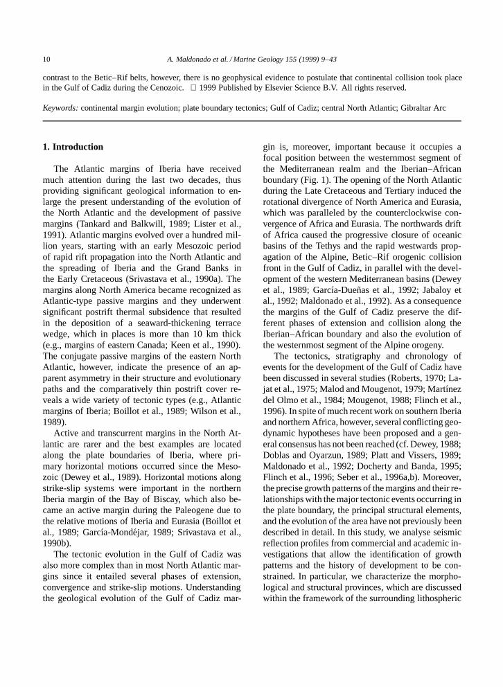
gin is, moreover, important because it occupies afocal position between the westernmost segment ofthe Mediterranean realm and the Iberian–Africanboundary (Fig. 1). The opening of the North Atlanticduring the Late Cretaceous and Tertiary induced therotational divergence of North America and Eurasia,which was paralleled by the counterclockwise con-vergence of Africa and Eurasia. The northwards driftof Africa caused the progressive closure of oceanicbasins of the Tethys and the rapid westwards prop-agation of the Alpine, Betic–Rif orogenic collisionfront in the Gulf of Cadiz, in parallel with the devel-opment of the western Mediterranean basins (Deweyet al., 1989; Garcıa-Duenas et al., 1992; Jabaloy etal., 1992; Maldonado et al., 1992). As a consequencethe margins of the Gulf of Cadiz preserve the dif-ferent phases of extension and collision along theIberian–African boundary and also the evolution ofthe westernmost segment of the Alpine orogeny.
The tectonics, stratigraphy and chronology ofevents for the development of the Gulf of Cadiz havebeen discussed in several studies (Roberts, 1970; La-jat et al., 1975; Malod and Mougenot, 1979; Martınezdel Olmo et al., 1984; Mougenot, 1988; Flinch et al.,1996). In spite of much recent work on southern Iberiaand northern Africa, however, several conflicting geo-dynamic hypotheses have been proposed and a gen-eral consensus has not been reached (cf. Dewey, 1988;Doblas and Oyarzun, 1989; Platt and Vissers, 1989;Maldonado et al., 1992; Docherty and Banda, 1995;Flinch et al., 1996; Seber et al., 1996a,b). Moreover,the precise growth patterns of the margins and their re-lationships with the major tectonic events occurring inthe plate boundary, the principal structural elements,and the evolution of the area have not previously beendescribed in detail. In this study, we analyse seismicreflection profiles from commercial and academic in-vestigations that allow the identification of growthpatterns and the history of development to be con-strained. In particular, we characterize the morpho-logical and structural provinces, which are discussedwithin the framework of the surrounding lithospheric
A. Maldonado et al. / Marine Geology 155 (1999) 9–43 11
Fig. 1. Geological setting and simplified bathymetry of the Gulf of Cadiz and surrounding areas. Legend: 1 D Hercynian Massif; 2D Betic–Rifean Internal Zones; 3 D dorsal complex; 4 D flysch units; 5 D Meso- and Intrarifean units; 6 D Prerifean units; 7 DBetic External Zones; 8 D Mesozoic paleomargins of Iberia–Africa; 9 D Guadalquivir olistostrome units; 10 D Neogene basins; 11 Dolistostrome front; 12 D seismic foci; COB D ocean–continent boundary. Bathymetry in meters.
elements. These data allow the geometry of the struc-tures and the tectonic processes that occur around theboundary between Iberia and Africa to be identified.The expression of the westernmost segment of theAlpine orogenic belts and its influence on the devel-opment of the Gulf of Cadiz is also analysed. Theobjective of this study is to provide new informationfor a better understanding of the evolution of conti-nental margins in a complex tectonic setting locatednear plate boundaries.
2. Methodology
The Spanish continental margin of the Gulf ofCadiz has been intensively explored by oil compa-nies, thus providing a dense network of multichannelseismic (MCS) profiles (Delaplanche et al., 1982;
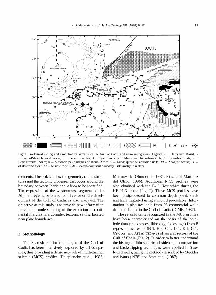
Martınez del Olmo et al., 1984; Riaza and Martınezdel Olmo, 1996). Additional MCS profiles werealso obtained with the B=O Hesperides during theHE-91-3 cruise (Fig. 2). These MCS profiles havebeen postprocessed to common depth point, stackand time migrated using standard procedures. Infor-mation is also available from 26 commercial wellsdrilled offshore in the Gulf of Cadiz (IGME, 1987).
The seismic units recognized in the MCS profileshave been characterized on the basis of the bore-hole data (thicknesses, lithology, facies, age) from 8representative wells (B-1, B-3, C-1, D-1, E-1, G-1,6Y-1bis, and ATLANTIDA-2) of several sectors of theGulf of Cadiz (Fig. 2). In order to better understandthe history of lithospheric subsidence, decompactionand backstripping techniques were applied in 5 se-lected wells, using the methods described by Stecklerand Watts (1978) and Stam et al. (1987).
12 A. Maldonado et al. / Marine Geology 155 (1999) 9–43
Fig. 2. Simplified bathymetric chart of the Gulf of Cadiz. Contour interval is 100 m with additional contours at 50 m. The grid ofmultichannel seismic (MCS) profiles and location of commercial wells analysed for this study is shown. Solid lines with numbersindicate MCS profiles displayed in Figs. 5 and 6.
3. Geological setting
3.1. Breakup of Pangea and the Mesozoic margins
Plate kinematic solutions indicate that during theTriassic the area of the Gulf of Cadiz was part of theTethys-related rift systems, when Permo-Carbonif-erous fracture zones became tensionally reactivated(Ziegler, 1989). The breakup of Pangea resulted inTriassic rifting and the development of the marginsof southern Iberia and northern Africa (Heymann,1989). Late Triassic basic volcanism was associatedwith this rifting and is represented by hydroclas-tic eruptions of basic volcanic rocks in the Cadizmargin. Post-volcanism tectonic extension initially
occurred in a SSW direction, changing later to a SEtrend (Garcıa-Navarro et al., 1994).
The Central Atlantic ridge ended in the GloriaTransform Fault, which was a major tectonic bound-ary throughout the early Mesozoic. This transformfault was probably connected with the extensional,deep oceanic basins of the Tethys. The Late Juras-sic and Early Cretaceous progressive rifting of theCentral Atlantic caused a major sinistral translationbetween Africa and Laurasia, which probably oc-curred along wrench-induced deep-crustal fractures,where the relative motion between the Central andNorth Atlantic rift systems was accommodated (Kl-itgord and Schouten, 1986; Ziegler, 1989). Jurassicspreading of the Tethys ocean took place through a
A. Maldonado et al. / Marine Geology 155 (1999) 9–43 13
major transcurrent fault, separating northern Africanfrom Iberian margins (Dercourt et al., 1986; Mauffretet al., 1989). This fault zone is thought to be locatedat the present area of the Alboran Sea (Andrieuxet al., 1971), but it could has extended westwardsinto the Gorringe Bank region, attributed to the latestJurassic (Feraud et al., 1986). Northwards, the ageof the older oceanic crust of the Tagus Plain, show-ing the continent–ocean boundary, corresponds tomagnetic anomaly M21 (150 Myr, early Tithonian).Mauffret et al. (1989) suggest that during the Creta-ceous occurred a northwards migration of the riftingprocess and a westwards jumping of the ridge, whichimplies an Early Cretaceous (anomaly MO, Aptian)abandoned spreading centre in the Tagus Plain. Seafloor magnetic anomaly reconstructions show thatthe separation of Eurasia from North America initi-ated 118 Myr ago north of the Newfoundland–AGFZ(Azores–Gibraltar Fracture Zone) (Srivastava et al.,1990a). A spreading axis and associated transformfaults were in existence during this time in the Gulfof Cadiz area, while a triple junction occurred be-tween the African–Iberia–North American plates inthe vicinity of the Gorringe Bank (Fig. 3).
3.2. Cretaceous and early Tertiary North Atlanticspreading
During the Cretaceous and Tertiary, the openingof the North Atlantic induced the rotational diver-gence of North America (Srivastava et al., 1990a).Iberia acted as an independent plate for most ofthe middle Cretaceous, until it became attached toAfrica sometime before chron 34 (Late Cretaceous,84 Myr), when the plate boundary was located in theBay of Biscay (Srivastava et al., 1990b). The MCSprofiles and the magnetic lineations from the easternHorseshoe Plain indicate Upper Jurassic deposits be-low a pre-Aptian reflector which represents a majorangular unconformity (Mauffret et al., 1989; Sartoriet al., 1994). Lower Aptian deposits were drilled atthe southern Gorringe Bank in DSDP Site 135 (Ryanet al., 1973), which also indicates that sedimenta-tion related to North Atlantic ocean spreading beganduring the Aptian in the area of the AGFZ, whereasthe Jurassic deposits were largely controlled by theNorth African–Iberian ocean spreading.
During the Middle Eocene to Middle Miocene
(chron 18 to chron 6c), Iberia became once againan independent plate. Strike slips along the Glo-ria Transform Fault passed into the compressionalarea of the Gorringe Bank, while the AGFZ wasan active plate boundary between Africa and Iberia(Roest and Srivastava, 1991). The relative motionbetween the two plates in the Gulf of Cadiz wassmall between chrons 18 and 13, but since then com-pression has existed east of Gorringe Bank, with asignificant amount of shortening in the area of theGulf of Cadiz. A major unconformity has been re-ported in DSDP Site 135 during the Early Eocene–Late Oligocene, and also is observed in AmpereSeamount and Coral Patch area. These unconformi-ties suggest regional uplift at this time (Hayes et al.,1972).
3.3. Late Cenozoic evolution
Plate-motion studies by Dewey et al. (1989) sug-gest that the area of the Alboran Sea–Gulf of Cadizplate boundary experienced about 200 km of roughlyN–S convergence between the mid-Oligocene toLate Miocene, followed by about 50 km of NW-directed oblique convergence from the Late Mioceneto recent. The Betic–Rif chains and the enclosedAlboran Domain represent the disrupted fragmentsof a convergent orogenic belt developed betweenthe two major plates within the generalized com-pressional regime and that evolved from the LateCretaceous to Early Miocene (De Jong, 1991; Monieet al., 1991; Garcıa-Duenas et al., 1992; Jabaloy etal., 1992). The northwards drift of Africa causedthe progressive closure of the Tethys basins and therapid westward propagation of the Gibraltar Arc belttowards the Gulf of Cadiz area (Balanya and Garcıa-Duenas, 1987). During the Aquitanian–Burdigalian,extensional tectonics and sea-floor spreading gaverise to most of the western Mediterranean Sea asthe Corsica–Sardinia block rotated counterclockwisefrom the Gulf of Lion and the Balearic block sep-arated from the Iberian Peninsula (Rehault et al.,1984; Dewey et al., 1989; Mauffret et al., 1995).Most of the Alboran Sea also developed during thistime, as a type of Mediterranean backarc basin (Hor-vath and Berckhemer, 1982; Comas et al., 1992;Maldonado et al., 1992). Part of the area now oc-cupied by the Alboran Sea underwent significant
14A
.Maldonado
etal./M
arineG
eology155
(1999)9–43
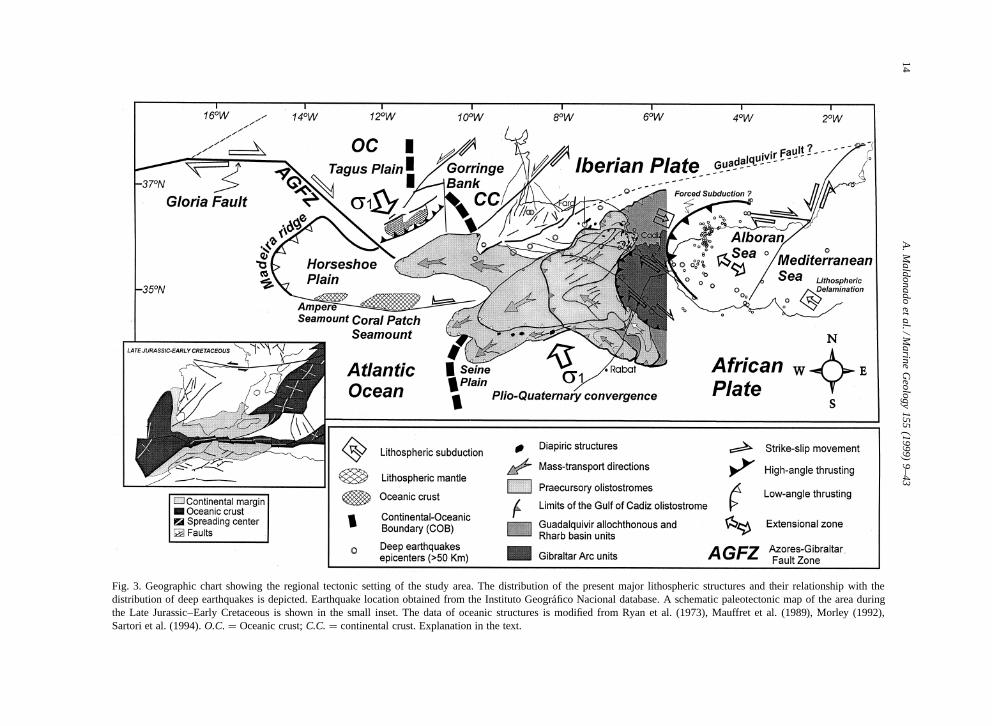
Fig. 3. Geographic chart showing the regional tectonic setting of the study area. The distribution of the present major lithospheric structures and their relationship with thedistribution of deep earthquakes is depicted. Earthquake location obtained from the Instituto Geografico Nacional database. A schematic paleotectonic map of the area duringthe Late Jurassic–Early Cretaceous is shown in the small inset. The data of oceanic structures is modified from Ryan et al. (1973), Mauffret et al. (1989), Morley (1992),Sartori et al. (1994). O.C. D Oceanic crust; C.C. D continental crust. Explanation in the text.

A. Maldonado et al. / Marine Geology 155 (1999) 9–43 15
crustal thinning (Platt and Vissers, 1989; Watts etal., 1993; Docherty and Banda, 1995; Seber et al.,1996a).
3.4. Quaternary tectonics
The tectonic regime in southern Iberia shows sig-nificant variations during the Quaternary. The Gibral-tar Strait suffered uplifting processes, whereas in theGulf of Cadiz westwards extension could have beeninfluenced by lateral ejection processes. Uplift ratesof between 0.1 to 0.2 mm=yr were calculated inthe Gibraltar area based on the altitude of UpperPleistocene marine deposits (Goy et al., 1995). Aright-dihedra diagram from the focal mechanism ofearthquakes in the Gulf of Cadiz region shows, how-ever, a general compressional stress regime with σ1
subhorizontal and NNW–SSE trending, whereas co-eval extensional processes took place in the AlboranSea (cf. Maldonado et al., 1992; Galindo-Zaldıvar etal., 1993).
The present kinematics along the Azores–Gibraltar Fracture Zone (AGFZ) is complex (Fig. 3).From west to east it is characterized as: (1) transten-sional in the western sector from the Azores triplejunction; (2) dextral along the Gloria TransformFault; (3) diffuse compressional in the area of theGorringe Bank; and (4) convergent complex withright-lateral strike slips in the Gulf of Cadiz andGibraltar Arc area (Grimison and Chen, 1986; Bu-forn et al., 1988a,b; Argus et al., 1989; Westaway,1990; Udıas and Buforn, 1992; Sartori et al., 1994).The model proposed by Argus et al. (1989) predicts aright-lateral slip of about 4 mm=yr along the easternportion of the AGFZ and a west-northwest conver-gence in the western Gulf of Cadiz (Figs. 1 and 3).The seismicity, heavily concentrated along the AGFZin the Azores and Gloria Fault, becomes disperse inthe Gulf of Cadiz and Gibraltar Arc, which mayindicate the more diffuse nature of the contact in thisarea and the partitioning of the relative motion alongseveral fracture zones (Buforn et al., 1988a,b). Seis-micity in the Gulf of Cadiz allows to differentiate,in addition, two main domains in this area (Udıasand Buforn, 1992): (1) the northern sector in theExternal Betic zone and Guadalquivir Depression,where most of the intermediate (30 km < h < 150km) and shallow earthquakes are located; and (2) the
southern sector, where the seismicity is lower andmost of the deep earthquakes are distributed along aN–S-trending arc in the western Alboran Sea (Figs. 1and 3).
4. Seismic stratigraphic units
4.1. Mesozoic and lower Cenozoic units
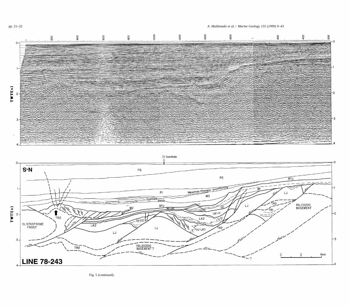
The Mesozoic and lower Cenozoic units are bestobserved in wells and multi-channel seismic profiles(MSC) from the northernmost area. These units areeither obscure below a thick olistostrome depositor are absent over most of the rest of the Gulf ofCadiz (Lajat et al., 1975; Delaplanche et al., 1982;Martınez del Olmo et al., 1984). The basement ismade up of the Paleozoic rocks of the Hercynianmassif of Iberia. Half-graben structures determinedthe main structural trends of this margin during theMesozoic, which were affected by inversion struc-tures during the Neogene compressional stages. TheTriassic evaporites acted as detachment layers duringthe extensional and compressional stages. Well dataand multichannel seismic profiles permit us to distin-guish seven main lithoseismic units from the Triassicto the Late Oligocene (Figs. 4–6).
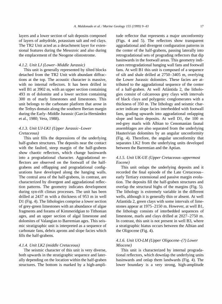
4.1.1. Units TR1 and TR2 (Triassic)Two main Triassic units are identified in wells
showing a typical Germanic-type facies: a lower sili-ciclastic TR1 Unit and an upper evaporitic TR2 Unitcomposed of salts, gypsum and shallow-water car-bonates (Fig. 4). In MCS profiles the top of TR1Unit locally shows a very high-amplitude reflector,mostly above the structural highs, frequently iden-tified as the acoustic basement (Fig. 5). This unithas been sampled at 4102 m depth below sea levelin well B1, where it is represented by the ‘redbeds’ facies composed of red clays and volcanogenicrocks filling half-grabens. Unit TR2 shows a strong,discontinuous acoustic reflector, frequently of hy-perbolic or chaotic character. It is also affected bydiapirism, particularly near the contact with the olis-tostrome front (Fig. 5). This unit has been drilledat well C1 between 1720 and 2763 m on top of adiapiric dome (Fig. 4). The lithologies consist of anupper section of 55 m of red clays with anhydrite
16A
.Maldonado
etal./M
arineG
eology155
(1999)9–43
Fig. 4. Lithologic logs of commercial wells. Stratigraphic units and horizons drilled by the wells and total depth are indicated. Main unconformities and stratigraphiccorrelation between the wells are also shown. Arrows indicate emplacement of the olistostrome and thrust structures (note that this representation is not a geologicalsection). See Fig. 2 for location of wells. Discussion in text.
A. Maldonado et al. / Marine Geology 155 (1999) 9–43 17
layers and a lower section of salt deposits composedof layers of anhydride, potassium salt and red clays.The TR2 Unit acted as a detachment layer for exten-sional features during the Mesozoic and also duringthe emplacement of the Neogene olistostrome.
4.1.2. Unit LJ (Lower–Middle Jurassic)This unit is generally represented by tilted blocks
detached from the TR2 Unit with abundant diffrac-tions at the top. The acoustic character is massive,with no internal reflectors. It has been drilled inwell B1 at 3902 m, with an upper section containing493 m of dolomite and a lower section containing300 m of marly limestones and limestones. Thisunit belongs to the carbonate platform that arose inthe Tethys domain along the southern Iberian marginduring the Early–Middle Jurassic (Garcıa-Hernandezet al., 1980; Vera, 1988).
4.1.3. Unit UJ-LK1 (Upper Jurassic–LowerCretaceous)
This unit fills the depressions of the underlyinghalf-graben structures. The deposits near the contactwith the faulted, steep margin of the half-grabensshow chaotic reflectors, which change basinwardsinto a progradational character. Aggradational re-flectors are observed on the footwall of the half-grabens and offlapping and progradational config-urations have developed along the hanging walls.The central area of the half-grabens, in contrast, arecharacterized by divergent and aggradational reflec-tion patterns. The geometry indicates developmentduring syn-rift climax processes. The unit has beendrilled at 2437 m with a thickness of 953 m in wellD1 (Fig. 4). The lithologies comprise a lower sectionof grey-green limestones with an abundance of algaefragments and forams of Kimmeridgian to Tithonianages, and an upper section of algal limestone anddolomites of Valangian to Barremian ages. This seis-mic stratigraphic unit is interpreted as a sequence ofcarbonate fans, debris aprons and slope facies whichfills the half-grabens.
4.1.4. Unit LK2 (middle Cretaceous)The seismic character of this unit is very diverse,
both upwards in the stratigraphic sequence and later-ally depending on the location within the half-grabenstructures. The bottom is marked by a high-ampli-
tude reflector that represents a major unconformity(Figs. 4 and 5). The reflectors show transparentaggradational and divergent configuration patterns inthe center of the half-grabens, passing laterally intoretrogradational sets of prograding reflectors that dipbasinwards in the footwall areas. This geometry indi-cates retrogradational hanging wall fans and footwallfans. At well B1 this unit is composed of a sequenceof silt and shale drilled at 2750–3405 m, overlyingthe Lower Jurassic dolomites. These facies are at-tributed to the aggradational sequence of the centerof a half-graben. At well Atlantida 2, the litholo-gies consist of calcareous grey clays with intervalsof black clays and polygenic conglomerates with athickness of 350 m. The lithology and seismic char-acter indicate slope facies interbedded with footwallfans, grading upwards into aggradational onlappingslope and basin deposits. At well D1, the 100 mred-grey marls with Albian to Cenomanian faunalassemblages are also separated from the underlyingHauterivian dolomites by an angular unconformity(Fig. 4). Therefore, the angular unconformity thatseparates LK2 from the underlying units developedbetween the Barremian and the Aptian.
4.1.5. Unit UK-UE (Upper Cretaceous–uppermostEocene)
This unit onlaps the underlying deposits and itrecorded the final episode of the Late Cretaceous–early Tertiary extensional and passive margin evolu-tion. The deposits fill the half-graben structures andoverlap the structural highs of the margins (Fig. 5).The lithology is extremely variable in the differentwells, although it is generally thin or absent. At wellAtlantida 2, green clays with some intervals of lime-stones appear at 1975–2150 m. However, at well B1,the lithology consists of interbedded sequences oflimestone, marls and clays drilled at 2027–2750 m.In contrast, this unit is not present in well B3, wherea stratigraphic hiatus occurs between the Albian andthe Oligocene (Fig. 4).
4.1.6. Unit UO-LM (Upper Oligocene–(?) LowerMiocene)
This unit is characterized by internal prograda-tional reflectors, which downlap the underlying unitsbasinwards and onlap them landwards (Fig. 4). Thelower boundary is a very strong, high-amplitude
18 A. Maldonado et al. / Marine Geology 155 (1999) 9–43
reflector interpreted as an erosional unconformity,which extends to the palaeo shelf-break. The aggra-dational and progradational reflectors are observedover the palaeo slope, while mounded configurationpatterns characterize the shelf-break. The lithologiesidentified at well D1 include glauconitic limestonewith Nummulites and algae fragments interbeddedwith grey to brown marls. This unit also exhibitslarge variations in thickness, from 20 m at 1933 m inwell D1, located in the deep basin, to thick depositstowards the shelf-break, such as the 375 m of wacke-stone to packstone limestones drilled at 1600 m inthe well B1 (Fig. 4). The seismic geometry and thelithologies suggest a progradational to aggradationalcarbonate shelf platform which developed over theentire margin and mantled the former fault-boundedunits deposited within the half-graben structures.
The upper boundary is also a very high-amplitudereflector that corresponds to a widely spread regionalunconformity. This unconformity is well observedin the northern area of the Gulf of Cadiz, boundingmid-Miocene deposits from the Oligocene carbonateplatform unit. The unconformity acted as a palaeo-slope for the generation of the Upper Miocene tur-bidite system, while basinwards it sinks below themid-Miocene olistostrome deposits (Fig. 5, Line 79-339, shot points 3200–4000).
4.2. Neogene and Quaternary units
Seven main stratigraphic units are differentiatedin the Gulf of Cadiz on the basis of their relationshipto the olistostrome. The location of the northern frontof the olistostrome, well mapped by the oil industry,reaches the central sector of the Gulf of Cadiz ina WNW–ESE direction and it masks and partiallyobliterates the underlying units in the southern area(Figs. 1 and 4).
4.2.1. Pre-olistostrome Unit M1(Langhian–Serravalian, lower Tortonian)
Unit M1 is deformed into a wedge-shaped moundin front of the olistostrome, while it dips south-eastwards below the olistostrome and is involved inthe basal overthrust (Figs. 5 and 6). The top is avery strong high-amplitude reflector, which marksthe base of the main olistostrome mass through theGulf of Cadiz basin. This reflector also represents the
basal foredeep unconformity (BFU). This unit is wellrepresented by three main depositional sequencesin the MCS profiles in the northern area (Fig. 5).The sequences are characterized by a wedge geom-etry filling depressions of the basement, showingprogradational and aggradational reflector configu-ration patterns. The lower sequence is the thickestand it progrades northwestwards. The intermediatesequence is thinner and onlaps the northern bound-ary of the lower sequence and the older units whichfill the basement depressions. The upper sequenceis more extensive and drapes the two underlyingsequences. This unit is equivalent to the Atlantidagroup previously described in the area (Martınez delOlmo et al., 1984; Riaza and Martınez del Olmo,1996).
Three main lithological packages were drilled atwell B3: a basal section from the lower Langhian iscomposed of grey-black marly clays with some inter-vals of fine-grained limestones at 1814–1850 m; anintermediate Langhian–Serravalian section at 1772–1814 m is represented by limestones interbeddedwith marly black clays, and an upper Serravalian tolower Tortonian section at 1757–1772 m consists ofplastic and compacted green clays with an abundanceof pyrite and glauconite (Fig. 4). These deposits maybe correlated with the fossil-rich carbonate formationof Lagos-Portimao dated as Langhian–Tortonian incentral Algarve (Antunes et al., 1990; Cachao andSilva, 1992; Boski and Moura, 1994). The Lagos–Portimao formation is the lowermost Tertiary unitrecognized in the northern emerged margin and itoverlies a major unconformity above the Mesozoicsubstratum. Well D1 near the olistostrome front, incontrast, drilled 200 m of compacted green to greyclays at 1740 m depth. The deposits of well D1 maycorrespond to the allochthonous margin of southernIberia, mostly composed of ductile marly clays ofdetrital nature sourced in the Betic orogeny. Theseclays are thought to be responsible for the formationof the marly diapirism that occurred in the centralarea of the gulf due to excess pore pressure, whichfacilitates density inversion in relation to the overly-ing deposits (Maldonado et al., 1989).
4.2.2. Syn-olistostrome unit M2 (upper Tortonian)This unit is well recognized near the front of the
olistostrome, where it is wedge-shaped and interfin-
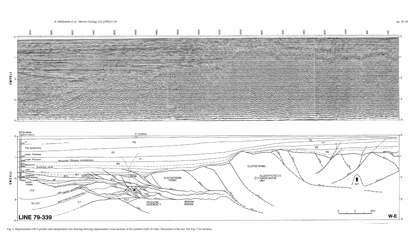
A. Maldonado et al. / Marine Geology 155 (1999) 9–43 pp. 19–20
Fig. 5. Representative MCS profiles and interpretative line drawing showing representative cross-sections of the northern Gulf of Cadiz. Discussion in the text. See Fig. 2 for location.
pp. 21–22 A. Maldonado et al. / Marine Geology 155 (1999) 9–43
Fig. 5 (continued).
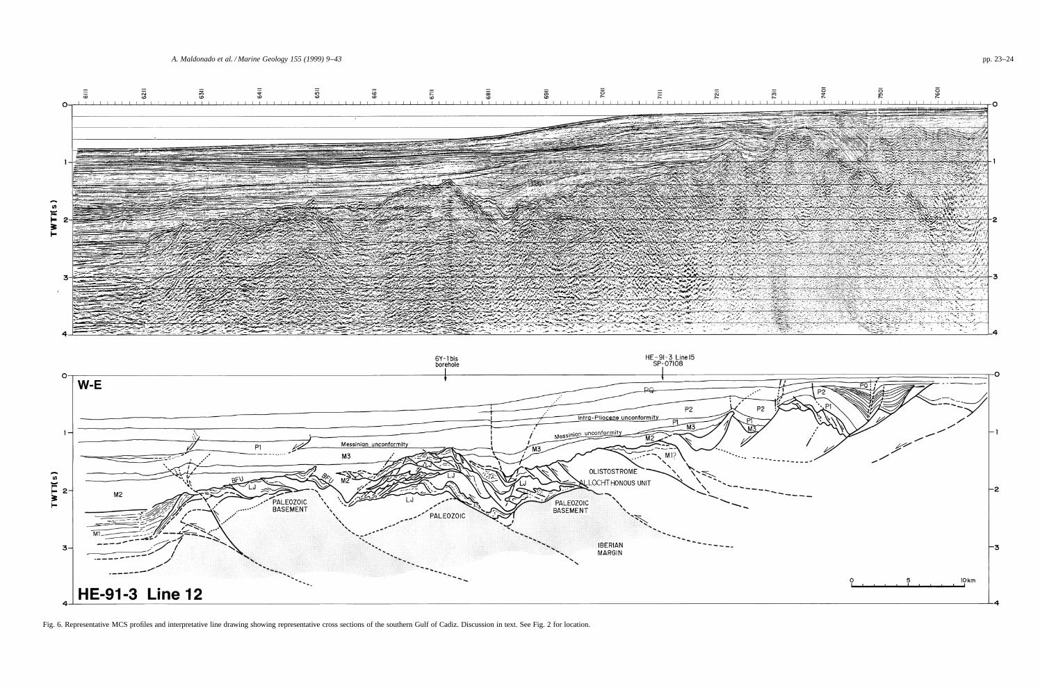
A. Maldonado et al. / Marine Geology 155 (1999) 9–43 pp. 23–24
Fig. 6. Representative MCS profiles and interpretative line drawing showing representative cross sections of the southern Gulf of Cadiz. Discussion in text. See Fig. 2 for location.

pp. 25–26 A. Maldonado et al. / Marine Geology 155 (1999) 9–43
Fig. 6 (continued).

A. Maldonado et al. / Marine Geology 155 (1999) 9–43 27
gers with the olistostrome (Fig. 5). The thickness de-creases uniformly northwards from the olistostromefront, where it reaches 300 m. The top of the unitis affected by overthrust faults of the olistostrome,whereas below it is delaminated or eroded. Thereare local progressive and angular unconformities andsome small depressions on top of the olistostrome,which may be filled by this unit. Most of these de-posits developed during the emplacement of the olis-tostrome and were also affected by later residualmovements of thrusting and backthrusting. The olis-tostrome masses reaching the Gulf of Cadiz erodedthe underlying deposits and formed a detrital basalunit (Fig. 5). This unit is equivalent to the Beticagroup that is described by the oil industry in the Gulfof Cadiz (Riaza and Martınez del Olmo, 1996). TheBetica group appears intensively deformed in frontof the olistostrome mass, developing wedge-shapedgeometries.
Unit M2 drilled at 1499–1757 m in well B3consists of plastic grey clays with an abundance ofglauconite and pyrite (Fig. 4). The lower boundaryof these deposits is the BFU reflector on top of theAtlantida group, while the upper boundary is alsoan erosional unconformity interpreted as a sequenceboundary.
4.2.3. Olistostrome unitThe olistostrome unit is seismically identified by
chaotic, high-amplitude reflectors with diffractionsand hyperbolic reflections. The lower boundary is astrong high amplitude reflector dipping southwardsfrom the olistostrome front and becoming obscurebelow the olistostrome body (Figs. 4 and 5). Theoverthrusting took place through low-angle planesobserved as high-amplitude reflectors within thechaotic olistostrome body. The front is configuredinto several wedges involving the syn-sedimentarydeposits of Unit M2. The youngest deposits, ofMessinian age, are also slightly affected by over-thrusting movements. The angular unconformitiesobserved within the depositional sequences are theresults of the kinematics of the wedge-shaped thrust-ing. Overthrusting also occurred within the bodyof the olistostrome, developing a relief in the up-per boundary which involves the overlying deposits.Slope facies were deposited in front of the activeoverthrusting, while they merge northwestwards into
hemipelagic facies. Backthrusting and extensionalfeatures are also seen at the back of the olistostromeinvolving the same units. This suggests a coevaldevelopment of overthrusting and backthrusting pro-cesses. Backthrusting also influences slope faciesdevelopment of Unit M2, which were deformed bylater displacements.
The main emplacement of the olistostrome to alocation close to its present distribution, took placejust before and during deposition of Unit M2, duringthe late Tortonian. The large advancing wedge wasdiverted by the bottom morphology and distributionof the previous deposits. Older accretionary wedgesare observed below the front of the olistostrome andmay be correlated with middle and probably LowerMiocene deposits (Figs. 5 and 6).
4.2.4. Unit M3 (Messinian)Unit M3 fills most of the irregularities and de-
pressions of the underlying deposits and drapesthe top of the olistostrome (Figs. 4–7). The thick-est deposits are observed in the depressions northof the olistostrome front, where they may reach450 m but are less than 200 m thick to absentabove the olistostrome body. Unit M3 correspondsto the Andalucıa group, which includes the Gua-diana and Guadalquivir sands (Riaza and Martınezdel Olmo, 1996). The Guadiana sands represent de-positional fan lobes derived south and southeast-wards from the northern Gulf of Cadiz margin. TheGuadalquivir sands began to develop earlier in theupper Guadalquivir Valley and have migrated, incontrast, southwestwards along the river valley to theGulf of Cadiz (Sierro et al., 1996).
Unit M3 consists of clays and interbedded veryfine-grained sand lenses which prograde into theforedeep basin from the northern margin of theGulf of Cadiz (Delaplanche et al., 1982; Riaza andMartınez del Olmo, 1996). These sands contain thegas field of the Gulf of Cadiz.
4.2.5. Unit P1 (Lower Pliocene)The bottom of this unit is a basin-wide erosional
unconformity recognized in single channel and MCSprofiles in the Gulf of Cadiz (Nelson et al., 1993).It is a rather uniform unit with a thickness of about300 m north of the olistostrome front and about 50 mabove the olistostrome in the northern area (Figs. 4–
28 A. Maldonado et al. / Marine Geology 155 (1999) 9–43
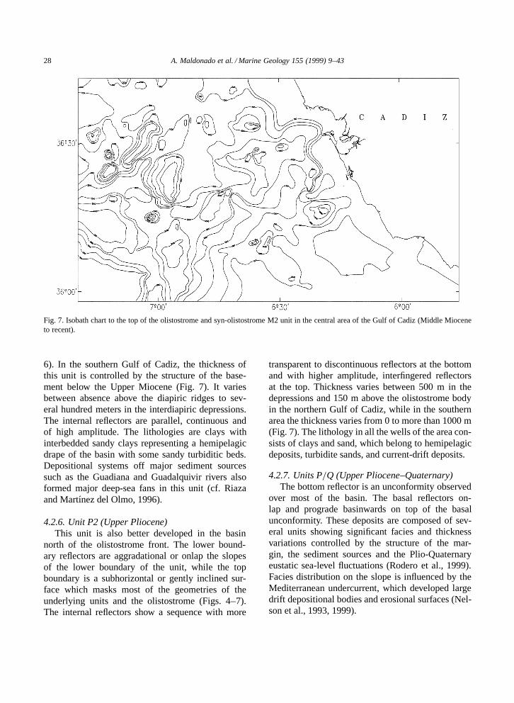
Fig. 7. Isobath chart to the top of the olistostrome and syn-olistostrome M2 unit in the central area of the Gulf of Cadiz (Middle Mioceneto recent).
6). In the southern Gulf of Cadiz, the thickness ofthis unit is controlled by the structure of the base-ment below the Upper Miocene (Fig. 7). It variesbetween absence above the diapiric ridges to sev-eral hundred meters in the interdiapiric depressions.The internal reflectors are parallel, continuous andof high amplitude. The lithologies are clays withinterbedded sandy clays representing a hemipelagicdrape of the basin with some sandy turbiditic beds.Depositional systems off major sediment sourcessuch as the Guadiana and Guadalquivir rivers alsoformed major deep-sea fans in this unit (cf. Riazaand Martınez del Olmo, 1996).
4.2.6. Unit P2 (Upper Pliocene)This unit is also better developed in the basin
north of the olistostrome front. The lower bound-ary reflectors are aggradational or onlap the slopesof the lower boundary of the unit, while the topboundary is a subhorizontal or gently inclined sur-face which masks most of the geometries of theunderlying units and the olistostrome (Figs. 4–7).The internal reflectors show a sequence with more
transparent to discontinuous reflectors at the bottomand with higher amplitude, interfingered reflectorsat the top. Thickness varies between 500 m in thedepressions and 150 m above the olistostrome bodyin the northern Gulf of Cadiz, while in the southernarea the thickness varies from 0 to more than 1000 m(Fig. 7). The lithology in all the wells of the area con-sists of clays and sand, which belong to hemipelagicdeposits, turbidite sands, and current-drift deposits.
4.2.7. Units P=Q (Upper Pliocene–Quaternary)The bottom reflector is an unconformity observed
over most of the basin. The basal reflectors on-lap and prograde basinwards on top of the basalunconformity. These deposits are composed of sev-eral units showing significant facies and thicknessvariations controlled by the structure of the mar-gin, the sediment sources and the Plio-Quaternaryeustatic sea-level fluctuations (Rodero et al., 1999).Facies distribution on the slope is influenced by theMediterranean undercurrent, which developed largedrift depositional bodies and erosional surfaces (Nel-son et al., 1993, 1999).

A. Maldonado et al. / Marine Geology 155 (1999) 9–43 29
5. Structural features in the Spanish margin ofthe Gulf of Cadiz
The trends of the main structural features of theSpanish margin in the Gulf of Cadiz are controlledin the western area by the External Zones of theBetic–Rif belts, where the Gibraltar Arc bends to de-velop an arcuate orogenic belt plunging westwards.The continental margin of the gulf consists of threemain tectonic provinces which concentrically sur-round the internal zones of the arc. These include theflysch units of the Campo de Gibraltar complex inthe proximity of the Strait of Gibraltar, the Betic–Rif External Zones, and the Neogene basins of theGuadalquivir Valley, which extend southwestwardsand occupy most of the central sector of the Gulfof Cadiz (Malod and Mougenot, 1979; Malod, 1982;Pallares et al., 1995; ITGE, 1998).
Northwestern and southeastern areas in theIberian continental shelf are characterized by theabsence or presence of shallow acoustic basementformations (Figs. 7 and 8). The basement in thenorthwestern sector is restricted to a narrow zone
Fig. 8. Simplified tectonic chart of the central sector of the Gulf of Cadiz. Symbols legend: 1 D fault; 2 D normal fault; 3 D reversefaults; 4 D anticline; 5 D syncline; 6 D diapir; 7 D well.
close to the coastline, while the overlying Cenozoicdeposits show significant seawards thickening. Thebasement, in contrast, crops out over large areas inthe southeastern sector of the shelf, and is locallydraped by a thin veneer of recent deposits. The base-ment is composed of fault-bounded blocks of flyschand subbetic units, which may be correlated withthe Gibraltar belt (cf. Balanya, 1991). The Cenozoicformations in this sector are only observed in theouter shelf. The evolution of the shelf was largely in-fluenced by the tectonics, since the main boundariesbetween geologic provinces coincide with faults af-fecting the basement in the southeastern sector andthe development of fault-bounded basins in the othersectors of the margin (Figs. 7 and 8).
5.1. Northwestern shelf
The northwestern shelf is characterized by ex-tensional features, subparallel to the coast, whichare associated with subsidiary faults of predomi-nant strike-slip component. These faults facilitatethe seawards subsidence of the shelf and the devel-
30 A. Maldonado et al. / Marine Geology 155 (1999) 9–43
opment of thick Cenozoic depositional units. Theinner and middle shelf exhibit three NNW–SSE-,NW–SE- and E–W-striking fault sets, which affectthe basement. According the displacement of units,boundaries and reflectors in the tectonic chart, thefirst and third group indicate a sinistral componentof strike-slip motion, while the second group is acomplex of normal faults, some of which correspondto growth faults, that may also have a strike-slipcomponent (Fig. 8). All these faults have been activeduring the Quaternary, with a significant proportionthat have late Quaternary to recent displacement,clearly observed in the high resolution profiles ofthe margin (cf. Rodero et al., 1999). Some faults,however, are interpreted as reactivated Pliocene andMiocene fractures.
The outer shelf contains faults with NNW–SSEand N–S directions, which intersect the edge ofthe shelf. These are generally normal faults, someof which appear to have a strike-slip componentand locally show reverse drag. The most recentdisplacements are from the mid- or early Quaternary,therefore older than the faults of the middle and innershelf. Some of these faults are associated to diapirsthat also have very recent displacements.
5.2. Southeastern shelf
The southeastern shelf is very different from thenorthwestern area. The structure of this sector wascontrolled by a compressive regime, which devel-oped fault-bounded blocks in the acoustic basementand constrained the development of large deposi-tional basins. The shallowness of the acoustic base-ment and the absence of a significant depositionalcover, however, make the identification of faults dif-ficult and only the most significant fractures are wellobserved (Fig. 8).
This sector is bounded to the northwest by a re-verse fault, which cuts obliquely across the shelfin a NE–SW direction and reaches the upper slope(Fig. 8). The fault facilitates the westwards exten-sion of the shelf, which reaches its maximum widthin this sector. This fault also bounds the basementformations and delineates the extension of the Ceno-zoic depositional units onlapping the basement. Thefault was active from the Pliocene to the late Quater-nary, experiencing in its northern sector the youngest
movements. The orientation, age and kinematics ofthe fault suggest the last compressive stages of theBetic–Rif orogen and the westwards thrusting.
5.3. Slope
The most prominent tectonic elements of theslope are open folds with a NE–SW axis, slightlycurved and subparallel among them (Fig. 8). Thesestructures are coherent with the fault system de-scribed in the northwestern shelf. Focal mechanismsolutions indicate a diffuse area of seismicity eastof Gorringe Bank (Buforn et al., 1988a,b; Bufornand Udıas, 1991; Blanco and Spakman, 1993; Seberet al., 1996a), which probably follows the bound-ary between major crustal elements (Figs. 1 and 3).One branch of this presently active area extends intothe Gulf of Cadiz and may be represented by theESE–WNW-trending strike-slip faults identified inthe high-resolution seismic profiles and the tectonicchart (Rodero et al., 1999; ITGE, 1998).
These structures are compatible with wrenchzones, with an approximate E–W to ESE–WNWorientation and a dextral sense involving both dip-slip and strike-slip components caused by deep faultsassociated with a broad deformation zone (Pallares etal., 1995; ITGE, 1998). The deformation zone maybe attributed to a branch of the boundary defined bythe continuing collision of the African and Eurasianplates. These structures and the inferred tectonicsin the Gulf of Cadiz are compatible with those ob-served in the Betic cordilleras that are characterizedby NNW–SSE-directed compression.
6. Growth patterns of the Gulf of Cadiz
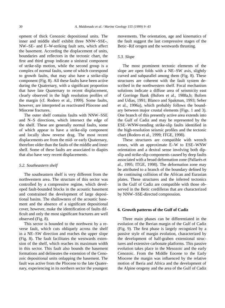
Three main phases can be differentiated in theevolution of the Iberian margin of the Gulf of Cadiz(Fig. 9). The first phase is largely recognized by apassive style of margin evolution, characterized bythe development of half-graben extensional struc-tures and extensive carbonate platforms. This passiveevolution takes place in the Mesozoic and the earlyCenozoic. From the Middle Eocene to the EarlyMiocene the margin was influenced by the relativemotion of Iberia and Africa and the development ofthe Alpine orogeny and the area of the Gulf of Cadiz
A. Maldonado et al. / Marine Geology 155 (1999) 9–43 31
Fig. 9. Synthesis of lithoseismic units based on well data and MCS profiles of the Gulf of Cadiz. Subsidence rates calculated usingbackstripping methods are indicated. Main tectonic events and relative motions of Iberia and Africa are correlated with the timing ofdevelopment of the main lithoseismic units. See Fig. 4 for thickness of units in the wells and description of lithoseismic units. Discussionin text.
was under transpression. Finally, the end of the olis-tostrome emplacement in the Gulf of Cadiz coincideswith an accelerated subsidence of the margin, whichbecomes essentially passive although modified bythe active compression between Iberia and Africa.
6.1. The initial passive margin
The breakup of Pangea and Triassic rifting initi-ated the margins of southern Iberia, where extensivered beds, limestones and evaporites were deposited(units TR1 and TR2). During the Early Jurassic,carbonate platforms developed in the Gulf of Cadiz(Unit LJ), which were part of the Tethys realmtogether with the roughly E–W-oriented southern
margins of Iberia (Vera, 1988). Following the riftingof Eurasia and North America, half-grabens were de-veloped and subsequently filled with carbonate fansand slope facies (Fig. 9). The structural blocks, ei-ther emergent or occupied by carbonate platformsand unconformities are shown by hard-grounds andcondensed sequences (cf. Garcıa-Hernandez et al.,1980). The main stage of syn-sedimentary Atlanticrift climax at the Gulf of Cadiz seems to have takenplace during the Kimmeridgian–Tithonian, while ex-tended post-rift deposits were developed during theHauterivian–Barremian. The widespread unconfor-mity in the Gulf of Cadiz before the early Aptianbetween units UJ and LK1=LK2 recorded a compres-sional event followed by extension (Fig. 9). About

32 A. Maldonado et al. / Marine Geology 155 (1999) 9–43
this time the eastward jumping of the Tagus spread-ing axis to its present location in the North Atlanticalso occurred (Mauffret et al., 1989).
Ocean-spreading in the North Atlantic inducedextensional tectonics in the Gulf of Cadiz, which de-formed the Cretaceous syn-tectonic post-Aptian de-posits (Fig. 9). Increased amounts of terrigenous ma-terials were supplied to the margin from the Aptianto the Albian, controlling depositional patterns in theGulf of Cadiz margin, and terrigenous siliciclasticfacies replaced the Jurassic carbonate platforms. Thehalf-graben of the Gulf of Cadiz became reactivatedand filled with a large variety of facies (Unit LK2),with a greater proportion of terrigenous deposits thanin previous units (Fig. 4). The deposits became moreextensive and onlapped structural highs.
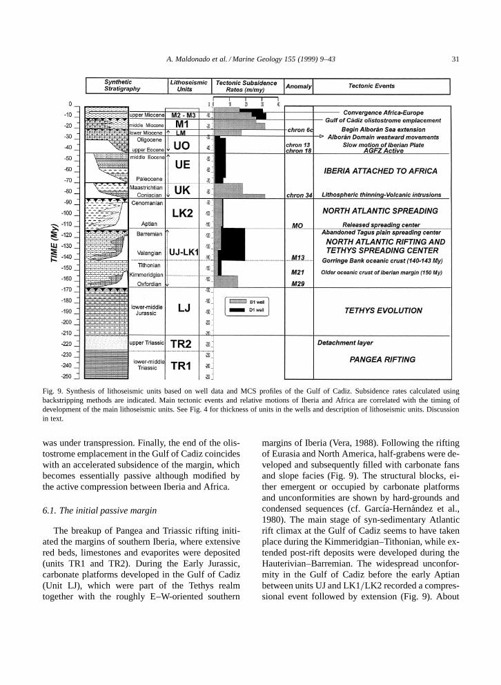
The units of the Gulf of Cadiz recorded a changein the depositional style during the Late Cretaceous,which may also reflect the change in the tectonicregime and the shifting of the AGFZ boundary be-tween Eurasia and Africa to the Bay of Biscay,when Iberia became attached to Africa (Fig. 9). Thedeposits are very irregularly distributed and depictsignificant facies variations (Unit UK-UE). The vol-canic intrusions of southern Portugal occurred duringthis time, probably reflecting thinning of the crust,and extensional normal faults were favoured alongthe Hercynian fractures. Basement subsidence curvesderived from well B1 show strong increases of tec-tonically induced subsidence between 90 and 70Myr (Fig. 10). Shallow-carbonate platforms, how-ever, may have continued in existence until theMaastrichtian within this tectonic regime.
6.2. The transpressive margin and olistostromeemplacement
The Upper Eocene–Lower Oligocene deposits inthe Gulf of Cadiz are very reduced or absent, re-flecting the compressional regime along the AGFZinitiated at chron 18 (Figs. 4 and 9). Extensive areasof erosion show uplifted blocks that developed dur-ing the generalized compressional regime, which in-duced inversion tectonics of the previous half-grabenstructures. Hayes et al. (1972) have also suggested aregional post-Early Eocene unconformity marked bya reduction in the depositional rate above the struc-tural highs of the Ampere–Coral Patch seamounts.
The Oligocene deposits were controlled by anincrease of the subsidence rate caused by reacti-vated extensional tectonics and graben development(Fig. 10). Middle–Upper Oligocene carbonate plat-forms onlapped the Cretaceous and early Tertiaryhighs during this time (Unit UO). A high-energy,carbonate shelf existed in the area linking the Cen-tral Atlantic and Mediterranean basins through thenorth Africa–south Iberia corridors. In the west-ernmost Gulf of Cadiz margin, a regional middleOligocene onlapping sequence may represent the 30Ma sequence boundary of the global sea-level curve(cf. Geel et al., 1990).
Since the mid-Oligocene to the recent, the Gulf ofCadiz has been located along the extensive area ofdeformation of the transcurrent fault system betweenAfrica and Iberia (Dewey et al., 1989). The Iberian–African plate boundary experienced transpressionand the probably floored by oceanic crust Mesozoicbasins of the Gulf of Cadiz area were submitted tosubduction. Wrench zones within conjugated faultsystems may have induced the development of sub-siding, roughly WSW–ENE-oriented basins (Figs. 1,3 and 8). The changing orientation of the stress-fieldmay also have played a significant role in the devel-opment of these basins (cf. Sanz de Galdeano, 1990;Maldonado et al., 1992). An autochthonous northerncalcareous margin of the Gulf of Cadiz extendedinto southern Portugal, while an allochthonous ter-rigenous southern margin developed around the mor-phological highs of the Alboran Domain. Betweenthese two margins, deep basins and straits connectedthe Atlantic and Mediterranean basins forming theBetic corridor (Sanz de Galdeano and Vera, 1992).The basins became progressively filled with plasticclays, while carbonate-rich deposits developed overthe structural highs of the Iberian margin (Unit M1).
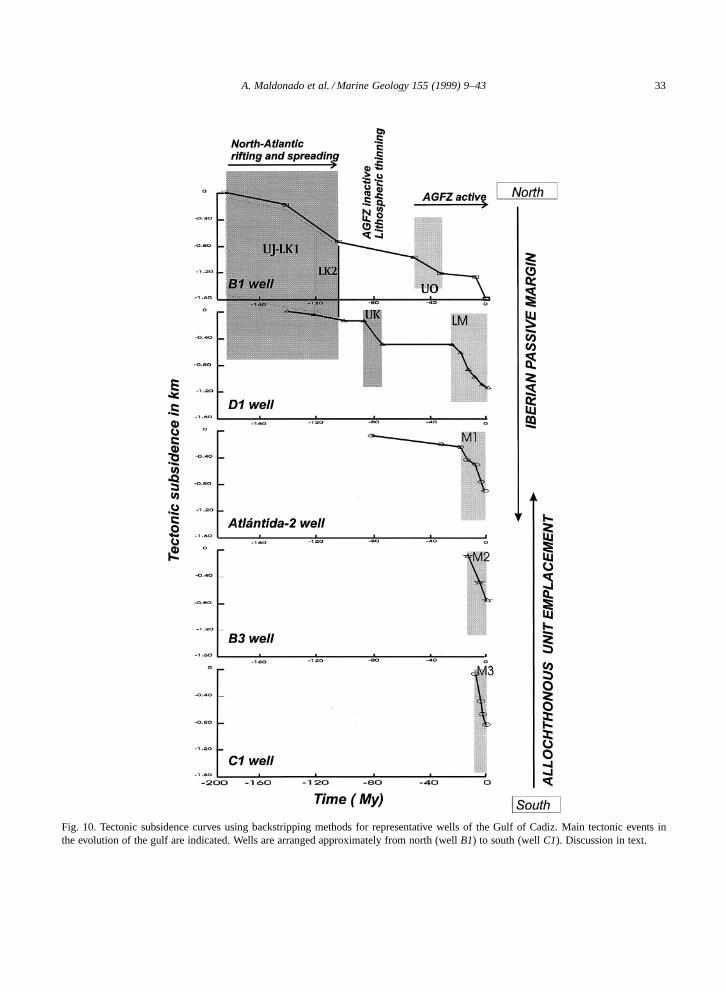
The olistostrome body was emplaced in foredeepbasins as a result of the westwards motion of theInternal Zone of the Betics (Fig. 3). Several olis-tostrome bodies may have developed as the orogenicfront progressed westwards between the Serravallianin the east to the late Tortonian in the Gulf of Cadiz(Fig. 11). The migration of these foredeep basinsprogressively closed the Betic corridor westwards.A rapid increase of basement subsidence rates inthe Gulf of Cadiz during the early Tortonian mayhave favoured the foredeep basin formation and the
A. Maldonado et al. / Marine Geology 155 (1999) 9–43 33
Fig. 10. Tectonic subsidence curves using backstripping methods for representative wells of the Gulf of Cadiz. Main tectonic events inthe evolution of the gulf are indicated. Wells are arranged approximately from north (well B1) to south (well C1). Discussion in text.
34 A. Maldonado et al. / Marine Geology 155 (1999) 9–43
Fig. 11. Interpretative cross-section of a SSE to NNW profile along the Spanish margin of the Gulf of Cadiz showing the main tectonicelements. MCS profiles used for the profile are projected over the cross-section.
emplacement of the olistostrome (Figs. 10 and 11).Younger westwards migration of the olistostromefront onto the Horseshoe and Seine plains wouldhave resulted largely from gravitational processesof the accretionary wedge in the continental margin(Fig. 13).
The olistostrome geometry in the Gulf of Cadizresembles the accretionary wedges formed at athrusting front with a rigid buttress at the rear(Figs. 11 and 13). Extensional deformation involvesboth, a back-wedge high and a dipping backstop tothe hinterland. The mechanism of underplating at thebase of the thrusting wedge also incorporates frag-ments of Mesozoic and early Cenozoic units fromthe attenuated distal margin of Iberia within the olis-tostrome body. Plastic Triassic materials from UnitTR2 were often incorporated into the olistostrome.This overthrusting and accretion in outer orogenicdomains such as the Gulf of Cadiz and Guadalquivirforedeeps was coeval with extensional deformationof the Internal Zone of the Betics, which culmi-nated in extreme thinning of the Alboran basin (cf.Maldonado, 1992). The Gibraltar crustal thrust rep-resents the boundary between the Neogene accre-tionary olistostrome wedge and the Internal Zones ofthe hinterland (Figs. 3, 13 and 14).
6.3. The late Cenozoic passive margin
Structural analysis shows the Tortonian maximumcompressional axis of the stress field in the area to beroughly NNW–SSE trending (Montenat et al., 1987;Sanz de Galdeano, 1990; Campillo et al., 1992).Sinistral NE-trending strike-slip faults were active in
the southern Iberian margin and Alboran Sea, whileprevious WSW-oriented faults were reactivated assinistral transpressive strike-slip faults (Maldonadoet al., 1992). During the Messinian, the stress fieldrotated slightly from NNW–SSE to N–S and thegeneralized compressional regime facilitated relativesea-level lowering as a result of intraplate stresses(e.g., Cloeting et al., 1992). This, together with aglobal sea-level lowering (Haq et al., 1987), resultedin the closure of the Betic and Rif straits (Campilloet al., 1992). This stress field allowed transcurrentmovements and extension in an E–W to ESE–WNWdirection.
Active subsidence in the Gulf of Cadiz facili-tated the development of thick progradational andaggradational depositional sequences over the mar-gin (Figs. 11 and 12). Large turbidite systems (UnitM3) were deposited during the Messinian in deep de-positional basins trending NE–SW along the axis ofthe Guadalquivir Valley and Gulf of Cadiz (Fig. 7).Several source areas provided significant amounts ofterrigenous materials for the development of thesesystems, mainly the Guadalquivir and Guadianarivers, but probably also other local drainage sys-tems. These turbidite systems developed as lowstandsystem tracts. A generalized erosional unconformity,which represents a sequence boundary, has beenrecognized between the lower and upper Messiniandepositional sequences.
At the end of the Messinian and during the EarlyPliocene, the stress field in the area was also roughlyoriented N–S compression (Philip, 1987), which fa-cilitated a transtensional regime and the developmentof pull-apart basins (cf. Maldonado et al., 1992).
A. Maldonado et al. / Marine Geology 155 (1999) 9–43 35
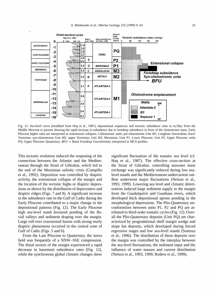
Fig. 12. Sea-level curve (modified from Haq et al., 1987), depositional sequences and tectonic subsidence rates in m=Myr from theMiddle Miocene to present showing the rapid increase in subsidence due to foredeep subsidence in front of the olistostrome mass. EarlyPliocene higher rates are interpreted as extensional collapses. Lithoseismic units: pre-olistostrome Unit M1, Langhian–Serravalian, lowerTortonian; syn-olistostrome Unit M2, upper Tortonian; Unit M3, Messinian; Unit P1, Lower Pliocene; Unit P2, Upper Pliocene; unitsPQ, Upper Pliocene–Quaternary. BFU D Basal Foredeep Unconformity interpreted in MCS profiles.
This tectonic evolution induced the reopening of theconnection between the Atlantic and the Mediter-ranean through the Strait of Gibraltar, which led tothe end of the Messinian salinity crisis (Campilloet al., 1992). Deposition was controlled by diapiricactivity, the extensional collapse of the margin andthe location of the tectonic highs or diapiric depres-sions as shown by the distribution of depocenters anddiapiric ridges (Figs. 7 and 8). A significant increasein the subsidence rate in the Gulf of Cadiz during theEarly Pliocene contributed to a major change in thedepositional patterns (Fig. 12). The Early Pliocenehigh sea-level stand favoured ponding of the flu-vial valleys and sediment draping over the margin.Large roll-over extensional basins with strong marlydiapiric phenomena occurred in the central zone ofGulf of Cadiz (Figs. 5 and 6).
From the Late Pliocene to Quaternary, the stressfield was frequently of a NNW–SSE compression.The distal sectors of the margin experienced a rapiddecrease in basement subsidence rates (Fig. 12),while the synchronous global climatic changes show
significant fluctuation of the eustatic sea level (cf.Haq et al., 1987). The effective cross-section atthe Strait of Gibraltar, controlling seawater massexchange was significantly reduced during low sea-level stands and the Mediterranean undercurrent out-flow underwent major fluctuations (Nelson et al.,1993, 1999). Lowering sea level and climatic deteri-oration induced large sediment supply to the marginfrom the Guadalquivir and Guadiana rivers, whichdeveloped thick depositional aprons ponding in themorphological depressions. The Plio-Quaternary un-conformities between units P1, P2 and PQ are at-tributed to third-order eustatic cycles (Fig. 12). Over-all the Plio-Quaternary deposits (Unit PQ) are char-acterized by progradational shelf margin wedge andslope fan deposits, which developed during forcedregressive stages and low sea-level stands (Somozaet al., 1996). The distribution of these deposits overthe margin was controlled by the interplay betweenthe sea-level fluctuations, the sediment input and theinfluence of water masses and current distribution(Nelson et al., 1993, 1999; Rodero et al., 1999).
36 A. Maldonado et al. / Marine Geology 155 (1999) 9–43
7. Regional geodynamic evolution
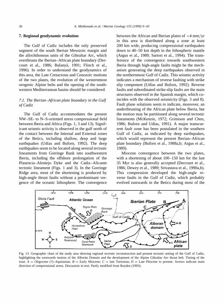
The Gulf of Cadiz includes the only preservedsegment of the south Iberian Mesozoic margin andthe allochthonous units of the Gibraltar Arc, whichoverthrusts the Iberian–African plate boundary (Der-court et al., 1986; Balanya, 1991; Flinch et al.,1996). In order to understand the geodynamics ofthis area, the Late Cretaceous and Cenozoic motionsof the two plates, the evolution of the westernmostorogenic Alpine belts and the opening of the south-western Mediterranean basins should be considered.
7.1. The Iberian–African plate boundary in the Gulfof Cadiz
The Gulf of Cadiz accommodates the presentNW–SE- to N–S-oriented stress compressional fieldbetween Iberia and Africa (Figs. 1, 3 and 13). Signif-icant seismic activity is observed in the gulf north ofthe contact between the Internal and External zonesof the Betics, including shallow, deep and largeearthquakes (Udıas and Buforn, 1992). The deepearthquakes seem to be located along several tectoniclineaments from Gorringe Bank into southwesternIberia, including the offshore prolongation of thePlasencia–Alentejo Dyke and the Cadiz–Alicantetectonic lineament (Figs. 1 and 3). In the GorringeRidge area, most of the shortening is produced byhigh-angle thrust faults without a predominant ver-gence of the oceanic lithosphere. The convergence
Fig. 13. Geographic chart of the study area showing regional tectonic reconstruction and present tectonic setting of the Gulf of Cadiz,highlighting the westwards motion of the Alboran Domain and the development of the Alpine Gibraltar Arc thrust belt. Timing of thetrust: A D Oligocene (?)–Aquitanian; B D Early Miocene; C D late Tortonian; D D Late Pliocene to present. Arrows indicate maindirection of compressional stress. Discussion in text. Partly modified from Royden (1993).
between the African and Iberian plates of <4 mm=yrin this area is distributed along a zone at least200 km wide, producing compressional earthquakesdown to 40–50 km depth in the lithospheric mantle(Argus et al., 1989; Sartori et al., 1994). The trans-ference of the convergence towards southwesternIberia through high-angle faults might be the mech-anism generating the deep earthquakes observed inthe northernmost Gulf of Cadiz. This seismic activityindicates a mechanism of reverse faulting with strikeslip component (Udıas and Buforn, 1992). Reversefaults and subordinated strike-slip faults are the mainstructures observed in the Spanish margin, which co-incides with the observed seismicity (Figs. 3 and 8).Fault plane solutions seem to indicate, moreover, anunderthrusting of the African plate below Iberia, butthe motion may be partitioned along several tectoniclineaments (McKenzie, 1972; Grimison and Chen,1986; Buforn and Udıas, 1991). A major transcur-rent fault zone has been postulated in the southernGulf of Cadiz, as indicated by deep earthquakes,which would represent the present Iberian–Africanplate boundary (Buforn et al., 1988a,b; Argus et al.,1989).
Miocene convergence between the two plates,with a shortening of about 100–150 km for the last35 Myr is also generally accepted (Dercourt et al.,1986; Dewey et al., 1989; Srivastava et al., 1990a,b).This compression developed the high-angle re-verse faults in the Gulf of Cadiz, which probablyevolved eastwards in the Betics during most of the
A. Maldonado et al. / Marine Geology 155 (1999) 9–43 37
Miocene into right-lateral strike-slip faults (cf. Sanzde Galdeano, 1990). The detailed motion along thisplate boundary is still speculative, although it isgenerally accepted that there was a N- to NNE-ori-ented, with minor variations, African plate motionin the European frame of reference between theEarly Eocene (51 Ma) and the Late Miocene (9 Ma).Since that time, it apparently changed 90º counter-clockwise to become northwesterly up to the present(Dewey et al., 1989).
7.2. The Alpine belts and the Gulf of Cadiz
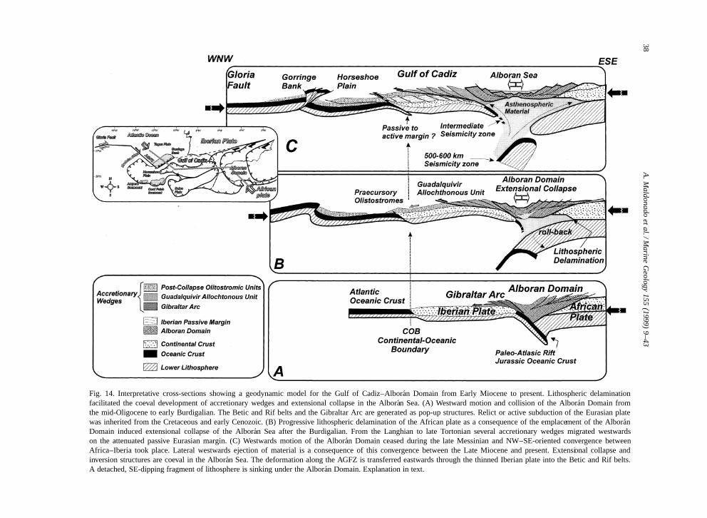
The external domain of the Gibraltar Arc in theGulf of Cadiz includes sedimentary allochthonousunits derived from the southern Iberian and northernAfrican margins of the Tethys (Garcıa-Hernandez etal., 1980; Balanya, 1991; Blankenship, 1992). Thefrontal tectono-sedimentary complexes of the Beticand Rif Cordilleras and the olistostrome constitutean accretionary wedge superposed on the Iberianpassive margin in the northern Gulf of Cadiz andover the Iberian–African boundary in the centralGulf of Cadiz. The structure of the accretionarywedge consists of frontal imbricated ridges, thrustsand low-angle extensional detachments (Fig. 11).Flinch et al. (1996) proposed that Triassic evaporiteswere originally emplaced as gravitational evaporitemasses in the Betic passive margin setting during theLate Cretaceous–Paleogene. These evaporites werelater overthrusted during the Neogene as part ofthe Gulf of Cadiz olistostrome. The seismic profilesand well data indicate that rapid extensional col-lapse affected the accretionary wedge in the Gulf ofCadiz during the late Messinian and the Pliocene,giving rise to major roll-over structures and the high-est rates of basin subsidence (Figs. 11 and 12).The extensional collapse may also have influencedthe westwards migration of the accretionary wedgetowards the oceanic crust of the Horseshoe Plain(Figs. 13 and 14).
The arcuate geometry of the arc, the causes ofextension in the backarc Alboran basin within a col-lision zone and the westward arc migration havebeen explained by several models. Following the ear-liest geological interpretations of the Betic and RifCordilleras, the Internal domain, independent fromAfrica and Iberia, was assigned to a block or mi-
croplate located in the eastern Tethys before collision(Andrieux et al., 1971). The indentation of this arcu-ate block with the Iberian and African blocks, wouldhave developed the curvature of the Gibraltar Arc(Andrieux et al., 1971; Bouillin et al., 1986; Sanzde Galdeano, 1990). Other authors, in contrast, haveemphasized the role of anomalous mantle diapirismand static extensional collapse (Dewey, 1988; Plattand Vissers, 1989; Doblas and Oyarzun, 1989; Wei-jermars, 1991; Platzman, 1992). Another model im-plies the delamination of a thickened continentalmantle lithosphere and the roll-back of the ‘subduc-tion’ hinge (Frizon de Lamotte et al., 1991; Gar-cıa-Duenas et al., 1992; Morley, 1992; Docherty andBanda, 1995; Seber et al., 1996a). Royden (1993)suggests that westwards motion of the Gibraltar Arcsince the Oligocene was the consequence of thewestwards retreat of an E-dipping subduction bound-ary from the Alboran Sea into the Gulf of Cadiz(Fig. 13). Westwards lateral ejection of material outof the primary plate boundary as a consequence ofN–S-directed convergence may have facilitated thewestwards migration of the Gibraltar Arc and theopening of the backarc Alboran basin (Maldonado etal., 1992). The Ampere Seamount and Coral PatchSeamount show reverse-thrust faults with prevailingnorthwards vergence towards the Horseshoe Plain(Sartori et al., 1994). This area exhibits high-anglefaults in the sedimentary cover and low-angle faultsin the oceanic basement. Thus, the Horseshoe Plainmay represent the accretionary wedge overthrustingoceanic crust at present (Figs. 3 and 13).
7.3. A geodynamic model for the Gulf of Cadiz
A significant aspect of the recent seismicity inthe Alboran Domain is the distribution of a largeconcentration of intermediate (50–150 km) and deep(640 km) earthquakes in a N–S arcuate segment ofthe western Alboran Sea (Figs. 1 and 3). The com-pressional axis of the deep earthquake mechanismsplunges eastwards, while most Mediterranean deepearthquakes show northwestwards or westwards dips(Udıas and Buforn, 1992). The seismic sources mayrepresent the contact between the Alboran Domain,the African and Iberian lithospheres. In this regards,the crustal thickness of 31 km under the eastern Gulfof Cadiz, near the Gibraltar Arc is attributed to the
38A
.Maldonado
etal./M
arineG
eology155
(1999)9–43
Fig. 14. Interpretative cross-sections showing a geodynamic model for the Gulf of Cadiz–Alboran Domain from Early Miocene to present. Lithospheric delaminationfacilitated the coeval development of accretionary wedges and extensional collapse in the Alboran Sea. (A) Westward motion and collision of the Alboran Domain fromthe mid-Oligocene to early Burdigalian. The Betic and Rif belts and the Gibraltar Arc are generated as pop-up structures. Relict or active subduction of the Eurasian platewas inherited from the Cretaceous and early Cenozoic. (B) Progressive lithospheric delamination of the African plate as a consequence of the emplacement of the AlboranDomain induced extensional collapse of the Alboran Sea after the Burdigalian. From the Langhian to late Tortonian several accretionary wedges migrated westwardson the attenuated passive Eurasian margin. (C) Westwards motion of the Alboran Domain ceased during the late Messinian and NW–SE-oriented convergence betweenAfrica–Iberia took place. Lateral westwards ejection of material is a consequence of this convergence between the Late Miocene and present. Extensional collapse andinversion structures are coeval in the Alboran Sea. The deformation along the AGFZ is transferred eastwards through the thinned Iberian plate into the Betic and Rif belts.A detached, SE-dipping fragment of lithosphere is sinking under the Alboran Domain. Explanation in text.

A. Maldonado et al. / Marine Geology 155 (1999) 9–43 39
Eurasian Hercynian crust, whereas the 25 km thick-ness observed just eastwards of the arc may struc-turally represent the Alboran Domain (Medialdea etal., 1986). Tomographic images of the upper mantlein the Alboran Domain show, in addition, a regionof anomalous positive seismic velocity (Blanco andSpakman, 1993; Seber et al., 1996b). The isolatedseismic source at 640 km depth and the anomalousvelocity distribution have been attributed to a frag-ment of subducted lithosphere detached from thesurface (Blanco and Spakman, 1993; Seber et al.,1996b).
We speculate that the sinking fragment may cor-respond to a portion of the Jurassic thinned and prob-ably oceanic lithosphere developed during the Tethysdrifting episode and that was slowly subducted in thearea of the Alboran Domain, probably beginning inthe Eocene as Iberia became an independent plate(Fig. 14). When the N–S- to NNW–SSE-orientedmotion between Iberia and Africa generated conti-nental collision during the Middle Miocene, exten-sion in the Alboran Sea and migration of the arcuatemountain front towards the Gulf of Cadiz could beattributed to a mechanism of collision-induced de-lamination of the continental mantle lithosphere (cf.Docherty and Banda, 1995; Seber et al., 1996a). TheMiocene subduction would have been preceded bythe delamination process of asymmetric, thickenedlithospheric mantle, similar to the mechanism pro-posed for the Tyrrhenian Basin–Calabrian Arc byChannel and Mareschal (1989). From the Mioceneto recent, the Tethys lithosphere would have becomedelaminated from the thick continental lithosphereand subducted deeper in the mantle, generating the¾600 km deep seismicity observed in the westernAlboran Domain.
We propose that transpression in the Gulf ofCadiz was initiated at chron 18, when Iberia be-came an independent plate and the relative motionof Africa was N to NE directed (Fig. 9). Most ofthe Tethys gap in the area was probably obliteratedbetween chron 18 and chron 6c, when Iberia wasan independent plate and the Alboran Domain wasemplaced westward over the African–Iberian suture(Figs. 9 and 14). In contrast to the Betic–Rif belts,there is no geophysical evidence to postulate thatcontinental collision took place in the Gulf of Cadiz.The continental crust decreases steadily in thickness
from the Iberian Peninsula, while there is a signifi-cant increase in sediment thickness towards the Gulfof Cadiz (Medialdea et al., 1986). The lithospherethickness, in addition, is thinner in the Gulf of Cadizthan in the continental margin off Morocco (Muellerand Kahle, 1993; Seber et al., 1996b). The eastwardsdip of the deep earthquake mechanisms attributed tothe delaminated lithosphere suggest that the initialsubduction may has been of the Iberian Tethys crustbelow Africa, while the present dynamics in the Gulfof Cadiz indicate underthrusting of the African platebelow Iberia (Fig. 14).
8. Conclusions
The deposits of the Gulf of Cadiz Iberian marginhave recorded the complex geodynamic evolutionof the Iberian–African boundary. Extensional pro-cesses involving rifting and spreading took placefrom the Triassic breakup of Pangea until the LateCretaceous as a consequence of transtensional move-ments between the Eurasian and African plates. Thewestwards propagation of the Tethys rift and sea-floor spreading created an E–W-trending, probablyoceanic, seaway between Iberia and Africa.
Ocean-spreading in the North Atlantic inducedadditional extensional tectonics in the Gulf of Cadiz,which deformed the syn-tectonic post-Aptian de-posits. Half-graben structures became reactivated.There was a modification in the depositional styleduring the Late Cretaceous, maybe in response tothe change in the tectonic regime due to the shift-ing of the AGFZ boundary between Eurasia andAfrica to the Bay of Biscay, when Iberia became at-tached to Africa (Fig. 9). The volcanic intrusions ofsouthern Portugal indicate thinning of the crust andextensional faults along ancient Hercynian fractures.Tectonically induced, basement subsidence curvesshow a strong increase in subsidence between 90 and70 Ma (Fig. 10).
Iberia became an independent plate at chron 18(Srivastava et al., 1990a,b). The relative motion be-tween Africa and the Gulf of Cadiz was small be-tween chrons 18 and 13, but since then a signifi-cant amount of shortening has occurred in the area(Fig. 9). Transpression and subduction of the Tethysthinned crust, probably in a southward direction be-
40 A. Maldonado et al. / Marine Geology 155 (1999) 9–43
low Africa is suggested by the distribution of deepearthquakes. Between the mid-Oligocene and LateMiocene, the Gulf of Cadiz experienced about 200km of N–S convergence. The orogenic front of theGibraltar Arc migrated westwards and reached theeastern Gulf of Cadiz, while an olistotrome wasemplaced. The end of this tectonic phase probablycoincided with the end of subduction in the central-southern Gulf of Cadiz.
Thermal subsidence accelerated during the LateMiocene, followed by extensional collapse duringthe Early Pliocene (Fig. 12). The approximately 50km of NW–SE-directed oblique convergence in theGulf of Cadiz since the Late Miocene to recentwas also accompanied by a change in the tectonicregime. A northwards shift in the vergence of theIberian–Africa boundary is assumed, since the recentearthquake mechanisms indicate overthrusting of theAfrican plate by Iberia (Fig. 14). The dominant tec-tonic regime at present, however, is characterized bymoderate tectonic subsidence and local transpressivetectonics.
Acknowledgements
We acknowledge the cooperation of Captain, of-ficers and crew of the B=O Hesperides during theHE-91-3 cruise. We are indebted to Drs. CecilioQuesada and Jesus Galindo-Zaldivar for helpful sug-gestions which improved the interpretation discussedin the manuscript. We also thank Jesus Rodero andLaura Perez of the ‘Instituto Andaluz de Ciencias dela Tierra’ for discussions and help with the figures.The initial funding for this study was provided bythe Joint Committee of Science and Technology ofthe U.S. Spain Treaty of Friendship (Project CCA8309=47). Financial support was also provided by‘Comision Interministerial de Ciencia y Tecnologıa’(CICYT) of Spain by an ‘Accion Especial’. Thisstudy was finalized within the framework of a JointProject no 125=94 of the ITGE=CSIC.
References
Andrieux, J., Fontbote, J., Mattauer, M., 1971. Sur un modeleexplicatif de l’Arc de Gibraltar. Earth Planet. Sci. Lett. 12,
191–198.Antunes, M.H.T., Civis, J., Pais, C.J., Sierro, F.J., Gonzalez-Del-
gado, J.A., Flores, J.A., Valle, M.F., 1990. El Neogeno delAlgarve (Portugal) y de la Cuenca del Guadalquivir (Espana).Actas Paleontol. (Univ. Salamanca) 68, 65–73.
Argus, D.F., Gordon, R.G., Demets, C., Stein, S., 1989. Closureof the Africa–Eurasia–North America plate motion circuit andtectonics of the Gloria fault. J. Geophys. Res. 94, 5585–5602.
Balanya, J.C., 1991. Estructura del dominio de Alboran en laparte norte del arco de Gibraltar. Ph.D. Thesis, Univ. Granada,210 pp.
Balanya, J.C., Garcıa-Duenas, V., 1987. Les directions struc-turales dans le Domaine d’Alboran de part et d’autre duDetroit de Gibraltar. C. R. Acad. Sci. 304 (II), 929–933.
Blanco, M.J., Spakman, W., 1993. The P-wave velocity structureof the mantle below the Iberian Peninsula: evidence for sub-ducted lithosphere below southern Spain. Tectonophysics 221,13–34.
Blankenship, C.L., 1992. Structure and palaeogeography of theExternal Betic Cordillera, southern Spain. Mar. Pet. Geol. 9,256–264.
Boillot, G., Mougenot, D., Girardeau, J., Winterer, E.L., 1989.Rifting processes on the West Galicia Margin, Spain. In:Tankard, A.J., Balkwill, H.R. (Eds.), Extensional Tectonicsand Stratigraphy of the North Atlantic Margins. Am. Assoc.Pet. Geol. and Can. Geol. Found. AAPG Mem. 46, 363–378.
Boski, T., Moura, D., 1994. The Neogene and Quaternary stratig-raphy in Central Algarve. A critical review and new proposals.1 Simposio sobre la Margen Continental Iberica Atlantica, pp.7–8 (abstract).
Bouillin, J.P., Durand-Delga, M., Olivier, P., 1986. Betic–Rifianand Tyrrhenian Arcs: Distinctive features, genesis, and de-velopment stages. In: Wezel, F.C. (Ed.), The Origin of Arcs.Elsevier, Amsterdam, Vol. 21, pp. 281–304.
Buforn, E., Udıas, A., 1991. Focal mechanism of earthquakes inthe Gulf of Cadiz, south Spain and Alboran Sea. In: Mezcua,J., Udıas, A. (Eds.), Seismicity, Seismotectonics and SeismicRisk of the Ibero–Maghrebian Region. Instituto GeograficoNacional, Madrid, pp. 29–40.
Buforn, E., Udıas, A., Colombas, M.A., 1988a. Seismicity,source mechanisms and tectonics of the Azores–Gibraltarplate boundary. Tectonophysics 152, 89–118.
Buforn, E., Udıas, A., Mezcua, J., 1988b. Seismicity and focalmechanisms in south Spain. Bull. Seismol. Soc. Am. 78,2008–2024.
Cachao, M., Silva, C.M., 1992. Neogene palaeogeographic evo-lution of Algarve basin (Southern Portugal): a two step model.Preliminary data. GAIA Spec. Vol. 4, 39–42.
Campillo, A., Maldonado, A., Mauffret, A., 1992. Stratigraphicand tectonic evolution of the western Alboran Sea: LateMiocene to recent. Geo-Mar. Lett. 12, 165–172.
Cloeting, S., van der Beek, P.A., van Rees, D., Roep, T.B.,Biermann, C., Stephenson, R.A., 1992. Flexural Interactionand the dynamics of Neogene extensional basin formation inthe Alboran–Betic region. Geo-Mar. Lett. 12, 66–75.
Comas, M.C., Garcıa Duenas, V., Jurado, M.J., 1992. Neogene
A. Maldonado et al. / Marine Geology 155 (1999) 9–43 41
tectonic evolution of the Alboran Sea from MCS data. Geo-Mar. Lett. 12, 157–164.
Channel, J.E.T., Mareschal, J.C., 1989. Delamination and asym-metric lithospheric thickening in the development of theTyrrhenian Rift. In: Coward, M. (Ed.), Alpine Tectonics. Spec.Publ. Geol. Soc. London 45, 285–300.
De Jong, K., 1991. Tectono-metamorphic studies and radiometricdating in the Betic Cordilleras (SE Spain) with implicationsfor the dynamics of extension and compression in westernMediterranean area. Ph.D. Thesis, Vrije Univ., Amsterdam,204 pp.
Delaplanche, J., Lafet, Y., Sineriz, B.G., Remon Gil, M.A., 1982.Seismic reflection applied to sedimentology and gas discoveryin the Gulf of Cadiz. Geophys. Prospect. 30, 1–24.
Dercourt, J., Zonenshain, L.P., Ricou, L.E., Zazmin, V.G., LePichon, X., Knipper, A.L., Grandjacquet, C., Shotshickov,I.M., Geyssant, J., Lepvrier, C., Perchersky, D.H., Boulin,J., Sibuet, J.C., Savostin, L.A., Sorokthin, O., Westphal, M.,Bazhenov, M.L., Lauer, J.P., Bijou Duval, B., 1986. Geologicalevolution of the Tethys belt from the Atlantic to the Pamirssince the Lias. Tectonophysics 123, 265–283.
Dewey, J.F., 1988. Extensional collapse of orogens. Tectonics 7,1123–1139.
Dewey, J.F., Helman, M.L., Turco, E., Hutton, D.H.W., Knott,S.D., 1989. Kinematics of the western Mediterranean. In:Coward, M. (Ed.), Alpine Tectonics. Spec. Publ. Geol. Soc.London 45, 265–283.
Doblas, M., Oyarzun, R., 1989. Neogene extensional collapsein the western Mediterranean (Betic–Rif Alpine belt): Impli-cations for the genesis of the Gibraltar Arc and magmaticactivity. Geology 17, 430–433.
Docherty, C., Banda, E., 1995. Evidence for the eastward migra-tion of the Alboran Sea based on regional subsidence analysis:A case for basin formation by delamination of the subcrustallithosphere? Tectonics 14 (4), 804–818.
Feraud, G., York, D., Mevel, C., Cornen, G., Hall, C.M.,Auzende, J.M., 1986. Additional 40Ar=39Ar dating of the base-ment and the alkaline volcanism of Gorringe Bank (AtlanticOcean). Earth Planet. Sci. Lett. 79, 255–269.
Flinch, J.A., Bally, A.W., Wu, S., 1996. Emplacement of apassive-margin evaporitic allochthon in the Betic Cordillera ofSpain. Geology 24 (1), 67–70.
Frizon de Lamotte, D., Andrieux, J., Guezou, J.C., 1991. Cine-matique des chevauchements neogenes dans l’Arc betico–rifain: discussion sur les modeles geodynamiques. Bull. Soc.Geol. Fr. 162, 611–626.
Galindo-Zaldıvar, J., Gonzalez-Lodeiro, F., Jabaloy, A., 1993.Stress and palaeostress in the Betic–Rif cordilleras (Mioceneto present). Tectonophysics 227, 105–126.
Garcıa-Duenas, V., Balanya, J.C., Martınez-Martınez, J.M., 1992.Miocene extensional detachments in the outcropping basementof the northern Alboran Basin (Betics) and their tectonicimplications. Geo-Mar. Lett. 12, 88–95.
Garcıa-Hernandez, M., Lopez-Garrido, A.C., Rivas, P., Sanz deGaldeano, C., Vera, J.A., 1980. Mesozoic palaeogeographicevolution of the External Zones of the Betic Cordillera. Geol.Mijnbouw 59, 155–168.
Garcıa-Mondejar, J., 1989. Strike-Slip subsidence of the Basque-Cantabrian basin of Northern Spain and its relationship toAptian–Albian opening of Bay of Biscay. In: Tankard, A.J.,Balkwill, H.R. (Eds.), Extensional Tectonics and Stratigraphyof the North Atlantic Margins. Am. Assoc. Pet. Geol. and Can.Geol. Found. AAPG Mem. 46, 395–411.
Garcıa-Navarro, E., Fernandez Rodrıguez, C., Castro, A., 1994.The volcanics of Ayamonte at the Atlantic margin of Huelva.GAIA Spec. Vol. 9, 99–102.
Geel, T., Roep, T.B., Ten Kate, W., Smit, J., 1990. Early–middle Miocene stratigraphic turning points in the AlicanteRegion (SE Spain): Reflections of western Mediterranean platetectonic reorganizations. Sediment. Geol. 75, 223–239.
Goy, J.L., Zazo, C., Silva, P.G., Lario, J., Bardajı, T., Somoza,L., 1995. Evaluacion geomorfologica del comportamiento neo-tectonico del Estrecho de Gibraltar (Zona Norte) durante elCuaternario. IV Coloquio Internacional sobre el Enlace Fijodel Estrecho de Gibraltar, Sevilla, pp. 111–122.
Grimison, N.L., Chen, W.P., 1986. The Azores–Gibraltar plateboundary: focal mechanisms, depths of earthquakes and theirtectonic implications. J. Geophys. Res. 91, 2029–2047.
Haq, B.U., Hardenbol, J., Vail, P.R., 1987. Chronology of fluctu-ating sea-levels since the Triassic. Science 235, 1156–1167.
Hayes, D.E., Pimm, A.C. et al., 1972. Init. Rep. DSDP XIV, 975pp.
Heymann, M.A.W., 1989. Tectonic and depositional history ofthe Moroccan continental margin. In: Tankard, A.J., Balkwill,H.R. (Eds.), Extensional Tectonics and Stratigraphy of theNorthern Atlantic Margins. Am. Assoc. Pet. Geol. and Can.Geol. Found. AAPG Mem. 46, 323–340.
Horvath, F., Berckhemer, H., 1982. Mediterranean back-arcbasins. In: Berckhemer, H., Hsu, K. (Eds.), Alpine Mediter-ranean Geodynamics. Am. Geophys. Union 7, 141–173.
IGME, 1987. Contribucion de la exploracion petrolıfera alconocimiento de la Geologıa de Espana. Instituto GeologicoMinero de Espana, Madrid, 465 pp.
ITGE, 1998. Mapa geologico de la plataforma continental es-panola y zonas adyacentes. E. 1:200.000. Memoria y Hoja No.86 y 86E. Golfo de Cadiz. Instituto Tecnologico Geominerode Espana, Madrid (in litt.).
Jabaloy, A., Galindo-Zaldıvar, J., Gonzalez-Lodeiro, F., 1992.The Mecina extensional system: its relation with the Post-Aquitanian piggy-back basins and the palaeostresses evolution(Betic Cordilleras, Spain). Geo-Mar. Lett. 12, 96–103.
Keen, C.E., Loncaravic, B.D., Reid, I., Woodside, J., Haworth,R.T., Williams, H., 1990. Tectonic and geophysical overview.In: Keen, M.J., Williams, G.L. (Eds.), Geology of the Conti-nental Margin of Eastern Canada, Geology of Canada. Geo-logical Survey of Canada, Ottawa, Vol. 2, pp. 31–85.
Klitgord, K.D., Schouten, H., 1986. Plate kinematics of the Cen-tral Atlantic. In: Vog, P.R., Tucholke, B.E. (Eds.), The WesternNorth Atlantic Region. (The Geology of North America, Vol.M.) Geol. Soc. Am., Boulder, CO, pp. 351–377.
Lajat, D., Biju-Duval, B., Gonnard, R., Letouzey, J., Winnock,E., 1975. Prolongement dans l’Atlantique de la partie externede l’Arc betico-rifain. Bull. Soc. Geol. Fr. 17, 481–485.
Lister, G.S., Etheridge, M.A., Symonds, P.A., 1991. Detachment
42 A. Maldonado et al. / Marine Geology 155 (1999) 9–43
models for the formation of passive continental margins. Tec-tonics 10 (5), 1038–1064.
Maldonado, A. (Ed.), 1992. Alboran Sea. Geo-Mar. Lett. Spec.Iss. 12, 61–186.
Maldonado, A., Baraza, J., Checa, A., Nelson, C.H., Barber,J.H., Hampton, M.H., Kayen, R.E., Lee, H.J., 1989. Tectonicframework, pattern of sedimentation, and potential environ-mental problems of the Cadiz Continental Margin, Spain. 28thInt. Geol. Congr., Washington, 2–3, 2–356.
Maldonado, A., Campillo, A.C., Mauffret, A., Alonso, B., Wood-side, J., Campos, J., 1992. Alboran Sea Late Cenozoic tectonicand stratigraphic evolution. Geo-Mar. Lett. 12, 179–186.
Malod, J.A., 1982. Comparaison de l’evolution des marges con-tinentales au nord et au sud de la Peninsule Iberique. Ph.D.Thesis, Univ. Pierre et Marie Curie, 235 pp.
Malod, J.A., Mougenot, D., 1979. L’historie geologique neogenedu golfe de Cadix. Bull. Soc. Geol. Fr. 21, 603–611.
Martınez del Olmo, W., Garcıa Gallo, J., Leret, G., Serrano,A., Suarez, J., 1984. Modelo Tectosedimentario del BajoGuadalquivir. I Congr. Esp. Geologıa, Segovia, pp. 199–213.
Mauffret, A., Mougenot, D., Miles, P.R., Malod, J.A., 1989.Results from Multichannel Reflection Profiling of the TagusAbyssal Plain (Portugal). Comparison with the Canadian Mar-gin. In: Tankard, A.J., Balkwill, H.R. (Eds.), Extensional Tec-tonics and Stratigraphy of the Northern Atlantic Margins. Am.Assoc. Pet. Geol. and Can. Geol. Found. AAPG Mem. 46,379–393.
Mauffret, A., Pascal, G., Maillard, A., Gorini, C., 1995. Tectonicsand deep structure of the north-western Mediterranean Basin.Mar. Pet. Geol. 12, 645–666.
McKenzie, D.P., 1972. Active tectonics of the Mediterraneanregion. Geophys. J. Astron. Soc. 30, 109–185.
Medialdea, T., Surinach, E., Vegas, R., Banda, E., Ansorge, J.,1986. Crustal structure under the western end of the Beticcordillera (Spain). Ann. Geophys. 4, 457–464.
Monie, P., Galindo-Zaldıvar, J., Gonzalez-Lodeiro, F., Goffe, B.,Jabaloy, A., 1991. First report on 40Ar=39Ar geochronology ofAlpine tectonics in the Betic Cordilleras (southern Spain). J.Geol. Soc. London 148, 289–297.
Montenat, C., Ott d’Estevou, P., Masse, P., 1987. Tectonic sedi-mentary characters of the Betic Neogene basins evolving in acrustal transcurrent shear zone (SE Spain). Bull. Cent. Rech.Explor. Prod. Elf-Aquitaine 11 (1), 1–22.
Morley, C.J., 1992. Notes on Neogene basin history of theWestern Alboran Sea and its implications for the tectonicevolution of the Rif–Betic orogenic belt. J. Afr. Earth Sci. 14,57–66.
Mougenot, D., 1988. Geologie de la marge Portugaise. Ph.D.Thesis, Univ. Pierre et Marie Curie, 155 pp.
Mueller, S., Kahle, H.G., 1993. Crust–mantle evolution, structureand dynamics of the Mediterranean–Alpine region. In: Smith,D.E., Turcotte, D.L. (Eds.), Contributions of Space Geodesyto Geodynamics: Crustal Dynamics. Am. Geophys. Union 23,249–298.
Nelson, C.H., Baraza, J., Maldonado, A., Rodero, J., Escutia, C.,Barber, J., 1999. Influence of the Atlantic inflow and Mediter-
ranean outflow currents on Late Quaternary sedimentary faciesof Gulf of Cadiz continental margin. Mar. Geol. 155, 99–129.
Nelson, C.H., Baraza, J., Maldonado, A., 1993. Mediterraneanundercurrent sandy contourites, Gulf of Cadiz, Spain. Sedi-ment. Geol. 82, 103–131.
Pallares, L., Aldaya, F., Maldonado, A., 1995. Tectonics of theGulf of Cadiz and the western end of the MediterraneanAlpine Belts. Rapp. Comm. Int. Mer Medit. 34, 114.
Philip, H., 1987. Plio-Quaternary evolution of the stress fieldin Mediterranean zones of subduction and collision. Ann.Geophys. 5B, 301–320.
Platt, J.P., Vissers, R.L.M., 1989. Extensional collapse of thick-ened continental lithosphere: A working hypothesis for theAlboran Sea and Gibraltar arc. Geology 17, 540–543.
Platzman, E.S., 1992. Paleomagnetic rotations and the kinematicsof the Gibraltar arc. Geology 20, 311–314.
Rehault, J.P., Boillot, G., Mauffret, A., 1984. The westernMediterranean basin, geological evolution. Mar. Geol. 55,447–477.
Riaza, C., Martınez del Olmo, W., 1996. Depositional model ofthe Guadalquivir–Gulf of Cadiz Tertiary basin. In: Friend, P.F.,Dabrio, C.J. (Eds.), Tertiary Basins of Spain. The StratigraphicRecord of Crustal Kinematics. (World and Regional Geology,6.) Cambridge Univ. Press, Cambridge, pp. 330–338.
Roberts, D.G., 1970. The Rif–Betic orogen in the Gulf of Cadiz.Mar. Geol. 9, 31–37.
Rodero, J., Pallares, L., Maldonado, A., 1999. Late Quaternaryseismic facies of the Gulf of Cadiz Spanish margin: deposi-tional processes influenced by sea-level change and tectoniccontrols (Central North-Atlantic). Mar. Geol. 155, 131–156.
Roest, W.R., Srivastava, S.P., 1991. Kinematics of the plateboundaries between Eurasia, Iberia and Africa in the NorthAtlantic from the Late Cretaceous to the present. Geology 19,613–616.
Royden, H.L., 1993. Evolution of retreating subduction bound-aries formed during continental collision. Tectonics 12, 629–638.
Ryan, W.B.F., Hsu, K.J. et al., 1973. Init. Rep. DSDP XIII, 514pp.
Sanz de Galdeano, C., 1990. Geologic evolution of the BeticCordilleras in the Western Mediterranean, Miocene to present.Tectonophysics 172, 107–119.
Sanz de Galdeano, C., Vera, J.A., 1992. Stratigraphic recordand palaeogeographic context of Neogene basins in the BeticCordillera, Spain. Basin Res. 4, 21–36.
Sartori, R., Torelli, L., Zitellini, N., Peis, D., Lodolo, E., 1994.Eastern segment of the Azores–Gibraltar line (central easternAtlantic): An oceanic plate boundary with diffuse compres-sional deformation. Geology 22, 555–558.
Seber, D., Barazangi, M., Ibenbrahim, A., Demnati, A., 1996a.Geophysical evidence for lithospheric delamination beneaththe Alboran Sea and Rif–Betic mountains. Nature 379, 785–790.
Seber, D., Barazangi, M., Tadili, B.A., Ramdani, M., Iben-brahim, A., Ben-Sari, D., 1996b. Three-dimensional uppermantle structure beneath the intraplate Atlas and interplate Rifmountains of Morocco. J. Geophys. Res. 101, 3125–3138.
A. Maldonado et al. / Marine Geology 155 (1999) 9–43 43
Sierro, F.J., Gonzalez-Delgado, J.A., Dabrio, C.J., Flores, J.A.,Civis, J., 1996. Late Neogene depositional sequences in theforeland basin of Guadalquivir (SW Spain). In: Friend, P.F.,Dabrio, C.J. (Eds.), Tertiary Basins of Spain. The StratigraphicRecord of Crustal Kinematics. (World and Regional Geology,6.) Cambridge Univ. Press, Cambridge, pp. 339–345.
Somoza, L., Hernandez-Molina, F.J., Lobo, F., Andres, J.R.,1996. Modelo de estratigrafıa secuencial de alta resolucionde la plataforma continental espanola del Golfo de Cadiz.Geogaceta Soc. Geol. Esp. 20 (1), 130–133.
Srivastava, S.P., Roest, W.R., Kovacs, L.C., Oakey, G., Levesque,S., Verhoef, J., Macnab, R., 1990a. Motion of Iberia sincethe Late Jurassic: results from detailed aeromagnetic measure-ments in the Newfoundland Basin. Tectonophysics 184, 229–260.
Srivastava, S.P., Schouten, H., Roest, W.R., Klitgord, K.D., Ko-vacs, L.C., Verhoef, J., Macnab, R., 1990b. Iberian plate kine-matics: a jumping plate boundary between Eurasia and Africa.Nature 344, 756–759.
Stam, B., Gradstein, P., Lloyd, P., Gillis, D., 1987. Algorithmsfor porosity and subsidence history. Comput. Geosci. 13, 317–349.
Steckler, M.S., Watts, A.B., 1978. Subsidence of the Atlantic-type continental margin off New York. Earth Planet. Sci. Lett.41, 1–13.
Tankard, A.J., Balkwill, H.R., 1989. Extensional tectonics and
stratigraphy of the North Atlantic margins. AAPG Mem. 46,641.
Udıas, A., Buforn, E., 1992. Sismicidad y sismotectonica de lasBeticas. Fıs. Tierra 4, 109–123.
Vera, J.A., 1988. Evolucion de los sistemas de deposito en elmargen Iberico de las Cordilleras Beticas. Rev. Soc. Geol.Esp. 1, 373–391.
Watts, A.B., Platt, J.P., Buhl, P., 1993. Tectonic evolution of theAlboran basin. Basin Res. 5, 153–177.
Weijermars, R., 1991. Geology and tectonics of the Betic Zone,SE Spain. Earth Sci. Rev. 31, 153–236.
Westaway, R., 1990. Present-day kinematics of the plate bound-ary zone between Africa and Europe, from the Azores to theAegean. Earth Planet. Sci. Lett. 96, 393–406.
Wilson, R.C.L., Hiscott, R.N., Willis, M.G., Gradstein, F.M.,1989. The Lusitanian Basin of West-Central Portugal: Meso-zoic and Tertiary Tectonic, Stratigraphy, and Subsidence His-tory. In: Tankard, A.J., Balkwill, H.R. (Eds.), ExtensionalTectonics and Stratigraphy of the North Atlantic Margins. Am.Assoc. Pet. Geol. and Can. Geol. Found. AAPG Mem. 46,341–363.
Ziegler, P.A., 1989. Evolution of the North Atlantic — Anoverview. In: Tankard, A.J., Balkwill, H.R. (Eds.), ExtensionalTectonics and Stratigraphy of the North Atlantic Margins. Am.Assoc. Pet. Geol. and Can. Geol. Found. AAPG Mem. 46,111–130.