Embed Size (px)
Citation preview

r I Forest Service
The Alaska Vegetation I
Pacific Northwest Research Station Classification General Technical Report PNW-GTR-286 July 1992
~~ ~
L.A. Viereck, C.T. Dyrness, A.R. Batten, @ and K.J. Wenzlick

Authors
I
L.A. VIERECK is a principal plant ecologist, C.T. DYRNESS was a research soil scientist (now retired), and K.J. WENZLICK was a secretary (currently is an editorial assistant, Research Information Services, Portland, Oregon 97208), Institute
A.R. BATTEN is research associate at University of Alaska Museum, Fairbanks, of Northern Forestty, 308 Tanana Drive, Fairbanks, Alaska 99775-5500; and
Alaska 99775-1200.

Abstract Viereck, L.A.; Dyrness, C.T.; Batten, A.R.; Wenzlick, K.J. 1992. The Alaska vegetation classification. Gen. Tech. Rep. PNW-GTR-286. Portland, OR: U.S. Department of Agriculture, Forest Service, Pacific Northwest Research Station 278 p.
The Alaska vegetation classification presented here is a comprehensive, statewide system that has been under development since 1976. The classification is based, as much as possible, on the characteristics of the vegetation itself and is designed to categorize existing vegetation, not potential vegetation. A hierarchical system with five levels of resolution is used for classifying Alaska vegetation. The system, an agglomerative one, starts with 888 known Alaska plant communities, which are listed and referenced. At the broadest level of resolution, the system contains three formations-forest, scrub, and herbaceous vegetation. In addition to the classification, this report contains a key to levels I, 11, and 111; complete descriptions of all level IV units; and a glossary of terms used.
Keywords: Vegetation, classification, Alaska, tundra, boreal forest, coastal forest, plant communities.

Contents 1 3 4 4 4 5 6 6 6 7 7 8 10 12 15 55 55 107 158 21 2 21 3 243 243 254
Introduction General Description of the Classification System Naming the Plant Communities Review of Vegetatlon Classificatlon Work in Alaska Southeast Alaska Aleutian Islands South-Central Alaska Southwest Alaska Northwest Alaska Arctic Alaska Interior Alaska Entire State of Alaska The Classiflcatlon System Key to Levels I, II, and 111 of the Alaska Vegetation Classlfkatlon Classification Table Descriptions of Level I, I I , 111, and IV Types I . Forest II. Scrub 111. Herbaceous Acknowledgments References Appendix Species list Glossary

Introduction The first draft of this classification system was produced at the Alaskan Rangeland Workshop in Anchorage in February 1976. It was a rudimentary effort with four levels of resolution. Improvements were made, and a revision was sent out for review in June 1976. Members of the committee that worked on these early drafts were William Gabriel (Bureau of Land Management, Anchorage), Samuel Rieger (Soil Conservation Service, Anchorage), David Murray (University of Alaska Fairbanks), and Leslie A. Viereck and C. Theodore Dyrness (Institute of Northern Forestry, Fairbanks). There was considerable statewide interest in the effort, and several suggestions for improve- ments in the system were received. In 1977, Murray and Batten (1977) produced an unpublished provisional classification of tundra communities in Alaska: Batten also reviewed many vegetation descriptions and determined the synonymy of many vege- tation types. Their work was incorporated into a much more comprehensive classi- fication system for Alaska's vegetation.
The first publication of the system appeared in 1980 under the title, "A preliminary classification system for vegetation of Alaska" (Viereck and Dyrness 1980). This
only the first approximation of a comprehensive, statewide system, and much work publication was widely distributed and apparently was well received; but it constituted
remained to be done. A revision of the classification system was released in May 1981 (Viereck and others 1981) and was distributed rather widely with a call for suggestions by users for further improvements. This 1981 revision incorporated two major changes: (1) tundra as a level I formation was discontinued, and the tundra units were retained and incorporated into the scrub and herbaceous vegetation for- mations: and (2) wetland units were developed fully and were clearly identified at level IV. This portion of the revision was based largely on a 1980 unpublished report by Batten (1980).
A workshop on classification of Alaska vegetation held in Anchorage in December 1981 led to a second revision of the published system, which was issued in May
level 111, definitions were agreed on that helped delineate the major units of the clas- 1982 (Viereck and others 1982). At the workshop, the classification was revised to
sification, and descriptions of the "descriptors" and "states" for determining the various levels were discussed. As a result of these discussions, many changes were made
the placement of aquatic vegetation in the herbaceous category. Workshop partici- in system terminology, and categories in level I were reduced from four to three with
pants also agreed that the final version should include keys, descriptions of vege- tation units, photographs typifying some of the more common units, and a glossary.
Another well-attended workshop involving those interested in classifying Alaska's vegetation was held in Anchorage in February 1983. Participants expressed strong interest in seeing the final version of the classification system published, and an inter- agency committee was appointed to aid in this endeavor. Members of the committee were Stephen Talbot ( U S Fish and Wildlife Service), Page Spencer (Bureau of Land Management), Merlin Wibbenmeyer (Alaska Department of Natural Resources), Jon Martin (USDA Forest Service). David Murray (University of Alaska Fairbanks), and Pete Scorup (University of Alaska, Palmer).
1

sources, USDA Soil Conservation Service, U.S. Fish and Wildlife Service, and Na- In 1984, the authors received funding from the Alaska Department of Natural Re-
tional Park Service to begin compiling material on Alaska vegetation types into an
were depleted before this sizable undertaking was finished, but an interim report of expanded and revised version of the Alaska vegetation Classification. The funds
progress, yet another unpublished revision of the classification system, was distrib- uted in March 1986 (Viereck and others 1986). This edition contained descriptions of all the herbaceous and scrub types at level IV except the dwarf tree scrub types, some minor revisions of the basic classification, an updated and expanded list of references, and a key to the first three levels in the classification.
We have attempted to devise a pure classification system; that is, one based, as much as possible, on the characteristics 01 the vegetation itself. The characteristic most frequently used is species composition. Inevitably the punty of the system is
clarity. The feature most often included in a unit definition along with species com- sometimes compromised and habitat features must be included in the definition for
position is character of the substrate; for example, at level IV we have included such units as ericaceous shrub bog and halophytic sedge wet meadow, which are partially defined by physical and chemical characteristics of their substrate.
Bailey and others (1978) summarize the types and characteristics of resource clas- sification systems. They note that the most basic system is a taxonomic classification independent of place. For maximum usefulness, a classification should be based on many characteristics. Our classification is based on all the plants at any location-the relative abundance of individual plant species. Our proposed system is a taxonomic classification designed to serve many needs. In this respect, it is a natural rather than an artificial classification designed to meet a narrowly defined need (Bailey and others 1978).
This system is designed to classify existing vegetation, not potential vegetation. A classification for potential vegetation must be built on a solid background of know- ledge of successional relations of all vegetation types. Because the successional
on existing vegetation. The successional relations are important and are described status of many plant communities in Alaska is, as yet, unknown, we concentrated
in the level IV descriptions when information is available.
Our classification was developed by aggregation, with plant communities as the
classes based on similarity of composition by species. Some plant communities we basic elements. We started with known communities and grouped them into broader
we attempted to list at least one published reference for each community, The com- have listed have been described in great detail, others only sketchily. In all cases,
munities generally are named for dominant species in principal layers (tree, tall
also listed. shrub, low shrub, and herb). In some cases, species with high indicator value are
2

We have Constructed a hierarchical classification containing units at five levels of resolution (levels I through V). In the ideal hierarchical system, each unit is exclusive of all others, and when one class at any level is known, all levels above it are auto-
formations-forest, scrub, and herbaceous. At the finest level of resolution (level V) matically known. The broadest, most generalized level (level I) consists of three
units are discrete plant communities, with levels 11, 111, and IV intermediate in re-
forest is comparable to Daubenmire's (1952) series. The scope of the system is solution. We have not attempted to name levels 11, 111, and IV, although level IV in
shown by the number of units: level II contains 11 units; level 111, 30 units; level IV, 146 units: and level V, 888 units.
General Description To be considered as a vegetation type in this system, at least 2 percent of cover of the Classification System and is considered to be unvegetated or barren.
must be vegetation. Any area with less than 2 percent in cover is not included here
The forest units are based on tree crown canopy coverage and tree species com- position down through level IV. The level I I classes for forest are needleleaf, broad- leaf, and mixed. A needleleaf forest is one where over 75 percent of total tree cover is contributed by needleleaf (coniferous) species. Similarly, a broadleaf forest has over 75 percent of the tree cover in broadleaf tree species. In a mixed forest, neither
cent of the total canopy cover. Classes in level 111 are based on amounts of total tree needleleaf nor broadleaf species have clear dominance: both contribute 25 to 75 per-
canopy cover and are those suggested by Fosberg (1967): closed, open, and wood- land. Closed stands have from 60 to 100 percent crown canopy. Open stands have from 25 to 60 percent crown canopy cover. Woodland has only scattered trees and a canopy cover of 10 to 25 percent. Level IV units are defined by the dominant tree species in the overstory. To be listed under a level IV unit, a tree species must comprise at least 25 percent of the total tree canopy.
Scrub vegetation classes are based on shrub height, shrub canopy coverage, and
scrub, tall scrub, low scrub, and dwarf scrub. Dwarf tree scrub is defined as vege- species composition down through level IV. The level II scrub classes are dwarf tree
tation having 10 percent or more of cover in tree species that on the site will not achieve 3 meters (10 ft) in height at maturity. Tall scrub vegetation is 1.5 meters (5 ft) or more in height, with 25 percent or more of the cover in tall shrubs. Low scrub vegetation is between 20 centimeters (8 in) and 1.5 meters (5 ft) in height and has 25 percent or more cover in low shrubs. Dwarf scrub vegetation is less than 20 centimeters (8 in) high, and has 25 percent or more cover in dwarf shrubs. Level 1 1 1 classes in dwarf tree scrub are the same used for forest; that is, closed, open, and woodland. Level 111 classes for tall and low scrub are closed and open. Closed tall and low scrub units have over 75 percent shrub canopy cover, and open units are defined as having less than 75 percent shrub cover. For dwarf scrub, the level 111 units are based on dominant plant species groups. These classes are dryas dwarf scrub, ericaceous dwarf scrub, and willow dwarf scrub.
3

Herbaceous vegetation is dominated by nonwoody species that may range from terrestrial grasses to aquatic algae. Level II units in the herbaceous category are designed to divide this tremendous diversity into four more manageable classes: graminoid herbaceous, forb herbaceous, bryoid herbaceous, and aquatic herba- ceous. Graminoid herbaceous vegetation has the predominance of cover in grasses or sedges. Forb herbaceous vegetation has the dominant plant cover in nongraminoid species (broadleaf herbs, ferns, and horsetails). Bryoid herbaceous is a special category of vegetation in which the predominance of cover is in mosses or lichens. Aquatic herbaceous vegetation consists of floating or submerged plants growing in water. This unit includes aquatic mosses and algae as well as vascular plants. Level 111 units for the graminoid and forb herbaceous classes are differentiated by moisture content of the substrate: dry, mesic, and wet. Wet sites are those that are saturated or semipermanently flooded. In the bryoid herbaceous class, there are two level Ill units: mosses and lichens. Level 111 divisions under aquatic herbaceous vegetation are based on degree of salinity of the water. The three units are freshwater, brackish water, and marine.
Naming the Plant Under level V, we list the plant communities and references known to us. We have Communities standardized the community names by listing only the most significant species.
Species in community names separated by hyphens are in the same layer; a slash
shrub, shrub to herb layer, and so forth). Many tundra communities have shrubs and (I) between species indicates a change in layer (tree layer to shrub, tall shrub to low
herbs in a single layer; dominants in this layer are separated by hyphens. Some ref- erences listed for the communities give complete descriptions; others may mention only the community name.
In many cases, elements of higher levels easily can be combined with community names for greater clarity. For example, a ficea marianalfeathermoss-C/a~~n;acom- munity is listed under open black spruce and a similar ficea mariandSphagnum-
munities should be referred to as open Picea marianalfeathermoss-Cladonia and Cladonia community is under black spruce woodland. In actual practice, these com-
woodland ficea mariana/Sphagnum-Cladonia, respectively. This not only improves differentiation between the two community types but also provides more information in the community name.
Review Of Vegetation Viereck and Dyrness (1980) give a brief review of some of the past vegetation clas- ClaSSifiCatiOn Work sification efforts in Alaska. To provide a background for our suggested classification, in Alaska it may be helpful to present an updated version of that review here. To facilitate our
discussions both here and in the descriptions of level IV units, we have divided the State into seven broad, generally recognized physiographic units. These units are southeast, Aleutians, south-central, southwest, northwest, arctic, and interior Alaska (fig.1).
Southeast Alaska years by Forest Selvice ecologists (Martin 1989). In some cases the work is still Most vegetation classification work in southeast Alaska has been done in recent
going on, and in others results have not yet appeared in published form. Alaback (1980b) developed a list of provisional forest communities on the basis of his ex- perience in conducting ecological research there for several years. Martin and others
unpublished. In addition, Martin and other ecologists have been working on vege- (1985) classified forest communities in the Sitka area. The results of this work are
tation classification in the Ketchikan area. Preliminary results of this work also are unpublished but are available (West 1986).
4

Aleutian Islands
b Northwest ’. Tenltory
f-
Figure I-Major geographic regions in Alaska
Older studies generally were localized in coverage. Klein (1965) provides detailed descriptions of the vegetation on Coronation and Woronkofski Islands, and Cooper
others (1989) describe 16 forest plant associations from Montague Island on the (1942) does the same for portions of Prince William Sound. Also, Borchers and
the vegetation of southeast Alaska to the Fish and Wildlife Service; his report lists south side of Prince William Sound. Palmer (1942) provides general information on
only two forest types and six nonforest types for the entire area. Neiland (1971) describes bog vegetation of southeast Alaska but does not separate distinct vege- tation types. Glacier Bay has been the subject of numerous studies of plant suc- cession after deglaciation (Cooper 1924, 1939; Crocker and Major 1955; Lawrence 1958).
Vegetation on many of the Aleutian Islands has not been described in detail. Much of the early, detailed work was focused on Amchitka Island. Amundsen (1972) describes 10 plant community types on Amchitka; a more detailed description of the vegetation was given by Shacklette and others (1969); they listed 15 habitats with 41 plant com- munities by using the system presented by Fosberg (1967). More recently, Byrd (1984) describes the vegetation on Buldir Island.
Virtually the only general descriptions of vegetation for the entire Aleutian Island chain come from the work of Hulten (1960), Tatewaki and Kobayashi (l934), and Bank (1951).
5
South-Central Alaska This diverse region, including an area from the peaks of the Alaska Range to the coastal marshes, has attracted considerable attention from those interested in vege- tation classification and inventory, especially during the last decade. A multiresource inventory was conducted from 1978 to 1980 of the huge Susitna River Basin (16 mil-
6 shrub types were described (US. Department of Agriculture 1986). These units are lion acres). As a result of this inventory, 19 forest types, 7 herbaceous types, and
equivalent to level IV units in this classification. The Anchorage-area vegetation is described by Tande (1983) for Elmendoff Air Force Base and by Hogan and Tande (1983) for the local wetlands.
tremendous variety of coastal habitats. Copper River Delta comprises the largest Prince William Sound, Cook Inlet, Kenai Peninsula, and Kodiak Island all offer a
wetland on the west coast of North America and, because of its extreme importance for wateffowl habitat, more and more plant ecological work has been undertaken there. Scheierl and Meyer (1976, 1977) prepared maps of the vegetation on the Copper River Delta, and Crow (1968) discusses ecological relations in the area. Crow (1977a. 1977b) and Crow and Koppen (1977) describe salt marsh vegetation
tation of cottonwood forests on Kodiak Island. in coastal areas elsewhere in south-central Alaska. Beak (1966) studied the vege-
Examples of alpine tundra are common in south-central Alaska, as are snow and ice fields and other nonvegetated mountainous areas. Pegau (1972) and Viereck (1962, 1963) describe plant communities in the Alaska Range, and Scott (1974a) supplies descriptions of alpine plant communities in the Wrangell Mountains.
Southwest Alaska Southwest Alaska includes the Bristol Bay area, Kuskokwim Bay, and the extensive Yukon-Kuskokwim Delta region (fig. 1). Much of this region is low and poorly drained; consequently, wetland vegetation types are common. Not much vegetation classifi- cation work has been undertaken in the area; some work has been carried out,
Jennings (1986) report on an intensive vegetation classification and mapping effort however, in wildlife refuges, and other projects are currently underway. Tande and
on a portion of the Yukon Delta National Wildlife Refuge. They identify and describe 77 community types ranging from halophytic wet meadows to tundra communities dominated by low shrubs. Talbot and others (1986) also worked on a vegetation reconnaissance and mapping project in Yukon Delta National Wildlife Refuge, and
central Yukon Delta. Farther south, broad vegetation types have been mapped by Byrd and Ronsse (1983) classified plant communities in the intertidal zone of the
using LANDSAT imagery in the Bristol Bay region (Wibbenmeyer and others 1982).
Northwest Alaska Northwest Alaska extends from just north of the Yukon River Delta to Cape Lisburne (fig. 1). This region includes Norton Sound, Seward Peninsula, Kotzebue Sound, and the Kobuk and Noatak River drainages. As in southwest Alaska, not much vegetation classification work has been done in this area. Some of the earliest work was con- ducted by Hopkins and Sigafoos (1951) who describe general vegetation patterns on
west Alaska and compares them with communities in other arctic areas. Johnson the Seward Peninsula. Hanson (1953) describes some vegetation types in north-
area: Eriophorurn tussock, Dryas fell-field, Eriophorum-Carex wet meadow, and others (1966) describe eight broad vegetation types in the Cape Thompson
stripe, Carex bigelowii high-center polygon, and saline meadow. Young (l974b) EriophorunCarexsolifluction slope, ericaceous shrub polygon, Dryas step and
describes the vegetation of the Noatak River valley.
6

Arctic Alaska
Interior Alaska
An extensive vegetation mapping and classification project in the Kobuk River drainage recently has been described by Craighead and others (1988). Vegetation was mapped by using the LANDSAT multispectral scanning system over an area of 33,768 square kilometers (13,034 mi'). Vegetation classification was based on data collected from 880 ground plots; 15 vegetation complexes were mapped. These complexes contain 68 separate plant communities and range from a tidal marsh complex to an alpine tundra complex. A variety of willow, shrub tundra, and both riparian and upland white spruce communities are described.
Much vegetation description and classification work has been undertaken in arctic Alaska, especially around Barrow and, more recently, near Prudhoe Bay. Therefore, it is impossible to review all the studies and here we will attempt to discuss only some exemplary reports. Notable studies in the past include those of Churchill (1955), Spetzman (1959), Britton (1967), and Johnson and Tieszen (1973). Churchill (1955) describes tundra communities in the Umiat region. Both Spetzman (1959) and Britton (1967) give general vegetation descriptions of arctic tundra north of the crest of the
Alaska and list 42 community types in 10 physiographic habitats. They do not Brooks Range. Johnson and Tieszen (1973) review the vegetation work in arctic
describe the community types but correlate eight major types with soil texture, drainage, soil type, and level of permafrost. The 42 community types represent a mix of habitats and general vegetation physiognomy and plant groups.
Walker and others (1982) mapped landforms, soils, and vegetation in a 5,700- square-kilometer (2,200-mi') portion of the Arctic National Wildlife Refuge by using LANOSAT data. Vegetation units mapped include wet sedge tundra, dry prostrate shrub, forb tundra, moist sedge-prostrate shrub tundra, moist sedge tussock-prostrate shrub tundra, moist sedge tussock-dwarf shrub tundra, and shrub tundra. Walker (1985b) also carried out a detailed study of vegetation and environmental gradients
42 vegetation types were identified. Factors studied for their possible control over at Prudhoe Bay. A total of 92 permanent study plots were established on which
vegetation distribution included temperature, soil moisture, soil pH, organic matter content, soil nutrients, snow depth, hummock size, cryoturbation, and animal activity. Walker (1983) presents an arctic Alaska tundra classification, especially designed for mapping applications.
The tundra vegetation near Barrow is described by Brown and others (1980a, 1980b). This report describes results of tundra biome research conducted under the Inter- national Biological Program. Murray (1978) presents a very helpful summary of the state of knowledge of vegetation, floristics, and phytogeography of northern Alaska.
Hettinger and Janz (1974) describe the vegetation and soils of the eastern portion of
forest, and correlate them with terrain and soil features. arctic Alaska. They identify and describe 67 vegetation types, ranging from tundra to
Alaska. Viereck (1975), after reviewing available information on taiga communities, Until about 1975, little work in vegetation classification had been done in interior
developed a classification that follows the system of Fosberg (1967) for the Inter- national Biological Program. Whenever possible, Viereck made his classification compatible with Reid's (1974) lor an adjacent area in Canada. Viereck also shows relative positions of all vegetation types along hypothetical moisture and temperature gradients.
7

Dyrness and Grigal (1979) identify and describe one white spruce and four black
occurrence of these communities with presence of permafrost, thickness of forest spruce communities along a 3-kilometer (1.9-mi) slope transect. They correlate
floor, and quantities of soil nutrients. Yarie (1983) studied the forest vegetation on 365 plots in a 3 600 000-hectare (8,895.600-acre) area north of the Yukon River and centered on the Porcupine River drainage. By using ordination methods, he classified the vegetation into 40 forest communities. Forest types in the Porcupine Block in- clude black spruce, white spruce, mixed black and white spruce, aspen, balsam
white spruce-birch, and black spruce-birch. Foote (1983) describes changes in veg- poplar, aspen-balsam poplar, aspen-birch, aspen-white spruce, aspen-black spruce,
of the Yukon River. She describes six developmental stages characteristically en- elation following fire on black spruce and white spruce sites in interior Alaska south
countered after fire: (1) newly burned, (2) moss-herb, (3) tall shrub-sapling, (4) dense tree, (5) hardwood or hardwood-spruce, and (6) spruce. In addition, Foote classifies and describes 12 mature forest communities.
Since the early 1970% intensive studies of the structure and function of forest com-
of the Canadian Journal of Forest Research (1983: vol. 13, issue 5) and in a book munities have been done near Fairbanks. Some results appeared in a special issue
(Van Cleve and others 1986). As a part of these efforts, successional stages were
the upland (Van Cleve and Viereck 1981. Van Cleve and others 1980). Eight primary identified and described for the Tanana River flood plain and white spruce sites on
successional stages are described for the flood plain that range from bare, recently deposited alluvium to mature white spruce and seven successional stages in the uplands, starting with newly burned and ending with mature white spruce. Results of a study of vegetation, soils, and forest productivity in 23 stands in the Fairbanks area are reported by Viereck and others (1983). Forest types studied included black spruce, white spruce, mixed black and white spruce, balsam poplar, birch, and aspen.
the growing season. Prelogging examination of the vegetation on Willow Island in the In these stands, tree productivity was strongly correlated with soil temperature during
Tanana River disclosed 10 white spruce communities plus one willow and one balsam poplar community (Dyrness and others 1988).
Entire State of Alaska All published statewide vegetation classifications we are aware of were developed for
of 1 :2,500,000, is the basis for several subsequent vegetation maps of Alaska. Map use with large-scale vegetation maps of Alaska. Spetzman's (1963) map, at a scale
units shown are four forest types (coastal western hemlock-Sitka spruce, bottomland spruce-poplar, upland spruce-hardwood, and lowland spruce-hardwood); three tundra types (moist, wet, and alpine); two shrub types (high brush and low brush); and muskeg-bog. A slightly modified version of this map was prepared at the same scale by the Joint FederaCState Land Use Planning Commission for Alaska (1973). Viereck and Little (1972) prepared a map of the vegetation of Alaska only slightly modified from Spetzman's map; they provide an extensive description of the mapped units, as well as further division and description of additional vegetation units.

Figure 2-Vegetation type map of Alaska.
The National Atlas of the USA (Kuchler 1969) includes a map of the potential vegetation of Alaska at a scale of 1 :7,500,000. The vegetation units are similar to Spetzman's (1963), although many names were changed. In the taiga, Kuchler combined the upland units into one unit called spruce-birch forests; the low mixed type he renamed black spruce forest; and the wet, moist, and alpine tundra of Spetzman he renamed water sedge tundra, cotton sedge tundra, and dryas mead- ows and barrens, respectively. Kuchler also recognized that vegetation of the Aleutian
types: Aleutian meadows and Aleutian heath and barrens. Islands differs from that of northern and western Alaska by identifying two distinct
Two provisional statewide classifications were used to develop our system. Murray and Batten (1977) constructed a suggested classification of Alaska tundra commu- nities. Several years later Batten (1980) proposed a classification framework for Alaska wetland and aquatic vegetation. Neither report is published.
Because of the small scale (1:lO,OOO,OOO) of the vegetation map (fig. 2), we have divided the State into only four major vegetation zones: (1) coastal forest, (2) boreal forest or taiga, (3) lowland tundra, and (4) upland tundra. Within each of these
classification. major vegetation zones there is a mosaic of vegetation types at all levels of our
9

Coastal forests are dominated by closed and open evergreen forests, primarily Sitka spruce-western hemlock. Closed and open deciduous forests are rare and limited primarily to stands of black cottonwood or red alder on flood plains, streamsides, and recently disturbed sites. Woodland lodgepole pine communities grade into bog types (locally called muskegs) on poorly drained sites. On coastal deltas, extensive areas of halophytic and freshwater sedge and grass wet meadows dominated by Carex lyngbyaeiare common.
and the northern and western limits of forest growth. It is dominated by closed, open, Boreal forest or taiga forms an extensive vegetation zone between the coastal forest
and woodland evergreen forests of black and white spruce, but has extensive areas of open and closed deciduous forests of paper birch, aspen, and balsam poplar. Within this vegetation zone are extensive mosaics of shrub and herbaceous types, including extensive areas of subarctic lowland sedge and sedge-moss bog meadows as well as willow, sweetgale, and graminoid bogs. There are also extensive areas of closed and open shrubs of alder and willows in successional communities after fire and alluvial deposition.
Lowland tundra occurs primarily on the coastal plain in northern Alaska and in low- lying deltas and other coastal areas in western Alaska. The dominant vegetation is
with many lakes. Eriophorum vaginatum tussock tundra occurs on the dryer sites. a wet sedge meadow of Eriophorum angustifoliurn and Carex aquatilis interspersed
Upland tundra in Alaska includes three major vegetation zones as mapped by most vegetation maps of Alaska; moist tundra, dry or alpine tundra, and shrub or high brush tundra. Over much of arctic and western Alaska, this type is dominated by
ridges and dry rocky sites. In mountainous areas above treeline, Dryas and Eriophorum vaginatum tundra with areas of Dryas dwarf shrub tundra on exposed
ericaceous shrub tundra are the m s t widespread plant communities. In many areas in western Alaska and in m s t areas near treeline in the Alaska and Brooks
birch. On the Aleutian Islands. the most widespread community is Empetrum heath, Ranges, the zone includes extensive areas of shrubland, primarily low shrub dwarf
but extensive areas of dry and mesic graminoid herbaceous vegetation of Elymus arenarius, Calamagrostis nutkaensis, and Deschampsia beringensis also occur.
The Alaska vegetation classification system is presented on the following pages. The Classification Table 1 presents the classification to level 111 and can be used as a quick reference System to the broad vegetation types in Alaska. This is followed by a key to the first three
levels of the classification. Following the key is a detailed presentation of all five levels of the system in tabular form (table 2). Finally, detailed descriptions of levels I, 11, 111, and IV are given on pages 55 to 212.
10

Table 1-Alaska vegetation classification to level ill
Level I Level II Level 111
I. Forest A. Needleleaf (conifer) forest
B. Broadleaf forest
C. Mixed forest
II. Scrub A. Dwarf tree scrub
B. Tall scrub
C. Low scrub
D. Dwarf scrub
1 1 1 . Herbaceous A. Graminoid herbaceous
B. Forb herbaceous
C. Bryoid herbaceous
D. Aquatic (nonemergent) herbaceous
(1) Closed needleleaf (conifer) forest ( 2 ) Open needleleaf (conifer) forest (3) Needleleaf (conifer) woodland
(1) Closed broadleaf forest (2) Open broadleaf forest (3) Broadleaf woodland
(1) Closed mixed forest (2) Open mixed forest (3) Mixed woodland
(1) Closed dwarf tree scrub (2) Open dwarf tree scrub (3) Dwarf tree scrub woodland
(1) Closed tali scrub (2) Open tall scrub
(1) Closed low scrub (2) Open low scrub
(1) Dryas dwarf scrub (2) Ericaceous dwarf scrub (3) Willow dwarf scrub
(1) Dry graminoid herbaceous (2) Mesic graminoid herbaceous (3) Wet graminoid herbaceous (emergent)
(1) Dry forb herbaceous (2) Mesic forb herbaceous (3) Wet forb herbaceous (emergent)
(1) Mosses (2) Lichens
(1) Freshwater aquatic herbaceous (2) Brackish water aquatic herbaceous (3) Marine aquatic herbaceous
11

Kev to Levels I. II. Descriptions of levels I, 11, 111, and IV follow the classification table and 111 of the Alaska Vegetation Classification
, ,
l a . Trees over 3 meters (10 ft) tall are present and have a canopy cover of 10 percent or more . . . . . . . . . . . . . . . . . . . . . . . . . . . . . . . . . . . . I. Forest 2
l b . Trees over 3 meters (10 ft) tall are absent or nearly so, Less than
than 3 meters [ l o ft] tall may be 10 percent cover. (Dwarf trees, less
present and abundant . . . . . . . . . . . I. Forest
.7
2a.
2b.
3a.
3b.
3c.
4a.
4b.
5a.
5b.
5c.
6a.
6b.
6c.
7a.
7b.
Over 75 percent of tree cover contributed by needleleaf (conifer) species . . . . . . . . . . . . . . . . . . . . . . . . . . . . . . 1.A Needleleaf forest 3
cover contributed by needleleaf Less than 75 percent of tree
(conifer)species . . . . . . . . . . . . . . . . . . . . . . . . . . . . . . . . . . . . . . . . . . . . . . . . . 4
Tree canopy of 60-100 percent cover . . . . . . . . . . . . . . . . . . . . . . . . . . . . . . . . . . .I.A.l Closed needleleaf forest
Tree canopy of 25-59 percent cover . . . . . . . . . . . . . . . . . . . . . . . . . . . . . . . . . . . . I.A.2 Open needleleaf forest
Tree canopy of 10-24 percent cover . . . . . . . . . . . . . . . . . . . . . . . . . . . . . . . . . . . . . I.A.3 Needleleaf woodland
contributed by broadleaf species 1.B Broadleaf forest 5 Over 75 percent of tree cover
contribute 25 to 75 percent of the Broadleaf or needleleaf species
treecover . . . . . . . . . . . . . . . . . . . . . . . . . . . . . . . . . . . . . . . . . . . . . . . . . . . . . . . 6
Tree canopy of 60-1 00 percent cover . . . . . . . . . . I.B.l Closed broadleaf forest
Tree canopy of 25-59 percent cover . . . . . . . . . . . . .1.B.2 Open broadleaf forest
Tree canopy of 10-24 percent cover . . . . . . . . . . . . . . 1.8.3 Broadleaf woodland
Tree canopy of 60-1 00 percent cover. . . . . . . . . . . . . I.C.l Closed mixed forest
Tree canopy of 25-59 percent cover . . . . . . . . . . . . . . . I.C.2 Open mixed forest
Tree canopy of 10-24 percent cover . . . . . . . . . . . . . . . . . I.C.3 Mixed woodland
Vegetation with at least 25 percent cover of erect to decumbent shrubs or with at least 10 percent cover of dwarf trees (less than 3 meters
. . . . . . . . . . . . . . . . . .
[ l o f t ] tall) . . . . . . . . . . . . . . . . . . . . . . . . . . . . . . . .
up to 25 percent shrub cover) . . . . . . . . . . . . . . . . Vegetation herbaceous (may have
. . . . . . . . . . . . . . . . . a
. . . . . . . . . . . . . . . . 15
12
II. Scrub
8a. Vegetation with at least 10 percent
8b. Vegetation with at least 25 percent cover of shrubs and less than 10 percent cover of dwarf trees . . . . . . . . . . . . . . . . . . . . . . . . . . . . . . . . . . . . 10
cover . . . . . . . . . . . . . . . . . . . . . . . . . . . . . . . . . . .II.A.l Closed dwarf tree scrub
cover . . . . . . . . . . . . . . . . . . . . . . . . . . . . . . . . . . . . ll.A.2 Open dwarf tree scrub
cover of dwarf trees . . . . . . . . . . . . . . . . . . . . . . . . . . . I1.A Dwarf tree scrub 9
9a. Dwarf tree canopy of 60-100 percent
9b. Dwarf tree canopy of 25-59 percent
9c. Dwarf tree canopy of 10-24 percent
loa. Shrubs more than 1.5 meters
lob. Shrubs less than 1.5 meters
cover . . . . . . . . . . . . . . . . . . . . . . . . . . . . . . . . ll.A.3 Dwarf tree scrub woodland
(5 ft) tall . . . . . . . . . . . . . . . . . . . . . . . . . . . . . . . . . . . . . . . . . .II.B Tall scrub 11
(5ft)tal l . . . . . . . . . . . . . . . . . . . . . . . . . . . . . . . . . . . . . . . . . . . . . . . . . . . . . . . 12
1 l a . Shrub canopy cover greater than 75 percent. . . . . . . . . . . . . . . . . . . . . . . . . . . . . . . . . . . . 11.8.1 Closed tall scrub
1 Ib . Shrub canopy cover of 25-74 percent . . . . . . . . . . . . . . . .11.8.2 Open tall scrub
12a. Shrubs 20 centimeters to 1.5 meters tall . . . . . . . . . . . . . . . 1I.C Low scrub 13
12b. Shrubs under 20 centimeters in height. . . . . . . . . . . . . . . .II.D Dwarf scrub 14
13a. Shrub canopy cover greater than 75 percent . . . . . . . . . . . . . . . . . . . . . . . . . . . . . . . . . . . . II.C.l Closed low scrub
13b. Shrub canopy cover of 25-74 percent, or as low as 2 percent if little or no other vegetation wver present . . . . . . . . . . . . . . . . . . . . . ll.C.2 Open low scrub
shrub layer . . . . . . . . . . . . . . . . . . . . . . . . . . . . . . . . . . II.D.l Dryas dwarf scrub
the dwarf shrub layer . . . . . . . . . . . . . . . . . . . . . . ll.D.2 Ericaceous dwarf scrub
14a. Dryas species dominant in the dwarf
14b. Ericaceous species dominant in
14c. Willow species dominant in the dwarf
111. Hebaceous
15a. Terrestrial vegetation, or if growing
scrub layer. . . . . . . . . . . . . . . . . . . . . . . . . . . . . . . . . . .II.D.2 Willow dwarf scrub
in the water, dominated by emergent vegetation . . . . . . . . . . . . . . . . . . . . . . . . . . . . . . . . . . . . . . . . . . . . . . . . . . . . . 16
15b. Dominant vegetation growing submerged in water or floating on the water surface, but not emerging above the water . . . . . . . . . . . . 1II.D Aquatic herbaceous 21
13

16a. Grasses, sedges, or rushes (graminoid) plants dominant . . . . . . . . . .
16b. Forbs or bryophytes dominant . . . . . . . . 17a. Grasslands of well-drained, dry
sites, such as south-facing bluffs, old beaches, and sand dunes. Typically (but not always) dominated by Elymus spp., Fesfuca spp., and Deschampsia spp. . . . . . . . . . . . . . .
17b. On moist sites, but usually not with standing water. Usually dominated by Calamagrostis spp., Carex spp. or Eriophorum spp.; tussocks often present . . . . . . . . . . . . . .
dominated by either sedges or present for part of the year;
grasses; includes wet tundra, bogs, marshes, and fens . . . . . . . . . . . . .
(broadleaf herbs, ferns, or horsetails) . . .
orlichens . . . . . . . . . . . . . . . . . . . . . . . . .
17c. On wet sites, standing water
18a. Vegetation dominated by forbs
18b. Vegetation dominated by mosses
19a. On dry sites, usually rocky and well
19b. On moist sites but without standing
19c. On wet sites, usually with standing
20a. Vegetation cover dominated by
drained; mostly tundra sites . . . . . . . . . .
water, mostly within forested areas . . . . .
water for part of the year. . . . . . . . . . . . .
mosses . . . . . . . . . . . . . . . . . . . . . . . . . .
20b. Vegetation cover dominated by
21a. Vegetation submerged or floating
lichens . . . . . . . . . . . . . . . . . . . . . . . . . .
. .
. .
. .
. .
. .
. .
, . .
, . .
. . .
. . .
. . .
. . .III.A Graminoid herbaceous 17
. . . . . . . . . . . . . . . . . . . . . . . . . . . 18
. . III.A.1 Dry graminoid herbaceous
lll.A.2 Mesic graminoid herbaceous
. lll.A.3 Wet graminoid herbaceous
. . . . . . . 111.8 Forb herbaceous 19
. . . . . .III.C Bryoid herbaceous 20
. . . . . . . III.B.l Dry forb herbaceous
. . . . ,111.8.2 Mesic forb herbaceous
. . . . . . 111.8.3 Wet forb herbaceous
. . . . . . . . . . . . . III.C.l Bryoid moss
. . . . . . . . . . . . .lll.C.2 Bryoid lichen
in fresh water. . . . . . . . . . . . . . . . . . . . . . III.D.1 Freshwater aquatic herbaceous
21 b. Vegetation submerged or floating
21c. Vegetation submerged or floating
in brackish water . . . . . . . . . . . . . . . . lll.D.2 Brackish water aquatic herbaceous
in salt water . . . . . . . . . . . . . . . . . . . . . . . . . . lll.D.3 Marine aquatic herbaceous
14

m n
15

m

Y
L
8 ._ m
a
d
17

18

19

20

Q
F 2
21

22

23

P z s 0,
n
u u
ld n
c

n
a a
25


27

u
ai ..2
ai
28

29

30

31


33


P m
35

36

37

36

39

40

u
m
.L
m
i
41


43

I
44
.

45

46

47


49


51


53

- > ? W
I
n
Qi
54

Descriptions of Vegetation with at least 10 percent cover of trees. Trees are defined as single- Level I, II, 111, stemmed woody plants at least 3 meters (10 ft) tall at maturity. This classification and IV Types I. Forest
includes the following tree species: Picea sifchensis, Tsuga heterophylla, Thuja plicafa, Chamaecyparis nootkatensis, Abies amabilis, Abies lasiocarpa, Taxus brevifolia, Picea glauca, Tsuga rnertensiana, Picea rnariana, Larix laricina. Pinus contorta, Alnus rubra, Populus trichocarpa, Populus balsamifera, Populus tremuloides, and Betula papyrifera.
I.A. Needleleaf Forest
Needleleaf forest communities are dominated by needleleaf (coniferous) tree species. In mixtures with broadleaf trees, needleleaf tree species contribute over 75 percent of the total tree cover.
I.A. 1. Closed Needleleaf Forest
Closed needleleaf forest communities have a crown canopy cover of 60 to 100 per- cent (fig. 3A and E). The tree canopy is comprised of at least 75 percent of needle- leaf (coniferous) tree species.
1.A.l.a. Closed Sitka Spruce Forest
DescriptionSitka spruce dominates the overstory of these communities, providing 40 to 85 percent cover (fig. 4). Western hemlock may be common, but provides less than 40 percent cover (usually less than 25 percent cover) and is overtopped by the spruce. Other tree species are uncommon. Total canopy cover is 60 percent or more. Seedlings of both western hemlock and Sitka spruce are common, but conditions favor spruce regeneration. Spruce trees in mature stands average 75 to 100 centi- meters (30 to 40 in) in diameter at breast height (d.b.h.) and 36 to 67 meters (1 10 to 220 ft) in height.
A
and western hemlock surrounded by a closed tall shrub stand of Ahus sinuata in south- Figure 3-A. Aerial photograph of a small clump of closed needleleaf forest of Sitka spruce
eastern Alaska. Color infrared film gives a reddish color for deciduous trees and shrubs. 6. Closed needleleaf forest of Sitka spruce and western hemlock stand shown in 3A.
55

Figure 4-Closed needleleal forest of Sitka spruce with an understory of Oplopanax horridus, Vaccinium spp., and mosses from Chichagof Island in southeastern Alaska. (Photograph m u n q on Manin.)
A dense shrub layer averages over 70 percent cover. Dominant shrubs are Oplopanax horridus, Alnus spp., Rubus spectabilis, Ribes spp., Vaccinium alaskaense, and V. ovalifolium.
The herb layer is commonly dominated by the ferns Gymnocarpiumdryopferis,
pedafus, Lysichifon americanum, Calamagrosfis nufkaensis, and Sfrepfopus spp. Dryopferis dilatafa, and Afhyrium filix-femina, and the herbs Tiareella frifoliata, Rubus
The herb layer cover is usually only moderate, averaging 29 percent cover.
P h a s e M n coasts subject to salt spray, high winds, and storms, a variant grows in which the shrub layer is sparse or absent and the herb layer is dominated by Calamagrosfis nufka8nsis. Associated herb species are various but commonly include Prenanfhes alata, Rubus pedafus. Gymnocarpium dryopferis, and Cornus spp. Western hemlock occurs in small quantities or is absent, and the spruce is smaller than in inland stands, averaging 50 to 63 centimeters (20 to 24 in) d.b.h. and 27 to 36 meters (80 to 11 0 ft) tall. Conifer seedlings are uncommon or absent.
elevations in southeastern Alaska where it is common on wet, well-drained alluvial Distribution and site characteristics-Sitka spruce forest occurs primarily at low
fans and flood plains and along a narrow coastal strip. It is also found at mideleva- tions on steep mountain slopes adjacent to channels, along snow avalanche paths, on slopes subject to mass-wasting, and on sites subject to annual deposits of loess. Soils are generally deep, poorly developed, and well drained, with a thin organic layer on the surface.
Successional status-Soil disturbance caused by flooding, salt spray, and ava- lanching seems to be the primary environmental factors allowing the spruce and
These communities seem to represent stable late-seral or climax units. shrub species, such as Oplopanax horridus, to maintain dominance on these sites.
spruce-hemlock forests but have less hemlock. They also are similar to open Sitka Closely related types-Closed Sitka spruce communities are similar to closed
spruce communities but have more trees and less understory diversity.
Photographs-Figure 4, this publication.
Primary reference-Martin and others 1985.
56

Communities-Picea sifchensis/Oplopanax horridus-Rubus spectabi/is/Gornus canadensis (Alaback 1980b, Neiland 1971a, Martin and others 1985, Stephens and others 1969). Picea sitchensis/Oplopanax horridus/Lysichiton americanum (Martin and others 1985). Picea sitchensis/Oplopanax horridus/Circaea alpina (Pawuk and Kissinger 1989). Picea sifchensis/Calamagrosfis nufkaensis (Martin and others 1985).
LA. 1.b. Closed Western Hemlock Forest
Description-These communities are dominated by western hemlock in the over- story (fig. 5). Sitka spruce may be present but provides less than 25 percent (usually much less) of the overstoty cover. Total overstory canopy cover ranges from 60 to
75 centimeters (14 to 30 in) d.b.h. and are about 24 to 36 meters (70 to 110 ft) tall. 100 percent. Other conifer species are uncommon. Mature trees range from 37 to
The shrub layer is dominated by some combination of Vaccinium alaskaense/ ovalifolium, Oplopanax horridus, and Menziesia ferruginea. The shrub layer is generally 1 to 1.5 meters (3 to 5 f i ) tall. Common ferns and herbs include Gymnocarpium dryopferis, Dryopteris dilafata, Athyrium filix-femina. fiarella frifoliata, Cornus spp., Sfreptopus spp., and Rubus pedatus.
Distribution and site characteristics-Western hemlock communities are wide- spread in southeastern Alaska where they occur from lowlands to the subalpine on several landforms including inactive alluvial fans and flood plains, footslopes, and steep mountain slopes. Soils usually are deep and well drained with a thin (10 to 15 centimeters [4 to 6 in]) forest floor layer.
Successional status-These communities are usually stable (climax). Some are moderately influenced by periodic surface or by subsurface groundwater flows (Martin and others 1985).
Closely related types-These communities are similar to closed Sitka spruce- western hemlock communities but have less spruce.
Photographs-Figure 5, this publication.
Primary reference-Martin and others 1985.
Communities-Tsuga heferophylla/Vacciniuum spp. (Fox 1983, Martin and others 1985). Tsuga heferophy//a/vaccinium spp./Dryopteris dilatata (Martin and others 1985). Tsuga heterophylla/Vaccinium spp.-Oplopanax horridus (LaBau 1981. Martin and others 1985). Tsuga heterophy/la/Oplopanax horridus (Martin and others 1985).
Figure %Closed needleleaf forest of western hemlock with an understory of Vaccinium spp and Dryopreris dilatata from southeastern Alaska. (Photograph munery Jon Maoin.)
57

58
/.A. 1.c. Closed Sitka Sprucewestern Hemlock Forest
Descrlptlon-These communities are dominated by Sitka spruce and western hemlock. The spruce provides 35 to 60 percent cover and constitutes mOSt 01 the overstory. Mature spruce trees generally are 30 to 50 meters (95 to 145 ft) tall and 50 lo 100 centimeters (20 to 40 in) d.b.h. Hemlock usually provides an understory 25 to 40 meters (80 to 125 ft) high with 30 to 60 percent cover. Average diameter of mature hemlock is 40 to 65 centimeters (15 to 25 in). Other tree species are uncommon.
A well-developed shrub layer 1 to 1.5 meters (3 to 5 ft) tall is usually present and consists of combinations of Oplopanax horridus, Vaccinium spp., and Rubus spectabilis. Common ferns and herbs include Gymnocarpium dryopteris, Dryopteris dilatata, Coptis aspleniifolia, Cornus spp., Rubus pedatus, Maianthemum dilataturn, Lysichiton americanum, Tiarella trifoliata, and Streptopus spp.
are common in southeastern Alaska and in a narrow coastal strip in south-central Dlstrlbutlon and site characterlstlcs-Closed Sitka spruce-westem hemlock stands
Alaska, mostly at low elevations on alluvial fans, flood plains, footslopes, and uplifted beaches. These communities occur on deep, well-drained, welldeveloped soils on
flooding. They also are found at midelevations on steep slopes near periodically interfluves and on poorly drained, weakly developed soils on lowlands subject to
active channels and snow avalanche paths and on mass-wasting slopes.
Successional status-Sitka spruce-western hemlock communities are climax or near-climax.
Closely related types-These communities are similar to both Sitka spruce communities and western hemlock communities but have substantial quantities of both tree species. They also are similar to open Sitka spruce-western hemlock communities but have greater tree cover.
Primary referenc+Martin and others 1985.
Communities-Picea sitchensis-Tsuga heterophylWLysichiton americanuW Sphagnumspp. (Alaback 1980b, Neiland 1971a, Stephens and others 1969). Picea sitchensis-Tsuga heterophyllalvaccinium spp.-Menziesia ferruginea (Neiland 1971a. Stephens and others 1969). Picea sitchensis-(Tsuga heterophy/la)'/Oplopanax horr;dus/Lysichiton amerrcanurn (Martin and others 1985). Picea sitchensis-(Tsuga heterophylla)(see footnote l)/Vacciniurn sppJOplopanax horridus (Marlin and others
and others 1985). Picea sitchensis-(Tsuga heterophy//a)(see footnote l)/Vaccinium 1985). Picea sitchensis-(Tsuga heterophylla)(see footnote l)/Vacciniumspp. (Martin
spp./Lysichiton arnericanurn (DeMeo and others 1989).
name by Martin and others (1985). ' Name in parentheses not included in the plant association

LA. 1.d. Closed Western Hemlock-Sitka Spruce-(Western Redcedar) Forest
Description-These communities are dominated by western hemlock. Sitka spruce is codominant but secondary to the hemlock in cover. Stands often are fairly open, but have about 60 percent overstory cover or more. South of 570 north latitude, western redcedar (Thuja plicata) often is included in stands lo the point of being codominant. Mature trees range from 38 to 50 centimeters (15 lo 20 in) in d.b.h. and from 24 to 30 meters (75 to 90 ft) in height. Western hemlock seedlings are common. A well-developed shrub layer 1 to 1.5 meters (3 to 5 it) tall is dominated by some combination of Oplopanax horridus, Vaccinium spp., Menziesia ferruginea, and Rubus spectabilis. Common ferns and herbs include Gymnocarpiurn dryopferis, Dryopferis dilafafa, Rubus pedafus, Tiarella frifoliafa, and Lysichiton americanum.
eastern Alaska and in a narrow strip along the coast of south-central Alaska at all Distribution and site characteristics-These communities are common in south-
where the soil is shallow but well drained. Rock outcrops are common. Soils are elevations below the subalpine zone. They generally occur on steep, stony slopes
forest floor layer is variable in thickness. A distinct microtopography of hummocks mineral and often disturbed by periodic surface and subsurface water flows. The
and hollows may be present.
Successional status-These are climax communities.
Closely related types-These communities are similar to Sitka spruce-western hemlock communities but have more hemlock and less spruce. They also are similar to Sitka spruce communities and western hemlock communities but differ in that both species are well represented.
Primary reference-Marlin and others 1985.
Communities-Tsuga heterophylla-Picea sitchensis-(Thuja plicafa)/Vaccinium spp./Rhytidiadelphus loreus (Alaback 1980b, Neiland 1971a, Stephens and others 1969). Tsuga heferophylla-Picea sifchensis-(Thuja plicata)/Lysichifon americanurW
footnote l)/Vaccinium spp./Oplopanax horridus (Martin and others 1985). Tsuga Sphagnum recurvum (Neiland 1971a). Tsuga heferophylla-(Picea sifchensis)(see
heterophylla-(Picea sifchensis)(see footnote l)/Vaccinium spp./Lysichifon americanum (Martin and others 1985).
1.A.l.e. Closed Western Hemlock-Alaska-Cedar
Description-These communities are dominated by western hemlock and Alaska- cedar (Chamaecyparis noofkafensis). Sitka spruce is uncommon, and mountain hemlock (Tsuga merfensiana) occurs in minor quantities. Canopy cover is usually at the lower end of the closed category (55 to 70 percent). Mature trees average 24 to 30 meters (75 to 90 it) tall and 38 to 50 centimeters (15 to 20 in) d.b.h. Hemlock seedlings are abundant; Alaska-cedar seedlings are uncommon.
A well-developed shrub layer 1 to 1.5 meters (3 to 4.5 It) tall is dominated by
Gymnocarpium dryopferis, Blechnum spicanf, Cornus spp., Rubus pedafus, Vaccinium spp. and Menziesia ferruginea. Common ferns and herbs include
Coptis aspleniifolia, and Lysichiton americanum.
59

Distribution and site characteristics-Western hemlock-Alaska-cedar communities occur at all elevations below the subalpine zone in southeastern Alaska. They pri- marily are found on stable mountain slopes, hillslopes, and footslopes where drain- age or root growth are impeded. Erosive surface or subsurface waterflow does not occur. Microtopography is sometimes characterized by mounds and depressions. Lysichiton americanurn is usually restricted to depressions.
Soils are mineral and may be either deep and somewhat poorly drained or shallow and well drained. The most common restricting layers of shallow soils are bedrock, compact till, and compact ash. Soils of localized depressions generally have a thick organic horizon.
Successlonal status-These communities are thought to be climax. When sites supporting these communities are logged, they tend to come back to Vacciniurn spp. and Menziesia ferruginea if the soil is not seriously disturbed, and to Alms sinuata and Rubus spectabilis if the soil has been seriously disturbed.
Closely related types-Closed western hemlock-Alaska-cedar communities are similar to some western hemlock stands but have more yellow-cedar. They also may be similar to some open mixed conifer stands but have slightly greater tree cover and fewer dominant tree species.
Primary referenceMartin and others 1985.
Communities-Tsuga heterophylla-Chamaecyparis nootkatensis/Vacciniurn spp. (Martin and others 1985). Tsuga heterophylla-Chamaecyparis nootkatensid Vaccinium spp./Lysichiton arneficanurn (Martin and others 1985). Tsuga heterophylla-Chamaecyparis nootkatensis/Vaccinirn spp./Oplopanax horridus (DeMeo and others 1989).
LA. i.f. Closed Mountain Hemlock Forest
Descrlption4ountain hemlock (Tsuga mertensiana) dominates the overstory (fig. 6). Sitka spruce may be present but occupies less than 10 percent of the over- story. Western hemlock may occur in the transition zone at the lower elevational extent of these communities. Overstory cover is greater than 60 percent, usually nearer 70 or 75 percent. Mature mountain hemlock trees range from 18 to 25 meters (55 to 75 ft) tall and from 38 to 50 centimeters (15 to 20 in) d.b.h.
A well-developed shrub layer about 1 meter (3 ft) high and providing about 65 per- cent cover is dominated by Vacciniurn spp. Common herbs and ferns include Cornus canadensis, Rubus pedatus, Coptis aspleniifolia, Blechnum spicant, and Faufia crista-galli.
Dlstrlbution and site characteristics-Mountain hemlock communities occur most often on upper mountain slopes. They also occur to a minor extent at lower
elevations range from 400 to 500 meters (1,300 to 1,600 ft). Slope gradients are elevations in frost pockets and on steep, norlh-facing mountain slopes. Typical
drained, and weakly to well developed. steep (on the order of 45 to 60 percent). Soils generally are shallow, poorly to well
" .

hemlock with a sparse understory of Vacciniurn Figure 6-Closed needleleaf forest of mountain
spp. and a dense forest floor covering 01 feathermosses in Prince William Sound in south-central Alasb.
Successional status-These communities are thought to be climax. Because they rarely are logged and rarely are affected by windthrow, secondary succession is poorly understood. Because of the dense shrub layer and poor growing conditions at these sites, they probably require substantial time to return to climax condition after disturbance.
Closely related types-Closed mountain hemlock communities are similar to open mountain hemlock communities but have greater canopy cover. At lower elevations, they grade into western hemlock, western hemlock-Alaska-cedar, and western hemlock-western redcedar communities.
Photographs-Figure 6, this publication.
Primary reference-Martin and others 1985.
Communities-Tsuga rnertensianaNacciniurn spp. (Fox 1983, Martin and others 1985).
I.A.1.g. Closed Western Hemlock-Western Redcedar Forest
redcedar. Other tree species of significance include Alaska-cedar and mountain Description-These stands are dominated by western hemlock and western
hemlock. A dense shrub layer composed of Vacciniurn alaskaense, V. ovalifoliurn,
present. Lysichifon arnericanurn is common as are patches of Sphagnurnspp. V. parvifoliurn, Menziesia ferruginea, Oplopanax horridus, and Gaultheria shallon is
Distribution and site characteristics-These stands are common in the southern portion of southeast Alaska (south of Wrangell) on moderately to highly productive sites with somewhat poorly to moderately well-drained soil. The soils may be organic or mineral.
Successional status-These communities appear to be climax. After logging or other disturbance, sites supporting these communities often go through a stage dominated by western hemlock, with small proportions of Sitka spruce and fre- quently a lodgepole pine component.
61

Closely related types-These wmmunities are closely related to western hemlock- Alaska-cedar communities but have more western redcedar and less Alaska-cedar. Western hemlock-Alaska-cedar communities often are found north of the range of western redcedar but on sites similar to those occupied by western hemlock-western redcedar farther south. Western hemlock-western redcedar communities also are similar to open mixed conifer communities but have greater arboreal cover and a stronger dominance of western hemlock and western redcedar.
Prlmary references-Alaback 1980b. Stephens and others 1969.
Communities-Tsuga heferophylla-Thuja plicafa/Vaccinium spp./Lysichifon americanurn (Alaback 1980b, Stephens and others 1969).
LA. 1.h. Closed Silver Fir-Western Hemlock Forest
and western hemlock. Sitka spruce and western redcedar also may be important. Descrlptlon-These stands are dominated by Pacific silver fir (Abies amabilis)
47 meters (143 ft) in height. A well-developed and productive shrub layer is present Maximum size of silver fir is approximately 115 centimeters (45 in) in diameter and
and is dominated by Vacciniurn alaskaense. Other common shrubs include Menziesia fermginea and Rubus specfabilis. Common ferns include Dryopferis dilafafa, Afhyriurn filix-femina, and Gymnocarpium dryopferis. The herb layer consists primarily of Cornus canadensis and the low trailing shrub Rubuspedafus. Common mosses include Rhyfidiadelphus loreus, Hylocomium splendens, and Plagiothecium undulafum.
Distributlon and site characteristics-Silver fir-western hemlock stands are scattered in southernmost southeast Alaska (south of lat. 55'15' N.), primarily on
slopes but sometimes extend from tidewater to tree line. Pacific silver fir shows the north- and east-facing slopes. They are most common on low- and mid-elevation
strongest dominance in stands in the northern part of its Alaska range.
SUCCeSSlOnal status-This is a climax forest type. Some stands have been logged in the past and have returned to silver fir codominance.
Closely related types-Pacific silver fir may be present in Sitka spruce-western hemlock stands and western hemlock-Sitka spruce-(western redcedar) stands.
Primary reference-luday and others 1980.
Communities-Abies amabilis-Tsuga heferophylla (Juday and others 1980).
I.A. 1.1. Closed Subalpine Fir Forest
Description-These communities are dominated by subalpine fir (Abies lasiocarpa). Other important tree species include Sitka spruce, mountain hemlock, and Alaska-
timeters (18 in) d.b.h. Most trees are considerably smaller, at least on the island cedar. The largest subalpine firs are on the order of 18 meters (55 R) tall and 45 cen-
growing in dense mats as low as 15 centimeters (6 in). Sitka spruce and mountain sites. On severely wind-exposed sites, subalpine fir readily forms krummholz by
form mats but occur as clumps of small trees surrounded by low mats of subalpine hemlock, on the other hand, when present on these exposed sites, do not as readily
fir. Layering appears to be the primary form of reproduction, at least on the island sites. Although abundant cones are formed, the seeds frequently are not viable. Common understory species include fauria crista-gall!, Cornus canadensis, and fhyllodoce aleutica.
62

Distrlbutlon and site characteristics-Small, widely scattered stands occur on upper slopes and ridges at a few localities in southeastern Alaska. Most of these are on relatively continental sites at the heads of mainland fjords, but a few are in maritime settings on islands. Stands are generally above 460 meters (1,500 ft) in elevation and extend upward to the limit of tree growth, over 945 meters (2,850 ft) in places. Subalpine fir forests are found most commonly on organic soils but also grow well on shallow, stony soils.
Successional status-As far as is known, these are climax stands; the subalpine fir maintains itself primarily by layering. Postdisturbance succession has not been described.
Closely related types-At the upper altitudinal limit of tree growth, the subalpine fir type becomes open and shrublike in form and grades into both an open forest type and a dwarf tree scrub type. At the other extreme, subalpine fir forest can grade into open or closed mountain hemlock and western hemlock-Sitka spruce stands. As trees become even less dense, the vegetation may grade into alpine shrub com- munities such as mountain heath tundra.
Primary references-Harris 1965, Worley and Jacques 1973.
Jaques 1973). Communities-Abies lasiocapa-Tsuga meflensiana (Harris 1965, Worley and
l.A.1.j. Closed White Spruce Forest
Description-The closed white spruce forest type represents the best developed, most productive forest sites in the taiga of Alaska (fig. 7). The overstory canopy cover, usually entirely white spruce but occasionally with either scattered paper birch or balsam poplar, can range from 60 to 100 percent. On the best sites, trees reach 30 meters (100 ft) in height and 60 to 90 centimeters (2 to 3 ft) in diameter but average much less and may be only 12 to 15 meters (40 to 50 ft) tall toward the western and northern fringes of the taiga. Tree densities may be as high as 4000 to
from 600 to 1000 per hectare (250 to 400 per acre) in the older stands. 5000 per hectare (1,600 to 2,000 per acre) in the younger stands but are usually
Figure 7-Closed needleleal forest of white spruce with a shrub layer of Rosa acicularis and a forest floor layer of Linnaea borealis and feathermosses on the flood plain of the Tanana River in interior Alaska.
63

Because of the dense tree canopy, the tall shrub layer of alders and willows is only sparsely developed and generally contributes little cover. Low shrubs and dwati shrubs, such as Vaccinium uliginosurn, Ledurngroenlandicum, Vaccinium vitis-idaea,
begins to open. Ernpetrum nigrum, and Betula nana, become common in older stands as the canopy
A well-developed moss layer consisting primarily of the feathermosses Hylocomiurn splendens, Pleuroziurn schreberi, and less commonly, Rhytidialdelphus tfiquefrus is characteristic of these stands. Herbaceous grtswth is usually sparse but horsetails, primarily Equisetum sylvaticum and €. arvense. may provide as much as 50 percent cover in flood-plain stands. Other forbs include Pyrola spp., Linnaea borealis, Geocaulon lividurn, Merfensia paniculata, and Goodyera repens.
Phases-A phase of this type, with lichens dominating the ground cover, has been reported from southwestern Alaska (Wibbenmeyer and others 1982). In the Porcu- pine River area of northeastern Alaska, Shephefdia canadensis and Arctostaphylos rubra are important shrubs and subshrubs in this type on dryer sites.
Distribution and site characteristics-This type is found on the most productive sites throughout the Alaska taiga. It occurs on young river terraces, especially where
west, or east aspects. The type is most extensive in central Alaska but occurs in permafrost is lacking, and on low-elevation slopes with well-drained soils on south,
and western tree lines. The soils are usually moderately well drained and lack isolated small stands along rivers and in warm upland sites nearly to the northern
permafrost or have a deep active layer.
Successional status-The closed white spruce type is considered by many to be the climax vegetation on the well-drained upland and flood-plain sites in much of the Alaska taiga. In the upland, white spruce stands occasionally may regenerate directly after fire, but more commonly white spruce replaces successional hardwood stands of aspen or birch. On the flood plain, white spruce stands usually develop after shrub
perhaps one to two generations, the white spruce stands are replaced by black and balsam poplar stages, and there is considerable evidence that over long periods,
spruce as permafrost develops on the site.
Closely related types-The closed white spruce forest is similar to the open white spruce type, except that the latter has more shrub cover and the moss layer may be partially replaced by lichens. On some transitional sites in the upland and on the flood plain, a mixture of white and black spruce occurs but with much the same understory vegetation as in the closed white spruce stands. In most publications, the type is referred to as the closed white spruce forest type or the white spruce forest type.
Photographs-Figure 7, this publication.
Primary references-Drury 1956, Foote 1983, Lutz 1956, Viereck and others 1983, Wibbenmeyer and others 1982, Yarie 1983.

Communities-Picea glaucahathermosses (Buckley and Libby 1957; Craighead and others 1988; Drury 1956; Dyrness and others 1988; Viereck 1970a, 1975). Picea glauca/Alnus fenuifolia/Hylocomium splendens (Dyrness and others 1988). Picea glauca/Viburnum edule/€quisetum afvense (Foote 1983). Picea glauca/Linnaea borealis-Equisetum sylvaticum (Foote 1983). Picea glauca/Rosa acicularisLinnaea boreali~/Hylocomium splendens (Viereck 1989). Picea glauca/Rosa acicularis- Shepherdia canadensis/Linnaea borealis (Yarie 1983). Picea glauca/Alnus spp./ Arctostaphylos uva-ursi (Yarie 1983). Picea glaucallllertensia spp./Gramineae (Yarie 1983). Picea glaucalSalix spp./Sbepherdia canadensis/Arcfosfaphylos spp./Peltigera spp. (Yarie 1983). Picea glauca/Rosa acicularis/€quisetum spp. (Yarie 1983). Picea glaucdshepherdia canadensis/€quisetum spp.-Arctostaphylos spp. (Yarie 1983).
glaucdRosa acicularis-Shepherdia canadensislArctosfaphylos rubra-Linnaea borealis Picea glauca/Alnus crispdRosa acicularis/Arctostaphylos rubra (Yarie 1983). Picea
(Yarie 1983).
1.A.i.k. Closed Black Spruce Forest
Description-These torest communities are dominated by black spruce (Picea mariana) (fig. 8). White spruce and paper birch may be present but are not very
(4 in) d.b.h. Productivity is very low, trees often requiring 100 years or more to important. Black spruce trees average 9 meters (30 ft) tall and 10 centimeters
reach average size. Tree density is high with 12,000 to 15,000 stems per hectare (4,900 to 6,070 stems per acre), but volume is low at 177 cubic meters per hectare (2,529 R3/acre) and mean annual increment is, at best, only 1.7 cubic meter per hectare (24 ft3/acre). Black spruce regeneration is usually abundant, primarily from layering of lower branches.
with a thick mat of Ihe feathermosses Hylocomium Figure 8-Closed needieleaf forest of black spruce
splendens and Pleurozium schreberi and foliose lichens, primarily Pelfigera canina and P. aphrhosa, in the uplands in interior Alaska.
65

black spruce. Common understory shrubs growing 0.5 to 2.0 meters (1.5 to 6 ft) Patches of Alnus crispa several meters high commonly grow intermixed with the
tall include Rosa acicularis, Salix spp., and Ledum groenlandicum. Common low shrubs include Vaccinium uliginosum, V. vitis-idaea, and Linnaea borealis. Ledum decumbens and Empetrum nigrum may be important locally. The moss layer varies from patchy to continuous and is composed primarily of Hylocomium splendens and Pleurozium schreberi. Sphagnum spp. may be important on many of the Wetter Sites. The moss mat is generally about 20 centimeters (8 in) thick, but may be up to a meter (3 ft) thick beneath mounds of sphagnum. Foliose lichens such as Pelfigera aphthosa and P. canina are common.
Most black spruce stands are burned before they are 100 years in age. Older trees are found occasionally, usually as stringers or islands within younger stands. Older stands have greater cover of mosses and low shrubs and less cover provided by tall shrubs.
Distribution and site characteristics-Closed black spruce forest is found on flood-plain terraces and on level to undulating uplands in interior and south-central Alaska. Soils range from well-drained alluvial gravels to poorly drained Cryaquepts. Permafrost is usually present at depths ranging from 30 centimeters (12 in) to over 1 meter (3 ft) but sometimes is absent from stands growing on coarse alluvium or on shallow soils over bedrock.
Successlonal status-Many of these stands seem to be stable until they are burned. After fire they eventually return to nearly their original composition. In the long term, they may be transitional between white spruce forests and open black spruce stands common on wetter and colder soils. This transition to open black spruce is probably driven by a tendency for the soil to become more poorly drained and for the permafrost table to rise as the moss mat becomes thicker and the soil becomes colder.
Closely related types-Closed black spruce communities are related to open black spruce communities but have a greater cover of black spruce and a thinner moss
taller trees. They may be similar to some closed black spruce-white spruce stands layer. They also are related to black spruce dwarf tree scrub communities but have
of open or closed spruce-birch mixed forest but with less birch. but are more strongly dominated by black spruce. They may resemble some stands
Photographs-Figure 8, this publication.
Primary references-Foote 1983, Neiland and Viereck 1977, Viereck and others 1983, Yarie 1983.
Communlt letPicea rnarianalfeathermosses (Drufy 1956, Lutz 1956, Neiland and Viereck 1977, Viereck 1975). Picea mariana/Rosa acicularis/Pe/tigera spp. (Foote 1983, La Roi 1967). Picea mariandLedum decumbens/Vaccinium vitis-idaed
rangiferina (Yarie 1983). Cladonia spp. (Yarie 1983). Picea mariandRosa acicularis/€quisetum spp./Cladonia
66

LA. 1.1. Closed Black Spruce-White Spruce Forest
Description-These stands have tree cover of more than 60 percent that is almost entirely contributed by black spruce and white spruce (fig. 9). These are slow-growing stands, and the trees rarely exceed 25 centimeters (10 in)
to 200 years of age. White spruce is often d.b.h. and 24 meters (75 11) tall, even at 100
older and larger than the black spruce in these stands. A few paper birch trees may be present, but they do not provide significant cover. Reproduction is usually abundant and primarily black spruce, but occasionally numerous white spruce seedlings occur. On some sites, reproduction may be nonexistent or consist of only a few birch seedlings.
The shrub layer generally is weakly devel- oped. Alnus crispa and willows several meters tall usually are present. Other under- story shrubs growing less than 1.5 meters
Figure 9-Closed needleleal forest of mixed black and white spruce with Equiserurn arvense, E. prafense, and the mosses Hylocornium splendens and Rhylidiadelphus lriquelrus in the herb and moss layers.
(5 ft) tall include Rosa acicularis, Viburnum edule, Ledumgroenlandicurn, Vacciniurn uliginosum, V. vitis-idaea, Ribes spp., and sometimes Empetrum nigrum. Equisetum sylvaficum frequently dominates the ground layer of flood-plain stands. Cornus
usually is present, generally dominated by Rhytidiadelphus triquetrus and Hylocorniurn canadensis and Linnaea borealis are common herbs. A thick layer of feathermosses
splendens. Sphagnum spp. may be important locally.
Phases-At high elevations, Betula nana and Arctostaphylos rubra may be important shrubs. Aulacomniumspp. and fruticose lichens dominate the moss and lichen layer.
Distribution and site characteristics-Closed black spruce-white spruce forests are common near the northern and western limits of trees, on flood-plain terraces in interior Alaska, and at the bases of south-facing slopes. Soils generally are poorly drained silts with a surface horizon about 10 centimeters (4 in) thick that is overlain by a decimeter or two of organic remains and the living moss mat. Soil pH is usually slightly acid (6.5) to neutral. Permafrost is often present at depths of 50 to 60 centi- meters (20 to 24 in). These communities occasionally are found on moderately well-drained soil, but permafrost is almost always present.
Successional status-On flood-plain terraces, these communities generally are transitional between closed white spruce stands on well-drained soils of the younger terraces and open black spruce stands on poorly drained soils of older terraces. Soil
white spruce and black spruce communities. organic matter, depth to permafrost, and drainage are intermediate between the
Closely related types-Closed black spruce-white spruce stands can resemble both open and closed stands of both white spruce forest and black spruce forest, depending on the proportion of the two species and the density of the tree cover.
Photographs-Viereck 1970a, figure 5; figure 9, this publication.
Primaty references-Viereck 1970a, Viereck and others 1983, Yarie 1983.
67

Communities-Picea mariana-P. glauca/leathermosses (Foote 1983; La Roi 1967;
spp./Arctostapbylos spp. (Yarie 1983). Picea glauca-P. mariandSalix spp./Vaccinium Neiland and Viereck 1977; Viereck 1970a, 1975). Picea glauca-P. mariandSalix
vitis-idaea/Hylocomium splendens (Yarie 1983). Picea glauca-P. mariandSalix spp./
decumbensEmpetrum nigrum (Yarie 1983). Picea mariana-P. glaucdsalix spp./ Vaccinium vitis-idaeallichens (Yarie 1983). Picea mariana-P. glaucdSalix spp./Ledum
Potentilla fruficosdRubus arcticus-Arctostapbylos spp. (Yarie 1983).
l.A.2. Open Needleleaf Forest
Open needleleaf forest communities have from 25 to 60 percent tree crown canopy cover. When mixed with broadleaf tree species, needleleaf (coniferous) trees con- tribute at least 75 percent of total tree cover (fig. 10, A and B).
I.A.2.a. Open Sitka Spruce Forest
Descrlption-Large Sitka spruce dominate the overstory and provide 35 to 55 per- cent cover (fig. 11). Small amounts of western hemlock may occur, but other conifer species are rare. Mature spruce range in height from 29 to 49 meters (95 to 160 ft) and from 51 to 102 centimeters (20 to 40 in) in d.b.h. Seedlings of both western hemlock and Sitka spruce may occur, but survival is limited. Alms rubra or A. sinuata usually dominate a tall shrub layer 3 to 12 meters (10 to 40 ft) in height and provide 15 to 40 percent cover.
Figure l&A. Aerial photograph of open needleleaf forest of black spruce in interior Alaska. 8. Ground view of open needleleaf forest of black spruce shown in A.
Figure 1 l a p e n needleleaf forest of Sitka spruce with an understory of Oploplanax horridus from Baranof Island in soulheastern Alaska. (Photograph m u m y J ~ O ~ ~ r t i " . )

A lower well-developed shrub layer about 2 meters high is dominated by Oplopanax horridus, Rubus spectabilis, Ribes spp., and Vacciniurn spp. Common ferns and herbs include Gymnocarpium dryopferis, Athyriurn fifix-fernina, and Tiareffa frifofiafa.
at low elevations on active alluvial fans and flood plains. It is sometimes also present Distribution and site characteristics-Open Sitka spruce forest occurs most often
at midelevations on steep mountain slopes adjacent to active channels and on active snow avalanche paths. The soils are generally deep, well drained, and weakly developed. The surface organic layer is thin because of frequent disturbance by water flow, snow movement, or mass-wasting. The mineral horizons are mixed, thereby reflecting their alluvial or colluvial origin.
Successional status-Open Sitka spruce (spruce/alder) communities appear to be stable over long periods of time. Periodic severe hydrologic disturbance seems to be the main environmental factor allowing spruce and alder to share dominance on these sites. Alder and Rubus specfabilis dominate these sites after clearcut logging. Conifers are slow to establish because of the thick shrub cover and the frequent disturbance of soil by mass movement.
Closely related types-These communities are similar to some closed tall alder scrub communities but have a substantial overstory of Sitka spruce. They also are similar to closed Sitka spruce communities but with less canopy cover.
Photographs-Figure 11, this publication.
Primary referencGMartin and others 1985.
Communities-Picea sifchensis/A/nus sinuafa/Ca/amagrosfis canadensis (Viereck 1979, Worley 1977). Picea sitchensis/Alnus spp. (Martin and others 1985).
I.A.2.b. Open Western Hemlock-Sitka Spruce Forest
Description-These communities have an open overstory dominated by western
65 percent with most of it provided by hemlock, but Sitka spruce provides at least hemlock and Sitka spruce (fig. 12). Total tree cover is usually in the range of 45 to
25 percent of the canopy cover. Mature western hemlock range from 21 to 27 meters (70 to 90 ft) tall and from 38 to 64 centimeters (15 to 25 in) d.b.h. Mountain hemlock may occur but generally in small quantities. Mature spruce average 29 meters (95 ft) in height and 64 centimeters (25 in) in d.b.h. A well-developed shrub layer 1 to 1.5 meters ( 3 to 5 ft) tall is dominated by Oplopanax horridus, Vaccinium spp., Menziesia ferruginea, and Rubus specfabilis. Common herbs are Lysichifon arnericanurn, Rubus pedafus, and Afhyrium fikfemina.
western hemlock with scattered Sitka Figure 12-Open needleleaf forest of
spruoe, scattered Oplopanax horridus in the shrub laysr, and conspicuous
on Chichagof Island in southeastern Alaska. Lysichifon americanurn in the herb layer
(Pholagraph munsry Jon Martin.)
69

Distribution and site characterlstlcs-Open hemlock-spruce communities are commonly found on slopes of less than a 30-percent gradient from midelevation to lower elevations. Common landforms supporting these communities include footslopes, mountainside benches, and concave slopes. Thick organic soils and surface and subsurface water flow characterize sites where these communities
water runoff than those where Lysichiton americanum dominates. Soils are deep, are found. Sites with understories dominated by Oplopanax hofridus have a greater
poorly drained, and weakly developed and have a thick surface organic layer 01 15 to 30 centimeters (6 to 12 in).
Successlonal status-Successional relations are largely unknown. Conifer seedlings do not seem to grow well on the poorly drained organic soils.
Closely related types-These communities are similar to closed western hemlock- Sitka spruce communities, the closed Sitka spruce-western hemlock communities and some closed western hemlock communities but canopy cover averages less than 60 percent. They also are similar to some open mixed-conifer communities, but are more strongly dominated by western hemlock and Sitka spruce.
Photographs-Figure 12, this publication.
Primary referent-Martin and others 1985.
Communltles-Tsuga heterophylla-(Picea sitchensis)(see footnote 1)lOplopanax horridus/Lysichiton americanum (Martin and others 1985).
bA.2.c. open Mountain Hemlock Forest
Descrlptlon-Mountain hemlock dominates the overstoty of these forest commu- nities by providing 15 to 60 percent cover (fig. 13). Overstory trees average 9 to 21 meters (30 to 70 ft) in height and 25 to 50 centimeters (10 to 20 in) in d.b.h. Mountain hemlock seedlings are generally common to abundant. Other conifer species, particularly Sitka spruce, may occur occasionally but are not important.
A well-developed shrub layer is present and is dominated by some combination of Vaccinium alaskaense, V. ovalifolium, Menziesia ferruginea, and Cladofhamnus pyfolifolia. These shrubs grow 1 to 1.5 meters (3 to 5 It) tall and provide 50 to 70 percent cover. In some communities, a layer of low alpine shrubs dominated by some combination of Cassiope mefltensiana, C. stelleriana, Phyllodoce aleutica spp. glanduliflora. and Luetkea pecrinata is present.
Figure 1 M p e n needleleaf forest of mountain hemlock with understory of Vaccinium spp. and Cassiope mettensiana in southeastern Alaska. (Photcgraph munsry Jon Manin.)
70

A layer of herbs and ferns provides 40 to 60 percent cover. Common species include Rubus arcticus, Coptis aspleniifolia, Veratmm viride, Cornus canadensis, and Fauria crista-galli. In some communities, sedges (including Carex aquatilis, C. nigricans, and Trichophorum caespitosum) may be common. In others, ferns (primarily Blechnum spicant) may be present.
Distribution and site characteristics-Mountain hemlock communities are found in south-central and southeastern Alaska. They primarily occupy sites at high ele- vations on upper mountain slopes but also may be found in isolated frost pockets or on steep north slopes at low elevations. They become increasingly common at low elevations near the western limit of the range of this type. Soils are shallow and often rather poorly drained. Soils may be either predominately mineral or organic.
Successional status-These communities are stable over long periods. They are rarely disturbed, either naturally or by humans; therefore, secondary succession patterns are unknown.
Closely related types-These communities are similar to closed mountain hemlock communities but have less than 60 percent tree cover. Some of these commu- nities are similar to mountain-heath tundra communities dominated by species of Phyllodoce, Cassiope, and Luetkea.
Photographs-Figure 13, this publication.
Primary reference-Martin and others 1985
Communities-Tsuga mertensianaWaccinium spp.-Cassiope mertensiana (Alaback
spp.-Cladofhamnus pyrolaeflorusFauria crista-galli (Alaback 1980b, DeMeo and 1980b, Jaques 1973, Martin and others 1985). Tsugamertensiana/Vaccinium
others 1989, Martin and others 1985, Pawuk and Kissinger 1989, Stephens and others 1969).
bA.2.d. Open Mixed Conifer Forest Description-These communities are dominated by various combinations of Alaska- cedar (Chamaecyparis nootkatensis), western hemlock, mountain hemlock, and Sitka spruce (fig. 14). Lodgepole pine (Pinus conforta) may be a minor constituent of the overstory. At the southern end of southeast Alaska, western redcedar (Thuja plicata) and Pacific yew (Taxus brevifolia) also may be present. Overstory cover ranges from 25 to 50 percent, with height averaging 11 to 24 meters (35 to 80 ft) and d.b.h. averaging 25 to 50 centimeters (10 to 20 in). Spruce and hemlock seedlings are usually abundant; cedar seedlings are uncommon.
Figure 14-Open needleleaf forest of several mnifer species, an understory of
lhe herb layer in southeastern Alaska Vacciniurn spp., and Fauria crista-galh in
(PhotqlraphmurteryJon Martin.)
71

The shrub layer is dominated by some combination of Vaccinium alaskaense, V. ovalifolium, Menziesia ferruginea, and Gaultheria shallon. This layer is 1 to 1.5 meters (3 to 5 ft) tall and is variable in its density; it provides from 20 to 80 percent cover. In some areas, a low shrub layer dominated by Empetrum nigrum is present.
Common species in the herb layer include Lysichiton americanum, Cornus canadensis, Coptis aspleniifolia, Tiarella trifoliata, Faufia crista-gall;, Carex spp., Blechnum spicant, Athyrium filix-femina, and Gymnocarpiurn dryopteris. Total herb cover ranges from 40 to 80 percent.
Distribution and site characterlstics-These communities are common in south- east Alaska on nearly level sites, hilltops, benches, lowlands, and valley bottoms, as well as gentle slopes. Soils are wet and poorly drained; they are either organic or have thick organic surface horizons.
Successional status-These communities are stable and slow to change. Because they are rarely disturbed, secondary succession patterns leading to these commu- nities are unknown. Tree growth rate on these sites is low; therefore, recovery from severe disturbance undoubtedly would be slow.
Closely related types-Some of these communities resemble open mountain hem- lock or open western hemlock-Sitka spruce stands, but they have a greater diversity of overstory tree species and are less strongly dominated by mountain hemlock or western hemlock and Sitka spruce. At the other extreme, some stands may resemble lodgepole pine woodlands but have greater overstory cover (greater than 25 percent), a greater diversity of overstory species, and a greatly reduced dominance of lodge- pole pine. Open mixed conifer forest also may resemble certain shrubby bog types but is differentiated by greater cover of trees.
Photographs-Figure 14, this publication.
Primary reference-Martin and others 1985.
Communities-Tsuga heterophylla-Chamaecyparis nootkatensis-Tsuga mertensianu Picea sitchensis/Vaccinium spp./Lysichiton americanum (Martin and others 1985). Tsuga heterophylla-Chamaecyparis nootkatensis-Tsuga mertensiana-Picea sitchensis/ Lysichiton americanum-Athyrium filix-femina (Martin and others 1985). Chamaecyparis nootkatensis-Tsuga mertensiana-Tsuga heterophylla-Picea sitchensis-Pinus contortd Vaccinium spp./Fauria crista-galli (Marlin and others 1985).
I.A.2.e. Open White Spruce Forest
the range of 25 to 60 percent (fig. 15). Trees are relatively small but variable in size. Descrlption-These stands are dominated by white spruce with total tree cover in
The largest trees are typically about 16 meters (50 ft) in height and 30 centimeters
much cover. A shrub layer dominated by Betula glandulosa 1 to 2 meters (3 to 6 ft) (12 in) d.b.h. Black spruce, paper birch, and aspen may be present but do not provide
tall is usually well developed. Alder (Alnus crispa or A. sinuata) and willows (primarily
shrubs such as Shepherdia canadensis and Rosa acicularis may be present, Salix planifolia and S. lanata) are common locally, especially on wetter sites. Low
particularly on lowland sites. Common herbs include Linnaea borealis, Equisetum spp., and Calamagrostis canadensis. Beneath the tall shrubs is a nearly continuous layer of feathermosses, primarily Pleurozium schreberi and Hylocomium splendens.

white spruce with a shrub layer of Figure l S 0 p e n needleleaf forest of
Ahus cr isp, A. tenuiiolia, and Rosa acicularis; the low subshrub Vaccinium
thick ieathermoss layer an the flood vitis-idaea on the forest floor; and a
plain of the Tanana River in interior Alaska.
Phases-On moist lowland sites in the Yukon Flats, willows (particularly Salix
cover may be dominated by foliose lichens such as Parmelia spp. and Pelfigera bebbiana) may replace Betula glandulosa as the dominant shrub. The ground
spp. Feathermosses are important associates.
Sphagnum replaces feathermosses in the ground layer on many sites in south- western Alaska because of the abundant precipitation and poor soil drainage.
Distribution and site characteristics-Open white spruce communities are common on well-drained timberline sites and occasionally occur on certain somewhat poorly drained to well-drained lowland sites. They are found through- out interior, northwest, southwest, and south-central Alaska. Soils are commonly Cryaquepts, Cryochrepts, or Cryofluvents and range from somewhat acid to almost
than 70 centimeters (30 in). Brooks Range tree-line stands commonly are on stream basic. Permafrost may be present or absent; but if present, it is generally deeper
and river terraces or alluvial fans where silts overlie alluvial gravels.
Successional status-Most stands appear to be stable and some are very old
sequences after disturbance are unknown. Some tree-line stands would remain (up to 250 years). Tree-line stands, in particular, are probably climax. Successional
unforested for long periods of time if severely disturbed.
Closely related types-These communities are similar to closed white spruce and white spruce woodland Communities but differ in the amount of tree cover present
to open black spruce-white spruce or open white spruce-paper birch communities, (25 to 60 percent for open white spruce communities). Some stands may be similar
but have less black spruce or paper birch. Some stands are similar to certain scrub communities but have at least 25 percent tree cover.
Photographs-Figure 15, this publication.
Primary references-Viereck 1970b, 1979; Yarie 1983.
73

Communities-Picea glauca/Alnus fenuifolia/Hylocomium splendens (Dyrness and others 1988). Picea glauca/Alnus crispa-A. tenuifolia/Vaccinium vifis-idaea/ Hylocomium splendens (Dyrness and others 1988, Viereck 1989). Picea glauca/ Alnus fenuifolia/Calamagrosfis canadensis-Vaccinium vifis-idaea (Dyrness and others 1988). Picea glauca/Betula glandulosa/Hylocomium splendens (Hettinger and Janz
glandulosa/Sphagnumspp. (Hettinger and Janz 1974; Viereck 1970b, 1975. 1979; 1974; Viereck 1970b, 1975, 1979; Williamson and Peyton 1962). Piceaglauca/Betula
Williamson and Peyton 1962). Picea glauca/Betula glandulosa/Cladonia spp. (Racine and Anderson 1979, Viereck 1979). Picea glauca/Salix bebbiana/Rosa acicularis/ Equisefum spp.-Epilobium spp./lichens (Yarie 1983). Picea glauca/Salix spp./ Shepherdia canadensis/Vaccinium vitis-idaea (Yarie 1983). Picea glauca/Salix spp./Ledum decumbens/Vaccinium vitis-idaea (Yarie 1983). Picea glauca/Alnus crispa-Salix spp./€quisefum arvense (Craighead and others 1988). Picea glaucd Vaccinium spp.-Salix spp./€quisefum arvense (Craighead and others 1988). Picea glauca/Salix spp./€quisefum arvense (Craighead and others 1988). Picea glaucd
(Craighead and others 1988). Picea glauca/Alnus crispaAeathermosses (Craighead Salix spp./feathermosses (Craighead and others 1988). Picea glaucalfeathermosses
feathermosses (Craighead and others 1988). Picea glauca/Befula nana-Vaccinium and others 1988). Picea g/auca/Alnus crispa-Salix spp./Vaccinium uliginosunV
uliginosu~feathermosses (Craighead and others 1988).
1.A.2.f. Open Black Spruce Forest
Descrlpt lon4pen black spruce forest is generally dominated by small black spruce trees 3 to 9 meters (9 to 30 ft) tall and 4 to 7 centimeters (1.5 to 3 in) d.b.h. growing at densities of 1200 to 3700 stems per hectare (480 to 1,500 stems per acre) (fig. 16). Stands over 100 years old occasionally are found; however, most
d.b.h. and 17 meters 156 ft] tall) and grow less densely. Black spruce seedlings and stands are younger. In older stands the trees are larger (up to 18 centimeters [7 in]
saplings are common in some stands; in others, reproduction is primarily by layering. Other tree species that may be present in minor quantities include paper birch, white spruce, and tamarack (Larix laricina).
An open to nearly continuous cover of low shrubs 10 to 100 centimeters (4 to 39 in) tall is characteristic of these communities. Common shrubs include Vaccinium uliginosum, V. vitis-idaea, Ledumgroenlandicum, and sometimes Rosa acicularis,
crispa, Betula glandulosa, and Salix spp. also occur in some stands. Common herbs Potentilla fruticosa. €mpetrum nigrum and L. decumbens. The tall shrubs Ahus
include Calamagrostis spp., Equisetum sylvaticum, Rubus chamaemorus, Eriophowm vaginatum, and Carex bigelowii. The ground layer generally is dominated by feather- mosses (commonly Pleurozium schreberi and Hylocomium splendens), though Polyfrichum spp., Sphagnum spp., and fruticose and foliose lichens are usually present and may be dominant in some stands.
Distrlbutlon and site characteristics-Open black spruce forests are extremely common on vast areas of poorly drained, cold terrain in interior and south-central Alaska. Soils are usually Histic Pergelic Cryaquepts and sometimes Cryochrepts.
may be absent in the southern part of the State and where the soil is shallow over Permafrost usually is present at depths of 30 to 60 centimeters (12 to 24 in) but
bedrock. The forest floor layer is usually 5 to 20 centimeters (2 to 8 in) thick but sometimes is over 1 meter (3 i t ) thick.
74

Figure 1 6 4 p e n needleleaf forest of black spruce with a shrub layer of Betula glandulosa, Ledum grosnlandicum. and Vaccinium uliginosum and a thick moss mat of the feathermosses Hylocomium splendens and Pleurozium schreberi in the uplands of interior Alaska.
Successional status-These communities are climax on cold, poorly drained sites. They burn frequently, and stands older than 100 years are rare. Postfire succession is complex and ranges from direct re-establishment of black spruce to successional seres involving various moss-herb, shrub, and tree communities.
Closely related types-Open black spruce communities are intermediate in tree cover between closed black spruce communities and black spruce woodland com- munities. In some areas, additional tree species such as paper birch, white spruce, tamarack, or quaking aspen (Populus fremuloides) occur in black spruce communi- ties but provide little cover. As the cover of these other tree species increases, the vegetation grades into communities where dominance is shared by black spruce and the associated species (black spruce-white spruce, aspen-spruce, and so forth). Scrubby stands of open black spruce are similar to open black spruce dwalf tree scrub communities.
Photographs-Figure 16, this publication.
Primary references-Foote 1983, Viereck and others 1983, Yarie 1983.
Communities-Picea mariandVaccinium spp./feathermosses (Drury 1956; Foote 1983; Lutz 1956; Viereck 1975, 1979). Picea marian&Ledum groenlandicurm Hylocomium splendens (Viereck 1989). Picea marian~eathermosses-C/adonia spp. (Foote 1983; Viereck 1975, 1979). Picea mariandBefulaglandu/osa-Ledum decumbens/Sphagnumspp. (Dachnowski-Stokes 1941, Drury 1956, Dyrness and Grigal 1979, Neiland and Viereck 1977). Picea mariandAhus fenuifolidBefula nana-Ledumdecumbens/Sphagnum spp. (Batten and others 1978, McCormick and Pichon 1978). Picea mariana/Arcfosfaphy/os rubra-Empetrum nigrum/Cladonia spp. (Yarie 1983). Picea mariana/Befula nana-Potentilla fruficosdCarex spp. (Yarie 1983) Picea mariana/Befula nana-Carex spp. (Yarie 1983). Picea mariana/A/nus crisp& Befula nandVaccinium spp./Cladonia spp. (Yarie 1983). Picea mariandVaccinium uliginosumEmpefrum nigrumllichens (Yarie 1983). Picea mariandVaccinium u/iginosum/Arcrosfaphy/os rubra/Dicranum spp. (Yarie 1983). Picea mariandSalix spp./Pofenfilla fruficosa/Arcfosfaphylos rubra/Pelfigera spp. (Yarie 1983). Picea marian&Betu/a glandulos~eathermosses (Jorgenson and others 1986).
75

I.A.2.g. Open Black Spruce-White Spruce Forest
codominants. Total arboreal cover is between 25 and 60 percent. Paper birch and Description-These open stands are made up of black spruce and white spruce as
quaking aspen may be present in small amounts. The trees tend to be small; the largest trees are about 5 to 10 centimeters (2 to 4 in) d.b.h. and 6 to 10 meters
or a mixture. A welldeveloped tall shrub layer dominated by Befula glandulosa (18 to 30 R) tall. Tree reproduction may be either black spruce or white spruce,
1 to 2 meters (3 to 6 ft) high often is present, especially at sites near treeline. Other tall shrubs locally important on moist sites include Alnus crispa, A. sinuafa, Salix spp., and Rosa acicularis. A low shrub layer usually is present and consists primarily of some combination of Vaccinium uliginosum, V. vitis-idaea. Potentilla fruticosa, Arctostaphylos rubra, Empetrum nigruum, and Ledum spp. Grasses and sedges may be common, especially in young stands, but in other stands herbs may be scarce. The moss layer is continuous or nearly so and dominated by a combination of Hylocomium splendens, Pleurozium schreberi, Polyfricbum spp., and Dicranum spp. Lichens such as Cladonia spp. are important on some sites.
Distribution and site characteristics-Open black spruce-white spruce forests are found at tree line, especially in the Yukon-Tanana uplands and on the northern slopes of the Alaska Range. These tree-line stands are similar to the more common tree-line stands of open white spruce forest but have a significant admixture of black spruce. Open black spruce-white spruce forests are occasionally found at lower
Alaska. Soils are Pergelic Cryaquepts and Pergelic Cryochrepts. Permafrost usually elevations and have been reported from the Porcupine Plateau in northeastern
is present at depths of 60 centimeters or more but is absent from some soils.
Successional status-Many stands, particularly those near tree line, may be climax or at least stable. Others may be in the process of changing from closed white spruce forests to black spruce forests in response to increasing organic layer thickness, a rising permafrost table, decreasing soil temperature, and decreasing soil drainage. Succession after disturbance on these sites has not been adequately described.
closed black spruce-white spruce forests and black spruce-white spruce woodlands Closely related types-Open black spruce-white spruce forests may resemble
but have roughly 25 to 60 percent tree cover. They also may be similar to open white spruce forests and open black spruce forests, but have significant amounts of both species.
Primary references-Viereck 1979, Yarie 1983.
Communities-Picea glauca-P. mariandLedum groenlandicum-Vaccinium vifis-idaea/Pleufozium schreberi (Viereck 1989). Picea mariana-P. glauca/Befula glandulosa (Viereck 1979). Picea glauca-P. mariana/Vaccinium uliginosud Arctostaphylos rubrdDicranum spp. (Yarie 1983). Picea mariana-P. glaucdBetula
glaucdLedum decumbens/Pefasifes spp./Dicranum spp. (Yarie 1983). Picea nandArcfostaphylos rubra-Vaccinium uliginosum (Yarie 1983). Picea mariana-P.
mariana-P. glauca/Shepherdia canadensis/Epilobium spp./Pelfigera spp. (Yarie 1983). PiCea glauca-P. mariandVaccinium uliginosum-Carex bigelowii (Craighead and others 1988). Picea mariana-P. glaucdRubus chamaemorus-Ledum decumbens-Vacciniumspp. (Craighead and others 1988).
76

1.A.2.h. Open Black Spruce-Tamarack Forest
Descriptlon-Open forest stands dominated by black spruce and tamarack are known to exist, but descriptions have not been published (fig. 17). The trees are small and stunted; the understory is similar to that of open black spruce forest
Distribution and site characteristics-
on wet lowlands in interior Alaska with a Black spruce-tamarack stands are found
shallow active layer above permafrost.
Successional status-The successional
they appear to be stable. status of these stands is unknown, but
Closely related types-Open black
open black spruce stands but with a spruce-tamarack stands are similar to
significant tamarack component.
publication. Photographs-Figure 17, this
Primary reference-None.
Figure 1 7 4 p e n needleleaf forest of tamarack and black spruce with a shrub layer of Befula glandulosa and Ledum groenlandicum and a moss cover of feathermosses and sphagnum mosses on an old river terrace in interior Alaska
Communities-Picea rnariana-Larix laricina (undescribed).
I.A.3. Needleleaf Woodland
Needleleaf woodland communities have from 10 to 25 percent total tree canopy coverage (fig. 18, A and B). Needleleaf (coniferous) tree species make up at least 75 percent of the total tree canopy.
Figure 18-A. Aerial view of needleleaf woodland of black spruce (center of photograph) in interior Alaska. 6. Ground view of black spruce needleleaf woodland shown in A.
77

I.A.3.a. Lodgepole Pine Woodland
Descrlption-The overstory of these communities is dominated by lodgepole pine
western redcedar, and mountain hemlock also may be present in the overstory. The (fig. 19). Total tree cover ranges from 10 to 25 percent. Scattered Alaska-cedar,
maximum size of lodgepole pine is about 25 to 40 centimeters (10 to 15 in) d.b.h. and 8 to 11 meters (25 to 35 ft) tall. A discontinuous layer of shrubs 1 to 2 meters (3 to 6 f t ) tall is usually present but provides little cover. Important species include
rooted on mounds at bases of trees. Dwarf shrubs are more important and provide Menziesia fernfginea, Vaccinium alaskaense, and V. ovalifolium. Shrubs usually are
15 percent cover or more. Primary low shrub species are Empetrum njgrum,
polifolia, Ledumgroenlandicum, and Vaccinium oxycoccos. Common herbs include Vaccinium caespifosum, V. uliginosum, V. vifis-idaea, Kalmia polifolia, Andromeda
angustifolium, and Cornus canadensis. Mosses, including Sphagnum spp., are Fauria crisfa-galli, Trichophorum caespifosum, Carex canadensis, Eriophorum
abundant.
poorly drained sites at all elevations below the subalpine zone in southeast Alaska. Distribution and site characteristlcs-Lodgepole pine woodlands are common on
These sites are either level or gently sloping and most commonly occur on lowland plateaus with compact till. Soils are deep, organic, and poorly drained.
change to bogs only slowly as paludification leads to tree death and bog expansion, Successlonal status-Lodgepole pine woodlands are climax communities; they
or as increased drainage enables spruce and hemlock to invade in quantity.
ClOSely related types-Lodgepole pine woodlands are closely related to open low ericaceous shrub bog communities but have more than 10-percent tree cover. They alSO are related to some poorly drained open forest types such as open mixed conifer forest.
Photographs-Figure 19, this publication.
Primary referenceSMartin and others 1985, Neiland 1971,
CommunitlecPinus confortaEmpetrurn nigrum (Martin and others 1985, Neiland 1971a).
Figure 19-Needleleaf woodland of lodgepole pine with a shrub layer of Menziesia fsrruginea and Vaccinium spp: a h a r f shNb layer of Emperrum nigrum. Vaccinium caespirosum. V. uliginosum.
Andromsdapolilolia; and an herb V. viris-idaea, Kalmia polifoliaa, and
layer of Fauria crisra-galliand Eriophorum angusrifolium in souheastern Alaska.
78
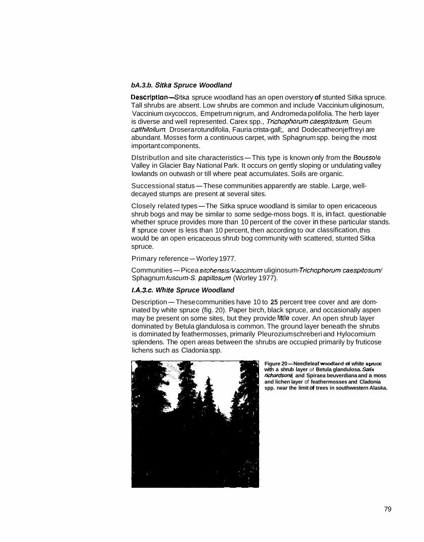
bA.3.b. Siika Spruce Woodland
Descrlpt ion4itka spruce woodland has an open overstory of stunted Sitka spruce. Tall shrubs are absent. Low shrubs are common and include Vaccinium uliginosum, Vaccinium oxycoccos, Empetrum nigrum, and Andromeda polifolia. The herb layer is diverse and well represented. Carex spp., Trichophorumcaespifosum, Geum calthifolium, Drosera rotundifolia, Fauria crista-gall;, and Dodecatheon jeffreyi are abundant. Mosses form a continuous carpet, with Sphagnum spp. being the most important components.
Dlstributlon and site characteristics-This type is known only from the Boussole Valley in Glacier Bay National Park. It occurs on gently sloping or undulating valley lowlands on outwash or till where peat accumulates. Soils are organic.
decayed stumps are present at several sites. Successional status-These communities apparently are stable. Large, well-
Closely related types-The Sitka spruce woodland is similar to open ericaceous shrub bogs and may be similar to some sedge-moss bogs. It is, in fact. questionable whether spruce provides more than 10 percent of the cover in these particular stands.
would be an open ericaceous shrub bog community with scattered, stunted Sitka If spruce cover is less than 10 percent, then according to our classification, this
spruce.
Primary reference-Worley 1977.
Communities-Picea sitchensis/Vaccinium uliginosum- Jrichophorum caespitosum/ Sphagnum fuscum-S. papiflosum (Worley 1977).
I.A.3.c. Whiie Spruce Woodland
Description-These communities have 10 to 25 percent tree cover and are dom- inated by white spruce (fig. 20). Paper birch, black spruce, and occasionally aspen
dominated by Betula glandulosa is common. The ground layer beneath the shrubs may be present on some sites, but they provide little cover. An open shrub layer
is dominated by feathermosses, primarily Pleurozium schreberi and Hylocomium splendens. The open areas between the shrubs are occupied primarily by fruticose lichens such as Cladonia spp.
Figure 20-Needleleaf woadland 01 white spruce with a shrub layer of Betula glandulosa. Salk richardson3, and Spiraea beuverdiana and a moss and lichen layer of feathermosses and Cladonia spp. near the limit 01 trees in southwestern Alaska.
79

the shrub layer is absent, and fruticose lichens dominate the openings between the P h a s e M n old sand dunes in the Kobuk Valley and the Kantishna River area,
scattered spruce trees. The most important lichens are species of Cladonia, Cladina, and Stereocaulon. A few prostrate ericaceous shrubs are present (primarily Empetrum nigrum and Vaccinium vifis-idaea), but these do not provide much cover.
overstory in what otherwise would be alpine ma! and cushion tundra. On these sites, On highly exposed sites near the altitudinal treeline, white spruce may grow as an
Dryas ocfopefala dominates low vegetation mats in which Arctostaphylos rubra, Salix
lichens, such as Cefraria cucullafa and C. islandica, are interspersed throughout the arcfica, Empetrum nigrum, and Vaccinium vitis-idaea also are important. Fruticose
mat. Mosses, primarily Pleurozium schreberi and Rhytidium rugosum, are found in moist depressions.
Distribution and Site characterlstlcs-White spruce woodlands are most common near the latitudinal and elevational tree lines, especially in the Brooks and Alaska Ranges. They generally are found on fairly exposed sites where conditions are even more severe than on sites supporting open white spruce forest. Soils are generally thin and well drained. Depth to permafrost is more than 50 centimeters (20 in), or permafrost may be nonexistent.
Successional status-These communities are probably climax and are held in their open state by a combination of low temperatures and exposure to wind. Their response to disturbance is unknown, but some sites might not return to forest veg- etation if the trees were destroyed even if a seed source was available upwind.
Closely related types-White spruce woodlands are similar to open white spruce forests but have less than 25 percent cover. On the other hand, stands with very sparse tree cover resemble certain shrubland communities with scattered spruce (primarily open low mesic shrub birch-ericaceous shrub, dryas or dryas-dwarf shrub tundra, and lichen dwarf shrub tundra). Stands containing black spruce may be similar lo black spruce-white spruce woodlands. but have less than 25 percent of the canopy cover contributed by black spruce.
Photographs-Fiacine 1976, figure 19; figure 20, this publication.
Primary references-Racine 1976, Viereck 1979.
Communities-Picea glauca/Befula glandulosa/feathermosses-C/adonia spp. (Hettinger and Janz 1974; Racine 1975; Viereck 1975, 1979; Williamson and Peyton
(Racine 1976). Picea glaucalsalix lanafa/Cladonia spp. (LaPerriere 1976). Picea 1962). Picea glauca/Dryas spp.-mosses (Viereck 1979). Picea glaucdcladonia spp.
glauca/Ledumgroenlandicum-Vaccinium vifis-idaea/feathermsses (Dyrness and others 1988). Picea glauca/Alnus fenuifolialArcfosfaphylos uva-urstlichens (Dyrness and others 1988). Picea glaucamryas octopetala-Salix reticulafa-Empefrum nigrum (Craighead and others 1988). Picea glauca/Alnus crispa-Salix spp./Fquisetum
(Craighead and others 1988). Picea glauca/Salix spp./feathermosses (Craighead and awense (Craighead and others 1988). Picea g/auca/Salix spp./Fquisefum arvense
others 1988). Picea glaUCa/VaCCifliUm spp.-Salix spp./€quisetum arvense (Craighead and others 1988). PiCea glaucafVaccinium spp.-Fmpefrum nigrum (Craighead and others 1988). Picea gl~UCa/saliX alaxensis-S. glauca-S. lanata/Carex scirpoidea (Craighead and others 1988). Picea glauca/Alnus crispalfeathermosses (Craighead

and others 1988). Picea glaucdAlnus cfispa-Salix spp./Vaccinium uliginosum! leathermosses (Craighead and others 1988). Picea glaucdvacciniurn uliginosum- Carex bigelowii (Craighead and others 1988). Picea glaucdLedum groenlandicum-
fenuifolidArctosfaphylos uva-urssiilichen (Dyrness and others 1988). Vaccinium vifis-idaealfeathermosses (Dyrness and others 1988). PiceaglaucdAlnus
l.A.3.d. Black Spruce Woodland
Description-These open stands have a total tree cover of 10 to 25 percent and are dominated by black spruce (fig. 21). Paper birch and tamarack may be present but provide little cover. Trees of these communities are very slow growing, with the largest trees (over 100 years old) being on the order of 15 centimeters (6 in) d.b.h. and 11 meters (37 ft) tall, or smaller. Tree density is often surprisingly great considering the open canopy. Densities of 445 to 2900 stems per
diameters greater than 2.5 centimeters (1 in) hectare (180 to 1,200 per acre) for stems with
have been reported. Basal areas are from 0.3 to 6.8 square meters per hectare (1.3 to 30 ft2 per acre). Most stands have enough black spruce
woodland cover. regeneration, usually by layering, lo maintain the
Tall shrubs in these stands consist of scattered clumps of Alnus crispa 1 to 3 meters (3 to 6 11) tall, Betula glandulosa, sometimes with willows such as Salix lanafa, S. planifolia, and S. glauca. Low shrubs are common in most stands and include Vacciniurn uliginosurn, V. vifis-idaea, Ledum decumbens, L. groenlandicum, and
sparse to dense. Common herbs include Carex Empetrum nigrum. The herb layer ranges from
spp., Eriophorum vaginatum, Calamagrosfis canadensis, Rubus chamaemorus, and Geocaulon
or nearly so. The mosses Hylocomium splendens, lividum. The moss and lichen layer is continuous
generally dominate beneath the shrubs. Although Pleurozium schreberi, and Sphagnum spp.
are absent or nearly so from some communities. Sphagnumspp. are commonly dominant, they
trees are usually dominated by shrubs and the On moist and wet sites, the areas between the
associated mosses. On drier sites, the shrubs are
between trees are occupied by fruticose and restricted to the vicinity of the trees; the openings
foliose lichens (fig. 22). Important lichens include Nephroma arcficum, Cladonia spp., Cladina spp., Cetraria spp., and Pelfigera spp.
Figure 21-Needleleaf wocdland of black
glandulosa, Ledum groenlandicum, and spruce with a low shrub layer of Befula
Vaccinium uliginosum and a scattered herbaceous layer with Eriophorum
Sphagnum, feathermosses, and Cladonia vaginarum and a moss and lichen layer of
spp. on a toe slope in interior Alaska
Figure 22-Needleleaf woodland of black spruce with a scattered shrub layer of
groenlandicum and a nearly wntinuous Vaccinium uliginsoum and Ledum
lichen layer of Cladonia spp. and
interior Alaska Pelrigera spp. on a well-drained soil in
81

Distribution and site characteristics-Black spruce woodlands are found through- out interior, westem, and south-central Alaska, primarily on cold, wet, poorly drained soils, but occasionally on some cold, well-drained soils. They are found in several topographic positions including flood plains, slopes, and ridges. Permafrost may be present or absent. Soils are shallow lo permafrost, bedrock, or raw parent material. They are generally Cryaquepts or, more rarely, Cryochrepts, with a surface organic layer 10 to 30 centimeters (4 to 12 in) thick.
When burned, these communities pass through several herb and shrub stages Successional status-Many black spruce woodlands seem to be a fire climax.
before returning lo black spruce woodland.
Closely related types-Black spruce woodlands often resemble open black spruce forest but have less than 25 percent tree cover. When tree canopy cover becomes less than 10 percent, the more open black spruce woodlands resemble various open
shrub bog, and mesic shrub birch-ericaceous shrub scrub. Stands containing white scrub communities, such as mixed shrub-sedge tussock bog, shrub birch-ericaceous
spruce can resemble black spruce-white spruce woodland, but contain less white spruce. Stunted trees on very poor sites may resemble black spruce dwarl tree woodland scrub.
Photographs-Ftacine 1976, figure 22; figures 21 and 22, this publication.
Prlmary references-Foote 1983, Racine 1976, Viereck and others 1983, Yarie
Communities-Picea mariana/Sphagnum spp.-Cladonia spp. (Heilman 1966; Viereck 1975, 1979). Picea mariana/Cladonia spp. (Foote 1983; Racine 1976; Viereck 1975, 1979). Picea mariana/Vaccinium spp.-Salix spp./Sphagnum spp. (Racine 1976, Webber and others 1978, Williamson and Peyton 1962). Picea mariana/Befula nana/€riophorum spp./Sphagnum spp. (Yarie 1983). Picea mariana/Sa/ix spp./Hylocomium splendens-Cladonia fangiferina (Yarie 1983). Picea
decumbens-Vacciniumspp. (Jorgenson and others 1986). Picea marianalsphagnum mariana/€riophorum vaginatum (Jorgenson and others 1986). Picea mariana/Ledum
spp. (Jorgenson and others 1986).
I.A.3.e. Black SpruceWhite Spruce Woodland
Description-These communities are comprised 01 black spruce and white spruce as codominants. Although both species provide a significant amount of cover, they
grow to relatively large sizes. The largest trees, usually white spruce, may reach may differ in size and age class. Trees tend lo be slow growing but occasionally
32 centimeters (13 in) d.b.h. and over 10 meters (33 ft) in height. More typical sizes are 7 to 11 centimeters (3 to 4 in) d.b.h. and 3 to 7 meters (10 to 23 ft) in height.
larger proportion of young trees to be black spruce rather than white spruce. Regeneration of both species generally is present, though there is a tendency for a
1983.

A well-developed tall shrub layer, consisting primarily of Befula glandulosa and Ahus
the tall shnrbs and trees. Common low shrubs include Vaccinium uliginosum, V. crispa, is characteristically present. A low shrub layer occupies the spaces between
and consists predominantly of Calamagrosfis canadensis and Carex bigelowii. A vifis-idaea, Emperrum nigrum, and Ledurn groenlandicum. The herb layer is sparse
continuous or nearly continuous layer of mosses is dominated by Pleurozium schreberi, Hylocomium splendens, and Polyfrichumspp. Foliose and fruticose lichens such as Cladonia spp., Cladina spp., Cetraria spp., and Peltigera spp. contribute a substantial amount of cover to the moss layer.
Distribution and site characteristics-Black spruce-white spruce woodlands are found near tree line in interior, western, and south-central Alaska. Near Fairbanks, they are reported on east- and west-facing slopes above 700 meters (2,300 it). They often occupy the coldest sites capable of supporting forest vegetation. The poorly developed, stony, mesic to dry soils are shallow and may lie directly on fractured bedrock. A 0- to 3-centimeter-thick (0- to 12-in-thick) organic layer covers the soil surface. Permafrost is absent or fairly deep.
Successional status-These woodlands appear to be climax but probably are in a very delicate balance with climate. A series of warm, moist summers might allow
decades. On the other hand, some catastrophically distutbed stands may not return many seedlings to establish, which would lead to a more closed canopy in a few
to a forested condition at all.
Closely related types-Densely treed stands resemble open black spruce-white spruce forest but have less than 25 percent tree cover. Very open stands grade into open low mesic shrub birch-ericaceous shrub scrub communities with scattered
these communities may resemble either black spruce woodland or white spruce spruce. Depending on the relative proportions of the two spruce species present,
woodland but have significant cover of both species.
Photographs-Foote 1983, figure 13.
Primary references-Foote 1983, Viereck and others 1983.
Communities-Picea mariana-P. glauca/Befulag/andulosalfeathermosses (Viereck 1979). Picea glauca-P. marianallichens (Foote 1983). Picea mariana-P. g/auca/Alnus crispa-Betula glandulosa/Pleurozium schreberi (Jorgenson and others 1986, Viereck and others 1983). Picea mariana-P. glauca/Rubus chamaemorus-Ledum decumbens- Vacciniumspp. (Craighead and others 1988).
/.E. Broadleaf Forest
contributed by broadleaf tree species. Alaska broadleaf tree species are Alnus Broadleaf forest communities have at least 75 percent of tree canopy coverage
rubra, Befula papyrifera, Populus frichocarpa, P. balsamifera, and P. fremuloides.
83

A
Figure 23-A. Aerial view of closed broadleaf forest in interior Alaska. E. Ground view of dosed broad- leaf paper birch forest similar to that shown in k
I.B. 1. Closed Broadleaf Forest
coverage. Less than 25 percent of the total tree coverage is contributed by Closed broadleaf forest communities have from 60 to 100 percent tree canopy
needleleaf (coniferous) tree species (fig. 23, A and B).
I.B. 1.a. Closed Red Alder Forest
a total tree cover of 60 percent or more (fig. 24). Red alder reaches heights of 6 to Description-These communities are dominated by red alder (Alnus rubra) and have
12 meters (20 to 40 ft) and diameters of IO to 40 centimeters (4 to 16 in). This type
stantial variations from the description are to be expected. Woody plants other than has been described only from the Stikine area in southeastem Alaska, and sub-
alder are scarce. Common species in the understory include Carex macrochaefa, Calamagrostis nufkagnsis, and in wet areas, Carex lyngbyaei and Potentilla palustris.
Distribution and slte characterlstlcs-Red alder forests are common on wet, well- drained sites with rich, stony, moist soils along creek bottoms and on river terraces in southeastern Alaska. They also occupy old clearcuts and other disturbed areas on
on avalanche slopes. moist, well-drained sites. Red alder, often with green alder, also forms dense thickets
Successlonal status-Red alder communities can be part of a hydrosere between marsh and Sitka spruce-western hemlock forest. Stands on flood plains and river terraces may remain stable for long periods. Red alder also is successional on disturbed sites, establishes itself in pure stands on skid trails after clearcut logging and dominates these areas for several decades.
84

alder in southeastern Alaska. Figure 24-Closed broadleaf forest of red
Closely related types-Red aider forests differ from tall alder scrub by being composed of a taller and more treelike alder. They also are similar to open Sitka spruce forests but have less spruce and more alder.
Photographs-Figure 24, this publication
Primary re fe rencede1 Moral and Watson 1978, Viereck and Little 1972.
Communities-Alnus rubra (del Moral and Watson 1978)
LA. 1.6. Closed Black Cottonwood Forest
Description-These communities are dominated by black cottonwood (Populus trichocarpa), which commonly grow 24 to 30 meters (80 to 100 11) tall and reach
with sparse understories. As the stands age, openings in the canopy allow the under- diameters of up to 1 meter (3 ft). Young stands tend to have continuous tree cover
story to develop more fully. Common shrubs include Rosa acicularis. Viburnum
the dominant species of the herb layer. edule, and Oplopanax horridus. Calamagrostis canadensis and Equisetum spp. are
Distribution and site characteristics-Black cottonwood communities are common on moist, well-drained sites on flood plains in south-central and southeastern Alaska.
Successional status-These are seral communities in the primary succession of stream terraces and flood plains that are intermediate between various early seral shrub communities on the one hand, and birch and spruce forest communities on the other.
85

Closely related types-Black cottonwood forests are closely related to balsam poplar forests, and the trees themselves are sometimes considered conspecific. The seed capsules of black cottonwood split into three parts at maturity, as opposed to those of balsam poplar which split into two parts at maturity. Closed black cotton- wood communities resemble open black cottonwood communities in species com- position but have much greater tree cover.
Primary references-US. Department of Agriculture 1986, Viereck and Little 1972.
Communities-Populus trichocarpa (undescribed).
I.B. I.C. Closed Balsam Poplar Forest
Descrlptlon-These forests are dominated by balsam poplar and have more than 60 percent canopy cover (fig. 25). This species commonly reaches diameters of 40 centimeters (16 in) and heights 01 30 meters (90 ft). Flood-plain balsam poplar stands are the most productive lorest stands in interior Alaska. Annual tree pro- duction averages 551 grams per square meter per year (4,900 Ib/acre) and reaches 950 grams per square meter per year (8.500 Ib/acre) on the most productive sites. Young stands have densities on the order of 2,000 stems per hectare (800 stems/ acre), but densities drop to 600 to 800 stems per hectare (200 to 300 stems/acre) in older stands.
Alms crispa and A. tenuifolia are common shrubs in these stands. Willows are common to abundant in young stands, but drop out after the balsam poplar canopy begins to close. Other common shrubs include Rosa acicularis (which may form a
times Cornus stolonifera. Dwarf shrubs are absent. A dense layer of herbs usually nearly continuous layer about 1.5 meters [5 R] high), Viburnum edule, and some-
is dominated by Calamagrosfis canadensis and Equisetum spp. Other common herbs include Geocaulon lividum, Galium boreale, and Meffensia paniculafa. Mosses and
frequent flooding that the forest floor is subject to. Some mosses usually are present, lichens usually are sparse because they are intolerant of the heavy leaf fall and
though, on the bases of the tree trunks, and the lichens Pelfigera spp. and Cladonia spp. can be found on sites flooded relatively infrequently.
layer and a variety of ferns becomes important. Phases-South of the Alaska Range, Oplopanax horridus may dominate the herb
Figure 2SClosed broadleaf forest of balsam poplar with a shrub layer of Ainus tenuifolia, Rosa adcularis, and Viburnum wduie and a herbaceous layer primarily of Equisetum awense and E. prarense on the flood plain of a river in interior Alas!ia

Occasionally, small stands of balsam poplar occur on slopes near timberline through- out Alaska. Associated species differ considerably between different parts of the State, but a scattered shrub layer of Salix spp., Rosa acicularis, and Viburnum edule usually is present. Calamagrostis canadensis usually dominates the herb layer. In the Brooks Range and possibly the Alaska Range, a ground layer dominated by Arctostaphylos rubra may be present.
Distribution and site characteristics-Balsam poplar stands are found primarily on flood plains in interior, south-central, and southwestern Alaska. A few small stands are isolated well north of treeline on the Arctic Slope along major rivers in the northern foothills of the Brooks Range. Soils are well-drained Cryofluvents lacking permafrost. They are essentially unmodified by soil-forming processes, with the soil profile layers remaining as they were originally deposited. The soil surface is covered by 2 to 15 centimeters (1 to 6 in) of leaf litter, the depth depending on the time since the last flooding and siltation episode.
Tree-line balsam poplar stands usually are on slopes with weakly developed, well-drained, thin soils without permafrost or with very deep permafrost.
Successional status-Flood-plain balsam poplar communities are part of a suc- cessional sequence from willow-alder thickets to balsam poplar to white spruce, and eventually to black spruce. Substantial numbers of white spruce seedlings and saplings are present in some stands. In other stands, white spruce may be very slow to invade, depending on the proximity of a white spruce seed source and the timing
old, but most are replaced by white spruce at about 100 years of age. of good white spruce seed crops. Some balsam poplar stands are over 200 years
Closely related types-Closed balsam poplar communities are similar to open balsam poplar communities but have 60 percent tree cover or more. Stands where white spruce contribute to the canopy are similar to closed poplar-spruce mixed forest or closed spruce-birch-poplar forest, but they have less canopy cover of spruce or birch. At the other extreme, young stands where balsam poplar shares the canopy with species ot willow may resemble closed tall willow thickets but have a greater dominance of balsam poplar.
Photographs-Foote 1983, figure 8; Viereck 1970a, figure 3; figure 25, this publication.
Primary references-Foote 1983; Viereck 1970a, 1979; Viereck and others 1983; Yarie 1983.
Communities-Populus balsamifera/Alnus tenuifolia/Calamagrostis canadensis (Buckley and Libby 1957; Drury 1956; Hettinger and Janz 1974; Lutz 1956; Neiland and Viereck 1977; Racine 1976; Viereck 1970a, 1975). Populus balsamifera/Alnus tenuifolia/Rosa acicularis/€quisetum spp. (Dyrness and others 1988, Viereck 1989). Populus balsamifera/Salix barclayi/Heracleum lanatum (Viereck 1970b). Populus balsamifera/Salix spp.-Alnus spp./herbs (Viereck 1979). Populus balsamifera/Alnus spp.-Salix spp./Rosa acicularis/€quiseturn spp. (Yarie 1983). Populus balsamifew
Arctostaphylos uva-ursi/Peltigera spp. (Yarie 1983). Rosa acicularis/Equisetum spp.-Pyrola spp. (Yarie 1983). Populus balsamifera/
87

I.B. 1.d. Closed Paper Birch Forest
Descrlption-These are communities with paper birch dominating the overstory and with at least 60 percent tree cover (fig. 26). Large trees reach 30 to 45 centimeters (12 to
ft) in height. Densities can range from 15,500 18 in) in d.b.h. and 18 to 25 meters (60 to 80
trees per hectare (6,300 treeslacre) for young stands (20 to 25 years old) to 370 trees per
years). Annual aboveground tree biomass hectare (150 treeslacre) for old stands (120
increment is about 343 to 572 grams per square meter (3,060 to 5,100 Iblacre). Leaf fall is heavy, on the order of 250 grams per square meter per year (2,230 Iblacre). Birch regeneration is limited mostly to stern suckers sprouting from the bases of old trees. White spruce and black spruce seedlings and saplings may be present but usually are not abundant.
In most stands. a discontinuous tall-shrub
Figure 26Closed broadleaf forest of paper birch with a scattered shrub layer of Wburnum edule and Rosa acicularis and an herbaceous layer of Equisetum awense and E. sylvaticum in the uplands of interior Alaska
layer several meters tall is made up of Alnus crispa or A. sinuafa. Rosa acicularis
though in some stands, particularly those with abundant alder, these shrubs may and Viburnum edule commonly form a shrub layer 1 to 2 meters (3 to 6 ft) high,
be lacking or nearly so. Dwarf shrubs may be absent or may be represented only by Vaccinium vifis-idaea and Linnaea borealis. The herb layer usually is dominated by
age of the stand. Merfensia paniculafa and €quisefum spp. also may be common. Calamagrostis canadensis. The importance of Calamagrostis generally increases with
Mosses and lichens are rare, probably because of the heavy leaf litter.
Distributlon and slte characteristics-Paper birch forests are common on several
drained to well-drained silts. In some areas, the soil is stony and shallow over upland sites in interior and south-central Alaska. Soils generally are moderately
bedrock. Permafrost usually is absent, but some birch forests develop on soils with permafrost and a shallow active layer. The organic horizon over the mineral soil is thin and consists mostly of decaying birch leaves. Mosses and lichens usually are absent from the forest floor.
Successional status-Paper birch communities generally result from fires or other disturbances and usually will be replaced by open or closed white spruce, black
types of spruce-birch mixtures. In south-central and interior Alaska, open mixtures spruce, or black spruce-white spruce communities after passing through several
of white spruce and birch with grassy openings may be climax on some sites (Neiland and Viereck 1977).
White spruce and paper birch may become established at the same time; however, the birch grows faster than the spruce. When the birch become overmature and die, the spruce is already present. It is more difficult for spruce to invade after a birch forest is well established, because the heavy leaf fall prevents the survival of spruce
the aging birch weaken and die. seedlings (Gregory 1966). Eventually, however, a few spruce become established as

Mature birch can survive low-intensity ground fires, but the aerial parts are easily killed by moderate and severe fires. If the roots survive the fire, the stumps sprout vigorously, which leads to an abundance of multiple-stemmed trees in the resulting forest.
Closely related types-Closed paper birch communities resemble open paper birch communities but have a greater overstory cover. Birch communities with spruce un- derstories just beginning to reach into the birch canopy may resemble spruce-birch
communities may resemble birch-aspen communities but with less aspen. mixed forest, but they have less spruce in the canopy. If aspen is present, birch
Photographs-Foote 1983, figures 4 and 5; figure 26, this publication.
Prlmary references-Foote 1983, Neiland and Viereck 1977, Viereck and others 1983.
Communities-Betula papyriferaIAlnus crispa/Calamagrostis spp. (Buckley and Libby 1957, Lutz 1956, Viereck 1975). Betulapapyrifefda/Viburnum edule (Foote 1983). Betula PapyriferdAlnus spp.-Salix spp. (Racine 1976). Betula papyrifera/
and others 1986). Ledumgroenlandicum/fleurozium schreberi-Polytrichum juniperinurn (Jorgenson
I.B.1.e. Closed Quaking Aspen Forest
Description-These stands are dominated by aspen and total tree cover is 60 per- cent or more (fig. 27). The largest aspen trees reach 25 to 36 centimeters (10 to 14 in) in d.b.h. and 18.3 meters (60 ft) in height. Aspen may grow in pure stands or be associated with small quantities of white spruce, black spruce, balsam poplar, or paper birch. White spruce seedlings and black spruce regeneration may be present. Tree densities range from 1,200 trees per hectare (480lacre) for mature stands (50 to 80 years old) to 700 trees per hectare (280lacre) for overmature stands.
Scattered clumps of Alnus crispa and Salix bebbiana that are several meters tall are commonly present. A broken to nearly continuous shrub layer 1 to 2 meters (3 to 6 ft) high consists primarily of Viburnum edule, Rosa acicular;& Salix spp., and Shepherdia canadensis. The herb layer is poorly developed, but scattered plants of Calamagrostis canadensis, Epilobium angusfifolium, Equisetum arvense, fedicularis labradorica, Linnaea borealis, Geocaulon lividurn, and Galium boreale usually can be found. Mosses and lichens are scarce.
with a shrub layer of Rosa acicularis, Viburnum edule, Figure 27-Closed broadleaf forest of quaking aspen
and Shepherdia canadensis; a scattered herbaceous layer of Calamagrosfis canadensis and Epilobium angusfifolium; and the creeping subshrub Linnaea
of loess in the uplands of interior Alaska borealis on a south-facing slope with a thick deposit
89
drained upland slopes in interior and south-central Alaska. These are the warmest Distribution and site characteristics-Closed aspen forests grow on warm, well-
forested sites in central Alaska. Slope gradient ranges from 7 to 40 percent. Soils are generally well-drained, sometimes shallow and stony, silt l o a m (often Alfic Cryochrepts). Snow melts early in spring, and seasonal frost retreats to at least 80 centimeters (30 in) below the surface by late June. Soils supporting aspen forest lack permafrost or have a thick active layer. The soils can become extremely dry during droughty summers.
Successional status-Aspen can colonize burned-over white spruce forest sites
characteristically light (Neiland and Viereck 1977). Fires therefore tend to maintain under some circumstances. Aspen are killed by hot fires, but in pure stands fires are
aspen stands. Aspen sprouts vigorously from roots when aerial portions of the tree are killed; thus, when aspen stands are burned or otherwise disturbed, they usually quickly regenerate themselves.
White spruce often seeds in at the same time that the aspen is established. The spruce initially grows much more slowly than the aspen, but in the absence of fire the short-lived aspen eventually die and leave the spruce to assume dominance. When the spruce overtop the aspen canopy, the demise of the shade-intolerant aspen is hastened.
Black spruce stands on shallow, stony soils, if severely burned so that the organic mat is removed, may be replaced by aspen. Presumably these sites eventually will return to black spruce if they are not reburned.
Closely related types-Closed aspen stands are similar to open aspen stands but
balsam poplar, and spruce-aspen communities but have low amounts of cover have more than 60 percent tree cover. They also are similar to birch-aspen, aspen-
contributed by the associated tree species.
Photographs-Foote 1983, figure 3; figure 27, this publication.
Primary referencesfoote 1983, Neiland and Viereck 1977, Viereck and others 1983, Yarie 1983.
Communities-Populus tremuloides/Viburnum edule/Linnaea borealis (Foote 1983). Populus tremuloides/Salix spp./Arcfostaphylos uva-ursi(Hettinger and Janz 1974, Viereck 1975). Populus tremuloides/Salix spp./Drepanocladus spp. (Yarie 1983).
I.B. 1.f. Closed Paper Birch-Quaking Aspen Forest
by paper birch and quaking aspen and the total tree cover is 60 percent or more. Description-These are communities in which dominance in the canopy is shared
Published descriptions of these communities are limited to very young stands on the Porcupine Plateau in northeastern Alaska. These stands have tree reproduction of black spruce, aspen, and birch. Alnus crispa and several species of willow form a tall shrub layer. A rather open, low shrub layer is composed of Rosa acicularis and
and Equisetum spp. Other common herbs include €pi/obium angustifolium, Linnaea Shepherdia canadensis. The ground layer is dominated by Arctostaphylos uva-ursi
borealis, and Arctostaphylos rubra. Scattered lichens include species of Cladonia, Cladina, Peltigera, and Cetraria.
90

Distribution and Site characteristlcs-Birch-aspen communities are found on moderately warm sites, primarily upland slopes, in interior and south-central Alaska. Permafrost is absent or more than a meter below the surface.
Successional status-Most stands originate after fire and most likely, in the absence of fire, will be replaced eventually by white spruce or black spruce.
Closely related types-Birch-aspen communities are related to paper birch commu- nities and aspen communities but have both species well represented in the canopy. If a spruce understory is beginning to enter the canopy, this community may resemble a spruce-birch-aspen mixed forest.
Primary reference-Yarie 1983.
Communities-Populus tremuloides-Betula papyrifera/Rosa acicularis/Arctostaphylos uva-urssPlichens (Yarie 1983).
I.B. 1.g. Closed Quaking Aspen-Balsam Poplar Forest
Description-These forest communities are dominated by aspen and balsam poplar and have a total tree cover of 60 percent or more. Scattered white sptuce also may be present in the overstory. Regeneration of aspen and balsam poplar usually is present, and frequently white spruce regeneration is as well. Annual productivity averages about 113 grams per square meter (1,000 Ib/acre) per year.
Willows commonly form a tall shrub layer, especially in young stands. Characteristic low shrubs include Rosa acicularis and Shepherdia canadensis. Common herbs include Mertensia paniculafa, Calamagrostis canadensis, Equisetum spp., fpilobium
perhaps the most common mosses. angustifolium, and Galium spp. Mosses and lichens are sparse: Dicranum spp. are
Distribution and site characteristlcs-Aspen-balsam poplar communities have been reported only from the Yukon Flats but are thought to be more widespread on flood plains in interior Alaska. They commonly occur on moderately well-drained soils (Cryofluvents). These tend to be young soils with circumneutral to slightly acidic soil reaction and only a few centimeters of organic matter on the mineral soil surface. Permafrost is at least 50 centimeters (20 in) below the surface at sites in the Yukon Flats and probably is lacking from many sites farther south.
Successional status-Flood-plain stands generally develop after alder and willow thickets. Usually the aspen and balsam poplar establish at the same time as the alder and willows but are overtopped for a few years by the faster growing shrubs. Most of these stands, if left undisturbed, would be expected to be replaced by white spruce. After a still longer time, the white spruce theoretically may give way to black spruce.
Closely related types-Aspen-balsam poplar stands are similar to aspen stands
where the tree canopy has recently emerged above the alder and willows, are similar and balsam poplar stands, but dominance is shared by both species. Young stands,
to tall alder, tall willow, and tall alder-willow shrub communities. Older stands where spruce is beginning to enter the canopy may resemble aspen-spruce or balsam poplar-spruce stands.
Primary reference-Yarie 1983.
Communities-Populus tremuloides-P. ba/samifera/Rosa acicularis (Yarie 1983).
91

view of open broadleaf forest of paper birch similar to that shown in A. Figure 28-A. Aerial view of open broadleaf forest of paper birch in interior Alaska. B. Ground
1.8.2. Open Broadleaf Forest
Open broadleaf forest communities have from 25 to 60 percent total tree canopy coverage. Over 75 percent of the canopy is made up of broadleaf tree species (fig. 28, A and E).
LB.2.a. Open Paper Blrch Forest
tree cover of 25 to 60 percent (fig. 29). Scattered white spruce or black spruce also Description-These communities are dominated by paper birch and have a total
may be present. On moist sites, such as those near the western treeline and many sites near the elevational treeline, shrubs dominate the openings between the trees.
Alder and willows also are present. Ericaceous shrubs form an open dwarf shrub Betula glandulosa, 1 to 2 meters (3 to 6 ft) tall, is characteristic of this shrub layer.
layer beneath the taller shrubs. The ground layer consists of a nearly continuous layer of teathermosses, primarily Hylocomium splendens and Pleurozium schreberi.
mon lichens include species of the genera Cladonia, Cladina, and Stereocaulon. Dry sites support lichens instead of shrubs in the openings between the trees. Com-
Another type of open birch community consists of overmature birch stands on upland slopes in interior and south-central Alaska: it lacks a spruce understory to replace the birch trees as they die. These stands have a low shrub layer composed primarily of Rosa acicularis and Viburnum edule. Clumps of tall alder are occasional. The herb layer is commonly dominated by Equisetum arvense or Calamagrostis canadensis.
Figure 24-Open broadleaf forest of mature paper b with a shrub layer of Alnus crispa and a herbaceous layer of Calamagrostis canadensis and Lycopodium complanarum on an east-facing slope in h e uplands interior Alaska
irch
Of
92

Distributlon and site characteristics-Overmature open birch stands are common in interior and south-central Alaska. The open birch stands with a lichen understory are apparently fairly rare; they occur mostly near the western tree line and near the elevational tree line of interior, western, and south-central Alaska. Elevational tree-line stands may have originated as a result of fires burning through white spruce stands.
including stabilized sand dunes and possibly some elevational tree-line sites, support Moist sites, such as those near tree line, support shrubby understories. Dry sites,
fruticose lichens in the forest openings. Soils are moderately well drained in the mature open upland birch sites. Permafrost is absent or with a deep active layer.
Successional status-The successional status of many open birch stands is un- known. Some probably will be replaced by white spruce if sufficient time elapses. Others, particularly certain overmature birch communities in south-central Alaska, do not appear to be heading toward spruce dominance. Perhaps they are reverting to open shrub communities with grassy openings (Neiland and Viereck 1977).
Closely related types-Open birch communities are similar to closed birch com-
and more tree cover than the latter (25 to 60 percent tree cover). munities and birch woodland communities but have less tree cover than the former
Photographs-Racine 1976, figure 9; figure 29, this publication
Primary references-Foote 1983, Hanson 1953, Neiland and Viereck 1977, Racine 1976.
Communities-BetulapapyriferdCladonia spp. (Racine 1976). Betula papyriferd Betula glandulosa/Hylocomium spp. (Hanson 1953; Hettinger and Janz 1974; Viereck 1975, 1979). Betulapapyr-sifera/Viburnum edule/Calamagrostis spp. (Foote 1983). Betula papyriferdAlnus crispd~edumgroenlandicum (Jorgenson and others 1986).
I.B.2,b. Open Quaking Aspen Forest
dominated by generally small aspen trees that Description-Open quaking aspen stands are
provide roughly 10 to 60 percent canopy cover (fig. 30). These trees rarely are larger than 12 centimeters (5 in) d.b.h. and 15 meters (50 ft) tall. A representative basal area is 8.7 square meters per hectare (37 ft'lacre). Rosa acicularis 1 to 2 meters (3 to 6 ft) tall may be present.
shrub, and Arctostaphylos uva-urs-simay form a Shepherdia canadensis is a common low
patchy ground cover. Common herbs include Calamagrostis purpurascens, Galium boreale, and Pulsatilla patens. Neither mosses nor lichens provide significant cover. Flood-plain sites may support substantial quantities of tall willows in addition to the aspen.
shrub layer of Shepherdia canadensis and Rosa acicularis Figure 3 6 O p e n broadleaf forest of quaking aspen with a
and an herbaceous layer of Calamagrostis purpurescens.
on a steep, south-facing bluff in interior Alaska. Pulsardla patens, and the subshrub Arctosfaphylos uva-ursi
93

Dlstrlbutlon and slte characterlstlcs-open aspen stands usually occur on very dry sites on steep, south-facing slopes along rivers in interior and south-central Alaska. They commonly are associated with dry midgrass-shrub or sagebrush-grass communities. Soils generally are shallow silt loams over fractured bedrock and are quite warm and dry. Open aspen stands also infrequently occur on more or less
70 centimeters (28 in). level, well-drained alluvium. If permafrost is present, it will be at depths greater than
white spruce stands have been destroyed by fire. White spruce may be unable to Successlonal status-Open aspen communities frequently develop on sites where
enable such an invasion at some time in the future. A series of hot, dry summers reinvade steeply sloping, dry sites, though small changes in summer climate may
may stress the aspen to the point of making them susceptible to death by certain diseases, thus converting the open aspen stands to dry midgrass-shrub communities or open sagebrush-grass communities. On the other hand, a series of wet, cool summers presumably could lead to the expansion of aspen forest at the expense of grassland and shrubland.
On most flood-plain sites aspen will be replaced by white spruce if left undisturbed.
communities but have less tree cover and generally occur on steeper and dryer Closely related types-Open aspen communities are similar to closed aspen
slopes.
Photographs-Figure 30, this publication.
Primary references-Neiland and Viereck 1977, Viereck and others 1983, Yarie
Communltles-Populus tremuloides/Salix spp./Arctosfaphylos uva-ursSramineae (Yarie 1983). Populus fremuloides/Salix spp./Arcfosfaphylos uva-ursEpilobium spp.
Arctostaphylos spp./lichens (Neiland and Viereck 1977). Populus fremu/oides/ (Yarie 1983). Populus fremuloides/€laeagnus commufata-Shepherdia canadensis/
Shepherdia canadensis/Calamagrosfis purpurascens (Viereck and others 1983).
I.B.2.c. Open Balsam Poplar (Black Cottonwood) Forest
cottonwood and have a total tree cover of 25 to 60 percent (fig. 31). Other tree Descrlptlon-These open stands are dominated by balsam poplar or black
d.b.h. and 20 to 30 meters (65 to 100 ft) in height. The trees of most open stands, species generally are absent. Balsam poplar reaches sizes of 40 centimeters (16 in)
though the maximum diameters remain about the same. Black cottonwood may grow particularly those near timberline, rarely exceed 10 to 12 meters (30 to 40 ft) tall,
slightly larger than balsam poplar. Understory composition is variable, but there usually is a scattered tall shrub layer consisting of Salix spp. and Alnus spp. and a low shrub layer dominated by Viburnum edule, Rosa acicularis, Shepherdia canadensis (restricted to balsam poplar), or Oplopanax horridus (restricted to black cottonwood). Common herbs are Calamagrostis canadensis, Pyrola spp., Mertensia paniculata, Epilobium angustifolium, and Arctostaphylos rubra. Hylocomium splendens and Pleurozium schreberi are common bryophytes.
1983.

Figure 3 1 4 p e n broadleaf forest of balsam poplar with a shrub layer of .Mix barclayi and Alnus crisp and an herbaceous layer of Calamagrosris canadensis, Equissrum pratense. and Heracleum lanatum on the flood plain of a river in southwestern Alaska
along the southeastern and southern coasts of Alaska. Balsam poplar stands occur Distribution and site characteristics-Black cottonwood stands are found only
over the remainder of forested areas in Alaska. When the two species' ranges meet, as in the Cook Inlet area, hybrids between the two species occur, making it difficult to determine which species dominates in some stands (Viereck and Foote 1970). Open balsam poplar and black cottonwood communities often are found on flood plains, but they occasionally occur on slopes. Flood-plain communities usually grow on well-drained sands and gravels capped by a thin layer of silt and an even shallower layer of organic material on the surface of the mineral soil. Stands on slopes usually occupy shallow, stony mineral soils over bedrock. Soils on both upland and flood-plain sites either lack permafrost or have deep active layers (70 centimeters [28 in] or more).
Successional status-Tree-line stands seem fairly stable. On flood plains, these stands maintain themselves in the face of severe flooding disturbance, including silt
white spruce or Sitka spruce is the eventual climax tree species. deposition and erosion. On such flood-plain sites, poplar or cottonwood is seral and
Closely related types-Open balsam poplar or black cottonwood communities are similar to closed balsam poplar communities and closed black cottonwood communi- ties but have less tree cover. They also are similar to balsam poplar woodlands but have more tree cover.
Photographs-Murray 1980, figure 2; figure 31, this publication.
Primary references-Edwards and Dunwiddie 1985, Racine and Anderson 1979, Viereck 1979.
Communities-Populus balsamifera/Salix spp.-Alnus spp./Ca/amagrostis spp. (Racine and Anderson 1979, Viereck 1979). Populus balsamiferdSalix hastata- Shepherdia candensis-Epilobium angustifo/ium/Hyocomium splendens-Pleurozium schreberi (Edwards and Dunwiddie 1985). Popu/us balsamiferdAlnus tenUifOlia/ Equisetum spp. (Viereck 1989).
95

Figure 32-Broadleaf woodland of paper birch with a lichen and moss layer ot the lichens Cladina spp.,
Stereocaulon spp. and the moss Cladonia spp., Cetraria spp., and
Rhacomitrium uliginosum on a well-drained gravel ndge in northern interior Alaska.
1.8.3. Broadlead Woodland
Broadleaf woodland communities have from 10 to 25 percent total tree cover. At least 75 percent of this total tree cover is contributed by broadleaf tree species.
I.B.3.a. Paper Birch Woodland
Description-Paper birch woodlands are characterized by open-grown paper birch, which has roughly 10 to 25 percent cover (fig. 32). The birches usually are multi- stemmed and rather stunted in growth form. Typical tree heights are 6 to 10 meters (20 to 32 ft) and tree diameters range up to 20 centimeters (8 in) but usually are less than half that. The ground cover consists primarily of fruticose lichens of the genera Cladonia, Cladina, Cetraria, and Stereocaulon. Lichen cover tends to be sparser than in the white spruce woodland, possibly because of increased litter fall. Shrubs and herbs are not important components of communities that have been described.
Distribution and slte characteristics-Paper birch woodlands occur on dry sites in
on stabilized sand dunes and coarse alluvial gravels. Permafrost is deep below the northwestern Alaska and northern interior Alaska. They have been reported growing
surface or absent from these soils.
Successional status-The successional relations of these communities is unknown. Similar sites also have white spruce woodlands with a few scattered, subordinate birches. Possibly the pure birch stands owe their existence to severe fire or other disturbances. Perhaps white spruce will replace the birch in the absence of further disturbance as it does on many other sites; however, evidence for this has not been reported.
Closely related types-Paper birch woodlands are similar Io open paper birch forests but have less tree cover. Sparsely wooded stands may grade into some type of shrub tundra or dryas-lichen tundra.
Photographs-Racine 1976, figure 9; figure 32, this publication.
Primary referenceflacine 1976.
Communities-Befu/apapyrifera/C/adonia spp. (Racine 1976).

I.B.3.b. Balsam Poplar Woodland
are very open with only 10 to 25 percent tree cover. They are similar to open balsam Description-These stands are dominated by balsam poplar in the tree layer and
poplar stands but have larger openings. Alders and willows are common tall shrubs. Other typical shrubs include Rosa acicularis, Viburnum edule, and (in black cotton- wood stands) Oplopanax horridus. Common herbs include Calamagrosfis canadensis, Epilobium angustifolium, Mertensia paniculafa, and Pyrola spp.
Distribution and site characteristics-Balsam poplar woodlands have been re- ported from the Susitna Valley but have not yet been described in any detail. They have been found on flood plains but probably are more common on slopes near tree line.
Successional status-Successional relations of these woodlands are unknown. It is uncertain whether white spruce, open shrubland, or grassland with scattered trees is climax on these sites.
Closely related types-These woodlands are similar to the equivalent open forests but have less cover. On the other hand, they may be similar to certain shrubland or grassland types with a few scattered trees.
Primaty reference-U.S. Department of Agriculture 1986.
Communities-fopulus babamifers
1.8.3.c. Paper Birch-Balsam Pop/ar Woodland
Description-These woodlands are made up of open stands of paper birch and balsam poplar. Total tree cover is 10 to 25 percent. Birch-poplar woodlands have been reported from the Susitna Valley but have not yet been described in any detail.
Distribution and site characteristics-These woodlands have been reported from the Susitna Valley of south-central Alaska. Soils are well drained to moderately well drained, and many of them are alluvial in origin. Permafrost is generally absent.
Successional status-The successional status of these communities is unknown.
Closely related types-Birch-balsam poplar woodlands are similar to birch wood- lands and balsam poplar woodlands but are composed of a mixture of the two
grassland types. species. The more sparsely treed communities may resemble various shrubland or
Primary references-None.
Communities-Betula papyrifera-Populus balsamifera (see footnote 2 ) .
'Winterberger, Kenneth; LaBau, V.J. Personal communication at workshop on classification of Alaska vegetaiton, December 3-4, 1981. Anchorage, AK.
97

white spruce wih a sparse shrub layer of Viburnum Figure 33-Closed mixed forest of paper birch and
sdule and Rosa aucularis.
I.C. Mixed Forest
In mixed forest, neither needleleaf nor broadleaf tree species have clear dominance.
Tree cover totals at least 10 percent. Both needleleaf and broadleaf contribute 25 to 75 percent of the total canopy cover.
I.C.1. Closed Mlxed Forest
Closed mixed forest communities have tree canopy coverages ranging from 60 to
species, with both groups contributing from 25 to 75 percent of the total tree cover. 100 percent. Dominance in the tree layer is shared between broadleaf and needleleaf
I.C. 1.a. Closed Sprucepaper Blrch Forest
Descrlptlon-These stands are made up of paper birch and either white or black
dominated by large white spruce and paper birch that reach maximum diameters spruce or a mixture of both (fig. 33). White spruce-paper birch stands generally are
of about 30 to 35 Centimeters (12 to 14 in) d.b.h. and maximum heights of 18 to 23 meters (60 to 75 ft). Tree regeneration is usually scattered and largely restricted to spruce. Stands commonly reach 140 years of age. Older stands tend to be more open (total tree cover decreases), and the relative cover of sptuce increases as the
the spruce component becomes more uneven aged as the stand matures. A mod- overmature birch trees drop out. The birch component of these stands is even aged:
erately dense tall shrub layer consisting of Alnus crispa, Salix bebbiana, and S. scouleriana often is present. A low shrub layer dominated by Rosa acicularis or Viburnum edule, or both, is characteristic of these communities. Other common low shrubs include Ribes frisfe, Spiraea beauverdiana, and Vaccinium vifis-idaea. Com- mon herbs include Calamagrosfis canadensis, Cornus canadensis, Linnaea borealis, Merfensia paniculafa, and Equisetum arvense. A patchy carpet of feathemosses commonly dominated by Hylocomium splendens occupies the forest floor.
Black spruce-paper birch stands 40 to 70 years old have black spruce averaging 7 to 9 centimeters (3 to 4 in) d.b.h. and 2 to 17 meters (6 to 56 ft) tall. Black spruce seedlings and saplings are common. Paper birch, ranging up to 20 centimeters (8 in) d.b.h.. are less abundant than black spruce. Little birch regeneration is present. The birch become overmature and slowly die as the stand ages: few are left by the time

stands reach 120 years of age. A tall shrub layer consisting of Alnus crispa, Salix bebbiana, S. glauca, and S. scouleriana may be present. Low shrubs are always present and are represented by Rosa acicularis, Vaccinium vitis-idaea, V. uliginosum,
poorly developed, but Calamagrostis canadensis usually is present. The ground layer Ledum groenlandicum, and sometimes Empetrum nigrum. The herb layer often is
is dominated by the feathermosses Pleurozium scbreberi and Hylocomium splendens, especially under spruce trees. Lichens are not abundant.
Distribution and site characteristics-Closed spruce-birch forests are common in interior and south-central Alaska and occasional in northwest and southwest Alaska. White spruce-birch stands tend to occur on well-drained to moderately well-drained soils (cryorthents or cryochrepts) on flood plains and slopes. Permafrost usually is lacking, except for sites near the northern or western limit 01 the range of these com- munities, where permafrost may be present as close to the surface as 30 centimeters (12 in).
Black spruce-birch stands usually occur on poorly drained soils, commonly classed as Cryaquepts, on flood-plain terraces and slopes. Similar stands can sometimes occur on well-drained sites, however. Permafrost usually is present at depths of 30 to 70 centimeters (12 to 28 in).
Successional status-Spruce-birch stands usually develop from stands of pure or nearly pure birch as the slower growing spruce reach the birch canopy and as the relatively short-lived birch begin to mature and die. In some areas, the birch and spruce establish at the same time, and the stand is dominated for many years by the faster growing birch. In other stands, only birch is present at the outset, and the spruce slowly comes into the stand over a long period.
Spruce-birch stands eventually develop into stands of pure spruce as the birch trees continue to drop out without replacement. In some cases, the resultant spruce stands may be fairly open if spruce regeneration is insufficient to maintain a closed overstory canopy.
Closely related types-Stands in which either the birch or the spruce is consider- ably more abundant in the overstory canopy may resemble closed birch, closed white spruce, or closed black spruce communities. Relatively open stands may resemble open spruce-birch communities.
Photographs-Lutz 1956, figure 13; figure 33, this publication.
Primary references-Jorgenson and others 1986, Lutz 1956, Yarie 1983.
Communities-Picea glauca-Betula papyrifera/Alnus crispa/Calamagrostis
Viereck 1975). Picea mariana-Betula papyrifera/Alnus crispa/Hylocomium canadensis (Buckley and Libby 1957, Hettinger and Janz 1974, Lutz 1956,
splendens (Jorgenson and others 1986). Picea mariana-Betula papyriferdLedum spp. (undescribed). Betula papyrifera-Picea glauca-P. mariana/Calamagrostis spp. (Foote 1983). Picea glauca-Betula papyrifera/Alnus spp.-Salix spp./Galium boreale (Yarie 1983). Picea glauca-Betula papyrifera/Alnus crispa/Ledum groenlandicum (Jorgenson and others 1986). Picea mariana-Betulapapyrifera/Arctostap~ylos uva-ursiilichens (Yarie 1983). Picea mar;ana-Betula papyrifera/Ledum decumbensNaccinium vifis-idaea (Yarie 1983).
99

I.C. 1.b. Closed White Spruce-Paper Blrch-Balsam Poplar (Black Cottonwood) Forest
Descrlptlon-These stands are made up of white spruce, paper birch, and either balsam poplar or black cottonwood. The canopy coverage is at least 60 percent.
Dlstrlbution and Slte characteristics-This type has been reported from flood plains in the Susitna River basin in south-central Alaska, but descriptions have not been published.
climax of white spruce or mixtures of white spruce and paper birch. Successional status-These stands are in a successional sequence leading to a
canopy, these communities could resemble closed white spruce, closed spruce-birch, Closely related types-Depending on the proportions of the dominant species in the
closed birch, or closed cottonwood communities. These communities also could resemble open birch-cottonwood-spruce communities, but they have more canopy cover.
Primary references-None.
Communltles-Picea glauca-Betula papyrifera-Populus balsamifera (frichocarpa) (see footnote 2).
IC. 1.c. Closed Spruce-Paper Blrch-Quaking Aspen Forest
black spruce. Only communities with black spruce codominance have been reported Descriptlon-Dominance in these stands is shared by birch, aspen, and white or
to date. Scattered tall shrubs include Salix bebbiana, S. scouleriana, and Betula glandulosa. A closed low shrub layer is dominated by Ledumgroenlandicum.
Common herbs include Geocaulon lividum, Epilobium angustifoliurn, and Lycopodium Vaccinium uliginosum, V. vitis-idaea, and Rosa acicularis are also well represented.
complanatum. The ground layer is dominated by the feathermosses Pleurozium schreberi and Hylocomium splendens.
Dlstrlbutlon and Slte characterlstlcs-These stands have been reported from interior Alaska at the bases of south-facing slopes. Soils are generally fine grained and moist and have been classified as Cryorthents. Permafrost may be present.
Successlonal status-These stands are seral and part of a successional sequence after fire. If they remain undisturbed, the birch and aspen will slowly drop out leaving a forest (closed or open) of nearly pure black spruce.
Closely related types-Depending on the proportions of the three dominants, these stands may resemble pure stands of any of the dominant species or spruce-birch, spruce-aspen, or birch-aspen types.
Primary referencdorgenson and others 1986.
Communities-Picea marianaBetula papyrifera-Populus tremuloides/Ledum groenlandicum(Jorgenson and others 1986).
100

Figure 3GClosed mixed forest of aspen and white spruce with an understoty of Linnaea borealis, Vaccinium vifis-idaea. Lycopodium complaflafum, and Epilobium angusfifolium in interior Alaska. (PhotqjraphoounesyA.Voungbload.)
1.c.7.d. Closed Quaking Aspen-Spruce Forest
black spruce, or both (fig. 34). Tree canopy coverage is over 60 percent. Small Description-These forests are codominated by quaking aspen and white spruce,
quantities of balsam poplar may be present in these stands. Spruce seedlings and saplings are usually common. Aspen root suckers may be abundant, but these normally live only a few years and then die. The largest trees of both aspen and white spruce in mature and overmature stands reach about 25 to 30 centimeters (10 to 12 in) d.b.h. and 18 to 22 meters (60 to 72 ft) in height. The aspen in aspen- black spruce stands is smaller. The largest black spruce reach 6 to 7 centimeters
than the spruce in both cases and begin to die if they are overtopped. The aspen (2.5 to 3 in) d.b.h. and 4 to 12 meters (12 to 40 ft) in height. The aspen are taller
are always even aged; the spruce are usually uneven aged as they come in slowly after the initial establishment of the stand. Stand densities are high in young stands, about 2,500 to 6,000 stems per hectare (1,000 to 2,40O/acre) at 20 years. Density decreases with age, reaching 1,500 aspen stems per hectare (600/acre) and 400 black spruce stems per hectare (160/acre) in aspen-black spruce stands at maturity
stems per hectare (400 to 600/acre) at about 100 years. (60 to 70 years). Density in aspen-white spruce stands decreases to 1,000 to 1,500
perhaps other species of Salix, usually are present. Rosa acicularis commonly forms Occasional tall shrubs such as Alnus crispa, Salix bebbiana, S. scouleriana, and
an intermittent low shrub layer. Common dwarf shrubs include Vaccinium vifis-idaea, V. uliginosum, Arctostaphylos uva-ursi, Linnaea borealis, and Shepherdia canadensis
groenlandicum, Linnaea borealis, and Arcfosfaphylos rubra in aspen-black spruce in aspen-white spruce stands, and Vaccinium vitis-idaea, V. uliginosum, Ledum
stands. Common herbs include Epilobium angusfifolium, Equisetum spp., Cornus canadensis, Calamagrostis canadensis, Mertensia paniculafa. and Pyrola spp. Common mosses on the forest floor of both white spruce and black spruce types are various combinations of Drepanocladus spp., Hylocomium splendens, and Polyfrichum spp., with the addition of Pleurozium schreberi in stands where black spruce is present. Pelfigera aphfhosa is a common lichen.
101

Dlstrlbutlon and site characterlstlcs-Aspen-white spruce communities occur on relatively warm, dry sites in interior and south-central Alaska. Aspen-black spruce stands occur on sites made relatively dry, at least temporarily. by fires in terrain
commonly Pergelic Cryaquepts developed on loess, bedrock, or alluvium. A thin normally occupied by black spruce forest. Soils of aspen-black spruce types are
organic layer (4 to 12 centimeters 12 to 5 in] thick) commonly is present. Permafrost usually is found at depths of 65 to 100 centimeters (26 to 40 in) in aspen-black spruce stands but is absent in aspen-white spruce stands.
Successional status-These stands commonly develop after fires. The aspen typically establishes itself very quickly after fire and is even aged. White spruce usually comes in slowly over many years after the aspen is already established.
cones are opened by the heat of the fire: it may also seed in more slowly in densely Black spruce often establishes immediately after a burn because its semiserotinous
than spruce in young stands. The aspen generally begin to decline at 60 to 100 years burned areas. The aspen grows quickly and generally is present in greater numbers
of age, which allows the spruce to rapidly gain in imporlance. Fire generally is more destructive to spruce than to aspen because of the thin bark, flammable low-growing foliage, and inability to generate root sprouts (unlike aspen). Fires consequently can transform these stands into more or less pure aspen stands, although spruce ulti-
communities eventually will be transformed into white spruce or black spruce forest. mately will invade again. In the absence of fire or other severe disturbance, these
Closely related types-These communities may be similar to quaking aspen, black spruce, white spruce, and black spruce-white spruce communities but are dominated
communities but have 60 percent total tree cover or more. by a mixture of aspen and spruces. They also may be similar to open aspen-spruce
Photographs-Foote 1983, figure 9; Lutz 1956, figure 15; figure 34, this publication.
Prlmary references-Foote 1983, Lutz 1956, Yarie 1983.
Communities-Populus tremuloides-Picea glaucalArCtosfaphylos uva-ursi (Buckley and Libby 1957, Lutz 1956, Viereck 1975). Populus tremuloides-Picea mariana/
(Foote 1983). Populus tremuloides-Picea glauca/Salix spp./€pilobium spp. (Yarie Ledum spp. (Viereck 1975). Populus fremuloides-Picea marimidcornus canadensis
1983). Populus tremuloides-Picea glauca/Salix spp./Arcfostapby/os uva-mi (Yarie 1983). Populus tremuloides-Picea mariandSalix spp./Rosa acicularisEquisetum spp. (Yarie 1983).
LC. 1.e. Closed Balsam Poplar-White Spruce Forest
with the balsam poplar dominating the canopy cover (fig. 35). In stands where white Descrlptlon-These forests are made up of balsam poplar and white spruce, usually
spruce is dominant, the balsam poplar tend to be decadent and there are many standing dead trees. In south-central Alaska, the poplars tend to be large, 75 to 100 centimeters (30 to 40 in) d.b.h. with smaller, younger spruce. In interior Alaska,
102

Figure 35-Closed mixed forest 01 balsam poplar and white
and Rosa acicularis with an herbaceous layer of Equisetum spruce with a shrub layer of Alnus tenuifolia, Viburnum edule.
awense on the flood plain of a river in interior Alaska.
the two species usually are similar in size and age but only 25 to 45 centimeters
Common tall shrubs include Alnus spp. and Salix spp. Important low shrubs are (10 to 18 in) d.b.h. Scattered openings where poplars have died usually are present.
herbs are Epilobium angusfifolium, Galium boreale, Calamagrosfis canadensis, Rosa acicularis, Viburnum edule, Rubus idaeus, and Oplopanax horridus. Common
Merfensia paniculafa, Pyrola spp., and Trienfalis europaea.
Distribution and site characteristics-These communities are found on flood plains
well drained, and poorly developed. Permafrost is absent or very deep. in interior, south-central, southwestern, and northwestern Alaska. Soils are alluvial,
stands of pure balsam poplar and climax stands of white spruce in the flood-plain Successional status-Balsam poplar-white spruce stands are transitional between
successional sequence.
Closely related types-These communities are similar to closed balsam poplar or
dominated by both species. They also may be similar to open spruce-balsam poplar black cottonwood communities and to closed white spruce communities but are
communities, but tree cover totals 60 percent or more.
Photographs-Figure 35, this publication.
Primary reference-US Department of Agriculture 1986.
Communities-Populus balsamifera-Picea g/auca/A/nus spp./Oplopanax hoffidus (U.S. Department of Agriculture 1986). Populus balsamifera-Piceaglauca/Alnus fenuifolia/€~uisetumspp. (Viereck 1989).
bC.2. Open Mixed Forest
Open mixed forest communities have from 25 to 60 percent total tree canopy coverage. Tree cover dominance is shared by both needleleaf and broadleaf tree species, with each contributing from 25 to 75 percent.
103

Figure 3 M p e n mixed forest of white spruce and
a herbaceous layer dominated by Calamagrostis paper birch with a shrub layer of Alnus crispa and
canadensis in south-central Alaska.
bC.2.a. Open Spruce-Paper Birch Forest
Descrlptlon-These stands are comprised of paper birch and either white or black spruce (fig. 36). Total tree cover is between 25 and 60 percent. The trees usually are fairly small, though trees in white spruce-paper birch stands may reach 15 meters (50 ft) in height and 20 centimeters (8 in) d.b.h. Alnus crispa and various species of willow may be important tall shrubs. Important understory species include Calamagrostis canadensis and low shrubs such as Betula glandulosa, Spiraea beauverdiana, Vaccinium uliginosum, V. vitis-idaea. and Ledum decumbens. Feathermosses such as Hylocomium splendens and Pleurozium schreberigenerally dominate the ground layer. In southwestern Alaska, open white spruce-paper birch stands have been reported from wet sites where the ground layer is a continuous thick mat of Sphagnumspp. Both foliose and fruticose lichens are important on some sites.
Distribution and site characteristics-Open spruce-paper birch forests occur on several upland sites in interior, south-central, southwestern, and northwestern Alaska. Many of these sites are relatively wet and poorly drained.
Successional status-Successional relations of these communities are poorly understood. Many of these communities appear to be stable and may be climax on some sites. On other sites, with time, the birch is replaced by white or black spruce.
open black spruce, and open paper birch types but are dominated by a mixture of Closely related types-These communities may be similar to open white spruce,
spruce and birch. They also are similar to closed spruce-paper birch communities, but with less than 60 percent cover, and to spruce-birch woodland, but with more than 25 percent cover. They also may be similar to some of the dwarf tree scrub types.
Photographs-Figure 36, this publication.
Primary references-US. Department of Agriculture 1986, Viereck 1970b
Communities-Picea glauca-Betula papyrifera/Calamagrostis canadensis- Hylocomium splendens (Hettinger and Janz 1974, Viereck 1975). Picea glauca-Betula papyrifera/Alnus crispa/Sphagnum spp. (Viereck 1975). Picea glauca-Betula papyrifera/Salix planifolidSphagnum spp. (Viereck 1970b). Picea marianaBetula papyrifera/Cladonia spp. (undescribed).

I.C.2.b. Open Quaking Aspen-Spruce Forest
white or black spruce. The Only communities described (Yarie 1983) have had black Descrlptlon-These communities are dominated by mixtures of quaking aspen and
spruce as the codominant species; however, open aspen-white spruce stands are known to exist. Both aspen and black spruce are stunted, rarely reaching 10 centi-
described, reproduction of both aspen and black spruce was present but not in meters (4 in) d.b.h. The aspen usually are taller than the spruce. In one stand
sufficient quantities to make canopy closure likely.
Common understory low shrubs include Rosa acicularis, Vaccinium uliginosum,
Epilobium angustifolium, Calamagrostis canadensis, and Pedicularis spp. V. vitis-idaea, and Empetrum nigrurn. Common herbs include Cornus canadensis,
common on uplands of the Porcupine Plateau. The soils generally are Pergelic Dlstribution and site characteristics-Open aspen-black spruce stands are
Cryorthents or Pergelic Cryaquepts. They are poorly drained but may be relatively dry because the surface organic layer has been removed by fire.
Successional status-Open aspen-black spruce stands are common on burned- over lands that previously supported black spruce. These stands probably will persist for some time, until the shorter lived aspen drops out of the stand and the surface organic layer becomes thick enough and the soils cold enough to inhibit growth of
open black spruce or open black spruce-white spruce forest. aspen roots and root suckers. The resultant climax vegetation is expected to be
open white spruce, and open black spruce communities but consist of more or less Closely related types-Open aspen-spruce communities are similar to open aspen,
equal mixtures of both aspen and spruce. They also are similar to closed aspen- spruce communities but have less than 60 percent tree cover.
Primary reference-Yarie 1983.
Communities-Populus tremuloides-Picea mariana/Vaccinium uliginosum Polyfrichum spp. (Yarie 1983).
l.C.2.c. Open Paper Birch-Balsam Poplar-Spruce Forest
white spruce, paper birch, and black cottonwood. All three species grow taller than Description-Described stands fitting this community have been dominated by
include Vaccinium uliginosum, V. vitis-idaea, Cornus canadensis, Empetrum nigrurn, 10 meters (32 ft). Tall shrubs include Alnus spp. and Salix spp. Common low shrubs
Common herbs include Calamagrostis canadensis, Equisetum spp., €pilobium Spiraea beauvefdiana, Rubus arcticus, Rosa acicularis, and Ledum groenlandicum.
and Geranium erianthum. angustifolium, Trientalis europaea, Merfensia paniculata, Streptopus amplexifolius,
described from creek bottoms in south-central Alaska. Distribution and site characteristics-Spruce-birch-cottonwood forests have been
the stand over time, thereby leaving white spruce and paper birch. Over even more Successional status-The balsam poplar or cottonwood is expected to drop out of
time, the paper birch also may drop out. In some south-central Alaska settings, paper birch appears to regenerate itself and persist in climax associations (Neiland and Viereck 1977).
105

Closely related types-Depending on the proportions of the dominant species in the canopy, these communities might resemble open white spruce, open spruce- birch, open paper birch, or open cottonwood communities. They also could resemble closed birch-cottonwood-spruce communities but have less canopy cover (25 to 60 percent).
Primary reference-US. Department of Agriculture 1986.
Communities-Betula papyrifera-Populus balsamifera-Picea glauca (see footnote 2).
I.C.2.d. Open Spruce-Balsam Poplar
Description-These communities are characterized by white spruce and balsam poplar dominance in the overstory. Total tree cover falls between 25 and 60 percent. Stands described thus far have been dominated by white spruce and balsam poplar.
feet) tall, and Viburnum edule. Rosa acicularis, Oplopanax horridus, and Rubus Important shrubs include Salix spp. and Alnus sinuata 2 or more meters (6 or more
idaeus growing 1 to 2 meters (3 to 6 fl) tall. The herbaceous layer includes Epilobium angustifolium, Cornus canadensis. Trientalis europaea, Pyrola spp., Mertensia paniculafa, Equisetum spp. and the ferns Athyrium filix-femina, Dryopferis dilafafa, and Gymnocarpium dryopteris. Mosses are common on the forest floor.
Distribution and site characteristics-Open white spruce-balsam poplar forests have been described from south-central Alaska where they occur in rather localized
white spruce forest. In some locations they appear to be associated with areas within low shrub vegetation at treeline, just above the elevational limit of open
high-elevation streams.
Successlonal status-The successional status of these stands is unknown.
Closely related types-Open spruce-balsam poplar (black cottonwood) communities are similar to closed poplar-spruce communities but have less than 60 percent tree cover. They also can be similar to open white spruce, open balsam poplar, or open black cottonwood communities but are dominated by mixtures of coniferous and broadleaved trees.
Primary reference-U.S. Department of Agriculture 1986.
Communities-Picea glauca-Populus balsamifera (see footnote 2) .
bC.3. Mixed Woodland
Mixed woodland communities have from 10 to 25 percent total tree cover. Dominance in the tree canopy is shared by both needleleaf and broadleaf tree species, with each group contributing from 25 to 75 percent of total tree cover.
I.C.3.a. Spruce-Paper Birch Woodland
black spruce or white spruce, or both. Total tree cover is 10 to 25 percent. Published DescrIptlon-Spruce-birch woodlands are dominated by mixtures of paper birch and
descriptions of these communities are lacking. Spruce-birch woodlands probably are similar to open spruce-birch forests but have less tree cover and the trees generally are smaller.

II. Scrub
from the Susitna Valley in south-central Alaska. Distribution and site characteristics-Spruce-birch woodlands have been reported
Successional status-The successional status of these stands is unknown.
forests but have less tree cover. Depending on the dominant species present, they Closely related types-Spruce-birch woodlands may be similar to open spruce-birch
can resemble black spruce woodlands, white spruce woodlands, or paper birch woodlands, but they are dominated by mixtures of spruce and paper birch.
Primary reference-Viereck and others 1986.
Communities-Picea rnariana-Betula papyritefa (see footnote 2).
Scrub communities have less than 10 percent cover of trees over 10 meters (3 11) in height. A tree is defined to be an individual of a tree species (for example, ficea spp., Befula papyrifera, Lafix laricina, Tsuga spp., Abies spp., Pinus spp., Charnaecyparus spp., Thuja spp., Taxus brevifolia, fopulus spp., or Alnus rubra) that has grown to a height of 3 meters (10 11) or more at the site under consideration.
trees less than 3 meters [ l o f t ] in height) or 25 percent or more cover of shrubs Scrub communities have 10 percent or more cover of dwarf trees (that is, mature
(woody plants of species other than trees), or as link as 2 percent woody plant cover (dwarf trees or shrubs) if no herbaceous or bryoid plants are present.
It is necessary to differentiate between ' w e " trees and "dwarf" trees only on sites where tree species provide the dominant overstory cover. A stand on a good site with a closed canopy of tall shrubs and abundant spruce seedlings and saplings beneath the shrub canopy is a closed tall shrub stand. It is not a forest, even though the spruce reproduction would be considered "true" trees because they probably will grow to be several tens of meters tall at maturity.
Scrub communities are composed of various combinations of dwarf trees, tall shrubs (over 1.5 meters [5 111 tall). low shrubs (0.2 to 1.5 meters [8 in to 5 ft] tall), and dwarf
considered shrubs. Breaks between open and closed cover and between dwarf, low, shrubs (less than 0.2 meter [8 in] tall). Subshrubs, such as Dryas spp., also are
and tall canopy heights are arbitrary and intended to be used only as approximate references. When individual stands span these dividing points. observers must use their own judgment and knowledge of the regional vegetation to arrive at a decision on classifying the stand.
1I.A. Dwarf Tree Scrub
Dwarf tree scrub communities are dominated by dwarf trees, usually shrublike in form, under 3 meters (10 ft) tall. Tree cover of trees over 3 meters (10 11) tall is less than 10 percent, and dwarf tree cover is 10 percent or more. Shrubs may be absent or abundant.
//.A. 1. Closed Dwarf Tree Scrub
Closed dwarf tree scrub communities are composed of trees less than 3 meters
tall provide less than 10 percent cover. (10 ft) tall. Cover of dwarf trees is 60 percent or more. Trees over 3 meters (10 11)
107

II.A.1.a. Closed Mountain Hemlock Dwarf Tree Scrub
than 3 meters (10 ft) tall at maturity. On sites with severe exposure to wind, mountain Description-These communities are dominated by mountain hemlock that are less
60 percent. Sitka spruce sometimes occurs with the hemlock, but other tree species hemlock may form a mat only 30 centimeters (12 in) tall. Total tree cover is at least
are rare or absent. A sparse low shrub cover of Vaccinium ovalifolium may be present. The dwarf shrub layer is well developed and consists of combinations of Rubus pedatus, Cassiope mertensiana, Vaccinim caespitosum, Empefrum nigrum, Phyllodoce aleufica, Luetkea pectinata, Cassiope sfelleriana, and Vaccinium uliginosum. Herb cover is generally low, although scattered clumps of Fauria crista-galli may be conspicuous. Important mosses include Dicranum scoparium, Rhyfidiadelphus loreus, Pleurozium schreberi, and Hylocomium splendens.
Dlstributlon and site characteristics-Closed mountain hemlock dwarf tree scrub communities are found on windblown ridges near treeline in southeast Alaska. Wind and blowing winter snow are the primary factors preventing the trees from growing taller.
Successlonal status-Successional relations are unknown, but these communities appear to be stable and may be climax for the specialized settings where they occur.
Closely related types-Closed mountain hemlock dwarf tree scrub communities are similar to closed mountain hemlock forests but are composed of smaller trees. They also are similar to open mountain hemlock dwarf tree scrub but have more than 60 percent total tree cover.
Primary reference-Worley 1977.
Communities-Tsuga merfensiana/Vaccinium ovalifo/ium/Rubus pedatus/Dicranum scoparium-Rhyfidiadelphus loreus (Worley 1977). Tsuga merfensiana/Vaccinium spp./Cassiope merfensiana-Rubus pedatus (Fox 1983).
II.A.1.b. Closed Subalplne Fir Dwarf Tree Scrub
growing less than 3 meters (10 It) tall. Other tree species that may be present Descrlptlon-These communities are dominated by subalpine fir (Abies lasiocarpa)
include mountain hemlock and Sitka spruce. Although cones are abundantly produced, viable seed may not be, and the principal method of reproduction seems to be layering. On sheltered sites, these trees grow taller than 3 meters (10 ft) and grade into subalpine fir forest. On highly exposed sites, they may form prostrate mats no more than 15 centimeters (6 in) in height. The associated conifers, if present, do not form mats but project through the subalpine fir mat as erect (though stunted) trees. Species common in the understory include Phyllodoce aleutica, Cornus canadensis, and faufia crista-gall;.
Distribution and site characteristics-closed subalpine fir dwarf tree scrub com- munities are common at tree line on the southeast Alaska mainland and at a few sites on islands. They occur in areas highly exposed to the wind. The wind and the abrasion of blowing snow in the winter are the primary causes of the stunted tree growth.
Successlonal status-Successional relations have not been studied, but these communities seem to be self-perpetuating and stable.

Closely related types-Closed subalpine fir dwarf tree scrub communities are similar to closed subalpine fir forest communities, but the trees are less than 3 meters (10 ft) tall and usually in krummholz form. They also may grade into closed mountain hemlock dwarf tree scrub and lorest communities as mountain hemlock becomes more important in the canopy, usually with decreasing elevation. As clump size becomes smaller, they may be regarded as scattered trees in various types of alpine shrub vegetation, primarily dwarf scrub mountain-heath tundra communities.
Photographs-Worley and Jacques 1973, figures 2 and 3.
Primary references-Harris 1965, Worley and Jacques 1973.
Worley and Jaques 1973). Communities-Abies lasiocarpdPbyllodoce aleutica-fauria crista-galli (Harris 1965,
ll.A.2. Open Dwarf Tree Scrub
These communities are composed of dwarf trees (tree species less than 3 meters [lo ft] tall) with a cover of 25 to 60 percent. "True" trees provide less than 10 percent cover. Shrubs may be absent or abundant but usually are fairly common.
ll.A.2.a. Open Black Spruce Dwarf Tree Scrub
Description-These communities are similar to open black spruce forest communities but are composed of trees averaging less than 3 meters (10 ft) in height at maturity. Dwarf tree cover is 25 to 60 percent and 'Vue" tree cover (provided by trees more than 3 meters [IO 111 in height) is less than 10 percent. Dwarf tamarack and paper birch also may be present in addition to the dominant black spruce. The understory is composed mainly of the same shrubs and herbs that make up the open black spruce forest understory.
Distribution and site characteristics-Open black spruce dwarf tree scrub com- munities are common in interior, south-central, and western Alaska on very cold or wet soils barely capable of supporting tree growth. At least 30 cm (12 in) of peat overlies poorly drained mineral soil, which is saturated with water throughout most of the growing season. Permafrost is continuous beneath a shallow, active layer 30 centimeters (12 in) thick in interior and western Alaska but is only sporadic in
the ridges of string bogs. In interior Alaska, they may occur on both patterned and south-central Alaska. In south-central Alaska, these communities are common on
unpatterned bogs. They also occur at both the latitudinal and altitudinal tree line.
Successional status-These communities are climax on cold wet sites that cannot support trees taller than 3 meters (10 ft). Many of these sites burn frequently, and stands older than 60 years are rare. Postlire succession is complex and ranges from direct re-establishment of black spruce to successional seres involving various moss-herb, shrub, and tree communities, to the re-establishment of an open black spruce dwarf tree scrub.
Closely related types-Open black spruce dwarf tree scrub communities are similar to open black spruce forests, except that the height of mature trees is less than 3 meters (10 f t) . Stands also may be similar to black spruce dwarf tree woodland, but have more than 25 percent cover of dwarf trees.
Photographs-Hogan and Tande 1983, plate 8.
Primary references-Hogan and Tande 1983, Luken and Billings 1983.
109

Communltles-Picea marianaMyrica gale-Ledum decumbens/Trichophorum caespitosumfeathermosses-Sphagnum spp. (Hogan and Tande 1983). Picea mariana/Ledum decumbens-Vaccinium vifis-idaea/Rubus chamaemorus/Sphagnum spp. (Luken and Billings 1983). Picea marianaEriophorum vaginafum (Craighead and others 1988).
ll.A.2.b. Open Mountain Hemlock Dwarf Tree Scrub
Descrlptlon-These communities are dominated by mountain hemlock growing
total cover 01 trees taller than 3 meters (10 ft) is less than 10 percent. Other tree less than 3 meters (10 ft) tall. Total cover of dwarf trees is 25 to 60 percent and
species are absent or unimportant, although the tall shrub, Sitka mountain-ash (Sorbus sitchensis), is sometimes present. Important low shrubs that have been reported include Cladothamnuspyfolaeflorus, Menziesia fefruginea, and Vaccinium ovalifolium. The dwarf shrub Empefrum nigrum also is common. Common herbs include Calamagrosfis canadensis, Cornus canadensis. and Fauria crista-galli. Dominant mosses are Pleurozium schreberi, Hylocomium splendens, Rhyfidiadelphus loreus, and Ptilium crista-casfrensis.
Distrlbutlon and Site characterlstlcs-Open mountain hemlock dwarf tree scrub communities have been reported as copses or islands of low trees within peatlands in southeastern Alaska. These sites are slightly elevated above the general level of the peatlands and, though wet, are substantially better drained than are the peatlands themselves. These communities also may be present on exposed subalpine ridges.
Successional status-Successional relations are unknown, but these communities probably persist for substantial periods and may be climax or near-climax on the specialized sites where they occur.
Closely related types-Open mountain hemlock dwarf tree scrub communities resemble closed mountain hemlock dwarf tree scrub but have a more open canopy. They also are similar to open mountain hemlock forest but are composed of trees less than 3 meters (10 ft) tall.
Primary reference-Worley 1977.
Communities-Tsuga me~ensiana/Cladothamnuspyrolaeflorus/€mpefrm nigrum- Calamagrosfis canadensis (Worley 1977).
ll.A.3. Dwarf Tree Scrub Woodland
These communities are composed of dwarf trees (tree species less than 3 meters [lo ft] tall) with a cover of 10 to 25 percent. If shrubs, herbaceous vegetation, and bryoid vegetation are lacking, dwarf tree cover can be as low as 2 percent. Trees over 3 meters (10 ft) tall provide less than 10 percent cover. Shrubs may be absent or abundant but usually are common.

ll.A.3.a. Black Spruce Dwarf Tree Woodland
Description-These communities consist of a sparse overstory of stunted black spruce less than 3 meters (10 11) tall. Total dwarf tree cover is 10 to 25 percent. The communities are very similar to black spruce woodlands but the trees tend to be noticeably shorter and fewer. Other tree species normally are not present. Common understory shrubs include Betula nana, Ledurn decurnbens, Vacciniurn uliginosurn,
the coldest, sites supporting these communities. Sedges, such as Eriophomrn V. vitis-idaea, and Myrica gale. Myrica generally occurs on the wettest, though not
vaginaturn and Carex bigelowii, are common. The moss mat may be either contin- uous or discontinuous. Common dominants include Aulacomniumspp., Hylocomium splendens, and Sphagnum spp. Lichens, including Pelfigera aphthosa and Cladonia spp., generally are present.
Distribution and site characteristics-Black spruce dwarf tree woodlands are common near tree line in interior, south-central, and western Alaska on cold, wet sites just barely capable of supporting trees. Soils are poorly drained and usually
30 to 60 centimeters (12 to 24 in) below the surface in interior and western Alaska have a surface peat layer at least 30 centimeters (12 in) thick. Permafrost is present
but may be absent or sporadic on south-central Alaska sites.
Successional status-Black spruce dwarf tree woodlands appear to be climax. Atier being burned, these sites pass through several herb and shrub stages before returning to black spruce woodland.
Closely related types-Black spruce dwarf tree woodlands resemble open black spruce dwarf tree scrub but have less than 25 percent dwarf tree cover. They also
then 3 meters (10 It) tali. The more open black spruce woodlands resemble various resemble black spruce woodlands and open black spruce forests but have trees less
open scrub communities, such as mixed shrub-sedge tussock bog, shrub birch- ericaceous shrub bog, and mesic shrub birch-ericaceous shrub scrub.
Photographs-Hogan and Tande 1983, plate 7; Tande 1983, plate 18.
Primary references-Hogan and Tande 1983, Tande 1983, Webber and others 1978.
Communities-Picea rnariana/Ledurn decumbensEphagnurn spp. (Hogan and Tande 1983, Tande 1983, Webber and others 1978). Picea rnariana/€riophorum vaginaturn (Craighead and others 1988). Picea rnariana/Befula nana/Carex spp. (Yarie 1983).
1I.B. Tall Scrub
Tail scrub communities have at least 25 percent cover of tall (1.5 meters [5 ft] or taller) shrubs, unless tall shrubs are the only plants present; cover then can be as low as 2 percent. Trees contribute less than 10 percent cover and often are absent. Low and dwarf shrubs may be present or absent. Maximum shrub heights of 4 to 6 meters (12 to 20 ft) commonly are attained, and even faller stands may develop on good sites in the southern part of Alaska.
111

Figure 37-A. Aerial view of closed tall shrub of willow and alder surrounded by a mixed birch-spruce stand adjacent to a small stream in south-central Alaska. 8. Ground view 01 dosed tall shrub shown in A.
11.8.1. Closed Tall Scrub Closed tall scrub communities have 75 percent or more cover of shrubs 1.5 meters (5 ft) tall or taller (fig. 37, A and 6). Tree species overtopping the shrub canopy provide less than 10 percent cover. Seedlings and saplings of tree species may be absent or abundant beneath the shrub canopy. Low shrubs and dwarf shrubs are usually sparse or absent. Mosses may be abundant.
II.B.1.a. Closed Tall Willow Shfub
cipally willows) taller than 1.5 meters (5 ft) (fig. 38). Maximum heights range from 2 Description-These stands have about 75 percent or greater cover of shrubs (prin-
to 3 meters (6 to 10 ft) in the north to over 6 meters (20 ff) in well-developed thickets in the south. Common dominant species include Salix alaxensis, S. arbusculoides, S. planifolia, and S. lanafa, as well as S. barclayiand S. sifchensis in the southern
canopy, and scattered balsam poplar (Populus balsamifera) or black cottonwood part of the State. Sometimes a few alders (Alnus spp.) contribute to the overstory
(Populus frichocarpa) overtop the willows. Low shrubs such as Pofenfilla fruficosa,
The understory is sparse in dense stands, though mosses, including Po/yfrichum Salix hasfafa, and S. brachycarpa are usually uncommon and restricted to openings.
spp., Hylocomium splendens, and Drepanocladus uncinatus, may grow abundantly. Slightly more open stands may have a dense understory of Calamagrosfis canadensis, Fesfuca alfaica, and Equisetum spp.
Dlstribution and site characteristics-Closed stands of tall willow are common throughout the State except for the Aleutian Islands and a narrow strip of tundra next to the Arctic Ocean. They are especially common in south-central, western, and interior Alaska and occur primarily on flood plains and streambanks, but they also are common on roadsides, burns, alpine drainageways, and (especially in western Alaska) sheltered slopes and lake margins. Soils usually are well to mod- erately drained and range in texture from loam to gravel. Permafrost is absent or 50 centimeters (20 in) or more below the surface.
Successional status-Closed tall willow communities on flood plains are succes- sional, usually developing from seral herb communities and eventually replaced by some kind of forest. Tall willow communities developing on burns usually are replaced by forests in the forested parts of the State. In tundra regions, closed tall

Figure 38-Closed tall willow shrub of Salixinmterior, S. alaxensis, S. novae-angliae, S. brachycarpa, and
arvense and E. pramtense on a river flood plain in S. lasiandra and an herbaceous layer of Equiseium
interior Alaska
willow stands slowly degenerate as the permafrost table rises. The willow stands become lower and more open and are eventually replaced by wet sedge meadow or tussock tundra types. Successional relations of stands on sheltered upland slopes are less clear. Some of these stands may persist for long periods.
Closely related types-Closed tall willow communities are similar to open tall willow communities but have greater than 75 percent of their cover in tail shrubs. They also
greater than 1.5 meters (5 ft). They are similar to closed tall alder-willow communities are similar to closed low willow communities, but the canopy height is generally
those dominated by Salix planifolia, S. lanafa, or S. barclayi, may closely resemble but have little or no alder. Some of the moister closed tall willow stands, particularly
some closed tall shrub swamps, but the shrub swamps are wetter with permanent or semipermanent standing water.
Photographs-Figure 38, this publication.
Primaty references-Bliss and Cantlon 1957, del Moral and Watson 1978, Hanson 1953, Racine and Anderson 1979, Viereck 1963.
Communities-Salix alaxensis (Bliss and Cantlon 1957, Brock and Burke 1980, Craighead and others 1988, Griggs 1936, Hanson 1953, Johnson and others 1966, Pegau 1972, Racine and Anderson 1979, Spetzman 1959, Viereck 1963). Salix alaxensis/Calamagrostis spp.-Equisetum arvense (Farjon and Bogaers 1985). Salix alaxensis/€quisefum arvense (Craighead and others 1988). Salix alaxensis-S. glauca-
Wiggins and Thomas 1962, Young 1974b). Salix alaxensis-S. glauca-S. planifolird S. lanata (Drew and Shanks 1965, Komarkova and Webber 1980, Spetzman 1959,
(Johnson and others 1966, Young and Racine 1977). Salix alaxensis-S. planifolia- Equisetum arvense (Craighead and others 1988). Salix alaxensis-S. planifolia
Ahus tenuifolirdVaccinium uliginosum-Betula glandulosa (Jorgenson and others 1986). Salix alaxensis-S. arbusculoides-S. glaucd€quisetum arvense-Pyrola grandiflora (Batten 1977, Bliss and Cantlon 1957). Salk alaxensis-S. arbuscu/oides/ Calamagrosfis canadensis-Equisetumprafense (Hulten 1966). Salix planifolia (Craighead and others 1988, Hopkins and Sigafoos 1951, Hulten 1962, Johnson and others 1966). Salixglauca-S. planifolia-S. lanafa (Batten 1977, Childs 1969,
Anderson 1979, Viereck 1962). Salix barclayi(de1 Moral and Watson 1978, Hulten Griggs 1936, Hanson 1953, Koranda 1960, Pegau 1968, Racine 1977, Racine and
1960).
113

Ahus fenuilofia with an herbaceous Figure 3SClosed tall alder shrub of
layer of Equisetum awense, E. prafense, E. palustre, Mosringia /aferiIo/ia, and Calamagrostis canadensis on a river flood plain in interior Alaska.
11.B. 1.6. Closed Tall Alder Shrub
over 1.5 meters (5 11) tall, with a tall shrub cover of 75 percent or more (fig. 39). Descrlptlon4losed tall alder stands are dominated by alder (Alnus spp.) generally
conditions. Alnus sinuata may grow considerably taller. Sometimes tall willows are Interior stands are generally 1.5 to 4.0 meters (5 to 13 ft) tall, depending on site
scattered through the stand, and occasionally a balsam poplar, black cottonwood, or spruce will overtop the shrub canopy. Understory shrubs are generally absent, but scattered Ribes spp., Rosa acicularis, and Rubus spectabilis (in southeast Alaska) may occur. Understory hebs may be sparse or dense. Common species in this layer include Calamagrosfis canadensis, Equisetum arvense, Aconitum delphinifolium, Epilobium lafifolium, E. angustifohm, Mertensia paniculata, and Atbyrium filix-femina. A discontinuous mat of mosses, largely feathermosses, may be present. A few lichens may be present.
steep subalpine slopes, drainages, and avalanche tracks, at forest edges, flood Distribution and slte characteristics-Tall closed alder stands are common on
well-drained flood-plain sites in south-central, interior, and western Alaska. Alnus plains, and along streambanks. Alflus crispa commonly dominates on upland and
sinuata dominates well-drained uplands and avalanche tracks in south-central and southeast Alaska. Alnus fenuifolia occasionally will be dominant, but most A. tenuifolia stands are shrub swamps. Soils usually are moist loams, often thin and stony.
Successional status-Closed tall alder stands are a topoedaphic climax at many sites, including avalanche tracks, steep alpine slopes, and tundra uplands. Subarctic lowland alder communities eventually will be replaced by forests in most instances; many have established themselves on sites disturbed by fire or land-clearing activities.
Closely related types-Closed tall alder communities resemble closed tall alder- willow communities but have few or no willows. They also resemble open tall alder communities and closed low alder communities but have 75 percent or more cover of shrubs about 1.5 meters (5 ft) tall or taller. Many of the moister closed tall alder communities resemble some shrub swamp communities but are drier, with a less

hummocky substrate and usually are dominated by Alnus crispa or A. sinuata (as opposed to A. tenuifolia, which typically dominates alder shrub swamps). Red alder is considered a tree, so stands of this species are classified as broadleaf forest.
Photographs-Figure 39, this publication.
Primary references-Batten and others 1978; Hanson 1951; Racine and Anderson 1979; Viereck 1962, 1963.
Communities-Alnus crispa/Calamagrostis canadensis (Hanson 1953; Hulten 1960,
and Racine 1977). Alflus crisp-Salix planifolia/Arcfagrostis latifolia-Equisetum 1962; Jorgenson and others 1986; Racine and Anderson 1979; Viereck 1962; Young
and others 1988). Ahus crispa/Festuca altaica-Arcfagrostis latifolia (Craighead and arvense (Craighead and others 1988). Alflus crispdSpiraea beauverdiana (Craighead
others 1988). Alnus crispa/Carex bigelowii-Festuca altaica-Arcfagroosfis latifolia (Craighead and others 1988). Alnus crispa/€quisefum arvense (Craighead and others
others 1988). Alnus crispa-Salix arbusculoides-S. glauca/Delphinium glaucum- 1988). Alnus crispa-Salix glauca-S. planifolia/€quisefum arvense (Craighead and
Aconitumdelphinifolium-Calamagrosfis spp. (Viereck 1963). Alnus sinuata (Batten and others 1978, Cooper 1942, Palmer 1942, Young and Racine 1978). Alnus
Alnus sinuafa/Rubus specfabilis (Heusser 1960, lsleib and Kessel 1973, Streveler sinuata/Calamagrosfiscanadensis (Hanson 1951; Hulten 1960, 1962; Worley 1980).
and Paige 1971). Alnus tenuifolia (Hogan and Tande 1983, Van Cleve and others 1971). Alnus fenuifolia/Calamagrosfis canadensis (Hanson 1953).
ll.8.l.c. Closed Tall Shrub Birch Shrub
Description-These communities are dominated by Betula glandulosa or hybrids of
or taller and provides 75 percent cover or more. A few tall willows may be present B. glandulosa and 6. papyrifera. The shrub canopy is generally 1.5 meters (5 ft) tall
but do not provide much cover.
Distribution and site characteristics-Closed tall shrub birch communities are
interior Alaska and on moderate, protected slopes beyond tree line in western rather uncommon types that occur primarily in forest openings near tree line in
Alaska, especially on the Seward Peninsula.
SUCCeSSiOnal status-Successional relations are largely unknown. On sites within tree line, these communities are probably late in a successional sequence that originated after some disturbance.
Closely related types-Closed tall shrub birch communities resemble other shrub birch communities (open tall shrub birch, closed low shrub birch, and open low shrub birch) but differ in having a tall shrub canopy at least 1.5 meters (5 ft) high with a cover of at least 75 percent. They also are similar to closed tall shrub birch-willow communities but have less willow cover.
Primary references-Hanson 1953, Jorgensen and others 1986.
Communities-Betula glandulosa (Hanson 1953). Betula glandulosa/Ledum decumbens-Vacciniumspp. (Jorgenson and others 1986).
115

Figure 4GClosed tall alder-willow shrub of Alms tenuifolia, Salix alaxensis, S. novae-angliae. S. lasiandm, and S. brachycarpa with an herbaceous layer of Equisetum arvense, E. palusfre, and Calamagrostis canadensis on a river flood plain in interior Alaska
ll.B.l.d. Closed Tall Alder- Willow ShNb
Descrlptlon-These communities are codominated by alders and willows (fig. 40). The average canopy height is 1.5 meters (5 ft) or more above the ground, and tall shrub cover averages at least 75 percent. The dominant alder is usually Alnus crispa or A. sinuafa, but may occasionally be A. fenuifolia. Dominant willows include Salix alaxensis, S. barclayi, S. sifchensis. S. planifolia, S. glauca, S. lanata, and S. arbusculoides. Within the forested part of the state, scattered trees (Populus spp., Betula papyrifera, or Picea spp.) may overtop the shrub canopy, but they provide less than 10 percent cover. Understory shrubs are scarce or absent, but seedlings and saplings of tree species (especially spruce) may be present on sites within the forest zone. The herb layer is often sparse and commonly includes Arctagrostis latifolia, Carex bigelowii, and Pyrola grandiflora in tundra areas and Calamagrostis
areas. Mosses may be present, but individual species have not been reported. canadensis, Equisetum awense, Afhyrium filix-femina. and Epilobium spp. in forested
on terrace edges and upland drainageways on slopes in northern and western Alaska Distribution and site characteristics-Closed tall alder-willow communities occur
and on raised beaches, streambanks, and flood plains in interior, south-central, and southeastern Alaska. They also occur as narrow ecotones between forests and various treeless communities. Soil textures range from river gravels to upland loams. Soils usually are adequately drained. Permafrost is absent or at least 50 centimeters (20 in) below the surface.
Successional status-In tundra areas, these communities can probably persist
forested part of the State, alder-willow shrub communities are eventually replaced permanently on sites with a thick active layer and adequate drainage. Within the
by trees.
Closely related types-Closed tall alder-willow communities are similar to closed tall alder and closed tall willow communities but have a substantial cover of both shrubs. They are similar to open alder-willow communities but have 75 percent or more of tall shrub cover. They also may resemble some shrub swamps but are much drier (lack semipermanent standing water).
Photographs-Figure 40, this publication.
116

Primary references-Batten and others 1978, Bliss and Cantlon 1957, George and others 1977.
Communities-Alnus crispa-Salix planifolia/Carex bigelowii (Craighead and others
glauca/Arctagrostis latifolia-Pyrola grandiflora (Churchill 1955). Alnus crispa-Salix 1988, George and others 1977, Racine and Anderson 1979). Alnus crispa-Salix
lanafa-S. planifolia-S. glauca (Bliss and Cantlon 1957). Alnus fenuifolia-Salix spp./ Equisetum spp. (Van Cleve and others 1971, Viereck 1989). Alnus tenuifolia-Salix alaxensis/Calamagrostiscanadensis (Ritchie and others 1981). Alnus sinuafa-Salix barclayi-S. sitchensis (Batten and others 1978).
ll.B.1.e. Closed Tall Shrub Birch-Willow Shrub
Description-These communities are codominated by willows and either shrub birches or shrub birch-tree birch hybrids. The average canopy height is 1.5 meters (5 ft) or more and tall shrub cover is 75 percent or more. Common willows include Salix planifolia and S. lanafa. Occasional trees may overtop the canopy, and alder
absent; spruce seedlings and saplings may be present. Herb and moss layers may be scattered within the canopy of some stands. Low shrubs are sparse or
probably are present but have not been described.
Distribution and site characteristics-Closed tall shrub birch-willow stands are rare, and have been reported only from near tree line on the Seward Peninsula.
Successional status-Successional relations are unknown, but many of these stands may be fairly stable.
other shorter or more open birch-willow stands but have canopies 1.5 meters (5 ft) Closely related types-Closed tall shrub birch-willow stands are similar to several
tail shrub birch and closed tall willow stands, but both birches and willows are or more high that provide 75 percent cover or more. They also are similar to closed
codominant.
Primary reference-Hanson 1953.
Communities-Betula glandulosa-Salix planifolia-S. lanafa-Alnus crispa (Hanson 1953).
lI.B.1.f. Closed Tall Shrub Swamp
Description-The unifying characteristic of shrub swamp stands is an excess of
Closed tall shrub swamps usually are dominated by alder, typically Alnus tenuifolia. moisture with standing water present throughout all or much of the growing season.
Alnus sinuata has been reported only rarely as a dominant. Some shrub swamps are dominated or codominated by willows, commonly Salix planifolia or S. lanafa.
or more tall (commonly 3 to 5 meters [lo to 16 It]) and provides at least 75 percent Sometimes scattered trees rise above the shrub canopy, which is 1.5 meters (5 ft)
cover. A low shrub layer may be absent or may be represented by such species as Chamaedaphne calyculata, Viburnum edule, Ribes spp., Sambucus callicarpa, Rosa aciculafis, and Oplopanax horridus. Common herbs include Calamagrosfis canadensis, Equisetum spp., Cornus canadensis, Jrienfalis europaea, Pofentilla palustris, and Carex spp. Sphagnumspp. or various other hydrophytic mosses such as Calliergon sarmenfosum are usually present.
117

Dlstrlbutlon and Site characteristics-Closed tall shrub swamps are common in
drained forest openings, bog edges, seepage areas below bluffs, and other poorly interior, south-central, and southeastern Alaska on marshy streambanks, poorly
drained sites with relatively nutrient-rich water. The substrate is usually hummocky, with water in the depressions throughout all or much of the growing season. The water is not stagnant but moves slowly through the system. The substrate generally consists of fine-textured mineral soil, sometimes with substantial quantities of inter- mixed, well-decomposed organic matter and sometimes with a thin surlicial peat layer. Soil reaction is normally circumneutral to acid but usually above pH 5.0.
Successional status-These communities probably represent topoedaphic climaxes in many cases and will persist as long as the hydrologic conditions causing seepage and flooding persist.
Closely related types-Closed tall shrub swamps resemble closed tall alder, willow, and alder-willow stands but are much wetter. Alnus tenuifolia is a common (but not universal) dominant of shrub swamps and rarely dominates scrub communities on mesic sites. Closed tall shrub swamps are also similar to open tall shrub swamps but have 75 percent or more of tall shrub cover.
Photographs-Crow 1968, figure 9; Hogan and Tande 1983, plate 9; Tande 1983, plate 19.
Primary references-Batten and others 1978, Crow 1968, Hogan and Tande 1983, Ritchie and others 1981, Tande 1983, Webber and others 1978.
Communities-Salix planifolia/Calamagrostis canadensis/Sphagnum spp. (Webber and others 1978). Alnus tenuifolia/Calamagrostis canadensis (Batten and others
others 1981). Betula papyrifera-Alnus tenuifoli~Calamagrostis canadensis (Hogan 1978, Hanson 1953, Quimby 1972). Alnus tenuifolkVCarex aquatilis (Ritchie and
and Tande 1983, McCormick and Pichon 1978, Ritchie and others 1981, Tande 1983). Alms sinuata/Calamagrostis canadensis (Crow 1968, Scheierl and Meyer 1977).
11.8.2. Open Tall Scrub
This includes communities of tall (1.5 meters [5 it] or taller) shrubs with open (25 to 75 percent tall shrub cover) canopies. Low shrubs may be abundant or absent. Tall shrub cover may be as low as 2 percent if mosses, herbs, and low shrubs are absent
ll.B.2.a. Open Tall Willow Shrub
by willows about 1.5 meters (5 It) high or higher, with a tall shrub cover of 25 to Descrlptlon-These are communities where the overstory canopy is dominated
75 percent (fig. 41). Common dominant species include Salix alaxensis, S. glauca, S. barclay;, S. planifolia, S. lanata, and S. bebbiana. Scattered trees, primarily white spruce and balsam poplar, may be present but total less than 10 percent cover. Low shrubs are unusual, but Salix brachycarpa, Rosa acicularis, Shepherdia canadensis, or others are sometimes present. The herb layer may be sparse or dense. If sparse, it is usually composed of species common in seral herb communities, such as Oxytropis spp., Astragalus spp., Epilobium latifolium. and Artemisia spp.: denser herb

a low shrub layer of Vaccnium uliginosum and Ledum Figure 41-Open tall willow shrub of Salix bebbiana with
groenlandicum and a herbaceous layer of Equiseium awense and Epilobium angustifolium that has developed after a fire in black spruce in interior Alaska.
layers may contain Calamagrostis canadensis, Epilobium angustifolium, Geranium erianthum, Aconitum delphinifolium, and other forbs. Mosses may be common or absent. Rhacomitrium canescens may be present on dry gravelly sites; Polyfrichum spp., Hylocomium splendens, and Drepanocladus uncinatus may be common on
of most of these stands. mesic sites. Lichens are generally rare, which reflects the early successional status
Distribution and site characteristlcs-Open tall willow communities occur on flood
ways, and on sheltered slopes. They are common throughout most of the State plains and recent outwash deposits. They also occur on sand dunes, in drainage-
except for southeastern Alaska and the Aleutian Islands. The substrate consists of
to be quite dry except when flooded. Flood-plain sites are subject to periodic flooding. excessively drained alluvial sands and gravels or loams. The coarser substrates tend
Most flood-plain sites lack relief, but in some fine-textured soils, hummocks and hollows may be present. In forested areas permafrost is absent or far below the surface; in tundra areas the active layer may be as shallow as 30 centimeters (12 in).
Successional status-Flood-plain open tall willow communities frequently develop from seral herb communities as willow seedlings grow and begin to dominate. In forested parts of the State, most of these communities will be replaced by trees after several intermediate stages if the communities are not redisturbed by flooding or erosion. In tundra areas, the willows eventually become decadent and do not grow as tall as an organic soil layer builds up and soil temperatures decrease. The willows usually are replaced by dwarf shrub-sedge tussock tundra or, in some cases, wet sedge meadow tundra. Successional relations of nonflood-plain open tall willow stands are mostly unknown.
Closely related t y p e s o p e n tall willow communities are similar to closed tall willow communities but have less than 75 percent cover. They also are similar to open low willow communities but are taller with canopy heights averaging 1.5 meters (5 ft) or more. Some stands may be similar to open tall alder-willow or open tall birch-willow, but alders and birches are absent or only minor components of willow communities.
Photographs-Figure 41, this publication.
Webber and others 1978. Primary references-Hanson 1951, Ritchie and others 1981, Viereck 1970a,
119

Communities-Salix alaxensis-S. glauca (Komarkova and Webber 1980). Salix alaxensisIArctostaphylos rubra (Webber and others 1978). Salix alaxensisIAstragalus alpinus-Epilobium latifolium (Webber and others 1978). Salix alaxensisIShepherdia canadensis/Dryas octopetala-Arctostaphylos rubra-Cladonia pyxidata (Scott 1974a). Salix alaxensisEquisetum arvense (Craighead and others 1988). Salix alaxensis-S. glauca-S. planifolia/Equisetum arvense (Craighead and others 1988). Salix alaxensisl Rhacomitrium canescens (Viereck 1970a). Salix brachycarpa-S. barclayi-S. glaucd Hylocomium splendens (Viereck 1966). Salix planifolia-S. glauca/Calamagrostis canadensis-Epilobium angustifolium-Equisetumpratense (Young and Racine 1978). Salix lanata-S. planifolia (Hanson 1951). Salix barclayi-S. glauca/Calamagrostis canadensis (Ritchie and others 1981). Salix barclayi-S. glauca/Carex lyngbyaei
others 1981). (Ritchie and others 1981). Salix bebbiana/Calamagrostisanadensis (Ritchie and
ll.B.2.b. Open Tall Alder Shrub
Description-These communities have an open (25 to 75 percent cover) canopy of tall shrubs (about 1.5 meters [5 ft] or more), primarily alders. Dominant alders include Alnus crispa, A. sinuata. and (more rarely) A. tenuifolia. Tree species (primarily bal- sam poplar and white spruce) occasionally may overtop the alder canopy, but they provide less than 10 percent cover. Low shrubs may be absent or common. Betula glandulosa, Vaccinium uliginosum, and Ledum spp. often are common in tree-line stands. Calamagrostis canadensis often dominates the herb layer, especially in lowland stands; Carex bigelowii may be common in tree-line stands. Mosses and lichens have not been reported.
the altitudinal tree line, on old burns, and on creek and river banks in interior and Distribution and site characteristics-Open tall alder communities are found near
south-central Alaska. Soils mostly are undescribed but moist silty loams have been reported. Soils are not flooded or water saturated (in contrast to those of shrub swamp communities, ll.B.2.f.). Permafrost probably is absent or soils have a thick active layer.
Successional status-Successional relations are unknown for the most part. Many alder stands on slopes below tree line will be replaced by forests. Stands at tree line and along riverbanks subject to periodic flooding may be relatively stable.
Closely related types-Open tall alder communities have a more open (less than 75 percent cover) canopy than closed tall alder communities and are taller than open low alder communities. They also are similar to open tall shrub swamps (which often are dominated by Ahus tenuifolia) but are drier.
Photographs-Tande 1983, plate 20.
Primary references-Brock and Burke 1980, Tande 1983, Wibbenmeyer and others 1982.
Communities-Alnus crispa/Calamagrostis canadensis (Young and Racine 1977). Alnus crispa/Vaccinium uliginosum (Brock and Burke 1980). Alnus crispa/Spiraea beauverdiana (Craighead and others 1988). Alnus crispa/Carex bigelowii-Festuca altaica-Arctagrostis latifolia (Craighead and others 1988). Alnus crispa/Festuca altaica-Arcfagrostis latifolia (Craighead and others 1988). Alnus sinuatd Calamagrostis canadensis (Crow 1968). Ahus tenuifolia/Calamagrostis canadensis (Tande 1983).
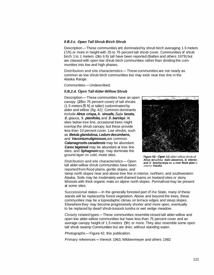
ll.B.2.c. Open Tall Shrub Birch Shrub
Description-These communities are dominated by shrub birch averaging 1.5 meters (5 ft) or more in height with 25 to 75 percent tall shrub cover. Communities of shrub birch 1 to 2 meters (3 to 6 It) tall have been reported (Batten and others 1979) but are classed with open low shrub birch communities rather than dividing the com- munities into low and high phases.
Distribution and site characteristics-These communities are not nearly as common as low shrub birch communities but may exist near tree line in the Alaska Range.
Communities-Undescribed.
ll.B.2.d. Open Tall Alder-Willow Shrub
canopy (25 to 75 percent cover) of tall shrubs Description-These communities have an open
alder and willow (fig. 42). Common dominants (1.5 meters [5 ft] or taller) codominated by
include Alnus crispa, A. sinuafa, Salk lanata, S. glauca, S . planifolia, and S. barclayi. At sites below tree line, occasional trees might overtop the shrub canopy, but these provide
as Betula glandulosa, Ledum decumbens, less than 10 percent cover. Low shrubs, such
and Vaccinium uliginosum, are common. Calamagrostis canadensis may be abundant. Carex bigelowii may be abundant at tree line sites, and Sphagnum spp. may dominate the ground layer on cold, moist sites.
Distribution and site characteristics-Open tall alder-willow shrub communities have been reported from flood plains, gentle slopes, and
Figure 4 2 4 p e n fall alder-willow shrub of Alnus tenuiiolia, Salix alaxensis, S. interior, and S. brachycarpa on a river flood plain in interior Alaska
steep north slopes near and above tree line in interior, northern, and southwestern Alaska. Soils may be moderately well-drained loams on lowland sites or stony lithosols with thick organic mats on alpine north slopes. Permafrost may be present at some sites.
Successional status-In the generally forested part of ihe State, many of these
communities may be a topoedaphic climax on terrace edges and steep slopes. stands will be replaced by forest vegetation. Above and beyond the trees, these
Elsewhere they may become progressively shorter amd more open, eventually to be replaced by dwarf shrub-tussock tundra or wet sedge meadow.
open low alder-willow communities but have less than 75 percent cover and an Closely related types-These communities resemble closed tall alder-willow and
tall shrub swamp Communities but are drier, without standing water. average canopy height of 1.5 meters (5 ft) or more. They also resemble some open
Photographs-Figure 42, this publication.
Primary references-Viereck 1963, Wibbenmeyer and others 1982
121

Communltles-Alnus crispa-Salix lanafa-S. planifoliaLedum decumbens-Carex bigelowii/Sphagnum spp. (Viereck 1963). Alnus crispa-Salix planifolidCarex bigelowii (Craighead and others 1988).
ll.B.2.e. Open Tall Shrub Birch-Willow Shrub
Description-These stands have an open canopy (25 to 75 percent cover) of tall (1.5 meters [5 111 or greater) shrubs dominated by shrub birches and willows. Dominant species include Betula glandulosa, Salix planifolia. and S. lanata. Tree species, especially spruce, may overtop the shrub canopy, but they provide less than 10 percent cover. Alnus crispa sometimes may be scattered in the tall shrub canopy.
and Vaccinium uliginosum, may be present. Calamagrostis canadensis, Festuca Low shrubs, such as Salix fuscescens, Spiraea beauverdiana, Ledum decumbens,
alfaica, and Mertensiapaniculata may be abundant in some stands. Mosses, including Sphagnum spp., may form extensive mats in welter areas, and fruticose
in drier. more open stands. lichens (such as Cladonia spp. and Stereocaulon fomentosum) are locally abundant
Distribution and site characteristics-Open tall shrub birch-willow stands occur on moderate upland slopes near the western and altitudinal tree-line, especially in the Alaska Range and on the Seward Peninsula. Soils are often moist silt loams, though no detailed descriptions are available. Permafrost may be present at some sites, probably at depths of 50 centimeters (20 in) or more.
Successional status-Successional relations are unknown. In their position near tree line, these communities may be fairly stable, perhaps occupying sites sub- marginal for tree growth but sufficiently warm to inhibit organic matter accumulation, soil cooling, and other edaphic phenomena leading to tundra development.
Closely related types-Open tall shrub birch-willow stands are similar to closed tall
former and taller (1.5 meters [5 ft] tall or more) than the latter. They also are similar and open low birch-willow but are more open (25 lo 75 percent cover) than the
to open tall shrub birch and open tall willow stands but are equally dominated by both shrub genera.
Primary reference-Hanson 1953.
Communlties--Betula glandulosa-Salix planifolia-S. lanata-Alnus crispa (Hanson
ll.B.2.f. Open Tall Shrub Swamp
Description-These are wetland scrub communities with waterlogged soils and standing water throughout all or much of the growing season. They are characterized by an open (25 to 75 percent cover) canopy of tall (1.5 meters [5 ft] or more) shrubs. Common dominants include Alnus fenuifolia. Salix planifolia, and S. lanata. Some- times Alnus crispa or A. sinuafa may be dominant or codominant, especially where A. tenuifolia is absent from the flora. Tree species occasionally may overtop the
common include Myrica gale, Spiraea beauverdiana, Viburnum edule, Rosa shrub canopy but provide less than 10 percent cover. Low shrubs that may be
acicularis, and Ribes friste. A dense herb layer often is present and can include species such as Calamagrostis canadensis, Carex aquafilis, Equisetum arvense, E. fluviatile, Potentilla palusfris, and Polemonium acufiflorum. Mosses, including Mnium spp., feathermosses, and sometimes Sphagnumspp.. are common but usually discontinuous. Lichens are scarce.
1 953).

Distribution and site characteristics-Open tall shrub swamps occur on wet soils on flood-plain terraces, on wet creek banks and drainageways, and in other places receiving seepage or relatively nutrient-rich water in interior and south-central Alaska. The substrate is usually hummocky, with microrelief of up to 70 centimeters (28 in). The hollows are usually flooded with water. This water is generally nct stagnant but flows slowly through the system. Soils may be mineral, a mixture of well-decomposed organic material and mineral material, or sometimes peat. Soil pH is circumneutral to slightly acid (ca. 6). Permafrost is generally absent but may be present at the northernmost sites.
Successional status-Successional relations are unknown. Most stands probably are fairly stable as long as the hydrologic regime remains constant.
tall shrub swamp communities but have more open shrub canopies (25 to 75 percent Closely related t y p e s o p e n tall shrub swamp communities are similar to closed
tall shrub cover). They also are similar to open tall willow, alder, and alder-willow communities but are wetter, with saturated soils and standing water during all or much of the growing season. Alnus tenuifolia, rarely dominant in nonwetland com- munities, commonly dominates shrub swamps. Some communities may be similar to willow-graminoid scrub bogs but have taller shrubs and usually have a substantial alder component.
Photographs-Hogan and Tande 1983, plate 5.
Primary references-Brock and Burke 1980, Hogan and Tande 1983, Ritchie and others 1981.
Communities-Alnus tenuifolidCarex aquatilis-Calamagrosris canadensis (Ritchie and others 1981). Alnus fenuifo/ia/Myrica gale-Calamagrostis canadensis (Ritchie and others 1981). Alms tenuifolialRosa acicularis-Calamagrostis canadensis (Hogan and Tande 1983). Salix planifolia-Alnus crispa/Betula nana-Calamagrostis spp. (Brock and Burke 1980).
KC. Low Scrub
These communities are dominated by low shrubs (shrubs 20 centimeters 18 in] to
by shrubs at least 20 centimeters (8 in) tall; trees provide less than 10 percent cover 1.5 meters (5 ft] tall). Specifically, these communities have at least 25 percent cover
and tall shrubs (taller than 1.5 meters [5 ft]) provide less than 25 percent cover. Dominant plants are generally alders, willows, and shrub birches. Myrica gale,
Some ericaceous shrubs transcend the boundary between dwarl scrub and low Potentilla fruticosa, and some ericaceous shrubs may dominate some communtites.
scrub. In general, Vaccinium uliginosum and Ledum spp. are considered to be low shrubs; Empetrum nigrum, Vaccinium vitis-idaea, Arctostaphylos spp., Loiseleuria procumbens, and Diapensia lapponica are considered to be dwarf shrubs. Com- munities containing shrub birch as a codominant species always are placed in either the tall or low scrub unit.
II.C.1. Closed Low Scrub
Closed low scrub includes communities with at least 75 percent cover by shrubs 20 centimeters (8 in) tall or taller. Trees provide less than 10 percent cover and shrubs over 1.5 meters (5 11) tall provide less than 25 percent cover.
123

Figure 43-Closed low birch shrub of
planifolia subsp. pulchra, S. glauca, Betula glandulosa wilh scattered Salix
Epilobiurn angustiloliurn between the Calamagmstis canadensis, and
the south slope of the Alaska Range birch clumps, just above lreeline on
in soulhenlral Alaska
II.C.1.a. Closed Low Shrub Birch Shrub
at least 20 centimeters (8 in) tall (fig. 43). Trees provide less than 10 percent cover Descrlption-These communities have at least 75 percent of their cover by shrubs
tall shrubs usually are absent. The low shrub (0.2 to 1.5 meters [8 in to 5 f t ] tall) and shrubs over 1.5 meters (5 f t ) tall provide less than 25 percent cover. Trees and
canopy is dominated by shrub birch (Befulaglandulosa or 8. nana). Sometimes scattered willows also are present in the overstory. Lower shrubs, such as Vacciniurn
small openings. Herbs generally are scarce, but feathermosses commonly form a uliginosurn and Ernpetrum nigrurn, may be common under the birch canopy and in
continuous mat and lichens may be common.
Distrlbution and site characteristics-Closed low shrub birch communities occur on river terraces in interior Alaska and on steep slopes and banks on the Seward Peninsula. The soil is fairly well drained and usually has an organic mat up to 30 cen- timeters (12 in) thick. Acid conditions predominate especially in the organic mat, which may be at least as acidic as pH 4.5. Permafrost is usually absent or at least 50 centimeters (20 in) below the surface.
Successional status-On terraces, the successional trend is usually toward in-
decreasing size and density of shtubs. On such sites, shrub birch communities tend creasing organic layer thickness, decreasing soil drainage and temperature, and
to be slowly transformed into shrub-tussock communities. On steep slopes and banks, closed low shrub birch communities may be a topographic climax.
tall shrub birch communities and open low shrub birch communities, but the birches Closely related types-Closed low shrub birch communities are similar to closed
are less than 1.5 meters (5 f t ) tall on the average and provide at least 75 percent cover. Closed low shrub birch-willow shrub has more willow.
Photographs-Viereck 1966, figure 8; figure 43, this publication.
Primary references-Hopkins and Sigafoos 1951, Racine and Anderson 1979, Viereck 1966.
Communities-Betula nana (Craighead and others 1988, Hopkins and Sigafoos
Hylocorniurn splendens (Viereck 1966). 1951, Racine and Anderson 1979). Betula glandulosa/P/euroziurn schfeberi-

Figure 44-Closed low willow shrub of Salixplaniiolia subsp. pulchra along a small stream in noiihwest Alaska.
1I.C.l.b. Closed Low Willow Shrub
20 centimeters (8 in) tall (fig. 44). Trees provide less than 10 percent cover, and Description-These communities have at least 75 percent cover by shrubs at least
shrubs over 1.5 meters (5 11) tall are absent or provide less than 25 percent cover. Willows commonly dominating the shrub canopy include Salixglauca, S. planifolia, and S. lanata. Myrica gale also may be present on wet sites. Common species in the herb layer include Calamagrosfis canadensis, Equisetum spp., Sanguisorba stipulata, Lafhyrus palustris, Festuca rubra, Amemone spp., and Astragalus alpinus. Feather- mosses, especially Hylocomium splendens, often are common.
Distribution and site characteristics-Closed low willow communities occur in moist protected gullies and drainageways, streambanks, and on steep scarps around lakes and ponds in arctic and alpine tundra of interior, northern, and western Alaska. They also are present on major river deltas in south-central Alaska and probably at the fringes of other low-elevation wetlands in south-central and interior Alaska. Soils are usually moist and fairly well drained. A thin organic layer may be present. Stands
of snow during winter, which melts relatively early in the spring. Permafrost usually is in topographic depressions (gullies and drainageways) are protected by a thick layer
absent or at least 50 centimeters (20 in) below the surface.
Successional status-Communities in depressions in tundra regions may represent topoedaphic climaxes. If they change at all, it is probably in the direction of shrub- tussock tundra. Lowland communities in south-central and interior Alaska are replaced eventually by forests, but this may take a long time, especially on the wetter sites.
Closely related types-Closed low willow shrub is similar to closed tall willow shrub and open low willow shrub but has less than 25 percent cover of shrubs over 1.5 meters (5 ft) tall and at least 76 percent cover in shrubs 20 centimeters (8 in) and taller. Closed low shrub birch-willow is codominated by dwarf birch and willow.
Photographs-Racine and Anderson 1979, figure 4; figure 44, this publication.
Viereck 1962, 1963. Primary references-Churchill 1955; Crow 1968: Racine and Anderson 1979:
125

Communltles-Salix planifolia (Craighead and others 1988). Salixplanifolia- Vaccinium spp./Arcfagrosfis lafifolia (Craighead and others 1988). Salix planifolia-S.
planifolia/Equisefum arvense (Webber and others 1978). Salix glauca-8 planifolia-S. lanafa-Myrica gale/Calamagrostis canadensis (Craighead and others 1988). Salix
lanafa/Equisefum arvense (Craighead and others 1988; Pegau 1968; Racine 1977; Racine and Anderson 1979; Viereck 1962, 1963). Salix glaucaPefasifes frigidus (Churchill 1955). Salix /anafa/Carexspp. (Craighead and others 1988). Salix lanafa/Equisefumspp. (Craighead and others 1988). Salix lanata/Carex aquafilis- Equisetum arvense (Scott 1974a). Salix spp./Fesfuca rubra (Crow 1968). Salix spp./€quisetum prafense (Crow 1968).
II.C.1.c. Closed Low Shrub Birch-Willow Shrub
Description-These communities have at
20 centimeters (8 in) tall (fig. 45). Trees least 75 percent cover by shrubs at least
provide less than 10 percent cover and shrubs over 1.5 meters (5 ft) tall provide
canopy is dominated by shrub birch less than 25 percent cover. The shrub
(Betula glandulosa or 6. nana) and willows (commonly Salix planifolia and
sparse. Mosses, such as Hylocomium spp S. lanafa). The herb layer is usually
and Aulacomniumspp., form a mat under the shrubs.
characterlstics-closed low shrub Distrlbutlon and Site
birch-willow shrub is uncommon veg- etation that has been reported from the northern foothills of the Brooks Range,
Figure 45-Closed low mixed birch and willow shrub of Betula glandulosa Salix lanata subsp. richardsonii. S. alauca. and Salix danifolia subsp. p u l c h r a h scattered whiie spruce on a river terrace in the Alaska Range.
where it occupies colluvial deposits near valley bottoms. Soils are generally Pergelic Cryaquepts or Histic Pergelic Cryaquepts. Microrelief patterns are absent. Permafrost is present, but thickness of the active layer is unknown.
Successional status-Shrub birch-willow shrub often is replaced by shrub-tussock tundra or wet sedge meadow, depending on soil moisture. This probably takes a long time, and it may be better to consider these communities as topoedaphic climaxes.
Closely related types-Closed low shrub birch-willow shrub is similar lo closed tall shrub birch-willow shrub and open low shrub birch-willow shrub but has at least 75 percent shrub cover and less than 25 percent tall shrub cover. It also is similar to closed low shrub birch shrub and closed low willow shrub but has a dominant com- ponent of both shrub birch and willow.
Photographs-Figure 45, this publication.
Prlmary referencdorgenson 1984.

Communities-Betula nana-Salixplanifolia/Hylocomium splendens-Aulacomnium turgidum (Jorgenson 1984). Betula nana-Salix planifolia-Ledum decumbens (Craighead and others 1988). Betula nana-Salk planifolidfetasites frigidus (Craighead and others 1988). Befula nana-Salix planifolia-Vaccinium uliginosum (Craighead and others 1988).
II.C.1.d. Closed Low Ericaceous Shrub
Description-These rare communities have at least 75 percent cover by shrubs at
over 1.5 meters (5 ft) tall provide less than 25 percent cover. These communities are least 20 centimeters (8 in) tall. Trees provide less than 10 percent cover and shrubs
dominated by ericaceous shrubs having a true shrub physiognomy. The only closed low ericaceous shrub community described to date is dominated by copperbush (Cladothamnuspyrolaeflorus). This shrub forms dense thickets with no important associated species.
from near tree line in southeast Alaska, where they commonly occur in depressions Distribution and site characteristics-Copperbush communities have been reported
and at the bases of steep banks where deep snow accumulates in the winter and persists until late spring.
Successional status-Copperbush communities appear to be a topoedaphic climax in areas of deep snow accumulation.
Closely related types-Closed low ericaceous shrub may be similar to dwarl ericaceous shrub tundra (II.D.1.g.) but are dominated by ericaceous shrubs that characteristically grow much taller than the 20-centimeter (8-in) boundary between dwarf shrubs and low shrubs.
Primary referencc+Shacklette 1965.
Communities-Cladofhamnuspyrolaeflorus (Shacklette 1965).
I1.C.l.e. Closed Low Alder-Willow Shrub
Description-These communities have at least 75 percent cover by shrubs at least 20 centimeters (8 in) tall. Trees provide less than 10 percent cover and shrubs over 1.5 meters (5 11) tall provide less than 25 percent cover. The shrub canopy is codom- inated by alder and willow. Species of aider and willow present in these communities have not been documented but probably include Alnus crispa, A. sinuata, Salix glauca, S. barclayi, S. planifolia, and S. lanafa. Dwarf ericaceous shrubs, such as Arctostaphylos alpina, Empetrum nigrum, and Vaccinium vitis-idaea may be common in the understory. Nonsphagnaceous mosses also are common.
Distribution and site characteristics-Closed low alder-willow communities have
flood plains and gentle slopes. They also may occur in other parts of the State, been reported from southeastern Alaska on poorly to moderately drained soils on
particularly interior and western Alaska near and beyond tree line.
Successional status-On gentle slopes beyond the treeline, these may be climax communities or at least stable over long periods. In flood-plain stands shrub density, soil drainage, and soil temperature probably decrease with time, resulting in replace-
climate. ment of shrub community by open forests or shrub tundra, depending on soil or
127

Closely related types-Closed low alder-willow communities are similar to closed tall alder-willow communities and open low alder-willow communities, but the canopy is primarily less than 1.5 meters (5 11) tall and provides at least 75 percent cover. These communities also are similar to closed low willow communities but have a substantial alder component.
Primary reference-Wibbenmeyer and others 1982.
Communltie+Alnus spp.-Salix spp. (Wibbenmeyer and others 1982).
ll.C.2. Open Low Scrub
Open low scrub Communities are characterized by an open canopy (25 to 75 percent cover) of low shrubs (0.2 lo 1.5 meters [E in to 5 ft) tall). More specifically, they have 25 to 75 percent cover by shrubs at least 20 centimeters (8 in) tall, shrubs taller than 1.5 meters (5 it) provide less than 25 percent cover, and trees overtopping the shrub canopy provide less than 10 percent cover. If low shrubs are the only plants present, cover can be as low as 2 percent. Many shrubby wetlands and tundra types are in- cluded in this unit. Many ericaceous shrubs sometimes grow shorter than 20 centi-
on wetlands and those containing shrub birch are treated as open low scrub. Other meters (8 in) and sometimes grow taller. In practice, ericaceous shrub communities
dwarl scrub unit (1I.D.). ericaceous shrub communities (primarily alpine heath vegetation) are treated in the
II.C.2.a. Open Low Mlxed Shrub-Sedge Tussock Tundra
Descrlptlon-These communities have at least 25 percent shrub cover and are dom- inated by tussock-forming sedges, usually Eriophorum vaginatum but sometimes Carex bigelowii. Tussocks are commonly 5 to 30 centimeters (2 to 12 in) high and
square meter (10.8Ift ) (Hopkins and Sigafoos 1951, Racine and Anderson 1979). 15 to 35 centimeters 6 to 14 in) wide, often with a density of 2-4 tussocks per
Trees are absent or very scarce. Mosses and dwarf shlubs form a mat surrounding the tussocks. Commn shrubs include Betulaglandulosa, 8. nana, Ledum decumbens, Vaccinium vitis-idaea, and V. uliginosum. Other shrubs sometimes commn include Empetrum nigrum (especially in western Alaska), Rhododendron
Arctostaphylos rubra. Rarely an open overstory of scatfered alders (Ahus crispa) or lapponicum (especially in calcareous areas), Salix planifolia, S. reticulafa, and
willows up to 1 meter (3 ft) tall is present. Herbs other than the tussock-formers are generally scarce, though Rubus chamaemorus is locally commn and Arctagrostis latifolia. Poa arctica, Eriophorum angusfifolium (especially in frost scars), Pedicularis labradorica, and Perasires frigidus may be present. Common mosses include
spp. Sphagnum is often a rather minor constituent, or even absent, but is sometimes Pleurozium schreberi, Hylocomium splendens, Aulacomnium spp., and Sphagnum
quite important. Lichens, such as Cetraria cucullata, C. islandica, Cladonia spp., Cladina rangiferina. and Jhamnolia subuliformis, may be common.
1
128

Distribution and site characteristics-Mixed shrub-sedge tussock tundra is char- acteristic of polygonal ground and wet to mesic gentle slopes in northern and western Alaska and in alpine areas of interior Alaska. It is one of the most extensive tundra vegetation units in the State and occupies vast areas of the Arctic Foothills and the Seward Peninsula. It commonly occurs on Pergelic Cryaquepts and Histic Pergelic Cryaquepts (upland tundra and meadow tundra) soils. Permafrost generally is present 30 to 40 centimeters (12 to 16 in) below the surface but may be as much as 90 centi- meters (35 in) below the surface on the Seward Peninsula (Hopkins and Sigafoos 1951, Racine and Anderson 1979).
An organic mat of variable thickness in which the shrubs are rooted often is present at the soil surface. The tussocks always are rooted in mineral soil so that the organic mat is never thicker than the active layer. Pockets of standing water usually are present at spring breakup and the soil remains moist to wet throughout the growing season. In many areas, water will seep slowly into soil pits dug at any time in the growing season. The mineral soil is a fine-textured gley with gray or dark-gray
generally acid with pH values of 4.4 to 4.9 at the surface; these usually increase mottling, which indicates anaerobic conditions and periodic waterlogging. Soils are
with depth.
Frost scars (unvegetated or slowly revegetating patches of mineral soil thrust to the surface by frost action) may be absent or abundant. Carex bigelowiitends to dominate on steeper, better drained, and less acid soils than Eriophorurn vaginaturn.
tation for large areas of arctic Alaska. But if local climatic conditions lead to the Successional status-Shrub-tussock communities probably are the climax vege-
tussocks (the tussocks must stay above the rising tide of peat but keep their roots in accumulation of organic matter, mosses and shrubs thrive at the expense of the
unfrozen mineral soil). Eventually, mosses and shrubs invade the tussocks, thereby leading to tussock senescence and death. This generally leads to the development of wet shrub birch-ericaceous shrub communities. Disturbances such as fire favor the tussocks by burning back the shrubs and moss and by releasing nutrients from the peat mat that the tussocks can use more effectively than the shrubs can use them (Fetcher and others 1984).
Closely related types-These communities are very similar, if not identical, to mixed shrub-sedge tussock bog communities but occur in arctic and alpine areas (beyond the trees) instead of in subarctic lowland areas (within the trees). They also are similar to tussock tundra (lll.A.2.d.) but have more than 25 percent shrub cover. They are similar to mesic shrub birch-ericaceous shrub communities and shrub birch-ericaceous shrub bog communities, except that these two communities lack tussocks.
Photographs-Drew and Shanks 1965, figure 11; Johnson and others 1966, figure
figure 9. 13; Kessel and Schaller 1960, figures 2 and 3; Racine 1976, figure 33; Viereck 1966,
Primary references-Brock and Burke 1980, Holowaychuk and Smeck 1979, Hopkins and Sigafoos 1951, Johnson and others 1966, Racine and Anderson 1979, Viereck 1966.
129

Communities-friophorum vaginaturn-Salixplanifolia-S. lanata (Koranda 1960).
(Childs 1969, Dean and Chesemore 1974, Hanson 1950). friophorurn vaginatum- Eriophorurn vaginatum-Carex bigelowii-Ledurn decurnbens-Vacciniurn vitis-idaea
Betula nana-Ledum decumbens-Vaccinium spp. (Bliss and Cantlon 1957, Clebsch 1957, Craighead and others 1988, Drew and Shanks 1965. Hanson 1953, Jorgenson
and Walters 1974, Young and Racine 1978). Eriophomm vaginaturn-Betula nana- 1984. Pegau 1968, Peterson and Billings 1978, Racine and Anderson 1979, Ugolini
Salix planifolia-Ledum decurnbens-Vaccinium spp. (Johnson and others 1966, Koranda 1960, Young 1974b). Eriophorum vaginaturn-Betula nana-Sa/ix lanata- Ledumdecumbens-Vaccinium spp. (Webber and others 1978). friophorurn vaginaturn-Betula nana-Ledum decumbens-Vaccinium spp.-Carex bigelowii (Brock and Burke 1980; Churchill 1955; Craighead and others 1988; Hopkins and Sigafoos 1951; Nodler and others 1978; Racine 1976,1977; Racine and Anderson 1979; Viereck 1966; Young and Racine 1977). friophorurn vaginatum-Betula nana-Salix planifolia-Ledum decumbens-Vaccinium spp.-Carex bigelowii (Spetzman 1959. Webber and others 1978). friophorum vaginatum-Betula nana (Jorgenson 1984, Kessel and Schaller 1960, Komarkova and Webber 1980, Webber and others 1978). Carex bigelowii-Betula nana-Salix planifolia-Ledum decumbens-Vaccinium spp. (Craighead and others 1988, Racine and Anderson 1979, Racine and Young 1978). Carex bigelowii-Salix spp.-Dyas integrifolia (Craighead and others 1988). Carex bigelowii-Vaccinium uliginosum-feathermosses (Craighead and others 1988). Carex bigelowii-Spiraea beauverdiana (Craighead and others 1988). Carex bigelowii- Vaccinium spp./Sphagnum spp. (Brock and Burke 1980). Eriopborurn vaginatum- Carex bigelowii-Betula nana-Ledum decumbens-Alnus crispa (Brock and Burke 1980).
ll.C.2.b. Open Low Mlxed Shrub-Sedge Tussock Bog
Description-These communities are dominated equally by sedge tussocks (usually
(20 in) above the surface and reach a maximum of 35 centimeters in diameter, friophomm vaginatum) and low shrubs. The tussocks are as high as 50 centimeters
though usually they are considerably smaller. Low shrubs provide at least 25 percent cover. They are commonly represented by Betula glandulosa, B. nana, Ledum decumbens, Vaccinium ulignosum, and V. vitis-idaea. Other low shrubs that may be present include Chamaedaphne calyculata, Vaccinium oxycoccos, Potentilla fruticosa, Salix planifolia, S. fuscescens. and Alnus tenuifolia. Trees provide less than 10 percent cover and usually are restricted to scattered. stunted individuals of black spruce. Herbs generally are sparse, but Rubus cbamaemorus, Equisetum spp.,
tussocks. Common msses include Sphagnumspp., Pleurozium schreberi, and and Carex spp. may be common. Mosses form a nearly continuous mat between
is sometimes present. Hylocomium splendens. Lichens appear to be scarce, though Peltigera canina
Distribution and site characterlstlcs-Mixed shrub-sedge tussock bog communities are found in the lowlands of interior and south-central Alaska in filled-in sloughs on flood plains and on cold. poorly drained slopes and terraces in wet silty mineral soil with a surface peat layer 10 to 40 centimeters (4 to 16 in) thick surrounding the tussocks. The soil is saturated most of the year. The organic layer is usually highly acidic (pH 3.5 to 5.7). Permafrost is present at 30 to 40 centimeters (12 to 16 in) below the surface. Some of these communities have evidently been burned in the past (Calmes 1976). As in the tussock tundra types, the tussocks are rooted in mineral soil and the shrubs are rooted primarily in the organic mat.
130

Successlonal status-Many of these communities appear to be quite stable amd
fire, to persist. If soils are not too wet, black spruce or tamarack, or both, may invade may be topoedaphic climaxes; others may require periodic disturbance, such as
scrub) vegetation. If the organic mat becomes thick, mosses and shrubs may invade in sufficient numbers for development of woodland or open forest (or dwarf tree
tussocks, thereby leading to their senescence and death. On the other hand, fire burns back the shrubs and moss, which releases nutrients for uptake by the tussocks. Shrub-tussock bogs seem to develop on permafrost soils, with fine-textured mineral soil composing at least the base of the active layer, on sites slightly too dry to support wet sedge meadows.
Closely related types-Mixed shrub-sedge tussock bogs are very similar to mixed shrub-sedge tussock tundra, and are differentiated primarily by locality. The shrub- tussock bogs occur in flood-plain depressions and poorly drained slopes within the generally forested part of the State. Shrub-tussock tundra occupies poorly drained slopes, plateaus, and valleys in northern, western, and interior Alaska above or beyond tree line. Mixed shrub-sedge tussock bogs also are similar to some black spruce woodland and black spruce dwarf tree scrub woodland communities but have less than 10 percent tree cover.
Photographs-calmes 1976, figures 4, 11, and 18.
Primary references-Calmes 1976, Dyrness and Grigal 1979, Neiland and Viereck 1977.
Communities-Eriophorm vaginaturn-Betula nana-Ledum decumbens/Sphagnum spp. (Calmes 1976, Dyrness and Grigal 1979, Neiland and Viereck 1977, Pegau 1972, Talbot and others 1984, Wibbenmeyer and others 1982).
ll.C.2.c. Open Low Mesic ShNb Birch-Ericaceous Shrub
Description-These communities have 25 to 75 percent cover by shrubs at least 20 centimeters (8 in) tall (fig. 46). Trees overtopping the shrubs provide less than
25 percent cover. Common dominants include Betula glandulosa, B. nana, Vaccinium 10 percent cover, and tall shrubs (taller than 1.5 meters [5 ft]) provide less than
uliginosum, V. vitis-idaea, Ledum decumbens, Arctostaphylos spp., and Empetrum nigrum. Other ericaceous shrubs are commonly present in smaller amounts. Salix reticulata, S. arctica, S. glauca, S. planifolia, and Dryas integrifolia may be important locally. Scattered trees, primarily white spruce and black spruce, may be present. The shrub birch frequently forms an overstory 0.5 to 1.5 meters (20 in to 5 It) tall, or sometimes slightly taller, with the ericaceous shrubs and any herbs present forming an understory below and between the taller shrubs. In less productive stands, the shrub birch may grow only 20 to 50 centimeters (8 to 20 in) tall and form a single layer of birch, ericaceous shrubs, and herbs. In both types, common herbs include Festuca altaica, Hierochloe alpina, and Carex bigelowii. A moss mat usually is present, especially under the shrubs. Hylocomium splendens, Pleurozium schreberi, Polytrichum spp., and Tomentbypnum nitens may be common. Lichens may be common to abundant. Important lichen species include Cetraria islandica, C. cucullata, Stereocaulon tomentosum. Cladonia spp., and Thamnolia vermicularis.
131

132
birch-ericaceous shrub tundra with Figure 4 6 0 p e n low mesic shrub
Betula glandulosa, Ledurn decurnbens. Vaccinium uliginosum, and Vaaccinium viris-idaea near tree line in the Alaska Range in interior Alaska
Distribution and slte characteristics-Mesic shrub birch-ericaceous shrub commu- nities occupy extensive areas of mesic slopes in the Alaska Range, in alpine areas of interior and south-central Alaska, and in northern and western Alaska. These commu-
conditions. The soil is generally mineral with a well-decomposed organic layer 5 to nities can develop on sites with a wide variety of moisture, temperature, and edaphic
30 centimeters (2 to 12) thick. Much mineral material is admixed into the base of the organic layer. Silt loams or stony silt loams are common. Soil reaction is usually somewhat acidic; pH 4.5 to 6.0 is fairly typical. Permafrost is generally present but usually at least 50 centimeters (20 in) below the surface.
change little over time. Some may develop on burned-over spruce forests and Successlonal status-Many of these communities appear to be stable and to
woodlands near tree line (Pegau 1972); these stands may be slowly reverting to forest. Mesic shrub birch-ericaceous communities tend to grade into shrub-tussock communities as moisture increases, into shrub birch-ericaceous shrub bogs as moisture increases on thick peat deposits, and into dwarf shrub (mat and cushion) fellfield communities as moisture decreases and wind exposure increases.
Closely related types-Mesic shrub birch-ericaceous shrub communities are similar to shrub birch-ericaceous bog communities, but lack hydrophytic sedges (such as Carex aquafilis, C. pluriflofa. and Eriophorum angusfifolium) and Sphagnum spp. Fesfuca altaica, present in many of the mesic communities is absent from the bog communities. Mesic birch-ericaceous communities also are similar to some mixed shrub-sedge tussock communities but lack tussock-forming sedges. At the other extreme, some communities resemble dwalf shrub (mat and cushion) communities but have abundant birch and usually are not as windswept and unproductive. They also are similar to open tall birch shrub communities but are dominated by low shrubs (generally 0.2 to 1.5 meters [E in to 5 ft] tall). They are similar to closed low shrub birch communities but have an open canopy (25 to 75 percent cover) and frequently a more diverse understory. Some white spruce woodlands are similar to mesic birch-ericaceous shrub communities but have at least 10 percent tree cover. Some ericaceous dwarf shrub and dryas dwarf shrub communities are similar lo mesic shrub birch-ericaceous shrub communities but lack significant cover of shrub birch.
Photographs-Viereck 1966, figure 7; figure 46, this publication.
.

Primary referencecHanson 1951; Pegau 1972; Steigers and others 1983; Viereck 1963, 1966, 1983.
Communities-Betula glandulosalVaccinium uliginosum-Empetrum nigrum-Ledum
Janz 1974, Hulten 1966, Jorgenson 1984, Kessel and Shaller 1960, Pegau 1968, decumbens’iichens (Anderson 1974, Batten 1977, Hanson 1953, Hettinger and
Steigers and others 1983, Webber and others 1978, Young and Racine 1978). Betula glandulosalfesfuca alfaica-Vaccinium spp./feathermosses-lichens (Hanson 1951, Hettinger and Janz 1974, Pegau 1972, Viereck 1963). BefulaglandulosaI Fesfuca alfaica4eathermosses (Batten and others 1979; Viereck 1962, 1966). Betula glandulosa-Vaccinium spp.-Carex bigelowii (Churchill 1955, Hanson 1950). Befula glandulosa-Ledum decumbens-Vaccinium vifis-idaea-Arcfagrostis lafifolia (Churchill 1955). Befulaglandulosa-Salix spp./Carex bigelowii-Ledum decumbens/ feathermosses-lichens (Hanson 1951. Scott 1972). Betula nana-Rubus chamaemorus- Ledum decumbens-Vaccinium spp. (Craighead and others 1988).
ll.C.2.d. Open Low Shrub Birch-Ericaceous Shrub Bog
Description-These communities have 25 to 75 percent cover by shrubs at least 20 centimeters (8 in) tall. Trees overtopping the shrub canopy provide less than
cent cover. Common dominants include Befula glandulosa, 6. nana, Vaccinium 10 percent cover and tall shrubs (over 1.5 meters or 5 ft) provide less than 25 per-
polifolia. Other locally common shrubs include Myrica gale, Pofenfilla fruticosa, Salix uliginosum, V. vifis-idaea, Ledum decumbens, Empefrum nigrurn, and Andromeda
planifolia, and S. reticulafa. Small stunted spruce trees are scattered in some stands, usually black spruce in interior and south-central Alaska lowlands and white spurce
common species include Rubus chamaemorus, Eriphorurn angustifolium, Carex near tree line. A wide variety of sedges and other herbs may be present. Some
aquafilis, C. limosa, C. pauciflora, C. rotundafa, and C. magellanica. Occasional Eriophorum vaginafum or Carex bigelowii tussocks may be present, and Equisetum fluviafile sotlletimes is abundant. Sphagnum spp. are abundant at most sites but also can be absent. Feathermosses, Dicranum spp. and Polyfrichum spp., are locally common. Common lichens include Cetraria islandica, C. cucullafa, Cladonia spp., and Cladina spp.
are common on wet, peaty substrates in south-central, interior, western, and to Distribution and site characteristics-Shrub birch-ericaceous bog communities
some extent northern Alaska. In many cases, these communities occupy the ridges of string bogs but they also occupy unpatterned wetlands. The substrate is peat, usually if not always composed at least partially of sphagnum mosses. The peat is at least 20 centimeters (8 in) thick, and accumulations greater than 4 meters (13 ft) thick have been reported (Hogan and Tande 1983). Microrelief is usually present, consisting of hummocks or narrow elongated ridges. The peat usually is acid with a pH of about 4.5 to 5.5. Permafrost is present at depths of 30 to 100 centimeters (12 to 40 in) at most sites but is absent from many of the southernmost stands.
Successional status-These communities may develop in some cases from sedge meadows or bog meadows as peat accumulates and the upper part of the peat becomes hummocky and drier, thereby enabling shrub invasion. They also may develop from shrub-tussock bogs if peat accumulates and overruns the tussocks. If growing-season warmth is adequate and the peat is not too wet, trees (primarily black spruce) may invade these sites and eventually transform them to woodlands or dwarf tree woodland scrub.
133

Closely related types-Shrub birch-ericaceous shrub bogs are similar to mesic shrub birch-ericaceous shrub communities but occur on peats and have peat-forming mosses or sedges, or both, as part of the community. Sphagnum spp. and hydro- phytic sedges (for example, Carex aquatilis and C. limosa) generally indicate a bog community. Birch-ericaceous bogs also are similar to ericaceous shrub bogs, but the latter lack shrub birch and are restricted mainly to maritime climates or extremely wet sites. Birch-ericaceous bogs also are similar to shrub-tussock bogs but lack tussocks. Some are similar to black spruce woodland and black spruce dwalf tree woodland scrub but have less than 10 percent tree cover.
Photographs-Drew and Shanks 1965, figures 15 and 17; Dlury 1956, figure 11; Hogan and Tande 1983, plates 13,14,16,17,19, and 22; Johnson and others 1966, figure 16; Racine 1976, figure 30; Racine 1978b, figure 40.
Prlrnary references-Brock and Burke 1980, Dachnowski-Stokes 1941, Drew and Shanks 1965, Drury 1956, Griggs 1936, Hanson 1951, Hogan and Tande 1983, Johnson and others 1966, Racine and Anderson 1979, Viereck 1966.
Communities-Betula glandulosa-Vaccinium vitis-idaea-Rubus chamaemomd Sphagnumspp. (Bos 1967, Dachnowski-Stokes 1941, Drew and Shanks 1965, Fries 1977, Hanson 1953, Hogan and Tande 1983, Johnson and others 1966, Jorgenson 1984. Komarkova and Webber 1978, Racine 1976, Racine and Anderson 1979, Rigg 1914, Rosenberg 1986. Steigers and others 1983, Tande 1983, Webber and others 1978. Young and Racine 1978). Betula glandulosa-Vaccinium uliginosum-Carex spp./Sphagnum spp. (Brock and Burke 1980; Hanson 1950, 1953; Hogan and Tande 1983; Racine 1978a, 1978b; Viereck 1970b). Betulaglandulosa-Andromeda polifolidSphagnumspp. (Hogan and Tande 1983, Ritchie and others 1981). Betula glandulosa-Rhododendron lapponicum-Carex spp. (Drew and Shanks 1965). Betula glandulosa-Myrica gale-Andromeda polifolidSphagnum spp. (Drury 1956, Hanson 1951, Hogan and Tande 1983). Betula glandulosa-Myrica gale-Carex spp./Sphagnum spp. (Griggs 1936). Potentilla fruticosa-Myrica gale-Betula glandulosdEmpetrum nigmnVSphagnumspp. (Hogan and Tande 1983. Racine 1978b). Potentilla fruticosa- M y r a gale-Betula glandulosa-Ledum decumbensfeathermosses (Hogan and Tande 1 983).
ll.C.2.e. Open Low Ericaceous Shrub Bog
Description-These communities are dominated by ericaceous shrubs generally forming a loose mat 20 to 50 centimeters (8 to 20 in) thick. Shrubs provide 25 to 75 percent cover. Common shrubs include Kalmia polifolia, Empetrum nigrum, Vaccinium uliginosum, V. vitis-idaea, Andromeda polifolia, Vaccinium oxycoccos, and Ledum decumbens. Ledum decumbens, Vaccinium uliginosurn, and V. vitis-idaea are most common in interior, south-central, and southwestern Alaska. Kalmia polifolia is limited to southeast Alaska. Scattered trees may be present in oceanic bogs (southeast Alaska and the gulf coast of Alaska). Common trees include lodgepole
western hemlock along the gulf coast. interior sites generally are too wet to support pine, Alaska-cedar, and mountain hemlock in southeast Alaska and Sitka spruce and
any trees at all; sites dry enough to support trees
134
r

generally also have an abundance of shrub birch, thereby becoming shrub birch- ericaceous shrub bogs. Sedges such as Eriophorurn angustifoliurn, Trichophorum caespitosum, Carex pluriflora, and C. pauciflora often are common or codominant. Other herbs commonly important include Rubus chamaemorus, Drosera spp., and Gentiana douglasiana; the last is restricted to southeastern Alaska. Sphagnum spp.
feathermosses. also may be common. Lichens may be present on mounds. are always present and usually dominate the moss layer. Other mosses, such as
Distribution and site characteristics-Ericaceous shrub bogs occur on peat
where shrub birch is absent and in a few extremely wet, young bogs in interior and deposits in maritime climates (southeast Alaska, gulf coasl, and Aleutian Islands)
south-central Alaska that are dominated by ericaceous shrubs and have not yet been
bogs and blanket bogs (bogs with thick peat deposits blanketing large areas of slopes invaded by shrub birch. In maritime areas, these communities occur on topogenous
and rounded summits). In south-central and interior Alaska, they are more or less restricted to topogenous bogs occupying lowland depressions. Peat depth is variable but generally is at least 45 centimeters (18 in) and often 1 to 2 meters (3 to 6 ft) or more. The peat usually is composed at least partially of sphagnum at the surface and often grades into sedge or woody peat with depth. The peat is highly acid, with pH values from 3.6 to 5.2. Bryophyte production of a bog near Fairbanks that is dom- inated by Andromeda polifolia has been measured at 115 grams per square meter per year (1,025 Ib/acre) (Luken and Billings 1983) and was produced by three
depth of 60 centimeters (24 in) along the Bering Sea side of the Alaska Peninsula species of Sphagnum. Permafrost generally is absent but has been reported at a
(Racine 1978a).
Successional status-No clear successional pattern is apparent in southeastern Alaska. Many of these bogs have remained stable for extended periods, others have been invaded by forest, and still others have expanded through paludification of forests (Neiland 1971). Relations among bog meadows (lacking substantial shrubs), ericaceous shrub bogs, and woodlands or open forests are complex and involve precipitation, temperature, vegetation, and peat composition.
In interior Alaska, ericaceous shrub bogs seem to develop from sedge meadows or sedge bog meadows as enough peat accumulates to provide a sufficiently dry surface for ericaceous shrub invasion. Dwarf birch also would be expected to invade in a relatively short time.
Closely related types-Ericaceous shrub bogs are similar to shrub birch-ericaceous shrub bogs but have little or no shrub birch. Many are similar to some mat and cushion (dwarf scrub) tundra types but are wetter and have more sphagnum and thicker peat accumulations. The dwarf scrub tundra types generally lack Sphagnum spp. or at most have them as minor constituents. Some ericaceous shrub bog communities are similar to bog meadow communities but have at least 25 percent shrub cover, primarily in ericaceous shrubs.
and Meyer 1977, figure 28 (aerial view). Photographs-Calmes 1976, figure 14; Dachnowski-Stokes 1941, figure 17; Scheierl
Primary references-Cooper 1942; Dachnowski-Stokes 1941; Luken and Billings 1983; Neiland 1971a, 1971b; Reiners and others 1971.
135

Communltles-Ledum decumbens-Vaccinium vitis-idaea/Sphagnum spp. (Dachnowski-Stokes 1941, Racine 1978b, Rigg 1914, Young and Racine 1976). Empetrum nigrum-Ledum decumbens/Sphagnum spp. (Bos 1967, Cooper 1942, Viereck 1970b). Empetrum nigrum-Vaccinium spp.-Carex pluriflora-Rubus chamaemorus/Sphagnumspp. (HultBn 1960). Empetrum nigrum-Vaccinium uliginosum-Eriophorrn angustifolium-Carex pauciflora/Sphagnum recurvum- Pleurozium schreberi3 Empetrum nigrum-Carex pluriflora-C. pauciflora/Sphagnum spp. (Batten and others 1978, Dachnowski-Stokes 1941, Heusser 1960, Scheierl and Meyer 1977). Empetrum nigrum-Eriophorum an~ustifolium-Carexpluriflora/Sphagnum recurvum-Pleurozium schreberi (see footnote 3). Empetrum nigrum-Eriophorum angustifolium/Sphagnum magellanicum-S. warnstorfii (Reiners and others 1971, Streveler and others 1973). Kalmia polifolia-Empetrum nigrum-Trichophorum caespitosum-Eriophorumangusfifolium/Sphagnum spp. (Dachnowski-Stokes 1941 ;
spp.-Carex spp. (Calmes 1976). Kalmiapolifolia-Empetrum nigrum-Trichophorum Neiland 1971a; Stephens and others 1969, 1970). Chamaedaphnecalyculata-Salix
caespitosum-Carexspp. (Dachnowski-Stokes 1941, Stephens and others 1969). Andromedapolifolia/Sphagnum spp. (Luken and Billings 1983, Racine 1976).
ll.C.2.f. Open Low Shrub Birch-Willow Shrub
Description-These communities have 25 to 75 percent cover of shrubs at least 20 centimeters (8 in) tall, less than 25 percent cover of shrubs taller than 1.5 meters (5 ft), and less than 10 percent cover of trees overtopping the shrub canopy. The canopy is dominated by shrub birch (Betula glandulosa, B. nana) and willows (Salix spp.). Common willows include Salix glauca, S. planifolia, S. lanata, and
common beneath the canopy and in openings include Vaccinium vitis-idaea, S. brachycarpa. Scattered black or white spruce may be present. Low shrubs
V. uliginosum, Ledum spp., and Empetrum nigrum. Common herbs include Calamagrostis canadensis, Eriophorum angustifolium, and Carex spp. on mesic to wet (usually lowland) sites and Festuca altaica and Hierochlo.5 alpha on mesic to dry (usually subalpine) sites. Scattered Eriophorum vaginatum tussocks may be present on wet sites. A continuous moss mat is present, which is usually composed of feathermosses (such as Hylocomium splendens and Pleurozium schreberj), Tomenthypnum nitens, and Aulacomnium palustre.
Distribution and site characteristics-Shrub birch-willow open low shrub commu- nities occur in poorly drained lowlands and moist slopes near tree line in interior, south-central, and southwestern Alaska and on terraces and cutbanks in arctic Alaska. They occur on mineral soils with a surface organic-rich horizon several centimeters thick. The soil is usually somewhat acid, with a pH of about 5 to 6.
(possibly shallower at the northernmost localities). Permafrost is nearly always present at depths of 50 to 100 centimeters (20 to 39 in)
Neiland, Bonita J. 1976. Unpublished field notes. On file with: University of Alaska Museum-Herbarium, 907 Yukon Drive, Fairbanks, AK 99775-1200.

Successional status-Communities on alpine and subalpine slopes are probably stable, though possibly subject to slow colonization by forests. Subarctic lowland stands also may be fairly stable as long as moisture conditions are constant. A drop
allow shrub-tussock communities or shrub birch-ericaceous shrub bog communities in the water table probably favors tree invasion, and a rise in the water table might
to occupy the site. Arctic stands generally develop from closed shrub thickets as the permafrost table rises and the active layer becomes wetter. In time, many of these stands will develop into shrub-tussock tundra.
Closely related types-Open low shrub birch-willow shrub is similar to mesic shrub birch-ericaceous shrub communities and shrub birch-ericaceous shrub bog commu- nities but has more willows, willow being codominant with birch. They also resemble some open low willow communities but have shrub birch. They are similar to closed low birch-willow and open tall birch-willow communities but are more open and
tundra, but Eriophomm vaginatum is much less important than it is in those types. shorter, respectively. Some stands may approach shrub-tussock bog or shrub-tussock
Primary references-Spetzman 1959, Steigers and others 1983, Talbot and others 1984, Viereck 1963.
Communities-Betula nana-Salix brachycarpa-S. planifolia-S. lanata/Arctostaphylos rubra-Cassiope fetragona-Ledum decumbens (Spetzman 1959). Betula nana- Salix lanata/Carex aquatilis-Equisetum spp. (Craighead and others 1988). Salix arbusculoides-S. glauca-S. hastataBetula glandulosa/Bromus pumpellianus-Festuca altaica (Batten 1977). Betula glandulosa-Salix glauca-S. planifolia/Festuca alfaica-
Salix glauca-Betula nana (Childs 1969). Betula glandulosa-Salix planifolia-Vaccinium Vaccinium vitis-idaea-Arctostapaphylos alpina/Hylocornium splendens (Viereck 1963)
uliginosum (Steigers and others 1983). Betula glandulosa-Salix spp.-Eriophorum spp./Hylocornium splendens (McCartney 1976, Talbot and others 1984).
ll.C.2.g. Open Low Willow Shrub
willows), at least 20 centimeters (8 in) tall (fig. 47). Shrubs taller than 1.5 meters Description-These communities have 25 to 75 percent cover of shrubs (primarily
(5 ft) provide less than 25 percent cover and trees overtopping the shrubs provide less than 10 percent cover. The understory is generally dominated by dwarf shrubs or forbs. Willows commonly dominant include Salix glauca, S. planifolia and S. lanata. Trees are generally absent. Shrubs important in the understory
dwarf willows such as Salix reticulafa, or subshrubs such as Dryas spp. Common include ericaceous shrubs such as Arctostaphylos rubra and Vaccinium uliginosum,
understory species include Petasites frigidus, Fesfuca altaica, Carex bigelowii, and Artemisia arctica. Nonsphagnaceous mosses may form patchy to continuous mats. On wet sites, Sphagnumspp. are sometimes present. Lichens are generally unimportant.
137

Figure 47-@en low willow shrub with Salix brachycarpa, Salix lanara subsp. richardsonii, and S. planifolia subsp. pulchra with a subshrub layer of Oryas ocroperala on glacial moraine in the Alaska Range in interior Alaska.
terraces, bluffs, dune complexes, and moist uplands in northern Alaska and on moist Distribution and site characteristics-Open low willow communities are found on
on moist to dry sites and S. lanata and S. planifolia on moist to wet sites. Dryas spp. slopes near treeline in interior and south-central Alaska. Salix glauca tends to occur
sites. Soils include dune sands and, more commonly, organic-rich silts, often with in the understory generally indicates dry sites, and Petasites frigidus indicates wet
organic matter and more rock fragments than lower, moister sites. The silty soils intermixed sand and gravel. Higher, more windswept sites generally have less
are generally somewhat acid, with a single measured pH value (from south-central Alaska) of 5.1 to 5.3. Frost scars are abundant in many stands. Microrelief features, such as hummocks and solifluction lobes, are also common at many of the moister sites. Permafrost is probably present at most sites. Depth to permafrost has not been measured but is probably from 30 to 100 centimeters (12 to 40 in).
Successlonal status-Several diverse communities are included in this unit, each with different successional relations, which are mostly unknown. Many communities may be fairly stable. Some stands on moist slopes grade upward into mesic shrub birch-ericaceous shrub communities as the soil becomes dry on windblown sites at high elevations (Brock and Burke 1980).
tundra and willow-graminoid bog, except that graminoids are not important in the Closely related types-Open low willow communities are similar to willow-sedge
with erect shrub physiognomy, or the sites are not located in tundra areas) or boglike understory and the communities are not generally tundralike (the willows are taller
(they lack hydrophytic sedges and Sphagnumspp.). They also are similar to open low birch-willow and alder-willow communities, but shrub birch and alder are un- important in them. They are similar to open tall willow and closed low willow, but have canopies less than 1.5 meters (5 ft) tall (or less than 25 percent cover of shrubs taller than that height) and open shrub canopies (less than 75 percent shrub cover), respectively.
Photographs-Figure 47, this publication.
Primary references-Brock and Burke 1980, Hanson 1958, Jorgenson 1984, Komarkova and Webber 1978, Webber and others 1978.

Communitles-Salix glauca/Arcfosfaphylos rubra-Vaccinium uliginosum-Arcfagrosfis
(Hettinger and Janz 1974). SalixglaucaPetasites frigidus (Churchill 1955). Salk latifolia (Hettinger and Janz 1974). Salix glauca/Dryas octopefala-Betula nana
glauca/Dryas ocfopetala (Webber and others 1978). Salix glauca/S. reticulafa-Carex podocarpa-Artemisia arcfica (Scott 1974a). Salix glauca/Arctostaphylos rubra-Dryas octopetala-Salix reticulafa-Oxytropis deflexa (Scott 1974a). Salix glauca-S. planifolia- S. lanafa/€quisefurn awense (Craighead and others 1988). Salix lanata-S. glauca/
(Craighead and others 1988, Webber and others 1978). Salix planifolidS. rotundifolia- Dryas integrifolia (Komarkova and Webber 1978). Salix lanafaEquisefurn awense
planifolia-S. lanafa/Calarnagrosfis canadensis (Craighead and others 1988). Salix S. phlebophylla-Pefasifes frigidus-Poa arcfica-Luzula confusa (Clebsch 1957). Salix
planifolia-S. lanata-Myrica gale/Calamagrostis canadensis (Craighead and others 1988). Salixglauca/Arctostaphylos alpina (Webber and others 1978). Salix glauca/ Hylocorniurn splendens (Jorgenson 1984). Salix planifoliaPefasifes frigidus- Sphagnum spp. (Jorgenson 1984). Salix planifolialBetula glandulosa-Vaccinium uliginosurn (Brock and Burke 1980).
ll.C.2.h. Open Low Willow-Sedge Shrub Tundra
willows, at least 20 centimeters (8 in) high (fig. 48). Shrubs taller than 1.5 meters Description-These communities have 25 to 75 percent cover of shrubs, primarily
cent. Salix planifolia or S. lanafa most commonly dominate these communities. (5 11) provide less than 25 percent cover and tree canopy cover is less than 10 per-
These often are quite low, 20 to 50 centimeters (8 to 20 in) tall. Carex aquatilis typically dominates the understory, though other sedges, such as C. vaginafa and C. bigelowii, are sometimes dominant. Other vascular plants commonly present include Salix a r c h and S. reticulata. Nonsphagnaceous mosses, commonly in- cluding Tomenfhypnurn nitens, Disfichiurn capillaceum, Drepanocladus spp., and Campyliurn sfellaturn, often are abundant. Lichens are scarce.
Distribution and site characteristics-Willow-sedge tundra occurs on terraces, pond margins, streambanks, low-center polygons, drained lake basins, and some- times strangmoor strang in northern and western Alaska. It also may occur on moist alpine slopes in interior Alaska but has not been reported from there. Soils are poorly drained, usually more poorly drained than shrub-tussock tundra. Permafrost is present; reported active layer thicknesses range from 60 to 75 centimeters (24 to 30 in), but some northern stands may have permafrost at shallower depths.
Figure 4 8 4 p e n low willow sedge-shrub tundra with Salixplanibl!a subsp. pulchra and scattered Beiula nana and Carex spp. between the shrub clumps in arctic Alaska.
139

Successional status-Successional relations are mostly unknown. Many stands
tundra. Increased moisture may cause a decrease in willows and shift toward wet may be fairly stable. Drying trends may produce changes toward shrub-tussock
sedge meadow.
Closely related types-Willow-sedge tundra is similar to open low willow commu- nities but has a strong sedge component. They are similar to willow-graminoid bogs but occur in tundra (arctic) settings. They also are similar lo sedge-willow tundra but have more than 25 percent shrub cover, primarily willows.
Photographs-Figure 48, this publication.
Webber and others 1978. Primary references-Komarkova and Webber 1978, Webber and Walker 1975,
Communities-Salix planifolia-Carex aquafilis (Komarkova and Webber 1978, 1980). Salk lanata-Carex aquafilis (Webber and Walker 1975, Webber and others 1978). Salix lanafa-Carex vaginata/Hylocomium splendens (Hettinger and Janz 1974). Salix lanafa/Carex spp. (Craighead and others 1988). Salix planifolia-Spiraea beauverdiana/ Carex aquafilis (Hulten 1966). Salix p/anifolia/Carex bigelowii (Craighead and others 1988). Salix planifolia/Carex bigelowii-Pefasites frigidus/Hylocomium splendens (Hanson 1958, Hettinger and Janz 1974). Salix planifolidcarex podocarpa-Pefasifes frigidus (Anderson 1974). Salix planifolia/Carex bigelowii-Arctagrostis lafifolia (Churchill 1955).
ll.C.2.1. Open Low Willow-Graminoid Shrub Bog
20 centimeters (8 in) tall, primarily willows. Shrubs taller than 1.5 meters (5 ft) Description-These communities have 25 to 75 percent cover of shrubs at least
provide less than 25 percent cover, and tree canopy cover is less than 10 percent.
tered individuals of shrub birch (Betulaglandulosa and €3. nana) sometimes are Dominant willows include Salix barclayi, S. commufata, and probably others. Scat-
present. Trees are absent or scarce. Understory dominants include Calamagrostis
abundant in some sites. Sphagnum is sometimes present. Lichens are absent or canadensis. Carex aquafilis, and C. pluriflora. Nonsphagnaceous mosses are
sparse.
Distribution and site characteristics-Willow-graminoid bogs occur in wet stream bottoms and lowland depressions in interior, southwestern, south-central, and south- east Alaska, but peat is generally thin. Permafrost is generally absent.
Successional status-Successional relations are largely unknown. If the substrate surface builds up or the water level drops, trees may invade, which leads to forest development. Willow graminoid bogs sometimes develop from wet meadows or bog meadows.
occur within the trees (subarctic lowland sites). They are similar to open low willow Closely related types-These communities are similar to willow-sedge tundra but
communities but have a strong component of grasses or sedges in the understory. Some stands may be similar to sweetgale-graminoid bogs but have more willows and
and lack a significant alder component. less sweetgale. Some may be similar to open tall scrub swamps but are not as tall
Photographs4iogan and Tande 1983, plates 20 and 21,
140

Primary references-Hogan and Tande 1983, Streveler and others 1973, Wibbenmeyer and others 1982.
Communities-Salix spp./Carex spp./Sphagnum spp. (See footnote 3). Salix
barclayi/Calamagrostiscanadensis-Carex spp. (Streveler and others 1973). Salk commutataCarex aquatilis/Calliergon giganteurn (Streveler and others 1973). Salix
spp.-Betula nana/Calamagrosfis canadensis-Carex aquatilis (Batten 1979). Salix spp.-Calamagrosfis camdeflsis/Pofentilla palusfris (Rosenberg 1986).
ll.C.2.j. Open Low Sweetgale-Graminoid Bog Description-These communities have 25 to 75 percent cover of shrubs at least 20 centimeters (8 in) tall, primarily sweetgale (Myrica gale) (fig. 49). Shrubs taller than 1.5 meters (5 ft) provide less than 25 percent cover, and free canopy cover is less than 10 percent. Other shrubs that may be present include Salix fuscescens, S. barclayi, Chamaedaphne calyculata, Betula glandulosa, B. nana, and Alnus tenuifolia. Scattered birch and spruce trees may be present. Commonly dominant graminoids include Calamagrostis canadensis, Carex livida, C. aquatilis, C. pluriflora, C. limosa, C. silchensis, C. magellanica, C. canescens, C. lyngbyaei, and Trichophorum caespitosum. Other common plants are Potentilla palustris, Menyanthes trifoliata, and Equisetum spp. Utricularia spp. may be present in flooded hollows between hummocks. Mosses, usually including Sphagnum spp., are abundant and together with the shrubs form a thick mat. Lichens are absent or sparse.
Distribution and site characteristics-Sweetgale-graminoid bogs occupy poorly drained lowlands (sometimes at the inland edge of coastal marshes), gentle slopes, depressions in string bogs, and floating bog mats at pond margins in southeastern,
water usually is present. The substrate is peat composed of sedges or mosses, or south-central, and southwestern Alaska. These sites are extremely wet, and standing
both, often with abundant woody fragments. The peat is at least 15 to 20 centimeters (6 to 8 in) thick and usually overlies silt or gravelly silt. Hummocky microrelief often is present. Soil reacton is only slightly acidic, with most recorded values clustering around pH 6. Permafrost is absent.
gale and Carex aquarrlrs, which form a zone around a subarctic Figure 4 U p e n low shrub sweetgale-graminoid bog of Myrica
lowland sedge wet meadow of Carex rosrrara in south-central Alaska.
141

Successional status-Successional relations are unknown. These communities appear to be fairly early stages of bog succession, given the thin peat accumulations and relatively high pH's of many stands. Exactly how they fit into a successional sequence remains to be discovered. Possibly ericaceous shrubs become more important as peat thickness increases and pH decreases. Bogs do not necessarily show a uniform increase in peat thickness with age (for example, string bogs). Patterns of peat generation and decomposition within a bog probably result from a complex interplay of many factors.
Closely related types-Some stands that are more or less intermediate between sweetgale-graminoid bogs and willow-graminoid bogs are found, but willows are secondary to sweetgale in sweetgale-graminoid bogs. These communities also are similar to subarctic lowland sedge-shrub wet meadows (lll.A.3.h.) but have at least 25 percent shrub cover, primarily in sweetgale.
Photographs-Hogan and Tande 1983, plates 11.12, 15, and 18; Scheierl and Meyer 1977, figure 21 (aerial view); figure 49, this publication.
Primary r e f e r e n c e e r o w 1968, Griggs 1936, Hanson 1951, Hogan and Tande 1983, Ritchie and others 1981.
Cornmunltles-Myrica gale/Jrichophorum caespitosum/Sphagnum spp. (Hogan and Tande 1983, Tande 1983, Viereck 1970b). Myrica gale/€mpetrum nigrum-Eriophorum
footnote 3). Myrica gale/Calamagrostis canadensis (Batten and others 1978, Frohne angustifolium-Carex pluriflora/Sphagnum recurvum-Pleurozium schreberi (See
1953, Hanson 1951, McCormick and Pichon 1978. Quimby 1972, Ritchie and others 1981). Myrica gale-Salix spp./Calamagrostis canadensis (Crow 1968. Scheierl and Meyer 1977). Myrica gale-Betula nana-Salix spp./Calamagrostis canadensis-Carex spp. (Seguin 1977). Myrica gale/Carex spp. (Hogan and Tande 1983, Ritchie and others 1981). Myrica gale-Salix spp./Carex spp. (Ritchie and others 1981). Myrica gale/Rubus chamaemoms/Sphagnum spp. (Griggs 1936, Wibbenmeyer and others
(Crow 1968). Myrica gale-Potentilla ffuticosa-Betula nana/Ledum decumbens-Rubus 1982). Myrica gale/Hordeum brachyantherum (Crow 1968). Myrica gale/Poa eminens
chamaemorus (Rosenberg 1986). Myrica gale/Menyanthes trifoliata-Carex spp. (Rosenberg 1986).
ll.C.2.k. Open Low Alder-Willow Shrub
Description-These communities have 25 to 75 percent cover of shrubs at least 20 centimeters (8 in) tall. Shrubs taller than 1.5 meter (5 ft) provide less than 25 percent cover and tree canopy cover is less than 10 percent. Alders and willows dominate the shrub canopy. Common species include Alnus crispa, Salix lanafa, S. planifoh, and S. glauca. Trees are scarce or, more commonly, absent. Shrubby understory species include Spiraea beauverdiana, Betula glandulosa, 6. nana, Empetrum nigrum, Vaccinium vitis-idaea, and Ledum decumbens. Common herbs include Equisetum awense, Eriophomm angustifolium, Rubus chamaemorus. Petasites frigidus, and Carex bigelowii Eriophomm vaginatum tussocks may be scattered. A continuous moss mat consisting of feathermosses or sphagnum, or both, often is present. Lichens, such as Cetraria cucullata and Cladonia spp., are present locally.
142

Distribution and site characteristics-Open low alder-willow shrub occurs on steep
terraces in northern Alaska. The shrubs and mosses form a hummocky mat over north slopes and along drainageways near tree line in interior Alaska and on river
thickness of the active layer has not been measured. mineral soil or rocks. Permafrost is probably present at most of these sites, but the
Successional status-These communities are probably fairly stable at many sites. With decreasing elevation and decreasing slope steepness, communities on drain- ageways grade into tall alder-willow communities. North Slope terrace communities probably become shrub-tussock tundra communities as the permafrost table rises and soils become colder and wetter.
Closely related types-Open low alder-willow shrub communities are similar to open tall alder-willow shrub and closed low alder-willow shrub but are composed primarily of low (less than 1.5 meters [5 ft] tall) shrubs and have open (less than
willow communities but have substantial cover of both kinds of shrubs. Some stands 75 percent) shrub canopies. They also are similar to open low alder and open low
willows and few tussocks. may be similar to shrub-tussock tundra but have more and usually taller alders and
Primary references-Bliss and Cantlon 1957, Brock and Burke 1980, Viereck 1963.
Communities-Alnus crispa-Salix spp./Carex bigelowii-Empefrum nigrum-Vaccinium
Alnus crispa-Salix planifoliaEriophorum angusfifolium/Sphagnum spp. (Brock and vifis-idaea/Cefraria cucullafa-Cladonia spp. (Bliss and Cantlon 1957, Viereck 1963).
Burke 1980).
ll.C.2.1. Open Low Alder Shrub
centimeters (8 in) tall, which are primarily alders. Shrubs taller than 1.5 meters (5 ft) Description-These communities have 25 to 75 percent cover of shrubs at least 20
provide less than 25 percent cover and tree canopy cover is less than 10 percent. Ahus crispa dominates most of these communities, but A. fenuifolia is dominant in some stands. Common understory species include Betula nana and the ericaceous shrubs Ledum decumbens, Empetrum nigrum, Vacciniurn uliginosum, V. vifis-idaea, and Arctostaphylos alpina. Carex bigelowii is often present, and friophorurn vaginatum tussocks may be present but not abundant. Mosses, such as Hylocomium splendens, Aulacomnium spp., Tomenfhypnum nifens, and sometimes Sphagnum spp., form a continuous mat.
alpine slopes, broad drainageways, and locally in poorly drained flats in south- Distribution and site characteristics-Open low alder shrub occurs on gentle
western, south-central, and interior Alaska and on river terraces in northern Alaska. The substrate consists of an organic mat over mineral soil and is generally acid. Permafrost is present at many of these sites.
Successional status-Successional relations are unknown. In northern Alaska, open low alder communities seem to occur in areas adjacent to and slightly better drained than areas supporting shrub-tussock tundra. Sometimes these areas are quite moist, but the water is moving (for example, open low alder shrub in broad drainageways receiving water from shrub-tussock tundra upslope). On level ground
tundra as the permafrost table rises and the soil becomes wetter and colder. away from drainageways, open low alder shrub may give way to shrub-tussock
143

Closely related t y p e s o p e n low alder shrub is similar to open tall alder shrub, but the general level of the canopy is lower than 1.5 meters (5 11). These communities also are similar to open low alder-willow communities but have little or no willow
tussocks. cover. Some are similar to shrub-tussock tundra but have more alder and few, if any,
Primary references-Bliss and Cantlon 1957, Drew and Shanks 1965.
CommunitlesAlnus crispdVaccinium uliginosum-Ledum decumbensBe1ula nana- Carex bigelowii/Hyocomium splendens-Aulacomnium palusfre (Bliss and Cantlon 1957). Alnus crispdBefula glandulosa-Ledum decumbens/Sphagnum spp. (Drew and Shanks 1965, Ritchie and others 1981).
ll.C.2.m. SagebrushJuniper
Description-Although these communities are known to exist on steep south-facing bluffs in interior and south-central Alaska, none has been described.
ll.C.2.n. Sagebrvsh-Grass
Description-These communities have 25 to 75 percent cover of shmbs taller than 20 centimeters (8 in), which is primarily sagebrush (fig. 50). Shrubs taller than 1.5 meters (5 ft) generally are absent or at most contribute less than 25 percent cover. Tree canopy cover, primarily aspen, is less than 10 percent. Common sage- brushes include Artemisia frigida and A. alaskana. Common associated grasses
and Festuca alfaica. Other common species include Potenfilh pennsylvanica and include Calamagrosfis purpurascens, Agropyron spicafum, Bromus pumpellianus,
Poa glauca. Mosses are scarce and lichens are scattered.
Distribution and site characteristics-Sagebrush-grass communities occur locally on steep south-facing bluffs primarily along major river systems in interior and south- central Alaska. The substrate vanes from silt loams to rocky silts and is extremely steep, unstable, and dry. Plant cover is discontinuous and much bare ground is exposed. Soil reaction is generally circumneutral, pH 6-8. Permafrost is absent.
they exist in. They sometimes share the bluffs with open stands of stunted aspen, Successional status-These communities are stable in the specialized localities
which presumably are on slightly moister microsites.
grass shrub of Alfemisia frigida, Figure W p e n low sagebrush-
purpurascens, and Agropyron spicatum Bromus pumpelkanus, Calamagrostis
on a south-facing river bluff in interior Alaska.
144

Closely related types-Sagebrush-grass communities are similar to some of the dry grassland communities (especially some midgrass-shrub communities) but have at least 25 percent shrub (primarily sagebrush) cover. They also are similar to sagebrush-juniper communities, but juniper is much less important or absent. Some may grade into aspen woodlands but have less than 10 percent tree cover.
Photographs-Figure 50, this publication.
Primary reference-Hanson 1951
Communities-Artemisia ffigida-Bromus pumpellianus (Hanson 1951)
1I.D. Dwarf Scrub These communities are dominated by dwarf shrubs (shrubs less than 20 centimeters [8 in] tall) and have at least 25 percent shrub cover. Trees provide less than 10 per- cent cover and usually are entirely absent: shrubs taller than 20 centimeters (8 in) provide less than 25 percent cover. If dwarf shrubs are the only plants present then cover can be as low as 2 percent (fig. 51, A and 6).
Dominant plants are most commonly ericaceous shrubs or species of Dryas. Willows that normally exceed 20 centimeters (8 in) in height (including Salix planifoh, S. lanata, S. glauca, and S. brachycarpa) are absent or nearly so. A
willow shrub regardless of the height of the willows. Ericaceous shrub communities community with 50 percent cover of Salix planifolia would be classified as open low
on wetlands and those containing shrub birch as a codominant are treated as low shrub communities (shrubs 20 to 150 centimeters [8 in to 5 111 tall). Other ericaceous shrub communities (primarily alpine heath) are treated here as dwarf shrub tundra (less than 20 centimeters [8 in] tall).
Closed and open forms of dwarf scrub tundra have been combined because the percentage of shrub cover is not as meaningful as it is in taller shrubdominated communities. The dwarf shrub layer is overtopped by the herb layer, so changes in dwarf shrub cover have a relatively small effect on physiognomy.
A
Figure 51-A. Aerial view of dryas dwarf shrub tundra area in the uplands between
Alaska 6. Ground view of the same the Tanana and Yukon Rlvers in interior
area as shown in A.
145

11.0.1. Dtyas Dwarf Scrub
These are dwarf scrub communities dominated by species of the genus Dryas. Ericaceous shrubs, willows, sedges, and lichens may be abundant or even codominant.
1I.D.l.a. Dryas Dwarf Shrub Tundra
which form mats a few centimeters thick (figs. 52 and 53). Dwarf shlubs other than Descrlptlon-These communities are dominated by species of the genus Dryas,
dryas may be absent or common, or sometimes even codominant. Common dwarf shrubs include ericads Vacciniurn vitis-idaea. V. uliginosurn, Cassiope tetragona, Arctostaphylos alpha, and A. rubra, and prostrate willows Salix reticulata and S. phlebophylla. Shrub birch is absent or nearly so, as are shrubby willows such as Salix glauca and S. brachycarpa. Graminoids, such as Hierochlo.5 alpina. Triseturn spicaturn, Carex rnicrochaeta, and C. scirpoidea may be present, but provide little cover. Forbs, including Oxyfropis nigrescens, Hedysarurn alpinurn, Minuarfia spp., Anemone spp., and Saxifraga spp. may be common. Mosses, such as Tornenthypnurn nitens and Rhacornitriurn spp., usually are present in small quantities, and lichens (such as Cetraria cucullata, Cetraria spp.. Cladina alpestris, Tharnnolia spp., and Stereocaulon spp.) may be common but not codominant. Trees
than 25 percent cover. Plant cover ranges from sparse to complete. Patterns, are absent, and shrubs taller than 20 centimeters (8 in) are absent or provide less
commonly steps or stripes, may be present.
windswept alpine sites throughout the northern two-thirds of the State and occa- Dlstrlbutlon and site characteristics-Dryas dwarf shrub tundra is common on
thin, well drained, and stony (generally Pergelic Cryaquolls, Cryoborolls, or sionally is present on well-drained, exposed arctic lowland sites. Soils are mostly
timeters (20 in) thick and usually much thicker. Most sites are exposed to strong Cryochrepts). Permafrost usually is present, but the active layer is at least 50 cen-
winds, which remove fines and organic material.
Successional status-Successional relations are largely unknown. Most of these communities are probably quite stable. Soils change very slowly in these exposed settings, which creates a relatively constant environment for plant growth.
Closely related types-Dryas tundra is similar to dryas-sedge tundra and dryas- lichen tundra but has fewer sedges and lichens, respectively. Some stands may be similar to dwarf ericaceous tundra or dwarf willow tundra, but ericaceous shrubs and willows, if present at all, are subordinate to dryas in the dryas tundra communities. Some open low shrub communities (such as low willow and mesic shrub birch- ericaceous shrub) have large quantities of dryas, but dryas tundra lacks shrub birch and erect shrubby willows.
Photographs-Johnson and others 1966, figures 2 and 6; Racine and Anderson 1979, figure 12; figures 52 and 53, this publication.
Primary references-Johnson and others 1966; Jorgenson 1984; Komarkova and Webber 1978; Racine and Anderson 1979; Viereck 1962, 1963; Webber and others 1978.

with a nearly continuous mat of Dryas Figure 52-Oryas dwarf shrub tundra
and Cassiope fetragona in the Alaska octopelala with scattered M i x reticulafa
Range in interior Alaska
composed of mats of Dryas drummono'ii Figure 53-Oryas dwarf shrub tundra
and Dryas infegr;fol;a, a seral community on glacial outwash in the Alaska Range.
Communities-Dryas ocfopetala (Craighead and others 1988, Drew and Shanks
others 1978, Pegau 1968, Viereck 1963). Dryas ocfopefala-Salix arcfica-Oxyfropis 1965, Hanson 1953, Hettinger and Janz 1974, Johnson and others 1966, Nodler and
and Young 1978, Talbot and others 1984). Dryas ocfopefala-Cassiope fefragona nigrescens (BOS 1967). Dryas octopefala-Vaccinium spp. (Jorgenson 1984, Racine
(Craighead and others 1988). Dryas ocfopefala-Salix reticulafa-Cassiope fefragona (Anderson 1974; Batten 1977; Kessel and Schaller 1960; Viereck 1962, 1963). Dryas
Arcfostaphylos alpina (Jorgenson 1984, Webber and others 1978, Young 1974b). ocfopefala-Vaccinium uliginosum-Salix reficulata (Anderson 1974). Dryas ocfopetala-
Dryas octopetala-Arcfosfaphylos alpina-Tomenfbypnum nitens-Carex bigelowii (Webber and others 1978). Dryas infegrifolia (Hettinger and Janz 1974, Kornarkova and Webber 1978, Webber and Walker 1975). Dryas infegrifolia-Arcfostapbylos rubra (Jorgenson 1984, Koranda 1960, Webber and others 1978). Dryas infegrifolia-Lupinus arcficus (Churchill 1955). Dryas infegrif~lia-Hedysarm alpinum-fesfuca rubra (Hanson 1951). Dryas drummondii-I). infegrifolia (Viereck 1966). Dryas infegrifolia-
(Drew and Shanks 1965, Jorgenson 1984). Dryas infegrifolia-Salix reficulafa- Poa glauca-Oxyfropis borealis (Koranda 1960). Dryas integrifolia-Vaccinium spp.
Equisetum arvense (Craighead and others 1988).
147

II.D.1.b. Dryas-Sedge Dwarf ShNb Tundra
strong sedge component. Carex scirpoidea, C. misandfa, C. bigelowii, Kobresia Descrlptlon-These communities are dominated by Dryas spp. and also have a
dwarf shrubs, such as Salix reticulafa and Arcfostaphylosspp., may be common. myosuroides, and several other sedges can be codominant with the dryas. Other
Grasses and broad-leaved herbs may be scattered (for example, Hierochloe alpina, Hedysarum spp., Saxifraga spp.). Mosses, commonly Tomenthypnum nifens,
lichens such as Cladonia spp. and Cetraria spp. The dryas, associated shrubs, and Rhyfidium rugosum, and Hylocomium splendens, are common as are fruticose
mosses form a mat a few centimeters thick through which the sedges and other herbs, if present, grow to heights of 10 to 30 centimeters (4 to 12 in). Trees are absent, and shrubs tailer than 20 centimeters (8 in) are absent or provide less than 25 percent cover. Shrub species that normally grow taller than 20 centimeters (8 in)
provide less than 20 percent cover. Total plant cover ranges from open to complete (such as Betula glandulosa, 6. nana, Salix glauca, and S. brachycarpa) are absent or
but often is greater than 75 percent.
Distribution and site characteristics-Dryas-sedge dwarf shrub tundra wmmu-
They occupy well-drained soils that are usually not quite as exposed and windswept nities are common on alpine sites throughout the northern two-thirds of the State.
as those supporting dryas tundra communities. The permafrost table is at least 50 centimeters (20 in) below the surface and usually much deeper.
Successional status-Successional relations are unknown. Most of these com- munities probably are stable and change slowly with time.
Closely related types-Dryas-sedge tundra is similar to dryas tundra but has more sedges. It also is similar to dryas-lichen tundra, but sedges are more important than
cent shrub cover, primarily dryas. Some stands may be similar to some of the dwarf lichens. It is similar to sedge-dryas (herbaceous) tundra but has more than 25 per-
ericaceous scrub tundra types or dwarf willow scrub tundra types, but ericaceous shrubs and willows are less important or absent entirely. Some stands may even
birch component and have only minor quantities of ericaceous shrubs. resemble some mesic shrub birch-ericaceous shrub communities but lack a shrub
Primary references-Drew and Shanks 1965, Gjaerevoll 1954, Viereck 1963.
Communities-Dryas ocfopefala-Carex scirpoidea (Gjaerevoll 1954). Dryas
and others 1966, Spetzman 1959). Dryas ocfopefala-Kobresia simpliciuscula octopetala-Kobresia myosuroides (Drew and Shanks 1965, Hanson 1951, Johnson
(Gjaerevoll 1954). Dryas ocfopefala-Vaccinium vitis-idaealuzula spp.-Carex misandfa (Childs 1969). Dryas ocfopetala-Carex franklinii (Gjaerevoll 1954).
integrifolia-Salk reticulafa-Carex scirpoidea (Batten 1977, Drew and Shanks 1965, Dryas octopefala-Salix arcfica-Carex bigelowii-mosses (Anderson 1974). Dryas
Hanson 1953, Hettinger and Janz 1974). Dryas infegrifolia-Carex misandfa-Rhyfidium
148

rugosum (Hettinger and Janz 1974). Dryas octopetala-Carex microchaeta (Webber and others 1978). Dryas octopefala-Carex misandfa-C. bigelowii (Hanson 1951). Dryas octopefala-Carex glacialis (Gjaerevoll 1954). Dryas octopefala-Carex
scirpoidea-Kobresia simpliciuscula (Koranda 1960). Dryas octopetala-Salix nardina-C. vaginafa-lichens (George and others 1977). Dryas infegrifolia-Carex
reticulata-Carex bigelowii(Hanson 1950, Viereck 1963). Dryas octopefala-Salix feficulafa-Carex podocarpa (Scott 1974a). Dryas integrifolia-Carex scirpoidea (Drew and Shanks 1965, Hettinger and Janz 1974). Dryas infegrifolia-Carex bigelowii (Craighead and others 1988, Jorgenson 1984). Dryas integrifolia-Oxvrropis nigrescens-Carex rupestris (Koranda 1960, Webber and Walker 1975). Dryas integrifolia-Carexspp. (Craighead and others 1988). Dryas integrifolia-Eriophorum scheuchzeri-Tomenthypnum nitens (Jorgenson 1984).
1I.D.T.c. Dryas-Lichen Dwarf Shrub Tundra
Description-These communities are codominated by dryas and fruticose lichens (fig. 54). Common lichens include Alecforia spp., Cetraria spp. (especially C. cucullafa), Cladina spp., and Thamnolia vermicularis. Mosses, including
twined with the dryas mat. Dwarf shrubs other than dryas may be present, commonly Tomenthypnum nitens, Rhacomitrium spp. and Polytrichum spp., may grow inter-
Salix reticulata, s. phlebophylla, Empefrum nigrum, Arctostaphylos spp., and other ericaceous shrubs. Graminoids such as Fesfuca spp., Hierochloe; a$ina, and Carex spp. may be present. Broad-leaved herbs, including Oxyfropis nigrescens, Minuarfia spp. and Saxifraga spp., may be common. Trees are absent and shrubs taller than 20 centimeters (8 in) (as well as shrub species normally growing taller than 20 cen- timeters [8 in], such as Betula spp., Salix glauca, and S. brachycarpa) are absent or provide less than 25 percent cover. Plant cover ranges from 2 to 100 percent. A substantial amount of the total cover is contributed by fruticose lichens.
Figure 54-Dryas-lichen tundra with scattered mats of Dryas ocloperaia, a wide variety of other subshrubs and herbs, including Oxyiropis nigrescens, Minuania arcria,
an open cover of lichens, especially Alecroria spp., Silene acaulis, Geum giaciaie. and Porenrilla biflora; and
Cetraria spp., and Cladonia spp. in arctic Alaska
149

Dlstrlbutlon and Slte characterlstlcs-Dryas-lichen dwarf shrub tundra occurs throughout alpine regions of the northern two-thirds of the State on exposed wind- swept sites. It reaches its best development in western Alaska, particularly on the
table is at least 50 centimeters (20 in) below the surface and usually deeper. The Seward Peninsula. Soils are young, thin, dry, and stony (Entisols). The permafrost
to strong winds with consequent deflation of fines and organic material causes lichens are extremely fragile when dry and subject to damage by trampling. Exposure
communities. soil development to proceed extremely slowly on most sites occupied by these
order of decades) to recover from severe trampling (Palmer and Rouse 1945). Most Successlonal status-Little is known except that lichens require many years (on the
dryas-lichen stands seem to be stable as long as they are not overgrazed.
Closely related types-Dryas-lichen tundra is similar to dryas tundra and dryas- sedge tundra, but lichens are much more important and provide substantial cover. Some stands may be similar to some of the ericaceous scrub tundra types (partic- ularly vaccinium, bearberry, and crowberry), but dryas is the most important vascular plant present. Some mesic shrub birch-ericaceous low shrub communities have
tundra. Dryas-lichen tundra also can be similar to lichen tundra but has much more abundant dryas and lichens, but shrub birch is absent or unimportant in dryas-lichen
dryas. Vascular plants are scarce in lichen tundra stands.
Photographs-Figure 54, this publication.
Prlrnary references-Drew and Shanks 1965, Hanson 1951, Johnson and others 1966, Pegau 1968, and Viereck 1962.
Cornrnunltles-Dryas ocfopefala-Cetraria spp.-Cladonia spp. (Pegau 1968, Viereck 1962). Dryas octopetala-lichens (Anderson 1974, Brock and Burke 1980, Childs 1969, George and others 1977, Hanson 1951, Spetzman 1959). Dryas integrifolia- lichens (Drew and Shanks 1965, Hanson 1951, Komarkova and Webber 1978, Webber and Walker 1975). Dryas octopetala-lichens-Oxytropis nigrescens-Salk phlebophylla-Carex microchaefa (Johnson and others 1966). Dryas octopetala- Stereocaulon tomentosum (Scott 1974a). Dryas octopetala-Cetraria cucullata (Scott 1974a. Viereck 1962). Dryas octopetala-Empetrum nigrum-Salix arctica-Cetraria spp.-Cladonia spp. (Young and Racine 1978). Dryas octopetala-Salk reticulata- Cladonia rangiferina (Scott 1974a).
11.0.2. Ericaceous Dwarf Scrub
These communities are dominated by ericaceous shrubs. Several of the level IV units are closely related, and assignment of communities to them is sometimes arbitrary.
II.D.2.a. Bearberry Dwarf Shrub Tundra
Descrlptlon-These types are dominated by bearberry (Arctostaphylos alpina or A. rubra). Other ericaceous shrubs also may be abundant or even codominant, particularly Vaccinium vitis-idaea, V. uliginosum, Ledum decumbens, Empetrum nigrum, and Cassiope tetragona. Prostrate willows such as Salix phlebophylla and S. rotundifo/ia also may be common. Shrub birch is absent or unimportant as are normally erect willows such as Salk glauca. Common herbs include Carex bigelowii,

little cover. Mosses are commonly intertwined in the mat of ericaceous shrubs or, in Oxyfropis nigrescens, Hierochlog alpina, and Carex spp. but these generally provide
the case of Rhacomitriumspp., occur as distinct polsters. Moss species reported include Dicranum spp. and Rhacomitrium lanuginosum. Tornenfhypnum nitens and Hylocorniurn splendens probably also are common on many sites. Fruticose lichens may be abundant. Common species include Cladina stellaris, C. rangiferina, C. arbuscula, Cetraria cucullafa, and Stereocaulon tornentosum. Trees generally are absent and never provide more than 10 percent cover. Shrubs taller than 20 centimeters (8 in) (and shrub species normally taller than 20 centimeters 18 in], such as Betula spp., Salixglauca, and S. planifolia) are absent or provide less than 25 percent cover. The mat of shrubs, mosses, and lichens commonly provides nearly complete vegetative cover, although open stands are present on exposed sites.
Distribution and site characteristics-Bearberry dwarf shrub tundra communities occupy alpine areas of interior, northern, and western Alaska, possibly being most common in the west. They occupy shallow, rocky, well-drained soils on slopes and windswept ridges that are not as exposed as those supporting dryas tundra commu- nities. Permafrost is at least 50 centimeters (20 in) deep and usually deeper.
Successional status-Successional relations are mostly unknown. Sometimes these communities occur on slopes between low scrub communities (such as mesic shrub birch-ericaceous shrub) and dryas communities. Bearberry dwarf shwb tundra com- munities seem to be stable over long periods. There may be a trend for shrub birch to establish and become more important as soil development proceeds and as exposure to wind decreases.
Closely related types-Bearberry tundra is closely related to vaccinium tundra and, in some cases, to crowberry tundra. Assigning stands to these units can become very arbitrary. Bearberry is more abundant in bearberry tundra than in the other ericaceous scrub tundras. Some dry windswept stands of bearberry tundra may be similar to some of the dryas-dominated communities but have less dryas and more bearberry. Bearberry tundra also may be similar to some dwarf willow scrub tundra communities but have more bearberry and less willow. Some bearberry stands may resemble some open low shrub communities, such as mesic shrub birch-ericaceous
willows. Moist bearberry stands may resemble ericaceous scrub bogs but lack shrub or open low willow, but lack significant quantities of shrub birch or erect
sphagnum and peat-forming sedges and generally occur on drier sites. They also may resemble mixed shrub-sedge tussock tundra but lack tussocks.
Photographs-Racine and Anderson 1979, figure 13.
Primary references-Hanson 1953, Jorgenson 1984, Racine and Anderson 1979, Webber and others 1978.
Communities-Arctostaphylos alpina-Vaccinium vifis-idaea (Hanson 1953). Arctosfapbylos alpina-Rhododendron camtschaticum (Pegau 1968). Afctostapbylos rubra-Cladina stellaris (Webber and others 1978). Arctostaphylos alpina-Vaccinium spp.-Empetrum nigrum-Cassiope fefragona-lichens (Jorgenson 1984). Arctostaphylos alpina-Vaccinium uliginosum-Dicranum spp.-Rhacomitrium lanuginosum (Jorgenson 1984). Arcfosfophylos alpina-Carex bigelowii (Racine and Anderson 1979).
151

Figure 55-Ericace0us dwarf shrub tundra of Vacciniurn uliginosum, V. viiis-idaea. Ledurn decurnbens.
alpha. a snowbed mrnmunity in arctic CassrOpe teuagona. and Arciosiaphylos
Alaska.
ll.D.2.b. Vaccinlum Dwarf Shrub Tundra
Descriptlon-Vaccinium dwarf shrub tundra communities are dominated by
Ledum decumbens, Arctostaphylos rubra, A. alpina, Empetrum nigrum, and Cassiope Vaccinium uliginosum or V. vitis-idaea (fig. 55). Other ericaceous shtubs. especially
tetragons, may be abundant or even codominant. Dwarf willows such as Salix phlebophylla, S. rotundifolia, and S. arctica also may be common. Common herbs include HiemChloe alpina, Polygonum bistorts, Anemone spp., Festuca altaica, and Luzula spp. Mosses, such as Polytrichumspp.. Dicranum spp., and Hylocomium splendens may be common, but usually do not contribute much cover. Fruticose
Common lichens include Cladina stellais, C. rangiferina, Cetraria islandica. lichens may provide substantial cover or may even codominate with the shrubs.
C. delisei, C. cuwllata, Stereocaulon spp., Alectoria nigricans, mamnolia vermicularis, and Sphaerophorus fragilis. Trees usually are absent and always provide less than 10 percent cover. Shrubs taller than 20 centimeters (8 in) (and shrub species that normally grow taller than 20 centimeters 18 in], such as Betula spp., Salix glauca, and S. planifolia) are absent or provide less than 25 percent cover.
Distribution and slte characteristics-Vaccinium dwarf shrub tundra communities
windswept ridges. They generally occupy shallow, stony, fairly well-drained soils. are common in alpine areas of interior, northern, 2nd western Alaska on slopes and
generally exposed to the wind and do not accumulate much snow in the winter but Permafrost is present at depths of 30 centimeters (12 in) or usually more. Sites are
usually are not as exposed as sites supporting dryas wmmunities.
Successional status--Successional relations are mst ly unknown. Sometimes these communities occur on slopes between low scrub communities (such as mesic shrub birch-ericaceous shrub) and dryas communities. Many vaccinium communities seem to be stable over long periods. There may be a long-term trend for shrub birch to invade and become more important as soil development proceeds or as exposure to wind decreases.
152

Closely related types-Vaccinium dwarf shrub tundra is closely related to bearberry tundra and, in some cases, to crowberry tundra and even cassiope tundra. Vaccinium spp. are more abundant in vaccinium tundra than in the other ericaceous units. Dry windswept stands of vaccinium tundra can be similar to dryas tundra or dwarf willow tundra but have more vaccinium and less dryas or willow. Mesic vaccinium stands can resemble mesic shrub birch-ericaceous shrub or open low willow shrub but lack significant quantities of shrub birch and erect willows. Moist vaccinium stands can
they generally occur on drier sites. They can also resemble mixed shrub-sedge also resemble ericaceous shrub bogs but lack sphagnum and peat-forming sedges;
tussock tundra but lack tussocks.
PhotographrFigure 55, this publication.
Primary references-Drew and Shanks 1965, Hanson 1951, Johnson and others 1966, Webber and others 1978.
Communities-Vaccinium vitis-idaea-Dryas octopetala-Empetrum nigrum-festuca alfaica (Scott 1974a). Vaccinium vitis-idaea-Salix phlebophylla-Arctostaphylos alpina
Anderson 1979). Vaccinium uligiflosum-Diapensia lapponica-Phyllodoce coerulea- (Anderson 1974). Vaccinium vifis-idaea-Empetrum nigrurn-Cladina spp. (Racine and
Salix polaris-S. arcfica (Fries 1977). Loiseleuria procumbens-Vaccinium uliginosum- Salix arctica-Ledum decumbens (Griggs 1936). Bryophyte-Vaccinium uliginosum- Dryas octopefala-Carex bigelowii(Anderson 1974). Vaccinium spp.-Ledum
others 1966). Ledum decumbens-Vaccinium vitis-idaea-Cetraria spp. (Hanson 1951) decumbens-Arcfostopbylos alpina-Cassiope fetragona (Hanson 1958, Johnson and
Rhododendron lapponicum-Vaccinium uliginosum-V. vifis-idaea (Drew and Shanks 1965). Fesfuca altaica-Vaccinium vifis-idaea-V. uliginosum-Empefrum nigrum-Dryas octopetala (Hanson 1951). Vacciflium uliginosum-V. vitis-idaea (Hettinger and Janz 1974). Vaccinium uliginosum-Empetrum nigrum-Ledum decumbens-Cladonia spp. (Steigers and others 1983). Vaccinium uliginosum-lichens (Craighead and others 1988).
ll.D.2.c. Crowberry Dwarf Shrub Tundra Description-Crowberry dwarf shrub tundra communities are dominated by Empetrum nigrum (fig. 56). Other dwarf shrubs may be abundant. Vaccinium uliginosum, V. vitis-idaea, Arcfosfapbylos a/pina, Cassiope tetragona, Salix arcfica,
of the range of this unit; Phyllodoce aleufica, Cassiope stelleriana, C. lycopodioides, and Dryas octopetala are common associates in the more continental, northern parts
oceanic climate prevalent in the Aleutian Islands and along the gulf coast. The herb C. mertensiana, Vaccinium caespifosum, and Luefkea pecfinafa are common in the
component is variable and usually provides little cover. It may include Geum calfhifolium, Arnica spp., Campanula spp., Pedicularis spp., Artemisia arcfica, Fauria crisfa-gall;, and Carex spp. Mosses apparently are common in most stands, but species names have not been reported. Lichens, especially Cladonia spp., are common in many stands. Trees usually are absent and always provide less than
are absent or provide less than 25 percent cover. 10 percent cover. Shrubs taller than 20 centimeters (8 in) (including shrub birch)
153

Figure 56Crowberry tundra dominated b)
the Aleutian Islands. nigrum with Carex spp. and Calamagrosiis
I Empsirum nurkaonsis in
Dlstrlbutlon and slte characterlstlcs-These communities are common in the Aleutian Islands and northwestern, southwestern, and south-central Alaska on slopes and level ground. They become infrequent east of Prince William Sound, apparently being replaced by mountain-heath dwarf shrub tundra communities. Soils are variable, ranging from thin well-drained mineral soil (most common in western Alaska and windswept Aleutian localities) to rather poorly drained peats. The peat is generally less than 30 centimeters (12 in) thick and often is broken by bedrock outcrops.
and southwestern sites but is absent elsewhere. Permafrost is present at depths of 30 to 60 centimeters (12 to 24 in) at most western
communities occupy large areas and appear to be stable. Successlonal status-Successional relations are unknown, but crowberry tundra
dwarf shrub types, especially the ericaceous ones, but has more Empetrum nigrum. Closely related types-Crowberry dwarf shrub tundra can be similar to all other
and has little or no sphagnum. Some western Alaska stands may resemble mesic It also is similar Io some ericaceous scrub bog communities but occurs on thin peak
tundra communities, but have more crowberry and lack sedge tussocks and shrub shrub birch-ericaceous scrub communities, or even mixed shrub-sedge tussock
birch.
Photographs-Figure 56, this publication.
Prlmary references-Bos 1967, Byrd 1984, Cooper 1942, Everett 1971, Griggs
Communities-Empetrum nigrum-Cassiope stelleriana-Phyllodoce aleutica- Vaccinium spp. (Cooper 1942, Fox 1983, Heusser 1960, lsleib and Kessel 1973, Palmer 1942). Empetrum nigrum-Vaccinium spp. (Friedman 1982, Griggs 1936, Racine and Young 1978). Empetrum nigrum-Lycopodium spp./Bracbythecium albicans-Cladonia spp. (Bank 1951). Empetrum nigrum-Carexpluriflora- C. macrochaeta/Cladonia spp. (Bank 1951, Everett 1971, Hu l th 1960, Shacklette and others 1969). Empetrum nigrum-Cassiope lycopodioides-Carex circinnata/ mosses (Byrd 1984). Empetrum nigrum-Arctostaphybs alpina (60s 1967, Fries 1977). Empetrum nigfum-Vaccinium uliginosum (HultBn 1962). Empetrum nigrum- Carex 6igelowii-Arcfostaphylos alpina (Bos 1967). Empetrum nigwm-Salix arctica- Cetraria spp. (Young and Racine 1978).
1936.
154
ll.D.2.d. Mountain-Heath Dwarf Shrub Tundra
Descrlptlon-Mountain-heath dwarf shrub tundra communities are dominated by Phyllodoce aleutica (P. aleutica ssp. glanduliflora in southeastern Alaska). Associated (sometimes codominant) dwarf shrubs include Cassiope mertensiana, C. stelleriana, Luetkea pectinata, Vaccinium uliginosum, and V. caespitosum. Several herbs, in- cluding Lupinus nootkatensis, Valeriana sitchensis, and Sedum rosea, may be minor components of the vegetation. Mosses and lichens probably are common, but species
cover. Shlubs taller than 20 centimeters (8 in) are absent or provide less than 25 per- names have not been reported. Trees are absent or provide less than 10 percent
cent cover. Plant cover ranges from open to complete but usually is fairly high.
Distribution and slte characterlstlcs-Mountain-heath dwarf shrub tundra com- munities are common on alpine slopes and snowbed margins in south-central and southeastern Alaska. Most are well protected by snow in winter. Soils usually are relatively thin and often are stony.
Successional status-Successional relations are unknown. These communities appear to be stable.
Closely related types-Mountain-heath dwarf shrub tundra can be similar to crow- berry tundra and some stands of cassiope tundra but has a greater proportion of Phyllodoce spp. Some stands also may be similar to ericaceous shrub bogs but have little or no sphagnum or other peat formers and much more mountain-heath.
Primary references-Klein 1965, Racine and Young 1978, Streveler and others 1973.
Communities-Phyllodoce aleutica-Cassiope stelleriana (Heusser 1960). Phyllodoce aleutica-Cassiope spp.-Vaccinium spp. (Klein 1965). Phyllodoce aleutica-Cassiope mertensiana (Jaques 1973). Leutkea pectinata-Phyllodoce spp.-Cassiope spp. (Racine and Young 1978, Streveler and others 1973).
ll.D.2.e. Cassiope Dwarf Shrub Tundra
Description-Cassiope dwarf shrub tundra communities are dominated by Cassiope tetragona in the northern two-thirds of the State and by Cassiope mertensiana in
ciated dwarf shrubs (sometimes codominant) include Vaccinium vitis-idaea, snow beds in the mountains bordering the Pacific Coast (fig. 57). Common asso-
Cassiope tetragona; and Cassiope stelleriana. Phyllodoce aleutica ssp. glanduliflora, V. uliginosum, Empetrum nigrum, Salix reticulata. S. arctica, and Dryas spp. with
Vaccinium uliginosum, V. caespitosum, and Empetrum nigrum with Cassiope meffensiana. Herbs, including Luzula spp., Pyrola spp., Saxifraga spp., and Carex bigelowii, are minor components of these communities. Mosses, including Distichium capillaceurn, Tomenthypnum nitens. Drepanocladus revolvens. Aulacomnium palustre, and Hylocomium splendens, are abundant in Cassiope tetragona stands. Mosses associated with C. meffensiana are unknown. Lichens, such as Cetraria richardsonii and C. cucullata, are common in Cassiope tetragona stands but provide little cover. Trees are absent, and shrubs over 20 centimeters (8 in) tall (including shrub birch of any height) are absent or provide less than 25 percent cover. Plant cover is usually complete or nearly so.
155

Figure 57-Ericaceous dwarf shrub tundra of Cassiope tetragona wilh some Dtyas ocroperala and Vaccinium vitis-idaea. a snowbed community in h e Alaska Range.
on moist alpine sites throughout Alaska with the possible exception of the Aleutian Distribution and site characteristicoCassiope dwarf shrub tundra is widespread
lobes, or snow accumulation areas, although it can occur on ridge crests and slopes Islands. It occurs on moist, thin, stony soils, commonly on north slopes, gelifluction
tundra occurs on sites well protected by snow in winter that become snow free in of all aspects. Sometimes the soil is a thin organic mat over boulders. Cassiope
the early to middle part of the growing season.
Successional status-Successional relations are unknown. These communities seem extremely stable.
Closely related types-Cassiope mefiensiana communities may be similar to
spp. They also may be similar to some ericaceous shrub bog communities but lack mountain-heath and crowberry communities but have a greater cover of Cassiope
sphagnum and peat-forming sedges, occur on better drained soils at higher ele- vations, and are dominated by Cassiope spp.
Cassiope tetragona communities may be similar to bearberry, vaccinium, and crowberry communities but have a greater cover of Cassiope tefragona. Some stands might intergrade with mesic shrub birch-ericaceous shrub stands, but cassiope tundra lacks shrub birch, generally has lower species diversity, and is dominated by Cassiope tetragona.
Photographs-Figure 57, this publication.
Primary references-Hanson 1953, Jorgenson 1984, Ward 1957, Webber and others 1978.
Communities-Cassiops tetragona (Anderson 1974; Komarkova and Webber 1978, 1980; Pegau 1968; Scott 1974a; Webber and others 1978). Cassiope tetragona-Salix rotundifoliamosses (Batten 1977, Jorgenson 1984, Webber and Walker 1975). Cassiope tefragona-Vaccinium uliginosum-mosses (Hanson 1953, Scoff 1974a).
Cassiope tetragona-Dryas integrifolia (Komarkova and Webber 1978, 1980; Koranda Cassiope fetfagona-Vaccinium vitis-idaea (Childs 1969, Webber and others 1978).
splendens-lichens (Jorgenson 1984). Cassiope fefragona-Dicranum spp. (Jorgenson 1960). Cassiope tetragona-Vaccinium vitis-idaea-Carex bigelowii-Hylocomium
156

1984). Cassiope mertensiana-C. stelleriana-Empetrum nigrum (Fox 1983; Heusser
alpinurn-Cladonia spp. (Hanson 1951). 1954, 1960; Ward 1957). Luetkea pectinata-Cassiope stelleriana-Lycopodium
11.0.3. Willow Dwarf Scrub
These are dwarf scrub communities dominated by prostrate willows. Shrubs taller than 20 centimeters (8 in) (including normally erect willow species such as Salix planifolia and S. brachycarpa of any height) are absent or provide less than 25 percent cover.
ll.D.3.a. Willow Dwarf Shrub Tundra
such as Salix polaris, S. reticulata, S. phlebophylla, S. rofundifolia, S. ovalifolia, and Description-Willow dwarf shrub tundra communities are dominated by dwarf willows
S. arctica. Other common dwarf shrubs (sometimes codominant) include Ernpetrum nigrum, Cassiope lycopodioides, Dryas spp., Vaccinium uliginosum, V. vitis-idaea, and Ledum decurnbens. Dwarf birch is absent or nearly so, as are shrubby, normally erect willows such as Salix planifolia, S. lanafa, S. glauca, and S. brachycarpa. Common herbs include Hierochloe alpina, Minuartia spp., Carex microchaeta, C. scirpoidea, Carex spp., Saxifraga spp., Poa arctica, and Anemone spp. Mosses, including Dicranurn spp., Aulacomnium spp., Hylocomium splendens, Tomenthypnum nitens, and Rhacomitriumspp., may be common. Lichens may be common but usually do not provide much cover. Species include Dacfylina arctica, Cladonia rangiferina, C. alpestris, Sphaerophorus globosus, Thamnolia vermicularis, Cetraria
absent or provide less than 10 percent cover. Shrubs taller than 20 centimeters (8 in) cucullata, and, in rocky fell-fields, Rhizocarpon spp. and Umbilicaria spp. Trees are
are absent or provide less than 25 percent cover. Plant cover ranges from very sparse to complete.
common in alpine areas and other windswept tundra settings throughout the State Distribution and site characteristics-Willow dwarf shrub tundra communities are
except for southeastern Alaska. They occupy a wide variety of habitats including snowbeds, wet high-alpine drainage channels, gelifluction lobes, windblown high- center polygon summits, stabilized sand dunes, mesic slopes, exposed slopes, and ridges. Soils are generally thin and well drained but range from wet (snowbeds and some gelifluction lobes) to dry. In moist and mesic settings, a thin organic mat may be present at the surface. Permafrost is present 30 centimeters (12 in) or more below the surface at most sites, except for the Aleutian Islands where permafrost is absent.
to be stable. Successional status-Successional relations are unknown. Most communities seem
dwarf ericaceous shrub tundra communities but have greater cover by dwarf willows. Closely related types-Willow dwarf shrub tundra communities are similar to many
They also are similar lo some open low shrub willow and birch communities but lack significant quantities of shrubby birches and willows. They also resemble mesic sedge-willow tundra but have more than 25 percent shrub cover, primarily of dwarf willows.
Photographs--Byrd 1984, figure 6; Shacklette and others 1969, figure 29.
Primary references-Anderson 1974, Byrd 1984, Hettinger and Janz 1974, Klein 1959. Shacklette and others 1969.
157

Communltles-Salk rotundifolia (Klein 1959, Komarkova and Webber 1978, White and others 1975). Salix rotundifolia-Oxyria digyna (Anderson 1974). Salk ovalifolia- Empetrum nigrum-festuca rubra-Calamagrostis deschampsioides (Hanson 1951).
Salix ovalifolia (White and others 1975). Salk reticulafa-Carex microchaeta- Salk polaris-S. reticulata-Hylocomium splendens-Carex podocarpa (Scott 1974a).
(Hettinger and Janz 1974). Salix rotundifolia-Potentilla vahliana-Saxifraga oppositifolia Rhacomitrium lanuginosum (Hettinger and Janz 1974). Salix reticulata-Carex saxatilis
(Racine and Anderson 1979). Salix polaris-Cetraria islandica-Cladina rangiferina (Scott 1974a). Salk arctica-Carex nesophila-Cladina alpestris-Cetraria cucullata (Klein 1959). Salix arctica-S. rotundifolia-Empetrum nigrum (Shacklette and others 1969). Salix rotundifolia-S. ovalifolia-Cassiope lycopodioides-Empetrum nigrum (Shacklette and others 1969). Salk ovalifolia-Artemisia borealis (Webber and others 1978). Salk rofundifolia-S. phlebophylla (Clebsch 1957). Salix phlebophylla (Craighead and others 1988). Salix reticulata-Dryas integrifolia-Carex bigelowii- Tomenthypnum nitens (Hettinger and Janz 1974). Salix reticulata-Ledum decumbens (Hettinger and Janz 1974). Salix spp.-Cassiope lycopodioides (Byrd 1984). Salix reticulafa-Carex bigelowii-Aulocomnium spp. (Jorgenson 1984). Salix reticulata-Dryas octopetala-Carex scirpoidea (Anderson 1974).
111. Herbaceous cover in tree species and less than 25 percent of their cover in shrubs. Most of Herbaceous communities lack woody plants or have less than 10 percent of their
these communities are dominated by graminoids (grasses or sedges), but others are dominated by broad-leaved herbs (forbs) or bryoids (bryophytes or lichens). Many tundra communities are included in the herbaceous unit, but the term ‘Tundra” is not used above level IV. Communities of aquatic herbs are grouped within level II as aquatic communities.
MA. Gramlnold Herbaceous
grasses (Gramineae) or sedges (Cyperaceae). Horsetails (Equisetaceae) and Graminoid herbaceous communities are dominated by grasslike plants, usually
but are treated instead as forbs in this classification. rushes (Juncaceae) are not included (unless codominant with a grass or sedge)
III.A.l. Dry Graminold Herbaceous
These are communities dominated by graminoids, occurring on welldrained to excessively drained sites. Forbs may be codominant in some stands. Shrubs may be present but provide less than 25 percent cover.
MA. 1.a. Elymus
Description-These communities are dominated by species of the genus Nymus, usually E. arenarius (fig. 58). Often the elymus grows in dense pure stands, but it also commonly mixes with other grasses or forbs. Common secondary. or sometimes codominant, species include the strand plants Lathyrus maritimus, Senecio pseudo- arnica, Honckenya peploides, Ligusticum scoticum, and Mertensia maritima and the
dominates certain dry inland sites; common codominants with this species include grasses Poa eminens and Festuca rubra. A different species, Elymus innovatus,
absent in most elymus communities, though feathermosses are abundant in some. Festuca altaica and Poa glauca. Mosses, lichens, and woody plants are scarce or
158

Figure SB--Dry graminoid herbaceous stand of Elymus arenarius with Senecio pseudoarnica and Medensia maririma on sand dunes in the Aleutian Islands.
to over 1 meter (3 11) in the southern part of the State. Elymus innovatus is usually Elymus arenarius ranges in height from around 20 centimeters (8 in) in the Arctic
30 to 70 centimeters (12 to 30 in) tall depending on site conditions. Vegetative cover of communities of both species may be complete or sparse.
acteristic of coastal and near-coastal sand dunes and the upper parts of coastal Distribution and site characteristics-Hymus arenarius communities are char-
where dominance is shared by ferns or large forbs of the family Umbelliferae sand beaches around the State. Exceptions are the Aleutian Island communities
(Apiaceae), which do not occur on coastal sands but on well-drained, mesic soils on slopes. In northen Alaska, because of the small tidal range and the extreme erosive force periodically exerted on beaches by storms, elymus communities are rare on exposed beaches and more commonly are found on the inland side of spits and barrier islands. Along much of the Beaufort Sea coast, sand substrates are rare and elymus communities are restricted mostly to dune fields at river mouths and small
form small localized stands on flood plains and dry south-facing slopes in the Alaska isolated pockets of sand scattered along the coast. Elymus innovatus communities
and Brooks Ranges. Substrates of the coastal Elymus arenarius communities consist of circumneutral (pH 6.4 to 7.3) sands or pebbles. Although many of these commu- nities are inundated by infrequent storm surges, water drains quickly without leaving any appreciable quantity of salt in the soil. Substrates of other elymus communities are well drained and consist of silt loams to river gravels. Permafrost is absent from all but the most northern sites; even there it is at least 1 meter (3 ft) below the surface.
Successional status-Hymus arenarius is normally the first species to colonize shifting dune sands. On beaches, elymus communities gradually replace halophytic herb communities as uplift or beach progradation decreases the frequency of tidal inundation. Increasing numbers of grasses, sedges, forbs, or low shrubs invade the elymus communities as the substrate is stabilized; the exact species depends on site characteristics and location. In western Alaska, ericacious shrubs, particularly crow- berry (Ernpetrum nigrurn), and several grasses and sedges gradually replace the
various herbaceous and shrubby types to culminate in Sitka spruce forest. elymus. In south-central and southeastern Alaska, succession proceeds through
159

Elymus innovatus types on flood plains develop from pioneer perennial-he& commu- nities, apparently in a few decades if the sites are not disturbed. In the Alaska Range, Betula glandulosa commonly invades the elymus communities to produce an open
slopes appear to be stable and may represent microclimatic, topographic. or edaphic low birch shrub scrub in a relatively short time. Elymus innovatus types on steep
climaxes.
Closely related types-Most coastal elymus communities grade seaward into
abundant to constitute an elymus community is often somewhat arbitrary. Some halophytic herb communities. The point at which Elymus arenarius is sufficiently
midgrass-herb communities of silty coastal slough levees resemble elymus com- munities but have less Elymus arenarius and often contain Puccinellia spp. or Triglochin marifimum, species not typical of elymus communities, The Aleutian Island elymus-umbel communities closely resemble some umbel or umbel-fern (mesic forb) communities, distinguished only by a higher cover of Elymus arenarius. The Elymus innovatus types are similar physiognomically to, and sometimes grade into, some of the dry fescue and midgrass types but differ in dominant species.
Photographs-Byrd 1984, figure 3 and 4; Hanson 1951, figure 30; Shacklette and others 1969, figure 5; Viereck 1966, figure 5; figure 58, this publication.
Primary references-Byrd 1984, Hanson 1951, Johnson and others 1966, Racine and Anderson 1979, Shacklette and others 1969, Viereck 1966.
Communities-€lymus arenarius (Bank 1951 : Batten and others 1978; George and others 1977; Griggs 1936; Hanson 1951, 1953; Johnson and others 1966; Klein 1959; Meyers 1985; Racine and Anderson 1979; Rosenberg 1986; Shacklette and others 1969; Spetzman 1959; Stephens and Billings 1967; Ugolini and Walters 1974; Young 1971). Elymus arenarius-Honckenya peploides (Manuwal 1979). Elymus
Wiggins and Thomas 1962). Elymus arenarius-Poa eminens-Calamagrostis arenarius-Honckenya peploides-Mertensia maritima (Fries 1977, Potter 1972,
canadensis (Quimby 1972). Elymus arenarius-Poa eminens-Carex ramenskii (Byrd and Ronsse 1983). Elymus arenarius-Senecio pseudo-arnica-Lathyrus maritimus
pseudo-arnica-Claytonia sibirica (Friedman 1982). Elymus arenarius-Lathyrus (Bank 1951, Hulten 1960, Rausch and Rausch 1968). Elymusarenarius-Senecio
maritimus (Hanson 1951). Elymus arenarius-Lathyrus maritimus-Poa eminens (Hanson 1953). Elymus arenarius-Heracleum lanatum-Angelica lucida (Byrd 1984).
1984). Elymus arenarius-Ligusficum scoticum-Anemone narcissiflora (Shacklette and Elymus arenarius-Heracleum lanatum-Angelica lucida-Athyrium filix-femina (Byrd
others 1969). Elymus arenarius/Potenti//a egedii(Crow and Koppen 1977). Elymus arenarius-Fesfuca rubra (Hanson 1951, Palmer and Rouse 1945). Elymus arenarius- Lathyrus maritimus-Senecio pseudo-arnica-Ange/ica lucida (Fries 1977). Elymus arenarius-Polemonium boreale-Senecio pseudo-arnica (Young and Racine 1978). Elymus arenarius-Calamagrostis canadensis-Descbampsia beringensis (Friedman 1982). Elymus arenarius-Dryas integrifolia (Komarkova and Webber 1980). Elymus innovatus-Fesfuca alfaica/Hylocomium splendens (Viereck 1966). Elymus innovatus-Poa glauca (Hanson 1951).

' , , .
Figure 54-Dry fescue stand of Festuca altaica and Elyrnus innovarus with scattered herbs of Aconitum delphinifoliurn and Solidago multiradiara on glacial ouwash in the Alaska Range.
M A . 1.b. Dry Fescue
Description-Dry fescue communities that have been reported are dominated by Festuca altaica, though stands dominated by F. rubra may exist and then would belong here also (fig. 59). Fesfuca altaica may grow in pure stands, or other grasses such as Calamagrosfis canadensis or C. purpurascens may be common or even co- dominant. Forbs, including Epilobium angustifolium, Achillea borealis, and Mertensia paniculata, may be common but not codominant. Mosses often are abundant, pri- marily feathermosses and sometimes also Polytrichum spp. Scattered low shrubs may be present but are not conspicuous. Lichens usually are sparse.
dry to mesic sites, including level lowland meadows in south-central Alaska, dry Distribution and site characteristics-Dry fescue communities occur on various
slopes at low elevations in interior Alaska, and alpine and subalpine slopes in the mountains (except in southeastern Alaska). Associated species differ among these sites; they range from Calamagrostis canadensis, Angelica lucida, and Sanguisorba sfipulata in south-central lowlands to Calamagrosfis purpurascens and Artemisia
alpine meadows. The substrate is usually mesic to dry, slightly to highly acid (pH 4.6 frigida on dry interior slopes to Carex spp., Salix reticulafa, and ericaceous shrubs in
to 6.6) silts or loams. Permafrost is absent with the possible exception of some alpine stands.
Successional status-Edaphic evidence indicates that at least some of the coastal fescue communities may have replaced Carex lyngbyaei halophytic sedge wet mead- ows. Willows probably invade the fescue meadows ultimately and convert them to low or tall scrub (Hanson 1951).
Hanson (1951) suggests that fire may initiate development of some fescue commu- nities on dry slopes in interior Alaska. These grasslands are then slowly reclaimed by willow, birch, and white spruce.
Little is known of successional relations of alpine and subalpine fescue communities, but many appear to be fairly stable over long periods.
161

Closely related types-Some dry fescue communities are similar to some dry €/ymus innovatus communities, and others are similar to mesic bluejoint commu- nities; the dry fescue communities have a greater cover of fescue. With increasing shrubs or herbs, dry fescue communities grade into midgrass-shrub or midgrass-herb communities, respectively. Shrubs are inconspicuous in dry fescue communities and forbs are not dominant.
Photographs-Figure 59, this publication.
Primary references-Hanson 1951, Viereck 1962.
Communities-Festuca altaica (Hanson 1951, 1953; Pegau 1972; Viereck 1962). Fesfuca a/faica-Ca/amagrosfis canadensis (Hanson 1951).
1II.A. 1.c. Mldgrass-Shrub
grasses such as Fesfuca altaica, Calamagrostis purpurascens, Agropyron spicafum, Description-These communities are commonly dominated by medium-height
Poa spp., and Bromus pumpellianus (fig. 60). Shrubs are conspicuous but provide
grass but still less than 25 percent. Common shrubs on alpine and subalpine slopes less than 25 percent cover. The shrubs occasionally provide more cover than the
include ericaceous shrubs, such as Vacciniurn vifis-idaea and Empetrum nigrum, and low willows. Sagebrush (Arfeemisia spp., especially Artemisia frigida) is the common shrub on dry slopes. Feathermosses may be commn (especially on alpine sites) or absent. Lichens often are common but may be absent. Total canopy cover is open (dry slope communities are almost always open) or closed. The grasses generally are 30 to 70 centimeters (12 to 30 in) tall, the shrubs 10 to 30 centimeters (8 to 12 in) tall.
Distribution and site characteristics-Midgrass-shrub communities occur on dry slopes at low elevations and on mesic to dry slopes and plateaus in alpine and sub-
the surrounding mountain ranges. alpine settings. They generally are restricted to interior and south-central Alaska and
Soils are typically silt loams, often with abundant intermixed gravel or rock fragments Low-elevation dry slope soils are generally slightly acid to moderately basic (pH 6 to 8). Alpine soils are usually acid (pH 5 to 6). Permafrost has not been reported but may be present under some alpine stands.
Successlonal status-These communities appear to be fairly stable. The Fesfuca alfaica-ericaceous shrub types may have developed from dry fescue communities and may be evolving toward open ericaceous shrub scrub. The dry slope types appear lo be stable and generally occupy slopes too steep and dry for woody plants other than sagebrush.
Closely related types-The Fesfuca altaica-shrub types are similar to dry fescue
types are similar to sagebrush-juniper open low shrub scrub, but juniper is lacking, communities but have a conspicuous shrub element. The dry slope grass-sagebrush
grasses are dominant, and sagebrush has less than 25 percent cover.
Photographs-Figure 60, this publication.
Primary references-Hanson 1951, Scott 1974a.

grasses Calamagrostis purpurascens, Bromus Figure 60-Midgrass-shrub stand of the
pumpellianus, and Elymus innovatus, shrubs of Artemisia frigida, and the herbs Pulsatilla patens, Antenarria rosea. Silene menziesii, and Arabis holboelliion a south-facing bluff in interior Alaska.
Communities-Festuca alfaica-Salix lanafa-Artemisia arcfica (Scott 1974a).
1951). Fesfuca altaica-Empetrum nigrum-Salix reficulafa (Scott 1974a). Agropyron Calamagrostis purpurascens-Artemisia frigida (Batten and others 1979, Hanson
spicafum-Artemisia frigida (Batten and others 1979, Hanson 1951). Fesfuca alfaica-Calamagrosfis canadensis-Empetrum nigrum (Bos 1967). Poa glauca-Artemisia frigida-Calamagrostispurpurascens (Hanson 1951).
III.A.1.d. Midgrass-Herb
broad-leaved herbs (fig. 61). A few communities have been included here that are Description-These communities are dominated by middle-height grasses and
dominated entirely by grasses, or grasses and sedges are codominant. Common dominant grasses include Fesfuca alfaica. F. rubra, Deschampsia beringensis, Poa eminens, and Agropyron subsecundum. Herbs reported as codominant include Anemone narcissiflora, Lupinus arcticus, Aconitum delphinifolium, Mertensia paniculafa, Cornus canadensis, Geranium erianfhum, Potentilla egedii, and Achillea borealis. Woody plants are rare or absent. Nonsphagnaceous mosses (especially feathermosses) are common in many of these communities. Plant cover is usually high.
various mesic sites, including alpine and subalpine meadows, streambanks, low- Distribution and site characteristics-Midgrass-herb communities are found on
throughout the State, but the others are restricted lo the Aleutian Islands and interior, land meadows, and coastal slough levees. Coastal slough levee variants are found
south-central, and southeastern Alaska. On coastal slough levees, the substrate is usually barely modified, tidally deposited silt. Other midgrass-herb communities generally occur on well-developed, well-drained silt loams or occasionally on sands. Soil pH is circumneutral to acid (usually 5.4 to 7.4), but values as low as 4.6 have been reported. The alpine sites tend to be acidic and the low-elevation sites circum- neutral. Permafrost generally is absent but has been reported at depths of about
coastal slough levees are Festuca rubra, Poa eminens, and Pofenfilla egedii. 1 meter (3 ft) from sites in the Alaska Range. Associated species characteristic of
Agropyron spp. and Deschampsia beringensis are restricted to low elevations; Festuca altaica and most of the herbs occur over a broad elevational range.
163

Successlonal status-The slough levee types often develop from halophytic herb communities as silt accumulation decreases flooding frequency. Tall willows, and eventually alder and Populus spp., invade these sites with further soil development and further removal from tidal influence. Successional relations of the other midgrass- herb communities are less clear. Some of the coastal meadow sites probably devel- oped from coastal marshes (halophytic sedge wet meadows) and eventually may succeed to tall scrub and forest unless paludification leads to bog development. Some of the stands on slopes appear to persist indefinitely.
Closely related types-These communities are similar to some of the hair-grass and dry fescue types but are dominated by forbs, or at least dominated by two or more different kinds of grasses. Some midgrass-herb types also are similar to mesic mixed herb communities but differ in having a codominant grass element.
Coastal levee communities often grade seaward into halophytic herb communities but differ in having substantial quantities of Poa eminens or Fesfuca rubra. As the levees become higher or sandier, these communities may grade into €/ymus arenarius types.
Photographs4ianson 1951, figure 24; figure 61, this publication.
Primary references-Hanson 1951, Ritchie and others 1981.
Communities-Festuca altaica-Anemone narcissiflora (Anderson 1974, Pegau 1972). Festuca alfaica-Lupinus arcticus (Scott 1974a). Festuca alfaica-Carex podocarpa- Aconitum delphinifolium-Mertensia paniculafa-Artemisia arctica (Hanson 1951).
feathermosses (Hanson 1951). Festuca alfaica-Calamagrosfis canadensis-Comus Festuca altaica-Sanguisorba sfipulata-Lycopodium alpinum-Salix reticulatal
canadensis-Geranium erianfhum (Hanson 1951). Festuca rubra-Dodecafheon pulchellum-Lathyrus palustris (Hanson 1951). Fesfuca rubfa-Angelica lucida-Achillea borealis-Cardamine umbellafa (Byrd 1984). Fesfuca rvbra-Carex supina-Agropyron boreale (Hanson 1951). Fesfuca rubra-Angelica lucida (Byrd 1984). Festuca brachyphylla-Poa arctica (Shacklette and others 1969). Poa eminens-Potentilla egedii

(Crow 1977b, Ritchie and others 1981). Poa eminens-Festuca rubra-Potentilla egedii
(Shacklette and others 1969). Agropyronpauciflorum-fpilobium angustifolium (Vince and Snow 1984). Poa eminens-Deschampsia beringensis-Festuca rubra
pauciflorum-Fesfuca rubra-Achillea borealis-Lafhyrus palusfris (Hanson 1951). Poa (Hanson 1951). Carex macrochaefa-Fesfuca rubra (Byrd 1984). Agropyron
glauca-Carex macrochaefa-Calamagrosfis canadensis-Angelica lucida (Hanson 1951). Carex macrochaefa-Deschampsia beringensis (Friedman 1982). Potentilla
beringensis (Crow 1968). egedii-Festuca rubra (del Moral and Watson 1978). Hedysarum alpinurn-Deschampsia
III.A.1.e. Hair-Grass
Description-These communities are dominated by hair-grasses (Deschampsia spp.), usually D. beringensis. Broad-leaved herbs may be common but not codom- inant. Mosses may be common or absent. Woody plants and lichens generally are
80 centimeters (16 to 32 in) tall. rare. The canopy may be open or closed, and the hair-grass usually grows 40 to
These are often rather diverse stands, with small numbers of a great many species. Sometimes the hair-grass is only weakly dominant over the other species in the stand. Common associated species (not all are likely to be present at any one site) include Potentilla egedii, Calamagrostis canadensis, Poa eminens, Achillea borealis, Fesfuca rubra, and Hedysarum alpinum.
Distribution and site characteristics-Hair-grass communities are found in southern Alaska (including the Aleutian Islands) in coastal or near-coastal settings such as channel levees, fringes of coastal marshes, cliff tops, and cliff bases. Soils are generally well drained and mesic to dry. Textures range from clays to sands, and pH generally is circumneutral to slightly acid, with the few reported values hovering around 6.7 to 6.8. Some hair-grass communities are flooded irregularly by brackish water during storm surges, but this seems to have no appreciable effect on soil salinity. Permafrost is absent.
Successional status-Hair-grass communities may be near the middle of several successional sequences. Communities on coastal channel levees probably develop from halophytic herb communities via midgrass-herb communities. Hair-grass com- munities at the upper fringes of coastal marshes may develop from halophytic sedge (especially Carex lyngbyael) stands if drainage is adequate and the marsh is prograding.
Some hair-grass communities may be invaded by Calamagrostis canadensis (Hanson 1951) and eventually replaced by it. Other stands may be replaced eventually by willows or alders.
communities but lack a dominant broad-leaved herb (forb) component. Forbs may be Closely related types-Hair-grass communities are most similar to midgrass-herb
common or scarce but not codominant. Some hair-grass communities have a sub- stantial cover of Calamagrosfis canadensis and are similar to bluejoint meadows or bluejoint-herb meadows but have less bluejoint (Calamagrostis canadensis) and more hair-grass.
165

Primary references-Hanson 1951, Ritchie and others 1981, Stephens and Billings
Communities-Deschampsia beringensis (Batten and others 1978 Hanson 1951, Ritchie and others 1981, Seguin 1977, Stephens and Billings 1967 ). Deschampsia beringensis-Juncus arcticus (Batten and others 1978). Deschampsia beringensis- Carex lyngbyaei (McCartney 1976). Deschampsia beringensis-Festuca rubra (Batten and others 1978, Hanson 1951).
lli.A.2. Mesic Graminoid Herbaceous
Communities dominated or codominaled by graminoids and occupying relatively mesic sites are included here. Forbs may be codominant in some communities and shrubs may be present, but these provide less than 25 percent cover.
lll.A.2.a. Bluejoint Meadow
Descrlption4luejoint meadows are dominated by bluejoint reedgrass (Calamagrostis canadensis), though a community dominated by C. nutkaensis has been reported from the Aleutian Islands (fig. 62). Other grasses and herbs may be present but not codominant. Mosses are often absent or scarce, especially in well-developed, dense stands of bluejoint. In slightly more open stands, a patchy layer of feathermosses may be present. Lichens and woody plants are absent or scarce within the bluejoint meadows, though often a mosaic pattern composed of bluejoint meadows and tall shrub (especially alder) communities exists. The veg- etation is usually very dense; cover is usually complete and canopy height is 0.8 to 1.4 meters (32 to 55 in), occasionally reaching 2 meters (6 11). Bluejoint meadows often occur as nearly pure stands of Calamagrostis canadensis, but sometimes minor amounts of species such as Heracleum lanatum, Angelica lucida. €pilobium angustifolium, Trientalis europaea. Merfensia paniculata, Viburnum edule, and Equisetum awense are present.
Distrlbutlon and site characteristics-Bluejoint meadows are very common in south-central and southwestern Alaska and are present in the Aleutian Islands and
valley bottoms to tree line, streambanks, lowland fens, and recently drained lake northwestern and interior Alaska. They occur on flood plains, upland slopes from
basins. They often occur in a mosaic pattern with shrub or broadleaf forest com- munities. They do not occur on windswept alpine sites. Though sometimes abundant at the fringes of coastal marshes, they are freshwater communities. Soils are usually silts, loams, mucks, or sedge peats and may be extremely wet (more or less per-
decaying plant material several centimeters or even decimeters thick usually is manently flooded with a few centimeters of water) to mesic or even dry. A mulch of
present at the soil surface. The wetter sites usually are hummocky. Soils are acid, usually ranging from pH 5 to 6. Permafrost has not been reported in bluejoint
communities in western Alaska. meadows but may exist at depths of 1 meter (3 ft) or more below the surface of
‘ Reported by Stephens and Billings (1967) as Deschampsia (= Vahlodwa) atropurpurq but species identification is questionable.
1967.
4
166

Successional status-In southwestern Alaska, bluejoint meadows are stable and appear to be climax or near-climax (Griggs 1936). They seem to develop from bluejoint-herb communities as the bluejoint gradually excludes other herbs.
to disturbed sites such as villages and recently drained lake basins (Racine and Bluejoint communities on the Seward Peninsula are small and largely restricted
will eventually raise the permafrost table and inhibit drainage, thereby leading to Anderson 1979). It seems likely that accumulation of organic matter in these sites
replacement by tussock tundra or wet sedge meadow.
Within the tree line, development of bluejoint communities is generally initiated by disturbance such as fire or land-clearing. Bluejoint communities may be preceded by a bluejoint-herb stage. Though bluejoint meadows may persist for some time, most probably will evolve through alder or willow scrub to a forest community if disturb- ance is not renewed (Mitchell and Evans 1966).
Closely related types-Bluejoint meadows are similar to bluejoint-herb meadows but are more strongly dominated by bluejoint (Calamagrosfis canadensis). Some bluejoint stands are invaded by willows, alders, or other shlubs. As long as these remain minor components of the vegetation, the stand is considered bluejoint meadow; otherwise it would be considered a bluejoint-shrub community. Some bluejoint stands may have small admixtures of midgrasses (such as Deschampsia beringensis and Fesfuca alfaica) and resemble some of the dry midgrass commu- nities, but again these stands are more strongly dominated by Calamagrosfis canadensis.
Photographs-Racine and Anderson 1979, figure 12; Tande 1983, plate 24; figure 62, this publication.
Primary references-Eyrd 1984, Hanson 1951, Racine and Anderson 1979, Ritchie and others 1981
Communities-Calamagrosfis canadensis (Bank 1951; Batten and others 1978; Burns 1964; Craighead and others 1988; Friedman 1982; Fries 1977; Hanson 1951, 1953; Heusser 1960; Hulten 1966; McCormick and Pichon 1978; Pegau 1968, 1972; Racine 1976; Racine and Anderson 1979; Ritchie and others 1981; Tande 1983; Wibbenmeyer and others 1982; Young and Racine 1976). Calamagrosfis canadensis/ Galium trifidum (Crow 1977b). Calamagrostis nutkaensis/Fesfuca fubra (Amundsen and Clebsch 1971, Byrd 1984).
167

lll.A.2.b. Bluejoint-Herb
Descrlpflon-Bluejoint-herb communities are dominated equally by bluejoint (Calamagrostis canadensis) and various herbs, commonly including Epilobium angusfifolium, Angelica lucida, Athyrium filix-femina, Equisetum arvense, and E. fluviafile. Sedges and other grasses, such as Carex macrochaeta, Deschampsia beringensis, and Festuca rubfa, also may be present in significant amounts. Woody plants are absent or scattered. Feathermosses may be absent or common and
in small quantities on certain wet sites. Lichens are scarce or absent. The canopy folytrichum spp. are sometimes present. Sphagnum spp. are sometimes present
so. Productivity of a mesic stand in south-central Alaska was determined to be is about 0.8 to 1.5 meters tall, sometimes taller. Cover usually is complete or nearly
465 grams per square meter per year (4,150 Ib/acre), primarily €pilobium angus- tifolium and Calamagrostis canadensis (Mitchell and Evans 1966).
the southern half of the State and occupy the same wide range of sites as bluejoint Dlstrlbutlon and site characterlstlcs-Bluejoint-herb communities are common in
meadows: flood plains, upland slopes from valley bottoms to tree line, streambanks, and fens. Soils also are similar to those of bluejoint meadows, usually silts or loams
timeters [4 to 12 in] of fresh water) but more commonly are mesic. The wetter sites or sometimes sedge peals. They may be extremely wet (flooded with 10 to 30 cen-
generally pH 5 to 6 (minimum value reported is pH 4.4). A layer of decaying plant usually have a hummocky microrelief pattern. Soil reaction is moderately acid,
material often is present at the surface but usually is not as thick as in pure bluejoint stands. Permafrost has not been reported from any of these communities but may exist at depths of 1 meter (3 11) or more under stands in western Alaska.
Successional status-In southwestern Alaska, bluejoint-herb communities may develop from fell-fields as soils become richer and deeper and from dwarf birch- ericaceous shrub communities as drainage improves (Griggs 1936). Where drainage and soil development are adequate, the bluejoint may eventually suppress the herbs thereby resulting in the bluejoint-alder grassland climax of that area.
developed when fire, land-clearing, or some other disturbance destroyed forest com- In the forested parts of the State, most of the mesic bluejoint-herb communities.have
munities. If disturbance is not renewed, most of these stands eventually are invaded
forest. If shrub invasion is delayed long enough, the bluejoint may crowd out other by shrubs (alder or willow, or both) and transformed to scrub vegetation and ultimately
herbs, thereby producing a bluejoint meadow.
The wet types may be derived from wet sedge meadows or wet herb marshes. In turn, they eventually are invaded by shrubs and become scrub communities.
Closely related types-Bluejoint-herb communities are similar to bluejoint meadows but have a substantial component of broad-leaved herbs or, rarely, other graminoids or ferns. They also may be similar to some bluejoint-shrub stands but lack a sig- nificant shrub component. Some mesic forb herbaceous communities may contain bluejoint but as a nondominant. flymus spp. and various midgrasses may be present in some bluejoint herb communities but are less abundant than they are in the elymus or midgrass communities.
Photographs-Mitchell and Evans 1966, figure 1.
168

Primary references-Batten and others 1978, del Moral and Watson 1978, Griggs 1936, Hanson 1951, Mitchell and Evans 1966, Ritchie and others 1981.
Communities-Calamagrostis canadensis-Epilobium angusfifolium (Hanson 1951. Klein 1959, Mitchell and Evans 1966, Young and Racine 1978). Calamagrosfis canadensis-Epilobium angustifolium-Geranium erianthum (Heusser 1960).
angusfifolium (Hulten 1960). Calamagrostis ca,iadensis-Epilobium angusfifolium- Calamagrosfis canadensis-Thalictrum minus-Geranium erianthum-Epilobium
Heracleum lanafum-Angelica genuflexa (Griggs 1936). Calamagrosfis canadensis- Deschampsia beringensis-Heracleum lanatum-Angelica lucida (Bank 1951).
canadensis-Festuca altaica-Elymus arenarius (Hanson 1951). CalamagfOSfiS Calamagrosfis canadensis-Fesfuca alfaica (Hanson 1951). Calamagrostis
canadensis-Elymus arenarius (Hanson 1951). Calamagrostis canadensis-C. nufkaensis-Geranium erianfhum (Friedman 1982). Calamagrostis canadensis- Equisetum sylvaficum (Hanson 1951). Calamagrosfis canadensis-Equisetum fluviatile-Pofenfillapalusfris (Ritchie and others 1981). Calamagrosfis canadensis- Hordeum brachyanfherum (Batten and others 1978). Calamagrosfis canadensis- Deschampsia beringensis (Batten and others 1978, Hanson 1951). Calamagrosfis canadensis-Angelica genuflexa (Hanson 1951). Calamagrosfis canadensis-Carex macrochaefa-Angelica lucida (Hanson 1951). Calamagrosfis canadensis-Carex macrochaefa (Hanson 1951). Calamagrostis canadensis-Afhyrium filix-femina (Hanson 1951). Carex macrochaefa-Calamagrosfis nufkaensis (Friedman 1982). Calamagrostis nutkaensis-Heracleum lanafum (del Moral and Watson 1978).
lll.A.2.c. Bluejoint-Shrub
Description4luejoint-shrub communities are dominated by bluejoint (Calamagrosfis canadensis) and have a conspicuous shrub element. The shrubs can be tail or short but must total less than 25 percent cover. The only such community reported consists of scattered clumps of tall alder (Alnus sinuafa) growing in a matrix of pure bluejoint.
other than bluejoint may be common or absent. Mosses are absent where the Bluejoint-willow and bluejoint-sweetgale stands certainly must exist, however. Herbs
bluejoint is dense (as is usually the case) but may be present in more open stands. Lichens are scarce or absent.
Distribution and site characteristics-Although bluejoint-shrub communities have been reported only from southwestern Alaska, they probably are distributed widely in south-central and interior Alaska on the full range of sites occupied by bluejoint meadows: flood plains, upland slopes from valley bottoms to tree line, and fens. Soils are wet to mesic silts, loams, or peats with acid reaction (pH 5 to 6).
Successional status-Griggs (1936) considers a landscape mosaic of bluejoint meadows and tall alder copses to be climax in southwestern Alaska beyond the tree line. He believes it to be the endpoint of both wet (via dwarf birch-ericaceous shrub communities and bluejoint-herb communities) and dry (via bluejoint-herb communities) seres on sites where soil development can proceed toward a mesic condition.
shrubs invade bluejoint meadows or bluejoint-herb stands, though sometimes they In forested parts of the State, bluejoint-shrub communities probably develop when
may develop directly after fire or other disturbance. If disturbance is not renewed, bluejoint-shrub communities probably develop into scrub and then forest communities.
169

Closely related types-Bluejoint-shrub communities are similar to bluejoint
25 percent cover) component of low or tall shrubs. They are also similar to open low meadows and bluejoint-herb communities but have a substantial (but still less than
or tall shrub communities with bluejoint understories but have less shrub cover. Wet bluejoint-shrub types grade into shrub-grass fen communities but have less shrub cover.
Photographs-Griggs 1936, figure 11.
Primary reference-Griggs 1936.
Communities-Calamagrostis canadensis-Alnus sinuata (Griggs 1936).
III.A.2.d. Tussock Tundra Description-Tussock tundra is dominated by sedges in a tussock growth form (fig. 63). Eriophorurn vaginaturn is the primary tussock-former, but in some stands
sizes and densities but commonly are 10 to 60 centimeters (4 to 24 in) tall and Carex bigelowii is the dominant tussock-forming sedge. Tussocks occur in many
spaced 30 to 60 centimeters (12 to 24 in) apart. Low shrubs often grow between the tussocks; occasionally these grow as high as the tops of the sedges but usually are much lower. These shrubs, commonly Betula nana, Ledum decurnbens, Vacciniurn
Mosses are common between tussocks. Sphagnum spp. may be locally abundant but vitis-idaea. V. uliginosurn, and Empetrum nigfurn, total less than 25 percent cover.
more commonly are absent or sparse. Lichens are common.
Distribution and site characteristics-Tussock tundra is widespread in northern and western Alaska on poorly drained, acid soils over permafrost on flats and gentle slopes with gradients up to 10 percent. It typically occurs on upland tundra or mead- ow tundra soils (Pergetic Cryaquepts or Histic Pergelic Cryaquepts). These are poorly drained, gleyed soils, often with a poorly decomposed organic horizon at the
of 4.4 to 5.5. Permafrost usually is present at depths of 30 to 50 centimeters (12 to surface, which may constitute most of the active layer. Soil pH is usually in the range
20 in). In some areas, the vegetation and surface organic mat frequently are broken by frost scars of mineral soil. Carex bigelowiitussock tundra is much less common than Eriophorurn vaginaturn tussock tundra and usually occupies slightly steeper and better drained sites when the two occur in the same area.
Successional status-Tussock tundra, especially in the arctic foothills and the hilly parts of the arctic coastal plain, is very stable and may represent climax vegetation
wet sedge meadows if drainage improves (usually through headward erosion of on poorly drained flats, plateaus, benches, and gentle slopes. It may develop from
streams and gullies). Conversely, it sometimes may develop from dwarf birch- ericaceous shrub communities if drainage is impeded or if the permafrost table
sedge tussocks, the tussocks will be killed and the site may convert to an ericaceous rises. If sphagnum can invade and accumulate to the point of overtopping the
shrub-herblsphagnum community. Tussock senescence also occurs if the permafrost table rises into the organic mat at the soil surface, because the roots of a tussock- former must reach mineral soil to survive.
Disturbance, such as soil frost activity or fire, may be necessary for the maintenance of some tussock tundra stands, particularly in more southerly areas.
170

naled by me sedge Eriophorum Figure &Tussock tundra domi-
vaginatum with scattered shrubs of Ledum decumbsns, Betula nana, and Salixplanilolia subsp. pulchrain arctic Alaska
Closely related types-A continuous gradation exists from stands of pure
or even more. Tussock communities with more than 25 percent shrub cover are Eriophorvrn vaginaturn with no shrubs to stands with shrub cover of 50 percent
grouped with birch and ericaceous shrub tundra or (within tree line) mixed shrub- sedge tussocklsphagnum bog. Locally in western Alaska, small stands of bluejoint or
grasses take on a tussock growth form. Tussock tundra is, however, always domi- medium-height grasses may be physiognomically sidilar to tussock tundra when the
nated by sedges. Some poorly drained treeless communities within the tree line are
the communities can be grouped with mixed shrub-sedge tussocklsphagnum bogs. similar to tussock tundra, but usually a substantial shrub cover also is present and
Photographs-Figure 63, this publication.
Primary references-Brock and Burke 1980, Komarkova and Webber 1978.
Communities-Eriophorvrn vaginaturn (Batten 1977, Craighead and others 1988, Johnson and others 1966, Komarkova and Webber 1978, Young 1974b). Eriophorurn
Janz 1974). Eriophorvum vaginaturn-Carexbigelowi;(Brock and Burke 1980, Churchill vaginaturn-Salix planifolia-Carex bigelowii/Hy/ocorniurn splendens (Hettinger and
1955, Craighead and others 1988. Jorgenson 1984).
lll.A.2.e. Mesic Sedge-Grass Meadow Tundra
Description-These are tundra communities (alpine or arctic) dominated by combi- nations of grasses and sedges. Dominant sedges are commonly Carex rnicrochaeta, C. podocarpa, C. bigelow;;, and C. aqua/i/;s. Dominant grasses reported include Poa arctica and Arctagrosris latifolia. Festuca spp., Hierochloe alpina. and Triseturn spicafurn also may be codominants. Forbs and woody plants are absent or scattered.
fairly low, but Arctagrostis latifolia may grow to 1 meter (3 ft). Plant cover usually is Lichens and nonsphagnaceous mosses may be common. Canopy heights usually are
complete or nearly so. A Carex aquatik-Poa arctica stand at Barrow with abundant mosses produced an aboveground biomass of 362 grams per square meter per year
square meter (350 Ib/acre) (Webber 1978). (3,230 Iblacre) and an aboveground vascular annual production of 39 grams per
171

Dlstrlbutlon and site characterlstlcs-Small stands of sedge-grass tundra are found infrequently in alpine and arctic tundra on sheltered welldrained sites, including old beach ridges, high-center polygons, streambanks, south-facing mesic alpine slopes, and protected alpine swales. Soils are well-drained, thin, and predominantly mineral, though an organic or organic-rich horizon of variable thickness n,ay be
circumneutral. Permafrost is present at depths as shallow as 36 centimeters (14 in) present at the surface. Some soils are highly acid (pH 4.2), but others may be
beneath sites on the arctic coastal plain but is much further below the surface of south-facing alpine sites.
Successlonal status-Successional relations of mesic sedge-grass meadow tundra are unknown, but most stands seem to be stable.
to wet sedge meadows and wet sedge-grass meadows, but the soil is better drained Closely related types-Mesic sedge-grass meadows with Carex aquatilis are similar
and the codominant grass is never Dupontia fischeri Other stands may be similar to
willow component. mesic sedge-herb, grass-herb, or sedge-willow tundras but lack a codominant herb or
Primary references-Batten 1977, Webber 1978.
Communities-Carex aquafilis-Poa arctica (Clebsch 1957, Webber 1978). Carex microchaeta-Poa arctica (Batten 1977). Carex podoca~a-Arctagrosfis latifolia (Scott 1974a).
lll.A.2.f. Mesic Sedge-Herb Meadow Tundra
the codominance of sedges and broad-leaved herbs. Carex macrochaefa has been Descr ipt lon4esic sedge-herb meadow tundra communities are characterized by
reported as a codominant sedge, but any of the sedges important in mesic sedge- grass meadow tundra also could be important here. Calamagrostis canadensis may be present but is not a codominant. A wide variety of herbs can occur with the sedge, including Geranium erianthum, Erigeron peregrinus, Anemone spp., Pedicularis spp.,
less than 25 percent cover. Willows are not conspicuous. Nonsphagnaceous mosses Saxifraga spp.. and Polygonum spp. Woody plants are scarce to common but total
usually low (under 50 centimeters [20 in]), and cover is usually high. are common to abundant. Lichens are scarce or common. The plant canopy is
Dlstribution and Site characterlstics-Scattered small stands of mesic sedge-herb meadow tundra occur on sheltered alpine slopes throughout the State. Soils are well drained, loamy, sometimes stony and thin, and sometimes thicker with an organic surface horizon. Moist stands near valley bottoms may have hummocky microrelief features. Permafrost is present at northern sites but absent from southern alpine localities.
Successlonal status-Successional relations of these communities are unknown.
Closely related types-These stands are similar to mesic sedge-grass meadow tundra but have more forbs and fewer grasses. They can be similar to mesic sedge- willow tundra but have fewer willows and more forbs. Stands with abundant forb cover are similar to mesic mixed herb communities but have a codominant abt4-84 Td (sim48862 0 Td.3a8Td (moreinant )Tj -0.01 20.00674 T7 Tw )Tj -0. 3. 10.5 0 Tc 2.bt4.238.7003 27 -0 S u c c e . 2 2 0 7 0 7 5 4 7 3 . 0 3 9 4 7 6 a 7 5 5 . 1 6 1 T m ( t o ) T j . 0 0 6 7 1 T c 2 . 6 3 7 0 T d ( w i l 5 4 c ) T j - 0 . T m ( m e s i c ) T j - 0 . 6 5 6 5 8 2 . 7 0 6 5 0 2 T c 2 . 3 1 8 4 . 3 2 0 9 T d ( m o r e 3 a 8 0 0 2 0 T d 4 7 3 . 0 3 9 4 7 6 a 7 5 5 . 1 4 5 3 0 T d ( m i 2 6 8 ) T j 0 . 0 0 5 0 7 T c 3 . v b u t n 4 6 b d ( h a v e ) T j - 0 . 0 1 8 1 9 T 7 e 2 0 7 0 7 5 4 7 3 2 0 . 3 7 5 2 5 b 6 e 7 t 9 1 4 7 0 T d ( t u n d r a ) T 7 t 7 T c 3 . 1 6 7 1 T c 2 . 7 0 9 3 0 o 5 0 0 1 0 . 3 7 0 . 0 0 2 8 1 1 3 1 . 0 4 B T - 0 . 0 1 9 1 ( f e a t u r e s . ) T j - 0 . 0 0 7 2 2 T c 7 9 9 a p 1 - 0 2 j 0 . 0 0 - 0 . T m ( m 5 - 0 . 0 1 7 9 4 T c 1 0 . 7 6 d ( c o m m 3 7 7 5 T c T c 2 . 8 0 4 0 4 0 5 T m ( - 0 ) T j - 0 . 0 C l o s e l y ) 7 6 a 7 5 5 . 1 4 5 3 0 0 4 0 4 0 5 e 2 . 7 7 T d ( m o r 9 1 o r b s . ) T 7 5 2 5 6 . 6 7 9 1 1 3 1 . 0 4 0 5 T m ( m e s i c ) T j - 0 . 0 0 5 9 5 T c i x 3 3 4 2 . 3 8 0 1 7 7 6 0 T d s T m ( S u c c e . 2 u T c 2 . 8 8 s h . 0 1 7 8 7 T c 0 8 1 8 0 T d . 0 . 0 1 7 8 7 T E . 2 2 0 7 0 T s h 0 T d ( w i t 6 s ) T j - 0 . 0 0 6 8 1 T c . 2 u T c 2 . 8 8 s h . 0 T m v 4 4 - 1 . 1 4 5 0 T d ( a . 9 T j - 0 . 0 0 6 1 3 1 . 0 4 0 5 T m ( m e s i c ) T j - 0 7 x 7 3 1 8 4 4 - 1 . 1 4 5 o m i n a n t ) . ) T j 0 . 0 2 9 8 6 T c 0 0 7 1 9 T c T c 2 . 8 4 5 3 0 T d ( 5 m t ) T j - 0 . s 7 3 3 . 1 6 7 1 e ) T j - 0 . 0 0 6 1 2 T c 0 . 0 0 7 1 9 T c . 3 9 4 2 0 T 9 h 4 T c 1 0 . 2 4 7 3 2 0 . 3 7 1 3 T c 3 . 2 1 5 3 0 T d ( s t a 2 u T c 2 . 8 i x e d ) T j m 5 - 0 . 0 1 7 4 4 9 7 3 7 t 7 T c 3 ) T c 1 . 7 s 7 3 2 . 7 0 9 3 0 T c 1 . 6 6 5 3 4 c 2 . b t 4 . 2 3 8 . 7 0 0 3 2 7 - 0
t o T 1 T c T c g 0 7 m 7 0 4 0 9 T d ( m 9 T - 3 i t i e h 2 2 8 3 0 5 9 5 T c d f o r b s . 7 a 0 ) T 3 3 i t i e 0 0 n 2 . 7 0 9 3 0 o 5 0 9 0 d T j - 0 . 0 - 2 u T c 2 2 - 1 . 1 4 5 0 7 7 3 9 4 2 0 T T 6 a 2 u T c 1 p 1 0 T d C l b t 4 - 8 4 0 . 7 0 0 3 2 4 8 j - 0 2 0 7 7 . 3 a 8 9 T d ( m o c d f o r b s . 7 a 0 ) T 3 3 c o 0 9 T d ( m o 3 a 8 T c T c 2 4 - 1 . 1 4 5 7 6 a 7 T 3 4 ) T j - 0 . T m ( m 2 6 8 1 d . 0 . 0 1 2 2 8 0 5 9 5 T c v 0 T n 4 6 b d 3 9 . 2 3 2 2 0 7 0 T d C l o s 5 7 e ) T 0 . 3 1 4 4 - 2 0 T m 3 1 s e b 6 e 7 t 4 2 0 T 9 h 4 T 4 - 0 . 0 ( m o r 7 t 7 . 0 0 5 0 7 T d ( c s ) T j - 3 2 0 7 o 8 4 ) T j 0 . 0 0 5 0 7 7 3 2 8 s 5 T 0 . 0 1 � T c 0 0 7 1 3 2 0 . 3 7 1 3 T c 3 . 2 1 5 3 4 d 2 8 d T 7 d ( a p 1 7 a 2 . 0 . 0 1 1 7 9 1 c ) T 7 5 . 0 1 7 9 4 ( T 1 T c T c 7 6 2 . 4 7 7 3 3 j 0 . 0 0 C l o 0 2 8 4 7 5 4 5 4 - 1 . 1 1 1 0 T j 0 . 0 c o 4 ( T 1 9 ( a . 7 6 a 7 T 3 4 ) T j - 7 5 4 5 4 - e 0 7 0 9 T d ( m 9 1 0 7 0 T a 7 m 3 1 s e l y 7 - s 5 T 0 . 0 1 2 . c T 2 2 0 ) T j - 0 . 0 1 7 9 1 c c ) 6 3 7 i x 3 3 h 0 T d ( w . . T m 7 3 0 4 s m 3 7 3 2 7 - T 0 u 0 C l o 0 2 8 4 0 s h 2 0 1 7 9 4 ( s 5 . 1 3 9 8 0 . 2 0 1 7 9 4 E T 0 ) T 0 . 0 1 s h 4 0 9 2 7 T E 6 5 . 2 1 . 0 4 B T - 3 m m 3 a T 0 u 0 C l o 0 2 8 4 0 s h 2 8 7 v c ) T j - a 2 1 2 T c . 9 7 8 7 T c 0 8 1 T 0 . 0 1 2 . c T 2 2 0 ) T j - 0 . 0 1 7 9 7 x 7 3 1 8 c e c o 0a p 1 7 2 9 ( a . 7 6 a 7 3 1 4 2 - 1 . 1 ) T . 2 i 0 . 0 1 7 9 1 c c 7 3 3

Primary reference-Hjeljord 1971.
Communities-Carex macrocbaeta-Geranium erianfbum-Erigeron peregrinus- Lupinus nootkatensis (Hjeljord 1971).
lll.A.2.g. Mesic Grass-Herb Meadow Tundra
Description-Mesic grass-herb meadow tundra is dominated by grasses (commonly
forbs (including Oxyria digyna, Petasires frigidus, and Saxifraga spp., among many Arcragrosfis latifolia, Bromus pumpellianus, Trisetum spicatum, and Poa spp.) and
others). Canopy height is usually under 50 centimeters (20 in). Plant cover is variable (open to closed).
Distribution and site characteristics-These communities are restricted to occa- sional small stands on various mesic sites throughout the arctic part of the State, including streambanks, sheltered pockets on slopes, and high-center polygons. Soils are relatively thin and well drained. Permafrost is probably present beneath all stands but may be under a thick active layer.
Successional status-Successional relations of mesic grass-herb meadow tundra are unknown, but it seems likely that the successional trend would be for sedges or low shrubs to gradually invade and gain dominance on at least some of these sites.
Closely related types-These stands are similar to mesic sedge-herb tundra but have more grasses and few sedges. Some stands may be similar to some mesic mixed herb communities but have more grass cover.
Primary referenceKoranda 1960.
Communities-Bromus pumpellianus-Trisetum spicafum-Bupleurum triradiatum (Koranda 1960). Luzula confusa-Poa arctica-Pefasites frigidus (Wiggins 1951).
lll.A.2.h. Sedge-Wiiiow Tundra
DescriptionSedge-willow tundra is dominated by sedges (commonly Carex aquatilis, C. bigelowii, or C. microchaeta) and has a conspicuous willow component, though total shrub cover is less than 25 percent. Common willows include Salix planifolia, S. lanata, S. fuscescens, S. reticdata, S. phlebophylla, S. rofundifolia,
components of the vegetation. Dryas integrifolia may be common at some sites. S. ovalilolia, and S. arcfica. Other shrubs may be present but are usually minor
Mosses, especially species of Aulacomnium, Tomenfhypnum, Hylocomium, and Polytrichum, are common and may form a continuous mat. Sphagnumspp. are generally rare, but are abundant at some sites. Lichens are relatively scarce but common locally. Canopy height is about 15 to 50 centimeters (6 to 20 in); cover usually is complete.
Distribution and site characteristics-Sedge-wiiiow tundra is found on wet to
basins, and north slopes, primarily in the Arctic but also in alpine areas. Frost scars mesic sites on flood plains, benches, plateaus, low-center polygons, drained lake
are abundant in some communities. Carex aquatilis dominates the wetter sites; other sedges dominate on the more mesic sites. Acid to circumneutral tundra soils (poorly drained, fine-textured mineral soils with a surface organic mat of variable thickness) commonly form the substrate, with permafrost at about 35 to 150 centimeters (14 to 60 in) (the deeper extremes from Alaska Range alpine sites). Low microrelief ridges, hummocks, or solifluction lobes often are present, and the shrubs often are concentrated on these features.
173

Successional status-Successional status of these stands is largely unknown, but
through lowering of the permafrost table or some other cause, the willows might many sedge-willow tundra stands appear to be stable. If drainage were to improve,
the willows might decrease and wet sedge meadows form. Considerable fluctuation increase in area and size and form scrub communities. If the sites became wetter,
in moisture regimen of these sites may have minimal impact, however, on the moisture conditions within the small raised microreliel features where the willows are concentrated.
Closely related types-Subarctic lowland sedge-shrub wet meadows are the subarctic counterpart of sedge-willow tundra and are differentiated primarily by geography, though the dominant sedge species commonly also are dilferent. Carex aquatiliswillow communities are similar lo some wet sedge meadow types but have
but likewise have a greater cover of willows. Some of the shrubbier sedge-willow more willows. Other sedge-willow communities resemble mesic sedge-grass tundra
tundra stands resemble willow-sedge tundra and willow-sedge fen but have less than 25 percent shrub cover.
PhotographHat ten 1977, figure 14; Drew and Shanks 1965, figure 10; Hettinger and Janz 1974, plate 1OC; Johnson and others 1966, figures 10 and 15.
Primary references-Drew and Shanks 1965; Hanson 1950, 1951; Johnson and others 1966; Viereck 1963.
Communities-Carex aquatilis-Salixplanifolia (Childs 1969, Clebsch 1957, Dennis 1968. Hanson 1951, Hettinger and Janz 1974, Koranda 1960, Webber and others 1978). Carex aquatilis-Salix lanata (Craighead and others 1988, Spetzman 1959). Carex aquafilis-Ahus crispa-Salix spp. (Bliss and Cantlon 1957). Carex bigelowii- Salix planifolia (Hettinger and Janz 1974, Johnson and others 1966, Koranda 1960, Viereck 1963). Carex bigelowii-Salix reticulafa-8 planifolia (Batten 1977, Hettinger and Janz 1974). Carex bigelowii-Salix reticulata (Drew and Shanks 1965, Hettinger and Janz 1974). €riophorum angustifolium-Salk planifolia (Fries 1977). friophorum angustifolium-Salix fuscescens (Johnson and others 1966). Erio~horumangusfifolium-
Salix polaris-€quisetum awense (Hanson 1950). Carex nesophila-Salix rotundifolia- Carex pluriflora-Salk reticulata (Hanson 1951). Carex bigelowii-C. membranacea-
(Meyers 1985). S. reficulata (Klein 1959). Carex subspathacea-~upontia fischeri-Salix ovalifolia
lll.A.2.i. Sedge-Birch Tundra
Description-Sedge-birch tundra is dominated by sedges (commonly Carex
or B. glandulosa). Total shrub cover is less than 25 percent. Mosses, including aquatilis or C. bigelowi!) with a substantial admixture of shrub birch (Betula nana
feathermsses and Sphagnumspp.. may be common.
Distribution and site characteristics-Sedge-birch tundra has been infrequently reported from flood plains and gentle slopes in northern Alaska. A hummocky microtopography usually is present, and the shrubs usually are concentrated on the hummocks.
Successional status-Successional relations of these communities are unknown.

Closely related types-Sedge-birch tundra is similar to wet sedge meadow tundra and mesic sedge-grass tundra but has a substantial dwarf birch component. At the other extreme, some shrubby stands may be similar to birch-sedge fens (not yet
than 25 percent shrub cover. reported from northern Alaska) or birch and ericaceous shrub tundra but have less
Photographs-tiettinger and Janz 1974, plate 11A.
Primary references-Hettinger and Janz 1974.
Communities-Carex bigelowii-C. aquatilis-Betula nana (Hettinger and Janz 1974).
ill.A.2.j. Sedge-Dryas Tundra
commonly Carex aquafilis or C. bigelowii but Eriophorum angustifolium and Description-Sedge-dryas tundra communities are dominated by sedges (most
Kobresia simpliciuscula also are included) and have a substantial component of
25 percent. Willows and ericaceous shrubs may be minor components of the Dryas integrifolia or D. ocfopefala. Total shrub cover (including dryas) is less than
vegetation. Nonsphagnaceous mosses (often including Drepanocladus spp. and
less than 30 centimeters (12 in) and commonly lower. Cover may be open to Tomenfhypnum nitens) are common: lichens usually are scarce. Canopy height is
complete.
Distribution and site characteristics-Sedge-dryas tundra is common on protected
southeastern Alaska. In lowland wet to mesic areas (terraces, flats, polygon rims), it mesic alpine slopes and calcareous tundra lowlands throughout the State except
is more or less restricted to calcareous substrates with circumneutral soil reaction. In alpine areas, it is found on both calcareous and acidic parent materials. Sometimes these communities occur in a mosaic pattern with other communities. An example would be low-center polygons with wet sedge meadow tundra in the centers and sedge-dryas tundra on the rims.
Lowland soils supporting these communities include Pergelic Cryaquepts and Pergelic Cryaquolls. An organic mat a few centimeters thick usually is present at the surface. Solifluction lobes are common in Communities on slopes. Permafrost has been reported at depths of 25 to 30 centimeters (10 to 12 in) at sites on the arctic coastal plain: the active layer is probably thicker at alpine sites.
Successional status-Successional relations of sedge-dryas tundra are unknown. Drying trends probably would favor the dryas; trends toward increasing moisture or (in the lowlands at least) increasing acidity probably would favor the sedges.
Closely related types-Some sedge-dryas communities are similar to mesic sedge-
stands with abundant dryas are similar to dryas-sedge tundra (open dwarf scrub) but herb tundra communities but have a greater cover of dryas. At the other extreme,
have less than 25 percent of dryas cover.
Photographs-Drew and Shanks 1965, figure 12; Johnson and others 1966, figures 5 and 9; Webber and Walker 1975, p. 85.
and Walker 1975, Webber and others 1978. Primary references-Drew and Shanks 1965, Johnson and others 1966, Webber
175

Communities-Carex aquatilis-Dryas infegrifolia (Webber and Walker 1975, Webber and others 1978). Carex bigelowii-Dryas integrifolia (Childs 1969, Hettinger and Janz 1974, Webber and others 1978). Carex bigelowii-€riophorum angustifolium-Dryas integrifolia (Drew and Shanks 1965). Carex bigelowii-Eriophorum angustifolium-Dryas octopefala (Anderson 1974). Carex bigelowii-C. membranacea-Dryas octopetala (Hanson 1950). Carex bigelowii-Dryas octopetala (Johnson and others 1966). Carex bigelowii-Dryas ocfopetala-Salix reticulafa (Anderson 1974, Scott 1974a, Webber and others 1978). Kobresia simpliciuscula-Dryas integrifolia (Webber and others 1978). Eriophorum angustifolium-Dryas infegrifolia (Webber and Walker 1975, Webber and others 1978).
lll.A.3. Wet Gramlnold Herbaceous
Communities dominated or codominated by graminoids and occupying wet sites are included here. Forbs may be codominant in some communities, and shrubs may be present but provide less than 25 percent cover. Soils are saturated with water or are undewater for all or most of the growing season.
lll.A.3.a. Wet Sedge Meadow Tundra
Description-Wet sedge meadow tundra is commonly dominated by Carex aquafilis, €riophorumangusfifolium, or both (fig. 64). Woody plants are generally absent, though sometimes prostrate willows are important. Mosses, commonly of the genera
important but is codominant on a few sites. Lichens are rare or absent. Scorpidiumor Drepanocladus, may be absent or common. Sphagnum is usually not
acid sites; Carex chordorrhiza is characteristic of very wet, floating sedge peats. Scorpidium scorpioides indicates circumneutral, marly soils; Sphagnum spp. indicates
Distribution and Site characteristics-Large stands of wet sedge meadow tundra are common on arctic lowlands, and small stands are locally common in alpine areas everywhere except southeast Alaska. They occur on drained lake basins, lake margins, depressions, and on level to gently sloping flood plains and terraces.
consist of a few centimeters of organic matter over mineral soil. Permafrost is Soils are fine-grained and poorly drained. They may be mineral or organic, or may
present, usually 30 to 50 centimeters (12 to 20 in) below the surface, though possibly up to 1 meter (3 ft) below the surface near the southern limit of this type. Soil pH ranges from circumneutral (7.5) to highly acid (4.5) (Drew and Shanks 1965, Holowaychuk and Smeck 1979). The soil is generally flooded at breakup, with a few centimeters of standing water persisting into at least the early part of the growing season.
complex (Britton 1967). It appears that wet sedge meadows may replace grass Successional status-Successional relations among tundra communities are
marshes (Afctophila fulva) if sedimentation or drainage causes the water table to
the water table may cause tussock tundra to be replaced by wet sedge meadow. drop. A further decrease in moisture may enable tussock tundra to move in. A rise in
176

of Eriophorum angusiifolium and Carex Figure 64-We1 sedge meadow tundra
aquafrlrs in arctic Alaska.
Closely related types-Wet sedge meadow tundra is similar to subarctic lowland sedge wet meadow (lll.A.3.g.), which occupies similar sites within the tree line. Although some species commonly dominate both, many species dominating the subarctic sites are not present in the Arctic. Also, Eriophorum angusfifolium is less commonly dominant on the subarctic sites than it is in the Arctic. This unit is also similar to wet sedge-grass and wet sedge-herb meadow tundras (which are esentially variants of wet sedge meadow tundra) but lack conspicuous grass or broad-leaved herb elements. Fresh sedge marsh also is similar but does not include any tundra
dominated by genera other than Carex. (arctic) communities, is permanently flooded with relatively deep water, and is
plates I, Il, and 111; Churchill 1955, figure 9; Drew and Shanks 1965, figure 14; PhotoQraphs--Batten 1977, figure 13 (aerial view); Bergman and others 1977,
and 16; Komarkova and Webber 1978, figure 66; Racine 1978a, figures 12 and 13; Hettinger and Janz 1978, plate 10E; Johnson and others 1966, figures 8, 9, 15,
publication. Racine and Anderson 1979, figure 24; Webber 1978, figure 7; figure 64, this
and Walker 1975. Primary references-Drew and Shanks 1965, Racine and Anderson 1979, Webber
Communities-Eriophorm angustifoliurn (Craighead and others 1988, Holowaychuk and Smeck 1979, Murray 1974, Racine 1976, Racine and Anderson 1979, Viereck 1963, White and others 1975). Eriophorumangusfifolium-E scheuchzeri(Brit1on 1967). Eriophorum angustifolium-Carex membranacea (Murray 1974). Eriophorum angustifoliurn-E. brachyanfherurn-Carex aquafilis (Murray 1974, Young 1974b). Eriophorum angusfifoliurn-Tfichophorum caespifosurn (Murray 1974). Eriophorum angusfifolium-Carex pluriflora-Salix reticulafa (Hanson 1951). Eriophorum angusfifolium-Carex aquatilis-C. lachenalii(K1ein 1959, Rausch and Rausch 1968).
Hanson 1950). Eriophorum angustifolium-Carex chordorrhiza (Webber and others Eriophorurn angusfifolium-Carex bigelowii(Anderson 1974, Drew and Shanks 1965,
1978). Eriophorumangustifolium-Equisetumfluviafile (Craighead and others 1988).
177

Eriophorum scheuchzeri/Drepanocladus revolvens (Jorgenson 1984). Carex aquatilis-Eriophorum angustifolium (Batten 1977; Bergman and others 1977; Childs 1969; Craighead and others 1988; Hopkins and Sigafoos 1951; Porter 1966; Racine 1977, 1978a. 1978b; Spetzman 1959). Carex aquatilis-Eriophorum angustifoliud Drepanocladus lycopodioides (Webber and Walker 1975, Webber and others 1978). Carex aquatilis-Eriophorum angustifolium/Rhytidium rugosum (Johnson and others 1966). Carex aquatilis-Eriophorum augusfifolium/Scorpidium scorpioides (Neiland and Hok 1975, Webber and Walker 1975). Carex aquatilis-Eriophorum angustifoliud Sphagnumspp. (Bos 1967, Johnson and others 1966). Carex aquatilis-Eriophorum angustifolium-carex rotundafa (Hanson 1953, Jorgenson 1984). Carex aquatilis- Eriophorum angusfifolium-E. russeolum (Murray 1974; Racine 1978a, 1978b). Carex aquatilis-Eriophorum angustifolium-E scheuchzeri (Jorgenson 1984, Koranda 1960, Pegau 1968). Carex aquafilis (Bergman and others 1977; Britton 1967; Churchill
and others 1977; Kessel and Schaller 1960; Komarkova and Webber 1978; Koranda 1955; Clebsch 1957; Craighead and others 1988; Dennis 1968; Fries 1977; George
1960; Meyers 1985; Murray 1974; Pegau 1972; Peterson and Billings 1978; Racine 1976,1978a. 1978b; Racine and Anderson 1979; Spetzman 1959; Webber 1978; White and others 1975; Young 1971). Carex aquafilis/Scorpidium scorpioides (Neiland and Hok 1975, Webber and Walker 1975, Webber and others 1978). Carex aquatilis/
and others 1977; Hanson 1951, 1953; Webber and others 1978). Carexaquatilis- Drepanocladus spp. (Webber and others 1978). Carex aquafilis-C. rotundata (George
Eriophorum russeolum/Drepanocladus lycopodioides (Webber 1978). Carex aquatilis- Eriophorumscheuchzeri (Britton 1967, Webber and others 1978). Carex aquatilis-
chordorrhiza-C. limosa-C. microglochin-Eriophorum scheuchzeri-E. angusfifolium Eriophorum scheuchzeri-Carex rotundata (Jorgenson 1984). Carex aquafilis-C.
(Drew and Shanks 1965). Carex chordorrhiza (Batten 1977, Spetzman 1959). Eriophorumscheuchzeri(Racine 1976). Carex fariflofa (Batten 1977, Hanson 1951). Carex bigelowii-C. rarifiora-C. saxatilis (Hettinger and Janz 1974). Carex rariflora- Hippuris tetraphyildSphagnurn spp. (HultBn 1962). Carex rotundata (Brock and Burke 1980).
III.A.3.b. Wet Sedge-Grass Meadow Tundra
Descriptlon4ommunities of this unit are dominated by sedges and grasses, or sometimes by grasses alone. Dominant sedges commonly are Carex aquatilis or Eriophorum angustifolium, or sometimes both. The dominant grass usually is Dupontia fischeri but sometimes is Alopecurus alpinus or other grasses (but not Arctophila fulva, which is characteristic of grass marsh types). The presence of
with this unit. Woody plants and lichens are absent or unimportant; mosses are Dupontia fischerias a codominant species often is sufficient lo include a community
common; sphagnum occasionally is present. Cover usually is close to 100 percent.
meter (750 to 820 Ib/acre) aboveground and 995 to 1,305 grams per square meter Biomass of a stand at Barrow has been reported to be 84 to 92 grams per square
52 grams per square meter per year (400 to 460 Ib/acre) (Webber 1978). (8,875 to 11,640 Ib/acre) belowground, with total vascular plant production of 45 to
178
r

Distribution and site characteristics-Wet sedge-grass meadow tundra commu- nities that have been reported all have been within a few kilometers of the Arctic coast, where they occupy shallow polygon troughs, streambanks, and low wet areas. Soils range from tundra humic gleys to histosols and are wet and fine textured. They usually are somewhat acid, with reactions as low as pH 4.1 reported (Webber 1978), and may be flooded by up to 15 centimeters (6 in) of water much of the growing season. Permafrost is present at shallow depths (ca. 30 to 40 centimeters [12 to 16 in]).
Successional status-Most wet sedge-grass meadow tundra communities probably
drops. are fairly stable ecologically. They may replace fresh grass marsh if the water table
wetter and dominated by Arctophila fulva. Wet sedge meadow tundra lacks grass; Closely related types-This unit differs from fresh grass marsh in that the latter is
wet sedge-herb meadow tundra has a substantial component of broad-leaved herbs. Mesic sedge-grass meadow tundra rarely is dominated by Carex aquatilis and never is dominated by Eriophorum angustifolium or Dupontia fischeri.
Photographs-Webber 1978, figures 5 and 66.
Primary references-Webber 1978, Webber and Walker 1975.
Communities-Dupontia fischeri(Britton 1967, Clebsch 1957, Dennis 1968, Meyers
and others 1977). Dupontia fischeri-Petasites frigidus (Dennis 1968). Dupontia 1985, Potter 1972, Wiggins 1951). Duponfia fischeri-Alopecurus alpinus (Bergman
fischeri-€riophorumangusfifolium (Brown and others 1970, Dennis 1968, Meyers 1985. Webber 1978, Young 1971). Dupontia fischeri-friophorumangustifolium/Bryum spp. (Webber 1978). Duponfia fischeri-€riophorum scheuchzeri (Spetzman 1959). Eriophorum angustifolium-Carex glareosa-Deschampsia caespitosa-Dupontia fischeri- Arctagroostis latifolia (Johnson and others 1966). Carex aquatilis-Dupontia fischeri (Potter 1972, Webber and others 1978, Wiggins 1951). Carex aquatilis-Dupontia fischeri/Oncophorus wahlenbergii (Webber 1978). Carex aquatilis-Dupontia fischeri/ Bryum spp. (Webber and Walker 1975, White and others 1975). Carex aquatilis-
Alopecurus alpinus (Koranda 1960). Alopecurus alpinus (Britton 1967). Duponfia fischeri-Carex membranacea (Koranda 1960). Eriophorum scheuchzeri-
lll.A.3.c. Wet Sedge-Herb Meadow Tundra
Description-These communities are dominated by sedges and broad-leaved herbs
dominate in certain settings. Several herbs may share dominance; some of the most (forbs). Carex aquatilis is often the dominant sedge, but several other carices may
common are Menyanthes frifoliata, Petasites frigidus, and Potentilla palustris. In southeast Alaska, Fauria crista-gall; may be the codominant herb. Woody plants and lichens are absent or rare. Mosses may be present or absent, but sphagnum is absent or at least unreported from these communities. Plant cover is usually open or even sparse.
179

Dlstrlbutlon and Slte characterlstlcs-Small stands 01 these communities are
wet, poorly drained sites with standing water, such as oxbow lakes, lake and pond locally common in tundra areas (arctic and alpine) throughout the State in very
water is usually shallow (15 centimeters [6 in] or less) but probably is sometimes margins, kettles and other depressions, and very wet polygon pans. The standing
deeper. Soils are poorly drained and fine textured, mineral or organic-rich, but without a well-presewed organic mat. Soil pH ranges from basic to acid but probably are not extremely acid. Permafrost is present at most sites 50 to 100 centimeters (20 to 40 in) below the surface but is absent from southeastern and south-central Alaska alpine sites.
Closely related types-This is a variant of wet sedge meadow tundra, differing in having a codominant broad-leaved herb component. It is similar to the subarctic lowland sedge meadow (lll.A.3.f.) within the tree line, though with more herbs. With increasing sphagnum, it also is similar to the subarctic lowland sedge-moss bog meadow (lll.A.3.k.). Mesic sedge-herb meadow tundra (lll.A.2.f.) is dominated by different species and occupies well-drained soils, usually on slopes. The wet herb units under the wet forb herbaceous branch of this classification (level 3, 111.8.3.) lack
the State. a significant sedge component and are generally restricted to the forested parts of
Prlmary references-Bliss and Cantlon 1957, Webber and others 1978.
Communities-Carex aquatilis-Menyanfhes trifoliata (Racine 1976, Webber and others 1978). Carex aquafilis-C. membranacea-Pefasites frigidus (Scott 1974a). Carex aquatilis-Potentilla palusfris (Bliss and Cantlon 1957, Webber and others 1978). Carex nigricans-Eriophorum angustifolium-Fauria crista-gal/;-Trichophorum caespifosum (Fox 1983, Jaques 1973). Trichophorum caespitosum-Triglochin palustris (Webber and others 1978).
lll.A.3.d. Fresh Sedge Marsh
Description-These communities are dominated by tall emergent sedges, primarily Scirpus validus or Eleocharis palusfris (fig. 65). Trees, shrubs, and lichens are absent; aquatic mosses may be present, but are not abundant. Plant cover may appear fairly dense when viewed from the side but generally is less than 50 percent because the dominant plants have no leaves.
Dlstrlbutlon and site characteristics-Fresh sedge marshes occur locally in deep
south-central and southeastern Alaska. Our reports have been from coastal settings (15 to 100 centimeters 16 to 14 in]) water of ponds, sloughs, and oxbow lakes in
where fresh sedge marshes occur in fresh water, although most of these sites are
expected to occur in inland lakes, ponds, and sluggish streams. Soils are mineral or infrequently flooded by sea water during storm surges. These communities also are
organic-rich mucks.
water bodies and may be replaced eventually by wet sedge meadow as plant detritus SUCCeSSlOnal status-These communities are early colonizers of ponds and other
could be encroached upon by horizontal growth of peat mats of adjacent bog or fen and other sediments accumulate. Under certain circumstances, these communities
communities
180

Closely related types-Wet sedge meadows are similar to fresh sedge marshes but
grass marshes are dominated by grasses (primarily Arctophila fulva) and are most have less water and are generally dominated by species of the genus Carex. Fresh
common in the Arctic. Fresh sedge marsh communities dominated by Eleocharis pafustris are similar to halophytic sedge wet meadow communities dominated by that species but are found in sites not susceptible to tidewater flooding.
Photograph!+-Batten and others 1978, figure 54; figure 65, this publication.
Primary references-Batten and others 1978, del Moral and Watson 1978.
Communities-Scirpus validus (Batten and others 1978, del Moral and Watson 1978, Hanson 1951, Neiland 1971b, Ritchie and others 1981). Eleocharis palustris-Hippuris vulgaris (Heusser 1960). Eleocharispalusfris-Myriophyllum spicatum (Crow 1968). Eleocharis palustris-Equisetum fluviatile-E. palusfre (Worley 1980).
lll.A.3.e. Fresh Grass Marsh
Description-These communities are dominated by grasses growing in deep water. Arctophila fulva is characteristically dominant or codominant. Woody plants and lichens are absent. Aquatic mosses (not sphagnum) often are present but usually contribute little cover or biomass. Total plant cover may be sparse or dense but usually is less than complete.
Distribution and site characteristics-This vegetation is common in deep (generally 15 to 200 centimeters or 6 to 79 in) water in ponds, slow-flowing streams, lake margins, and thermokarst pits in arctic and northwestern Alaska, primarily the arctic coastal plain, though small stands can be found on lake margins throughout the State. It generally seems to occur in shallower water in the southern part of the State and sometimes grows in wet mud without standing water. Soils can be mineral or organic; water pH ranges from circumneutral down to about 5.0.
Successional status-Marshes are early colonizers of water bodies and may eventually be replaced by wet meadow communities.
Closely related types-Fresh sedge marshes are similar, but they are dominated by species of the leafless (or nearly so) genera Scirpus and Eleocharis and do not occur in the Arctic. Wet meadow communities are flooded by shallow water, if flooded at all, and are dominated by different species.
181

Photographs-Webber and Walker 1975, p. 89.
Primary references-Bergman and others 1977, Webber and Walker 1975, Wiggins and Thomas 1962.
Communities-Arctophila fulva (Batten 1977, Bergman and others 1977, Britton 1967, Childs 1969, Clebsch 1957, Hultbn 1966, Komarkova and Webber 1978, Meyers 1985, Murray 1974, Potter 1972, Racine and Anderson 1979, Rausch and Rausch 1968, Streveler and others 1973, Webber and others 1978. Wiggins and Thomas 1962). Arctophila fulva-Carex aquatilis (Webber and Walker 1975, Wiggins 1951). Arctophila fulva-Ranunculuspallasii(Johnson and others 1966, Spetzman 1959, Webber 1978, Young

Figure €.&Subarctic lowland sedge wet meadow of
Communities-Carex aquafilis (Ritchie and others 1981, Rosenberg 1986). Carex aquafilis-Menyanfhes trifoliafa/Scorpidium spp. (Ritchie and others 1981). Carex aquatilis-Equisetum arvense (Johnson and Vogel 1966, Murray 1974, Scott 1974a).
1986). Carex saxati/is-Calamagrosfis canadensis/Calliergon giganteurn (Drury 1956). Carex aquafilis-C. saxafilis (Hanson 1951, Pegau 1972). Carex saxafilis (Rosenberg
Carex rostrata (Craighead and others 1988; Racine 1976, 1978b; Ritchie and others 1981; Rosenberg 1986). Carex rostrata-C. aquatilis (Calmes 1976, Dachnowski- Stokes 1941, Drury 1956, Hulten 1966, Rosenberg 1986, Tande 1983). Carex rostrata-€riophorum angusfifolium-Calamagrosfis canadensis (Racine 1978b). Carex rosfrata-Eriophorum angustifolium-Equisefurn fluviatile (Porsild 1939). Carex mstrata- Eriophorum angustifolium-Arctophila fulva (Porsild 1939). Carex rosfrata-Equisefum
(Porsild 1939). Carex lyngbyaei(Byrd 1984, Griggs 1936, Hultkn 1960, Scheierl and fluviatile (Craighead and others 1988). Carex roosffafa-C. saxafilis-Equisetum fluviatile
others 1973). Carex lyngbyaei-C. sifchensis (Neiland 1971b, Quimby 1972, Ritchie Meyer 1977). Carex lyngbyaei-C. aquatilis (Dachnowski-Stokes 1941, Streveler and
and others 1981). Carex lyngbyaei-C. saxafilis (Streveler and others 1973). Carex lyngbyaei-Calamagrostis canadensis (Batten and others 1978, Crow 1977b, Hanson 1951). Carex lyngbyaei-Lathyruspalusfris (Batten and others 1978, Crow 1968). Carex lyngbyaei-Cicufa mackenziana (Crow 1968). Carex lyngbyaei-C. pluriflora-
others 1969). Carex lyngbyaei-C. macrochaeta/Cladina portenfosa (Amundsen 1977, C. anfhoxanfbea-C. macrochaefa (Amundsen and Clebsch 1971, Shacklette and
Amundsen and Clebsch 1971, Everett 1971, Shacklette and others 1969). Carex plurif/ora-Deschampsia beringensis (Crow 1977b). Deschampsia beringensis-Carex lyngbyaei(McCarlney 1976). Carexsitchensis (Ritchie and others 1981). Carex sitchensis-Caltha palustris (Thomas 1957). Carex lasiocarpa (Rosenberg 1986). Eriophorum angustifolium-Carex livida (Rosenberg 1986).
lll.A.3.g. Subarctic Lowland Sedge-Shrub Wet Meadow
uous shrub component. Trees are absent or insignificant. Shrubs are conspicuous Description-These wetland types are dominated by sedges but have a conspic-
to common. Carex lyngbyaeiis the only dominant sedge reported, but communities but still total less than 25 percent cover. Lichens are scarce; mosses are occasional
dominated by other coarse sedges probably exist. Important shrubs are commonly Myrica gale or Salix spp.
183

Distribution and slte characteristics-These types have been reported infrequently from the upper parts of coastal marshes in south-central and southeastern Alaska. They may be more widespread than the paucity of reports indicates and could be expected to occur near edges of wetlands in the interior as well. The coastal marsh sites are quite wet and usually have a hummocky surface. The water is .%sentially fresh, though sites that have been reported may be subject to infrequent sea-water flooding during extreme storm surges.
Successional status-These communities seem to represent broad ecotones between sedge wetlands and adjacent scrub types.
with less sweetgale (Myrica gale) and with sedge instead of grass. This type also is Closely related types-Some stands are similar to the sweetgale-grass type but
similar to some wet sedge meadow types but has more shrubs. The arctic counter- part of this unit is mesic sedge-willow tundra.
Photographs-Scheierl and Meyer 1977, figure 28 (aerial).
Primary reference-Frohne 1953.
Communities-Carex lyngbyaei-Salix spp. (Scheierl and Meyer 1977). Carex lyngbyaei-Myrica gale (Frohne 1953). Scirpus microcarpus-Salix barclayi-S. sifchensis (Worley 1980).
lll.A.3.h. Halophytic Grass Wet Meadow
Description-These are communities dominated or codominated by grasses, char- acteristically species of the salt-tolerant genus Puccinellia. Halophytic forbs, such as Honckenya peploides, Triglochin marifimum, Plantago maritima, Spergularia canadensis or Cochlearia officinalis are often codominant. Woody plants, mosses, and lichens are absent; marine algae are present at some sites. Vegetation is sparse and productivity is low. Aerial standing crop reaches a maximum of about 400 grams per square meter (3,600 Ib/acre) dry matter in southern Alaska (Crow and Koppen 1977); amounts approximately one-fifth this large might be more typical.
edges of coastal marshes throughout the State. Soils are mostly clays and fine silts Distribution and site characteristics-These communities are found at the seaward
thousand (Vince and Snow 1984). with most reports averaging around 10 parts per subject to regular, if not daily, tidal inundation. Salinity ranges from 1 to 35 parts per
thousand. The soil reaction is generally circumneutral (pH 6.5 to 7.5), at least in the southern part of the State. Water runs off quickly after high tides and the surface rapidly dries, but beneath the surface the soil remains wet (Neiland 1971). Permafrost is absent except at the northernmost sites.
These communities become smaller and less common as one goes north, probably as a result of decreasing tidal range and the extreme erosive power of sea ice combined with storm surges.
Successional status-Where sediment continues to accumulate, marsh development will probably cause gradual seaward migration of these communities and replace- ment at the inland edge by halophytic sedge wet meadow communities.
184

Closely related types-Halophytic grass wet meadow communities occur in the
the latter lack significant grass cover. Halophytic grass meadows often grade inland same settings as and are very similar to halophytic herb wet meadows, except that
into halophytic sedge wet meadows, which are generally taller, denser, and more productive. The ecotone between the two usually is narrow and abmpt.
Photographs-Batten and others 1978, figures 24 and 39; Neiland 1971b, figure 10.
Primary references-Crow and Koppen 1977, Jefferies 1977, Meyers 1985, Neiland 1971 b, Vince and Snow 1984.
Communities-Puccinelia nufkaensis-Spergularia canadensis (Crow 1977b, Crow and Koppen 1977). Puccinellia nutkaensis-Suaeda depressa (Crow and Koppen 1977). Puccinellia nufkaensis-Plantago maritima (Crow and Koppen 1977). Puccinellia nufkaensis-Glaux maritima (Crow 1977b, Crow and Koppen 1977). Puccinellia nutkaensis-Fucus spp. (Crow 1977b, Crow and Koppen 1977). Puccinellia nufkaensis-Honckenya peploides (Crow 1977b). Puccinellia nufkaensis (Batten and others 1978, Cooper 1931, Streveler and others 1973, Vince and Snow 1984). Puccinellia grandis-Triglochin maritimum (McCormick and Pichon 1978, Neiland 1971 b. Quimby 1972). Puccinellia grandis-Plantago maritima-Elymus arenarius (Neiland 1971 b). Puccinellia grandis (Batten and others 1978, McCormick and Pichon 1978). Puccinellia glabra-Plantago maritima (Hanson 1951). Puccinellia borealis- Potentilla egedii (Hanson 1953). Puccinellia phryganodes (Jefferies 1977, Meyers 1985, Rosenberg 1986). Puccinellia phryganodes-Triglochin maritimum (Quirnby 1972, Rosenberg 1986, Vince and Snow 1984). Puccinelliaphryganodes-Salicornia europaea (Hanson 1951). Puccinelliaphrvaanodes-Cochlearia officinalis (Thomas 1951). Puccinellia andersonii(Meyers 1985).
Ill.A.3.i. Halophytic Sedge Wet Meadow
Description-These communities generally form the main body of coastal marshes around the State (fig. 67). They can be grouped into two main phases: (1) monotypic stands of coarse sedges near the seaward edges of coastal marshes, and ( 2 ) more diverse stands dominated by more delicate sedges farther inland.
swards of sedges. Carex lyngbyaeigenerally domi- Communities of the first phase are composed of dense
nates in southern Alaska, and Carex ramenskii and
northern sites. Woody plants, mosses, and lichens are C. subspafhacea are characteristic dominants of
absent. Plant cover is often complete (100 percent) and is usually over 50 percent, though sparse stands do occur. Reported aerial standing crops range from 466 grams per square meter (4,150 Ib/acre) for Carex lyflgbyaeicommunities at Cook Inlet (Vince and Snow 1984) to 94 grams per square meter (838 Iblacre) for
dominant sedges range in height from over 1 meter C. subspafhacea at Barrow (Jefferies 1977). The
(3 ft) in Carex lyngbyaeicommunities of southern Alaska to a few centimeters in northern Alaska.
. ._
Figure 67-Halophytic sedge wet meadow of Carexlyngbyaeiin the tidal zone in south-central Alaska.
185

Communities of the second phase are commonly dominated by Carexpluriflora in the south and C. rariflora in the north. Low shrubs may be present, but mosses and lichens are absent. Plant cover is usually complete or nearly so and plant height is generally 20 to 40 centimeters (8 to 16 in).
Distribution and site characterlstics-The coarse sedge communities of the first phase are common throughout the State along borders of brackish ponds, drainage- ways, and tidal flats. Areas tend to be quite small in northern Alaska, where tidal fluctuation is small and coastal erosion is intense. Frequency of tidal inundation ranges from several times per month to once per summer. Soils consist of silts and clays, without microtopography, that often overlay sand or gravel. Water quickly runs off most of the seaward sites after flooding, which allows the surface centimeter or two of soil to dry. Soil salinity ranges from 6 to 12 parts per thousand. Soil reaction is circumneutral to slightly acid.
form a broad ecotone with freshwater wetlands. The substrate is a saturated hum- Communities of the second phase occur inland from those of the first phase and
mocky peat, often with a few centimeters of water in the depressions. Soil salinity is generally between 0 and 6 parts per thousand; soil reaction ranges from slightly acid to as low as pH 4.4.
Successional status-Succession depends primarily on whether the coastline is
grading marsh would be from halophytic forb or halophytic grass to halophytic sedge prograding (as on deltas), subsiding, or stable. The successional trend on a pro-
phase one to halophytic sedge phase two to various freshwater wetland types. Where the coastline is subsiding, the successional trend would be reversed.
Closely related types-Seaward edges of communities of the first phase commonly border abruptly on halophytic grass wet meadow communities. The sedge commu-
the second phase frequently grade inland into fresh wet meadows or bogs. They are nities are substantially taller and denser than the grass communities. Communities of
from the sea (never tidally inundated) and support mosses and a greater diversity of especially similar to subarctic lowland sedge-bog meadows, but the latter are farther
sedges. With increasing shrubs, these inland halophytic sedge meadows may grade inland into sweetgale, willow ten, or shrubby bog communities. Communities domi- nated by Neocharispalusfris are similar to certain fresh sedge marshes but are exposed to periodic flooding by tidewater.
Photographs-Batten and others 1978, figure 9; Neiland 1971b, figures 12 and 13; Racine and Anderson 1979, figure 22; figure 67, this publication.
Primary relerence&el Moral and Watson 1978, Frohne 1953, Jefferies 1977, Meyers 1985, Stephens and Billings 1967, Vince and Snow 1984.
Communities-Carex subspafbacea (Hanson 1951, 1953; Meyers 1985). Carex subspafbacea-Puccinelliaphryganodes (Bergman and others 1977, Byrd and Ronsse 1983, Nodler and others 1978, Webber and others 1978). Carex ursina (Jefferies 1977). Carex mackenziei(Byrd and Ronsse 1983. Ritchie and others 1981). Carex ramenskii(6atten and others 1978, Hanson 1951, Jefferies 1977, Neiland 1971b, Quimby 1972, Vince and Snow 1984). Carex ramenskii-Potentilla egedii (Byrd and Ronsse 1983, George and others 1977, Rosenberg 1986). Carex ramenskii-Triglochin marifimum-Pofenfilla egedii (Hanson 1951, Ritchie and others 1981). Carex lyngbyaei (Batten and others 1978; Craighead and others 1988; Crow 1968, 1977b; Crow and

Koppen 1977; del Moral and Watson 1978; Friedman 1982; Frohne 1953; Hanson 1951; Klein 1965; McCormick and Pichon 1978; Neiland 1971b; Racine and Anderson 1979; Ritchie and others 1981; Rosenberg 1986; Stephens and Billings 1967; Streveler and others 1973; Vince and Snow 1984; Wibbenmeyer and others 1982). carex lyngbyaei-Poa eminens-Pofenfilla egsdii (Rosenberg 1986). Carex lyngbyaei- Triglochin maritimum (Crow 1968, Crow and Koppen 1977, Ritchie and others 1981). Carex lyngbyaei-fotenfilla egedii (Crow 1977b). Carex lyngbyaei-Heocharis palustris (Crow 1968, 1977b). Carex lyngbyaei-Hippuris t e f ~ ~ p h ~ l l a (Crow 1968). Carex lyngbyaei-Polygonumamphibium (Thomas 1957). CareXp/urif/ora (Vince and Snow
Rosenberg 1986). Carex pluriflora-Triglochin palusfris (Crow 1977b). Carex pluriflora- 1984). Carex pluriflora-c. lyngbyaei (Hanson 1951, Ritchie and others 1981,
Deschampsia beringensis (Crow 1977b). Carex rarif/ora-Sa/ix ovalifolia-Empetrum nigrurn (Byrd and R o m e 1983, Hanson 1951). Eleocharispalustris (Crow 1977b. del Moral and Watson 1978). Scirpus paludosus (McCormick and Pichon 1978, Neiland 1971b, Quimby 1972).
llLA.3.j. Subarctic Lowlandsedge-Bog Meadow
Descriptlon-These communities are dominated by low peat-forming sedges growing on bog peats. Common sedges include Eriophorum russeolum, Carex limosa, C. pluriflora, C. chofu'orrhiza. C. livida, C. magellanica, and Trichophorurn caespifosum. These species are much smaller and more delicate than the coarse robust species that dominate sedge wet meadows. Shrubs, mosses (including sphagnum), and lichens may be common or absent but are not dominant. Andromeda polifolia is commonly present in minor quantities. Plant cover is complete or nearly so.
the nonarctic part of the State, (including the Aleutian Islands) in filled-in sloughs, Dlstrlbution and site Characteristics-Sedge-bog meadows are found throughout
wettest bog communities with saturated peaty soils often forming quaking mats. boggy pond margins, and other topographic depressions. These are among the
The peat, composed primarily of sedge material, is generally at least 30 centimeters
times may be shallowly flooded. Permafrost is generally absent, though isolated (12 in) thick and usually much thicker. It often is marked with small pools or some-
pockets of ice may occur under hummocks in interior Alaska. Reported soil reactions range from pH 5.4 to 6.4.
Successional status-Floating mats of these communities may actively extend into shallow lakes and replace marsh or aquatic communities there. Likewise, peat accumulation in wet meadows can lead to their gradual transformation into sedge- bog meadows. Continued bog development may cause these communities to be replaced by mossier and shrubbier bog communities.
the former are dominated by low slender sedges and occur on well-preserved peats. Closely related types-Sedge-bog meadows are similar to sedge wet meadows, but
They are also similar to sedge-moss bogs but lack a dominant moss component. As broad-leaved herbs increase at the expense of sedges, these communities grade into subarctic lowland herb bog meadows.
Photographs-Calmes 1976, figures 2, 8, 9, and 17.
Primary references-calmes 1976, Drury 1956, Shacklette 1961.
187

Communltles-Eriophorrn russeolum-E. scheuchzeri (Wilson and Underwood 1979). €riophormspp.-Menyanthes trifoliata (Dachnowski-Stokes 1941). Eriophorum russeolum-Carex kelloggii-Calamagrostis canadensis (Heusser 1960). Eriophorum
others 1973). Carex limosa-C. chordorrbiza (Calmes 1976, Drury 1956). Tarex russeolum-Carex limosa-Calamagrosfis canadensis (Cooper 1939, Streveler and
limosa-C. capillaris (Viereck 1970b). Carex pluriflora (Hulten 1960). Carex pluriflora- Eriophorm russeolum (Bank 1951). Carex kelloggii-C. canescens (Shacklette 1961 a). Carex livida-Menyanfhes trifoliata (Hogan and Tande 1983).
lll.A.3.k. Subarctic Lowland Sedge-Moss Bog Meadow
Description-These communities are dominated by mosses, principally Sphagnum spp. (fig. 68). Low sedges, such as those listed above for sedge-bog meadows, are generally present and usually codominant. The aspect is of low slender sedges and other herbs growing out of a matrix of sphagnum mosses. Low shrubs and lichens may be present or absent but are not dominant. Andromeda polifolia and Vaccinium oxycoccos are low, delicate shrubs that are commonly present, though they provide
or nearly so. little cover. Widely scattered stunted trees may be present. Plant cover is complete
occur throughout the nonarctic parts of the State on peat in filled-in lakes and other Distribution and site characteristics-The subarctic lowland sedge-moss bogs
depressions or on slopes where precipitation is adequate (Aleutian Islands, south- eastern Alaska, and parts of south-central Alaska) and may form floating mats. The
dotted with small pools. The reaction of the peat is generally pH 4.0 to 5.5, though substrate is wet acidic peat at least 30 centimeters (12 in) thick and frequently is
values as high as 6.2 have been reported. The pH of the wafer in the pools is usually slightly higher than that of the associated peat. Permafrost is generally absent, but isolated pockets may be present under moss hummocks in interior Alaska.
Successional status-Floating mats of these communities may advance into shallow lakes lo replace marsh or aquatic vegetation. Continued peal accumulation in sedge- bog meadows combined with invasion of sphagnum mosses also can result in estab-
conditions resulting eventually in shrub or forest invasion of the bog. lishmenl of these sedge-moss bogs. Continued bog development may yield surface
moss bog meadow dominated by the Figure GB--Subarctic lowland sedge-
sphagnum mosses Sphagnum luscum and S. warnstofii, the sedges Carex paucinora, C. limosa. and Eriophorum angustifolium. and the low shrubs Andromeda polilolia, Betula nana, and
Alaska. Vaccinium oxycoccos in southwest
188

though the latter lack a dominant moss component. They also are similar to heb-bog Closely related types-These communities are similar to sedge-bog meadows,
meadows, where broad-leaved herbs have increased their influence at the expense of sedges.
Photographea lmes 1976, figures 3 and 17; Cooper 1942, figure 4; figure 68, this publication.
Primary references-Calmes 1976, Cooper 1942, Dachnowski-Stokes 1941, Drury 1956.
Communities-Carex aquafilis-Menyanthes trifoliata/Sphagnum spp. (Scheierl and Meyer 1977). Carex aquat;lis/Sphagnum riparium (Luken and Billings 1983). Carex nigricans-C. limosa/Sphagnum recufvum (Cooper 1942). Carex limosa- C. chordorrhiza/Sphagnum spp. (Calmes 1976; Drury 1956; Hanson 1953, 1958). Carex limosa-Eriophorum russeolum/Sphagnum fuscum-S. papillosum (Dachnowski- Stokes 1941). Carexpluriflora-Calamagroslis spp./Sphagnumspp. (Thomas 1957; also see footnote 3). Carex chordorrbiza-Menyanfhes trifoliata/Sphagnum spp. (Scheierl and Meyer 1977). Carex canescens-C. magellanica/Sphagnum teres (Calmes 1976, Drury 1956). Eriophofum russeolum-Equisefumfluviatile/Sphagnum spp. (Racine 1978b). Eriophorum russeolum-Carex rotundafa/Sphagnum spp. (Rosenberg 1986). Eriopholvm russeolum-Carex p/urif/ora/Sphagnum spp. (Rosenberg 1986). Eriophorum russeolum-Carex limosa/Sphagnum squarrosum (Hogan and Tande 1983). Erophofum scheuchzeri-Menyanthes trifoliafa/Sphagnum spp. (Heusser 1960). Trichophorumcaespifosum-Eriophorum spp.-Rhynchospora a/ba/Sphagnum spp. (Dachnowski-Stokes 1941, Streveler and others 1973). Rhynchospora alba-Drosera anglica/Sphagnum lindbergii-S. tenellum (Neiland 1971 b). Carex pluriflora-friophorum russeolum/Sphagnum teres-S. magellanicum (Shacklette and others 1969).
IlI.8. Forb Herbaceous
(Juncaceae), horsetails (Equisetaceae), and ferns. Graminoids may be present but Included are communities dominated by forbs (broad-leaved herbs), rushes
are not dominant. Shrubs may be present but provide less than 25 percent cover.
111.8.1. Dry Forb Herbaceous
This includes forb communities on dry sites. Most of these are sparsely vegetated pioneer communities.
lll.B.l.a. Seral Herbs
Description-These are open communities of herbs colonizing previously unveg- etated landscapes (fig. 69). A wide variety of herbs may be present. Some of the most common are fpilobium lafifolium, Arfemisia files;;, Crepis nana, Hedysarum mackenzii, and Oxyria digyna. Grasses may be present but usually are widely scattered. Woody plants and small patches of mosses may be present but provide
ground are exposed. little cover. Lichens are scarce. Cover is often low and varying amounts of bare
out the State, primarily on unstable sites such as flood plains, riverbanks, and Distribution and site characteristics-Seral herb communities are found through-
eroding bluffs. Though biomass and cover are low, diversity often is high. The substrate usually is coarse and excessively drained.
189

Figure 69-Seral herb stand dominated by Epilobium
Astragalus nufzorinensis, and several other herb species lariiolium with scauered Anemlsia rilesii, Crepis nana,
on the gravel bar of a glacial river in the Alaska Range in interior Alaska.
Successional status-These are early successional communities colonizing recently exposed surfaces. If disturbance is not renewed, many will develop into grass or scrub communities depending on locality and climate.
Closely related types-Seral herb communities are similar to alpine herb commu- nities, but the former usually are on lowlands (including mountain flood plains) recently or periodically disturbed by a catastrophic agent, commonly moving water
are typical of talus slopes and rock outcrops, where soil development is minimal and (floods on flood plains or storm surges on coastal bluffs). Alpine herb communities
disturbance comes in the form of frost action or rockfall.
Photographs-Figure 69, this publication.
Primary references-lohnson and others 1966, Spetzman 1959.
Communities-Epilobium latifolium (Scott 1974a, Webber and others 1978).
and others 1966, Spetzman 1959). Epilobiurn lafifolium-Crepis nana (Young 1974b). Epilobium lafifolium-Artemisia tilesii (Batten 1977, Bliss and Cantlon 1957, Johnson
officinalis-Oxyria digyna-Saxifraga rivularis (Potter 1972). Cochlearia officinalis- Hedysarum alpinurn-Artemisia arctica (Webber and others 1978). Cochlearia
(Meyers 1985). Wilbelmsia physodes-Artemisia arctica-Chrysanthemum arcficum Phippsia algida-Sfellaria humifusa (Webber 1978). Artemisia arctica ssp. comafa
(Thomas 1951). Equisetum variegafum (Helm and others 1984, Young 1974b). Dryas drummondii-€pilobium latifolium (Talbot and others 1984).
lll.B.l.b. Alpine Herb-Sedge (Snowbed)
Description-This unit includes a wide variety of vegetation types below late-lying snowbanks in mountainous areas throughout the State. Dominant species may be herbs (such as Oxyria digyna, Koenigia islandica, Saxifraga rivularis, Cardarnine bellidifolia, Poa arctica, Carex lachenalii, and Claytonia sarmenfosa), mosses, and lichens, commonly Cetraria delisei. Woody plants are absent. Cover is sparse, and much bare ground generally is present.
Distribution and site characteristics-Snowbed communities occur below outcrops and in depressions, streambeds, or other topographic features that break the wind and allow substantial snowdrifts to accumulate. Soils are well drained, often stony, and may be dry late in the season. These sites are irrigated, at least seasonally, by water from late-melting snowdrifts upslope.
190

The sites themselves are covered with snow through part or most of the summer. Species present must adapt to a short growing season.
Successional status-These specialized communities are not likely to change as long as winter precipitation and wind patterns do not change significantly.
Closely related types-These communities may resemble mesic sedge-herb meadow tundra but have a more open vegetative cover and less sedge cover and are located in snowbeds. In some cases, these snowbed communities may grade into alpine herb communities on adjacent talus, but a topographic break and changes in species usually separate the two. Open dwarf scrub snowbed communities are dominated by prostrate mat-forming shrubs, are usually more densely vegetated than alpine herb-sedge snowbeds, and occur on sites with long growing seasons.
Prlmary references4ohnson and others 1966, Scott 1974a.
Communities-Cetraria delisei-Oxyria digyna-Koenigia islandica-Saxifraga rivularis (Johnson and others 1966). Carex lachenalii-Oxyria digyna-Claytonia sarmenfosa (Scott 1974a). Rhacomifrium canescens-Dicranoweisia cirrafa-Oxyria digyna (Scott 1974a). Anthelia julacea-Scapania paludosa-Saxifraga hirculus-Lepfarrhena pyrolifolia (Shacklette and others 1969). Rubus arcticus-Sedum mea-Polygonum bisforta-Saxifraga hirculus (Racine and Young 1978). Carex nigricans (Jaques 1973).
III.5.l.c. Alpine Herbs
blockfields. A wide variety of herbs may be present, often with no particular species Description-Alpine herb communities consist of sparse vegetation on talus and
dominating. Species commonly present include Draba spp., Saxifraga spp., Festuca brachyphylla, Potentilla spp., Diapensia lapponica, Oxyria digyna, Androsace spp.,
Small patches of mosses such as Andreaea spp. may be present between rocks. Epilobium latifolium, and Smelowskia spp. Woody plants are absent or nearly so.
with much bare rock between individual plants. Lichens, especially crustose lichens, may be common. These communities are open
outcrops, and blockfields throughout the State. These are sites too steep or too Distribution and site characteristics-Alpine herb communities occur on talus, rock
windblown for soil development. The substrate consists of lithosols or regosols between rocks.
unvegetated surfaces. They persist at these sites indefinitely because soil formation Successional status-These are early successional communities colonizing stony,
is slow and fine materials are either blown away or moved downslope as soon as they are formed.
Closely related types-Alpine herb communities are very similar to seral herb communities, but seral communities occur primarily on flood plains, cutbanks, and
disturbance ceases. Alpine herb communities are maintained in a successional state other sites where succession to other communities will occur fairly rapidly after
communities (notably Epilobium lafifolium). Others, such as Artemisia tilesiiand indefinitely by steep slopes and wind erosion. Some species are common in both
as Draba spp. and Smelowskia spp., are more typical of alpine herb communities. Eedysarum mackenzii, are more typical of seral herb communities. Still others, such
191

Alpine herb communities also may be similar to alpine heb-sedge (snowbed) com- munities, but the latter occur in depressions below snowbeds lasting late in the
well-developed soils and have much denser (usually closed) vegetation. Very open spring and usually are quite distinctive. Mesic mixed herb communities are on
dwarf scrub communities may resemble alpine herb communities, but ir the latter the plants are primarily woody mat-formers, such as dryas, crowberry, or prostrate willows.
communities (lll.C.2.), but herbs are almost completely absent from lichen Very open alpine herb communities with lichens present may resemble lichen
communities.
Photographs-Johnson and others 1966, figure 5; Racine and Anderson 1979, figure 17; Shacklette and others 1969, figures 6. 7, 18, 30, 32, and 33.
Primary references-Griggs 1936, Johnson and others 1966, Racine and Anderson 1979, Shacklette and others 1969, Spetzman 1959.
Communities-Saxifraga tricuspidata-Daba caesia (Batten 1977, Johnson and others 1966). Saxifraga oppositifolia (Griggs 1936). Saxifraga oppositifolia-Epilobium latifolium (Viereck 1963). Saxifraga tricuspidafa-Artemisia arctica (Webber and others
others 1969). Potentilla villosa-Draba hyperborea-Saxifraga bracteata (Shacklette and 1978). Potentilla byparctica-Cerastium aleuticum-Draba aleutica (Shacklette and
others 1969). Artemisia arctica-Potentilla hyparctica-Hierochloe alpina (Heusser 1954, 1960). Diapensia lapponica6axifraga bronchialis-Sibbaldia procumbens-Trisetum spicatum (Griggs 1936). Saxifraga spp.-festuca brachypbylla-Poa glauca-Luzula confusa-Minuartia spp. (Spetzman 1959). Oxyria digyna-Saxifraga punctafa-Sedum rosea-Primula tscbuktscborum (Fries 1977). Veronica stelleri-Cassiope lycopodioides-
Umbilicariaproboscidea-Agrostis borealis (Shacklette and others 1969). Geum Tofieldia coccinea-Salix rotundifolia (Shacklette and others 1969). Carex circinnafa-
rossii-Silene acaulis-Oxyria digyna (Friedman 1982). Hierochloe: alpina-Luzula tundricola-Potentilla elegans (Racine and Anderson 1979).
111.B.2. Mesic Forb Herbaceous
These forb communities primarily occur on rich, sheltered, well-drained sites with deep soils.
lll.B.2.a. Mixed Herbs
Description-These communities are dominated by herbs and have complete or
spp., Angelica spp., Lupinus spp., Artemisia spp., Lathyrus spp., Anemone spp, nearly complete vegetative cover (fig. 70). Locally common herbs include Campanula
(especially feathermosses) also are common at many sites. Lichens may be present; Delphinium spp., and Aconitum delphinifolium. Sedges, grasses, ferns, and mosses
woody plants are rare.

Figure 70-A mesic forb herbaceous community dominated by Fauria crista-gaili and Luetkia pectinata near the coast in south-central Alaska.
Distribution and site characteristiccMixed herb communities are found in small, local patches on deep, loamy, fairly well-drained soils along streambanks, on stabilized dunes, on ancient beach ridges, and in sheltered pockets on subalpine slopes. These communities have been reported from southeastern and south-central Alaska and the Aleutian Islands; they probably are present throughout the State. Snow generally accumulates on these sites throughout winter but melts early in
thick active layers may exist over permafrost in northern and western Alaska. spring. Permafrost has not been reported, but communities of this type on relatively
Successional status-Successional relations are largely unknown and probably differ considerably by individual location and site characteristics. In general, it seems
types or, occasionally, bogs in the forested parts of the State and toward sedge or likely that mixed herb communities would tend to develop toward scrub or forest
tussock communities elsewhere.
Closely related types-Mesic mixed herb communities with Heracleurn lanafurn or Angelica spp. are similar to large umbel types but differ in having less Umbelliferae cover. Other mesic mixed herb communities are similar to mesic sedge-herb meadow tundra, but have fewer sedges. They also can be similar to alpine herb and seral herb communities but grow much more densely and occur on much more mesic sites with deeper soils. Still other mesic mixed herb communities can resemble some of the dry or mesic grass types (elymus, bluejoint, fescue, or other medium-height grasses) but have more herbs and fewer grasses.
PhotographsShacklette and others 1969, figure 13; figure 70, this publication.
Shacklette and others 1969. Primary references-Anderson 1974, Bank 1951, Hanson 1951, Klein 1965,
193

Communltles-Fauria crista-galli (Shacklette 1965). Fauria crista-galli-Caltha biflora (Fox 1983. Klein 1965). Achillea borealis-Arnica unalaschcensis-Claynia sibirica- Geum cafihifolium (Shacklette and others 1969). Polygonum viviparum-Campanula
Mertensia paniculata-Arcfagrosfis latifolia (Anderson 1974). Aconitum delphinifolium- lasiocarpa-Primula cuneifolia-Cardamine umbellata (Bank 1951). Epilobium latifolium-
Aquilegia formosa-Sanguisorba stipulata-Geranium erianfhum (Cooper 1942). Strepropus amplexifolius-Linnaea borealis-Juncus arcticus (Bank 1951). Platanthefa spp.-Fritillaria camschatcensis-Polygonum viviparum-Erigeron peregrinus (Bank 1951). Athyrium filix-femina-Carex lyngbyaei-Heracleum lanatum-Geum macrophyllum (Shacklette and others 1969). Lupinus arcticus-Aconitum delphinifolium-Anemone narcissiflora (Brock and Burke 1980). Fritillaria camschatcensis-Aconitum maximum- Angelica lucida (Friedman 1982). lris serosa-Dodecafheon pulchellum (Frohne 1953). Hedysarum alpinurn-Equbefum variegafum (Crow 1968). Lupinus nootkatensis- Lathyrus maritimus-Achillea borealis (Hanson 1951).
lll.B.2.b. Fireweed
Description-These communities are dominated by fireweed (Epilobium angusfifolium). Grasses, sedges, mosses, lichens, and woody plants may be present but are inconspicuous.
Distrlbution and site characteristics-Fireweed communities are common on disturbed sites in south-central Alaska and on recent burns in interior Alaska, though none has been reported in the literature.
probably will be invaded by bluejoint (Calamagrostis canadensis) fairly quickly. They Successlonal status-If disturbance is not renewed, most of these communities
then may persist for several years as bluejoint or bluejoint-herb communities before yielding to scrub and eventually forest communities. Alternatively, fireweed cornmu-
that survived the original disturbance. nities may be replaced rapidly by shrubs or trees sprouting from roots and rhizomes
Closely related types-Fireweed communities can be similar to some bluejoint-herb communities but have less bluejoint and a stronger dominance of fireweed.
Primary references-None.
Communitles-Epilobium angustifolium (undescribed).
lll.B.2.c. Large Umbel
Description-These communities are dominated by tall herbs (0.5 to 1.5 meters [20 in to 5 It]) of the family Umbelliferae, most commonly of the genera Heracleum
it is the large umbellifers that are most conspicuous in these communities. Woody and Angelica. Other broadleaved herbs, grasses, and sedges may be common, but
plants are absent or rare; nonsphagnaceous mosses often are abundant; lichens may be present. Cover is complete or nearly so.
Distribution and site characteristics-Small stands are common on relatively deep soils of sheltered subalpine mesic slopes and streambanks in south-central and southeastern Alaska and the Aleutian Islands. These sites usually are protected by snow in winter but become snow-free in early summer. Permafrost is absent.
Successional status-Successional relations are unknown. Stands in the Aleutian
replaced by scrub or forest communities. Islands may be quite stable. Those in south-central Alaska eventually may be
194
Closely related types-These communities are closely related to the mixed herb and fern types but have more cover of Heracleum lanafum or Angelica spp. Com- munities containing Elymus arenarius are closely related to some of the elymus (dry graminoid herbaceous) types but have more umbels and less elymus.
Primary reference-Byrd 1984.
CommunitieoHeracleum lanatum-Veratrum viride-Senecio triangularis (Cooper 1942, Fox 1983). Heracleum lanatum-Athyrium filix-femina-Angelica lucida (Byrd 1984, Friedman 1982). Artemisia tilesii-Heracleum lanafum-Elymus arenarius (Byrd 1 984).
111.8.2.6. Ferns
Description-These communities are Characterized by a lush growth of ferns, often Athyrium filix-femina or Dryopferis spp. Herbs, grasses, and sedges may be common but are inconspicuous. Woody plants are absent or rare, mosses may be common, and lichens may be present. Cover is complete or nearly so.
Distribution and site characteristics-Fern communities usually are found at low elevation in localized patches in relatively deep, well-drained, moist soils in south- eastern and south-central Alaska and the Aleutian Islands. These sites are snow covered in winter but become snow free early in spring. Permafrost is absent. The single community reported is at the bases of rock cliffs at low elevations in the Aleutian Islands.
Successional status-Successional relations are unknown.
Closely related types-Fern communities can be similar to large umbel commu- nities and mesic mixed herb communities but are strongly dominated by ferns.
Primary referenceqank 1951
Communities-Athyrium filix-femina-Cystopteris fragilis-Botrychium spp.- Gymnocar~iumdryopferis (Bank 1951)
111.8.3. Wet Forb Herbaceous
These wet forb communities occur on soils saturated with water or semipermanently flooded.
lll.B.3.a. Fresh Herb Marsh
Description-Fresh herb marsh communities are dominated by emergent herbs in deep water (15 centimeters [6 in] or more). Characteristically, the dominant or co- dominant emergent is Equisetum fluviatile; although it is not really an herb, it is included with true herbs on the basis of being nongraminoid and nonwoody. Common associated emergent herbs (sometimes codominant) include Menyanthes frifoliata and Potentilla palustris. Floating-leaved or submerged aquatic plants, such as Potamogeton spp., Hippuris vulgaris, and Myriophyllum spicatum. may be present or even abundant. Aquatic mosses often are common. Woody plants and lichens are absent. Plant cover is open.
195

Distribution and site characteristics-Fresh herb marshes occur in permanently flooded sites (usually with 15 to 100 centimeters [6 to 40 in] of water), including sloughs, oxbow lakes, sluggish rivers, and lake margins, in and near the forested parts of the State. Soils may be mineral silts or sands or welldecomposed organic mucks.
they replace open water or aquatic communities. As sedimentation and organic matter Successional status-These are early successional communities in aquatic seres;
accumulation gradually build up the soil to near the water level, these communities probably will be replaced by graminoid wet meadows. They also can be replaced by laterally expanding floating bog mats.
Closely related types-Fresh herb marshes are similar to graminoid marshes in that they consist of tall emergent plants in deep water. The former are dominated, however, by nongraminoid emergents, typically Equisetum fluviatile.
meadows. Many of the common secondary species of marshes are codominant in Fresh herb marshes also are similar to subarctic lowland herb wet meadows and bog
water than marshes or have no standing water at all. Herb bog meadows often occur herb wet meadows or herb bog meadows. Wet meadows are flooded with much less
floating mats submerged slightly below the surface that sink when walked on. The in shallower water than herb marshes but sometimes are in fairly deep water or on
substrate of the bog meadows is peat. in contrast to the mineral or well-decomposed organic substrate of marshes. Neither herb wet meadows nor herb bog meadows are dominated by €quiseturn fluviatile.
Primary references-Racine 1976, Ritchie and others 1981.
Cornmunitie~-Equisefum fluviatile (Craighead and others 1988, Racine 1976, Ritchie and others 1981). Equisetum fluviatile-Menyanfhes trifoliafa (Hulten 1966. Racine 1978b, Ritchie and others 1981, Rosenberg 1986). Equisetum fluviatile- Polygonum amphibium (Young and Racine 1976).
llJ.B.3.b. Subarctic Lowland Herb Wet Meadow Descriptlon-Herb wet meadows are dominated by herbs or nonwoody plants other than grasses and sedges, commonly Equisetum arvense, E. variegatum, Calfha palustris, and Juncus arcticus. Scattered grasses and sedges may be present. Nonsphagnaceous mosses may be common or absent. Lichens and woody plants are rare or absent. Cover usually is less than complete.
areas, pools, pond margins, and marsh edges throughout most of the State, espe- Distribution and site characteristics-Herb wet meadows are found in seepage
They occur on saturated or shallowly flooded soils. If standing water is present, it cially the southern two-thirds. Stands usuaiiy are quite small and widely scattered.
usually is less than 15 centimeters (6 in) deep. Soils usually are mineral silts or sometimes sands; often they have a few centimeters of well-decomposed organic muck at the surface. Soil reaction is circumneutral to acid but not extremely acid; pH values of 6.1 to 7.0 have been reported, but some herb meadows probably occur on more acidic substrates.
Successional status-As soil development proceeds, adjacent wet sedge meadows may expand into and ovewhelm many of these communities, which eventually evolve to bog or scrub communities.
196

Closely related types-Herb wet meadows are similar lo fresh herb marshes but
to herb bog meadows but occupy essentially mineral substrates instead of peats. are not as wet and are not dominated by Equisetum fluviatile. They also are similar
They also resemble wet sedge-herb tundra and subarctic lowland wet sedge meadows, but sedges are absent or scarce.
Photographs-Batten and others 1978, figure 26; Racine and Anderson 1979, figure 25.
Primary references-Cooper 1939, Hanson 1951, Shacklette and others 1969.
Communities-Equisetum arvense (Craighead and others 1988, Hulten 1960). Equisetum arvense-E. variegafum (Batten and others 1978). Equisetum arvense- E. var;egatum/Phi/onofis fonfana (Cooper 1939). Calfha palusfris (Murray 1974). Calfha palustris-Clayfonia sibirica (Shacklette and others 1969). Caltha palustris- Sparganium hyperboreum (Amundsen 1977, Amundsen and Clebsch 1971). Calfha palusfris-Angelica lucida-Plafanthera spp. (Friedman 1982). Juncus arcficus (del Moral and Watson 1978, Hanson 1951). Senecio congesfus (Racine and Anderson 1979). Parnassia kofzebuei/Philonofis fonfana (Shacklette and others 1969).
lll.B.3.c. Subarctic Lowland Herb Bog Meadow
Description-Herb bog meadows are dominated by broad-leaved herbs, commonly Menyanfhes trifoliata (fig. 71). Other common herbs include Potentilla palustris and Calfha palustris. Aquatic plants such as Hippuris vulgaris and Sparganium spp. may
woody plants, and lichens are absent or scarce. Plant cover is usually open. be present. Mosses, sometimes including sphagnum, usually are present. Graminoids,
Distribution and site characteristics-Small stands of herb bog meadows are found on the wettest parts of floating peat mats, in shallow bog pools, and on boggy pond margins throughout the southern two-thirds of the State. The substrate is peat, often a floating peat rnat, and may be strongly acidic. Standing water usually is present. The peat rnat is often shallowly submerged and sinks 20 to 50 centimeters (8 to 20 in) or more when walked on.
Flgure 71-Subarctic lowland herb bog meadow 01 Menyanfhes iriloliafa, Porentdia palustris, and Caliha palustris near the coast in south-central Alaska.
197

Successlonal status-In some cases, these communities extend into ponds,
pools brought into existence by various bog processes. As the peat mat thickens, replacing aquatic or emergent (marsh) communities. In other cases, they occupy bog
sedge-moss bog communities. many herb bog meadow communities gradually will be replaced by sedge bog or
occur on peat substrates and are usually dominated by different species (commonly Closely related types-Herb bog meadows are similar to herb wet meadows but
Menyanthes trifoliata). They also are similar to herb marshes but have a peat sub- strate and are never dominated by Equisetum fluviatile. Herb bog meadows are similar to sedge bog meadows and sedge-moss bog meadows but have few sedges.
Photographs-Dachnowski-Stokes 1941, figure 10; Tande 1983, plate 23; figure 71, this publication.
Primary references-Dachnowski-Stokes 1941, Griggs 1936, Racine 1978b, Ritchie and others 1981, Tande 1983.
Communltles-Menyanthes trifoliata (Dachnowski-Stokes 1941, Griggs 1936,
Menyanthes trifoliatalSphagnum spp. (Racine 1978b, Scheierl and Meyer 1977, Palmer 1942, Ritchie and others 1981, Rosenberg 1986, Young and Racine 1976).
Seguin 1977). Menyanthes frifoliata-Ranunculus pallasii (Webber and others 1978). Menyanthes trif~/iata-Potentilla palusrris (Griggs 1936, Tande 1983). Hippuris
girgensohnii-Rh~idiadel~hus friquetrus (Bank 1951). vulgaris-Menyanthes trifoliata (Cooper 1942). Viola /angsdorffii/Sphagnum
111.8.3.4. Halophytic Herb Wet Meadow
Descrlptlon-These communities are dominated by halophytic herbs such as Triglochin maritimum, Plantago maritima, Honckenya peploides, Meltensia maritima, Atriplexspp., and Cochlearia officinalis (fig. 72). Scattered halophytic grasses (usually Puccinellia spp.) or sedges may be present. Woody plants, mosses, and lichens generally are absent. Scattered shrubs may be present in some slough
less halophytic species such as Poa eminens, Festuca rubra, and flymus arenarius. levee halophylic herb communities, along with scattered representatives of other
Plant cover often is open. A relatively dense stand of Triglochin maritimum and Potentilla egediiin upper Cook Inlet had a peak standing crop of 412 k 63 grams per square meter (3,675 f 560 Iblacre) (Vince and Snow 1984).
Distribution and site characteristics-Halophytic herb communities occur through- out the State at the seaward edges of beaches and coastal marshes, on gentle swales and backslopes within coastal marshes, and on coastal slough levees. The substrate consists of tidally deposited silts, sands, or pebbles and is inundated at least a few times per month by high tides. As the tides recede, water runs rapidly off the surface leaving it firm, but silt substrates remain saturated below the upper 1 or 2 centimeters (0.5 to 1 in). Measured substrate salinity and pH range from 6 to 13 parts per thousand and pH 6.4 to 8.6. respectively.
Successional status-These are early successional communities; on prograding beaches and marshes, most will be replaced gradually on marshes by halophytic sedge meadows (usually Carex lyngbyaei, C. subspathacea, or C. ramenski,) and on beaches by Elymus arenarius communities.

Closely related types-Halophytic herb communities occupy habitats similar to halophytic grass wet meadows (Puccinellia spp.) and often intergrade with the latter
way with halophytic sedge wet meadows (Carex ramenski;, C. subspathacea, or but have few grasses and many herbs. They sometimes intergrade in a similar
C. lyngbyae!). Again, the boundary between communities must sometimes be arbitrary, but halophytic herb communities have few sedges and relatively abundant herbs.
Halophytic herb communities on slough levees can resemble some midgrass-herb
grasses are widely scattered and herbs are much more conspicuous in the former. communities (Deschampsia beringensis, Fesfuca rubra, or Poa erninens), but
Photographs-Neiland 1971b, figure 9; Racine 1978b, figure 38; figure 72, this publication.
Prrmaty references-Batten and others 1978, Frohne 1953, Hanson 1951, Neiland 1971b, Ritchie and others 1981, Vince and Snow 1984.
Communities-Triglochin maritimum (Frohne 1953, Quimby 1972, Ritchie and others 1981). Triglochin marifimum-Potentilla egedii(Hanson 1951, Vince and Snow 1984). Triglochin maritimum-Plantago maritima (Batten and others 1978, Vince and Snow 1984, Ritchie and others 1981). Triglochin marifimum-Puccinelspp. (Racine 1978b). Triglochin palusfris-Atr~lexgmelini (Neiland 1971 b). Honckenya peploides
peploides (Amundsen and Clebsch 1971, Batten and others 1978, Britton 1967, (Batten and others 1978, Crow 1977b, Meyers 1985). Men'ensia marifirna-Honckenya
Griggs 1936, Hanson 1953, Potter 1972, Spetzman 1959, Streveler and others 1973, Thomas 1951). Cochlearia officinalis (Wiggins and Thomas 1962). Cochlearia
phryganodes (Webber and others 1978). Honckenya peploides-Senecio pseudo- officinalis-Lathyrus maritimus (Bank 1951). Cochlearia o~icinalis-~uccinellia
arnica (Shacklette and others 1969, Young 1971). Cochlearia officinalis-Fucus distichus (Batten and others 1978). Cochlearia officinalis-Achillea borealis (Byrd
(Meyers 1985). 1984). Plantago maritima-Puccinellia spp. (Hanson 1951). Sfellaria humifusa
111. C. Bryoid
This unit includes communities dominated by bryophytes and lichens. Bryophytes and lichens also may be abundant in graminoid and forb communities and some shrubby communities, but here they occur to the near-exclusion of vascular plants.
1II.C. 1. Bryophyte
These are communities dominated by mosses or hepatics.
199

Figure 73-A along a small
wet bryophyte ( stream in arctic
:ommunity Alaska.
1II.C. 1.a. Wet Bryophyte Descrlptlon-These are communities of bryophytes, including mosses and hepatics (fig. 73). Common dominants include Gymnocolea acutiloba, Scapania paludosa, and Nardia spp. Vascular plants and lichens are absent or nearly so. Sphagnumspp. have not been reported. Plant cover is usually nearly 100 percent.
Distribution and site characteristics-Wet bryophyte communities have been reported lrom the southern (high precipitation) part of the State. They are always of small extent and widely scattered and often are associated with peculiar substrate conditions (lor example, copper concentrations on Latouche Island [Shacklette
of wet to mesic organic material (moss or liverwort peat) overlying mineral soil. 1961al). Substrates are varied but often consist of 10 to 60 centimeters (4 to 24 in)
Permafrost is absent from all sites reported.
Successional status-Successional relations are various and many are unknown. Some communities maintained by mineral concentrations, such as the Gymnocolea acutiloba community on Latouche Island, appear to have remained stable over a
colonized mountain rivulets, thereby providing a substrate for invasion by fauria herb long period (Shacklette 1961a). The Scapania-Nardia community on Yakobi Island
meadows and, later, copperbush thickets (Shacklette 1965).
Closely related types-Wet bryophyte communities are similar to dry bryophyte communities but are dominated by different species and occupy wetter substrates. They also are similar to some subarctic lowland sedge-moss bog communities, and the distinction between them is sometimes arbitrary. Sphagnum communities generally are included with the sedge-moss bog types even if sedges are very sparse or locally absent from small areas. Wet bryophyte communities have virtually no vascular plants and are defined arbitrarily not to be parts of bogs or other broad landscape features.
Photographs-Figure 73, this publication.
Primary references-Shacklette 1961a, 1965.
Communities-Gymnocola acutiloba (Shacklette 1961a). Scapaniapaludosa- Nardia compressa (Shacklette 1965). Nardia scalaris-Bryum stenotrichum (Shacklette 1961 a). Pleuroclada albescens (Shacklette 1961 a). Scapania paludosa-Nardia scalaris-Marsupella emarginafa (Shacklette and others 1969).
200

Figure ? L A dry bryophyte community of Rhacomifrium
of south-central Alaska. lanuginosum on coarse gravel outwash in a coastal area
III.C.1.6. Dly Bryophyte
Description-These are communities dominated by bryophytes, usually mosses such as Rhacomitrium spp., Grimmia apocarpum, and Andreaea rupesfris (fig. 74). Lichens may be common. Vascular plants are rare or absent. Cover usually is sparse.
and have been reported primarily from the Aleutian Islands, though they probably are Distribution and site characteristics-Dry bryophyte communities are fairly rare
more widespread. They are most common on windswept coarse mineral substrates, including sand dunes and gravelly slopes. These are sparsely vegetated types with much exposed substrate.
Moss mound communities also are included within this unit. These well-vegetated microcommunities occupy a substrate of dead mosses. Some mounds consist of mosses throughout, others have rock cores. Substrates are generally acidic (pH 5 to 7).
Successional status-The windswept barren dry bryophyte communities are an early successional stage but may persist indefinitely because of wind deflation of soil materials. Moss mounds are temporary features; eventually growth ceases and the
vegetation. mounds start to break apart, finally becoming indistinguishable from the surrounding
Closely related types-Dry bryophyte communities are similar to wet bryophyte communities but are dominated by different species and occupy drier sites. The dry windswept bryophyte types also are similar to some lichen communities but are dcminated by bryophytes instead of lichens. Both resemble some of the most sparsely vegetated open dwarf shrub (mat and cushion) communities, but the latter have more vascular plants, particularly shrubs or subshrubs.
Photographs-Shacklette and others 1969, figure 10; figure 74, this publication.
Primary reference-Shacklette and others 1969.
Communities-Rhacomifrium lanuginosum-Dicranum spp. (Shacklette and others 1969). Rhacomifrium lanuginosum-Grimmia apocarpa-Ulofa phyllanfha (Shacklette and others 1969). Andreaea rupesfris-Grimmia apocarpa-Rhacomifrium lanuginosum (Shacklette and others 1969).
201

lichens on a granite bouMet in the Alaska Range in Figure 75-A community of crustose and foliose
interior Alaska.
iil.C.2. Lichen
These are communities dominated by lichens.
lii.C.2.a. Crustose Lichen
Descrlption-These communities are dominated by crustose lichens, such as Rhizocarpon spp. and Lecanora spp. (fig. 75). Xerophytic saxicolous (rock inhabiting) foliose lichens, especially Umbilicaria spp., Xanfhoria spp., and Parmelia saxatilk, also may be abundant. Fruticose lichens, mosses and vascular plants are absent or rare. Plant cover always is sparse.
extremely xeric, windblown, soilless sites such as rockfields, outcrops, and recent Distribution and site characteristics-These communities grow on rocks on
lava flows where nothing but saxicolous lichens can grow. They are common in alpine regions throughout the State.
Successional status-Crustose lichen communities are probably the earliest suc- cessional stage of many xeric seres but are likely to persist indefinitely because of severe environmental conditions at the sites they inhabit.
Closely related types-Crustose lichen communities are similar to foliose and fruticose lichen communities but are even more xeric and consist entirely of saxicolous lichens. They also may be similar to some very open dwarf scrub (mat and cushion) communities, but the latter have more vascular plants.
Photographs-Racine and Anderson 1979, figure 18; Shacklette and others 1969, figure 7; figure 75, this publication.
Primary referenc+Racine and Anderson 1979.
Communities-Umbilicariaspp. (Rausch and Rausch 1968). Umbi/icaria spp.- Rhizocarponspp. (Anderson 1974, Hanson 1953, Kessel and Schaller 1960, Klein 1959, Pegau 1968, Rausch and Rausch 1968, Webber and others 1978). Umbilicaria spp.-Parmelia spp. (Webber and .others 1978). Umbilicaria spp.-Cetraria spp.-
Ramalina scoparia-R. almquistii(Shack1ette and others 1969). Lecanora spp: Cornicdafia spp.-Pseudephebe spp. (Talbot and others 1984). Xanfhorea candelaria-
Parmelia saxatilis-Xanthorea candelaria (Racine and Anderson 1979).

Figure 76-A community of fruticose lichens, primarily Ceiraria nivalis and Thamnolia vermicularis, on rock scree in arctic Alaska.
lll.C.2.b. Foliose and Fruticose Lichen
Descriptlon-Foliose and fruticose lichen communities are dominated by foliose and fruticose lichens, such as species of Cladonia, Cladina, and Stereocaulon (fig. 76). Crustose lichens may be common. Mosses are uncommon. Vascular plants are absent or nearly so. This unit is reserved for communities where lichens are common and other life forms are absent or nearly so.
Distribution and site characteristics-Foliose and fruticose lichen communities are most important in southwestern and northwestern Alaska, where they occur on fellfields and exposed ridges. These sites are slightly more amenable to plant growth than are those occupied by crustose lichen communities, but the sites are still too severe for vascular plant growth.
Successional status-Successional relations are unknown.
crustose lichen communities but are dominated by foliose and at least some fruti- Closely related types-Foliose and fruticose lichen communities are similar to
cose lichens. They also are similar to some lichen-rich open dwarf shrub types, but vascular plants are absent or very scarce. Dwarf shrubs or sedges, or both, have been common in all the fruticose lichen-rich communities reported to date. Com- munities with a dense cover of lichens but with some shrub or herbaceous cover
classification. have been placed in dwarf scrub or graminoid herbaceous tundra types in this
Photographs-Figure 76, this publication.
Primary references-None known.
Communities-Cladina slellaris-Sphaerophorus fragilis (Klein 1959). Cladonia spp.-Cetraria spp. (Johnson and others 1966). Cladonia spp.-Cladina spp. (Brock and Burke 1980). Alectoria spp.-Stereocaulon spp. (Brock and Burke 1980).
1II.D. Aquatic Herbaceous
These are communities dominated by plants with leaves that float on the water surface or grow entirely below the surface of the water.
111.0.1. Freshwater Aquatic Herbaceous
This unit includes aquatic communities in fresh water.
203

pondlily mmmunily of Nuphar Figure 77-A freshwater aquatic
palysepalum in a shallow lake in south-central Alaska
I1I.D. 1.8. Pondllly
polysepalumor Nymphaea tefragona) (fig. 77). Other aquatic plants, such as Description-These are aquatic communities dominated by pondlilies (Nuphar
spicatum, or aquatic mosses, also may be common. Emergent species such as Calliffiche spp., Pofamogefon spp., Sparganium spp., Hippuris vulgaris, Myriophyllum
Scirpus spp. and Carex spp. may be scattered but usually are absent.
Distribution and site characteristics-Pondlily communities are commn in ponds, bog pools, and shallow lake embayments throughout the forested parts of the State and extend somewhat beyond the trees in the western part of the State. Water depth generally ranges from 3.0 to 9.5 meters (10 to 30 11). The substrate is usually a well- decomposed organic-rich muck, but pondlilies also grow in peat-bottomed pools.
Successional status-These are early stages of aquatic seres and most will be replaced by emergent sedges or floating bog mat communities as the ponds fill in.
Closely related types-Pondlily communities are distinctive. Pondlilies are large, conspicuous, and tend to dominate aquatic communities wherever they are present.
Photographs-Cooper 1942, figure 4; Hogan and Tande 1983, plate 28; Shacklette 1961 b, figure 355.1; Tande 1983, plate 26; figure 77, this publication.
Primary references-Cooper 1942, Hogan and Tande 1983, Ritchie and others 1981, Shacklette 1961 b.
Communities-Nupharpolysepalum (Dachnowski-Stokes 1941; Griggs 1936: Hogan and Tande 1983; Heusser 1960; Johnson and Vogel 1966; Palmer 1942; Porsild 1939; Racine 1976, 1978b; Ritchie and others 1981; Tande 1983). Nuphar polysepalum-Ca//itriche vema (Streveler and others 1973). Nupharpolysepalum- Sparganium angusfifolium (Cooper 1942). Nuphar polysepalum-lsoefes muricafa (Shacklette 1961b). Nupharpolysepalum-Huris vulgaris (Drury 1956, lsleib and Kessel 1973). Nupharpolysepalum-Pofamogefongramineus (Rosenberg 1986). Nupharpolysepalum-Polarnogeton spp. (Talbot and others 1984).

Figure 78- A freshwater aquatic common marestail community of Hippuris vulgaris in a shallow pond in arctic Alaska
lll.D.I.b. Common Marestail
Description-These aquatic communities are dominated by common marestail
or may be associated with other aquatic species, commonly Sparganiumspp. and (Hippuris vulgaris) (fig. 78). This species may occur in pure, usually small, stands
Myriophyllum spicatum. Emergent plants are absent or rare.
Distribution and site characteristics-Common marestail communities occur throughout the State in shallow freshwater pools and flooded depressions, usually in 5 to 30 centimeters (2 to 12 in) 01 water. In some localities, the water occasionally dries to leave the marestail in wet mud for a few days or even weeks of the growing season. The substrate is mineral soil or organic-rich muck. Marestail stands are usually small in area but quite common.
Successional status-Like most aquatic communities, these are early successional and probably will be replaced by wet sedge meadows or sedge bogs as the organic substrate builds up.
Closely related types-These communities are similar to other aquatic communities but have common marestail as a dominant component. They are especially similar to four-leaf marestail communities (which grow in brackish ponds) but are dominated by common marestail instead of tour-leaf marestail.
Some marshes (Scripus spp., Equisetum fluviatile, and Arctophila fulva communities) and wet sedge meadows have abundant marestail. Emergents are common in all those communities but are absent or nearly so from common marestail communities.
Photographs-Figure 78, this publication.
Primary references-Ritchie and others 1981, Webber and others 1978.
Communities-Hippuris vulgaris (Potter 1972, Racine 1976, Ritchie and others 1981). Hippuris vulgar;s-Potamogefongramineus (Webber and others 1978). Hippuris vulgaris-Sparganium hyperboreum (Hulten 1966, Porsild 1939, Streveler and others 1973). Hippuris vulgaris-Potentilla palusfris (Spetzman 1959).
205

1ll.D. I.C. qua tic Buttercup
cups, including Ranunculus trichophyllus, R. gmelini, R. hyperboreus. and R. pallasii. Descriptlon-These communities are dominated or codominated by aquatic butter-
Common associated aquatic plants include h'ippufis vulgaris, Myriophyllum spicatum and Pofamogefon spp. and, in streams, the aquatic moss Fontinalis neomexicana. Emergent plants are absent or rare.
Dlstrlbutlon and site characteristics-Aquatic buttercup communities are common in several habitats throughout the State. They occur in ponds, sloughs, oxbow lakes, sluggish rivers, swift streams, beaded drainages, and wet polygon centers. Water depths range from a few centimeters to a meter or more. Ranunculus hyperboreus and, to a lesser degree, R. gmeliniare facultative aquatics and can live for a time in wet mud during periods of low water. Substrates are usually mineral soils or organic- rich mucks.
Successional status-Like all aquatic communities, these are early successional and most will be replaced eventually by marshes or wet meadows.
Closely related types-These communities are similar to other aquatic communities but have aquatic buttercups as major components. Again, they may be similar to some marsh or wet meadow communities but lack emergent plants.
Prlmary referencedohnson and others 1966, Shacklette and others 1969.
Communities-Ranunculus frichophyllus-Hippuris vulgaris (Friedman 1982. Hanson 1953, Shacklette and others 1969). Ranunculus frichophyllus-Pofamogeton nafans
others 1966). Ranunculus hyperboreus-R. frichophyllus (Griggs 1936). Fontinalis (Seguin 1977). Ranunculus hyperboreus-R. gmelini-R. frichophyllus (Johnson and
neomexicana-Ranunculus frichophyllus (Bank 1951, Shacklette and others 1969). Ranunculus frichophyllus (Streveler and others 1973).
lll.D.l.d. Burreed
Description-These communities are dominated by burreed (Sparganiumspp.)
species including Polamgeton spp, Hippuris vulgaris, Ranunculus pallasii, and (fig. 79). These species often form pure stands or commonly mix with other aquatic
aquatic mosses such as Calliergon sarmenfosum. Emergent plants are absent or rare. The leaves of most burreed species lie flat on the surface of the water, but the central portion of the leaves of some species (Sparganiumangustifolium and
on the surface. S. multipedunculatum) commonly arch out of the water. with only the tips floating
Distributlon and site chatacterlstlcs-Burreed communities occupy small areas, but are widely distributed throughout the State. They are found in freshwater ponds, sloughs, oxbow lakes, shallow embayments, and sluggish rivers, usually in 10 to 50 centimeters (4-20 in) of water. The substrate is usually mineral silts or organic-rich mucks.
probably will be replaced by marshes or wet meadows. Successional status-Many of these early successional aquatic communities
Closely related types-Burreed communities are similar to other aquatic commu- nities but have burreed as a major component. They also may be similar to some marsh or wet meadow communities but lack emergent species.
206

Figure ?%A freshwater aquatic burreed community of Sparganium hyperboreum in a shallow pool in south-central Alaska
Photographs-Figure 79, this publication.
Primary references-Racine 1976, 1978b; Racine and Anderson 1979; Spetzman 1959.
CommunltiecSparganiumhyperboreum (Heusser 1960, Johnson and others 1966, Murray 1974, Spetzman 1959). Sparganium hyperboreum-Pofamogeton perfohatus
Young 1974b). Sparganium hyperboreurn-Ranunculspallasii(Racine 1976, Racine (Hulten 1966). Sparganium hyperboreurn-Potamogefonpectinatus (Racine 1978b,
and Anderson 1979, Wiggins and Thomas 1962, Young 1974b).
lll.D.l.e. Water Milfoil
Description-These communities are dominated by water milfoil (Myriophyllum spicafum). Common associated or codominant aquatic species include Pofamogeton spp., Sparganiumspp.. and Calliffiche spp. Emergent plants are absent or rare.
Distribution and site characteristics-Water milfoil communities are common as small stands in freshwater ponds, sloughs, oxbow lakes, and flooded depressions throughout interior, south-central, and western Alaska. They usually occur in shallow water about 10 to 100 centimeters (4 to 40 in) deep. Substrates include mud, organic- rich muck, and peat.
Successional status-Most of these communities probably will be replaced by marshes or wet meadows as succession advances.
communities but have a dominant component of water milfoil. This species also Closely related types-Water milfoil communities are similar to other aquatic
is common in the understory of some marshes (dominated by Scirpus validus or Equisetum fluviatile) and the wetter parts of some wet meadows (dominated by
or no emergents. Menyanthes frifoliata or various sedges), but water milfoil communities have few
Photographs-Batten and others 1978, figure 16; Dachnowski-Stokes 1941, figure 17.
Primary references-Racine and Anderson 1979, Ritchie and others 1981.
207
Communities-Myriophyllum spicafum-Potamogefon perfoliafus (Batten and others 1978, Racine 1976). Myriophyllumspicafum-Pofamogefon spp. (Dachnowski-Stokes 1941, Ritchie and others 1981, Young 1974b). Myriophyl/umspicafum-Ufricularia vulgaris (Porsild 1939, Racine and Anderson 1979).
lII.D.l.f. Fresh Pondweed
Description-These communities are dominated by pondweeds (Potamogefonspp.). Some species grow mostly submerged (Pofamogefonpectinatus). and others extend to the water surface and have some floating leaves (P. gramheus). Common asso- ciated aquatic plants include Myriophyllum spicatum, Hippuris vulgaris, Sparganium spp., and Callifricbe spp. Cham spp. may be common on mineral substrates at the bottom of clear water bodies. Emergent plants are absent or rare.
freshwater lakes, ponds, and sluggish rivers throughout Alaska, except for the litto- Distribution and site characteristics-Pondweed communities are common in
3 meters (10 ft) of water and are rooted in a substrate of mud or organic-rich muck. ral fringe of the arctic coastal plain. They occur in 10 centimeters (4 in) to at least
Successional status-Communities in shallow water will probably be replaced by marshes or wet meadows. Those in deep water may eventually suffer the same fate but after a much longer time.
Closely related types-These communities are similar to other aquatic communities, but have a dominant component of pondweeds. They are especially similar to brackish pondweed communities and sometimes contain the same species, but the
inundated by tides. Some pondweeds are found occasionally in the understories of brackish pondweed types are restricted to shallow ponds on the coast periodically
marsh communities, but pondweed communities contain few or no emergents.
Primary reference-Ritchie and others 1981.
Communitles-Pofamgefon gramineus-P. alpinus (Porsild 1939). Pofamgefon berchfoldi-P. alpinus (Porsild 1939). Pofamogetonpectinatus (Spetzman 1959).
(Ritchie and others 1981). Pofamgeton filiformis-Ruppia spiralis (Cooper 1939). Pofamogefon perfoliafus
III.D.1.g. Waterstar-Won
Descriptlon-These communities are dominated or codominated by water star-wort
only one reported is Subularia aquafica. Emergent plants are rare or absent. (Callitfiche spp.). Other aquatic plants may be associated with the star-wort, but the
Distribution and site characteristics-Water star-wort communities have been reported only from Amchitka Island, but small communities are probably scattered in freshwater ponds, bog pools, and shallow lake embayments throughout the State, except for the arctic coastal plain. These communities have been reported only from
with various substrates and 1 or 2 meters (3 to 6 ft) of water. rock-bottomed seasonal pools, but they probably also exist in perennial water bodies
Successional status-Most of these communities probably are eventually replaced by marshes or wet meadows.
Closely related types-These communities are similar to other aquatic communities but have a dominant component of water star-wort.
Primary reference-Shackiette and others 1969.

Communlties-Su~ularia aquafica-Callitfiche anceps (Shacklette and others 1969).
lll.D.l.h. Aquatic

Closely related types-These communities are similar to other aquatic communities but are dominated by four-leaf marestail. They are especially similar to common marestail communities, which occur exclusively in fresh water, but are dominated by four-leaf marestail instead of common marestail and occur in brackish, coastal settings. Four-leaf marestail may be common in the understory of the wetter parts of
from four-leaf marestail communities. some halophytic sedge wet meadow communities, but emergent plants are lacking
Primary references-Batten and others 1978, del Moral and Watson 1978.
Communities-Hippuris tetraphylla (Potter 1972). Hippuris tetraphylla-Potamogeton pectinatus (Batten and others 1978). Hippuris tetraphylla-Pofamogeton filiformis- Myriophyllumspicatum (Crow 1968, lsleib and Kessel 1973). Hippuris fetraphylla- Pofamogeton filiformis (del Moral and Watson 1978, Thomas 1957).
lll.D.2.b. Bracklsh Pondweed
tolerate brackish water, primarily Potamogeton pectinatus and P. filiformis. Description-These communities are dominated by species of pondweed that
communities also are included. Hippuris tetraphylla may be present. Emergent Wigeongrass (Ruppia spiralis) and horned pondweed (Zannichellia palustris)
plants are absent or rare.
Dlstributlon and site characteristics-Brackish pondweed communities occupy shallow (10 to 50 centimeters [4 to 20 in] deep) brackish ponds in coastal marshes throughout Alaska, except for the Chukchi and Beauforl seacoasts. These ponds are tidally inundated several times each summer and have salinities of roughly 1 to 10 parts per thousand. The substrate consists of tidally deposited silts and clays.
Successional status-Most ponds containing brackish pondweed communities are replaced eventually by halophytic sedge wet meadows.
Closely related types-These communities are similar to fresh pondweed com- munities, and most of the dominant species also grow in fresh water. The brackish pondweed communities occur, however, only within or at the edges of coastal marshes and may include Hippuris tetraphylla or other salt-tolerant species as minor constituents. Pondweed species with broad leaves (such as Potamogetongramineus and P. perfoliatus) never dominate brackish communities.
Primary references-Neiland 1971 b, Palmer 1942.
Communities-~yriophyllum spicafum-Potamogeton filiformis (Crow 1968). Pofamogeton filiformis (Crow 1968). Potamogefonspp. (Neiland 1971b, Palmer 1942). Potamogetonspp.-Zanniche/liapalustris (Rosenberg 1986).
111.0.3. Marine Aquatic Herbaceous
This unit includes communities in the ocean.
21 0

Figure 80(len)-A marine aquatic eelgrass community of Zosiera marina in a lagoon in south^ west Alaska. (Photograph counery JaannaRoIh.)
Figure 8l(right)-A marine algae community of Fucus spp. in coastal south-central Alaska (Photograph oounery Glenn Juday.)
lll.D.3.a. Eelgrass
Description-These communities are dominated by eelgrass (Zostera marina) and normally occur as pure stands of this species (fig. 80).
bays, inlets, and lagoons with clear water along the Alaska coast as far north as the Distribution and site characteristics-Eelgrass communities occur in protected
zones. The substrate usually is marine silts and clays but sometimes is cobbles. north shore of the Seward Peninsula. They occur in the subtidal and lower intertidal
Successional status-These communities probably would be considered climax in most instances.
Closely related types-Eelgrass communities are distinctive and unlikely to be mistaken for another type except, perhaps, certain communities of marine algae.
to suri in southeastern Alaska. Surfgrass (Phyllospadix scoulerf) communities occur occasionally on rocks exposed
Photographs-Figure 80, this publication.
Primary references-Batten and others 1978, McRoy 1968, Roth 1986.
Communities-Zostera marina (Batten and others 1978, McRoy 1968, Palmer 1942, Roth 1986).
lll.D.3.b. Marine Algae
Description-These communities are dominated by various species of marine algae, including species of fucus, Laminaria, Gigarfina, Porpbyra, Alaria, and Ulva (fig. 81). Plants other than algae are not present.
on subtidal and intertidal rocky shores along the Pacific coast and the Aleutian Distribution and site characteristics-Marine algae communities are widespread
Islands.
21 1

Successlonal status-Successional relations are unknown to us.
communities will border on and intergrade with halophytic herb communities on Closely related types-These communities are quite distinctive. Rarely, Fucus
gravels near river mouths, but even then they usually are distinct.
Photographs-Lebednik and Palmisano 1977, several figures; figure 81, this publication.
Primary references-Batten and others 1978, Lebednik and Palrnisano 1977.
CommunItles-Many communities occur, but a review of marine ecological literature is beyond the scope of this vegetation classification, which is terrestrially oriented. Species of Fucus, Gigarfina, Porphyra, and Ulva are important along Alaska coasts (Batten and others 1978, Druehl 1970, Palmer 1942, Stevens 1965).
Acknowledgments It is impossible to acknowledge everyone who contributed to the Alaska vegetation
that significantly influenced or encouraged our work should be mentioned, though. classification over the 15 years of its development. A few individuals and agencies
Agencies and programs that contributed direct funding to the project include the Bureau of Land Management, the National Park Service. U.S. Fish and Wildlife Service, the Alaska Department of Natural Resources, and the US. Man and the Biosphere Program (MAB). William Gabriel (retired), Bureau of Land Management, gave us considerable support over the years through his organization of various vegetation committees and working groups and his suggestions and encourage- ment during the many revisions of the classification. Merlin Wibbenmeyer, Alaska Department of Natural Resources, was untiring in his efforts to coordinate the agency funding of the classification efforts during the late 1970s and early 1980s; he also has served on our publication committee for the last 5 years. Linda Schandelmeier was responsible for compiling the extensive bibliography that formed the basis for the classification and that is presented at the end of this publication. Kenneth Winterberger, Forestry Sciences Laboratory, Anchorage, provided us with the paired aerial and ground plot photographs and reviewed several sections of the manuscript. Sage Patton and Joanna Roth, Institute of Northern Forestry, Fairbanks, were helpful in several aspects of bibliography and manuscript preparation. Richard Driscoll (retired), USDA Forest Service, Rocky Mountain Experiment Station, encouraged us to develop an Alaska classification separate from the national classification being developed at Fort Collins and was helpful in our efforts to coordinate our system with the national system. Finally, we thank the committee that reviewed and offered suggestions for revisions to the classification. Members of this committee were David Murray, University of Alaska Fairbanks; Peter Scotup, University of Alaska, Palmer; Jon Martin, USDA Forest Sewice, Sitka; Page Spencer, Bureau of Land Manage- ment, Anchorage; Stephen Talbot, US. Fish and Wildlife Service, Anchorage; and Merlin Wibbenmeyer, Alaska Department of Natural Resources, Anchorage.

References While preparing the Alaska vegetation classification, we compiled a complete bibli- ography of published and unpublished papers and reports related to all aspects of vegetation classification, inventory, and mapping in Alaska. The list of 480 citations includes all references cited in this publication and the papers and unpublished material that we were able to locate and review. We have an additional list of about 100 citations, not included here, that we have not been able to locate and review.
Acevedo, William; Walker, Donald; Gaydos, Leonard; Wray, James. 1982. Vegetation and land cover: Arctic National Wildlife Refuge Coastal Plain, Alaska. Misc. Investigations Series Map 1-1443. Reston, VA: Department of the Interior, U.S. Geolgoical Survey. 1: 250,000.
Ager, T.A.; Ager, L.P. 1980. Ethnology of the Eskimos of Nelson Island. Alaska. Arctic Anthropology. t7(1): 27-48.
Alaback, P.B. 1980a. Biomass and primary productivity of understory vegetation in the Sitka spruce-western hemlock forests of southeast Alaska. [Place of publication unknown]: U.S. Department of Agriculture, Forest Service, Pacific Northwest Forest and Range Experiment Station; final report. 53 p.
Alaback, Paul B. 1980b. Proposed provisional plant community types of southeastern Alaska. 14 p. Unpublished report. On file with: Institute of Northern Forestry, 308 Tanana Drive, Fairbanks, AK 99775.
Alaback, Paul B. 1982a. Dynamics of understory biomass in Sitka spruce-western hemlock
Alaback, Paul B. 1982b. Forest community structural changes during secondary succession in southeast Alaska. In: Means, Joseph E., ed. Forest succession and stand development research in the Northwest: Proceedings of the symposium; 1981 March 26; Corvallis, OR. Corvallis. OR: Oregon State University, Forest Research Laboratory: 70-79.
forests of southeast Alaska. Ecology. 63(6): 1932-1948.
Alaback, Paul B. 1984. Piant succession following logging in the Sitka spruce-western hemlock forests of southeast Alaska: implications for management. Gen. Tech. Rep. PNW-GTF-173. Portland, OR: U.S. Department of Agriculture, Forest Service, Pacific Northwest Forest and Range Experiment Station. 25 p.
Alaska Planning Group, US. Department of Agrlculture. 1974. Proposed Porcupine National
unknown]. 672 p. Forest, Alaska. Final Environmental Statement. [Place of publication unknown]: [Publisher
Alaska Plannlng Group, U.S. Department of the Interlor. 1974a. Proposed Aniakchak Caldera National Monument, Alaska. Final environmental statement. [Place of publication unknown]: [Publisher unknown]. 547 p.
Alaska Plannlng Group, US. Department of the Interior. 1974b. Proposed Arctic National Wildlife Refuge Alaska. Final environmental statement. [Place of publication unknown]: [Publisher unknown]. 668 p.
Alaska Planning Group, US. Department of the Interior. 1974c. Proposed Beaver Creek National Wild River Alaska. Final environmental statement. [Place of publication unknown]: [Publisher unknown]. 400 p.
Alaska Planning Group, U.S. Department of the Interior. 1974d. Proposed Chukchi lmuruk National Reserve, Alaska. Final environmental statement. [Place of publication unknown]: [Publisher unknown]. 763 p.
Alaska Planning Group, U.S. Department of the Interlor. 1974e. Proposed Fortymile National Wild and Scenic River, Alaska. Final environmental statement. [Place of pub- lication unknown]: [Publisher unknown]. 422 p.
213

Alaska Planning Group, U.S. Department of the Interlor. 19741. Proposed Harding Icefield- Kenai Fjords National Monument, Alaska. Final environmental statement. [Place of pub- lication unknown]: [Publisher unknown]. 618 p.
Alaska Planning Group, US. Department of the Interlor. 19746. Proposed lliamna Resource Range Alaska. Final environmental statement. [Place of publication unknown]: [Publisher unknown]. 620 p.
Alaska Planning Group, US. Department of the Interior. 1974h. Proposed Katmai National Park Alaska. Final environmental statement. [Place of publication unknown]: [Publisher unknown]. 652 p.
Alaska Plannlng Group, U.S. Department of the Interior. 19741. Proposed Kobuk Valley National Monument, Alaska. Final environmental statement. [Place of publication unknown]: [Publisher unknown]. 626 p.
Alaska Planning Group, U.S. Department of the Interior. 19743. Proposed Noatak National Arctic Range Alaska. Final environmental statement. [Place of publication unknown]: [Publisher unknown]. 700 p.
Alaska Plannlng Group, U.S. Department of the Interior. 1974k. Proposed Selawik National Wildlife Refuge. Final environmental statement. [Place of publication unknown]: [Publisher unknown]. 632 p.
Alaska Plannlng Group, U.S. Department of the Interior. 19741. Proposed Wrangell Mountain National Forest Alaska. Final environmental statement. [Place of publication unknown]: [Publisher unknown]. 713 p.
Alaska Plannlng Group, U.S. Department of the Interior. 1974111. Proposed Wrangell-St.
[Publisher unknown]. 76.4 p. Elias National Park Alaska. Final environmental statement. [Place of publication unknown]:
Alaska Plannlng Group, U.S. Department of tha Interior. 1974n. Proposed Yukon-Charley National Rivers, Alaska. Final environmental statement. [Place of publication unknown]: [Publisher unknown]. 669 p.
Alaska Plannlng Group, US. Department of the Interior. 19740. Proposed Yukon Delta National Wildlife Refuge, Alaska. Final environmental statement. [Place of publication unknown]: [Publisher unknown]. 550 p.
Alaska Planning Group, U.S. Department of the Interior. 1974p. Proposed Yukon Flat National Wildlife Refuge, Alaska. Final environmental statement. [Place of publication unknown]: [Publisher unknown]. 646 p.
Alaska Plannlng Group, U.S. Department of the Interior. 1974q. Proposed Yukon- Kuskokwim National Forest. Alaska. Final environmental statement. [Place of pub- lication unknown]: [Publisher unknown]. 673 p.
Battelle. Columbus Laboratories; BMI-171-139. 27 p. Amundsen, C.C. 1972. Plant ecology of Amchitka Island: final report. Columbus. OH:
Amundsen, C.C. 1977. Terrestrial plant ecology. In: Merriit. Melvin L.; Fuller, R. Glen, eds. The environment of Amchitka Island. Alaska. TID-26712. [Place of publication unknown]: Technical Information Center, Energy Research and Development Administration: 203-226.
Amundsen, C.C.; Clebsch, E.E.C. 1971. Dynamics of the terrestrial ecosystem vegetation of Amchitka Island. Alaska. Bioscience. 21 (2): 619-623.
Amundsen, Cllfford C. 1985. Central Aleutian tundra: ecological manifestations of maritime tundra landscapes in the central Aleutian Islands (Amchitka, Adak). Alaska. Final Rep. Knoxville, TN: Department of Botany and Graduate Program in Ecology, University of Tennessee. 77 p. [plus appendixes].
214

Anderson, J.H. 1972. Phytocenology and primary production at Eagle Summit, Alaska. In: Proceedings, 1972 tundra biome symposium; 1972 July; Seanle, WA. (Place of publication unknown]: US. Tundra Biome: 61-69.
Summit Tundra Biome site. U.S. Tundra Biome Data Rep. 74-42. Fairbanks, AK: University of Alaska, institute of Arctic Biology: 1-1 to Vlll-2.
Nunataks, lower Lleweliyn Glacier, northwestern British Columbia. Fairbanks, AK: University of Alaska, Institute of Arctic Biology. 13 p.
Anderson, J.H. 1974. Plants, soils, phytocenology and primary production of the Eagle
Anderson, J.H. 1979. Preliminary botanical sketch of the Camp 26 and Marble Mountain
Anderson, James H.; Shapiro, Lewls; Belon, Albert E. 1973. Vegetative and geologic mapping of the western Seward Peninsula, Alaska, based on ERTS-1 imagery. In: Freden. Stanley C.; Mercanti, Enrico P.: Becker, Margaret A,, mmps.. eds. Symposium on significant resuns obtained from the Earth resources technology satellite-I: Volume 1: Technical presentations, section A: Proceedings of a symposium: 1973 March 5-9: New Carrollton. MD. NASA SP-327. Washington, DC: National Aeronautics and Space Administration. Scientific and Technical Information Office: 67-75.
Andreev, V.N. 1978. Botanicheskie Nablyudeniya na Alyaske: Botanical ObSeNatiOnS on
Arctlc Envlronmental lniormatlon and Data Center. 1980. An assessment of environmental effects of construction and operation of the proposed Tyee Lake hydroelectric project, Petersburg and Wrangell, Alaska. Anchorage, AK: University of Alaska, Arctic Information and Data Center. 231 p.
Alaska. Akademiya Nauk SSSR. 63(1): 115-128.
Arctic Environmental Information and Data Center; lnstltute of Soclal, Economic,
available knowledge. Anchorage, AK: University of Alaska, Arctic Environmental Information Government Research. 1974a. The Bristol Bay environment, a background study of
and Data Center; Fairbanks, AK: University of Alaska, Institute of Social, Economic, Government Research. 858 p.
Government Research. 1974b. The western Gulf of Alaska, a summary of available knowledge. Anchorage, AK: University of Alaska, Arctic Environmental Information and Data Center: Fairbanks, AK: University of Alaska, Institute of Social, Economic, Govern- ment Research. 599 p.
Arctlc lnstltute of North Amerlca. 1974. The Alaskan arctic coast. a background study of
Arctlc Envlronmental Information and Data Center; Institute of Social, Economic,
available knowledge. Anchorage, A K Alaska Office, Arctic institute of North Ameriia. 551 p.
Balley, Edgar P. 1976. Breeding bird distribution and abundance in the Barren Islands, Alaska. The Murrelet. 57(1): 2-12.
Bailey, Robert G.; mister, Robert D.; Henderson, Jan A. 1978. Nature of land and resource classification-a review. Journal of Forestry. 76(10): 650-655.
Bank, Theodore P., II. 1951. Botanical and ethnobotanical studies in the Aleutian Islands. I: Aleutian vegetation and Aleut culture. Michigan Academy of Science, Arts and Letters 37: 13-30,
Bank, Theodore P., II. 1953. Biological succession in the Aleutians. Pacific Science. 7: 493-503.
Barbour, M.G.; DeJong, T.M.; Johnson, A.F. 1975. Additions and corrections to a review of North American Pacific Coast beach vegetation. Madrono. 23(3): 130-134.
Batten, Alan R. 1979. Wetlands of the Kenai River corridor. 2 p. [plus maps]. Unpublished report. On file with: Institute of Northern Forestry, 308 Tanana Drive, Fairbanks, AK 99775.
215

Batten, Alan R. 1980. A proposed classification framework for Alaskan wetland and aquatic vegetation. Final Rep. 135 p. Unpublished report. On file with: Institute of Northern Forestry, 308 Tanana Drive, Fairbanks, AK 99775.
Batten, Alan R.; Murphy, Stephen; Murray, David F. 1978. Definition of Alaskan coastal wetlands by floristic criteria. Cowallis, OR: Corvallis Environmental Research I aboratory; EPA 804965-01. 490 p.
Batten, Alan R.; Murray, David F. 1982. A literature survey on the wetland vegetation of Alaska. Fairbanks, AK: Institute of Arctic Biology and Museum, University of Alaska; Tech. Rep. Y-82-2; contract DACW39-76-M-2473. 222 p. Prepared for: Office, Chief of Engineers, US. Army, Washington, DC.
Batten, Alan R.; Murray, David F.; Dawe, Janice C. 1979. Threatened and endangered plants in selected areas of the ELM Fortymile Planning Unit, Alaska. BLM-Alaska Tech.
Alaska State Office. 127 p. Rep. 3. Anchorage, AK: US. Department of the Interior. Bureau of Land Management,
Batten, Alan Richard. 1977. The vascular floristics, major vegetation units, and phytogeog- raphy of the Lake Peters area, northeastern Alaska. Fairbanks, AK: University of Alaska. 330 p. MS. thesis.
Beak, Edward W. 1966. Vegetation of the cottonwood forests of Kodiak Island. The Canadian Field-Naturalist, 80: 166-171.
Bergman, Robert D.; Howard, Robert L; Abraham, Kenneth F.; Weller, Milton W. 1977. Water birds and their wetland resources in relation to oil development at Stokersen Point, Alaska. Resour. Publ. 129. Washington, DC: US. Department of the Interior, Fish and Wildlife Service. 38 p.
Billings, W.D.; Peterson, KM. 1980. Vegetation change and ice-wedge polygons through the thaw-lake cycle in arctic Alaska. Arctic and Alpine Research 12(4): 413-432.
Bliss, L.C. 1975. Tundra grasslands, herblands, and shrublands and the role of herbivores. Geoscience and Man. I O : 51-79.
Bllss, L.C.; Cantlon, J.E. 1957. Succession on river alluvium in northern Alaska. American Midland Naturalist. 52: 452-469.
Bllss, Lawrence C.; Gustafson, Karen M. 1981. Proposed ecological natural landmarks in the Brooks Range, Alaska. Seattle, WA: Department of Botany, University of Washington. 175 p.
Bolovan, Karen. 1985. The vegetation of Nunivak Island Yukon Delta National Wildlife Refuge,
Borchers, S.L; Wattenbarger, J.; Ament, R. 1989. Forest plant associations of Montague
of watershed '89: a conference on the stewardship of soil, air, and water resources: 1989 Island. Chugach National Forest: preliminary results. In: Alexander, Earl B., ed. Proceedings
March 21-23; Juneau, AK. Juneau, AK: U S . Department of Agriculture, Forest Service, Alaska Region: 29-46.
Bos, Gregory Neil. 1967. Range types and their utilization by muskox on Nunivak Island.
Alaska. [Place of publication unknown]: U S . Fish and Wildlife Service. [Not paged].
Alaska: a reconnaissance study. Fairbanks, A K University of Alaska. 113 p. MS. thesis.
Breckon, Gary J.; Barbour, Michael G. 1974. Review of North American Pacific Coast beach vegetation. Madrono. 22: 333-360.
Britton, Max E. 1967. Vegetation of the arctic tundra. In: Hansen, Henry P., ed. Arctic biology. Cowallis, OR: Oregon State University Press: 67-130.
21 6

Brock, Steven; Burke, Ingrid. 1980. Vegetation. In: Farquhar. N.; Schubert. J., eds. Ray Mountains, central Alaska: environmental analysis and resources statement. Middlebury, VT: Middlebury College. Northern Studies Program: 147-202.
Brown, Davld E.; Lowe, Charles H.; Pase, Charles P. 1980a. A digitized systematic clas- sification for ecosystems with an illustrated summary of the natural vegetation of North America. Gen. Tech. Rep. RM-73. Fort Collins, CO: U.S. Department of Agriculture, Forest Service, Rocky Mountain Forest and Range Experiment Station. 93 p.
Brown, J.; Everen, K.R.; Webber, P.J. [and others] 1980b. The coastal tundra at Barrow. In: Brown. Jerry; Miller, Philip C.; Tieszen, Larry L.; Bunnell. Fred L.. eds. An arctic eco- system: the coastal tundra at Barrow. Alaska. US/IBP Synthesis Series 12. Stroudsburg, PA: Dowden. Hutchinson and Ross, Inc.: 1-29.
Brown, J.; Pitelka, F.A.; Coulombe, H.N. 1970. Section I-A: a word model of the Barrow ecosystem. In: Fuiler, W.A.; Kevan, P.G., eds. Proceedings, conference on produdivity and conservation in northern circumpolar lands; 1969 October 15-17; Edmonton, AB. IUCN Pub. New Series 16. Morges, Switzerland: International Union for Conservation of Nature and Natural Resources: 41-43,
Brown, Jerry, ed. 1975. Ecological and limnological reconnaissances from Prudhoe Bay into the Brooks Range, Alaska-summer 1985. Hanover, NH: U S . Army Cold Regions Research and Engineerlng Laboratory. 65 p.
Brown, Jerry; Berg, Rlchard L, eds. 1980. Environmental engineering and ecological baseline investigations along the Yukon River-Prudhoe Bay Haul Road. CRREL Rep. 80-19. Hanover, NH: U.S. Army, Corps of Engineers, Cold Regions Research and Engineering Laboratory. 187 p.
Brown, Jerry; Miller, Philip C.; Tleszen, Larry L.; Bunnell, Fred L, eds. 198Oc. An arctic ecosystem: the coastal tundra at Barrow. Alaska. US/IBP Synthesis Series 12. Stroudsburg, PA: Dowden. Hutchinson and Ross, Inc. 571 p.
Buckley, John L.; Llbby, Wllbur L. 1957. Research and reports on aerial interpretation of terrestrial bioenvironments and faunal populations. Tech. Rep. 57-32. Fairbanks, AK: Alaska Air Command. Arctic Aeromedical Laboratory. Ladd Air Force Base. 105 p.
Buckley, John L.; Llbby, Wllbur L 1959. The distribution in Alaska of plant and animal
Aeromedical Laboratory. Ladd Air Force Base. 43 p. life available for survival. Tech. Rep. 58-10. Fairbanks, AK: Alaska Air Command. Arctic
Burns, John J. 1964. Pingos in the Yukon-Kuskokwim Delta. Alaska: their plant succession and use by mink. Arctic. 17(3): 203-210.
compared to another Aleutian Island. Arctic. 37(1): 37-48. Byrd, G. Vernon. 1984. Vascular vegetation of Buldir Island, Aleutian Islands, Alaska,
Byrd, G. Vernon; Dlvoky, George J.; Bailey, Edgar P. 1980. Changes in marine bird and mammal populations on an active volcano in Alaska. The Murrelet. 61: 50-62.
Byrd, G. Vernon; Ronsse, Dennis. 1983. Preliminary classification of plant communities in the vegetated intertidal zone of the central Yukon Delta. Alaska. Bethel, AK: Yukon Delta NWR. 18 p. Unpublished manuscript. On file with: Institute of Northern Forestry, 308 Tanana Drive, Fairbanks, AK 99775.
Byrd, G. Vernon; Woolington, Dennis W. 1977. Breeding biology, habitat utilization, and population structure of Aleutian Canada geese. Draft. 140 p. Unpublished report. On file with: Institute of Northern Forestry, 308 Tanana Drive, Fairbanks, AK 99775.
Cahalane, Vlctor H. 1959. A biological survey of Katmai National Monument. Smithsonian Misc. Coll. Vol. 138. NO. 5, Publ. 4376. Washington, DC: Smithsonian Institution. 246 p.
21 7

Calmes, Mary A. 1976. Vegetation pattern of bottomland bogs in the Fairbanks area, Alaska. Fairbanks, AK: University of Alaska. 104 p. MS. thesis.
Calvin, Natasha I. 1977. A qualitative description of the intertidal plants and animals of
Chapin, F.S., 111. 1975. Suocessional relationships of Eriophorum vaginaturn. In: Brown, Jerry, ed. Emlogical and limnological reconaissances from Prudhoe Bay into the Brooks Range, Alaska-summer 1975. Hanover, NH: US. Army Cold Regions Research and Engineering Laboratory: 36-39.
northwestern Alaska. Biol. Pap. Univ. Alaska 10. Fairbanks, A K University of Alaska. 76 p.
Churchlll, Ethan D. 1955. Phytosociological and environmental characteristics of some plant communities in the Umiat region of Alaska. Ecology. 36(4): 606-627.
Berners Bay, southeastern Alaska. Syesis. 10: 11-24.
Childs, Henry E., Jr. 1969. Birds and mammals of the Pitmegea River region, Cape Sabine,
Clebsch, Edward Ernst Cooper. 1957. The summer season climatic and vegetational gradient between Point Barrow and Meade River, Alaska. Knoxville, TN: University of Tennessee. 60 p. MS. thesis.
Coady, John W. 1973. Evaluation of mwse range and habitat Utilization in interior Alaska. In: Coady. John W. Interior moose studies. Pro]. Prog. Rep. Juneau, A K Alaska Department of Fish and Game: 1-26. Vol. 1.
Coady, John W. 1974. Evaluation of mwse range and habitat utilization in interior Alaska. In: Coady, John W. interior moose studies. Pro]. Prog. Rep. Juneau, AK: Alaska Department of Fish and Game: 1-1 2. Vol. 2.
Cooper, Davld J. 1986. Arctic-alpine tundra vegetation of the Arrigetch Creak Valley, Brooks Range, Alaska. Phytocoenoiogia. 14(4): 647-555.
Coopar, W.S. 1931. A third expedition to Glacier Bay. Alaska. Ecology. 12(1): 61-95.
Cooper, Willlam S. 1939. Afourth expedition to Glacier Bay. Alaska. Ecology. 20(2): 130-155. Cooper, Willlam S. 1942. Vegetation of the Prince William Sound region, Alaska; with a brief
excursion into post-Pleistocene climatic history. Ecological Monographs. 12(1): 1-22.
Cooper, Willlam Skinner. 1924. The forests of Glacier Bay-present. past, and yet unborn. Journal of Forestry. 22(1): 16-23.
Craighead, John J.; Cralghead, F. Lance; Cralghead, Derek J.; Redmond, Roland L. 1988. Mapping arctic vegetation in norlhwest Alaska using Landsat MSS imagery, National Geographic Research. 4(4): 496-527.
Crocker, Robert L; Major, Jack. 1955. Soil development in relation to vegetation and surface age at Glacier Bay, Alaska. Journal of Ecology. 43(2): 42748.
Crow, J.H. 1977a. Sak marshes of the Alaska Pacific Coast. In: Andrews, Rollin D., 111; Carr, Robert L.; Gibson, Flash [and others]. eds. Proceedings of the symposium on terrestrial and aquatic ecological studies of the Northwest; 1976 March 26-27; Cheney, WA. Cheney, WA: Eastern Washington State College. Department of Biology: 103-110.
Crow, J.H. 1977b. Sak marshes of Port Valdez. Alaska, and vicinity: a baseline study. Final Rep. [Place of publication unknown]: Rutgers Universky. Newark College of Arts and Sciences. I13 p.
Crow, J.H.; Koppen, J.D. 1977. The salt marshes of China Poot Bay, Alaska. Volume 10: Environmental studies of Kachemak Bay and lower Cook Inlet. Anchorage, AK: Alaska Department of Fish and Game. 29 p.

Crow, John Huber. 1968. Plant ecology of the Copper River Detta, Alaska. Pullman, WA: Washington State University. 120 p. Ph.D. dissertation.
Crum, Howard A,; Sleere, William C.; Anderson, Lewis E. 1973. A new list of mosses of North America north of Mexico. The Bryologist. 76(1): 85-130.
Curatolo, J.A.; Eoyce, M.S.; Robus, M.A.; Kacyon, R.H. 1981. Aquatic furbearer habitat survey. Juneau, AK: U.S. Department of Agriculture, Forest Service: final report; contract 53-0109-0-00052. 33 p. [plus appendixes].
Dachnowskl-Stokes, A.P. 1941. Peat re~ources in Alaska. Tech. Bull. 769. Washington, DC: U.S. Department of Agriculture. 84 p.
Daubenmire, R.F. 1952. Forest vegetation of northern Idaho and adjacent Washington, and its bearing on concepts of vegetation classification. Ecological Monographs. 22(2): 301-330.
Davls, A.; Rak, D.; Davldson, D.; Huecker, R. 1980. Soil resource inventory of the Kenai
U S . Department of Agricutture, Forest Service. 148 p. [plus maps]. Peninsula, Chugach National Forest, Alaska, 1980. Alaska Reg. Rep. 110. Juneau, AK:
Dean, Frederick C. 1964. Biological investigations of the Baird and Schwatka Mountains Brooks Range, Alaska, 1963. Fairbanks, A K University of Alaska. 130 p.
Dean, Frederick C.; Chesemore, David L. 1974. Studies of birds and mammals in the Baird and Schwatka Mountains, Alaska. Biol. Pap. Univ. Alaska 15. Fairbanks, AK: University of Alaska. 80 p.
del Moral, Roger; Watson, Alan F. 1978. Vegetation on the Stikine Flats, southeast Alaska. Northwest Science. 52(2): 137-150.
DeMeo, T.; West, R.; Martin, J.R. 1989. Preliminary forest plant assocation management guide: Ketchikan Area, Tongass National Forest. Unpublished report. On file with: Ketchikan Ranger District, Ketchikan. AK 99901,
Dennls, John Goodwln. 1968. Growth of tundra vegetation in relation to arctic microenviron- ments at Barrow, Alaska. Durham, NC: Duke University. 289 p. Ph.D. dissertation.
Densmore, David. 1980. Vegetation and forest dynamics of the upper Dietrich River Valley, Alaska. Raleigh, NC: North Carolina State University. 183 p. MS. thesis.
Drew, James V.; Shanks, Royal E 1965. Landscape relationships of soils and vegetation in the forest-tundra ecotone. upper Firth River Valley, Alaska-Canada. Ecological Monographs. 35(3): 285-306.
Druehl, L.D. 1970. The pattern of Laminariales distribution in the northeast Pacific. Phycologia. 9(3/4): 237-247.
Drury, W.H., Jr. 1956. Bog flats and physiographic processes in the upper Kuskokwim River region, Alaska. Contrib. Gray Herb. 178. Cambridge, MA: Harvard University. 130 p.
Dyrness, C.T.; Grlgal, D.F. 1979. Vegetation-soil relationships along a spruce forest transect in interior Alaska. Canadian Journal of Botany. 57(23): 2644-2656.
Dyrness, C.T.; Vlereck, L.A.; Foote, M.J.; Zasada, J.C. 1988. The effect on vegetation and soil temperature of logging flood-plain white spruce. Res. Pap. PNW-RP-392. Portland, OR: US. Department of Agricutture. Forest Service, Pacific Northwest Research Station. 45 p.
Eben, James I.; Brown, Galen N. 1977. Ecologic/wver-type mapping for purposes of cultural resources sampling in NPRA. Albuquerque, NM: Remote Sensing Division, Southwest Cultural Resources Center, National Park Service. 16 p.
219

Edwards, Mary E.; Dunwlddle, Peter W. 1985. Dendrochronological and palynological observations on Populus balsamifera in northern Alaska, U.S.A. Arctic and Alpine Research. 17(3): 271 -278.
Edwards, M.E.; Armbuster, W.S. 1989. A tundra-steppe transition on Kathul Mountain, Alaska, U.S.A. Arctic and Alpine Research. 21(3): 296-304.
Egan, Robert S. 1987. A fiith checklist of the lichen-forming, lichenicolous and allied fungi of the continental United States and Canada. The Btyologist. 90(2): 77-173.
Evans, B.M.; Walker, D.A.; Benson, C.S. [and others]. 1989. Spatial interrelationships between terrain, snow distribution, and vegetation patterns at an arctic foothill site in Alaska. Holarctic Ecology. 12(3): 270-278.
Everett, K.R. 1971. Composition and genesis of the organic soils of Amchitka Island. Aleutian Islands, Alaska. Arctic and Alpine Research. 3(1): 1-16.
Everett, K.R. 1980. Distribution and variability of soils near Atkasook, Alaska. Arctic and Alpine Research. 12(4): 433-446.
Everett, K.R.; Murray, B.M.; Murray, D.F. [and others]. 1985. Reconnaissance observations of long-term natural vegetation recovery in the Cape Thompson region, Alaska, and additions to the checklist of flora. CRREL Rep. 85-1 1. Hanover, NH: US. Army Cold Regions Research and Engineering Laboratory. 84 p.
the Porcupine River in interior Alaska. Phytocoenologia. 13(4): 465-504. Farjon, Aljos; Bogaers, Pleter. 1985. Vegetation zonation and primary succession along
Farquhar, N.; Schubert, J., eds. 1980. Ray Mountains, central Alaska: an environmental analysis and resources statement. Middlebury, VT: Middlebury College, Northern Studies Program. 390 p.
Felix, Nancy A,; Jorgenson, M. Torre. 1984. Effects of winter seismic exploration on the coastal plain of the Arctic National Wildlife Refuge. Alaska, 1984. Fairbanks, AK: Arctic National Wildlife Refuge, U.S. Fish and Wildlife Service. 86 p.
Felix, Nancy A,; Raynolds, Martha K 1989. The effects of winter seismic trails on tundra vegetation in northeastern Alaska, U.S.A. Arctic and Alpine Research. 21(2): 188-202.
Fetcher, Ned; Beatty, Thomas F.; Mulllnax, Ben; Wlnkier, Daniel S. 1984. Changes in Arctic tussock tundra thirteen years aiter fire. Ecology. 65(4): 1332-1333.
Foote, M. Joan. 1983. Classification, description, and dynamics of plant communlies after fire in the taiga of interior Alaska. Res. Pap. PNW-307. Portland, OR: US. Department of Agriculture, Forest Service, Pacific Northwest Forest and Range Experiment Station. 108 p.
Fosberg, F.R. 1967. A classification of vegetation for general purposes. In: Peterkin, G.F.. comp. Guide to the checksheet for IBP areas. IBP Handb. 4. Oxford and Edinburgh: Blackwell Scientific Publications: 73-120.
Fox, Joseph Larkln. 1978. Weather as a determinant factor in summer mountain goat activity and habtat use. Fairbanks, AK: University of Alaska. 64 p. M S . thesis.
Fox, Joseph Larkln. 1983. Constraints on winter habtat selection by the mountain goat (Oreamnos americanus) in Alaska. Seattle, WA: University of Washington. 147 p. Ph.D. dissertation.
Friedman, Bonnie. 1982. Environmental: section 3. In: Draft feasibility study for Atka Island hydroelectric project. [Place of publication unknown]: [Publisher unknown]: [Not paged]. Submitted to Alaska Power Authority by NORTEC. Inc.
220

Fries, Janet A. 1977. The vascular flora of Nunivak Island, Alaska. Middlebury, VT: Environ- mental Studies Department, Middiebury College. 58 p. Senior thesis project. On file with: Institute of Northern Forestry, 308 Tanana Drive, Fairbanks, AK 99775.
Frohne, William C. 1953. Mosquito breeding in Alaskan salt marshes, with special reference to Aedes punctodes Dyar. Mosquito News. 13: 96-103.
Gabriel, Herman W.; Talbot, Stephen S. 1984. Glossary of landscape and vegetation ecology for Alaska. ELM-Alaska Tech. Rep. IO. Anchorage, AK: U S . Department of the Interior. Bureau of Land Management. 137 p.
Gasbarro, Anthony F. 1978. Copper River-Wrangells regional analysis. Fairbanks, AK: School of Agriculture and Land Resources Management, Agricultural Experiment Station, University of Alaska. 77 p.
George, T.H.; Stringer, W.J.; Preston, J.E. [and others]. 1977. Reindeer range inventory in western Alaska from computer-aided digital classification of LANDSAT data. In: 28th Alaska science conference. Alaska Division American Association for the Advancement of Science; 1977 September 22-24; Anchorage, AK. Anchorage. AK: Alaska Division American Asso- ciation for the Advancement 01 Science: 98-115. Vol. 4.
Gjaerevoll, Olav. 1954. Kobresieto-dryadion in Alaska. Nyn Magasin for Botanikk. 3: 51-54.
Gjaerevoll, Olav. 1980. A comparison between the alpine plant communities of Alaska and Scandinavia. Acta Phylogeographica Suecica. 68: 83-88
Gregory, Robert A. 1966. The effect of leaf litter upon establishment of white spruce beneath paper birch. The Forestry Chronicle. 42: 251-255.
Grlggs, Robert F. 1936. The vegetation of the Katmai District. Ecology. 17(3): 380-417.
Grumman Ecosystems Corporation. 1971. Flora, vegetation and ecological formations. In: A resource inventory and evaluation of the recreational potential of the Wood River-Tikchik Lakes area of Alaska. Bethpage. N Y 12.1 to 12.66. Chapter 12.
Hagen, R.; Meyer, M. 1978. Remote sensing applications to habaat analysis of the Bering River-Controller Bay Trumpeter Swan Management Area and Martin River Valley, Alaska.
and the Agricultural Experiment Station, institute of Agriculture, Forestry and Home IAFHE RSL Res. Rep. 78-4. St. Paul, MN: Remote Sensing Laboratory, College of Forestry
Economics. University of Minnesota. 65 p.
Hamet-Ahtl, L. 1976. Biotic subdivisions of the Boreal Zone. Geobotanicheskoe Kartografirovanie. 1976: 51-58.
Hanley, Thomas A,; Wailmo, Olof C.; Schoen, John W.; Klrchhoff, Matthew D. [n.d.]. Habitat relationships of Sitka black-tailed deer. Admin. Doc. 151. Juneau, AK: U.S. Department of Agriculture, Forest Service. Region IO. 32 p.
Hanson, Herbert C. 1950. Vegetation and soil profiles in some solifluction and mound areas in Alaska. Ecology. 31 (4): 606-630.
Hanson, Herbert C. 1951. Characteristics of some grassland. marsh, and other plant commu- nities in western Alaska. Ecological Monographs. 21(4): 317-378.
Hanson, Herbert C. 1953. Vegetation types in northwestern Alaska and comparisons with communities in other arctic regions. Ecology. 34(1 ) : 111-140.
Hanson, Herbert C. 1958. Caribou management studies: analysis of Nelchina caribou range. [Place of publication unknown]: [Publisher unknown]; job completion reports: Project W-3-R-12 wildlife investigations; work plan B, job 6, vol. 12. no. 4. 68 p.
Harris, Arland S. 1965. Subalpine fir on Harris Ridge near Hollis, Prince of Wales Island. Alaska. Northwest Science. 39(4): 123-128.
221

Harris, Arland S.; Farr, Wilbur A. 1974. The forest ecosystem of southeast Alaska. 7: Forest ecology and timber management. Gen. Tech. Rep. PNW-25. Portland, OR: U.S. Depart-
Station. 109 p. ment of Agriculture, Forest Service, Pacific Northwest Forest and Range Experiment
Harris, Arland S.; Hutchlnson, 0. Keith; Meehan, William R. [and others]. 1974. The forest ecosystem of southeast Alaska. 1: The setting. Gen. Tech. Rep. PNW-12. Portland, OR: US. Department of Agriculture, Forest Service, Pacific Northwest Forest and Range Experiment Station. 40 p.
Hatch, Martha A. 1978. Flora of Chowiet Island in the Semidi National Wildlife Refuge, Alaska. 41 p. Unpublished report. On file with: Institute of Northern Forestty. 308 Tanana Drive, Fairbanks, AK 99775.
Hatch, Martha A. 1985. Vegetation and flora of the Semidi Islands, Alaska. Fairbanks, AK:
Heebner, Deborah K. 1982. The numerical analysis of vegetation plots in Denali National Park
University of Alaska. 118 p. M.S. thesis.
and Preserve. Fairbanks, AK: University of Alaska. 243 p. M.S. thesis.
Hegg, Karl M.; Sleverdlng, Harold. 1979. Timber resources of the Kuskokwim flood plain and adjacent uplands. Resour. Bull. PNW-87. Portland. OR: US. Department of Agriculture, Forest Service, Pacific Northwest Forest and Range Experiment Station. 40 p.
Heilman, Paul E. 1966. Change in distribution and availability of nitrogen with forest succes-
Helm, D.; Collins, W.; McKendrlck, J. 1984. Floodplain succession in southcentral Alaska. In: LaBau, Vernon J.; Kerr, Calvin L., eds. Inventorying forest and other vegetation of the high
American Foresters regional technical conference; 1984 July 23-26; Fairbanks, AK. latitude and high altitude regions: Proceedings of an international symposium, Society of
Bethesda, MD: Society of American Foresters: 114-1 18.
sion on north slopes in interior Alaska. Ecology. 47(5): 825.831.
Helm, Dot. 1982. Vegetation studies for the proposed Susitna hydroelearic project. Agroborealis. 14: 52-55.
Hettlnger, L.R.; Janz, A.J. 1974. Vegetation and soils of northeastern Alaska. Arctic Gas Biol.
206 p. Rep. Ser. Vol. 21. [Place of publication unknown]: Northern Engineering Services Co. Ltd.
Henlnger, Loren; Janz, Arnold; Weln, Ross W. 1973. Vegetation of the northern Yukon Territory. Arctic Gas Biol. Rep. Ser. Vol. 1. [Place of publication unknown]: Northern Engineering Services Co. Ltd. 171 p.
Botanical Club. 81(3): 236-250. Heusser, Calvin J. 1954. Nunatak flora of the Juneau Ice Field, Alaska. Bulletin of the Torrey
Heusser, Calvin J. 1960. Late-Pleistocene environments of North Pacific North America. Am. Geogr. SOC. Spec. Publ. 35. New York: American Geographical Soclety. 308 p.
Hjeljord, Olav G. 1971. Feeding ecology and habitat preference of the mountain goat in Alaska. Fairbanks, AK: University of Alaska. 128 p. M.S. thesis.
Hogan, Mary; Tande, Gerald F. 1983. Vegetation types and bird use of Anchorage wetlands. Anchorage, AK: U.S. Department of the Interior, Fish and Wildlife Service-Region 7. Special Studies. 134 p.
Holmes, Kay W. 1981. Natural revegetation of dredge tailings at Fox, Alaska. Agroborealis. 13: 26-29.
Holmes, R.T.; Black, C.P. 1973. Ecological distribution of birds in the Kolomak River-Askinuk Mountain region, Yukon-Kuskokwim Delta. Alaska. Condor. 75(2): 150-163.
222

Holowaychuk, N.; Smeck, Neil E. 1979. Soils of the Chukchi-lmuruk area. In: Melchior, Herbert R., ed. Biological survey of the Bering Land Bridge National Monument: revised final report. Fairbanks, AK: Biology and Resource Management Program, Alaska Coop- erative Park Studies Unit, University of Alaska: 114-192. Chapter 6.
Hooper, David Chandler. 1952. Waterfowl investigations at Minto Lakes, Alaska. Fairbanks, AK: University of Alaska. 62 p. M.S. thesis.
Hopklns, D.M.; Slgafoos, R.S. 1951. Frost action and vegetation patterns on Seward Peninsula, Alaska. Geol. Surv. Bull. 974-C. Washington, DC: U.S. Department of the Interior, Geological Survey: 51-100.
HuItbn, Eric. 1960. Flora of the Aleutian Islands and westernmost Alaska Peninsula with notes on the flora of Commander Islands. 2d. ed., rev. Weinheim. Germany: J. Cramer. 376 p.
HultBn, Eric. 1962. Flora and vegetation of Scammon Bay, Bering Sea Coast, Alaska. Svensk Botanisk Tidskrift. 56(1): 36-54.
Hultbn, Eric. 1966. Contributions to the knowledge of flora and vegetation of the southwestern Alaskan mainland. Svensk Botanisk Tidskrift. 60(1): 175-189.
Hultbn, Eric. 1968. Flora of Alaska and neighboring territories. Stanford, CA: Stanford Uni- versity Press. 1008 p.
Hunt, Steven; Tltlow, Budd; Root, Ralph [and others]. 1986. Aerial photos of land cover types aid Denali mining impact analysis. Park Science. 6(2): 3-6.
Islelb, M.E. “Pete”; Kessel, Brlna. 1973. Birds of the North Gull Coast-Prince William Sound region, Alaska. Biol. Pap. Univ. Alaska 14. Fairbanks, AK: University of Alaska. 149 p.
Jackson, Marlon T. 1981. Vegetation patterns of an emperor goose nesting ground near Kokechik Bay, western Alaska. National Geographic Society Research Reports. 13: 287-296.
Jaques, Dennls Randall. 1973. Reconnaissance botany of alpine ecosystems on Prince of Wales Island, southeast Alaska. Corvallis, OR: Oregon State University. 133 p. MS. thesis.
Jefferles, R.L 1977. The vegetation of salt marshes at some coastal sacs in arctic North America. Journal of Ecology. 65: 661-672.
Jeglum, J.K.; Bolssonneau, A.N.; Haavlsto, V.F. 1974. Toward a wetland classification for Ontario. Information Rep. 0-X-215. Sault Ste. Marie, ON: Great Lakes Forest Research Centre, Canadian Forestry Service, Department of the Environment. 54 p. [plus appendixes].
Johnson, Albert W.; Kubanls, Susan A. 1978. Investigations of weeds and weedy Vegetation along the Yukon River-Prudhoe Bay haul road. In: Brown. Jerry, principal investigator. Ecological baseline investigations along the Yukon River-Prudhoe Bay Haul Road, Alaska. Hanover, NH: Corps of Engineers, U.S Army Cold Regions Research and Engineering Laboratory; progress report: 5-24.
Johnson, Albert W.; Kubanis, Susan A. 1979. Investigations of weeds and weedy vegetation along the Yukon River-Prudhoe Bay haul road: a second year annual report. CRREL Internal Rep. 594. Hanover, NH: US. Army Corps of Engineers, Cold Regions Research and Engineering Laboratory. 80 p.
Johnson, Albert W.; Vlereck, Leslie A. 1962. Some new records and range extensions of
Johnson, Albert W.; Vlereck, Leslie A,; Johnson, Ross E.; Melchlor, Herbert. 1966.
arctic plants for Alaska. Biol. Pap. Univ. Alaska 6. Fairbanks, AK: University of Alaska. 32 p.
Vegetation and flora. In: Wilimovsky. Norman J.: W o k . John N.. eds. Environment of the Cape Thompson region, Alaska. Oak Ridge, TN: US. Atomic Energy Commission, Division of Technical Information: 277-354. Chaoter 14.
223

Johnson, Philip L.; Vogel, Theodore C. 1966. Vegetation of the Yukon flats region, Alaska. Res. Rep. 209. Hanover, NH: U.S. Army Materiel Command, Cold Regions Research and Engineering Laboratory. 53 p.
Johnson, Phlllp L.; Tleszen, Larry L. 1973. Vegetative research in arctic Alaska. In: BrittOn. Max E., ed. Alaskan arctic tundra: Proceedings of the 25th anniversary celebr?tion of the Naval Arctic Research Laboratory: 1972 August 14; Fairbanks, AK. Tech. Pap. 25. New Hampshire: Arctic Institute of North America: 169.198.
Joint Federal-State Land Use Plannlng Commlssl~on for Alaska. 1973. Major ecosystems of Alaska. Washington, DC: US. Geological Survey. Map.
Jorgenson, M. Torre; Slaughter, Charles W.; Vlereck, Leslle A. 1986. Relation of vegetation and terrain in the Caribou-Poker Creek research watershed, central Alaska. 89 p. Unpub-
AK 99775. lished document. On file with: Institute of Northern Forestry, 308 Tanana Drive, Fairbanks.
Jorgenson, T. 1984. The response of vegetation to landscape evolution on glacial till near Toolik Lake, Alaska. In: LaBau, Vernon J.; Kerr. Calvin L., eds. Inventorying forest and other vegetation of the high latitude and high altitude regions: Proceedings of an inter- national symposium, Society of American Foresters regional technical conference; 1984 July 23-26; Fairbanks, AK. Bethesda. MD: Society of American Foresters: 134-141.
Juday, Glenn Patrlck. 1983. Limestone landscapes of the White Mountains. Agroborealis. 15: 24-28.
Juday, Glenn Patrick. 1988. Alaska Research Natural Area: 1. Mount Prindle. Gen. Tech. Rep. PNW-GTR-224. Portland. OR: U.S. Department of Agriculture, Forest Service. Pacific Northwest Research Station. 34 p.
Juday, Glenn Patrlck. 1989. Alaska Research Natural Areas. 2: Limestone Jags. Gen. Tech. Rep. PNW-GTR-237. Portland. OR: US. Department of Agriculture, Forest Service. Pacific Northwest Research Station. 58 p.
Juday, Glenn Patrlck; Alaback, Paul; Harris, AI. 1980. Establishment report, Red River Research Natural Area, Tongass National Forest, Misty Fiords National Monument. Alaska. [Not paged]. Unpublished report. On file with: Institute of Northern Forestry. 308 Tanana Drive, Fairbanks, AK 99775.
Juday, Glenn Patrlck; Zasada, John C. 1984. Structure and development of an old-growth white spruce forest on an interior Alaska floodplain. In: Meehan. William R.; Merrell, Theodore R.. Jr.; Hanley, Thomas A,, eds. Fish and wildlife relationships in old-growth forests: Proceedings of a symposium; 1982 April 12-15.; Juneau, AK. [Place of publication unknown]: American Institute of Fishery Research Biologists: 227-234.
Kan, E.P. 1977. The ten-ecosystem study (TES) interim report. Rep. JSC-12924. Houston, TX: Lockheed Electronics Company, Inc., System and Services Division: 1-1 to 8-1.
Kassler, Katrlna C. 1979. Relicts of the late Pleistocene arclic-steppe: investigations of certain south-facing slopes in interior Alaska. Middlebury. VT: Northern Studies Program. Middlebury College. 65 p.
Kessel, Brlna. 1979. Avian habaat classiiication for Alaska. The Murrelet. 60: 86-94.
Kessel, Brlna; Cade, Tom J. 1958. Birds of the Colville River, northern Alaska. Biol. Pap. Univ. Alaska 2. Fairbanks, AK: University of Alaska. 83 p.
Kessel, Brlna; Schaller, George E. 1960. Birds of the upper Sheenjek Valley, northeastern Alaska. Biol. Pap. Univ. Alaska 4. Fairbanks, AK: University of Alaska. 59 p.

Kessler, Wlnlfred B. 1979. Bird population responses to clearcuning in the Tongass National
culture, Forest Service, Alaska Region, Tongass National Forest, Ketchikan Area. 22 p. Forest of southeast Alaska. Alaska Reg. Rep. 71. Ketchikan. AK: US. Department 01 Agri-
Klein, David R. 1959. Saint Matthew Island reindeer-range study. Spec. Sci. Rep. Wildlife 43. Washington, DC: US. Department of the Interior, Fish and Wildlife Service. 48 p.
Klein, David R. 1965. Ecology of deer range in Alaska. Ecological Monographs. 35(3): 259-284.
Kornarkova, V. 1983. Recovery of plant communities and summer thaw at the 1949 Fish Creek test well 1, arctic Alaska. In: Permafrost: 4th international conference proceedings; 1983 July 17-22: Fairbanks, AK. Washington, DC: National Academy Press: 645-650.
Komarkova, V.; Webber, P.J. 1978. Geobotanical mapping, vegetation disturbance and recovery In: Lawson, D E ; Brown, J.: Everett. K.R. [and others]. Tundra disturbances and
78-28. Hanover, NH: U S Army Cold Regions Research and Engineering Laboratory: 41-51. recovery following the 1949 exploratory drilling, Fish Creek, northern Alaska. CRREL Rep.
Komarkova, V.; Webber, P.J. 1979. Analysis of 5-km vegetation transects along the Yukon River to Prudhoe Bay Haul Road. Internal Rep. 61 0. Hanover. NH: US. Army, Corps of Engineers, Cold Regions Research and Engineering Laboratory. 175 p.
Komarkova, Vera; Webber, P.J. 1980. Two low arctic vegetation maps near Atkasook, Alaska. Arctic and Alpine Research. 12(4): 447-472.
Koranda, John James. 1960. The plant ecology of the Franklin Bluffs area, Alaska. Knoxville,
Koranda, John J.; Evans, Charles D. 1975. A discussion of sites recommended as potential
versity of Alaska, Tundra Biome Center. 189 p. natural landmarks in the arctic lowland. natural region, northern Alaska. Fairbanks, AK: Uni-
TN: University of Tennessee. 235 p. Ph.D. thesis.
Krause, H.H.; Relger, S.; Wllde, S.A. 1959. Soils and forest growth on different aspects in the Tanana watershed of interior Alaska. Ecology. 40(3): 492-495.
Krelg, Raymond A.; Reger, Richard D. 1982. Air-photo analysis and summary of landform soil properties along the route of the trans-Alaska pipeline system. Geologic Rep. 66. College, AK: Alaska Division of Geological and Geophysical Surveys. 149 p.
Kuchler, A. 1969. Potential natural vegetation of Alaska. US. Geological Survey National Atlas Map 89. Washington. DC: US. Geological Survey.
LaBau, Vernon J. 1981. Summary of vegetation classification information on southeast Alaska. Reinventory timber plots. Data sheets. On file with: Institute of Northern Forestry, 308 Tanana Drive, Fairbanks, AK 99775.
LaBau, Vernon J.; Kerr, Calvln L., eds. Inventorying forest and other vegetation of the high latitude and high altitude regions: Proceedings of an international symposium. Society of American Foresters regional technical conference; 1984 July 23-26; Fairbanks, AK. Bethesda, MD: Society of American Foresters. 296 p.
LaBau, Vernon J.; Mead, BeR R.; Herman, David A. 1986. Quantification of vegetation edge for the Tanana River Basin, Alaska. In: Proceedings, 1986 ASPRS-ACSM fall convention: 1986 September 18-October 3; Anchorage, AK. Falls Church, VA: American Society of Photogrammetry and Remote Sensing: 335-341.
LaPerrlere, A.J.; Lent, P.C.; Gassaway, W.C.; Nodler, F.A. 1980. Use of Landsat data for moose-habltat analyses in Alaska. Journal of Wildlife Management. 44(4): 881-887.
LaPerrlere, Arthur J.L., 111. 1976. Feasibility of caribou winter habitat analysis using satellite data. Fairbanks, AK: University of Alaska. 167 p. Ph.D. thesis.
225

Lapin, Marc. 1985% The vegetation of the Eek River drainage, Yukon Delta National Wildlife Refuge. Bethel, AK: US. Fish and Wildlife Service. 16 p.
Lapin, Marc. 1985b. Vegetation of the Kwethluk River drainage. Bethel, AK: U.S. Fish and Wildlife Service. [Not paged].
La Rol, George H. 1967. Ecological studies in the boreal spruce-fir forests of the North American taiga. I: Analysis of the vascular flora. Ecological Monographs. 37(3): 229-253.
La Rol, George H.; Strlnger, Muriel H. 1976. Ecological studies in the boreal spruce-fir forests of the North American taiga. 11: Analysis of the bryophyte flora. Canadian Journal of Botany. 54(7): 619-643.
Lausl, D.; Nlmls, P.L. 1985. Roadside vegetation in boreal south Yukon and adjacent Alaska. Phytocoenologia. 13(1): 103.138.
Lawrence, Donald B. 1958. Glaciers and vegetation in southeastern Alaska. American Scientist. 46(2): 89-122.
Lawson, D.E.; Brown, J.; Everett, K.R. [and others]. 1978. Tundra disturbances and
78-28. Hanover. NH: US. Army Cold Regions Research and Engineering Laboratory. 91 p. recovery following the 1949 exploratory drilling. Fish Creek, northern Alaska. CRREL Rep.
Lebednlk, Phillip A.; Palmlsano, John F. 1977. Ecology of marine algae. In: Merritt, Melvin L.; Fuller. R. Glen, eds. The environment of Amchitka Island, Alaska. TID-26712. [Place of publication unknown]: Technical Information Center, Energy Research and Development Administration: 353-393.
Lee, Lyndon C.; Teskey, Robert 0.; Hlnckley, Thomas M. 1982. Impact of water level changes on woody riparian and wetland communities. Volume 11: Alaska. Seattle, WA: College of Forest Resources, University of Washington. 170 p.
LeResche, R.E.; Bishop, R.H.; Coady, J.W. 1974. Distribution and habitats of moose in Alaska. Le Naturaliste Canadien. 101: 143-178.
Luken, J.O.; Billings, W.D. 1983. Changes in bryophyte production associated with a thermokarst erosion cycle in a subarctic bog. Lindbergia. 9: 163-1 68.
Lutz, H.J. 1956. Ecological effects of forest fires in the interior of Alaska. Tech. Bull. 1133. [Place of publication unknown]: US. Department of Agriculture. 121 p.
Lyon, John Grlrnson; George, Thomas Luke. 1979. Vegetation mapping in the Gates of the Arctic National Park. In: 45th annual meeting of the American Society of Photogrammetry;
483-497. 1979 March 22; Washington, DC. [Place of publication unknown]: [Publisher unknown]:
MacDonald, K.B.; Barbour, M.G. 1974. Beach and salt marsh vegetation along the Pacific Coast. In: Reimold. R.J.; Queen, W.H., eds. Ecology of halophytes. New York: Academic Press: 175-234.
MacDonald, Keith B. 1977. Plant and animal communities of Pacific North American salt marshes. In: Chapman, V.J., ed. Ecosystems of the world. I: Wet coastal ecosystems. New York: Elsevier Science Publishing Co.: 167-191.
Manuwal, Naornl J. 1979. Vegetation of the Barren Islands, Alaska. Syesis. 12: 131-146.
Markon, Carl J. 1980. Terrestrial and aquatic habitat mapping along the Alaska natural gas pipeline system. Anchorage, AK: US. Fish and Wildlife Service, Special Studies. 67 p.
Martin, Jon R. 1989. Vegetation and environment in old growth forests of southeast Alaska: a plant association classification. Tempe, A Z : Arizona State University. 221 p. MS. Thesis.
226

Martin, Jon R.; Brady, Ward W.; Downs, James M. 1985. Preliminary forest plant associations (habitat types) of southeast Alaska: Chatham Area, Tongass National Forest. 91 p. Draft. On file with: Institute of Nolthern Forestry. 308 Tanana Drive, Fairbanks, AK 99775.
Marvin, LuDean C. 1986. A floristic survey of the Eklutna Valley, Chugach State Park, Alaska. Provo. UT: Brigham Young University. 147 p. MS. thesis.
McCartney, Nancy Glover. 1976. Effects of Eskimos on soils and vegetation at two northern archeological sites. Madison, WI: University of Wisconsin. 652 p. Ph.D. thesis.
McCormick, Jack; Plchon, Wayne. 1978. Wetlands of Potter Marsh, Point Campbell to Potter. WAPORA Proj. 681. Washington, DC: WAPORA, Inc. 79 p.
McKendrlck, Jay D. 1981. Responses of arctic tundra to intensive muskox grazing. Agroborealis. 13: 49-55.
McKendrlck, J.D.; Scorup, P C ; Mitchell, Wm. W.; Branton, 1. 1974. Identification of phenological stages and vegetation types for land use classification. Final report. Greenbelt, MD: National Aeronautics and Space Administration, Goddard Space Flight Center. 95 p.
McKendrlck, Jay D. 1987. Plant succession on disturbed sites, North Slope, Alaska, USA. Arctic and Alpine Research 19(4): 554-565.
McRoy, C. Peter. 1966. The standing stock and ecology of eelgrass (Zostera marina L.) in lzembek Lagoon, Alaska. Seattle, WA: University of Washington. 138 p. MS. thesis.
McRoy, C. Peter. 1968. The distribution and biogeography of Zostera marina (eelgrass) in Alaska. Pacific Science. 22(4): 507-513.
Meehan, William R. 1974. The forest ecosystem of southeast Alaska: 4. Wildlife habitats. Gen. Tech. Rep. PNW-16. Portland, OR: US. Department of Agriculture, Forest Service, Pacific Northwest Forest and Range Experiment Station. 32 p.
Merriam, C. Hart. 1884. The geographic distribution of animals and plants in North America. Washington, DC: US. Department of Agriculture: 203-214.
Meyers, Cynthia R. 1985. Vegetation of the Beaufort Sea coast, Alaska: community com- position, distribution, and tidal influences. Fairbanks, AK: University of Alaska. 206 p. MS. thesis.
Miller, P.C. 1975. Patterns of plant growth forms in the tussock tundra. In: Brown, Jerry, ed.
Alaska-summer 1975. Wanover. NH: US. Army Cold Regions Research and Engineering Ecological and limnological reconnaissances from Prudhoe Bay into the Brooks Range,
Laboratory: 40-44.
Miquelle, Dale. 1985. Food habits and range conditions of bison and sympatric ungulates on the upper Chitna River, Wrangell-St. Elias National Park and Preserve. ResearchFiesources Management Rep. AR-8. Anchorage AK: National Park Service, Alaska Regional Office. 112 p.
Mitchell, Wm. W. 1968. On the ecology of Sitka alder in the subalpine zone of south-central Alaska. In: Trappe, J.M.; Franklin, J.F.; Tarrant, R.F.; Hansen, G.M., eds. Biology of alder: Proceedings of a symposium held at Northwest Scientific Association 40th annual meeting;
Service, Pacific Northwest Forest and Range Experiment Station: 45-56. 1967 April 14-15; Pullman, WA. Portland, OR: U.S. Department of Agriculture, Forest
Mitchell, Wm. W.; Evans, Jim. 1966. Composition of two disclimax bluejoint stands in south- central Alaska. Journal of Range Management. 19(2): 65-68.
227

Money, Dennis. 1977. Vegetation classification. In: Proceedings of the meeting on LANDSAT in Alaska: Remote sensing for resource inventory; 1977 June 30; Anchorage, AK. Anchorage, AK: Bureau of Land Management, Alaska District Office: 13-22.
Moore, N.J. 1983. Pioneer Salk alaxensis communities along the Sagavanirtok River and adjacent drainages. Fairbanks, AK: University of Alaska. 189 p. MS . thesis.
Mould, Eric David. 1977. Movement panerns of moose in the Colville River area, Alaska. Fairbanks, AK: University of Alaska. 82 p. MS. thesis.
Mouton, Michele A,; Splndler, Michael A. 1980. Vegetation and habitat structure. In: Spindler, Michael A,; Mouton, Michele A,; MacDonald, Stephen 0. Biological surveys in the Firth- Mancha Research Natural Area, Alaska, 1979. Fairbanks, AK: William 0. Douglas Arctic Wildlife Range, Arctic National Wildlife Refuge: 10-36.
Murray, D.F. 1974. Notes on the botany at selected localities in the Alatna and Killik River valleys, central Brooks Range, Alaska. Final Rep. Fairbanks, AK: University of Alaska, Alaska Cooperative Parks Studies Unit. 218 p. [plus appendixes].
Murray, D.F.; Murray, B.M. 1975. Notes on the floristics of tussock tundra at selected sites. In: Brown, Jerry, ed. Ecological and limnological reconnaissance from Prudhoe Bay into the Brooks Range, Alaska-summer 1975. Hanover, NH: US . Army Cold Regions Research and Engineering Laboratory: 27-30.
Murray, D.F.; Murray, B.M.; Johnson, A.W. 1978. Botanical rewnnaissance of the Yukon River-Prudhoe Bay haul road, 1977. In: Brown. Jerry, principal investigator. Ecological baseline investigations along the Yukon River-Prudhoe Bay Haul Road, Alaska. Progress Rep. Hanover. NH: Corps of Engineers, US. Army Cold Regions Research and Engineering Laboratory: 88-91.
Murray, D.F.; Murray, B.M.; Llpkln, R.; Johnson, A.W. 1979. Botanical inventory of the Yukon River-Prudhoe Bay haul road and selected sites in National Petroleum R e s e r v e Alaska: 15-27 July 1978. Internal Rep. 611. Hanover. NH: US. Army, Corps of Engineers, Cold Regions Research and Engineering Laboratory. 49 p.
Murray, D.F.; Murray, B.M.; Yurtsev, B.A.; Howensteln, R. 1983. Biogeographic significance of steppe vegetation in subarctic Alaska. In: Permafrost: 4th international conference proceedings; 1983 July 17-22; Fairbanks, AK. Washington, DC: National Academy Press: 883-888.
Murray, David F. 1978. Vegetation, floristics, and phytogeography of northern Alaska. In: Tieszen, Larry L., ed. Vegetation and production ecology of an Alaskan arctic tundra. Ecological Studies 29. New York: Springer-Verlag: 19-36.
Murray, David F. 1980. Balsam poplar in northern Alaska. Canadian Journal of Anthropology. l(1): 29-32.
Murray, David F.; Batten, Alan R. 1977. A provisional classification of Alaskan tundra. 134 p. Unpublished report. On file with: Institute of Arctic Biology. University of Alaska, Fairbanks, AK 99775.
National Petroleum Reserve In Alaska Task Force. 1978. Ecological profile. Study Rep. 4.
Alaska Land Use Study. 1 1 8 p. [Place of publication unknown]: US . Department of the Interior, National Petroleum Reserve
Neiland, B.J. 1971a. The forest-bog complex of southeast Alaska. Vegetatio Acta Geobotanica 22. 64 D.
228

Neiland, Bonita J. 1971b. Survey of vegetational and environmental panerns of the Chickaloon
of Alaska. 21 p. A report to: The Kenai National Moose Range, Bureau of Sports Fish and Flats, Kenai Peninsula, Alaska. College, AK: Depallment of Biological Sciences, University
Wildlife, U.S. Department of the Interior, Kenai, Alaska.
Nelland, Bonita J. 1975. Investigations of possible correlations of vegetation, substrate, and topography in interior Alaska. Fairbanks, AK: University of Alaska, School of Agriculture and Land Resources Management. 61 p. Unpublished report. On file with: Institute of Northern Forestry, 308 Tanana Drive, Fairbanks, AK 99775.
Neiland, Bonita J.; Hok, Jerome R. 1975. Vegetation survey of the Prudhoe Bay region. In: Brown, Jerry, ed. Ecological investigations of the tundra biome in the Prudhoe Bay region, Alaska. Biol. Pap. Univ. Alaska Spec. Rep. 2. Fairbanks, AK: University of Alaska: 73-80.
Neiland, Bonita J.; Viereck, Leslie A. 1977. Forest types and ecosystems. In: North American forest lands at latitudes north of 60 degrees: Proceedings of a symposium; 1977 September 19-22; Fairbanks, AK. Fairbanks, A K University of Alaska, School of Agriculture and Land Resources Management, Agricultural Experiment Station, Cooperative Extension Service: 109-136.
Noble, Mark G. 1978. Sherman Glacier vegetation. Northwest Science. 52(4): 351-357.
Noble, Mark G.; Sandgren, Craig D. 1976. A floristic survey of Muir Point, Glacier Bay National Monument, Alaska. Bulletin of the Torrey Botanical Club. 103(3): 132-136.
Nodler, Frances A,; LaPerriere, Arthur J.; Klein, David R. 1978. Vegetation type mapping in northwestern Alaska in relation to caribou and reindeer range potentials. Spec. Rep. 2. Fairbanks, AK: Alaska Cooperative Wildlife Research Unit, University of Alaska. 33 p.
Oldemeyer, John L.; Regelin, Wayne L. 1984. Forest succession, habitat management, and
of the Interior, Fish and Wildlife Service, Denver Wildlife Research Center. 422 p. moose on the Kenai National Wildlife Refuge. Final Rep. Fort Collins, CO: U.S. Department
Ovenden, Lynn: Brassard, Guy R. 1989. Wetland vegetation near Old Crow, northern Yukon. Canadian Journal of Botany. 67(4): 954-960
Palmer, L.J. 1942. Major vegetative types of southeastern Alaska. 16 p. Unpublished report. On file with: Institute of Northern Foresty, 308 Tanana Drive, Fairbanks, AK 99775.
Palmer, L.J.; Rouse, C.H. 1945. Study of the Alaska tundra with reference to its reactions lo reindeer and other grazing. Res. Rep. 10. Juneau, AK: U.S. Fish and Wildlife Service. 48 p.
Pawuk, W.H.; Kissinger, E. 1989. Preliminary forest plant assocations: Sitkine Area, Tongass National Forest. [Not paged]. Unpublished report. On file with: Petersburg Ranger District, Petersburg, AK 99833.
Pearson, Walter H. 1970. An investigation of the soil fauna of some tidal marshes of south- east Alaska. Fairbanks, AK: University of Alaska. 92 p. M.S. thesis.
Pegau, Robert E. 1968. Reindeer range appraisal in Alaska. Fairbanks, AK: University of Alaska. 130 p. M.S. thesis.
Pegau, Robert E. 1970. Succession in the exclosures near Unalakleet. Alaska. Canadian Field Naturalist. 84(2): 175-177.
Pegau, Robert E. 1972. CariCau investigations-analysis of range. In: Pegau. Robert E.; Hemming, James E. Caribou report. Volume 12. Juneau, AK: Alaska Department of Fish and Game; Proj. Prog. Rep.; Fed. Aid Wildl. Restoration; Proj. W-17-2 and W-17-3; Job 3.3R: 1-216.
229

Petersen, Tobl Norton. 1980. University of Alaska boreal arboretum preliminary vegetation covertype mapping and vascular plant inventory. Fairbanks, AK: University of Alaska. 31 p. Unpublished report. On file with: Institute of Northern Forestry, 308 Tanana Drive, Fairbanks, AK 99775.
Peterson, K.M.; Billings, W.D. 1978. Geomorphic processes and vegetational change along the Meade River sand bluffs in northern Alaska. Arctic. 31(1): 7-23.
Peterson, K.M.; Billings, W.D. 1980. Tundra vegetational patterns and succession in relation to microtopography near Atkasook, Alaska. Arctic and Alpine Research. 12(4): 473-482.
Porsild, A.E. 1939. Contributions to the flora of Alaska. Rhodora. 41: 141.301.
Porter, Stephen C. 1966. Pleistocene geology of Anaktuvuk Pass, central Brooks Range, Alaska. Tech. Pap. 18. [Place of publication unknown]: Arctic Institute of North America. 100 p.
Potter, Loren D. 1972. Plant ewlogy of the Walakpa Bay area, Alaska. Arctic. 25(2): 115-130.
Quimby, Roland Louis. 1972. Waterbird habitat and use of Chickaloon Flats. Fairbanks, AK: University of Alaska. 86 p. M.S. thesis.
Racine, C.H. 1980. Effects of a tundra fire on soils and plant communities along a hillslope in the Seward Peninsula, Alaska. CRREL Spec. Rep. 80-37. Hanover. NH: U.S. Army Cold Regions Research and Engineering Laboratory. 21 p.
Racine, C.H. 1981. Tundra fire effects on soils and three plant communities along a hillslope gradient in the Seward Peninsula. Alaska. Arctic. 34(1): 71-84.
Racine, C.H.; Dennis, J.G.; Patterson, W.A., 111. 1985. Tundra fire regimes in the Noatak River Watershed, Alaska: 1956-83. Arctic. 38(3): 194.200.
Racine, C.H.; Young, S.B. 1978. Ecosystems of the proposed Lake Clark National Park, Alaska: results of the Center for Northern Studies 1976 ecosystem survey: final report. Contributions from the Center for Northern Studies 16. Wolcott, VT: The Center for Northern Studies. 232 p.
‘Raclne, Charles H. 1975. Tussock tundra vegetation in relation to topography, soils and frost action in the Chukchi-lmuruk area, Seward Peninsula, Alaska. 22 p. Unpublished report. On file with: Institute of Northern Forestry, 308 Tanana Drive, Fairbanks, AK 99775. [Presented at: American institute of Biological Sciences Symposium; 1975 August; Corvallis, OR].
Raclne, Charles H. 1976. Flora and vegetation. In: Melchior. Herbert R.. ed. Biological survey of the proposed Kobuk Valley National Monument. Final Rep. Fairbanks, AK: National Park Service, U.S. Department of the Interior; Fairbanks, AK: University of Alaska, Alaska Cooperative Park Studies Unit, Biological and Resource Management Program: 39-139.
Racine, Charles H. 1977. Tundra disturbance resulting from a 1974 drilling operation in the Cape Espenberg area, Seward Peninsula, Alaska. Wolcott. VT: Center for Northern Studies. 47 p.
Racine, Charles H. 1978a. Ecosystems and vegetation types of the proposed Katmai western extension in relation to soils topography, and disturbance. In: Young, Steven 8.; Racine, Charles H., eds. Ecosystems of the proposed Katmai western extension, Bristol Bay
Wolcott, VT: Center for Northern Studies. 94 p. Lowlands, Alaska: final report. Contributions from the Center for Northern Studies 15.
Racine, Charles H. 1978b. Vegetation of the proposed Lake Clark National Park in relation to topography, soils and disturbance. In: Racine. C.H.; Young, S.B., by. Ecosystems of the proposed Lake Clark National Park..Alaska: results of the Center for Northern Studies
Wolwtt, V T The Center for Northern Studies: 33-129. 1976 ecosystem survey: final report. Contributions from the Center for Northern Studies 16.
230
I

Raclne, Charles H.; Anderson, J.H. 1979. Flora and vegetation of the Chukchi-lmuruk area. In: Melchior. Herbert R., ed. Biological survey of the Bering Land Bridge National Monument:
Cooperative Park Studies Unit, University of Alaska: 38-113. revised final repott. Fairbanks, AK: Biology and Resource Management Program, Alaska
Rausch, R. 1958. The occurrence and distribution of birds on Middleton Island. Alaska. The Condor. 60: 227-242.
Rausch, Robert L.; Rausch, Virginla R. 1968. On the biology and systematic position of Microtus abbreviatus Miller, a vole endemic to the St. Matthew Islands, Bering Sea. Sonderdruck aus Zeitschrift fur Saugetierkunde. 33(2): 65-99.
Reed, John C., Jr.; Harms, John C. 1956. Rates of tree growth and forest succession in the Anchorage-Matanuska Valley area, Alaska. Arctic. 9(4): 238-248.
Rep. Series Vol. 3. [Place of publication unknown]: Northern Engineering Services Co. Ltd. 145 p.
Reld, David E.; Janz, Arnold. 1974. Vegetation of the MacKenzie Valley-part two. Arctic Gas Biological Rep. Series Vol. 3. [Place of publication unknown]: Northern Engineering Services Co. Ltd. 166 p.
Reid, David E. 1974. Vegetation of the MacKenzie Valley-part one. Arctic Gas Biological
Reiners, William A,; Worley, Ian A.; Lawrence, Donald 6. 1971. Plant diversity in a chronosequence at Glacier Bay. Alaska. Ecology. 52(1): 55-65.
Reynolds, Keith M. 1990. Preliminary classification of forest vegetation of the Kenai
Agriculture, Forest Service, Pacific Northwest Research Station. 67 p. Peninsula, Alaska. Res. Pap. PNW-RP-424. Portland. OR: US. Department of
Rieger, Samuel; Wunderlich, R. Eugene. 1960. Soil survey and vegetation of northwestern Kodiak Island area, Alaska. [Place of publication unknown]: Soil Survey Service, Bureau of Land Management. 46 p.
Rigg, George E. 1914. Notes on the flora of some Alaskan sphagnum bogs. Plant World. 17(6): 167-1 82.
Rigg, George E. 1937. Some raised bogs of southeastern Alaska with notes on flat bogs and muskegs. American Journal of Botany. 24: 194-198.
Ritchie, Robert; Curatolo, James; Batten, Alan. 1981. Knik Arm wetland study: final report. Fairbanks, AK: Alaska Biological Research. 195 p.
Roach, Deborah Ann. 1983. Buried seed and standing vegetation in two adjacent tundra habitats, northern Alaska. Oecologia. 60: 359-364.
Ronsse, Dennis E. 1984. A preliminary investigation of wetland vegetation on the Selawik National Wildlife Refuge. Selawik NWR Prog. Rep. 1984-1. Kotzebue, AK: Selawik National Wildlife Refuge, U.S. Fish and Wildlife Service. 6 p.
Rosenberg, Daniel H. 1986. Wetland types and bird use of Kenai lowlands. Anchorage, AK: U.S. Department of the Interior, Fish and Wildlife Service, Region 7, Special Studies. 189 p.
Roth, Joanna E. 1986. Effects of disturbance of clipping on two distinct forms of Zostera marina L. Fairbanks, AK: University of Alaska. 100 p. MS. thesis.
Rolhe, Thomas C.; Lanigan, Steven H.; Martin, Patricia A.; Tande, Gerald F. 1983. Natural resource inventory of Elmendorf Air Force Base, Alaska: pari I. Anchorage, AK: US. De- partment of the Interior, Fish and Wildlife Service, Region ?, Special Studies. 368 p.
Rucks, Jeff. 1977. An inventory of wildlife and wildlife habitat of the Gulkana River, Alaska. Boulder, CO: Western interstate Commission for Higher Education, Resources Development Internship Program. 28 p.
231

Ruth, Robert H.; Harris, A S . 1979. Management of western hemlock-Sitka spruce forests for timber production. Gen. Tech. Rep. PNW-88. Portland, OR: US . Department of Agriculture, Forest Service. Pacific Northwest Forest and Range Experiment Station. 197 p.
Sandgren, Craig D.; Noble, Mark G. 1978. A floristic survey of a subalpine meadow on Mt. Wright, Glacier Bay National Monument, Alaska. Northwest Science. 52(4): 329-336.
Sandor, John A. 1955. Forest type classification: Alaska region. Juneau, AK: US. Department of Agriculture. Forest Service, Division of Resource Management. 24 p.
Schelerl, R.; Meyer, M. 1976. Evaluation and inventory of waterfowl habitats of the Copper
Sensing Laboratory, College of Forestry and the Agricultural Experiment Station, Institute of River Delta, Alaska, by remote sensing. IAFHE RSL Res. Rep. 76-3. St. Paul, MN: Remote
Agriculture, Forestry and Home Economics, University of Minnesota. 46 p.
Schelerl, R.; Meyer, M. 1977. Habitat analysis of the Copper River Delta game management
tory, College of Forestry and the Agricultural Experiment Station, Institute of Agriculture, area (east side) Alaska. IAFHE RSL Res. Rep. 77-8. St. Paul, MN: Remote Sensing Labora-
Forestry and Home Economics, University of Minnesota. 73 p.
Scorup, Peter C.; Swanson, J. David. 1984. A provisional inventory and evaluation of forage quality on Seward Peninsula reindeer ranges. In: LaBau. Vernon J.; Kerr, Calvin L., eds. Inventorying forest and other vegetation of the high latitude and high altitude regions: Pro- ceedings of an international symposium, Society of American Foresters regional technical conference; 1984 July 23-26; Fairbanks, AK. Bethesda. MD: Society of American Foresters: 241 -248.
Scott, Richard Walter. 1972. Ewlogy and phytogeography of alpine vegetation in the southeastern Wrangell Mountains, Alaska. Ann Arbor, MI: University of Michigan. 314 p. Ph.D. thesis.
Scott, Richard W. 1974a. Alpine plant communities of the southeastern Wrangell Mountains, Alaska. In: Bushnell. V.C.; Marcus, M.G.. eds. lcefield ranges research project scientific results: volume 4. New York: American Geographical Society: 283-306.
Scott, Richard W. 1974b. The effect of snow duration on alpine plant community composition and distribution. In: Bushnell, V.C.; Marcus, M.G., eds. lcefield ranges research project scientific results: volume 4. New York: American Geographical Society: 307-318.
Scott, Richard W. 1974c. Floristic and ecological phytogeography of the southeastern Wrangell Mountains, Alaska. In: Bushnell. V.C.; Marcus, M.G., eds. lcefield ranges research project scientific results: volume 4. New York: American Geographical Society: 339-353.
Scott, Rlchard W. 1974d. Successional patterns on moraines and outwash of the Frederika Glacier, Alaska. In: Bushnell. V.C.; Marcus, M.G.. eds. lcefield ranges research project scientific results: volume 4. New York: American Geographical Society: 319-329.
Scott, Richard W. 19749. The vegetation of Chitistone, Skolai and Frederika Valleys, Alaska. In: Bushnell, V.C.; Marcus, M.G., eds. lcefield ranges research project scientific results: Vol. 4. New York: American Geographical Society: 331-337.
Seguln, Randolph J. 1977. Portage Flats wildlife habitat inventory and analysis 1977. In: Mangan, Larry S., ed. Boulder, CO: Western Interstate Commission for Higher Education. 64 p.
Seguln, Randolph Joeseph. 1979. Wildlife habitat evaluation in the Portage Flats area, Alaska. Fairbanks, AK: University of Alaska. 116 p. MS. thesis.
Selkregg, Lldia L. 1974. Alaska regional profiles: southcentral region. Anchorage, AK: University of Alaska, Arctic Environmental Information and Data Center. 255 p. Vol. 1.

Selkregg, Lidla L. 1975a. Alaska regional profiles: arctic region. Anchorage, AK: University of Alaska, Arctic Environmental Information and Data Center. 218 p. Vol. 2.
Selkregg, Lidia L. 1975b. Alaska regional profiles: northwest region. Anchorage, AK: University of Alaska, Arctic Environmental Information and Data Center. 265 p. Vol. 5.
Selkregg, Lidia L. 1975~ . Alaska regional profiles: southeast region. Anchorage, AK: University of Alaska, Arctic Environmental Information and Data Center. 233 p. Vol. 4.
University of Alaska, Arctic Environmental Information and Data Center. 313 p. Vol. 3.
Selkregg, Lidia L. 1975e. Alaska regional profiles: Yukon region. Anchorage, AK: University
Selkregg, Lidia L. 1975d. Alaska regional profiles: southwest region. Anchorage, AK:
of Alaska, Arctic Environmental Information and Data Center. 346 p. Vol. 6.
Setzer, Theodore S.; Mead, Bert R.; Carroll, Gary L. 1984. Timber resource statistics for the Willow block, Susitna River basin multiresource inventory unit, Alaska, 1978. Resour. Bull. PNW-114. Portland, OR: US. Department of Agriculture, Forest Service, Pacific Northwest Forest and Range Experiment Station. 47 p.
Shacklette, Hansford T. 1961a. Physiographic processes of sedge meadow pool formation on Latouche Island, Alaska. In: Geological Survey Research. U S . Geological Survey Prof. Pap. 424. Washington, DC: U.S. Geological Survey: D-197 to D-198.
Shacklette, Hansford T. 1961b. Substrate relationships of some bryophyte communities on Lalouche Island. Alaska. The Bryologist. 64(1): 1-16.
Shacklette, Hansford T. 1965. A leafy liverworl hydrosere on Yakobi Island, Alaska. Ecology. 46(3): 377-378.
Shacklette, Hansford T. 1966a. Phytoecology of a greenstone habitat at Eagle, Alaska. Geo- logical Survey Bulletin 1198-F. Washington, DC: U.S. Government Printing Office. 36 p.
Shacklette, Hansford T. 1966b. Unattached moss polsters on Amchitka Island, Alaska. The Bryologist. 69(3): 346-352.
Shacklette, Hansford T.; Durrell, L.W.; Erdman, James A. [and others]. 1969. Vegetation of Amchitka Island. Aleutian Islands. Alaska. Geol. Surv. Prof. Pap. 648. Washington, DC: U.S. Government Printing Office. 66 p.
Shasby, Mark; Carneggle, David. 1986. Vegetation and terrain mapping in Alaska using landsat MSS and digital terrain data. Photogrammetric Engineering and Remote Sensing. 52(6): 779-786.
Shelton, Napier. 1962. A study of vegetational zonation in Mount McKinley National Park, Alaska. Durham, NC: Duke University. 62 p. M.S. thesis.
Sigafoos, Robert S. 1958. Vegetation of northwestern North America, as an aid in inter- pretation of geologicdata. Geol. Surv. Bull. 1061-E. Washington, DC: US. Depariment of the Interior. Geological Survey: 165-185.
Sjors, Hugo. 1985. A comparison between mires of southern Alaska and Fennoscandia. Aquilo. 21: 89-94.
Smith, David Kent. 1974. Floristic, emlogic and phytogeographic studies of the bryophytes
thesis. in the tundra around Barrow, Alaska. Knoxville, TN: University of Tennessee. 191 p. Ph.D.
Smith, Glibert M. 1950. The fresh-water algae of the United States. 2d ed. New Vork: McGraw-Hill Book Company. 719 p.
Smith, Gilbert M. 1969. Marine algae of the Monterey Peninsula, California. 2d ed. Stanford, CA: Stanford University Press. 752 p.
233

Smith, Katherlne C.; Larson, Frederlc R. 1984. Overstory-understory relationships in the black spruce type of interior Alaska. In: LaBau, Vernon J.; Kerr, Calvin L., eds. Inventorying forest and other vegetation of the high latitude and high altitude regions: Proceedings of an
July 23-26; Fairbanks, AK. Bethesda, MD: Society of American Foresters: 103-1 12. international symposium, Society of American Foresters regional technical conference: 1984
Snow, Alllson A.; Vlnce, Susan W. 1984. Plant zonation in an Alaskan salt marsh. II: An experimental study of the role of edaphic conditions. Journal of Ecology. 72: 669-684.
Sparks, Louise H.; del Moral, Roger; Watson, Alan F.; Kruckeberg, Arthur R. 1977. The distribution of vascular plant species on Sergief Island, southeast Alaska. Syesis. I O : 1-9.
Spetzman, L.A. 1963. Terrain study of Alaska. Part 5: Vegetation. In: U.S. Department of the Army, Engineering Intelligence Study. EIS 301. Washington, DC: Chief of Engineers. [Not paged].
Spetzman, Lloyd A. 1959. Vegetation of the Arctic slope of Alaska. US. Geol. Surv. Prof. Pap. 302-E. Washington, DC: US. Government Printing Office. 58 p.
Splndler, Michael A. 1976. Ecological survey of the birds, mammals and vegetation of
thesis. Fairbanks Wildlife Management Area. Fairbanks, AK: University of Alaska. 258 p. M.S.
Splndler, Michael A. 1978. Bird populations and habitat use in the Okpilak River delta area, Arctic National Wildlife Range, Alaska. Fairbanks, AK: Arctic National Wildlife Range, U.S. Fish and Wildlife Service. 79 p.
Spindler, Mlchael A.; Kessel, Brina. 1978. Terrestrial avian habitats and their utilization, upper Tanana River Valley, Alaska, 1977. Fairbanks, AK: University of Alaska Museum. 118 p.
Spindler, Michael A.; Mouton, Michele A,; MacDonald, Stephen 0. 1980. Biological surveys in the Firth-Mancha Research Natural Area, Alaska, 1979-1980. Fairbanks, AK: William 0. Douglas Arctic Wildlife Range, Arctic National Wildlife Refuge. 91 p.
Stanek, Walter. 1980. Vegetation types and environmental factors associated with Foothills Gas Pipeline Route, Yukon Territory (maps and legend). BC-X-205. Victoria, BC: Environ- ment Canada, Forestry Service. 47 p.
Steere, William Campbell. 1978. Floristics, phytogeography, and ecology of arctic Alaskan bryophytes. In: Tieszen, Larry L.. ed. Vegetation and production ecology of an Alaskan arctic tundra. Ecological Studies 29. New York: Springer-Verlag: 141-167.
Stelgers, William D., Jr.; Helm, Dot; MacCracken, James G. [and others] 1983. Alaska Power Authority, Susitna Hydroelectric Project, environmental studies-subtask 7.12: 1982 plant emlogy studies. Final Rep. Palmer, AK: University of Alaska, Agricultural Experiment Station. 288 p.
Stephens, F.R. 1969. Aforest ecosystem on a glacier in Alaska. Arctic. 22(4): 178-183.
Stephens, F.R.; Billings, R.F. 1967. Plant communities of a tide-influenced meadow on Chichagof Island, Alaska. Northwest Science. 41(4): 178-183.
Stephens, F.R.; Gass, C.R.; Billlngs, R.F. 1970. The muskegs of southeast Alaska and their diminished extent. Northwest Science. 44(2): 123-130.
Stephens, F.R.; Gass, C.R.; Billlngs, R.F.; Paulson, D.E. 1969. Soils and associated ecosystems of the Tongass. 67 p. Draft. On file with: Institute of Northern Forestry, 308 Tanana Drive, Fairbanks, AK.99775.
234

Stevens, M.E. 1965. Relation of vegetation to some soils in southeastern Alaska. In: Youngberg. C.T., ed. Forest-soil relationships in North America. Corvallis, OR. Oregon State University Press: 177-188.
Corvallis. OR: Oregon State University. 259 p. Ph.D. thesis. Stone, Catherine S. 1984. Panerns in coastal marsh vegetation of the Juneau area, Alaska.
Stotler, Raymond; Crandler-Stotler, Barbara. 1977. A checklist of the liverworts and hornworts of North America. The Bryologist. 80(3): 405-428.
Streveler, G.P.; Worley, LA.; Terry, C.J.; Gordon, R.J. 1973. Dixon Harbor biological survey: final report on the summer phase of 1973 research. 241 p. Unpublished report. On file with: Institute of Northern Forestry, 308 Tanana Drive, Fairbanks, AK 99775.
Streveler, Gregory P.; Paige, Bruce P. 1971. The natural history of Glacier Bay National Monument, Alaska: a survey of past research and suggestions for the future. [Place of publication unknown]: U.S. Department of the Interior, National Park Service, Glacier Bay National Monument. 89 p.
Talbot, S.S.; Fleming, M.D.; Markon, C.J. 1986. May 1985 draft: LANDSAT-facilitated vegetation map and vegetation reconnaissance of Yukon Delta National Wildlife Refuge, Alaska. Anchorage, AK: U.S. Fish and Wildlife Service, Refuge Support. [Not paged]. Unpublished report. On file with: Institute of Northern Forestry, 308 Tanana Drive, Fairbanks, AK 99775.
Talbot, S.S.; Markon, C.J.; Shasby, M.B. 1984. LANDSAT-facilitated vegetation classi- fication of Tetlin National Wildlife Refuge, Alaska. In: LaBau, Vernon J.; Kerr. Calvin L., eds. Inventorying forest and other vegetation of the high latitude and high altitude regions: Proceedings of an international symposium, Society of American Foresters regional technical conference; 1984 July 23-26; Fairbanks, AK. Bethesda, MD: Society of American Foresters: 143-151.
Talbot Stephen S.; Markon, Carl J. 1986. Vegetation mapping of Nowitna National Widlife
Sensing. 52(6): 791-799. Refuge, Alaska using Landsat MSS digital data. Photogrammetic Engineering and Remote
Tande, Gerald F. 1983. Vegetation. In: Rothe, Thomas C.; Lanigan, Steven H.; Martin, Patricia A.; Tande, Gerald F. Natural resource inventory of Eimendorf Air Force Base, Alaska: part I. Anchorage, AK: U.S. Department of the Interior. Fish and Wildlife Service, Region 7, Special Studies: 14-85.
Tande, Gerald F.; Jennings, Thomas W. 1986. Classification and mapping of tundra near Hazen Bay. Yukon Delta National Wildlife Refuge, Alaska. Alaska Investigations AI 87/01. Anchorage, AK: U.S. Fish and Wildlife Service. Alaska Investigations Field Office, Wetlands and Marine Ecology Branch. 187 p.
Tatewaki, M.; Kobayashi, Y. 1934. A contribution to the flora of the Aleutian Islands. Journal of Faculty Agriculture. Sapporo, Japan: Hokkaido Imperial University; 36(1): 1-1 19.
Taylor, R.F. 1929. The role of Sitka spruce in the development of second growth in S.E. Alaska. Journal of Forestry. 27(5): 532-534.
Taylor, R.F. 1930. The indicator vegetation of S.E. Alaska. University of Washington Forestry Club Ouarterly: 21-27.
Taylor, R.F. 1932. The successional trend and its relation to second-growth forests in southeastern Alaska. Ecology. 13(4): 381.391
Taylor, R.F. 1933. Site prediction in virgin forests of S.E. Alaska. Journal of Forestry. 21(1): 14-18.
235

Taylor, R.F. 1934. Yield of second-growth western hemlock-Sitka spruce stands in south- eastern Alaska. Tech. Bull. 412. Washington, DC: US. Depa*ment of Agriculture. 30 p.
Taylor, R.J. 1981. Shoreline vegetation of the arctic Alaska mast. Arctic. 34(1): 37-42.
Thomas, John H. 1951. A collection of plants from Point Lay, Alaska. Contributions from the Dudley Herbarium. 4(3): 53-56.
Thomas, John H. 1957. The vascular flora of Middleton Island, Alaska. Contributions from the Dudley Herbarium. 5(2): 39-56.
Thompson, D.C. 1980. A classification of the vegetation of Boothia Peninsula and the northern district of Keewatin, N.W.T. Arctic. = ( I ) : 73-99.
Tieszen, Larry L., ed. 1978. Vegetation and production eoology of an Alaskan arctic tundra. Ecological Studies 29. New York: Springer-Verlag. 666 p.
Ugollnl, F.C.; Mann, D.H. 1979. Biopedological origin of peatlands in southeast Alaska. Nature. 261: 366368.
Ugolini, Florenzo C.; Walters, James C. 1974. Pedological survey of the Noatak River Basin. In: Young, S.B., ed. The environment of the Noatak River Basin, Alaska: results of the Center for Northern Studies biological survey of the Noatak River Valley, 1973. Contri- butions from the Center for Northern Studies 1. Wolcott. VT: The Center for Northern Studies: 86-156.
United Nations Educational, Scientificand Cultural Organization. 1973. International classification and mapping of vegetation. Ecology and conservation 6. Paris. 93 p.
US. Army Engineer District, Alaska. 1979. Aleutian Islands and lower Alaska Peninsula, debris removal and cleanup, draft environmental impact statement. [Publisher location unknown]: US. Army Corps of Engineers, Alaska District. 272 p.
US. Department of Agriculture. 1986. Timber and vegetation resources of the Susitna River
308 Tanana Drive, Fairbanks, AK 99775. Basin-Alaska. 49 p. Unpublished office report. On file with: Institute of Northern Forestry,
US. Department of Agriculture, Forest Service. 1975. West Chichagot-Yakobi Island Draft Environmental Statement. Juneau. AK. 109 p.
U.S. Department of the Army, Alaska Distrlct, Corps of Engineers. 1978. Kenai River review: final. Anchorage, AK. 334 p.
US. Department of the Interlor. 1975. Proposed Alaska Peninsula National Wildlife Refuge Alaska. Final environmental impact statement. [Place of publication unknown]: [Publisher unknown]. 339 p.
U.S. Department of the Interior. 1980. A proposal: Alaska Peninsula National Wildlife Refuge Draft Environmental Impact Statement. Washington, DC: US. Fish and Wildlife Service: 1-1 7 [plus maps and appendixes].
US. Department of the Interior, Bureau of Sport Fisheries and Wildlife, Alaska Planning Group. 1973. Proposal, lliamna National Resource Range Alaska. [Place of publication unknown]. 195 p.
Valkenburg, Patrick. 1976. A study of the brown bear (Ursus arctos) in the proposed northeastern addition to Mount McKinley National Park. Fairbanks, AK: University of Alaska. 88 p. MS. thesis.
Van Cleve, K.; Chapin, F.S., 111.; Flanagan, P. [and others]. 1986. Forest ecosystems in the Alaska taiga: a synthesis of structure and function. New York: Springer-Verlag. 230 p.

Van Cleve, K.; Viereck, L.A. 1981. Forest succession in relation to nutrient cycling in the boreal forest of Alaska. In: West, D.; Shugart, H.; Botkin, D., eds. Forest succession: concepts and applications. New York: Springer Advanced Texts in Life Sciences: 185-21 1.
Van Cleve, Keith; Dyrness, Ted; Viereck, Les. 1980. Nutrient cycling in interior Alaska flood plains and its relationship to regeneration and subsequent forest development. In: Murray, Mayo; Van Veldhuizen, Robert M., eds. Forest regeneration at high latitudes: Proceedings of an international workshop; 1979 November 15-16; Fairbanks, AK. Gen. Tech. Rep. PNW-107. Portland, OR: U.S. Department of Agriculture, Forest Service, Pacific Northwest Forest and Range Experiment Station: 11-18,
Van Cleve, Keith; Viereck, Leslie A.; Schlentner, Robert L. 1971. Accumulation of nitrogen on alder (Ahus) ecosystems near Fairbanks, Alaska. Arctic and Alpine Research. 3(2): 101-1 14.
Venard, James W.; Hays, H.E. 1980. Area planning and development: forest resource assessment, Nana Corporation. Juneau, AK: U S . Department of Agriculture, Forest Service, State and Private Forestry, Alaska Region. 29 p.
Ver Hoef, Jay M. 1985. Vegetation patterns of two areas in southeast Alaska's forests. Fairbanks, AK: University of Alaska. 136 p. M.S. thesis.
Ver Hoef, Jay M.; Neiland, Bonita J.; Glenn-Lewin, David C. 1988. Vegetation gradient analysis of two sites in southeast Alaska. Northwest Science. 63(4): 171-180.
Viereck, L.A. 1962. Range survey: sheep and goat investigations. [Place of publication unknown]: [Publisher unknown]; completion report, W-6-R-3. Alaska work plan E, Job 2-a. 21 p.
Viereck, L.A. 1963. Sheep investigations: survey of range ecology. Juneau, AK: Alaska Department of Fish and Game; project W-6-R-4, work plan E, Job 2-A. [Not paged].
Viereck, L.A. 1965. Relationship of white spruce to lenses of perennially frozen ground, Mount McKinley National Park, Alaska. Arctic. 18(4): 262-267.
Viereck, L.A. 1983. The effects of fire in black spruce ecosystems of Alaska and northern Canada. In: Wein. Ross W.; MacLean, David A., eds. The role of fire in northern circumpolar ecosystems. New York: John Wiley 8 Sons Ltd.: 201.220, Chapter 11.
Viereck, L.A.; Dyrness, C.T.; Batten, A.R. 1981. Revision of preliminary classification system for vegetation of Alaska. 64 p. Unpublished. On file with: Institute of Northern Forestry, 308 Tanana Drive, Fairbanks, AK 99775.
Viereck, L.A.; Dyrness, C.T.; Batten, A.R. 1982. Revision of preliminary classification for vegetation of Alaska. 72 p. Unpublished. On file with: Institute of Northern Forestry, 308 Tanana Drive, Fairbanks, AK 99775.
Viereck, L.A.; Dyrness, C.T.; Batten, A.R. 1986. The 1986 revision of the Alaska vegetation classification. 112 p. [plus bibliography]. Unpublished. On file with: Institute of Northern Forestry, 308 Tanana Drive, Fairbanks, AK 99775.
Viereck, L.A.; Van Cleve, K.; Dyrness, C.T. 1986. Forest ecosystem distribution in the taiga environment. In: Van Cleve, K.; Chapin, F.S.. 111; Flanagan, P.W. [and others], eds. Forest ecosystems in the Alaskan taiga: a synthesis of structure and function. New York: Springer Veriag: 22-43. Chapter 3.
Viereck, Leslie A. 1966. Plant succession and soil development on gravel outwash of the Muldrow Glacier, Alaska. Ecological Monographs. 36(3): 181.199.
Viereck, Leslie A. 1970a. Forest succession and soil development adjacent to the Chena River in interior Alaska. Arctic and Alpine Research. 2(1): 1-26.
237

Viereck, Leslie A. 1970b. Preliminary investigation of vegetation types surrounding Lake Aleknagik, Wood River Lakes, Alaska. 15 p. Unpublished report. On file with: Institute of Northern Forestry, 308 Tanana Drive, Fairbanks, AK 99775.
Viereck, Leslie A. 1975. Forest ecology of the Alaska taiga. In: Proceedings of the circumpolar conference on northern ecology; 1975 September 15-18; Oltawa, ON. Ottawa, ON: National Research Council of Canada: 1-1 to 1-22.
Viereck, Leslie A. 1979. Characteristics of treeline plant communities in Alaska. Holarctic Ecology. 2(4): 228-238.
Viereck, Leslie A. 1989. Floodplain succession and vegetation classification in interior Alaska. In: Ferguson, D.E.; Morgan, P.; Johnson, F.D., comps. Proceedings, land classifications based on vegetation: applications for resource managment; 1987 November 17-19:
Service, Intermountain Research Station: 197.203. Moscow, ID. Gen. Tech. Rep. INT-257. Ogden, UT: U.S. Department of Agriculture, Forest
Viereck, Leslie A.; Dyrness, C.T. 1980. A preliminary classification system for vegetation of Alaska. Gen. Tech. Rep. PNW-106. Portland, OR: US. Department of Agriculture, Forest Service, Pacific Northwest Forest and Range Experiment Station. 38 p.
Viereck, Leslie A.; Dyrness, C.T.; Van Cleve, Keith; Foote, M. Joan. 1983. Vegetation, soils, and forest productivity in related forest types in interior Alaska. Canadian Journal of Forest Research. 13(5): 703-720.
Vlereck, Leslle A,; Foote, M. Joan. 1970. The status of Populus balsamifera and P. frichocarpa in Alaska. The Canadian Field Naturalist. 84(2): 169.173.
Vlereck, Leslie A.; Llttle, Elbert L. 1972. Alaska trees and shrubs. Agric. Handb. 410. Washington, DC: U.S. Department of Agriculture, Forest Sewice. 265 p.
Vince, Susan W.; Snow, Allison. 1979. Preliminary study of the plant ecology of Susitna Flats, Alaska. Draft Rep. Anchorage, AK: Alaska Department of Fish and Game. 25 p.
Vince, Susan W.; Snow, Allison A. 1984. Plant zonation in an Alaskan salt marsh: I. distribution, abundance, and environmental factors. Journal of Ecology. 72: 651.667.
Vincent, Robert E. 1964. The origin and affinity of the biota of the Kodiak Island group, Alaska. Pacific Science. 18: 11 9-1 25.
Walker, D.A.; Acevedo, W. 1986. A LANDSAT-derived vegetation map of the Beechey Point Quadrangle, Arctic Coastal Plain, Alaska. CRREL Rep. 363. Hanover, NH: U.S. Army Cold Regions Research and Engineering Laboratory. 77 p.
Walker, D.A.; Acevedo, W.; Everett, K.R. [and others]. 1982. Landsat-assisted environ- mental mapping in the Arctic National Wildlife Refuge, Alaska. CRREL Rep. 82-37. Hanover, NH: U.S. Army, Cold Regions Research and Engineering Laboratory. 59 p.
Walker, D.A.; Blnnlan, E.; Evans, B.M. [and others]. 1989. Terrain, vegetation, and landscape evolution of the R4D research site, Brooks Range, Alaska. Holarctic Ecology. 12(3): 238-261.
Walker, D.A.; Everett, K.R.; Webber, P.J. 1983. Geobotany. In: Troy, D.M., ed. Prudhoe Bay unit-Eileen west end environmental studies program, summer 1982. Fairbanks, AK: LGL Research Associates. Inc.: 2-1 to 2-77. Chapter 2.
Walker, D.A.; Everett, K.R.; Webber, P.J.; Brown, J. 1980. Geobotanical atlas of the Prudhoe Bay region, Alaska. CRREL Rep. 80-14. Hanover, NH: U.S. Army Corps of Engineers, Cold Regions Research and Engineering Laboratory. 69 p.
238

Walker, D.A.; Lederer, N.P. 1983. Vegetation aerial and ground reference data for the Noatak and Kotzebue 1:250,000-scale quadrangles. Boulder, CO: Institute of Arctic and Alpine Research. [Not paged].
Walker, D.A.; Short, S.K.; Andrews, J.T.; Webber, P.J. 1981. Late Holocene pollen and present-day vegetation, Prudhoe Bay and Atigun River, Alaska North Slope. Arctic and Alpine Research. 13(2): 153-172.
Walker, D.A.; Webber, P.J. 1979a. Relationships of soil acidity and air temperature to the wind and vegetation at Prudhoe Bay, Alaska. Arctic. 32(3): 224-236.
Walker, D.A.; Webber, P.J. 1979b. Report of Yukon River to Prudhoe Bay vegetation mapping program. Internal Rep. 607. Boulder. CO: Institute of Arctic and Alpine Research. Depart- ment of Environmental, Population, and Organismic Biology, University of Colorado. 186 p.
Walker, D.A.; Webber, P.J. 1983. Vegetation studies, 1:63.360-scale mapping and an accu- racy check of the 1:250,000-scale LANDSAT-derived map in the Arctic National Wildlife Refuge, Alaska. Boulder, CO: Institute of Arctic and Alpine Research. 151 p.
Walker, D.A.; Webber, P.J.; Everett, K.R.; Brown, J. 1977. The effects of low-pressure wheeled vehicles on plant communities and soils at Prudhoe Bay, Alaska. Spec. Rep. 77-17. Hanover, NH: U.S. Army Corps of Engineers, Cold Regions Research and Engi- neering Laboratory. 49 p.
Walker, D.A.; Webber, P.J.; Komarkova, V. 1979. A large scale (1 :6000) vegetation mapping method for northern Alaska. 49 p. Unpublished report. On file with: Institute of Northern Forestry. 308 Tanana Drive, Fairbanks, AK 99775.
Walker, Donald A. 1983. A hierarchical tundra vegetation classification especially designed for
July 17-22; Fairbanks. AK. Washington, DC: National Academy Press: 1332-1337. mapping in northern Alaska. In: Permafrost: 4th international conference proceedings; 1983
Walker, Donald A. 1985a. Illustrated surface-form and vegetation legend for geobotanical mapping of the Arctic Coastal Plain of northern Alaska. Boulder. CO: Institute of Arctic and Alpine Research, University of Colorado. 70 p.
Walker, Donald A. 1985b. Vegetation and environmental gradients of the Prudhoe Bay region, Alaska. CRREL Rep. 85-14. Hanover, NH: U.S. Army Cold Regions Research and Engi- neering Laboratory. 240 p.
studies in the Arctic National Wildlife Refuge, Alaska. Final Rep. Boulder. CO: Institute of Arctic and Alpine Research, University of Colorado. 125 p.
Walker, Donald A.; Webber, P.J.; Everett, K.R. 1983. 1:63,360-scale geobotanical mapping
Walker, Donald A.; Webber, Patrick J.; Walker, Marilyn D. [and others]. 1986. Use of geobotanical maps and automated mapping techniques to examine cumulative impacts in the Prudhoe Bay oilfield. Alaska. Environmental Conservation. 13(2): 149-160.
Walker, E.H. 1945. Plants of the Aleutian Islands. In: Collins, H.B., Jr.; Clark, A.H.; Walker, E.H. The Aleutian Islands: their people and natural history. War Background Studies 21, Bull. 3775. Washington, DC: Smithsonian Institution; 63-71.
Wallrno, Olof C.; Schoen, John W. 1980. Response of deer to secondary forest succession in southeast Alaska. Forest Science. 26(3): 448-462.
Ward, J.F.; Edwards, B.F. 1978. Ten-ecosystem study (TES) site VI, Fort Yukon, Alaska, final report. [Place of publication unknown]: National Aeronautics and Space Administration 87 p.
Ward, Richard T. 1957. Some ecological notes on the alpine tundra in the area of the Juneau b e Field. Iowa Academy of Science. 64: 113-126.
239
Watson, Sarah. 1981. Wetlands habitat investigations in Sitka Sound, Alaska. Anchorage, A K Alaska Department of Fish and Game, Marine and Coastal Habitat Management, Habitat Protection. 126 p.
Webber, P.J. 1975. Vegetation. In: Brown, Jerry, ed. Ecological and limnological reconnais- sances from Prudhoe Bay into the Brooks Range, Alaska-summer 1975. Hanover. NH: U.S. Army Cold Regions Research and Engineering Laboratory: 24-26.
Webber, P.J.; Komarkova, V.; Walker, D.A.; Werbe, E. 1978. Vegetation mapping and response to disturbance along the Yukon River-Prudhoe Bay haul road. In: Brown, Jerry, principal investigator. Ecological baseline investigations along the Yukon River-Prudhoe Bay haul road, Alaska. Hanover, NH: Corps of Engineers, US . Army Cold Region Research and Engineering Laboratory: 25-87.
Webber, P.J.; Miller, PC.; Chapln, F.S., 111; McCown, B.H. 1980. The vegetation: pattern and succession. in: Brown, Jerry; Miller, Philip C.; Tieszen, Larry L.; Bunnell, Fred L., eds. An arctic ecosystem: the coastal tundra at Barrow, Alaska. US/IBP Synthesis Series 12. Stroudsburg. P A Dowden, Hutchinson and Ross, Inc.: 186-218.
Webber, P.J.; Walker, D.A.; Rowley, F. 1975. Gradient analysis of plant growth forms. In: Brown. Jerry, ed. Ecological and limnological reconnaissances from Prudhoe Bay into the Brooks Range, Alaska-summer 1975. Hanover. NH: U.S. Army Cold Regions Research and Engineering Laboratory: 31-35.
Webber, Patrlck J. 1978. Spatial and temporal variation of the vegetation and its production, Barrow, Alaska. In: Tieszen, Larry L., ed. Vegetation and production ecology of an Alaskan arctic tundra. Ecological Studies 29. New York: Springer-Verlag: 37-1 12.
Webber, Patrick J.; Walker, Donald A. 1975. Vegetation and landscape analysis at Prudhoe Bay, Alaska: a vegetation map of the tundra biome study area. In: Brown, Jerry, ed. Ecological investigations of the tundra biome in ihe Prudhoe Bay region, Alaska. Bioi. Pap. Univ. Alaska Spec. Rep. 2. Fairbanks, AK: University of Alaska: 81-91.
Welsh, Stanley L. 1974. Anderson's flora of Alaska and adjacent parts of Canada. Provo, UT: Brigham Young University Press. 724 p.
West, Randolph A. 1986. Key to preliminary plant associations (habitat types) of southeast Alaska: Ketchikan Area, Tongass National Forest. Draft. 8 p. On file with: Institute of Northern Forestry, 308 Tanana Drive, Fairbanks, AK 99775.
Western Alaska Ecological Services; U.S. Fish and Wlldlife Service. 1981. Bradley Lake habitat evaluation procedures report. [Not paged]. Unpublished report. On file with: U.S. Fish and Wildlife Service, Anchorage, AK 99501.
White, Roben G.; Thomson, Brian R.; Skogland, Terge [and others].1975. Ecology of caribou at Prudhoe Bay. Alaska. In: Brown, Jerry, ed. Ecological investigations of the tundra
AK: University of Alaska: 151-201. biome in the Prudhoe Bay region, Alaska. Biol. Pap. Univ. Alaska Spec. Rep. 2. Fairbanks,
Wibbenmeyer, Merlin; Grunblatt, Jesse; Shea, Lana. 1982. User's guide for Bristol Bay land a v e r maps. Anchorage, AK: State of Alaska; US. Department of the Interior. 120 p.
Research. 4(4): 291 -305. Wlelgolaskl, F.E. 1972. Vegetation types and plant biomass in tundra. Arctic and Alpine
Wiersma, G. Bruce; Slaughter, Charles; Hilgert, Jerry [and others]. 1986. Reconnaissance of Noatak National Preserve and biosphere reserve as a potential site for inclusion in the integrated global background monitoring network. Washington, DC: US. Department of State, U.S. Man and the Biosphere Program. 84 p.

Wiggins, Ira L. 1951. The distribution of vascular plants on polygonal ground near Point Barrow. Alaska. Contributions from the Dudley Herbarium. Stanford. CA: Natural History Museum of Stanford University. 4(3): 41-52.
Wiggins, Ira L.; MacVicar, Donald G., Jr. 1958. Notes on the plants in the vicinity of Chandler Lake, Alaska. Contributions from the Dudley Herbarium. Stanford, CA: Natural History Museum of Stanford University. 5(3): 69-95.
Wiggins, Ira L.; Thomas, John Hunter. 1962. A flora of the Alaska Arctic Slope. Arctic Institute of North America Spec. Publ. 4. Toronto: ON: University of Toronto Press. 425 p.
Wilde, S A . ; Krause, H.H. 1960. Soil-forest types of the Yukon and Tanana Valleys in sub- arctic Alaska. Journal of Soil Science. 11 (2): 266-279.
Williamson, F.S.L. 1957. Ecological distribution of birds in the Napaskiak area of the Kuskokwim River Delta, Alaska. Condor. 59: 317-338.
Wilson, Brighton, F.; Patterson, William A,, 111; O’Keafe, John F. 1985. Longevity and
Journal of Botany. 63(10): 1870-1875. persistence of alder west of the tree line on the Seward Peninsula, Alaska. Canadian
Williamson, Francis S.L.; Peyton, Leonard J. 1962. Faunal relationships of birds in the
73 p. lliarnna Lake area, Alaska. Biol. Pap. Univ. Alaska 5. Fairbanks, AK: University of Alaska.
Wilson, W.J.; Underwood, L.S. 1979. An assessment of environmental effects of construction and operation of the proposed Terror Lake hydroelectric facility, Kodiak, Alaska. Anchorage, AK: Arctic Environmental Information and Data Center, University of Alaska. 305 p.
Winters, Jack F., Jr. 1980. Summer habitat and food utilization by Dall sheep and their relation to body and horn size. Fairbanks, AK: University of Alaska. 129 p. M.S. thesis.
Wolff, Jerry 0.; Cowling, Joanne. 198:. Moose browse utilization in Mount McKinley National Park, Alaska. Canadian Field-Naturalist. 95(1): 85-88.
Worley, Ian A. 1975. Plant community analysis. In: Streveler, G.P.; Worley, LA., eds. Dixon Harbor biological survey: final report on the summer phase of 1974 research. Juneau, AK: National Park Service: 42-90.
Worley, LA.; Streveler, G.P. 1974. Plant communities. in: Streveler, G.P.; Worley, LA.; Terry, C.J.; Gordon, R.J. Dixon Harbor biological survey: final report on the summer phase of 1973 research: 16-30. Unpublished report. On file with: Institute of Northern Forestry, 308 Tanana Drive, Fairbanks, AK 99775.
Worley, Ian A. 1972. The bryo-geography of southeastern Alaska. Vancouver, BC: University of British Columbia. 715 p. Ph.D. thesis.
Worley, Ian A. 1977. Plant community analysis. In: Streveler. G.P.; Worley, I.A., eds. Dixon Harbor biological survey: final report on the summer phase of 1975 research. Juneau, AK: National Park Service: 126-239. Part 6.
Worley, Ian A. 1980. Plant community analysis. In: Streveler. G.P.; Worley, LA.; Molnia, B.F., eds. Lituya Bay environmental survey. Juneau, AK: National Park Service: 92-192. 2 vol.
Worley, Ian A.; Jacques, Dennis. 1973. Subalpine fir (Abies lasiocarpa) in coastal western North America. Northwest Science. 47(4): 265-273.
Worley, Ian A,; Savrine, Thomas J., Jr. 1980. The vegetation map. In: Streveler, G.P.; Worley, LA.; Molnia. B.F., eds. Lituya Bay environmental survey. Juneau. AK: National Park Service: 193-200. 2 VOI.
241

Yarle, John. 1983. Forest community classification of the Porcupine River drainage, interior Alaska, and its application to forest management. Gen. Tech. Rep. PNW-154. Portland. OR: US. Department of Agriculture, Forest Service, Pacific Northwest Forest and Range Experiment Station. 68 p.
Young, S.B.; Raclne, C.H. 1977. Vegetational and floristic analysis and discussion of the quaternary environment of the Kobuk Valley. Wolwtt, VT: Center for Northern Studies. 47 p.
Young, S.B.; Raclne, C.H. 1978. Ecosystems of the proposed Katmai western extension, Bristol Bay lowlands, Alaska. Final Rep. Contributions from the Center for Northern Studies 15. Wolcott. VT: Center for Norlhern Studies. 94 p.
Young, Steven E. 1971. The vascular flora of St. Lawrence Island with special referewe to floristic zonation in the arctic regions. Contributions from the Gray Herbarium of Harvard University. 201: 115 p.
Young, Steven E. 1974a. Floristics of the Noatak River drainage. In: Young, S.B., ed. The environment of the Noatak river basin, Alaska: results of the Center for Northern Studies biological survey of the Noatak River Valley, 1973. Contributions from the Center for Northern Studies 1. Wolcott, VT: The Center for Northern Studies: 354459.
Young, Steven E. 1974b. Vegetation of the Noatak River Valley, Alaska. In: Young, S.B., ed. The environment of the Noatak river basin, Alaska: results of the Center for Northern Studies biological survey of the Noatak River Valley, 1973. Contributions from the Center for Northern Studies 1. Wolwtt, VT: The Center for Northern Studies: 58-84.
Young, Steven B.1976a. An annotated checklist of the vascular flora of the Yukon-Charley study area. In: Young, Steven 6.. ed. The environment of the Yukon-Charley Rivers area Alaska: results of the Center for Northern Studies biological survey of the Yukon-Charley Rivers area 1974-5. Contributions from the Center for Northern Studies 9. Wolcott, VT: Center for Northern Studies: 59-96.
Young, Steven B. 1976b. Floristic investigations in the '"arctic-steppe" biome. In: Young, Steven 6.. ed. The environment of the Yukon-Charley Rivers area Alaska: results of the Center for Northern Studies biological survey of the Yukon-Charley Rivers area 1974-5. Contributions from the Center for Northern Studies 9. Wolcott, VT: Center for Northern Studies: 124-145.
Young, Steven 6.; Raclne, Charles H. 1976. General vegetation studies. In: Young, Steven B., ed. The environment of the Yukon-Charley Rivers area Alaska: results of the Center for Northern Studies biological survey of the Yukon-Charley Rivers area 1974-5. Contributions from the Center for Northern Studies 9. Wolcott, VT: Center for Northern Studies: 40-58.
Table %List of scientific and common names used In the text
Scientific names Common name
Trees? Abies amabilis (Dougl.) Forbes Abies lasiocarpa (Hook.) Nun. Alnus rubra Bong. Betula papyrifera Marsh. var. humilis (Reg.)
Larixlaricina (Du Roi) K. Koch Chamaecyparis nootkafensis (D. Don) Spach
Picea glauca (Moench) Voss Picea nlariana (Mill.) B.S.P. Picea sitchensis (Bong.) Carr. Pinus mnlorta Dougl. Populus balsamifera L. Populus tremuloides Michx. Populus trichocarpa Torr. & Gray Taxus brevifolia Nutt. Thuja plicafa Donn Tsuga heterophylla (Ral.) Sarg. Tsuga mertensiana (Bong.) Carr.
Fern. 8 Raup
Shrub and subshrubs:a Alnus crispa (Ail.) Pursh Alnus sinuafa (Reg.) Rydb. Alnus tenuifolia Nutt. Andromeda polifolia L. Arctost.sphylos alpina (L.) Spreng. Arctostaphylos rubra (Rehd.& Wilson) Fern. Arctostaphylos uva-ursi(L.) Spreng. Artemisia alaskana Rydb. Artemisia frigida Willd. Betula glandulosa Michx. Betula nana L. Cassiope lycopodioides (Pall.) D. Don Cassiope mertensiana (Bong.) D. Don Cassiope sfelleriana (Pall.) DC. Cassiope tefragona (L.) D. Don Chamaedaphne calyculata (L.) Moench Cladothamnuspyrolaeflorus Bong. Cornus stolonifera Michx. Diapen:jia lapponica L. Dryas drummondii Richards. Dryas integrifolia Vahl Dryas octopetala L.
Empetrum nigrum L. Elaeagnus cummutata Bernh.
Kalmia ,oolifolia Wang. Gaultheria shallon Pursh
Ledum decumbens (nit.) Small (= Ledum palustre L. ssp. decumbens (nit.) Hull.)
Footnote (on page 253.
Pacific silver fir Subalpine fir Red alder
Alaska paper birch Alaska-cedar Tamarack, larch White spruce
Sitka spruce Black spruce
Lodgepole pine Balsam poplar Quaking aspen
Pacific yew Black cottonwood
Western redcedar Western hemlock Mountain hemlock
American green alder Sitka alder Thinleal alder Bog-rosemary Alpine bearberry Red-fruit bearberry
Alaska sagebrush Bearberry, kinnikinnik
Resin birch, bog birch Fringed sagebrush
Alaska cassiope Dwarf arCtic birch
Starry cassiope Mertens cassiope
Four-angled cassiope Leatherleaf Copperbush Red-osier dogwood Diapensia Drummond mountain-avens
White mountain-avens Entire-leaf mountain-avens
Silverberry Crowberry Salal Bog kalmia
Narrow-leaf Labrador-tea
243

Table %List of scientific and common names used In the text (continued)
Scientific names
Ledum groenlandicum Oeder (= Ledum palustre L. ssp. groenlandicum (Oeder) Hull.)
Linnaea borealis L. Loiseleuriaprocumbens (L.) Dew. Menziesia ferruginea Sm. Myrica gale L. Oplopanax horridus (Sm.) Miq. Phyllodoce aleutica (Spreng.) Heller PhyNodoce aleutica ssp. glanduliflora
Phyllodoce coerulea (L.) Bab. Potentilla fruticosa L. Rhododendron camtschaticum Pall. Rhododendron lapponicum (L.) Wahlenb. Ribes triste Pall. Rosa acicularis Lindl. Rubus idaeus L. var. str@osus (Michx.) Maxim Rubus spectabilis Pursh Salix alaxensis (Anderss.) Cov. Salix arbuscubides Anderss. Salix arctica Pall. Safix barclayi Anderss. Salix bebbiana Sarg. Salk brachycarpa Nun. ssp. niphoclada
Salix mmmutata Bebb Salix fuscescens Anderss. Salix glauca L. Salix hastata L. Salix interior Rowlee Salix lanata L. ssp. richardsonii (Hook.)
Salix lasiandra Benth. Salix novae-angliae Anderss. Salix ovalifolia Trautv. Salixphlebophylla Anderss. Salixplanifolia Pursh ssp. pulchra
Salixpolaris Wahlenb. ssp. pseudopolaris
Salix reticulata L. Salix rotundifolia Trautv. Salk sitchensis Sanson Sambucus callicarpa Greene Shepherdia canadensis (L.) Nun. Sorbus sitchensis Roem. Spiraea douglasii Hook. Spiraea beauverdiana Schneid. Vaccinium alaskaense Howell Vaccinium caespitosum Michx.
(Hwk.) Hult.
(Rydb.) Argus
A. Skwortz.
(Cham.) Argus
(Flcd.) Hult.
Common name
Twinflower Labrador-tea
Alpine-azalea Rusty menziesia Sweetgale Devilsclub Aleutian mountain-heath
Glandular Aleutian mountain-heath Blue mountain-heath Bush cinquefoil Kamchatka rhododendron Lapland rosebay American red currant Prickly rose American red raspberry Salmonberry Feltleaf willow Littletree willow Arctic willow Barclay willow Bebb willow
Barren-ground willow
Alaska bog willow Undergreen willow
Grayleaf willow Halberd willow Sandbar willow
Richardson willow
Tall blueberry willow Pacific willow
Ovalleaf willow Skeletonleaf willow
Diamondleaf willow
Polar willow Netleaf willow Least willow Sitka willow Pacific red elder
Sitka mountain-ash Buffaloberry
Douglas spirea Beauverd spirea Alaska blueberry Dwarf blueberry

Table &--List of scientific and common names used in the text (continued)
Scientific names Common name
Vaccinium ovalifolium Sm. Vaccinium oxycocms L. Vaccinium parvifolium Sm. Vaccinium uliginosum L. Vaccinium vitis-idaea L. Viburnum edule (Michx.) Raf
Herbs: b
Achillea borealis Bong. Aconitum delphinifolium DC. Aconitum maximum Pall. Agropyrm boreale (Turcz.) Drobov
Agropyron pauciflorum (Schwein.) Hitchc. Agropyrm spicatum (Pursh) Scribn. & Sm. Agropyron subsecundum (Link) Hitchc. Agrostis borealis Hartm. Alopecurus alpinus Sm. Androsace L. Anemone narcissiflora L. Angelica genuflexa Nun. Angelica lucida L. Antennaria rosea Greene Aquilegia formosa Fisch. Arabis holboelliiHornem. Arctagrc'stis larifolia (R.Br.) Griseb. Arctophrla fulva (Trin.) Anderss.
Artemisia arctica Less. Arnica unalaschcensis Less.
Artemisia arctica Less. ssp. comata
Artemisia borealis Pall. Artemisia tilesii Ledeb. Astragalus alpinus L Astragalus nutzotinensis Rousseau
Atriplex gmelini C.A. Mey. Athyriunl filix-femina (L.) Roth
Blechnum spicant (L.) Roth Eotrychiom L. Bromus pumpellianus Scribn. Bupleurom triradiatum A d a m Calamagrosris canadensis (Michx.) Beauv. Calamaigrostis deschampsioides Trin. Calamagrostis nutkaensis (Presl) Steud. Calamagrostis purpurascens R. Br. Callitrick,e anceps Fern. Callitriche verna L. emend. Lonnr. Calfha biflora DG. Calrha palusiris L.
Footnote on page 253.
(= Agropyron latiglume (Scribn. 8 Sm.) Rydb.)
(Rydb.) Hult.
Early blueberry Bog cranberry Red huckleberry Bog blueberry Mountain-cranberry High bushcranberry
Northern yarrow Monkshood Kamchatka aconite
Northern wheatgrass Few-flowered wheatgrass Bluebunch wheatgrass Wheatgrass
Alpine foxtail Red bentgrass
No wmmon name Narcissus-flowered anemone
Sea coast angelica Bent-leaved angelica
Western columbine Pussytoe
No wmmon name Polar grass Pendent grass No mmmon name Arctic wormwood
No common name Northern wormwood No wmmon name Alpine milk vetch Sickle pod
Orach, spearscale Lady fern
Deer fern Moonwort
Thorough-wort Bromegrass
Bluejoint No wmmon name Pacific reed-grass Purple reed-grass Water star-wort Vernal water star-wort
Yellow marsh-marigold Broad-leaf marsh-marigold
245

Table %List of scientlfic and common names used in the text (continued)
Scientific names
Campanula /asiocarpa Cham. Cardarnine hellidifolia L. Cardarnine ornbellata Greene Carex L. Carex anfhoxanthea Pres1 Carex aquatilis Wahlenb. Carex bigelowii Torr. Carex canescens L. Carex capillaris L. Carex chordorrhiza Ehrh. Carex circinnata C.A. Mey. Carex franklinii Boott Carex glacidis Mack. Carex glareosa Wahlenb. Carex kel lqgi i W. Boott Carex lachenalii Schkuhr Carex lasioiarpa Ehrh. Carex fimosa L. Carex livida (Wahlenb.) Wiild. Carex IyngbyaeiHornem
Carex rnacrochaeta C.A. Mey. Carex rnacKenziei Krecz.
Carex rnagellanica Lam. Carex men~branacea Hook.
Carex rnicmglochin Wahlenb. Carex rnicrxhaeta Holm
Carex rnisandra R. Br. Carex nardina E. Fries Carex nesophila Holm Carex nigncans C.A. Mey. Carexpauciflora Lightf. Carexplurlflora Hult. Carex podocarpa R.Br. Carex rarnenskiiKom. Carex rariflora (Wahlenb.) J.E. Sm. Carex rost'afa Stokes Carex rotundafa Wahlenb. Carex rupesfris All. Carex sax.-ltilis L. Carex scirpoidea Michx. Carex sitchensis Prescott Carex subspathacea Wormsk.
Carex ursma Dew. Carex supina Willd.
Carex vaginata Tausch Cerastiurn aleuticurn Hult. Chrysanthemum arcticum L. Cicuta rnackenzieana Raup Circaea alpha L. Claytonia sarmentosa C.A. Mey. Claytonia sibirica L.
Common name
Bellflower Alpine bittercress Bittercress Sedge
Water sedge No wmmon name
Silvery sedge Bigelow sedge
Hair-like sedge Creeping sedge Coiled sedge No common name Glacier sedge Weak cluster sedge Kellogg sedge Arctic hare's-foot sedge No common name Shore sedge Livid sedge Lyngbye sedge
Alaska long-awned sedge Mackenzie sedge
Bog sedge Fragile sedge No common name False uncinia Short-leaved sedge Hepburn sedge Bering Sea sedge Blackish sedge Few-flowered sedge Many-flowered sedge Short-stalk sedge Ramenski sedge Loose-flowered alpine sedge Beaked sedge Round-fruited sedge Rock sedge No wmmon name Nollhern single-spike sedge Sitka sedge Hoppner sedge
No common name No common name
Sheathed sedge Aleutian chickweed
Water hemlock Arctic daisy
Enchanter's nightshade Spring beauty Siberian spring beauty
246

Table 3-Lis.t of scientific and common names used In the text (continued)
Scientific names Common name
Cochlearia officinalis L. Coptis aspleniifolia Salisb. Coptis frifolia (L.) Salisb. Cornus canadensis L. Crepis ,nana Richards.
Delphinium glaucum S.Wats. Cystopteris fragilis (L.) Bernh.
Deschampsia beringensis Hult. Deschampsia caespitosa (L.) Beauv. Dodecatheon jeffreyivan Houtte Dodecatheon pulchellum (Raf.) Merr. Draba aleutica Ekman Draba caesia Adams Draba hyperborea (L.) Dew. Drosera anglica Huds. Drosera rotundifolia L. Dryopteris dilatata (Hoffm.) Gray Duponlia fischeriR. Br. Eleocharis palustris (L.) Roem. & Schult. Elymus arenarius L. Elymus innovatus Beal Epilobixn adenocaulon Haussk. Epilobium angustifolium L. Epilobium latifolium L. Equisetum arvense L. Equisetum fluviatile L. ampl. Ehrh. Equisetum palusfre L. Equisetum pratense Ehrh. Equisetum sylvaticum L. Equisetum variegatum Schleich. Erigercmperegrinus (Pursh) Greene Eriogo,wm flavum Nun. Erioph,xum angustifolium Honck. Eriophtmm brachyantherum Trautv. 8 Mey. Eriophorum russeolum E. Fries Eriophorum scheuchzeri Hoppe Eriophorum vaginatum L. Fauria crista-gall; (Menzies) Makino Festuca altaica Trin. Festuca brachyphylla Schult. Festuca rubra L. Fritillaria camschatcensis (L.) Ker-Gawl. Galium boreale L. Galium trifidum L. Gentiana douglasiana Bong. Geocaulon lividum (Richards.) Fern. Geranium erianthum DC. Geum calthifoiium Menzies Geum glaciaie Adams Geum rnacrophyiium Willd. Geum rossii(R. Br.) Ser.
SCUNY grass Goldthread Goldthread Bunchberry. dwarl dogwood Dwarl hawk's-beard
Glaucous larkspur Fragile fern
Bering hair-grass
Jeffrey shooting star Tufted hair-grass
Pretty shooting star Aleutian draba No mmmon name No mmmon name Long-leaved sundew Round-leaved sundew Spinulose shield-fern Tundra grass, dupontia Spike rush Dunegrass Downy ryegrass Northern willow-herb Fireweed Dwarf fireweed Meadow horsetail Swamp horsetail Marsh horsetail
Woodland horsetail Meadow horsetail
Variegated scouring-rush Coastal fleabane
Tall conongrass Umbrella plant
No mmmon name Russett cottongrass White cottongrass Tussockcottongrass Deer cabbage Fescue grass Sheep fescue Red fescue Black lily, indian rice Northern bedstraw Small bedstraw Swamp gentian Northern commandra Northern geranium Caltha-leafed avens Glacier avens Large-leaved avens Ross avens
247

Table %List of scientific and common names used in the text (continued)
Scientific names Common name
Glaux maritima L. Glyceria borealis (Nash) Batchelder Goodyera repens (L.) R. Br.
Hedysarum alpinum L. Gymnocarpium dryopteris (L.) Newm.
Hedysarum mackenzii Richards. Heracleum lanatum Michx. Hierochloe alpina (Sw.) Roem. 8 Schult. Hippuris tetraphylla L. Hippuris vulgaris L. Honckenya peploides (L.) Ehrh. Hordeum brachyantherum Nevski lris setosa Pall.
Juncos arcticus Willd. lsoetes muricata Dur.
Kobresia simpliciuscula (Whalenb.) Mack. Kobresia myosuroides (Vill.) Fiori 8 Paol.
Koenigia islandica L. Lathyrus mariiimus L. Lathyrus palustris L. Leptarrhenapyrolifolia (D. Don) Ser. Ligusticum scoticum L. Limosella aquatica L.
Lupinus arcticus S. Wats. Luetkeapectinata (Pursh) Kuntze
Lupinus nootkatensis Donn Luzula confusa Lindeb. Luzula tundrimla Gorodk. Lycopodium alpinum L. Lycopodium complanatum L. Lysichiton americanum Hult. 8 St. John Maianthemum dilatatum (How.) Nels. 8 Macbr. Menyanthes trifoliata L. Mertensia maritima (L.) S.F. Gray Mertensiapaniculata (nit.) G. Don Minuartia arctica (Stev.) Aschers. 8 Graebn. Myriophyllum spicatum L. Nupharplysepalum Engelm. Nymphaea tetragona Gaorgi Oxyria digyna (L.) Hill Oxytropis borealis DC. Oxytropis deflexa (Pall.) DC. Oxytropis nigrescens (Pall.) Fisch. Pamassia kotzebueiCham. 8 Schlecht. Pedicularis labradorica Wirsing Petasites frigidus (L.) Franch. Phippsia agida (Soland.) R. Br. Phyllospadix scouleriHook. Plantago maritima L. Platanthera L.C. Rich. Poa arctica R. Br.
Sea milkwort Northern manna grass Rattlesnake plantain Oak fern Alpine sweet-vetch Northern sweet-vetch Cow parsnip Alpine holygrass Four-leaf marestail Common marestail Seabeach sandwort Meadow barley Wild lris Quillwort Arctic rush No common name No wmmon name Koenigia Beach pea Wild-pea Leatherleaved saxifrage Beach lovage Mudwort
Arctic lupine Luetkea
Wood rush Nootka lupine
Tundra woodrush Alpine club moss Ground-cedar Yellow skunk cabbage False lily-of-the-valley Buckbean Oysterleaf Bluebell Arctic sandwort Water milfoil Yellow pondlily Dwarf waterlily Mountain sorrel Boreal oxytrope Deflexed oxytrope Blackish oxytrope Kotzebue grass-of-parnassus Labrador Iousewoti Arctic sweet coltsfoot Snow grass Scouler's surfgrass Goose-tonque Bog orchid Arctic bluegrass

Table >List of scientific and common names used In the text (continued)
Scientific names Common name
Poa eminens Presl Poa glauca M.Vahl Polemonium acutitlorurn Willd. Polemonium boreale Adams Polygonum amphfbfum L. Polygonum bistoria L. Polygonum viviparum L. Polystichum munitum (Kaulf.) Presl. Potamogeton alpinus Balb. Potamogeton berchtoldiFieb. Potamogeton filiformis Pers. Potamogeton gramineus L. Potamogeton natans L. Potamogeton pectinatus L. Potamogeton perfoliatus L. Potentilla biflora Willd. Potent:lla egedii Wormsk. Potentilla elegans Cham. & Schlecht. Potentilla hyparctica Make Potentillapalustris (L.) Scop. Potentilla pennsylvanica L. Potentilla vahliana Lehm. Potentilla villosa Pall. Prenanthes alata (Hook.) Dietr. Primula cuneifolia Ledeb. Primula tschuktschorum Kjellm Puccinellia andersoniiSwallen Puccinellia borealis Swallen Puccinellia glabra Swallen Puccinellia grandis Swallen Puccinellia phryganodes (Trim)
Puccinellia nutkaensis (Presl)
Pulsatillapatens (L.) Mill. Pyrola asarifolia Michx. Pyrola grandiflora Radius Pyrola secunda L. Ranunculus gmelini DC. Ranunculus hyperboreus Rottb. Ranunculus pallasif Schlecht. Ranunculus reptans L. Creeping buttercup Ranunculus trichophyllus Chaix. White water crowfoot
Rubus arcticus L. Rhynchospora alba (L.) M. Vahl Beak rush
Rubus chamaemorus L. Rubus pedatus Sm Ruppia spiralis L. Salicornia europaea L. Sanguisorba stipulata Raf. Saxifraga bracteata D. Don
Coastal bluegrass Glaucous bluegrass Blue Jacobs ladder Northern Jacobs ladder Water smartweed Meadow bistort Alpine bistort Sword fern Northern pondweed Berchtold pondweed Filiform pondweed Grasslike pondweed Floating pondweed Fennel-leaf pondweed Clasping-leaf pondweed Two-flowered cinquefoil Common silverweed Elegant cinquefoil Arctic cinquefoil Marsh fivefinger Pennsylvania cinquefoil One-flowered cinquefoil Villous cinquefoil Rattlesnake root Wedge-leaf primrose Chukch primrose Anderson alkali grass Northern alkali grass Glabrous alkali grass Large alkali grass
Scribn. & Merr. Creeping alkali grass
Fern. & Weath. Pacific alkali grass Pasqueflower Liverleaf wintergreen Large-flowered wintergreen One-sided wintergreen No mmmon name Arctic buttercup Pallas buttercup
Nagoon-berry Cloudberry Five-leaf bramble Di!ch grass Glasswort Sitka burnet No common name
249

Table 3-List of Sclentific and common names used In the text (continued)
Scientific names Common name
Saxifraga bronchialis L.
Saxifraga oppositifolia L. Saxifraga hirculus L.
Saxifraga punctata L. Saxifraga rivularis L. Saxifraga tricuspidata Rottb. Scirpus microcarpus Presl. Scripus paludosus Nels. Scirpus validus M. Vahl Sedum rosea (L.) Scop. Senecio congestus (R. Br.) DC. Senecio pseudo-arnica Less. Senecio triangularis Hook. Sibbaldia procumbens L. Silene acaulis L. Silene menziesii Hook. Smelowskia C.A. Mey. Solidago multiradiata Ait. Sparganium angustifolium Michx. Sparganium hyperboreum Laest. Sparganium multipedunculatum (Morong)
Spergularia canadensis (Pers.) G. Don Stellaria humifusa Rottb. Streptopus amplexifolius (L.) DC. Suaeda depressa (Pursh) S. Wats. Subularia aquatica L. Thalictrum minus L. Tiarella trifoliata L. Tofieldia coccinea Richards. Trichophorum caespitosum (L.) Hartm.
Trientalis europaea L. (= Scirpus caespitosus L.)
Triglochin maritimum L. Triglochin palustris L.
Utricularia vulgaris L. Trisetum spicatum (L.) Richter
Vahlodea atropurpurea (Wahlenb.) E. Fries (= Deschampsia atropurpurea (Wahlenb.) Scheele)
Valeriana sitchensis Bong. Veratrum viride Ait. Veronica stelleri Pall. Viola langsdoflfii Fisch. Wilhelmsia physodes (Fisch.) McNeill Zannichellia palustris L. Zostera marina L.
Rydb.
Spotled saxifrage Bog saxifrage Purple mountain sawifrage Cordate-leaved saxifrage Brook saxifrage
Small-fruit bullrush Prickly savifrage
Great bulrush Bayonet-grass
Roseroot Marsh fleabane No common name No common name Sibbaldia Moss campion No wmmon name No wmmon name Goldenrod Narrow-leaved burreed Northern burreed
Emersed burreed Canada sand-spurry Low chickweed Twisted-stalk Sea blite Awlwort Meadow rue Lace flower Northern asphodel
Tufted clubrush Stadlower Maritime arrow grass Marsh arrow grass Downy oatgrass Common bladderwort
Mountain hair-grass Sitka valerian
Alpine speedwell False hellebore
Merckia Langsdotff violet
Horned pondweed Eelgrass

Table %List of scientific and common names used In the text (continued)
Scientific names
Brophytes:c Andreaea rupestris Hedw. Anthelia julacea (L.) Dum. Aulacomnium palustre (Hedw.) Schwaegr. Aulacomnium turgidum (Wahlenb.) Schwaegr Brachythecium albicans (Hedw.) B.S.G. Bryum stenotrichum C. Muell. Calliergon giganteum (Schimp.) Kindb. Calliergon sarmentosum (Wahlenb.) Kindb. Campylium stellaturn (Hedw.) C. Jens. Dicranoweisia cirrata (Hedw.) Lindb. ex Milde Dicranum scoparium Hedw. Distichium capillaceum (Hedw.) B.S.G. Drepanocladus lycopodioides (Brid.) Warnst. Drepanocladus revolvens (Sw.) Warnst. Drepanocladus uncinafus (Hedw.) Warnst.
Fontinalis neomexicana Sull. & Lesq. Fontinalis antipyretica Hedw.
Grimmia apocarpa Hedw. (= Schistidium
Gymnocolea acutiloba (Schiffn.) K. Mull Hylocomium splendens (Hedw.) B.S.G. Marsupella emarginata (Ehrh.) Dum. Mnium Hedw. Nardia compressa (Hook.) S. Gray Nardia scalaris S. Gray Oncophorus wahlenbergii Brid Philonotis fontana (Hedw.) Brid. Plagiothecium undulaturn (Hedw.) B.S.G. Pleuroclada albescens (Hook.) Spruce Pleurozium schreberi (Brid.) Mitt. Polytrichum juniperinurn Hedw.
Rhacomitrium canescens (Hedw.) Brid. Ptilium crista-castrensis (Hedw.) De Not.
Rhacomitrium lanuginosum (Hedw.) Brid.
Rhytidiadelphus triquetrus (Hedw.) Warnst. Rhytidiadelphus loreus (Hedw.) Warnst.
Rhytidium rugosum (Hedw.) Kindb. Scapania paludosa (K. Mull) K. Mull Scorpidium scorpioid0s (Hedw.) Limpr. Sphagnum L.
Sphagnum girgensohniiRuss. Sphagnum fuscum (Schimp.) Klinggr.
Sphagnum lindbergiiSchimp. ex Lindb. Sphagnum magellanicum Brid. Sphagnum papillosum Lindb. Sphagnum riparium Angstr.
apocarpum)
Footnote on page 253.
Common name
No common name No common name No wmmon name No common name No common name No wmmon name No wmmon name No wmmon name No common name No common name No wmmon name No common name No common name No wmmon name No common name No common name No common name
No common name No wmmon name Feathermoss
No wmmon name No wmmon name
No common name No common name No wmmon name No common name No common name No wmmon name Feathermoss No common name No wmmon name No wmmon name No wmmon name No common name
No wmmon name Feathermoss
No common name No common name Sphagnum moss Sphagnum moss Sphagnum moss Sphagnum moss
Sphagnum moss Sphagnum moss
Sphagnum moss
251

Table 3-List of sclentlflc and common names used In the text (continued)
Scientific names Common name
Sphagnum recuwum P.-Beauv. Sphagnum squarrosum Crome Sphagnum tenellurn Ehrh. ex Hoffm. Sphagnum teres (Schimp.) Angstr. ex C. Hartm Sphagnum warnstodii Russ. Jomenthypnum nitens (Hedw.) Loeske Ulota phyllantha Brid.
L ichewd Alectoria nigricans (Ach.) Nyl. Cetraria cucullata (Bellardi) Ach. Cetraria delisei (Boty ex Schaerer) Nyl. Cetraria islandica (L.) Ach. Cetraria nivalis (L.) Ach. Cladina arbuscula (Walk.) Hale & Culb. Cladinapollentosa (Dufour) Follm. (= Cladina impexa B. de Lesd.)
Cladina rangiferina (L.) Nyl. (= Cladonia rangiferina (L.) Rabenh.)
Cladina stellaris (Opiz) Brodo (= Cladina alpestris (L.) Nyi.) (= Cladonia alpestris (L.) Rabenh.)
Cladonia Hill ex Browne Cladonia pyxidata (L.) Hoffm.
Dactylina arctica (Richardson) Nyl. Gxnicularia (Schreber) Hoffm.
Lecanora Ach. in Luyken Masonhalea richardsonii (Hook.) Karnef. (= Cetraria richardsonii Hook.)
Nephroma arcticum (L.) Torss. Parmelia saxatilis (L.) Ach. Peltigera Willd. Peltigera aphthosa (L.) Willd. Peltigera canina (L.) Willd. Pseudephebe M. Choisy Ramalina almquistii Vainio Ramalina scoparia Vainio Rhizocarpon Ramond ex DC. Siphula ceratites (Wahlenb.) Fr. Sphaerophorus fragilis (L.) Pers. Sphaerophorus globosus (Huds.) Vainio Stereocaulon tomentosum Fr. Thamnolia subuliformis (Ehrh.) Culb. Thamnolia vermicularis (Swartz) Ach.
Xanthoria candelaria (L.) Th. Fr. Umbilicariaproboscidea (L.) Schrader ex Schaerer
Sphagnum moss Sphagnum moss Sphagnum moss Sphagnum moss Sphagnum moss No common name No common name
No mmmon name No mmmon name No common name No common name No common name No common name
No common name
Reindeer lichen
No common name No common name No common name No common name No common name No common name
No common name No common name No common name No common name No common name Dog lichen No common name No common name No common name No common name No common name No common name No common name No common name No common name
Worm lichen No common name No common name

Table %List of Scientific and common names used in the text (continued)
Scientific names Common name ~
Algae:' ~~ ~
Alaria Grev. Chara Valliant
No mmmon name
Fucus distichus L. No mmmon name No mmmon name
Laminaria Lamour. Gigaflina Stackh. No common name
Porphyra C.A. No common name
Ulva L. No common name No wmmon name
a Nomenclature from Viereck and Little (1972). Nomenclature from Hulten (1968); some common names from Welsh (1974). Nomenclature from Crum and others (1973) for mosses and Stotler and Crandall-Stotler (1977) for
Nomenclature from Egan (1987). hepatics.
e Nomenclature for marine algae from Smith (1969) and for freshwater algae Smilh (1950).
253

Glossary'
254
Abundanc+(l) The total number of individuals of a species in an area, population, or community; (2) total number of individuals in a sample divided by the number of occupied sampling units gives relative abundance; (3) also may be expressed subjectively on a five-part scale as very rare, rare, infrequent, abundant, and very abundant.
Active layer-The layer of soil above the permafrost that thaws and freezes annually.
Age dlstrlbutlon-The classification of individuals of a population according to age classes or periods, such as prereproductive, reproductive, and postreproductive, or into numerical intervals such as 10-year age classes
All-agebApplied to a stand of trees in which trees of all ages are found.
AlluvlaCRefers to material transported and deposited by running water.
Alluvial soil-Soil that has developed from transported and relatively recently de- posited material (alluvium), characterized by little or no modification of the original material by soil-forming processes.
Alluvium-A general term for all detrital material deposited or in transit by streams, including gravel, sand, silt, clay, and all variations and mixtures of these.
A lp ine (1 ) Refers to those portions ot mountain landscapes above tree growth, or the organisms living there; (2) that vegetation occurring between the upper limit of trees (tree line) and the lower limit of snow (snowline) on mountains high enough to possess both of these features; (3) implies high elevation, particularly above tree line, and a cold climate.
found above tree line: (2) low herbaceous vegetation dominated by grasses, sedges, Alpine meadow-(1) A dense, low, meadowlike type of herbaceous plant cover
and other herbs in the alpine zone; (3) nearly synonymous with alpine grassland.
Alpine tundra-That portion of the landscape above the upper limit of tree growth that supports a plant cover of dwart shrubs and herbs.
Annual plant-A plant completing its life cycle and dying in 1 year or less; for example, Bromus tectorum.
Aquatic plant, emerged or emersed-A plant adapted to life with its lower parts submerged in water, its upper parts raised out of water.
Aquatic plant, Immersed-A plant adapted for life submerged or almost submerged in water: for example, Myriophy//um spp.
Aquatlc s l tecS i tes permanently or at least characteristically flooded where all dominant plants are aquatics with floating or submerged leaves; for example, species of Potamogeton, Hippuris, Myriophy//um, and several others. Depth of water is not significant but its persistence is.
Arctic-High-latitude region where tree growth usually is absent because of un- favorable environmental conditions (low temperatures, short growing season) and more or less following the 10 OC mean daily isotherm for the warmest month of the year. In general, north of 670 N. latitude; sometimes defined in Alaska as north of the "P-Y-K Line," or north of the Porcupine, Yukon, and Kuskokwim Rivers.
' Definitions for terms are from Gabriel and Talbot (1984).

Assoclatlon, plant-A stand or group of stands made up of plants Characterized by
ture and uniform habitat conditions. The term generally is reserved for a climax a definite floristic composition consisting of uniformity in physiognomy and struc-
community.
Avalanche track-The central, channellike corridor along which an av alanche has
or an eroded surface marked by pits, scratches, and grooves. moved; it may take the form of an open path in a forest, with bent and broken trees,
ground terminology for tundra; (2) an area devoid 01 vegetation or nearly so. Ba r reb (1 ) An area devoid of trees or tall shrubs, as in the Canadian "barren
gravel or larger rock fragments and extending into the water for some distance. The BeackDepositional area at the shore of an ocean or lake covered by silt, sand,
zone of demarcation between land and water.
that is exposed at the surface. Bedrock-The solid rock underlying the soil and other unconsolidated material or
Biennial plant-A plant requiring 2 years to complete its life cycle; for example, raspberries.
Biomass-(1) The total amount of living material present in a particular area or habitat (community biomass) at any given time on a per-unit-area basis expressed in terms of either mass ( g d , kg/ha) or energy (callm'); (2) an expression of the total weight of matter incorporated into a population of organisms (species biomass).
Biome-A continental-scale ecosystem characterized by similarities in plant life-form and environment (for example, tundra or coniferous forest) but including all plants and animals in the area.
as rain or snow and generally dominated by sphagnum mosses; (2) a peat-covered Bog-(1) A peat-forming ecosystem influenced solely by water falling directly onto it
or peat-filled area, generally with a high water table dominated by mosses, especially sphagnum-although the water table is near the surface, there is little standing water
or trees with Sphagnurnspp. usually present and often dominating the moss layer; except in ponds; (3) in Alaska, bog vegetation may be predominantly herbs, shrubs,
substrate is composed of very wet sedge peat or sphagnum peat with depth of peat ranging from 30 centimeters (12 in) to several meters.
channel, and the upper surface of the peat is either horizontal or gently sloping. Basin bog-A bog that has built up to the water level in a lake or an old river
(1) bogs of cool temperate regions formed under a maritime rainfall at lower Blanket bog-Term used in Britain for bog covering undulating semiuplands:
temperatures as in southeastern Alaska. elevations; (2) bogs that have developed on hills under high rainfall and low
Ericaceous shrub b o g 4 i t e s in Alaska on wet, peaty soils on which ericaceous shrubs are codominant with sedges, mosses, other shrubs, or trees. Trees, when present, provide less than 25 percent of the cover. Peats may be either sedge or sphagnum, and accumulations range from 15 centimeters (6 in) to 12 meters (39 ft).
255

Flat ralsed b o g 4 bog having a tendency for peat growth to extend up the sloping valley sides, thereby leaving the boundary between bog and valley side poorly marked.
maior influence in the development of the bog. Lacustrine bog-The transitional stage in which some mineral water is still a
Paludification-4 bog formed over previously dry land where a rise in the water table saturates the soil without forming a lake.
Quaking bog- ( l ) Bog that has developed on a mat of Carexor Sphagnum growing over a water surface; (2) a carpet of bog vegetation that is floating and sinks and quivers when walked on. Often called a floating bog.
Ralsed bog4og with an elevated central area caused by peat accumulation.
dependent on precipitation for water and minerals. This central zone is generally isolated from the local water table and chiefly
String bog-A common taiga landscape consisting of alternating low bog ridges (German: stfange) and wet, sedgy hollows (Swedish: flarke, English: flarks). The ridges and hollows are oriented across the major slope of the peatland at right
termed a ‘Yen” because it usually is fed by waters from outside the mire. angles 10 water movement. Synonym of strangmoor(German) and more properly
Treed bog-A type of ericaceous shrub bog with 10 to 25 percent of the cover in trees at least 135 centimeters (53 in) tall. See muskeg.
Bog r i d g e A ridge of peat moss supporting shrubs or trees and superimposed on a matrix composed primarily of sedges. The ridges are narrow, usually with their long axes across the slope, and may form into net patterns. Synonyms are strange (German), sfrangar (Swedish), and pounu (Finnish).
transcontinental regions, extending from the northern polar seas south lo southern Boreak(1) Northern, or having lo do with northern regions; (2) one of three
Canada.
Boulder- Rock fragments larger than 60 centimeters (2 i t ) in diameter.
those of fresh water and sea water. Brackish water-Slightly salty water with a saline content intermediate between
Breast height-A standard height for measurement of tree diameters 1.37 meters (4.5 ft) above average ground level in the United States; in Europe and most Commonwealth countries, 1.3 meters (4.25 ft).
graminoid. Broad-IeafebWith leaves other than linear in outline as opposed to grasslike or
Angiospermae. in loose contrast to the generally needle-leaved Gymnospermae. Broadleaf-(adj.) A conventional term applied to trees and shrubs of the
See hardwood
Browse-(n.) Twigs or shoots, with or without attached leaves, of shrubs or trees that are available for forage for wild or domestic animals. (v.) To eat such plant material.

fication, a herbaceous vegetation class including both bryoid communities and Bryold-(1) A moss, liverwort, or hornwort; (2) in the Alaska vegetation classi-
lichen communities.
and hornworts. Bryophyte-A plant of the phylum Bryophyta, which includes mosses, liveworts,
Burn-An area over which fire has run.
Caespitose (cespitose>-Plants with short stems and branches usually covered with leaves and forming dense tufts or cushions; for example, Silene acaulis. See cushion plant.
collectively by crowns of adjacent trees, shrubs, or herbs, depending on the type Canopy-(1) More or less continuous cover of branches and foliage formed
of vegetation; (2) the cover of leaves and branches formed by the tops or crowns of plants as viewed from above.
they grow and spread laterally. A canopy in which the individual crowns are nearing Canopy closure-In a stand, the progressive reduction of space between crowns as
general contact is termed a "close canopy"; and having achieved contact, a "closed canopy."
Canopy cover-See cover.
Character (characteristic) species-A plant species nearly always found in a community type regardless of its abundance or influence.
Circumboreal-Occurring simultaneously in the northern parts of North America, Asia, and Europe. The zoological equivalent of this botanical term is holarctic.
Circumpolar-Occurring around the North or South Pole.
to form a first category of classes; classification proceeds upward through synthe- Classificatiow(1) A "bottom-up'' synthesis in which units are grouped by similarities
sizing of new categories until all classes are included in one superclass; (2) the orderly arrangement of objects by their differences and similarities.
Clay-As a soil separate, mineral soil particles less than 0.002 millimeter (0.0005 in) in diameter. As a soil textural class, soil material that is 40 percent or more clay, less than 45 percent sand, and less than 40 percent silt.
Climax-That state of a biotic community that is attained when population structures of all its species fluctuate rather than exhibit unidirectional change. Such a com- munity will remain in a self-perpetuating state so long as present climatic, edaphic, and biotic conditions continue.
communities permitted by the climate of a region. Climatic climax-The ultimate phase of ecological development of plant
Edaphic climax-Any distinctive type of stable community that develops on soils different from those supporting a climatic climax.
Fire climax-Any type of apparently stable vegetation whose distinctiveness depends on being burned at regular intervals.
Zoofic c l i m a x 4 n y type of stable vegetation whose continued existence depends on continuous stress from heavy use by animals.
257

Climax species-A species that is self-perpetuating in the absence of disturbance, with no evidence of replacement by other plant species.
Climax vegetation-(1) The pattern or complex of climax communities (associations) in a landscape corresponding lo the pattern of environmental gradients or habitats;
duces itself and does not change so long as the environment remains the same; (2) the stabilized plant community of a particular site, where the plant cover repro-
(3) the final, stable community in an ecological succession that is able to reproduce itself indefinitely under existing environmental conditions.
Codominant-One of several species dominating a plant community, no one to the exclusion of the others.
Colluvial-(1) In soils, material that has been transported downhill and has accu-
transported and deposited by mass-wasting and local unconcentrated runoff on mulated on lower slopes or at the bottom of the hill; (2) pertaining to material
and at the base of steep slopes.
Community-A general term for an assemblage of plants living together and interacting among themselves in a specific location with no particular ecological status being implied. The basic unit of vegetation.
communities, that is relatively stable and recurs in similar habitats. Successional Community-type-An abstract community. or a group or class of similar abstract
status is uncertain.
CompetitIowThe influence of one plant on another that results when both draw from one or more resources in short supply.
Conlfer-(n.) A plant belonging to Coniferales that bears cones and needlelike or scalelike leaves. Sometimes misleadingly referred to as a softwood,
Conlferou+(adj.) Bearing cones.
Constancy-The relative consistency of occurrence of a species in stands of equal size located in a community-type, expressed as a percentage of the stands in which the species occurs.
Cover-(1) Any vegetation producing a protecting mat on or just above the soil
of plants of one or more species; (3) the entire canopy of all plants of all sizes and surface; (2) the area of ground covered by the vertical projection of the aerial parts
species found in an area.
projection of the canopy. Expressed as a percentage of area. CanOpycoVer-The proportion of the ground area covered by the vertical
Crown cover-The ground area covered by the crown of a tree or shrub, as delimited by the vertical projection of its outermost perimeter.
Crown-The upper portion of a tree or shrub including the branches and foliage.
Crown closure-(1) The closing together of the crowns of trees in a forest as they age and grow; (2) by extension of the term, the proportion of the ground area covered by the aggregate vertical projection of all the tree crowns in a crown cover. Expressed as a percentage of area.
258

Ctyaquepts-Gray or olive soils with a high water table during all or most of the summer. They generally are strongly mottled. These soils have many textures and may have substratum of gravelly sand below 30 centimeters (12 in). Only thin accumulations of organic matter occur on the soil surtace, and only thin dark upper horizons occur in the mineral soil.
Cryochrepts-Soils in which small or moderate amounts of organic matter have been incorporated into the upper portion of the mineral soil. Usually are well drained
gravelly. Many of these soils contain permafrost. and support forest vegetation. Textures are most often loam or silt loam but may be
Cryptogam-(I) Any plant reproducing sexually without forming seeds; (2) collective term for the Thallophytes, Bryophytes, and Pteridophytes.
Cushion plant-An herbaceous or low woody plant so densely branched that it forms a dense, resilient mat or cushion; for example, Silene acaulis.
bark, at 1.37 meters (4.5 ft) above ground level. See breast height. Diameter at breast height (d.b.h.)-The diameter of a tree, measured outside the
Decadent-Declining or decaying.
Deciduous-Woody plants, or pertaining to woody plants, that seasonally lose all their leaves and temporarily become bare-stemmed.
Density, stand-The number of plants per unit of area at a given time. Expressed as number per square meter or stems per acre.
Depauperate-Describing an unusually sparse growth of undergrowth plants.
breeding populations separated by a distance precluding genetic exchange by Disjunct-Pertaining to discontinuous range having two or more potentially inter-
pollination or dissemination.
Distr ibut iob(1) The geographic range of a species at any one time; (2) the pattern of occurrence of individuals of a taxon in an area.
DisturbancP-Any mechanism limiting plant biomass by causing its partial or total destruction.
Diversity-An expression of the variety of species that exist in a community, or of the variety of communities in a landscape.
Domlnanc+The degree of influence that a plant species exerts over a community as measured by its mass or basal area per unit area of the ground surface, or by the proportion it forms of the total cover, mass, or basal area of the community.
Dominant-(1) The plant species having the greatest canopy coverage; (2) the most
the community in its larger aspects, usually preponderant either numerically or in numerous or vigorous species in a stand; (3) a taxon or group of taxa characterizing
mass.
by surface and subsurface runoff and artificially by ditching and other measures for Drainage (hydrology)-Process of downward removal of water from soil, particularly
hastening removal.
259

Dralnage (pedology)-Frequency and duration of the periods when the soil is free of saturation or partial saturation. Commonly expressed in terms of seven subjective drainage classes extending from very poorly drained to excessively drained.
Verypooflydfalned-Drainage class where water is removed from the soil so slowly that free water remains at or on the surface during most of the growing season.
Poorly draln-rainage class where water is removed so slowly that the soil is saturated periodically during the growing season or remains wet for long periods.
Somewhatpoorlydfalned-Drainage class where water is removed slowly enough that the soil is wet for significant periods during the growing season.
Moderately well dralned-Drainage class where water is removed from the soil somewhat slowly during some periods. These soils are wet for only a short time during the growing season.
Welldralned-Drainage class where water is removed from the soil readily, but not rapidly. Water is available to plants throughout most of the growing season, and wetness does not inhibit growth of roots for significant periods
the soil rapidly. Many somewhat excessively drained soils are sand textured and Somewhat excesslvely drained-Drainage class where water is removed from
rapidly permeable.
Excesslvelydralned-Drainage class where water is removed from the soil very
shallow. rapidly. Excessively drained soils are commonly very coarse textured, stony, or
Drift-(1) Any rock material such as boulders, till, gravel, sand, or silt and clay transported by a glacier and deposited by or from the ice or by water derived from melting of the ice; (2) snow lodged on the lee of a surface irregularity under the influence of wind.
Duff-Forest litter and other organic debris in various stages of decomposition on top of the mineral soil; typical of conifer forests in cool climates where the rate of decomposition is slow and litter accumulation exceeds decay.
0.2 meter (8 in) tall. Dwarf scrub-Vegetation made up of dwarf shrubs and averaging less than
Dwarf sh rubA shrub or woody plant usually less than 0.2 meter (8 in) tall.
Dwarf tree forest-In Alaska, vegetation with 10 percent or more crown cover in dwarf trees that will not achieve heights of 3 meters (10 ft) or more at maturity; for example, some black spruce bogs.
Ecosystem-(1) Totality of an environment plus its included organisms, or habitat and community as an interacting unit; (2 ) a community, including all component organisms, together with the environment forming an interacting system. The fundamental unit in ecology.
of vegetation. E c o t o n e A transition zone between two well-defined plant communities or units
different from the habitat of other races of that species: Ecotyp+Within a species, a race that is genetically adapted to a local habitat
260

Edaphic-(adj.) Pertaining to the soil and particularly the influence of soil on organisms.
Edge-The more or less well-defined boundary between two or more elements in a landscape; for example, forest and grassland.
Emergent-Aquatic plant, usually rooted, that during part of its life cycle has portions above water; for example, cattail and bulrush.
Endemlc-A taxon confined to a particular region and having a comparatively restricted distribution (usually a relatively small geographic area or an unusual or rare type of habitat).
to sandy deposits in dunes or to silt (loess) in blankets on the surface. Eolian soil material-Material accumulated through wind action. Commonly refers
Ephemeral-Short-lived existence, or occupying a site for a brief period.
Epiphyte-A plant using another living plant as a substratum (that is, growing upon another plant but deriving no sustenance from the supporting structure); for example, many mosses and lichens growing on trees.
Erlcaceom-Refers to the heath family, Ericaceae; for example, blueberry.
Eutrophic-Literally, 'Well fed." Refers to habitats. particularly soils and water, rich in nutrients.
Even aged-A stand of trees with individuals that originated at nearly the same time and thus have essentially the same age. The maximum difference in age in an even-aged stand is usually 10 to 20 years.
by retaining at least some of their leaves at all times or by having green stems that EvergreebPlants, or pertaining to plants, that remain green the year round, either
carry on the principal photosynthetic functions.
Exotic-A plant or species not native to the region it is growing in; for example, clover in alpine tundra.
Exposure-[l) The openness of a site to weather conditions, particularly sun and wind; (2 ) the direction a slope faces.
Fauna-(1) The sum total of all species of animals living in a defined area at one time; (2) a collective term tor all animal species in the same way that "vegetation" is a collective term for all plant communities.
Feathermoss-Common name for some species of mosses; for example, Hylocomium splendens, Pleurozium schreberi, Pfilium crista-castrensis. and Rhytidiadelphus triqueffus.
Fel l f ie lbFrom the Danish fjoeldmark, or rock desert. A type of tundra ecosystem characterized by rather flat relief, very stony soil, and low, widely spaced vascular plants.
Fen-A general term for a mire (peat-forming ecosystem) with little or no Sphagnum spp. and with a source of water and minerals outside the limits of the mire. Fens,
generally support a more varied vegetation, composed of grasses, sedges, or reeds, in comparison with bogs, are less acidic or even alkaline and mineral rich. Fens
than bogs do.
261

Eutrophic feWutrient-rich fen with green sedges predominate and Sphagnum spp. are absent. Usually on sites with nutrient-rich ground water.
Forested fen-see swamp.
Mesotrophk f e H moderately nutrient-poor fen where greyish-green sedges are predominant and Sphagnum spp. occur. With an increase in Sphagnum spp., it would become a bog.
Patterned f e H mire (peat-forming ecosystem) characterized by low peat ridges alternating with parallel wet hollows, the pattern developing parallel to the contour (at right angles to water movement) on gentle slopes.
String fen-A patterned fen with long strings and flarks. (see bog, string bog).
Shrub fen-A type of mire (peat-forming ecosystem) usually flooded with slowly flowing water. Vegetated with low (less than 1.5 meters [5 ft] tall) erect shrubs and a generally open canopy. Trees may be present or absent. Sedge peat often is present.
Fertility, soil-The quality that enables a soil to provide plant nutrients, in ade- quate amounts and in proper balance, for the growth of specified plants when light, moisture, temperature, soil physical conditions, and other growth factors are favorable.
Flre cycle-The length of time necessary for an area equal to the entire area of interest to burn. The size of the area of interest must be clearly specified. Expressed as years per area. Synonym of fire rotation.
Flre effect-Any consequence, neutral, detrimental, or beneficial, resulting from a fire.
Fire frequency-The number of fires per unit of time in some designated area (which may be as small as a single point). The size of the area must be specified. Expressed as number of fires per unit of time per unit of area.
designated area (that is, the interval between two successive fire occurrences). The Fire interval-The number of years between two successive fires documented in a
size of the area must be clearly specified. Unit of measurement is years. Synonym of fire-free interval and fire-return interval.
Fire regime-The type, intensity, size, and frequency of fires typical for a specific land area. The fire regime determines the scale of fire effects and the way fire influences an ecosystem.
Floating aquatic plant-Plant adapted to a floating aquatic existence, not rooted in soil; for example, duckweed and some algae.
Flood plaln-A nearly level alluvial plain bordering a stream and subject to periodic flooding unless protected artificially.
Flooding-The temporary covering of the soil with water from overflowing streams, runoff from adjacent slopes, and exceptionally high tides.
F l o r i t A collective term for all plant species in the same way that "vegetation" is a collective term for all plant communities. Flora indicates what species are present; not abundance or spatial arrangement.
Floristic-Pertaining to the species composition of vegetation.
262

Foliage cover-See cover.
Foot slope-The inclined surface at the base of a hill; also, the toe of a hill.
F o r b A n herbaceous plant other than a grass, sedge, or other grasslike plant.
more or less closely together; (2) in the Alaska vegetation classification, vegetation Forest-(1) Plant community predominately of trees and other woody plants, growing
with at least 10 percent of the crown cover by trees (that is, single stemmed woody plants at least 3 meters [ lo ftl in height at maturity).
Broadleaf forest-In the Alaska vegetation classification, forest vegetation in which 75 percent or more of the forest canopy is made up of broadleaf trees.
Closed f o r e s t 4 community completely dominated by the tree stratum because of the closure of the crowns. In the Alaska vegetation classification, defined as having over 60 percent tree canopy coverage.
Conifer f o res f4ee forest, needleleaf.
Hardwood f o res fqee forest, broadleaf.
Mixed foresf+l) A forest composed of two or more species of trees; (2 ) according the the Alaska vegetation classification, a forest composed of both needleleaf and broadleaf trees.
Needleleaf forest-ln the Alaska vegetation classification, forest vegetation in which 75 percent or more of the forest canopy is made up of needleleaf trees.
Open boreal forest-The widespread forest within the subarctic zone between the tree line and closed boreal forest. Synonym of subarctic woodland, open woodland, and lichen-woodland.
Forest cover-All trees and other woody plants occupying the ground in a forest.
Forest floor-An inclusive term for deposited dead plant matter on the mineral soil surface in a forest. Includes litter and unincorporated humus. See duff.
out its extent in composition and development under essentially similar conditions. Forest type-A forest stand, community, or association essentially similar through-
Usually used in an abstract sense to mean both climax and seral species.
Forest-tundra-Characterized by a mosaic of forest communities, krummholz, tree
tundra vegetation on exposed ridges between the rivers and in xeric habitats. islands, or trees growing along river and lake shores or in sheltered positions and a
Forest-tundra ecotone-A transition belt between the dense conifer forest and alpine or arctic tundra.
resemble each other in appearance and in major features of their environment; for Formation-A continental-scale vegetation unit comprising all plant communities that
example, northern coniferous forest and tropical rain forest.
Frequency-(1) Number of recurring events in unit time (for example, forest fires per year); (2) the degree of uniformity with which individuals of a species are distributed in an area and, more specifically, a stand. Expressed as a percentage of plots (quadrats) of equal size in which a species occurs in a stand.
Fruticose-Shrubby, as in fruticose lichens; for example, Cladonia rangiferina.
263

FueC(1) Any combustible material that will support a forest or range fire; (2) dead and down woody material in a forest.
Glacial drift-Rock debris transported by a glacier and deposited either directly from the ice or from the melt water.
Glacial outwash-Gravel, sand, and silt, commonly stratified, deposited by melt water as it flows from glacial ice.
Glacial till-Unsorted, nonstratified glacial drift consisting of clay, silt, sand, and stones transported and deposited by glacial ice.
Gradient-A more or less continuous change of some property in space. Gradients of environmental properties are ordinarily reflected in gradients of biota.
GraminolbGrasslike in appearance with leaves mostly very narrow or linear.
Grass-A member of the family Gramineae and characterized by hollow stems that are circular in cross section and bladelike leaves arranged on the culm or stem in two ranks.
GraSSlanbA landscape in which the existing plant cover is dominated by grasses.
Gravel-Rounded or angular fragments of rock 2 millimeters to 7.5 centimeters (0.08-3 in) in diameter.
Groundwater-Water that moves downward from the upper soil layers into permanently saturated soil and geologic zones.
development in response to environmental conditions within its genetic constitution. Growth form-The characteristic shape or appearance of a plant as a result of its
plant or animal normally lives in as opposed to the range or geographical distribution. Habitat-The natural abode of a plant or animal; refers to the kind of environment a
die back each year; for example, Artemisia frigida. Half-shrub-A perennial plant with a woody base whose annually produced stems
Halophyte-A plant adapted to existence in a saline environment and more or less restricted to saline or alkaline soils or to sites influenced by salt water.
Halophytic-Refers to halophyte.
HardwoobGenerally, a colloquial term for trees having broad leaves, in contrast to the needleleaf conifers. Inaccurate. in that the wood of many conifers is harder than that of many "hardwoods."
families Ericaceae, Empetraceae, or Diapensiaceae found on infertile sites. Heath-Community of grasslike plants and shrubs of one or more of the heath
Frequently found on bogs in Alaska.
HeathlanbLandscape dominated by evergreen sclerophyllous shlubs growing on soils very low in plant nutrients. The vegetation always contains members of the heath families-Ericaceae, Empetraceae, and Diapensiaceae.
Herb-Flowering plant with no significant woody tissue above the ground; incl J des forbs and grasses.

Herbaceous4n the Alaska vegetation classification, vegetation with 2 percent or
and less than 10 percent of crown cover of woody plants. more of the crown cover in vascular and nonvascular (mosses and lichens) plants
there is a predominance of cover of floating or submerged plants growing in water. Aquatic herbaceoos4n the Alaska vegetation classification, vegetation in which
Can include mosses and algae as well as vascular plants. In this classification,
forb herbaceous and graminoid herbaceous units. emergent plants are not included in aquatic vegetation but are placed in the wet
Bryoid herbaceoos4n the Alaska vegetation classification. a category of vege- tation in which the predominance of cover is in mosses or lichens.
Forb herbaceous4n the Alaska vegetation classification. herbaceous vegetation in which the predominance of cover in nongrasslike plants. This includes forbs, rushes, ferns, and horsetails.
Graminoid herbaceous4n the Alaska vegetation classification, herbaceous vegetation with the predominance of cover in grasses or sedges.
Herbland-Any landscape on which herbaceous species dominate the vegetation.
Holarctic-Occurring simultaneously in the northern parts of North America, Asia, and Europe. The botanical equivalent of this zoological term is circumboreal.
Horizon, soil-A layer of soil, approximately parallel to the surface, having distinct characteristics produced by soil-forming processes.
HumificatiortThe process of decomposition whereby organic material is humified and becomes humus.
Hummock-A microtopographic elevated area on a raised bog, composed prin- cipally of hummock-forming species such as Sphagnum fuscum, S. imbricatum, and S. flavicomans.
sharply rounded tops and steep sides. Hummocky relief resembles rolling or Hummocky-Refers to a landscape of hillocks, separated by low sags, having
undulating relief, but the tops of ridges are narrower and the sides are shorter and less even.
well in excess of field capacity most of the time. Hydrophyte-A plant usually found growing in water or in soil containing water
Hygrophyte-A plant that is more or less restricted to moist sites; for example, Drosera rotundifolia.
Ice lenses-Segregated ground ice oriented more or less parallel to the ground surface.
in thermal contraction cracks in permafrost. Formation and active growth of wedges Ice wedges-Wedge-shaped vertical or inclined sheets of foliar ground ice that form
requires temperatures of -40 to -45 O C (-40 to -50 OF) for creation of contraction cracks.
as an "imporlance value" depending on the values the investigator considers most Importance-Density, basal area, cover, or frequency each could be interpreted
important for a particular species or community.
265

Indlcator-A plant whose presence, abundance, or vigor is indicative of certain site conditions; for example, Cassiope lefragona on sites with late-melting snowbeds.
Indigenous-Native to the area; not introduced by man.
interspersed with abrupt ridges. Not a single feature but a landscape. Karst-A limestone plateau malked by sinks, or karst holes, and solution channels
of tree growth in mountains. Knrmmholz-Scrubby, stunted trees often forming a characteristic zone at the limit
water level lowers or the land raises. Lacustrlne deposlt-Mineral material deposited in lake water and exposed when the
LandscapCAI1 the natural features, such as hills, forest, and water, that distinguish one part of Earth's surface from another.
when wet or saturated. Landsllde-The rapid downhill movement of a mass of soil and loose rock, generally
Layer (vegetation)-A stuctural component of a community consisting of plants of about the same stature or height; for example, tree layer, shrub layer, herb layer, and moss layer.
Lichen-woodland-Subarctic forest in which the open ground between trees is covered with lightcolored fruticose lichens; for example, Cladonia rangiferina.
Llnear leaf-A leaf many times as long as wide and with essentially parallel sides at least in the middle portions.
L i thophytCA plant growing on a rock; for example, lichens and mosses.
of nearly bare rock. Lithosol-A young soil consisting mainly of partly weathered rock fragments or
freshly fallen or slightly decomposed plant parts. Lltter-A surface layer on the forest floor of loose organic debris consisting of
emergence by abnormal tides. LlttoraCThat portion of the sea shore subject to alternate submergence and
growing in moist places; for example, Marchanfia. Liverwort-A small plant in the class Hepaticae, phylum Bryophyta, usually
particles, and less than 52 percent sand particles. Loam-Soil material that is 7 to 27 percent clay particles, 28 to 50 percent silt
Loess-Soil material transported and deposited by wind and consisting of predominantly silt-sized particles.
Low moor-Type of fen composed of peat or muck soil, formed in eutrophic or mesotrophic waters (commonly a former lake) and, therefore, relatively rich in minerals and supporting a rich vegetation.
Lowland-A relative term for land tying along streams and flood plains.
or intertidal, but low enough to be inundated at least once daily by high tides. Marine aquatic-Aquatic plant community types in ocean settings, either subtidal

Marsh-(1) A periodically wet or continually flooded nonpeat-forming ecosystem where the surface is not deeply submerged and supports sedges, cattails, and rushes or other hygrophytic plants. Subclasses include freshwater and saltwater marshes. Less acid and less continuously flooded than a bog, often only inter- mittently flooded. (2) In Alaska, sites are characteristically flooded with 15 centi- meters (6 in) or more of water; may have no standing water late in the summer but soils remain saturated. Vegetation usually is dominated by emergent herbaceous plants. Typical species are Arctophila fulva, Scifpus spp., Equisetum fluviatile, and Eleochafispalustfis. Woody plants, lichens, and sphagnum are absent or rare.
Sa/tmarsh--Similar to a fresh marsh, but adjacent to the sea and inundated periodically (tidally or seasonally) with saline water.
and subject to tidal inundation. Usually the vegetation is composed of salt-tolerant Tidal m a r s M o w marsh lands traversed by interlacing channels and sloughs
(halophytic) grasses and sedges.
Meadow-Closed herbaceous vegetation, commonly in stands of limited extent. Often used to denote stands of grasses and sedges.
Brackish marsh meadow-Coastal flats and lower beach habitats regularly inundated by tides. Soils are mineral, sometimes overlain by a tough sod of roots and rhizomes or by shallow (up to 20 centimeters [8 in]) peat.
Fresh marsh meadow-Fresh or essentially fresh community types predomi- nately on mineral soils or less than 30 centimeters (12 in) of peat. Where peat is present, it usually is sedge peat.
grasslike plants belonging to Cyperaceae; for example, cottongrass. Sedge m e a d o w 4 vegetation unit (usually in wet situations) consisting of low
Wet meadow-In Alaska, sites characterized by saturated soils or by flooding to depths of less than 15 centimeters (6 in) and vegetation dominated by herbaceous species, usually graminoids. Moss cover varies but generally is low. Soils are mineral but may be overlain by a shallow organic layer.
Mesic-Refers to sites of habitats characterized by intermediate moisture conditions; that is, neither decidedly wet (hygric) nor decidedly dry (xeric).
Mesophyte-A plant whose normal habitat is neither very wet nor very dry; for example, paper birch.
Metamorphic rock-Rock of any origin altered in mineralogical composition, chemical composition, or structure by heat and pressure. Nearly all such rocks are crystalline.
and pits that are only a few feet in diameter and height. Microrelief-Small-scale local differences in topography, including mounds, swales,
observed even in climax stands. Microseres involve such processes as the Microsere-A time sequence of communities, of small areal extent, that may be
that follow each other in a unit of litter, and the development of vegetation on an replacement of a large individual plant after it dies, the sequence of decomposers
abandoned ant nest.
Mineral soil-Soil that is mainly mineral material and low in organic material (usually less than 20 percent). Its bulk density is greater than that of organic soil.
267

MIreGeneral term embracing all peat-forming ecosystems described in English by other terms such as bog, fen, carr, muskeg, moor, and peatland. Does not include marshes because they are, by definition, nonpeat-forming and seasonally flooded.
water supplies. Mires are subdivided into fens and bogs by origin and chemistry of their respective
A- and B-horizons and occasionally to the humic material. Moisture, soil-The relative amount of moisture in the soil, usually applied to the
fen); (2) in England, the term is applied to high-lying country covered with heather Moor-(1) A term applied to any area of deep peat whether acid or alkaline (bog or
and other ericaceous dwarf shrubs, mainly Vacciniurn.
Moor, string-See fen, sfring and bog, string.
Moraine-An accumulation of glacial drift built within a glaciated region by the direct action of glacial ice. Examples are lateral, terminal, and recessional moraines.
occurring in a wet habitat. Moss-A plant in the class Musci of the phylum Bryophyta; usually, but not always,
Moss peat-Peats composed generally of Sphagnum spp. It also includes peals having a high percentage of other constituents, such as sedge-moss peat, woodmoss peat, and moss-sedge peat.
Mottling, soil-Irregular spots of different soil colors that differ in number and size. Mottling generally indicates poor aeration and impeded drainage.
Muck-Black, well-decomposed organic material accumulated under conditions of imperfect drainage. Contains more mineral matter and is usually dalker than peat, and the original plant parts are not recognizable.
Muskeg-A wet area usually moss-floored, characterized chiefly by an organic soil. Muskeg most often refers to a black spruce woodland with a thick mat of mosses (generally Sphagnurnspp.) underlain by peat.
Needleieaf-Plant bearing stiff. linear, needlelike leaves, or vegetation composed of needleleaf plants; for example, Picea glauca.
Needleieaf declduousNeedIeleaf plant that loses its leaves and has bare stems seasonally: for example, Larix laricina.
Nets, nonsorted-Patterned ground with a mesh intermediate between that of a
absence of a border of stones, such as characterize a sorted net. nonsorted circle and a nonsorted polygon, and with a nonsorted appearance due to
borders formed 01 relatively large stones or boulders and centers consisting of finer Nets, polygonal-Honeycomb patterns in the soils of arctic and alpine regions, with
particles sorted by solifluction processes.
circle and a sorted polygon, and with a sorted appearance commonly due to a border Nets, sorted-Patterned ground with a mesh intermediate between that of a sorted
of stones surrounding finer material.
Neutral soil-A soil having a pH value between 6.6 and 7.3.

Old-growth stand-Not synonymous with old-aged forest and must be recognized on the basis of stand characteristics rather than age of trees. Old-growth stands contain trees of wide range of sizes and ages and have a deep, multilayered canopy. They contain large standing dead snags and large down dead trees and other coarse woody debris.
Oligotrophic-(1) Describing bog formed of plants growing in waters poor in nutrients, as in a raised bog; (2) pertaining to water poorly supplied with the basic nutrients needed by plants.
Organic matter-The more or less decomposed material of the soil derived from organic sources, usually from plant remains. The term covers matter in all stages of decay.
Organic terrain-Tract of land having a surficial layer of living plant material (vegetation) and a sublayer of peat or fossilized plant detritus of any depth existing
Term used somewhat interchangeably with muskeg in Canada. in association with various hydrological conditions and underlying mineral formations.
Outwash, glacial-Stratified sand and gravel produced by glaciers and carried, sorted, and deposited by water originating mainly from the melting of glacial ice.
velocity is suddenly reduced; for example, at the mouth of a gorge or ravine. Outwash fan-Material deposited by fast-flowing, heavily loaded water whose
Outwash plain-A land form of mainly sandy- or coarse-textured material of glaciofluvial origin deposited gradually. An outwash plain commonly is smooth; where pitted, it generally is low in relief.
Overstory-The portion of the trees forming the upper canopy in a forest stand of more than one story.
Paludiflcatiow-Literally, "swamping." Process of mire (peat-forming ecosystem) formation over previously forested land or grassland due to climatic or autogenic processes leading to waterlogging and anaeroby.
Parent material-(1) The great variety of unconsolidated, more or less chemically weathered organic and mineral material from which soil forms. Consolidated bedrock is not yet parent material by this definition. (2) The C-horizon of the soil.
Patterned ground-A collective term for the more or less symmetrical forms such
essarily confined to ground that is subject to intensive frost action. Circles, polygons, as circles, polygons, nets, steps, and stripes that are characteristic of but not nec-
on slopes. and nets are most typically formed on level ground, and stripes and steps are found
water-saturated conditions through the incomplete decomposition of plant and animal Peat-Layer consisting largely of organic residues originating under more or less
constituents; results from anaerobic conditions, low temperatures, and other complex causes.
Amorphous granularpeat-Descriptive term applied to one of the primary mac- roscopic elements 01 peat that is granular in nature but has no particular shape.
269

sedge peat-Peat composed of sedge species, primarily Carex, with Juncus,
unit proportion of peat is more than 50 percent sedge. Eriophorum, and Scirpus. In some instances, sedge peat is so-termed because a
Sphagnum p e a t 4 e a t that develops from sphagnum mosses.
Peatland-A generic term including all types of peat-covered terrain. Many peat- lands are a complex of bogs and fens, sometimes called a "mire complex." A loose synonym of muskeg and organic terrain.
PerennIaCA plant that lives for 3 or more years.
Pergelic-A soil temperature regime that has mean annual soil temperatures of less than 0 OC (32 OF). Permafrost is present.
PerlglaclaLRefers to areas, conditions, processes, and deposits adjacent to the margin of a glacier.
Permafrost-Perennially frozen ground, or ground in which a temperature below 0 O C (32 OF) has existed continuously for 2 or more years. Permafrost is defined exclusively by temperature, and no moisture or ice need be present.
Active layer-The layer of ground above the permafrost that freezes and thaws each year.
Confinuouspermafrost--A zone of perennially frozen ground in which perma- frost is present everywhere except under lakes and rivers that do not freeze to the bottom.
Discontinuouspermafrost-A zone including numerous permafrost-free areas that progressively increase in size and area from north to south until the permafrost-free zone is reached.
Permafrost tab/+The upper surface of permafrost.
pH valu-A numerical designation of acidity and alkalinity in the soil, the negative
alkalinity and those below 7.0 indicate acidity. logarithm of hydrogen-ion concentration. pH 7.0 is neutral; values above 7.0 indicate
in species composition or abundance as caused by a change in environmental Phase-Subdivision of a unit of vegetation representing a characteristic variation
conditions.
Phenology-The study of the time of appearance of characteristic periodic events in the life cycle of organisms in nature and how these events are influenced by environmental factors, such as temperature, latitude, and elevation; for example, flowering and leaf-fall in plants.
Physiognomy-The general outward appearance of a plant community, determined by the life-form of the dominant species; for example, forest or scrub.
Physiography-Branch of physical science dealing with the physical features of Earth's surface and the description of the landscape.
Pingo-An Eskimo term for a perennial, conical-shaped ice-cored mound as much as 65 meters (213 ft) high and 1000 meters (3280 ft) in diameter. Generally found on the arctic slope, but open-system pingos also occur south of the Brooks Range.

Pioneer-Plant capable of invading bare sites and persisting there (that is, colonizing, until replaced by other species as succession proceeds); for example, Stereocaulon spp. and Epilobium spp.
PleistocenGThe geological epoch preceding the Recent in the Quaternary period of the Cenozoic era; began about 1 million years ago and lasted for about 1 million years.
Polygons-One of the forms of patterned ground caused by intensive frost action.
Highcenteredpolygon~olygons bordered by eroding ice wedges that have permitted the polygon margin to collapse into thermal contraction cracks. Generally, a later developmental stage of ice-wedge polygon that is associated with improved drainage.
Ice wedge polygons-Large-scale polygonal features commonly outlined by shallow trenches underlain by ice wedges.
covered by low ridges of peat that cause the margins of the polygon to be higher Low-cenferedpolygons-Polygons bordered by active ice wedges, which are
than the surface of the center.
Population-A group of individual plants of the same species in a common location or habitat.
PresenceThe occurrence of a taxon in a vegetation (association or stand) table. Plots do not have to be of equal size.
Profile, soil-A vertical section of the soil extending through all its horizons and into the parent material.
Promlnence-The degree to which a species characterizes or dominates the community, or conspicuously impresses the observer, regardless of any numerical abundance.
ecological observations are made. Quadrats may be square, rectangular, or circular. Quadrat-A small, clearly demarcated plot or sample area of known size where
Quaternary-The latest geologic period of the Cenozoic era, which began about 1 million years ago and includes the Recent and Pleistocene epoch.
Range-That portion of Earth's surface enclosed by a line drawn about the outer- most limits of the distribution of a taxon. A species does not occupy all the area within its range owing to differences in soil, topography, and so forth.
Raw humus-A loose term for any appreciable accumulation of slightly to moderately decomposed organic matter on the surface of a mineral soil.
RegeneratioLRenewal of a tree crop, whether by natural or artificial means; also the young crop itself.
Regolith-The unconsolidated mantle of weathered rock and soil material overlying the solid rock of the earth.
Regosol-Young soils located on deep, unconsolidated soft mineral deposits; for example, sand dunes and loess.
Rellef-Variations in elevation of Earth's surface.

Revegetation-The reestablishment or improvement of a plant cover. May take place naturally through reproductive processes of the existing flora or be induced by humans through seeding or transplanting.
Riparian-Pertaining to streamside environment.
Saline-Pertaining to soil or water containing sufficient soluble salts to interfere with normal plant growth.
Sand-As a soil separate, individual rock or mineral fragments from 0.05 to 2.0 millimeters (0.002 to 0.08 in) in diameter. Most sand grains consist of quartz. As a soil textural class, a soil that is 85 percent or more sand and no more than 10 percent clay.
Sandstone-Sedimentary rock containing dominantly sand-size particles.
Saprophyte-A plant incapable of synthesizing its nutrient requirements from inorganic sources and that obtains food from dead or decaying organic material.
Scree-Sheet of coarse rock debris mantling a mountain slope. Whereas talus is an accumulation of rock material at the base of a cliff, scree includes loose material lying on slopes without cliffs.
S c r u b ( 1 ) Woody vegetation predominantly of shrubs, ranging between 0.2 meter (8 in) and 3 meters (10 ft) in height; (2) in the Alaska vegetation classification, treeless vegetation (or with less than 10 percent tree crowns) and with shrubs comprising 25 percent or more of the absolute crown cover.
Dwarf shrub scrub-ln the Alaska vegetation classification, scrub vegetation that is less than 20 centimeters (8 in) tall and with 25 percent or more crown cover in dwarf shrubs. If tall or low shrubs are present, their combined cover should be
25 percent. less than
Dwarf tree scrub-ln the Alaska vegetation classification, vegetation with 10 per- cent or more crown cover in dwarf trees that will not achieve heights of 3 meters (10 ft) at maturity on those sites.
than 1.5 meters (5 ft) in height and with 25 percent or more crown cover in shrubs. Low shrub scmb-ln the Alaska vegetation classification, scrub vegetation less
Scrub lanb ln the Alaska vegetation classification, landscape occupied by scrub vegetation or capable of growing shrubs.
Sedge-A plant in Cyperaceae, grasslike in appearance, but with solid stems that are triangular in cross section.
Sedimentary rock-Rock made of particles deposited from suspension in water. The chief types of sedimentary rock are conglomerate, formed from gravel; sandstone, formed from sand; shale, formed from clay; and limestone, formed from soft masses of calcium carbonate.
Seral-Nonclimax; that is, a species or a community demonstrably susceptible to
centuries at most. replacement by another species or community, usually within a few decades or a few
272

Sere-A sequence of plant communities that follow one another in an ecological
particular kind of stable (climax) association. succession on the same habitat from a pioneer stage to, and terminate in, a
climax; for example, white spruce series or black spruce series. Series--Term for a group of habitat types having the same tree species dominant at
generally producing several basal stems instead of a single bole, and from a S h r u b A woody perennial plant differing from a tree by its low stature and by
perennial herb by its persistent and woody stem(s).
D w a r f s h r u M shrub less than 20 centimeters (8 in) tall.
LOW s h r u b 4 the Alaska vegetation classification, a shrub between 20 centi- meters (8 in) and 1.5 meters (5 ft) in height.
Tall s h r u M shrub more than 1.5 meters (5 ft) in height.
Shrubland-A landscape occupied by a scrub vegetation and probably not capable of growing trees.
Silt-As a soil separate, individual mineral particles that range in diameter from the upper linlit of clay (0.002 millimeter [0.0005 in]) to the lower limit of very fine sand (0.05 millimeter [0.002 in]). As a soil textural class, soil that is 80 percent or more silt and less than 12 percent clay.
Site-An area considered in terms of its environment and ecological factors with
climatic, and soil conditions of an area. reference to capacity to produce a particular vegetation; the combination of biotic,
S l o u g k A former stream channel now containing standing water, at least seasonally.
Snag-Standing dead tree from which the leaves and most of the branches have fallen.
SnowbebArea where snow accumulates each winter and melts late each growing season; for example, cornice on the lee of a ridge.
Snowfield-An area or mass of snow that remains throughout much of the summer.
wood of many conifers is harder than that of many "hardwoods"; for example, spruce Softwood-In common usage, the wood of a coniferous tree. Inaccurate, in that the
is harder than aspen.
Soil-The unconsolidated mineral and organic material on the immediate surface of Earth that serves as a natural medium for the growth of land plants.
Soil reaction-The degree of acidity or alkalinity of a soil expressed in pH values.
Soil texture-A property defined by particle size distribution and thus dependent on relative proportions of sand, silt, and clay particles in a mass of soil.
Coarse-textured soil-sand or loamy sand.
Moderately coarse-textured soil-sandy loam and fine sandy loam.
Medium-textored soil-Very fine sandy loam, loam, silt loam, or silt.
Moderately fine-fextored s o i l 4 l a y loam, sandy clay loam, and silty clay loam.
Fine-texrured so i l 4andy clay, silty clay, and clay.
273

SolifluctlowDownslope movement ("flowing soil") of earth materials resulting from frost action characteristic of areas with cold arctic or alpine climate.
Solum-The upper and most weathered part of a soil profile, above the parent
consists of the A- and B-horizons. material. in which processes of soil formation are active. The solum in mature soils
Sphagnum moss-Moss plants of the genus Sphagnum.
Spruce bog-A loosely applied term describing confined areas of organic terrain where coniferous trees are a prominent feature of the vegetational cover.
Stand-A concrete (vs. abstract) aggregation of plants of more or less similar uniformity in physiognomy, species composition, spatial arrangement, and condition to distinguish it from adjacent communities, Concrete stands, which we sample or measure, are aggregated into abstract communities. and communities are further abstracted into a general vegetation.
SteppeTemperate zone vegetation dominated by grasses and occurring in climates where zonal soils are too dry to support trees. Open grass or other herbaceous veg- etation, the plants or tufts discrete but averaging less than their diameters apart.
Stones-Rock fragments 25 to 60 centimeters (10 lo 24 in) in diameter.
channels filled with coarse rock fragments and are oriented parallel to the direction Stone strlpes-Patterned ground with bands of fine rock debris that alternate with
of the steepest slopes.
Stony-Refers to a soil containing stones in numbers that interfere with or prevent tillage.
Strand-That portion of the shore between high and low water on beaches, spits, reefs, and so forth.
Stratum (vegetation)-A horizontal layer in a community in which the plants are about the same height.
Structure (soil)-The arrangement of primary soil particles into compound particles or aggregates that are separated from adjoining aggregates.
Structure (vegetation)-(I) The spatial distribution pattern of life forms in a plant community, especially with regard to their height, abundance, or coverage within the individual layers: (2) the three components of vegetation structure are (a) vertical
individuals and species populations), and (c) quantitative structure (abundance of structure (stratification into layers), (b) horizontal structure (spatial distribution of
each species).
SubalpIneThe first distinctive type of vegetation, usually open forest, below the alpine tundra.
Subarctic-Perlaining lo regions immediately outside the Arctic Circle. Often inter- preted as constituting a biotic transition belt (the forest-tundra ecotone) between the treeless arctic zone and the forested boreal zone.
Subarctic forest-The northern part of the boreal forest, characterized by open stands of small conifers, chiefly black spruce, with abundant lichens on the ground.
Subarctic woodland-See forest, open boreal.
274

Submerged aquatic plant-Plant adapted to totally submerged aquatic existence or with only leaves floating.
Subsoil-Technically, the B-horizon; roughly, the part of the solum below plow depth.
Substratum-The soil or other material that plants are rooted in or attached to.
Succession-The gradual replacement of one community of plants by another; the sequence of communities being termed a sere and each community a seral (successional) stage. The endpoint of succession is a stable, climax community.
Primafy succession-Plant succession on newly formed soils or on surfaces exposed for the first time that have never borne vegetation.
Secondafysuccessiorr-Plant succession subsequent to the destruction of all or part of the original vegetation on a site.
Succulent-Having the stems or leaves conspicuously fleshy.
Surface soil-Commonly refers to the top horizon in the soil profile (generally the A-horizon).
Swale-A moist or marshy depression, particularly in a grassland or prairie.
Swamp-In the Alaska vegetation classification, wetland sites dominated by tall shrubs and occasional trees. Standing or flowing water usually is present. Although peat generally is absent, soils may be high in organic matter content. A wooded fen.
Synecology-The study of plant communities and their environmental relations.
T a i g i t A Russian term meaning "land of little sticks," and originally applied to the open conifer lichen woodland between the boreal conifer forest and the tundra. This term often is used more broadly to denote the northern portion of the boreal forest.
Talus-In polar and arid temperate climates, the debris from rock falls accumulates at the foot of cliffs and steep slopes. The sloping heap of rock fragments is termed '7alus," from the French term for slope.
Taxon-A neutral term for a taxonomic group of any rank, such as subspecies, species, or genus.
with summer seasons that either are hot or are warm but of long duration. Temperate-Climates with regular winter seasons of freezing weather, alternating
Terrace-An old alluvial plain, ordinarily flat or undulating, bordering a river, a lake, or the sea. A stream terrace is frequently called a second bottom, in contrast with a flood plain, and is infrequently subject to overflow.
Thermokarst-A permafrost-related landscape characterized by a peculiar topog-
ground ice and the settling or caving of the ground surface. raphy of pits, hummocks, depressions, and small ponds caused by the melting of
Tidal-Refers to plants or vegetation within reach of the influence of tides.
Tidal marsh-Low marshlands traversed by interlacing channels and sloughs
grasses and sedges. and subject to tidal inundation. Usually the vegetation is composed of salt-tolerant
275

T i lCAn unstratified, nonsorted deposit of gravel, boulders, sand and finer materials that has been transported and laid down by glacial ice with little or no transportation or sorting by water.
Till plain-An extensive flat-to-undulating area underlain by glacial till.
TlmberllneSome consider the upper edge of continuous forest to be timberline; others recognize timberline as the altitude of the highest tree or a midpoint between these extremes.
deficiency of an essential growth requirement, such as light, moisture, or nutrient ToleranceThe relative ability of a plant species to survive and develop under a
supply. Tre&A woody perennial plant, typically large (a mature height of at least 3 meters [ lo feet]) and with a single well-defined stem and a definite crown shape.
Tree Ilne-A loose term for the limit beyond which trees cannot or do not occur. Tree line is more generally used lo refer to the altitudinal boundaty, and the term 'Tree limit" is used for the latitudinal boundary.
Tree, dwarf-In the Alaska vegetation classification, a plant species that would, under normal conditions, be a tree but which will not achieve a height of 3 meters (10 ft) on the site where found; for example black spruce on bogs or near treeline.
T u n d r s A cold-climate landscape having a vegetation without trees. The absence of trees is caused by a complex of conditions that ultimately is related to regional climate. This regional aspect distinguishes tundra from treeless bogs where low edaphic extremes prevent tree growth in areas within a generally forested region.
Alpine tundra-That portion of the landscape above the upper limit of tree growth in the higher mountain regions that supports a plant cover of dwarf shrubs and herbs.
growth) with a dwarf shrub scrub vegetation. Dwarf shrub scrub tundra--A tundra landscape (beyond the limits of tree
an herbaceous vegetation. Herbaceous tundra-A tundra landscape (beyond the limits of tree growth) with
with a vegetation composed of mat and cushion plants. Mat and cusblon tundra-A tundra landscape (beyond the limits of tree growth)
an herbaceous vegetation of nontussock-forming sedges and grasses. Sedge-grass t u n d r a 4 tundra landscape (beyond the limits of tree growth) with
Shrub tundra-A tundra landscape (beyond the limits of tree growth) with a scrub vegetation.
Tussock tundra-A tundra landscape (beyond the limits of tree growth) with an herbaceous vegetation of tussock-forming plants, particularly Eriophorurnspp.
Tussock-A plant form that is tufted and bears many stems arising as a large, dense cluster from the crown.

~ y p + ~ kind of vegetation; for example. cover type, community-type, or forest type.
development, by which they may be differentiated from other groups of stands. It C o v e r t y p e A descriptive term used to group stands similar in composition and
suggests repetition of the same character under similar conditions.
Undergrowth-A loose term generally meaning shrubs and herbs growing under a forest canopy.
Understory-That portion of the trees in a stand below the upper crown cover or overstory. Also commonly applied to shrubs and herbs growing under a forest or shrub canopy.
Uneven-agecCA stand of trees in which the individuals are of considerably different ages but are not all ages.
terrace; land above the lowlands along streams. UplanbLand at higher elevation, in general, than the alluvial plain or stream
transport of food (via phloem) and water (via xylem). Vascular plant-Fern or seed plant having an internal system of vascular tissue for
Vegetation-(1) The mosaic of plant communities in the landscape; (2) plants in general, or the sum total of plant life in an area.
Acfual vegetation-The currently existing vegetation mosaic of an area; the vegetation actually existing at the time of observation. regardless of the character, condition, and stability of its component communities.
Climax vegetation-The final, stable community in an ecological succession that is able to reproduce itself indefinitely under existing climatic conditions.
Original vegetatlon45xists in a landscape before European influence affects it significantly.
Potential natural vegetation-The climax vegetation that would develop if human influence were removed.
Vegetation type-A kind of vegetation, or the kind of community of any size, rank, or stage of succession.
Vegetation zone-The vegetation cover found in a specified geographic region or zone having a uniform macroclimate.
Vegetative cover-More properly called plant cover, vegetal cover, or vegetational cover.
Water table-The upper limit of the soil or underlying rock material that is wholly saturated with water.
Perched water t ab leThe surface of a local zone of saturation held above the main body of ground water by an impermeable layer or stratum (for example, clay or permafrost) and separated from the main body of ground water by an unsaturated zone.
WaterloggecCSaturated with water. Replacement of most of the soil air by water.
277

WatershebAn entire drainage basin including all living and nonliving components of the system.
WetlanbLands where saturation with water is the dominant factor in determining the nature of soil development and the types of plant and animal communities living in the area.
Wet meadow-These sites are characterized by saturated soils or by flooding to depths 01 less than 15 centimeters (6 in). The vegetation is dominated by hebaceous species, usually by graminoids. Moss cover varies but generally is low. Soils are mineral but may be overlain by a shallow organic layer.
Woodland-In the Alaska vegetation classification, forest vegetation with 10 to 25 percent crown cover by the tree crowns.
BfoaUIeaf wooUlanU4n the Alaska vegetation classification, a broadleaf forest vegetation with 10 to 25 percent crown cover of the tree crowns.
Conlfef wooU/anc%See woodland, needleleaf.
Llchen wooUlanbSee forest, open boreal.
MIxeU wood lanb ln the Alaska vegetation classification, a mixed broadleaf and needleleaf forest vegetation with 10 to 25 percent crown cover by the tree crowns.
Needleleaf wooUland--ln the Alaska vegetation classification, a needleleaf vegetation with 10 to 25 percent crown cover by the tree crowns.
Xeric-Refers to a dry habitat or site.
XerophytctA plant capable of surviving periods of prolonged moisture deficiency. A plant that grows on dry sites.
ZonaCln Russian geobotany, term applied to vegetation unit that reflects a close relation to current climatic conditions of a large region on soils with nonextreme properties. Zonal plant community corresponds more or less to climatic climax community.
Zone-An area characterized by similar flora or fauna; a belt or area that certain species are limited to.

Viereck, L.A.; Dymess, C.T.; Batten, A.R.; Wenzlick, K.J. 1992. The Alaska vegetation classification. Gen. Tech. Rep. PNW-GTR-286. Portland, OR: U.S. Department of Agriculture. Forest Service, Pacific Northwest Research Station. 278 p.
The Alaska vegetation classification presented here is a wmprehensive, statewide
as much as possible, on the characteristics of the vegetation itself and is designed system that has been under development since 1976. The dassification is based,
to categorize existing vegetation, not potential vegetation. A hierarchical system with five levels of resolution is used for classifying Alaska vegetation. The system, an agglomerative one, starts with 888 known Alaska plant communities, which are listed and referenced. At the broadest level of resolution, the System contains three formations-forest, scrub, and herbaceous vegetation. In addition to the classification, this report contains a key to levels I. II. and 1 1 1 ; wmplete descriptions of all level IV units; and a glossary of terms used.
Keywords: Vegetation. classification, Alaska, tundra, boreal forest, coastal forest, plant communities.
The Forest Service of the US. Department of Agriculture is dedicated to the principle of multiple use management of the Nation's forest resources for sustained yields of wood, water, forage, wildlife, and recreation. Through forestry research, cooperation with the States and private forest owners, and management of the National Forests and National Grasslands, it strives-as directed by Congress-to provide increasingly greater service to a growing Nation.
The U.S. Department of Agriculture is an Equal Opportunity Employer. Applicants for all Department programs will be given equal consideration without
origin. regard to age, race, color, sex, religion, or national
333 S.W. First Avenue Pacific Northwest Research Station
P.O. Box 3890 Portland, Oregon 97208-3890

U.S. Department of Agriculture
333 S.W. First Avenue Pacific Northwest Research Station
P.O. Box 3890 , Portland, Oregon 97208 I
Official Business Penalty for Private Use, $300
do NOT detach label