Embed Size (px)
Citation preview

Technical Paper 1
Traffic and transport impact assessment


Transport for New South Wales
Lindfield Substation Traffic and Transport Assessment 16 July 2014

Document information
Client: Transport for New South Wales Title: Lindfield Substation Traffic and Transport Assessment Document No: 2176502A-ITP-RPT-3708-RevA Date: 16 July 2014 Rev Date Details
16/07/2014 Traffic and Transport Impact Assessment
Author, Reviewer and Approver details
Prepared by: Ryan Miller Date: 16/07/2014 Signature:
Reviewed by: John Webster Date: 16/07/2014 Signature:
Approved by: Paul Greenhalgh Date: 16/07/2014 Signature:
Distribution
Transport for New South Wales, Parsons Brinckerhoff file, Parsons Brinckerhoff Library
©Parsons Brinckerhoff Australia Pty Limited 2013
Copyright in the drawings, information and data recorded in this document (the information) is the property of Parsons Brinckerhoff. This document and the information are solely for the use of the authorised recipient and this document may not be used, copied or reproduced in whole or part for any purpose other than that for which it was supplied by Parsons Brinckerhoff. Parsons Brinckerhoff makes no representation, undertakes no duty and accepts no responsibility to any third party who may use or rely upon this document or the information.
Document owner
Parsons Brinckerhoff Australia Pty Limited ABN 80 078 004 798 Level 27 Ernst & Young Centre 680 George Street, Sydney NSW 2000 GPO Box 5394 Sydney NSW 2001 Australia Tel: +61 2 9272 5100 Fax: +61 2 9272 5101 Email: [email protected] www.pbworld.com Certified to ISO 9001, ISO 14001, AS/NZS 4801 A GRI Rating: Sustainability Report 2011

Parsons Brinckerhoff | 2176502A-ITP-RPT-3708-RevA i
Transport for New South Wales Lindfield Substation Traffic and Transport Assessment
Contents Page number
Glossary v
Executive Summary vii
1. Introduction 1
1.1 The proposal 1
1.2 Location of the substation 5
1.3 Construction working hours 5
1.4 Purpose of this report 8
1.5 Structure of this report 8
2. Methodology 9
2.1 Document review 9
2.2 Consultation with TfNSW 9
2.3 Site inspection 9
3. Existing conditions 11
3.1 Rail services 11
3.2 Bus services 12
3.3 Road network and hierarchy 12
3.4 Vehicle load, length, height and turning restrictions 13
3.5 Lindfield Railway Station precinct 13
3.5.1 Lindfield station details 13 3.5.2 Parking 14 3.5.3 Pedestrian network and facilities 14 3.5.4 Cycle network and facilities 14
3.6 Proposed Lindfield substation site 16
3.6.1 Parking 16 3.6.2 Pedestrian network and facilities 16
3.7 Cable and service relocation sites 17
3.7.1 Access to the works areas 17 3.7.2 Parking 17 3.7.3 Pedestrian network and facilities 17

ii Parsons Brinckerhoff | 2176502A-ITP-RPT-3708-RevA
Transport for New South Wales Lindfield Substation Traffic and Transport Assessment
Contents (Continued) Page number
4. Construction impact assessment 19
4.1 Rail corridor access points 19
4.1.1 Lindfield substation 19 4.1.2 Cable and service relocation sites 19
4.2 Construction vehicle routes 21
4.3 Construction traffic generation and distribution 25
4.4 Construction vehicle and staff parking 25
4.5 Impacts during construction 25
4.5.1 Intersection performance 25 4.5.2 Station access 26 4.5.3 Parking 26 4.5.4 Pedestrians and cyclists 26
5. Operational impact assessment 27
5.1 Lindfield substation 27
5.2 Cable and service relocation accesses 27
6. Mitigation measures and strategies 29
6.1 General requirements 29
6.2 Construction methods 30
7. Conclusion 31

Parsons Brinckerhoff | 2176502A-ITP-RPT-3708-RevA iii
Transport for New South Wales Lindfield Substation Traffic and Transport Assessment
List of tables Page number
Table 3.1 Bus services adjacent to the proposed substation site 12 Table 3.2 Lindfield station facilities 13 Table 4.1 Construction traffic generation 25
List of figures Page number
Figure 1.1 Indicative layout of the proposed Lindfield South substation 3 Figure 1.2 Indicative access arrangements to the proposed Lindfield South substation 4 Figure 1.3 Site boundary 6 Figure 1.4 Site boundary 7 Figure 3.1 Rail network 11 Figure 3.2 Existing bus services in the Lindfield area 12 Figure 3.3 Existing bicycle network in the Lindfield area 15 Figure 3.4 On-street parking on Lindfield Avenue adjacent to the proposed Lindfield
substation 16 Figure 4.1 Lindfield substation location and access 20 Figure 4.2 Construction vehicle routes to and from the project site 23 Figure 4.3 Construction vehicle routes to and from the project site 24


Parsons Brinckerhoff | 2176502A-ITP-RPT-3708-RevA v
Transport for New South Wales Lindfield Substation Traffic and Transport Assessment
Glossary CBD central business district
CEMP Construction Environmental Management Plan
CSR Combined Services Route
EPA (NSW) Environmental Protection Agency
km/h kilometres per hour
kv kilovolt
LGA local government area
m metres
OHW overhead wiring
RAV Restricted Access Vehicle
REF Review of Environmental Factors
Roads and Maritime (NSW) Roads and Maritime Services
TfNSW Transport for NSW
vpd Vehicles per day


Parsons Brinckerhoff | 2176502A-ITP-RPT-3708-RevA vii
Transport for New South Wales Lindfield Substation Traffic and Transport Assessment
Executive Summary The proposal
In future, Sydney Trains intends to operate increasing train services on the North Shore Line. A new traction power substation is required to allow for an increase in the capacity along the North Shore Line for additional train services to be run and will support the delivery of the North West Rail Link. Therefore, a new substation is proposed to be constructed at Lindfield to supply the North Shore Line. The proposal also includes ancillary electrical works generally between Killara Station and the Clanville Road overbridge in Lindfield.
The substation site (where the substation would be constructed) is located on Lindfield Avenue at the intersection with Strickland Avenue in Lindfield, approximately 300 metres to the south of Lindfield Station. The site is within the existing rail corridor between the North Shore Line up-track (i.e. travelling towards Sydney central business district (CBD)) and Lindfield Avenue. In addition, the works comprise ancillary electrical works, including the installation of aerial earth wires to existing power poles generally between Killara Station and Russell Avenue, Lindfield and the realignment of existing overhead wiring generally between Russell Avenue and the Clanville Road overbridge.
Vehicle restrictions
Vehicle restrictions currently apply on routes connecting with the proposed substation site access and the cable and service relocation gated accesses (existing rail corridor accesses). Careful planning of construction traffic routes by the contractor is required due to load limit, height restrictions and banned vehicle movements.
Construction traffic impact assessment
Construction traffic generation
It is anticipated that up to 20 vehicles in total would arrive to the substation site prior to the weekday AM peak hour and up to 10 vehicles in total would leave the substation site in the PM peak hour.
It is anticipated that up to 10 vehicles in total would arrive to the cable and services relocation sites prior to the weekday AM peak hour and up to 5 vehicles in total would leave the substation site in the PM peak hour.
Intersection performance
Given the anticipated low construction traffic generated during peak periods, the impacts to intersection performance on the surrounding road network would be considered negligible.
Pedestrian impacts
There would be minor impacts to pedestrians due to temporary closures of the footpath on the western side of Lindfield Avenue adjacent to the proposal site.
Parking impacts
There would be a temporary loss of up to six car parking spaces on Lindfield Avenue during construction to allow for access to the substation site via the driveway entry for both light and heavy vehicles.

viii Parsons Brinckerhoff | 2176502A-ITP-RPT-3708-RevA
Transport for New South Wales Lindfield Substation Traffic and Transport Assessment
Road closure impacts
Short term temporary road closures would be required on Lindfield Avenue to accommodate construction vehicle access to the substation site and ancillary electrical works. No long term road closures of Lindfield Avenue are proposed or required as part of this proposal. No road closures would be required for the cable and service relocation sites.
Operational traffic impact assessment
Operational traffic generation
Once construction is completed, the Lindfield substation would undergo testing and would be commissioned for service. Once operational, the maintenance requirements of the substation are anticipated to be small, in the form of one site visit per month by one person for maintenance and attendance for switching operations during power isolations.
Once construction is completed, maintenance requirements of the cables and relocated services is anticipated to be small and have only negligible traffic impacts on the surrounding road network and local intersections.
Intersection performance
Given the anticipated low operational traffic generated during peak periods, the impacts to intersection performance on the surrounding road network would be considered negligible.
Parking impacts
It is anticipated that approximately two on-street parking spaces would be removed on Lindfield Avenue to allow for driveway access to the substation.
Mitigation measures and strategies
Several general mitigation measures and strategies have been suggested to ameliorate the proposal related impacts including:
traffic controllers positioned at access gates adjacent to residential areas and access driveways to assist with vehicle ingress and egress, to stop traffic if required and to assist pedestrian crossing movements
road occupancy licences for temporary closure of roads would be obtained, where required
heavy vehicles would be restricted to the routes specified and route markers installed for heavy vehicles along designated routes
restricting construction traffic movements to and from the sites outside of peak periods
signs would be provided at each access point to assist in deliveries to each work site
signs would be provided at each access point for pedestrian and cyclist guidance
signs would be installed to advise pedestrians of temporary footpath closures and signs advising of the alternative pedestrian detour route installed
local bus operators would be consulted to ensure that they are aware of proposed operation changes and that impacts to bus services are minimised
an emergency response plan would be developed for construction traffic incidents
a pre and post construction assessment of road pavement assets would be conducted in areas likely to be used by construction traffic

Parsons Brinckerhoff | 2176502A-ITP-RPT-3708-RevA ix
Transport for New South Wales Lindfield Substation Traffic and Transport Assessment
public communications would be conducted to warn the community and local residents of vehicle movements and anticipated effects on the local road network relating to the site works
access to all private properties adjacent to the works would be maintained during construction
during project inductions all heavy vehicle drivers would be provided with the emergency response plan for construction traffic incidents
undertake road safety audits where required or deemed necessary
coordination of project staging, vehicle movement and scheduling, equipment and resourcing.
Conclusion
Construction and operational traffic impacts would be negligible given that the majority of construction traffic and maintenance related vehicle trips would occur outside of peak road network periods. Several mitigation measures have been recommended to remove or ameliorate any proposal related impacts to road users.


Parsons Brinckerhoff | 2176502A-ITP-RPT-3708-RevA 1
Transport for New South Wales Lindfield Substation Traffic and Transport Assessment
1. Introduction 1.1 The proposal In future, Sydney Trains intends to operate increasing train services on the North Shore Line. A new traction power substation is required to allow for an increase in the capacity along the North Shore Line for additional train services to be run and will support the delivery of the North West Rail Link. Therefore, a new substation is proposed to be constructed at Lindfield to supply the North Shore Line. The proposal also includes ancillary electrical works generally between Killara Station and the Clanville Road overbridge in Lindfield.
The substation site (where the substation would be constructed) is located on Lindfield Avenue at the intersection with Strickland Avenue in Lindfield, approximately 300 metres to the south of Lindfield Station. The site is within the existing rail corridor between the North Shore Line up-track (i.e. travelling towards Sydney central business district (CBD)) and Lindfield Avenue. In addition, the works comprise ancillary electrical works, including the installation of aerial earth wires to existing power poles generally between Killara Station and Russell Avenue, Lindfield and the realignment of existing overhead wiring generally between Russell Avenue and the Clanville Road overbridge.
The key features of the proposal are:
construction and operation of a new traction power substation at Lindfield in order to continue to power the Sydney Trains network (in particular the North Shore Line). Components of the substation would generally include:
construction of two new rectifier transformers
installation of switchgear room containing switchgear and switchboards, batteries and changers, voice and data communications equipment
installation of the rectifier and reactor unit(s)
office and associated facilities
earthworks and construction of a retaining wall on the western side of the substation site, adjacent to the rail line
realignment of the existing 33 kilovolt (kV) and 11 kV overhead wiring (OHW), to a new combined services route (CSR), generally between power pole P57 (to the south of Lindfield Station near the intersection with Russell Avenue, Lindfield and power pole P49 (to the north of the Clanville Road overbridge)
relocation and installation of signalling cable and communication cable to the substation to connect with existing cables along the North Shore Line
security and permanent maintenance lighting within and external to the building
construction of a new driveway access to the substation site from Lindfield Avenue and a paved surface area to provide car parking for approximately four vehicles within the proposed substation compound
landscaping and vegetation surrounding the proposed substation building, generally to the east and south of the site
installation of feeder and return cabling to the OHW system on the North Shore Line
installation of an aerial earth wire to the top of the existing (Sydney Trains) power poles, generally between Killara Station and Russell Avenue, Lindfield

2 Parsons Brinckerhoff | 2176502A-ITP-RPT-3708-RevA
Transport for New South Wales Lindfield Substation Traffic and Transport Assessment
relocation of street lighting and power routes to provide access to the substation for construction and maintenance (including future replacement of substation equipment).
Minor enabling works are expected to be undertaken in late 2014. Service relocation will commence in mid 2015 with construction of the substation expected to commence in early 2016 (subject to Transport for NSW’s determination of this Review of Environmental Factors (REF)) with testing and commissioning anticipated in August 2017. The substation site is expected to be handed over to Sydney Trains in late 2017.
It is anticipated that the main construction activities associated with the Lindfield substation would be carried out in the following sequence:
establishment works
excavation
civil and building works including:
piling works and deflection/retaining wall
drainage works
cable sub-floor chamber
ground beams
floor slab
super structure
electrical fit out
commissioning.
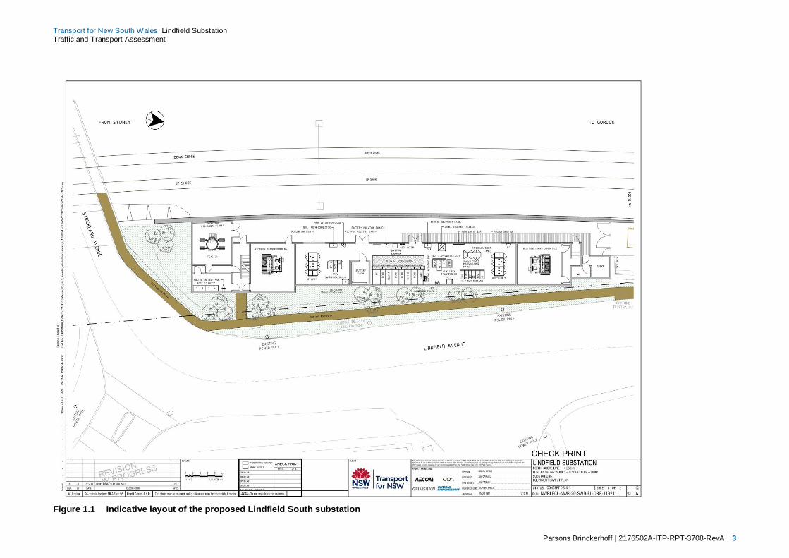
Figure 1.1 and Figure 1.2 on the following pages show the indicative substation layout and the proposed access and parking arrangements for vehicles to the substation respectively.
Parsons Brinckerhoff | 2176502A-ITP-RPT-3708-RevA 3
Transport for New South Wales Lindfield Substation Traffic and Transport Assessment
Figure 1.1 Indicative layout of the proposed Lindfield South substation

4 Parsons Brinckerhoff | 2176502A-ITP-RPT-3708-RevA
Transport for New South Wales Lindfield Substation Traffic and Transport Assessment
Figure 1.2 Indicative access arrangements to the proposed Lindfield South substation

Parsons Brinckerhoff | 2176502A-ITP-RPT-3708-RevA 5
Transport for New South Wales Lindfield Substation Traffic and Transport Assessment
1.2 Location of the substation The proposal site is located on Lindfield Avenue, at the intersection with Strickland Avenue in Lindfield, approximately 300 metres to the south of Lindfield Station, as shown in Figure 1.1. The site is within the existing North Shore rail corridor between the North Shore Line up-track (i.e. travelling towards Sydney central business district (CBD)) and Lindfield Avenue. The site boundary including the substation location, overhead wiring and the relocation of cabling is shown in Figures 1.3 and 1.4.The site is located within the Ku-Ring-Gai local government area (LGA).
1.3 Construction working hours The proposed works would generally be undertaken during the standard (NSW) Environment Protection Authority (EPA) construction hours, which are as follows:
7.00 am to 6.00 pm Monday to Friday
8.00 am to 1.00 pm Saturdays
No work on Sundays or public holidays.
Exemptions and approval for works outside the above standard construction hours may be required in the following circumstances:
works required by utility service providers or where impacts to services cannot be reasonably managed
works requiring rail closedowns
works requiring the closure of roads, bridges or stations
oversized deliveries/unloading of machinery that can only be transported between hours specified by the police or Roads and Maritime
where works can be undertaken so as to be inaudible at the nearest residential receivers
as otherwise agreed with the EPA in the issuing of an environmental protection licence for licensable works.
If required, out-of-hours works would be applied for and appropriate assessments and mitigation strategies undertaken.
Work within the Lindfield substation site will be generally undertaken within the standard construction hours mentioned above. However, the realignment of the aerial high voltage feeders can only take place within normal construction outages in conjunction with the North Shore Line rail possessions. The construction of the proposed deflection/retaining wall along the western edge of the site would also require works to be undertaken during designated rail possession periods. Rail possessions are times when rail services will not be running, allowing maintenance and/or construction works to be safely undertaken. Sydney Trains are permitted a certain number of weekend rail possessions per year to allow for railway maintenance, construction and other activities that are only able to be undertaken whilst normal services are not operating.
For the North Shore Line, rail possessions occur between 12.00 am and 4.00 am for weeknight possession and 2.00 am Saturday to 4.00 am Monday for weekend possessions. Construction work affecting train operations would be performed as required 24 hours, 7 days a week during these track possessions.

6 Parsons Brinckerhoff | 2176502A-ITP-RPT-3708-RevA
Transport for New South Wales Lindfield Substation Traffic and Transport Assessment
Figure 1.3 Site boundary

Parsons Brinckerhoff | 2176502A-ITP-RPT-3708-RevA 7
Transport for New South Wales Lindfield Substation Traffic and Transport Assessment
Figure 1.4 Site boundary

8 Parsons Brinckerhoff | 2176502A-ITP-RPT-3708-RevA
Transport for New South Wales Lindfield Substation Traffic and Transport Assessment
1.4 Purpose of this report The main purpose of this report is to:
identify and assess the impacts of the substation and ancillary works (cable and services relocation) relating to:
construction and operational traffic impacts
road and public transport users including pedestrians and cyclists
recommend mitigation measures and strategies to ameliorate any impacts.
1.5 Structure of this report This report has the following structure:
Section 2 discusses the report methodology
Section 3 reviews the existing situation within the study area
Section 4 discusses the construction traffic impacts
Section 5 discusses the operational traffic impacts
Section 6 discusses the mitigation measures and strategies to ameliorate the proposal impacts
Section 7 concludes the study.

Parsons Brinckerhoff | 2176502A-ITP-RPT-3708-RevA 9
Transport for New South Wales Lindfield Substation Traffic and Transport Assessment
2. Methodology This section discusses the methodology behind the preparation of this report including documents reviewed, data collected and site inspections undertaken.
2.1 Document review The following documents were reviewed as part of this study:
project documents and reports provided by TfNSW
(NSW) Roads and Maritime Services (Roads and Maritime) Restricted Access Vehicle (RAV) guides
Sydney Trains and Transport Info websites
Bicycle Info website
Council websites containing bicycle plans.
2.2 Consultation with TfNSW A preliminary meeting was held with TfNSW on 8 November 2013 to discuss the proposed content of the traffic impact assessment. A follow up meeting was held on 11 February 2014 to further discuss the content of this traffic impact assessment.
2.3 Site inspection Parsons Brinckerhoff undertook a site inspection on 14 November 2013 to assess existing railway station operations (at Lindfield) and the location of the proposed substation in Lindfield.


Parsons Brinckerhoff | 2176502A-ITP-RPT-3708-RevA 11
Transport for New South Wales Lindfield Substation Traffic and Transport Assessment
3. Existing conditions This section describes the existing traffic and transport conditions adjacent to the proposed site within the study area.
3.1 Rail services Rail services are currently provided to Lindfield railway station along the T1 North Shore Line which forms part of the existing Sydney Trains network, as shown in Figure 3.1.
Source: Sydney Trains
Figure 3.1 Rail network

12 Parsons Brinckerhoff | 2176502A-ITP-RPT-3708-RevA
Transport for New South Wales Lindfield Substation Traffic and Transport Assessment
3.2 Bus services Bus services that currently operate in the Lindfield area are provided by Transdev and include a service along Lindfield Avenue and Middle Harbour Road (Route 558), as shown in Figure 3.2.
Source: Transdev (2014)
Figure 3.2 Existing bus services in the Lindfield area
Bus services adjacent to the proposed substation site are shown in Table 3.1.
Table 3.1 Bus services adjacent to the proposed substation site Bus
route Operated
by Description Hours of operation (weekdays) Frequency
558 Transdev Daily service between Lindfield and Chatswood
From Lindfield station
(from 7.17 am to 7.16 pm)
AM peak: 30 minutes
Off peak/PM peak: 60 minutes
From Chatswood station (from 7.50 am to 7.41 pm)
AM/PM peak: 30/45 minutes Off peak: 60 minutes
3.3 Road network and hierarchy Roads within a network are classified according to a road hierarchy relating closely to their functional role and the volume of traffic they carry. Roads and Maritime has defined four classes for the classification of roads:
Arterial roads - predominantly carry through traffic from one region to another forming a principal avenue for urban traffic movements. Typically traffic volumes would be in excess of 15,000 vehicles per day (vpd).
Proposal site area

Parsons Brinckerhoff | 2176502A-ITP-RPT-3708-RevA 13
Transport for New South Wales Lindfield Substation Traffic and Transport Assessment
Sub-arterial roads - connect the arterial roads to areas of development or carry traffic directly from one part of a region to another, they may also relieve traffic on arterial roads in some circumstances. Typically traffic volumes would range from 5,000 vpd to 20,000 vpd.
Collector roads - connect the sub-arterial roads to the local road system in developed areas. Typically traffic volumes would be in the range from 2,000 vpd to 10,000 vpd, but residential amenity would begin to decline with volumes in excess of 5,000 vpd.
Local roads - are the sub-divisional roads within a particular developed area. These are used solely to provide local access, and typically carry low volumes, usually less than 2,000 vpd.
The key roads on the surrounding road network (refer to Figure 1.3 and Figure 1.4) include:
Pacific Highway (A1) which is a State Road that has a six lane undivided road configuration which carries approximately 58,000 vpd (station 33.013 in 2008) through the Chatswood area. As a major arterial road, this road is designated as a B-double route and allows vehicles with a maximum vertical height clearance of 4.6 metres (m).
Lindfield Avenue is a two-lane, two-way collector road that provides an important link on the eastern side of the Pacific Highway and railway line connecting the Lindfield Town Centre to local residents. Lindfield Avenue has a posted speed limit of 50 kilometres per hour (km/h). Lindfield Avenue is under the care and control of Ku-Ring-Gai Council.
Strickland Avenue is a two-lane, two-way local road that provides an important link on the eastern side of the Pacific Highway and railway line connecting the Lindfield Town Centre to local residents, and providing a key local railway crossing (bridge). Strickland Avenue has a posted speed limit of 50 km/h. Strickland Avenue is under the care and control of Ku-Ring-Gai Council.
Clanville Road is a two-lane, two-way local road that provides an important link on the northern side of the Pacific Highway connecting to local residents to the Pacific Highway via a key local railway crossing (bridge). Clanville Road has a posted speed limit of 50 km/h. Clanville Road is under the care and control of Ku-Ring-Gai Council.
3.4 Vehicle load, length, height and turning restrictions A review of the RAV information, as well as details obtained during the site inspection, indicate the following restrictions apply to certain vehicles in the study area:
3 tonne load limit on Strickland Avenue and Lindfield Avenue adjacent to the proposed Lindfield South substation location
4.0 m height clearance limit on Balfour Street, Lindfield (road under railway bridge)
3 tonne load limit on Rawhiti Street, Lindfield.
3.5 Lindfield Railway Station precinct The following facilities are provided at Lindfield station.
3.5.1 Lindfield station details
Table 3.2 Lindfield station facilities
Station Bus stop Ferry wharf Taxi rank Bike racks or lockers Kiss-and-ride Car park

14 Parsons Brinckerhoff | 2176502A-ITP-RPT-3708-RevA
Transport for New South Wales Lindfield Substation Traffic and Transport Assessment
Station Bus stop Ferry wharf Taxi rank Bike racks or lockers Kiss-and-ride Car park
Lindfield Yes No Yes Yes No No
Source: Sydney Trains and site inspection
3.5.2 Parking
Existing on-street parallel parking is provided on Lindfield Avenue, Strickland Avenue and Middle Harbour Road, in close proximity to the substation site.
3.5.3 Pedestrian network and facilities
Paved concrete footpaths are provided on either side of Lindfield Avenue and Strickland Avenue and provide good quality pedestrian access to and from Lindfield station.
3.5.4 Cycle network and facilities
There is no separated cycling path adjacent to the substation site. Cyclists would have to share the traffic lane with vehicles on Lindfield Avenue, Strickland Avenue and Clanville Road.
Existing bicycle routes in the Lindfield area are shown in Figure 3.3 on the following page.

Parsons Brinckerhoff | 2176502A-ITP-RPT-3708-RevA 15
Transport for New South Wales Lindfield Substation Traffic and Transport Assessment
Source: Sydway
Figure 3.3 Existing bicycle network in the Lindfield area
16 Parsons Brinckerhoff | 2176502A-ITP-RPT-3708-RevA
Transport for New South Wales Lindfield Substation Traffic and Transport Assessment
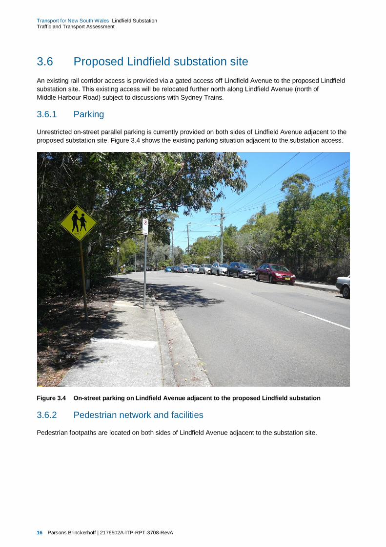
3.6 Proposed Lindfield substation site An existing rail corridor access is provided via a gated access off Lindfield Avenue to the proposed Lindfield substation site. This existing access will be relocated further north along Lindfield Avenue (north of Middle Harbour Road) subject to discussions with Sydney Trains.
3.6.1 Parking
Unrestricted on-street parallel parking is currently provided on both sides of Lindfield Avenue adjacent to the proposed substation site. Figure 3.4 shows the existing parking situation adjacent to the substation access.
Figure 3.4 On-street parking on Lindfield Avenue adjacent to the proposed Lindfield substation
3.6.2 Pedestrian network and facilities
Pedestrian footpaths are located on both sides of Lindfield Avenue adjacent to the substation site.

Parsons Brinckerhoff | 2176502A-ITP-RPT-3708-RevA 17
Transport for New South Wales Lindfield Substation Traffic and Transport Assessment
3.7 Cable and service relocation sites As described in section 1.1, the proposal would require the realignment of high voltage lines, the signalling services route, aerial earth wiring and utilities realignment. This is described in further detail in section 5.2.2 to 5.2.5 of the main report for the Lindfield Substation Review of Environmental Factors (Parsons Brinckerhoff 2014).
3.7.1 Access to the works areas
Access to the work areas would be via existing access gates on Llewellyn Lane, Strickland Lane and Clanville Road. These access locations are shown in Figure 4.2 and Figure 4.3.
3.7.2 Parking
No on-street parallel parking is provided at the cable and service relocation accesses on Llewellyn Lane, Strickland Lane or off Clanville Road. On-street parallel parking is however provided on both sides of Llewellyn Street and Burleigh Street which adjoin Llewellyn Lane.
3.7.3 Pedestrian network and facilities
Footpaths are provided on both sides of Clanville Road with connection to the Pacific Highway and Roseville station. No footpaths are provided on Llewellyn Lane or Strickland Lane.


Parsons Brinckerhoff | 2176502A-ITP-RPT-3708-RevA 19
Transport for New South Wales Lindfield Substation Traffic and Transport Assessment
4. Construction impact assessment
This section describes the impacts anticipated during construction.
4.1 Rail corridor access points 4.1.1 Lindfield substation
Access to the substation is proposed off Lindfield Avenue which would require the temporary removal of approximately six on-street parking spaces during construction to allow vehicle site access. Four on-street car parking spaces would be reclaimed once the site becomes operational. Short term temporary road closures would be required on Lindfield Avenue to accommodate construction vehicle access to the substation site and ancillary electrical works. No long term road closures of Lindfield Avenue are proposed or required as part of this proposal. The location of this substation and its access is shown in Figure 4.1.
4.1.2 Cable and service relocation sites
All access driveways to the proposed cable and service relocation sites is existing and would not require any temporary removal of on-street car parking spaces. No road closures would be required for the cable and service relocation sites. The proposed haulage routes to these access driveways are shown in Figure 4.2 and Figure 4.3.

20 Parsons Brinckerhoff | 2176502A-ITP-RPT-3708-RevA
Transport for New South Wales Lindfield Substation Traffic and Transport Assessment
Figure 4.1 Lindfield substation location and access

Parsons Brinckerhoff | 2176502A-ITP-RPT-3708-RevA 21
Transport for New South Wales Lindfield Substation Traffic and Transport Assessment
4.2 Construction vehicle routes Construction vehicles routes to and from the substation site and access to the cable and service relocation areas is described below and shown in Figure 4.2 and Figure 4.3.
The access routes to the substation site include:
ROUTE 1
To the site:
left or right from the Pacific Highway onto Havilah Road
right onto Lindfield Avenue
right into the site.
From the site:
left onto Lindfield Avenue
left onto Havilah Road
left or right onto the Pacific Highway.
ROUTE 2
To the site:
left or right from the Pacific Highway onto Strickland Avenue
left onto Lindfield Avenue
left into the site.
From the site:
right onto Lindfield Avenue
right onto Strickland Avenue
left or right onto the Pacific Highway.
The access route to the Llewellyn Lane access include:
ROUTE 3
To the site:
left onto Llewellyn Street from the Pacific Highway
onto Llewellyn Lane
left into the site
From the site:
left onto Llewellyn Lane
right onto Burleigh Street
left or right onto the Pacific Highway.

22 Parsons Brinckerhoff | 2176502A-ITP-RPT-3708-RevA
Transport for New South Wales Lindfield Substation Traffic and Transport Assessment
The access routes to the Strickland Lane access include:
ROUTE 4
To the site:
left or right from the Pacific Highway onto Strickland Avenue
right onto Strickland Avenue
right onto Strickland Lane
left into the site
From the site:
right onto Strickland Lane
left onto Strickland Avenue
left onto Strickland Avenue (at Lindfield Avenue intersection)
left or right onto the Pacific Highway.
ROUTE 5
To the site (light vehicles only):
left or right from the Pacific Highway into Clanville Road
left onto Rawhiti Street
left onto Strickland Avenue
left onto Strickland Lane
left into site
From the site (light vehicles only):
right onto Strickland Lane
right onto Strickland Avenue
right onto Rawhiti Street
right onto Clanville Road
left or right onto the Pacific Highway.
The access route to the Clanville Road access include:
ROUTE 6
To the site:
left or right from the Pacific Highway into Clanville Road
left into the site
From the site:
right onto Clanville Road
left or right onto the Pacific Highway.
Permits to exceed the local load limit will be obtained from Ku-Ring-Gai Council on an as required basis for delivery of construction equipment, removal of excess spoil from site excavation activities, concrete deliveries and delivery of construction materials and equipment.

Parsons Brinckerhoff | 2176502A-ITP-RPT-3708-RevA 23
Transport for New South Wales Lindfield Substation Traffic and Transport Assessment
Figure 4.2 Construction vehicle routes to and from the project site

24 Parsons Brinckerhoff | 2176502A-ITP-RPT-3708-RevA
Transport for New South Wales Lindfield Substation Traffic and Transport Assessment
Figure 4.3 Construction vehicle routes to and from the project site

Parsons Brinckerhoff | 2176502A-ITP-RPT-3708-RevA 25
Transport for New South Wales Lindfield Substation Traffic and Transport Assessment
4.3 Construction traffic generation and distribution Traffic generation during construction of the project is assumed to comprise traffic generated by construction personnel and construction vehicles travelling to and from the site. Project staff are assumed to arrive at the sites by personal vehicle.
The anticipated construction traffic generated by this project is presented in Table 4.1.
Table 4.1 Construction traffic generation
Location/Construction elements Number of workforce (daytime
shift)
Trips during the PM peak hour
Total daily trips during a weekday
(in and out)
Substation works
Construction of substation Up to 20 10 40
Cable and services relocation works Up to 10 5 20
As construction staff would arrive at the site before the shift start at 7.00 am and depart the site after the shift between 3.00 pm and 6.00 pm. The construction light vehicle trips were not considered for the AM peak hour traffic assessment as they do not coincide with the existing AM traffic peak. However they were considered for the PM peak hour traffic assessment as they would coincide with the existing PM traffic peak. It is assumed 50 per cent of construction light vehicle outbound trips would occur during the PM peak hour. Construction vehicle trips (heavy vehicles) would occur throughout the working day (shift).
4.4 Construction vehicle and staff parking Construction vehicles would be parked off-street within the rail corridor at the substation site. Personal construction staff vehicles would be parked on-street. Suggested suitable locations for construction staff parking include Lindfield Avenue, Strickland Avenue and Middle Harbour Road.
There would be limited or no space for construction staff vehicle parking at the substation and cable and service relocation sites. The contractor is to consider parking requirements during project implementation.
4.5 Impacts during construction 4.5.1 Intersection performance
At the Lindfield substation location, up to 10 vehicles (refer to Table 4.2) could be leaving the site in the PM peak hour. These vehicles are likely to travel to the Pacific Highway via either Balfour Street or the adjacent intersection at Strickland Avenue. The Strickland Avenue intersection is unsignalised and therefore the impacts would be minimal. The low vehicle volume would also mean minimal impacts at the Balfour Street intersection.
Minimal construction related traffic is anticipated at the Llewellyn Lane, Strickland Lane and Clanville Road accesses and therefore minimal impact is expected at local intersections. It is expected that up to five vehicles (refer to Table 4.2) could be leaving the site in the PM peak hour.

26 Parsons Brinckerhoff | 2176502A-ITP-RPT-3708-RevA
Transport for New South Wales Lindfield Substation Traffic and Transport Assessment
4.5.2 Station access
No impacts to the existing Lindfield railway station access or operation are anticipated.
4.5.3 Parking
Substation access proposed off Lindfield Avenue during construction would require the temporary removal of approximately six on-street parking spaces to allow vehicle site access.
4.5.4 Pedestrians and cyclists
Temporary footpath closures are expected on the western side of Lindfield Avenue during the undergrounding of the transmission lines and the construction of a new driveway access to the substation.

Parsons Brinckerhoff | 2176502A-ITP-RPT-3708-RevA 27
Transport for New South Wales Lindfield Substation Traffic and Transport Assessment
5. Operational impact assessment
5.1 Lindfield substation Once construction is completed, the Lindfield substation would undergo testing and would be commissioned for service. Once operational, the maintenance requirements of the substation are anticipated to be small, in the form of one site visit per month by one person for maintenance and attendance for switching operations during power isolations. It is anticipated that approximately two on-street parking spaces would be removed on Lindfield Avenue to allow for driveway access to the substation.
5.2 Cable and service relocation accesses Once construction is completed, maintenance requirements of the cables and relocated services is anticipated to be small and have only negligible traffic impacts on the surrounding road network and local intersections.


Parsons Brinckerhoff | 2176502A-ITP-RPT-3708-RevA 29
Transport for New South Wales Lindfield Substation Traffic and Transport Assessment
6. Mitigation measures and strategies
The following mitigation measures and strategies would be applied where possible to this project.
6.1 General requirements As part of the Construction Environmental Management Plan (CEMP), traffic management plans would be developed to address construction traffic and transport management. The objectives would be to:
ensure public safety
maintain a reasonable level of public access across the rail line and to public transport services
minimise disruption to public transport services and, where necessary manage disruption in consultation with the relevant transport provider
ensure that affected local residents and businesses are advised of any disruption to traffic flows, parking and public transport services
ensure that disruptions to traffic flows on public streets are minimised and, where unavoidable, managed in consultation with the relevant road authority
reduce the exposure of the community to heavy construction vehicle traffic impacts and associated noise and vibration, where possible
ensure adequate access to work site including sight distance
ensure that road damage from construction traffic is monitored and addressed in consultation with the relevant road authority.
To ensure the key objectives are achieved, the following mitigation actions would be undertaken:
traffic controllers positioned at access gates adjacent to residential areas and access driveways to assist with vehicle ingress and egress, to stop traffic if required and to assist pedestrian crossing movements
road occupancy licences for temporary closure of roads would be obtained, where required
heavy vehicles would be restricted to the routes specified and route markers installed for heavy vehicles along designated routes
restricting construction traffic movements to and from the sites outside of peak periods
signs would be provided at each access point to assist in deliveries to each work site
signs would be provided at each access point for pedestrian and cyclist guidance
signs would be installed to advise pedestrians of temporary footpath closures and signs advising of the alternative pedestrian detour route installed
local bus operators would be consulted to ensure that they are aware of proposed operation changes and that impacts to bus services are minimised
an emergency response plan would be developed for construction traffic incidents
a pre and post construction assessment of road pavement assets would be conducted in areas likely to be used by construction traffic

30 Parsons Brinckerhoff | 2176502A-ITP-RPT-3708-RevA
Transport for New South Wales Lindfield Substation Traffic and Transport Assessment
public communications would be conducted to warn the community and local residents of vehicle movements and anticipated effects on the local road network relating to the site works
access to all private properties adjacent to the works would be maintained during construction
during project inductions all heavy vehicle drivers would be provided with the emergency response plan for construction traffic incidents
undertake road safety audits where required or deemed necessary
coordination of project staging, vehicle movement and scheduling, equipment and resourcing.
6.2 Construction methods Construction methods would seek to manage the construction traffic impacts for the following:
heavy vehicle traffic:
minimise the number of heavy vehicle trips on road
minimise the distance travelled by heavy vehicles by encouraging multi-drop delivery trips
minimise disruption on the local road network by using nominated haulage routes, which avoid sensitive areas such as schools
minimise the running of empty trucks
construction worker traffic:
encourage the use of alternative travel modes to the work sites. Encourage car ‘pooling’ where alternatives are not practical
provide emergency vehicle parking within worksites
temporary worksite access:
use existing accesses wherever possible
use traffic controllers to manage site access
close and lock site access points/gates after construction hours
minimise construction traffic during school start and end times near the following schools:
– Lindfield Public School, corner of Pacific Highway and Grosvenor Road, Lindfield.

Parsons Brinckerhoff | 2176502A-ITP-RPT-3708-RevA 31
Transport for New South Wales Lindfield Substation Traffic and Transport Assessment
7. Conclusion The construction related traffic associated with the construction of the proposed substation site works and the cable and service relocation works is minimal and would have a negligible impact on the operation and the performance of the surrounding road network and intersection operation. The volumes of traffic generated by the construction works is minimal and is likely to occur outside of peak periods. There would be minor impacts to pedestrians due to temporary closures of the footpath on the western side of Lindfield Avenue adjacent to the proposal site to allow the construction of the new substation driveway access and ancillary works. It is anticipated that approximately six on-street parking spaces would be temporarily removed on Lindfield Avenue to allow for driveway access to the substation during construction.
Operational traffic is anticipated to minimal and therefore only negligible impact is expected to the operation and the performance of the surrounding road network and intersection operation. It is anticipated that approximately two on-street parking spaces would be removed on Lindfield Avenue to allow for driveway access to the substation during operation.
Project related impacts would be removed, reduced or ameliorated where possible. Signs would be installed to advise pedestrians of temporary footpath closures and signs advising of the alternative pedestrian detour route installed. Traffic controllers positioned at access gates adjacent to residential areas and access driveways to assist with vehicle ingress and egress, to stop traffic if required and to assist pedestrian crossing movements. No major impacts are foreseen with the construction or operation of this proposal.
![Index [killara-h.schools.nsw.gov.au] · 2020. 8. 17. · My name is Arash Atah and I am an English teacher at Killara High School. I am located in the English staffroom upstairs in](https://img.dokumen.tips/doc/110x75/5fc8def0bb97ab098518cbe6/index-killara-h-2020-8-17-my-name-is-arash-atah-and-i-am-an-english-teacher.jpg)