Embed Size (px)
Citation preview
Conservation Management Zones of AustraliaTasmanian Temperate Rainforests and Highland Forests
Prepared by the Department of the Environment
ACKNOWLEDGEMENTS
This project and associated products are the result of a collaboration between the Biodiversity Conservation Division and the Environmental Resources Information Network (ERIN). Invaluable input, advice and support were provided by staff and leading researchers from across the Department of the Environment (DotE), Department of Agriculture (DoA), the Commonwealth Scientific and Industrial Research Organisation (CSIRO), and the academic community. We would particularly like to thank staff within the Wildlife, Heritage and Marine Division, Parks Australia and the Environment Assessment and Compliance Division of DotE, Nyree Stenekes and Robert Kancans (ABARES), Sue McIntyre (CSIRO), Richard Hobbs (University of Western Australia), Michael Hutchinson (ANU); David Lindenmayer and Emma Burns (ANU); and Gilly Llewellyn, Martin Taylor and other staff from the World Wildlife Fund for their generosity and advice.
Special thanks to CSIRO staff Kristen Williams and Simon Ferrier whose modelling of biodiversity patterns enabled identification of the Conservation Management Zones of Australia.
© Commonwealth of Australia, 2015.
The Conservation Management Zones of Australia profile is licensed by the Commonwealth of Australia for use under a Creative Commons By Attribution 3.0 Australia licence with the exception of the Coat of Arms of the Commonwealth of Australia, the logo of the agency responsible for publishing the report, content supplied by third parties, and any images depicting people.
For licence conditions see here.
ContentsAcknowledgement of Traditional Owners and Country.................................................................4
Introduction....................................................................................................................................4
Zone at a glance............................................................................................................................5
Population characteristics..............................................................................................................9
Employment, volunteering and incomes......................................................................................14
Agriculture, Natural Resource Management practices and sources of NRM advice...................17
Land tenure, land use, Native Title and Local Government Areas..............................................20
Zone vegetation characteristics...................................................................................................22
Ramsar and Nationally Important Wetlands................................................................................23
World and National Heritage.......................................................................................................24
Major National Reserve System properties.................................................................................24
EPBC Act (1999) threatened ecological communities.................................................................25
EPBC Act (1999) threatened species..........................................................................................26
EPBC Act (1999) migratory species............................................................................................29
Threatened endemic species......................................................................................................31
Invasive species..........................................................................................................................33
Vegetation profiles and management recommendations............................................................35
Acknowledgement of Traditional Owners and CountryThe Australian Government acknowledges Australia’s Traditional Owners and pays respect to Elders past and present of our nation’s Aboriginal and Torres Strait Islander communities. We honour the deep spiritual, cultural and customary connections of Traditional Owners to the Australian landscape, including Australia’s waterways, land and sea country.
Introduction The 23 Conservation Management Zones of Australia are geographic areas, classified according to their ecological and threat characteristics. The zones are also aligned with the Interim Biogeographic Regionalisation of Australia.
The Conservation Management Zones provide a way of understanding Australia’s natural environment that will assist in long-term conservation planning and help the Australian Government to better design, deliver and report on Natural Resource Management (NRM) investments, including ensuring alignment of national NRM priorities with local action.
The Conservation Management Zones also provide a filter through which to make national environmental and socio-economic data more accessible and comprehensible, and a framework for gathering on-ground knowledge and expertise about the environment. This will improve information flow to the Australian Government about regional NRM requirements, best practice management, emerging NRM issues and knowledge gaps.
The Conservation Management Zones do not represent any change to existing administrative boundaries or governance structures, but aim to support the NRM and wider community to cooperatively manage environmental assets across boundaries, where they share common threats, ecological characteristics and stakeholders.
Each Conservation Management Zone profile contains a standard suite of nationally available ecological and socio-economic information. We hope that this information will enable Australians of all ages and backgrounds to engage with, understand and appreciate Australian landscapes, and support all Australians to manage our natural resources more effectively.
The profile information provides an indicative, high-level stock-take of the environmental and socio-economic landscape and it is not intended to be comprehensive. It should also be noted that, at present, the profiles contain only limited information on aquatic ecosystems, coastal assets and Indigenous land management practices. In future, consultation and comprehensive literature reviews will enable us to provide more complete information.
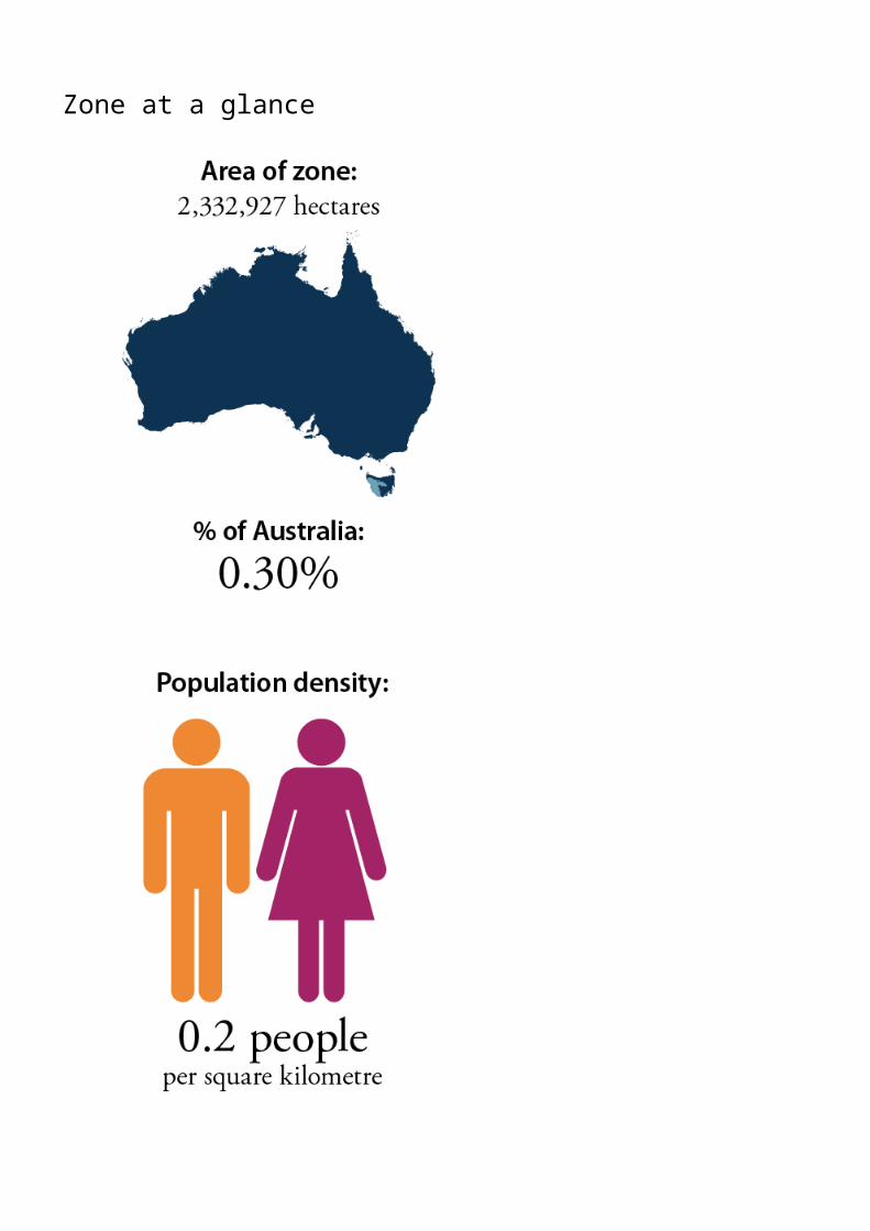
Zone at a glance
Source: Based on Australian Bureau of Statistics data
TOWNS AND LOCALITIES POPULATION
Queenstown 1,979
Rosebery 920
Strahan 661
Tullah 192
Waratah 250
Zeehan 725
NATURAL RESOURCE MANAGEMENT (NRM) REGIONSNRM Cradle Coast TAS
NRM North TAS
NRM South TAS
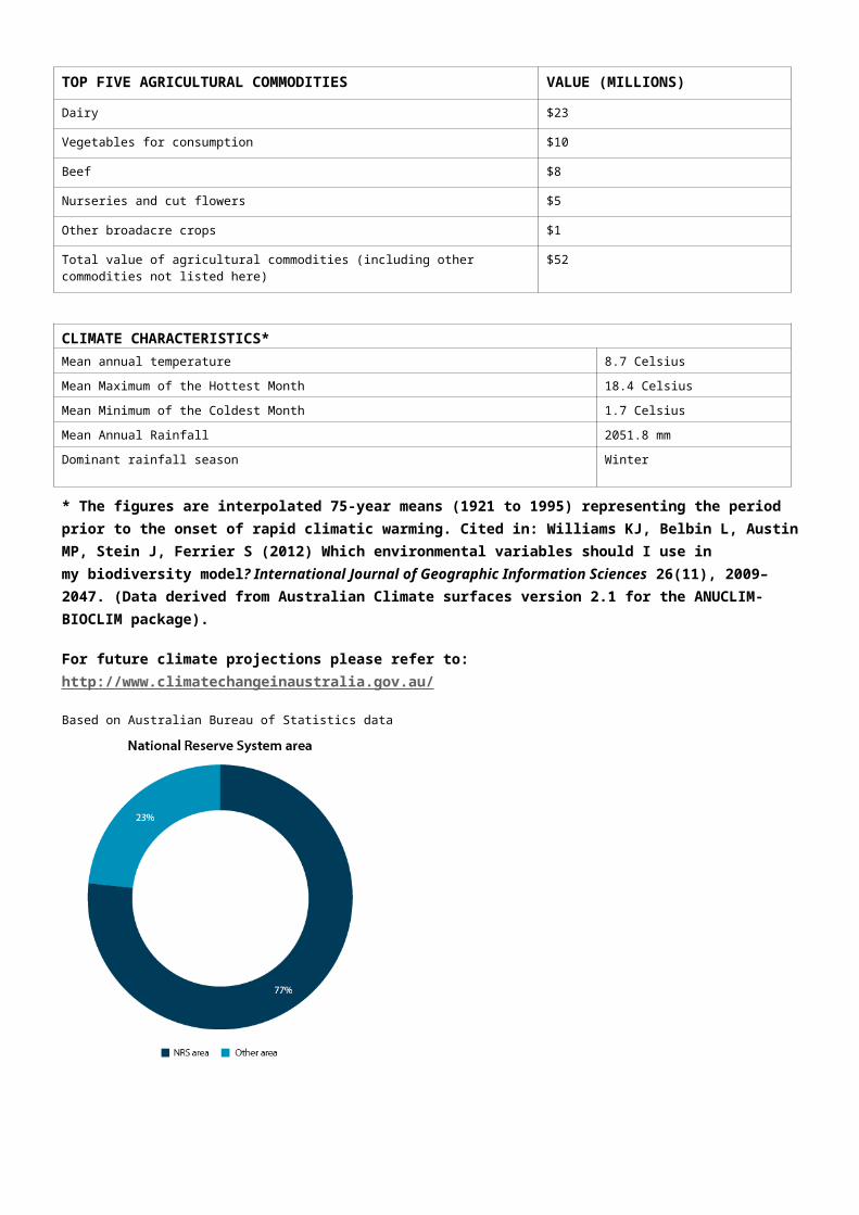
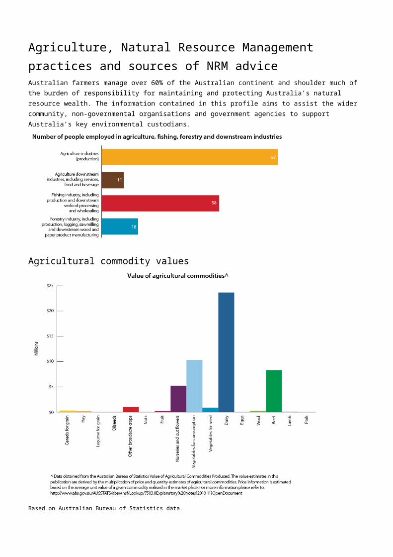
TOP FIVE AGRICULTURAL COMMODITIES VALUE (MILLIONS)
Dairy $23
Vegetables for consumption $10
TOP FIVE AGRICULTURAL COMMODITIES VALUE (MILLIONS)
Beef $8
Nurseries and cut flowers $5
Other broadacre crops $1
Total value of agricultural commodities (including other commodities not listed here) $52
CLIMATE CHARACTERISTICS*Mean annual temperature 8.7 Celsius
Mean Maximum of the Hottest Month 18.4 Celsius
Mean Minimum of the Coldest Month 1.7 Celsius
Mean Annual Rainfall 2051.8 mm
Dominant rainfall season Winter
* The figures are interpolated 75-year means (1921 to 1995) representing the period prior to the onset of rapid climatic warming. Cited in: Williams KJ, Belbin L, Austin MP, Stein J, Ferrier S (2012) Which environmental variables should I use in my biodiversity model? International Journal of Geographic Information Sciences 26(11), 2009–2047. (Data derived from Australian Climate surfaces version 2.1 for the ANUCLIM-BIOCLIM package).
For future climate projections please refer to: http://www.climatechangeinaustralia.gov.au/
Source: Based on Australian Bureau of Statistics data
Native Title area Although there have been no Native Title Determinations finalised within this Conservation Management Zone, it continues to represent important Indigenous heritage values and places that are of deep significance to Indigenous persons and their practices, observations, customs, beliefs and history.
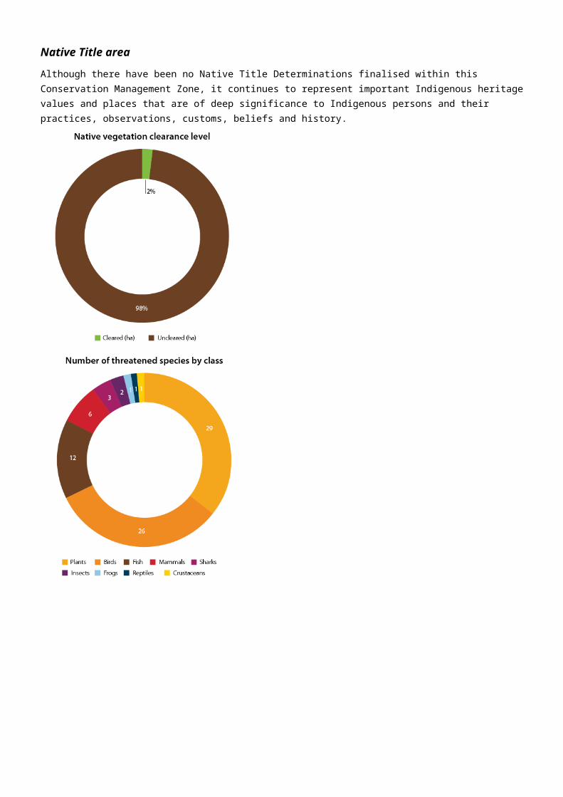
Source: Based on data from the National Native Title Register; Collaborative Australian Protected Area Database (CAPAD); National Vegetation Information System (NVIS); Species’ Profile and Threats Database (SPRAT).

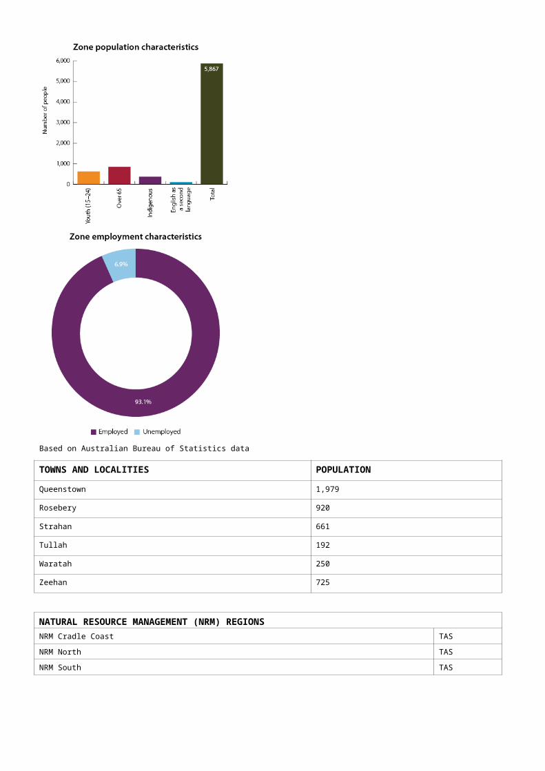
Population characteristics
Population
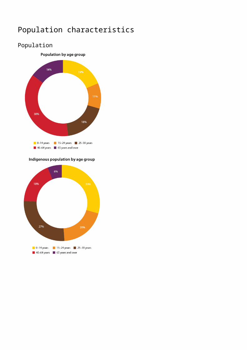
Source: Based on Australian Bureau of Statistics data
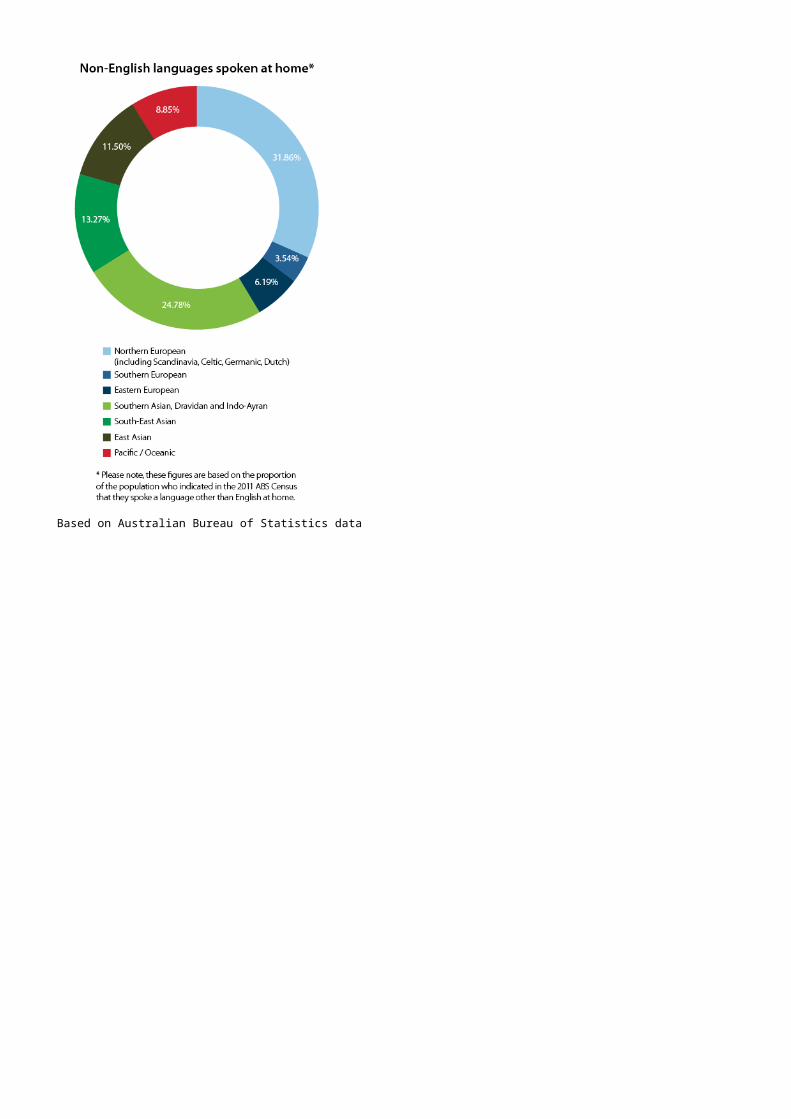
LANGUAGES SPOKEN AT HOMEEnglish 92.48%
Other languages 1.93%
Not stated 5.40%
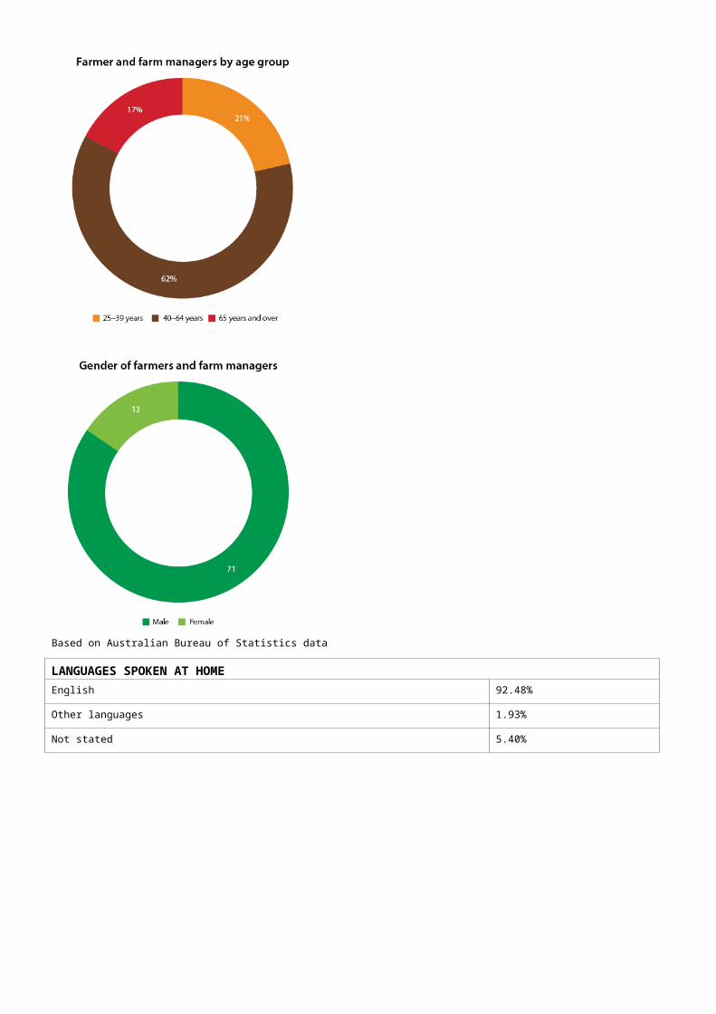
Source: Based on Australian Bureau of Statistics data
Education
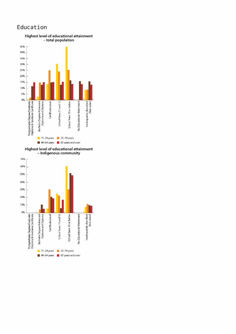
Source: Based on Australian Bureau of Statistics data
Employment, volunteering and incomes
Employment
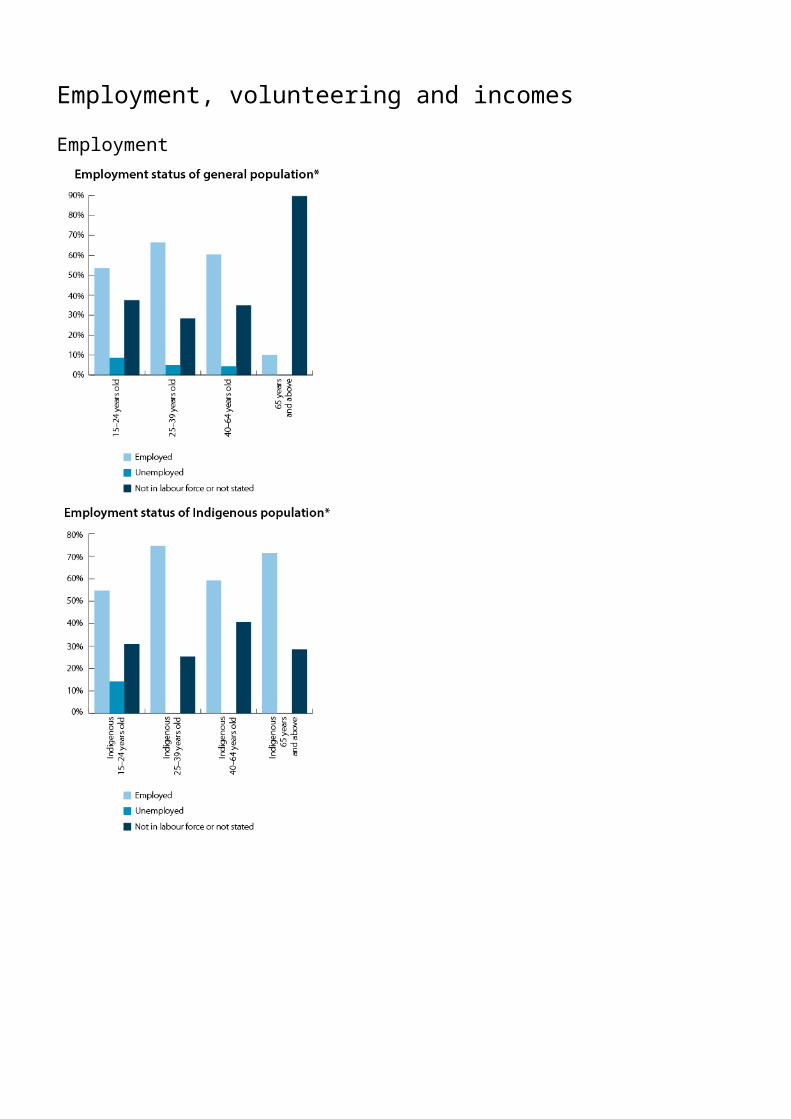
Source: Based on Australian Bureau of Statistics data
Source:
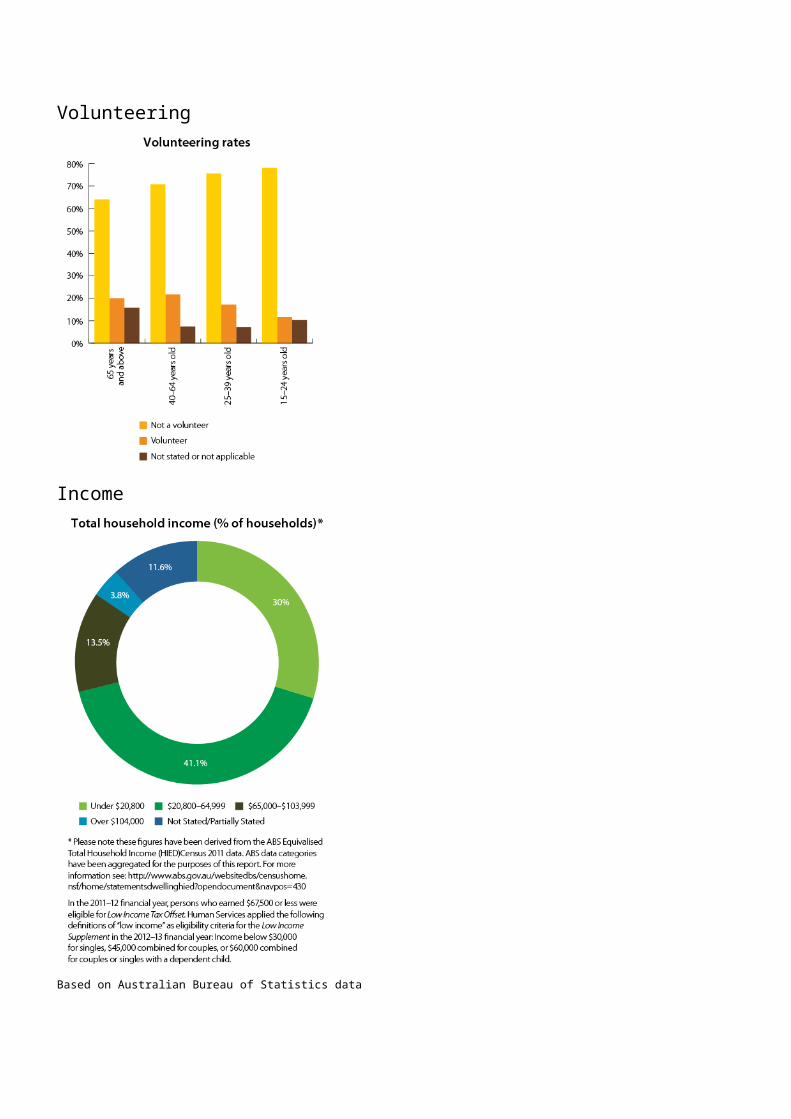
Volunteering
Income
Source: Based on Australian Bureau of Statistics data
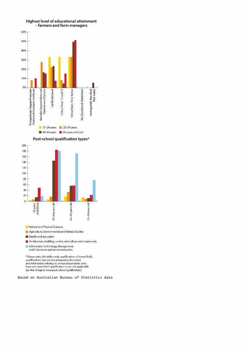
Agriculture, Natural Resource Management practices and sources of NRM adviceAustralian farmers manage over 60% of the Australian continent and shoulder much of the burden of responsibility for maintaining and protecting Australia’s natural resource wealth. The information contained in this profile aims to assist the wider community, non-governmental organisations and government agencies to support Australia’s key environmental custodians.
Agricultural commodity values
Source: Based on Australian Bureau of Statistics data
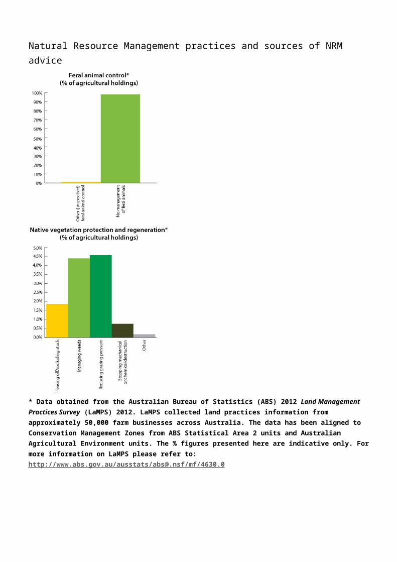
Natural Resource Management practices and sources of NRM advice
* Data obtained from the Australian Bureau of Statistics (ABS) 2012 Land Management Practices Survey (LaMPS) 2012. LaMPS collected land practices information from approximately 50,000 farm businesses across Australia. The data has been aligned to Conservation Management Zones from ABS Statistical Area 2 units and Australian Agricultural Environment units. The % figures presented here are indicative only. For more information on LaMPS please refer to: http://www.abs.gov.au/ausstats/[email protected]/mf/4630.0

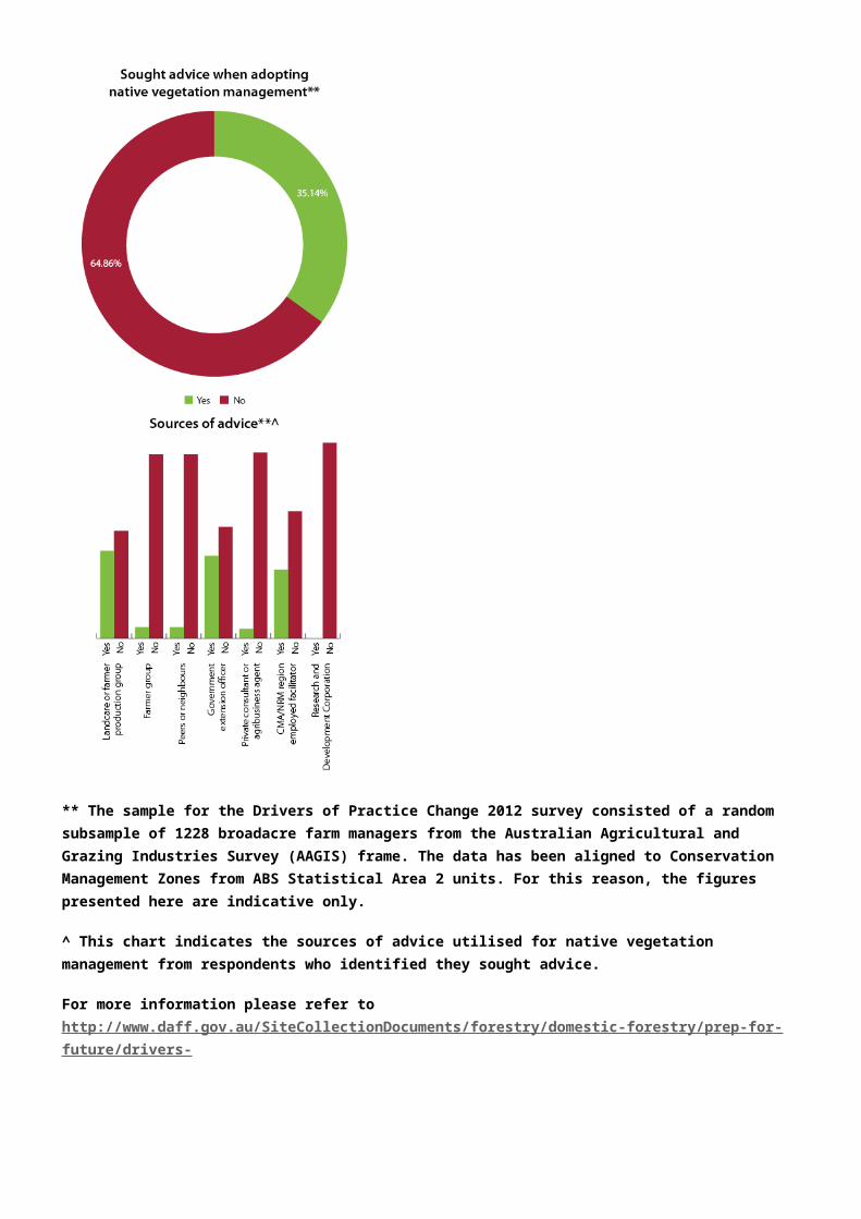
** The sample for the Drivers of Practice Change 2012 survey consisted of a random subsample of 1228 broadacre farm managers from the Australian Agricultural and Grazing Industries Survey (AAGIS) frame. The data has been aligned to Conservation Management Zones from ABS Statistical Area 2 units. For this reason, the figures presented here are indicative only.
^ This chart indicates the sources of advice utilised for native vegetation management from respondents who identified they sought advice.
For more information please refer to http://www.daff.gov.au/SiteCollectionDocuments/forestry/domestic-forestry/prep-for-future/drivers-
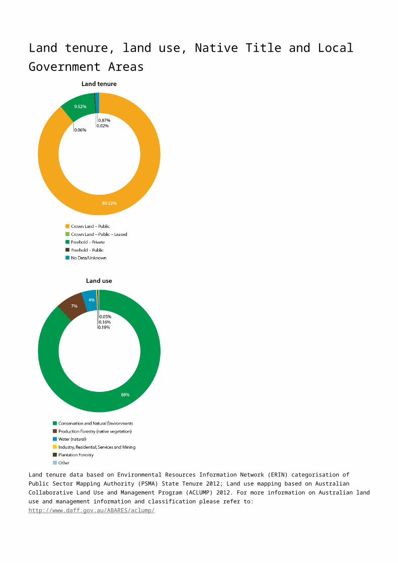
Land tenure, land use, Native Title and Local Government Areas
Source: Land tenure data based on Environmental Resources Information Network (ERIN) categorisation of Public Sector Mapping Authority (PSMA) State Tenure 2012; Land use mapping based on Australian Collaborative Land Use and Management Program (ACLUMP) 2012. For more information on Australian land use and management information and classification please refer to: http://www.daff.gov.au/ABARES/aclump/
INDIGENOUS LAND COUNCILS
Tasmanian Aboriginal Land and Sea Council: www.talsc.net.au
Although there have been no Native Title Determinations finalised within this Conservation Management Zone, it continues to represent important Indigenous heritage values and places that are of deep significance to Indigenous persons and their practices, observations, customs, beliefs and history.
LOCAL GOVERNMENT AREASCentral Coast Council TAS
Central Highlands Council TAS
Circular Head Council TAS
Derwent Valley Council TAS
Huon Valley Council TAS
Kentish Council TAS
Meander Valley Council TAS
Northern Midlands Council TAS
Southern Midlands Council TAS
Waratah-Wynyard Council TAS
West Coast Council TAS
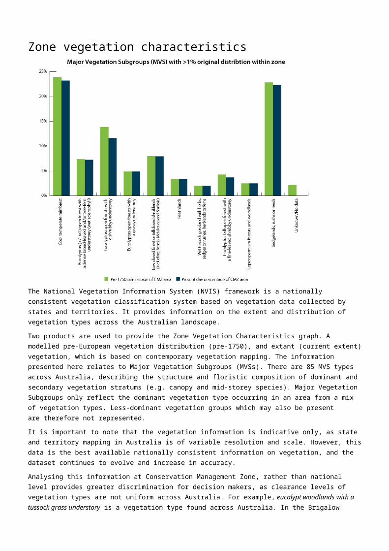
Zone vegetation characteristics
The National Vegetation Information System (NVIS) framework is a nationally consistent vegetation classification system based on vegetation data collected by states and territories. It provides information on the extent and distribution of vegetation types across the Australian landscape.
Two products are used to provide the Zone Vegetation Characteristics graph. A modelled pre-European vegetation distribution (pre-1750), and extant (current extent) vegetation, which is based on contemporary vegetation mapping. The information presented here relates to Major Vegetation Subgroups (MVSs). There are 85 MVS types across Australia, describing the structure and floristic composition of dominant and secondary vegetation stratums (e.g. canopy and mid-storey species). Major Vegetation Subgroups only reflect the dominant vegetation type occurring in an area from a mix of vegetation types. Less-dominant vegetation groups which may also be present are therefore not represented.
It is important to note that the vegetation information is indicative only, as state and territory mapping in Australia is of variable resolution and scale. However, this data is the best available nationally consistent information on vegetation, and the dataset continues to evolve and increase in accuracy.
Analysing this information at Conservation Management Zone, rather than national level provides greater discrimination for decision makers, as clearance levels of vegetation types are not uniform across Australia. For example, eucalypt woodlands with a tussock grass understory is a vegetation type found across Australia. In the Brigalow Woodlands Conservation Management Zone, eucalypt open woodlands with a tussock grass understory originally covered approximately 36% of the zone, but today it only covers only 14.5 % of the zone (58.7% of this vegetation community has been cleared in the Brigalow). In the Northern Australia Tropical Savannah zone, this vegetation type originally occupied 19.6% of the zone. Today, it occupies approximately 19.4% of the zone (only 2.3% of this vegetation type has been cleared). It should be noted that this data only provides an indication of change in extent, and not vegetation condition.
For more information on the National Vegetation Information System (NVIS) please refer to: http://www.environment.gov.au/topics/science-and-research/databases-and-maps/national-vegetation-information-system

Ramsar and Nationally Important WetlandsRAMSAR WETLANDS JURISDICTION HECTARESInterlaken (Lake Crescent) TAS 513
For more information on Ramsar please refer to: http://www.environment.gov.au/topics/water/water-our-environment/wetlands/ramsar-convention-wetlands
NATIONALLY IMPORTANT WETLANDS JURISDICTION HECTARES CRITERIA
Allwrights Lagoon TAS 36.1 5
Clarence Lagoon TAS 39.2 5
Great Lake TAS 16,421.6 5
Hatfield Sphagnum TAS 1.1 1, 5
Interlaken Lakeside Reserve TAS 0.1 1, 3, 5
Kemps Marsh TAS 347.6 2, 3, 5
Lake Ashwood TAS 7.2 1, 5
Lake Bantick TAS 4.9 1, 5
Lake Garcia TAS 5.7 1, 5
Lake Kaye TAS 29.7 5
Lake Lea TAS 151.2 1
Lake Surprise TAS 18.7 5
Maggs Mountain Sphagnum TAS 1.1 5
Mt Rufus Sphagnum TAS 1.1 1, 5
Shadow Lake Sphagnum TAS 19.5 1, 5Nationally important wetlands are defined according to the following criteria:
1. It is a good example of a wetland type occurring within a biogeographic region in Australia.
2. It is a wetland which plays an important ecological or hydrological role in the natural functioning of a major wetland system/complex.
3. It is a wetland which is important as the habitat for animal taxa at a vulnerable stage in their life cycles, or provides a refuge when adverse conditions such as drought prevail.
4. The wetland supports 1% or more of the national populations of any native plant or animal taxa.
5. The wetland supports native plant or animal taxa or communities which are considered endangered or vulnerable at the national level.
6. The wetland is of outstanding historical or cultural significance.
Please note, the above are a subset of all the Nationally Important Wetlands found within the Zone. For more information on Nationally Important Wetlands please see: http://www.environment.gov.au/resource/directory-important-wetlands-australia-third-edition
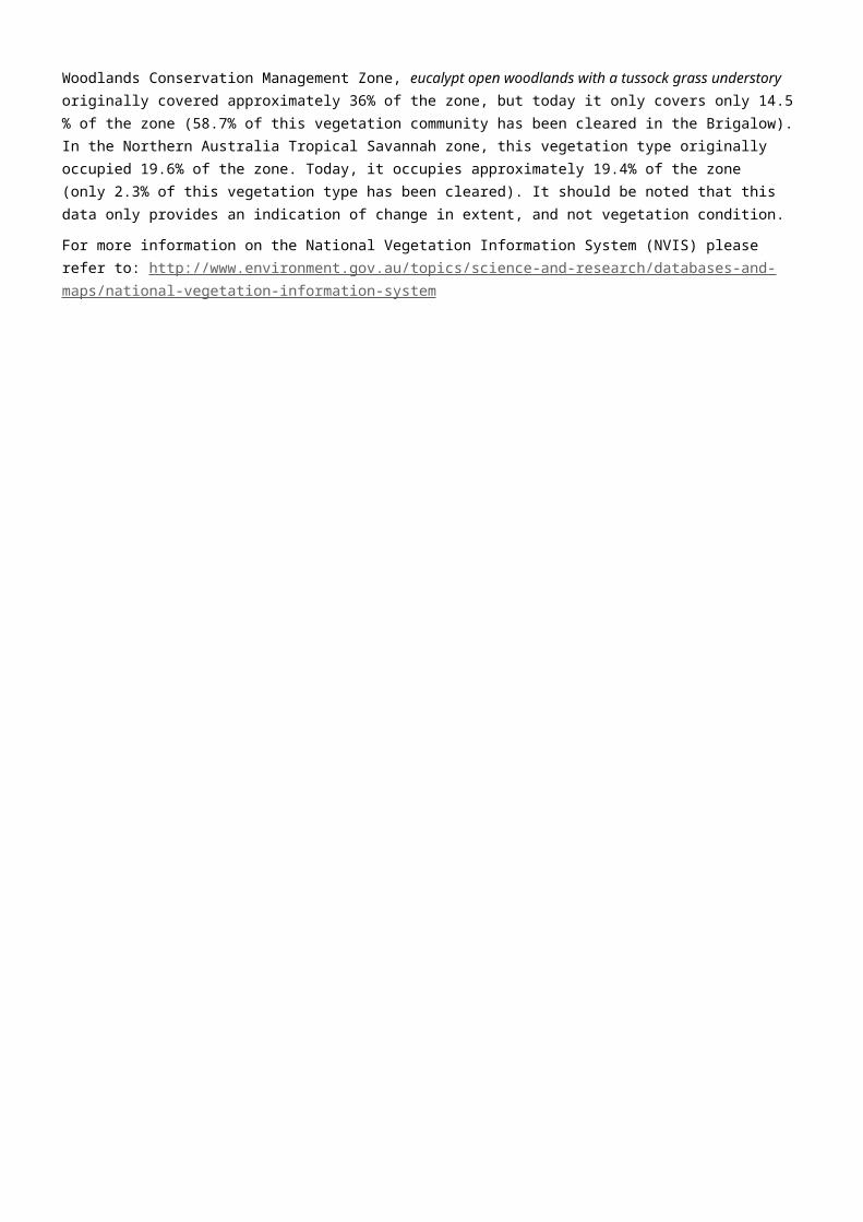
World and National HeritageHERITAGE VALUES WORLD OR NATIONAL HERITAGE
TYPEJURISDICTION HECTARES % OF
ZONETasmanian Wilderness World and National Natural TAS 1,162,353 49.82
Western Tasmania Aboriginal Cultural Landscape
National Indigenous TAS 7,754 0.33
Please refer to the Australian Heritage Database for detailed information on listing criteria for these heritage values: http://www.environment.gov.au/topics/heritage/publications-and-resources/australian-heritage-database
For more information on Australia’s world and national heritage please refer to: http://www.environment.gov.au/topics/heritage/about-australias-heritage
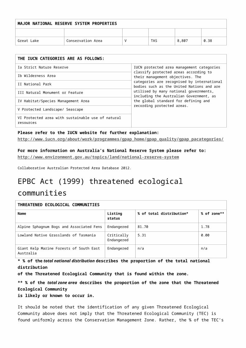
Major National Reserve System propertiesMAJOR NATIONAL RESERVE SYSTEM PROPERTIES
Name Property type IUCN category
Jurisdiction Hectares % of zone
Southwest National Park II TAS 413,882 17.74
Franklin-GordonWild Rivers
National Park II TAS 395,678 16.96
Southwest Conservation Area VI TAS 168,928 7.24
Cradle Mountain-LakeSt Clair
National Park II TAS 142,716 6.12
Central Plateau Conservation Area VI TAS 92,926 3.98
Arthur-Pieman Conservation Area VI TAS 75,995 3.26
Meredith Range Regional Reserve VI TAS 71,417 3.06
Walls of Jerusalem National Park II TAS 49,060 2.10
Mount Dundas Regional Reserve VI TAS 38,861 1.67
Donaldson River Nature Recreation Area V TAS 30,664 1.31
Savage River Pipeline Forest Reserve IV TAS 26,092 1.12
Granite Tor Conservation Area VI TAS 22,448 0.96
Savage River Regional Reserve VI TAS 19,691 0.84
Great Western Tiers Conservation Area VI TAS 18,985 0.81
West Coast Range Regional Reserve VI TAS 18,050 0.77
Mount Heemskirk Regional Reserve VI TAS 16,669 0.71
Savage River National Park II TAS 15,613 0.67
Reynolds Falls Nature Recreation Area V TAS 13,374 0.57
Tyndall Regional Reserve VI TAS 12,693 0.54
Great Lake Conservation Area V TAS 8,807 0.38
THE IUCN CATEGORIES ARE AS FOLLOWS:
Ia Strict Nature Reserve IUCN protected area management categories classify

THE IUCN CATEGORIES ARE AS FOLLOWS:
protected areas according to their management objectives. The categories are recognised by international bodies such as the United Nations and are utilised by many national governments, including the Australian Government, as the global standard for defining and recording protected areas.
Ib Wilderness Area
II National Park
III Natural Monument or Feature
IV Habitat/Species Management Area
V Protected Landscape/ Seascape
VI Protected area with sustainable use of natural resources
Please refer to the IUCN website for further explanation: http://www.iucn.org/about/work/programmes/gpap_home/gpap_quality/gpap_pacategories/
For more information on Australia’s National Reserve System please refer to: http://www.environment.gov.au/topics/land/national-reserve-system
Source: Collaborative Australian Protected Area Database 2012.
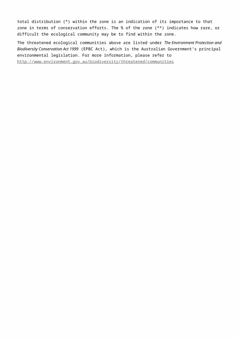
EPBC Act (1999) threatened ecological communitiesTHREATENED ECOLOGICAL COMMUNITIES
Name Listing status % of total distribution* % of zone**
Alpine Sphagnum Bogs and Associated Fens Endangered 81.70 1.78
Lowland Native Grasslands of Tasmania Critically Endangered
5.31 0.00
Giant Kelp Marine Forests of South East Australia Endangered n/a n/a
* % of the total national distribution describes the proportion of the total national distribution of the Threatened Ecological Community that is found within the zone.
** % of the total zone area describes the proportion of the zone that the Threatened Ecological Community is likely or known to occur in.
It should be noted that the identification of any given Threatened Ecological Community above does not imply that the Threatened Ecological Community (TEC) is found uniformly across the Conservation Management Zone. Rather, the % of the TEC’s total distribution (*) within the zone is an indication of its importance to that zone in terms of conservation efforts. The % of the zone (**) indicates how rare, or difficult the ecological community may be to find within the zone.
The threatened ecological communities above are listed under The Environment Protection and Biodiversity Conservation Act 1999 (EPBC Act), which is the Australian Government’s principal environmental legislation. For more information, please refer to http://www.environment.gov.au/biodiversity/threatened/communities
EPBC Act (1999) threatened speciesTHREATENED MAMMALS
Common name Scientific name Status % of totaldistribution*
% of zone**
Spotted-tail Quoll, Spot-tailed Quoll, Tiger Quoll (Tasmanian population)
Dasyurus maculatus maculatus (Tasmanian population)
Vulnerable 36.35 91.64
Tasmanian Devil Sarcophilus harrisii Endangered 36.14 99.95
Eastern Barred Bandicoot (Tasmania) Perameles gunnii gunnii Vulnerable 1.97 2.53
Humpback Whale Megaptera novaeangliae Vulnerable n/a n/a
Southern Right Whale Eubalaena australis Endangered n/a n/a
Blue Whale Balaenoptera musculus Endangered n/a n/a
* Population in Stirling Ranges National Park, otherwise thought to be locally extinct.
THREATENED BIRDS
Common name Scientific name Status % of totaldistribution*
% of zone**
Tasmanian Azure Kingfisher Ceyx azureus diemenensis Endangered 49.34 35.63
Wedge-tailed Eagle (Tasmanian) Aquila audax fleayi Endangered 34.02 99.98
Masked Owl (Tasmanian) Tyto novaehollandiae castanops (Tasmanian population)
Vulnerable 7.86 11.51
Orange-bellied Parrot Neophema chrysogaster Critically Endangered
6.13 16.65
Australasian Bittern Botaurus poiciloptilus Endangered 2.52 40.11
Australian Fairy Tern Sternula nereis nereis Vulnerable 0.30 0.75
Swift Parrot Lathamus discolor Endangered 0.03 0.23
Campbell Albatross Thalassarche melanophrisimpavida
Vulnerable 0.01 0.87
Gibson’s Albatross Diomedea exulans gibsoni Vulnerable 0.01 0.55
Northern Royal Albatross Diomedea epomophora sanfordi Endangered 0.01 0.87
Salvin’s Albatross Thalassarche cauta salvini Vulnerable 0.01 0.87
Shy Albatross, Tasmanian Shy Albatross Thalassarche cauta cauta Vulnerable 0.01 0.87
Buller’s Albatross, Pacific Albatross Thalassarche bulleri Vulnerable 0.01 0.56
Tristan Albatross Diomedea exulans exulans Endangered n/a n/a
Soft-plumaged Petrel Pterodroma mollis Vulnerable n/a n/a
Blue Petrel Halobaena caerulea Vulnerable n/a n/a
Southern Giant-Petrel Macronectes giganteus Endangered n/a n/a
Northern Giant-Petrel Macronectes halli Vulnerable n/a n/a
Wandering Albatross Diomedea exulans (sensu lato) Vulnerable n/a n/a
Antipodean Albatross Diomedea exulans antipodensis Vulnerable n/a n/a
Southern Royal Albatross Diomedea epomophoraepomophora
Vulnerable n/a n/a
Black-browed Albatross Thalassarche melanophris Vulnerable n/a n/a
Gould’s Petrel Pterodroma leucoptera Endangered n/a n/a
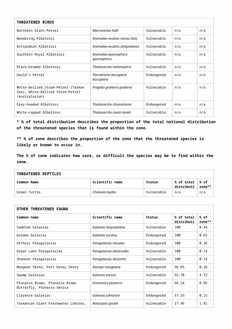
THREATENED BIRDS
leucoptera
White-bellied Storm-Petrel (Tasman Sea), White-bellied Storm-Petrel (Australasian)
Fregetta grallaria grallaria Vulnerable n/a n/a
Grey-headed Albatross Thalassarche chrysostoma Endangered n/a n/a
White-capped Albatross Thalassarche cauta steadi Vulnerable n/a n/a
* % of total distribution describes the proportion of the total national distribution of the threatened species that is found within the zone.
** % of zone describes the proportion of the zone that the threatened species is likely or known to occur in.
The % of zone indicates how rare, or difficult the species may be to find within the zone.
THREATENED REPTILES
Common Name Scientific name Status % of totaldistribution*
% of zone**
Green Turtle Chelonia mydas Vulnerable n/a n/a
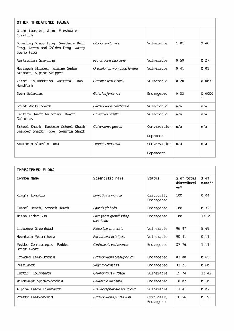
OTHER THREATENED FAUNA
Common name Scientific name Status % of totaldistribution*
% of zone**
Saddled Galaxias Galaxias tanycephalus Vulnerable 100 0.44
Golden Galaxias Galaxias auratus Endangered 100 0.65
Arthurs Paragalaxias Paragalaxias mesotes Endangered 100 0.36
Great Lake Paragalaxias Paragalaxias eleotroides Vulnerable 100 0.74
Shannon Paragalaxias Paragalaxias dissimilis Vulnerable 100 0.74
Maugean Skate, Port Davey Skate Zearaja maugeana Endangered 96.85 0.28
Swamp Galaxias Galaxias parvus Vulnerable 93.78 4.72
Ptunarra Brown, Ptunarra Brown Butterfly, Ptunarra Xenica
Oreixenica ptunarra Endangered 68.54 8.95
Clarence Galaxias Galaxias johnstoni Endangered 57.33 0.15
Tasmanian Giant Freshwater Lobster, Giant Lobster, Giant Freshwater Crayfish
Astacopsis gouldi Vulnerable 17.96 1.91
Growling Grass Frog, Southern Bell Frog, Green and Golden Frog, Warty Swamp Frog
Litoria raniformis Vulnerable 1.01 9.46
Australian Grayling Prototroctes maraena Vulnerable 0.59 0.27
Marrawah Skipper, Alpine Sedge Skipper, Alpine Skipper
Oreisplanus munionga larana Vulnerable 0.41 0.01
Ziebell’s Handfish, Waterfall Bay Handfish Brachiopsilus ziebelli Vulnerable 0.20 0.003
Swan Galaxias Galaxias fontanus Endangered 0.03 0.00001
Great White Shark Carcharodon carcharias Vulnerable n/a n/a
Eastern Dwarf Galaxias, Dwarf Galaxias Galaxiella pusilla Vulnerable n/a n/a
School Shark, Eastern School Shark, Snapper Shark, Tope, Soupfin Shark
Galeorhinus galeus Conservation Dependent
n/a n/a
Southern Bluefin Tuna Thunnus maccoyii Conservation Dependent
n/a n/a
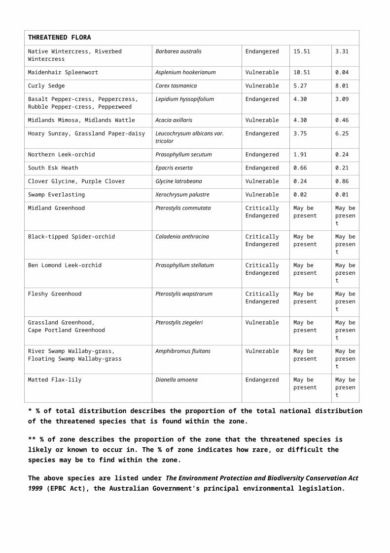
THREATENED FLORA
Common Name Scientific name Status % of totaldistribution*
% of zone**
King’s Lomatia Lomatia tasmanica Critically Endangered
100 0.04
Funnel Heath, Smooth Heath Epacris glabella Endangered 100 0.32
Miena Cider Gum Eucalyptus gunnii subsp. divaricata
Endangered 100 13.79
Liawenee Greenhood Pterostylis pratensis Vulnerable 96.97 5.69
Mountain Poranthera Poranthera petalifera Vulnerable 90.41 0.11
Pedder Centrolepis, Pedder Bristlewort Centrolepis pedderensis Endangered 87.76 1.11
Crowded Leek-Orchid Prasophyllum crebriflorum Endangered 83.80 0.65
Pearlwort Sagina diemensis Endangered 32.21 0.60
Curtis’ Colobanth Colobanthus curtisiae Vulnerable 19.74 12.42
Windswept Spider-orchid Caladenia dienema Endangered 18.07 0.10
Alpine Leafy Liverwort Pseudocephalozia paludicola Vulnerable 17.41 0.02
Pretty Leek-orchid Prasophyllum pulchellum Critically Endangered
16.56 0.19
Native Wintercress, Riverbed Wintercress Barbarea australis Endangered 15.51 3.31
Maidenhair Spleenwort Asplenium hookerianum Vulnerable 10.51 0.04
Curly Sedge Carex tasmanica Vulnerable 5.27 8.01
Basalt Pepper-cress, Peppercress, Rubble Pepper-cress, Pepperweed
Lepidium hyssopifolium Endangered 4.30 3.09
Midlands Mimosa, Midlands Wattle Acacia axillaris Vulnerable 4.30 0.46
Hoary Sunray, Grassland Paper-daisy Leucochrysum albicans var. tricolor
Endangered 3.75 6.25
Northern Leek-orchid Prasophyllum secutum Endangered 1.91 0.24
South Esk Heath Epacris exserta Endangered 0.66 0.21
Clover Glycine, Purple Clover Glycine latrobeana Vulnerable 0.24 0.86
Swamp Everlasting Xerochrysum palustre Vulnerable 0.02 0.01
Midland Greenhood Pterostylis commutata Critically Endangered
May be present
May be present
Black-tipped Spider-orchid Caladenia anthracina Critically Endangered
May be present
May be present
Ben Lomond Leek-orchid Prasophyllum stellatum Critically Endangered
May be present
May be present
Fleshy Greenhood Pterostylis wapstrarum Critically Endangered
May be present
May be present
Grassland Greenhood, Cape Portland Greenhood
Pterostylis ziegeleri Vulnerable May be present
May be present
River Swamp Wallaby-grass, Floating Swamp Wallaby-grass
Amphibromus fluitans Vulnerable May be present
May be present
Matted Flax-lily Dianella amoena Endangered May be present
May be present
* % of total distribution describes the proportion of the total national distribution of the threatened species that is found within the zone.
** % of zone describes the proportion of the zone that the threatened species is likely or known to occur in. The % of zone indicates how rare, or difficult the species may be to find within the zone.
The above species are listed under The Environment Protection and Biodiversity Conservation Act 1999 (EPBC Act), the Australian Government’s principal environmental legislation.
Please note that the list of threatened flora species is not comprehensive. The flora listed here have a significant proportion of their total national distribution within the zone. For more information please refer to: http://www.environment.gov.au/biodiversity/threatened/species or the Species Profiles and Threats Database http://www.environment.gov.au/cgi-bin/sprat/public/sprat.pl
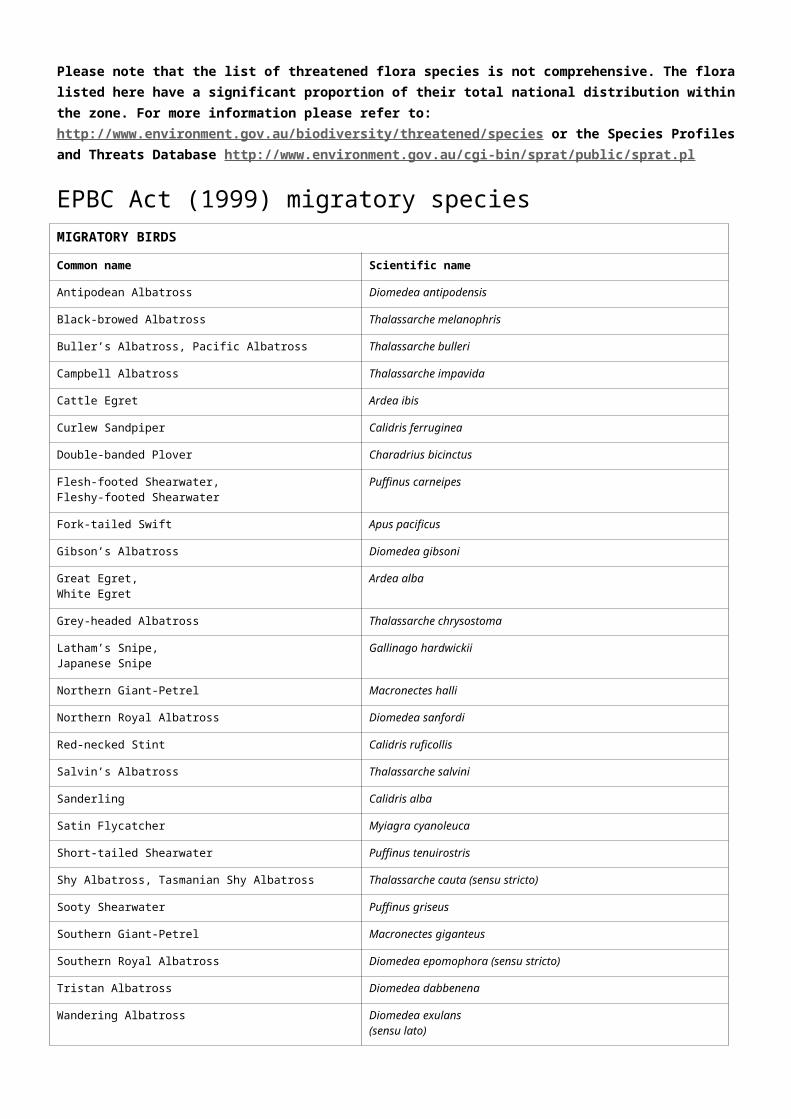
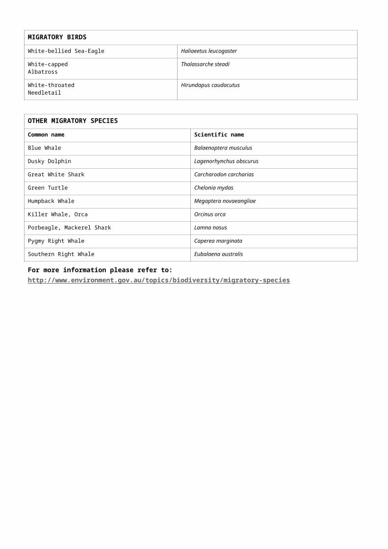
EPBC Act (1999) migratory speciesMIGRATORY BIRDS
Common name Scientific name
Antipodean Albatross Diomedea antipodensis
Black-browed Albatross Thalassarche melanophris
Buller’s Albatross, Pacific Albatross Thalassarche bulleri
Campbell Albatross Thalassarche impavida
Cattle Egret Ardea ibis
Curlew Sandpiper Calidris ferruginea
Double-banded Plover Charadrius bicinctus
Flesh-footed Shearwater, Fleshy-footed Shearwater
Puffinus carneipes
Fork-tailed Swift Apus pacificus
Gibson’s Albatross Diomedea gibsoni
Great Egret,White Egret
Ardea alba
Grey-headed Albatross Thalassarche chrysostoma
Latham’s Snipe,Japanese Snipe
Gallinago hardwickii
Northern Giant-Petrel Macronectes halli
Northern Royal Albatross Diomedea sanfordi
Red-necked Stint Calidris ruficollis
Salvin’s Albatross Thalassarche salvini
Sanderling Calidris alba
Satin Flycatcher Myiagra cyanoleuca
Short-tailed Shearwater Puffinus tenuirostris
Shy Albatross, Tasmanian Shy Albatross Thalassarche cauta (sensu stricto)
Sooty Shearwater Puffinus griseus
Southern Giant-Petrel Macronectes giganteus
Southern Royal Albatross Diomedea epomophora (sensu stricto)
Tristan Albatross Diomedea dabbenena
MIGRATORY BIRDS
Wandering Albatross Diomedea exulans(sensu lato)
White-bellied Sea-Eagle Haliaeetus leucogaster
White-cappedAlbatross
Thalassarche steadi
White-throatedNeedletail
Hirundapus caudacutus
OTHER MIGRATORY SPECIES
Common name Scientific name
Blue Whale Balaenoptera musculus
Dusky Dolphin Lagenorhynchus obscurus
Great White Shark Carcharodon carcharias
Green Turtle Chelonia mydas
Humpback Whale Megaptera novaeangliae
Killer Whale, Orca Orcinus orca
Porbeagle, Mackerel Shark Lamna nasus
Pygmy Right Whale Caperea marginata
Southern Right Whale Eubalaena australis
For more information please refer to: http://www.environment.gov.au/topics/biodiversity/migratory-species
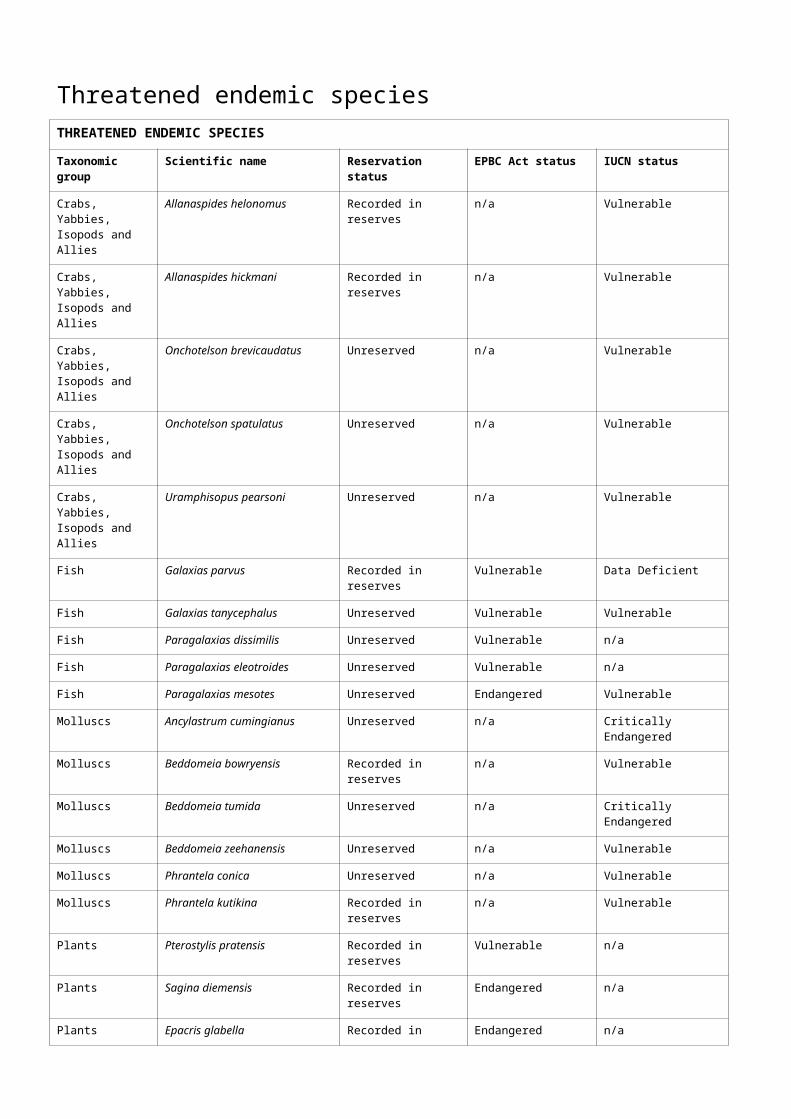
Threatened endemic speciesTHREATENED ENDEMIC SPECIES
Taxonomic group
Scientific name Reservation status EPBC Act status IUCN status
Crabs, Yabbies,Isopods and Allies
Allanaspides helonomus Recorded in reserves n/a Vulnerable
Crabs, Yabbies,Isopods and Allies
Allanaspides hickmani Recorded in reserves n/a Vulnerable
Crabs, Yabbies,Isopods and Allies
Onchotelson brevicaudatus Unreserved n/a Vulnerable
Crabs, Yabbies,Isopods and Allies
Onchotelson spatulatus Unreserved n/a Vulnerable
Crabs, Yabbies,Isopods and Allies
Uramphisopus pearsoni Unreserved n/a Vulnerable
Fish Galaxias parvus Recorded in reserves Vulnerable Data Deficient
Fish Galaxias tanycephalus Unreserved Vulnerable Vulnerable
Fish Paragalaxias dissimilis Unreserved Vulnerable n/a
Fish Paragalaxias eleotroides Unreserved Vulnerable n/a
Fish Paragalaxias mesotes Unreserved Endangered Vulnerable
Molluscs Ancylastrum cumingianus Unreserved n/a Critically Endangered
Molluscs Beddomeia bowryensis Recorded in reserves n/a Vulnerable
Molluscs Beddomeia tumida Unreserved n/a Critically Endangered
Molluscs Beddomeia zeehanensis Unreserved n/a Vulnerable
Molluscs Phrantela conica Unreserved n/a Vulnerable
Molluscs Phrantela kutikina Recorded in reserves n/a Vulnerable
Plants Pterostylis pratensis Recorded in reserves Vulnerable n/a
Plants Sagina diemensis Recorded in reserves Endangered n/a
Plants Epacris glabella Recorded in reserves Endangered n/a
Plants Poranthera petalifera Recorded in reserves Vulnerable n/a
Plants Centrolepis pedderensis Recorded in reserves Endangered n/a
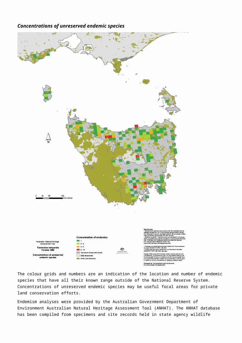
Concentrations of unreserved endemic species
The colour grids and numbers are an indication of the location and number of endemic species that have all their known range outside of the National Reserve System. Concentrations of unreserved endemic species may be useful focal areas for private land conservation efforts.
Endemism analyses were provided by the Australian Government Department of Environment Australian Natural Heritage Assessment Tool (ANHAT). The ANHAT database has been compiled from specimens and site records held in state agency wildlife atlases, museum collections, and the work of individual researchers. For more information please refer to: http://www.environment.gov.au/topics/heritage/publications-and-resources/australian-natural-heritage-assessment-tool
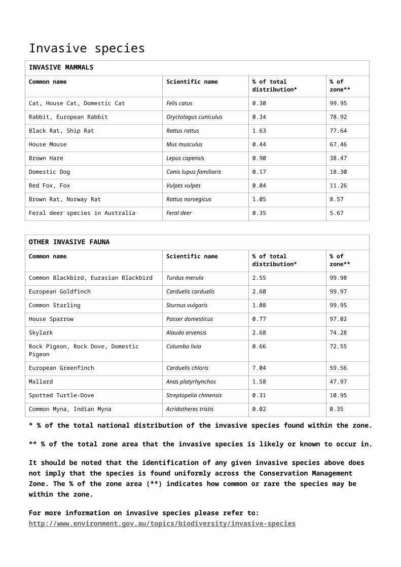
Invasive species INVASIVE MAMMALS
Common name Scientific name % of total distribution* % of zone**
Cat, House Cat, Domestic Cat Felis catus 0.30 99.95
Rabbit, European Rabbit Oryctolagus cuniculus 0.34 78.92
Black Rat, Ship Rat Rattus rattus 1.63 77.64
House Mouse Mus musculus 0.44 67.46
Brown Hare Lepus capensis 0.90 38.47
Domestic Dog Canis lupus familiaris 0.17 18.30
Red Fox, Fox Vulpes vulpes 0.04 11.26
Brown Rat, Norway Rat Rattus norvegicus 1.05 8.57
Feral deer species in Australia Feral deer 0.35 5.67
OTHER INVASIVE FAUNA
Common name Scientific name % of total distribution* % of zone**
Common Blackbird, Eurasian Blackbird Turdus merula 2.55 99.98
European Goldfinch Carduelis carduelis 2.60 99.97
Common Starling Sturnus vulgaris 1.08 99.95
House Sparrow Passer domesticus 0.77 97.02
Skylark Alauda arvensis 2.68 74.28
Rock Pigeon, Rock Dove, Domestic Pigeon Columba livia 0.66 72.55
European Greenfinch Carduelis chloris 7.04 59.56
Mallard Anas platyrhynchos 1.58 47.97
Spotted Turtle-Dove Streptopelia chinensis 0.31 10.95
Common Myna, Indian Myna Acridotheres tristis 0.02 0.35
* % of the total national distribution of the invasive species found within the zone.
** % of the total zone area that the invasive species is likely or known to occur in.
It should be noted that the identification of any given invasive species above does not imply that the species is found uniformly across the Conservation Management Zone. The % of the zone area (**) indicates how common or rare the species may be within the zone.
For more information on invasive species please refer to: http://www.environment.gov.au/topics/biodiversity/invasive-species
INVASIVE FLORA
Common name Scientific name % of total distribution*
% of zone**
Blackberry, European Blackberry Rubus fruticosus aggregate 2.74 97.71
Willows except Weeping Willow, Pussy Willow and Sterile Pussy Willow
Salix spp. except S.babylonica, S.x calodendron & S.x reichardtii
3.10 87.55
Gorse, Furze Ulex europaeus 4.45 75.96
INVASIVE FLORA
Broom, English Broom, Scotch Broom, Common Broom, Scottish Broom,Spanish Broom
Cytisus scoparius 3.34 34.12
Montpellier Broom, Cape Broom, Canary Broom, Common Broom, French Broom, Soft Broom
Genista monspessulana 4.32 27.63
Boneseed Chrysanthemoides monilifera subsp. monilifera
0.40 5.50
Bridal Creeper, Bridal Veil Creeper, Smilax, Florist’s Smilax, Smilax Asparagus
Asparagus asparagoides 0.09 3.15
African Boxthorn, Boxthorn Lycium ferocissimum 0.05 1.02
Bitou Bush, Boneseed Chrysanthemoides monilifera May be present May be present
* % of the total national distribution of the invasive species found within the zone.
** % of the total zone area that the invasive species is likely or known to occur in.
It should be noted that the identification of any given invasive species above does not imply that the species is found uniformly across the Conservation Management Zone. The % of the zone area (**) indicates how common or rare the species may be within the zone.
For more information on invasive species please refer to: http://www.environment.gov.au/topics/biodiversity/invasive-species
Vegetation profiles and management recommendations
Vegetation extent information and species lists contained in the vegetation profiles are based on analysis from the National Vegetation Information System (NVIS), including analysis of Major Vegetation Subgroups and NVIS Level V descriptions. Please see http://www.environment.gov.au/node/18930 for more information.
The management recommendations have been drawn from EPBC Act Recovery Plans, EPBC Act Ecological Communities Listing Advice and other sources. The recommendations are indicative only. Systematic reviews of management literature, consultation processes and improved Natural Resource Management program monitoring and evaluation will support development of a comprehensive set of management recommendations over time.
Sedgelands, rushs or reeds vegetation profile
97.75% Remaining
Commonly found species within this communityGymnoschoenus sphaerocephalus; Eucalyptus gunnii; Eucalyptus rodwayi; Acion hookeri; Baumea arthrophylla; Dracophyllum milliganii; Lepidosperma concavum; Leptospermum scoparium; Leptospermum nitidum; Melaleuca squamea; Melaleuca squarrosa; Banksia marginata; Empodisma minus; Leptocarpus tenax; Isophysis tasmanica; Lomandra longifolia; Gahnia microstachya; sedge; heath; shrub.
Management recommendationsPROTECTION SUSTAINABLE
AGRICULTURALPRACTICE
REHABILITATION FIREMANAGEMENT
WILDLIFEMANAGEMENT
WEEDMANAGEMENT
FERALANIMALMANAGEMENT
DISEASEMANAGEMENT
Manage public access to protect delicate alpine vegetation from trampling by recreational park users. Where relevant, encourage uptake of conservation agreements and covenants on private land to
Exclude stock and maintain fences to prevent domestic stock access.
Develop and implement suitable fire management strategies to protect Alpine Sphagnum Bogs and Associated Fens ecological community.
Eradicate weeds, especially Spanish heath and Salix spp. Willows. Undertake early detection and eradication of founder populations of invasive weeds.Manage public access to prevent
Ensure strict hygiene protocols are in place to avoid spread of Phytophthora cinnamomi.
PROTECTION SUSTAINABLEAGRICULTURALPRACTICE
REHABILITATION FIREMANAGEMENT
WILDLIFEMANAGEMENT
WEEDMANAGEMENT
FERALANIMALMANAGEMENT
DISEASEMANAGEMENT
protect Alpine Sphagnum Bogs and Fens.
spread of weeds and plant disease.
Cool temperate rainforest vegetation profile
97.16% Remaining
Commonly found species within this communityAthrotaxis selaginoides; Athrotaxis cupressoides; Eucalyptus coccifera; Nothofagus cunninghamii; Nothofagus gunnii; Agastachys odorata; Atherosperma moschatum; Dicksonia antarctica; Lagarostrobos franklinii; Phyllocladus aspleniifolius; Richea pandanifolia; Blechnum wattsii; Prionotes cerinthoides; Gleichenia alpina; Astelia alpina; fern; heath; shrub; tussock grass; sedge.
Management recommendationsPROTECTION SUSTAINABLE
AGRICULTURALPRACTICE
REHABILITATION FIREMANAGEMENT
WILDLIFEMANAGEMENT
WEEDMANAGEMENT
FERALANIMALMANAGEMENT
DISEASEMANAGEMENT
Encourage uptake of conservation agreements and covenants on private land.
Ensure apiarists maintain strict surveillance of hives during leatherwood honey production (in order toprevent theestablishment of feral beepopulations).
Improve the connectivity of remnants through facilitating regrowth as well as active replanting.
Fire intervals of <100 years result in the loss of cool temperate rainforest. Fire should therefore be excluded as much as possible.Some cool temperate rainforest species may survive or regenerate if the fires are cool and the remnant is long unburnt (>100 years). Other cool temperate rainforest species, such as pines, may be lost permanently in fire
Raise public awareness to reduce road mortality rates of threatened mammals.Establish and maintain a captive breeding program for Tasmanianspotted-tail quolls.Improve forestry practices to eliminate or reduce negative consequences on fauna.
Implement control measures for non-native predators, such as cats. However, ensure that feral cat trapping and poisoning does not have adverse affects on Tasmanian spotted-tail quolls.
Implement strict hygiene protocols to prevent spread of Myrtle wilt (which affects Nothofagus cunninghamii) and Phytophthora cinnamomi. This includes managing public and vehicle access, and preventing the introduction of foreign soil and plant material.
Eucalyptus open forests with a shrubby understorey vegetation profile
84.08% Remaining
Commonly found species within this communityEucalyptus nitida; Eucalyptus obliqua; Eucalyptus viminalis; Eucalyptus ovata; Eucalyptus sieberi; Eucalyptus pauciflora; Eucalyptus subcrenulata; Eucalyptus coccifera; Eucalyptus amygdalina; Leptospermum lanigerum; Acacia dealbata; Banksia marginata; Exocarpos cupressiformis; Epacris impressa; Polystichum proliferum; Pteridium esculentum; Lomandra longifolia; fern; forb; heath; sedge.
Management recommendationsPROTECTION SUSTAINABLE
AGRICULTURALPRACTICE
REHABILITATION
FIREMANAGEMENT
WILDLIFEMANAGEMENT
WEEDMANAGEMENT
FERALANIMALMANAGEMENT
DISEASEMANAGEMENT
Protect remnants from clearing. Protect hollow-bearing trees.Retain standing dead trees and fallen timber.
Low closed forest or tall closed shrublands (including Acacia, Melaleuca and Banksia) vegetation profile
99.42% Remaining
Commonly found species within this communityMelaleuca ericifolia; Acacia longifolia subsp. Sophorae; Banksia marginata; Pomaderris apetala; Leptospermum lanigerum; Melaleuca squarrosa; Ozothamnus turbinatus; Eucalyptus nitida; Leucopogon parviflorus; Monotoca glauca; Leptospermum glaucescens; Notelaea ligustrina; Melaleuca squamea; Olearia argophylla; Olearia axillaris; Acacia mucronata; Leptospermum scoparium; Gahnia grandis; Blechnum nudum; Ehrharta stipoides; Hypolepis rugosula; Rhagodia candolleana; Isolepis nodosa; Acaena pallida; Poa labillardierei; Polystichum proliferum; Viola hederacea;Empodisma minus; rush; heath; shrub; sedge; fern; tussock grass.
Management recommendationsPROTECTION SUSTAINABLE
AGRICULTURALPRACTICE
REHABILITATION FIREMANAGEMENT
WILDLIFEMANAGEMENT
WEEDMANAGEMENT
FERALANIMALMANAGEMENT
DISEASEMANAGEMENT
Retain fallen timber and ban firewood collection.
Fence remnants.Exclude stock altogether whilst remnants are regenerating and saplings are palatable.
Fence to allow natural regeneration. Use seed sourced directly from the same sites for rehabilitation purposes.
Fire should be low intensity. Burn at 10–15 year intervals in banksia dominant remnants to assist in regeneration.
Control woody weeds such as gorse andblackberry.In remnants containing banksia, Yorkshire fog, cocksfoot and brown-top bent can be problematic grass species.
Implement strict hygiene regimes to avoid spread of Phytophthora cinnamomi. This includes managing public pedestrian and vehicle access and avoiding introduction of soil and foreign plant matter.

Eucalyptus (+/- tall) open forest with a dense broad-leaved and/or tree-fern understorey (wet sclerophyll) vegetation profile
98.46% Remaining
Commonly found species within this communityEucalyptus nitida; Eucalyptus obliqua; Pomaderris apetala; Eucalyptus brookeriana; Eucalyptus delegatensis subsp. tasmaniensis; Nothofagus cunninghamii; Atherosperma moschatum; Eucalyptus regnans; Phyllocladus aspleniifolius; Dicksonia antarctica; Melaleuca ericifolia; Melaleuca squamea; Acacia longifolia subsp. sophorae; Ozothamnus turbinatus; Banksia marginata; Nematolepis squamea; Coprosma quadrifida; Blechnum wattsii; Bauera rubioides; Gahnia grandis; Empodisma minus; Pittosporum bicolor; Coprosma quadrifida; Olearia argophylla; Polystichum proliferum; Microsorum pustulatum;rush; heath; shrub; sedge.
Management recommendationsPROTECTION SUSTAINABLE
AGRICULTURALPRACTICE
REHABILITATION FIREMANAGEMENT
WILDLIFEMANAGEMENT
WEEDMANAGEMENT
FERALANIMALMANAGEMENT
DISEASEMANAGEMENT
Avoid further fragmentation and clearance of forests.Maintain standing dead trees, leaf litter and fallen timber.
If foresting, ensure forestry practices support regeneration of bothunderstorey and overstorey species.Minimise soil compaction from forestry equipment.
Research suggests that the mean interval between high intensity fires that result in death of some trees is between 75–150 years. Mountain ash forests will sharply reduce in extent if high intensity fire intervals are more frequent.
Protect and maintain hollow bearing trees as these provide habitat for tree-dwelling mammals. In forests that have had mature, hollow-bearing trees selectively logged provide nesting boxes for both mammals and birds. Monitor boxes regularly for
Manage feral cats.