Embed Size (px)
Citation preview

1
L-GĦARB TO L-GĦARB: 10KM
Ta’ Ġurdan Walk

2
Xlendi Walk
Ħondoq Ir-Rummien Walk
Dwejra Walk
Comino Walk
Daħlet Qorrot Walk
Ramla Walk
Saltpans Walk
Ta’ Ġurdan WalkStarting: L-Għarb
Ending: L-Għarb
Length: 10km
Grading: Moderate, difficulty with some steep inclines and a few rocky areas
Landscape: Urban, coastal, countryside roads and paths
Trail markings
Getting there and back: Gozo Channel operates regular ferries to L-Imġarr Harbour leaving from iċ-Ċirkewwa in Malta. Buses leave regularly from the harbour to Victoria where a bus can be taken to L-Għarb and back.
Recommended Walking season: October to May

3
OverviewThis circular walk starts and ends in the village square of L-Għarb. The road running down the left-hand side of the church leads to open countryside, passing the “St. Dimitri Chapel” and affording good views of “Ta’ Ġurdan Lighthouse” and “Ta’ Pinu Sanctuary”. The valley of “Wied il-Mielaħ” is reached after a nice walk along the coast. The hilly features of the island and the view of the vast expanse of sea stretching beyond the steep cliffs are best enjoyed from the top of Ta’ Ġurdan Hill. This walk leads on to the magnificent valley of “Wied il-Għasri”, ensconced between sheer cliffs, followed by Ta’ Ġurdan Lighthouse. This imposing landmark affords a bird’s-eye view of most of the island. Eventually the walk leads to the “Ta’ Pinu Sanctuary” a centre of religious devotion and ex-voto offerings. The road through the fields behind the sanctuary leads back to the centre of the village where the walk began.
The route map in the centre pages of this booklet, together with the many signposts along the route, will help you to follow the walk more easily. Sticking to the set route affords a fascinating cross-section of Gozitan countryside, folklore and traditions.

4
NotesCOUNTRYSIDE CODE
• The route is suitable for hikes, horse rides and pedal bikes.• Most of the route is accessible to small vehicles.• One should check the local bus timetable if one is travelling by bus to the route starting
point.• The local weather forecast should be checked before setting off as there is hardly any
shelter from adverse weather conditions along the route. A raincoat can come in very handy in rainy conditions.
• As most of the walk is over open countryside, it is advisable to carry a packed lunch. It is possible to buy food at L-Għarb.
• Public conveniences are available at Triq ta’ Pinu and Triq it-Trux in L-Għarb.• Bird trapping and bird shooting are practised in the countryside. There are, however strict
regulations determining areas where such activities are permitted and times of year where no such activities are allowed. Note also that bird shooting is prohibited from 1.00pm on wards on Sundays and public holidays throughout the year.
HEALTH AND SAFETY
• Hikers are advised to follow the set route. Short cuts are to be avoided since many fields are privately owned.
• Hikers should not climb over rubble walls to avoid damaging them.• Hikers should avoid collecting wildlife specimen, including flowers or plants.• Hikers are advised to tread carefully along the trails to avoid trampling on the sparse
vegetation.• The throwing of stones or other objects into valleys or other freshwater sites is strictly
prohibited.• Walking or cycling close to the cliff edges is to be avoided.• It is advisable to follow this route in broad daylight, giving due allowances for time
allotted to inevitable stops, resting, taking of photo graphs and observing nature.
Before undertaking any part of this walk, it is strongly recommended to ensure that one’s physical and medical conditions permit the undertaking of these activities. Particular attention is to be made to the often irregular terrain and to refrain from undertaking these walks in prohibitive weather conditions. All walks are undertaken at one’s own risk.
Whilst every effort has been made to ensure the accuracy of information contained in this brochure as at time of publication, the Ministry for Gozo accepts no liability for any inaccuracies or omissions whatsoever. Moreover, the Ministry for Gozo accepts no liability for accidents or any type of losses while following these walks.
WALK HIGHLIGHTS
Walking along the route one discovers how the island’s rich history, traditions and geographical features intertwine with nature and local folklore. Hiking along the cliffs one can observe the rugged coastline of the Maltese islands, where panoramic views show secluded valleys full of life among the hills. Old farming methods are gradually being replaced by modern farming.

5
Church of the Visitation of Our Lady
This walk starts from Pjazza taz-Zjara tal-Madonna in the picturesque village of L-Għarb. The
quaint, distinctive feel of the square is enhanced by the parish church dedicated to the Visitation of Our Lady (1).
The church, built in 1679, is one of the best examples of baroque architecture in the Maltese islands. One of its two belfries displays in bold letters the message “Ibni

6
għozz iz-zmien” (Cherish time, my son). The concave facade is adorned with intricate sculpture and carved around the main door are the symbols of Faith, Hope and Charity. In front of the parish church is a stone plinth supporting a cross. The year 1783 can be clearly seen notched on the column.
An imposing old building located on the same side as the cross houses a Folklore Museum exhibiting specimens of Gozo’s folklore and heritage. From the village square, follow the road called Triq Madonna tal–Virtu’ flanking the left-hand
The Folklore Museum
Wied ir-Raħeb

7
Ta’ Ġurdan Lighthouse
side of the church. Going downhill you will notice the facades of recently built houses, especially those bearing the names of foreign countries and cities, such as Australia or the United States of America. These are owned by returned migrants who left the Maltese islands in search of a better life in lands of opportunity. The variety of balconies and terraces is striking. Triq Madonna tal–Virtu’ levels out at a crossroads. Our walk continues straight ahead along Triq Birbuba.
Along this road is a children’s playground named after Pope John Paul
II, the only Pope ever to have visited Gozo. From here you can observe the “Wied ir-Raħeb”, the Hermit’s Valley or the Sacristan’s Valley.
Continue along Triq Birbuba and when you arrive at a Y-junction take the right fork. Proceeding along the road, between dry-stone walls, you will start to see in the distance the “Ta’ Ġurdan Lighthouse” towering above the undulating landscape.

8
San Dimitri’s Chapel
After about 400 meters you turn right on to a footpath and after less than 200 meters you turn left on to a dusty path which leads towards the San Dimitri chapel (2). Turning right at the crossroads you come to the chapel, which dates
back to the 15th century. The altarpiece shows St. Demetrius on horseback. The high ground on which the chapel stands provides a breathtaking view of L-Għarb, Ta’ Pinu Sanctuary, Ta’ Ġurdan Lighthouse, Iż-Żebbuġ and quarries that were formerly used to extract prime yellow globigerina limestone and have now been restored to agricultural use. Going back to

9
Inside San Dimitri’s Chapel
the crossroads, take the road that turns to the right toward the northern coast. Not far in the distance you can observe a circular row of Following the footpath you arrive at a T-junction where you turn left. This path runs downhill through heavily eroded yellowish globigerina limestone and clay. Ahead you see a group of large boulders which appear to be stone
megaliths but are actually just natural boulders. Proceed towards the coast and then turn right towards the yellow limestone coast, entering a landscape of wind-sculpted limestone.
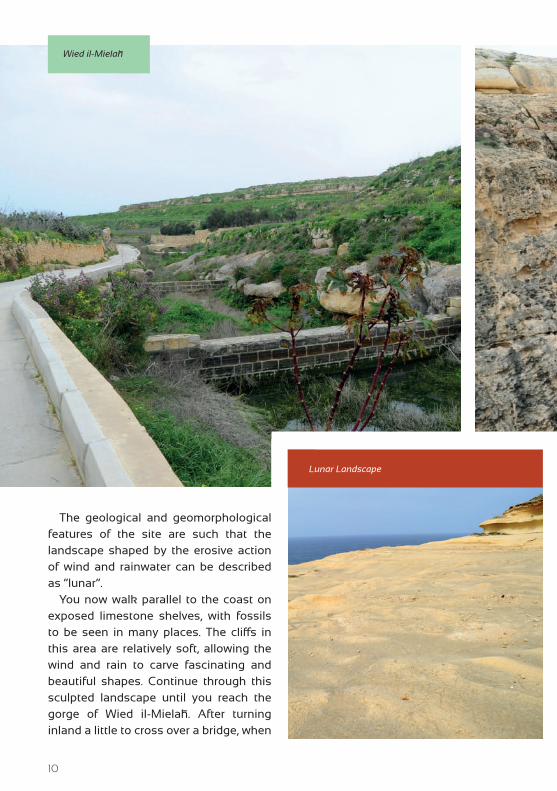
10
The geological and geomorphological features of the site are such that the landscape shaped by the erosive action of wind and rainwater can be described as “lunar”.
You now walk parallel to the coast on exposed limestone shelves, with fossils to be seen in many places. The cliffs in this area are relatively soft, allowing the wind and rain to carve fascinating and beautiful shapes. Continue through this sculpted landscape until you reach the gorge of Wied il-Mielaħ. After turning inland a little to cross over a bridge, when
Wied il-Mielaħ
Lunar Landscape

11
Wied il-Mielaħ Window
you reach the other side of the gorge you can admire an impressive rock arch, a famous window called the Wied il-Mielaħ Window. The natural rock formation of a massive window in the cliff was once a small crack in the rock that became wider and wider due to the combined action of rain, waves and wind until it assumed its current shape of a large natural window. The process of erosion is ongoing and inevitably the top layer of this rock formation is destined to fall off.
The walk continues to the east along a track parallel to the coast with many views of large caves at sea level. These caverns are the favourite haunts of local diving schools. The terrain in this area above the cliffs, marked by holes, cracks, fissures
and sharp points, is called “karst”. It is formed by the action of acidic rainwater on the Upper Coralline Limestone. When carbon dioxide dissolves in the rainwater, it forms a mild acid that causes erosion along the fissures of the bedrock. Since the mineral composition of the rock is not uniform, it does not erode evenly, thus giving rise to the typical karst landscape.
If an area is composed only of soft globigerina limestone it erodes evenly to form smooth planes that are often rich in fossils. But in places where the globigerina is overlaid by Upper

12
TA’ ĠURDAN WALK

13

14
Caves at sea level
Coralline Limestone (a harder type of sedimentary rock) , it erodes more slowly than the exposed parts. This gives rise to structures that resemble tables, with an Upper Coralline Limestone top and a
Globigerina Limestone leg. The stretches of Globigerina Limestone visible on the left side of this road clearly illustrate this. You may also notice that this type of landscape slowly starts to give way to a new type of habitat, the rocky steppe. This type of habitat is formed when an area is composed mainly of hard Lower Coralline Limestone and the calcium carbonate found in it dissolves. The remaining minerals form the red soil that can be seen in the cracks. Where the pockets of soil are deep enough, the typical plants of this environment start growing. If conditions are favourable enough, karst
Mediterranean Thyme

15
Gozo Hyoseris
The endemic and protected Maltese Wall Lizard
terrain slowly turns into steppe. Due to several environmental factors, such as lack of water, which particularly affect the steppe due to the shallowness of the soil, only a few plants are adapted to survive here. The following flora are typical of coastal steppes: Mediterranean steppe grass, goat-grass and sea squill. The main shrub is Mediterranean thyme, sometimes heavily bordered by the parasitic dodder plant.
This site also hosts certain endemic species (i.e. species growing only on Gozo) such as the Gozo Hyoseris, and even orchids can be identified by the
discerning eye. This area is also very rich in fauna, including molluscs, insects, beetles and reptiles. If this walk is taken early in the morning, one may even spot the common Black snake. This area is littered with fossils embedded in the rock, the remains of ancient creatures that used to live in the sea. They provide evidence that the Maltese islands are made of

16
Wied il-Għasri
sedimentary rock that formed under the sea about 25 million years ago. The effect of erosion on the cliffs can be seen in the variety of shapes and contours that the surrounding cliffs and hills have assumed.
The village of Iż-Żebbuġ, standing on the plateau, can be seen from this area.
By following the path downhill one arrives at another valley, the Wied il-Għasri. Prickly pears and capers grow on
and around the dry-stone walls. During late spring the area becomes a carpet of red poppies. L-Għasri valley is a deep gorge-like valley with very high cliffs carved into the Lower Coralline Limestone and the overlying Globigerina Limestone.
This valley follows a winding path that leads to the open sea, which soon comes into view. A small, secluded pebbly bay lies at the mouth of the valley. Although it seems inaccessible, a series of steps have been cut into one side of the cliff face. The gorge is especially impressive during rough weather as the swell of seawater

17
Ta’ Ġurdan lighthouse
rushes through the inlet at the end of the gorge and crashes on to the small beach.
Here you can also see cliff flora, especially interesting since it includes many endemic species as well as species found mainly in North Africa.
The route continues inland, running along the upper reaches of the valley of Wied il-Għasri. Take the beaten earth path on the right-hand side past a small rural
building, heading uphill along a road with natural yellow rock walls.
The path goes steeply uphill and levels off near a private residence. At the next junction you can see the Ta’ Ġurdan lighthouse (3) at the top of the hill to your right. You can reach the lighthouse by walking along the path on the right. The hill of Ta’ Ġurdan lighthouse is about 160 meters above sea level. This high

18
vantage point offers magnificent views of the island. The North coast and much of the rest of the island can be seen clearly. On days of optimum visibility, one can also observe the outline of the island of Sicily. The now dilapidated buildings close to the lighthouse used to serve as an RAF base during World War II. There was also an observation post manned by three Scouts.
The route takes you back downhill to the point where the asphalt road, Triq il-Fanal,
intersects Triq ta’ Għammar, which is the main road linking L-Għasri to Ta’ Pinu. This road passes through Għammar hamlet and proceeds towards L-Għarb. The majestic Ta’ Pinu Sanctuary (4) is now quite close and you may visit this church which is open daily for worship and visiting.
The Għammar plateau, crowned by a statue in front of the sanctuary, is directly ahead. The thirteen statues of the Way of the Cross can be seen along a steep, uphill road.
View from Ta’ Ġurdan
19
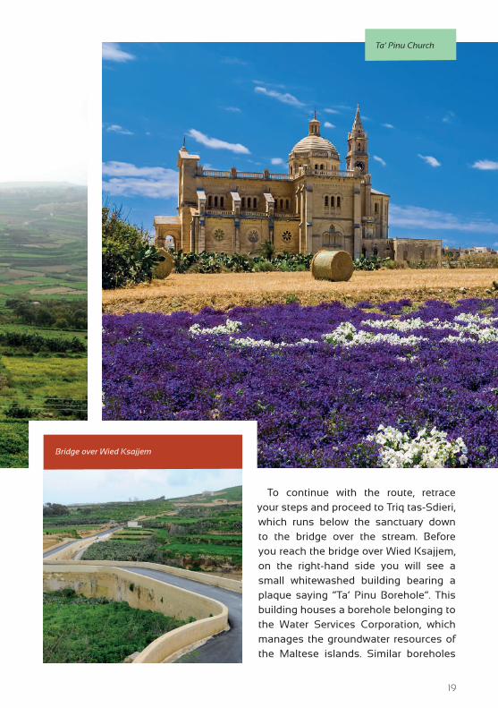
Ta’ Pinu Church
To continue with the route, retrace your steps and proceed to Triq tas-Sdieri, which runs below the sanctuary down to the bridge over the stream. Before you reach the bridge over Wied Ksajjem, on the right-hand side you will see a small whitewashed building bearing a plaque saying “Ta’ Pinu Borehole”. This building houses a borehole belonging to the Water Services Corporation, which manages the groundwater resources of the Maltese islands. Similar boreholes
Bridge over Wied Ksajjem

20
are found in other valleys in Gozo, Comino and Malta. Soon you come to the bridge over Wied Ksajjem where you can observe orchards in disused stone quarries by the valley. The stone used to build Ta’ Pinu was extracted and worked in these quarries. Before proceeding uphill, you should take a last look at the sanctuary and its imposing belfry.
Triq Tas-Sdieri continues uphill until you reach the outskirts of L-Għarb. The walk continues along Triq il-Blata on your left, where the various designs of stone balconies, old and new, as well as the typical architectural features of the older village dwellings offer a quaint, unique scene. Soon the road passes by the side of the parish Church and enters the village square from where this walking tour began.
Back to the Main Square

21
CHURCH OF THE VISITATION OF OUR LADY
The Parish Church and
Collegiate Basilica, built in 1699
and consecrated in 1729, is
one of the most architecturally perfect
churches in Gozo. The design is based
on Francesco Borromini’s Sant’Agnese
in Agone in Piazza Navona in Rome.
The L-Għarb church was built to replace
the older and smaller chapel of “Taż-
Żejt” (still standing), which served as the
parish church for fifty years. It is called
Taż-Żejt’ (zejt meaning oil) because of
a legend that says that an old woman
found oil oozing from the side of the
church, spread it over her body and was
cured of her ills. However, this building
proved too small and the parishioners
decided to build a new church. Its
foundation stone was laid in 1699 and
the parish was transferred to the new
church around 1729. It was consecrated
on 28 September 1755. In 1774 the church
became the second Collegiate of Gozo
and was elevated to the status of minor
Basilica in 1967.
The feast day is the 31st May and the
village festivities take place during the
first weekend of July.
THE LEGENDS OF SAN DIMITRI’S CHAPEL
One of the legends of San
Dimitri starts with a surprise
attack by Turkish corsairs on this
part of Gozo. A young lad, the only son of
a peasant who lived close to the chapel,
was captured and taken into captivity. His
desperate mother rushed to the chapel
and passionately implored San Dimitri to
redeem her son from slavery. The woman
made a solemn vow that she would
provide oil for the chapel’s lamp every
single day of her life. Miraculously the
images of the saint and his horse came
to life from the chapel’s altarpiece and
rushed out after the Turkish slave ship,
saved the boy from the terrified corsairs
and rode back to the chapel, delivering
the lad safe and sound to his delighted
mother. After this miraculous sally, San
Dimitri returned to his original position
in the picture. Local people insist that his
horse left hoof marks on the rocks around
the chapel. The other two legends relate
how a massive earthquake drove the land
on which the former chapel stood into the
sea. However, the chapel miraculously did
not crumble and the oil lamp continued
to burn in the depths. The legend claims
that fishermen sometimes see the oil
Snippets
1 2

22
Ta’Pinu Church
lamp still flickering down on the seabed.
A similar legend narrates how two sailors,
who dived from a ship anchored nearby
to try to free their blocked anchor, came
up to narrate how they had seen a chapel
in which an oil lamp was burning! The
present chapel, built between 1736 and
1809, is well looked after by the members
of a lay religious society based in L-Għarb.
TA’ ĠURDAN LIGHTHOUSE
The construction of the
lighthouse started in June 1852.
Originally it was lit by means of
a large oil lantern and revolving reflector.
This system was changed to one using
kerosene lamps and lenses, later replaced
by a more sophisticated system, installed
by the Barbier Bernard firm of Turenne in
France, which is still in use today.
TA’ PINU CHURCH
Ta’ Pinu Church was built by
public subscription following
a miracle in 1833 involving
a spinster, Karmni Grima, and a
small chapel located on the site. The
foundation stone was laid in 1916 and
the consecration by Bishop Gonzi took
place in 1931. A year later Pope Pius XI
elevated it to the status of a Basilica. The
precision and intricate elegance of the
splendid stone work, especially on the
inside of the Church, are admirable.
Ta’ Pinu is visited by large numbers of
pilgrims as well as tourists. The sacristy
is full of ex-voto offerings. The 16th
century chapel is still preserved inside
the Basilica, as is the original Madonna
Ta’ Pinu painting (1619) by Bartolomeo
Amadeo Perugino.
3
4

23
Info Pages
WEBSITES:
www.gozo.gov.mtwww.visitgozo.comwww.ecogozo.com
www.gozochannel.com
TOURIST INFORMATION OFFICE IN GOZO:
No. 17, Independence Square, Victoria, Gozo, VCT 1021Tel: (+356) 22915452
OPENING HOURS:Mondays to Saturdays: 09:00 to 17:30 (Last admission 17:15)
Sundays and public holidays*: 09:00 to 13:00 (Last admission 12:45)
Note: *except on Christmas Day, New Year, Good Friday & Easter Sunday
BUS TIMETABLES:
www.transport.gov.mt
All rights reserved. No part of this publication may be reproduced, stored in retrieval system or transmitted, in any form or by any means, electronic, mechanical, photocopying,
recording or otherwise, without the prior written consent of the copyright holder. Direct enquiries may be forwarded to the Ministry for Gozo.

Photography by:
GEORGE SCERRIRENO RAPATHERESE DEBONO
PAUL SCICLUNADANIEL CILIAETIENNE MICALLEF
Xlendi Walk Ħondoq Ir-Rummien Walk
Dwejra Walk
Comino Walk
Saltpans Walk
O T H E R W A L K S IN THE SERIES
Ramla Walk Daħlet Qorrot Walk
MINISTRY FOR GOZO
Rural Development Programme for Malta 2007-2013
Axis 3 – Improving the Quality of Life in Rural AreasProject Part-financed by the European Union
The European Agricultural Fund for Rural DevelopmentCo-financing Rate: 75% European Union: 25% Government of Malta
Europe Investing in Rural Areas