Embed Size (px)
Citation preview
REPORT ON NATIONAL SURVEY OF MULTI-ORGANIZATIONAL GIS PROGRAMS
Prepared by:
Croswell-Schulte IT Consultants Frankfort, KY
www.croswell-schulte.com
Major Oak Consulting, A Verint Company New Providence, NJ
www.majoroakconsulting.com
Contact: Peter Croswell, (502) 848-8827, [email protected]
Survey Work Supported by:
Louisville/Jefferson County Information Consortium (LOJIC)
Contact: Curt Bynum, Manager (502)-540-6121
Cuyahoga County Ohio Information Technology Department Contact: John Kable, GIS Planning &
Development Manager (216)-443-8043
February, 2015
This report is distributed by the GIS Management Institute (GMI) of the Urban and Regional Information Systems Association (URISA). See www.urisa.org/main/gis-management-institute
Croswell-Schulte Information Technology Consultants www.croswell-schulte.com Major Oak Consulting www.majoroakconsulting.com
TABLE OF CONTENTS
Report Sections
PREFACE ............................................................................................................................................. iii
SECTION 1: DESCRIPTION OF SURVEYS .................................................................................... 1
SECTION 2: LOCAL/REGIONAL GIS PROGRAM SURVEY- SUMMARY OF RESULTS....... 4
2.1 GIS Program Background, Structure, Participation .................................................................... 4 2.2 Multi-Organizational GIS Program Tenure .................................................................................... 4 2.3 GIS Program Mission and/or Vision Statement ........................................................................... 6 2.4 Organization Types of Users and Participants ........................................................................... 11 2.5 Oversight and Collaboration bodies ............................................................................................... 12 2.6 Populations Served by GIS Program ............................................................................................... 13 2.7 Annual Operating Budget and Staffing .......................................................................................... 14 2.8 Additional Information about the GIS Program Management and Staff ........................... 15 2.9 Formal Mandate and Administrative and Legal Vehicles ....................................................... 17 2.10 Additional Information about Organizational Structure ..................................................... 18 2.11 Funding Sources and Financing Strategies................................................................................ 20 2.12 GIS Coordination Activities, and Services .................................................................................. 22 2.13 Benefits of Multi-Organizational GIS Collaboration ............................................................... 24 2.14 Potential Impact of Limitations and Obstacles ........................................................................ 26 2.15 Organizational and Management Best Practices ..................................................................... 27 2.16 Technical/Technology Best Practices ......................................................................................... 31 2.17 Additional Ideas and Insights Provided by Respondents .................................................... 34
SECTION 3: STATEWIDE GIS PROGRAM SURVEY – SUMMARY OF RESULTS ............... 36
APPENDIX A: WEB-BASED SURVEY FORMS ........................................................................... 40
A.1 Forms from Local/Regional GIS Program Survey ..................................................................... 40 A.2 Forms from Statewide GIS Program Survey................................................................................ 44
List of Figures Figure 1: Lead Organization Types ............................................................................................................................. 8 Figure 2: Organization Types of Users .................................................................................................................... 11 Figure 3: Collaboration Bodies ................................................................................................................................... 12 Figure 4: Summary of Reported GIS Program Budgets .................................................................................... 15 Figure 5: Formal Mandate and Administrative and Legal Vehicles ............................................................ 17 Figure 6: Funding Sources and Financing Strategies ........................................................................................ 20 Figure 7: Organizational and Management Best Practices ............................................................................. 28 Figure 8: Technical/Technology Best Practices .................................................................................................. 32
National Survey of Multi-Organizational GIS Programs i February 2015
Croswell-Schulte Information Technology Consultants www.croswell-schulte.com Major Oak Consulting www.majoroakconsulting.com
List of Tables Table 1: Questions from Multi-Organizational GIS Surveys ............................................................................. 2 Table 2: Number of Responses by State ................................................................................................................... 4 Table 3: Summary of the Local/Regional GIS Program Name and their Tenure ..................................... 5 Table 4: GIS Program Organizational Leads, Participants and Geographic Scope .................................. 9 Table 5: Examples of GIS Program Policy/Governing Bodies ....................................................................... 13 Table 6: Summary of Population Size for GIS Programs .................................................................................. 14 Table 7: Types of GIS Coordination, Activities, and Services Provided .................................................... 23 Table 8: Ranked Benefits from Multi-Organizational GIS Programs .......................................................... 24 Table 9: Importance and Impact of Limitations and Obstacles .................................................................... 26
National Survey of Multi-Organizational GIS Programs ii February 2015
Croswell-Schulte Information Technology Consultants www.croswell-schulte.com Major Oak Consulting www.majoroakconsulting.com
PREFACE
The surveys described in this report were conducted the fall of 2014 as part of two project engagements involving consulting teams from Croswell-Schulte IT Consultants and Major Oak Consulting. Funding for these projects was provided by the following client organizations:
The Louisville and Jefferson County Metropolitan Sewer District (MSD) in support of a GIS best practices evaluation for the Louisville/Jefferson County Information Consortium (LOJIC) and all of LOJIC’s partner organizations and users.
AND
Cuyahoga County, OH as the lead in a project supported in part by a state of Ohio Local Government Innovation Fund (LGIF) grant to support evaluation and planning for a Countywide shared enterprise GIS program (including participation by the Northeast Ohio Regional Sewer District (NEORSD), municipalities in the County, and other organizations).
Recognizing the value of this survey information to organizations throughout North America, these client organizations have agreed to make this report available to any interested party through the Urban and Regional Information Systems Association (URISA).
Croswell-Schulte IT Consultants and Major Oak Consulting would like to thank LOJIC and Cuyahoga County for their participating in preparing the survey tools and financially supporting the survey work. We would also like to thank those organizations and individuals who took the time to respond to this survey—the information from the survey provides an excellent foundation for examination of the status, best practices, and direction of multi-organizational GIS programs.
This report summarizes the data gathered from an extensive set of survey questions. Raw data from the survey can be made available upon request to:
Peter Croswell, President Croswell-Schulte IT Consultants 406 Winners Circle Frankfort, KY 40601 (502) 848-8827 (502) 320-9055 (cell) [email protected]
This report is distributed by the GIS Management Institute (GMI) of the Urban and Regional Information Systems Association (URISA). See www.urisa.org/main/gis-management-institute
National Survey of Multi-Organizational GIS Programs iii February 2015
Croswell-Schulte Information Technology Consultants www.croswell-schulte.com Major Oak Consulting www.majoroakconsulting.com
SECTION 1: DESCRIPTION OF SURVEYS
For the purpose of this survey, the term multi-organizational GIS program is used in a broad sense. The term encompasses formal GIS consortia in which multiple organizations collaborate (through formal written agreements) on a range of GIS development and operational activities and have well-defined leadership and staff to support users in the organizations. But the term also applies to less formal GIS programs in which multiple organizations have agreed to share data, participate in joint funding on GIS projects, or work out common standards that facilitate regional coordination
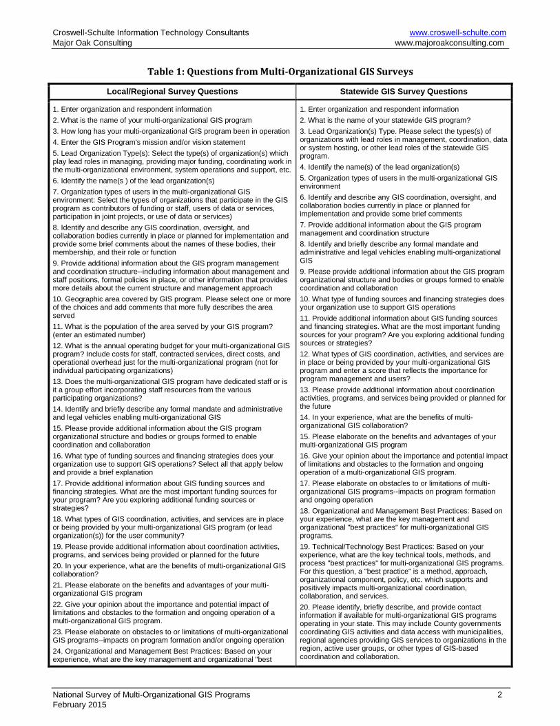
The Croswell-Schulte Team conducted two Web-based surveys to gather information about the status, characteristics, and best practices of existing multi-organizational GIS programs. Two Web-based surveys were designed and deployed using the SurveyGizmo.com service. These two surveys included similar questions but targeted two different GIS program types: a) Local and regional (multi-County) GIS programs and b) Statewide GIS programs. Survey questions for each of the surveys are shown in Table 1. The Web-based survey forms used a mix of checkbox, radio button, and text box entries with space for respondent comments to elaborate on entries. The forms for these surveys are shown in Appendix A.
.
National Survey of Multi-Organizational GIS Programs 1 February 2015
Croswell-Schulte Information Technology Consultants www.croswell-schulte.com Major Oak Consulting www.majoroakconsulting.com
Table 1: Questions from Multi-Organizational GIS Surveys
Local/Regional Survey Questions Statewide GIS Survey Questions
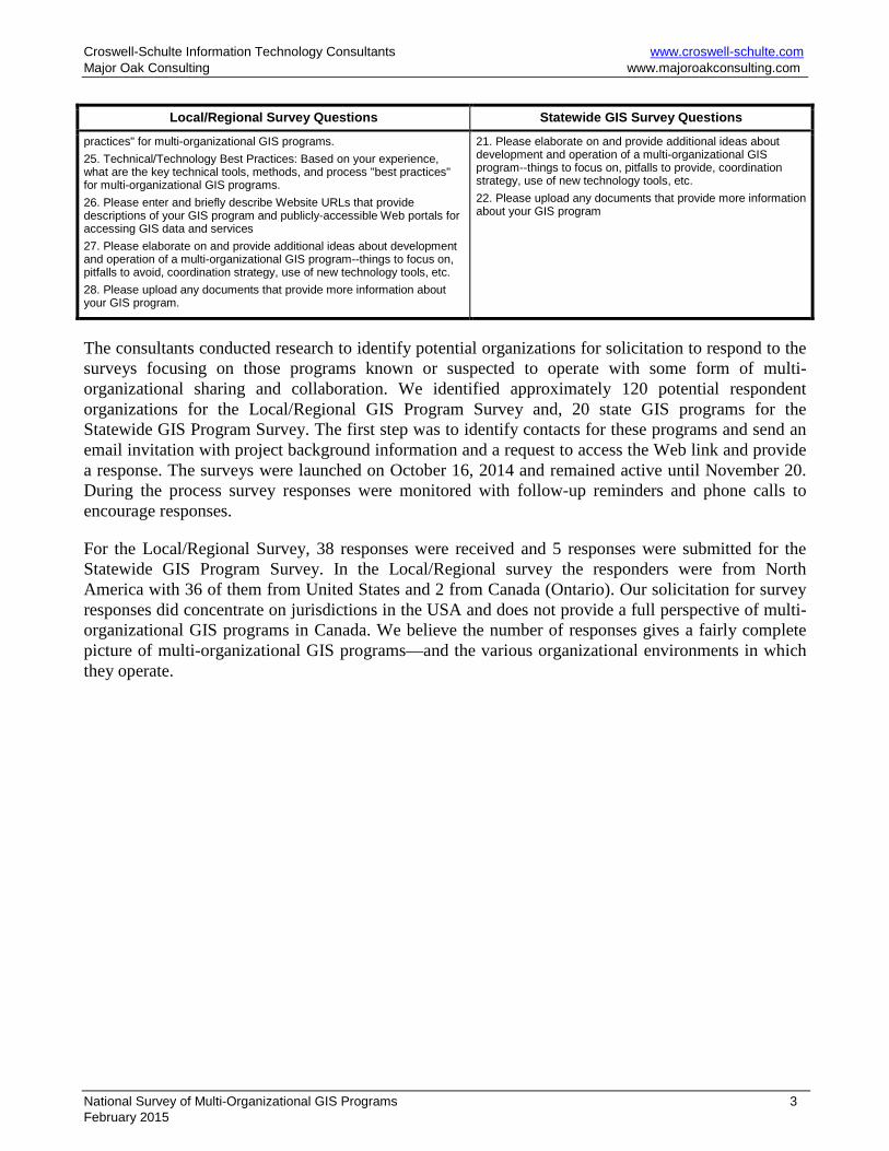
1. Enter organization and respondent information 2. What is the name of your multi-organizational GIS program 3. How long has your multi-organizational GIS program been in operation 4. Enter the GIS Program's mission and/or vision statement 5. Lead Organization Type(s): Select the type(s) of organization(s) which play lead roles in managing, providing major funding, coordinating work in the multi-organizational environment, system operations and support, etc. 6. Identify the name(s ) of the lead organization(s) 7. Organization types of users in the multi-organizational GIS environment: Select the types of organizations that participate in the GIS program as contributors of funding or staff, users of data or services, participation in joint projects, or use of data or services) 8. Identify and describe any GIS coordination, oversight, and collaboration bodies currently in place or planned for implementation and provide some brief comments about the names of these bodies, their membership, and their role or function 9. Provide additional information about the GIS program management and coordination structure--including information about management and staff positions, formal policies in place, or other information that provides more details about the current structure and management approach 10. Geographic area covered by GIS program. Please select one or more of the choices and add comments that more fully describes the area served 11. What is the population of the area served by your GIS program? (enter an estimated number) 12. What is the annual operating budget for your multi-organizational GIS program? Include costs for staff, contracted services, direct costs, and operational overhead just for the multi-organizational program (not for individual participating organizations) 13. Does the multi-organizational GIS program have dedicated staff or is it a group effort incorporating staff resources from the various participating organizations? 14. Identify and briefly describe any formal mandate and administrative and legal vehicles enabling multi-organizational GIS 15. Please provide additional information about the GIS program organizational structure and bodies or groups formed to enable coordination and collaboration 16. What type of funding sources and financing strategies does your organization use to support GIS operations? Select all that apply below and provide a brief explanation 17. Provide additional information about GIS funding sources and financing strategies. What are the most important funding sources for your program? Are you exploring additional funding sources or strategies? 18. What types of GIS coordination, activities, and services are in place or being provided by your multi-organizational GIS program (or lead organization(s)) for the user community? 19. Please provide additional information about coordination activities, programs, and services being provided or planned for the future 20. In your experience, what are the benefits of multi-organizational GIS collaboration? 21. Please elaborate on the benefits and advantages of your multi-organizational GIS program 22. Give your opinion about the importance and potential impact of limitations and obstacles to the formation and ongoing operation of a multi-organizational GIS program. 23. Please elaborate on obstacles to or limitations of multi-organizational GIS programs--impacts on program formation and/or ongoing operation 24. Organizational and Management Best Practices: Based on your experience, what are the key management and organizational "best
1. Enter organization and respondent information 2. What is the name of your statewide GIS program? 3. Lead Organization(s) Type. Please select the types(s) of organizations with lead roles in management, coordination, data or system hosting, or other lead roles of the statewide GIS program. 4. Identify the name(s) of the lead organization(s) 5. Organization types of users in the multi-organizational GIS environment 6. Identify and describe any GIS coordination, oversight, and collaboration bodies currently in place or planned for implementation and provide some brief comments 7. Provide additional information about the GIS program management and coordination structure 8. Identify and briefly describe any formal mandate and administrative and legal vehicles enabling multi-organizational GIS 9. Please provide additional information about the GIS program organizational structure and bodies or groups formed to enable coordination and collaboration 10. What type of funding sources and financing strategies does your organization use to support GIS operations 11. Provide additional information about GIS funding sources and financing strategies. What are the most important funding sources for your program? Are you exploring additional funding sources or strategies? 12. What types of GIS coordination, activities, and services are in place or being provided by your multi-organizational GIS program and enter a score that reflects the importance for program management and users? 13. Please provide additional information about coordination activities, programs, and services being provided or planned for the future 14. In your experience, what are the benefits of multi-organizational GIS collaboration? 15. Please elaborate on the benefits and advantages of your multi-organizational GIS program 16. Give your opinion about the importance and potential impact of limitations and obstacles to the formation and ongoing operation of a multi-organizational GIS program. 17. Please elaborate on obstacles to or limitations of multi-organizational GIS programs--impacts on program formation and ongoing operation 18. Organizational and Management Best Practices: Based on your experience, what are the key management and organizational "best practices" for multi-organizational GIS programs. 19. Technical/Technology Best Practices: Based on your experience, what are the key technical tools, methods, and process "best practices" for multi-organizational GIS programs. For this question, a "best practice" is a method, approach, organizational component, policy, etc. which supports and positively impacts multi-organizational coordination, collaboration, and services. 20. Please identify, briefly describe, and provide contact information if available for multi-organizational GIS programs operating in your state. This may include County governments coordinating GIS activities and data access with municipalities, regional agencies providing GIS services to organizations in the region, active user groups, or other types of GIS-based coordination and collaboration.
National Survey of Multi-Organizational GIS Programs 2 February 2015
Croswell-Schulte Information Technology Consultants www.croswell-schulte.com Major Oak Consulting www.majoroakconsulting.com
Local/Regional Survey Questions Statewide GIS Survey Questions
practices" for multi-organizational GIS programs. 25. Technical/Technology Best Practices: Based on your experience, what are the key technical tools, methods, and process "best practices" for multi-organizational GIS programs. 26. Please enter and briefly describe Website URLs that provide descriptions of your GIS program and publicly-accessible Web portals for accessing GIS data and services 27. Please elaborate on and provide additional ideas about development and operation of a multi-organizational GIS program--things to focus on, pitfalls to avoid, coordination strategy, use of new technology tools, etc. 28. Please upload any documents that provide more information about your GIS program.
21. Please elaborate on and provide additional ideas about development and operation of a multi-organizational GIS program--things to focus on, pitfalls to provide, coordination strategy, use of new technology tools, etc. 22. Please upload any documents that provide more information about your GIS program
The consultants conducted research to identify potential organizations for solicitation to respond to the surveys focusing on those programs known or suspected to operate with some form of multi-organizational sharing and collaboration. We identified approximately 120 potential respondent organizations for the Local/Regional GIS Program Survey and, 20 state GIS programs for the Statewide GIS Program Survey. The first step was to identify contacts for these programs and send an email invitation with project background information and a request to access the Web link and provide a response. The surveys were launched on October 16, 2014 and remained active until November 20. During the process survey responses were monitored with follow-up reminders and phone calls to encourage responses.
For the Local/Regional Survey, 38 responses were received and 5 responses were submitted for the Statewide GIS Program Survey. In the Local/Regional survey the responders were from North America with 36 of them from United States and 2 from Canada (Ontario). Our solicitation for survey responses did concentrate on jurisdictions in the USA and does not provide a full perspective of multi-organizational GIS programs in Canada. We believe the number of responses gives a fairly complete picture of multi-organizational GIS programs—and the various organizational environments in which they operate.
National Survey of Multi-Organizational GIS Programs 3 February 2015

Croswell-Schulte Information Technology Consultants www.croswell-schulte.com Major Oak Consulting www.majoroakconsulting.com
SECTION 2: LOCAL/REGIONAL GIS PROGRAM SURVEY- SUMMARY OF RESULTS
2.1 GIS PROGRAM BACKGROUND, STRUCTURE, PARTICIPATION - MULTI-ORGANIZATIONAL SURVEY
Out of total 38 respondents 36 are from United States and 2 are from Canada. Table 2 summarizes the respondents from various states.
Table 2: Number of Responses by State
State Number of
Respondents
State Number of
Respondents Arizona 1 Maryland 1 Arkansas 1 Minnesota 2 California 5 New Jersey 1 Florida 1 Ohio 1 Georgia 1 Ontario/Canada 2 Idaho 2 Oregon 2 Illinois 2 Pennsylvania 3 Indiana 3 South Carolina 1 Iowa 1 Tennessee 2 Kansas 1 Washington 1 Kentucky 2 Wisconsin 2
2.2 MULTI-ORGANIZATIONAL GIS PROGRAM TENURE
Based on the survey results, assumed to be a reasonable sample of multi-organizational GIS programs in North America, many are mature operations. More than 80% of the respondents had GIS programs in operation for more than 10 years and one GIS program (Lane Council of Governments Regional Land Information Database (RLID)) has been in operation for 40 years—originally with an IBM mainframe computer to support environmental to support planning. Several of the most successful formal multi-organizational consortia, including Knoxville Knox County Knoxville Utilities Board (KUB) GIS (KGIS) and the Cincinnati Area Geographic Information System (CAGIS), have been in operation since the late 1980s.
Some Respondents reported that formal GIS Consortia were formed to address GIS staffing challenges that small and medium size communities face when implementing a GIS program. As GIS technology and the regional data continued to improve, the regional partners saw new opportunities for the GIS and started expanding to other agencies in Counties, Municipalities etc. Only one agency reported that the GIS program became dysfunctional because of lack of funds. Table 3 summarizes the responding organizations and tenure of their GIS Programs.
National Survey of Multi-Organizational GIS Programs 4 February 2015

Croswell-Schulte Information Technology Consultants www.croswell-schulte.com Major Oak Consulting www.majoroakconsulting.com
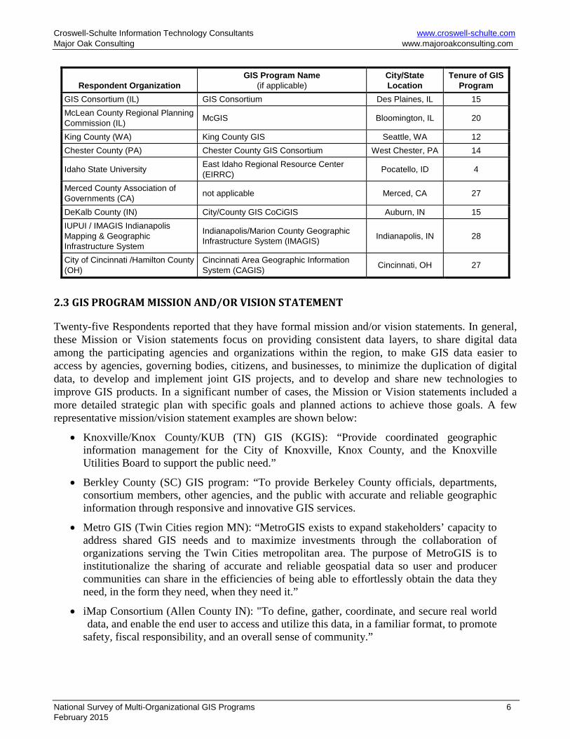
Table 3: Summary of the Local/Regional GIS Program Name and their Tenure (years in operation)
Respondent Organization GIS Program Name
(if applicable) City/State Location
Tenure of GIS Program
Milwaukee County (WI) Milwaukee County Automated Mapping and Land Information System (MCAMLIS) Milwaukee, WI 9
Pulaski Area (AR) GIS (PAgis) Pulaski Area Geographic Information System (PAgis) Little Rock, AR 26
City of Oshkosh (WI) not applicable Oshkosh, WI 20 Muscatine (IA) Area Geographic Information Consortium (MAGIC)
Muscatine (IA) Area Geographic Information Consortium (MAGIC) Muscatine, IA 14
Atlantic County (NJ) Office of GIS Atlantic County Office of GIS Northfield, NJ 17 Clark County (KY) Consortium for GIS
Clark County Consortium of Geographic Information Systems Winchester, KY 17
Southwestern Pennsylvania Commission not applicable Pittsburgh, PA 21
Washington County (MD) not applicable Hagerstown, MD 8
San Diego County (CA) San Diego Geographic Information Source (SanGIS) San Diego, CA 30
City of Hayden, ID Kootenai County GIS, North Idaho Regional Resource Center, Idaho Geospatial Council
Hayden, ID 15
Oregon Metro Regional Land Information System (RLIS) Portland, OR 25 City of Phoenix, AZ not applicable Phoenix, AZ 20 County of Allegheny (PA) not applicable Pittsburgh, PA 14 Lane Council of Governments (LCOG)
Regional Land Information Database (RLID) Eugene, OR 40
Johnson County (KS) AIMS (Automated Information Mapping System) Olathe, KS 28
Nashville Davidson County (TN) Metro GIS Nashville, TN 18 Metro GIS (Twin Cities, MN) Metro GIS St Paul, MN 18 Arrowhead Regional Development Commission (MN) North Shore GIS Consortium Duluth, MN 5
Knoxville Knox County KUB GIS (KGIS)
Knoxville Knox County Knoxville Utilities Board (KUB) GIS (KGIS) Knoxville TN 29
Allen County (IN) iMap Consortium Fort Wayne, IN 5
Palm Beach County (FL) Countywide GIS (CWGIS) West Palm Beach, FL 20
Planning and Development Services of Kenton County (KY)
Land Information of Northern Kentucky GIS or LinkGIS Fort Mitchell, KY 28
Sacramento Area Council of Governments (CA)
Sacramento County GIS Cooperative, Yolo County GIS Cooperative Sacramento, CA 12
Gwinnett County (GA) Gwinnett GIS Community Partnership (informal name) Lawrenceville, GA 5
Berkeley County (SC) Berkeley County GIS Consortium Moncks Corner, SC 23
Butte County Association of Governments (CA)
Butte County Association of Governments Regional GIS Chico, CA 17
City of Mississauga (ON) not applicable Mississauga, ON NA Contra Costa County (CA) Bay Area Regional GIS Council (BAR-GC) Martinez, CA NA
National Survey of Multi-Organizational GIS Programs 5 February 2015
Croswell-Schulte Information Technology Consultants www.croswell-schulte.com Major Oak Consulting www.majoroakconsulting.com
Respondent Organization GIS Program Name
(if applicable) City/State Location
Tenure of GIS Program
GIS Consortium (IL) GIS Consortium Des Plaines, IL 15 McLean County Regional Planning Commission (IL) McGIS Bloomington, IL 20
King County (WA) King County GIS Seattle, WA 12 Chester County (PA) Chester County GIS Consortium West Chester, PA 14
Idaho State University East Idaho Regional Resource Center (EIRRC) Pocatello, ID 4
Merced County Association of Governments (CA) not applicable Merced, CA 27
DeKalb County (IN) City/County GIS CoCiGIS Auburn, IN 15 IUPUI / IMAGIS Indianapolis Mapping & Geographic Infrastructure System
Indianapolis/Marion County Geographic Infrastructure System (IMAGIS) Indianapolis, IN 28
City of Cincinnati /Hamilton County (OH)
Cincinnati Area Geographic Information System (CAGIS) Cincinnati, OH 27
2.3 GIS PROGRAM MISSION AND/OR VISION STATEMENT
Twenty-five Respondents reported that they have formal mission and/or vision statements. In general, these Mission or Vision statements focus on providing consistent data layers, to share digital data among the participating agencies and organizations within the region, to make GIS data easier to access by agencies, governing bodies, citizens, and businesses, to minimize the duplication of digital data, to develop and implement joint GIS projects, and to develop and share new technologies to improve GIS products. In a significant number of cases, the Mission or Vision statements included a more detailed strategic plan with specific goals and planned actions to achieve those goals. A few representative mission/vision statement examples are shown below:
• Knoxville/Knox County/KUB (TN) GIS (KGIS): “Provide coordinated geographic information management for the City of Knoxville, Knox County, and the Knoxville Utilities Board to support the public need.”
• Berkley County (SC) GIS program: “To provide Berkeley County officials, departments, consortium members, other agencies, and the public with accurate and reliable geographic information through responsive and innovative GIS services.
• Metro GIS (Twin Cities region MN): “MetroGIS exists to expand stakeholders’ capacity to address shared GIS needs and to maximize investments through the collaboration of organizations serving the Twin Cities metropolitan area. The purpose of MetroGIS is to institutionalize the sharing of accurate and reliable geospatial data so user and producer communities can share in the efficiencies of being able to effortlessly obtain the data they need, in the form they need, when they need it.”
• iMap Consortium (Allen County IN): "To define, gather, coordinate, and secure real world data, and enable the end user to access and utilize this data, in a familiar format, to promote safety, fiscal responsibility, and an overall sense of community.”
National Survey of Multi-Organizational GIS Programs 6 February 2015
Croswell-Schulte Information Technology Consultants www.croswell-schulte.com Major Oak Consulting www.majoroakconsulting.com
• East Idaho Regional Resource Center (EIRRC): “To empower local people to participate in The Idaho Map enhance geospatial capabilities in the region share scarce resources avoid duplication of effort and bridge local and state activities.”
• Muscatine Area (IA) GIS Consortium (MAGIC): “To improve the efficiency and effectiveness of its member organizations through the coordinated development of geographic and land information systems (GIS/LIS) technology and data. The intended beneficiaries of this consortium are the citizens, taxpayers and consumer/owners of the member organizations. The expected benefits are improved products and services delivered at the lowest reasonable cost.”
• San Diego Geographic Information Source (SanGIS): “To maintain and promote the use of a regional geographic data warehouse for the San Diego region and to assist in the development of shared geographic data and automated systems which use that data.”
• Johnson County (KS) AIMS: “To provide open, efficient, and enterprise access to spatial data at a reasonable cost to aid stakeholders in making more efficient and effective decisions. Ultimately, these decisions add value to the quality of life that our stakeholders have come to expect. To accomplish this mission, AIMS applies sound GIS principles with quality spatial data and effective distribution technologies to put AIMS services at the disposal of our stakeholders.
• GIS Consortium (Chicago Region): “To reduce the cost and risk of GIS in small- and medium-sized communities. The members of the GISC believe that their commitment to collaboration, quality, and efficiency are the cornerstone values then enable this organizations success.”
• King County (WA) GIS (KCGIS): “To work in partnership with county agencies to provide accurate, consistent, accessible, affordable, and comprehensive GIS data, GIS infrastructure, and GIS services to support the unique business needs of King County and the communities we serve. TKCGIS is the premier provider of spatial information and GIS services in the region.”
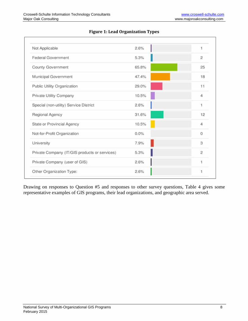
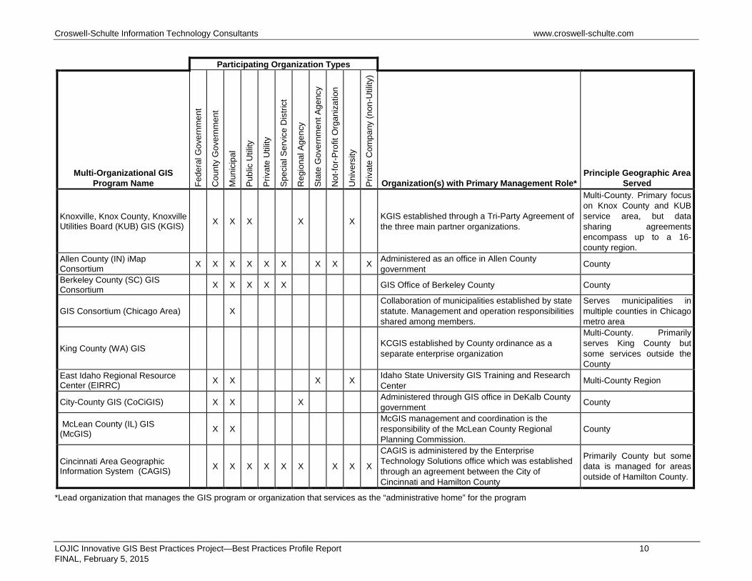
In Survey Question #5, Respondents were given the option to select one or more types of organizations that have a leadership role in the multi-organizational GIS program. Leadership is defined as a having a major role in managing the GIS program, status as principal funding source, coordinating work in the multi-organizational environment, and major role in technical operations. Responses are summarized in Figure 1. Based on the survey responses, County Government, with over 65% of the responses, is the predominant Lead Organization Type. Municipal Governments (47%) and Regional Agencies (32%) are also frequent responses and Universities play a lead role in several cases. Most of the responses identifying “Regional Agency” involve an existing multi-County regional planning agency with a notable exception being two Regional GIS Resource Centers in the state of Idaho. A significant response frequency for Public Utility Organization (29%) shows that these water and/or wastewater organizations have a critical role in many multi-organizational GIS programs.
National Survey of Multi-Organizational GIS Programs 7 February 2015
Croswell-Schulte Information Technology Consultants www.croswell-schulte.com Major Oak Consulting www.majoroakconsulting.com
Figure 1: Lead Organization Types
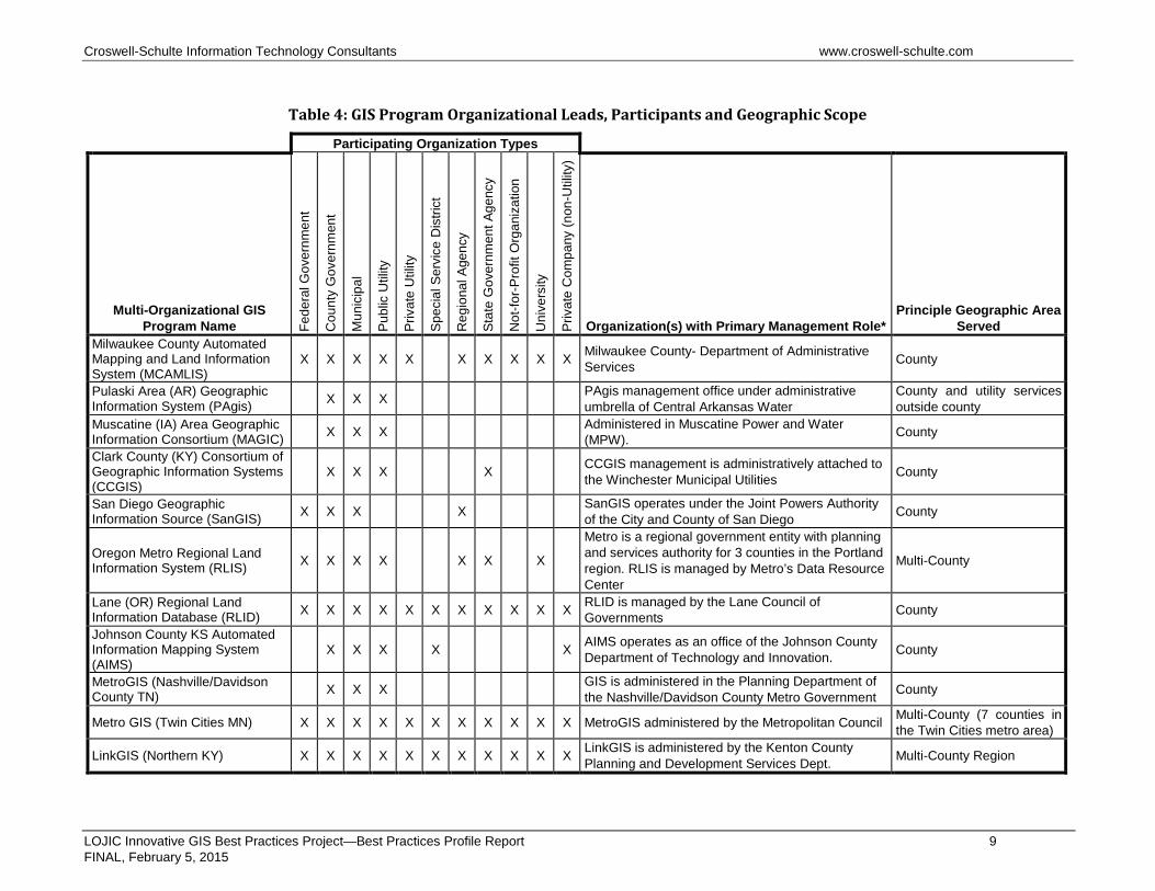
Drawing on responses to Question #5 and responses to other survey questions, Table 4 gives some representative examples of GIS programs, their lead organizations, and geographic area served.
National Survey of Multi-Organizational GIS Programs 8 February 2015
Croswell-Schulte Information Technology Consultants www.croswell-schulte.com
Table 4: GIS Program Organizational Leads, Participants and Geographic Scope
Participating Organization Types
Multi-Organizational GIS Program Name Fe
dera
l Gov
ernm
ent
Cou
nty
Gov
ernm
ent
Mun
icip
al
Publ
ic U
tility
Priv
ate
Util
ity
Spec
ial S
ervi
ce D
istri
ct
Reg
iona
l Age
ncy
Stat
e G
over
nmen
t Age
ncy
Not
-for-P
rofit
Org
aniz
atio
n
Uni
vers
ity
Priv
ate
Com
pany
(non
-Util
ity)
Organization(s) with Primary Management Role* Principle Geographic Area
Served Milwaukee County Automated Mapping and Land Information System (MCAMLIS)
X X X X X X X X X X Milwaukee County- Department of Administrative Services County
Pulaski Area (AR) Geographic Information System (PAgis) X X X PAgis management office under administrative
umbrella of Central Arkansas Water County and utility services outside county
Muscatine (IA) Area Geographic Information Consortium (MAGIC) X X X Administered in Muscatine Power and Water
(MPW). County
Clark County (KY) Consortium of Geographic Information Systems (CCGIS)
X X X X CCGIS management is administratively attached to the Winchester Municipal Utilities County
San Diego Geographic Information Source (SanGIS) X X X X SanGIS operates under the Joint Powers Authority
of the City and County of San Diego County
Oregon Metro Regional Land Information System (RLIS) X X X X X X X
Metro is a regional government entity with planning and services authority for 3 counties in the Portland region. RLIS is managed by Metro’s Data Resource Center
Multi-County
Lane (OR) Regional Land Information Database (RLID) X X X X X X X X X X X RLID is managed by the Lane Council of
Governments County
Johnson County KS Automated Information Mapping System (AIMS)
X X X X X AIMS operates as an office of the Johnson County Department of Technology and Innovation. County
MetroGIS (Nashville/Davidson County TN) X X X GIS is administered in the Planning Department of
the Nashville/Davidson County Metro Government County
Metro GIS (Twin Cities MN) X X X X X X X X X X X MetroGIS administered by the Metropolitan Council Multi-County (7 counties in the Twin Cities metro area)
LinkGIS (Northern KY) X X X X X X X X X X X LinkGIS is administered by the Kenton County Planning and Development Services Dept. Multi-County Region
LOJIC Innovative GIS Best Practices Project—Best Practices Profile Report 9 FINAL, February 5, 2015
Croswell-Schulte Information Technology Consultants www.croswell-schulte.com
Participating Organization Types
Multi-Organizational GIS Program Name Fe
dera
l Gov
ernm
ent
Cou
nty
Gov
ernm
ent
Mun
icip
al
Publ
ic U
tility
Priv
ate
Util
ity
Spec
ial S
ervi
ce D
istri
ct
Reg
iona
l Age
ncy
Stat
e G
over
nmen
t Age
ncy
Not
-for-P
rofit
Org
aniz
atio
n
Uni
vers
ity
Priv
ate
Com
pany
(non
-Util
ity)
Organization(s) with Primary Management Role* Principle Geographic Area
Served
Knoxville, Knox County, Knoxville Utilities Board (KUB) GIS (KGIS) X X X X X KGIS established through a Tri-Party Agreement of
the three main partner organizations.
Multi-County. Primary focus on Knox County and KUB service area, but data sharing agreements encompass up to a 16-county region.
Allen County (IN) iMap Consortium X X X X X X X X X Administered as an office in Allen County
government County
Berkeley County (SC) GIS Consortium X X X X X GIS Office of Berkeley County County
GIS Consortium (Chicago Area) X Collaboration of municipalities established by state statute. Management and operation responsibilities shared among members.
Serves municipalities in multiple counties in Chicago metro area
King County (WA) GIS KCGIS established by County ordinance as a separate enterprise organization
Multi-County. Primarily serves King County but some services outside the County
East Idaho Regional Resource Center (EIRRC) X X X X Idaho State University GIS Training and Research
Center Multi-County Region
City-County GIS (CoCiGIS) X X X Administered through GIS office in DeKalb County government County
McLean County (IL) GIS (McGIS) X X
McGIS management and coordination is the responsibility of the McLean County Regional Planning Commission.
County
Cincinnati Area Geographic Information System (CAGIS) X X X X X X X X X
CAGIS is administered by the Enterprise Technology Solutions office which was established through an agreement between the City of Cincinnati and Hamilton County
Primarily County but some data is managed for areas outside of Hamilton County.
*Lead organization that manages the GIS program or organization that services as the “administrative home” for the program
LOJIC Innovative GIS Best Practices Project—Best Practices Profile Report 10 FINAL, February 5, 2015
Croswell-Schulte Information Technology Consultants www.croswell-schulte.com
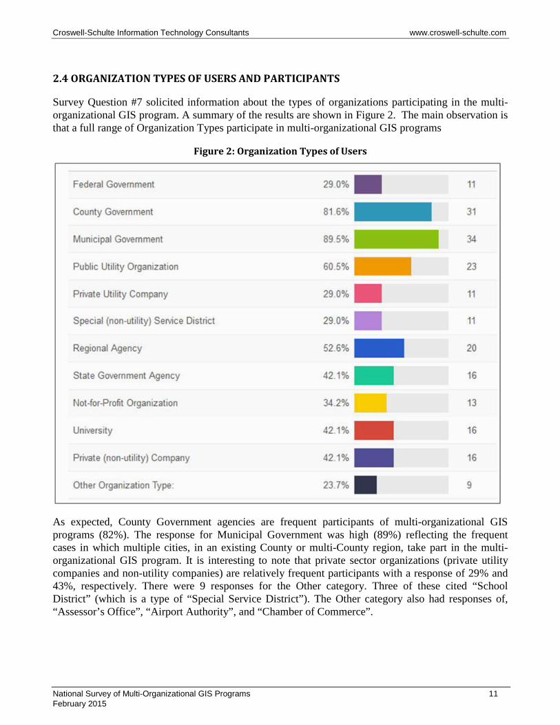
2.4 ORGANIZATION TYPES OF USERS AND PARTICIPANTS
Survey Question #7 solicited information about the types of organizations participating in the multi-organizational GIS program. A summary of the results are shown in Figure 2. The main observation is that a full range of Organization Types participate in multi-organizational GIS programs
Figure 2: Organization Types of Users
As expected, County Government agencies are frequent participants of multi-organizational GIS programs (82%). The response for Municipal Government was high (89%) reflecting the frequent cases in which multiple cities, in an existing County or multi-County region, take part in the multi-organizational GIS program. It is interesting to note that private sector organizations (private utility companies and non-utility companies) are relatively frequent participants with a response of 29% and 43%, respectively. There were 9 responses for the Other category. Three of these cited “School District” (which is a type of “Special Service District”). The Other category also had responses of, “Assessor’s Office”, “Airport Authority”, and “Chamber of Commerce”.
National Survey of Multi-Organizational GIS Programs 11 February 2015
Croswell-Schulte Information Technology Consultants www.croswell-schulte.com
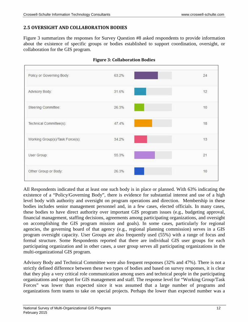
2.5 OVERSIGHT AND COLLABORATION BODIES
Figure 3 summarizes the responses for Survey Question #8 asked respondents to provide information about the existence of specific groups or bodies established to support coordination, oversight, or collaboration for the GIS program.
Figure 3: Collaboration Bodies
All Respondents indicated that at least one such body is in place or planned. With 63% indicating the existence of a “Policy/Governing Body”, there is evidence for substantial interest and use of a high level body with authority and oversight on program operations and direction. Membership in these bodies includes senior management personnel and, in a few cases, elected officials. In many cases, these bodies to have direct authority over important GIS program issues (e.g., budgeting approval, financial management, staffing decisions, agreements among participating organizations, and oversight on accomplishing the GIS program mission and goals). In some cases, particularly for regional agencies, the governing board of that agency (e.g., regional planning commission) serves in a GIS program oversight capacity. User Groups are also frequently used (55%) with a range of focus and formal structure. Some Respondents reported that there are individual GIS user groups for each participating organization and in other cases, a user group serves all participating organizations in the multi-organizational GIS program.
Advisory Body and Technical Committee were also frequent responses (32% and 47%). There is not a strictly defined difference between these two types of bodies and based on survey responses, it is clear that they play a very critical role communication among users and technical people in the participating organizations and support for GIS management and staff. The response level for “Working Group/Task Forces” was lower than expected since it was assumed that a large number of programs and organizations form teams to take on special projects. Perhaps the lower than expected number was a
National Survey of Multi-Organizational GIS Programs 12 February 2015
Croswell-Schulte Information Technology Consultants www.croswell-schulte.com
matter of terminology in the question. Where Working Groups/Task Forces were reported, they function as project teams for accomplishing a specific task (e.g., preparation of specifications for LiDAR acquisition). In some cases these bodies were established as subcommittees of another formal body (e.g., Technical Committee). It is likely that many of the GIS programs that did not indicate existence of Working Groups/Task Forces still assemble work teams of some type but may not establish them as formal bodies as part of the GIS program. Ten Respondents indicated “Other”, which, in most cases, were variations of bodies shown in the other choices. In a few cases, these responses made reference to technical teams and “service bureaus” within IT departments (which support the GIS).
Table 5 provides information about selected Policy/Governing bodies.
Table 5: Examples of GIS Program Policy/Governing Bodies
Organization Name Name/Description of Policy/Governing Body
Pulaski Area (AR) GIS (PAgis)
PAgis Board of Directors. The Board sets policy and procedures for the daily operations, approves the annual financial plan and approves policy decisions as required. Each member agency has 1 voting member. The Board meets every other month.
Clark County (KY) GIS Consortium (CCGIS)
CCGIS Board of Directors established through an interlocal agreement between the Clark County PVA, Winchester Municipal Utilities, the City of Winchester, and Clark County. The CCGIS Board sets goals, approves actions, and provides guidance to CCGIS staff.
San Diego (CA) Geographic Information Source (SanGIS)
SanGIS Board of Directors with many of their powers delegated to the SanGIS Management Committee.
MetroGIS (Twin Cities, MN)
MetroGIS is governed by a Policy Board and Coordinating Committee. The Policy Board is comprised of county commissioners from the region’s seven counties as well as representatives from metropolitan cities, school districts and watershed districts
Knoxville Knox County KUB (TN) GIS (KGIS)
KGIS Policy Board. Governing Body established through a Tri-Party agreement among the 3 main participants. Has responsibility for financial oversight, major policy decisions, and other major organizational and operational issues.
Allen County (IN) – iMap Consortium
iMap Management Board - established by the County in 2002. Became a joint City-County Board in 2009 - 9 members
LinkGIS (Northern KY) LinkGIS Guidance Committee - made up of the lead organizations executive director levels - This group meets quarterly
GIS Consortium (Chicago Area) GIS Consortium Board of Directors consists of one-person per community member.
King County (WA) GIS GIS Oversight Committee (Refer to description with the KCGIS O&M Plan - see: http://www.kingcounty.gov/operations/GIS/About/O_M.aspx
Idaho State University - EIRCC
Idaho Geospatial Council (statewide coordination body that supports GIS initiatives at the local and regional level).
Cincinnati Area (OH) GIS (CAGIS)
CAGIS Board established through a formal agreement among City of Cincinnati, Hamilton County, and Duke Energy and is responsible for the implementation of the Agreement. The CAGIS Board consists of nine members: four members appointed by the Cincinnati City Manager, four members appointed by the County Administrator, one of whom must be the Hamilton County Engineer, and one member appointed by Duke Energy.
Palm Beach County (FL) Countywide GIS (CWGIS)
GIS Policy Advisory Committee (GIS-PAC) The GIS-PAC is responsible for recommending long range goals, objectives, operational priorities, and funding allocation.
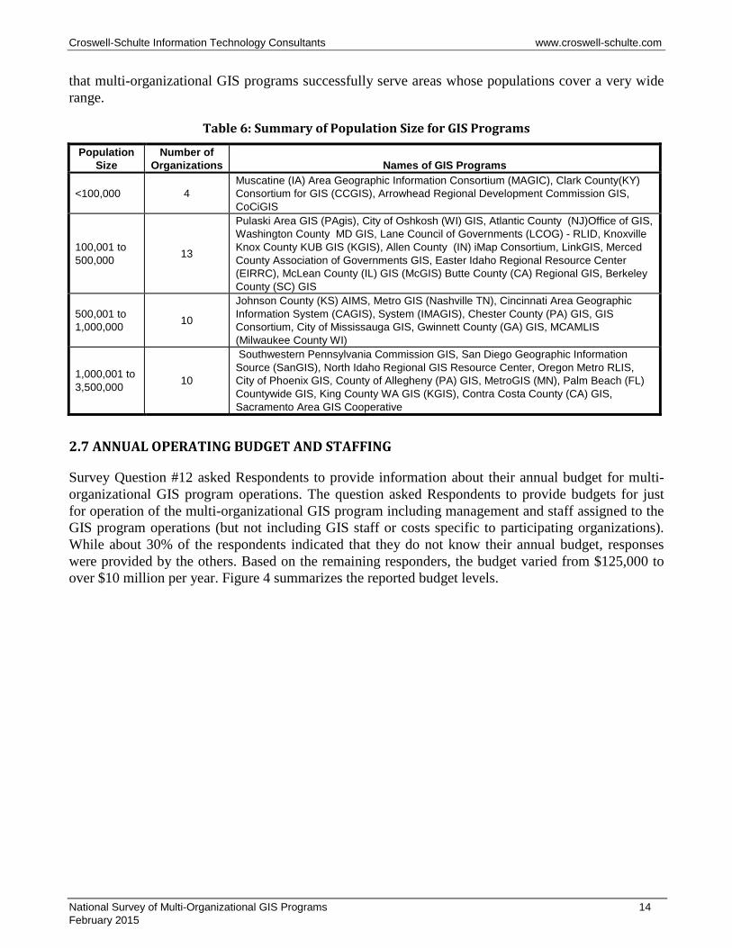
2.6 POPULATIONS SERVED BY GIS PROGRAM
Survey Question #11 asked Respondents to give an estimated population in the areas served by the GIS program. As expected, there was a broad range reported with a low population of 34,000 (Clark County KY GIS Consortium) to a high of 3.2 million (MetroGIS MN). Population served is directly related to the area served as well as the level of urbanization, but it is clear, as summarized in Table 6,
National Survey of Multi-Organizational GIS Programs 13 February 2015
Croswell-Schulte Information Technology Consultants www.croswell-schulte.com
that multi-organizational GIS programs successfully serve areas whose populations cover a very wide range.
Table 6: Summary of Population Size for GIS Programs
Population Size
Number of Organizations Names of GIS Programs
<100,000 4 Muscatine (IA) Area Geographic Information Consortium (MAGIC), Clark County(KY) Consortium for GIS (CCGIS), Arrowhead Regional Development Commission GIS, CoCiGIS
100,001 to 500,000 13
Pulaski Area GIS (PAgis), City of Oshkosh (WI) GIS, Atlantic County (NJ)Office of GIS, Washington County MD GIS, Lane Council of Governments (LCOG) - RLID, Knoxville Knox County KUB GIS (KGIS), Allen County (IN) iMap Consortium, LinkGIS, Merced County Association of Governments GIS, Easter Idaho Regional Resource Center (EIRRC), McLean County (IL) GIS (McGIS) Butte County (CA) Regional GIS, Berkeley County (SC) GIS
500,001 to 1,000,000 10
Johnson County (KS) AIMS, Metro GIS (Nashville TN), Cincinnati Area Geographic Information System (CAGIS), System (IMAGIS), Chester County (PA) GIS, GIS Consortium, City of Mississauga GIS, Gwinnett County (GA) GIS, MCAMLIS (Milwaukee County WI)
1,000,001 to 3,500,000 10
Southwestern Pennsylvania Commission GIS, San Diego Geographic Information Source (SanGIS), North Idaho Regional GIS Resource Center, Oregon Metro RLIS, City of Phoenix GIS, County of Allegheny (PA) GIS, MetroGIS (MN), Palm Beach (FL) Countywide GIS, King County WA GIS (KGIS), Contra Costa County (CA) GIS, Sacramento Area GIS Cooperative
2.7 ANNUAL OPERATING BUDGET AND STAFFING
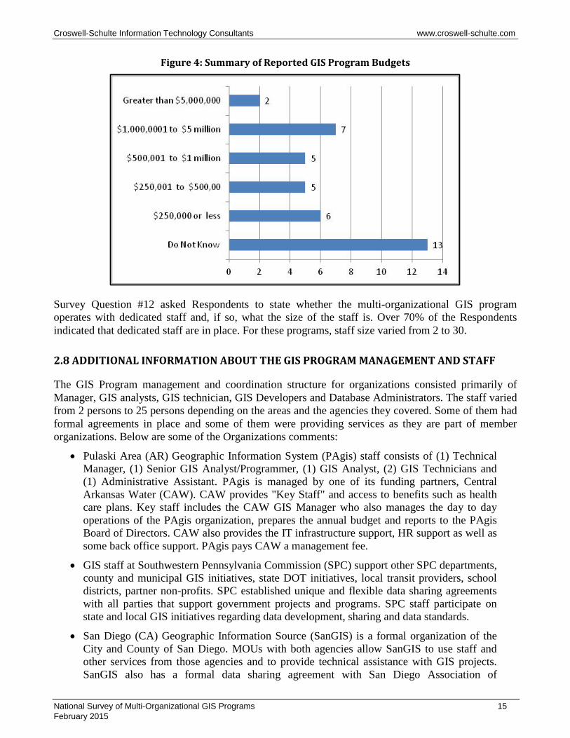
Survey Question #12 asked Respondents to provide information about their annual budget for multi-organizational GIS program operations. The question asked Respondents to provide budgets for just for operation of the multi-organizational GIS program including management and staff assigned to the GIS program operations (but not including GIS staff or costs specific to participating organizations). While about 30% of the respondents indicated that they do not know their annual budget, responses were provided by the others. Based on the remaining responders, the budget varied from $125,000 to over $10 million per year. Figure 4 summarizes the reported budget levels.
National Survey of Multi-Organizational GIS Programs 14 February 2015
Croswell-Schulte Information Technology Consultants www.croswell-schulte.com
Figure 4: Summary of Reported GIS Program Budgets
Survey Question #12 asked Respondents to state whether the multi-organizational GIS program operates with dedicated staff and, if so, what the size of the staff is. Over 70% of the Respondents indicated that dedicated staff are in place. For these programs, staff size varied from 2 to 30.
2.8 ADDITIONAL INFORMATION ABOUT THE GIS PROGRAM MANAGEMENT AND STAFF
The GIS Program management and coordination structure for organizations consisted primarily of Manager, GIS analysts, GIS technician, GIS Developers and Database Administrators. The staff varied from 2 persons to 25 persons depending on the areas and the agencies they covered. Some of them had formal agreements in place and some of them were providing services as they are part of member organizations. Below are some of the Organizations comments:
• Pulaski Area (AR) Geographic Information System (PAgis) staff consists of (1) Technical Manager, (1) Senior GIS Analyst/Programmer, (1) GIS Analyst, (2) GIS Technicians and (1) Administrative Assistant. PAgis is managed by one of its funding partners, Central Arkansas Water (CAW). CAW provides "Key Staff" and access to benefits such as health care plans. Key staff includes the CAW GIS Manager who also manages the day to day operations of the PAgis organization, prepares the annual budget and reports to the PAgis Board of Directors. CAW also provides the IT infrastructure support, HR support as well as some back office support. PAgis pays CAW a management fee.
• GIS staff at Southwestern Pennsylvania Commission (SPC) support other SPC departments, county and municipal GIS initiatives, state DOT initiatives, local transit providers, school districts, partner non-profits. SPC established unique and flexible data sharing agreements with all parties that support government projects and programs. SPC staff participate on state and local GIS initiatives regarding data development, sharing and data standards.
• San Diego (CA) Geographic Information Source (SanGIS) is a formal organization of the City and County of San Diego. MOUs with both agencies allow SanGIS to use staff and other services from those agencies and to provide technical assistance with GIS projects. SanGIS also has a formal data sharing agreement with San Diego Association of
National Survey of Multi-Organizational GIS Programs 15 February 2015
Croswell-Schulte Information Technology Consultants www.croswell-schulte.com
Governments (SANDAG) that covers a regional, public-facing, GIS data warehouse and interactive map. SanGIS operates as an independent agency however and develops its own policies, owns its own network, and has its own budget.
• Kootenai County GIS, North Idaho Regional Resource Center, Idaho Geospatial Council (City of Hayden) currently has all volunteers, however, beginning to work with NI RRC and the Panhandle Area Council and CEDA for grant collaboration and management NI RRC- is in the steering committee stage and will be able to obtain a manager once funding is established. IGC - see website listed above.
• Regional Land Information System (RLIS) (Oregon Metro) Research Center is led by a department director who oversees three divisions: - Enterprise Services - Client Services - Modeling Services. Each division is led by a manager who oversees the work of 6-9 staff in each division.
• County of Allegheny (PA) GIS staff consists of a GIS Manager, a GIS Outreach Specialist, a Senior GIS Analyst and 4 GIS Analysts, 3 of which are union employees. The staff is a group within the Division of Computer Services and takes direction from the director of this division, who is also the CIO.
• At Regional Land Information Database (RLID) of Lane (OR) Council of Governments (LCOG) The GIS Coordinators Committee (GIS leads from 5 partner agencies) oversees subcommittees and reports regularly to the Steering Committee. LCOG is the principal service provider to the regional partnership administering pooled funding, staffing and an annual work program known as the Cooperative Project Agreement (CPA). LCOG's GIS Program Manager is responsible for managing the CPA and coordinating regional GIS services including RLID.
• Knoxville Knox County Knoxville Utilities Board (TN) GIS (KGIS) - KGIS office consists of seven (7) personnel: Director, Office Technician, DBA, Systems Admin, Senior Developer, Developer and GIS Analyst. Approval for Application Development and Systems Changes is coordinated with each respective IT department of the Tri-Party organizations.
• For Land Information of Northern Kentucky GIS or LinkGIS Planning and Development Services of Kenton County (PDSKC) is considered the managing partner of LinkGIS. There are interlocal agreements in place as well as MOAs in order to establish the partnership. With Pendleton County there is a yearly contract that is renewed by the PC Fiscal Court. PDSKC GIS works as the hub of the LinkGIS partnership. Each partner is a spoke of the wheel and transfers data back and forth as needed. PDSKC GIS team then serves as the clearinghouse for GIS data in the three-county area. Staff positions are managed at each partner’s discretion. The PDSKC team has 6 FTEs and 3 PTEs currently.
• Berkeley County (SC) GIS Consortium has 7 staff members with the Director reporting directly to the County Supervisor.
• GIS Consortium (Chicago area) staffing model consists of direct and shared professionals. Direct positions include GIS Specialist, Coordinator and Analyst. Shared include Developers, platform administrator, and manager.
• IUPUI/IMAGIS Indianapolis/Marion County (IN) Mapping & Geographic Infrastructure System consortium operates as a service contract among peers. The contract identifies the Board, and agency rights and responsibilities, the base map layers, and funding. Each
National Survey of Multi-Organizational GIS Programs 16 February 2015
Croswell-Schulte Information Technology Consultants www.croswell-schulte.com
participant pays an annual membership fee. Note: IMAGIS partners agreed to discontinue this long-lived GIS consortia at the end of 2014.
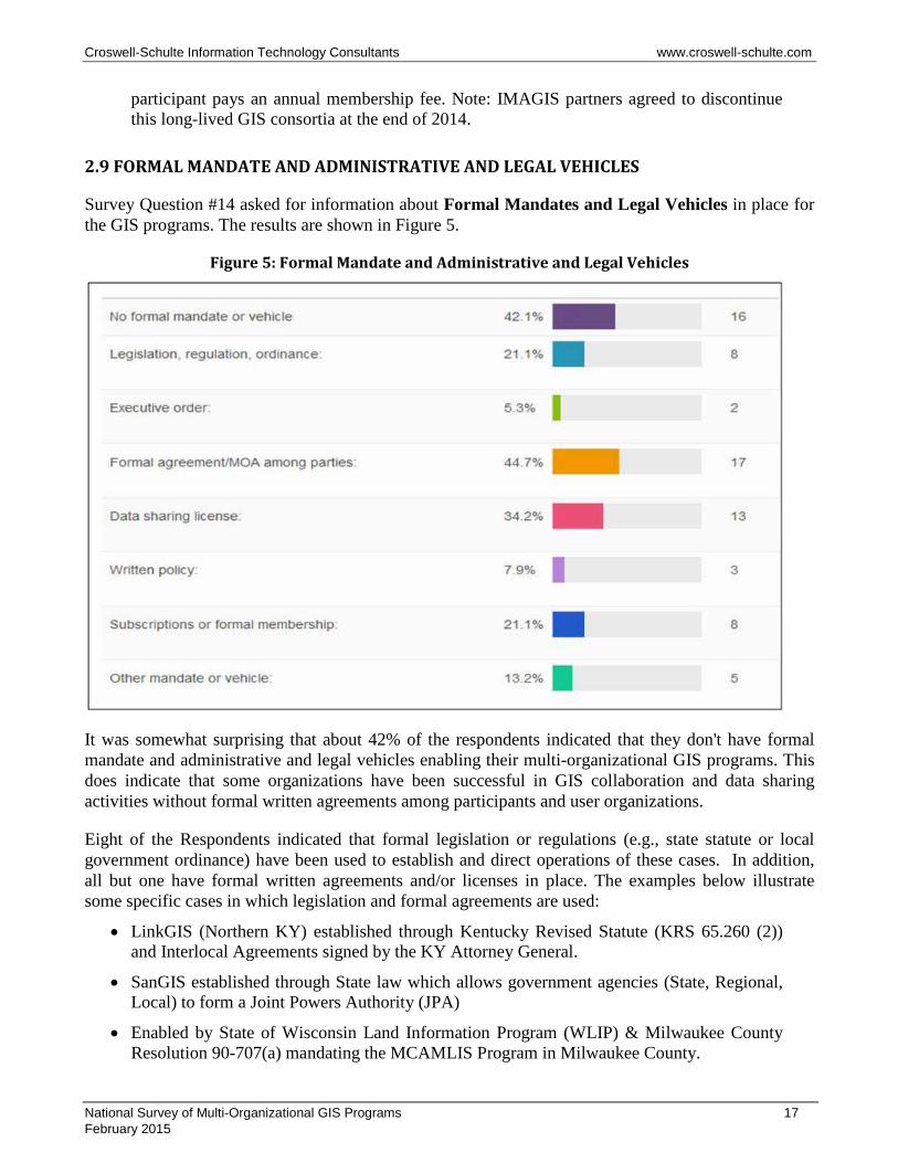
2.9 FORMAL MANDATE AND ADMINISTRATIVE AND LEGAL VEHICLES
Survey Question #14 asked for information about Formal Mandates and Legal Vehicles in place for the GIS programs. The results are shown in Figure 5.
Figure 5: Formal Mandate and Administrative and Legal Vehicles
It was somewhat surprising that about 42% of the respondents indicated that they don't have formal mandate and administrative and legal vehicles enabling their multi-organizational GIS programs. This does indicate that some organizations have been successful in GIS collaboration and data sharing activities without formal written agreements among participants and user organizations.
Eight of the Respondents indicated that formal legislation or regulations (e.g., state statute or local government ordinance) have been used to establish and direct operations of these cases. In addition, all but one have formal written agreements and/or licenses in place. The examples below illustrate some specific cases in which legislation and formal agreements are used:
• LinkGIS (Northern KY) established through Kentucky Revised Statute (KRS 65.260 (2)) and Interlocal Agreements signed by the KY Attorney General.
• SanGIS established through State law which allows government agencies (State, Regional, Local) to form a Joint Powers Authority (JPA)
• Enabled by State of Wisconsin Land Information Program (WLIP) & Milwaukee County Resolution 90-707(a) mandating the MCAMLIS Program in Milwaukee County.
National Survey of Multi-Organizational GIS Programs 17 February 2015

Croswell-Schulte Information Technology Consultants www.croswell-schulte.com
• King County Council approved ordinance 2001-0555 (enactment 14270) creating the King County Geographic Information Systems Fund. The King County geographic information systems fund operates under the name King County GIS Center (KCGIS Center).
• The Muscatine (IA) Area Geographic Information Consortium (MAGIC) was established under the provisions of Iowa code 28E which allows creation of separate local government entities for a specific purpose, in this case to provide GIS data and services.
A total of 23 Respondents indicated use of written agreements and/or licenses to define terms for collaboration and data sharing among participant organizations. Licenses are used frequently (34% of the Respondents) to establish terms for GIS data sharing. In some cases, license terms for data sharing/data use are incorporated into formal agreements or memoranda-of-agreement among parties. License terms establish ownership of the data, limitations on use of the data or distribution to third parties, financial obligations (if applicable), and in many cases, liability statements. Some examples of the use of formal agreements and licenses, from Respondent comments, are:
• KGIS Tri-Party Agreement and Charter approved by each of the Tri-Party organizations (City of Knoxville, Knox County and KUB).
• PAgis Inter-local agreement and by-laws filed with the Pulaski County (AR) Clerk.
• SanGIS operates under a formal Joint Powers Authority agreement (filed with the State of California) and separate MOUs with the City, County, and SANDAG.
• The City of Mississauga (ON) uses data sharing MOA's with abutting municipal entities, utility companies and various higher levels of government.
• The GIS Consortium (Chicago Area) uses membership agreements and service provider agreements.
• CAGIS has a formal “Master Agreement” that codifies terms for participation.
Subscriptions or memberships are used by 8 responding GIS programs—establishing terms for access to data or services. Subscriptions and memberships may be considered a type of written agreement but they tend to be focused on specific products and services accessible by user organizations—often users that are considered “external” (not a principal participant or funder of the multi-organizational GIS program).
2.10 ADDITIONAL INFORMATION ABOUT ORGANIZATIONAL STRUCTURE
Survey Question #15 asked Respondents to provide additional information and elaborate on their GIS program organizational structure and coordination approach. The examples below illustrate some of the specific approaches and practices used by these programs:
• Muscatine (IA) Area Geographic Information Consortium (MAGIC) staff answer to the MAGIC Governing Board. MAGIC staff works with the MAGIC technical advisory committee to review current best practice operations.
• Atlantic County (NJ) Office of GIS began as SMAC (New Jersey State Mapping Advisory Committee).
• Southwestern Pennsylvania Commission (SPC) convenes an informal GIS user's group from member governments to discuss regional initiatives and collaborate on projects.
National Survey of Multi-Organizational GIS Programs 18 February 2015
Croswell-Schulte Information Technology Consultants www.croswell-schulte.com
• San Diego (CA) Geographic Information Source (SanGIS) - day to day operational decisions is made by a Program Manager hired by the Board of Directors. The program manager reports to a Management Committee that the Board has delegated most responsibilities to. The Management Committee is comprised of the GIS Program Managers from the City, the County, and SANDAG. SANDAG does not provide direct funding and therefore has only an advisory role on the Management Committee.
• In addition to RLIS Partners, Oregon Metro organizes a regional consortium of organizations that pool resources to acquire orthophotos, LiDAR and derivatives.
• City of Phoenix (AZ) participates in the Maricopa Regional GIS Technical Council.
• In the County of Allegheny (PA) GIS, an Outreach Specialist maintains contact with GIS users throughout the county (municipal, regional, other governmental, etc) to answer general GIS questions and provide data extracts for datasets that are not available publicly.
• The iMap Consortium is led by Allen County (IN). The GIS Coordinator, under the guidance of the iMap Management Board and the IT Directors of Allen County and Fort Wayne, works to provide communication and collaboration between partners as well as the State and Federal agencies.
• Palm Beach Countywide (FL) GIS Coordination (CWGIS) is responsible for project management, contract management, meeting coordination, interactive communication maintaining GIS intergovernmental relations, and planning functions. CWGIS acts as a point of contact with the GIS community at large. This includes the GIS-PAC, GIS-PMT, the Forum, the GIS Service Bureau, the municipalities and other public sector entities such as Solid Waste Authority, the South Florida Water Management District, the School District, the private sector, etc. CWGIS looks to leverage the GIS investments for standards, partnerships, synergy between agencies and jurisdictions. They are responsible for issuing and maintaining the aerial mapping contracts, encouraging GIS data and system sharing and supporting the self-directed team environment that completes the tasks identified by both the GIS-PAC and the GIS PMT. CWGIS participates in both the Forum and the annual GIS Expo.
• The Berkeley County (SC) GIS Consortium has a 1 year agreement signed by all Consortium members. Since that time we have operated with no formal agreement.
• The City of Mississauga (ON) is within the Region of Peel. The Region is within the Province of Ontario and the province is within Federal jurisdiction. As such they meet on ad hoc and project specific occasions on an as-needed basis.
• The GIS Consortium (Chicago area) Board meets 10 times a year. Individual workgroups meet on average twice a year. They have monthly technology webinars to demonstrate local government solutions. There are meetings daily onsite between community staff and the direct assigned professional.
• The Indianapolis/Marion County (IN) Mapping & Geographic Infrastructure System (IMAGIS) operates to coordinate between agencies and with neighboring communities, the State of Indiana, Federal GIS activities, and the Indiana Coordinating Council (IGIC). Most agencies have internal GIS staff.
National Survey of Multi-Organizational GIS Programs 19 February 2015
Croswell-Schulte Information Technology Consultants www.croswell-schulte.com
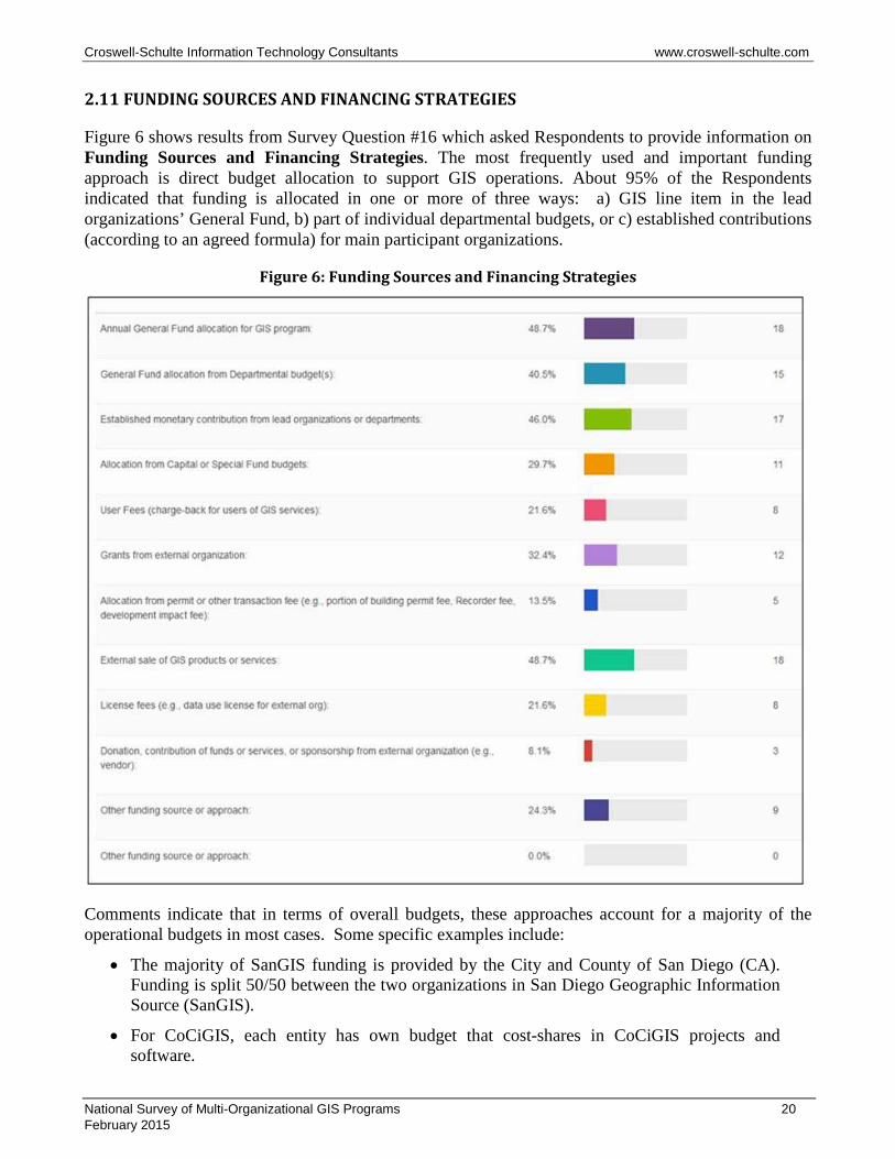
2.11 FUNDING SOURCES AND FINANCING STRATEGIES
Figure 6 shows results from Survey Question #16 which asked Respondents to provide information on Funding Sources and Financing Strategies. The most frequently used and important funding approach is direct budget allocation to support GIS operations. About 95% of the Respondents indicated that funding is allocated in one or more of three ways: a) GIS line item in the lead organizations’ General Fund, b) part of individual departmental budgets, or c) established contributions (according to an agreed formula) for main participant organizations.
Figure 6: Funding Sources and Financing Strategies
Comments indicate that in terms of overall budgets, these approaches account for a majority of the operational budgets in most cases. Some specific examples include:
• The majority of SanGIS funding is provided by the City and County of San Diego (CA). Funding is split 50/50 between the two organizations in San Diego Geographic Information Source (SanGIS).
• For CoCiGIS, each entity has own budget that cost-shares in CoCiGIS projects and software.
National Survey of Multi-Organizational GIS Programs 20 February 2015
Croswell-Schulte Information Technology Consultants www.croswell-schulte.com
• Clark County Consortium of Geographic Information Systems (CCGIS) - CCGIS Board of Directors sets annual budget. Member agencies include CCGIS funding as line item in General Funds.
• Countywide GIS (CWGIS) (Palm Beach County) - Staffing for the Countywide GIS Coordinator and the GIS Service Bureau through Annual General Fund Allocation.
• Gwinnett GIS Community Partnership has annual general fund allocation for operating budget for software maintenance, base data updates.
• Each "data custodian" budgets for their own staff and projects in iMap Consortium (Allen County IN).
• For the King County (WA) GIS (KCGIS), enterprise GIS is funded via a GIS O&M funding model that allocates costs to agencies by level of actual desktop and web based mapping use.
• In Pulaski Area (AR) Geographic Information System (PAgis) the total operation and maintenance dues from each approved annual budget are divided out among the funding partners based on predefined percentages. The predefined percentages are based on the density of road centerlines and address points in each agencies self defined services area.
• In the Muscatine (IA) Area Geographic Information Consortium (MAGIC), Muscatine Power and Water (MPW) contributes to MAGIC through its operating budget.
• For KGIS (TN), a very detailed cost allocation formula (that involved extensive tracking and forecasting of personnel time) and rebate strategy was used over the past 15 years for KGIS funding, but beginning in FY 2015 the funding formula has been simplified to an equal 3-way split for all operational and capital funding from the Tri-party, with aerial imagery costs being adjusted according to geographic service area extent.
• Bay Area Regional GIS Council (BAR-GC) of Contra Costa County (CA) asks for a flat $50,000 annual contribution from each participating department in order to be part of the steering committee. Each participating department then gets to vote on how the overall budget is used.
• In Land Information of Northern Kentucky GIS (LinkGIS) organization each partner in Kenton gives $25,000 toward GIS program yearly. Campbell contributions are split three ways between the three paying partners.
• Each Consortium member has an agreed percentage of the budget that it pays each year for Berkeley County (SC) GIS Consortium (Berkeley County Government).
• Multiple departments in the City of Cincinnati and Hamilton County (OH) agencies provide monetary contribution for Cincinnati Area Geographic Information System (CAGIS).
About 30% of the Respondents indicated use of Capital or Special Fund Budgets. Some of these cases involved setting up special funds specifically for GIS data acquisition (e.g., re-acquisition of orthoimagery or planimetric mapping updates). Other cases involved allocations from Capital Budgets supporting infrastructure improvements. About half of Respondents indicated that funding comes from User Fees (charge-back services) or Sales of GIS Products/Services. The survey did not request information about the percentage of overall GIS program budgets contributed by the different sources but comments from Respondents indicate that, in most cases, User Fees and Product/Service sales do not contribute or provide major revenue for most of the Respondents. Some of the organizations using
National Survey of Multi-Organizational GIS Programs 21 February 2015
Croswell-Schulte Information Technology Consultants www.croswell-schulte.com
these mechanisms only apply them to “external” users (organizations that are not formal members and funding partners for the multi-organizational GIS program). Respondent comments indicate that there is a trend toward lowering or eliminating fees for GIS product and service sales but several Respondents did report that this mechanism is used to support specific parts of their operation including these cases:
• Map and Data sales allow Metro GIS of Nashville/Davidson County (TN) to purchase new imagery, LiDAR, software and plotters. Everything else is covered through general fund.
• The Lane County (OR) RLID is exploring an increase in revenue through higher fees for commercial users.
• Johnson County AIM collects fees to pay for GIS software licenses.
• The City of Mississauga sells data to utilities that generate substantial annual fees. In addition they also sell data to educational organization at a very heavily discounted rate to promote its use.
• Countywide GIS (CWGIS) of Palm Beach County has GIS Service Bureau which provides application development services to outside private or public non-BCC agencies.
Grants from outside organizations have been used in about a third of the responding programs (12 Respondents). Grants typically do not provide major funding (as a percentage of the overall operational budget) and, by their nature, are normally one-time or sporadic sources (requiring time and resources for grant application and management). But they have provided funds to support specific projects—most frequently GIS database development.
There were a relatively low number of responses for funding through Permit or Other Transaction Fees. This may be the case because such a funding mechanism normally requires legislation and possibly an increase in existing fees which can be politically unpopular. Among the 5 Respondents who reported using this funding approach, the following types of transaction fees are used: a) County Recorder fees (Johnson County AIMS, Milwaukee County MCAMLIS, and McLean County McGIS) and b) Metro GIS (Nashville/Davidson County TN) has fee for assignment of a temporary parcel number for building permits.
The 9 Respondents who selected “Other Funding Source” cited funding approaches which were variations of the specific Question #16 choices.
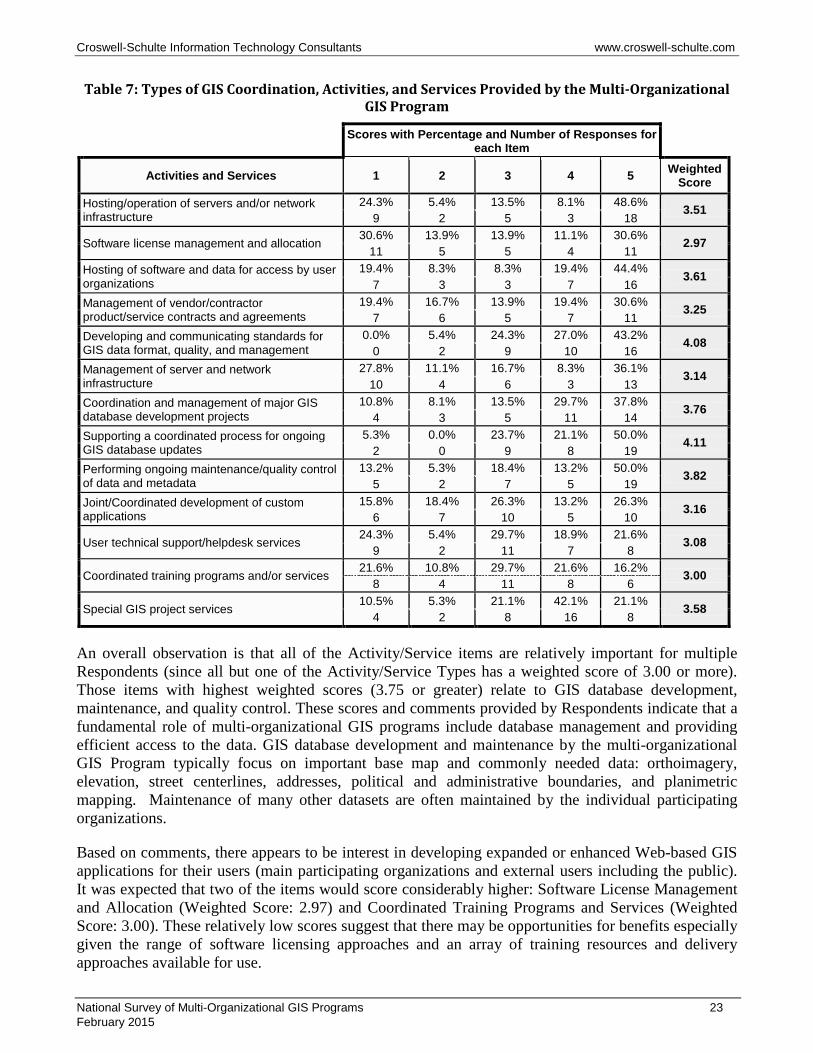
2.12 GIS COORDINATION ACTIVITIES, AND SERVICES
Survey Question #18 about the types of GIS Coordination, Activities, and Services provided by the multi-organizational GIS program. Respondents were asked to rank each of the activity/service types with a score from 1 to 5. A score of "1" indicates low importance and a score of "5" means critically important to program management and/or users. Table 7 presents the responses. To provide a basis to compare overall importance a Weighted Score computed by multiplying the raw score by the number of responses for that score.
National Survey of Multi-Organizational GIS Programs 22 February 2015
Croswell-Schulte Information Technology Consultants www.croswell-schulte.com
Table 7: Types of GIS Coordination, Activities, and Services Provided by the Multi-Organizational GIS Program
Scores with Percentage and Number of Responses for each Item
Activities and Services 1 2 3 4 5 Weighted
Score Hosting/operation of servers and/or network infrastructure
24.3% 5.4% 13.5% 8.1% 48.6% 3.51 9 2 5 3 18
Software license management and allocation 30.6% 13.9% 13.9% 11.1% 30.6% 2.97 11 5 5 4 11
Hosting of software and data for access by user organizations
19.4% 8.3% 8.3% 19.4% 44.4% 3.61 7 3 3 7 16
Management of vendor/contractor product/service contracts and agreements
19.4% 16.7% 13.9% 19.4% 30.6% 3.25 7 6 5 7 11
Developing and communicating standards for GIS data format, quality, and management
0.0% 5.4% 24.3% 27.0% 43.2% 4.08 0 2 9 10 16
Management of server and network infrastructure
27.8% 11.1% 16.7% 8.3% 36.1% 3.14 10 4 6 3 13
Coordination and management of major GIS database development projects
10.8% 8.1% 13.5% 29.7% 37.8% 3.76 4 3 5 11 14
Supporting a coordinated process for ongoing GIS database updates
5.3% 0.0% 23.7% 21.1% 50.0% 4.11 2 0 9 8 19
Performing ongoing maintenance/quality control of data and metadata
13.2% 5.3% 18.4% 13.2% 50.0% 3.82 5 2 7 5 19
Joint/Coordinated development of custom applications
15.8% 18.4% 26.3% 13.2% 26.3% 3.16 6 7 10 5 10
User technical support/helpdesk services 24.3% 5.4% 29.7% 18.9% 21.6% 3.08 9 2 11 7 8
Coordinated training programs and/or services 21.6% 10.8% 29.7% 21.6% 16.2% 3.00 8 4 11 8 6
Special GIS project services 10.5% 5.3% 21.1% 42.1% 21.1% 3.58 4 2 8 16 8
An overall observation is that all of the Activity/Service items are relatively important for multiple Respondents (since all but one of the Activity/Service Types has a weighted score of 3.00 or more). Those items with highest weighted scores (3.75 or greater) relate to GIS database development, maintenance, and quality control. These scores and comments provided by Respondents indicate that a fundamental role of multi-organizational GIS programs include database management and providing efficient access to the data. GIS database development and maintenance by the multi-organizational GIS Program typically focus on important base map and commonly needed data: orthoimagery, elevation, street centerlines, addresses, political and administrative boundaries, and planimetric mapping. Maintenance of many other datasets are often maintained by the individual participating organizations.
Based on comments, there appears to be interest in developing expanded or enhanced Web-based GIS applications for their users (main participating organizations and external users including the public). It was expected that two of the items would score considerably higher: Software License Management and Allocation (Weighted Score: 2.97) and Coordinated Training Programs and Services (Weighted Score: 3.00). These relatively low scores suggest that there may be opportunities for benefits especially given the range of software licensing approaches and an array of training resources and delivery approaches available for use.
National Survey of Multi-Organizational GIS Programs 23 February 2015
Croswell-Schulte Information Technology Consultants www.croswell-schulte.com
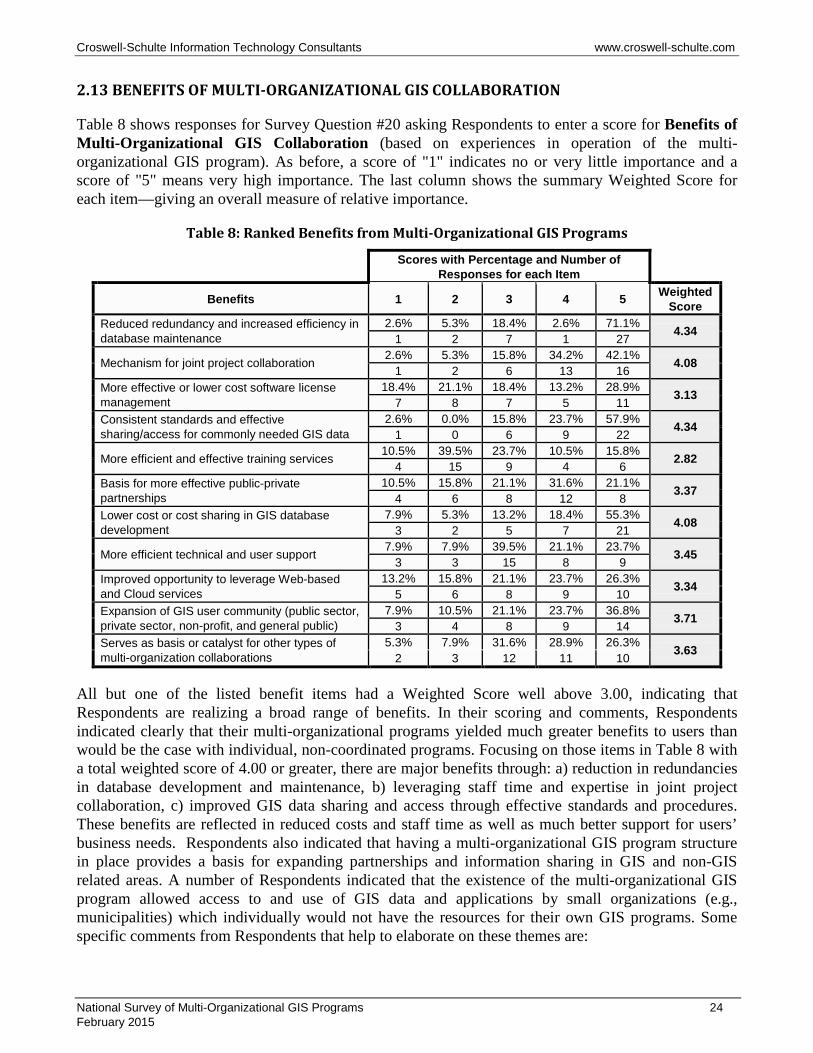
2.13 BENEFITS OF MULTI-ORGANIZATIONAL GIS COLLABORATION
Table 8 shows responses for Survey Question #20 asking Respondents to enter a score for Benefits of Multi-Organizational GIS Collaboration (based on experiences in operation of the multi-organizational GIS program). As before, a score of "1" indicates no or very little importance and a score of "5" means very high importance. The last column shows the summary Weighted Score for each item—giving an overall measure of relative importance.
Table 8: Ranked Benefits from Multi-Organizational GIS Programs
Scores with Percentage and Number of
Responses for each Item
Benefits 1 2 3 4 5 Weighted Score
Reduced redundancy and increased efficiency in database maintenance
2.6% 5.3% 18.4% 2.6% 71.1% 4.34 1 2 7 1 27
Mechanism for joint project collaboration 2.6% 5.3% 15.8% 34.2% 42.1% 4.08 1 2 6 13 16 More effective or lower cost software license management
18.4% 21.1% 18.4% 13.2% 28.9% 3.13 7 8 7 5 11 Consistent standards and effective sharing/access for commonly needed GIS data
2.6% 0.0% 15.8% 23.7% 57.9% 4.34 1 0 6 9 22
More efficient and effective training services 10.5% 39.5% 23.7% 10.5% 15.8% 2.82 4 15 9 4 6 Basis for more effective public-private partnerships
10.5% 15.8% 21.1% 31.6% 21.1% 3.37 4 6 8 12 8 Lower cost or cost sharing in GIS database development
7.9% 5.3% 13.2% 18.4% 55.3% 4.08 3 2 5 7 21
More efficient technical and user support 7.9% 7.9% 39.5% 21.1% 23.7% 3.45 3 3 15 8 9 Improved opportunity to leverage Web-based and Cloud services
13.2% 15.8% 21.1% 23.7% 26.3% 3.34 5 6 8 9 10 Expansion of GIS user community (public sector, private sector, non-profit, and general public)
7.9% 10.5% 21.1% 23.7% 36.8% 3.71 3 4 8 9 14 Serves as basis or catalyst for other types of multi-organization collaborations
5.3% 7.9% 31.6% 28.9% 26.3% 3.63 2 3 12 11 10
All but one of the listed benefit items had a Weighted Score well above 3.00, indicating that Respondents are realizing a broad range of benefits. In their scoring and comments, Respondents indicated clearly that their multi-organizational programs yielded much greater benefits to users than would be the case with individual, non-coordinated programs. Focusing on those items in Table 8 with a total weighted score of 4.00 or greater, there are major benefits through: a) reduction in redundancies in database development and maintenance, b) leveraging staff time and expertise in joint project collaboration, c) improved GIS data sharing and access through effective standards and procedures. These benefits are reflected in reduced costs and staff time as well as much better support for users’ business needs. Respondents also indicated that having a multi-organizational GIS program structure in place provides a basis for expanding partnerships and information sharing in GIS and non-GIS related areas. A number of Respondents indicated that the existence of the multi-organizational GIS program allowed access to and use of GIS data and applications by small organizations (e.g., municipalities) which individually would not have the resources for their own GIS programs. Some specific comments from Respondents that help to elaborate on these themes are:
National Survey of Multi-Organizational GIS Programs 24 February 2015
Croswell-Schulte Information Technology Consultants www.croswell-schulte.com
• Milwaukee County (WI) Automated Mapping and Land Information System (MCAMLIS) save time and money providing one-stop location for commonly used data and viewing applications.
• Pulaski Area (AR) Geographic Information System (PAgis) has achieved greater collaboration than would occur otherwise; consistent, high quality base map and addressing; few barriers for data sharing amongst local governments; advanced GIS analysis and web services capabilities; lower costs of data acquisition and training; less duplication of efforts.
• Moving to a shared data standard is allowing City of Oshkosh (WI) to collaborate, reduce redundancy and create the server data updates to the end users faster. For example, moving to a shared data standard for addressing with the hope of feeding address updates to 911 with a fully automated process.
• At Muscatine (IA) Area Geographic Information Consortium (MAGIC), 2 FTEs can be leveraged to provide GIS data and services to hundreds of government, private section and general public users here in the community.
• Southwestern Pennsylvania Commission coordinates effort at maintenance of base maps (street centerlines) collaboration on regional aerial photography, data exchange between regional agency and counties or municipalities.
• In Washington County (MD) before the Enterprise GIS Office was established, the only multi-departmental collaboration which existed was performed by GIS staff in the Planning Department, and it was not their mandate to do so. The enterprise GIS office is much better positioned to serve multiple departments.
• San Diego (CA) Geographic Information Source (SanGIS) provides efficiency in GIS data maintenance and provision of GIS data to the public agencies that need it. Though SanGIS is "owned" only by the City and County of San Diego, the data is used by all 17 other incorporated cities in the County, various public agencies, and private companies. The regional GIS data warehouse provides one place for GIS data so that regional agencies don't have to maintain their own.
• Many of the Oregon Metro Regional Land Information System (RLIS) benefits are intangibles resulting from improved relationships between individuals in partner organizations.
• At City of Phoenix (AZ), resources are "right sized" for the tasks or projects. Whether this is staffing, hardware or software, there is less waste.
• The Knoxville/Knox County/Knoxville Utilities Board (TN) GIS (KGIS) - Builds trust between the various organizations (beyond the politics). In these days of "big data", the role of cataloging the various types, sources and accuracy of the map-related assets becomes even more valuable. Understanding and documenting various "touchpoints" between the respective agency workflows essential to good government.
• The GIS Consortium has become a model in the greater Chicago region for other shared services models reducing overall costs and need for technical staff by small and medium size municipalities.
• CoCiGIS (DeKalb County IN) group have been able to cost share for an Esri ELA that allows them to expand their GIS use with additional staff. This step has now increased use and encourages additional layer creations from other departments.
National Survey of Multi-Organizational GIS Programs 25 February 2015
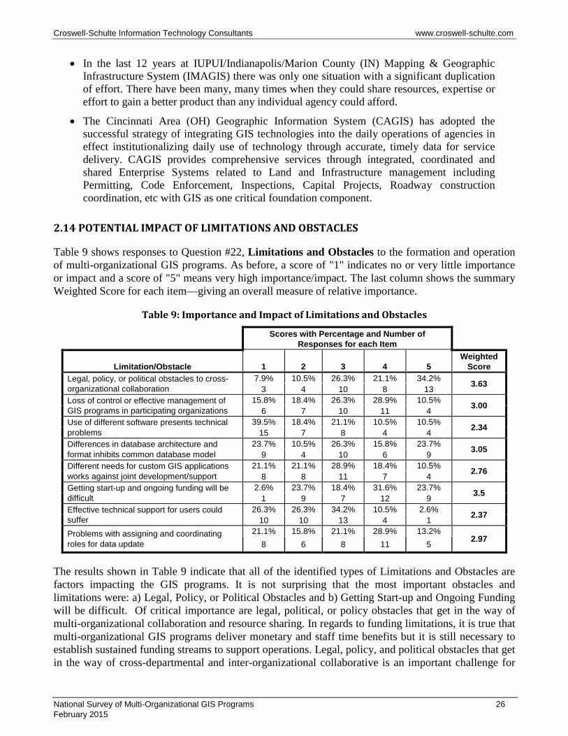
Croswell-Schulte Information Technology Consultants www.croswell-schulte.com
• In the last 12 years at IUPUI/Indianapolis/Marion County (IN) Mapping & Geographic Infrastructure System (IMAGIS) there was only one situation with a significant duplication of effort. There have been many, many times when they could share resources, expertise or effort to gain a better product than any individual agency could afford.
• The Cincinnati Area (OH) Geographic Information System (CAGIS) has adopted the successful strategy of integrating GIS technologies into the daily operations of agencies in effect institutionalizing daily use of technology through accurate, timely data for service delivery. CAGIS provides comprehensive services through integrated, coordinated and shared Enterprise Systems related to Land and Infrastructure management including Permitting, Code Enforcement, Inspections, Capital Projects, Roadway construction coordination, etc with GIS as one critical foundation component.
2.14 POTENTIAL IMPACT OF LIMITATIONS AND OBSTACLES
Table 9 shows responses to Question #22, Limitations and Obstacles to the formation and operation of multi-organizational GIS programs. As before, a score of "1" indicates no or very little importance or impact and a score of "5" means very high importance/impact. The last column shows the summary Weighted Score for each item—giving an overall measure of relative importance.
Table 9: Importance and Impact of Limitations and Obstacles
Scores with Percentage and Number of Responses for each Item
Limitation/Obstacle 1 2 3 4 5
Weighted Score
Legal, policy, or political obstacles to cross-organizational collaboration
7.9% 10.5% 26.3% 21.1% 34.2% 3.63 3 4 10 8 13 Loss of control or effective management of GIS programs in participating organizations
15.8% 18.4% 26.3% 28.9% 10.5% 3.00 6 7 10 11 4 Use of different software presents technical problems
39.5% 18.4% 21.1% 10.5% 10.5% 2.34 15 7 8 4 4 Differences in database architecture and format inhibits common database model
23.7% 10.5% 26.3% 15.8% 23.7% 3.05 9 4 10 6 9 Different needs for custom GIS applications works against joint development/support
21.1% 21.1% 28.9% 18.4% 10.5% 2.76 8 8 11 7 4 Getting start-up and ongoing funding will be difficult
2.6% 23.7% 18.4% 31.6% 23.7% 3.5 1 9 7 12 9 Effective technical support for users could suffer
26.3% 26.3% 34.2% 10.5% 2.6% 2.37 10 10 13 4 1 Problems with assigning and coordinating roles for data update
21.1% 15.8% 21.1% 28.9% 13.2% 2.97 8 6 8 11 5
The results shown in Table 9 indicate that all of the identified types of Limitations and Obstacles are factors impacting the GIS programs. It is not surprising that the most important obstacles and limitations were: a) Legal, Policy, or Political Obstacles and b) Getting Start-up and Ongoing Funding will be difficult. Of critical importance are legal, political, or policy obstacles that get in the way of multi-organizational collaboration and resource sharing. In regards to funding limitations, it is true that multi-organizational GIS programs deliver monetary and staff time benefits but it is still necessary to establish sustained funding streams to support operations. Legal, policy, and political obstacles that get in the way of cross-departmental and inter-organizational collaborative is an important challenge for
National Survey of Multi-Organizational GIS Programs 26 February 2015
Croswell-Schulte Information Technology Consultants www.croswell-schulte.com
almost all the Respondents. Respondents were asked to provide comments elaborating on their scores and the list below summarizes issues and challenges that these GIS programs face:
• Engaging and maintaining support from senior management and officials and the need to re-educate and promote the GIS program as new management officials are elected or appointed. This includes active roles by individuals that sit on a GIS Program Governing/Policy Body.
• Ongoing need and challenge to explain and ensure adherence of established GIS data and metadata standards (as a foundation data sharing and use).
• While committees and user groups provide a necessary and useful means to enable and support inter-organizational collaboration, information sharing, and project work, it is an ongoing challenge to manage and maintain active participation by users and technical people in participating organizations.
• GIS consortia operations are challenged in cases in which the missions or business models of participating organizations have major differences (e.g., private utility organization in collaboration with a local government entity).
• Different policies or legal restrictions in regards to sharing of and access to certain GIS data can create complications in data management.
• Getting start-up funding can be difficult, but it is more of a challenge to put in place stable, sustained funding for ongoing operations.
• Successful GIS consortium operations which are providing effective services to user organizations can result in a participating organization relying too much on consortium staff and resources and not making their own investment in GIS staff and professional development. (NOTE: most of the successful multi-organizational GIS programs had staff supporting overall operations but individual participating organizations also included staff and resources for GIS operations. These GIS programs work best when there is a well-coordinated environment for collaboration among consortium staff and technical staff and users in the participating organization).
• It is a challenge for any enterprise GIS program to find qualified staff (with necessary subject area and technical skills) and to retain staff.
• Individual organization and departmental priorities can take precedence over the GIS Program operations. “Organizational isolation” of the GIS program office can result in reduction in necessary tangible support particularly when GIS is not actively contributing to business.
2.15 ORGANIZATIONAL AND MANAGEMENT BEST PRACTICES
For the purposes of this survey, a “best practice” is defined as “a method, technique, process, or tool that has been shown (through practice) to deliver superior results and benefits for the multi-organizational GIS program and its user community”. Survey Question #24 asked Respondents about Organizational and Management Best Practices—those practices having to do with organizational structure, policies, planning procedures, project management practices, communications, etc. Figure 7 shows responses to this survey question.
National Survey of Multi-Organizational GIS Programs 27 February 2015
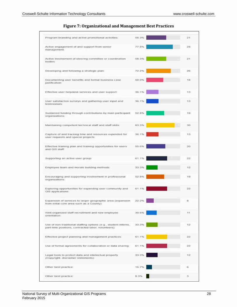
Croswell-Schulte Information Technology Consultants www.croswell-schulte.com
Figure 7: Organizational and Management Best Practices
National Survey of Multi-Organizational GIS Programs 28 February 2015
Croswell-Schulte Information Technology Consultants www.croswell-schulte.com
All but 6 of the 21 listed best practices had a response level of 50% or greater indicating that they are important ingredients for successful multi-organizational GIS programs. The six best practices with lower scores include:
• Effective user helpdesk services and user support (36%). • User satisfaction surveys and gathering user input and testimonials (36%). • Capture of and tracking time and resources expended for user requests and special projects
(36%). • Employee team and morale building methods (33%). • Well-organized staff recruitment and new employee orientation (22%). • Use of non-traditional staffing options (33%).
Those best practices with the highest response level (greater than 70%) included: a) Engaging and Maintaining Active Support from Senior Management, b) Developing and Following a Strategic Plan, c) Maintaining Competent Technical Staff and Skills indicting these should be considered as fundamental best practices for most multi-organizational GIS programs.
Many Respondents provided comments to elaborate on their scoring of Organizational and Management Best Practices and these ideas and insights are summarized below:
• Respondents consider active “branding” and promotion of the GIS Program important—mainly because it creates an identity for the program and helps expand the user base and benefits derived from the program. Branding often means having a recognizable name, logo, and “marketing” material to explain the program. Some Respondents indicated use of an organization’s public relations and training offices to support outreach and marketing. Some of the Respondents have formally allocated portions of their budget and staff for marketing and outreach activities. Use of Web-based social media for promotion and communication with users is being used or considered by several responding programs.
• Challenges associated with engaging and maintaining support of senior management and officials is a concern for most of the Respondents. This seems to be most critical during system development and early years of operation. A general consensus among Respondents is that maintaining connection with and support from senior management and officials requires a concerted effort through presentations, briefings, and testimonials from users. In addition, the GIS program organizational structure, with technical or coordinating committees playing a role in senior management communication is important. In the end, successful GIS applications, clear benefits addressing the organizations’ business needs, and satisfied users is the basis for strong and sustained senior management support.
• A majority of Respondents indicated that active involvement of steering and coordination committees/bodies is important. Some are using these coordination entities successfully to support communication and collaboration but a significant number of Respondents indicated that these bodies were not being used as effectively as they might—a fact that may call for changes in membership and mission and perhaps improved leadership and management.
• Strategic planning is considered by the vast majority of Respondents to be a critical best practice—even in cases where the Respondents’ GIS Programs do not have a recent plan. Respondents indicated that strategic plans lay a foundation for specific actions and
National Survey of Multi-Organizational GIS Programs 29 February 2015
Croswell-Schulte Information Technology Consultants www.croswell-schulte.com
projects—ensuring that those activities and projects contribute to short-term and long-term goals. Strategic planning works best when they are prepared with input by all participating organizations and their preparation can benefit by an outside facilitator or consultant.
• Half of the Respondents identified Documenting User Benefits and Formal Business Case Justification as a best practice. In some cases, benefits are documented in an anecdotal way as a record of “success stories”. In some of the Respondents’ GIS programs, there is a formal requirement to carry out an analysis of benefits or formal business case justification for new projects—and there is a specific format prescribed for project planning. There is a general consensus that some method of capturing/documenting a record of user benefits is important.
• It was somewhat surprising that only 36% of Respondents selected User Satisfaction Surveys and Gathering User Input and Testimonials. Most organizations do not carry out carry out formal satisfaction surveys but several did indicate they are done sporadically and one Respondent indicated that they are carried out annually. This is perhaps one best practice area that might be considered for adoption by more multi-organizational GIS programs. However, Respondent comments did emphasize the need for adoption of a strong and well-directed practice of customer (user) service and responsiveness.
• It is not surprising that the most frequently cited best practice is: Maintaining Competent Technical Staff and Staff Skills. Most GIS programs have ongoing challenges to hire and retain competent staff and keep them well trained and current with latest GIS products and methods. This is addressed by the most successful GIS programs by specifically allocating resources and staff time for training—through the most efficient means (e.g., instructor-led sessions, on-line training). For some inter-organizational collaboration on training adds efficiencies to training programs. Some of the Respondents indicate that they have prepared formal training plans and course material.
• Over 60% of Respondents indicated that Supporting an Active User Group is important because they provide a forum for users to share ideas and provide mutual support. There appears to be a broad range in level of formality (membership, leadership, meeting format) for the user groups. Some Respondents mentioned that they have multiple user groups segmented by application area. There was a concern expressed about the challenge involved in keeping user groups active, relevant, and of benefit to participants.
• It was expected that the response frequency for Employee Team and Morale Building would have been higher than 40%. Some of the Respondents mentioned specific approaches for morale building, employee recognition including: a) providing full employee benefits and access to training and professionally development opportunities, b) teambuilding by giving back to the community through special projects, c) weekly production meetings among different work groups, d) employee events like pot-luck lunch and team games.
• Over 60% of the Respondents selected Effective Project Planning and Management Practices. Several Respondents noted the use of formal templates for project planning and reporting. None of the Respondents cited use of formal independent project management practices such as the Project Management Body of Knowledge (PMBOK) from the Project Management Institute (PMI).
National Survey of Multi-Organizational GIS Programs 30 February 2015

Croswell-Schulte Information Technology Consultants www.croswell-schulte.com
2.16 TECHNICAL/TECHNOLOGY BEST PRACTICES
Survey Question #25 focused on Technical/Technology Best Practices—those practices having to do with GIS and IT databases, software, hardware, networks, methodologies, applications and related services and administration procedures. Figure 8 summarizes the responses to the 15 best practices included in the survey.
National Survey of Multi-Organizational GIS Programs 31 February 2015

Croswell-Schulte Information Technology Consultants www.croswell-schulte.com
Figure 8: Technical/Technology Best Practices
It was expected that the response rate for listed best practices concerning Cloud-based Services and Infrastructure would be relatively low. Response rates for two of the listed best practices: a) Use of
National Survey of Multi-Organizational GIS Programs 32 February 2015
Croswell-Schulte Information Technology Consultants www.croswell-schulte.com
Open Source Software (~14%) and b) Use/Integration of Commercial Web-based GIS Services (~30%) were unexpectedly low but there were Respondent comments indicating interest in these areas. While there was a fairly high response rate for “Expansion of Field/Mobile Applications (53%), it was expected to be high given the high-level of coverage in trade publications and the consultants’ experience with other organizations. It could be that some responding organizations already had substantial field/mobile applications already deployed and that additional “expansion” in this application area was not selected.
A summary of Respondent comments and observations about Technical/Technology Best Practices is provided as follows:
• There was a very strong consensus that a successful enterprise GIS program needs to have efficient procedures, custom tools, and effective quality assurance processes for GIS database maintenance. There should be a specific group overseeing quality and posting updates (after QA checks) to the central GIS database repository. Sound database maintenance is supported by clear standards for content, format, quality, and “mapping rules”.
• GIS program staff should have responsibility for acquisition/update of key base map layers including orthoimagery and street centerlines. Planimetric mapping is not a standard product for many of the Respondents but is considered critical for others. There was interest expressed in increasing the frequency of orthoimagery capture and a trend toward LiDAR acquisition and DEM processing.
• Open Access to GIS Data and Services is a critical best practice for most of the Respondents (~70%). This best practice is associated with Web-based Applications (response level of ~80%). These practices address the main objective of most multi-organizational GIS programs. There were a few comments about restrictions on access to certain GIS data and consideration being given to lifting those restrictions. There was general consensus about the need to deploy well-designed Web-based applications that provide an intuitive interface for GIS data query, display, and analysis. There were a few comments about deploying such applications in a Cloud environment (ArcGIS Online).
• Several Respondents indicated that they are using an enterprise license agreement (ELA) and that this has lowered costs (based on multiple server and desktop licenses) and made overall license management more efficient. Some have negotiated to apply Esri ELA terms to multiple organizations participating in the GIS program. Several Respondents did indicate that they are making a move to more server-based environments (from local Desktop).
• The 50% response level for GIS Integration of External Software and Databases was lower than expected. Several Respondents mentioned that GIS integration with external systems is the best way to drive benefits and address users’ business needs. Specific external systems mentioned included infrastructure asset management, permit management and tracking, and business intelligence.
• Response levels were low for the listed best practices on Cloud-based Infrastructure and Services. There was interest in this area but only 2 Respondents indicated current use of Cloud services (ArcGIS Online) but several others have plans to do so. Some comments expressed some caution about moving into the Cloud because of concerns about data duplication, costs, and administration requirements.
National Survey of Multi-Organizational GIS Programs 33 February 2015
Croswell-Schulte Information Technology Consultants www.croswell-schulte.com
• Only about 36% of the Respondents selected the best practice, Use of Available Templates for GIS Applications. This suggests that many of the Respondents are not making use of templates or off-the-shelf application packages. Two Respondents made reference to templates available from Esri (including the Local Government Information Model). Other Respondents indicated the importance of a clear, documented application development methodology.
• The listed best practice, Use of Internal IT resources and Staff for System and Database Administration, addresses the critical issue of allocation of staff resources for technical management and administration (software license management, network administration, server administration, database configuration, etc.). The response level of almost 60% indicates that an organization’s IT department has been assigned technical responsibilities for the IT infrastructure that supports GIS. Leveraging available skills and resources in an organization’s existing IT department is a good way to make efficient use of resources to support the GIS program.
2.17 ADDITIONAL IDEAS AND INSIGHTS PROVIDED BY RESPONDENTS
Survey Question #27 asked Respondents to provide any additional ideas and suggestions about development and operation of a multi-organizational GIS program--things to focus on, pitfalls to avoid, coordination strategy, use of new technology tools, etc. A summary of comments provided is included as follows:
• City of Oshkosh (WI) GIS: Starting with core datasets and customer needs is the key to starting the process. There is a significant need to plan how the collaboration will function, get funding, create data standards etc. However, many efforts have failed because the core management and end users did not see anything tangible.
• Muscatine (IA) Area Geographic Information Consortium (MAGIC): An independent GIS organization sounds like a good idea; however, it would be easier to be an actual part of a department in one of their partner organizations.
• San Diego (CA) Geographic Information Source (SanGIS): Technology by itself is usually not an issue but getting all agencies to actively participate and provide funding is the challenge. The more agencies that agree, formally, to participate, the better.
• Lane (OR) Regional Land Information Database (RLID): People and relationships are the heart of success or failure. Technology issues are secondary and present a wide range of alternatives and viable approaches to virtually any business objective. Conditions for systems to take root and flourish, as in nature, do not exist everywhere but where they do exist, it requires constant tending and care (and some occasional luck) to be sustained.
• Knoxville Knox County Knoxville Utilities Board (TN) GIS (KGIS): Pursue an open-data sharing policy as long as the organization can be funded sufficiently without the additional funding sources, but temper that policy based upon data protection requirements and mission of the respective agencies.
• Allen County (IN) iMap Consortium: A high priority is to make effective use of funds and services provided to the operation of government as well as communication with the public driving cost down while increasing services to the public. Focus on integration of enterprise applications (911, 311, permitting, code enforcement, etc.) using GIS. Coordination strategy
National Survey of Multi-Organizational GIS Programs 34 February 2015
Croswell-Schulte Information Technology Consultants www.croswell-schulte.com
starts with a coordinator and is implemented using communication and collaboration. Pitfalls are most commonly related to politics. One must remember computers are apolitical.
• Information of Northern Kentucky GIS (LinkGIS) (Planning and Development Services of Kenton County) lists the following: a) It is all about relationships!, b) Be a GIS evangelist; you need to get the word out at every turn. Most of the time the commissioners, city council members, mayors, key elected officials don't understand the work horse that GIS is behind the scenes and how it is touching lives daily in their jurisdiction. Tell them, then tell them what you told them, then tell them again!, c) Never go for the bleeding edge of technology...it can get messy. Always go for the leading edge, d) Never assume that communication is complete... it is always good to follow up... and follow up again, e) Always seek to understand first...You will be the only one in the room performing this exercise, f) Always best to set your ego aside to get things moving and done, g) Remember that things are not always as they seem...give yourself and others the benefit of the doubt.
• Berkeley County (SC) GIS Consortium is a dedicated GIS Department with staff that is able to focus on the needs of the County and GIS Consortium provides a solid foundation for success.
• City of Mississauga (ON) GIS: The most important thing to remember is that almost all things relate to a place - like an address or property, or can be referenced to same. In my books, it's not the regular 80/20 rule - it's pretty much 100%. Moving to an enterprise spatial database with a good metadata is the most important technical thing to accomplish. The next most important thing to realize is that the data will be of limited use if there aren't policies and practices to keep the assets maintained. Maintaining data costs money - lots of money. There is absolutely no value in promoting data for third party use of it is not continually updated. Many "Open Data" fanatics miss this point. Having project specific data might be nice, but its usefulness in proving true answers to mission critical business practices is totally lost otherwise. You might postulate or project results based on incomplete or outdated data or statistics, but invariably these results may be more damaging than doing without the data altogether. Just my 0.02 worth, and in Canada we no longer have the penny. Everything is rounded to the nearest 0.05 worth. As such my 0.02 doesn't count for anything. Best of luck on your survey.
• GIS Consortium (Chicago Area): It is important to get a consensus among stakeholders that although each community is unique, we have a lot in common and that can be leveraged for everyone's benefits. You also have to find a private partner that is committed to local government and the vision of a collaborative model that does not divide, but rather combines groups and resources.
• DeKalb County IN/CoCiGIS: There is a need for clear standards, procedures and plans for future projects with monthly meetings to discuss new layers, maps, and changes to software/database design. This is very effective in keeping all involved and on the same page with recent activity within each entity.
• Indianapolis/Marion County (IN) Mapping & Geographic Infrastructure System (IMAGIS): IMAGIS has been in operation for 28 years and maintains a comprehensive GIS database and services for a large user community. In recent years, there has been a lack of consensus on the amounts and allocation of membership fees. As a result of discontinued participation, IMAGIS as a formal entity has been discontinued (end of 2014).
National Survey of Multi-Organizational GIS Programs 35 February 2015

Croswell-Schulte Information Technology Consultants www.croswell-schulte.com
SECTION 3: STATEWIDE GIS PROGRAM SURVEY – SUMMARY OF RESULTS
As explained in Section 1, an additional survey was conducted aimed at state GIS programs. The questions used in this survey were similar to those for the Local/Regional survey. The state GIS survey targeted statewide programs that coordinate GIS activities and provides data and services for broad user communities—state agencies, regional agencies, local governments, and other public sector and private sector organizations. Five responses were received—from the states of Florida, New Jersey, Oregon, South Carolina, and Tennessee. All Respondents were in a lead management role for GIS Programs in their state. While this sample is not sufficiently large to assess circumstances and trends for statewide GIS programs in general, the responses did serve to confirm and augment results from the Local/Regional survey.
Results of this survey are summarized below:
• There was general consensus in the need and value of formal coordination bodies including a policy/governing body, technical committees and user groups.
• As in the case of the Local/Regional Survey, Respondents see a wide range of benefits for multi-organizational GIS collaboration with greatest importance assigned to: a) Reduced Redundancy and Increased Efficiency in Database Maintenance, b) Mechanism for Joint Project Collaboration, c) Consistent Standards and Effective Sharing/Access for Commonly Needed GIS Data, d) Lower Cost or Cost Sharing in GIS Database Development, and e) Expansion of GIS User Community (Public Sector, Private Sector, Non-Profit, and General Public).
• Respondents offered the following comments about benefits of statewide, multi-organizational GIS programs:
‐ South Carolina: By identifying particular layers that are needed by the state agencies, we have also found that multiple agencies were maintaining duplicate layers. By agreeing as to which agencies ought to be responsible for which layers, we removed duplication of effort. We also improved communication and made sure that the agency that took responsibility for the layer maintained fields critical for each of the agencies that needed the data.
‐ Oregon: The ROI study we conducted in 2006/07 indicated that state and local government in Oregon spends over $5B annually on collection, use, and management of geospatial data, and that inefficiencies in coordination are causing us to waste at least $200M annually. An ROI study in 2012, partially funded by Oregon GEO, for the 20-year King County GIS program measured a 10:1 return. King County spent $240M over the past 20 years and returned $2.4B on that investment.
‐ Tennessee: The TNMap enterprise GIS provides the most cost effective approach for maintaining, developing, hosting, and serving statewide geospatial data products to over 200 state agency personnel. In addition, our public facing GIS web applications provide the general public with access to our wide collection of geospatial data and services. Finally, the funding collaboration among our federal, state, and local partners has allowed us to acquire large scale GIS data at the most cost effective approach.
‐ New Jersey: Cost avoidance through the coordination of development of new data sets has been and continues to be a huge benefit.
National Survey of Multi-Organizational GIS Programs 36 February 2015
Croswell-Schulte Information Technology Consultants www.croswell-schulte.com
• Observations about key obstacles that impact GIS program development and operation include:
‐ Oregon: The key obstacle is executive support and understanding. All the rest can be overcome with strong executive support, and become a matter of prioritization. Every organization has sufficient funding to support better coordination, which pays for itself many times over. The executive leadership doesn't often understand the value of geospatial data and how much they spend on it, or how much they waste on it. The structure of government is a silo and GIS coordination is all about formalizing the connections between the silos in a way that keeps those connections from breaking when people and projects come and go.
‐ New Jersey: In the early years, unwillingness to give up control was a major obstacle. Over time it has evolved into a successful balance, where agencies still are able to control their internal programs and meet their own needs, but accrue the benefit of the central GIS capability as well.
‐ South Carolina: Sustainable funding is key. Ours is based on voluntary contributions. Should executive leadership change and decide to no longer contribute to the funding, the coordination effort would suffer. Also, a pay to participate model such as ours makes it impractical for small agencies or agencies with minimal GIS operations to participate.
‐ Florida: Despite a strategic plan for statewide GIS coordination and some efforts supporting that plan, Florida does not have a multi-organizational GIS program. There is coordination between state agencies, regional agencies, federal agencies, and local government, but this is all facilitated GIS manager-to-GIS manager, with no formal coordination bodies.
• The Statewide GIS programs use a variety of funding sources as illustrated by Respondent comments below:
‐ For Oregon, various federal grants have been applied over the years. A real estate transaction fee of $1 on all transactions funded a large portion of the Oregon statewide parcel mapping effort.
‐ In New Jersey large data acquisitions (such as aerial imagery) are funded ad hoc, often from multiple funding sources.
‐ For South Carolina, the state agencies are their only and most important funding sources. South Carolina State is exploring additional funding sources and would like to get state appropriated funding for continuity, so that the state agencies don't have to pay a fee to participate, allowing for any state agency to participate.
‐ In Oregon, the state agency assessment provides funding for positions and equipment. This funding is beyond their $250K annual fund for statewide data development.
‐ The New Jersey GIS program has been successful in putting together a number of state-federal partnerships for data acquisition, such as imagery and LiDAR. Federal funds are getting harder and the state has to adjust to that fact.
‐ In Tennessee, a large portion of funding comes from the Emergency Communications Board. This board funds total of 5 GIS positions and this staff is focused on implementation of NG911 statewide in Tennessee. They provide training, support,
National Survey of Multi-Organizational GIS Programs 37 February 2015
Croswell-Schulte Information Technology Consultants www.croswell-schulte.com
technical assistance, QA/QC, and other technical GIS related support to all 100 local emergency communication districts in Tennessee. They are currently seeking funding from USGS to support their goal for creating/developing statewide LiDAR through the 3DEP program.
• Respondents cited a number of Organizational and Management Best Practices with the following receiving the highest level of response: a) Active Involvement of Steering Committee or Coordination Bodies, b) Developing and Following a Strategic Plan, c) Maintaining Competent Technical Staff and Staff Skills, d) Sustained Funding Through Contributions By Main Participant Organizations, e) Maintaining Competent Technical Staff and Staff Skills, f) Effective Training Plan and Training Opportunities for Users and GIS Staff, g) Supporting an Active User Group, h) Encouraging and Supporting Involvement in Professional Organizations, i) Use of Non-Traditional Staffing Options (e.g.,., Student Interns, Part-Time Positions, Contracted Labor, Volunteers), and j) Use of Formal Agreements for Collaboration or Data Sharing. A number of insightful observations were made by the Respondents including:
‐ Should establish a name and logo that is associated with the coordination program.
‐ Need to facilitate a customer base and have ongoing discussions/technical presentations on enterprise GIS services.
‐ Senior management support is key to make certain they recognize the value of the program and continue to support contribution of both money and staff resources.
‐ Strategic planning gives direction and helps facilitate buy-in of the participating organizations.
‐ Documentation of user applications and benefits help to illustrate value of participation and is good for communicating this value to executive leadership.
‐ In order to effectively complete projects and activities, time volunteered/contributed by staff in participating agencies (for activities such as data conflation) is critical.
‐ Making sure the developed data meets the needs of each of the participating agencies that require that data layer is very important to make the data most valuable through maximum usage and removal of duplication of effort across agencies.
‐ Disclaimer statements regarding fitness / warranty of the data for any particular purpose helps make agencies feel more comfortable about sharing their data.
• In regards to Technical/Technology Best Practices, there was strong consensus on the following: a) Organized Process and Tools for Database Update and Maintenance, b) Improved Approaches for Development, or Acquisition to Updated Core GIS Data (e.g., orthoimagery, Street Centerlines, Elevation), and c) Public Clearinghouse or Web Portal for GIS Access. Several Respondents also indicated the value of enterprise GIS software licensing and the deployment of Web-based GIS applications for a broad range of users. It also appears that Cloud-based services are being considered for implementation. Comments provided by Respondents about Technical/Technology Best Practices include:
‐ Enterprise software licensing can be a cost saver, but not always. Need to evaluate the specific deal being offered.
National Survey of Multi-Organizational GIS Programs 38 February 2015

Croswell-Schulte Information Technology Consultants www.croswell-schulte.com
‐ With server-based Web GIS applications and opportunities for Cloud-based services, it is o longer necessary to assume that each user will need a desktop software license.
‐ Open source GIS software is worthy of consideration but total cost of ownership and support must be considered.
‐ Template GIS applications are becoming viable now, previous generations have been fairly weak.
National Survey of Multi-Organizational GIS Programs 39 February 2015
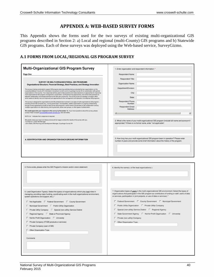
Croswell-Schulte Information Technology Consultants www.croswell-schulte.com
APPENDIX A: WEB-BASED SURVEY FORMS
This Appendix shows the forms used for the two surveys of existing multi-organizational GIS programs described in Section 2: a) Local and regional (multi-County) GIS programs and b) Statewide GIS programs. Each of these surveys was deployed using the Web-based service, SurveyGizmo.
A.1 FORMS FROM LOCAL/REGIONAL GIS PROGRAM SURVEY
National Survey of Multi-Organizational GIS Programs 40 February 2015
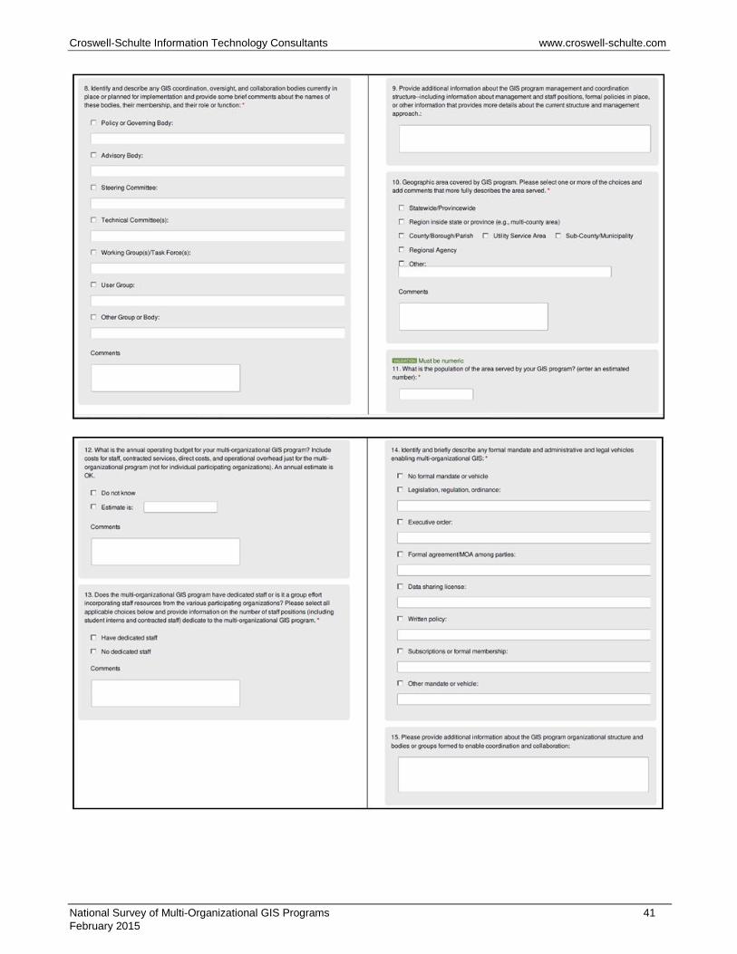
Croswell-Schulte Information Technology Consultants www.croswell-schulte.com
National Survey of Multi-Organizational GIS Programs 41 February 2015
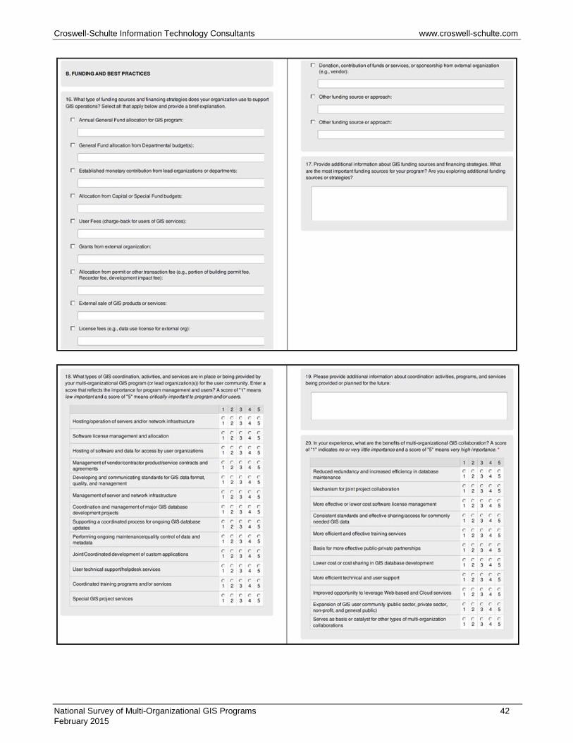
Croswell-Schulte Information Technology Consultants www.croswell-schulte.com
National Survey of Multi-Organizational GIS Programs 42 February 2015
Croswell-Schulte Information Technology Consultants www.croswell-schulte.com
National Survey of Multi-Organizational GIS Programs 43 February 2015

Croswell-Schulte Information Technology Consultants www.croswell-schulte.com
A.2 FORMS FROM STATEWIDE GIS PROGRAM SURVEY
National Survey of Multi-Organizational GIS Programs 44 February 2015

Croswell-Schulte Information Technology Consultants www.croswell-schulte.com
National Survey of Multi-Organizational GIS Programs 45 February 2015
Croswell-Schulte Information Technology Consultants www.croswell-schulte.com
National Survey of Multi-Organizational GIS Programs 46 February 2015

Croswell-Schulte Information Technology Consultants www.croswell-schulte.com
National Survey of Multi-Organizational GIS Programs 47 February 2015
Croswell-Schulte Information Technology Consultants www.croswell-schulte.com
National Survey of Multi-Organizational GIS Programs 48 February 2015