Embed Size (px)
Citation preview

Survey Results & Analysis
for
2013 GIS-T Survey & State Roll Call
Tuesday, April 23, 2013 Powered by Vovici EFM
www.vovici.com
Executive Summary
This report contains a detailed statistical analysis of the results to the survey titled 2013 GIS-T Survey & State Roll Call. The results analysis includes answers from all respondents who took the survey in the 50 day period from Monday, March 04, 2013 to Monday, April 22, 2013. 44 completed responses were received to the survey during this time.
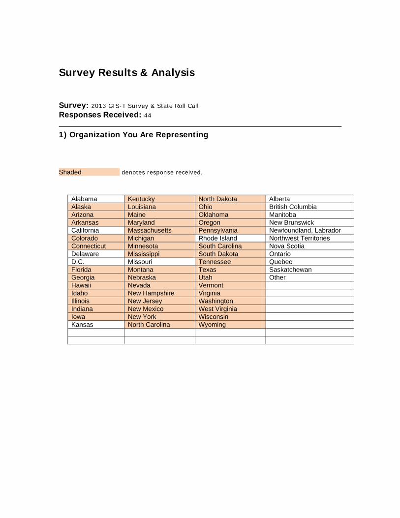
Survey Results & Analysis
Survey: 2013 GIS-T Survey & State Roll Call Responses Received: 44
1) Organization You Are Representing Shaded denotes response received.
Alabama Kentucky North Dakota Alberta Alaska Louisiana Ohio British Columbia Arizona Maine Oklahoma Manitoba Arkansas Maryland Oregon New Brunswick California Massachusetts Pennsylvania Newfoundland, Labrador Colorado Michigan Rhode Island Northwest Territories Connecticut Minnesota South Carolina Nova Scotia Delaware Mississippi South Dakota Ontario D.C. Missouri Tennessee Quebec Florida Montana Texas Saskatchewan Georgia Nebraska Utah Other Hawaii Nevada Vermont Idaho New Hampshire Virginia Illinois New Jersey Washington Indiana New Mexico West Virginia Iowa New York Wisconsin Kansas North Carolina Wyoming

2) Contact Information (Above Organization Name and Name must be provided as minimum):
Agency Name: Name: Title: Division: E-mail Address: Phone
Number: Fax Number:
AK
Department of Transportation & Public Facilities
Talena E Adams Transportation Data Services Manager
Program Development
[email protected] 907-465-6981 907-465-
6984
AR
Arkansas State Highway and Transportation Dept.
Sharon Hawkins Section Head - Mapping and Graphics
Plannning and Research
[email protected] 501-569-2205
AZ Arizona Department of Transportation
James Meyer GIS Program Manager
Multimodal Planning Division [email protected] 602.712.8037
CO Colorado Department of Transportation
William Johnson GIS Data Management Section Manager
Transportation Development
[email protected] 303-512-4808 303-757-
9727
CT Connecticut Department of Transportation
James R. Spencer
GIS Development Manager Planning [email protected]
ov 860.594.2014 860.594.2056
FL Fldorida Department of Transportation
Jared Causseaux GIS Coordinator [email protected]
(850) 245-1715
GA
Georgia Department of Transportation (GDOT)
Teague Buchanan
Assistant Administrator, Data Management
IT Applications [email protected] 404-631-1053 404-631-
1999
HI DOT Goro Sulijoadikusumo
Planning Survey Engineer Highways goro.sulijoadikusum
[email protected] 8085871839 8085871787
IA Iowa Department of Transportation
Eric Abrams Spatial Infrastructure and Coordination
Performance & Technology
[email protected] 5152391949
ID Idaho Transportation Department
Jason Brinkman Trans Sys MGR - Acting GIS manager
Transportation Systems
[email protected] 208-334-8253 208-334-
4432
IL Illinois Department of Transportation
Dan Wilcox State GIS Coordinator Dan.Wilcox@Illinois.
gov 217-524-0031 217-782-8822
IN Indiana Department of Transportation
Joel Bump Enterprise Data Manager
Management Information Systems
[email protected] 317-234-3106 317-232-5551
KY Kentucky Transportation Cabinet
Will Holmes GIS Branch Manager Office of Information Technology
[email protected] 502 564-8900
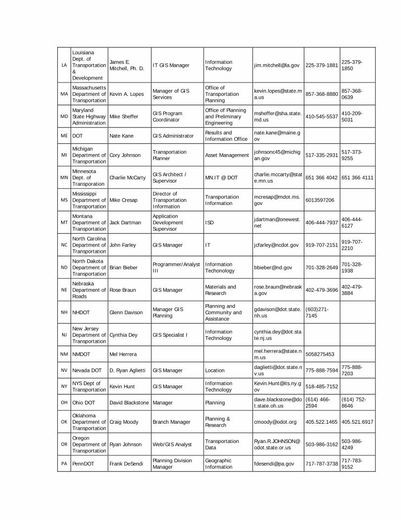
LA
Louisiana Dept. of Transportation & Development
James E. Mitchell, Ph. D. IT GIS Manager Information
Technology [email protected] 225-379-1881 225-379-1850
MA Massachusetts Department of Transportation
Kevin A. Lopes Manager of GIS Services
Office of Transportation Planning
[email protected] 857-368-8880 857-368-
0639
MD Maryland State Highway Administration
Mike Sheffer GIS Program Coordinator
Office of Planning and Preliminary Engineering
[email protected] 410-545-5537 410-209-
5031
ME DOT Nate Kane GIS Administrator Results and Information Office
MI Michigan Department of Transportation
Cory Johnson Transportation Planner Asset Management johnsonc45@michig
an.gov 517-335-2931 517-373-9255
MN Minnesota Dept. of Transporation
Charlie McCarty GIS Architect / Supervisor MN.IT @ DOT charlie.mccarty@stat
e.mn.us 651 366 4042 651 366 4111
MS Mississippi Department of Transportation
Mike Cresap Director of Transportation Information
Transportation Information
[email protected] 6013597206
MT Montana Department of Transportation
Jack Dartman Application Development Supervisor
ISD [email protected] 406-444-7937 406-444-
6127
NC North Carolina Department of Transportation
John Farley GIS Manager IT [email protected] 919-707-2151 919-707-2210
ND North Dakota Department of Transportation
Brian Bieber Programmer/Analyst III
Information Techonology [email protected] 701-328-2649 701-328-
1938
NE Nebraska Department of Roads
Rose Braun GIS Manager Materials and Research
[email protected] 402-479-3696 402-479-
3884
NH NHDOT Glenn Davison Manager GIS Planning
Planning and Community and Assistance
(603)271-7145
NJ New Jersey Department of Transportation
Cynthia Dey GIS Specialist I Information Technology
NM NMDOT Mel Herrera [email protected] 5058275453
NV Nevada DOT D. Ryan Aglietti GIS Manager Location [email protected] 775-888-7594 775-888-
7203
NY NYS Dept of Transportation Kevin Hunt GIS Manager Information
Technology [email protected] 518-485-7152
OH Ohio DOT David Blackstone Manager Planning [email protected]
(614) 466-2594
(614) 752-8646
OK Oklahoma Department of Transportation
Craig Moody Branch Manager Planning & Research [email protected] 405.522.1465 405.521.6917
OR Oregon Department of Transportation
Ryan Johnson Web/GIS Analyst Transportation Data
[email protected] 503-986-3162 503-986-
4249
PA PennDOT Frank DeSendi Planning Division Manager
Geographic Information [email protected] 717-787-3738 717-783-
9152
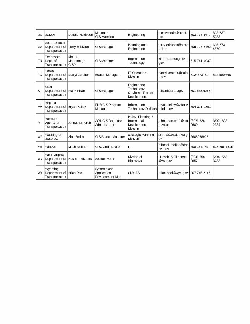
SC SCDOT Donald McElveen Manager GIS/Mapping Engineering mcelveende@scdot.
org 803-737-1677 803-737-5033
SD South Dakota Department of Transportation
Terry Erickson GIS Manager Planning and Engineering
[email protected] 605-773-3402 605-773-
4870
TN Tennessee Dept. of Transportation
Kim H. McDonough, GISP
GIS Manager Information Technology
[email protected] 615-741-4037
TX Texas Department of Transportation
Darryl Zercher Branch Manager IT Operation Division
[email protected] 5124673782 5124657668
UT Utah Department of Transportation
Frank Pisani GIS Manager
Engineering Technology Services - Project Development
[email protected] 801.633.6258
VA Virginia Department of Transportation
Bryan Kelley RNS/GIS Program Manager
Information Technology Division
[email protected] 804-371-0851
VT Vermont Agency of Transportation
Johnathan Croft AOT GIS Database Administrator
Policy, Planning & Intermodal Development Division
(802) 828-2600
(802) 828-2334
WA Washington State DOT Alan Smith GIS Branch Manager Strategic Planning
Division [email protected] 3605968925
WI WisDOT Mitch Moline GIS Administrator IT [email protected] 608.264.7494 608.266.1515
WV West Virginia Department of Transportation
Hussein Elkhansa Section Head Divsion of Highways
(304) 558-9657
(304) 558-3783
WY Wyoming Department of Transportation
Brian Peel Systems and Application Development Mgr
GIS\ITS [email protected] 307.745.2146
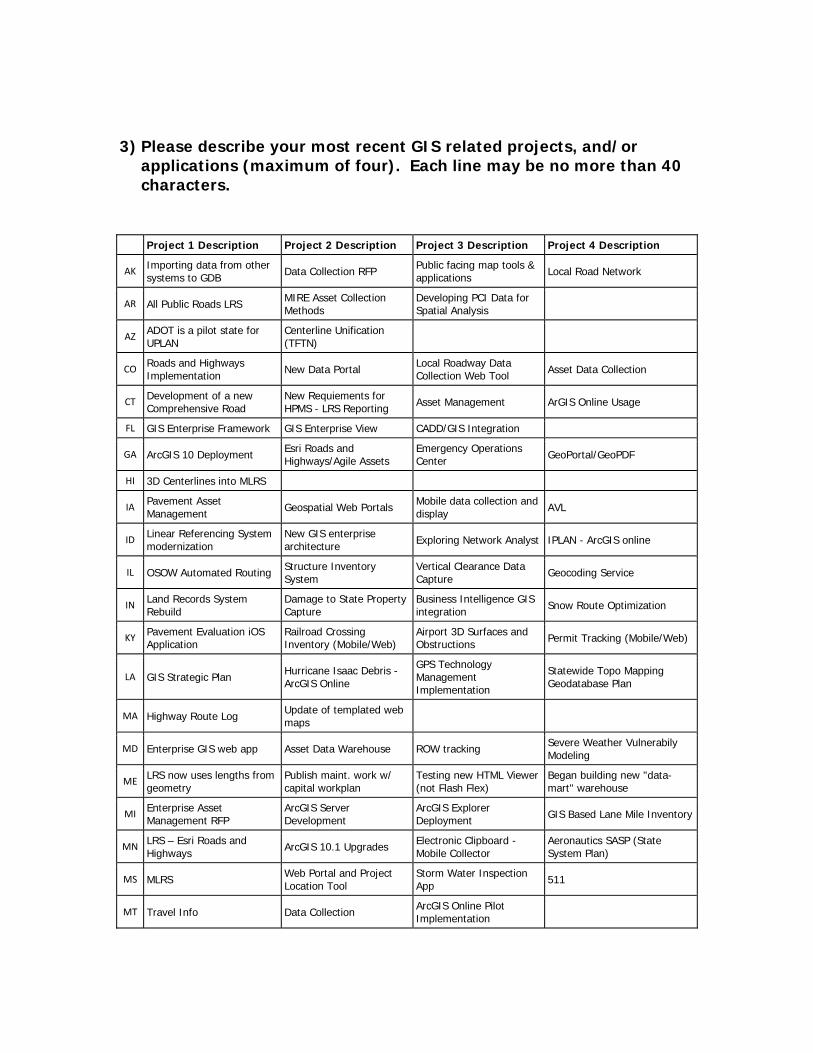
3) Please describe your most recent GIS related projects, and/or
applications (maximum of four). Each line may be no more than 40 characters.
Project 1 Description Project 2 Description Project 3 Description Project 4 Description
AK Importing data from other systems to GDB Data Collection RFP Public facing map tools &
applications Local Road Network
AR All Public Roads LRS MIRE Asset Collection Methods
Developing PCI Data for Spatial Analysis
AZ ADOT is a pilot state for UPLAN
Centerline Unification (TFTN)
CO Roads and Highways Implementation New Data Portal Local Roadway Data
Collection Web Tool Asset Data Collection
CT Development of a new Comprehensive Road
New Requiements for HPMS - LRS Reporting Asset Management ArGIS Online Usage
FL GIS Enterprise Framework GIS Enterprise View CADD/GIS Integration
GA ArcGIS 10 Deployment Esri Roads and Highways/Agile Assets
Emergency Operations Center GeoPortal/GeoPDF
HI 3D Centerlines into MLRS
IA Pavement Asset Management Geospatial Web Portals Mobile data collection and
display AVL
ID Linear Referencing System modernization
New GIS enterprise architecture Exploring Network Analyst IPLAN - ArcGIS online
IL OSOW Automated Routing Structure Inventory System
Vertical Clearance Data Capture Geocoding Service
IN Land Records System Rebuild
Damage to State Property Capture
Business Intelligence GIS integration Snow Route Optimization
KY Pavement Evaluation iOS Application
Railroad Crossing Inventory (Mobile/Web)
Airport 3D Surfaces and Obstructions Permit Tracking (Mobile/Web)
LA GIS Strategic Plan Hurricane Isaac Debris - ArcGIS Online
GPS Technology Management Implementation
Statewide Topo Mapping Geodatabase Plan
MA Highway Route Log Update of templated web maps
MD Enterprise GIS web app Asset Data Warehouse ROW tracking Severe Weather Vulnerabily Modeling
ME LRS now uses lengths from geometry
Publish maint. work w/ capital workplan
Testing new HTML Viewer (not Flash Flex)
Began building new "data-mart" warehouse
MI Enterprise Asset Management RFP
ArcGIS Server Development
ArcGIS Explorer Deployment GIS Based Lane Mile Inventory
MN LRS – Esri Roads and Highways ArcGIS 10.1 Upgrades Electronic Clipboard -
Mobile Collector Aeronautics SASP (State System Plan)
MS MLRS Web Portal and Project Location Tool
Storm Water Inspection App 511
MT Travel Info Data Collection ArcGIS Online Pilot Implementation
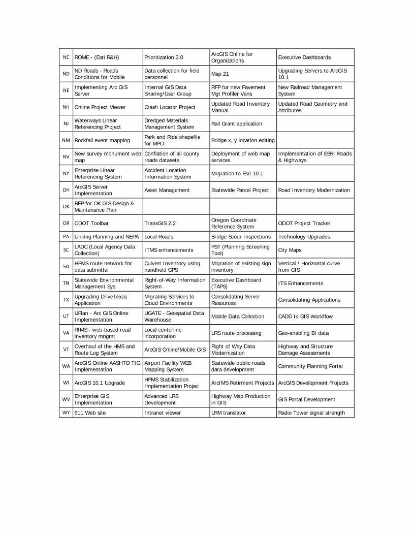
NC ROME - (Esri R&H) Prioritization 3.0 ArcGIS Online for Organizations Executive Dashboards
ND ND Roads - Roads Conditions for Mobile
Data collection for field personnel Map 21 Upgrading Servers to ArcGIS
10.1
NE Implementing Arc GIS Server
Internal GIS Data Sharing/User Group
RFP for new Pavement Mgt Profiler Vans
New Railroad Management System
NH Online Project Viewer Crash Locator Project Updated Road Inventory Manual
Updated Road Geometry and Attributes
NJ Waterways Linear Referencing Project
Dredged Materials Management System Rail Grant application
NM Rockfall event mapping Park and Ride shapefile for MPO Bridge x, y location editing
NV New survey monument web map
Conflation of all county roads datasets
Deployment of web map services
Implementation of ESRI Roads & Highways
NY Enterprise Linear Referencing System
Accident Location Information System MIgration to Esri 10.1
OH ArcGIS Server Implementation Asset Management Statewide Parcel Project Road Inventory Modernization
OK RFP for OK GIS Design & Maintenance Plan
OR ODOT Toolbar TransGIS 2.2 Oregon Coordinate Reference System ODOT Project Tracker
PA Linking Planning and NEPA Local Roads Bridge Scour Inspections Technology Upgrades
SC LADC (Local Agency Data Collection) ITMS enhancements PST (Planning Screening
Tool) City Maps
SD HPMS route network for data submittal
Culvert Inventory using handheld GPS
Migration of existing sign inventory
Vertical / Horizontal curve from GIS
TN Statewide Environmental Management Sys.
Right-of-Way Information System
Executive Dashboard (TAPS) ITS Enhancements
TX Upgrading DriveTexas Application
Migrating Services to Cloud Environments
Consolidating Server Resources Consolidating Applications
UT UPlan - Arc GIS Online Implementation
UGATE - Geospatial Data Warehouse Mobile Data Collection CADD to GIS Workflow
VA RIMS - web-based road inventory mngmt
Local centerline incorporation LRS route processing Geo-enabling BI data
VT Overhaul of the HMS and Route Log System ArcGIS Online/Mobile GIS Right of Way Data
Modernization Highway and Structure Damage Assessments
WA ArcGIS Online AASHTO TIG Implementation
Airport Facility WEB Mapping System
Statewide public roads data development Community Planning Portal
WI ArcGIS 10.1 Upgrade HPMS Stabilization Implementation Projec ArcIMS Retirment Projects ArcGIS Development Projects
WV Enterprise GIS Implementation
Advanced LRS Development
Highway Map Production in GIS GIS Portal Development
WY 511 Web site Intranet viewer LRM translator Radio Tower signal strength
4) Please describe up to four (maximum) GIS related projects, applications, and/or issues that are of interest to your organization. Each line may be no more than 40 characters.
Project 1 Description Project 2 Description Project 3 Description Project 4 Description
AK ESRI Roads and Highways ArcGIS online IT infrastructure improvements
AR LiDAR Data Intergration Department Wide
Enterprise GIS/Data Management
Performance Measures/Dashboards
AZ Roads and Highways Adaptation
ArcGIS Online Photolog Viewer
CO MAP-21 All Public Roads Reporting Asset Management CAD - GIS Interoperability Data Governance
CT Contemporary Road Network Modeling HPMS/LRS Modeling Asset Management ArcGIS Online Usage and
Benefit
FL GeoSpatial Networks for All Public Roads CADD/GIS Integration Public Information Web
Portals
GA CAD/GIS Interoperability Delcan-ArcGIS Interoperability MS4 Oracle P6 Exalytics/Esri
ArcGIS Server
HI Bringing Lidar data into GIS
Creating a virtual roadway environment
IA CADD/GIS Integration ArcGIS Online Geospaital Maturity & Standards Mobile data collection
ID ITD's presence on the Web
Federal requirement to capture all roads ITD ROW parcels Exploring City Engine
IL
IN ESRI Roads & Highways Implementation
Continue Enterprise Systems Integration Mobile LiDAR Authoritative Data Sources
KY CAD/GIS Integration Asset Management Non-GIS System Integration
LiDAR Integration (Aerial,Mobile,Fixed)
LA Flooded Roads Data Collection/Modeling
Statewide Public Roads Data Management
ESRI Roads and Highways Imlementation
ESRI/AgileAssets Interoperability
MA Migration to ESRI's Roads and Highways
MD Esri Roads and Highways implementation GIS Portal technology Cloud Storage/ArcGIS
Online mobile applications
ME Mobile data viewing, update, collection
Linear/Location Referencing System
Dynamic seg. in query/report user tools
Cross-modal adequacy comparison methods
MI Enterprise Asset Management Vendors ESRI Roads and Highways Mobile Technology &
ArcGIS Server Future of ArcGIS Explorer
MN LRS Esri Roads and Highways Asset management Systems Research projects –
operational data Data Modeling and Governance
MS Local Government Data Sharing
Roadway Information Management System Metadata Interoperability - apps
services people
MT Mobile Applications Web Apps for roadway location data
NC Mobile Data Collection LRS Web Applications and Mapping
ND Mobile data collection
NE Adding a GIS Coordinator Position Asset Management Local Network /w Street
Point Addressing Statewide Public Webportal
NH Mobile Technology
NJ
NM We are serving map services internally
Serve maps for NMDOT similar to UPLAN
We are evaluating ESRI Roads & Highways
NV Right of Way dataset Engineering Stationing LRM Underground Utilities Dataset
Low-cost mobile GPS data collection
NY Integration of LRS with Enterprise AM
Expansion of LRS to all public roads
Effective use of cloud based GIS
OH Web Services Mobile Data Collection HPMS Cloud
OK Design & Maintenance for OK GIS
Standardize Rd. Invt. data collection MPO data share Advanced use of .KML Files
OR Asset Management FHWA All Roads LRS CAD to GIS Interoperability Mobile Solutions
PA Snow Route Optimization Traffic Managment System Multi-Agency Planning Permitting and Routing
SC Migrating State Map to GIS Web Applications for Public LiDAR use, sharing, storage Right of Way
SD LIDAR - mobile vs aerial MAP21 requirements
TN LiDAR (ALL types) CAD/GIS Integration (or lack thereof)
Imagery management, analysis and dist. Big Data
TX Using iOS for Asset Collection in AGO
AGO Originations - Best Practices
Sharing Assets across multiple agencies
UT LRS Updates and Messaging Custom vs COTS Applications Linking BI tools to GIS Environmental Screening
Analysis - PEL
VA Synch'ing data on LRS Enterprise mobile framework ArcGIS Online for Orgs governance model Straight Line Diagram
VT VTrans-E911 Road Centerline Conflation Esri’s Roads & Highways Maintenance Management -
Asset Lifecycle Right of Way Data Modernization
WA Enterprise asset management solutions
Enterprise mobile field data stewardship
Mobile application/system dev. platforms
Stewardship/governance - cloud resources
WI Local road inventory program (LRIP) WISLR VB replacement projects
WV Enterprise LRS Development
LRS-Asset Management System Integration CAD-GIS Integration Transporation Geospatial
Data Collection
WY New HPMS requirements LRS update Mobile development
5) How is GIS deployed in your agency? Possible Answers - We have no GIS function in our agency
We have specific individuals involved in GIS applications, but no agency wide coordination We have a single unit responsible for both GIS core functions and applications We have GIS unit(s) responsible for core functions, and multiple end users in various program offices We have integrated most agency databases through an Enterprise GIS, and have developed GIS applications throughout the agency Other (please specify)
Other Responses:
WA Combination of 4 and 4.
MN MnDOT - Both Core Unit and Business Unit
6) How large is your GIS core staff? (e.g. 5 FTE). If your agency does
not have a formal GIS core staff, please indicate such as "0".
Number of Full-Time Employees
Number of Part-Time Employees
Number of On-site Contractors
Number of Off-site Contractors
AK 6 3
AR 13
AZ 10
CO 17
CT 4
FL
GA 2 5
HI 0 0 1 1
IA 3 1
ID 6
IL 3 4 1
IN 15
KY 20 3 3 15
LA 3 0 0 0
MA 10 3 2
MD 5 1 10
ME 8
MI 3 2 0 0
MN 8 3
MS 15 25 3 8
MT 11
NC 30 3
ND 5 1 0 0
NE 9 3
NH 3 0 0 0
NJ 7
NM 3
NV 5 0 0 0
NY 4 0 2 0
OH 20 2 2 2
OK 8 0 0 1
OR 12 0.26 0 10
PA 4 1 5 0
SC 9 0 3 0
SD 3

TN 15 2
TX 3 2
UT 5 3 1.5 1
VA 9 0 18 12
VT 15 4
WA 14 1 0 0
WI 8 1
WV 7
WY 3 1
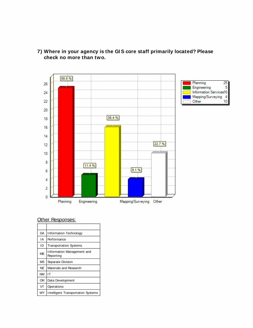
7) Where in your agency is the GIS core staff primarily located? Please check no more than two.
Other Responses:
GA Information Technology
IA Performance
ID Transportation Systems
ME Information Management and Reporting
MS Separate Division
NE Materials and Research
NM IT
OR Data Development
VT Operations
WY Intelligent Transportation Systems
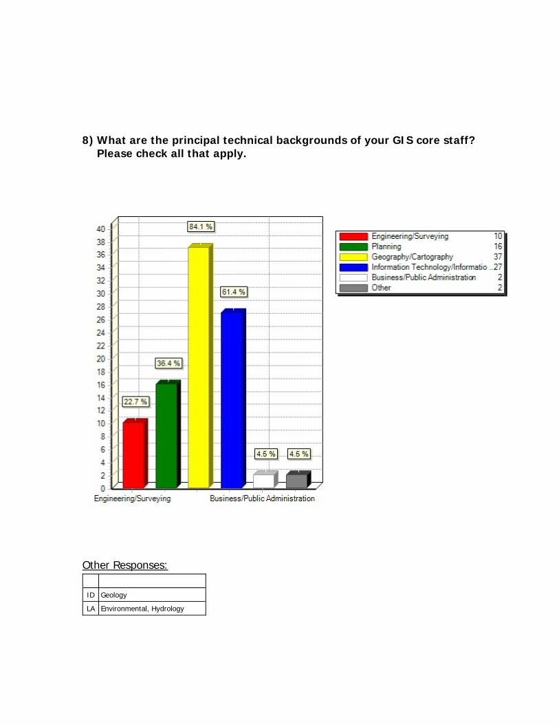
8) What are the principal technical backgrounds of your GIS core staff? Please check all that apply.
Other Responses:
ID Geology
LA Environmental, Hydrology
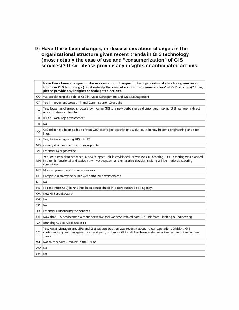
9) Have there been changes, or discussions about changes in the organizational structure given recent trends in GIS technology (most notably the ease of use and “consumerization” of GIS services)? If so, please provide any insights or anticipated actions.
Have there been changes, or discussions about changes in the organizational structure given recent trends in GIS technology (most notably the ease of use and “consumerization” of GIS services)? If so, please provide any insights or anticipated actions.
CO We are defining the role of GIS in Asset Management and Data Management
CT Yes in movement toward IT and Commissioner Oversight
IA Yes. Iowa has changed structure by moving GIS to a new performance division and making GIS manager a direct report to division director
ID IPLAN, Web App development
IN No
KY GIS skills have been added to “Non-GIS” staff’s job descriptions & duties. It is now in some engineering and tech lines.
LA Yes, better integrating GIS into IT.
MD in early discussion of how to incorporate
MI Potential Reorganization
MN Yes, With new data practices, a new support unit is envisioned, driven via GIS Steering – GIS Steering was planned in past, is functional and active now.. More system and enterprise decision making will be made via steering committee
NC More empowerment to our end-users
NE Complete a statewide public webportal with webservices
NH No
NY IT (and most GIS) in NYS has been consolidated in a new statewide IT agency.
OK New GIS architecture
OR No
SD No
TX Potential Outsourcing the services
UT Now that GIS has become a more pervasive tool we have moved core GIS unit from Planning o Engineering.
VA Branding GIS services under IT
VT Yes, Asset Management, GPS and GIS support position was recently added to our Operations Division. GIS continues to grow in usage within the Agency and more GIS staff has been added over the course of the last few years.
WI Not to this point - maybe in the future
WV No
WY No

10) Is anyone on the GIS core staff a Certified GIS professional?
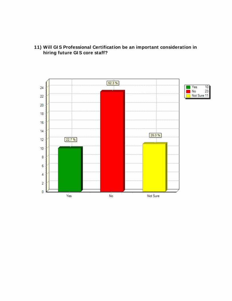
11) Will GIS Professional Certification be an important consideration in hiring future GIS core staff?
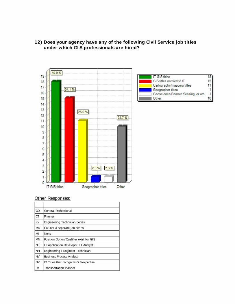
12) Does your agency have any of the following Civil Service job titles under which GIS professionals are hired?
Other Responses:
CO General Professional
CT Planner
KY Engineering Technician Series
MD GIS not a separate job series
MI None
MN Position Option/Qualifier exist for GIS
NE IT Application Developer, IT Analyst
NH Engineering / Engineer Technician
NV Business Process Analyst
NY IT Titles that recognize GIS expertise
PA Transportation Planner
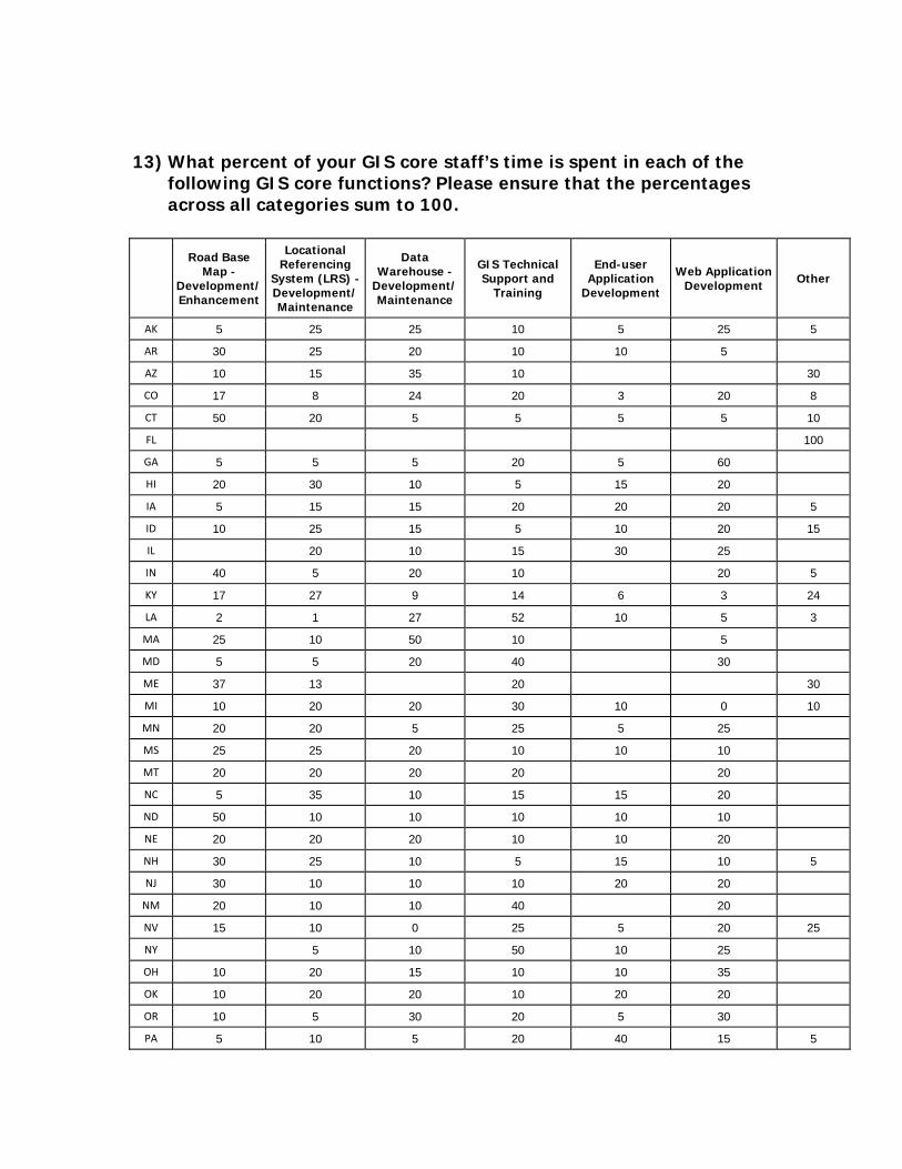
13) What percent of your GIS core staff’s time is spent in each of the following GIS core functions? Please ensure that the percentages across all categories sum to 100.
Road Base Map -
Development/Enhancement
Locational Referencing
System (LRS) - Development/Maintenance
Data Warehouse -
Development/Maintenance
GIS Technical Support and
Training
End-user Application
Development
Web Application Development Other
AK 5 25 25 10 5 25 5
AR 30 25 20 10 10 5
AZ 10 15 35 10 30
CO 17 8 24 20 3 20 8
CT 50 20 5 5 5 5 10
FL 100
GA 5 5 5 20 5 60
HI 20 30 10 5 15 20
IA 5 15 15 20 20 20 5
ID 10 25 15 5 10 20 15
IL 20 10 15 30 25
IN 40 5 20 10 20 5
KY 17 27 9 14 6 3 24
LA 2 1 27 52 10 5 3
MA 25 10 50 10 5
MD 5 5 20 40 30
ME 37 13 20 30
MI 10 20 20 30 10 0 10
MN 20 20 5 25 5 25
MS 25 25 20 10 10 10
MT 20 20 20 20 20
NC 5 35 10 15 15 20
ND 50 10 10 10 10 10
NE 20 20 20 10 10 20
NH 30 25 10 5 15 10 5
NJ 30 10 10 10 20 20
NM 20 10 10 40 20
NV 15 10 0 25 5 20 25
NY 5 10 50 10 25
OH 10 20 15 10 10 35
OK 10 20 20 10 20 20
OR 10 5 30 20 5 30
PA 5 10 5 20 40 15 5

SC 25 15 10 10 10 10 20
SD 20 20 20 20 20
TN 20 20 10 20 10 20
TX 10 10 20 50 10
UT 25 25 15 15 20
VA 25 15 10 15 10 20 5
VT 21 6 36 13 10 10 4
WA 10 10 10 20 20 30
WI 5 10 10 25 25 25
WV 15 30 15 15 10 10 5
WY 15 15 10 15 25 20
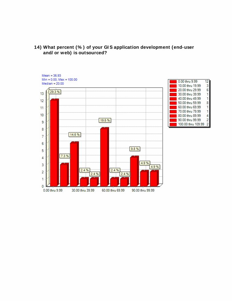
14) What percent (%) of your GIS application development (end-user and/or web) is outsourced?

15) What is the approximate annual amount ($) expended by your agency for GIS application development contracts?
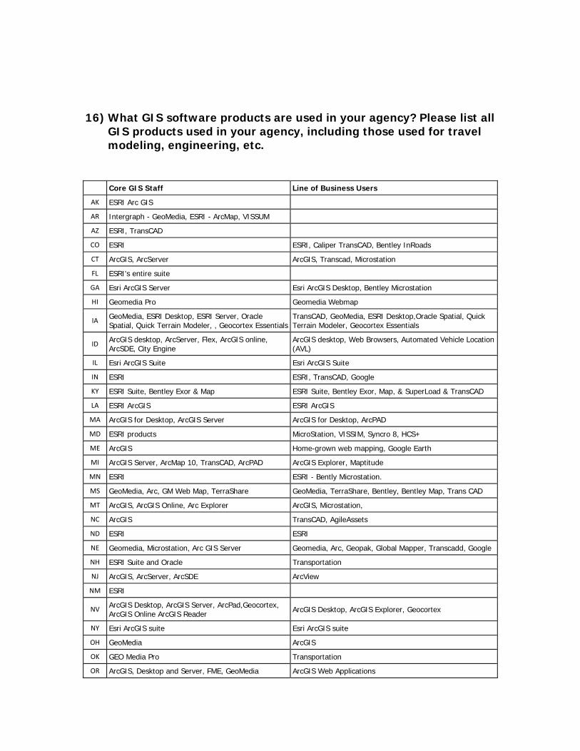
16) What GIS software products are used in your agency? Please list all GIS products used in your agency, including those used for travel modeling, engineering, etc.
Core GIS Staff Line of Business Users
AK ESRI Arc GIS
AR Intergraph - GeoMedia, ESRI - ArcMap, VISSUM
AZ ESRI, TransCAD
CO ESRI ESRI, Caliper TransCAD, Bentley InRoads
CT ArcGIS, ArcServer ArcGIS, Transcad, Microstation
FL ESRI's entire suite
GA Esri ArcGIS Server Esri ArcGIS Desktop, Bentley Microstation
HI Geomedia Pro Geomedia Webmap
IA GeoMedia, ESRI Desktop, ESRI Server, Oracle Spatial, Quick Terrain Modeler, , Geocortex Essentials
TransCAD, GeoMedia, ESRI Desktop,Oracle Spatial, Quick Terrain Modeler, Geocortex Essentials
ID ArcGIS desktop, ArcServer, Flex, ArcGIS online, ArcSDE, City Engine
ArcGIS desktop, Web Browsers, Automated Vehicle Location (AVL)
IL Esri ArcGIS Suite Esri ArcGIS Suite
IN ESRI ESRI, TransCAD, Google
KY ESRI Suite, Bentley Exor & Map ESRI Suite, Bentley Exor, Map, & SuperLoad & TransCAD
LA ESRI ArcGIS ESRI ArcGIS
MA ArcGIS for Desktop, ArcGIS Server ArcGIS for Desktop, ArcPAD
MD ESRI products MicroStation, VISSIM, Syncro 8, HCS+
ME ArcGIS Home-grown web mapping, Google Earth
MI ArcGIS Server, ArcMap 10, TransCAD, ArcPAD ArcGIS Explorer, Maptitude
MN ESRI ESRI - Bently Microstation.
MS GeoMedia, Arc, GM Web Map, TerraShare GeoMedia, TerraShare, Bentley, Bentley Map, Trans CAD
MT ArcGIS, ArcGIS Online, Arc Explorer ArcGIS, Microstation,
NC ArcGIS TransCAD, AgileAssets
ND ESRI ESRI
NE Geomedia, Microstation, Arc GIS Server Geomedia, Arc, Geopak, Global Mapper, Transcadd, Google
NH ESRI Suite and Oracle Transportation
NJ ArcGIS, ArcServer, ArcSDE ArcView
NM ESRI
NV ArcGIS Desktop, ArcGIS Server, ArcPad,Geocortex, ArcGIS Online ArcGIS Reader ArcGIS Desktop, ArcGIS Explorer, Geocortex
NY Esri ArcGIS suite Esri ArcGIS suite
OH GeoMedia ArcGIS
OK GEO Media Pro Transportation
OR ArcGIS, Desktop and Server, FME, GeoMedia ArcGIS Web Applications
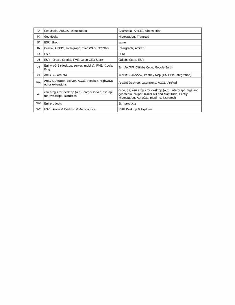
PA GeoMedia, ArcGIS, Microstation GeoMedia, ArcGIS, Microstation
SC GeoMedia Microstation, Transcad
SD ESRI Shop same
TN Oracle, ArcGIS, Intergraph, TransCAD, FOSS4G Intergraph, ArcGIS
TX ESRI ESRI
UT ESRI, Oracle Spatial, FME, Open GEO Stack Citilabs Cube, ESRI
VA Esri ArcGIS (desktop, server, mobile), FME, Xtools, Bing Esri ArcGIS, Citilabs Cube, Google Earth
VT ArcGIS – ArcInfo ArcGIS – ArcView, Bentley Map (CAD/GIS integration)
WA ArcGIS Desktop, Server, AGOL, Roads & Highways, other extensions ArcGIS Desktop, extensions, AGOL, ArcPad
WI esri arcgis for desktop (a,b), arcgis server, esri api for javascript, lizardtech
cube, ge, esri arcgis for desktop (a,b), intergraph mge and geomedia, caliper TransCAD and Maptitude, Bently Microstation, AutoCad, mapinfo, lizardtech
WV Esri products Esri products
WY ESRI Server & Desktop & Aeronautics ESRI Desktop & Explorer
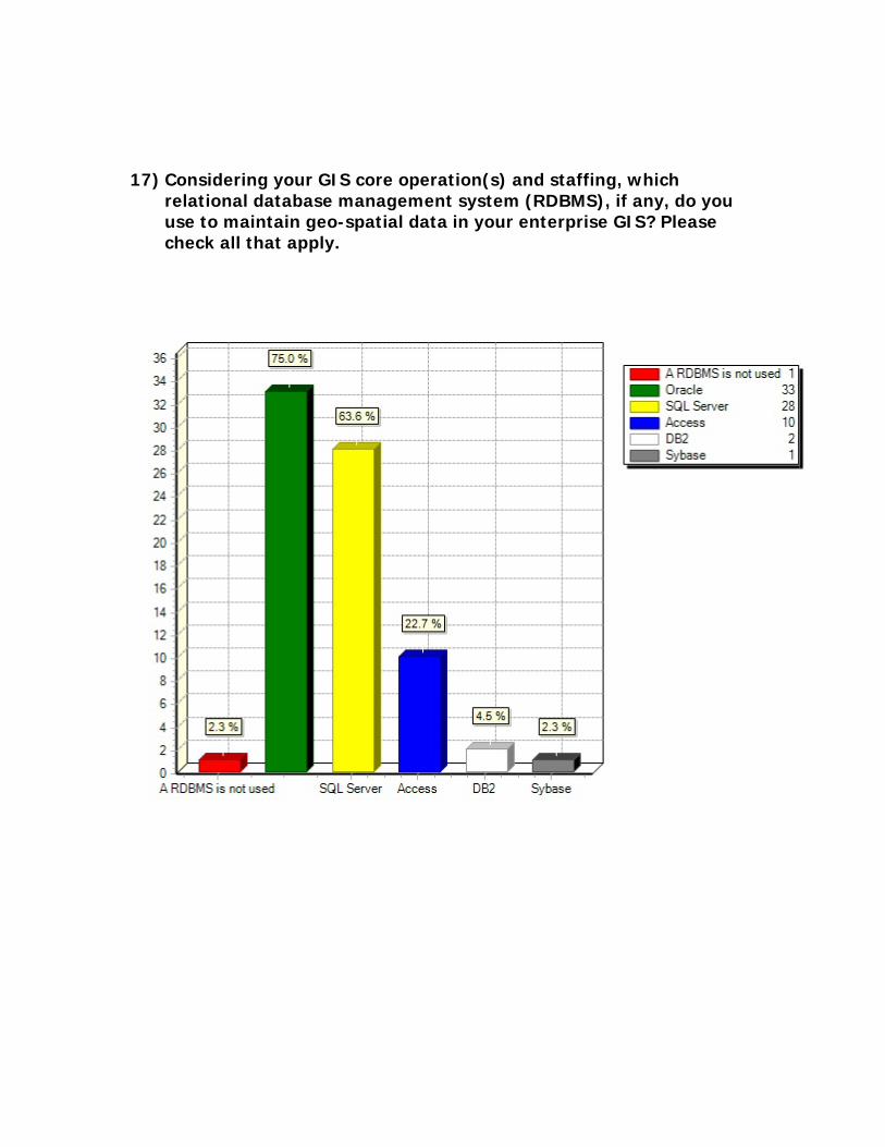
17) Considering your GIS core operation(s) and staffing, which relational database management system (RDBMS), if any, do you use to maintain geo-spatial data in your enterprise GIS? Please check all that apply.
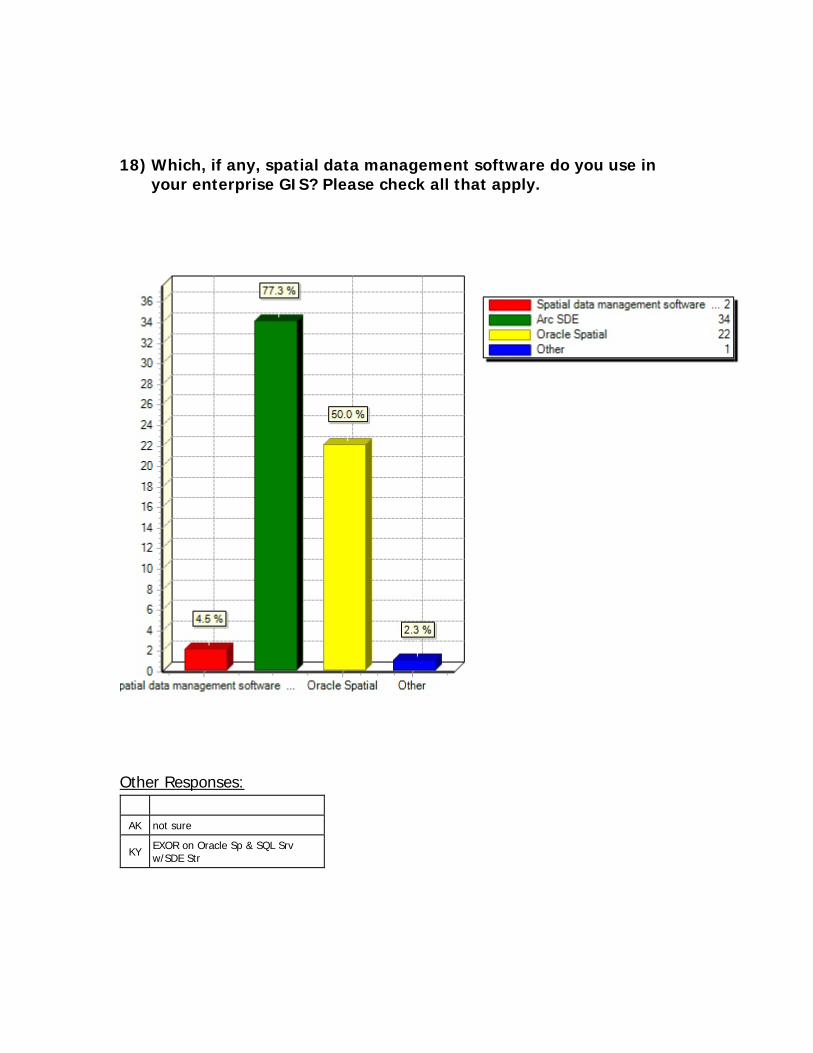
18) Which, if any, spatial data management software do you use in your enterprise GIS? Please check all that apply.
Other Responses:
AK not sure
KY EXOR on Oracle Sp & SQL Srv w/SDE Str
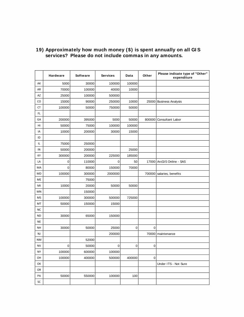
19) Approximately how much money ($) is spent annually on all GIS services? Please do not include commas in any amounts.
Hardware Software Services Data Other Please indicate type of "Other" expenditure
AK 5000 30000 100000 100000
AR 70000 100000 40000 10000
AZ 25000 100000 500000
CO 15000 90000 250000 10000 25000 Business Analysis
CT 100000 50000 750000 50000
FL
GA 200000 395000 5000 50000 800000 Consultant Labor
HI 50000 75000 100000 100000
IA 10000 200000 30000 15000
ID
IL 75000 250000
IN 50000 200000 25000
KY 300000 200000 225000 185000
LA 0 110000 0 50 17000 ArcGIS Online - SAS
MA 0 80000 150000 70000
MD 100000 300000 2000000 700000 salaries, benefits
ME 75000
MI 10000 20000 50000 50000
MN 150000
MS 100000 300000 500000 725000
MT 50000 150000 15000
NC
ND 30000 65000 150000
NE
NH 30000 50000 25000 0 0
NJ 200000 70000 maintenance
NM 52000
NV 0 50000 0 0 0
NY 100000 600000 100000
OH 100000 400000 500000 400000 0
OK Under ITS - Not Sure
OR
PA 50000 550000 100000 100
SC

SD unknown
TN 50000 300000 250000 120000
TX 20000 750000 20000 10000
UT 20000 70000 200000 800000
VA 1000000 700000 2000000 25000
VT 10 100 50
WA 10000 60000 30000
WI 0 210000 0 50000 0 0
WV 300000 300000 500000 600000
WY 47000 100000 110000
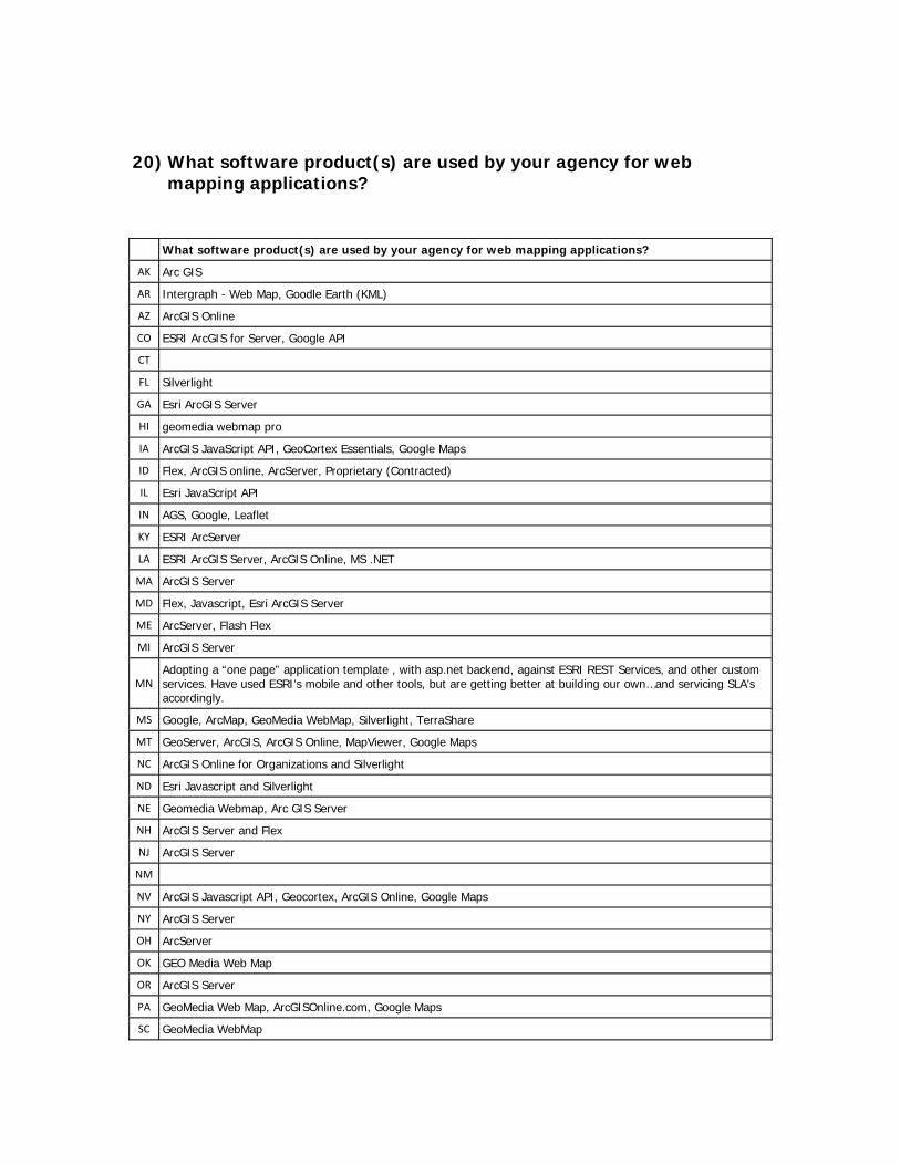
20) What software product(s) are used by your agency for web
mapping applications?
What software product(s) are used by your agency for web mapping applications?
AK Arc GIS
AR Intergraph - Web Map, Goodle Earth (KML)
AZ ArcGIS Online
CO ESRI ArcGIS for Server, Google API
CT
FL Silverlight
GA Esri ArcGIS Server
HI geomedia webmap pro
IA ArcGIS JavaScript API, GeoCortex Essentials, Google Maps
ID Flex, ArcGIS online, ArcServer, Proprietary (Contracted)
IL Esri JavaScript API
IN AGS, Google, Leaflet
KY ESRI ArcServer
LA ESRI ArcGIS Server, ArcGIS Online, MS .NET
MA ArcGIS Server
MD Flex, Javascript, Esri ArcGIS Server
ME ArcServer, Flash Flex
MI ArcGIS Server
MN Adopting a “one page” application template , with asp.net backend, against ESRI REST Services, and other custom services. Have used ESRI’s mobile and other tools, but are getting better at building our own…and servicing SLA’s accordingly.
MS Google, ArcMap, GeoMedia WebMap, Silverlight, TerraShare
MT GeoServer, ArcGIS, ArcGIS Online, MapViewer, Google Maps
NC ArcGIS Online for Organizations and Silverlight
ND Esri Javascript and Silverlight
NE Geomedia Webmap, Arc GIS Server
NH ArcGIS Server and Flex
NJ ArcGIS Server
NM
NV ArcGIS Javascript API, Geocortex, ArcGIS Online, Google Maps
NY ArcGIS Server
OH ArcServer
OK GEO Media Web Map
OR ArcGIS Server
PA GeoMedia Web Map, ArcGISOnline.com, Google Maps
SC GeoMedia WebMap
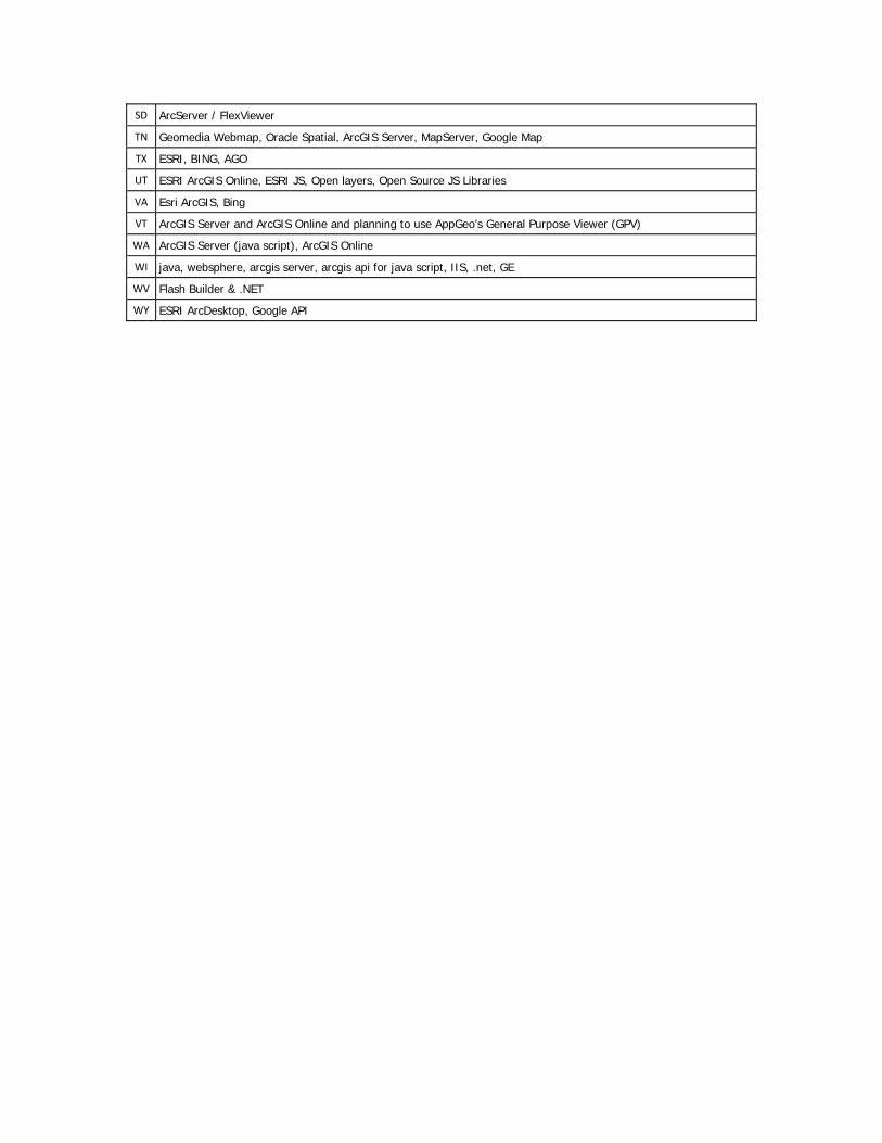
SD ArcServer / FlexViewer
TN Geomedia Webmap, Oracle Spatial, ArcGIS Server, MapServer, Google Map
TX ESRI, BING, AGO
UT ESRI ArcGIS Online, ESRI JS, Open layers, Open Source JS Libraries
VA Esri ArcGIS, Bing
VT ArcGIS Server and ArcGIS Online and planning to use AppGeo’s General Purpose Viewer (GPV)
WA ArcGIS Server (java script), ArcGIS Online
WI java, websphere, arcgis server, arcgis api for java script, IIS, .net, GE
WV Flash Builder & .NET
WY ESRI ArcDesktop, Google API
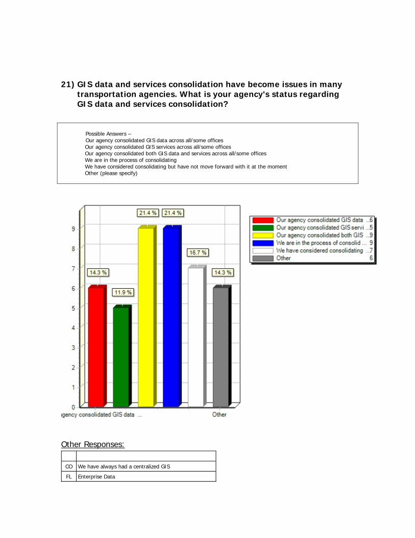
21) GIS data and services consolidation have become issues in many transportation agencies. What is your agency's status regarding GIS data and services consolidation?
Possible Answers – Our agency consolidated GIS data across all/some offices
Our agency consolidated GIS services across all/some offices Our agency consolidated both GIS data and services across all/some offices We are in the process of consolidating We have considered consolidating but have not move forward with it at the moment Other (please specify)
Other Responses:
CO We have always had a centralized GIS
FL Enterprise Data

IA We use a federated approach for data
IN Server/Services consolidated statewide
KY Considered w/ statewide IT consolidation
LA State CIO is discussing consolidation
PA No Activity
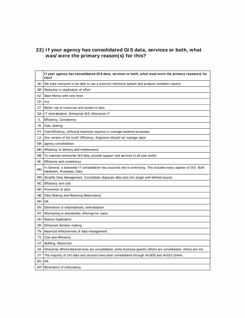
22) If your agency has consolidated GIS data, services or both, what was/were the primary reason(s) for this?
If your agency has consolidated GIS data, services or both, what was/were the primary reason(s) for this?
AK We want everyone to be able to use a common reference system and produce consisten reports.
AR Reduction in duplication of effort
AZ Save Money with new hires
CO n/a
CT Better use of resources and access to data
GA IT centralization, Enterprise GIS, Enterprise IT
IL Efficiency, Consistency
IN Cost, sharing
KY Cost/efficiency, technical expertise required to manage backend processes.
LA One version of the truth! Efficiency. Engineers should not manage data!
MA agency consolidation
MD efficiency of delivery and maintenance
ME To maintain enterprise GIS data, provide support and services to all user levels.
MI Efficiency and consistency
MN In General, a statewide IT consolidation has occurred and is continuing. This includes many aspects of GIS: Staff, Hardware, Processes, Data.
MS Simplify Data Management, Consolidate disparate data sets into single well defined source
NC Efficiency and cost
ND Prevention of silos
NE Data Sharing and Reducing Redundancy
NH NA
NV Elimination of redundancies, centralization
NY Attempting to standardize offerings for users
OH Reduce Duplication
OK Enhanced decision making
TN Maximize effectiveness of data management
TX Cost and efficiency
UT Staffing, Resources
VA Enterprise efforts/data/services are consolidated, some business-specific efforts are consolidated, others are not
VT The majority of GIS data and services have been consolidated through ArcSDE and ArcGIS Online.
WV NA
WY Elimination of redundancy
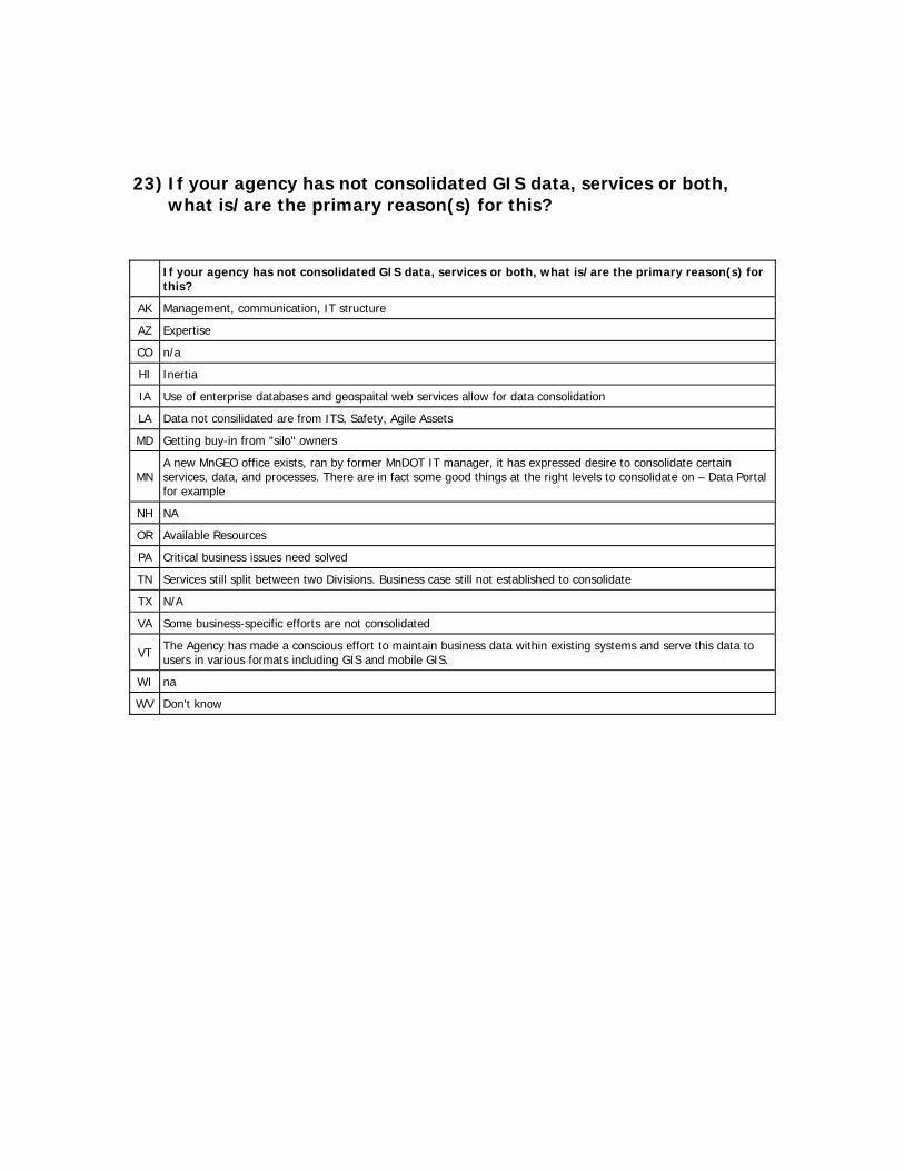
23) If your agency has not consolidated GIS data, services or both, what is/are the primary reason(s) for this?
If your agency has not consolidated GIS data, services or both, what is/are the primary reason(s) for this?
AK Management, communication, IT structure
AZ Expertise
CO n/a
HI Inertia
IA Use of enterprise databases and geospaital web services allow for data consolidation
LA Data not consilidated are from ITS, Safety, Agile Assets
MD Getting buy-in from "silo" owners
MN A new MnGEO office exists, ran by former MnDOT IT manager, it has expressed desire to consolidate certain services, data, and processes. There are in fact some good things at the right levels to consolidate on – Data Portal for example
NH NA
OR Available Resources
PA Critical business issues need solved
TN Services still split between two Divisions. Business case still not established to consolidate
TX N/A
VA Some business-specific efforts are not consolidated
VT The Agency has made a conscious effort to maintain business data within existing systems and serve this data to users in various formats including GIS and mobile GIS.
WI na
WV Don't know
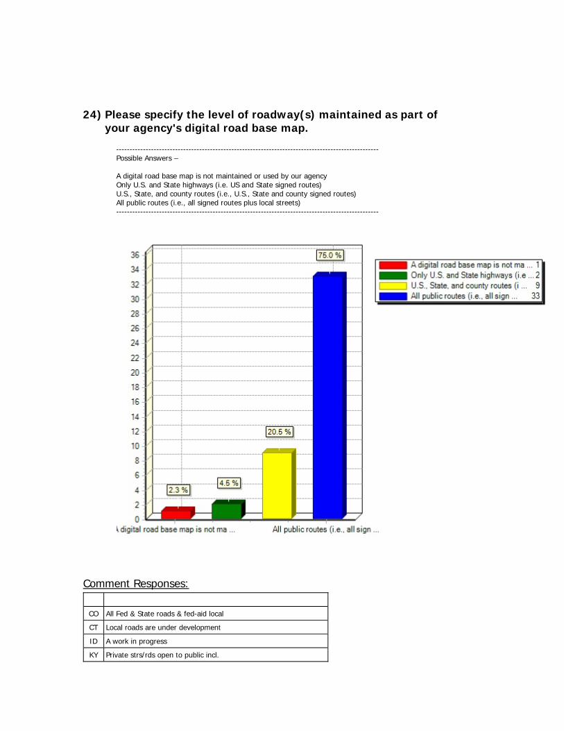
24) Please specify the level of roadway(s) maintained as part of your agency's digital road base map.
-------------------------------------------------------------------------------------------------- Possible Answers – A digital road base map is not maintained or used by our agency Only U.S. and State highways (i.e. US and State signed routes) U.S., State, and county routes (i.e., U.S., State and county signed routes) All public routes (i.e., all signed routes plus local streets) --------------------------------------------------------------------------------------------------
Comment Responses:
CO All Fed & State roads & fed-aid local
CT Local roads are under development
ID A work in progress
KY Private strs/rds open to public incl.

LA We also have some private roads
MI IT & DOT partnership
MN More attention to Trunk Highways.
NJ also include private roads and alleys
NY Maintained by NYS Homeland security, not
UT State GIS Office handles local roads
WA We are 85% complete with "All public"
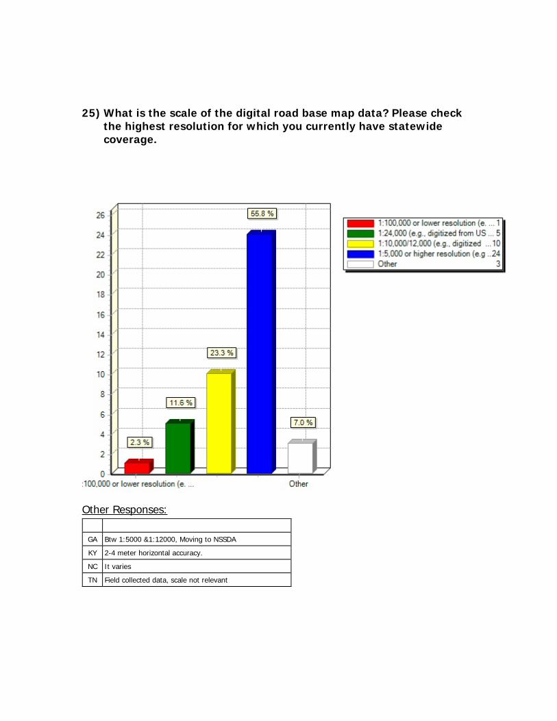
25) What is the scale of the digital road base map data? Please check the highest resolution for which you currently have statewide coverage.
Other Responses:
GA Btw 1:5000 &1:12000, Moving to NSSDA
KY 2-4 meter horizontal accuracy.
NC It varies
TN Field collected data, scale not relevant
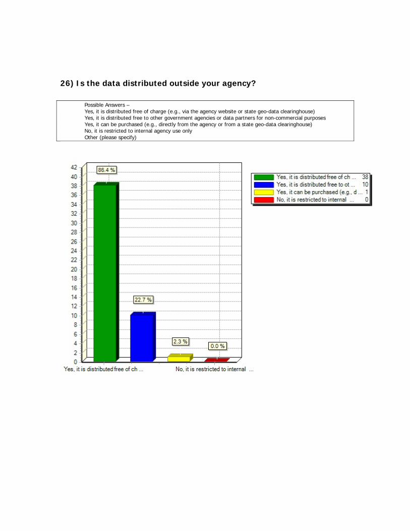
26) Is the data distributed outside your agency?
Possible Answers – Yes, it is distributed free of charge (e.g., via the agency website or state geo-data clearinghouse)
Yes, it is distributed free to other government agencies or data partners for non-commercial purposes Yes, it can be purchased (e.g., directly from the agency or from a state geo-data clearinghouse) No, it is restricted to internal agency use only Other (please specify)
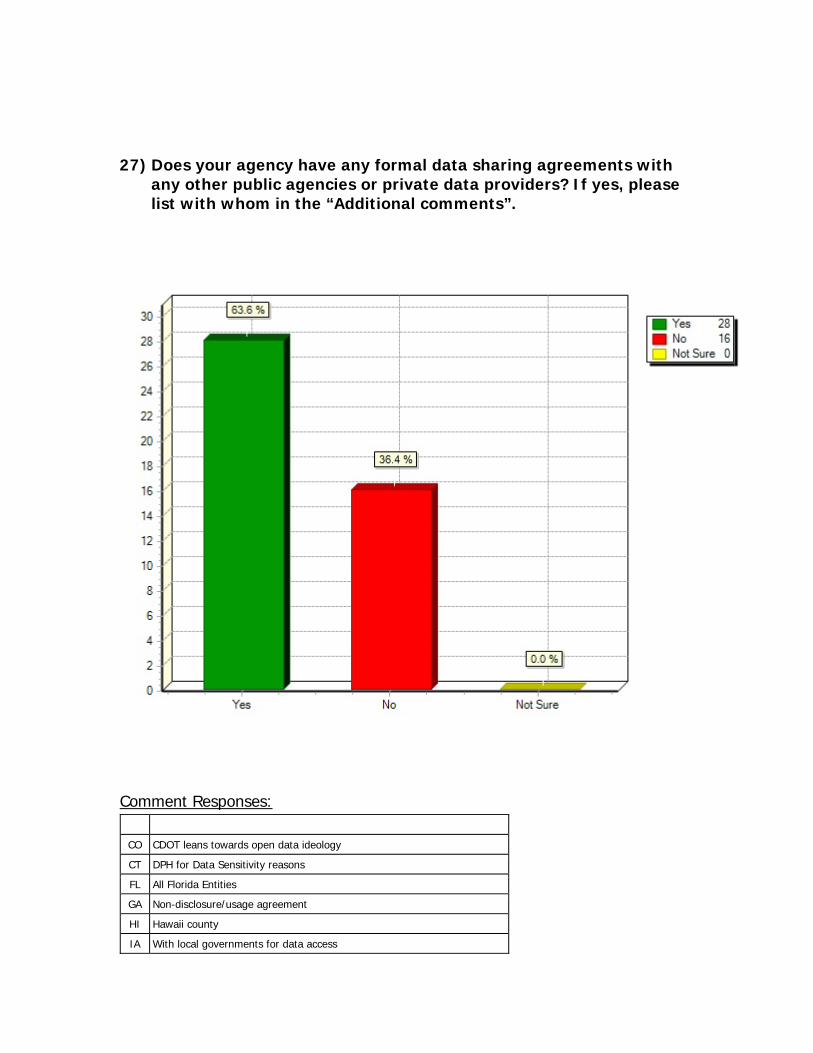
27) Does your agency have any formal data sharing agreements with any other public agencies or private data providers? If yes, please list with whom in the “Additional comments”.
Comment Responses:
CO CDOT leans towards open data ideology
CT DPH for Data Sensitivity reasons
FL All Florida Entities
GA Non-disclosure/usage agreement
HI Hawaii county
IA With local governments for data access
IN Google, Navteq
IS Nokia
MA MassGIS
MD Beginning to revisit and restructure
MI IT has partnerships with local govt.
MN Too many to list here.
MS Other State and Local Agencies
NV Counties
NY NYS GIS Data Sharing Cooperative
OR Cities and Counties
SC GIC Group
TN TDOT provides state base map imagery
TX TNRIS
UT Department of Natural Resources
VA State GIS coordinating agency
WY Wind River Indian Reservation
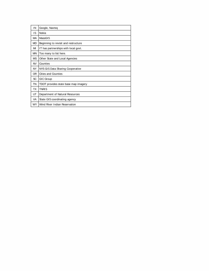
28) Please specify, if any, those geo-spatial databases that are maintained by your agency and routinely shared with other state agencies or disseminated to the public? Please specify all that are applicable.
Other Responses:
CO Highways, major roads, local roads
LA Statewide Topographic Mappiing GDB
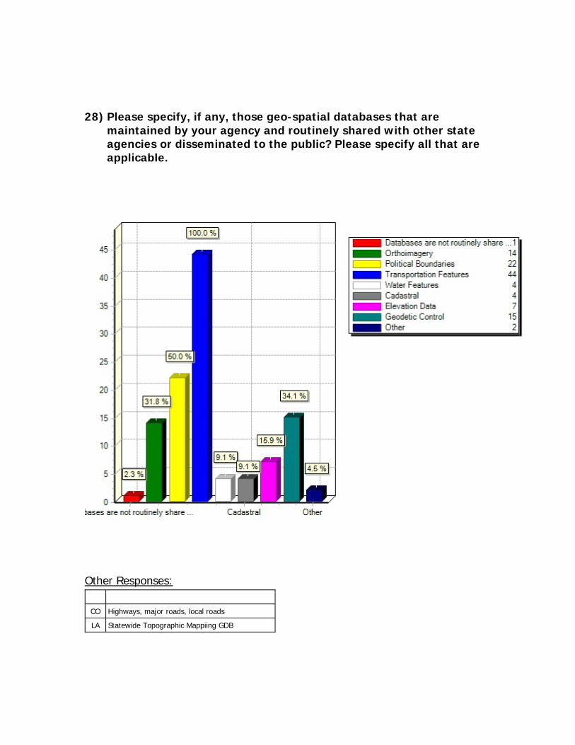
29) What other sources do you routinely use to obtain geo-spatial data that you don't maintain yourself? Please check no more than two.
Other Responses:
LA GIS web services from al the above
Possible Answers to Above - Other state or local government agencies Statewide geo-spatial data clearinghouse Federal agency Web Sites NSDI Geo-Spatial One Stop Web Portal Data provided by commercial GIS software vendors Data purchase from commercial sources Other (please specify)
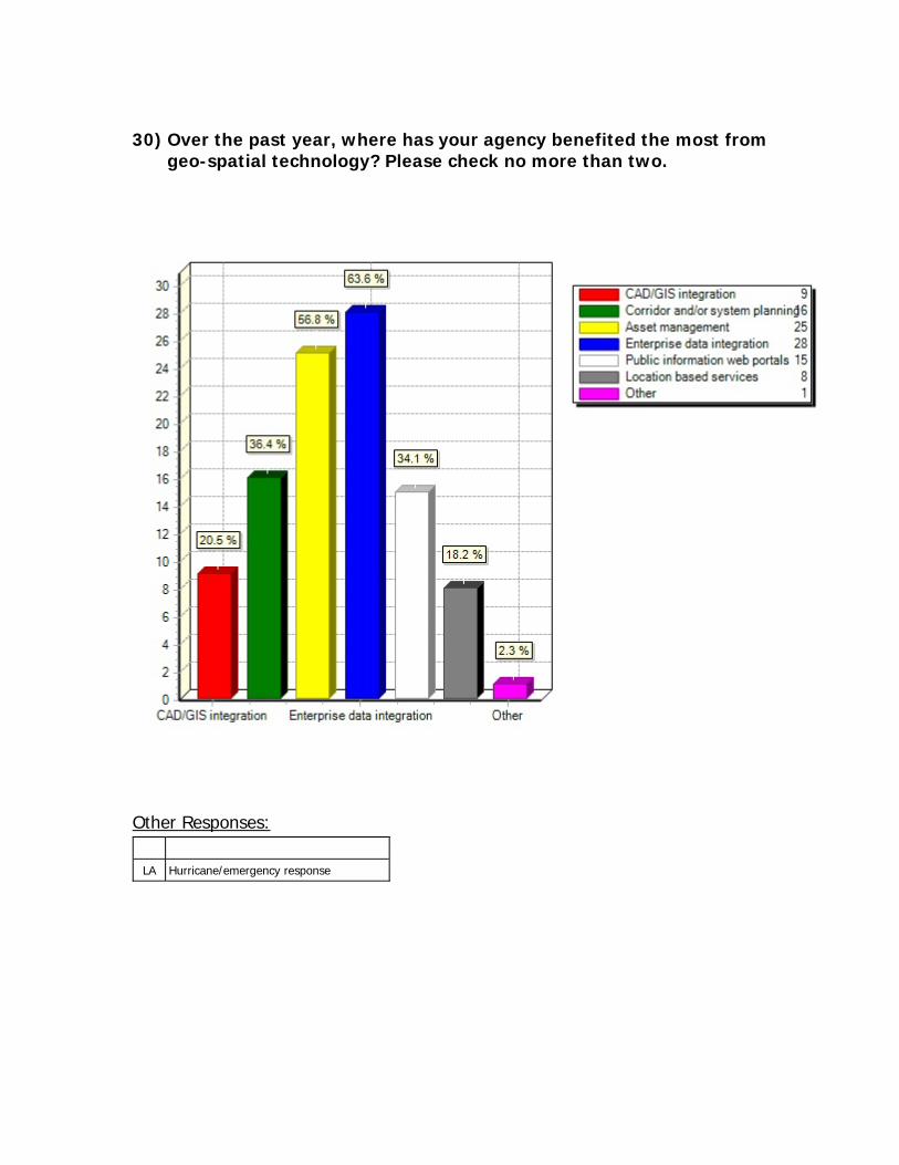
30) Over the past year, where has your agency benefited the most from
geo-spatial technology? Please check no more than two.
Other Responses:
LA Hurricane/emergency response
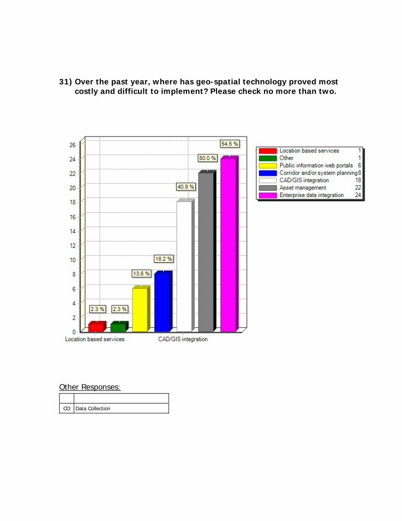
31) Over the past year, where has geo-spatial technology proved most costly and difficult to implement? Please check no more than two.
Other Responses:
CO Data Collection
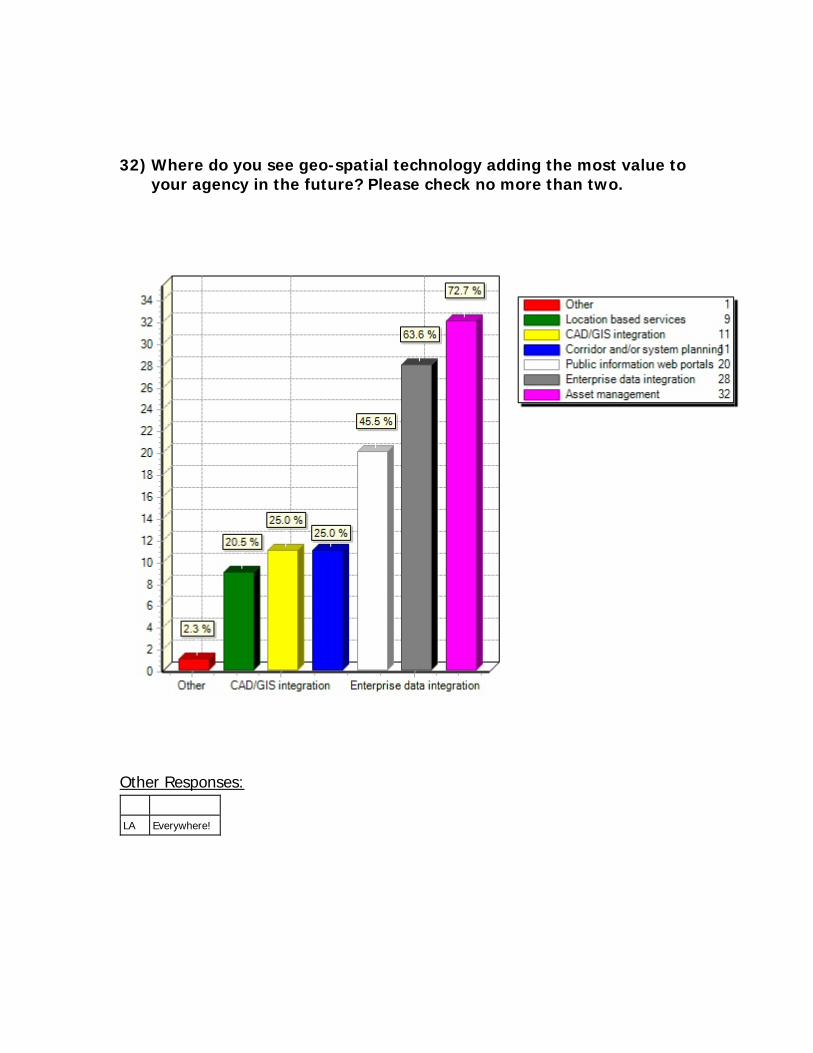
32) Where do you see geo-spatial technology adding the most value to your agency in the future? Please check no more than two.
Other Responses:
LA Everywhere!
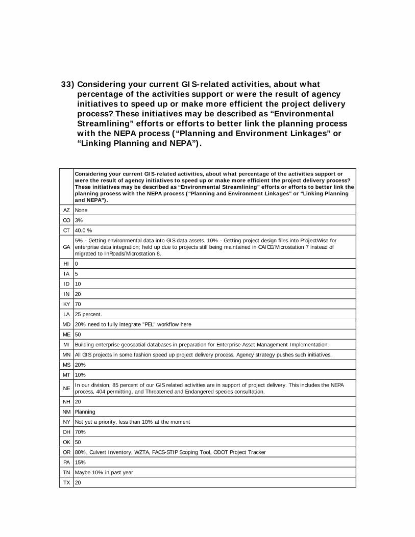
33) Considering your current GIS-related activities, about what percentage of the activities support or were the result of agency initiatives to speed up or make more efficient the project delivery process? These initiatives may be described as “Environmental Streamlining” efforts or efforts to better link the planning process with the NEPA process (“Planning and Environment Linkages” or “Linking Planning and NEPA”).
Considering your current GIS-related activities, about what percentage of the activities support or were the result of agency initiatives to speed up or make more efficient the project delivery process? These initiatives may be described as “Environmental Streamlining” efforts or efforts to better link the planning process with the NEPA process (“Planning and Environment Linkages” or “Linking Planning and NEPA”).
AZ None
CO 3%
CT 40.0 %
GA 5% - Getting environmental data into GIS data assets. 10% - Getting project design files into ProjectWise for enterprise data integration; held up due to projects still being maintained in CAICE/Microstation 7 instead of migrated to InRoads/Microstation 8.
HI 0
IA 5
ID 10
IN 20
KY 70
LA 25 percent.
MD 20% need to fully integrate "PEL" workflow here
ME 50
MI Building enterprise geospatial databases in preparation for Enterprise Asset Management Implementation.
MN All GIS projects in some fashion speed up project delivery process. Agency strategy pushes such initiatives.
MS 20%
MT 10%
NE In our division, 85 percent of our GIS related activities are in support of project delivery. This includes the NEPA process, 404 permitting, and Threatened and Endangered species consultation.
NH 20
NM Planning
NY Not yet a priority, less than 10% at the moment
OH 70%
OK 50
OR 80%, Culvert Inventory, WZTA, FACS-STIP Scoping Tool, ODOT Project Tracker
PA 15%
TN Maybe 10% in past year
TX 20
UT 25%
VA 25%
VT
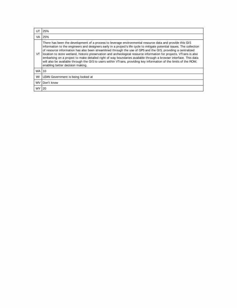
There has been the development of a process to leverage environmental resource data and provide this GIS information to the engineers and designers early in a project’s life cycle to mitigate potential issues. The collection of resource information has also been streamlined through the use of GPS and the GIS, providing a centralized location to store wetland, historic preservation and archeological resource information for projects. VTrans is also embarking on a project to make detailed right of way boundaries available through a browser interface. This data will also be available through the GIS to users within VTrans, providing key information of the limits of the ROW, enabling better decision making.
WA 10
WI LEAN Government is being looked at
WV Don't know
WY 20
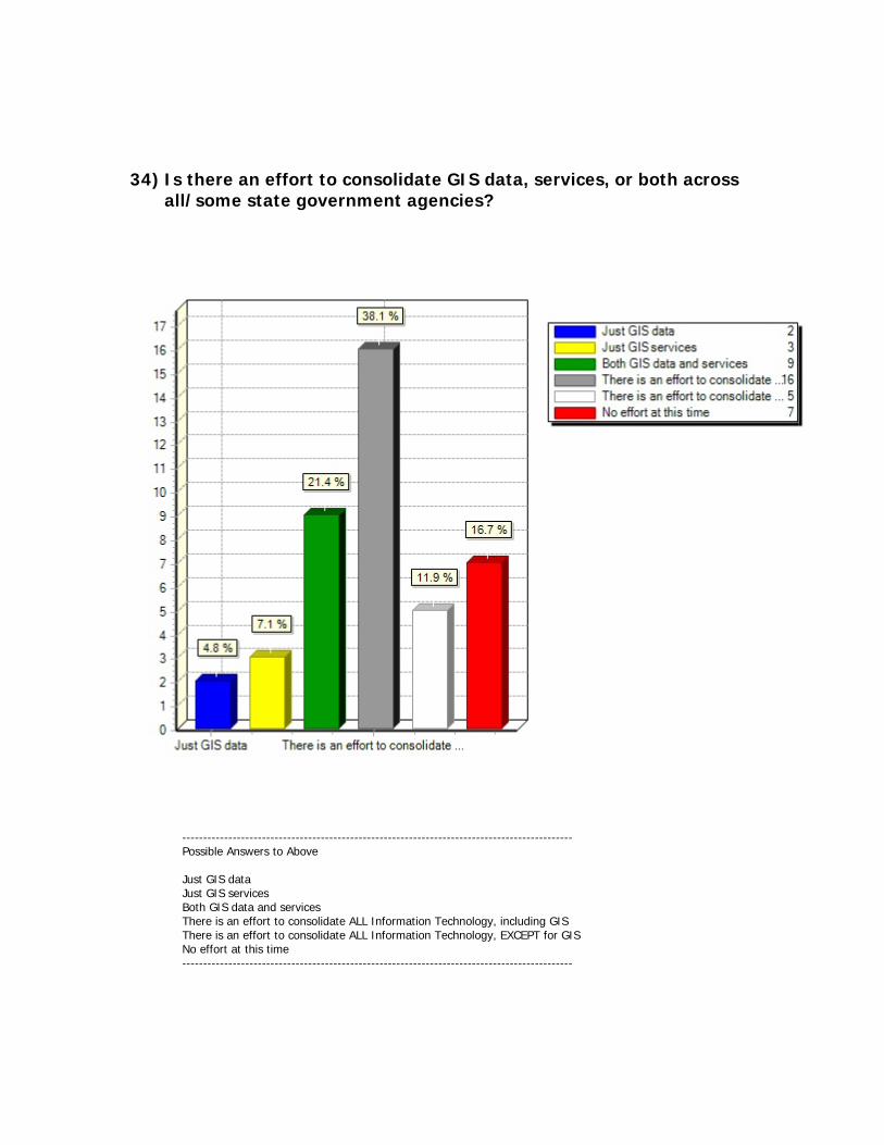
34) Is there an effort to consolidate GIS data, services, or both across all/some state government agencies?
--------------------------------------------------------------------------------------------- Possible Answers to Above Just GIS data Just GIS services Both GIS data and services There is an effort to consolidate ALL Information Technology, including GIS There is an effort to consolidate ALL Information Technology, EXCEPT for GIS No effort at this time ---------------------------------------------------------------------------------------------
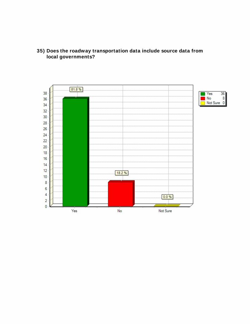
35) Does the roadway transportation data include source data from local governments?
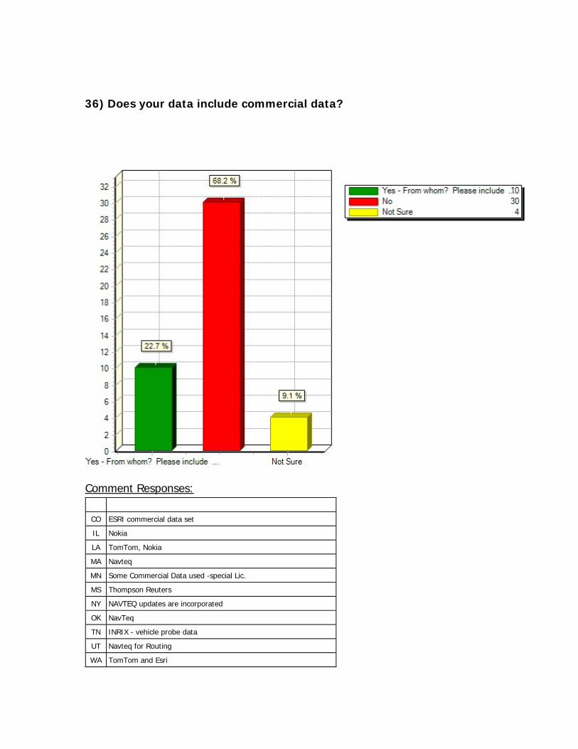
36) Does your data include commercial data?
Comment Responses:
CO ESRI commercial data set
IL Nokia
LA TomTom, Nokia
MA Navteq
MN Some Commercial Data used -special Lic.
MS Thompson Reuters
NY NAVTEQ updates are incorporated
OK NavTeq
TN INRIX - vehicle probe data
UT Navteq for Routing
WA TomTom and Esri
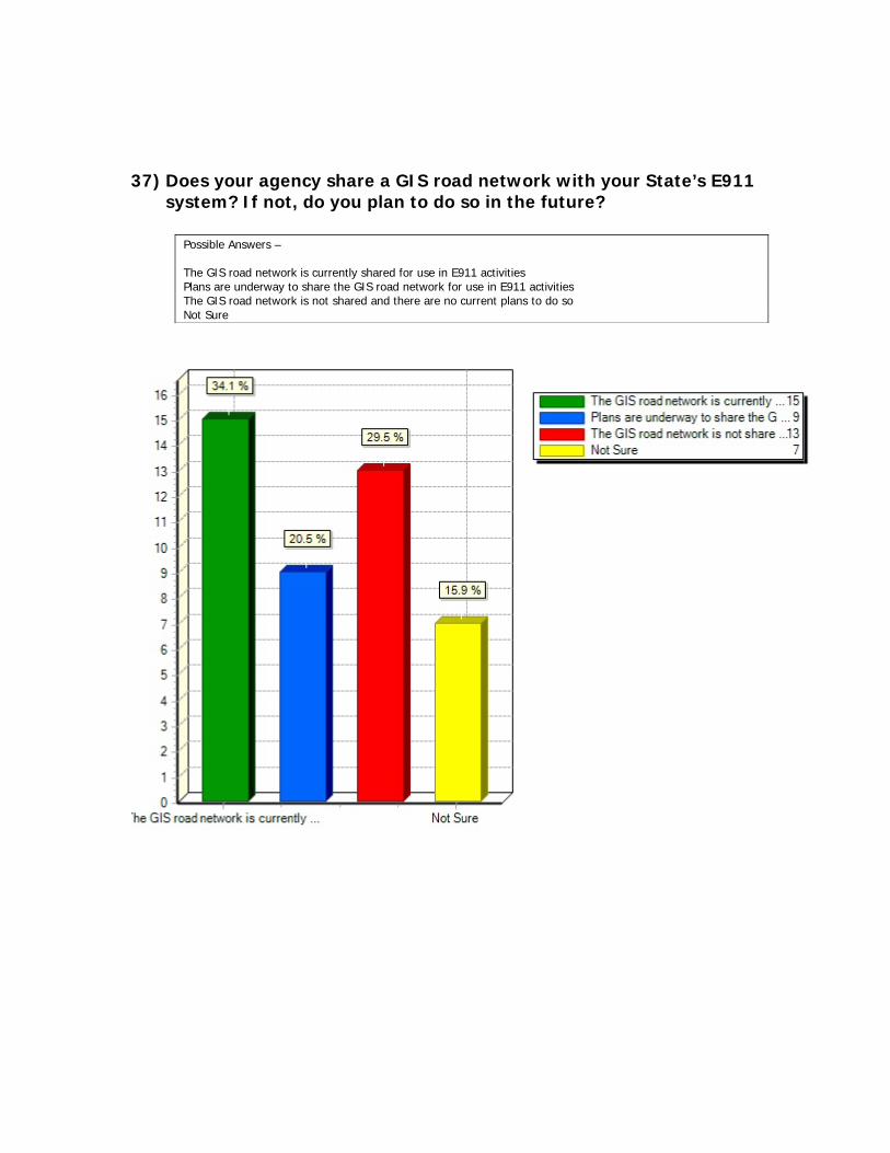
37) Does your agency share a GIS road network with your State’s E911 system? If not, do you plan to do so in the future?
Possible Answers – The GIS road network is currently shared for use in E911 activities Plans are underway to share the GIS road network for use in E911 activities The GIS road network is not shared and there are no current plans to do so Not Sure
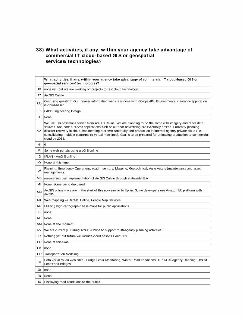
38) What activities, if any, within your agency take advantage of commercial IT cloud-based GIS or geospatial services/technologies?
What activities, if any, within your agency take advantage of commercial IT cloud-based GIS or geospatial services/technologies?
AK none yet, but we are working on projects to test cloud technology.
AZ ArcGIS Online
CO Confusing question: Our traveler information website is done with Google API. Environmental clearance application is cloud-based.
CT CADD Engineering Design
FL None.
GA
We use Esri basemaps served from ArcGIS Online. We are planning to do the same with imagery and other data sources. Non-core business applications such as outdoor advertising are externally hosted. Currently planning disaster recovery in cloud, implmenting business continuity and production in internal agency private cloud (i.e. consolidating multiple platforms to virtual machines). Goal is to be prepared for offloading production to commercial cloud by 2018.
HI 0
IA Some web portals using arcGIS online
ID IPLAN - ArcGIS online
KY None at this time.
LA Planning, Emergency Operations, road Inventory, Mapping, Geotechnical, Agile Assets (maintenance and asset management).
MD researching best implementation of ArcGIS Online through statewide ELA
MI None. Some being discussed.
MN ArcGIS online – we are in the start of this now similar to Uplan. Some developers use Amazon EC platform with ArcGIS.
MT Web mapping w/ ArcGIS Online, Google Map Services
ND Utilizing high cartographic base maps for public applications.
NE none
NH None
NM None at the moment
NV We are currently utilizing ArcGIS Online to support multi-agency planning activities.
NY Nothing yet but future will include cloud based IT and GIS.
OH None at this time
OK none
OR Transportation Modeling
PA Data visualization web sites - Bridge Scour Monitoring, Winter Road Conditions, TIP, Multi-Agency Planning, Posted Roads and Bridges
SD none
TN None
TX Displaying road conditions to the public.

UT Arc GIS Online for adhoc or sensitive data creation.
VA Data sharing, data collaboration, data editing, some application hosting
VT ArcGIS Online
WA We are just getting started with this with ArcGIS Online withing WSDOT and at a statewide level.
WI Some apps use GE we have apps that use arcgis server web mapping services
WV We are using Esri's ArcGIS Online for Organizations to upgrade our GIS portal.
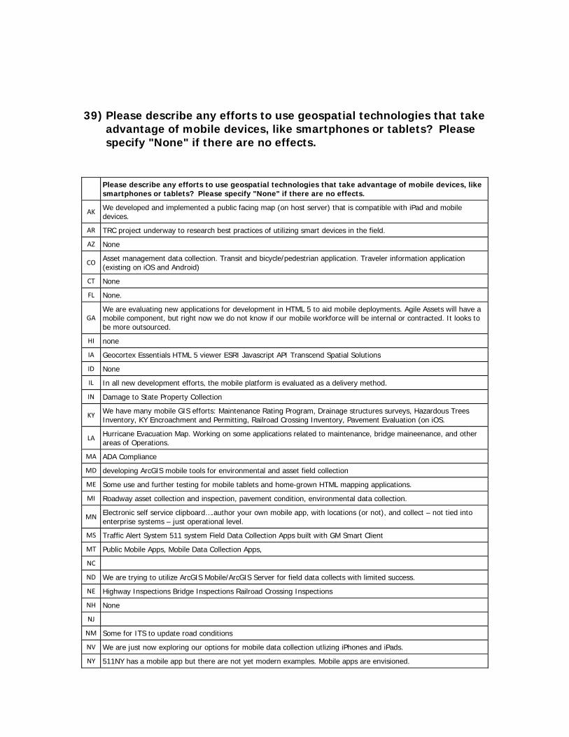
39) Please describe any efforts to use geospatial technologies that take advantage of mobile devices, like smartphones or tablets? Please specify "None" if there are no effects.
Please describe any efforts to use geospatial technologies that take advantage of mobile devices, like smartphones or tablets? Please specify "None" if there are no effects.
AK We developed and implemented a public facing map (on host server) that is compatible with iPad and mobile devices.
AR TRC project underway to research best practices of utilizing smart devices in the field.
AZ None
CO Asset management data collection. Transit and bicycle/pedestrian application. Traveler information application (existing on iOS and Android)
CT None
FL None.
GA We are evaluating new applications for development in HTML 5 to aid mobile deployments. Agile Assets will have a mobile component, but right now we do not know if our mobile workforce will be internal or contracted. It looks to be more outsourced.
HI none
IA Geocortex Essentials HTML 5 viewer ESRI Javascript API Transcend Spatial Solutions
ID None
IL In all new development efforts, the mobile platform is evaluated as a delivery method.
IN Damage to State Property Collection
KY We have many mobile GIS efforts: Maintenance Rating Program, Drainage structures surveys, Hazardous Trees Inventory, KY Encroachment and Permitting, Railroad Crossing Inventory, Pavement Evaluation (on iOS.
LA Hurricane Evacuation Map. Working on some applications related to maintenance, bridge maineenance, and other areas of Operations.
MA ADA Compliance
MD developing ArcGIS mobile tools for environmental and asset field collection
ME Some use and further testing for mobile tablets and home-grown HTML mapping applications.
MI Roadway asset collection and inspection, pavement condition, environmental data collection.
MN Electronic self service clipboard….author your own mobile app, with locations (or not), and collect – not tied into enterprise systems – just operational level.
MS Traffic Alert System 511 system Field Data Collection Apps built with GM Smart Client
MT Public Mobile Apps, Mobile Data Collection Apps,
NC
ND We are trying to utilize ArcGIS Mobile/ArcGIS Server for field data collects with limited success.
NE Highway Inspections Bridge Inspections Railroad Crossing Inspections
NH None
NJ
NM Some for ITS to update road conditions
NV We are just now exploring our options for mobile data collection utlizing iPhones and iPads.
NY 511NY has a mobile app but there are not yet modern examples. Mobile apps are envisioned.
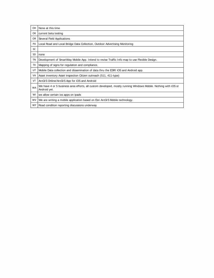
OH None at this time
OK current beta testing
OR Several Field Applications
PA Local Road and Local Bridge Data Collection, Outdoor Advertising Monitoring
SC
SD none
TN Development of SmartWay Mobile App. Intend to revise Traffic Info map to use Flexible Design.
TX Mapping of signs for regulation and compliance.
UT Mobile Data collection and dissemination of data thru the ESRI iOS and Android app.
VA Asset inventory Asset inspection Citizen outreach (511, 411-type)
VT ArcGIS Online/ArcGIS App for iOS and Android
WA We have 4 or 5 business area efforts, all custom developed, mostly running Windows Mobile. Nothing with iOS or Android yet.
WI we allow certain ios apps on ipads
WV We are writing a mobile application based on Esri ArcGIS Mobile technology.
WY Road condition reporting discussions underway
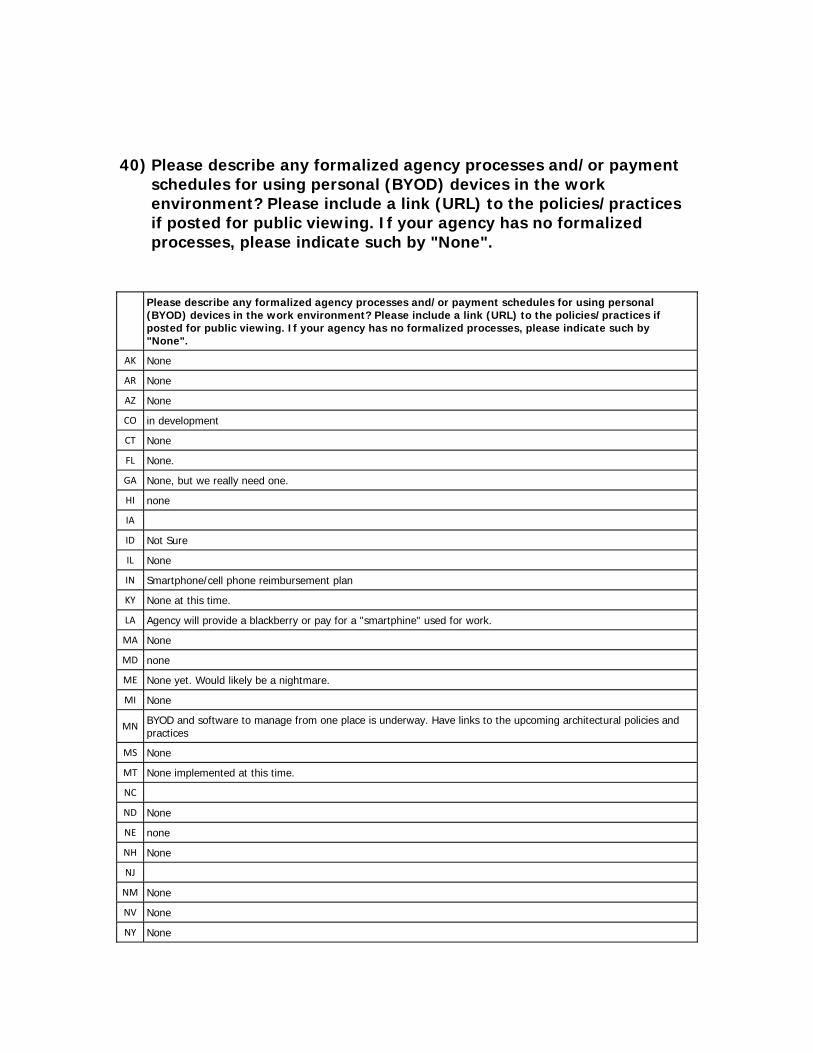
40) Please describe any formalized agency processes and/or payment schedules for using personal (BYOD) devices in the work environment? Please include a link (URL) to the policies/practices if posted for public viewing. If your agency has no formalized processes, please indicate such by "None".
Please describe any formalized agency processes and/or payment schedules for using personal (BYOD) devices in the work environment? Please include a link (URL) to the policies/practices if posted for public viewing. If your agency has no formalized processes, please indicate such by "None".
AK None
AR None
AZ None
CO in development
CT None
FL None.
GA None, but we really need one.
HI none
IA
ID Not Sure
IL None
IN Smartphone/cell phone reimbursement plan
KY None at this time.
LA Agency will provide a blackberry or pay for a "smartphine" used for work.
MA None
MD none
ME None yet. Would likely be a nightmare.
MI None
MN BYOD and software to manage from one place is underway. Have links to the upcoming architectural policies and practices
MS None
MT None implemented at this time.
NC
ND None
NE none
NH None
NJ
NM None
NV None
NY None
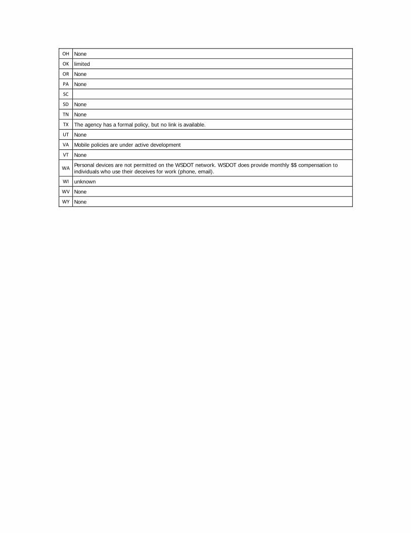
OH None
OK limited
OR None
PA None
SC
SD None
TN None
TX The agency has a formal policy, but no link is available.
UT None
VA Mobile policies are under active development
VT None
WA Personal devices are not permitted on the WSDOT network. WSDOT does provide monthly $$ compensation to individuals who use their deceives for work (phone, email).
WI unknown
WV None
WY None
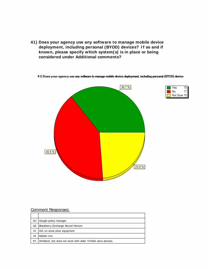
41) Does your agency use any software to manage mobile device deployment, including personal (BYOD) devices? If so and if known, please specify which system(s) is in place or being considered under Additional comments?
Comment Responses:
CO Google policy manager
GA Blackberry Exchange Server/Verizon
ID AVL on snow plow equipment
IN Mobile Iron
KY AirWatch, but does not work with older Trimble Juno devices.
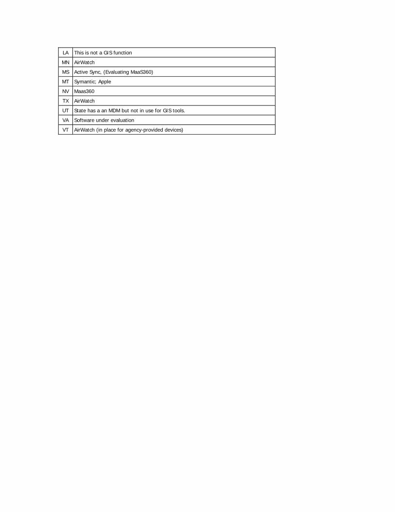
LA This is not a GIS function
MN AirWatch
MS Active Sync, (Evaluating MaaS360)
MT Symantic; Apple
NV Maas360
TX AirWatch
UT State has a an MDM but not in use for GIS tools.
VA Software under evaluation
VT AirWatch (in place for agency-provided devices)
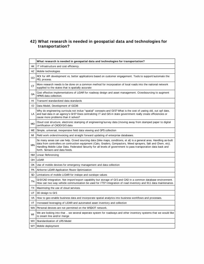
42) What research is needed in geospatial data and technologies for transportation?
What research is needed in geospatial data and technologies for transportation?
AK IT infrastructure and cost efficiency.
AZ Mobile technologies
CO ROI for API development vs. better applications based on customer engagement. Tools to support/automate the PEL process.
CT More research needs to be done on a common method for incorpoation of local roads into the national network supplied to the states that is spatially accurate
GA Cost effective implementations of LiDAR for roadway design and asset management. Crowdsourcing to augment HPMS data collection.
HI Transxml standardized data standards
ID Data Model, Development of GCDB
LA Why do engineering curricula not inclue "spatial" concepts and GIS? What is the cost of useing old, out opf date, and bad data in an agency's GIS? Does centralizing IT and GiS in state government really create efficiencies or cause more problems than it solves?
MD Cloud cost structure, electronic stamping of engineering/survey data (moving away from stamped paper to digital certification of CADD/GIS data
ME Simple, universal, inexpensive field data viewing and GPS collection
MI Field work orders/invoicing and straight forward updating of enterprise databases.
MN
So many areas can use help. Crowd sourcing data (bike maps, conditions, et al) is a general area. Handling as-built data from controllers on contruction equipment (Cats, Graders, Compactors, Weed sprayers, Salt and Chem, etc). Handling Mobile Lidar Data. Federated Security for all levels of government to pass transporation data back and forth. Sensors and data feeds.
NM Linear Referencing
OH LiDAR
OK Use of mobile devices for emergency management and data collection
PA Airborne LiDAR Application Route Optimization
SD Limitations of mobile LIDAR for inslope and outslope values
TN GIS/CAD integration. Not import/export capability but storage of GIS and CAD in a common database environment. How can two way vehicle communication be used for ITS? Integration of road inventory and 911 data maintenance.
TX Maximizing the use of cloud services.
UT 3D design to GIS
VA How to geo-enable business data and incorporate spatial analytics into business workflows and processes.
VT Increased leveraging of LiDAR and automated asset inventory and collection
WA Personal devices are not permitted on the WSDOT network.
WI We are looking into that .. we several seperate system for roadways and other inventory systems that we would like to sream line and/or merge
WV Standardization of LRS Model
WY Mobile deployment
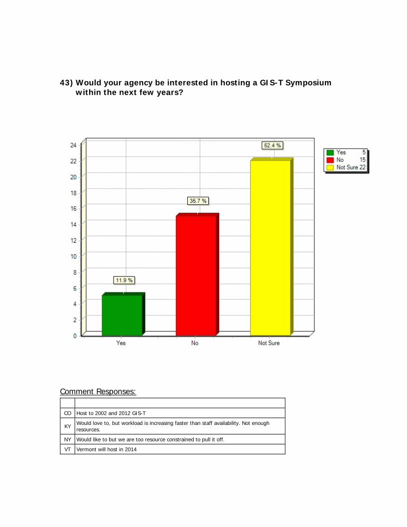
43) Would your agency be interested in hosting a GIS-T Symposium within the next few years?
Comment Responses:
CO Host to 2002 and 2012 GIS-T
KY Would love to, but workload is increasing faster than staff availability. Not enough resources.
NY Would like to but we are too resource constrained to pull it off.
VT Vermont will host in 2014
44) Please identify 3 GIS for transportation-related technology focus topics, industry challenges, evolving technologies, integration topics, etc. in which you would be interested in hearing about in one of the future Roll Call Roundtable discussions at the Symposium.
Roundtable Topic 1 Roundtable Topic 2 Roundtable Topic 3
AZ Is ESRI Roads and Highways really capable?
What amount of IT related work constitutes an IT job?
CO All Public Roads Requirement - MAP 21 It is time to push back on FHWA
GIS Tools to Support Traffic Safety. Based on new MAP-21 requirements for both safety data and traffic safety assessments.
Asset Management
CT Road Networking Cloud based Servicies for Enterprise data sharing Assest Management
GA How to build MAP-21 requirements into GIS (i.e. bridge maintenance cost on NHS routes).
Integrating ITS/511 with GIS (i.e. Real-time traffic data, fleet tracking, incidents, weather).
How states have implemented addressing and routing within their transportation GIS datasets.
HI 3d/lidar data transxml cad/gis integration
IA Geospaital Maturity Models CADD/GIS integration strategies Use of enterprise spatial datbases
ID Mapping Highway Right-of-Way Mobile data access and editing - remote locations void of cellular service and GPS satellite coverage.
All roads
IN GIS in Business Intelligence/KPI BIM Workflow management/Quality control
LA Building and managing a "complete" road database (both directions, couplets, ferries, and rams).
Mile points or Mile Posts - how do you locate liner vents in the reverse direction?
How do you staff an enterprise GIs in a state DOT?
MD Map-21 Implications for GIS Cloud technologies Climate Change/Severe weather modeling with GIS
ME Simple, universal, inexpensive field data viewing and GPS collection
LRS experiences - From states (not vendors)
Inexpensive aerial photography (Ohio?)
MI ESRI Roads and Highways Mobile/Smart Phone solutions/apps to support Transportation workflows. CAD/GIS Integration
MN
BIM – Build – Information – management – one continuous process to gather good information from either the build or maintenance of assets, and then put it to use further upstream.
Single Page Application Pattern (front end work and API's) - the push to HTML5, CSS3, and related technologies. This is going to push a lot of application dev in next years.
Photogrammetrics - digital imagery data ingest, and meta data that supports it. Can an industry standard meta data be defined so ingest can be automated, or are imagery vendors flexible enough to meet each DOT's meta data needs. (Project, Flight Line, sequential image number, Camera, x-y-z-role-pitch-yaw, conditions, etc). This could help with retro cataloging as well.
MS GSM Localization being mislabeled by industry as GPS functionality in
Road Data collection, verification, and integration into enterprise LRS (best
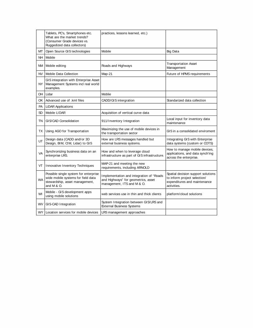
Tablets, PC's, Smartphones etc. What are the market trends? (Consumer Grade devices vs. Ruggedized data collectors)
practices, lessons learned, etc.)
MT Open Source GIS technologies Mobile Big Data
NH Mobile
NM Mobile editing Roads and Highways Transportation Asset Management
NV Mobile Data Collection Map-21 Future of HPMS requirements
NY GIS integration with Enterprise Asset Management Systems incl real world examples.
OH Lidar Moblie
OK Advanced use of .kml files CADD/GIS intergration Standarized data collection
PA LiDAR Applications
SD Mobile LIDAR Acquisition of vertical curve data
TN GIS/CAD Consolidation 911/Inventory Integration Local input for inventory data maintenance
TX Using AGO for Transportation Maximizing the use of mobile devices in the transportation sector GIS in a consolidated enviroment
UT Design data (CADD and/or 3D Design, BIM, CIM, Lidar) to GIS
How are LRS messages handled but external business systems.
Integrating GIS with Enterprise data systems (custom or COTS)
VA Synchronizing business data on an enterprise LRS.
How and when to leverage cloud infrastructure as part of GIS infrastructure.
How to manage mobile devices, applications, and data synch'ing across the enterprise.
VT Innovative Inventory Techniques MAP-21 and meeting the new requirements, including ARNOLD
WA
Possible single system for enterprise wide mobile systems for field data stewardship, asset management, and M & O.
Implementation and integration of “Roads and Highways” for geometrics, asset management, ITS and M & O.
Spatial decision support solutions to inform project selection/ expenditures and maintenance activities.
WI Mobile - GIS development apps using mobile solutions web services use in thin and thick clients platform/cloud solutions
WV GIS-CAD Integration System Integration between GIS/LRS and External Business Systems
WY Location services for mobile devices LRS management approaches
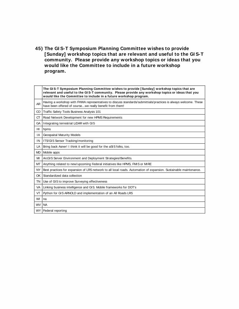
45) The GIS-T Symposium Planning Committee wishes to provide [Sunday] workshop topics that are relevant and useful to the GIS-T community. Please provide any workshop topics or ideas that you would like the Committee to include in a future workshop program.
The GIS-T Symposium Planning Committee wishes to provide [Sunday] workshop topics that are relevant and useful to the GIS-T community. Please provide any workshop topics or ideas that you would like the Committee to include in a future workshop program.
AR Having a workshop with FHWA representatives to discuss standards/submittials/practices is always welcome. These have been offered of course...we really benefit from them!
CO Traffic Safety Tools Business Analysis 101
CT Road Network Development for new HPMS Requirements
GA Integrating terrestrial LiDAR with GIS
HI hpms
IA Geospaital Maturity Models
IN ITS/GIS Sensor Tracking/monitoring
LA Bring back Asner! I think it will be good for the aSIS folks, too.
MD Mobile apps
MI ArcGIS Server Environment and Deployment Strategies/Benefits.
MT Anything related to new/upcoming Federal initiatives like HPMS, FMIS or MIRE
NY Best practices for expansion of LRS network to all local roads. Automation of expansion. Sustainable maintenance.
OK Standardized data collection
TN Use of GIS to improve Surveying effectiveness
VA Linking business intelligence and GIS. Mobile frameworks for DOT's
VT Python for GIS ARNOLD and implementation of an All Roads LRS
WI na
WV NA
WY Federal reporting
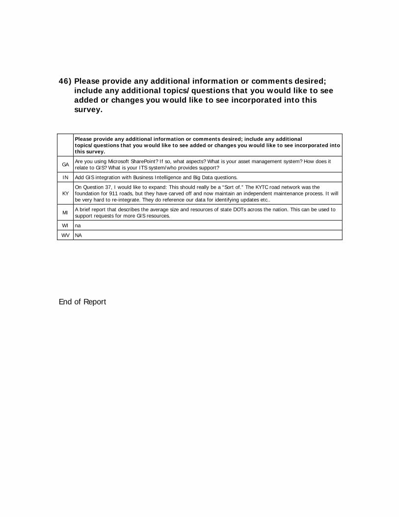
46) Please provide any additional information or comments desired; include any additional topics/questions that you would like to see added or changes you would like to see incorporated into this survey.
Please provide any additional information or comments desired; include any additional topics/questions that you would like to see added or changes you would like to see incorporated into this survey.
GA Are you using Microsoft SharePoint? If so, what aspects? What is your asset management system? How does it relate to GIS? What is your ITS system/who provides support?
IN Add GIS integration with Business Intelligence and Big Data questions.
KY On Question 37, I would like to expand: This should really be a “Sort of.” The KYTC road network was the foundation for 911 roads, but they have carved off and now maintain an independent maintenance process. It will be very hard to re-integrate. They do reference our data for identifying updates etc..
MI A brief report that describes the average size and resources of state DOTs across the nation. This can be used to support requests for more GIS resources.
WI na
WV NA
End of Report