Embed Size (px)
Citation preview
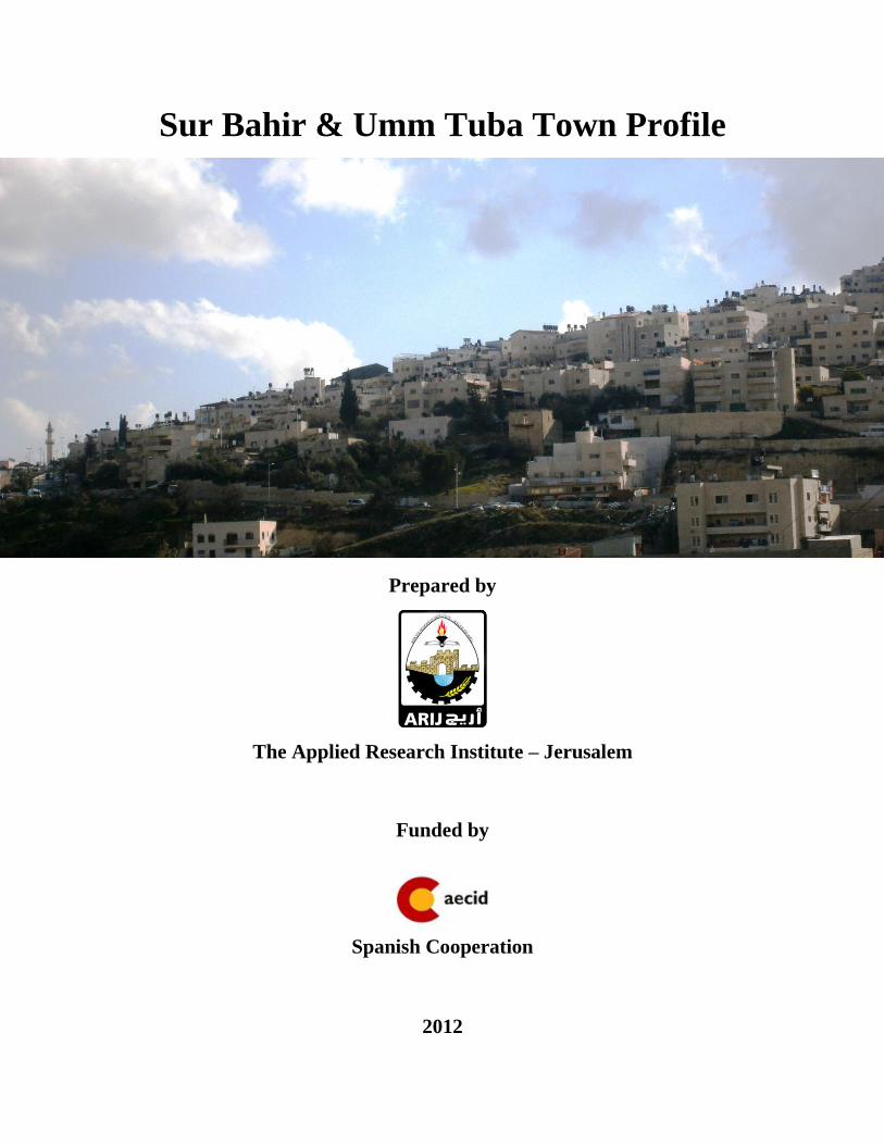
Sur Bahir & Umm Tuba Town Profile
Prepared by
The Applied Research Institute – Jerusalem
Funded by
Spanish Cooperation
2012
Palestinian Localities Study Jerusalem Governorate
1
Acknowledgments
ARIJ hereby expresses its deep gratitude to the Spanish agency for International Cooperation for
Development (AECID) for their funding of this project.
ARIJ is grateful to the Palestinian officials in the ministries, municipalities, joint services councils,
village committees and councils, and the Palestinian Central Bureau of Statistics (PCBS) for their
assistance and cooperation with the project team members during the data collection process.
ARIJ also thanks all the staff who worked throughout the past couple of years towards the
accomplishment of this work.
Palestinian Localities Study Jerusalem Governorate
2
Background
This report is part of a series of booklets, which contain compiled information about each city, village,
and town in the Jerusalem Governorate. These booklets came as a result of a comprehensive study of all
villages in Jerusalem Governorate, which aims at depicting the overall living conditions in the
governorate and presenting developmental plans to assist in developing the livelihood of the population
in the area. It was accomplished through the "Village Profiles and Needs Assessment;" the project
funded by the Spanish Agency for International Cooperation for Development (AECID).
The "Village Profiles and Needs Assessment" was designed to study, investigate, analyze and document
the socio-economic conditions and the needed programs and activities to mitigate the impact of the
current unsecure political, economic and social conditions in the Jerusalem Governorate.
The project's objectives are to survey, analyze, and document the available natural, human,
socioeconomic and environmental resources, and the existing limitations and needs assessment for the
development of the rural and marginalized areas in the Jerusalem Governorate. In addition, the project
aims at preparing strategic developmental programs and activities to mitigate the impact of the current
political, social, and economic instability with the focus on the agricultural sector.
All village profiles in Arabic and English are available online at http://vprofile.arij.org.

Palestinian Localities Study Jerusalem Governorate
3
Table of Contents
Location and Physical Characteristics ............................................................................. 4
History ................................................................................................................................. 5
Religious and Archaeological Sites ................................................................................... 5
Population ........................................................................................................................... 6
Education ............................................................................................................................ 7
Health Status ....................................................................................................................... 8
Economic Activities ............................................................................................................ 8
Agricultural Sector ............................................................................................................. 9
Institutions and Services .................................................................................................. 11
Infrastructure and Natural Resources ........................................................................... 12
Geopolitical Status of Sur Bahir & Umm Tuba Town ................................................. 13
Development Plans and Projects .................................................................................... 23
Town Development Priorities and Needs ....................................................................... 24
References ......................................................................................................................... 25
Palestinian Localities Study Jerusalem Governorate
4
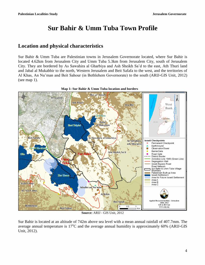
Sur Bahir & Umm Tuba Town Profile
Location and physical characteristics
Sur Bahir & Umm Tuba are Palestinian towns in Jerusalem Governorate located, where Sur Bahir is
located 4.62km from Jerusalem City and Umm Tuba 5.3km from Jerusalem City, south of Jerusalem
City. They are bordered by As Sawahira al Gharbiya and Ash Sheikh Sa’d to the east, Ath Thuri land
and Jabal al Mukabbir to the north, Western Jerusalem and Beit Safafa to the west, and the territories of
Al Khas, An Nu’man and Beit Sahour (in Bethlehem Governorate) to the south (ARIJ-GIS Unit, 2012)
(see map 1).
Map 1: Sur Bahir & Umm Tuba location and borders
Source: ARIJ - GIS Unit, 2012
Sur Bahir is located at an altitude of 742m above sea level with a mean annual rainfall of 407.7mm. The
average annual temperature is 17oC and the average annual humidity is approximately 60% (ARIJ-GIS
Unit, 2012).

Palestinian Localities Study Jerusalem Governorate
5
Umm Tuba is located at an altitude of 707m above sea level with a mean annual rainfall of 431.8mm.
The average annual temperature is 17oC and the average annual humidity is approximately 60% (ARIJ-
GIS Unit, 2012).
All services are provided by the Israeli Municipality of Jerusalem (Sur Bahir Mayor, 2012).
History
An ancient story claims that Omar Ben al Khattab held a secret meeting in the area with his army leaders
before he entered Jerusalem, and the town was therefore originally named ‘As Sir al Bahir’ (‘the
impressive secret’), which later became Sur Bahir (Sur Bahir Mayor, 2012).
The town was established over 1000 years ago, and its original residents were from the Arabian
Peninsula and Yemen (Sur Bahir Mayor, 2012).
Religious and archaeological sites
There are 3 mosques in the town, Al Muhajireen, Al Murabiteen and Al ‘Omari mosques. There are no
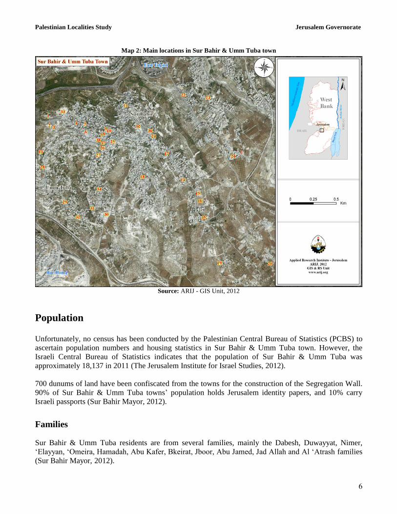
sites of archaeological interest in the town (Sur Bahir Mayor, 2012) (see map 2).
Palestinian Localities Study Jerusalem Governorate
6
Map 2: Main locations in Sur Bahir & Umm Tuba town
Source: ARIJ - GIS Unit, 2012
Population
Unfortunately, no census has been conducted by the Palestinian Central Bureau of Statistics (PCBS) to
ascertain population numbers and housing statistics in Sur Bahir & Umm Tuba town. However, the
Israeli Central Bureau of Statistics indicates that the population of Sur Bahir & Umm Tuba was
approximately 18,137 in 2011 (The Jerusalem Institute for Israel Studies, 2012).
700 dunums of land have been confiscated from the towns for the construction of the Segregation Wall.
90% of Sur Bahir & Umm Tuba towns’ population holds Jerusalem identity papers, and 10% carry
Israeli passports (Sur Bahir Mayor, 2012).
Families
Sur Bahir & Umm Tuba residents are from several families, mainly the Dabesh, Duwayyat, Nimer,
‘Elayyan, ‘Omeira, Hamadah, Abu Kafer, Bkeirat, Jboor, Abu Jamed, Jad Allah and Al ‘Atrash families
(Sur Bahir Mayor, 2012).
Palestinian Localities Study Jerusalem Governorate
7
Education
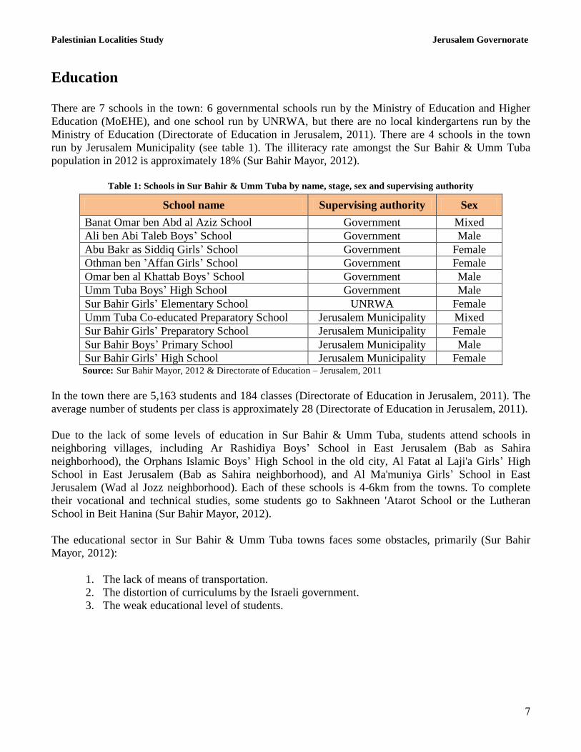
There are 7 schools in the town: 6 governmental schools run by the Ministry of Education and Higher
Education (MoEHE), and one school run by UNRWA, but there are no local kindergartens run by the
Ministry of Education (Directorate of Education in Jerusalem, 2011). There are 4 schools in the town
run by Jerusalem Municipality (see table 1). The illiteracy rate amongst the Sur Bahir & Umm Tuba
population in 2012 is approximately 18% (Sur Bahir Mayor, 2012).
Table 1: Schools in Sur Bahir & Umm Tuba by name, stage, sex and supervising authority
School name Supervising authority Sex
Banat Omar ben Abd al Aziz School Government Mixed
Ali ben Abi Taleb Boys’ School Government Male
Abu Bakr as Siddiq Girls’ School Government Female
Othman ben ’Affan Girls’ School Government Female
Omar ben al Khattab Boys’ School Government Male
Umm Tuba Boys’ High School Government Male
Sur Bahir Girls’ Elementary School UNRWA Female
Umm Tuba Co-educated Preparatory School Jerusalem Municipality Mixed
Sur Bahir Girls’ Preparatory School Jerusalem Municipality Female
Sur Bahir Boys’ Primary School Jerusalem Municipality Male
Sur Bahir Girls’ High School Jerusalem Municipality Female Source: Sur Bahir Mayor, 2012 & Directorate of Education – Jerusalem, 2011
In the town there are 5,163 students and 184 classes (Directorate of Education in Jerusalem, 2011). The
average number of students per class is approximately 28 (Directorate of Education in Jerusalem, 2011).
Due to the lack of some levels of education in Sur Bahir & Umm Tuba, students attend schools in
neighboring villages, including Ar Rashidiya Boys’ School in East Jerusalem (Bab as Sahira
neighborhood), the Orphans Islamic Boys’ High School in the old city, Al Fatat al Laji'a Girls’ High
School in East Jerusalem (Bab as Sahira neighborhood), and Al Ma'muniya Girls’ School in East
Jerusalem (Wad al Jozz neighborhood). Each of these schools is 4-6km from the towns. To complete
their vocational and technical studies, some students go to Sakhneen 'Atarot School or the Lutheran
School in Beit Hanina (Sur Bahir Mayor, 2012).
The educational sector in Sur Bahir & Umm Tuba towns faces some obstacles, primarily (Sur Bahir
Mayor, 2012):
1. The lack of means of transportation.
2. The distortion of curriculums by the Israeli government.
3. The weak educational level of students.
Palestinian Localities Study Jerusalem Governorate
8
Health status
There are some health centers available in Sur Bahir & Umm Tuba towns, 5 of which are run by Israeli
insurance companies such as Maccabi, Clalit and Meuhedet. These include general physicians and
specialized physicians in most fields, a motherhood and childcare center, a medical laboratory, a
radiology center and a physiotherapy center. There are also 5 private dental clinics in the town, 2 plastic
surgery centers and 3 pharmacies. In the absence of required health services or in emergencies, residents
of Sur Bahir & Umm Tuba go to hospitals in East and West Jerusalem, including Hadasa (Al 'Isawiya
and 'Ein Karem), Al Muttala', Ad Dajani, the Red Crescent, Al Maqasid and Al Faransawi hospitals.
These hospitals are between 8 and 22km from the towns (Sur Bahir Mayor, 2012).
The health sector in Sur Bahir & Umm Tuba towns faces some obstacles, primarily (Sur Bahir Mayor,
2012):
1. The lack of an ambulance.
2. The lack of a nearby hospital.
3. The existence of flying/partial checkpoints.
Economic activities
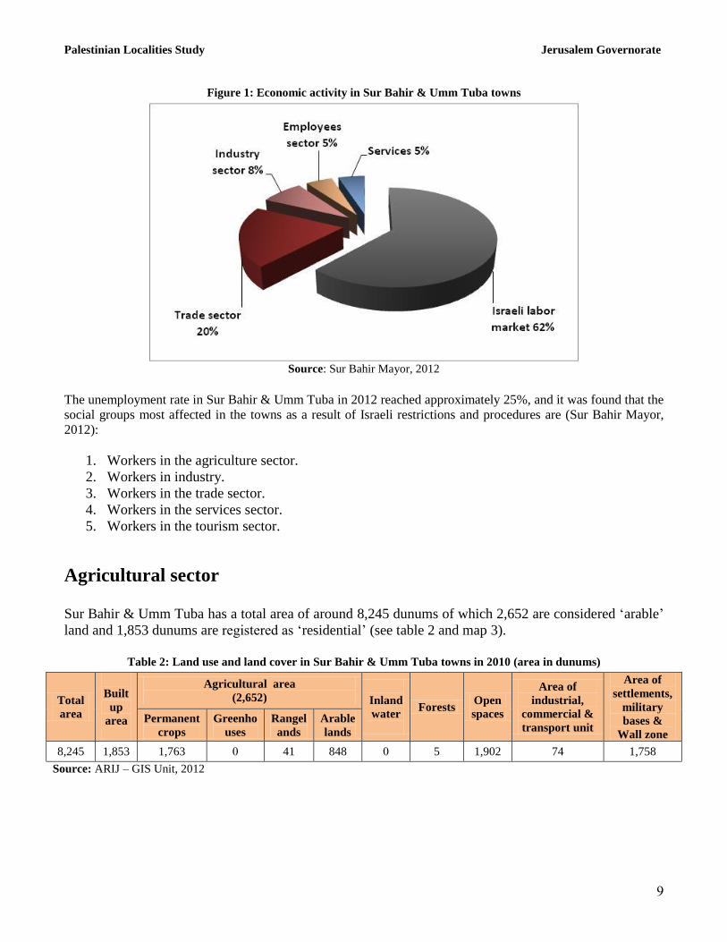
The economy in Sur Bahir & Umm Tuba is dependent on several economic sectors, mainly the Israeli
labor market, which absorbs 62% of the workforce (Sur Bahir Mayor, 2012) (see figure 1).
A field survey conducted by ARIJ in 2012 showed that the distribution of labor by economic activity in
Sur Bahir & Umm Tuba is as follows:
Israeli labor market (62%)
Trade sector (20%)
Industry (8%)
Government or private employees sector (5%)
Services sector (5%)
In terms of commercial and industrial production in Sur Bahir & Umm Tuba towns, there are 50 grocery
stores, 7 bakeries, 3 butchers, 15 fruit and vegetable stores, 10 different service stores and 21 different
professional workshops (blacksmith, carpentry, etc.), in addition to an olive oil press (Sur Bahir Mayor,
2012).
Palestinian Localities Study Jerusalem Governorate
9
Figure 1: Economic activity in Sur Bahir & Umm Tuba towns
Source: Sur Bahir Mayor, 2012
The unemployment rate in Sur Bahir & Umm Tuba in 2012 reached approximately 25%, and it was found that the
social groups most affected in the towns as a result of Israeli restrictions and procedures are (Sur Bahir Mayor,
2012):
1. Workers in the agriculture sector.
2. Workers in industry.
3. Workers in the trade sector.
4. Workers in the services sector.
5. Workers in the tourism sector.
Agricultural sector
Sur Bahir & Umm Tuba has a total area of around 8,245 dunums of which 2,652 are considered ‘arable’
land and 1,853 dunums are registered as ‘residential’ (see table 2 and map 3).
Table 2: Land use and land cover in Sur Bahir & Umm Tuba towns in 2010 (area in dunums)
Total
area
Built
up
area
Agricultural area
(2,652)
Inland
water
Forests Open
spaces
Area of
industrial,
commercial &
transport unit
Area of
settlements,
military
bases &
Wall zone
Permanent
crops
Greenho
uses
Rangel
ands
Arable
lands
8,245 1,853 1,763 0 41 848 0 5 1,902 74 1,758
Source: ARIJ – GIS Unit, 2012
Palestinian Localities Study Jerusalem Governorate
10
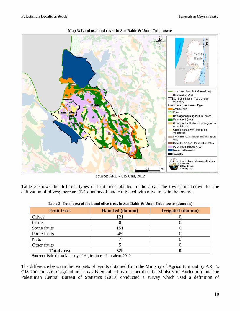
Map 3: Land use/land cover in Sur Bahir & Umm Tuba towns
Source: ARIJ - GIS Unit, 2012
Table 3 shows the different types of fruit trees planted in the area. The towns are known for the
cultivation of olives; there are 121 dunums of land cultivated with olive trees in the towns.
Table 3: Total area of fruit and olive trees in Sur Bahir & Umm Tuba towns (dunums)
Fruit trees Rain-fed (dunum) Irrigated (dunum)
Olives 121 0
Citrus 0 0
Stone fruits 151 0
Pome fruits 45 0
Nuts 7 0
Other fruits 5 0
Total area 329 0 Source: Palestinian Ministry of Agriculture - Jerusalem, 2010
The difference between the two sets of results obtained from the Ministry of Agriculture and by ARIJ’s
GIS Unit in size of agricultural areas is explained by the fact that the Ministry of Agriculture and the
Palestinian Central Bureau of Statistics (2010) conducted a survey which used a definition of
Palestinian Localities Study Jerusalem Governorate
11
agricultural areas based on land ownership. Therefore, the areas included in the survey were those of
actual holdings of agricultural areas instead of seasonal ones. The survey did not consider fragmented
and small seasonal cultivated areas in residential and agricultural areas. ARIJ’s survey, however,
indicated the existence of a high proportion of small and fragmented holdings (home gardens)
throughout the occupied Palestinian territories, thus accounting for the larger area of agricultural
holdings calculated by ARIJ.
ARIJ’s field survey also shows that 15% of the residents in Sur Bahir & Umm Tuba rear and keep
domestic animals, such as sheep, goats, and bees (Sur Bahir Mayor, 2012) (see table 4).
Table 4: Livestock in Sur Bahir & Umm Tuba towns
Cows* Sheep Goats Camels Horses Donkeys Mules Broilers Layers Bee
hives
0 300 300 0 0 0 0 0 0 35
*Including cows, bull calves, heifer calves and bulls
Source: Palestinian Ministry of Agriculture - Jerusalem, 2010
There are no agricultural roads in the towns (Sur Bahir Mayor, 2012). The agricultural sector is one of
the sectors most affected by the Israeli occupation, as all agricultural lands have been confiscated;
currently there is a very small commercial growing sector. Israeli Occupation Forces immediately
demolish any barracks constructed in the area. It is worth mentioning that Sur Bahir & Umm Tuba were
previously amongst the most productive wheat and barley growing areas, but the occupation practices
have led to the almost complete disappearance of this sector (Sur Bahir Mayor, 2012).
Institutions and services
Sur Bahir & Umm Tuba towns have very few governmental institutions. There is a post office and a few
local institutions and associations that provide services to various sectors of society. These include (Sur
Bahir Mayor, 2012):
Sur Bahir Youth Club: A sports center founded through support and contributions from town
residents. The club provides cultural, sports, and artistic activities.
The Islamic Club: A sports center founded through support and contributions from town
residents. The club provides cultural, sports, and artistic activities.
Endowments Zakat Fund Committee: Provides religious services, consultancies and cultural
services.
Palestinian Localities Study Jerusalem Governorate
12
Infrastructure and natural resources
Electricity and telecommunication services
Sur Bahir & Umm Tuba have been connected to a public electricity network since 1950. They are
served by Jerusalem Electricity Company, which is the main source of electricity in the towns.
Approximately 100% of the housing units in the town are connected to this network (Sur Bahir Mayor,
2012).
Sur Bahir & Umm Tuba are connected to a telecommunication network through Jerusalem Municipality
and approximately 90% of the housing units within the towns’ boundaries are connected to phone lines
(Sur Bahir Mayor, 2012).
Transportation services
Sur Bahir & Umm Tuba have 35 public buses (Al Muwahhad Company), which are the main means of
transportation in the towns (Sur Bahir Mayor, 2012)
Water resources
Sur Bahir & Umm Tuba are provided with water by Jihon (an Israeli company) through the public water
network established in 1972, and approximately 100% of the housing units are connected to this network
(Sur Bahir Mayor, 2012).
Sanitation
Sur Bahir & Umm Tuba have public sewerage networks; about 50% of the towns’ housing units use the
sewage networks as the main means of wastewater disposal, while the rest (50%) use cesspits and
endocrines (Sur Bahir Mayor, 2012).
Solid waste management
Jerusalem Municipality is the official body responsible for managing the collection and disposal of solid
waste generated by citizens and establishments in the town. No specific fees are charged to the
population served by domestic solid waste collection and transportation services; citizens pay the
‘Arnona’ taxes to Jerusalem Municipality which range between 3,000 and 10,000 NIS per year
depending on household size. This tax covers all services provided by Jerusalem Municipality to the
towns’ residents, including solid waste services (Sur Bahir Mayor, 2012).
Most of the population in Sur Bahir & Umm Tuba benefit from the solid waste services, whereby waste
is collected from households, institutions, shops and public squares in plastic bags and then transferred
to containers distributed throughout the towns. Jerusalem Municipality collects the solid waste and then
Palestinian Localities Study Jerusalem Governorate
13
transports it using a waste vehicle to El 'Eizariya dumping site, where it is usually buried and sometimes
burnt (Sur Bahir Mayor, 2012).
The daily per capita rate of solid waste production in Sur Bahir & Umm Tuba is 1.05kg. Therefore, the
estimated amount of solid waste produced per day from Sur Bahir & Umm Tuba residents is nearly 16
tons, or 5,873 tons per year (ARIJ-WERU, 2012).
The towns’ residents suffer from the poor collection and disposal services of solid waste; typically,
waste accumulates in the streets for several days before it is collected (Sur Bahir Mayor, 2012).
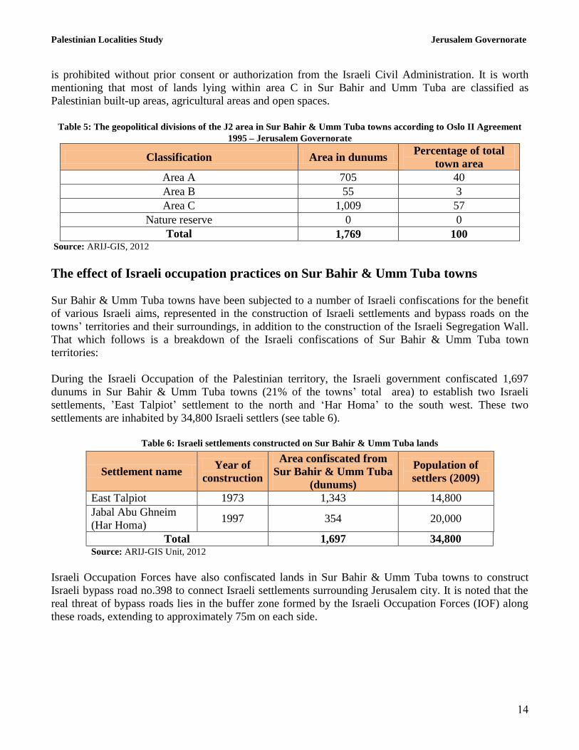
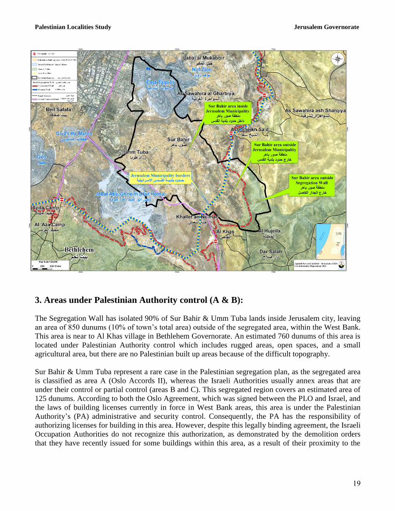
Geopolitical status of Sur Bahir & Umm Tuba town
The majority of Sur Bahir & Umm Tuba towns, covering an area of 8,245 dunums is located under the
control of Jerusalem Israeli Municipality, which was declared illegally and unilaterally in 1967 after the
occupation of the West Bank including East Jerusalem, in addition to the Gaza Strip and other Arab
lands. Jerusalem Governorate was divided into two main regions; J1 and J2. J1 area is located inside the
borders and under the control of Jerusalem Municipality, and includes many Palestinian communities
from the Old Town and Jerusalem City (Beit Al Maqdis), in addition to Sur Bahir & Umm Tuba towns
which are located in J1’s southern area. The other region is J2, which is located outside the borders and
control of Jerusalem Municipality. The eastern and western parts are under the control of Palestinian
Authority’s whilst the central part of the Governorate remains under Israeli control.
The area under the control of Jerusalem Municipality (inside J1) within Sur Bahir & Umm Tuba towns
covers approximately 6,476 dunums (78.5% of the towns’ total area), while the area outside of
Municipality control (J2) is nearly 1,769 dunums (21.5% of the towns’ total area). Three quarters of Sur
Bahir & Umm Tuba towns’ population is located in J1, whilst a small percentage is located outside the
Municipality borders in J2.
According to the Oslo II Interim Agreement signed between the Palestinian Liberation Organization
(PLO) and Israel on 28th
September 1995, the West Bank was classified into areas “A,” “B” and “C.”
The towns of Sur Bahir & Umm Tuba were not subjected to this classification, but remained as they
were before this agreement under the control of Jerusalem Israeli Municipality, except for an estimated
area of 1,769 dunums (21.5% of the towns’ total area) located near Al Khas village in Bethlehem
Governorate.
One should note that a small proportion of Sur Bahir & Umm Tuba lands extend outside the borders of
Jerusalem Municipality and the Israeli Segregation Wall. These lands were subjected to Oslo II Interim
Agreement land classification system. This part was divided into areas “A”, “B” and “C”.
Approximately 705 dunums (40% of the J2 area in Sur Bahir & Umm Tuba) were classified as area A
where the Palestinian National Authority (PNA) has responsibility for internal security and public order.
55 dunums (3% of the J2 area in Sur Bahir & Umm Tuba) were classified as area B, where the
Palestinian National Authority has complete control over civil matters but Israel continues to have
overriding responsibility for security. An area constituting 1,009 dunums (57% of the J2 area in Sur
Bahir & Umm Tuba) were classified as area C, where Israel retains full control over security and
administration related to the territory (see table 5). In area C, Palestinian building and land management
Palestinian Localities Study Jerusalem Governorate
14
is prohibited without prior consent or authorization from the Israeli Civil Administration. It is worth
mentioning that most of lands lying within area C in Sur Bahir and Umm Tuba are classified as
Palestinian built-up areas, agricultural areas and open spaces.
Table 5: The geopolitical divisions of the J2 area in Sur Bahir & Umm Tuba towns according to Oslo II Agreement
1995 – Jerusalem Governorate
Classification Area in dunums Percentage of total
town area
Area A 705 40
Area B 55 3
Area C 1,009 57
Nature reserve 0 0
Total 1,769 100 Source: ARIJ-GIS, 2012
The effect of Israeli occupation practices on Sur Bahir & Umm Tuba towns
Sur Bahir & Umm Tuba towns have been subjected to a number of Israeli confiscations for the benefit
of various Israeli aims, represented in the construction of Israeli settlements and bypass roads on the
towns’ territories and their surroundings, in addition to the construction of the Israeli Segregation Wall.
That which follows is a breakdown of the Israeli confiscations of Sur Bahir & Umm Tuba town
territories:
During the Israeli Occupation of the Palestinian territory, the Israeli government confiscated 1,697
dunums in Sur Bahir & Umm Tuba towns (21% of the towns’ total area) to establish two Israeli
settlements, ’East Talpiot’ settlement to the north and ‘Har Homa’ to the south west. These two
settlements are inhabited by 34,800 Israeli settlers (see table 6).
Table 6: Israeli settlements constructed on Sur Bahir & Umm Tuba lands
Settlement name Year of
construction
Area confiscated from
Sur Bahir & Umm Tuba
(dunums)
Population of
settlers (2009)
East Talpiot 1973 1,343 14,800
Jabal Abu Ghneim
(Har Homa) 1997 354 20,000
Total 1,697 34,800 Source: ARIJ-GIS Unit, 2012
Israeli Occupation Forces have also confiscated lands in Sur Bahir & Umm Tuba towns to construct
Israeli bypass road no.398 to connect Israeli settlements surrounding Jerusalem city. It is noted that the
real threat of bypass roads lies in the buffer zone formed by the Israeli Occupation Forces (IOF) along
these roads, extending to approximately 75m on each side.
Palestinian Localities Study Jerusalem Governorate
15
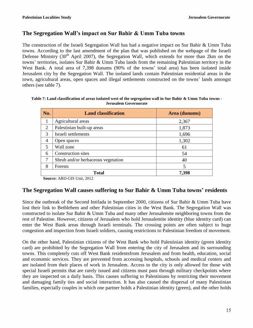
The Segregation Wall’s impact on Sur Bahir & Umm Tuba towns
The construction of the Israeli Segregation Wall has had a negative impact on Sur Bahir & Umm Tuba
towns. According to the last amendment of the plan that was published on the webpage of the Israeli
Defense Ministry (30th
April 2007), the Segregation Wall, which extends for more than 2km on the
towns’ territories, isolates Sur Bahir & Umm Tuba lands from the remaining Palestinian territory in the
West Bank. A total area of 7,398 dunums (90% of the towns’ total area) has been isolated inside
Jerusalem city by the Segregation Wall. The isolated lands contain Palestinian residential areas in the
town, agricultural areas, open spaces and illegal settlements constructed on the towns’ lands amongst
others (see table 7).
Table 7: Land classification of areas isolated west of the segregation wall in Sur Bahir & Umm Tuba towns -
Jerusalem Governorate
No. Land classification Area (dunums)
1 Agricultural areas 2,367
2 Palestinian built-up areas 1,873
3 Israeli settlements 1,696
4 Open spaces 1,302
5 Wall zone 61
6 Construction sites 54
7 Shrub and/or herbaceous vegetation 40
8 Forests 5
Total 7,398
Source: ARIJ-GIS Unit, 2012
The Segregation Wall causes suffering to Sur Bahir & Umm Tuba towns’ residents
Since the outbreak of the Second Intifada in September 2000, citizens of Sur Bahir & Umm Tuba have
lost their link to Bethlehem and other Palestinian cities in the West Bank. The Segregation Wall was
constructed to isolate Sur Bahir & Umm Tuba and many other Jerusalemite neighboring towns from the
rest of Palestine. However, citizens of Jerusalem who hold Jerusalemite identity (blue identity card) can
enter the West Bank areas through Israeli terminals. The crossing points are often subject to huge
congestion and inspection from Israeli soldiers, causing restrictions to Palestinian freedom of movement.
On the other hand, Palestinian citizens of the West Bank who hold Palestinian identity (green identity
card) are prohibited by the Segregation Wall from entering the city of Jerusalem and its surrounding
towns. This completely cuts off West Bank residentsfrom Jerusalem and from health, education, social
and economic services. They are prevented from accessing hospitals, schools and medical centers and
are isolated from their places of work in Jerusalem. Access to the city is only allowed for those with
special Israeli permits that are rarely issued and citizens must pass through military checkpoints where
they are inspected on a daily basis. This causes suffering to Palestinians by restricting their movement
and damaging family ties and social interaction. It has also caused the dispersal of many Palestinian
families, especially couples in which one partner holds a Palestinian identity (green), and the other holds
Palestinian Localities Study Jerusalem Governorate
16
Jerusalemite identity (blue). The Segregation Wall has also prevented Palestinians from reaching places
of worship in the Holy City and thus has deprived them from practicing religious rituals in Jerusalem.
As a result of the Segregation Wall plan published on the webpage of the Israeli Defense Ministry in
2007, the lands of Sur Bahir & Umm Tuba town became isolated from neighboring Palestinian towns
and villages. The Segregation Wall, along with the settlement belt around Jerusalem City, has isolated
East Jerusalem from the rest of the West Bank. Parallel to the establishment of the Segregation Wall, the
Israeli Occupation Authorities constructed a settlement belt around Sur Bahir & Umm Tuba and around
Jerusalem City, which aims to create an isolation areaand prevent urban expansion in the Palestinian
towns of Jerusalem. The Israeli Authorities have constructed these settlements close to urbanized areas
in Jerusalemite towns, which has led to an increase in the total area confiscated from these towns and
has minimized the area available for future urban expansion. This move has created a new reality for the
towns’ residents that will be difficult to reverse. These Israeli policies and plans, particularly in
Jerusalem and the remaining Palestinian Territory, have led to the creation of high population densities
as a result of the lack of lands available for urban expansion, forcing residents to adopt internal and
vertical expansion. Thus, the city of Jerusalem and its surrounding towns are considered to have some of
the highest population densities in the world. The population density in the Palestinian neighborhoods of
East Jerusalem is approximately 13,500 people per km2
compared to 9,000 people per km2 in settlements
of East Jerusalem and 8,300 people per km2 in West Jerusalem.
The dilemma of land and building licenses in Sur Bahir & Umm Tuba towns
1. Inside Jerusalem Municipality boundaries The problems associated with land and building licenses is considered to be one of the most difficult
problems in Sur Bahir & Umm Tuba towns. The reason for this is two-fold; the high prices of land, and
the very high cost of licenses for construction in Sur Bahir & Umm Tuba due to their strategic proximity
to the Old City and Al-Aqsa Mosque. This has made it an important target for Judaization and
colonization, in addition to restrictions related to building licenses imposed by the Israeli Occupation
Forces.
According to citizens of Jerusalem, land prices in East Jerusalem, particularly land located within the
borders of the Jerusalem municipality (which is rarely available), are significantly higher than those for
land located outside the borders of the municipality, and are even doubled in areas closer to the city
center.
The Israeli Occupation Authorities have used money as an effective instrument to buy Palestinian lands
in Jerusalem for high prices and ‘Judaize’ these lands by implanting Jewish settlers in the city. Israeli
forces offer Palestinians unlimited prices for such lands and houses, especially in the city center and its
neighborhoods. Anyone in Jerusalem who has land and wants to build a house or additional land has to
apply for authorization and permission from the Municipality of Jerusalem. This puts obstacles in the
way of Palestinians who want to get a construction license, as it is an attempt to expel Palestinians out of
Jerusalem city and change the demographic balance for the benefit of the Jews, thus making Palestinians
in Jerusalem a minority.
Palestinian Localities Study Jerusalem Governorate
17
One of the main obstacles that prevents Palestinians from obtaining a building license is that one has to
prove ownership of the land. The Israeli Occupation Authorities demand that Palestinians seeking to
build a house or structure, must prove their ownership of the land, which is considered to be a political
problem relating to the occupation which has been ongoing since 1967.
According to a report prepared by Bimkom Organization (Planners for Planning Rights), approximately
50% of East Jerusalem lands are unregistered in the archive of ownership, such as those in the town of
Kafr ‘Aqab and the area extending from Al ‘Isawiya town in the north to Sur Bahir in the south.
Additionally, 25% of the lands in East Jerusalem are in the process of survey and registration (such as
Beit Hanina and Shu’fat towns); and only 25% of the lands in East Jerusalem are officially
registered,including parts of Al Bireh, Qalandiya, Beit Hanina, Hizma and ‘Anata, Ash Sheikh Jarrah
and Beit Safafa (Bimkom, 2004).
According to the testimonies of Palestinians in the towns of Sur Baher and Um Tuba, the licensing
procedure for Palestinians is lengthy (sometimes lasting years) and carries a very high cost ranging
between NIS 150,000-300,000, depending on the land area and type of building. Thus, due to the high
costs imposed on Palestinians to acquire building permits and the lengthy licensing procedures,
Palestinians often build without waiting for the license approval in order to meet their housing needs.
Because of the political problem of land registration and ownership, the unreasonable prices of licenses
and the length of time it takes to secure licenses, many citizens resort to building without licenses due to
their humanitarian needs and natural family growth. In these instances, the Israeli Occupation
Authorities usually demolish the property and force the Palestinian owner to pay for his own demolition
and submit a new building application, incurring new fees and more time. On top of this, the majority of
Palestinian people in Jerusalem are living in difficult conditions because of high poverty rates, which is
a consequence of the Israeli Occupation closures which restrict their movement and prevent them from
reaching their work places. These Israeli restrictions and harassments against the Palestinians in East
Jerusalem, along with the housing problems, lack of land available for building and increased
unemployment rate, force many Jerusalemites to migrate outside the borders of the Municipality towards
the West Bank or even travel abroad in search of better living standards.
According to the ‘Civic Coalition for Defending Palestinian Rights’ in Jerusalem, (CCDPRJ, 2009), the
Israeli Authorities have adopted many policies which aim to enact pressure on Jerusalemites. An
example of this is the case of the demographic status and urban growth in Jerusalem, as the area that is
allocated for the development of Palestinian neighborhoods in East Jerusalem falls under the jurisdiction
of the Jerusalem Municipality and is estimated at approximately 9,200 dunums - only 13% of the total
area of East Jerusalem. Meanwhile, the remaining area of East Jerusalem which is under the jurisdiction
of the Jerusalem Municipality is classified as Israeli settlements, green areas (which cannot be used for
Palestinian urban growth), public buildings, roads and other uses.
Furthermore, the Israeli Authorities often do not prepare the necessary master plans for the Palestinian
neighborhoods in East Jerusalem which are required for the urban planning process. In cases when the
Israeli Authorities do prepare master plans for Palestinian neighborhoods in East Jerusalem, they usually
restrict areas designated for Palestinian urban expansion to limited percentages which are below the
necessary percentages for natural urban growth (between 25% and 75%). If one compares these
percentages with the percentage of lands used for Israeli settlements, it is found that urban growth varies
between 75%-120%. In Sur Baher and Um Tuba towns for example, the Israeli Authorities determined
Palestinian Localities Study Jerusalem Governorate
18
the urban growth percentage to be 35%-50%, whereas the neighboring settlement of Har Homa (Jabal
Abu Ghuneim) which was illegally constructed on the part of the land of Sur Baher and Um Tuba towns,
covers a percentage of 90%-120% (CCJ, 2009).
It should be noted that the Israeli Jerusalem Municipality has classified some areas within its boundaries
(including areas in Sur Bahir & Umm Tuba) as ‘green areas.’ The Israeli Occupation Authorities (IOA)
have used this classification as a way of controlling and confiscating more Palestinian lands in the
towns. Moreover, the IOA demolished houses in Jerusalem under the pretext that these houses were
built on ‘green areas’, as seen in the ethnic cleansing process in ‘Al Bustan neighborhood’ in Silwan.
The targeting of Al Bustan came after the Israeli Municipality of Jerusalem announced a plan on
February 20th
2009 to relocate more than 1,500 Palestinian citizens living in the 88 houses comprising
Al Bustan neighborhood to an alternative location. The Municipality plans to demolish the 88 houses to
establish the ‘King David Garden’ as part of the ‘Biblical Gardens’ around the Holy City. Also under the
name of ‘Green Areas’, the Israeli Authorities have built many settlements in Jerusalem, such as Reches
Shu’fat (Ramat Shlomo) in the north and Jabal abu Ghneim (Har Homa) in the south. One must also
note that some areas within Sur Bahir & Umm Tuba towns which are classified as ‘green areas,’ will
become part of the future Israeli settlement plans in Jerusalem city and its surroundings.
2. “Area C” classifications (Oslo II Agreement)
An estimated 1,769 dunums (21.5% of the towns’ total area) of Sur Bahir & Um towns are located
outside the boundary of Jerusalem Municipality (J2) and are subjected to the Oslo II Agreement
classification system. 1,009 dunums (57% of the total area) have been classified as area C outside the
Municipality, which includes most of the towns’ citizens who are living outside the Municipality
borders. This area faces the same problem of obtaining licenses for construction from the Israeli Civil
Administration in ‘Beit El’ settlement in Ramallah Governorate.
However, for the area which is not under the control of Jerusalem Municipality the cost ofconstruction
licenses are lower than the Municipality controlled areas within Sur Bahir & Umm Tuba. According to
the testimonies of citizens, this cost can reach up to approximately 10,000 NIS. However obtaining a
license is still a complicated procedure, and the Israeli Civil Administration puts obstacles in the way of
those wishing to obtain a license. This is due to Israeli Occupation Forces’ aims to Judaize Jerusalem
city and put restrictions on the population in a way that forces people to leave (see map 1).
Palestinian Localities Study Jerusalem Governorate
19
3. Areas under Palestinian Authority control (A & B):
The Segregation Wall has isolated 90% of Sur Bahir & Umm Tuba lands inside Jerusalem city, leaving
an area of 850 dunums (10% of town’s total area) outside of the segregated area, within the West Bank.
This area is near to Al Khas village in Bethlehem Governorate. An estimated 760 dunums of this area is
located under Palestinian Authority control which includes rugged areas, open spaces, and a small
agricultural area, but there are no Palestinian built up areas because of the difficult topography.
Sur Bahir & Umm Tuba represent a rare case in the Palestinian segregation plan, as the segregated area
is classified as area A (Oslo Accords II), whereas the Israeli Authorities usually annex areas that are
under their control or partial control (areas B and C). This segregated region covers an estimated area of
125 dunums. According to both the Oslo Agreement, which was signed between the PLO and Israel, and
the laws of building licenses currently in force in West Bank areas, this area is under the Palestinian
Authority’s (PA) administrative and security control. Consequently, the PA has the responsibility of
authorizing licenses for building in this area. However, despite this legally binding agreement, the Israeli
Occupation Authorities do not recognize this authorization, as demonstrated by the demolition orders
that they have recently issued for some buildings within this area, as a result of their proximity to the
Palestinian Localities Study Jerusalem Governorate
20
Segregation Wall. Palestinian residents who have been notified of these orders are in the process of
defending their legal rights before the Israeli judiciary, in order to stop the Israeli demolition orders.
The right of adequate housing is considered one of the most prominent rights asserted in charters and
international treaties and in international humanitarian law, which call for the respect of human dignity
and the right to adequate housing. However, the Israeli state, through their aggression against the human
rights of Palestinians, classifies itself to be above such laws and standards. .
Dangerous Israeli escalations in Jerusalem housing demolitions
During recent years, the Israeli Occupation Authorities have escalated their attacks against houses of
Palestinians living in Jerusalem by targeting them through housing and other building demolitions.
These demolitions are normally carried out under the pretext of ‘unlicensed construction.’ An estimation
conducted by the UN Office for the Coordination of Humanitarian Affairs shows that since 1967, the
Israeli Occupation has demolished approximately 2,000 houses in Jerusalem, in addition to thousands of
other constructions (OCHA, 2009). According to Al Maqdese Organization for Society Development,
approximately 1,059 houses and constructions were demolished in East Jerusalem between 2000 and
2011, resulting in the displacement of 4,865 Palestinians from Jerusalem, of whom 1,290 were women
and 2,537 were children (Al Maqdese, 2012). That which follows is a description of some of the
demolition orders recently issued in Sur Bahir & Umm Tuba:
In February 2008, the Israeli Occupation Authorities issued a demolition order for Al Omari
Mosque in Umm Tuba town under the pretext of ‘unlicensed construction.’ One should note that
this mosque has historical value and was built approximately 700 years ago, long before Israel’s
occupation of Palestine. The mosque was rehabilitated in 1963 during the Jordanian rule and
recently the people of Umm Tuba started a new rehabilitation process to expand this old mosque
in order to include the increasing number of worshippers, as it is difficult to build a new larger
mosque in the area due to Israeli policies on construction (Al-Aqsa Online, 2012).
In December 2010, the Israeli Authorities forced citizen Maryam ‘Arraq from Sur Bahir to
demolish her house after issuing an order from the Municipality. They also imposed a fine of
50,000 NIS on her small home of 80m2 (Palestine Remembered, 2012).
In December 2010, the Israeli Authorities forced citizen Khalil Ramadan Dabash and his sons
from Sur Bahir to demolish their house which consisted of two apartments with an area of 160m2
each. This residence was over 30 years old and was home to a family of 25 people. They were
forced to demolish the house under the pretext of a phantom road construction. The family tried
to object to the order through the Israeli courts but they did not succeed. Thus they were forced
to execute this order by themselves and demolish their own house to avoid huge sums of money
and fines to the Municipality for demolition (Palestine Remembered, 2012).
In December 2010, the Israeli Authorities also forced citizen Sharif Muhammad Suleiman ‘Atton
from Sur Bahir to demolish his house consisting of one floor with an area of 85m2. This
residence was home to a family of 8. The reason provided by the Israeli Authorities for the
demolition of this home was that it represented an ‘unlicensed building.’ At the same time, the
Israeli Authorities demolished for the second time the house of citizen Ahmad abu Sarhan
covering an area of 100m2 (Palestine Remembered, 2012).

Palestinian Localities Study Jerusalem Governorate
21
In October 2009, the Israeli Authorities demolished the house of citizen Nimr Ali Nimr from Sur
Bahir which consisted of two floors including four apartments with an area of 600m2, which was
home to a family of 50 (Ma’an, 2012).
It is important to note that dozens of houses in Sur Bahir & Umm Tuba are threatened with demolition
under the pretext of ‘unlicensed construction’, despite the fact that the residents fulfill the necessary
procedures for licenses. However, the Municipality of Jerusalem usually refuses the requests under
unspecifiedpretexts.
The Municipal tax (Arnona) has a megative impact on the living status and
economic situation of Palestinians in Jerusalem
The Municipal tax, (‘Arnona’ in Hebrew), is imposed by the Jerusalem Municipality on the owners of
buildings and land in Jerusalem. This tax is considered to be one of the greatest burdens on Palestinian
residents of the city, including the residents of Sur Bahir & Umm Tuba towns. The Israeli Authorities
use this tax as an instrument to put pressure on Palestinians and force them to leave the city.
The ‘Arnona’ tax is calculated based on certain criteria which take in to consideration the classification
of the area and the land use classification of the Jerusalem master plan (residential areas, commercial,
industrial, agricultural, public buildings, parking etc.). They also take in to consideration the zone type,
the type of use and the area of building or land (Jerusalem Municipality, 2012). Regarding the
residential areas, they classify these into four categories (A, B, C and D), and based on this zoning,
along with the area of building, they determine and calculate the amount of tax that must be paid to the
Municipality. For example, the tax tariff in the residential areas varies in the four zones between 35-98
NIS per m2 which is equivalent to approximately 10-25 US$ per m
2. This means that a small house (or
apartment) with an area of 100-150 m2 will cost the owner 3,000-10,000 NIS a year in tax, equivalent to
approximately 800-3,000 US$. For commercial shops, the tax imposed by the municipality is folded,
which affects the economic activity as these taxes force the merchants to increase their prices. The tax
rate for the commercial shops varies between 309-319 NIS per m2 depending on the area of the shop,
which is equivalent to approximately 80 US$ per m2. In addition to the taxation of residential and
commercial areas, the Municipality also imposes taxes on places of worship, agricultural areas, schools,
kindergartens, elderly homes and other facilities.
The segregation plan has had a significant negative impact on the economic situation of the Palestinians
living in Jerusalem in general and on the commercial sector in particular, as it has also suffered from the
global recession. Much of the trade in Jerusalem is largely dependent on the Palestinian visitors to the
Holy City from the West Bank, the Gaza Strip and those from the occupied lands of 1948, but Israeli
closure of the city has negatively affected this trase and the economic situation of the city and its
residents. Despite these difficulties, the Occupation Authorities continue to impose taxes without taking
into consideration the situation of the Jerusalemites, who represent the poorer class in the Holy City. In
fact, just last year (2012), the Municipality decided to increase the ‘Arnona’ by approximately 3%,
increasing still further the burden on the Palestinians of Jerusalem.
It is also important to note that in the case of Jerusalem, the Palestinians are forced to pay these taxes
just to maintain their presence in the city without even receiving a decent level of Municipal services in
return. The planning process in the Municipality of Jerusalem focuses on the political-demographic
Palestinian Localities Study Jerusalem Governorate
22
dimension that aims to Judaize the city rather than planning for the purposes of prosperity and well-
being of its citizens. Furthermore, Palestinian neighborhoods and communities in Jerusalem are
deliberately neglected in the provision of services. For instance, the Municipality rarely carries out the
necessary maintenance for the infrastructure of Arab neighborhoods, including roads, water and waste
water networks, solid waste and other services. The most obvious problem that the people of Jerusalem
suffer from is the lack of a cleaning service and the accumulation of solid waste, despite their
commitment to paying their taxes to the Municipality. This injustice can be clearly seen if we compare
the situation of the Palestinians in Jerusalem with that of the illegal settlers living in the city who have
all of their facilities and services provided for them in order to encourage them to stay in the Holy City.
Mazmuria terminal near Sur Bahir & Umm Tuba
At the southern entrance of Sur Bahir & Umm Tuba, the Israeli Occupation Forces established
Mazmuria trade terminal (An Nu’man checkpoint) which was constructed on lands of the Al Khas and
An Nu’man villages in the Bethlehem Governorate, nearby to Sur Bahir and Umm Tuba. This terminal
completed the Israeli segregation plan to separate Jerusalem towns (including Sur Bahir & Umm Tuba)
from Bethlehem. After the construction of the Segregation Wall and these barriers, interaction between
this town and Bethlehem city became difficult, especially for people holding the Palestinian identity
card (green) who cannot reach the isolated towns within Jerusalem city.
Mazmuria terminal is one of six main trade passages in the West Bank which have been installed by the
Israeli Authorities to organize the movement of goods between the West Bank and the occupied
Palestinian territory in 1948. At these trade passages,, goods are unloaded from Israeli trucks abd then
loaded on to Palestinian ones, and vice versa.
The establishment of this terminal dates back to 2003, when the Israeli Occupation Authorities
published a detailed map of the terminal to be established in the area, in addition to a military base to
protect the terminal and the Segregation Wall. The terminal occupies an area of 84 dunums of land
isolated behind the wall. The map also showed an Israeli bypass road near the wall, intended to connect
the terminal and the military base with settlements in Jerusalem and those to the east and north of the
city. When Israeli bulldozers attacked the villages and started the implementation of the plan, residents
of the two villages submitted objections to the Israeli High Court of Justice, which obstructed the
implementation of the project until the first quarter of 2005. On 3rd
September 2005, Israeli Occupation
Forces handed residents of Al Khas and An Nu’man four further Israeli military orders holding numbers
156/05/T, 155/05/T, 154/05/T and 52/05. These orders informed residents that 43 dunums of An
Nu’man and Beit Sahour lands in Bethlehem Governorate would be confiscated to construct a trade
passage. Later, in 2007, the Israeli Occupation Forces issued more military orders holding numbers
31/07/T and02/07/S to confiscate 25 dunums from Beit Sahour and Bethlehem for military purposes and
for the expansion of the terminal.
Palestinian Localities Study Jerusalem Governorate
23
Israeli military orders issued in Sur Bahir & Umm Tuba towns
Israeli Occupation Authorities have issued a set of military orders to confiscate lands in Sur Bahir &
Umm Tuba towns for different military purposes. The following are some of the key orders issued:
1. Israeli military order no. 22/03/T: Issued on the 12th
August 2003 to confiscate 173.4 dunums of
land from Sur Bahir & Umm Tuba, Ash Shayyah and As Sawahira al Gharbiya, for the
construction of the Segregation Wall.
2. Israeli military order no. 23/03/T: Issued on the 24th
August 2003 to confiscate 19 dunums of
land from Sur Bahir & Umm Tuba for the construction of the Segregation Wall.
3. Israeli military order no. 47/03/T: Issued on the 22nd
July 2003 to confiscate 1.5 dunums of land
from Sur Bahir & Umm Tuba for undisclosed military purposes.
Development plans and projects
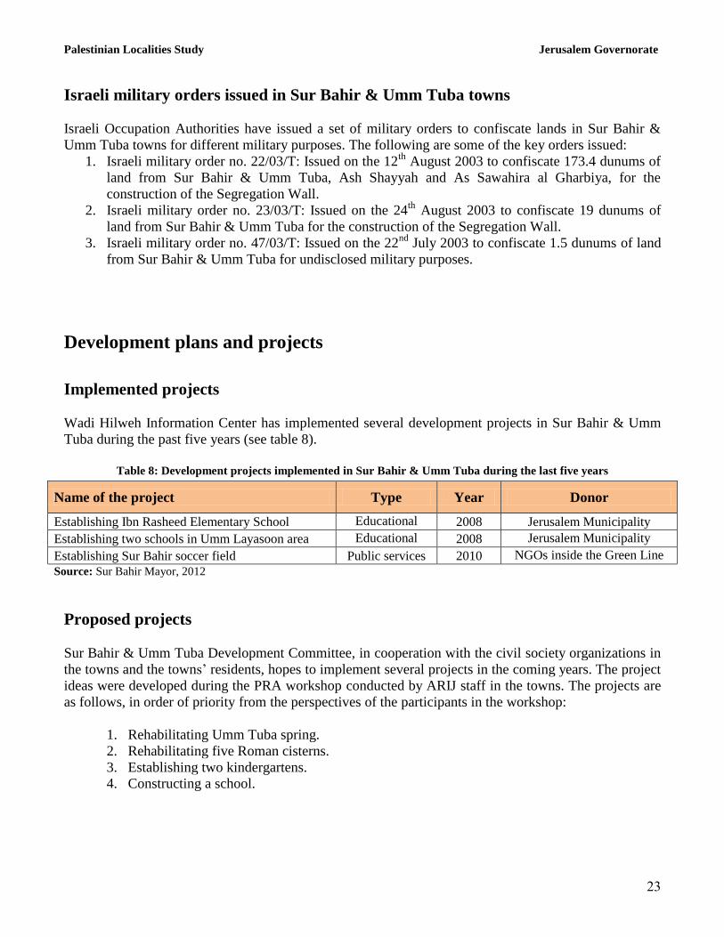
Implemented projects
Wadi Hilweh Information Center has implemented several development projects in Sur Bahir & Umm
Tuba during the past five years (see table 8).
Table 8: Development projects implemented in Sur Bahir & Umm Tuba during the last five years
Name of the project Type Year Donor
Establishing Ibn Rasheed Elementary School Educational 2008 Jerusalem Municipality
Establishing two schools in Umm Layasoon area Educational 2008 Jerusalem Municipality
Establishing Sur Bahir soccer field Public services 2010 NGOs inside the Green Line
Source: Sur Bahir Mayor, 2012
Proposed projects
Sur Bahir & Umm Tuba Development Committee, in cooperation with the civil society organizations in
the towns and the towns’ residents, hopes to implement several projects in the coming years. The project
ideas were developed during the PRA workshop conducted by ARIJ staff in the towns. The projects are
as follows, in order of priority from the perspectives of the participants in the workshop:
1. Rehabilitating Umm Tuba spring.
2. Rehabilitating five Roman cisterns.
3. Establishing two kindergartens.
4. Constructing a school.

Palestinian Localities Study Jerusalem Governorate
24
Town development priorities and needs
Sur Bahir & Umm Tuba suffer from a significant shortage of infrastructure and services. Table 9 shows
the development priorities and needs in the town according to the Development Committee’s feedback
(Sur Bahir Mayor, 2012).
Table 9: Development priorities and needs in Sur Bahir & Umm Tuba
No. Sector Strongly
needed Needed
Not a
priority Notes
Infrastructural needs
1 Constructing and paving roads *
2 Rehabilitating of old water networks *
3 Extending the water network to cover new built up
areas *
4 Constructing new water networks *
5 Rehabilitating/constructing of new wells or springs *
Rehabilitating Umm
Tuba spring
6 Constructing of water reservoirs *
7 Constructing a sewage disposal network *
8 Constructing a new electricity network *
9 Providing containers for solid waste collection *
10 Providing vehicles for collecting solid waste *
11 Providing a sanitary landfill *
Health needs
1 Building new clinics or health care centres *
2 Rehabilitating old clinics or health care centres *
3 Purchasing medical equipment and tools *
Educational needs
1 Building new schools
* Constructing a
school
2 Rehabilitating old schools
* Rehabilitating a
school
3 Purchasing new equipment for schools *
Agriculture needs
1 Rehabilitation of agricultural lands *
2 Building rainwater harvesting cisterns *
3 Construction of barracks for livestock *
4 Veterinary services *
5 Seeds and hay for animals *
6 Construction of new greenhouses *
7 Rehabilitation of greenhouses *
8 Field crop seeds *
9 Plants and agricultural supplies *
Source: Sur Bahir Mayor, 2012
Palestinian Localities Study Jerusalem Governorate
25
References
Al Maqdese Organization Website, 2012. http://www.al-maqdese.org
Al-Aqsa Online Website, 2012. http://alaqsa-online.com
Applied Research Institute - Jerusalem (ARIJ), 2012. Geographic Information Systems and
Remote Sensing Unit Database. Bethlehem - Palestine.
Applied Research Institute - Jerusalem (ARIJ), 2012. Geographic Information Systems and
Remote Sensing Unit; Land Use Analysis (2010) – Half Meter High Accuracy. Bethlehem -
Palestine.
Applied Research Institute - Jerusalem (ARIJ), 2012. Water & Environment Research Unit
Database (WERU). Bethlehem - Palestine.
Bimkom. Nati Marom. 2004. The Planning Deadlock: Planning Policy, Land Arrangements,
Building Permits and House Demolitions in East Jerusalem, Jerusalem.
Jerusalem Municipality Website. 2012. https://www.jerusalem.muni.il
Ma’an News Agency, 2012. http://www.maannews.net
Ministry of Education & Higher Education (MOHE) - Jerusalem, 2011. Directorate of Education;
A database of schools (2010/2011). Jerusalem – Palestine.
OCHA. 2009. Special Focus: The Planning Crisis in East Jerusalem.
Palestinian Ministry of Agriculture (MOA), 2010. Directorate of Agriculture data in Jerusalem
(2009/2010). Jerusalem – Palestine.
Palestine Remembered Website, 2012. http://www.palestineremembered.com.
Sur Bahir Mayor, 2012.
The Civic Coalition for Defending Palestinian Rights in Jerusalem. 2009. Aggressive Urbanism
(In Arabic)
The Jerusalem Institute for Israel Studies. Jerusalem Statistical Yearbook, 2010/2011.