Embed Size (px)
Citation preview
INVENTORY OF ARTISANAL FISHERY COMMUNITIES IN THE WESTERN AND CENTRAL MEDITERRANEAN
No. 77 2006
ISS
N 1020-9549
GENERAL FISHERIES COMMISSION FOR THE MEDITERRANEAN
9 7 8 9 2 5 1 0 5 6 0 6 6
TR/M/A0824E/1/11.06/1200
ISBN 978-92-5-105606-6 ISSN 1020-9549
STUDIES AND REVIEWS
For years, the impoverishment of artisanal fishery in Mediterranean countries has beenfrequently reported at all levels when the urgency for intervention was systematically
highlighted. In addition, it has also been reiterated that, at present, there is not enoughknowledge either of the primary and secondary magnitudes of artisanal fishery or of the
normative and managerial tools that cover the entire spectrum of competence. Information onartisanal fishery, in the wide sense, is fundamental for planning and management purposes. It is, therefore, extremely important to document all the elements that influence and interact
directly or indirectly with artisanal fisheries (e.g. synergies, conflicts or friction, possibleinteraction and connection, etc.). During the project Cooperation Networks to Facilitate
Coordination to Support Fisheries Management in the Western and Central Mediterranean(COPEMED), the first-ever inventory of regional artisanal fishery communities in the Central
and Western Mediterranean was implemented. This was possible through direct assistance tosome member countries to develop and improve their capacity to collect and analyse
information on artisanal fisheries. The inventory resulted in a comprehensive list of all thefishing communities performing artisanal fisheries in the region, including their localization,
description, use, pictures and other ancillary information. This exercise, based on 13 582 sitesvisited (interviewed), produced 11 papers, involved 16 scientists (regional and national), and also collected a selected bibliography of about 200 documents. Most of the results
are presented in this paper.
INVENTORY OF ARTISANAL FISHERY COMMUNITIES IN THE CENTRAL AND WESTERN MEDITERRANEAN
by
Salvatore R. CoppolaFishery Resources DivisionFAO Fisheries Department
FOOD AND AGRICULTURE ORGANIZATION OF THE UNITED NATIONSRome, 2006
STUDIES AND REVIEWS No. 77
GENERAL FISHERIES COMMISSION FOR THE MEDITERRANEAN
The designations employed and the presentation of material in this information product do not imply the expression of any opinion whatsoever on the part of the Food and Agriculture Organization of the United Nations concerning the legal or development status of any country, territory, city or area or of its authorities, or concerning the delimitation of its frontiers or boundaries.
All rights reserved. Reproduction and dissemination of material in this information product for educational or other non-commercial purposes are authorized without any prior written permission from the copyright holders provided the source is fully acknowledged. Reproduction of material in this information product for resale or other commercial purposes is prohibited without written permission of the copyright holders. Applications for such permission should be addressed to the Chief, Electronic Publishing Policy and Support Branch, Information Division, FAO, Viale delle Terme di Caracalla, 00153 Rome, Italy or by e-mail to [email protected]
© FAO 2006
ISBN 978-92-5-105606-6
iii
PREPARATION OF THIS DOCUMENT Reorganization of the artisanal fishery sector in the Mediterranean is one of the recurring issues in the many debates on the future status of its fisheries. At the same time, it is believed that more knowledge on this sector is indispensable. Therefore, only an appropriate assessment of these fisheries and the resources they exploit, including the other economic components implicated in the same area, will enable modern and effective management. The project Cooperation Networks to Facilitate Coordination to Support Fisheries Management in the Western and Central Mediterranean (COPEMED) took up the challenge to assess the artisanal fisheries in its eight member countries through a subregional project activity, thus for the first time acting at the regional level on an issue which is normally only dealt with at national level. The inventory implemented by COPEMED produced a comprehensive listing of all the artisanal communities performing artisanal fisheries in the region including their localization, description, practices, pictures and some other ancillary information. The whole study, summarized in this document, consisted of the planning and realization of: (a) the methodological design; (b) the data collection (field work); (c) the database Artisanal Fishery in the Mediterranean (ArtFiMed); (d) the case studies; (e) the processing and analysis and (f) the CD-ROM output, including appropriate documentation and a power-point presentation. It is also worth mentioning that this exercise, based on 13 582 sites visited (interviewed), has produced 11 papers, involved 16 regional and national scientists, and has also gathered a selected bibliography of about 200 documents concerning artisanal fishery in the Mediterranean region.
Coppola, S.R. Inventory of artisanal fishery communities in the Western and Central Mediterranean. Studies and Reviews. General Fisheries Commission for the Mediterranean. No. 77. Rome, FAO. 2006. 82p.
ABSTRACT
For years, the impoverishment of artisanal fishery in Mediterranean countries has been frequently reported at all levels when the urgency for intervention was systematically highlighted. In addition, it has also been reiterated that, at present, there is not enough knowledge either of the primary and secondary magnitudes of artisanal fishery or of the normative and managerial tools that cover the entire spectrum of competence. Information on artisanal fishery, in the wide sense, is fundamental for planning and management purposes. It is, therefore, extremely important to document all the elements which influence and interact directly or indirectly with artisanal fisheries, (e.g. synergies, conflicts or friction, possible interaction and connection, etc.). During the project Cooperation Networks to facilitate Coordination to Support Fisheries Management in the Western and Central Mediterranean (COPEMED), the first-ever inventory of regional artisanal fishery communities in the Centraland Western Mediterranean was implemented. This was possible through direct assistance to some of the member countries to develop and improve their capacity to collect and analyse information on artisanal fisheries. The inventory resulted in a comprehensive list of all the fishing communities performing artisanal fisheries in the region, including their localization, description, use, pictures and other ancillary information. This exercise, based on 13 582 sites visited (interviewed), produced 11 papers, involved 16 scientists (regional and national), and also collected a selected bibliography of about 200 documents. Most of the results are presented in this paper.

v
CONTENTS
Page Preface............................................................................................................................................. 1 Introduction ..................................................................................................................................... 2 1. Background ........................................................................................................................... 3 2. The original programme.. ......... ......... ................................................................................. 3 2.1 The objective .............................................................................................................. 3 2.2 The objective situation reported ................................................................................. 4 2.3 Effort to define the artisanal fishery in the COPEMED area...................................... 5 2.4 The agreed change of objectives................................................................................. 7 2.5 Workshop’s conclusions and recommendations......................................................... 7 3. The new approach ................................................................................................................. 8 3.1 The programme of work ............................................................................................. 8 3.2 The inventory programme .......................................................................................... 10 3.3 Standardization of the data items................................................................................ 11 3.3.1 Fishing gear ...................................................................................................... 11 3.3.2 Target species ................................................................................................... 11 3.3.3 Species name .................................................................................................... 12 3.3.4 Fishing zone...................................................................................................... 12 3.3.5 Fishing port....................................................................................................... 12 3.3.6 Fishing seasons................................................................................................. 12 3.4 Data structure.............................................................................................................. 12 3.5 Coverage ..................................................................................................................... 13 3.6 The spatial structure.................................................................................................... 14 3.7 The implementation process ....................................................................................... 15 3.7.1 The field work .................................................................................................. 15 3.8 The data processing tools............................................................................................ 16 3.8.1 ArtFiMed database ........................................................................................... 16 3.8.2 The CD-ROM builder (Janus tool)................................................................... 16 3.8.3 The “Janus” interface ....................................................................................... 17 3.9 Outputs from this component….. ............................................................................... 18 3.9.1 Results .............................................................................................................. 18 3.9.2 Final results ...................................................................................................... 19 3.10 Synergies with other activities in the project .............................................................. 20 4. The status of the collected information by country............................................................... 20 4.1 The fieldwork was conducted in all countries with a different degree of coverage ... 20 4.2 Ports with artisanal fishery operations........................................................................ 21 4.3 Regional standardization/grouping ............................................................................. 21 4.3.1 Fishing seasons................................................................................................. 21 4.3.2 Fishing zones .................................................................................................... 22 4.3.3 Species.............................................................................................................. 23 4.3.4 Gear .................................................................................................................. 23 5. Preliminary statistical estimates............................................................................................ 23 5.1 The data source ........................................................................................................... 23 5.2 The consistency of the databank................................................................................. 24 5.3 Gear composition........................................................................................................ 25 5.4 Species and catch composition . ................................................................................. 26 5.5 Fishing zone................................................................................................................ 28 5.6 Fishing activity ........................................................................................................... 29 5.7 Fishermen composition............................................................................................... 30 5.8 Matching results between countries............................................................................ 31 5.8.1 General ............................................................................................................. 31

vi
Page
6. Case studies........................................................................................................................... 39 6.1 Artisanal fishery in the Cilento area (southern Tyrrhenian sea), Coordinator: .......... Francesco Colloca....................................................................................................... 39
6.2 Integrated study of artisanal fisheries in the Nador Lagoon (by Malouli Idrissi, M. and Houssa Rachida)............................................................ 40
Appendix 1 – Contributors .............................................................................................................. 41 Appendix 2 – Preliminary area stratification and localization of artisanal fishery communities in the Western and Central Mediterranean.......................................... 42 Appendix 3 – Selected bibliography on artisanal fisheries in the Mediterranean ........................... 70 Appendix 4 – Species caught by artisanal fishery and their national names................................... 76
1
PREFACE The review of artisanal fisheries in the Mediterranean, or rather paying artisanal fisheries different attention to that given in the past, has already been initiated through recurring debates on the future status of the fisheries in the Mediterranean. Artisanal fisheries is the weakest element when negotiating management issues on a large scale, and its interaction with the many other activities in the same (shared) area calls for special attention. It is believed that more knowledge, and specifically results from case studies based on actual situations, can help to visualize the changes needed to direct artisanal fisheries toward a more modern management, respected by and respectful of the environment, fishery, etc. This study is the output of a team that has worked part time, in many cases voluntarily, to achieve some results, which they consider not the point of arrival but the start of deeper analyses and more sector studies. This work has been totally developed, in all its components, within the Cooperation Networks to Facilitate Coordination to Support Fisheries Management in the Western and Central Mediterranean (COPEMED) FAO project. The list of contributors and consultants that have participated is given in Appendix 1. Since the COPEMED project and the countries had assigned high priority to this study and because this was the first time such an inventory had been undertaken at a regional level, the first release was elaborated and produced (despite some missing data because of coverage problems in some countries) soon after the main field work had been completed. Missing data were mainly due to uncertainties that had arisen, in some cases during the data collection phase and, in others, to changes of priorities and objectives. However, once the report had been distributed, it became evident that there was a need for information on the situation of the artisanal fishery in the region as a whole and that the missing data had diminished the results achieved so far. The COPEMED project therefore launched a second round to complete and consolidate the information, where needed. As a result, all countries contributed and excellent coverage, both spatial and typological, was achieved, with the exception of Italy where information was collected only in Sicily and partially for the Campania region. In this second edition the whole dataset generated by the application is considered. Additional refining of the national names in the species and métier/gear databases was undertaken and more precise port and landing-place geographical references were added, and while these cannot be considered exhaustive they remain a good base for future applications. It might also be reported that during the same period the project launched two cases studies as immediate follow up.

2
INTRODUCTION The need to improve knowledge about the artisanal sector has been underlined on many occasions. This sector involves many countries, encompasses many fishing gears and methods, its resources, shared among various parties, move from one region to another, and the size of the fish catch varies from country to country, as does its economical value. Only an appropriate assessment of these fisheries and the resources they exploit, including the other economic components in the same area, will enable modern and effective management. Through this initiative, the COPEMED project also offered the possibility of carrying out a programme of work to study this sector in depth in its area of competence (Algeria, France, Italy, Libyan Arab Jamahiriya, Malta, Morocco, Spain and Tunisia). Information on the artisanal fishery sector, in the wide sense, is fundamental for planning and management purposes provided that it covers most of the interacting elements. It is, therefore, extremely important to document all the elements in related sectors which intervene and interact directly or indirectly with artisanal fisheries, and describe synergies, conflicts or frictions and possible interactions and associations. Taking into account the different levels of knowledge and information of the sector in the various countries, it is desirable to foresee such a programme diluted over the long term, and to execute it in steps. A workshop held in Malta in March 1998 was the first step, the starting point of the entire programme. This programme was undertaken using national experts as much as possible with the aim of increasing national competence under the coordination of, and in consultation with, an international team covering distinct subjects (statistics, biology, economics, management), which is responsible for providing the main direction and guidelines. The team was provided by the FAO–COPEMED project as necessary. The methods and results have been put at the disposal of all participating country administrations as well as of the various institutes and laboratories in the region. The status of this work has been submitted regularly to the Scientific Advisory Committee (SAC) of the General Fisheries Commission for the Mediterranean (GFCM).
3
1. BACKGROUND At one of the annual Steering Committee meetings of COPEMED the question of the lack of systematic information on artisanal fisheries at the regional level was put forward and given considerable attention. The Steering Committee supported the plan to reinforce the data collection system of this sector, due to its great importance in the region, and promoted a seminar on this topic. After an assessment of the poor level of knowledge of the artisanal fishery sector in the region, and of its integration within the countries, there was a unanimous consensus to extend the mandate of the seminar to a medium-term programme of work. One of the main issues of such a programme was to assist in finding solutions and alternatives to establish a robust data collection system, useful for sectoral studies in the region. Within this framework, the Workshop in Malta was used to start the operation aimed at reinforcing national systems and their capabilities in artisanal fisheries, using the most appropriate methods and expertise to secure regional exchange of data, techniques, results and software. A detailed programme of work was set up by the co-coordinating group within the COPEMED project. 2. THE ORIGINAL PROGRAMME 2.1 The objective The objective of the original programme was to review the artisanal fisheries statistics produced by all countries in the COPEMED area. Because of the nature of the mandate, the programme was mainly based on statistical monitoring, data collection and dissemination. It was planned, firstly, to undertake an assessment at the national level, followed by a complete study that would consist of (1) an inventory of existing information and data; (2) defining the characteristics of artisanal fisheries at the national level; and (3) defining standards in order to harmonize outputs from national statistical systems to allow regional aggregation, at least in the western central Mediterranean by:
identifying the institutions in charge of statistical surveys and dealing with artisanal fisheries in the Mediterranean;
contacting the national persons responsible, introducing the objectives of this programme to
them and exploring the possibility and feasibility of the COPEMED project helping to improve the methodology, the approach, the manuals, forms and questionnaires that they used, in order to harmonize the data collection and reporting instruments (codification system, reporting statistics, frequency of updating, etc.);
preparing a questionnaire, for distribution among the national experts responsible for the data
collection, to obtain general information on the status of data collection (qualitative and quantitative) on artisanal fisheries in their respective countries;
as an end product, preparing a series of national reports on the existing statistical systems
covering the different aspects of data collection, processing and presentation as a whole. Also, the analytical part of the statistical systems, including analysis of the results, would have been stressed in order to start evaluating the level of accuracy and reliability of the results produced.
4
The main issue of this exercise, after a regional or subregional review of all the ongoing systems, was to identify the system which appeared to be the most appropriate model as the starting point for regional discussion. The role of this system as a "starting point" and not as "the model system itself" must be stressed. It is well known that in this field it is not advisable to replicate practices or duplicate and adapt a system developed for other scenarios. The programme of work also envisaged, once the assessment had been completed and duly analysed, to undertake further activities, such as: (a) Involving sectoral experts to design and implement multidisciplinary pilot studies. (b) At the end of the programme, being able to assist in formulating strategies for the
rehabilitation of the artisanal fishery sector, followed by decision support systems constructed on real data, using utilities and models not built only on empirical considerations or theory. Such strategies should also take into consideration basing their evaluation and studies on management tools developed or conceived within a regional context.
(c) The ultimate objective of this task was to assist, whenever requested, in the establishment of a data collection system for artisanal fisheries in all the member countries.
In the view of the project team, the first important task was the organization of the workshop in Malta where the whole programme of work, the objectives and the expected results would be presented, discussed, and the first phase implemented immediately. At the same time, the project working group (WG) started to collect and scrutinize all the bibliographies dealing with artisanal fisheries published so far including those not published through official channels. Objectives (a) and (b) had to be undertaken in the shortest time possible whereas objective (c) had to be planned carefully and implemented gradually, because it was largely dependent on the previous steps. It was stressed that, in this exercise, all national participants would act as national experts rather than as national representatives, and would work as a WG, whose composition might change according to the topics that, along the way, were taken into consideration. Expertise in such subjects as economics, management, environment, geographic information system (GIS), etc., were also to be incorporated in the WG. All the national participants would be requested to critically present at the workshop the status of the data collection system in their own area of interest and comment their interaction within a regional context. 2.2 The objective situation reported At the workshop, national experts presented their reports and the statistics were submitted according to a given format. The whole set of reports was published as an addendum to the meeting summary. Other experiences undertaken outside the Mediterranean area or specific case studies conducted by researchers outside this scheme were also presented. In particular, the statistical survey system tested for the artisanal fisheries in Guinea, implemented by the Office de la Recherche Scientifique et Technique Outre-Mer (ORSTOM), was presented.

5
This exercise was developed to see whether experiences outside the Mediterranean could be used to optimise our work. It focused particularly on the methodology developed and the results obtained. A certain number of communications concerning studies undertaken in this field were also presented. These, geographically localized, helped to assess the situation and status of this research in the Mediterranean Sea. Among others things, it is important to mention the following:
the artisanal fisheries in Tuscany (Italy) the artisanal fisheries in Andalusia characterization of the artisanal fisheries in a zone of Alicante (impact analysis on the use of
artificial reefs) the small-scale fisheries in the central Adriatic (Marche) the dolphin fish fishery in Sicily application du Système d'information géographique (SIG) aux pêcheries artisanales dans le
nord de la mer d'Alboran (Méditerranée occidentale).
For the needs of the COPEMED programme the métiers (vessel/gear) to be considered as the starting point for artisanal fishery were finally agreed on. The main difficulty encountered was that this sector deals with a heterogeneous population in space, over time, the gear and use of the same, etc. To start with, artisanal fishery includes all the métiers that are not typically or strongly industrial, such as the following, which are excluded.
trawlnets large seines for small pelagics (other than those using lampara) gear targeting great migratory species (purse seines, longlines, drift nets, stationary uncovered
pound nets–madragues, tuna rods, trolling lines) hydraulic dredges for shellfish “large” longliners (a Moroccan specificity; the term large should be clarified).
Based on the papers presented and the discussion generated, it was stressed that further reflection was needed to see how it would be possible to define artisanal fishery in the region, covering all, or most, of the characteristics and peculiarities of the single national and local fishery practices. In fact, in most cases, the different terms used to define an artisanal fishery activity: artisanal fisheries, petit pêche, piccola pesca, pêche cotiere, pesca costiera, etc., were not only a matter of semantics or translation. Different countries, in the same region, use different criteria to classify artisanal fishery considering different notions simultaneously, from the economical and socio-economical environment, to the type and size of the boat and the engine, the target species, fishing habits and tradition. As a matter of fact, métiers included in one country may be excluded in another. 2.3 Effort to define the artisanal fishery in the COPEMED area The most important step, after the presentation and discussion of the national reports, was to encompass the different components of artisanal fisheries in the various countries of the region into a practical definition for the needs of COPEMED. Artisanal fishery includes very diverse fishing techniques and practices, used by very varied boats and work platforms. The objective here is not to propose a definition, but to make the readers
6
aware of this diversity. The list below, which is not intended to be complete, includes a certain number of elements that describe artisanal fishery. Special mention should be made of the COPEMED countries belonging to the European Community (EC), since there are great expectations that the results of the work programmed would help to give more visibility to the peculiarity of the Mediterranean artisanal fisheries. This important sector is generally minimized and management and legislative decisions are influenced accordingly. From the national definitions of their artisanal fishery, it seems that three criteria are always present in the definition of artisanal fishery operations:
boat length; gross tonnage and fishing gear; target species.
An effort was made to identify the most important reported characteristics that demonstrated artisanal fishery diversity at the technical and economic level.
at technical level:
small tonnage (≤ 10 TJB) low power < 100 HP with or without outboard engine reduced autonomy < 24 hours very often, locally produced engines minimum or non-existent safety equipment use of many fishing gears, depending on:
the presence of species, in space and time the nature of the sea bed the existence of specific regulations an important knowledge of target species and of their behaviour noble species fishery
at socio-economic level
boat owners (or their family) practice of another professional activity small crew (1 to 5 people) high employment in connection with investment direct sale to fish shops or restaurants individual catches of low tonnage but of high value small hierarchy in the work at sea.
The large lampara-o fishery, mainly targeting a group of small pelagics, should not normally be defined as artisanal fishery. In Italy, where this activity is largely observed, it is performed by large vessels, but also by a great number of small vessels sometimes with only one fisherman. In this latter case it is definitely an artisanal practice. Since it was not possible to separate the lampara fishing performed with large boats (sometimes using accessory boats) from that using typically artisanal boats, it was agreed to classify all lampara fishing in the Mediterranean as artisanal fishery, regardless of the size and typology of the fishing unit. In the case of Spain, it was reported that they would have a problem in classifying these vessels as artisanal, since some
7
of them are only used as lampara boats for about six months of the year while for the rest of the time they are fishing in the north of the country using industrial gear. 2.4 The agreed change of objectives At this point it was evident that most of the statistics reported (in the wide sense) could not be considered of significant importance at the regional level, because they lacked one of the fundamental rules of regional aggregation: standardization of the items included. In conclusion, there was no ground to continue with the original plan, and to do so would only have been of academic interest. The group of experts agreed on the proposal to re-assess the status of artisanal fisheries in the Mediterranean, starting with the definition of artisanal fisheries. It was stressed that its intention was not to impose standards, but it can be stated that whatever is reported and estimated under this study refers to a defined unit. For this reason, the activity concerning artisanal fishery could not be reduced to a number of meetings and working groups, but had to concentrate on the action being undertaken with the countries according to their level of interest. Such a programme of work should assist institutions and fishermen’s associations to find solutions to (or even to understand better) problems concerning the practice and management of artisanal fisheries. It is expected that the accomplishment of such a programme will enable us to obtain results in the short (few months), medium and long terms (three years). In the short term, a regional information system for artisanal fisheries in the western central Mediterranean would be set in motion (documentation, “métiers”, identification, etc.). In the medium term, this information system would enable organizing the statistics collection within a framework of purposive surveys or an already initiated statistical system. Good catch and effort data, population dynamics parameters and socio-economic data will allow the mechanisms interacting in this sector to be understood, and to identify test zones to start in-depth comparative studies. Finally, the possibility of using simulation tools to implement strategies for the rehabilitation of the artisanal fishery sector should also be envisaged. Among others things, the use of geographic information systems was considered. 2.5 Workshop’s conclusions and recommendations The conclusion of the workshop in Malta resulted in a change of the objectives of our initial plan. It was decided to study the situation more deeply by visiting all the countries and becoming acquainted with their artisanal fishery practices. This field of activity should also emphasize the relationship and the interaction of the artisanal communities with real life which constitutes a unique “ensemble” whose components cannot or should not be analyzed separately because they are significantly interdependent. It is believed that when management decisions need to be taken for artisanal fisheries, due attention should also be given to all the other activities (industrial, manual, social, economic, ethical, etc.) in the same area. A reconnaissance survey should also be launched to produce as complete as possible an inventory of the many communities performing artisanal fisheries in the region. This study, that purposely is not intended to be a classic census, should produce a comprehensive document listing all the artisanal communities in the region including their localization, a description, the use, possibly a photo and other ancillary information. It is strongly believed that only after such an exercise would it be possible to re-vitalize the idea of formulating data collection systems for artisanal fishery based on regional standards to enable a comparison.

8
For the exchange of information between researchers, administrations and the COPEMED scientists an Internet workgroup has been set up, managed by the team leader and open only to the activity group members. As already stated, it was purposely decided to launch an inventory and not a census for two main reasons: (a) COPEMED does not have a mandate to directly conduct national censuses, and (b) the organization of a census at the national level is an issue that needs to be discussed fully with the many institutions in the country dealing with national census. This would have definitely jeopardized the materialization of the inventory. It was decided to propose to the countries in the COPEMED area that they participate in a joint effort within COPEMED technical assistance to develop or improve their capacity to collect and analyze information on artisanal fishery and favour collaboration between countries to make this idea feasible. It was also envisaged to utilize, at a later stage, complementary expertise on artisanal fishery management to assist the project and the countries that would have to formulate project plans to adapt results of pilot studies to their own situations in order to:
assist in setting up management tools for artisanal fishery in the western central Mediterranean; and
develop case studies in the region with the peculiarity that their results, methodologies, and
the basic information be useful and adapted to other zones and situations. 3. THE NEW APPROACH 3.1 The programme of work The outcome of the workshop in Malta was indeed very useful to re-arrange the approach to be followed and, at the same time, to reconcile the activities. The aim of this new task was to conduct a preliminary inventory survey (reconnaissance survey) of all the artisanal fishery communities in the Mediterranean area. This work, carried out simultaneously in all countries covered by the project, enabled us to design an appropriate multipurpose survey in a second phase. This was because the main objective of the activities remained unchanged, i.e., to "launch some studies aiming at defining management strategies for artisanal fisheries to benefit the fishermen’s communities and the administrations, and not just be the statistical component”. It was clear that the proposed programme was, in a way, ambitious, but it was stressed that if instead of an activity (one occasion only), a properly formulated programme, with stepwise tasks, was set up it would have a better possibility of being completed or continued in case constraints, delays or different levels of participation occurred. It was also believed that if this programme was mainly directed to the countries, which would finally receive the tool, a higher probability of national follow-up could be expected. Finally, it was believed and agreed that this exercise would be followed by sectoral surveys (case studies) carried out with the assistance of domain experts to make the results “fruitful”.
9
A new work plan was formulated based on successive steps as follows: (a) Identification and definition of artisanal fisheries
Undertake a complete review of all the available documentation on artisanal fishery in the Mediterranean.
(b) Location of artisanal fishery communities and their activity in space and time
Define, make an inventory of and localize all the artisanal fishery communities in the region according to a given definition, and memorize the data according to a structure to be used for many other tasks.
(c) Assessment of the main non-fishery issues interacting with artisanal fisheries by type,
zones, typologies, etc. Assessment and description of activities and situations that directly or indirectly interacted with artisanal fishery (holiday localities and infrastructures, marine parks, reserves, platforms, etc.).
(d) Inventory of the main fishery components associated with artisanal fisheries
Assessment of the main fishery components interacting with artisanal fisheries (fleet composition, mariculture, catch, effort, fishermen, etc. – collecting information only, not through exhaustive surveys).
(e) Definition and classification into regional typologies (to enable regional comparison and
analysis) Many of the characteristics included in the inventory needed to be normalized to certain standards. This was especially true for fishing seasons (time), target species and associated species, fishing zone, etc., where information may not be immediately usable, or classifiable. (e.g., the seasonal pattern of a certain artisanal métier performed in many cases from January-June, compared to another reported to be performed from February-June, or another from February-May, and so on). Standardization and subsequent normalization to a common denominator, in order to create classifiable typologies and help implement case studies as sample surveys of “homogenous" sub-populations.
(f) Determination and selection of pilot studies
Formulate and implement in well-delimited areas regionally-oriented pilot studies so that the results were applicable, or could contribute, to other scenarios. A well-delimited zone would be identified starting from the output of the inventory which should give a global view of the situation regarding artisanal fisheries in the region.
(g) Definition of a research programme for the execution of detailed pilot studies in well-
delimited zones, the results of which could serve as a relevant model for other zones Analysis of detailed information together with other information coming from different sources and disciplines. More than one scenario was taken into consideration for study. Among others, the long-standing problem of conflicts between artisanal and industrial fisheries in certain areas was taken into account. Legislation regulating artisanal fisheries and other aspects dealing with rules, regulations and rights were also addressed. The interaction with other realities and infrastructures sharing the same ground or marine zones, such as agriculture, mariculture, marine parks as well as tourism was also considered in the case studies. This called for an immediate follow up of case studies dealing with the socio-economic sector, biological (stocks) surveys, cost benefit surveys and yield analyses. Selection of case studies for implementation and, whenever possible, for financing by COPEMED was based on the proposals received and the results obtained during the inventory.
10
(h) Setting up and execution of pilot studies intended to define fisheries management strategies of this sector for the benefit of those parties involved in the fishing sector and in the administration For the purpose of studying and proposing management options in the field of artisanal fisheries for the benefit of the fishermen’s communities as well as for the administrations, it was also necessary to collect accessory information that might or might not influence the activity. Results of the studies, in order to be re-applicable, re-considered or even used to demonstrate scenarios, were presented as models or through an interactive model that also had to be developed. These management options can be “visualized” and evaluated through various media and with the assistance of some well-defined tools. Among other things, this programme intended associating the results with such tools as:
Analyses through GIS. Long- and short-term analyses of the variations in the artisanal fisheries. Use of bio-economical models, etc.
(i) Presentation of the results and critical analyses of the results
The output of the inventory phase was prepared as a series of papers, tables, maps and typologies of artisanal fishery at the regional level. The results have been incorporated into the Project Home Page dealing with GIS (initiative under development), with the Encyclopedia of the Species of the Mediterranean, and the Fishery Atlas of FAO. The results of the case studies have been published and sent to the appropriate people and institutions for further consideration.
3.2 The inventory programme The purpose of the preliminary phase of this work was to establish a detailed inventory of the artisanal fisheries and their geographical location. The project subsequently prepared a series of tables, maps and typologies aimed at extending the presentation of the artisanal fishery characteristics at the regional level. The preliminary objective of this work was the elaboration of a comprehensive document containing an inventory of all artisanal fisheries present in the Western and Central Mediterranean, GIS maps showing their distribution, and a description of the main fisheries with some preliminary analysis. These results have been integrated into the project’s internet page, in the GIS in progress, and also in the Mediterranean and the FAO fisheries atlases. A comparative analysis of practices, terminology and interpretation of artisanal fisheries in each country enabled a standardized method to define the artisanal fisheries in the region to be established.
11
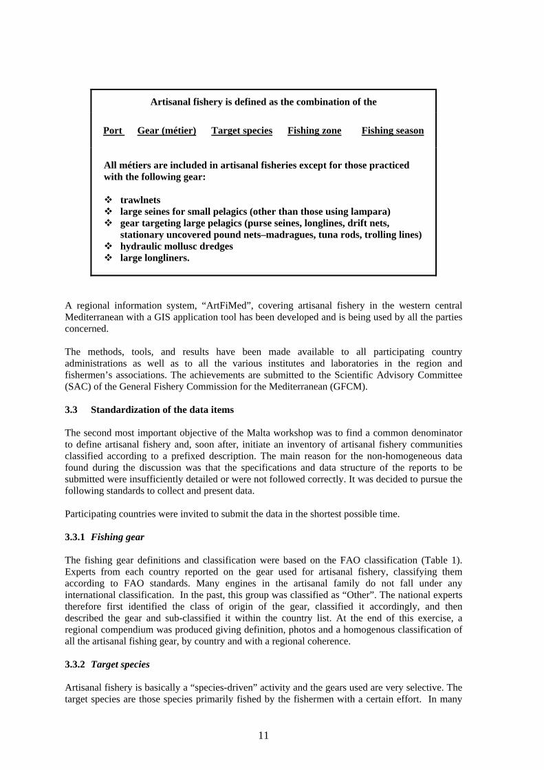
Artisanal fishery is defined as the combination of the
Port Gear (métier) Target species Fishing zone Fishing season
All métiers are included in artisanal fisheries except for those practiced with the following gear:
trawlnets large seines for small pelagics (other than those using lampara) gear targeting large pelagics (purse seines, longlines, drift nets,
stationary uncovered pound nets–madragues, tuna rods, trolling lines) hydraulic mollusc dredges large longliners.
A regional information system, “ArtFiMed”, covering artisanal fishery in the western central Mediterranean with a GIS application tool has been developed and is being used by all the parties concerned. The methods, tools, and results have been made available to all participating country administrations as well as to all the various institutes and laboratories in the region and fishermen’s associations. The achievements are submitted to the Scientific Advisory Committee (SAC) of the General Fishery Commission for the Mediterranean (GFCM). 3.3 Standardization of the data items The second most important objective of the Malta workshop was to find a common denominator to define artisanal fishery and, soon after, initiate an inventory of artisanal fishery communities classified according to a prefixed description. The main reason for the non-homogeneous data found during the discussion was that the specifications and data structure of the reports to be submitted were insufficiently detailed or were not followed correctly. It was decided to pursue the following standards to collect and present data. Participating countries were invited to submit the data in the shortest possible time. 3.3.1 Fishing gear The fishing gear definitions and classification were based on the FAO classification (Table 1). Experts from each country reported on the gear used for artisanal fishery, classifying them according to FAO standards. Many engines in the artisanal family do not fall under any international classification. In the past, this group was classified as “Other”. The national experts therefore first identified the class of origin of the gear, classified it accordingly, and then described the gear and sub-classified it within the country list. At the end of this exercise, a regional compendium was produced giving definition, photos and a homogenous classification of all the artisanal fishing gear, by country and with a regional coherence. 3.3.2 Target species Artisanal fishery is basically a “species-driven” activity and the gears used are very selective. The target species are those species primarily fished by the fishermen with a certain effort. In many

12
cases fishermen report targeting more than one “target” species simultaneously. However, it was decided to keep the number of target species to a maximum of three in order of importance. Associated species, secondary species, etc., in this work were all considered as synonyms to classify non-target species captured during the fishermen’s attempts to catch the target species. 3.3.3 Species name The standard nomenclature was that of the FAO. No other classification was allowed. The national experts were requested to collect this information, and add to the FAO denominations the national name used for that species. This improved the internal data dictionary, and contributed to the completion of the Encyclopedia of the species in the Mediterranean and the FAO nomenclatorial species database. 3.3.4 Fishing zone Reporting and classification of the fishing zones reflected the database solution for storing of data. It was firstly decided to use a three-key code to indicate the geographical name of the zone (port, gulf, bank, lagoon), the geographic reference of the zone expressed in geographical coordinates, distance from a known point, or other clear identifier. The description of the fishing zone included the nature of the sea bottom and the depth. This initial exercise was useful to design and classify the zone. In a second stage, a solution was found by introducing a generalized grid map with codified grids for the entire region. (see the spatial structure, para 3.6). 3.3.5 Fishing port Name of the port and the geographic coordinates, if not already known, had to be calculated through GPS (global positioning system) or other instruments. This included all ports and landing places from where artisanal fishing units operate. 3.3.6 Fishing seasons The fishing season was considered as the period during which a given métier was practiced, in a certain fishing zone targeting a given species. It was expressed in months according to the table below or in a 12-digit array containing zero (no activity) or 1 (activity) values in sequence.
J F M A M J J A S O N D ^ ^ ^ ^ ^ 0 0 0 1 1 1 1 1 0 0 0 0
3.4 Data structure In order to standardize and facilitate systematic reporting a hierarchical system was established to enable field staff to start the work immediately without waiting for a complex database system to be developed. This approach, though rather tedious, also helped us to develop the database in all its parts, and keep open any further automatic transfer into any database for future applications. As a parallel task, a fully relational database “ArtFiMed” was developed and made available to all participants. It incorporated all the knowledge acquired during the field work and retained its compatibility with other COPEMED national statistical databases.

13
The whole initial structure was built around Excel and Word files and transferred afterwards into a database with GIS interfaces to ArcView®. Table 3.5 summarizes the fields that were collected during the inventory phase. This data model refers to the first step envisaged in the work programme concerning the in-depth study of artisanal fisheries in the western central Mediterranean. As agreed, data collected at this level mainly concerned inventory data, and were more qualitative than quantitative. Its main objective was to gather, with the minimum of resources, and in a relatively short time, all the main characteristics to enable us to obtain an exhaustive inventory of fishing communities performing artisanal fishery, as defined at the meeting held in Malta. 3.5 Coverage The spatial coverage of this exercise was the total population under consideration. In other words, all the artisanal fishery communities were reported, even where only little ancillary data were known. As far as the data coverage was concerned, four hierarchical levels were introduced, and the following items collected:
Country level Port level Community level (elementary artisanal fishery) Item level (gear used, species, fishing zones)
Table 3.5a – Ports, landing places or any other localities where an activity defined as «artisanal fishery» was present
Name of the port/locality Region or province (administrative) where located Geographical localization of the port in latitude, longitude units. Very brief description identifying the port or locality (few words to explain whether it was a
port or a landing place, a seasonal landing place or other). Expected number of artisanal fishing units present in the port (known or subjective estimates) Expected number of artisanal fishermen present in the port (known or subjective estimates). Note. Any ancillary information useful to the work
with:
Description of the ports (about half page) describing the port, its position, the activity, the importance, the coexistence of other activities related to artisanal fishery, etc. Also the presence in the area or in the vicinity of tourist areas, marine or national parks, etc., in a separate file
and:
A photograph of the port or locality, emphasizing the artisanal component
14
Table 3.5b – Items collected for each port, landing place or any other locality
Gear used (FAO name in English, French or Spanish) National/local name of the gear Target species (scientific name, or FAO name in English, French or Spanish) National/local name of the target species Associated species (scientific names, or FAO name in English, French or Spanish). Fishing zone by name or a range from the port, or any other indication as appropriate Average depth (known parameter or estimates) Months of activity in the year. Expected number of artisanal fishing units using that gear in that period (known or estimates) Expected number of artisanal fishermen using that gear in that period (known or subjective
estimates). Fish transport performed by the same fishermen Complementary activity carried out by the above (boat/fishermen) Associated in cooperative
For each of the above items, whenever applicable, a description or comments were required. (Description or comments were to be given in a separate file, mainly reporting on details about gear used, species and associated, fishing zones, months of activity, number of units and number of fishermen) A photograph of the gear and the species was requested. 3.6 The spatial structure A GIS application was developed in association with the database implementation. This was a tool complete with basic detailed maps and utilities representing graphical features in a spatial context, i.e., not related directly and solely to ports but to fishing areas, species and gear operating. This work had a limited GIS component that would enable the user to incorporate directly into a GIS package (ArcView® was selected for this exercise) the fishing grounds for different combinations of métiers/species directly from the database. Also, other associated information such as the existence of marine parks, other fisheries, other infrastructures could be added in sequence to the "case" in order to present a composite view in which the artisanal fishery operated. For this, new basic map(s) (grid) and a new script to display the results in ArcView® were developed. Various attempts were tested to have a simple mapping system at the same time to identify and record on paper, memorize in the computer, allow aggregation and separation, and enable post- stratification of the elements. In this respect, it was decided to introduce an elementary grid system for the COPEMED area, which might be extended to all the Mediterranean Sea for application concerning artisanal fisheries. The basic map extended from the coastline to a depth of 200-m isobaths, and contained all the fishing grounds included in such area. Because of the big differences in depth from zone to zone, an overlapping grid map was also generated extending from the coastline to the 12 nautical mile limit. Each cell of the grid was 2x2 minutes dimension (enough to locate specific artisanal fishing grounds) and had a unique identification code. The coding was constructed by associating the latitude coordinates of the lower left corner of each cell. In this way the user could easily identify a concrete cell and its code on a map. For example, if the cell coordinates were 2º 26’ W 37º
15
12’ N, the code would be W0226N3712. The west (W) or east (E) directions had to be specified in the code, since while N is constant, there are COPEMED areas that are located on both sides of the Greenwich meridian. A set of cells could describe a fishing ground for a concrete métier-species. This set was considered as a special geozone in the database, not related to ports but to métiers. The grid for the COPEMED area to 200 m depth has 30 782 cells and covers a surface of 330 815 km2. The grid for the COPEMED area from the coastline to the 12 nautical mile line is now ready. It has 28 418 cells and covers a surface of 308 777 km2. All this information is clearly and thoroughly discussed in the report prepared by the GIS developers J. Baro and J.M. Serna (see Appendix 3 – Bibliography). 3.7 The implementation process In order to achieve the objectives, three groups were set up.
Design, supervision and analysis group Field work and data collection group Data processing and GIS group
The three groups did not work independently, but, vice versa, they all participated in the whole work bringing their own expertise and experiences. The design, supervision and analysis group was concentrated in the FAO headquarters Fisheries Department. The list of participants and their involvement is given in Appendix 1. 3.7.1 The field work Regarding the field work undertaken in connection with the inventory of artisanal fisheries, three approaches were applied dictated by the facilities and resources available and accessible in the different countries. In countries where no statistical unit was present, or infrastructure available to conduct the survey, COPEMED directly supported the data collection system through the involvement of an expert visiting the country, and conducting the survey with the national staff. Where the infrastructure existed but there were budgetary limitations, the project supported the costs related to staff mobility, computers, etc. It was also agreed that for those countries where data existed, but which were not fully compatible, or had not been updated or were missing some characteristics, the project would support the cost of updating, standardizing and integration of the results into the ArtFiMed system. The field work data collection group consisted of six consultants recruited purposely. Each covered one country (or part of it) and prepared a detailed report on the field activity that should be consulted to get the direct outline of the work undertaken. The COPEMED consultants who took part in the field activities were: Mr Alain Damiano, ORSTOM; Ms Géraldine Criquet supported by IFREMER (Sete); Mr Francesco Colloca, University of Rome – La Sapienza; Mr Leonardo Cannizzaro, IRMA – Mazara del Vallo; Mr Ignacio de Leiva Moreno, COPEMED; Mr M.J. Alarcón, COPEMED; Mr Valerio Crespi, COPEMED; Mr Michel Lamboeuf, COPEMED.
16
3.8 The data processing tools This task was split into more than one activity. To avoid losing the positive momentum generated by the Malta workshop a quick “spreadsheet workbook” approach was immediately developed and the field work started in some countries. Its purpose was twofold - to start the data collection, and use it as a pilot study to better design the database with real information gathered in the field. While data collection was already under way and colleagues were working, another team developed the preliminary version of the database. The database was afterwards provided with tools to regularly and automatically update the artisanal fishery CD-ROM for the presentation of national and regional results using normal browsers. The database description and the CD-ROM structure and functioning are described in other documents. 3.8.1 ArtFiMed database The data collection system architecture construction was developed taking into account the nature of the data, their origin, dynamicity and so on. The “ArtFiMed” database was firstly constructed around such a model and made available to all parties concerned. It was designed by the author of this paper and developed at the Instituto Español de Oceanografía (IEO) in Fuengirola, Malaga, by Jorge Baro and José Miguel Serna. Once it was ready, all data collected and stored in the Excel datasheets were downloaded into the database, which was then used for data entry and for all other built-in functions. After heavy utilization by different users, the system was then finalized in Rome (by M. Spinelli, FIRM) who also incorporated some other tools and routines developed by J. Baro and J.M. Serna, F. Ramos, A. Bensch, as well as by himself. 3.8.2 The CD-ROM builder (Janus tool) It was believed that more knowledge, and specifically results from studies based on actual situations, could help to visualize the changes, to highlight similarities and dissimilarities, to interpret the evolution. Raw data, collected within a statistical programme, needed to be elaborated in order to be usable as appropriate. The more the elaboration results are precise, complete, pertinent, timely and updateable by the users, the better they will be appreciated and used, both in terms of interest generated and people involved. From a conceptual point of view, the analytical approaches, provided that the processing scheme (logical and mechanical) is known and valid, that the data elements are adequately structured, and if we are dealing with the same type of data (numerical, descriptive, pictorial, or other), are not complicated. The uncertainty arises when we need to process and present different types of data within the same “problem” and intend to reach many end-users of different levels and skills, interest and functions. In other words, we need complex summaries integrating and describing statistical results mixed with charts and graphics, maps and pictures, descriptions, tendencies, etc., easy to read, interpret, distribute and be updated. Among many solutions, converting the whole into HTML (hypertext markup language) format to be browsed afterwards in synthesized way was definitely considered the most appropriate. However, revision would not be a simple task in this solution. Developing a high-quality hand-made CD-ROM to browse the contents of the survey and show the results of the processing focusing on various situations and scenarios would have served very well but only for a limited period of time.

17
A CD-ROM model architecture was also developed taking into account the end-users’ requirements, the mass and type of data, the frequency of updating, the coverage, etc. The whole architecture was built around three blocks constituting the CD-backbone (static), the data cruncher (dynamic) and the CD-builder, respectively. The static part of this architecture (the backbone) was the first to be defined, finalized and safeguarded (logos, map contours, indexes, radio buttons, texts, captions, etc.). Additional material was extracted from the database in a structured way making use of rigid standards and a strict directory system for subsidiary data. Results from the routine processing and analysis were memorized according to the nature of the process needed, type of files, dates, areas, species, gear, etc. The “data cruncher” searched for data according to fixed models and/or a dynamically built model according to the situation. Comparative analyses were constructed and performed by fishery typologies and communities, on a national and regional basis and according to the availability of the data. For regional matching purposes, sometimes data was normalized and grouped into macro variables (seasons, gear, species groups, fishing zones). The CD-builder constituted the “pride of the system”. Tables, graphs, statistical routines, dynamic construction of sentences, estimates, shaping of maps and positioning of live points, tree-structured links and net connections were all generated dynamically by “Janus” software, using dynamic structures to be finally assembled in the CD-ROM. The output is a CD-ROM containing updated results that can be produced at any time directly by qualified and authorized national users, by just running the “Janus” program interfaced to the “ArtFiMed” database. This process is executed each time a new set of data is included in the system or when the database is updated with new data or edited. Each participating country (participating institutions) has a copy of its own database and update it if and when required. As far as the regional aggregation was concerned (and the subsequent production of the regional CD-ROM), only authorized COPEMED project staff can undertake this operation. The regional version on CD-ROM is ready to be used and is available on the COPEMED Web site http://www.faocopemed.org/vldocs/0001009/index.htm. 3.8.3 The “Janus” interface A two-way interface represented by the Roman mythological god “two-faced Janus” was developed specifically for this application. The tool is dual-faced, i.e., it has the CD-ROM on one side and the database on the other. In this context the database must be a census database or ArtFiMed. Simply speaking, Janus reads, manipulates, crunches, archives, associates, etc., all the information according to a model, transforms it into HTML and replaces the old data with new ones. In fact, in our model, Janus interacts indifferently from the ArtFiMed DataBase to the CD-ROM, or from the census database (GFCM-MedStat sample) to the ArtFiMed database and again to the CD-ROM. It is expected that the extensive use of this tool (or methodology), would contribute to a better visual assessment of the changes of artisanal fishery communities or larger areas both at national and regional level. A comparative analysis between different artisanal fishery data domains, by year and by country, could also serve as a prototype for these communities management.
18
3.9 Outputs from this component The main output of this work has been the elaboration of a comprehensive inventory of all the artisanal fishery communities present in the Western and Central Mediterranean, including GIS maps showing their distribution and a description of the main fisheries. The overall tangible output can broadly be summarized as follows: All information provided by the countries has been assembled in a relational database and each country provided with it own segment.
On request, a new subset of the related database can be provided to the responsible institutions concerned so that they can maintain their database, enter new data or perform their own analysis.
The inventory of artisanal fisheries communities in the western central Mediterranean to be
assessed and browsed.
Establishment of a system of data collection for artisanal fisheries data in each member country.
Preparation of an exhaustive bibliography on this subject.
A computerized tool to produce regional aggregations, national and regional preliminary
analysis and organize the results into a CD-ROM for browsing and consulting. This tool enables updating national and regional CD-ROMs at any time, after any updating and data modifications, without external assistance.
Automated production by the COPEMED project of a CD-ROM/GIS atlas type containing all
the information gathered, classified according to a given structure. Among other things, this CD-ROM is structured to allow posting all the revisions the users will incorporate in the future.
The relational database is linked to a GIS application to provide a spatial vision of the data, hence constituting a very useful tool to manage the fishery. ArcView® has been used as a background tool to exploit this application. Scientists from participating countries had received training on ArcView®, and all the institutions participating had received a free copy of ArcView®. Countries were also provided with the freeware version, ArcExplorer®, that would enable them to easily visualize the results, distribute the product internally and externally to their institution. The results are intended to be used as a base book on the traditional fishing sector for future studies. 3.9.1 Results The overall programme of work anticipated a certain number of tasks to be implemented in sequence (See: 3.1 – The programme of work). Till now tasks (a) through (e) and, partially, (f) have been achieved and therefore results can only be limited to completed tasks. In the first instance, it was intended to publish the preliminary results on electronic support with, perhaps, some paper output of summaries. In this way we had hoped to supply a fresh product, at

19
low cost and hopefully with a wide distribution. We were confident that the more the information “travelled” the better would be the understanding of this work, which also means support. This document (complemented by the CD-ROM) has been elaborated to cope with a list of artisanal fishing carried out in the western central Mediterranean, maps showing its distribution, and a description of the main fisheries. This work has also been published in electronic format and would, hopefully, be used as a reference for future research on traditional fishing in the Mediterranean. The published CD-ROM includes the following chapters:
The bibliography (may be in the form of a "virtual library"); On request, and limited to the participating institutions, the national database in "open format"
(Read/Write access) with all the data management functions; The browser accessing regional and national databases in "Read Only"; A built-in navigating tool to process and view original and processed data contained in the
database; A library of GIS maps and scenarios already developed and ready to use; The documentation related to this activity; Results of the two case studies already conducted in the Nador lagoon (Morocco) and in the
Cilento (Italy). Ideas and possible subjects on which to construct potential applications based on this work
(preliminary case studies); Activity reports that have generated this work.
3.9.2 Final results As previously mentioned, when programmed, this project activity considered about eight tasks to be undertaken. They were labeled from (a) through (i). Tasks (a) through (e) and partially (f) have been accomplished. Unfortunately it was not possible to fully extend the programme of work to cover also point (g) “Definition of a research programme for the execution of detailed pilot studies in well-delimited zones, the results of which could serve as a relevant model for other zones) and point (h) “Setting up and execution of pilot studies intending to define fisheries management strategies of this sector for the benefit of those parties involved in the fishing sector and in the administration. The follow-up was limited to two case studies and their results are published in separate papers. The final step (point “i”) of the original programme or work could not be undertaken because it had to consider the analytical results of all other previous activities not implemented and present the overall work and critically comment on the propositions. The two case studies implemented were not considered sufficient to present a comprehensive view from which decisions could be taken. Proposals related to the Nador lagoon and to the Cilento area can be found in “Colloca, F., Crespi, V., Cerasi, S., Coppola, S.R. Evolution of the Artisanal Fishery in Cilento, Italy – case study. FAO – COPEMED, Rome, May 2003”and “Malouli Idrissi, M., Houssa, R. Etude intégrée de la pêche artisanale dans la lagune de Nador. FAO – COPEMED, Nador – May 2003“. The idea was to incorporate all the results obtained during each step into a comprehensive report with supporting socioeconomic interactions published in hyper textual mode, using Internet browsers to help the user navigate through the system as a Decision Support Tool. However, based on the amount of work done and the results so far achieved and, mainly considering the positive reactions from all the participating country institutions to the work
20
accomplished, it is hoped that a follow-up to this application, possibly not limited to the COPEMED area, could be envisaged. 3.10 Synergies with other activities in the Project At the time of this inventory, the COPEMED project was undertaking parallel activities dealing with GIS application but not yet in the socio-economic sector. Should this exercise be expanded or further developed, it was strongly recommended that the objectives, the methodology adopted and the expected results would, in the future, be part of a wider operation. This argument should not be limited to activities within the COPEMED project, but also in connection to other subregional projects in the region. It must be stressed that the joint action of expertise from different and complementary disciplines has added value to the present results. 4. THE STATUS OF THE COLLECTED INFORMATION BY COUNTRY 4.1 The fieldwork was conducted in all countries with a different degree of coverage Algeria The data collection process was presented and explained; data collection started early January 2001. The field work was completed in 2003. (Sahi Mohand Akli et Bouaicha Mohamed. La pêche artisanale en Algérie. COPEMED, Algiers – May 2003) France The data collection for métiers was completed for the entire coastline. Data for the Languedoc-Roussillon area, up to Marseilles, were collected in a first run, the remainder was completed after a year. The geographical data set had some gaps. (Guillou, A., Crespi, V. 1999. Frame survey on the distribution, composition and activity of the Gulf of Lions small-scale fishing fleet.) Italy Basic data on port fleet consistency were available, but were not detailed enough to be used for this task. Data from the Cilento area were complete and well refined. Some data for Sicily were also available. (Colloca, F. 1999. COPEMED Project - Work Report: Artisanal fisheries in the western Mediterranean – Italy (October-December 1998/April-June 1999))
Libyan Arab Jamahirija The database was complete, as were also the geographical data. Métiers attributes were missing in the database but the information was contained in the descriptive files of the métiers and ports. The task force staff tried to extract elementary data from the descriptions (narrative). (Lamboeuf, M., 2000. Artisanal Fisheries in Libya – Census of Fishing Vessels and Inventory of Artisanal Fishery Métiers. COPEMED Project ). Malta Work was completed and allowed for integration into the general database. However a few descriptions and photos were still missing. (De Leiva, J.I., Busuttil, C., Darmanin, M., Camilleri, M. Malta Fisheries. COPEMED Project). Morocco In Morocco, the coverage was complete. Geographical data were initially missing, but finally they were entered in Rome using ArcView®. (Damiano, A. 1999. Appui pour la réalisation d'un recensement sur la pêche artisanale en Méditerranée marocaine. COPEMED Project).

21
Spain The data collection for métiers was completed for the entire coastline. Regarding geographical data, after the completion of the Baleares, Murcia, Andalousia and Catalunia were completed. However a few descriptions and photos were still missing. (Alarcón J.A.U. 2001. Inventario de la Pesca Artesanal en España Mediterránea (2000–2001). COPEMED Project). Tunisia The field work in Tunisia was implemented in two steps. In February 2002 the whole work was completed. (Ben Moussa, Hedi. La Pêche Artisanale en Tunisie. COPEMED, Tunis – May 2003). 4.2 Ports with artisanal fishery operations One of the first achievements of this work was a comprehensive list of ports with geographic references for all ports in the COPEMED area where artisanal communities performed their activity. In Appendix 2 the ports are listed country by country. 4.3 Regional standardization /grouping In order to compare national data on a regional scale some post stratification and classification were needed. They were built after having treated all the elementary artisanal fishery records for each of the variables that needed to be grouped. A computer model was also developed in order to enable grouping for future entries. The groupings were made by associating métiers performing the same activity using its variable as the control characteristic (i.e., when using the activity pattern (seasons) the “months” variable is used to group observations with identical remaining parameters (target species, gear, fishing zone). In the CD-ROM presentation, the aggregation pattern of all the main characteristics is given in full. In summary, they are the following: 4.3.1 Fishing seasons Standard fishing seasons were introduced by logically grouping similar activities performed by the same fleet during the reported time period. It was also assumed that if an activity was performed for more then eight consecutive months, it could be considered as “all year round”. Elementary seasons of two consecutive months were artificially created. This was needed to avoid the same activity (target species, gear, fishing zone) reported as having been performed in June, being considered differently to a similar one covering a period of June-July. The seasonal combinations and the associated keywords are reported in Table 4.3.1.a. Table 4.3.1b shows an example of how working months were grouped to form seasonal combinations.
22
Table 4.3.1a – Seasonal combinations
Reported fishing seasons Standard seasons
Only winter Winter Only spring Spring Only summer Summer Only autumn Autumn Winter and spring or part of it Winter-spring Winter and summer or part of it Winter-summer Spring and summer or part of it Spring-summer Autumn and winter or part of it Autumn-winter Spring and autumn or part of it Spring-autumn Summer and autumn or part of it Summer-autumn Three seasons All seasons
Table 4.3.1b – Example of working months’ aggregations in seasonal combinations
Season Winter Spring Summer Autumn Standard season
111111110000 Activity Activity Activity No activity All season – 8 months 110000000000 Activity No activity No activity No activity Winter 001100000000 Activity Activity No activity No activity Winter-spring 000111111100 No activity Activity Activity Activity All seasons –3 seasons 000011111000 No activity No activity Activity No activity Summer 110000000111 Activity No activity No activity Activity Autumn-winter 000100000000 No activity Activity No activity No activity Spring
4.3.2 Fishing zones Fishing zones were grouped into four main classes. In Table 4.3.2 the standardized fishing zones are reported as also their descriptions.
Table 4.3.2 – Standardized fishing zones
Standard fishing
zones Range or or or
Coastal waters All depths <=50 Min <=25 and Max <=55
Min <=20 and Max <=60
Min <=10 and Max <=75
Medium range Max-Min < 100 Min >25 and Max <=55
Min >20 and Max <=60
Min >10 and Max <=75
Deep waters All depths >150 Min >100 and Max >250
Wide range All the others

23
4.3.3 Species The species or group of species (accessory or target) were grouped into main families using the scientific name of the family. 4.3.4 Gear Fishing gears were standardized by grouping them into main categories, following the FAO classification. (FAO Fisheries Technical Paper No. 222. Rev.1, Rome 1990). 5. PRELIMINARY STATISTICAL ESTIMATES In presenting some preliminary results, it must be stressed that these are partial and reflect only data that are actually in the data base. While they were based on more than 13 000 elementary artisanal fishery records, which was probably the highest number ever analyzed simultaneously, they cannot be considered as final. In fact, for some cases (take the observation distribution by country, for example) they represented a very good sample and reflected the situation satisfactorily; in others they were less representative. However, it is worth issuing some results that may certainly help in describing the artisanal fishery. 5.1 The data source The data on the artisanal fishing sector in the Mediterranean Sea was collected in a data bank called “ArtFiMed”, which is composed of 13 582 records. Each record contains all the items related to one elementary artisanal fishery unit. It is split up into eight countries (see Table 5.1). Most records hold data for Libyan A.J. (25.7%), Spain (17.4 %), France (15.6%) and Tunisia (14.7%). In fact, these represent 73.4% of the total data. These figures show that artisanal fishery has a different weight country by country. This data bank contains 31 fields (see Table 5.2). It must be stressed that these preliminary estimates come from an inventory and from partial coverage. They should be used accordingly.
Table 5.1 – Number of records by countries
Source: FAO-ArtFiMed 2000–2003
Countries No. of records %
Libyan Arab Jamihirija 3 488 25.7 Spain 2 361 17.4 France 2 121 15.6 Tunisia 2 002 14.7 Morocco 1 402 10.3 Algeria 1 265 9.3 Malta 609 4.5 Italy 334 2.5 Total 13 582 100
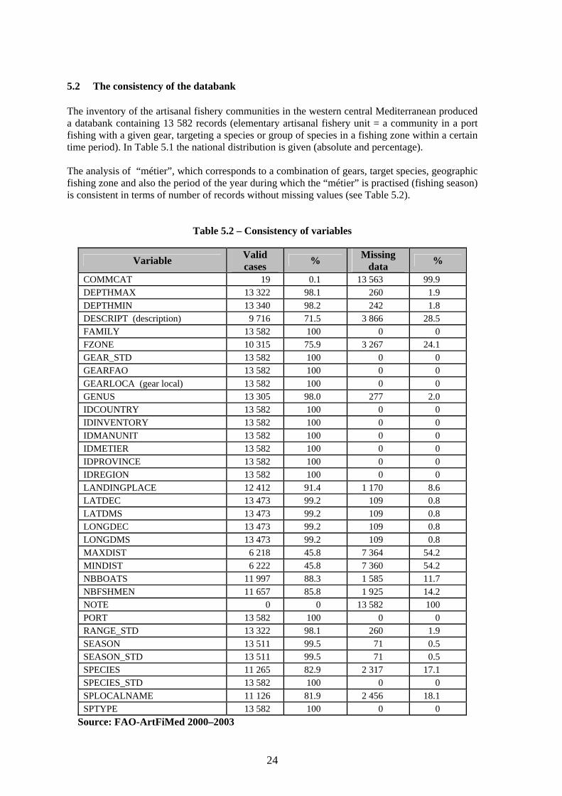
24
5.2 The consistency of the databank The inventory of the artisanal fishery communities in the western central Mediterranean produced a databank containing 13 582 records (elementary artisanal fishery unit = a community in a port fishing with a given gear, targeting a species or group of species in a fishing zone within a certain time period). In Table 5.1 the national distribution is given (absolute and percentage). The analysis of “métier”, which corresponds to a combination of gears, target species, geographic fishing zone and also the period of the year during which the “métier” is practised (fishing season) is consistent in terms of number of records without missing values (see Table 5.2).
Table 5.2 – Consistency of variables
Variable Valid cases % Missing
data %
COMMCAT 19 0.1 13 563 99.9 DEPTHMAX 13 322 98.1 260 1.9 DEPTHMIN 13 340 98.2 242 1.8 DESCRIPT (description) 9 716 71.5 3 866 28.5 FAMILY 13 582 100 0 0 FZONE 10 315 75.9 3 267 24.1 GEAR_STD 13 582 100 0 0 GEARFAO 13 582 100 0 0 GEARLOCA (gear local) 13 582 100 0 0 GENUS 13 305 98.0 277 2.0 IDCOUNTRY 13 582 100 0 0 IDINVENTORY 13 582 100 0 0 IDMANUNIT 13 582 100 0 0 IDMETIER 13 582 100 0 0 IDPROVINCE 13 582 100 0 0 IDREGION 13 582 100 0 0 LANDINGPLACE 12 412 91.4 1 170 8.6 LATDEC 13 473 99.2 109 0.8 LATDMS 13 473 99.2 109 0.8 LONGDEC 13 473 99.2 109 0.8 LONGDMS 13 473 99.2 109 0.8 MAXDIST 6 218 45.8 7 364 54.2 MINDIST 6 222 45.8 7 360 54.2 NBBOATS 11 997 88.3 1 585 11.7 NBFSHMEN 11 657 85.8 1 925 14.2 NOTE 0 0 13 582 100 PORT 13 582 100 0 0 RANGE_STD 13 322 98.1 260 1.9 SEASON 13 511 99.5 71 0.5 SEASON_STD 13 511 99.5 71 0.5 SPECIES 11 265 82.9 2 317 17.1 SPECIES_STD 13 582 100 0 0 SPLOCALNAME 11 126 81.9 2 456 18.1 SPTYPE 13 582 100 0 0
Source: FAO-ArtFiMed 2000–2003
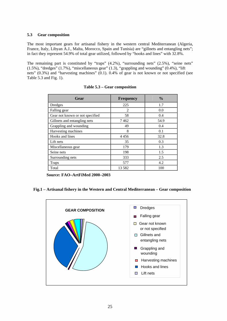
25
5.3 Gear composition The most important gears for artisanal fishery in the western central Mediterranean (Algeria, France, Italy, Libyan A.J., Malta, Morocco, Spain and Tunisia) are “gillnets and entangling nets”; in fact they represent 54.9% of total gear utilized, followed by “hooks and lines” with 32.8%. The remaining part is constituted by “traps” (4.2%), “surrounding nets” (2.5%), “seine nets” (1.5%), “dredges” (1.7%), “miscellaneous gear” (1.3), “grappling and wounding” (0.4%), “lift nets” (0.3%) and “harvesting machines” (0.1). 0.4% of gear is not known or not specified (see Table 5.3 and Fig. 1).
Table 5.3 – Gear composition
Source: FAO–ArtFiMed 2000–2003
Fig.1 – Artisanal fishery in the Western and Central Mediterranean – Gear composition
Gear Frequency % Dredges 225 1.7 Falling gear 2 0.0 Gear not known or not specified 58 0.4 Gillnets and entangling nets 7 462 54.9 Grappling and wounding 49 0.4 Harvesting machines 8 0.1 Hooks and lines 4 456 32.8 Lift nets 35 0.3 Miscellaneous gear 179 1.3 Seine nets 198 1.5 Surrounding nets 333 2.5 Traps 577 4.2 Total 13 582 100
GEAR COMPOSITION Dredges
Falling gear
or not specified Gillnets andentangling nets
Grappling and wounding
Hooks and lines
Lift nets
Gear not known
Harvesting machines
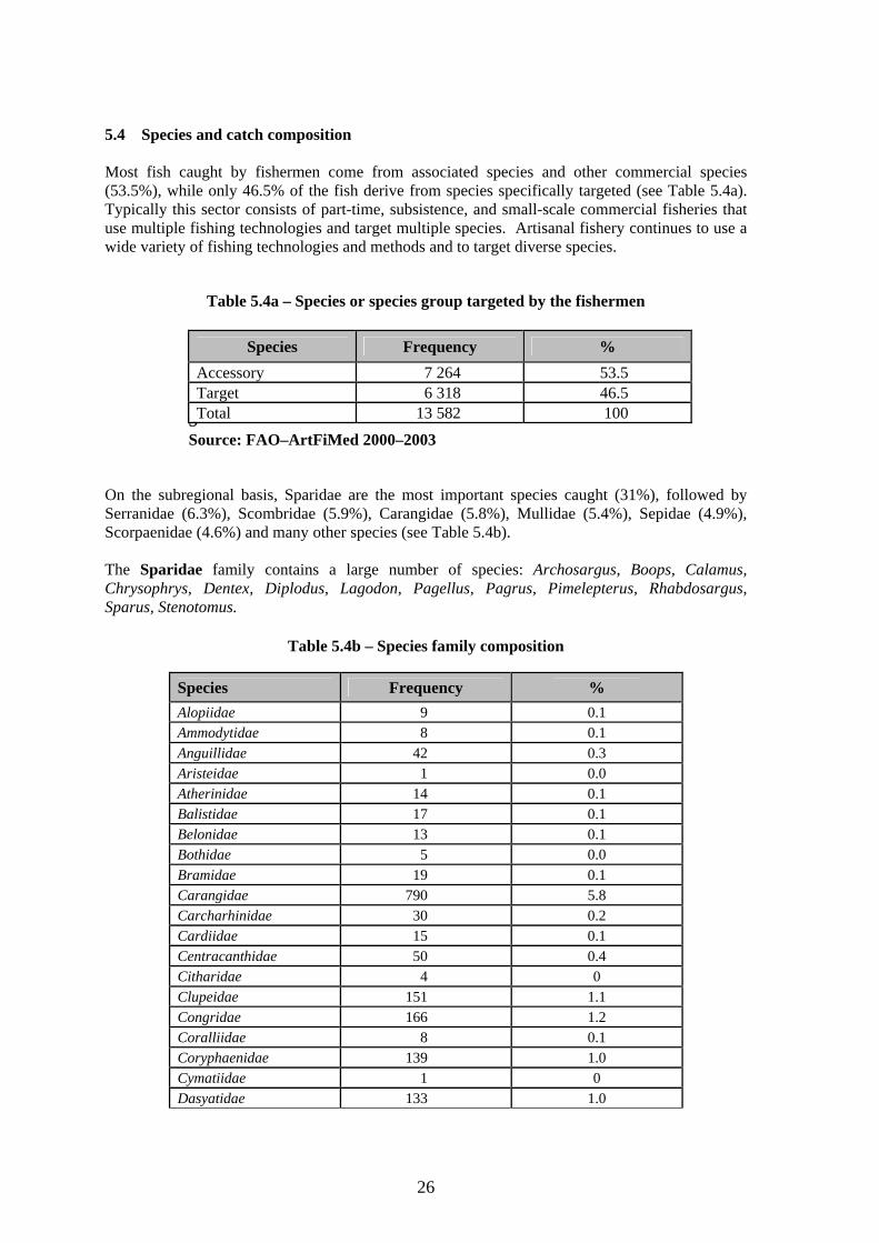
26
5.4 Species and catch composition Most fish caught by fishermen come from associated species and other commercial species (53.5%), while only 46.5% of the fish derive from species specifically targeted (see Table 5.4a). Typically this sector consists of part-time, subsistence, and small-scale commercial fisheries that use multiple fishing technologies and target multiple species. Artisanal fishery continues to use a wide variety of fishing technologies and methods and to target diverse species.
Table 5.4a – Species or species group targeted by the fishermen
SSource: FAO–ArtFiMed 2000–2003
On the subregional basis, Sparidae are the most important species caught (31%), followed by Serranidae (6.3%), Scombridae (5.9%), Carangidae (5.8%), Mullidae (5.4%), Sepidae (4.9%), Scorpaenidae (4.6%) and many other species (see Table 5.4b). The Sparidae family contains a large number of species: Archosargus, Boops, Calamus, Chrysophrys, Dentex, Diplodus, Lagodon, Pagellus, Pagrus, Pimelepterus, Rhabdosargus, Sparus, Stenotomus.
Table 5.4b – Species family composition
Species Frequency % Alopiidae 9 0.1 Ammodytidae 8 0.1 Anguillidae 42 0.3 Aristeidae 1 0.0 Atherinidae 14 0.1 Balistidae 17 0.1 Belonidae 13 0.1 Bothidae 5 0.0 Bramidae 19 0.1 Carangidae 790 5.8 Carcharhinidae 30 0.2 Cardiidae 15 0.1 Centracanthidae 50 0.4 Citharidae 4 0 Clupeidae 151 1.1 Congridae 166 1.2 Coralliidae 8 0.1 Coryphaenidae 139 1.0 Cymatiidae 1 0 Dasyatidae 133 1.0
Species Frequency % Accessory 7 264 53.5 Target 6 318 46.5 Total 13 582 100
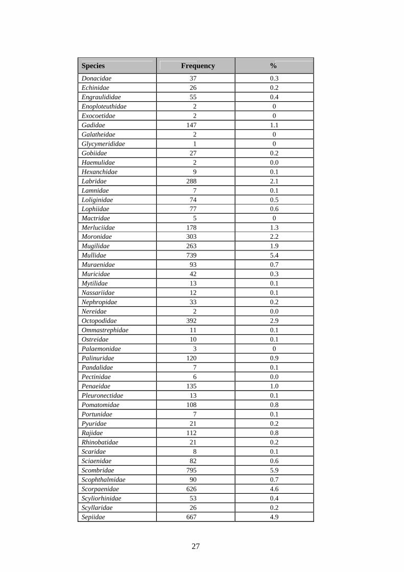
27
Species Frequency %
Donacidae 37 0.3 Echinidae 26 0.2 Engraulididae 55 0.4 Enoploteuthidae 2 0 Exocoetidae 2 0 Gadidae 147 1.1 Galatheidae 2 0 Glycymerididae 1 0 Gobiidae 27 0.2 Haemulidae 2 0.0 Hexanchidae 9 0.1 Labridae 288 2.1 Lamnidae 7 0.1 Loliginidae 74 0.5 Lophiidae 77 0.6 Mactridae 5 0 Merluciidae 178 1.3 Moronidae 303 2.2 Mugilidae 263 1.9 Mullidae 739 5.4 Muraenidae 93 0.7 Muricidae 42 0.3 Mytilidae 13 0.1 Nassariidae 12 0.1 Nephropidae 33 0.2 Nereidae 2 0.0 Octopodidae 392 2.9 Ommastrephidae 11 0.1 Ostreidae 10 0.1 Palaemonidae 3 0 Palinuridae 120 0.9 Pandalidae 7 0.1 Pectinidae 6 0.0 Penaeidae 135 1.0 Pleuronectidae 13 0.1 Pomatomidae 108 0.8 Portunidae 7 0.1 Pyuridae 21 0.2 Rajidae 112 0.8 Rhinobatidae 21 0.2 Scaridae 8 0.1 Sciaenidae 82 0.6 Scombridae 795 5.9 Scophthalmidae 90 0.7 Scorpaenidae 626 4.6 Scyliorhinidae 53 0.4 Scyllaridae 26 0.2 Sepiidae 667 4.9
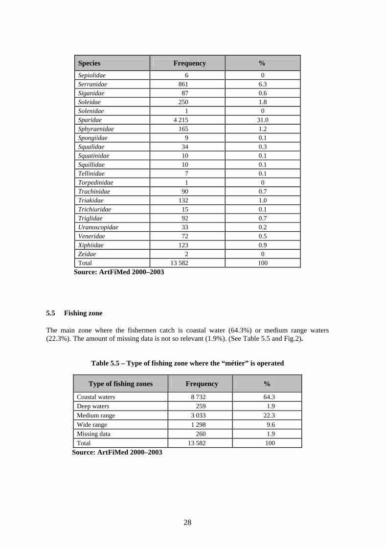
28
Species Frequency %
Sepiolidae 6 0 Serranidae 861 6.3 Siganidae 87 0.6 Soleidae 250 1.8 Solenidae 1 0 Sparidae 4 215 31.0 Sphyraenidae 165 1.2 Spongiidae 9 0.1 Squalidae 34 0.3 Squatinidae 10 0.1 Squillidae 10 0.1 Tellinidae 7 0.1 Torpedinidae 1 0 Trachinidae 90 0.7 Triakidae 132 1.0 Trichiuridae 15 0.1 Triglidae 92 0.7 Uranoscopidae 33 0.2 Veneridae 72 0.5 Xiphiidae 123 0.9 Zeidae 2 0 Total 13 582 100
Source: ArtFiMed 2000–2003 5.5 Fishing zone The main zone where the fishermen catch is coastal water (64.3%) or medium range waters (22.3%). The amount of missing data is not so relevant (1.9%). (See Table 5.5 and Fig.2).
Table 5.5 – Type of fishing zone where the “métier” is operated
Type of fishing zones Frequency %
Coastal waters 8 732 64.3 Deep waters 259 1.9 Medium range 3 033 22.3 Wide range 1 298 9.6 Missing data 260 1.9 Total 13 582 100
Source: ArtFiMed 2000–2003
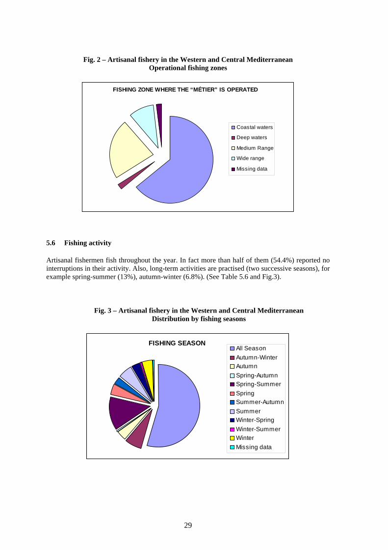
29
Fig. 2 – Artisanal fishery in the Western and Central Mediterranean Operational fishing zones
FISHING ZONE WHERE THE “MÉTIER” IS OPERATED
Coastal waters
Deep waters
Medium Range
Wide range
Missing data
5.6 Fishing activity Artisanal fishermen fish throughout the year. In fact more than half of them (54.4%) reported no interruptions in their activity. Also, long-term activities are practised (two successive seasons), for example spring-summer (13%), autumn-winter (6.8%). (See Table 5.6 and Fig.3).
Fig. 3 – Artisanal fishery in the Western and Central Mediterranean Distribution by fishing seasons
FISHING SEASONAll SeasonAutumn-WinterAutumnSpring-AutumnSpring-SummerSpringSummer-AutumnSummerWinter-SpringWinter-SummerWinterMissing data
30
Table 5.6 – Fishing season
Season Frequency %
All season 7 388 54.4 Autumn-winter 926 6.8 Autumn 496 3.7 Spring-autumn 111 0.8 Spring-summer 1 761 13 Spring 579 4.3 Summer-autumn 406 3.0 Summer 751 5.5 Winter-spring 454 3.3 Winter-summer 69 0.5 Winter 570 4.2 Missing data 71 0.5 Total 13 582 100
Source: ArtFiMed 2000–2003 5.7 Fishermen composition This type of fishery is characterized by a low number of fishermen and boats per métier (see Tables 5.7a and 5.7b). In this specific case, an accurate analysis of the number of fishermen cannot be considered accurate here since this item of information was descriptive and not punctual and numeric.
Table 5.7a – Number of fishermen per métier
Fishermen (occurrences) reported Frequency %
Missing data 1 925 14.2 From 1 to 3 1 327 9.8 From 4 to 6 1 460 10.7 From 7 to 15 2 778 20.5 More than 15 6 092 44.9 Total 13 582 100
Source: ArtFiMed 2000–2003
Table 5.7b – Number (occurrences) of boats per métier
Métier occurrences Frequency %
Missing data 1 585 11.7 From 1 to 2 2 168 16.0 From 3 to 4 1 939 14.3 From 5 to 8 2 518 18.6 More than 8 5 361 39.5 Total 13 571 100
Source: ArtFiMed 2000–2003
31
5.8 Matching results between countries 5.8.1 General Based on the available data in Algeria, France, Italy, Libyan A.J., Spain and Tunisia “gillnets and entangling nets” are the most used gear; while in Malta and Morocco the most used gear are “hooks and lines” (see Tables 5.8.1a and 5.8.1b).
Table 5.8.1a – Gear composition by country
Gear Esp Fra Ita Lby AJ. Mor Mlt Tun Dza Total Dredges 147 69 9 225Falling gear 2 2Gear not known or not specif 58 58Gillnets and entangling nets 1 321 1 477 213 1 776 528 207 1 189 751 7 462Grappling and wounding 47 2 49Harvesting machines 6 2 8Hooks and lines 564 340 82 1 529 664 276 561 440 4 456Lift nets 35 35Miscellaneous gear 12 75 26 61 4 1 179Seine nets 49 19 6 92 7 25 198Surrounding nets 20 39 3 71 57 72 37 34 333Traps 248 9 4 2 50 54 198 12 577Total 2 361 2 121 334 3 488 1 402 609 2 002 1 265 13 582Source: ArtFiMed 2000–2003
Table 5.8.1b – Percentage composition of gear by country (%)
Gear Esp Fra Ita Lby AJ. Mor Mlt Tun Dza Total Dredges 6.2 3.3 0.0 0.0 0.6 0.0 0.0 0.0 1.7Falling gear 0 0 0 0 0 0 0 0 0Gear not known /specified 0 2.7 0 0 0 0 0 0 0Gillnets and entangling nets 56.0 69.6 63.8 50.9 37.7 34.0 59.4 59.4 54.9Grappling and wounding 0 0 0 1.3 0 0 0 0 0Harvesting machines 0 0 0 0 0 0 0 0 0Hooks and lines 23.9 16.0 24.6 43.8 47.4 45.3 28.0 34.8 32.8Lift nets 0 1.7 0 0 0 0 0 0 0Miscellaneous gear 0.5 3.5 7.8 1.7 0.0 0.0 0.2 0.1 1.3Seine nets 2.1 0.9 1.8 0.0 6.6 0.0 0.3 2.0 1.5Surrounding nets 0.8 1.8 0.9 2.0 4.1 11.8 1.8 2.7 2.5Traps 10.5 0.4 1.2 0.1 3.6 8.9 9.9 0.9 4.2Total 100 100 100 100 100 100 100 100 100
Source: ArtFiMed 2000–2003
In all countries except Malta, fishermen reported catching associated species rather than target species (see Tables 5.8.1c and 5.8.1d). Sparidae is the most important family caught by artisanal fishermen in all countries (31% of the total) except in Italy where Scombridae is the first family (13.8%). The second family differs country by country: Sepiidae in Spain (7.5%), Labridae in France (8.1%), Sparidae in Italy (10.2%), Scombridae in Morocco (9.2%), Serranidae in Libyan
32
A.J. (13.9%), Carangidae in Malta (12.3%) and in Algeria (9.2%), and finally Scorpaenidae in Tunisia (8.2%) (see Tables 5.8.1e and 5.8.1f).
Table 5.8.1c – Target and accessory species composition by country
Species Esp Fra Ita Lby AJ. Mor Mlt Tun Dza Total Accessory 1 367 1 333 200 1 714 902 135 1 009 604 7 264 Target 994 788 134 1 774 500 474 993 661 6 318 Total 2 361 2 121 334 3 488 1 402 609 2 002 1 265 13 582
Source: ArtFiMed 2000–2003
Table 5.8.1d – Target and accessory species composition by country (%)
Species Esp Fra Ita Lby AJ. Mor Mlt Tun Dza Total Accessory 57.9 62.8 59.9 49.1 64.3 22.2 50.4 47.7 53.5 Target 42.1 37.2 40.1 50.9 35.7 77.8 49.6 52.3 46.5 Total 100 100 100 100 100 100 100 100 100
Source: ArtFiMed 2000–2003
Table 5.8.1e – Species family by country
Species family Esp Fra Ita Lby AJ. Mor Mlt Tun Dza Total Alopiidae 1 1 7 9 Ammodytidae 8 8 Anguillidae 9 13 2 9 8 1 42 Aristeidae 1 1 Atherinidae 7 7 14 Balistidae 9 4 1 3 17 Belonidae 1 3 9 13 Bothidae 5 5 Bramidae 9 9 1 19 Carangidae 124 69 32 259 67 75 47 117 790 Carcharhinidae 1 22 7 30 Cardiidae 12 3 15 Centracanthidae 6 2 7 6 3 2 24 50 Citharidae 4 4 Clupeidae 15 34 5 13 51 3 7 23 151 Congridae 48 59 2 1 39 4 13 166 Coralliidae 4 3 1 8 Coryphaenidae 10 8 17 30 50 22 2 139 Cymatiidae 1 1 Dasyatidae 122 11 133 Donacidae 30 5 2 37 Echinidae 3 23 26 Engraulididae 2 15 3 27 7 1 55 Enoploteuthida 2 2
33
Species family Esp Fra Ita Lby A.J. Mar Mlt Tun Dza Total Exocoetidae 2 2 Gadidae 36 28 1 45 37 147 Galatheidae 2 2 Glycymerididae 1 1 Gobiidae 26 1 27 Haemulidae 2 2 Hexanchidae 9 9 Labridae 24 172 91 1 288 Lamnidae 2 4 1 7 Loliginidae 25 3 17 13 14 2 74 Lophiidae 44 27 1 5 77 Mactridae 5 5 Merluciidae 84 53 15 2 24 178 Moronidae 50 119 4 4 31 86 9 303 Mugilidae 16 120 3 28 8 84 4 263 Mullidae 146 85 15 150 72 37 158 76 739 Muraenidae 5 23 4 23 19 4 15 93 Muricidae 23 19 42 Mytilidae 3 10 13 Nassariidae 12 12 Nephropidae 18 12 3 33 Nereidae 2 2 Octopodidae 115 11 27 20 70 58 87 4 392 Ommastrephida 10 1 11 Ostreidae 10 10 Palaemonidae 3 3 Palinuridae 56 29 8 1 8 18 120 Pandalidae 5 2 7 Pectinidae 4 2 6 Penaeidae 25 4 11 4 90 1 135 Pleuronectidae 3 10 13 Pomatomidae 15 24 65 4 108 Portunidae 6 1 7 Pyuridae 1 20 21 Rajidae 7 28 23 10 6 38 112 Rhinobatidae 16 5 21 Scaridae 8 8 Sciaenidae 1 1 62 5 3 10 82 Scombridae 138 86 46 172 129 32 81 111 795 Scophthalmidae 17 73 90 Scorpaenidae 95 109 25 105 19 46 167 60 626 Scyliorhinidae 6 1 45 1 53 Scyllaridae 20 4 2 26 Sepiidae 177 73 28 140 54 37 140 18 667 Sepiolidae 2 4 6 Serranidae 48 30 2 484 80 70 52 95 861 Siganidae 87 87 Soleidae 96 72 5 18 48 11 250 Solenidae 1 1 Sparidae 559 505 34 1 289 584 175 696 373 4 215
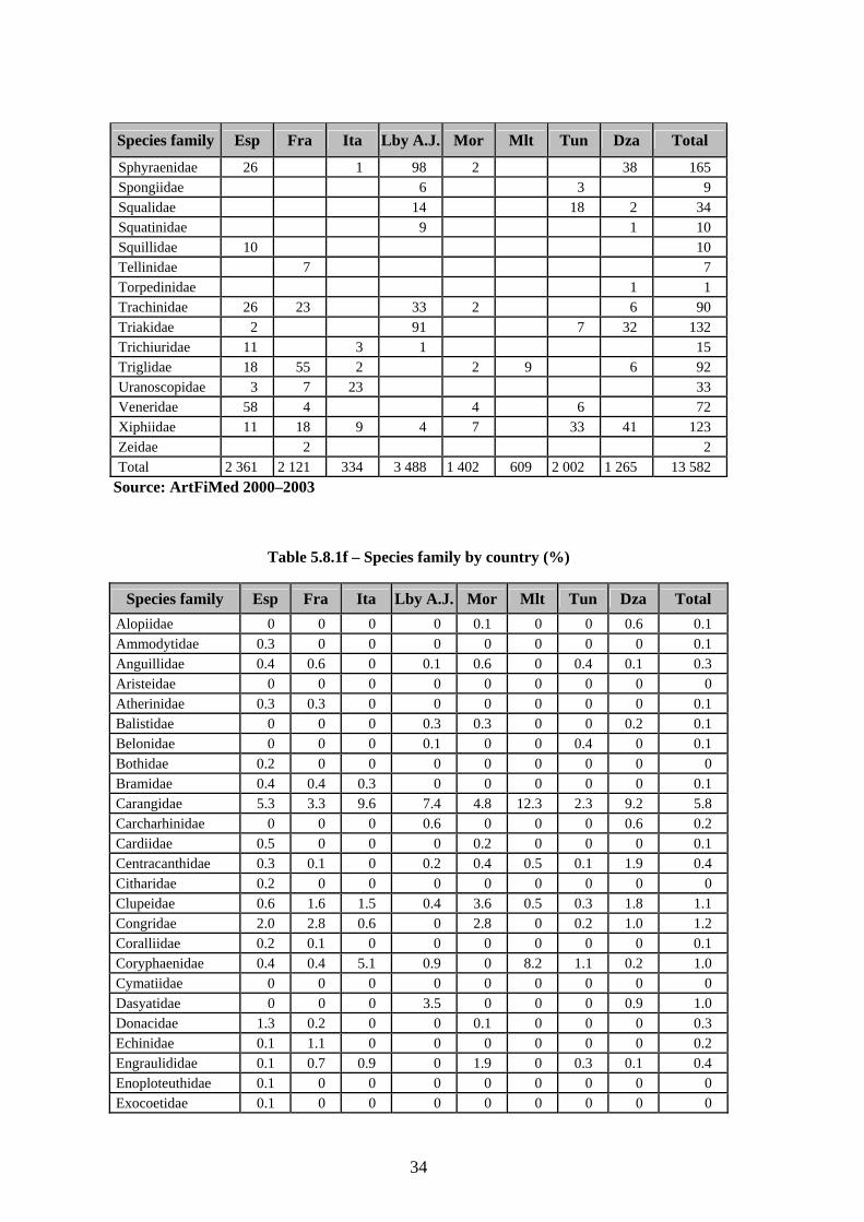
34
Species family Esp Fra Ita Lby A.J. Mor Mlt Tun Dza Total
Sphyraenidae 26 1 98 2 38 165 Spongiidae 6 3 9 Squalidae 14 18 2 34 Squatinidae 9 1 10 Squillidae 10 10 Tellinidae 7 7 Torpedinidae 1 1 Trachinidae 26 23 33 2 6 90 Triakidae 2 91 7 32 132 Trichiuridae 11 3 1 15 Triglidae 18 55 2 2 9 6 92 Uranoscopidae 3 7 23 33 Veneridae 58 4 4 6 72 Xiphiidae 11 18 9 4 7 33 41 123 Zeidae 2 2 Total 2 361 2 121 334 3 488 1 402 609 2 002 1 265 13 582
Source: ArtFiMed 2000–2003
Table 5.8.1f – Species family by country (%)
Species family Esp Fra Ita Lby A.J. Mor Mlt Tun Dza Total Alopiidae 0 0 0 0 0.1 0 0 0.6 0.1 Ammodytidae 0.3 0 0 0 0 0 0 0 0.1 Anguillidae 0.4 0.6 0 0.1 0.6 0 0.4 0.1 0.3 Aristeidae 0 0 0 0 0 0 0 0 0 Atherinidae 0.3 0.3 0 0 0 0 0 0 0.1 Balistidae 0 0 0 0.3 0.3 0 0 0.2 0.1 Belonidae 0 0 0 0.1 0 0 0.4 0 0.1 Bothidae 0.2 0 0 0 0 0 0 0 0 Bramidae 0.4 0.4 0.3 0 0 0 0 0 0.1 Carangidae 5.3 3.3 9.6 7.4 4.8 12.3 2.3 9.2 5.8 Carcharhinidae 0 0 0 0.6 0 0 0 0.6 0.2 Cardiidae 0.5 0 0 0 0.2 0 0 0 0.1 Centracanthidae 0.3 0.1 0 0.2 0.4 0.5 0.1 1.9 0.4 Citharidae 0.2 0 0 0 0 0 0 0 0 Clupeidae 0.6 1.6 1.5 0.4 3.6 0.5 0.3 1.8 1.1 Congridae 2.0 2.8 0.6 0 2.8 0 0.2 1.0 1.2 Coralliidae 0.2 0.1 0 0 0 0 0 0 0.1 Coryphaenidae 0.4 0.4 5.1 0.9 0 8.2 1.1 0.2 1.0 Cymatiidae 0 0 0 0 0 0 0 0 0 Dasyatidae 0 0 0 3.5 0 0 0 0.9 1.0 Donacidae 1.3 0.2 0 0 0.1 0 0 0 0.3 Echinidae 0.1 1.1 0 0 0 0 0 0 0.2 Engraulididae 0.1 0.7 0.9 0 1.9 0 0.3 0.1 0.4 Enoploteuthidae 0.1 0 0 0 0 0 0 0 0 Exocoetidae 0.1 0 0 0 0 0 0 0 0
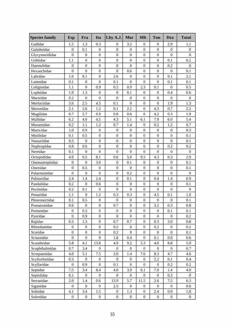
35
Species family Esp Fra Ita Lby A.J. Mor Mlt Tun Dza Total Gadidae 1.5 1.3 0.3 0 3.2 0 0 2.9 1.1 Galatheidae 0 0.1 0 0 0 0 0 0 0 Glycymerididae 0 0 0 0 0 0 0 0 0 Gobiidae 1.1 0 0 0 0 0 0 0.1 0.2 Haemulidae 0 0 0 0 0 0 0 0.2 0 Hexanchidae 0 0 0 0 0.6 0 0 0 0.1 Labridae 1.0 8.1 0 2.6 0 0 0 0.1 2.1 Lamnidae 0.1 0 0 0.1 0 0 0 0.1 0.1 Loliginidae 1.1 0 0.9 0.5 0.9 2.3 0.1 0 0.5 Lophiidae 1.9 1.3 0 0 0.1 0 0 0.4 0.6 Mactridae 0.2 0 0 0 0 0 0 0 0 Merluciidae 3.6 2.5 4.5 0.1 0 0 0 1.9 1.3 Moronidae 2.1 5.6 1.2 0.1 2.2 0 4.3 0.7 2.2 Mugilidae 0.7 5.7 0.9 0.8 0.6 0 4.2 0.3 1.9 Mullidae 6.2 4.0 4.5 4.3 5.1 6.1 7.9 6.0 5.4 Muraenidae 0.2 1.1 1.2 0.7 1.4 0 0.2 1.2 0.7 Muricidae 1.0 0.9 0 0 0 0 0 0 0.3 Mytilidae 0.1 0.5 0 0 0 0 0 0 0.1 Nassariidae 0.5 0 0 0 0 0 0 0 0.1 Nephropidae 0.8 0.6 0 0 0 0 0 0.2 0.2 Nereidae 0.1 0 0 0 0 0 0 0 0 Octopodidae 4.9 0.5 8.1 0.6 5.0 9.5 4.3 0.3 2.9 Ommastrephidae 0 0 3.0 0 0.1 0 0 0 0.1 Ostreidae 0 0.5 0 0 0 0 0 0 0.1 Palaemonidae 0 0 0 0 0.2 0 0 0 0 Palinuridae 2.4 1.4 2.4 0 0.1 0 0.4 1.4 0.9 Pandalidae 0.2 0 0.6 0 0 0 0 0 0.1 Pectinidae 0.2 0.1 0 0 0 0 0 0 0 Penaeidae 1.1 0 1.2 0.3 0.3 0 4.5 0.1 1.0 Pleuronectidae 0.1 0.5 0 0 0 0 0 0 0.1 Pomatomidae 0.6 0 0 0.7 0 0 3.2 0.3 0.8 Portunidae 0 0.3 0 0 0 0 0 0.1 0.1 Pyuridae 0 0.9 0 0 0 0 0 0 0.2 Rajidae 0.3 1.3 0 0.7 0.7 0 0.3 3.0 0.8 Rhinobatidae 0 0 0 0.5 0 0 0.2 0 0.2 Scaridae 0 0 0 0.2 0 0 0 0 0.1 Sciaenidae 0 0 0 1.8 0.4 0 0.1 0.8 0.6 Scombridae 5.8 4.1 13.8 4.9 9.2 5.3 4.0 8.8 5.9 Scophthalmidae 0.7 3.4 0 0 0 0 0 0 0.7 Scorpaenidae 4.0 5.1 7.5 3.0 1.4 7.6 8.3 4.7 4.6 Scyliorhinidae 0.3 0 0 0 0 0 2.2 0.1 0.4 Scyllaridae 0 0.9 0 0.1 0 0 0 0.2 0.2 Sepiidae 7.5 3.4 8.4 4.0 3.9 6.1 7.0 1.4 4.9 Sepiolidae 0.1 0 0 0 0 0 0 0.3 0 Serranidae 2.0 1.4 0.6 13.9 5.7 11.5 2.6 7.5 6.3 Siganidae 0 0 0 2.5 0 0 0 0 0.6 Soleidae 4.1 3.4 1.5 0 1.3 0 2.4 0.9 1.8 Solenidae 0 0 0 0 0 0 0 0 0
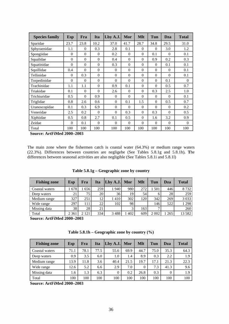
36
Species family Esp Fra Ita Lby A.J. Mor Mlt Tun Dza Total Sparidae 23.7 23.8 10.2 37.0 41.7 28.7 34.8 29.5 31.0 Sphyraenidae 1.1 0 0.3 2.8 0.1 0 0 3.0 1.2 Spongiidae 0 0 0 0.2 0 0 0.1 0 0.1 Squalidae 0 0 0 0.4 0 0 0.9 0.2 0.3 Squatinidae 0 0 0 0.3 0 0 0 0.1 0.1 Squillidae 0.4 0 0 0 0 0 0 0 0.1 Tellinidae 0 0.3 0 0 0 0 0 0 0.1 Torpedinidae 0 0 0 0 0 0 0 0.1 0 Trachinidae 1.1 1.1 0 0.9 0.1 0 0 0.5 0.7 Triakidae 0.1 0 0 2.6 0 0 0.3 2.5 1.0 Trichiuridae 0.5 0 0.9 0 0 0 0 0 0.1 Triglidae 0.8 2.6 0.6 0 0.1 1.5 0 0.5 0.7 Uranoscopidae 0.1 0.3 6.9 0 0 0 0 0 0.2 Veneridae 2.5 0.2 0 0 0.3 0 0.3 0 0.5 Xiphiidae 0.5 0.8 2.7 0.1 0.5 0 1.6 3.2 0.9 Zeidae 0 0.1 0 0 0 0 0 0 0 Total 100 100 100 100 100 100 100 100 100 Source: ArtFiMed 2000–2003
The main zone where the fishermen catch is coastal water (64.3%) or medium range waters (22.3%). Differences between countries are negligebe (See Tables 5.8.1g and 5.8.1h). The differences between seasonal activities are also negligible (See Tables 5.8.1i and 5.8.1l)
Table 5.8.1g – Geographic zone by country
Fishing zone Esp Fra Ita Lby A.J. Mor Mlt Tun Dza Total Coastal waters 1 678 1 656 259 1 940 980 272 1 501 446 8 732Deep waters 21 75 20 36 19 54 6 28 259Medium range 327 251 12 1 410 302 120 342 269 3 033Wide range 297 111 22 102 98 146 522 1 298Missing data 38 28 21 3 163 7 260Total 2 361 2 121 334 3 488 1 402 609 2 002 1 265 13 582
Source: ArtFiMed 2000–2003
Table 5.8.1h – Geographic zone by country (%)
Fishing zone Esp Fra Ita Lby A.J. Mor Mlt Tun Dza Total Coastal waters 71.1 78.1 77.5 55.6 69.9 44.7 75.0 35.3 64.3Deep waters 0.9 3.5 6.0 1.0 1.4 8.9 0.3 2.2 1.9Medium range 13.9 11.8 3.6 40.4 21.5 19.7 17.1 21.3 22.3Wide range 12.6 5.2 6.6 2.9 7.0 0 7.3 41.3 9.6Missing data 1.6 1.3 6.3 0 0.2 26.8 0.3 0 1.9Total 100 100 100 100 100 100 100 100 100
Source: ArtFiMed 2000–2003
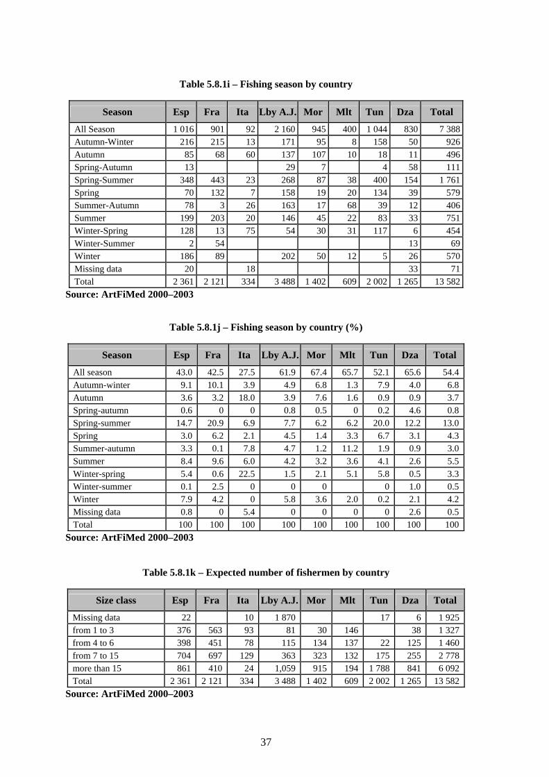
37
Table 5.8.1i – Fishing season by country
Season Esp Fra Ita Lby A.J. Mor Mlt Tun Dza Total
All Season 1 016 901 92 2 160 945 400 1 044 830 7 388Autumn-Winter 216 215 13 171 95 8 158 50 926Autumn 85 68 60 137 107 10 18 11 496Spring-Autumn 13 29 7 4 58 111Spring-Summer 348 443 23 268 87 38 400 154 1 761Spring 70 132 7 158 19 20 134 39 579Summer-Autumn 78 3 26 163 17 68 39 12 406Summer 199 203 20 146 45 22 83 33 751Winter-Spring 128 13 75 54 30 31 117 6 454Winter-Summer 2 54 13 69Winter 186 89 202 50 12 5 26 570Missing data 20 18 33 71Total 2 361 2 121 334 3 488 1 402 609 2 002 1 265 13 582
Source: ArtFiMed 2000–2003
Table 5.8.1j – Fishing season by country (%)
Season Esp Fra Ita Lby A.J. Mor Mlt Tun Dza Total
All season 43.0 42.5 27.5 61.9 67.4 65.7 52.1 65.6 54.4Autumn-winter 9.1 10.1 3.9 4.9 6.8 1.3 7.9 4.0 6.8Autumn 3.6 3.2 18.0 3.9 7.6 1.6 0.9 0.9 3.7Spring-autumn 0.6 0 0 0.8 0.5 0 0.2 4.6 0.8Spring-summer 14.7 20.9 6.9 7.7 6.2 6.2 20.0 12.2 13.0Spring 3.0 6.2 2.1 4.5 1.4 3.3 6.7 3.1 4.3Summer-autumn 3.3 0.1 7.8 4.7 1.2 11.2 1.9 0.9 3.0Summer 8.4 9.6 6.0 4.2 3.2 3.6 4.1 2.6 5.5Winter-spring 5.4 0.6 22.5 1.5 2.1 5.1 5.8 0.5 3.3Winter-summer 0.1 2.5 0 0 0 0 1.0 0.5Winter 7.9 4.2 0 5.8 3.6 2.0 0.2 2.1 4.2Missing data 0.8 0 5.4 0 0 0 0 2.6 0.5Total 100 100 100 100 100 100 100 100 100
Source: ArtFiMed 2000–2003
Table 5.8.1k – Expected number of fishermen by country
Size class Esp Fra Ita Lby A.J. Mor Mlt Tun Dza Total
Missing data 22 10 1 870 17 6 1 925from 1 to 3 376 563 93 81 30 146 38 1 327from 4 to 6 398 451 78 115 134 137 22 125 1 460from 7 to 15 704 697 129 363 323 132 175 255 2 778more than 15 861 410 24 1,059 915 194 1 788 841 6 092Total 2 361 2 121 334 3 488 1 402 609 2 002 1 265 13 582
Source: ArtFiMed 2000–2003
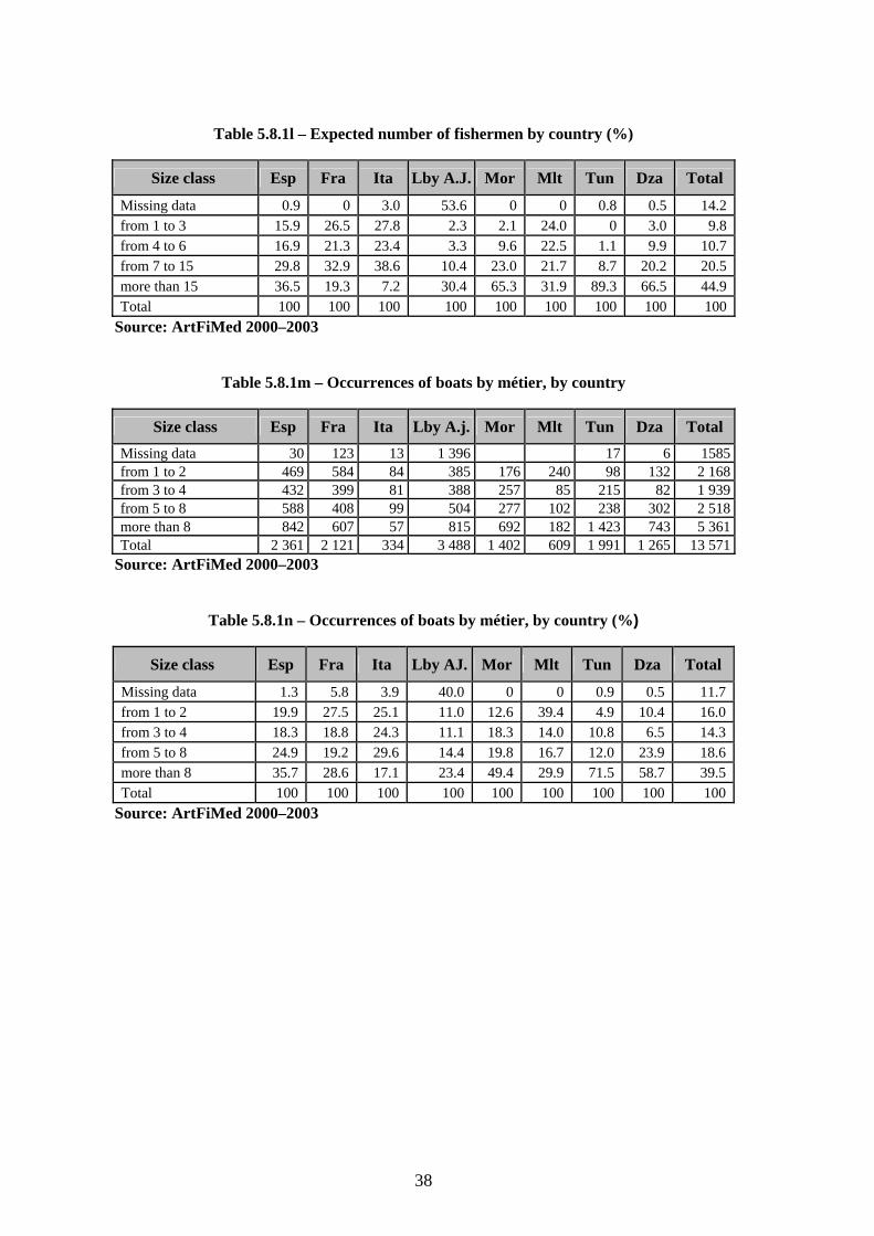
38
Table 5.8.1l – Expected number of fishermen by country (%)
Size class Esp Fra Ita Lby A.J. Mor Mlt Tun Dza Total
Missing data 0.9 0 3.0 53.6 0 0 0.8 0.5 14.2from 1 to 3 15.9 26.5 27.8 2.3 2.1 24.0 0 3.0 9.8from 4 to 6 16.9 21.3 23.4 3.3 9.6 22.5 1.1 9.9 10.7from 7 to 15 29.8 32.9 38.6 10.4 23.0 21.7 8.7 20.2 20.5more than 15 36.5 19.3 7.2 30.4 65.3 31.9 89.3 66.5 44.9Total 100 100 100 100 100 100 100 100 100
Source: ArtFiMed 2000–2003
Table 5.8.1m – Occurrences of boats by métier, by country
Size class Esp Fra Ita Lby A.j. Mor Mlt Tun Dza Total Missing data 30 123 13 1 396 17 6 1585from 1 to 2 469 584 84 385 176 240 98 132 2 168from 3 to 4 432 399 81 388 257 85 215 82 1 939from 5 to 8 588 408 99 504 277 102 238 302 2 518more than 8 842 607 57 815 692 182 1 423 743 5 361Total 2 361 2 121 334 3 488 1 402 609 1 991 1 265 13 571
Source: ArtFiMed 2000–2003
Table 5.8.1n – Occurrences of boats by métier, by country (%)
Size class Esp Fra Ita Lby AJ. Mor Mlt Tun Dza Total
Missing data 1.3 5.8 3.9 40.0 0 0 0.9 0.5 11.7from 1 to 2 19.9 27.5 25.1 11.0 12.6 39.4 4.9 10.4 16.0from 3 to 4 18.3 18.8 24.3 11.1 18.3 14.0 10.8 6.5 14.3from 5 to 8 24.9 19.2 29.6 14.4 19.8 16.7 12.0 23.9 18.6more than 8 35.7 28.6 17.1 23.4 49.4 29.9 71.5 58.7 39.5Total 100 100 100 100 100 100 100 100 100
Source: ArtFiMed 2000–2003
39
6. CASE STUDIES Once the preliminary part had been completed, the programme made a big change in its activity: it passed from a qualitative and generic inventory to punctual and precise studies to be implemented where the experimental conditions enabled in-depth and detailed data collection. The first case study, which should in any case be proposed in countries where this is a standing issue, was the assessment of the weight in terms of fleet, catch, effort and value of the artisanal fishery. Some proposals came out of the meeting in Monastir, Tunisia (May, 1999) from the country experts. The participants had been asked to form groups and prepare a theoretical case analysis. The subjects for these case analyses were chosen by the participants. The following case studies were worked out:
Evolution of a given métier Prospectives of integration and diversification of the artisanal fishery in the region Interactions between artisanal fisheries métiers and the interaction between artisanal and
industrial fisheries The final decision on the case studies was taken at the meeting dealing with the end of the inventory phase, where the results so far achieved were presented and commented. At that moment the country experts knew on which data and information they could count, and had a clear idea of the distribution pattern of the artisanal fishery communities, their concentrations, the composition, the importance, similarities, etc. In order to expedite implementation of the programme, two case studies were assigned: one in south Italy and one in Morocco (Nador). They were published in a specific issue of the series Informes y Estudios COPEMED nº 10. (Colloca et al., 2003) published in September 2003. 6.1 Artisanal fishery in the Cilento area (southern Tyrrhenian Sea), Coordinator: Francesco Colloca (with Crespi, V., Cerasi, S. and Coppola, S.R.) Objectives: The general objective of the study was to identify management/co-management strategies in artisanal fishery, which could be used as a guide in other Italian/Mediterranean coastal areas. Data collection routines on both fishery activity and coastal zone based activities were developed for this purpose. The outputs of the study were the following:
analysis of the evolution of the artisanal fishery during the last ten years through comparison of old (1994–95) and new quantitative data on fishery components;
distribution analysis of the fishing effort in the coastal zone; socio-economic changes which had affected the traditional fishing activities; analysis of factors involved in the observed processes; hypothesis testing, studies of issues related to processing and management systems.
40
6.2 Integrated Study of artisanal fisheries in the Nador lagoon, by Malouli Idrissi, M. and Houssa Rachida. (original title : Etude intégrée de la pêche artisanale dans la lagune de Nador, par Malouli Idrissi, M. et Houssa Rachida)
Objectives:
Estimate of the global fishing effort. Estimate of the catch per effort unit and of the lagoon's global catch. Assessment of the socio-economic features. Use of the GIS tool for mapping the fishing effort, the catch per surface unit, the total catch
and the socio-economic features. Spatial analysis of the interaction between the different mapping parameters. Identification and economic assessment of the train chain fishery products. Identification of constraints for the industry and possible solutions.
For more information on the two case studies, the document is available upon request to COPEMED and in PDF format at: http://www.faocopemed.org
41
APPENDIX 1
Contributors
Abdalla Ben-Abdalla MBRC – Tripoli Libyan A.J. Ahmed Amer Zentani MBRC – Tajura Libyan A.J. Alain Bonzon FAO Fisheries Department – Rome Italy Alain Damiano ORSTOM France Alessandro Germoni FAO–COPEMED, Rome Italy Alexis Bensch COPEMED, Alicante Spain Amor El Abed Directeur general INSTM Tunisia André Forest IFREMER Nante France Atig A. D. Huni Director MBRC – Tajura Libyan A.J. Ben Moussa Hedi DGPA – Tunis, Tunisia Tunisia Charles Busuttil Department of Fisheries and Aquaculture Malta Christophe Breuil Economie des Pêches France Fabio Conte MiPAF DG–Pesca – Rome Italy Federico De Rossi FAO–MedStad TaskForce Rome Italy Francesco Colloca University of Rome Italy Francisco Ramos COPEMED Alicante Spain Giovanni Della Seta MiPAF – DG Pesca – Rome Italy Guillou Alain IFREMER Sète France Harry Farrugio Directeur IFREMER Sète France Houcine Gharbi INSTM La Goulette Tunisia Jarboui Ohrman INSTM Sfax Tunisia Jorge Baro IEO Malaga–Fuengirola Spain José Antonio Alarcón COPEMED – IEO Malaga–Fuengirola Spain José Miguel Serna IEO Malaga–Fuengirola Spain Juan Ignacio de Leiva FAO–COPEMED, Rome Italy
K. Boudjelida Directeur de la formation, de la recherche et de la vulgarisation (MPRH) Algeria
Lucio Labanchi IREPA Salerno Italy Malouli Idrissi Mohamed INRH Centre Nador Morocco Marco Spinelli FAO MedStat TaskForce–Rome Italy Matthew Camilleri Department of Fisheries and Aquaculture Malta Michael Darmanin Department of Fisheries and Aquaculture Malta Michel Lamboeuf FAO–COPEMED Consultant Libyan A.J. Mme Linda Kerzabi MPRH – Algérie Algeria Pedro Torres IEO – Madrid Spain Pilar Hernandez COPEMED, Alicante Spain Rachid Benayad MPRH – Algeir Algeria Rafael Robles Director COPEMED Project Spain Sadok Ben Meriem INSTM La Goulette Tunisia Sahi Mohand Akli CNDPA – Bou Ismail Tipaza, Algérie Algeria Salvatore R. Coppola FAO Fisheries Department – Rome Italy Valerio Crespi and Géraldine Criquet FAO–COPEMED/IFREMER – Sète Italy
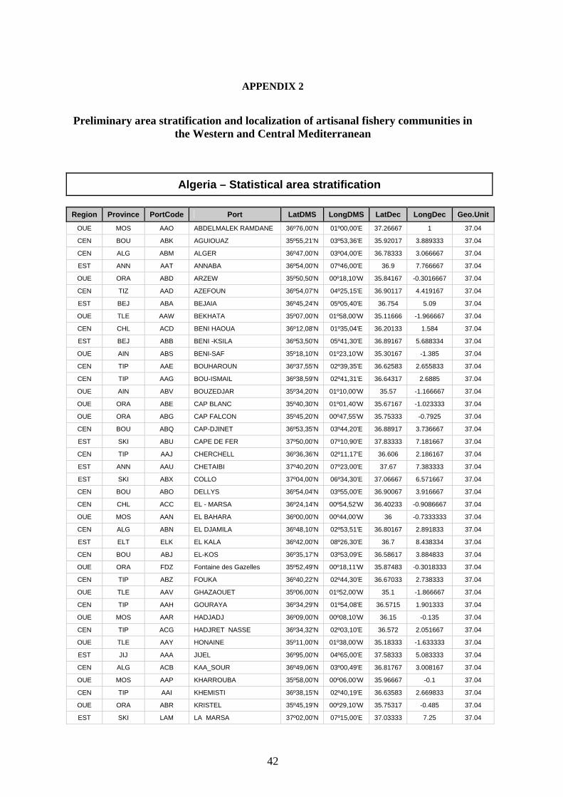
42
APPENDIX 2
Preliminary area stratification and localization of artisanal fishery communities in the Western and Central Mediterranean
Algeria – Statistical area stratification
Region Province PortCode Port LatDMS LongDMS LatDec LongDec Geo.Unit
OUE MOS AAO ABDELMALEK RAMDANE 36º76,00'N 01º00,00'E 37.26667 1 37.04
CEN BOU ABK AGUIOUAZ 35º55,21'N 03º53,36'E 35.92017 3.889333 37.04
CEN ALG ABM ALGER 36º47,00'N 03º04,00'E 36.78333 3.066667 37.04
EST ANN AAT ANNABA 36º54,00'N 07º46,00'E 36.9 7.766667 37.04
OUE ORA ABD ARZEW 35º50,50'N 00º18,10'W 35.84167 -0.3016667 37.04
CEN TIZ AAD AZEFOUN 36º54,07'N 04º25,15'E 36.90117 4.419167 37.04
EST BEJ ABA BEJAIA 36º45,24'N 05º05,40'E 36.754 5.09 37.04
OUE TLE AAW BEKHATA 35º07,00'N 01º58,00'W 35.11666 -1.966667 37.04
CEN CHL ACD BENI HAOUA 36º12,08'N 01º35,04'E 36.20133 1.584 37.04
EST BEJ ABB BENI -KSILA 36º53,50'N 05º41,30'E 36.89167 5.688334 37.04
OUE AIN ABS BENI-SAF 35º18,10'N 01º23,10'W 35.30167 -1.385 37.04
CEN TIP AAE BOUHAROUN 36º37,55'N 02º39,35'E 36.62583 2.655833 37.04
CEN TIP AAG BOU-ISMAIL 36º38,59'N 02º41,31'E 36.64317 2.6885 37.04
OUE AIN ABV BOUZEDJAR 35º34,20'N 01º10,00'W 35.57 -1.166667 37.04
OUE ORA ABE CAP BLANC 35º40,30'N 01º01,40'W 35.67167 -1.023333 37.04
OUE ORA ABG CAP FALCON 35º45,20'N 00º47,55'W 35.75333 -0.7925 37.04
CEN BOU ABQ CAP-DJINET 36º53,35'N 03º44,20'E 36.88917 3.736667 37.04
EST SKI ABU CAPE DE FER 37º50,00'N 07º10,90'E 37.83333 7.181667 37.04
CEN TIP AAJ CHERCHELL 36º36,36'N 02º11,17'E 36.606 2.186167 37.04
EST ANN AAU CHETAIBI 37º40,20'N 07º23,00'E 37.67 7.383333 37.04
EST SKI ABX COLLO 37º04,00'N 06º34,30'E 37.06667 6.571667 37.04
CEN BOU ABO DELLYS 36º54,04'N 03º55,00'E 36.90067 3.916667 37.04
CEN CHL ACC EL - MARSA 36º24,14'N 00º54,52'W 36.40233 -0.9086667 37.04
OUE MOS AAN EL BAHARA 36º00,00'N 00º44,00'W 36 -0.7333333 37.04
CEN ALG ABN EL DJAMILA 36º48,10'N 02º53,51'E 36.80167 2.891833 37.04
EST ELT ELK EL KALA 36º42,00'N 08º26,30'E 36.7 8.438334 37.04
CEN BOU ABJ EL-KOS 36º35,17'N 03º53,09'E 36.58617 3.884833 37.04
OUE ORA FDZ Fontaine des Gazelles 35º52,49'N 00º18,11'W 35.87483 -0.3018333 37.04
CEN TIP ABZ FOUKA 36º40,22'N 02º44,30'E 36.67033 2.738333 37.04
OUE TLE AAV GHAZAOUET 35º06,00'N 01º52,00'W 35.1 -1.866667 37.04
CEN TIP AAH GOURAYA 36º34,29'N 01º54,08'E 36.5715 1.901333 37.04
OUE MOS AAR HADJADJ 36º09,00'N 00º08,10'W 36.15 -0.135 37.04
CEN TIP ACG HADJRET NASSE 36º34,32'N 02º03,10'E 36.572 2.051667 37.04
OUE TLE AAY HONAINE 35º11,00'N 01º38,00'W 35.18333 -1.633333 37.04
EST JIJ AAA JIJEL 36º95,00'N 04º65,00'E 37.58333 5.083333 37.04
CEN ALG ACB KAA_SOUR 36º49,06'N 03º00,49'E 36.81767 3.008167 37.04
OUE MOS AAP KHARROUBA 35º58,00'N 00º06,00'W 35.96667 -0.1 37.04
CEN TIP AAI KHEMISTI 36º38,15'N 02º40,19'E 36.63583 2.669833 37.04
OUE ORA ABR KRISTEL 35º45,19'N 00º29,10'W 35.75317 -0.485 37.04
EST SKI LAM LA MARSA 37º02,00'N 07º15,00'E 37.03333 7.25 37.04
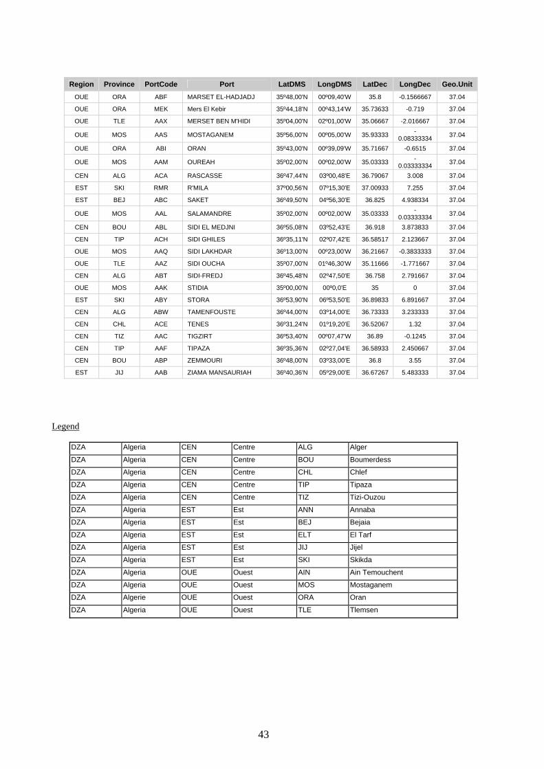
43
Region Province PortCode Port LatDMS LongDMS LatDec LongDec Geo.Unit OUE ORA ABF MARSET EL-HADJADJ 35º48,00'N 00º09,40'W 35.8 -0.1566667 37.04
OUE ORA MEK Mers El Kebir 35º44,18'N 00º43,14'W 35.73633 -0.719 37.04
OUE TLE AAX MERSET BEN M'HIDI 35º04,00'N 02º01,00'W 35.06667 -2.016667 37.04
OUE MOS AAS MOSTAGANEM 35º56,00'N 00º05,00'W 35.93333 -0.08333334 37.04
OUE ORA ABI ORAN 35º43,00'N 00º39,09'W 35.71667 -0.6515 37.04
OUE MOS AAM OUREAH 35º02,00'N 00º02,00'W 35.03333 -0.03333334 37.04
CEN ALG ACA RASCASSE 36º47,44'N 03º00,48'E 36.79067 3.008 37.04
EST SKI RMR R'MILA 37º00,56'N 07º15,30'E 37.00933 7.255 37.04
EST BEJ ABC SAKET 36º49,50'N 04º56,30'E 36.825 4.938334 37.04
OUE MOS AAL SALAMANDRE 35º02,00'N 00º02,00'W 35.03333 -0.03333334 37.04
CEN BOU ABL SIDI EL MEDJNI 36º55,08'N 03º52,43'E 36.918 3.873833 37.04
CEN TIP ACH SIDI GHILES 36º35,11'N 02º07,42'E 36.58517 2.123667 37.04
OUE MOS AAQ SIDI LAKHDAR 36º13,00'N 00º23,00'W 36.21667 -0.3833333 37.04
OUE TLE AAZ SIDI OUCHA 35º07,00'N 01º46,30'W 35.11666 -1.771667 37.04
CEN ALG ABT SIDI-FREDJ 36º45,48'N 02º47,50'E 36.758 2.791667 37.04
OUE MOS AAK STIDIA 35º00,00'N 00º0,0'E 35 0 37.04
EST SKI ABY STORA 36º53,90'N 06º53,50'E 36.89833 6.891667 37.04
CEN ALG ABW TAMENFOUSTE 36º44,00'N 03º14,00'E 36.73333 3.233333 37.04
CEN CHL ACE TENES 36º31,24'N 01º19,20'E 36.52067 1.32 37.04
CEN TIZ AAC TIGZIRT 36º53,40'N 00º07,47'W 36.89 -0.1245 37.04
CEN TIP AAF TIPAZA 36º35,36'N 02º27,04'E 36.58933 2.450667 37.04
CEN BOU ABP ZEMMOURI 36º48,00'N 03º33,00'E 36.8 3.55 37.04
EST JIJ AAB ZIAMA MANSAURIAH 36º40,36'N 05º29,00'E 36.67267 5.483333 37.04
Legend
DZA Algeria CEN Centre ALG Alger
DZA Algeria CEN Centre BOU Boumerdess
DZA Algeria CEN Centre CHL Chlef
DZA Algeria CEN Centre TIP Tipaza
DZA Algeria CEN Centre TIZ Tizi-Ouzou
DZA Algeria EST Est ANN Annaba
DZA Algeria EST Est BEJ Bejaia
DZA Algeria EST Est ELT El Tarf
DZA Algeria EST Est JIJ Jijel
DZA Algeria EST Est SKI Skikda
DZA Algeria OUE Ouest AIN Ain Temouchent
DZA Algeria OUE Ouest MOS Mostaganem
DZA Algerie OUE Ouest ORA Oran
DZA Algeria OUE Ouest TLE Tlemsen
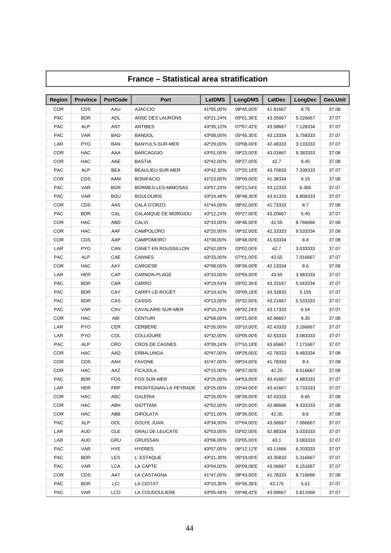
44
France – Statistical area stratification
Region Province PortCode Port LatDMS LongDMS LatDec LongDec Geo.Unit
COR CDS AAU AJACCIO 41º55,00'N 08º45,00'E 41.91667 8.75 37.08
PAC BDR ADL ANSE DES LAURONS 43º21,24'N 05º01,36'E 43.35667 5.026667 37.07
PAC ALP ANT ANTIBES 43º35,12'N 07º07,42'E 43.58667 7.128334 37.07
PAC VAR BAD BANDOL 43º08,00'N 05º45,30'E 43.13334 5.758333 37.07
LAR PYO BAN BANYULS-SUR-MER 42º29,00'N 03º08,00'E 42.48333 3.133333 37.07
COR HAC AAA BARCAGGIO 43º01,00'N 09º23,00'E 43.01667 9.383333 37.08
COR HAC AAE BASTIA 42º42,00'N 09º27,00'E 42.7 9.45 37.08
PAC ALP BEA BEAULIEU-SUR-MER 43º42,30'N 07º20,18'E 43.70833 7.338333 37.07
COR CDS AAM BONIFACIO 41º23,00'N 09º09,00'E 41.38334 9.15 37.08
PAC VAR BOR BORMES-LES-MIMOSAS 43º07,24'N 06º21,54'E 43.12333 6.365 37.07
PAC VAR BOU BOULOURIS 43º24,48'N 06º48,30'E 43.41333 6.808333 37.07
COR CDS AAS CALA D'ORZO 41º44,00'N 08º42,00'E 41.73333 8.7 37.08
PAC BDR CAL CALANQUE DE MORGIOU 43º12,24'N 05º27,00'E 43.20667 5.45 37.07
COR HAC ABD CALVI 42º33,00'N 08º46,00'E 42.55 8.766666 37.08
COR HAC AAF CAMPOLORO 42º20,00'N 09º32,00'E 42.33333 9.533334 37.08
COR CDS AAP CAMPOMORO 41º38,00'N 08º48,00'E 41.63334 8.8 37.08
LAR PYO CAN CANET EN ROUSSILLON 42º42,00'N 03º02,00'E 42.7 3.033333 37.07
PAC ALP CAE CANNES 43º33,00'N 07º01,00'E 43.55 7.016667 37.07
COR HAC AAY CARGESE 42º08,00'N 08º36,00'E 42.13334 8.6 37.08
LAR HER CAP CARNON-PLAGE 43º33,00'N 03º59,00'E 43.55 3.983333 37.07
PAC BDR CAR CARRO 43º19,54'N 05º02,36'E 43.33167 5.043334 37.07
PAC BDR CAY CARRY-LE-ROUET 43º19,42'N 05º09,18'E 43.32833 5.155 37.07
PAC BDR CAS CASSIS 43º13,00'N 05º32,00'E 43.21667 5.533333 37.07
PAC VAR CAV CAVALAIRE-SUR-MER 43º10,24'N 06º32,24'E 43.17333 6.54 37.07
COR HAC ABI CENTURI 42º58,00'N 09º21,00'E 42.96667 9.35 37.08
LAR PYO CER CERBERE 42º26,00'N 03º10,00'E 42.43333 3.166667 37.07
LAR PYO COL COLLIOURE 42º32,00'N 03º05,00'E 42.53333 3.083333 37.07
PAC ALP CRO CROS DE CAGNES 43º39,24'N 07º10,18'E 43.65667 7.171667 37.07
COR HAC AAD ERBALUNGA 42º47,00'N 09º29,00'E 42.78333 9.483334 37.08
COR CDS AAH FAVONE 41º47,00'N 09º24,00'E 41.78333 9.4 37.08
COR HAC AAZ FICAJOLA 42º15,00'N 08º37,00'E 42.25 8.616667 37.08
PAC BDR FOS FOS-SUR-MER 43º25,00'N 04º53,00'E 43.41667 4.883333 37.07
LAR HER FRP FRONTIGNAN-LA PEYRADE 43º25,00'N 03º44,00'E 43.41667 3.733333 37.07
COR HAC ABC GALERIA 42º26,00'N 08º39,00'E 42.43333 8.65 37.08
COR HAC ABH GIOTTANI 42º52,00'N 09º20,00'E 42.86666 9.333333 37.08
COR HAC ABB GIROLATA 42º21,00'N 08º36,00'E 42.35 8.6 37.08
PAC ALP GOL GOLFE JUAN 43º34,00'N 07º04,00'E 43.56667 7.066667 37.07
LAR AUD GLE GRAU DE LEUCATE 42º53,00'N 03º02,00'E 42.88334 3.033333 37.07
LAR AUD GRU GRUISSAN 43º06,00'N 03º05,00'E 43.1 3.083333 37.07
PAC VAR HYE HYERES 43º07,00'N 06º12,12'E 43.11666 6.203333 37.07
PAC BDR LES L' ESTAQUE 43º21,30'N 05º19,00'E 43.35833 5.316667 37.07
PAC VAR LCA LA CAPTE 43º04,00'N 06º09,06'E 43.06667 6.151667 37.07
COR CDS AAT LA CASTAGNA 41º47,00'N 08º43,00'E 41.78333 8.716666 37.08
PAC BDR LCI LA CIOTAT 43º10,30'N 05º36,36'E 43.175 5.61 37.07
PAC VAR LCO LA COUDOULIERE 43º05,48'N 05º48,42'E 43.09667 5.811666 37.07

45
Region Province PortCode Port LatDMS LongDMS LatDec LongDec Geo.Unit PAC ALP LFI LA FIGUEIRETTE 43º29,06'N 06º56,06'E 43.485 6.935 37.07
PAC ALP LGA LA GALERE 43º30,00'N 06º57,24'E 43.5 6.956666 37.07
PAC VAR LLO LA LONDE LES MAURES 43º07,00'N 06º14,54'E 43.11666 6.248333 37.07
PAC VAR LMA LA MADRAGUE 43º02,24'N 06º06,42'E 43.04 6.111667 37.07
PAC BDR LMO LA MADRAGUE-DE-MONTREDON 43º14,00'N 05º21,12'E 43.23333 5.353333 37.07
PAC ALP LRA LA RAGUE 43º31,00'N 06º56,24'E 43.51667 6.94 37.07
PAC BDR LRE LA REDONNE 43º20,06'N 05º12,00'E 43.335 5.2 37.07
PAC ALP LSA LA SALIS 43º34,12'N 07º08,00'E 43.57 7.133333 37.07
PAC VAR LSE LA SEYNE-SUR-MER 43º06,06'N 05º53,00'E 43.10167 5.883333 37.07
COR CDS AAV LAVA 41º59,00'N 08º40,00'E 41.98333 8.666667 37.08
PAC VAR LVA LAVANDOU 43º08,18'N 06º22,18'E 43.13833 6.371666 37.07
LAR GAR GRO LE GRAU-DU-ROI 43º32,00'N 04º08,00'E 43.53333 4.133333 37.07
PAC ALP LMU LE MOURE ROUGE 43º32,36'N 07º02,36'E 43.54333 7.043334 37.07
LAR AUD CAF LES CABANES-DE-FLEURY 43º13,00'N 03º14,00'E 43.21667 3.233333 37.07
COR HAC ABF L'ILE ROUSSE 42º38,00'N 08º56,00'E 42.63334 8.933333 37.08
COR HAC AAB MACINAGGIO 42º58,00'N 09º27,00'E 42.96667 9.45 37.08
PAC ALP MAN MANDELIEU-LA-NAPOULE 43º31,30'N 06º56,48'E 43.525 6.946667 37.07
PAC VAR MAR MARINES DE COGOLIN 43º16,00'N 06º35,18'E 43.26667 6.588333 37.07
LAR HER MPL MARSEILLAN-PLAGE 43º19,00'N 03º34,00'E 43.31667 3.566667 37.07
PAC BDR MAG MARTIGUES 43º24,00'N 05º03,00'E 43.4 5.05 37.07
PAC ALP MEN MENTON 43º46,36'N 07º30,42'E 43.77667 7.511667 37.07
PAC ALP MON MONACO 43º44,06'N 07º25,30'E 43.735 7.425 37.07
PAC ALP NIC NICE 43º41,42'N 07º17,12'E 43.695 7.286667 37.07
LAR HER PAL PALAVAS-LE FLOTS 43º32,00'N 03º56,00'E 43.53333 3.933333 37.07
COR CDS AAN PIANNOTOLI 41º29,00'N 08º57,00'E 41.48333 8.95 37.08
COR CDS AAI PINARELLO 41º41,00'N 09º23,00'E 41.68333 9.383333 37.08
PAC VAR PDA PORT D'AGAY 43º25,48'N 06º51,30'E 43.43 6.858333 37.07
PAC BDR PCA PORT DE CARTEAU 43º21,00'N 04º51,00'E 43.35 4.85 37.07
PAC ALP PFO PORT DE FONTEVILLE (MONACO) 43º43,48'N 07º25,24'E 43.73 7.423333 37.07
LAR HER FRO PORT DE FRONTIGNAN 43º26,00'N 03º46,00'E 43.43333 3.766667 37.07
PAC BDR PGO PORT DE GOUDES 43º13,00'N 05º20,48'E 43.21667 5.346667 37.07
PAC BDR PAM PORT DE L'AMARREE 43º27,48'N 04º23,36'E 43.46333 4.393333 37.07
PAC BDR PPE PORT DE PECHE DE SAUMATY 43º21,24'N 05º19,30'E 43.35667 5.325 37.07
PAC BDR PSA PORT DE SAUSSET-LES-PINS 43º19,54'N 05º06,30'E 43.33167 5.108333 37.07
PAC VAR POU PORT DES OURSINIERES 43º05,12'N 06º01,12'E 43.08667 6.02 37.07
PAC VAR PBR PORT DU BRUSC 43º04,36'N 05º48,12'E 43.07667 5.803333 37.07
LAR HER AGD PORT DU CAP-D'AGDE 43º16,00'N 03º31,00'E 43.26667 3.516667 37.07
LAR HER GAG PORT DU GRAU-D'AGDE 43º17,00'N 03º27,00'E 43.28333 3.45 37.07
PAC VAR PNI PORT DU NIEL 43º02,12'N 06º07,42'E 43.03667 6.128334 37.07
LAR PYO ARG PORT-ARGELES-LE RACOU 42º32,00'N 03º03,00'E 42.53333 3.05 37.07
PAC VAR PCR PORT-CROS 43º00,36'N 06º23,00'E 43.01 6.383333 37.07
PAC BDR PBO PORT-DE-BOUC 43º24,00'N 04º59,00'E 43.4 4.983333 37.07
PAC BDR PPO PORT-DE-PONTEAU 43º22,12'N 05º00,36'E 43.37 5.01 37.07
PAC ALP PGA PORT-GALLICE ET PORT-CROUTON 43º33,48'N 07º07,00'E 43.56333 7.116667 37.07
LAR AUD PLN PORT-LA-NOUVELLE 43º01,00'N 03º04,00'E 43.01667 3.066667 37.07
LAR AUD LEU PORT-LEUCATE 42º52,00'N 03º03,00'E 42.86666 3.05 37.07
COR HAC ABA PORTO 42º16,00'N 08º41,00'E 42.26667 8.683333 37.08
COR CDS AAR PORTO POLLO 41º43,00'N 08º48,00'E 41.71667 8.8 37.08
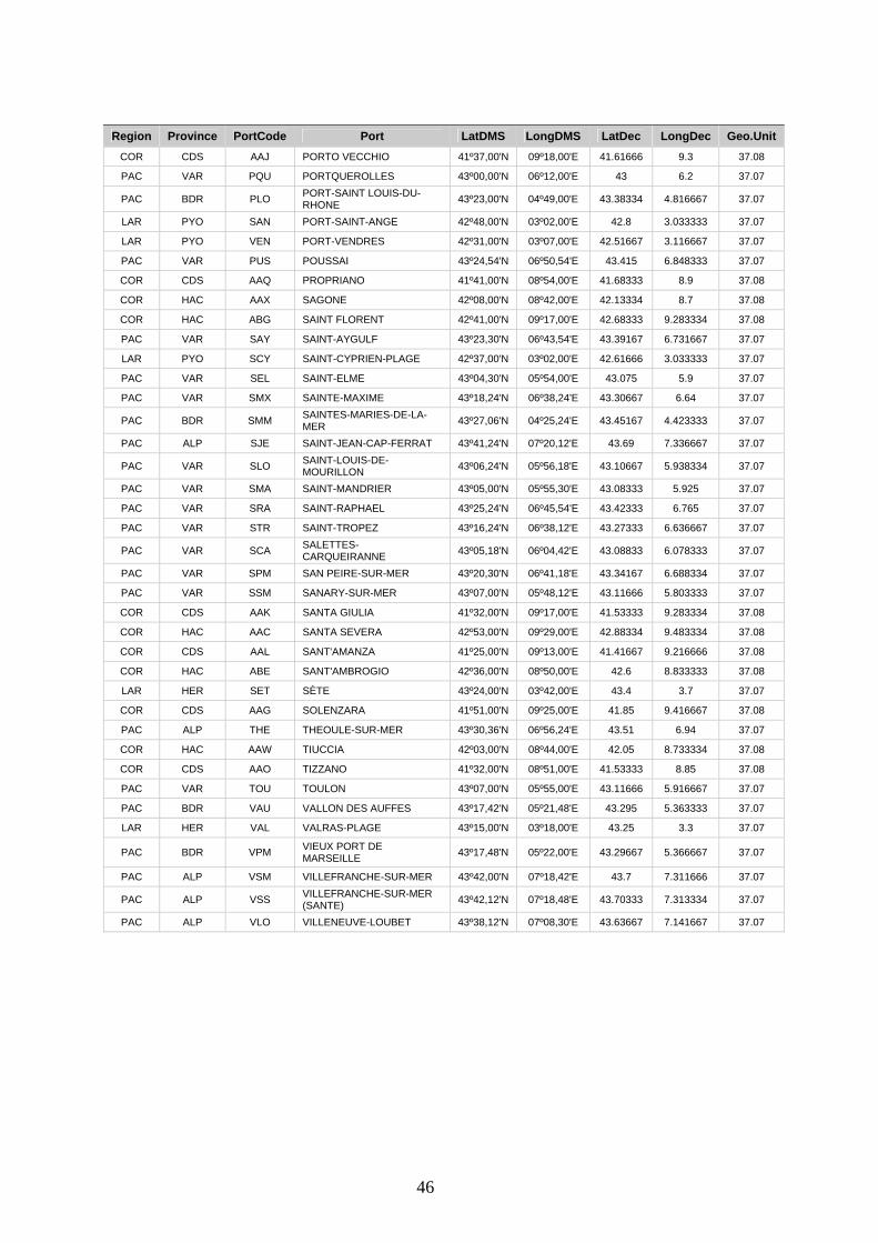
46
Region Province PortCode Port LatDMS LongDMS LatDec LongDec Geo.Unit COR CDS AAJ PORTO VECCHIO 41º37,00'N 09º18,00'E 41.61666 9.3 37.08
PAC VAR PQU PORTQUEROLLES 43º00,00'N 06º12,00'E 43 6.2 37.07
PAC BDR PLO PORT-SAINT LOUIS-DU-RHONE 43º23,00'N 04º49,00'E 43.38334 4.816667 37.07
LAR PYO SAN PORT-SAINT-ANGE 42º48,00'N 03º02,00'E 42.8 3.033333 37.07
LAR PYO VEN PORT-VENDRES 42º31,00'N 03º07,00'E 42.51667 3.116667 37.07
PAC VAR PUS POUSSAI 43º24,54'N 06º50,54'E 43.415 6.848333 37.07
COR CDS AAQ PROPRIANO 41º41,00'N 08º54,00'E 41.68333 8.9 37.08
COR HAC AAX SAGONE 42º08,00'N 08º42,00'E 42.13334 8.7 37.08
COR HAC ABG SAINT FLORENT 42º41,00'N 09º17,00'E 42.68333 9.283334 37.08
PAC VAR SAY SAINT-AYGULF 43º23,30'N 06º43,54'E 43.39167 6.731667 37.07
LAR PYO SCY SAINT-CYPRIEN-PLAGE 42º37,00'N 03º02,00'E 42.61666 3.033333 37.07
PAC VAR SEL SAINT-ELME 43º04,30'N 05º54,00'E 43.075 5.9 37.07
PAC VAR SMX SAINTE-MAXIME 43º18,24'N 06º38,24'E 43.30667 6.64 37.07
PAC BDR SMM SAINTES-MARIES-DE-LA-MER 43º27,06'N 04º25,24'E 43.45167 4.423333 37.07
PAC ALP SJE SAINT-JEAN-CAP-FERRAT 43º41,24'N 07º20,12'E 43.69 7.336667 37.07
PAC VAR SLO SAINT-LOUIS-DE-MOURILLON 43º06,24'N 05º56,18'E 43.10667 5.938334 37.07
PAC VAR SMA SAINT-MANDRIER 43º05,00'N 05º55,30'E 43.08333 5.925 37.07
PAC VAR SRA SAINT-RAPHAEL 43º25,24'N 06º45,54'E 43.42333 6.765 37.07
PAC VAR STR SAINT-TROPEZ 43º16,24'N 06º38,12'E 43.27333 6.636667 37.07
PAC VAR SCA SALETTES-CARQUEIRANNE 43º05,18'N 06º04,42'E 43.08833 6.078333 37.07
PAC VAR SPM SAN PEIRE-SUR-MER 43º20,30'N 06º41,18'E 43.34167 6.688334 37.07
PAC VAR SSM SANARY-SUR-MER 43º07,00'N 05º48,12'E 43.11666 5.803333 37.07
COR CDS AAK SANTA GIULIA 41º32,00'N 09º17,00'E 41.53333 9.283334 37.08
COR HAC AAC SANTA SEVERA 42º53,00'N 09º29,00'E 42.88334 9.483334 37.08
COR CDS AAL SANT'AMANZA 41º25,00'N 09º13,00'E 41.41667 9.216666 37.08
COR HAC ABE SANT'AMBROGIO 42º36,00'N 08º50,00'E 42.6 8.833333 37.08
LAR HER SET SÈTE 43º24,00'N 03º42,00'E 43.4 3.7 37.07
COR CDS AAG SOLENZARA 41º51,00'N 09º25,00'E 41.85 9.416667 37.08
PAC ALP THE THEOULE-SUR-MER 43º30,36'N 06º56,24'E 43.51 6.94 37.07
COR HAC AAW TIUCCIA 42º03,00'N 08º44,00'E 42.05 8.733334 37.08
COR CDS AAO TIZZANO 41º32,00'N 08º51,00'E 41.53333 8.85 37.08
PAC VAR TOU TOULON 43º07,00'N 05º55,00'E 43.11666 5.916667 37.07
PAC BDR VAU VALLON DES AUFFES 43º17,42'N 05º21,48'E 43.295 5.363333 37.07
LAR HER VAL VALRAS-PLAGE 43º15,00'N 03º18,00'E 43.25 3.3 37.07
PAC BDR VPM VIEUX PORT DE MARSEILLE 43º17,48'N 05º22,00'E 43.29667 5.366667 37.07
PAC ALP VSM VILLEFRANCHE-SUR-MER 43º42,00'N 07º18,42'E 43.7 7.311666 37.07
PAC ALP VSS VILLEFRANCHE-SUR-MER (SANTE) 43º42,12'N 07º18,48'E 43.70333 7.313334 37.07
PAC ALP VLO VILLENEUVE-LOUBET 43º38,12'N 07º08,30'E 43.63667 7.141667 37.07

47
Legend
FRA France COR Corse CDS Corse-du-Sud
FRA France COR Corse HAC Haute-Corse
FRA France LAR Languedoc-Roussillon AUD Aude
FRA France LAR Languedoc-Roussillon GAR Gard
FRA France LAR Languedoc-Roussillon HER Hérault
FRA France LAR Languedoc-Roussillon PYO Pyrenées-Orientales
FRA France PAC Provence-Alpes-Côte d´Azur ALP Alpes-Maritimes
FRA France PAC Provence-Alpes-Côte d´Azur BDR Bouches-du-Rhône
FRA France PAC Provence-Alpes-Côte d´Azur VAR Var

48
Italy – Statistical area stratification
Region Province PortCode Port LatDMS LongDMS LatDec LongDec Geo.Unit
CAM SAL ACC ACCIAROLI 40º11,00'N 15º01,47'E 40.18333 15.02967 37.10
SIC CAT ACI ACI TREZZA 37°33,40'N 15°09,80'E 37.55667 15.16333 37.19
CAM SAL AGN AGNONE S. NICOLA 40°13,00'N 14°59,00'E 40.21667 14.98333 37.10
CAM SAL AGR AGROPOLI 40°21,30'N 14°59,00'E 40.355 14.98333 37.10
LIG SAV ALA ALASSIO 44°01,12'N 08°11,60'E 44.01867 8.193334 37.09
LIG SAV ALB ALBENGA 44°02,00'N 08°13,00'E 44.03333 8.216666 37.09
SAR SAS ALG ALGHERO 40°33,87'N 08°18,46'E 40.5645 8.307667 37.11
CAM SAL AMA AMALFI 40°37,94'N 14°36,13'E 40.63233 14.60217 37.10
CAL CSZ AMN AMANTEA 39°08,00'N 16°04,00'E 39.13334 16.06667 37.10
TUS LIV ANT ANTIGNANO 43°29,68'N 10°24,63'E 43.49467 10.4105 37.09
LAT ROM ANZ ANZIO 41°26,62'N 12°38,38'E 41.44367 12.63967 37.09
SAR NUO ARB ARBATAX 39°56,60'N 09°42,07'E 39.94333 9.701167 37.11
TUS LIV ARD ARDENZA 43°31,00'N 10°18,95'E 43.51667 10.31583 37.09
SIC PAL ARE ARENELLA 38°08,91'N 13°22,52'E 38.1485 13.37533 37.10
LIG GEN ARZ ARENZANO 44°23,97'N 08°41,25'E 44.3995 8.6875 37.09
LIG IMP ARM ARMA DI TAGGIA 43°49,90'N 07°51,60'E 43.83167 7.86 37.09
SIC SIR AUG AUGUSTA - RADA 37°11,72'N 15°14,07'E 37.19533 15.2345 37.19
CAL REG BAG BAGNARA CALABRA 38°17,90'N 15°48,97'E 38.29833 15.81617 37.10
CAM NAP BAI BAIA 40°49,04'N 14°04,73'E 40.81733 14.07883 37.10
SIC SIR BAO BAIA DI OGNINA 36°58,69'N 15°15,58'E 36.97817 15.25967 37.16
SIC PAL BAL BALESTRATE 38°03,06'N 13°00,36'E 38.051 13.006 37.10
TUS PSA BCA BOCCA D'ARNO 43°40,80'N 10°16,20'E 43.68 10.27 37.09
LIG LSP BCM BOCCA DI MAGRA 44°02,70'N 09°59,40'E 44.045 9.99 37.09
SIC TRA BON BONAGIA 38°04,10'N 12°35,60'E 38.06833 12.59333 37.10
LIG LSP BSS BONASSOLA 44°10,85'N 09°34,10'E 44.18083 9.568334 37.09
LIG IMP BOR BORDIGHERA 43°46,82'N 07°40,71'E 43.78033 7.6785 37.09
SAR NUO BOS BOSA MARINA 40°17,36'N 08°28,61'E 40.28933 8.476833 37.11
CAL VIB BRI BRIATICO 37.10
SIC SIR BRU BRUCOLI 37°17,15'N 15°11,17'E 37.28583 15.18617 37.19
SAR CAG BUG BUGGERRU 39°24,04'N 08°24,04'E 39.40067 8.400666 37.11
SAR CAG CAG CAGLIARI 39°12,00'N 09°06,71'E 39.2 9.111834 37.11
SIC SIR CBE CALA BERNARDO 36°51,88'N 15°08,00'E 36.86467 15.13333 37.16
SAR SAS CBI CALA BITTA 41°07,65'N 09°28,06'E 41.1275 9.467667 37.11
TUS LIV CSC CALA DELLO SCALO (ISOLA GORGONIA) 43°25,72'N 09°54,60'E 43.42867 9.91 37.09
LAT LAT CFE CALA DI FEOLA (ISOLA DI PONZA) 40°53,84'N 12°57,96'E 40.89734 12.966 37.10
SAR NUO CGO CALA GONONE 40°16,81'N 09°38,36'E 40.28017 9.639334 37.11
TUS LIV CGI CALA S. GIOVANNI (ISOLA PIANOSA) 42°35,25'N 10°05,71'E 42.5875 10.09517 37.09
LIG GEN CAR CAMOGLI 44°21,09'N 09°09,03'E 44.3515 9.1505 37.09
TUS GRO CAM CAMPESE (ISOLA DEL GIGLIO) 42°22,18'N 10°52,79'E 42.36967 10.87983 37.09
LAT LAT CAN CANALE DI S. ANASTASIA 41°17,29'N 13°20,66'E 41.28817 13.34433 37.10
SAR SAS CNN CANNIGIONE 41°06,47'N 09°26,66'E 41.10783 9.444333 37.11
SIC MES COR CAPO D’ORLANDO 38°09,45'N 14°45,80'E 38.1575 14.76333 37.10
TUS LIV CAP CAPRAIA (ISOLA DI CAPRAIA) 43°03,09'N 09°50,36'E 43.0515 9.839334 37.09
49
Region Province PortCode Port LatDMS LongDMS LatDec LongDec Geo.Unit
CAM NAP CMI CASAMICCIOLA (ISOLA D'ISCHIA) 40°45,07'N 13°54,73'E 40.75117 13.91217 37.10
SIC TRA CDG CASTELLAMMARE DEL GOLFO 38°01,86'N 12°52,99'E 38.031 12.88317 37.10
CAM NAP CST CASTELLAMMARE DI STABIA 40°41,85'N 14°28,61'E 40.6975 14.47683 37.10
SAR SAS CTS CASTELSARDO 40°54,92'N 08°42,16'E 40.91533 8.702666 37.11
TUS LIV CTG CASTIGLIONCELLO 43°24,15'N 10°25,30'E 43.4025 10.42167 37.09
TUS GRO CPE CASTIGLIONE DELLA PESCAIA 42°45,58'N 10°52,71'E 42.75967 10.8785 37.09
SIC CAT CAT CATANIA 37°29,16'N 15°05,40'E 37.486 15.09 37.19
TUS LIV CAV CAVO (ISOLA D'ELBA) 42°51,65'N 10°25,40'E 42.86083 10.42333 37.09
SIC PAL CEF CEFALU - PORTO VECCHIO 38°02,25'N 14°01,08'E 38.0375 14.018 37.10
CAM SAL CET CETARA 40°38,81'N 14°42,27'E 40.64683 14.7045 37.10
CAL CSZ CER CETRARO 39°31,36'N 15°55,62'E 39.52267 15.927 37.10
CAM NAP CHI CHIAIOLELLA (ISOLA DI PROCIDA) 40°44,73'N 14°00,44'E 40.7455 14.00733 37.10
LIG GEN CHA CHIAVARI 44°18,71'N 09°19,11'E 44.31183 9.3185 37.09
LAT ROM CIV CIVITAVECCHIA 42°05,97'N 11°46,32'E 42.0995 11.772 37.09
CAL CSZ DIA DIAMANTE 39°40,42'N 15°48,46'E 39.67367 15.80767 37.10
LIG IMP DIN DIANO MARINA 43°54,44'N 08°05,19'E 43.90733 8.0865 37.09
SIC RAG DON DONNALUCATA 36°45,72'N 14°38,11'E 36.762 14.63517 37.16
LIG GEN DUC DUCA DEGLI ABRUZZI – GENOVA 44°23,92'N 08°55,73'E 44.39867 8.928833 37.09
SAR SAS FER FERTILIA 40°35,60'N 08°17,30'E 40.59333 8.288333 37.11
LIG SAV FIN FINALE LIGURE 44°10,56'N 08°22,34'E 44.176 8.372334 37.09
LAT ROM FIU FIUMICINO 41°46,23'N 12°13,11'E 41.7705 12.2185 37.09
CAM CAS FGA FOCE DEL GARIGLIANO 41°13,24'N 13°45,78'E 41.22066 13.763 37.10
CAM SAL FSE FOCE DEL SELE 40°29,95'N 14°56,22'E 40.49917 14.937 37.10
CAM CAS FVO FOCE DEL VOLTURNO 41°01,24'N 13°55,28'E 41.02067 13.92133 37.10
LAT LAT FSI FOCE SISTO 41°15,84'N 13°09,05'E 41.264 13.15083 37.10
LAT LAT FVE FOCE VERDE 41°24,70'N 12°48,87'E 41.41167 12.8145 37.09
TUS GRO FOL FOLLONICA 42°55,32'N 10°45,20'E 42.922 10.75333 37.09
CAM NAP FOR FORIO (ISOLA D'ISCHIA) 40°44,38'N 13°51,60'E 40.73967 13.86 37.10
LAT LAT FOM FORMIA - PORTO NUOVO- 41°15,17'N 13°36,78'E 41.25283 13.613 37.10
TUS LUC FOT FORTE DEI MARMI 43°57,20'N 10°09,80'E 43.95333 10.16333 37.09
LAT LAT GAE GAETA - PORTO SALVO 41°13,12'N 13°34,40'E 41.21867 13.57333 37.10
LIG SAV GAL GALLINARA 44°01,58'N 08°13,52'E 44.02633 8.225333 37.09
SIC CLT GEI GELA 37°03,69'N 14°13,83'E 37.0615 14.2305 37.16
SIC MES GIA GIARDINI NAXOS 37°49,49'N 15°16,62'E 37.82483 15.277 37.19
TUS GRO GIG GIGLIO PORTO (ISOLA DEL GIGLIO) 42°21,61'N 10°55,21'E 42.36017 10.92017 37.09
CAL REG GIO GIOIA TAURO 38°26,60'N 15°53,54'E 38.44333 15.89233 37.10
SAR SAS GOL GOLFO ARANCI 40°59,67'N 09°37,43'E 40.9945 9.623834 37.11
LIG IMP IMP IMPERIA - PORTO MAURIZIO 43°52,58'N 08°01,82'E 43.87634 8.030334 37.09
SIC PAL IFE ISOLA DELLE FEMMINE 38°12,09'N 13°14,05'E 38.2015 13.23417 37.10
SIC MES IAL ISOLA DI ALICUDI 38°32,00'N 14°21,80'E 38.53333 14.36333 37.10
SIC TRA IFP ISOLA DI FAVIGNANA - CALA PRINCIPALE 37°55,93'N 12°19,50'E 37.93217 12.325 37.16
SIC TRA IFL ISOLA DI FAVIGNANA - PUNTA LONGA 37°55,00'N 12°19,30'E 37.91667 12.32167 37.16
SIC MES IFI ISOLA DI FILICUDI-PORTO 38°33,68'N 14°35,00'E 38.56133 14.58333 37.10
SIC AGR ILA ISOLA DI LAMPEDUSA 35°29,58'N 12°36,03'E 35.493 12.6005 37.16
SIC TRA ILE ISOLA DI LEVANZO 37°59,15'N 12°20,56'E 37.98583 12.34267 37.16
SIC AGR ILI ISOLA DI LINOSA 35°51,20'N 12°51,70'E 35.85333 12.86167 37.16
50
Region Province PortCode Port LatDMS LongDMS LatDec LongDec Geo.Unit
SIC MES ILC ISOLA DI LIPARI–CANNETO 38°29,30'N 14°58,00'E 38.48833 14.96667 37.10
SIC MES ILM ISOLA DI LIPARI - MARINA CORTA 38°27,75'N 14°57,55'E 38.4625 14.95917 37.10
SIC MES ILP ISOLA DI LIPARI - PIGNATARO 38°28,55'N 14°57,88'E 38.47583 14.96467 37.10
SIC MES ILT ISOLA DI LIPARI – PORTINENTE 38°27,50'N 14°57,60'E 38.45833 14.96 37.10
SIC MES ILS ISOLA DI LIPARI - SOTTOMONASTERO 38°28,18'N 14°57,47'E 38.46967 14.95783 37.10
SIC TRA IMA ISOLA DI MARETTIMO 37°57,90'N 12°04,49'E 37.965 12.07483 37.16
SIC MES IPA ISOLA DI PANAREA 38°38,10'N 15°04,69'E 38.635 15.07817 37.10
SIC TRA IPT ISOLA DI PANTELLERIA - PORTO VECCHIO 36°49,95'N 11°56,56'E 36.8325 11.94267 37.16
SAR CAG IAC ISOLA DI S. ANTIOCO - CALASETTA 39°06,75'N 08°22,49'E 39.1125 8.374833 37.11
SAR CAG IAP ISOLA DI S. ANTIOCO - PORTO PONTE ROMANO 39°03,13'N 08°28,56'E 39.05217 8.476 37.11
SAR CAG IPI ISOLA DI S. PIETRO - CARLOFORTE 39°08,62'N 08°19,00'E 39.14367 8.316667 37.11
SIC MES ISM ISOLA DI SALINA - MALFA 38°34,85'N 14°50,55'E 38.58083 14.8425 37.10
SIC MES ISR ISOLA DI SALINA - RINELLA 38°32,75'N 14°49,60'E 38.54583 14.82667 37.10
SIC MES ISS ISOLA DI SALINA - S. MARIA DI SALINA 38°33,36'N 14°52,58'E 38.556 14.87633 37.10
SIC MES ISF ISOLA DI STROMBOLI – FICOGRANDE 38°48,28'N 15°14,00'E 38.80467 15.23333 37.10
SIC MES IST ISOLA DI STROMBOLI - SCARI 38°47,09'N 15°14,05'E 38.78483 15.23417 37.10
SIC PAL IUS ISOLA DI USTICA 38°42,42'N 13°11,94'E 38.707 13.199 37.10
SIC MES IVU ISOLA DI VULCANO - PORTO DI LEVANTE 38°24,81'N 14°57,78'E 38.4135 14.963 37.10
SAR SAS LMA LA MADDALENA - PORTO MERCANTILE 41°12,58'N 09°24,57'E 41.20967 9.4095 37.11
LIG LSP LSP LA SPEZIA 44°06,15'N 09°49,90'E 44.1025 9.831667 37.09
CAM NAP LAM LACCO AMENO (ISOLA D'ISCHIA) 40°45,18'N 13°53,58'E 40.753 13.893 37.10
LAT ROM LAD LADISPOLI 41°56,90'N 12°04,30'E 41.94833 12.07167 37.09
LIG SAV LAI LAIGUEGLIA 43°58,80'N 08°09,80'E 43.98 8.163333 37.09
LIG GEN LAV LAVAGNA 44°18,25'N 09°20,52'E 44.30416 9.342 37.09
LIG LSP LGR LE GRAZIE 44°04,21'N 09°50,67'E 44.07017 9.8445 37.09
LIG LSP LER LERICI 44°04,50'N 09°54,35'E 44.075 9.905833 37.09
LIG LSP LEV LEVANTO 44°09,80'N 09°35,70'E 44.16333 9.595 37.09
SIC AGR LIC LICATA 37°05,17'N 13°56,53'E 37.08617 13.94217 37.16
TUS LIV LIV LIVORNO 43°33,44'N 10°17,42'E 43.55733 10.29033 37.09
LIG SAV LOA LOANO 44°08,01'N 08°15,89'E 44.1335 8.264833 37.09
CAM SAL MAI MAIORI 37.10
BAS POT MAR MARATEA 39º59,09'N 15º42,38'E 39.98583 15.71067 37.10
TUS LIV MMA MARCIANA MARINA (ISOLA D'ELBA) 42°48,50'N 10°11,91'E 42.80833 10.1985 37.09
LIG IMP MAG MARINA DEGLI AREGAI 43°50,35'N 07°55,00'E 43.83917 7.916667 37.09
CAM NAP MLO MARINA DELLA LOBRA 40°36,53'N 14°20,19'E 40.60883 14.3365 37.10
LIG SAV MAN MARINA DI ANDORA 43°57,00'N 08°09,55'E 43.95 8.159166 37.09
SIC SIR MAV MARINA DI AVOLA 36°53,80'N 15°08,60'E 36.89667 15.14333 37.16
CAL CSZ MBE MARINA DI BELVEDERE 39°36,44'N 15°51,25'E 39.60733 15.85417 37.10
CAM SAL MDC MARINA DI CAMEROTA 40º00,00'N 15º22,29'E 40 15.37467 37.10
TUS LIV MCA MARINA DI CAMPO (ISOLA D'ELBA) 42°44,54'N 10°14,37'E 42.74233 10.2395 37.09
TUS MCA MCR MARINA DI CARRARA 44°01,69'N 10°02,67'E 44.02817 10.0445 37.09

51
Region Province PortCode Port LatDMS LongDMS LatDec LongDec Geo.UnitCAM SAL CAS MARINA DI CASALVELINO 40º10,29'N 15º06,28'E 40.17484 15.10783 37.10
TUS LIV MCE MARINA DI CECINA 43°18,09'N 10°29,15'E 43.3015 10.48583 37.09
CAM NAP MEQ MARINA DI EQUA 40°39,75'N 14°25,10'E 40.6625 14.41833 37.10
TUS GRO MGR MARINA DI GROSSETO 42°42,82'N 10°59,11'E 42.71367 10.98517 37.09
TUS MCA MMS MARINA DI MASSA 44°00,30'N 10°05,78'E 44.005 10.09633 37.09
LAT ROM MNE MARINA DI NETTUNO 41°27,15'N 12°39,60'E 41.4525 12.66 37.09
SIC MES MPA MARINA DI PATTI 38°09,22'N 14°58,39'E 38.15367 14.97317 37.10
TUS LUC MPI MARINA DI PISA 43°40,78'N 10°16,18'E 43.67967 10.26967 37.09
CAM SAL MDP MARINA DI PISCIOTTA 40º06,17'N 15º13,36'E 40.10467 15.22667 37.10
CAM SAL POL MARINA DI POLICASTRO 40º04,15'N 15º30,15'E 40.07084 15.50417 37.10
CAM NAP MPR MARINA DI PROCIDA (ISOLA DI PROCIDA) 40°46,09'N 14°01,73'E 40.76817 14.02883 37.10
SAR NUO MPU MARINA DI PUNTALDIA 40°48,80'N 09°41,50'E 40.81333 9.691667 37.11
SIC RAG MRA MARINA DI RAGUSA 36°46,80'N 14°32,82'E 36.78 14.547 37.16
LIG GEN MFG MARINA FIERA DI GENOVA 44°23,34'N 08°56,42'E 44.389 8.940333 37.09
CAM NAP MGS MARINA GRANDE - SORRENTO 40°37,66'N 14°22,07'E 40.62767 14.36783 37.10
CAM NAP MGI MARINA GRANDE ( ISOLA DI CAPRI) 40°33,43'N 14°14,70'E 40.55717 14.245 37.10
CAM NAP MPS MARINA PICCOLA - SORRENTO 40°37,79'N 14°22,76'E 40.62983 14.37933 37.10
CAM NAP MPC MARINA PICCOLA ( ISOLA DI CAPRI) 40°32,40'N 14°14,30'E 40.54 14.23833 37.10
SIC TRA MSL MARSALA 37°46,92'N 12°26,16'E 37.782 12.436 37.16
SIC SIR MZM MARZAMEMI 36°43,91'N 15°07,47'E 36.73183 15.1245 37.16
SIC TRA MAZ MAZARA DEL VALLO 37°38,56'N 12°35,22'E 37.64267 12.587 37.16
SIC MES MES MESSINA 38°11,50'N 15°33,71'E 38.19167 15.56183 37.10
CAM NAP MET META DI SORRENTO 40°38,79'N 14°24,46'E 40.6465 14.40767 37.10
SIC MES MIL MILAZZO 38°12,86'N 15°14,96'E 38.21433 15.24933 37.10
CAM NAP MOL MOLOSIGLIO - NAPOLI 40°49,99'N 14°15,53'E 40.83317 14.25883 37.10
SIC PAL MON MONDELLO 38°12,24'N 13°19,76'E 38.204 13.32933 37.10
LIG LSP MRL MONTE ROSSO AL MARE - PORTO DI LEVANTE 44°08,52'N 09°39,63'E 44.142 9.6605 37.09
LIG LSP MRP MONTE ROSSO AL MARE - PORTO DI PONENTE 44°08,57'N 09°38,65'E 44.14283 9.644167 37.09
LIG GEN NER NERVI 44°22,95'N 09°01,96'E 44.3825 9.032666 37.09
CAM NAP NIS NISIDA 40°47,90'N 14°10,20'E 40.79833 14.17 37.10
SAR SAS OLB OLBIA 40°55,25'N 09°31,60'E 40.92083 9.526667 37.11
LIG IMP ONE ONEGLIA 43°52,98'N 08°02,43'E 43.883 8.0405 37.09
SAR ORI ORI ORISTANO - PORTO SANTA GIUSTA 39°51,70'N 08°31,73'E 39.86167 8.528833 37.11
SAR NUO ORO OROSEI 40°22,65'N 09°44,20'E 40.3775 9.736667 37.11
LAT ROM OST OSTIA - CANALE DEI PESCATORI 41°43,02'N 12°18,27'E 41.717 12.3045 37.09
SAR SAS PAU PALAU 41°10,93'N 09°23,30'E 41.18217 9.388333 37.11
SIC PAL PLM PALERMO - PORTO COMMERCIALE - 38°07,22'N 13°22,66'E 38.12033 13.37767 37.10
SIC PAL PLE PALERMO - S. ERASMO 38°06,76'N 13°22,76'E 38.11267 13.37933 37.10
CAM SAL PAL PALINURO 40º01,44'N 15º16,43'E 40.029 15.2785 37.10
CAL REG PAI PALMI 38°21,55'N 15°50,15'E 38.35917 15.83583 37.10
CAL CSZ PAO PAOLA 39°21,65'N 16°01,66'E 39.36083 16.02767 37.10
SAR CAG PER PERD'E SALI 39°01,71'N 09°02,02'E 39.0285 9.033667 37.11
SAR CAG PES PESCHIERA S. GIOVANNI 39°23,90'N 09°37,00'E 39.39833 9.616667 37.11
TUS LIV PIO PIOMBINO 42°55,89'N 10°33,10'E 42.9315 10.55167 37.09
52
Region Province PortCode Port LatDMS LongDMS LatDec LongDec Geo.UnitCAL VIB PIZ PIZZO CALABRO 38°44,25'N 16°09,60'E 38.7375 16.16 37.10
LAT LAT PON PONZA (ISOLA DI PONZA) 40°53,84'N 12°57,96'E 40.89734 12.966 37.10
SIC PAL POR PORTICELLO S. FLAVIA 38°05,10'N 13°32,60'E 38.085 13.54333 37.10
CAM NAP PRT PORTICI 40°48,67'N 14°19,91'E 40.81116 14.33183 37.10
TUS LIV PAZ PORTO AZZURRO (ISOLA D'ELBA) 42°45,74'N 10°23,82'E 42.76233 10.397 37.09
LAT LAT PBA PORTO BADINO 41°16,75'N 13°12,15'E 41.27917 13.2025 37.10
SAR CAG PCO PORTO CORALLO 39°26,40'N 09°38,35'E 39.44 9.639167 37.11
CAM NAP PIS PORTO D'ISCHIA (ISOLA D'ISCHIA) 40°44,82'N 13°56,58'E 40.747 13.943 37.10
SIC AGR PEM PORTO EMPEDOCLE 37°16,46'N 13°31,78'E 37.27433 13.52967 37.16
TUS GRO PEC PORTO ERCOLE 42°23,60'N 11°12,68'E 42.39333 11.21133 37.09
CAM NAP PIN PORTO INDUSTRIALE - NAPOLI 40°49,35'N 14°18,30'E 40.8225 14.305 37.10
CAM NAP PMI PORTO MISENO 40°47,25'N 14°05,48'E 40.7875 14.09133 37.10
SIC AGR PPA PORTO PALO DI MENFI 37°34,38'N 12°54,53'E 37.573 12.90883 37.16
SAR SAS PPO PORTO POZZO 41°13,18'N 09°17,09'E 41.21967 9.284833 37.11
SAR SAS PRO PORTO ROTONDO 41°01,73'N 09°32,62'E 41.02883 9.543667 37.11
TUS GRO PSS PORTO S. STEFANO 42°26,24'N 11°07,49'E 42.43733 11.12483 37.09
SAR CAG PTE PORTO TEULADA 38°55,61'N 08°43,42'E 38.92683 8.723666 37.11
SAR SAS PTO PORTO TORRES 40°50,85'N 08°24,08'E 40.8475 8.401334 37.11
LIG GEN PVE PORTO VECCHIO-GENOVA 44°24,26'N 08°55,18'E 44.40434 8.919666 37.09
TUS LIV PEL PORTOFERRAIO (ISOLA D'ELBA) 42°48,72'N 10°19,77'E 42.812 10.3295 37.09
LIG GEN PTF PORTOFINO 44°18,18'N 09°12,83'E 44.303 9.213834 37.09
SIC SIR PPL PORTOPALO 36°40,00'N 15°07,55'E 36.66667 15.12583 37.16
SAR CAG PTS PORTOSCUSO 39°11,96'N 08°22,88'E 39.19933 8.381333 37.11
LIG LSP PTV PORTOVENERE 44°03,03'N 09°50,24'E 44.0505 9.837334 37.09
SAR CAG PTM PORTOVESME 39°11,50'N 08°23,30'E 39.19167 8.388333 37.11
CAM NAP POS POSILLIPO – NAPOLI 40°49,25'N 14°13,12'E 40.82084 14.21867 37.10
CAM SAL PST POSITANO 40°37,63'N 14°29,10'E 40.62717 14.485 37.10
SIC RAG POZ POZZALLO 36°43,20'N 14°50,85'E 36.72 14.8475 37.16
SIC CAT PZZ POZZILLO 37°39,60'N 15°12,10'E 37.66 15.20167 37.19
CAM NAP PZU POZZUOLI 40°49,37'N 14°06,88'E 40.82283 14.11467 37.10
CAL CSZ PRA PRAIA A MARE 39°53,00'N 15°46,00'E 39.88334 15.76667 37.10
TUS LIV QUE QUERCIANELLA 43°27,50'N 10°21,80'E 43.45833 10.36333 37.09
LIG GEN RAP RAPALLO 44°20,69'N 09°14,01'E 44.34483 9.2335 37.09
LIG GEN REC RECCO 44°21,60'N 09°08,50'E 44.36 9.141666 37.09
TUS LIV RME RIO MARINA (ISOLA D'ELBA) 42°48,90'N 10°25,90'E 42.815 10.43167 37.09
LAT LAT RMA RIO MARTINO 41°22,80'N 12°55,15'E 41.38 12.91917 37.09
SIC CAT RIP RIPOSTO 37°43,98'N 15°12,73'E 37.733 15.21217 37.19
LIG IMP RIV RIVA LIGURE 43°50,18'N 07°53,00'E 43.83633 7.883333 37.09
TUS LIV ROS ROSIGNANO SOLVAY 43°22,88'N 10°25,90'E 43.38133 10.43167 37.09
LIG GEN SMG S. MARGHERITA LIGURE 44°19,86'N 09°13,02'E 44.331 9.217 37.09
CAM NAP SAS S. AGNELLO DI SORRENTO 40°38,04'N 14°23,38'E 40.634 14.38967 37.10
CAM NAP SAN S. ANGELO (ISOLA D'ISCHIA) 40°44,38'N 13°51,60'E 40.73967 13.86 37.10
SIC AGR SLE S. LEONE 37°15,52'N 13°34,80'E 37.25867 13.58 37.16
CAM NAP SLU S. LUCIA - NAPOLI 40°49,71'N 14°15,14'E 40.8285 14.25233 37.10
SIC CAT SMA S. MARIA LA SCALA 37°37,00'N 15°10,60'E 37.61666 15.17667 37.19
SIC PAL SIN S. NICOLO L'ARENA 38°00,80'N 13°37,42'E 38.01333 13.62367 37.10
SIC CAT STE S. TECLA 37°38,00'N 15°11,00'E 37.63334 15.18333 37.19
SIC TRA SVC S. VITO LO CAPO 38°10,76'N 12°44,27'E 38.17933 12.73783 37.10
53
Region Province PortCode Port LatDMS LongDMS LatDec LongDec Geo.UnitSIC MES SAG S.AGATA DI MILITELLO 38°04,52'N 14°38,42'E 38.07533 14.64033 37.10
LAT LAT SFC S.FELICE CIRCEO 41°13,37'N 13°05,77'E 41.22283 13.09617 37.10
CAM SAL SMR S.MARCO DI CASTELLABATE 40°16,30'N 14°56,30'E 40.27167 14.93833 37.10
LAT ROM SMI S.MARINELLA 42°02,02'N 11°52,47'E 42.03367 11.8745 37.09
SAR SAS STG S.TERESA DI GALLURA 41°14,74'N 09°11,93'E 41.24567 9.198833 37.11
CAM SAL SAL SALERNO 40°39,98'N 14°44,60'E 40.66633 14.74333 37.10
LIG GEN SFR SAN FRUTTUOSO 44°18,86'N 09°10,52'E 44.31433 9.175333 37.09
LIG IMP SLO SAN LORENZO A MARE 43°51,65'N 07°58,01'E 43.86083 7.966833 37.09
TUS LIV SVI SAN VINCENZO 43°05,90'N 10°32,22'E 43.09833 10.537 37.09
CAM NAP SNZ SANNAZZARO - NAPOLI 40°49,25'N 14°13,12'E 40.82084 14.21867 37.10
LIG IMP SNR SANREMO 43°48,90'N 07°47,29'E 43.815 7.788167 37.09
CAM SAL SAP SAPRI 40º03,58'N 15º37,49'E 40.066 15.63033 37.10
LIG SAV SAV SAVONA 44°18,93'N 08°30,33'E 44.3155 8.5055 37.09
CAL CSZ SCL SCALEA 39°48,92'N 15°47,25'E 39.81533 15.7875 37.10
CAM SAL SCA SCARIO 40º03,07'N 15º29,30'E 40.05183 15.49167 37.10
LAT LAT SCU SCAURI 41°15,17'N 13°42,14'E 41.25283 13.70233 37.10
SIC AGR SCC SCIACCA 37°30,05'N 13°04,52'E 37.50083 13.07533 37.16
CAL REG SCI SCILLA 38°15,34'N 15°43,03'E 38.25566 15.71717 37.10
SIC RAG SCO SCOGLITTI 36°53,45'N 14°25,63'E 36.89083 14.42717 37.16
SIC TRA SLN SELINUNTE 37.16
LIG GEN SEL SESTRI LEVANTE 44°16,38'N 09°23,20'E 44.273 9.386666 37.09
LIG GEN SEP SESTRI PONENTE–GENOVA 44°24,93'N 08°50,48'E 44.4155 8.841333 37.09
SIC PAL SFE SFERRACAVALLO 38°11,98'N 13°16,51'E 38.19967 13.27517 37.10
SIC AGR SIC SICULIANA MARINA 37°19,20'N 13°24,60'E 37.32 13.41 37.16
SAR NUO SNC SINISCOLA - LA CALETTA 40°36,57'N 09°45,34'E 40.6095 9.755667 37.11
SIC SIR SIR SIRACUSA - PORTO PICCOLO 37°04,05'N 15°17,90'E 37.0675 15.29833 37.19
LAT LAT SPE SPERLONGA 41°15,13'N 13°26,20'E 41.25217 13.43667 37.10
LIG SAV SPO SPOTORNO 44°13,48'N 08°25,30'E 44.22467 8.421667 37.09
SIC CAT STA STAZZO 37°39,00'N 15°11,00'E 37.65 15.18333 37.19
SAR SAS STI STINTINO 40°56,13'N 08°13,96'E 40.9355 8.232667 37.11
TUS GRO TAL TALAMONE 42°33,28'N 11°08,25'E 42.55467 11.1375 37.09
SIC PAL TEI TERMINI IMERESE 37°59,09'N 13°43,10'E 37.98483 13.71833 37.16
LAT LAT TER TERRACINA 41°16,93'N 13°15,68'E 41.28217 13.26133 37.10
SIC PAL TES TERRASINI 38°10,20'N 13°05,08'E 38.17 13.08467 37.10
CAM NAP TAN TORRE ANNUNZIATA 40°44,74'N 14°27,11'E 40.74567 14.45183 37.10
CAM NAP TGR TORRE DEL GRECO 40°47,09'N 14°21,78'E 40.78483 14.363 37.10
SIC TRA TRA TRAPANI 38°00,39'N 12°30,03'E 38.0065 12.5005 37.10
CAL VIB TRO TROPEA 38°40,81'N 15°54,31'E 38.68017 15.90517 37.10
TUS LIV VAD VADA 43°20,87'N 10°27,22'E 43.34783 10.45367 37.09
LIG SAV VLI VADO LIGURE 44°16,23'N 08°27,23'E 44.2705 8.453834 37.09
LIG SAV VAR VARAZZE 44°21,15'N 08°34,12'E 44.3525 8.568666 37.09
LIG IMP VEN VENTIMIGLIA 43°47,32'N 07°35,85'E 43.78867 7.5975 37.09
LAT LAT VPV VENTOTENE (ISOLA ) PORTO VECCHIO 40°47,75'N 13°26,17'E 40.79583 13.43617 37.10
LIG IMP VER VERNAZZA 44°08,11'N 09°40,01'E 44.13517 9.666833 37.09
TUS LUC VIS VIAREGGIO 43°51,69'N 10°14,08'E 43.8615 10.23467 37.09
CAL VIB VIB VIBO VALENTIA MARINA 38°43,26'N 16°07,80'E 38.721 16.13 37.10
CAM NAP VIC VICO EQUENSE 40°40,07'N 14°25,75'E 40.66784 14.42917 37.10
CAM SAL VIE VIETRI 37.10
SAR CAG VIL VILLASIMIUS 39°07,42'N 09°30,44'E 39.12366 9.507334 37.11
LIG GEN VOL VOLTRI – GENOVA 44°24,92'N 08°46,70'E 44.41533 8.778334 37.09

54
Legend
ITA Italy BAS Basilicata POT Potenza
ITA Italy CAL Calabria CAN Catanzaro
ITA Italy CAL Calabria CSZ Cosenza
ITA Italy CAL Calabria REG Reggio Calabria
ITA Italy CAL Calabria VIB Vibo Valentia
ITA Italy CAM Campania NAP Napoli
ITA Italy CAM Campania SAL Salerno
ITA Italy CAM Campania CAS Caserta
ITA Italy LAT Lazio LAT Latina
ITA Italy LAT Lazio ROM Roma
ITA Italy LAT Lazio VIT Viterbo
ITA Italy LIG Liguria GEN Genova
ITA Italy LIG Liguria IMP Imperia
ITA Italy LIG Liguria LSP La Spezia
ITA Italy LIG Liguria SAV Savona
ITA Italy SAR Sardegna CAG Cagliari
ITA Italy SAR Sardegna NUO Nuoro
ITA Italy SAR Sardegna ORI Oristano
ITA Italy SAR Sardegna SAS Sassari
ITA Italy SIC Sicilia AGR Agrigento
ITA Italy SIC Sicilia CAT Catania
ITA Italy SIC Sicilia CLT Caltanissetta
ITA Italy SIC Sicilia MES Messina
ITA Italy SIC Sicilia PAL Palermo
ITA Italy SIC Sicilia RAG Ragusa
ITA Italy SIC Sicilia SIR Siracusa
ITA Italy SIC Sicilia TRA Trapani
ITA Italy TUS Toscana GRO Grosseto
ITA Italy TUS Toscana LIV Livorno
ITA Italy TUS Toscana LUC Lucca
ITA Italy TUS Toscana MCA Massa Carrara
ITA Italy TUS Toscana PSA Pisa
55
Libyan Arab Jamahiriya – Statistical area stratification
Region Province PortCode Port LatDMS LongDMS LatDec LongDec Geo.Unit
JAG TUB BDS ABOU DOUAISSAH 32º07,700N 23º51,800E 32.12833 23.86333 37.21
JAG FAT ADD ADDIRSIYAH (TOLMEITA) 32º42,840N 20º56,796E 32.714 20.9465 37.21
JAG TUB GZL AIN GHAZALA 32º11,259N 23º17,764E 32.1875 23.296 37.21
TRI TAR ZRG AIN ZARGA 32º53,653N 13º09,794E 32.89417 13.16317 37.21
JAG BAN AZI AIN ZIANA 32º12,713N 20º09,326E 32.21183 20.15533 37.21
JAG BAN AGU AL AGURIYA (TOKRA) 32º32,054N 20º33,400E 32.53417 20.55667 37.21
JAG JAG HMM AL HAMAMAH 32º55,065N 21º37,548E 32.91767 21.62567 37.21
JAG JAG HNY AL HANIYAH 32º50,205N 21º30,803E 32.83667 21.51333 37.21
JAG DAR ATT ATTIMIMI 32º20,819N 23º05,033E 32.34683 23.08383 37.21
JAG BAN AZZ AZZUAYTINA 30º56,992N 20º06,710E 30.94983 20.11183 37.21
TRI TAR BAB BAB EL BAHAR 32º54,052N 13º10,629E 32.90083 13.177 37.21
JAG BAN BAT BATA 31º42,418N 19º56,335E 31.70683 19.93883 37.21
TRI TAR BZR BAZRAH 32º52,931N 13º09,076E 32.88217 13.15117 37.21
SIR SUR BJW BEN JAWAD 30º48,897N 18º04,350E 30.81483 18.0725 37.21
JAG BAN BSC BENGHAZI SCOUT CLUB 32º05,237N 20º02,753E 32.08717 20.04583 37.21
JAG JAG BST BEST 32º52,533N 21º33,923E 32.8755 21.56533 37.21
JAG BAN BDR BOU DOUARA 31º43,302N 19º55,754E 31.72167 19.92917 37.21
SIR MIS BFM BOU FATMA 32º25,516N 14º57,458E 32.42517 14.9575 37.21
SIR SUR GDL BOU SADA (AIN EL GENDEL) 30º59,553N 17º34,330E 30.9925 17.57217 37.21
TRI TAR BSI BSIS 32º44,508N 13º59,643E 32.7418 13.994 37.21
JAG TUB BKT BU AL KHATIR 32º10,400N 23º32,300E 32.17333 23.53833 37.21
SIR SAW BUH BUEIRAT EL HASSUN 31º26,284N 15º40,686E 31.438 15.678 37.21
JAG DAR BBE BUMBA EAST 32º30,500N 23º06,500E 32.50834 23.10833 37.21
JAG DAR BBW BUMBA WEST 32º24,341N 23º05,966E 32.40567 23.09933 37.21
SIR SUR CHE CHESH 31º14,505N 16º11,439E 31.24167 16.1905 37.21
JAG DAR DRN DERNA 32º45,631N 22º39,203E 32.7605 22.65333 37.21
SIR MIS DZR DZAIRAH 32º25,172N 15º00,330E 32.4195 15.0055 37.21
JAG TUB AGL EL AGEILA 32º00,384N 24º15,006E 32.00633 24.25 37.21
SIR SUR JER EL JERIAH 30º23,805N 18º42,885E 30.39667 18.71467 37.21
SIR SAW KH1 EL KHAOUADA 1 31º32,016N 15º35,181E 31.5335 15.58633 37.21
SIR SAW KH2 EL KHAOUADA 2 31º29,799N 15º36,792E 31.4965 15.61317 37.21
JAG TUB MGR EL MAGARIN 32º08,100N 23º50,700E 32.135 23.845 37.21
TRI TAR MGT EL MAGTAH 32º53,739N 13º22,547E 32.8955 13.37567 37.21
JAG JAG MSH EL MASHAOUB 32º46,732N 21º22,649E 32.77883 21.37733 37.21
SIR SAW MRG EL MERGEB 31º46,446N 15º26,349E 31.774 15.439 37.21
JAG FAT OGL EL OGLA 32º46,402N 21º20,716E 32.77333 21.34517 37.21
TRI TAR SJR EL SHEJERA 32º49,133N 13º32,108E 32.81883 13.535 37.21
TRI TAR END ENADI EL BAHRI 32º54,597N 13º14,084E 32.90983 13.23467 37.21
TRI ANK FAR FARWAH 33º04,736N 11º44,152E 33.07883 11.73583 37.21
JAG TUB QDB GARDABAH 32º10,300N 23º26,300E 32.17167 23.43833 37.21
TRI TAR GAS GASRIAH 32º52,540N 13º06,900E 32.87567 13.115 37.21
TRI TAR GRD GHARDAGAH 32º51,016N 13º02,615E 32.85017 13.0435 37.21
TRI TAR GRN GHARNATAH 32º52,907N 13º08,224E 32.88167 13.137 37.21
JAG BAN GMN GMINIS (EL NUGTAH) 31º38,974N 19º57,429E 31.6495 19.957 37.21
JAG BAN HBB HABIB 31º34,176N 19º58,380E 31.5695 19.973 37.21
SIR SUR HRW HARAWA 31º05,234N 17º17,618E 31.08717 17.2935 37.21
56
Region Province PortCode Port LatDMS LongDMS LatDec LongDec Geo.Unit SIR SAW JME JABIAT MERZUGA 32º00,524N 15º21,180E 32.00867 15.353 37.21
SIR MIS JMA JABIT EL MALTIA 32º23,555N 15º09,528E 32.3925 15.15867 37.21
SIR MIS JNT JANNAT 32º24,651N 15º05,380E 32.41083 15.08967 37.21
TRI ZAW JNZ JANZOUR 32º50,560N 13º01,398E 32.84267 13.02317 37.21
JAG JAG JJR JARJARUMA 32º46,890N 21º24,316E 32.7815 21.40517 37.21
JAG DAR JFR JFARAH 32º29,259N 23º07,255E 32.4875 23.12083 37.21
SIR AJD BIS JUNET ATTALIANI (BISHR) 30º23,251N 19º31,059E 30.3875 19.5175 37.21
SIR AJD AQA JUNET EL GUTAANI (ARBATASH) 30º16,122N 19º03,146E 30.26867 19.05233 37.21
JAG DAR KAR KARSAH 32º49,423N 22º29,130E 32.8237 22.4855 37.21
JAG BAN KKA KHASHEM EL KABESH 31º21,553N 20º03,353E 31.35917 20.05583 37.21
JAG JAG KKE KHASHEM EL KELB 32º49,550N 21º29,712E 32.82583 21.49517 37.21
JAG DAR ATR LATHRUN 32º52,375N 22º16,057E 32.87283 22.2675 37.21
TRI ANK MAB MARSA ABOUBAKAR 32º48,764N 12º27,882E 32.81267 12.46467 37.21
TRI KHU MKH MARSA AL KHUMS 32º39,297N 14º16,376E 32.65483 14.27283 37.21
JAG TUB MMU MARSA AL MURAIYSSAH 31º54,600N 25º02,200E 31.91 25.03667 37.21
JAG TUB MAA MARSA BOU LAFARIT 31º59,300N 24º25,000E 31.98833 24.41667 37.21
JAG TUB MBA MARSA BURDIYAH 31º45,225N 25º05,448E 31.75367 25.09067 37.21
TRI ZAW MDL MARSA DILA 32º47,576N 12º44,877E 32.79284 12.74783 37.21
JAG TUB MWD MARSA EL AWDAH 32º06,344N 23º55,954E 32.10567 23.9325 37.21
JAG TUB MMR MARSA EL MREGAH 31º42,700N 25º07,500E 31.71167 25.125 37.21
JAG TUB MGB MARSA GABES 31º59,500N 24º35,200E 31.99167 24.58667 37.21
JAG TUB MHR MARSA HAREGAH 31º48,000N 25º03,900E 31.8 25.065 37.21
SIR SUR MWJ MARSA LAWEIJA 30º54,688N 17º52,006E 30.91133 17.86667 37.21
JAG TUB MWR MARSA LAWRAH 31º58,500N 24º54,800E 31.975 24.91333 37.21
JAG TUB MLK MARSA LUCCH 32º01,044N 24º45,809E 32.01733 24.76333 37.21
JAG TUB MOE MARSA OUM ECHAOUCH 32º03,000N 24º01,000E 32.05 24.01667 37.21
TRI ANK SBR MARSA SABRATHA 32º48,298N 12º28,273E 32.80483 12.47117 37.21
TRI ZAW MSZ MARSA SIDI ZEID 32º47,702N 12º34,452E 32.795 12.57417 37.21
TRI ANK MTB MARSA TOBBAH 32º48,000N 12º32,179E 32.8 12.53617 37.21
TRI ANK MZW MARSA ZUWAGHAH 32º48,820N 12º26,702E 32.81367 12.445 37.21
TRI TAR MSI MEDINA SIAHIAH 32º51,421N 13º03,923E 32.857 13.06533 37.21
SIR AJD BRG MINA AL BRAYGAH 30º25,000N 19º35,000E 30.41667 19.58333 37.21
TRI KHU KHM MINA AL KHUMS 32º40,687N 14º14,672E 32.678 14.2445 37.21
JAG BAN MBJ MINA BENGHAZI JADID 32º06,227N 20º02,895E 32.10367 20.04817 37.21
JAG BAN MBK MINA BENGHAZI KADIM 32º06,299N 20º03,288E 32.10483 20.05467 37.21
SIR MIS QSR MINA QASR AHMED 32º22,455N 15º13,043E 32.37417 15.21733 37.21
SIR SUR LNF MINA RAS LANUF 30º30,251N 18º34,181E 30.50417 18.56967 37.21
TRI ZAW MTR MOTRUD 32º47,653N 12º36,824E 32.79417 12.61367 37.21
JAG TUB MRA MRASSAS 32º10,700N 23º39,200E 32.17833 23.65333 37.21
JAG BAN MRE MREISSAH 31º57,060N 19º56,689E 31.951 19.94467 37.21
JAG BAN MHS MUNGAR HOSSEIN 32º24,400N 20º21,800E 32.40667 20.36333 37.21
JAG BAN MUR MURRAH 31º28,515N 19º59,673E 31.47517 19.9945 37.21
JAG DAR NGH NADI EL GHOUS 32º48,123N 22º33,330E 32.802 22.5555 37.21
JAG BAN NMI NADI EL MILAHAH 32º05,404N 20º02,966E 32.09 20.04933 37.21
JAG BAN NAG NAKHLAT (SHAETER) 31º49,211N 19º55,809E 31.82017 19.93 37.21
JAG BAN NAY NAYL 31º44,403N 19º55,555E 31.74 19.9259 37.21
JAG DAR OEF OUM EL FRAIS 32º16,000N 23º13,000E 32.26667 23.21667 37.21
JAG DAR HIL RAS EL HILAL 32º54,741N 22º10,239E 32.91233 22.1705 37.21
TRI ANK RWS RAS EL WASSIF 32º48,129N 12º31,380E 32.802 12.523 37.21
JAG DAR ETT RAS ETTIN 32º36,742N 23º07,525E 32.61234 23.12533 37.21
57
Region Province PortCode Port LatDMS LongDMS LatDec LongDec Geo.Unit TRI TAR RAM RAS LAMAN 32º47,580N 13º44,831E 32.793 13.74717 37.21
SIR SUR RLA RAS LANUF COMPOUND 30º32,100N 18º30,400E 30.535 18.50667 37.21
TRI TAR RGT REGATA 32º51,266N 13º03,384E 32.85433 13.05633 37.21
SIR MIS RUM RUMIA 32º16,068N 15º17,879E 32.26767 15.29783 37.21
TRI TAR SGL SAGALIA 32º54,556N 13º14,745E 32.90917 13.24567 37.21
JAG BAN SBD SHAT EL BADIN 31º11,944N 20º09,796E 31.199 20.16317 37.21
TRI ZAW SBL SIDI BLAL 32º49,396N 12º57,308E 32.82317 12.955 37.21
TRI TAR SMJ SIDI MAHJUB 32º54,637N 13º14,382E 32.9105 13.23967 37.21
TRI TAR SSB SIDI SHAAB 32º53,755N 13º11,629E 32.89583 13.19367 37.21
SIR SUR SRT SIRT 31º12,695N 16º35,017E 31.2115 16.5835 37.21
TRI TAR DTP SPECIAL DT PLACE 32º51,536N 13º04,389E 32.85883 13.073 37.21
SIR SUR SLT SULTAN 31º08,182N 17º06,352E 31.13633 17.10583 37.21
JAG JAG SUS SUSAH 32º54,212N 21º57,853E 32.9035 21.96417 37.21
TRI KHU SWE SWENIA 32º42,654N 14º09,366E 32.71083 14.156 37.21
JAG BAN TER TERRIA 31º53,810N 19º56,814E 31.89683 19.94683 37.21
SIR MIS TBB TOUBBA 32º24,642N 15º02,372E 32.41067 15.0395 37.21
JAG TUB TBG TOUBBEIRG 32º06,665N 23º55,760E 32.111 23.92933 37.21
JAG TUB TBK TUBRUK 32º04,716N 23º58,444E 32.0785 23.974 37.21
TRI KHU TUE TUEBIA 32º31,979N 14º26,332E 32.53283 14.43883 37.21
SIR AJD UMG UM GHARANIQ (JABAL KHASH) 30º17,294N 18º56,443E 30.28817 18.94067 37.21
JAG TUB WAR WADI ABDOUL RASUL 32º06,008N 23º58,495E 32.1 23.97483 37.21
JAG TUB WAK WADI ABOU EL KHALIFA 31º46,500N 25º05,200E 31.775 25.08667 37.21
JAG DAR WAD WADI BOU DHABAN 32º39,100N 23º01,800E 32.65167 23.03 37.21
JAG DAR WBA WADI BOU LAGUIG 32º38,000N 23º06,100E 32.63334 23.10167 37.21
JAG DAR WKH WADI KHALIJ (KHABTAH) 32º40,600N 22º55,296E 32.67667 22.9215 37.21
SIR SUR WAH WADI LAHMAR (TISSAIN) 31º02,790N 17º26,303E 31.0465 17.43833 37.21
JAG DAR WHA WADI LHAMASSAH 32º38,943N 22º59,878E 32.649 22.99783 37.21
JAG TUB WMR WADI MRERAH 32º05,980N 23º58,838E 32.09967 23.9805 37.21
JAG TUB WOG WADI OHUNG EL ANZAH 31º44,000N 25º07,200E 31.73333 25.12 37.21
JAG TUB WOR WADI OUM RUKBAH 31º58,300N 24º57,000E 31.97167 24.95 37.21
JAG TUB WSH WADI SAHAL EAST 31º58,770N 24º32,810E 31.9795 24.54683 37.21
JAG TUB WSA WADI SAHAL WEST 32º08,221N 23º50,119E 32.137 23.83517 37.21
TRI TAR WTU WADI TURGHUT 32º47,360N 13º49,616E 32.78933 13.82683 37.21
SIR SUR YAG YAHUDIYAH GHARBIYAH 30º46,900N 18º11,500E 30.78167 18.19167 37.21
SIR SUR YAS YAHUDIYAH SHARGIYAH 30º44,117N 18º14,984E 30.73517 18.24967 37.21
SIR SUR YAW YAHUDIYAH WASTIYAH 30º45,800N 18º13,300E 30.76333 18.22167 37.21
SIR ZLI ZLI ZLITEN 32º29,951N 14º34,295E 32.49917 14.5715 37.21
SIR MIS ZRE ZREG 32º26,250N 14º54,158E 32.4375 14.9025 37.21
TRI ANK ZUW ZUWARAH 32º55,275N 12º07,194E 32.92117 12.11983 37.21
58
Legend LBY Libyan A.J. JAG Jabal Aghdar BAN Benghazi
LBY Libyan A.J. JAG Jabal Aghdar DAR Darnah
LBY Libyan A.J. JAG Jabal Aghdar FAT Al Fatih
LBY Libyan A.J. JAG Jabal Aghdar JAG Al Jabal Al Aghdar
LBY Libyan A.J. JAG Jabal Aghdar TUB Tubruq
LBY Libyan A.J. SIR Gulf Of Sirt AJD Ajdabiya
LBY Libyan A.J. SIR Gulf Of Sirt MIS Misratah
LBY Libyan A.J. SIR Gulf Of Sirt SAW Sawfajjin
LBY Libyan A.J. SIR Gulf Of Sirt SUR Surt
LBY Libyan A.J. SIR Gulf Of Sirt ZLI Zliten
LBY Libyan A.J. TRI Tripoli ANK An Nuqat Al Khams
LBY Libyan A.J. TRI Tripoli KHU Al Khums
LBY Libyan A.J. TRI Tripoli TAR Tarabulus
LBY Libyan A.J. TRI Tripoli ZAW Az Zawiyah
59
Malta – Statistical area stratification
Region Province PortCode Port LatDMS LongDMS LatDec LongDec Geo.Unit
MLT WES ANB ANCHOR BAY 35º57,67'N 14º20,50'E 35.96117 14.34167 37.15
MLT NEA ARM ARMIER 35º59,43'N 14º21,42'E 35.9905 14.357 37.15
MLT NEA BAH BAHAR IC-CAGHAQ 35º56,47'N 14º27,40'E 35.94117 14.45667 37.15
MLT VAL BAL BALLUTA BAY 35º54,96'N 14º29,80'E 35.916 14.49667 37.15
MLT SWE BIR BIRZEBBUGA (PRETTY BAY) 35º49,60'N 14º31,76'E 35.82667 14.52933 37.15
MLT SWE BBU BIRZEBBUGA (ST GEORGE'S BAY) 35º49,39'N 14º31,98'E 35.82317 14.533 37.15
MLT NEA BUG BUGGIBA 35º57,19'N 14º24,53'E 35.95317 14.40883 37.15
GOZ GOZ COM COMINO 36º01,07'N 14º20,23'E 36.01783 14.33717 37.15
GOZ GOZ DAH DAHLET QORROT 36º03,07'N 14º19,00'E 36.05117 14.31667 37.15
GOZ GOZ DWE DWEJRA 36º03,30'N 14º11,51'E 36.055 14.19183 37.15
MLT WES GHA GHAR LAPSI 35º49,71'N 14º25,46'E 35.8285 14.42433 37.15
MLT WES GNE GNEJNA 35º55,30'N 14º20,50'E 35.92167 14.34167 37.15
MLT VAL GZA GZIRA (LAZZARETTO CREEK) 35º54,22'N 14º29,70'E 35.90367 14.495 37.15
MLT VAL GZI GZIRA (SLIEMA CREEK) 35º54,28'N 14º29,92'E 35.90467 14.49867 37.15
GOZ GOZ HON HONDOQ-IR RUMMIEN 36º01,77'N 14º19,38'E 36.0295 14.323 37.15
MLT VAL KAL KALKARA (KALKARA CREEK) 35º53,42'N 14º31,52'E 35.89034 14.52533 37.15
MLT NEA LAR LITTLE ARMIER 35º59,44'N 14º21,58'E 35.99067 14.35967 37.15
MLT NEA MAF MARFA 35º59,27'N 14º20,68'E 35.98783 14.34467 37.15
MLT NEA MPO MARFA POINT (CIRKEWWA) 35º59,30'N 14º19,88'E 35.98833 14.33133 37.15
MLT VAL MRS MARSA 35º53,08'N 14º29,80'E 35.88467 14.49667 37.15
GOZ GOZ MAR MARSALFORN 36º04,40'N 14º15,65'E 36.07333 14.26083 37.15
MLT SWE MAK MARSASKALA 35º51,81'N 14º33,78'E 35.8635 14.563 37.15
MLT SWE MMA MARSAXLOKK (IL-MAGHLUQ) 35º50,43'N 14º32,86'E 35.8405 14.54767 37.15
MLT SWE MXX MARSAXLOKK (IX-XATT) 35º50,45'N 14º32,69'E 35.84083 14.54483 37.15
MLT SWE MKA MARSAXLOKK (KAVALLERIZZA) 35º50,27'N 14º32,58'E 35.83783 14.543 37.15
MLT NEA MEL MELLIEHA BAY 35º58,00'N 14º21,38'E 35.96667 14.35633 37.15
GOZ GOZ MGA MGARR 36º01,69'N 14º17,90'E 36.02817 14.29833 37.15
GOZ GOZ MIX MGARR IX-XINI 36º01,32'N 14º16,35'E 36.022 14.2725 37.15
MLT NEA MIS MISTRA BAY 35º57,62'N 14º23,43'E 35.96033 14.3905 37.15
MLT VAL MSI MSIDA (MSIDA CREEK) 35º53,66'N 14º29,81'E 35.89433 14.49683 37.15
MLT SWE QAJ QAJJENZA 35º49,98'N 14º32,11'E 35.833 14.53517 37.15
MLT NEA QAW QAWRA 35º57,20'N 14º25,50'E 35.95333 14.425 37.15
GOZ GOZ QBA QBAJJAR 36º04,76'N 14º15,14'E 36.07933 14.25233 37.15
MLT NEA RAM RAMLA TAL-QORTIN 35º59,25'N 14º21,10'E 35.9875 14.35167 37.15
MLT NEA RTT RAMLA TAT-TORRI 35º59,62'N 14º21,93'E 35.99367 14.3655 37.15
MLT VAL RIN RINELLA 35º53,60'N 14º31,63'E 35.89333 14.52717 37.15
MLT NEA SAL SALINA 35º56,96'N 14º25,40'E 35.94933 14.42333 37.15
MLT VAL SDO SENGLEA (DOCKYARDS CREEK) 35º53,10'N 14º31,19'E 35.885 14.51983 37.15
MLT VAL SEN SENGLEA (FRENCH CREEK) 35º53,36'N 14º30,92'E 35.88933 14.51533 37.15
MLT VAL SLI SLIEMA (SLIEMA CREEK) 35º54,52'N 14º30,22'E 35.90867 14.50367 37.15
MLT VAL SGE ST GEORGE'S BAY 35º55,67'N 14º29,28'E 35.92783 14.488 37.15
MLT VAL SJU ST JULIAN'S BAY 35º55,23'N 14º29,50'E 35.9205 14.49167 37.15
MLT NEA PFE ST PAUL'S BAY (IL-FEKRUNA) 35º57,08'N 14º23,33'E 35.95133 14.38883 37.15
MLT NEA PGI ST PAUL'S BAY (IL-GILLIERU) 35º57,04'N 14º24,42'E 35.95067 14.407 37.15
MLT NEA PVE ST PAUL'S BAY (IL-VECCA) 35º56,82'N 14º23,12'E 35.947 14.38533 37.15
60
Region Province PortCode Port LatDMS LongDMS LatDec LongDec Geo.Unit
MLT NEA PTA ST PAUL'S BAY (TAL-GHAZZELIN) 35º57,05'N 14º24,00'E 35.95083 14.4 37.15
MLT NEA PXE ST PAUL'S BAY (XEMXIJA) 35º57,00'N 14º23,13'E 35.95 14.3855 37.15
MLT SWE STH ST THOMAS BAY 35º51,33'N 14º33,92'E 35.8555 14.56533 37.15
MLT VAL TAX TA'XBIEX (MSIDA CREEK) 35º53,83'N 14º29,57'E 35.89717 14.49283 37.15
MLT VAL VGH VALLETTA (GRAND HARBOUR) 35º54,02'N 14º31,12'E 35.90033 14.51867 37.15
MLT VAL VAL VALLETTA (MARSAMXETT) 35º54,05'N 14º30,57'E 35.90083 14.5095 37.15
MLT VAL VPI VALLETTA (PIXKERIJA) 35º53,82'N 14º30,95'E 35.897 14.51583 37.15
MLT VAL VDO VITTORIOSA (DOCKYARD CREEK) 35º53,08'N 14º31,22'E 35.88467 14.52033 37.15
MLT VAL VIT VITTORIOSA (KALKARA CREEK) 35º53,25'N 14º31,59'E 35.8875 14.5265 37.15
MLT WES WIE WIED IZ-ZURRIEQ 35º49,27'N 14º27,17'E 35.82117 14.45283 37.15
MLT VAL XGH XGHAJRA 35º53,33'N 14º32,93'E 35.88883 14.54883 37.15
GOZ GOZ XLE XLENDI 36º01,88'N 14º13,08'E 36.03133 14.218 37.15
Legend
MLT Malta GOZ Gozo GOZ Gozo
MLT Malta MLT Malta NEA North Northeast Area
MLT Malta MLT Malta SWE South West Area
MLT Malta MLT Malta VAL Valletta Area
MLT Malta MLT Malta WES West Area
61
Morocco – Statistical area stratification
Region Province PortCode Port LatDMS LongDMS LatDec LongDec Geo.Unit
TAT CHE AAR AARKOUB 35°16,20'N 04°50,10'W 35.27 -4.835 37.03
THO HOC ADZ ADOUZ 37.03
TAT TET AMS AMSA 35°32,30'N 05°13,00'W 35.53833 -5.216667 37.03
TAT CHE AMT AMTTER 35°14,60'N 04°47,40'W 35.24333 -4.79 37.03
EST NAD ARJ ARJEL 35°11,10'N 02°49,90'W 35.185 -2.831667 37.03
TAT TET AWC AWCHTAM 35°30,60'N 05°09,50'W 35.51 -5.1583 37.03
TAT CHE AZE AZENTI 35°22,40'N 04°59,30'W 35.37333 -4.988333 37.03
TAT TET AZL AZLA 35°33,20'N 05°14,70'W 35.55333 -5.245 37.03
THO HOC BAD BADIS 35°10,20'N 04°17,80'W 35.17 -4.296667 37.03
TAT TET BEL BEL YOUNECH 35°54,50'N 05°23,60'W 35.90833 -5.393333 37.03
EST NAD BOK BOKANA 35°14,70'N 02°54,20'W 35.245 -2.903333 37.03
THO HOC BOS BOUSSKOUR 37.03
EST NAD BOU BOUYAHYATEN 35°07,60'N 02°21,80'W 35.12667 -2.363333 37.03
EST NAD CAB CABO KILATE 35°17,20'N 03°42,10'W 35.28667 -3.701667 37.03
THO HOC CAL CALA IRIS 35°09,00'N 04°22,20'W 35.15 -4.37 37.03
EST NAD CHA CHAABI 35°11,10'N 03°21,00'W 35.185 -3.35 37.03
EST NAD CHL CHAMLALA 35°13,40'N 03°12,20'W 35.22333 -3.203333 37.03
EST NAD CHF CHFIRT 35°12,70'N 03°31,40'W 35.21167 -3.523333 37.03
TAT CHE CHM CHMAALA 35°19,70'N 04°56,30'W 35.32833 -4.938334 37.03
TAT TET DAL DALIA 35°54,30'N 05°28,70'W 35.905 -5.478333 37.03
TAT TAN DIK DIKY 35°49,90'N 05°35,50'W 35.83167 -5.591667 37.03
EST NAD DJA DJAZIRA (KARIAT) 35°07,55'N 02°45,55'W 35.20167 -2.76 37.03
EST BER MOU EMBOUCHURE MOULOUYA 35°07,30'N 02°20,60'W 35.12167 -2.343333 37.03
TAT TAN FER FERDIOUA 35°49,90'N 05°37,00'W 35.83167 -5.616667 37.03
EST NAD FRM FERMA 35°07,10'N 02°43,40'W 35.11833 -2.723333 37.03
TAT TET FNI FNIDEK 35°50,70'N 05°21,20'W 35.845 -5.353333 37.03
EST NAD HDI HDID 35°13,70'N 03°46,10'W 35.22833 -3.768333 37.03
EST NAD IBO IBOUATEN 35°10,40'N 02°49,30'W 35.17333 -2.821667 37.03
EST NAD ICH ICHTIANE (LAGUNE) 35°10,00'N 02°48,90'W 35.16667 -2.815 37.03
EST NAD ICM ICHTIANE (MER) 35°10,10'N 02°48,50'W 35.16833 -2.808333 37.03
EST NAD IFR IFRI OGHARABOU 35°11,40'N 03°19,50'W 35.19 -3.325 37.03
EST NAD IHR IHRIOUINE 35°05,90'N 02°38,20'W 35.09833 -2.636667 37.03
EST NAD IJE IJETI 35°14,00'N 03°36,30'W 35.23333 -3.605 37.03
THO HOC INO INOUAREN 35°13,70'N 03°58,70'W 35.22833 -3.978333 37.03
TAT CHE JEB JEBHA 35°12,60'N 04°39,90'W 35.21 -4.665 37.03
TAT CHE JEN JENNANE NICHE 35°17,40'N 04°51,30'W 35.29 -4.855 37.03
TAT CHE KAA KAA SRASS 35°24,80'N 05°04,10'W 35.41333 -5.0683 37.03
EST NAD KAL KALLAT 35°16,20'N 03°08,60'W 35.27 -3.143333 37.03
TAT TAN KSA KSAR SGHER 35°50,80'N 05°33,70'W 35.84667 -5.561666 37.03
EST NAD LZB LAAZIB (BOUJIDAR) 35°17,00'N 03°43,20'W 35.28333 -3.72 37.03
EST NAD LZS LAAZIB (SIDI CHAIB) 35°16,40'N 03°44,40'W 35.27333 -3.74 37.03
EST NAD LAS LASSIAKH 37.03
EST NAD LEO LEON 35°13,30'N 03°14,20'W 35.22167 -3.236667 37.03
TAT TET MAD MARTIL DIZA 35°36,90'N 05°16,20'W 35.615 -5.27 37.03
TAT TET MAO MARTIL OUED EL MALEH 35°38,00'N 05°16,50'W 35.63334 -5.275 37.03
THO HOC MAS MASTASSA 35°09,30'N 04°25,80'W 35.155 -4.43 37.03
62
Region Province PortCode Port LatDMS LongDMS LatDec LongDec Geo.Unit TAT TET MDQ M'DIK PLAGE 35°41,10'N 05°19,20'W 35.685 -5.32 37.03
TAT TET MDP M'DIK PORT 35°40,90'N 05°18,80'W 35.68167 -5.313334 37.03
EST NAD MOH MOUHANDIS 35°09,00'N 02°47,10'W 35.15 -2.785 37.03
EST NAD MLY MOULAY ALI CHERIF 35°40,20'N 02°40,20'W 35.16333 -2.671667 37.03
TAT TAN OUE OUED ALLIANE 35°49,60'N 05°39,20'W 35.82667 -5.653333 37.03
TAT TET OUM OUED EL MARSSA 35°54,30'N 05°27,00'W 35.905 -5.45 37.03
TAT TET OUL OUED LAOU 35°27,10'N 05°05,40'W 35.45167 -5.09 37.03
TAT TET OUR OUED RMEL 35°53,10'N 05°30,00'W 35.885 -5.5 37.03
EST NAD OUA OULED AMGHAR 35°15,50'N 03°38,80'W 35.25834 -3.646667 37.03
EST NAD OUB OULED BOUATEYA (LAGUNE) 35°10,30'N 02°54,90'W 35.17167 -2.915 37.03
EST NAD PLA PLAGE ROUGE 35°06,30'N 02°28,80'W 35.105 -2.48 37.03
THO HOC ALH PORT AL HOCEIMA 35°14,90'N 03°55,40'W 35.24833 -3.923333 37.03
EST NAD BEN PORT BENI ANSAR 35°16,10'N 02°55,50'W 35.26833 -2.925 37.03
EST NAD RAB RABDA 35°14,40'N 03°45,80'W 35.24 -3.763333 37.03
EST NAD RAS RAS KEBDANA 35°08,70'N 02°25,40'W 35.145 -2.423333 37.03
EST BER SAI SAIDIA 35°05,10'N 02°12,90'W 35.085 -2.215 37.03
EST NAD SAM SAMER 35°13,80'N 03°11,20'W 35.23 -3.186667 37.03
EST NAD SEH SEHEL 35°16,20'N 03°45,10'W 35.27 -3.751667 37.03
EST NAD ABE SID EL ABED 35°05,20'N 02°35,90'W 35.08667 -2.598333 37.03
EST NAD BAC SID EL BACHIR 35°05,40'N 02°31,70'W 35.09 -2.528333 37.03
TAT TET ABD SIDI ABDESSALAM EL BAHRI 35°35,10'N 05°15,50'W 35.585 -5.258333 37.03
EST NAD ALI SIDI ALI (LAGUNE) 35°11,10'N 02°55,50'W 35.185 -2.925 37.03
EST NAD DRI SIDI DRISS 35°13,20'N 03°34,10'W 35.22 -3.568333 37.03
TAT CHE FTO SIDI FTOUH 35°10,50'N 04°31,10'W 35.175 -4.518333 37.03
EST NAD HSS SIDI HSSAIN 35°11,90'N 03°26,80'W 35.19833 -3.446667 37.03
TAT CHE YAH SIDI YAHYA AARAB 35°18,00'N 04°52,80'W 35.3 -4.88 37.03
EST NAD SOU SOUANI 2 35°12,40'N 03°47,70'W 35.20667 -3.795 37.03
TAT CHE STE STEHATT 35°20,80'N 04°57,30'W 35.34667 -4.955 37.03
TAT CHE TAG TAGHESSA 35°13,30'N 04°44,00'W 35.22167 -4.733333 37.03
EST NAD TAH TAHYA 35°11,50'N 03°25,70'W 35.19167 -3.428333 37.03
TAT CHE TAK TAKMOUT 35°11,30'N 04°35,80'W 35.18833 -4.596667 37.03
TAT TET TMG TAMGUERTE 35°29,10'N 05°07,70'W 35.485 -5.1283 37.03
TAT TET TMR TAMRABET 35°32,20'N 05°11,70'W 35.53667 -5.195 37.03
TAT TET TMN TAMRNOUTE 35°31,50'N 05°10,20'W 35.525 -5.17 37.03
EST NAD TAM TAMRSSATE 35°06,10'N 02°29,40'W 35.10167 -2.49 37.03
TAT TAN TAN TANGER 35°47,20'N 05°48,50'W 35.78667 -5.808333 37.03
EST NAD TAU TAOURIRT 35°07,30'N 02°44,10'W 35.12167 -2.735 37.03
THO HOC TAO TAOUSSART 37.03
TAT CHE TAR TARGA 35°23,50'N 05°00,50'W 35.39167 -5.008333 37.03
EST NAD TAZ TAZAGHINE 35°12,00'N 03°30,20'W 35.2 -3.503333 37.03
EST NAD TCH TCHARANA 37.03
EST NAD TIB TIBOUDA 35°25,20'N 02°57,50'W 35.42 -2.958333 37.03
THO HOC TIK TIKET 37.03
EST NAD TIR TIRKAA (LAGUNE) 35°11,60'N 02°55,60'W 35.19333 -2.926667 37.03
THO HOC TOR TORRES 35°09,40'N 04°19,60'W 35.1566 -4.326667 37.03
TAT CHE ZAO ZAOUIA 35°24,10'N 05°00,90'W 35.40167 -5.015 37.03

63
Legend MOR Morocco EST Oriental BER Berkane
MOR Morocco EST Oriental NAD Nador
MOR Morocco TAT Tanger-Tetouan CHE Chefchaouen
MOR Morocco TAT Tanger-Tetouan TAN Tanger
MOR Morocco TAT Tanger-Tetouan TET Tetouan
MOR Morocco THO Taza-Al Hoceima-Taounate HOC Al Hoceima
64
Spain – Statistical area stratification
Region Province PortCode Port LatDMS LongDMS LatDec LongDec Geo.Unit
AND ALM ADR ADRA 36º44,36'N 03º01,06'W 36.74333 -3.01833 37.01
MUR MRC AGL AGUILAS 37º24,30'N 01º34,18'W 37.40833 -1.57167 37.01
VAL ALI ALI ALACANT 38º19,60'N 00º29,12'W 38.33333 -0.48667 37.06
BAL MLL ALC ALCUDIA 39º49,60'N 03º08,30'E 39.83333 3.14167 37.05
AND ALM ALM ALMERIA 36º49,54'N 02º28,60'W 36.83167 -2.48333 37.01
AND GRA ALU ALMUNECAR 36º43,60'N 03º41,36'W 36.7333 -3.6933 37.01
VAL ALI ALT ALTEA 38º35,06'N 00º03,12'W 38.585 -0.05333 37.06
BAL MLL AND ANDRAITX 39º32,48'N 02º23,12'E 39.54667 2.38667 37.05
CAT BAR ARM ARENYS DE MAR 41º34,30'N 02º33,30'E 41.575 2.5583 37.06
CAT BAR BAD BADALONA 41º26,30'N 02º15,00'E 41.4417 2.25 37.06
AND ALM BAL BALERMA 36º43,06'N 02º52,16'W 36.71823 -2.87124 37.01
CAT BAR BAR BARCELONA 41º20,18'N 02º08,60'E 41.33833 2.15 37.06
CAT GIR SRI BEGUR (SA RIERA) 41º58,40'N 03º12,60'E 41.97334 3.21 37.06
AND MAL BNA BENAJARAFE 36º42,36'N 04º12,00'W 36.71 -4.2 37.01
AND MAL BEN BENALMADENA 36º36,01'N 04º30,45'W 36.60015 -4.51258 37.01
VAL CAS BNI BENICARLO 40º24,36'N 00º26,12'E 40.41 0.43667 37.06
VAL ALI BND BENIDORM 38º31,60'N 00º07,54'W 38.5333 -0.1317 37.06
CAT GIR BLA BLANES 41º40,18'N 02º47,48'E 41.67167 2.79667 37.06
VAL CAS BOR BORRIANA 39º51,24'N 00º04,12'W 39.8566 -0.07 37.06
AND ALM CDG CABO DE GATA 36º45,18'N 02º13,02'W 36.75492 -2.21715 37.01
MUR MRC CDP CABO DE PALOS 37º37.80'N -00º41.40'W 37.63 -0.69 37.06
CAT GIR CAD CADAQUES 42º16,06'N 03º17,06'E 42.2683 3.285 37.06
BAL MLL CLR CALA RATJADA 39º42,44'N 03º27,54'E 39.71233 3.465 37.05
CAT TAR CFT CALAFAT 40º55,90N 00º51,20'E 37.06
CAT TAR CLF CALAFELL 41º11,36'N 01º38,51'E 41.1933 1.6475 37.06
AND GRA CLH CALAHONDA 36º42,60'N 03º24,00'W 36.71 -3.4 37.01
CAT BAR CLC CALELLA 41º36,24'N 02º38,42'E 41.6067 2.645 37.06
CAT GIR CDX CALELLA DE PALAFRUGELL 41º58,65'N 03º11,15'E 41.9775 3.185833 37.06
AND MAL CLV CALETA DE VELEZ 36º44,54'N 04º04,06'W 36.74833 -4.06833 37.01
VAL ALI CLP CALP 38º38,06'N 00º04,12'E 38.635 0.07 37.06
CAT TAR CBR CAMBRILS 41º03,36'N 01º03,36'E 41.06 1.06 37.06
AND ALM CAB CARBONERAS 36º57,54'N 01º53,30'W 36.965 -1.89167 37.01
MUR MRC CAR CARTAGENA 37º35,54'N 00º59,06'W 37.59833 -0.985 37.06
CAT TAR CDA CASES DE ALCANAR 40º33,12'N 00º31,60'E 40.55333 0.53333 37.06
AND GRA CDF CASTELL DE FERRO 36º44,44'N 03º19,06'W 36.74564 -3.31826 37.01
VAL CAS CAS CASTELLON 39º58,06'N 00º01,12'E 39.96833 0.02 37.06
CEU CTA CEU CEUTA 35º53,42'N 05º18,24'W 35.895 -5.3066 36.01
BAL MEN CIU CIUDADELA 40º00,00'N 03º49,54'E 40 3.8317 37.05
CAT GIR COL COLERA 42º24,30'N 03º09,30'E 42.405 3.155 37.06
BAL MLL CSJ COLONIA SANT JORDI 39º18,60'N 03º00,00'E 39.3166 3 37.05
CAT TAR COM COMA-RUGA 41º10,50'N 01º30,80'E 41.175 1.513333 37.06
VAL VLE CUL CULLERA 39º09,06'N 00º13,60'W 39.15167 -0.23333 37.06
CAT TAR DEL DELTEBRE 40º45,60'N 00º45,00'E 40.7666 0.75 37.06
VAL ALI DEN DENIA 38º50,36'N 00º07,24'E 38.84333 0.12333 37.06
AND ALM RET EL ALQUIAN 36º50,41'N 02º21,56'W 36.84475 -2.3656 37.01
VAL ALI CMP EL CAMPELLO 38º25,30'N 00º23,24'W 38.425 -0.39 37.06
65
Region Province PortCode Port LatDMS LongDMS LatDec LongDec Geo.UnitCAT BAR MAS EL MASNOU 41º28,30'N 02º18,42'E 41.475 2.3117 37.06
AND MAL MCH EL MORCHE 36º44,31'N 03º59,50'W 36.74185 -3.99724 37.01
AND ALM EZP EL ZAPILLO 36º49,80'N 02º27,00'W 36.83 -2.45 37.01
CAT GIR EMP EMPURIABRAVA 42º14,60'N 03º08,10'E 42.24333 3.135 37.06
AND MAL ESP ESTEPONA 36º24,48'N 05º09,12'W 36.41333 -5.15333 36.01
BAL IBI FRT FORMENTERA 38º43,60'N 01º25,06'E 38.7333 1.4183 37.05
BAL MEN FRN FORNELLS 40º03,18'N 04º07,60'E 40.055 4.1333 37.05
CAT GIR FOR FORNELLS DE LA SELVA 41º56,20'N 03º12,90'E 41.93667 3.215 37.06
AND MAL FUE FUENGIROLA 36º32,36'N 04º36,48'W 36.54333 -4.61333 37.01
VAL VLE GAN GANDIA 38º59,48'N 00º08,42'W 38.99667 -0.145 37.06
CAT BAR GAX GARRAF 41º14,90'N 01º54,00'E 41.24833 1.9 37.06
AND ALM GAR GARRUCHA 37º10,60'N 01º48,54'W 37.18333 -1.815 37.01
VAL ALI GUA GUARDAMAR DEL SEGURA 38º04,12'N 00º39,12'W 38.07 -0.6533 37.06
BAL IBI IBI IBIZA 38º54,36'N 01º26,36'E 38.91 1.44333 37.05
AND ALM IDM ISLETA DEL MORO 36º54,00'N 01º58,80'W 36.9 -1.98 37.01
CAT TAR AME L´AMETLLA 40º52,48'N 00º48,12'E 40.88 0.80333 37.06
CAT TAR AMP L´AMPOLLA 40º48,42'N 00º42,48'E 40.81167 0.71333 37.06
VAL ALI IDT L´ILLA DE TABARCA 38º09,54'N 00º28,42'W 38.165 -0.4783 37.06
AND MAL LCM LA CALA DEL MORAL 36º42,60'N 04º18,00'W 36.71 -4.3 37.01
AND MAL DUQ LA DUQUESA 36º21,21'N 05º13,45'W 36.35583 -5.22916 36.01
AND GRA LHE LA HERRADURA 36º44,18'N 03º44,36'W 36.73847 -3.74336 37.01
AND CAD LLI LA LINEA 36º10,48'N 05º20,06'W 36.18011 -5.33493 36.01
AND GRA LRB LA RABITA 36º45,00'N 03º10,20'W 36.75 -3.17 37.01
VAL ALI VIL LA VILA JOIOSA 38º30,18'N 00º13,06'W 38.505 -0.21833 37.06
CAT GIR LSC L'ESCALA 42º07,00'N 03º08,70'E 42.11666 3.145 37.06
CAT GIR EST L'ESTARTIT 42º30,00'N 03º12,20'E 42.5 3.203333 37.06
CAT TAR HOS L'HOSPITALET 40º59,40'N 00º56,00'E 37.06
CAT GIR LLA LLAÇÀ 42º22,40'N 03º09,70'E 42.37333 3.161667 37.06
CAT GIR LLF LLAFRANC 41º53,50'N 03º11,60'E 41.89167 3.193333 37.06
CAT GIR LLM LLORET DE MAR 41º41,54'N 02º51,00'E 41.6983 2.85 37.06
AND MAL LBO LOS BOLICHES 36º33,21'N 04º36,39'W 36.55587 -4.61084 37.01
BAL MEN MAH MAHON 39º53,36'N 04º16,06'E 39.8933 4.2683 37.05
AND MAL MAL MALAGA 36º42,36'N 04º25,12'W 36.71 -4.42 37.01
AND MAL MPE MALAGA PLAYAS ESTE 36º41,51'N 04º26,17'W 36.69757 -4.43793 37.01
AND MAL MPO MALAGA PLAYAS ESTE 36º43,12'N 03º21,30'W 36.72 -4.35833 37.01
AND MAL MAR MARBELLA 36º30,24'N 04º53,24'W 36.50667 -4.89 37.01
CAT GIR MPA MARINA PALAMÓS 41º50,40'N 03º08,10'E 41.84 3.135 37.06
CAT BAR MAT MATARO 41º32,30'N 02º27,30'E 41.5416 2.4583 37.06
MUR MRC MAZ MAZARRON 37º34,00'N 01º15,24'W 37.56667 -1.25667 37.06
MEL MLI MEL MELILLA 35º17,30'N 02º56,12'W 35.2917 -2.93667 36.03
AND ALM MOJ MOJACAR 37º08,30'N 01º51,00'W 37.1417 -1.85 37.01
CAT BAR MON MONTGAT 41º28,00'N 02º17,30'E 41.4667 2.2917 37.06
VAL ALI MOR MORAIRA 38º40,60'N 00º08,30'E 38.6833 0.1417 37.06
AND GRA MOT MOTRIL 36º43,18'N 03º31,24'W 36.72167 -3.52333 37.01
AND MAL NRJ NERJA 36º44,42'N 03º52,30'W 36.745 -3.875 37.01
CAT GIR PAL PALAMOS 41º50,24'N 03º07,12'E 41.84 3.12 37.06
BAL MLL PDM PALMA DE MALLORCA 39º34,06'N 02º38,30'E 39.56833 2.64167 37.05
VAL CAS PCL PENISCOLA 40º21,12'N 00º24,12'E 40.35333 0.40333 37.06
VAL CAS PER PERELLO 39º16,42'N 00º16,24'W 39.2783 -0.2733 37.06
VAL CAS PET PERELLONET 39º18,30'N 00º17,24'W 39.3083 -0.29 37.06
66
Region Province PortCode Port LatDMS LongDMS LatDec LongDec Geo.UnitCAT BAR PDX PINEDA DE MAR 37.05
BAL MLL POL POLLENSA 39º54,18'N 03º05,12'E 39.905 3.0866 37.05
CAT BAR PBL PORT BALÍS 41º33,50'N 02º30,50'E 41.55833 2.508333 37.06
CAT GIR PAR PORT D'ARO 41º48,00'N 03º03,80'E 41.8 3.063333 37.06
CAT GIR PDS PORT DE LA SELVA 42º20,20'N 03º11,90'E 42.33667 3.198333 37.06
CAT BAR GIN PORT GINESTA 41º15,20'N 01º55,30'E 41.25333 1.921667 37.06
CAT BAR POX PORT OLÍMPIC 41º23,20'N 02º12,10'E 41.38667 2.201667 37.06
CAT BAR PVE PORT VELL 41º20,10'N 02º10,20'E 41.335 2.17 37.06
CAT GIR POR PORTBOU 42º25,70'N 03º10,00'E 42.42833 3.166667 37.06
BAL MLL PCO PORTO COLOM 39º24,60'N 03º16,12'E 39.4166 3.27 37.05
BAL MLL PCR PORTO CRISTO 39º32,60'N 03º19,60'E 39.55 3.3333 37.05
CAT BAR PRE PREMIA 41º28,60'N 02º21,00'E 41.4833 2.35 37.06
AND MAL RDV RINCON DE LA VICTORIA 36º42,54'N 04º16,30'W 36.715 -4.275 37.01
AND ALM ROQ ROQUETAS 36º45,30'N 02º36,06'W 36.75833 -2.60167 37.01
CAT GIR ROS ROSES 42º15,00'N 03º10,00'E 42.25 3.166667 37.06
VAL VLE SAG SAGUNT 39º38,36'N 00º12,30'W 39.6433 -0.2083 37.06
AND GRA SAL SALOBRENA 36º44,22'N 03º35,27'W 36.73932 -3.5907 37.01
CAT TAR SAX SALOU 41º04,40'N 01º07,80'E 41.07333 1.13 37.06
BAL IBI SAA SAN ANTONIO ABAD 38º58,48'N 01º18,36'E 38.98 1.31 37.05
AND MAL SPA SAN PEDRO DE ALCANTARA 36º28,54'N 05º00,00'W 36.48166 -5 36.01
MUR MRC SPP SAN PEDRO DEL PINATAR 37º49,18'N 00º45,00'W 37.82167 -0.75 37.06
CAT TAR SCR SANT CARLES DE LA RAPITA 40º36,36'N 00º36,18'E 40.61 0.605 37.06
CAT GIR SFG SANT FELIU DE GUIXOLS 41º46,42'N 03º01,48'E 41.77833 3.03 37.06
CAT TAR SJA SANT JORDI D'ALFAMA 40º54,70'N 01º40,90'E 37.06
CAT BAR SPM SANT POL DE MAR 41º36,00'N 02º37,30'E 41.6 2.625 37.06
CAT GIR SMA SANTA MARGARIDA 42º15,30'N 03º08,90'E 42.255 3.148333 37.06
VAL ALI SPO SANTA POLA 38º10,60'N 00º33,48'W 38.18333 -0.56333 37.06
BAL MLL SNY SANTANY 39º19,48'N 03º10,42'E 39.33 3.1783 37.05
CAT TAR SDC SEGUR DE CALAFELL 41º11,20'N 01º36,30'E 41.18667 1.605 37.06
CAT BAR SIT SITGES 41º13,60'N 01º48,42'E 41.2333 1.8117 37.06
BAL MLL SOL SOLLER 39º47,54'N 02º41,42'E 39.7983 2.695 37.05
CAT GIR TAM TAMARIU 41º55,40'N 03º12,60'E 41.92333 3.21 37.06
CAT TAR TAR TARRAGONA 41º06,18'N 01º14,18'E 41.105 1.23833 37.06
CAT TAR TRD TARRAGONA 41º05,00'N 01º12,90'E 41.08333 1.215 37.06
AND MAL TRM TORRE DEL MAR 36º44.40'N -04º05.40'W 36.74 -4.09 37.01
CAT TAR TRB TORREDEMBARRA 41º08,60'N 01º24,00'E 41.15 1.4 37.06
AND CAD TGD TORREGUADIARO 36º16.80'N -05º16.20'W 36.28 -5.27 36.01
VAL ALI TRV TORREVELLA 37º57,42'N 00º41,12'W 37.96167 -0.68667 37.06
CAT GIR TDM TOSSA DE MAR 41º43,00'N 02º55,60'E 41.7167 2.9333 37.06
VAL VLE VAL VALENCIA 39º26,48'N 00º18,24'W 39.44667 -0.30667 37.06
CAT BAR VIG VILANOVA I LA GELTRU 41º12,24'N 01º43,42'E 41.20667 1.72833 37.06
AND ALM VLR VILLARICOS 37º15,00'N 01º45,60'W 37.25 -1.76 37.01
VAL CAS VIN VINAROS 40º27,30'N 00º28,36'E 40.45833 0.47667 37.06
VAL ALI JAV XABIA 38º47,42'N 00º11,12'E 38.795 0.18667 37.06
67
Legend
ESP Spain AND Andalucia ALM Almeria
ESP Spain AND Andalucia CAD Cadiz
ESP Spain AND Andalucia GRA Granada
ESP Spain AND Andalucia MAL Malaga
ESP Spain BAL Baleares IBI Ibiza
ESP Spain BAL Baleares MEN Menorca
ESP Spain BAL Baleares MLL Mallorca
ESP Spain CAT Catalunya BAR Barcelona
ESP Spain CAT Catalunya GIR Girona
ESP Spain CAT Catalunya TAR Tarragona
ESP Spain CEU Ceuta CTA Ceuta
ESP Spain MEL Melilla MLI Melilla
ESP Spain MUR Murcia MRC Murcia
ESP Spain VAL Valencia ALI Alicante
ESP Spain VAL Valencia CAS Castellon
ESP Spain VAL Valencia VLE Valencia

68
Tunisia – Statistical area stratification
Region Province PortCode Port LatDMS LongDMS LatDec LongDec Geo.Unit
TUN MED AAC AGHIR 33º44,00'N 11º02,00'E 33.73333 11.03333 37.14
TUN MED AJI AJIM 33º40,00'N 10º40,00'E 33.66667 10.66667 37.14
TUN SFA ATT ATTAYA 34º39,00'N 11°18,00'E 34.65 11.3 37.14
TUN MON BEK BEKALTA 35°37,30'N 11°02,50'E 35.625 11.0472 37.13
TUN NAB BKH BENI KHIAR 36°28,00'N 10°49,00'E 36.46667 10.81667 37.13
TUN BIZ BIZ BIZERTE 37°17,00'N 09°53,00'E 37.28333 9.883333 37.12
TUN MED BOU BOUGHRARA 33°31,00'N 10°42,00'E 33.51667 10.7 37.14
TUN BIZ AAD CAP ZEBIB 37º15,00'N 10º05,00'E 37.25 10.08333 37.12
TUN SFA AWA EL AWABED 34°51,30'N 10°54,00'E 34.85833 10.9 37.14
TUN MED KET EL KETF 33°11,00'N 11°30,00'E 33.18333 11.5 37.14
TUN MED AAH ELGREEN 33º41,00'N 10º39,00'E 33.68333 10.65 37.14
TUN SFA ELL ELLOUZA 35°00,40'N 11°00,30'E 35.01111 11.00833 37.13
TUN SOU ESS ESSALLOM 36°18,00'N 10°30,00'E 36.3 10.5 37.13
TUN GAB GAB GABES 33°53,30'N 10°07,07'E 33.89167 10.11861 37.14
TUN GAB GHA GHANNOUCH 34°55,30'N 10°06,00'E 34.925 10.1 37.14
TUN BIZ GME GHAR EL MELH 37°08,30'N 10°13,00'E 37.14167 10.21667 37.12
TUN TUN AAJ HAMMAM LIF 37.12
TUN NAB HAM HAMMAMET 36°23,00'N 10°37,00'E 36.38334 10.61667 37.13
TUN MED AAG HASSI DJELLABAH 33º35,00'N 10º55,00'E 33.58333 10.91667 37.14
TUN SOU HER HERGLA 36°02,30'N 10°31,30'E 36.04167 10.525 37.13
TUN NAB AAA HOUARIA 37º04,00'N 11º04,00'E 37.06667 11.06667 37.12
TUN MED HOU HOUMET SOUK 33°53,00'N 10°51,30'E 33.88334 10.85833 37.14
TUN TUN KAL KALAAT ANDALOUS 36º04,00'N 10º12,00'E 36.06667 10.2 37.12
TUN SOU KAN KANTAOUI 35°53,00'N 10°36,30'E 35.88334 10.60833 37.13
TUN NAB KEL KELIBIA 36°50,00'N 11°07,00'E 36.83333 11.11667 37.13
TUN MON KHN KHNISS 35°43,00'N 10°50,00'E 35.71667 10.83333 37.13
TUN SFA KRA KRATEN 34°50,00'N 11°14,30'E 34.83333 11.24167 37.14
TUN MON KSI KSIBAT EL MADIOUNI 35°41,00'N 10°52,20'E 35.68333 10.87222 37.13
TUN MAH CHE LA CHEBBA 35°13,30'N 11°09,30'E 35.225 11.15833 37.13
TUN TUN GOU LA GOULETTE 36°48,30'N 10°18,00'E 36.80833 10.3 37.13
TUN TUN MAR LA MARSA 36°53,20'N 10°20,00'E 36.88889 10.33333 37.13
TUN SFA MAH MAHARES 34°31,00'N 10°30,00'E 34.51667 10.5 37.14
TUN MAH MAD MAHDIA 35°30,00'N 11°05,20'E 35.5 11.08889 37.13
TUN MAH AAI MALLOULECH 35º13,00'N 11º05,00'E 35.21667 11.08333 37.13
TUN SFA AAL MELLITA 34º39,09'N 10º50,15'E 34.6515 10.83583 37.14
TUN BIZ GAL MENZEL ABDERRAHMEN 37º13,00'N 09º55,00'E 37.21667 9.916667 37.12
TUN MON MON MONASTIR 35°46,30'N 10°50,00'E 35.775 10.83333 37.13
TUN BIZ RAF RAF RAF 37°12,20'N 10°12,00'E 37.20555 10.2 37.12
TUN LAR AAF RAOUED 36º56,00'N 10º15,00'E 36.93333 10.25 37.12
TUN BIZ RAS RAS JEBAL 37°16,00'N 10°04,00'E 37.26667 10.06667 37.12
TUN MAH SAL SALAKTA 35°23,00'N 11°03,00'E 35.38334 11.05 37.13
TUN TUN AAK SALAMBO 37.12
TUN MON SAY SAYADA 35°40,30'N 10°54,00'E 35.675 10.9 37.13
TUN SFA SFA SFAX 34°43,00'N 10°46,00'E 34.71667 10.76667 37.14
TUN SOU SAP SIDI ABDELHAMID 35°48,00'N 10°40,00'E 35.8 10.66667 37.13
TUN TUN SBO SIDI BOU SAID 36°52,20'N 10°22,00'E 36.87222 10.36667 37.13

69
Region Province PortCode Port LatDMS LongDMS LatDec LongDec Geo.Unit TUN NAB SDA SIDI DAOUD 37°00,30'N 10°53,00'E 37.00834 10.88333 37.12
TUN SFA SMA SIDI MANSOUR 34°47,30'N 10°52,00'E 34.79167 10.86667 37.14
TUN BIZ AAB SIDI MECHREG 37º10,00'N 09º10,00'E 37.16667 9.166667 37.12
TUN NAB SIL SILMANE 36°44,00'N 10°28,30'E 36.73333 10.475 37.13
TUN SFA SKH SKHIRA 34°17,00'N 10°05,30'E 34.28333 10.09167 37.14
TUN SOU SOU SOUSSE 35°49,00'N 10°39,00'E 35.81667 10.65 37.13
TUN JEN TAB TABARKA 36°58,00'N 08°44,20'E 36.96667 8.738889 37.12
TUN MON TEB TEBOULBA 35°39,30'N 10°57,30'E 35.65833 10.95833 37.13
TUN SFA AAE ZABBOUSA 34º43,00'N 10º13,00'E 34.71667 10.21667 37.14
TUN GAB ZAR ZARRAT 33°42,00'N 10°22,00'E 33.7 10.36667 37.14
TUN MED ZAZ ZARZIS 33°30,00'N 11°07,00'E 33.5 11.11667 37.14
TUN JEN ZOU ZOUARA 36º59,00'N 08º52,00'E 36.98333 8.866667 37.12
Legend
TUN Tunisia TUN Tunisie BIZ Bizerte
TUN Tunisia TUN Tunisie GAB Gabes
TUN Tunisia TUN Tunisie JEN Jendouba
TUN Tunisia TUN Tunisie LAR L'Ariana
TUN Tunisia TUN Tunisie MAH Mahdia
TUN Tunisia TUN Tunisie MED Mednine
TUN Tunisia TUN Tunisie MON Monastir
TUN Tunisia TUN Tunisie NAB Nabeul
TUN Tunisia TUN Tunisie SFA Sfax
TUN Tunisia TUN Tunisie SOU Sousse
TUN Tunisia TUN Tunisie TUN Tunis

70
APPENDIX 3
Selected bibliography on artisanal fisheries in the Mediterranean
Alarcón, J.A.U. 2001. Inventario de la Pesca Artesanal en España Mediterránea (2000–2001).
COPEMED Project Ben Moussa, H. 2003. La pêche artisanale en Tunisie. FAO–COPEMED, Tunis, May 2003 Colloca, F. 1999. COPEMED Project – Work Report: Artisanal fisheries in the Western
Mediterranean – Italy. (October–December 1998/April–June 1999) Colloca, F., Crespi, V., Cerasi, S. & Coppola, S.R. Evolution of the artisanal fishery in Cilento,
Italy – case study. COPEMED, Rome, May 2003 Colloca, F., Crespi, V., Cerasi, S., Coppola, S.R., Malouli Idrissi, M. & Houssa, R..
COPEMED Informes y Estudios No. 10 – September 2003. Artisanal fishery communities. Two case studies
Coppola, S.R. 2001–2003. Inventory of artisanal fishery communities in the Western and Central Mediterranean. COPEMED Project. FAO, Rome, 77 pp.
Damiano, A. 1999. Appui pour la réalisation d'un recensement sur la pêche artisanale en Méditerranée marocaine. COPEMED Project
De Leiva, J.I., Busuttil, C., Darmanin, M. & Camilleri, M. 1999. Malta Fisheries. COPEMED Project
Guillou, A. & Crespi, V. 1999. Frame survey on the distribution, composition and activity of the Gulf of Lions small-scale fishing fleet.
Lamboeuf, M. 2000. Artisanal Fisheries in Libya – Census of Fishing Vessels and Inventory of Artisanal Fishery Métiers. COPEMED Project
Malouli Idrissi, M. & Houssa, R. Etude intégrée de la pêche artisanale dans la lagune de Nador. COPEMED, Nador, May 2003
Sahi Mohand A. & Bouaicha M. La pêche Artisanale en Algérie. COPEMED, Algiers, May 2003
-------------------- ------------------------- -----------------------
Abdessalem, F. 1995. La pêche côtière dans le région Nord de la Tunisie. Cahier CERES Série
géographique (11): 173–202 Addesso, G. & Seris, E. 1998. Mise en place d’un suivi de l’évolution de l’effort de pèche dans
la réserve marine de Cerbère-Banyuls. Réalisation d’un état des lieux et mise au point méthodologique.– Rapport intermédiaire, Réserve Naturelle Marine Cerbère-Banyuls, 14p., 2 annexes.
Alegret, J.L. 1988. Les Confraries de Pescadors: la dimensión social de la pesca a Catalunya. Informe.
Aloui-Bejaoui, N. 1995. La pêche à la "charfia" à Kerkennah: importance et originalité d'une technique de pêche ancestrale. Cahier CERES Série géographique ( 11 ): 155–172.
Andaloro, F. & Cavallaro, G. 1982. Test di resa su rete tramaglio nell’area dello Stretto di Messina. Naturalista sicil., 6 (Suppl.), 2: 421–428.
Anon. 1986. Los bolicheros de Málaga (Un programa de recuperación de recursos pesqueros: aspectos históricos, administrativos y sociológicos).
Anon. 1988. Jornadas sobre investigación de la pesca artesanal en el Mediterráneo español. Arculeo, M. & Riggio, S. 1984. Dati preliminari sulla piccola pesca nel Golfo di Palermo. Nova
Thalassia, 6 (Suppl.): 725 Ardizzone, G. & Bombace, G. 1982. Prime osservazioni sulla piccola pesca costiera lungo un
litorale del Medio Tirreno. Naturalista sicil., S. IV, 6 (Suppl.), 2: 389–394.
71
Auteri, R., Abella, A., Baino, R. & Serena, F. 1989. Criteri gestionali applicati alla pesca del rossetto (Aphia minuta) nel Tirreno Settentrionale. Consorzio Regionale per l’Idrobiologia e Pesca (CRIP), 56 pp (mimeo).
Auteri, R., Abella, A., Baino, R. & Serena, F. 1992. La pesca del rossetto (Aphia minuta) in Toscana: stagioni di pesca 1990–91 e 1991–92. Rapporto finale. Consorzio Regionale per l’Idrobiologia e Pesca (CRIP), 65 pp (mimeo).
Auteri, R., Abella, A., Baino, R., Donati, L., Lazzaretti, A., Righini, P., Serena, F., Silvestri, R., Voliani, A. & Zucchi, A. 1996. Studio per l’individuazione di un sistema razionale per lo sfruttamento del rossetto nell’alto Tirreno. Relazione per il triennio 1994–1996. Consorzio Regionale per l’Idrobiologia e Pesca (CRIP), 119 pp (mimeo).
Auteri, R., Abella, A., Baino, R., Righini, P., Serena, F., Silvestri, R. & Voliani, A. 1998. La pesca del rossetto (Aphia minuta, Pisces, Gobidae) in Toscana. Biol. Mar. Medit., 5(3): 477–486.
Auteri, R., Baino, R. & Abella, A. 1999. Biology and population dynamics of the transparent goby: a locally important resource of artisanal fisheries. Atti Convegno ICCOPS, Genova.
Baino, R., & Silvestri, R. 1987. Efficiency of a driftnet for grey mullet. Rapp. Comm. int. Mer. Medit. 30(5): 237.
Baino, R., Voliani, A., & Silvestri, R. 1988. Fishing recruitment and exploitation on to a Donax trunculus stock off Tuscany Coast. Rapp. Comm. Int. Mer. Médit., 31(2): 22.
Baino, R., Auteri, R. & Donati, L. 1996. Crescita e reclutamento alla pesca del rossetto. Biol. Mar. Medit., 3(1): 525–526.
Baino, R., Righini, P. & Silvestri. 1998. Target species and CPUE of trammel, gillnet and combined nets in sandy and rocky bottoms. Rapp. Comm. int. Mer. Médit., 35(2): 516–517.
Baro, J., Núñez, J.C., Ramos, F. & Camiñas, J.A. 1988. La Pêche Artisanale dans la Mer d'Alboran: contribution à l'étude de la taille des poissons capturés par différents engins.
Be Naceur, L. 1993. Bilan systématique de l'état actuel de la pêche côtière en Tunisie et proposition d'un plan global d'intervention pour un développement futur. Cahier CERES Série géographique (9) : 11–22.
Biagi, F. & De Ranieri, S. 1985. Indagine sulla piccola pesca costiera nell’area limitrofa alla foce del fiume Arno. Atti Soc. Tosc. Sci. Nat., Mem., Serie B, 92: 103–118.
Bradai, M.N., Ghorbel, M., Bouain, A., Jarboui, O, Wannes, Ghorbel, A. & Mnif, L. 1995. La pêche côtière dans le gouvernorat de Sfax. Aspect socio-économique et technique. Ecobiologie de certains poissons. Rapport pour le DGRST: 99 pp.
Bradai, M.N, Ghorbel, M. & Bouain, A. 1995. Aperçu sur l'activité de pêche dans le gouvernorat de Sfax. Cahier CERES Série géographique (11): 211–236.
Camiñas, J.A. 1986. Situación actual de las pesquerías artesanales en la región costera española del Mar de Alborán y del sistema de recogida de datos estadísticos para su evaluación – Informe.
Camiñas, J.A., Baro, J. & Díaz del Río, V. 1988. Pesquerías artesanales: especies capturadas con artes que actúan sobre el fondo. Relación con su hábitat natural – Congreso.
Camiñas, J.A., Baro, J. & Reina, J.A. 1988. Primeros resultados del estudio de las pesquerías artesanales del Mediterráneo andaluz – Informe.
Camiñas, J.A., Lleonart, J., Mas, J. & Oliver, P. 1989. Considérations méthodologiques sur la pêche aux petits métiers dans la Mediterranée espagnole.
Camiñas, J.A., Ramos, F., Núñez, J.C. & Baro, J. 1990. Catalogue faunistique des especès capturées par la flotille artisanale dans la Mer d'Alboran (SE de l'Espagne).
Cejpa, A.M. 1983. La pèche aux petits métiers en Languedoc-Roussillon. Doc. CEPRALMAR, 89 p. (plus annexes, 154 p.).
Cejpa, A.M. 1984. La pêche aux petits métiers en Languedoc-Roussillon. La Pêche Maritime, juillet 1984, 392–397.
Cejpa, A.M. 1986. Estimation de la production d’une catégorie de petits métiers du quartier de Sète de 1981 à 1983. Doc. CEPRALMAR.

72
Charbonnier, D. & Caddy, J. 1986. Rapport de la consultation du CGPM sur les méthodes d’évaluation de la pêche des petits métiers dans la Méditerranée occidentale. Sète, France. FAO Rapp. pêches, 362: 155 p.
Cherif, A. 1993. La pêche côtière dans le nord de la Tunisie: ressources halieutiques et problèmes d'exploitation : l'exemple du gouvernorat de Bizerte. Cahier CERES Série géographique (9): 23–34.
Cherif, A. 1995. La pêche à Zarzis : Approche socio-économique et spatiale. Cahier CERES Série géographique (11): 239–262.
Collart, D. & Charbonnel, E. 1998. Impact des récifs artificiels de Marseillan et d’Agde sur le milieu marin et la pêche professionnelle. Bilan du suivi 1996/1997. Contrat Conseil Régional Languedoc-Roussillon & Conseil Général de l’Hérault. CEGEL & GIS Posidonie publ., Fr. : 1–168.
Coppola, S.R. 1987. Aerial Frame Surveys. An application of Remote Sensing to Fishery Statistics. Report of the Twelfth International Training Course on the Contribution of Remote Sensing to Marine Fisheries. pp. 215–254. Rome, Italy, 11–30 May 1987.
Coppola, S.R. 1997. MEDFISH – A Data and Information Model for Decision Support to Fishery and Aquaculture Management for the Mediterranean – GFCM – Working Party on Fishery Statistics and Economics. pp. 27.
Coppola, S.R.. 1999. Review of the Maltese Fishery Statistical System and options for its improvement. FAO–COPEMED Technical Document. La Valletta, November 1999
Coppola, S.R. & MedStat. 2002. An adaptive approach for the improvement of Fishery Statistical Systems in Mediterranean countries under FAO Projects. GFCM–FAO May 2002.
Coppola, S.R. & Cingolani, N. 1987. Definition and preliminary evaluation of the Italian fishing zones exploited by the national fleet. GFCM Fifth Technical Consultation on Stock Assessment in the Adriatic and Ionian Seas. pp. 40, Bari, Italy
Coppola, S.R., Garcia, S.M. & Willmann, R. 1992. Simple bio-economic simulation models for sequential fisheries on tropical shrimps using age groups or commercial categories. (BEAM1–BEAM2). FAO Computerized Information Series (Fisheries) No. 1. Rome, FAO. 50 p.
Coppola, S.R., Fisher, W., Garibaldi, L., Scialabba, N. & Carpenter, K. 1994. SPECIESDAB – FAO Global Species Database for fisheries purposes. FAO Computerized Information Series (Fisheries) No. 9. Rome, FAO. 103 p.
Coppola, S.R. & Camilleri, M. 2001. Review of the Maltese Fishery Statistical System. Part 2 – Catch and Effort Assessment Survey. FAO–COPEMED Technical Document. La Valletta, May 2001.
De Metrio, G., Bello, G., Lenti, M., Petrosino, G. & Sciscioli, V. 1985. L’attivita’ di pesca col tramaglio di fondo della marineria di Porto Cesareo (LE) negli anni 1978–1983. Nota I. Oebalia, vol. XI–2, N.S: 593–607.
De Pablo, F. 1992. Estudio sobre la pesca de la langosta, Palinurus elephas, en Menorca, 1990. Inf. Téc. Inst. Esp. Oceanog., 122: 45 pp.
Demestre, M., Recasens, L. & Sánchez, P. 1989. Evolution de la pêcherie pendant les vingt dernières années dans les lagunes du delta de l'Ebre (Catalogne, Espagne).
Duclerc, J. & Bertrand, J. 1993. Variabilité spatiale et temporelle d’une pêcherie au filet dans le golfe du Lion. Essai d’évaluation de l’impact d’un récif artificiel. Rapport Interne IFREMER/DRV 93.003/RH–Sète.
Durand, J.R., Lemoalle, J. & Weber, J. La Recherche Face à la pêche artisanale. Research and small-scale fisheries, pp. 205–213 Mediterráneo Ibérico.
Duval-Mellon, C. 1987. Impact halieutique des récifs artificiels du Languedoc-Roussillon. Rapport Interne IFREMER/DRV 87.016/RH Sète, 200p.
El Aiba, H. 1995. La pêche dans le gouvernorat de Medenine: Modernisation et problèmes d'exploitation des ressources. Cahier CERES Série géographique (11): 293–308.
El Abed, A. 1997. Spécificités de la pêche côtière en Tunisie. Rapport et documents de l'INSTM, 1996, 3–20.
73
El Abed, A. 1999. La pêche côtière en Tunisie: techniques utilisées et gestion durable: Accepté dans le bulletin de l'INSTM, en cours.
Fabi, G. & Giannini, S. 1983. Considerazioni sulla pesca della Lumachina di mare Sphaeronassa mutabilis (L.) in Adriatico. Il Gazzettino della Pesca, XXX (9): 8–10.
Fabi, G. & De Ranieri, S. 1998. Trammel and gill net selectivity in the Adriatic and Tyrrhenian seas. Final Report for the Commission of the European Communities, DG XIV. 162+XVIII pp.
Fabi, G., Grati, F., Luccarini, F. & Spagnolo, A. 1998. Studio per la gestione integrata, protezione e valorizzazione della fascia costiera marchigiana. Rapporto per l'Azienda Speciale Pesca e Agricoltura (A.S.Pe.A.) della C.C.I.A. di Ancona. 25 pp.
Fabi, G., Cingolani, N. & Grati, F. 2001. Case studies on the relationships between fishing capacity, fishing effort and fishing mortality: Adriatic Sea. STECF Working Group (SGBRE) "Follow-up of MAGP IV". Brussels, Belgio, 19–23 novembre 2001.
Fabi, G., Grati, F., Lucchetti, A. & Scarcella, G. 2001. Osservazioni preliminari sulle catture di Sepia officinalis con tre attrezzi da posta in medio Adriatico. Biol. Mar. Medit., 8 (1): 660–664.
Fabi G. & Sartor P. 2001. Sepia officinalis: impact of three set gear fishing techniques in the Adriatic and the Ligurian Sea. Final Report for the Commission of the
European Communities, DG XIV. 119+IX pp. Fabi, G., Grati, F. & Manoukian, S. 2002. Case study on the relationship between nominal
fishing effort and effective fishing effort generated by the small-scale fishery: Northern Adriatic Sea. STECF Working Group (SGBRE) "Fleet dynamics". Brussels, Belgio, 18–22 febbraio 2002.
Fabi, G., Sbrana, M., Biagi, F., Grati, F., Leonori, I. & Sartor, P. 2002. Trammel and gill net selectivity for Lithognathus mormyrus (L., 1758), Diplodus annularis (L., 1758) and Mullus barbatus (L., 1758) in the Adriatic and the Ligurian seas. Fisheries Research, 54: 375–388.
FAO. 1986. Fisheries Report, nº 362: 75–76 Mar de Alborán FAO – Rapport sur les pêches. Rapport de la cinquième Consultation technique, nº 395: 65–74 Mar de Alborán.
Farrugio, H. 1989. Artisanat et pêche en Méditerranée. Evolution et état de la recherche.– In: La Recherche Face à la Pèche Artisanale. Symp. Int. ORSTOM–IFREMER, Montpellier France, 3–7 juillet 1989, J. R. Durand, J. Lemoalle et J. Weber (Eds), Paris, ORSTOM, 1991, t. 1: 143–156.
Farrugio, H. & Le Corre, G. 1984. Stratégie d’échantillonnage des pêches aux petits métiers en Méditerranée. Rapp.Etude IFREMER–CEE XIV–B–1,83/2/M09 P1 : 120 p.
Farrugio, H. & Le Corre, G. 1985. Les pêcheries de lagune en Méditerranée. Définition d’une stratégie d’évaluation. Rapp.Etude IFREMER–CEE XIV–B–1,84/2/M03 P1 : 251 p.
Farrugio, H. & Le Corre, G. 1987. Etude pour une gestion optimale des pêcheries démersales interactives dans le golfe du Lion. Rapp. Conv. CEE/IFREMER, 86–1210440–DRV–87–015/RH/Sète.
Farrugio, H. & Le Corre, G. 1991. Recherche halieutique et pêches artisanales interactives en Méditerranée française: caractéristiques et perspectives d’aménagement. In: La Recherche Face à la Pêche Artisanale. Symp. Int. ORSTOM–IFREMER, Montpellier France, 3–7 juillet 1989, J. R. Durand, J. Lemoalle et J. Weber (Eds), Paris, ORSTOM, 1991, t. 1: 349–355.
Farrugio, H. & Le Corre, G. 1993. A sampling strategy and methodology for assessment and monitoring of Mediterranean small-scale fishery. Sci.Mar., 57(2–3) : 131–137.
García, M. & Massó, C. 1986. Modelo de explotación por buceo del coral rojo (Corallium rubrum, L.), 0074–0195.
García, M. 1987. Arrecifes artificiales: Una técnica de potenciación pesquera, MAPA. Jornadas sobre Economía y Sociología de las Comunidades Pesqueras, Mar Catalán.
Grati, F., Fabi, G., Lucchetti, A. & Consoli, P. 2001. Analisi delle catture di Solea vulgaris Quensel, 1806 effettuate con reti ad imbrocco in medio Adriatico. Given at the 32nd SIBM Congress, Numana, Italy, 4–9 june 2001.
74
Iglesias, M. 1995. Biología y pesca de Aphia minuta en la isla de Mallorca. Ph. D., Universidad de las Islas Baleares. 314 pp.
Iglesias, M. & Martorell, J. 1992. La pesquería de Góbidos en las Islas Baleares, 1992. Inf. Téc. Inst. Esp. Oceanog., 116: 18 pp.
Iglesias, M., Massutí, E., Reñones, O. & Morales-Nin, B. 1994. Three small-scale fisheries based on the island of Majorca (NW Mediterranean). Soc. Hist. Nat. Balears, 37: 35–58.
Jouvenel, J.Y. & Bachet, F. 1995. Aménagement de la bande côtière de la Côte Bleue. Programme de suivi des peuplements ichtyologiques de la réserve de Carro. Rapport du Parc Régional Marin de la Côte Bleue et de la DIREN PACA, 40p.
Le Corre, G., Rosecchi, E. & Bigot, J.L. 1990. Enquête cadre sur la pêche artisanale en Région Provence-Alpes-Côte d’Azur. Contrat IFREMER – Conseil Régional Provence-Alpes- Côte d’Azur. Rapport interne IFREMER. DRV –90.13 RH/Sète : 144 pp.
Llabrés, M. & Martorell, J. 1984. La pesquería de artes menores en Baleares. Comunidad Autónoma de las Islas Baleares. 270 pp. (mimeo).
Lleonart, J. & Sánchez, P. 1986. Artes menores en Cataluña: estado actual y perspectivas. FAO Fisheries Report nº 362: 77–78.
Marinaro, J.Y. 1992. Etude de la pêche côtière dans le quartier maritime de Port-Vendres (1990–1991). Premier rapport annuel. Université de Perpignan, Laboratoire de Biologie Marine, 56 p.
Marinaro, J.Y. 1994. Etude de la pêche côtière dans le quartier maritime de Port-Vendres (1993). Rapport annuel. Université de Perpignan, Laboratoire de Biologie Marine, 30 p.
Marty, F. 1991. Mémoire des savoirs-faire des pêcheurs de Gruissan.– Edition du CPIE des étangs du Narbonnais, 126 p.
Massuti, E. 1997. Biology of Coryphaena hippurus in the Western Mediterranean. Ph. D., Universidad de las Islas Baleares. 169 pp
Ortiz, A., Massó, C., Soriano C. & Lima., J. 1986. La barra italiana como arte de pesca del coral rojo, Corallium rubrum (L.), en el Mar de Alborán (SE de España). Revista. Publicaciones del MAPA – Pesca artesanal, recursos pesqueros, Mar de Alborán, pp. 1–168.
Reñones, O., Massutí, E. & Morales-Nin, B. 1992. Primeras experiencias de captura y mantenimiento en cautividad de llampuga (Coryphaena hippurus, L.) en Mallorca.
Rey, H. 1989. Etude économique de la pêche aux petits métiers en Languedoc-Roussillon. Rapport contrat Ministère de la Mer/Centre d’Etude de projets, Montpellier, 210 p.
Romdhan, M.S. 1993. Techniques et engins de pêche utilisés sur la côte septentrionale de la Tunisie. Cahier CERES Série géographique (9): 195–210.
Rompdhan, M.S. 1995. La pêche dans la région de Zarzis: ports, flottille et engin de pêche. Cahier CERES Série géographique (11): 133–154.
Sacchi, J., Mortreux, S., Vacherot, J.P. & Seris, E. 1998. Sélectivité des filets cales en Méditerranée. Projet SELMED n° 95/C/76/12 – CEE/DG XIV–IFREMER–CETEMER–ICRAM–NCMR Rapport Final.
Salem, A. 1995. La commercialisation des produits de la mer à partir de Zarzis. Cahier CERES Série géographique (11): 263–292.
Sánchez, P. & Obarti, R. 1993. The biology and fishery of Octopus vulgaris caught with clay pots in Spanish Mediterranean coast.
Scarcella, G., Fabi, G., Grati, F. & Lucchetti, A. 2001. Osservazioni su alcuni fattori che influenzano l'ingresso di Sepia officinalis L. 1758 nelle trappole. Given at the 32nd SIBM Congress, Numana, Italy, 4–9 june 2001.
Seco, P. 1984. Análisis crítico de los diferentes métodos utilizados para la pesca del coral. Conferencia.
Silvestri, R., Baino, R. & Auteri, R. Composizione delle catture realizzate con il tremaglio nell’area livornese. Biol. Mar. Medit. In press.

75
Voliani, A., Auteri, R., Baino, R. & Giannardi, G. 1990. Changes in size and abundance of Donax trunculus related to depth and bottom characteristics. Rapp. Comm. Int. Mer. Médit., 32 (1): 29
Voliani, A., Auteri, R., Baino, R. & Silvestri, R. 1997. Insediamento nel substrato ed accrescimento di Donax trunculus sul litorale toscano. Biol. Mar. Medit., 4(1): 458–460.
Zaouali, J. 1995. La mer des Bibans. Etude écologique et socio-économique. Cahier CERES Série géographique ( 11 ): 63–78.
Zoghlami, O. 1993. La pêche côtière en Tunisie. Cahier CERES Série géographique ( 9 ): 235–254.

76
APPENDIX 4
Species caught by artisanal fishery and their national names
Scientific Name English French Spanish Algerian Italian Libyan Maltese Moroccan Tunisian Abralia veranyi Verany's enope squid Encornet de Verany Enoploluria de Verany Abralia veranyi Acanthocardia tuberculata Tuberculate cockle Bucarde tuberculée Corruco
Alopias vulpinus Thresher shark Renard Zorro Requin renard Pesce volpe Budenb Alopias vulpinus Requin renard
Alosa alosa Allis shad Alose vraie Sábalo común Chbouka Alosa Loza Lacca Alose Chbouka Anguilla anguilla European eel Anguille d'Europe Anguila europea Anguille Anguilla Anguila Sallura Anguille Aphia minuta Transparent goby Nonnat Chanquete Nonnat Rossetto Abokeshash Makku Nonnat
Aristeus antennatus Blue and red shrimp Crevette rouge Gamba rosada Gambero viola Aristeus antennatus
Aspitrigla cuculus Red gurnard Grondin rouge Arete Capone imperiale Djaj Zumbrell ghadma
Atherina boyeri Big-scale sand smelt Joel Pejerrey Atherine Latterino copoccione Wazef Kurunella ghajnejh
kbar Atherine
Auxis rochei Bullet tuna Bonitou Melva Melva Bonito Matseti Tumbrell Melva Auxis thazard Frigate tuna Auxide Melva Tombarello Tumbrelli Auxis thazard Balistes carolinensis Grey triggerfish Baliste-cabri Pez ballesta Cochon de mer Pesce Balestra Hallouf Hallouf Cochon de mer Belone belone Garfish Orphie Aguja Aiguille Aguglia Yebrah Imsella Aiguille
Bolinus brandaris Purple dye murex Murex-droite épine Cañailla Sconciglio Bolinus brandaris
Boops boops Bogue Bogue Boga Bouga Boga Boga Vopa Bogue Bouga
Bothus podas Wide-eyed flounder Rombou podas Podas Rumbo Rombo d'arena Barbun ghajnejh imbeghda
Brama brama Atlantic pomfret Grande castagnole Japuta Pesce castagna unknown Pixxiluna Callista chione Smooth callista Vernis fauve Almejón Fasolara Campogramma glaycos Vadigo Liche lirio Lirio Cerviola imperiali Serra
Caranx crysos Blue runner Carangue coubali Jurel azul Carango mediterraneo Sawro imbriali Sawrella imperjali
denbha iswed
Caranx rhonchus False scad Comète coussut Jurel real Carango Ronco Caranx rhonchus
Carcharhinus plumbeus Sandbar shark Requin gris Tiburón trozo Requin gris Squalo grigio Kalb baher Kelb gris Lkars Requin gris
Carcinus aestuarii Mediterranean shore crab
Crabe vert de la Méditerranée Cangrejo mediterráneo Granchio da
moleca
Carcinus maenas Green crab Crabe vert Cangrejo verde Granchio verde europeo
Cerastoderma edule Common edible cockle Coque commune Berberecho comun Cuore Chamelea gallina Striped venus Petite praire Chirla
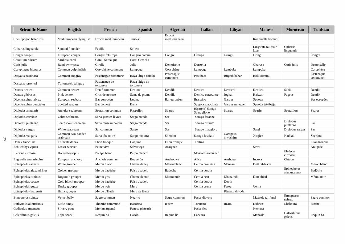
77
Scientific Name English French Spanish Algerian Italian Libyan Maltese Moroccan Tunisian
Cheilopogon heterurus Mediterranean flyingfish Exocet méditerranéen Juriola Exocet méditerranéen
Rondinella komuni
Citharus linguatula Spotted flounder Feuille Solleta Lingwata tal-qxur kbar
Citharus linguatula
Conger conger European conger Congre d'Europe Congrio común Congre Grongo Gringu Gringu Congre Corallium rubrum Sardinia coral Corail Sardaigne Coral Cerdeña Coris julis Rainbow wrasse Girelle Julia Demoiselle Donzella Gharusa Coris julis Demoiselle Coryphaena hippurus Common dolphinfish Coryphène commune Lampuga Coryphène Lampuga Lambuka Lampuka Coryphène
Dasyatis pastinaca Common stingray Pastenague commune Raya látigo común Pastenague commune Pastinaca Bugrah bahar Boll komuni Pastenague
commune
Dasyatis tortonesi Tortonese's stingray Pastenague de tortonese
Raya látigo de tortonese
Dentex dentex Common dentex Denté commun Denton Dendik Dentice Dentichi Dentici Sabia Dendik Dentex gibbosus Pink dentex Gros denté rose Sama de pluma Dendik Dentice corazziere Joghali Hajwat Pageot Dendik Dicentrarchus labrax European seabass Bar européen Lubina Bar européen Branzino Garous Spnotta Bar européen Dicentrarchus punctatus Spotted seabass Bar tacheté Baila Spigola macchiata Garous mnaghet Spnotta tat-tbajja
Diplodus annularis Annular seabream Sparaillon commun Raspallón Sbares (Spareto) Sarago Sparaglione Sbarus Sparlu Sparaillon Sbares
Diplodus cervinus Zebra seabream Sar à grosses lèvres Sargo breado Sar Sarago faraone
Diplodus puntazzo Sharpsnout seabream Sar à museau pointu Sargo picudo Sar Sarago pizzuto Diplodus puntazzo Sar
Diplodus sargus White seabream Sar commun Sargo Sar Sarago maggiore Sargi Diplodus sargus Sar
Diplodus vulgaris Common two-banded seabream Sar à tête noire Sargo mojarra Sherdou Sarago fasciato Garagous
mwashim Xirgien Haddad Sherdou
Donax trunculus Truncate donax Flion tronqué Coquina Flion tronque Tellina Flion tronque Echiichthys vipera Lesser weever Petite vive Salvariego Araignée Sawt Araignée
Eledone cirrhosa Horned octopus Poulpe blanc Pulpo blanco Moscardino bianco Eledone cirrhosa
Engraulis encrasicolus European anchovy Anchois commun Boquerón Anchouwa Alice Anshoga Incova Chtoun Epinephelus aeneus White grouper Mérou blanc Cherne de ley Mérou blanc Cernia bronzina Mennani Dott tal-faxxi Mérou blanc
Epinephelus alexandrinus Golden grouper Mérou badèche Falso abadejo Badèche Cernia dorata Epinephelus alexandrinus Badèche
Epinephelus caninus Dogtooth grouper Mérou gris Cherne dentón Mérou noir Cernia near Khanzirah Dott abjad Mérou noir Epinephelus costae Gold blotch grouper Mérou badèche Falso abadejo Cernia dorata Dooth Epinephelus guaza Dusky grouper Mérou noir Mero Cernia bruna Farouj Cerna Epinephelus haifensis Haifa grouper Mérou d'Haifa Mero de Haifa Khanzirah soda
Etmopterus spinax Velvet belly Sagre commun Negrito Sagre common Pesce diavolo Mazzola tal-fanal Etmopterus spinax Sagre common
Euthynnus alletteratus Little tunny Thonine commune Bacoreta R'zem Tonnetto Rzam Kubrita Lbakoura R'zem Gadiculus argenteus Silvery pout Merlan argenté Faneca plateada Pesce fico Nemusa
Galeorhinus galeus Tope shark Requin-hâ Cazón Requin ha Canesca Mazzola Galeorhinus galeus Requin ha
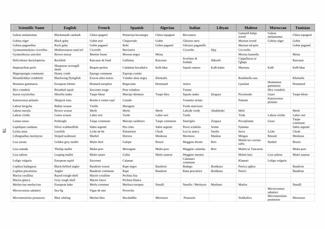
78
Scientific Name English French Spanish Algerian Italian Libyan Maltese Moroccan Tunisian
Galeus melastomus Blackmouth catshark Chien spagnol Pintarroja bocanegra Chien espagnol Boccanera Gattarell halqu iswed
Galeus melastomus Chien espagnol
Gobius niger Black goby Gobie noir Chaparrudo Gobie Ghiozzo nero Mazzun iswed Gobius niger Gobie Gobius paganellus Rock goby Gobie paganel Bobí Gobie paganel Ghiozzo paganello Mazzun tal-port Gobie paganel Gymnammodytes cicerellus Mediterranean sand eel Cicerelle Barrinaire Cicerello Djaj Ciccirella Gymnothorax unicolor Brown moray Murène brune Morena negra Mrina Morina kannella Mrina
Helicolenus dactylopterus Rockfish Rascasse de fond Gallineta Rascasse Scorfano di fondale Shkorfo Cippullazza ta'
l'ghajn Rascasse
Heptranchias perlo Sharpnose sevengill shark Requin-perlon Cañabota bocadulce Kelb bhar Squalo manzo Kalb baher Murruna Kalb Kelb bhar
Hippospongia communis Honey comb Eponge commune Esponja común Hirundichthys rondeletii Blackwing flyingfish Exocet-ailes noires Volador aleta negra Khottaifa Rondinella rara Khottaifa
Homarus gammarus European lobster Homard européen Bogavante Hommard Astice Ljunfant Hommarus gammarus Hommard
Illex coindetii Broadtail squid Encornet rouge Pota voladora Totano Illex coindetii Isurus oxyrinchus Shortfin mako Taupe bleue Marrajo dientuso Taupe bleu Squalo mako Zergaya Pixxitondu Lkars Taupe bleue
Katsuwonus pelamis Skipjack tuna Bonite à ventre rayé Listado Tonnetto striato Palamit Katsuwonus pelamis
Labrus bergylta Ballan wrasse Vieille Maragota Tordo marvizzo Labrus merula Brown wrasse Merle Merlo Merle Labride verde Abukheder Mirli Merle Labrus viridis Green wrasse Labre vert Tordo Labre vert Tordo Tirda Labrus viridis Labre vert
Lamna nasus Porbeagle Taupe commune Marrajo sardinero Taupe commune Smeriglio Zergaya Pixxiplamtu Lkars Taupe commune
Lepidopus caudatus Silver scabbardfish Sabre argenté Pez cinto Sabre argente Pesce sciabola Semta Fjamma Sabre argenté Lichia amia Leerfish Liche né-bé Palometon Chrab Leccia amica Strella Serra Liche Chrab Lithognathus mormyrus Striped seabream Marbré Herrera Menkous Mormora Mankus Mingus Rmouli Menkous
Liza aurata Golden grey mullet Mulet doré Galupe Bourri Muggine dorato Bori Mulett tac-carruta safra Hanbel Bourri
Liza ramada Thinlip mullet Mulet-porc Morragute Mulet-porc Muggine calamita Bori Mulett ta' l'imcarrat Mulet-porc
Liza saliens Leaping mullet Mulet sauter Galúa Mulet sauteur Muggine musino Mulett buri Liza saliens Mulet sauteur
Loligo vulgaris European squid Encornet Calamar Calamaro commune Klamari Loligo vulgaris
Lophius budegassa Black-bellied angler Baudroie rousse Rape negro Baudroie Budego Boshkara Petrica zghira Baudroie Lophius piscatorius Angler Baudroie commune Rape Baudroie Rana pescatrice Boshkara Petrici Baudroie Mactra corallina Rayed trough-shell Mactre coralline Pechina lisa Mactra glauca Grey rough shell Mactre fauve Pechina blanca Merluccius merluccius European hake Merlu commun Merluza europea Nasalli Nasello / Merluzzo Marlutso Marloz Nasalli
Microcosmus sabatieri Sea fig Figue de mer Provecho Microcosmus sabatieri
Micromesistius poutassou Blue whiting Merlan bleu Bacaladilla Mernouze Potassolo Stokkafixx Micromesistius poutassou Mernouze

79
Scientific Name English French Spanish Algerian Italian Libyan Maltese Moroccan Tunisian
Mugil cephalus Flathead grey mullet Mulet à grosse tête Pardete Mulet a grosse tete Cefalo mazzone Buri Mulett ta' l'iswed Mulet à grosse
tête
Mullus surmuletus Striped red mullet Rouget-barbet de roche Salmonete de roca Rouget Triglia di scoglio Trelia hamra Trilja tal-hama Rouget
Muraena helena Mediterranean moray Murène de la Méditerranée Morena Murène Murena Zemrina Morina Murène
Mustelus asterias Starry smoothhound Emissole tachetée Musola coronada Ktat bou noqta Palombo stellato Matsola Mazzola tat-tbajja Kalb Ktat bou noqta Mustelus mustelus Smoothhound Emissole lisse Musola Ktat Palombo Matsola Massola blaxewka Kalb il bahr Ktat Mycteroperca rubra Comb grouper Mérou royal Gitano Cernia rossa Dooth yahudi Cerna denbha dritt
Mytilus galloprovincialis Mediterranean mussel Moule méditerranéenne Mejillón mediterráneo Moule Cozza o Mitilo Mytilus
galloprovincialis Moule
Nassarius mutabilis Changeable nassa Nasse-ceinture Mugarida lisa Naucrates ductor Pilot fish Poisson-pilote Pez piloto Poisson pilote Pesce pilota Lalaja Fanfru Baghbagh Poisson pilote
Nephrops norvegicus Norway lobster Langoustine Cigala Langoustine Scampo Ragustelli Nephrops norvegicus Langoustine
Oblada melanura Saddled seabream Oblade Oblada Kahlaya Occhiata Kahla Kahlija Kahla Kahlaya Octopus salutii Spider octopus Poulpe de Saluzzi Pulpo arena Octopus salutii
Octopus vulgaris Common octopus Pieuvre Pulpo común Poulpe Polpo commune Octopus vulgaris Poulpe
Orcynopsis unicolor Plain bonito Palomette Tasarte Bonite plate Palamita bianca Plamtu bla rigi Orcynopsis unicolor
Ostrea edulis European flat oyster Huître plate européenne Ostra Ostrica
Pagellus acarne Axillary seabream Pageot acarné Aligote Morjane Fragolino bastardo Bazoka Bazuga Pageot Morjane Pagellus bellottii Red pandora Pageot à tache rouge Breca chata Pagellus bogaraveo Blackspot seabream Dorade rose Besugo Morjane Rovello unknown Bazuga Pageot Morjane Pagellus erythrinus Common pandora Pageot commun Breca Morgen Pagello Morjan Pagella hamra Pageot rouge Morgen Pagrus auriga Redbanded seabream Pagre rayé Hurta Pagro reale Pagru hamrani Pagrus pagrus Common seabream Pagre commun Pargo Pagre Pagro Pagri Pagrus pagrus Pagre Palaemon serratus Common prawn Bouquet Camarón común Gamberetto
Palinurus elephas Common spiny lobster Langouste rouge Langosta común Aragosta rossa Awwista Palinurus elephas
Palinurus mauritanicus Pink spiny lobster Langouste rose Langosta mora Palinurus mauritanicus
Paracentrotus lividus Stony sea urchin Oursin-pierre Erizo de mar Riccio
Parapenaeus longirostris Deep-water pink shrimp Crevette rose du large Gamba de altura Crevette rose Gambero rosa Gambli bojad Parapenaeus longirostris Crevette rose
Parapristipoma octolineatum African striped grunt Grondeur rayé Boca de oro Parapristipoma octolineatum
Pecten jacobaeus Great Mediterranean scallop
Coquille Saint-Jacques de Méditerranée Concha de peregrino Coquille Saint-
Jacques Cappasanta Pecten jacobaeus
Coquille Saint- Jacques
Penaeus kerathurus Caramote prawn Caramote Langostino Caramote Mazzancolla Penaeus kerathurus Caramote
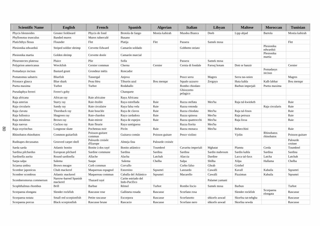
80
Scientific Name English French Spanish Algerian Italian Libyan Maltese Moroccan Tunisian Phycis blennoides Greater forkbeard Phycis de fond Brotola de fango Mostia kabirah Musdea Bianca Deeb Lipp abjad Bartola Mostia kabirah Phyllonotus trunculus Banded murex Murex tuberculé Busano Platichthys flesus Flounder Flet Platija Flet Passera Samek mosa Flet
Plesionika edwardsii Striped soldier shrimp Crevette Edward Camarón soldado Gobbetto striato Plesionika edwardsii
Plesionika martia Golden shrimp Crevette dorée Camarón marcial Plesionika martia
Pleuronectes platessa Plaice Plie Solla Passera Samek mosa Polyprion americanus Wreckfish Cernier commun Cherna Cernier Cernia di fondale Farouj hotam Dott or hanzir Cernier
Pomadasys incisus Bastard grunt Grondeur métis Roncador Pomadasys incisus
Pomatomus saltatrix Bluefish Tassergal Anjova Pesce serra Magres Serra tas-snien Magres Prionace glauca Blue shark Peau bleu Tiburón azul Bou menqar Squalo azzurro Zergaya Huta kahla Kalb labhar Bou menqar Psetta maxima Turbot Turbot Rodaballo Rombo chiodato Barbun imperjali Psetta maxima
Pseudaphya ferreri Ferrer's goby Chanquete Ghiozzetto pelagico
Raja africana African ray Raie africaine Raya Africana Raja asterias Starry ray Raie étoilée Raya estrellada Raie Razza stellata Mes'ha Raja tal-kwiekeb Raie Raja circularis Sandy ray Raie circulaire Raya falsa vela Raie Razza rotonda Raja circularis Raie Raja clavata Thornback ray Raie bouclée Raya de clavos Raie Razza chiodata Mes'ha Raja tal-fosos Raie Raja fullonica Shagreen ray Raie-chardon Raya cardadora Raie Razza spinosa Mes'ha Raja petruza Raie Raja miraletus Brown ray Raie-miroir Raya de espejos Raie Razza quattrocchi Mes'ha Raja lixxa Raie Raja naevus Cuckoo ray Raie fleurie Raya santiguesa Razza fiorita Mes'ha Raja oxyrinchus Longnose skate Pocheteau noir Picón Raie Razza monaca Mes'ha Rebecchini Raie
Rhinobatos rhinobatos Common guitarfish Poisson-guitare commun Guitarra común Poisson guitare Pesce violino Vjolin Rhinobatos
rhinobatos Poisson guitare
Ruditapes decussatus Grooved carpet shell Palourde croisée d'Europe Almeja fina Palourde croisée Palourde
croisee Sarda sarda Atlantic bonito Bonite à dos rayé Bonito atlántico Toumbrel Cavaritu imperiali Mghatat Plamtu Cerda Toumbrel Sardina pilchardus European pilchard Sardine commune Sardina Sardina Sardina Sardin mabroum Sardin kahla Sardina Sardina Sardinella aurita Round sardinella Allache Alacha Latchah Alaccia Dardine Lacca tal-faxx Latcha Latchah Sarpa salpa Salema Saupe Salema Chelba Salpa Shilba Xilpa Hallama Chelba Sciaena umbra Brown meagre Corb commun Corvallo Corbo falso Ghrab Griebel Scomber japonicus Chub mackerel Maquereau espagnol Estornino Sqoumri Lanzardo Cawalli Kavall Kabaila Sqoumri Scomber scombrus Atlantic mackerel Maquereau commun Caballa del Atlántico Sqoumri Macarello Cawalli Pizzintun Kabaila Sqoumri
Scomberomorus commerson Narrow-barred Spanish mackerel Thazard rayé Carite estriado del
Indo-Pacífico Palamet yamani
Scophthalmus rhombus Brill Barbue Rémol Turbot Rombo liscio Samek mosa Barbun Turbot
Scorpaena elongata Slender rockfish Rascasse rose Gallineta rosada Rascasse Scorfano rosa Slender rockfish Scorpaena elongata Rascasse
Scorpaena notata Small red scorpionfish Petite rascasse Escorpora Rascasse Scorfanotto shkorfo aswad Skorfna tat-tebgha Rascasse Scorpaena porcus Black scorpionfish Rascasse brune Rascacio Rascasse Scorfano nero shkorfo aswad Skorfna sewda Rascasse
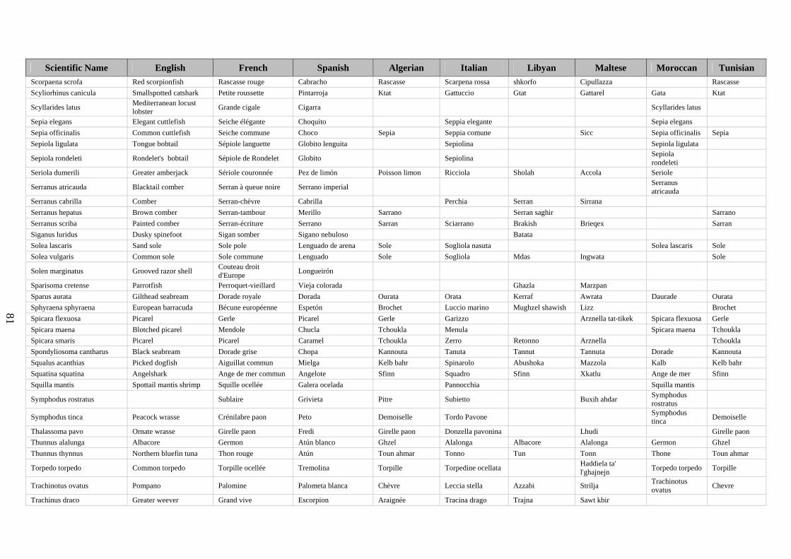
81
Scientific Name English French Spanish Algerian Italian Libyan Maltese Moroccan Tunisian Scorpaena scrofa Red scorpionfish Rascasse rouge Cabracho Rascasse Scarpena rossa shkorfo Cipullazza Rascasse Scyliorhinus canicula Smallspotted catshark Petite roussette Pintarroja Ktat Gattuccio Gtat Gattarel Gata Ktat
Scyllarides latus Mediterranean locust lobster Grande cigale Cigarra Scyllarides latus
Sepia elegans Elegant cuttlefish Seiche élégante Choquito Seppia elegante Sepia elegans Sepia officinalis Common cuttlefish Seiche commune Choco Sepia Seppia comune Sicc Sepia officinalis Sepia Sepiola ligulata Tongue bobtail Sépiole languette Globito lenguita Sepiolina Sepiola ligulata
Sepiola rondeleti Rondelet's bobtail Sépiole de Rondelet Globito Sepiolina Sepiola rondeleti
Seriola dumerili Greater amberjack Sériole couronnée Pez de limón Poisson limon Ricciola Sholah Accola Seriole
Serranus atricauda Blacktail comber Serran à queue noire Serrano imperial Serranus atricauda
Serranus cabrilla Comber Serran-chèvre Cabrilla Perchia Serran Sirrana Serranus hepatus Brown comber Serran-tambour Merillo Sarrano Serran saghir Sarrano Serranus scriba Painted comber Serran-écriture Serrano Sarran Sciarrano Brakish Brieqex Sarran Siganus luridus Dusky spinefoot Sigan somber Sigano nebuloso Batata Solea lascaris Sand sole Sole pole Lenguado de arena Sole Sogliola nasuta Solea lascaris Sole Solea vulgaris Common sole Sole commune Lenguado Sole Sogliola Mdas Ingwata Sole
Solen marginatus Grooved razor shell Couteau droit d'Europe Longueirón
Sparisoma cretense Parrotfish Perroquet-vieillard Vieja colorada Ghazla Marzpan Sparus aurata Gilthead seabream Dorade royale Dorada Ourata Orata Kerraf Awrata Daurade Ourata Sphyraena sphyraena European barracuda Bécune européenne Espetón Brochet Luccio marino Mughzel shawish Lizz Brochet Spicara flexuosa Picarel Gerle Picarel Gerle Garizzo Arznella tat-tikek Spicara flexuosa Gerle Spicara maena Blotched picarel Mendole Chucla Tchoukla Menula Spicara maena Tchoukla Spicara smaris Picarel Picarel Caramel Tchoukla Zerro Retonno Arznella Tchoukla Spondyliosoma cantharus Black seabream Dorade grise Chopa Kannouta Tanuta Tannut Tannuta Dorade Kannouta Squalus acanthias Picked dogfish Aiguillat commun Mielga Kelb bahr Spinarolo Abushoka Mazzola Kalb Kelb bahr Squatina squatina Angelshark Ange de mer commun Angelote Sfinn Squadro Sfinn Xkatlu Ange de mer Sfinn Squilla mantis Spottail mantis shrimp Squille ocellée Galera ocelada Pannocchia Squilla mantis
Symphodus rostratus Sublaire Grivieta Pitre Subietto Buxih ahdar Symphodus rostratus
Symphodus tinca Peacock wrasse Crénilabre paon Peto Demoiselle Tordo Pavone Symphodus tinca Demoiselle
Thalassoma pavo Ornate wrasse Girelle paon Fredi Girelle paon Donzella pavonina Lhudi Girelle paon Thunnus alalunga Albacore Germon Atún blanco Ghzel Alalonga Albacore Alalonga Germon Ghzel Thunnus thynnus Northern bluefin tuna Thon rouge Atún Toun ahmar Tonno Tun Tonn Thone Toun ahmar
Torpedo torpedo Common torpedo Torpille ocellée Tremolina Torpille Torpedine ocellata Haddiela ta' l'ghajnejn Torpedo torpedo Torpille
Trachinotus ovatus Pompano Palomine Palometa blanca Chèvre Leccia stella Azzabi Strilja Trachinotus ovatus Chevre
Trachinus draco Greater weever Grand vive Escorpion Araignée Tracina drago Trajna Sawt kbir

82
Scientific Name English French Spanish Algerian Italian Libyan Maltese Moroccan Tunisian
Trachurus mediterraneus Mediterranean horse mackerel
Chinchard à queue jaune Jurel mediterráneo Chourou farasi Suro Saurou aswad Sawrella Chren Chourou farasi
Trachurus trachurus Atlantic horse mackerel Chinchard d'Europe Jurel Chourou europi Suro Saurou Sawrella kahla Chrene Chourou europi Trigla lucerna Tub gurnard Grondin-perlon Bejel Galinette Capone gallinella Djaj Gallinetta Galinette Trigla lyra Piper gurnard Grondin-lyre Garneo Galinette Capone lira Gallinetta Trigla lyra Galinette
Trigloporus lastoviza Streaked gurnard Grondin camard Rubio Galinette Capone dalmato Gallinetta tar-rigi Trigloporus lastoviza Galinette
Trisopterus luscus Pouting Tacaud commun Faneca Trisopterus luscus
Trisopterus minutus Poor cod Capelan Capellán Merluzzetto Trisopterus minutus
Umbrina canariensis Canary drum Ombrine bronze Verrugato de fango unknown Umbrina cirrosa Shi drum Ombrine cotière Verrugato fusco Ombrine Ombrina Baghlah Gurbell tad-daqna Ombrine
Umbrina ronchus Fusca drum Ombrine fusca Verrugato Umbrina ronchus
Uranoscopus scaber Stargazer Uranoscope Miracielo Rascasse blanche Pesce prete Bollm Zondu Rascasse blanche
Venerupis rhomboides Banded carpet shell Palourde rose Almeja rubia
Venus verrucosa Warty venus Praire commune Escupiña grabada Praire commune Praire commune
Xiphias gladius Swordfish Espadon Pez espada Bou sif Pesce spada Aboucet Piscispat Bou sif Xyrichthys novacula Pearly razorfish Donzelle lame Rao Rason Moshta Rason Zeus faber John dory Saint-Pierre Pez de San Pedro Saint-pierre Pesce San Pietro San bitro Pixxi San Pietru Saint-pierre
Species national names provided by COPEMED national collaborators: ArtFiMed 2000-2003, SpecieDab, FishBase
ÉTUDES ET REVUES DE LA CGPM DÉJÀ PUBLIÉES GFCM STUDIES AND REVIEWS ALREADY ISSUED 1 Standardisation de méthodes d'étude biométrique et d'observation de clupéidés (en particulier de Sardina
pilchardus) utilisées en biologie des pêches. Division des pêches de la FAO. 1957 1 Standardization of biometric and observation methods for Clupeidae (especially Sardina pilchardus) used in
fisheries biology. FAO Fisheries Division. 1957 2 Le Chalutage en Méditerranée – Observations préliminaires sur les chaluts italiens. Division des pêches de
la FAO. Septembre 1957 2 Mediterranean trawling Preliminary observations in the study of Italian trawl nets. FAO Fisheries Division.
September 1957 3 La pollution des eaux provoquée par les déversements des sucreries. Carlo Maldura et Paul Vivier. Avril
1958 3 Water pollution caused by wastes from sugar refineries. Carlo Maldura and Paul Vivier. April 1958 4 Filets tournants et coulissants en fibres synthétiques. Gerhard Klust. Septembre 1958 4 Ring nets made of synthetic fibres. Gerhard Klust. September 1958 5 La pisciculture dans les eaux intérieures des pays membres du CGPM. Secrétariat du CGPM. Février 1959 5 Inland water fisheries in the GFCM member countries. Secretariat of the GFCM. February 1959 6 Le chalutage en Méditerranée. Deuxième et troisième rapports. Division des pêches de la FAO. Mai 1959 6 Mediterranean trawling. Second and third reports. FAO Fisheries Division. May 1959 7 La technique des pêcheries dans les lagunes saumâtres. Ruggero de Angelis. Août 1959 7 Fishing installations in brackish lagoons. Ruggero de Angelis. August 1959 8 La situation de la pêche en Italie, en particulier dans le secteur de la distribution. Paolo Pagliazzi. Octobre
1959 8 Situation of the fishing industry in Italy, particularly regarding distribution. Paolo Pagliazzi. October 1959 9 Documentation graphique sur certains engins de pêche utilisés dans les lagunes littorales espagnoles.
Fernando Lozano Cabo. Novembre 1959 9 Graphic documentation on some fishing gear used in Spanish coastal lagoons. Fernando Lozano Cabo.
November 1959 10 Le chalutage en Méditerranée Quatrième rapport. J. Schärfe, Division des pêches de la FAO. Mars 1960 10 Mediterranean trawling. Fourth report. J. Schärfe, FAO Fisheries Division. March 1960 11 Le traitement du fond des étangs piscicoles et ses effets sur la productivité. La pisciculture dans divers pays
européens. Alfred G. Wurtz. Juin 1960 11 Methods of treating the bottom of fish ponds and their effects on productivity. Fish culture in certain
European countries. Alfred G. Wurtz. June 1960 12 Exploitation et description des lagunes saumâtres de la Méditerranée. Ruggero de Angelis. Août 1960
12 Mediterranean brackish water lagoons and their exploitation. Ruggero de Angelis. August 1960 13 Contrôle d'un chalut opérant entre deux eaux ou sur le fond et tiré par un seul bateau. J. Schärfe, Division
des pêches de la FAO. Septembre 1960 13 A new method for "aimed" one-boat trawling in mid-water and on the bottom. J. Schärfe, FAO Fisheries
Division. September 1960 14 Le chalutage en Méditerranée. Cinquième rapport. J. Schärfe, Division des pêches de la FAO. Mai 1961 14 Mediterranean trawling. Fifth report. J. Schärfe, FAO Fisheries Division . May 1961 15 La madrague sicilienne de course. Vito Fodera. Juillet 1961 15 The Sicilian tuna trap. Vito Fodera. July 1961 16 Influence de la température et de l'éclairement sur la distribution des crevettes des moyennes et grandes
profondeurs. Walter Ghidalia et François Bourgois. August 1961 16 The influence of temperature and light on the distribution of shrimps in medium and great depths. Walter
Ghidalia and François Bourgois. August 1961 17 L'amélioration des techniques de la pêche au feu. F. Bourgois et L. Farina, Experts de la FAO. Novembre
1961 17 Improvements of techniques for fishing with lights. F. Bourgois and L. Farina, FAO Experts. November
1961 18 L'élevage des huîtres en parcs flottants. M. Nikolic et I. Stojnic. Mars 1962 18 A sytem of oyster culture on floating shellfish parks. M. Nikolic and I. Stojnic. March 1962 19 Pêche au feu. Raimondo Sarà. Août 1962 19 Light fishing. Raimondo Sarà. August 1962 20 Réglementation en vigueur sur la pêche de la sardine en Méditerranée. Service d'études législatives de la
FAO. Juillet 1963 20 Existing regulations for sardine fishing in the Mediterranean. FAO Legislation Research Branch. July 1963 21 Diagnoses démographiques sur les populations de poissons dans les cours d'eau à truites. R. Cuinat et
R. Vibert. Octobre 1963 21 Demographic diagnosis on fish populations in trout streams. R. Cuinat and R. Vibert. October 1963 22 Dommages causés par les marsouins et autres animaux marins déprédateurs en Méditerranée. C. Ravel.
Novembre 1963 22 Damage caused by porpoises and other other predatory marine animals in the Mediterranean. C. Ravel.
November 1963 23 Etudes sur la sardine (Sardina pilchardus Walb.) et l'anchois (Engraulis encrasicholus L.) dans le golfe de
Naples et sur leur comportement sous l'influence de la lumière artificielle. Olav Dragesund. Juin 1964 23 Studies on the sardine (Sardina pilchardus Walb.) and anchovy (Engraulis encrasicholus L.) in the Gulf of
Naples and their behaviour in artificial light. Olav Dragesund. June 1964

24 Réglementations concernant certaines industries de transformation des produits des pêches maritimes dans les pays méditerranéens. D. Rémy. Septembre 1964
24 Regulations on certain sea food processing industries in Mediterranean countries. D. Rémy. September
1964 25 Sur la valeur des anneaux nets pour la détermination de l'âge des sardines (Sardina pilchardus Walb.).
R. Muzinic. Décembre 1964 25 The value of sharp rings for the age determination of sardine (Sardina pilchardus Walb,.). R. Muzinic.
December 1964 26 Revue critique des effets des détergents synthétiques sur la vie aquatique. R. Marchetti. Octobre 1965 26 Critical review of the effects of synthetic detergents on aquatic life. R. Marchetti. October 1965 27 Méthodes permettant d'économiser la main-d'oeuvre à bord des chalutiers méditerranéens. M. Ben-Yami.
Novembre 1965 27 Labour-saving methods on board Mediterranean trawlers. M. Ben-Yami. November 1965 28 La distribution et la commercialisation du poisson en Sicile. G. Bombace. Novembre 1965 28 Preliminary report on fish distribution and marketing in Sicily. G. Bombace. November 1965 29 Réglementation sanitaire des mollusques. R. Coppini. Décembre 1965 29 Sanitary regulations for molluscs. R. Coppini. December 1965 30 L'élevage de la truite fario et de la truite arc-en-ciel dans les eaux à température très élevée. E.G. Calderon.
Décembre 1965 30 The raising of brown trout and rainbow trout in water at high temperatures. E.G. Calderon. December 1965 30 (Suppl.1) Suite des études sur les possibilités de développement de la salmoniculture en eaux chaudes. E.G.
Calderon. Novembre 1968 31 Mortalité initiale de la sardine dans les conditions expérimentales et mortalité due au marquage.
R. Muzinic. Août 1966 31 Initial mortality of the sardine under experimental conditions and in the tagging work. R. Muzinic. August
1966 32 Study of hake (Merluccius merluccius L.) biology and population dynamics in the central Adriatic.
S. Zupanovic. February 1968 33 Unités de stock de la sardine de la Méditerranée occidentale et de l'Adriatique. M.G. Larrañeta. Juin 1968 34 The system of currents in the Adriatic Sea. M. Zore-Armanda. July 1968 35 Investigations of mullet fisheries by beach seine on the U.A.R. Mediterranean coast. S. Zaky Rafail Rehabilitation of the fisheries of an inland saline lake in the United Arab Republic. S. El Zarka Variations annuelles des captures de mulet dans le lac de Varna. D. Morovic
Juillet/July 1968 36 Aquarium tagging experiments on sardines with anchor tags by the use of tricaine methane sulfonate.
R. Muzinic. October 1968 37 Fishery of the green crab (Carcinus maenas L.) and soft crab cultivation in the lagoon of Venice.
S. Varagnolo
Results obtained by geological charting of trawling grounds in the channels of the northern Adriatic. S. Alfierivic
Effects of fresh water and saturated sea-water brine on the survival of mussels, oysters and some epibionts on them. M. Hrs. Brenko and L. Igic
December 1968 38 The weight-length relationship of United Arab Republic Sardinella. A.M. El-Maghraby Distribution et densité des oeufs de sardines (Sardina pilchardus Walb.) dans l'Adriatique centrale au cours
de la saison 1965/66. J. Karlovac Coincidence and alternation in Yugoslav pelagic fisheries. R. Muzinic
Février/February 1969 39 Selectivity of gillnets for Nile perch (Lates niloticus L.). R. Koura and A.A. Shaheen Cod end mesh size effect on Italian otter trawl efficiency. R. Koura
February 1969 40 Studies on the life history of Adriatic sprat. N. and D. Zavodnik. March 1969 41 Note préliminaire à l'étude de la production primaire dans l'Adriatique centrale. T. Pucher-Petkovic Long term observation of plankton fluctuation in the central Adriatic. T. Vucetic and T. Pucher-Petkovic Relation between some factors affecting productivity and fish catch in the central Adriatic area. M. Buljan
Mars/March 1969 42 Long line Mediterranean fisheries studies west of Alexandria. S.Z. Rafail, W.L. Daoud and M.M. Hilal. July
1969 43 Marine resource of the United Arab Republic. A.A. Aleem. December 1969 44 Les ressources vivantes des eaux profondes de la Méditerranée occidentale et leur exploitation. Groupe
d'experts du CGPM. Octobre 1970 44 Living deep water resources of the western Mediterranean and their exploitation. GFCM Group of Experts.
October 1970 45 Quelques techniques de fumage du poisson applicables dans la zone méditerranéenne. H. Lizac,
Département des pêches de la FAO. Février 1971 45 Some techniques of smoking fish applicable in the Mediterranean area. H. Lisac, FAO Fisheries
Department . December 1970 46 Studies on the distribution, growth and abundance of migrating fry and juveniles of mullet in a brackish
coastal lake (Edku) in the United Arab Republic. S. E. Zarka, A.M. El-Maghraby and Kh. Abdel-Hamid. December 1970
47 On the use of anaesthetics in the transportation of sardines. R. Muzinic. December 1970 48 Investigations on Sciaenidae and Moronidae catches and on the total catch by beach seine on the U.A.R.
Mediterranean coast. S.Z. Rafail Studies on the population and the catchability of Norway lobster in the central Adriatic. S. Jukic
July 1971 49 Evolution de la pêche sur le talus du plateau continental des îles Baléares entre 1940 et 1969. M. Massuti Explorations of the possible deep-water trawling grounds in the Levant Basin. O.H. Oren, M. Ben-Yami and
L.. Zismann
Juillet/July 1971 50 Commercialisation du poisson frais et congelé dans certains pays méditerranéens. CGPM. Décembre 1971
50 Marketing of fresh and frozen fish in Mediterranean countries. GFCM. December 1971 51 Etat de la pollution marine en Méditerranée et réglementation. CGPM. Août 1972 51 The state of marine pollution in the Mediterranean and legislative controls. GFCM. September 1972 52 Aquaculture en eau saumâtre dans la région méditerranéenne. CGPM. Août 1973 52 Brackish water aquaculture in the Mediterranean region. GFCM. August 1973 53 Fuel consumption as an index of fishing effort. D. Levi and G. Giannetti Fluctuations of zooplankton and echo-trace abundance in the central Adriatic. T. Vucetic and I. Kacic
November 1973 54 Study of fish populations by capture data and the value of tagging experiments. S. Zaky Rafail Les ressources halieutiques de la Méditerranée et de la mer Noire. D. Levi et J.-P. Troadec Perspectives for fisheries development to 1985 in the GFCM Member Nations. GFCM Secretariat
Octobre 1974 54 Study of fish populations by capture data and the value of tagging experiments. S. Zaky Rafail The fish resources of the Mediterranean and the Black Sea. D. Levi and J.-P. Troadec Perspectives for fisheries development to 1985 in the GFCM Member Nations. GFCM Secretariat
October 1974 55 Ponte contrôlée et élevage des larves d'espèces marines sélectionnées de la Méditerranée. CGPM Controlled breeding and larval rearing of selected Mediterranean marine species. GFCM.
Avril/April 1976 56 Données sur les bateaux et engins de pêche en Méditerranée. P.-Y. Dremière et C. Nédélec. Mai 1977 56 Data on fishing vessels and gear in the Mediterranean. P.-Y. Dremière and C. Nédélec. Mai 1977 57 Quelques aspects de la culture du poisson et des crustacés en eau saumâtre en Méditerranée. CGPM. 1981 57 Aspects of brackish water fish and crustacean culture in the Mediterranean. GFCM. 1980 58 Aménagement des ressources vivantes dans la zone littorale de la Méditerranée. CGPM. 1981 58 Management of living resources in the Mediterranean coastal area. GFCM. 1981 59 Les ressources halieutiques de la Méditerranée. Première partie: Méditerranée occidentale. P. Oliver. 1983 59 Los recursos pesqueros del Mediterráneo. Primera parte: Mediterráneo occidental. P. Oliver. 1983 60 The fisheries resources of the Mediterranean. Part two: Black Sea. L. Ivanov and R.J.H. Beverton.1985 61 Aménagement des pêches dans les lagunes côtières. J.M. Kapetsky et G. Lasserre. 1984 61 Management of coastal lagoon fisheries. J.M. Kapetsky and G. Lasserre. 1984 62 Evolution des techniques de la pêche italienne. 1987 62 Evolution of technology in Italian fisheries. 1987 63 Tendances récentes des pêches et de l'environnement dans la zone couverte par le Conseil général des
pêches pour la Méditerranée (CGPM). J.F. Caddy et R.C. Griffiths. Décembre 1990 63 Recent trends in the fisheries and environment in the General Fisheries Council for the Mediterranean
(GFCM) area. J.F. Caddy and R.C. Griffiths. December 1990

64 Fisheries and environment studies in the Black Sea. Part 1: V.G. Dubinina and A.D. Semenov. Part 2:
Yu. P. Zaitzsev. Part 3: A. Kocatas, T. Koray, M. Kaya and O.F. Kara. 65 A review of the state of the fisheries and the environment of the Northeastern Mediterranean (Northern
Levantine Basin). Ferit Bingel, Emin Ozsoy and Umit Unluata. September 1993 65 Etude de l'état des pêches et de l'environnement dans la Méditerranée du Nord-Est (bassin levantin
septentrional). Ferit Bingel, Emin Ozsoy et Umit Unluata. Avril 1997 66 Resource and Environmental Issues Relevant to Mediterranean Fisheries Management. March 1996 66 Questions concernant les ressources et l'environnement dans la gestion des pêcheries méditerranéennes.
Avril 1997 67 Introduction of mullet haarder (Mugil so-iuy Basilewsky) into the Black Sea and the Sea of Azov.
L.I. Starushenko and A.B. Kazansky. May 1996 68 Environmental management of fish resources in the Black Sea and their rational exploitation. K. Prodanov,
K. Mikhailov, G. Daskalov, C. Maxim, A. Chashchin, A. Arkhipov, V. Shlyakhov and E. Ozdamar. April 1997
69 Long and short-term trends of Mediterranean fishery resources. L. Fiorentini, J.F. Caddy and J.I. de Leiva.
September 1997 70 Issues in Mediterranean fisheries management: geographical units and effort control. J.F. Caddy. October
1998 70 Eléments pour l'aménagement des pêcheries méditerranéennes: unités géographiques et contrôle de
l'effort. J.F. Caddy. 1999 71 Feasibility assessment for a database on socio-economic indicators for Mediterranean fisheries. R.
Franquesa, I.M. Malouli and J.A. Alarcón. 2001 72 Decision-support systems for fisheries. The ITAFISH case study. Coppola, S.; Crosetti, D. 2001 73 Manual of fisheries sampling surveys: methodologies for estimations of socio-economic indicators in the
Mediterranean Sea. E. Sabatella and R. Franquesa. 2004 74 Ecosystem effects of fishing in the Mediterranean: an analysis of the major threats of fishing gear and
practices to biodiversity and marine habitats. S. Tudela. 2004 75 Fisheries laws and regulation in the Mediterranean: a comparative study. P. Cacaud. 2005 76 Implementation of the International Plan of Action to Prevent, Deter and Eliminate Illegal, Unreported
and Unregulated Fishing: relationship to, and potential effects on, fisheries management in the Mediterranean. J. Swan. (in press)
77 Inventory of artisanal fishery communities in the Western and Central Mediterranean. S.R. Coppola.
2006. 78 AdriaMed Expert Consultation: “Interactions between Aquaculture and Capture Fisheries”. Cataudella, S.; Massa, F.; Crosetti, D. (eds.). (2005)

INVENTORY OF ARTISANAL FISHERY COMMUNITIES IN THE WESTERN AND CENTRAL MEDITERRANEAN
No. 77 2006
ISS
N 1020-9549
GENERAL FISHERIES COMMISSION FOR THE MEDITERRANEAN
9 7 8 9 2 5 1 0 5 6 0 6 6
TR/M/A0824E/1/11.06/1200
ISBN 978-92-5-105606-6 ISSN 1020-9549
STUDIES AND REVIEWS
For years, the impoverishment of artisanal fishery in Mediterranean countries has beenfrequently reported at all levels when the urgency for intervention was systematically
highlighted. In addition, it has also been reiterated that, at present, there is not enoughknowledge either of the primary and secondary magnitudes of artisanal fishery or of the
normative and managerial tools that cover the entire spectrum of competence. Information onartisanal fishery, in the wide sense, is fundamental for planning and management purposes. It is, therefore, extremely important to document all the elements that influence and interact
directly or indirectly with artisanal fisheries (e.g. synergies, conflicts or friction, possibleinteraction and connection, etc.). During the project Cooperation Networks to Facilitate
Coordination to Support Fisheries Management in the Western and Central Mediterranean(COPEMED), the first-ever inventory of regional artisanal fishery communities in the Central
and Western Mediterranean was implemented. This was possible through direct assistance tosome member countries to develop and improve their capacity to collect and analyse
information on artisanal fisheries. The inventory resulted in a comprehensive list of all thefishing communities performing artisanal fisheries in the region, including their localization,
description, use, pictures and other ancillary information. This exercise, based on 13 582 sitesvisited (interviewed), produced 11 papers, involved 16 scientists (regional and national), and also collected a selected bibliography of about 200 documents. Most of the results
are presented in this paper.