Embed Size (px)
Citation preview
1 ARCHAEOLOGY IN THE ROCKS 2016 • PRE-VISIT INFORMATION
PRE-VISIT INFORMATION AND RESOURCES FOR TEACHERS & STUDENTS
PRESENTED BY Sydney Living Museums, Sydney Learning Adventures and The Big Dig
TEN CRITICAL STEPS IN RESEARCHING AND INVESTIGATING AN HISTORICAL ARCHAEOLOGICAL SITE
1 IDENTIFICATION The site is identified as a potential archaeological resource, a place of cultural significance
– for example, in an archaeological management plan, heritage register, planning scheme or conservation plan.
2 THREAT ASSESSMENT There is a proposal to undertake development or works that may have an
impact on the archaeological resource. Such a proposal may include a development, such as a new building, and works or repairs to existing buildings or sites.
3 RESEARCH An archaeologist is engaged to prepare a report, including a detailed assessment
of archaeological value. Tasks generally include researching documentary sources, a careful site inspection, comparing other sites and excavations, assessing the potential of the site for answering research questions, preparing a statement of significance, and making recommendations about the need (or otherwise) for excavation. An archaeological proposal is prepared that includes questions to be addressed in an excavation (research design) as well as a strategy for the dig and project management of it.
4 REVIEW OF PROPOSAL The archaeological proposal is considered and a decision made
on whether or not to carry out an excavation. State authorities and/or others knowledgeable about the proposed excavation consult with the owners/developers of the site to consider the archaeological proposals. They make decisions about whether or not to excavate or carry out other archaeological investigations – for example, to excavate prior to the development, to undertake archaeological monitoring of sensitive areas during works, to retain the archaeological resource without disturbance, or to have no archaeological involvement at all.
5 PREPARATION FOR EXCAVATION The archaeologists, owners/developers and
relevant authorities organise permits, staffing, volunteers, facilities, equipment, and how to coordinate these and other activities on site. Arrangements are made for the storage of artefacts after the dig.
6 EXCAVATION The site is prepared, then excavated. Stratigraphic recording (involving
the preparation of plans, sections and photographs), recovery of artefacts, control of public access, and preparation of progress reports are all carried out. Some analysis and treatment of finds is completed during the excavation. Following excavation, the site may be infilled, or work done to protect any in situ remains or unexcavated areas.
7 POST-EXCAVATION ANALYSIS AND REPORT-WRITING There is crossover
between this stage and the process of excavation. Information from the excavation is collated, and finds are sorted, conserved and stored. Preliminary responses to questions in the research design are addressed. Recommendations about further archaeological analysis or excavations are made.
8 FURTHER ANALYSIS Detailed analysis of all information arising from the excavation is carried
out, comparisons are made with the material and findings from other excavations, and information from documentary research is used to answer questions of research design. A final excavation report detailing the results of the excavation is compiled and, if the site is to be preserved in situ, a conservation management plan is developed.
9 POTENTIAL TO INTERPRET THE SITE Findings from the excavation may be conveyed to the
general public through publications and exhibitions. If the site is conserved in situ and made available to the public, then interpretative works, such as displays of artefacts, site tours and programs, information panels and images showing the location and significance of previous buildings, or explaining the archaeological remnants, can be installed.
10 PUBLICATION AND OFFICIAL SUBMISSION The results of the excavation are published
and formally submitted to the relevant authorities.
PRE-VISIT INFORMATION AND RESOURCES FOR TEACHERS & STUDENTS
PRESENTED BY Sydney Living Museums, Sydney Learning Adventures and The Big Dig
2 ARCHAEOLOGY IN THE ROCKS 2016 • PRE-VISIT INFORMATION
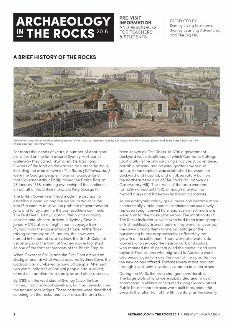
Panoramic views of Port Jackson (detail), James Taylor, 1820–23, reprinted 1988 by Tim McCormick from copper plates held in the State Library of NSW. Image courtesy Tim McCormick
For many thousands of years, a number of Aboriginal clans lived on the land around Sydney Harbour, a waterway they called ‘Warrane’. The Traditional Owners of the land on the eastern side of the harbour, including the area known as The Rocks (Tallawoladah), were the Gadigal people. It was on Gadigal land that Governor Arthur Phillip raised the British flag on 26 January 1788, claiming ownership of the continent on behalf of the British monarch, King George III.
The British Government had made the decision to establish a penal colony in New South Wales in the late 18th century to solve the problem of overcrowded jails, and to lay claim to the vast southern continent. The First Fleet, led by Captain Phillip and carrying convicts and officers, arrived in Sydney Cove in January 1788 after an eight-month voyage from Plymouth via the Cape of Good Hope. At the flag-raising ceremony on 26 January, the cove was named in honour of Lord Sydney, the British Colonial Secretary, and the town of Sydney was established as one of the farthest outposts of the British Empire.
When Governor Phillip and the First Fleet arrived on Gadigal land, at what would become Sydney Cove, the Gadigal clan numbered around 60 people. After just two years, only a few Gadigal people had survived; almost all had died from smallpox and other diseases.
By 1792, on the west side of Sydney Cove, timber-framed, thatched-roof dwellings, built by convicts, lined the natural rock ledges. These cottages were described as being ‘on the rocks’ and, ever since, the area has
been known as ‘The Rocks’. In 1796 a government dockyard was established, of which Cadman’s Cottage (built c1816) is the only surviving structure. A bakehouse, portable hospital and hospital gardens were also set up. A marketplace was established between the dockyard and hospital, and an observatory built on the northern headland of The Rocks (still known as Observatory Hill). The streets of the area were not formally named until 1810, although many of the myriad alleys and laneways had local nicknames.
As the embryonic colony grew larger and became more economically viable, modest sandstone houses slowly replaced rough convict huts, and even a few mansions were built for the more prosperous. The inhabitants of The Rocks included convicts who had been tradespeople or Irish political prisoners before they were transported, the savvy among them taking advantage of the burgeoning business opportunities offered by the growth of the settlement. There were also waterside workers who serviced the nearby port, and sailors who manned the ships that plied the harbour and seas beyond. Free settlers who migrated to Australia were also encouraged to make the most of the opportunities the new colony offered. Fortunes were made and lost through investment in various commercial enterprises.
During the 1840s the area changed considerably. The large plots of land were subdivided and rows of commercial buildings constructed along George Street. Public houses and terraces were built throughout the area. In the latter half of the 19th century, as the density
A BRIEF HISTORY OF THE ROCKS
PRE-VISIT INFORMATION AND RESOURCES FOR TEACHERS & STUDENTS
PRESENTED BY Sydney Living Museums, Sydney Learning Adventures and The Big Dig
3 ARCHAEOLOGY IN THE ROCKS 2016 • PRE-VISIT INFORMATION
A BRIEF HISTORY OF THE ROCKS (continued)
of dwellings increased, overcrowding, substandard housing and inadequate sanitation enhanced The Rocks’ reputation as a slum area. It was the notorious haunt of ‘The Rocks Push’, a group of larrikin gangs who beat and robbed unsuspecting passers-by.
In January 1900, bubonic plague reached Sydney, carried into port by fleas on shipboard rats. On 19 January, carter Arthur Paine, aged 33, reported suffering a headache and nausea at work. After delivering his load, he returned to the warehouse. Once diagnosed with bubonic plague, he was hurriedly transferred to the Quarantine Station on North Head. Arthur Paine survived but, despite the fact that only three of the 103 plague deaths recorded in Sydney occurred in The Rocks, the damage was done. The rest of Sydney considered the area a disease-ridden slum, so it was barricaded off and the buildings were cleansed, fumigated and disinfected over a number of months.
The outbreak of plague was the impetus for large-scale redevelopment. The Sydney Harbour Trust (later the Maritime Services Board) resumed vast sections of The Rocks and Darling Harbour in 1901 to control and develop the harbour. It resumed the wharves and land between Sydney Cove, Darling Harbour, Millers Point, Observatory Hill and The Rocks. Over 900 substandard houses, commercial buildings and wharves were demolished at a cost of one million pounds, as part of a program of modernisation and expansion aimed to create a ‘working man’s paradise’. The port was cleaned up. According to the Sydney Harbour Trust Commissioners’ report for the half-year ended 30th June 1902:
To show the extent to which the Port is polluted … between the 28th November, 1901, and the 22nd August, 1902, there were removed to Goat Island, to be burnt there, no less than 2,524 rats, 1,068 cats, 1,260 dogs, 283 bags of meat, 305 bags of fish, 1,467 fowls, 25 parrots, 23 sheep, 14 pigs, 1 bullock, 9 calves, 9 goats, 5 hares, 3 kangaroos, 1,620 rabbits, 48 bags of chaff, 8 bales of straw, 3 flying foxes, and 2 sharks.
World War I then intervened and the vision for the redevelopment of The Rocks was never fully realised. After the war, redevelopment resumed at a much slower pace, in effect saving much of The Rocks from wholesale demolition. The building of the Sydney Harbour Bridge (1923–32) changed the area dramatically. Whole streets disappeared under the bridge’s southern approach,
but its construction created much-needed employment for many local families during the Depression years.
Threats to redevelop The Rocks resurfaced again in the late 1950s and public protests calling for the preservation of Sydney’s built heritage continued well into the 1970s, culminating in a series of ongoing union ‘Green Bans’ that eventually saved the area from complete demolition. The government’s subsequent aim was to revitalise the area and preserve the remaining buildings.
Much of Sydney’s early colonial history and aspects of its Indigenous heritage are retained in the land and foreshore areas of The Rocks. Preserving the precinct has archaeological and historical implications of national significance. Some of the area’s richest archaeological sites are in Cumberland and Gloucester streets, Foundation Park and Dawes Point Park. Artefacts and the remains of structures uncovered at these sites reveal a wealth of information about their inhabitants and the growth of the area. Merchant’s House in George Street provides a record of the lives and habits of the more affluent merchant class in early colonial Sydney.
When this archaeological information is combined with detailed historical records held in a variety of national institutions, among them the State Library of New South Wales, it provides a fascinating snapshot of the lives of early Sydney’s inhabitants.
REFERENCES AND RECOMMENDED READING
P Ashton, C Butler-Bowdon, A Cossu & W Johnson, Painting The Rocks: the loss of old Sydney, Historic Houses Trust of NSW, Sydney, 2010 A Cossu, A place in The Rocks, Historic Houses Trust of NSW, Sydney, 2007*
G Karskens, Inside the Rocks: the archaeology of a neighbourhood, Hale & Ironmonger, Sydney, 1999 G Karskens, The Rocks: life in early Sydney, Melbourne University Press, Melbourne, 1998 *now out of print
WEBsydneylivingmuseums.com.au www.shfa.nsw.gov.au www.thebigdig.com.au/history/

PRE-VISIT INFORMATION AND RESOURCES FOR TEACHERS & STUDENTS
PRESENTED BY Sydney Living Museums, Sydney Learning Adventures and The Big Dig
4 ARCHAEOLOGY IN THE ROCKS 2016 • PRE-VISIT INFORMATION
PARBURY RUINS ARCHAEOLOGICAL SITE
In February 2000, during excavation to build a new apartment building in Millers Point, workers uncovered the remains of an early colonial cottage, built c1815–22. An assessment by the Heritage Office, in conjunction with an archaeological investigation, determined the unexpected finds to be of state significance. The developers, Walsh Bay Partnership, redesigned the new apartments to accommodate the archaeological remains.
The foundations of the six-to-eight-room cottage and some of the 20,000 artefacts uncovered are preserved below ground. The public is granted limited access.
ARCHAEOLOGY AND HISTORY AS WAYS OF EXPLAINING THE PAST
The work of historians Historians strive to understand the past and present by studying and interpreting records that document people, places and events. They use written, pictorial and oral sources, and evidence from landscapes, sites and material culture (objects). However, there are often gaps, and records do not always accurately represent the past, so historians are cautious about drawing interpretations and conclusions from them. Records often present the subjective viewpoints of their creators, moulded and shaped by a host of internal and external factors such as the creator’s life experiences, gender, knowledge, values and attitudes, and the audience for which the record was prepared. In turn, these factors are influenced by the prevailing beliefs and social mores of the time in which the records were created. For example, many surviving historical records from medieval times were written by the literate minority of the period, the monks, and therefore reflect the religious values and dogma of the dominant medieval church rather than the views of the secular general population.
The work of archaeologistsThe word ‘archaeology’ is derived from two Greek words: archaeo, meaning ‘ancient’, and logos, meaning ‘the study of’. Archaeology is the study of objects from past human societies, allowing us to gain an understanding of how people in those societies lived.
In their quest to interpret and record history, archaeologists unearth and interpret objects – artefacts – and other physical evidence from the material culture of past societies. Archaeological evidence is
the only source of information available to explain human life and society before people began to write, around 5000 years ago. And archaeological findings based on interpretation of artefacts allow aspects of daily life at all levels of past societies to be examined and interpreted to give a more holistic idea of how people lived in those societies.
Historical archaeology‘Historical archaeology’ is a term hotly debated by academics in historical and archaeological circles. There is general acceptance that it refers to ‘the stuff of remains from any historic period’, an ‘historic period’ being one that has generated records. In this sense, historical archaeology represents a partnership between the two disciplines in which an examination of written records adds to or confirms the findings of archaeological investigations.
Artefacts discovered at Parbury Ruins. Photo by Anna Cossu.
Artefacts from The Big Dig archaeological site. Photo courtesy of La Trobe University (Exploring the Archaeology of the Modern City), and the Sydney Harbour Foreshore Authority
PRE-VISIT INFORMATION AND RESOURCES FOR TEACHERS & STUDENTS
PRESENTED BY Sydney Living Museums, Sydney Learning Adventures and The Big Dig
5 ARCHAEOLOGY IN THE ROCKS 2016 • PRE-VISIT INFORMATION
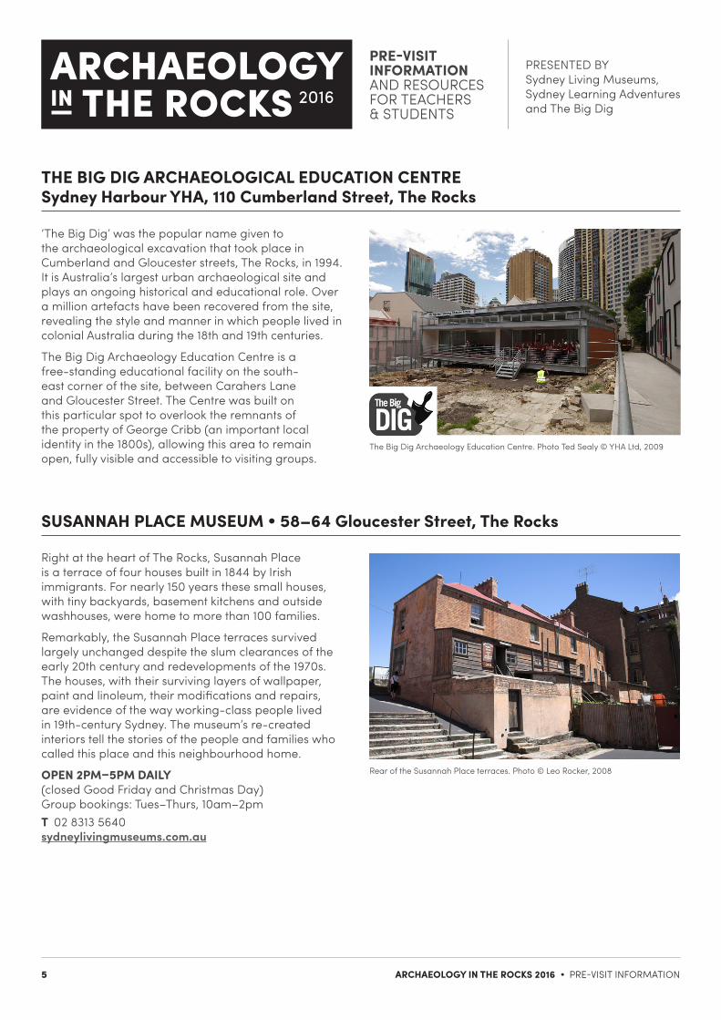
THE BIG DIG ARCHAEOLOGICAL EDUCATION CENTRE Sydney Harbour YHA, 110 Cumberland Street, The Rocks
SUSANNAH PLACE MUSEUM • 58–64 Gloucester Street, The Rocks
The Big Dig Archaeology Education Centre. Photo Ted Sealy © YHA Ltd, 2009
Rear of the Susannah Place terraces. Photo © Leo Rocker, 2008
‘The Big Dig’ was the popular name given to the archaeological excavation that took place in Cumberland and Gloucester streets, The Rocks, in 1994. It is Australia’s largest urban archaeological site and plays an ongoing historical and educational role. Over a million artefacts have been recovered from the site, revealing the style and manner in which people lived in colonial Australia during the 18th and 19th centuries.
The Big Dig Archaeology Education Centre is a free-standing educational facility on the south-east corner of the site, between Carahers Lane and Gloucester Street. The Centre was built on this particular spot to overlook the remnants of the property of George Cribb (an important local identity in the 1800s), allowing this area to remain open, fully visible and accessible to visiting groups.
Right at the heart of The Rocks, Susannah Place is a terrace of four houses built in 1844 by Irish immigrants. For nearly 150 years these small houses, with tiny backyards, basement kitchens and outside washhouses, were home to more than 100 families.
Remarkably, the Susannah Place terraces survived largely unchanged despite the slum clearances of the early 20th century and redevelopments of the 1970s. The houses, with their surviving layers of wallpaper, paint and linoleum, their modifications and repairs, are evidence of the way working-class people lived in 19th-century Sydney. The museum’s re-created interiors tell the stories of the people and families who called this place and this neighbourhood home.
OPEN 2PM–5PM DAILY (closed Good Friday and Christmas Day) Group bookings: Tues–Thurs, 10am–2pm T 02 8313 5640 sydneylivingmuseums.com.au

PRE-VISIT INFORMATION AND RESOURCES FOR TEACHERS & STUDENTS
PRESENTED BY Sydney Living Museums, Sydney Learning Adventures and The Big Dig
6 ARCHAEOLOGY IN THE ROCKS 2016 • PRE-VISIT INFORMATION
The Rocks Discovery Museum, Kendall Lane. Photographer unknown
PARBURY RUINS • 17 Windmill Street • Floorplan c1815–63
ROCKS DISCOVERY MUSEUM • Kendall Lane, The Rocks
The Rocks Discovery Museum, in a restored 1850s sandstone warehouse, is free and family friendly, and tells the story of The Rocks from pre-European days to the present. It displays a unique collection of images and archaeological artefacts that have been found in The Rocks. The interactive exhibits bring the history of the area alive, with touch screens and audio and visual elements.
Learn about the traditional custodians of the area, the establishment of the English colony and the time when sailors, whalers and traders lived there. Find out about the 1970s union-led protests that preserved this unique part of Sydney for future generations to explore and enjoy.
OPEN 10AM–5PM DAILY (closed Good Friday and Christmas Day) Kendall Lane, The Rocks (enter via Argyle Street)T 02 9240 8680

PRE-VISIT INFORMATION AND RESOURCES FOR TEACHERS & STUDENTS
PRESENTED BY Sydney Living Museums, Sydney Learning Adventures and The Big Dig
7 ARCHAEOLOGY IN THE ROCKS 2016 • PRE-VISIT INFORMATION
QUESTIONS TO ANSWER FOLLOWING YOUR VISIT
1. Why is it important for historical research to be carried out before a site is excavated?
2. List three common threats to archaeological sites:
1.
2.
3.
3. After artefacts have been excavated, they are grouped according to the materials from which they are made. Can you name five of these groups?
1.
2.
3
4.
5.
4. What types of documentary sources existed relating to the Cumberland Street and Parbury Ruins sites?
5. Susannah Place Museum is a conservation project. What does ‘conservation’ mean? What are the benefits of conservation?
6. Compare the Parbury Ruins and Cumberland Street sites from the point of view of how they have been interpreted for, and presented to, the public. What are the similarities and differences in their interpretation?

PRE-VISIT INFORMATION AND RESOURCES FOR TEACHERS & STUDENTS
PRESENTED BY Sydney Living Museums, Sydney Learning Adventures and The Big Dig
8 ARCHAEOLOGY IN THE ROCKS 2016 • PRE-VISIT INFORMATION
ARTEFACT ANALYSIS SHEET
ARTEFACT 1 ARTEFACT 2
What is it made from?For example: wood, metal, stone, ceramic, bone, shell.
Is it complete?Is it broken, snapped, cut or worn away?
Does it have any markings? For example: patterns, decoration, symbols, writing, cuts, scratches.
How was it made?By hand or machine? Locally or imported?
What do you think it is?How do you think it was used?
Estimate when you think it was made.For example: colonial era, 1880s, 20th century
Where do you think it was found?
Who do you think may have used or owned it?
Can you think of other ways it may have been used?
NAME:
QUICK SKETCH ARTEFACT 1
QUICK SKETCH ARTEFACT 2

PRE-VISIT INFORMATION AND RESOURCES FOR TEACHERS & STUDENTS
PRESENTED BY Sydney Living Museums, Sydney Learning Adventures and The Big Dig
9 ARCHAEOLOGY IN THE ROCKS 2016 • PRE-VISIT INFORMATION
ARTEFACT ANALYSIS SHEET
ARTEFACT 3 ARTEFACT 4
What is it made from?For example: wood, metal, stone, ceramic, bone, shell.
Is it complete?Is it broken, snapped, cut or worn away?
Does it have any markings? For example: patterns, decoration, symbols, writing, cuts, scratches.
How was it made?By hand or machine? Locally or imported?
What do you think it is?How do you think it was used?
Estimate when you think it was made.For example: colonial era, 1880s, 20th century
Where do you think it was found?
Who do you think may have used or owned it?
Can you think of other ways it may have been used?
NAME:
QUICK SKETCH ARTEFACT 3
QUICK SKETCH ARTEFACT 4