Embed Size (px)
Citation preview

STAGECOACH COMMUNITY PLAN
Routt County, Colorado
Adopted March 16, 2017

2017 ACKNOWLEDGEMENTS The Stagecoach Community Plan was developed as a cooperative endeavor between Routt County, the Morrison Creek Metropolitan Water and Sanitation District, Stagecoach Property Owners Association and the citizens and property owners of the Stagecoach Area. The plan was developed under the direction of the Routt County Board of County Commissioners and Planning Commission by the Planning Staff of the County. It also involved an intensive effort to contact and solicit ideas and reactions from Stagecoach land owners such as the Stagecoach Ski Corporation and the other large number of Stagecoach lot owners who live near and far. Maps were developed by the County Geographic Information Systems (GIS) Department. Important information was provided by several other County Departments, including the Road and Bridge Department, County Assessor, Environmental Health Department and by the South Routt County and Steamboat Springs School District and the Oak Creek Fire Protection District.
Routt County Commissioners Timothy V. Corrigan, Chair
Cari Hermacinski, Douglas B. Monger
Routt County Regional Planning Commission
Steve Warnke, Chair Troy Brookshire, Vice Chair
Brian Arel Andy Benjamin
Doug Baker Bob Woodmansee
Peter Flint Karl Koehler Jim McGee John M. Merrill Bill Norris
Contributors Routt County
The Morrison Creek Metropolitan Water & Sanitation District Stagecoach Property Owners Association
Oak Creek Fire District Colorado Parks and Wildlife United States Forest Service
Routt County Planning Department
Chad Phillips, Planning Director
Kristy Winser, Assistant Planning Director/Project Manager Chris Brookshire, Planner II
Alan Goldich, Planner II Watkins Fulk-Gray, Planner I
Veronica Blake, Office Manager Sarah Katherman, Minute Taker/Editor
This update plan is based on the original Stagecoach Community Plan that was adopted September 1999. Significant portions of the original plan have been retained as part of the update. The consultant team for the
1999 plan included: Clarion Associates of Colorado, LLC
Civitas, Inc. Civil Design Consultants

TABLE OF CONTENTS: 1. INTRODUCTION..............................................................................................................1
1.1 History of Stagecoach ............................................................................................1 1.2 Current Status ........................................................................................................5 1.3 Issues to Be Resolved .............................................................................................9 1.4 Overview of the Community Planning Process .................................................11
2. EXISTING CONDITIONS .............................................................................................12
2.1 Platted Lots and Subdivisions .............................................................................12 2.2 Current Zoning ....................................................................................................12 2.3 Water System .......................................................................................................13 2.4 Surface Waters………………………………………………………………... 14 2.5 Waste Water Systems………………………………………………………… 14 2.6 Road Capacity and Status ...................................................................................15 2.7 Electric, Alternative Energy and Wireless Service Options ............................17 2.8 Emergency Services .............................................................................................18 2.9 Educational Facilities...........................................................................................18 2.10 Wildlife Habitat ....................................................................................................19 2.11 Wildfire: Mitigation and Suppression ..............................................................21 2.12 Air Quality ............................................................................................................21 2.13 Water Quality .......................................................................................................21 2.14 Incorporation or Expanded District Service .....................................................22
3. PLANNING OPPORTUNITIES AND CONSTRAINTS ............................................23
3.1 Planning Opportunities .......................................................................................23 3.2 Planning Constraints ...........................................................................................24
4. FINDINGS AND CONCLUSIONS OF THE UPDATE PROCESS…………….. 25 5. STAGECOACH COMMUNITY PLAN ......................................................................27
5.1 Preferred Land Uses and Core Values...............................................................28 5.2 Neighborhood Market .........................................................................................28 5.3 Trails and Recreational Oriented Development ...............................................30 5.4 Infill and Lot consolidations ...............................................................................33 5.5 Natural, Scenic and Environmentally Sensitive Areas .....................................34 5.6 Housing ................................................................................................................37
6. IMPLEMENTATION .....................................................................................................38
6.1 Keys to Success .....................................................................................................38 6.2 Applicability of the Plan ......................................................................................39 6.3 Specific Implementation Actions ........................................................................40 6.4 Conclusion ............................................................................................................43

APPENDICIES
APPENDIX A: Stagecoach Subdivision and Zoning APPENDIX B: North Stagecoach Subdivisions, Zoning & Water Utilities APPENDIX C: South Stagecoach Subdivisions, Zoning & Water Utilities APPENDIX D: Lot Consolidation Flow Chart APPENDIX E: Vault Chart per Subdivision APPENDIX F: Infrastructure inventory chart per subdivision APPENDIX G: Stagecoach Community Contact List APPENDIX H: Future Land Use Map APPENDIX I: Definitions
The Woodmoor Vision (circa 1972)
Stagecoach Community Plan Page 1
1. INTRODUCTION
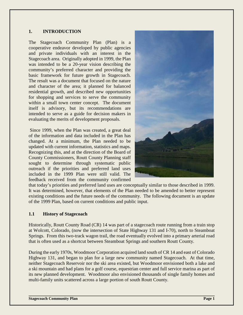
The Stagecoach Community Plan (Plan) is a cooperative endeavor developed by public agencies and private individuals with an interest in the Stagecoach area. Originally adopted in 1999, the Plan was intended to be a 20-year vision describing the community’s preferred character and providing the basic framework for future growth in Stagecoach. The result was a document that focused on the nature and character of the area; it planned for balanced residential growth, and described new opportunities for shopping and services to serve the community within a small town center concept. The document itself is advisory, but its recommendations are intended to serve as a guide for decision makers in evaluating the merits of development proposals. Since 1999, when the Plan was created, a great deal of the information and data included in the Plan has changed. At a minimum, the Plan needed to be updated with current information, statistics and maps. Recognizing this, and at the direction of the Board of County Commissioners, Routt County Planning staff sought to determine through systematic public outreach if the priorities and preferred land uses included in the 1999 Plan were still valid. The feedback received from the community confirmed that today’s priorities and preferred land uses are conceptually similar to those described in 1999. It was determined, however, that elements of the Plan needed to be amended to better represent existing conditions and the future needs of the community. The following document is an update of the 1999 Plan, based on current conditions and public input. 1.1 History of Stagecoach Historically, Routt County Road (CR) 14 was part of a stagecoach route running from a train stop at Wolcott, Colorado, (now the intersection of State Highway 131 and I-70), north to Steamboat Springs. From this two-track wagon trail, the road eventually evolved into a primary arterial road that is often used as a shortcut between Steamboat Springs and southern Routt County. During the early 1970s, Woodmoor Corporation acquired land south of CR 14 and east of Colorado Highway 131, and began to plan for a large new community named Stagecoach. At that time, neither Stagecoach Reservoir nor the ski area existed, but Woodmoor envisioned both a lake and a ski mountain and had plans for a golf course, equestrian center and full service marina as part of its new planned development. Woodmoor also envisioned thousands of single family homes and multi-family units scattered across a large portion of south Routt County.

Stagecoach Community Plan Page 2
In 1972 Routt County granted Woodmoor urban-scale zoning for the entire site. The zoning allowed for the development of both multi-family and single family lots of less than 1 acre—if central water and sewer services were provided. The County also approved 16 subdivision plats referred to today as the original Woodmoor Subdivisions, covering 1,938 single-family lots with the potential for thousands of additional condominium and townhouse units. The original Woodmoor subdivisions are shown in the adjacent table. Single family lots in Stagecoach were rapidly sold to over 1,400 different owners from all over the country and other parts of the world. Between that time and 1999, 78 single family homes were built on those lots. In addition, 172 multi-family units were constructed, but most of the multi-family tracts were retained for future development. Portions of the land that were not subdivided at that time received County zoning approval that would allow for a total of over 4,500 more dwelling units, if developed at maximum density. Even if developed at lower densities, the Woodmoor approvals would have accommodated housing for nearly as many people as lived in Steamboat Springs at that time. To provide water and sewer services for the anticipated development, Woodmoor helped create the Morrison Creek Metropolitan Water and Sanitation District (the “Metro District”). The Metro District sold bonds to investors and used the proceeds to begin constructing an extensive system of water wells, water pipes, sewer collection lines, and a sewage treatment plant. To achieve construction efficiencies, it sized these facilities to serve between 1,000 and 2,000 dwelling units. When future homes were built and hook-up fees and real property taxes were collected, those revenues would be used to repay bondholders. Unfortunately, in 1974 Woodmoor experienced hard times and filed for bankruptcy. Without an active sales program, lot sales and resales slowed down. Without a master developer, construction of multi-family units stopped altogether. Some of those who had sold the land to Woodmoor received portions of the land back following the bankruptcy, subject to zoning and platting that the County had approved. Some of the original sellers – including the MountainAir Company – still own those lands.
16 Original Subdivisions by
Woodmoor
North Area
South Area
Eagleswatch
Morningside
Townhouses (Projects I & II)
Horseback
South Shore Blackhorse I & II
Meadowgreen I, II and III (Includes Eagles Nest and Wagon Wheel)
Skyhitch I, II, III & IV High Cross
South Station I & II
High Cross

Stagecoach Community Plan Page 3
Since houses were not being built, real estate tax revenues to the Metro District did not rise as fast as expected and hook-up fees were not paid either. As a result, the Metro District was unable to meet its payments to the bondholders, and in 1976 it also sought the protection of the Bankruptcy Court. The Court required the Metro District to impose a levy of 20 mills ($20 on every $1,000 of assessed valuation) to repay the bondholders. The Court also ordered the Metro District to live within a 20 mill levy for its other operations. As a result of these constraints, the Metro District was unable to build additional infrastructure and facilities to serve new development unless the property owners agreed to pay for the construction. Since most property owners were not able to finance those utility extensions themselves, home construction declined and stayed at a very low level for most of the next 15 years. Although it did not have the financial capacity to expand, the Metro District continued to operate and maintain the oversized infrastructure that had already been built. The Metro District emerged from bankruptcy in the early 2000’s, allowing it to assume responsibility for its financial affairs and plan for its future with more freedom. In 1972, Woodmoor created the Stagecoach Property Owners Association (SPOA). Originally, SPOA had two membership classes: (1) Woodmoor, and (2) other lot owners. In 1977-1978, the non-Woodmoor lot owners took control of the organization. Over the years, SPOA has published the Stagecoach Express newspaper on a periodic basis, collected membership assessments (formerly referred to as dues), and used those assessments to finance the extension of a Yampa Valley Electric Association (YVEA) power line and other improvements. It has also acted as a clearinghouse for information on Stagecoach, and represented its members’ interests in dealings with the County and other public agencies. In the early 1980s, SPOA also participated in discussions that led to the approval of a “Vault Agreement” between Routt County and the Metro District. The Vault Agreement allows property owners to construct closed septic systems where individual onsite waste treatment systems (OWTS) or septic leachfields are not allowed and central sewers are not available, with the condition that those closed systems are pumped out on a regular basis and access roads are built and maintained to minimum County standards.

Stagecoach Community Plan Page 4
In light of this history, and the fact that infrastructure could not be installed to support the development as the buyers originally anticipated, it is not surprising that tensions have developed. Some of the lot purchasers have been adamant about finding ways to develop their lots even without the originally planned infrastructure in place. Some current residents are happy with the existing levels of development, and are apprehensive about any changes that would bring in more residents. A few major landowners are anxious to move forward as Woodmoor envisioned, with the expansion of the ski area and/or with large residential developments. Some lot owners would like to see the Metro District become more active in expanding infrastructure since it emerged from bankruptcy, while others are skeptical of anything that would create additional assessments or charges on their land without also creating tangible short-term benefits to their particular properties. In 1980, Routt County adopted its first Master Plan, which provides guidance to future development throughout the County and identified Stagecoach as a potential future growth area. Growth areas are intended to be self-contained communities with a mix of housing, commercial and retail uses, and employment opportunities, surrounded by areas that will remain rural and free of outward sprawl. Under the Master Plan, Stagecoach could only become a growth center if it could provide a full range of services and jobs to support the housing supply. The Master Plan did not originally include a detailed community plan for Stagecoach, but the Metro District, SPOA, and some large Stagecoach landowners subsequently requested that a detailed plan be prepared. The 1999 Stagecoach Community Plan was the result of that effort. 1.2 Current Status
1.2.1 Current Development and Trends Stagecoach encompasses the Metro District boundaries, the Stagecoach State Park, Stagecoach Reservoir, the ski area and the residential community that lies south of the reservoir. The area contains vacant lots, residential single family and multiple family developments, agricultural lands and preserved common area parcels surrounded by BLM land and the Routt National Forest. The land included in Stagecoach incorporates the broad northern meadow near the Stagecoach Reservoir, a narrow neck of steep land to the south between Song Mountain (formerly referred to as Woodchuck Mountain) and Young’s Peak, and a large area of open meadows and wooded slopes on the southern end. It is convenient to refer to the areas as the “North Area” and the “South Area”, with the dividing line falling between Eagles Watch and Morningside Subdivisions. A vicinity map of the land included in Stagecoach is provided on the following page.

Stagecoach Community Plan Page 5

Stagecoach Community Plan Page 6
There are several hundred vacant residential lots in Stagecoach. The North Area of Stagecoach is where most of the land with higher density zoning is located. For the most part, the lots in this area are served by electricity, improved roads and central water and sewer. Since the adoption of the 1999 Stagecoach Plan, large portions of the original Woodmoor subdivision of Meadowgreen in the north have been replatted into newer subdivisions. The new subdivisions, such as the Neighborhoods at Young’s Peak and Red Hawk Village, are referred to as the non-Woodmoor subdivisions. These residential subdivisions are served by improved roads, electricity and central water and sewer. The vast area that lies between the North and South Areas contains primarily larger un-platted metes and bounds residential parcels. The majority of the platted single family residential lots are located in the South Area, which remains largely undeveloped due to the limitations of the roads and the lack of centralized water and sewer service. In addition to limited infrastructure, the local economy has also had an impact on development in Stagecoach. Although the national recession of 2007 arrived late to Colorado, its impacts were eventually felt on a local level. Development in Routt County overall, and in Stagecoach specifically, came to a halt. According to the County Assessor, Steamboat Springs and its surrounding areas started to see some improvement in the real estate market, with rising home values, beginning in 2013. This trend has slowly spread to Stagecoach, as indicated by the 2015 appraisals. According to the Routt County Building Department and the Metro District, the number of construction permits issued for Stagecoach increased from 0 in 2010 to 4 permits in 2016, indicating that the economy is slowly gaining momentum. The Stagecoach area encompasses land beyond the 16 original subdivisions platted by Woodmoor. Stagecoach now includes 31 platted subdivisions, including several lot consolidations that have occurred since the adoption of the 1999 Plan. There are currently over 2,388 platted single and multi-family lots within Stagecoach, of which 1,802 remain vacant, predominantly located in the South Area. Zoned but un-platted parcels such as Song Mountain (formally Woodchuck Mountain) have residential development opportunities. However, before building lots are created or sold, and before any development occurs, the land would either need to be platted through a formal County process or divided by metes and bounds into parcels of no less than 35 acres. A few years ago, an application for a zone change that would have allowed as many as 272 new residential lots on Song Mountain was submitted to the County and was granted initial approval. That approval has since expired. To date, 488 dwelling units have been built in Stagecoach. This number includes 324 single family units, mostly located in the northern subdivisions of Eagle’s Watch, The Neighborhoods, Meadowgreen, and South Shore. All 164 multi-family units are located in the North Area in Town Homes Projects I and II, Eagle’s Nest, and Wagon Wheel. Based on the 2010 U.S. Census data, there are 530 full-time residents living in Stagecoach with approximately 75% of those residents living in the North Area, in close proximity to the intersection of CR 212 and CR16.
Stagecoach Community Plan Page 7
1.2.2 Constraints to Development The 16 original subdivisions developed by Woodmoor have more limitations on development than the 15 newer subdivisions located in the Stagecoach area. This is largely because the Woodmoor subdivisions were platted with the intent that water, sewer and roads would be developed, which did not occur. As a result, owners were left with few feasible options for obtaining central water and sewer connections and passable roads. Therefore, it remains very difficult for property owners to access their properties, let alone develop their lots. The newer subdivisions do not have these same constraints. Subdivision improvement agreements, bonding, and conditions of approval provide assurance that the agreed upon infrastructure is developed prior to the sale of lots. For an overview of an inventory of infrastructure per subdivision, a chart is provided in this plan (Appendix F). Further, under Routt County’s Low Density Residential (LDR) and High Density Residential (HDR) zoning and the terms of the original Stagecoach development approvals, lots may only be developed if they have adequate road access and central sewer service. Practically all of the Woodmoor subdivisions fall into these zoning categories. Extending water and sewer lines and constructing roads to serve individual lots often require the cooperation of all property owners that would be affected by those services. Achieving such cooperation can be very difficult, but it is not impossible. Property owners in Meadowgreen Filing 1, for example, were successful in sponsoring their own Local Improvement District (LID) to finance their own utilities and infrastructure. Although unsuccessful, SPOA also has attempted to facilitate motivated lot owners to get their neighbors to contribute to road improvements that would benefit an entire area. And, while the Vault Agreement has opened the door to the development of lots without connections to the sewer system, the individual lot owners must still bear the high monthly costs of pumping and maintenance, and must cover the costs of improving the road, developing a well, and providing power – through either the extension of electrical lines or the installation of an alternative power system. The number of permits for septic vaults is limited. Each subdivision that is not connected to the sewer line has a maximum number of vault permits that can be issued. The number is calculated by the gross acreage of that subdivision divided by 5 (the minimum acreage required to have an onsite septic system). As a result, some subdivisions, such as the Morningside Subdivision, now have close to the maximum number of vaults for which permits can be issued. In 2009, in response to concerns raised by the Metro District, the Routt County Commissioners discussed reducing the cap on the number of new septic vaults allowed in Stagecoach and possibly disallowing them after 2011. This would have added another hurdle to development in Stagecoach, if the Commissioners had not voted unanimously to reject the proposal from the Metro District. To date, there are 90 residential dwellings in the Stagecoach area operating on vault systems. Concerns remain regarding the high volumes of affluent pumped into the sewer plant from vaults and the high individual maintenance costs associated with vault systems. As a reference, a table of the number of Vault Permits issued per Subdivision is provided as Appendix E. As an alternative path to development that avoids the need for vaults or the extension of water and sewer lines, Routt County provides for the consolidation of small lots into parcels large enough to allow for a water well and the installation of an OWTS. This process entails the re-platting of
Stagecoach Community Plan Page 8
contiguous lots into tracts of 5 acres or more and the re-zoning of the parcels to Mountain Residential Estates (MRE) zone district. The vacation of internal utility easements from the original subdivision plat is also required prior to development. Since the adoption of the 1999 Plan, there have been 9 lot consolidations of this type, all located in the southern subdivisions of Stagecoach. Consolidations are depicted on the south Stagecoach subdivision map as MRE and found as Appendix C of this plan. 1.2.3 Real Property Taxes Pursuant to Colorado law, lots that are improved with homes are assessed at “residential” assessment rates, while those that are unimproved are assessed at “vacant” rates. Even though a lot may be undeveloped, a mill levy is still assigned to help fund public services. The mill levy assessed by Routt County is the same County-wide. Additional levies for school districts, fire districts, and other special taxing districts can mean that total tax bills vary significantly across the County, and Stagecoach is no exception. Stagecoach lot owners pay a mill levy to the Metro District for operations and maintenance of infrastructure, whereas most property owners in other un-incorporated areas of Routt County do not. Currently, the largest portion of a Stagecoach tax bill goes to the South Routt School District, followed by the portion that goes to the Metro District. Under Colorado law, each school district must establish a uniform system of real property taxes throughout its district, and those taxes must be paid by all property owners, regardless of whether they build a house or contribute any children to the school system. In fact, the large number of platted lots in Stagecoach has added assessed value to the South Routt County School District even though the area has had very few children attending local schools. The third largest tax payment included in a Stagecoach property owner’s tax bill is to Routt County. The County mill levy is used to pay for various services, including but not limited to road and bridge maintenance, snow plowing, environmental health services, building permitting and inspection, emergency and social services as required by the State of Colorado, the Clerk & Recorder, Coroner, Sheriff, and the County courts. The remainder of an average tax bill can be attributed to levies by the Oak Creek Fire Protection District (Fire District) and the library, cemetery, Colorado River, and Upper Yampa Special Districts, which are minimal in comparison 1.3 Issues to Be Resolved 1.3.1 Future Growth The historically slow pace of development in Stagecoach, and the lack of infrastructure and amenities that were originally planned by Woodmoor, have led to differing opinions about the future of the area. Some believe the area should be built out as originally planned by Woodmoor 45 years ago. Others enjoy the slow pace of change, lack of neighbors and traffic, and want Stagecoach to continue on the way it is now. Others believe Stagecoach could become a recreation-based community with a different character and different attractions than those shown in the Woodmoor plan. One significant goal of this Plan is to clarify a future direction for Stagecoach as a community that is consistent with the goals articulated in the Routt County Master Plan. The Master Plan calls for

Stagecoach Community Plan Page 9
directing new growth into defined, high quality and balanced “growth centers” and keeping the remaining portions of Routt County rural. Within south Routt County, Stagecoach is designated in the Master Plan as a “potential” growth center, and areas around it are intended to remain rural. If future growth cannot be accommodated in Stagecoach, demand will tend to produce more dispersed and less organized development that will erode the rural character of the County. Such development would be inconsistent with the Master Plan and detrimental to south Routt County in general. Future growth in Stagecoach will help clarify and adjust expectations, and will allow investments by both the public and private sectors to be made with more certainty. 1.3.2 Lack of Market Activity For the significant percentage of Stagecoach property owners who are interested in selling their lots, the low level of current sales activity is a cause for concern. While a market for larger consolidated lots exists, the market for smaller lots with limited access and without utilities or septic capabilities is still very weak. Likewise, vacant residential lots in the non-Woodmoor subdivisions that are served by roads, water and sewer remain undeveloped as well. Although economics has played its role in the slow development and sale of lots, the lack of basic infrastructure and neighborhood services has also contributed to this trend. However, with the market recovering and interest in development in the area increasing, this trend is likely to change in the future. Another significant goal of this Plan is to clarify what amenities or policies could encourage higher levels of market activity in Stagecoach without inspiring growth in un-incorporated Routt County as a whole. 1.3.3 Limited Options for Landowners of the 16 Original Subdivisions Developed by the
Woodmoor Corporation. For those who want to build a home in Stagecoach, there are currently few options to do so on lots developed by the Woodmoor Corporation that are not served by roads, water or sewer, other than through lot consolidation. Once lots are consolidated into parcels of at least 5 acres, property owners can pay for access roads, electric connections (or solar power), well and septic improvements, and they can build homes. If they cannot afford to do that, they can try to organize their neighbors to share the cost of access roads and electric service, or they can wait until the economics of development improve. Owners of lots smaller than 5 acres have basically the same options, except that they can either install a vault, and have it pumped regularly, or try to get their neighbors to split the cost of sewer and water line extensions in their area. If they cannot afford any of these options, they have the option of selling their lots to neighbors who want to assemble 5 acres. Except for the availability of vaults and the extension of the YVEA power line, these options have changed very little over time. A third goal of this Plan is to increase the number of options available to landowners. 1.3.4 The Need for Cooperation and Participation In any development as large and with a past as complicated as Stagecoach, the cooperation of many parties is needed to create success. Neither the Routt County government, the Metro

Stagecoach Community Plan Page 10
District, SPOA or major landowners in control of developable land have created the challenges identified above, nor are any of those organizations legally responsible to solve them. However, the cooperation of all four groups is necessary to clarify the vision for Stagecoach, encourage appropriate market activity, and create more options for the property owners. It will also take the cooperation of the South Routt County School District, Stagecoach State Park, the Fire District, and many other service providers to help Stagecoach become a center that is able to accommodate some of the growth that will inevitably come to south Routt County, and to do so in a way that meets the present and future needs of the community under the guidance and policies of Routt County. A fourth goal of this Plan is to identify specific ways for each of these entities to cooperate and participate in this process more closely than they have in the past. 1.3.5 Protection of Private Property Rights The rights of owners of real property are protected by both the federal and state constitutions, and they need to be protected in the planning process. In addition, the nature of those protections needs to be clearly understood. Under both Colorado and federal law, land owners are entitled to put their properties to some reasonable economic use, and not to have the rules of development changed unless the County affords them both procedural and substantive due process. On the other hand, neither constitutional nor statutory laws guarantee that (a) land owners can do whatever they want with their properties; (b) land owners must be allowed to develop if adequate public facilities are not in place; (c) the County will not change the rules of development over time; or (d) the County will provide subsidies to rescue failed developments or to encourage future development. A final goal of this Plan is to ensure that both the vision for Stagecoach and the means used to achieve it will respect those private property rights that are protected by state and federal law. 1.4 OVERVIEW OF THE COMMUNITY PLANNING PROCESS The 1999 Stagecoach Community Plan laid the foundation for how the Stagecoach community envisioned its future. The goal of the update process was to determine if that plan needed to be modernized or completely rewritten. This question initiated the kick-off to the Community Plan update process in October 2014. First, staff sent out 1,371 surveys owners of property in the Stagecoach area in an effort to reach as many individual lot owners as possible, to inform the community of the Plan update process, and to gather updated demographic information and community input. Staff received over 280 responses to the survey. Second, in November 2014, two community engagement meetings were held at the Stagecoach fire station to gather more input from the community. More than 30 people representing the community of Stagecoach attended each meeting. Third, staff compiled the findings and presented them at work sessions to the Planning Commission and thereafter to the Board of County Commissioners. Fourth, in April 2016 staff revised the Plan, in draft form, based on community input and direction by the Planning Commission and Board of County Commissioners. Fifth, staff refined the information and presented a draft of the Stagecoach Community Plan update for consideration of adoption.

Stagecoach Community Plan Page 11
Stagecoach Community Plan Page 12
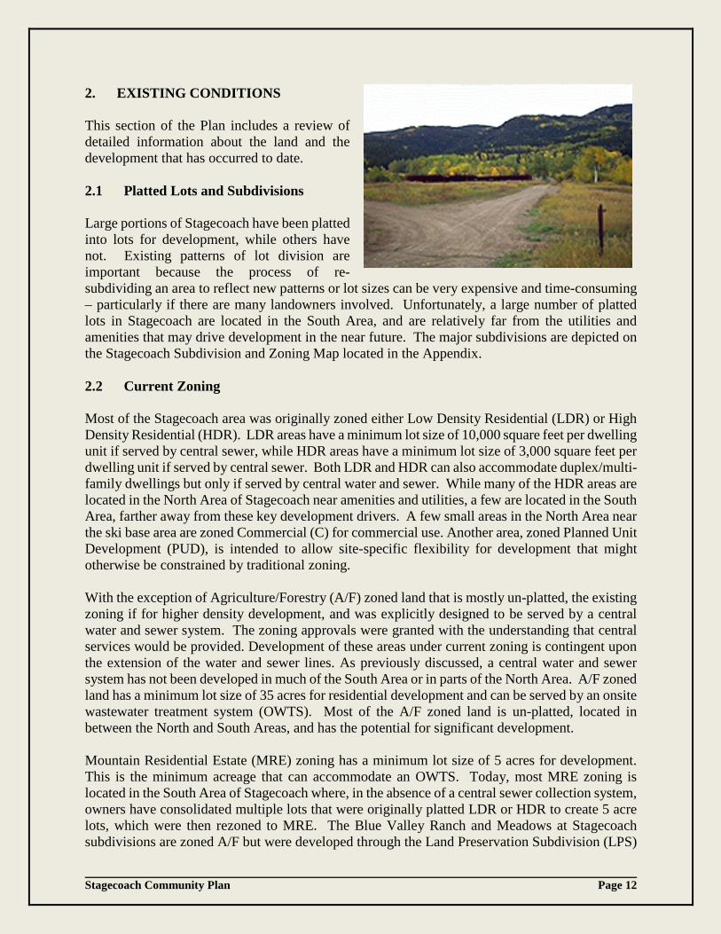
2. EXISTING CONDITIONS This section of the Plan includes a review of detailed information about the land and the development that has occurred to date. 2.1 Platted Lots and Subdivisions Large portions of Stagecoach have been platted into lots for development, while others have not. Existing patterns of lot division are important because the process of re-subdividing an area to reflect new patterns or lot sizes can be very expensive and time-consuming – particularly if there are many landowners involved. Unfortunately, a large number of platted lots in Stagecoach are located in the South Area, and are relatively far from the utilities and amenities that may drive development in the near future. The major subdivisions are depicted on the Stagecoach Subdivision and Zoning Map located in the Appendix. 2.2 Current Zoning Most of the Stagecoach area was originally zoned either Low Density Residential (LDR) or High Density Residential (HDR). LDR areas have a minimum lot size of 10,000 square feet per dwelling unit if served by central sewer, while HDR areas have a minimum lot size of 3,000 square feet per dwelling unit if served by central sewer. Both LDR and HDR can also accommodate duplex/multi-family dwellings but only if served by central water and sewer. While many of the HDR areas are located in the North Area of Stagecoach near amenities and utilities, a few are located in the South Area, farther away from these key development drivers. A few small areas in the North Area near the ski base area are zoned Commercial (C) for commercial use. Another area, zoned Planned Unit Development (PUD), is intended to allow site-specific flexibility for development that might otherwise be constrained by traditional zoning. With the exception of Agriculture/Forestry (A/F) zoned land that is mostly un-platted, the existing zoning if for higher density development, and was explicitly designed to be served by a central water and sewer system. The zoning approvals were granted with the understanding that central services would be provided. Development of these areas under current zoning is contingent upon the extension of the water and sewer lines. As previously discussed, a central water and sewer system has not been developed in much of the South Area or in parts of the North Area. A/F zoned land has a minimum lot size of 35 acres for residential development and can be served by an onsite wastewater treatment system (OWTS). Most of the A/F zoned land is un-platted, located in between the North and South Areas, and has the potential for significant development. Mountain Residential Estate (MRE) zoning has a minimum lot size of 5 acres for development. This is the minimum acreage that can accommodate an OWTS. Today, most MRE zoning is located in the South Area of Stagecoach where, in the absence of a central sewer collection system, owners have consolidated multiple lots that were originally platted LDR or HDR to create 5 acre lots, which were then rezoned to MRE. The Blue Valley Ranch and Meadows at Stagecoach subdivisions are zoned A/F but were developed through the Land Preservation Subdivision (LPS)
Stagecoach Community Plan Page 13
process. In lieu of 35-acre development, a LPS allows for development on A/F zoned land on smaller, 5-acre parcels with the condition that a large area within the subdivision is preserved as open space. Although it is important to recognize the expectations of all those who bought lots in Stagecoach, the pattern of existing zoning is not a rigid constraint, since zoning can be changed by action of the Board of County Commissioners to reflect new planning directions as long as constitutional rights are protected and statutory procedures are followed. Current zoning for Stagecoach is illustrated on the Stagecoach Subdivisions and Zoning Map, Appendix A. 2.3 Water System The Metro District’s current water supply is obtained entirely from the Brown’s Park Formation bedrock aquifer underlying the Metro District area. Since this potable water supply comes from the ground where it is naturally filtered and has no influence from a surface source, the only treatment necessary is chlorination at the well site. There are ten wells: four are in production and six are not currently in use. The aquifer beneath the Metro District area south of Stagecoach Reservoir, which encompasses approximately 9,000 acres, is estimated to contain between 1 and 2 million acre-feet of water storage with an annual recharge rate of about 2000 to 3000 acre feet. Since the Metro District only uses about 60 acre-feet per year within the North Area and 5 acre-feet per year within the South Area, there is more than sufficient volume in the aquifer to fulfill the needs of the Metro District far into the future. The Metro District does, however, have other water supply sources should there be a need. These water sources include a decreed 9.0 cubic foot per second (cfs) direct flow diversion from the Yama River at Stagecoach Reservoir, long term lease contracts with the Upper Yampa Water Conservancy District (UYWCD) for 500 acre-feet per year from Stagecoach Reservoir and 60 acre-feet per year from Yamcolo Reservoir. The original Metro District water facilities were constructed in 1973 and consisted of the “lower” subdivision pipelines and tanks, and the “upper” south system pipelines and tanks. The “upper system” serves the Blackhorse II Subdivision in the South Area and by-passes the Horseback and Blackhorse I Subdivisions. The “lower system” serves the North Area of Stagecoach, where 2000 feet of pipeline extensions were constructed to serve the newer subdivisions of the Neighborhoods at Young’s Peak, Middle Creek Village, Coyote Run, Meadow Green replats and Lynx Basin Estates from a looped system following CRs 16 and 212. The locations of water lines are depicted on Appendix B and C. The Metro District’s water system facilities consist of storage tanks, wells with chlorine disinfection, pipelines, pressure regulating valves (PRV), and booster pump stations that are divided between the north and south water systems, although most of the water services are currently located in the north system. The north and south systems are not interconnected, but according to recommendations included in a Metro District 2009 Water Master Plan, eventually these systems should be interconnected to meet the Metro District’s needs at full buildout. Continuing to rely on ground water development as identified in the Water Master Plan is more cost-effective, more flexible in accommodating phased development, and has fewer complications
Stagecoach Community Plan Page 14
with potential operational, maintenance and water quality monitoring costs than associated with a surface water diversion and treatment system. In addition to the capacity of the existing wells and pumps, the pattern of existing water distribution lines acts as a significant restriction on development. According to the Metro District, property owners may obtain water by tapping into the line for $9,000 per single family dwelling provided a mainline is within 100 feet of the subject lot. Individual wells can also be drilled on property to be developed that is far from the existing lines. Property owners must pay to have the well drilled, but since the well falls within the Metro District’s boundaries the well is owned by the Metro District, which has the right to utilize the well to serve others as part of its system. It is estimated that the total cost of developing an individual well is between $20,000 and $30,000. 2.4 Surface Waters
The Stagecoach Reservoir is an important 820 acre water resource providing recreational opportunities for boating and fishing, as well as water storage for users within the UYWCD boundaries. UYWCD’s boundaries encompass most of Routt County and extend into Moffat County to a point just southwest of the City of Craig. The area serves municipal, agricultural and industrial water users. The reservoir has 36,460 acre-feet of storage capacity to meet future water needs. After the adoption of the 1999 plan, the UYWCD proposed to construct another reservoir to meet future needs of the UYWCD. The proposed Morrison Creek Reservoir project was planned to benefit water users within UYWCD’s boundaries and to supplement the storage supply in Stagecoach Reservoir. The location identified for the reservoir is on the northeast side of the Horseback Subdivision and the east side of the Morrison Divide Ranch Subdivision. The capacity of the proposed reservoir is estimated to be between 4,010 acre-feet and 4,965 acre-feet, depending upon final technical and environmental studies of the site. Although the project is in the preliminary stages of review, it remains an option for the future as described in the UYWCD Master Plan. 2.5 Wastewater Systems
The Metro District’s sewage treatment facility was built in 1972 and serves approximately 475 dwelling units. This number includes hook ups to the central sewer collection systems, and vault systems within the Metro District boundaries. The system currently has a hydraulic capacity of 350,000 gallons per day and has an excess capacity of about 1,750 taps, although that number could change if treatment standards change or if the usage increases. Currently, the number of dwelling units the facility serves is far below its design capacity, although a 2009 study determined that there are deficiencies with the system’s design criteria regarding reliability and operability. The study concluded that the remaining useful life of the facility is limited. As such, the study recommended that the Metro District should not invest significant dollars in the existing facility, but should plan for a replacement facility that can be built in phases. In response, the Metro District has performed planned maintenance and has certified the proper operation of the system. It has also implemented upgrades and improvements that have extended the wastewater treatment plant’s long-term viability. The facilities are currently operating at well below the design capacity and, through best management practices and proper maintenance, the system continues to operate
Stagecoach Community Plan Page 15
reliably. For specific implementation actions by the Metro District, refer to section 6.3.15 of the plan. The wastewater system’s current pattern of sanitary sewer trunk lines affects the cost of serving different portions of the Stagecoach area. One stem of the system currently extends all the way from the treatment plant near Stagecoach Reservoir up CR 16 and as far south as the Black Horse II subdivision. Extension of the trunk lines to additional portions of southern Stagecoach may be expensive, particularly for areas that do not drain efficiently into the CR 16 trunk line. Sewer line locations can be found on maps provided in Appendices B and C of this Plan. The Metro District charges $7,000 for a single family home connection to its wastewater system. Water and sewer tap fees were prepaid through the Metro District bankruptcy process on a number of lots within Stagecoach originally platted by the Woodmoor Corporation where water and sewer lines are now within 100 feet of the lot boundaries. Information on tap fee certificates and the most up-to-date estimates and information can be obtained by contacting the Metro District. Owners of lots located far from the sewer trunk lines have fewer options than those whose lots are close to the lines. The only wastewater alternative available for an existing platted lot is a vault, known as a non-discharge system. This is a system that collects waste and is pumped out periodically through a contract with the Metro District. On lots of 5 acres or more, an OWTS can be developed. According to the Metro District, 90 vaults have been installed. The cost of installing a vault can be up to $15,000, the cost of required pumping can run up to $300 per month, and the costs to bring access roads up to required standards to adequately handle pump trucks can also be expensive. A complete chart of vault permits that have been issued can be found in Appendix E of the plan. 2.6 Road Capacity and Status CR 14 is the sole access to the Stagecoach residential area, Lynx Pass and surrounding recreational areas. CR 14 is commonly used as an alternative route to State Highway (SH) 131 that connects Steamboat Springs to the community of Phippsburg and Towns of Yampa and Oak Creek. While a shorter route, CR 14 is even narrower than SH 131 and crosses Yellow Jacket Pass, a low elevation mountain pass at 7,400 feet that lies between Steamboat Springs and South Routt County. In 1989, Routt County began improvements to CR 14. The road improvements were scheduled for implementation in four phases. The first three phases were completed in the mid -1990’s. In 2008 the Routt County Transit Needs and Feasibility Study cited safety concerns with the difficult commute along CR 14 and described how the proposed Phase 4 of the County Road project would make this potential transit route safer. It also noted that the Average Daily Trips (ADT) on CR 14 is 1,900, which is higher than the 1,500 ADT on SH 131. Unfortunately, the final phase of improvements was delayed until recently due to financial constraints brought on by the 2008 national recession. The CR 14 Phase 4 project plan includes the redesign, reconstruction and realignment of segments of the road. It also includes slope stabilization and repair of a 5.2 mile section of CR 14. In 2014-2015 the right-of-way for the road work was purchased, spot shouldering and drainage improvements were installed, and the top of the pass was widened. The work has improved sight distances, and pedestrian and bicycle safety. At this time, funding has not been identified to complete the rest of Phase 4 reconstruction without completing the improvements; the geometry and lack of shoulders may reduce the capacity.
Stagecoach Community Plan Page 16
In 1995, a detailed transportation study by DMJM was conducted as part of the consultant contract for the 1999 Plan. One important conclusion of the study was that the roadways serving Stagecoach are limited by capacity constraints on CR 14 and SH 131 (which are outside the boundaries of both the North and South Areas). The County Roads within Stagecoach itself (CRs 16, 212 and 18A) also have capacity constraints. Furthermore, because the Stagecoach site is remote, and relies heavily on Steamboat Springs and Oak Creek for jobs and services, traffic generation rates are likely to rise as more year-round residents locate in the area, and as more retail and commercial uses are located in either Oak Creek or Stagecoach. The 1995 study also calculated the potential traffic impacts of a Stagecoach ski area with approximately 50,000 skier days, and of continued growth in traffic to and from Stagecoach State Park. It found ski area-related traffic during the winter months and state park-related traffic during the summer months would make up only about 5% of the total traffic generated by Stagecoach. The vast majority of traffic generated by future development will be the result of residential development. Therefore, the inclusion or exclusion of the recreational operations will probably not affect the road needs of Stagecoach significantly. According to the DMJM study, the existing two lane designs of CRs 14 and 16 could probably accommodate increased levels of traffic without requiring expansion, but may constrain development opportunities in the future. Therefore, it will be important to monitor what types of units are built and how traffic levels change over time, so that development works within the capacity constraints of the two lane roads. If growth in Stagecoach outpaces road capacity on CRs 16, 18A, 14 and/or SH 131, a mechanism will have to be developed through which new development will fund the necessary expansion of the roads. Maintenance of rural County Roads is already challenged by dispersed development outside of designated growth centers and by people who purchase remote lots, but are not fully aware of the responsibilities associated with rural living. As development increases in Stagecoach, lot owners will be required to invest in the local roads that connect the County Roads to their homes. Existing road conditions and maintenance varies by subdivision in Stagecoach. Some areas have gravel roads maintained by the County, others have partially graveled roads that are privately maintained and others have mapped but unbuilt roads. Because of this diversity, each lot to be developed must be reviewed by the Routt County Road and Bridge Department and the Fire District on a case by case basis to ensure public safety and fire protection. In addition, prior to a vault system being installed, the Metro District must determine if the road is adequate to handle a truck to pump out the vault. Refer to Appendices B and C of the Plan for road classifications. Currently, it is estimated by Routt County Road and Bridge Department that the cost of building one tenth of a mile of roadway to a “County Paved Road Standard” is approximately $21,309. This is the minimum standard allowed for a road to be considered for eventual County Road acceptance and maintenance, and requires two 11’ travel lanes with 4’ paved shoulders and 3’ gravel shoulders. Roads built to a lesser standard are commonly found in the Stagecoach area and are privately maintained. If the intent is to maintain a road privately, the road can be developed as a gravel road to a “driveway” or “shared access” standard. A gravel road shall consist of two14’ lanes for a total roadway width of 28’, but modified roadway sections may be evaluated on a case by case basis to ensure the roads satisfy the needs of the, fire code, development, and the expected traffic. The cost of building a reduced standard road will vary based on the situation, but ultimately
Stagecoach Community Plan Page 17
would be far less than the cost of building to a County Paved Road Standard. Specific information on road standards, costs, design resources and limited technical assistance is available by contacting the Routt County Road and Bridge Department or can be found on the department website. In an effort to summarize the current status of roads within Stagecoach and the maintenance responsibility for the roads, Routt County Planning staff created maps located in Appendices B and C of this plan. Note that not all of County maintained roads are constructed to current standards and developers may be responsible for upgrades. 2.7 Electric, Alternative Energy and Wireless Options Since its initial development, Stagecoach has suffered from limited electric capacity to serve new construction. Even with efforts by SPOA and YVEA to extend a major feeder line in Stagecoach, the availability of electrical services remains limited, especially in the South Area. The 12.5 KV feeder line crosses the North Area meadow near the reservoir and generally follows CR 16 south to the entrance of the Sky Hitch III subdivision. The extension has a capacity to serve 1,400 additional dwelling units but not all Stagecoach homes are intending to take advantage of this service due to the high cost of connecting. Appendix F of this plan provides an overview of subdivisions that have electric availability. Due to the technicalities of electric connections, YVEA recommends that users contact them for the most accurate and up-to-date information on options. Alternately, some current Stagecoach residents have installed photo-voltaic solar devices to power their homes, and at least one unit is using a wind generator on a backup basis. Because of Colorado’s sunny climate and the deregulation of power suppliers, it is likely these and other types of alternative energy sources (such as active solar designs or earth sheltered construction) will be employed by some Stagecoach homes in the future. Wireless cell phone coverage within Stagecoach is limited. There are wireless facilities in the vicinity but the surrounding topography creates coverage gaps in Stagecoach where there is no direct line of sight to the facilities. There are other service connection considerations available for telephone and high speed internet. In fact, in February of 2016, Routt County developed a Strategic Broadband Plan that provides a number of options and strategies for improving broadband services throughout Routt County. It was determined that access to affordable, redundant and abundant broadband service is a primary goal and that providing competitive broadband is essential to sustaining and developing Routt County’s economic and cultural vitality. Specifically for Stagecoach, the existing fire station was identified as a potential wireless access point which would further expand broadband services to homes and businesses in the Stagecoach Community. 2.8 Emergency Services and Public Safety
Emergency services are currently provided to the Stagecoach area by the Fire District. There is a fire station located on CR 16 adjacent to the Neighborhoods of Young’s Peak in the North Area of Stagecoach. Its location is accessible to higher density developments in the North Area and has direct road access to homes in the South Area.
Stagecoach Community Plan Page 18
Immediate medical services are currently provided by the South Routt Medical Central Health District, as well as other clinics in Steamboat Springs. As the population of Stagecoach grows, there may be demand to support a small clinic in Stagecoach, as well. It would be appropriate to locate that facility in close proximity to a future neighborhood node. In response to concerns raised by emergency responders, addressing requirements for Routt County were implemented in 1997. Proper street and address signage, sequential house numbers and named roads accessing two or more residences are critical to emergency responders’ ability to find a location in a timely manner. The development of accurate addressing records for emergency services is important for Stagecoach and especially for the remote South Area. Such records also have an impact on utilities, delivery services, and rural postal delivery. County addressing requirements can be found on the Routt County website. 2.9 Educational Facilities
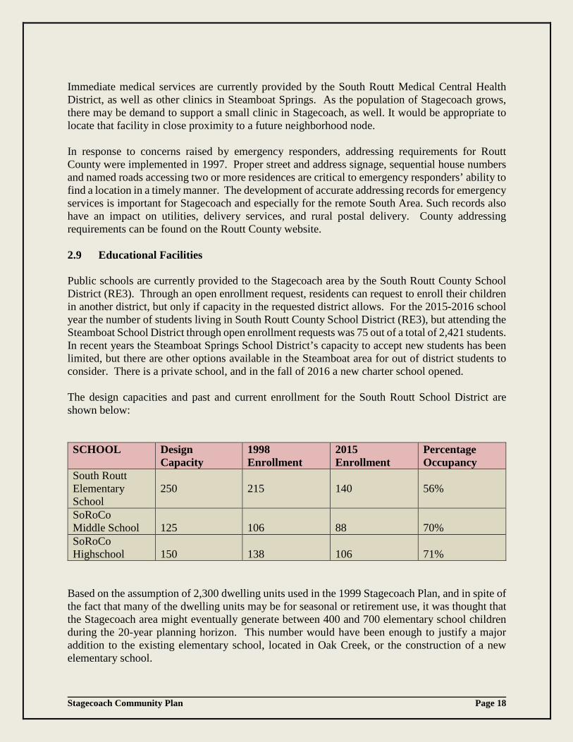
Public schools are currently provided to the Stagecoach area by the South Routt County School District (RE3). Through an open enrollment request, residents can request to enroll their children in another district, but only if capacity in the requested district allows. For the 2015-2016 school year the number of students living in South Routt County School District (RE3), but attending the Steamboat School District through open enrollment requests was 75 out of a total of 2,421 students. In recent years the Steamboat Springs School District’s capacity to accept new students has been limited, but there are other options available in the Steamboat area for out of district students to consider. There is a private school, and in the fall of 2016 a new charter school opened. The design capacities and past and current enrollment for the South Routt School District are shown below: SCHOOL Design
Capacity 1998 Enrollment
2015 Enrollment
Percentage Occupancy
South Routt Elementary School
250
215
140
56%
SoRoCo Middle School
125
106
88
70%
SoRoCo Highschool
150
138
106
71%
Based on the assumption of 2,300 dwelling units used in the 1999 Stagecoach Plan, and in spite of the fact that many of the dwelling units may be for seasonal or retirement use, it was thought that the Stagecoach area might eventually generate between 400 and 700 elementary school children during the 20-year planning horizon. This number would have been enough to justify a major addition to the existing elementary school, located in Oak Creek, or the construction of a new elementary school.
Stagecoach Community Plan Page 19
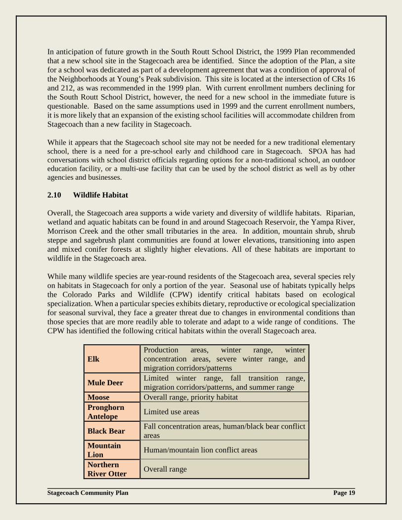
In anticipation of future growth in the South Routt School District, the 1999 Plan recommended that a new school site in the Stagecoach area be identified. Since the adoption of the Plan, a site for a school was dedicated as part of a development agreement that was a condition of approval of the Neighborhoods at Young’s Peak subdivision. This site is located at the intersection of CRs 16 and 212, as was recommended in the 1999 plan. With current enrollment numbers declining for the South Routt School District, however, the need for a new school in the immediate future is questionable. Based on the same assumptions used in 1999 and the current enrollment numbers, it is more likely that an expansion of the existing school facilities will accommodate children from Stagecoach than a new facility in Stagecoach. While it appears that the Stagecoach school site may not be needed for a new traditional elementary school, there is a need for a pre-school early and childhood care in Stagecoach. SPOA has had conversations with school district officials regarding options for a non-traditional school, an outdoor education facility, or a multi-use facility that can be used by the school district as well as by other agencies and businesses. 2.10 Wildlife Habitat Overall, the Stagecoach area supports a wide variety and diversity of wildlife habitats. Riparian, wetland and aquatic habitats can be found in and around Stagecoach Reservoir, the Yampa River, Morrison Creek and the other small tributaries in the area. In addition, mountain shrub, shrub steppe and sagebrush plant communities are found at lower elevations, transitioning into aspen and mixed conifer forests at slightly higher elevations. All of these habitats are important to wildlife in the Stagecoach area. While many wildlife species are year-round residents of the Stagecoach area, several species rely on habitats in Stagecoach for only a portion of the year. Seasonal use of habitats typically helps the Colorado Parks and Wildlife (CPW) identify critical habitats based on ecological specialization. When a particular species exhibits dietary, reproductive or ecological specialization for seasonal survival, they face a greater threat due to changes in environmental conditions than those species that are more readily able to tolerate and adapt to a wide range of conditions. The CPW has identified the following critical habitats within the overall Stagecoach area.
Elk Production areas, winter range, winter concentration areas, severe winter range, and migration corridors/patterns
Mule Deer Limited winter range, fall transition range, migration corridors/patterns, and summer range
Moose Overall range, priority habitat Pronghorn Antelope Limited use areas
Black Bear Fall concentration areas, human/black bear conflict areas
Mountain Lion Human/mountain lion conflict areas
Northern River Otter Overall range
Stagecoach Community Plan Page 20
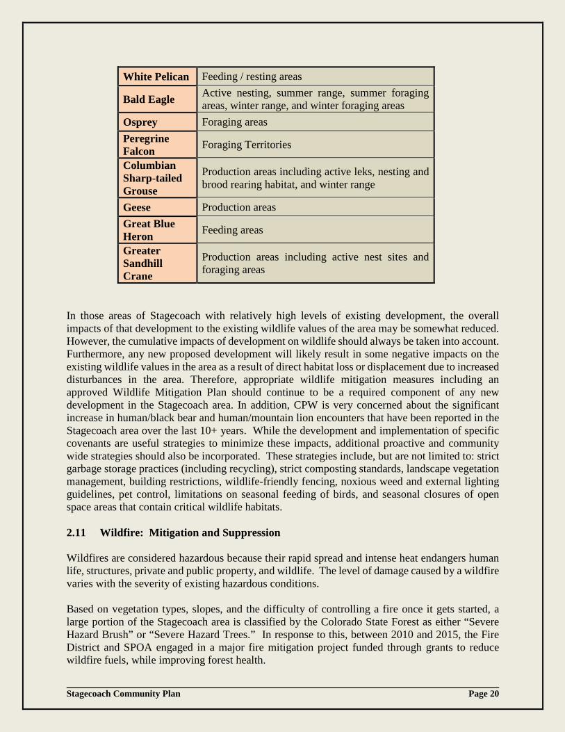
White Pelican Feeding / resting areas
Bald Eagle Active nesting, summer range, summer foraging areas, winter range, and winter foraging areas
Osprey Foraging areas Peregrine Falcon Foraging Territories
Columbian Sharp-tailed Grouse
Production areas including active leks, nesting and brood rearing habitat, and winter range
Geese Production areas Great Blue Heron Feeding areas
Greater Sandhill Crane
Production areas including active nest sites and foraging areas
In those areas of Stagecoach with relatively high levels of existing development, the overall impacts of that development to the existing wildlife values of the area may be somewhat reduced. However, the cumulative impacts of development on wildlife should always be taken into account. Furthermore, any new proposed development will likely result in some negative impacts on the existing wildlife values in the area as a result of direct habitat loss or displacement due to increased disturbances in the area. Therefore, appropriate wildlife mitigation measures including an approved Wildlife Mitigation Plan should continue to be a required component of any new development in the Stagecoach area. In addition, CPW is very concerned about the significant increase in human/black bear and human/mountain lion encounters that have been reported in the Stagecoach area over the last 10+ years. While the development and implementation of specific covenants are useful strategies to minimize these impacts, additional proactive and community wide strategies should also be incorporated. These strategies include, but are not limited to: strict garbage storage practices (including recycling), strict composting standards, landscape vegetation management, building restrictions, wildlife-friendly fencing, noxious weed and external lighting guidelines, pet control, limitations on seasonal feeding of birds, and seasonal closures of open space areas that contain critical wildlife habitats. 2.11 Wildfire: Mitigation and Suppression Wildfires are considered hazardous because their rapid spread and intense heat endangers human life, structures, private and public property, and wildlife. The level of damage caused by a wildfire varies with the severity of existing hazardous conditions. Based on vegetation types, slopes, and the difficulty of controlling a fire once it gets started, a large portion of the Stagecoach area is classified by the Colorado State Forest as either “Severe Hazard Brush” or “Severe Hazard Trees.” In response to this, between 2010 and 2015, the Fire District and SPOA engaged in a major fire mitigation project funded through grants to reduce wildfire fuels, while improving forest health.

Stagecoach Community Plan Page 21
As the number of people visiting, living, and working in a wildfire hazard area increases, the risk of wildfires increases, depending on the topography and vegetation. Although the construction of the new fire station has reduced the risk of property damage or loss, wildfire mitigation measures should still be considered for existing structures and required through conditions of approval as new development occurs. Additionally, wildfire risk can be significantly reduced by following the 2008 Stagecoach Community Wildfire Protection Plan and the building location guidelines and vegetation management guidelines for “defensible space” published by the Colorado State Forest Service and available on their website 2.12 Air Quality The Stagecoach area is not included in the geographic boundaries of the Steamboat Springs Airshed and is not currently in violation of any federal air quality standards. Because the Routt County Solid Fuel Device Resolution, adopted in 1991, does not currently apply to Stagecoach, the number and type of wood and/or coal burning devices is not regulated in Stagecoach. However, in 1996 the City/County Air Quality Committee recommended that Routt County consider a County-wide wood smoke ordinance based on population density, so this situation may change in the future. In sparsely populated areas such as Stagecoach, the most significant threat to air quality generally comes from particulate matter (e.g. dust from dirt roads) rather than vehicle emissions, but that balance can shift as roads are paved and the population grows. Since the relatively high snowfall in the South Area and further up Lynx Pass tends to suppress dust during much of the year, particulate matter is not expected to exceed federal thresholds during the 20-year planning horizon. 2.13 Water Quality An overlying layer of shale acts as an aquitard to protect underlying, water-bearing sandstone units from most surface water influences. Ground water sourced from four production wells that extend into the water-bearing sandstone units is acceptable as a source of drinking water. A Drinking Water Permit issued to the Metro District by the Colorado Department of Health and Environment (CDPHE) requires chlorine disinfection to meet conditions set forth in the permit. Likewise, following treatment of wastewater, discharges from the waste water treatment facility must meet effluent limits as described in a discharge permit also issued by the CDPHE. As development increases, the risk of water pollution generally increases from non-point sources such as automotive by-products (primarily fluids), sediment from construction and roads, and toxic contaminants from fertilizers, herbicides, paint, and other chemicals homeowners may use on their property. Contaminants from these sources that run off into the surrounding streams and eventually into Stagecoach Reservoir can be reduced by requiring Best Management Practices (BMPs) when development occurs. Common BMPs include installing grass-lined swales, check dams, or sediment sumps between disturbed areas (particularly roads) and nearby streams; providing covered storage for maintenance equipment and vehicles; using development agreements to limit the use of herbicides and fertilizers; and engaging in outreach efforts to educate homeowners on the proper disposal of household hazardous wastes. Furthermore, the cumulative impacts of numerous individual OWTSs and drinking water supply wells will need to be analyzed if more lot consolidations occur. The potential impacts on water quality of advanced type treatment
Stagecoach Community Plan Page 22
systems and wells would also need to be understood prior to the County implementing a special zoning district that would allow such systems to serve development on existing small platted lots. 2.14 Incorporation or Expanded District Service With only 488 dwelling units currently in place in Stagecoach, and with an active metropolitan district in place to provide water and sewer services, it would almost certainly not be cost-effective for Stagecoach to incorporate as a Colorado town at the present time. Incorporation carries with it both advantages and disadvantages. On the positive side, it allows a community to take over the provision of many services and facilities, and to adopt land use controls and police regulations that differ from the County’s. On the negative side, incorporation carries with it the practical responsibility for providing certain services (such as zoning, animal control, budgeting, and reporting) and relieves the County government of the duty to provide those services. The Routt County Master Plan identifies several Growth Centers throughout the County, which include Hayden, Yampa, Oak Creek and Steamboat Springs. A Growth Center is an incorporated area that generally has a significant amount of urban-density development and high-intensity land uses. These areas include cities and towns and the areas adjacent to these incorporated communities. In general, a Growth Center should provide concentrated residential development, a center of commerce and civic activities, a detailed adopted Community Comprehensive Plan, access routes that can safely accommodate expected traffic flows, and have the fiscal capacity to provide essential services to its residents. In the case of Stagecoach, incorporation would leave the Metro District and the South Routt County School District in place (along with their tax levies) as providers of water, sewer, and school services. It would also leave the Routt County portion of the property tax levy in place. The cost of providing additional services would fall to the new town’s taxpayers. While the new town would have the power to collect property or sales taxes, sales tax revenues would probably be small (in light of the low sales that the current population would generate), and the taxes would be subject to a vote of the people. For all of these reasons, it is unlikely that the residents of Stagecoach would find incorporation to be a cost-effective way to provide public services. Instead, Stagecoach is considered a “potential” Growth Center in the Routt County Master Plan, because, while not meeting the strict definition of a Growth Center, it does have existing platting, urban-density zoning (including commercial), a special district, and an approved sub-area plan. As Stagecoach grows, new residential and commercial developments and uses should occur within the vicinity of the potential Growth Center and in compliance with the adopted community plan for Stagecoach.

Stagecoach Community Plan Page 23
3. PLANNING OPPORTUNITIES AND CONTRAINTS The vision for the future of Stagecoach must reflect not only the information presented in this Plan, but an understanding of the less quantifiable aspects of Stagecoach that may create important opportunities and constraints to future development. 3.1 Planning Opportunities Fortunately, the Stagecoach area has several important advantages that make future development likely. While some of these opportunities arise from the natural features and spectacular physical setting of the land, others, such as the existence of large un-platted tracts of land, are the by-product of the troubled development history of the area. In crafting the future vision for this area, Stagecoach needs to take advantage of the opportunities discussed below. The Stagecoach area is blessed with abundant wildlife and tremendous physical beauty, including the views over Stagecoach Reservoir, Song Mountain (formerly known as Woodchuck Mountain), Young’s Peak, the relatively open valleys both in front of the lake and behind it, and the small streams that run through the valley. The natural beauty and feeling of solitude have been important factors in many residents’ choice to purchase property and move to the area. This has been noted in the past and continues to be identified in the update process as an important issue. In addition, the character of the area lends itself to recreational amenities and activities, and provides potential for new or improved options for recreational development. Stagecoach State Park and the

Stagecoach Community Plan Page 24
Reservoir already provide important opportunities for active and passive recreation that 150,000 visitors utilize each year. There is an existing network of non-motorized trails for hiking, biking and cross country skiing and new trails are likely to be constructed as development continues. A small ski area with limited operation exists, but has the potential to expand and become a focal point for future development. Proper permits and approvals are in place for that expansion. The addition of other recreational amenities remains a possibility for the future, as the scenic qualities of the area and opportunities for recreation can attract new development. Another promising aspect of Stagecoach is that large tracts of un-platted land (particularly in the North Area) continue to be held by a single landowner. This makes planning for the future easier, and provides the community with a blank slate for open space and recreational opportunities, and/or the development of a small town center. The County has recognized the diverse opportunities that exist in Stagecoach and has increased flexibility for future development by identifying new ways to support development in conformance with the Plan. Specifically, commercial/mixed use type development can be approved through using policies and standards. Other incentives the County has drafted to encourage and support development include: allowing applications to be combined to streamline the approval process, reducing application costs to support zone changes supported by the Plan, and reducing road standards. The County also provides a Conceptual Plan process through which potential developers can obtain feedback on a proposal without spending too much time or money on professionally prepared plans. 3.2 Planning Constraints
In spite of all the planning opportunities available in the Stagecoach area, there are several constraints that will limit future development options. Most of those constraints are the result of the complicated financial history of the development and the related bankruptcies of Woodmoor and the Metro District. One significant planning constraint in the Stagecoach area is that, according to SPOA’s membership records, the 2,388 platted lots within SPOA’s boundaries are currently owned by over 1,500 individual owners who are scattered throughout the world. This does not include the many non-SPOA tracts. Fragmented ownership increases the time and expense of notifying landowners about costs of development and alternatives for development, and of negotiating lot consolidations and joint improvements. This became apparent when only 270 property owners responded to the community surveys sent out in the process of updating this Plan. Furthermore, the priorities for property owners in the South Area, such as the development of basic infrastructure are different than the priorities for property owners in the North Area, where the majority of development is located and supporting infrastructure is in place. Fragmented ownership has also been an issue when attempts have been made to amend the covenants of SPOA or other homeowners’ associations. Strict covenants have deterred potential buyers and have limited development potential, but amending covenants is challenging when all property owners must agree to the change. State law provides a mechanism whereby an association can petition the district court for approval of changes

Stagecoach Community Plan Page 25
with the support of only a percentage of owners. SPOA used this process in 2015 and successfully amended its covenants for the first time. Similarly, the Metro District is subject to limitations regarding rate adjustments and fee structures by the Colorado’s Taxpayer Bill of Rights (TABOR). TABOR limits the rate at which the Metro District can increase revenue collections or tax rates, and requires a vote of all Metro District property owners in order to raise taxes or to issue most types of debt. In addition, most financing is limited by the total assessed value of property in the Metro District, which is not very high. The combination of an election requirement and limited property values means that the Metro District will probably not be in a position to borrow significant funds to expand its infrastructure systems in the near future. Stagecoach cannot look to the County for infrastructure funding, as Routt County is also subject to TABOR restrictions on revenue growth, new taxes, and the issuance of debt. Because any measure put forward by the County would be subject to a County-wide vote, it would be difficult for Routt County to secure new sources of revenue or to borrow money to build infrastructure in Stagecoach. Since neither the Metro District nor the County are likely sources of additional funding for Stagecoach, the future vision should not assume that funding for major infrastructure improvements will be available from these sources any time soon. As a special district, however, the Metro District has the opportunity to access alternative funding sources. In the short-term it will be up to individual property owners, small groups of landowners or developers to initiate Local Improvement Districts (LIDs) or Public Improvement Districts (PIDs), as outlined in the Implementation portion of this Plan. As it stands, individual property owners are responsible for utility and road extensions to their properties. Additional costs and considerations of land ownership and rural living should be factored into any decision to purchase property in Stagecoach. A Guide to Rural Living is a great resource for information and considerations. This document can be obtained by contacting either the CSU Extension Office or the Routt County Planning Department. 4. FINDINGS AND CONCLUSIONS OF THE UPDATE PROCESS In the fall of 2014 the County sent out 1,371 surveys to lot owners in the Stagecoach area to gather current demographic information and community input for the update process. The data collected from the 280 responses were similar to the results of surveys sent out in 1999 for the creation of the original Stagecoach Community Plan. In particular, 81% of those who responded were non-residents and indicated that they do not plan to build a home or to live in Stagecoach. Many indicated that they had changed their plans since the purchase of their lots, while others have inherited lots or received them as gifts, and treat them as an asset to be sold when the time is right. Of the respondents, 53% stated they were interested in selling their lots and 19% said that they have built on their properties. Of those who have built homes, 16% are full-time residents and 3% are part-time residents. The turnout for each community engagement meeting included representatives from SPOA, the Metro District, Routt County, the Town of Oak Creek, Stagecoach State Park, South Routt School District, the Board of Realtors and residents of Stagecoach. Based on the input from the 280 surveys returned and from the community meetings, staff determined that the Stagecoach

Stagecoach Community Plan Page 26
community continues to value the following elements: the nature and character of the area (solitude), lot consolidations and infill with a focus on infrastructure expansion, and the preservation of environmentally sensitive lands. While recreational activities have always been included as the foundation of Stagecoach as a resort community, emphasis has moved from a ski area or golf course community to a focus on hiking, biking and Nordic skiing. There has been a shift in focus away from amenities that may not be developed to recreational activities that are currently available to the community. The concept of a small town center offering mix-use opportunities such as a community market and a daycare facility is still favored. While the 1999 Plan designated a specific location at the base of the ski area as the appropriate spot for a future town center, the recent survey indicates that the community would now support the development of a town center in a different location. In 2005, an application for a mixed-use commercial center, the Stagecoach Marketplace, was approved but was never developed. Since that time the community has expressed frustration with the limited amount of land available in Stagecoach that is zoned for new commercial uses. Currently, the only area with commercial zoning is owned by a single property owner. The community clearly expressed its opinion that the lack of developable land for retail use has inhibited the community’s potential growth. It was suggested that more flexibility for retail development could be incorporated into the community plan through the update process. The desired flexibility was created by developing specific standards that, if met, would allow retail uses in other locations. This concept has been incorporated into the plan update and is discussed in Chapter 5. In response to the concerns regarding the lack of infrastructure (water, sewer and roads) in the 16 subdivisions developed by Woodmoor, it was suggested that the County could implement a special zoning district that would allow the use of OWTSs on smaller lots if advanced type treatment systems could be designed. This was suggested as an alternative to extending sewer lines or requiring a minimum of 5 acres for the use of an OWTS. Research into advanced septic systems, however, indicates that the concentration of many such systems within a special zoning district could impact overall water quality. Furthermore, the cumulative impacts from numerous individual OWTSs and drinking water supply wells are unknown. Therefore, studies would need to be conducted and systems would need to be monitored and inspected prior to creating such as zoning district. Neither the County nor the Metro District has the money or the resources to fulfill this need. Another concern is that allowing development on smaller lots would increase population, and add traffic to limited-capacity County Roads. Lastly, advanced type OWTSs require a power source. With limited infrastructure in the South Area, this would present another challenge to making these systems successful. It was determined that if, at a later date, the County pursues the option of creating a special zoning district, a built-in cost recovery system to support annual monitoring should be considered. Because Stagecoach includes separate areas with separate interests, it was suggested that the County consider developing two separate community plans: one for the South area, where the primary concern in the lack of infrastructure, and another one for the North Area, which has newer subdivisions with different challenges. The Board of County Commissioners and Planning Commission felt that although there are separate interests and challenges to development in the North and South Areas of Stagecoach, the preferred land uses and core community values remain
Stagecoach Community Plan Page 27
the same. Therefore it was decided that there should be one plan that clarifies and addresses the distinct challenges of the two different areas in Stagecoach. In order to address the perceived notion that the current lot consolidation process has several steps and is difficult to navigate, staff was directed to create a flow chart clarifying the process and the steps needed to accomplish a lot consolidation. The consolidated information includes an updated cost analysis of the process, a clarification of the road improvement information, and parcel maps to help facilitate consolidations. An applicant is now able to request that staff create a map indicating which parcels are for sale using the survey results of owners who responded that they were interested in selling land. Therefore, a potential buyer or existing land owner interested in consolidating lots to create a 5-acre parcel that would allow for an OWTS could use data from the Assessor’s Office to obtain contact information for potential sellers. A flow chart has been provided in this plan as Appendix D and includes an updated cost analysis of the process. 5. STAGECOACH COMMUNITY PLAN While planning opportunities and constraints can help lay the foundation for Stagecoach’s future, they do not determine what kind of a community it should be. Because of the differing goals of the residents, non-resident owners, and investors in the Stagecoach area, it is important that this Plan clarify the vision for what kind of place Stagecoach should be in the future. As described in the 1999 Plan, the community continues to embrace the unique nature and character of the area and its recreational opportunities. Specifically, the community values the physical beauty, the feeling of solitude and the existing recreational amenities such as trails for hiking, biking and Nordic skiing, in addition to the potential for new recreational opportunities through recreation oriented development. 5.1 Preferred Land Use and Core Values. Stagecoach has developed over the past 40+ years into a desirable community without the influence of high-impact commercial amenities or a town center that serves as a focal point for retail, commercial, and public facilities. Nevertheless, the preferred land use and direction described by the community is that Stagecoach will continue to evolve as a diverse community with a unique and desirable rural Routt County character, with recreational opportunities while emphasizing self-reliance within a supportive local community. The core values of the Stagecoach community are as follows:
• Encourage diverse types of environmentally sensitive housing that are in conformance with the Routt County Master Plan, Routt County Zoning Regulations, and pertinent property owner association covenants.
• Encourage ‘in-fill’ of existing subdivisions and lot consolidations while focusing on implementation of new infrastructure.
• Preserve open spaces and scenic views to the best extent practicable. • Protect wildlife habitat and reduce potential for wildlife/human conflict. • Develop safe and environmentally sensitive transportation systems of trails, roads and
conveyances.
Stagecoach Community Plan Page 28
The 2016 plan update is intended to be a guideline for land use and development decisions within Stagecoach. The preferred land uses described below are depicted on a Future Land Use Map (FLUM), provided as Appendix H of this plan. The FLUM and policies listed are intended to serve as a guideline for land use and development decisions to achieve the goals and objectives that the community values. The policies should be used in conjunction with the Routt County Master Plan and Zoning and Subdivision Regulations as a basis for land use decisions in Stagecoach. Subsequent action items outline the recommendations for activities that local departments, citizens and others could engage in to support the community goals. Overall, great care should be taken by the decision makers in the next twenty years to protect the core values of Stagecoach when presented with proposals for high-impact public or private commercial development that could jeopardize the valued character of this unique community. 5.2 Neighborhood Marketplace Conceptually, the small town center model remains the same as described in the 1999 Plan, but rather than being the focal point of the community located near the base of the ski area, the concept preferred by the community would be more of a retail node or neighborhood marketplace. The neighborhood node could offer uses and services such as a community retail market, office space, gas station and daycare center that would support the community as it grows. The current plan also allows for more flexibility than the 1999 Plan regarding the location of the future marketplace. The neighborhood marketplace concept described by the community is derived from a previously approved application for a 9,800 sq. ft. two-story mix-used building called the Stagecoach Marketplace. That application included a change of zone to PUD and was approved in 2005, but, as previously mentioned, was never developed. While the location remains a good candidate for a neighborhood marketplace, the lack of commercial zoning in other areas has limited the options for development. Therefore, it was suggested that the community plan update include more flexibility for retail development elsewhere provided that a project meets certain standards and is supported by the community plan. The overall vision of the Plan, however, does not support multiple commercial/retail developments fragmented throughout Stagecoach. Rather, it supports the development of an area that can meet the criteria for a single neighborhood node for commercial uses. The first project submitted to Routt County for review that can meet the standard criteria outlined below, and is consistent with all applicable plans and regulations, may be approved. The Plan’s concept, however, does not preclude a recreation oriented development such as an expanded ski area or marina from having commercial uses and retail components. Such commercial uses would be considered accessory to recreation oriented developments. Areas eligible for commercial use/mixed-use type development shall meet the following standards: 5.2.1 Standards
1. The development site shall be located in the North Area of Stagecoach. The North Area
shall imply the areas that are served by the Metro District via the “lower” north loop. The development site shall be eligible to tie into the existing water and sewer systems and must satisfy any conditions necessary to obtain a commitment to serve agreement from the Metro District.

Stagecoach Community Plan Page 29
2. The site must have reasonable access to serve the development and be eligible to obtain an approved County access permit from CR 16, 212 or 18A. A traffic study may be required to determine if additional improvements to CRs are necessary.
3. There shall be adequate on-site parking to accommodate the use. 5.2.2 Policy
A. A small, walkable neighborhood node with mix-uses and pedestrian meeting places
should be developed in the North Area of Stagecoach. The location should have the ability to expand to support the community as it grows.
B. The development shall be designed and located in a manner to support the nature and character of Stagecoach.
C. Where development has already taken place, infill and adjacent development of the same type should fit in with the existing patterns of development.
D. Screening, landscaping and/or exterior finishes and colors shall be compatible with the existing character of the site and adjacent properties. This shall be determined as part of the review process.
E. All trash containers, including dumpsters, shall be bear resistant.
5.2.3 Actions A. Support proposals to develop a neighborhood marketplace with retail and commercial
uses, as well as public facility sites, to support the community as it grows. A development proposal should generally be approved if it can meet the above-stated standards and comply with all applicable Routt County land use and environmental regulations.
B. Organize the majority of retail and commercial development in the same area to support a small walkable neighborhood node, prevent sprawl, and avoid the dispersal of commercial and retail uses.
C. Organize mixed-use development for multi-family residential and commercial uses within or on a network of small new roads connecting to CRs 16, 212 or 18A and the retail/commercial street that provides access to the neighborhood node.
D. Develop a neighborhood node that supports the core values of the community. F. Require the use of bear-resistant trash containers as certified by the Interagency Grizzly
Bear Committee (IGBC) in all newly approved retail, commercial and/or residential development. And, whenever possible, include bear-resistant centralized garbage storage locations in all newly approved retail, commercial and/or residential developments.
Stagecoach Community Plan Page 30
5.3 Trails and Recreation Oriented Development Since there are a wide variety of recreational opportunities in Stagecoach, recreation continues to serve as an important component of the preferred land use concept. The following section identifies recreational amenities and opportunities for recreation oriented development that are most desirable, important, and that will allow the community to continue to develop as a recreation destination. 5.3.1 Hiking, Biking, and Nordic Ski Trails The importance of establishing a good system of non-motorized trails has been recognized since at least 1988, when SPOA representatives proposed a Stagecoach Trails Plan. Although to date no formal plan has been prepared, their vision has been successful in establishing some trails that will eventually link the various recreational amenities. Trails will give residents a better opportunity to explore the open spaces and enjoy the spectacular views in and around Stagecoach. An example would be the proposed public trail along the western side of Young’s Peak Preserve. This trail, as proposed, will connect to existing trails in neighboring subdivisions and provide an extension of the existing trail system. A future trail to connect Stagecoach with the Town of Oak Creek has also been discussed. As new development occurs, a coordinated effort by landowners, SPOA, other homeowners’ associations (HOAs) and pertinent agencies should facilitate the extension of the existing trail system in a manner that will take advantage of some of the most dramatic views in Stagecoach. 5.3.1.1 Policy
A. A system of non-motorized hike/bike/ski trails should be developed to link the various
recreational amenities and open spaces in Stagecoach and beyond. B. All trash containers, including dumpsters, shall be bear-resistant.
5.3.1.2 Actions A. Design and approve a system of connected trails that are open to the public; take
advantage of the views of the north and south meadows, the reservoir, Young’s Peak, Green Ridge, Woodchuck Mountain, and Blacktail Mountain.
B. Implement the most environmentally sound practices. C. Design trails to link the recreation oriented developments to the neighborhood
marketplace and other amenities as they develop. D. Develop a Stagecoach Trails Plan in conjunction with landowners, Stagecoach HOA’s
and pertinent agencies.
Stagecoach Community Plan Page 31
5.3.2 Recreation Oriented Development:
Recreation Oriented Development (ROD) is a development in which a recreational component such as, but not limited to, a ski area, marina or golf course, is the central feature of the development. RODs may include an array of amenities to support the overall use. Typically the supporting development would include mixed residential and commercial type uses. Because several large parcels depicted as ROD on the FLUM lack specific direction or detail, a FLUM amendment may be required prior to processing any land use applications on property shown as ROD. Properties identified as ROD are shown on the FLUM (Appendix H.) A small ski area has been operating at Stagecoach since 1996 under a Special Use Permit issued by Routt County. Presently, ski operations involve only limited snowcat and vehicular access to skiing utilizing a road system. The ski area is not currently operating at its full approved intensity. This Plan anticipates that ski area operations may expand to accommodate more skiers, lift operations, and base facilities sized to meet the local and area demand. The details of any expansion of the facilities will be developed by the owner of the ski area property. If the development concept can meet the minimum standards described in Section 5.2, it could also serve as the neighborhood node at the location previously approved for the Stagecoach Marketplace. A future road could connect the site with the ski area. Any development or expansion of existing operations will be subject to the issuance of appropriate permits by Routt County. The existing marina located at the State Park along the northern shore of Stagecoach Reservoir is an important summer base for recreational activities for Routt County. A potential second marina, in conjunction with a golf course, was discussed in the 1999 Plan. The proposed location for the second marina was along the south shore of the reservoir. That development concept was dependent upon the success of the original vision, economy and land owner interest. Today that land use concept is no longer the preferred vision. However, should the current or future land owner choose to pursue this option, the community is supportive of a private or daily/user fee marina facility at this location as part of a new recreation oriented development with supportive commercial retail uses or other recreation based development. Likewise, although a golf course-based recreation oriented development is no longer deemed feasible or desirable by the landowners of the property, development under the existing HDR zoning would be supported. In addition, a portion of the property could also serve as an alternate location for a neighborhood commercial retail node if the minimum standards described by section 5.2 can be met. 5.3.2.1 Policy A. The ski area and associated support uses should be encouraged to expand operations to
accommodate more skiers and better serve as a winter base of recreation for the Stagecoach area.
B. Any proposal for a ROD that would serve as a winter/summer base for recreation in Stagecoach should be supported if the project is economically viable and consistent with this plan.
C. Should a recreation based development not be feasible on either location designated as ROD on the FLUM, then the underlying zoning would apply, including high density residential development for areas so zoned.

Stagecoach Community Plan Page 32
D. The most environmentally sound practices shall be implemented. E. Recreational amenities should be linked to each other and to the neighborhood node as
development occurs. F. New ROD projects should provide covered areas for maintenance equipment.
5.3.2.2 Actions A. Support proposals to expand the capacity of the ski area through the addition of lift
operations, base facilities, or skier support facilities if the proposals comply with all applicable Routt County land use and environmental regulations.
B. Approve a ROD with supporting recreational facilities along the south shore of the reservoir, provided the design and layout of the facility complies with all applicable Routt County land use and environmental regulations, and is coordinated with the Stagecoach State Park.
C. Encourage any potential golf course development to be designed in a manner that showcases as much of the open feeling of the meadow as possible, particularly along the edge of the reservoir. The design should also prioritize the views to and from the reservoir.
E. Monitor what types of units are built and how traffic levels change over time, so that development grows within the capacity constraints of the two lane roads.
F. Amend the FLUM, as necessary, prior to processing any land use applications on property shown as ROD.
5.4 Infill and Replats (Lot Consolidations) Future multi-family developments should be directed to the areas in the north equipped with the necessary infrastructure to handle high density development or to locations that can be served by a central sewage collection system. In the South Area of Stagecoach, infill residential development with an emphasis on lot consolidation is preferred over the subdivision of un-platted lands. Compared to the density originally platted, lot consolidations would reduce the number of vacant lots in the South Area of Stagecoach. Lot consolidation would also help preserve the rural character and open space, and allow for more natural-looking, lower density development. At the same time, there was consensus among the landowners that those who can afford to bring roads and services to their South Area lots – no matter how remote – should be allowed to do so if they can meet County and Fire District standards. Because it is unlikely that basic infrastructure will be installed to serve the original platted subdivisions in the South Area, the County has supported efforts to consolidate adjoining lots into parcels of sufficient size to support individual wells and OWTSs. Following the adoption of the 1999 Plan, the Board of County Commissioners approved a reduction in the road standards for remote areas and reduced the fees for lot consolidations in Stagecoach. To further facilitate consolidations, County staff created a comprehensive and concise lot consolidation handout that lists projected costs, the necessary steps and contact information to guide a potential applicant through the process.
Stagecoach Community Plan Page 33
5.4.1 Policy: A. The preservation of open space and limited-density development should be encouraged
in areas that lack infrastructure, unless infrastructure can be provided. B. High density developments should be located in the North Area of Stagecoach. C. The consolidation of lots originally platted and zoned for higher densities into parcels
of 5 acres or more should be encouraged. D. Infill development and consolidations for residential development should be encouraged
in the South Area of Stagecoach. E. Where development has already taken place, infill development should fit in with the
existing patterns of development. F. The development of single family lots of sufficient size to ensure safe setbacks from
individual septic systems and water wells should be supported through the lot consolidation process.
5.4.2 Actions: A. In cooperation with Stagecoach HOAs, continue to update, and make available to the
public, maps and information regarding property owners interested in selling their lots. B. Continue to update and distribute a comprehensive and concise consolidation process
handout that includes the projected costs of development. C. Continue to clarify road improvement standards for remote areas. 5.5 Natural, Scenic and Environmentally Sensitive Areas. As it was from the start, it is still true today, that the number one reason that people choose to move to Stagecoach is its natural physical beauty, privacy, peace and serenity. Open lands, scenic qualities and the protection of wildlife and habitat continue to be cited as important values. As more of Stagecoach is developed for recreation, housing, and commercial uses, the views and the wildlife habitat will become fragmented. The impacts of development are cumulative. New development in the North Area of Stagecoach, where there is already a significant amount of development, will likely result in some negative impacts on the existing wildlife and the scenic vistas of the surrounding mountains and valleys. Wildlife mitigation and management plans, along with the implementation of specific covenants, are strategies to minimize the impacts of new subdivisions on wildlife resources. In general, future development should support the preservation of the natural environment. Recreational amenities, recreation oriented development and public areas in Stagecoach should be designed sensitively, with respect for the existing landforms and the beauty of the area. New construction should avoid the hazards associated with building on steep slopes, geologically unstable areas, and areas with high wildfire risk. New construction should also avoid areas of significant wildlife habitat. Standards for building structures within mapped skylined areas should be carefully followed. If a landowner decides to locate a structure in a skylined location, specific
Stagecoach Community Plan Page 34
mitigation measures should be utilized to soften the appearance of the structure. These mitigation measures include, but are not limited to, landscaping, painting, and reducing the size/height of the structure. Landowners can contact the Planning Department for further details. Development patterns should also protect and enhance the gateway to Stagecoach: new construction should be setback from CR 16 as the road enters the Stagecoach area. Maintaining an open entry drive will emphasize the importance of the existing wetlands, and highlight the long views across the meadows and the reservoir. Where development cannot be kept far from this entry road, it should be clustered to minimize its visibility from the road. The policies below reflect general principles that should be followed unless there is a compelling reason why doing so would be impossible or impractical. 5.5.1 Policies A. New construction should avoid the hazards associated with building on steep slopes
and geologically unstable areas. B. New development should be designed in a manner to support the core values of
Stagecoach. C. Development on ridges that results in skylining should be discouraged. D. If possible, site grading and driveway cuts should be located to minimize visibility from
CRs 16, 18A and 212,. All cut or filled areas should be revegetated with native vegetation within one growing season.
E. New development should be designed and constructed to avoid reductions in air and water quality wherever possible.
F. New construction on slopes over 30% should not be approved, unless no other building site is available on the parcel, or unless building on an alternative site would violate other portions of this Plan.
G. New improvements in critical wildlife habitat areas (as designated CPW) should not be approved, unless no other building site is available on the parcel, or unless building on an alternative site would violate other portions of this Plan. All property fencing should be of a type approved by the CPW to minimize risks to wildlife.
H. New improvements should be located to minimize site grading, unless a site that would require more extensive grading would reduce visibility from Routt CRs 16, 18A and 212.
I. New improvements should not be approved for sites within 50 feet of water bodies, unless no other building sites are available on the parcel, or unless building on an alternative building site would violate other portions of this Plan.
J. New improvements for human occupancy should be located outside of designated severe wildfire hazard areas wherever possible, and should be designed to comply with the “Colorado State Forest Service Guidelines on Defensible Space.”
K. New improvements should incorporate grass-lined swales between paved areas and nearby streams.
Stagecoach Community Plan Page 35
5.5.2 Actions A. Support implementation of skyline standards to reduce the interruption of scenic vistas
by structures placed on skylines, and to minimize the scarring of hillsides. Discourage development on barren hillsides.
B. New development should attempt to minimize detraction from the rural character and scenic vistas in Stagecoach.
C. Inform Stagecoach landowners of the importance of preserving view corridors and of regulations requiring visual mitigation of proposed skylined structures.
D. Encourage, through the County review process, the use of Wildlife Mitigation Plans approved by CPW.
E. Require that development agreements consider limiting the use of fertilizers on recreational and commercial properties to levels that will not degrade the water quality in Stagecoach area streams or the reservoir.
5.6.1 Housing
Fortunately, the diversity of the current Stagecoach housing stock is likely to ensure that the community grows as a healthy, mixed-income community. Many of the individual homes constructed will continue to appreciate, and will attract development of similarly high quality. At the same time, the substantial stock of several hundred multi-family units developed 40 years ago will continue to serve a need for less expensive housing in the Stagecoach area, and the County as a whole. New multi-family housing should be concentrated in the North Area where infrastructure is already in place to support the development, or directed to locations that can be served by central water and a sewage collection systems. New single family homes should be developed on five-acre lots currently not served with central water and sewer. As new recreational and commercial development occurs, it will be important to ensure that the overall housing stock remains balanced and that employee housing is provided at prices the workforce can afford. 5.6.1 Policies A. Stagecoach should provide a diversity of housing types that meet the needs of those
who work in Stagecoach and in south Routt County. B. New multi-family developments should be located where there is existing central water
and sewer or in areas that can be served by extending the existing infrastructure. C. House numbers or fire numbering systems shall be legible and plainly visible from the
street or road in accordance with the Routt County addressing system. D. Support rezoning of five-acre lots in order to allow the use of OWTSs.
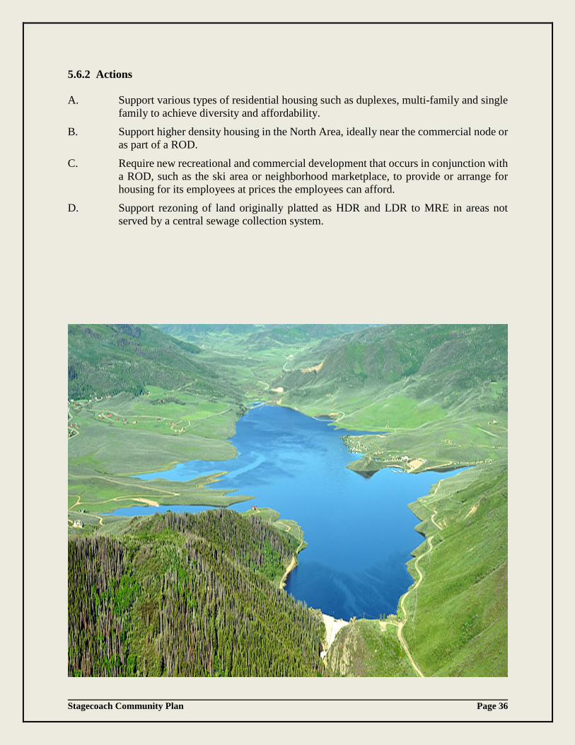
Stagecoach Community Plan Page 36
5.6.2 Actions A. Support various types of residential housing such as duplexes, multi-family and single
family to achieve diversity and affordability. B. Support higher density housing in the North Area, ideally near the commercial node or
as part of a ROD. C. Require new recreational and commercial development that occurs in conjunction with
a ROD, such as the ski area or neighborhood marketplace, to provide or arrange for housing for its employees at prices the employees can afford.
D. Support rezoning of land originally platted as HDR and LDR to MRE in areas not served by a central sewage collection system.

Stagecoach Community Plan Page 37
6. IMPLEMENTATION Although the Stagecoach Community Plan can establish a clearer vision for the future of the area, specific steps must be implemented if that vision is to become a reality over time. Without concerted efforts to implement the Plan, it will remain just a set of good ideas that may or may not happen. It is therefore important that Routt County and all other interested parties commit to making the Plan a success. This will take a significant investment of time and effort. Once the County, the Metro District, Stagecoach HOAs and others begin taking specific steps to implement the Plan, the Plan will begin to take on a life of its own, and Stagecoach will begin to control its destiny more than it has in the past. The more actively individual players work to coordinate their activities in a positive manner under this Plan, the greater its chances for success. This section outlines both an approach to implementing the Plan, and specific steps that can be taken to do so. It also provides for continued monitoring of growth in Stagecoach to ensure that future activities are consistent with the Plan. 6.1 Keys to Success In order to move towards the Plan’s vision, protect the property rights of the Stagecoach property owners, and reduce dissatisfaction with the costs of development in Stagecoach, it will be important to: 6.1.1 Harness the Power of the Private Market Implementation steps should try to work with significant market forces – such as the
demand for larger lots in south Routt County and the strong track record of recreation related development – rather than trying to force patterns of development for which there is no market demand. In addition, the consolidation of smaller lots (particularly in the South Area) will only occur if market forces can be harnessed to facilitate the sale of lots by those who do not intend to build, and the purchase and consolidation of those lots by those who do.
6.1.2 Acknowledge True Development Costs, Responsibility for Costs, and Timeline for
Infrastructure Installation Some of the frustration with the slow pace of development and lot sales in Stagecoach has
come from: (1) misunderstandings about the true costs of development, (2) confusion about who is responsible for those costs, and/or (3) unrealistic assumptions about how soon specific lots might be served by infrastructure or road extensions. While the costs of development could have been spread over more beneficiaries and over more time at less cost when Woodmoor was acting as a master developer, the bankruptcies of Woodmoor and the Metro District have dramatically changed the economics of development. Everyone involved in Stagecoach, including individual lot owners, should be making investment, sales, and construction decisions based on the total estimated costs of lot development.

Stagecoach Community Plan Page 38
6.1.3 Reduce Development Costs Without Reducing Quality Since the time and expense of extending basic infrastructure to many lots will be much
greater than expected, it is even more important that other development costs be reduced as much as possible. At the same time, it should be acknowledged that many of the current residents of Stagecoach have made investment decisions that have resulted in a very high quality residential and recreation-based community. New development should not be compromised in ways that will reduce the overall quality of development in the area or that will negatively affect property values in Stagecoach. The County should continue to work with Stagecoach HOAs, the Metro District, and individual property owners to evaluate alternative individual and community sewage disposal systems that are consistent with the intended character of Stagecoach and the economic health of the Metro District.
6.1.4 Provide Property Owners with More Information and Choices. Property owners make better decisions when they have current, accurate information on
which to base those decisions. Property owners are generally happier with their decisions when they have more options to choose from – even if none of the options give them exactly what they want. In the case of Stagecoach, where a large number of property owners reside all over the world, it is even more important that information about anticipated development costs and opportunities to sell or consolidate lots be distributed frequently. The information distributed must be current and accurate, since a large number of property owners and investors are affected.
6.2 Applicability of the Plan The following implementation strategies have been drafted to reflect three important over- riding principles. 6.2.1 New Approvals Consistent With the Plan The County will evaluate development proposals for conformity with the adopted Plan. If
proposals to plat, re-plat, or rezone land are consistent with this Plan, approval is likely. 6.2.2 Individual Choice for Platted Lot Owners Individual lot owners who want to build homes on their lots as originally platted will be
free to do so – no matter how remote and isolated the lots are from roads and utilities – but the owners will be responsible for meeting all County requirements for such development, including infrastructure requirements.
6.2.3 Consistency between the County, Metro District and the HOAs in Stagecoach is
encouraged – But Not Required Since the County has only limited authority over the activities of the Metro District – and
no authority over the activities of SPOA or other HOAs – those organizations are not required to take actions consistent with the terms of this Plan. They are, however, strongly encouraged to make decisions consistent with the Plan and should not expect to receive County approvals or support for activities that are inconsistent with the Plan. Following adoption of the Plan, the County may consider entering into intergovernmental agreements or letters of agreement with the Metro District or SPOA and other HOAs that would encourage more consistency with the Plan.

Stagecoach Community Plan Page 39
6.3 Specific Implementation Actions 6.3.1 Review Applications for Consistency with this Plan In order to guide future decisions toward the implementation of this Plan, Routt County
should review proposed zoning changes, subdivision applications, and other applications for consistency with this Plan. The review should address consistency with the preferred land uses and core values, and the policies and actions listed in Section 5, as well as the specific implementation actions in this Section 6. Applications for developments that would require CRs 14 or 16 to become four lane roads should not be approved unless the developer agrees to pay for the necessary improvements.
6.3.2 Reduce or Waive Filing and Development Approval Fees In order to encourage the consolidation of smaller lots into larger lots that meet the 5 acre
requirement for an OWTS, the County should continue to reduce or waive application and processing fees for lot consolidations and zone changes that reduce densities in ways consistent with this Plan. The resulting revenue loss to the County may be offset by lower road maintenance costs on CR 16 due to the consolidation of land resulting in few lots and less traffic. Fees and charges should not be waived for proposed projects that would increase development densities or the County’s operating or maintenance costs.
6.3.4 Develop a Website Inventory Bank Staff has created an inventory map of lots in each subdivision whose owners replied to the
surveys that they are interested in selling their properties. Interested persons can contact Planning staff to obtain these subdivision inventory maps. Information from the Assessor’s website can then be used by those interested in consolidating contiguous lots into 5-acre parcels to contact potential lot sellers. The County, the Board of Realtors and Stagecoach HOAs should encourage property owners to contact Planning staff if they are interested in selling their property in order to keep the database current and help facilitate consolidations. The County should set up a website for Stagecoach that publicizes this information and that can be accessed by the public so research can be done by individuals and realtors without the involvement of the County.
6.3.5 Create Periodic Sales Pools Using data from the information bank and/or from their own sources, the County should
encourage realtors, SPOA and other HOAs in Stagecoach to create and publicize sales pools for each subdivision. Realtors could notify lot owners in a subdivision that a buyer (who need not be named) is willing to buy three lots in X subdivision at a price not to exceed $Y per lot if offers to sell are received within Z days. Alternatively, a realtor could identify some of the lowest priced lots for sale in a given subdivision and notify all the potential buyers in that subdivision of the opportunity to purchase enough land to create a 5 acre lot at the lowest current price. Creative use of the internet to contact prospective buyers and sellers could make sales pools an effective tool to promote lot consolidation.
6.3.6 Conduct an Annual Lot Auction Realtors could also sponsor an annual auction to bring buyers and sellers together. Using
data from the information bank or from their own sources, realtors could notify all lot

Stagecoach Community Plan Page 40
owners of the opportunity to put their lots up for sale at an auction. Potential sellers could name their lowest sale price. If bidders at the auction offer the minimum price or more, the lot would be sold. If no one bids the minimum price, then it would not be sold. Information about the number of lots sold and the prices paid would be put into the information bank in order to encourage participation in the next year’s auction. Creative use of the internet to contact prospective buyers and sellers could make auctions a more effective tool to promote lot consolidation.
6.3.7 Support Efforts of Lot Owners to Create Financing Tools
Several lot owners have expressed their willingness to pay additional assessments in order to bring roads and utilities to their properties. As residential construction activity continues, subdivisions may find it advantageous to form LIDs to help them pay for utility and road extensions other than water and sewer lines, even if the resulting development will be on 5 acre lots. The County and the Metro District should encourage Stagecoach HOAs to cooperate in the formation of LIDs in conformance with applicable Colorado law.
The formation of a PID is another tool that could be used to finance infrastructure improvements. Under a PID approach, a group of landowners would file a petition to the County to create the PID. If approved, the Board of County Commissioners would sit as directors of the district, and would conduct its affairs, which could include selling bonds secured by the property within the PID boundaries.
A third possibility would be for the Metro District to take on responsibility for building or operating types of improvements other than water and sewer. This would require County approval and a vote of Metro District members, but would utilize an existing organization and might avoid the creation of multiple overlapping districts. It would also lay the groundwork for a long term option for incorporation.
6.3.8 Develop a non-motorized Trail System
This Plan calls for a system of trails to link together the various recreational amenities, and to give residents a better opportunity to explore the open spaces and enjoy the spectacular views in and around Stagecoach. While, any trail system within the National Forest would be considered on a case by case basis by the U.S. Forest Service, the County should encourage CPW, the Bureau of Land Management, U.S. Forest Service, and Stagecoach HOAs to work together to determine where such trails could be located. This would provide the maximum benefits with minimum impact on the environment, and to determine who would maintain the trails after construction. Any such trails should avoid sensitive wildlife habitats. Leash laws should be enforced to avoid impacts to local wildlife species.
6.3.9 Evaluate Affordable Housing Needs of the Community. Housing prices throughout Routt County are trending upward and Stagecoach is no exception. As a potential “growth center” identified in the Routt County Master Plan, Stagecoach needs to provide a broad mix of land uses, and housing for those who work in the area at prices they can afford. Although Stagecoach is currently a more affordable option in Routt County, it will be important to ensure that housing options remain attainable.

Stagecoach Community Plan Page 41
6.3.10 Encourage Stagecoach Rezonings Consistent With Plan. The County should encourage individual landowners in Stagecoach to initiate rezoning
consistent with this Plan where it is feasible to do so. In the case of lot consolidations, the County should continue finding ways to streamline the process of rezoning to the MRE zone district. Where land included in the boundaries of the Stagecoach area is not already platted or is not indicated for higher densities or different uses in this Plan, the land should generally be limited to lots of 35 acres or larger. As supported in the Routt County Master Plan, the consolidation of lots over the last ten years has been carried out by approval of new subdivisions that reduce the originally zoned density and reduce the potential impacts from traffic congestion.
6.3.11 Encourage Surrounding Areas to Remain Rural Much of the beauty of the Stagecoach area comes from the pristine landscape that
surrounds it. The County should encourage the owners of surrounding lands to protect their property through the continuation of current rural uses, employing all available tools and incentives, including LPS and conservation easements, to help them do so. In general, development around the boundaries of the Stagecoach area south of CR 14 should be presented as LPS Exemptions, or subdivisions with lot sizes of 35 acres or larger.
6.3.12 Support Efforts of Lot Owners to Sell or Donate Lots or Easements to a Land
Conservation Organization Property owners can often obtain a charitable tax deduction in return for donating lots to a
qualified land conservation organization, or for selling their lots to such an organization at a price that is below fair market value. If a lot owner decides that they do not want to make the investments necessary to develop their lot, a donation or sale might be financially advantageous to the lot owner and consistent with this Plan. The County should encourage Stagecoach HOAs and land conservation organizations to make information about these options available.
6.3.13 Update Transportation Planning Regularly in Order to Confirm the Adequacy of the
Road System Due to the complicated history of Stagecoach and the slow pace of recent development,
much of this Plan depends on assumptions about what types of development will occur in the future, what kinds of traffic impacts the development will create, and what types of services the community will need. Seasonal second home or resort development will likely generate one pattern of traffic, while year-round housing occupied by those who work in Steamboat Springs will generate much more intensive traffic. In order to obtain good baseline traffic information, the County should continue to obtain new traffic counts, and staff should re-evaluate the findings of all prior traffic studies in light of the updated counts.
The County should also continue to monitor the future development of Stagecoach and periodically update its transportation planning to confirm the adequacy of the road system to anticipate the need for costly road improvements. The County should monitor how many and what types of units are built, and when a small neighborhood node or recreation oriented development is developed, the County should evaluate how much additional capacity is available in the road system and how traffic levels change over time, to ensure that development works within the constraints of the 2-lane road capacities.
Stagecoach Community Plan Page 42
As an alternative, if the Stagecoach community supports growth that would exceed current road capacities and cause traffic congestion problems, a discussion must occur regarding how new development will fund the expansion of the existing road network. That discussion should also consider the construction of an additional access route to Stagecoach through the South Shore Subdivision across the dam to CR 18.
6.3.14 Evaluate Incorporation and Expanded District Service Options. As Stagecoach grows, the residents may want to determine if it would be cost effective,
feasible and beneficial to request expansion of the types of services and facilities provided by the Metro District or to incorporate Stagecoach as a municipal government. A feasibility study should be conducted when Stagecoach has more concentrated residential development, a center of commerce and civic activities, and possesses the fiscal capacity to provide essential services to the residents of the community.
6.3.15 The Morrison Creek Metropolitan Water and Sanitation District
The Metro District infrastructure is 42 years old. Although the wastewater treatment plant has exceeded its original estimated life expectancy, the Metro District has performed planned maintenance to ensure that the certified operation of the system continues. The Metro District has also implemented upgrades and improvements that have extended the wastewater treatment plant’s viability. The facilities are currently operating well below the design capacity and, through best management practices and proper maintenance, the system continues to operate reliably.
The existing plant is subject to two types of age related risks: chronic disruption and catastrophic failure. Both types of risk could influence water quality in Stagecoach Reservoir downstream of the plant and potentially disrupt service to customers of the Metro District. A short-term backup treatment system was acquired and installed by the Metro District in 2000 to ensure necessary redundancy in the event of catastrophic failure and to facilitate major planned maintenance or improvements to the existing system.
Potential chronic disruption risks include: breakdown of vital parts and machines, overloading of the system from dumping of concentrated vault effluent, power failure, and excessive influx of water into the sewer lines from spring runoff. All of these have been experienced in the past and have been dealt with promptly and successfully. Risk factors that could cause catastrophic failure are: wildfire (very low risk in the plant’s current location), major breach of holding tanks due to materials fatigue, and building fire. The backup treatment system is included in the emergency preparedness plan of operation for the facility and may be utilized in the event of a chronic or catastrophic failure to continue to protect the environment. The Metro District commissioned an evaluation of the status and future of the wastewater treatment plant in 2009. That evaluation, entitled “Strategic Plan for Development of the Existing Sewage Treatment Plant,” – concluded that "assuming a low growth rate, the existing facility should be serviceable for about a 10-year period - say until 2020. With a near zero growth rate, practically, the useful plant life might be extended even further." The Metro District has experienced a very low growth rate since 2009.
Stagecoach Community Plan Page 43
Due to the risks associated with the aging plant infrastructure and the potential for more rapid population growth in the Metro District, the Metro District Board of Directors and the Metro District Manager have initiated a planning process for the replacement of the existing wastewater treatment plant. The planning process is intended to lead to the eventual replacement of the current wastewater treatment facilities with a new, modern sewage treatment plant. The date of completion of such replacement will depend upon the rate of growth and development in the Metro District or on the inability of the facilities to meet State of Colorado discharge requirements.
Fortunately and coincidentally, the Metro District has a manager with 30 years of experience with the current facilities and administrative functions, and an attorney who has represented the Metro District since the beginning of the Woodmoor development in the 1970’s. In addition, the current Board includes a professional hydro-geologist, a professional civil/environmental engineer with expertise in water treatment, an ecosystem scientist with expertise in nutrient dynamics in ecosystems, a mathematician with experience in construction, and a professional construction manager. The Metro District Manager, attorney and the Board members will accomplish much of the preliminary planning prior to engaging external consultants.
Planning steps to be undertaken by the Board and Manager include:
1. Develop a guiding document for current and future Board members and Metro District staff, outlining the need for a new plant, the type of plant needed and its location, costs, and financing avenues. The guiding document is expected to be the basis for proposals for grants, loans, bonds and/or justification for any Metro District request for voter approval. The guiding document will be prepared during fiscal year 2017.
2. Determine the preliminary capacity, type, location, and estimated costs of a new plant. a. Preliminary estimates of required capacity will drive decisions with respect to the
type of plant chosen for future construction. An estimate of commercial and residential taps will be made based on the anticipated growth of the Stagecoach community. This phase will be completed during the 2nd quarter of 2017.
b. Preliminary evaluation of treatment process alternatives will be performed to determine the optimal type of plant for long-term reliable service to the community.
c. An evaluation of the existing site, as well as alternative locations, will be performed. The location is likely to be at or near the existing plant, due to the location of existing inflow trunk lines and the substantial amount of property owned by the Metro District at its current location.
d. Preliminary cost estimates for potential replacement facilities will be developed. Completion during the 3rd quarter of 2017.
e. Potential funding sources will be identified and contacted about the availability of and procedures for submitting funding proposals with assistance from the Colorado Department of Public Affairs Office of Water and Wastewater Management, the Colorado Water Resources and Power Development Authority, and other agencies if needed. Completion by the 4th quarter of 2017.
i. Determine pathways for financing that require only Board approval (preferred) such as grants.
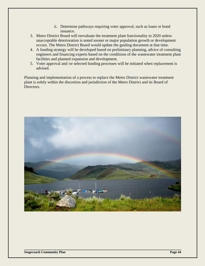
Stagecoach Community Plan Page 44
ii. Determine pathways requiring voter approval, such as loans or bond issuance.
3. Metro District Board will reevaluate the treatment plant functionality in 2020 unless unacceptable deterioration is noted sooner or major population growth or development occurs. The Metro District Board would update the guiding document at that time.
4. A funding strategy will be developed based on preliminary planning, advice of consulting engineers and financing experts based on the conditions of the wastewater treatment plant facilities and planned expansion and development.
5. Voter approval and /or selected funding processes will be initiated when replacement is advised.
Planning and implementation of a process to replace the Metro District wastewater treatment plant is solely within the discretion and jurisdiction of the Metro District and its Board of Directors.

Stagecoach Community Plan Page 45
6.4 Conclusion Although the bankruptcies of Woodmoor and the Metro District have created significant challenges over the past 40 + years, the Stagecoach area still retains its stunning beauty, unique nature and character, with abundant wildlife and a combination of potential recreational and development opportunities necessary to make it a success. The Stagecoach Community Plan update process has been instrumental in improving inter-agency coordination and bringing the community together to formulate the community’s vision. The end result is a document that supports the core values of the community and provides guidance for achieving the Plan’s goals:
• The Plan clarifies a future vision and direction for Stagecoach, consistent with the Routt County Master Plan, as a potential growth area and identifies what amenities and policies can be used to achieve those ends.
• The Plan identifies the amenities that could encourage higher levels of market activity and provides policies to support their development.
• The Plan provides more development opportunities for land owners through more flexible zoning for land uses that would not be permitted under current zoning. It also supports lot consolidations and provides resources to facilitate them.
• The Plan confirmed that both the clarified vision for Stagecoach and the means used to achieve it will also respect those private property rights that are protected by state and federal law.
If the vision in this Plan is embraced by the community, and future decisions are consistent with it, there is every reason to believe that Stagecoach will mature into a unique, high quality community. Although quite different and somewhat smaller than the original Woodmoor vision, the future Stagecoach promises to be even more rewarding to its residents and more sensitive to the land that is the source of its charm than anything envisioned in the past.
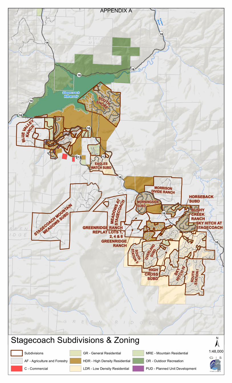
YampaRiver
StagecoachReservoir
STAGECOACH MOUNTAIN
MEADOWS SUBD
BLUE
VALLEY
RANC
H
MEAD
OWS A
TST
AGEC
OACH
SOUT
HST
ATIO
N IMORNINGSIDESUBD
SOUTHSHORE
EAGLESWATCH SUBD
OVER
LAND
SUBD
MORRISONDIVIDE RANCH
SKY
HITCH
IV
SOUTHSTATION II
GREENRIDGERANCH
GREENRIDGE RANCHREPLAT LOTS 1,
2, 4 & 8
SKY HITCH ATSTAGECOACH
HORSEBACKSUBD
HIGHCROSS
SUBD
BUSHYCREEKRANCH
¬«212 ¬«212
¬«14
¬«14
¬«18¬«18
¬«18
¬«16
¬«16
¬«16
¬«16
¬«16
SubdivisionsAF - Agriculture and ForestryC - Commercial
GR - General Residential HDR - High Density ResidentialLDR - Low Density Residential
MRE - Mountain ResidentialOR - Outdoor RecreationPUD - Planned Unit Development
Stagecoach Subdivisions & Zoning1:48,000±
APPENDIX A
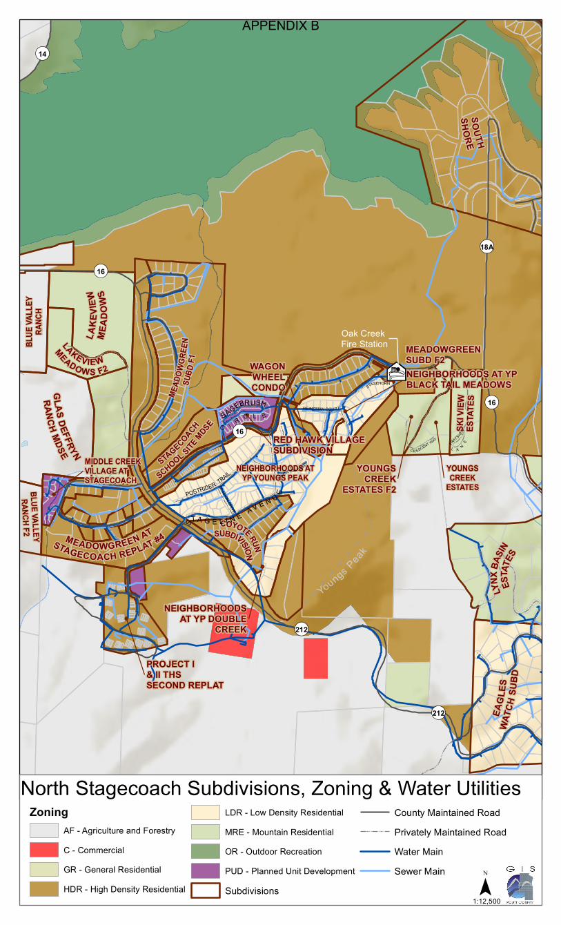
SKI V
IEWES
TATE
S
LYNX
BASIN
ESTA
TES
COYOTE RUN
SUBDIVISION
MEAD
OWGR
EEN
SUBD
F1
BLUE
VALL
EYRA
NCH
LAKEVIEW
MEADO WS F2
STAGECOACH
SCHOOL SITEMDSE
BLUE VALLEYRANCH F2
SOUTHSHORE
MEADOWGREEN ATSTAGECOACH REPLAT #4
GLAS DEFFRYN
RANCHMDSE
NEIGHBORHOODS ATYP YOUNGS PEAK
LAKE
VIEW
MEAD
OWS
EAGL
ESWA
TCH
SUBD
NEIGHBORHOODS AT YPBLACK TAIL MEADOWS
RED HAWK VILLAGESUBDIVISION
YOUNGSCREEK
ESTATES F2
NEIGHBORHOODSAT YP DOUBLE
CREEK
WAGONWHEELCONDO
YOUNGSCREEK
ESTATES
MEADOWGREENSUBD F2
MIDDLE CREEKVILLAGE ATSTAGECOACH
PROJECT I& II THSSECOND REPLAT
¬«14
¬«212
¬«212
¬«18A
¬«16
¬«16
¬«16
C R ESCENT WAY
DIVISION DRIVE
C O NDUCTOR COURT
REINSMAN COURT
POSTRIDER TRAIL
STAGEHORN
TRAIL
ST A G E L I N E A V E N U E
FRAYS HER
L A NE
SAGEBRUSH
C I R C L E
Sources: Esri, USGS, NOAA
1:12,500±
ZoningAF - Agriculture and ForestryC - CommercialGR - General Residential HDR - High Density Residential
LDR - Low Density ResidentialMRE - Mountain ResidentialOR - Outdoor RecreationPUD - Planned Unit DevelopmentSubdivisions
County Maintained RoadPrivately Maintained RoadWater MainSewer Main
¯1:12,500
²µ
Oak Creek Fire Station
North Stagecoach Subdivisions, Zoning & Water Utilities
Youngs Peak
APPENDIX B
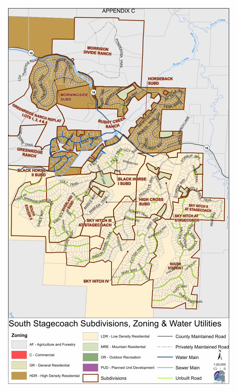
Morris
on C
reek
Morris
on C
reek
Morriso n CreekLittle
Bushy Creek
Silver Creek
Bushy Creek
MorrisonCreek
GREENRIDGERANCH
SKY HITCH IIAT STAGECOACH
SOUTHSTATION I
SKY HITCH IIIAT STAGECOACH
GREENRIDGE RANCH REPLATLOTS 1, 2, 4 & 8
MORNINGSIDESUBD
BLACK HORSEII SUBD
SKY HITCH ATSTAGECOACH
HORSEBACKSUBD
OVER
LAND
SUBD
MORRISONDIVIDE RANCH
HIGH CROSSSUBD
BUSHY CREEKRANCH
BLACK HORSEI SUBD
SKY HITCH IV
SOUTHSTATION II
¬«16
¬«16
¬«16
WILD WAYPIONEER WAY
ARABIAN WAY
CARSON WAY
HOPI WAY
SABL
EWAY
BUGGY WAY
C HI EF
JOSE
PH
SINGLE TREE WAY
HAME TRAIL
KINGBOLTWAY
AZTE
C WAY
OGLAL
AWAY
HIDEAWAY LANE
CINCH TRAIL
TETO
NWAY
CODYWAY
YUMA WA
Y
REIN
WAY
BRIDLEWAY
FARG
OW
AYSUNDANCE WAY
VIGILANTEW
AY
KINGBO
LTTR
AIL
OVERLAND TRAIL
FILLY T RAIL
BIGWHIP WAY
SURREYTRAIL
TIFFO
RDTR AI
L
MA RICO
PATR
AIL
FILLYTR
AIL TLINGIT WAY MILE
SRAN
CHLA
NE
LOS R AN
CHOS
ROAD
KICKAPOO WAY
SHAY WAY
PIMA WAY
SPRINGBOARD TRAIL
WHIFFLE
TREETR
AIL
WAGONWH
EEL T
RAIL
SHAY
WAY
SENECATR
AIL
ROAN WAY
CUTTE
R TRAIL
COMM
ANCHE ROAD
TEWA WAYTEWA WAY
CHEYEN
NETR
AIL
RAMUDA TRAIL
FILLY TRAIL
STIR
RUP WAY
ST
IRRUP WAY
WENATCHI TRAIL
CHEY
ENNE
TRAIL
PONDEROSATRAIL
WHIFFLETREE TR AIL
HALTERT RAIL
UTE TRAIL
HOCH-EYE
WAY
COLT TRAIL
COLT TRAIL
KING
BOLT
TR AIL
ZoningAF - Agriculture and Forestry
C - Commercial
GR - General Residential
HDR - High Density Residential
LDR - Low Density Residential
MRE - Mountain Residential
OR - Outdoor Recreation
PUD - Planned Unit Development
Subdivisions
County Maintained RoadPrivately Maintained RoadWater MainSewer MainUnbuilt Road
±1:20,000
South Stagecoach Subdivisions, Zoning & Water Utilities
APPENDIX C

PO Box 773749 Steamboat Springs, CO 80477
(970) 879-2704 fax (970) 879-3992
www.co.routt.co.us
REVIEW PROCESS
STAGECOACH/STEAMBOAT LAKE
CONSOLIDATION
1 Refer to Planning Department’s
Submittal Checklist for minimum
submittal requirements.
* This timeframes is approximate.
** This timeframe is dependent upon
the applicant’s attorney and surveyor.
Application submitted
ap
pro
ve
d
6-8
we
eks*
Planning submittal
requirements complete? 1
yes
Public notice period - Hearing dates set
- Public notices mailed & published
Planning Commission
hearing
Board of County
Commissioners hearing
Planning review - Coordination with referral agencies
Plat Review
- Title Commitment (less than 30 days old)
- Planning staff review
- County attorney review
- Applicant’s attorney reviews plat and provides
certification language based on language found in
Section 7 of the Subdivision Regulations.
Obtain all required signatures on the plat
BCC signs plat last
Record plat
Co
up
le o
f we
eks to
co
up
le o
f mo
nth
s**
Other Costs to Consider
Fee in lieu as required in Section 3.5.2 of the Subdivision
Regulations - $1,400
Surveys and Plats prepared by a licensed surveyor -
approximately $750
Attorney to review plat - see attorney for accurate cost
Recordation fees - approximately $20
Title Commitment - see a title company for accurate cost
Agreements with appropriate Metro District (vault and/or
tap fees), if applicable - see appropriate Metro District for
accurate costs
Other Agencies that may need to be contacted
Routt County Road & Bridge - (970) 879-0831
Morrison Creek Metro District - (970) 736-8250
Stagecoach Property Owners Association (SPOA) -
(970) 736-8250
Oak Creek Fire Department - (970) 736-8104
Steamboat Lake Water and Sanitation District -
(970) 871-7370
North Routt Fire District - (970) 879-6064
Utility Companies:
Atmos Energy
Yampa Valley Electric
Comcast
Century Link
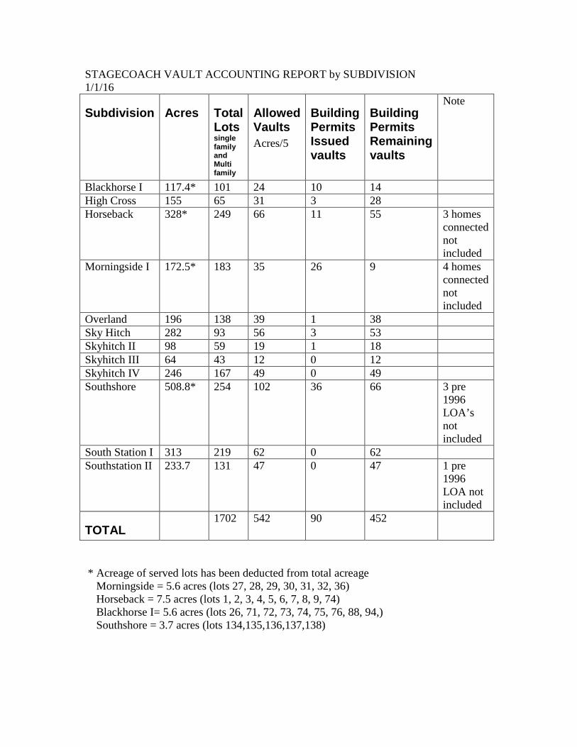
STAGECOACH VAULT ACCOUNTING REPORT by SUBDIVISION 1/1/16
* Acreage of served lots has been deducted from total acreage Morningside = 5.6 acres (lots 27, 28, 29, 30, 31, 32, 36) Horseback = 7.5 acres (lots 1, 2, 3, 4, 5, 6, 7, 8, 9, 74) Blackhorse I= 5.6 acres (lots 26, 71, 72, 73, 74, 75, 76, 88, 94,) Southshore = 3.7 acres (lots 134,135,136,137,138)
Subdivision
Acres
Total Lots single family and Multi family
Allowed Vaults Acres/5
Building Permits Issued vaults
Building Permits Remaining vaults
Note
Blackhorse I 117.4* 101 24 10 14 High Cross 155 65 31 3 28 Horseback 328* 249 66 11 55 3 homes
connected not included
Morningside I 172.5* 183 35 26 9 4 homes connected not included
Overland 196 138 39 1 38 Sky Hitch 282 93 56 3 53 Skyhitch II 98 59 19 1 18 Skyhitch III 64 43 12 0 12 Skyhitch IV 246 167 49 0 49 Southshore 508.8* 254 102 36 66 3 pre
1996 LOA’s not included
South Station I 313 219 62 0 62 Southstation II 233.7 131 47 0 47 1 pre
1996 LOA not included
TOTAL 1702 542 90 452

Subdivision Water Sewer Vaults Electricity Roads1 Allowed Constructed Remaining All road
constructed Some roads constructed2
None
North Stagecoach Meadowgreen Yes Yes N/A N/A N/A Yes4 X Southshore No No 102 36 66 No X3 (most) Lynx Basin Yes5 Yes5 N/A N/A N/A Yes4 X Eagles Watch Yes Yes N/A N/A N/A Yes4 X
South Stagecoach Morningside I No No6 35 26 9 Yes4 X3 Horseback No7 No6 66 11 55 Yes4 X3 Blackhorse I No8 No9 24 10 14 Yes4 X Blackhorse II Yes Yes N/A N/A N/A Yes4 X Sky Hitch I No No 56 3 53 Yes4 X Sky Hitch II No No 19 1 18 No X Sky Hitch III No No 12 0 12 No X Sky Hitch IV No No 49 0 49 No X South Station I No No 62 0 62 No X South Station II No No 47 0 47 No X Highcross No No 31 3 28 No X Overland No No 39 1 38 No X * Subdivisions not listed in this table have a water system, a central sewage collection system, electric hook up, and constructed roads.
1 Please contact the Road & Bridge Dpt. for current maintenance services that are provided. 2 The roads in this category are constructed to varying conditions and standards. Please see the Road & Bridge Dpt. for any required improvements. 3 The County maintains roads in this subdivision but is not required to upgrade or fix the roads. 4 Please contact YVEA for service details. 5 Please contact the Morrison Creek Metro District for service details. 6 Sewer main line runs along CR 16. 7 For the eastern section of the subdivision, the water main line runs along CR 16. 8 Sewer main line runs along a portion of Filly Trail. 9 Water main line runs along Filly Trail and CR 16.
APPENDIX F

APPENDIX G: STAGECOACH COMMUNITY CONTACT LIST
1
Districts & Agencies
Colorado Parks and Wildlife Libbie Miller District Wildlife Manager, Yampa Steamboat Springs, CO 80477 Home Office: (970) 736-8359 [email protected]
Colorado State Parks: Stagecoach Reservoir State Park Craig Preston, Park Manager Oak Creek, CO 80467 970-736-2436 [email protected]
Forest Service Medicine Bow-Routt National Forest Thunder Basin National Grasslands Janet E Faller, Routt Zone Realty Specialist 925 Weiss Drive Steamboat Springs, CO 80487 p: 970-870-2174 [email protected]
Morrison Creek Metropolitan Water and Sanitation District Steve Colby, Manager 24490 Uncompahgre Road Oak Creek, CO 80467 970-736-8250 [email protected]
Oak Creek Fire Protection District Chuck Wisecup, Chief Oak Creek, CO 80467 970-736-8104 [email protected]
South Routt Economic Development Council Oak Creek, Colorado 80467 [email protected].
South Routt School District RE-3 Darci Mohr, Superintendent [email protected] Oak Creek, CO 80467 970-736-2313
Stagecoach Ski Corporation Chris Wittemeyer Steamboat Springs, CO 80477 970-875-2408 [email protected]
Town of Oak Creek Mary Alice Page-Allen, AICP 970-846-4582 (cell) [email protected]
Upper Yampa River Water Conservancy District Tom Sharp, Chair [email protected]
Yampa Valley Land Trust 1201 Lincoln Ave, Steamboat Springs, CO 80487 (970) 879-7240
Yampa Valley Electric Steamboat Springs Office: 2211 Elk River Road Steamboat Springs, CO 80487 Local Phone: 970-879-1160

APPENDIX G: STAGECOACH COMMUNITY CONTACT LIST
2
Home Owner Associations
Coyote Run Owners Association, Inc. Attn: Carol (Sue) Hochreiter 348 Old Fish Creek Falls Rd Steamboat Springs, CO 80477 Eagles Nest Townhomes Owner's Assoc. Attn: Carol (Sue) Hochreiter 348 Old Fish Creek Falls Rd Steamboat Springs, CO 80477
Lakeview Meadows Owners Association, Inc Attn: Jill Brabec 721 Oak Street, Suite 202 Steamboat Springs, CO 80488 Lynx Basin Heidi Flint, President [email protected]
Morrison Divide Homeowners Association Rich Saterdal, President [email protected]
Red Hawk Village Homeowners Association Attn: Carol (Sue) Hochreiter 348 Old Fish Creek Falls Rd Steamboat Springs, CO 80477
Steamboat Association Management Bryan Ayer, Property Manager [email protected] 970 875-2810
Stagecoach Property Owner’s Association (SPOA) John Troka, President [email protected] 303 795-8561
Stagecoach Townhouse Association, Inc. Attn: Carol (Sue) Hochreiter 348 Old Fish Creek Falls Rd Steamboat Springs, CO 80477
The Neighborhoods @ Young's Peak Owner's Assoc. Attn: Jill Brabec 721 Oak Street, Suite 202 Steamboat Springs, CO 80488
Wagon wheel Condominiums at Stagecoach c/o Steamboat Association Management 675 Snapdragon Way, Suite 100 Steamboat Springs, CO 80487

APPENDIX G: STAGECOACH COMMUNITY CONTACT LIST
3
Routt County Departments 522 Lincoln Avenue Historic Courthouse Complex
Routt County Assessor 970 870-5544
Routt County Building Department 970 870-5566
Routt County Environmental Health 970 870-5588
Routt County Planning 970-879-2704
Routt County Road and Bridge 970 870-8031

RIDGE
R IDGE
Cabin
1:35/OpenSpace
Large LotResidential
1:35/OpenSpace
1:35/OpenSpace
1:35/OpenSpace
1:35/OpenSpace
Resid.Existing
Resid.Existing
Resid.Existing
Resid.Existing
Recreational Oriented Development
Recreational OrientedDevelopment
Large Lot Residential
Resid.Existing
COUNTY ROAD 16
COUNTY ROAD 14
COUNT YRO
AD15
C OUNTY ROAD 17
COUNTY ROAD 18COU NTY R OAD 27
COUNTY R O AD 25
COUNTY ROAD 19
COUNTY RO A D 13A
COU NTY ROAD 1 2
COUN TYROAD 13 COUNTY ROAD 21
COUNTY ROAD 132
COUNTY ROAD 23
COUNTY ROAD 8
COLORADOSTATE HIGHW
AY13 1
Stagecoach Reservoir
Yamp
a Rive
r
¯
This map is for planning purposes only.It was prepared from publicly available information.Any other use or recompilation of the informationis the sole responsibility of the user. This mapshould not be used to establish legal title, boundarylines, locations of improvements or utilities, or relied upon in any flight activity. Routt Countyexpressly disclaims all liability regarding accuracy or completeness of this map.Created by Routt County Planning Office, August 2016
0 0.8 1.6 2.4 3.20.4Miles
LegendBASEROADSSUBTYPE
HighwaysCounty RoadsPrivateCityUSFSParcelsMajorWaterbodiesRivers
RouttCoZoning2011ZONE
AF - Agriculrue and ForestryMRE - Mountain ResidentialGR - General ResidentialLDR - Low Density ResidentialHDR - High Density ResidentialC - CommercialPUD - Planned Unit Development
2016 DRAFTSTAGECOACH
COMMUNITYPLAN

Appendix I
Definitions
Existing Residential: The purpose of this zone district is to permit no change over existing zoning. The underlying zoning for these areas provide for a variety of housing types and densities.
Large Lot Residential: The large lot zone district allows for the flexibility to build single family homes on no less than 5-acres without a Central Sewage Collection System CSCS or on 1-acre requiring a hook up to a Central Sewage Collection System.
Open Space: This zone district is intended allow rural residential development on 35-acres compatible with adjacent agricultural uses while providing open areas for connectivity for agricultural related uses.
Recreation Oriented Development: An area where the recreational component such as but not limited to a ski area, marina or golf course is the central feature of the development for leisure activity that may include an array of amenities to support the overall use. This typically includes mixed use development of residential and commercial type uses. Land uses and proposed general locations that make up the Recreation Oriented Development are identified on a concept plan to be preliminarily discussed for conformance with the community plan and all other applicable plans prior to moving forward with the applicable regulatory process.
Small lot Residential: The small lot zone district allows for a variety of housing types including single family, two family and multifamily dwellings low density lots. Typically this allows for one unit per 10,000 sf. A Central Sewer Central System is required for development within this zoning category.