Embed Size (px)
Citation preview

March 2007
Technical Guidelines for the Establishment of a Coastal Greenbelt
Sri Lanka Country Office


i
March 2007
Technical Guidelines for theEstablishment of a Coastal Greenbelt
Sri Lanka Country Office

ii
Published by : The World Conservation Union (IUCN), Sri Lanka Country Office
Copyright : © 2006 International Union for Conservation of Nature and Natural Resources.
Reproduction of this publication for educational or other non-commercial purposes is
authorized without prior written permission from the copyright holder provided the source is
fully acknowledged.
Reproduction of this publication for resale or other commercial purposes is prohibited without
prior written permission of the copyright holder.
Citation : Technical Guidelines for the Establishment of a Coastal Greenbelt. March 2007. The World
Conservation Union (IUCN). Sri Lanka Country Office
ISBN : 978-955-8177-67-9
Cover Photograph : Bhagya Gunasekera © IUCN
Produced by : The World Conservation Union (IUCN) Sri Lanka Country Office
Printed by : Karunaratne & Sons Ltd.
67, UDA Industrial Estate
Katuwana Road
Homagama
Available from : The World Conservation Union (IUCN)
Sri Lanka Country Office
53, Horton Place
Colombo 07
Sri Lanka

iii
FOREWORD
The need to establish a coastal green belt following the post-tsunami scenario has led to unregulated and disoriented
rehabilitation work that are likely to have serious negative consequences. There is, therefore, an urgent need to set
out specially designed guidelines to ensure that well integrated greenbelts will emerge in conformity with basic stand-
ards and policies set out for coast conservation. In the light of this, the Coast Conservation Department (CCD) has
initiated the development of Guidelines for the establishment of a green belt along the tsunami affected coastal belt.
It is true that hard engineering solutions for impact mitigation and reducing social and economic vulnerability of coastal
areas are possible options for disaster mitigation, yet it is known that the heavy investments required for such solu-
tions do not usually receive priority consideration, while their major visual impacts significantly degrade the coastal
scenery in many situations. At the same time, such constructions can also disrupt traditional ways of life of many
beach dwelling people. On the other hand, the establishment of vegetation as a soft solution for some coastal prob-
lems including sea and wind erosion has been scientifically tested with substantial success all over the world in the
recent past. In fact, after the Tsunami, it has been found that wherever there were wide, thick belts of mangroves and/
or seashore forests had reduced the impact of the tsunami on coastal settlements. Other benefits of coastal vegeta-
tion includes the conservation of biodiversity, providing livelihood support for coastal communities through agricultural
and forestry crops, affording shade for various human activities, and in contributing to recreation and scenic beauty,
and enhancing tourism.
The overall objective of the guidelines is to evolve a systematically designed common approach to rehabilitate a veg-
etation buffer, which is called the Greenbelt, stable enough to absorb some of the devastating energy of natural
disasters, such as tsunamis, and reduce their detrimental effects. The guidelines are meant to facilitate those who
intend to undertake projects on regeneration of the green belt. It is prudent to clear the misconception that the motive
behind the greenbelt initiative is to acquire private lands by the State. It has to be understood that the Government
has no such intention. The philosophy behind the Greenbelt is to achieve the best possible balance between human
use and nature conservation needs.
A draft Guidelines was prepared initially by the CCD supported by a technical committee comprising of key
stakeholders. This was further improved by the technical assistance provided by IUCN Sri Lanka.
The guidelines are presented in two formats; one is a concise report on best practices, and the other is a detailed
report on technical know how. The technical report provides the methodology and in depth view of methods that are
essential to know when undertaking greening projects for establishment of the Greenbelt. In general, it provides pro-
spective implementers a sequentially set-out process of rehabilitation of the greenbelt, that includes a clear picture of
the current ground situation, the conceptual basis and benefits of greenbelts, a guide to identification of land-use
based landscape entities, the procedure to initiate and plan the activities, choice of plant species, factors to be con-
sidered in costing, the legal issues to be considered, sources of obtaining information and planting ‘material, and
finally a long term strategy for managing and monitoring of progress. On the one hand, the Best Practice Guidelines
provides implementers a quick reference to the procedures.
Presented here is the technical guide. After the introduction in Chapter I, Chapter II provides guidelines on project
planning and design. It contains information on selecting a site, project appraisal, designing principles, selection of
plant species and planting designs, and the legal framework. Chapter III provides guidelines for implementation. It
contains information on the sources of planting material, establishment of plant nurseries and methods of planting,
protection and maintenance, and the management aspects. Management aspects contain strategies on organizing
local communities and assigning responsibilities, coordination with relevant agencies, and providing technical assist-
ance. It further elaborates as to how the sustainability is ensured by means of incentives given to private land owners,
providing credit facilities, through competitions and awards schemes, and community mobilization and awareness
creation. Chapter IV provides methods suggested for monitoring and evaluation, including time schedules, framework
for evaluation, record keeping, and working through participatory appraisals.

iv
Annex I is the Annotated Guiding Principals for Post-tsunami rehabilitation and reconstruction. The maps and tables
extracted from the Rapid Environmental Assessment report done by MENR/UNEP (2005) called “Green Assessment”
are given in Annex II & III respectively. Annex IV provides the maps of “Natural” Landscapes in the coastal zone of Sri
Lanka. Annex V provides design outlays of identified landscapes for greenbelt planting. Annex VI provides the meth-
ods of establishment of nurseries and planting. Annex VII: gives limits of the Coastal Set Back by the area.
The limits set out to establish a Greenbelt, however, vary depending on the given site, and are now based, not only on
the coastal vulnerability factors, but also on the post-tsunami situation of the beach front. The CCD and the relevant
Divisional Secretariats will provide assistance to identify the zones provisionally eligible for the establishment of veg-
etation covers.
The Green Belt Guidelines can be used wisely by both the project implementers and the Government Authorities,
leading to realizing a GREEN COAST for the people of Sri Lanka. The GREEN COAST would, in return, help regaining
the minds and lives of tsunami affected people in the long run, regaining their lost world.
Financial assistance for the preparation of the guide was provided by Oxfam through Green Coast project.
Mr. Nissanka Perera Ms. Shiranee Yasaratne
Director Country Representative
Coast Conservation Department The World Conservation Union (IUCN)
Sri Lanka Sri Lanka
Dr. R.A.D.B. Samaranayake
Ms. Hester Basnayake
Prof. Hemanthi Ranasinghe
Mr. Jagath Gunawardane
Dr. Ajantha de Alwis
Mr. B.J.H. Premathilake
Mr. L.P.D. Dayananda
Mr. Shamen Vidanage
Mr. Sarath Ekanayake
Mr. Harshana Rajakaruna
TECHNICAL CONTRIBUTIONS
Oxfam to IUCN Sri Lanka through Green Coast.
FINANCIAL CONTRIBUTIONS

v
CONTENTS
EXECUTIVE SUMMARY ... ... ... ... ... ... ... ... 1
1. INTRODUCTION ... ... ... ... ... ... ... ... 3
1.1 Backdrop ... ... ... ... ... ... ... ... 3
1.2 The Context ... ... ... ... ... ... ... ... 3
1.3 What is a Green Belt? ... ... ... ... ... ... ... 4
1.4 Objectives ... ... ... ... ... ... ... ... 5
1.5 About the Guidelines ... ... ... ... ... ... ... 6
2. GUIDELINES ON PLANNING AND DESIGN ... ... ... ... ... 6
2.1 Landscapes of the Coastal Belt ... ... ... ... ... ... 6
2.2 Site Selection and Appraisal ... ... ... ... ... ... 7
2.3 Design Principles and Concepts ... ... ... ... ... ... 7
2.4 Selection of Plant Species and Planting Designs ... ... ... ... ... 8
2.5 Estimating Costs ... ... ... ... ... ... ... 13
2.6 Legal Framework and Institutional Arrangements ... ... ... ... 13
3. GUIDELINES FOR IMPLEMENTATION ... ... ... ... ... ... 15
3.1 Sources of Planting Material ... ... ... ... ... ... 15
3.2 Establishment of Plant Nurseries and Methods of Planting ... ... ... ... 15
3.3 Protection and Maintenance ... ... ... ... ... ... 16
3.4 Management ... ... ... ... ... ... ... ... 16
3.5 Ensuring Sustainability ... ... ... ... ... ... ... 18
4. MONITORING AND EVALUATION ... ... ... ... ... ... 19
4.1 Basic Groundwork ... ... ... ... ... ... ... 19
4.2 Committees for Monitoring and Evaluation ... ... ... ... ... 19
4.3 The Time Schedule ... ... ... ... ... ... ... 20
4.4 Framework for Evaluation ... ... ... ... ... ... ... 20
4.5 Record Keeping ... ... ... ... ... ... ... 20
4.6 Participatory Appraisal ... ... ... ... ... ... ... 20
BIBLIOGRAPHY ... ... ... ... ... ... ... ... ... 20
ANNEXES ... ... ... ... ... ... ... ... ... 21
Annex I: The Cairo Principles ... ... ... ... ... ... ... 21
Annex II: Maps from the MENR/UNEP REA Report (2005) ... ... ... ... ... 22
Annex III: Tables from the MENR/UNEP REA Report (2005) ... ... ... ... 23
Annex IV: Natural Landscapes of Sri Lanka’s Coastal Zone ... ... ... ... ... 31
Annex V: Design Outlays for Greenbelt Planting of Identified Landscapes ... ... ... 34
Annex VI: Establishment of Nurseries and Methods of Planting ... ... ... ... 38
Annex VII: Coastal Set Back Limits ... ... ... ... ... ... ... 46
Annex VIII: Coastal Plant Communities in Sri Lanka ... ... ... ... ... 48


1
The diverse habitats that comprise the sea and coastal
environment have historically provided invaluable
tangible benefits to Sri Lanka and its people. The
coastline of Sri Lanka is 1620 km, in length, while the
coastal region which makes up 24 percent of the
country’s entire land area of 65,510 sq km, also accounts
for 25 percent of the population, 70 percent of the tourist
hotels, 67 percent of industrial units, 17 percent of
agricultural lands and 20 percent of home gardens. The
Coastal Zone of Sri Lanka is clearly defined in the Coast
Conservation Act No:57 of 1981, while the set-back
limits have now been identified in the Coastal Zone
Management Plan based not only on vulnerability factors,
but also on the post-tsunami situation of the beach front.
The sandy beaches, estuaries, lagoons, sea grass beds,
coral reefs mudflats, mangroves and, sand dunes have
for centuries protected and buffered the coastal
communities against the hazardous effects of storms,
cyclones and hurricanes, and also filtered pollutants
from discharges. Although storm surges that accompany
cyclones have not been considered frequent
phenomena in Sri Lanka, climate change resulting from
global warming has in recent times changed this
scenario. The harbour waves generated by the Tsunami
of December 2004, that struck the Eastern, Southern
and South Western coasts, was the worst calamity that
Sri Lanka has ever faced in recent times. The magnitude
of the destruction awakened the Nation to the reality of
seeing the extent of unpreparedness, either to face and
mitigate such calamities, or manage an expedient
recovery plan. However, it has been recognized that the
major causes that affected mitigation, are the nature and
extent of coastal erosion and habitat degradation that
have taken place over the last several decades.
In early 2005, the Ministry of Environment and Natural
Resources carried out a field analysis of tsunami
impacts on what may be referred to as the ‘Green’
environment (ecosystems, biodiversity, protected areas
and farmlands) and the ‘Brown’ environment (pollution,
debris and impacts on human settlements and
infrastructure). This Report revealed that there was
severe beach erosion in patches, both in the east and
south-west, with some locations showing extensive
erosion and sand migration due largely to the effects of
the tsunami back-wash. Much of the beach vegetation
also was severely damaged, especially Ipomoea
pescaprae (Mudu-bim-thamburu), although Pandanus
(Mudukeylya) and Spinifex Ilttoreus (Maha-ravana
ravula) are reported to have survived, especially when
in clumps. It had also been apparent that where large
stands of mangroves existed, buffering tsunami waves
were effective, while other coastal forests were for the
most part, too open to play such a role.
Although hard engineering solutions for impact
mitigation and reducing social and economic
vulnerability of coastal areas are possible options for
disaster mitigation, yet it is known that the heavy
investments required for such solutions do not usually
receive priority consideration. On the other hand the
establishment of vegetation (Greenbelt) as a soft
solution for some coastal problems including sea and
wind erosion, has been tested with substantial success.
A Greenbelt is defined as a strip of natural or artificially
created coastal vegetation designed to prevent coastal
erosion, and mitigate the adverse impacts of natural
coastal hazards on human lives and property. It is a
country specific and site specific entity defined in
relation to risk factors and vulnerability to coastal
hazards. In terms of coastal degradation the situation
has evidently reached alarming proportions, and hence
needed urgent measures to recreate natural systems
and restore historical ecosystems that could revitalize
the health of the country’s coastal zone.
The overall objective in the preparation of these
Guidelines is to evolve a systematically designed
common approach to restore, rehabilitate and/or
recreate a vegetational barrier/buffer (Greenbelt) that
may be resilient and stable enough to prevent or
mitigate the devastating effects of natural disasters such
as cyclones, storm surges and tsunamis.
These guidelines, which are limited to restoration,
rehabilitation and/or creation afresh of a greenbelt in
degraded stretches of the coastal zone of Sri Lanka, are
meant to assist and demonstrate best practices for those
who intend to undertake landscape regeneration
projects in, and even just behind the coastal reservation.
The Guide provides prospective implementers a
sequentially set-out process of greenbelt reconstruction/
restoration, that includes a clear picture of the current
ground situation, the conceptual basis and benefits of
greenbelts, a guide to identification of land-use based
landscape entities, the procedure to initiate and plan
the activities, choice of plant species, cost estimates,
the legal issues to be considered, sources of obtaining
information and planting material, and finally the
strategy for managing and monitoring of progress.
EXECUTIVE SUMMARY

2
The Guidelines have been formulated in terms of three
characteristic landscape types identified on the basis of
a visible division of landscapes from a land use
perspective. These are described as natural, rural and
urban landscapes. These types are found in varying
extents, in the climatic regions of the wet, dry, and the
arid zones. Although transitional landforms could be
found, for the purpose of these guidelines, the
transitional landforms as well as the arid climatic zone
would not be considered as separate entities.
Areas considered as natural landscapes encompass
all areas which are relatively unaffected by human
activity, especially those which are already designated
as protected areas (national parks and other categories
of reserves), e.g. the coastal edges of Yala, Wilpattu and
Bundala National Parks, and also areas which, though
not yet designated, are potentially suitable for
designation as nature conservation/preservation areas.
The immediate hinterland of the coastline could be
deemed rural in areas where, despite a similar variation
in landform to that in natural areas, the natural
vegetation has been largely replaced by non-
indigenous agricultural species such as Cocos nucifera
(coconut palms) and Borassus flabellifer (palmyrah
palms). Urban landscapes are those coastal strips within
or bordering urban settlements, usually including
seaside parks, playgrounds, esplanades and marine
drives, sometimes with seaside retaining walls and often
bordered by artificial coastal protection structures such
as rock revetments.
As a first step, prospective project proponents are
advised to study the area and identify whether the
chosen landscape should be considered as urban, rural,
or natural. Wherever natural maritime vegetation
communities exist, even as small remnants, the basic
principle should be to conserve them and integrate them
into the design. The advice of coastal engineers should
also be sought at the very outset to find out whether it is
necessary to construct a bund for protection against
tsunamis, and if so, what should be its width, height,
profile and structure. The decisions will depend on the
particular characteristics and importance of each
location and will therefore be site-specific. Once such
preliminary activities are completed, an appraisal and
design should be done with the aid of relevant experts,
always getting at least basic advice from a Coastal
Planner. The basic principles and concepts that should
be applied when designing should be in the first
instance be in accordance with the conditions laid down
by the Coast Conservation Department.
In natural landscapes, apart from preserving and
restoring natural ecosystems, exotic and introduced
plant species should be excluded. There should be as
few as possible of structures such as shelters, camping
sites and vehicle parks. Footpaths if any should
preferably be raised board walks. Bicycle and
pedestrian circulation should be minimal. Materials,
finishes, shapes, facades, etc. should be in harmony
with the natural habitat. In rural landscapes, it is advised
that at least a 15 – 20m wide strip of natural littoral
woodland and strand plants be planted seaward of
agricultural crops. Vegetation belts could take either a
naturalistic form or a geometric form. In urban
landscapes any plant species could be planted as long
as they are adapted to the coastal environment. There
could also be open grass, sandy, paved parks, or
playgrounds of various sizes, provided there is a
substantial belt of trees on the seaward side. There
should be a sufficiently wide beach stabilizing
vegetation strips between seaside retaining walls and
the open beach.
After site selection the next important step therefore has
to be a consultation with knowledgeable persons in
fields of agronomy, ecology and landscape architecture,
as well as a cross section of the local community and
representatives of relevant Community Based
Organizations. The Guidelines highlight the significance
of community participation in planning and successful
implementation of greenbelt restoration activities.
The Guidelines recommend that the choice of plant
species in greenbelt rehabilitation be primarily based
on the growth potential and adaptability of plants to a
given situation. The essential considerations in
establishing Greenbelts include choice of species,
selection of site, collection and germination of seeds,
planting in the field, spacing, protection, and
maintenance. These issues are discussed, and detailed
operational procedures are appended in annexes. A
concise review of the legal issues involved and the
institutional arrangements available are also presented
in order to enlighten prospective project proponents of
the existing statutory requirements.
In order to provide a basic guidance on the likely levels
of investment required, a basis for estimating costs is
also provided. Finally the Guidelines provide information
on possible sources of planting material, and also an
operational framework for monitoring and evaluation of
the progress of work.

3
1.1 Backdrop
The coastal environment is unique because it
constitutes the interface where the marine and terrestrial
environments merge, making resource management a
challenge. The diverse habitats that comprise the sea
and coastal environment have historically provided
invaluable tangible benefits to the nation and its people.
Sri Lanka with its unique geographical location, and its
vast territorial sea amounting to 7.8 times the total area
of the country, can enjoy and benefit substantially more
from its coastal resources than from its limited share of
terrestrial natural resources. However, the continuously
changing bio-geo-physical conditions and processes,
and the underlying interface of two different mega-
ecosystems themselves, place the coastal areas at high
risk of natural disasters.
The coastline of Sri Lanka is 1620 km, in length inclusive
of bays and inlets, but excluding lagoons, while the
coastal region comprises 74 Divisional Secretaries’
Divisions with a coastal boundary. The coastal region
which makes up 24 percent of the country’s entire land
area of 65,510 sq km, also accounts for 25 percent of
the population, 70 percent of the tourist hotels, 67
percent of industrial units, 17 percent of agricultural
lands and 20 percent of home gardens. It is also home
for a large number of high priority archaeological,
historical, religious, cultural, scenic and recreational
sites. Apart from the highly economically valuable sites
for coastal and marine fishery, the coastal region also
supports habitats that are vital for ecological functions
and maintaining biodiversity.
Sandy beaches, estuaries, lagoons, sea grass beds,
coral reefs mudflats, mangroves and, sand dunes are
some of the diverse habitats that make up the coastal
environment. These habitats have for centuries
protected and buffered the coastal communities against
the hazardous effects of storms, cyclones and
hurricanes, and also filtered pollutants from discharges,
while at the same time providing opportunities for
recreation, and significantly contributing to the aesthetic
value of the area. These habitats also provide spawning
grounds, nurseries, shelter and food for marine life that
includes a significant number of rare and endangered
species.
However, owing to the population pressure with more
people finding livelihoods and employment in coastal
areas, and a booming tourist industry that has exceeded
the carrying capacity in several locations with critical
ecosystems, the coastal habitats have faced increasing
degradation, resulting in a substantial lowering of its
protective and buffering capacity.
Although storm surges that accompany cyclones have
not been considered frequent phenomena in Sri Lanka
(with a projected occurrence of one every 5 years),
climate change resulting from global warming has in
recent times changed this scenario. Tropical storms,
floods and erosion are the more frequent natural
hazards, and were also the top 10 disasters that had
caused one fourth of the total economic damage during
the last 50 years.
The tidal waves that accompanied the cyclone of 1978
devastated most of the hotels bordering the shoreline
on the East Coast. The harbour waves generated by the
Tsunami of December 2004, that struck the Eastern,
Southern and South Western coasts indeed constituted
the worst calamity that Sri Lanka has ever faced in recent
times.
Recognizing the magnitude of the reconstruction efforts
necessary following the Tsunami of December 2004,
the United Nations Environment Programme’s (UNEP)
Tsunami Disaster Task Force, convened a meeting in
Cairo in February 2005 to discuss coastal zone
rehabilitation and management in the Tsunami affected
region. The main outcome of this meeting was the
formulation of a set of Guiding Principles for Post-
Tsunami Rehabilitation and Reconstruction, which have
set forth an integrated pathway towards reconstruction
(See Annex I).
Restoration of Coastal Wetlands after the Tsunami is
the focus of an Information Paper prepared jointly by the
International Water Management Institute (IWMI) and
the World Conservation Union (IUCN). A set of guiding
principles adopted from the Ramsar Conventions’s
Principles and Guidelines for Wetland Restoration,
highlights critical issues, impacts and the systematic
basis for restoration of significant wetlands.
1.2 The Context
The magnitude and devastation of the scale of the
tsunami that struck Sri Lanka and several other Indian
Ocean countries in December 2004 jettisoned
1. INTRODUCTION

4
of the beach vegetation also was severely damaged,
especially Ipomoea pescaprae (Mudu-bim-thamburu)
although Pandanus (Mudukeylya) and Spinifex Ilttoreus
(Maha-ravana ravula) are reported to have survived,
especially when in clumps. It had also been apparent
that where large stands of mangroves existed, buffering
tsunami waves were effective, while other coastal
forests were for the most part, too open to play such a
role. The practice of planting monoculture coastal
shelterbelts of Casuarina, especially in cyclone prone
areas however, did not appear to be effective wave
barriers, and the current evidence indicate that a good
wind shelterbelt mix should include shorter trees and
shrubs, which when planted on sand dunes helped
indirectly by stabilizing the dunes. Coconut palms can
withstand the physical impact and salinity effects and
reduce beach erosion, but they do not contribute to
protecting areas behind them. Palmyrah palms are less
tolerant of salinity. Even trees such as Kohomba, Suriya
and Kottamba appear to have been subjected to some
breakage and uprooting, besides defoliation owing to
increased soil salinity.
Monitoring irrigation water sources for contamination
by substances such as arsenic, in order to ensure that
agricultural crops (especially those for consumption by
humans or animals), planted in the proposed green
belts will not be harmful in any way, is also of prime
importance.
It is clear that in terms of coastal degradation the
situation had reached alarming proportions, and hence
needed urgent measures to recreate natural systems
and restore historical ecosystems that will revitalize the
health of the country’s coastal zone.
Restoration and reconstruction however, are major
challenges, since many of the affected shorelines are
densely populated, often with communities considered
to be amongst the poorest. Hence any reconstruction
effort must ensure efficiency, sustainability and equality,
and be guided by principles that are scientific,
participatory, and in harmony with natural systems.
1.3 What is a Green Belt?
It is true that hard engineering solutions for impact
mitigation and reducing social and economic
vulnerability of coastal areas are possible options for
disaster mitigation, yet it is known that the heavy
investments required for such solutions do not usually
receive priority consideration, while their major visual
authorities, civil society, and all other organized groups
to the reality of seeing the extent of unpreparedness,
either to face and mitigate such calamities, or manage
an expedient recovery plan.
However, the major causes that affected mitigation, are
the nature and extent of coastal erosion and -habitat
degradation that have taken place over the last several
decades. Such adverse situations together with sheer
disregard for the scientifically determined set- back
standards, by those concerned with development
programmes, have compromised the ability of the
coastal zone to adopt to environmental change.
The government realizing the need for prompt and
organized action, immediately established an Interim
Committee for Disaster Management. This was followed
by the institution of a Disaster Management Center, and
the appointment of a Parliamentary Select Committee
on Disaster Management. Subsequently a separate
Ministry for Disaster Management was established.
Presently several Ministries and agencies associated
with these ministries are involved in awareness raising
on how to respond to such unforeseen natural disasters.
These include the Ministry for Disaster Management,
the Ministry involved in Disaster Rehabilitation, Ministry
of Science and Technology, Ministry of Health, Ministry
of Education, Ministry of Environment, Ministry of
Fisheries and Aquatic Resources, Ministry of Urban
Development/Water Management and the Defense
Ministry. In addition, a number of NGOs, as well as
intergovernmental agencies such UNDP, IUCN, UNEP,
FAO, IWMI, and several others have not only been
involved in awareness raising on natural disaster
amongst various audiences, but also in mobilizing
resources for quick restoration and rehabilitation work.
In early 2005, the Ministry of Environment and Natural
Resources carried out a field analysis of tsunami
impacts on the ‘Green’ environment (ecosystems,
biodiversity, protected areas and farmlands) and the
‘Brown’ environment (pollution, debris and impacts on
human settlements and infrastructure). This Report
highlighted the key issues in the country in the aftermath
of the disaster, including pollution of the coastal strip by
solid waste and debris, and its contamination by sea
water, which are relevant to the task of restoration or
establishment of a vegetational buffer.
It was also revealed that there was severe beach erosion
in patches, both in the east and south-west, with some
locations showing extensive erosion and sand migration
due largely to the effects of the tsunami back-wash. Much

5
impacts significantly degrade the coastal scenery in
many situations. On the other hand the establishment of
vegetation as a soft solution for some coastal problems
including sea and wind erosion, has been tested with
substantial success all over the world in the recent past.
In fact after the Tsunami, it has been found that wherever
there were wide, thick belts of mangroves and/or
seashore forest, it had reduced the impact of tsunami on
coastal settlements and property. Other benefits of
coastal vegetation includes the conservation of
biodiversity, providing livelihood support for coastal
communities through agricultural and forestry crops,
affording shade for various human activities, and in
contributing to recreation and scenic beauty.
A Greenbelt could be defined as a strip of natural or
artificially created coastal vegetation designed to
prevent coastal erosion, and mitigate the adverse
impacts of natural coastal hazards on human lives and
property. The greenbelt area however is a country
specific and site specific stretch of vegetation in the
coastal zone, defined in relation to risk factors and
vulnerability to coastal hazards. The Coastal Zone of Sri
Lanka is clearly defined in the Coast Conservation Act
No:57 of 1981, although, issues addressed in the
Coastal Zone Management Plan of 2004 are not
restricted to the coastal zone, but extends to the District
Secretaries Divisions with a coastal boundary. However,
the distortions in the shoreline consequent to the
tsunami, and the resulting conflicts in relation to tenurial
and access rights of coastal dwellers, as well as
deprivation of their livelihoods, induced the government
to revise the boundary limit of set backs to be in
accordance with those determined in the Coastal Zone
Management Plan of 1997 (See Annex VIII).
The limits set out however, vary with the particular site,
and are now based not only of coastal vulnerability
factors but also on the post-tsunami situation of the
beach front (See Annexes II and III). The Coast
Conservation Department or the relevant Divisional
Secretariat can provide assistance to identify the zones
provisionally eligible for the establishment of vegetation
covers.
1.4 Objectives
The overall objective in the preparation of these
Guidelines is to evolve a systematically designed
common approach to restore, rehabilitate and/or
recreate a vegetational barrier/buffer (Greenbelt) that
may be resilient and stable enough to prevent or
mitigate the devastating effects of natural disasters such
as cyclones, storm surges and tsunamis. A greenbelt
will ideally represent a multipurpose investment, in
terms of stabilizing a fragile and unconsolidated beach
front in the coastal belt, while at the same time
functioning as a wind barrier where necessary,
providing shade and protection, enhancing the
landscape for recreation, tourism, and providing
opportunities for economic returns to traditional coastal
communities.
Nevertheless the enthusiasm and wide acceptance of
the need to rehabilitate or establish afresh, a coastal
belt of vegetational cover following the post-tsunami
scenario, has in recent times led to unregulated and
disoriented rehabilitation work that are likely to have
serious negative consequences. There is therefore an
urgent need to set out specially designed guidelines to
ensure that well integrated greenbelts will emerge in
conformity with basic standards and policies on coast
conservation.
Specific objectives
The specific objectives of these guidelines are as
follows:
Devise planning guidelines for setting up
environmentally sound vegetational barriers that are
most likely to give protection from or mitigate the
hazardous impacts of natural disasters.
Determine the basis, composition and layout of
greenbelt, where such greening is considered
necessary from a conservation, coastal protection,
aesthetic, livelihoods, recreational and architectural
stand point.
Provide guidance on restoration of natural habitats
with both existing as well as ecologically and bio-
physically acceptable plant species.
Provide guidance on creating bio-physical and
livelihood supportive conditions that are better than
those that existed before the disaster struck the
nation.
Identify institutional arrangements, for
implementation, monitoring and evaluation of
greenbelt creation activities approved for
implementation at the ground level

6
1.5 About the Guidelines
These guidelines are meant to facilitate those who
intend to undertake landscape regeneration projects in
and even just behind the coastal reservation. The
guidelines are however, limited to restoration,
rehabilitation and/or creation afresh of a greenbelt in
eroded and degraded stretches of the coastal zone of
Sri Lanka, although the greening process may
sometimes need extensive preliminary pre-planting
preparatory work such as clearing debris, solid waste
disposal de-salinization and water purification. At this
point it is necessary to clear the misconception that the
motive behind the greenbelt initiative was to acquire
private lands by the State. It has to be clearly understood
that the Government has no such intention. The aim of
the Greenbelt strategy is to achieve the best possible
balance between human use and nature conservation
needs, while ensuring the following: -
Creation of conditions that are better than those that
existed before Tsunami, in terms of ameliorating/
reducing hazards to life and property, and make
communities particularly the poor and marginalized,
less vulnerable to such hazards.
Setting out landscapes that are aesthetically pleasing
and varied in character from place to place, of
increasing scenic value, while providing shade where
necessary, and enhancing coastal tourism, recreation
and other activities.
There is better protection of the shoreline against
erosion; (vegetation cover stabilizes the soil
increasing resistance to wave action and it disburses
wave energy, decreasing possible damage).
Establishment of dense vegetation cover where
necessary, to disburse wave and wind energy to the
extent of reducing potential damage to human lives
and properties from natural hazards such as
Tsunamis and Cyclones.
Improving the socio-economic conditions of local
coastal communities through green belt vegetation
contributing to their livelihoods directly (e.g. through
sale of agricultural produce) or indirectly (e.g. by
providing shade, coolness, shelter, visual
enhancement, etc. for other revenue generating
activities).
The Guide provides prospective implementers a
sequentially set-out process of greenbelt reconstruction/
restoration, that includes a clear picture of the current
ground situation, the conceptual basis and benefits of
greenbelts, a guide to identification of land-use based
landscape entities, the procedure to initiate and plan
the activities, choice of plant species, factors to be
considered in costing, the legal issues to be considered,
sources of obtaining information and planting material,
and finally the strategy for managing and monitoring of
progress.
2. GUIDELINES ON PLANNINGAND DESIGN
2.1 Landscapes of the Coastal Belt
For the purposes of creating or restoring coastal
vegetation belts, it is useful to select plant species on
the visible division of the landscape from a land use
perspective, into three major landscape types – natural,
rural and urban. It must nevertheless be noted that there
are areas of transition and overlap among them, e.g.
urban fringe, suburban, rural-natural. These types are
found in varying extents, in the three climatic regions of
the wet zone, the dry zone and the arid zone. However,
for the purpose of these guidelines, the transitional
landforms and the arid climatic zone would not be
considered as separate entities.
Areas considered as NATURAL encompass all areas
which are relatively unaffected by human activity,
especially those which are already designated as
protected areas (national parks and other categories of
reserves), e.g. the coastal edges of Yala, Wilpattu and
Bundala National Parks, and also areas which, though
not yet designated, are potentially Decisions may have
to be taken as to what should be done with any
remaining debris. Should it be taken away or used for
creating new landform/features or buried deep at the
site itself? Should there be a combination of such
remedies? In some cases it might indeed be useful as a
landscape construction material, for example, in parapet
walls and retaining walls or even protective bunds in an
aesthetic manner, keeping in mind that it cannot be used
to make artificial sand dunes as the latter must be made
up completely of sand.
The advice of coastal engineers should be sought at the
very outset to find out whether it is necessary to construct
a bund for protection against tsunamis, and if so, what
should be its width, height, profile and structure. In any
case it would be best to align it along the landward side
within the coastal reservation in the case of sufficiently
wide reservations, or further inland so as not to disfigure

7
the scenery. Landscape architects should work closely
with coastal engineers to adapt its basic shape, so that
it looks as if it is an intrinsic part of the scenery. In strict
natural landscapes, such structures should not be
introduced at all.
The decisions will depend on the particular
characteristics and importance of each location and will
therefore be site-specific while requiring expert advice.
2.2 Site Selection and Appraisal
When ever possible the appraisal and design should
be done with the aid of relevant experts, always getting
at least basic advice from a Coastal Planner even for
urban locations, andscape architects should obtain
advice from other specialists. For rural locations,
landscape architects and sometimes other specialists
also are needed besides agriculturists. For natural
locations, landscape architects, ecologists and often
other specialists such as geologists are needed.
Whatever the location, detailed survey sketches and
evaluation information of the existing vegetation are
essential. In general, apart from ecological and aesthetic
factors, social and socio-economic issues must also be
addressed.
Based on the appraisal and its recommendations, a
“landscape proposal” should be drawn up for each site,
commencing with conceptualization. After consensus is
reached on the concept, the overall “outline landscape
design” and the “detailed landscape design” including
construction and planting details should be prepared.
There should be layout plans giving measurements and
planting plans showing how the planting should be set
out. There should be section drawings and sometimes
elevation drawings and preferably also three-
dimensional sketches to clearly illustrate how the work
should be done and what its outcome would be. It is
vitally important to design appropriate temporary
protective fencing for areas to be planted and to have
realistic work programs. Cost estimates should be
prepared for all items of work including maintenance.
2.3 Design Principles and Concepts
The following basic principles and concepts should be
applied when designing, adhering also to conditions
laid down by the Coast Conservation Department.
In Natural locations
Existing natural ecosystems should be preserved. In
other locations, the natural terrain should be restored
as far as possible and the natural vegetation should
be restored or enhanced, keeping visual effect also
in mind. In certain places, the growth/regeneration of
natural vegetation may be merely facilitated, e.g. by
temporary protective fencing of a sympathetic design.
In others, some careful planting of natural species
could facilitate quicker restoration, and in yet others,
planting for simulation of the natural plant community
may be permissible. The natural littoral woodland
species will be the most used species, because
sandy shores border most of the island. Wherever
mangroves have been damaged or depleted, they
should be rehabilitated and enhanced and wherever
they have been destroyed, they should be restored.
Obviously, the shape and form of vegetation belts or
patches should be irregular and naturalistic – not
geometric or regular.
Introduced/exotic species should be excluded. There
should be very careful identification/selection of
different character/use areas, and the necessary links
or barriers between them.
Structures should be as few as possible: there will
probably be a need for small information centers,
picnic/rest shelters, toilets and other minor service
buildings, e.g. at camp sites.
Footpaths through mangrove forests and over sand
dunes should preferably be raised board walks, to
ensure minimum disturbance to the mangroves or
the dune stabilizing vegetation.
Vehicle access should be very limited or even
prohibited and parking areas should be at the edges
of such sites and as inconspicuous as possible.
Bicycle and pedestrian circulation should be
minimized.
Materials, finishes, shapes, facades, styles and
locations of structures should be chosen very
carefully to ensure that they are in harmony with the
natural habitat.
A preservation /conservation management plan
should also be prepared.
Unless debris can be recycled or re-used in keeping
with the principles above, it should be taken out of
the site completely.

8
In Rural locations
At least a 15 to 20m wide strip of natural littoral
woodland and strand plants should be planted
seaward of agricultural crops. Imitation of the typical
mix and distribution of species in the natural
community of each site would be best, although some
exotic/introduced species may be used. As already
pointed out, any patches of natural vegetation should
not be removed but integrated. Vegetation belts and
patches could take either a naturalistic form or a
geometric form, but closer to the sea, should
preferably be irregular and naturalistic.
Agricultural crops, not confined to native and endemic
species, should be selected to suit the specific
location.
Structures, vehicle access, footpaths and cycle paths
should be minimal and harmoniously integrated.
In general, materials and finishes should reflect the
rusticity of the location.
A management plan should be prepared.
Debris may be buried, recycled or used for ground
shaping: the terrain should be made suitable for the
natural vegetation belt and agricultural crops chosen.
In Urban locations:
Paches of natural vegetation should be integrated as
far as possible with whatever is the most suitable
concept for a particular area.
There could be open grass/sandy/paved parks or
playgrounds or sports grounds of various sizes,
provided there is a substantial belt of trees on the
seaward side, and in cyclone prone areas, wind
shelter belts on all sides.
Any plant species could be planted as long as they
are adapted to the coastal location. Where roads
happen to run through the site or where they are
planned within it, care should be taken to avoid
roadside planting of soft wood trees or trees with brittle
branches,
There could be many alternative styles, materials,
finishes and colours for structures and surfaces and
they should be strong enough to tolerate intensive
use.
Vegetation could be either irregular and naturalistic
or regular and geometric in form, but formal
geometrical layouts and regular planting will often
be desirable.
There should be sufficiently wide beach stabilizing
vegetation strips between seaside retaining walls
and the open beach.
Vehicle access and parking should be minimized.
Sea walls, piers, quays, street furniture, kiosks, picnic/
rest shelters, infrastructure facilities and other minimal
permitted structures should be located and detailed
with care, to ensure an attractive townscape.
A management plan should be prepared.
Debris could be recycled or re-used as landscape
material if suitable.
2.4 Selection of Plant Species andPlanting Designs
The choice of plant species in greenbelt rehabilitation
has to be primarily based on the growth potential and
adaptability of plants to a given situation. Hence the
initial consideration has to be a careful assessment of
the geo-physical and agro-ecological conditions, the
land use values and community needs, and more
importantly the existing ground situation of the selected
rehabilitation site in relation to the level of disturbance
and the existing residual vegetation. It is thus clear that
a number of technical as well as non-technical
considerations are pre-requisites for the choice of plant
species and planting designs.
After site selection the next step therefore has to be a
consultation with knowledgeable persons in fields of
agronomy, ecology and landscape architecture, as well
as a cross section of the local community and
representatives of relevant Community Based
Organizations. In brief, to ensure establishment of a
successful greenbelt, the prospective project proponent
must have a perfect understanding of the ground
situation before embarking on developing the
landscape proposal.
A fairly broad selection of plants for the Wet Zone and
the Dry/Arid Zones are summarized in the table below.

9
Tab
le I.
Lis
t of P
lan
t Sp
ecie
s
Wo
od
y p
lan
ts fo
r si
te r
ehab
ilita
tio
n in
Tsu
nam
i aff
ecte
d a
reas
.
1A
caci
a au
ricul
iform
isF
abac
eae
xx
x
2A
dina
cor
difo
liaR
ub
iace
ae
Ko
lon
xx
3A
egle
mar
mel
osR
utac
eae
Bel
ix
xH
omeg
arde
ns
4A
lbiz
ia l
ebbe
ckF
abac
eae
Kab
alm
ara
xx
5A
lsto
nia
scho
laris
Apo
cyna
ceae
Ruk
atta
nax
xx
6A
naca
rdiu
m o
cide
ntal
eA
naca
rdia
ceae
Kaj
ux
xH
omeg
arde
ns
7A
rtoc
arpu
s he
tero
phyl
lus
Mor
acea
eK
osx
xH
omeg
arde
ns
8A
zadi
rach
ta i
ndic
aM
elia
cea
eK
oh
om
ba
xx
x
9A
zim
a te
trac
anth
eS
alva
dora
ceae
xx
x
10
Bam
busa
vul
garis
Bam
busa
ceae
Un
ax
xH
omeg
arde
ns
11
Ber
ringt
onia
asi
atic
aLe
cyth
idac
eae
Mu
dill
ax
x
12
Ber
rya
cord
ifolia
Tili
acea
eH
alm
illa
xx
13
Bor
assu
s fla
bblif
erP
alm
aeT
hal
xx
x
14
Brid
elia
ret
usa
Eu
ph
orb
iace
ae
Ket
akel
ax
x
15
Cal
ophy
llum
ino
phyl
lum
Clu
sia
cea
eD
om
ba
xx
x
16
Cas
sia
auric
ulat
aF
abac
eae
Ra
na
wa
rax
xx
17
Cas
sia
fistu
laF
abac
eae
Eh
ala
xx
x
18
Cas
sia
roxb
urgh
iiF
abac
eae
Rat
u-w
ax
xx
19
Cas
uarin
a eq
uisi
afol
iaC
asua
rina
ceae
Kas
ax
xx
20
Cei
ba p
enta
ndra
Bom
baca
ceae
Pul
unga
sx
xH
omeg
arde
ns
No
.B
ota
nic
al n
ame
Fam
ilyL
oca
l nam
eo
n s
ite
suit
abili
ty
Clim
atic
pre
fere
nce
Sit
e p
refe
ren
ceR
emar
ksD
ry/A
rid
zo
ne
Wet
zo
ne
Beh
ind
bea
chM
ore
inte
rio
r

10
Wo
od
y p
lan
ts fo
r si
te r
ehab
ilita
tio
n in
Tsu
nam
i aff
ecte
d a
reas
.
No
.B
ota
nic
al n
ame
Fam
ilyL
oca
l nam
eo
n s
ite
suit
abili
ty
Clim
atic
pre
fere
nce
Sit
e p
refe
ren
ceR
emar
ksD
ry/A
rid
zo
ne
Wet
zo
ne
Beh
ind
bea
chM
ore
inte
rio
r
21
Chl
orox
ylon
sw
iete
nia
Rut
acea
eB
urut
hax
x
22
Cle
rode
ndru
m i
nerm
eV
erbe
nace
aeB
uren
dax
x
23
Coc
os n
ucife
raP
alm
aeP
olx
xx
x
24
Cor
dia
dich
otom
aB
ora
gin
ace
ae
Lo
lux
x
25
Dilo
nix
regi
aFa
bace
aeM
al m
ara
xx
xA
venu
e pl
ant
26
Dio
spyr
os m
alab
aric
aE
be
na
cea
eT
him
biri
xx
Riv
eri
ne
27
Ery
thrin
a sp
p.Fa
bace
aeE
rab
ad
ux
xx
x
28
Eug
enia
jam
bola
naM
yrta
ceae
Jam
bux
xH
omeg
arde
ns
29
Fili
cium
dec
ipie
nsS
ap
ind
ace
ae
Pih
imbi
yax
x
30
Glir
icid
ia s
epiu
mFa
bace
aeW
etah
ira
xx
xH
omeg
arde
ns
31
Hib
iscu
s til
iace
usM
alva
ceae
Bel
ipat
tax
x
32
Hol
opte
lea
inte
grifo
liaU
lmac
eae
God
akir
illa
xx
33
Hyd
noca
rpus
ven
enat
aF
laco
urtia
ceae
Ma
kulu
xx
xR
ive
rin
e
34
Lim
onia
aci
diss
ima
Rut
acea
eD
ivu
lx
xx
35
Mad
huca
lon
gifo
liaS
apot
acea
eM
ee
xx
xR
ive
rin
e
36
Man
gife
ra i
ndic
aA
naca
rdia
ceae
Am
bax
xx
Hom
egar
dens
37
Man
ilkar
a he
xand
raS
apot
acea
eP
alu
xx
38
Mel
ia d
ubia
Me
liace
ae
Lu
nu
mid
ella
xH
omeg
arde
ns
39
Mes
ua f
erre
aC
lusi
ace
ae
Na
xx
Ave
nue
plan
t
40
Mor
inga
ole
ifera
Mor
inga
ceae
Mur
rung
ax
xx
Hom
egar
dens

11
Wo
od
y p
lan
ts fo
r si
te r
ehab
ilita
tio
n in
Tsu
nam
i aff
ecte
d a
reas
.
No
.B
ota
nic
al n
ame
Fam
ilyL
oca
l nam
eo
n s
ite
suit
abili
ty
Clim
atic
pre
fere
nce
Sit
e p
refe
ren
ceR
emar
ksD
ry/A
rid
zo
ne
Wet
zo
ne
Beh
ind
bea
chM
ore
inte
rio
r
41
Nau
clea
orie
ntal
isR
ub
iace
ae
Bak
mee
xx
Riv
eri
ne
42
Pan
danu
s od
orat
issi
mus
Pa
nd
an
ace
ae
Wet
ake
xx
43
Pis
onia
gra
ndis
Nyc
tagi
nace
aeW
atha
bang
ax
xx
x
44
Plu
mer
ia r
ubra
Apo
cyna
ceae
Ara
liya
xx
xH
omeg
arde
ns
45
Pon
gam
ia p
inna
taFa
bace
aeK
ara
nd
ax
xx
x
46
Psi
dium
gua
java
Myr
tace
aeP
eera
xx
Hom
egar
dens
47
Pun
ica
gran
atum
Pu
nic
ace
ae
De
lum
xx
Ho
me
ga
rde
ns
48
Sal
vado
ra p
ersi
caS
alva
dora
ceae
Mal
ittan
xx
x
49
Sam
anea
sam
anFa
bace
aeM
ara
xx
xA
venu
e pl
ant
50
Sch
leic
hera
ole
osa
Sa
pin
da
cea
eK
oo
nx
x
51
Ses
bani
a gr
andi
floer
aFa
bace
aeK
athu
rum
urun
gax
xx
Hom
egar
dens
52
Str
ychn
os n
ux-v
omic
aL
og
an
iace
ae
Ingi
nix
x
53
Sw
eitw
nia
mah
ogon
iM
elia
cea
eM
ah
og
an
ix
xH
om
eg
ard
en
s
54
Syz
ygiu
m c
umin
iM
yrta
ceae
Ma
da
nx
xx
55
Tam
arin
dus
indi
caFa
bace
aeS
iyam
bala
xx
x
56
Tect
ona
gran
dis
Ver
bena
ceae
Teak
xx
x
57
Term
inal
ia a
rjuna
Com
bret
acea
eK
umbu
kx
xx
Riv
eri
ne
58
Term
inal
ia c
atap
paC
ombr
etac
eae
Kot
tam
bax
xx
x
59
The
spes
ia p
opul
nea
Mal
vace
aeG
anso
oriy
ax
xx
x
60
Vite
x al
tissi
ma
Ve
rbe
na
cea
eM
illa
xx

12
Method of Planting
Essential considerations in establishing Greenbelts
Selection of site
Choice of species
Collection and germination of seeds
Planting in the field
Spacing
Protection
Maintenance
The species selected should ideally grow and establish
well in the locations selected for planting. These could
be selected either from the area itself or brought from
outside. It also should serve the objective of establishing
such plants, and be easy to establish with less cost.
Another important point to be considered is that the
selected species should not have a negative influence
on the site. In the tsunami affected areas, it would be
ideal to select ground, shrub and tree species which
were originally occurring in the natural state in the area.
Further the following aspects should also be considered
in selecting plant species:
Use of multipurpose trees and shrubs
High adaptability to saline conditions
Resilience and resistance to wind and wave damage
Suited to the livelihood, recreational, economic
and other needs of the coastal community.
In storm prone areas shelterbelts should be erected
preferably on all sides of the landscape features of the
coast. The trees used for this purpose are tall and
possess a medium crown. They should be fast growing
and resilient. The following characteristics should be
present in such shelterbelts;
Adequate porosity from top to bottom.
Height for shelter purposes should be appropriate.
Width of the belt to serve its shelter purpose must
be adequate.
Ensure a combination of slow-growing and fast-
growing (temporary/nurse planting) species.
Ensure an appropriate combination of tree and shrub
species, and the use of coppicing for some trees.
Ensure orientation of the shelterbelt at right angles
to the predominant wind direction.
The following are the major design outlays for planting
the identified landscapes:
Natural locations:
The natural terrain should be restored as far as
possible and the natural vegetation should be
restored or enhanced. In certain places growth/
regeneration may occur unaided, e.g. by temporary
fencing to a sympathetic design.
Footpaths through mangrove forests and over sand
dunes should preferably be raised board walks to
ensure minimum disturbance to the mangroves or
the dune stabilizing vegetation.
Materials, finishes, shapes, facades, styles and
locations of structures should be chosen very
carefully to ensure that they are in harmony with the
natural habitat.
A preservation /conservation management plan
should also be prepared.
Unless debris can be recycled or re-used in keeping
with the principles above, it should be taken out of
the site completely.
Diagrams with explanatory notes are given in Annex VI:
Design Outlays for Planting Identified Landscapes
Rural locations:
At least a 15 to 20m wide strip of natural littoral
woodland and strand plants should be planted
seaward of agricultural crops.
As already pointed out, any patches of natural
vegetation should not be removed but integrated.
Agricultural crops, not confined to native and endemic
species, should be selected to suit the specific location.
Structures, vehicle access, footpaths and cycle paths
should be minimal and harmoniously integrated.
Debris may be buried, recycled or used for ground
shaping: the terrain should be made suitable for the
natural vegetation belt and agricultural crops chosen.
Diagrams with explanatory notes are given in Annex VI:
Design Outlays for Planting Identified Landscapes
Urban locations:
Patches of natural vegetation should be integrated
as far as possible with whatever is the most suitable
concept for a particular area.
There could be open grassed/sandy/paved parks or
playgrounds or sports grounds of various sizes,
13
provided there is a substantial belt of trees on the
seaward side, and in cyclone prone areas, wind
shelter belts on all sides.
Plant species could be endemic/native/introduced,
as long as they are adapted to the coastal location.
There could be many alternative styles, materials,
finishes and colours for structures and surfaces and
they should be strong enough to tolerate intensive use.
Formal geometrical layouts and regular planting will
often be suitable
There should be sufficiently wide beach stabilizing
vegetation strips between seaside retaining walls
and the open beach.
Vehicle access and parking should be minimal and
done so as not to stand out with the general aesthetics
of the area.
Sea walls, piers, quays, street furniture, kiosks, picnic/
rest shelters, infrastructure facilities and other minimal
permitted structures should be located and detailed
with care, to ensure an attractive townscape.
A management plan should be prepared.
Debris could be recycled or re-used as landscape
material if suitable.
Diagrams with explanatory notes are given in Annex VI:
Design Outlays for Planting Identified Landscapes In
cyclone prone areas, whether rural or urban
Along the north and east coasts in particular, wind
shelter belts should be planted around crops and
settlements.
The trees and shrubs used could be introduced
species as well as indigenous/native (found naturally
in Sri Lanka) and endemic (found naturally only in Sri
Lanka) species.
Medium canopy, long-rooted trees and thick-foliaged
shrubs should be combined to provide reasonably dense
windbreaks while still allowing the wind to filter through.
Diagrams with explanatory notes are given in Annex VI:
Design Outlays for Planting Identified Landscapes
2.5 Estimating Costs
Tree planting material varies in cost depending on the
size of the plant (according to prevalent standards for
nursery stock) and the species (according to method of
growing plants of the particular species, time taken to
grow them, distance to be transported and the rarity of
the species). It is accepted practice to use rates for supply
and planting of healthy, well-formed, container-grown
trees which meet specifications for standard nursery
stock, including excavation of planting pits, soil
improvement, stakes and ties (or other adequate
supports if necessary) and maintenance operations for
one year, when working out cost estimates.
2.6 Legal Framework and InstitutionalArrangements
The legal framework and institutional arrangements that
are committed, and have a role in reconstruction efforts
of the coastal zone are briefly described below.
The term coast is loosely applied to describe the area of
land adjoining the sea and not covered by seawater
and is usually denoted by some physically identifiable
features. There are no laws that define the extent of land
that falls into the areas known as the coast. The term
“coastal Zone’ is part of the coast that falls within the
jurisdiction of the Coast Conservation Department and
has been defined under Section 42 of the Coast
Conservation Act No.57 of 1981 as amended by Act
No.64 of 1988. According to this definition, the Coastal
Zone is the area lying within a limit of three hundred
meters landwards of the Mean High Water Line and a
limit of two kilometers seawards of the Mean Low Water
Line, and in the case of rivers, streams, lagoons or any
other body of water connected to the sea either
permanently or periodically, the landward boundary
extending to a limit of two kilometers measured
perpendicular to the straight base line drawn between
the natural entrance points thereof, and shall include
the waters of such rivers, streams, lagoons or any other
water body so connected to the sea.
Several other terms related to the coast are defined
under Section 42 of the Coast Conservation Act. One is
the Foreshore, which is the area of the shore of the sea
between the Mean High Water and the Mean Low Water.
The term Coastline means the line of intersection of the
plane of water at Mean Sea Level with the coast. An
important definition is the Beach which means a gently
sloping area of unconsolidated material, typically sand,
that extends landwards from the mean high water mark
to the area where there is a marked change in material
or natural physiographic form. In cases where there is
no marked change in the material or natural
physiographic form, the beach will be deemed to extend
to a distance of 20 meters landward from the mean high
water level or to a level of 2.5 meters above mean high
water level, whichever is less.

14
One of the main functions of the Coast Conservation Act
is to regulate and control development activities in the
coastal zone. The term development is defined under
Section 42 to mean any activity that is likely to alter the
physical nature of the coastal zone in any way and
includes the construction of buildings and works, the
deposit of waste or other material from outfalls, vessels
and by other means, the removal of sand, seashells,
natural vegetation, sea grass and other substances,
dredging and filling, land reclamation and mining. The
only activity that has been excluded from the category of
development activities is fishing. This definition is very
wide and covers all those things that can be done in the
coastal zone
The regulation of and the controlling of development
activities in the coastal zone is achieved by the issuing of
permits for development activities that are declared by
the minister in charge of the subject of coast conservation
(at present it is under the Minister of Fisheries) as
prescribed activities under Section 13.The regulations
in force at present are the Coast Conservation
Regulations, No.1 of 1982. These deal with the types of
prescribed projects that do and do not need a licence
and the criteria that have to be observed in permitting
development activities in the coastal zone. According to
regulation 3, the two types of development activities in
the coastal zone that do not need a permit are.
Cultivation of crops,
Planting of trees and other vegetation.
Therefore, it is clear that the creation of green belts in
the coastal zone do not need permits from the Coast
Conservation Department. However, there may be efforts
and instances to incorporate other activities along with
tree plantation, such as erection of buildings (either as
watch huts or visitor centers) and the excavation of sand
and soil to create dykes and gullies. If there is any such
other activities, they need to be done only with the
approval of the Coast Conservation Department as they
are prescribed projects that need a permit to commence.
The regulation 4 states that if any development activity
is planned in an area declared as an Urban
Development Area under the provisions of the Urban
Development Authority Law, No.41 of 1978, the
requirements must be in conformity with the
development plans of the Urban Development Authority.
It has to be noted that the coastal zone of the Republic of
Sri Lanka has been declared an Urban Development
Area by order published in gazette extraordinary
No.223/16 of 17th December 1982. The coastal zone for
the purposes of this declaration is much wider, being
the area lying within the limits of one kilometer (1k.m.)
landwards from the Mean High Water Line of the sea.
The Section 29 of the Urban Development Authority Law
interprets and defines the term development activity for
the purposes of this law. This definition has several
exclusions, which include the use of any land for the
purpose of agriculture and horticulture. Thus, any green
belt planting that does not include any erection of
buildings or the creation of embankments or gullies or
the making of structures do not need to be bound by the
provisions of this law.
The Coast Conservation Regulations also impose the
following conditions on development activities that may
or may not need a permit:
The activity should not infringe upon the right of
access to the beach by the public,
The activity should not adversely affect the quality of
beaches or affect their preservation,
It should not dislocate any existing fishing activities,
It should not affect any Marine Sanctuary,
It has to be sited so as to allow an adequate buffer zone
to accommodate the dynamics of coastal processes.
It should not be located within any place of religious
worship or of performance of any religious rite,
It should not be sited within any area reserved as a
wildlife habitat,
It should not be sited within an area reserved for the
purpose of recreation by the public.
There are some areas of the coastal zone that fall within
extents of land declared either as Sanctuaries (e.g.-
Kalametiya – Lunama and Rumassala) or as National
Reserves (e.g.- Ruhuna National Park, Hikkaduwa
National Park) under the Fauna and Flora Protection
Ordinance. Issues related to these areas therefore fall
within the jurisdiction of the Forest Department (FD) and
the Department of Wildlife Conservation (DWLC). The
foregoing provisions therefore restrain tree planting
activities or cultivation of plants for the purposes of
creating green belts in such areas by any third party.
This extends to those areas that can be declared even
under the provisions of the Forest Ordinance such as
Conservation Forests and Reserved Forests, and to any
National Heritage Wilderness area declared under the
National Heritage Wilderness Areas Act.

15
The Marine Pollution Protection Act of 1981 which
provides for prevention, reduction and control of
pollution in Sri Lankan waters, with provision for penal
action, together with the National Environmental Act of
1980 with its amendments of 1993, empowers the
Central Environment Authority to have regulatory control
over pollution, and also calls on project approving
agencies to submit and obtain approval for EIA’s for
prescribed development projects.
3. GUIDELINES FORIMPLEMENTATION
3.1 Sources of Planting Material
There is a general lack of plant nurseries in suitable
locations, which stock adequate quantities of plant
material of suitable species. The following is a list of
some of the major State institutions that maintain
nurseries in different parts of the country:
The Forest Department, 82, Rajamalwatta Road,
Battaramulla (Tel. 011 – 2866616, Fax 011 - 2866633),
has District Forest Officers (DFOs), Regional Forest Officers
(RFOs) and nurseries in the following relevant locations:
Puttalam District: DFO (tel. 032 – 65360), nurseries in
Puttalam and Chilaw,
Kalutara District: DFO (tel. 034 – 22138),
Galle District: DFO (tel. 091 – 34036), Kottawa central
plant nursery,
Matara District: DFO (tel. 041 – 21164),
Hambantota District: DFO (tel. 047 – 20371),
Ampara: DFO (tel. 063 – 22054), nursery at
Paragahakalle, Kalmunai.
Batticaloa: DFO (tel. 065 – 22355), nursery in
Kalawanchikudy.
Trincomalee: DFO (Tel. 026 – 22306).
The Forest Department may undertake provision of
plants on order, given sufficient time for preparation.
The Botanic Gardens at Peradeniya (Tel. 081 –
2388307, 2388238) and Gampaha (Tel. 033 –
2222316) will accept orders for plants if they are
allowed enough time for preparation.
Certain agricultural crop species are available in the
Department of Agriculture Sales Rooms in Colombo
(Tel. 011 - 269 6547) and Matara (Tel. 041 - 2221872):
They can also provide information on the
department’s farm nurseries and out-growers in
various parts of the island.
Cashew plants can be ordered from the Sri Lanka
Cashew Corporation, 396, Galle Road, Colombo 3
(Tel. 011 – 2575118, 2576054), and from their
Hambantota nursery (Tel. 047 – 2221572). Smaller
orders for up to about 1000 plants should be placed
2 –3 months in advance, while large orders should
be placed about 6 months in advance. Seedlings 0.3
to 0.6 m tall are usually available.
Coconut (and King Coconut) plants can be obtained
by contacting the Coconut Cultivation Board at 9/428,
Denzil Kobbekaduwa Mawatha, Battaramulla, (Tel.
011 – 2861331/2, Fax 011 - 5549507).
For Palmyrah plants, one should contact the
Palmyrah Development Board, 244, City Office, Galle
Road, Colombo 4 (Tel. 011 – 2586820, Fax 011 -
2553697).
A more comprehensive list of nurseries maintained by
the State and private sector organizations is given in
Annex VII
It is however, strongly recommended that local
communities be encouraged to set up nurseries, with
the guidance of technical experts, to provide plant
material for both coastal green belt projects and other
projects in their particular regions.
In any case, a temporary nursery should be established
for each green belt project, at least for plant storage on a
temporary basis, and may be also for growing the plants
till they reach suitable sizes for planting out at the site.
3.2 Establishment of Plant Nurseries andMethods of Planting
Plant nurseries for provision of planting material for
beach reservation/coastal green belt planting should
be as close as possible to the restoration site, preferably
within the official coastal reservation or comparable
areas. Propagation should be done in these nurseries
themselves, in order to ensure that newly planted
material will become acclimatized to the maximum. The
following is the sequence of steps in the establishment
of plant nurseries.
Collection and Storage of Seed
Nursery Arrangement
Seed Germination and pre-treatment

16
Site Selection, Preparation and Design
Boundary and Other Buildings
Nursery stock
Sowing Seeds, Watering and Shading
Alternative use of Poly-pots and Potting Medium
The detailed explanation of the manner in which a
nursery should be established and the method of
planting in the field are given in Annex VII. The
information was extracted from the Tree Planting Manual
(Nisi Lesa Pelayak Sitawamu) and the Forest Nursery
Manual for Sri Lanka published by the Forest
Department (1994). The given information on planting
techniques are more suitable for normal sites, but directly
applicable for coastal belts. Therefore, for the site specific
methods and techniques, it is recommended that one
should consult the District Forest Officers.
3.3 Protection and Maintenance
In the case of individual tree planting using whips or
standard trees, tree guards should be provided
immediately after planting.
Belts/groups/patches/strips of closely planted trees or
shrubs or creepers or mixed vegetation should be
surrounded by sufficiently strong temporary fencing, to
last three to five years, depending on the period
required for the selected mix of species to grow to
substantial sizes. Fencing should be installed before
actual planting commences. Jungle timber posts
preferably with plastic coated (maybe barbed) wire
strands is usually economical. Cattle/goat/deer proof
gates or stiles should be made for access for
maintenance. There should be a reasonably permeable
screen along the windward edge of the fence, made of
brush wood or wattle hurdles or thatched palm leaves
or palm leaves/fronds fixed on a post and wire fence.
In some locations, rabbit/hare or rodent proof mesh or
wire netting may also be needed. It is recommended to
use woven netting (fixed to posts) with the bottom turned
down at right angles and held down on the ground by
sods or buried vertically in the ground, strengthened by
two line wires – one along the top of the netting, which is
fixed to it, and the other 15cm above it. The height of
such a barrier should be 105cm, with the height of the
netting being 90cm, and the width of netting buried or
turned flat being 15cm.
Fences for protection from larger animals should be
higher – at least 1.5 m (5 feet) and they should be
sufficiently far away from the outside lines of planting, to
ensure protection of the branches and foliage as the
plants grow larger.
While the character of the tree guards/fences should be
matched to the natural/rural/urban character of the
location, they should preferably be strong enough to
withstand the seaside climate without needing
replacement, or much maintenance and repair.
In very bare, exposed situations, temporary shade
should also be provided as far as possible using
materials such as palm leaves/branches or jute. Since
post maintenance operations of planting trees are very
much critical for the survival of the greenbelts, for more
technical details, it is recommended that one should
consult the District Forest Officers.
3.4 Management
Organizing local community and assigning
responsibilities
Whoever undertakes coastal greening activities, the
involvement of local community is vital for the
sustainability of the programme. Therefore enough
community participation should be ensured throughout
the project from project design to monitoring. It must be
understood that at all important stages from project
design to monitoring the involvement of local community
is vital for maintenance and sustainability of the
greenbelt programme. Following are important tools for
ensuring community participation
Select the target community with whom the
programme is to be implemented and make them
aware of the project, especially about the potential
short-term and long-term benefits that would ensue.
A proper education and awareness programme
targeting both adults and children of the community
should be is conducted before initiating planting
activities. For this purpose the required expertise and
resource persons for education and awareness
activities can be obtained from Government agencies
such as the Forest Department, Coast Conservation
Department, Universities, and technically capable
Non Government agencies like IUCN.
Tangible short-term benefits are important to attract
people at the initial stage. They can be incorporated
into the program in different ways as follows;
Providing a Daily working allowance for people who
are involve with project activities. These include

17
mainly plant material collections, ground
preparations, nursery maintenance, watering and
weeding, plant protection and other relevant work.
Local people can be asked to produce plant materials
and the project can buy them by paying reasonable
amount. The selected families for nursery
establishment are to be trained well.
Some monthly/daily allowance for maintenance of
nurseries and new plantations
Allocating a block grant for a community Trust, or for
an existing community welfare programme handled
by the community for their common benefits. This kind
of arrangements should be discussed with the
community, and get their agreement before initiating.
Local community members should be properly educated
about all direct and indirect benefits of the project and
necessary arrangements to be made to ensure that local
people can derive some economic benefits. As an
example, the benefits of harvesting of economic crops
like coconut can be obtained by the local people who
participate in the programme. Regarding private land,
the gains of the beneficiary party are very clear. However
where state lands are concerned the situation may not
be so. Therefore following management alternatives can
be suggested for planting in state lands.
Alternative 1
The people who are engaged in the initial phase of the
project can be further organized to form community
organization or if the work is to be carried out with an
existing organization, their capability can be
strengthened. Such a CBO can come to an agreement
with the Divisional Secretariat of the particular area,
which owns the state land, regarding the harvest. The
organization may be required to distribute the returns
among members after paying a predetermined share to
the state.
Alternative 2
Private individuals/organizations interested in greenbelt
restoration are encouraged to lease state owned coastal
lands for undertaking tree planting programmes. The
Coast Conservation Department can recommend
release of available state lands for tree planting only.
The interested party should plant the recommended
species within the coastal reservation (as set out in the
CZMP 1997), and the rest of the lease land can be
cultivated with a commercially important species such
as coconut. The direct benefits to the interested party
are through the harvest of their commercial plantation.
There are number of opportunities from which
interested parties could drive a range of indirect benefits.
These alternatives can also be used for transferring the
ownership of a particular programme to the involved
communities.
Assignment of responsibilities
Other important aspect for a successful greenbelt
initiative is that the division and assignment of works
among the involved people, especially during planting
and maintenance stages. Each task should have a
responsible person / party who should ensure that the
assigned work is done in a correct and efficient manner.
Coordination with relevant agencies
Establishment a proper coordination with relevant
government and other research agencies are important
in terms of contributing to the national level objectives of
the coastal green belt. The outcomes of individual
projects are finally to be contributed these objectives.
The coast conservation department basically
coordinates the coastal green belt establishment
activities with the assistance of forest department. It is
recommended to coordinate at the very initial stage of
your project to ensure maximum contribution to the
national objectives and to avoid wasting resources. If
your site/s comes within the category of Urban according
to the above classification, Urban Development Authority
should be consulted for especial landscape designing
of the project.
Providing technical assistance
Initial field level technical assistances to undertake
green belt activities are provided by the field officers of
Coast Conservation Department and Forest
Department. They regularly visit the planting sites and
coordinate with relevant persons and agencies for any
specific technical inputs if required. Technical assistance
to prepare especial landscapes designs for your site/s
can be obtained from the landscape and environment
division of Urban Development Authority The Forest
Department, Coast Conservation Department, Botanical
Gardens Department, universities, Urban Development
Authority, and organizations like IUCN potential
agencies to provide technical inputs to this project. Two
joint committees, one at National level and other at
district level will be established for better coordination.
At national level committee, Director/CCD and the

18
conservator General of Forests are co-chaired and
discussed policy level issues pertaining to Green Belt
implementation. The proposed district level committee
will be co-chaired by area Engineer, CCD and District
forest officer and discuss issues related to the field level
implementation.
Financial Resources
Availability of adequate financial resources is a crucial
factor for sustainability of coastal planting programmes.
Once the trees are planted in the field it is necessary to
carefully maintain these plants for at least 2 to 3 years
for which sufficient funds must be available. Furthermore
monitoring, evaluation and recording the growth progress
are aspects to be considered in the allocation of funds.
3.5 Ensuring Sustainability
Incentives for private land owners
It is important to have some incentive schemes to
encourage communities and private land owners to
contribute resources and efforts for greenbelt
reconstruction activities, since most lands along the
coastline of the country belong to private parties. There
are no laws and regulations to compel people to
undertake activities in their land without their willing
cooperation.
Among measures to induce individuals and
communities to undertake greenbelt activities is the
provision of training and awareness creation
programmes to demonstrate the potential direct and
indirect benefits of a greenbelt, especially its function as
a protection against coastal erosion, which will save a
considerable amount of money for restoration.
If private land owners are willing to plant recommended
plant species at the seafront of their land, government
or other greenbelt supportive agencies can provide
seedling of commercial crop species, home garden tree
species and fertilizers for a certain period as an incentive
for their participation. Also technical inputs for planting
can be arranged freely. The number of seedlings and
the amount of fertilizers depend on the extent of their
coastal greenbelt.
Credit Facilities
Credit facilities at concessionary interest rates for coastal
planting in private lands can be promoted through banks
and other financial services institutions, to persuade
private land owners to contribute their efforts in
establishing greenbelts. People who own sufficient
extents of beachfront lands can have greenbelts at their
seafronts, while planting economically useful crops
towards the interior parts. This will not only enable such
persons to benefit economically, but will also ensure the
sustainability of the greenbelt.
Competitions and awards
It is also important to have programmes to appreciate
the efforts of people and organizations who have
contributed to a greenbelt as a national endeavour for
disaster mitigation. A government agency like CCD, with
the involvement of the private sector, can initiate an
awards scheme or some competitions among the
contributors to enhance their motivation.
Community mobilization and awareness creation
Positive attitudes of the local community towards
greenbelts are extremely important to ensure their
optimum participation in the programme. According to a
survey conducted by CCD, it has been revealed that a
majority of coastal people believe that a coastal
greenbelt with a natural vegetation would improve the
protection of coastal environment against natural
hazards. Also they believe that natural vegetation in the
coastal green belt would improve the scenic value of
the coastal environment which supports to attract more
tourists. Therefore increased awareness and education
on the potential benefits of greenbelt, will help to build
up positive attitudes among coastal people. Awareness
creation among school children is an investment to
ensure sustainability of a project, because they can be
a useful conduit to transfer the relevant message to the
adults
Other coastal uses
A green belt project should be designed after a clear
site assessment, and all other coastal uses have been
taken into consideration. Traditional uses and beach
accesses should not be disturbed by the proposed green
belt activities. It is important to have a dialogue with
identified coastal resource users in the selected location
to get their views for designing the green belt activities.
It is also important to ensure consultation with relevant
government agencies like the Fisheries Department and
the Ceylon Tourist Board.

19
4. MONITORING ANDEVALUATION
4.1 Basic Groundwork
Monitoring and Evaluation (M&E) are key operations
that ensure good management and implementation of
the Greenbelt Restoration Programme. The primary
objective of M & E is to systematically assess and guide
the implementation strategy of project activities to a
successful completion, within a specified timeframe.
This activity obviously has to be operated through
Committees functioning on a hierarchical basis. In the
previous section the creation of two coordinating
committees was mentioned. These Committees too will
be responsible for assessment of progress.
Initially it has to be mentioned that at the designing stage
of the project proposal, the proponents of a Greenbelt
restoration project, should as a part of the
implementation process, develop a mechanism for
monitoring and evaluation of the progress of their project
activities. This must be done in consultation with CCD,
UDA, and Forest Department, because the M & E
process must be in accordance with the relevant
Guidelines for Establishment of Coastal Zone Greenbelt.
4.2 Committees for Monitoring andEvaluation
Although as explained in Section 3.5, two Committees;
one at the National level and the other at the District
level would be installed for coordination of Greenbelt
project activities throughout the entire coastal belt, there
will necessarily exist a ground level M & E Committee at
the Divisional Secretariat level. This Committee will be
chaired by the Divisional Secretary, and will include
technically qualified representatives of the relevant
stakeholders state agencies based in the area. The
Committee would be expected to appoint a team to
undertake monitoring and evaluation in accordance
with the Guidelines. The M & E team should not exceed
3 members, of whom at least one member should
preferably be with experience in project management
and evaluation. The other two members should be
representatives of two of the key stakeholder state
institutions linked to project activities (viz., CCD, UDA,
FD and the Department of Agriculture), identified on the
basis of the type of project activities involved.

20
4.3 The Time Schedule
Although the design, plan and implementation strategy
of the project proposal would have received prior
approval at the National Coordinating Committee, the
initial step that the M & E Team should take is to ensure
that the timelines set in the project document are realistic
in the context of the site-specific ground situation,
especially in relation to community attitudes, availability
of resources locally, the existing state of the site, and the
possible conflicts with other planned or on-going
projects within the identified greenbelt project area. If
such local site-specific issues do not make the original
timelines realistic, the M & E team must immediately call
a meeting with the project proponents, and re-set the
timelines for project implementation.
4.4 Framework for Evaluation
Monitoring and evaluation has to be undertaken
according to an analytical framework devised on the
basis of the schedule of activities to be carried out. This
conceptual framework therefore begins with the project
design as described above, in terms of time tables for
undertaking and completing the project activities. In its
simplest form the analytical framework for evaluation
would be as shown below for the first quarterly Report:
4.5 Record Keeping
Maintaining of progress records is an important aspect
in project implementation. The project proponent should
preferably identify a competent and committed senior or
honorable member of the local community to supervise
and maintain schedules and records of all activities
undertaken in the Project. The selected community
member should be paid an incentive allowance for the
services provided.
4.6 Participatory Appraisal
The M & E team must ensure that the monitoring and
evaluation process takes place with the participation of
the local community organization that has taken the
initiative to assist in the implementation of the project.
On arrival at the site, the team can be accompanied by a
few members of the committee for on the spot, first hand
observations and evaluations of the state of the ground
operations. While taking down personal notes of the
current status, the team should seek the advice of the
community on different aspects of the work programme,
especially in relation to any constrains and problem in
carrying out the schedule of work. All such observation
must be taken note of in assessing the implementation
status. In addition, based on the records maintained by
the supervising community member, the analytical
framework should be completed, and a concise
quarterly report prepared for the Divisional Secretary.
The M&E Team should present an analytical view of the
current situation, that incorporates the views of both the
project implementers and the local community.
BIBLIOGRAPHY
1. FAO – Assessment of Tsunami Damage to Coastal
Ecosystems and Development of Guidelines for
Integrated Coastal Area Management. (Courtesy:
Prof. Hemanthi Ranasinghe).
2. Forest Department (1994a) Forest Nursery Manual
for Sri Lanka.
3. Forest Department (1994b) Nisi Lesa Pelayak
Sitawamu – Tree Planting Manual
4. IWMI/IUCN – After the Tsunami: Restoring Coastal
Wetlands – Series of Best Practice Guidelines (Sri
Lanka), Information Paper No: 12.
5. Ministry of Fisheries and Aquatic Resources/Coast
Conservation Department – Coastal Zone
Management Plan (1997).
6. Ministry of Fisheries and Aquatic Resources/Coast
Conservation Department – Coastal Zone
Management Plan (2004).
7. Technical Reports submitted by Hesther Basnayake
(Planning and Designing Coastal Ecosystems),
Jagath Gunawardana (Legal Issues) and Hemanthi
Ransinghe (Establishment and Planting of Coastal
Ecosystems).
8. UDA/CCD – A Basic Guide to Design, Planting and
Establishment of Coastal Greenbelts in Sri Lanka –
Prepared by the Environment and Landscape
Division of the Urban Development Authority in
Consultation with the Coast Conservation
Department. (Courtesy: Mrs. Hesther Basnayake).
9. US Commission on Ocean Policy – A Preliminary
Report, Chapter 11 – Conserving and Restoring
Coastal Habitats.
10. UNEP/GPA – Annotated Guiding Principles for Post-
Tsunami Rehabilitation and Reconstruction (Cairo
Principles).

21
ANNEXES
Annex I
Annotated Guiding Principles For Post-Tsunami Rehabilitation And Reconstruc-tion
(Cairo Principles)
To guide the massive coastal reconstruction effort, the
United Nations Environment Programme (UNEP)
Tsunami Disaster Task Force in cooperation with the
UNEP Coordination Office of the Global Programme of
Action for the Protection of the Marine Environment from
Land-based Activities (UNEP/GPA) convened a meeting
on February 17,2005 in Cairo to discuss coastal zone
rehabilitation and management in the tsunami – affected
region. Attendees from the affected nations and
supporting international institutions1 endorsed twelve
key principles (hereafter referred to as the Guiding
Principles) consistent with an advance to more
sustainable forms of coastal development and the United
Nations Millennium Development Goals.
The Guiding Principles
1. (Overarching principle) Reduce the vulnerability of
coastal communities to natural hazards by
establishing a regional early warning system; and
applying construction setbacks, greenbelts and
other no-build areas in each nation, founded on a
science –based mapped “reference line”.
Using concepts of integrated coastal management,
including public engagement in local decision-
making, employ a rapid assessment zoning and
planning process to:
2. Promote early resettlement with provision for safe
housing; debris clearance; potable water, sanitation
and drainage services; and access to sustainable
livelihood options.
3. Enhance the ability of the natural system to act as a
bio-shield to protect people and their livelihood by
conserving, managing and restoring wetlands,
mangroves, spawning areas, sea grass beds and
coral reefs; and by seeking alternative sustainable
sources of building materials, with the aim of
keeping coastal sand, coral mangroves and rock in
place.
4. Promote design that is cost- effective, appropriate
and consistent with best practice and placement of
infrastructure away from hazard and resource areas,
favouring innovative and soft engineering solutions
to coastal erosion control.
5. Respect traditional public access and uses of the
shoreline, and protect religious and cultural sites.
6. Adopt ecosystem based management measures;
promote sustainable fisheries management in over-
fished areas, and encourage low impact
aquaculture.
7. Promote sustainable tourism that respects setback
lines and carrying capacity, benefits local
communities and applied adequate management
practices.
How things are done is as important, sometimes
more important, than what is done, Local knowledge
and insights are critically important to successful
planning and decision-making, and local citizens
must be engaged in the rehabilitation and
reconstruction process at every stage. It is essential
that the application of the construction setback line
and the boundaries of bio shields are defined in
consultation with the local communities coastal
reach by coastal reach.
8. Secure commitments from governments and
international organizations to abide by these
Principles and build on and strengthen existing
institutional arrangements where possible.
9. Ensure public participation through capacity
building and the effective utilization of all means of
communication to achieve outcomes that meet the
needs and realities of each situation.
10. Make full use of tools such as strategic environment
assessment, spatial planning and environmental
impact assessment, to identify trade-offs and options
for a sustainable future.
11. Develop mechanisms and tools to monitor and
periodically communicate the outcomes of the
reconstruction through indicators that reflect socio-
economic change and ecosystem health.
12. Widely disseminate good practices and lessons
learned as they emerge.

22
Annex II
Maps from the MENR/UNEP REA Report (2005)

23
Annex III
Tables from the MENR/UNEP REA Report (2005)
Table III.1 Landward tsunami penetration in Trincomalee and Ampara district
TRINCOMALEE DISTRICT
Grama Niladhari Division & No Place name Penetration (m)
Pulmottai - 04 Kokkilai Lagoon 200
Pullmoatai - 04 3rd Mile post 200
Pulmoattai - 04 Kuttikaldai 300
Pulmotai - 11 Behind Ilmenite Factory 200
Pullmottai - 11 Pulmodai Town 300
Pulmoddai - 11 Arisimaalai 100
Thiriyaai Panmalaikudah 200
Thiriyaai Kalrawa 300
Thiriyaai Thiriyai-kalrawa 200
Thiriyaai - 237 Thiriyai Junction 300
Senthoor - 237B Senthoor 300
Senthoor - 237 Puddavaikattu 350
Jaya Nagar - 239C Valapattukudah 200
Jaya Nagar - 239C Karadimaalai 200
Veerancholai - 239B Veerancholai 650
Kumburupiddy East - 240B Kumburupiddy 300
Kumburupiddy East - 240B Sallaipaiaru 150
Kumburupiddy East - 240B Sallaipaiaru 400
Kumburupiddy North - 240A Sallaipaiaru 300
Kumburupiddy North - 240A Thavicalmaalai 200
Kumburupiddy South - 240 Devimaalai 100
Irrakakandy - 241A Irrakakandy 150
Vaalaiyoothu Vaalaiyoothu 200
Nilaveli Gopalapuram Gopalapuram 500
Nilaveli - 241 Nilaveli 500
Veloor - 241C Veloor 400
Iqbal Nagar - 241D Ragulthottam 700
Iqbal Nagar - 241D Adukkuparai 400
Sampalthivu - 242 Manganai 50
Sampaltivu - 242 Sampalthivu Ward 350
Salla - 242A Salli 150
Uppuveli - 243 Alles Garden 300
Uppuveli - 243 Uppuveli 200
Pattanatheru NC Road 350
NC Road - 244 Pattanatheru 75
Pattanatheru Fort Frederick Road 300
Villundy Town Beach 60
Arunagrinagar - 244G Inner Harbour Road 100
Orr’s Hill Lower Road - 244P Lower Road 20

24
Grama Niladhari Division & No Place name Penetration (m)
Sinna Muhaththuvaram - 9 Sinna Muhaththuwaram 400
Thampaddai - 2 Thampbaddai 300
Thampaddai - 2 Thampaddai 300
Thambaddai Thambaddai 300
Thambaddai - 3 Periya Muhaththuwaram 400
Thambiluvil - 01 Thambiluvil 300
Thambiluvil - 01 Kanagaratnam 450
Thambiluvil - 02 Thambiluvil 450
Thiruk Thirukkovil 1 300
Thhambiluvil Thambiluvil - 02 600
Vinayahapuram - 4 Vinayahapuram 800
Thirukkovil Vinayahapuram 400
Korawatha Korawatha 600
Korawatha Korawatha 200
Omiree Korawatha 350
Omiree Thirupathi 400
Omiree Omiree 1000
Omary Omary 600
Manelaichenai Manelaichenai 600
Komari Komari 80
Komari Komari 80
Sinna Muhathhtuwaram - 9 Sinna Muhaththuwaram 400
AMPARA DISTRICT

25
District Beach Observations
Gampaha Negombo lagoon Slight damage, rubble in mouth area, a few uprooted mangroves estuary Absorbed energy; changed wave to flood
Colombo Lunawa lagoon Opened barrier at mouth. Absorbed energy; the revetment was more significant in settlement protection
Kalutara Kalu Ganga estuary Slight erosion at mouth. Absorbed energy; many contributory factors connected with settlement protection
Galle Madu Ganga estuary Slight mangrove uprooting, sand barrier at mouth breached. Absorbed energy; many contributory factors connected with settlement protection
Kosgoda lagoon Sand barrier at mouth breached. Probably contributed to funnelling energy in to settlement area and contributed to settlement damage, likely to improve fishery productivity
Koggala lagoon Sand barrier at mouth breached. Minor if any role in settlement protection
Hambantota Rekawa lagoon Sand barrier at mouth temporarily breached. Minor if any role in settlement protection
Kalametiya lagoon Sand barrier at mouth temporarily breached. Settlement on beach front, not protected by lagoon
Ampara Arugam kalapu Sand barrier temporarily breached. some mangrove uprooting, much sand and debris deposited. partial energy absorption, partial funnelling of wave energy; sink for debris facilitated, salt intrusion into paddy fields
Komari lagoon Sand barrier temporarily breached, some mangrove uprooting, much sand and debris deposited. partial energy absorption, partial funnelling of wave energy; sink for debris, facilitated salt intrusion into paddy fields.
Batticaloa Batticaloa lagoon Several openings to the sea seasonally blocked by sand barrier, most re-opened sink for debris. partially absorbed energy while partially funnelling energy and flood water mainly through the opening at Batticaloa (Barr Road) may have caused extensive salt intrusion with serious consequences for paddy cultivation
Uppar Panichankerny Opening of sand barrier at mouth. partial absorption and partial funnelling of estuary energy
Trincomalee Sinnakarachchiya Opening of estuary mouth. partial absorption and funnelling of energy
Periyakarachchiya Opening of estuary mouth. partial absorption and funnelling of energy
Kokkilai lagoon Opening of estuary mouth. Failed to absorb energy, extensive settlement (shared) destruction
Mullaitivu Kokkilai lagoon Opening of estuary mouth. Failed to absorb energy, extensive settlement (shared) destruction
Nayaru Opening of estuary mouth. Failed to absorb energy, extensive settlement destruction
Nanthi Kadal Opening of estuary mouth. Failed to absorb energy, extensive settlement destruction
Jaffna Thondamanaru Opening of estuary mouth. Failed to absorb energy, extensive settlement lagoon destruction
Table III.2 Tsunami impacts on lagoons and estuaries

26
District Beach Observations
Gampaha Lewis Place, Beach scouring by diffracted or reflected wave. Beach stabilized by offNegombo, ca 5km shore breakwaters, absorbed energy, protected hotels
Colombo Wellawatte-Mt Beach scouring by diffracted or reflected wave. Beach partially fronted by lavinia, ca 2km rock reef, partial absorption of wave energy.
Kalutara Panadura, 2-3km Slight erosion by diffracted or reflected wave. Adjoining estuary failed to absorb energy; severe damage to settlement
Tangerine, 3km Slight erosion by diffractedor reflected wave. Broad beach absorbedwave energy
Maggona, 2-3km Slight erosion over 2-3km by diffracted or reflected wave. Broad beach absorbed wave
Moragalla, >2km Pitting, Observable erosion over 2-3 km by diffracted or reflected wave. Partial energy absorption, solid, low-income housing protected
Kosgoda, 2-3km Observable erosion over 2-3km by diffracted or reflected wave. Narrow beach failed to absorb energy; Kosgoda Beach Resort destroyed
Galle Benthota, 2-3km Slight erosion by diffracted or reflected wave. Partial abosorptior of energy, Soliday built hotels not vulnerable.
Godagala-Induruwa Little observable erosion
Akurala-Seenigama Narrow beach, backed by high revetment, observable but slight erosion, >4km Extensive settlement and train damage. many contributory factors
Hambantota Hambantota Broad beach, raised berm, slight erosion. Failed to absorb energy, extensive settlement damage
Ampara Arugam Bay, >2km Broad beach, low berm, slight reshaping and erosion. Failed to absorb energy, extensive damage to settlements and agricultural land
Kalmunai, >5km Broad beach, raised berm, visible erosion, scarring and pitting. Failed to absorb energy, extensive damage to settlements and agricultural land
batticaloa Kalladi, >3km Broad, Flat beach, reshaping and considerable erosion, adjoining estuary mouth. Failed to absorb energy, flood and energy dissipation on settlement, extensive damage.
Mullaitivu Nayaru, 2-3km Broad beach, pitted and scarred by erosion, sand layers removed to expose previously buried culverts. Failed to absorb energy, extensive damage to building, including some solid structures.
Nanthi kadal 2-3km Broad beach, pitted and scarred by erosion, sand layers removed to expose previously buried culverts. Failed to absorb energy, extensive damage to
buildings, including some solid structures
Jaffna Uduththurai Broad beach with raised berm, slight erosion, failed to dampen energy, extensive damage to vulnerable houses, churches survived
Maruthankerny Broad beach with raised berm, slight erosion, failed to dampen energy, extensive damage to vulnerable houses, churches survived
Casuarinas Beach fronted by dead coral, backed by road on embankment, corals scattered, boat access obstructe, Absorbed energy, assisted by embankment, mainly flood damage.
Table III.3 Tsunami impacts on beaches

27
District Sand dune area Observations
Jaffna Manalkadu Some shifting of dunes, some shape change, Protected some houses at higher elevation, provided refuge.
Vadamarachchi East Little visible damage. May have accelerated wave flow and energy on the landward decline of berm and low dune combination, thereby increasing settlement damage.
Ampara Kalmunai-Pottuvil Little damage to dunes. Mixed role of dunes: in some stretches they provided protection, but not in others.
Pottuvil Wave energy penetrated at points north and south of Pottuvil Townwhere dunes had been denuded Stable, vegetated dunes provided
protection.
Hambantota Panama Breached low points of dunes and created fresh pools with new tidal inlets. No settlements.
Yala (Protected Area) Overtopping where dune elevation had been reduced by people. Failed to protect two hotels which had flattened dunes to provide
beach access Protected hotel situated behind intact dune.
Karagan Lewya Overtopped partially-mined dune. Failed to protect road traffic resulting in many deaths.
Gampaha Palliwatte-Duwa Dune not overtopped. Protected settlements.
District Sand spit Observations
Kalutara Kalutara Slightly reshaped
Galle Bentota Breached, serious damage. Absorbed energy, probably protected some structures
Kosgoda Breached, self-rapaired. Probably absorbed energy and protected road and bridge
Batticaloa Vakarai Slight erosion. Failed to absorb energy, extensive settlement damage
Table III.4 Tsunami impacts on sand dunes

28
District Name Status
Ampara Lanugala National Park
Ampara Sangamam Sanctuary
Ampara Kudimbigala Sanctuary
Ampara Yala East National Park
Batticaloa/Polonnaruwa Triconamadu Nature Reserve
Galle Hikkaduwa National Park
Galle Honduwa Island Sanctuary
Galle Rocky Islets Ambalangoda Sanctuary
Galle Telwatte Sanctuary
Galle Parapaduwa Nun’s Island Sanctuary
Galle Rumassala Sanctuary
Galle Madinduwa Sanctuary
Galle Maduganga Ramsar site
Galle Elweliyaya Sanctuary
Gampaha Muthurajawala Sanctuary
Hambantota Yala Stict Natural Reserve Strict Natural Reserve
Hambantota Bundala National Park/ Ramsar wetland
Hambantota Katagamuwa Sanctuary
Hambantota Nimalawa Sanctuary
Hambantota Palle mallale Sanctuary
Hambantota Kalametiya Sanctuary
Hambantota Kirama Sanctuary
Hambantota Weerawila Sanctuary
Hambantota Madunagala Sanctuary
Hambantota Rekawa Proposed Turtle Refuge
Hambantota Godawaya Proposed Turtle Refuge
Hambantota/Monaragala Ruhuna(Yala) National Park
Jaffna Chundikulum Sanctuary
Matara Kirilakele Sanctuary
Monaragala Kataragama Sanctuary
Mullaitivu Kokilai Sanctuary
Puttalam Anawilundawa Sanctuary/ Ramsarwetland
Trincomalee Pigeon Island National Park
Trincomalee Great Sorber Island Sanctuary
Trincomalee Little Sorber island Sanctuary
Trincomalee Trincomalee Naval Head works Sanctuary
Trincomalee Seruwela-Allai Sanctuary
Table III. 5 Protected Areas in coastal districts affected by the tsunami
Protected Areas under the Department of Wild Life Conservation (DWLO)
29
Galle Hikkaduwa Proposed Conservation area
Galle Magala Proposed Conservation area
Galle Balapitiya Proposed Conservation area
Gampaha Munakarei Proposed Conservation area
Hambantota Kalametiya Proposed Conservation area
Hambantota Kahandamodara Proposed Conservation area
Hambantota Rekawa Proposed Conservation area
Kalutara Hirana 1 Proposed Conservation area
Kalutara Hiarana 11 Proposed Conservation area
Kalutara Kaluwamodara Proposed Conservation area
Kalutara Megama Proposed Conservation area
Kalutara Ittapana Proposed Conservation area
Kalutara Ollewa Proposed Conservation area
Mangrove areas proposed for conservation by the Forest Department

30
SAM site Key environmental impacts
Negombo The lagoon mouth was deepened by the tsunami, but the six canals connected to the lagoon were blocked by debris. The beaches are polluted with debris and rubbish. There was little damage to coastal
vegetation such as mangroves. Sand dunes in Morawalla, Sethapaduwa and Thalahena were damaged; in some places these dunes had been up to 15m high but they have now been eroded and have lost areas of
vegetation. Much debris has been deposited inside the lagoon.
Lunuwa The mouth of Lunawa lagoon was swept open and water level in the lagoon decreased. After a few days the lagoon mouth closed again. Beaches in the SAM area are being used as dumps for plastic, wood and solid waste. Some beaches are being cleaned, but others are polluted
with debris and rubble. The coastal vegetation has been damaged severely; even some coconut palms have been destroyed indicating the force of the water.
Maduganga The physical structure of the mouth of Maduganga lagoon has not changed, but the sandbar blocking the lagoon from the sea was swept away and the southern bank was slightly damaged in places. A large amount of debris is still inside the lagoon, including several sunken
boats. Due to the opening of the lagoon mouth, salinity inside the lagoon has increased, which could cause salt-water intrusion into paddy fields. In several places the coastal vegetation has been damaged.
Hikkaduwa Salt water has intruded into ground water and the lagoon. The coastalvegetation has been affected. Debris and rubbish have entered the lagoon.
Debris and nets have been deposited on the coral reefs. Sewage lines are still intact. Two canals (Wulaguda, Mahakadewella Ella) have been polluted
with debris and rubbish, as have nearby beaches.
Habaraduwa The lagoon mouth of Kogalla is intact and does not seem to have changed. Salt water intruded into inland, wells, water bodies and paddy fields. The mangroves near kogalla lagoon have been destroyed. Coastal vegetation and crops have been destroyed.
Mawella Groundwater polluted with salt water, resulting in unusable wells. The Mawella canal and the Moreketiva lagoon are heavily polluted with debris and rubbish; there is a large amount of vegetation and organic material inside the Moreketiya lagoon. The canal is now open but blocked by debris. The beach in the SAM area is polluted with debris and rubbish.
Kalametiya The lagoon mouth seems to be damaged. The walls of the canal that connect the sea and the lagoon have b een damaged. An opening between the lagoon and the sea was created directly south of this canal. About 17 ha of paddy in Ussangoda has been destroyed by the tsunami. The lagoon has been polluted with debris and rubbish. Sand dunes have been damaged in some areas. Vegetation has been cleared widely for temporary or permanent housing.
Table III. 6 Tsunami impacts on Special Area Managements sites

31
Annex IV
Natural Landscapes of Sri Lanka’s CoastalZone (Coastal Habitats)
Coral Reefs
Coral reefs consist of a large rigid structural mass of
calcium carbonate formed by the cemented skeletal
remains resulting from the successive growth and
development of reef building corals and coralline algae.
The corals constitute the more important component since
they give vivid color and varied three-dimensional form to
the reef.Coral reefs in Sri Lanka can be found along 2 to
3 percent of the nation’s total shoreline (Figure 1). They
are mostly of the fringing type, meaning they occur
adjacent to shore and grow from the sea floor, usually on
a nucleus of rock.Barrier reefs, which are ridges of corals
lying some distance from shore and running parallel with
it. are rare in Sri Lanka. Examples of barrier reefs are the
formations at Vankalai and Silavathurai. Both fringing and
barrier reefs dissipate wave energy and are important for
coastal stability and as a source of beach material. Coral
reefs occur in shallow coastal waters that are clear and
free from excessive freshwater and nutrients. Growth of
corals depends on the presence of microscopic symbiotic
plants in their body walls. These plants require sunlight
that passes through the clear, shallow water.Surveys have
recorded 171 species of reef building corals in Sri Lanka
waters. The staghorn coral (Acropora spp.) is the
dominant genera. Spatial heterogeneity is a key reef
characteristic providing diverse living opportunities for a
multitude of plants and animals. This spatial heterogeneity
is lost when corals are broken or removed. Loss of spatial
heterogeneity inevitably results in a general decrease in
the diversity of coral reef organisms. The growth rate of
corals is slow and varies between 2 cm per year for the
massive brain coral and 10cm per year for branching
corals. When physical damage occurs, its consequences
are rapid and obvious. Coral reefs can become masses
or rubble encrusted by algae without the color and
productivity that characterizes living reefs. Reef
degradation by pollution, however, is insidious and them
anifestation of damage occurs over a prolonged period.
This process is seen in some of the reefs at Vanderloos
Bay where white patches on boulder corals correspond
to areas where corals have died. In Polhena, rotting of
coconut husks in the intertidal region has led to the
destruction of coral reefs.

32
Estuaries and Lagoons
An estuary is a semi-enclosed coastal body of water which
has a free connection with the sea, and within which sea
water is measurably diluted by freshwater derived from
land drainage. For management, the estuaries in Sri
Lanka need to be subdivided as basin estuaries and
riverine estuaries, since the main management issues for
the two types are fundamentally different. Basin estuaries
form where rivers discharge into relatively shallow basins
which in turn connect with the sea (Negombo and
Puttalam Lagoons). Numerous coastal bodies of water
that are named as lagoons (Puttalam, Negombo, Chilaw,
Jaffna and Batticaloa Lagoons) are actually basin
estuaries. Riverine estuaries are formed by rivers
discharging directly into the sea by way of relatively
narrow channels (Kelani Ganga estuary, Nilwala Ganga
estuary). Lagoons are coastal bodies of water containing
brackish water which are either permanently separated
from the sea or are connected to this sea only during part
of the year. Sri Lanka’s estuaries and lagoons are shown
in Figure 2. Many of these estuaries are closely linked
with the major urban centers along the coast. As
populations increase and urban expansion continues, the
estuaries, in addition to their natural functions, will be
required to support a widening range of human activities.
Sri Lanka’s estuaries support many commercially
important organisms that contribute both to estuarine and
nearshore fisheries. Some 90 percent of organisms of
commercial importance captured in estuaries and
lagoons arrive as migrants from the sea. This productivity
depends largely on the estuary’s mix of fresh and marine
waters in providing and renewing nutrients, organic
material, sand, oxygen, and water circulation patterns.
Sand transported by rivers into the sea by way of riverine
estuaries is important to beach maintenance. The
eventual fate of basin estuaries and lagoons is extinction
by sedimentation. This process occurs through the
stabilization of shoals by vegetation, barrier formation by
long shore drift or opening up to an estuary mouth by
erosion to form a bay. The pace of extinction depends
primarily upon geomorphology and can be increased by
human activities.

33
Mangroves
Mangroves are salt-tolerant, woody, seed-bearing
plants ranging in size from small shrubs to tall trees.
They occur along sheltered intertidal coastlines, and in
association with estuaries and lagoons. Although
mangroves occur on saline soils they have the usual
plant requirements of freshwater, nutrients and oxygen.
Mangrove cover was 8687 hectares in 1993. This area
represents a small percent of Sri Lanka’s total low
energy coastal habitat (salt marshes, tidal flats, estuaries,
lagoons). Since tidal amplitude in Sri Lanka rarely
exceeds 75 cm. mangroves occur as a narrow intertidal
belt and extend less than one kilometer landward from
the mean low water tidal level. There are 14 species of
true mangroves and 12 species of mangrove associates
in Sri Lanka. The most extensive mangrove stands occur
in the Puttalam, Batlicaloa, Trincomalee, Jaffna and
Gampaha districts. They are absent along exposed
shorelines affected by seasonally high wave energy in
the southwestern, southern and northeastern coastal
sectors. Some dense localized stands occur in
association with lagoons at Koggala and Kalametiya
which are more or less separated from tidal influence.
The mangrove ecosystem can be a major source of food
and nutrients to estuarine, lagoon and nearshore
coastal waters, and provides a nursery for the early
stages of commercially important crustaceans and
fish.Mangroves stabilize shorelines against erosion,
both in estuaries as well as along some segments of the
eastern coast where their presence inhibits wave
damage. Mangrove stands also help control runoff
thereby reducing siltation in estuaries and seagrass
beds. Mangroves support a number of subsistence and
commercial uses critical to the welfare of some coastal
communities. Permits are being issued for cutting
mangroves in certain areas by District and Divisional
Secretaries under the provisions of the Forest Ordinance.
Seagrass Beds
Scagrass beds are composed of rooted, seed-bearing,
marine plants (halophytes). They occur in shallow,
nearshore coastal waters that are sheltered from high
wave energy, and in estuaries and lagoons. The
seagrasses, epiphytes and the abundant detritus found
in seagrass beds together comprise a highly productive
habitat that supports many commercially important
organisms. Seagrass beds are abundant along Sri
Lanka’s coast although their locations and extent have
not been precisely mapped and estimated. They form
dense underwater meadows, the edges of which may
be glimpsed during low tide. They often occur in
association with coral reef ecosystems. Seagrasses
allow epiphytic organisms to obtain sites for attachment
and provide nesting habitat and food for a number of
species of fish. They also provide habitats and food for
the endangered Dugong and Sea turtles. Some
herbivorous fish consume the leaves, some juvenile fish
feed upon epiphytes and several shrimp species feed
upon grass detritus. Lastly, seagrass binds sediment and
stabilizes it against erosion.The major portion of marine
fisheries production in Sri Lanka is obtained from the
nearshore coastal waters along the northwestern and
northeastern coasts. These are also the areas where
seagrass beds are most extensive. The linkage between
seagrass beds, coral reefs, and fisheries production is
direct and critical, but not usually quantified nor always
recognized.
Salt Marshes
Salt marshes consist of herbaceous, salt resistant
plants growing in sandy or muddy tidal flats in arid areas
which are periodically inundated by sea water.Salt
marshes are common characteristics of coastal areas in
temperate climatesand they are generally replaced in
the tropics by mangroves. Nevertheless,tropical
versions of salt marshes occur.In Sri Lanka salt marshes
occur mainly in regions where the dry season is
prolonged as in the north, northwest, northeast and
southeast. Whereas the saltmarshes in the northern
regions occur mainly on exposed tidal flats, in the
souththey occur largely in the shelter of sand dunes.Salt
marsh vegetation in Sri Lanka typically occurs as
sparse, short growth interspersed with scrub
mangroves. In the Mannar district where tidal flats are
more extensive, marsh vegetation contains up to 56
species. In the vicinity of Mundel Lake, there are salt
marsh and mangrove associations. This type of salt
marsh mangrove association is created by changes that
occur in mangrove stands when the canopy is removed
causing the soil to become dehydrated and hypersaline,
allowing salt marsh vegetation to develop. The major
natural functions of salt marshes are to provide nutrients
to nearshore coastal waters, provision of bird habitat,
supply of seed fish for coastal aquaculture and as a
discharge area that can absorb storm water runoff. Salt
marshes are not heavily utilized in Sri Lanka at the
present.

34
Barrier Beaches, Spits and Dunes
Barrier beaches and spits. Barrier beaches are
accumulations of unconsolidated sediment transported
ashore by waves and molded into a form that lies across
a body of water and isolates it from the sea (Rekawa
beach). Spits are essentially incipient barrier beaches
that project from the shore in the direction of dominant
drift and are free at one end (e.g. the shoal that builds
seasonally at the mouth of Negombo Lagoon).
Dunes are wind blown accumulations of sand which
are distinctive from adjacent land forms such as beaches
and tidal flats. Although they resemble beaches they
differ mainly with respect to absence of tidal effect. Dunes
are unstable unless covered by vegetation.
Certain reaches of Sri Lanka’s coastline consist of
barrier beaches that isolate lagoons and swamps from
the sea, and spits that partially enclose estuaries. Some
of these formations have extensive dunes associated
with them as at Kalpitiya. Other barrier beaches are free
at both ends and form islands (Karaitivu). Barrier
beaches predominate along the southern and
southwestern coasts while spits are more common
along the western and eastern coasts.
Sri Lanka’s most prominent spits occur along the
western and eastern coasts, forming in the direction of
longshore drift. Most spits are unstable. regularly shifting
position, and changing the location of estuarine inlets.
For instance, the inlet of Batticaloa has moved to its
present position from a previous location 5 km south.
Spits that protrude into estuaries are especially
unstable (the spit at the Kalu Ganga estuary).
Coast protection and sand supply are the major natural
functions of barrier beaches and spits. In addition, some
segments of beaches serve as nesting areas for sea
turtles (Kosgoda). The dynamic spits ‘ that form
seasonally at estuarine inlets obstruct natural water flow
patterns, often resulting in the flooding of low-lying lands
(Kalu Ganga and Maha Oya estuaries), and in
decreased fishery productivity. For example, fishery
yields at Koggala Lagoon declined sharply after a spit
expanded into a barrier beach and sealed off the inlet.
Prominent sand dunes in Sri Lanka are found along
portions of the southern northeastern and northwestern
coasts. Extensive dune systems stretch between
Mullaitivu and Point Pedro, and Ambakandawila, K-
alpitiya, Kirinda and Sangamakande Points.
The formation and persistence of dunes depends on
the delivery of sand to the dune by wind and retention of
sand by moisture and vegetation cover. Removal of
vegetation results in dune migration as experienced in
Manalkadu, Point Pedro in 1950.
Dunes serve as protective barriers particularly during
storm conditions. Lowering of the dune by mining or by
creating access to the beach decreases their
effectiveness as barriers (Uswetakeiyaw’a).
Annex V
Design Outlay for Planting of IdentifiedLandscapes
Introduction
In setting out to design planting outlays the first important
step is to study the area and identify whether it is urban,
rural, natural or transitional. Wherever natural maritime
vegetation communities exist, even as small remnants,
the basic principle should be to conserve them and
integrate them into the design.
Decisions have to be taken as to what to do with debris.
Should it be taken away or used for creating new
landform/features or buried deep at the site itself?
Should there be a combination of such remedies? In
some cases it might indeed be useful as a landscape
construction material.e.g. for making a protective bund
in an aesthetic manner.
The decisions will depend on the particular
characteristics and importance of each location and will
therefore be site-specific while requiring expert advice.
The appraisal and design should be done with the aid
of relevant experts, always getting at least basic advice
from a coastal engineer. For urban locations, landscape
architects are a must. For rural locations, landscape
architects are needed besides agriculturists and
sometimes also foresters, because of the scenic value
of the coastal strip. For natural locations, ecologists and
landscape architects and sometimes other specialists
such as geologists are needed. Socio-economic as well
as ecological and aesthetic factors must be considered.

35
Arrangement of the Tree Belt
In the areas where the natural coastal tree belt had
prevailed, care should be taken to mimic its original
condition. The arrangement of the belt should be as
follows where the design includes both ground
vegetation, shrubs and then trees.
With regard to the mangrove areas, care should be taken
to reinstate the mangroves from the species which were
present prior to tsunami.
In Natural locations:
The natural terrain should be restored as far as possible
and the natural vegetation should be restored or
enhanced. In certain places its growth/regeneration may
be merely facilitated, e.g. by temporary fencing to a
sympathetic design.
There should be very careful identification of character/
use areas and the necessary links or barriers between
them.
Footpaths through mangrove forests and over sand dunes
should preferably be raised board walks to ensure
minimum disturbance to the mangroves or the dune
stabilizing vegetation.
Materials, finishes, shapes, facades, styles and locations
of structures should be chosen very carefully to ensure
that they are in harmony with the natural habitat.
A preservation /conservation management plan should
also be prepared.
Unless debris can be recycled or re-used in keeping with
the principles above, it should be taken out of the site
completely.
A NATURAL EXAMPLE (MANGROVE)(Courtesy of UDA)

36
A NATURAL EXAMPLE (SAND DUNE)(Courtesy of UDA)
A RURAL EXAMPLE(Courtesy of UDA)
In Rural locations:
At least a 15 to 20m wide strip of natural littoral woodland
and strand plants should be planted seaward of
agricultural crops.
As already pointed out, any patches of natural vegetation
should not be removed but integrated.
Agricultural crops, not confined to native and endemic
species, should be selected to suit the specific location.
Structures, vehicle access, footpaths and cycle paths
should be minimal and harmoniously integrated.
Debris may be buried, recycled or used for ground
shaping: the terrain should be made suitable for the
natural vegetation belt and agricultural crops chosen.

37
Formal geometrical layouts and regular planting will
often be suitable
There should be sufficiently wide beach stabilizing
vegetation strips between seaside retaining walls and
the open beach.
Vehicle access and parking should not appropriately
done not to stand out with the general aesthetics of the
area.
Sea walls, piers, quays, street furniture, kiosks, picnic/
rest shelters, infrastructure facilities and other minimal
permitted structures should be located and detailed with
care, to ensure an attractive townscape.
A management plan should be prepared.
Debris could be recycled or re-used as landscape
material if suitable.
URBAN EXAMPLE: FORMAL ESPLANADE(Courtesy of UDA)
In Urban locations:
Patches of natural vegetation should be integrated as
far as possible with whatever is the most suitable concept
for a particular area.
There could be open grassed/sandy/paved parks or
playgrounds or sports grounds of various sizes,
provided there is a substantial belt of trees on the
seaward side, and in cyclone prone areas, wind shelter
belts on all sides.
Plant species could be endemic/native/introduced, as
long as they are adapted to the coastal location.
There could be many alternative styles, materials,
finishes and colours for structures and surfaces and they
should be strong enough to tolerate intensive use.

38
Annex VI
Establishment of Nurseries and Methodsof Planting
The following information was extracted from the Tree
Planting Manual (Nisi Lesa Pelayak Sitawamu) and the
Forest Nursery Manual for Sri Lanka published by the
Forest Department (1994).
Establishment of Plant Nurseries
Plant nurseries for provision of planting material for
beach reservation/coastal green belt planting should
be as close as possible to the restoration sites.
Propagation should be done in these nurseries
themselves, in order to ensure that newly planted
material will become acclimatized to the maximum.
a) Collection and Storage of Seed
Use of good quality seeds is the secret to a successful
planting programme. In collection of seeds, the following
guidelines should be adhered to;
Source of seed
From superior trees; in size, length, stem shape,
height, diameter, disease resistance (visually)
Time of collection
When ripe, before dispersal
Change of color of fruit taken as an indicator
Sound, healthy, good quality seeds selected
Twisted or less vigorous seeds rejected
Methods of seed collection
From ground – naturally fallen or after shake
From freshly fallen trees/lopping branches
From standing trees
Seed extraction
Pulpy/fleshy fruits
By hand after drying in sun
Macerating by soaking
Dry fruits like pods, cones, capsules
By drying
Seed cleaning
By handpicking, Water separation, Sieving
When storing seed, their viability period should be taken
into consideration. Usually seeds within coats lose
viability (life) during a short period of time, while thick
coated seeds can retain viability longer. Store only seeds
that are in good condition –fully mature and undamaged.
Dry the seeds in a well ventilated shady area. Place the
dried seed in airtight containers. Keep the seeds in a
cool, dry location.
b) Seed Germination and pre-treatment
It is always better to make a germination test before
sowing. Follow the steps below for a germination test of
a seed batch:
Fill a small wooden box or metal dish with fine sand
(preferably sterilized) and moisten it.
Level the sand and press a counted number of seeds
just into the surface, with the width of a seed between
each couple. For small seeded species sprinkle a set
weight of seed evenly over the tray.
Cover with dry sand to the depth of the seed thickness
Place it in a plastic bag or cover with transparent
polythene sheeting making sure there is plenty of air
space inside and seal with string or with stones round
the edge.
Place the samples in a warm place but not in direct
sunlight.
Condensation should form on the inside of the plastic
in less than twenty four hours. If such moisture goes
of, carefully moisten the samples with a water sprayer.
Count how many seeds have germinated out of the
original seed lot. This can be calculated to a
percentage, and this is called germination percent.
This will give you an idea of the germination capacity
of the particular tree species.
The seeds of species which do not readily germinate,
need some kind of pretreatment. Pretreatment has two
objectives; 1) to obtain a high germination percentage,
and 2) to reduce the time over which germination takes
place. Dormancy may be controlled by the seed coat or
by the embryo, or by both. It is easy to overcome
dormancy by the seed coat. When the seed coat is hard
it prevents germination. Pretreatments are designed to
split, soften or rub away the seed coat or remove the
inhibiting chemicals. Some of the pretreatments which
can be used for hard seed coated species in the
replanting process are detailed below;

39
Add seeds to 15 times their volume of water, which
has just boiled and leave for 3 minutes, then put the
seeds in cold water and leave for 24 hrs.
Soak the seeds in water for two days and dry under
shade
For pods
Cut across the ends of the pods to allow water into
the seed, then soak for few days. As soon as
germination starts extract the seeds for sowing.
For very thick seed coats
Soak in water for 3 days, air dry for 3 days (in
shade) then soak for two days, air dry for 2 days,
then soak for one day and air dry for one day.
Mechanical treatment
Mechanically cutting the impervious seed coat
Chemical treatment
Soaking in lime water
Dilute alkali/acid
Salt solutions
Fire treatment
Spread the seeds on a wire mesh and subject
to smoke.
Stratification
Seed layers and sand/peat/charcoal layers
arranged alternatively in cardboard boxes dug in
soil
c) Nursery Arrangement:
Nurseries should be laid out so that the “nursery stock”
(planting material) is available in healthy condition, with
the plants spaced as necessary to ensure balanced,
even growth. Tr imming may be done throughout
production if genuinely necessary.
The trees and other plants should preferably be grown
in suitable light containers. Container grown trees
should be regularly transplanted and grown at
sufficiently wide spacing to enable full development. For
example, if aiming for container grown trees with main
stems having a girth (the measurement of the
circumference of the stem) of 100-150 mm, meaning
that the diameter will be 32-48 mm, the spacing should
be at 2 m.
Footpaths and mobile equipment (e.g. cart) routes in the
nurseries should be carefully laid out, and wide enough
to facilitate handling of the plants by the workers as well
as inspection of plants. Numbers of rows of plants should
be such that the plants could be comfortably reached
from the footpaths. The minimum width of a footpath,
allowing one person to walk while pushing a basic
handcart, should be more than the width of the cart by at
least 300 mm; generally a 1.2 m overall path width is
sufficient. This is also the minimum width of a footpath
on which two people walking in opposite direction can
pass each other comfortably. If two workers with such
carts need to pass each other, then the path width should
be at least 2.4 m, but this depends on the width of the
carts. Special attention should be given to the width of
lanes if more complex or sophisticated machinery, such
as machinery for lifting of “standard trees” and “semi-
mature trees” are to be used.
Ensure that each group of plants of the same species
are stacked separately and clearly labeled, giving the
botanic name and the common names.
There should be sturdy fencing and gateways for
pedestrians and vehicles, a nursery office cum store
including workers’ facilities and also a propagation shed
if necessary
d) Site Selection, Preparation and Design
1. Water Supply:- Water must be available all the year.
Quality of water is important as much as water
quantity. Approximately 1000 litres (one cubic meter)
is needed each day for 20,000 seedlings.
2. Soil:- There must be supplies of sand and soil nearby.
Use only top soil in potting mixtures. The effective
volume of a standard polypot (4 x 9 “) is 650 cm3. The
best potting mixture is 2:1:1: (soil:sand:organic
matter).
3. Access:- As close to the planting site/s as possible
4. Slope:- A very slightly sloping site is ideal to provide
for drainage of surface water. There must never be
water standing as this will cause roots to die and will
encourage the growth of damping off fungi.
5. Exposure:- Select a site with no strong or drying
winds. If necessary, erect temporary barriers of
bamboo mats or coir cloth. Where strong winds are
common tree or shrub wind breaks or hedges should
be grown around the boundary of the nursery.
6. Labour:-Ensure that adequate local labour will be
available whenever it is needed.

40
The following items should be included in a proper
design;
Fenced boundary
Seedbed and stand out beds
Internal paths
Store for tools and materials
Water storage
Drains
Soil storage shelter
Composting area
Shade area
Clear away all rocks, shrubs and old tree stumps. Level
the site. Avoid all standing water or water-logging, and if
needed build internal drains. On gently sloping sites the
drains should be broad (1m wide) and shallow (15 cm
deep in the centre). Lay out the position of the huts and
beds with pegs and string.
It is important to ensure that a continuous water supply
is available. The nursery should be set up where a deep
well can be dug or piped water is present. In nursery
sites which are large in extent, a concrete tank should
be constructed for water storage.
e) Boundary and Other Buildings
Make a wall or fence around the whole nursery to keep
out animals. Possible materials are;
Barbed wire Wire mesh
Palm fonds Stone
In the entrance put the following;
A gate
A cattle grid
A goat proof style
Every temporary or permanent nursery needs a small
store with a door which can be locked to ensure safety
of equipment and nursery records. It will also require a
shed 4m by 2.5m to protect the soil and workers from the
sun and rain. Soil which dries out in the sun become
inactive because microorganisms beneficial for plant
growth need moisture for survival. Seeds which are sown
in trays will usually be kept in a germination shed. The
germination shed should be about 2.5m high, made of
local materials and lined with clear plastic to maintain
humidity.
f) Seed beds
Seedbeds should be one meter wide so that it is easy to
reach over the whole bed without standing on it.
Mark out the bed with string tied to sticks (5 x 1m)
Make a shallow trench 5 – 10m deep and erect the
frame to a total height of about 25cm
Make the frame from flat stones, wood, bamboo or
bricks
Fill the bottom of the bed with 10 cm of small round
stones (3-5cm in diameter)
Cover the layer of small stones (1-2 cm in diameter)
and then coarse gravel. Total depth of these two
layers about 6 cm.
Finally cover with 5 cm of the same sterilized mixture
or sand used in seed trays
The surface should be 4 cm below the rim of the frame.
Level and firm down.
Once the seedlings are pricked out and planted in poly-
pots, these are stacked in stand out beds until taken for
planting out in the field. To hold about 15 poly-pots the
bed should be about 1m wide and 6m long. The distance
between 2 stand out beds are about 60cm which can be
used as paths. In order to prepare a stand out bed the
following steps should be taken;
Mark the corners and edges of the beds with string
and wooden pegs
Shape the ground so that the centre of the bed is
slightly higher (2-3 cm) than the edges. This will
ensure drainage of excess water away from the bed
into the drains.
Lay a sheet of heavy gauge polythene on the surface
of the bed before the pots are set out. Make sure the
edges are not turned up or they will trap water.
Alternatively, use a layer of flat stones.

41
Make the frame of the bed 15 cm high. It may be of
split bamboo, old boards, brick or any other locally
available material.
Do not use a frame which traps water.
Never use soil as a frame
Make sure that water drains away freely between
beds and never sands round the pots.
Ensure that pots stay upright or bent stems will be
produced.
Seedbeds and standout beds may be shaded by making
a frame, and covering it with locally available materials
such as split bamboo supporting palm fronds, coir or
gunny bags. The shade must be movable and
adjustable. Aim for approximately 70% evenly
distributed shade. Polythene sheeting may be used to
line the covering if protection from heavy rain is needed.
Shade should be constructed in sections so that it can
be rolled up.
Make provision for tying down the shade during windy
weather. However, it must always be ensured that fresh
air can circulate freely.
g) Nursery Stock
Nursery stock is produced in several ways
Direct sowing in pots
Seeds are sown directly in the polypots.
Sowing in seedbeds or trays and pricking out later
Seeds are sown in seedbeds or in small trays, and
pricked out into polypots
Direct sowing in beds and stumping
Seedlings are grown in open beds. At planting
time, the seedling is lifted from the bed and the
shoot and roots are trimmed to produce a ‘stump’
for planting (eg. teak)
Taking wildings
Transplanting naturally regenerated seedlings
from the wild into polypots
In general, the root system of a plant should be well
balanced in relation to the plant, and it should be
conducive to successful transplantation. Trees and
shrubs should be materially undamaged and free from
pests, diseases, discoloration and deformity. The root
ball or the compost in the container should be free from
perennial weeds.
h) Sowing Seeds, Watering and Shading
For species which take three or more weeks to reach a
size at which they can be safely picked out, use a mixture
of equal parts of sand and top soil. For species that are
ready for picking out in less than three weeks, use pure
sand. Remove silt from sand by washing with five times
its volume of water in a bucket. Shake vigorously and
pour off the water. Repeat until the water is clean. This
will improve drainage and more importantly it will stop a
crust forming on the surface. Do not add animal manure
or compost to the mixture. Pass the mixture through a
sieve with a 2 mm mesh. Newly germinated seedlings
are very susceptible to fungal attack and can be killed
within 24 hours. Therefore it is necessary to sterilize the
medium used in seedbeds/trays so as to kill not only
harmful fungi but also weed seeds, insects and
nematodes. This can be done by the following method;
Cut a 200 litre oil drum in half lengthwise. Scrub the
drum with warm, soapy water. Put the medium in it and
moisten well. Heat over a fire to 600 C (just too hot to
touch) for half and hour constantly turning the medium
over with a spade so that the soil at the bottom is not
overheated.

42
Sowing should be done in the germination shed. Do not
grow more seedlings per square meter as the danger of
damping off will be increased, and overcrowding will
result in weak seedlings. Very small seed can be mixed
with twice its volume of sterilized sand to make it easier
to spread evenly. Cover the seed with its own thickness
of sand or soil mixture.
Keep the seedbeds moist but do not over water as this
will lead to damping off. To judge the wetness of the soil
press back of the finger on to the surface. If the soil is
moist enough it will feel wet and particles will stick to the
skin. If the soil is dry and hardly any particles stick to
your finger watering is needed. Watering may be needed
up to four times a day. Water with a mist sprayer. Better to
avoid watering cans as they are much too coarse for the
fine seeds. When watering, direct the nozzle of the spray
upwards or hold it at least 60 cm from the bed so that the
seeds are not disturbed.
Newly germinated seedlings of most tree species requi-
re shade. Provide shade about 30 cm above soil level.
Normally seedlings are ready for picking out when they
are not more than 2-3 cm high and with 3 to 4 true leaves,
as well as the cotyledons. Picking out is a most delicate
operation, as small seedlings are very tender. The
precise stage for best results varies with species. Water
the pots the day before picking out. Water the seedbeds
both on the day before and again just before lifting the
seedlings. Work under shade in the late afternoon or
early morning. Lift a few seedlings at a time with a flat
stick and drop them at once into a shallow bowl of water.
When lifting seedlings, hold them by their oldest leaves
or the cotyledons. Never hold them by their stems. Make
a hole in the potting medium with a round stick about
thickness of a pencil. The hole must be deep enough for
the roots to drop in without being bent into a J or U
shape. If necessary lay the wet roots on dry sand to add
weight to assist in lowering the roots into the hole. Fill
the hole with a finely sieved mixture of dry sterilized
sand poured from a bottle. This dry sand will quickly
absorb moisture from the soil. Water with a knapsack
sprayer. Keep the pots very moist for the next two to
three days. Keep the seedlings shaded for a few days.
When the seedlings start to grow new leaves, gradually
remove the shade by taking it off for one hour in the
morning and one hour in the late afternoon. Gradually
increase this period until after one week after which no
shade is provided.
i) Poly-pots and Potting Medium
Use standard poly-pots of 9 x 4 inch laid flat size, made
of 300 gauge polythene. Use black polythene if the time
in the nursery will be more than 5 months. Have three
rows of three holes 8 mm in diameter in the bottom part
of the pot.
Pots are usually filled with a mixture of top soil, sand and
well rotted cow dung or compost normally in the ratio of
2:1:1. Use the top soil from an area with good chemical
and physical soil properties. When collecting soil, first
remove surface vegetation then dig out soil to a depth of
20-30 cm. If weed seed is a problem, carefully scrape off
and discard the top 1 cm of soil with the surface
vegetation. Break up lumps then pass the soil through a
coarse (10-20 mm) sieve to remove stones, lumps and
roots. Do this when the soil is dry. Sand should be clean
and free from silt. Adding organic matter by way of
compost will be beneficial to improve physical structure
of the potting medium when good top soil is not available.
When animal manure is available, it is better to be used
with compost. It is not appropriate to use fresh manure it
should be old and well rotted. Chicken manure mixed
with rice straw in equal parts is acceptable.
When preparing the potting medium, pass the soil and
sand through a sieve of 5 mm mesh. Put sand, soil and
compost one on top of the other and mix them together
with a spade. Turn the heap over and then back to where
it was. Do this few times until there is thorough mixing.
Store the mixture in the potting shed. When filling the
mixture into poly-pots, rub the pot between the fingers to
open it and fill the pot with the mixture. Use a trowel or
locally made scoop. Add mixture and firm down in 3 or 4
stages. Do not fill the entire pot and then try to make the
soil firm, as this will leave pockets of air. Fill to within one
centimeter from the top of the pot. Be careful not to
damage the top of the pot. Water the pots and keep them
moist until seed is sown or seedlings are picked out. Fill
pots as close as possible to the time of sowing or picking
out.

43
Direct sowing into pots is however, the most suitable
method for large seeds. Push the seed into the medium
until it is covered by twice its own thickness but never
more than 5 mm. When germination is complete, remove
surplus seedlings to leave one per pot. Do not transplant
the removed seedlings.
3.3 Method of Planting
a) Site Preparation
The area available for planting on the beach is usually
having the following characteristics;
High salinity (the usual salinity level had been
aggravated by tsunami)
High evaporation
The substrate (sand) is having low organic matter;
tsunami has brought debris which has decomposed
and therefore some organic matter is available on
the beach
Therefore the following management practices are
recommended;
Growing salt-tolerant crops
Reducing deep tillage by adopting conservation
tillage, including no-till (deep tillage may bring salts
up to the topsoil from deeper soil horizons)
Returning manure and crop residues to the soil
(increased organic matter improves the ability of soil
to retain water, preventing it from moving into
groundwater)
Watering the plants much more than their
requirement so that the salt will be flushed out
Levelling
Secondary salinization can occur from uneven
distribution of irrigation water due to irregular
topography. Microdepressions act as points of
focused recharge; salts are leached from the
recharge locations. Adjacent microknolls, however,
act as points of focused evaporative discharge; salts
accumulate and may cause salinity problems at the
discharge locations. Levelling the site allows more
even water distribution and avoids concentration of
water and salts at specific places in the field.
b) Time of planting and Spacing
Just after the first monsoon rains either Maha or Yala
depending on the site. In wet zone sites both rains can
be utilized while in the dry/arid zone sites Maha rains
are valid. This will give a great impetus for plant growth
and ample water will be available for the initial growth.
Distance between plants. Choosing the correct spacing
is important as individual trees depending on their
species, size etc. needs different growing spaces for
optimum growth and development.
Factors governing the spacing
Rate of growth of species
Fast – wide spacing
Slow – close spacing
Branching habit
Number of branches high – wide spacing
Number of branches low – close spacing
Height of trees
Tall trees – wide spacing
Short trees – close spacing
Site factor
Dry areas and areas with high weed invasion
close spacing
Fruit trees
Wide spacing
c) The technique of planting the seedlings in
the field
1st step
Prepare the planting holes about 18" long and 9’ wide.
Place the soil on either side of the planting hole. The
rule of the thumb is that the length of the planting hole
should be twice as long as the length of the polypot.
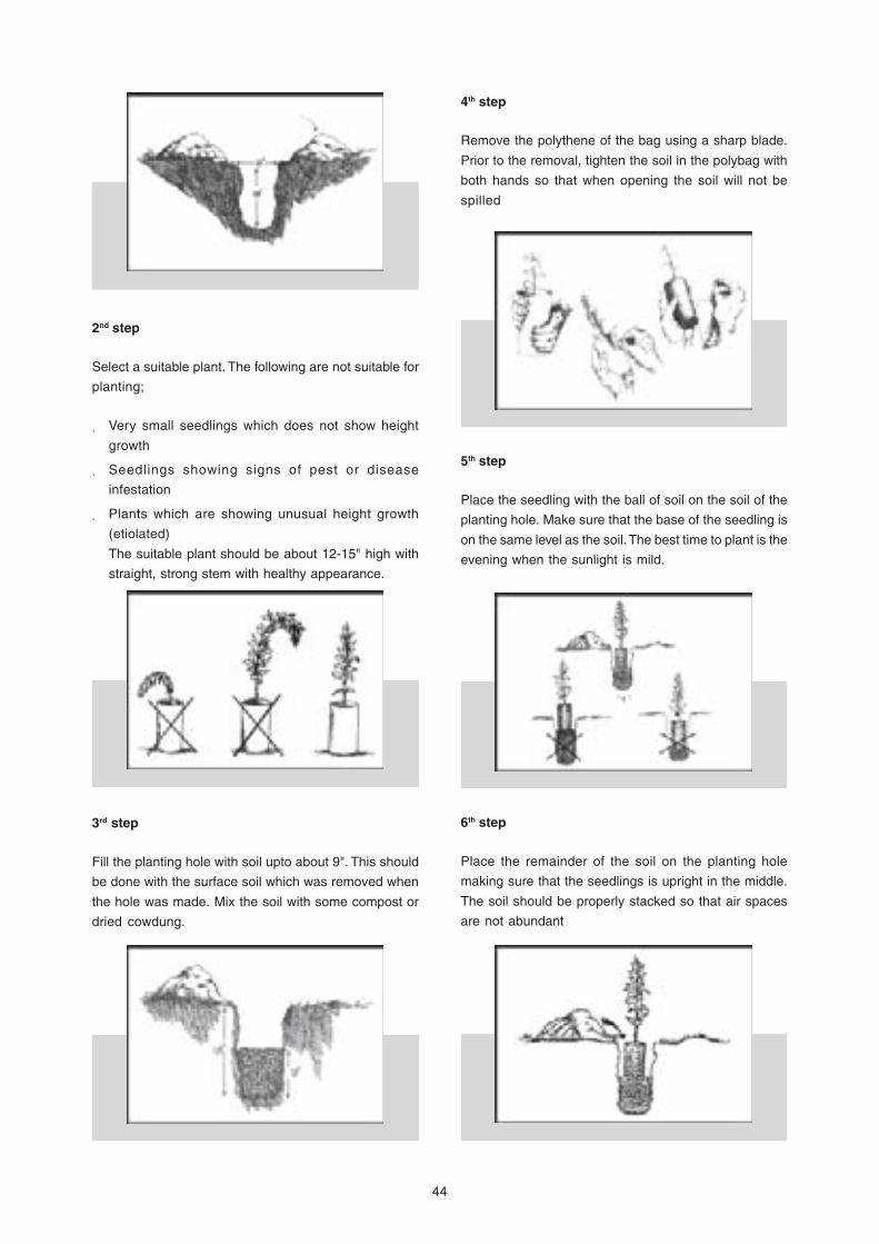
44
4th step
Remove the polythene of the bag using a sharp blade.
Prior to the removal, tighten the soil in the polybag with
both hands so that when opening the soil will not be
spilled
6th step
Place the remainder of the soil on the planting hole
making sure that the seedlings is upright in the middle.
The soil should be properly stacked so that air spaces
are not abundant
2nd step
Select a suitable plant. The following are not suitable for
planting;
Very small seedlings which does not show height
growth
Seedlings showing signs of pest or disease
infestation
Plants which are showing unusual height growth
(etiolated)
The suitable plant should be about 12-15" high with
straight, strong stem with healthy appearance.
5th step
Place the seedling with the ball of soil on the soil of the
planting hole. Make sure that the base of the seedling is
on the same level as the soil. The best time to plant is the
evening when the sunlight is mild.
3rd step
Fill the planting hole with soil upto about 9". This should
be done with the surface soil which was removed when
the hole was made. Mix the soil with some compost or
dried cowdung.

45
7th step
Press the soil around the plant hard with the fingers of
the leg. This makes sure that there are no air spaces so
that water will be accumulated in them and cause
adverse effects to the plant.
8th step
Water the plant thoroughly. To reduce evaporation loss,
place leaf mould or straw around the seedling. This will
help the plant in several ways;
Keep the moisture around the seedlings for a long
time
Reduce the soil temperature around the seedling
even when the temperature in the surroundings are
high
Reduce the growth of weeds
To avoid the plant from sagging. A stick can be held
parallel to it to provide support. This will provide support
against strong winds
9th step
To protect the plant from animal and other disturbances,
it is necessary to have a guard around it. This can be
made out of sticks, tar barrels or any other suitable
material
10th step
Weeding
It is necessary to remove the weeds at least in the initial
stages of the seedlings until it gets established on the
soil. Otherwise it will be throttled by the weeds in no time
and die.
11th step
Fertilization
It is appropriate to use cow dung, leaf mould or compost
to the plant for fast growth and establishment
12th step
In the event of seedlings not surviving, it is necessary to
fill the gaps with similar aged seedlings taken from the
nursery.

46
Setback Standards for Development Activities in the Coastal Zone bySegment and Vulnerability
Annex VII

47
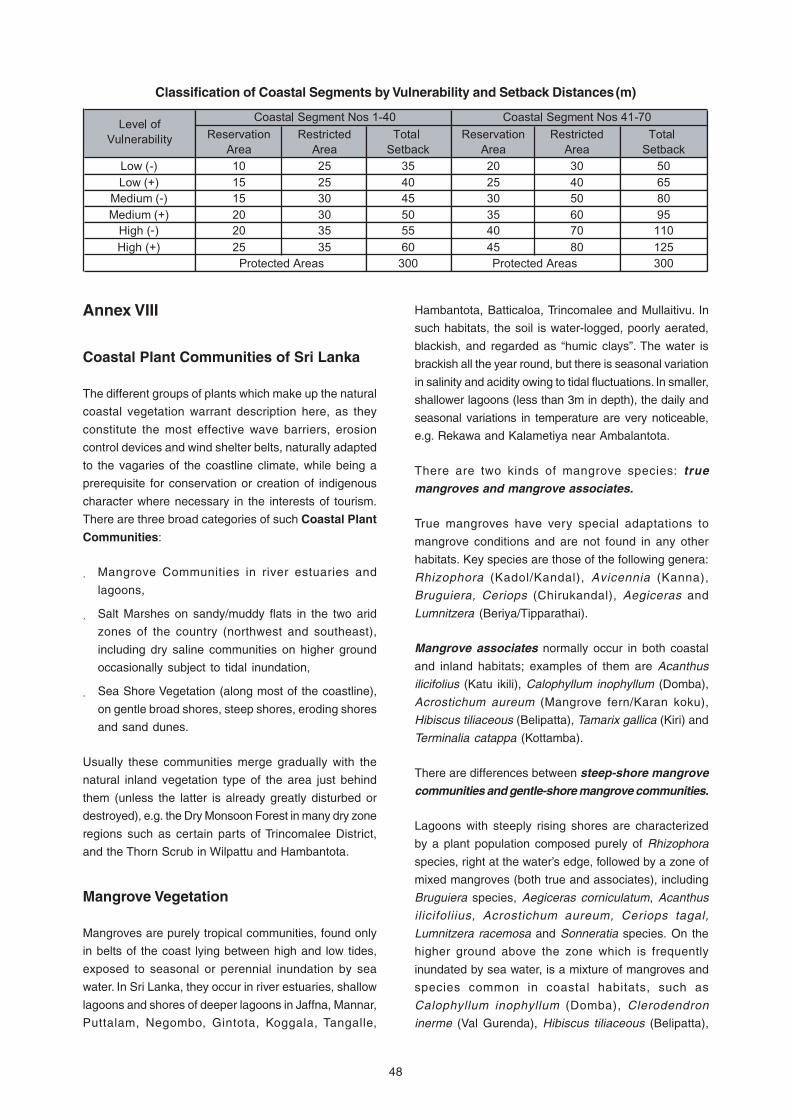
48
Classification of Coastal Segments by Vulnerability and Setback Distances (m)
Annex VIII
Coastal Plant Communities of Sri Lanka
The different groups of plants which make up the natural
coastal vegetation warrant description here, as they
constitute the most effective wave barriers, erosion
control devices and wind shelter belts, naturally adapted
to the vagaries of the coastline climate, while being a
prerequisite for conservation or creation of indigenous
character where necessary in the interests of tourism.
There are three broad categories of such Coastal Plant
Communities:
Mangrove Communities in river estuaries and
lagoons,
Salt Marshes on sandy/muddy flats in the two arid
zones of the country (northwest and southeast),
including dry saline communities on higher ground
occasionally subject to tidal inundation,
Sea Shore Vegetation (along most of the coastline),
on gentle broad shores, steep shores, eroding shores
and sand dunes.
Usually these communities merge gradually with the
natural inland vegetation type of the area just behind
them (unless the latter is already greatly disturbed or
destroyed), e.g. the Dry Monsoon Forest in many dry zone
regions such as certain parts of Trincomalee District,
and the Thorn Scrub in Wilpattu and Hambantota.
Mangrove Vegetation
Mangroves are purely tropical communities, found only
in belts of the coast lying between high and low tides,
exposed to seasonal or perennial inundation by sea
water. In Sri Lanka, they occur in river estuaries, shallow
lagoons and shores of deeper lagoons in Jaffna, Mannar,
Puttalam, Negombo, Gintota, Koggala, Tangalle,
Hambantota, Batticaloa, Trincomalee and Mullaitivu. In
such habitats, the soil is water-logged, poorly aerated,
blackish, and regarded as “humic clays”. The water is
brackish all the year round, but there is seasonal variation
in salinity and acidity owing to tidal fluctuations. In smaller,
shallower lagoons (less than 3m in depth), the daily and
seasonal variations in temperature are very noticeable,
e.g. Rekawa and Kalametiya near Ambalantota.
There are two kinds of mangrove species: truemangroves and mangrove associates.
True mangroves have very special adaptations to
mangrove conditions and are not found in any other
habitats. Key species are those of the following genera:
Rhizophora (Kadol/Kandal), Avicennia (Kanna),
Bruguiera, Ceriops (Chirukandal), Aegiceras and
Lumnitzera (Beriya/Tipparathai).
Mangrove associates normally occur in both coastal
and inland habitats; examples of them are Acanthus
ilicifolius (Katu ikili), Calophyllum inophyllum (Domba),
Acrostichum aureum (Mangrove fern/Karan koku),
Hibiscus tiliaceous (Belipatta), Tamarix gallica (Kiri) and
Terminalia catappa (Kottamba).
There are differences between steep-shore mangrovecommunities and gentle-shore mangrove communities.
Lagoons with steeply rising shores are characterized
by a plant population composed purely of Rhizophora
species, right at the water’s edge, followed by a zone of
mixed mangroves (both true and associates), including
Bruguiera species, Aegiceras corniculatum, Acanthus
ilicifoliius, Acrostichum aureum, Ceriops tagal,
Lumnitzera racemosa and Sonneratia species. On the
higher ground above the zone which is frequently
inundated by sea water, is a mixture of mangroves and
species common in coastal habitats, such as
Calophyllum inophyllum (Domba), Clerodendron
inerme (Val Gurenda), Hibiscus tiliaceous (Belipatta),

49
Cerbera manghas (Gon Kaduru), Tamarix gallica (Kiri)
and Terminalia catappa (Kottamba).
Lagoons with gentle shores are usually characterized
by a mixed mangrove community of Rhizophora,
Avicennia, Sonneratia and Acanthus at the water’s edge,
although in areas of frequent sea inundation, the other
species, less tolerant than Rhizophora, are rare or absent.
Moving inland, there is a gradual transformation of this
mixed mangrove community into littoral woodland.
In certain mud flats, a mixed plant population consisting
almost entirely of Acanthus ilicifolius and Acrostichum
aureum is discernible.
In some mangrove areas in river estuaries and larger
lagoons along the southern and southwestern coasts,
there are pure or almost pure populations of Nipa
fruticans (Marsh palm/Gin pol) along the water’s edge
(e.g. Gintota, Weligama, Waikkal).
Salt Marshes and Dry Saline Communities
These are found only in the arid extremes of the north-
west (Puttalam, Mannar) and south-east (Hambantota,
Ambalantota) coasts. The common species include
Arthrocnemum (T-kotanai), Salicornia, Suaeda (umiri),
sedges, and certain grasses.
Salt marshes occur on high ground which is periodically
inundated with sea water. These sandy and muddy flats
dry out during the dry season, increasing aridity and
salinity. An example is Mundel lake, where the salt marsh
vegetation shows a very clear zonation.
Dry saline communities occur on high ground which is
rarely subjected to sea inundation and they include a
variety of communities. Communities dominated by
Arthrocnemum are open in nature and are found on
sandy, dry, flat plains. Suaeda communities occur along
the coast as well as inland; the coastal communities are
dominated by the dwarf, much-branched shrub Suaeda
maritima, with a few scattered other Suaeda species,
and (in smaller numbers), species such as Cynodon
dactylon (Bermuda Grass), Por tulaca species
(Urugenda, Heen genda kola, Genda kola) and
Salicornia brachiata. In Mundel area, the grass Zoysia
matrella is also found. In stable depressions scattered
in between Arthrocnemum and Suaeda communities
there is a mixed vegetation of Microcoleus, Cynodon
species, Cyperus species such as Cyperus rotundus
(Kalanduru), and Salicornia all showing a clear division
into zones.
Seashore Vegetation
The immediate hinterland of the coastline could be
deemed RURAL in areas where, despite a similar
variation in landform to that in natural areas, the natural
vegetation has been largely replaced by non-
indigenous agricultural species such as Cocos nucifera
(coconut palms) and Borassus flabellifer (palmyrah
palms). In some cases, there might be crops such as
Anacardium occidentale (cashewnut).a little further
inland, and even patches of grassland used for grazing.
In certain areas, such as Mundel, Waikkal, and
Hambantota, aqua-culture (especially prawn farms) and
salt-pans have replaced the original mangroves or salt
marshes. Groups or strips of Casuarina equisetifolia
(Kasa), which is also an introduced species although it
may be considered as being naturalised in Sri Lanka,
have been planted in many locations along both the wet
zone and dry zone beaches for wind shelter or beach
stabilization. Nevertheless, remnant pockets, patches
and strips of natural plant communities still exist, albeit
dispersed and fragmented.
It is appropriate to categorise as URBAN those coastal
strips within or bordering urban settlements, usually
including seaside parks, playgrounds, esplanades and
marine drives, sometimes with seaside retaining walls
and often bordered by artificial coastal protection
structures such as rock revetments.
Tree and shrub vegetation closest to the high tide line
would largely comprise combinations of indigenous
species such as Mudilla, Mudukeyiya, Thakkada, Vara
and Val gurenda, and species introduced to Sri Lanka
such as Pol, Thal, Kottamba, Suriya, Casuarina, and
Agave species. Although most of the natural strand
vegetation would have been destroyed or removed,
there could still be patches of creepers such as Mudu-
bim-thamburu and Maha-ravana-ravula, and grasses
such as Bermuda Grass and Manila Grass. Even
mangroves persist in some urban areas, although
extremely prone to (often unauthorized) filling and
encroachment. Further inland within the designated
coastal reservation there could be other species such
as Domba, Palu, Kohomba, Madan, Fig family trees (e.g.
Banyan), Letta-kochcha, Amba, Cashew, Kelani Tissa,
Kaneru, Kahakaneru,Vadamal, etc.
Source: Guidelines for Coastal Reservation Greenbelts
in Sri Lanka, Prepared by Ms Hesthor Basnayake, of UDA.


The World Conservation Union (IUCN) was founded in 1948 and brings together nearly 1,100
members (States, government agencies, NGOs and affiliates) and some 10,000 scientists and
experts from 181 countries in a unique worldwide partnership. Its mission is to influence, encourage
and assist societies throughout the world to conserve the integrity and diversity of nature and to
ensure that any use of natural resources is equitable and ecologically sustainable. Within the
framework of global conventions IUCN has helped over 75 countries to prepare and implement
national conservation and biodiversity strategies. IUCN has approximately 1,000 staff, most of
whom are located in its regional and country offices while some 150 work at its Headquarters in
Gland, Switzerland.
In the context of IUCN’s mission, the role of the IUCN programme in Sri Lanka is to be a facilitator
of conservation action. It plays a catalytic role, and offers effective platforms to promote dialogue
and discussion among the various partners engaged in conservation work. The emphasis of the
Programme is to support sustainable natural resource initiatives of the Union’s members and
partners in Sri Lanka, in biodiversity conservation, conservation and management of critical
habitats, environmental policy support, institutional support and environmental education and
awareness. It also provides opportunities for the practical application of methodologies developed
through the Union’s scientific networks to support the conservation initiatives of members and
partners of IUCN in Sri Lanka.
The in-country operations of IUCN in Sri Lanka commenced in 1988. In addition to the country
office in Colombo, the programme has now expanded with four regional offices operating from the
southern, eastern and central parts of the country.
The World Conservation Union
53, Horton PlaceColombo 07
Sri Lanka
Tel. +94 11 2682418Fax. +94 11 2682470
E-mail. [email protected]
www.iucnsl.org
Sri Lanka Country Office


![Coastal Greenbelt Project (Loan 1353-BAN[SF]) in the ... · Project Completion Report PCR: BAN 25311 Coastal Greenbelt Project (Loan 1353-BAN[SF]) in the People’s Republic of Bangladesh](https://img.dokumen.tips/doc/110x75/5ac82a6d7f8b9aa1298bf209/coastal-greenbelt-project-loan-1353-bansf-in-the-completion-report-pcr.jpg)