Embed Size (px)
Citation preview
SpecificationPearson Edexcel Level 1/Level 2 GCSE in Geography A (2GA01)For first certification 2014
Issue 5
Edexcel, BTEC and LCCI qualifications
Edexcel, BTEC and LCCI qualifications are awarded by Pearson, the UK’s largest awarding body offering academic and vocational qualifications that are globally recognised and benchmarked. For further information, please visit our qualification websites at www.edexcel.com, www.btec.co.uk or www.lcci.org.uk. Alternatively, you can get in touch with us using the details on our contact us page at www.edexcel.com/contactus
About Pearson
Pearson is the world’s leading learning company, with 40,000 employees in more than 70 countries working to help people of all ages to make measurable progress in their lives through learning. We put the learner at the centre of everything we do, because wherever learning flourishes, so do people. Find out more about how we can help you and your learners at: www.pearson.com/uk
This specification is Issue 5. Key changes from Issue 4 remain sidelined, new changes are double sidelined. We will inform centres of any changes to this issue. The latest issue can be found on our website: www.edexcel.com
References to third-party material made in this specification are made in good faith. We do not endorse, approve or accept responsibility for the content of materials, which may be subject to change, or any opinions expressed therein. (Material may include textbooks, journals, magazines and other publications and websites.)
Authorised by Martin StrettonPrepared by Matthew GregoryISBN 978 1 446 91190 7All the material in this publication is copyright© Pearson Education Limited 2014
Pearson Edexcel Level 1/Level 2 GCSE in Geography A Specification – Issue 5 © Pearson Education Limited 2014 1
Introduction
The Pearson Edexcel Level 1/Level 2 GCSE in Geography A is designed for use in schools and colleges. It is part of a suite of GCSE qualifications offered by Edexcel.
About this specificationThe new Pearson Edexcel Level 1/Level 2 GCSE in Geography A has four units. This allows for a flexible teaching approach, in which students can study a unit and then move on to the next part of the course.
Core topics cover key elements of both the physical and human world, and skills considered to be essential.
The optional topics allow students to study areas of geography in more depth, focusing on contemporary issues from both physical and human environments.
The fieldwork element of this course is found in the controlled assessment unit. This provides a more structured approach to internal assessment. The fieldwork tasks must be chosen from the list of tasks provided by Edexcel, but centres can put them in the context of their local area.
Key subject aimsThis specification gives students opportunities to:
■ actively engage in the process of geography to develop as effective and independent learners, and as critical and reflective thinkers with enquiring minds
■ develop their knowledge and understanding of geographical concepts and appreciate the relevance of these concepts to our changing world
■ develop a framework of spatial awareness in which to appreciate the importance of the location of places and environments from local to global
■ appreciate the differences and similarities in people’s views of the world and its environments, societies and cultures
■ understand the significance of values and attitudes to the development and resolution of issues
■ develop their responsibilities as global citizens and recognise how they can contribute to a future that is sustainable and inclusive
■ develop and apply their learning to the real world through fieldwork and other out-of-classroom learning
■ use geographical skills, appropriate technologies, enquiry and analysis.
2
Contents
Pearson Edexcel Level 1/Level 2 GCSE in Geography A Specification – Issue 5 © Pearson Education Limited 2014
Specification at a glance 4
A Qualification content 6
Knowledge and understanding 6
Skills 7
List of unit contents 8
Unit 1 Geographical Skills and Challenges 9
Overview 9
Detailed unit content 12
Unit 2 The Natural Environment 17
Overview 17
Detailed unit content 19
Unit 3 The Human Environment 28
Overview 28
Detailed unit content 30
Unit 4 Investigating Geography 42
Overview 42
Detailed unit content 46
B Assessment 56
Assessment summary 56
Assessment Objectives and weightings 57
Relationship of Assessment Objectives to units 57
Entering your students for assessment 58
Student entry 58
Forbidden combinations and classification code 58
Access arrangements and special requirements 59
Equality Act 2010 59
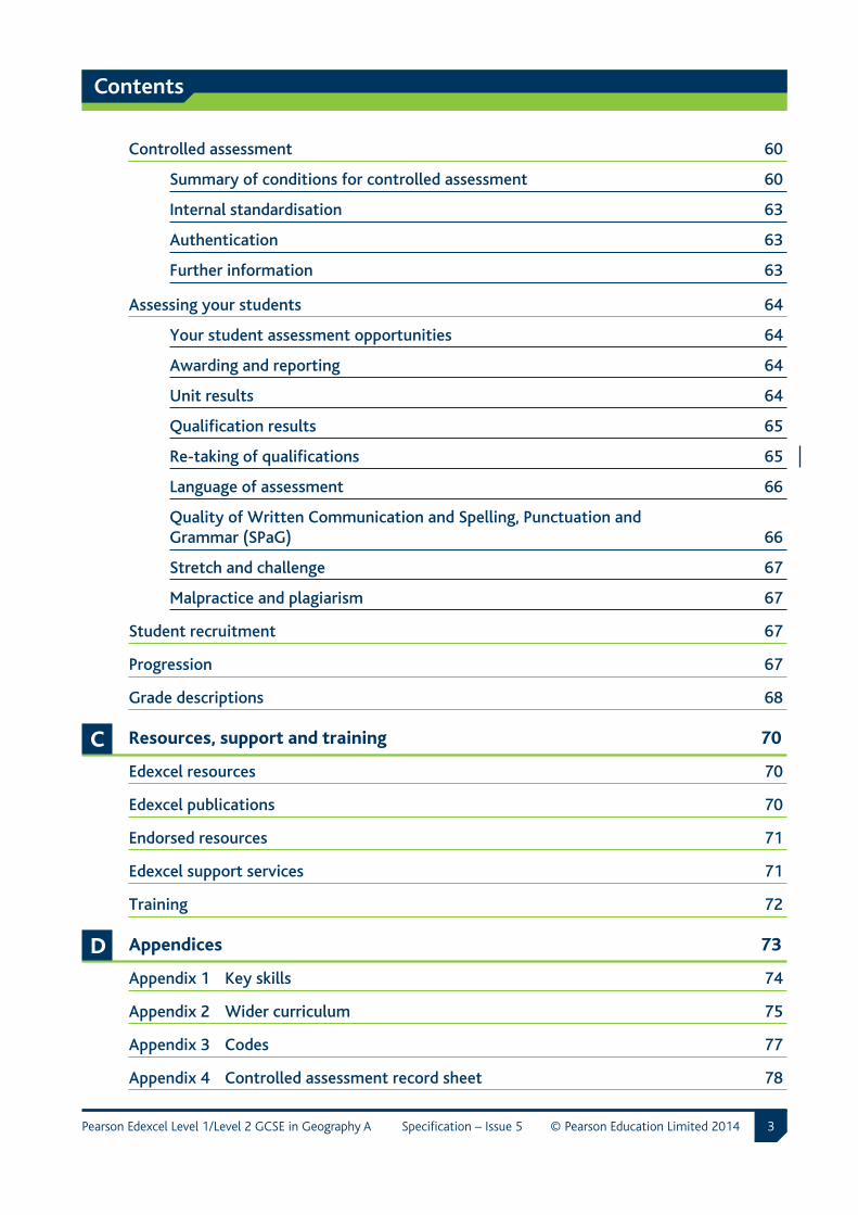
Contents
3Pearson Edexcel Level 1/Level 2 GCSE in Geography A Specification – Issue 5 © Pearson Education Limited 2014
Controlled assessment 60
Summary of conditions for controlled assessment 60
Internal standardisation 63
Authentication 63
Further information 63
Assessing your students 64
Your student assessment opportunities 64
Awarding and reporting 64
Unit results 64
Qualification results 65
Re-taking of qualifications 65
Language of assessment 66
Quality of Written Communication and Spelling, Punctuation and Grammar (SPaG) 66
Stretch and challenge 67
Malpractice and plagiarism 67
Student recruitment 67
Progression 67
Grade descriptions 68
C Resources, support and training 70
Edexcel resources 70
Edexcel publications 70
Endorsed resources 71
Edexcel support services 71
Training 72
D Appendices 73
Appendix 1 Key skills 74
Appendix 2 Wider curriculum 75
Appendix 3 Codes 77
Appendix 4 Controlled assessment record sheet 78
4 Pearson Edexcel Level 1/Level 2 GCSE in Geography A Specification – Issue 5 © Pearson Education Limited 2014
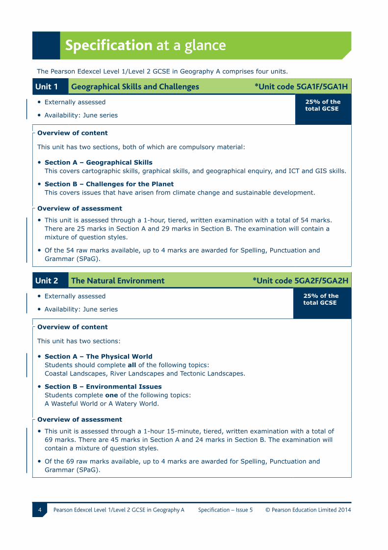
Specification at a glance
The Pearson Edexcel Level 1/Level 2 GCSE in Geography A comprises four units.
Unit 1 Geographical Skills and Challenges *Unit code 5GA1F/5GA1H
• Externally assessed
• Availability: June series
25% of the total GCSE
Overview of content
This unit has two sections, both of which are compulsory material:
• Section A – Geographical Skills This covers cartographic skills, graphical skills, and geographical enquiry, and ICT and GIS skills.
• Section B – Challenges for the Planet This covers issues that have arisen from climate change and sustainable development.
Overview of assessment
• This unit is assessed through a 1-hour, tiered, written examination with a total of 54 marks. There are 25 marks in Section A and 29 marks in Section B. The examination will contain a mixture of question styles.
• Of the 54 raw marks available, up to 4 marks are awarded for Spelling, Punctuation and Grammar (SPaG).
Unit 2 The Natural Environment *Unit code 5GA2F/5GA2H
• Externally assessed
• Availability: June series
25% of the total GCSE
Overview of content
This unit has two sections:
• Section A – The Physical World Students should complete all of the following topics: Coastal Landscapes, River Landscapes and Tectonic Landscapes.
• Section B – Environmental Issues Students complete one of the following topics: A Wasteful World or A Watery World.
Overview of assessment
• This unit is assessed through a 1-hour 15-minute, tiered, written examination with a total of 69 marks. There are 45 marks in Section A and 24 marks in Section B. The examination will contain a mixture of question styles.
• Of the 69 raw marks available, up to 4 marks are awarded for Spelling, Punctuation and Grammar (SPaG).
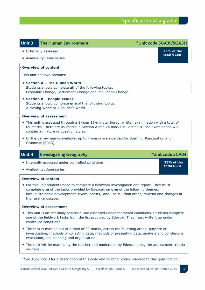
5
Specification at a glance
Pearson Edexcel Level 1/Level 2 GCSE in Geography A Specification – Issue 5 © Pearson Education Limited 2014
Unit 3 The Human Environment *Unit code 5GA3F/5GA3H
• Externally assessed
• Availability: June series
25% of the total GCSE
Overview of content
This unit has two sections:
• Section A – The Human World Students should complete all of the following topics: Economic Change, Settlement Change and Population Change.
• Section B – People Issues Students should complete one of the following topics: A Moving World or A Tourist’s World.
Overview of assessment
• This unit is assessed through a 1-hour 15-minute, tiered, written examination with a total of 69 marks. There are 45 marks in Section A and 24 marks in Section B. The examination will contain a mixture of question styles.
• Of the 69 raw marks available, up to 4 marks are awarded for Spelling, Punctuation and Grammar (SPaG).
Unit 4 Investigating Geography *Unit code 5GA04
• Internally assessed under controlled conditions
• Availability: June series
25% of the total GCSE
Overview of content
• For this unit students need to complete a fieldwork investigation and report. They must complete one of the tasks provided by Edexcel, on one of the following themes: local sustainable development, rivers, coasts, land use in urban areas, tourism and changes in the rural landscape.
Overview of assessment
• This unit is an internally assessed unit assessed under controlled conditions. Students complete one of the fieldwork tasks from the list provided by Edexcel. They must write it up under controlled conditions.
• The task is marked out of a total of 50 marks, across the following areas: purpose of investigation, methods of collecting data, methods of presenting data, analysis and conclusions, evaluation, and planning and organisation.
• The task will be marked by the teacher and moderated by Edexcel using the assessment criteria on page 53.
*See Appendix 3 for a description of this code and all other codes relevant to this qualification.
6 Pearson Edexcel Level 1/Level 2 GCSE in Geography A Specification – Issue 5 © Pearson Education Limited 2014
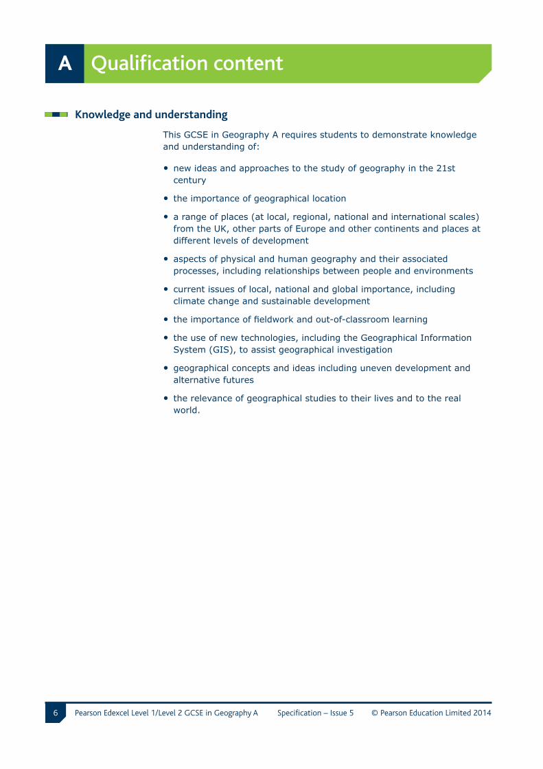
A Qualification content
Knowledge and understanding
This GCSE in Geography A requires students to demonstrate knowledge and understanding of:
• new ideas and approaches to the study of geography in the 21st century
• the importance of geographical location
• a range of places (at local, regional, national and international scales) from the UK, other parts of Europe and other continents and places at different levels of development
• aspects of physical and human geography and their associated processes, including relationships between people and environments
• current issues of local, national and global importance, including climate change and sustainable development
• the importance of fieldwork and out-of-classroom learning
• the use of new technologies, including the Geographical Information System (GIS), to assist geographical investigation
• geographical concepts and ideas including uneven development and alternative futures
• the relevance of geographical studies to their lives and to the real world.
7
Qualification content A
Pearson Edexcel Level 1/Level 2 GCSE in Geography A Specification – Issue 5 © Pearson Education Limited 2014
Skills
This GCSE in Geography A provides students with the opportunity to develop the ability to:
• identify relevant geographical questions and issues and establish appropriate sequences of investigation, incorporating geographical skills and enquiry skills
• carry out fieldwork and out-of-classroom learning
• use new technologies, including GIS, to assist geographical investigation
• extract and interpret information from a range of sources, including field observations, maps (including Ordnance Survey maps of different scales), drawings, photographs (ground, aerial and satellite imagery), diagrams and tables
• acquire and use geographical vocabulary
• communicate in a variety of ways, including extended writing and graphical forms
• make informed geographical decisions
• describe, analyse and interpret evidence, making decisions, drawing and justifying conclusions and communicating findings in ways appropriate to the task’s audience
• evaluate methods of collecting, presenting and analysing evidence and the validity and limitations of evidence and conclusions.
8
A Qualification content
Pearson Edexcel Level 1/Level 2 GCSE in Geography A Specification – Issue 5 © Pearson Education Limited 2014
List of unit contents
Unit 1 Geographical Skills and Challenges 9
Section A Geographical Skills 12
Topic 1 Basic skills 12
Topic 2 Cartographic skills 12
Topic 3 Graphical skills 13
Topic 4 Geographical enquiry skills 14
Topic 5 ICT skills 14
Topic 6 Geographical Information System (GIS) skills 14
Section B Challenges for the Planet 15
Unit 2 The Natural Environment 17
Section A The Physical World 19
Topic 1 Coastal Landscapes 19
Topic 2 River Landscapes 21
Topic 3 Tectonic Landscapes 23
Section B Environmental Issues 24
Topic 4 A Wasteful World 24
Topic 5 A Watery World 26
Unit 3 The Human Environment 28
Section A The Human World 30
Topic 1 Economic Change 30
Topic 2 Settlement Change 32
Topic 3 Population Change 35
Section B People Issues 37
Topic 4 A Moving World 37
Topic 5 A Tourist’s World 40
Unit 4 Investigating Geography 42
9
Unit 1
Pearson Edexcel Level 1/Level 2 GCSE in Geography A Specification – Issue 5 © Pearson Education Limited 2014
Qualification content A
Unit 1 Geographical Skills and Challenges
Overview
Content overview
This unit contains two sections:
• Section A – Geographical Skills
• Section B – Challenges for the Planet.
Both of these sections are compulsory and all aspects of these sections must be studied.
Section A includes the following topics:
• Topic 1: Basic Skills
• Topic 2: Cartographic Skills
• Topic 3: Graphical Skills
• Topic 4: Geographical Enquiry Skills
• Topic 5: ICT Skills
• Topic 6: Geographical Information Systems (GIS) Skills.
This unit covers the geographical skills that are essential for all GCSE Geography students. They will gain an understanding of these skills and expertise in how to apply them to geographical investigations. Cartographic, graphical and geographical enquiry, and ICT and GIS skills are covered.
This unit also covers the major challenges our planet is currently facing: climate change and sustainability. This is a key topic for anyone living in the 21st century and it is vital that students are well informed and able to make their own decisions on this subject.
10
Unit 1
Pearson Edexcel Level 1/Level 2 GCSE in Geography A Specification – Issue 5 © Pearson Education Limited 2014
A Qualification content
Use of examples
In this unit, where ‘e.g.’ precedes a concept in the unit content, students are not expected to have been taught the particular example given. They should be able to illustrate their answer with an example of their choice.
For instance, in Unit 1 Topic 7.1 The causes, effects and responses to climate change 7.1d, the specification states:
‘the responses to climate change, from a local to a global scale, e.g. from ‘live simply’ campaigns to world superpower meetings (Bali in 2007).’
Students will be expected to learn about the responses to climate change, from a local to a global scale, but they may or may not have looked at this in relation to the ‘live simply’ campaigns and world superpower meetings. In the unit examination, students could be asked to discuss the responses to climate change, from a local to a global scale. They could be asked to give examples, or be given a contextualised question relating to a different example in the examination.
Use of ‘including’
Where ‘including’ precedes a concept in the unit content, students are expected to have been taught that particular content.
For instance, in Unit 1 Topic Graphical Skills 3b, the specification states:
‘interpret a variety of graphs, including those located on maps and topological diagrams.’
Students will be expected to interpret all of the types of graphs listed and possibly other types of graphs. In the unit examination, students could be asked to interpret graphs, maps and topological diagrams but nothing further.
11
Unit 1
Pearson Edexcel Level 1/Level 2 GCSE in Geography A Specification – Issue 5 © Pearson Education Limited 2014
Qualification content A
Assessment overview
• This unit will be assessed via a 1-hour written examination.
• It has a total of 54 marks.
• Of the 54 raw marks available, up to 4 marks are awarded for Spelling, Punctuation and Grammar (SPaG).
• There will be a variety of question types, such as short-answer, cartographic, graphical and extended-answer questions.
• All questions in the written examination are compulsory.
• Section A will contain questions on geographical skills, such as cartography and graphics. Students will have access to a resource booklet alongside the examination paper. This will contain the maps, diagrams and graphs needed to answer the questions.
• Section B will contain questions on the two main challenges facing the planet: climate change and sustainable development. Students might need stimulus material in the resource booklet to answer the questions.
12
Unit 1
Pearson Edexcel Level 1/Level 2 GCSE in Geography A Specification – Issue 5 © Pearson Education Limited 2014
A Qualification content
Detailed unit content
Section A Geographical Skills (compulsory topics – study all topics from 1 to 6)
Topic 1 Basic Skills
Students will be assessed on their ability to:
a label and annotate diagrams, maps, graphs and sketches
b draw sketches from photographs and while in the field
c use and interpret aerial, oblique and satellite photographs for different landscapes
d write coherently, showing the importance of good literacy skills in expressing geographical points.
Topic 2 Cartographic Skills
2.1 Atlas maps
Students will be assessed on their ability to:
a recognise and describe distributions and patterns of both human and physical features.
2.2 Sketch maps
Students will be assessed on their ability to:
a draw, label, annotate, understand and interpret sketch maps.
13
Unit 1
Pearson Edexcel Level 1/Level 2 GCSE in Geography A Specification – Issue 5 © Pearson Education Limited 2014
Qualification content A
2.3 Ordnance Survey maps (1:50,000 scale)
Students will be assessed on their ability to:
a recognise symbols (using a key), four- and six-figure grid references, and straight line and winding distances
b demonstrate an understanding of direction, using an eight-point compass
c demonstrate understanding of the construction of cross-sections
d complete and annotate cross-sections, indicating height and degree of slope and simple contour patterns
e recognise and describe patterns of vegetation, land use and communications
f describe and identify the site, situation and shape of settlements
g recognise and describe distributions and patterns of both human and physical features
h infer human activity from map evidence, including tourism
i use maps in association with photographs, sketches and written directions.
Topic 3 Graphical Skills
Students will be assessed on their ability to:
a construct and complete a variety of graphs, charts and maps
b interpret a variety of graphs, including those located on maps and topological diagrams.
14
Unit 1
Pearson Edexcel Level 1/Level 2 GCSE in Geography A Specification – Issue 5 © Pearson Education Limited 2014
A Qualification content
Topic 4 Geographical Enquiry Skills
Students will be assessed on their ability to:
a identify, analyse and evaluate geographical questions, hypotheses and issues
b establish appropriate sequences of investigation and follow appropriate enquiry approaches
c extract and interpret information from a range of sources, including field observations, maps, drawings, photographs, diagrams and tables and secondary sources
d describe, analyse and interpret evidence
e draw and justify conclusions from evidence
f evaluate methods of data collection, presentation and analysis of evidence.
Topic 5 ICT Skills
Students will be assessed on their ability to:
a collect and annotate photographs and satellite images
b use databases to find census and population data
c use the internet, e.g. to investigate case studies of volcanic eruptions or floods
d extract information from video and television programmes
e carry out data presentation and analysis techniques
f use spreadsheets and data-handling software
g research and present investigative work.
Topic 6 Geographical Information System (GIS) Skills
Students will be assessed on their ability to:
a capture and represent geographical information in systems such as Aegis
b use web-mapping sites, such as Google Earth and Multimap.
15
Unit 1
Pearson Edexcel Level 1/Level 2 GCSE in Geography A Specification – Issue 5 © Pearson Education Limited 2014
Qualification content A
Section B Challenges for the Planet (compulsory topic – topic 7)
Key ideas Detailed content
7.1 The causes, effects and responses to climate change
a How and why climate has changed since the last ice age.
How the climate has changed in the last 10,000 years to the present day. Causes to include volcanic activity, orbital geometry and variations in solar output.
b The causes of current climate change on a local and global scale, including the burning of fossil fuels and the increase of methane in the atmosphere.
A variety of causes, to include those listed, should be studied through examples which illustrate the actions of individuals, such as increase in car ownership and groups of people, such as energy producers.
c The negative effects that climate change is having on the environment and people, including changing patterns of crop yield, rising sea levels and retreating glaciers, on a local and global scale.
A variety of effects should be studied through examples at a local and global scale; this includes the study of the impact on food production, the threat to areas at sea level, including small islands and the threat to marine environments, such as coral reefs.
d The responses to climate change, from a local to a global scale, e.g. from ‘live simply’ campaigns to world superpower meetings (Bali in 2007).
There is a range of responses to climate change, from the response of governments on a global scale to the responses of individuals at a local scale. There is a range of attitudes to climate change, from lack of acceptance of either the reality of change or its human causes to differences over the possible responses. The detail of global meetings should be studied, e.g. Bali in 2007, and local campaigns.
16
Unit 1
Pearson Edexcel Level 1/Level 2 GCSE in Geography A Specification – Issue 5 © Pearson Education Limited 2014
A Qualification content
Key ideas Detailed content
7.2 Sustainable development for the planet
a Definitions and interpretations of sustainable development.
Sustainable development is a contested term. There are contrasting definitions and interpretations that depend on the values and attitudes of individuals, governments and organisations.
b The concept of sustainable development, through the following contexts:
These could be taught individually or together within the context of sustainable development.
i the development of policies by large organisations to make them more sustainable
Consider the specific detail of examples which range from within the workplace, such as recycling bins, to reduction of air pollution in manufacturing industries.
ii the management of transport in urban areas, including the public versus private debate
A range of sustainable transport schemes to be studied in different urban areas, e.g. park and ride, and congestion charging.
iii the effects of resource extraction from tropical rainforests and their management.
A range of resource extraction examples from tropical rainforest environments should be studied with contrasting management initiatives, e.g. oil extraction in remote environments, mining and palm oil production for biofuels.
17
Unit 2
Pearson Edexcel Level 1/Level 2 GCSE in Geography A Specification – Issue 5 © Pearson Education Limited 2014
Qualification content A
Unit 2 The Natural Environment
Overview
Content overview
This unit covers the physical geography aspects of the natural world and the issues related to the environment.
Section A will cover the physical world and students will need to study all of the following topics:
• Topic 1: Coastal Landscapes
• Topic 2: River Landscapes
• Topic 3: Tectonic Landscapes.
Section B will cover environmental issues and students will need to study one of the following two topics:
• Topic 4: A Wasteful World
• Topic 5: A Watery World.
Use of examples
In this unit, where ‘e.g.’ precedes a concept in the unit content, students are not expected to have been taught the particular example given. They should be able to illustrate their answer with an example of their choice.
For instance, in Topic 1.1c Coastal processes produce landforms, the specification states:
Explain the process of longshore drift and how it impacts on the coastline both in the features it forms and the related issues, e.g. deposition in estuaries.
Students will be expected to be able to explain the process of longshore drift and how it affects the coastline features and related issues but they may or may not have studied it regarding deposition in estuaries. In the unit examination students could be asked to explain the process of longshore drift and its impacts on the coastline. They could be asked to give examples, or be given a contextualised question relating to a different example in the examination.
18
Unit 2
Pearson Edexcel Level 1/Level 2 GCSE in Geography A Specification – Issue 5 © Pearson Education Limited 2014
A Qualification content
Use of ‘including’
Where ‘including’ precedes a concept in the unit content, students are expected to have been taught that particular content.
For instance, in Topic 1.1b The impact of weathering, erosion and mass movement on the coast; the specification states:
…the processes involved, including the influence of geology.
Students will be expected to learn about the influence of geology on the formation of these landforms. In the unit examination, students could be asked questions on the influence of geology on landform formation.
Assessment overview
• This unit will be assessed via a 1-hour 15-minute written examination.
• It has a total of 69 marks.
• Of the 69 raw marks available, up to 4 marks are awarded for Spelling, Punctuation and Grammar (SPaG).
• There will be a variety of question types, such as short-answer, graphical and extended-answer questions.
• In the examination, students will need to answer all questions from Section A and one from Section B.
• Section A will contain three questions: one on each of the physical world topics. Students will have to answer all questions. They will have access to a resource booklet alongside the examination paper. This will contain any stimulus material needed to answer the questions.
• Section B will contain two questions: one on each of the environmental issues topics. Students will have to choose one question to answer on the topic they have studied. Students might need the stimulus material in the resource booklet to answer the questions.
19
Unit 2
Pearson Edexcel Level 1/Level 2 GCSE in Geography A Specification – Issue 5 © Pearson Education Limited 2014
Qualification content A
Detailed unit content
Section A The Physical World
Topic 1 Coastal Landscapes
Key ideas Detailed content
1.1 Coastal processes produce landforms
a Types of wave: destructive and constructive.
The characteristics of the two wave types should be studied.
b The impact of weathering, erosion and mass movement on the coast: cliffs and wave-cut platforms, headlands and bays, caves, arches, stacks and stumps.
Describe the landforms listed and explain their formation in terms of sequence and the processes involved, including the influence of geology. Examine annotated diagrams of the landforms. Students should develop photographic and map recognition abilities.
c The process and impact of longshore drift on the coastline.
Explain the process of longshore drift and how it impacts on the coastline, both in the features it forms and the related issues, e.g. deposition in estuaries.
d The formation of beaches, spits and bars.
Describe the landforms listed and explain their formation in terms of sequence and the processes involved. Examine annotated diagrams of the landforms. Students should develop photographic and map recognition abilities.
20
Unit 2
Pearson Edexcel Level 1/Level 2 GCSE in Geography A Specification – Issue 5 © Pearson Education Limited 2014
A Qualification content
Key ideas Detailed content
1.2 Coastal landforms are subject to change
a Differential rates of cliff recession due to factors such as fetch, geology and coastal management.
Understand the factors which cause cliff recession, including erosion, weathering processes and mass movement.
b The effects of coastal recession on people and the environment.
Effects in relation to both the human and natural environments, e.g. insurance claims and loss of land, should be taught through a range of examples.
c Prediction and prevention of the effects of coastal flooding by forecasting, building design, planning and education.
How the effects of coastal flooding are reduced through planning before the event.This should be taught through a range of examples.
d The types of hard and soft engineering used on the coastline of the UK and the advantages and disadvantages of these techniques.
Define hard and soft engineering. The main types of coastal defence used on the coastline of the UK should be studied, including groynes, sea walls, off-shore reefs, rip rap, revetments, beach replenishment, managed retreat and cliff regrading.
1.3 Coastal management
a How the coast is managed in a named location.
Examine a case study to describe and explain the management of a coastal area. The management should be focused on an area of coastline.
21
Unit 2
Pearson Edexcel Level 1/Level 2 GCSE in Geography A Specification – Issue 5 © Pearson Education Limited 2014
Qualification content A
Topic 2 River Landscapes
Key ideas Detailed content
2.1 River processes produce distinctive landforms
a Drainage basin terms: watershed, confluence, tributary, source and mouth.
Definitions of terms should be learnt. Recognition of the features on diagrams, maps and photographs but not drainage basin patterns.
b The impact of weathering, erosion and mass movement on river landscapes.
The processes should be understood in the context of their role in forming the river features listed in 2.1d.
c Change in characteristics (width, depth, velocity, discharge and gradient) of a river and its valley from source to mouth.
Understand the changing characteristics in upper, middle and lower stages of the river valley.
d The formation of interlocking spurs, waterfalls, meanders, river-cliffs, oxbow lakes, flood plains and levees.
Describe the landforms and explain their formation in terms of the sequence and processes involved, including the influence of geology. Examine annotated diagrams of the landforms. Students should develop photographic and map recognition abilities.
22
Unit 2
Pearson Edexcel Level 1/Level 2 GCSE in Geography A Specification – Issue 5 © Pearson Education Limited 2014
A Qualification content
Key ideas Detailed content
2.2 Floodingandfloodprevention
a The physical and human causes of river flooding.
General physical and human factors, e.g. intensity of rainfall, urbanisation and deforestation.
b The effects of river flooding on people and the environment.
Effects in relation to both the human and natural environments, e.g. insurance claims and loss of land, should be taught through a range of examples.
c Prediction and prevention of the effects of river flooding by forecasting, building design, planning and education.
How the effects of river flooding are reduced through planning before the event. This should be taught through a range of examples.
d The types of hard and soft engineering used to control rivers in the UK and the advantages and disadvantages of these techniques.
Define hard and soft engineering. The main types of defence used on UK rivers should be studied, including embankments, channelisation, flood relief channels, flood plain zoning, washlands, dams, and flood warning systems.
2.3 River management
a How a river is managed in a named location.
Examine a case study to describe and explain the management of a riverine area. The management should be focused on an area of river.
23
Unit 2
Pearson Edexcel Level 1/Level 2 GCSE in Geography A Specification – Issue 5 © Pearson Education Limited 2014
Qualification content A
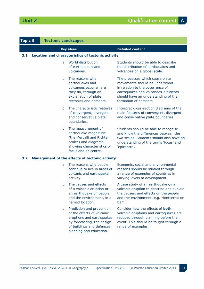
Topic 3 Tectonic Landscapes
Key ideas Detailed content
3.1 Location and characteristics of tectonic activity
a World distribution of earthquakes and volcanoes.
Students should be able to describe the distribution of earthquakes and volcanoes on a global scale.
b The reasons why earthquakes and volcanoes occur where they do, through an explanation of plate tectonics and hotspots.
The processes which cause plate movements should be understood in relation to the occurrence of earthquakes and volcanoes. Students should have an understanding of the formation of hotspots.
c The characteristic features of convergent, divergent and conservative plate boundaries.
Interpret cross-section diagrams of the main features of convergent, divergent and conservative plate boundaries.
d The measurement of earthquake magnitude (the Mercalli and Richter scales) and diagrams, showing characteristics of focus and epicentre.
Students should be able to recognise and know the differences between the two scales. Students should also have an understanding of the terms ‘focus’ and ‘epicentre’.
3.2 Management of the effects of tectonic activity
a The reasons why people continue to live in areas of volcanic and earthquake activity.
Economic, social and environmental reasons should be studied through a range of examples of countries in varying levels of development.
b The causes and effects of a volcanic eruption or an earthquake on people and the environment, in a named location.
A case study of an earthquake or a volcanic eruption to describe and explain the causes, and effects on the people and the environment, e.g. Montserrat or Bam.
c Prediction and prevention of the effects of volcanic eruptions and earthquakes by forecasting, the design of buildings and defences, planning and education.
Consider how the effects of both volcanic eruptions and earthquakes are reduced through planning before the event. This should be taught through a range of examples.
24
Unit 2
Pearson Edexcel Level 1/Level 2 GCSE in Geography A Specification – Issue 5 © Pearson Education Limited 2014
A Qualification content
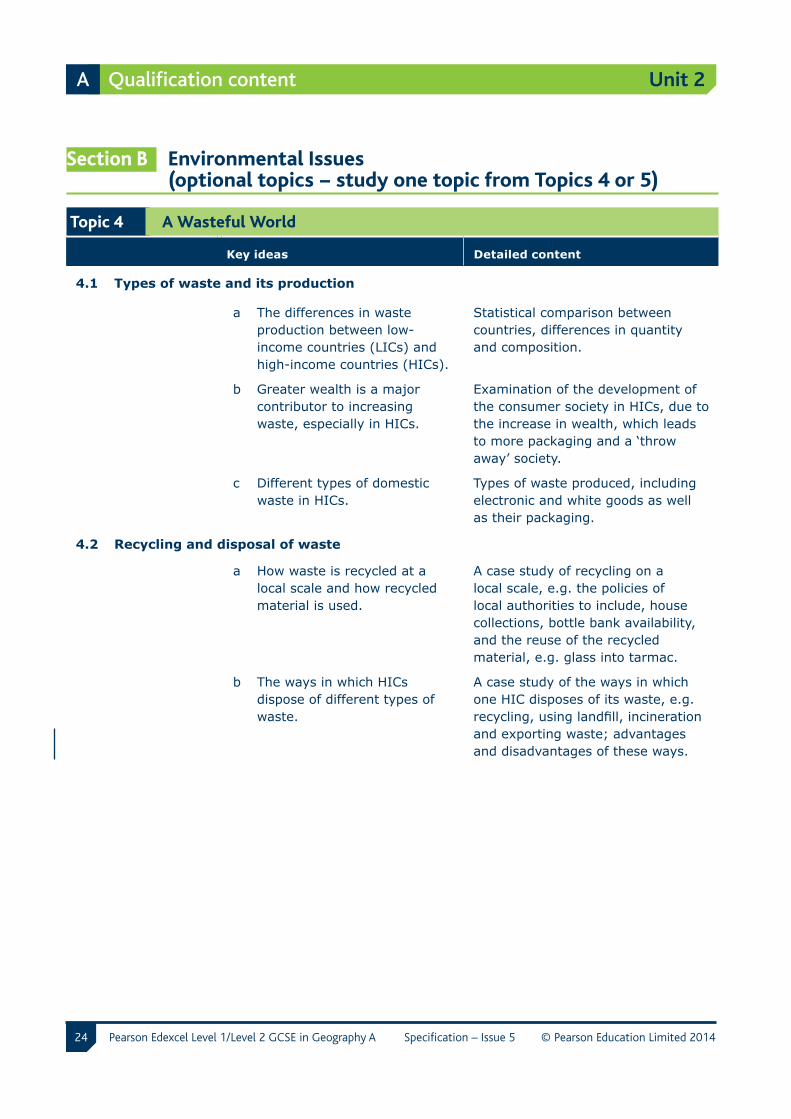
Section B Environmental Issues (optional topics − study one topic from Topics 4 or 5)
Topic 4 A Wasteful World
Key ideas Detailed content
4.1 Types of waste and its production
a The differences in waste production between low-income countries (LICs) and high-income countries (HICs).
Statistical comparison between countries, differences in quantity and composition.
b Greater wealth is a major contributor to increasing waste, especially in HICs.
Examination of the development of the consumer society in HICs, due to the increase in wealth, which leads to more packaging and a ‘throw away’ society.
c Different types of domestic waste in HICs.
Types of waste produced, including electronic and white goods as well as their packaging.
4.2 Recycling and disposal of waste
a How waste is recycled at a local scale and how recycled material is used.
A case study of recycling on a local scale, e.g. the policies of local authorities to include, house collections, bottle bank availability, and the reuse of the recycled material, e.g. glass into tarmac.
b The ways in which HICs dispose of different types of waste.
A case study of the ways in which one HIC disposes of its waste, e.g. recycling, using landfill, incineration and exporting waste; advantages and disadvantages of these ways.
25
Unit 2
Pearson Edexcel Level 1/Level 2 GCSE in Geography A Specification – Issue 5 © Pearson Education Limited 2014
Qualification content A
Key ideas Detailed content
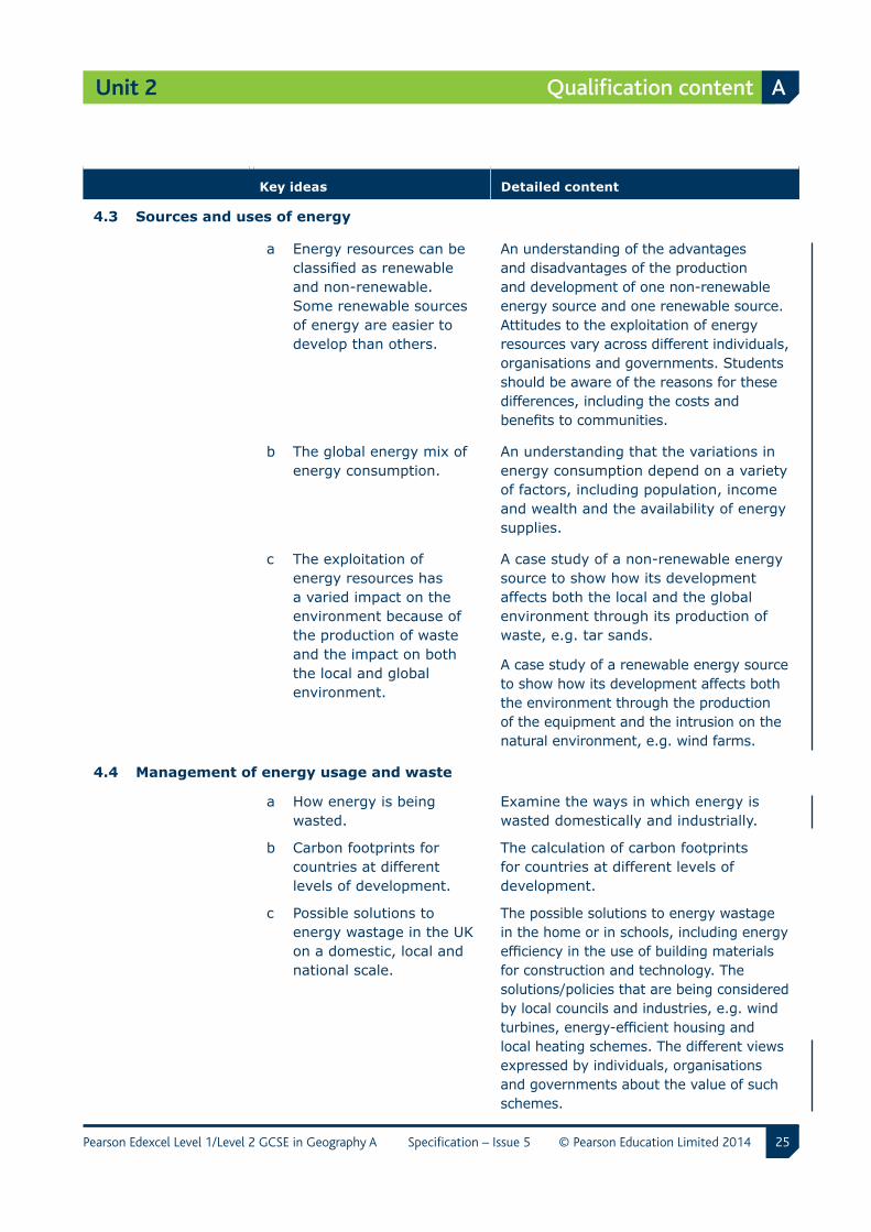
4.3 Sources and uses of energy
a Energy resources can be classified as renewable and non-renewable. Some renewable sources of energy are easier to develop than others.
An understanding of the advantages and disadvantages of the production and development of one non-renewable energy source and one renewable source. Attitudes to the exploitation of energy resources vary across different individuals, organisations and governments. Students should be aware of the reasons for these differences, including the costs and benefits to communities.
b The global energy mix of energy consumption.
An understanding that the variations in energy consumption depend on a variety of factors, including population, income and wealth and the availability of energy supplies.
c The exploitation of energy resources has a varied impact on the environment because of the production of waste and the impact on both the local and global environment.
A case study of a non-renewable energy source to show how its development affects both the local and the global environment through its production of waste, e.g. tar sands.
A case study of a renewable energy source to show how its development affects both the environment through the production of the equipment and the intrusion on the natural environment, e.g. wind farms.
4.4 Management of energy usage and waste
a How energy is being wasted.
Examine the ways in which energy is wasted domestically and industrially.
b Carbon footprints for countries at different levels of development.
The calculation of carbon footprints for countries at different levels of development.
c Possible solutions to energy wastage in the UK on a domestic, local and national scale.
The possible solutions to energy wastage in the home or in schools, including energy efficiency in the use of building materials for construction and technology. The solutions/policies that are being considered by local councils and industries, e.g. wind turbines, energy-efficient housing and local heating schemes. The different views expressed by individuals, organisations and governments about the value of such schemes.
26
Unit 2
Pearson Edexcel Level 1/Level 2 GCSE in Geography A Specification – Issue 5 © Pearson Education Limited 2014
A Qualification content
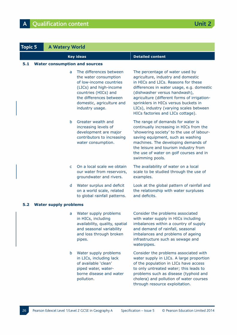
Topic 5 A Watery World
Key ideas Detailed content
5.1 Water consumption and sources
a The differences between the water consumption of low-income countries (LICs) and high-income countries (HICs) and the differences between domestic, agriculture and industry usage.
The percentage of water used by agriculture, industry and domestic in HICs and LICs. Reasons for these differences in water usage, e.g. domestic (dishwasher versus handwash), agriculture (different forms of irrigation-sprinklers in HICs versus buckets in LICs), industry (varying scales between HICs factories and LICs cottage).
b Greater wealth and increasing levels of development are major contributors to increasing water consumption.
The range of demands for water is continually increasing in HICs from the ‘showering society’ to the use of labour-saving equipment, such as washing machines. The developing demands of the leisure and tourism industry from the use of water on golf courses and in swimming pools.
c On a local scale we obtain our water from reservoirs, groundwater and rivers.
The availability of water on a local scale to be studied through the use of examples.
d Water surplus and deficit on a world scale, related to global rainfall patterns.
Look at the global pattern of rainfall and the relationship with water surpluses and deficits.
5.2 Water supply problems
a Water supply problems in HICs, including availability, quality, spatial and seasonal variability and loss through broken pipes.
Consider the problems associated with water supply in HICs including imbalances within a country of supply and demand of rainfall, seasonal imbalances and problems of ageing infrastructure such as sewage and waterpipes.
b Water supply problems in LICs, including lack of available ‘clean’ piped water, water-borne disease and water pollution.
Consider the problems associated with water supply in LICs. A large proportion of the population in LICs have access to only untreated water; this leads to problems such as disease (typhoid and cholera) and pollution of water courses through resource exploitation.
27
Unit 2
Pearson Edexcel Level 1/Level 2 GCSE in Geography A Specification – Issue 5 © Pearson Education Limited 2014
Qualification content A
Key ideas Detailed content
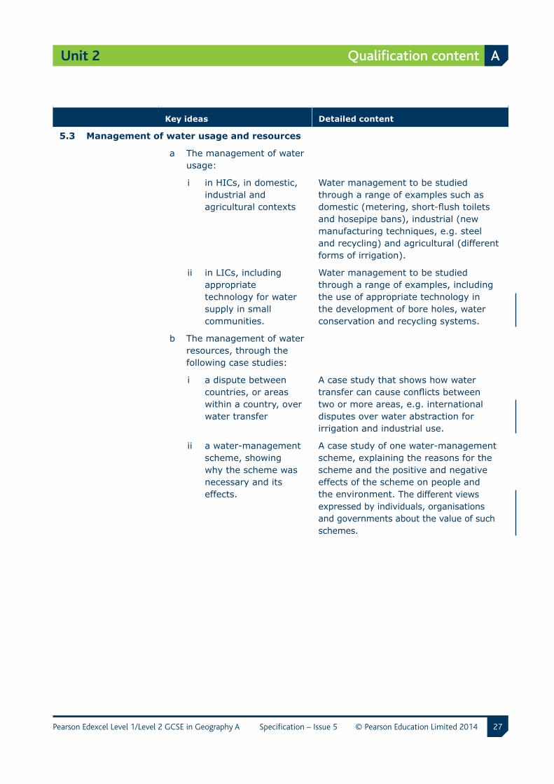
5.3 Management of water usage and resources
a The management of water usage:
i in HICs, in domestic, industrial and agricultural contexts
Water management to be studied through a range of examples such as domestic (metering, short-flush toilets and hosepipe bans), industrial (new manufacturing techniques, e.g. steel and recycling) and agricultural (different forms of irrigation).
ii in LICs, including appropriate technology for water supply in small communities.
Water management to be studied through a range of examples, including the use of appropriate technology in the development of bore holes, water conservation and recycling systems.
b The management of water resources, through the following case studies:
i a dispute between countries, or areas within a country, over water transfer
A case study that shows how water transfer can cause conflicts between two or more areas, e.g. international disputes over water abstraction for irrigation and industrial use.
ii a water-management scheme, showing why the scheme was necessary and its effects.
A case study of one water-management scheme, explaining the reasons for the scheme and the positive and negative effects of the scheme on people and the environment. The different views expressed by individuals, organisations and governments about the value of such schemes.
28
Unit 3
Pearson Edexcel Level 1/Level 2 GCSE in Geography A Specification – Issue 5 © Pearson Education Limited 2014
A Qualification content
Unit 3 The Human Environment
Overview
Content overview
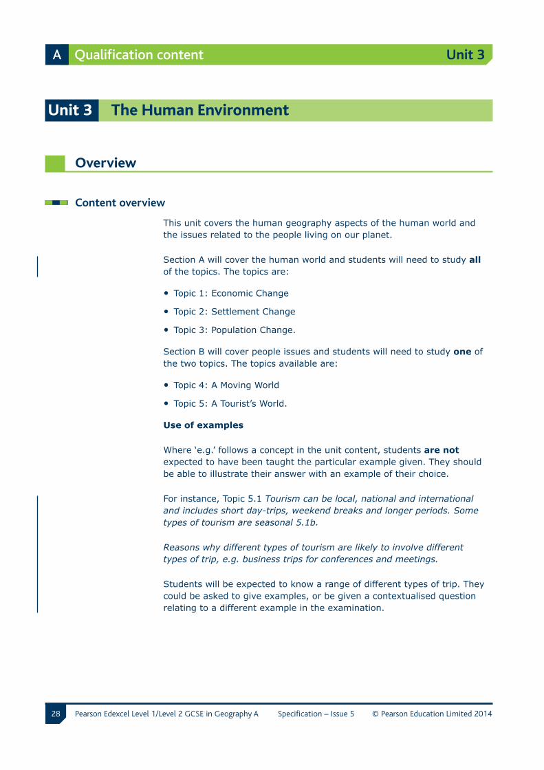
This unit covers the human geography aspects of the human world and the issues related to the people living on our planet.
Section A will cover the human world and students will need to study all of the topics. The topics are:
• Topic 1: Economic Change
• Topic 2: Settlement Change
• Topic 3: Population Change.
Section B will cover people issues and students will need to study one of the two topics. The topics available are:
• Topic 4: A Moving World
• Topic 5: A Tourist’s World.
Use of examples
Where ‘e.g.’ follows a concept in the unit content, students are not expected to have been taught the particular example given. They should be able to illustrate their answer with an example of their choice.
For instance, Topic 5.1 Tourism can be local, national and international and includes short day-trips, weekend breaks and longer periods. Some types of tourism are seasonal 5.1b.
Reasons why different types of tourism are likely to involve different types of trip, e.g. business trips for conferences and meetings.
Students will be expected to know a range of different types of trip. They could be asked to give examples, or be given a contextualised question relating to a different example in the examination.
29
Unit 3
Pearson Edexcel Level 1/Level 2 GCSE in Geography A Specification – Issue 5 © Pearson Education Limited 2014
Qualification content A
Use of ‘including’
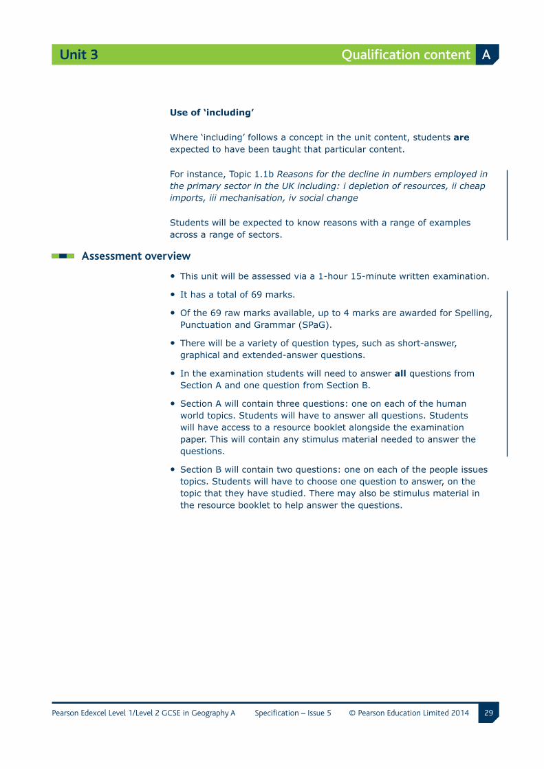
Where ‘including’ follows a concept in the unit content, students are expected to have been taught that particular content.
For instance, Topic 1.1b Reasons for the decline in numbers employed in the primary sector in the UK including: i depletion of resources, ii cheap imports, iii mechanisation, iv social change
Students will be expected to know reasons with a range of examples across a range of sectors.
Assessment overview
• This unit will be assessed via a 1-hour 15-minute written examination.
• It has a total of 69 marks.
• Of the 69 raw marks available, up to 4 marks are awarded for Spelling, Punctuation and Grammar (SPaG).
• There will be a variety of question types, such as short-answer, graphical and extended-answer questions.
• In the examination students will need to answer all questions from Section A and one question from Section B.
• Section A will contain three questions: one on each of the human world topics. Students will have to answer all questions. Students will have access to a resource booklet alongside the examination paper. This will contain any stimulus material needed to answer the questions.
• Section B will contain two questions: one on each of the people issues topics. Students will have to choose one question to answer, on the topic that they have studied. There may also be stimulus material in the resource booklet to help answer the questions.
30
Unit 3
Pearson Edexcel Level 1/Level 2 GCSE in Geography A Specification – Issue 5 © Pearson Education Limited 2014
A Qualification content
Detailed unit content
Section A The Human World
Topic 1 Economic Change
Key ideas Detailed content
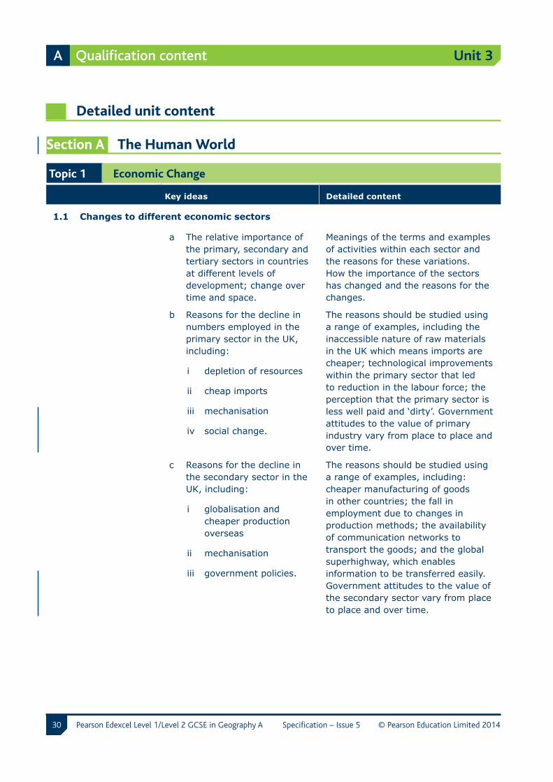
1.1 Changes to different economic sectors
a The relative importance of the primary, secondary and tertiary sectors in countries at different levels of development; change over time and space.
Meanings of the terms and examples of activities within each sector and the reasons for these variations. How the importance of the sectors has changed and the reasons for the changes.
b Reasons for the decline in numbers employed in the primary sector in the UK, including:
i depletion of resources
ii cheap imports
iii mechanisation
iv social change.
The reasons should be studied using a range of examples, including the inaccessible nature of raw materials in the UK which means imports are cheaper; technological improvements within the primary sector that led to reduction in the labour force; the perception that the primary sector is less well paid and ‘dirty’. Government attitudes to the value of primary industry vary from place to place and over time.
c Reasons for the decline in the secondary sector in the UK, including:
i globalisation and cheaper production overseas
ii mechanisation
iii government policies.
The reasons should be studied using a range of examples, including: cheaper manufacturing of goods in other countries; the fall in employment due to changes in production methods; the availability of communication networks to transport the goods; and the global superhighway, which enables information to be transferred easily. Government attitudes to the value of the secondary sector vary from place to place and over time.
31
Unit 3
Pearson Edexcel Level 1/Level 2 GCSE in Geography A Specification – Issue 5 © Pearson Education Limited 2014
Qualification content A
Key ideas Detailed content
1.1 Changes to different economic sectors (continued)
d A study of the growth of the secondary sector in one low-income country (LIC) or middle-income country (MIC).
A case study to show the reasons for the growth and the effects of the growth of the secondary sector on the country, e.g. China. The study can be of one sector, e.g. clothing, but should involve more than one company.
e Reasons for the dramatic growth of the tertiary sector since 1970, including:
i a rise in the demand for services linked to disposable incomes
ii the development of new technologies and services
iii decrease in employment in the primary and secondary sectors
iv demographic changes, e.g. the ageing population.
The reasons should be studied using a range of examples, including: the increased provision of luxury services, such as beautician services and health clubs; the increase in technology, which has led to an increase in employment in services such as telecommunication and sales and the ageing population, which has led to an increasing number of wealthy, retired people who have the time to spend the ‘grey pound’.
1.2 Economic locations
a Factors affecting the location of primary, secondary and tertiary activity illustrate these factors by reference to an activity in each sector.
Understand that location factors vary between sectors. The factors for the location of a sector can also change over time.
b The costs and benefits of de-industrialisation in rural areas.
Costs include loss of employment, decline in other economic activities and a declining income for local government. Benefits may include a cleaner environment, new opportunities for development, including an increase in tourism and the tertiary sector. This should be taught through the use of examples.
32
Unit 3
Pearson Edexcel Level 1/Level 2 GCSE in Geography A Specification – Issue 5 © Pearson Education Limited 2014
A Qualification content
Topic 2 Settlement Change
Key ideas Detailed content
2.1 Factors affecting settlements
a Settlements have developed in order to carry out different functions in society. These functions vary both from place to place and over time as societies change and develop.
Define different functions, including residential, market centres, administrative, strategic, industrial and tourist resorts. The variation in importance of these functions from place to place should be studied through examples. All settlements experience change over time; this should be explored using at least one example of such change for a UK settlement.
b Changes to rural communities caused by:
i counter-urbanisation
ii the depopulation of remote rural areas.
The demographic, social, economic and environmental changes to rural communities caused by counter-urbanisation and the depopulation of remote rural areas should be studied through examples.
33
Unit 3
Pearson Edexcel Level 1/Level 2 GCSE in Geography A Specification – Issue 5 © Pearson Education Limited 2014
Qualification content A
Key ideas Detailed content
2.2 Changing land use in urban areas
a Land use in urban areas in the UK is changing, largely in response to the need for more housing and deindustrialisation.
This section should be studied through either local or national examples.
b The reasons for (social, economic and political) and consequences of the need for more housing, including the use of brownfield and greenfield sites, and urban sprawl.
Reasons for these changes, including:
i social and political factors (later marriages, divorce and age structure)
ii economic factors such as increased wealth leading to growth of owner-occupiers
iii the attitudes of both central and local government to development.
Consequence of the need for more housing, including:
i the movement of secondary industry to newly industrialised countries, which has meant that there are premises available for conversion into housing
ii urban sprawl and the development of greenfield sites
iii the development of ‘gated suburbs’.
c The consequences of deindustrialisation, including the redevelopment and renewal of derelict and brownfield sites.
Redevelopment and renewal of old industrial sites, e.g. along rivers and canals in urban areas.
d The advantages and disadvantages of brownfield and greenfield sites.
Explain the advantages and disadvantages of brownfield and greenfield sites. Attitudes to development will vary among individuals and organisations.
34
Unit 3
Pearson Edexcel Level 1/Level 2 GCSE in Geography A Specification – Issue 5 © Pearson Education Limited 2014
A Qualification content
Key ideas Detailed content
2.3 Rapid growth in LICs
a Reasons for the rapid growth of urban areas in LICs.
Reasons for growth, including high rates of natural increase and rural to urban migration, which should be studied through examples of different urban areas.
b A study of an LIC urban area to assess the effects of this rapid growth.
A case study of the effects of rapid growth in a LIC. Only the effects require case-study detail. The effects can be both positive and negative, and include the development of squatter settlements, pollution and congestion.

35
Unit 3
Pearson Edexcel Level 1/Level 2 GCSE in Geography A Specification – Issue 5 © Pearson Education Limited 2014
Qualification content A
Topic 3 Population Change
Key ideas Detailed content
3.1 Population growth and distribution
a The growth and distribution of global population.
Change in global population numbers over the past 2000 years and the distribution of sparsely populated and densely populated areas of the world. The reasons for these distributions include climate, soils and the history of settlement.
b Reasons for changes to birth and death rates, including study of the demographic transition model.
Reasons to include medical, economic, social and political influences. The characteristics of the stages and reasons why societies might move from one stage to another. Students must have an awareness that the model is not universally applicable and is dynamic. Government attitudes to population change vary from place to place and over time.
c The physical and human factors affecting the distribution and density of population in China and the UK.
The physical factors, such as relief climate and soils, as well as human factors, such as employment, trade and transport networks.
d How two countries cope with contrasting population problems, one trying to increase and the other trying to decrease the birth rate.
Two different countries should be studied. The focus should be on the incentives and disincentives used for each country and why these policies have been adopted.
36
Unit 3
Pearson Edexcel Level 1/Level 2 GCSE in Geography A Specification – Issue 5 © Pearson Education Limited 2014
A Qualification content
Key ideas Detailed content
3.2 Characteristics of population
a The characteristics of population on a local scale including age, gender, ethnic, religious and occupational structure.
Students will need to know how to describe, understand and interpret census data.
b Comparison of population pyramids for three countries at different levels of development.
Population pyramids as a way of representing age and gender. Comparison of an HIC, MIC and LIC.
c The consequences of youthful and ageing populations.
Understand that consequences can be both positive and negative. These should be looked at for the provision of services (health, education, housing, pensions) and employment.
d A study of the advantages and disadvantages of an ageing population within a country.
Examine a case study of one country. Links should be made to 3.2c.
37
Unit 3
Pearson Edexcel Level 1/Level 2 GCSE in Geography A Specification – Issue 5 © Pearson Education Limited 2014
Qualification content A
Section B People Issues (optional topics − study one topic from Topics 4 or 5)
Topic 4 A Moving World
Key ideas Detailed content
4.1 Population movement
a There are different types of population movement: long-term and short-term migration and short-term population movements.
Define population movement, and include the distinctions between migration (immigration and emigration) and other short-term population movements (holidays, commuters and university students).
b Migration can be classified as national and international, long-term and short-term, voluntary and forced.
National migration, e.g. north to the south-east of England, and international migration, e.g. UK to Australia, and long-term, short-term, voluntary (retirement) and forced (refugees) migration. The issue of legal and illegal migration should be discussed. Students should understand that migrations often involve a combination of these classifications, for example refugees can be international and forced. These movements can be shown on flow maps.
4.2 Flows of population
a International flows into and within Europe since 1945.
The main flows into and within Europe should be studied.
b The social and economic impact of these flows on the host and the country of origin.
Understand that these flows can have both positive and negative impacts on the host country and country of origin, and the values and attitudes of different stakeholders (from individuals to governments) vary. Social impacts include ethnicity. The impacts of these flows should be studied through examples.
38
Unit 3
Pearson Edexcel Level 1/Level 2 GCSE in Geography A Specification – Issue 5 © Pearson Education Limited 2014
A Qualification content
Key ideas Detailed content
4.3 Factorsinfluencingratesofpopulationmovement
a The factors that affect rates of movement:
i awareness of opportunities through technology (satellites, media, internet) and personal communication
The development of new and improved technology for both transport and communication networks.
ii transport developments (cheaper and faster modes of travel and improved infrastructure)
Development and growth of budget airlines serving areas throughout the world, e.g. easyJet. Improved infrastructure for transport, e.g. the Channel Tunnel and connecting railway systems.
iii Government policies vary from time to time and from place to place.
Understand that government policies vary and include quotas, skills testing and open-door policies. These policies attempt to satisfy economic, as well as political, pressures.
4.4 Reasonsforshort-termpopulationflow
a There is a variety of reasons for short-term population flow: medical, sport, tourism and economic.
Examples must be of short-term population flows. Students must learn the reasons for each short-term population flow, which need to be learnt in a general way. Examples of these are:
i movements within Europe for medical and dental treatment
ii economic migration in Europe for jobs
iii flows of tourists within Europe, often from North to South.
39
Unit 3
Pearson Edexcel Level 1/Level 2 GCSE in Geography A Specification – Issue 5 © Pearson Education Limited 2014
Qualification content A
Key ideas Detailed content
4.5 Retirement migration
a A study of the reasons for, and the consequences of, retirement migration within a country or overseas.
The chosen case study should be long term and involve consideration of push and pull factors and the consequences on the destination, e.g. overseas movement.
40
Unit 3
Pearson Edexcel Level 1/Level 2 GCSE in Geography A Specification – Issue 5 © Pearson Education Limited 2014
A Qualification content
Topic 5 A Tourist’s World
Key ideas Detailed content
5.1 Growth of the tourist industry
a There are many different types of tourism from leisure to business travel.
Define tourism to include travel for leisure, business and visiting friends and relatives. Assess the importance of these and how they are measured. Students should be aware of the reasons for these differences.
b Tourism can be local, national and international and includes short day-trips, weekend breaks and longer periods. Some types of tourism are seasonal.
Reasons why different types of tourism are likely to involve different types of trip, e.g. business trips for conferences and meetings. Leisure trips will include short breaks as well as longer breaks. Leisure tourism tends to be highly seasonal. Types of leisure tourism include beach holidays, short city breaks, activity holidays, health tourism, heritage and cultural tourism.
5.2 Resort development
a The social, economic and political causes of the growth in tourism.
Examine global factors causing tourist growth: social (greater leisure time), economic (greater disposable income) and political (relaxing of borders in EU), and government policies encouraged by global organisations, such as the IMF and World Bank.
b Tourist destinations offer a variety of physical and human attractions.
Consider areas with physical attractions, e.g. snow for skiing, sand and sun for beach holidays and human attractions, such as temples, museums, shops and restaurants. There is a range of destinations from independent hotels and guest houses to enclave resorts, conference centres and the cruise ship business, offering a range of attractions to suit different markets. Business destinations will offer modern infrastructure and conference facilities.
c Different types of leisure breaks.
Types of leisure tourism include beach holidays, short city breaks, activity holidays, health tourism, heritage and cultural tourism.
41
Unit 3
Pearson Edexcel Level 1/Level 2 GCSE in Geography A Specification – Issue 5 © Pearson Education Limited 2014
Qualification content A
Key ideas Detailed content
d The Butler model of resort development.
The development of an EU resort related to the Butler model such as a UK Victorian seaside resort or a more recent development in Spain. Consider the case study to show the development of a resort from its origin to present day.
5.3 Impacts of the tourist industry
a The positive and negative impacts of the tourist industry in countries at different stages of development:
i social impacts of different types of tourism from enclave resorts to business travel destinations
ii economic impacts in terms of job creation, income generated and the possibilities for economic development
iii environmental impacts from enclave resorts to business travel
Attitudes to tourism vary across individuals, organisations and governments. The costs and benefits fall unevenly and this, along with different values, influences opinions.
Social impacts include both direct and indirect impacts, from the cultural issues that might arise, the issues of seasonal employment, the impact of second homes on local services and communities, to the possible benefits to health and education services.
Assessment of the impacts of tourist development for the economy in terms of job creation and the contribution to national or local income, allowing for the effect of the multiplier but also the loss of income through leakage to foreign and non-local owners.
The positive impacts in terms of improving the environment using income generated from tourism but also the damage done by some forms of tourism.
5.4 Eco-tourism
a A study of an eco-tourist destination to show how tourism can protect the environment and benefit the local community.
This case study can be in a country at any level of development.
42
Unit 4
Pearson Edexcel Level 1/Level 2 GCSE in Geography A Specification – Issue 5 © Pearson Education Limited 2014
A Qualification content
Unit 4 Investigating Geography
Overview
Content overview
Throughout this GCSE course, students need to acquire a range of geographical skills. These skills should be developed through both fieldwork and linked practical exercises.
The Royal Geographical Society, Geographical Association, Field Studies Council and Ofsted (2011 subject report) all support the notion that good and regular fieldwork motivates students and enhances their learning in geography.
Fieldwork and enquiry skills linked to controlled assessment must include:
• Planning/Pre-fieldwork focusing a fieldwork investigation, contextualising and localising from one of the Edexcel tasks (see page 43). This stage will include secondary data research, which will contribute to the final report. Students will be marked on the focus, planning and organisation of their final report.
• Research and data collection (including primary fieldwork skills), undertaking fieldwork, including sampling, data collection and recording techniques which will result in data presentation and analysis in the final report.
• Analysis, conclusion, evaluation and final report production, including a range of data presentation techniques; analysis of data and drawing of conclusions; evaluation of the techniques used and the conclusions drawn, commenting on the reliability and accuracy of findings and linking back to the original task. Structuring and presentation of the final report.
The task structure is shown more fully on page 45: The Route of Enquiry
The controlled conditions are shown in full on pages 49-51.
43
Unit 4
Pearson Edexcel Level 1/Level 2 GCSE in Geography A Specification – Issue 5 © Pearson Education Limited 2014
Qualification content A
Each year, Edexcel will provide six task questions that students will use as the basis for their fieldwork. These will be linked to parts of the specification (see below). These themes and their main specification links will remain the same for the duration of this specification.
Theme Mainarea(s)ofspecificationlinkage Relevant pages in thespecification
Approaches to local sustainable development
Unit 1: Section B, Challenges for the Planet: Topic 7 Sustainable developments for the planet
16
Coastal processes, landforms and management
Unit 2: Section A, The Physical World: Topic 1 Coastal Landscapes
19–20
River processes, landforms and flooding
Unit 2: Section A, the Physical World: Topic 2 River Landscapes
21
Changes in the rural landscape
Unit 3: Section A, The Human World: Topic 2 Settlement Change (specifically 2.1 Factors affecting settlements)
32
Changing land use in urban areas
Unit 3: Section A, The Human World: Topic 2 Settlement Change (specifically 2.2 Changing land use in urban areas
33
The effects of tourism
Unit 3: Section B, People Issues: Topic 5 A Tourist’s World
40
The focus and/or context of the tasks will change on an annual basis, although centres are free to continue using the same or similar fieldwork sites and locations only if relevant and appropriate. New task questions will be released in secure form on the Edexcel website approximately two years before the final date of submission so that centres can plan their fieldwork appropriately.
Centres can find exemplar materials on the Edexcel website at www.edexcel.com/geography.
44
Unit 4
Pearson Edexcel Level 1/Level 2 GCSE in Geography A Specification – Issue 5 © Pearson Education Limited 2014
A Qualification content
Assessment overview
This unit is an internally assessed unit under controlled conditions (see pages 49 to 51). Students complete one of the fieldwork tasks from the list provided by Edexcel.
The controlled assessment is marked out of a total of 50 marks, based on the following sections:
a purpose of investigation (6 marks)
b methods of data collection (9 marks)
c methods of presenting data (11 marks)
d analysis and conclusions (9 marks)
e evaluation (9 marks)
f planning and organisation (6 marks).
The controlled assessment final report will be marked internally by teachers and a sample moderated by Edexcel.
45
Unit 4
Pearson Edexcel Level 1/Level 2 GCSE in Geography A Specification – Issue 5 © Pearson Education Limited 2014
Qualification content A
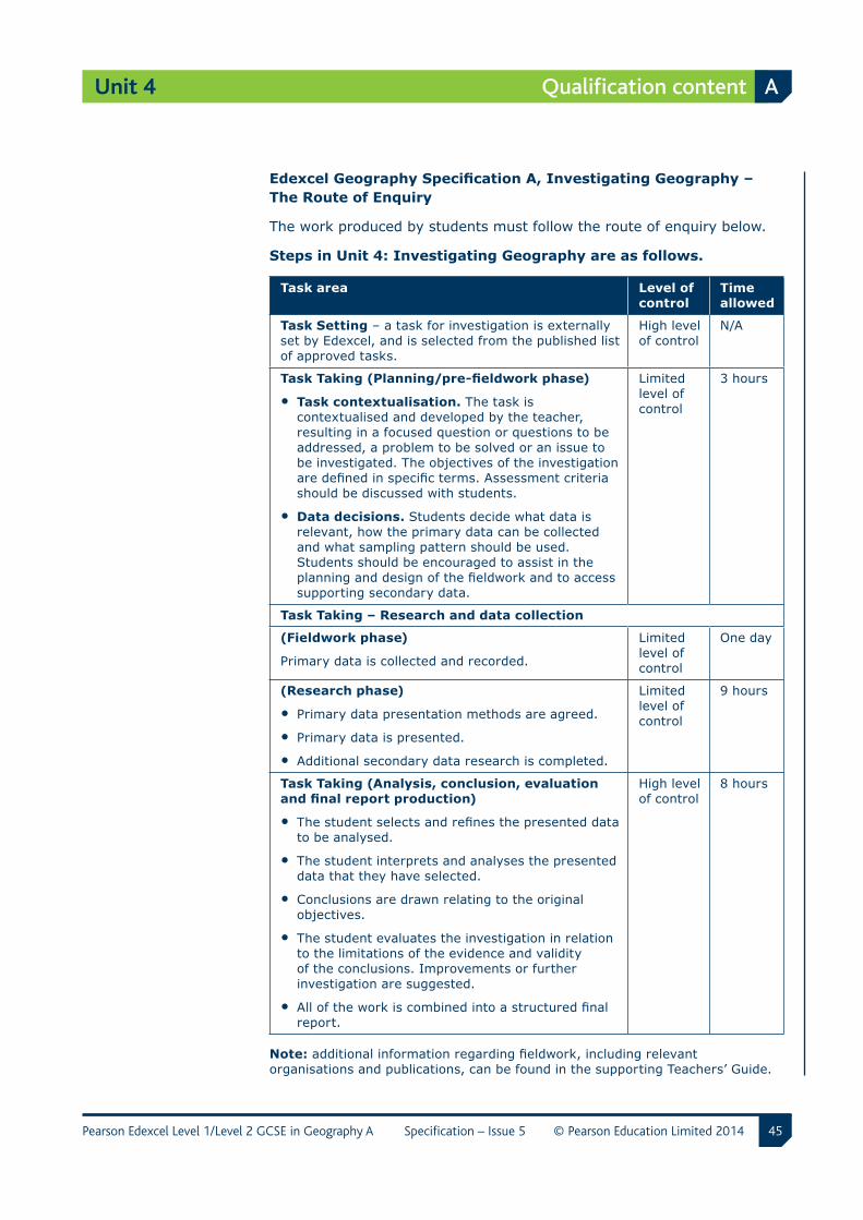
EdexcelGeographySpecificationA,InvestigatingGeography–The Route of Enquiry
The work produced by students must follow the route of enquiry below.
Steps in Unit 4: Investigating Geography are as follows.
Task area Level of control
Time allowed
Task Setting – a task for investigation is externally set by Edexcel, and is selected from the published list of approved tasks.
High level of control
N/A
TaskTaking(Planning/pre-fieldworkphase)
• Task contextualisation. The task is contextualised and developed by the teacher, resulting in a focused question or questions to be addressed, a problem to be solved or an issue to be investigated. The objectives of the investigation are defined in specific terms. Assessment criteria should be discussed with students.
• Data decisions. Students decide what data is relevant, how the primary data can be collected and what sampling pattern should be used. Students should be encouraged to assist in the planning and design of the fieldwork and to access supporting secondary data.
Limited level of control
3 hours
Task Taking – Research and data collection
(Fieldwork phase)
Primary data is collected and recorded.
Limited level of control
One day
(Research phase)
• Primary data presentation methods are agreed.
• Primary data is presented.
• Additional secondary data research is completed.
Limited level of control
9 hours
Task Taking (Analysis, conclusion, evaluation andfinalreportproduction)
• The student selects and refines the presented data to be analysed.
• The student interprets and analyses the presented data that they have selected.
• Conclusions are drawn relating to the original objectives.
• The student evaluates the investigation in relation to the limitations of the evidence and validity of the conclusions. Improvements or further investigation are suggested.
• All of the work is combined into a structured final report.
High level of control
8 hours
Note: additional information regarding fieldwork, including relevant organisations and publications, can be found in the supporting Teachers’ Guide.
46
Unit 4
Pearson Edexcel Level 1/Level 2 GCSE in Geography A Specification – Issue 5 © Pearson Education Limited 2014
A Qualification content
Detailed unit content
Delivery of the controlled assessment
Skills
Students must demonstrate the ability to carry out the following skills when completing their controlled assessment:
a identify, analyse and evaluate geographical questions and issues
b follow/establish appropriate sequences of investigation, incorporating geographical skills, both fieldwork and research
c extract and interpret information from a range of different primary and secondary data sources, such as Ordnance Survey maps, photographs, drawings, diagrams and tables, and using technology to support the enquiry process
d evaluate methods of collecting, presenting and analysing evidence, and the validity and limitations of their evidence and conclusions
e use Geographical Information Systems (GIS) and/or digital maps (visualisation) during their geographical investigation. See below.
Geographical Information Systems
The use of GIS and/or digital maps (visualisation) should be used during the student’s fieldwork investigations. Assessment criteria b and c will critically assess the student’s ability to use GIS in the fieldwork investigation.
Examples of visualisation are Google Earth and Google Maps, as well as dedicated mapping or GIS software, including Infomapper, Aegis and ArcMapper/ArcGIS. Additional support regarding GIS and visualisation can be found in the Teachers’ Guide.
47
Unit 4
Pearson Edexcel Level 1/Level 2 GCSE in Geography A Specification – Issue 5 © Pearson Education Limited 2014
Qualification content A
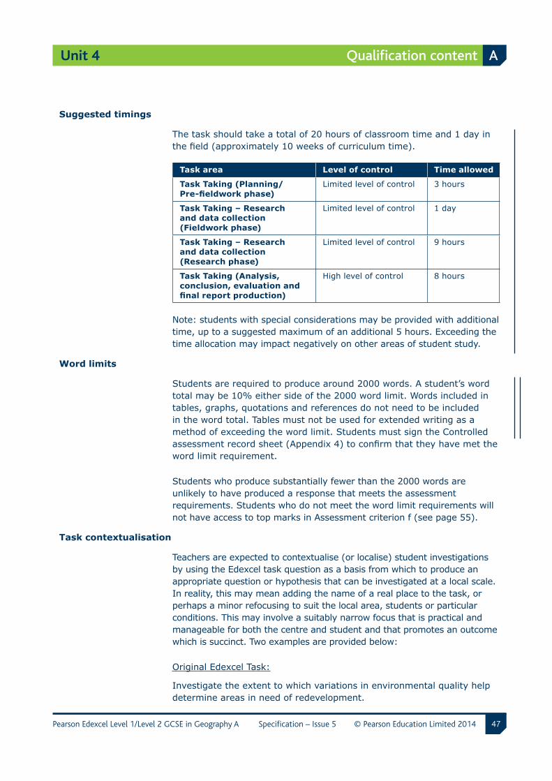
Suggested timings
The task should take a total of 20 hours of classroom time and 1 day in the field (approximately 10 weeks of curriculum time).
Task area Level of control Time allowed
Task Taking (Planning/ Pre-fieldworkphase)
Limited level of control 3 hours
Task Taking – Research and data collection (Fieldwork phase)
Limited level of control 1 day
Task Taking – Research and data collection (Research phase)
Limited level of control 9 hours
Task Taking (Analysis, conclusion, evaluation and finalreportproduction)
High level of control 8 hours
Note: students with special considerations may be provided with additional time, up to a suggested maximum of an additional 5 hours. Exceeding the time allocation may impact negatively on other areas of student study.
Word limits
Students are required to produce around 2000 words. A student’s word total may be 10% either side of the 2000 word limit. Words included in tables, graphs, quotations and references do not need to be included in the word total. Tables must not be used for extended writing as a method of exceeding the word limit. Students must sign the Controlled assessment record sheet (Appendix 4) to confirm that they have met the word limit requirement.
Students who produce substantially fewer than the 2000 words are unlikely to have produced a response that meets the assessment requirements. Students who do not meet the word limit requirements will not have access to top marks in Assessment criterion f (see page 55).
Task contextualisation
Teachers are expected to contextualise (or localise) student investigations by using the Edexcel task question as a basis from which to produce an appropriate question or hypothesis that can be investigated at a local scale. In reality, this may mean adding the name of a real place to the task, or perhaps a minor refocusing to suit the local area, students or particular conditions. This may involve a suitably narrow focus that is practical and manageable for both the centre and student and that promotes an outcome which is succinct. Two examples are provided below:
Original Edexcel Task:
Investigate the extent to which variations in environmental quality help determine areas in need of redevelopment.
48
Unit 4
Pearson Edexcel Level 1/Level 2 GCSE in Geography A Specification – Issue 5 © Pearson Education Limited 2014
A Qualification content
Contextualised Task Example 1:
(i) An assessment of environmental quality in two contrasting suburbs of Taunton.
(ii) Where should redevelopment efforts be targeted in areas of Taunton?
Contextualised Task Example 2:
To what extent are there variations in environmental quality (using primary and secondary data) in three census ‘output areas’ of Pembroke Dock? How and where should regeneration be managed in the three areas of Pembroke Dock?
Variety of report formats/possible outcomes
The final piece of work, which forms the assessed component (referred to as the ‘report’) could be produced using alternative formats. Students must ensure they meet the 2000 word limit requirement irrespective of the medium or format used. This is to ensure there is sufficient extended writing for a reliable assessment of QWC.
There may be several different ways in which a student may incorporate alternative formats into their final report. Students must always be encouraged to use geographical writing to support each of these formats – see below for examples.
Format Example of linked geographical writing
DVD Annotations/notes/transcripts of extended interviews, which formed part of the data collection.
PowerPoint presentations
Notes and descriptions to accompany graphs, analysis on slides, together with description of results etc.
Interactive (online/electronic) GIS maps
Summary writing in call-outs/placements to provide site descriptions of locations.
Website blog A personal diary/blog which holds details of images and information about sites, weather, etc. Smartphone uploads of images and text to specific website.
49
Unit 4
Pearson Edexcel Level 1/Level 2 GCSE in Geography A Specification – Issue 5 © Pearson Education Limited 2014
Qualification content A
Levels of control
Internal assessment under controlled conditions has levels of control for task setting, task taking and task marking. These must be adhered to when students are completing their investigation.
Task setting
High level of control
Tasks will be set by Edexcel and centres will be free to choose from a list of six tasks.
The task questions for this controlled assessment are confidential and must not be shown to students before they start the tasks. Teachers can view all the task options available before deciding which task the students will complete. It is acceptable for all the students in a class to complete the same task. However, the same task does not have to be chosen for all students and they can work on a mixture of different tasks.
The tasks will change every year, in accordance with the Ofqual regulations for GCSE Geography. Teachers must take care when using these tasks to ensure that students are completing the correct task for a particular year. The front sheet of each task will show the dates for which it is valid. Each task will be valid from June of one year to May of the next year, for example June 2012 to May 2013.
Task taking
a Planning/pre-fieldwork
Planning and pre-fieldwork preparation will be carried out under limited control.
Authenticity control
Students may carry out their planning and secondary data collection whilst not being directly supervised by the teacher, for example in a library or at home.
Collaboration control
Students may work together in planning their fieldwork and data collection.
Feedback control
Teachers may support students in their fieldwork preparation and in the choice of appropriate primary and secondary data to collect. Teachers may support students to ensure that plans and data collection methods are appropriate.
Resources control
The secondary data can include extracts from books and journals, and pages from websites. The secondary data cannot be directly incorporated into the final report. It may be included only as brief extracts and must be correctly referenced.
Time control
Three hours is permitted for this phase.
50
Unit 4
Pearson Edexcel Level 1/Level 2 GCSE in Geography A Specification – Issue 5 © Pearson Education Limited 2014
A Qualification content
b Research and data collection
Research and data collection, including fieldwork, will be carried out under limited control.
Authenticity control
Fieldwork phase – the collection of primary data must be supervised by the teacher. Guidance may be given regarding the appropriateness of different forms of data collection.
Research phase – students may be supported in their choice of forms of presentation of the primary data. Students may produce their data presentation prior to the final report write up phase. Students should produce a range of different forms of presentation, so that they can choose the most appropriate to use and adapt in the final report.
Collaboration control
Fieldwork phase – students may work collaboratively or independently when collecting primary data from fieldwork. All students must show evidence of their contribution to the collection of fieldwork primary data in the response to assessment criterion b – where they need to produce evidence of the data that they have collected and explain why the method was used. Students must collect their own primary data, but datasets may be collated and shared depending on the task focus.
Research phase – students should work individually on preparing the presentation of their data. Other additional research, and collection of all secondary data should also be completed individually.
Feedback control
Fieldwork phase – teachers can comment on the data collection being undertaken by students, e.g. on the nature and suitability of the methodology selected. Any support, both oral and written, given to students should be dated and logged. It should indicate clearly the exact nature of the advice. (Please see Appendix 4: Controlled assessment record sheet)
Research phase – the teacher may work with the student to suggest appropriate forms of data presentation. The teacher must not interpret the data or provide any assistance in terms of analysis and evaluation of the data. Students must individually produce their data presentations.
Resources control
Fieldwork phase – teachers should keep a record of any advice or additional primary data provided to students. This should be recorded in the Controlled assessment record sheet (Appendix 4)
Research phase – students should prepare a range of presentation methods for their data, which they can select from in the final report write-up.
Time control
Fieldwork phase – 1 day
Research phase – 9 hours
51
Unit 4
Pearson Edexcel Level 1/Level 2 GCSE in Geography A Specification – Issue 5 © Pearson Education Limited 2014
Qualification content A
c Analysis,conclusion,evaluationandfinalreportproduction– high level of control
Authenticity control
Students must complete all work under direct supervision. Work may be hand written or produced using ICT. All ICT equipment must be checked and monitored to ensure students do not access prepared drafts.
Collaboration control
Students must complete all work independently and must not communicate with each other.
Feedback control
Teachers may communicate with students to provide clarification of assessment terms and controlled conditions but must not provide suggestions or solutions to the controlled assessment task.
Resources control
Students should have access only to the primary data notes, secondary data notes and task focus notes, and their prepared forms of data presentation. ICT access, for example, to enable production of online personalised GIS maps, is permitted but must be monitored.
Time control
Eight hours is permitted for completion of the final report. This time may be split between a number of sessions. All student materials must be stored securely between sessions.
Task marking
Task marking – medium level of control
The marking of the tasks will be carried out by teachers and moderated by Edexcel. There is no requirement to annotate students’ work, although it is good practice to write full justification comments on the Controlled assessment record sheet (Appendix 4).
Quality of written communication
Opportunities for students to be assessed on the quality of their written communication (QWC) have been identified within assessment criterion c. This assesses the student’s ability to:
• present relevant information in a form that suits its purpose
• ensure that text is legible and that spelling, punctuation and grammar are accurate so that meaning is clear
• use a suitable structure and style of writing
• use specialist vocabulary when appropriate.
52
Unit 4
Pearson Edexcel Level 1/Level 2 GCSE in Geography A Specification – Issue 5 © Pearson Education Limited 2014
A Qualification content
Health and safety
All centres must comply with the new requirements (2011) of relevant legislation and codes of practice, including the Department for Education health and safety guidance for schools (www.education.gov.uk/schools/adminandandfinance/health and safety) and the Health and Safety executive – School trips and outdoor learning activities (http://www.hse.gov.uk/services/education/school-trips.pdf).
Centres should also develop their own mechanisms so that students know the importance of ensuring their own safety and that of others. This could include developing risk assessments as part of the preparation for fieldwork, for example by using Google Maps and Google StreetView to assess likely hazards and risk.
Hazard – danger that could reasonably be expected to cause harm, e.g. contact with slippery rocks next to a stream.
Impact/severity – how someone might be harmed.
Risk – the chance that someone will be harmed by a particular hazard, e.g. a fall/slip or trip.
A Risk Rating can be developed, based on likelihood and severity (or worst-case outcome). For example, whilst working in a river the likelihood of slipping on wet rocks may be described as ‘infrequent’ (a score of 3/5), whilst the severity could be ‘injury’ (a score of 3/5). These two together give a risk-rating score 9/25 (3 x 3), which would indicate that a control should be in place to minimise the chance of injury through slipping.
Additional support on this aspect of the specification is available in the Teachers’ Guide.
Marking procedure
Teachers should use the assessment criteria descriptors to assess which mark range the work best fits. When this has been determined, teachers must decide whether the work is placed at the ‘bottom’, ‘middle’ or ‘top’ of this mark range. A mark can then be confidently assigned to the work.
Note that not all descriptors have to be met for a mark to be given in a particular band. The descriptors should be used more as guidance as to the overall quality for the work, rather than explicit characteristics, i.e. a ‘must have list’.
Wherever possible, centres should always try to internally moderate and cross-standardise work to ensure fairness, accuracy and reliability.
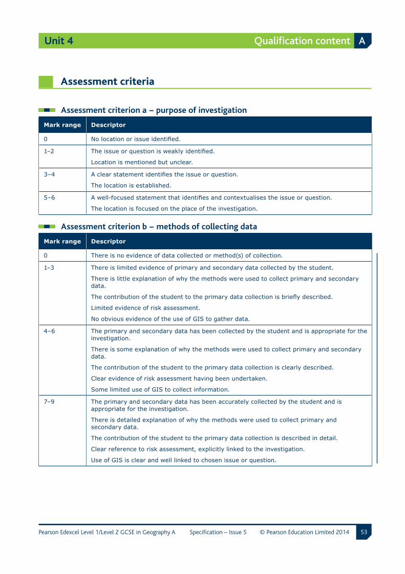
53
Unit 4
Pearson Edexcel Level 1/Level 2 GCSE in Geography A Specification – Issue 5 © Pearson Education Limited 2014
Qualification content A
Assessment criteria
Assessment criterion a − purpose of investigation
Mark range Descriptor
0 No location or issue identified.
1–2 The issue or question is weakly identified.
Location is mentioned but unclear.
3–4 A clear statement identifies the issue or question.
The location is established.
5–6 A well-focused statement that identifies and contextualises the issue or question.
The location is focused on the place of the investigation.
Assessment criterion b − methods of collecting data
Mark range Descriptor
0 There is no evidence of data collected or method(s) of collection.
1–3 There is limited evidence of primary and secondary data collected by the student.
There is little explanation of why the methods were used to collect primary and secondary data.
The contribution of the student to the primary data collection is briefly described.
Limited evidence of risk assessment.
No obvious evidence of the use of GIS to gather data.
4–6 The primary and secondary data has been collected by the student and is appropriate for the investigation.
There is some explanation of why the methods were used to collect primary and secondary data.
The contribution of the student to the primary data collection is clearly described.
Clear evidence of risk assessment having been undertaken.
Some limited use of GIS to collect information.
7–9 The primary and secondary data has been accurately collected by the student and is appropriate for the investigation.
There is detailed explanation of why the methods were used to collect primary and secondary data.
The contribution of the student to the primary data collection is described in detail.
Clear reference to risk assessment, explicitly linked to the investigation.
Use of GIS is clear and well linked to chosen issue or question.
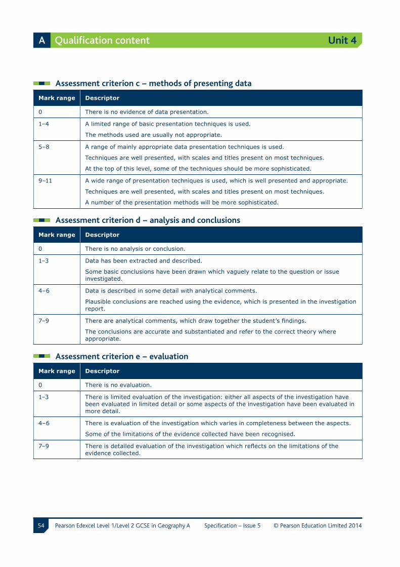
54
Unit 4
Pearson Edexcel Level 1/Level 2 GCSE in Geography A Specification – Issue 5 © Pearson Education Limited 2014
A Qualification content
Assessment criterion c − methods of presenting data
Mark range Descriptor
0 There is no evidence of data presentation.
1–4 A limited range of basic presentation techniques is used.
The methods used are usually not appropriate.
5–8 A range of mainly appropriate data presentation techniques is used.
Techniques are well presented, with scales and titles present on most techniques.
At the top of this level, some of the techniques should be more sophisticated.
9–11 A wide range of presentation techniques is used, which is well presented and appropriate.
Techniques are well presented, with scales and titles present on most techniques.
A number of the presentation methods will be more sophisticated.
Assessment criterion d − analysis and conclusions
Mark range Descriptor
0 There is no analysis or conclusion.
1–3 Data has been extracted and described.
Some basic conclusions have been drawn which vaguely relate to the question or issue investigated.
4–6 Data is described in some detail with analytical comments.
Plausible conclusions are reached using the evidence, which is presented in the investigation report.
7–9 There are analytical comments, which draw together the student’s findings.
The conclusions are accurate and substantiated and refer to the correct theory where appropriate.
Assessment criterion e − evaluation
Mark range Descriptor
0 There is no evaluation.
1–3 There is limited evaluation of the investigation: either all aspects of the investigation have been evaluated in limited detail or some aspects of the investigation have been evaluated in more detail.
4–6 There is evaluation of the investigation which varies in completeness between the aspects.
Some of the limitations of the evidence collected have been recognised.
7–9 There is detailed evaluation of the investigation which reflects on the limitations of the evidence collected.
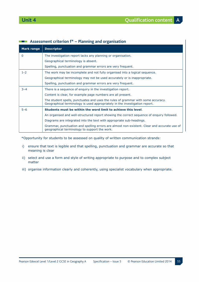
55
Unit 4
Pearson Edexcel Level 1/Level 2 GCSE in Geography A Specification – Issue 5 © Pearson Education Limited 2014
Qualification content A
Assessment criterion f* − Planning and organisation
Mark range Descriptor
0 The investigation report lacks any planning or organisation.
Geographical terminology is absent.
Spelling, punctuation and grammar errors are very frequent.
1–2 The work may be incomplete and not fully organised into a logical sequence.
Geographical terminology may not be used accurately or is inappropriate.
Spelling, punctuation and grammar errors are very frequent.
3–4 There is a sequence of enquiry in the investigation report.
Content is clear, for example page numbers are all present.
The student spells, punctuates and uses the rules of grammar with some accuracy. Geographical terminology is used appropriately in the investigation report.
5–6 Students must be within the word limit to achieve this level.
An organised and well-structured report showing the correct sequence of enquiry followed.
Diagrams are integrated into the text with appropriate sub-headings.
Grammar, punctuation and spelling errors are almost non-existent. Clear and accurate use of geographical terminology to support the work.
*Opportunity for students to be assessed on quality of written communication strands:
i) ensure that text is legible and that spelling, punctuation and grammar are accurate so that meaning is clear
ii) select and use a form and style of writing appropriate to purpose and to complex subject matter
iii) organise information clearly and coherently, using specialist vocabulary when appropriate.
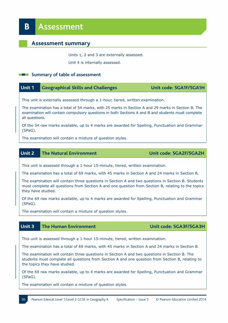
56 Pearson Edexcel Level 1/Level 2 GCSE in Geography A Specification – Issue 5 © Pearson Education Limited 2014
B Assessment
Assessment summary
Units 1, 2 and 3 are externally assessed.
Unit 4 is internally assessed.
Summary of table of assessment
Unit 1 Geographical Skills and Challenges Unit code: 5GA1F/5GA1H
This unit is externally assessed through a 1-hour, tiered, written examination.
The examination has a total of 54 marks, with 25 marks in Section A and 29 marks in Section B. The examination will contain compulsory questions in both Sections A and B and students must complete all questions.
Of the 54 raw marks available, up to 4 marks are awarded for Spelling, Punctuation and Grammar (SPaG).
The examination will contain a mixture of question styles.
Unit 2 The Natural Environment Unit code: 5GA2F/5GA2H
This unit is assessed through a 1-hour 15-minute, tiered, written examination.
The examination has a total of 69 marks, with 45 marks in Section A and 24 marks in Section B.
The examination will contain three questions in Section A and two questions in Section B. Students must complete all questions from Section A and one question from Section B, relating to the topics they have studied.
Of the 69 raw marks available, up to 4 marks are awarded for Spelling, Punctuation and Grammar (SPaG).
The examination will contain a mixture of question styles.
Unit 3 The Human Environment Unit code: 5GA3F/5GA3H
This unit is assessed through a 1-hour 15-minute, tiered, written examination.
The examination has a total of 69 marks, with 45 marks in Section A and 24 marks in Section B.
The examination will contain three questions in Section A and two questions in Section B. The students must complete all questions from Section A and one question from Section B, relating to the topics they have studied.
Of the 69 raw marks available, up to 4 marks are awarded for Spelling, Punctuation and Grammar (SPaG).
The examination will contain a mixture of question styles.
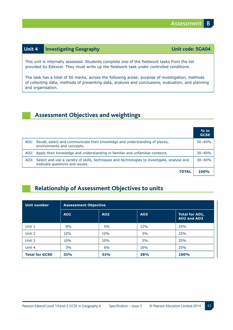
Assessment B
57Pearson Edexcel Level 1/Level 2 GCSE in Geography A Specification – Issue 5 © Pearson Education Limited 2014
Unit 4 Investigating Geography Unit code: 5GA04
This unit is internally assessed. Students complete one of the fieldwork tasks from the list provided by Edexcel. They must write up the fieldwork task under controlled conditions.
The task has a total of 50 marks, across the following areas: purpose of investigation, methods of collecting data, methods of presenting data, analysis and conclusions, evaluation, and planning and organisation.
Assessment Objectives and weightings
% in GCSE
AO1: Recall, select and communicate their knowledge and understanding of places, environments and concepts.
30–40%
AO2: Apply their knowledge and understanding in familiar and unfamiliar contexts. 30–40%
AO3: Select and use a variety of skills, techniques and technologies to investigate, analyse and evaluate questions and issues.
30–40%
TOTAL 100%
Relationship of Assessment Objectives to units
Unit number Assessment Objective
AO1 AO2 AO3 Total for AO1, AO2 and AO3
Unit 1 8% 5% 12% 25%
Unit 2 10% 10% 5% 25%
Unit 3 10% 10% 5% 25%
Unit 4 3% 6% 16% 25%
Total for GCSE 31% 31% 38% 100%
B Assessment
58 Pearson Edexcel Level 1/Level 2 GCSE in Geography A Specification – Issue 5 © Pearson Education Limited 2014
Entering your students for assessment
Student entry
From the June 2014 examination series onwards, students will be required to sit all of their examinations at the end of the course. Students may complete the controlled assessment task(s) at any appropriate point during the course and controlled assessment work must be submitted for moderation at the end of the course. Centres must ensure that controlled assessment tasks submitted are valid for the series in which they are submitted.
Details of how to enter students for this qualification can be found in Edexcel’s UK Information Manual, a copy of which is sent to all examinations officers. The information can also be found on Edexcel’s website: www.edexcel.com.
Forbidden combinations and classification code
Centres should be aware that students who enter for more than one GCSE qualification with the same classification code will have only one grade (the highest) counted for the purpose of the school and college performance tables.
Students should be advised that if they take two specifications with the same classification code, schools and colleges are very likely to take the view that they have achieved only one of the two GCSEs. The same view might be taken if students take two GCSE qualifications that have different classification codes but have significant overlap of content. Students who have any doubts about their subject combinations should check with the institution to which they wish to progress before embarking on their programmes.
Assessment B
59Pearson Edexcel Level 1/Level 2 GCSE in Geography A Specification – Issue 5 © Pearson Education Limited 2014
Access arrangements and special requirements
Edexcel’s policy on access arrangements and special considerations for GCE, GCSE, and Entry Level is designed to ensure equal access to qualifications for all students (in compliance with the Equality Act 2010) without compromising the assessment of skills, knowledge, understanding or competence.
Please see the Edexcel website (www.edexcel.com) for:
• the Joint Council for Qualifications (JCQ) policy Access Arrangements, Reasonable Adjustments and Special Considerations
• the forms to submit for requests for access arrangements and special considerations
• dates for submission of the forms.
Requests for access arrangements and special considerations must be addressed to:
Special Requirements Edexcel One90 High Holborn London WC1V 7BH
Equality Act 2010
Please see the Edexcel website (www.edexcel.com) for information on the Equality Act 2010.
B Assessment
60 Pearson Edexcel Level 1/Level 2 GCSE in Geography A Specification – Issue 5 © Pearson Education Limited 2014
Controlled assessment
In controlled assessments, control levels are set for three linked processes: task setting, task taking and task marking. The control levels (high, medium or limited, depending on the subject) are set for each process so that the overall level of control secures validity and reliability, provides good manageability for all involved and allows teachers to authenticate the student work confidently.
The summary of the controlled conditions for this specification are shown below.
Summary of conditions for controlled assessment
Internal assessment under controlled conditions has levels of control for task setting, task taking and task marking. These must be adhered to when students are completing their investigation.
Task setting
High level of control
Tasks will be set by Edexcel and centres will choose from a list of tasks.
The task sheets for this controlled assessment are confidential and must not be shown to students before they start the investigation. They will be available on the Edexcel website for teachers to download. Teachers can view all the task sheets available before deciding which task students will complete. It is acceptable for all students in a class to complete the same task. However, the same task does not have to be chosen for all students and they can work on a mixture of different tasks.
The tasks will change every year, in accordance with the Ofqual regulations for GCSE Geography. Teachers must take care when using these tasks to ensure that students are completing the correct task for a particular year. The front sheet of each task will show the dates for which it is valid. Each task will be valid from June of one year to May of the next year, for example June 2012 to May 2013.
Assessment B
61Pearson Edexcel Level 1/Level 2 GCSE in Geography A Specification – Issue 5 © Pearson Education Limited 2014
Task taking
a Planning/Pre-fieldwork
Planning and pre-fieldwork preparation will be carried out under limited control.
Authenticity control
Students may carry out their planning and secondary data collection whilst not being directly supervised by the teacher, for example in a library or at home.
Collaboration control
Students may work together in planning their fieldwork and data collection.
Feedback control
Teachers may support students in their fieldwork preparation and in the choice of appropriate primary and secondary data to collect. Teachers may support students to ensure that plans and data collection methods are appropriate.
Resources control
The secondary data can include extracts from books and journals, and pages from websites. The secondary data cannot be directly incorporated into the final report. It may be included only as brief extracts and must be correctly referenced.
Time control
Three hours is permitted for this phase.
b Research and data collection
Research and data collection, including fieldwork, will be carried out under limited control.
Authenticity control
Fieldwork phase – the collection of primary data must be supervised by the teacher. Guidance may be given regarding the appropriateness of different forms of data collection.
Research phase – students may be supported in their choice of forms of presentation of the primary data. Students may produce their data presentation prior to the final report write-up phase. Students should produce a range of different forms of presentation, so that they can choose the most appropriate to use and adapt in the final report.
Collaboration control
Fieldwork phase – students may work collaboratively or independently when collecting primary data from fieldwork. All students must show evidence of their contribution to the collection of fieldwork primary data in the response to assessment criterion b – where they need to produce evidence of the data that they have collected and explain why the method was used. Students must collect their own primary data but datasets may be collated and shared depending on the task focus.
B Assessment
62 Pearson Edexcel Level 1/Level 2 GCSE in Geography A Specification – Issue 5 © Pearson Education Limited 2014
Research phase – students should work individually on preparing the presentation of their data. Other additional research, and collection of all secondary data should also be completed individually.
Feedback control
Fieldwork phase – teachers can comment on the data collection being undertaken by students, e.g. on the nature and suitability of the methodology selected. Any support, both oral and written, given to students should be dated and logged. It should indicate clearly the exact nature of the advice. (Please see Appendix 4: Controlled assessment record sheet)
Research phase – the teacher may work with the student to suggest appropriate forms of data presentation. The teacher must not interpret the data or provide any assistance in terms of analysis and evaluation of the data. Students must individually produce their data presentations.
Resources control
Fieldwork phase – teachers should keep a record of any advice or additional primary data provided to students. This should be recorded in the Controlled assessment record sheet (Appendix 4)
Research phase – students should prepare a range of presentation methods for their data, which they can select from in the final report write-up.
Time control
Fieldwork phase – 1 day
Research phase – 9 hours
c Analysis,conclusion,evaluationandfinalreportproduction– high level of control
Authenticity control
Students must complete all work under direct supervision. Work may be handwritten or produced using ICT. All ICT equipment must be checked and monitored to ensure students do not access prepared drafts.
Collaboration control
Students must complete all work independently and must not communicate with each other.
Feedback control
Teachers may communicate with students to provide clarification of assessment terms and controlled conditions but must not provide suggestions or solutions to the controlled assessment task.
Resources control
Students should have access only to the primary data notes, secondary data notes and task focus notes, and their prepared forms of data presentation. ICT access, for example, to enable production of online personalised GIS maps, is permitted but must be monitored.
Time control
Eight hours is permitted for completion of the final report. This time may be split between a number of sessions. All student materials must be stored securely between sessions.
Assessment B
63Pearson Edexcel Level 1/Level 2 GCSE in Geography A Specification – Issue 5 © Pearson Education Limited 2014
Task marking
Task marking – medium level of control
The marking of the tasks will be carried out by teachers and moderated by Edexcel. There is no requirement to annotate students’ work, although it is good practice to write full justification comments on the Controlled assessment record sheet (Appendix 4).
Internal standardisation
Teachers must show clearly how the marks have been awarded in relation to the assessment criteria. If more than one teacher in a centre is marking students’ work, there must be a process of internal standardisation to ensure that there is consistent application of the assessment criteria.
Authentication
All students must sign an authentication statement. Statements relating to work not sampled should be held securely in the centre. Those which relate to sampled students must be attached to the work and sent to the moderator. In accordance with a revision to the current Code of Practice, any candidate unable to provide an authentication statement will receive zero credit for the component. Where credit has been awarded by a centre-assessor to sampled work without an accompanying authentication statement, the moderator will inform Edexcel and the mark will be adjusted to zero.
Further information
For more information on annotation, authentication, mark submission and moderation procedures, please refer to the Pearson Edexcel Level 1/Level 2 GCSE in Geography A: Instructions and administrative documentation for internally assessed units document, which is available on the Edexcel website.
For up-to-date advice on teacher involvement, please refer to the Joint Council for Qualifications (JCQ) Instructions for conducting coursework/portfolio document on the JCQ website: www.jcq.org.uk. For up-to-date advice on malpractice and plagiarism, please refer to the JCQ Suspected Malpractice in Examinations: Policies and Procedures and Instructions for conducting coursework/portfolio documents on the JCQ website: www.jcq.org.uk.
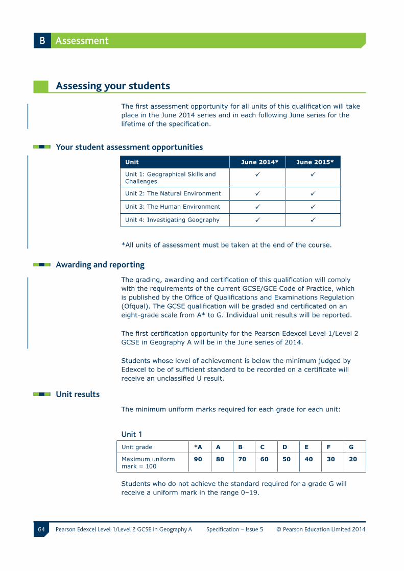
B Assessment
64 Pearson Edexcel Level 1/Level 2 GCSE in Geography A Specification – Issue 5 © Pearson Education Limited 2014
Assessing your students
The first assessment opportunity for all units of this qualification will take place in the June 2014 series and in each following June series for the lifetime of the specification.
Your student assessment opportunities
Unit June 2014* June 2015*
Unit 1: Geographical Skills and Challenges
Unit 2: The Natural Environment
Unit 3: The Human Environment
Unit 4: Investigating Geography
*All units of assessment must be taken at the end of the course.
Awarding and reporting
The grading, awarding and certification of this qualification will comply with the requirements of the current GCSE/GCE Code of Practice, which is published by the Office of Qualifications and Examinations Regulation (Ofqual). The GCSE qualification will be graded and certificated on an eight-grade scale from A* to G. Individual unit results will be reported.
The first certification opportunity for the Pearson Edexcel Level 1/Level 2 GCSE in Geography A will be in the June series of 2014.
Students whose level of achievement is below the minimum judged by Edexcel to be of sufficient standard to be recorded on a certificate will receive an unclassified U result.
Unit results
The minimum uniform marks required for each grade for each unit:
Unit 1
Unit grade *A A B C D E F G
Maximum uniform mark = 100
90 80 70 60 50 40 30 20
Students who do not achieve the standard required for a grade G will receive a uniform mark in the range 0–19.
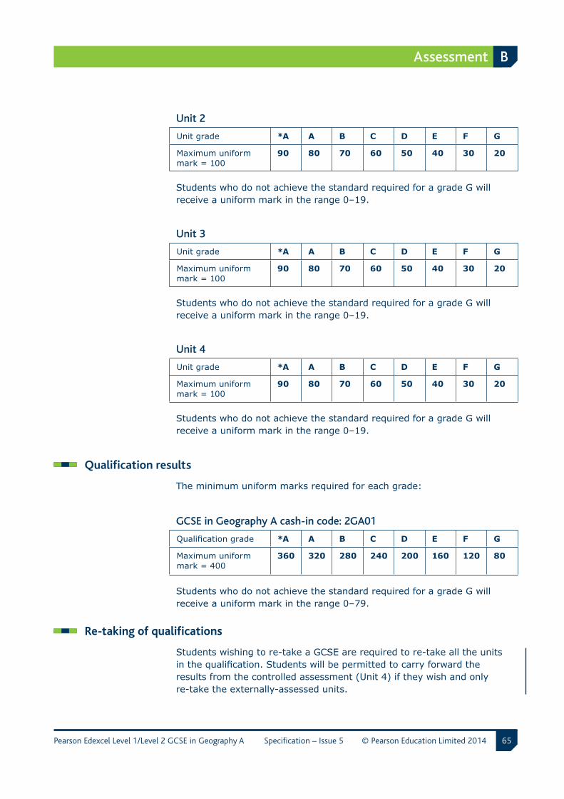
Assessment B
65Pearson Edexcel Level 1/Level 2 GCSE in Geography A Specification – Issue 5 © Pearson Education Limited 2014
Unit 2
Unit grade *A A B C D E F G
Maximum uniform mark = 100
90 80 70 60 50 40 30 20
Students who do not achieve the standard required for a grade G will receive a uniform mark in the range 0–19.
Unit 3
Unit grade *A A B C D E F G
Maximum uniform mark = 100
90 80 70 60 50 40 30 20
Students who do not achieve the standard required for a grade G will receive a uniform mark in the range 0–19.
Unit 4
Unit grade *A A B C D E F G
Maximum uniform mark = 100
90 80 70 60 50 40 30 20
Students who do not achieve the standard required for a grade G will receive a uniform mark in the range 0–19.
Qualification results
The minimum uniform marks required for each grade:
GCSE in Geography A cash-in code: 2GA01
Qualification grade *A A B C D E F G
Maximum uniform mark = 400
360 320 280 240 200 160 120 80
Students who do not achieve the standard required for a grade G will receive a uniform mark in the range 0–79.
Re-taking of qualifications
Students wishing to re-take a GCSE are required to re-take all the units in the qualification. Students will be permitted to carry forward the results from the controlled assessment (Unit 4) if they wish and only re-take the externally-assessed units.
B Assessment
66 Pearson Edexcel Level 1/Level 2 GCSE in Geography A Specification – Issue 5 © Pearson Education Limited 2014
Language of assessment
Assessment of this specification will be available in English only. Assessment materials will be published in English only and all work submitted for examination and moderation must be produced in English.
Quality of Written Communication and Spelling, Punctuation and Grammar (SPaG)
Students will be assessed on their ability to:
• ensure that text is legible and that spelling, punctuation and grammar are accurate so that the meaning is clear
• select and use a form and style of writing appropriate to the purpose and to the complexity of the subject matter
• organise information clearly and coherently, using specialist vocabulary when appropriate.
Spelling, Punctuation and Grammar (SPaG)
Additional marks will be awarded for spelling, punctuation and grammar. The questions that relate to the assessment of these skills will be marked clearly on the question paper.
Performance indicators for the assessment of SPaG
Threshold performanceCandidates spell, punctuate and use the rules of grammar with reasonable accuracy in the context of the demands of the question. Any errors do not hinder meaning in the response. Where required, they use a limited range of specialist terms appropriately.
Intermediate performanceCandidates spell, punctuate and use the rules of grammar with considerable accuracy and general control of meaning in the context of the demands of the question. Where required, they use a good range of specialist terms with facility.
High performanceCandidates spell, punctuate and use the rules of grammar with consistent accuracy and effective control of meaning in the context of the demands of the question. Where required, they use a wide range of specialist terms adeptly and with precision.
Assessment B
67Pearson Edexcel Level 1/Level 2 GCSE in Geography A Specification – Issue 5 © Pearson Education Limited 2014
Stretch and challenge
Students can be stretched and challenged in all units through the use of different assessment strategies, for example:
• using a variety of stems in questions – for example analyse, evaluate, discuss and compare
• ensuring connectivity between sections of questions
• a requirement for extended writing
• using of a wider range of question types to address different skills – for example open-ended questions, case studies.
Malpractice and plagiarism
For up-to-date advice on malpractice and plagiarism, please refer to the JCQ Suspected Malpractice in Examinations: Policies and Procedures document on the JCQ website: www.jcq.org.uk.
Student recruitment
Edexcel’s access policy concerning recruitment to our qualifications is that:
• the qualifications must be available to anyone who is capable of reaching the required standard
• the qualifications must be free from barriers that restrict access and progression
• equal opportunities exist for all students.
Progression
• Students who have completed this GCSE in Geography A can progress to a number of different qualifications at level 3, including GCE in Geography, Geology, Environmental Sciences, Travel and Tourism, and Leisure and Recreation.
• Students could also progress to employment, usually with further training.
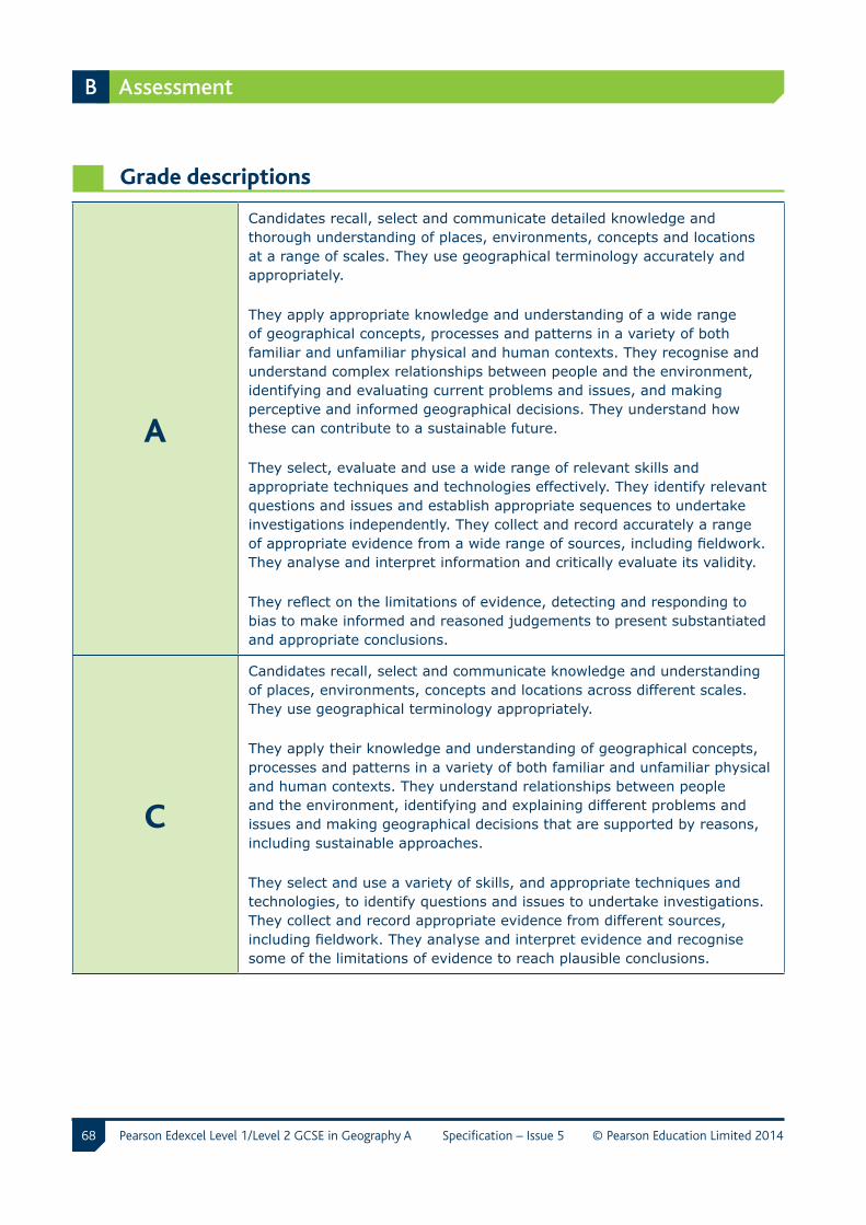
B Assessment
68 Pearson Edexcel Level 1/Level 2 GCSE in Geography A Specification – Issue 5 © Pearson Education Limited 2014
Grade descriptions
A
Candidates recall, select and communicate detailed knowledge and thorough understanding of places, environments, concepts and locations at a range of scales. They use geographical terminology accurately and appropriately.
They apply appropriate knowledge and understanding of a wide range of geographical concepts, processes and patterns in a variety of both familiar and unfamiliar physical and human contexts. They recognise and understand complex relationships between people and the environment, identifying and evaluating current problems and issues, and making perceptive and informed geographical decisions. They understand how these can contribute to a sustainable future.
They select, evaluate and use a wide range of relevant skills and appropriate techniques and technologies effectively. They identify relevant questions and issues and establish appropriate sequences to undertake investigations independently. They collect and record accurately a range of appropriate evidence from a wide range of sources, including fieldwork. They analyse and interpret information and critically evaluate its validity.
They reflect on the limitations of evidence, detecting and responding to bias to make informed and reasoned judgements to present substantiated and appropriate conclusions.
C
Candidates recall, select and communicate knowledge and understanding of places, environments, concepts and locations across different scales. They use geographical terminology appropriately.
They apply their knowledge and understanding of geographical concepts, processes and patterns in a variety of both familiar and unfamiliar physical and human contexts. They understand relationships between people and the environment, identifying and explaining different problems and issues and making geographical decisions that are supported by reasons, including sustainable approaches.
They select and use a variety of skills, and appropriate techniques and technologies, to identify questions and issues to undertake investigations. They collect and record appropriate evidence from different sources, including fieldwork. They analyse and interpret evidence and recognise some of the limitations of evidence to reach plausible conclusions.
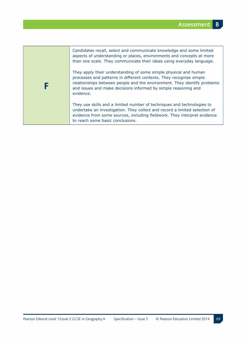
Assessment B
69Pearson Edexcel Level 1/Level 2 GCSE in Geography A Specification – Issue 5 © Pearson Education Limited 2014
F
Candidates recall, select and communicate knowledge and some limited aspects of understanding or places, environments and concepts at more than one scale. They communicate their ideas using everyday language.
They apply their understanding of some simple physical and human processes and patterns in different contexts. They recognise simple relationships between people and the environment. They identify problems and issues and make decisions informed by simple reasoning and evidence.
They use skills and a limited number of techniques and technologies to undertake an investigation. They collect and record a limited selection of evidence from some sources, including fieldwork. They interpret evidence to reach some basic conclusions.

70 Pearson Edexcel Level 1/Level 2 GCSE in Geography A Specification – Issue 5 © Pearson Education Limited 2014
C Resources, support and training
Edexcel resources
Edexcel aims to provide the most comprehensive support for our qualifications.
Teacher and student support
The resources from Edexcel provide you and your students with comprehensive support for our GCSE Geography qualification. This dedicated suite of resources has been written by subject experts to ensure that you and your department have everything needed to deliver the specification.
Edexcel publications
You can order further copies of the specification, sample assessment materials (SAMs) and teacher’s guide documents from:
Edexcel Publications Adamsway Mansfield Nottinghamshire NG18 4FN
Telephone: 01623 467467 Fax: 01623 450481 Email: [email protected] Website: www.edexcel.com

Resources, support and training C
71Pearson Edexcel Level 1/Level 2 GCSE in Geography A Specification – Issue 5 © Pearson Education Limited 2014
Endorsed resources
Edexcel also endorses some additional materials written to support this qualification. Any resources bearing the Edexcel logo have been through a quality-assurance process to ensure complete and accurate support for the specification. For up-to-date information about endorsed resources, please visit www.edexcel.com/endorsed.
Please note that while resources are checked at the time of publication, materials may be withdrawn from circulation and website locations may change.
Edexcel support services
Edexcel has a wide range of support services to help you implement this qualification successfully.
ResultsPlus – ResultsPlus is an application launched by Edexcel to help subject teachers, senior management teams and students by providing detailed analysis of examination performance. Reports that compare performance between subjects, classes, your centre and similar centres can be generated in ‘one-click’. Skills maps that show performance according to the specification topic being tested are available for some subjects. For further information about which subjects will be analysed through ResultsPlus, and for information on how to access and use the service, please visit www.edexcel.com/resultsplus.
Ask the Expert – to make it easier for you to raise a query with us online, we have merged our Ask Edexcel and Ask the Expert services.
There is now one easy-to-use web query form that will allow you to ask any question about the delivery or teaching of Edexcel qualifications. You’ll get a personal response from one of our administrative or teaching experts sent to the email address you provide. You can access this service at www.edexcel.com/ask.
We’re always looking to improve the quantity and quality of information in our FAQ database, so you’ll be able to find answers to many questions you might have by searching before you submit the question to us.
C Resources, support and training
72 Pearson Edexcel Level 1/Level 2 GCSE in Geography A Specification – Issue 5 © Pearson Education Limited 2014
The service allows you to search through a database of thousands of questions and answers on everything Edexcel offers. If you don’t find an answer to your question, you can choose to submit it straight to us. One of our customer services team will log your query, find an answer and send it to you. They’ll also consider adding it to the database if appropriate. This way the volume of helpful information that can be accessed via the service is growing all the time.
Support for students Learning flourishes when students take an active interest in their education and when they have all the information they need to make the right decisions about their futures. With the help of feedback from students and their teachers, we’ve developed a website for students that will help them:
• understand subject specifications
• access past papers and mark schemes
• find out how to get exams remarked
• learn about other students’ experiences at university, on their travels and entering the workplace.
We’re committed to regularly updating and improving our online services for students. The most valuable service we can provide is helping schools and colleges unlock the potential of their students. See: www.edexcel.com/students.
Training
A programme of professional development and training courses, covering various aspects of the specification and examination, will be arranged by Edexcel each year on a regional basis. Full details can be obtained from:
Training from Edexcel Edexcel One90 High Holborn London WC1V 7BH
Telephone: 0844 576 0027 Email: [email protected] Website: www.edexcel.com/training
73Pearson Edexcel Level 1/Level 2 GCSE in Geography A Specification – Issue 5 © Pearson Education Limited 2014
D Appendices
Appendix 1 Key skills 74
Appendix 2 Wider curriculum 75
Appendix 3 Codes 77
Appendix 4 Controlled assessment record sheet 78
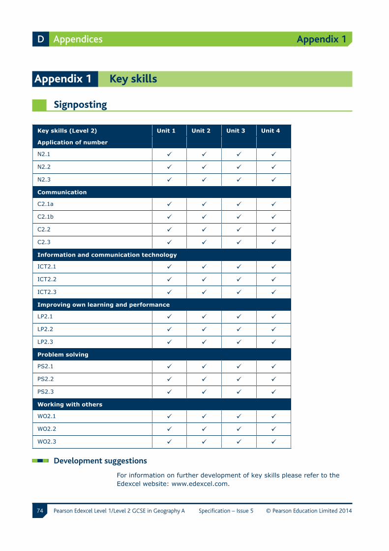
74
Appendix 1
Pearson Edexcel Level 1/Level 2 GCSE in Geography A Specification – Issue 5 © Pearson Education Limited 2014
D Appendices
Appendix 1 Key skills
Signposting
Key skills (Level 2) Unit 1 Unit 2 Unit 3 Unit 4
Application of number
N2.1
N2.2
N2.3
Communication
C2.1a
C2.1b
C2.2
C2.3
Information and communication technology
ICT2.1
ICT2.2
ICT2.3
Improving own learning and performance
LP2.1
LP2.2
LP2.3
Problem solving
PS2.1
PS2.2
PS2.3
Working with others
WO2.1
WO2.2
WO2.3
Development suggestions
For information on further development of key skills please refer to the Edexcel website: www.edexcel.com.
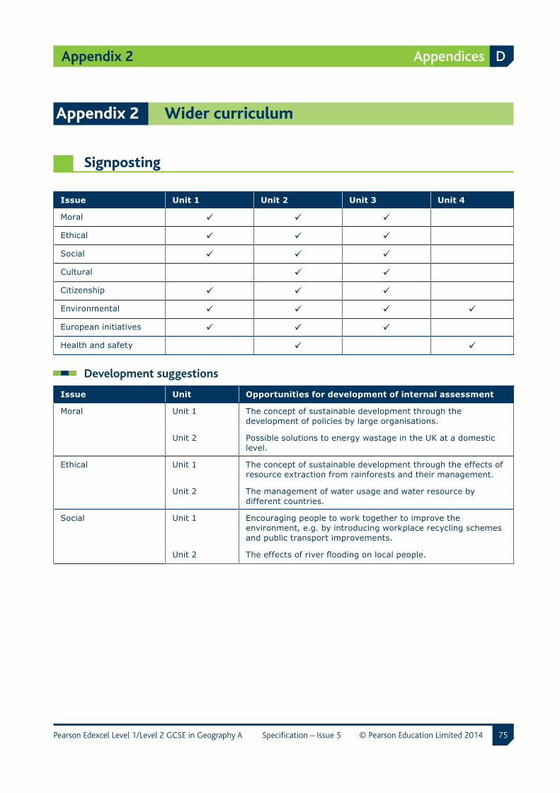
75
Appendix 2
Pearson Edexcel Level 1/Level 2 GCSE in Geography A Specification – Issue 5 © Pearson Education Limited 2014
Appendices D
Appendix 2 Wider curriculum
Signposting
Issue Unit 1 Unit 2 Unit 3 Unit 4
Moral
Ethical
Social
Cultural
Citizenship
Environmental
European initiatives
Health and safety
Development suggestions
Issue Unit Opportunities for development of internal assessment
Moral Unit 1 The concept of sustainable development through the development of policies by large organisations.
Unit 2 Possible solutions to energy wastage in the UK at a domestic level.
Ethical Unit 1 The concept of sustainable development through the effects of resource extraction from rainforests and their management.
Unit 2 The management of water usage and water resource by different countries.
Social Unit 1 Encouraging people to work together to improve the environment, e.g. by introducing workplace recycling schemes and public transport improvements.
Unit 2 The effects of river flooding on local people.
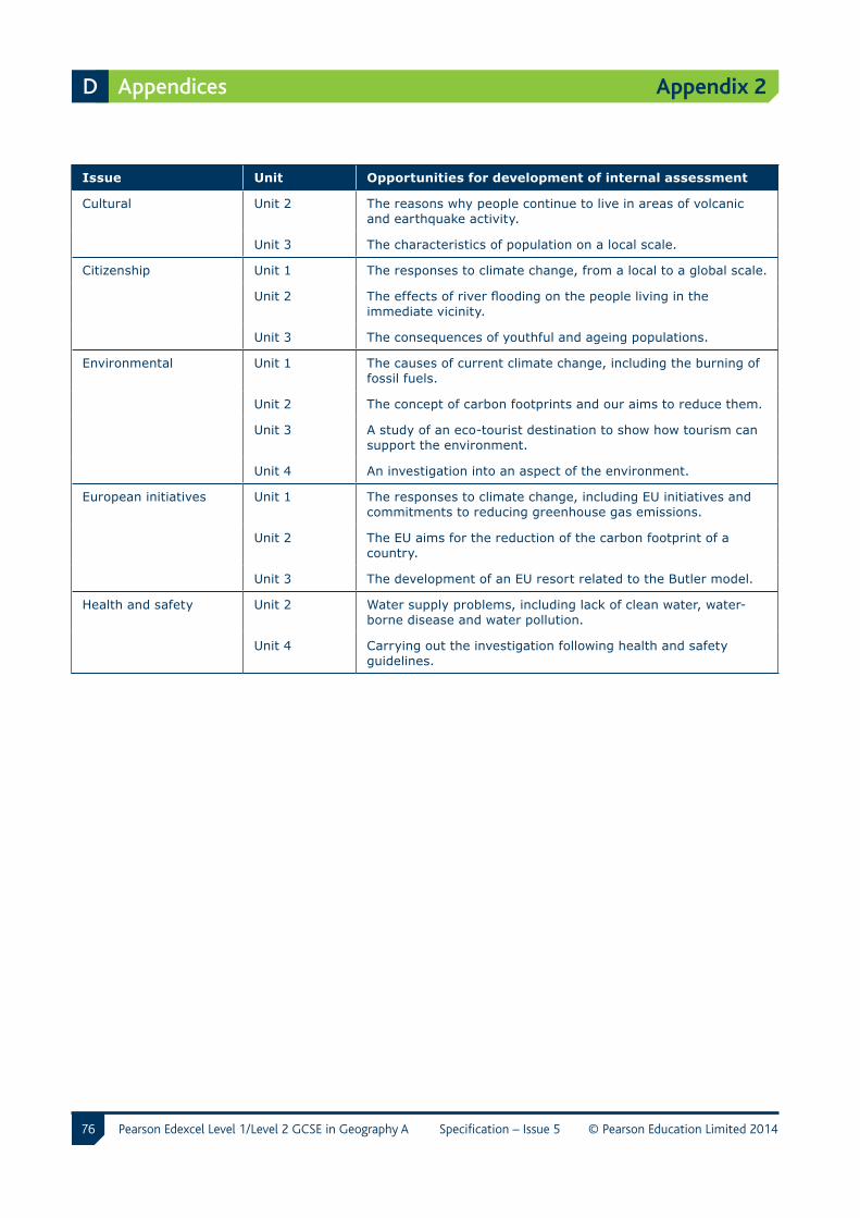
76
Appendix 2
Pearson Edexcel Level 1/Level 2 GCSE in Geography A Specification – Issue 5 © Pearson Education Limited 2014
D Appendices
Issue Unit Opportunities for development of internal assessment
Cultural Unit 2 The reasons why people continue to live in areas of volcanic and earthquake activity.
Unit 3 The characteristics of population on a local scale.
Citizenship Unit 1 The responses to climate change, from a local to a global scale.
Unit 2 The effects of river flooding on the people living in the immediate vicinity.
Unit 3 The consequences of youthful and ageing populations.
Environmental Unit 1 The causes of current climate change, including the burning of fossil fuels.
Unit 2 The concept of carbon footprints and our aims to reduce them.
Unit 3 A study of an eco-tourist destination to show how tourism can support the environment.
Unit 4 An investigation into an aspect of the environment.
European initiatives Unit 1 The responses to climate change, including EU initiatives and commitments to reducing greenhouse gas emissions.
Unit 2 The EU aims for the reduction of the carbon footprint of a country.
Unit 3 The development of an EU resort related to the Butler model.
Health and safety Unit 2 Water supply problems, including lack of clean water, water-borne disease and water pollution.
Unit 4 Carrying out the investigation following health and safety guidelines.
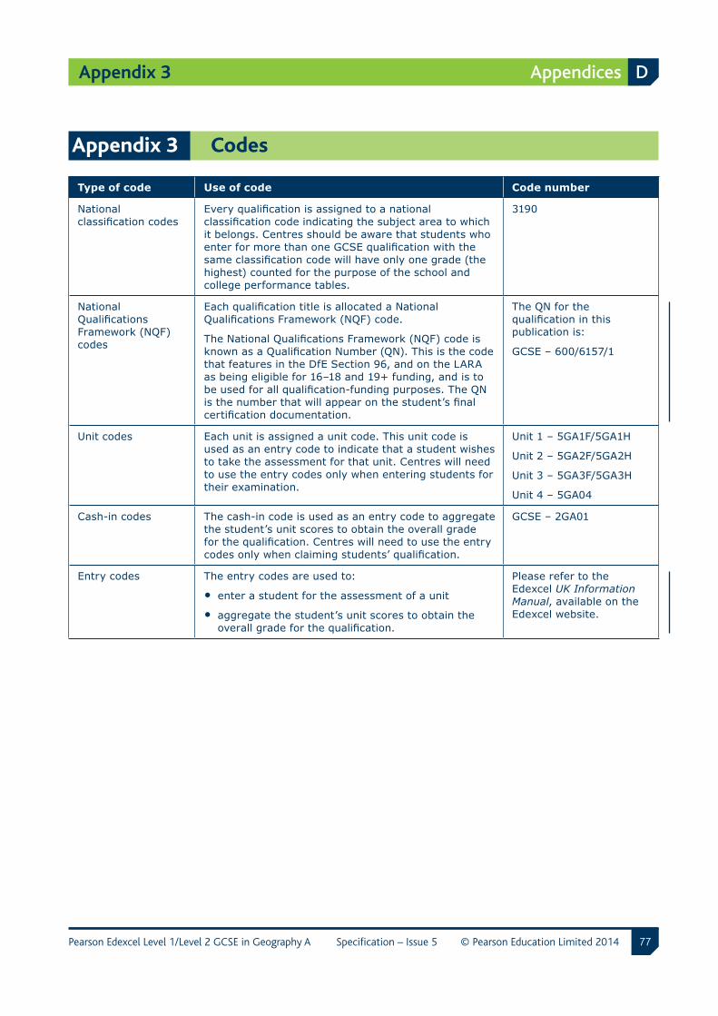
77
Appendix 3
Pearson Edexcel Level 1/Level 2 GCSE in Geography A Specification – Issue 5 © Pearson Education Limited 2014
Appendices D
Appendix 3 Codes
Type of code Use of code Code number
National classification codes
Every qualification is assigned to a national classification code indicating the subject area to which it belongs. Centres should be aware that students who enter for more than one GCSE qualification with the same classification code will have only one grade (the highest) counted for the purpose of the school and college performance tables.
3190
National Qualifications Framework (NQF) codes
Each qualification title is allocated a National Qualifications Framework (NQF) code.
The National Qualifications Framework (NQF) code is known as a Qualification Number (QN). This is the code that features in the DfE Section 96, and on the LARA as being eligible for 16–18 and 19+ funding, and is to be used for all qualification-funding purposes. The QN is the number that will appear on the student’s final certification documentation.
The QN for the qualification in this publication is:
GCSE – 600/6157/1
Unit codes Each unit is assigned a unit code. This unit code is used as an entry code to indicate that a student wishes to take the assessment for that unit. Centres will need to use the entry codes only when entering students for their examination.
Unit 1 – 5GA1F/5GA1H
Unit 2 – 5GA2F/5GA2H
Unit 3 – 5GA3F/5GA3H
Unit 4 – 5GA04
Cash-in codes The cash-in code is used as an entry code to aggregate the student’s unit scores to obtain the overall grade for the qualification. Centres will need to use the entry codes only when claiming students’ qualification.
GCSE – 2GA01
Entry codes The entry codes are used to:
• enter a student for the assessment of a unit
• aggregate the student’s unit scores to obtain the overall grade for the qualification.
Please refer to the Edexcel UK Information Manual, available on the Edexcel website.
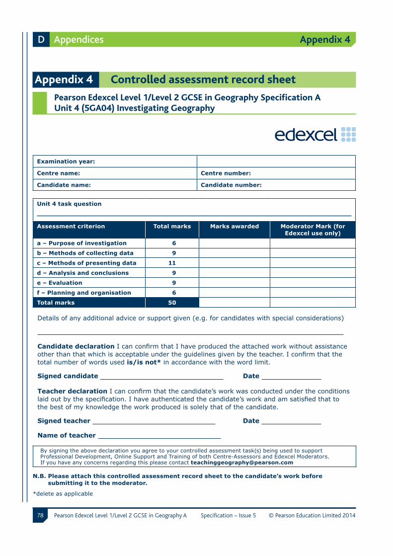
78
Appendix 4
Pearson Edexcel Level 1/Level 2 GCSE in Geography A Specification – Issue 5 © Pearson Education Limited 2014
D Appendices
Appendix 4 Controlled assessment record sheet
Pearson Edexcel Level 1/Level 2 GCSE in Geography Specification A Unit 4 (5GA04) Investigating Geography
Examination year:
Centre name: Centre number:
Candidate name: Candidate number:
Unit 4 task question
Assessment criterion Total marks Marks awarded Moderator Mark (for Edexcel use only)
a – Purpose of investigation 6
b – Methods of collecting data 9
c – Methods of presenting data 11
d – Analysis and conclusions 9
e – Evaluation 9
f – Planning and organisation 6
Total marks 50
Details of any additional advice or support given (e.g. for candidates with special considerations)
Candidate declaration I can confirm that I have produced the attached work without assistance other than that which is acceptable under the guidelines given by the teacher. I confirm that the total number of words used is/is not* in accordance with the word limit.
Signed candidate Date
Teacher declaration I can confirm that the candidate’s work was conducted under the conditions laid out by the specification. I have authenticated the candidate’s work and am satisfied that to the best of my knowledge the work produced is solely that of the candidate.
Signed teacher Date
Name of teacher
By signing the above declaration you agree to your controlled assessment task(s) being used to support Professional Development, Online Support and Training of both Centre-Assessors and Edexcel Moderators. If you have any concerns regarding this please contact [email protected]
N.B. Please attach this controlled assessment record sheet to the candidate’s work before submitting it to the moderator.
*delete as applicable
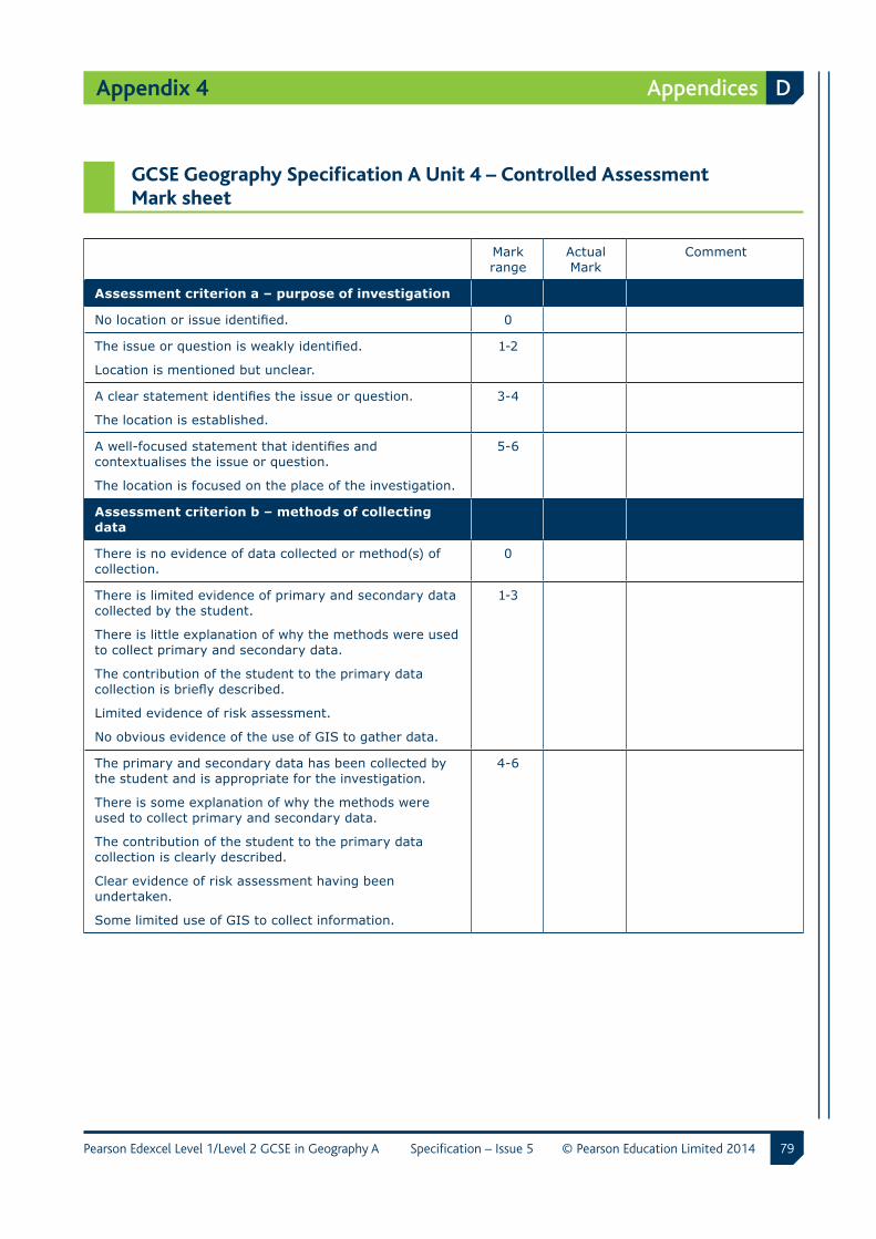
79
Appendix 4
Pearson Edexcel Level 1/Level 2 GCSE in Geography A Specification – Issue 5 © Pearson Education Limited 2014
Appendices D
GCSE Geography Specification A Unit 4 – Controlled Assessment Mark sheet
Mark range
Actual Mark
Comment
Assessment criterion a – purpose of investigation
No location or issue identified. 0
The issue or question is weakly identified.
Location is mentioned but unclear.
1-2
A clear statement identifies the issue or question.
The location is established.
3-4
A well-focused statement that identifies and contextualises the issue or question.
The location is focused on the place of the investigation.
5-6
Assessment criterion b – methods of collecting data
There is no evidence of data collected or method(s) of collection.
0
There is limited evidence of primary and secondary data collected by the student.
There is little explanation of why the methods were used to collect primary and secondary data.
The contribution of the student to the primary data collection is briefly described.
Limited evidence of risk assessment.
No obvious evidence of the use of GIS to gather data.
1-3
The primary and secondary data has been collected by the student and is appropriate for the investigation.
There is some explanation of why the methods were used to collect primary and secondary data.
The contribution of the student to the primary data collection is clearly described.
Clear evidence of risk assessment having been undertaken.
Some limited use of GIS to collect information.
4-6
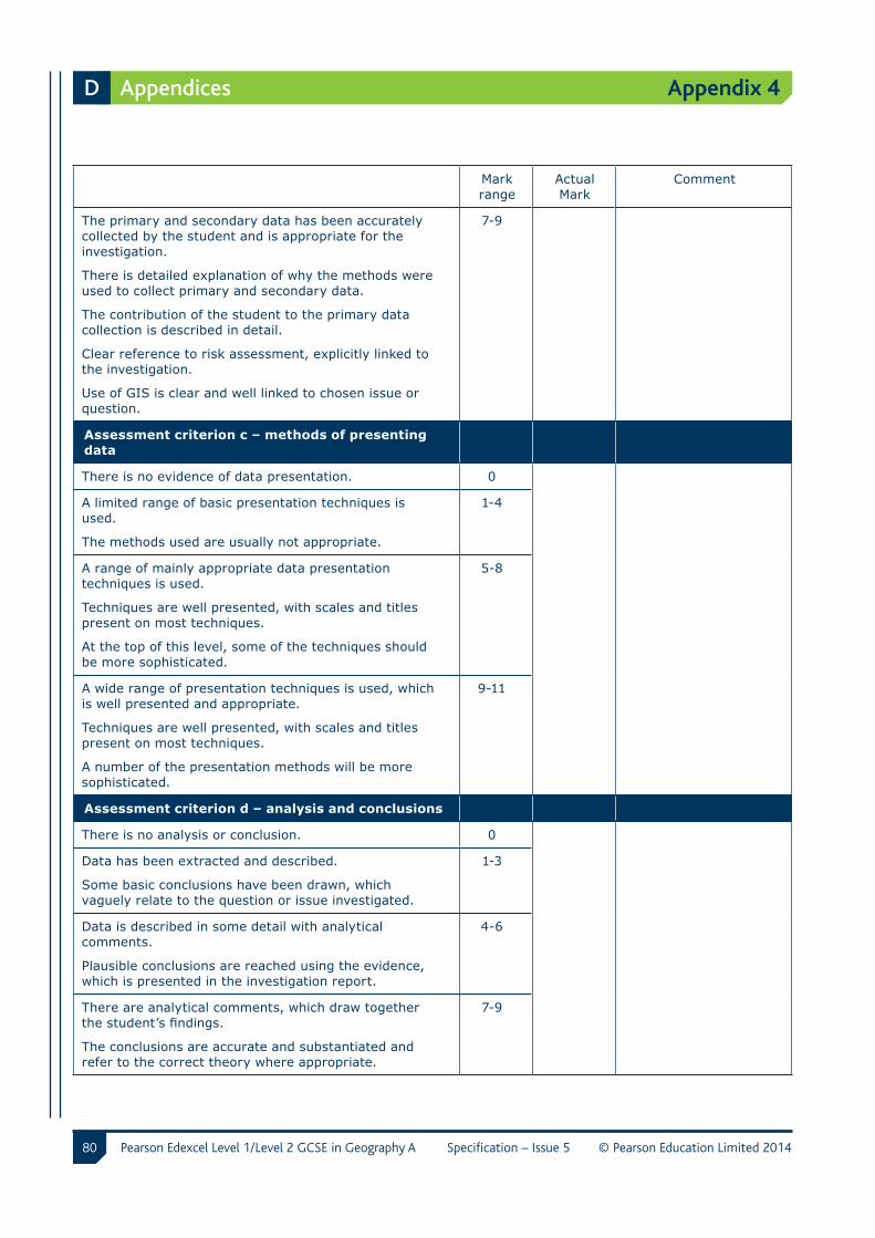
80
Appendix 4
Pearson Edexcel Level 1/Level 2 GCSE in Geography A Specification – Issue 5 © Pearson Education Limited 2014
D Appendices
Mark range
Actual Mark
Comment
The primary and secondary data has been accurately collected by the student and is appropriate for the investigation.
There is detailed explanation of why the methods were used to collect primary and secondary data.
The contribution of the student to the primary data collection is described in detail.
Clear reference to risk assessment, explicitly linked to the investigation.
Use of GIS is clear and well linked to chosen issue or question.
7-9
Assessment criterion c – methods of presenting data
There is no evidence of data presentation. 0
A limited range of basic presentation techniques is used.
The methods used are usually not appropriate.
1-4
A range of mainly appropriate data presentation techniques is used.
Techniques are well presented, with scales and titles present on most techniques.
At the top of this level, some of the techniques should be more sophisticated.
5-8
A wide range of presentation techniques is used, which is well presented and appropriate.
Techniques are well presented, with scales and titles present on most techniques.
A number of the presentation methods will be more sophisticated.
9-11
Assessment criterion d – analysis and conclusions
There is no analysis or conclusion. 0
Data has been extracted and described.
Some basic conclusions have been drawn, which vaguely relate to the question or issue investigated.
1-3
Data is described in some detail with analytical comments.
Plausible conclusions are reached using the evidence, which is presented in the investigation report.
4-6
There are analytical comments, which draw together the student’s findings.
The conclusions are accurate and substantiated and refer to the correct theory where appropriate.
7-9
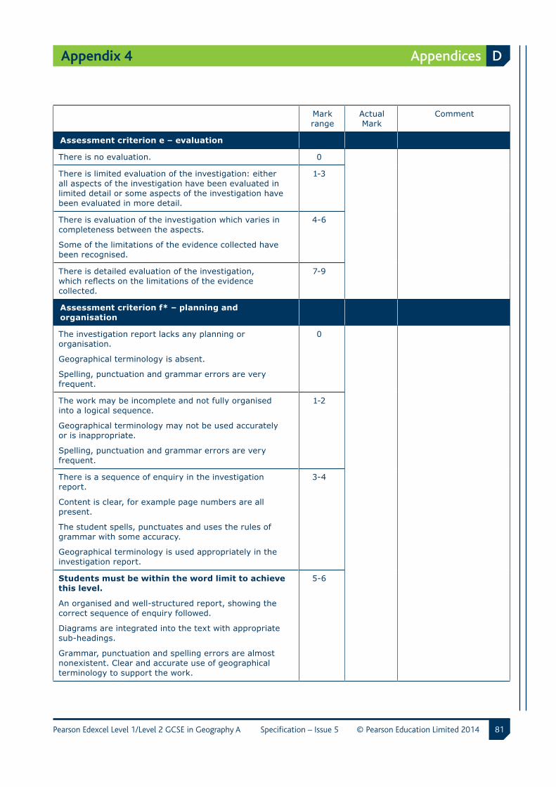
81
Appendix 4
Pearson Edexcel Level 1/Level 2 GCSE in Geography A Specification – Issue 5 © Pearson Education Limited 2014
Appendices D
Mark range
Actual Mark
Comment
Assessment criterion e – evaluation
There is no evaluation. 0
There is limited evaluation of the investigation: either all aspects of the investigation have been evaluated in limited detail or some aspects of the investigation have been evaluated in more detail.
1-3
There is evaluation of the investigation which varies in completeness between the aspects.
Some of the limitations of the evidence collected have been recognised.
4-6
There is detailed evaluation of the investigation, which reflects on the limitations of the evidence collected.
7-9
Assessment criterion f* – planning and organisation
The investigation report lacks any planning or organisation.
Geographical terminology is absent.
Spelling, punctuation and grammar errors are very frequent.
0
The work may be incomplete and not fully organised into a logical sequence.
Geographical terminology may not be used accurately or is inappropriate.
Spelling, punctuation and grammar errors are very frequent.
1-2
There is a sequence of enquiry in the investigation report.
Content is clear, for example page numbers are all present.
The student spells, punctuates and uses the rules of grammar with some accuracy.
Geographical terminology is used appropriately in the investigation report.
3-4
Students must be within the word limit to achieve this level.
An organised and well-structured report, showing the correct sequence of enquiry followed.
Diagrams are integrated into the text with appropriate sub-headings.
Grammar, punctuation and spelling errors are almost nonexistent. Clear and accurate use of geographical terminology to support the work.
5-6
82
Appendix 4
Pearson Edexcel Level 1/Level 2 GCSE in Geography A Specification – Issue 5 © Pearson Education Limited 2014
D Appendices
*Opportunity for students to be assessed on quality of written communication strands:
i) ensure that text is legible and that spelling, punctuation and grammar are accurate so that meaning is clear
ii) select and use a form and style of writing appropriate to purpose and to complex subject matter
iii) organise information clearly and coherently, using specialist vocabulary when appropriate.
N.B. Please attach this controlled assessment record sheet to the candidates work before submitting it to the moderator.
ma190614S:LT\PD\GCSE Linear\9781446911907_GCSE_Lin_Geog_A_Issue_5\9781446911907_GCSE_Lin_Geog_A_Issue_5.indd-82/1

For further copies of this publication, please send an email to the following addresses:
UK customers: [email protected] International customers: [email protected]
Also, you can download copies at: www.edexcel.com
For more information on Edexcel and BTEC qualifications please visit our websites: www.edexcel.com and www.btec.co.uk
Pearson Education Limited. Registered in England and Wales No. 4496750 Registered Office: Edinburgh Gate, Harlow, Essex CM20 2JE VAT Reg No GB 278 537121