Embed Size (px)
Citation preview
Spatial Data Infrastructures in The Netherlands: State of play 2011
SPATIAL APPLICATIONS DIVISION K.U.LEUVEN RESEARCH & DEVELOPMENT
Celestijnenlaan 200 E, B-3001 LEUVEN TEL.: 32 16 32 97 32 FAX: 32 16 32 97 60 URL: http://www.sadl.kuleuven.ac.be
EC-INSPIRE: Spatial Data Infrastructures in Europe: State of play Spring 2011 The Netherlands
K.U.Leuven (SADL) 2
Report meta-information
Title Spatial Data Infrastructures in The Netherlands: State of play 2011
Creator Danny Vandenbroucke & Dimitrios Biliouris (SADL)
Date Issued 2010-09-01
Subject INSPIRE State of Play
Publisher K.U.Leuven (SADL + ICRI)
Description This report is summarizing the review of SDI in The Netherlands
Contributor Danny Vandenbroucke & Dimitrios Biliouris (SADL), Katleen Janssen (ICRI); Joep Crompvoets (OE)
Previous Contributor Jos Van Orshoven (SADL), Catharina Bamps (SADL), Katleen Janssen (ICRI); Prof. B. Kok (RAVI, TU Delft), Prof. Henri J.G.L. Aalders (Delft University of Technology), Bastiaan van Loenen (TU Delft), Arnold Bregt (University of Wageningen)
Format MS Word 97/2000
Audience INSPIRE stakeholders
Identifier rcr11NLv123
Language EN
Coverage Autumn 2009 – Spring 2010
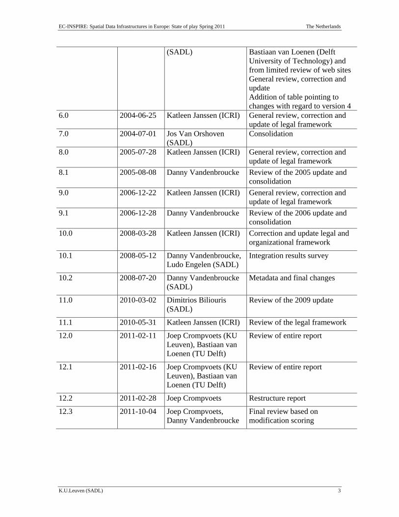
Version number Date Modified by Comments 1.0 2002-11-17 Catharina Bamps
(SADL) & Peter Beusen (ICRI)
First version
2.0 2002-12-20 Jos Van Orshoven (SADL)
Completion & harmonization with 31 other country reports
3.0 2003-07-31 Catharina Bamps (SADL)
Consolidation and integration of comments received from: - B. Kok, (RAVI & Delft
University of Technology) - Prof. Henri J.G.L. Aalders
(Delft University of Technology)
Addition of: - Report meta-information - Executive summary - Abbreviations/acronyms
4.0 2003-08-25 Jos Van Orshoven (SADL)
Harmonisation with 31 other country reports
5.0 2004-06-20 Catharina Bamps Integration of comments from Mr
EC-INSPIRE: Spatial Data Infrastructures in Europe: State of play Spring 2011 The Netherlands
K.U.Leuven (SADL) 3
(SADL) Bastiaan van Loenen (Delft University of Technology) and from limited review of web sites General review, correction and update Addition of table pointing to changes with regard to version 4
6.0 2004-06-25 Katleen Janssen (ICRI) General review, correction and update of legal framework
7.0 2004-07-01 Jos Van Orshoven (SADL)
Consolidation
8.0 2005-07-28 Katleen Janssen (ICRI) General review, correction and update of legal framework
8.1 2005-08-08 Danny Vandenbroucke Review of the 2005 update and consolidation
9.0 2006-12-22 Katleen Janssen (ICRI) General review, correction and update of legal framework
9.1 2006-12-28 Danny Vandenbroucke Review of the 2006 update and consolidation
10.0 2008-03-28 Katleen Janssen (ICRI) Correction and update legal and organizational framework
10.1 2008-05-12 Danny Vandenbroucke, Ludo Engelen (SADL)
Integration results survey
10.2 2008-07-20 Danny Vandenbroucke (SADL)
Metadata and final changes
11.0 2010-03-02 Dimitrios Biliouris (SADL)
Review of the 2009 update
11.1 2010-05-31 Katleen Janssen (ICRI) Review of the legal framework
12.0 2011-02-11 Joep Crompvoets (KU Leuven), Bastiaan van Loenen (TU Delft)
Review of entire report
12.1 2011-02-16 Joep Crompvoets (KU Leuven), Bastiaan van Loenen (TU Delft)
Review of entire report
12.2 2011-02-28 Joep Crompvoets Restructure report
12.3 2011-10-04 Joep Crompvoets, Danny Vandenbroucke
Final review based on modification scoring
EC-INSPIRE: Spatial Data Infrastructures in Europe: State of play Spring 2011 The Netherlands
K.U.Leuven (SADL) 4
This document does not represent the position of the Commission or its services. No inferences should be drawn from these documents as to the content or form of the current and future proposals to be presented by the Commission.
This document does neither represent the position of the Member States and countries under study.
EC-INSPIRE: Spatial Data Infrastructures in Europe: State of play Spring 2011 The Netherlands
K.U.Leuven (SADL) 5
Executive summary The Dutch NSDI can be described as the result of various initiatives taken in a bottom-up approach for more than 15 years. Different stakeholders initiated and eventually agreed to collaborate and implement.
In 2006, the GI-Board (‘GI Council’) was created. All ministries and agencies involved in the SDI (development and use) are represented in this board. Next to the GI-Board, Geonovum plays an important implementation role in the Dutch Geographic Information Infrastructure. Together they took over the role of RAVI and the NCGI. Geonovum’s key tasks are: representing the Dutch geo-information community; standardization; creating and maintaining the national geoportal; the operational INSPIRE coordination; and international networking. The political responsibility for Geonovum lies with the minister of Infrastructure and Environment. The foundation is funded by the ministry of Infrastructure and Environment, the ministry of Economic Affairs, Agriculture, and Innovation, the Cadastre and TNO-NITG.
The Ministry of Infrastructure and Environment has introduced the following policy measures: - Boosting innovation and knowledge development in the professional geo-field with a
substantial subsidy to the Space for Geo-Information (RGI) programme; - founding the GI Council, with strategic advisory duties; - forming Geonovum, a foundation of public sector parties; - arranging formal consultations with industry, the geoprofession and the academia in
Geo-meeting; - defining the legal framework for, and implementing, various key registers
(basisregistraties).
Pursuant to advice from the GI Council, the Geonovum and RGI foundations have devised an approach and strategy in consultation with parties in the Geo-meeting. The result is known as GIDEON and was established in 2008. GIDEON sets the approach and implementation strategy for the years 2008 – 2011.
The Dutch geo-information sector is assessed to generate at least 1.5 billion Euros, and employs 15 thousand of people. Various parties are working together on the execution of parts of GIDEON in seven implementation strategies. Jointly, these strategies leads to the creation of a key geo-facility for the Netherlands.
The seven strategies are as follows:
1. to give geo-information a prominent place within the Dutch e-services; 2. to encourage the use of the existing four key geo-registers, and to set up two
new ones; 3. to embed the INSPIRE Directive into Dutch legislation and to implement the
technical infrastructure;
EC-INSPIRE: Spatial Data Infrastructures in Europe: State of play Spring 2011 The Netherlands
K.U.Leuven (SADL) 6
4. to optimise supply by forming a government-wide geo-information facility, that includes geo-data standardization, new infrastructure, and collaborative maintenance;
5. to encourage the use of geo-information in five government policy and implementation chains, such as safety, the sustainable living environment, mobility, and area development;
6. to create a favourable climate for adding economic value to the available publicsector geo-information;
7. to encourage collaboration in knowledge, innovation and education, for the permanent development and renewal of the key geo-information facility for the Netherlands.
As far as the INSPIRE transposition is concerned, this has been concluded and a final text has been published
A national Geo-Portal exists since 2009 that addresses the broader NSDI and is updated every 3 to 6 months. At the end of 2010, it holds around 11,000 datasets.
EC-INSPIRE: Spatial Data Infrastructures in Europe: State of play Spring 2011 The Netherlands
K.U.Leuven (SADL) 7
Table of Contents
EXECUTIVE SUMMARY .......................................................................................................................... 5
TABLE OF CONTENTS ............................................................................................................................. 7
ABBREVIATIONS AND ACRONYMS ..................................................................................................... 8
1 GENERAL INFORMATION ........................................................................................... 11
1.1 METHOD .................................................................................................................................... 11 1.2 THE NSDI-SCENE IN THE NETHERLANDS ................................................................................... 11
2 DETAILS OF THE DUTCH NSDI (NGII) ..................................................................... 15
2.1 INTRODUCTION........................................................................................................................... 15 2.2 COMPONENT 1: COORDINATION AND ORGANIZATIONAL ISSUES ................................................. 15 2.3 COMPONENT 2: LEGAL FRAMEWORK AND FUNDING ................................................................... 18 2.4 COMPONENT 3: DATA FOR THEMES OF THE INSPIRE ANNEXES ................................................. 24 2.5 COMPONENT 4: METADATA ....................................................................................................... 27 2.6 COMPONENT 5: NETWORK SERVICES ......................................................................................... 28 2.7 COMPONENT 6: ENVIRONMENTAL THEMES AND ACTIVITIES ...................................................... 30 2.8 STANDARDS ............................................................................................................................... 30 2.9 USE AND EFFICIENCY OF THE NSDI ........................................................................................... 32
3 ANNEXES .......................................................................................................................... 34
3.1 LIST OF SDI ADDRESSES / CONTACTS FOR THE NETHERLANDS .................................................. 34 3.2 LIST OF REFERENCES FOR THE NETHERLANDS ........................................................................... 35
EC-INSPIRE: Spatial Data Infrastructures in Europe: State of play Spring 2011 The Netherlands
K.U.Leuven (SADL) 8
Abbreviations and acronyms AKR Automated Cadastral Register BAG Register for Addresses and Buildings BBR Register of enterprises/companies BGI Bedrijvenplatform Geo-Informatie BGR Register of buildings BRA Register of standardised addresses BSIK Besluit Subsidies Investeringen in de Kennisinfrastructuur bnSP de Beroepsvereniging van Nederlandse Stedenbouwkundigen en
Planologen BZK Ministry of the Interior and Kingdom Relations CBS Centraal Bureau voor de Statistiek CPB Netherlands Bureau for Economic Policy Analysis CT Core Thematic Data DLG Dienst Landelijk Gebied DR National Service for Implementation of Regulations DURP Digitaal Uitwisselbare Ruimtelijke Plannen ECU European Currency Unit FGDC Federal Geographic Data Committee SC-DLO DLO-Staring Centrum GBA Register of persons GBKN Grootschalige Basiskaart Nederland GDI R&C Geodata Infrastructuur Rampenbestrijding en Crisisbeheersing GI Geographical Information GIDEON Geographical information and services for e-government in the
Netherlands GIS Geographical Information System GML Geography Markup Language GPS Global Positioning System GSDI Global Spatial Data Infrastructure IMRO Informatiemodel Ruimtelijke Ordening IMWA Informatiemodel Water INSPIRE INfrastructure for SPatial InfoRmation in Europe IPO Interprovinciaal Overleg ISO International Organization for Standardization KNMI Royal Netherlands Meteorological Institute LBG-RIVM Laboratorium voor Bodem- en Grondwateronderzoek van het RIVM
EC-INSPIRE: Spatial Data Infrastructures in Europe: State of play Spring 2011 The Netherlands
K.U.Leuven (SADL) 9
LKI Cartographic Information system LNV Agriculture, Nature and Food Quality LSV-GBKN Landelijk Samenwerkingverband - National Cooperation GBKN MinVROM Ministry of Housing Spatial, Planning and the Environment MNP Netherlands Environmental Assessment Agency NCGI Nationaal Clearinghouse Geo Informatie NGII National Geographic Information Infrastructure NGR National Georegister NIROV Nederlands Instituut voor Ruimtelijke Ordening en Volkshuisvesting NITG Nederlands Instituut voor toegepaste Geowetenschappen NIVR Netherlands Agency for Aerospace Programmes NMA Topographical Service NSDI National Spatial Data Infrastructures OOV Openbare Orde en Veiligheid (Public Order and Safety) OWS OpenGIS Webservices PPP Public-Private Partnerships PSI Policy and legislation on access to public sector information RAVI Dutch Council for Real Estate Information RD Rijksdriehoeksstelsel REF Reference data RGD Rijks Geologische Dienst RGI Space for Geo-Information RIVM Rijksinstituut voor Volksgezondheid en Milieu RPB Netherlands Institute for Spatial Research RWS Directorate-General for Public Works and Water Management SAG Samenwerking Aardkundige Gegevens SDI Spatial Data Infrastructures SVI Structure Outline for Geographic Information TDN Topografische Dienst Nederland (Topographical Service of the
Netherlands) TNO Netherlands Organization for Applied Scientific Research TNO GG TNO Grondwater en Geo-Energie UvW Association of Water Boards V&W Traffic, Public Works and Water Management VNG Vereniging van Nederlandse Gemeenten VROM Ministerie van Volkshuisvesting, de Ruimtelijke Ordening en het
Milieubeheer = Ministry of Public Health, Spatial Planning and Environmental Affairs
WBP Wet Bescherming Persoonsgegevens
EC-INSPIRE: Spatial Data Infrastructures in Europe: State of play Spring 2011 The Netherlands
K.U.Leuven (SADL) 10
WFS Web Feature Service WOZ Assessment of immovable objects registration
EC-INSPIRE: Spatial Data Infrastructures in Europe: State of play Spring 2011 The Netherlands
K.U.Leuven (SADL) 11
1 GENERAL INFORMATION
1.1 Method This report summarises the review of SDI in The Netherlands 2011, and reflects the degree to which the SDI situation in The Netherlands is similar to the ideas set out in the INSPIRE position papers and in the more recent INSPIRE scoping papers.
In comparison with the previous country reports, this report has been updated to the situation of Spring 2011. In order to achieve this, expert knowledge (of Bastiaan van Loenen / Delft University of Technology), literature and websites are used to describe the current situation of SDI-development and INSPIRE-implementation in The Netherlands.
For more background about the method applied, see Vandenbroucke, D., Zambon, M.-L., Crompvoets, J., and Dufourmont, H., 2008. Chapter 16, INSPIRE Directive: Specific requirements to monitor its implementation. In: J. Crompvoets, A. Rajabifard, B. van Loenen, and T. Delgado Fernández (Eds.), A Multi-view Framework to Assess Spatial Data Infrastructures. The Melbourne University Press, Melbourne, Australia, pp. 327-355.
1.2 The NSDI-scene in The Netherlands
1.2.1 GI-Board, Geonovum and GIDEON
In 2006, the GI-Board (‘GI Council’) was created. All ministries and agencies involved in the SDI (development and use) are represented in this board. Next to the GI-Board, the Geonovum foundation plays an important role in the Dutch Geographic Information Infrastructure. Together they took over the role of RAVI and the NCGI.
Geonovum’s key tasks according to the website (www.geonuvum.nl) are:
to develop and standardise the geo-information infrastructure while also being innovative.
to build up and disseminate knowledge in the area of geo-information infrastructure.
to make the geo-information infrastructure more accessible to administrative bodies, institutions and departments in the Netherlands and the European Union.
In order to attain its goals Geonovum has set itself the following tasks (see website www.geonovum.nl):
to share and make accessible all the geo-information available in the Netherlands.
to be a think tank in the domain of geo-information. to be the 'voice of geo-information' that provides the minister of Infrastructure
and Environment and the Council for Geo-information with professional advice and relevant knowledge.
EC-INSPIRE: Spatial Data Infrastructures in Europe: State of play Spring 2011 The Netherlands
K.U.Leuven (SADL) 12
to develop high-quality and widely applicable standards and to monitor their use.
The political responsibility for Geonovum lies with the minister of Infrastructure and Environment. The foundation was funded by the Ministry Infrastructure and Environment, the Ministry of Economic Affairs, Agriculture and Innovation, the Cadastre and the Geological Survey (TNO).
Pursuant to advice from the GI Council, the Geonovum and RGI foundations have devised an approach and strategy in consultation with parties in the Geo-meeting. RGI was a Dutch innovation program to improve and innovate the Dutch National Geographic Information Infrastructure, and expertise concerning geo-information in The Netherlands (2005-2009). As a result GIDEON was created – an approach and implementation strategy for the national facility for location-specific information. This vision was accepted in 2008 by the Dutch Cabinet and Parliament.
Part of the GIDEON strategy is to embed the INSPIRE Directive into Dutch legislation and to implement the technical infrastructure (Grus et al., 2009). The objective of the strategy is to transpose INSPIRE into Dutch legislation, while creating the technical infrastructure in consultation with the professional field.
GIDEON set seven strategies:
1. to give geo-information a prominent place within the Dutch e-services; 2. to encourage the use of the existing four key geo-registers, and to set up two
new ones; 3. to embed the INSPIRE Directive into Dutch legislation and to implement the
technical infrastructure; 4. to optimize supply by forming a government-wide geo-information facility
that include geo-data standardization, new infrastructure, and collaborative maintenance;
5. to encourage the use of geo-information in five government policy and implementation chains, such as safety, the sustainable living environment, mobility, and area development;
6. to create a favourable climate for adding economic value to available public sector geo-information;
7. to encourage collaboration in knowledge, innovation and education, for the permanent development and renewal of the key geo-information facility for the Netherlands.
GIDEON was created thanks to the cooperation and commitment of the several ministries, agencies and universities,
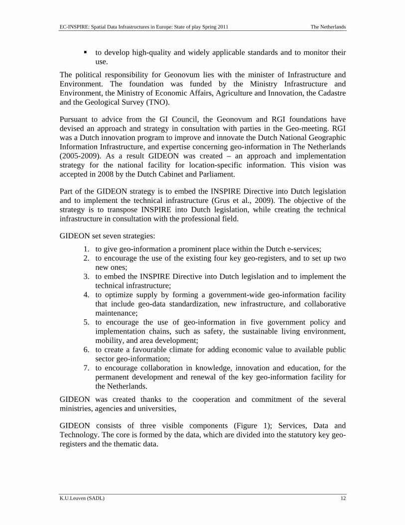
GIDEON consists of three visible components (Figure 1); Services, Data and Technology. The core is formed by the data, which are divided into the statutory key geo-registers and the thematic data.
EC-INSPIRE: Spatial Data Infrastructures in Europe: State of play Spring 2011 The Netherlands
K.U.Leuven (SADL) 13
Figure 1. The visible components of GIDEON
GIDEON is implemented by following a stepwise approach to construct the infrastructure while learning from results achieved along the way. Through a (half) yearly monitoring process, the progress of the GIDEON vision is assessed and reported to the GI–council (see http://www.geonovum.nl/dossiers/gideon). The results of the monitoring are used by the GI-Council to further promote GIDEON implementation and to address potential barriers or delayed processes.
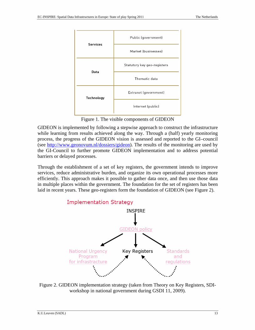
Through the establishment of a set of key registers, the government intends to improve services, reduce administrative burden, and organize its own operational processes more efficiently. This approach makes it possible to gather data once, and then use those data in multiple places within the government. The foundation for the set of registers has been laid in recent years. These geo-registers form the foundation of GIDEON (see Figure 2).
Figure 2. GIDEON implementation strategy (taken from Theory on Key Registers, SDI-workshop in national government during GSDI 11, 2009).
EC-INSPIRE: Spatial Data Infrastructures in Europe: State of play Spring 2011 The Netherlands
K.U.Leuven (SADL) 14
1.2.2 Other initiatives
Other relevant initiatives are RO-Online, Public Services on the map, and National Georegistry.
RO-Online is the portal used by the government to make available spatial plans in digital format. All spatial plans of the government can be accessed by using RO-Online. The spatial plans are displayed as one image to allow the showing of all the spatial plans currently made for a specific area in a glance. RO is accessible by everyone via www.ruimtelijkeplannen.nl. From 1 January 2010, governmental agencies are obliged (by the Law of Spatial Planning) to digitise spatial plans and to make them available via RO-Online. From 1 May 2010, Cadastre and Geonovum are responsible for the management of RO-Online. More specific, the Cadastre is responsible for the system and the helpdesk RO-Online. Geonovum is responsible for the management of the domain specific standards and contact with the stakeholders. In this way, RO-Online is able to fulfil the needs of the stakeholders.
Initiative Public services on the map (Publieke dienstverlening op de kaart) is an initiative of the former Ministry of Housing, Spatial Planning and the Environment (VROM), the former Ministry of Agriculture, Nature and Food Quality (LNV), Directorate-General for Public Works, Traffic and Water Management (RWS), Cadastre, TNO and Geonovum. The objective of this initiative is to establish a central platform for geo-information. This could be achieved by making data centrally available, making commitments about the use, and working together on the development of data infrastructures such as INSPIRE and key registries. In this way, the partners of this initiative improve their service delivery to themselves and others.
The National Georegistry is the catalogue of online geo-information in the Netherlands, Data providers are able to register their data meanwhile users can discover what data and services are available. In February 2011, the number of published metadata of datasets in the National Georegistry is 2603, and the number of published metadata of services is 11 (more information about the National Georegistry can be found later in this report).
EC-INSPIRE: Spatial Data Infrastructures in Europe: State of play Spring 2011 The Netherlands
K.U.Leuven (SADL) 15
2 Details of the Dutch NSDI (NGII)
2.1 Introduction This chapter presents the status of the different components regarding the Dutch NSDI in more detail. The components be presented are: 1 Coordination and organisational issues; 2) Legal framework and funding; 3) Data for thems of the INSPIRE annexes; Metadata; 5) Network services; 6) Environmental themes and activities; and 7) Standards. Finally, the use and efficiency of the Dutch NSDI is briefly presented
2.2 Component 1: Coordination and organizational issues The Geographic Information Council is the highest administrative advisory body for Geographic information in the Netherlands. In this GI-Board most government organisations (ministries, provinces, municipalities, water authorities, and government agencies) involved in the NSDI are represented.
Geonovum is the National Spatial Data Infrastructure (NSDI) executive committee in the Netherlands. The organisation was founded in spring 2007 and devotes itself to providing better access to geo-information in the public sector. Geonovum develops and manages the geo-standards necessary to implement this goal. The activities of Geonovum are subsidised by the Ministries of Infrastructure and Environment, Economic Affairs, Agriculture, and Innovation, the Cadastre and TNO. Geonovum replaced RAVI and the National clearinghouse geo-information organisations.
In September 2007, Geonovum, assigned by the Ministry of VROM, presented a plan for the implementation of INSPIRE in the Netherlands (http://www.Geonovum.nl/ Download-document/61-Plan-van-Aanpak-INSPIRE-in-Nederland.html). Three phases were foreseen: preparation, execution and closure. Geonovum coordinates the implementation of INSPIRE in the Netherlands. Part of this initiative is the development of the national INSPIRE portal that has to be connected to the European INSPIRE-portal and filled with spatial data and metadata. The initiative has also to deliver the general terms and conditions for the using the INSPIRE network, geo-data and metadata and a basic service level agreement between data-providers and users.
The Ministry of Infrastructure and Environment is the ministry responsible for implementing the INSPIRE legislation in the Netherlands. The Ministry of Infrastructure and Environment requested Geonovum to manage the implementation process. The legislative process concentrates on the source data owners of the data covered by INSPIRE. The most important source data owners for INSPIRE are the Cadastre, the Ministry of Infrastructure and Environment, the Ministry of Economic Affairs, Agriculture, and Innovation, the Ministry of Defence, TNO, Alterra, the Royal Netherlands Meteorological Institute (KNMI), Statistics Netherlands (CBS), provincial governments, and district water boards. Market parties may tie in with the facilities created within the INSPIRE framework.
EC-INSPIRE: Spatial Data Infrastructures in Europe: State of play Spring 2011 The Netherlands
K.U.Leuven (SADL) 16
Currently, each organisation has its own agreement and rules on data and service sharing. Generally, most datasets are exchanged between governmental organisations free of costs (except for most Cadastre datasets). An agreement on standards and licences has been set for all groups of stakeholders including the conditions of use. However, a number of conditions exist on the availability of data such as confidentiality of personal data (e.g. cadastral data, data from the Ministry of Economic Affairs, Agriculture, and Innovation). At the same time a third party with economic interests raised a question on the fairness of freely available data.
Regarding the implementation strategy the Dutch national vision for geo-information is reflected on the GIDEON document for the years 2008-2011. (http://www.Geonovum.nl/sites/default/files/GIDEON_Engels_0.pdf).A number of organizations have been involved in the implementation strategy from National to local governments, to universities and Geobusiness NL (an umbrella organization for private sector GI organizations). The following organisations committed themselves to GIDEON: former Ministry of Housing, Spatial Planning and the Environment (VROM); Ministry of the Interior and Kingdom Relations (BZK); Ministry of Foreign Affairs; Ministry of Defence; former Ministry of Agriculture, Nature and Food Quality (LNV), Government Service for Land and Water Use (DLG) and National Service for Implementation of Regulations (DR); former Ministry of Transport, Public Works and Water Management (V&W), Directorate-General for Public Works and Water Management (RWS); Netherlands Bureau for Economic Policy Analysis (CPB); GeoBusiness Netherlands; Association of Provincial Authorities (IPO) and the provincial governments of North-Brabant and South-Holland; Cadastre; Netherlands Environmental Assessment Agency (MNP); Netherlands Agency for Aerospace Programmes (NIVR); Netherlands Institute for Spatial Research (RPB); Geonovum; Space for Geo-Information (RGI) association; Netherlands Organization for Applied Scientific Research (TNO); Alterra; Association of Water Boards (UvW); Universities: TU Delft, Utrecht University, VU University Amsterdam and Wageningen University; Association of Netherlands Municipalities (VNG) and Municipality of Vlaardingen; and Association of Water Boards.
The main objectives of the Dutch NSDI referring to INSPIRE are: To incorporate the INSPIRE Directive into Dutch legislation, and create the
technical infrastructure in consultation with the professional field. The implementation will maintain compatibility with the national key facilities (basisregistraties).
The Ministry of Infrastructure and Environment aims through the INSPIRE implementation to enhance the range, quality, and availability of geo-information.
While the Milestones are:
2009: Completion of INSPIRE legislative process. 2010: Metadata available for Annexes I and II. Search, view and download
services available. 2011: Operational INSPIRE portal (as part of the national georegister.
EC-INSPIRE: Spatial Data Infrastructures in Europe: State of play Spring 2011 The Netherlands
K.U.Leuven (SADL) 17
In 2009, the geoportal was launched, and all the organisations providing spatial data (INSPIRE compulsory or not, public and private) are included in this so-called National Georegistry of the Netherlands.
The transposition has been concluded and a final text has been published. (http://wetten.overheid.nl/BWBR0026158/geldigheidsdatum_15-12-2009). An issue of interest that alerted the Dutch House of Commons (Tweede Kamer) was about the cost aspect. Therefore they pointed out that INSPIRE should be implemented up to the minimum necessary-compulsory level. An additional cost-benefit analysis was requested by the members of the parliament and was executed at the end of 2009. It was noted that no changes to the existing legislation were incorporated because of the adoption of the INSPIRE directive. However, the implementation of the National georegister as part of the INSPIRE program is an addition to the minimum necessary-compulsory level.
Conclusions of Component 1
The approach and territorial coverage of the Dutch SDI is truly national and a number of the SDI components have reached a significant level of operationality. Geonovum is the officially recognised coordinating body of the SDI and although not controlled by users they are indirectly represented. Producers and users are participating in the SDI while there is involvement of non-public sector actors such as universities, and Geobusiness Netherlands.
Based on these conclusions we score the indicators as follows:
• The approach and territorial coverage of the SDI is truly national
• One or more components of the SDI have reached a significant level of operationality (5)
• The officially recognised or de facto coordinating body of the SDI is a NDP, i.e. a
NMA or a comparable organisation (No)
• The officially recognised or de facto coordinating body for the SDI is an organisation controlled by data users (Partially)
• An organisation of the type ‘national GI-association’ is involved in the
coordination of the SDI
• Producers and users of spatial data are participating in the SDI
• Only public sector actors are participating in the SDI (No)
EC-INSPIRE: Spatial Data Infrastructures in Europe: State of play Spring 2011 The Netherlands
K.U.Leuven (SADL) 18
2.3 Component 2: Legal framework and funding
2.3.1 Legal framework
The Ministry of Infrastructure and Environment is the formal responsible for GI-related matters in The Netherlands.
The results of the NSDI-initiative are partially integrated in legal instruments:
A key element of the NSDI is the “authentic registers” (basisregistraties). Authentic registrations are registrations with a uniquely defined core dataset, which government agencies are obligated to use. The collection and maintenance of the data is regulated in legislation, and the data consistent, adhering to the data specifications, across the registration. The users are obliged to report incorrect information to producers, and there is a stringent policy on quality assurance.
The authentic registrations include several datasets that can be considered as geographic datasets. First, the law making Top10NL of the Cadastre the authentic registration for topography was adopted in January 2008 by amendments to the Law on the Cadastre. From 1 January 2009, all public bodies in the Netherlands are under an obligation to use it. Local authorities that had their own 1:10,000 topographic maps had to make the switch by 1 January 2010. In addition, the derived 1:50,000, 1:100,000, 1:250,000, 1:500,000 and 1: 1,000,000 are also part of the authentic registration for topography. A convenant was signed between the Ministry of Infrastructure and Environment and the Cadastre about the maintenance of the registration.
Second, the authentic registration for addresses and buildings was included in the law of 24 January 2008 (which was amended on 14 February 2009). The law entered into force on 1 July 2009, and the local authorities are since then under the obligation to deliver their address and building data to the national registry (BAG). As of February 2011, 97% of the municipalities submitted their data to the BAG-registry. From 1 July 2011, the registration has to be used by all public bodies.
For the third authentic registration, the large-scale topography (1:500 to 1:2.000), draft legislation was intended to be issued in early 2010. It is expected to be introduced in the parliamentary process mid-2011.
The fourth authentic registration, subsurface, will be fully operational by 2013. This was approved by a Decision from the cabinet in December 2008.
A fifth registration concerns the WOZ registration (Assessment of immovable objects registration). This is the basis for real property taxation.
Another important legal instrument is the law 2 July 2009 transposing the INSPIRE directive into Dutch law. The law stays close to the directive, requires the public authorities to create metadata and gives everyone the right to use the network services. The rules for sharing data have to be set up by a ministerial decree.
EC-INSPIRE: Spatial Data Infrastructures in Europe: State of play Spring 2011 The Netherlands
K.U.Leuven (SADL) 19
The minister of the former Ministry of Public Health, Spatial Planning and Environmental Affairs supported the transposition of the INSPIRE directive into the Dutch law by stating the following: Spatial information is key for the proper execution of environmental policies. Harmonisation through INSPIRE, including the requirement to share data, enables more effective future European environmental policy making. INSPIRE implementation will result in accessible, viewable, downloadable, and interoperable digital information. The impact of INSPIRE will be broader than just environmental policy making. It will result in a general spatial data infrastructure at the European level (Ministry of Public Health, Spatial Planning and Environmental Affairs, 2009).
2.3.2 Public-private partnerships (PPP’s)
In 1975, the Large Scale Base Map of the Netherlands (GBKN - Grootschalige Basiskaart van Nederland) was established by Royal Degree,. After a long period of development, in 1992 the LSV-GBKN (Landelijk Samenwerkingverband - National Cooperation GBKN) was established which finished the production of the GBKN in 1999. The LSV-GBKN was a national joint venture with 11 regional joint ventures. The production costs are €20 million and nationwide fully covered. It is a PPP of the municipalities, utility companies, water boards, the Dutch Cadastre and the Dutch administration. If the GBKN becomes one the authentic registration large scale topography, then the maintenance is a public task and the PPP construction is no longer be maintained.
2.3.3 Policy and legislation on access to and re-use of public sector information (PSI)
The legal basis for access to public information is the Government Information Public Access Act of 31 October 1991. This act replaced the Act on Public Access to Information of 9 November 1978. It creates a presumption that documents created by a public agency should be available to everyone. The law provides for access to information that is crucial in the decision making process of the administration. The price to be paid for this information is based on dissemination cost. Government agencies can claim copyright or database right on their data and many of them do so.
Directive 2003/4 on access to environmental information was implemented in Dutch law by the Act of 30 September 2004, modifying the Government Information Public Access Act, the Act on environmental management and other Acts.
The Government Information Public Access Act has been revised to include the implementation of Directive 2003/98 on the re-use of PSI. In 2009, the Ministry of Internal Affairs announced that it would review the legislation implementing the PSI directive. While the Dutch policy already went beyond the minimum requirements of the directive (thanks to the policy document ‘Naar optimale beschikbaarheid van overheidsinformatie – Towards the optimal availability of public sector information), this is aimed to be translated into the legislation. The new legislation was intended to be
EC-INSPIRE: Spatial Data Infrastructures in Europe: State of play Spring 2011 The Netherlands
K.U.Leuven (SADL) 20
brought before Parliament before the end of 20101. Its main principles are: the adaptation of the pricing principle towards the charging of only marginal costs; the banning of public sector bodies to use their intellectual property rights to impose conditions on re-use; and the creation of transitory rules for a number of data collections, including the Cadastre, allowing for the adaptation of their funding model.
2.3.4 Legal protection of GI by intellectual property rights
Copyright is primarily regulated by the Copyright Act of 1912. The 2001 directive on copyright in the information society has been included into national legislation.
In principle, copyright is applicable to all government information -with the exception of official texts of legislation, judicial decisions and administrative decrees-, although copyright must be claimed explicitly by the government for the protection to be effective and a copyright sign (©) has to be placed on the work. Commercial use of the data for which copyright is claimed by an administrative agency is only allowed when the agency concerned gives its consent.
Due to their factual and standardized character geographic information often does not meet the requirements of originality required by copyright. However, common law shows that geo-information with a personal view can still be protected by copyright.
Based on the European Directive on the legal protection of databases (96/9/EC), the 1912 Copyright Act was amended and a Dutch version of the Directive, the Database Law, enacted in 1999. The new law protects the producer of a database which shows that there has been qualitatively and/or quantitatively a substantial investment in either the obtaining, verification or presentation of the contents. Government agencies explicitly have to reserve their rights. In a Decision on a case between the City of Amsterdam and Landmark, the Council of State (the highest administrative court) decided that the city could not be considered a producer of the database, because it did not bear the risk of the substantial investment in the database, as the data was partially obtained from the national ministry, and partially paid for by the city of Amsterdam in order to facilitate the performance of its public task. The court found that there was no financial risk, so the city could not invoke its database right to impose conditions on the re-use by Landmark.
The new legislation on PSI aims to ban the public sector bodies from using their intellectual property rights to restrict the re-use of their data.
2.3.5 Restricted access to GI further to the legal protection of privacy
The Netherlands Data Registration Act was passed in 1989 and applies to all collections of personal data, regardless of residency status in the Netherlands. It also applies to foreign files having a Dutch file controller and containing personal data about Netherlands residents. A new Personal Data Protection Act (Wet Bescherming
1 This was postponed due to new government.
EC-INSPIRE: Spatial Data Infrastructures in Europe: State of play Spring 2011 The Netherlands
K.U.Leuven (SADL) 21
Persoonsgegevens – WBP) was approved by the parliament in June 2000 and implements EU Directive 95/46/EG. It came into force on 1 September 2001.
Although geographic data primarily focuses on geographic objects and not on natural persons, and even might be presented in an anonymous way, an operator can often easily relate these data to natural persons. In most cases the law concerning privacy protection is therefore applicable to geo-information. Hence, each organization or business should notify persons that they have been registered and for what purpose.
EU Directive 2002/58 on privacy and electronic communications has been implemented in national law by several regulations and an act of 22 April 2004 in particular. For an overview of the acts implementing this directive, see http://europa.eu.int/information_society/policy/ecomm/doc/implementation_enforcement/country_by_country/netherlands_2002_58.pdf.
Particular attention to privacy and personal data is also paid in the legislation on the authentic registration for buildings and addresses. Data from the registration that can be considered as personal data can only be transferred to parties that are authorised to process personal data under the privacy legislation.
2.3.6 Licensing framework
The overall policy of Dutch government (esp. the Ministry of Internal Affairs) is to promote the free and unrestricted use of public sector information. It recommends to use the public domain mark (see http://creativecommons.org/publicdomain/mark/1.0/deed.nl) or as an alternative the creative commons zero license (see http://creativecommons.org/publicdomain/zero/1.0/deed.nl).
However, it appeared that for several public spatial datasets the creative commons licenses were impossible to use. Therefore, Geonovum, in cooperation with Delft University of Technology, developed a licensing framework based on creative commons, called Geo gedeeld. It proposes seven possible standard licensing conditions. The licences may contain one or more of the following conditions:
1. Obligation of attribution; 2. No redistribution is allowed; 3. Derivative works only if Work is not selectable from derivative work; 4. The licence has a limited duration; 5. A charge has to be paid for using the data; 6. Purpose limitation: use is limited to specified purposes (e.g., only by government
organisations); 7. Additional conditions.
The model was discussed with the data holders and adapted to their needs. It was accepted by the GI-council and will be implemented in the course of 2011.
EC-INSPIRE: Spatial Data Infrastructures in Europe: State of play Spring 2011 The Netherlands
K.U.Leuven (SADL) 22
The licence generator can be found at: http://www.geonovum.nl/diensten/gebruiksvoorwaarden. In 2011, the text is available in English.
2.3.7 Funding model for SDI and pricing policy
Funding
The 2011 budget of Geonovum to fulfil its tasks is set at €3.300.000.
The funding for INSPIRE implementation is mainly directed to:
coordinating body/structure service development setting-up registers other components of the infrastructure (e.g. monitoring and reporting)
The former Ministry of Housing, Spatial Planning and the Environment reserved the following funds for the INSPIRE implementation: 2008: € 0.5 mln, 2009: € 0.7 mln, 2010: € 0.7 mln, and 2011: €0.75 mln. The assumption in financing the costs of implementing INSPIRE for source data owners is that these costs are for the expense of the source data owners themselves (VROM, 2008).
Cost-recovery is one of the principles applicable to data supply by Dutch governmental bodies to third parties. A policy change towards open policies in the Netherlands has occurred for provincial data (since 2007) and the water board authorities (2009) as well as for data supplied by Directorate-General for Public Works and Water Management (Rijkswaterstaat), and Statistics Netherlands. Also the authentic register Building and Addresses (BAG) are available for free to all (until July 2011), and in the future for the cost of dissemination. The authentic registration topography is available for the marginal cost of dissemination for government users. The subsurface database has a similar policy. And the large scale topography should become freely available when it has reached the status of authentic registration. In February 2011, the Ministry of the Interior launched the Dutch open government data portal (see www.data.overheid.nl), including a reference to the national georegister.
The Cadastre is required by law to recover its operational costs through data sales, but is forbidden to make profits from its core activities. With the plans for the new PSI legislation, the new law makes a few explicit exceptions to the marginal cost policy. Since the Cadastre has its own accessibility regime in the Cadastre Act regulation, the Cadastre is one of the exceptions to the expected new national policy.
Pricing
The nationaal georegister provides metadata free of charge. The data sets themselves are contained at the owning organization, being among others government agencies, provincial and local authorities.
EC-INSPIRE: Spatial Data Infrastructures in Europe: State of play Spring 2011 The Netherlands
K.U.Leuven (SADL) 23
Conclusions of Component 2
The INSPIRE Directive has been transposed. In addition, an organisational and technological strategic framework has been established (GIDEON). The Government Information Public Access Act has been revised to include the implementation of Directive 2003/98 on the re-use of PSI. In 2009, the Ministry of Internal Affairs announced that it would review the legislation implementing the PSI directive. While the Dutch policy already went beyond the minimum requirements of the directive, this is translated into the legislation. The new legislation on PSI bans the public sector bodies from using their intellectual property rights to restrict the re-use of their data. Particular attention to privacy and personal data is also paid in the legislation on the authentic registration for buildings and addresses (BAG). Data from the registration that can be considered as personal data can only be transferred to parties that are authorised to process personal data under the privacy legislation. Geonovum, in cooperation with Delft University of Technology, has started working on a licensing model based on creative commons, called Geo gedeeld. It proposes four sets of standard licensing conditions. It should be noted that no long-term financial security of the SDI-initiative exists. However, the Ministry of Infrastructure and Environment has reserved the following funds for INSPIRE implementation: 2008: € 0.5 mln, 2009: € 0.7 mln, 2010: € 0.7 mln, and 2011: € 0.75 mln. Regarding the pricing framework the lack of consistent national guidelines on pricing and/or availability of government information has resulted in pricing and access policies varying from one government department to another. There is, however, a trend towards open data policies for public sector geographic information.
Based on these conclusions we score the indicators as follows:
• There is a legal instrument or framework determining the SDI-strategy or –development
• There are true PPP’s or other co-financing mechanisms between public and
private sector bodies with respect to the development and operation of the SDI-related projects
• There is a freedom of information (FOI) act. This act applies also to public sector
geo-information (PSGI). In some instances there is legislation specifically dedicated to PSGI such as the Kadaster Act, Acts on authentic registrations (buildings, addresses, topography, cadastral, taxation), data from Statistics Netherlands, and the Dutch Royal Meteorological Service. Further, local authorities still enjoy a relative freedom to determine prices for requests.
• GI can specifically be protected by copyright (yes)
• Privacy laws are actively being taken into account by the holders of GI
• There is a framework or policy for sharing GI between public institutions
EC-INSPIRE: Spatial Data Infrastructures in Europe: State of play Spring 2011 The Netherlands
K.U.Leuven (SADL) 24
• There are simplified and standardised licences for personal use (yes)
• The long-term financial security of the SDI-initiative is secured (Partially)
• There is a pricing framework for trading, using and/or commercialising GI (in Preparation)
2.4 Component 3: Data for themes of the INSPIRE annexes
2.4.1 Data sets of different resolutions covering the INSPIRES and other themes
In the 'Structure Outline for Geo-information' (SVI, 1992) the information concerning parcels of land, people, companies, buildings and addresses, was identified as the fundamental building blocks for the NGII. They are part of a larger concept within the e-Government initiative, called basic (authentic) registers. Currently, the Dutch government has defined 13 basic registers of which 5 are spatial in nature: Buildings/Addresses; Topography; Large-scale topography; Subsurface; and WOZ (Assessment of immovable objects registration).
Examples of other available fundamental datasets that have a nation-wide coverage are:
Land cover database of the Netherlands produced by the Alterra; Land cover ecological database of the Netherlands produced by Alterra); Waterways spatial dataset produced by the Survey Department of the
Directorate General of Public Works and Water Management; Geology spatial dataset produced by the National Geological Survey (NITG-
TNO); Archaeology spatial dataset produced by the Institute for Archaeological Soil
Exploration; Cadastral map produced by the Cadaster; Digital elevation model.
Besides these fundamental data sets hundreds of other core data and thematic data sets are produced.
It is estimated that there are 36,000 datasets in the public sector of potential use to others. All scale levels are supported.
In the GIDEON report a table provides a list of 77 spatial databases in various scales with data owners such as Alterra, Kadaster, KNI, TNO etc.
EC-INSPIRE: Spatial Data Infrastructures in Europe: State of play Spring 2011 The Netherlands
K.U.Leuven (SADL) 25
Regarding the three INSPIRE annexes addressing the 34 spatial data themes. The Netherlands is providing discovery and view services for most of them while a number of them can be also downloaded. The datasets are provided in a variety of scales and resolution according to their usage. All metadata are based on ISO and are available for most of the data themes.
Geonovum publishes an overview of progress in this area on its website. The progress review is confined to Appendix I & II. From the list, it is clear to everyone how far the various organizations involved proceed with their activities. (http://www.Geonovum.nl/dossiers/inspire/voortgang).
2.4.2 Geodetic reference systems and projections
The spatial reference systems used are:
Rijksdriehoeksstelsel (RD) with the Bessel Ellipsoid of 1841 and a azimuth stereographic projection with ± 4000 higher order points;
Lambert conformal conical; Geographic.
For GPS observations, ETRS is used.
2.4.3 Quality of the data
No information has been found about the data quality procedures for the INSPIRE and other thematic datasets. In addition, no information has been found about any service quality procedure.
2.4.4 Interoperability and harmomisation of data
OpenGIS-standards are sometimes used to ensure interoperability between datasets and information services. Geonovum has released a document called Framework for standards (in Dutch) to guide the technical implementation of INSPIRE. The document consists of chapters on standards for INSPIRE and application to The Netherlands, metadata, architecture elements, information models and service elements.
As an important interoperability tool, a national validation service for the spatial planning standards was developed (former Ministery VROM, 2009), which became operational by the end of 2008. A national validation service was provided to test digital plans at four levels. The first test ensures that the GML data encoding is according to the schemes and business rules of the standards. The second test sees whether all file names are used properly. A third test determines whether the geometry is fully interoperable, not only according to official GML-standards but also with specific choices to facilitate the use in a broad range of GIS and CAD systems. Finally, a check is made to see if the digital signature is valid to ensure the integrity and completeness of the plan (Duindam et al., 2009).
EC-INSPIRE: Spatial Data Infrastructures in Europe: State of play Spring 2011 The Netherlands
K.U.Leuven (SADL) 26
In the webpage of Geonovum users can find this validation tools (http://www.Geonovum.nl/diensten/valideren).
2.4.5 Language and culture
Metadata and documents are provided in Dutch. The websites of the different authorities are in Dutch and often also in English. The geoportal facility is accessible in four languages: Dutch, English, French and German. However, the metadata is recorded in Dutch only.
Conclusions of Component 3
From the previous country reports regarding the status of the Dutch NSDI, it appears that numerous spatial datasets exist that provide a basis for contributing to the coverage of pan-European INSPIRE-selected data themes and components. The existing geodetic reference system and projection systems are standardised, documented and interconvertable. An important interoperability tool, the national validation service for the spatial planning standards was developed. Metadata and documents are provided in Dutch while the websites of the different authorities are in Dutch and often also in English.
Based on these conclusions we score the indicators as follows:
• Spatial datasets exist that form the basis for contributing to the coverage of pan-European INSPIRE data themes and components
• The geodetic reference system and projection systems are standardised,
documented and transformable.
• There is a documented data quality control procedure applied at the level of the SDI (Unknown)
• Concern for interoperability goes beyond conversion between different data
formats
• The national language is the operational language of the SDI
• English is used as secondary language
EC-INSPIRE: Spatial Data Infrastructures in Europe: State of play Spring 2011 The Netherlands
K.U.Leuven (SADL) 27
2.5 Component 4: Metadata
2.5.1 Availability of metadata
Metadata are produced for a significant part of the spatial datasets. Geonovum has a coordinating and stimulating role. The National Georegister (NGR) integrates geographic information from several Dutch authorities together in one single portal. There are currently (February 2011) almost 2600 datasets with metadata registered and for 11 services metadata is registered.
2.5.2 Metadata catalogues
Geonovum manages the metadata catalogue in a centralized way. The National Georegister (http://www.nationaalgeoregister.nl/geonetwork/srv/nl/main.home) is the metadata catalogue of The Netherlands. Users can search for metadata using keywords, accuracies, area, theme and/or producer of the dataset. This metadata catalogue is strongly based on the ISO and OGC standards.
Another metadata catalogue is managed by the Water service of Directorate-General for Public Works and Water Management (http://www.nodc.nl). The metadata are in English, their character is ‘utf8’ and are ISO 19115:2003/19139 version 1.0 (US Federal Geographic Data Committee (FGDC).
2.5.3 Metadata implementation
No information has been found nor provided.
Conclusions of Component 4
Metadata are produced for a significant number of spatial datasets of the INSPIRE-themes. The National Georegister (http://www.nationaalgeoregister.nl/) brings geographic information from Dutch authorities together in an integrated portal. Metadata can be found for a number of different themes on the national geoportal from 2009 onwards. Geonovum manages the metadata catalogue in a centralized way. However, Geonovum provides models and brings people together, but does not coordinate implementation.
Based on these conclusions we score the indicators as follows:
• Metadata are produced for a significant number of spatial datasets of the themes of the INSPIRE annexes
• One or more standardised metadata catalogues are available covering more than
one data producing agency
• There is a coordinating authority for metadata implementation at the level of the SDI (Partially)
EC-INSPIRE: Spatial Data Infrastructures in Europe: State of play Spring 2011 The Netherlands
K.U.Leuven (SADL) 28
2.6 Component 5: Network Services
2.6.1 Geoportal
The Nationaal Georegister (http://www.nationaalgeoregister.nl/geonetwork/srv/en/ main.home) provides a (thematic, enterprise) metadata catalogue through one geo-portal.. In this national Geoportal a metadata search results in 2600 different results from a variety of sources. Moreover, the GeoNetwork open source provides the option to save these results as pdf.
The National Georegistry provides:
a geographic search engine a web mapping viewer publishing tools for data providers, and elaborate background information
2.6.2 Network services
The Netherlands holds numerous network services. This list is just an overview of services made publicly available via the preliminary geo-portal of Geonovum: http://services.Geonovum.nl/PAS.php, as well as the national geoportal http://www.nationaalgeoregister.nl/geonetwork/srv/en/main.home.
2.6.2.1 Discovery services
The Nationaal Georegister includes the main discovery service for spatial data in The Netherlands. The options for searching are mainly keywords, themes, area and time. There is also a specific INSPIRE search that allows to search per Annex, Source type, Service type, Organisation and INSPIRE theme.
2.6.2.2 Viewing services
The Nationaal Georegister has a graphical component enabling to visualise the spatial datasets as well as to elaborate search options. A number of organisations (governmental, provinces, municipalities, water boards, private companies etc) are currently involved in this integrated portal.
Another Viewing service is the national Atlas (http://www.nationaleatlas.nl/). This result was the key product of the project that was co-financed by the Program ‘Ruimte voor Geoinformatie’ (project RGI-111). All maps of the Atlas are interactive. It is also possible to search for alternative datasets. Through the Atlas maps, which form the footprint of the available datasets, the metadata of those datasets can be evaluated. The envisaged architecture of the national atlas employs the OWS specifications in a multi-tier setup (Kraak et al., 2009).
According to the INSPIRE Monitoring Report 2010, 48 viewing services are established.
EC-INSPIRE: Spatial Data Infrastructures in Europe: State of play Spring 2011 The Netherlands
K.U.Leuven (SADL) 29
2.6.2.3 Download services
According to the INSPIRE Monitoring Report 2010, 36 download services exist.
2.6.2.4 Transformation services
No information has been found.
2.6.2.5 Invoking services
No information has been found
2.6.3 Spatial data services and other services
These types of services such as Web Processing Services, Authentication services, Payment services are envisaged to be implemented by Geonovum.
Partly under the umbrella of the R&D initiative (‘Space for Geo-Information initiative’), Geonovum developed and tested a vision for an advanced service of interconnected regional and thematic geoportals and spatial data services.
2.6.4 Use of software
There is a tendency in Geonovum to turn to more open software-solutions. The program OSOSS tries to stimulate this (see https://noiv.nl/open-source-en-open-standaarden/).
The current spatial planning standards are largely based on comprehensive GML3 schema with GML profiling on top of that to overcome interoperability issues. Web service access to this data requires the use of web based feature services (WFS) (Duindam et al., 2009).
Conclusions of Component 5
In 2009, the Geoportal National Georegister was launched. The Netherlands holds at least one discovery services and several viewing services and download services. No information is found regarding transformation and middleware services allowing data services to be invoked. Regarding the spatial data services and other services, they are currently envisaged to be implemented by Geonovum.
Based on these conclusions we score the indicators as follows:
• There are one or more discovery services making it possible to search for data and services through metadata
• There are one or more view services available for to visualise data from the
themes of the INSPIRE annexes
EC-INSPIRE: Spatial Data Infrastructures in Europe: State of play Spring 2011 The Netherlands
K.U.Leuven (SADL) 30
• There are one ore more on-line download services enabling to download (parts of) copies of datasets
• There are one or more transformation services enabling spatial datasets to be
transformed to achieve interoperability (Not Known)
• There are one or more middleware services allowing data services to be invoked (Not Known)
2.7 Component 6: Environmental themes and activities The national geoportal (http://www.nationaalgeoregister.nl/geonetwork/ srv/nl/main.home) provides a list of various thematic environmental data. This list (part of the search option) includes themes such as: agriculture and livestock, biota, climatology, meteorology, inlands waters, oceans, etc.
Conclusions of Component 6
Based on the information provided on the previous paragraph we score the indicator as follows:
• Thematic environmental data are covered by the described SDI-initiative or there is an independent thematic environmental SDI (Partially)
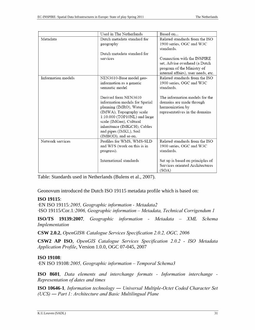
2.8 Standards In the website of Geonovum there is a dedicated page on Geo-Standards and in particular on INSPIRE compliant geostandards (only in Dutch). (available at: http://www.Geonovum.nl/geostandaarden). At the same time a wiki-page on standards exists (http://wiki.Geonovum.nl/index.php/Main_Page) providing the standards framework. The framework includes information about International, European and Netherlands standards. Moreover, information on metadata and Service Oriented Architecture is provided.
The coherence in the framework is based on the division of three parts, metadata, information models and network services. In these three parts the standards are categorized to obtain a good connection to existing (inter)national standards, including INSPIRE standards. The following table shows how this is elaborated and also gives an overview of what is described by the framework.
EC-INSPIRE: Spatial Data Infrastructures in Europe: State of play Spring 2011 The Netherlands
K.U.Leuven (SADL) 31
Table: Standards used in Netherlands (Bulens et al., 2007).
Geonovum introduced the Dutch ISO 19115 metadata profile which is based on:
ISO 19115: ·EN ISO 19115:2005, Geographic information - Metadata2 ·ISO 19115/Cor.1:2006, Geographic information – Metadata, Technical Corrigendum 1
ISO/TS 19139:2007, Geographic information - Metadata – XML Schema Implementation
CSW 2.0.2, OpenGIS® Catalogue Services Specification 2.0.2, OGC, 2006
CSW2 AP ISO, OpenGIS Catalogue Services Specification 2.0.2 - ISO Metadata Application Profile, Version 1.0.0, OGC 07-045, 2007
ISO 19108: ·EN ISO 19108:2005, Geographic information – Temporal Schema3
ISO 8601, Data elements and interchange formats - Information interchange - Representation of dates and times
ISO 10646-1, Information technology ― Universal Multiple-Octet Coded Character Set (UCS) ― Part 1: Architecture and Basic Multilingual Plane
EC-INSPIRE: Spatial Data Infrastructures in Europe: State of play Spring 2011 The Netherlands
K.U.Leuven (SADL) 32
ISO 639-2, Codes for the representation of names of languages - Part 2: Alpha-3 code
ISO TC 46/SC 4, 2003, Dublin Core Metadata Element Set, versie 1.1, also published as ISO 15836:2003, http://www.niso.org/international/SC4/n515.pdf.
The standardization process that has taken place in the field of spatial planning in the Netherlands over the last years has yielded into a coherent set of Spatial Planning Standards. These Standards comprise three normative parts: An information model (Geonovum, 2008), standards comprising comparability requirements and a standard for the infrastructural demands (Ministerie van VROM, 2008).
The use of the Standards by municipalities, provinces and the central government itself is enforced by law in a separate governmental Regulation. In these terms, the standards are appendices to this regulation. This means that updates are made in a controlled and transparent process. For the future, it is envisioned that updates on the standards are made with a frequency of every two years to accommodate errors and future developments. For this reason, the management and maintenance of the Standards is granted to Geonovum. This management is executed in close relation to the main spatial planning stakeholders as a transparent process, ensuring future commitment. (Duindam et al., 2009)
Conclusions of Component 7
Developments of international standards are followed closely and applied. Moreover, a strategic document from Geonovum: “Geo-standaarden” exists.
Based on these conclusions we score the indicator as follows:
• The SDI-initiative is devoting significant attention to standardisation issues
2.9 Use and efficiency of the NSDI Examples of the positive impact of the use of (parts of) the Dutch spatial data infrastructure and how the SDI is used to support environmental practices, are:
In the Netherlands, different ministries and some national geo-information registers, generate the National Geo Data Infrastructure for Disaster and Emergency response management: GDI R&C (“Rampen & Crisis”) (2009). This GDI is available via web service through a dedicated infrastructure made especially for crisis and disaster management: OOV-net and is owned by the ministry of Internal Affairs (Smit, 2009).
Another part of the Dutch SDI is developed in the project EduGIS in which geo-information and GIS tools from different sources are made available for educational purposes. The aim is to stimulate GIS use in schools so students learn spatial thinking and using geo-ICT and become more aware of their (spatial) environment. See: www.edugis.nl.
An important element -from the perspective of the future development of an SDI at the European level- is the initiatives to develop cross-border SDI projects. An example is the cross-border exchange of information between the Netherlands and North
EC-INSPIRE: Spatial Data Infrastructures in Europe: State of play Spring 2011 The Netherlands
K.U.Leuven (SADL) 33
Rhine/Westphalia. The former ministry of Housing, Spatial Planning and the Environment was responsible for an Interregional European cross border management which in turn is part of the GIDEON policy plan. The intention was to establish collaboration among Dutch, German and Belgian borders including 4 Euro regions in one common program X-border-GDI. A number of running examples include spatial planning, Water management, Nature and Tourism, Traffic and Disaster management (e.g. the Geo viewer for animal disease, the Tourism project ‘eRIGG’ providing hiking maps, etc). Details of the project can be found at: http://www.x-border-gdi.org/en/index.html.
Moreover, a research network led by NEO BV on change detection has been established (http://www.mutmut.nl/index2.html). The projects of Mutatis Mutandis indicate the spatial changes of geoinformation.
EC-INSPIRE: Spatial Data Infrastructures in Europe: State of play Spring 2011 The Netherlands
K.U.Leuven (SADL) 34
3 Annexes
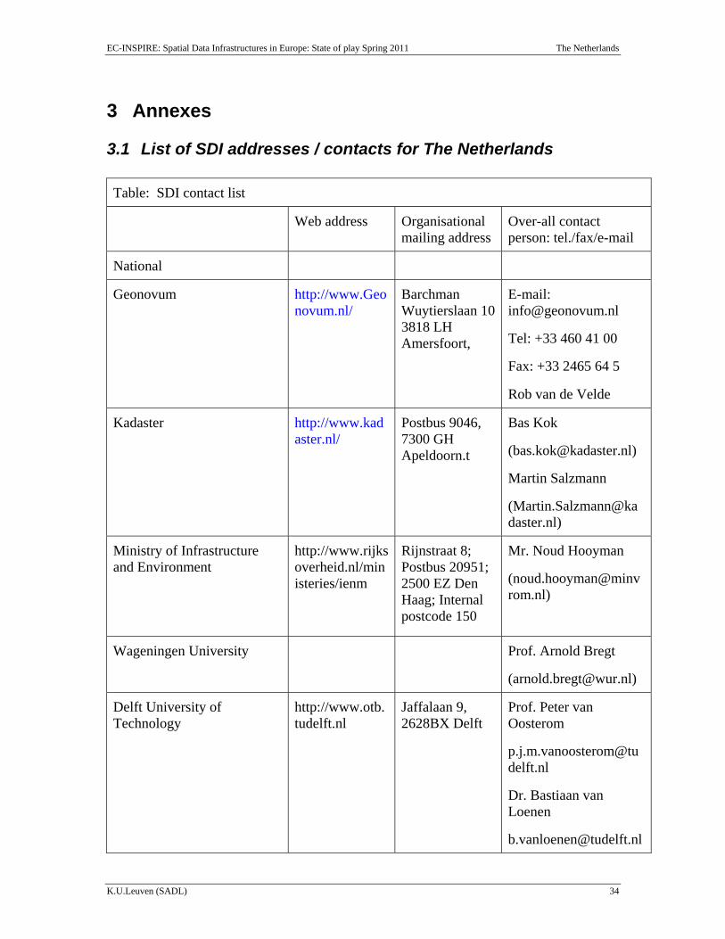
3.1 List of SDI addresses / contacts for The Netherlands Table: SDI contact list
Web address Organisational mailing address
Over-all contact person: tel./fax/e-mail
National
Geonovum http://www.Geonovum.nl/
Barchman Wuytierslaan 103818 LH Amersfoort,
E-mail: [email protected]
Tel: +33 460 41 00
Fax: +33 2465 64 5
Rob van de Velde
Kadaster http://www.kadaster.nl/
Postbus 9046, 7300 GH Apeldoorn.t
Bas Kok
Martin Salzmann
Ministry of Infrastructure and Environment
http://www.rijksoverheid.nl/ministeries/ienm
Rijnstraat 8; Postbus 20951; 2500 EZ Den Haag; Internal postcode 150
Mr. Noud Hooyman
Wageningen University Prof. Arnold Bregt
Delft University of Technology
http://www.otb.tudelft.nl
Jaffalaan 9, 2628BX Delft
Prof. Peter van Oosterom
Dr. Bastiaan van Loenen
EC-INSPIRE: Spatial Data Infrastructures in Europe: State of play Spring 2011 The Netherlands
K.U.Leuven (SADL) 35
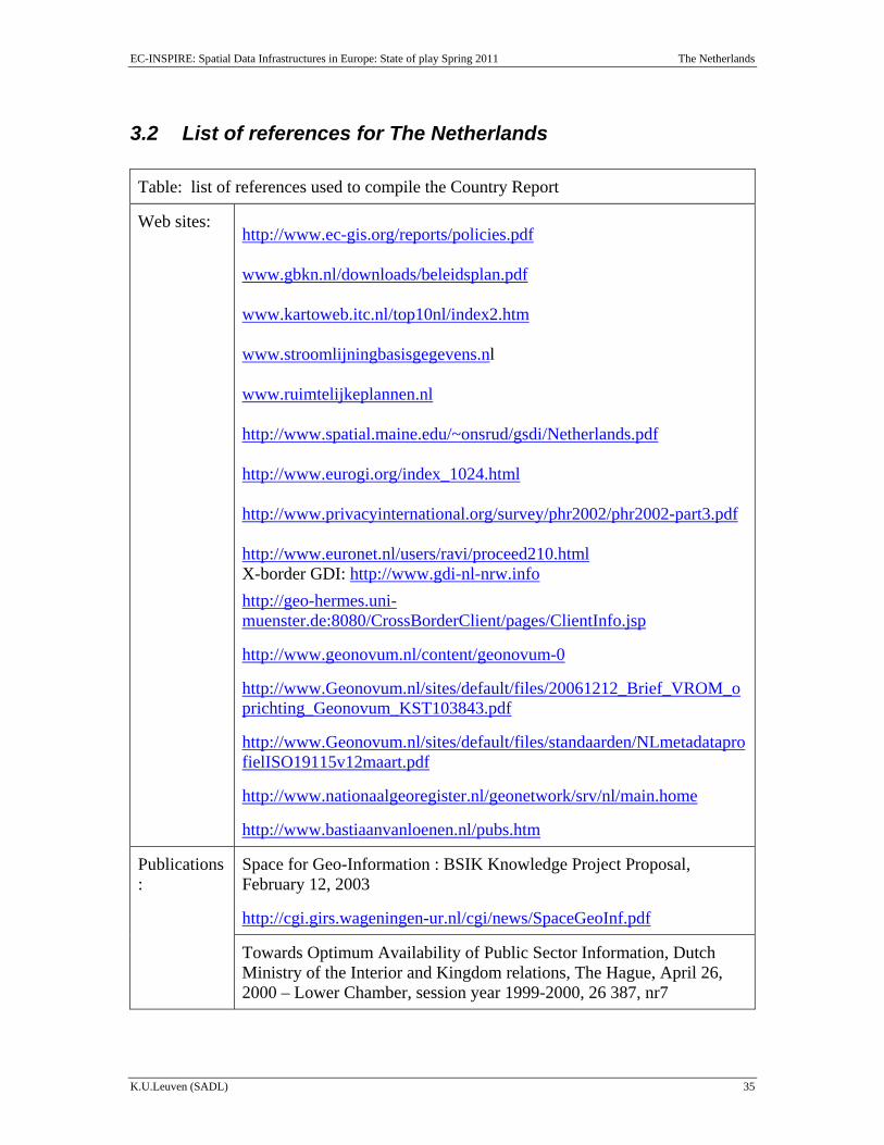
3.2 List of references for The Netherlands Table: list of references used to compile the Country Report
Web sites: http://www.ec-gis.org/reports/policies.pdf www.gbkn.nl/downloads/beleidsplan.pdf www.kartoweb.itc.nl/top10nl/index2.htm www.stroomlijningbasisgegevens.nl www.ruimtelijkeplannen.nl http://www.spatial.maine.edu/~onsrud/gsdi/Netherlands.pdf http://www.eurogi.org/index_1024.html http://www.privacyinternational.org/survey/phr2002/phr2002-part3.pdf http://www.euronet.nl/users/ravi/proceed210.html X-border GDI: http://www.gdi-nl-nrw.info http://geo-hermes.uni-muenster.de:8080/CrossBorderClient/pages/ClientInfo.jsp
http://www.geonovum.nl/content/geonovum-0
http://www.Geonovum.nl/sites/default/files/20061212_Brief_VROM_oprichting_Geonovum_KST103843.pdf
http://www.Geonovum.nl/sites/default/files/standaarden/NLmetadataprofielISO19115v12maart.pdf
http://www.nationaalgeoregister.nl/geonetwork/srv/nl/main.home
http://www.bastiaanvanloenen.nl/pubs.htm
Publications:
Space for Geo-Information : BSIK Knowledge Project Proposal, February 12, 2003
http://cgi.girs.wageningen-ur.nl/cgi/news/SpaceGeoInf.pdf
Towards Optimum Availability of Public Sector Information, Dutch Ministry of the Interior and Kingdom relations, The Hague, April 26, 2000 – Lower Chamber, session year 1999-2000, 26 387, nr7
EC-INSPIRE: Spatial Data Infrastructures in Europe: State of play Spring 2011 The Netherlands
K.U.Leuven (SADL) 36
Geonovum. Framework van Standaarden (2.0). December 2007
Geonovum. Plan van Aanpak INSPIRE Nederland (1.0), VROM, September 2007
GIDEON – Key geo-information facility for the Netherlands, MinVROM, 2008, 56p.
Geonovum, GIDEON Progress reports 2008, 2009 and 2010 http://www.geonovum.nl/dossiers/gideon (in Dutch only)
Geonovum, Framework for harmonized licenses (Geo shared) http://www.geonovum.nl/diensten/gebruiksvoorwaarden (in Dutch only)
Ministry of Public Health, Spatial Planning and Environmental Affairs, 2009. Memorie van toelichting van het INSPIRE wetsvoorstel
L., Grus, S., van Wijngaarden, A., Bregt, and W., Castelein. IMPLEMENTING INSPIRE IN THE NETHERLANDS, Annals of Geomatics, Volume VII, 4(34), pp. 47-56, 2009.
R., Beck and C. van der Sande. Sharing Change Information: the most efficient way of updating geodata in the Netherlands. GSDI 11, Rotterdam, 2009.
J., Bulens, W., Vullings, J., Crompvoets, and M., Reuvers. 2007. The framework of standards for the Dutch SDI. 10th AGILE International Conference on Geographic Information Science 2007 Aalborg University, Denmark
M-J. Kraak,, F. Ormeling, B. Köbben and T. Aditya. 2009. The Potential of a National Atlas as Integral Part of the Spatial Data Infrastructure Exemplified by the New Dutch National Atlas. SDI Convergence. Research, Emerging Trends, and Critical Assessment. B. van Loenen, J.W.J. Besemer, J.A. Zevenbergen (Editors). Nederlandse Commissie voor Geodesie Netherlands Geodetic Commission 48, 2009.
A. Duindam, R. Bloksma, H. Genee and J. van der Veen. 2009. State of Play of the Operational and Legally Bound Spatial Planning SDI in The Netherlands. GSDI 11, Rotterdam, 2009.
J., H., Smit, 2009. Geo-information architecture of the safety region IJsselland in the Netherlands. GSDI 11, Rotterdam, 2009.