Embed Size (px)
Citation preview
Southeast Coastal Ocean Observing Regional Association (SECOORA):Supporting Resilient Ecosystems, Communities and Economies
TOPIC AREA 1: “Implementation and Development of Regional Coastal Ocean Observing Systems”PROJECT DURATION: June 1, 2016 – May 31, 2021
TOTAL FUNDING REQUEST: $20,000,000
This schematic is a visual representation of the overall proposal. With oversight from Governance and Management, and in collaboration with PIs, Data Management and Communications successfully manages and integrates data for a suite of tools and applications. Each component is linked to priority stakeholder needs under four theme areas. *Numbers reflect proposed and existing stations.
Debra HernandezExecutive DirectorSECOORAP.O. Box 13856Charleston, SC 29422P: (843) 906-8686E: [email protected]
Vembu SubramanianRCOOS ManagerSECOORAP.O. Box 13856Charleston, SC 29422P: (727) 525-1926E: [email protected]
Megan LeeFinancial RepresentativeSECOORAP.O. Box 13856Charleston, SC 29422P: (843) 864-6755E: [email protected]
NOAA-NOS-IOOS-2016-2004378
Conrad Lautenbacher, Jr.SECOORA Board ChairGeoOptics, Inc.5673, Bend Creek RoadDunwoody, GA 30338P: (770) 730-5911E: [email protected]
Principal Investigator Associate Investigator Associate Investigator Associate Investigator
This project complies with the 2014 NOAA IOOS Draft Programmatic Environmental Assessment, specifically the Project Design Criteria. Detailed information on activities and compliance is included in Appendix 8: National Environmental Policy Act Questions and Responses.
SECOORA Governance and Management
OBSERVATIONS
INTEGRATED PRODUCTS AND FORECASTS
Marine Weather Portal
Southeast Seasonal Continental Shelf
Ecosystem Advisory Report
Swimming Beach and Shellfish Water Quality17 High Frequency
Radars*
23 In situ Stations, Some Measure Ocean Acidification Variables*
Southeast Atlantic Glider Observatory
Coupled Marine Environmental Assessment and Prediction
MODELS
Ocean Sound Observing Initiative
Vulnerability of Crustacean Fisheries
to Climate Change
Harmful Algal Bloom Forecasting for West
Florida Shelf
STAKEHOLDER ENGAGEMENT THEMES
Ecosystems: Water Quality and Living Marine Resources
Climate Change Coastal Hazards Marine Operations
Real-Time and Historical Data
Portal
Adaptive Sampling
Data Assimilation
Resilient Ecosystems • Resilient Communities • Resilient Economies
Swimming Advisory
Shellfish Advisory
West Florida Shelf Coastal Ocean Model
Harmful Algal Bloom Event Sampling
Data Management and Com
municationsDa
ta M
anag
emen
t and
Com
mun
icatio
ns
Satellite Observations
Project Name: Southeast Coastal Ocean Observing Regional Association (SECOORA): Supporting Resilient Ecosystems, Communities and Economies Primary Contact & Recipient Institution: Debra Hernandez, Executive Director, SECOORA P.O. Box 13856, Charleston, SC 29422; P: (843) 906-8686; E: [email protected] Other Principal Investigators and Affiliation (* Denotes Lead PI): Robert Byrne, University of South Florida (USF); Alina Corcoran, FL Fish and Wildlife Conservation Com-mission (FWC)*; L. Kellie Dixon, Mote Marine Laboratory (MML); Jennifer Dorton, University of North Caro-lina Wilmington (UNCW)*; Catherine Edwards, University of Georgia (UGA) Skidaway Institute of Oceanog-raphy (SkIO)*; Amy Fowler, SC Department of Natural Resources (DNR)*; Ryan Gandy, FWC; Ruoying He, North Carolina State University (NCSU)*; Chuanmin Hu, USF; Chad Lembke, USF, Jason Lenes, USF, Lynn Leonard, UNCW*; Yongang Liu, USF; James Locascio, MML*; Vincent Lovko, MML; Mark Luther, USF*; George Maul, Florida Institute of Technology (FIT)*; Clifford Merz, USF; Scott Noakes, UGA*; Dwayne Porter, University of South Carolina (USC)*; Roger Pugliese, South Atlantic Fishery Management Council (SAFMC); Marcel Reichert, SC DNR; Mitchel Roffer, Roffer’s Ocean Fishing Forecasting Service, Inc. (ROFFS)*; Ryan Rykaczewski, USC; Denise Sanger, SC DNR*; Dana Savidge, UGA SKIO; Jeff Scud-der, USF; Harvey Seim, UNC Chapel Hill (UNCCH); Lynn (Nick) Shay, University of Miami (UM)*; George Voulgaris, USC; Robert Weisberg, USF*; Joseph Zambon, NCSU; Fumin Zhang, Georgia Institute of Tech-nology Project Summary SECOORA is part of the US Integrated Ocean Observing System (IOOS®), and evolved out of several ear-lier sub-regional programs. Its footprint covers both the eastern Gulf of Mexico (GOM) and the South Atlan-tic Bight (SAB), which are connected by the Loop Current- Florida Current- Gulf Stream continuum. Our members include a cross-section of regional interests from private industry, academia, non-governmental organizations and state and federal government. SECOORA integrates observations, models, data man-agement and outreach to sustain and advance an end-to-end, regional coastal ocean observing system (RCOOS) responsive to societal needs. An information management system transforms and delivers value-added products and services consistent with priorities identified through stakeholder needs assessments. SECOORA emphasizes coordinating a multidisciplinary suite of coastal ocean observations with numerical models so that societally important phenomena may be described, understood and ultimately predicted via applications of best science practices. This work provides foundational observing, modeling and data man-agement capabilities to predict and support preparedness to changing conditions, thus enabling resiliency.
IOOS, from its inception, recognized the importance of the coastal ocean in providing a significant part of the nation’s ecosystems services. SECOORA is a region where hurricane landfalls are prevalent and where consequences from oil and gas operations are significant. The region is also a major tourist destination and a commercial and recreational fishing hub. Through performance, SECOORA has demon-strated both a vision and set of accomplishments toward meeting the IOOS goal of societally relevant ap-plied science. SECOORA sustains observations consisting of High Frequency radars (HFR) for surface currents and waves; moored buoys for surface meteorology and water temperature, salinity and in some instances waves and currents; coastal stations for surface meteorology and water level; glider surveys, in-cluding bio-optical measurements, temperature, and salinity; and, exploratory bio-acoustic measurements. These observational components inform and support models across multiple scales and applications. SECOORA-related modeling is used to explain various phenomenology in the region, including harmful algal blooms (HABs), storm surges, oil spill trajectories, fisheries recruitment and beach water quality. SECOORA funding, therefore, supports an array of coastal ocean observations in addition to benefitting
society across a spectrum of coastal ocean applications. SECOORA is currently supported by a National Oceanographic Partnership Program grant administered through the National Oceanic and Atmospheric Administration (NOAA) US IOOS Program Office which ends in 2016. This proposal seeks funding for the five year period from 2016 - 2021.
Priorities for SECOORA over the next five years are to sustain critical observing, data management and modeling activities, build upon successes with users, seek new leveraging opportunities and add new multidisciplinary RCOOS components. With level ($2.5M) funding, SECOORA specifically seeks to:
• Continue governance and management for the regional association (RA); • Effectively engage users and other stakeholders to prioritize investments; • Provide data management and communication (DMAC) infrastructure; • Continue operation of the existing HFRs in the region, presently consisting of 15 sites distributed
from Cape Hatteras to west Florida, and continue coordination with the national network; • Continue operation of 21 in situ stations along the Carolina and West Florida Shelf (WFS) coasts; • Sustain modeling and other product efforts, including: 1) SECOORA-wide daily nowcast/forecast
(N/F) system for currents, waves, and primary production, 2) statistical beach and shellfish water quality predictions; 3) an improved Marine Weather Portal (MWP); and, 4) a high resolution WFS circulation modeling system directly linking shelf seas with estuaries;
• Address spatial observing gaps by: 1) initiating a glider observatory for the South Atlantic Bight (SAB) and 2) installing a coastal water quality and meteorological station in Charleston Harbor, SC.
With funding above $2.5M, necessary additions to the RCOOS will be enabled to: • Implement a HAB forecasting system for the WFS; • Provide seasonal ecosystem advisory reports for the SE continental shelf; • Assess vulnerability of marine and estuarine crustacean fisheries to climate change; • Deploy seafloor pH, passive acoustics and related sensors near the Ocean Acidification (OA)-
enhanced National Data Buoy Center (NBDC) buoy 41008 in Gray’s Reef National Marine Sanctu-ary (GRNMS);
• Install and operate new HFRs east of Port Canaveral, Florida; • Add OA sensor packages to existing buoys (Carolina and WFS coasts); and, • Implement an initiative to measure marine soundscapes and define ambient noise baselines.
SECOORA works closely with partners to achieve our goals. Below are contributors to this effort: • Federal: NOAA National Weather Service (NWS), Ocean Acidification Program, National Estuarine
Research Reserve System (NERRS), National Marine Fisheries Service (NMFS), National Ocean Ser-vice (NOS), Ecological Forecasting Roadmap Team, National Centers for Coastal Ocean Science (NCCOS), Office of Response and Restoration (OR&R), and GRNMS, US Marine Corps, US Army Corps of Engineers (USACE), US Coast Guard (USCG).
• State: NC Department of Environment and Natural Resources (DENR), SC Department of Health and Environmental Control (DHEC), GA DNR, FL Department of Environment Protection (DEP), FL De-partment of Health (FL DOH), FL FWC.
• NGOs: SAFMC, Southeastern Fisheries Association (SFA), Governors’ South Atlantic Alliance (GSAA). • Emergency managers at Federal, state and local levels: NOAA OR&R, NOAA NWS Weather Forecast
Offices (WFOs), county emergency managers.
Table of Contents Introduction / Background ............................................................................................................................... 1 Connections to Users/Stakeholders and Benefits ........................................................................................... 2 Goals, Objectives and Workplans ................................................................................................................... 2 Goal 1: Continue SECOORA’s region-wide governance and communication structure to engage users and stakeholders in coastal observing science. ..................................................................................................... 3
Objective 1.1: Maintain governance and management for the RA and RCOOS. ...................................... 3 Objective 1.2: Engage users and other stakeholders to prioritize investments. ......................................... 3 Objective 1.3: Provide DMAC infrastructure to enable collaboration and decision-making. ...................... 3
Goal 2: Continue existing core observation investments in the region. ......................................................... 5 Objective 2.1: Maintain 15 HFRs distributed throughout the region. ......................................................... 5 Objective 2.2: Maintain 21 in situ stations along the Carolina and WFS coasts. ....................................... 5
Goal 3: Begin to address geographic gaps in observations. .......................................................................... 6 Objective 3.1: Establish a regional glider observatory in the SAB. ............................................................ 6 Objective 3.2: Install a new coastal water quality station in Charleston Harbor. ....................................... 7
Goal 4: Continue delivery of operational model forecasts and products to serve priority users. ................... 7 Objective 4.1: Enhance and operate a Coupled Marine Environmental Assessment and Prediction System. ....................................................................................................................................................... 7 Objective 4.2: Downscaling from the Deep-ocean, across the Continental Shelf and into the Estuaries. . 7 Objective 4.3: Provide an Early Warning System for Swimming Beach and Shellfish Harvesting Waters. .................................................................................................................................................................... 8 Objective 4.4: Optimize and enhance the SECOORA Marine Weather Portal (MWP). ............................. 8
Goal 5: Initiate new operational products to meet additional user needs. ...................................................... 9 Objective 5.1: Implement a HAB forecasting system for the WFS. ........................................................... 9 Objective 5.2: Provide seasonal ecosystem advisory reports for the SE continental shelf. ...................... 9 Objective 5.3: Assess vulnerability of marine crustacean fisheries of the SE to climate change. ........... 10
Goal 6: Continue building critical elements of the observing system by adding biogeochemical and marine sound sensors, and HFRs ............................................................................................................................. 10
Objective 6.1: Improve the seafloor observatory near Gray’s Reef OA buoy. .......................................... 10 Objective 6.2: Add and maintain OA sensor packages at locations on the WFS and NC coasts. ........... 10 Objective 6.3: Implement a regional ocean sound observing initiative to characterize and measure sources of sound production and establish acoustic baseline levels. ....................................................... 11 Objective 6.4: Install and operate new HFRs east of Port Canaveral, Florida. ........................................ 11
User Benefits and Product Delivery .............................................................................................................. 12 Summary ....................................................................................................................................................... 13 Milestones and Cost Proposal ...................................................................................................................... 14
Appendices Appendix 1. Maps and Figures Appendix 2. References Appendix 3. Letters of Support Appendix 4. Budget Narrative Appendix 5. Curriculum Vitae of Lead Principal Investigators Appendix 6. Congressional Districts Appendix 7. SF-424A Forms Appendix 8. NEPA
SECOORA: Supporting Resilient Ecosystems, Communities and Economies 1
Introduction / Background SECOORA seeks to leverage and augment existing observational, modeling, data management and prod-uct assets in the region capitalizing on nearly two decades of RCOOS experience. This work provides foundational observing, modeling and data management capabilities to predict and support preparedness to changing conditions, thus enabling resiliency. RCOOS assets are used to characterize marine condi-tions, identify responses to stochastic events, validate existing and developing models, support decision-making and predict and verify short and long-term coastal ocean ecological and physical trends, all of which are necessary to achieve resilient ecosystems, communities and economies. SECOORA will contin-ue engagement with regional partners and end users in the development and enhancement of products and services consistent with priorities identified by assessing their needs.
SECOORA’s highest priorities are to continue supporting coastal ocean observing assets and models that provide real-time information to users, and generate long-term datasets necessary to detect, analyze and pre-dict environmen-tal and ecosystem changes in the SE coastal ocean. RCOOS assets to be supported with $2.5M include: 1. Fifteen exist-
ing HFR in-stallations throughout the region;
2. Twenty-one existing in situ stations along the Carolina and WFS coasts;
3. A new coastal water quality and meteorological station in Charleston Harbor;
4. An initial SAB glider observatory; and, 5. Models and products, including: a) SECOORA-wide daily N/F system for currents, waves, and primary
production, b) downscaling model for the WFS, c) a statistical beach and shellfish water quality predic-tion; and d) an improved SECOORA MWP.
With funding above $2.5M baseline, the addition of new OA and acoustic sensor suites, in conjunction with enhanced modeling efforts and new products (including a WFS HAB forecast and an ecosystem advisory report) will address significant regional issues related to port expansion, offshore energy exploration and development, fisheries management and environmental threats such as OA and HABs. With these ex-panded capabilities, SECOORA will be strategically positioned to meet the needs of a variety of regional and national user-groups. As shown in Figure 1, SECOORA’s proposed activities are structured on IOOS system design and will continue SECOORA’s contributions to national and regional components of IOOS. The full-time Execu-tive Director coordinates RA governance and management with a Board comprised of representatives from multiple sectors. Stakeholders are regularly engaged through formal and informal mechanisms that inform
Figure 1: This schematic is a visual representation of the overall proposal. With oversight from Governance and Management, and in collab-oration with PIs, Data Management and Communications successfully manages and integrates data for a suite of tools and applications. Each component is linked to priority stakeholder needs under four theme areas.1 *Numbers reflect proposed and existing stations.
SECOORA: Supporting Resilient Ecosystems, Communities and Economies 2
SECOORA’s priorities. Over 55% of the proposal budget is devoted to observing operations that include HRF systems, gliders and moored and coastal stations, some of which have been in continuous operation for 20 years. The proposed investment in DMAC functions will assure IOOS DMAC requirements and standards are met and incorporated into operations. The planned modeling activities are tightly linked to the observing subsystem and support a suite of integrated products and forecasts that address priority stake-holder needs for decision support tools. The proposal team, comprised of 33 principal investigators, repre-sents a broad range of scientific and technical expertise and experience, and is fully capable of implement-ing the proposed objectives. SECOORA activities are highly leveraged and supported by many partners and stakeholders assuring the available federal funding will have maximum impact, both regionally and na-tionally. To summarize, the goals, objectives and supporting information of this proposal demonstrate SECOORA’s alignment with the requirements of this funding opportunity as well as IOOS program goals. Connections to Users/Stakeholders and Benefits Regional and national stakeholders benefit from an enhanced and sustained RCOOS through easy access to data and information required for safety, commerce, public health and ecosystem management. In Octo-ber 2014, SECOORA evaluated existing stakeholder needs assessments2 for the SE, vetted findings with the Board, and confirmed four thematic priority areas on which SECOORA should focus: 1) Ecosystems: Water Quality and Living Marine Resources; 2) Coastal Hazards; 3) Marine Operations; and 4) Climate Change. The goals and objectives of this proposal reflect and address these priorities.
Our major partners are identified in the Project Summary, and Letters of Support in Appendix 3 ad-dress specific benefits to users. SECOORA also engages stakeholders through participation in regional and national teams, meetings, conferences, science fairs, newsletters and focused workshops as well as collaborations with the other RAs. Several students are directly supported as part of this proposal and many others are engaged by PIs, resulting in significant contribution to development of future scientists. Additionally, SECOORA actively participates in regional groups such as the GSAA, NOAA’s Southeast and Caribbean Regional Team (SECART), and the Southeast Ocean and Coastal Acidification Network (SOCAN), which represent key stakeholder groups. Each of these collaborations further leverages SECOORA work and outreach. More details on product delivery, users and benefits are in this proposal beginning on page 12.
Goals, Objectives and Workplans At an annual funding level of $2.5M, SECOORA will implement Goals 1 through 4 to support SECOORA’s base capacity. SECOORA will maintain existing infrastructure and, barring significant accidents or failures, will target system uptime of 85%. In addition, SECOORA will add new observing infrastructure (Goal 3) needed to fill long-standing gaps in our regional network and build capacity required to ensure SECOORA’s long-term viability as a regional enterprise. At $4M annually, Goals 5 and 6 will be added while fully imple-menting Goals 1 through 4. Goal 5 includes significant new products intended to meet current and growing user demand for science-based decision support tools, while Goal 6 addresses science and management issues of regional significance through addition of new OA, acoustic and physical sensors. SECOORA is a mature RA supporting extensive observing assets (Figure 2), some of which have been in continuous operation since 1998. As one of 11 RAs established through US IOOS, SECOORA coordinates coastal and ocean observing activities, facilitates dialogue among stakeholders, and provides a governance framework that supports regional observing across the linked sub-regions of the SE US, includ-ing the WFS, southern and eastern FL, and the SAB. SECOORA seeks to meet SE decision-maker needs for coastal and ocean information by sustaining and advancing the RCOOS through implementation of six goals over the next five years. Objectives and tasks are also included in Table 2, Milestones. For each goal, we describe below objectives, technical approach, data management and product development.
SECOORA: Supporting Resilient Ecosystems, Communities and Economies 3
Goal 1: Continue SECOORA’s region-wide governance and communication structure to engage users and stakeholders in coastal observing science. Objective 1.1: Maintain governance and management for the RA and RCOOS. SECOORA’s existing membership, governance, management and communications enterprise uniquely positions SECOORA to coordinate the SE’s coastal and ocean observing activities. SECOORA is a non-profit membership organization with three full-time and two part-time staff who provide program develop-ment, data and information management, communications, accounting and other program coordination and management services. Hernandez leads the team and oversees SECOORA staff and operations. Subra-manian is the RCOOS Manager and DMAC coordinator. Lee is the Business Manager and Knight the part-time accountant. Wakely is Communications Specialist, leading web and social media content develop-ment.
SECOORA is governed by a Board of Directors and by-laws that stipulate both geographic and sector (i.e. academic, private, public/nonprofit) representation. Members represent a broad range of stake-holders and expertise with interests in the coast and ocean. SECOORA Board of Directors serve three-year terms, with approximately 1/3 of the Board elected annually by the membership. Board responsibilities in-clude oversight of fiscal matters, development of proposals and SECOORA’s application for certification as Regional Information Coordination Entity (scheduled for submittal in Spring 2016). Objective 1.2: Engage users and other stakeholders to prioritize investments. All SECOORA members and PIs represent their institutions, peers, and/or interest groups in SECOORA decision-making and serve as ambassadors for SECOORA and IOOS. RA staff, PIs and partners actively engage in local, regional and national stakeholder groups (e.g. GSAA, NOAA SECART, Integrated Track-ing of Aquatic Animals in the GOM (iTAG), local American Meteorological Society, Marine Technology So-ciety, etc.), which help SECOORA establish priorities, identify leveraging opportunities and reduce redun-dant efforts in our region. For example, SECOORA is leading SOCAN in partnership with NOAA’s OA Pro-gram, and planning for a SE climate variability and fisheries workshop with NOAA NMFS and other RAs.
SECOORA uses formal and informal communications to engage members and stakeholders. Communication activities and products include an annual report,3 informational one-pagers and other print material, presentations at meetings, press releases, e-newsletters and content for website and various so-cial media outlets. We also regularly survey4 users and stakeholders regarding priorities and requirements. These efforts increase stakeholders’ awareness of observing activities and their relevance. At the $4 mil-lion funding level, a part-time contractor will be added to support additional outreach. Objective 1.3: Provide DMAC infrastructure to enable collaboration and decision-making. SECOORA proposes to enhance the current DMAC subsystem to improve efficiency, coordination and sus-tainability of the system as a whole, while maintaining all existing data partnerships. Recent technological advances and new data management strategies provide the opportunity to augment the capabilities of the existing SECOORA data management system to better meet the needs of stakeholders and user groups. Given the central role of DMAC in SECOORA’s mission, in 2015 the SECOORA Board of Directors rec-ommended a competitive contract process for provision of SECOORA DMAC functions under the direct supervision of the SECOORA staff. Through this process, Axiom Data Science, LLC (Axiom) was selected for providing data management services, with Wilcox serving as the project manager.
Axiom will provide the DMAC infrastructure and management support for SECOORA. Axiom pro-vides comprehensive technical solutions to meet data management needs, while using open source soft-ware resources, high performance computing clusters and interoperability services. This framework will directly leverage systems, capabilities and lessons learned from ongoing DMAC activities for the Alaska
SECOORA: Supporting Resilient Ecosystems, Communities and Economies 4
Ocean Observing System, the Central and Northern California Ocean Observing System and IOOS. The resulting DMAC system will increase data access and use, and allow SECOORA to rapidly develop new capabilities and tools to meet a variety of user needs.
SECOORA is committed to implementing the standards and guidelines set forth by the IOOS DMAC subsystem. We will continue to work alongside other RAs, data partners and the IOOS program of-fice on the implementation of QARTOD (both technically and by providing feedback on draft manuals), and will participate in all national DMAC efforts and meetings. SECOORA will ensure that all data products are discoverable and broadly accessible to user groups through implementation of standard IOOS services. As data discovery (Open Geospatial Consortium (OGC) Catalog Service for the Web and access systems (OGC Sensor Observation Service, Open-source Project for a Network Data Access Protocol (OpeNDAP), Environmental Research Division's Data Access Program (ERDDAP), OGC Web Mapping Service) evolves, scientific numerical synthesis activities will be accelerated by the availability of larger numbers of high quality data sets that can be operated on in sophisticated ways (visualized, subset and transformed). Effective Communication with Users and Stakeholders: Axiom will update SECOORA’s website, rebranding SECOORA to coincide with the IOOS rebranding effort, and provide SECOORA with a state-of-the-art streamlined platform to distribute information, tools and products. New applications developed will follow the branded style guide. The Axiom developed framework manages a variety of ocean data types (in situ, mobile, and remotely sensed, numerical multidimensional grids, geographic information system ,and other structured formats), exposes managed data through interoperability systems based on IOOS service standards, and uses several user interface tools that allow data to be discovered and explored by the broader community. Using this framework to power the SECOORA DMAC system will enable the part-ners to rapidly ingest or connect to data sources relevant to SECOORA and efficiently develop advanced user tools and data products. These data sources include SECOORA-supported assets as well as relevant data from local, state, regional and federal sources. The proposed efforts will redevelop the current catalog interface to effectively search and query the entire DMAC infrastructure and allow users to find all SECOORA data resources (e.g., buoy, glider, satellite or model), and immediately be presented with metadata and the ability to extract and visualize the data. Simplified Coordination and Integration of Data Lifecycle: The data provider relationship will be re-structured to facilitate efficient data transfer. For example, in situ data providers currently submit their data to NDBC independently; here it is proposed to centralize the NDBC data submission process through the SECOORA DMAC infrastructure. SECOORA will also use the Research Workspace, a scientific collabora-tion platform and data management tool developed by Axiom, to secure and centralize project information from data providers, generate IOOS compliant metadata, and ultimately elect project profiles and data files for publication on public data portals and catalogs. Restructuring the DMAC infrastructure will allow for bet-ter quality control, reliable delivery of data and products, archiving to national data centers, distribution of data to NDBC and the World Meteorological Organization Global Telecommunication System, distribution through IOOS standard services and data formats, and controlled metadata standards and vocabularies. This expertise and infrastructure will also be available to support appropriate inclusion of relevant local, state, and regional data sources not currently discoverable. DMAC Sustainability: Through Axiom, SECOORA will have access to larger computational and storage resources. This allows processing and integration of larger and more complex datasets into the DMAC system and better positions SECOORA to respond to user requests such as oil spill trajectory mod-eling5. The SECOORA data assembly center, replicated at data centers in Portland, OR and Providence, RI, are designed to be highly redundant to support recovery in the event of a catastrophic failure. All data-bases and code repositories are backed-up on nightly, weekly and monthly schedules. In-progress devel-opment is replicated to source control servers to ensure that source code is preserved. All servers undergo routine maintenance to swiftly address security vulnerabilities. Servers containing source code and data-
SECOORA: Supporting Resilient Ecosystems, Communities and Economies 5
bases are located behind an Enterprise level firewall and are physically secure with environmental regula-tion systems, redundant power and Uninterrupted Power Supply systems in addition to fire suppression. Goal 2: Continue existing core observation investments in the region. Objective 2.1: Maintain 15 HFRs distributed throughout the region. HFR arrays currently maintained and operated in the region (Figure 2) map surface currents at high spatial and temporal resolution across the coastal ocean and the outer shelf and slope. These arrays include Coastal Ocean Dynamics Applications Radar (CODAR) and Wellen Radars (WERA), most of which have operated for at least 10 years. Each of five SECOORA members (UNCCH, USC, UGA SkIO, UM, USF) possesses two or more radars. Surface current data are currently being reported in near real time (NRT) to SECOORA and to the HFR National Network at Scripps Institute of Oceanography (Scripps) and Rutgers through the IOOS-sponsored HFR Surface Current Mapping Initiative and are proposed to continue for this five-year proposal. WERA installations also provide surface wave measurements as a function of position and time over a subset of the domain. Both operational and quality metrics are routinely checked. This in-cludes assessment of daily variations in coverage and uptime using metrics such as database latency, range of coverage and number of solutions as implemented by the National HFR Network. Objective 2.2: Maintain 21 in situ stations along the Carolina and WFS coasts. Strategically placed in situ arrays address marine user observational needs and provide a critical compo-nent in the development, validation and application of state-of-the-art numerical circulation models. The observations and models are part of a coordinated system that informs a variety of scientific exploration and societally relevant (economic and environment) issues. Two institutions (UNCW and USF) will continue to operate and maintain for this five-year proposal 21 in situ stations along the coasts of the Carolinas and WFS (Figure 2), several of which have been operational for 20 years. USF will sustain four offshore real-time meteorological/oceanographic stations (three buoys, one tower); two non-real-time subsurface sta-tions; and six real-time meteorological and water level stations, some equipped with water temperature and salinity sensors. One coastal station, maintained in partnership with YSI/Xylem, measures water quality variables6 while another (Big Carlos Pass) includes an acoustic sensor for measuring fish activity. UNCW will sustain six real-time meteorological/oceanographic stations located offshore of NC and SC. Three of these stations include WaveRider buoys co-located with a meteorological buoy and these are operated and maintained in partnership with USACE and the Coastal Data Information Program (CDIP) at Scripps. All of these in-situ stations augment a number of existing real-time observing sites operated by federal and state agencies. At a minimum, the stations are outfitted with sensors that collect wind speed/gust/direction, rela-tive humidity, air temperature, barometric pressure, water temperature and salinity. Some of the stations collect water column temperature, salinity and currents which are important contributions to the validation of forecast models. Table 1 provides the list of variables measured by the in situ assets.
The buoy and coastal station designs are robust, with both the Carolinas and WFS arrays surviving prior hurricanes. Moorings and coastal stations are generally deployed for one year with intermediate ser-vicing as needed. This annual schedule requires instrument calibration and repairs, expendables replace-ment, ship-time, engineering support, and data management support. USF WFS network data telemetry is via the NOAA Geostationary Operational Environmental Satellite (GOES) network and UNCW uses Iridium and cell phone services. UNCW (through Second Creek Consulting) and USF address data management and IOOS data certification requirements such as QA/QC, data delivery, operational system alerts and sys-tem performance monitoring. All data feeds into the SECOORA DMAC system.
SECOORA: Supporting Resilient Ecosystems, Communities and Economies 6
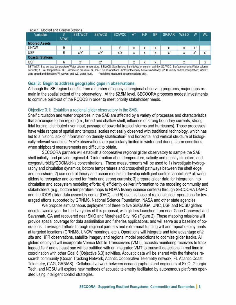
Table 1. Moored and Coastal Stations Variables: #
STNS SST/WCT SS/WCS SC/WCC AT H/P BP SR/PAR WS&D W WL
Moored Assets UNCW 9 x x x* x x x x x x* USF 6 x/x* x/x* x/x x x x x* x x* x* Coastal Stations USF 6 x* x* x x x x x SST/WCT: Sea surface temperature/Water column temperature; SS/WCS: Sea Surface Salinity/Water column salinity; SC/WCC: Surface currents/Water column currents; AT: Air temperature; BP: Barometric pressure; SR/PAR: Solar radiation/ Photosynthetically Active Radiation; H/P: Humidity and/or precipitation; WS&D: wind speed and direction; W: waves; and WL: water level. *Variables measured at some stations only.
Goal 3: Begin to address geographic gaps in observations. Although the SE region benefits from a number of legacy subregional observing programs, major gaps re-main in the spatial extent of the observatory. At the $2.5M level, SECOORA proposes modest investments to continue build-out of the RCOOS in order to meet priority stakeholder needs. Objective 3.1: Establish a regional glider observatory in the SAB. Shelf circulation and water properties in the SAB are affected by a variety of processes and characteristics that are unique to the region (i.e., broad and shallow shelf, influence of strong boundary currents, strong tidal forcing, distributed river input, passage of powerful tropical storms and hurricanes). Those processes have wide ranges of spatial and temporal scales not easily observed with traditional technology, which has led to a historic lack of information on density stratification7 and horizontal and vertical structure of biologi-cally relevant variables. In situ observations are particularly limited in winter and during storm conditions, when shipboard measurements are difficult to obtain. SECOORA partners will establish a cooperative regional glider observatory to sample the SAB shelf initially; and provide regional 4-D information about temperature, salinity and density structure, and oxygen/turbidity/CDOM/chl-a concentrations. These measurements will be used to 1) investigate hydrog-raphy and circulation dynamics, bottom temperatures and cross-shelf pathways between the shelf edge and nearshore; 2) use control theory and ocean models to develop intelligent control capabilities8 allowing gliders to recognize and correct for fronts and strong currents; 3) prepare glider data for integration into circulation and ecosystem modeling efforts; 4) efficiently deliver information to the modeling community and stakeholders (e.g., bottom temperature maps to NOAA fishery science centers) through SECOORA DMAC and the IOOS glider data assembly center (DAC); and 5) use this base of regional glider operations for lev-eraged efforts supported by GRNMS, National Science Foundation, NASA and other state agencies.
We propose simultaneous deployment of three to five SkIO/UGA, UNC, USF and NCSU gliders once to twice a year for the five years of this proposal, with gliders launched from near Cape Canaveral and Savannah, GA and recovered near SkIO and Morehead City, NC (Figure 2). These mapping missions will provide spatial coverage for data assimilation and fisheries applications, and will serve as a baseline of op-erations. Leveraged efforts through regional partners and extramural funding will add repeat deployments at targeted locations (GRNMS, UNCW moorings, etc.). Operations will integrate and take advantage of in situ and HFR observations, satellite imagery and regional model predictions to optimize glider tracks. All gliders deployed will incorporate Vemco Mobile Transceivers (VMT), acoustic monitoring receivers to track tagged fish9 and at least one will be outfitted with an integrated VMT to transmit detections in real time in coordination with other Goal 6 (Objective 6.3) activities. Acoustic data will be shared with the fisheries re-search community (Ocean Tracking Network, Atlantic Cooperative Telemetry network, FL Atlantic Coast Telemetry, iTAG, GRNMS). Collaborative work between oceanographers and engineers at SkIO, Georgia Tech, and NCSU will explore new methods of acoustic telemetry facilitated by autonomous platforms oper-ated using intelligent control strategies.
SECOORA: Supporting Resilient Ecosystems, Communities and Economies 7
Objective 3.2: Install a new coastal water quality station in Charleston Harbor. Charleston Harbor is the busiest port in the state of SC, and the second largest in the SE US in cargo ton-nage and value. Currently there is no continuous water quality monitoring of the surface and bottom waters in Charleston Harbor. The deepening of Charleston Harbor to accommodate larger vessels may begin in late 2016, which could alter salinity regimes and circulation patterns. A before and after dataset will be of great value in assessing project impacts and the data will be useful to recreational and commercial boating interests, scientists, and managers. Coordination with USACE, USCG, SC Port Authority, SC DNR and SC DHEC to identify an observing site will assure stakeholders receive optimal benefits.
SC DNR will configure and construct in Years 1 and 2 the proposed station to include paired sur-face and bottom YSI EXO2 data sondes to account for the two-layer estuarine circulation and water quality dynamics. The surface sonde will be located 0.5m below mean low water and the bottom sonde will be de-ployed 0.5m off the bottom. The sondes will measure water temperature, salinity, dissolved oxygen, pH, turbidity and water depth. The surface sonde will also measure chlorophyll fluorescence and fluorescence of dissolved organic matter (FDOM, a proxy for total dissolved organic carbon). Data will be recorded at 15-minute sampling intervals beginning in Year 2 and will be telemetered for the duration of this proposal via NOAA GOES. Data will be QA/QC’d following QARTOD manuals, and delivered via DMAC to users. Goal 4: Continue delivery of operational model forecasts and products to serve priority users. A central goal of SECOORA is to develop, in partnership with end users, operational products that will sup-port decision-making. Along with ongoing delivery of the regional model forecasts that fill temporal and spatial gaps in observations, SECOORA will develop and enhance products in collaboration with our part-ners to support their operational needs. Product delivery plans are included in Table 2 and geographic scope is shown in Figure 3. Objectives 4.1 through 4.3 will operate for Years 1 through 5. Objective 4.4 is a three-year development effort, and then will be maintained by SECOORA DMAC. Objective 4.1: Enhance and operate a Coupled Marine Environmental Assessment and Prediction System. SECOORA will work with members at NCSU to: 1) sustain NCSU’s South Atlantic Bight Gulf of Mexico (SABGOM) ocean circulation daily N/F modeling system;10, 11 2) establish the full couplings of wave (SWAN12), atmosphere (WRF13) and ocean circulation (ROMS14) models, and generate regional, high reso-lution nowcasts and forecasts of ocean circulation, waves, marine weather, lower trophic level marine eco-system predictions and other value added products; 3) implement into the prediction system a routine data assimilation of satellite-observed sea surface temperature and sea surface height, glider-measured subsur-face temperature and salinity, HFR-measured surface currents and other environmental data collected in regional fishery independent surveys; 4) continue model skill assessment for marine environmental varia-bles through appropriate comparisons with independent (non-assimilated) observations (e.g., mooring ob-servations). Working with SAFMC, the team will also start developing the interface between NCSU’s oceanographic modeling system and Ecopath as well as other higher trophic level ecological/fishery mod-els. Through this work, SECOORA will implement an advanced regional marine environmental assessment and prediction capability over the entire SECOORA domain with associated error estimates, and update and transmit information to stakeholders in a timely and clear fashion. Objective 4.2: Downscaling from the Deep-ocean, across the Continental Shelf and into the Estuaries. A parallel modeling effort exists in the NE GOM for which daily, automated ocean circulation N/F are pro-vided by nesting Finite Volume Coastal Ocean Model (FVCOM) into HYbrid Coordinate Ocean Model (HY-COM). Initial work (with model simulations quantitatively gauged against in situ observations15) now in-cludes the region from west of the Mississippi River Delta to south of the Florida Keys with real time river inflows versus climatology. Recent applications to HABs16, 17, gag grouper recruitment18, and DWH oil
SECOORA: Supporting Resilient Ecosystems, Communities and Economies 8
transports both subsurface19 and surface20 demonstrate the utility of the approach in contributing stake-holder-driven information. This West Florida Coastal Ocean Model (WFCOM), with resolution beginning with that of HYCOM (4km) along the open boundary, includes the various estuaries, telescoping down to 150m in both Tampa Bay and Charlotte Harbor. WFCOM provides the tracking capability for WFS HABs (in collaboration with FWC), and it was recently used by emergency managers for an oil spill training exer-cise (for which model simulations were accessed from NOAA GNOME through the NOAA GOODS using THREDDS data server capabilities developed with the assistance of SECOORA DMAC. WFCOM, in coor-dination with USF HFR and moorings, is presently being used by a USCG sponsored USF graduate stu-dent for an MS thesis project concerning SAR. These multidisciplinary applications will continue to develop new products via stakeholder outreach. Evident from the applications already cited is that coastal ocean ecology depends on multidimensional aspects related to organism success. Inter-annual variations in K.brevis red tides, gag recruitment success and fish location/abundance are all tied to the circulation that determines the transport of water properties. For instance, upwelling is required for a K. brevis bloom to manifest along the shore21, but too much upwelling suppresses bloom development22, thus the inclusion of of WFCOm in Objective 5.1. Only through coordinated multidisciplinary studies do we gain understandings and predictive capabilities for matters of stakeholder concern. Objective 4.3: Provide an Early Warning System for Swimming Beach and Shellfish Harvesting Waters. Currently, no tools exist to explore the likely effects of changing land-use practices and climate change scenarios on pathogenic bacterial pollution in the coastal areas of NC, SC and FL. SECOORA members from USC will develop the tools needed to forecast the frequency of pollution events that will impact shell-fish harvesting and beach management under various climate change scenarios by building upon existing SECOORA, NOAA, Environmental Protection Agency (EPA), USGS and state-supported coastal and ocean observing efforts, and SECOORA and EPA modeling efforts. This will result in enhancements to existing decision support tools23 currently in operation in Long Bay SC and the Chesapeake Bay, and adapt them for multiple management uses in coastal waters of SC, Newport River estuary and Pamlico Sound in NC, and the east coast of FL (Figure 3).
This early warning system will provide predictions of bacterial loading based on indicator bacteria concentration, radar-based precipitation, salinity, water temperature and potentially other environmental data such as tributary river flow, wind, current and wave information.24 An ensemble modeling approach of Multiple Regression and Classification and Regression Tree analyses will be used to develop these rela-tionships.25 26 Sensitivity analysis will be performed to evaluate the effect of changes in each of the pa-rameters included in the resulting predictive models. State and local health and natural resource agency personnel are collaborators will inform product development as described in Table 2. Objective 4.4: Optimize and enhance the SECOORA Marine Weather Portal (MWP). The MWP is the most viewed product on the SECOORA website. NOAA’s NWS offices within the eastern and southern regions were integral in the development of the current MWP and push users to the site. This project will leverage resources from UNCW, USC, Second Creek Consulting, SECOORA, state and local resource management and public health agencies, NWS, and NOAA’s Office for Coastal Management / NERRS. These MWP enhancements will: 1) upgrade the existing MWP with newer mapping technology and advanced data management that will increase its speed and efficiency; 2) incorporate NWS derived rip current products where available (e.g. NWS coverage areas in NC, FL); and 3) incorporate the current and planned SECOORA beach water quality products for NC, SC and FL (Objective 4.3). The planned up-grades will result in a more stable, faster MWP and facilitate public access to rip current and water quality information.
SECOORA: Supporting Resilient Ecosystems, Communities and Economies 9
Goal 5: Initiate new operational products to meet additional user needs. Objective 5.1: Implement a HAB forecasting system for the WFS. In recent decades, HABs have expanded geographically, increased in duration and intensity, and resulted in escalated economic costs worldwide27 and within the SECOORA footprint.28 29 Ecological and human health costs are estimated at over $25M/year in FL alone.30 Despite recent improvements in communi-cating HAB risks to public health and resource managers, monitoring and forecasting needs to be more robust to meet management and public needs. Leveraging existing infrastructure and resources, SECOORA proposes to build a comprehensive HAB Observing and Forecasting System in the eastern GOM that can then be applied to other areas. SECOORA is well positioned to support such efforts given the prevalence of offshore K. brevis blooms and the prominent role of circulation in dictating whether blooms will affect coastal zones.31 FWC collects and analyzes routine and event response samples for the presence of greater than 80 HAB species, including K. brevis. These data are reported daily to managers in detailed reports and weekly in public bulletins. During blooms, stakeholder conference calls provide an additional forum to dis-tribute 1) HAB information from satellite imagery32 and 2) short-term (3-5-day) bloom forecasts33 generated from biophysical models based on high resolution 3-D circulation (WFCOM, covering the eastern GOM in forecast mode) and discrete data. FWC, USF and MML propose to integrate this work with other existing observing and forecasting tools to build a HAB observing and forecasting system for the eastern GOM to provide forecasts of K. brevis before bloom formation, as well as short-to-mid range forecasts during blooms for the five-year duration of this proposal. Team members from USF and MML will leverage existing infrastructure and resources (e.g., equipment, staff time) to conduct a series of field campaigns to generate discrete water column observations and supplement these them with glider and daily remote sensing ob-servations.
This project will not only result in the output of physical, chemical and biological observations, but also in the development and dissemination of state-of-the-art products including a robust ecological fore-cast model; an improved forecast tool; and an integrated visualization system (i.e., Google-Earth interface that integrates cell abundance, satellite imagery, forecasts and glider data). Ultimately, this work will con-tribute to a better understanding of bloom development and advance the mitigation of negative effects of HABs that can be applied beyond the WFS. Objective 5.2: Provide seasonal ecosystem advisory reports for the SE continental shelf. Through past work with SAFMC, SECOORA is positioned to utilize regional expertise from management, industry and academic sectors to synthesize and promote innovative, credible, and objective science-based advice on the likely impacts of ocean climate variability on coastal marine ecosystems in the SE.34 NOAA is addressing this issue through their Integrated Ecosystem Assessment and currently provides data, analysis and advice for several regions, but not the SE.35 As the SAFMC has no plans to provide seasonal ecosys-tem advisories, this initiative will fill an important gap. The Advisory will be composed of graphics and inter-pretive text, with data distilled into a series of graphs, figures and text. The state of the environment, de-rived from physical data, will then be compared with known vulnerabilities of important marine species to make inferences about the likely effects of the physical environment on them. Some of the data and anal-yses will be subdivided into logical areas, such as Raleigh Bay, Onslow Bay, Long Bay, south central FL, etc., but the entire region will be addressed.
Roffer (ROFFS™) will derive the semi-annual “SECOORA Ecosystem Advisory Report”, including collecting and analyzing all physical oceanographic, meteorological and climate data for the five years of this proposal. Pugliese (SAFMC) and Reichert (SC DNR) will review the Ecosystem Advisory prior to public release to ensure the Report is current regarding regional fisheries management issues. Reichert, who leads the Marine Monitoring, Assessment, and Prediction Program (MARMAP) and the SE Area Monitoring
SECOORA: Supporting Resilient Ecosystems, Communities and Economies 10
and Assessment Program – South Atlantic (SEAMAP-SA) will provide fish relative abundance, life history and oceanographic data as well as information on fishery management issues related to the Advisory. Objective 5.3: Assess vulnerability of marine crustacean fisheries of the SE to climate change. While management authority for crustacean fisheries generally resides with individual states, the dynamics of those resources are often interconnected within the SAB. This initiative will utilize long-term fisheries-independent monitoring data of crustacean resources (focusing on blue crab and shrimp) from NC, SC, GA and FL-east coast to explore the role of changing climate in managing commercial fisheries of annual, mi-gratory species. Data assembly and curation will occur in Year 1, and modeling will begin in Year 2. The project concludes in Year 3.
SECOORA members and partners, SC DNR, FWC and FL DEP, will coordinate the acquisition of regional crustacean fisheries-independent data sets from NC, SC, GA and FL-east coast as well as the SEAMAP-SA trawl surveys. These data can capture intra- and inter-annual variability due to the longevity of the monitoring efforts and the spatial spread of the sampling stations. In addition to these data, fisheries dependent data, in the form of landings, are also reported at the state level and available for this project. While environmental abiotic conditions are recorded during the fisheries-independent sampling, other key environmental data measured by existing SECOORA assets will also be used to inform model develop-ment. SECOORA members UNCCH and USC will develop models that incorporate regional ocean, atmos-phere, and watershed data to examine spatio-temporal variability in crustacean fisheries-independent and dependent data in relation to physical processes. The initial step is to assemble region-wide observations into a database to examine consistency and thoroughness. After assembly, the database will be archived and visualized. In step 2, observations will be used to examine relationships between abiotic factors and fishery-independent and dependent data from various life stages and for validation of oceanographic model data. Goal 6: Continue building critical elements of the observing system by adding biogeochemical and marine sound sensors, and HFRs Objective 6.1: Improve the seafloor observatory near Gray’s Reef OA buoy. SECOORA member UGA will continue operation of the seafloor observatory located near the NDBC Buoy 41008 mooring in GRNMS for the 5 years of this proposal. Started in 2008 as a joint research project be-tween UGA and GRNMS to enhance the OA buoy monitoring of surface water chemistry, deployments since 2008 show that observed periodic high partial pressure carbon dioxide (pCO2) spikes in seafloor data are not reflected in surface analyses and not well-explained by upwelling given the distance from the shelf break. NOAA’s Atlantic Oceanographic and Meteorological Laboratory has documented near-bottom wa-ters with relatively low values for aragonite saturation state that are higher in pCO2 and lower in pH, sug-gesting that seafloor pCO2 spikes represent water mass movement not reflected in sea surface observa-tions. During these periods, some components of the benthic community could be stressed, so it is vital to understand these OA impacts in order to anticipate the fate of the benthic community. In support of GRNMS management activities, an acoustic sensor will also be added. UGA and GRNMS will operate and service (quarterly) the seafloor platform along with the existing pCO2, pH, and water quality sensors, and provide the data to SECOORA for data serving and dissemination. Objective 6.2: Add and maintain OA sensor packages at locations on the WFS and NC coasts. In coordination with the NOAA OA Program and SOCAN, a suite of OA sensors will be added to moorings on the WFS in Year 1 and NC in Year 2. The suite will likely include the Sea-Bird Scientific SeapHOxTM sensor that combines the Satlantic SeaFETTM pH with the Sea-Bird Electronics SBE 37-SMP-ODO Micro-CAT CTD+DO. In Year 1 USF will deploy two CO2 sensors at the surface (2m water depth); one on the
SECOORA: Supporting Resilient Ecosystems, Communities and Economies 11
50m mooring and one on the 25m mooring in the WFS. USF will also deploy Sunburst sensors to measure CO2 fugacity (fCO2). By measuring pH and fCO2, we will be able to better characterize the CO2 system pa-rameters including carbonate saturation state. This will allow assessment of impacts of air-sea interaction and ocean circulation on pH level variations. In addition to characterizations derived from pH and fCO2, total alkalinity (TA) at the moorings will be obtained from regional relationships between TA and salinity (S). Re-cent examinations indicate TA-S relationships36 are relatively simple on the WFS in comparison to the northern GOM, where TA is much more influenced by variable admixtures of seawater TA and alkalinity that is derived from rivers (where S~0 and TA > 0). Regional TA-S relationships will be obtained throughout the project through sample collections each time the moorings and sensors are serviced, and also by sam-ple collections obtained via ships of opportunity. The program of CO2 system measurements will allow comprehensive CO2 system calculations via either pH and fCO2, pH and TA, or fCO2 and TA. The measure-ment strategy will involve system ‘over-determination’ to provide a critical evaluation of sensor perfor-mance. With the experience gained in the data analyses and performance of the sensors at WFS, OA sen-sors will be deployed to two UNCW maintained buoys (30m depth) in the Carolinas in Year 2 along with continued operation of the WFS OA sensors. Operation of all of the OA sensor suites will continue through Year 5. Objective 6.3: Implement a regional ocean sound observing initiative to characterize and measure sources of sound production and establish acoustic baseline levels. As the RCOOS matures, the expansion of sensor types can contribute to understanding ecosystem pro-cesses and potential anthropogenic and climate change impact. An example is acoustic sensors. SECOORA proposes to incorporate hydrophones offshore of NC, the WFS and at one inshore site in southwest FL. Hydrophones will be deployed from bottom frames and will measure ambient sound levels and characterize sources of anthropogenic and natural (e.g. fish, marine mammal) noise. The proposed work will incorporate active and passive acoustics to examine patterns in habitat use and in fish sound pro-duction that are typically associated with reproductive behavior.37 Environmental data (atmospheric and oceanic) measured at each site on similar time scales as acoustic data will be used to explain variability in sound production and presence/absence of fishes. Mooring chain from buoys may introduce unwanted noise, so recordings made near these sites will be distanced to minimize this effect. During Year 1 both acoustic receiver types (passive ambient and acoustic tag) will be deployed at the Big Carlos Pass (south of Fort Meyers, FL) and ledge sites offshore of NC. Fish species present at each site will be surveyed and a subset will be selected for acoustic tagging (up to 20 fishes at each site). Following evaluation of the results from the first year of deployments, the acoustic program will be continued offshore of NC and expanded through the deployment of acoustics sensors on offshore WFS stations and at the Gray’s Reef seafloor observatory (Objective 6.1), as well as adding miniaturized passive acoustics units to gliders (Objective 3.1). The data will be analyzed with respect to human activities and will complement NOAA’s Ocean Noise Reference Station Network established in 2014 to monitor background acoustic levels. Objective 6.4: Install and operate new HFRs east of Port Canaveral, Florida. To address critical gaps in the current HFR network, FIT and UM (the longest running WERA operator on the east coast) will deploy two 8-channel, 8 MHz WERA systems, one at FIT’s Vero Beach Marine Lab and one at the Air Force Station next to Kennedy Space Center (a distance of ~45 nm or 83 km). These sys-tems will be deployed in Year 1. Once operational, HFR data will be provided in NRT to the national net-work and SECOORA, supporting the USCG, NWS and other users. Along with beginning to fill critical gaps in SECOORA HFR coverage, this system will address science objectives (e.g. Archer, et al. 2015).38 Per-formance metrics will be the same as those for Objective 2.1.
SECOORA: Supporting Resilient Ecosystems, Communities and Economies 12
User Benefits and Product Delivery SECOORA’s approach to developing end-user applications begins with identification and engagement of local, regional and national partners who have articulated a need that can be addressed through coastal ocean observations or applications. Partners are engaged to develop specifications that guide the product and service development effort. End-users participate in the design, development, and validation of such products. Every product or service to be developed under this proposal has a clear link between specific stakeholders and specific SECOORA-supported observation, model, or prediction data. SECOORA en-sures that proper and complete metadata are generated, collected and maintained, and that products are made available to the wider user community through commonly used dissemination protocols via SECOORA DMAC system. All observational data, maps, models and other coastal and ocean observing information and products are easily accessed via the SECOORA website, social media outlets and e-newsletters.
Our product delivery plans are tailored to meet users needs and provide important benefits. All SECOORA generated data is delivered through a variety of web services and webpages, and benefits in-clude support for NOAA NWS marine weather forecasts and marine hazards advisories, USCG Search and Rescue (SAR) operations, US Marine Corps and US Navy training operations, and USACE modeling and sediment management applications. Data and data products also support ecosystem management and fisheries stakeholders. Resource managers, recreational anglers and commercial fishers will benefit from improved efficiency in catching target species, reduced by-catch, and less fuel usage. SECOORA’s rich data repository also allows stakeholders to utilize historic data. Examples of uses of this archived data in-clude: 1) informing managers and the public of the paths and intensities of past tropical storm systems and coastal water levels associated with these events; 2) visualizing when and where polluted water could move into coastal areas; and 3) providing data to inform climate vulnerability assessments. Table 2 out-lines additional delivery plans for non-data products included in this proposal and Figures 2 and 3 in Ap-pendix 1 show observing locations and areal extent of products included in this proposal.
Table 2. Product Delivery Plans and Users (Activities above the red line are funded at $2.5M, those below at $4M) Goals and Objectives Delivery Plans and Users: 4 Continue delivery of operational model forecasts and products to serve priority users 4.1 Coupled Marine Envi-
ronmental Assessment and Prediction System
N/F model results served via web services. Stakeholder groups include USCG, NOAA NMFS, NOAA OR&R, Bureau of Ocean Energy Management, NC DENR, SC DNR, GA DNR, FL FWC, NWS and SAFMC.
4.2 West Florida Coastal Ocean Model
N/F model results served via web services. Stakeholder groups include USCG, FL FWC, recreational mariners, NOAA Office of Response and Recovery.
4.3 Advisory System for Beach and Shellfish
Waters
Smartphone apps and web services. Products include nowcast tools and forecasting products derived by coupling the nowcasting tools and climate change model scenarios. User groups, including resource managers, public health officials and representatives of potentially vulnerable populations will be convened to provide guidance, input and re-view in support of tool development.
4.4 Marine Weather Portal (MWP)
Served via web services. Project personnel will work with NWS offices to provide itera-tive feedback on the enhanced product. Users include the marine stakeholder commu-nity (fishermen, boaters, NWS, beachgoers).
5 Initiate new operational products to meet user needs 5.1 WFS HAB Forecast
System
Predictive HAB bulletins served via FWC, USF and SECOORA websites. Lead PI is an end-user with connections to other stakeholder groups. Other end-users (e.g., FL Dept. of Agriculture & Consumer Services, FL Dept. of Health) will be engaged to assess the utility of developed tools during bloom-centered conference calls and annual meetings.
5.2 SE Continental Shelf Seasonal Ecosystem
Advisory Reports
Provided via email and websites. PIs (ROFFS™, SAFMC and SC DNR) are fisheries management stakeholders with direct links to fisheries managers, fisheries oceanog-raphers, commercial and recreational fishermen, climate scientists, ecologists and the
SECOORA: Supporting Resilient Ecosystems, Communities and Economies 13
public. Fishing industries will be engaged in providing field observations on a volunteer basis. Other specific users include NOAA NMFS, SE Fisheries Science Center (SEFSC), and SE Regional Office (SERO).
5.3 Vulnerability of Crusta-cean Fisheries to Cli-
mate Change
Web accessible data and model results. Lead PI is an end-user with connections to state crustacean managers from NC, SC, GA and FL, and commercial and recreational fishermen. Managers will provide both fisheries independent and dependent data from current and historical collections. Outreach will occur via state departments (NCDMF, SC DNR, GA DNR, FL FWC) and Sea Grant offices, and presented in public meetings, workshops and webinars.
Summary The proposed baseline funding of $2.5M will support the core RCOOS framework that has been developed over the past five years that provides:
• Regional coverage over a geographically large and diverse section of the US coastal ocean; • Stakeholder engagement relative to RCOOS components, including buoy, tower, coastal station,
HFR and model data on which citizens, decision-makers and scientists have come to depend; • Cross-state and intra-regional cooperation; and, • Maintenance of critical in-water infrastructure, data flow from offshore to the internet, and proven
technical capabilities and experience in operational coastal ocean observing. As a mature RA in a region with significant observing gaps, SECOORA must balance mainte-
nance, filling important gaps in observations and creating new connections to users through thoughtful ex-pansion of products and services to build-out the RCOOS. Numerous national and regional imperatives would also be addressed at the $4M level by leveraging SECOORA infrastructure (maintained/planned at $2.5M) and expanding capabilities. Additional funding will allow for the operation of a WFS HAB forecast-ing system, as well as the deployment of sensors needed to assess and respond to: 1) OA effects on key marine organisms, 2) offshore energy development that makes the SE the prime national battleground for new offshore energy exploration, for which the seismic issue is very significant; 3) harbor/port expansion programs on the east coast; 4) HABs on the WFS, which result in economic costs over $25M/year in FL fisheries and tourism alone39. With additional funding, we are poised to address these and other regionally significant issues in partnership with numerous stakeholders.
The proposed activities will deliver stakeholders the ongoing observations and modeling products they rely on, and new integrative project components that leverage existing SECOORA efforts (observa-tions, models and DMAC) to create new and exciting opportunities. For example, the proposed glider ob-servatory will use SECOORA HFR data and circulation N/F model predictions to optimize glider data collec-tion, which will then be assimilated into the newly enhanced regional modeling N/F system and inform fish-eries managers. The MWP, regional ocean model, WFS model and shellfish and beach advisories will in-corporate SECOORA data streams to improve decision-making. The DMAC system will enable users and stakeholders to combine various components of the SECOORA network in novel ways. By creating syner-gies, adding new capabilities in an intelligent way and supporting core operations, SECOORA will continue to lead observing science in the SE.
SECOORA: Supporting Resilient Ecosystems, Communities and Economies 14
Milestones and Cost Proposal Table 3. Goals, Objectives/Milestones and Schedule
Goals and Objectives
2016-2017 2017-2018 2018-2019 2019-2020 2020-2021 (Quarter) (Quarter) (Quarter) (Quarter) (Quarter)
1 2 3 4 1 2 3 4 1 2 3 4 1 2 3 4 1 2 3 4 Goal 1: Continue SECOORA’s region-wide governance and communication to manage RA and engage users and stakeholders in coastal observing science Maintain governance and management for the RA and RCOOS x x x x x x x x x x x x x x x x x x x x
Engage users and other stakeholders to prioritize invest-ments
x x x x x x x x x x x x x x x x x x x x
Maintain and operate DMAC x x x x x x x x x x x x x x x x x x x x Goal 2: Maintain existing core observation investments in the region Maintain fifteen HFR distributed throughout the region x x x x x x x x x x x x x x x x x x x x Maintain 21 in situ stations along the Carolina and WFS coasts
x x x x x x x x x x x x x x x x x x x x
Goal 3: Begin to address geographic gaps in observations Establish a regional glider observatory in the SAB x x x x x x x x x x x x x x x x x x x x Install a new coastal water quality and metrological station in Charleston Harbor, SC
x x x x x x x x x x x x x x x x x x x x
Goal 4: Continue delivery of operational model forecasts and products to serve priority users Enhance and operate a Coupled Marine Environmental Assessment and Prediction System for the SE x x x x x x x x x x x x x x x x x x x x
Downscaling from the Deep-ocean, across the Continental Shelf and into the Estuaries x x x x x x x x x x x x x x x x x x x x
Provide an Early Warning System for Swimming Beach and Shellfish Harvesting Waters
x x x x x x x x x x x x x x x x x x x x
Optimize and enhance the SECOORA MWP x x x x x x x x x x x x
Goal 5: Initiate new operational products to meet additional user needs Implement a HAB forecasting system for the WFS x x x x x x x x x x x x x x x x x x x x Provide seasonal ecosystem advisory reports for the SE x x x x x x x x x x x x x x x x x x x x Assess vulnerability of crustacean fisheries to climate change
x x x x x x x x x x x x
Goal 6: Continue building the observing system by adding biogeochemical and marine sound sensors, and HFRs Enhance the seafloor observatory near Gray’s Reef OA buoy x x x x x x x x x x x x x x x x x x x x
Add and maintain comprehensive OA sensor packages at 4 buoys x x x x x x x x x x x x x x x x x x x x
Implement a regional ocean sound observing initiative x x x x x x x x x x x x x x x x x x x x Install and operate new HFR east of Port Canaveral, FL x x x x x x x x x x x x x x x x x x x x
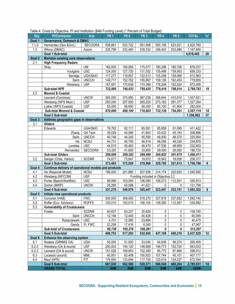
Cost Proposal. Summarized costs of the 5-year duration of this effort at the $4M scenario are in Table 4. Base funding of $2.5M would support Goals 1 through 4, however operational readiness and uptime of var-ious observations will be significantly impacted at this level. Therefore, additional funding of $330k to $580k is allocated to Goals 1 through 4 for the $4M scenario to address inflation and allow for spares, re-placement and repair of assets. Goals 5 and 6 are added with additional funding as indicated in Table 4. All components of this proposal are leveraged, however it is difficult to provide exact dollar values on con-tributions. Most of the observing assets were purchased with non-IOOS funds, and ongoing maintenance is subsidized by other grants. The same is true of most of the modeling work, i.e. models were initially de-veloped with other funds. Five percent of the SECOORA Executive Director’s salary is supported from member dues, as is a portion of her travel. Finally, a number of PIs are working at very subsidized or no cost. The glider observatory and GRNMS buoy operations are supported by GRNMS.
SECOORA: Supporting Resilient Ecosystems, Communities and Economies 15
Table 4. Costs by Objective, PI and Institution ($4M Funding Level) (* Percent of Total Budget) Obj. PI/Contractor Inst. YR 1 YR 2 YR 3 YR 4 YR 5 TOTAL %*
Goal 1 Governance, Outreach & DMAC 1.1-2 Hernandez (Gov.&Out.) SECOORA 508,861 533,722 561,998 593,158 623,021 2,820,760
1.3 Wilcox (DMAC) Axiom 225,799 232,465 239,332 246,403 253,686 1,197,685
Goal 1 Sub-total 4,018,445 20 Goal 2 Maintain existing core observations
2.1 High Frequency Radars
Shay UM 165,000 169,956 175,077 180,298 185,706 876,037
Voulgaris USC 124,000 127,720 131,552 135,498 139,563 658,333
Savidge UGA/SkIO 117,277 119,857 122,513 125,248 128,068 612,963
Seim UNCCH 149,717 152,762 155,897 159,126 162,453 779,955
Weisberg USF 167,001 170,638 174,386 178,246 182,224 872,495
Sub-total HFR 722,995 740,933 759,425 778,416 798,014 3,799,783 19
2.2 Moored & Coastal Leonard (Carolinas) UNCW 365,000 375,950 387,228 398,844 410,810 1,937,831
Weisberg (WFS Moor.) USF 250,000 257,500 265,225 273,182 281,377 1,327,284
Luther (WFS Coastal) USF 55,000 56,650 58,350 60,100 61,904 292,004 Sub-total Moored & Coastal 670,000 690,100 710,803 732,126 754,091 3,557,119 18 Goal 2 Sub-total 7,356,902 37 Goal 3 Address geographic gaps in observations
3.1 Gliders
Edwards UGA/SkIO 76,763 82,111 85,591 85,858 81,099 411,422
Zhang GA Tech 38,529 40,068 41,663 43,433 45,193 208,886
Seim UNCCH 40,748 44,245 45,556 46,930 48,375 225,854
He NCSU 44,731 45,795 46,916 48,095 49,339 234,876
Lembke USC 44,515 45,463 46,470 47,536 48,669 232,653
Hernandez SECOORA 53,320 41,600 33,800 29,000 29,000 186,720
Sub-total Gliders 298,606 299,282 299,996 300,852 301,675 1,500,411
3.2 Sanger (Chas. Harbor) SCDNR 74,877 73,647 19,972 19,943 19,938 208,377 Goal 3 Sub-total 373,483 372,929 319,968 320,795 321,613 1,708,788 9 Goal 4 Continue delivery of operational models and products
4.1 He (Regional Model) NCSU 196,000 201,880 207,936 214,174 220,600 1,040,590
4.2 Weisberg (WFCOM) USF Funding included in Objective 2.2 4.3 Porter (Beach/Shellfish) USC 99,999 103,000 106,090 109,273 112,551 530,913
4.4 Dorton (MWP) UNCW 35,280 45,098 41,421 0 0 121,799
Goal 4 Sub-total 331,279 349,978 355,447 323,447 333,151 1,693,302 8 Goal 5 Initiate new operational products
5.1 Corcoran (HAB) FWC 300,000 309,000 318,270 327,818 337,652 1,592,740
5.2 Roffer (Eco. Advisory) ROFFS 100,015 103,015 106,105 109,290 112,567 530,992 5.3 Vulnerability of Crustaceans
Fowler SCDNR 60,637 63,327 35,826 0 0 159,790
Seim UNCCH 12,194 12,445 40,426 0 0 65,065
Rykaczewski USC 4,701 12,090 23,684 0 0 40,475
Gandy FL FWC 22,206 17,416 8,345 0 0 47,967
Sub-total of Crustaceans 99,738 105,278 108,281 0 0 313,297
Goal 5 Sub-total 499,753 517,293 532,656 437,108 450,219 2,437,029 12 Goal 6 Enhance the observing system
6.1 Noakes (GRNMS OA) UGA 50,000 51,500 53,045 54,636 56,274 265,455
6.2-3 Weisberg (OA & sound) USF 250,003 144,125 146,908 149,773 152,724 843,533 6.2-3 Leonard (OA & sound) UNCW 151,026 169,853 102,390 85,775 87,868 596,912
6.3 Locascio (sound) MML 40,001 63,408 100,923 157,744 45,101 407,177 6.4 Maul (HFR) FIT 176,800 133,694 117,105 120,618 124,237 672,454
Goal 6 Sub-total 667,830 562,580 520,371 568,546 466,204 2,785,531 14 GRAND TOTAL $4M $4M $4M $4M $4M $20M