Embed Size (px)
Citation preview
ARTICLE
SIRENE: A Spatial Data Infrastructure to Enhance Communities’Resilience to Disaster-Related Emergency
Simone Sterlacchini1 • Gloria Bordogna2 • Giacomo Cappellini1 • Debora Voltolina1
Published online: 22 February 2018
� The Author(s) 2018. This article is an open access publication
Abstract Planning in advance to prepare for and respond
to a natural hazard-induced disaster-related emergency is a
key action that allows decision makers to mitigate unex-
pected impacts and potential damage. To further this aim, a
collaborative, modular, and information and communica-
tions technology-based Spatial Data Infrastructure (SDI)
called SIRENE—Sistema Informativo per la Preparazione
e la Risposta alle Emergenze (Information System for
Emergency Preparedness and Response) is designed and
implemented to access and share, over the Internet, rele-
vant multisource and distributed geospatial data to support
decision makers in reducing disaster risks. SIRENE flexi-
bly searches and retrieves strategic information from local
and/or remote repositories to cope with different emer-
gency phases. The system collects, queries, and analyzes
geographic information provided voluntarily by observers
directly in the field (volunteered geographic information
(VGI) reports) to identify potentially critical environmental
conditions. SIRENE can visualize and cross-validate
institutional and research-based data against VGI reports,
as well as provide disaster managers with a decision sup-
port system able to suggest the mode and timing of inter-
vention, before and in the aftermath of different types of
emergencies, on the basis of the available information and
in agreement with the laws in force at the national and
regional levels. Testing installations of SIRENE have been
deployed in 18 hilly or mountain municipalities (12 located
in the Italian Central Alps of northern Italy, and six in the
Umbria region of central Italy), which have been affected
by natural hazard-induced disasters over the past years
(landslides, debris flows, floods, and wildfire) and experi-
enced significant social and economic losses.
Keywords Data retrieval � Decision support
system � Disaster management � Italy � Spatial data
infrastructure � Susceptibility/hazard and risk
maps � Volunteered geographic information
1 Introduction
Nowadays there is a recognized need for designing and
developing ICT (information and communications tech-
nology)-based strategies and tools to support decision
makers in preparedness and response to disaster-related
emergencies. The Council of the European Union
(1999, 2005) recommends, in its Community Action Pro-
gramme Decisions in the field of Civil Protection, to ‘‘take
account of scientific research and technological develop-
ment,’’ ‘‘improve techniques and methods of response,’’
and ‘‘increase public information, education and aware-
ness,’’ so as to help citizens who live in at risk areas to
protect themselves more effectively.
The Hyogo Framework for Action 2005–2015 (UNISDR
2005, p. 9) promoted initiatives expected to improve early
warning systems based on the direct involvement of the
population and ‘‘the use, application and affordability of
recent information, communication and space-based tech-
nologies and related services, as well as earth observations,
to support disaster risk reduction.’’ The Sendai Framework
& Simone Sterlacchini
1 Institute for the Dynamics of Environmental Processes –
National Research Council of Italy (CNR-IDPA),
1-20126 Milan, Italy
2 Institute for Electromagnetic Sensing of the Environment –
National Research Council of Italy (CNR-IREA),
15-20133 Milan, Italy
123
Int J Disaster Risk Sci (2018) 9:129–142 www.ijdrs.com
https://doi.org/10.1007/s13753-018-0160-2 www.springer.com/13753
for Disaster Risk Redaction 2015–2030 (UNISDR 2015,
p. 15) promotes a ‘‘real time access to reliable data, the use
of space and in situ information, including geographic
information systems (GIS), and use information and com-
munications technology innovations to enhance measure-
ment tools and the collection, analysis and dissemination of
data.’’
Within the above mentioned international frameworks,
we designed and implemented an interoperable ICT-based
spatial data infrastructure (SDI) and related Web services
called SIRENE—Sistema Informativo per la Preparazione
e la Risposta alle Emergenze (Information System for
Emergency Preparedness and Response) to support local
disaster managers to anticipate, cope with, resist against,
and recover from the impacts of natural hazard-induced
disasters (debris flows, landslides, floods, and wildfire,
among others). The initial definition of the SDI require-
ments revealed a limited knowledge on the part of the
locally appointed disaster managers about the mode and
timing of intervention. Improving their decision-making
tasks was identified as the primary aim of the SDI. This
goal was accomplished by incorporating five principles: (1)
plan in advance preventive and mitigation measures to
reduce the effects of unexpected and adverse events; (2)
anticipate, as far as possible, the demand for disaster relief
operations; (3) enhance the knowledge of local managers
on procedures and methods of intervention in order to have
a positive control in the aftermath of the disaster (pre-
paredness); (4) organize and manage resources and
responsibilities to deal with the emergency; and (5)
increase the level of data sharing and communication
during the disaster (response).
The SIRENE SDI comprises the following modules/
services:
• A local repository in which to store and manage
heterogeneous, multisource, and geographically local-
ized information: metadated, authoritative, and
research-based susceptibility/hazard and risk maps;
volunteered geographic information provided by obser-
vers directly in the field (Goodchild 2007); and data
useful to cope with a disaster (strategic structures and
infrastructures, resources, and so on);
• A GIS installation to visualize and interact with both
local and remote geospatial data;
• A VGI module to create, assemble, and disseminate
VGI reports concerning the critical environmental
conditions that could require monitoring or rapid
intervention;
• An engine to flexibly search and retrieve data from the
repository;
• A cross-validation service to analyze the extracted
institutional and research-based susceptibility/hazard
and risk maps against VGI reports;
• A decision support system to suggest, for different
types of natural hazards, the proper emergency man-
agement procedures (in agreement with the regulatory
framework in force at the national and regional levels),
the instructions of execution, the people in charge of
performing each action, and the legal documents to be
issued at each emergency phase; and
• A communication system (e-mail, Short Message
Service (SMS), Skype) to enable data sharing and
dissemination.
From the citizens’ side, SIRENE may improve risk
awareness by its efforts to (1) increase citizen’s under-
standing of the risks and their components (hazard sources,
vulnerable elements, potential consequences of impacts,
and so on); (2) monitor and track identified risks; and (3)
evaluate risk process effectiveness. People who may be
threatened by a disaster may learn in advance what to
expect and how to react, and increase their personal culture
of safety as a result. This induced proactive participatory
mechanism can complement the disaster managers’ effort
to save lives, reduce property damage, and sustain a
community’s essential functions.
Although some of the SIRENE SDI services have
already been proposed in the literature, the novelty consists
in the services integration as a whole. As recognized by the
Civil Protection Services, where testing installations are in
use, this is one of the main pros in using SIRENE.
Specifically, disaster managers have at their disposal, in a
timely and efficient manner:
• All the modules/services in a single infrastructure to
cope with different types of risk; and
• The opportunity to adopt and deploy homogeneous and
standardized emergency preparedness and response
procedures all over the municipalities that are affected
by the disaster.
The main aim of this article is to describe SIRENE’s
design and implementation. A review of related research
publications and projects is initially presented. An over-
view of the SDI architecture and the different modules and
services then are described. A hypothetical use case of the
SIRENE SDI follows. Discussion and ongoing activities
conclude the article.
123
130 Sterlacchini et al. SIRENE: A Spatial Data Infrastructure to Enhance Communities’ Resilience
2 Literature Review
The scientific literature relevant to our SDI ranges from
volunteered geographic information (VGI) collection and
exploitation to multisource spatial data infrastructures
(SDIs) and decision support systems (DSS) for disaster-
related emergency management.
Craglia et al. (2012, p. 389) provide useful insights into
the value of social network data for policy and science
reports. The authors extend ‘‘the paradigm of spatial data
infrastructures by advocating an interactive and dynamic
framework based on near-to-real time information from
sensors and citizens’’ and analyze the extent to which it is
possible to extract information (messages and photos) that
are posted daily through social networks such as Twitter
and Flickr. The results show that the proposed system can
efficiently retrieve useful and timely information from the
large volumes of VGI being exchanged daily. SIRENE
exploits only structured information provided by different
types of observers by means of the VGI portal. Ongoing
activities are related to the inclusion, among the monitored
sources, of the information that could be extracted from
social networks. In fact, the big data created in the context
of social networks are valuable, not only for detecting
critical events but mainly and more importantly, for ana-
lyzing and studying the crowd habits and mode of reactions
during the occurrence of critical events.
A systematic literature review of collaborative approa-
ches based on VGI exploitation in hazard analysis is pre-
sented by Klonner et al. (2016). The authors conclude that
the use of VGI in preparedness and mitigation brings with
it many opportunities, but also contend that there are still
several challenges that remain. These difficulties include
the need for integrated research, given that most of the
analyses are revealed to be discipline-centric with a lack of
interdisciplinary approaches. SIRENE starts from this
suggestion and considers VGI as a complementary source
of information in the SDI framework.
The research proposed by Schade et al. (2010) suggests
that up to 6 billion human sensors are potentially available
to monitor the state of the environment, validate global
models with local knowledge, and provide information that
only humans can capture. The authors argue that Sensor
Web Enablement1 (SWE) standards can be applied to
develop metadata from VGI reports, thus converting VGI
into a timely, cost-effective, and valuable source of infor-
mation for a SDI. Schade et al. describe a workflow for
VGI integration into SDI and how VGI sensing and event
detection techniques can support a crisis information sys-
tem. This is close to our approach of deploying VGI maps
that use the standard Open Geospatial Consortium (OGC)
services in order to analyze the contemporary maps with
information from other sources. In our approach we deploy
VGI by Web Map Service2 (WMS) and Web Feature
Service3 (WFS) standard services. The rational for not
using SWE standard is that in our case observers are asked
to report observations described qualitatively by categories,
free text, and pictures and not by quantitative measure-
ments, as in the case of VGI created by means of sensors.
Hertfort et al. (2016) analyze the different kinds of
geographic information generated by crowdsourcing as a
new data source to complement official information.
Specifically, they distinguish three types of crowdsourcing
with increasing complexity and demand in terms of expe-
rience or skills: classification, digitization, and conflation.
They develop a geographical information crowdsourcing
and use it to further point out the potential of the different
types of crowdsourcing for disaster management and
humanitarian aid. In our approach, VGI is mainly used to
point out critical conditions affecting real world objects
(classification) or to identify areas that could require
monitoring or rapid intervention (digitization). Conflation
is carried out later, during the VGI analysis phase, to
identify areas with a sufficient density of VGI reports to
become a priority for intervention.
Horita et al. (2015) stress the utility of VGI to com-
plement sensor data. These authors use and evaluate the
impact of VGI reports to improve the coverage of moni-
tored areas in flood risk management. In order to be able to
cross-analyze VGI with sensor data, created and managed
within distinct VGI platforms and information systems,
Horita and colleagues outline the need to adopt interoper-
able services. This meshed service is achieved by adopting
the Sensor Observation Service (SOS) from the OGC
standards, which defines the interfaces for both data
receiving and sharing. The SOS also stores the received
data in a sensor database. This SOS supports the integration
of distinct data formats as well as the interoperability of
diverse data sources. Data collected in an SOS are then
converted to the geospatial service standard WFS, which
enables the researcher to ask questions about geographical
features on the Internet. Horita et al. (2015) provide two
means to query VGI and sensor data: the former for
specifying spatial conditions, the latter for specifying
temporal conditions. In SIRENE, we rely on the WFS
service for VGI querying with spatial and content condi-
tions. We also apply a spatial/temporal density-based
clustering algorithm (Arcaini et al. 2016) to identify and
validate VGI reporting of critical situations.
1 http://www.opengeospatial.org/ogc/markets-technologies/swe.
2 http://www.opengeospatial.org/standards/wms.3 http://www.opengeospatial.org/standards/wfs.
123
Int J Disaster Risk Sci 131
Camponovo and Freundschuh (2014) have analyzed
VGI reports created by volunteers via the Ushahidi4 Web
platform (2015) in response to the earthquake that occurred
in Haiti on 12 January 2010. Volunteers translated mes-
sages (text, e-mail, and voice) submitted by the victims of
the earthquake and categorized each message into a pri-
mary and secondary category, expressing distinct emer-
gency needs. Camponovo and Freundschuh’s analysis
illustrated that the VGI categories and subcategories
mostly failed to convey the main idea of the victims’
message. Notwithstanding these results, the authors rec-
ognized the utility of VGI for emergency rescue was
considerable and they outlined the need for novel methods
to cope with the imprecision and uncertainty embedded in
VGI. Haklay (2013) offers a different point of view: he
points out that imprecision and uncertainties are integral
parts of any VGI collection and he states that novel
methods to represent and to deal with those problems are
needed. A VGI creation and management facility is
incorporated into SIRENE SDI. This element provides a
flexible discovery service that can identify VGI reports
able to answer vague queries and to rank the VGI reports.
This feature helps to cope with VGI imprecision and
uncertainty.
As for a multisource SDI for disaster risk management,
Miyazaki et al. (2015) offer a comprehensive survey of
many worldwide initiatives for disaster risk management.
They highlight the important role played by exploitation of
satellite data products, ground-based observation mea-
surements, and crowdsourcing data created by volunteers
with tools such as Ushahidi (2015) and Sahana (Sahana
Software Foundation 2015).
A comprehensive overview that achieves state-of-the-art
status in geoprocessing Web architecture and technologies,
combined with examination of the most current develop-
ments in recent years, is undertaken by Zhao et al. (2012).
These authors state that light-weight protocols, crowd-
sourcing capability, and the potential to process real-time
geospatial data sources provided by sensors enables dis-
tributed, interoperable, and collaborative processing of
geospatial data for information and knowledge discovery.
Manfre et al. (2012) discuss the role of spatial data
sharing in the context of the establishment of SDIs to deal
with natural hazard-induced disasters. They maintain this
can best be done by reinforcing participation from orga-
nizations and governments that improves preventive and
emergency plans and that increases the potential involve-
ment of citizens in the risk and disaster management pro-
cess by providing VGI reports. These ideas are also at the
basis of SIRENE, since the SDI provides access to multi-
source geospatial data and VGI.
The AGORA Project (2016) ‘‘aimed at advancing
knowledge on the use of crowdsourcing and social media
for supporting decision-making in disaster risk manage-
ment.’’ This project fosters the use of VGI as a source of
useful information to ‘‘improve the resilience of cities
against disasters and extreme events.’’ SIRENE comple-
ments AGORA features by providing a flexible discovery
service that uses susceptibility/hazard and risk maps con-
sistent with current query conditions, a cross-validation
service to compare VGI reports against the susceptibil-
ity/hazard and risk maps, and a DSS able to guide the
disaster managers in emergency preparedness and
response. SIRENE is an improvement of the original SDI
presented by Bordogna et al. (2016) that integrates multi-
source heterogeneous geospatial data sets and time series
information (for example, multitemporal satellite data and
VGI) in a fully interoperable framework. The main dif-
ferences rely on the following: (1) the susceptibility/hazard
and risk maps management within an SDI, potentially
distributed in several nodes on the Internet (to support
scalability); the maps are derived by processing multi-
source geo-information by distinct models whose use
depends on the type of risk, the authoritative and research-
based data available, and the geo-referenced observations
collected in situ by observers (VGI); (2) the DSS workflow
automation to support disaster managers in disaster pre-
paredness and response; and (3) the query and retrieval
engine, which can ease the analysis of the geospatial data
sets by providing complex intelligent spatiotemporal
querying and answering facilities.
For decision support of environmental domains, a
review is proposed by Sokolova et al. (2011) in areas of
complex system analysis and decision making by means of
intelligent tools, including agent-based systems. The article
also compares existing agent-oriented methodologies and
frameworks for decision support. Although multiple
efforts, created for theoretic research and practical imple-
mentation of information systems, resulted in many suc-
cessful applications, many successful efforts still lack a
systemic view and cannot offer a coordinated and con-
trolled approach that links methods together into a coherent
methodology. Such partially successful DSSs focus
excessively on a specific aspect of environmental man-
agement in contrast with the comprehensive nature of the
SIRENE DSS, which is a workflow support tool for all the
emergency management phases needed for all kinds of risk.
The Decision Support Systems Characteristics and Best
Practices report drafted within the DECIDE project
(DECIDE 2015) reviews the literature on the state-of-the-
art of DSSs for disaster management (DM). Advances and
theory are investigated based on a project’s theoretical
foundation, commonly used models, and usage of geo-
graphical information systems (GIS). Finally, a review of4 https://www.ushahidi.com/.
123
132 Sterlacchini et al. SIRENE: A Spatial Data Infrastructure to Enhance Communities’ Resilience
eight DSS for DM research and operational projects is
performed, which also includes a comparative analysis of
their functionalities. The review indicates that DM, espe-
cially in the phases of preparedness and response, includes
complex decision processes. In such a context, situational
awareness, forecasted conditions, efficient communica-
tions, and comprehensive visualization in a DSS for DM
are valuable to decision makers. In designing the SIRENE
SDI, such ideas are kept in mind by introducing modules
that enhance specific aspects such as situational awareness
and forecasted conditions (VGI reports and a flexible dis-
covery service of susceptibility/hazard and risk maps),
efficient communication by local stand-alone platforms to
manage disaster-related emergencies at the local level,
comprehensive visualization by means of the adoption of
OGC Web services for maps, and VGI sharing and visu-
alization on the Web.
Shan et al. (2012) propose an emergency response
decision support system (ERDSS) as an important tool for
authorities to enhance their emergency response capabili-
ties. ERDSS is mainly used to make emergency early
warning contingency plans, coordinate and command
emergency response activities, manage resources, and
provide related knowledge. An effective ERDSS is one of
the key factors that determine whether emergency man-
agement will be successful. Shan and his fellow authors
provide an in-depth literature review of existing research
about emergency response, e-government, information
technology (IT) service management, and decision support
systems is provided. Such proposal, although focused on
the emergency response control and planning, fails to offer
a discovery service of susceptibility/hazard and risk maps
whose efficacy can be great during the emergency pre-
paredness and response phase.
Horita et al. (2015) propose a conceptual data model
based on OGC interoperable standards and a framework
that integrates voluntary (VGI) and conventional data from
wireless sensor networks (WSN) with a spatial decision
support system (SDSS) to assist the decision makers in
flood risk management. This research is relevant to SIR-
ENE because it also integrates VGI into the SDI and
includes a DSS to support disaster managers in the exe-
cution of emergency procedures and protocols, in compli-
ance with the regulations in force at the regional and
national levels.
SIRENE takes great advantage of the studies analyzed in
this section. Our emergency preparedness and response
information system moves a step forward by integrating
different modules and services in support of disaster
management decision-process operations.
3 Overview of the SIRENE SDI Architecture
From a software engineering point of view, the main
characteristics of SIRENE implementation are the cost
minimization of both hardware and software components
gained by: (1) its freely distributable licence (with no
royalties required); (2) its self-explanatory user interface
and user interaction: (3) its comprehensive functionalities
that exploit both authoritative/research-based and freely
provided geographic information; (4) its stand-alone set up
without external dependencies except for the common
libraries provided by the operating system); (5) its rapid
prototyping (functional requirements and logic details may
change within the prototyping loop) and easiness to update;
and (6) its network failure resilience, since its use is pos-
sible even in the event of Internet failure).
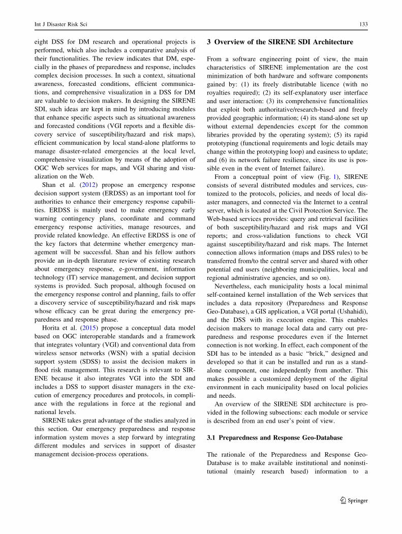
From a conceptual point of view (Fig. 1), SIRENE
consists of several distributed modules and services, cus-
tomized to the protocols, policies, and needs of local dis-
aster managers, and connected via the Internet to a central
server, which is located at the Civil Protection Service. The
Web-based services provides: query and retrieval facilities
of both susceptibility/hazard and risk maps and VGI
reports; and cross-validation functions to check VGI
against susceptibility/hazard and risk maps. The Internet
connection allows information (maps and DSS rules) to be
transferred from/to the central server and shared with other
potential end users (neighboring municipalities, local and
regional administrative agencies, and so on).
Nevertheless, each municipality hosts a local minimal
self-contained kernel installation of the Web services that
includes a data repository (Preparedness and Response
Geo-Database), a GIS application, a VGI portal (Ushahidi),
and the DSS with its execution engine. This enables
decision makers to manage local data and carry out pre-
paredness and response procedures even if the Internet
connection is not working. In effect, each component of the
SDI has to be intended as a basic ‘‘brick,’’ designed and
developed so that it can be installed and run as a stand-
alone component, one independently from another. This
makes possible a customized deployment of the digital
environment in each municipality based on local policies
and needs.
An overview of the SIRENE SDI architecture is pro-
vided in the following subsections: each module or service
is described from an end user’s point of view.
3.1 Preparedness and Response Geo-Database
The rationale of the Preparedness and Response Geo-
Database is to make available institutional and noninsti-
tutional (mainly research based) information to a
123
Int J Disaster Risk Sci 133
multidisciplinary group of potential end users (scientists,
experts, and technicians).
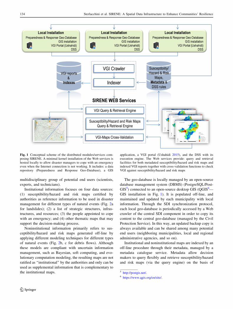
Institutional information focuses on four data sources:
(1) susceptibility/hazard and risk maps certified by
authorities as reference information to be used in disaster
management for different types of natural events (Fig. 2a
for landslides); (2) a list of strategic structures, infras-
tructures, and resources; (3) the people appointed to cope
with an emergency; and (4) other thematic maps that may
support the decision-making process.
Noninstitutional information primarily refers to sus-
ceptibility/hazard and risk maps generated off-line by
applying different modeling techniques for different types
of natural events (Fig. 2b, c for debris flows). Although
these models are compliant with uncertain information
management, such as Bayesian, soft computing, and evo-
lutionary computation modeling, the resulting maps are not
ratified as ‘‘institutional’’ by the authorities and only can be
used as supplemental information that is complementary to
the institutional maps.
The geo-database is locally managed by an open-source
database management system (DBMS) (PostgreSQL/Post-
GIS5) connected to an open-source desktop GIS (QGIS6—
GIS installation in Fig. 1). It is populated off-line, and
maintained and updated by each municipality with local
information. Through the SDI synchronization protocol,
each local geo-database is periodically accessed by a Web
crawler of the central SDI component in order to copy its
content to the central geo-database (managed by the Civil
Protection Service). In this way, an updated backup copy is
always available and can be shared among many potential
end users (neighboring municipalities, local and regional
administrative agencies, and so on).
Institutional and noninstitutional maps are indexed by an
off-line procedure through their metadata, managed by a
metadata catalogue service. Metadata allow decision
makers to query flexibly and retrieve susceptibility/hazard
and risk maps (via the query engine) on the basis of
Fig. 1 Conceptual scheme of the distributed modules/services com-
posing SIRENE. A minimal kernel installation of the Web services is
hosted locally to allow disaster managers to cope with an emergency
even when the Internet connection is not working. It includes: a data
repository (Preparedness and Response Geo-Database), a GIS
application, a VGI portal (Ushahidi 2015), and the DSS with its
execution engine. The Web services provide: query and retrieval
facilities for both metadated susceptibility/hazard and risk maps and
indexed VGI reports together with cross-validation functions to check
VGI against susceptibility/hazard and risk maps
5 http://postgis.net/.6 https://www.qgis.org/en/site/.
123
134 Sterlacchini et al. SIRENE: A Spatial Data Infrastructure to Enhance Communities’ Resilience
relevant user-defined criteria (mainly referring to static
geo-environmental variables and/or the dynamic meteoro-
logical-climatic parameters).
Institutional and noninstitutional maps are then com-
pared with the spatial distribution of vulnerable elements.
The institutional approach classifies the study area into four
qualitative risk classes (from very low to high, Fig. 2d) by
Fig. 2 Examples of
hydrogeological
susceptibility/hazard and risks
maps of the Consortium of
Mountain Municipalities
(Italian Central Alps). These
maps are stored in the
Preparedness and Response
Geo-Database: a institutional
qualitative index-based
landslide susceptibility map;
b noninstitutional debris flow
initiation susceptibility map;
c noninstitutional debris flows
runout susceptibility map;
d institutional qualitative index-
based landslide and debris flow
risk map; e noninstitutional
semiquantitative debris flow
risk map
123
Int J Disaster Risk Sci 135
means of a bidimensional matrix (hazard against exposure/
impact); the noninstitutional approach classifies the study
area into four semiquantitative risk classes (Fig. 2e) and
also provides exposure data, expressed in monetary terms
and the expected degree of loss (risk) by applying three
different vulnerability values (Blahut et al. 2014).
The geo-database also provides disaster managers with
authoritative and geocoded information about strategic
structures, infrastructures, resources, and personal contacts
(related to authorities, technicians, and volunteers) with the
intention to prepare for and cope with a disaster-related
emergency.
A graphic user interface is designed and implemented to
make data entry easier for people who are not expert in
Structured Query Language (SQL). Control mechanisms
are also implemented to constrain and regulate data entry
by checking errors, data completeness, and consistency.
3.2 Susceptibility/Hazard and Risk Maps Query
and Retrieval Engine
Given that modeling susceptibility/hazard and risk maps is
a computationally time-consuming activity, a large number
of institutional and noninstitutional maps are prepared and
stored in advance for each study area, each of which is
synthesized by thematic, modeling, geographic, and tem-
poral metadata. This module (Susceptibility/Hazard and
Risk Maps Query and Retrieval Engine in Fig. 1) makes
use of the SDI catalogue service to manage, query, and
retrieve the metadata. It is based on the Open Geospatial
Consortium (OGC) Catalogue Service for the Web (CSW)
standard that describes common interfaces with which to
access metadata information. This Web service provides
the decision maker with a high level, flexible query lan-
guage to search, retrieve, and display the most plausible
institutional and noninstitutional maps (by exploring their
metadata content). Plausible maps in this context are con-
sidered to be those maps that have been generated or
modeled with parameter values that best fit an area’s cur-
rent geo-environmental and meteorological-climatic con-
ditions, ranked according to the degree of fulfillment of the
above-mentioned conditions.
3.2.1 Storing the Metadata in a Catalogue Service
Metadata are encoded in Extensible Markup Language
(XML), a format compliant with current regulations in
force at the European level for geo-data interoperability
(INSPIRE 2007). These metadata are an extension of the
standard INSPIRE metadata schema, which guaranties full
compliance with OGC CSW as far as the discovery facility
is based on spatial, temporal, and thematic representation.
The metadata fields, which describe the spatial content of
the hazard/susceptibility and risk maps, are embedded
within the content field of the standard metadata format,
since they enable a content-based discovery of the maps as
described below.
3.2.2 Searching Susceptibility/Hazard and Risk Maps
In order to retrieve susceptibility/hazard and risk maps that
are most plausible with respect to current environmental
and meteorological-climatic conditions, the metadata first
are indexed. Each query must be flexible enough in order to
allow the end user to specify vague selection conditions,
which can containing linguistic terms that have vague
meaning, such as ‘‘high temperature in the last week’’ (in
case of wildfire) or ‘‘high precipitation in the last three
days’’ (in case of floods). This is done by modeling flexible
queries in the framework of fuzzy databases (Bordogna and
Psaila 2004; Galindo 2008). When precise information
concerning triggering or predisposing parameters is avail-
able, classic queries with crisp conditions can be formu-
lated as a special type of flexible queries.
(1) Direct query by constraining the parameters values
A flexible direct query can specify soft conditions for
the values of some parameters. For example, the end user
can specify a query by the following soft conditions:
• Select SM = ‘‘wildfire susceptibility map’’
Where
• high pn = temperature during TP = last month
AND
• very high pn = temperature during TP = last week
AND
• very high pn = wind during TP = yesterday
AND
• None pn = rainfall during TP = last month
in which SM stands for ‘‘spatial map theme,’’ pn stands
for ‘‘parameter name,’’ and TP for ‘‘time parameter.’’
The end user formulates this query when interested in
retrieving the most plausible wildfire susceptibility maps
given the current conditions described by the linguistic
values of the parameters. Such soft conditions constrain the
values of the correspondent parameter to some ongoing
recent meteorological-climatic conditions, which are
expressed by the linguistic values ‘‘high’’ for ‘‘tempera-
ture’’ during the ‘‘last month,’’ or ‘‘very high’’ for ‘‘tem-
perature’’ during the ‘‘last week,’’ and so on.
This query is evaluated by accessing the metadata
indexes to compute the ranking score of each indexed map.
The SM maps associated with the ranking scores greater
than zero can be listed in decreasing order to the user.
123
136 Sterlacchini et al. SIRENE: A Spatial Data Infrastructure to Enhance Communities’ Resilience

(2) Direct query by constraining the parameters trends
The end user specifies a soft condition concerning the
trend of some parameters based either on recent or fore-
casted values:
An example of such query can be:
• Select SM = ‘‘wildfire susceptibility map’’
Where
• High_increasing pn = temperature during TP = last
month
AND
• High_increasing pn = wind during TP = yesterday
AND
• High_decreasing pn = rainfall during TP = last
month
The evaluation is performed as in the previous case. The
SM maps associated with the positive ranking scores are
listed to the end user in decreasing order.
(3) Inverse query
Inverse queries are useful when a decision maker needs
to know the lower/upper bounds of some environmental
and/or meteorological-climatic parameters (pn) that may
trigger a given susceptibility/hazard or risk level. In this
case the result of a query is a summary of the parameter
maps that generated the top ranked map that best satisfies
the query condition.
An example of query could be the following:
• Select pn1 = ‘‘temperature’’, pn2 = ‘‘wind’’
Where
• SM = ‘‘wildfire susceptibility map’’ is high
in which ‘‘high’’ is a soft condition on the susceptibility
values of wildfire maps. This query is evaluated by
accessing the SM maps content index, by identifying the
SM map that best matches the soft constraint ‘‘high’’ and in
retrieving the parameters ‘‘temperature’’ and ‘‘wind’’ that
are encoded into the metadata of the SM map.
(4) Results
The result of a flexible query must be an informative
answer. Besides retrieving the most plausible susceptibil-
ity/hazard or risk maps, two virtual maps, which represent
the most likely optimistic and pessimistic scenarios that
may occur, are generated, together with the variability of
susceptibility/hazard or risk levels in each pixel. To pro-
vide this additional information, a map fusion operation is
performed. Specifically, given m maps retrieved by a
query, they are merged in order to obtain the most pes-
simistic/optimistic scenario. For the optimistic scenario,
the value of a pixel can be computed as the minimum
susceptibility/hazard or risk level in all maps. In fact, in the
optimistic map the best case is expected to happen, that is,
the lowest level within each pixel is selected. Conversely,
for the pessimistic scenario, the value of a pixel is com-
puted as the maximum value, the highest susceptibil-
ity/hazard or risk level in each pixel.
3.3 Volunteered Geographic Information (VGI)
and Query and Retrieval Engine
This module (VGI Portal (Ushahidi) in Fig. 1) exploits the
geographic information freely reported by different types
of observers (citizens, volunteers, technicians, and
authorities), before or in the early stages of an emergency.
In order to define the authorship of the VGI reports, four
different types of observers are considered: (1) citizens are
the general public; (2) volunteers are the civil protection
volunteers who have received an adequate training in civil
protection matters and so they can contribute to the disaster
risk preparedness and response of an area; (3) technicians
are local employees whose technical background can be
effectively exploited during a disaster emergency; and (4)
authorities are local representatives or delegates who have
the power or right to give orders and make decisions.
VGI providers use a customized version of the free tool
Ushahidi to create locally and submit their observations
(VGI reports), which consist of text, date, and time cate-
gories, and possibly also images and videos (more details
in Arcaini et al. 2013). These observers connect to the local
VGI portal, managed by the local control room operator,
who authenticates their identity on the administration
registry. This procedure discourages spam reports. Obser-
vers are categorized according to their status as authorities,
technicians, volunteers, and citizens who may be unregis-
tered or registered observers.
Each municipality hosts a local installation of Ushahidi.
The local acquisition of VGI was chosen to allow the
operator to confirm the reliability of VGI reports by: (1)
cross-checking the authorship of the VGI authors with their
personal information (status); and (2) comparing the VGI
reports with the contents of the other incoming VGI
reports. In effect, one of the primary problems in the use of
VGI is estimating the quality of the information, which
depends on several factors, such as the reputation of the
source, and the truthfulness and accuracy of the content
(Devillers and Jeansoulind 2006; Goodchild and Li 2012).
A method for estimating report quality is based on a
comparison between the textual content of the VGI reports
close to each other both in space and time. A high density
of records that point out the same observation in a given
region at the same time reinforces the truthfulness of their
content and thus increases the level of attention to and
possible intervention in the reporting area. After applying
these filters, the operator can demand a supplementary
123
Int J Disaster Risk Sci 137
in situ monitoring activity or can make the VGI reports
directly visible both locally and remotely to other
municipalities.
Each local, independent Ushahidi database is periodi-
cally visited by the central VGI crawler of the SIRENE
SDI and the new VGI reports are indexed and managed by
the central VGI catalog service to enable their availability
to other municipalities. Finally, a mapping and a cross-
validation component (Arcaini et al. 2013) allows users to
visualize VGI reports by matching a query from all
municipalities. The operator can extract and visualize on a
map where all reports concerning a particular hazard cat-
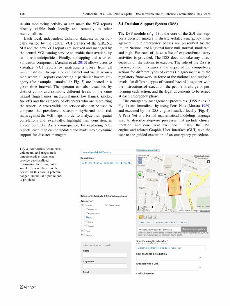
egory (for example, ‘‘smoke’’ in Fig. 3) are located in a
given time interval. The operator can also visualize, by
distinct colors and symbols, different levels of the same
hazard (high flames, medium flames, low flames, smoke,
fire off) and the category of observers who are submitting
the reports. A cross-validation service also can be used to
compare the preselected susceptibility/hazard and risk
maps against the VGI maps in order to analyze their spatial
correlations and, eventually, highlight their consistencies
and/or conflicts. As a consequence, by exploiting VGI
reports, each map can be updated and made into a dynamic
support for disaster managers.
3.4 Decision Support System (DSS)
The DSS module (Fig. 1) is the core of the SDI that sup-
ports decision makers in disaster-related emergency man-
agement. Four emergency phases are prescribed by the
Italian National and Regional laws: null, normal, moderate,
and high. For each of these, a list of expected/mandatory
activities is provided. The DSS does not take any direct
decision on the actions to execute. The role of the DSS is
passive, since it suggests the expected or compulsory
actions for different types of events (in agreement with the
regulatory framework in force at the national and regional
levels, for different types of natural hazards) together with
the instructions of execution, the people in charge of per-
forming each action, and the legal documents to be issued
at each emergency phase.
The emergency management procedures (DSS rules in
Fig. 1) are formalized by using Petri Nets (Murata 1989)
and executed by the DSS engine installed locally (Fig. 4).
A Petri Net is a formal mathematical modeling language
used to describe stepwise processes that include choice,
iteration, and concurrent execution. Finally, the DSS
engine and related Graphic User Interface (GUI) take the
user to the guided execution of an emergency procedure.
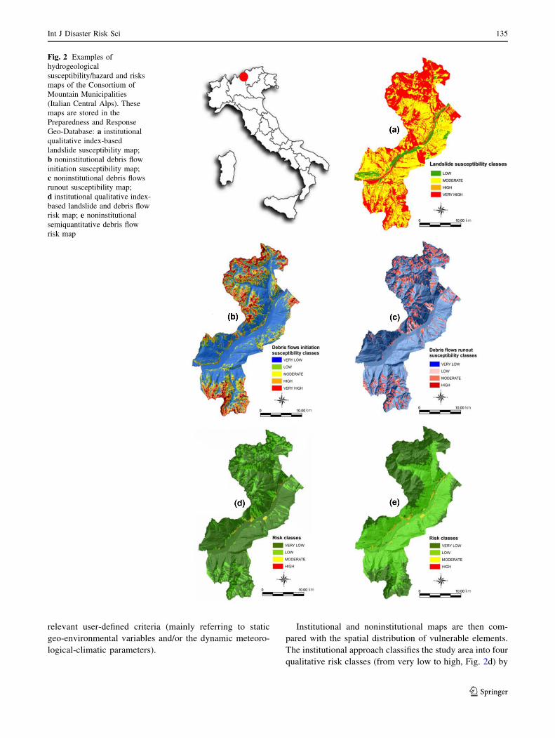
Fig. 3 Authorities, technicians,
volunteers, and (registered/
unregistered) citizens can
provide geo-localized
information by filling out a
simple form on their mobile
device. In this case, a potential
danger (smoke) at a public park
is provided
123
138 Sterlacchini et al. SIRENE: A Spatial Data Infrastructure to Enhance Communities’ Resilience

When accessing SIRENE, the disaster manager is
allowed to (Fig. 5):
1. Select the proper management procedure (workflow)
among those that are listed (as explained in the Use
Case) in relation to the hazard type, graphically
visualize and interactively execute it;
2. follow the instructions of execution of each procedural
step;
3. access the local geo-database and extract institutional
and noninstitutional data;
4. access and issue the documents linked to each
procedural step;
5. deliver the current state of emergency management to
the Civil Protection Service, through the Internet
connection;
6. access institutional regional/national weather forecast
websites through Web services;
7. access institutional regional/national volunteers’ man-
agement websites through Web services; and
8. guarantee communication and information sharing by
communication tools (Skype, SMS, and e-mails).
At any time, the workflow can be forced to move for-
ward, although the ongoing action may not yet be com-
pletely accomplished. This is important when an event
becomes extreme and no time is available to start and
conclude each step before getting to the proper emergency
phase. A log file registers all the executed actions, the
operator in charge and the time and date of each action.
This log file plays a crucial role: in the training phase, to
measure the response capacity to different hazard types
and, if needed, to check and modify the formalized pro-
cedures; to carry out back analysis (identify lessons learned
from past events or simulations); and to control, verify, and
validate the consistency of each procedural step.
Fig. 4 A Petri Net that formalizes the emergency management procedure for hydrogeological risks. It is designed according to the national and
regional legislative framework in charge for this type of risk
123
Int J Disaster Risk Sci 139
4 SIRENE SDI Use Case
In this section we describe the steps that a decision maker
can perform when managing a hypothetical disaster-related
emergency by means of SIRENE SDI. After receiving a
meteorological bulletin that details severe weather forecast
for the following hours in an area vulnerable to flood
hazard, the decision maker launches SIRENE and starts a
new session selecting the procedure formalized for
Hydraulic Risk. When the Moderate Emergency Phase is
adopted by the Regional Office of Civil Protection, SIR-
ENE leads the decision maker throughout the flow of
procedural steps defined in compliance with the Italian
legislative framework and guides him/her in planning the
earliest countermeasures to be put into practice to deal with
the predicted phenomena.
The decision maker proceeds choosing the proper action
and, jointly, the DSS shows the instructions of execution.
For each operational step the decision maker visualizes
information and contacts (fixed and mobile phone numbers
or e-mails) of either authorities or responsible parties who
must be alerted (that is, the Operative Municipal Respon-
sible, the Volunteers Responsible, the Municipal Police
Commander, and all other members of the Local Crisis
Unit), and generates the documentation to be issued (for
example, for the activation of volunteers). Through the
geo-database, the decision maker verifies the location and
availability of strategic structures and logistic resources.
At the same time, the DSS allows the decision maker to
stay up-to-date with evolving meteorological conditions
through direct access to the Regional Civil Protection
website. A worsening of meteorological conditions initiates
a statement of the High Emergency Phase by the Regional
Meteorological Office of Civil Protection. This warning
triggers SIRENE to push the decision maker to elevate the
local emergency phase to a regional scale response. The
DSS suggests the decision maker prearranging the activa-
tion of local coordination centers for emergency manage-
ment (the Local Crisis Unit) and, eventually, provides
supporting material and documentation to be approved and
submitted. The decision maker is exhorted to carry on and
adjust monitoring actions that focus attention on the
potential to exceed instrumental thresholds (that is, rainfall
or river water depth thresholds) that activate risk scenarios
in the most critical points.
By accessing the geo-database through the Query and
Retrieval Engine, the decision maker retrieves previously
stored institutional and noninstitutional susceptibility/haz-
ard and risk maps in order to evaluate the extent of the
areas potentially affected by the expected flood event. By
overlapping the expected scenarios with the VGI provided
by different types of observers directly in the field (Cross-
Validation Module), the decision maker is able to update
the hazard scenario and to verify the number and location
of the exposed elements in order to plan a possible evac-
uation. The communication capabilities implanted in
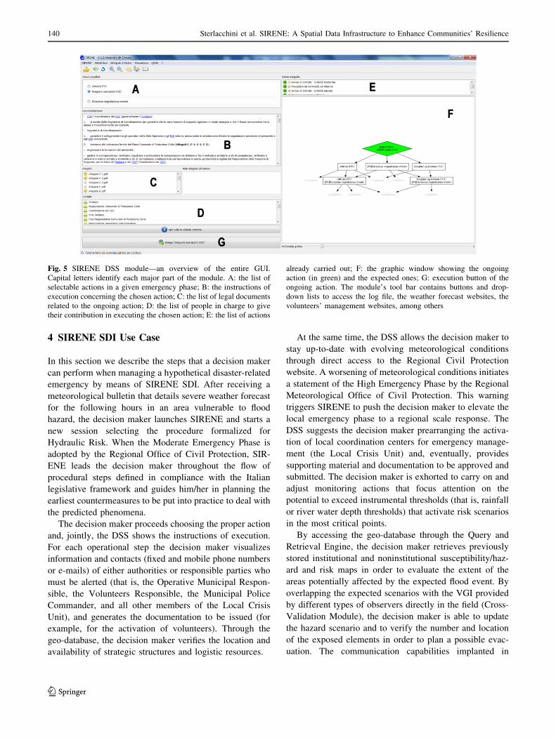
Fig. 5 SIRENE DSS module—an overview of the entire GUI.
Capital letters identify each major part of the module. A: the list of
selectable actions in a given emergency phase; B: the instructions of
execution concerning the chosen action; C: the list of legal documents
related to the ongoing action; D: the list of people in charge to give
their contribution in executing the chosen action; E: the list of actions
already carried out; F: the graphic window showing the ongoing
action (in green) and the expected ones; G: execution button of the
ongoing action. The module’s tool bar contains buttons and drop-
down lists to access the log file, the weather forecast websites, the
volunteers’ management websites, among others
123
140 Sterlacchini et al. SIRENE: A Spatial Data Infrastructure to Enhance Communities’ Resilience
SIRENE allow the decision maker to alert the strategic
structures available to shelter people who could be dis-
placed during an evacuation, as well as alert the respon-
sible parties appointed to perform the evacuation
procedure. The decision maker keeps a positive control on
monitoring all such actions and resources deployment.
When a critical hazard condition arises and threatens to
become extreme, the decision maker can raise the local
emergency phase. The decision maker is called to activate
the Local Crisis Unit and to intensify countermeasures to
manage rescue activities, evacuation, and population
assistance. The decision maker carefully examines each
operational step suggested by the DSS, which makes
available execution instruction for every responsible per-
son involved in local coordination centers for emergency
management. The action protocol can be stopped uniquely
by the senior decision maker with the revocation of the
emergency phase previously activated. The DSS guaran-
tees the decision maker a positive control on the return to
the Normal Emergency Phase as well as on the proper
management of human and logistic resources.
5 Discussions and Ongoing Activities
Risk managers need up-to-date, authoritative, research-
based, and geo-localized information in order to improve
their ability to prepare and deal with critical ongoing or
expected events, under specific static and dynamic envi-
ronmental conditions. This allows monitoring and mitiga-
tion options and emergency interventions to be planned
effectively in advance and deployed on time.
The main challenge of SIRENE is to provide disaster
managers with a modular, collaborative ICT-based SDI
aimed at preparing for and coping with disaster-related
emergencies. Although some modules and services of the
infrastructure have already been proposed in the literature,
others are relatively new as is their integration into a
coherent emergency information, decision, and action
framework.
SIRENE SDI provides different modules and services
that can be used to manage both the preparedness and the
response phases of an emergency. During the former, the
Preparedness and Response Geo-Database can be contin-
uously updated. The VGI portal can be used to collect
freely provided data on most at risk areas that potentially
need monitoring and/or mitigation actions. The Query and
Retrieval Engine can be used to extract and collate data to
know in advance what to expect and how to visualize
potential hazardous events within a Web GIS. The DSS can
be used under normal conditions to check the workflow
consistency of the model and train disaster managers and
responders. During an emergency response, the cross-
validation functions can be used to check VGI evidence
against existing susceptibility/hazard and risk maps and, if
needed, refine them. The integration of authoritative and
research-based data with freely provided volunteer infor-
mation makes the maps’ updating procedure more reliable
and very effective. The DSS also makes emergency man-
agement more controlled and completely compliant with
the relevant laws at the national and regional levels. The
communication system (Skype, SMS, and e-mails) sup-
ports easy and quick data sharing and dissemination.
No similar SDI is currently available in Italy. Although
advantages have been recognized by the Civil Protection
Services, where a test version has been running for over a
year, the main disadvantage is that multirisk procedure,
intended to manage jointly different types of concurrent or
subsequent correlated events (for example, a landslide that
dams a river), have not yet been designed and imple-
mented. Today, each event is managed separately and
independently one from another. In the next release of
SIRENE, we will address this weakness by providing new
mechanisms to improve multirisk procedures and share
related information.
SIRENE has not yet been used to manage an actual
disaster officially; nevertheless the Civil Protection Ser-
vices of the study areas in northern Italy and Umbria have
tested the SDI and provided feedback to support its
upgrading and redesign of the graphic user interface (GUI).
Initially, the study areas contribution was mainly restricted
to the definition of system requirements and then to error
identification both in the system’s architecture and its
workflow contents. Nowadays many volunteers, techni-
cians, and authorities (no citizens at this stage of the
development) are using SIRENE in order to provide
feedback concerning SIRENE’s usability, efficiency, reli-
ability, and, above all, the correctness and completeness of
its workflows contents.
Other workflows will be designed and implemented by
Petri Nets for chemical and industrial accidents, heat
waves, and dam collapse. So far only the workflows for the
management of disaster-related emergencies caused by
floods, wildfires, landslides, and debris-flows have been
designed and implemented by Petri Nets. Because these
hazards are the main risks in the study areas, which disaster
managers have faced in the past and are expected to cope
with in the future, they represent the first priority in the
design of comprehensive management workflows.
Acknowledgements This work has been carried out within the pro-
ject: SIMULATOR—Sistema Integrato ModULAre per la gesTione e
prevenziOne dei Rischi—Integrated Modular System for Risk
Prevention and Management, financed by the Lombardy regional
government, Italy. The authors would like to thank the anonymous
reviewer for the valuable comments aimed to improve the manuscript.
123
Int J Disaster Risk Sci 141

Open Access This article is distributed under the terms of the
Creative Commons Attribution 4.0 International License (http://crea
tivecommons.org/licenses/by/4.0/), which permits unrestricted use,
distribution, and reproduction in any medium, provided you give
appropriate credit to the original author(s) and the source, provide a
link to the Creative Commons license, and indicate if changes were
made.
References
AGORA Project. 2016. A geospatial open collaborative architecture for
building resilience against disasters and extreme events. http://
www.agora.icmc.usp.br/site/agora/. Accessed 17 Dec 2017.
Arcaini, P., G. Bordogna, and S. Sterlacchini. 2013. Flexible querying
of volunteered geographic information for risk management. In
Proceedings of the 8th Conference of the European Society for
Fuzzy Logic and Technology (EUSFLAT-13), ed. J. Montero, G.,
Pasi, and D. Ciucci, 281–288. Paris: Atlantis Press.
Arcaini, P., G. Bordogna, D. Ienco, and S. Sterlacchini. 2016. User-
driven geo-temporal density-based exploration of periodic and
not periodic events reported in social networks. Information
Sciences 340–341: 122–123.
Blahut, J., T. Glade, and S. Sterlacchini. 2014. Debris flows risk
analysis and direct loss estimation: The case study of Valtellina
di Tirano, Italy. Journal of Mountain Science 11(2): 288–307.
Bordogna, G., and G. Psaila. 2004. Fuzzy-spatial SQL. In Flexible
query answering systems, ed. H. Christiansen, M.S. Hacid, T.
Andreasen, and H.L. Larsen, 307–319. Berlin: Springer.
Bordogna, G., T. Kliment, L. Frigerio, P.A. Brivio, A. Crema, D.
Stroppiana, M. Boschetti, and S. Sterlacchini. 2016. A spatial data
infrastructure integrating multisource heterogeneous geospatial
data and time series: A study case in agriculture. ISPRS
International Journal of Geo-Information 5(5): Article 73.
Camponovo, M.E., and S.M. Freundschuh. 2014. Assessing uncer-
tainty in VGI for emergency response. Cartography and
Geographic Information Science 41(5): 440–455.
Craglia, M., F. Ostermann, and L. Spinsanti. 2012. Digital Earth from
vision to practice: Making sense of citizen-generated content.
International Journal of Digital Earth 5(5): 398–416.
DECIDE (Decision Support System For Disaster Emergency Man-
agement). 2015. Decision support systems characteristics and
best practices report. http://www.decide-project.eu/. Accessed 17
Dec 2017.
Devillers, R., and R. Jeansoulind. 2006. Fundamentals of spatial data
quality. London: ISTE.
European Union. 1999. Council decision of 9 December 1999
establishing a community action programme in the field of civil
protection, 1999/847/EC OJ L327/53. http://eur-lex.europa.eu/
legal-content/EN/TXT/PDF/?uri=CELEX: 31999D0847&fro-
m = EN. Accessed 17 Dec 2017.
European Union. 2005. Council decision of 20 December 2004
amending decision 1999/847/EC as regards the extension of the
community action programme in the field of civil protection,
2005/12/EC OJ L6/7. http://eur-lex.europa.eu/legal-content/EN/
TXT/PDF/?uri=CELEX: 32005D0012&from = EN. Accessed
17 Dec 2017.
Galindo, J. 2008. Handbook of research on fuzzy information
processing in databases. Hershey, PA: IGI Global.
Goodchild, M.F. 2007. Citizens as sensors: The world of volunteered
geography. GeoJournal 69(4): 211–221.
Goodchild, M.F., and L. Li. 2012. Assuring the quality of volunteered
geographic information. Spatial Statistics 1: 110–120.
Haklay, M. 2013. Citizen science and VGI: Overview and typology of
participation. In Crowdsourcing geographic knowledge:
Volunteered geographic information (VGI) theory and practice,
ed. D.Z. Sui, S. Elwood, and M.F. Goodchild, 105–125. New
York: Springer.
Herfort, B., M. Eckle, and J.P. de Albuquerque. 2016. Being specific
about geographic information crowdsourcing: A typology and
analysis of the Missing Maps project in South Kivu. In
Proceedings of the 13th International Conference on Informa-
tion Systems for Crisis Response and Management, Rio de
Janeiro, Brazil, 22–25 May 2016, ed. A.H. Tapia, P. Antunes,
V.A. Banuls, K. Moore, and J. Porto de Albuquerque. Informa-
tion Systems for Crisis Response and Management (ISCRAM)
Digital Library.
Horita, F.E.A., J.P. de Albuquerque, L.C. Degrossi, E.M. Mendiondo,
and J. Ueyama. 2015. Development of a spatial decision support
system for flood risk management in Brazil that combines
volunteered geographic information with wireless sensor net-
works. Computers & Geosciences 80: 84–94.
Klonner, C., S. Marx, T. Uson, J.P. de Albuquerque, and B. Hofle.
2016. Volunteered geographic information in natural hazard
analysis: A systematic literature review of current approaches
with a focus on preparedness and mitigation. ISPRS Interna-
tional Journal of Geo-Information 5: Article 103.
INSPIRE (Infrastructure for Spatial Information in the European
Community). 2007. Directive 2007/2/EC of the European
Parliament and of the Council of 14 March establishing an
infrastructure for spatial information in the European Commu-
nity (INSPIRE). Official Journal of the European Union, 2007, L
108/1, 50.
Manfre, L.A., E. Hirata, J.B. Silva, E.J. Shinohara, M.A. Giannotti,
A.P.C. Larocca, and J.A. Quintanilha. 2012. An analysis of
geospatial technologies for risk and natural disaster manage-
ment. ISPRS International Journal of Geo-Information 1(2):
166–185.
Miyazaki, H., M. Nagai, and R. Shibasaki. 2015. Reviews of
geospatial information technology and collaborative data deliv-
ery for disaster risk management. ISPRS International Journal of
Geo-Information 4(4): 1936–1964.
Murata, T. 1989. Petri nets: Properties, analysis and applications. In
Proceedings of the IEEE 77(4): 541–580.
Sahana Software Foundation. 2015. Open source disaster management
software. http://sahanafoundation.org/. Accessed 14 Nov 2016.
Schade, S., G. Luraschi, B. De Longueville, S. Cox, and L. Dıaz.
2010. Citizens as sensors for crisis events: Sensor Web
enablement for volunteered geographic information. In Proceed-
ings of WebMGS 2010—1st International Workshop on Perva-
sive Web Mapping, Geoprocessing and Services, ed. M.A.
Brovelli, S. Dragicevic, S. Li, and B. Veenendaal. ISPRS—
International Society for Photogrammetry and Remote Sensing.
Shan, S., L. Wang, L. Li, and Y. Chen. 2012. An emergency response
decision support system framework for application in e-govern-
ment. Information Technology and Management 13(4): 411–427.
Sokolova, M., A. Fernandez-Caballero, and F. Gomez. 2011. A
review on frameworks for decision support systems for envi-
ronmental domains. Revista EIDOS 4: 74–83.
UNISDR (United Nations International Strategy for Disaster Reduc-
tion). 2005. Hyogo framework for action 2005–2015. https://
www.unisdr.org/we/coordinate/hfa. Accessed 24 Nov 2017.
UNISDR (United Nations International Strategy for Disaster Reduc-
tion). 2015. Sendai framework for disaster risk reduction 2015–
2030. http://www.unisdr.org/we/coordinate/sendai-framework.
Accessed 17 Dec 2017.
Ushahidi. 2015. Web site. http://www.ushahidi.com/. Accessed 17
Dec 2017.
Zhao, P., T. Foerster, and P. Yue. 2012. The geoprocessing web.
Computers & Geosciences 47: 3–12.
123
142 Sterlacchini et al. SIRENE: A Spatial Data Infrastructure to Enhance Communities’ Resilience