Embed Size (px)
Citation preview
The Environmental Status of the Heart of Borneo
SHORT REPORT
2012
REPORTHoB
The Environmental Status of theHeart of Borneo – Short Report
2
© Text 2012 WWF; Photographs: as credited in captions.Any reproduction of text in full or in part must reference the title and credit WWF as the copyright owner.All rights reservedMain author: Stephan WulffraatEditorial and production team: John Morrison, WWF-US, Aurelie Shapiro, WWF-Germany, Chris Greenwood, WWF HoB Communications, Junaidi Payne, WWF-Malaysia, Contributors: Hanna Tobing, WWF-Indonesia, Cristina Eghenter, WWF-Indonesia, Godwin Limberg, FFI, Albertus Tjiu, WWF-Indonesia, Douglas Sheil, Catherine Parsons, Mohamad Nasir, Lisa Curran, Yale University, Wim Giesen, Rob Stuebing, Adam Tomasek, WWF HoB, Erik Meijaard, TNC
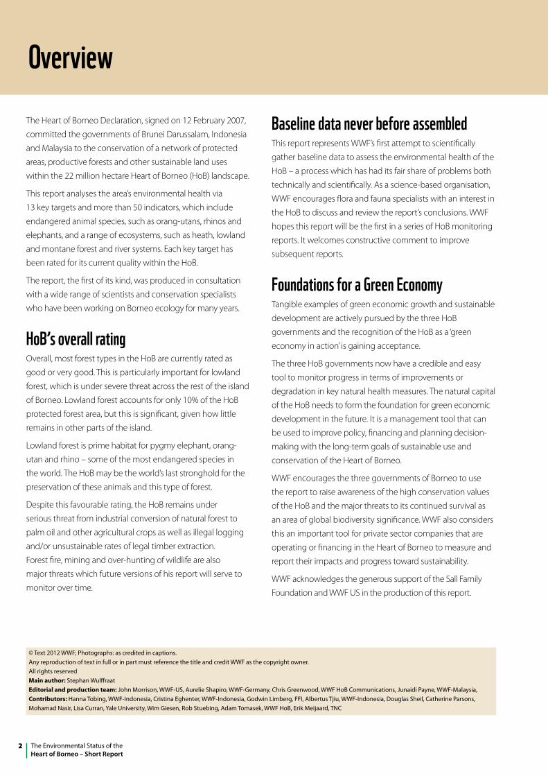
OverviewThe Heart of Borneo Declaration, signed on 12 February 2007,
committed the governments of Brunei Darussalam, Indonesia
and Malaysia to the conservation of a network of protected
areas, productive forests and other sustainable land uses
within the 22 million hectare Heart of Borneo (HoB) landscape.
This report analyses the area’s environmental health via
13 key targets and more than 50 indicators, which include
endangered animal species, such as orang-utans, rhinos and
elephants, and a range of ecosystems, such as heath, lowland
and montane forest and river systems. Each key target has
been rated for its current quality within the HoB.
The report, the first of its kind, was produced in consultation
with a wide range of scientists and conservation specialists
who have been working on Borneo ecology for many years.
HoB’s overall ratingOverall, most forest types in the HoB are currently rated as
good or very good. This is particularly important for lowland
forest, which is under severe threat across the rest of the island
of Borneo. Lowland forest accounts for only 10% of the HoB
protected forest area, but this is significant, given how little
remains in other parts of the island.
Lowland forest is prime habitat for pygmy elephant, orang-
utan and rhino – some of the most endangered species in
the world. The HoB may be the world’s last stronghold for the
preservation of these animals and this type of forest.
Despite this favourable rating, the HoB remains under
serious threat from industrial conversion of natural forest to
palm oil and other agricultural crops as well as illegal logging
and/or unsustainable rates of legal timber extraction.
Forest fire, mining and over-hunting of wildlife are also
major threats which future versions of his report will serve to
monitor over time.
Baseline data never before assembledThis report represents WWF’s first attempt to scientifically
gather baseline data to assess the environmental health of the
HoB – a process which has had its fair share of problems both
technically and scientifically. As a science-based organisation,
WWF encourages flora and fauna specialists with an interest in
the HoB to discuss and review the report’s conclusions. WWF
hopes this report will be the first in a series of HoB monitoring
reports. It welcomes constructive comment to improve
subsequent reports.
Foundations for a Green EconomyTangible examples of green economic growth and sustainable
development are actively pursued by the three HoB
governments and the recognition of the HoB as a ‘green
economy in action’ is gaining acceptance.
The three HoB governments now have a credible and easy
tool to monitor progress in terms of improvements or
degradation in key natural health measures. The natural capital
of the HoB needs to form the foundation for green economic
development in the future. It is a management tool that can
be used to improve policy, financing and planning decision-
making with the long-term goals of sustainable use and
conservation of the Heart of Borneo.
WWF encourages the three governments of Borneo to use
the report to raise awareness of the high conservation values
of the HoB and the major threats to its continued survival as
an area of global biodiversity significance. WWF also considers
this an important tool for private sector companies that are
operating or financing in the Heart of Borneo to measure and
report their impacts and progress toward sustainability.
WWF acknowledges the generous support of the Sall Family
Foundation and WWF US in the production of this report.
3The Environmental Status of theHeart of Borneo– Short Report
The HoB Environmental Status Project
IntroductionDespite all the global attention, until now no comprehensive
data has been presented about the current state of the
natural systems in the Heart of Borneo (HoB). Until recently,
no-one had asked questions about this globally important
region such as:
> How much tropical rainforest remains in the Heart of Borneo (HoB)? Is it viable for the long term?
> What are the top three threats in the HoB? What is that estimation based on?
> How much peat forest is currently in protected areas in the HoB? Is that enough?
This report attempts to provide the data to help answer these
questions.
Measuring the vital signsBeginning with a small group of experts on the natural history
of Borneo, a set of 13 indicators was chosen to represent the
dominant and critical ecosystems and species on the island.
Once a consensus was reached on the indicators, remote
sensing and geographic information specialists set out to
collect meaningful data for each one. If data for a particular
indicator was considered insufficient or unrepresentative, it
has been put on hold until better methods or data become
available.
A unique set of criteria was developed so that each indicator
could be rated Very Good, Good, Fair or Poor in a meaningful
way. By combining the indicators, statements can be made
about particular components of the HoB’s natural systems or
about the HoB as a whole.
We need to know more about several indicators; we hope
practical methods and resources will emerge to capture that
data. Overall, enough information has been collected to make
some broad statements about the vital signs of the HoB. These
metrics will improve in the next few years.
Threats to the HoBLooking forward 10 years, the top threats are:
> industrial conversion of natural forests
> illegal logging
> legal commercial but unsustainable rates of timber extraction
> forest fire
> mining
> over-hunting and collecting.
Because of the relatively short future window (10 years)
climate change was not classified as one of the top threats.
But an increase in climatic variability may exacerbate some
of the other threats. Only two of the prioritised direct threats
are currently amenable to data collection using remotely
sensed data: industrial conversion and forest fires. There are no
annual analyses of industrial conversion. Forest fire data were
compiled for a 14-year period – locations were marked but
no real information of annual forest fire loss was quantified in
terms of carbon losses.
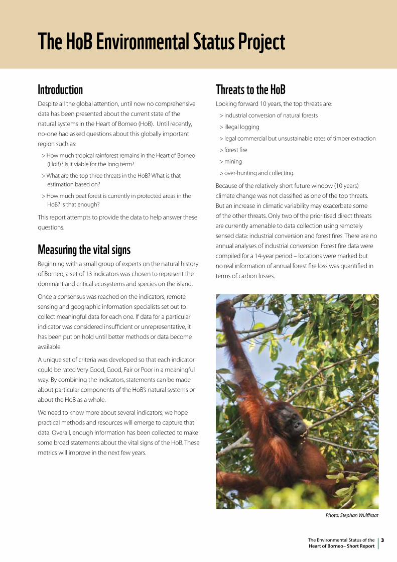
Photo: Stephan Wulffraat
The Environmental Status of theHeart of Borneo – Short Report
4
Conservation management The primary conservation management indicator is the extent
to which different natural ecosystems are covered by legally
protected areas. Ten per cent of each natural ecosystem is a
globally agreed minimum. For the Heart of Borneo, 20% (of the
remaining ecosystem) is a more reasonable goal. Conservation
science indicates that larger percentages are more likely to
support biodiversity and buffer against changing climate.
Another important component for conservation management
is the extent to which protected areas are effectively
performing their role. A comprehensive survey of the
management of the HoB’s protected areas has yet to be
carried out – but would be a very high priority.
The definition of what constitutes a protected area is
contentious. In Sabah, for example, Dermakot and Ulu Segama
Forest Reserves are not considered protected areas, although
they are managed for sustainable wood production, and forest
restoration programs are in place for damaged areas within
these Reserves. Together, they harbour the largest orang-utan
population in Malaysia (J. Payne, pers. comm.).
ImplicationsThe ecological systems are broadly doing well, with some
exceptions. The pressure on the remaining HoB forests and
associated species has never been greater. Though precise
data is not often available, as forest areas continue to shrink
and experience fragmentation, the pace of conversion and
degradation can increase, and increasing climate variability
combined with fire can be devastating.
The largest ranking threat to the integrity of the HoB is
industrial conversion of natural forests. Conversion is mainly
occurring to establish oil palm plantations and smaller areas
for pulp wood plantations. The ecosystem mostly affected is
the lowland rainforest. Most locations are at the edges of the
HoB, as defined by WWF though some inland areas in West
Kalimantan are also allocated.
Forest fires are also considered a major threat. These
devastating events have occurred mainly at the edges of
the HoB and the main ecosystems affected are heath forests,
lowland rainforests and peat swamp forests.
Mining is a threat that has been somewhat underestimated so
far, probably because of lack of data. The major type of mining
in the HoB is for coal, which is always done by digging in open
pit mining. Mining concession data is not officially available
and to complicate analysis even more, there are many small
concession holders, less inclined to environmental protection,
that get sub-concessions from the larger companies. Mining
often occurs at interior foot slopes of mountains of the HoB,
particularly in Central Kalimantan.
KEy ECOSySTEM OR SPECIESLowland rainforest
Upland rainforest
Montane forest
Peat swamp forest
Limestone forest
Heath forest
River ecosystems
Bornean elephants and banteng
Sumatran rhinoceros
Bornean clouded leopards
Orang-utans
Bearded pigs
Endemic pitcher plants
Protected area coverage in the HoB’s main ecosystemsECOSySTEM AREA PROTECTEd % PROTECTEdLowland rainforest 3,355 km2 9.6%
Upland rainforest 13,177 km2 18%
Montane forest 9,959 km2 29%
Heath forest <300 km2 <1%
Limestone forest <200 km2 <1%
Peat swamp forest <1% 0%
5The Environmental Status of theHeart of Borneo– Short Report
Future developmentsThe good news is that the governments of the HoB have
pledged to protect and restore its natural gifts for the benefit
of local, national, and even global constituencies.
Their bold commitments, supported by non-governmental
organisations, provide great promise that a balanced
configuration of land use will eventually protect and maintain
natural systems in the HoB and the ecosystem services that
they provide.
The HoB Environmental Report will be used by the WWF
network to monitor progress of the HoB Initiative in terms of
improvements in key biological measures for the HoB.
With appropriate funding, future editions of this report will
KEy ECOSySTEM OR SPECIES IndICATOR RAw dATA RESulT 2008 RATInGLowland rainforest % of historical extent 58,897 km2 63% GoodUpland rainforest % of historical extent 89,879 km2 82% Very
GoodMontane forest % of historical extent 38,511 km2 89% Very
GoodPeat swamp forest % of historical extent 6,572 km2 72% GoodLimestone forest % of historical extent 386 km2 79% GoodHeath forest % of historical extent 4,285 km2 48% FairRiver ecosystems % natural cover in Kapuas
watershed39,230 km2 47% overall Fair
% natural cover in Barito watershed
38,020 km2 63% overall Good
% natural cover in Mahakam watershed
41,130 km2 54% overall Fair
% natural cover in Kayan watershed
28,280 km2 95% overall Very Good
Bornean elephants Total population ~1,000 individuals ~1,000 individuals Fair% of historic distribution 22,000 km2 ~60% Good
Sumatran rhinoceros Total population <50 individuals <50 individuals Poor#
Bornean clouded leopards
Suitable habitats for viable populations
165,170 km2 76% Good
Orang-utans Average densities in peat swamp and lowland forests
0.61 and 0.48 individuals/km2
Fair
Endemic pitcher plants
% of viable historic locations 21 80% Good
include biological indicators in increasing number and
diversity, leading to a broader and increasingly accurate
representation of the flora and fauna of the HoB.
A number of current HoB projects, such as the expedition to
discover and document wildlife in the Sungai Ingei Protection
Forest in Brunei’s portion of the Heart of Borneo, will provide
added information to further improve the use and accuracy of
this document.
This report also serves as a bell-wether on progress towards
the delivery of WWF’s conservation goals for the HoB. It is
hoped that the three HoB governments will also find the
report useful as they plan the conservation and sustainable
development of the 22 million hectares of the interconnected,
biodiversity-rich forest within the HoB.
# Current rating for rhino – the rating of FAIR in the body text is aspirational.
The Environmental Status of theHeart of Borneo – Short Report
6
Key HoB indicatorsThe results for the natural system indicators for which there
was sufficient data are summarised in the table on page 5.
When combined, these individual indicator ratings result in
an overall rating of Good for the HoB. That is encouraging,
though the picture is mixed and each indicator tells a story
that is worth reading. It should be noted that the discussion
of ecosystem viability is restricted to the HoB only – not the
entire island of Borneo.
lowland rainforestThe project produced an updated map of the extent of
lowland rainforest ecosystems. The HoB boundaries were
drawn to incorporate adjacent, contiguous lowland rainforest,
so the 63% of remaining historic lowland rainforest (classified
as Good) is a bit misleading. Island-wide, lowland rainforest
is quickly becoming rare, due to logging and forest fires.
Elephants and orang-utans live in lowland rainforest almost
entirely below 150 m asl.
upland rainforestThe picture looks brighter for upland rainforest ecosystems,
the major HoB ecosystem. Most (82%) are still standing and in
many cases in primary condition, giving a Very Good rating.
Montane forestNearly all Borneo’s montane forest ecosystems are within the
HoB, and the 89% of remaining historic montane forests are
generally still in primary condition, resulting in a Very Good
rating. These areas have a very high rate of local endemism
(unique to a defined geographic location) for animal and plant
species.
Peat swamp forestPeat swamp ecosystems occur mainly in the wide coastal
lowlands. Many of those areas have either been converted
or are highly disturbed. Interior peat swamp areas within the
HoB are generally in better condition, and 72% of historic
peat swamp is still present, resulting in a viable rating of
Good. However, we have to keep in mind that most of these
forests have been logged.
limestone forestLimestone ecosystems are scattered throughout Borneo, but
the only large areas are at the Sangkuliran peninsula in East
Kalimantan and northern South Kalimantan. These are partly
degraded while the smaller limestone areas in the interior are
all in relatively healthy condition. Degradation of limestone
ecosystems is usually irreversible. The extent of limestone
forest is above the proposed viable threshold of 60% of
historic extent and is rated as Good.
Heath forestOriginally, there were large stretches of heath forest,
particularly in Indonesian Borneo. Few wide areas are left,
and these are mainly in central and east Kalimantan. Even
these are not in pristine condition, as several areas have been
burned in the past 25 years. Due to the poor soils that heath
forest develops on, their restoration is extremely difficult.
Existing heath forest is 48% of historic levels compared with
the proposed viable extent of about 60%, giving a Fair rating.
p 34 Mt Kinabalu
7The Environmental Status of theHeart of Borneo– Short Report
River ecosystemsThere is little information about the in-stream biodiversity
status of Borneo’s rivers. The most practical indicator considers
the percentage of forest cover in the watershed of each of
the main rivers. Southern and western Borneo are generally
converted, while conditions in the north are somewhat
better. The overall HoB rating for this indicator is Fair. A more
comprehensive picture of freshwater biodiversity must be
seen as a priority.
Bornean elephants and bantengsDue to their similar ecological roles and use of habitat,
elephants and banteng were grouped into one conservation
target – forest-edge herbivores – but little information is
available about bantengs. Elephants, which are mostly
in Sabah, have suffered as a result of habitat conversion.
Population size, distribution and connectivity will be the major
indicators to measure. The total population remains relatively
stable, as elephant herds move from destroyed habitats into
protected habitats. The proposed desired rating for population
size is only Fair (seen as the best long-term scenario, requiring
constant management).
Sumatran rhinocerosThe only locations where there is still an opportunity for
Borneo rhinoceros to survive are in a few protected areas in
Sabah, partly outside the HoB. The occasional records from
other areas most likely refer only to single individuals and no
viable populations. WWF in Sabah keeps records of all rhino
sightings and is compiling updated documentation. The
proposed desired future rating for rhinoceros is only Fair (the
best long-term scenario, requiring constant management).
Bornean clouded leopardsThe clouded leopard is one of the top predators and the
largest cat species of the island. It is likely to play a major role
in regulating healthy populations of monkeys, ungulates
and smaller mammals. A viable population of at least 50
individuals needs an estimated 400 km2 of uninterrupted
forest blocks. The rating for viable populations is a good
indicator of connectivity of large connecting blocks of forests.
There is currently minimal data on the clouded leopard in
Borneo, but based on available habitat, it is possible the
conservative rating for the population is Fair to Good.
Orang-utansMost orang-utan populations of Borneo live outside the HoB
boundaries. However the HoB also harbours a number of large
populations, mainly in its lowland and peat swamp forests in
West and Central Kalimantan and in Sabah. The populations
in the HoB are relatively stable, because most are in protected
areas. However, many populations in the other parts of Borneo
are under severe pressure. The densities in lowland as well as
in peat swamp forests of the HoB are rated Fair. The long-term
scenario is to improve the rating for peat swamp forests to
Good through the many conservation efforts in the Danau
Sentarum and corridor to Betung Kerihun area. Good chances
of orang-utan conservation success can also be achieved in
remote hilly lowland areas where orang-utans can now be
reintroduced.
Endemic pitcher plantsEndangered plant species are represented by the rare
endemic pitcher plants (Nepenthaceae), for which distribution
records exist for most species. These pitcher plants serve as a
good indicator species as they grow mainly in fragile habitats.
Several species are restricted to mountain summits in Sabah,
which are all State parks. A number of species occur only in
locations without any legal protection status. The relatively
high level of attention to these rare species provides some
form of protection. The estimated rating is Good.
The Environmental Status of theHeart of Borneo – Short Report
8
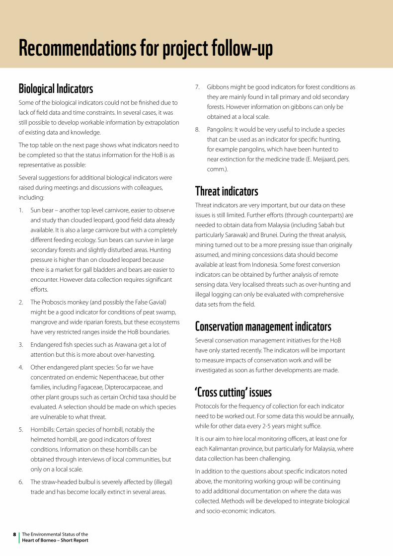
Biological IndicatorsSome of the biological indicators could not be finished due to
lack of field data and time constraints. In several cases, it was
still possible to develop workable information by extrapolation
of existing data and knowledge.
The top table on the next page shows what indicators need to
be completed so that the status information for the HoB is as
representative as possible:
Several suggestions for additional biological indicators were
raised during meetings and discussions with colleagues,
including:
1. Sun bear – another top level carnivore, easier to observe
and study than clouded leopard, good field data already
available. It is also a large carnivore but with a completely
different feeding ecology. Sun bears can survive in large
secondary forests and slightly disturbed areas. Hunting
pressure is higher than on clouded leopard because
there is a market for gall bladders and bears are easier to
encounter. However data collection requires significant
efforts.
2. The Proboscis monkey (and possibly the False Gavial)
might be a good indicator for conditions of peat swamp,
mangrove and wide riparian forests, but these ecosystems
have very restricted ranges inside the HoB boundaries.
3. Endangered fish species such as Arawana get a lot of
attention but this is more about over-harvesting.
4. Other endangered plant species: So far we have
concentrated on endemic Nepenthaceae, but other
families, including Fagaceae, Dipterocarpaceae, and
other plant groups such as certain Orchid taxa should be
evaluated. A selection should be made on which species
are vulnerable to what threat.
5. Hornbills: Certain species of hornbill, notably the
helmeted hornbill, are good indicators of forest
conditions. Information on these hornbills can be
obtained through interviews of local communities, but
only on a local scale.
6. The straw-headed bulbul is severely affected by (illegal)
trade and has become locally extinct in several areas.
7. Gibbons might be good indicators for forest conditions as
they are mainly found in tall primary and old secondary
forests. However information on gibbons can only be
obtained at a local scale.
8. Pangolins: It would be very useful to include a species
that can be used as an indicator for specific hunting,
for example pangolins, which have been hunted to
near extinction for the medicine trade (E. Meijaard, pers.
comm.).
Threat indicatorsThreat indicators are very important, but our data on these
issues is still limited. Further efforts (through counterparts) are
needed to obtain data from Malaysia (including Sabah but
particularly Sarawak) and Brunei. During the threat analysis,
mining turned out to be a more pressing issue than originally
assumed, and mining concessions data should become
available at least from Indonesia. Some forest conversion
indicators can be obtained by further analysis of remote
sensing data. Very localised threats such as over-hunting and
illegal logging can only be evaluated with comprehensive
data sets from the field.
Conservation management indicatorsSeveral conservation management initiatives for the HoB
have only started recently. The indicators will be important
to measure impacts of conservation work and will be
investigated as soon as further developments are made.
‘Cross cutting’ issuesProtocols for the frequency of collection for each indicator
need to be worked out. For some data this would be annually,
while for other data every 2-5 years might suffice.
It is our aim to hire local monitoring officers, at least one for
each Kalimantan province, but particularly for Malaysia, where
data collection has been challenging.
In addition to the questions about specific indicators noted
above, the monitoring working group will be continuing
to add additional documentation on where the data was
collected. Methods will be developed to integrate biological
and socio-economic indicators.
Recommendations for project follow-up
9The Environmental Status of theHeart of Borneo– Short Report
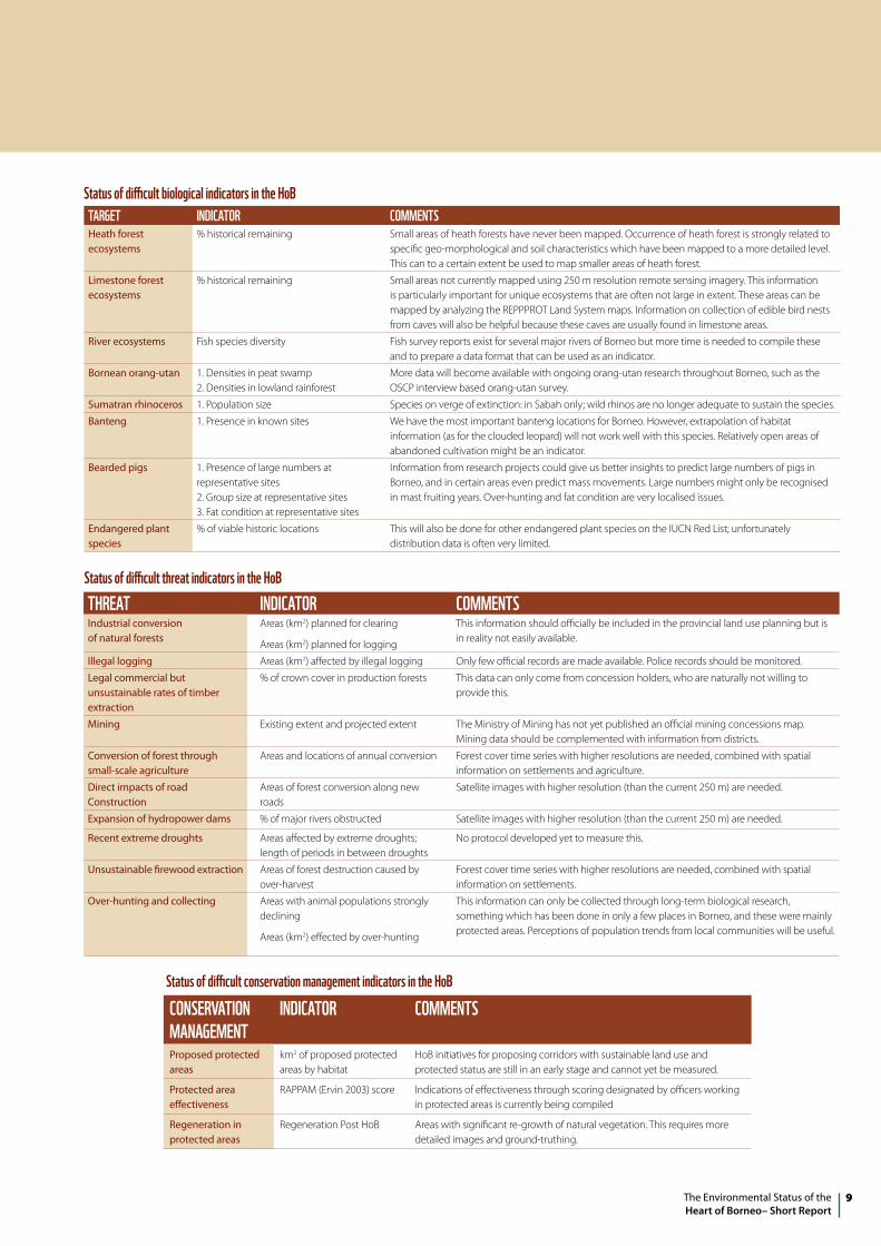
TARGET IndICATOR COMMEnTSHeath forest ecosystems
% historical remaining Small areas of heath forests have never been mapped. Occurrence of heath forest is strongly related to specific geo-morphological and soil characteristics which have been mapped to a more detailed level. This can to a certain extent be used to map smaller areas of heath forest.
Limestone forest ecosystems
% historical remaining Small areas not currently mapped using 250 m resolution remote sensing imagery. This information is particularly important for unique ecosystems that are often not large in extent. These areas can be mapped by analyzing the REPPPROT Land System maps. Information on collection of edible bird nests from caves will also be helpful because these caves are usually found in limestone areas.
River ecosystems Fish species diversity Fish survey reports exist for several major rivers of Borneo but more time is needed to compile these and to prepare a data format that can be used as an indicator.
Bornean orang-utan 1. Densities in peat swamp 2. Densities in lowland rainforest
More data will become available with ongoing orang-utan research throughout Borneo, such as the OSCP interview based orang-utan survey.
Sumatran rhinoceros 1. Population size Species on verge of extinction: in Sabah only; wild rhinos are no longer adequate to sustain the species.
Banteng 1. Presence in known sites We have the most important banteng locations for Borneo. However, extrapolation of habitat information (as for the clouded leopard) will not work well with this species. Relatively open areas of abandoned cultivation might be an indicator.
Bearded pigs 1. Presence of large numbers at representative sites 2. Group size at representative sites 3. Fat condition at representative sites
Information from research projects could give us better insights to predict large numbers of pigs in Borneo, and in certain areas even predict mass movements. Large numbers might only be recognised in mast fruiting years. Over-hunting and fat condition are very localised issues.
Endangered plant species
% of viable historic locations This will also be done for other endangered plant species on the IUCN Red List; unfortunately distribution data is often very limited.
Status of difficult biological indicators in the HoB
Status of difficult threat indicators in the HoBTHREAT IndICATOR COMMEnTSIndustrial conversion of natural forests
Areas (km2) planned for clearing
Areas (km2) planned for logging
This information should officially be included in the provincial land use planning but is in reality not easily available.
Illegal logging Areas (km2) affected by illegal logging Only few official records are made available. Police records should be monitored.
Legal commercial but unsustainable rates of timber extraction
% of crown cover in production forests This data can only come from concession holders, who are naturally not willing to provide this.
Mining Existing extent and projected extent The Ministry of Mining has not yet published an official mining concessions map. Mining data should be complemented with information from districts.
Conversion of forest through small-scale agriculture
Areas and locations of annual conversion Forest cover time series with higher resolutions are needed, combined with spatial information on settlements and agriculture.
Direct impacts of road Construction
Areas of forest conversion along new roads
Satellite images with higher resolution (than the current 250 m) are needed.
Expansion of hydropower dams % of major rivers obstructed Satellite images with higher resolution (than the current 250 m) are needed.
Recent extreme droughts Areas affected by extreme droughts; length of periods in between droughts
No protocol developed yet to measure this.
Unsustainable firewood extraction Areas of forest destruction caused by over-harvest
Forest cover time series with higher resolutions are needed, combined with spatial information on settlements.
Over-hunting and collecting Areas with animal populations strongly declining
Areas (km2) effected by over-hunting
This information can only be collected through long-term biological research, something which has been done in only a few places in Borneo, and these were mainly protected areas. Perceptions of population trends from local communities will be useful.
Status of difficult conservation management indicators in the HoB
COnSERvATIOn MAnAGEMEnT
IndICATOR COMMEnTS
Proposed protected areas
km2 of proposed protected areas by habitat
HoB initiatives for proposing corridors with sustainable land use and protected status are still in an early stage and cannot yet be measured.
Protected area effectiveness
RAPPAM (Ervin 2003) score Indications of effectiveness through scoring designated by officers working in protected areas is currently being compiled
Regeneration in protected areas
Regeneration Post HoB Areas with significant re-growth of natural vegetation. This requires more detailed images and ground-truthing.
The Environmental Status of theHeart of Borneo – Short Report
10
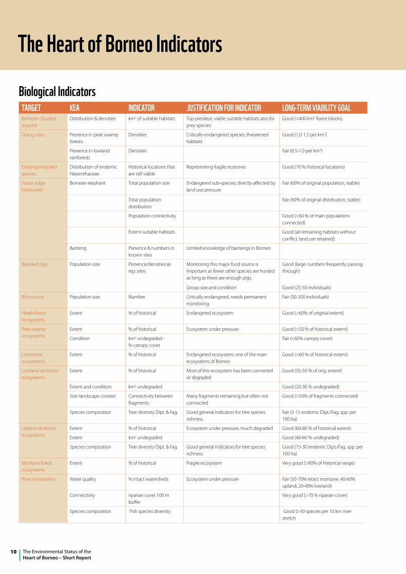
The Heart of Borneo Indicators
Biological IndicatorsTARGET KEA IndICATOR JuSTIFICATIOn FOR IndICATOR lOnG-TERM vIABIlITy GOAlBornean clouded leopard
Distribution & densities km2 of suitable habitats Top predator, viable suitable habitats also for prey species
Good (>400 km2 forest blocks)
Orang-utan Presence in peat swamp forests
Densities Critically endangered species, threatened habitats
Good (1.0-1.5 per km2)
Presence in lowland rainforests
Densities Fair (0.5-1.0 per km2)
Endangered plant species
Distribution of endemic Nepenthaceae
Historical locations that are still viable
Representing fragile ecotones Good (70 % historical locations)
Forest edge herbivores
Bornean elephant Total population size Endangered sub-species; directly affected by land use pressure
Fair (60% of original population, stable)
Total population distribution
Fair (60% of original distribution, stable)
Population connectivity Good (>60 % of main populations connected)
Extent suitable habitats Good (all remaining habitats without conflict. land use retained)
Banteng Presence & numbers in known sites
Limited knowledge of bantengs in Borneo
Bearded pigs Population size Presence/densities @ rep. sites
Monitoring this major food source is important as fewer other species are hunted as long as there are enough pigs.
Group size and condition
Good (large numbers frequently passing through)
Good (25-50 individuals)
Rhinoceros Population size Number Critically endangered, needs permanent monitoring
Fair (50-200 individuals)
Heath forest ecosystems
Extent % of historical Endangered ecosystem Good (>60% of original extent)
Peat swamp ecosystems
Extent % of historical Ecosystem under pressure Good (>50 % of historical extent)
Condition km2 undegraded - % canopy cover
Fair (<60% canopy cover)
Limestone ecosystems
Extent % of historical Endangered ecosystem; one of the main ecosystems of Borneo
Good (>60 % of historical extent)
Lowland rainforest ecosystems
Extent % of historical Most of this ecosystem has been converted or degraded
Good (35-50 % of orig. extent)
Extent and condition km2 undegraded Good (20-30 % undegraded)
Size-landscape context Connectivity between fragments
Many fragments remaining but often not connected
Good (>50% of fragments connected)
Species composition Tree diversity Dipt. & Fag. Good general indicators for tree species richness
Fair (5-15 endemic Dipt./Fag. spp. per 100 ha)
Upland rainforest ecosystems
Extent % of historical Ecosystem under pressure, much degraded Good (60-80 % of historical extent)
Extent km2 undegraded Good (40-60 % undegraded)
Species composition Tree diversity Dipt. & Fag. Good general indicators for tree species richness
Good (15-30 endemic Dipt./Fag. spp. per 100 ha)
Montane forest ecosystems
Extent % of historical Fragile ecosystem Very good (>80% of historical range)
River ecosystems Water quality % intact watersheds Ecosystem under pressure Fair (50-70% intact montane, 40-60% upland, 20-40% lowland)
Connectivity riparian cover 100 m buffer
Very good (>70 % riparian cover)
Species composition Fish species diversity Good (>30 species per 10 km river stretch
11The Environmental Status of theHeart of Borneo– Short Report
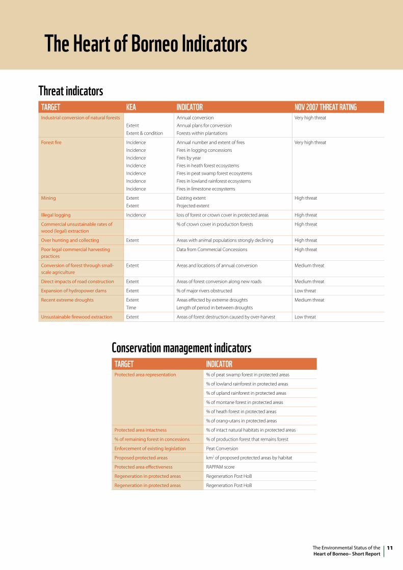
Threat indicatorsTARGET KEA IndICATOR nOv 2007 THREAT RATInGIndustrial conversion of natural forests
Extent
Extent & condition
Annual conversion
Annual plans for conversion
Forests within plantations
Very high threat
Forest fire Incidence
Incidence
Incidence
Incidence
Incidence
Incidence
Incidence
Annual number and extent of fires
Fires in logging concessions
Fires by year
Fires in heath forest ecosystems
Fires in peat swamp forest ecosystems
Fires in lowland rainforest ecosystems
Fires in limestone ecosystems
Very high threat
Mining Extent
Extent
Existing extent
Projected extent
High threat
Illegal logging Incidence loss of forest or crown cover in protected areas High threat
Commercial unsustainable rates of wood (legal) extraction
% of crown cover in production forests High threat
Over hunting and collecting Extent Areas with animal populations strongly declining High threat
Poor legal commercial harvesting practices
Data from Commercial Concessions High threat
Conversion of forest through small-scale agriculture
Extent Areas and locations of annual conversion Medium threat
Direct impacts of road construction Extent Areas of forest conversion along new roads Medium threat
Expansion of hydropower dams Extent % of major rivers obstructed Low threat
Recent extreme droughts Extent
Time
Areas effected by extreme droughts
Length of period in between droughts
Medium threat
Unsustainable firewood extraction Extent Areas of forest destruction caused by over-harvest Low threat
Conservation management indicatorsTARGET IndICATORProtected area representation % of peat swamp forest in protected areas
% of lowland rainforest in protected areas
% of upland rainforest in protected areas
% of montane forest in protected areas
% of heath forest in protected areas
% of orang-utans in protected areas
Protected area intactness % of intact natural habitats in protected areas
% of remaining forest in concessions % of production forest that remains forest
Enforcement of existing legislation Peat Conversion
Proposed protected areas km2 of proposed protected areas by habitat
Protected area effectiveness RAPPAM score
Regeneration in protected areas Regeneration Post HoB
Regeneration in protected areas Regeneration Post HoB
The Heart of Borneo Indicators
The Environmental Status of theHeart of Borneo – Short Report
12
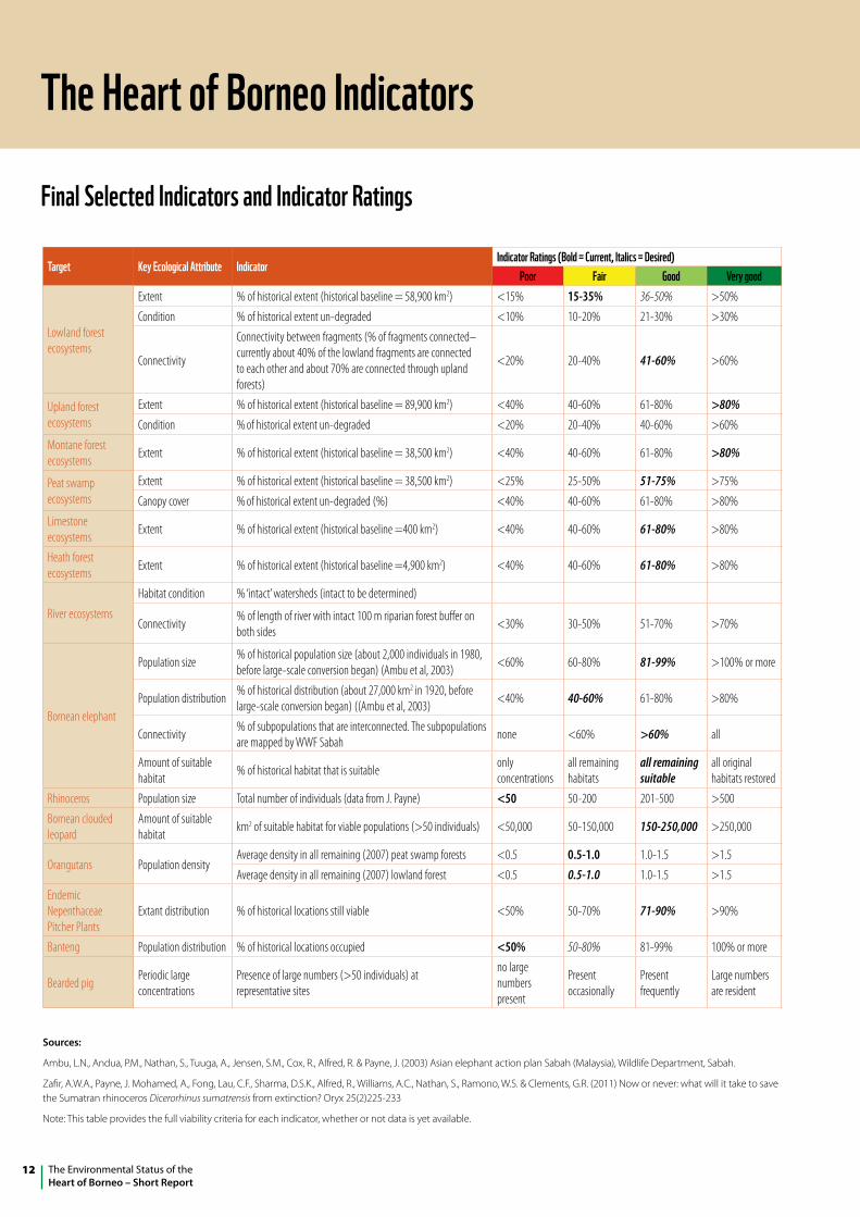
Final Selected Indicators and Indicator Ratings
The Heart of Borneo Indicators
Target Key Ecological Attribute IndicatorIndicator Ratings (Bold = Current, Italics = desired)
Poor Fair Good very good
Lowland forest ecosystems
Extent % of historical extent (historical baseline = 58,900 km2) <15% 15-35% 36-50% >50%
Condition % of historical extent un-degraded <10% 10-20% 21-30% >30%
Connectivity
Connectivity between fragments (% of fragments connected–currently about 40% of the lowland fragments are connected to each other and about 70% are connected through upland forests)
<20% 20-40% 41-60% >60%
Upland forest ecosystems
Extent % of historical extent (historical baseline = 89,900 km2) <40% 40-60% 61-80% >80%Condition % of historical extent un-degraded <20% 20-40% 40-60% >60%
Montane forest ecosystems Extent % of historical extent (historical baseline = 38,500 km2) <40% 40-60% 61-80% >80%
Peat swamp ecosystems
Extent % of historical extent (historical baseline = 38,500 km2) <25% 25-50% 51-75% >75%
Canopy cover % of historical extent un-degraded (%) <40% 40-60% 61-80% >80%
Limestone ecosystems Extent % of historical extent (historical baseline =400 km2) <40% 40-60% 61-80% >80%
Heath forest ecosystems Extent % of historical extent (historical baseline =4,900 km2) <40% 40-60% 61-80% >80%
River ecosystems
Habitat condition % ‘intact’ watersheds (intact to be determined)
Connectivity % of length of river with intact 100 m riparian forest buffer on both sides <30% 30-50% 51-70% >70%
Bornean elephant
Population size % of historical population size (about 2,000 individuals in 1980, before large-scale conversion began) (Ambu et al, 2003) <60% 60-80% 81-99% >100% or more
Population distribution % of historical distribution (about 27,000 km2 in 1920, before large-scale conversion began) ((Ambu et al, 2003) <40% 40-60% 61-80% >80%
Connectivity % of subpopulations that are interconnected. The subpopulations are mapped by WWF Sabah none <60% >60% all
Amount of suitable habitat % of historical habitat that is suitable only
concentrationsall remaining habitats
all remaining suitable
all original habitats restored
Rhinoceros Population size Total number of individuals (data from J. Payne) <50 50-200 201-500 >500
Bornean clouded leopard
Amount of suitable habitat km2 of suitable habitat for viable populations (>50 individuals) <50,000 50-150,000 150-250,000 >250,000
Orangutans Population densityAverage density in all remaining (2007) peat swamp forests <0.5 0.5-1.0 1.0-1.5 >1.5
Average density in all remaining (2007) lowland forest <0.5 0.5-1.0 1.0-1.5 >1.5
Endemic Nepenthaceae Pitcher Plants
Extant distribution % of historical locations still viable <50% 50-70% 71-90% >90%
Banteng Population distribution % of historical locations occupied <50% 50-80% 81-99% 100% or more
Bearded pig Periodic large concentrations
Presence of large numbers (>50 individuals) at representative sites
no large numbers present
Present occasionally
Present frequently
Large numbers are resident
Sources:
Ambu, L.N., Andua, P.M., Nathan, S., Tuuga, A., Jensen, S.M., Cox, R., Alfred, R. & Payne, J. (2003) Asian elephant action plan Sabah (Malaysia), Wildlife Department, Sabah.
Zafir, A.W.A., Payne, J. Mohamed, A., Fong, Lau, C.F., Sharma, D.S.K., Alfred, R., Williams, A.C., Nathan, S., Ramono, W.S. & Clements, G.R. (2011) Now or never: what will it take to save the Sumatran rhinoceros Dicerorhinus sumatrensis from extinction? Oryx 25(2)225-233
Note: This table provides the full viability criteria for each indicator, whether or not data is yet available.