Embed Size (px)
Citation preview

APIRG/18 - WP-17 Appendix A
Appendix A to WP/17 on Agenda Item 3.5
APPENDIX-3.5G
Insert Logo Here Insert Logo Here Insert Logo Here Organisation 1 Organisation 2 Organisation 3
Edition : Edition Date : Status :
Service Level Agreement Template

APIRGG/18 - WP-17 Appendix A
Appendix A to WP-17 on Agenda Item 3.5
Edi t ion : 0 .5 Proposed Issue Page 2
DOCUMENT APPROVAL
The following table identifies all management authorities that have successively approved the present issue of this document.
In witness whereof, the undersigned have executed this Agreement as of the date previously mentioned in this Agreement.
[Insert authority names below as appropriate]
AUTHORITY NAME AND SIGNATURE DATE
Aeronautical Information Services
Data Originator
Regulator

APIRG/18 - WP-17 Appendix A
Appendix A to WP/17 on Agenda Item 3.5
Edi t ion : 0 .5 Proposed Issue Page 3
DOCUMENT CHANGE RECORD
The following table records the complete history of the successive editions of the present document.
EDITION DATE REASON FOR CHANGE SECTIONS
PAGES AFFECTED

APIRG/18 - WP-17 Appendix A
Appendix A to WP/17 on Agenda Item 3.5
Edi t ion : 0 .5 Proposed Issue Page 4
TABLE OF CONTENTS
1. INTRODUCTION ................................................................................................................
1.1 Scope ........................................................................................................................ 1.2 Parties to the Agreement .......................................................................................
1.3 Perspective – Regulative Environment ............................................................... 1.4 Term .......................................................................................................................... 1.5 Conventions ............................................................................................................
1.5.1 Time .......................................................................................................................
1.5.2 Quality Attributes ..................................................................................................
1.5.3 Data Categories ....................................................................................................
2. SERVICES AND SERVICE LEVELS ................................................................................ 2.1 Service Description .................................................................................................
2.1.1 Regulation ............................................................................................................ 2.2 Optional Services ....................................................................................................
2.3 Exclusions ...............................................................................................................
2.4 Limitations ............................................................................................................... 2.5 Entities Involved ......................................................................................................
2.6 Service Levels .........................................................................................................
2.6.1 Data Originator .....................................................................................................
2.6.2 AISP ......................................................................................................................
2.7 Service Level Indications ......................................................................................
3. MANAGEMENT ELEMENTS .............................................................................................
3.1 Rewards and Remedies ..........................................................................................
3.2 Escalation Procedures ..........................................................................................
3.3 SLA Lifecycle ........................................................................................................... 3.3.1 Reporting ..............................................................................................................
3.3.2 Reviews ................................................................................................................
3.3.3 Change Process ....................................................................................................
3.4 Points of Contact ....................................................................................................
4. REFERENCES ....................................................................................................................
4.1 Refer to docs and add a short description ...........................................................
TABLE 1: PARTIES TO AGREEMENT ....................................................................................... 2 TABLE 2: DATA TO BE PROVIDED .......................................................................................... 5 TABLE 3: DATA ATTRIBUTES – ENTITY X ............................................................................. 6 TABLE 4: SERVICE LEVEL INDICATIONS .............................................................................. 7

APIRG/18 - WP-17 Appendix A
Appendix A to WP/17 on Agenda Item 3.5
Edi t ion : 0 .5 Proposed Issue Page 5
TABLE 5: POINTS OF CONTACT .............................................................................................. 8

APIRG/18/WP-17 to Agenda Item 3.5
3.5G-6 Appendix 3.5G to WP-17 on Agenda Item 3.5
S LA/1
Ed i t ion : 0 .5 Proposed Issue Page 6
1. INTRODUCTION
1.1 Scope
This Service Level Agreement (SLA) documents the agreed provision of service for the supply of aeronautical information (Data) by [organisation name] (The Data Originator) to [organisation name] (The AISP) and the agreed standards to which the said information shall be published by the AISP. This SLA is overseen and managed by the [organisation name] (The Regulator).
1.2 Benefits Gained from an SLA
An SLA is a contract between parties that defines the services provided, the indicators associated with these services, acceptable and unacceptable service levels, liabilities on the part of the service provider and the customer, and actions to be taken in specific circumstances.
In the scope of this SLA only modes of operation are discussed and formalised and financial components are not considered.
The basic objectives of an SLA are as follows:
• Better communication. It facilitates two-way communication between the parties. This communication starts at the beginning of the process to establish an SLA and continues throughout the life of the arrangement. The parties involved come together in order to understand each other’s needs, priorities and concerns, and to gain an insight into the problems which may be faced by each party through the failure of each party to fulfil their obligations.
• Guards against expectation creep. It is not uncommon for one party’s expectations of another to be higher than that which may be considered reasonable. Discussing these expectations and the resource commitments necessary to meet them is one activity undertaken in the establishment of an SLA. The process facilitates the identification and discussion of expectations. As a result, it helps identify service levels that are considered acceptable by each party and which are attainable and achievable.
• Mutually agreed standard. It sets an agreed standard against which performance may be measured. It identifies customer expectations, defines the boundaries of the service provision and clarifies responsibilities. In the absence of a shared understanding about needs and priorities, it is easy for conflicts to arise between parties. An SLA and the communication process involved in establishing it help to minimise the conflicts between the parties and provides a means for conflict resolution should a problem arise.
• A process for gauging service effectiveness. As the SLA defines standards against which the service may be measured and evaluated, it provides the basis for performing an assessment of the effectiveness of the service.
1.3 Parties to the Agreement
The following table describes and names the legal entities and their representatives who have reviewed and approved this SLA.

7 Appendix 3.5G to WP-17 on Agenda Item 3.5
S LA/1
Page 7 Proposed Issue Ed i t ion : 0 .5
Entity [Insert Regulator details here]
Address Re presentative
[Insert AISP details here]
[Insert Data Originator details here]
Table 1: Parties to Agreement
1.4 Perspective – Regulative Environment
A number of documents specify the regulatory requirements for the provision of information by Data Originators and its subsequent processing by AIS. These include:
• ICAO Annex 4 “Aeronautical Charts”;
• ICAO Annex 5 “Units of Measurement to be Used in Air and Ground Operations”;
• ICAO Annex 11 “Air Traffic Services”;
• ICAO Annex 14 “Aerodromes”;
• ICAO Annex 15 “Aeronautical Information Services”. These documents are further supported by guidance material, including:
• ICAO Doc 8126 “AIS Manual”;
• ICAO Doc 8697 “Aeronautical Chart Manual”;
• ICAO Doc 9674 “WGS-84 Manual”;
• Operating Procedures for AIS Dynamic Data (OPADD). [Add any State applicable regulation here]
1.5 Term
The term of this SLA shall be as follows: Start Date: [Insert start date here] End Date: [Insert end date here] Duration: [Insert duration here] Once agreed The AISP and The Data Originator cannot withdraw from all or part of this agreement within the above dates. [Add any other agreed constraints of / specification for the scope here.]
1.6 Conventions
Within this SLA, the following conventions are used:

APIRG/18/WP-17 to Agenda Item 3.5 3.5G-8
Appendix 3.5G to WP-17 on Agenda Item 3.5
S LA/1
Ed i t ion : 0 .5 Proposed Issue Page 8
1.6.1 Time
1.6.2 Presentation of Date and Time in All-numeric Form
This SLA uses Co-ordinated Universal Time (UTC) as described in Attachment D of Annex 5.
This SLA uses the procedures for writing the date and time in all-numeric form as described in Attachment E of Annex 5.
Times expressed as a number of “Office hours” include the hours from 8:00 to 16:00 Dutch local time (Monday to Friday).
Times expressed as a number of “Office hours” include business hours, Monday through Friday, excluding designated holidays.
Unless specifically mentioned otherwise, all durations specified are in working days.
1.6.3 Quality Attributes / Definitions
Accuracy: A degree of conformance between the estimated or measured value and the true value.
AIRAC System: A system aimed at advance notification based on common effective dates, of circumstances that necessitate significant changes in operating practices.
NOTAM System: A system of distributing notices by means of telecommunication, that contain information concerning the establishment, condition or change in any aeronautical facility, service, procedure or hazard, the timely knowledge of which is essential to personnel concerned with flight operations.
Resolution: A number of units or digits to which a measured or calculated value is expressed and used.
Integrity: A degree of assurance that an aeronautical data item and its value have not been lost or altered since its origination or authorised amendment.
Timeliness: A characteristic by which either data is provided or actions performed, with sufficient time remaining so as not to impact later actions and possibly jeopardise the achievement of the required result within due time.
1.6.4 Data Categories
The following data classifications are used within this document:
Routine: There is a very low probability when using corrupted routine data that the continued safe flight and landing of an aircraft would be severely at risk with the potential for catastrophe.
The permitted maximum error rate is 1 in 1000, providing an integrity level of 1 x 10⁻³.
APIRG/18/WP-17 to the Agenda I
S LA/1
Ed i t ion : 0 .5 Proposed Issue Page 9
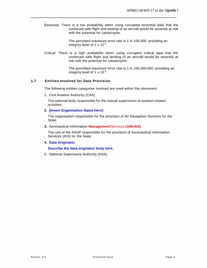
Essential: There is a low probability when using corrupted essential data that the continued safe flight and landing of an aircraft would be severely at risk with the potential for catastrophe.
The permitted maximum error rate is 1 in 100,000, providing an integrity level of 1 x 10⁻⁵.
Critical: There is a high probability when using corrupted critical data that the continued safe flight and landing of an aircraft would be severely at risk with the potential for catastrophe.
The permitted maximum error rate is 1 in 100,000,000, providing an integrity level of 1 x 10⁻⁸.
1.7 Entities Involved for Data Provision
The following entities categories involved are used within this document:
1. Civil Aviation Authority (CAA)
The national body responsible for the overall supervision of aviation-related activities.
2. [Insert Organisation Name Here]
The organisation responsible for the provision of Air Navigation Services for the State.
3. Aeronautical Information Management/Services (AIM/AIS) The unit of the ANSP responsible for the provision of Aeronautical Information Services (AIS) for the State.
4. Data Originator Describe the data originator body here.
5. National Supervisory Authority (NSA)

APIRG/18/WP-17 Appendix 3.5G to WP-17 on Agenda Item 3.5
S LA/1
Ed i t ion : 0 .5 Proposed Issue Page 10
2. SERVICES AND SERVICE LEVELS
2.1 Service Description
The Data Originator will provide the AISP with the Data for which it is responsible as listed in Table 2, below.
Table 2: Data to be Provided
The AISP will, in turn, publish the information within the National Publication and in accordance with ICAO and National regulations.
2.1.1 Regulation
[Detail here the regulation that applies to this SLA]
2.2 Optional Services
[Detail any further services required here]
2.3 Exclusions
[Detail any further services required here]
2.4 Limitations
[Detail any further services required here]
2.5 Entities Involved
[Detail any the entities involved here]
2.6 Service Levels
2.6.1 Data Originator
All Data shall be provided in accordance with the following criteria:
1. The Data shall include its effective date.
2. The Data shall include its period of validity.
3. The Data shall be provided with the requested publication.
4. The Data shall be prepared in accordance with the following standards:
a. [List standards here]
Additionally, the Data Originator shall provide each of the identified Data items in Table 2, in accordance with the following specific criteria:

APIRG/18/WP17 3.5G-11
Appendix 3.5G to WP-17on Agenda Item 3.5
S LA/1
Ed i t ion : 0 .5 Proposed Issue Page 11
2.6.1.1 Data Item x – Repeat for each data item.
The Data shall be provided at least [insert timeliness requirement] days prior to the effective date.
The Data shall be provided by [insert delivery requirement] means.
The Data shall be provided in [insert required format of delivery].
The Data shall be provided with the following quality attributes:
Attribute Accuracy Resolution Inte grity Level Note
X’1 20 m 1 second Critical
X’2 1 ft 0.1 ft Essential
X’3 n/a n/a Routine Textual data Table 3: Data Attributes – Entity X
The Data shall be provided by with the following mete-data:
1. [insert meta-data requirement].
[Add more requirements for the provision of information]
2.6.2 AISP
The AISP shall process the Data upon receipt.
The AISP shall present a draft publication including the Data for approval by [insert approver] at least [insert timeliness requirement] days prior to the effective date.
The AISP shall publish the Data within the requested publication unless otherwise agreed, in writing, with the Data Originator.
[Add more requirements for the publication of information]
2.7 Service Level Indications
The following measures will be used to assess the performance of the service:

APIRG/18/WP17 3.5G-12
Appendix 3.5G to WP-17on Agenda Item 3.5
S LA/1
Ed i t ion : 0 .5 Proposed Issue Page 12
Measure Description Target date1.
Late provision must be alerted to the AIM as soon as known. The publication of this information will then be the subject of negotiation.
Format The Data is provided by the Data Originator to the AIM, without errors in presentation or content, in the format detailed within this SLA.
95%
Draft Publication The AIM will present a draft publication to the Data Originator for approval within the specified timeframe.
95% by required due date2.
100% within one day following due date2.
Publication The AIM will publish the Data within the required period (e.g. in compliance with
the AIRAC cycle).
95% by required due date.
Quality of Publication The IAIP product prepared will be
provided in accordance with the applicable standards.
95%
Add and amend indications as required.
Due date is used to mean the number of days in advance of the effective date that the information is to be provided to the AIS. This period is defined in section 2.6.1.
Measure Description Target
The Data is delivered by the Data 100% Originator to the AIM with the required quality levels.
Quality of Data
The Data is delivered by the Data Originator to the AIM within the specified timeframe.
95% by required due date1.
100% within three days
following due
Timeliness

APIRG/18/WP-17 3.5G-13
Appendix 3.5G to WP-17 on Agenda Item 3.5
S LA/1
Ed i t ion : 0 .5 Proposed Issue Page 13
Table 4: Service Level Indications 2 Due date is used to mean the number of days in advance of the
effective date that the draft publication is to be provided to the Data Originator.
3. MANAGEMENT ELEMENTS 3.1 Rewards and Remedies
[Detail rewards and remedies here] 3.2 Escalation Procedures [Detail any escalation procedures here] 3.3 SLA Lifecycle 3.3.1 Reporting [Detail any reporting here] 3.3.2 Reviews [Detail any reviews here] 3.3.3 Change Process [Detail the change process here] 3.4 Points of Contact The following points of contact for execution of the SLA are:
Organisation Primary Contact Secondary Contact [Insert Regulator details here] [Insert Primary Contact
details here, including name, role/job title, address, telephone, fax and email]
[Insert Secondary Contact details here, including name, role/job title, address, telephone, fax and email]
[Insert AISP details here] [Insert Primary Contact
details here, including name, role/job title, address, telephone, fax and email]
[Insert Secondary Contact details here, including name, role/job title, address, telephone, fax and email]
[Insert Data Originator details here]
[Insert Primary Contact details here, including name, role/job title, address, telephone, fax and email]
[Insert Secondary Contact details here, including name, role/job title, address, telephone, fax and email]
Table 5: Points of Contact

APIRG/18/WP-17 3.5G-14
Appendix 3.5G to WP-17 on Agenda Item 3.5
S LA/1
Ed i t ion : 0 .5 Proposed Issue Page 14
4. FUTURE INTENTIONS
4.1 General
Although outside the scope of this SLA, AIM and the [Data Originator] have a number of intentions for improvement which may have a consequential impact on this SLA.
The following sections outline these and should be considered during the review of the SLA, once it is in operation.
4.2 Describe future intentions here
5. REFERENCES
5.1 Refer to docs and add a short description.
End of Document

APIRG/18 – WP/17 Appendix B
a) Proposal for Amendment to the AFI Basic ANP (Doc 7474 Vol. II) for the introduction of
a new Section related to e-TOD
World Geodetic System – 1984 (WGS-84)
67. In order to ensure that quality (accuracy, resolution and integrity) and traceability requirements for the WGS-84 related geographical coordinate data are met, States must take measures to develop and introduce a quality system programme. This programme containing procedures, processes and resources should be in conformity with the International Organization for Standardization (ISO) 9000 series of quality assurance standards.
(Insert the following new Text) Electronic Terrain and Obstacle Data (eTOD) Requirements (FASID Table AIS 9)
68. Recognizing that significant safety benefits for international civil aviation will be provided by in-flight and ground-based applications that rely on quality electronic Terrain and Obstacle Data (eTOD), States should make every effort to implement the eTOD provisions in accordance with Chapter 10 of Annex 15 and Doc 9881. 69. FASID Table AIS-X sets out the requirements for the provision of Electronic Terrain and Obstacle Data (e-TOD) to be provided by States. 70. The implementation of e-TOD should involve different Administrations within and outside the Civil Aviation Authority i.e.: AIS, Aerodromes, Military, National Geographic and Topographic Administrations/Agencies, procedure designers, etc. 71. States, while maintaining the responsibility for data quality and availability, should consider to which extent the provision of electronic terrain and obstacle data could be delegated to national geodetic Institutes/Agencies, based on Service Level Agreement reflecting such delegation. 72. States should consider carefully the required level of details of collected terrain and obstacle data with particular emphasis on obstacle data and associated cost. 73. States should take into consideration the requirements for update/maintenance of data, especially related to obstacles. 74. States should work co-operatively with regard to the cross-border issue, for the sake of harmonization and more efficient implementation of e-TOD. (Renumber the following paragraphs)

APIRG/18 - WP/17 Appendix C
Appendix C to WP/17 on Agenda Item 3.5
FASID TABLE AIS-X — e-TOD REQUIREMENTS
EXPLANATION OF THE TABLE
1 Name of the State, territory or aerodrome for which electronic Terrain and Obstacle Data (e-TOD) are required with the designation of the aerodrome use:
RS — international scheduled air transport, regular use RNS — international non-scheduled air transport, regular use RG — international general aviation, regular use AS — international scheduled air transport, alternate use
2 Runway designation numbers
3 Type of each of the runways to be provided. The types of runways, as defined in Annex 14, Volume 1, Chapter I,
are:
NINST — non-instrument runway; NPA — non-precision approach runway PA1 — precision approach runway, Category I; PA2 — precision approach runway, Category II; PA3 — precision approach runway, Category III.
4 Requirement for the provision of Terrain data for Area 1, shown by an ‘‘X’’ against the State or territory to be
covered.
5 Requirement for the provision of Terrain data for Area 2 (TMA), shown by an ‘‘X’’ against the aerodrome to be covered.
6 Requirement for the provision of Terrain data for Area 2 (45 Km radius from the ARP), shown by an
‘‘X’’ against the aerodrome to be covered.
7 Requirement for the provision of Terrain data for Area 3, shown by an ‘‘X’’ against the aerodrome to be covered.
8 Requirement for the provision of Terrain data for Area 4, shown by an ‘‘X’’ against the runway threshold to be covered.
9 Requirement for the provision of Obstacle data for Area 1, shown by an ‘‘X’’ against the State or territory to be
covered.
10 Requirement for the provision of Obstacle data for Area 2 (TMA), shown by an ‘‘X’’ against the aerodrome to be covered.
11 Requirement for the provision of Obstacle data for Area 2 (45 Km radius from the ARP), shown by an
‘‘X’’ against the aerodrome to be covered.
12 Requirement for the provision of Obstacle data for Area 3, shown by an ‘‘X’’ against the aerodrome to be covered.
13 Remarks (timetable for implementation)
Note: For Columns 4 to 12 use the following symbols:
X- Required but not implemented XI- Required and implemented

APIRG/18 - WP/17 Appendix C
Appendix C to WP/17 on Agenda Item 3.5
STATE, TERRITORY OR AERODROME FOR WHICH eTOD IS REQUIRED TERRAIN DATA REQUIRED
OBSTACLE DATA REQUIRED REMARKS
CITY/AERODROME
RWY No
RWY TYPE
Area 1
Area 2
Area 3 Area
4 Area 1
Area 2
Area 3
TMA 45Km
TMA 45Km
1 2 3 4 5 6 7 8 9 10 11 12 13
ALGERIA
DAUA ADRAR/Touat RS
04 22
NPA
DAAG ALGER/Houari Boumediene RS
05 23
09 27
NPA PA2
PA1 NPA
DABB ANNABA/El Mellah RS
01 19
05 23
NPA PA1 NPA
NINST
DABC CONSTANTINE/Mohamed Boudiaf RS
14 32 16 34
NPA PA1 NPA PA1
DAUG GHARDAIA/Noumérate RS
12 30
NPA PA1
NINST
DAUH HASSI-MESSAOUD/Oued Irara RS
18 361
01 19
PA1 NPA
DAUI IN-SALAH/ AS
05 23
NPA NPA
DAOO ORAN/Es Sénia RS
07 25
NPA PA2
DAAT TAMANRASSET/Aguennar AS
02 20 08 26
NPA PA1 NPA
DABS TEBESSA/Tébessa RS
11 29 12
NPA NPA NPA
NINST

APIRG/18 - WP/17 Appendix C
Appendix C to WP/17 on Agenda Item 3.5
STATE, TERRITORY OR AERODROME FOR WHICH eTOD IS REQUIRED TERRAIN DATA REQUIRED
OBSTACLE DATA REQUIRED REMARKS
CITY/AERODROME
RWY No
RWY TYPE
Area 1
Area 2
Area 3 Area
4 Area 1
Area 2
Area 3
TMA 45Km
TMA 45Km
30
DAON TLEMCEN/Zénata RS
09 27
NPA NPA
DAUZ ZARZAITINE/In Amenas RS
05 23 15 33
NPA NPA
ANGOLA
FNHU HUAMBO/Albano Machado RS
11 29
NPA NPA
FNLU LUANDA/4 de Fevereiro RS
05 23 07 25
NPA PA1
BENIN
DBBB COTONOU/Cadjehoun RS
06 24
NPA PA1
BOTSWANA
FBFT FRANCISTOWN/ Francistown RS
11 29
NINST NINST
FBSK GABORONE/Sir Seretse Khama Intl RS
08 26
PA1 NPA
FBKE KASANE/Kasane RS
08 26
NPA NINST
FBMN MAUN/Maun RS
08 26
NINST NINST
FBSP SELEBI-PHIKWE/Selebi-Phikwe
12 30
NINST PA1
NINST

APIRG/18 - WP/17 Appendix C
Appendix C to WP/17 on Agenda Item 3.5
STATE, TERRITORY OR AERODROME FOR WHICH eTOD IS REQUIRED TERRAIN DATA REQUIRED
OBSTACLE DATA REQUIRED REMARKS
CITY/AERODROME
RWY No
RWY TYPE
Area 1
Area 2
Area 3 Area
4 Area 1
Area 2
Area 3
TMA 45Km
TMA 45Km
RS
BURKINA FASO
DFOO BOBO-DIOULASSO/Bobo-Dioulasso RS
06 24
PA1 NPA
DFFD OUAGADOUGOU/Ouagadougou RS
04L 22R
PA1 NPA
BURUNDI
HBBA BUJUMBURA/Bujumbura RS
18 36
PA1 NPA
CAMEROON
FKKD DOUALA/Douala RS
12 30
NPA PA2
FKKR GAROUA/Garoua RS
09 27
PA1 NPA
FKKL MAROUA/Salak RS
13 31
NPA NINST
FKKN N'GAOUNDERE/N’Gaoundere AS
03 21
NPA NINST
FKYS YAOUNDE/Nsimalen RS
01 19
NINST PA2
CAPE VERDE
GVFM PRAIA/Francisco Mendes RS
04 22
NPA NINST

APIRG/18 - WP/17 Appendix C
Appendix C to WP/17 on Agenda Item 3.5
STATE, TERRITORY OR AERODROME FOR WHICH eTOD IS REQUIRED TERRAIN DATA REQUIRED
OBSTACLE DATA REQUIRED REMARKS
CITY/AERODROME
RWY No
RWY TYPE
Area 1
Area 2
Area 3 Area
4 Area 1
Area 2
Area 3
TMA 45Km
TMA 45Km
GVAC SAL I./Amilcar Cabral RS
01 19 07 25
PA1 NPA
CENTRAL AFRICAN REPUBLIC
FEFF BANGUI/M'Poko RS
17 35
NPA PA1
FEFT BERBERATI/Berberati RS
17 35
NPA NINST
CHAD
FTTJ N'DJAMENA/N'Djamena RS
05 23
PA1 NPA
COMOROS
FMCV ANJOUAN/Ouani RS
10 28
NPA NPA
FMCZ DZAOUDZI/Pamanzi, Mayotte I. RS
16 34
NINST NPA
FMCH MORONI/Prince Said IbrahimHahaia RS
02 20
PA1 NPA
CONGO
FCBB BRAZZAVILLE/Maya-Maya RS
06 24
PA1 NPA
FCPP POINTE NOIRE/Agostino Neto RS
17 35
NPA NPA
COTE D'IVOIRE
DIAP ABIDJAN/Felix Houphouet Boigny Intl RS
03 21
NPA PA2

APIRG/18 - WP/17 Appendix C
Appendix C to WP/17 on Agenda Item 3.5
STATE, TERRITORY OR AERODROME FOR WHICH eTOD IS REQUIRED TERRAIN DATA REQUIRED
OBSTACLE DATA REQUIRED REMARKS
CITY/AERODROME
RWY No
RWY TYPE
Area 1
Area 2
Area 3 Area
4 Area 1
Area 2
Area 3
TMA 45Km
TMA 45Km
DIBK BOUAKE/Bouake RS
03 21
NPA PA1
DEMOCRATIC REPUBLIC
OF THE CONGO
FZNA GOMA/Goma RS
18 36
NINST NPA
FZAA KINSHASA/N'Djili RS
06 24
NPA PA1
FZIC KISANGANI/Bangoka AS
13 31
NPA NPA
FZQA LUBUMBASHI/Luano AS
07 25
PA1 NPA
FZWA MBUJI MAYI/Mbuji Mahi AS
17 35
NPA NINT
DJIBOUTI
HDAM DJIBOUTI/Ambouli RS
09 27
NPA PA1
EGYPT
HEBL ABU-SIMBEL/Abu-Simbel RS
15L 33R 15L 33R
NPA NPA NPA NPA
HEAX ALEXANDRIA/Alexandria RS
04 22 18 36
NPA NPA NPA NPA
HESN ASWAN/Aswan RS
17 35
NPA PA1
HECA CAIRO/Cairo Intl RS
05L 23R 05R 23L 16 34
PA2 PA2 PA2 PA2 NPA NPA

APIRG/18 - WP/17 Appendix C
Appendix C to WP/17 on Agenda Item 3.5
STATE, TERRITORY OR AERODROME FOR WHICH eTOD IS REQUIRED TERRAIN DATA REQUIRED
OBSTACLE DATA REQUIRED REMARKS
CITY/AERODROME
RWY No
RWY TYPE
Area 1
Area 2
Area 3 Area
4 Area 1
Area 2
Area 3
TMA 45Km
TMA 45Km
HEGN HURGHADA/Hurghada RS
16 34
NPA PA1
HELX LUXOR/Luxor RS
02 20
NPA PA1
HEMM MERSA-MATRUH/Mersa-Matruh RS
15 33
NPA NPA
HESH SHARM EL SHEIKH/Sharm El Sheikh RS
04L 22R 04R 22L
PA1 NINST
HESC ST. CATHERINE/St. Catherine RS
17 35
NPA NINST
HETB TABA/Taba RS
04 22 14 32
NINST NPA
EQUATORIAL GUINEA
FGSL MALABO/Malabo RS
05 23
PA1 NPA
ERITREA
HHAS ASMARA/Asmara Intl RS
07 25 12 30
PA1 NPA
HHSB ASSAB/Assab RS
12 30
NPA NINST
ETHIOPIA
HAAB ADDIS ABABA/Bole Intl RS
07 25
NPA PA1
HADR DIRE DAWA/Dire Dawa Intl RS
15 33
NINST NPA
FRANCE (ILE DE LA REUNION)

APIRG/18 - WP/17 Appendix C
Appendix C to WP/17 on Agenda Item 3.5
STATE, TERRITORY OR AERODROME FOR WHICH eTOD IS REQUIRED TERRAIN DATA REQUIRED
OBSTACLE DATA REQUIRED REMARKS
CITY/AERODROME
RWY No
RWY TYPE
Area 1
Area 2
Area 3 Area
4 Area 1
Area 2
Area 3
TMA 45Km
TMA 45Km
FMME SAINT-DENIS/Gilot La Reunion RS
12 30 14 32
NINST NPA PA1
NINST
GABON
FOON FRANCEVILLE/M'Vengue RS
15 33
PA1 NPA
FOOL LIBREVILLE/Leon M'Ba RS
16 34
PA1 NPA
FOOG PORT GENTIL/Port Gentil RS
03 21
NPA PA1
GAMBIA
GBYD BANJUL/Banjul Intl RS
14 32
NPA PA1
GHANA
DGAA ACCRA/Kotoka Intl RS
03 21
NPA PA1
DGSI KUMASI/Kumasi RS
02 20
NPA NPA
DGLE TAMALE/Tamale RS
05 23
NPA NPA
GUINEA
GUCY CONAKRY/Gbessia RS
06 24
PA1 NPA
GUXN KANKAN/Diankana RS
10 28
NPA NINST
GULB LABE/Tata RS
06 24
NINST NINST

APIRG/18 - WP/17 Appendix C
Appendix C to WP/17 on Agenda Item 3.5
STATE, TERRITORY OR AERODROME FOR WHICH eTOD IS REQUIRED TERRAIN DATA REQUIRED
OBSTACLE DATA REQUIRED REMARKS
CITY/AERODROME
RWY No
RWY TYPE
Area 1
Area 2
Area 3 Area
4 Area 1
Area 2
Area 3
TMA 45Km
TMA 45Km
GUNZ N'ZEREKORE/Konia RS
18 36
NPA NINST
GUINEA-BISSAU
GGOV BISSAU/Osvaldo Vieira Intl RS
03 21
NPA PA1
KENYA
HKEL ELDORET/Eldoret Intl RS
08 26
PA2 NPA
HKMO MOMBASA/Moi Intl RS
03 21 15 33
NPA PA1
HKJK NAIROBI/Jomo Kenyatta Intl RS
06 24
PA2 NPA
LESOTHO
FXMM MASERU/Moshoeshoe I. Intl RS
04 22
NINST PA1
LIBERIA
GLRB MONROVIA/Roberts Intl RS
04 22
PA2 NPA
LIBYAN ARAB JAMAHIRIYA
HLLB BENGHAZI/Benina RS
15L 33R 15R 33L
PA1 NPA NPA PA1
HLLS SEBHA/Sebha RS
13 31
PA1 NPA
HLLT TRIPOLI/Tripoli Intl RS
06 24 09
PA1 PA2

APIRG/18 - WP/17 Appendix C
Appendix C to WP/17 on Agenda Item 3.5
STATE, TERRITORY OR AERODROME FOR WHICH eTOD IS REQUIRED TERRAIN DATA REQUIRED
OBSTACLE DATA REQUIRED REMARKS
CITY/AERODROME
RWY No
RWY TYPE
Area 1
Area 2
Area 3 Area
4 Area 1
Area 2
Area 3
TMA 45Km
TMA 45Km
27 18 36
MADAGASCAR
FMMI ANTANANARIVO/Ivato RS
11 29
PA1 NPA
FMNA ANTSIRANANA/Arrachart RS
13 31
NPA NINST
FMNM MAHAJANGA/Amborovy RS
14 32
NPA NINST
FMNN NOSY-BE/Fascene RS
05 23
NPA PA1
FMMS SAINTE-MARIE/Sainte-Marie RS
01 19
NPA NPA
FMMT TOAMASINA/Toamasina RS
01 19
NPA PA1
FMSD TOLAGNARO/Tolagnaro RS
07 25
NPA NPA
MALAWI
FWCL BLANTYRE/Chileka RS
10 28
PA1NPA
NPA
FWLI LILONGWE/Lilongwe Intl RS
14 32
PA1 NPA
MALI
GABS BAMAKO/Senou RS
06 24
PA1 NPA
GAGO GAO/Gao RS
07 25
NPA NINST
GAKY KAYES/Kayes RS
08 26
NPA NINST

APIRG/18 - WP/17 Appendix C
Appendix C to WP/17 on Agenda Item 3.5
STATE, TERRITORY OR AERODROME FOR WHICH eTOD IS REQUIRED TERRAIN DATA REQUIRED
OBSTACLE DATA REQUIRED REMARKS
CITY/AERODROME
RWY No
RWY TYPE
Area 1
Area 2
Area 3 Area
4 Area 1
Area 2
Area 3
TMA 45Km
TMA 45Km
GAKL KIDAL/Kidal RS
10 28
NPA NINST
GAMB MOPTI-BARBE/Mopti-Barbe RS
05 23
NPA NINST
GANR NIORO/Nioro RS
08 26
NPA NINST
GATB TOMBOUCTOU/ Tombouctou RS
07 25
PA1 NPA
MAURITANIA
GQPA ATAR/Atar RS
04 22
NPA NINST
GQNI NEMA/Nema RS
10 28
NINST NPA
GQPP NOUADHIBOU/Nouadhibou RS
03 21
PA1 NPA
GQNN NOUAKCHOTT/Nouakchott RS
05 23
PA1 NPA
GQPZ ZOUERATE/Zouerate RS
28 10
NPA NPA
MAURITIUS
FIMP MAURITIUS/Sir Seewoosagur Ramgoolam Intl RS
14 32
PA1 NPA
MOROCCO
GMAD AGADIR/Al Massira RS
10 28
NPA PA1
GMTA AL HOCEIMA/Cherif Al Idrissi RS
18 36
PA1 NINST
GMMN CASABLANCA/Mohammed V RS
17 35
NPA PA2

APIRG/18 - WP/17 Appendix C
Appendix C to WP/17 on Agenda Item 3.5
STATE, TERRITORY OR AERODROME FOR WHICH eTOD IS REQUIRED TERRAIN DATA REQUIRED
OBSTACLE DATA REQUIRED REMARKS
CITY/AERODROME
RWY No
RWY TYPE
Area 1
Area 2
Area 3 Area
4 Area 1
Area 2
Area 3
TMA 45Km
TMA 45Km
GMFK ERRACHIDIA/Moulay Ali Cherif AS
13 31
NPA PA1
GMFF FES/Saïss RS
10 28
NPA PA1
GMMX MARRAKECH/Ménara RS
10 28
PA1 NPA
GMMZ OUARZAZATE/Ouarzazate RS
12 30
NPA PA1
GMFO OUJDA/Angads RS
06 24
PA1 NINST
GMME RABAT/Salé RS
04 22
PA1 NPA
GMTT TANGER/Ibnou-Batouta RS
10 28
NPA PA1
GMAT TAN-TAN/Plage Blanche RS
14 22
NPA NINST
GMTN TETOUAN/Saniat-Rimel RS
06 24
NPA NINST
MOZAMBIQUE
FQBR BEIRA/Beira RS
12 30 06 24
PA1 NPA
FQMA MAPUTO/Maputo Intl RS
05 23
NPA PA1
NAMIBIA
FYKT KEETMANSHOOP/Keetmanshop RS
04 22 18 36
NPA NPA
FYWB WALVIS BAY/Walvis Bay RS
09 27 12 30
NPA NPA

APIRG/18 - WP/17 Appendix C
Appendix C to WP/17 on Agenda Item 3.5
STATE, TERRITORY OR AERODROME FOR WHICH eTOD IS REQUIRED TERRAIN DATA REQUIRED
OBSTACLE DATA REQUIRED REMARKS
CITY/AERODROME
RWY No
RWY TYPE
Area 1
Area 2
Area 3 Area
4 Area 1
Area 2
Area 3
TMA 45Km
TMA 45Km
FYWH WINDHOEK/Hosea KutakoWindhoek RS
08 26 16 34
PA1 NPA
NIGER
DRZA AGADES/Sud RS
07 25
NPA NINST
DRRN NIAMEY/Diori Hamani Intl RS
09R 27L 09L 27R
PA1 NPA
DRZR ZINDER/Zinder AS
06 24
NPA NINST
NIGERIA
DNAA ABUJA/Nnamdi Azikiwe RS
04 22
NPA PA1
DNCA CALABAR/Calabar RS
03 21
NPA PA1
DNIL ILORIN/Ilorin AS
05 23
PA1 NPA
DNKA KADUNA/Kaduna RS
05 23
PA1 NPA
DNKN KANO/Mallam Aminu Kano Intl RS
06 24 05 23
PA2 PA2
DNMM LAGOS/Murtala Muhammed RS
01L 19R 01R 19L
PA2 PA2 NPA PA2
DNMA MAIDUGURI/Maiduguri RS
05 23
PA2 NPA
DNPO PORT HARCOURT/Port Harcourt Intl RS
03 21
NPA PA1
DNSO SOKOTO/Abubakar Saddiq III Intl RS
08 26
PA1 NPA

APIRG/18 - WP/17 Appendix C
Appendix C to WP/17 on Agenda Item 3.5
STATE, TERRITORY OR AERODROME FOR WHICH eTOD IS REQUIRED TERRAIN DATA REQUIRED
OBSTACLE DATA REQUIRED REMARKS
CITY/AERODROME
RWY No
RWY TYPE
Area 1
Area 2
Area 3 Area
4 Area 1
Area 2
Area 3
TMA 45Km
TMA 45Km
RWANDA
HRYR KIGALI/Gregoire Kayibanda RS
10 28
NPA PA1
SAO TOME AND PRINCIPE
FPST SAO TOME/Sao Tomé RS
11 29
PA1 NPA
SENEGAL
GOGS CAP SKIRING/Cap Skiring RS
15 33
NINST NPA
GOOY DAKAR/Leopold Sedar Senghor Intl RS
18 36 03 21
PA2 NPA
GOSS SAINT LOUIS/Saint Louis RS
18 36
NPA NINST
GOTT TAMBACOUNDA/Tambacounda RS
06 24
NPA NPA
GOGG ZIGUINCHOR/Ziguinchor RS
10 28
NINST NPA
SEYCHELLES
FSIA MAHE/Seychelles Intl RS
13 31
NPA PA1
SIERRA LEONE
GFLL FREETOWN/Lungi RS
12 30
NPA PA1
SOMALIA
HCMI BERBERA/Berbera AS
05 23
NINST NINST

APIRG/18 - WP/17 Appendix C
Appendix C to WP/17 on Agenda Item 3.5
STATE, TERRITORY OR AERODROME FOR WHICH eTOD IS REQUIRED TERRAIN DATA REQUIRED
OBSTACLE DATA REQUIRED REMARKS
CITY/AERODROME
RWY No
RWY TYPE
Area 1
Area 2
Area 3 Area
4 Area 1
Area 2
Area 3
TMA 45Km
TMA 45Km
HCMV BURAO/Burao RS
13 31
NINST NINST
HCMH HARGEISA/Hargeisa RS
06 24
NPA NPA
HCMK KISIMAYU/Kisimayu AS
05 23
NPA PA1
HCMM MOGADISHU/Mogadishu RS
05 23
NPA PA1
SOUTH AFRICA
FAAB ALEXANDER BAY/Alexander Bay RS
01 19 07 25 11 29
NPA NINST
FABL BLOEMFONTEIN/Bloemfontein AS
02 20 12 30
PA1 NPA
NINST NINST
FACT CAPE TOWN/Cape Town RS
01 19 16 34
PA1 NPA
FADN DURBAN/Durban RS
05 23
NPA PA1
FAJS JOHANNESBURG/Johannesburg RS
03L 21R 03R 21L 15 33
PA2 MINST
PA2 PA2
NINST NINST
FAGM JOHANNESBURG/Rand RS
18 36
NPA NPA
FALA LANSERIA/Lanseria RS
06L 24R 06R 24L 17 35
NPA NINST

APIRG/18 - WP/17 Appendix C
Appendix C to WP/17 on Agenda Item 3.5
STATE, TERRITORY OR AERODROME FOR WHICH eTOD IS REQUIRED TERRAIN DATA REQUIRED
OBSTACLE DATA REQUIRED REMARKS
CITY/AERODROME
RWY No
RWY TYPE
Area 1
Area 2
Area 3 Area
4 Area 1
Area 2
Area 3
TMA 45Km
TMA 45Km
FAUP UPINGTON/Upington RS
01 19 08 26
NPA NPA
SPAIN
GCLP GRAN CANARIA/Gran Canaria, Canary I. RS
03L 21R 03R 21L
PA1 NPA
NINST NINST
GCHI HIERRO/Hierro, Canary I. RS
16 34
NPA NINST
GCLA LA PALMA/La Palma, Canary I. RS
01 19
NPA NINST
CGRR LANZAROTE/Lanzarote, Canary I. RS
04 22
NPA NPA
GEML MELILLA/Melilla RS
15 33
NPA NINST
GCFV FUERTEVENTURA/ Fuerteventura, Canary I. RS
01 19
PA1 NPA
GCXO TENERIFE NORTE/Los Rodeos, Canary I. RS
12 30
NPA NPA
GCTS TENERIFE SUR/Reina Sofia, Canary I. RS
08 26
PA1 NPA
SUDAN
HSSJ JUBA/Juba RS
13 31
PA1 NINST
HSKA KASSALA/Kassala AS
02 20
NINST NINST
HSSS KHARTOUM/Khartoum RS
18 36
PA1 NPA
HSPN PORT SUDAN/Port Sudan Intl RS
18 36
NPA PA1

APIRG/18 - WP/17 Appendix C
Appendix C to WP/17 on Agenda Item 3.5
STATE, TERRITORY OR AERODROME FOR WHICH eTOD IS REQUIRED TERRAIN DATA REQUIRED
OBSTACLE DATA REQUIRED REMARKS
CITY/AERODROME
RWY No
RWY TYPE
Area 1
Area 2
Area 3 Area
4 Area 1
Area 2
Area 3
TMA 45Km
TMA 45Km
SWAZILAND
FDMS MANZINI/Matsapha RS
07 25
NPA
NINST
TOGO
DXXX LOME/Tokoin RS
05 23
NPA PA1
DXNG NIAMTOUGOU/Niamtougou RS
03 21
PA1 NPA
TUNISIA
DTTJ DJERBA/Zarzis RS
09 27
PA1 NPA
DTMB MONASTIR/Habib Bourguiba RS
08 26
PA1 NPA
DTTX SFAX/Thyna RS
15 33
NPA NPA
DTKA TABARKA/7 NOVEMBRE RS
09 27
NPA PA1
DTTZ TOZEUR/Nefta RS
09 27
PA1 NPA
DTTF GAFSA/Ksar RS
05 23
PA1 NPA
DTTA TUNIS/Carthage RS 01
19 11 29
NPA PA1
NPAINST
PA1NPA

APIRG/18 - WP/17 Appendix C
Appendix C to WP/17 on Agenda Item 3.5
STATE, TERRITORY OR AERODROME FOR WHICH eTOD IS REQUIRED TERRAIN DATA REQUIRED
OBSTACLE DATA REQUIRED REMARKS
CITY/AERODROME
RWY No
RWY TYPE
Area 1
Area 2
Area 3 Area
4 Area 1
Area 2
Area 3
TMA 45Km
TMA 45Km
UGANDA
HUEN ENTEBBE/Entebbe Intl RS
17 35
PA1 NPA
UNITED REPUBLIC OF TANZANIA
HTDA DAR-ES-SALAAM/Dar-Es-Salaam RS
05 23
PA1 NPA
HTKJ KILIMANJARO/Kilimanjaro Intl RS
09 27
PA1 NPA
HTZA ZANZIBAR/Zanzibar RS 18
36 NINST
NPA
WESTERN SAHARA
GSAI EL AAIUN/El Aaiun RS
04 22
NPA PA1
GSMA SMARA/Smara RS 17
35 NINST NINST
GSVO VILLA CISNEROS/Villa Cisneros RS
04 22
NINST NPA
ZAMBIA
FLLI LIVINGSTONE/Livingstone Intl RS
10 28 15 33
NPA PA1 NPA
FLLS LUSAKA/Lusaka Intl RS 10
28 PA1 NPA
FLMF MFUWE/Mfuwe RS 08
26 NPA NPA
FLND NDOLA/Ndola RS
10L 28R 10R 28L
NPA PA1 NPA
ZIMBABWE

APIRG/18 - WP/17 Appendix C
Appendix C to WP/17 on Agenda Item 3.5
STATE, TERRITORY OR AERODROME FOR WHICH eTOD IS REQUIRED TERRAIN DATA REQUIRED
OBSTACLE DATA REQUIRED REMARKS
CITY/AERODROME
RWY No
RWY TYPE
Area 1
Area 2
Area 3 Area
4 Area 1
Area 2
Area 3
TMA 45Km
TMA 45Km
FVBU BULAWAYO/Bulawayo RS
13 31
NPA NPA
FVHA HARARE/Harare RS
06 24
PA1 PA1
FVFA VICTORIA FALLS/Victoria Falls RS
12 30
PA1 NINST

APIRG/18 - WP/17 Appendix D
Appendix D to WP/17 on Agenda Item 3.5
AFI Region E-TOD IMPLEMENTATION PLAN
Updated Timelines
Timelines: GLOBAL REGIONAL NATIONAL

APIRG/18 - WP/17 Appendix D
Appendix D to WP/17 on Agenda Item 3.5
AFI REGION - E-TOD Implementation Timelines 2000 01 02 03 04 05 06 07 08 09 10 11 12 13 14 15 16 Global Provision of Terrain Data
for Area 1
States Angola Benin Botswana Burkina Faso Burundi Cape Verde Central African Republic Chad Comoros Congo Cote d’Ivoire Democratic Republic of Congo Djibouti Equatorial Guinea Eritrea Ethiopia Gabon Gambia Ghana Guinea Guinea Bissau Kenya Lesotho Liberia Madagascar Malawi Mali Mauritanie Mauritius Mozambique Namibia Niger Nigeria Rwanda Sao Tome and Principe Senegal Seychelles Sierra Leone Somalia South Africa Swaziland Togo Uganda United Republic of Tanzania Zambia Zimbabwe

APIRG/18 - WP/17 Appendix D
Appendix D to WP/17 on Agenda Item 3.5
AFI REGION - E-TOD Implementation Timelines 2000 01 02 03 04 05 06 07 08 09 10 11 12 13 14 15 16 Global Provision of Obstacle Data
for Area 1
States Angola Benin Botswana Burkina Faso Burundi Cape Verde Central African Republic Chad Comoros Congo Cote d’Ivoire Democratic Republic of Congo Djibouti Equatorial Guinea Eritrea Ethiopia Gabon Gambia Ghana Guinea Guinea Bissau Kenya Lesotho Liberia Madagascar Malawi Mali Mauritanie Mauritius Mozambique Namibia Niger Nigeria Rwanda Sao Tome and Principe Senegal Seychelles Sierra Leone Somalia South Africa Swaziland Togo Uganda United Republic of Tanzania Zambia Zimbabwe

APIRG/18 - WP/17 Appendix D
Appendix D to WP/17 on Agenda Item 3.5
AFI REGION - E-TOD Implementation Timelines 2000 01 02 03 04 05 06 07 08 09 10 11 12 13 14 15 16 Global Provision of Terrain Data
for Area 2
States Angola Benin Botswana Burkina Faso Burundi Cape Verde Central African Republic Chad Comoros Congo Cote d’Ivoire Democratic Republic of Congo Djibouti Equatorial Guinea Eritrea Ethiopia Gabon Gambia Ghana Guinea Guinea Bissau Kenya Lesotho Liberia Madagascar Malawi Mali Mauritanie Mauritius Mozambique Namibia Niger Nigeria Rwanda Sao Tome and Principe Senegal Seychelles Sierra Leone Somalia South Africa Swaziland Togo Uganda United Republic of Tanzania Zambia Zimbabwe

APIRG/18 - WP/17 Appendix D
Appendix D to WP/17 on Agenda Item 3.5
AFI REGION - E-TOD Implementation Timelines 2000 01 02 03 04 05 06 07 08 09 10 11 12 13 14 15 16 Global Provision of Obstacle Data
for Area 2
States Angola Benin Botswana Burkina Faso Burundi Cape Verde Central African Republic Chad Comoros Congo Cote d’Ivoire Democratic Republic of Congo Djibouti Equatorial Guinea Eritrea Ethiopia Gabon Gambia Ghana Guinea Guinea Bissau Kenya Lesotho Liberia Madagascar Malawi Mali Mauritanie Mauritius Mozambique Namibia Niger Nigeria Rwanda Sao Tome and Principe Senegal Seychelles Sierra Leone Somalia South Africa Swaziland Togo Uganda United Republic of Tanzania Zambia Zimbabwe

APIRG/18 - WP/17 Appendix D
Appendix D to WP/17 on Agenda Item 3.5
AFI REGION - E-TOD Implementation Timelines 2000 01 02 03 04 05 06 07 08 09 10 11 12 13 14 15 16 Global Provision of Terrain Data
for Area 3
States Angola Benin Botswana Burkina Faso Burundi Cape Verde Central African Republic Chad Comoros Congo Cote d’Ivoire Democratic Republic of Congo Djibouti Equatorial Guinea Eritrea Ethiopia Gabon Gambia Ghana Guinea Guinea Bissau Kenya Lesotho Liberia Madagascar Malawi Mali Mauritanie Mauritius Mozambique Namibia Niger Nigeria Rwanda Sao Tome and Principe Senegal Seychelles Sierra Leone Somalia South Africa Swaziland Togo Uganda United Republic of Tanzania Zambia Zimbabwe

APIRG/18 - WP/17 Appendix D
Appendix D to WP/17 on Agenda Item 3.5
AFI REGION - E-TOD Implementation Timelines 2000 01 02 03 04 05 06 07 08 09 10 11 12 13 14 15 16 Global Provision of Obstacle Data
for Area 3
States Angola Benin Botswana Burkina Faso Burundi Cape Verde Central African Republic Chad Comoros Congo Cote d’Ivoire Democratic Republic of Congo Djibouti Equatorial Guinea Eritrea Ethiopia Gabon Gambia Ghana Guinea Guinea Bissau Kenya Lesotho Liberia Madagascar Malawi Mali Mauritanie Mauritius Mozambique Namibia Niger Nigeria Rwanda Sao Tome and Principe Senegal Seychelles Sierra Leone Somalia South Africa Swaziland Togo Uganda United Republic of Tanzania Zambia Zimbabwe

APIRG/18 - WP/17 Appendix D
Appendix D to WP/17 on Agenda Item 3.5
AFI REGION - E-TOD Implementation Timelines 2000 01 02 03 04 05 06 07 08 09 10 11 12 13 14 15 16 Global Provision of Terrain Data
for Area 4
States Angola Benin Burkina Faso Botswana Burundi Cape Verde Central African Republic Chad Comoros Congo Cote d’Ivoire Democratic Republic of Congo Djibouti Equatorial Guinea Eritrea Ethiopia Gabon Gambia Ghana Guinea Guinea Bissau Kenya Lesotho Liberia Madagascar Malawi Mali Mauritanie Mauritius Mozambique Namibia Niger Nigeria Rwanda Sao Tome and Principe Senegal Seychelles Sierra Leone Somalia South Africa Swaziland Togo Uganda United Republic of Tanzania Zambia Zimbabwe

APIRG/18 - WP/17 Appendix D
Appendix D to WP/17 on Agenda Item 3.5
X = Implemented N = Non Implemented
AFI REGION - E-TOD Implementation Timelines 2000 01 02 03 04 05 06 07 08 09 10 11 12 13 14 15 16 Global Provision of Obstacle Data
for Area 4
States Angola Benin Botswana Burkina Faso Burundi Cape Verde Central African Republic Chad Comoros Congo Cote d’Ivoire Democratic Republic of Congo Djibouti Equatorial Guinea Eritrea Ethiopia Gabon Gambia Ghana Guinea Guinea Bissau Kenya Lesotho Liberia Madagascar Malawi Mali Mauritanie Mauritius Mozambique Namibia Niger Nigeria Rwanda Sao Tome and Principe Senegal Seychelles Sierra Leone Somalia South Africa Swaziland Togo Uganda United Republic of Tanzania Zambia Zimbabwe

APIRG/18 - WP/17 Appendix D
Appendix D to WP/17 on Agenda Item 3.5
P = Plan Implementation

APIRG/18 – WP/17 Appendix E1
Appendix E1 to WP/17 on Agenda Item 3.5
AIM PERFORMANCE OBJECTIVES (AIS-AIM Transition)
REGIONAL PERFORMANCE OBJECTIVES / NATIONAL PERFORMANCE OBJECTIVES
TRANSITION FROM AIS TO AIM
Benefits Environment . reductions in fuel consumption; Efficiency . improved planning and management of flights; . efficient use of airspace; Safety . improved safety
KPI Status of implementation of the AIRAC system in the AFI Region Status of implementation of QMS in the AFI Region Status of implementation of AIS Automation in the AFI Region
Number of States complying with the AIRAC procedures Proposed Number of Posting of AIS information on the ICAO AFI Forum Metrics Number of States having developed and signed service Level Agreements between AIS and data Originators Number of States having organized QMS awareness campaigns and training programmes Number of States having implemented QMS Number of States having developed eAIP Number of States having developed a National Plan for the transition from AIS to AIM
Strategy Short term (2010-2011)
Medium term (2011 – 2015)
ATM OC COMPONENTS TASKS
TIMEFRAME START-END RESPONSIBILITY STATUS
AUO, ATM SDM • Improve the
compliance with the AIRAC system
Ongoing States &
AFI AIMTF Valid
• Use of the internet, including the ICAO AFI Forum, for the advance posting of the aeronautical information considered of importance to users;
2009 – 2011
States & ICAO Valid
• Signature of service Level Agreements between AIS and data originators;
2009 – 2011
States Valid
• Foster the implementation of AFI QMS based on the AFI Region Methodology for the implementation of QMS ;
2009 – 2011 ICAO &
AFI AIMTF & States Valid
• Monitor the implementation of QMS until complete
2008 - 2013 ICAO &
AFI AIMTF Valid

APIRG/18 – WP/17 Appendix E1
Appendix E1 to WP/17 on Agenda Item 3.5
implementation of the requirements by all AFI States;
• Foster the development of eAIPs by AFI States;
2009 - 2013 States &
AFI AIMTF Valid
• Monitor the implementation of AIS automation in the AFI Region in order to ensure availability, sharing and management of electronic aeronautical information;
2008 -2013
ICAO & AFI AIMTF
Valid
• Foster the development of National/regional AIS databases;
2010 – 2015 ICAO &
AFI AIMTF & States Valid
Linkage to GPIs GPI-5: performance-based navigation; GPI-11: RNP and RNAV SIDs and STARs; GPI-18: Aeronautical Information
Abbreviations used in the Global ATM Operational Concept: AO Aerodrome Operations AOM Airspace Organization and Management ATM SDM ATM Service Delivery Management AUO Air User Operations CM Conflict Management DCB Demand and Capacity Balancing TS Traffic Synchronization
------------

APIRG/18 - WP/17 Appendix E2
Appendix E2 to WP/17 on Agenda Item 3.5
AIM PERFORMANCE OBJECTIVES
NATIONAL PERFORMANCE OBJECTIVE - IMPLEMENTATION OF WGS-84 AND e-TOD
Benefits Environment • Supporting benefits described in performance objectives for PBN Efficiency • WG8 -84 is a prerequisite for performance-based navigation, benefits described in performance
objectives for PBN. • support approach and departure procedure design and implementation • improve aircraft operating limitations analysis • support aeronautical chart production and on-board databases Safety • improve situational awareness • support determination of emergency contingency procedures • support technologies such as ground proximity and minimum safe altitude warning systems • see benefits described in performance objectives for PBN KPI • status of implementation of WGS-84 in the AFI Region
• status of implementation of e-TOD in the AFI Region (for Areas 1 & 4) Proposed Metrics
• number of States having fully implemented WGS-84 • number of States having organized e-TOD awareness campaigns and training programmes • number of States having implemented e-TOD for Areas 1 & 4.
Strategy Short term (2010-2012) Medium term (2012 - 2016)
ATM OC COMPONENTS
TASKS TIMEFRAME START-END
RESPONSIBILITY STATUS
ATM CM
Electronic terrain and obstacle data (e-TOD)
• share experience and resources in the implementation of e-TOD through the establishment of an e-TOD working group
2008-2011
APIRG States
e-TOD WG has been established
• report requirements and monitor implementation status of e-TOD using a new AIS Table of the AFI FASID (Ref. Appendix B)
2008-ongoing APIRG States
APIRG/18 for amendment of FASID APIRG/18 for endorsement of e-TOD WG proposals
• develop a high level policy for the management of a national e-TOD programme
2008-20092012
States
ATM OC Electronic terrain and obstacle data (e-TOD)
• Provide Terrain and Obstacle data for area 1
2008-2012 States
AFI AIM TF to review
• Provide Terrain and Obstacle data for area 4 2008-2012 States
AFI AIM TF to review
• assessment of Annex 15 requirements related to the provision of e-TOD for area 2 and 3
2010-2012 States
AFI AIM TF to review

APIRG/18 - WP/17 Appendix E2
Appendix E2 to WP/17 on Agenda Item 3.5
• development of an action plan
for the provision of e-TOD for area 2 and 3
2013 States
AFI AIM TF to review
• provide necessary Terrain and Obstacle data for area 2 2015 States AFI AIM TF
to review • provide necessary Terrain and
Obstacle data for area 3 2015 States AFI AIM TF to review
ATM AUO
WGS-84 • establish WGS-84 implementation
goals in coordination with the national PBN implementation plan
2008-20092012 States
APIRG/18 AFI AIM-TF
• report requirements and monitor implementation status of WGS-84 using the new AIM-5 Table of the AFI FASID and take remedial action if required
• completeWGS-84 implementation
2011- 2013
2013
APIRG States
States Linkage to GPIs
GPI-5: Performance-based navigation; GPI-9: Situational awareness; GPI-ll: RNP and RNAV SIDs and STARs; GPI-18: Aeronautical Information; GPI-20: WGS-84; GPI-2l: Navigation systems

APIRG/18 – WP/17 Appendix E3
Appendix E3 to WP17 on Agenda Item 3.5
AIS/MAP PERFORMANCE OBJECTIVES
ELIMINATION OF IDENTIFIED AIS/MAP DEFICIENCIES
(implementation of WGS-84 coordinates, publication of aeronautical charts and timely publication and updating of AIS/MAP documents, i.e. NOTAMs, AIPs, AICs, etc.)
Benefits Efficiency • improved collaborative decision-making through sharing aeronautical data information Safety • enhance safety by timely exchange air safety data, i.e. electronically and wider distribution of such
data Strategy
Short term (2010) Medium term (2011 - 2015)
ATM OC COMPONENTS
TASKS TIMEFRAME START-END
RESPONSIBILITY STATUS
AIS/MAP • publication of relevant aeronautical charts.
2008 - 20092011
States/ANSPs Survey for APIRG
• publication of WGS-84 coordinates for en-route waypoints and use for GNSS coordinates for terminal approaches and departure procedures
2008 - 20092011
States/ANSPs Survey for APIRG
• publication of AIPs, NOTAMs and AICs using standards formats.
States/ANSPs
• States concerned to develop action plan to eliminate the deficiencies
2008 -20092011 States/ANSPs Survey for APIRG
Linkage to GPIs
GPI/18: Aeronautical information; GPI/20: WGS-84

APIRG/18 - WP/17
Appendix F1
Table AIM-1 Responsibility for the provision of AIM Services EXPLANATION OF THE TABLE
Column: 1 Name of the State or territory 2 Designated international NOTAM Office (NOF) 3 Designated State for AIP production 4 Designated State for aeronautical charts (MAP) production 5 Designated State for the provision of the authoritative Integrated Aeronautical
Information Database (IAID) 6 Designated State for the provision of the Pre-flight information services 7 Remarks — additional information, as appropriate.

FASID TABLE AIM-1
Responsibility for the provision of AIM Services
State NOF AIP MAP IAID Pre-Flight
Briefing Remarks
1 2 3 4 5 6 7 Angola Benin Burkina Faso Botswana Burundi Cape Verde Central African Republic
Chad Comoros Congo Cote d’Ivoire Democratic Republic of Congo
Djibouti Equatorial Guinea Eritrea Ethiopia Gabon Gambia Ghana Guinea Guinea Bissau Kenya Lesotho Liberia Madagascar Malawi Mali Mauritanie Mauritius Mozambique Namibia Niger Nigeria Rwanda Sao Tome and Principe
Senegal Seychelles Sierra Leone Somalia South Africa Swaziland Togo Uganda United Republic of Tanzania
Zambia Zimbabwe

APIRG/18 - WP/17 Appendix F2
Table AIM-2 Provision of AIM products and services based on the Integrated Aeronautical Information Database (IAID) EXPLANATION OF THE TABLE
Column: 1 Name of the State or territory for which the provision of AIM products and services based
on the IAID is required. 2 Requirement for the implementation and designation of the authoritative IAID, shown by:
FI – Fully Implemented PI – Partially Implemented NI – Not Implemented
Note 1 — The IAID of a State is a single access point for one or more databases (AIS, Terrain, Obstacles, AMDB, etc). The minimum set of databases which should be integrated is defined in Annex 15.
Note 2 — Information providing detail of “PI” should be given in the Remarks column (the implemented components of the IAID).
Note 3 — The information related to the designation of the authoritative IAID should be published in the AIP (GEN 3.1)
3 Requirement for an IAID driven AIP production, shown by: FC – Fully compliant (eAIP: Text, Tables and Charts) PC – Partially compliant NC – Not compliant
Note 4 — AIP production includes, production of AIP, AIP Amendments and AIP Supplements
4 Requirement for an IAID driven NOTAM production, shown by: FC – Fully Compliant NC – Not compliant
5 Requirement for an IAID driven SNOWTAM production, shown by: FC – Fully Compliant NC – Not compliant
6 Requirement for an IAID driven PIB production, shown by: FC – Fully compliant NC – Not compliant
7 Requirement for Charting systems to be interoperable with the IAID, shown by: FC – Fully compliant PC – Partially compliant NC – Not compliant
8 Requirement for Procedure design systems to be interoperable with the IAID, shown by: FI – Fully Implemented PI – Partially Implemented NI – Not Implemented

APIRG/18 - WP/17 Appendix F2
9 Requirement for ATS systems to be interoperable with the IAID, shown by:
FI – Fully Implemented PI – Partially Implemented NI – Not Implemented
10 Action Plan — short description of the State’s Action Plan with regard to the provision of AIM products and services based on the IAID, including planned date(s) of full compliance, as appropriate.
11 Remarks — additional information, including detail of “PC”, “NC”, “PI” and “NI”, as appropriate.

APIRG/18 - WP/17 Appendix F2
FASID TABLE AIM-2
Integrated Aeronautical Information Database (IAID)
State IAID AIP NOTAM SNOWTAM PIB Charting Procedure
design ATS Action Plan
Remarks
1 2 3 4 5 6 7 8 9 10 11 Angola Benin Burkina Faso Botswana Burundi Cape Verde Central African Republic
Chad Comoros Congo Cote d’Ivoire Democratic Republic of Congo
Djibouti Equatorial Guinea Eritrea Ethiopia Gabon Gambia Ghana Guinea Guinea Bissau Kenya Lesotho Liberia Madagascar

APIRG/18 - WP/17 Appendix F2
State IAID AIP NOTAM SNOWTAM PIB Charting Procedure
design ATS Action Plan
Remarks
1 2 3 4 5 6 7 8 9 10 11 Malawi Mali Mauritanie Mauritius Mozambique Namibia Niger Nigeria Rwanda Sao Tome and Principe
Senegal Seychelles Sierra Leone Somalia South Africa Swaziland Togo Uganda United Republic of Tanzania
Zambia Zimbabwe

APIRG18 - WP/17 Appendix F3
Table AIM-3 Terrain and Obstacles datasets and Airport Mapping Databases (AMDB) EXPLANATION OF THE TABLE
Column
1 Name of the State or territory for which Terrain and Obstacles datasets and AMDB are required.
2 Compliance with requirement for the provision of Terrain datasets, shown by: FC – Fully compliant PC – Partially compliant NC – Not compliant
3 Compliance with requirement for the provision of Obstacle datasets, shown by: FC – Fully compliant PC – Partially compliant NC – Not compliant
4 Implementation of AMDB, shown by: FI – Fully Implemented PI – Partially Implemented NI – Not implemented
5 Action plan — short description of the State’s Action Plan with regard to compliance with the requirements for provision of Terrain and Obstacles datasets and implementation of AMDB.
6 Remarks— additional information, including detail of “PC” and “NC”, as appropriate.

FASID TABLE AIM-3
Terrain and Obstacle datasets and Airport Mapping Database (AMDB)
State
Terrain Datasets
Obstacle datasets
AMDB Action Plan Remarks
1 2 3 4 5 6 Angola Benin Burkina Faso Botswana Burundi Cape Verde Central African Republic
Chad Comoros Congo Cote d’Ivoire Democratic Republic of Congo
Djibouti Equatorial Guinea Eritrea Ethiopia Gabon Gambia Ghana Guinea Guinea Bissau Kenya Lesotho Liberia Madagascar Malawi Mali Mauritanie Mauritius Mozambique Namibia Niger Nigeria Rwanda Sao Tome and Principe
Senegal Seychelles Sierra Leone Somalia

AIS
State
Terrain Datasets
Obstacle datasets
AMDB Action Plan Remarks
1 2 3 4 5 6 South Africa Swaziland Togo Uganda United Republic of Tanzania
Zambia Zimbabwe

APIRG18 - WP/17 Appendix F4
Table AIM-4 Aeronautical Data Quality EXPLANATION OF THE TABLE
Column: 1 Name of the State or territory. 2 Compliance with the requirement for implementation of QMS for Aeronautical
Information Services including safety and security objectives, shown by: FC – Fully compliant PC – Partially compliant NC – Not compliant
3 Compliance with the requirement for the establishment of formal arrangements with approved data originators concerning aeronautical data quality, shown by:
FC – Fully compliant PC – Partially compliant NC – Not compliant
4 Implementation of digital data exchange with originators, shown by: FI – Implemented PI – Partially Implemented NI – Not implemented
Note 1 — Information providing detail of “PI” and “NI” should be given in the Remarks column (percentage of implementation).
5 Compliance with the requirement for metadata, shown by: FC – Fully compliant PC – Partially compliant NC – Not compliant
6 Compliance with the requirements related to aeronautical data quality monitoring (accuracy, resolution, timeliness, completeness), shown by:
FC – Fully compliant PC – Partially compliant NC – Not compliant
7 Compliance with the requirements related to aeronautical data integrity monitoring, shown by:
FC – Fully compliant PC – Partially compliant NC – Not compliant
8 Compliance with the requirements related to the AIRAC adherence, shown by: FC – Fully compliant PC – Partially compliant NC – Not compliant
9 Action Plan — short description of the State’s Action Plan with regard to aeronautical data quality requirements implementation, including planned date(s) of full compliance, as appropriate.
10 Remarks — additional information, including detail of “PC”, “NC”, “PI” and “NI”, as appropriate.

APIRG18 - WP/17 Appendix F4
FASID TABLE AIM-4 Aeronautical Data Quality
State
QMS Establishment of formal
agreements
Digital data exchange
with originators
Metadata Data quality
monitoring
Data integrity
monitoring
AIRAC adherence
Action Plan Remarks
1 2 3 4 5 6 7 8 9 10 Angola Benin Burkina Faso Botswana Burundi Cape Verde Central African Republic
Chad Comoros Congo Cote d’Ivoire Democratic Republic of Congo
Djibouti Equatorial Guinea Eritrea Ethiopia Gabon Gambia Ghana Guinea Guinea Bissau Kenya Lesotho Liberia

APIRG18 - WP/17 Appendix F4
State
QMS Establishment of formal
agreements
Digital data exchange
with originators
Metadata Data quality
monitoring
Data integrity
monitoring
AIRAC adherence
Action Plan Remarks
1 2 3 4 5 6 7 8 9 10
Madagascar Malawi Mali Mauritanie Mauritius Mozambique Namibia Niger Nigeria Rwanda Sao Tome and Principe
Senegal Seychelles Sierra Leone Somalia South Africa Swaziland Togo Uganda United Republic of Tanzania
Zambia Zimbabwe

APIRG/18 - WP/17 Appendix F5
Table AIM-5 World Geodetic System-1984 (WGS-84) EXPLANATION OF THE TABLE
Column: 1 Name of the State or territory for which implementation of WGS-84 is required. 2 Compliance with the requirements for implementation of WGS-84 for FIR and Enroute
points, shown by: FC – Fully compliant PC – Partially compliant NC – Not compliant
3 Compliance with the requirements for implementation of WGS-84 for Terminal Areas (arrival, departure and instrument approach procedures), shown by:
FC – Fully compliant PC – Partially compliant NC – Not compliant
4 Compliance with the requirements for implementation of WGS-84 for Aerodrome, shown by:
FC – Fully compliant PC – Partially compliant NC – Not compliant
5 Compliance with the requirements for implementation of Geoid Undulation, shown by: FC – Fully compliant PC – Partially compliant NC – Not compliant
6 Action Plan — short description of the State’s Action Plan with regard to WGS-84 implementation, including planned date(s) of full compliance, as appropriate.
7 Remarks — additional information, including detail of “PC” and “NC”, as appropriate.

APIRG/18 - WP/17 Appendix F5
FASID TABLE AIM-5 World Geodetic System-1984 (WGS-84)
State FIR/ENR Terminal AD GUND Action Plan
Remarks
1 2 3 4 5 6 7
Angola Benin Burkina Faso Botswana Burundi Cape Verde Central African Republic
Chad Comoros Congo Cote d’Ivoire Democratic Republic of Congo Djibouti Equatorial Guinea Eritrea Ethiopia Gabon Gambia Ghana Guinea Guinea Bissau Kenya Lesotho Liberia Madagascar

APIRG/18 - WP/17 Appendix F5
State FIR/ENR Terminal AD GUND Action Plan
Remarks
1 2 3 4 5 6 7
Malawi Mali Mauritanie Mauritius Mozambique Namibia Niger Nigeria Rwanda Sao Tome and Principe
Senegal Seychelles Sierra Leone Somalia South Africa Swaziland Togo Uganda United Republic of Tanzania
Zambia Zimbabwe

APIRG18- WP/17 Appendix F6
Table AIM-6 AERONAUTICAL CHARTS EXPLANATION OF THE TABLE
Column
1 Name of the State or territory for which aeronautical charts are required.
2 Compliance with the requirements for the Enroute Chart — ICAO (ENRC) and the ATC Surveillance Minimum Altitude Chart — ICAO (ATCSMAC), shown by:
FC – Fully compliant PC – Partially compliant NC – Not compliant
3 Compliance with requirements for charts related to terminal areas (IAC, ARC, SID, STAR, VAC) shown by:
FC – Fully compliant PC – Partially compliant NC – Not compliant
4 Compliance with the requirement for Aerodrome charts (ADC, ADGMC and APDC), shown by:
FC – Fully compliant PC – Partially compliant NC – Not compliant
5
Compliance with the requirements for Obstacle Charts (AOC-A, PATC, AOC-E) shown by:
FC – Fully compliant) PC – Partially compliant NC – Not compliant
6 Compliance with the requirement for WAC, shown by: FC – Fully compliant PC – Partially compliant NC – Not compliant
7 Action plan — short description of the State’s Action Plan with regard to aeronautical charts implementation, including planned date(s) of full compliance, as appropriate.
8 Remarks— additional information, including detail of “PC” and “NC”, as appropriate.

VII-AIM X-2
FASID TABLE AIM-6 Aeronautical Charts
State
ENR & ATCSMAC
Charts related to Terminal
Areas
AD Charts
Obstacle Charts
WAC Action Plan Remarks
1 2 3 4 5 6 7 8 Angola Benin Burkina Faso Botswana Burundi Cape Verde Central African Republic
Chad Comoros Congo Cote d’Ivoire Democratic Republic of Congo
Djibouti Equatorial Guinea
Eritrea Ethiopia Gabon Gambia Ghana Guinea Guinea Bissau Kenya Lesotho Liberia Madagascar Malawi Mali Mauritanie Mauritius Mozambique Namibia Niger Nigeria Rwanda Sao Tome and Principe
Senegal

AIS
State
ENR & ATCSMAC
Charts related to Terminal
Areas
AD Charts
Obstacle Charts
WAC Action Plan Remarks
1 2 3 4 5 6 7 8 Seychelles Sierra Leone Somalia South Africa Swaziland Togo Uganda United Republic of Tanzania
Zambia Zimbabwe

APIRG/18 - WP/17 Appendix F7
FASID Table AIM-7 PRODUCTION RESPONSIBILITY FOR SHEETS OF THE WORLD AERONAUTICAL CHART - ICAO 1:1 000 000
EXPLANATION OF THE TABLE
Column: 1 Name of the State accepting production responsibility. 2 World Aeronautical Chart — ICAO 1:1 000 000 sheet number(s) for which
production responsibility is accepted. 3 Remarks.
Note 1— When Aeronautical Charts — ICAO 1:500 000 or Aeronautical Navigation
Charts — ICAO Small Scale, are made available instead of the 1:1 000 000 chart, this is to be indicated in the Remarks column.
Note 2— In those instances where the production responsibility for certain sheets has been accepted by more than one State, these States by mutual agreement should define limits of responsibility for those sheets.

FASID Table AIM-7 Production responsibility for sheets of the
World Aeronautical Chart - ICAO 1:1 000 000 (WAC)
1 2 3 State Sheet number(s) Remarks Angola
Benin
Burkina Faso
Botswana
Burundi
Cape Verde Central African Republic Chad Comoros Congo Cote d’Ivoire
Democratic Republic of Congo
Djibouti
Equatorial Guinea
Eritrea
Ethiopia
Gabon
Gambia
Ghana
Guinea
Guinea Bissau
Kenya
Lesotho
Liberia
Madagascar
Malawi
Mali
Mauritanie
Mauritius
Mozambique
Namibia
Niger
Nigeria
Rwanda
Sao Tome and Principe
Senegal
Seychelles
Sierra Leone
Somalia

APIRG/18 - WP/17 Appendix F7
---------------
South Africa
Swaziland
Togo
Uganda
United Republic of Tanzania
Zambia
Zimbabwe

APIRG/18 - WP/17 Appendix F8
Table AIM-8 Pre-Flight Information Services EXPLANATION OF THE TABLE
Column: 1 Name of the State or territory. 2 Compliance with the requirements for the provision of Pre-Flight Information
Bulletins (PIB), shown by: FC – Fully compliant, against each type of PIB PC – Partially compliant, against each type of PIB NC – Not compliant, against each type of PIB
Note 1 — AD: Aerodrome type bulletins Area: Area type bulletins (FIR or group of FIRs or States) FIR route: FIR route specific bulletin Narrow route: Narrow path route specific bulletin
3 Compliance with the requirements for the availability of the elements of the Integrated Aeronautical Information Publications (IAIP), maps and charts to the flight operations personnel, shown by:
FC – Fully compliant PC – Partially compliant NC – Not compliant
4 Requirement for a common point of access to aeronautical information and meteorological information briefings, shown by:
FI – Fully Implemented PI – Partially Implemented NI – Not implemented
5 Action Plan — short description of the State’s Action Plan with regard to Pre-Flight Information Services, including planned date(s) of full compliance, as appropriate.
6 Remarks — additional information, including detail of “PC”, “NC”, “PI” and “NI”, as appropriate.

APIRG/18 - WP/17 Appendix F8
FASID TABLE AIM-8
Pre-Flight Information Services
State
PIB IAIP
Aeronautical Information and Meteorological
information Integrated Briefing
Action Plan Remarks AD Area FIR route
Narrow route
1 2 3 4 5 6
Angola Benin Burkina Faso Botswana Burundi Cape Verde Central African Republic Chad Comoros Congo Cote d’Ivoire Democratic Republic of Congo Djibouti Equatorial Guinea Eritrea Ethiopia Gabon Gambia Ghana Guinea Guinea Bissau Kenya

APIRG/18 - WP/17 Appendix F8
State
PIB IAIP
Aeronautical Information and Meteorological
information Integrated Briefing
Action Plan Remarks AD Area FIR route
Narrow route
1 2 3 4 5 6
Lesotho Liberia Madagascar Malawi Mali Mauritanie Mauritius Mozambique Namibia Niger Nigeria Rwanda Sao Tome and Principe Senegal Seychelles Sierra Leone Somalia South Africa Swaziland Togo Uganda United Republic of Tanzania
Zambia Zimbabwe

APIRG/18 - WP/17 Appendix F9
Table AIM-9
AIM Certification EXPLANATION OF THE TABLE
Column: 1 Name of the State or territory for which implementation of AIM Certification is required. 2 Availability of AIM Regulations, shown by:
FC – Fully compliant PC – Partially compliant NC – Not compliant
Note.— Please provide in the Remarks column detail of “PC” and “NC”. 3 Compliance with the requirements for the establishment of a Safety Oversight System for
ensuring the effective implementation of safety-related policy and procedures in the area of AIM, shown by:
FC – Fully compliant PC – Partially compliant NC – Not compliant
Note 1.— Please provide in the Remarks column detail of “PC” and “NC”. Note 2.— A Safety Oversight System is based on the eight (8) Critical Elements (CEs) as defined in the ICAO Safety Oversight Manual (Doc 9734, Part A). Note 3.— As part of the Safety Oversight System, States should, in particular: a) establish an entity responsible for the safety oversight of the AIS/AIM service
provider(s)(not necessarily limited to the safety oversight of AIM) with clearly defined functions and responsibilities, or delegate this function to a Regional/Sub-Regional Organization;
b) ensure the availability of sufficient number of qualified AIM inspectors; c) establish minimum qualifications and experience for the AIM inspectorate staff ; d) establish detailed job descriptions reflecting all the regulatory and safety oversight tasks
for the AIM inspectorate staff; e) establish the necessary procedures for the AIM inspectorate staff; f) establish and implement a formal surveillance programme for the continuing supervision
of the AIS/AIM service provider(s) and ensure that safety oversight is effectively conducted; and
g) establish and implement a mechanism/system for the elimination of deficiencies identified by the AIM inspectorate staff.
4 Compliance with the requirements for implementation of AIM certification, shown by: FC – Fully compliant PC – Partially compliant NC – Not compliant
Note 4.— AIM Certification may be performed within the framework of ANS Certification

APIRG/18 - WP/17 Appendix F9
5 Action Plan — short description of the State’s Action Plan with regard to the implementation
of the different requirements of AIM certification, including planned date(s) of full compliance, as appropriate.
6 Remarks — additional information, including detail of “PC” and “NC”, as appropriate.

APIRG/18 - WP/17 Appendix F9
FASID TABLE AIM-9 AIM Certification
State AIM
Regulations AIM Safety Oversight
AIM Certification
Action Plan
Remarks
1 2 3 4 5 6
Angola Benin Burkina Faso Botswana Burundi Cape Verde Central African Republic Chad Comoros Congo Cote d’Ivoire Democratic Republic of Congo Djibouti Equatorial Guinea Eritrea Ethiopia Gabon Gambia Ghana Guinea Guinea Bissau Kenya Lesotho Liberia Madagascar Malawi

APIRG/18 - WP/17 Appendix F9
State AIM
Regulations AIM Safety Oversight
AIM Certification
Action Plan
Remarks
1 2 3 4 5 6
Mali Mauritanie Mauritius Mozambique Namibia Niger Nigeria Rwanda Sao Tome and Principe Senegal Seychelles Sierra Leone Somalia South Africa Swaziland Togo Uganda United Republic of Tanzania
Zambia Zimbabwe

APIRG/18 - WP/17 Appendix G
Appendix G to WP/17 on Agenda Item 3.5 __________________________________________________________________________
Proposal for Amendment to the AFI Basic FASID (Doc 7474 Vol.II) for the inclusion of materials related to transition from AIS to AIM Amendment of the AIS Parts of the AFI Basic ANP and FASID in order to introduce/develop Planning material related to the transition from AIS to AIM consisting of new AIM Tables. This amendment proposal to Doc. 7474 (Vol. I and II) relates to the requirement for an overview of the Air Navigation Plan and the requirements for FASID tables, along with amendments to text which will be relevant to operations within the AFI Region of responsibility.
AFI ANP, VOLUME II, FASID PART x - AERONAUTICAL INFORMATION MANAGEMENT (AIM) (Insert the following new Text)
1. INTRODUCTION 1.1 The material in this part complements that contained in Part x — AIM of the AFI Basic ANP and should be taken into consideration in the overall planning processes for the AFI region. 1.2. This part contains the details of the facilities and services to be provided to fulfill the basic requirements of the plan as agreed between the provider and user States concerned. Such agreement indicates a commitment on the part of the State(s) concerned to implement the requirement(s) specified. It provides a structured framework for States to plan and to monitor their progress and supports regional and national plans to implement the transition to AIM. This element of the FASID, in conjunction with the AFI Basic ANP, is kept under constant review by APIRG in accordance with its schedule of management, in consultation with user and provider States and with the assistance of the ICAO AFI Regional Office. 1.3. To satisfy new requirements arising from the Global Air Traffic Management Operational Concept, aeronautical information services must transition to a broader concept of aeronautical information management, with a different method of information provision and management given its data-centric nature as opposed to the product-centric nature of AIS. AIM is the dynamic, integrated management of aeronautical information services – safely, economically and efficiently – through the provision and exchange of quality assured digital aeronautical data in collaboration with all parties. 2. ORGANISATION AND PROVISION OF AIM FACILITIES AND SERVICES 2.1. AIM requires all aeronautical information to be stored as data sets that can be accessed by user applications. The establishment and maintenance of an Integrated Aeronautical

APIRG/18 - WP/17 Appendix G
Appendix G to WP/17 on Agenda Item 3.5 __________________________________________________________________________
Information Database where data sets are integrated and used to produce current and future AIM products and services is a fundamental step in the transition to AIM. The following AIM FASID tables contain planning criteria and provisions requiring implementation and compliance by States: • Responsibility for the provision of AIM Services • Provision of AIM products and services based on the Integrated Aeronautical Information Database (IAID) • Terrain and Obstacle data sets and Airport Mapping Databases (AMDB) • Aeronautical Data Quality • World Geodetic System – 1984 (WGS84) • Aeronautical Charts • Production Responsibility for sheets of the World Aeronautical Chart – ICAO 1:1 000 000 • Pre-Flight Information Services • AIM Certification 2.2. FASID Table AIM-1 sets out the responsibilities for the provision of AIM services in the AFI Region. It takes into account the current situation and new developments specific to the AFI Region where States delegate certain AIS/AIM services to a Regional Agency (e.g. with the establishment of Functional Airspace Blocs (FAB). The responsibilities for the provision of aeronautical data, products and services in such cases need to be clearly assigned. 2.3. FASID Table AIM-2 sets out the requirements for the Provision of AIM products and services based on the Integrated Aeronautical Information Database (IAID). It reflects the transition from the current product centric AIS to data centric AIM. For the future digital environment it is important that the -2 authoritative databases are clearly designated and such designation must be published for the users. This is achieved with the concept of the Integrated Aeronautical Information Database (IAID), a single access point for one or more authoritative databases (AIS, Terrain, Obstacles, AMDB, etc) for which the State is responsible. 2.4. FASID Table AIM-3 sets out the requirements for the provision of Terrain and Obstacles datasets and Aerodrome Mapping Data Bases (AMDB). The AFI e-TOD implementation Checklist at Attachment A1 and the AFI e-TOD implementation strategy at Attachment A2 to Part x - AIM of the AFI FASID is developed to assist States in the process of e-TOD implementation. 2.5. FASID Table AIM-4 sets out the requirements for aeronautical data quality. Attachment B to Part x - AIM of the AFI FASID describes the safety and security objectives to be included in the Quality Management System of AIM. Attachment C to Part x - AIM of the AFI FASID lists the data originators and the type of aeronautical data/information required to be exchanged by direct electronic connection. 2.6. FASID Table AIM-5 sets out the requirements for the implementation of the World Geodetic System – 1984 (WGS-84).The requirement to use a common geodetic system remains essential to facilitate the exchange of data between different systems. The expression of all coordinates in the AIP and charts using WGS-84 is an important first step for the transition to AIM.

APIRG/18 - WP/17 Appendix G
Appendix G to WP/17 on Agenda Item 3.5 __________________________________________________________________________
2.7. FASID Table AIM-6 sets out the requirements for the production of aeronautical charts. The provision of digital mapping data bases e.g. AMDB, allows for the provision and use of electronic aeronautical charts. Annex 4 SARPs include the requirement for an Electronic Aerodrome Terrain and Obstacle Chart. 2.8. FASID Table AIM-7 sets out the responsibilities for the production of the sheets of the World Aeronautical Chart 1: 1 000 000 (WAC). The assignment of the WAC sheets is determined by regional agreement, based on the delineation of areas specified in Appendix 5 to Annex 4 and taking into consideration the cross-border issues. Note.- The World Aeronautical Chart 1: 1 000 000 provides information to satisfy the requirements of visual air navigation. 2.9. FASID Table AIM-8 sets out the requirements for the provision of pre-flight information services. 2.10. FASID Table AIM-9 sets out the requirements for AIM Certification.

APIRG/18 - WP/17 Appendix H
Appendix H J-1
AFI REGION QESTIONNAIRE FOR STATE’S TRANSITION FROM AIS TO AIM National Plan for the transition from AIS to AIM
a) Have you developed a National Plan for the transition from AIS to AIM? If Yes, is it based on the ICAO Roadmap (Phases 1, 2 and 3) ? YES NO
Sample No formal plan has been developed for the whole transition but a set of initiatives for several steps of the Roadmap. Phase 1 is fully covered by our initiatives / Phases 2 and 3 are partly covered by our initiatives.
X
STATE
1. Phase 1 – Consolidation (2009)
a) What do you consider a realistic timeframe for the implementation of Phase 1? Sample 2013 – due to the implementation of QMS by the raw data originators
Quality measures will be reinforced to ensure the required level of quality of the aeronautical information. Before end of June 2013.
Incremental improvements in data quality will be achieved through the implementation of the revised QMS. Data quality is expected to be fully compliant before the end of June 2017.
a) What do you consider a realistic timeframe for the implementation of Phase 1? STATE
b) What is the status of implementation of the following steps of Phase 1 in your State? P-03 — AIRAC adherence monitoring
Implemented (specify how)
Planned (specify when/how)
Additional comments/clarification required
Sample There seems currently no effective means available to monitor the process steps after “publication”, (which is beyond our influence and control (mailing).
Implemented up to the process step “publication” in the frame of the Quality Management System.
STATE

APIRG/18 - WP/17 Appendix H
Appendix H J-2 b) What is the status of implementation of the following steps of Phase 1 in your State?
P-03 — AIRAC adherence monitoring
Implemented (specify how)
Planned (specify when/how)
Additional comments/clarification required
STATE
b) What is the status of implementation of the following steps of Phase 1 in your State?
P-04 — Monitoring of States’ differences to Annex 4 and Annex 15
Implemented (specify how)
Planned (specify when/how)
Additional comments/clarification required
Sample During preparations for ICAO USOAP all differences to Annex 4 and Annex 15 have been identified and recorded, using standard checklists supplied from ICAO. Since then, some of those differences are removed and some standards are changed, checklists were updated. Differences are published in the AIP.
Dialogs are conducted concerning differences between CAA and service provider about measures and time frame.
STATE
b) What is the status of implementation of the following steps of Phase 1 in your State? P-05 — WGS-84 implementation
Implemented (specify how)
Planned (specify when/how)
Additional comments/clarification required
Sample Implemented – since 1998 Geoid Undulation not yet
implemented STATE

AppendixH J-3
b) What is the status of implementation of the following steps of Phase 1 in your State? P-17 — Quality
Implemented (specify how)
Planned (specify when/how)
Additional comments/clarification required
Sample Partially achieved. Not in place for all data throughout the data management chain. Partly implemented concerning integrity.
Data exchange tool will improve data integrity.
STATE
2. Phase 2 – Going Digital (2009 – 2011)
a) What do you consider a realistic timeframe for the implementation of Phase 2? Sample Many steps of Phase 2 are already implemented; however the entire scope of data will be covered by 2015.
STATE
b) What is the status of implementation of the following steps of Phase 2 in your State?
P-01 — Data quality monitoring
Implemented (specify how)
Planned (specify when/how)
Additional comments/clarification required
Sample A structured monitoring system is not implemented. Quality management in the chain is fractured.
State policy under development
STATE

APIRG/18 – WP/17 Appendix H
Appendix H J-4
a) What is the status of implementation of the following steps of Phase 2 in your State?
P-06 — Integrated aeronautical information database
Implemented (specify how)
Planned (specify when/how)
Additional comments/clarification required
Sample AISP operates a database of static aeronautical data based on AICM/AIXM 4.5 and a separate database for dynamic aeronautical data. The database was converted to the current AIXM 4.5 version with the effective date of 4th of June 2010. Obstacle data database with only one way exchange from (originator) to AISP under test operation.
With the introduction of a system based on AIXM 5.1 an integration of the static and dynamic database is expected. The deadline for the transition to AIXM 5.1 is not specified yet.
STATE
a) What is the status of implementation of the following steps of Phase 2 in your State?
P-07 — Unique identifiers
Implemented (specify how)
Planned (specify when/how)
Additional comments/clarification required
Sample AISP uses a model of unique feature identification based on natural keys in compliance with AIXM 4.5.
With the introduction of a system based on AIXM 5.1 the universally unique identifier (UUID) model will be implemented. We expect possible difficulties in the transition process to the new unique identifiers.
STATE b) What is the status of implementation of the following steps of Phase 2 in your State?
P-07 — Unique identifiers Implemented
(specify how) Planned
(specify when/how) Additional
comments/clarification required STATE . a) What is the status of implementation of the following steps of Phase 2 in your State?
P-08 — Aeronautical information conceptual model
a) What is the status of implementation of the following steps of Phase 2 in your State? P-02 — Data integrity monitoring
Implemented (specify how)
Planned (specify when/how)
Additional comments/clarification required
STATE
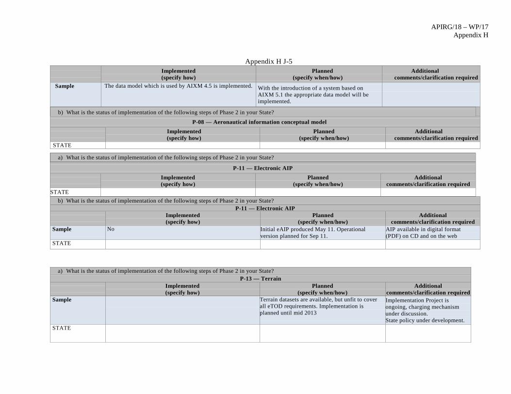
APIRG/18 – WP/17 Appendix H
Appendix H J-5
Implemented (specify how)
Planned (specify when/how)
Additional comments/clarification required
Sample The data model which is used by AIXM 4.5 is implemented. With the introduction of a system based on AIXM 5.1 the appropriate data model will be implemented.
b) What is the status of implementation of the following steps of Phase 2 in your State?
P-08 — Aeronautical information conceptual model
Implemented (specify how)
Planned (specify when/how)
Additional comments/clarification required
STATE
b) What is the status of implementation of the following steps of Phase 2 in your State? P-11 — Electronic AIP
Implemented (specify how)
Planned (specify when/how)
Additional comments/clarification required
Sample No Initial eAIP produced May 11. Operational version planned for Sep 11.
AIP available in digital format (PDF) on CD and on the web
STATE
a) What is the status of implementation of the following steps of Phase 2 in your State? P-13 — Terrain
Implemented (specify how)
Planned (specify when/how)
Additional comments/clarification required
Sample
Terrain datasets are available, but unfit to cover all eTOD requirements. Implementation is planned until mid 2013
Implementation Project is ongoing, charging mechanism under discussion. State policy under development.
STATE
a) What is the status of implementation of the following steps of Phase 2 in your State?
P-11 — Electronic AIP
Implemented (specify how)
Planned (specify when/how)
Additional comments/clarification required
STATE

APIRG/18 – WP/17 Appendix H
Appendix H J-6 b) What is the status of implementation of the following steps of Phase 2 in your State?
P-13 — Terrain
Implemented (specify how)
Planned (specify when/how)
Additional comments/clarification
STATE
a) What is the status of implementation of the following steps of Phase 2 in your State? P-14 — Obstacles
Implemented (specify how)
Planned (specify when/how)
Additional comments/clarification
required Sample Partially provided but not compliant with chapter 10 of
ICAO Annex 15 Data collected for Area 1
Area 1 planned for 2012 Area 2 and Area 3 planned 2015
State policy under development.
STATE
b) What is the status of implementation of the following steps of Phase 2 in your State? P-14 — Obstacles
Implemented (specify how)
Planned (specify when/how)
Additional comments/clarification required STATE
a) What is the status of implementation of the following steps of Phase 2 in your State?
P-15 — Aerodrome mapping
Implemented (specify how)
Planned (specify when/how)
Additional comments/clarification
required Sample No No concrete planning available yet, still under
review.
STATE

APIRG/18 – WP/17 Appendix H
Appendix H J-7
3. Phase 3 – Information Management (2011 – 2016)
a) What do you consider a realistic timeframe for the implementation of Phase 3? Sample We believe that the foreseen implementation time frame of Phase 3 is too ambitious and think that 2013-2018 would be a more realistic time frame.
STATE a) What is the status of implementation of the following steps of Phase 3 in your State?
P-09 — Aeronautical data exchange
Implemented (specify how)
Planned (specify when/how)
Additional comments/clarification required
Sample An AIXM interface from/to the central aeronautical database (refer to P-06) is available.
It is planned to implement the exchange model and mechanisms together with AICM 5.1. This starts in 2013
Not implemented between data providers and AIS
STATE
b) What is the status of implementation of the following steps of Phase 3 in your State? P-09 — Aeronautical data exchange
Implemented (specify how)
Planned (specify when/how)
Additional comments/clarification required
STATE
a) What is the status of implementation of the following steps of Phase 3 in your State? P-10 — Communication networks
Implemented (specify how)
Planned (specify when/how)
Additional comments/clarification required
Sample AISP has been using the Internet for static and dynamic data exchange for some time already. AFTN is also being used, currently in the role of a backup network for dynamic data exchange. Starting August 2010 the AISP is using PENS for dynamic data exchange.
Migration to AMHS completed. For some specific services Internet is being used.
In some specific cases the ANSP is delivering aeronautical data to customers (airlines) through business-to-business (B2B) web services (industry standard). Briefing services (self- and home briefing) are provided by making use of the Internet in line with the ICAO Doc 9855 (requires update in line with latest developments).

APIRG/18 – WP/17 Appendix H
Appendix H J-8 STATE
a) What is the status of implementation of the following steps of Phase 3 in your State? P-12 — Aeronautical information briefing
Implemented (specify how)
Planned (specify when/how)
Additional comments/clarification required
Sample For many years the ANSP is applying enhanced NOTAM selection criteria for the delivery of NOTAMs to airlines going beyond the ICAO provisions (enhancing the operational relevance for the airline). This procedure is applied in agreement with the Regulator.
Despite the constraints with the current NOTAM selection criteria, the presentation of all required pre-flight information (AIS, FPL and MET) has been improved in an integrated system allowing for custom tailored information.
b) What is the status of implementation of the following steps of Phase 3 in your State?
P-12 — Aeronautical information briefing
Implemented (specify how)
Planned (specify when/how)
Additional comments/clarification required
STATE
a) What is the status of implementation of the following steps of Phase 3 in your State?
P-16 — Training
Implemented (specify how)
Planned (specify when/how)
Additional comments/clarification required
Sample
Currently it is not clear what is expected under the training header. ICAO training manual has to be developed to reflect the new competencies required by the transition to AIM, before national requirements can be developed.

APIRG/18 – WP/17 Appendix H
Appendix H J-9
a) What is the status of implementation of the following steps of Phase 3 in your State?
P-18 — Agreements with data originators
Implemented (specify how)
Planned (specify when/how)
Additional comments/clarification required
Sample Under Development. See P-01. Partially achieved, some requirements in current CAA publications.
By July 2013 – Implementation of CAA Policy for Agreements with Data Originators.
STATE
a) What is the status of implementation of the following steps of Phase 3 in your State?
P-19 — Interoperability with meteorological products
Implemented (specify how)
Planned (specify when/how)
Additional comments/clarification required
Sample Partially implemented, pre-flight information briefing is provided in harmonized way (one stop shop) in accordance with current ICAO Annex 3 and ICAO Annex 15 requirements.
Next step (fully integrated briefing) will be implemented after the design and implementation of the appropriate data exchange technology is finished (WXXM – Weather Exchange Model).
STATE
STATE

Appendix H J-10
P-20 — Electronic aeronautical charts
Implemented (specify how)
Planned (specify when/how)
Additional comments/clarification required
Sample
More detailed specification are required; Annex 4, Chapter 20 Electronic Aeronautical Chart Display is too general.
a) What is the status of implementation of the following steps of Phase 3 in your State? P-20 — Electronic aeronautical charts
Implemented (specify how)
Planned (specify when/how)
Additional comments/clarification required
STATE
a) What is the status of implementation of the following steps of Phase 3 in your State?
P-21 — Digital NOTAM
Implemented (specify how)
Planned (specify when/how)
Additional comments/clarification required
Sample Plan to provide digital NOTAM by Jul 2017. AIXM 5.1 will be the enabler to digital NOTAM.
STATE
4. Do you expect any specific difficulty which could impede the transition from AIS to AIM?
YES NO

Appendix H J-11 Sample x Potential for the non-participation of key stakeholders providing e-TOD data.
x Continuation of downturn in aviation industry causing financial constraints on the State AIS provider and other key stakeholders supplying aeronautical data. x Non-agreement by airports to establishment of SLA with State AIS for provision of data. x Justification to aerodromes for additional costs related to the provision of survey data for digital mapping. x Funding, decision making on all levels, manpower capacity, availability of knowledge, technical infrastructure, acceptance by all stakeholders, timescales unrealistic.
X
STATE
5. What kind of assistance/support do you expect from ICAO to expedite the transition from AIS to AIM?
Sample x Specific guidance material for implementation of each subject. Development of more detailed guidance materials, manuals, best practices examples and other supporting documents. x Expeditious revisions to Annex 15 and 4 when appropriate. x Regional workshops and seminars to ensure consistency in the transition to AIM.
STATE
6. Do you have any suggestion to update/improve the ICAO Roadmap for the Transition from AIS to AIM? Sample x In the first version of the Roadmap document the description of the steps is quite basic and insufficient. Those definitions should be
expanded and/or reference to specific standards, manuals and other documents should be provided within it. x Timelines should be permanently monitored and adapted accordingly.
STATE
7. Any other suggestion on the subject?
Sample x ICAO Doc 9881 is only a draft, but the content is paramount for the transition to AIM - e.g. the attributes of terrain and obstacle data need clear definitions and explanations – including examples of obstacles together with attributes.
STATE

Appendix H J-12

APIRG/18 - WP/17 Appendix I
Appendix I to WP/17 on Agenda Item 3.5
Status report against the 21 steps of the ICAO Roadmap for the transition from AIS to AIM
State AIS AIM Transition Table Phase 1 P~03 —AIRAC adherence monitoring P~04 —Monitoring of States’differences to Annex 4 and Annex 15 P~05 —WGS~84 implementation P~17 —Quality Phase 2 P~01 —Data quality monitoring P~02 —Data integrity monitoring P~06 —Integrated aeronautical information database P~07 —Unique identifiers P~08 —Aeronautical information conceptual model P~11—Electronic AIP P~13 —Terrain P~14 —Obstacles P~15—Aerodrome mapping Phase 3 P~09 —Aeronautical data exchange P~10—Communication networks P~12 —Aeronautical information briefing P~16 —Training P~18 —Agreements with data originators P~19 —Interoperability with meteorological products P~20 —Electronic aeronautical charts P~21 —Digital NOTAM

APIRG/18 – WP/17 Appendix I
Appendix I to WP/17 on Agenda Item 3.5
Appendix -H
Date Last Amended:
Phase 1 Consolidation Phase 2 Going Digital Phase 3 Information Management P~03 P~04 P~05 P~17 P~01 P~02 P~06 P~07 P~08 P~11 P~13 P~14 P~15 P~09 P~10 P~12 P~16 P~18 P~19 P~20 P~21
Angola Benin Burkina Faso Burundi Cape Verde Central African Republic Chad Comoros Congo Cote d’Ivoire Democratic Republic of C
Djibouti Equatorial Guinea Eritrea Ethiopia Gabon Gambia Ghana Guinea Guinea Bissau Kenya Lesotho Liberia

APIRG/18 – WP/17 Appendix I
Appendix I to WP/17 on Agenda Item 3.5
Madagascar Malawi Mali Mauritanie Mauritius Mozambique Namibia Niger Nigeria Rwanda Sao Tome and Principe Senegal Seychelles Sierra Leone Somalia South Africa Swaziland Togo Uganda United Republic of Tanzania
Zambia Zimbabwe X= Implemented N= Non Implemented P= Plan Implementation

APIRG/18 – WP/17 Appendix I
Appendix I to WP/17 on Agenda Item 3.5

APIRG/18 - WP/17 Appendix J
Appendix J to WP/17 on Agenda Item 3.5
NOTAM Templates related to the operational impact and limited access of airspace and
routes affected by volcanic ash
NOTAM Templates
General Structure of NOTAM content For each operational area, a short description is given for in which situations the examples can be used. It follows by a description of the structure of the NOTAM text, providing the sequence of the free text information to be inserted in item E). The structure of the information is in accordance with a dedicated digital NOTAM event scenario. Filling instructions and NOTAM codes The NOTAM examples include some instructions in completion of the qualifier line, the recommended NOTAM code and instruction in how to describe a published airspace in item E).
Navigation warnings Type of operational impact/event These templates apply for the issuance of navigation warnings for potential volcanic activity: a) pre-eruption notification and outbreak of a volcano including detailed information regarding the activity, b) volcano ash contamination areas forecast spread and movement, for which an area restriction has not been established Structure of information The examples follow the structure of the digital NOTAM event scenario Ad-hoc special activity area: airspace type – activity/reason – location note (ex. name of volcano) – geometry (horizontal/vertical) – note(s); The structure of the information is illustrated by color coding in the NOTAM example 2.2.3.1 with the following meaning: Red = airspace type Blue =activity/reason for the area establishment Green =location note of the activity Purple = Geometry Orange = airspace activity note #1(there may be as many Notes as necessary) Brown = airspace activity note #2 (there may be as many Notes as necessary) NOTAM examples Pre-eruptive volcanic alert (A0777/10 NOTAMN Q) BIRD/QWWLW*/IV/NBO/W/000/999/6337N01901Wxxx** A) BIRD B) 1002260830 C) 1002261100

APIRG/18 - WP/17 Appendix J
Appendix J to WP/17 on Agenda Item 3.5
E) PRE-ERUPTIVE ACTIVITY ALERT FOR VOLCANIC ACTIVITY, POSSIBLY INDICATING IMMINENT ERUPTION (VOLCANO KATLA 1702-03 ICELAND-S) AS FOLLOWS: CIRCLE WITH CENTRE 6337.5N 01901.5W AND RADIUS OF XXXNM***. VOLCANIC ASH CLOUD IS EXPECTED TO REACH 50.000 FEET AMSL FEW MINUTES FROM START OF ERUPTION. AIRCRAFT ARE REQUIRED TO FLIGHT PLAN TO REMAIN AT LEAST XXXM CLEAR OF VOLCANO AND MAINTAIN WATCH FOR NOTAM/SIGMET FOR AREA F) GND G) UNL *) Recommended NOTAM code: QWWLW “Significant volcanic activity will take place…(specify)”. **) A radius shall be included in the qualifier line in a way that encompasses the total area of influence of the NOTAM. ***) XXX is a distance established by the Provider State and shall correspond to the radius in the qualifier line. Reporting on outbreak of volcanic eruption (A0778/10 NOTAMR A0777/10 Q) BIRD/QWWLW/IV/NBO/W/000/999/6337N01901Wxxx A) BIRD B) 1002261000 C) 1002261300 E) VOLCANIC ERUPTION CONFIRMED IN VOLCANO KATLA 17-2-03 ICELAND-S. CIRCLE WITH CENTRE 6337.5N 01901.5W AND RADIUS OF XXXNM. VOLCANO ASH CLOUD IS EXPECTED TO REACH 50 000 FEET AMSL. AIRCRAFT ARE REQUIRED TO REMAIN AT LEAST XXXNM CLEAR OF VOLCANO AND MAINTAIN WATCH FOR NOTAM/SIGMET FOR BIRD AREA. F) GND G) UNL Reporting on forecasted volcanic ash area [of Medium or High, High/Medium or High/Medium/Low contamination] (A0207/10 NOTAMN Q) EIAA/QWWLW/IV/NBO/W /000/200/xxxxNxxxxxE (orW)/xxx*) A)EIAA B) 1005190700 C) 1005191300 E) VOLCANIC ASH AREA OF MEDIUM CONTAMINATION FORECAST AS FOLLOWS: 5243N 00853W - 5330N 00618W - 5150N 00829W - 5243N 00853W**) F)SFC G) FL200 *) The geographical reference (coordinates lat/long) shall represent the approximate centre of a circle whose radius encompasses the whole area of influence. A radius shall be included in a way that encompasses the total area of influence of the NOTAM. **) Definition of the area should be done by radius/circle or coordinates only. Definition of airspace by the use of geographical or administrative features such as State borders, rivers, sea shores etc) is not supported by the digital NOTAM event scenario and is therefore not recommended. If operational necessary, this can be defined by providing a simplified polygon larger than the area and excluding a neighbouring FIR, for example.

APIRG/18 - WP/17 Appendix J
Appendix J to WP/17 on Agenda Item 3.5
Coordinates defining the lateral limits of the area (polygon) should be enumerated in clockwise order, each point separated by space-hyphen-space. The last and the first points of the list shall be the same.
Airspace restrictions Type of operational impact/event These templates apply for established temporary airspace restrictions for areas affected by volcanic activity: a) temporary airspace restriction due to outbreak of volcanic eruption, b) temporary airspace restrictions based on forecast ash contamination areas spread and movement Structure of information The examples follow the structure of the digital NOTAM event scenario Ad-hoc special activity area: airspace type – activity/reason – location note (ex. name of volcano) – geometry (horizontal/vertical) – note(s); The structure of the information is illustrated by color coding in the NOTAM example 2.3.3.1 with the following meaning: Red = airspace type Blue =activity/reason for the area establishment Green =location note of the activity Purple = Geometry Orange = airspace activity note #1(there may be as many Notes as necessary) Brown = airspace activity note #2 (there may be as many Notes as necessary) NOTAM examples Established temporary airspace restriction for confirmed volcanic eruption (A0255/11 NOTAMN Q) BIRD/QRDCA*/IV/NBO/W/000/500/6337N01901Wxxx** A) BIRD B) 1103260800 C) 1103261200 E) TEMPORARY DANGER AREA ESTABLISHED FOR CONFIRMED VOLCANIC ERUPTION VOLCANO KATLA 1702-03 ICELAND-S AS FOLLOWS: CIRCLE WITH CENTRE 6337.5N 01901.5W AND RADIUS OF XXXNM*** VOLCANIC ASH CLOUD REPORTED REACHING FL500. AIRCRAFT ARE REQUIRED TO REMAIN CLEAR OF AREA AND MAINTAIN WATCH FOR NOTAM/SIGMET FOR BIRD AREA. F) SFC G) FL500 *) Recommended NOTAM code: QRTCA “Temporary restricted area activated”, QRDCA “Danger area activated” and QRPCA “ Prohibited area activated”, based on States decision on established restriction. **) A radius shall be included in the qualifier line in a way that encompasses the total area of influence of the NOTAM. ***) XXX is a distance established by the Provider State and shall correspond to the radius in the qualifier line
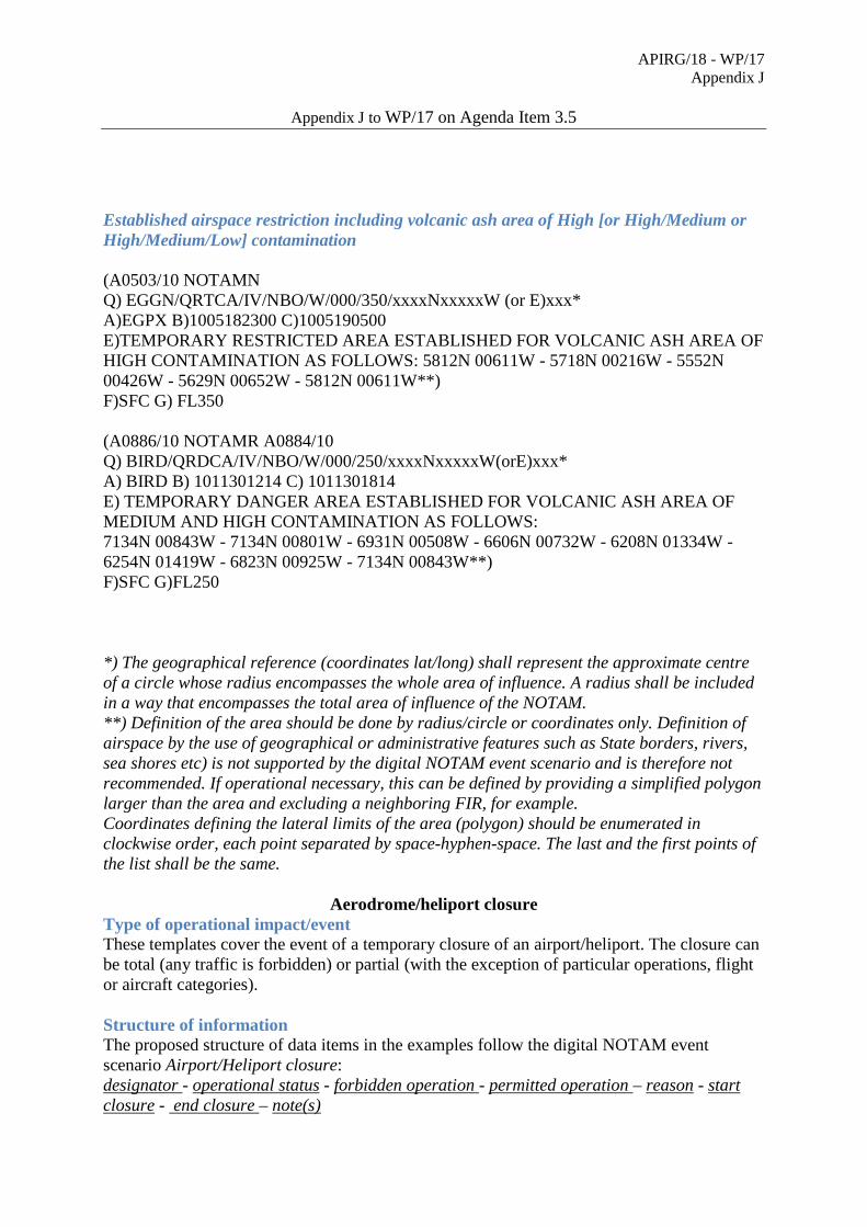
APIRG/18 - WP/17 Appendix J
Appendix J to WP/17 on Agenda Item 3.5
Established airspace restriction including volcanic ash area of High [or High/Medium or High/Medium/Low] contamination (A0503/10 NOTAMN Q) EGGN/QRTCA/IV/NBO/W/000/350/xxxxNxxxxxW (or E)xxx* A)EGPX B)1005182300 C)1005190500 E)TEMPORARY RESTRICTED AREA ESTABLISHED FOR VOLCANIC ASH AREA OF HIGH CONTAMINATION AS FOLLOWS: 5812N 00611W - 5718N 00216W - 5552N 00426W - 5629N 00652W - 5812N 00611W**) F)SFC G) FL350 (A0886/10 NOTAMR A0884/10 Q) BIRD/QRDCA/IV/NBO/W/000/250/xxxxNxxxxxW(orE)xxx* A) BIRD B) 1011301214 C) 1011301814 E) TEMPORARY DANGER AREA ESTABLISHED FOR VOLCANIC ASH AREA OF MEDIUM AND HIGH CONTAMINATION AS FOLLOWS: 7134N 00843W - 7134N 00801W - 6931N 00508W - 6606N 00732W - 6208N 01334W - 6254N 01419W - 6823N 00925W - 7134N 00843W**) F)SFC G)FL250 *) The geographical reference (coordinates lat/long) shall represent the approximate centre of a circle whose radius encompasses the whole area of influence. A radius shall be included in a way that encompasses the total area of influence of the NOTAM. **) Definition of the area should be done by radius/circle or coordinates only. Definition of airspace by the use of geographical or administrative features such as State borders, rivers, sea shores etc) is not supported by the digital NOTAM event scenario and is therefore not recommended. If operational necessary, this can be defined by providing a simplified polygon larger than the area and excluding a neighboring FIR, for example. Coordinates defining the lateral limits of the area (polygon) should be enumerated in clockwise order, each point separated by space-hyphen-space. The last and the first points of the list shall be the same.
Aerodrome/heliport closure Type of operational impact/event These templates cover the event of a temporary closure of an airport/heliport. The closure can be total (any traffic is forbidden) or partial (with the exception of particular operations, flight or aircraft categories). Structure of information The proposed structure of data items in the examples follow the digital NOTAM event scenario Airport/Heliport closure: designator - operational status - forbidden operation - permitted operation – reason - start closure - end closure – note(s)

APIRG/18 - WP/17 Appendix J
Appendix J to WP/17 on Agenda Item 3.5
The structure of the information is illustrated by color coding in the NOTAM example 2.3.3.1, with the following meaning: Red = designator Blue =operational status (closure/limitation) Green = forbidden operation (flight/aircraft) Purple = permitted operation (flight/aircraft) and PPR details Orange = reason for aerodrome/heliport closed Indigo = start closure Pink = end closure, schedule Brown = further instructions concerning the airport closure Note (there may be as many Notes as necessary) NOTAM examples Aerodrome/Heliport closed for all traffic (A1340/10 NOTAMN Q)EFIN/QFALC/IV/NBO/A/000/999/6455N01252E/010 A)EFOU B) 1012151600 C) 1012151900EST E) AD*) EFOU CLOSED FOR ALLTRAFFIC DUE TO VOLCANIC ASH AREA OF HIGH CONTAMINATION FORECAST FOR INFO CALL + 35885207700 *) If the designator concerns a heliport, the word “HELIPORT” shall be included. Aerodrome/Heliport closed for IFR traffic (A0468/10 NOTAMN Q)EFIN/QFALT/I/NBO/A/000/999/6455N012521E/010 A)EFOU B) 1003211000 C) 1003211300EST E) AD EFOU CLOSED FOR IFR TRAFFIC DUE TO VOLCANIC ASH AREA OF MEDIUM CONTAMINATION FOR INFO CALL + 35885207700
Restrictions on route portions/flight levels Type of operational impact/event These templates cover the event of a temporary closure of one or more route portions (could be on different routes) due to a common cause, such as the activation of a temporary restricted area. If more than one route portion is concerned, the eventual vertical layers and schedules specified by the data originator are assumed to apply identically to all route portions (routes); if one route portion has different layers or schedules, it shall be considered a separate event and a separate NOTAM shall be issued. Structure of information The proposed structure of data items in the examples follow the digital NOTAM event scenario Route portion closure: route availability - route designator - start point - end point - direction - lower level - upper level - start time - end time - schedule - reason - note(s)

APIRG/18 - WP/17 Appendix J
Appendix J to WP/17 on Agenda Item 3.5
The structure of the information is illustrated by color coding in the NOTAM example 2.5.3.1 with the following meaning: Red = route availability Blue =route designator Green = start point (designator of the significant point, and the type in case of a navaid) Purple = end point (designator of the significant point and the type in case of a navaid) Indigo = lower level/upper level Orange = start time/end time/schedule Pink = reason (explanation of the situation that triggered the closure of the route) Brown = further instructions concerning the route portion closure Note (there may be as many Notes as necessary) : NOTAM examples Area Navigation (RNAV) routes portion closure with vertical layer (A0515/10 NOTAMN Q) ENOR/QANLC/I/NBO/E/285/400/6230N00300E/085 A)ENOR B) 1004151200 C) 1004151400EST E) RNAV ROUTE SEGMENTS CLSD UM 996 ISVIG – VIGRA DVOR/DME (VIG) UL727 ISVIG – FLORO DVOR/DME (FLO) UP607 INGAL – FLORO DVOR/DME (FLO) FROM FL285 TO FL400 DUE TO VOLCANIC ASH AREA OF HIGH CONTAMINATION FORECAST ATS route *) portion closure with vertical layer A0515/10 NOTAMN Q) LFFF/QARLC/IV/NBO/E/200/400/4920N0015E/060 A)LFFF B) 1011030800 C) 1011031000EST E) ATS ROUTE SEGMENTS CLSD UL612 XAMAB – RESMI FROM FL 200 TO FL 400 03 NOV 2010 08:00 TO 03 NOV 2010 10:00EST DUE TO TEMPORARY ESTABLISHED DANGER AREA FOR VOLCANIC ASH AREA OF MEDIUM AND HIGH CONTAMINATION. *)The second and third NOTAM code letters AR apply for conventional ATS routes, TACAN routes and routes other than Area Navigation routes.