Embed Size (px)
Citation preview
Sejarah Ilmu Geografi
danMakna Ruang
Triarko NurlambangDept. Geografi FMIPA UI
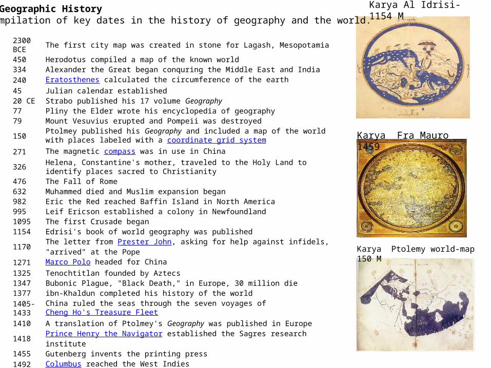
Timeline of Geographic HistoryThis is a compilation of key dates in the history of geography and the world.
2300 BCE The first city map was created in stone for Lagash, Mesopotamia
450 Herodotus compiled a map of the known world334 Alexander the Great began conquring the Middle East and India240 Eratosthenes calculated the circumference of the earth45 Julian calendar established20 CE Strabo published his 17 volume Geography77 Pliny the Elder wrote his encyclopedia of geography79 Mount Vesuvius erupted and Pompeii was destroyed
150 Ptolmey published his Geography and included a map of the world with places labeled with a coordinate grid system
271 The magnetic compass was in use in China
326 Helena, Constantine's mother, traveled to the Holy Land to identify places sacred to Christianity
476 The Fall of Rome632 Muhammed died and Muslim expansion began982 Eric the Red reached Baffin Island in North America995 Leif Ericson established a colony in Newfoundland1095 The first Crusade began1154 Edrisi's book of world geography was published1170 The letter from Prester John, asking for help against infidels, "arrived" at the Pope1271 Marco Polo headed for China1325 Tenochtitlan founded by Aztecs1347 Bubonic Plague, "Black Death," in Europe, 30 million die1377 ibn-Khaldun completed his history of the world1405-1433 China ruled the seas through the seven voyages of Cheng Ho's Treasure Fleet
1410 A translation of Ptolmey's Geography was published in Europe1418 Prince Henry the Navigator established the Sagres research institute1455 Gutenberg invents the printing press1492 Columbus reached the West Indies1494 Treaty of Tordesillas established Spanish and Portuguese control over new discoveries
Karya Al Idrisi-1154 M
Karya Fra Mauro 1459
Karya Ptolemy world-map 150 M

Cantino Planisphere – 1502 M
1500 Cabral discovered Brazil1505 Portugal established trading posts in East Africa1517 Martin Luther begins Protestant Reformation1519 Magellan began his circumnavigation of the earth1543 Copernicus published his On the Revolution of Heavenly Spheres1569 Mercator created his map1582 Gregorian calendar established1602 The Dutch East India company was founded1620 Pilgrims landed in New England1675 The Royal Observatory was established at Greenwich, England
1714 The British government offered a 20,000 pound reward to the person who could accurately determine longitude at sea
1761 John Harrison's chronometer was perfected, allowing determination of longitude at sea1768-1779 James Cook explored the earth
1769 Alexander von Humboldt was born1776 British colonies in America declare independence1779 Carl Ritter was born
1788 Hutton's theory of uniformitarianism was introduced ("no vestige of a beginning, no prospect of an end")
1789 French Revolution1798 Thomas Malthus' first essay on population1803 Thomas Jefferson completed the Louisiana Purchase 1804-1806 Lewis and Clark explored the western United States
1817 The first volume of Ritter's Die Erkunde was published
1821 Simon Bolivar gains independence for Venezuela, sparking widespread independence in South America
1825 Erie Canal complete1830 The Royal Geographical Society was formed in London
Lyell published his Principles of Geology
Timeline of Geographic HistoryThis is a compilation of key dates in the history of geography and the world.
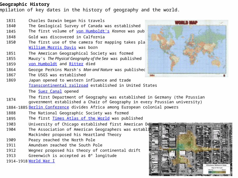
1831 Charles Darwin began his travels1840 The Geological Survey of Canada was established1845 The first volume of von Humboldt's Kosmos was published1848 Gold was discovered in Calfornia1850 The first use of the camera for mapping takes place in France
William Morris Davis was born1851 The American Geographical Society was formed1855 Maury's The Physical Geography of the Sea was published1859 von Humboldt and Ritter died1864 George Perkins Marsh's Man and Nature was published1867 The USGS was established1869 Japan opened to western influence and trade
Transcontinental railroad established in United StatesThe Suez Canal opened
1874 The first Department of Geography was established in Germany (the Prussian government established a Chair of Geography in every Prussian university)
1884-1885 Berlin Conference divides Africa among European colonial powers1888 The National Geographic Society was formed1895 The first Times Atlas of the World was published1903 University of Chicago established first American Department of Geography1904 The Association of American Geographers was established
Mackinder proposed his Heartland Theory1909 Peary reached the North Pole1911 Amundsen reached the South Pole1912 Wegner proposed his theory of continental drift1913 Greenwich is accepted as 0° longitude1914-1918 World War I
Timeline of Geographic HistoryThis is a compilation of key dates in the history of geography and the world.
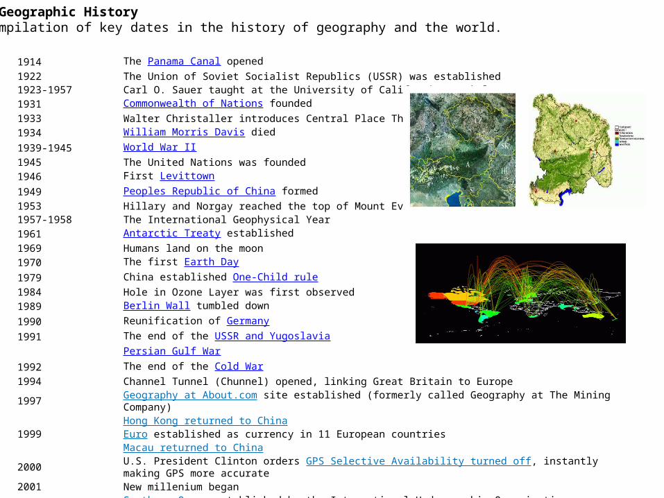
1914 The Panama Canal opened1922 The Union of Soviet Socialist Republics (USSR) was established1923-1957 Carl O. Sauer taught at the University of California, Berkeley1931 Commonwealth of Nations founded1933 Walter Christaller introduces Central Place Theory1934 William Morris Davis died1939-1945 World War II1945 The United Nations was founded1946 First Levittown1949 Peoples Republic of China formed1953 Hillary and Norgay reached the top of Mount Everest1957-1958 The International Geophysical Year1961 Antarctic Treaty established1969 Humans land on the moon1970 The first Earth Day1979 China established One-Child rule1984 Hole in Ozone Layer was first observed1989 Berlin Wall tumbled down1990 Reunification of Germany1991 The end of the USSR and Yugoslavia
Persian Gulf War1992 The end of the Cold War1994 Channel Tunnel (Chunnel) opened, linking Great Britain to Europe1997 Geography at About.com site established (formerly called Geography at The Mining Company)
Hong Kong returned to China1999 Euro established as currency in 11 European countries
Macau returned to China2000 U.S. President Clinton orders GPS Selective Availability turned off, instantly making GPS more accurate2001 New millenium began
Southern Ocean established by the International Hydrographic Organization2002 East Timor gains independence
Timeline of Geographic HistoryThis is a compilation of key dates in the history of geography and the world.
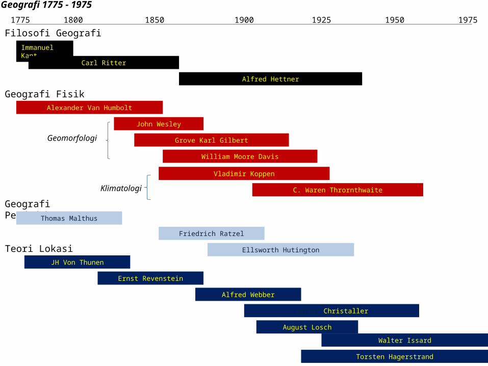
Geografi 1775 - 1975
Filosofi Geografi1775 1800 1850 1900 1950 19751925
Immanuel Kant
Carl Ritter
Alfred Hettner
Geografi FisikAlexander Van Humbolt
John Wesley
Grove Karl Gilbert
William Moore Davis
Vladimir Koppen
C. Waren Thrornthwaite
Geomorfologi
Klimatologi
Geografi PendudukThomas Malthus
Friedrich Ratzel
Ellsworth HutingtonTeori LokasiJH Von Thunen
Ernst Revenstein
Alfred Webber
Walter Christaller
August Losch
Walter Issard
Torsten Hagerstrand

GEOGRAFI 1960 – SAAT INI
1. 1965 – 1983: MODERN / PRE-POSTMODERN• Era kuantitatif: Brian Berry dll (kelompok Chicago Univ.), Petter
Haggett, Leslie J. King• Pre-Postmodern: David Harvey, Richard Peet, Reginal G. Colledge,
David Ley, Gunnar Olsson, Nigel Thrift
2. 1984 – 1989: POSTMODERN GEOGRAPHIES• Richard peet, Eric Sheppard, Henri Lefebvre, Edward W. Soja,
Michael J. Dear, David Harvey, dll
3. 1990 – 2000an: THE ALTERED SPACES OF POSTMODERNITY• Julie Graham, Michael Stopper, Martin Dodge (Virtual Geography),
Michael Dear, John Pickel, dll
SEKARANG DAN AKAN DATANG?
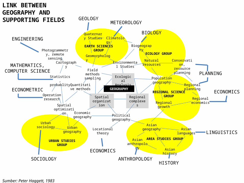
Quaternary Studies Climatology
Geomorphology
EARTH SCIENCES GROUP
Environmental Studies
Biogeography
Natural resources
ECOLOGY GROUP
Conservation, resource planning
Population geography
Regional planning
Regional economicsRegional
growth
REGIONAL SCIENCE GROUPRegional
complexes
Ecological Analysis
Spatial organization
GEOGRAPHY
Field methods sampling
Quantitative methods
Economic geography Political
geography
Locational theory
Asian geography Asian
languages
Asian history
Asian anthropology
AREA STUDIES GROUP
Spatial optimization
Urban geography
Urban sociology
URBAN STUDIES GROUP
Operation research
Statistics, probablity
Cartography
Photogrammetry, remote sensing
Sumber: Peter Haggett, 1983
GEOLOGYMETEOROLOGY
BIOLOGY
PLANNING
ECONOMICS
LINGUISTICS
HISTORYANTHROPOLOGY
ECONOMICS
SOCIOLOGY
ECONOMETRIC
MATHEMATICS, COMPUTER SCIENCE
ENGINEERING
LINK BETWEEN GEOGRAPHY AND SUPPORTING FIELDS
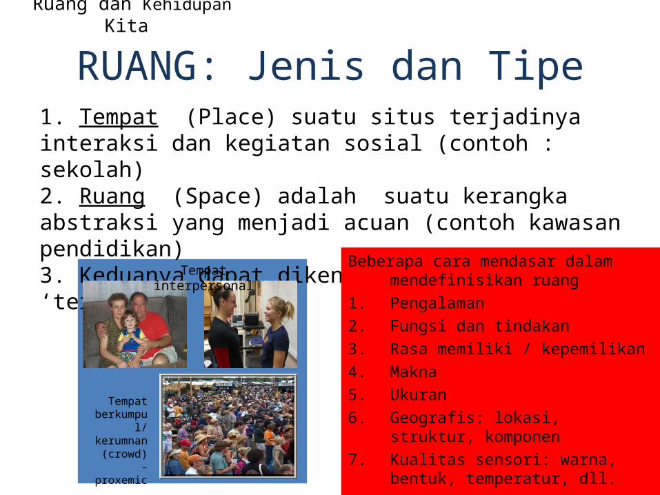
Ruang dan Kehidupan Kita
RUANG: Jenis dan Tipe1. Tempat (Place) suatu situs terjadinya interaksi dan kegiatan sosial (contoh : sekolah)2. Ruang (Space) adalah suatu kerangka abstraksi yang menjadi acuan (contoh kawasan pendidikan)3. Keduanya dapat dikenali sebagai satu ‘teritori’
Beberapa cara mendasar dalam mendefinisikan ruang
1. Pengalaman2. Fungsi dan tindakan3. Rasa memiliki / kepemilikan4. Makna5. Ukuran6. Geografis: lokasi, struktur, komponen7. Kualitas sensori: warna, bentuk,
temperatur, dll.
Tempat interpersonal
Tempat berkumpu
l/ kerumnan (crowd) - proxemic
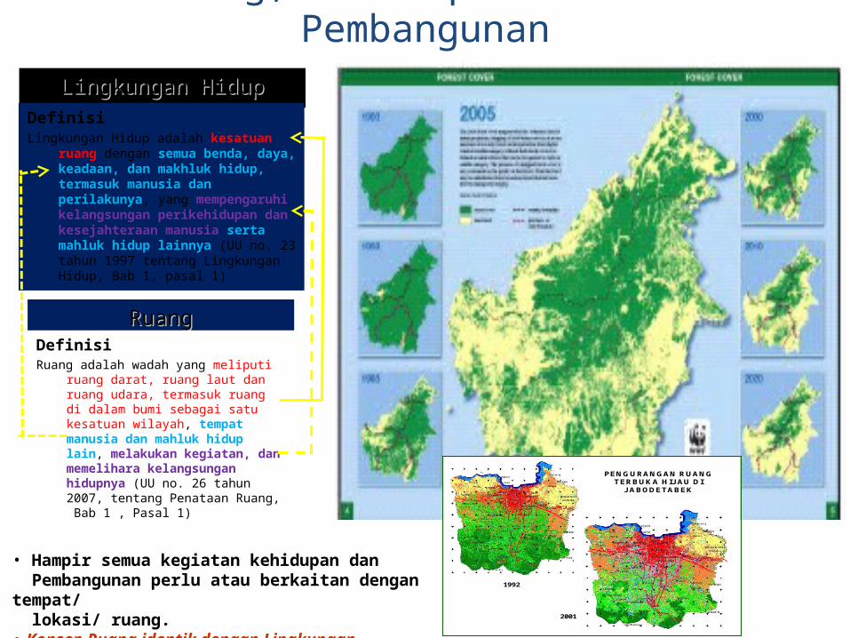
Lingkungan HidupLingkungan HidupDefinisiLingkungan Hidup adalah kesatuan ruang dengan
semua benda, daya, keadaan, dan makhluk hidup, termasuk manusia dan perilakunya, yang mempengaruhi kelangsungan perikehidupan dan kesejahteraan manusia serta mahluk hidup lainnya (UU no. 23 tahun 1997 tentang Lingkungan Hidup, Bab 1, pasal 1)
RuangRuangDefinisiRuang adalah wadah yang meliputi ruang
darat, ruang laut dan ruang udara, termasuk ruang di dalam bumi sebagai satu kesatuan wilayah, tempat manusia dan mahluk hidup lain, melakukan kegiatan, dan memelihara kelangsungan hidupnya (UU no. 26 tahun 2007, tentang Penataan Ruang, Bab 1 , Pasal 1)
(Zone B1 & B4)(Zone B1 & B4)
Sumber: Citra Landsat 30-07-1992
Oleh :Ditjen PenataanRuang dan LAPAN
(Zone B3 & B4)(Zone B5)(Zone B2)(Zone N2 & N2)
(Zone N2)(Zone N2)(Zone N2)
Sumber: Citra Landsat 17-07-2001
Oleh :Ditjen PenataanRuang dan LAPAN
1992
2001
PENGURANGAN RUANG TERBUKA HIJ AU DI
J ABODETABEK
• Hampir semua kegiatan kehidupan dan Pembangunan perlu atau berkaitan dengan tempat/ lokasi/ ruang. • Konsep Ruang identik dengan Lingkungan
Ruang, Kehidupan Kita dan Pembangunan
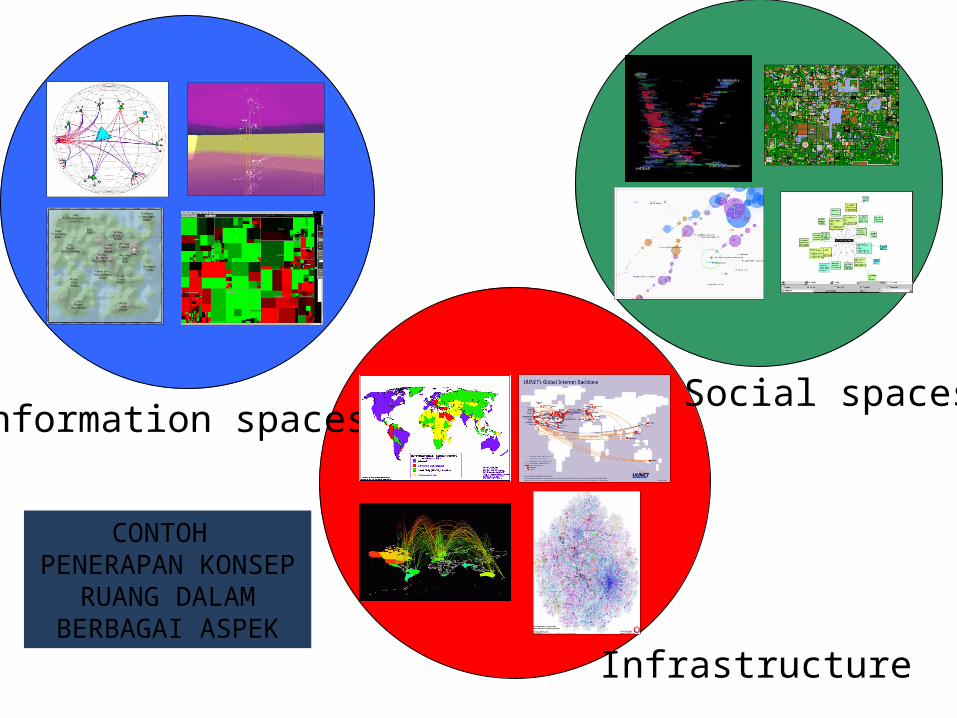
Information spaces Social spaces
Infrastructure
CONTOH PENERAPAN KONSEP RUANG DALAM
BERBAGAI ASPEK
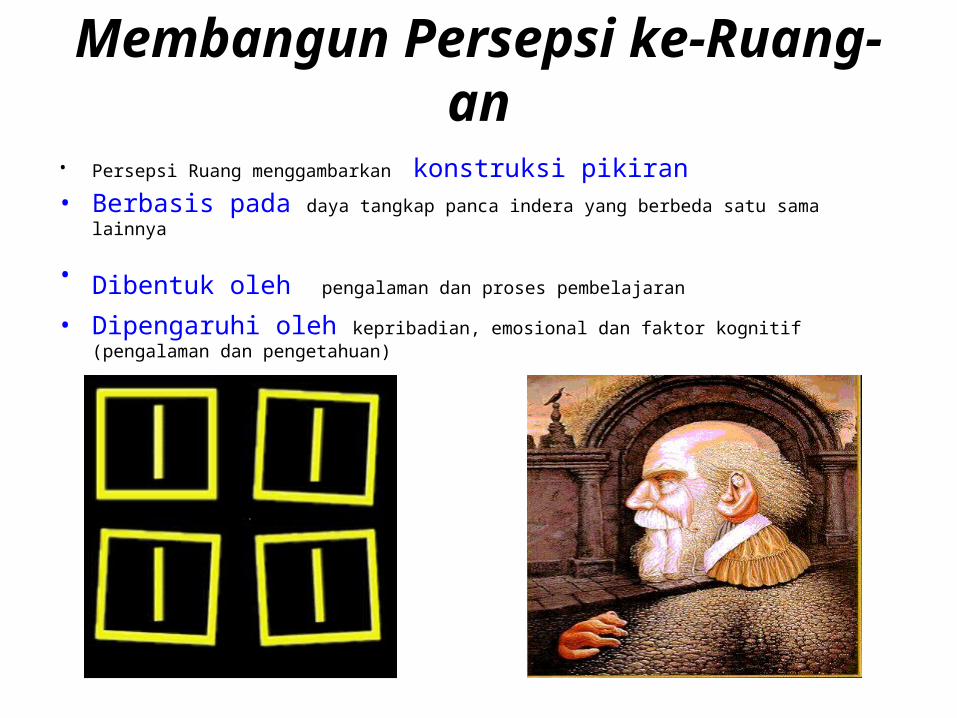
Membangun Persepsi ke-Ruang-an• Persepsi Ruang menggambarkan konstruksi pikiran• Berbasis pada daya tangkap panca indera yang berbeda satu sama lainnya
• Dibentuk oleh pengalaman dan proses pembelajaran
• Dipengaruhi oleh kepribadian, emosional dan faktor kognitif (pengalaman dan pengetahuan)
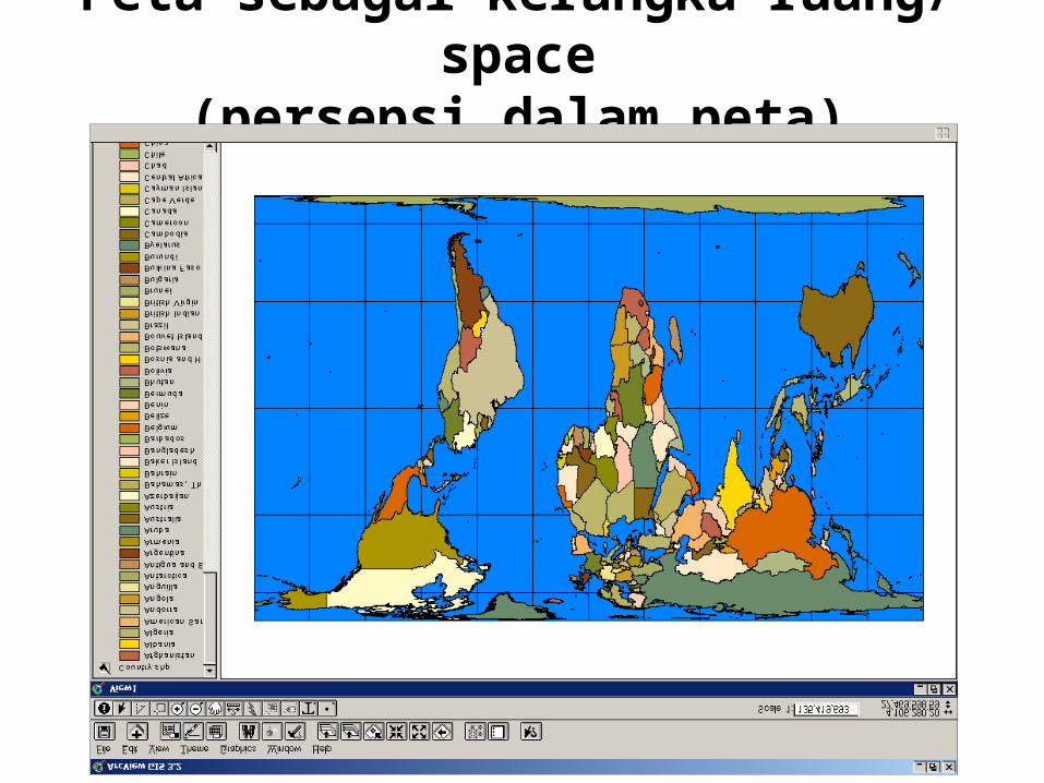
Peta sebagai kerangka ruang/ space
(persepsi dalam peta)
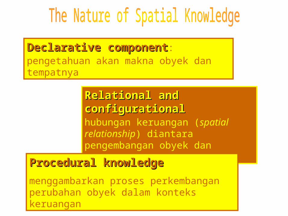
Declarative componentDeclarative component:pengetahuan akan makna obyek dan tempatnya
Relational and configurationalRelational and configurationalhubungan keruangan (spatial relationship) diantara pengembangan obyek dan tempatnya
Procedural knowledgeProcedural knowledgemenggambarkan proses perkembangan perubahan obyek dalam konteks keruangan
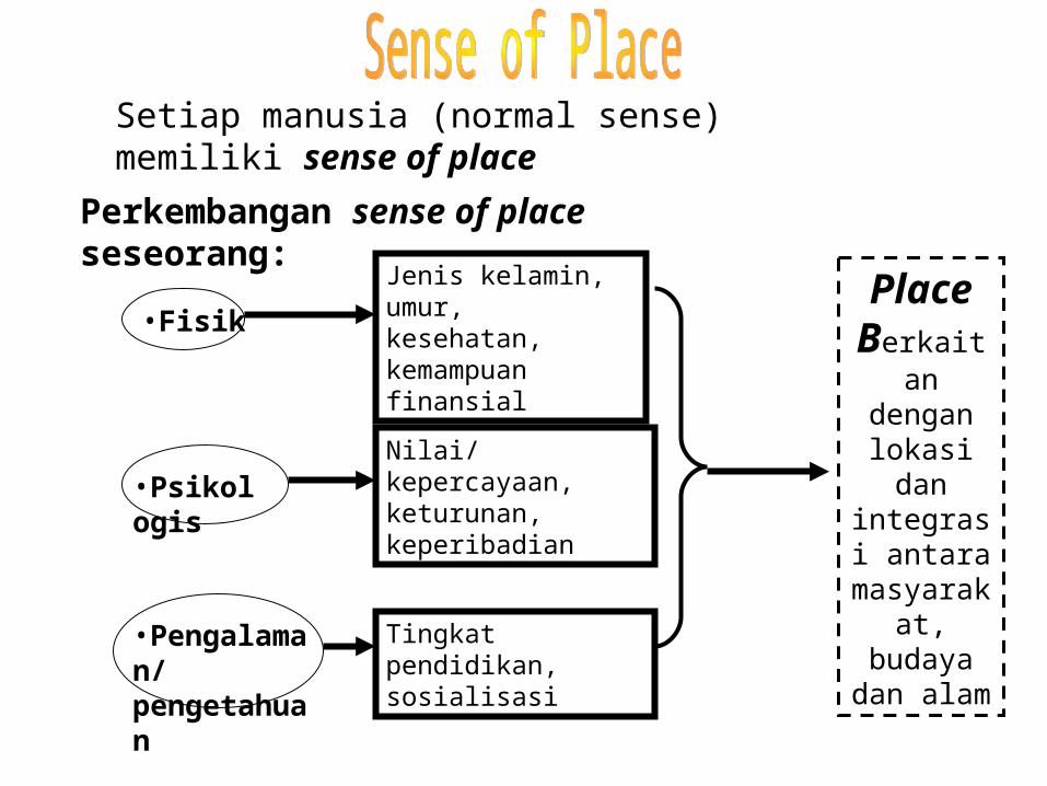
Place Berkaitan
dengan lokasi dan integrasi antara
masyarakat, budaya dan
alam
Setiap manusia (normal sense) memiliki sense of place
Perkembangan sense of place seseorang:
•FisikJenis kelamin, umur, kesehatan, kemampuan finansial
•PsikologisNilai/kepercayaan, keturunan, keperibadian
•Pengalaman/ pengetahuan
Tingkat pendidikan, sosialisasi
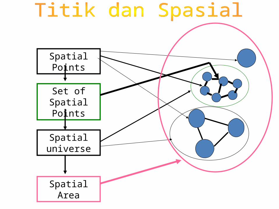
Spatial Points
Set of Spatial Points
Spatial universe
Spatial Area
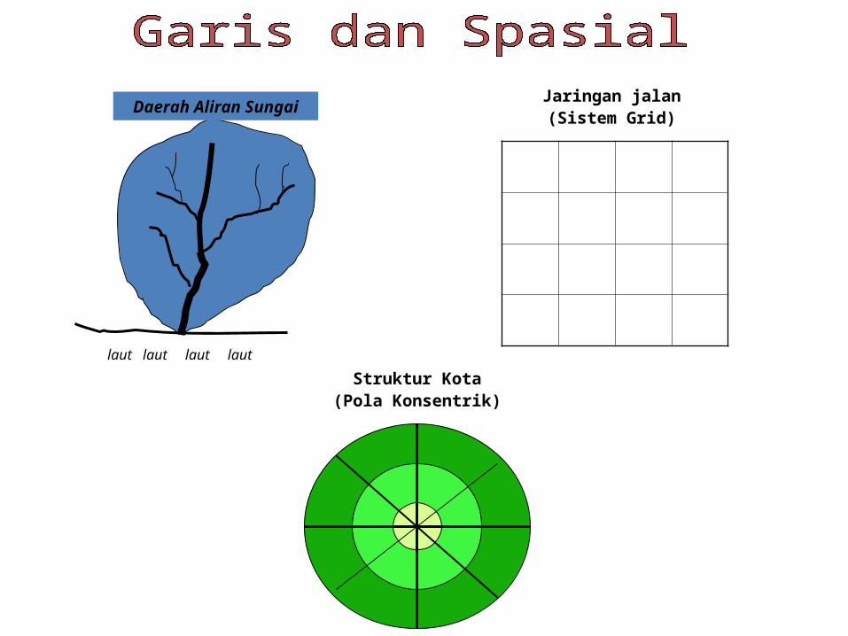
Daerah Aliran Sungai
laut
laut
laut
laut
Jaringan jalan(Sistem Grid)
Struktur Kota(Pola Konsentrik)
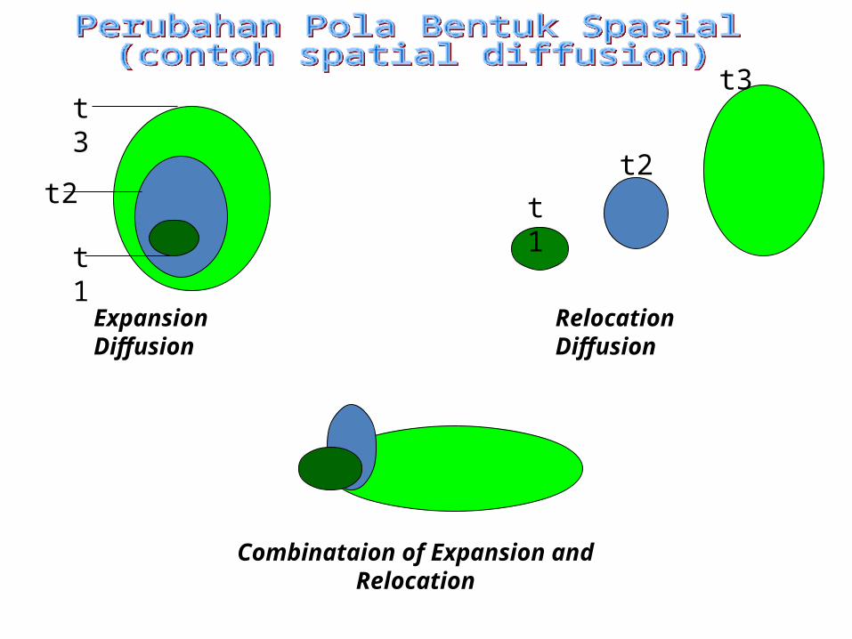
t1
t2
t3
Expansion Diffusion
t1t2
t3
Relocation Diffusion
Combinataion of Expansion and Relocation
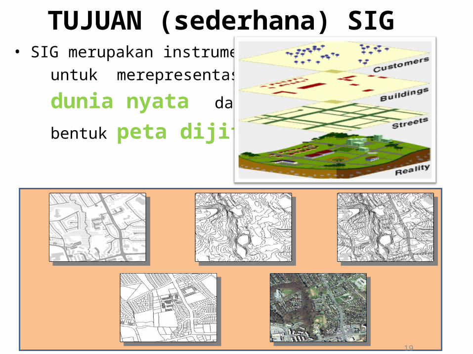
TUJUAN (sederhana) SIG• SIG merupakan instrumen untuk merepresentasikan
dunia nyata dalam
bentuk peta dijital
19
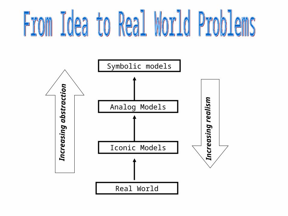
Symbolic models
Analog Models
Iconic Models
Real World
Incr
easi
ng a
bstr
actio
n
Incr
easi
ng re
alis
m
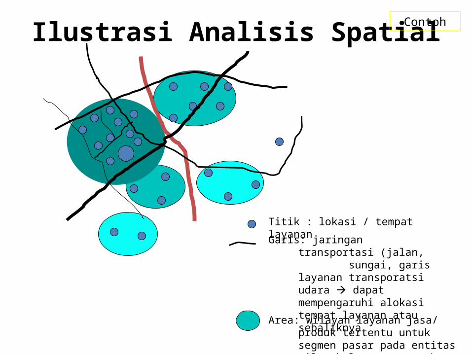
Ilustrasi Analisis Spatial
Titik : lokasi / tempat layanan
Garis: jaringan transportasi (jalan, sungai, garis layanan transporatsi udara dapat mempengaruhi alokasi tempat layanan atau sebaliknya
Area: wilayah layanan jasa/ produk tertentu untuk segmen pasar pada entitas wilayah layanan tersebut
Contoh
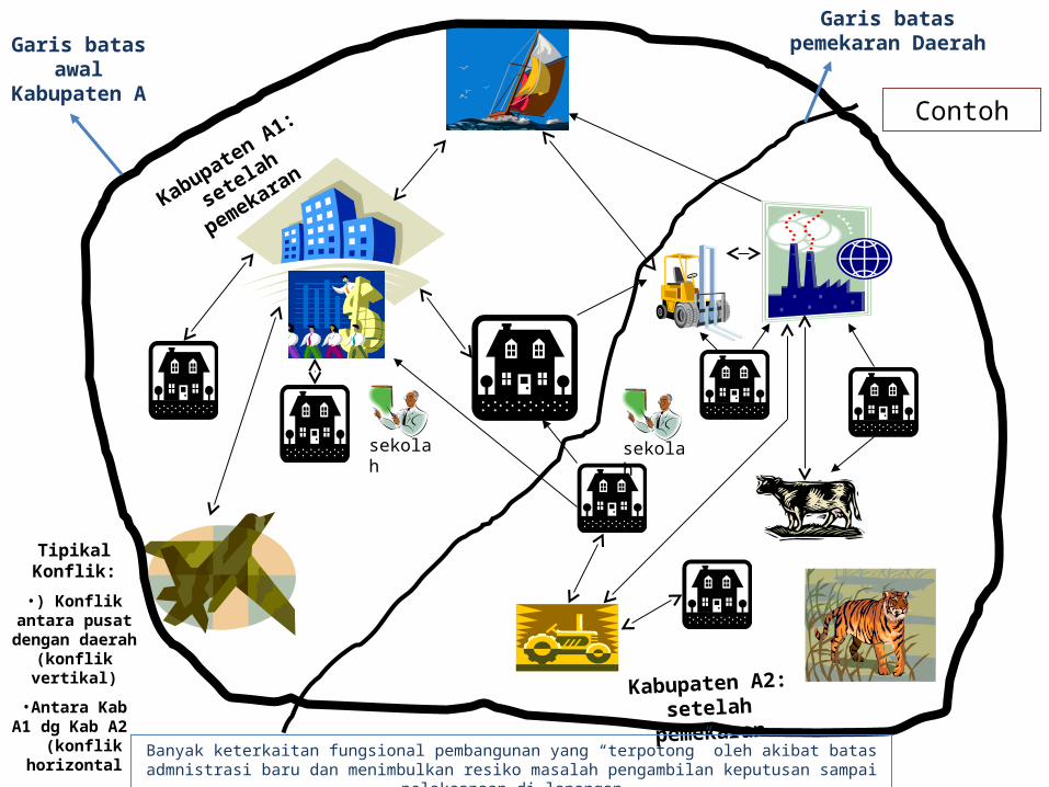
Garis batas awal
Kabupaten A
Garis batas pemekaran Daerah
Kabupaten A1:
setelah pemekaran
Kabupaten A2: setelah pemekaran
Tipikal Konflik:•) Konflik antara
pusat dengan daerah (konflik
vertikal)
•Antara Kab A1 dg Kab A2
(konflik horizontal
Banyak keterkaitan fungsional pembangunan yang “terpotong” oleh akibat batas admnistrasi baru dan menimbulkan resiko masalah pengambilan keputusan sampai pelaksanaan di lapangan
sekolah sekolah
Contoh
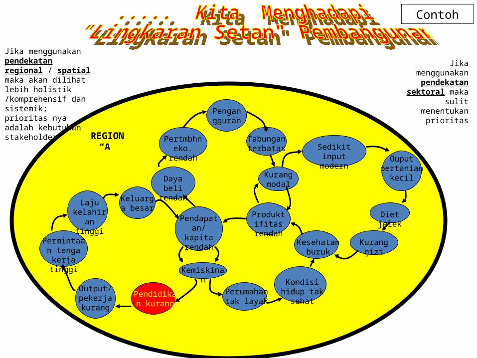
Pengangguran
Tabungan terbatas
Kurang modal
Produktifitas rendah
Pendapatan/kapita rendah
Daya beli rendah
Pertmbhn eko. rendah
Keluarga besar
Laju kelahiran
tinggi
Permintaan tenga kerja
tinggi
Output/ pekerja kurang
Pendidikan kurang
Kemiskinan
Perumahan tak layak
Kondisi hidup tak sehat
Kesehatan buruk
Kurang gizi
Diet jelek
Ouput pertanian
kecil
Sedikit input modern
REGION “A”
Jika menggunakan pendekatan
sektoral maka sulit
menentukan prioritas
Jika menggunakan pendekatan regional / spatial maka akan dilihat lebih holistik /komprehensif dan sistemik; prioritas nya adalah kebutuhan stakeholder
Contoh
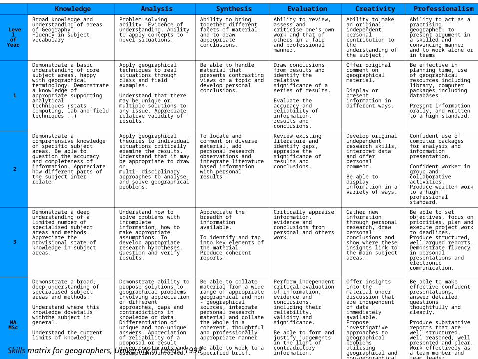
Knowledge Analysis Synthesis Evaluation Creativity Professionalism
Levelof
Year
Broad knowledge and understanding of areas of Geography. Fluency in subject vocabulary
Problem solving ability. Evidence of understanding. Ability to apply concepts to novel situations.
Ability to bring together different facets of material, and to draw appropriate conclusions.
Ability to review, assess and criticise one's own work and that of others in a fair and professional manner.
Ability to make an original, independent, personal contribution to the understanding of the subject.
Ability to act as a practising geographer, to present argument in a skilled and convincing manner and to work alone or in teams
1
Demonstrate a basic understanding of core subject areas, happy with geographical terminology. Demonstrate a knowledge of appropriate supporting analyticaltechniques (stats., computing, lab and field techniques ..)
Apply geographical techniques to real situations through class and field examples.
Understand that there may be unique or multiple solutions to any issue. Appreciate relative validity of results.
Be able to handle material that presents contrasting views on a topic and develop personal conclusions.
Draw conclusions from results and identify the relative significance of a series of results.
Evaluate the accuracy and reliability of information, results and conclusions.
Offer original comment on geographical material.
Display or present information in different ways.
Be effective in planning time, use of geographical resources including library, computer packages including databases.
Present information orally, and written to a high standard.
2
Demonstrate a comprehensive knowledge of specific subject areas. Be able to question the accuracy and completeness of information. Appreciate how different parts of the subject inter-relate.
Apply geographical theories to individual situations critically examine the results. Understand that it may be appropriate to draw onmulti- disciplinary approaches to analyse and solve geographical problems.
To locate and comment on diverse material, add personal research observations and integrate literature based information with personal results.
Review existing literature and identify gaps, appraise the significance of results and conclusions.
Develop original independent research skills, interpret data and offer personal comment.
Be able to display information in a variety of ways.
Confident use of computer packages for analysis and information presentation.
Confident worker in group and collaborative activities.Produce written work to a high professional standard.
3
Demonstrate a deep understanding of a limited number of specialised subject areas and methods. Appreciate the provisional state of knowledge in subject areas.
Understand how to solve problems with incomplete information, how to make appropriate assumptions. To develop appropriate research hypotheses. Question and verify results.
Appreciate the breadth of information available.
To identify and tap into key elements of the material. Produce coherent reports.
Critically appraise information, evidence and conclusions from personal and others work.
Gather new information through personal research, draw personal conclusions and show where these insights link to the main subject areas.
Be able to set objectives, focus on priorities, plan and execute project work to deadlines. Produce structured, well argued reports. Demonstrate fluency in personalpresentations and electronic communication.
MAMSc
Demonstrate a broad, deep understanding of specialised subject areas and methods.
Understand where this knowledge dovetails withthe subject in general.
Understand the current limits of knowledge.
Demonstrate ability to propose solutions to geographical problems involving appreciation of different approaches, gaps and contradictions in knowledge or data. Differentiation of unique and non-unique answers. Appreciation of reliability of a proposal or result given constraints and assumptions involved.
Be able to collate material from a wide range of appropriate geographical and non - geographical sources, integrate personal research material and collate the whole in a coherent, thoughtful and professionally appropriate manner.
Be able to work to a specified brief.
Perform independent critical evaluation of information, evidence and conclusions, including their reliability, validity and significance.
Be able to form and justify judgements in the light of contradictory information.
Offer insights into the material under discussion that are independent of data immediately available.
Propose investigative approaches to geographical problems utilising geographical and non-geographical methods as appropriate.
Be able to make effective confidentpresentations, answer detailed questions thoughtfully and clearly.
Produce substantive reports that are well structured, well reasoned, wellpresented and clear. Work effectively as a team member and team leader
Skills matrix for geographers, University of Leeds, 1998