Embed Size (px)
Citation preview

1
Seismic Hazard in Karachi, Pakistan: Un-certain Past, Uncertain FutureRoger Bilham, Sarosh Lodi, Susan Hough, Saira Bukhary, Abid Murtaza Khan, and S.F.A. Rafeeqi
The city of Karachi, Pakistan (pop. 14 M) sits close to a plate boundary and within reach of earthquakes on numerous tectoni-cally active structures surrounding the city. One can draw parallels—geologic as well as demographic—with another megacity for which seismic hazard is known to be high: Los Angeles, California (Figure 1). Yet with a short historical record, limited instru-mental seismic data, and little geological or geodetic constraint on slip rates, seismic hazard in Karachi is poorly characterized. In this report we present a critical review of the historical record as well as an over-view of potential earthquake sources in and around Karachi. The history of Karachi prior to 1800 is indistinguishable from that of many fishing
villages on the northern shores of the Arabian Sea. It was known to Arab and Portuguese traders who sometimes stopped at the village on their way to the Malabar coast. Colonial trade with Sindh was limited in the 18th cen-tury. Exploratory surveys starting in 1808 led to the annexation of Sindh to British rule in 1843. In 1901 Karachi had grown from a small village to a town with a population of fewer than 140,000 people. The population grew to 500,000 by the time Pakistan became an independent nation in 1947, at which time the city grew dramatically with the influx of a million refugees from India. By 1960 its population exceeded 2 million, a figure that doubled by 1980 and more than doubled again to 10 million by 2000. With an estimated growth rate of 3.75% its population will ex-ceed 30 million within two decades.
Fig.1 Tectonic settings of Karachi and Los Angeles to same scale with the growth in their populations shown right. A 250 km radius circle around each city in the figure below is shown with simplified tectonics.
In Press: Seism.Res. Lett. August 2007
2
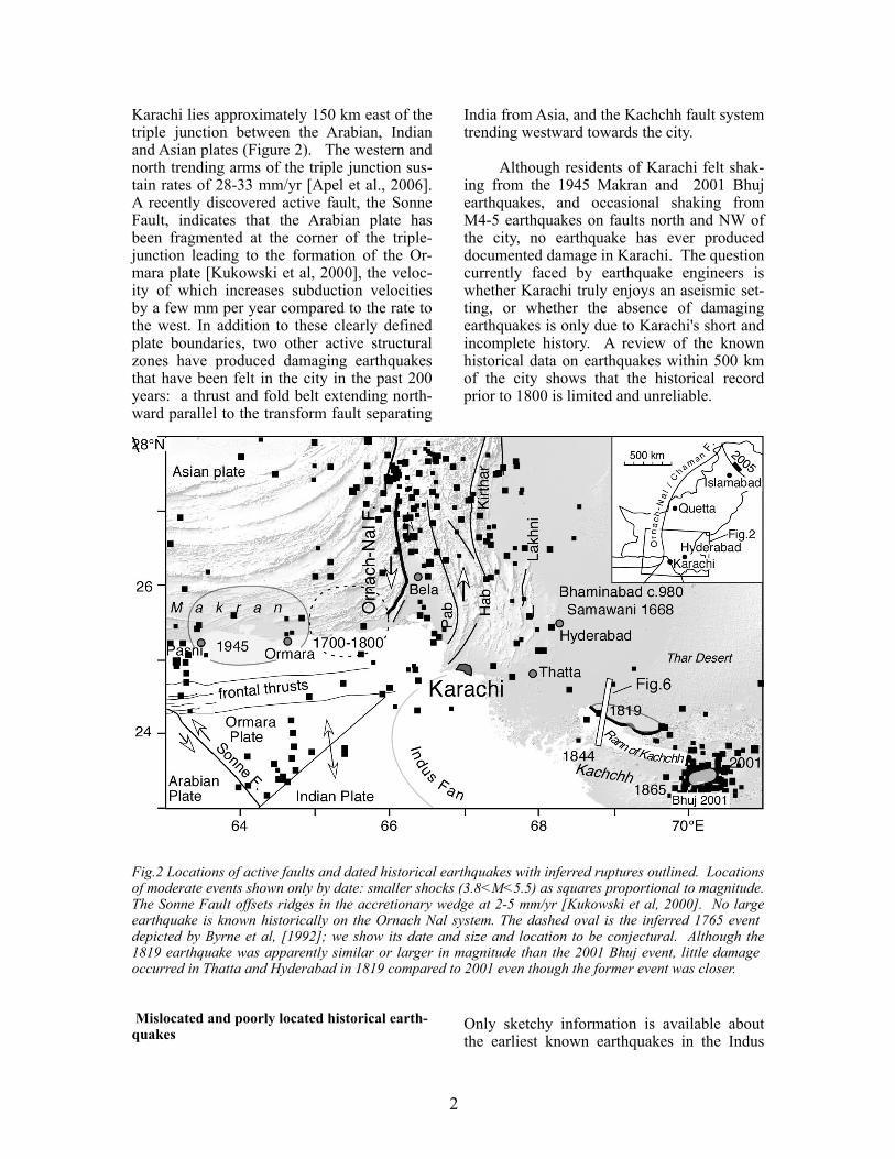
Karachi lies approximately 150 km east of the triple junction between the Arabian, Indian and Asian plates (Figure 2). The western and north trending arms of the triple junction sus-tain rates of 28-33 mm/yr [Apel et al., 2006]. A recently discovered active fault, the Sonne Fault, indicates that the Arabian plate has been fragmented at the corner of the triple-junction leading to the formation of the Or-mara plate [Kukowski et al, 2000], the veloc-ity of which increases subduction velocities by a few mm per year compared to the rate to the west. In addition to these clearly defined plate boundaries, two other active structural zones have produced damaging earthquakes that have been felt in the city in the past 200 years: a thrust and fold belt extending north-ward parallel to the transform fault separating
India from Asia, and the Kachchh fault system trending westward towards the city.
Although residents of Karachi felt shak-ing from the 1945 Makran and 2001 Bhuj earthquakes, and occasional shaking from M4-5 earthquakes on faults north and NW of the city, no earthquake has ever produced documented damage in Karachi. The question currently faced by earthquake engineers is whether Karachi truly enjoys an aseismic set-ting, or whether the absence of damaging earthquakes is only due to Karachi's short and incomplete history. A review of the known historical data on earthquakes within 500 km of the city shows that the historical record prior to 1800 is limited and unreliable.
Fig.2 Locations of active faults and dated historical earthquakes with inferred ruptures outlined. Locations of moderate events shown only by date: smaller shocks (3.8<M<5.5) as squares proportional to magnitude. The Sonne Fault offsets ridges in the accretionary wedge at 2-5 mm/yr [Kukowski et al, 2000]. No large earthquake is known historically on the Ornach Nal system. The dashed oval is the inferred 1765 event depicted by Byrne et al, [1992]; we show its date and size and location to be conjectural. Although the 1819 earthquake was apparently similar or larger in magnitude than the 2001 Bhuj event, little damage occurred in Thatta and Hyderabad in 1819 compared to 2001 even though the former event was closer.
Mislocated and poorly located historical earth-quakes
Only sketchy information is available about the earliest known earthquakes in the Indus

3
Mansura has caused some authors to question the severity of shaking since the city of Mansura continued to function until at least 1025 AD [Cunningham, 1871; Lambrick 1964]. The paradox was addressed by Cousens [1905] who noted that these authors may have been unduly influenced by Haig's [1884] tentative mapping of the several ar-chaeological remains in the region, which led to the placement of Mansura 8 km to the NE of Brahmanabad. An alternative interpreta-tion proposed by Cousens was that Mansura was reconstructed on the site of Brahmanabad following the earthquake, and that the numer-ous nearby ruins are those of earlier archaeo-logical sites. Hodivala [1939], however, points to a contemporary text indicating that the two once thriving cities were separated by several km. We consider the most probable interpretation is that both cities were dam-aged, but that survivors chose to abandon the catastrophic ruin of Brahmanabad in favor of reconstructing Mansura. All authors agree that the subsequent 11th century abandonment of the cities of Brahmanabad and Mansura was caused by a shift in the river that occurred before the middle of the 11th century.
Fig. 3. Henry Cousens’ 1897 photo of the ruined tower at Brahmanabad (Bhamanabad) whose ex-cavation had been first reported by Bellasis [1857]. Crushed skeletons and scattered coins indicate its destruction by an earthquake sometime after 975AD . British Library Archive.
delta region; very early accounts can be espe-cially unclear. Numerous catalogs of earth-quakes in the Indus delta include an earth-quake in AD 893 or AD 894 that is known from archival sources to have destroyed the town of Debal, or Dvin in Armenia. Oldham [1883] recognized that the most likely loca-tion for the 894 earthquake was not in India but rather in Armenia where substantial inde-pendent evidence points to the occurrence of a large earthquake [Ambraseys and Melville, 1982 p.175]. Ambraseys [2004] discusses how this conflation arose: Mallet [1852] and Old-ham [1883] mentioned that the earthquake might have been associated with the ruined port of Debil, or Debal, which is located in the Indus delta. A city by this name no longer ex-ists, and some (but not all) archeologists who have excavated the ruined port of Bhanbore, 30 km SW of Thatta, equate these ruins with ancient Debal (see discussion in Elliot, [1957]). Bhanbore (Bhambor) is located close to a limestone outcrop on the westernmost edge of the delta, and was a settlement from the 1st century BC to the 13th century AD. The Arabic historian Ali Sher Kani attributes the destruction of Debal to an earthquake in the 8th century [Elliot, 1957], but a later ac-count by Mir Tahir suggests that it was aban-doned without haste in the 11th century when the nearby channel no longer became naviga-ble [Lambrick,1964]. That mariners mention Debal as recently as the 18th century [Yule et al, 1903] suggests that Debal, like many vil-lages in the Indus delta, may have been relo-cated more than once in response to avulsions of the Indus' distributaries.
Brahmanabad c. 980
An earthquake in the 10th century reportedly destroyed the town of Brahmanabad (26°56'N, 68°54'E), approximately 80 km NE of Hyder-abad [Bellasis, 1857a & b; Haig 1884; Rav-erty, 1892]. The evidence for its violent end is recorded by skeletons trapped in doorways and in the corners of collapsed masonry rooms (Fig. 3). One skull was found indented by a brick. Scattered copper coins in the ruins provide an earliest date for the earthquake of 970 AD [Cunningham, 1871, 274-277], but the survival of the nearly co-located city of

4
north of the jurisdiction of Chachgan (Figure 5).
The specific association of Samawani with the port of Lari (its variants are Lahiri and Lahori) has caused several authors to favor placing Samawani near the coastal port of Bandar Lahori 150 km to the SSW. The pas-sage could also have been alluding to the his-torically important but relatively small 1595 river settlement of Lari (now named Rohri) found near Alor 200 km north of Samawani in the province of Multan. We consider it prob-able that the port of Bandar Lahori was men-tioned only because it was the largest town of the Province of Thatta (Figure 3). Although the location of Samawani is not known pre-cisely [Habib, 1892], the location of the town of Nasarpur (present-day Nasirpur at 25° 31' N, 68° 37' E) on a former course of the Indus approximately 100 km NE of Thatta is not in doubt [Lambrick, 1957; Cunningham, 1871; McMurdo, 1834a,b; Haig 1894]. The one dis-senting opinion occurs in the 1770 map of Le Gentil [1820], who interpreted the provincial lists of the A'in Akbari without the benefit of geographical control [Gole, 1988]. He locates the Nasarpur jurisdiction SE of Thatta. A measure of his error is that he places the town of Umarkot (25°21'N, 69°46'E), the birthplace of Akbar in the Thar Desert, amid the man-grove swamps of the southernmost Indus Delta (23°45'N, 68°20'E).
F i g . 4 . M u g h a l re v e n u e s f r o m towns in T h a t t a p ro v i n c e in 1596 in millions of dams, the 16th cen-tury coin-age. Num-bers for the town of Thatta are miss-ing from
the A’in -i-Akbari listings. Samawani is clearly in the second rank of the 51 shown.
Samawani 1668
In his 1710 history of the reign of the Em-peror Aurangzeb (Maasir-i-Alamgiri), the Per-sian historian Musta’idd Khan notes that in May 1668 a report was received from the Mughal Province of Thatta that an earthquake had damaged the town of Samawani [Oldham, 1883; Ambraseys, 2004]. Sarkar [1947] trans-lates the passage as follows:
"It was reported from the province of Tatta, that the village of Samawani in the jurisdiction of the port of Lari, had sunk down with 30,000 residents, owing to an earthquake."
Perkins in Elliott [1957] states:
"On the 1st Zí-l hijja, 1078 A.H. (3rd May, 1668), the intelligence arrived from Thatta that the town of Samájí had been destroyed by an earthquake; thirty thousand houses were thrown down."
and Oldham [1883] citing Biblioteca Indica, 66, p.74 (1874), reproduces it as follows:
"At this time (between the 1st and 10th Zí hajja, 1078 A.H) a report was received from the Soobah of Tattah that the town of Samawani (or Samanji) which belongs to the Parganah of Láhori had sunk into the ground with 30,000 houses, during an earthquake"
The date of the earthquake (2-11 May 1668) is imprecise since it is inferred to have occurred between the entries for which dates are pro-vided[Ambraseys, 2004]. Samawani has been translated with the following varia-tions: Jamawani [LeGentil, 1820], Sema-dany [Gladwin, 1835], Samaji or Samanji [Sarkar, 1947], Samawadi [Elliot, 1957] and Summawati [Habib, 1982].
The various translations of the original Per-sian text give rise to inconsistencies in in-terpretation. Thatta was the name of both the Province (“Subah”) of Thatta and one of its five judicial subdivisions (“Pargan-nah”), as well as a town of the same name (Figure 3). As described in the A'in Akbari of Fazl-i-Allami [Sarkar,1978], the coastal port of Bandar Lahori (long since aban-doned) was not a jurisdiction, but the larg-est town within the jurisdiction of Thatta. Samawani, however, lay in the jurisdiction of Nasarpur (Nassirpur, Nasrpur or Nassirpoor)
5
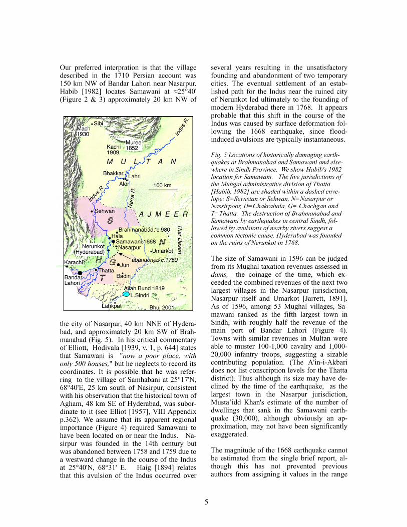
several years resulting in the unsatisfactory founding and abandonment of two temporary cities. The eventual settlement of an estab-lished path for the Indus near the ruined city of Nerunkot led ultimately to the founding of modern Hyderabad there in 1768. It appears probable that this shift in the course of the Indus was caused by surface deformation fol-lowing the 1668 earthquake, since flood-induced avulsions are typically instantaneous.
Fig. 5 Locations of historically damaging earth-quakes at Brahmanabad and Samawani and else-where in Sindh Province. We show Habib's 1982 location for Samawani. The five jurisdictions of the Muhgal administrative division of Thatta [Habib, 1982] are shaded within a dashed enve-lope: S=Sewistan or Sehwan, N=Nasarpur or Nassirpoor, H=Chakrahala, G= Chachgan and T=Thatta. The destruction of Brahmanabad and Samawani by earthquakes in central Sindh, fol-lowed by avulsions of nearby rivers suggest a common tectonic cause. Hyderabad was founded on the ruins of Nerunkot in 1768.
The size of Samawani in 1596 can be judged from its Mughal taxation revenues assessed in dams, the coinage of the time, which ex-ceeded the combined revenues of the next two largest villages in the Nasarpur jurisdiction, Nasarpur itself and Umarkot [Jarrett, 1891]. As of 1596, among 53 Mughal villages, Sa-mawani ranked as the fifth largest town in Sindh, with roughly half the revenue of the main port of Bandar Lahori (Figure 4). Towns with similar revenues in Multan were able to muster 100-1,000 cavalry and 1,000-20,000 infantry troops, suggesting a sizable contributing population. (The A'in-i-Akbari does not list conscription levels for the Thatta district). Thus although its size may have de-clined by the time of the earthquake, as the largest town in the Nasarpur jurisdiction, Musta’idd Khan's estimate of the number of dwellings that sank in the Samawani earth-quake (30,000), although obviously an ap-proximation, may not have been significantly exaggerated.
The magnitude of the 1668 earthquake cannot be estimated from the single brief report, al-though this has not prevented previous authors from assigning it values in the range
Our preferred interpration is that the village described in the 1710 Persian account was 150 km NW of Bandar Lahori near Nasarpur. Habib [1982] locates Samawani at ≈25°40' (Figure 2 & 3) approximately 20 km NW of
the city of Nasarpur, 40 km NNE of Hydera-bad, and approximately 20 km SW of Brah-manabad (Fig. 5). In his critical commentary of Elliott, Hodivala [1939, v. 1, p. 644] states that Samawani is "now a poor place, with only 500 houses," but he neglects to record its coordinates. It is possible that he was refer-ring to the village of Samhabani at 25°17'N, 68°40'E, 25 km south of Nasirpur, consistent with his observation that the historical town of Agham, 48 km SE of Hyderabad, was subor-dinate to it (see Elliot [1957], VIII Appendix p.362). We assume that its apparent regional importance (Figure 4) required Samawani to have been located on or near the Indus. Na-sirpur was founded in the 14th century but was abandoned between 1758 and 1759 due to a westward change in the course of the Indus at 25°40'N, 68°31' E. Haig [1894] relates that this avulsion of the Indus occurred over

6
the channel and incised a path through it, dis-placing the saline waters of the basin sur-rounding Fort Sindri with freshwater [Burnes, 1833].
Baker's 1844 profile shows a maximum eleva-tion of the crest of the Allah Bund of 6.2 m above Lake Sindri (Figure 6), a number that has been used as a measure of coseismic uplift assuming an absence of pre-seismic topogra-phy. However, there is an ambiguity in Baker's data in that if the bed of the river (DA) were raised, its bank should also have been raised (EC dashed line). If we assume the measured bed profile DA is not caused by bank collapse we can obtain an independent estimate of coseismic uplift of >4 m , and not greater than ≈6m, since if the lip of the chan-nel were higher than point F (Figure 6) the stream would have chosen a path around the Bund rather than through it [Wynne, 1872]. However, the measured bank profile (EC solid line) should also have been raised to mimic the bed profile (DA). In places the measured profile is more than a meter too low, suggest-ing possible bank collapse or erosion between 1819 and 1844. Reid (1911) summarizes the controversy, but no measurements of the Bund were made until Rajendran and Rajendran [2001] measured several profiles across it. They report variable relief along strike and a maximum elevation of the crust of the Bund of 5.3 m relative to the present Lake Sindri shoreline to the south. They describe terraces that they interpret as evidence for multiple uplift events, with uplift of the most recent terrace by no more than 4.3 m. However, these terraces have not been confirmed by subsequent visitors. Rajendran and Rajendran also provide evidence for multiple earth-quakes in the region in the form of dated ma-terials associated with paleoliquefaction fea-tures in pits excavated north of the Allah Bund. We note that these need not necessarily have been formed by former earthquakes re-peatedly raising the Allah Bund. The Bhuj earthquake 70 km to the SW demonstrated that regional liquefaction occurred throughout the Rann of Kachchh [Tuttle et al, 2001].
6.5<M<7.6 [for references see Ambraseys, 2004]. If Samawani were on the banks of the mile-wide Indus, damage could have been caused by the lateral-spreading of soils, by slumping, liquefaction or even a tsunami. Ambraseys points out that the earthquake is likely to have been modest because damage to neither Bandar Lahori nor Thatta was reported in 1668. With Samawani located 100 km NNE of Thatta, however, one would need to look elsewhere for collateral damage. The temple structures of Thatta survived ≈100 km from the 7.6<M<8 Allah Bund 1819 earthquake, and with minor damage 200 km from the Mw=7.6 Bhuj 2001 earthquake. Thus the ab-sence of damage in these towns at most places an upper limit (e.g. M≈7) on the magnitude of the 1668 earthquake. News of the earthquake was reported not from the town but from the province of Thatta, and no other towns are mentioned. In particular no damage was re-ported from nearby Nasarpur, which was abandoned 5 decades after the earthquake be-cause of the slow subsequent avulsion of the Indus.
Allah Bund 1819
On 16 June 1819 a severe earthquake in the northern Rann of Kachchh caused the deaths of two thousand people [MacMurdo, 1820; 1823; Oldham, 1883;1926]. The earthquake created a 30x20 km basin around Fort Sindri (Fig.5), south of a 10-km wide elongated re-gion of uplift known as the Allah Bund [Bur-nes, 1834; Oldham, 1926]. The extent of the subsidence was apparent because the depres-sion immediately flooded. The Allah Bund earthquake has the distinction of being the first in India for which geodetic leveling data [Baker, 1846] can be used to constrain aspects of the rupture [Bilham, 1998]. The earthquake resulted in local uplift (the Allah Bund) that raised the bed of the river. At the time of the earthquake the river was dry due to the diver-sion of its waters by an artificial dam up-stream. The channel remained dry for 7 years until in 1826 a flood burst the upstream dam and water formed a temporary lake north of the raised channel of the Allah Bund. The wa-ters eventually overtopped the lowest point of

7
Fig. 6 Before and after the 1819 earthquake (See fig. 2 for location of section). Upper profile uses Baker's 1844 leveling data north of points E and D. Although the pre-earthquake surface morphology between E &C is disputed, the depth of the river was reported ≈2 fathoms (4 m) by Grindlay [1808]. Lower profile is the section leveled by Baker[1846] across and through the Allah Bund [Oldham, 1898] corrected for river sinuosity. Baker's 56 km-long river profile has an estimated cumulative error of <20 cm, and shows that the base of the Puram (Narra) was typically ≈4 m below the bank (consistent with Grindlay). Fort Sindri (on the banks of the Puram) sank <1 m in 1819 but the Sunda region shallowed in 1819 [Burnes, 1833].
A dip of 68°˜NNE for the rupture was inferred from the ratio of uplift to subsidence using Baker’s data [Bilham, 1998]. However, un-certainty as to the maximum subsidence is caused by the truncation of Baker's profile close to the shores of Lake Sindri - it is un-clear whether his maximum depth of 3 m sampled the lake floor or the river channel. This area is now a deltaic platform extending several hundreds of meters into L. Sindri A minimum length to the rupture (≈50 km) may be inferred from the inferred east-west basin dimension of Lake Sindri, and the maximum length has been inferred from the morphology of the northern edge of the Rann of Kachchh as 80-150 km by Oldham [1926].
Uncertaintees in the magnitude of the 1819 earthquake remain despite the availability of numeric data. Our current understanding of the rupture geometry of the 1819 event is markedly different from that of the nearby 2001 Bhuj earthquake described below, and future studies may lead to a revision of the mechanism of the earlier event. Newly avail-able remote-sensing imagery for the Allah Bund region show a deeply dissected uplift feature with numerous abandoned channels, suggesting that a simple dislocation model based on Baker’s vertical profile may be in-appropriate. Using Baker's profile as a con-straint for a planar fault rupture, Bilham [1998] estimated Mw= 7.7±0.2. If the 1819 uplift were 4.5 m, the magnitude would be reduced to Mw=7.6. These estimates assume
8
a rupture length of 110±40 km and a down-dip width of 20±5 km. A comparison between intensities recorded in 1819 and 2001 led Hough et al. [2002] to suggest a magnitude of 7.6 for the 1819 event. In contrast, Am-braseys and Douglas [2004] provisionally list Mw=8.2 for the 1819 event based on an inten-sity scaling law derived for northern India. They caution, however, that this magnitude may require revision.
The 1819 earthquake was accompanied by aftershocks that decayed in intensity over the following year, but sporadic earthquakes were reported during the next 50 years. Few of the half dozen earthquakes that were felt prior to 1900, however, were described in sufficient detail to assign a magnitude or even a loca-tion. An earthquake in c.1846 occurred with numerous aftershocks, a small tsunami, and apparent ground deformation near Lakhpat. Although the true dates of these events are confused in different accounts [Bilham, 1998], the 20 km region of uplift reported near Sunda involved at least 60 cm of uplift, which would probably require Mw>6.5 given simple assumptions and a reverse mechanism.
An earthquake struck the Bhuj region in Janu-ary, 1856, at a time when a geodetic survey was underway. A masonry pillar at Kararho (23°5'N, 70°13'E) supporting the theodolite was damaged sufficiently to cause anxiety among the survey team [Burrard, 1890]. The documented effects suggest a locally damag-ing earthquake, perhaps around Mw6. Any-thing larger would surely have been reported from Bhuj or Anjar. The most damaging earthquake near Bhuj in the region prior to 2001 occurred in Anjar in 1956 (Mw=6.1) and this was accompanied by >50 cm of vertical deformation east of Anjar.
Bhuj 2001
The 26 January 2001 Mw=7.6 earthquake oc-curred approximately 100 km east of the Allah Bund and resulted in 18,500 deaths due to collapsed buildings in the Bhuj/Anjar region [Bendick et al., 2001]. The earthquake is of interest in that its magnitude was large for its comparatively small rupture area - a 20 km x 20 km reverse fault below 9 km depth [Jade et al., 2003; Wallace et al., 2006]. The earth-
quake did not occur on the same fault that produced the 1819 event, but both faults are within the EW-trending Kachchh fault system. The small rupture area of the Bhuj earthquake suggests that several such earthquakes could occur between the 1819 and 2001 ruptures, or in an extended region of the same structure to the east or west.
Ground motions from the Bhuj earthquake were strong enough in Karachi to cause doors to open and close, and some buildings were reportedly “cracked” (see Hough et al., 2002). Of concern for Karachi is the prospect of similar events on extensions of the Kachchh fault system towards the west. It is not clear if and how these fault structures extend to the west away from the Kachchh mainland. The Allah Bund appears to trend NW or W at its most westerly expression, and Sawar [2004] argues that this trend beneath the Indus west towards Karachi and to the north towards the Himalaya. Stein et al. [2002] extend the Rann of Kachchh fault zone to the W/SW, but con-clude that the eastward extension of the Kachchh zone curves towards the NW follow-ing a weak line of microseismicity. They in-terpret the large Rann of Kachchh earth-quakes, and the scattered seismicity through the deserts of Rajasthan and Sindh to define a fragment of the Indian plate moving at a ve-locity on the order of 3 mm/yr relative to In-dia.
Makran Subduction and the Transform boundary
We now review earthquakes that have oc-curred to the west of Karachi (Fig. 2).
Ormara 1700-1800
An earthquake is alleged to have caused a landslide on the Makran Coast 150 km west of Karachi at some time in the 18th century. Ambraseys and Melville [1982] list the ap-proximate year as c.1765. The source of this information is the director of the Makran tele-graph line, who wrote a note to the Govern-ment of Bombay indicating that " a smart shock of an earthquake" had been felt in Gwadar at 00:45 on the morning of the 25th August 1864 and speculates that large earth-quakes, if they occurred along the Makran
9
coast, could jeopordize telegraph communica-tions (Walton, 1864). From its brief mention in telegrams from Gwadar and not from other telegraph posts along the Makran coast, the 1864 earthquake was presumably quite small (M<5). Walton’s letter, however, describes the possible occurrence of an earthquake re-membered by local people:
" As the entire coast of Mekran (sic) is volcanic, I often enquired of the Baluchees regarding the oc-currence of earthquakes, and the only phenomenon of this sort, of which I could obtain any informa-tion, was said to have happened about 100 years ago, when, as my informant assured me, an entire hill, with men and camels on it, disappeared into the sea. I imagine this must have been a landslip caused by some submarine disturbance. The spot was pointed out to me and is known as Ras Kooch-eree on the chart."
(Walton’s assessment of the Makran coast as volcanic was based on the mud volcanoes found along the coast.)
The precise identification of 1765 as the year of a great earthquake is obviously inappropri-ate based on the vague mention of the timing of the earlier event. Byrne et al. [1992] iden-tify this earthquake as a great rupture beneath the leading edge of Asia at the easternmost end of the Makran subduction zone. How-ever, a landslide could have also been trig-gered by a large strike-slip earthquake on the southernmost Ornach-Nal fault system. It is even possible that no large earthquake oc-curred around 1765; the landslide could have been spontaneous, or the result of unusually heavy rain.
Byrne et al. [1992] also state that a great earthquake may have occurred on the western Makran subduction zone in 1851; however we find no evidence for this interpretation. An earthquake apparently did occur along the Makran coast in 1851; however, while Byrne et al. [1992] cite Quittmeyer and Jacob [1979] as a reference regarding this event, the latter paper includes only brief mention that an earthquake was reported at Gwadar on 19 April 1851, in turn citing Oldham [1883], who notes that Merewether[1852] records several houses collapsed in three shocks at 5 pm that
day. Quittmeyer and Jacob [1979] do not in-clude the earthquake on their list of docu-mented south-central Asian earthquakes that produced maximum intensity of VIII or greater. One can further recall Walton’s letter from Gwadar, written just 13 years after 1851. Had a major earthquake occurred along the Makran coast in 1851, surely local people would have been aware of it.
Makran 1945
In contrast to the vague information about 18th and 19th century Makran earthquakes, the 28 November 1945 Mw8.1 subduction zone earthquake is well constrained. This event occurred 250-350 west of Karachi (Figure 2) and was recorded globally. Walton’s 1864 concerns about submarine cables were borne out when this earthquake occurred, as cables broke in eight places due to submarine slides. To reconcile observed shoreline uplift with the mechanism of the earthquake, Byrne et al. [1992] argue for a rupture on a thrust plane with a 5-degree dip, extending from 70-90 km inland to 10-30 km offshore. Based on the distribution of intensities, morphological changes, and the sparse distribution of re-corded aftershocks, the rupture is inferred to have propagated SSE with a duration of 56 s, suggesting a rupture dimension of 80-150 km extending eastward from Pasni. Numerous mud volcanoes erupted inland and offshore, creating four transient islands coastward of a line connecting the horsts at Pasni and Or-mara. The coastline at Pasni subsided and the tombola at Ormara was raised 2 m. Numer-ous aftershocks were recorded and locally felt [Ambraseys and Melville, 1982; Byrne et al., 1992].
Important unresolved problems attend the in-terpretation of the tsunami generated by the 1945 earthquake. The tsunami was reported as a 0.5-m wave in the Seychelles 3400 km to the SE; it broke mooring ropes at 13N on the Malabar coast and was noticed at Muscat on the Oman coast. At Pasni a small wave ar-rived soon after the mainshock, but according to Pendse [1948], who does not cite his source, the damaging tsunami did not arrive until 3.25 hours later. Pendse [1948] also de-

10
scribes the damaging 1.5-m wave at Karachi as having followed three earlier, smaller waves during the previous two hours. Am-braseys and Melville [1982] indicate that two damaging waves arrived at Pasni 90 and 120 minutes after the mainshock. Although ac-counts conflict to some extent, it appears that the largest tsunami wave did not arrive at Pasni until several hours following the main-shock. There are many possible explanations for this delay, the most likely of which is that it was caused by one or more submarine land-slides triggered by the earthquake.
GPS deformation rates and current slip po-tential, Makran
Modern GPS studies indicate that Arabia ap-proaches the Asian plate at a velocity of 28-30 mm/yr along the Makran coast [Apel et al., 2006]. Relative motion between the Ormara plate and Arabia increases this velocity to 32-35 mm/yr [Kukowski et al., 2000]. Assuming complete seismic coupling, a maximum slip deficit of ~2m has developed along the 1945 rupture zone. The seismic potential of the subduction zone to the east of the 1945 rup-ture is less well constrained. As discussed above, it is possible that a large earthquake occurred to the east of the 1945 rupture zone at some time during the 18th century. If this is the case, a slip deficit of 6-9 m has developed along this segment of the subduction zone. Were this earthquake to occur today, we esti-mate its potential magnitude to be as high as Mw8.2. The slip deficit along the 1945 rup-ture zone could produce an earthquake with Mw7.8 if the event occurred today.
We note, however, that the magnitude esti-mates above assume complete seismic cou-pling. Kukowski et al. [2000] conclude from the offset of accretionary ridges by the Sonne fault that offshore locking is strong, but it is unlikely that complete seismic coupling ex-tends throughout the subduction interface. Also, in contrast to the ≈70 km inland pre-seismic locking line inferred for down-dip rupture termination of the 1945 earthquake by Byrne et al. [1992], our recent GPS measure-ments indicate that the locking line must be close to the coast or offshore. The data are derived from continuous GPS receivers in-stalled in Ormara and Karachi and indicate
Ormara's velocity is 21.5 +/- 3 mm/yr SSW relative to India. Assuming that aseismic slip occurs downdip on a planar subhorizontal dis-location, and that Asia/Ormara plate conver-gence is ≈33mm/yr, elastic theory requires that the current locking line must be offshore, close to the seaward termination of rupture in 1945. If further GPS measurements along the Makran coast confirm the high rate of slip at Ormara, it would suggest that little or no po-tential slip is accumulating. This result would be of importance to Karachi since it would imply that no great earthquake is pending, and/or that the renewal time for 1945-type events is significantly more than the ≈200 years inferred from plate convergence rates alone. Clearly, additional measurements are needed to confirm this initial result before one can draw conclusions about the seismic poten-tial of the subduction zone segment to the east of the 1945 rupture zone.
Active Faults North and Northwest of Ka-rachi
Lastly we review structures that are poten-tially active but for which no significant seis-micity has been reported. South of the triple junction the plate boundary separating the Arabian and Indian plate trends to the SW along the Murray Ridge, the transtenstional SE edge of the Ormara plate [Kukowski et al., 2000]. This consists of a series of small strike slip faults separated by normal faults that are presumably unable to host large damaging earthquakes. Transtensional motion here is 3-6 mm/yr, and recent seismicity consists of moderately small shocks with maximum magnitudes <5. We note, however, that a growing body of evidence suggests that earth-quake ruptures can jump between distinct fault segments, raising a question about the extent to which fault segmentation limits maximum earthquake size.
Ornach Nal earthquakes?
The Ornach-Nal fault (Figure 2) is the south-ernmost of several en-echelon strike faults collectively termed the Chaman fault system [Yeats et al., 1979] that define the western edge of the Indian plate. Its slip rate is esti-mated from geological offsets to be 20-40 mm/year [Lawrence et al., 1992] and plate
11
closure rates constrained by recent data sug-gest a mean velocity of 26 mm/yr [Apel et al, 2006], or ≤34 mm/yr if one takes the inferred Ormara plate velocity into account. The southernmost segment of the Ornach Nal fault system starts 130 km due west of Karachi and extends northward for 200 km. Based on scaling relations (e.g., Wells and Coppersmith, 1994), the fault could produce an earthquake with a magnitude as large as Mw7, or perhaps larger. Though recent faulting has been identi-fied [Nakata et al., 1991] the historical record contains no known earthquake on this seg-ment. Recent seismicity is sparse north of the plate boundary, but increases northward away from the coast. Four hundred km north of Karachi it reaches a region of significant his-torical seismicity with five damaging earth-quakes starting in 1892 [Griesbach, 1893] and 1909 [Heron, 1911] followed by the 1931/35 Mach/Quetta earthquake sequence [West, 1934; 1936], a series of three M>7 earth-quakes that resulted in 35,000 deaths. This sequence included large earthquakes on both the Chaman fault system and the frontal thrust faults to the east (discussed below) [Am-braseys and Bilham, 2003]. If we assume that the Ornach Nal fault has not slipped since the 18th century, it would now have developed 6-8 m of potential slip. If the southernmost segment were to slip in a single event (≈200 km), it could generate a maximum credible earthquake, approaching Mw8.0.
Blind Thrust earthquakes near Karachi?
To the north of Karachi the well-developed Kirthar fold and thrust belt verges to the east, the southernmost ranges of which are ex-pressed both east and west of the city (Figure 2). Nakata et al., [1991] identify a possibly active surface scarp on the Korangi Fault on the eastern outskirets of Karachi. Shortening is driven in the north by the convergent com-ponent of strain caused by transpressional oblique-slip of the transform boundary, but to the south this obliquity appears to be much reduced or absent. Near Sibi the frontal thrusts most recently slipped in 1931 (Mach Mw=7.1; Ambraseys and Bilham, 2003) but as the Kirthar hills are followed southward no historical large earthquakes have been re-
corded, although microseismicity does indeed occur. Estimates for the rate of shortening across this fold belt near the latitude of Quetta vary from 5 to 11 mm/year [Ambraseys and Bilham, 2003; Apel et al 2006] ; hence one might anticipate M>7 earthquakes to be asso-ciated with maximum renewal times of the order of 200 years. If maximum earthquake size were limited by fault segmentation to be below Mw7, one would expect to see more frequent moderate shocks. The paucity of such events in historical times argues against this interpretation, suggesting instead that less frequent large events should be expected.
Partitioned convergence in the Kirthar range?
The city of Karachi is constructed on the southernmost folds of the Kirthar range with several named faults (Surjan, Lakhni, Jhimpir) within 125 km of the city. Schelling [1999] argues that activity on the easternmost frontal faults of the range near and north of Hydera-bad appears to have ceased However, at least two faults have been mapped near and NW of Karachi: the Hab and the Pab faults. These faults are thought to be active, although nei-ther slip rate estimates nor local earthquake recordings are available for either of them. We note, however, that evidence for seismicity 50-110 km NE of Hyderabad (possible M≥7 earthquakes in Brahmanabad circa 980 and Samawani in 1668) suggests either that activ-ity on the westernmost Kirthar thrusts contin-ues beneath the Indus sediments, or that other structures are tectonically active in this re-gion.
The only instrumental seismic data for events in and around Karachi is from the NEIC, which is incomplete for Mw below approxi-mately 5. Events recorded since the early 1960s reveal few events immediately around the city of Karachi, with a small number of M4-5 shocks that were large enough to be felt in the city (Figure 2). Several events are lo-cated close to the Hab and Pab faults, includ-ing a mb4.6 earthquake on 8 September 1986 and a mb4.5 earthquake on 29 September 1998. Both of these earthquakes were felt in Karachi.
12
Seismic HazardOur present, imperfect understanding of earthquake hazard in Karachi reveals an ap-parent paradox. On the one hand, Karachi sits close to an active plate boundary and is liter-ally surrounded by active faults. We note a striking parallel between its setting and that of another well known megacity: Los Angeles, California (Figure 1). On the other hand, in contrast to Los Angeles, Karachi has experi-enced no damaging earthquakes in the last 150 years and few events large enough to be felt.
Having summarized what is known about tec-tonics in and around Karachi, it is clear that key question still remain regarding the seis-mogenic potential of a number of regional faults. At best the hazard in Karachi might be low, if, for example, the southern Chaman fault is creeping and/or the eastern Makran subduction zone has a shallow locking depth. At worst, however, the hazard in Karachi could be roughly comparable to that in Los Angeles, or perhaps even worse in Karachi given its proximity to the subduction zone, for which Los Angeles has no analog. Consider-ing the number of known active faults that menace Karachi from almost every direction, however, it seems possible if not probable that hazard is higher than that assigned by recent national and global hazard maps.
A consideration of relative seismic risk in Ka-rachi and Los Angeles leads to even more alarming conclusions. Seismic building pro-visions, including the Field Act to protect public school buildings, were first adopted in California following the 1933 Long Beach earthquake. The building codes have been updated and strengthened since that time. Notably, codes were strengthened in the early 1970s after the 1971 Sylmar earthquake re-vealed previously unsuspected vulnerabilities of nonductile concrete buildings – the likes of which were ubiquitous throughout the region. The code has never included mandatory retro-fitting, so these older and highly vulnerable buildings are a serious concern. The building code provisions were strengthened again in 1997, so buildings built between the early 1970s and 1997 are also not constructed ac-cording to current standards. Unexpected
vulnerabilities of relatively modern structures were revealed as recently 1994, when the M6.7 Northridge earthquake caused unex-pected damage to steel welds.
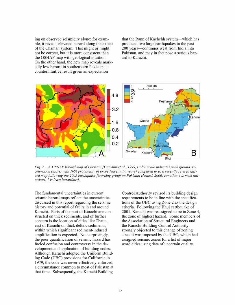
Although concern thus remains for the ade-quacy of building codes in southern Califor-nia, efforts to assess hazards and implement effective codes have far outpaced comparable efforts for Karachi. Two efforts have been made in recent years to develop a national seismic hazard map for Pakistan. The first of these was the analysis done by the Global Seismic Hazard Assessment Program, or GSHAP [Giardini et al., 1999]. The GSHAP map for Pakistan (Figures 5, 6a) was based by necessity on global earthquake catalogs and reveals, to the trained eye, apparent strengths as well as weaknesses. One possible strength is that this map reveals fairly high hazard in southeasternmost Pakistan, a consequence of high rates of recent activity primarily across the border in India, but to some extent also a consequence of activity on the Pakistani side of the border. An obvious limitation of the GSHAP map, however, is the “bulls-eye” around the location of the 1935 Quetta earth-quake and the low hazard both north and south of this location. One possibile reprieve to future seismicity here, is that like the San Andreas system, part of the Chaman system may be creeping. It was initially thought that the Chaman fault might be creeping to the north of Quetta [Szeliga et al., 2006], but a recent analysis of the interferograms interprets this aseismic slip as local afterslip following a M5 earthquake on the fault [M. Furuya & S. P. Satyabala, personal communication, 2007] . . In general, the map reveals the inevitable limitation of a seismicity-based map in a re-gion where the historical record is clearly much shorter than the length of the earthquake cycle. This limitation is further exacerbated by the absence of other information to con-strain source models, for example GPS data and slip-rate information.
The deadly 2005 Kashmir earthquake pro-vided the impetus for the government of Paki-stan to develop a new national hazard map, a preliminary draft of which was available to one of the authors (Figure 6b). This map considers regional tectonics rather than rely-
13
Fig. 7. A. GSHAP hazard map of Pakistan [Giardini et al., 1999, Color scale indicates peak ground ac-celeration (m/s/s) with 10% probability of exceedence in 50 years) compared to B. a recently revised haz-ard map following the 2005 earthquake [Working group on Pakistan Hazard, 2006; zonation 4 is most haz-ardous, 1 is least hazardous].
The fundamental uncertainties in current seismic hazard maps reflect the uncertainties discussed in this report regarding the seismic history and potential of faults in and around Karachi. Parts of the port of Karachi are con-structed on thick sediments, and of further concern is the location of cities like Thatta, east of Karachi on thick deltaic sediments, within which significant sediment-induced amplification is expected. Not surprisingly, the poor quantification of seismic hazard has fueled confusion and controversy in the de-velopment and application of building codes. Although Karachi adopted the Uniform Build-ing Code (UBC) provisions for California in 1979, the code was never effectively enforced, a circumstance common to most of Pakistan at that time. Subsequently, the Karachi Building
ing on observed seismicity alone; for exam-ple, it reveals elevated hazard along the extent of the Chaman system. This might or might not be correct, but it is more consistent than the GSHAP map with geological intuition. On the other hand, the new map reveals mark-edly low hazard in southeastern Pakistan, a counterintuitive result given an expectation
that the Rann of Kachchh system—which has produced two large earthquakes in the past 200 years—continues west from India into Pakistan, and may in fact pose a serious haz-ard to Karachi.
Control Authority revised its building design requirements to be in line with the specifica-tions of the UBC using Zone 2 as the design criteria. Following the Bhuj earthquake of 2001, Karachi was reassigned to be in Zone 4, the zone of highest hazard. Some members of the Association of Structural Engineers and the Karachi Building Control Authority strongly objected to this change of zoning since it was imposed by the UBC, which had assigned seismic zones for a list of major word cities using data of uncertain quality.
14
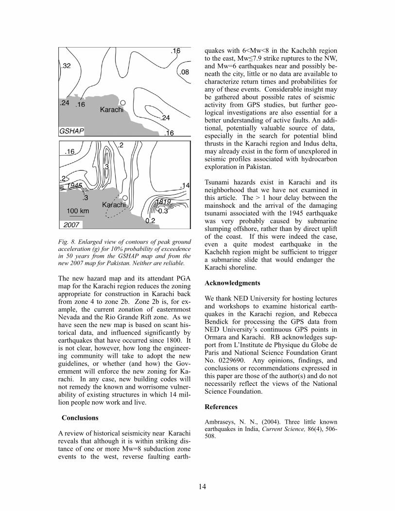
Fig. 8. Enlarged view of contours of peak ground acceleration (g) for 10% probability of exceedence in 50 years from the GSHAP map and from the new 2007 map for Pakistan. Neither are reliable.
The new hazard map and its attendant PGA map for the Karachi region reduces the zoning appropriate for construction in Karachi back from zone 4 to zone 2b. Zone 2b is, for ex-ample, the current zonation of easternmost Nevada and the Rio Grande Rift zone. As we have seen the new map is based on scant his-torical data, and influenced significantly by earthquakes that have occurred since 1800. It is not clear, however, how long the engineer-ing community will take to adopt the new guidelines, or whether (and how) the Gov-ernment will enforce the new zoning for Ka-rachi. In any case, new building codes will not remedy the known and worrisome vulner-ability of existing structures in which 14 mil-lion people now work and live.
Conclusions
A review of historical seismicity near Karachi reveals that although it is within striking dis-tance of one or more Mw=8 subduction zone events to the west, reverse faulting earth-
quakes with 6<Mw<8 in the Kachchh region to the east, Mw≤7.9 strike ruptures to the NW, and Mw=6 earthquakes near and possibly be-neath the city, little or no data are available to characterize return times and probabilities for any of these events. Considerable insight may be gathered about possible rates of seismic activity from GPS studies, but further geo-logical investigations are also essential for a better understanding of active faults. An addi-tional, potentially valuable source of data, especially in the search for potential blind thrusts in the Karachi region and Indus delta, may already exist in the form of unexplored in seismic profiles associated with hydrocarbon exploration in Pakistan.
Tsunami hazards exist in Karachi and its neighborhood that we have not examined in this article. The > 1 hour delay between the mainshock and the arrival of the damaging tsunami associated with the 1945 earthquake was very probably caused by submarine slumping offshore, rather than by direct uplift of the coast. If this were indeed the case, even a quite modest earthquake in the Kachchh region might be sufficient to trigger a submarine slide that would endanger the Karachi shoreline.
Acknowledgments
We thank NED University for hosting lectures and workshops to examine historical earth-quakes in the Karachi region, and Rebecca Bendick for processing the GPS data from NED University’s continuous GPS points in Ormara and Karachi. RB acknowledges sup-port from L’Institute de Physique du Globe de Paris and National Science Foundation Grant No. 0229690. Any opinions, findings, and conclusions or recommendations expressed in this paper are those of the author(s) and do not necessarily reflect the views of the National Science Foundation.
References
Ambraseys, N. N., (2004). Three little known earthquakes in India, Current Science, 86(4), 506-508.
15
Ambraseys, N.N., and Melville, C.P., (1982). A History of Persian Earthquakes, Cambridge Uni-versity Press, London, pp.219.
Ambraseys, N., and R. Bilham, (2003) Earth-quakes and crustal deformation in northern Balu-chistan, Bull. Seism Soc. Am. 93(4), 1573-1600.
Ambraseys, N. N. and J. Douglas, (2004) Magni-tude calibration of North Indian earthquakes,. Geophys. J. Int. 158, 1-42.
Apel et al., E., R. Bürgmann, P. Bannerjee, and B. Nagarajan, (2006). Geodetically constrained In-dian Plate motion and implications for plate boundary deformation, Eos Trans. AGU, 85(52), Fall Meeting Supplement, T51B-1524.
Baker, W. E., (1846), Remarks on the Allah Bund and on the drainage of the eastern part of the Sind basin, Trans. Bombay Geogr. Soc., 7, 186-188.
Bellasis, A. F. (1857a), An account of the ancient and ruined city of Brahminabad, in Sind, J. Bom-bay R. Asiatic Soc., 5, 413-425,
Bellasis, A. F. (1857b), Further observations of the ruined city of Brahminabad, in Sind, J. Bombay R. Asiatic Soc., 5, 467-477.
Bendick, R., R. Bilham, E. Fielding, V. Gaur, S.E. Hough, G. Kier, M. Kulkarni, S. Martin, and M. Mukol (2001). The January 26, 2001 Bhuj, India earthquake, Seismological Research Letters, 72, 328-335.
Bilham, R, (1998), Slip parameters for the Rann of Kachchh, 16 June 1819 earthquake, quantified from historical accounts, Geol. Soc London Sp. Pub. 146, 295-319.
Burnes, A., (1833) A memoir on the Eastern Branch of the River Indus giving an account of the alterations produced by it by an earthquake in 1819, also a theory of the Runn, and some conjec-tures on the Route of Alexander the Great, drawn up in the years 1827-28, R. Asiatic Soc., 3, 550-588.
Burnes, A., (1834) Travels into Bokhara, Volume 3.
Burrard, S. G., (1890) in H. H. Cole, Account of the Operations of the Great Trigonometrical Sur-vey of India, 14, Cutch Coast Series.
Byrne, D.E., L.R. Sykes, and D.M. Davis (1992). Great thrust earthquakes and aseismic slip along the plate boundary of the Makran subduction zone, J. Geophys. Res. 97, 449-478.
Cousens, H., (1905). Conservation of ancient monuments in the Bombay Presidency, J. Bombay Branch R. Asiatic Soc., Extra Number, Centenary Memorial Volume, 149-162.
Cunningham, A., (1871) The ancient geography of India, pp. 589.
Delhoste, E, (1832), Observations on Sind, Inst. of Sindhology Publication Reprint 129. 1987. pp118.
Elliot, H. M, (1857), The history of India as told by its own historians: The Muhammadan Period. 8 Volumes, (1867-1878), 3rd edition ed. by Dowson, Trubner, London.
Gentil, Jean-Baptiste-Joseph, (1820). Maps of Mughal India: Drawn by Jean-Baptiste-Joseph Gentil, Agent for the French Government to the Court of Shuja-Ud-Daula at Faizabad, 1770.
Griesbach, C.L. (1893). Notes on the earthquake of Baluchistan on the 20th December 1892, Rec. Geol. Surv. Ind., 26, 57-64.
Giardini, D., G. Grunthal, K. Shedlock, and P. Zheng (1999). The GSHAP Global Seismic Haz-ard Map, Annali di Geofisica, 42, 1225-1230.
Gole, S, (1988) Maps of Mughal India, Drawn by Colonel Jean-Baptiste Gentil, agent for the French Government to the Court of Shuja ud-Daula at Faizabad, in 1770. New Delhi: Manohar.
Grindlay, (1808), diary reproduced in Burnes A., Travels into Bokhara, Volume 3 Appendix. 1834.
Habib, I., (1982). An atlas of the Mughal empire: political and economic maps with detailed notes, bibliography and index. Oxford. pp 105.
Haig, M. R. (1874), On the sites of Brahmanabad and Masurah in Sindh; with others of less note in their vicinity, J. R. Asiatic Soc., 16., 281-294.
Haig, M. R. (1894) The Indus Delta Country; A memoir chiefly on its ancient geography and his-tory. Kegan Paul, Trench & Trübner. pp148.
16
Heron A., (1911). The Baluchistan earthquake of the 21st October 1909, Rec. Geol. Surv. India, 41, 22-35.
Hodīvālā, S. H., (1939), Studies in Indo-Muslim History: A Critical Commentary on Elliot and Dowson's History of India as told by its own histo-rians. Volume 1, pp. 712. Kokil and Co.
Hough, S.E., S. Martin, R. Bilham, and G. M. At-kinson, (2002). The 26 January 2001 M 7.6 Bhuj, India, Earthquake: Observed and Predicted Ground Motions, Bull. Seism. Soc. Amer, 92, 2061-2079.
Jade S. D. and 12 other authors, (2003). Pre-seismic, co-seismic and post seismic displace-ments associated with the Bhuj earthquake derived from recent and historic geodetic data. J. Ind Inst of Sci. 112(3), 331-346.
Jarrett, H.S., 1891. The A'in-i Akbari by Abu'l-Fazl Allami, Translated from the original Persian by Col. H. S. Jarrett, Asiatic Soc. Bengal.Volume. II. Calcutta, Baptist Mission Press.
Kukowski, N., T. Schillhorn, E. R. Flueh, & K. Huhn, (2000). Newly identified strike-slip plate boundary in the northeastern Arabian Sea, Geol-ogy, 28:, 355-358
Lambrick, H. T., (1964). Sind: A general introduc-tion, Sindhi Ababi Board, Hyderabad pp 274.
Lawrence, R.D., Hasan Khan, S., Nakata, T., (1992). Chaman Fault, Pakistan-Afghanistan, in Bucknam, R.C., and Hancock, P.L., eds., Major active faults of the world—Results of IGCP Pro-ject 206: Annales Tectonicae, Special Issue Sup-plement to v. 6, p. 196–223.
Nakata T., H. Tsutsumi, S. H. Khan, & R. D. Law-rence (1991), Active faults of Pakistan, Sp. Pub. 21, Research Center for Regional Geography, Hi-roshima Univ. pp141.
Macmurdo, J., (1820) Account of the earthquake at Kutch on the 16th June 1819 drawn from pub-lished and unpublished letters from India.120-124. Edinburgh Philosophical Journal, 3, 21, 120-124.
MacMurdo, J., (1823) Papers related to the earth-quake which occurred in India in 1819, Trans. Lit. Soc Bombay, 3, 90-116.
Mallet, R. (1852). Report of the twenty-first meet-ing of the British Association for the Advancement
of Science, Ipswich, 1851, second report on the facts of earthquake phonemona, 272-320.
Merewether, W., (1852), A report of the disastrous consequences of the severe earthquake felt in the provinces of Upper Scinde on the 24th January 1852. J. Bombay Geog. Soc., 10, 284-6
Nakata, T., H. Tsutsumi, S. H. Khan and R. D Lawrence, (1991). Active Faults of Pakistan; Map sheets and inventories, Sp. Pub. 21, Res. Center for Regional Geography, Hiroshima University, pp.141.
Oldham, R. D., (1898). A note on the Allah Bund in the north west of the Runn of Cuch. Mem. Geol. Surv. India, 28, 27-30.
Oldham, T., (1883). Catalogue of Indian earth-quakes, Mem. Geol. Surv. India, 19, 163-215, Cal-cutta.
Oldham, R. D. (1926). The Cutch (Kachh) Earth-quake of 16th June 1819 with a revision of the great earthquake of 12th June 1897. Mem. Geol. Surv. of India, 46, 71-146.
Pendse, C. G., (1948). The Makran earthquake of the 28th of November, 1945, Sci. Notes, 10, 141-145, Indian Meteorological Dept.
Quittmeyer R. C., and K. H. Jacob (1979) Histori-cal and modern seismicity of Pakistan, Afghani-stan, northwestern India, and southeastern Iran Bull. Seism. Soc. Amer., 69(3):773-823
Rajendran C. P. and K. Rajendran, (2001). Charac-teristics of Deformation and past seismicity asso-ciated with the 1819 Kutch Earthquake, north-western India, Bull. Seism. Soc Amer., 91(30), 407-426.
Raverty, H. G. (1892) The Mihran of Sind, and its tributaries, J. Asiatic Soc. Bengal, 61, 156-508.
Ried, H.F. (1911). The elastic rebound theory of earthquakes, 413-444, Bull. Dept. Geology, Univ. California Berkeley, A.C. Lawson and J.C. Mer-riam, ed., 1910-1911.
Sarkar, J., (1947), Maasir-i-Alamgiri - An English translation of Saqi Must'ad Khan's History of the Emperor Aurangzib. Suhail Academy Reprint 1981, Lahore pp.350.
Sarkar, J, (1978), The A'in-i Akbari by Abu'l-Fazl Allami, Translated from the original Persian by
17
Col. H. S. Jarrett, corrected and further annotated by Jadunnath Sarkar, Second edition. Oriental Books Reprint Corp. New Delhi, 1978.
Sawar, G., (2004). Earthquakes and the Neo-tectonic Framework of the Kutch-Hyderabad-Karachi Triple junction Area, Indo-Pakistan, Pak. J. Hydrocarbon Res., 14, 35-40.
Schelling, D. D. (1999). Frontal structural geome-tries and detachment tectonics of the northeastern Karachi arc, southern Kirthar Range, Pakistan, Geol. Soc Amer. 328, 287-302.
Stein, S., G. Sella, and E.A. Okal, (2002). The January 26, 2001 Bhuj earthquake and the diffuse boundary of the Indian plate, Amer. Geophys. Un. Geodyn. Monog., 30, 243-254.
Szeliga, W.M., M. Furuya, S. Satyabala, and R. Bilham, (2006). Surface creep along the Chaman fault on the Pakistan-Afghanistan border imaged by SAR interferometry, (abstract), Eos, Trans. Am. Geophys. U. 87 (52).
Tuttle, M. P., Hengesh, J., Tucker, K. B., Lettis, W., Deaton, S. L., and Frost, J. D., 2002, Observa-tions and comparisons of liquefaction features and related effects induced by the Bhuj earthquake, Earthquake Spectra, v. 18, Supplement A, p. 79-100.
Wallace, K., R. Bilham, F. Blume, V.K. Gaur, V. Gahalaut (2006). Geodetic constraints on the Bhuj 2001 earthquake and surface deformation in the Kachchh Rift Basin, Geophys. Res. Let 33, 10.1029/2006GL025775.
Walton, H.I. (1864). correspondence, 27 August 1864., in Proc. Geog. Soc. Bombay, 17, cxxv.
West, W.D. (1934). The Baluchistan earthquakes of 25th and 27th August 1931, Mem. Geol. Surv. India, 67, 1-82.
West, W.D. (1936). Preliminary geological report on the Baluchistan (Quetta) earthquake of May 31st, 1935, Rec. Geol. Surv.India, 69, 204-241.
Wells, D.L. and K.J. Coppersmith (1994). New empirical relationships among magnitude, rupture length, rupture width, rupture area, and surface displacement, Bull. Seism. Soc. Am. 84, 974-1002.
Wynne, A.B. (1872). Memoir on the geology of Kutch, Mem. Geol. Soc. India, 9, 1-294.
Yeats, R.S., Lawrence, R.D., Jamil-Ud-Din, Syed, and Khan, S.H. (1979). Surface effects of the 16 March 1978 earthquake, Pakistan-Afghanistan border, in Farah, Abul, and De Jong, K.A., eds., Geodynamics of Pakistan: Quetta, Pakistan, Geo-logical Survey of Pakistan, p. 359–361.
Yule, H. and A. C. Burnell, (1903). Hobson-Jobson, A glossary of colloquial anglo-Indian words and phrases, and of kindred terms, etymo-logical, historical, geographical and discursive, pp. 1021. Ed. W. Crooke, reprint Asian Educational Services. Madras 1995.
Author Affiliations
Roger Bilham, CIRES and Geological Sci-ences, University of Colorado, Boulder, CO 80309-0399. USA
Susan Hough, U.S. Geological Survey, 525 South Wilson Ave., Pasadena, California, 91106, USA
Sarosh Lodi, Saira Bukhary, Abid Murtaza Khan, and S.F.A. Rafeeqi, Dept. of Civil En-gineering, NED University of Engineering and Technology, Karachi 75270 Pakistan.