Embed Size (px)
Citation preview
Segmentation of megathrust rupture zones from fore-arc deformation
patterns over hundreds to millions of years, Arauco peninsula, Chile
Daniel Melnick,1 Bodo Bookhagen,2,3 Manfred R. Strecker,1 and Helmut P. Echtler1,4
Received 8 May 2008; revised 30 September 2008; accepted 27 October 2008; published 24 January 2009.
[1] This work explores the control of fore-arc structure on segmentation of megathrustearthquake ruptures using coastal geomorphic markers. The Arauco-Nahuelbutaregion at the south-central Chile margin constitutes an anomalous fore-arc sector in termsof topography, geology, and exhumation, located within the overlap between theConcepcion and Valdivia megathrust segments. This boundary, however, is only based on�500 years of historical records. We integrate deformed marine terraces dated bycosmogenic nuclides, syntectonic sediments, published fission track data, seismicreflection profiles, and microseismicity to analyze this earthquake boundary over102–106 years. Rapid exhumation of Nahuelbuta’s dome-like core started at 4 ± 1.2 Ma,coeval with inversion of the adjacent Arauco basin resulting in emergence of theArauco peninsula. Here, similarities between topography, spatiotemporal trends in fissiontrack ages, Pliocene-Pleistocene growth strata, and folded marine terraces suggest thatmargin-parallel shortening has dominated since Pliocene time. This shortening likelyresults from translation of a fore-arc sliver or microplate, decoupled from South Americaby an intra-arc strike-slip fault. Microplate collision against a buttress leads tolocalized uplift at Arauco accrued by deep-seated reverse faults, as well as incipientoroclinal bending. The extent of the Valdivia segment, which ruptured last in 1960 with anMw 9.5 event, equals the inferred microplate. We propose that mechanical homogeneityof the fore-arc microplate delimits the Valdivia segment and that a marked discontinuityin the continental basement at Arauco acts as an inhomogeneous barrier controllingnucleation and propagation of 1960-type ruptures. As microplate-related deformationoccurs since the Pliocene, we propose that this earthquake boundary and the extent of theValdivia segment are spatially stable seismotectonic features at million year scale.
Citation: Melnick, D., B. Bookhagen, M. R. Strecker, and H. P. Echtler (2009), Segmentation of megathrust rupture zones from
fore-arc deformation patterns over hundreds to millions of years, Arauco peninsula, Chile, J. Geophys. Res., 114, B01407,
doi:10.1029/2008JB005788.
1. Introduction
[2] Historical time-space records of great subductionearthquakes demonstrate that ruptures tend to occur repeat-edly within distinct seismotectonic sectors along the fore-arc [e.g., Ando, 1975; Kelleher, 1972; Lomnitz, 1970;Thatcher, 1990]. Statistical analysis of such historical earth-quake patterns have resulted in early attempts of assessingseismic hazard introducing the concept of ‘‘seismic gaps’’[e.g., Mogi, 1979; Thatcher, 1990], and the time predictablemodel [Shimazaki and Nakata, 1980]. However, paleoseis-mic studies have shown that recurrence of large-magnitude
earthquakes in subduction zones is variable and can exceedthe time span of historical records [e.g., Satake and Atwater,2007]. Because the magnitude of an earthquake largelydepends on the fault area that ruptured and the amount ofslip [e.g., Hanks and Kanamori, 1979; Kanamori, 1977;Wells and Coppersmith, 1994], understanding the factorsthat control lateral propagation of the dynamic earthquakerupture front, and the timescales on which seismotectonicsegmentation is relevant, may furnish valuable informationfor our understanding of the earthquake process at plateboundaries and natural hazard assessment.[3] Three major features have been proposed to control
segmentation of subduction earthquake ruptures: bathymet-ric anomalies in the incoming oceanic plate [e.g., Robinsonet al., 2006; Taylor et al., 1987], sediment thickness in thetrench [Ruff, 1989], and discontinuities within the upperplate [e.g., McCaffrey, 1992; Song and Simons, 2003]. Theextent of rupture segments also appears to be manifested bythe spatial distribution of geophysical anomalies in fore-arcregions. For example, the positive correlation betweensubduction earthquake ruptures and the position and extent
JOURNAL OF GEOPHYSICAL RESEARCH, VOL. 114, B01407, doi:10.1029/2008JB005788, 2009ClickHere
for
FullArticle
1Institut fur Geowissenschaften, Universitat Potsdam, Potsdam,Germany.
2Department of Geological and Environmental Sciences, StanfordUniversity, Stanford, California, USA.
3Geography Department and Institute for Computational Earth SystemSciences, University of California, Santa Barbara, California, USA.
4GeoForschungsZentrum Potsdam, Potsdam, Germany.
Copyright 2009 by the American Geophysical Union.0148-0227/09/2008JB005788$09.00
B01407 1 of 23

of trench-parallel gravity anomalies at several subductionzones suggests that the segmentation of great earthquakeruptures is controlled by the structure acquired over time-scales equivalent to the development of fore-arc basins,about 106–107 years [Llenos and McGuire, 2007; Song andSimons, 2003; Wells et al., 2003].[4] Earthquake-related fore-arc deformation is usually
recorded by coastal landforms, such as multiple levels ofemerged abrasion platforms or coastal terraces. Detailedanalysis of their geomorphic characteristics, chronology,and relation to the structural setting may provide valuablepaleoseismic information, and can thus provide data neededto understand the long-term evolution of fore-arcs [e.g.,Lajoie, 1986; Taylor et al., 1987]. Interestingly, severalstudies have shown that distinct coastal landforms, like
peninsulas and embayments, tend to occur at seismotectonicboundaries [e.g., Ando, 1975; Bourgois et al., 2007; Collotet al., 2004; Kelleher, 1972; Lomnitz, 1970]. In fact, majorhistorical seismotectonic segments along the Peru-Chilemargin are delimited by such promontories, which markdistinct anomalies of the coastline (Figure 1a). Some ofthese earthquake boundaries also coincide with lower plateanomalies. For example, collision of the Peruvian NazcaRidge (14�S) coincides with the Pisco peninsula and theboundary between the 1974 and 2007 Mw 8.0 ruptures;collision of the Chile Rise (46�S) correlates with the Taitaopeninsula, which constitutes the southern limit of the 1960Mw 9.5 earthquake rupture [Cisternas et al., 2005; Lomnitz,2004]. Conversely, there is no pronounced coastline anom-aly or discrete earthquake rupture boundary in the regions
Figure 1. Index maps. (a) Major seismotectonic features of the central and south-central Andean fore-arc. Rupture segment of most recent, major (M � 8) subduction earthquake [Beck and Ruff, 1989; Comteand Pardo, 1991; Lomnitz, 1970, and references therein]. Note that distinct promontories seem to occursystematically at rupture segment boundaries. LOFZ, Liquine-Ofqui fault zone. (b) Location of theArauco peninsula and study area. Major Quaternary faults compiled from references in text.Seismotectonic segments, rupture zones of historical subduction earthquakes, and main tectonic featuresof the south-central Andean convergent margin. Earthquake ruptures were compiled from Campos et al.[2002], Comte et al. [1986], Kelleher [1972], and Lomnitz [2004]. Dashed white line denotes edge of>1.5 km thick sediment fill in the trench. Data on Nazca plate and trench from Bangs and Cande [1997]and Tebbens and Cande [1997]. Segments of the Chile Rise subducted at 3 and 6 Ma from Cande andLeslie [1986].
B01407 MELNICK ET AL.: EARTHQUAKE SEGMENTATION AT ARAUCO
2 of 23
B01407
where the Juan Fernandez (32�S) and Iquique ridges (20�S)collide with the margin (Figure 1a), making unambiguouscorrelations between rupture segments and lower plateanomalies difficult. Indeed, some peninsulas that clearlycorrespond to historical earthquake rupture boundaries,like the Mejillones (23�S) and Arauco (38�S) peninsulas,apparently are not related to lower plate anomalies.[5] In this study, we attempt to gain fundamental insight
into the problem of earthquake rupture segmentation from ageological perspective and examine patterns of fore-arcdeformation and exhumation over various temporal (102–106 years) and spatial (101–103 km) scales. This includes theanalysis of coseismic land level changes during two greatearthquakes of adjacent rupture segments, deformed Plio-cene-Quaternary marine sediments and terrace surfaces, anda synopsis of the late Cenozoic structural and thermal history.We focus on the south-central Chile margin (Figure 1b),where accounts of great earthquakes have been used todefine historical seismic sectors [e.g., Barrientos, 1987;Beck et al., 1998; Campos et al., 2002; Cisternas et al.,
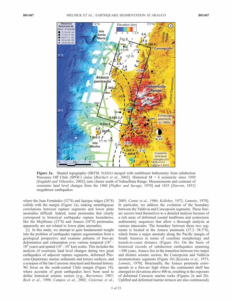
2005; Comte et al., 1986; Kelleher, 1972; Lomnitz, 1970].In particular, we address the evolution of the boundarybetween the Valdivia and Concepcion segments. These fore-arc sectors lend themselves to a detailed analysis because ofa rich array of deformed coastal landforms and syntectonicsedimentary sequences that allow a thorough analysis atvarious timescales. The boundary between these two seg-ments is located at the Arauco peninsula (37.2–38.5�S),which forms a major anomaly along the Pacific margin ofSouth America in terms of coastline morphology andtrench-to-coast distance (Figure 1b). On the basis ofhistorical records of subduction earthquakes spanning�500 years, Arauco lies in the transition between two majorand distinct seismic sectors, the Concepcion and Valdiviaseismotectonic segments (Figure 1b) [Kaizuka et al., 1973;Lomnitz, 1970]. Structurally, the Arauco peninsula corre-sponds to a fore-arc high where the continental shelf hasemerged to elevations above 400 m, resulting in the exposureof deformed Cenozoic marine rocks (Figures 2a and 2b).Uplifted and deformed marine terraces are also continuously
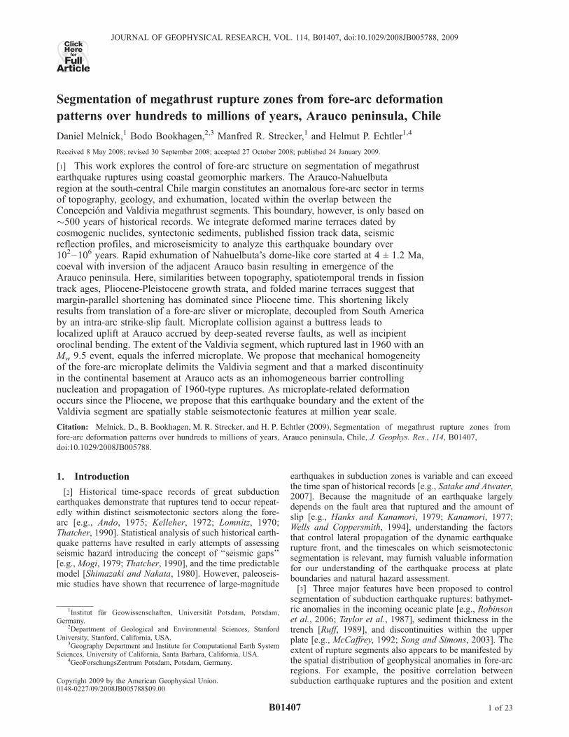
Figure 2a. Shaded topography (SRTM, NASA) merged with multibeam bathymetry from subductionProcesses Off Chile (SPOC) cruise [Reichert et al., 2002]. Historical M > 6 seismicity since 1950[Engdahl and Villasenor, 2002]; note cluster south of Nahuelbuta Range. Measurements and contours ofcoseismic land level changes from the 1960 [Plafker and Savage, 1970] and 1835 [Darwin, 1851]megathrust earthquakes.
B01407 MELNICK ET AL.: EARTHQUAKE SEGMENTATION AT ARAUCO
3 of 23
B01407
exposed along the coast of the peninsula. We use newgeomorphic, seismic, borehole, stratigraphic, structuraland geochronologic data, as well as results from variousgeophysical and geologic studies in the Arauco region[Bohm et al., 2002; Bruhn, 2003; Contreras-Reyes et al.,2008; Glodny et al., 2008a, 2008b; Haberland et al., 2006;Hackney et al., 2006; Krawczyk et al., 2006; Luth et al.,2003; Melnick et al., 2006a; Radic et al., 2005] to explorethe control of fore-arc tectonics and inherited structures onthe present-day segmentation of rupture propagation duringa subduction earthquake. This also entails an overall eval-uation of active plate boundary deformation and coastallandscape evolution on timescales spanning from 105 to106 years. Furthermore, we analyze the regional tectonicsof south-central Chile’s fore and intra-arc regions toaddress whether the boundary between the Valdivia and
Concepcion seismic segments is a transient or long-termfeature.
2. Seismotectonic, Geologic, and GeomorphicSetting
2.1. Tectonics of the South-Central Chile Margin
[6] The Chile margin is formed by subduction of theoceanic Nazca plate under the South American continent ata convergence rate of 66 mm/a, which has decreased �40%over the last 10 Ma [Kendrick et al., 2003]. The Nazca platein the Arauco region is �32 Ma old, and its age increasescontinuously northward at �1 Ma/100 km along the trench(Figure 1b) [Tebbens and Cande, 1997]. The principaloceanic features are the Chile Rise, an active spreadingcenter colliding with the margin at 46.5�S, and the Juan
Figure 2b. Simplified geological map of the Arauco-Nahuelbuta region based on Elgueta and Arcos[1994], Pineda [1986], Sernageomin [2003], and our own mapping. Offshore structures interpreted frombathymetry and SPOC and ENAP seismic reflection profiles [Melnick et al., 2006a]. Bathymetriccontours from SPOC and Servicio Hidrografico y Oceanografico de la Armada (SHOA)-Chile data.
B01407 MELNICK ET AL.: EARTHQUAKE SEGMENTATION AT ARAUCO
4 of 23
B01407
Fernandez Ridge, a hot spot seamount chain intersecting themargin at 33�S (Figure 1a). A major discontinuity of theNazca plate in south-central Chile is the Valdivia FractureZone system at �40�S (Figure 1b), which separates oceaniccrust generated at the Chile Rise to the south, from crust thatformed at the East Pacific Rise to the north [Tebbens andCande, 1997]. The Mocha Fracture Zone is subducted belowthe central part of the Arauco peninsula (Figure 1b). Multi-beam bathymetry [Reichert et al., 2002] images this Frac-ture Zone as two �5 km wide sharp and narrow ridgesassociated with several small seamounts. The bathymetricrelief associated with the Mocha Fracture Zone amounts to amaximum of 1 km. Previous work has suggested that theanomalous uplift of the Arauco peninsula is a result ofsubduction of the Mocha Fracture Zone [Boettcher, 1999;Cifuentes, 1989; Kaizuka et al., 1973; Lohrmann et al.,2006; Lomnitz, 2004]. However, this fracture zone isoblique to the Pliocene-Quaternary plate convergence vec-tor [Somoza, 1998], and thus its intersection with the marginhas migrated southward at �100 km/Ma. Hence, its positionbelow the Arauco peninsula has not been stationary. On thebasis of our integrated data from this region, we will furtheraddress the role of the Mocha fracture in the seismotectonicsof the region.[7] A dramatic increase in sediment flux into the trench
during the Pliocene caused by enhanced glacial erosion inthe Patagonian Andes led to the onset of accretionaryprocesses along the south-central Chile margin at thattime [Bangs and Cande, 1997]. Seismic profiles image1.5–2.3 km of glacially derived sediments in the trench, arelatively narrow (�30–40 km) and young (�2–3 Ma)frontal accretionary wedge, and an up to 1.5 km thicksubduction channel [Bangs and Cande, 1997; Contreras-Reyes et al., 2008]. Cenozoic fore-arc basins exist over mostof the Chile margin and are filled with more than 3 km ofsediments in the shelf region [e.g., Gonzalez, 1990]. Seis-mic reflection profiles and coastal exposures reveal thatfore-arc basins between 34 and 45�S record Miocene toearly Pliocene extension, followed by contraction since thelate Pliocene [Melnick and Echtler, 2006a]. This change inkinematics is interpreted to have been caused by the shiftfrom erosive to accretionary conditions after glacial agefilling of the Chile trench.[8] The onshore part of the margin consists of (Figures 2a
and 2b) [e.g., Melnick and Echtler, 2006b; Mpodozis andRamos, 1990] (1) the Coastal Platform, formed by upliftedCenozoic marine and coastal sequences, the focus of thisstudy; (2) the Coastal ranges, which include a segmentedPermo-Triassic accretionary complex and a late Paleozoicmagmatic arc; (3) the Central Depression, a low-relief areaformed by Oligo-Miocene sedimentary and volcanic rockscovered by Pliocene-Quaternary fluvial-alluvial sediments;and (4) the Main Cordillera, which hosts a long-lived Meso-Cenozoic magmatic arc and intra-arc volcano-sedimentarybasins.[9] The principal structural feature of the Main Cordillera
is the Liquine-Ofqui fault zone (LOFZ; Figure 1b), a dextralstrike-slip system that controls the architecture of the intra-arc region between the Chile Triple Junction at 46.2�S andthe Copahue volcano at 38�S [e.g., Herve, 1994; Lavenuand Cembrano, 1999; Rosenau et al., 2006]. The LOFZdecouples a fore-arc sliver from the rest of the continent, the
Chiloe block (Figure 1a) [Beck et al., 1993; Forsythe andNelson, 1985; Lavenu and Cembrano, 1999], which movesnorthward with respect to the stable Andean foreland to theeast (Figure 1b). Kinematic modeling of the LOFZ predictsa long-term (�6 Ma) shear rate of 32 ± 6 mm/a in asouthern domain (46–42�S), which decreases to 13 ±3 mm/a for a northern domain (42–38�S) [Rosenau et al.,2006]. This velocity gradient may have been partly accom-modated by internal deformation of the Chiloe fore-arcsliver, consistent with Pliocene-Quaternary contractionaland transpressional structures that strike oblique to themargin [Melnick and Echtler, 2006a, 2006b; Rosenau etal., 2006]. The development of these structures and theirrole in accommodating sliver motion is further documentedby shortening in the Arauco region as shown in this study.Dextral shear along the LOFZ increased at �6 Ma, asevidenced by isotopic dating of synkinematic minerals inhigh-strain mylonites [Cembrano et al., 2002] and onset ofrapid exhumation driven by transpression [Thomson, 2002];this acceleration has been interpreted as a result of theconsecutive collision of three segments of the Chile Rise inthe region between 47.5 and 46.5�S (Figure 1b). The long-term strike-slip rate of the LOFZ predicted by kinematicmodeling may have slowed down, because the presentmargin-parallel component of oblique plate convergence isonly 24 mm/a according to geodetic data [Kendrick et al.,2003] or 28 mm/a according to the NUVEL-1a global platemotion model [Demets et al., 1994]. This decrease in sliprate along the LOFZ is likely a result of the continuousdecline in overall plate convergence rate [Kendrick et al.,2003]. Global Positioning System (GPS) data shows north-ward, margin-parallel velocities that reach 6.8 mm/a in thesouthern sector of the Chiloe sliver (45–43�S), accountingfor �30% of the margin-parallel component of obliqueconvergence [Wang et al., 2007]. These regional GPS datashow margin-parallel translation of the Chiloe sliver anddextral strike-slip motion of the LOFZ. Unfortunately, noestimates of slip rates along the LOFZ on shorter timescalesof 103–105 years have been obtained so far.[10] Contemporary deformation in the central and south-
ern region of the Chiloe sliver (45–39�S) still includespostseismic relaxation following the 1960 Mw 9.5 earth-quake, in addition to interseismic strain accumulation [Klotzet al., 2001; Wang et al., 2007]. This postseismic signal isno longer visible in the northern leading edge of the Chiloesliver, which corresponds to the southern Arauco region,where GPS data document counterclockwise rotations inaddition to interseismic coupling [Moreno et al., 2008].
2.2. Cenozoic Geology of the Arauco Fore-Arc Basinand Nahuelbuta Coastal Range
[11] The Arauco Basin contains over 3 km of lateCretaceous to Holocene continental and marine sediments,and has been a major center of coal mining and hydrocarbonexploration for over a century. This depocenter includes theCampanian to Maastrichtian Quiriquina Formation, thePaleocene to Eocene synextensional Lebu Group, the lateMiocene to early Pliocene synextensional Ranquil Forma-tion, and the late Pliocene to Pleistocene syncontractionalTubul Formation [e.g., Biro, 1979; Elgueta and Arcos,1994; Encinas et al., 2008; Finger et al., 2007; Le Rouxand Elgueta, 1997; Melnick and Echtler, 2006a; Pineda,
B01407 MELNICK ET AL.: EARTHQUAKE SEGMENTATION AT ARAUCO
5 of 23
B01407
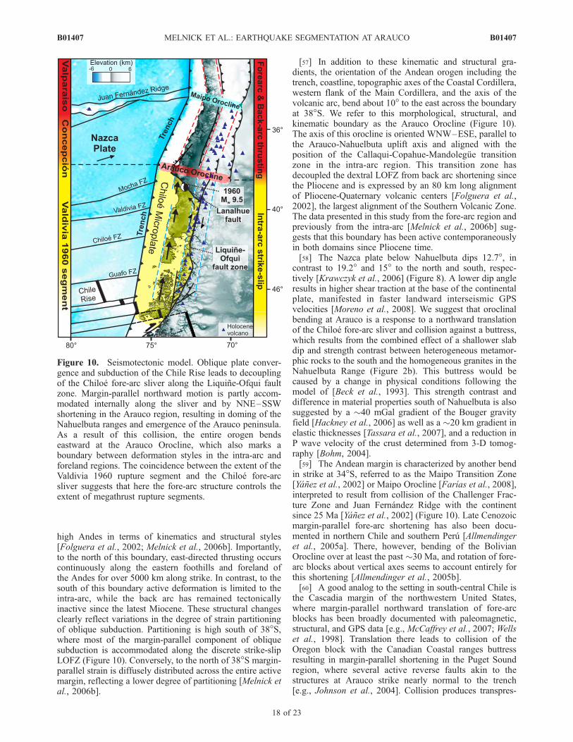
1986] (Figure 2b). During Miocene to early Pliocene time,low amounts of trench fill and high plate convergencevelocity caused subduction erosion resulting in over1.5 km of fore-arc subsidence and synextensional deposi-tion of the Ranquil Formation, comprising mainly lowerbathyal turbidites [Encinas et al., 2008; Finger et al., 2007;Melnick and Echtler, 2006a]. During the shift towardaccretionary conditions between 4.5 and 2.5 Ma, positiveinversion and uplift of fore-arc depocenters occurred in theregion between 34 and 45�S [Melnick and Echtler, 2006a].Growth strata associated with seismically active reversefaults reflect continuous and ongoing shortening and upliftcoeval with the deposition of the Tubul Formation [Melnicket al., 2006a].
[12] The Nahuelbuta Range is located immediately east ofthe Arauco peninsula and has a dome-like morphology witha maximum elevation of 1525 m. Considering the elevationsof the Coastal Cordillera, which are typically well below700 m, Nahuelbuta is an anomalous sector in term oftopography (Figures 1b and 2a). This range is formed bya Carboniferous granitic core bounded by high-temperaturecontact metasedimentary rocks referred to as the EasternSeries [Herve, 1988]. The northwest-striking Lanalhue faultrunning along the southern flank of Nahuelbuta (Figure 2b)marks the contact between the Eastern and Western Series,which consist of high-pressure and low-temperature meta-sedimentary rocks and ophiolitic components [Herve,1988]. Dating of synkinematic minerals in mylonitic shearzones of the Lanalhue fault indicate sinistral shear at�275 Ma [Glodny et al., 2008a]. Counterparts of theNahuelbuta granite crop out at 39.5�S in the Main Cordil-lera, leading these authors to correlate these outcrops andpropose �100 km of sinistral displacement along theLanalhue fault during Permian time.[13] However, the Lanalhue fault also cuts fluvial and
alluvial terraces of the Malleco Formation on the easternflank of the Coastal Cordillera (Figure 2b), whose age rangeis bracketed by several 4.4 ± 0.5 to 0.8 ± 0.3 Ma oldvolcanic deposits interbedded near the base and top, respec-tively, of the predominantly clastic sequence [Suarez andEmparan, 1997]. The The Incoming Plate to MegaThrustEarthQuake Processes (TIPTEQ)-North local seismic net-work [Haberland et al., 2006] registered several clusters ofcrustal earthquakes between 1 and 22 km depth, exactlybelow the surface expression of the Lanalhue and Morguillafaults. The latter seems to be a trenchward continuation ofthe Lanalhue fault, cutting through the southern flank of theArauco peninsula where it offsets the Pleistocene Canetesurface (Figures 2b and 3d). Focal mechanisms are consis-tent with steeply dipping fault planes as expected also fromlinear fault scarps, as observed in outcrops near the town ofCapitan Pastene, and as imaged by the TIPTEQ deepseismic reflection profile shot at 38.2�S [Groß et al.,2008]. These geophysical and geological data identifythe Lanalhue fault as a steeply NE-dipping, long-livedcrustal-scale structure with neotectonic activity manifestedby deformed Quaternary landforms and localized crustalseismicity.[14] Fission track (FT) cooling ages from the Nahuelbuta
Range and adjacent sectors of the Coastal Cordillera havebeen reported in a regional thermochronologic survey ofsouth-central Chile [Glodny et al., 2008b]. At Nahuelbuta,nine mean apatite FT ages range from 106 ± 29 to 54.6 ±4.1 Ma and seven mean zircon FT ages of paired samplesrange from 242 ± 29 to 179 ± 49 Ma (Figures 4a and 4b).Inverse modeling of track length distribution data of fourapatite FT samples from the top of the Nahuelbuta Range(samples at higher elevations in Figure 4a) indicates slowTertiary cooling at an exhumation rate of 0.03–0.04 mm/auntil 4 ± 1.2 Ma, and an increase to >0.2 mm/a since thattime [Glodny et al., 2008b]. In contrast, modeling ofsamples from the Valdivia and Concepcion regions locatedfarther south (39–40�S) and north (36–37�S) of Nahuel-buta, respectively, do not show this increase in coolingduring the early Pliocene, but exhibit a rather slow contin-uous cooling trend corresponding to an exhumation rate of
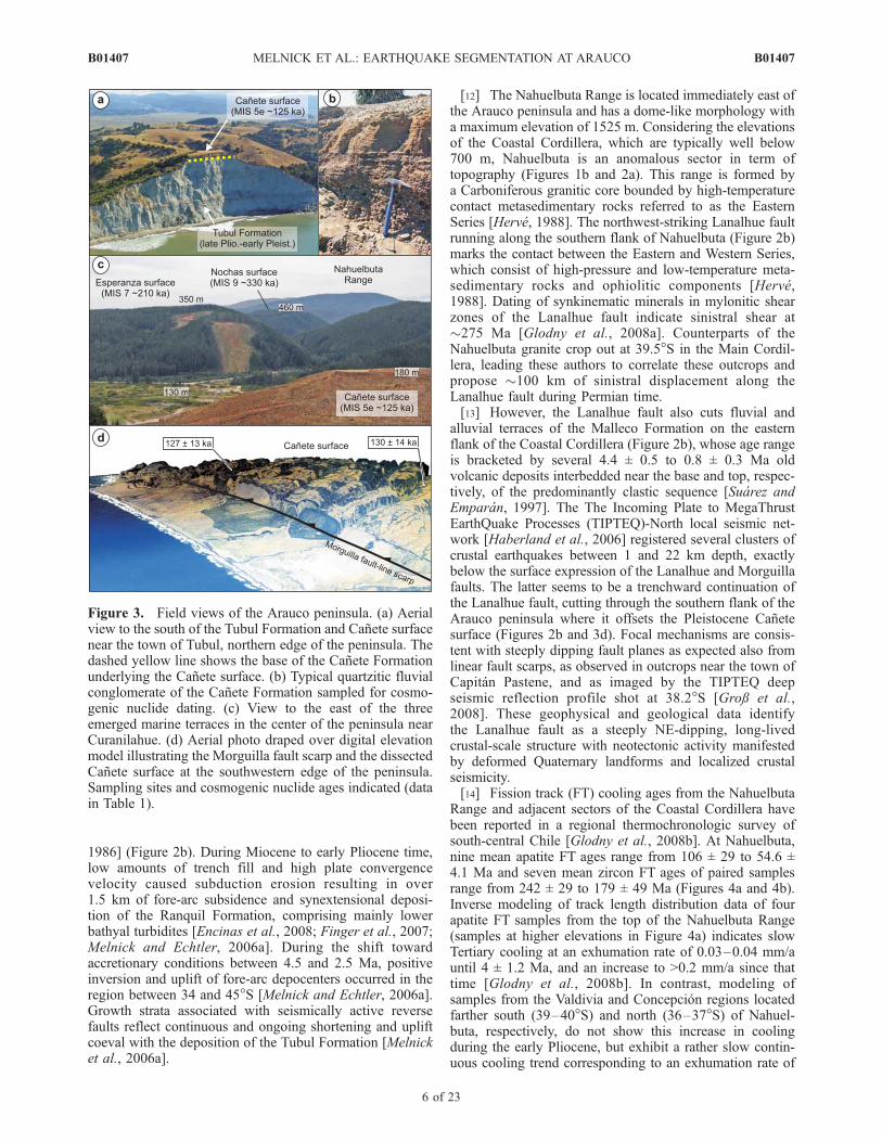
Figure 3. Field views of the Arauco peninsula. (a) Aerialview to the south of the Tubul Formation and Canete surfacenear the town of Tubul, northern edge of the peninsula. Thedashed yellow line shows the base of the Canete Formationunderlying the Canete surface. (b) Typical quartzitic fluvialconglomerate of the Canete Formation sampled for cosmo-genic nuclide dating. (c) View to the east of the threeemerged marine terraces in the center of the peninsula nearCuranilahue. (d) Aerial photo draped over digital elevationmodel illustrating the Morguilla fault scarp and the dissectedCanete surface at the southwestern edge of the peninsula.Sampling sites and cosmogenic nuclide ages indicated (datain Table 1).
B01407 MELNICK ET AL.: EARTHQUAKE SEGMENTATION AT ARAUCO
6 of 23
B01407

0.03–0.04 mm/a over the past �100 Ma. This latter rate canbe considered as the long-term regional background exhu-mation rate along the Coastal Cordillera of south-centralChile, except for Nahuelbuta.
2.3. Quaternary Geomorphic Setting of theArauco-Nahuelbuta Region
[15] Only a few previous studies have focused on thetectonic geomorphology of this region and addressed therelation between late Quaternary and historic fore-arc de-formation. The pioneer work of Kaizuka et al. [1973]described three sequences of uplifted marine terraces atArauco including the well preserved Canete surface corre-lated with marine oxygen isotope stage (MIS) 5e thatreaches 232 m and which has been inferred to correlatewith MIS 5e, as well as two higher surfaces, Esperanzaand Nochas, which reach 360 and 471 m, respectively(Figures 3c and 4b). These three surfaces are abrasionplatforms covered by a veneer of shallow marine, fluvial,and eolian sediments. The marine surfaces are foldedaround a northwest-trending anticline in the center of the
peninsula (Figures 4a, 4b, and 6c). Our analysis of terrestrialcosmogenic nuclides corroborates a last interglacial(MIS 5e) origin for the Canete surface (Table 1; samplesites shown on Figures 3a, 3d, 4a, and 5; see sections 3and 4.3 and auxiliary material for details).1 A markedlower surface exists at the southwestern edge of Arauconear Lebu where it reaches a maximum elevation of 125 m.This surface has marine and eolian deposits comparable tothe higher surfaces, and was probably formed during oneof the interstadial stages of the last glacial period. How-ever, because of its limited extent along the coast, thisterrace is less suitable to explore margin-parallel variabilityof tectonic uplift.[16] The Nahuelbuta Range has a domal morphology
forming a major regional drainage anomaly along south-central Chile’s Coastal Cordillera [Rehak et al., 2008].Several higher, barren surfaces of inferred marine abrasionorigin exist up to about 1000 m elevation on the western
Figure 4. Markers of uplift and deformation. (a) Map of marine terraces in the Arauco region andlocation of shoreline angle measurement. Cosmogenic nuclide ages of the Canete terrace are shown.Zircon and apatite fission track (FT) ages from Glodny et al. [2008b]. (b) Topographic swath profile, areashown in Figure 4a, and elevation of shoreline angles projected to the profile. (c) FT ages projected alongthe same profile. Note the similar warping pattern between terrace shorelines, topography, and apatite FTages. In turn, zircon FT ages have a flat pattern. (d) Age-elevation plot of apatite FT ages. The inverserelation implies that more exhumation has occurred in the higher-elevation region.
1Auxiliary materials are available in the HTML. doi:10.1029/2008JB005788.
B01407 MELNICK ET AL.: EARTHQUAKE SEGMENTATION AT ARAUCO
7 of 23
B01407

flank of the Nahuelbuta Range. Several faults of unknownkinematics, but with clear morphological expression forma curved array that follows the topography along theeastern flank of the Nahuelbuta Range (Figure 2b). Someof these faults juxtapose Triassic sediments with Paleozoicintrusives and control the occurrence of several metamor-phic roof pendants, and may thus have formed prior to theCenozoic. The Puren Basin is a triangular intermontanedepression at the southern flank of Nahuelbuta, which isfilled with Plio-Quaternary sediments of the MallecoFormation. This basin is limited by two NW- and SW-dipping reverse faults that splay from the Lanalhue fault(Figure 2b). The northern fault juxtaposes Paleozoic intru-sives and Malleco sediments and has a clear morpholog-ical expression with pronounced triangular facetssuggesting a Quaternary age.[17] The Lanalhue and Lleu-Lleu lakes are located in the
southern sector of the Arauco peninsula and immediatelyfarther south of it, respectively (Figure 4a). These coastallakes are drowned fluvial valleys located in the hangingwall of the Morguilla fault. It is likely that tectonic defeatassociated with slip on the Morguilla fault and resultinguplift of its hanging wall and possibly tilting at the edge ofthe Arauco anticline resulted in the formation of both lakes.A high-resolution seismic survey combined with sedimentcoring revealed the original fluvial nature of these lakes andthe post-MIS 5e flooding and uplift history [Blumberg et al.,2007].[18] Pleistocene sedimentary units and coastal landforms
are also abundant in the neighboring regions of the AraucoPeninsula. On Isla SantaMarıa, 12 km to the north (Figure 2a),marine and eolian sediments crop out in vertical sea cliffexposures. Radiocarbon dating of paleosol horizons interbed-ded in the marine-dominated sequence, which representmarkers of paleo sea-level position, indicate deposition be-tween 53 and 27 ka, corresponding to uplift at an average rateof 1.8±0.4 mm/a [Melnick et al., 2006a]. Sequences ofuplifted Holocene beach berms are exposed in a coastalplain in the eastern part of the island. Beach berms are alsofound on the surroundings of the Arauco Gulf and on IslaMocha, �60 km south of Arauco (Figure 2a) [Kaizuka etal., 1973; Nelson and Manley, 1992]. Bookhagen et al.[2006] calculated a maximum uplift rate of 2.3 ± 0.1 mm/aover the past �3 ka for Isla Santa Marıa on the basis ofluminescence ages of beach berm crests. In their detailedstudy of uplifted strandlines at Isla Mocha, Nelson andManley [1992] reported uplift rates between 5.5 and 10 mm/a over the past �11 ka on the basis of radiocarbon dating ofmarine shells.[19] The Santa Marıa and Mocha islands as well as the
core of the Arauco peninsula are tilted eastward (Figure 6c).In a previous study, we showed that Isla Santa Marıaconsists of two asymmetrically tilted Pleistocene surfaces,which represent the forelimbs of two anticlines that con-verge at the island and are cored by reverse faults [Melnicket al., 2006a]. At Isla Mocha northeastward tilting is evidentfrom inclined marine surfaces in the central ridge of theisland, a pronounced asymmetry in the drainage system, aswell as from the two measurements of coseismic upliftmade by Plafker and Savage [1970] after the 1960 earth-quake (Figure 2a). Short-wavelength tilting at Isla Mocha isalso possibly linked to a major reverse structure, the Mocha-T
able
1.Cosm
ogenic
NuclideAges
oftheCaneteSurface
Sam
ple
Nam
eElevation
(mabovesealevel)
Sam
ple
Depth
(m)
10Be(103atoms/g)a
26Al(103atoms/g)a
26Al/10Be
10BeModel
Age(ka)
b26AlModel
Age(ka)
bMeanModel
Age(ka)
Measured
Value
Associated
Error
Measured
Value
Associated
Error
Measured
Value
Associated
Error
Measured
Value
Associated
Error
Measured
Value
Associated
Error
Measured
Value
Associated
Error
Ar08
50
1.5
133.06
3.73
858.23
61.15
6.4
0.5
126
18
133
21
130
14
Ar08
50
2.1
72.93
2.19
519.48
50.37
7.1
0.7
123
18
142
24
133
14
Ar05
61
1.8
101.40
2.99
639.31
23.35
6.3
0.3
128
18
131
19
130
13
Ar07
150
0.7
340.46
8.25
1934.15
52.15
5.7
0.2
131
19
124
18
127
13
aUncertainties
inatomicabundances(1s)only
representerrorsassociated
withtheacceleratormassspectrometry
(AMS)ratiomeasurements.Wedid
notincludethe1suncertainty
intheBecarrieraddition(�
2%)
andstable
AMSmeasurements(�
5%).Theseresultsarecorrectedforratiosmeasuredin
process
blanksas
described
inthetext.
bCalculatedbyusingcorrectedproductionratesscaled
tosite-specificaltitudes
[Lal,1991]anddepth
shieldingbased
onspallation,fastmuons,andnegativemuoncapture[G
ranger
andMuzikar,2001;Granger
and
Smith,2000].Weusedadensity
of1.8
g/cm
3andattenuationlength
of160g/cm
2.Uncertainties
indepth-shielded
ages
arefullypropagated
from
AMSuncertainties
anddoincludea10%
1suncertainty
innuclide
productionratesincludingscalingfactorsforaltitudeandlatitude,as
wellas
10%
1suncertainties
indensity,attenuationcoefficients,andhalf-lives.Nouncertainties
arepropagated
forthedepth
shieldingbecause
no
uncertainties
areprovided
forcoefficientbyGranger
andSmith[2000].
B01407 MELNICK ET AL.: EARTHQUAKE SEGMENTATION AT ARAUCO
8 of 23
B01407

Villarica fault zone [Melnick and Echtler, 2006b], whichcuts through the entire margin from the trench to the MainCordillera (Figure 2b).
2.4. Historic Subduction Earthquakes in theArauco Region
[20] Historical records of great earthquakes in Chile of theultimate �500 years reveal that the Arauco peninsula islocated in the transition between the Valdivia and Concep-cion seismotectonic segments (Figure 1b) [Kaizuka et al.,1973; Lomnitz, 2004]. The Valdivia segment ruptured lastduring the 1960 Mw 9.5 earthquake, while the last greatevent that nucleated in the Concepcion segment occurred in1835 with an estimated magnitude of 8.5 [Lomnitz, 2004]. Itappears from the spatiotemporal trends of ruptures in thesetwo segments that great earthquakes occur in pairs, probablytriggered by stress transfer mechanisms that load the neigh-boring sector [e.g., Freed, 2005]. However, this does notseem to be the case for the transition between the Con-cepcion and Valparaiso segments farther north, whichappear to have a rather diffuse boundary both in spaceand time (Figure 1b).[21] The 1960 earthquake sequence started with four
foreshocks reaching up to Mw 8.2, followed a day after bythe Mw 9.5 main shock and a major Mw 7.9 aftershock[Cifuentes, 1989; Engdahl and Villasenor, 2002; Kanamori,
1977]. All these large-magnitude events occurred on 21 and22 May and nucleated along a discrete, NW–SE elongatedregion between 38.8� and 38.2�S, at approximate depths of35–50 km (Figure 2a). This elongated region, whose shapeis independent of relative relocation uncertainties, is parallelto the Lanalhue fault and remained the locus of sustainedseismic activity with earthquakes up to Mw 7.9 until the mid1970s [Engdahl and Villasenor, 2002]. Coseismic upliftcaused by the 1960 events of 1.5 m was registered imme-diately after at Lebu [Alvarez, 1963]; at the same localityPlafker and Savage [1970] measured 1.3 ± 0.2 m in 1968(Figure 2a). No clear evidence of coastal land level changeswas found north of Lebu suggesting that rupture did notpropagate beyond the Arauco peninsula. This assessment isalso supported by repeated leveling of a line running alongthe inland region that recorded no more than 11 cm of upliftbetween the pre- and postearthquake surveys [Plafker andSavage, 1970]. Uplift of 1.7 m was measured immediatelyafter the earthquake at Isla Mocha [Seivers, 1963] and laterof 1.8 ± 0.2 and 1.0 ± 0.4 m at the western and eastern coast,respectively, by Plafker and Savage [1970] in 1968, sug-gesting some landward tilting. Immediately east of Mochauplift was only 0.9 ± 0.2 and 0.2 ± 0.4 m (Figure 2a). Southof 38.5�S, 1960 land level changes along the coastline weredominated by subsidence, which reached 2.7 m near the cityof Valdivia at 40�S [Plafker and Savage, 1970].
Figure 5. Cosmogenic nuclide composite depth profiles and age models for (top) 10Be and (bottom)26Al. Curves for 100, 120, and 140 ka model ages are shown. See text for methods and details. Samplinglocations are shown in Figure 4a. The composite profile includes four samples collected at three sites.
B01407 MELNICK ET AL.: EARTHQUAKE SEGMENTATION AT ARAUCO
9 of 23
B01407
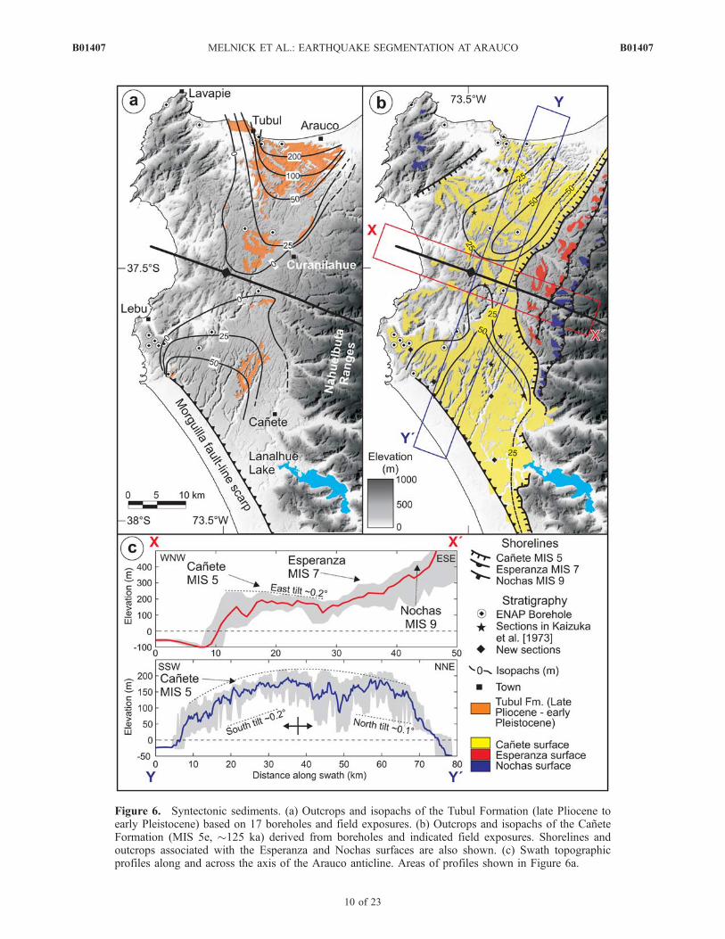
Figure 6. Syntectonic sediments. (a) Outcrops and isopachs of the Tubul Formation (late Pliocene toearly Pleistocene) based on 17 boreholes and field exposures. (b) Outcrops and isopachs of the CaneteFormation (MIS 5e, �125 ka) derived from boreholes and indicated field exposures. Shorelines andoutcrops associated with the Esperanza and Nochas surfaces are also shown. (c) Swath topographicprofiles along and across the axis of the Arauco anticline. Areas of profiles shown in Figure 6a.
B01407 MELNICK ET AL.: EARTHQUAKE SEGMENTATION AT ARAUCO
10 of 23
B01407

[22] Coseismic uplift during the 1835 earthquake wasmeasured by Darwin and FitzRoy in the Arauco Bay areaand at Isla Mocha about two to four weeks after the event[Darwin, 1851]. Maximum uplift of 3.0 m occurred at IslaSanta Marıa, 2.4 m at Isla Quiriquina in the Bay ofConcepcion, 1.8 m at Tubul and 1.5 m at the harbor ofTalcahuano, whereas Isla Mocha rose only by 0.6 m(Figure 2a).[23] Isobases of coseismic uplift from the 1960 and 1835
earthquakes seem to converge at the Arauco peninsula(Figure 2a), similar to rupture zones of previous earthquakesin south-central Chile (Figure 1a) [Lomnitz, 1970, 2004].These events led Lomnitz [1970] to define the Valdiviaand Concepcion seismic segments and subsequently ledKaizuka et al. [1973] to propose that emergence of theArauco peninsula occurred by accumulated coseismic upliftduring both Valdivia- and Concepcion-type earthquakes.This would imply that at least some permanent deformationin this region, where two distinct rupture segments overlap,is accumulated during the coseismic phase of the seismiccycle. We further explore this hypothesis by examining thespatial distribution of Neogene sediments exposed atArauco and patterns of deformed Quaternary marine terra-ces, and by comparing them with coseismic uplift patternsfrom the 1835 and 1960 earthquakes.
3. Methods
[24] Our study of seismotectonic processes is basedprimarily on geological, geomorphic, and structural fieldmapping. We used air photos at scales of 1:20,000 to1:125,000 and digital elevation models derived from shuttleradar topography mission (SRTM) data [Farr et al., 2007],digitized topographic maps at 1:50,000 scale, and ASTERsatellite imagery. Offshore industry seismic reflection pro-files (Figure 2b) made available by Empresa Nacional delPetroleo (ENAP, Chile’s state oil company) were integratedwith onshore structural and sedimentological observations[e.g., Melnick and Echtler, 2006a; Radic et al., 2005].Isopach maps of late Pliocene and Pleistocene unitswere generated from 17 ENAP exploration boreholes (seeauxiliary material, Table S1) [Elgueta and Arcos, 1994]; inaddition to seven exposed stratigraphic sections originallysurveyed by Kaizuka et al. [1973] and revisited during ourstudy, as well as seven new stratigraphic sections surveyedin the present study. Interpolated isopach contours werederived using the subsurface data in addition to the distri-bution of outcrops at the surface and their dip angles(Figures 6a and 6b).[25] We measured the elevation of three uplifted Pleisto-
cene marine terraces to understand deformation patterns and
to calculate surface uplift rates in the Arauco region(Figures 3c, 4a, and 4b). Worldwide, the best morpholog-ically expressed marine terrace dates from the last intergla-cial sea level highstand (MIS 5e) [e.g., Hearty and Kindler,1995; Johnson and Libbey, 1997]. The age of MIS 5e isarbitrarily fixed to range from 130 to 116 ka [Kukla et al.,2002], but may extend between 134 and 113 ka [Muhs etal., 2002], with a peak from 128 to 116 ka on tectonicallystable regions, where it is found at elevations of 2–8 m[Muhs, 2002]. Other well-represented interglacial terracesworldwide are from MIS 7 and 9, with age ranges of 200–220 and 320–340 ka, respectively (Table 2) [e.g., Chappelland Shackleton, 1986;Marquardt et al., 2004; Shackleton etal., 1990; Shackleton and Opdyke, 1973].[26] Marine terraces can be used as markers of paleo sea-
levels. The elevation of the shoreline angle, the base of thepaleo sea cliff, is considered most representative of relativeeustatic sea level highstands correlated with odd-numberedMIS [e.g., Keller and Pinter, 2002; Lajoie, 1986]. Shorelineangles of the three preserved terraces in the Arauco regionwere measured at 93 locations (Figure 4a). On the terracesof the Arauco peninsula, it is assumed that the present-dayelevation of the mantled material closely approximatesformer mean sea level elevation. However, in some casesthis assumption incorporates an additional uncertainty, be-cause younger eolian or colluvial material may cover thesurface. However, we could discard this possibility at manylocalities where the abrasion surface was still visible.Despite this, a conservative error of 5, 10, and 15 m isassumed in our elevation measurements for the three terra-ces assigned to MIS 5e, 7, and 9, respectively (see belowand Table 2). We thus incorporate these uncertainties in ourelevation estimates of shoreline angles and derived upliftrates.[27] The marine terraces at Arauco are cut into various
types of bedrock (Figure 2b) and generally consist ofshallow marine sediments overlain by a veneer of fluvialconglomerates (up to 3 m thick) and locally by eolian sands.The best developed and widest terrace in the Arauco regionis the Canete surface, which was identified and correlatedwith MIS 5e by Kaizuka et al. [1973] on the basis of itswidth, lateral continuity, and degree of preservation ofstratigraphic features. In 2004, we sampled quartz pebblesfrom fluvial conglomerates overlying marine deposits of theCanete Formation, and underlying the abandoned Canetesurface (Figure 3b) for exposure dating using 10Be and26Al in situ produced cosmogenic nuclides (Table 1, seeauxiliary material for a detailed explanation of the datingmethods). These ages define terrace abandonment as fluvialincision occurred because of base level lowering, likelycaused by the sudden drop in sea level at the end of an
Table 2. Pleistocene Deformation Rates Derived From Marine Terrace Data
TerraceName MIS
Age(ka)
Error(ka)
Sea LevelElevationa
(m)
Sea LevelElevationError (m)
Shoreline AngleErrorb (m)
Maximum UpliftRate (mm/a)
Maximum Uplift RateError (mm/a)
ShorteningRate (mm/a)
Shortening RateError (mm/a)
Canete 5e 125 10 5 3 5 1.8 0.2 5.59 0.17Esperanza 7 210 10 �3 4 10 1.7 0.2 6.17 0.3Nochas 9 330 10 4 4 15 1.4 0.2 6.23 0.25
aSea level elevation at the respective marine oxygen isotope stage.bEstimated error in measurements of shoreline angle elevations of each terrace.
B01407 MELNICK ET AL.: EARTHQUAKE SEGMENTATION AT ARAUCO
11 of 23
B01407

interglacial or interstadial period combined with tectonicuplift [e.g., Chappell and Shackleton, 1986]. We restrictedour sample locations to pristine, in situ terrace surfaces, anassessment that is further corroborated by the lack of ofbioturbation within the underlying gravels and that originaldepositional imbrication is still intact. We were not able tocollect surface samples as the surfaces did not contain anyquartz pebbles. However, we were able to collect foursubsurface samples at three sites that approximate the ageof the Canete terrace very well. We found the best samplingsites to be vertical road cuts that we enlarged and whereboth the marine and fluvial units were exposed. In somecases the underlying bedrock was exposed as well. Arepresentative outcrop of the fluvial gravels sampled forcosmogenic dating can be found on Figure 3b.[28] Our limited, but precise ages from the Canete surface
corroborate the inference of Kaizuka et al. [1973] that thissurface was formed during the last interglacial. Followingthe same principles of Kaizuka et al. [1973], we tentativelyassign the two upper surfaces (Esperanza and Nochassurfaces) to MIS 7 and 9, respectively. Similar geomorphiccharacteristics identify these surfaces as abrasion platformsthat were sculpted during two separated, protracted sea levelhighstands that preceded the last interglacial highstand. Asshown in section 4.3.1, uplift and shortening rates obtainedwith these assumptions agree very well within uncertaintieswith rates calculated from the isotopically dated Canetesurface.
4. Results: Deformation, Uplift, and Exhumationof the Nahuelbuta Range and Arauco Peninsula
[29] In order to characterize the Pliocene to recent tec-tonic history and its relation to the structural style of theArauco-Nahuelbuta region, to quantify surface uplift rates,and to explore their along-strike variability and relation toactive faults, we have studied deformation markers in thecoastal realm at various timescales. We describe thesedeformation markers chronologically: Early Pliocene exhu-mation patterns based on fission track ages, late Plioceneand Pleistocene growth strata, regionally deformed Pleisto-cene marine terraces, and clusters of crustal seismicity andtheir relation to active faults mapped from seismic reflectionprofiles and field observations.
4.1. Thermochronology of the Nahuelbuta Range
[30] Fission track (FT) cooling ages from the NahuelbutaRange have been reported by Glodny et al. [2008b]. In orderto explore the spatial patterns of these ages in terms of thelocal structures, we projected their positions along a profilenormal to the neotectonic warping axis of the NahuelbutaRange and the Arauco peninsula and plotted them togetherwith a topographic swath profile of a 50 � 150 km region(Figure 4c). The zircon FT ages display a rather flat patternalong the entire profile with no relation to the topography.Conversely, the apatite FT data describe a curved patternthat follows the domal topography of the Nahuelbuta Rangeand the Arauco peninsula anticline. In an age-elevation plot(Figure 4d), the apatite FT data continuously decrease inage with increasing elevations, which is opposite to thatobserved in most actively uplifting mountain ranges of theworld [e.g., Fitzgerald et al., 1993]. This indicates that
higher magnitudes of exhumation have been taking place inthe more elevated parts of the range.[31] At Nahuelbuta, the positive correlation between
exhumation and topography, the inverse apatite FT age-elevation relation, and the early Pliocene increase in cool-ing/exhumation rate indicates that this sector of the CoastalCordillera has been anomalous in terms of exhumation andprobably rock uplift rate since early Pliocene time.
4.2. Deformation and Sedimentary Patterns of theTubul Formation
[32] The Tubul Formation consists of sandstone andminor siltstone deposited in a shallow water, nearshoreshelf environment during late Pliocene to early Pleistocenetime [Nielsen and Valdovinos, 2008]. Deposits of the TubulFormation overlie the earlier units with a marked angularunconformity [e.g., Biro, 1979; Bruggen, 1950; Pineda,1986]. The Canete Formation at the Arauco peninsula restsunconformably on the upper section of this unit (see below).[33] Outcrops of the Tubul Formation are restricted to the
northern and southern sectors of the Arauco peninsula onthe flanks of Cretaceous to Eocene strata (Figure 2b). Thethickness of the Tubul Formation increases away fromthe center of the peninsula; both toward the north andsouth, as constrained by 15 boreholes and the overalldistribution of outcrops (Figure 6a). In the northern sector,near the town of Tubul, the lowermost exposures on verticalsea cliffs (analogous to Figure 3a) strike east-west and dip�4 to 6� north; the dip decreases gradually up sequence tosubhorizontal near its top, which in this region is covered bythe subhorizontal marine and fluvial sediments of theCanete Formation (Figure 3a). These field geometries areconsistent with the seismically imaged syncontractionalgrowth strata in the Arauco Bay, immediately to the north(Figure 2b) [Melnick et al., 2006a], and the southward-thinning wedge geometry along the northern flank of thepeninsula. The situation is similar in the southern sector ofthe peninsula, but there the lowermost exposed levels dipand increase in thickness to the south (Figure 6a). Growthstrata of the Tubul Formation in sea-cliff exposures farthersouth in the Coi-Coi region at 38.5�S are also compatiblewith syncontractional deformation [seeMelnick and Echtler,2006a, Figure 3].[34] Reflection seismic profile ENAP 28 is oriented
north-south and located immediately south of the peninsula(Figure 7, profile location shown in Figure 2b). The ENAPexploration borehole ‘‘D,’’ situated above profile 28 farthersouth, encountered the continental basement below 624 mof Tubul sediments. This unconformity is clearly imaged inmany seismic lines of the fore-arc basins in south-centralChile [Gonzalez, 1990; Melnick and Echtler, 2006a]. Profile28 images two northwest striking, high-angle reverse faultsresponsible for the syncontractional deposition of the TubulFormation. Both faults are blind and propagate anticlines.This profile images a lower unit characterized by low-amplitude, discontinuous and parallel reflectors, and anupper unit formed by higher-amplitude, continuous reflec-tors. Reflectors in the upper unit decrease in dip upsequence and exhibit internal onlapping and changes inthickness. Both units are deformed by an anticline, which ispropagated by a blind reverse fault that only cuts and offsetsthe lower unit. An asymmetric hinge graben is imaged
B01407 MELNICK ET AL.: EARTHQUAKE SEGMENTATION AT ARAUCO
12 of 23
B01407
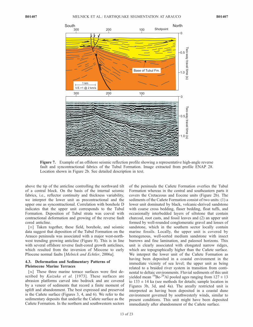
above the tip of the anticline controlling the northward tiltof a central block. On the basis of the internal seismicfabrics, i.e., reflector continuity and thickness variability,we interpret the lower unit as precontractional and theupper one as syncontractional. Correlation with borehole Dindicates that the upper unit corresponds to the TubulFormation. Deposition of Tubul strata was coeval withcontractional deformation and growing of the reverse faultcored anticline.[35] Taken together, these field, borehole, and seismic
data suggest that deposition of the Tubul Formation on theArauco peninsula was associated with a major west-north-west trending growing anticline (Figure 8). This is in linewith several offshore reverse fault-cored growth anticlines,which resulted from the inversion of Miocene to earlyPliocene normal faults [Melnick and Echtler, 2006a].
4.3. Deformation and Sedimentary Patterns ofPleistocene Marine Terraces
[36] These three marine terrace surfaces were first de-scribed by Kaizuka et al. [1973]. These surfaces areabrasion platforms carved into bedrock and are coveredby a veneer of sediments that record a finite moment ofuplift and abandonment. The best expressed and preservedis the Canete surface (Figures 3, 4, and 6). We refer to thesedimentary deposits that underlie the Canete surface as theCanete Formation. In the northern and southwestern sectors
of the peninsula the Canete Formation overlies the TubulFormation whereas in the central and southeastern parts itcovers the Cretaceous and Eocene units (Figure 2b). Thesediments of the Canete Formation consist of two units: (1) alower unit dominated by black, volcanic-derived sandstonewith coarse cross bedding, flaser bedding, float tuffs, andoccasionally interbedded layers of siltstone that containcharcoal, root casts, and fossil leaves and (2) an upper unitformed by well-rounded conglomeratic gravel and lenses ofsandstone, which in the southern sector locally containmarine fossils. Locally, the upper unit is covered byhomogenous, well-sorted medium sandstone with insectburrows and fine lamination, and paleosol horizons. Thisunit is clearly associated with elongated narrow ridges,which are topographically higher than the Canete surface.We interpret the lower unit of the Canete Formation ashaving been deposited in a coastal environment in theimmediate vicinity of sea level; the upper unit as beingrelated to a braided river system in transition from conti-nental to deltaic environments. Fluvial sediments of this unityielded mean 10Be-26Al pooled ages ranging from 127 ± 13to 133 ± 14 ka (see methods for details; sample location inFigures 3b, 3d, and 4a). The areally restricted unit isinterpreted as having been deposited in a coastal duneenvironment governed by southwesterly winds, similar topresent conditions. This unit might have been depositedimmediately after abandonment of the Canete surface.
Figure 7. Example of an offshore seismic reflection profile showing a representative high-angle reversefault and syncontractional fabrics of the Tubul Formation. Image extracted from profile ENAP 28.Location shown in Figure 2b. See detailed description in text.
B01407 MELNICK ET AL.: EARTHQUAKE SEGMENTATION AT ARAUCO
13 of 23
B01407

[37] The thickness of the Canete Formation underlyingthe Canete surface increases from a minimum of 20 min the center of the peninsula to a maximum of at least50 m in the southern and northern sectors (Figure 6b).Similarly, the elevation of the shoreline angle of theCanete surface increases toward the center of the penin-sula, where it reaches a maximum of 231 m (Figure 4b).These opposed variations in thickness and shorelineelevation are consistent with deposition contemporaneouswith growth of an anticline, whose axis is oriented west-northwest to east-southeast.[38] The Esperanza and Nochas surfaces are exposed in
the central part of the peninsula and the western flank ofNahuelbuta (Figure 4b). They are less well preserved thanthe Canete surface, but still contain marine and fluvial
deposits with clear treads and paleocliffs (Figures 3cand 6c). The position of their shoreline angle reachesmaximum elevations of 360 and 471 m, respectively,mimicking the pattern of the Canete surface in the centerof the peninsula. Because of a regular elevation spacingbetween these three surfaces and similar distribution oftheir shoreline angles (Figure 4b), we infer that theEsperanza and Nochas surfaces were formed associatedwith sea level highstands at MIS 7 and 9, which precededthe last interglacial highstand responsible for the formationof the Canete surface. Although correlating MIS 7 and 9to the two upper surfaces is tenuous, the age-elevationrelationships in conjunction with the isotopically datedCanete surface yields very similar uplift and shorteningrates (see subsections below and Table 2).
Figure 8. Profile of surface and crustal structure along the Arauco peninsula. Surface profile withmaximum topography along swath shown by shaded rectangle in the center of the map. Fault dips areonly apparent because of vertical exaggeration. Seismicity and focal mechanisms of the ISSA [Bohm,2004; Bohm et al., 2002; Bruhn, 2003] and TIPTEQ [Haberland et al., 2006] local networks. Depth ofthe Tubul and Canete formations from ENAP boreholes and exposed sections in the field (see Figure 6).Contours in the blue region labeled Nazca plate represent the top of the slab projected from 10 kmspaced, parallel lines in the area of the map (2 km contours also shown in the map). Slab geometry fromTassara et al. [2006]. Shallow structures from the northern sector integrated from seismic reflectionprofiles described by Melnick et al. [2006a]; southern sector from profile ENAP 28 (Figure 7). Gray focalmechanism from U.S. Geological Survey National Earthquake Information Center catalog (21 May 1990,Mw 6.3, 5 km depth).
B01407 MELNICK ET AL.: EARTHQUAKE SEGMENTATION AT ARAUCO
14 of 23
B01407
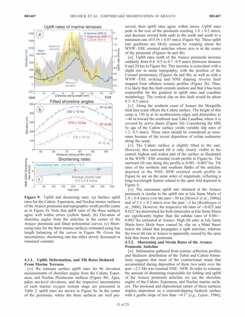
4.3.1. Uplift, Deformation, and Tilt Rates DeducedFrom Marine Terraces[39] We estimate surface uplift rates for 96 elevation
measurements of shoreline angles from the Canete, Esper-anza, and Nochas Pleistocene surfaces (Figure 4b). Ages,paleo sea-level elevations, and the respective uncertaintiesof each marine oxygen isotope stage are presented inTable 2; uplift rates are shown in Figure 9a. In the centerof the peninsula, where the three surfaces are well pre-
served, their uplift rates agree within errors. Uplift ratespeak in the core of the peninsula reaching 1.8 ± 0.2 mm/a,and decrease toward both ends in the north and south to aminimum rate of 0.36 ± 0.07 mm/a (Figure 9a). These upliftrate gradients are likely caused by warping about theWNW–ESE oriented anticline whose axis is in the centerof the peninsula (Figures 4a and 4b).[40] Uplift rates north of the Arauco peninsula increase
suddenly from 0.4–0.5 to 0.7–0.9 mm/a (between distance0 and 20 km in Figure 9a). This increase is coincident with aslight rise in mean topography, with the position of theCoronel promontory (Figures 4a and 4b), as well as with aWNW–ESE striking and NNE dipping reverse faultmapped from offshore seismic profiles (Figure 2b). Thus,it is likely that this fault extends onshore and that it has beenresponsible for the gradient in uplift rates and coastlinemorphology. The vertical slip on this fault would be about0.3–0.5 mm/a.[41] Along the southern coast of Arauco the Morguilla
fault line scarp offsets the Canete surface. The height of thisscarp is 150 m at its northwestern edges and diminishes to�40 m toward the southeast near Lake Lanalhue where it iscovered by active dunes (Figure 3d). Considering the MIS5e age of the Canete surface yields variable slip rates of1.2–0.3 mm/a. These rates should be considered as mini-mum because of the recent deposition of eolian sedimentsalong the scarp.[42] The Canete surface is slightly tilted to the east.
However, this eastward tilt is only clearly visible in thecentral, highest and widest part of the surface as illustratedin the WNW–ESE oriented swath profile in Figure 6c. Theeastward tilt rate along this profile is 0.001–0.002�/ka. Tiltrates of the northern and southern flanks of the anticlinedepicted in the NNE–SSW oriented swath profile inFigure 6c are on the same order of magnitude, reflecting along-wavelength feature related to the open fold depicted inFigure 8.[43] The maximum uplift rate obtained at the Arauco
peninsula is similar to the uplift rate at Isla Santa Marıa of1.8 ± 0.4 mm/a over the past �50 ka [Melnick et al., 2006a]and of 2.3 ± 0.2 mm/a over the past �3 ka [Bookhagen etal., 2006]. However, the respective tilt rates of �0.025 and0.022�/ka determined for both timescales at Isla Santa Marıaare significantly higher than the subdue rates of 0.001–0.002�/ka estimated at Arauco. High tilt rates at Isla SantaMarıa have likely been caused by slip on a blind thrustbelow the island that propagates a tight anticline, whereasthe lower tilt rate at Arauco is apparently caused by the openfold that forms the peninsula.4.3.2. Shortening and Strain Rates of the AraucoPeninsula Anticline[44] Information gathered from seismic reflection profiles
and thickness distribution of the Tubul and Canete forma-tions suggests that most of the contractional strain thataccumulated during deposition of these two units over thepast �2.5 Ma was oriented NNE–SSW. In order to estimatethe amount of shortening responsible for folding and upliftof the Arauco peninsula anticline we use the shorelineangles of the Canete, Esperanza, and Nochas marine surfa-ces. The erosional and depositional nature of these surfacesimplies deposition on a seaward-dipping bedrock surfacewith a gentle slope of less than �0.1� [e.g., Lajoie, 1986],
Figure 9. Uplift and shortening rates. (a) Surface upliftrates for the Canete, Esperanza, and Nochas terrace surfacesof the Arauco peninsula and topographic swath profile (sameas in Figure 4). Note that uplift rates of the three surfacesagree well within errors (yellow band). (b) Elevation ofshoreline angles from the anticline in the center of theArauco peninsula and fitted polynomial curves. (c) Short-ening rates for the three marine surfaces estimated using linelength balancing of the curves in Figure 9b. Given theuncertainties, shortening rate has either slowly decreased orremained constant.
B01407 MELNICK ET AL.: EARTHQUAKE SEGMENTATION AT ARAUCO
15 of 23
B01407

which can be considered subhorizontal along strike toestimate shortening rates. We use the line length balancingtechnique to estimate shortening magnitudes and rates [e.g.,Ramsay and Huber, 1987]. Plane strain is assumed, whichmay not be fully the case given that the Canete surface isslightly tilted to the east (Figure 6c) and that plate conver-gence is oblique to our cross section (see discussion). In anycase, our surface and borehole data suggest that the majorityof the syntectonic growth of the Tubul and Canete forma-tions was a result of NNE–SSW oriented shortening over atthe past �2.5 Ma (Figures 6a and 8).[45] In order to estimate line length changes, we fitted
polynomial functions to the shoreline angle elevation mea-surements of each marine surface and projected them alonga NNE–SSW profile (Figure 9b). The interpolated along-strike lengths of the folded shorelines were then comparedto the horizontal distances to calculate amounts of finiteshortening. Shortening was estimated only for the major,60 km wide fold in the center of the peninsula, where theterraces are best expressed, and which is aligned with thetopographic axis of the adjacent Nahuelbuta Range and areaof enhanced exhumation. Shortening magnitudes and ratesare shown in Table 2 for each surface. Shortening rates forthe Canete, Esperanza, and Nochas terraces are 5.6 ± 0.2,6.2 ± 0.3, and 6.2 ± 0.2 mm/a, at a strain rate of �2.9, �3.1,and �3.2 � 10�16 s�1, respectively. Average shortening is6.0 ± 0.4 mm/a; rates decrease linearly within uncertaintiesat an average of 0.3 mm/a/105 a (Figure 9c).
4.4. Active Crustal Faults From Shallow Seismicityand Seismic Reflection Profiles
[46] The temporary Integrated Seismological Experimentin the Southern Andes (ISSA) and TIPTEQ amphibiouslocal seismic networks deployed 62 and 70 broadband landseismic stations and several OBS/OBH in the Arauco regionduring 2000 and 2004–2005, respectively [Bohm, 2004;Bohm et al., 2002; Bruhn, 2003; Haberland et al., 2006].These data demonstrate that most of the seismicity in theupper plate is concentrated in the fore-arc region below theshelf and coast. Shallow earthquakes (�M 5) cluster in tworegions surrounding the Arauco peninsula (Figure 8). In aprevious study, we have shown that the northern clusteradjacent to Isla Santa Marıa is related to a steep northeast-striking reverse fault, which is apparently rooted in the plateinterface [Melnick et al., 2006a]. The southern cluster islocated below the steep, up to 150 m high northwest-striking Morguilla fault scarp (Figures 3d and 8). Analogousto the region surrounding Isla Santa Marıa, earthquakesassociated with the Morguilla fault form a cluster with acontinuous alignment in cross section from a depth of 5 kmuntil the plate interface, which below this region is at about27 km depth (Figure 8). Shallow focal mechanisms arecompatible with a northwest-striking, northeast-dippingreverse fault with minor strike-slip components [Bruhn,2003; Haberland et al., 2006].[47] Similar to the Isla Santa Marıa and Arauco Bay
areas, seismic reflection data immediately south of theMorguilla fault image steep reverse faults that control thesyncontractional deposition of the late Pliocene to Quater-nary units (Figures 2b and 7). We thus consider it likely thatthe Morguilla scarp is the surface expression of a deep-reaching, northwest-striking reverse fault that dips steeply
to the northeast. However, this scarp might have beenmodified by recent coastal erosion and eolian deposition.
5. Discussion
5.1. Deformation, Surface Uplift, and Exhumation ofthe Nahuelbuta Range and Arauco Peninsula
[48] Our integrated stratigraphic and structural data fromthe Arauco region suggests that margin-parallel, continuousshortening starting in the early Pliocene has led to theemergence of the continental shelf and topographic devel-opment of the Nahuelbuta Range and Arauco peninsula.Apatite fission track data shows that exhumation in thecentral part of Nahuelbuta records an order of magnitudeincrease at a central age of 4 Ma, from 0.03 mm/a to greaterthan 0.2 mm/a [Glodny et al., 2008b]. Despite modelinguncertainties of 30%, this age agrees well with relatedtectonic events with independent age constraints, such asthe onset of inversion of the extensional Arauco fore-arcbasin [Melnick and Echtler, 2006a] and collision of theChile Rise [Cande and Leslie, 1986]. The collision of theChile Rise has led in turn to accelerated exhumation andstrike-slip motion of the Liquine-Ofqui fault zone (seebelow). The correlation between the dome-like morphologyof the Nahuelbuta Range and the warped distribution offission track ages with higher amounts of exhumation in thecentral, higher-elevation parts of the range (Figure 4),suggests that tectonic growth by asymmetric doming hascontrolled local exhumation in an area of �1200 km2. Incontrast, adjacent sectors of the Coastal Cordillera nearConcepcion (36.5�S) and Valdivia (40�S) have remainedrelatively stable and have been exhuming at a low steadyrate of 0.03–0.04 mm/a since Triassic time [Glodny et al.,2008b].[49] The thickness of the late Pliocene to early Pleisto-
cene Tubul and of the �125 ka old Canete formationsincreases away from the WNW–ESE oriented main warp-ing axis toward the edges of the peninsula (Figures 6, 7,and 8). The three marine terrace surfaces along thewestern, coastal flank of Nahuelbuta and along the Araucopeninsula have been folding about this same axis at ashortening rate of �6 mm/a over the past �330 ka,resulting in coeval uplift at a variable rate between 0.3and 1.8 mm/a across the strike of the anticline (Figure 9).We interpret these changes in thicknesses to reflect depo-sition coeval to growth of the Arauco anticline accommo-dating margin-parallel shortening.[50] Marine seismic reflection profiles off the northern
and southern edges of the Arauco peninsula image blindhigh-angle reverse faults at the core of fault propagationanticlines (Figures 2b, 7, and 8). Some of these faults occurin the immediate vicinity of crustal seismicity clusters(�M 5.2). The alignment of seismicity is compatible withthe steep fault dip angles predicted by focal mechanisms,suggesting that microearthquakes illuminate crustal-scalefaults, some of which appear to be rooted in the plateinterface thrust (Figure 8). The spatial coincidence be-tween the distribution of topography, exhumation gra-dients, uplifted and warped marine terraces, Pliocene andPleistocene growth strata (Figures 4 and 6), and activereverse faults suggests that uplift of the Arauco peninsulais controlled by these deep-reaching structures (Figure 8).
B01407 MELNICK ET AL.: EARTHQUAKE SEGMENTATION AT ARAUCO
16 of 23
B01407

One of these structures is the Morguilla fault, whichappears to be associated with the Lanalhue fault zone(Figures 2b and 3c), a margin-scale, seismically activefault system inherited from Paleozoic time [Glodny et al.,2008a] (Figure 8). These observations emphasize the roleof inherited upper plate fabrics in guiding and focusingactive plate boundary deformation in this environment.
5.2. Uplift and Deformation Mechanisms of theArauco-Nahuelbuta Fore-Arc Block
[51] The Arauco peninsula and Nahuelbuta Range arepart of an anomalous segment of the Chilean margin interms of topography, geology and exhumation. The formeris a major anomaly of the coastline along the Pacific shoreof South America, where the trench-to-coast distance rea-ches a local minimum, whereas the latter coincides with anarea where the mean elevation of the Coastal Cordillera isdouble the average typical of south-central Chile. Interest-ingly, this correlates spatially with focused Pliocene-Recentexhumation at Nahuelbuta and maximum uplift rates deter-mined from Pleistocene marine terraces at the center ofArauco reaching 1.8 ± 0.2 mm/a, which is nearly twice theaverage rate of 0.9 ± 0.4 mm/a between 33.5 and 40�S(based on data compiled by Melnick and Echtler [2006a]).These high rates are interpreted in terms of focused short-ening and uplift. We further explore the tectonic processesresponsible for this focused deformation in terms of lowerand upper plate features.5.2.1. Role of Lower Plate Anomalies andTrench Sediments[52] Previous studies have proposed that the Mocha
Fracture Zone, which today is subducted underneath Arauco(Figure 1b), is responsible for the anomalous rapid emer-gence of the peninsula during the Quaternary [Boettcher,1999; Kaizuka et al., 1973; Lohrmann et al., 2006]. How-ever, our integrated data suggests ongoing uplift and foldingof the Arauco-Nahuelbuta region since �4 Ma, when theintersection of the Mocha Fracture Zone with the marginoccurred �400 km north. Thus, the Mocha Fracture seemsunlikely to be responsible for the pronounced and protractedlocalized uplift of the Arauco peninsula and NahuelbutaRange.[53] Another process that could explain the anomalous
uplift of the Arauco-Nahuelbuta region would be localizedunderplating and basal accretion of subducted trench sedi-ments. In fact, south of 33�S, the Chile trench has beenfilled with over 1 km of sediments since Pliocene time[Bangs and Cande, 1997]. Basal accretion has been sug-gested as a major process in Paleozoic accretionary tecton-ics of this region [Glodny et al., 2005], but its imprint onCenozoic tectonics has not been yet observed in geophys-ical images [e.g., Krawczyk et al., 2006; Ranero et al.,2006]. Sediments in the Chile trench are mostly supplied byrivers that drain the high Andes cutting across the CoastalCordillera, and are deposited in large submarine fans [e.g.,Thornburg et al., 1990]. Transport of sediments northwardalong an axial channel in the trench seems to be related toglaciations and have occurred only during the Holocene[Volker et al., 2006]. Thus, the size of the fans in this systemlargely determines the amount of sediments available forfrontal and basal accretion. If basal accretion would beindeed occurring, it should be more pronounced inland of
the large fans, where trench fill is thicker [Volker et al.,2006]. Large fans have been imaged off the mouth of everymajor river in south Chile [Thornburg et al., 1990]; how-ever, no clear relation between their positions and localizedcoastal uplift is apparent [Rehak et al., 2008]. The largestfan in this region is the Bıo-Bıo fan, located 50 km north ofArauco (Figure 2b). Thus, underplating and basal accretionof trench sediment as well as increased deformation anduplift of the upper plate would be expected to occurlandward of the Bıo-Bıo river mouth, in vicinity of Con-cepcion (Figures 2a and 2b). However, this region hasexperienced slower exhumation and uplift than at Arauco(Figure 9a) resulting in a subdued topography. Hence,underplating and basal accretion of trench sediments areprobably not viable processes to explain localized uplift,exhumation, and margin-parallel shortening observed in theArauco-Nahuelbuta region.5.2.2. Role of the Segmented Upper Plate[54] The Arauco peninsula is in the northern sector of the
Chiloe block, a fore-arc sliver decoupled from stable SouthAmerica by the dextral Liquine-Ofqui fault zone (LOFZ)[e.g., Cembrano et al., 2002; Herve, 1994]. Dextral shearalong the LOFZ increased at �6 Ma triggered by anaugment in convergence obliquity and by collision of threeconsecutive segments of the Chile Rise at the trailing edgeof the Chiloe block, located near the Taitao peninsula at46.5�S (Figures 1a and 10) [e.g., Cande and Leslie, 1986;Cembrano et al., 2002; Rosenau et al., 2006; Thomson,2002]. Thus, a synchronous acceleration is expected in thenorthward motion of the fore-arc sliver. The mean slip ratealong the LOFZ over the past �6 Ma decreases from �32 to�13 mm/a northward along the Chiloe block [Rosenau etal., 2006], consistent with high partitioning of obliqueconvergence. Similarly, GPS data show the highest mar-gin-parallel rates of �6 mm/a in the southern sector of theChiloe block and a continuous decreases northward [Wanget al., 2007]. Unfortunately, no slip rate data of the LOFZexist yet on intermediate time scales (105–103 years).[55] Our regional inspection of marine terraces south of
Arauco revealed deformation along discrete reverse faultswith strike-slip components that are oriented oblique to themargin, like the Mocha-Villarica fault (Figure 2b). Thissupports the hypothesis that part of the margin-parallelcomponent of oblique plate convergence is absorbed inter-nally within the sliver, as originally suggested by Rosenauet al. [2006]. However, these structures are high-anglereverse faults that propagate open folds and control long-wavelength tilting, which does not account for muchshortening. Our integrated data shows that �6 mm/a ofmargin-parallel shortening have been accommodated atArauco over the past 330 ka, and that this shorteninghas been active since �4 Ma. This rate is slower than the�13 mm/a stike-slip rate predicted for the northern LOFZby Rosenau et al. [2006], and therefore suggests either asubstantial decrease in sliver motion, as may be expectedfrom the documented decline in plate convergence rate, orpartial accommodation of sliver motion elsewhere.[56] Major changes in fault kinematics and structural style
occur at the latitude of Arauco-Nahuelbuta along the intra-arc and foreland regions to the east. For example, the LOFZends at the Callaqui-Copahue-Mandolegue volcanic linea-ment (38�S), which marks a major transition along the
B01407 MELNICK ET AL.: EARTHQUAKE SEGMENTATION AT ARAUCO
17 of 23
B01407
high Andes in terms of kinematics and structural styles[Folguera et al., 2002; Melnick et al., 2006b]. Importantly,to the north of this boundary, east-directed thrusting occurscontinuously along the eastern foothills and foreland ofthe Andes for over 5000 km along strike. In contrast, to thesouth of this boundary active deformation is limited to theintra-arc, while the back arc has remained tectonicallyinactive since the latest Miocene. These structural changesclearly reflect variations in the degree of strain partitioningof oblique subduction. Partitioning is high south of 38�S,where most of the margin-parallel component of obliquesubduction is accommodated along the discrete strike-slipLOFZ (Figure 10). Conversely, to the north of 38�S margin-parallel strain is diffusely distributed across the entire activemargin, reflecting a lower degree of partitioning [Melnick etal., 2006b].
[57] In addition to these kinematic and structural gra-dients, the orientation of the Andean orogen including thetrench, coastline, topographic axes of the Coastal Cordillera,western flank of the Main Cordillera, and the axis of thevolcanic arc, bend about 10� to the east across the boundaryat 38�S. We refer to this morphological, structural, andkinematic boundary as the Arauco Orocline (Figure 10).The axis of this orocline is oriented WNW–ESE, parallel tothe Arauco-Nahuelbuta uplift axis and aligned with theposition of the Callaqui-Copahue-Mandolegue transitionzone in the intra-arc region. This transition zone hasdecoupled the dextral LOFZ from back arc shortening sincethe Pliocene and is expressed by an 80 km long alignmentof Pliocene-Quaternary volcanic centers [Folguera et al.,2002], the largest alignment of the Southern Volcanic Zone.The data presented in this study from the fore-arc region andpreviously from the intra-arc [Melnick et al., 2006b] sug-gests that this boundary has been active contemporaneouslyin both domains since Pliocene time.[58] The Nazca plate below Nahuelbuta dips 12.7�, in
contrast to 19.2� and 15� to the north and south, respec-tively [Krawczyk et al., 2006] (Figure 8). A lower dip angleresults in higher shear traction at the base of the continentalplate, manifested in faster landward interseismic GPSvelocities [Moreno et al., 2008]. We suggest that oroclinalbending at Arauco is a response to a northward translationof the Chiloe fore-arc sliver and collision against a buttress,which results from the combined effect of a shallower slabdip and strength contrast between heterogeneous metamor-phic rocks to the south and the homogeneous granites in theNahuelbuta Range (Figure 2b). This buttress would becaused by a change in physical conditions following themodel of [Beck et al., 1993]. This strength contrast anddifference in material properties south of Nahuelbuta is alsosuggested by a �40 mGal gradient of the Bouger gravityfield [Hackney et al., 2006] as well as a �20 km gradient inelastic thicknesses [Tassara et al., 2007], and a reduction inP wave velocity of the crust determined from 3-D tomog-raphy [Bohm, 2004].[59] The Andean margin is characterized by another bend
in strike at 34�S, referred to as the Maipo Transition Zone[Yanez et al., 2002] or Maipo Orocline [Farıas et al., 2008],interpreted to result from collision of the Challenger Frac-ture Zone and Juan Fernandez Ridge with the continentsince 25 Ma [Yanez et al., 2002] (Figure 10). Late Cenozoicmargin-parallel fore-arc shortening has also been docu-mented in northern Chile and southern Peru [Allmendingeret al., 2005a]. There, however, bending of the BolivianOrocline over at least the past �30 Ma, and rotation of fore-arc blocks about vertical axes seems to account entirely forthis shortening [Allmendinger et al., 2005b].[60] A good analog to the setting in south-central Chile is
the Cascadia margin of the northwestern United States,where margin-parallel northward translation of fore-arcblocks has been broadly documented with paleomagnetic,structural, and GPS data [e.g., McCaffrey et al., 2007; Wellset al., 1998]. Translation there leads to collision of theOregon block with the Canadian Coastal ranges buttressresulting in margin-parallel shortening in the Puget Soundregion, where several active reverse faults akin to thestructures at Arauco strike nearly normal to the trench[e.g., Johnson et al., 2004]. Collision produces transpres-
Figure 10. Seismotectonic model. Oblique plate conver-gence and subduction of the Chile Rise leads to decouplingof the Chiloe fore-arc sliver along the Liquine-Ofqui faultzone. Margin-parallel northward motion is partly accom-modated internally along the sliver and by NNE–SSWshortening in the Arauco region, resulting in doming of theNahuelbuta ranges and emergence of the Arauco peninsula.As a result of this collision, the entire orogen bendseastward at the Arauco Orocline, which also marks aboundary between deformation styles in the intra-arc andforeland regions. The coincidence between the extent of theValdivia 1960 rupture segment and the Chiloe fore-arcsliver suggests that here the fore-arc structure controls theextent of megathrust rupture segments.
B01407 MELNICK ET AL.: EARTHQUAKE SEGMENTATION AT ARAUCO
18 of 23
B01407

sion resulting in uplift of the Olympic Mountains andpeninsula [Wells et al., 1998], a major topographic anomalyalong the Cascadia margin. The Olympic Mountains have adome-like morphology with maximum elevations that dou-ble the surrounding regions, analogous to the NahuelbutaRange. Quaternary and geodetic deformation along thecoast of the Olympic peninsula is dominated by the Kala-loch syncline, a broad, low-amplitude fold whose axis isoriented ENE–WSW, nearly orthogonal to the margin[Thackray, 1998]. The Kalaloch syncline apparently accom-modates margin-parallel shortening resulting from transla-tion of the Oregon block. The Olympic peninsula could bethus considered analogous to the Arauco peninsula-Nahuel-buta Range block, although in a more evolved stage andsubjected to glaciations.
5.3. Upper Plate Control on Segmentation ofSubduction Earthquakes: Boundary Between theValdivia and Concepcion Seismotectonic Domains
[61] The magnitude of a subduction earthquake is thoughtto be controlled by the length and width that its rupture mayachieve along the strike of the megathrust and by finite faultslip [Hanks and Kanamori, 1979]. Bathymetric features ofthe lower plate, such as fracture zones or seamounts,frictional instabilities along the plate interface or petrophys-ical discontinuities of the fore-arc resulting in mechanicalheterogeneities have been proposed to act as major barriersthat could potentially stall earthquake rupture propagation,thus limiting the finite magnitude [e.g., Aki, 1979; Collot etal., 2004; Taylor et al., 1987].[62] In the Arauco-Chiloe region, the lower plate is cut by
several fracture zones. Plate roughness, however, issmoothed by 1.5–2.3 km of sediments filling the trenchbefore entering the interplate zone. The fact that the 1960rupture propagated for �1000 km across four of thesefracture zones (Figure 1b) suggests that at least here lowerplate anomalies have been unable to stall rupture propaga-tion. Conversely, the 2001 Arequipa earthquake (Mw 8.4),which ruptured �400 km of the Andean megathrust insouthern Peru where the trench is virtually devoid of sedi-ments, was stalled by a subducting fracture zone [Robinsonet al., 2006]. This fracture zone is similar in size to itscounterparts in south-central Chile, suggesting that theamount of trench sediments may exert a major influenceon smoothing lower plate bathymetric anomalies, andconsequently limiting rupture propagation along the Andeanmegathrust. However, the Chile trench is continuously filledwith over 1.5 km of sediments between 33 and 45�S, acrossthe boundary between the Valdivia and Concepcion seismicsegments (Figure 1b). Thus, in the Arauco region neitherbathymetric anomalies of the lower plate nor variable trenchfill thicknesses present viable parameters to have influencedthe position of this earthquake rupture boundary. We there-fore further discuss a third possibility, which includes thecontrol of inherited fore-arc heterogeneity and structure.[63] Uplift and doming of the Arauco-Nahuelbuta region
is likely a result of crustal thickening due to collision of thenorthward-translating Chiloe microplate; this crustal thick-ening increases the normal stresses on the megathrust andconsequently the degree of interplate coupling. The shearstress necessary to rupture the megathrust is a function ofplate convergence, the strength of the fault, and the normal
stress or load of the fore-arc [e.g., Scholz, 2002]. Thus, ahigher load generated by a thicker section of crust in thefore-arc at Arauco-Nahuelbuta would require higher shearstresses for failure. This could inhibit dynamic rupturepropagation, ultimately controlling the position of theseismotectonic boundary. However, the higher topographyat Nahuelbuta is in part compensated by a shallowerangle of the subducting slab [Hackney et al., 2006], andthus crustal thickness remains relatively constant alongNahuelbuta.[64] The pioneer theoretical earthquake barrier model of
Aki [1979] classified the barriers where earthquakes canstart and/or stop as inhomogeneous and geometrical. Thestrength gradient caused by the sharp lithological transitionacross the Lanalhue fault, which juxtaposes heterogeneousmetamorphic rocks with homogeneous intrusives (Figure 2b)likely represents an inhomogeneous barrier in the sense ofAki [1979]. This discontinuity marks pronounced anoma-lies in gravity, crustal P wave velocities, and elastic thick-ness, suggesting major changes in the petrophysicalproperties of the crust. The nature of the Lanalhue fault[Glodny et al., 2008a], its expression in a deep reflectionprofile [Groß et al., 2008], and the distribution of micro-seismicity [Haberland et al., 2006] strongly suggest thatthis structure as well as the adjacent geological units extendthrough the entire crust. Thus, it is plausible that thisinhomogeneous barrier extends to the interplate seismo-genic zone. Coincidently, several M > 7 earthquakes of the1960 sequence including the Mw 9.5 main shock werenucleated along the plate interface in the region adjacentto the Lanalhue fault (Figure 2a), following the conceptualmodel of Aki [1979]. These observations suggest that thelimit between the Concepcion and Valdivia megathrustrupture segments as well as initiation and propagation ofValdivia-type ruptures are controlled by the geologicalstructure of the fore-arc.[65] An inhomogeneous barrier analogous to the situation
at Arauco-Nahuelbuta seems to exist at the Nankai marginof SE Japan. The position of this barrier below the Kiipeninsula has controlled nucleation and propagation ofsubduction earthquakes from two adjacent seismotectonicsegments [Kodaira et al., 2006]. This barrier is highlightedby pronounced anomalies in gravity and P wave velocitiesas well as by the morphology of the coastline. The nature ofthis barrier has been attributed to the position of an oldintrusive complex in the continental basement [Kodaira etal., 2006].[66] In this context we explore further regional tectonic
features of the Chile margin and their effect on seismotec-tonic segmentation. The position of the Arauco peninsula iscoincident with the northern termination of the Liquine-Ofqui fault zone, and the Valdivia earthquake rupturesegment corresponds to the extent of the Chiloe fore-arcsliver (Figure 10). The basement of the entire Chiloe sliversouth of Nahuelbuta consists of a rather homogenous unit ofmetamorphic rocks interpreted as a Paleozoic accretionarywedge [Glodny et al., 2005]. The trench in this area iscontinuously filled with over 1.5 km of sediments along thesliver [Bangs and Cande, 1997]. Thus, both the upper plateand the plate interface along the entire Chiloe sliver aremechanically homogenous and decoupled from the conti-nent; such homogeneity is thought to smooth the seismic
B01407 MELNICK ET AL.: EARTHQUAKE SEGMENTATION AT ARAUCO
19 of 23
B01407
strength [Ruff, 1989], and therefore to facilitate dynamicpropagation the earthquake rupture. We suggest that thesefactors controlled the giant magnitude of the 1960 earth-quake, when rupture propagated for �1000 km along theentire length of the Chiloe sliver resulting in aMw 9.5 event.At the Arauco peninsula, where historical ruptures of theConcepcion and Valdivia segments have stopped, the base-ment character of the upper plate changes dramaticallybecause of the appearance of intrusive rocks. The southernlimit of the Valdivia segment corresponds to the southernChiloe sliver, where the Chile Rise collides against themargin (Figure 1b), a geometrical barrier [Aki, 1979] whosehigh heat flow may contribute to inhibiting strong platecoupling and consequently earthquake rupture [e.g.,Hyndman and Wang, 1995].[67] Taking our observations together, we suggest that the
Chiloe sliver and Arauco-Nahuelbuta block control thespatial extent of the Valdivia seismic segment. As ourintegrated study has demonstrated, collision of the Chiloesliver has led to ongoing shortening at its northern, leadingedge resulting in uplift of the Arauco-Nahuelbuta blockover the past �4 Ma. During this time, the trench has beenconstantly filled with sediments derived from repeated Pata-gonian glaciations and two segments of the Chile Rise haveimpinged on the margin at the southern, trailing edge of theChiloe sliver (Figure 10). Thus, we consider it also plausiblethat the extent and location of the Valdivia seismic segment,including its northern and southern boundaries at Arauco andTaitao peninsulas, respectively, has remained stable inspace over the past few million years. Consequently, forthis sector of the Andean margin, upper plate structural andpetrophysical characteristics apparently play a major rolein governing the segmentation of subduction earthquakeruptures.
6. Conclusions
[68] We have integrated a multidisciplinary data set toexplore the kinematics of coastal deformation at varioustimescales in the Arauco-Nahuelbuta fore-arc sector of thesouth-central Chile margin. This sector corresponds to theoverlapping boundary of two adjacent megathrust earth-quake rupture zones, defined from �500 years of historicalrecords. Here, similarities between topography, exhumationpatterns derived from fission track dating, the spatial dis-tribution of syntectonic sediments, and the character ofuplifted and deformed marine terraces suggest that constantdeformation mechanisms have led to sustained kinematicssince the early Pliocene. Deformation has been dominatedby margin-parallel shortening leading to localized uplift ofthe Arauco-Nahuelbuta block, whereas adjacent sectors ofsouth-central Chile’s Coastal Cordillera have remainedstable. We interpret this localized margin-parallel shorteningas a result of northward translation of the Chiloe microplateand of its collision against a buttress. This buttress mayresult from the conspiring effects of a sharp lithologicaltransition in Paleozoic basement rocks and a shallower slabbelow the Arauco-Nahuelbuta block. The Chiloe microplateis a fore-arc sliver decoupled from stable South America bythe arc-parallel Liquine-Ofqui strike-slip fault zone. North-ward sliver translation parallel to the margin is a response to
oblique convergence between the Nazca and South Americanplates, as well as oblique collision and spreading of the ChileRise at the sliver’s southern trailing edge (Figure 10). Ourinterpretation of the conditions of the Arauco-Nahuelbutafore-arc block is consistent with regional fault kinematic,thermochronologic, and geomorphic data that indicatedecoupling of this fore-arc microplate and ongoing collisionsince early Pliocene time.[69] The 1960 and 1835 subduction zone earthquake
ruptures of the adjacent Concepcion and Valdivia seismicsegments taper off across the Arauco-Nahuelbuta block(Figure 2a), analogous to the estimated rupture zones ofprevious historical earthquakes (Figure 1b). The nucleationregion of the 1960 sequence, which includes the Mw 9.5main shock as well as several Mw > 7.9 fore and after-shocks, is located along the flank of the Arauco-Nahuelbutablock, adjacent to the Lanalhue fault (Figures 2a and 2b).This seismically active structure contains Paleozoic mylon-ites, juxtaposes two distinct units of the continental base-ment, and marks pronounced gradients in variousgeophysical data. We propose that the sharp gradient inpetrophysical properties of the crust marked by the Lanal-hue fault represents an inhomogeneous earthquake barrier,which controls initiation and propagation of Valdivia 1960-type megathrust ruptures.[70] The extent of historical ruptures of the Valdivia
segment equals the extent of the Chiloe microplate and ofa segment of the Chile trench filled with over 1.5 km ofsediments (Figure 10). These sediments derive from glacialerosion of the Patagonian Andes, a process that beganduring the Pliocene. We propose that mechanical homoge-neity provided by a fore-arc microplate that is decoupledfrom the stable continent and by an interplate zonesmoothed by trench sediments may facilitate rupture prop-agation for a distance in excess of 1000 km along theValdivia segment, generating giant earthquake magnitudessuch as during the 1960 event that reached Mw 9.5. Wesuggest that the boundary between the Valdivia and Con-cepcion seismotectonic sectors and the extent of Valdivia-type earthquake ruptures have been sustained over thepast few million years, because microplate decouplingresulting from oblique plate convergence and subductionof an active spreading center at its trailing edge, as well ascollision causing uplift at its leading edge have beenongoing since the early Pliocene. These results emphasizethe role of inherited upper plate fabrics in guiding activeplate-boundary deformation and subduction zone earth-quake segmentation processes.
[71] Acknowledgments. We thank Empresa Nacional del Petroleo(ENAP), Chile, for providing seismic profiles and well logs and permissionto publish them. L. Rojas, J. P. Radic, and C. Mpodozis (ENAP-Sipetrol)were instrumental in obtaining these data and contributed to fruitfuldiscussions. J. Jara, M. Moreno, and M. Sanchez (U. of Concepcion, Chile)helped in the field. This is publication GEOTECH-334, of the TIPTEQproject TP-L (from The Incoming plate to megaThrust EarthQuakes),funded by the German Ministry for Education and Research and theGerman Research Council in the framework of the GEOTECHNOLOGIESprogram ‘‘Continental Margins’’ (grant 03G0594A). Melnick’s researchat the University of Potsdam has been supported by grant ME 3157/2-1of the Deutsche Forschungsgemeindschaft (DFG), the Leibniz awardStr373/16–1 of the DFG to M. Strecker, and by the Center for SystemAnalysis of Geoprocesses (CSAG). This work benefited from constructivereviews by R. Briggs and A. Tassara.
B01407 MELNICK ET AL.: EARTHQUAKE SEGMENTATION AT ARAUCO
20 of 23
B01407

ReferencesAki, K. (1979), Characterization of barriers on an earthquake fault,J. Geophys. Res., 84, 6140–6148, doi:10.1029/JB084iB11p06140.
Allmendinger, R. W., G. Gonzalez, J. Yu, G. Hoke, and B. Isacks (2005a),Trench-parallel shortening in the northern Chilean fore-arc: Tectonic and cli-matic implications,Geol. Soc. Am. Bull., 117, 89–104, doi:10.1130/B25505.1.
Allmendinger, R. W., R. Smalley Jr., M. Bevis, H. Caprio, and B. Brooks(2005b), Bending the Bolivian orocline in real time, Geology, 33,905–908, doi:10.1130/G21779.1.
Alvarez, L. (1963), Studies made between Arauco and Valdivia with respectto the earthquakes of 21 and 22 May 1960, Bull. Seismol. Soc. Am., 53,1315–1330.
Ando, M. (1975), Source mechanisms and tectonic significance of histor-ical earthquakes along the Nankai trough, Japan, Tectonophysics, 27,119–140, doi:10.1016/0040-1951(75)90102-X.
Bangs, N. L., and S. C. Cande (1997), Episodic development of a conver-gent margin inferred from structures and processes along the southernChile margin, Tectonics, 16, 489–503, doi:10.1029/97TC00494.
Barrientos, S. (1987), Is the Pichilemu-Talcahuano (Chile) a seismic gap?,Seismol. Res. Lett., 61, 43–48.
Beck, M. E., Jr., C. Rojas, and J. Cembrano (1993), On the nature ofbuttressing in margin-parallel strike-slip fault systems, Geology, 21,755–758, doi:10.1130/0091-7613(1993)021<0755:OTNOBI>2.3.CO;2.
Beck, S., S. Barrientos, E. Kausel, andM.Reyes (1998), Source characteristicsof historic earthquakes along the central Chile subduction zone, J. South Am.Earth Sci., 11, 115–129, doi:10.1016/S0895-9811(98)00005-4.
Beck, S. L., and L. J. Ruff (1989), Great earthquakes and subduction alongthe Peru trench, Phys. Earth Planet. Inter., 57, 199–224, doi:10.1016/0031-9201(89)90112-X.
Biro, L. (1979), Contribucion al conocimiento de la Formacion Tubul, Plio-ceno Superior, Provincia de Arauco (37�140S), paper presented at 2ndCongreso Geologico Chileno, Serv. Nac. de Geol. y Minerıa, Arica, Chile.
Blumberg, S., et al. (2007), Coastal lakes in south-central Chile (38�S):Archives of Holocene climate and fore-arc tectonics, EOS Trans. AGU,88(52), Fall Meet. Suppl., Abstract PP31D-0653.
Boettcher, M. (1999), Tectonics of the Arauco peninsula and nearby fore-arcregion (south-central Chile), Mitt. Geol. 83, pp. 1–58, PalaontologischesInst. Univ. Hamburg, Hamburg, Germany.
Bohm, M. (2004), 3-D local earthquake tomography of the southern Andesbetween 36� and 40�S, Ph.D. thesis, 135 pp., Free Univ., Berlin.
Bohm, M., et al. (2002), The southern Andes between 36�S and 40�S lati-tude: Seismicity and average velocities, Tectonophysics, 356, 275–289,doi:10.1016/S0040-1951(02)00399-2.
Bookhagen, B., H. P. Echtler, D. Melnick, M. R. Strecker, and J. Q. G.Spencer (2006), Using uplifted Holocene beach berms for paleoseismicanalysis on the Santa Marıa Island, south-central Chile, Geophys. Res.Lett., 33, L15302, doi:10.1029/2006GL026734.
Bourgois, J., et al. (2007), Tectonic record of strain buildup and abruptcoseismic stress release across the northwestern Peru coastal plain, shelf,and continental slope during the past 200 kyr, J. Geophys. Res., 112,B04104, doi:10.1029/2006JB004491.
Bruggen, J. (1950), Fundamentos de la Geologıa de Chile, 374 pp., Inst.Geogr. Mil., Santiago.
Bruhn, C. (2003), Momententensoren hochfrequenter ereignisse in sudChile, Ph.D. thesis, 181 pp., Univ. of Potsdam, Potsdam, Germany.
Campos, J., et al. (2002), A seismological study of the 1835 seismic gap insouth-central Chile, Phys. Earth Planet. Inter., 132, 177 – 195,doi:10.1016/S0031-9201(02)00051-1.
Cande, S. C., and R. B. Leslie (1986), Late Cenozoic tectonics of thesouthern Chile trench, J. Geophys. Res., 91, 471–496, doi:10.1029/JB091iB01p00471.
Cembrano, J., et al. (2002), Late Cenozoic transpressional ductile deforma-tion north of the Nazca-South America-Antarctica triple junction, Tecto-nophysics, 354, 289–314, doi:10.1016/S0040-1951(02)00388-8.
Chappell, J. M., and N. J. Shackleton (1986), Oxygen isotopes and sealevel, Nature, 324, 137–140, doi:10.1038/324137a0.
Cifuentes, I. L. (1989), The 1960 Chilean earthquakes, J. Geophys. Res.,94, 665–680, doi:10.1029/JB094iB01p00665.
Cisternas, M., et al. (2005), Predecessors of the giant 1960 Chile earth-quake, Nature, 437, 404–407, doi:10.1038/nature03943.
Collot, J. Y., et al. (2004), Are rupture zone limits of great subduction earth-quakes controlled by upper plate structures? Evidence from multichannelseismic reflection data acquired across the northern Ecuador-southwest Co-lombiamargin, J.Geophys. Res., 109, B11103, doi:10.1029/2004JB003060.
Comte, D., and M. Pardo (1991), Reappraisal of great historical earthquakesin the northern Chile and southern Peru seismic gaps, Nat. Hazards, 4,23–44, doi:10.1007/BF00126557.
Comte, D., et al. (1986), The 1985 central Chile earthquake: A repeat ofprevious earthquakes in the region?, Science, 233, 449–453, doi:10.1126/science.233.4762.449.
Contreras-Reyes, E., I. Grevemeyer, R. Flueh, and C. Reichert (2008),Upper lithospheric structure of the subduction zone offshore of southernArauco peninsula, Chile at �38�S, J. Geophys. Res., 113, B07303,doi:10.1029/2007JB005569.
Darwin, C. (1851), Geological Observations of South America, 279 pp.,Smith and Elder, London.
Demets, C., R. G. Gordon, D. F. Argus, and S. Stein (1994), Effect of recentrevisions to the geomagnetic reversal time scale on estimates of currentplate motions, Geophys. Res. Lett., 21, 2191 – 2194, doi:10.1029/94GL02118.
Elgueta, S., and R. Arcos (1994), Geologıa y Modelo de Sedimentacionde la Secuencia Cretacico Terciaria de la Cuenca de Arauco, 34 pp.,Empresa Nac. del Petroleo, Santiago.
Encinas, A., et al. (2008), Rapid and major coastal subsidence duringthe late Miocene in south-central Chile, J. South Am. Earth Sci., 25,157–175, doi:10.1016/j.jsames.2007.07.001.
Engdahl, E. R., and A. Villasenor (2002), Global seismicity: 1900–1999, inInternational Handbook of Earthquake and Engineering Seismology,edited by W. H. Lee et al., pp. 665–690, Academic, Amsterdam.
Farıas, M., et al. (2008), Late Miocene high and rapid surface uplift and itserosional response in the Andes of central Chile (33�–35�S), Tectonics,27, TC1005, doi:10.1029/2006TC002046.
Farr, T. G., et al. (2007), The shuttle radar topography mission, Rev. Geo-phys., 45, RG2004, doi:10.1029/2005RG000183.
Finger, K. L., S. N. Nielsen, T. J. DeVries, A. Encinas, and D. E. Peterson(2007), Paleontologic evidence for sedimentary displacement in Neogenefore-arc basins of central Chile, Palaios, 22, 3–16, doi:10.2110/palo.2005.p05-081r.
Fitzgerald, P. G., E. Stump, and T. F. Redfield (1993), Late Cenozoic upliftof Denali and its relation to relative plate motion and fault morphology,Science, 259, 497–499, doi:10.1126/science.259.5094.497.
Folguera, A., V. A. Ramos, and D. Melnick (2002), Transicion de los AndesPatagonicos a los Andes centrales: Extremo norte del sistema de Liquine-Ofqui (38�S), Rev. Geol. Chile, 29, 227–240.
Forsythe, R., and E. Nelson (1985), Geological manifestations of ridgecollision: Evidence from the Golfo de Penas-Taitao basin, southern Chile,Tectonics, 4, 477–495, doi:10.1029/TC004i005p00477.
Freed, A. M. (2005), Earthquake triggering by static, dynamic, and post-seismic stress transfer, Annu. Rev. Earth Planet. Sci., 33, 335–367,doi:10.1146/annurev.earth.33.092203.122505.
Glodny, J., et al. (2005), Internal dynamics of a paleoaccretionary wedge:Insights from combined isotope tectonochronology and sandbox model-ling of the south-central Chilean fore-arc, Earth Planet. Sci. Lett., 231,23–39, doi:10.1016/j.epsl.2004.12.014.
Glodny, J., et al. (2008a), Differential late Paleozoic active margin evolu-tion in south-central Chile (37�S–40�S): The Lanalhue fault zone,J. South Am. Earth Sci., 26, 397–411, doi:10.1016/j.jsames.2008.06.001.
Glodny, J., K. Grafe, H. Echtler, and M. Rosenau (2008b), Mesozoic to Qua-ternary continental margin dynamics in south-central Chile (36–42�S): Theapatite and zircon fission track perspective, Int. J. Earth Sci., 97, 1271–1291, doi:10.1007/s00531-007-0203-1.
Gonzalez, E. (1990), Hydrocarbon resources in the coastal zone of Chile, inGeology of the Andes and Its Relation to Hydrocarbon and MineralResources, edited by G. E. Ericksen et al., pp. 383–404, Cricum-Pac.Counc. for Energy and Miner. Resour., Houston, Tex.
Granger, D. E., and P. F. Muzikar (2001), Dating sediment burial within situ-produced cosmogenic nuclides: Theory, techniques, and limita-tions, Earth Planet. Sci. Lett., 188, 269 –281, doi:10.1016/S0012-821X(01)00309-0.
Granger, D. E., and A. L. Smith (2000), Dating buried sediments usingradioactive decay and muogenic production of 26Al and 10Be, Nucl.Instrum. Methods Phys. Res. Sect. B, 172, 822 –826, doi:10.1016/S0168-583X(00)00087-2.
Groß, K., et al. (2008), The reflection seismic survey of project TIPTEQ:The inventory of the Chilean subduction zone at 38.2�S, Geophys. J. Int.,172, 565–571.
Haberland, C., A. Rietbrock, D. Lange, K. Bataille, and S. Hofmann(2006), Interaction between fore-arc and oceanic plate at the south-centralChilean margin as seen in local seismic data, Geophys. Res. Lett., 33,L23302, doi:10.1029/2006GL028189.
Hackney, R., et al. (2006), The segmented overriding plate and coupling atthe south-central Chilean Margin (36 –42�S), in The Andes: ActiveSubduction Orogeny, edited by O. Oncken et al., pp. 355–374, Springer-Verlag, Berlin.
Hanks, T., and H. Kanamori (1979), A moment magnitude scale, J. Geo-phys. Res., 84, 2348–2350, doi:10.1029/JB084iB05p02348.
Hearty, P. J., and P. Kindler (1995), Sea-level highstand chronology fromstable carbonate platforms (Bermuda and the Bahamas), J. Coastal Res.,11, 675–689.
B01407 MELNICK ET AL.: EARTHQUAKE SEGMENTATION AT ARAUCO
21 of 23
B01407

Herve, F. (1988), Late Paleozoic subduction and accretion in southernChile, Episodes, 11, 183–188.
Herve, F. (1994), The southern Andes between 39� and 44�S latitude: Thegeological signature of a transpressive tectonic regime related to a mag-matic arc, in Tectonics of the Southern Central Andes, edited by K. J.Reutter et al., pp. 243–248, Springer, Berlin.
Hyndman, R. D., and K. Wang (1995), The rupture zone of Cascadia greatearthquakes from current deformation and the thermal regime, J. Geo-phys. Res., 100, 22,133–22,154, doi:10.1029/95JB01970.
Johnson, M. E., and L. K. Libbey (1997), Global review of upper pleisto-cene (Substage 5e) rocky shores: Tectonic segregation, substrate varia-tion, and biological diversity, J. Coastal Res., 13, 297–307.
Johnson, S. Y., R. J. Blakely, W. J. Stephenson, S. V. Dadisman, and M. A.Fisher (2004), Active shortening of the Cascadia fore-arc and implica-tions for seismic hazards of the Puget Lowland, Tectonics, 23, TC1011,doi:10.1029/2003TC001507.
Kaizuka, S., T. Matsuda, M. Nogami, and N. Yonekura (1973), Quaternarytectonic and recent seismic crustal movements in the Arauco peninsulaand its environs, central Chile, Geogr. Rep. Tokyo Metrop. Univ., 8, 1–49.
Kanamori, H. (1977), The energy release in great earthquakes, J. Geophys.Res., 82, 2981–2987, doi:10.1029/JB082i020p02981.
Kelleher, J. A. (1972), Rupture zones of large South American earthquakesand some predictions, J. Geophys. Res., 77, 2089–2103.
Keller, E. A., and N. Pinter (2002), Active Tectonics: Earthquakes, Uplift,and Landscape, Prentice-Hall, Upper Saddle River, N. J.
Kendrick, E., et al. (2003), The Nazca-South America Euler vector and itsrate of change, J. South Am. Earth Sci., 16, 125–131, doi:10.1016/S0895-9811(03)00028-2.
Klotz, J., et al. (2001), Earthquake cycle dominates contemporary crustaldeformation in central and southern Andes, Earth Planet. Sci. Lett., 193,437–446, doi:10.1016/S0012-821X(01)00532-5.
Kodaira, S., et al. (2006), A cause of rupture segmentation and synchroni-zation in the Nankai trough revealed by seismic imaging and numericalsimulation, J. Geophys. Res., 111, B09301, doi:10.1029/2005JB004030.
Krawczyk, C., et al. (2006), Geophysical signatures and active tectonicsat the south-central Chilean margin, in The Andes: Active SubductionOrogeny, edited by O. Oncken et al., pp. 171–192, Springer-Verlag,Berlin.
Kukla, G. J., et al. (2002), Last interglacial climates, Quat. Res., 58, 2–13,doi:10.1006/qres.2001.2316.
Lajoie, K. R. (1986), Coastal tectonics, in Active Tectonics, edited by R. E.Wallace, pp. 95–124, Natl. Acad. Press, Washington, D. C.
Lal, D. (1991), Cosmic ray labeling of erosion surfaces: In situ nuclideproduction rates and erosion models, Earth Planet. Sci. Lett., 104,424–439, doi:10.1016/0012-821X(91)90220-C.
Lavenu, A., and J. Cembrano (1999), Compressional- and transpressional-stress pattern for Pliocene and Quaternary brittle deformation in fore-arcand intra-arc zones (Andes of central and southern Chile), J. Struct.Geol., 21, 1669–1691, doi:10.1016/S0191-8141(99)00111-X.
Le Roux, J. P., and S. Elgueta (1997), Paralic parasequences associated withEocene sea-level oscillations in an active margin setting: Trihueco For-mation of the Arauco basin, Chile, Sediment. Geol., 110, 257–276,doi:10.1016/S0037-0738(96)00086-3.
Llenos, A., and J. J. McGuire (2007), Influence of fore-arc structure on theextent of great subduction zone earthquakes, J. Geophys. Res., 112,B09301, doi:10.1029/2007JB004944.
Lohrmann, J., et al. (2006), Subduction channel evolution in brittle fore-arcwedges: A combined study with scaled sandbox experiments, seismolo-gical and reflection seismic data and geological field evidence, in TheAndes: Active Subduction Orogeny, edited by O. Oncken et al.,pp. 237–262, Springer-Verlag, Berlin.
Lomnitz, C. (1970),Major earthquakes and tsunamis inChile during the period1535 to 1955, Geol. Rundsch., 59, 938–960, doi:10.1007/BF02042278.
Lomnitz, C. (2004), Major earthquakes of Chile: A historical survey,1535–1960, Seismol. Res. Lett., 75, 368–378.
Luth, S., et al. (2003), A crustal model along 39�S from a seismic refractionprofile-ISSA 2000, Rev. Geol. Chile, 30, 83–94.
Marquardt, C., A. Lavenu, L. Ortlieb, E. Godoy, and D. Comte (2004),Coastal neotectonics in southern central Andes: Uplift and deformation ofmarine terraces in northern Chile (27�S), Tectonophysics, 394, 193–219,doi:10.1016/j.tecto.2004.07.059.
McCaffrey, R. (1992), Oblique plate convergence, slip vectors, and fore-arcdeformation, J. Geophys. Res., 97, 8905–8915, doi:10.1029/92JB00483.
McCaffrey, R., et al. (2007), Fault locking, block rotation and crustal defor-mation in the Pacific Northwest, Geophys. J. Int., 169, 1315–1340,doi:10.1111/j.1365-246X.2007.03371.x.
Melnick, D., and H. P. Echtler (2006a), Inversion of fore-arc basins insouth-central Chile caused by rapid glacial age trench fill, Geology, 34,709–712, doi:10.1130/G22440.1.
Melnick, D., and H. P. Echtler (2006b), Morphotectonic and geologic digitalmap compilations of the south-central Andes (36�–42�(S), in The Andes:Active Subduction Orogeny, edited by O. Oncken et al., pp. 565–568,Springer-Verlag, Berlin.
Melnick, D., B. Bookhagen, H. Echtler, and M. Strecker (2006a), Coastaldeformation and great subduction earthquakes, Isla Santa Marıa, Chile(37�S), Geol. Soc. Am. Bull., 118, 1463–1480, doi:10.1130/B25865.1.
Melnick, D., F. Charlet, H. P. Echtler, and M. De Batist (2006b), Incipientaxial collapse of the Main Cordillera and strain partitioning gradientbetween the central and Patagonian Andes, Lago Laja, Chile, Tectonics,25, TC5004, doi:10.1029/2005TC001918.
Mogi, K. (1979), Two kinds of seismic gaps, Pure Appl. Geophys., 117,1172–1186, doi:10.1007/BF00876213.
Moreno, M. S., J. Klotz, D. Melnick, H. Echtler, and K. Bataille (2008),Active faulting and heterogeneous deformation across a megathrust seg-ment boundary from GPS data, south-central Chile (36–39�S), Geochem.Geophys. Geosyst., 9, Q12024, doi:10.1029/2008GC002198.
Mpodozis, C., and V. Ramos (1990), The Andes of Chile and Argentina, inGeology of the Andes and Its Relation to Hydrocarbon and MineralResources, edited by G. E. Ericksen et al., pp. 59 –90, Cricum-Pac.Counc. for Energy and Miner. Resour., Houston, Tex.
Muhs, D. R. (2002), Evidence for the timing and duration of the lastinterglacial period from high-precision uranium-series ages of corals ontectonically stable coastlines, Quat. Res., 58, 36 – 40, doi:10.1006/qres.2002.2339.
Muhs, D. R., K. R. Simmons, and B. Steinke (2002), Timing and warmth ofthe Last Interglacial period: New U-series evidence from Hawaii andBermuda and a new fossil compilation for North America, Quat. Sci.Rev., 21, 1355–1383, doi:10.1016/S0277-3791(01)00114-7.
Nelson, R., and W. Manley (1992), Holocene coseismic and aseismic upliftof the Isla Mocha, south-central Chile, Quat. Int., 15–16, 61 –76,doi:10.1016/1040-6182(92)90036-2.
Nielsen, S. N., and C. Valdovinos (2008), Mollusks of the Tubul Formation(south-central Chile): Implications for the early Pleistocene climate of thesoutheastern Pacific, Nautilus, 122, 201–216.
Pineda, V. (1986), Evolucion paleografica de la cuenca sedimentariaCretacico-Terciaria de Arauco, in Geologıa y Recursos Minerales deChile, edited by J. Frutos et al., pp. 375–390, Univ. de Concepcion,Concepcion, Chile.
Plafker, G., and J. C. Savage (1970), Mechanism of the Chilean earthquakeof May 21 and 22, 1960, Geol. Soc. Am. Bull., 81, 1001 – 1030,doi:10.1130/0016-7606(1970)81[1001:MOTCEO]2.0.CO;2.
Radic, J. P., P. Alvarez, and L. Rojas (2005), Tectonostratigraphic evolutionof the Arauco-Itata fore-arc basin, central Chile, paper presented at 6thInternational Symposium of Andean Geodynamics, Inst. de Rech. pour leDev., Barcelona, Spain.
Ramsay, J. G., and M. I. Huber (1987), The Techniques of Modern Struc-tural Geology: Folds and Fractures, Academic, London.
Ranero, C. R., R. von Huene, W. Weinrebe, and C. Reichert (2006), Tec-tonic processes along the Chile convergent margin, in The Andes: ActiveSubduction Orogeny, edited by O. Oncken et al., pp. 92–121, Springer-Verlag, Berlin.
Rehak, K., M. R. Strecker, and H. P. Echtler (2008), Morphotectonic seg-mentation of an active fore-arc, 37�–41�S, Chile, Geomorphology, 94,98–116, doi:10.1016/j.geomorph.2007.05.002.
Reichert, C., et al. (2002), Fahrtbericht Sonne-Fahrt SO-161 Leg 2 & 3,SPOC: Subductionsprozesse vor Chile, Forschungsvorhaben 03G0161A,Bundesanst. fur Geowiss. und Rohstoffe, Hannover, Germany.
Robinson, D. P., S. Das, and A. B. Watts (2006), Earthquake rupture stalledby a subducting fracture zone, Science, 312, 1203–1205, doi:10.1126/science.1125771.
Rosenau, M., D. Melnick, and H. Echtler (2006), Kinematic constraints onintra-arc shear and strain partitioning in the southern Andes between 38�Sand 42�S latitude, Tectonics, 25, TC4013, doi:10.1029/2005TC001943.
Ruff, L. J. (1989), Do trench sediments affect great earthquake occurrencein subduction zones?, Pure Appl. Geophys., 129, 263–282, doi:10.1007/BF00874629.
Satake, K., and B. F. Atwater (2007), Long-term perspectives on giantearthquakes and tsunamis at subduction zones, Annu. Rev. Earth Planet.Sci., 35, 349–374, doi:10.1146/annurev.earth.35.031306.140302.
Scholz, C. H. (2002), The Mechanics of Earthquakes and Faulting, 2nd ed.,471 pp., Cambridge Univ. Press, Cambridge, U. K.
Seivers, A. (1963), The seismic sea wave of 22 May 1960 along the Chileancoast, Bull. Seismol. Soc. Am., 53, 1125–1190.
Sernageomin (2003), Geologic map of Chile: Digital version, scale1:1.000.000, Santiago, Chile.
Shackleton, N. J., and N. D. Opdyke (1973), Oxygen isotope and paleo-magnetic stratigraphy of the equatorial Pacific cores V28–238: Oxygenisotope and ice volumen on as 105 years and 106 years scale, Quat. Res.,3, 39–55, doi:10.1016/0033-5894(73)90052-5.
B01407 MELNICK ET AL.: EARTHQUAKE SEGMENTATION AT ARAUCO
22 of 23
B01407

Shackleton, N. J., A. Berger, and W. R. Peltier (1990), An alternativeastronomical calibration of the lower Pleistocene timescale based onODP Site 677, Trans. R. Soc. Edinburgh Earth Sci., 81, 251–261.
Shimazaki, K., and T. Nakata (1980), Time-predictable recurrence modelfor large earthquakes, Geophys. Res. Lett., 7, 279–282, doi:10.1029/GL007i004p00279.
Somoza, R. (1998), Updated Nazca (Farallon)-South America relativemotions during the last 40 My: Implications for mountain building inthe central Andean region, J. South Am. Earth Sci., 11, 211–215,doi:10.1016/S0895-9811(98)00012-1.
Song, T. R. A., and M. Simons (2003), Large trench-parallel gravity varia-tions predict seismogenic behavior in subduction zones, Science, 301,630–633, doi:10.1126/science.1085557.
Suarez, M., and C. Emparan (1997), Hoja Curacautın: Regiones de laAraucanıa y del Bıo-Bıo, Map 105, scale scale1:250,000/scale, Serv.Nac. de Geol. y Minerıa, Santiago, Chile.
Tassara, A., H. J. Gotze, S. Schmidt, and R. Hackney (2006), Three-dimensional density model of the Nazca plate and the Andean continentalmargin, J. Geophys. Res., 111, B09404, doi:10.1029/2005JB003976.
Tassara, A., C. Swain, R. Hackney, and J. Kirby (2007), Elastic thicknessstructure of South America estimated using wavelets and satellite-derivedgravity data, Earth Planet. Sci. Lett., 253, 17–36, doi:10.1016/j.epsl.2006.10.008.
Taylor, F., C. Frohlich, J. Lecolle, and M. Strecker (1987), Analysis ofpartially emerged corals and reef terraces in the central Vanuatu arc:Comparison of contemporary coseismic and nonseismic with Quaternaryvertical movements, J. Geophys. Res., 92, 4905–4933, doi:10.1029/JB092iB06p04905.
Tebbens, S. F., and S. C. Cande (1997), Southeast Pacific tectonic evolutionfrom early Oligocene to present, J. Geophys. Res., 102, 12,061–12,084,doi:10.1029/96JB02582.
Thackray, G. D. (1998), Convergent-margin deformation of Pleistocenestrata on the Olympic coast of Washington, USA, Geol. Soc. Spec. Publ.,146, 199–211.
Thatcher, W. (1990), Order and diversity in modes of Circum-Pacific earth-quake recurrence, J. Geophys. Res., 95, 2609 – 2624, doi:10.1029/JB095iB03p02609.
Thomson, S. N. (2002), Late Cenozoic geomorphic and tectonic evolutionof the Patagonian Andes between latitudes 42�S and 46�S: An appraisal
based on fission-track results from the transpressional intra-arc Liquine-Ofqui fault zone, Geol. Soc. Am. Bull., 114, 1159–1173.
Thornburg, T. M., L. D. Kulm, and D. M. Hussong (1990), Submarine-fan development in the southern Chile trench: A dynamic interplay oftectonics and sedimentation, Geol. Soc. Am. Bull., 102, 1658–1680,doi:10.1130/0016-7606(1990)102<1658:SFDITS>2.3.CO;2.
Volker, D., et al. (2006), Latitudinal variation in sedimentary processes inthe Peru-Chile trench off central Chile, in The Andes: Active SubductionOrogeny, edited by O. Oncken et al., pp. 193–216, Springer-Verlag,Berlin.
Wang, K., et al. (2007), Crustal motion in the zone of the 1960 Chileearthquake: Detangling earthquake-cycle deformation and fore-arc-slivertranslation, Geochem. Geophys. Geosyst., 8, Q10010, doi:10.1029/2007GC001721.
Wells, D. L., and K. J. Coppersmith (1994), New empirical relationshipsamong magnitude, rupture length, rupture width, rupture area, and sur-face displacement, Bull. Seismol. Soc. Am., 84, 974–1002.
Wells, R. E., C. S. Weaver, and R. J. Blakely (1998), Fore-arc migration inCascadia and its neotectonic significance, Geology, 26, 759 –762,doi:10.1130/0091-7613(1998)026<0759:FAMICA>2.3.CO;2.
Wells, R. E., R. J. Blakely, Y. Sugiyama, D. W. Scholl, and P. A. Dinterman(2003), Basin-centered asperities in great subduction zone earthquakes: Alink between slip, subsidence, and subduction erosion, J. Geophys. Res.,108(B10), 2507, doi:10.1029/2002JB002072.
Yanez, G., J. Cembrano, M. Pardo, C. Ranero, and D. Selles (2002), TheChallenger-Juan Fernandez-Maipo major tectonic transition of the Nazca-Andean subduction system at 33–34�S: Geodynamic evidence andimplications, J. South Am. Earth Sci., 15, 23–38, doi:10.1016/S0895-9811(02)00004-4.
�����������������������B. Bookhagen, Department of Geological and Environmental Sciences,
Stanford University, 450 Serra Mall, Braun Hall, Building 320, Stanford,CA 94305, USA.H. P. Echtler, GeoForschungsZentrum Potsdam, Telegrafenberg, D-14473
Potsdam, Germany.D. Melnick and M. R. Strecker, Institut fur Geowissenschaften,
Universitat Potsdam, Karl-Liebknecht-Strasse 24, Haus 27, D-14415Potsdam, Germany. ([email protected])
B01407 MELNICK ET AL.: EARTHQUAKE SEGMENTATION AT ARAUCO
23 of 23
B01407


![Slip segmentation and slow rupture to the trench during ...seismo.berkeley.edu/~rallen/pub/2016melgar1/Melgar... · shallow parts of the megathrust [Melgar and Bock, 2015]. This is](https://img.dokumen.tips/doc/110x75/5e30bab426ee3d0bc92d9d12/slip-segmentation-and-slow-rupture-to-the-trench-during-rallenpub2016melgar1melgar.jpg)


![Slip segmentation and slow rupture to the trench during ...shearer/mahi/PDF/2016/Melgar_2016.pdf · shallow parts of the megathrust [Melgar and Bock, 2015]. This is further exemplified](https://img.dokumen.tips/doc/110x75/6061d62a0e2cdf33d2099b7b/slip-segmentation-and-slow-rupture-to-the-trench-during-shearermahipdf2016melgar2016pdf.jpg)
![Slip segmentation and slow rupture to the trench during the ...wenyuanfan/Melgaretal_GRL_2016.pdfshallow parts of the megathrust [Melgar and Bock, 2015]. This is further exemplified](https://img.dokumen.tips/doc/110x75/60e29fb0a14e386afa486f11/slip-segmentation-and-slow-rupture-to-the-trench-during-the-wenyuanfanmelgaretalgrl2016pdf.jpg)