Embed Size (px)
Citation preview
SEDIMENTATION IN SUNGAI SARAWAK POSTmiddotBARRAGE
Chai Su Boon
Master of Environmental Science (Land Use and Water Resource Management)
2006
Pusat Khidmat Maklumat Akademik UNlYERSm MALAYSIA SARAWAK
PKHIDMAT MAKLUMAT AKADEMIK
111111111 rliiiilllllllill 1000246211 ~
SEDIMENTATION IN SUNGAI SARAWAK POST- BARRAGE
CHAISUBOON
A thesis submitted
In partial fulfilment of the requirements for the degree of
Masters ofEnvironmental Science (Sustainable Land use and Water
Resource Management)
-Faculty ofResource Science and Technology
Universiti Malaysia Sarawak
2006
Acknowledgement
I am greatly indebted to my thesis supervisor Associate Professor Dr Lau
Seng for his kind advice and guidance throughout the course of thls study
His comments have been of great help every time guiding me through the
process of finishing this thesis My gratitude also goes to all the lecturers
that have been involved in this programme leading up to this final module
for channelling their knowledge in a thoughtful and passionate manner I
would also like middotto thank all the parties which have contributed to this
study whether information wise or through moral support Thank you to
Kuching Barrage Management Sdn Bhd The Sarawak Marine
Department and The Sarawak Rivers Board just to name a few
This dissertation is dedicated to my middotfamily friends and course mates
whose example and aspirations in life will be with me always
middotChai SuBoon (2006)
ii
Pusat Khidmat Maklumat Akademillt UNlVERSm MALAYSIA SARAWAK
Table of Contents
Acknowledgement 11
Table of Contents ill
List of Figures -Vll
Abstract lX
List of Tables vi
Abstrak x
Chapter 1 -Introduction 1
Hypothesis 10
Study Objective 10
-Chapter 2 - Literature Review 11
21 Sediment Transport and Deposition 11
22 Barrage 13
23 Turbidity 15
24 Total Suspended Solids 16
25 Impacts of Barrages and Dams from a Sedimentation
-Perspective 17
iii
26 Summary - Sungai SarawakEnvironmental Control and River
Management Study Sedimentation Study 20
Chapter 3 - Methodology 2-9
31 Study Area 29
32 Barrage Operation 29
33 -Riverbed Survey Data 31
34 Water Quality Data 32
35 Data Analysis 34
Chapter 4 - Results and Discussion 37
41 Sungai Sarawak Regulation Scheme 37
42 Barrage Operation 37
421 -Intended-Operation Approach 37
422 Present Operation Approach 39
423 Classification of Barrage Gate Operation 44
43 Riverbed Survey Data 47
431 Cross-section Profile Comparison 47
432 Longitudinal Profile Comparison 50
44 Water Quality Data 54
iv
54441 Cross-section Profile Comparison
56442 Water Quality Comparison
-J
59Chapter 5 - Conclusion
61References
Appendix 63
v
List of Tables
Table 21 - Simulated Trap Efficiency
Table 41 - Turbidity Measurements and Corresponding TSS Levels
vi
List of Figures
Figure 11 - Locality Plan of the Sungai Sarawak Barrage
Figure 21 - Idealized Sediment Transport
Figure 22 - Sungai Sarawak Barrage Malaysia
Figure 23 - Locality Plan of the Three Gorges Dam China
Figure 31 - Location of the Study Area (Henderson Point to Sungai
Sarawak Barrage
Figure 32 - Location ofGenerated -Cross Sections (01 to -12)
Figure 33 - Location of Water Quality Sampling Sites
Figure 41 - Sungai Sarawak Barrage Operation Levels II
Figure 42 - Barrage Gate Operation (1-998 - 2005)
Figure 43 - Barrage Operation 2005
vii
Figure 44 - Typical -Cross-section Profile -Comparison Template
Figure 45 - Cross Sectional Area Comparison
Figure 46 - Comparison ofMaximum Depth at Each Cross Section
Figure 47 - Longitudinal Profile Comparison (Scenario F amp 2003)
Figure 48 - Longitudinal Profile -Comparison (Scenario A amp 2003~
Figure 49 - -Differences in Bed Level (Compared to Baseline Simulation)
Figure 410 - Total Suspended Solids Trend(LKIM Jetty)
Figure 411 - Total Suspended Solids Trend (Satok Bridge)
viii
Abstract
The general objective of this ~tudy was to reVIew the findings of the
sedimentation study that was conducted as part of the Sungai Sarawak
Environmental Control and River Management Study 1997 One of the
crucial problems related to the performance of reservoirs such as the
Sungai Sarawak Barrage impoundment is the progressive reduction in
storage capacity due to sedimentation Reservoir sedimentation raises
flood plain levels reducing its effectiveness for flood mitigation purposes
The primary study area was the river section beginning from Henderson
Point (near Ban Hock Wharf) to the Sungai Sarawak Barrage further
downstream Channel cross-section and longitudinal profiles were
generated through manual profiling using navigation charts
Subsequently comparative analyses of the profiling results were done
using traditional methods Comparisons between actual and simulated
levels were conducted The effectiveness of barrage operation from a
sediment re-suspension aspect was roughly gauged by comparing turbidity
measurements taken prior to and during barrage gate operation The
assessment of cross sectional profiles conducted in this study suggests that
most sections of the river reach in question were deeper and wider This
indicates that the river reach from Henderson Point to Sungai Sarawak
Barrage has not been affected by impoundment sedimentation in any
detrimental manner The increase in total suspended solids level during
gate operation as opposed to levels prior to operation was quite
appreciable It is reasonable to assume that the turbulence created during
gate operations is sufficient to re-suspend some of the settled sediment
particles and effectively transport the particles out of the impoundment
Generally the impoundment sedimentation upstream of the Sungai
Sarawak is not significant due to regmar gate operation
ix
Abstrak
Objective am tesis ini adalah untuk menelitikembali kesimpulanshy
kesimpulan kajian mendakan yang dijalankan sebagai sebahagian
daripada Sungai Sarawak Environmental Control and River
Management Study 1997 Salah satu masalah utama yang dihadapi
dalam pengendalian kawasan tadahan air seperti yang terdapat di Baraj
Sungai Sarawak adalah pengurangan progresif isipadu takungan air
yang disebabkan olehmendakan Mendakan di kawasan takungan air ini
akan meninggikan paras dataran dan mengurangkan keberkesananya
dalam perihal perlindungan banjir Kawasan utama kajian ini meliputi
bahagian sungai bermula dari Henderson Point di hulu sehingga Baraj
Sungai Sarawak di hilir Profilsungai secara melintang and memanjang
telah dihasilkan secara kasar menggunakan carta navigasi Profil sungai
yang dihasilkan akan dibandingkan dengan menggunakan cara-cara
tradisi Perbandingan di antara paras sebenar dan paras simulasi telah
dilakukan Keberkesanan operasi baraj middotdari segi menimbulkan semula
mendakan dapat dinilai secara kasar melalui perbandingan ukuran
turbiditi sebelumdan semasa operasi pintu baraj Perbandingan profil
sungai dalam kajian ini menunjukkan bahawa secara amnya bahagian
sungai yang dikaji telah menjadi lebih Lebar dan dalam Ini menandakan
bahawa bahagian sungai dari Henderson Point menuju ke Baraj Sungai
Sarawak tidak mengalami masalah mendakan yang serius Kenaikan
paras pepejal terampai semasa operasi pintu baraj jika dibandingkan
dengan paras sebelum operasiadalahagak ketara Jadiadalah
munasabahjika menganggap bahawa arus air yang dihasilkan semasa
operasi baraj adalah cukup untuk menimbulkan sebahagian mendakan
dan membawanya keluar daripada kawasan tadahan ke laut ampcara
amnya masalah mendakan dikawasan tadahanbaraj telah dapat
dikurangkan dengan operasi pintu baraj yang sentiasa
x
I
Chapter 1 - Introduction
The progress of human civilization has been sustained by rivers for many
centuries Various essential needs such as water supply generation of
electricity agricultural irrigation and ship navigation are fulfilled by river
systems such as Sungai Sarawak The river is a vital water supply source for
Kuching City and various other communities along the river stretch Sungai
Sarawak is also a key transportation route for goods and people via small
craft as well as larger container ships This method of transport is still
crucial for some communities especially in the upper basin areas that are not
linked by roads All along Sungai Sarawak numerous agricultural activities
can be found such as aquaculture schemes plantations and animal farms
which rely on the river for irrigation and drainage Agriculture activities are
a source of food and income for the local population Other economic
activities closely linked to Sungai Sarawak include sand dredging and small
scale fishing Annually a number of recreational activities are held along the
river such as -boat races and parades Some -are carried out as tourist
attraction programmes whilst others are linked to tradition and leisure
interest Sungai Sarawak is a key aesthetical component of Kuching City as
the river flows right through it In fact the river forms a natural boundary
for the citys northern and southern administrative zones The Kuching
Waterfront was built on both banks of the river to obscure its muddy banks
consequently increasing its aesthetic appearance Most of the inhabitants
within the Sungai Sarawak basin are connected to the river one way or ~
another Sungai Sarawak is very dependable as it is fed by rainfall and
groundwater all year round
The length of Sungai Sarawak is -approximately 120 kilometres along its
longest stretch and drains a basin area of approximately 1400 square
1
kilometres The upper river basin is steep while the lower basin is relatively
flat The river has two principal tributaries Sungai Sarawak Kiri and
Sungai Sarawak Kanan The Kiri tributary rises from the Bengoh Range ~
whilst the Kanan tributary flows from the mountain ranges southwest of
Kuching near the Indonesian border The tributaries meet just downstream
of Batu Kitang some 34 kilometres upstream from Kuching City Onwards
from the convergence ofthe tributaries Sungai Sarawakmeanders through a
wide coastal flood plain before flowing into the South China Sea There are
various manmade structures spanning across and along the river serving
various purposes These structures have altered the natural river flow and
consequently the morphological development as well Examples include the
Sungai Sarawak Barrage and the Batu Kitang Weir that spans across Sungai
Sarawak Kiri just above the confluence The exponential increase in human
population has necessitated the construction of these structures creating
artificial reservoirs capable of meeting various needs -ranging from increased
water supply demand to provision of safe navigation Alluvial rivers such as
Sungai Sarawak pose a number -of challenging problems in the design of
reservoirs on account of the intricate role of the sediment load they carry
(KTA 1997) It is often difficult to predict the effects of such man-made
creations due to the multitude of factors involved The construction of a dam
weir or barrage will invariably alter the equilibrium of the river leading to
aggradation and degradation in some sections of the river
The Sungai Sarawak Barrage was considered to be a unique engineering
endeavour in its time Irrefutably th~ concept of integrating barrage bridge and ship lock into a single structure was somewhat innovative The barrage
is actually a component of the Sungai Sarawak Regulation Scheme (SSRS)
which also includes two causeways one across Sungai Santubong at Bako
and the other across Sungai Sarawak at Pending The project was divided
2
into three phases with Phase 1 being the construction of the BaltoCauseway
which was completed in 1993 The rock-filled dam stretches across Loba
Santubong linking the Bako road to Sejingkat Phase 2 was the construction ~
of the main barrage facility inclusive of (i) barrage equipped with five radial
gates to regulate Sungai Sarawak water level(ii) ship lock with dimensions
of 125 metres long by 25 metres wide and (iii) four lane bridge with a span of
435 metres The third and final phase was the construction of the Second
Causeway another rock-filled dam across the Sarawak River at Pending
(LSS 1998)
With the completion of the Sungai Sarawak Regulation Scheme project in
1997 it is now possible to regulate the river water level upstream of the
barrage The closure of the river by the causeways and barrage creates a
massive reservoir from Pending up to Batu Kitang The locality plan and
longitudinal profile of the Sungai Sarawak Barrage can be referred to in
Figure 11 The main objectives of the Sungai Sarawak Regulation Scheme
are as follows (LSS 1998)
bull To provide communication links to Sejingkat and the Pending Isthmus
bull To regulate the river water level upstream of the barrage
bull To reduce the transport of muddy sediments to the foreshores of
Santubong and -Damai r
bull To mitigate fluvial and tidal flooding in Kuching City
bull To secure Kuching City water supply
The key component of the scheme is the barrage facility and its five
hydraulically operated radial gates The overall width of the barrage is 145
3
metres consisting of 5 bays with a clear opening of 25 metres each The top
level of each bay is at +400 metres LSD while the base is at -800 metres
LSD
Figure 11- Locality Plan of the Sungai Sarawak Barrage
Projects involving the construction of a retention structure like the Sungai
Sarawak Barrage of relatively small height are implemented when the waterdemand is less than the minimum available river flow Such structures will
also playa role in flood mitigation anltl act as temporary retention storage It
is generally believed that such structures will cause fewer disturbances to
river regime compared to those that involve the construction of high dams
and large capacity reservoirs Larger capacity reservoirs are required in
cases of rivers that for several weeks or months in a year have inadequate
4
lulat Khldmat Maklumat Akadlmlk UNlVERSm MALAYSIA SARAWAK
discharge to meet the demand One of the crucial problems related to the
performance of reservoirs is the progressive reduction in storage capacity due
to sedimentation Reservoir sedimentation raises flood plain levels and increases the risk of flooding in low lying areas Sedimentation will also
reduce the effectiveness of the reservoir in terms of volume of storage
whether for water supply or flood mitigation purposes In its simplest form
the prediction of sedimentation behaviour involves the estimation of the
annual sediment yield from the basin determination of the fraction of this
which would deposit in the reservoir based on knowledge of its trap efficiency
and finally computation of the deposition profile (Rangaraju 2004)
A similar sedimentation study to the above was carried out as part of the
Sungai Sarawak Environmental Control and River Management Study
(hereafter to be referred to as the Sungai Sarawak Study) This was
conducted to predict potential impacts of the Sungai Sarawak Regulation
Scheme on sedimentation in the impoundment and backwater zones of the
barrage The annual sediment load in Sungai Sarawak was estimated using
data obtained from collection programmes conducted between October and
December 1995 Turbidity meters equipped with data loggers were deployed
at three sites along the Sungai Sarawak Kiri (Kampung Git) and Sungai
Sarawak Kanan (Bau and Buan Bidi) Corresponding water samples were
also collected and the sediment concentrations were derived in order to
calibrate the turbidity meters Using flow data from two Department of ~
Irrigation and Drainage (DID) telemetry stations namely Buan Bidi (Kanan)
and Kampung Git (Kiri) the specific discharge for each station was
calculated The specific discharge was then plotted against the corresponding
sediment concentration to establish correlation
5
The sediment modeling in this study was conducted using Mike 11 software
developed by the Danish Hydraulic Institute (DHI) Sediment transport
modeling involves the scheduling of flow events In this case actual flow data I
from 1984 for Buan Bidi (Sungai Sarawak Kanan) and Kampung Git (Sungai
Sarawak Kiri) were utilized The tributaries downstream of Buan Bidi along
the Kanan were assumed to contribute equivalent specific discharge as the
sub-basin upstream of the station It is similar for Sungai Sarawak Kiri
except that data from Kampung Git were used Beyond the confluence
specific discharge was taken as the mean value of the two tributaries A
number of alternative barrage operational strategies were simulated using
the model to represent post-barrage conditions The water level immediately
upstream of the barrage was used as the downstream boundary condition for
the sediment transport simulations The following were the alternatives for
downstream boundary condition devised for the model
bull Tidal record from 1982 representing pre-barrage conditions (1984 record
unavailable)
bull Operation when combined inflow to the impoundment exceeds 200 m3s
this will correspond to approximately 53 operations per year (roughly 75
of the tides)
bull Operation when combined inflow to the impoundment exceeds 300 m3s
this will correspond to approximately 32 operations per year (roughly 45
of the tides)
bull No operation represented by a constant water level 05 m
The pre-barrage condition was modeled to predict bed profile changes over a
period of time This was done to establish baseline data against which postshy
6
barrage scenarios would be assessed Any disparities between the two data
sets were attributed to the barrage and its operational strategy Several
scenarios were modeled representing six years of pre-barrage conditions
bull Scenario A - using the Van Rijn sediment transport formula and sand
mining at 500000 tonnes per year
bull Scenario B - using the Engelund-Hansen sediment transport formula and
sand mining at 500000 tonnes per year
bull Scenario C - using the Van Rijn sediment transport formula and no sand
mmmg
The scenario adopted as the baseline simulation (Scenario A) in this study is
the Van Rijn sediment transport formula and sand mining was assumed to be
500000 tonnes per year
The post barrage condition modelingYias divided into two sections and is as
follows (i) backwater sedimentation and (ii) impoundment sedimentation
Post-barrage conditions were simulated with the model using the Van Rijn
sediment transport formula The three scenarios that were simulated are as
follows
bull Scenario D - No operation and continued dredging
bull Scenario E ~ Operation at Q =300 mSs and continued dredging
bull Scenario F - Operation at Q=200 Irfss and continued dredging
The result from scenario D suggests that without barrage operation there will
be insignificant bed level change in the Sungai Sarawak proper due to
backwater effect However it is anticipated that there will be a consistent
7
bull
bed level rise of between 020 and 025 metres annually in the lower Sungai
Sarawak Kiri that will propagate further upstream with time On the other
hand with regular barrage operation as simulated in scenarios E and F it is
expected that the sedimentation problem in Sungai Sarawak Kiri will no
longer be an issue
In order to estimate the extent of impoundment sedimentation a series of
scenarios were run through the model The impounded zone stretches from
the Sungai Sarawak Barrage up to Batu Kitang The completion of the
barrage and causeways has allowed for the creation of a sizeable water
reservoir intended for water storage and also as a flood protection tool Each
scenario takes into account three grain size fractions and is over a period of
three years The trap efficiency refers to the percentage of accumulated
sediments in the impoundment from total sediment supply A total of six
scenarios with distinctive conditions were simulated using the model and
they are as follows
bull Scenario 1 - No operation (constant water level in the impoundment)
bull Scenario 2 - No operation (disregarding re-suspension of clay and silt)
bull Scenario 3 - Operation at Q=200 m 3s
bull Scenario 4 - Operation at Q=200 m 3s (disregarding re-suspension of clay
and silt)
bull Scenario 5 - Operation at Q= 300 m 3s
bull Scenario 6 - No operation and future land use factoring (sediment
concentration increased by a factor of 2)
8
Generally the simulation results indicate that nearly all (about -90) sand
particles will be trapped in the impoundment zone On the other hand the
trapping of clay particles will be minimal Without barrage operation the trapping of silt particles will be 16 as opposed to 3 (Scenario 3) and SO4
(Scenario 5) with regular barrage operation
The Sungai Sarawak Environmental -and River Management Study
recommended that the barrage operation frequency be increased to reduce
backwater and impoundment sedimentation Modeling results have
consistently shown that the sedimentation rate can be reduced with regular
barrage operation as opposed to fewer operations The introduction of saline
water into the impoundment during the wet season is also undesirable as a
large portion of the annual sediment load will enter the impoundment during
this period Barrage gate operation when combined inflow into the
impoundment exceeds 200 m3s was found to prevent return flow which is
advantageous from a sedimentation viewpoint This thesis generally aims to
review the accuracy of the modeling results and whether recommendations
raised were observed
-9
Hypothesis
Sedimentation due to the impoundment of the river upstream of the Sungai Sarawak Barrage is not significant because of the regular barrage gate
operations
Study Objective
General Objective
The general objective of this study was to review the findings of the
sedimentation study that was conducted as part of the Sungai Sarawak
Environmental Control and River Management Study-(1997)
Specific Objectives
bull To identify differences if any between present and intended barrage gate
operation approach
bull To ascertain the extent of impoundment sedimentation upstream of the
Sungai Sarawak Barrage
bull To assess theeftectiveness of the Sungai Sarawak Barrage gate operation
strategy from a sediment re-suspension viewpoint ~
10
Chapter 2 - Literature Review
21 Sediment Transport and Deposition
The total sediment load transported by rivers consists of bed load and wash
load materials The rate of downstream sediment transport depends on
several factors including the stream transport capacity volume of sediment
supply into the active channel and material particle size available for
transport Annual sediment transport rate is the volume or weight of
sediment moving across a line per year This parameter is closely linked to
the volume of readily available sediment entering an active channel Every
sediment particle which passes a particular cross-section of a river or stream
must satisfy two conditions and are as follows (i) it must have been eroded
somewhere in the river basin above the cross-section and (ii) it must be
transported by the river flow from the place of erosion to the cross-section
Each of these two conditions may limit the sediment rate at the cross-section
depending on the relative magnitude of the two controls The availability of
material in the river basin and transporting ability of the stream will govern
sediment rates measured at a specific cross-section In most rivers the finer
part of the load which the flow can easily carry in large quantities is limited
by its availability in the river basin This part of the load is the wash load
The coarser portion of the load is limited in its rate by the transport ability of
the flow between the source and the section This part of the load is
designated as bed load (Chanson 1999)
Larger and heavier sediment particles are carried downstream as bed load
Bed load is transported downstream of river reaches by rolling or bouncing
along the riverbed The grain size of bed load sediments depends heavily on
discharge channel gradient and channel dimensions all of which control local
11
velocity Typically storm flows capable of mobilizing and transporting gravel
and cobbles as bed load occur only several times annually Bed load material
is generally transported from higher to lower gradient reaches where it is
deposited as channel lag or bar deposits The grain-size distribution on the
riverbed generally provides a good indication of the particle sizes being
transported as bed load The suspended sediment load consists of the smaller
grain size fraction of the total sediment load and is transported downstream
by suspension in the stream flow column During the course of a single storm
event suspended sediment is typically transported much further than bed
load sediment The largest particles transported in suspension ranging from
silt to fine sand may be deposited in very low gradient reaches along the river
or on the delta and the smaller particles are typically transported to the
estuary where they eventually settle to the bottom The available sediment
volume therefore can vary from one reach to the next and from year to year
(Zhou 2001)
Sedimentation problems generally occur at locations where the sediment
transporting capacity of the hydraulic system is reduced due to the decrease
of the steady (currents) and oscillatory (waves) flow velocities and related
turbulent motions (Van Rijn 2004) Problems related to sedimentation are
most often associated with human interference in the physical system such as
the construction of artificial structures such as barrage or dam that will alter
the river flow When impoundments are created in a freshwater system the ~
natural dynamic equilibrium between the movement of water and the
movement of sediments that exists in free flowing systems is altered
drastically Sediments which usually move downstream with the flow will
tend to settle at the bottom of reservoirs or in backwater sections of a river
due to the lower water velocities Several techniques exist for moving
sediments across a reservoir and into the downstream areas and they vary in
12
cost and effectiveness depending on the characteristics of each particular
reservoir Sediment management techniques usually follow one of three
general approaches namely mechanical removal sediment routing or
sediment flushing
r~ JI~ - -------------shy ------_shy--11-- 1
I H 1s-
1- ----- shy
-----~~~ ---------~-~- I ~
Figure 21 - Idealized Sediment Transport
(Source httphigheredmcgraw -hillcom)
22 Barrage
A barrage is defined as a barrier fitted with gates that are constructed across a river to raise
~
or lower the water level for navigation flood mitigation
irrigation and other uses A barrage can also function as a bridge linking the
opposite banks of a river Barrages are usually made of concrete and the
gates are made of steel The number of gates would be dependent upon the
river width and discharge capacity Some describe barrages as miniature
dams due to the height of these structures that are normally a magnitude
13
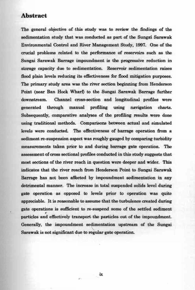
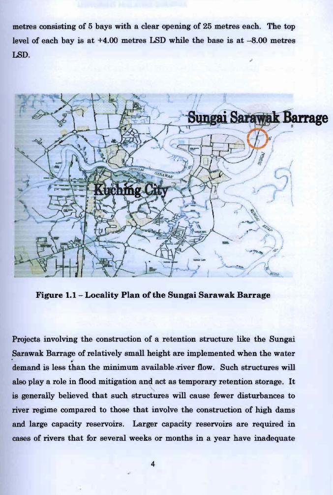
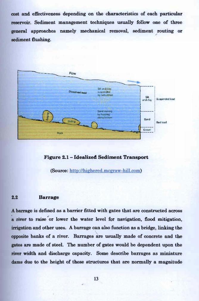