Embed Size (px)
Citation preview

BART Warm Springs Extension Final Environmental Impact Statement Volume 1
4.6-1June 2006
J&S 04071.04
Section 4.6 Wetlands
4.6.1 IntroductionThis section describes existing conditions related to wetlands and other bodies of water in the vicinity of the WSX Alternative. The section also analyzes the WSX Alternative’s potential impacts on wetlands and other waters and identifies mitigation measures to address substantial adverse impacts.
4.6.2 Affected Environment4.6.2.1 Methodology for Assessment of Existing Conditions The area studied for the analysis of wetlands encompassed the 5.4-mile-long approximately 100-foot-wide WSX Alternative corridor, an access road along Morrison Creek, New Marsh, and an adjacent biological resource area. This is referred to as the wetlands study area.
Inventory of Existing Information As preparation for the field surveys, Jones & Stokes biologists, independent scientists retained by BART to evaluate project effects, conducted a search of pertinent existing literature to evaluate the potential for sensitive wetlands habitats to occur in the biological resources study area. The following sources of information were used in the pre-field inventory.
Pertinent environmental documents, including the following.
Lake Elizabeth Stivers Lagoon Marsh Design and Improvement Program, Draft Environmental Impact Report (City of Fremont 1993a).
Lake Elizabeth Stivers Lagoon Marsh Design and Improvement Program, Final Environmental Impact Report (City of Fremont 1993b).
Biological Resource Assessment for the Grimmer Boulevard and Irvington Pump Station Sites Owned by San Francisco Public Utilities Commission (Environmental Collaborative for Baseline Environmental Consulting 2000).
Jones & Stokes staff also consulted individuals recognized as experts in biological issues relevant to the wetlands study area. These individuals are listed in the personal communications section in Chapter 10, References.

San Francisco Bay Area Rapid Transit District Section 4.6. Wetlands
BART Warm Springs Extension Final Environmental Impact Statement Volume 1
4.6-2June 2006
J&S 04071.04
Field Surveys Jones & Stokes biologists conducted reconnaissance-level surveys of the wetlands study area in May 2002 and December 2004. The biologists collected data by walking and driving the project site and recorded the data in the field on data sheets and aerial photographs (scale 1:2,400). Special attention was paid to sensitive resources such as wetlands.
Reconnaissance-level surveys for special-status and common wildlife were conducted on May 14 and 15, 2002 (see Section 4.7, Biological Resources). During the reconnaissance-level wildlife surveys, a wildlife biologist walked the length of the WSX Alternative corridor gathered information to assess the suitability of existing habitats, including wetlands habitats, for special-status wildlife species; where habitat suitable for special-status wildlife was encountered, its areal extent and potential as breeding habitat were evaluated.
Wetlands Delineation A formal delineation of waters of the U.S. in the biological resources study area was conducted on June 6, 2002, to identify bodies of water, including wetlands, that qualify for jurisdictional status under Section 404 of the federal Clean Water Act (see 3.4.6, Regulatory Setting, below). The survey was conducted by a botanist/wetland ecologist and a soil scientist in accordance with standard protocols detailed in the U.S. Army Corps of Engineers Wetlands Delineation Manual (Environmental Laboratory 1987).
4.6.2.2 Existing Conditions Wetlands habitats in the study area were divided into two primary types: open water habitats and forested and emergent seasonal wetlands. The existing conditions of those resources are summarized below.
Open Water Habitats Bodies of open water in the biological resources study area include Lake Elizabeth, New Marsh, and several creeks. The deeper areas of open water are largely unvegetated. However, vegetation is found along shorelines. The following sections focus on vegetation communities along the shorelines of the open water habitats in the biological resources study area.
Lake Elizabeth and New Marsh Lake Elizabeth, located in Fremont Central Park, originated as a natural sag pond along an active trace of the Hayward fault (City of Fremont 1991, as amended).1 (See Figures 4.6-1a through 4.6-1c for locations of wetlands in project corridor.) It has been artificially modified to form a year-round recreational lake maintained with groundwater, and also provides flood storage capacity for the City of Fremont during the wet season (Jones & Stokes 2000). Lake Elizabeth encompasses 83 acres. Approximately 550 linear feet of the WSX Alternative alignment is within (in a subway structure) the northeast arm of Lake Elizabeth; the WSX Alternative corridor includes 3.7 acres or approximately 4% of the lake’s area. The portion of Lake Elizabeth intersected by the WSX Alternative corridor has a maximum depth of approximately 6 feet. Much of Lake Elizabeth’s 1 Sag pond refers to a wetted depression formed by surface deformation along an active fault trace.


San Francisco Bay Area Rapid Transit District Section 4.6. Wetlands
BART Warm Springs Extension Final Environmental Impact Statement Volume 1
4.6-3June 2006
J&S 04071.04
shoreline consists of concrete and riprap, but a narrow band of cattail (Typha latifolia) and bulrush (Scirpus acutus) grows along the lake’s southern and eastern margins. An island in the southern portion of the lake supports arroyo willow (Salix lasiolepis) cover.
New Marsh is located approximately 300 feet from the east edge of the WSX Alternative construction corridor and approximately 400 feet from the centerline of the corridor at the northern end of Lake Elizabeth. New Marsh is a small (1.8-acre) pond created in the late 1980s to serve as a retention basin for runoff from surrounding portions of Fremont Central Park. The shoreline of New Marsh supports patches of bulrush and cattail.
Creek Habitat There are nine streams within the WSX Alternative corridor, all of which have been rerouted and altered from their historical condition (see Figure 4.5-1 in Section 4.5, Hydrology). Five of the streams (K, I, J, H, and M) are either culverted or channelized and lined with concrete where they cross the WSX Alternative corridor; they serve as flood control channels and are maintained by the Alameda County Flood Control and Water Conservation District (ACFCD). The remaining four (L, L-1,2 L-10, and H-1) are open channels that have not been hardscaped.
Mission Creek is a perennial tributary of Coyote Creek, a principal drainage of the South Bay region that enters San Francisco Bay southwest of Fremont (see related discussion in Section 4.5, Hydrology). The 6-foot-wide channel that characterizes Mission Creek in the WSX Alternative corridor was established in 1986 when Lake Elizabeth was excavated. Although Mission Creek is a tributary of Coyote Creek, high wet-season flows typically back up where the creek is culverted at Paseo Padre Parkway and flow via a weir into Lake Elizabeth. As the flood flows subside, lake water drains back into Mission Creek via the same weir. During extreme flood events, flood flows in Mission Creek overtop the bank and discharge directly into Lake Elizabeth upstream of the weir (Jones & Stokes 2000). Mission Creek supports a range of emergent, upland, and ruderal plant species along its banks (Figure 4.6-1a).
The other eight streams within the WSX Alternative corridor, including the unnamed flood control channel north of Paseo Padre Parkway, are tributaries to Mission Creek. They range from 2 feet wide to approximately 6 feet wide. Some support intermittent emergent vegetation such as watercress (Nasturtium officinale); most also support ruderal vegetation such as cocklebur (Xanthiumstrumarium) on their banks. Emergent vegetation along the unnamed flood control channel north of Paseo Padre Parkway includes cattail, watercress, bulrush, alkali bulrush (Scirpus robustus), and knotweed (Polygonum sp.). Saltgrass (Distichlis spicata), rabbit’s-foot grass (Polypogonmonspeliensis), and cocklebur are also found on the banks of this unnamed flood control channel.
One additional stream would be affected by improvements to the existing ACFCD maintenance road for emergency vehicle access to the southern ventilation structure. Morrison Creek is a natural stream that originates in Morrison Canyon in eastern Fremont, midway between Niles Canyon and Interstate 680, and it is a tributary of Mission Creek. West of Mission Boulevard, the natural stream channel has been rerouted to a channel that parallels the UP railroad. In the project area, the stream channel parallels the eastern boundary of Fremont Central Park from Stevenson Boulevard to its confluence with Mission Creek. The channel, which is approximately 25 feet wide at its upper edge, is V-shaped for approximately 1,875 feet south of Stevenson Boulevard. This section of the stream
2 Line L-1 is slated for removal by the City of Fremont’s grade separations project.

San Francisco Bay Area Rapid Transit District Section 4.6. Wetlands
BART Warm Springs Extension Final Environmental Impact Statement Volume 1
4.6-4June 2006
J&S 04071.04
does not support wetlands. The southern 1,425 feet of the channel is U-shaped and supports emergent aquatic vegetation, including umbrella sedge (Cyperus eragrostis), barnyard grass (Echinochloa crus-galli), and Italian ryegrass (Lolium multiflorum).
Forested and Emergent Seasonal Wetlands There are four occurrences of forested and emergent seasonal wetland habitat within the wetlands study area: at Tule Pond South, east of Lake Elizabeth, along Mission Creek; and along the flood control channels adjacent to the UP alignment north of Paseo Padre Parkway (see Figure 4.6-1a). Although identified as separate localities, the occurrences east of Lake Elizabeth and along Mission Creek are treated as a single site because they are physically contiguous and biologically similar.
Riparian Habitat (Forested) The project corridor supports approximately 6.0 acres of riparian habitat in three locations: Tule Pond South, Lake Elizabeth/Mission Creek, and north of Paseo Padre Parkway (Figure 4.6-1a).
Like Lake Elizabeth, Tule Pond occupies a natural sag formed along the Hayward fault that has been modified to serve as a flood control basin for local runoff during the wet season (Parikh Consultants 2002). Tule Pond is bisected by Walnut Avenue; the portion north of Walnut Avenue (Tule Pond North) is hydrologically connected to the portion south of Walnut Avenue (Tule Pond South) via two 18-inch culverts. The portion of Tule Pond outside the project corridor (Tule Pond North) encompasses an area of 1.6 acres. The portion of Tule Pond within the WSX Alternative corridor (Tule Pond South) encompasses an area of approximately 1.1 acres and is seasonally flooded; at the time of the May–July 2002 surveys, Tule Pond South was dry except for a small pool approximately 1 to 2 feet deep in the northern portion of the basin. Tule Pond South supports 1.2 acres of riparian forest habitat, which is dominated by arroyo willow.
As of the May 2002 survey, the extent of riparian forest east of Lake Elizabeth was approximately 6.0 acres. The dominant overstory species in this area are willows (Salix spp.). The understory typically consists of blackberries (Rubus spp.), poison-oak (Toxicodendron diversilobum), poison hemlock (Conium maculatum), rushes (Juncus spp.), and stinging nettle (Urtica dioica). Riparian vegetation along Mission Creek consists of a dense canopy of red willow (Salix laevigata), arroyo willow, and sandbar willow (S. exigua). Because the floodplain adjacent to Mission Creek is several feet above the ordinary high water mark, willow scrub in this area is subject only to occasional flooding.
The flood control channels north of Paseo Padre Parkway support 0.9 acres of riparian forest similar to that east of Lake Elizabeth and along Mission Creek. This flood control channel supports willow scrub habitat. The riparian forest at this location is within the area affected by the City of Fremont’s grade separations project and will be removed or substantially disturbed prior to implementation of the WSX Alternative.
Seasonal Wetlands Emergent seasonal wetland habitat occurs in three occurrences: Tule Pond South (1.5 acres), adjacent to the flood control channels north of Paseo Padre Parkway (0.212 acre), and isolated patches along the WSX Alternative alignment (0.8 acre). The wetlands delineation report prepared for the WSX Alternative, A Report on Wetlands and Other Aquatic Habitats Occurring along the

San Francisco Bay Area Rapid Transit District Section 4.6. Wetlands
BART Warm Springs Extension Final Environmental Impact Statement Volume 1
4.6-5June 2006
J&S 04071.04
San Francisco Bay Area Rapid Transit District Proposed Warm Springs Extension, (San Francisco Bay Area Rapid Transit District 2002) is available under separate cover and contains detailed information on individual wetland features. The wetlands delineation report is available for review at the BART offices at 300 Lakeshore Drive, 21st Floor, Oakland, CA 94612. The following paragraphs provide a summary of the report.
Wetlands habitat at Tule Pond South supports knotweed, cattail, and hardstem bulrush (Schoenoplectus acutus). Adjacent upland habitat is dominated by ripgut grass, wild barley, and coyote brush (Baccharis pilularis).
Approximately 0.212 acre of seasonal wetlands is present in the area north of Paseo Padre Parkway, on both sides of the flood control channels (Huffman & Associates 2002a; City of Fremont 2005). Dominant species include smartweed, bristly ox-tongue (Picris echioides), curly dock (Rumex crispus), and poison hemlock. Adjacent herbaceous uplands at this location consist primarily of annual grassland dominated by Italian ryegrass, in association with bird’s-foot trefoil (Lotus corniculatus), bristly ox-tongue, curly dock, field bindweed (Convolvulus arvensis), bull thistle (Cirsium vulgare), and narrow-leaved milkweed (Asclepias fascicularis).
The 2002 surveys identified an emergent seasonal wetland approximately 500 feet south of the proposed location of the optional Irvington Station, along the west side of the WSX Alternative alignment between the two railroad tracks. This wetland is approximately 550 feet long and encompasses an area of 0.39 acre. The dominant species is creeping spikerush (Eleocharis macrostachya); associated species include Italian ryegrass, bristly ox-tongue, creeping wildrye (Leymus triticoides), umbrella sedge (Cyperus eragrostis), and water pygmy-weed (Crassula aquatica). Adjacent upland vegetation is dominated by Bermuda grass (Cynodon dactylon) in association with stinkweed (Ditrichia graveolens), curly dock, scarlet pimpernel (Anagallisarvensis), Mediterranean mustard (Hirschfeldia incana), and wild oat (Avena fatua). This wetland is within the area affected by the city’s grade separations project and will be removed prior to implementation the WSX Alternative, assuming the grade separations project takes place as planned; additional discussion of this issue is provided in the impacts discussion below.
Table 4.6-1 summarizes the wetland communities in the wetlands study area.

San Francisco Bay Area Rapid Transit District Section 4.6. Wetlands
BART Warm Springs Extension Final Environmental Impact Statement Volume 1
4.6-6June 2006
J&S 04071.04
Table 4.6-1. Wetland Vegetation Communities in the Study Area
Habitat Type (Location) Acreage
Seasonal wetland (Tule Pond South) 1.5
Seasonal wetland (Morrison Creek)* 0.3
Seasonal wetland (flood control channel north of Paseo Padre Parkway)* 0.3
Seasonal wetland (500 ft south of optional Irvington Station)* 0.7
Seasonal wetland (500 ft south of optional Irvington Station) 0.1
Total wetland 2.9
Riparian (Tule Pond South) 1.2
Riparian (Mission Creek/Lake Elizabeth) 3.9
Riparian (north of Paseo Padre Parkway)* 0.9
Total riparian 6.0
Open water (Lake Elizabeth) 3.7
Streambed (Morrison Creek) 0.1
Open water (Mission Creek) 0.2
Open water (Unnamed Creek A)* 0.1
Open water (other creeks in WSX Alternative corridor) 0.3
Total open water 4.4
Notes:
* Denotes communities within the City of Fremont’s grade separations project boundaries.
Source: Jones & Stokes
4.6.3 Regulatory SettingThe following federal, state, and local laws, regulations, ordinances, and rules are related to wetlands and the construction and operation of the WSX Alternative.
4.6.3.1 FederalClean Water Act The Clean Water Act (CWA) is the primary federal law protecting the quality of the nation’s surface waters, including lakes, rivers, and wetlands. As such, it empowers the U.S. EPA to set national water quality standards and effluent limitations and establishes permit review mechanisms to enforce them, operating on the principle that all discharges into the nation’s waters are unlawful unless specifically authorized by a permit. Key provisions of the CWA are described in detail in Section 4.5, Hydrology.

San Francisco Bay Area Rapid Transit District Section 4.6. Wetlands
BART Warm Springs Extension Final Environmental Impact Statement Volume 1
4.6-7June 2006
J&S 04071.04
Most of the CWA’s provisions are at least indirectly relevant to the management and protection of wetlands and biological resources because of the link between water quality and ecosystem health. The portions of the CWA that are most directly relevant to wetlands management are contained in CWA Section 404, which regulates the discharge of dredged and fill materials into waters of the U.S., which include the following features.
All areas within the ordinary high water mark of a stream, including non-perennial streams with a defined bed and bank and any stream channel that conveys natural runoff, even if it has been realigned.
Seasonal and perennial wetlands.
Wetlands are defined for regulatory purposes as areas “inundated or saturated by surface or ground water at a frequency and duration sufficient to support, and that under normal circumstances do support, a prevalence of vegetation typically adapted for life in saturated soil conditions” (33 CFR 328.3, 40 CFR 230.3).
CWA Section 404 requires project proponents to obtain a permit from the U.S. Army Corps of Engineers (Corps) for all discharges of dredged or fill material into waters of the U.S., including oceans, bays, rivers, streams, lakes, ponds, and wetlands, before proceeding with a proposed activity. The Corps may issue either an individual permit evaluated on a case-by-case basis, or a general permit evaluated at a program level for a series of related activities. General permits are preauthorized and are issued to cover multiple instances of similar activities expected to cause only minimal adverse environmental effects. Nationwide Permits (NWPs) are a type of general permit issued to cover particular fill activities. Each NWP specifies particular conditions that must be met in order for the NWP to apply to a particular project. Waters of the U.S. in the project corridor are under the jurisdiction of the Corps, San Francisco District.
Compliance with CWA Section 404 requires compliance with several other environmental laws and regulations, including NEPA, the ESA, the federal Coastal Zone Management Act, and the National Historic Preservation Act (see Section 4.12, Cultural Resources). In addition, the Corps cannot issue or verify any permit until a water quality certification, or waiver of certification, has been issued pursuant to CWA Section 401 (see Section 4.5, Hydrology). Section 404 permits may be issued only if there is no practicable alternative to the proposed discharge that would have less impact on the aquatic ecosystem and has no other significant adverse environmental consequences. Section 4.5, Hydrology, provides additional information on Section 404 permitting.
Executive Order 11990 – Protection of Wetlands For any mass transportation project that may affect a wetlands area, the U.S. Department of Transportation (USDOT) Order on Preservation of the Nation’s Wetlands (5660.1A) requires that an analysis of impacts must be performed. For transportation project purposes, USDOT’s order implements the presidential Executive Order on Protection of Wetlands, EO 11990. If the analysis shows that the project will have a significant impact on wetlands, an environmental impact statement will usually be required. The environmental analysis should include an assessment of the impacts on wetlands and associated wildlife resulting from both construction and operation of the project. It should also include measures to minimize adverse impacts and avoid, to the fullest extent possible, drainage, filling, or other disturbance of wetlands. Alternatives that would avoid new construction in wetlands, must be studied. If the preferred alternative requires new construction in wetlands, the

San Francisco Bay Area Rapid Transit District Section 4.6. Wetlands
BART Warm Springs Extension Final Environmental Impact Statement Volume 1
4.6-8June 2006
J&S 04071.04
analysis must demonstrate that there are no practicable alternatives to the use of the wetlands, and all practicable measures to minimize harm have been included.
4.6.3.2 State Porter-Cologne Water Quality Control Act The Porter-Cologne Water Quality Control Act, in part, implements the federal CWA to provide a mechanism for protecting the quality of the state’s waters through the State Water Quality Control Board (SWRCB) and the nine Regional Water Quality Control Boards (RWQCBs). Section 4.5, Hydrology, describes the provisions of the Porter-Cologne Act.
The SWRCB and the San Francisco Bay RWQCB have taken the position that the Porter-Cologne Act and basin plans developed pursuant to the act provide independent authority to regulate discharge of fill material to wetlands outside the jurisdiction of Corps. This applies specifically to isolated wetlands considered non-jurisdictional based on the Solid Waste Agency of Northern Cook County (SWANCC) v. United States Army Corps of Engineers decision (121 S.CT. 675, 2001), which limited the Corps’s jurisdiction over certain isolated wetlands.
Lake or Streambed Alteration Agreements (Section 1600 et seq.) As discussed in Section 4.5, Hydrology, the California Fish & Game Code regulates activities that interfere with the natural flow of, or substantially alter the channel, bed, or bank of a lake, river, or stream. Lake-bed and streambed alteration activities are covered under Section 1602. Requirements to protect the integrity of biological resources and water quality are often conditions of streambed alteration agreements administered under Section 1600 et seq.
4.6.4 Environmental Consequences and Mitigation Measures4.6.4.1 Methodology for Analysis of Environmental ConsequencesAnalysis of impacts related to wetlands focused on the WSX Alternative’s potential to result in changes in the areal extent or quality of wetlands resources. Changes in the areal extent of habitat were evaluated quantitatively through geographic information system (GIS) analysis, based on field mapping and the anticipated area and duration of ground disturbance (see Chapter 3). Table 4.6-2 summarizes the potentially affected acreages that were derived via GIS analysis and used in the following impact analysis. Other types of impacts on wetlands were evaluated qualitatively.
Impacts specific to construction and operation of the optional Irvington Station were addressed separately, because this option may not be implemented even if the WSX Alternative is approved.

San Francisco Bay Area Rapid Transit District Section 4.6. Wetlands
BART Warm Springs Extension Final Environmental Impact Statement Volume 1
4.6-9June 2006
J&S 04071.04
Table 4.6-2. Summary of Wetlands Acreages Affected by WSX Alternative and Optional Irvington Station
Vegetation Community Permanent Impact (acres) Temporary Impact (acres)
Seasonal Wetland
Tule Pond South 0.7 0.8
Morrison Creek 0.1 0
Seasonal wetland south of Warm Springs Station
0.1 0
Total seasonal wetland acreage affected 0.9 0.8
Riparian
Tule Pond South 0.4 0.8
Mission Creek 0.2 3.7
Total riparian acreage affected 0.6 4.6
Open Water and Creek
Lake Elizabeth 0 7.5
Morrison Creek 0 0
Mission Creek 0 1.4
Other creeks and flood control channels 0 4.8
Total open water and creek acreage affected 0 13.7
Note: This table does not include habitats within the City of Fremont’s grade separations project area of potential effect.
Source: Jones & Stokes
4.6.4.2 Alternative-Specific Environmental Analysis Impacts Related to Operation of the WSX Alternative Impact WL-1—Permanent loss of wetlands habitat.
WSX Alternative. Implementation of the WSX Alternative would require filling emergent seasonal wetlands at Tule Pond South and in the vicinity of the proposed Warm Springs Station site. As much as 0.7 acre of seasonal wetlands habitat at Tule Pond South and an additional 0.1 acre of seasonal wetland habitat within Morrison Creek and 0.1 acre of wetlands habitat east of the UP alignment and south of the proposed Warm Springs Station site could be lost. This would represent an adverse impact on a sensitive plant community that provides important habitat for a variety of wildlife. The following mitigation measure would minimize this impact.
Mitigation Measure WL-1—Restore, create, and protect wetland habitat to mitigate loss of wetland habitat. To ensure that implementation of the WSX Alternative results in no net loss of wetland habitat functions and values, BART will compensate for the loss of

San Francisco Bay Area Rapid Transit District Section 4.6. Wetlands
BART Warm Springs Extension Final Environmental Impact Statement Volume 1
4.6-10June 2006
J&S 04071.04
wetland habitat at Tule Pond South, south of the Warm Springs Station site, and any other affected locations through a combination of onsite restoration/creation and offsite protection and enhancement of at least 0.8 acre of wetland habitat. The size and location(s) of the area(s) to be restored/created will be determined based on appropriate mitigation ratios derived in consultation with the Corps. A mitigation plan will be prepared by a wetland biologist experienced in mitigation and restoration. The plan will be implemented under the biologist’s guidance. The California Regional Water Quality Control Board will be consulted regarding the effectiveness of the proposed mitigation plan. Subject to approval by the Corps, the wetland mitigation plan will address temporary and permanent impacts (temporary impacts are addressed below under Impact WL-5). Factors that will be considered in developing an effective mitigation plan in consultation with the Corps include the following.
Function and values: Wildlife species, percentage of vegetative cover and/or density, approximate plant height, plant and animal species diversity, root development, and canopy stratification.
Hydrological regime: Sources of water, discharge points, areas affected by seasonal flooding, direction of flow, and size of watershed.
Specific measurable criteria for the above factors will be incorporated into the plan in conformance with applicable regulatory requirements and the Corps’ guidelines. Such criteria cannot be specifically identified at this stage, however, because the Corps has not visited the site.
Prior to any work that could disturb wetland or creek habitat within the WSX Alternative corridor, BART will obtain the following permits as required.
U.S. Army Corps of Engineers – Individual permit as required under Clean Water Act Section 404.
San Francisco Bay Regional Water Quality Control Board – Water quality certification as required under Clean Water Act Section 401.
California Department of Fish and Game – Streambed Alteration Agreement.
Consultation with these agencies will determine the implementation of this mitigation measure for disturbance of wetland and creek habitat.
No-Build Alternative. The No-Build Alternative would result in no project-related loss of wetlands habitat. As discussed above, 0.6 acre of wetlands in the project area will be affected by the city’s grade separations project, regardless of whether the WSX Alternative is constructed. Mitigation for wetlands impacts resulting from the city’s grade separations project will be implemented by the City of Fremont.
Impact WL-2—Loss of riparian forest habitat.
WSX Alternative. Implementation of the WSX Alternative would result in the permanent loss of approximately 0.6 acre of riparian forest habitat adjacent to Tule Pond South and east of Mission Creek, within the WSX Alternative corridor. Riparian forest is naturally rare because it is restricted
San Francisco Bay Area Rapid Transit District Section 4.6. Wetlands
BART Warm Springs Extension Final Environmental Impact Statement Volume 1
4.6-11June 2006
J&S 04071.04
to stream corridors. Because of its rarity, biological importance, and sensitivity to disturbance, any effects on riparian habitat are typically considered impacts. Loss of 0.6 acre of riparian habitat would constitute an adverse impact. Mitigation Measure WL-2 would minimize that impact.
Mitigation Measure WL-2—Enhance, recreate, or restore riparian forest to compensate for the loss of riparian forest habitat. BART will compensate for the permanent loss of riparian forest habitat at Tule Pond South and east of Mission Creek through onsite restoration/creation of 0.6 acre of forested riparian habitat west of the existing Tule Pond South site (Figure 4.6-1a) and east of Mission Creek. Compensation will be provided at a minimum ratio of 1:1 (1 acre restored or created for every acre removed). Restoration activities will occur after construction.
BART will retain a qualified restoration ecologist to develop a conceptual restoration and monitoring plan that describes how riparian habitat will be enhanced or recreated and monitored over a minimum period of time. BART will be responsible for ensuring that the restoration and monitoring plan is implemented.
After restoration and revegetation are completed, monitoring will be conducted for a minimum of 5 years to ensure that the success criteria identified below are met and to identify any necessary remedial actions. The revegetation/restoration plan for riparian habitats will be considered successful when the following criteria are met.
The restored site is composed of a mix of species similar to that removed during the construction activity; native species are planted where appropriate.
The restored site has at least 75% of the absolute cover of native vegetation present in areas immediately adjacent to the construction corridor.
Plantings are self-sustaining without human support (e.g., weed control, rodent and deer control, irrigation).
Functions and values of the restored habitat are comparable to those of adjacent undisturbed riparian habitat.
Remedial action will be required if any of the above criteria are not met during the monitoring period. The purpose of the remedial action will be to ensure that the above criteria are met.
No-Build Alternative. The No-Build Alternative would result in no project-related loss of riparian forest habitat.
Impact WL-3—Potential impacts on seasonal wetlands habitat identified as vernal pool invertebrate and California tiger salamander habitat.
WSX Alternative. A 0.39-acre seasonal wetland in the project area, located between the former SP and WP railroad tracks south of the optional Irvington Station site, is known to support a population of California tiger salamander. This wetland is within the area affected by the city’s grade separations project, and its loss would be addressed under the environmental review process for that project. Because the wetland would no longer be present, it would not be affected by the WSX Alternative, and there would be no impact.

San Francisco Bay Area Rapid Transit District Section 4.6. Wetlands
BART Warm Springs Extension Final Environmental Impact Statement Volume 1
4.6-12June 2006
J&S 04071.04
No-Build Alternative. Under the No-Build Alternative, 0.7 acre of wetlands in the project area will be removed by the city’s grade separations project, regardless of whether the WSX Alternative is constructed. There would be no additional WSX-related impacts. This impact will be addressed in the Corps Section 404 Permit for the grade separations project.
Impacts Related to Construction of the WSX Alternative Impact WL-4—Temporary disturbance of open water habitat.
WSX Alternative. Construction of the subway segment of the WSX Alternative would require installation of a cofferdam and dewatering of a total of 7.5 acres of open water habitat in the northeast arm of Lake Elizabeth (approximately 9% of the lake’s area). Once construction is complete, the cofferdam would be removed and the area would return to its preconstruction condition. However, construction activities could temporarily deter wildlife from using open water habitats. This impact is temporary and limited to the vicinity of construction, since wildlife species would still have access to other areas of the open water habitat.
During construction, water quality in the remaining portion of the lake would be protected by best management practices (BMPs) required for compliance with the NPDES General Permit for Discharges of Storm Water Associated with Construction Activities (see discussion under Impact H-9 [Potential for accelerated erosion and discharge of sediment into water bodies as a result of ground-disturbing activities]) in Section 4.5, Hydrology, and by Mitigation Measures H-10(a) (Implement water quality control measures to prevent release of sediment) and H-11 (Implement hazardous materials spills prevention and control plan). These measures would minimize the degradation of open water habitats used by a variety of common wildlife species and the following mitigation measure would further minimize this impact in the construction vicinity.
Mitigation Measure WL-4—Install erosion barriers. Require the construction contractor to use erosion barriers to prevent construction materials and excavated soil from entering any of the open water areas.
No-Build Alternative. The No-Build Alternative would result in no project-related disturbance of open water habitat.
Impact WL-5—Temporary disturbance of wetlands and creek habitat.
WSX Alternative. Construction of the WSX Alternative could result in the temporary disturbance of as much as 7.0 acres of wetlands and creek habitat in the WSX Alternative corridor (Figure 4.6-1a) by direct removal, filling, hydrologic interruption (including dewatering), and other activities. Affected waterways would include Mission Creek, which has not been hardscaped and supports a substantial amount of native and non-native natural vegetation. Wetland and creek habitats are considered environmentally sensitive areas (see Figure 4.6-2 for general locations of these areas). Disturbance of these areas would consequently represent an adverse impact. However, BMPs required for compliance with relevant NPDES General Permits (see discussion under Impacts H-9 and H-11 in Section 4.5, Hydrology), and the following mitigation measures would help avoid or minimize the disturbance.
Mitigation Measure WL-5(a)—Avoid or minimize disturbance of wetlands and creeks.At a minimum, mitigation for this impact will include the following measures.


San Francisco Bay Area Rapid Transit District Section 4.6. Wetlands
BART Warm Springs Extension Final Environmental Impact Statement Volume 1
4.6-13June 2006
J&S 04071.04
All environmentally sensitive areas will be staked and flagged in the field and marked on construction drawings before construction begins. BART’s construction contractor(s) will avoid construction activities in and adjacent to creeks and saturated or ponded wetlands during the wet season (winter and spring) to the maximum extent possible. Wetlands and creek habitats on and near active construction sites will be protected by installing environmentally sensitive area fencing (orange construction barrier fencing) at least 20 feet outboard of the edge of the ordinary high-water mark; depending on site-specific conditions and permit requirements, the buffer may be wider than 20 feet to prevent erosion and sedimentation impacts on wetland habitats. Construction specifications for the WSX Alternative will include language that specifically prohibits construction-related activities, including vehicle laydown and operation, storage of materials and equipment, and other ground-disturbing activities, in fenced environmentally sensitive areas.
BART will retain qualified biologists and/or resource specialists to monitor construction activities near wetlands and creeks. Monitors will be hired and trained prior to construction, and will be responsible for preconstruction surveying, staking and fencing sensitive resources, onsite monitoring, documenting compliance and violations, coordinating with contract compliance inspectors, and performing postconstruction documentation.
Contractors will ensure that woody debris, soils, and any other materials that are inadvertently deposited below the ordinary high-water mark of drainages are removed. Removal will be accomplished by qualified personnel in a manner that minimizes disturbance of drainage bed and banks.
If it is not possible to avoid ground-disturbing activities in or adjacent to environmentally sensitive areas, including creeks and/or saturated or ponded wetlands, the following measures will be implemented to minimize disturbance.
When working in or adjacent to creeks or wetlands, contractors will use geotextile cushions or other appropriate materials (e.g., timber pads, prefabricated equipment pads) to minimize damage to the substrate and vegetation and increase the likelihood of successful restoration.
When working upslope of creeks or wetlands, contractors will use geotextile mats, excelsior blankets, or other soil stabilization products to minimize the potential for construction to contribute to erosion and sedimentation that could affect wetland water quality.
Contractors will stabilize exposed slopes and streambanks immediately on completion of ground-disturbing activities, using a non-vegetative material that will bind the soil initially and break down within a few years.
Mitigation Measure WL-5(b)—Restore disturbed wetlands and creek habitat. To ensure that implementation of the WSX Alternative results in no net loss of wetland and creek habitat functions and values, BART will ensure that wetlands and creeks disturbed during construction activities are restored and/or revegetated. BART will comply with any measures required by the Corps as part of the Section 404 permitting process.
In addition, BART will retain a qualified restoration ecologist to develop a restoration/revegetation plan for wetlands and creeks adversely affected by construction activities, in conjunction with resource and regulatory agency staff. The

San Francisco Bay Area Rapid Transit District Section 4.6. Wetlands
BART Warm Springs Extension Final Environmental Impact Statement Volume 1
4.6-14June 2006
J&S 04071.04
restoration/revegetation plan will include design specifications, an implementation plan, maintenance requirements, and a monitoring program.
After restoration and revegetation are completed, monitoring will be conducted for a minimum of 5 years to ensure that the success criteria identified below are met and to identify any necessary remedial actions. Annual monitoring reports will be submitted to the Corps and the San Francisco Bay RWQCB. The reports will summarize the data collected during each monitoring period, describe the progress of the restored habitats relative to the success criteria outlined below, and discuss any remedial actions performed.
The revegetation/restoration plan for wetland and creek habitats will be considered successful when the following criteria are met.
The restored site is composed of a mix of species similar to that removed during the construction activity.
The restored site has at least 75% of the absolute cover of native vegetation present in areas immediately adjacent to the construction corridor.
Plantings are self-sustaining without human support (e.g., weed control, rodent and deer control, irrigation).
Functions and values of the restored habitat are comparable to those of adjacent undisturbed wetland and creek habitats.
Remedial action will be required by BART if any of the above criteria are not met during the monitoring period. The purpose of the remedial action will be to ensure that the above criteria are met.
Mitigation Measure WL-5(c)—Compensate for temporary loss of wetlands and creek habitat. To compensate for the temporary loss of wetlands and creek habitat during construction, BART will implement Mitigation Measure WL-1 (Restore, create, and protect wetland habitat to mitigate loss of wetland habitat) discussed above. As discussed above in this mitigation measure, the size of the area(s) to be restored/created will be determined based on appropriate mitigation ratios derived in consultation with the Corps.
No-Build Alternative. The No-Build Alternative would result in no project-related disturbance of wetlands or creek habitat.
Impact WL-6—Temporary disturbance of riparian forest habitat.
WSX Alternative. Construction of the WSX Alternative would result in the temporary disturbance of approximately 0.8 acres of riparian habitat located at Tule Pond South and 3.9 acres of riparian forest habitat located east of Lake Elizabeth on both sides of Mission Creek (Figure 4.6-1a).
Because it is typically restricted to stream corridors, riparian forest is naturally a rare component of the landscape. However, because the 3.9 acres of riparian forest along Mission Creek are adjacent to approximately 40 acres of intact riparian forest habitat, the effect of temporary disturbance at this location would be reduced by the presence of the larger area of undisturbed habitat. Most wildlife displaced by the project would be able to utilize the adjacent habitat temporarily, and the undisturbed riparian forest habitat would serve as a seed bank to facilitate the revegetation of the disturbed habitat. However, because of the rarity, biological importance, and sensitivity to disturbance of

San Francisco Bay Area Rapid Transit District Section 4.6. Wetlands
BART Warm Springs Extension Final Environmental Impact Statement Volume 1
4.6-15June 2006
J&S 04071.04
riparian habitat, any effect on riparian forest is typically considered an adverse impact. The following mitigation measures would minimize this impact.
Mitigation Measure WL-6(a)—Minimize disturbance of riparian habitats. BART’s construction contractor(s) will avoid construction activities in and adjacent to riparian habitats to the maximum extent possible. Riparian habitats on and near active construction sites will be protected by installing environmentally sensitive area fencing (orange construction barrier fencing) outboard of (upslope from) the edge of the riparian zone. Depending on site-specific conditions, the buffer may be wider than 20 feet, as needed to protect the area from erosion. The locations of fences will be marked in the field with stakes and flags and will be shown on the construction drawings.
If it is not possible to avoid work in riparian areas, BART’s construction contractor(s) will minimize impacts on riparian forest vegetation by trimming vegetation rather than removing entire shrubs or trees wherever practicable. Shrubs will be cut at least 1 foot above ground level to leave the root systems intact and allow for more rapid regeneration. Cutting will be limited to the minimum area necessary in the construction zone. To protect migratory birds, no removal of woody riparian vegetation will take place during the breeding season (March 1–August 1).
Mitigation Measure WL-6(b)—If it is not possible to avoid work in riparian areas, restore disturbed riparian forest areas. BART will ensure that the riparian forest disturbed during construction activities is restored and/or revegetated.
BART will retain a qualified restoration ecologist to develop a revegetation plan for riparian forest adversely affected by construction activities. The revegetation plan will include design specifications, an implementation plan, maintenance requirements, and a monitoring program. To help develop the plan, the restoration ecologist will qualitatively sample the riparian vegetation in the WSX Alternative corridor prior to construction. Revegetation will be implemented immediately following disturbance in substantially disturbed areas or as appropriate for site conditions, based on the evaluation of the restoration ecologist and input from agency staff. Weeds will be vigorously controlled within and adjacent to the restoration site to ensure that no new noxious weeds are introduced into the area.
Monitoring will be conducted by BART for a minimum of 5 years to document the degree of success in achieving the success criteria identified below and to identify any necessary remedial actions. The reports will summarize the data collected during each monitoring period, describe the progress of restored habitats relative to the success criteria outlined below, and discuss any remedial actions performed.
The revegetation plan for riparian habitat will be considered successful when the following criteria are met.
The riparian habitat established is composed of a mix of native species similar to that removed by the construction.
The absolute cover of riparian vegetation is at least 75% of that in adjacent riparian areas not impacted by construction.
The health and vigor of riparian vegetation in the planted areas is similar to that of individuals of the same species in adjacent riparian areas, based on a qualitative comparison of leaf turgor, stem caliber, leaf cover and foliage density.

San Francisco Bay Area Rapid Transit District Section 4.6. Wetlands
BART Warm Springs Extension Final Environmental Impact Statement Volume 1
4.6-16June 2006
J&S 04071.04
Plantings are self-sustaining without human support (e.g., weed control, rodent control, or irrigation).
No-Build Alternative. The No-Build Alternative would result in no project-related disturbance of riparian forest habitat.
Impacts Related to the Optional Irvington Station Construction and implementation of the Irvington Station would result in no impacts on wetlands.
4.6.4.3 Least Environmentally Damaging Practicable AlternativeSection 404 of the Clean Water Act prohibits discharges of fill material to wetlands if there is a practicable alternative to the proposed project that would have less adverse impact on the aquatic ecosystem, so long as the alternative does not have other significant adverse environmental consequences. An alternative is “practicable” if it is available and capable of being done after taking into consideration cost, existing technology, and logistics in light of overall project purposes. The determination regarding alternatives under Clean Water Act Section 404(b)(1) is commonly referred to the “least environmentally damaging practicable alternative” (LEDPA) analysis. Depending on the complexity of the project and the number of alternatives considered, the alternatives analysis may be submitted with or subsequent to the permit application.
An analysis of alternatives is presented in this EIS and the previous environmental documents incorporated herein by reference, the 1992 EIR and the 2003 SEIR. Section 3.6 in Chapter 3, Alternatives Considered, discusses the analyses in the prior documents and reasons that alternatives previously considered were rejected.
Based on this analysis, the WSX Alternative is the least environmentally damaging practicable alternative that meets BART’s overall project purposes and avoids other adverse environmental consequences resulting from regional growth and traffic congestion. Although the No-Build Alternative would not affect wetland resources, it would not meet the project's purpose and need and would not provide the project's proposed environmental benefits (e.g., alleviate traffic congestion, improve air quality and energy efficiency, and promote transit-oriented land use). Based on constraints to the WSX Alternative alignment, it is not technologically feasible for the alignment to avoid the wetlands identified in Table 4.6-2 above. BART technology is heavy rail technology that requires a predominantly straight alignment and gentle curves. (The minimum curve for mainline BART track is a 1,000-foot radius curve.) This makes it infeasible to avoid wetland areas through minor route adjustments. Tule Pond is approximately 500 feet south of the end of the Fremont Station platform. This distance is too short to make a route adjustment away from Tule Pond technologically feasible. In addition, a route adjustment around Tule Pond would be cost-prohibitive. The planned BART alignment south of the Fremont BART Station is bordered by multi-family residential development. Any major adjustment to the alignment would require acquisition of several properties with existing apartments and condominiums, increasing the right-of-way cost for the project.
As a result of the construction of the Fremont Station at its present location north of Walnut Avenue in 1972, any southern extension of the BART system from the Fremont Station must cross the

San Francisco Bay Area Rapid Transit District Section 4.6. Wetlands
BART Warm Springs Extension Final Environmental Impact Statement Volume 1
4.6-17June 2006
J&S 04071.04
Hayward Fault and its associated sag ponds (of which Tule Pond is one). Due to the technological constraints described above, all the BART alternatives identified in the 1992 EIR had alignments that extended south from the Fremont Station through the Tule Pond area, the area of primary wetland impact. As described in Section 3.6, these alternatives also would be less practicable than the WSX Alternative due to access issues, land use issues, and seismic risks, or they would produce greater overall environmental impacts, particularly on visual resources. The non-BART transportation improvement alternatives evaluated in the 1992 EIR and 2003 SEIR would have fewer wetland impacts than the WSX Alternative, but these alternatives were determined to be infeasible or insufficient to meet the project purpose and need.
In addition, if the least environmentally damaging practicable alternative results in wetlands impacts, those impacts must be minimized or mitigated to the extent feasible. Table 4.6-2 summarizes the wetland habitat acreages that would be affected by the Proposed Action. As discussed in Section 4.6.4.2, the WSX Alternative includes all practicable measures to minimize harm to wetlands. Mitigation measures and Best Management Practices will be implemented to minimize the temporary impacts on wetlands in the construction right-of-way and indirect impacts on adjacent wetlands. Permanent impacts on seasonal and riparian wetlands will be compensated for by on-site restoration and/or by off-site wetland preservation and enhancement.

BART Warm Springs Extension Final Environmental Impact Statement Volume 1
4.7-1June 2006
J&S 04071.04
Section 4.7 Biological Resources
4.7.1 IntroductionThis section describes existing biological resources in the biological resources area, analyzes the WSX Alternative’s potential impacts on those resources, and identifies mitigation measures to address adverse impacts.
4.7.2 Affected Environment4.7.2.1 Methodology for Assessment of Existing Conditions The area studied for the analysis of biological resources encompassed the 5.4-mile-long approximately 100-foot-wide WSX Alternative corridor, an access road along Morrison Creek, New Marsh, an adjacent biological resource area. This is referred to as the biological resources study area. Biological resources in the study area are shown in Figures 4.7-1a through 4.7-1c; New Marsh is shown in Figure 4.7-1a. Jones & Stokes biologists performed the assessment of biological resources in the study area in two phases: (1) pre-field inventory of existing information, and (2) reconnaissance- and protocol-level field surveys. Details on the assessment and a summary definition of “special-status species,” as used in this document, are provided below.
Inventory of Existing Information As preparation for the field surveys, Jones & Stokes biologists conducted a search of pertinent existing literature to evaluate the potential for special-status species and sensitive habitats to occur in the biological resources study area. The following sources of information were used in the pre-field inventory.
Pertinent environmental documents, including the following.
Lake Elizabeth Stivers Lagoon Marsh Design and Improvement Program, Draft Environmental Impact Report (City of Fremont 1993a).
Lake Elizabeth Stivers Lagoon Marsh Design and Improvement Program, Final Environmental Impact Report (City of Fremont 1993b).
Biological Resource Assessment for the Grimmer Boulevard and Irvington Pump Station Sites Owned by San Francisco Public Utilities Commission (Environmental Collaborative for Baseline Environmental Consulting 2000).

San Francisco Bay Area Rapid Transit District Section 4.7. Biological Resources
BART Warm Springs Extension Final Environmental Impact Statement Volume 1
4.7-2June 2006
J&S 04071.04
The City of Fremont’s Biological Assessment for the Paseo Padre Grade Separation Project (The Huffman-Broadway Group, Inc. 2003).
Summary of Preliminary Mitigation Requirements and Options, BART Warm Springs Extension Project (Reynolds 1997).
Technical memorandum, Fremont Wal-Mart Site Burrowing Owl survey and biological reconnaissance summary letter (North State Resources 1999).
U.S. Fish and Wildlife Service (USFWS) species lists for the WSX Alternative corridor and vicinity (see Appendix C).
California Natural Diversity Database (CNDDB) records for the Niles, Milpitas, Mountain View, Newark, Hayward, Dublin, Livermore, La Costa Valley, and Calaveras Reservoir 7.5-minute topographic quadrangles (see Appendix C).
Jones & Stokes staff also consulted individuals recognized as experts in biological issues relevant to the biological resources study area. These individuals are listed in the personal communications section in Chapter 10, References.
Field Surveys Jones & Stokes biologists conducted reconnaissance-level surveys of the biological resources study area in May and July 2002, November 2004, and January 2005. The biologists collected data by walking and driving the project site and recorded the data in the field on data sheets and aerial photographs (scale 1:2,400). Special attention was paid to sensitive resources such as wetlands (see Section 4.6, Wetlands), sensitive habitats, and areas with the potential to support special-status species.1
Reconnaissance-level botanical surveys were performed in May and July 2002. On May 17, 2002, the biological resources study area was surveyed, except for the 19.37-acre ruderal area between the former SP and WP railroad tracks southeast of Lake Elizabeth, which was surveyed on July 17, 2002. During the surveys, botanists traversed the survey area on foot. They recorded all plant species observed and mapped vegetation communities on aerial photographs.
Reconnaissance-level surveys, during which a wildlife biologist walked the length of the biological resources study area and recorded all wildlife species observed, were conducted on May 14 and 15, 2002.2 Information was gathered to assess the suitability of existing habitats for special-status wildlife species. Where habitat suitable for special-status wildlife was encountered, its areal extent and potential as breeding habitat were evaluated. A follow-up survey was conducted on January 18, 2005, to assess wildlife habitat along the access road.
A reconnaissance-level survey of special status fish species, during which a fish biologist walked along Mission Creek bordering Lake Elizabeth, was conducted on November 8, 2004. Information was gathered to assess the suitability of existing habitats for anadromous salmonid species, including Chinook salmon and steelhead. In addition, a driving survey of Mission Creek downstream of Paseo
1 See Section 4.7.3, Regulatory Setting, below for a full definition of the term special-status species.2 Another reconnaissance-level survey was conducted in May 2004 to reconfirm the results of the 2002 surveys.


San Francisco Bay Area Rapid Transit District Section 4.7. Biological Resources
BART Warm Springs Extension Final Environmental Impact Statement Volume 1
4.7-3June 2006
J&S 04071.04
Padre Parkway was performed to determine the suitability of the channel to support adult anadromous fish migration.
Based on the results of these surveys, biologists conducted focused surveys in the biological resources study area. These included surveys for special-status birds and nesting raptors as well as protocol-level surveys3 for California red-legged frogs (Rana aurora draytonii), vernal pool invertebrates, and Western Burrowing Owls (Athene cunicularia hypugaea). The protocol-level surveys for California red-legged frogs and vernal pool invertebrates are administered by USFWS, and Burrowing Owl surveys are subject to guidelines prepared and administered by the California Department of Fish and Game (CDFG). Additional information on procedures followed during the June 2002 focused surveys is provided in Appendix C.
Definition of Special-Status Species Special-status species are plants and animals that are legally protected under state or federal laws or other regulations, and species that are candidates for certain types of legal protection. Special-status species include the following categories of plants and animals.
Plants and animals listed, proposed for listing, and candidates for possible future listing as threatened or endangered under the federal Endangered Species Act (ESA) (50 CFR 17.12 [listed plants], 50 CFR 17.11 [listed animals], and various notices in the Federal Register [proposed species]).
Plants and animals listed, proposed for listing, and candidates for possible future listing as threatened or endangered under the California Endangered Species Act (CESA) (14 CCR 670.5).
Plants listed as rare under the California Native Plant Protection Act (California Fish and Game Code, Section 1900 et seq.).
Plants considered “rare, threatened, or endangered in California” by the California Native Plant Society (CNPS) (Lists 1B and 2 in California Native Plant Society 2001).
Animal species of special concern to CDFG, as listed in Remsen (1978) (birds), Williams (1986) (mammals), and Jennings and Hayes (1994) (amphibians and reptiles).
Animals fully protected under the California Fish and Game Code (Section 5050 [amphibians and reptiles], Section 3515 [fish], Sections 3500 and 3800 [birds], and Section 4700 [mammals]).
Additional information on relevant laws and regulations is provided below in Section 4.7.3, Regulatory Setting.
3 Protocol-level surveys are focused surveys that follow an established protocol or guidelines approved by regulatory agencies.

San Francisco Bay Area Rapid Transit District Section 4.7. Biological Resources
BART Warm Springs Extension Final Environmental Impact Statement Volume 1
4.7-4June 2006
J&S 04071.04
4.7.2.2 Existing Conditions Vegetation
Vegetation Communities Much of the biological resources study area is developed with houses; occupied and vacant businesses; parking lots; paved sidewalks; and horticultural landscaping, including a variety of non-native trees and shrubs. Some land, however, has remained in a seminatural to natural condition.
Vegetation communities in the biological resources study area include ruderal forb-grassland and agricultural fields; open water habitats; forested and emergent seasonal wetlands; and residential and commercial landscaped areas. The following sections describe each upland community type; wetlands communities are described in Section 4.6, Wetlands. Table 4.7-1 shows the acreage of vegetation communities within the biological resources study area, and Figures 4.7-1a though 4.7-1c show their areal distribution.4 Table 4.7-2 lists the common plant species observed during the May–July 2002 botanical survey.
Table 4.7-1. Vegetation Communities in Biological Resources Study Area
Habitat Type (Location) Acreage
Ruderal forb-grassland (subway portal) 7.7
Ruderal forb-grassland (Fremont Central Park and dredge pond areas) 20.0
Ruderal forb-grassland (subway portal)1 19.4
Ruderal forb-grassland1 (south of Washington Blvd.) 8.9
Ruderal forb-grassland (optional Irvington Station site) 7.8
Ruderal forb-grassland (adjacent to railroad tracks) 17.6
Ruderal forb-grassland (Warm Springs Station site) 30.7
Total ruderal forb-grassland 112.0
Total wetland2 2.9
Total riparian2 6.0
Total open water2 4.4
Notes: 1 Denotes communities within the City of Fremont’s grade separations project boundaries. 2 See Section 4.6, Wetlands, for detailed acreage information.
Source: Jones & Stokes
4 The City of Fremont grade separations project is recognized as a change to the existing setting that will occur before the WSX Alternative is constructed; therefore, it is a component of the No-Build Alternative and must be taken into account in project design and in evaluating impacts and alternatives. However, current conditions without the grade separations project are also described here to document existing conditions for USFWS Section 7 consultation.

San Francisco Bay Area Rapid Transit District Section 4.7. Biological Resources
BART Warm Springs Extension Final Environmental Impact Statement Volume 1
4.7-5June 2006
J&S 04071.04
Table 4.7-2. Common Plant Species Observed in Biological Resources Study Area: May–July 2002
Scientific Name Common Name Scientific Name Common Name Ambrosia psilostachya Western ragweed Lotus corniculatus Bird’s-foot trefoil Anagallis arvensis Scarlet pimpernel Malva nicaensis Bull mallow Arundo donax Giant reed Malvella leprosa Alkali mallow Asclepias fascicularis Narrow-leaf milkweed Matricaria matricarioides Pineapple weed Avena fatua Wild oat Medicago polymorpha BurcloverBaccharis pilularis Coyote brush Melilotus alba White sweetclover Baccharis salicifolius Mulefat Myoporum laetum MyoporumBeta vulgaris Beet Olea europaea Olive Bromus catharticus Rescue grass Opuntia sp. Prickly-pearBromus diandrus Ripgut brome Paspalum dilatatum Dallis grass Bromus hordeaceus Soft chess Phalaris minor Mediterranean canary grass Bromus madritensis ssp. rubens Red brome Phalaris paradoxa Paradox canary grass Bromus tectorum Cheatgrass Picris echioides Bristly ox-tongue Capsella bursa-pastoris Shepherd’s-purse Piptatherum miliaceum Smilo grass Cardaria draba Heart-podded hoary cress Plantago lanceolata English plantain Carduus pycnocephalus Italian thistle Polygonum amphibium var. emersum Swamp knotweed Centaurea calcitrapa Purple star-thistle Polygonum arenastrum Common knotweed Chamaesyce sp. Spurge Polypogon monspeliensis Annual rabbit’s-foot grass Chenopodium sp. Goosefoot Prunus dulcis AlmondCirsium vulgare Bull thistle Raphanus sativus Wild radish Conium maculatum Poison hemlock Ricinis communis Castor-beanConvolvulus arvensis Field bindweed Rubus discolor Himalayan blackberry Conyza bonariensis Horseweed Rubus ursinus California blackberry Coronopus didymus Wartcress Rumex crispus Curly dock Crassula aquatica Water pygmy-weed Salix exigua Narrow-leaved willow Crypsis schoenoides Swamp timothy Salix laevigata Red willow Cyperus eragrostis Umbrella sedge Salix lasiolepis Arroyo willow Distichlis spicata Saltgrass Salsola tragus Russian thistle Dittrichia graveolens Stinkweed Sambucus mexicanus Blue elderberry Eleocharis macrostachya Creeping spikerush Schinus sp. Pepper tree Epilobium brachycarpum Panicled willow-herb Schoenoplectus acutus var. occidentalis Hard-stem bulrush Eremocarpus setigerus Turkey mullein Scrophularia californica California figwort Erodium cicutarium Red-stem filaree Senecio vulgaris Common groundsel Eschscholzia californica California poppy Silybum marianum Milk-thistle Eucalyptus camaldulensis Red gum Sinapis arvensis Field mustard Foeniculum vulgare Wild fennel Sonchus asper Prickly sow-thistle Galium aparine Bedstraw Sonchus oleraceus Common sow-thistle Geranium dissectum Cut-leaf geranium Sparganium eurycarpum Bur-reedGnaphalium luteo-album Weedy cudweed Toxicodendron diversilobum Poison-oakHirschfeldia incana Mediterranean mustard Tragopogon porrifolius salsifyHordeum brachyantherum Meadow barley Tribulus terrestris Puncture vine

San Francisco Bay Area Rapid Transit District Section 4.7. Biological Resources
BART Warm Springs Extension Final Environmental Impact Statement Volume 1
4.7-6June 2006
J&S 04071.04
Scientific Name Common Name Scientific Name Common Name Hordeum murinum ssp. leporinum Foxtail barley Trifolium pratense Red clover Hordeum vulgare Wild barley Triticum aestivum WheatJuglans sp. Black walnut Typha angustifolia Arrow-leaved cattail Juncus balticus Baltic rush Vicia sativa ssp. sativa Common vetch Lactuca serriola Prickly lettuce Vicia villosa ssp. varia Winter vetch Lepidium strictum Wayside peppergrass Vinca major Greater periwinkle Leymus triticoides Creeping wildrye Xanthium strumarium Common cocklebur Lolium multiflorum Italian ryegrass
Source: Jones & Stokes
Ruderal Forb-Grassland and Agricultural Fields There are approximately 112 acres of ruderal forb-grassland and agricultural fields in the WSX Alternative corridor. Vegetation typical of these ruderal forb-grasslands and agricultural fields includes early flowering annuals such as mustards (Brassica spp.), wild barley (Hordeum vulgare),ripgut grass (Bromus diandrus), Italian ryegrass (Lolium multiflorum), fiddleneck (Amsinckia sp.), and clasping henbit (Lamium amplexicaule). Agricultural fields in the biological resources study area are limited in extent. Historically, the fields have been used to grow a variety of crops, including grains and assorted vegetables.
Open Water Open water habitat is discussed in detail in Section 4.6, Wetlands. However, there is some upland habitat adjacent to Lake Elizabeth and New Marsh. This upland habitat consists of park-maintained ball fields and ruderal forb-grassland. The UP alignment east of New Marsh isolates it from other upland habitat in the area.
Residential and Landscaped Areas Landscaped portions of the biological resources study area support a variety of ornamental native and exotic species, such as coast redwood (Sequoia sempervirens), western sycamore (Platanus racemosa), pines (Pinus spp.), eucalyptus (Eucalyptus spp.), and sweetgum (Liquidambar styraciflua), as well as shrubs and grasses.
Special-Status Plant SpeciesTable 4.7-3 lists the special-status plants identified as having the potential to occur within the biological resources study area, based on the presence of known populations and suitable habitat near the study area. Detailed information on these species is provided in Appendix C.

San Francisco Bay Area Rapid Transit District Section 4.7. Biological Resources
BART Warm Springs Extension Final Environmental Impact Statement Volume 1
4.7-7June 2006
J&S 04071.04
Table 4.7-3. Special-Status Plants with Potential to Occur in Biological Resources Study Area
Scientific Name Common Name Likelihood of Occurrence in Study Area
Astragalus tener var. tener Alkali milk-vetch None; no suitable habitat
Atriplex joaquiniana San Joaquin spearscale None; no suitable habitat
Castilleja ambigua ssp. ambigua
Salt-marsh owl’s-clover None; no suitable habitat
Centromadia parryi ssp.congdonii
Congdon’s spikeweed Suitable habitat is present, but surveys indicate species is absent from study area
Chorizanthe robusta var. robusta
Robust spineflower None; no suitable habitat
Clarkia concinna ssp. automixa
Santa Clara red ribbons (South Bay clarkia)
None; no suitable habitat
Cordylanthus maritimusssp. palustris
Point Reyes bird’s-beak None; no suitable habitat
Eryngium aristulatum var. hooveri
Hoover’s button-celery None; no suitable habitat
Lasthenia conjugens Contra Costa goldfields None; no suitable habitat
Malacothamnus arcuatus Arcuate bush mallow None; no suitable habitat
Monardella villosa ssp. globosa
Robust monardella None; no suitable habitat
Navarretia prostrata Prostrate navarretia None; no suitable habitat
Plagiobothrys chorisianusvar. chorisianus
Choris’s popcorn-flower None; no suitable habitat
Streptanthus albidus ssp. peramoenus
Most beautiful jewel-flower
None; no suitable habitat
Source: California Department of Fish and Game 2002, California Native Plant Society 2001, Jones & Stokes field survey data
No special-status plant species were observed in the project corridor during the May–July 2002 botanical surveys, but not all plants that could occur in the project corridor were visible or identifiable at that time. Although 14 species were identified as having the potential to occur, the May 2002 surveys identified suitable habitat for only one special-status plant, Congdon’s spikeweed (Centromadia parryi ssp. congdonii) in the biological resources study area.
Congdon’s spikeweed is on the CNPS List 1B of species considered rare, threatened, or endangered in California and elsewhere. It is a late summer-blooming annual plant up to 2.3 feet tall. The species is endemic to California’s central coast and is found in four distinct areas: northern Monterey County; San Luis Obispo County; southwestern Alameda County and northwestern Santa Clara County; and central Contra Costa County. Congdon’s spikeweed occurs in annual grassland and in ruderal areas that were once annual grassland. The primary threat to its survival is habitat loss from agricultural and urban development.

San Francisco Bay Area Rapid Transit District Section 4.7. Biological Resources
BART Warm Springs Extension Final Environmental Impact Statement Volume 1
4.7-8June 2006
J&S 04071.04
Several locations of Congdon’s spikeweed have recently been confirmed in the vicinity of the WSX Alternative, including two within 0.5 mile of the WSX Alternative corridor: one near the intersection of Durham Road and Warm Springs Boulevard, and the other on Auto Mall Parkway approximately 0.4 mile west of the WSX Alternative alignment (Preston 1999). Habitat at the Auto Mall Parkway locality is similar to the ruderal forb-grassland habitat at the proposed Warm Springs Station site. No spikeweeds were observed at the proposed Warm Springs Station site in May 2002. However, Congdon’s spikeweed normally blooms during the late summer and autumn, and the best time to survey for the species is between August and October. To ensure that surveys would be conducted at the appropriate time of year, Jones & Stokes botanists conducted a visit to a known population during the May 2002 survey and visited another known population in Pleasanton on August 7, 2002, to assess whether plants were in bloom at that time. Based on the results of those visits, an additional survey for Congdon’s spikeweed was conducted in the biological resources study area on September 11, 2002; no spikeweeds were observed during the September visit. Accordingly, Congdon’s spikeweed is believed to be absent from the biological resources study area.
Wildlife
Common Species During the reconnaissance-level surveys of the biological resources study area, a variety of common wildlife species were observed in the study area. Other sources, including the CNDDB, also indicate that a variety of species have been observed in the biological resources study area (EIP Associates 1990, Hoch pers. comm.). Because of the study area’s urban/suburban setting, these species are largely limited to those that can tolerate disturbance by human activity. Table 4.7-4 lists common birds and mammals known or expected to use habitats in the biological resources study area.
Table 4.7-4. Birds and Mammals Observed or Expected to Use Habitat in Biological Resources Study Area
Scientific Name Common Name Scientific Name Common Name Birds Lanius excubitor Northern Shrike
Accipiter cooperii Cooper’s Hawk Larus occidentalis Western Gull
Accipiter striatus Sharp-shinned Hawk Limnodromus griseus Short-billed Dowitcher
Aechmophorus occidentalis Western Grebe Limnodromus scolopaceus Long-billed Dowitcher
Aeronautes saxatalis White-throated Swift Melospiza melodia Song Sparrow
Agelaius phoeniceus Red-winged Blackbird Melospiza lincolnii Lincoln’s Sparrow
Agelaius tricolor Tri-colored Blackbird Mimus polyglottos Northern Mockingbird
Anas cyanoptera Cinnamon Teal Numenius phaeopus Long-billed Curlew
Anas platyrhynchos Mallard Nycticorax nycticorax Black-crowned Night Heron
Anser albifrons Greater White-fronted Goose Oxyura jamaicensis Ruddy Duck
Aphelocoma coerulescens Scrub Jay Passerculus sandwichensis Savannah Sparrow
Ardea herodias Great Blue Heron Passerina amoena Lazuli Bunting
Athene cunicularia hypugea Western Burrowing Owl Phaisianus colchicus Ring-necked Pheasant
Branta canadensis Canada Goose Phalacrocorax auritus Double-crested Cormorant
Bucephala albeola Bufflehead Pipilo crissalis California Towhee
Buteo jamaicensis Red-tailed Hawk Pipilo erythrophthalmus Spotted Towhee
Buteo lineatus Red-shouldered Hawk Podilymbus podiceps Pied-billed Grebe
Buteo regalis Ferruginous Hawk Porzana carolina Sora

San Francisco Bay Area Rapid Transit District Section 4.7. Biological Resources
BART Warm Springs Extension Final Environmental Impact Statement Volume 1
4.7-9June 2006
J&S 04071.04
Scientific Name Common Name Scientific Name Common Name Butorides striatus Green-backed Heron Psaltriparus minimus Bushtit
Calidris minutilla Least Sandpiper Rallus limicola Virginia Rail
Calypte anna Anna’s Hummingbird Sayornis nigricans Black Phoebe
Carduelis psaltria Lesser Goldfinch Sayornis saya Say’s Phoebe
Carduelis tristis American Goldfinch Stelgidopteryx serripennis Northern Rough-winged Swallow
Carpodacus mexicanus House Finch Sturnella neglecta Western Meadowlark
Cathartes aura Turkey Vulture Sturnus vulgaris European Starling
Catharus ustalatus Swainson’s Thrush Tachycineta bicolor Tree Swallow
Casmerodius albus Great Egret Tachycineta thalassina Violet-green Swallow
Charadrius vociferus Killdeer Tringa melanoleuca Greater Yellowlegs
Circus cyaneus Northern Harrier Turdus migratorius American Robin
Cistothorus palustris Marsh Wren Wilsonia pusilla Wilson’s Warbler
Colaptes auratus Northern Flicker Zenaida macroura Mourning Dove
Columba livia Rock Dove Zonotrichia atricapilla Golden-crowned Sparrow
Corvus brachyrynchos Common Crow Zonotrichia leucophrys White-crowned Sparrow
Dendrocopos nuttallii Nuttall’s Woodpecker MammalsDendrocopos pebescens Downy Woodpecker Didelphis virginiana Virginia opossum
Dendroica petechia Yellow Warbler Lepus californicus Black-tailed jackrabbit
Egretta thula Snowy Egret Mephitis mephitis Striped skunk
Elanus leucurus White-tailed Kite Microtus californicus Meadow vole
Euphagus cyanocephalus Brewer’s Blackbird Ondatra zibethius Muskrat
Falco sparverius American Kestrel Otospermophilus beecheyi California ground squirrel
Fulica americana American Coot Peromyscus maniculatus Deer mouse
Gallinago gallinago Common Snipe Procyon lotor Raccoon
Gallinula chloropus Common Moorhen Reithrdontomys megalotis Western harvest mouse
Geothlypis trichas Yellow-rumped Warbler Thomomys bottae Botta’s pocket gopher
Himantopus mexicanus Black-necked Stilt Urocyron cinereoargenteus Gray fox
Hirundo pyrrhonota Cliff Swallow Vulpes fulva Red fox
Hirundo rustica Barn Swallow
Source: Jones & Stokes
Some common fish species are present in water bodies in the biological resources study area, including Lake Elizabeth. Most of the creeks in the WSX Alternative project study area are small systems that are substantially affected by air temperature; therefore, most contain warm water from late spring through early fall (see Section 4.6, Wetlands). There are two unnamed channels (L-1 and L-10) that likely support mostly introduced warm-water resident fish species, including green sunfish (Lepomis cyanellis), fathead minnow (Pimephales promelas), red and golden shiner (Notropislutrensis and Notemigonas crysoleucas), and mosquitofish (Gambusia affinis). Native fish species that could occur include California roach (Hesperoleucas symmetricus), threespine stickleback (Gasterosteus aculeatus) and Sacramento sucker (Catostomus occidentalis).

San Francisco Bay Area Rapid Transit District Section 4.7. Biological Resources
BART Warm Springs Extension Final Environmental Impact Statement Volume 1
4.7-10June 2006
J&S 04071.04
Special-Status Species Special-status wildlife species identified in the 2002 pre-field inventory as occurring in the East Bay region are listed in Table A in Appendix C. This table identifies the status of the species, species distribution, habitat requirements, and potential for occurrence in the biological resources study area.
Based on known species distribution, habitat requirements, and the results of the 2002 prefield inventory and field surveys, 10 special-status wildlife species are known or have the potential to occur in the biological resources study area. These species are listed in Table 4.7-5 and discussed in greater detail below in Special-Status Species that May Occur in the Biological Resources Study Area.
Seven special-status species are known to occur in the East Bay region but are believed to be absent from the biological resources study area itself.
The following additional 11 of the 45 species listed in Appendix C may use the biological resources study area during migration or dispersal or may forage in the surrounding region, but they do not breed or roost in the study area: the curved-foot hygrotus diving beetle (Hygrotus curvipes), Bank Swallow, Ferruginous Hawk (Buteo regalis), Little Willow Flycatcher (Empidonax traillii), Long-billed Curlew, Sharp-shinned Hawk (Accipiter striatus), Short-eared Owl (Asio flammeus), greater western mastiff bat (Eumops perotis californicus), Pacific Townsend’s big-eared bat (Corynorhinus townsendii townsendii), small-footed myotis (Myotis ciliolabrum), and Yuma myotis (M.yumanensis). Because sufficient and/or higher quality migration and foraging habitat exists for these 11 species within the East Bay region, they are not discussed further. Because sufficient and/or higher quality migration and foraging habitat exists within the East Bay region for these 11 species, they are not discussed in detail in this document.
Based on the 2002 reconnaissance-level field surveys, the biological resources study area does not support habitat for the 17 remaining species listed in Table A in Appendix C. These 17 species are not discussed further in this document.
Table 4.7-5 summarizes special-status species use of the biological resources study area.
Table 4.7-5. Summary of Special-Status Species’ Use of Biological Resources Study AreaSpecial-Status Species
Species Known or with Potential to Occur in Study Area California tiger salamander (Ambystoma californiense) California red-legged frog (Rana aurora draytonii) Western pond turtle (Clemmys marmorata) Cooper’s Hawk (Accipiter cooperi) Loggerhead Shrike (Lanius ludovicianus) Northern Harrier (Circus cyaneus) Tricolored Blackbird (Agelaius tricolor) Western Burrowing Owl (Athene cunicularia hypugea) White-tailed Kite (Elanurus leucurus) Yellow-breasted Chat (Icteria virens) Yellow Warbler (Dendroica petechia brewsteri)

San Francisco Bay Area Rapid Transit District Section 4.7. Biological Resources
BART Warm Springs Extension Final Environmental Impact Statement Volume 1
4.7-11June 2006
J&S 04071.04
Special-Status Species Species that May Occur in Surrounding Region but Are Unlikely to Use Study Area Vernal pool fairy shrimp (Branchinecta lynchi) Vernal pool tadpole shrimp (Lepidurus packardi) San Francisco forktail damselfly (Ischnura gemina) California Black Rail (Laterallus jamaicensis) Central California Coast Steelhead (Onchorhynchus mykiss) Central Valley fall-run Chinook salmon (Onchorhynchus tshawytscha)Species that May Use Study Area for Migration, Dispersal, or Foraging but Do Not Breed in Study Area Curved-foot hygrotus diving beetle (Hygrotus curvipes) Bank Swallow (Riparia riparia) Ferruginous Hawk (Buteo regalis) Little Willow Flycatcher (Empidonax traillii) Long-billed Curlew (Numenius americanus) Sharp-shinned Hawk (Accipiter striatus) Short-eared Owl (Asio flammeus) Greater western mastiff bat (Eumops perotis californicus) Pacific Townsend’s big-eared bat (Corynorhinus townsendii townsendii) Small-footed myotis (Myotis ciliolabrum) Yuma myotis (Myotis yumanensis)Sources: U.S. Fish and Wildlife Service, Wetland Research Associates 1991, Ohlone Audubon Society unpublished bird list, California Department of Fish and Game 2003, Jones & Stokes field survey data
In addition, raptors and swallows may nest in the biological resources study area. Although most raptors and swallows are not special-status species, their occupied nests and eggs are protected under the federal Migratory Bird Treaty Act (MBTA) and the California Fish and Game Code (see Section 4.7.3, Regulatory Setting, below).
Special-Status Species Known or with Potential to Occur in Biological Resources Study Area This section briefly describes the ten special-status wildlife species known or having the potential to occur in the biological resources study area
California Tiger Salamander. The central California distinct population segment of the California tiger salamander was listed as federally threatened under the ESA on August 4, 2004 (69 FR 47212). Subsequently, critical habitat for the central California distinct population segment of the California tiger salamander was proposed by USFWS on August 10, 2004 (69 FR 48570). None of the proposed critical habitat is within the project study area. California tiger salamanders are found throughout the Central Valley, including the Sierra Nevada foothills, and in the coastal region from Butte County south to Santa Barbara County.
California tiger salamander is a lowland species restricted to grasslands and low foothill regions where its breeding habitat (long-lasting rain pools) occurs. In addition to temporary ponds or pools, California tiger salamanders also breed in slower portions of streams and in some permanent waters (Stebbins 2003). Permanent aquatic sites are unlikely to be used for breeding unless they lack fish

San Francisco Bay Area Rapid Transit District Section 4.7. Biological Resources
BART Warm Springs Extension Final Environmental Impact Statement Volume 1
4.7-12June 2006
J&S 04071.04
predators (Jennings and Hayes 1994). California tiger salamanders also require dry-season refuge sites in the vicinity of breeding sites (within 1 mile) (Jennings and Hayes 1994). The species spends a significant time underground in the burrows of California ground squirrels, gophers, and other animals, and in soil crevices (Stebbins 2003). The CNDDB contains several records of California tiger salamanders in the Niles and Milpitas 7.5-minute quadrangles.
Suitable breeding habitat for this species is present at two locations in the study area: the 0.7-acre seasonal wetland located between the former SP and WP railroad tracks south of Washington Boulevard and the optional Irvington Station site and New Marsh (See Section 4.6, Wetlands, for a discussion of these two sites). New Marsh in Fremont Central Park may provide suitable breeding habitat and adjacent upland estivation habitat for this species; however, California tiger salamanders have not been previously documented in New Marsh (CNDDB 2004). Biologists observed California tiger salamander larvae in the seasonal wetland south of Washington Boulevard in February 2003. This wetland occurs within the area affected by the City of Fremont’s grade separations project and will be removed by the city prior to implementation of the WSX Alternative. The City of Fremont conducted a survey for California tiger salamander in the wetland in spring 2003 and determined that salamanders were breeding at this site. In consultation with CDFG, the City of Fremont trapped and relocated 200 adult and 204 larvae California tiger salamanders from this wetland in winter 2003 and spring 2004.
As of April 2006, the wetland south of Washington Boulevard had not been removed by the City of Fremont but is proposed for removal in summer 2006, prior to the construction of the WSX Alternative. The city will mitigate the loss of the wetland and associated uplands, which consist of isolated annual grasslands between the east and west railroad lines, by purchasing 7.5 credits/acres at the Ohlone Preservation Bank. This compensation has been informally approved by USFWS and a biological opinion for the City of Fremont’s Grade Separations project has been issued. The City of Fremont’s proposed California tiger salamander compensation would fully mitigate for any effects to upland habitat associated with the wetland south of Washington Boulevard (The Huffman-Broadway Group, Inc. 2003). There are no migration corridors between the wetland south of Washington Boulevard and other potential breeding sites in the area. New Marsh is approximately 1.5 miles north of this wetland, and several major roads bisect the corridor, making immigration and/or colonization of New Marsh difficult or impossible.
California Red-Legged Frog. The California red-legged frog is federally listed as threatened and is a state species of special concern. The current range of the California red-legged frog includes California’s central coast from Marin County south to Ventura County. California red-legged frogs are usually found near ponds, creeks, marshes, and other vegetated wetlands, but may disperse far from water following breeding, and may estivate in rodent burrows or cracks in the soil during dry periods. California red-legged frogs require permanent or nearly permanent ponded water habitat with emergent and submergent vegetation, and may use stock ponds and pools within streams. California red-legged frogs are most common in intermittent waters that lack predatory bullfrogs (Rana catesbeiana) and introduced fish species.
California red-legged frogs have not been observed in the WSX Alternative corridor or the larger biological resources study area. However, California red-legged frogs have been reported from two localities outside the biological resources study area but within 5 miles of the WSX Alternative

San Francisco Bay Area Rapid Transit District Section 4.7. Biological Resources
BART Warm Springs Extension Final Environmental Impact Statement Volume 1
4.7-13June 2006
J&S 04071.04
corridor.5 In 1996, one adult and one juvenile were found in Agua Caliente Creek south of Mission Boulevard (1 mile east of the southern terminus of the project area and 2.2 miles southeast of Lake Elizabeth). In 1999, one individual was observed in a densely vegetated canal in Union City (3 miles northwest of the northern terminus of the project area and 4 miles northwest of Lake Elizabeth) (California Department of Fish and Game 2004).
Within the WSX Alternative corridor, potential habitat for California red-legged frog occurs at South Tule Pond, south of Walnut Avenue and at New Marsh located within Fremont Central Park. New Marsh and South Tule Pond both support bullfrogs, mosquitofish (Gambusia affinis), and crayfish (Astacus astacus), which are considered predators of California red-legged frogs. The presence of significant predators reduces the quality of these habitats for California red-legged frogs; however, it does not preclude them from using these areas as foraging and/or breeding.
Western Pond Turtle. The western pond turtle is a federal species of concern and a state species of special concern. Western pond turtles are found throughout California in ponds, marshes, rivers, and irrigation canals with muddy or rocky bottoms and emergent vegetation.
The open water in existing ponds or streams in the biological resources study area likely offers moderate-quality habitat for western pond turtles. However, none were observed during either the reconnaissance-level wildlife surveys or surveys for California red-legged frog conducted in 2002. The CNDDB contains one record of western pond turtle occurring near Sunol, which is approximately 3 miles east of the project corridor (California Department of Fish and Game 2002).
Cooper’s Hawk. The Cooper’s Hawk is a state species of special concern. Cooper’s Hawks are found throughout North America and Mexico. In California, they breed in a wide variety of habitat types, including deciduous, coniferous, and mixed forests; oak woodlands; deciduous riparian habitats; woodlots; and suburban and urban areas. Urban nest sites have included isolated trees in residential neighborhoods. The species’ decline is not well documented overall, but has been attributed in California to habitat destruction, particularly destruction of lowland riparian areas (Remsen 1978).
Cooper’s Hawks were observed in the project corridor in 1992 and may have nested in the vicinity of Stivers Lagoon at that time (Ohlone Audubon Society unpublished bird list). No Cooper’s Hawks were observed during the June 2002 protocol-level surveys. However, suitable nest sites for the species occur in the riparian habitat adjacent to Lake Elizabeth, which is within and adjacent to the WSX Alternative corridor.
Loggerhead Shrike. The Loggerhead Shrike is a state species of special concern. Loggerhead Shrikes are relatively common in lowland California, preferring open habitat with scattered shrubs, trees, posts, fences, utility lines, or other perches. They nest in shrubs or trees.
Loggerhead Shrikes were not observed during the 2002 surveys, although suitable nesting and foraging habitat is abundant in the WSX Alternative corridor.
Northern Harrier. The Northern Harrier is a state species of special concern. Northern Harriers are residents throughout lowlands in California, where they forage in grasslands, meadows, marshes, and
5 USFWS requires habitat assessments for California red-legged frog to document all known occurrences within 5 miles of a project area.

San Francisco Bay Area Rapid Transit District Section 4.7. Biological Resources
BART Warm Springs Extension Final Environmental Impact Statement Volume 1
4.7-14June 2006
J&S 04071.04
seasonal and agricultural wetlands. They construct their nests on the ground in grasslands with tall vegetative cover.
Northern Harriers are abundant and widespread throughout the region surrounding the WSX Alternative corridor. They are known to have nested in the area in 1992 (Ohlone Audubon Society unpublished bird list), but none were seen in the biological resources study area during the June 2002 surveys. One nest was observed during the 2002 survey near the proposed Warm Springs Station site, but it appeared to have been destroyed by mowing activity earlier in the nesting season.
Tricolored Blackbird. The Tricolored Blackbird is a state species of special concern. Tricolored Blackbirds are permanent residents in California’s Central Valley from Butte County to Kern County, and are also found at scattered coastal locations from Marin County south to San Diego County. They breed at scattered locations in Lake, Sonoma, and Solano Counties, and rarely in Siskiyou, Modoc, and Lassen Counties as well. Tricolored Blackbirds forage in open areas that offer abundant insect prey, such as marshes, pastures, agricultural wetlands, dairies, and feedlots. They are colonial nesters and prefer nest sites in emergent marsh vegetation such as cattails, or upland nest sites that offer blackberries or grain crops and a nearby source of water.
Statewide surveys found no nesting colonies of Tricolored Blackbirds near the biological resources study area (Beedy and Hamilton 1999). Two Tricolored Blackbirds were observed in the cattail border along the pond northwest of Lake Elizabeth during the 2002 focused surveys for special-status wildlife. These individuals were not breeding. Suitable foraging and resting habitat is present in the biological resources study area, especially in ruderal forb-grassland and emergent seasonal wetland habitat.
Western Burrowing Owl. The Western Burrowing Owl is a federal species of concern and a state species of special concern and is protected by Section 3503.5 of the California Fish and Game Code (see 4.7.3, Regulatory Setting, below). Western Burrowing Owls are found in lowland areas throughout California, including the Central Valley, northeastern plateau, southeastern deserts, and coastal regions. Burrowing Owls prefer open, dry, and nearly level grassland habitats, where they feed on insects, small mammals, and reptiles. They nest and roost in burrows, typically using abandoned ground squirrel burrows in roadside embankments, on levees, and along irrigation canals. The breeding season usually extends from late February to August. Ground squirrel control measures and the conversion of grassland to agricultural use are the primary factors responsible for the decline of the species.
Five Burrowing Owls and three active Burrowing Owl nests were observed in the biological resources study area during the June 2002 protocol-level surveys (Appendix C). All of the nests were located at the proposed Warm Springs Station site. In June 2004, biologists observed four potential Burrowing Owl nests at the Warm Springs Station site. Suitable habitat for this species also occurs north (as far north as the city’s golf course) and south of Paseo Padre Parkway and between the former SP and WP railroad tracks south of Washington Boulevard, although no owls were observed in these areas during the June 2002, 2003, or 2004 surveys. Additional surveys were conducted in June 2002 by a biologist from Beeman & Associates Biological Consultants, in preparation for the City of Fremont’s grade separations project (Huffman & Associates 2002b). No owls were found in any of the potential habitat surveyed for the city’s grade separations project.
White-Tailed Kite. The White-tailed Kite is fully protected under the California Fish and Game Code (see 4.7.3, Regulatory Setting, below). White-tailed Kites are found in lowlands west of the

San Francisco Bay Area Rapid Transit District Section 4.7. Biological Resources
BART Warm Springs Extension Final Environmental Impact Statement Volume 1
4.7-15June 2006
J&S 04071.04
Sierra Nevada from the northern end of the Sacramento Valley south as far as San Diego County. They forage in valleys, coastal areas, and low foothills that support valley oaks (Quercus lobata) or live oaks (Q. wislizenii); in riparian areas; and in marshes near open grasslands. They construct their nests in trees, often in riparian corridors.
White-tailed Kites have been observed foraging in the WSX Alternative project area (Ohlone Audubon Society unpublished bird list), but none were seen during the June 2002 surveys.
Yellow-Breasted Chat. The Yellow-breasted Chat is a state species of special concern. Yellow-breasted Chats breed locally in California’s coastal mountains and in the foothills of the Sierra Nevada, in the area east of the northern California Cascades, and very locally in inland southern California. They construct nests in dense riparian habitats.
Yellow-breasted Chats are considered a rare, local breeder in the East Bay region. The biological resources study area offers a limited extent of suitable breeding habitat for this species. No Yellow-breasted Chats were observed during the June 2002 surveys.
Yellow Warbler. The Yellow Warbler is a state species of special concern. Yellow Warblers are a resident and winter visitor on the Salton Sea and in isolated areas in Imperial, San Diego, Ventura, and Fresno Counties. They winter in Merced County and along the Sacramento River in Colusa, Glenn, Butte, Sutter, and Yolo Counties, and breed at sites in Lassen, Fresno, and Yolo Counties.
Yellow Warblers are considered a rare, local breeder in the East Bay region. The biological resources study area offers a limited extent of suitable breeding habitat for this species. No Yellow Warblers were observed during the June 2002 surveys.
Special-Status Species that May Occur in the Surrounding Region The following sections briefly describe special-status wildlife species that may occur in the region surrounding the biological resources study area but are believed to be absent from the study area itself. The sections below also summarize the evidence suggesting that these species do not occur in the biological resources study area.
Vernal Pool Fairy Shrimp. The vernal pool fairy shrimp is federally listed as threatened. Vernal pool fairy shrimp are found in vernal pools and seasonal wetlands throughout California’s Central Valley and interior Coast Ranges, and in western Riverside County. Critical habitat has been proposed for 11 vernal pool invertebrates, including vernal pool fairy shrimp and vernal pool tadpole shrimp described below. Figure 4.7-2 indicates proximity of proposed critical habitat to the WSX Alternative corridor.
Vernal pool fairy shrimp are very small (length less than 1.0 inch) and are typically translucent or pale in color. They occur in neutral to slightly alkaline vernal pools and rock outcrop pools. The life history of vernal pool fairy shrimp is dependent on the ephemeral nature of the vernal pools and seasonal wetlands they inhabit. The eggs, or resting cysts, of fairy shrimp allow the species to persist in dry sediment throughout the summer months. A percentage of these cysts hatch upon inundation of the pool, and individuals can reach sexual maturity in as little as 3 weeks. Adults of this species typically only persist in a pool for 70–90 days, even if the habitat remains inundated for a longer duration.
Potential habitat for vernal pool fairy shrimp is present at one site in the study area: the 0.7-acre seasonal wetland located between the former SP and WP railroad tracks, south of the optional

San Francisco Bay Area Rapid Transit District Section 4.7. Biological Resources
BART Warm Springs Extension Final Environmental Impact Statement Volume 1
4.7-16June 2006
J&S 04071.04
Irvington Station site (Figure 4.7-1b). As described in Section 4.6, Wetlands, the dominant plant species in this habitat is creeping spikerush; associated species include Italian ryegrass, bristly ox-tongue, creeping wildrye, umbrella sedge, and water pygmy-weed. An informal reconnaissance of this wetland on August 20, 2002, found that the sediments contain shells of seed shrimp (Ostracoda),which commonly co-occur with fairy shrimp. However, the wetland receives runoff from the former SP and WP railroad tracks, which may render the water chemistry unsuitable for vernal pool fairy shrimp. Protocol-level surveys were conducted to determine the presence of the vernal pool fairy shrimp in potential habitat. No special-status invertebrates were found in the study area during the surveys. Vernal pool fairy shrimp do not occur in the WSX Alternative corridor.
Vernal Pool Tadpole Shrimp. The vernal pool tadpole shrimp is federally listed as endangered. Vernal pool tadpole shrimp are found in vernal pools and seasonal wetlands in the Central Valley and Sacramento–San Joaquin Delta regions.
Vernal pool tadpole shrimp are larger than vernal pool fairy shrimp (length approximately 0.2 to 2.0 inches). Individuals are typically green but may be mottled in highly turbid water. Vernal pool tadpole shrimp are slow-growing invertebrates typically found in moderate- to large-sized pools with muddy bottoms. They are omnivorous and generally forage in dense vegetation on the bottoms of pools. The life history of this species is closely dependent on the dry and wet cycles of its habitat. Adults are only present in the winter months when the habitat is inundated; the population persists through the summer months in the form of resting cysts. Once hatched, vernal pool tadpole shrimp are long-lived, typically persisting until the habitat is dry or the water’s dissolved oxygen content falls to a fatal level.
Vernal pool tadpole shrimp are known to occur in the San Francisco Bay National Wildlife Refuge, approximately 2.8 miles west of the proposed Warm Springs Station site. Potential habitat for vernal pool tadpole shrimp is present at one site in the biological resources study area: the seasonal wetland located between the former SP and WP railroad tracks, south of the optional Irvington Station site (described in Section 4.6, Wetlands). Protocol-level surveys were conducted to determine the presence of the vernal pool tadpole shrimp in potential habitat. No special-status invertebrates were found in the study area during the surveys. Vernal pool tadpole shrimp do not occur in the WSX Alternative corridor.
San Francisco Forktail Damselfly. The San Francisco forktail damselfly is a federal species of concern. The damselfly is endemic to the San Francisco Bay Area; extant populations occur from Marin County south to Santa Cruz County. Habitat for the San Francisco forktail damselfly includes shallow permanent water sources with gradually sloping banks, and the species is known to use small ponds, marshes, and artificial channels with sparse emergent vegetation.
The channelized creeks and other permanent bodies of open water in the biological resources study area may provide suitable habitat for the San Francisco forktail damselfly. Recent surveys conducted in suitable habitat within 5 miles of the WSX Alternative corridor in Union City failed to document the species’ presence (Hafernik pers. comm.). The San Francisco forktail damselfly is considered unlikely to occur in the biological resources study area.
California Black Rail. California Black Rails are largely confined to the northern San Francisco Bay Estuary. Small, isolated populations are present along the outer coast in Tomales Bay, Bolinas Lagoon, Morro Bay, and Bodega Bay; in the Sacramento Valley and Sierra Nevada foothills; and in the Colorado River basin (Evens et al. 1991). Black Rails are primarily found in tidal salt marsh


San Francisco Bay Area Rapid Transit District Section 4.7. Biological Resources
BART Warm Springs Extension Final Environmental Impact Statement Volume 1
4.7-17June 2006
J&S 04071.04
habitat, but they also occur in freshwater marsh (Aigner et al. 1995). The California Black Rail is a federal species of concern, is listed as threatened under CESA, and is fully protected under the California Fish and Game Code (see 4.7.3, Regulatory Setting, below).
The CNDDB contains one record of Black Rail in Alameda Creek, less than1 mile northwest of the WSX Alternative corridor. However, there is no habitat for this species within the biological resources study area, and no Black Rails were observed during the 2002 field surveys.
Nesting Swallows and Raptors in the Biological Resources Study Area The results of the 2002 surveys are presented below for swallows and raptors that are known to nest or have the potential to nest in the project corridor. Although most swallows and raptors are not considered special-status species, occupied nests and eggs are protected by federal and state laws.
Swallows. Barn Swallows (Hirundo rustica) and Cliff Swallows (Petrochelidon pyrrhonota) build mud nests on the undersides of artificial structures such as bridges. Cliff Swallows are colonial nesters and often nest in colonies of hundreds of birds. Both species winter in South America and return to California in February to breed. Nesting occurs from April to August, and southward migration occurs in September and October (Zeiner et al. 1990).
Northern Rough-winged Swallows (Stelgidopteryx serripennis) and Tree Swallows (Tachycineta bicolor) are cavity-nesting birds that inhabit lakeshores, flooded meadows, marshes, and streams. Northern Rough-winged Swallows nest in burrows, under bridges, and in culverts or sewer pipes, while Tree Swallows nest in tree holes. Northern Rough-winged Swallow nests are usually solitary, while most Tree Swallows nest in loose colonies.
Potential nesting habitat for Barn Swallows and Cliff Swallows occurs on the undersides of the UP bridge structures and the Auto Mall Parkway overpass in the biological resources study area. No nesting Barn or Cliff Swallows were observed during the June 2002 surveys, but it is possible for swallows to colonize previously unused bridges that offer suitable habitat.
Tree Swallows nest in cavities in trees and snags throughout Fremont Central Park. The City of Fremont maintains nest boxes for Tree Swallows around Lake Elizabeth. The swallows begin arriving in Central Park in January and continue to use the area for the remainder of the nesting season (March–August). Cliff Swallows, Tree Swallows, and Northern Rough-winged Swallows were observed during the June 2002 surveys.
Raptors. Raptors, such as Red-tailed Hawk (Buteo jamaicensis), Red-shouldered Hawk (Buteolineatus), and Great Horned Owl (Bubo virginianus), nest in riparian and woodland areas. The breeding season for these species generally lasts from February 1 to August 15.
A variety of raptors may nest in riparian and woodland habitats within the biological resources study area. During the 2002 focused surveys, a pair of American Kestrels (Falco sparverius) was observed along the UP alignment north of Washington Boulevard, a Great Horned Owl was observed in the riparian habitat south of Lake Elizabeth, a Red-tailed Hawk was observed over Paseo Padre Parkway in the WSX Alternative corridor, and a damaged and abandoned Northern Harrier nest was observed at the proposed Warm Springs Station site (see Northern Harrier section above). In addition, a Red-shouldered Hawk was observed in a large conifer adjacent to the optional Irvington Station site, and a Barn Owl feather was found under a large eucalyptus tree on the site. No active raptor nests were identified within the biological resources study area during the June 2002 surveys, but suitable

San Francisco Bay Area Rapid Transit District Section 4.7. Biological Resources
BART Warm Springs Extension Final Environmental Impact Statement Volume 1
4.7-18June 2006
J&S 04071.04
nesting habitat is present. The potential for raptors to nest within the WSX Alternative corridor is considered moderate.
FishInformation on fish species in this section is based on a field survey conducted on November 8, 2004; a review of the pertinent literature; previous reports for Mission Creek and Lake Elizabeth; and contact with individuals knowledgeable about fisheries resources in the biological resources study area (Atkinson, Nogare, Stern pers. comms.). Before the reconnaissance-level survey was undertaken, the potential for special-status fish species to occur in the project area was evaluated based on information from CDFG’s CNDDB (2004), and conversations with CDFG and National Marine Fisheries Service fisheries biologists (Atkinson, Stern pers. comms.). A Jones & Stokes fish biologist conducted the reconnaissance-level field survey of the entire project site to assess habitats and their potential to support special-status species.
Mission Creek Mission Creek drains a watershed of approximately 11 square miles. Elevations range from sea level at San Francisco Bay to 2,500 feet at Mission Peak. Mission Creek flows in a northwesterly direction as it leaves the foothills of the Diablo Range before turning in a more southerly direction as it enters the coastal plain bordering the bay. Mission Creek flows into San Francisco Bay via Mud Slough and Coyote Creek.
Mission Creek and its associated waterways have been extensively modified to serve as stormwater drainage channels. Past modifications to Mission Creek include dredging, channel realignment, channel straightening, and culverting. For example, downstream of Paseo Padre Parkway below the project area, Mission Creek parallels Grimmer Avenue in a nearly straight alignment for more than 1 mile. Within this reach, Mission Creek is confined to twin underground reinforced concrete box (RCB) culverts for approximately 0.5 mile beginning at Fremont Avenue. Farther upstream, Mission Creek flows through an underground culvert where Interstate 680 crosses the creek at the base of the foothills. The excessive length of the twin RCB culverts downstream of Fremont Avenue, coupled with the expected shallow water depths at low flows and the high water velocities at high flows, likely limit or preclude fish (including anadromous salmonids) from accessing habitats upstream of the culverts.
Fish species reported to occur in Mission Creek include western mosquitofish (Gambusia affinis) and catfish (Ictalurus spp.) (Environmental Science Associates 1993). Because Mission Creek is hydraulically connected to Lake Elizabeth, fish species that occur in the lake may also be present in the creek, especially in reaches of the creek that border or are downstream of the lake.
At the time of the reconnaissance survey, stream flow in Mission Creek in the project area was approximately 1 cubic foot per second (cfs). Dense riparian vegetation was observed along Mission Creek where the creek borders the lake and shaded the creek where the vegetation overhangs the water. Upstream and downstream of this reach, riparian vegetation and stream shading is absent and the creek more resembles a drainage ditch. Stream habitats in the reach of Mission Creek that border the lake consisted primarily of long, slow-moving backwater habitats. Sand and clay- or silt-sized particles comprised the majority of substrates observed in the channel; gravel substrates suitable for salmonid spawning were absent.

San Francisco Bay Area Rapid Transit District Section 4.7. Biological Resources
BART Warm Springs Extension Final Environmental Impact Statement Volume 1
4.7-19June 2006
J&S 04071.04
Due to the low flow conditions, the presence of downstream migration barriers, and absence of spawning-sized substrates, it is unlikely that Mission Creek provides habitat for salmonids, including steelhead and Chinook salmon.
Lake Elizabeth Lake Elizabeth, located in Fremont Central Park, is an 83-acre recreational lake owned by ACFCD and maintained with groundwater by the City of Fremont. It originated as a natural sag (Stivers Lagoon) formed along an active trace of the Hayward fault, but has been artificially enlarged, and hardscape has been installed to stabilize portions of the shoreline. The lake is a popular recreational feature that provides boating and fishing opportunities. Maximum water depths in the lake range approximately from 4 to 6 feet and the lake typically exhibits eutrophic (i.e., rich in nutrients) conditions.
Fish species known to occur in Lake Elizabeth include largemouth bass (Micropterus salmoides),bluegill (Lepomis macrochirus), green sunfish (L. cyanellus), pumpkinseed (L. gibbosus), redear sunfish (L. microlophus), common carp (Cyprinus carpio), and crappie (Pomoxis spp.). These species are not presently stocked in the lake on a regular basis and their populations are likely sustained through natural reproduction in the lake. CDFG periodically stocks the lake with hatchery rainbow trout (Oncorhynchus mykiss) in the winter and channel catfish (Ictalurus punctatus) in the spring and fall. Rainbow trout that are stocked in the winter probably do not survive over the summer due to excessive water temperatures in the lake. Over the past 2 years, lake anglers have caught three sturgeon (Acipsenser spp.) (Nogare pers. comm.).
Although the origin of the sturgeon is unknown, their occurrence in the lake is likely the result of stocking by CDFG or illegal fish introductions by the public, rather than as a result of fish swimming upstream from the bay.
Special-Status Species that May Occur in the Surrounding Region The following information on steelhead and Chinook salmon is based on the known life history requirements for the species, and their likelihood of occurrence in Mission Creek is based on the professional judgment of the fish biologist who conducted the site visit, coupled with information obtained from the resource agencies.
Central California Coast Steelhead. The Central California Coast Steelhead Evolutionarily Significant Unit (ESU) is federally listed as threatened (62 FR 43938, August 18, 1997). The Central California Coast Steelhead ESU includes river basins from the Russian River, California (inclusive) to Aptos Creek, and the drainages of San Francisco and San Pablo Bays (62 FR 159; August 18, 1997). Critical habitat for this ESU is currently proposed for the Santa Clara subbasin, which includes the Guadalupe River and Coyote Creek (69 FR 71880; December 10, 2004). However, unoccupied areas within this subbasin have not been identified as essential for the conservation of this ESU (69 FR 71880; December 10, 2004). Steelhead (seagoing rainbow trout) populations within Alameda County are encompassed by this ESU. Steelhead populations in most tributaries to San Francisco and San Pablo Bays have been extirpated (McEwan and Jackson 1996).
In general, steelhead require freshwater streams with relatively cold, clean water in sufficient quantity for migration, spawning, and rearing. They also require streams with relatively clean gravels of appropriate sizes for successful spawning; adequate amounts of instream cover for

San Francisco Bay Area Rapid Transit District Section 4.7. Biological Resources
BART Warm Springs Extension Final Environmental Impact Statement Volume 1
4.7-20June 2006
J&S 04071.04
protection from predators; and an abundant supply of food (e.g., aquatic insects). Adult steelhead leave the ocean in late fall and winter and ascend coastal streams to spawn in winter and early spring. Because juvenile steelhead rear year-round, suitable habitat for steelhead includes streams that have adequate levels of flow, temperature, food, and cover continuously. For Alameda County, the CNDDB contains records of steelhead in Alameda Creek. Steelhead are known to occur in Coyote Creek (Santa Clara County), which Mission Creek flows into at San Francisco Bay, and its tributaries (e.g., Upper Penitencia Creek). Mission Creek, a channelized and culverted creek, is unlikely to support a population of steelhead (Atkinson, Stern pers. comms.). Underground culverts in downstream reaches probably prevent adults from migrating to upper reaches of Mission Creek. Low flows, excessive summer water temperatures, and poor substrate quality also preclude steelhead from occurring in the biological resources study area.
Because Mission Creek is unlikely to support steelhead migration, spawning, and rearing, the project, as proposed, is unlikely to have an adverse effect on steelhead or their habitat, including critical habitat for this ESU (see Section 4.7.4, Environmental Consequences and Mitigation Measures below). Consequently, it is anticipated that National Oceanic and Atmospheric Administration National Marine Fisheries Service (NOAA Fisheries) will not require Section 7 consultation on steelhead or critical habitat for this project.
Central Valley Fall/Late Fall-Run Chinook Salmon. The Central Valley Fall/Late Fall-Run Chinook Salmon ESU is a federal species of concern (64 FR 50393), and is a commercially valuable, federally managed species. The Magnuson-Stevens Act, as amended by the Sustainable Fisheries Act of 1996 (Public Law 104-267), sets forth Essential Fish Habitat (EFH) provisions to identify and protect important habitats of federally managed marine and anadromous fish species. The Magnuson-Stevens Act defines EFH as waters and substrate necessary for fish to spawn, breed, feed, and grow to maturity.
Habitat requirements for Chinook salmon are similar to those listed above for steelhead. However, adult Chinook salmon leave the ocean beginning in early fall and spawn in coastal streams in fall. Juvenile Chinook salmon leave their natal streams within a few months after emerging from the gravel (i.e., in late winter and early spring); therefore, streams that support Chinook salmon are not required to have suitable conditions year-round (i.e., during summer). However, many of the factors discussed above for steelhead, also are likely to preclude Chinook salmon from using Mission Creek; their occurrence in Mission Creek would likely be the result of fish straying from Coyote Creek. (Mission Creek is hydraulically connected to Coyote Creek.)
Because Mission Creek is unlikely to support Chinook salmon migration, spawning, and rearing, the project, as proposed, is unlikely to have an adverse effect on Chinook salmon or their habitat, and Mission Creek is not likely to provide essential fish habitat necessary for Chinook salmon (see Section 4.7.4, Environmental Consequences and Mitigation Measures, below). Consequently, it is anticipated that NOAA Fisheries will not require EFH consultation for Chinook salmon for this project.
4.7.3 Regulatory SettingThe following federal, state, and local laws, regulations, ordinances, and rules are related to biological resources and the construction and operation of the WSX Alternative.

San Francisco Bay Area Rapid Transit District Section 4.7. Biological Resources
BART Warm Springs Extension Final Environmental Impact Statement Volume 1
4.7-21June 2006
J&S 04071.04
4.7.3.1 FederalEndangered Species Act The federal ESA of 1973 protects fish and wildlife species that have been identified by the USFWS and/or NOAA Fisheries as threatened or endangered, and their habitats. Endangered refers to species, subspecies, or distinct population segments that are in danger of extinction through all or a significant portion of their range; threatened refers to species, subspecies, or distinct population segments that are likely to become endangered in the near future.
The ESA is administered by USFWS and NOAA Fisheries. In general, NOAA Fisheries is responsible for protection of ESA-listed marine species and anadromous fishes, while other listed species are under USFWS jurisdiction.
The following sections summarize specific provisions of the ESA (Sections 9 and 7) that are relevant to the WSX Alternative.
ESA Prohibitions (Section 9) ESA Section 9 prohibits the “take” of any fish or wildlife species listed under the ESA as endangered. Take of threatened species is also prohibited under Section 9 unless otherwise authorized by federal regulations.6 Take, as defined by the ESA, means “to harass, harm, pursue, hunt, shoot, wound, kill, trap, capture, or collect, or to attempt to engage in any such conduct.” Harm is defined as “any act that kills or injures the species, including significant habitat modification.” In addition, Section 9 prohibits removing, digging up, cutting, and maliciously damaging or destroying federally listed plants on sites under federal jurisdiction.
ESA Authorization Process for Federal Actions (Section 7) ESA Section 7 provides a means for authorizing take of threatened and endangered species by federal agencies. It applies to actions that are conducted, permitted, or funded by a federal agency. Under Section 7, the federal agency conducting, funding, or permitting an action (the lead agency) must consult with USFWS or NOAA Fisheries, as appropriate, to ensure that the proposed action will not jeopardize endangered or threatened species or destroy or adversely modify designated critical habitat. If a proposed project “may affect” a listed species or designated critical habitat, the lead agency is required to prepare a biological assessment (BA) evaluating the nature and severity of the expected effect. In response, USFWS or NOAA Fisheries issues a biological opinion (BO), with a determination that the proposed action either
may jeopardize the continued existence of one or more listed species (jeopardy finding) or result in the destruction or adverse modification of critical habitat (adverse modification finding), or
will not jeopardize the continued existence of any listed species (no jeopardy finding) or result in adverse modification of critical habitat (no adverse modification finding).
6 In some cases, exceptions may be made for threatened species under ESA Section 4[d]; in such cases, the USFWS or NMFS issues a “4[d] rule” describing protections for the threatened species and specifying the circumstances under which take is allowed.

San Francisco Bay Area Rapid Transit District Section 4.7. Biological Resources
BART Warm Springs Extension Final Environmental Impact Statement Volume 1
4.7-22June 2006
J&S 04071.04
The biological opinion issued by USFWS or NOAA Fisheries may stipulate discretionary “reasonable and prudent” conservation measures. If the project would not jeopardize a listed species, USFWS or NOAA Fisheries issues an incidental take statement to authorize the proposed activity.
Migratory Bird Treaty Act The MBTA (16 USC 703) enacts the provisions of treaties between the United States, Great Britain, Mexico, Japan, and the former Soviet Union, and authorizes the U.S. Secretary of the Interior to protect and regulate the taking of migratory birds. It establishes seasons and bag limits for hunted species and protects migratory birds, their occupied nests, and their eggs (16 USC 703, 50 CFR 21, 50 CFR 10). Most actions that result in taking or in permanent or temporary possession of a protected species constitute violations of the MBTA. Examples of permitted actions that do not violate the MBTA include the possession of a hunting license to pursue specific gamebirds; legitimate research activities; display in zoological gardens; bird-banding; and other similar activities (Faanes et al. 1992). USFWS is responsible for overseeing compliance with the MBTA, and the U.S. Department of Agriculture’s Animal Damage Control Officer makes recommendations on related animal protection issues.
4.7.3.2 State California Endangered Species Act The California Endangered Species Act (CESA), administered by CDFG, protects wildlife and plants listed by the California Fish and Game Commission as threatened and endangered under the act. CESA prohibits all persons from taking species that are state-listed as threatened or endangered except under certain circumstances; the CESA definition of take is any action or attempt to “hunt, pursue, catch, capture, or kill.”
CESA Section 2081 provides a means by which agencies or individuals may obtain authorization for incidental take of state-listed species, except for certain species designated as “fully protected” under the California Fish and Game Code (see below). Take must be incidental to, and not the purpose of, an otherwise lawful activity. Requirements for a Section 2081 permit are similar to those used in the ESA Section 7 process. They include identification of impacts on listed species, development of mitigation measures that minimize and fully mitigate impacts, development of a monitoring plan, and assurance of funding to implement mitigation and monitoring.
California Native Plant Protection Act The California Native Plant Protection Act (CNPPA) of 1977 prohibits importation of rare and endangered plants into California, take of rare and endangered plants, and sale of rare and endangered plants (the “threatened “ category replaced “rare” when the CESA was enacted in 1984). CESA prohibits take of listed plants except as otherwise authorized by the CNPPA.
Removal of plants for performance of a public service by a public agency or a publicly or privately owned public utility is exempt from CNPPA. Accordingly, some BART activities may be considered exempt from the CNPPA. Evaluation of potential impacts on state-listed plant species was conducted for the supplemental environmental impact report produced for this project in 2003 (San

San Francisco Bay Area Rapid Transit District Section 4.7. Biological Resources
BART Warm Springs Extension Final Environmental Impact Statement Volume 1
4.7-23June 2006
J&S 04071.04
Francisco Bay Area Rapid Transit District 2003), and the results of that evaluation are considered in this analysis of potential impacts on biological resources.
California Fish and Game Code
Protections for Individual Species The California Fish and Game Code (Code) provides protection from take for a variety of species. Take is defined under the Code as “hunt, pursue, catch, capture, or kill, or attempt to hunt, pursue, catch, capture, or kill.”
Certain species are considered fully protected, meaning that the Code explicitly prohibits all take of individuals of these species, except for take required for scientific research, which may be authorized by CDFG in some situations. Section 5050 of the Code lists fully protected amphibians and reptiles, Section 5515 lists fully protected fishes, Section 3511 lists fully protected birds, and Section 4700 lists fully protected mammals.
The Code provides less stringent protection for other species, prohibiting most take, but permitting CDFG to issue regulations authorizing take under some circumstances. Eggs and nests of all birds are protected under Section 3503, nesting birds (including raptors and passerines) under Sections 3513 and 3503.5, birds of prey under Section 3503.5, migratory non-game birds under Section 3800, and other specified birds under Section 3505.
4.7.3.3 LocalCity of Fremont Tree Ordinance The City of Fremont’s Tree Preservation Ordinance is intended to limit the unnecessary destruction of trees in order to preserve existing windbreaks and foster conservation. The ordinance requires that a permit be obtained for the removal of any tree with a trunk diameter of 6 inches or more, measured at 4.5 feet above the ground. Certain trees designated as “landmark trees” are specifically protected from removal under Section 4-5109 of the ordinance; a list of existing landmark trees within Fremont city limits is maintained by the city and is periodically amended and updated by the Fremont City Council. Commercial-type nut- and fruit-bearing trees, with the exception of European olive (Oleaeuropaea) and black walnut (Juglans hindsii), are exempt from protection.
BART, as a multi-county transit district, is not legally required to comply with local regulations such as the Fremont tree ordinance. However, BART recognizes that transit projects can result in the loss of local biological resources, and considers relevant local regulations in developing its criteria for determining impacts on biological resources.

San Francisco Bay Area Rapid Transit District Section 4.7. Biological Resources
BART Warm Springs Extension Final Environmental Impact Statement Volume 1
4.7-24June 2006
J&S 04071.04
4.7.4 Environmental Consequences and Mitigation Measures4.7.4.1 Methodology for Analysis of Environmental ConsequencesAnalysis of impacts related to biological resources focused on the WSX Alternative’s potential to result in changes in the areal extent or quality of biological resources. Changes in the areal extent of upland habitat were evaluated quantitatively through geographic information system (GIS) analysis, based on field mapping and the anticipated area and duration of ground disturbance; Table 4.7-6 summarizes the potentially affected upland habitat acreages that were derived via GIS analysis and used in the following analysis. Changes in the areal extent of Wetland resources are described in Section 4.6, Wetlands. Other types of impacts on biological resources were evaluated qualitatively.
Impacts specific to construction and operation of the optional Irvington Station were addressed separately, because this option may not be implemented even if the WSX Alternative is approved.
Table 4.7-6. Summary of Upland Habitat Acreages Affected by WSX Alternative and Optional Irvington Station
Vegetation Community Permanent Impact (acres) Temporary Impact (acres)
Ruderal Forb-Grassland
Walnut Avenue to Stevenson Boulevard 3.3 4.5
Fremont Central Park 0.0 20.0
Areas adjacent to former SP and WP railroad tracks
3.4 13.3
Warm Springs Station site 30.7 0.0
Total ruderal forb-grassland acreage affected without Irvington Station Option
37.4 37.8
Irvington Station site 7.8 0.0
Total ruderal forb-grassland affected, including Irvington Station option
45.2 37.8
Note: This table does not include habitats within the City of Fremont’s grade separations project area of potential effect.
Source: Jones & Stokes
4.7.4.2 Alternative-Specific Environmental Analysis Impacts Related to Operation of the WSX Alternative Impact BIO-1—Effects of increased noise and groundborne vibration on wildlife.

San Francisco Bay Area Rapid Transit District Section 4.7. Biological Resources
BART Warm Springs Extension Final Environmental Impact Statement Volume 1
4.7-25June 2006
J&S 04071.04
WSX Alternative. As discussed in Section 4.13, Noise and Vibration, operation of the WSX Alternative would result in additional noise and groundborne vibration in the project vicinity. Increased noise and vibration have the potential to disturb common and special-status wildlife species, including migratory birds and raptors. Wildlife might avoid areas traversed by frequent, noisy, fast-moving trains. However, as described in Mitigation Measures N-1 and N-2 (see Section 4.13, Noise and Vibration), BART would implement measures to reduce noise and groundborne vibration in areas adjacent to the WSX Alternative alignment. Moreover, wildlife in the area is already habituated to noise and vibration associated with trains operating on the existing UP tracks, motor vehicle traffic, and nearby urban/suburban land uses. Wildlife would likely also become habituated to noise and vibration levels associated with operation of the WSX Alternative. This is not considered an impact.
No-Build Alternative. The No-Build Alternative would result in no new project-related sources of noise or groundborne vibration.
Impact BIO-2—Loss of ruderal forb-grassland habitat.
WSX Alternative. A total of approximately 37.4 acres of ruderal forb-grassland habitat would be permanently removed from the WSX Alternative corridor as a result of implementing the WSX Alternative. An additional 19.4 acres of ruderal forb habitat in the area east of Lake Elizabeth between the former WP and SP alignments would not be affected by the WSX Alternative because this habitat is within the area affected by the city’s grade separations project and will be removed or substantially disturbed prior to implementation of the WSX Alternative, these acres are not considered under this impact analysis.
As described in Existing Conditions above, a variety of bird species use the ruderal forb-grassland habitat in the biological resources study area for foraging, nesting, and cover. Loss of this habitat would result in fragmentation; however, the existing ruderal grassland in the project corridor is already highly fragmented because of development in the past decade, and similar habitat of equivalent or greater value is abundant in the East Bay region. The loss of 30.7 acres of this habitat at the proposed Warm Springs Station site would result in impacts on nesting Western Burrowing Owls. This impact is addressed under Impact BIO-3. The loss of the remaining 6.7 acres of non-native annual forb-grassland, which is currently not occupied by Western Burrowing Owls or other special-status species, is considered a negligible effect because this habitat type is not a sensitive natural community and it provides low-quality habitat for most species. Furthermore, loss of 37.4 acres of ruderal forb-grassland is not expected to contribute to the destruction or deterioration of an individual, population, or habitat for special-status species.
No-Build Alternative. The No-Build Alternative would result in no loss of ruderal forb-grassland habitat related to the WSX Alternative.
Impact BIO-3—Loss of occupied Western Burrowing Owl habitat and direct impacts on Western Burrowing Owls.
WSX Alternative. Construction of the proposed Warm Springs Station would result in the permanent loss of 30.7 acres of currently occupied Western Burrowing Owl habitat and the removal of three nests that support five individual owls. The permanent loss of occupied habitat would constitute an adverse impact. The following mitigation measure would compensate for this impact.

San Francisco Bay Area Rapid Transit District Section 4.7. Biological Resources
BART Warm Springs Extension Final Environmental Impact Statement Volume 1
4.7-26June 2006
J&S 04071.04
Mitigation Measure BIO-3—Implement on- and offsite replacement of Western Burrowing Owl habitat. BART will ensure that the loss of Western Burrowing Owl habitat in the WSX Alternative corridor is compensated by the provision of replacement habitat either on- or offsite. Habitat replacement will be based on a biological analysis of the requirements of the owls at this site, or CDFG-approved guidelines (California Department of Fish and Game 1995).
Location of the compensation habitat will be identified in conjunction with CDFG through a mitigation agreement. Compensation habitat may be located either on- or offsite, depending on approval from CDFG. If necessary, BART will construct two artificial burrows for each occupied burrow lost or rendered unsuitable as a result of construction activities. BART will retain a qualified biologist to build and monitor the artificial burrows. BART will ensure that the mitigation habitat (including artificial burrows) is maintained for owls in perpetuity.
No-Build Alternative. The No-Build Alternative would result in no loss of Western Burrowing Owl Habitat.
Impact BIO-4—Removal of trees.
WSX Alternative. The WSX Alternative has the potential to result in the loss of trees along the WSX Alternative alignment. The number of protected trees that would be removed because of the WSX Alternative cannot be ascertained until project designs are finalized, but, based on the results of the May–June 2002 surveys, it is not expected to exceed five trees, including two large red gum (Eucalyptus camaldulensis) trees adjacent to Tule Pond South. Further, according to the City of Fremont’s current list of landmark trees, no listed landmark trees would be removed as a result of WSX Alternative activities. Although BART is a multi-county transit agency and as such is not legally required to comply with local ordinances, removal of trees is considered an impact. The following mitigation measures would avoid or compensate for this impact.
Mitigation Measure BIO-4(a)—Conduct a tree survey to assess tree resources affected by the WSX Alternative. BART will retain a certified arborist to conduct a tree survey of the WSX Alternative corridor, including potential contractor laydown areas, and to identify and evaluate trees that will be removed, including any landmark trees as identified by the City of Fremont. If the arborist’s survey does not identify any protected trees or known landmark trees that would be removed or damaged as a result of the WSX Alternative, no further mitigation is necessary. However, if the WSX Alternative would remove or damage any protected tree(s), Mitigation Measure BIO-4(b) as described below will also be implemented.
Mitigation Measure BIO-4(b)—Provide replacement trees for the removal of protected trees. For any tree with a trunk diameter in excess of 6 inches measured at 4.5 feet above ground level that is removed as a result of the WSX Alternative, BART will ensure that replacement trees are planted in the WSX Alternative corridor. At a minimum, each removed tree that meets the 6-inch standard will be replaced with either (1) one replacement tree of 24-inch box size, or (2) three replacement trees of 15-gallon size. Replacement trees will be native species such as coast live oak (Quercus agrifolia), California buckeye (Aesculus californica), California bay laurel (Umbellularia californica), or other appropriate species native to the Fremont area or similar to the mix of species removed during construction activity. Trees will be planted in close proximity

San Francisco Bay Area Rapid Transit District Section 4.7. Biological Resources
BART Warm Springs Extension Final Environmental Impact Statement Volume 1
4.7-27June 2006
J&S 04071.04
to removal sites, in locations suitable for the replacement species. Selection of replacement sites and installation of replacement plantings will be supervised by a qualified botanist. Newly planted trees will be monitored by a qualified botanist at least once a year for 5 years. Any trees that do not survive during that period will be replaced. Any trees planted as remediation for failed plantings will be planted as stipulated here for original plantings, and will be monitored for a period of 5 years following installation. Tree replacement will occur after project construction.
No-Build Alternative. The No-Build Alternative would result in no project-related removal of trees.
Impact BIO-5—Water quality degradation effects on fish in Mission Creek and Lake Elizabeth from operational dewatering.
WSX Alternative. As discussed in Section 4.5, Hydrology, operation of the WSX Alternative would require groundwater dewatering to address groundwater seepage in portions of the WSX Alternative that are located at or below the local groundwater table. In addition, dewatering would be required for precipitation falling directly within the U-Wall area. Groundwater seepage and precipitation would be collected in a pump sump and discharged in one of six methods. Two of the methods include discharge to Mission Creek and Lake Elizabeth. If the Mission Creek discharge alternative is selected, seepage water would be discharged to a 100-foot-long grassy swale that drains to Mission Creek. If the Lake Elizabeth discharge alternative is selected, seepage water would be discharged directly to the lake. Discharge would occur approximately three times each day for 8 minutes at a flow rate/volume of 1.1 cfs.
Discharge of groundwater to Mission Creek and Lake Elizabeth could adversely affect fish in these water bodies if pollutant levels in discharge waters are higher than receiving waters. However, impacts on fish in Mission Creek and Lake Elizabeth are not anticipated from the discharge of groundwater because seepage water originates from high-quality groundwater and seepage water in the tunnel will not come into contact with significant quantities of pollutants within the tunnel. In addition, compliance with applicable permit requirements as described in Mitigation Measure H-8 will help ensure that the discharges do not adversely affect aquatic life.
No-Build Alternative. The No-Build Alternative would result in no degradation of water quality from operational dewatering or resultant effects on fish in Mission Creek and Lake Elizabeth.
Impacts Related to Construction of the WSX Alternative Impact BIO-6—Temporary disturbance of ruderal forb-grassland.
WSX Alternative. Construction of the WSX Alternative would result in the temporary disturbance of a total of approximately 37.8 acres of ruderal forb-grassland (non-native annual grassland) habitat throughout the WSX Alternative corridor. Mitigation Measures H-9 (Ensure implementation of NPDES permit conditions) and H-10(a) (Implement water quality control measures to prevent release of sediment) (described in Section 4.5, Hydrology), as well as the following mitigation measures, would be implemented to avoid or minimize the impact.
Mitigation Measure BIO-6(a)— Minimize and avoid forb-grassland habitat. Thefollowing minimization and avoidance measures will be implemented to ensure pre-project conditions are restored in areas where ruderal forb-grassland habitat is temporarily disturbed.

San Francisco Bay Area Rapid Transit District Section 4.7. Biological Resources
BART Warm Springs Extension Final Environmental Impact Statement Volume 1
4.7-28June 2006
J&S 04071.04
Remove as little vegetation as possible. Replace topsoil and replant the 37.8 acres of grassland habitat, using a mixture of native perennial and annual grasses and forbs. Minimize construction activities in sensitive habitat areas.
Mitigation Measure BIO-6(b)—Minimize erosion of stockpiled soil. During construction, measures necessary to prevent erosion and pollution from the excavated and stockpiled soil, such as the use of geotextiles, will be implemented.
No-Build Alternative. The No-Build Alternative would result in no temporary disturbance of ruderal-forb grassland.
Impact BIO-7—Potential for introduction or spread of noxious weeds.
WSX Alternative. Construction activities have the potential to introduce or spread noxious weeds in currently uninfested areas. However, the WSX Alternative corridor is highly disturbed and urbanized, and is dominated by ruderal forb-grassland that already supports a relatively high proportion of exotic plants and noxious weeds. Because of the dominance of this habitat and the WSX Alternative corridor’s urban setting, the potential for noxious weeds introduced or spread from active construction areas to affect wildlands is low, and this impact is considered minimal.
No-Build Alternative. The No-Build Alternative would result in no project-related introduction or spread of noxious weeds.
Impact BIO-8—Temporary disturbance of habitat for Western Burrowing Owl.
WSX Alternative. As described in Impact BIO-3 above, Western Burrowing Owls (a state species of special concern and federal species of concern) are known to use the Warm Springs Station site, and suitable habitat also occurs elsewhere in the WSX Alternative corridor. Further, owls could colonize currently unoccupied habitat in the project corridor before construction begins. Construction of the WSX Alternative has the potential to result in temporary disturbance of up to 37.8 acres of habitat suitable for Western Burrowing Owls. Disturbance or mortality of Western Burrowing Owls would be an adverse impact. The following mitigation measure would avoid or minimize this impact.
Mitigation Measure BIO-8—Conduct preconstruction surveys for nesting and wintering Burrowing Owls, and implement measures to avoid or minimize impacts if owls are present. If construction activities are scheduled to occur during the breeding season (approximately February 1–August 31), BART, in consultation with CDFG, will retain a qualified biologist to conduct a preconstruction survey within 1 to 2 weeks of the onset of construction activities. If active Western Burrowing Owl nests are found, biologists will establish a 250-foot buffer zone around the active burrow(s). The buffer zone(s) will be delineated with highly visible temporary construction fencing. No construction activities will occur until a qualified biologist has determined that the young have fledged.
Preconstruction surveys will also be conducted if activities are scheduled to occur during the non-breeding season (September 1–January 31). If Western Burrowing Owls are found, BART will either implement avoidance measures or will passively relocate the owls. Avoidance will involve establishing a 160-foot no-disturbance buffer zone that

San Francisco Bay Area Rapid Transit District Section 4.7. Biological Resources
BART Warm Springs Extension Final Environmental Impact Statement Volume 1
4.7-29June 2006
J&S 04071.04
will be delineated with highly visible temporary construction fencing. Passive relocation will involve installation of one-way doors in the entrances of all burrows in areas where construction is slated to occur. One-way doors will be installed at least 48 hours before construction begins, and will be monitored for 1 week. Following the monitoring period, the burrows will be excavated to prevent reoccupation by owls.
No-Build Alternative. The No-Build Alternative would result in no project-related disturbance of Burrowing Owl habitat.
Impact BIO-9—Temporary noise disturbance of nesting common and special-status raptors.
WSX Alternative. The WSX Alternative corridor contains potential nesting habitat for non-listed special-status raptors and for common raptor species protected under Section 3503.5 of the Code (see 4.7.3, Regulatory Setting). Disturbance related to human activity and construction noise could cause nest abandonment and death of young or loss of reproductive potential at active nest sites. Common raptor species are widespread in the East Bay region, and localized disturbance of nesting individuals is not expected to present a threat to the species’ persistence in the area. However, disturbance of nesting special-status raptors would constitute an adverse impact. The following mitigation measure would avoid or minimize the impact.
Mitigation Measure BIO-9—Conduct a preconstruction survey for nesting raptors, and implement measures to avoid or minimize impacts if nesting special-status raptors are present. No mitigation is required if construction occurs during the non-breeding season (August 16–February 28). However, if construction activities occur between March 1 and August 15, BART will retain a qualified biologist to conduct a preconstruction survey for special-status raptor species in the WSX Alternative corridor, including contractor laydown areas. The survey, which will be conducted during the calendar year in which the activity is slated to begin, will determine whether nesting special-status birds of prey would be affected. The results of the survey will be considered valid only for the season in which the survey was conducted; if phased construction is planned, an additional survey or surveys may be required.
If the survey does not identify any nesting special-status raptor species in the area potentially affected by the proposed activity, no further mitigation is required.
If nesting special-status raptors are found during a preconstruction survey, the biologist will identify and establish a buffer area around each active raptor nest. No construction activities will take place inside the buffer area until the biologist has determined that the young have fledged or the parents are no longer attempting to nest. The size of the buffer area will be determined in consultation with CDFG, based on site conditions. Examples of approved buffers include the following.
Northern Harrier – minimum 200-foot radius around active nest.
Cooper’s Hawk – minimum 500-foot radius around active nest.
White-tailed Kite – minimum of 500-foot radius around active nest.
No-Build Alternative. The No-Build Alternative would result in no project-related noise disturbance of raptors.

San Francisco Bay Area Rapid Transit District Section 4.7. Biological Resources
BART Warm Springs Extension Final Environmental Impact Statement Volume 1
4.7-30June 2006
J&S 04071.04
Impact BIO-10—Temporary disturbance of nesting habitat for special-status raptors.
WSX Alternative. Construction of the WSX Alternative would result in the temporary disturbance of 4.7 acres of riparian forest habitat adjacent to Tule Pond South, Lake Elizabeth and on both sides of Mission Creek (see Section 4.6, Wetlands) and a total of 37.8 acres of ruderal forb-grassland habitat throughout the WSX Alternative corridor, both of which represent potential nesting habitat for a variety of special-status raptors. The temporary loss of potential nesting habitat for special-status raptors is considered a negligible impact because disturbed habitats would return to pre-project conditions following construction, and similar habitat of equivalent or greater value is abundant in the East Bay region.
No-Build Alternative. The No-Build Alternative would result in no construction-related temporary disturbance of raptor nesting habitat.
Impact BIO-11—Temporary disturbance of nesting swallows.
WSX Alternative. Construction of the WSX Alternative could disturb nesting swallows. As discussed in Existing Conditions above, Tree Swallow nests have been observed in riparian habitat south of Lake Elizabeth, and the two railroad bridges in the WSX Alternative corridor offer potential nesting habitat for Cliff Swallows and Barn Swallows, although no swallows have been observed nesting at either of these locations. Swallows are not considered special-status species, but their occupied nests and eggs are protected by federal and state laws, including the MBTA and the Code (see 4.7.3, Regulatory Setting, above). Impacts on nesting swallows are considered to occur if the action has the potential to affect the viability of local populations. Disturbance of nesting swallows in the WSX Alternative corridor is considered an adverse impact because the species potentially affected are colonial nesters, and entire breeding populations could be affected. The following mitigation measure and Mitigation Measure WL-6(a) (described in Section 4.6, Wetlands) would avoid or minimize impacts on nesting swallows.
Mitigation MeasureBIO-11—Avoid construction during swallow nesting season or remove empty nests and prevent new nesting. No mitigation is required if construction in potential swallow nesting habitat occurs entirely outside the swallow nesting season (March 1–August 1). However, if construction activities occur in potential swallow nesting habitat during the nesting season, BART will retain a qualified wildlife biologist to inspect known and potential nest sites during the non-breeding season (September 1–February 28). Abandoned nests will be removed. If swallows begin constructing new nests during the breeding season, a qualified wildlife biologist will remove the nests before nesting swallows complete nest construction. Construction in nesting swallow habitat will not begin before September 1, or until after USFWS issues appropriate removal permits.
Mitigation Measure WL-6(a)—Minimize disturbance of riparian habitats. Thismitigation measure is described in Section 4.6, Wetlands. In this case, this mitigation measure applies specifically to impacts on nesting Tree Swallows because this species typically nests in riparian habitat.
No-Build Alternative. The No-Build Alternative would result in no construction-related temporary disturbance of nesting swallows.

San Francisco Bay Area Rapid Transit District Section 4.7. Biological Resources
BART Warm Springs Extension Final Environmental Impact Statement Volume 1
4.7-31June 2006
J&S 04071.04
Impact BIO-12—Disturbance or loss of wetlands and upland habitat identified as potential habitat for California red-legged frog.
WSX Alternative. Potential habitat for California red-legged frog was identified within and adjacent to the project corridor at South Tule Pond and near New Marsh. Placement of fill material within South Tule Pond and adjacent uplands to create an embankment to support the WSX alignment would result in the permanent loss of 2.1 areas of California red-legged frog habitat. Excavation within the remaining portion of South Tule Pond to increase stormwater capacity and creation of a new detention basin adjacent to South Tule Pond would result in an additional 3.1 acres of temporary impacts to California red-legged frog habitat. Temporarily disturbed areas would be restored to pre-project conditions or, in the case of the new detention basin, would be planted with species presently growing within South Tule Pond.
Within Fremont Central Park, potential California red-legged frog breeding habitat at New Marsh would be avoided. Construction of permanent facilities (i.e., two parking lots and a basketball court) would result in the removal of 1.3 acres of suitable upland habitat for California red-legged frog. Creation and operation of a contractor laydown area and cut-and-cover construction of the subway segment of the WSX would result in the temporary disturbance of another 17.4 acres of upland habitat.
Equipment staging, traffic (construction vehicles and other vehicles) moving along the construction easement, and construction personnel working in potential California red-legged frog habitat at South Tule Pond and near New Marsh could kill or injure California red-legged frogs. This is considered an adverse impact.
BART has prepared a California red-legged frog site assessment for the WSX Alternative (Appendix C) and has participated in formal consultation with USFWS for potential construction-related impacts on California red-legged frogs. USFWS issued a biological opinion for the proposed project on March 21, 2006. The biological opinion determined that the WSX Alternative may affect, but isnot likely to adversely affect California red-legged frogs. The biological opinion will be submitted to the Corps in accordance with the 404 permitting process. The biological opinion includes the following avoidance, minimization, and compensation measures to ensure that construction of the WSX Alternative does not result in adverse impacts on California red-legged frogs.
Mitigation Measure BIO-12(a)—Implement measures to avoid, minimize, and compensate for disturbance of California red-legged frog and California tiger salamander habitat at South Tule Pond and New Marsh. Implementation of the following avoidance, minimization, and compensation measures prior to, during, and after construction will ensure that construction of the WSX Alternative does not adversely affect California red-legged frogs and California tiger salamander.
A pre-construction survey will be conducted immediately preceding any construction activity (including grading or equipment staging) that occurs in red-legged frog or tiger salamander habitat or an activity that may result in take of these species. A qualified biologist approved by USFWS will carefully search all obvious potential hiding spots for red-legged frogs or tiger salamanders, such as large downed woody debris, the perimeter of pond or wetland habitat, and the riparian corridor associated with streams and drainages. Any red-legged frog or tiger salamander found will be captured and held for the minimum amount of time necessary to release them in

San Francisco Bay Area Rapid Transit District Section 4.7. Biological Resources
BART Warm Springs Extension Final Environmental Impact Statement Volume 1
4.7-32June 2006
J&S 04071.04
suitable habitat outside of the work area. Suitable release sites will be approved by the USFWS prior to the start of construction activities.
Prior to the start of construction, a qualified biologist approved by USFWS will train all construction personnel regarding habitat sensitivity, identification of special status species, and required practices before the start of construction. The training will include the general measures that are being implemented to conserve these species as they relate to the project, the penalties for non-compliance, and the boundaries of the project area. If new construction personnel are added to the project, the contractor will ensure that the personnel receive the mandatory training before starting work. A fact sheet or other supporting materials containing this information will be prepared and distributed to all construction personnel. Upon completion of training, construction personnel will sign a form stating that they attended the training and understand all the conservation and protection measures. Training will be conducted and information sheets prepared in languages other than English, as appropriate.
In the South Tule Pond work area, ground-disturbing construction activities will be limited to the period from May 1 through October 31.
Because dusk and dawn are often the times when red-legged frogs are most actively foraging and dispersing, all construction activities in the South Tule Pond work area will cease one-half hour before sunset and will not begin prior to one-half hour before sunrise.
Permanent and temporary construction disturbances and other types of project-related disturbance to red-legged frog or tiger salamander habitat will be minimized to the maximum extent practicable and confined to the designated work area as shown on Figures 4.7-3 and 4.7-4 and identified on the construction plans. To minimize temporary disturbances, all project-related vehicle traffic will be restricted to established roads, construction work areas, and other designated areas. At no time will equipment or construction personnel be allowed to adversely affect areas outside the designated work area without authorization from the USFWS. These work areas should be included in preconstruction surveys and, to the maximum extent possible, should be established in locations disturbed by previous activities to prevent further adverse effects.
In Fremont Central Park, the work area will begin 200 feet from the edge of New Marsh (potential red-legged frog or tiger salamander breeding habitat), thereby creating a 200-foot no-disturbance buffer zone around New Marsh. Prior to the start of construction including grading and equipment staging, the contractor (working with the USFWS-approved biologist) will install suitable tiger salamander and red-legged frog exclusion fencing between the New Marsh 200-foot no-disturbance buffer and the work area. The extent of the exclusion fencing will be identified on the construction plans as an environmentally sensitive habitat area. Exclusion fencing will be a minimum of 36 inches high and constructed of either Dupont vexar plastic sheeting (14 x 6 mm mesh) or plywood buried at least 4 inches underground. Exclusion fencing will be maintained throughout the entire construction period.


San Francisco Bay Area Rapid Transit District Section 4.7. Biological Resources
BART Warm Springs Extension Final Environmental Impact Statement Volume 1
4.7-33June 2006
J&S 04071.04
A biologist approved by USFWS will monitor all ground-disturbing construction activity within suitable habitat. After ground-disturbing activities are complete, the USFWS-approved biologist will train an individual to act as the on-site construction monitor. The construction monitor will have attended the training described previously in this mitigation measure (see second bulleted item). Both the USFWS-approved biologist and the construction monitor will have the authority to stop and/or redirect project activities to ensure protection of resources and compliance with all environmental permits and conditions of the project. The USFWS-approved biologist and construction monitor will complete a daily log summarizing activities and environmental compliance.
A biologist approved by USFWS will oversee the implementation of all the Terms and Conditions in the biological opinion, and will have the authority to stop project activities if any of the requirements associated with the Terms and Conditions are not being fulfilled. If the biologist has requested a stop work due to take of any of the listed species, the USFWS and the California Department of Fish and Game will be notified within one (1) working day via email or telephone.
If a red-legged frog or tiger salamander is encountered during project construction, all construction activities in the immediate area will cease until the animal is removed and relocated by a USFWS-approved biologist to suitable habitat outside the work area (see first bulleted item associated with this mitigation measure).
If an injured or dead red-legged frog or tiger salamander (including adults, tadpoles, and eggs) is found during project construction, USFWS will be notified within one (1) working day. Injured red-legged frogs or tiger salamanders shall be cared for by a licensed veterinarian or other qualified person. Notification of the injured or dead animal must include the date, time, and location of the incident or finding of a dead animal clearly indicated on a USGS 7.5-minute quadrangle and other maps at a finer scale, and any other pertinent information. This information will be provided to the following individuals: Chris Nagano, Deputy Assistant Field Supervisor, Endangered Species Program at the Sacramento Fish and Wildlife Office at (916-414-6648); Scott Heard, Resident Agent-in-Charge of the USFWS’s Law Enforcement Division (916- 414-6660); and Ron Schlorff, Department of Fish and Game at 1416 9th Street, Sacramento, California 95814 (916-654-4262).
Any person capturing or handling tiger salamanders or red-legged frogs will be a qualified biologist approved by the USFWS (USFWS-approved biologist). A qualified biologist means any person who has completed at least four years of university training in wildlife biology or a related science and/or has demonstrated field experience in the identification and life history of the tiger salamander or red-legged frog. Resumes of all biologists proposed to capture or handle red-legged frogs and tiger salamanders will be submitted to the USFWS no later than 30 days prior to the start of construction for approval.
Nets or bare hands may be used to capture tiger salamanders or red-legged frogs. USFWS-approved biologists will not use soaps, oils, creams, lotions, repellents, or solvents of any sort on their hands within two hours before and during periods when

San Francisco Bay Area Rapid Transit District Section 4.7. Biological Resources
BART Warm Springs Extension Final Environmental Impact Statement Volume 1
4.7-34June 2006
J&S 04071.04
they are capturing and relocating red-legged frogs or tiger salamanders. To avoid transferring disease or pathogens between aquatic habitats during the course of surveys or handling of red-legged frogs or tiger salamanders, USFWS-approved biologists will follow the Declining Amphibian Populations Task Force’s “Code of Practice.” USFWS-approved biologists will limit the duration of handling and captivity of red-legged frogs or tiger salamanders. While in captivity, individuals of these species will be kept in a cool, moist, aerated environment, such as a bucket containing a damp sponge. Containers used for holding or transporting adults of these species will not contain any standing water.
All vehicle parking will be restricted to previously determined areas or existing roads. Necessary vehicles belonging to the biological monitors and construction supervisors will be parked at the nearest point on existing access roads.
Rodent control will be permitted only in developed portions of the project area. Rodent control will not be implemented in any of the open space areas. The method of rodent control will comply with the methods of rodent control discussed in the 4(d) rule published in the final listing rule for the tiger salamander (FR 69:47212-47248).
Tightly woven fiber netting or similar material will be used for erosion control or other purposes at the project site to ensure that the red-legged frog and/or the tiger salamander do not get trapped. This limitation will be communicated to the contractor through use of Special Provisions included in the bid solicitation package. Coconut coir matting is an acceptable erosion control material. No plastic mono-filament matting will be used for erosion control.
A representative will be appointed by BART to serve as the contact/resource for any employee or contractor who might inadvertently kill or injure a red-legged frog or tiger salamander or who finds a dead, injured or entrapped individual. The representative will be identified during the employee education program. The representative’s name and telephone number will be provided to the USFWS prior to the initiation of ground disturbance activities.
No canine or feline pets or firearms (except for Federal, State, or local law enforcement officers and security personnel) will be permitted in the work area to avoid harassment, killing, or injuring of tiger salamanders or red-legged frogs. Because the work area occurs in a park/residential setting, canine or feline pets may be present in the vicinity of the work area.
A litter control program will be instituted at the project site. All construction personnel will ensure that their food scraps, paper wrappers, food containers, cans, bottles, and other trash from the project area are deposited in covered or closed trash containers. The trash containers will be removed from the project area at the end of each working day.
BART will notify USFWS when project construction in red-legged frog and tiger salamander habitat at South Tule Pond and New Marsh is complete. A written report will be submitted to USFWS, containing, at minimum, the following information: (1)

San Francisco Bay Area Rapid Transit District Section 4.7. Biological Resources
BART Warm Springs Extension Final Environmental Impact Statement Volume 1
4.7-35June 2006
J&S 04071.04
a brief summary of the project actions, construction methods and materials used to minimize effects to red-legged frog and tiger salamander habitat; (2) the number of red-legged frog and tiger salamanders (including adults, tadpoles, and eggs) relocated from the construction area and a brief description of their condition (i.e., healthy, lethargic, stunned, noticeable injuries, deformed, etc.); (3) a summary of all red-legged frog or tiger salamander injured or killed; (4) any problems that occurred that might have prevented compliance with the above measures; and (5) methods to avoid these problems in the future.
BART will include Special Provisions that include the above listed avoidance and minimization measures in the solicitation for bid information when applicable. In addition, BART will educate and inform contractors involved in the project as to the requirements of the biological opinion.
Mitigation Measure BIO-12(b). Compensate for permanent and temporary impacts to California red-legged frog and California tiger salamander habitat at South Tule Pond and Fremont Central Park. BART will compensate for the permanent and temporary effects on aquatic and upland habitat for red-legged frog at South Tule Pond and Fremont Central Park and permanent and temporary effects on upland habitat for tiger salamander at Fremont Central Park by preserving suitable aquatic and upland habitat at the Ohlone Preserve Conservation Bank in Alameda County (Ohlone Bank). For purposes of compensation, aquatic habitat and upland habitat will be analyzed together. Permanent effects on habitat will be compensated at a ratio of 3:1 (replacement:lost) and temporary effects at a ratio of 1.1:1 (1.0 acre will be restored onsite to pre-project conditions and 0.1 acre will be preserved at the Ohlone Bank). Acreages of habitat affected and compensation land to be preserved or restored are summarized below in Table 4.7-7. Based on these estimates, BART will preserve 12.2 acres of suitable habitat at the Ohlone Bank (6.6 acres of red-legged frog habitat and 5.6 acres of combined tiger salamander and red-legged frog habitat). BART will provide a letter of intent to purchase conservation credits at the Ohlone Bank within 60 days from after issuance of the biological opinion for the proposed action, and BART will purchase conservation credits at the Ohlone Bank within 6 months of the issuance of the biological opinion.
Mitigation Measure BIO-12(c). Biological Monitoring. Mitigation Measure BIO-12(c). Biological Monitoring. The following monitoring measures will be implemented:
Biological monitors will be selected by and report directly to the BART Project Manager (PM). Biological monitors will work in close coordination with BART's Construction Management Oversight (CMO) consultants, who will have day-to-day oversight responsibility for the contractor's activities in the field. At no time will the biological monitors be responsible to or come under the authority of the contractor in the performance of their duties. Biological monitors shall have the authority, through the PM and/or CMO, to stop or re-direct project activities to ensure protection of resources and compliance with all environmental permits and conditions of the project.

San Francisco Bay Area Rapid Transit District Section 4.7. Biological Resources
BART Warm Springs Extension Final Environmental Impact Statement Volume 1
4.7-36June 2006
J&S 04071.04
Primary lines of communication will be between the monitor(s) and the PM. The PM will be responsible for environmental compliance and reporting. The PM will take the lead in addressing any non-compliance issues. If there is a non-compliance issue, the PM will notify the appropriate agencies.
Monitors will be kept informed of construction activities by the PM and CMO. Monitors will participate in daily briefings of activities and be in constant communication with the PM and CMO by radio or cell phone. Monitors will file a daily written log.
Biological monitors will provide the PM with regular reports of monitoring activities, which shall be compiled and reviewed on at least a quarterly basis, or more frequently if necessary, depending on construction activity. The reports will be made available to interested agencies such as FTA, FTA’s project management oversight consultant, USFWS, CDFG, and any other agency that requests copies. As with the written environmental reports, BART will conduct environmental coordination meetings with reviewing agencies on a quarterly basis, or more frequently, if necessary.
Sensitive habitat areas will be clearly delineated in the field from contractor work areas by exclusion fencing. As required under conditions of the Biological Opinion, the contractor will remain within the contractor work areas that are illustrated on Figures 4.7-3 and 4.7-4 of the FEIS
BART will include financial penalties for noncompliance with biological mitigation measures in the contract documents as an incentive to avoid sensitive habitat areas.
Table 4.7-7: Estimated Effects on Tiger Salamander and Red-Legged Frog Habitat and Proposed Compensation
Tiger salamander
Red-legged frog
Acres Affected
Mitigation Ratio
Onsite Restoration
Acres Preserved
South Tule Pond
Permanent Effects
X 2.1 3:1 0 6.3
Temporary Effects
X 3.1 1.1:1 3.1 0.3
Fremont Central Park
Permanent Effects
X X 1.3 3:1 0 3.9
Temporary Effects
X X 17.4 1.1:1 17.4 1.7
Total 23.9 20.5 12.2

San Francisco Bay Area Rapid Transit District Section 4.7. Biological Resources
BART Warm Springs Extension Final Environmental Impact Statement Volume 1
4.7-37June 2006
J&S 04071.04
Impact BIO-13—Permanent and Temporary disturbance of potential California tiger salamander upland estivation habitat.
New Marsh provides potential breeding habitat for California tiger salamander, although no occurrences have been previously recorded (CNDDB 2004). New Marsh is perennial and contains known predators to California tiger salamander (i.e., bullfrogs and mosquito fish), reducing the potential for the marsh to support developing California tiger salamander larvae. While the WSX Alternative would not directly affect the breeding habitat at New Marsh, it would affect adjacent upland areas that could potentially be used by California tiger salamanders during the nonbreeding season. Construction of permanent facilities (i.e., two parking lots and a basketball court) will result in the removal of 1.3 acres of potential upland habitat for California tiger salamander. Creation and operation of a contractor laydown area and cut-and-cover construction of the subway segment of the WSX will result in the temporary disturbance of another 17.4 acres of upland habitat. Temporarily disturbed areas would be restored to pre-project conditions.
Equipment staging, traffic (construction vehicles and other vehicles) moving along the construction easement, and construction personnel working in potential California tiger salamander upland habitat south of Washington Boulevard and near New Marsh could excavate or collapse burrows used by California tiger salamander, and construction equipment could kill or injure California tiger salamander. This is considered an adverse impact. BART and FTA have participated in formal consultation with USFWS for potential construction-related impacts on California tiger salamander. USFWS issued a biological opinion for the WSX Alternative on March 21, 2006. The biological opinion determined that the WSX Alternative may affect, but is not likely to adversely affect California tiger salamanders. Implementation of Mitigation Measure BIO-12 (consistent with the biological opinion) would ensure that California tiger salamanders are not adversely affected by construction of the WSX Alternative.
Mitigation Measure BIO-12(a)—Implement measures to avoid, minimize, and compensate for disturbance of California red-legged frog and California tiger salamander habitat at South Tule Pond and New Marsh. This mitigation measure was described previously.
Mitigation Measure BIO-12(b)—Compensate for permanent and temporary impacts to California red-legged frog and California tiger salamander habitat at South Tule Pond and Fremont Central Park (New Marsh). This mitigation measure was described previously.
Mitigation Measure BIO-12(c)—Biological Monitoring. This mitigation measure was described previously.
Impact BIO-14—Water quality degradation effects on fish in Mission Creek and Lake Elizabeth during construction.
WSX Alternative. As discussed in Section 4.5, Hydrology, construction of the WSX Alternative would require site clearing, excavation, and grading. Exposed soils could be eroded and additional sediment discharged to water bodies in the vicinity of the WSX Alternative, including Mission Creek and Lake Elizabeth. Excessive sediment deposited in or near stream channels can degrade aquatic habitats and increased turbidity can increase fish mortality and reduce feeding opportunities for fish. Additionally, construction materials, such as concrete, sealants, oil, and paint, could adversely affect water quality if accidental spills occurred during project construction. Increased pollutant

San Francisco Bay Area Rapid Transit District Section 4.7. Biological Resources
BART Warm Springs Extension Final Environmental Impact Statement Volume 1
4.7-38June 2006
J&S 04071.04
concentrations could limit fish production, abundance, and distribution by reducing egg survival and causing direct mortality of fish or their prey. These effects also could potentially be carried downstream during storm events, contributing to increased turbidity, sedimentation, and pollutant concentrations in downstream habitats on Coyote Creek that support steelhead and Chinook salmon.
BART would avoid and minimize the potential for sediment and pollutant effects by implementing Mitigation Measures H-9, H-10(a), and H-10(b).
No-Build Alternative. The No-Build Alternative would result in no water quality degradation effects on fish in Mission Creek and Lake Elizabeth.
Impact BIO-15—Temporary loss of fish spawning and rearing habitat in Lake Elizabeth during construction.
WSX Alternative. As discussed in Section 4.5, Hydrology, construction of the WSX Alternative would include the installation of a temporary cofferdam in Lake Elizabeth to accommodate the cut-and-cover construction operation. The presence of the cofferdam and associated dewatering of the eastern arm of the lake would temporarily reduce the surface area of the lake from 83 acres to approximately 67 acres, an 18% reduction in area. This reduction in surface area could adversely affect fish (e.g., bass, sunfish, catfish) in the lake by reducing the amount of spawning habitat and living space, thereby resulting in a temporary reduction in abundance of gamefish in the lake. The temporary reduction in lake surface area is expected to have a negligible effect on fish populations in the lake because the amount of the reduction in surface area is small relative to the total amount of habitat that will remain available to fish in the unaffected portion of the lake; fish stranded in the eastern arm of the lake will be rescued and relocated to the lake (see Mitigation Measure BIO-16 below); and the isolation of the eastern arm of the lake would be would be temporary (1 year or less).
No-Build Alternative. The No-Build Alternative would result in no temporary loss of fish spawning and rearing habitat in Lake Elizabeth.
Impact BIO-16—Potential for fish stranding leading to mortality during dewatering activities.
WSX Alternative. As discussed in Section 4.5, Hydrology, construction of the WSX Alternative would include the installation of a temporary cofferdam in Lake Elizabeth to accommodate the cut-and-cover construction operation. A similar construction method would be used for cut-and-cover subway construction at Mission Creek and creek flow downstream would be maintained through temporary culverts or other means. The presence of the cofferdam and associated dewatering of the eastern arm of the lake and dewatering of the construction site on Mission Creek could result in fish stranding and mortality if stranded fish are not rescued before dewatering activities conclude. Fish mortality resulting from dewatering would be considered an adverse impact. Mitigation Measure BIO-16 would minimize this impact.
Mitigation Measure BIO-16—Capture and relocate any stranded fish during dewatering activities. A CDFG-permitted biologist familiar with fish capture techniques will monitor dewatering activities in the isolated eastern arm of Lake Elizabeth and Mission Creek. The biologist should be experienced with fish capture, holding, and transfer techniques. The biologist will use seining, dip netting, or other appropriate techniques to capture stranded fish as dewatering is occurring. Pumps used to dewater areas should be appropriately screened to prevent fish entrainment. Flow in Mission Creek should be diverted around construction sites in increments (e.g., 25%,

San Francisco Bay Area Rapid Transit District Section 4.7. Biological Resources
BART Warm Springs Extension Final Environmental Impact Statement Volume 1
4.7-39June 2006
J&S 04071.04
50%, 75%, and 100%) if practicable to allow time for fish to escape dewatering sites. Downstream flow in Mission Creek will not be interrupted at any time (i.e., a live stream must be present in reaches downstream of dewatered segments at all times). Any rescued fish will be immediately placed into an aerated holding tank for subsequent release to Mission Creek or Lake Elizabeth, as appropriate. Monitoring will continue until all stranded fish are rescued and relocated and the dewatering is complete.
No-Build Alternative. The No-Build Alternative would create no potential for fish stranding leading to mortality during dewatering activities.
Impacts Related to the Optional Irvington Station Some of the impacts and mitigation measures identified for the WSX Alternative would also apply to the optional Irvington Station. As appropriate, the discussion below refers the reader to the previous section, Impacts Related to Warm Springs Extension, for descriptions of those mitigation measures that apply to both the Warm Springs Extension and the optional Irvington Station.
Impacts Related to Station Operation Impact BIO-17—Loss of ruderal forb-grassland habitat at optional Irvington Station site.
WSX Alternative. Development of the optional Irvington Station would result in the permanent loss of 7.8 acres of ruderal forb-grassland (non-native annual grassland) habitat at the Irvington Station site. The loss of ruderal forb-grassland habitat represents a negligible impact because this habitat type is not a sensitive natural community, provides low-quality habitat for most species, and similar habitat of equivalent or greater quality is abundant in the East Bay region. Moreover, the loss of 7.8 acres of ruderal forb-grassland is not expected to contribute to the destruction or deterioration of an individual, population, or habitat for special-status species.
No-Build Alternative. The No-Build Alternative would result in no project-related loss of ruderal forb-grassland habitat at the Irvington Station site.
Impact BIO-18—Removal of protected trees from Irvington Station site.
WSX Alternative. Development of the optional Irvington Station has the potential to result in the loss of trees at the Irvington Station site that are protected by the Fremont Tree Preservation Ordinance. The number of protected trees that would be removed because of the Irvington Station option cannot be ascertained until designs are finalized, but, based on the results of the May–June 2002 surveys, it is expected to be on the order of 20 to 30 trees, including California pepper trees (Schinus molle), red gums, walnuts (Juglans spp.), and palms (Phoenix sp.). Impacts on the palm trees, which are associated with the historic Gallegos Winery site, would occur with implementation of the city’s grade separations project. BART considers removal of any trees greater than 6 inches in diameter at 4.5 feet in height an impact. Mitigation Measures BIO-4a and BIO-4b will compensate for this impact.
Mitigation Measure BIO-4(a)—Conduct a tree survey to assess tree resources affected by the WSX Alternative. This mitigation measure is described above.
Mitigation Measure BIO-4(b)—Provide replacement trees for the removal of protected trees. This mitigation measure is described above.

San Francisco Bay Area Rapid Transit District Section 4.7. Biological Resources
BART Warm Springs Extension Final Environmental Impact Statement Volume 1
4.7-40June 2006
J&S 04071.04
No-Build Alternative. The No-Build Alternative would result in no project-related removal of protected trees from the Irvington Station site, although protected palm trees would be removed by the city’s grade separations project.
Impacts Related to Optional Irvington Station Construction Impact BIO-19—Temporary noise disturbance of common and special-status nesting raptors at optional Irvington Station site.
WSX Alternative. Potential nesting habitat for non-listed special-status raptors and common raptor species protected under Section 3503.5 of the California Fish and Game (see 4.7.3, Regulatory Setting, above) occurs within and adjacent to the optional Irvington Station site. Disturbance related to human activity and construction noise could cause nest abandonment and death of young or loss of reproductive potential at active nest sites. Common raptors are widespread in the East Bay region, and localized disturbance of nesting is not expected to present a threat to the species’ persistence in the area. However, disturbance of nesting special-status raptors at the Irvington Station site constitutes an adverse impact. Mitigation Measure BIO-9 would avoid or minimize this impact.
Mitigation Measure BIO-9—Conduct a preconstruction survey for nesting raptors, and implement measures to avoid or minimize impacts if nesting special-status raptors are present. This mitigation measure is described above.

BART Warm Springs Extension Final Environmental Impact Statement Volume 1
4.8-1June 2006
J&S 04071.04
Section 4.8 Land Use and Planning
4.8.1 IntroductionThis section describes existing land uses in the land use study area, evaluates the WSX Alternative’s consistency with relevant land use and planning documents and policies, and analyzes its potential effects on land use.
4.8.2 Affected Environment4.8.2.1 Methodology for Assessment of Existing Conditions The area studied for this land use analysis includes the WSX Alternative corridor and adjacent areas. This is referred to as the land use study area. The EIS consultant team coordinated with staff from Fremont’s Departments of Planning, Economic Development, and Parks and Recreation, and conducted a series of reconnaissance surveys of existing land uses in the land use study area in May 2002. The following sources were used to compile information on current Fremont General Plan policies, and zoning and existing land uses, plans, and policies in the land use study area. Other relevant plans and policies were also consulted.
The current Fremont General Plan (City of Fremont 1991, as amended).
The Fremont General Plan Atlas (City of Fremont 2002a).
The Fremont Zoning Atlas (City of Fremont 2002b).
The Fremont Housing Element 2001–2006 (City of Fremont 2001).
The Fremont Redevelopment Plan (City of Fremont 1998, as amended).
The Fremont Implementation Plan (City of Fremont 2003).
The BART Strategic Plan (San Francisco Bay Area Rapid Transit District 1999).
The BART System Expansion Policy (San Francisco Bay Area Rapid Transit District 2002).
The Metropolitan Transportation Commission 2001 Regional Transportation Plan for the San Francisco Bay Area (Metropolitan Transportation Commission 2001).
San Francisco Bay Area Rapid Transit District Section 4.8. Land Use and Planning
BART Warm Springs Extension Final Environmental Impact Statement Volume 1
4.8-2June 2006
J&S 04071.04
The Countywide Transportation Plan (Alameda County Congestion Management Agency/Alameda County Management Agency Steering Committee for the I-880 Corridor Study 2001).
4.8.2.2 Existing Conditions Fremont is a the fourth largest city in the Bay Area, encompassing several communities that originated as separate and distinct towns in the 19th century, as well as newer residential, commercial, and industrial development. To address the unique resources and concerns associated with each part of Fremont, the city is divided into 10 planning areas: Baylands, Centerville, Central Area, Industrial, Irvington, Mission San Jose, Niles, Northern Plain, and Warm Springs (City of Fremont 1991, as amended) (Figure 4.8-1). Each planning area has a distinctive set of land use goals and policies outlined in the general plan. Overlaid on top of these planning areas are redevelopment plan areas, historic overlay areas, and specific plan study areas.
The WSX Alternative alignment largely follows the existing Union Pacific (UP) freight train corridor through the center of Fremont, bisecting the Central Planning area and skirting the eastern edges of the Irvington and Industrial Planning Areas before reaching its southern terminus at the proposed Warm Springs Station site. The portion of the WSX Alternative alignment that traverses the Industrial Planning Area is within several thousand feet of the western edge of the Mission San Jose Planning Area, and the alignment’s southern terminus is similarly near the Warm Springs Planning Area. Consequently, the WSX Alternative has the potential to affect five of Fremont’s planning areas directly (Figure 4.8-2).
Land uses adjacent to the WSX Alternative alignment range from open space to industrial development (Figure 4.8-3). The WSX Alternative would run along the city’s currently designated BART corridor. The following sections provide additional information on the range of existing land uses along and near the WSX Alternative alignment in each of the five planning areas that could be affected by the WSX Alternative, proceeding from north to south.
Central Planning Area The Central Planning Area comprises three sub-areas: the Central Business District (CBD), Central Area Residential, and Industrial Area. As of the most recent (2000 Amendment) revision of the Fremont General Plan, the Central Planning Area supported an estimated 2.2 million square feet of office and medical space and 1.4 million square feet of retail space (City of Fremont 1991, as amended). Residential uses in the Central Planning Area include both single-family enclaves and higher density residential development ranging from 11 to 70 dwelling units per acre (City of Fremont 1991, as amended). A number of multi-family apartment complexes and condominiums are located near the WSX Alternative alignment, including the Fremont Villas, Red Hawk Ranch, and The Benton. The area also encompasses a few undeveloped parcels, including one located east of Stevenson Boulevard at Paseo Padre Parkway.1 The Fremont Civic Center is located at the corner of Liberty and Capitol Avenue. The Alameda County Library and Police Building are located at Civic Center Drive and Stevenson Boulevard, immediately adjacent to Fremont Central Park.
1 Natural and semi-natural habitats such as ruderal habitat on undeveloped parcels, wetlands, and riparian corridors are discussed in detail in Section 4.6, Wetlands, and Section 4.7, Biological Resources; these resources are not addressed further in this chapter.


San Francisco Bay Area Rapid Transit District Section 4.8. Land Use and Planning
BART Warm Springs Extension Final Environmental Impact Statement Volume 1
4.8-3June 2006
J&S 04071.04
Within the Central Planning Area, from the existing Fremont BART Station south to Stevenson Boulevard, the WSX Alternative alignment is bordered primarily by residential land uses. Tule Pond, a natural sag2 modified to serve as a flood detention basin, straddles Walnut Avenue adjacent to residential uses within the WSX Alternative alignment (see Section 4.5, Hydrology). South of Stevenson Boulevard, the WSX Alternative alignment runs beneath Fremont Central Park, including the northeastern arm of Lake Elizabeth (Figure 4.8-3).
Fremont Central Park is located in the southeast portion of the Central Planning Area (Figure 4.8-2). Central Park has an area of 440 acres and is jointly owned by the City of Fremont and the Alameda County Flood Control and Water Conservation District (ACFCD). The park’s amenities now include Lake Elizabeth, a natural sag pond modified for recreational and flood detention use (see Section 4.5,Hydrology), a skate park, passive recreation areas, a golf course, a dog park, and ball fields and courts. Proposed future amenities include a cultural arts center and gymnasium (Rakley pers. comm.).
The San Francisco Public Utilities Commission’s Hetch Hetchy aqueduct system runs east-west across the Central Planning Area, crossing the WSX Alternative alignment in the subsurface southeast of Lake Elizabeth to pass under Paseo Padre Parkway at Grimmer Boulevard (San Francisco Public Utilities Commission 2002). Additional information on the Hetch Hetchy pipelines is presented in Section 4.12 (Cultural Resources).
The city has received at least two requests to rezone the industrial land east of Civic Center Drive and north of Stevenson Boulevard, which includes land adjacent to the reserved WSX Alternative corridor, for single-family residential development, but the land has not been rezoned. A proposal was made to redesignate a 19-acre parcel between the former SP and WP alignments and north of Paseo Padre Parkway from open space to residential use. A general plan amendment with a zoning request was required. The City issued a Notice of Preparation for the proposal in January 2002 and followed with a Draft Environmental Impact Report (EIR) in October 2002. The City Planning Commission rejected the proposed rezoning and the EIR was not certified. A second application for a residential project on the site was made in August 2003. That application was deemed incomplete by the City of Fremont in October 2003, and the application has not moved forward.
Mission San Jose Planning Area The Mission San Jose Planning Area encompasses a historic district centered around the old Spanish Mission, neighborhood retail development along arterial streets, and residential development dominated by single-family homes. (See Figures 4.8-2 and 4.8-3.) The portion of the Mission San Jose Planning Area bordering the WSX Alternative alignment consists of single-family residential development ranging from 4 to 10 dwelling units per acre (City of Fremont 1991, as amended). An affordable housing development of 100 units—60 affordable family housing units and 40 very low income senior units—is located in the area. Oroysom Village, the affordable housing development, is located at 43280 Bryant Terrace, and Avelina, the senior very low income development, is located at 221 Bryant Common.
2 Sag refers to a depression formed by surface deformation along an active fault trace. A sag pond forms when a sag is filled by runoff and/or groundwater to form a body of standing water.

San Francisco Bay Area Rapid Transit District Section 4.8. Land Use and Planning
BART Warm Springs Extension Final Environmental Impact Statement Volume 1
4.8-4June 2006
J&S 04071.04
Irvington Planning Area The Irvington Planning Area centers on a historic commercial core that includes a number of pre-1900 buildings interspersed with newer structures. The historic core area is surrounded by areas of primarily single-family residential development punctuated by multi-family development and retail uses. Older industrial uses are present along the historic railroad transportation corridor (City of Fremont 1991, as amended). Isolated residences are present among these industrial uses, primarily along Osgood Road between Washington Boulevard and Auto Mall Parkway.
In the Irvington Planning Area, the WSX Alternative alignment is primarily located within the existing UP corridor, which incorporates a mixture of light industrial and open space designations along the length of the corridor. Designated land uses at the optional Irvington Station site include primarily light industrial, public facility, and a historic district overlay. The historic Gallegos Winery ruins are located in the northern portion of the optional Irvington Station site. Adjacent land uses also include residential, predominantly single-family residences consisting of 5 to 7 dwelling units per acre. An area of multi-family residential uses, consisting of 11 to 18 dwelling units per acre, exists directly adjacent to the alignment on the west between Tivoli Garden Terrace and Blacow Road. Light industrial uses border the west side of the alignment at Washington Boulevard. Further south, largely single-family residential uses border the west side of the alignment, with industrial and commercial lands to the east from Washington Boulevard southward (Figure 4.8-3). Figure 4.8-4 shows existing land uses in the vicinity of the optional Irvington Station site.
Industrial Planning Area As the name implies, the Industrial Planning Area is dominated by industrial uses, including warehouses and high technology (City of Fremont 1991, as amended). Some parcels remain undeveloped, and residential uses are also locally present, including a residential complex north of Mission Boulevard and isolated single-family residences associated with prior agricultural uses.
The WSX Alternative alignment is primarily bordered by industrial and commercial uses from Auto Mall Parkway southward (Figure 4.8-3). The site of the proposed Warm Springs BART Station at the intersection of Grimmer Boulevard and Osgood Road/Warm Springs Boulevard is located within this planning area. A Warm Springs BART Station Specific Plan Study Area overlay designation also exists within the Industrial Planning Area. This general plan overlay designation identifies the general location of the proposed Warm Springs Station but does not set specific boundaries; specific boundaries would be defined as part of the planning process.
The 34-acre Warm Springs BART Station site, which is owned by BART, is zoned general industrial and is currently leased as a model plane recreational facility and for recreational vehicle storage. The site is bounded by warehouses, office and commercial uses, equipment yards, and a single-family residence (Figure 4.8-5). The New United Motors Manufacturing, Inc. (NUMMI) plant is located across the train tracks on the west side of the proposed Warm Springs BART Station site, south of the intersection between Lopes Court and the former SP right-of-way.
Warm Springs Planning Area The Warm Springs Planning Area includes commercial and primarily single-family residential uses. Its commercial center is located at the intersection of Mission Boulevard and Warm Springs Boulevard, with additional commercial uses scattered in surrounding residential neighborhoods.


San Francisco Bay Area Rapid Transit District Section 4.8. Land Use and Planning
BART Warm Springs Extension Final Environmental Impact Statement Volume 1
4.8-5June 2006
J&S 04071.04
Residential portions of the Warm Springs Planning Area are dominated by single-family housing located near the commercial center and to the south of the district on Warm Springs Boulevard. Housing density ranges from 3 to 7 dwelling units per acre, with some apartment and condominium development of up to 18 to 27 dwelling units per acre. Along Warm Springs Boulevard, residential uses on the east side of Warm Springs Boulevard within the Warm Springs Planning Area abut industrial uses on the west side of Warm Springs Boulevard in the adjacent Industrial Planning Area.
4.8.3 Regulatory SettingThe WSX Alternative falls within the regulatory and/or planning jurisdiction of several governmental agencies. The City of Fremont has primary responsibility for local land use and local transportation planning within the land use study area. The Metropolitan Transportation Commission (MTC), and Alameda County Congestion Management Agency (ACCMA) have regional planning responsibilities that include the land use study area.
The following sections discuss relevant plans and policies of the FTA, City of Fremont, BART, MTC, and ACCMA.
4.8.3.1 Sections 3 and 5 of the Urban Mass Transportation Act of 1964 Sections 3 and 5 of the Urban Mass Transportation Act of 1964 (as amended) require that federally funded transit projects be consistent with official plans for the comprehensive development of an area, as well as with a community’s goals and objectives. To ensure compliance with this requirement, every environmental document should include maps showing existing and proposed future land uses of the area around an alternative. If an alternative is fully consistent with existing and proposed land uses and will not be the impetus for new development that would be inconsistent with policies or plans, no further analysis is required. If an alternative would not be compatible with surrounding land uses or would encourage land use and development inconsistent with local plans, goals and objectives, the expected impacts on the area and a discussion of alternative locations should be presented in the environmental document. In addition, the document should identify measures that would be used to mitigate any anticipated adverse impacts.
4.8.3.2 City of Fremont General PlanPursuant to Sections 65300–65403 of the California Government Code, the Fremont General Plan(City of Fremont 1991, as amended) provides the foundation for land use decisions within Fremont city limits. It represents Fremont’s official policy for defining growth patterns, regulating future character and quality of development, articulating goals for the city’s housing and economic development, and identifying implementation measures that will move Fremont toward achievement of those goals. It also defines a vision for future land use and development that reflects on the unique character and history of each of Fremont’s 10 planning areas to meet the needs of future residents while preserving the historical and other unique qualities of each distinct community.
The following sections describe the Fremont General Plan goals, objectives, and policies relevant to the BART extension land use study area; discuss current Fremont policies regarding future land use and development in the five planning areas potentially affected by the WSX Alternative alignment;

San Francisco Bay Area Rapid Transit District Section 4.8. Land Use and Planning
BART Warm Springs Extension Final Environmental Impact Statement Volume 1
4.8-6June 2006
J&S 04071.04
and summarize existing general plan land use designations and zoning of parcels relevant to the WSX Alternative alignment.
General Plan Fundamental Goals The Fundamental Goals section of the Fremont General Plan represents the overall vision for Fremont’s future and is the foundation upon which the general plan was developed. With respect to the WSX Alternative, the most directly relevant Fundamental Goals reflecting the land use-transit nexus are Goals F-11 (Increased Transportation Alternatives and Reduced Dependency on the Automobile) and F-14 (Prominent Leadership Role in Regional Forums in Addressing the Regional Issues That Affect Fremont), presented below. The city’s partnership with regional agencies on the WSX Alternative is directly related to those Fundamental Goals from the Fremont General Plan.
Goal F-11: While the automobile will continue to be the dominant transportation mode for the foreseeable future, it is clear that over-dependence on the auto is not in the city’s best interest. The high environmental and monetary cost of maintaining this dependency is indisputable. Fossil fuels are a finite resource that should not be squandered. The City of Fremont should promote strategies to encourage less dependence on the auto.
Goal F-14: It is clear that all Bay Area cities are part of a highly integrated region. Decisions made by our immediate neighbors, as well as decisions made in San Francisco and San Jose, have substantial effects on Fremont’s future. Certain issues, such as regional transportation and air quality, can only be addressed in a cooperative manner. Today, more than ever, it is important for people to consider the regional effects of local decisions. Fremont must play a prominent role in the region.… We should continue to think regionally and act locally.
General Plan Land Use Policies Listed below are the Fremont General Plan land use policies most directly relevant to the WSX Alternative.
Policy LU 1.9: To achieve a variety of housing types, the City has designated locations where moderate and higher density development is appropriate. Criteria for the location of higher density housing include access to transit, proximity to commercial areas, proximity to a collector or arterial street, and as a transition use where maximum flexibility in site design is required. For those areas where higher densities are indicated on the General Plan Diagram, construction of housing at significantly lower densities than planned would not meet the City’s goals. The City therefore establishes a minimum required density of development for all medium and high-density residential uses.
Policy LU 2.6: Development of the Central Business District should be guided by a design and development plan, which identifies a limited core area for very high intensity development, and other sub-areas as necessary or appropriate. Projects within one-half mile of the BART Station should be high intensity, or be phased and designed so as to not preclude the long-term achievement of a high intensity core area.
Policy LU 2.8: Central Business District development shall provide safe, convenient and continuous pedestrian walkways linking building entrances to street sidewalks, crossings, and linking building entrances, activity centers and transit as illustrated in the Central Business District Central Area Conceptual Pedestrian Connection Plan. Esplanades shall be provided

San Francisco Bay Area Rapid Transit District Section 4.8. Land Use and Planning
BART Warm Springs Extension Final Environmental Impact Statement Volume 1
4.8-7June 2006
J&S 04071.04
where designated on the Plan. Elements of the system shall be provided in new projects or in existing projects when significant modifications are made in an existing development.
Policy LU 7.8: The Warm Springs BART Specific Plan Study Area, the Fremont Shores Study Area, the East and West Vargas Plateau/Sheridan Road Sub-Areas and the Centerville Specific Plan Study Area are also identified as “Study Areas.” For these areas, all proposed uses shall be reviewed for their potential to further or hinder the achievement of the goals of the study process. Uses that have no potential for significant conflict with any potential recommended land use recommendations of the study will be allowed under existing land use regulations until such time as the proposed study or specific plan is completed and new land use designations are adopted.
Transportation Element The Transportation Element of the Fremont General Plan describes the city’s existing transportation system and addresses the city’s transportation needs. It acknowledges that automobile use, while providing unmatched mobility, comfort, and convenience, results in significant environmental and monetary costs. It also acknowledges BART’s plans to increase service to Fremont by adding two new stations, one in Irvington and one in Warm Springs.
Transportation Goal T 2 and T3, listed below, are directly relevant to the WSX Alternative.
Goal T 2: Convenient alternatives to the automobile to conserve energy, reduce congestion, improve air quality, and provide a variety of transportation choices to meet a variety of needs.
Objective T2.2: Convenient and attractive rail service to serve Fremont residents, workers, and businesses as a viable alternative to the automobile.
Policy T2.2.1: Encourage the development of rail systems to serve Fremont residents, workers, and businesses.
Implementation 1: Actively support BART extension to the southern part of Fremont with stations in Irvington, Warm Springs, and South Fremont.
Goal T-3: Transportation Facilities and corridors that enhance the City’s historic, visual, and natural resources.
Objective T 3.1: Transportation corridors that enhance community and City identity.
Policy T 3.1.2: Require transportation facilities that aesthetically complement their built and natural environment.
Implementation 1: Work with transportation providers like BART to develop station designs which complement the areas in which they are located.
Implementation 2: The BART extension shall be trenched, covered, and sound insulated under Central Park and shall be grade separated along with the existing railroad.
Implementation 3: Review proposed transportation facilities in relation to identified wetlands. Identify alternative alignments that would avoid disruption of wetlands and/or mitigations for wetlands disruption.

San Francisco Bay Area Rapid Transit District Section 4.8. Land Use and Planning
BART Warm Springs Extension Final Environmental Impact Statement Volume 1
4.8-8June 2006
J&S 04071.04
Policies Relevant to City of Fremont Planning Areas Table 4.8-1 and Figure 4.8-6 show current land use designations applicable to the WSX Alternative alignment. The following sections describe Fremont General Plan policies and trends regarding development in the five planning areas that encompass the WSX Alternative alignment.
Table 4.8-1. Current Land Use Designations and Zoning Adjacent to WSX Alternative Alignment
Location or Segment adjacent to Alignment General Plan Designation Zoning
Fremont BART Station Public Facility P-F (Public Facility)
Walnut Avenue to Stevenson Boulevard Medium to High Density Residential, Historic Resource
R-G-9, R-G-12 (Garden Apartment Residential)
Stevenson Boulevard to Hetch Hetchy Pump Station
Open Space, Institutional/Open Space, Historic Resource
O-S (Open Space and Institutional Open Space)
Hetch Hetchy Pump Station Public Facility P-F (Public Facility)
Paseo Padre Parkway to Union Street
West side of track Light Industrial I-L (Light Industrial)
East side of track Light Industrial, various residential
I-L (Light Industrial), P-84-12, P-79-1 (various residential)
Union Street to Main Street Light Industrial, Historic Resource
I-L (Light Industrial)
Main Street to Washington Boulevard Commercial C-G (General Commercial)
Washington Boulevard to Auto Mall Parkway
West side of track Low Density Residential, Commercial
R-G-29, R-1-6 (Garden Apartment Residential, Single Family Residential), C-C (Community Commercial)
East side of track Light Industrial I-L (Light Industrial)
Auto Mall Parkway to Grimmer Boulevard General Industrial G-I (General Industrial)
Grimmer Boulevard to North of Mission Boulevard
Restricted Industrial, General Industrial, Public Facility
I-R (Restricted Industrial), G-I (General Industrial), P-F (Public Facility)
Sources: City of Fremont 1991, as amended; City of Fremont 2000; City of Fremont 2002a
Central Planning Area The Central Planning Area comprises three distinct sub-areas: the Central Business District (CBD), Central Area Residential, and Industrial Area. Fremont Central Park is also located within the Central Planning Area.


San Francisco Bay Area Rapid Transit District Section 4.8. Land Use and Planning
BART Warm Springs Extension Final Environmental Impact Statement Volume 1
4.8-9June 2006
J&S 04071.04
Central Business District The WSX Alternative alignment skirts the perimeter of the CBD. The CBD is bounded by Mission Boulevard and the existing BART alignment on the northeast, Mowry Avenue on the north, Fremont Boulevard on the west (extending to Argonaut Way at The Hub shopping center), and Stevenson Boulevard on the south. A wide variety of uses is currently allowed in the CBD, consistent with the city’s intention that it serve as a high-intensity, pedestrian-oriented office, medical, civic, entertainment, and business nucleus, with the highest intensity uses focused near BART’s existing Fremont Station. The CBD is also intended to provide a healthy retail center serving nearby offices and residences. The Fremont General Plan anticipates that some areas around the CBD’s core may be converted to high-intensity residential or mixed-use (commercial/residential) land uses (City of Fremont 1991, as amended). Central Area Residential Residential land uses of varying densities surround the CBD on all sides. Within the Central Area Residential sub-area, the general plan calls for the highest density residential areas to be located west of the existing Fremont BART Station and adjacent to the CBD. Lower density development is discouraged in areas proposed for high-density development (City of Fremont 1991, as amended). Industrial Area The Industrial Area portion of the Central Planning Area is located between the WSX Alternative alignment and Alameda Creek. Although the general plan states that the Industrial Area should be retained, it stipulates a light industrial character because of the area’s proximity to residential development and to groundwater recharge facilities serving Fremont. No new major industrial development is expected (City of Fremont 1991, as amended). The existing BART alignment from the Fremont Station north toward the Union City Station and the WSX Alternative alignment from the Fremont Station south to the optional Irvington Station are located within the Niles Cone Groundwater Basin, which extends from Mission Boulevard west through Newark.
Alameda Creek watershed, which accounts for 15% of Alameda County’s water supply, recharges the aquifers of the Niles Cone Groundwater Basin. Sixteen wells are used to extract water from the groundwater basin. Together these wells are capable of producing up to 47.5 million gallons of water per day. This water is blended with Hetch Hetchy water before being delivered to customers. A dense pocket of aquifer recharge facilities is located in the Niles District of Fremont between Alvarado-Niles Road and Peralta Boulevard. This area is located east of the existing BART alignment, midway between the Union City and Fremont Stations. The aquifer recharge area would not be affected by the extension of the BART alignment south toward Warm Springs.
The Fremont General Plan recommends development of a master plan for Fremont Central Park. To date, a master plan document has not been prepared, but a master plan map has been developed that illustrates existing park facilities (See Figures 4.9-3a and 4.9-3b in Section 4.9, Parks and Recreation).
Mission San Jose Planning Area The general plan proposes development of a more detailed design and development plan for the Mission San Jose Planning Area’s historic Community Commercial Center. In the interim, the general plan recommends that development proposals be reviewed for consistency with the area’s historic character. The existing land use plan for the Mission San Jose Planning Area provides for no

San Francisco Bay Area Rapid Transit District Section 4.8. Land Use and Planning
BART Warm Springs Extension Final Environmental Impact Statement Volume 1
4.8-10June 2006
J&S 04071.04
significant changes, and seeks to maintain the area’s historic character (City of Fremont 1991, as amended).
Irvington Planning Area Fremont intends to foster economic vitality and pedestrian-oriented commercial use within the Irvington Planning Area. A large portion of Irvington’s commercial center is designated as a redevelopment area, and the general plan calls for maintaining the boundaries of the Irvington Community Commercial Center in order to limit the spread of commercial uses and encourage revitalization of existing areas within the center (City of Fremont 1991, as amended).
Figure 4.8-7 shows current land use designations for the vicinity of the optional Irvington Station. The general plan acknowledges the potential for significant change in the Irvington Planning Area if a BART station is developed at Washington Boulevard and Osgood Road, recommends that the land use plan for areas near the Irvington Station site be reviewed for compatibility with the station, and identifies the city as responsible for taking an active role in ensuring that the station is compatible with the character of the Irvington community (City of Fremont 1991, as amended). In keeping with general plan recommendations, the city has worked with the community to create the IrvingtonConcept Plan, which was adopted on January 25, 2005 and sets forth a vision for revitalization of the Irvington District.
The concept plan outlines a long-range plan that contains the vision and goals for Irvington and provides steps that should be taken in order to accomplish those goals. Conceptual designs and illustrative site plans contained within the concept plan provide examples of how specific areas may be developed (Figure 4.8-8).
As shown in Figure 4.8-7, the primary land use designation in the Concept Plan Area is community commercial. General plan policies for the community commercial land use designation that are relevant to development of the concept plan include the following.
The existing scale and character of community commercial parcel should be preserved with revitalization and development plans.
Buildings within a community commercial designated property are encouraged to be oriented towards sidewalks or public plazas and walkways, with retail encouraged at the ground level.
Local Economy Element Policy 3.5.2 encourages medium density commercial and office areas around the potential future Irvington BART Station.
The concept plan seeks to support all of these policies by creating a more vibrant commercial core in Irvington and an intensification of land uses adjacent to the potential future BART station site. The concept plan outlines as its overall development concept that the district’s center at Five Corners be strengthened by building upon the historic character, commercial and residential opportunities, and potential for pedestrian-scale development.
According to the concept plan, Bay Street and Main Street, linked by Five Corners and a short segment of Union Street, would become the primary pedestrian-oriented corridor in the district. The plan describes this corridor as becoming a distinctive commercial pedestrian amenity for the Irvington district that simultaneously emphasizes the potential BART station role as a neighborhood station augmented by regional patrons arriving by automobile, bus, shuttle, or other vehicular means via Osgood Road. The concept plan identifies the new BART station as an integrated, positive


San Francisco Bay Area Rapid Transit District Section 4.8. Land Use and Planning
BART Warm Springs Extension Final Environmental Impact Statement Volume 1
4.8-11June 2006
J&S 04071.04
influence on new commercial and housing development consistent with the overall vision for Irvington. Goal 11 of the concept plan is particularly relevant to the WSX Alternative: Integrate the potential future BART station and accompanying residential and commercial development into Irvington.As discussed below, it is BART’s policy to encourage transit-oriented development at and near station sites, which increases ridership and is compatible with local development plans. However, such projects must be developed through the City of Fremont’s planning process, with BART’s cooperation consistent with its policy.
Industrial Planning Area The Industrial Planning Area is intended to conserve industrial-designated land for future industrial development, and to provide for various types of industrial development without conflicts between different types of industries. The land use plan for the Industrial Planning Area encourages the development of employment-generating uses in a “park” environment, and protects them from industries less concerned with amenities of this type. Additionally, the Industrial Planning Area provides for smaller-scale light industrial uses serving the local area near residential and commercial areas.
The land use plan for the Industrial Planning Area discusses establishing a Warm Springs BART Specific Plan Study Area for consideration of more dense, compact mixed-use development to make optimal use of the access provided by a future BART station in this area. According to the general plan, conversion to residential uses is one possible option (City of Fremont 1991, as amended). Specifically, Policy LU 3.9 allows for the city to consider general plan amendments to convert industrial-designated land to alternative uses such as residential; the policy sets forth conformance criteria in considering potential general plan amendments. Figure 4.8-5 shows current land use designations for the proposed Warm Springs Station site and vicinity.
In May 2002, the Fremont City Council directed city staff to include preparation of the Warm Springs BART Specific Plan in the Planning Division’s 2002–2003 Work Program. Preparation of a specific plan for transit-oriented development around the Warm Springs BART station is in keeping with Fremont General Plan Land Use Policy 7.8, which states:
The Warm Springs BART Specific Plan Study Area [is] … identified as [one of several] “Study Areas.” For these areas, all proposed uses shall be reviewed for their potential to further or hinder the achievement of the goals of the study process. Uses which have no potential for significant conflict with any potential recommended land use recommendations of the study will be allowed under existing land use regulations until such time as the proposed study or specific plan is completed and new land use designations are adopted.
A consultant team was selected for the Warm Springs BART Specific Plan and potential land use scenarios have been developed. Following a City Council workshop and meetings with stakeholders, three scenarios for the Warm Springs Station area evolved: high-intensity residential use, office/commercial use, and mixed use. Preparation of the specific plan is underway. Any future development project within the specific plan area will be subject to appropriate environmental review. Therefore, any analysis of potential environmental effects would be highly speculative. The specific plan will be subject to appropriate environmental review by the city, as will any future development projects proposed for the area covered by the specific plan.

San Francisco Bay Area Rapid Transit District Section 4.8. Land Use and Planning
BART Warm Springs Extension Final Environmental Impact Statement Volume 1
4.8-12June 2006
J&S 04071.04
Warm Springs Planning Area Land uses in the Warm Springs Planning Area consist of residential and neighborhood-serving commercial. The commercial center consists of a shopping center complex and other commercial buildings at the intersection of Mission Boulevard and Warm Springs Boulevard. The land use plan for the Warm Springs Planning Area does not anticipate significant changes from those planned in the past. The most significant changes likely to affect the Warm Springs Planning Area would likely occur adjacent to it in other planning areas (City of Fremont 1991, as amended).
According to the general plan, changes likely to occur adjacent to the planning area include those associated with the development of the Warm Springs BART Station at South Grimmer and Warm Springs Boulevards, and with the changes likely to occur in land use near the station. Because the BART station is located outside of the Warm Springs Planning Area, the general plan refers to it in the discussion of the Industrial Planning Area. As noted above in the discussion of the Industrial Planning Area, such potential effects would be assessed during the specific planning process for the station area when more specific information is known about opportunities for new planned uses.
4.8.3.3 City of Fremont Zoning Zoning adjacent to the WSX Alternative alignment is dominated by open space and industrial designations. Table 4.8-1 shows current zoning for areas adjacent to the WSX Alternative alignment. From the existing Fremont Station south to Paseo Padre Parkway, areas adjacent to the WSX Alternative alignment are primarily zoned R-G-9 and R-G-12 (garden apartment residential), O-S (open space/institutional open space), and P-F (public facility). Between Paseo Padre Parkway and Washington Boulevard, adjacent zoning is dominated by various industrial designations, although P-84-12 and P-79-1 residential zoning is present east of the WSX Alternative alignment as far south as Union Street. South of Washington Boulevard, the area west of the WSX Alternative alignment is zoned R-G-29 (garden apartment residential), R-1-6 (single family residential), and C-C (community commercial) as far south as Auto Mall Parkway. East of the WSX Alternative alignment, and west of the WSX Alternative alignment from Auto Mall Parkway to the alignment’s southern terminus, zoning is industrial.
4.8.3.4 BART Strategic Plan BART’s mission is to provide transit services that increase mobility and accessibility and help to preserve the Bay Area’s environment and quality of life (San Francisco Bay Area Rapid Transit District 1999). The BART Strategic Plan charts a course to successfully fulfilling this mission. To address land use and quality of life issues associated with the successful operation and expansion of BART, the strategic plan commits to working in partnerships with communities to integrate transit service with appropriate community development and efforts to improve transit access in surrounding areas to generate BART ridership. BART’s vision for enhancing transit ridership calls for development of transit-oriented communities to realize the full value of regional transit investments, while maximizing the livability of those communities.
The following goals, objectives, and strategies in the BART Strategic Plan are directly relevant to the WSX Alternative (San Francisco Bay Area Rapid Transit District 1999). These goals, objectives, and strategies have been expanded by BART’s Board of Directors since the strategic plan was adopted in 1999, including directives for comprehensive ridership plans that address transit-oriented

San Francisco Bay Area Rapid Transit District Section 4.8. Land Use and Planning
BART Warm Springs Extension Final Environmental Impact Statement Volume 1
4.8-13June 2006
J&S 04071.04
land use and development, multi-modal access, and station capacity and functionality (San Francisco Bay Area Rapid Transit District 2000, 2002).
Building Partnerships for Support Goal 3: Residents of the Bay Area will value and take pride in BART as an integral part of their communities.
Strategy: Create area and facilities in or immediately adjacent to our stations that serve as community gathering or exhibit places.
Transit Travel Demand Goal 1: BART will work to understand changing transit demand patterns and be prepared to respond to them, and BART will work proactively to influence travel demand trends in the region that support transit ridership.
Objective: Increase transit ridership.
Strategy: Track regional growth and activity patterns to identify existing and emerging markets.
Strategy: Advocate those infrastructure investments that best support transit ridership.
Goal 3: BART will encourage and facilitate improved access to and from BART stations by all modes.
Objective: Reduce percentages of single-occupied vehicles relative to access of all other modes.
Strategy: Improve access via taxis, shuttles, buses, walking, bicycles, and other transit.
Strategy: Work with local communities to promote transit oriented development, enhanced destinations, and multiple purpose stops.
Goal 4: BART will work to close gaps in regional rail services between major populations and employment centers and/or corridors.
Objective: In conjunction with the development of MTC’s Regional Transportation Plan, identify key corridors such as Fremont-South Bay and establish partnerships among the respective key agencies and decision-makers to achieve consensus regarding rail service enhancement strategies.
Strategy: Promote development by appropriate agencies of updated transit travel demand forecasts based on reasonable land use projections and network assumptions.
Strategy: Work with other public agencies to close the gaps in regional transit service.
Strategy: Identify transit-oriented nodes and corridors of future expansion, and outline a package of incremental future development: transit centers and transit-oriented development, busways, automated guideway transit and rail extensions.

San Francisco Bay Area Rapid Transit District Section 4.8. Land Use and Planning
BART Warm Springs Extension Final Environmental Impact Statement Volume 1
4.8-14June 2006
J&S 04071.04
Land Use and Quality of Life Goal 1: In partnership with the communities it serves, BART’s properties will be used in ways that first maximize transit ridership and then balance transit-oriented development goals with community desires.
Objective: Coordinate comprehensive planning and assessment of transit-oriented development at BART stations in concert with local communities. Develop and implement a support structure to ensure that all new development around BART stations be transit-oriented. Develop and implement a support structure to enable BART to advocate and educate for transit-oriented development near BART stations.
Objective: Develop and implement a support structure to ensure that all new development around BART stations be transit-oriented.
Goal 2: In partnership with the communities BART serves, BART will promote transit ridership and enhance the quality of life by encouraging and supporting transit-oriented development within walking distance of BART stations.
Objective: Coordinate comprehensive planning and assessment of transit-oriented development around BART stations in concert with local communities. Establish an approach for BART station area planning to connect with planning efforts in local communities adjacent to BART.
Strategy: Establish coalitions with other transit providers to promote intermodal improvements at BART stations.
Strategy: Improve communication regarding station area land use issues between BART and the communities through which BART runs.
BART System Expansion Policy and Criteria On December 5, 2002, with the BART Strategic Plan policies as a foundation, the BART Board adopted System Expansion Criteria with a defined process and criteria for project advancement. The criteria consider ridership in the context of project cost, surrounding land use, good pedestrian and bicycle access, connections with other transit systems, effects on the existing BART system, and the degree of partnering and community support.
The expansion criteria are designed to contend with the pressures of growth in the Bay Area and to address the dispersal of jobs and housing while reinvesting in BART and other transit systems to maximize service. BART, as a steward of public funding for transportation investments that enhance the Bay Area’s environment and quality of life, will utilize the adopted criteria to meet the following goals.
Enhance regional mobility, especially access to jobs.
Generate new ridership on a cost-effective basis.
Demonstrate a commitment to transit-supportive development.
Enhance multi-modal access to the BART system.
Develop projects in partnership with the communities that will be served.

San Francisco Bay Area Rapid Transit District Section 4.8. Land Use and Planning
BART Warm Springs Extension Final Environmental Impact Statement Volume 1
4.8-15June 2006
J&S 04071.04
Implement and operate technology-appropriate service.
Ensure that all projects address the needs of the District’s residents.
4.8.3.5 Metropolitan Transportation Commission Regional Transportation Plan for the San Francisco Bay Area The Metropolitan Transportation Commission (MTC) is the agency responsible for planning, coordinating, and financing transportation in the nine-county San Francisco Bay Area. Established by the State Legislature in 1970 under California Government Code Section 66500 et seq., MTCfunctions as both the regional transportation planning agency (a state designation) and as the region’s metropolitan planning organization (MPO) (a federal designation). In both of these capacities, MTC is responsible for developing a program of projects for the Regional Transit Expansion Policy (RTEP), and its companion investment program, the Regional Transportation Plan (RTP), a master strategy for rail and bus transit expansion in the San Francisco Bay Region. It is the responsibility of MTC to review requests from local agencies for state and federal grants for transportation projects to evaluate their compatibility with the RTP (Metropolitan Transportation Commission 2001). Per MTC’s 2001 evaluation of proposed transit projects, BART to Warm Springs has been identified as a “Tier 1” project. On November 12, 2004, MTC released a Draft Regional Transportation Plan (also known as the 2030 Plan), which also includes the WSX Alternative. The Regional Transportation Plan was adopted by MTC on February 23, 2005.
According to RTEP criteria for financial feasibility, priority is to be assigned to those projects of the original seven Tier 1 Resolution No.1876 projects that do not yet have a defined and secured financial agreement (MTC Resolution 3357, Attachment A, Criteria: Definitions and Measurements, December, 2001). RTEP Resolution 3357 also contains a number of performance criteria. Performance criteria relevant to the WSX Alternative include the following.
Land Use: Evaluate potential system benefits accrued as a result of adjacent land uses along rail/bus corridors, based on year 2025 projected net residential and employment land use densities around planned stations or transit corridors.
Cost effectiveness: Evaluate “cost per new rider,” measured as dollars per new rider (shifting from auto to transit, not transit to auto).
System Connectivity: Assess the interconnected relationship of the transit expansion and the existing transit network, through measures of connections, service frequency, and gap closures.
System Access: Determine the ability of users to easily access the new extensions, based on number of modal access options.
Project Readiness: Prioritize projects that are able to proceed expeditiously to implementation, based on pre-construction activities completed or in progress as of December 2001.
Each of the above performance criteria assign ratings of high, medium, or low to projects according to their relative perceived benefit. In addition to the evaluation criteria used to evaluate proposed projects, the RTP (Metropolitan Transportation Commission 2001) also contains the following goal and associated objectives directly relevant to the land use implications of the WSX Alternative.
Goal: Community Vitality - Promote vital and livable communities.

San Francisco Bay Area Rapid Transit District Section 4.8. Land Use and Planning
BART Warm Springs Extension Final Environmental Impact Statement Volume 1
4.8-16June 2006
J&S 04071.04
Objective: Foster new ideas for improving communities through transportation investments.
Objective: Assist with efforts to plan and implement transit-oriented development projects.
Alameda County Congestion Management Agency Countywide Transportation Plan 2001–2026 ACCMA is charged with bringing together Alameda County’s multiple transportation systems and choices, including BART, in a shared vision. ACCMA’s Countywide Transportation Plan (Alameda County Congestion Management Agency 2001) captures this shared vision for the county’s long- term transportation needs and is intended to provide a blueprint for transportation improvement through the year 2026.
The following “Guiding Principle” has been set forth by the ACCMA Steering Committee. Transportation investments must be made in conjunction with appropriate land use planning…. (Alameda County Congestion Management Agency 1995).
Additionally, the following goal and associated objective of ACCMA’s Countywide Transportation Plan (Alameda County Congestion Management Agency 2001) are directly relevant to the WSX Alternative.
Goal: Transit access and transit use. Objective: a service-oriented transit system that provides frequent, convenient, and reliable service to the major activity centers in each of the county’s major transportation corridors.
4.8.4 Environmental Consequences and Mitigation Measures4.8.4.1 Methodology for Analysis of Environmental ConsequencesThis analysis focuses on potential project impacts on adjacent land uses, including long-term (operational) impacts and impacts related to construction traffic, noise, and dust, as well as consistency with relevant planning documents and goals. Effects of specific future transit-oriented development projects are not part of this analysis. The Warm Springs Specific Plan and Irvington Concept Plan have their own environmental review processes that will provide opportunities for public review and comment once impacts are assessed. Impacts on open space and natural habitats are addressed in Section 4.6, Wetlands, and Section 4.7, Biological Resources. Impacts related to the displacement of residents and to acquisition of property are addressed in Section 4.10, Population, Economics, and Housing. Impacts on archaeological and historical resources, including historic properties, are addressed in Section 4.12, Cultural Resources.
Because existing and approved land uses vary along the WSX Alternative corridor, impacts were addressed segment by segment, corresponding to the segments of the WSX Alternative alignment described in Chapter 3, Alternatives Considered.

San Francisco Bay Area Rapid Transit District Section 4.8. Land Use and Planning
BART Warm Springs Extension Final Environmental Impact Statement Volume 1
4.8-17June 2006
J&S 04071.04
Under state law (Government Code section 53090 et seq.), BART is not required to comply with local land use plans, policies, and zoning ordinances. Therefore, were the WSX Alternative inconsistent with such local requirements, such inconsistency would not be determined to be an impact and mitigation would not be required. For purposes of NEPA review, BART nevertheless wishes to emphasize to the public and to local jurisdictions the extent to which the project is consistent with local plans, policies, and zoning ordinances.
4.8.4.2 Alternative-Specific Environmental Analysis Impacts Related to Operation of the WSX Alternative Impact LU-1—Potential adverse effect on the efficiency, effectiveness, or productivity of adjacent land uses.
WSX Alternative. In addressing the WSX Alternative’s impact on the efficiency, effectiveness, and productivity of adjacent uses, this analysis considered such factors as impacts on auto or pedestrian circulation patterns and access to properties; the ability to continue use of adjacent lands for their designated purpose; and overall compatibility of uses. Analysis of this impact is organized geographically, based on the WSX Alternative alignment segments identified in Chapter 3, Alternatives Considered.
Fremont BART Station to Stevenson Boulevard (Central Planning Area)This northernmost segment of the WSX Alternative alignment, extending southward from the existing Fremont Station (BART’s current southern terminus), contains some sensitive land uses, including Tule Pond and adjacent residential uses.3 Within the Tule Pond segment, the WSX Alternative would include an embankment approximately 20 feet high and 150 feet wide as the tracks extend south from the existing elevated BART station, as well as a grade-separated extension over Walnut Avenue.
Alignment. The WSX Alternative would lower the street grade of Walnut Avenue by approximately 1 foot to provide sufficient clearance under the proposed BART bridges. The extension over Walnut Avenue would be grade-separated to reduce rail/vehicle conflicts and increase the efficiency of area circulation patterns. Because of these features, the WSX Alternative would not result in any substantial adverse changes in site access or circulation along the Fremont BART Station–Stevenson Boulevard segment of the alignment, and would therefore have no substantial operational impacts on land uses in this vicinity.
South of Tule Pond, the WSX Alternative alignment extends through an area bordered by multi-family residential uses along both sides. The WSX Alternative alignment would traverse the area via a raised embankment that would gradually descend southward to grade before entering first a retained-cut segment, and then a subway structure north of Stevenson Boulevard. This section of the WSX Alternative alignment was studied for effects associated with noise, vibration, and aesthetic effects on adjacent residential land uses. Noise and vibration effects are discussed in Section 4.13, and aesthetic effects are discussed in Section 4.11.
The WSX Alternative would be located on currently undeveloped land that has been retained for the extension of the BART corridor, and it is consistent with approved plans for the BART extension in
3 See Sections 4.5, Hydrology, 4.6, Wetlands, and 4.7, Biological Resources.

San Francisco Bay Area Rapid Transit District Section 4.8. Land Use and Planning
BART Warm Springs Extension Final Environmental Impact Statement Volume 1
4.8-18June 2006
J&S 04071.04
this area. The WSX Alternative would not adversely affect the efficiency, effectiveness, or productivity of land use surrounding the Fremont BART Station–Stevenson Boulevard segment of the WSX Alternative alignment, nor would it substantially affect circulation patterns, preclude access to adjacent properties, or affect continued use of adjacent lands for their designated purpose over the long term. The WSX Alternative would be compatible with land uses adjacent to the Fremont BART Station–Stevenson Boulevard segment of the WSX Alternative alignment, and would not result in substantial adverse impacts on land use or planning in this area.
Stevenson Boulevard to SP Railroad Right-of-Way (Fremont Central Park) (Central Planning Area) From the north subway portal, the WSX Alternative would extend through a subway structure beneath Stevenson Boulevard and Fremont Central Park, including the northeastern arm of Lake Elizabeth. Operational impacts related to land use in this segment of the alignment would be minimal, because Stevenson Boulevard, Fremont Central Park, and Lake Elizabeth would be returned to their existing contours and all existing uses would be reinstated following construction. The only operational impacts within this segment would involve the permanent location of ventilation structures for the subway.
There are two options for ventilating the subway: a single ventilation structure or two smaller ventilation structures. If the single-structure option were implemented (Option 1), the structure would be placed in Fremont Central Park approximately 125 feet south of the existing parking lot. If the two-structure option were implemented (Option 2), the first structure would be placed in a parking lot in Fremont Central Park and the second structure would be placed east of Lake Elizabeth near Mission Creek (see Figures 3-7e and 3-7f in Chapter 3, Alternatives Considered). The ventilation structures under either option would be primarily subterranean, but would include above-ground features consisting of a 10-foot-high wall and a paved parking area. Option 1 would cover an area approximately 50 to 70 feet wide and 300 feet long; Option 2 would cover two areas approximately 40 to 60 feet wide and 230 feet long each. The structures would not conflict with existing or planned recreational use in the area. Aesthetic impacts are discussed in Section 4.11. Existing recreational facilities would not be displaced, and given the size of Fremont Central Park (430 acres), the proposed ventilation structures would occupy a negligible percentage (approximately 0.001%) of the park’s total area. (Visual impacts of the ventilation structures are discussed in Section 4.11, Aesthetics.)
The WSX Alternative would not adversely affect the efficiency, effectiveness, or productivity of land use surrounding the Fremont Central Park segment of the WSX Alternative alignment, nor would it substantially affect circulation patterns, preclude access to adjacent properties, or affect continued use of adjacent lands for their designated purpose over the long term. The WSX Alternative would be compatible with land uses adjacent to the Fremont Central Park segment of the WSX Alternative alignment, and would not result in substantial adverse impacts on land use or planning in this area.
SP Railroad Right-of-Way to Paseo Padre Parkway (Central Planning Area)South of Lake Elizabeth, the subway alignment would pass under the former SP tracks and emerge into an expansive open space area consisting of the former WP and SP rail corridors, immediately south of the Fremont Golf Course. The southern subway portal would be located approximately 100 feet east of the former SP alignment in an undeveloped parcel. The WSX Alternative alignment would be located midway between the former SP and WP alignments within this open space portion of the corridor. The alignment would follow a retained cut for approximately 800 feet and then transition to grade. Paseo Padre Parkway will be lowered as part of the City of Fremont’s grade separations project, planned for completion prior to the WSX Alternative, permitting the WSX

San Francisco Bay Area Rapid Transit District Section 4.8. Land Use and Planning
BART Warm Springs Extension Final Environmental Impact Statement Volume 1
4.8-19June 2006
J&S 04071.04
Alternative alignment to cross over Paseo Padre Parkway on a bridge structure. This would improve access across the WSX Alternative corridor and reduce potential rail/vehicle conflicts. Additionally, as part of the WSX Alternative, a traction power substation would be constructed within the open space parcel near the south subway portal, and a gap breaker station and train control bungalow would be co-located approximately 200 feet north of Paseo Padre Parkway. An access road would also be constructed to these facilities from Paseo Padre Parkway.
North of Paseo Padre Parkway, single-family residential land uses are located to the east of the WSX Alternative corridor beyond the former WP alignment, and Fremont Central Park is located to the west of the corridor beyond the former SP alignment. The new traction power substation would consist of a 12-foot-high structure, surrounded by a concrete block wall (approximately 188 feet by 65 feet or 12,220 sf), and would be situated in an open field area south of the Fremont Golf Course. The combined gap breaker station and train control bungalow would consist of two approximately 12-foot-high structures surrounded by a fence (approximately 156 feet by 54 feet or 8,424 sf), situated in an open field. These structures would be noticeable by users of the Fremont Golf Course and from nearby residential uses. Aesthetic impacts are discussed in Section 4.11. The structure(s) would not conflict with existing or planned use in the area. The SP Railroad–Paseo Padre Parkway segment of the WSX Alternative alignment is occupied by two railroad easements, and has been planned for the extension of the BART system. The WSX Alternative would not affect operations of the rail lines, as these lines will be reconfigured as part of the City of Fremont’s grade separations project.
The WSX Alternative would not adversely affect the efficiency, effectiveness, or productivity of land use surrounding the SP Railroad–Paseo Padre Parkway segment of the WSX Alternative alignment, nor would it substantially affect circulation patterns, preclude access to adjacent properties, or affect continued use of adjacent lands for their designated purpose over the long term. The WSX Alternative would be compatible with land uses adjacent to the SP Railroad–Paseo Padre Parkway segment of the WSX Alternative alignment, and would not result in substantial adverse impacts on land use or planning in this area.
Paseo Padre Parkway to Washington Boulevard (Irvington Planning Area)Between Paseo Padre Parkway and Washington Boulevard, the WSX Alternative alignment would shift to the east to follow the former WP alignment at grade within the linear open space corridor designated as light industrial. The majority of surrounding land uses east and west of this segment of the WSX Alternative alignment consist of medium-density residential uses, with a light industrial complex located to the west, and low-density single-family residential uses located to the east as the WSX Alternative corridor approaches Washington Boulevard. Washington Boulevard will be modified as part of the city’s grade separations project planned for completion before the WSX Alternative, and will extend over the WSX Alternative corridor. The WSX Alternative alignment extends through this area at grade.
The Paseo Padre Parkway–Washington Boulevard segment of the WSX Alternative alignment would likely be associated with noise, vibration, and aesthetic effects on adjacent residential land uses, discussed in Sections 4.13, Noise and Vibration, and 4.11, Aesthetics. However, the WSX Alternative would extend through the area that has been planned for the extension of the BART corridor, and it is consistent with approved plans for the BART extension in this area. The WSX Alternative would not adversely affect the efficiency, effectiveness, or productivity of land use surrounding the Paseo Padre Parkway–Washington Boulevard segment of the WSX Alternative alignment, nor would it substantially affect circulation patterns, preclude access to adjacent

San Francisco Bay Area Rapid Transit District Section 4.8. Land Use and Planning
BART Warm Springs Extension Final Environmental Impact Statement Volume 1
4.8-20June 2006
J&S 04071.04
properties, or affect continued use of adjacent lands for their designated purpose over the long term. The WSX Alternative would be compatible with land uses adjacent to the Paseo Padre Parkway–Washington Boulevard segment of the WSX Alternative alignment, and would not result in substantial adverse impacts on land use or planning in this area.
Washington Boulevard to Southern Terminus (Irvington and Industrial Planning Areas)From Washington Boulevard to the terminus of the WSX Alternative alignment south of the proposed Warm Springs Station, the WSX Alternative alignment would continue at grade along the former WP alignment. Immediately south of Washington Boulevard, public-designated uses are located on both the east and west side of the WSX Alternative corridor.
The public-use designated parcel on the east is designated for a future BART station (optional Irvington Station, discussed in greater detail below).
Intensification of land uses surrounding BART facilities is being addressed through the City of Fremont’s Irvington Concept Plan. While not part of this WSX Alternative, the access plan and station layout reflect and coordinate with Fremont’s land use planning efforts.
The west side of the corridor primarily comprises residential land uses as the alignment extends further south toward Auto Mall Parkway, and industrial and open space uses from Auto Mall Parkway to the terminus of the WSX Alternative alignment. Industrial, commercial, and open space lands are located to the east of the proposed alignment from Washington Boulevard to the southern terminus.
Industrial and commercial land uses would not be affected by these aspects of the WSX Alternative. The WSX Alternative would require the displacement of businesses as discussed in Section 4.10, Population, Economics, and Housing. Per the impacts assessment in Section 4.10, impacts associated with displacements would be addressed by Mitigation Measure POP-3 (Acquire property and relocate residences and businesses) (see Section 4.10, Population, Economics, and Housing).Although individual parcels would be affected by the WSX Alternative, business displacements would not result in a change to the surrounding pattern of land use. The WSX Alternative would extend through existing rail easements and an area that has been planned for the extension of the BART corridor. The WSX Alternative is consistent with approved plans for the BART extension in this area, and the proposed Warm Springs Station would be located on vacant land that is designated for public use as a future BART station.
Grade-separated access would be maintained at Grimmer Boulevard by a new bridge to accommodate the WSX Alternative’s northbound and southbound tracks. South of the Grimmer Boulevard bridge, the WSX Alternative alignment would continue at grade into the Warm Springs Station site and through a maintenance facility, and would end approximately 2,000 feet north of Mission Boulevard. Grimmer Boulevard would provide east-west vehicular access to the station site. Osgood Road and Warm Springs Boulevard would provide the principal north-south access. The primary access to the station itself would be from two new signalized intersections on Warm Springs Boulevard and a two-lane road extension from Warm Springs Court (currently a cul-de-sac). As discussed in Section 4.2, Transportation, Warm Springs Boulevard is proposed for widening from South Grimmer Boulevard to the southern end of the proposed Warm Springs Station parking lot to accommodate the additional traffic and turning movements. A signalized intersection at Warm Springs Boulevard and Warm Springs Court has been suggested to facilitate the proposed Warm Springs Court access.

San Francisco Bay Area Rapid Transit District Section 4.8. Land Use and Planning
BART Warm Springs Extension Final Environmental Impact Statement Volume 1
4.8-21June 2006
J&S 04071.04
Three locations are proposed for a traction power substation in the Washington Boulevard–Southern Terminus segment of the WSX Alternative alignment. One is within the unimproved Blacow Road right-of-way immediately east of the WSX Alternative alignment and within the landscaped area of the City of Fremont Corporation Yard. The second traction power substation and a train control bungalow would be located on the east side of the WSX Alternative alignment midway between Auto Mall Parkway and South Grimmer Boulevard. The third substation is located at the Warm Springs Station. The traction power substation would consist of a 12-foot-high structure, and would be surrounded by a concrete block wall on approximately 12,220 sf of land. A gap breaker station would be installed south of Auto Mall Parkway, east of the WSX Alternative alignment. The gap breaker station would consist of a 12-foot-high structure surrounded by a fence on approximately 3,200 sf of land. A combined traction power substation and train control bungalow would be constructed north of Auto Mall Parkway and would consist of two 12-foot-high structures on approximately 16,324 sf of land. Aesthetic effects are discussed in Section 4.11. These facilities would either be located within the WSX Alternative alignment, or within industrial/commercial areas. Consequently, these structures would not conflict with existing or planned use in the area.
The WSX Alternative would not adversely affect the efficiency, effectiveness, or productivity of land use surrounding the Washington Boulevard–Southern Terminus segment of the WSX Alternative alignment, nor would it substantially affect circulation patterns, preclude access to adjacent properties, or affect continued use of adjacent lands for their designated purpose over the long term. The WSX Alternative would be compatible with land uses adjacent to the Washington Boulevard–Southern Terminus segment of the WSX Alternative alignment, and would not result in substantial adverse impacts on land use or planning in this area.
Summary (All Segments)Implementation of the WSX Alternative may result in noise, vibration, and visual impacts on surrounding land uses (discussed further in Sections 4.13, Noise and Vibration, 4.11, Aesthetics, and 4.10, Population, Economics, and Housing). Nevertheless, residential uses are encouraged near public transit nodes as part of transit-oriented developments in order to support more efficient use of valuable land and provide more efficient transportation networks. The WSX Alternative alignment would be developed within an existing open space corridor that has been retained and designated for extension of the BART corridor. Intensification of land uses surrounding the WSX Alternative alignment is encouraged to enhance use of transit opportunities provided by a BART station. Use of adjacent lands would likely continue to intensify in response to growth and transit-oriented development proposals in the vicinity of the WSX Alternative alignment and the Warm Springs Station. The Fremont General Plan and city zoning provide mechanisms to support growth and land use intensification associated with the WSX Alternative.
All WSX Alternative facilities would be located on land planned for the extension of the BART system, and the WSX Alternative is consistent with approved plans for the BART extension in Fremont. Although negligible impacts would occur as described, the WSX Alternative would not adversely affect the efficiency, effectiveness, or productivity of land use surrounding the WSX Alternative alignment, nor would it substantially affect circulation patterns, preclude access to adjacent properties, or affect continued use of adjacent lands for their designated purpose over the long term. Therefore, the WSX Alternative would be compatible with adjacent land uses and planning.
No-Build Alternative. The No-Build Alternative would result in no potential adverse impacts on the efficiency, effectiveness, or productivity of adjacent land uses.

San Francisco Bay Area Rapid Transit District Section 4.8. Land Use and Planning
BART Warm Springs Extension Final Environmental Impact Statement Volume 1
4.8-22June 2006
J&S 04071.04
Impact LU-2—Potential inconsistency with applicable plans and policies.
WSX Alternative.
BART System Expansion PoliciesAs discussed above in Section 4.8.3 (Regulatory Setting), BART has adopted policies related to system expansion, station planning, access, and recommended land uses surrounding BART stations. The proposed site plan for the Warm Springs Station (Figure 3-6a) illustrates the proposed station concept. The station structure, with stairs, escalators, station agent, concourse, and train platform, would be adjacent to the track alignment on the west side of the station site. The mid-day parking and transit multimodal access facilities would be located immediately to the east of the station structure. The remainder of the site would be devoted to station parking, with the exception of the northwest corner, which would be reserved for potential future station facilities.
The station concept plan is based on BART’s policies for flexibility and access enhancements. The access facilities, all of which are located east of the platform area, include a primary entry plaza linked to a multimodal circulation plan, with pedestrian walkways and bicycle lanes; a dedicated transit center with bus and shuttle drop off; and dedicated areas for auto pick up and/drop off, taxis, paratransit,4 and parking facilities for the disabled.
While onsite development other than BART commuter facilities is not part of the WSX Alternative, the station is designed to have the flexibility to accommodate transit-oriented development at a future date. Principal site access is proposed via three east-west roadways that run from Warm Springs Boulevard toward the entry plaza. This internal roadway network is designed to divide the site into a series of land use units, each approximately the size of a city block, which could later be developed with ridership-generating uses as part of a phased development. Street frontage could be provided for future retail/commercial uses along both South Grimmer Boulevard and Warm Springs Boulevard.
In addition, BART’s conceptual design of the Warm Springs Station is planned to accommodate construction of a future pedestrian bridge to the west, over the adjacent UP tracks, as illustrated in Figure 3-6b. This access to the area west of the railroad corridor would allow future access to a large amount of vacant and underutilized land and an existing major employment generator, which would enhance future development and ridership opportunities.
Through its strategic plan and System Expansion Criteria, BART supports the intensification of surrounding land uses, which could enhance the increased transit opportunities and ridership provided by a BART station. Typically, station area planning extends approximately 0.5 mile from the station site. The proposed Warm Springs BART Station is perhaps unique in the South Bay in the degree to which there is vacant land around it. On the east side of the station site is a vacant parcel of more than 35 acres. On the immediate west side of the station across the BART alignment, there are several vacant parcels on either side of Lopes Court, including a vacant parcel of 107 acres (City of Fremont 2002c). Mixed-use development incorporating both higher density residential and office uses are being considered on these and other parcels.
4 Paratransit services are services provided to people with disabilities who are unable to use fixed-route transit service. These services often require the patron to call ahead of time and will result in the patron being picked up at the door (for example at home) and then dropped off at the door at the other end of the trip (for example the doctor).

San Francisco Bay Area Rapid Transit District Section 4.8. Land Use and Planning
BART Warm Springs Extension Final Environmental Impact Statement Volume 1
4.8-23June 2006
J&S 04071.04
In May 2002, the Fremont City Council authorized city staff to begin preparation of a Warm Springs Specific Plan for the Warm Springs Station area, as identified by the Fremont General Plan. As previously discussed, the City has selected a consultant team to prepare the plan and potential land use scenarios have been developed. BART is cooperating in the Warm Springs Specific Plan process. The specific plan will guide the land uses surrounding the BART station and ensure appropriate development near the Warm Springs Station to help enhance the benefits of this major regional transit investment. Preparation of the specific plan is underway. The land use intensification possible under a specific plan is not reflected in the ridership forecasts and environmental analyses for the WSX Alternative. Certification of a separate EIR that addresses land use intensification for the Warm Springs Specific Plan area will be required prior to specific plan adoption.
The specific plan to be developed for the Warm Springs area is expected to include a transit-oriented land use and infrastructure plan accompanied by urban design guidelines that will become adopted into the Fremont General Plan, with the zoning changes necessary for implementation. The major land use focus will be on developing currently vacant parcels within walking distance of the BART station, including integration with existing development. BART is assisting the City to develop a multimodal access plan in the context of the specific planning process. Included in the analyses will be pedestrian, bicycle, bus, shuttle and other modes of access to BART and from BART to neighborhoods, civic institutions, and job centers in southern Fremont.
In sum, it is BART’s policy to encourage transit-oriented development at and near station sites, which increases ridership and is compatible with local development plans. However, such projects must be developed through the City of Fremont’s planning process, with BART’s cooperation consistent with its policies. The specific plan will be subject to an EIR, with the city as the lead agency, and any future development project within the specific plan area will be subject to appropriate environmental review. Any analysis of potential environmental impacts would be highly speculative.
Regional Transportation PlanAs discussed above in Section 4.8.3 (Regulatory Setting), the WSX Alternative was evaluated as part of MTC’s performance evaluation of regional transportation projects and was included in the Regional Transportation Expansion Program as a Tier 1 project, indicating that it met the criteria for project advancement and is consistent with MTC’s policies. On November 12, 2004, MTC released a Draft Regional Transportation Plan, which also includes the WSX Alternative. The Regional Transportation Plan, known as Transportation 2030, was adopted by MTC on February 23, 2005.
ACCMA Countywide Transportation PlanThe guiding principle of ACCMA is: “Transportation investments must be made in conjunction with appropriate land use planning….” As discussed above, it is BART’s policy to encourage land use intensification and transit-oriented development around its stations. BART is assisting the city to develop the Warm Springs Specific Plan. Completion of the city’s specific plan would encourage higher density development around the proposed station site, consistent with the goals of the ACCMA.
Therefore, the WSX Alternative is consistent with applicable plans and policies, and this impact is negligible.

San Francisco Bay Area Rapid Transit District Section 4.8. Land Use and Planning
BART Warm Springs Extension Final Environmental Impact Statement Volume 1
4.8-24June 2006
J&S 04071.04
As discussed above, although under state law BART is not required to comply with the FremontGeneral Plan or zoning ordinances, BART wishes to disclose to the public and to local jurisdictions the extent to which its projects are consistent with local land use planning. The Fremont GeneralPlan (City of Fremont 1991, as amended) indicates a future BART alignment from the existing Fremont Station, through Fremont Central Park, and along the existing railroad corridor, and designates the proposed Warm Springs Station site for public use with a BART station overlay.
No-Build Alternative. No potential inconsistency with applicable plans and policies would result from implementation of the No-Build Alternative.
Impacts Related to Construction of the WSX Alternative Impact LU-3—Creation of construction impacts, such as traffic and circulation obstructions, noise, dust, and other pollutants, and safety issues.
WSX Alternative. Construction of the WSX Alternative would result in temporary traffic and circulation obstructions; the generation of noise, dust, and other pollutants; and potential safety issues. The following paragraphs address these impacts on a segment-by-segment basis, using the segment designations presented in Chapter 3, Alternatives Considered.
Fremont BART Station to Stevenson Boulevard (Central Planning Area)Construction of the Fremont BART Station–Stevenson Boulevard segment of the WSX Alternative alignment would result in temporary impacts on the existing Fremont BART Station, Walnut Avenue, Tule Pond (the project would also have permanent impacts by filling a portion of Tule Pond), and residential land uses adjacent to the alignment. A temporary contractor laydown area would be created on a vacant parcel adjacent to the WSX Alternative alignment, north of Stevenson Boulevard. No substantial land use impacts on the vacant parcel would occur as a result of use for contractor laydown. Local circulation patterns would be temporarily disrupted during implementation of proposed improvements to Walnut Avenue, and parking areas would be displaced within the existing confines of the Fremont BART Station; these impacts are addressed in detail in Sections 4.2, Transportation and 4.10, Population, Economics, and Housing and through Mitigation Measure POP-7 (Maintain access, traffic control, and parking supply during construction).Following WSX Alternative construction, adequate circulation would be restored and maintained across the new tracks via an underpass. The WSX Alternative would require construction of an approximately 20-foot-high and 150-foot-wide embankment in the Fremont BART Station–Stevenson Boulevard area, which could generate temporary noise and dust pollution with the potential to adversely affect residential land uses within the proposed embankment construction area; these impacts are addressed in detail in Sections 4.13, Noise and Vibration, and 4.14, Air Quality.
Stevenson Boulevard to SP Railroad Right-of-Way (Fremont Central Park) (Central Planning Area)Construction of the Fremont Central Park segment of the WSX Alternative alignment would result in temporary impacts on Stevenson Boulevard, Fremont Central Park, and Lake Elizabeth. Temporary contractor laydown areas would be established within the WSX Alternative alignment adjacent to Stevenson Boulevard, and within Fremont Central Park at the northern end of Lake Elizabeth. Temporary impacts (e.g. noise, dust, circulation obstructions) on the park and park users would occur during construction (see Sections 4.2, Transportation, 4.13, Noise and Vibration, and 4.14, AirQuality). However, existing recreational facilities would not be displaced, and park facilities and any damaged landscaping would be reestablished following construction.

San Francisco Bay Area Rapid Transit District Section 4.8. Land Use and Planning
BART Warm Springs Extension Final Environmental Impact Statement Volume 1
4.8-25June 2006
J&S 04071.04
Construction of the cut-and-cover subway structure would involve trenching through existing facilities within the WSX Alternative right-of-way. This would temporarily affect circulation on Stevenson Boulevard; traffic would be rerouted through Fremont Central Park during subway construction. In addition, a cofferdam would be installed and the eastern portion of Lake Elizabeth would be drained during subway construction. The cofferdam and associated laydown areas would likely remain in the park for most of the subway construction period, which is expected to be approximately 2 years. Noise, visual disruption, and the presence of laydown areas associated with construction of the ventilation structures would also affect park users. However, the effects of subway construction would ultimately be temporary, and would be designed to minimize conflicts with the needs of park users during operation. Because the construction zone would divide recreational areas such as ball fields and a dog-run facility, a relocated ball field parking area and a temporary dog-run facility would be provided and use of the facilities would not be disrupted. A temporary pedestrian bridge would also be constructed over the cut-and-cover subway construction just north of Lake Elizabeth. The following section, Section 4.9, Parks and Recreation, discusses project impacts to Fremont Park. (See Chapter 3, Alternatives Considered, for a detailed description of the construction scenario for the WSX Alternative. See also Sections 4.5, Hydrology and Water Quality, 4.7, Biological Resources, and 4.11, Aesthetics, for additional discussion of the effects of cut-and-cover construction on resources in the park.) Parkland would be returned to existing contours, and all existing uses would be reinstated following construction.
SP Railroad Right-of-Way to Paseo Padre Parkway (Central Planning Area)Construction within the SP Railroad–Paseo Padre Parkway segment of the WSX Alternative alignment could result in impacts on railroad facilities, pipelines, and adjacent residential land uses. A temporary contractor laydown area would be created within the open space area in the UP railroad corridor, immediately south of the Fremont Golf Course. This portion of the alignment would cross over two Hetch Hetchy pipelines north of Paseo Padre Parkway. Construction efforts would be coordinated with utility companies to avoid substantial disruption to these pipelines and related facilities as discussed in Chapter 3, Alternatives Considered. Paseo Padre Parkway will be grade-separated as part of the City of Fremont’s grade separations project planned for completion prior to the WSX Alternative, and consequently would not be disrupted during construction of the WSX Alternative. Circulation would be maintained across the corridor at Paseo Padre Parkway during all construction phases. Construction of the traction power substation, gap breaker station, and train control bungalow would occur within the open space parcel north of Paseo Padre Parkway. Construction within this portion of the WSX Alternative alignment could result in temporary noise and air quality impacts on adjacent residential uses, and possibly on park users to the west. Air and noise impacts are addressed in detail in Sections 4.13, Noise and Vibration, and 3.14, Air Quality.
Paseo Padre Parkway to Washington Boulevard (Irvington Planning Area)Construction of the Paseo Padre Parkway–Washington Boulevard segment of the WSX Alternative alignment could affect adjacent residential receptors; residential land uses on both sides of the WSX Alternative alignment could be subject to construction noise, dust, and circulation constraints. However, Washington Boulevard will be modified as part of the city’s grade separations project planned for completion prior to the WSX Alternative, and will extend over the WSX Alternative alignment. Therefore, traffic circulation at Washington Boulevard would not be disrupted by construction of the WSX Alternative.
Washington Boulevard to Southern Terminus (Irvington and Industrial Planning Areas)Construction of the Washington Boulevard–Southern Terminus segment of the WSX Alternative alignment would affect the ACFCD drainage channel located on the east side of the WSX Alternative

San Francisco Bay Area Rapid Transit District Section 4.8. Land Use and Planning
BART Warm Springs Extension Final Environmental Impact Statement Volume 1
4.8-26June 2006
J&S 04071.04
corridor, Grimmer Boulevard, and adjacent residential land uses. A temporary contractor laydown area would be established immediately north of Auto Mall Parkway. Construction of the traction power substations and train control bungalow would result in temporary impacts on nearby receptors. The WSX Alternative would require modification of the ACFCD drainage channel, which would likely be undergrounded in a concrete box culvert. Impacts associated with modification of the channel are addressed in Section 4.5, Hydrology and Water Quality. At Grimmer Boulevard, the existing bridge containing the former WP track would be removed and replaced by two new bridges to accommodate the WSX Alternative’s northbound and southbound tracks. Temporary circulation impacts would occur at Grimmer Boulevard; it might be necessary to reroute traffic during construction (see Section 4.2, Transportation). Two new signals would be installed on Warm Springs Boulevard along the approach to the Warm Springs Station, and Warm Springs Court (currently a cul-de-sac) would be extended. Additionally, Warm Springs Boulevard would be widened from South Grimmer Boulevard to the southern end of the Warm Springs Station parking lot to accommodate the additional traffic and turning movements. Construction would result in impacts on adjacent residential land uses on both sides of the proposed alignment. Industrial and commercial land uses would not be affected by construction of the WSX Alternative because they are not typically sensitive to construction noise or dust impacts.
Summary (All Segments)Construction of the WSX Alternative could result in temporary noise, dust, visual, and circulation impacts on sensitive receptors surrounding the WSX Alternative alignment and ancillary facilities. As described in Sections 4.2, Transportation, 4.10, Population, Economics, and Housing, 4.11, Aesthetics, 4.13, Noise and Vibration, and 4.14, Air Quality, mitigation measures implemented during construction would reduce these impacts to a negligible level. Construction-related land use effects on Fremont Central Park are considered adverse impacts even with utilization of the above referenced mitigation measures. However, Mitigation Measure LU-3 would minimize the impacts.
Mitigation Measure LU-3—Limit construction-related effects on land uses adjacent to the project alignment in Fremont Central Park. The following measures will be utilized to limit short-term construction impacts related to the loss of parking associated with the softball/baseball fields at Fremont Central Park and the temporary disruption of walking paths around Lake Elizabeth. Implementation of these measures will be coordinated as necessary under a comprehensive agreement with the City of Fremont.
A dog-run facility will be provided. A temporary pedestrian bridge will be constructed over the cut-and-cover subway construction just north of Lake Elizabeth. Access across the BART construction zone between the parking lots for the softball fields will be provided whenever games are scheduled. A public pathway across the construction zone from the neighborhood to the east will be maintained during construction whenever feasible. Mitigation measures applicable to Fremont Central Park are noted in other sections of this document (e.g., Section 4.5, Hydrology, Section 4.6, Wetlands, and Section 4.7, Biological Resources) to reduce impacts on the park. To the extent that the existing park paths may currently be capable of accommodating bicycles, the relocated paths will provide equivalent access. The paths will be well signed, and any paths closed for public safety and security will be well marked. At least
San Francisco Bay Area Rapid Transit District Section 4.8. Land Use and Planning
BART Warm Springs Extension Final Environmental Impact Statement Volume 1
4.8-27June 2006
J&S 04071.04
one public pathway across the construction zone near Lake Elizabeth will be maintained at all times to accommodate people who walk or ride bicycles to the park from the residential areas immediately east of the railroad corridor. BART and the construction contractor will work with the City of Fremont and ACFCD to develop and put into practice a program to maintain Lake Elizabeth’s flood control function or provide alternative temporary storage, if necessary, during the construction period.BART and the construction contractor will work with the City of Fremont to find the most suitable locations and durations for construction storage. Please see also Mitigation Measure TRN-25—Develop and implement a construction phasing and traffic management plan.
BART and its contractor will coordinate with the City Parks and Recreation staff to provide as much advance notice as possible for construction scheduling and other project activities that would cause disruptions to the use of the park.
No-Build Alternative. Under the No-Build Alternative, no construction impacts, such as traffic and circulation obstructions; noise, dust, and other pollutants; and safety issues would be created.
Impacts Related to Operation of the Optional Irvington Station The discussion of impacts related to the optional Irvington Station concludes that there would be no substantial impacts on Land Use resources in the area proposed for the optional Irvington Station. Impact LU-4—Potential adverse effect on the efficiency, effectiveness, or productivity of adjacent land uses at optional Irvington Station site.
WSX Alternative. Impacts related to the displacement of land uses for the Irvington Station are discussed in Section 4.10, Population, Economics, and Housing. The optional Irvington Station would not adversely affect the efficiency, effectiveness, or productivity of remaining adjacent land uses. As part of the city’s grade separations project planned for completion prior to the WSX Alternative, Osgood Road will be widened, and Washington Boulevard will be widened and raised to cross the realigned rail corridor. Vehicular access to the Irvington Station area would be via Washington Boulevard, Fremont Boulevard, and Olive Avenue from the east and west. Driscoll Road and Osgood Road would provide the principal north-south access. Vehicular access to the optional Irvington Station and to parking lots on the station’s east side would be provided by one new signalized intersection on Osgood Road.
Operation of the optional Irvington Station could result in visual, traffic, and noise effects on adjacent residential land uses to the east and west of the site. Less sensitive industrial and commercial land uses would not be affected. Additional discussion of these issues is provided in Sections 4.2, Transportation, 4.11, Aesthetics, and 4.13, Noise and Vibration.
The optional Irvington Station facilities would be located within existing rail easements, and in an area that has been planned for a future BART station. The WSX Alternative and optional Irvington Station are consistent with approved plans for the BART extension in this area, and a majority of the optional Irvington Station would be located on vacant land that is designated for public use as a future BART station.

San Francisco Bay Area Rapid Transit District Section 4.8. Land Use and Planning
BART Warm Springs Extension Final Environmental Impact Statement Volume 1
4.8-28June 2006
J&S 04071.04
The optional Irvington Station would not substantially affect circulation patterns, preclude access to adjacent properties, or affect continued use of adjacent lands for their designated purpose over the long term. The WSX Alternative would be compatible with adjacent land uses and would result in negligible impacts on land use or planning.
No-Build Alternative. The No-Build Alternative would result in no potential adverse impact on the efficiency, effectiveness, or productivity of adjacent land uses.
Impact LU-5—Potential inconsistency with applicable plans, policies, and environmental goals applicable to optional Irvington Station.
WSX Alternative.
BART System Expansion PoliciesThe optional Irvington Station is also consistent with BART policies, goals, and objectives identified above. As discussed above in Section 4.8.3 (Regulatory Setting), BART encourages intensification of land uses surrounding BART facilities in order to enhance increased transit opportunities provided by a BART station. The Irvington Station site is geographically constrained due to the railroad alignment and existing development to the west, the planned Washington Boulevard grade separation project to the north, and a steep slope to the east. In addition, the Hayward fault is located along the east side of station site, presenting seismic constraints. The conceptual Irvington site plan is designed to accommodate these conditions based on BART’s criteria and principles for site flexibility and access enhancements. The facilities include a circulation plan that addresses areas on either side of Osgood Road, with pedestrian pathways and bicycle lanes; a dedicated transit center, with bus and shuttle drop off; and dedicated areas for auto pick up/drop off, taxis, paratransit, and daily parking facilities. In addition, each of the three station access points (Osgood Road-east, Osgood Road-west, and the Washington Boulevard frontage road-west) is anchored by a public plaza.
Although there are some opportunities for transit-oriented development at the Irvington Station site, the larger development opportunity is in the Irvington community itself. As discussed previously in this section, Fremont has adopted the Irvington Concept Plan, which supports the intensification of land uses in Irvington and promotes transit-oriented land uses. Accordingly, construction of the optional Irvington Station is consistent with BART’s goals and policies encouraging transit-oriented land use around stations. However, projects in the concept plan area must be developed through the city’s planning process, with BART’s cooperation consistent with its policy. Although the Irvington Concept Plan has been adopted, there are no specific proposals for transit-oriented development related to the proposed station site at the present time. A draft negative declaration has been prepared as part of an amendment for the Irvington Redevelopment Plan. Any future development projects proposed for the concept plan area will also be subject to appropriate environmental review.
Regional Transportation PlanAs discussed above in Section 4.8.3 (Regulatory Setting), the WSX Alternative was evaluated as part of MTC’s performance evaluation of regional transportation projects and was included in the Regional Transportation Expansion Program as a Tier 1 project, indicating that it met the criteria for project advancement and is consistent with MTC’s policies. On November 12, 2004, MTC released a Draft Regional Transportation Plan, which also includes the WSX Alternative. The Regional Transportation Plan was adopted by MTC on February 23, 2005. The optional Irvington Station

San Francisco Bay Area Rapid Transit District Section 4.8. Land Use and Planning
BART Warm Springs Extension Final Environmental Impact Statement Volume 1
4.8-29June 2006
J&S 04071.04
would enhance the Warm Springs Extension’s overall system connectivity, system access, and land use benefits, consistent with the goals of MTC.
ACCMA Countywide Transportation PlanAs discussed above, it is BART’s policy to encourage land use intensification and transit-oriented development around its stations. BART is cooperating with the city’s Irvington Concept Plan. The city’s concept plan encourages higher density development around the proposed Irvington Station site, consistent with the goals of the ACCMA. Therefore, the WSX Alternative is consistent with applicable plans and policies, and this impact is negligible.
As discussed above, although under state law BART is not required to comply with the FremontGeneral Plan or zoning ordinances, BART wishes to emphasize to the public and to local jurisdictions the extent to which its projects are consistent with local land use planning. The FremontGeneral Plan (City of Fremont 1991, as amended) designates the Irvington Station site for public use with a BART Station overlay. Therefore, the optional Irvington Station is consistent with local land use planning efforts.
No-Build Alternative. No potential inconsistency with applicable plans and policies would result from implementation of the No-Build Alternative.
Impacts Related to Construction of the Optional Irvington Station Impact LU-6—Creation of impacts during construction of optional Irvington Station.
WSX Alternative. Implementation of the Irvington Station option would involve site grading, construction of the station and associated facilities, and minor street improvements. Construction-related circulation impacts along Washington Boulevard and Osgood Road would be limited because improvements would already be in place as a result of the city’s grade separations project, which will widen Osgood Road and Washington Boulevard and raise Washington Boulevard to cross the rail corridor. Construction of the optional Irvington Station could result in additional temporary impacts as a result of construction-related noise, dust, and aesthetic impacts. As described in Sections 4.2, Transportation, 4.11, Aesthetics, 4.13, Noise and Vibration, and 4.14, Air Quality, mitigation measures utilized during construction would reduce these impacts to a negligible level. Consequently, construction of the optional Irvington Station is not expected to result in substantial adverse impacts related to land use in the vicinity of the station site.
No-Build Alternative. Under the No-Build Alternative, no project-related construction impacts would be created.

BART Warm Springs Extension Final Environmental Impact Statement Volume 1
4.9-1June 2006
J&S 04071.04
Section 4.9 Parks and Recreation
4.9.1 IntroductionThis section describes existing conditions related to parks and recreation in the WSX Alternative area, analyzes the WSX Alternative’s potential effects on parks and recreation areas, and identifies mitigation measures to avoid or reduce adverse effects. Chapter 6, Section 4(f)/Section 6(f) Evaluation, details the requirements of Section 4(f) of the Department of Transportation Act of 1965 and Section 6(f)(3) of the Land and Water Conservation Fund Act of 1965 related to public parks and recreation areas.
4.9.2 Affected Environment4.9.2.1 Methodology for Assessment of Existing Conditions The study area for parks and recreation was defined as any park or recreation area within 0.25 mile of the WSX Alternative alignment (Figure 4.9-1). Project staff conducted a field survey of the study area, and additional information was obtained from the 1992 environmental impact report (EIR) (San Francisco Bay Area Rapid Transit District 1992) and the 2003 final supplemental EIR (SEIR) (San Francisco Bay Area Rapid Transit District 2003).
4.9.2.2 Existing Conditions ParksOne public park (Fremont Central Park/Lake Elizabeth) and two public school playgrounds and athletic fields (Grimmer and John Gomes Elementary Schools) were identified in the study area.
Fremont Central Park/Lake Elizabeth According to the City of Fremont Parks and Recreation Department web site, development of Fremont Central Park and Lake Elizabeth commenced in 1960 (City of Fremont 2002). The park, located at 40000 Paseo Padre Parkway, is set on 433.90 acres and bounded by Stevenson Boulevard, Paseo Padre Parkway, and the UP rights-of-way. Lake Elizabeth occupies about 83 acres in the park.
The 1992 EIR states that ownership of Fremont Central Park is shared by the City of Fremont (approximately 260 acres) and the Alameda County Flood Control and Water Conservation District (ACFCD) (approximately 174 acres, including Lake Elizabeth and Mission Creek). ACFCD

San Francisco Bay Area Rapid Transit District Section 4.9. Parks and Recreation
BART Warm Springs Extension Final Environmental Impact Statement Volume 1
4.9-2June 2006
J&S 04071.04
operates its portion as a flood control facility. A renewable cooperative license agreement permits the City of Fremont to operate ACFCD property as a public park and recreation facility while ACFCD retains its primary right to operate the flood control facility. ACFCD authority over its portion of the park includes the right to review any grading, structures, or improvements, with approval to be determined based on the preservation of existing flood control, drainage, and water conservation functions.
The 1992 EIR also describes two other property interests in the park. The Southern Pacific Railroad (SP) right-of-way separates the main park area from its east subarea, and a Pacific Gas & Electric Company (PG&E) utility easement transects the nature area at the southern end of the park.
The 1992 EIR states that some of the land for the park was acquired with federal funds. Portions of the land and facilities in the park were acquired and/or developed with federal funding from Land and Water Conservation Fund (LWCF) grants. A review of the LWCF grants database maintained by the California Department of Parks and Recreation (DPR) has revealed that two LWCF grants were used for park facilities. A $14,456 grant in 1973 was made for the Fremont Central Park bike trail, and a grant in 1974 for $95,562 was made for the Fremont Central Park sports complex. The grants were awarded to DPR and subsequently assigned by DPR to the City of Fremont for improvements to Fremont Central Park. Consultation with the National Park Service (NPS) has been initiated regarding the conversion to non-park purposes of a portion of the property in Central Park improved with LWCF funds, and is addressed in Chapter 6, Section 4(f)/Section 6(f) Evaluation.
A Parks and Recreation Master Plan (City of Fremont 1995) describes the existing and planned parks and recreation facilities in Fremont, including Fremont Central Park. Other land use planning information applicable to Fremont Central Park is discussed in Section 4.8, Land Use and Planning.
Fremont Central Park serves as both a park and recreation facility and represents nearly half of all park and recreation space in Fremont. Fremont Central Park has the following existing facilities.
Senior citizen center.
Community center.
Lake Elizabeth.
Boathouse with docks, launches, boat storage, and boat rentals.
Fishing pier.
Band pavilion.
18 tennis courts and a pro shop.
6 softball fields, a guard shack, support space, and a snack bar.
10 soccer fields and a snack bar.
2 basketball courts.
Skate park.
Teen Center.
Executive Golf Course and Driving Range.


San Francisco Bay Area Rapid Transit District Section 4.9. Parks and Recreation
BART Warm Springs Extension Final Environmental Impact Statement Volume 1
4.9-3June 2006
J&S 04071.04
Golf driving range and pro shop.
More than 200 picnic tables, with four group picnic areas by reservation.
4 playgrounds.
Approximately 5 miles of walking and jogging trails.
1.5-mile exercise course.
Dog park.
50-acre nature area with a boardwalk and nature center.
Open turf areas.
Parking lots.
Various park services and maintenance structures.
The 2003 Final SEIR states that proposed new facilities at Fremont Central Park include a cultural arts center and an aquatics gymnasium (Rakley pers. comm.). The construction of a new Family Water Play Facility is expected to begin in 2006, with the facility opening to the public in May 2007.
Several public facilities are located within the larger boundaries of Central Park but are not located on parkland, such as the police building and jail, Tri-City Animal Shelter, and the offices of the Fremont Main Library and Alameda County Public Library.
Gomes Neighborhood ParkGomes Neighborhood Park, which is part of the City’s park and recreation system, is located adjacent to Gomes Elementary School on Lemos Lane and extends west toward Fremont Golf Course, which is part of the city’s park and recreation system. The 13.17-acre park is bound by an Alameda County Flood Control District channel on the north, residential development and Lemos Lane on the south, Gomes Elementary School on the east, and the golf course on the west. The park provides open space for local neighborhood activities.
John Gomes Elementary School Playground and Athletic Fields The John Gomes Elementary School playground and athletic fields are located at 555 Lemos Lane, about 0.25 mile east of Fremont Central Park and the WSX Alternative alignment. The playground and athletic fields are owned and operated by the Fremont Unified School District (FUSD) for both school and general public use. Facilities include playground equipment, ball fields, and basketball courts.
Grimmer Elementary School Playground and Athletic Fields The Grimmer Elementary School playground and athletic fields are located at 43030 Newport Drive, just west of the WSX Alternative alignment and adjacent to the railroad right-of-way. The playground and athletic fields are owned and operated by the FUSD for both school and general public use. School staff members report that most public use of the playground and athletic fields occurs on the weekends (McDonald pers. comm.). Facilities include a baseball diamond and a track.

San Francisco Bay Area Rapid Transit District Section 4.9. Parks and Recreation
BART Warm Springs Extension Final Environmental Impact Statement Volume 1
4.9-4June 2006
J&S 04071.04
Recreation Areas No recreation areas were identified in the study area, except for those included as part of the parks described above.
4.9.3 Environmental Consequences and Mitigation Measures4.9.3.1 Methodology for Analysis of Environmental ConsequencesThis section focuses on potential effects of the WSX Alternative on parks and recreation, including long-term operational effects and effects related to construction. Potential impacts on parks and recreation were assessed qualitatively using standards developed by BART on the basis of regulatory requirements and accepted professional practice.
4.9.3.2 Alternative-Specific Environmental Analysis Impacts Related to Operation of the WSX Alternative Impact PR-1—Occurrence or acceleration of substantial deterioration of park and recreational facilities or programs.
WSX Alternative. Fremont Central Park—The WSX Alternative would extend through a subway structure beneath Stevenson Boulevard and Fremont Central Park, including the northeastern arm of Lake Elizabeth. Permanent operational effects on park facilities and programs in this area would be minimal because Stevenson Boulevard, Fremont Central Park, and Lake Elizabeth would be returned to their existing condition and all existing park facilities and programs would be reinstated following construction.
The only long-term operational effects within this area would involve the permanent location of ventilation structures for the subway (Figures 4.9-2a and 4.9-2b). Two options are being considered for ventilating the subway: a single ventilation structure (Option 1) or two slightly smaller structures (Option 2). If Option 1 is implemented, the structure would be placed in Fremont Central Park, approximately 125 feet south of the existing parking area (Figure 3-7e in Chapter 3, AlternativesConsidered). A visual simulation of Option 1 is depicted in Figure 4.11-6 in Section 4.11, Aesthetics. If Option 2 is implemented, one structure would be placed in the existing Fremont Central Park south parking lot and a second structure would be placed east of Lake Elizabeth near Mission Creek (Figure 3-7f in Chapter 3, Alternatives Considered). The ventilation structures under either option would be primarily subterranean, but would include aboveground features (a 10-foot-high wall and a paved parking area). Option 1 would cover an area approximately 50 to 70 feet wide and 300 feet long, and Option 2 would cover two areas approximately 40 to 60 feet wide and 230 feet long each. The proposed ventilation structures would occupy approximately 24,484 square feet (0.56 acre), which is a negligible percentage (approximately 0.13%) of Fremont Central Park’s total area (433.90 acres). Existing park facilities and those proposed for the WSX Alternative (permanent and temporary) are presented in Figures 4.9-3a and 4.9-3b.


San Francisco Bay Area Rapid Transit District Section 4.9. Parks and Recreation
BART Warm Springs Extension Final Environmental Impact Statement Volume 1
4.9-5June 2006
J&S 04071.04
Option 1 would not involve any permanent relocation of park facilities, but Option 2 would likely require that the south parking lot be reconfigured and that the adjacent dog park and basketball courts be relocated in order to accommodate the north ventilation structure. Figure 4.9-4 illustrates a preliminary conceptual plan for Option 2 in this area. Instead of one south parking lot, two lots would be constructed, with the total number of parking spaces increasing from 135 spaces to at least 150 spaces. The relocated dog park would be situated just south of the existing parking lot, next to one of the new parking lots, and would be essentially the same size and offer the same amenities. The basketball courts would be moved slightly to the west next to the other new parking lot, but would otherwise remain the same. Two park buildings used for sports storage and maintenance are located approximately 50 feet south of the proposed north ventilation structure. Both structures are separated from the ventilation structure by the relocated road to the parking areas further to the south. No project-related effects on the buildings are anticipated. City staff members have indicated that the reconfiguration of these facilities would be unlikely to have adverse consequences on park programs, and could actually be beneficial insofar as the new layout could better serve the dog park and basketball courts with separate parking lots. The south ventilation structure proposed under Option 2 would require no relocation of park facilities, since it would be located in an undeveloped area. Figure 4.9-5 shows a preliminary conceptual plan for Option 2 in this area.
Other than the modifications to the south parking lot for Option 2, neither of the ventilation structure options would entail any substantial long-term change in the vehicular, pedestrian, or bicycle circulation patterns in Fremont Central Park. If Option 2 is implemented, then an existing ACFCD access road would be modified to provide access to the south ventilation structure. The ACFCD access road parallels the east side of Fremont Central Park, but is separated from City-owned park property by a flood control channel. The modified access road would follow its current alignment from Stevenson Boulevard to about Mission Creek, and would only cross onto the park at its very southernmost end, after it crosses south of Mission Creek. At this point a new road to the vent structure would extend approximately 550 feet from Mission Creek to the vent structure. To make the existing ACFCD access road consistent with current standards, it could be necessary to widen it for some or all of its length. Provisions for future pedestrian and bicycle access along the road also could be made. Because the access road would traverse alongside a relatively undeveloped area of the park and would only occupy a small portion of undeveloped park land at its southern end, it would not require the displacement of park facilities or otherwise result in a substantial disruption to park facilities and programs.
Visual effects of the ventilation structures associated with the 1-mile-long subway portion of the WSX Alternative are analyzed in Section 4.11, Aesthetics. The analysis finds that the ventilation structures would potentially affect the visual quality and character of Fremont Central Park, but Mitigation Measure A-3 in Section 4.11, Aesthetics, would substantially reduce this effect.
Mitigation Measure A-3—Implement measures to conceal the ventilation structures. In designing and placing the ventilation structures in Fremont Central Park, BART will implement the following mitigation measures.
Coordinate with the City of Fremont in developing criteria for design of the structures to be placed in the park. BART will ensure that the final designs of the structures and the plantings will be consistent with visual resources of the immediate project vicinity, including park maintenance facilities and landscaping.

San Francisco Bay Area Rapid Transit District Section 4.9. Parks and Recreation
BART Warm Springs Extension Final Environmental Impact Statement Volume 1
4.9-6June 2006
J&S 04071.04
Use surface treatments forms, textures, and colors that reflect Fremont’s architectural character and that help blend the ventilation structures and ancillary equipment into the surroundings. Establish plantings (e.g., trees and shrubs) along the edges of buildings and any fencing. The plantings will be consistent with the character of existing vegetation in the park.
Noise and vibration effects from operation of the WSX Alternative are analyzed in Section 4.13, Noise and Vibration. Because train operations would be confined within a subway beneath Fremont Central Park, noise and vibration effects from trains would be avoided in the park. Accordingly, the analysis shows that noise and vibration effects on Fremont Central Park facilities or programs from operation of the WSX Alternative would be limited to noise that could be generated from the ventilation structures. Noise-reduction measures such as acoustically rated vents, as described in Mitigation Measure N-3 in Section 4.13, Noise and Vibration, would substantially reduce this effect.
Mitigation Measure N-3—Design and construct electrical substations, vent shafts, and other ancillary facilities to reduce noise. Electrical substations, vent shafts, and other ancillary facilities will be designed so that noise generated by these facilities does not exceed the limits specified in Table 4.13-6 (see Section 4.13). Measures to be employed may include but are not limited to the following.
Orient noise-generating components away from noise-sensitive land uses or locating buildings between noise-generating components and noise-sensitive land uses. Use acoustically rated vents to reduce noise. Construct local barriers or enclosures around noise-generating components.
Gomes Elementary School Playground/Athletic Fields—At John Gomes Elementary School, operation of the WSX Alternative would occur at a distance from the school such that no substantial deterioration in the playground and athletic fields or the programs using them would occur or be accelerated.
Grimmer Elementary School Playground/Athletic Fields—Operation of the WSX Alternative would potentially affect the Grimmer Elementary School playground and athletic fields. Because these facilities and the programs utilizing them would be separated from the WSX Alternative only by the width of the UP tracks (approximately 60 feet), some potential would exist for indirect aesthetic and noise intrusions to occur. As described in Section 4.11, Aesthetics, however, potential adverse visual effects would be substantially reduced by the presence of existing privacy fences that partially or wholly screen views from the school athletic fields. The noise analysis in Section 4.13, Noise and Vibration, concludes that the WSX Alternative would not result in an adverse effect at the Grimmer Elementary School playground and athletic fields. However, noise reduction measures (i.e., noise barriers) would be implemented pursuant to the results of the 2003 SEIR. In this NEPA document, FTA noise criteria are used to identify noise impacts. In the 2003 SEIR, BART’s adopted noise criteria from its Extensions Program System Design Criteria were used to identify noise impacts. BART is committed to carrying out mitigation measures adopted in the 2003 SEIR for all receptors identified therein. The 2003 SEIR identified a noise impact at Grimmer Elementary School due to BART train operations under the WSX Alternative. This impact would be minimized through noise reduction measures (e.g., noise barriers, sound insulation) in Mitigation Measure N-1. Accordingly, the noise effects of the WSX Alternative would be unlikely to substantially impair the


San Francisco Bay Area Rapid Transit District Section 4.9. Parks and Recreation
BART Warm Springs Extension Final Environmental Impact Statement Volume 1
4.9-7June 2006
J&S 04071.04
protected activities, features, and attributes that qualify this resource for protection under Section 4(f).
Mitigation Measure N-1—Implement noise-reducing measures at noise-sensitive land uses in the WSX Alternative corridor. The following mitigation measures are available for reducing noise impacts from operation of the WSX Alternative. The measures include but are not limited to the following.
Noise Barriers – Construction of barriers is a common approach to reducing noise impacts from surface transportation sources. The primary requirements for an effective noise barrier are that (1) the barrier be high enough and long enough to break the line-of-sight between the sound source and the receiver; (2) the barrier be of an impervious material with a minimum surface density of 4 lb/sq. ft., and (3) the barrier not have any gaps or holes between the panels or at the bottom. Because numerous materials meet these requirements, the selection of materials for noise barriers is usually dictated by aesthetics, durability, cost, and maintenance considerations. Depending on the proximity of the barrier to the tracks and on the track elevation, transit system noise barriers typically range in height between 4 and 8 feet. Building Sound Insulation – Sound insulation of residences and institutional buildings to improve the outdoor-to-indoor noise reduction has been widely applied around airports and has seen limited application for transit projects. Although this approach has no effect on noise in exterior areas, it may be the best choice for sites where noise barriers are not feasible or desirable, and for buildings where indoor sensitivity is of greatest concern. Substantial improvements in building sound insulation (on the order of 5 to 10 dBA) can often be achieved by adding an extra layer of glazing to the windows, sealing any holes in exterior surfaces that act as sound leaks, and providing forced ventilation and air-conditioning so that windows need not to be opened. Special Trackwork at Crossovers – Because the impacts of wheels over rail gaps at track crossover locations increase noise by about 6 dBA, crossovers in sensitive areas are a major source of noise impact. The first option for mitigation is to relocate the crossovers. BART Facility Standards do not allow the use of spring rail or moving point frogs. Per Standard, all mainline frogs shall be rail-bound manganese type in accordance with AREMA Portfolio Plan 621.
No-Build Alternative. No facilities would be constructed under the No-Build Alternative. Therefore, it would not cause substantial deterioration in park and recreational facilities or programs to occur or be accelerated. No effect would occur.
Impact PR-2—Induce construction or expansion of parks or recreational facilities.
WSX Alternative. As stated in Chapter 5, Other NEPA Considerations, the WSX Alternative would accommodate planned growth in population, housing, and employment in the next 15–20 years in the south Bay Area (southern Alameda and northern Santa Clara Counties). In addition, no substantial growth in the local population, housing, and employment would result from the WSX Alternative. Even assuming a worst-case scenario, in which all new employment related to the WSX Alternative would require new housing in Fremont, the new employment and housing would account for a negligible fraction of total employment and housing in the city. Accordingly, there would be no substantial demand for new or expanded parks or recreational facilities. See also Section 4.10, Population and Housing.

San Francisco Bay Area Rapid Transit District Section 4.9. Parks and Recreation
BART Warm Springs Extension Final Environmental Impact Statement Volume 1
4.9-8June 2006
J&S 04071.04
No-Build Alternative. No facilities would be constructed under the No-Build Alternative. Therefore, it would not cause construction or expansion of parks or recreational facilities that could have an adverse effect on the environment. No effect would occur.
Impacts Related to Construction of the WSX Alternative Impact PR-3—Construction-related disruptions to park and recreation facilities or programs.
WSX Alternative. Fremont Central Park—Construction in Fremont Central Park is estimated to last two years and would result in temporary effects on Stevenson Boulevard, Fremont Central Park and Lake Elizabeth. A three-year construction period is considered a worst-case situation. BART has worked closely with the City of Fremont Park and Recreation Department to develop a construction plan that would retain current park activities to the greatest extent possible. Softball fields, soccer fields, and tennis courts would all be retained and remain active during construction. The dog run and affected parking areas would be temporarily relocated within the park and would remain open. Pedestrian and bicycle paths would be maintained, including where the construction zone would cross the bike and pedestrian trail around Lake Elizabeth. Sailing activities would continue on the lake. The only facilities that would not remain open during construction are two basketball courts. The city has stated that the two courts do not receive regular use, and city staff has not requested the courts be maintained during construction. Figure 4.9-3a and 4.9-3b of the EIS illustrate where park facilities and activities will be maintained during construction. Discussions between BART and the City of Fremont will continue as more detailed plans are developed to finalize the location of both temporary and permanent park facilities. Some of these construction-related effects (e.g., noise, dust, circulation obstructions) are examined in more detail elsewhere in this document. (See Sections 4.2, Transportation; 4.13, Noise and Vibration; and 4.14, Air Quality; also see Sections 4.5, Hydrology, and 4.7, Biological Resources, for additional discussion of the effects of construction on natural resources in the park.) The discussion below describes the anticipated construction activities in the vicinity of Fremont Central Park, and the effects on park facilities, programs, and patrons that would result. (See also Chapter 3, Alternatives Considered, for a detailed description of the construction scenario for the WSX Alternative.)
Construction of Subway and Its Effects—Construction of the cut-and-cover subway structure would involve trenching through existing facilities within the WSX Alternative right-of-way (Figures 4.9-2a and 4.9-2b). The schedule for construction activities will depend largely on the contractors’ plans, but it is anticipated that construction of the subway trench will occur in stages. Various segments of the subway trench could be constructed in one or more locations, with some segments built sequentially and others concurrently. It is important to note, however, that opportunities to stage construction activities in the park are limited by several constraints, including (1) the need to segregate contractors’ laydown and work areas from public areas, (2) prohibitions on construction activity in the 100-year flood zone between the months of October and April, and (3) habitat protections (e.g., federal Migratory Bird Treaty Act) that require avoidance of protected biological resources.
To accommodate construction activities in a constrained setting, while also maintaining safe access to park facilities and programs, a construction zone with restricted access would be established in an area along the WSX Alternative alignment through the park. (See also Section 4.17, Safety and Security.) The construction zone would also encompass portions of the park surrounding, but not including, the softball complex. The construction zone would be fenced and screened, and would be limited to a size sufficient to safely contain construction activities and equipment. Special

San Francisco Bay Area Rapid Transit District Section 4.9. Parks and Recreation
BART Warm Springs Extension Final Environmental Impact Statement Volume 1
4.9-9June 2006
J&S 04071.04
construction methods would also be employed to protect park facilities outside the construction zone (e.g., trench shoring and/or sheet piling could be used to avoid damage to the softball complex fields and light standards).
Public access to the north end of the park would be provided at several points along Stevenson Boulevard, including the driveway on the east side of the police facility, the driveway for the parking lot at the softball complex, and the driveways between the tennis courts and the two east softball fields.
Three new temporary parking lots would be provided, one at the northeast corner of the park near the tennis courts, a second adjacent to the two east softball fields, and the third between the west side of the softball complex and the police facility. Additionally, the two existing parking lots on the east side of the softball complex would be reconfigured as one lot during construction.
Construction at the north end of the subway alignment could temporarily affect circulation on Stevenson Boulevard; thus, to minimize any potential disruptions to circulation that could arise, traffic would possibly be rerouted through the north end of Fremont Central Park.
To ensure safe passage to and from park facilities and parking areas, protected routes would be utilized either around or over the construction zone. This could potentially include the installation of a temporary pedestrian bridge over the cut-and-cover trench at the north end of the park.
To construct the portion of the subway beneath Lake Elizabeth, a cofferdam would be installed, and the eastern portion of the lake would be drained. The cofferdam and associated laydown areas would likely remain in the park for most of the subway construction period. Thus, to maintain access along the pedestrian and bicycle path in this area, a temporary detour around or over the cofferdam would be created.
Construction of Ventilation Structures and Its Effects—Construction of the proposed subway ventilation structure(s) would also affect park facilities and users. As described above in the discussion of operational effects, both of the ventilation structure options would place a structure within or adjacent to the parking lots east of the softball complex. Construction of the subway trench and the ventilation structure(s) would therefore necessitate reconfiguration of the adjacent parking lots (see above) and relocation of the nearby dog park to a site on the west side of the softball complex. The basketball courts in this area also would have to be removed, but would not necessarily be relocated during the construction period. They would, however, be rebuilt near their current location once construction of the subway and ventilation structure(s) is complete.
Aesthetic Effects of Construction Activities—Section 4.11, Aesthetics, describes the aesthetic effects on Fremont Central Park that would result from construction of the WSX Alternative. This analysis concludes that construction activities would have substantial adverse effects related to trenching and exposed bare soils, removal and alteration of landscaping and portions of roadway, the presence of heavy equipment, and installation of a cofferdam in Lake Elizabeth. Measures such as those described for Mitigation Measure PR-3 could be taken to minimize these adverse effects, but some residual unavoidable adverse effects would occur because of the relatively lengthy duration (about 2 years) of construction activities in Fremont Central Park.
In addition to Mitigation Measure PR-3 below, mitigation measures intended to reduce effects on Fremont Central Park are noted in other sections of this document (i.e., Mitigation Measure TRN-25 in Section 4.2, Transportation; Mitigation Measure LU-3 in Section 4.8, Land Use; Mitigation

San Francisco Bay Area Rapid Transit District Section 4.9. Parks and Recreation
BART Warm Springs Extension Final Environmental Impact Statement Volume 1
4.9-10June 2006
J&S 04071.04
Measure A-6 in Section 4.11, Aesthetics; and Mitigation Measures N-4[a] and [b] and N-5 in Section 4.13, Noise and Vibration).
Mitigation Measure PR-3—Limit construction-related disruptions to Fremont Central Park. Implementation of the following measures will be coordinated as necessary under a comprehensive agreement with the City of Fremont:
A relocated dog park will be provided. A temporary pedestrian bridge will be constructed over the cut-and-cover subway construction just north of Lake Elizabeth. Access across the construction zone between the parking lots for the softball fields will be provided whenever games are scheduled. A public pathway across the construction zone from the neighborhood to the east will be maintained during construction whenever feasible. To the extent that existing park paths may currently be capable of accommodating bicycles, the relocated paths will provide equivalent access. The paths will be well signed, and any paths closed for public safety and security will be well marked. At least one public pathway across the construction zone near Lake Elizabeth will be maintained at all times to accommodate people who walk or ride bicycles to the park from the residential areas immediately east of the railroad corridor. BART and the construction contractor will work with the City of Fremont and ACFCD to develop and implement a program to maintain Lake Elizabeth’s flood control function or provide alternative temporary storage, if necessary, during the construction period. BART and the construction contractor will work with the City of Fremont to find the most suitable locations and durations for construction storage. BART and its contractor will coordinate with the City Parks and Recreation staff to provide as much advance notice as possible for construction scheduling and other project activities that would cause disruptions to the use of Central Park.
Gomes Neighborhood Park—Because Gomes Neighborhood Park is sufficiently distant from the WSX Alternative alignment (approximately 1,000 feet from the subway alignment at its closest point and more than 1,300 feet from the closest at-grade segment), construction-related disruptions to the park (such as traffic and circulation disruptions, noise, dust, and safety issues) are not anticipated. In addition, Gomes Neighborhood Park is separated from the alignment by the width of Fremont Golf Course and a residential neighborhood.
Gomes Elementary School Playground/Athletic Field—Because the Gomes Elementary School playground and athletic fields are sufficiently distant from the WSX Alternative alignment and are buffered from the alignment by other land uses, no construction-related disruptions to park and recreation facilities or programs (e.g., traffic and circulation obstructions; noise, dust, and other pollutants; and safety issues) are anticipated.
Grimmer Elementary School Playground/Athletic Field—The playground and athletic fields at Grimmer Elementary School would be subject to temporary effects (e.g., noise and dust) during construction of the WSX Alternative (see Sections 4.13, Noise and Vibration, and 4.14, Air Quality).
San Francisco Bay Area Rapid Transit District Section 4.9. Parks and Recreation
BART Warm Springs Extension Final Environmental Impact Statement Volume 1
4.9-11June 2006
J&S 04071.04
Construction activities would occur along the existing railroad right-of-way and would not affect access to these facilities from Newport Drive.
No-Build Alternative. No facilities would be constructed under the No-Build Alternative. Therefore, it would cause no construction-related disruptions to park and recreation facilities or programs, such as traffic and circulation obstructions; noise, dust, and other pollutants; and safety issues. No effect would result.
Impacts Related to the Optional Irvington Station The discussion of effects related to the optional Irvington Station concludes that there would be no substantial effects on parks and recreation in the area proposed for the optional Irvington Station because there are no parks or recreation facilities proximate to the location of the optional Irvington Station and the optional Irvington Station would not cause substantial demand for new or expanded parks or recreational facilities.

BART Warm Springs Extension Final Environmental Impact Statement Volume 1
4.10-1June 2006
J&S 04071.04
Section 4.10 Population, Economics, and Housing
4.10.1 IntroductionThis section describes existing population and housing characteristics in Fremont. This section also analyzes the WSX Alternative’s potential impacts on housing supply and population, including displacement of residential and business uses, and identifies mitigation measures to avoid or reduce impacts.
4.10.2 Affected Environment4.10.2.1 Methodology for Assessment of Existing ConditionsUnlike most other analyses in this document, the discussion of population and housing impacts is related to a larger geographic region than the WSX Alternative corridor and immediately adjacent areas. This broader assessment is necessary because social and economic impacts often affect a wider geographic area than other impacts; for example, regardless of where in Fremont a property is located, property tax revenues benefit school children throughout Fremont. In addition, the data on social and economic conditions used in this section are based on units such as census tracts that extend beyond the WSX Alternative corridor. Consequently, the population and housing study area includes the entire City of Fremont. Statistics about Alameda County are also presented to provide context for the characteristics of the city.
The primary source of data used in this analysis was the 2000 U.S. Census (2000 Census), which contains the most recent comprehensive dataset available. Census information was supplemented with information from the Association of Bay Area Governments (ABAG) Projections 2000(Association of Bay Area Governments 2000). ABAG, a regional agency, develops economic and demographic forecasts based on current zoning, general plans, and other local development policies, in conjunction with economic and demographic demand coming from both regional and subregional areas.
Other key sources of information consulted on existing population and housing conditions in Fremont and Alameda County include the following.
The current Fremont General Plan (City of Fremont 1991, as amended).
The Fremont Housing Element 2001–2006 (City of Fremont 2001).
San Francisco Bay Area Rapid Transit District Section 4.10. Population,Economics, and Housing
BART Warm Springs Extension Final Environmental Impact Statement Volume 1
4.10-2June 2006
J&S 04071.04
Projections 2002 (Association of Bay Area Governments 2001).
City of Fremont Planning Department staff.
City of Fremont Economic Development Department staff.
Population and housing information was derived from the current Fremont General Plan (City of Fremont 1991, as amended). Demographic information was obtained from the 2000 Census, ABAG’s Projections 2002 (Association of Bay Area Governments 2001), and from staff of the City of Fremont’s Planning and Economic Development Departments. Additional information was obtained from the California Board of Equalization and Alameda County.
4.10.2.2 Existing Conditions The City of Fremont and Alameda County have undergone substantial changes in population, demographics, and housing conditions over the past decade, as well as changes in income, real estate, employment, business activity, retail sales, and municipal revenues and expenditures. Fremont has a vibrant, healthy economy. The city’s growth rate still outpaces that of Alameda County: residential construction is strong and stable; median and average home prices have grown considerably; and employment and business activity have significantly outpaced projections. This growth suggests that Fremont will soon import workers from other Bay Area locations and beyond. In addition, vacancy rates for office and industrial space are currently less than 11% and retail sales growth has increased annually, up from declines in the first half of the 1990s. The following sections provide additional detail. Fremont’s planning areas, discussed below, are described in detail in Section 4.8, Land Use and Planning.
Demography and Income According to the 2000 Census, Fremont contains approximately 68,237 households, with a total population of 203,413 persons (3.0 persons per household) and a mean household income of $103,100 (Table 4.10-1). The city’s population growth slowed considerably between 1990 and 2000 from the rapid rate of 37% experienced between 1980 and 1990 to 17% between 1990 and 2000 (Association of Bay Area Governments 2001). Between 1980 and 1990, the growth in number of households in Fremont outpaced population growth; however, this trend reversed between 1990 and 2000, indicating that household size has grown during the last decade. As might be expected from the expansion of the economy in the late 1990s, mean annual household income has increased by 21%.

San Francisco Bay Area Rapid Transit District Section 4.10. Population,Economics, and Housing
BART Warm Springs Extension Final Environmental Impact Statement Volume 1
4.10-3June 2006
J&S 04071.04
Table 4.10-1. Population Characteristics, Alameda County and Fremont
1990 2000 % Change
1990 to 2000
Alameda County
Total population 1,276,702 1,443,741 13.1%
Number of households 479,518 523,366 9.1%
Income of all households – mean $68,000 $82,500 21.3%
Fremont
Total population 173,339 203,413 17.3%
Number of households 60,198 68,237 13.4%
Income of all households – mean $85,200 $103,100 21.0%
Note: Income data are presented in constant 2000 dollars.
Sources: Association of Bay Area Governments, Projections 2002
The 2000 Census indicates that Fremont’s population is predominantly White (41%) and Asian (37%), with a smaller percentage of Hispanic- or Latino-heritage inhabitants of any race (13%). Other groups represent less than 10% of the city’s population. The racial and ethnic makeup of Fremont’s planning areas is generally similar, except that the Irvington Planning Area has twice as many Whites as Asians or Latinos, and the Mission San Jose Planning Area is predominantly Asian (52%).
HousingThe production of single-family residential homes in Fremont was steady over the 4-year period from 1998 through 2001 (Table 4.10-2). An average of 331 homes was constructed annually during that period, with a sharp increase in single-family construction during 1999. Multi-family residential construction has been volatile, with more than 400 units produced in 1998 and 2000, and only 2 units produced in 2001. Housing production in Fremont falls short of demand, according to ABAG’s Regional Housing Needs Determination report. The report indicates there is need for 894 additional units per year for the period 1999–2003.
Between 1999 and 2001, 261 affordable housing units were constructed in Fremont. Of those, 240 are considered very low- and low-income housing. The remaining 21 units are considered moderate- income housing. In 2001, affordable housing assistance programs aided 2,029 very low-income households, 1,280 low-income households, and 749 moderate-income households in Fremont. Affordable housing production in Fremont also falls short of demand according, to ABAG’s Regional Housing Needs Determination report.

San Francisco Bay Area Rapid Transit District Section 4.10. Population,Economics, and Housing
BART Warm Springs Extension Final Environmental Impact Statement Volume 1
4.10-4June 2006
J&S 04071.04
Table 4.10-2. Residential Building Permit Activity in Fremont, 1998–2001
Total Single-Family Units
Number of New Single-Family Units
Total Multi-Family Units
Number of New Multi-Family Units
2001 48,799 260 20,296 2
% change 00–01 0.5% -4% <0.01% -99%
2000 48,539 271 20,294 469
% change 99–00 0.5% -40% 2.3% 122%
1999 48,268 453 19,825 211
% change 98–99 0.9% 33% 1.0% -48%
1998 47,815 341 19,614 404
Source: Association of Bay Area Governments
The average sale price of a single-family home was $531,820 in 2002. The price increased to $542,342 in 2003 and $653,330 in 2004; median sale prices for the same period were $467,000 in 2002, $475,888 in 2003, and $599,000 in 2004. Sale prices were slightly lower for multi-family housing (condominiums), with average sale prices of $319,508 in 2002, $330,426 in 2003, and $373,713 in 2004 and median sale prices of $290,000 in 2002, $310,000 in 2003, and $336,000 in 2004 (Bay East Association of Realtors 2002).
Employment and Business Activity Total employment in Fremont was estimated at 108,410 in 2000. This number reflects an increase of almost 45% over employment in 1990 (Association of Bay Area Governments 2002), and employment is projected to grow to 130,190 by 2015 (Table 4.10-3). Manufacturing (including high technology) and services industries together are expected to continue to dominate the economy: according to projections, each will individually account for 33% of the labor force by 2015. Employment in the service sector in Fremont increased to 32% in 2000 from a 1990 level of 27% (Table 4.10-4) (Association of Bay Area Governments 2002). The largest private employer in any sector is New United Motors Manufacturing, Inc. (NUMMI).
In 2000, the number of employed residents in Fremont was estimated at 108,597, roughly equivalent to the 108,410 jobs in Fremont. By 2015, Fremont is projected to have 127,300 employed residents and 130,190 total jobs, indicating an increasing number of workers commuting to work in Fremont (Association of Bay Area Governments 2002).

San Francisco Bay Area Rapid Transit District Section 4.10. Population,Economics, and Housing
BART Warm Springs Extension Final Environmental Impact Statement Volume 1
4.10-5June 2006
J&S 04071.04
Table 4.10-3. Growth Projections Alameda County and Fremont, 1990–2015
1990 2000 2005 2010 2015 % Change1990–2015
Alameda County
Population 1,276,702 1,443,741 1,534,400 1,588,900 1,628,800 27.6%
Households 479,518 523,366 543,400 562,010 578,540 20.7%
Household size 2.59 2.71 2.77 2.77 2.76 6.6%
Employment* 644,100 751,680 790,400 857,450 914,790 42.0%
Employed residents 645,981 697,882 730,700 789,700 833,800 29.1%
Mean household income in constant 2000 dollars
68,000 82,500 84,200 88,800 93,400 37.4%
Fremont
Population 173,339 203,413 214,600 220,500 224,800 29.7%
Households 60,198 68,237 70,350 72,240 73,960 22.9%
Household size 2.86 2.96 3.02 3.02 3.01 5.2%
Employment* 75,100 108,410 115,700 123,270 130,190 73.4%
Employed residents 96,579 108,597 113,100 121,300 127,300 31.8%
Mean household income in constant 2000 dollars
85,200 103,100 104,600 110,700 117,100 37.4%
Note: * The employment indicator represents the total number of jobs in the area, some of which are held by local residents and the remainder of which are held by workers living outside of the area. 1990 and 2000 numbers are actual values.
Source: Association of Bay Area Governments, Projections 2002
Table 4.10-4. Employment in Fremont 1990, 2000, and 2015
1990 (Actual) 2000 (Estimated) 2015 (Projected)
Total employed 75,100 108,410 130,190
Percentage employed in:
Agriculture and mining 1.0% 0.8% 0.6%
Manufacturing and wholesale trade 32.5% 32.5% 33.3%
Retail trade 18.3% 14.9% 14.0%
Services 27.1% 31.6% 32.7%
Other* 20.9% 20.3% 19.5%
Employed residents 96,579 108,597 127,300
Net commuters to other areas 21,479 187 -2,890
Notes: * Other includes jobs in construction, transportation, finance, and government.
Source: Association of Bay Area Governments, Projections 2002

San Francisco Bay Area Rapid Transit District Section 4.10. Population,Economics, and Housing
BART Warm Springs Extension Final Environmental Impact Statement Volume 1
4.10-6June 2006
J&S 04071.04
Real Estate DevelopmentTable 4.10-5 outlines the existing supply and demand (absorption rate) for office and industrial space in Fremont. The figures show a vacancy rate of approximate 10% for office space and 11% for industrial space and are similar to vacancy rates throughout Silicon Valley for the same time period. This statistic includes space within the City of Newark since Newark is entirely surrounded by the City of Fremont, and the two cities’ office and industrial markets overlap. Conditions have changed substantially since 1990, a period of economic recession, when vacancy rates were 17% for office space and 22% for industrial space. Although the supply of office and industrial space has grown in the last 10 years, the demand for space has outpaced supply (Fremont Economic Development 2002).
Table 4.10-5. Summary of Office and Industrial Space: Supply and Absorption, City of Fremont
Office Space (square feet) Second Quarter 2004
Industrial Space (square feet) Second Quarter 2004
Existinga 2,349,156 9,573,002
Under construction/new construction completedb 0 0
Vacantc 204,740 930,492
Vacancy rated 9.9% 11.3%e
Net absorption 38,469f 188,530g
Notes:a Includes Class A, Class B, Class C, and Suburban Garden Office buildings over 10,000 square feet. Source: BT Commercial Real Estate. b Source: CB Richard Ellis. c Includes available direct and sublease vacancies. Source: BT Commercial Real Estate. d Vacant square feet divided by the net rentable area (NRA). Source: CB Richard Ellis. e This figure is a combined total for both Fremont and Newark. Source: CB Richard Ellis. f Second quarter net absorption. Source: CB Richard Ellis. g First quarter net absorption. This figure is a combined total for Fremont and Newark.
Source: CB Richard Ellis.
Retail Sales Retail sales growth from the latter half of the 1990s through 2000 was positive for both Fremont and Alameda County (Table 4.10-6). By contrast, between 1989 and 1993/1994, periods of economic recession, average growth in retail sales for the both Fremont and Alameda County was negative (California Board of Equalization 2000).

San
Fra
ncis
co B
ay A
rea
Rap
id T
rans
it D
istri
ct
S
ectio
n 4.
10.
Pop
ulat
ion,
Eco
nom
ics,
and
Hou
sing
BA
RT
War
m S
prin
gs E
xten
sion
Fi
nal E
nviro
nmen
tal I
mpa
ct S
tate
men
t V
olum
e 1
4.10
-7
June
200
6
J&S
040
71.0
4
Tabl
e 4.
10-6
.Ta
xabl
e S
ales
for A
lam
eda
Cou
nty
and
Frem
ont,
1989
–200
0 (d
olla
r am
ount
s ar
e in
thou
sand
s)
1989
19
90
1991
19
92
1993
19
94
1995
19
96
1997
19
98
1999
20
00
Gro
wth
19
89–
2000
A
lam
eda
Cou
nty
Ret
ail
11,6
63
11,4
78
10,8
63
10,7
28
10,5
30
10,8
49
11,1
70
11,6
38
12,0
59
12,2
76
13,0
96
14,6
15
25.3
%
Oth
er
7,33
5 7,
345
6,95
5 7,
139
6,88
2 7,
240
8,21
6 9,
283
9,85
0 9,
780
9,66
2 10
,428
42
.2%
T
otal
all
18,9
97
18,8
23
17,8
18
17,8
67
17,4
12
18,0
89
19,3
86
20,9
21
21,9
09
22,0
56
22,7
58
25,0
43
31.8
%
Frem
ont
R
etai
l 1,
341
1,37
1 1,
283
1,21
7 1,
175
1,16
1 1,
207
1,34
7 1,
436
1,44
4 1,
553
1,73
4 29
.3%
O
ther
72
1 63
9 68
3 85
9 76
6 88
8 1,
101
1,22
4 1,
340
1,21
1 1,
097
1,26
7 75
.7%
T
otal
all
2,06
1 2,
010
1,96
6 2,
076
1,94
1 2,
049
2,30
8 2,
571
2,77
6 2,
655
2,65
0 3,
000
45.6
%
Not
e:A
djus
tmen
ts to
200
1 do
llar a
re b
ased
on
CPI
for S
an F
ranc
isco
-Oak
land
-San
Jose
, CA
. Ser
ies I
D:
CU
UR
A42
2SA
O
U.S
. Bur
eau
of L
abor
Sta
tistic
s, W
ashi
ngto
n, D
C
http
://da
ta.b
ls.g
ov/c
gi-b
in/s
urve
ymos
t
Sour
ce:
Cal
iforn
ia B
oard
of E
qual
izat
ion,
Tax
able
Sal
es in
Cal
iforn
ia, A
nnua
l Rep
ort,
1989
thro
ugh
2000

San Francisco Bay Area Rapid Transit District Section 4.10. Population, Economics, and Housing
BART Warm Springs Extension Final Environmental Impact Statement Volume 1
4.10-8June 2006
J&S 04071.04
Municipal Revenues and Expenditures General financing at the county level has remained relatively stable over the past decade. At the county level, charges for services, which have increased from about 6% to about 12% of total revenues, represent the largest percentage change in revenues; the portion of Alameda County revenues from taxes has declined slightly, from about 28% to about 25% (County of Alameda 2001). At the municipal level, revenue from taxes has increased by 5%, accounting for about 70% of city revenues, up from about 65% in 1989. Revenue from licenses, permits, and service charges has declined from about 9% to about 3% of Fremont revenues (City of Fremont 2001).
Table 4.10-7. General Financing, Fiscal Year 2000/2001 Alameda County and City of Fremont
Alameda County (%)
City of Fremont (%)
Revenues
Taxes and fees 24.9 69.7
Licenses and permits 0.3 0.3
Fines, forfeitures, and penalties 1.9 1.8
Use of money and property 1.3 8.4
State, federal, and other aid 55.8 11.4
Charges for current services 12.4 2.3
Franchises and surcharges 0.0 6.0
Other revenue 3.4 0.08
100% 100%
Total revenues (in 000’s) $1,363,473 $108,871
Revenues per capita $944 $535
Current Expenditures
General government 7.4 22.4
Public protection 27.3 73.5
Public assistance, health, and sanitation 64.8 3.4
Public ways and facilities 0.2 0
Recreation and cultural services, education 0.03 0.7
Capital outlay 0.2 0
100% 100%
Total expenditures (in 000’s) $1,353,277 $68,889
Expenditures per capita $937 $339
Sources: County of Alameda Comprehensive Annual Financial Report, 2000–2001; City of Fremont, Combined Statement of Revenues, Expenditures and Changes in Fund Balances (2000–2001)

San Francisco Bay Area Rapid Transit District Section 4.10. Population,Economics, and Housing
BART Warm Springs Extension Final Environmental Impact Statement Volume 1
4.10-9June 2006
J&S 04071.04
On the expenditure side, Alameda County is spending less on general government (administration) and public facilities, and more on community services than in the early 1990s. In the City of Fremont, general government expenditures have increased only slightly (about 8%), but public safety costs have increased significantly, from about 45% of total expenditures to about 74%, since 1990 (County of Alameda 2001, City of Fremont 2001). Table 4.10-7 presents revenues and expenditures for Alameda County and the City of Fremont for the 2000/2001 fiscal year.
Neighborhood Characteristics The WSX Alternative alignment crosses or is adjacent to five of Fremont’s planning areas: Central Area, Mission San Jose, Irvington, Industrial, and Warm Springs. These planning areas are undergoing growth in population and households, and changes in ethnic composition.
The population of Fremont as a whole grew by 17% from 1990 to 2000. This growth was reflected in similar growth in the Mission San Jose and Warm Springs Planning Areas. The Central Area experienced the greatest population growth (22%) of the planning areas along the WSX Alternative alignment. During the same period, the number of households in the Central Fremont Planning Area grew by 14%, consistent with Fremont’s overall household growth rate, indicating that average household size increased in Central Fremont. The Irvington Planning Area experienced only 3% growth.
4.10.3 Regulatory Setting4.10.3.1 FederalThe Uniform Relocation Assistance and Real Property Acquisition Policies Act of 1970, as amended, mandates that certain relocation services and payments be made available to eligible residents, businesses, and nonprofit organizations displaced by construction and operation of transit-related projects. The act establishes uniform and equitable procedures for land acquisition, and provides for uniform and equitable treatment of persons displaced from their homes, businesses, or farms by federal and federally assisted programs. BART complies with these regulations to address relocations that result from capital expansion projects.
4.10.3.2 State The California Government Code requires that relocation assistance be provided to any person, business, or farm operation displaced because of the acquisition of real property by a public entity for public use (Chapter 16, Section 7260 et seq.). In addition, comparable replacement properties must be available or provided for each displaced person within a reasonable period of time prior to displacement.
4.10.3.3 LocalThe Housing Element of the Fremont General Plan (City of Fremont 1991, as amended) contains the following goals and objectives that are relevant to the WSX Alternative.

San Francisco Bay Area Rapid Transit District Section 4.10. Population,Economics, and Housing
BART Warm Springs Extension Final Environmental Impact Statement Volume 1
4.10-10 June 2006
J&S 04071.04
Housing Goal 1: Conservation and Enhancement of Existing Residential Neighborhoods.
Housing Goal 2: High Quality and Well-Designed New Housing of All Types Throughout the City.
The city continues to consider these goals from the 1991 Housing Element to be important and applicable to the 2001–2006 timeframe. However, the city recently updated the Housing Element of the General Plan, as required every 5 years by the state. The current Housing Element was adopted by the city in February 2002. New policies will be added to the Housing Element to respond to issues identified during the Housing Element update process. Listed below are policies in the current Housing Element that are applicable to the WSX Alternative.
Increase emphasis on the production of affordable rental units for very low- and low-income households.
Expand city partnerships with nonprofit developers to build and maintain affordable residential units.
Revise city procedures/requirements to encourage additional development of residential units, especially affordable units.
The Irvington Planning Area has been designated as a redevelopment area. A concept plan has been developed for the area, in which housing opportunity sites are identified. The plan identifies housing and community development goals for the redevelopment amendment process. The following goal is relevant to the WSX Alternative.
Integrate the potential future BART station and accompanying residential and commercial development into Irvington.
4.10.4 Environmental Consequences and Mitigation MeasuresIn general, impacts on a population occur when the distribution or concentration of growth is altered by the implementation or construction of a project. Adverse impacts on housing occur when a project displaces housing or people and requires the construction of replacement housing for people who have been displaced. If businesses are displaced, business activity may also be affected.
4.10.4.1 Methodology for Analysis of Environmental ConsequencesThis analysis evaluated the impact of the WSX Alternative on population, housing, and business activity characteristics outlined in 4.10.2 Affected Environment above. It included assessments of residential and business properties displaced by and potential alterations in demographic characteristics as a result of the WSX Alternative.

San Francisco Bay Area Rapid Transit District Section 4.10. Population,Economics, and Housing
BART Warm Springs Extension Final Environmental Impact Statement Volume 1
4.10-11 June 2006
J&S 04071.04
4.10.4.2 Alternative-Specific Environmental Analysis Impacts Related to Operation of the WSX Alternative Impact POP-1—Disruption or division of the physical arrangement of an existing community such that social interaction within the community is severely hampered.
WSX Alternative. With the exception of the area between Walnut Avenue and Stevenson Boulevard, and through Fremont Central Park, where the WSX alignment is bordered by residential and open space/recreational uses respectively, the WSX Alternative alignment would largely follow the existing UP right-of-way, an established transportation corridor. Because the WSX Alternative alignment is located within an established transportation corridor, few disruptions to the existing community are anticipated. As part of the City of Fremont’s separate grade separations project (see Chapter 3, Alternatives Considered, for a full description), grade-separated access would be established to provide safer and more efficient vehicle circulation across the WSX Alternative alignment
The majority of the alignment that traverses the area has been owned by BART for more than a decade, and has been kept vacant to support future southward extension of BART service. Consequently, development of this portion of the WSX Alternative alignment within the BART guideway would not disrupt or divide adjacent residential communities.
Following the installation of the subway through Fremont Central Park, existing recreational uses would be reestablished. No elevated structures would be constructed within the park. The only permanent aboveground facilities within the park would be one or two ventilation structures. These structures would not displace active recreational uses, and would not significantly affect the recreational community that uses the park.
The proposed Warm Springs Station would occupy land that is largely vacant at present, in an area that supports concentrated commercial and industrial uses. Therefore, the proposed Warm Springs Station would not divide any neighborhoods or established communities.
Therefore, implementation of the WSX Alternative would not disrupt or divide the physical arrangement of existing communities along the WSX Alternative alignment, and this impact is considered negligible.
No-Build Alternative. Under the No-Build Alternative no action-related disruption or division of the physical arrangement of an existing community would occur.
Impact POP-2—Inducement of substantial growth in an area, either directly (e.g., by proposing new homes or buildings) or indirectly (e.g., through extension of roads or infrastructure), not in accordance with existing community or city plans.1
WSX Alternative. The WSX Alternative is being developed to accommodate existing commuter demand in the area. The WSX Alternative could have an indirect growth-inducing impact by accelerating planned growth in a more compact transit-oriented form, particularly in and around the Warm Springs BART Station Specific Plan Area. Transit-oriented and infill development could 1 Chapter 5 provides additional analysis of growth issues related to the WSX Alternative.

San Francisco Bay Area Rapid Transit District Section 4.10. Population,Economics, and Housing
BART Warm Springs Extension Final Environmental Impact Statement Volume 1
4.10-12 June 2006
J&S 04071.04
support BART ridership growth and a reduction in automobile commuting trips in the region. Any future growth that could result from the WSX Alternative is under the jurisdiction of the City of Fremont and will be addressed in the city’s specific planning process (see Chapter 5 for a discussion of the indirect effect of the WSX Alternative).
The WSX Alternative could increase the number of jobs in the WSX Alternative area by approximately 29 employees associated with BART operations. This increase represents less than 0.01 percent of Fremont’s projected employment growth over the next 20 years and is considered negligible. Indirect employment growth could also be encouraged if new commercial development were to follow the introduction of the Warm Springs BART Station. Because this growth would be consistent with the aims of the Fremont General Plan, it is considered a negligible impact.
In summary, the WSX Alternative could have an indirect growth-inducing impact in the areas immediately adjacent to the proposed Warm Springs BART Station. However, the City of Fremont is conducting a specific planning process that will include environmental review of any changes in land use designations and zoning that would be needed to accommodate anticipated growth, including transit-oriented development. This impact is considered negligible.
No-Build Alternative. No action-related direct or indirect growth inducement would result from the No-Build Alternative.
Impact POP-3—Displacement of existing businesses or housing, especially affordable housing. WSX Alternative. A total of approximately 27 parcels would be affected by the WSX Alternative, 25 of which are privately owned parcels. Of the 25 privately owned parcels, one is residential and 24 are businesses. Table 4.10-8 provides a list of parcels affected by the WSX Alternative. For the single residential property, although the WSX Alternative would require the permanent displacement of approximately five parking spaces from the rear of the parking lot at the Presidio Apartments, no residential units would be displaced at the facility. Therefore, no residential relocations would be required for the WSX Alternative.
Of the 24 affected privately owned businesses, 16 are expected to be displaced. Relatively small portions of the property at the remaining eight businesses would be required for the WSX Alternative, and displacement of the operating businesses at the sites is not expected to be required. Businesses affected by the WSX Alternative include neighborhood-serving retail businesses such as print shops and construction contractor offices, as well as contractor storage lots, container storage lots, machine shops, and motorcycle repair shops. None of these businesses are expected to have unique relocation requirements that could not be accommodated within or in the general vicinity of the WSX Alternative area.
The WSX Alternative could result in the loss of a portion of the current onsite parking supply for certain businesses because of partial acquisition of these parcels. Potential locations at which parking supply would be reduced are Yoko’s Dance Academy, the Fremont Swim Club, Skyway Business Center, and the Spin-a-Yarn Restaurant.
Displacements of businesses, including reduction of available parking, and displacement of parking at residential developments are considered impacts. Displacement impacts would be minimized by constructing the WSX Alternative primarily within the existing UP right-of-way and by

San Francisco Bay Area Rapid Transit District Section 4.10. Population,Economics, and Housing
BART Warm Springs Extension Final Environmental Impact Statement Volume 1
4.10-13 June 2006
J&S 04071.04
implementation of the mitigation measure described below. Mitigation for displacement impacts is guided by the Federal Uniform Relocation and Real Properties Acquisition Policies Act of 1970, as amended. This act sets forth mandatory minimum requirements for acquisition, appraisal, and relocation payments and services to compensate for displacements resulting from public agency projects. Implementation of the following mitigation measure would ensure that impacts related to displacement of residents and businesses are addressed as stipulated by federal and state law and therefore minimize the impact.
Mitigation Measure POP-3—Acquire property and relocate residences and businesses.BART’s Real Estate Services Department will institute an acquisition and relocation program that meets the requirements of applicable state and federal acquisition and relocation laws. Acquisition will involve compensation at fair market value for properties, and relocation assistance will include, but is not limited to, down payments or rental supplements, moving costs, business reestablishment reimbursement, and goodwill offers, as appropriate. All benefits will be provided in accordance with the Federal Uniform Relocation and Real Properties Acquisition Policies Act and applicable state law.
No-Build Alternative. No existing businesses or housing would be displaced by the No-Build Alternative.
Impact POP-4—Displacement of substantial numbers of people, necessitating the construction of replacement housing elsewhere.
WSX Alternative. As described in Impact POP-3 above, only one residential parcel would be affected by the WSX Alternative, and no residential displacements would result. Mitigation Measure POP-3 would provide compensation for impacts on this residential parcel. Because the WSX Alternative would not displace a substantial number of people and would not necessitate the construction of offsite replacement housing, no impact would occur.
No-Build Alternative. No persons would be displaced by the No-Build Alternative, and replacement housing elsewhere would be unnecessary.

San
Fra
ncis
co B
ay A
rea
Rap
id T
rans
it D
istri
ct
S
ectio
n 4.
10.
Pop
ulat
ion,
Eco
nom
ics,
and
Hou
sing
BA
RT
War
m S
prin
gs E
xten
sion
Fi
nal E
nviro
nmen
tal I
mpa
ct S
tate
men
t V
olum
e 1
4.10
-14
June
200
6
J&S
040
71.0
4
Tabl
e 4.
10-8
. D
ispl
acem
ents
Req
uire
d fo
r the
WS
X A
ltern
ativ
e
Num
ber o
f
Stre
etN
umbe
r St
reet
Nam
e/ L
ocat
ion
Use
B
usin
ess N
ame
Bus
ines
ses
Aff
ecte
d
Res
iden
tial
Prop
ertie
sA
ffec
ted
Not
es
Frem
ont B
AR
T St
atio
n to
Ste
vens
on B
oule
vard
2000
W
alnu
t Ave
nue
Mul
ti-fa
mily
re
side
ntia
lTh
e Pr
esid
io A
partm
ents
0
1 Pa
rtial
dis
plac
emen
t of r
ear
park
ing
lot
SP R
ailro
ad R
ight
-of-
Way
to P
aseo
Pad
re P
arkw
ay
NA
Pa
seo
Padr
e Pa
rkw
ay
Publ
ic fa
cilit
y C
ity a
nd C
ount
y of
San
Fr
anci
sco
0
0 Fu
ll di
spla
cem
ent o
f pub
licly
ow
ned
wat
er d
istri
butio
n pu
mpi
ng
faci
lity
(Irv
ingt
on P
ump
Stat
ion)
.
The
pum
p st
atio
n w
ould
be
rem
oved
as p
art o
f a se
para
te
proj
ect.
Was
hing
ton
Bou
leva
rd to
end
of W
SX A
ltern
ativ
e A
lignm
ent
4240
0 O
sgoo
d R
oad
Com
mer
cial
Y
oko’
s Dan
ce A
cade
my
1 0
Parti
al d
ispl
acem
ent o
f driv
eway
an
d pa
rkin
g ar
ea.
4240
0 O
sgoo
d R
oad
Com
mer
cial
Fr
emon
t Sw
im C
lub
1
0 Pa
rtial
dis
plac
emen
t of d
rivew
ay
and
park
ing
area
4380
1 O
sgoo
d R
oad
Indu
stria
l W
este
rn T
ract
ion
II
1 0
Use
of v
ehic
le a
nd e
quip
men
t st
orag
e an
d ve
hicu
lar a
cces
s to
indu
stria
l bui
ldin
g. B
uild
ing
on
site
wou
ld n
ot b
e di
spla
ced.
NA
O
sgoo
d R
oad
at B
laco
w
Roa
d Pu
blic
faci
lity
City
of F
rem
ont
Cor
pora
tion
Yar
d 0
0 Pa
rtial
use
of o
pen
park
ing
and
stor
age
lot.
2878
Pr
une
Ave
nue
C
omm
erci
al
AJ S
ervi
ces
1 0
Full
disp
lace
men
t
2878
Pr
une
Ave
nue
Com
mer
cial
Eu
ro C
ar
1 0
Full
disp
lace
men
t.
2878
Pr
une
Ave
nue
Com
mer
cial
M
alla
r 1
0 Pa
rtial
dis
plac
emen
t. A
cces
s to
rear
of b
usin
ess w
ill b
e re
duce
d.

San
Fra
ncis
co B
ay A
rea
Rap
id T
rans
it D
istri
ct
S
ectio
n 4.
10.
Pop
ulat
ion,
Eco
nom
ics,
and
Hou
sing
BA
RT
War
m S
prin
gs E
xten
sion
Fi
nal E
nviro
nmen
tal I
mpa
ct S
tate
men
t V
olum
e 1
4.10
-15
June
200
6
J&S
040
71.0
4
Num
ber o
f
Stre
etN
umbe
r St
reet
Nam
e/ L
ocat
ion
Use
B
usin
ess N
ame
Bus
ines
ses
Aff
ecte
d
Res
iden
tial
Prop
ertie
sA
ffec
ted
Not
es
3065
-317
9
Skyw
ay C
ourt
Ligh
t in
dust
rial
/off
ice
Skyw
ay B
usin
ess C
ente
r 1
0 Pa
rtial
dis
plac
emen
t of
land
scap
ed a
rea.
2020
W
arm
Spr
ings
Cou
rt C
omm
erci
al
and
indu
stria
l N
IP W
eldi
ng
1 0
Full
disp
lace
men
t.
2040
W
arm
Spr
ings
Cou
rt
Com
mer
cial
C
hino
’s M
.C.
4 0
Full
disp
lace
men
t. F
our s
uite
s ap
pear
to b
e oc
cupi
ed.
2090
W
arm
Spr
ings
Cou
rt C
omm
erci
al
and
indu
stria
l R
usse
tt D
iese
l Ser
vice
1
0 Pa
rtial
dis
plac
emen
t of
unde
velo
ped
area
at r
ear o
f par
cel
2120
W
arm
Spr
ings
Cou
rt In
dust
rial
Eagl
e R
ock
& S
uppl
y 1
0 Fu
ll di
spla
cem
ent.
4591
5 W
arm
Spr
ings
Bou
leva
rd
Com
mer
cial
Sp
in-a
-Yar
n R
esta
uran
t 1
0 Pa
rtial
dis
plac
emen
t of u
npav
ed
over
flow
par
king
are
a be
hind
re
stau
rant
.
4594
5 W
arm
Spr
ings
Bou
leva
rd
Com
mer
cial
A
mst
ar S
tora
ge C
onta
iner
s 1
0 Pa
rtial
dis
plac
emen
t of r
ear
stor
age
yard
.
4597
3 #1
W
arm
Spr
ings
Bou
leva
rd
Com
mer
cial
D
esig
n G
lass
1
0 Fu
ll di
spla
cem
ent.
4597
3 #2
W
arm
Spr
ings
Bou
leva
rd
Com
mer
cial
Sc
rogg
ins C
onst
ruct
ion
1 0
Full
disp
lace
men
t.
4597
3 #3
W
arm
Spr
ings
Bou
leva
rd
Com
mer
cial
A
llied
Con
tract
ors
1 0
Full
disp
lace
men
t.
4597
3 #4
W
arm
Spr
ings
Bou
leva
rd
Com
mer
cial
Q
uadr
ant M
achi
ne, I
nc.
1 0
Full
disp
lace
men
t.
4597
3 #5
W
arm
Spr
ings
Bou
leva
rd
Com
mer
cial
U
nkno
wn
1 0
Full
disp
lace
men
t.
4597
3 #6
W
arm
Spr
ings
Bou
leva
rd
Com
mer
cial
U
nocc
upie
d 0
0 Fu
ll di
spla
cem
ent.
4597
3 #7
W
arm
Spr
ings
Bou
leva
rd
Com
mer
cial
U
nocc
upie
d 0
0 Fu
ll di
spla
cem
ent
4597
3 #8
W
arm
Spr
ings
Bou
leva
rd
Com
mer
cial
R
.J.L.
Con
stru
ctio
n 1
0 Fu
ll di
spla
cem
ent.
4597
3 #9
W
arm
Spr
ings
Bou
leva
rd
Com
mer
cial
JD
M C
ompa
ny
1 0
Full
disp
lace
men
t.
4597
3 #1
0 W
arm
Spr
ings
Bou
leva
rd
Com
mer
cial
Sm
all B
usin
ess P
artn
ers
1 0
Full
disp
lace
men
t.

San
Fra
ncis
co B
ay A
rea
Rap
id T
rans
it D
istri
ct
S
ectio
n 4.
10.
Pop
ulat
ion,
Eco
nom
ics,
and
Hou
sing
BA
RT
War
m S
prin
gs E
xten
sion
Fi
nal E
nviro
nmen
tal I
mpa
ct S
tate
men
t V
olum
e 1
4.10
-16
June
200
6
J&S
040
71.0
4
Num
ber o
f
Stre
etN
umbe
r St
reet
Nam
e/ L
ocat
ion
Use
B
usin
ess N
ame
Bus
ines
ses
Aff
ecte
d
Res
iden
tial
Prop
ertie
sA
ffec
ted
Not
es
Not
e: N
A m
eans
not
app
licab
le.
Sour
ce:
Jone
s & S
toke
s 200
3.

San Francisco Bay Area Rapid Transit District Section 4.10. Population,Economics, and Housing
BART Warm Springs Extension Final Environmental Impact Statement Volume 1
4.10-17 June 2006
J&S 04071.04
Impacts Related to Construction of the WSX Alternative Impact POP-5—Disruption or division of the physical arrangement of an existing community such that social interaction within the community is severely hampered.
WSX Alternative. Temporary community disruption impacts would occur at Fremont Central Park during construction of the WSX Alternative. Construction of the WSX Alternative at the park would require temporary relocation of Stevenson Boulevard onto the northern edge of the park until the cut-and-cover subway section beneath the existing alignment of Stevenson Boulevard is complete. In addition, construction of the subway within park boundaries (Stevenson Boulevard to SP Railroad Right-of-Way segment of the WSX Alternative alignment, described in Chapter 3, AlternativesConsidered) would affect recreational facilities. However, recreational facilities affected by construction activities would be temporarily relocated within the park and would remain accessible to users. Temporary walkways would be provided over the cut-and-cover construction zone within the park, and a temporary pathway connection would be provided on the top of the cofferdam in Lake Elizabeth, so the pedestrian/bicycle path around Lake Elizabeth would remain usable. Construction zones for ventilation structures would be contained by fencing and screened from view as much as possible.
Although construction would temporarily disrupt some park activities, the WSX Alternative construction scenario would provide for continued use of the park and its recreational facilities.Moreover, park facilities would be restored to their existing (preconstruction) condition when construction of the subway and vent structures in the park is complete. Based on the construction scenario described above and in Chapter 3, minimal temporary disruption of the surrounding community would result from WSX Alternative construction in Fremont Central Park, and this impact is considered negligible.
No-Build Alternative. No action-related disruption or division of the physical arrangement of an existing community would occur under the No-Build Alternative.
Impact POP-6—Creation of construction-related jobs.
No substantial construction-period population changes would occur with implementation of the WSX Alternative. Construction of the WSX Alternative is expected to employ 300 persons for a 3-year period. Approximately 40 engineers would also be employed for 18 months during the design-build phase of WSX Alternative development, but they would not be onsite in Fremont.
As described in Existing Conditions above, total employment in Fremont is projected to grow from 108,410 in 2000 to 130,190 by 2015, an increase of about 20% (Association of Bay Area Governments 2002). Construction-related employment, including employment for the WSX Alternative, would constitute approximately 1% of Fremont’s employment growth during this period and would be minimal in the context of total employment growth in Fremont.
Construction employment related to the WSX Alternative would likely generate a temporary demand for housing. As a worst-case scenario, if each new employee required separate housing, as many as 300 new housing units would be required. This figure would represent about 5% of household growth projected by 2015 and would be minimal in the context of total households in Fremont. This estimate is extremely conservative. No unique construction techniques or equipment would be

San Francisco Bay Area Rapid Transit District Section 4.10. Population,Economics, and Housing
BART Warm Springs Extension Final Environmental Impact Statement Volume 1
4.10-18 June 2006
J&S 04071.04
required to construct the WSX Alternative; therefore, the work force is anticipated to be locally derived (Bay Area) and would not require substantial new housing development. Therefore, this is a negligible impact.
No-Build Alternative. No project-related construction jobs would be created under the No-Build Alternative.
Impact POP-7—Substantial diminishment in access to and parking at businesses and residences.
WSX Alternative. Construction vehicles and equipment will use local roadways to access construction zones along the WSX Alternative alignment. Truck and equipment traffic may temporarily disrupt existing local traffic patterns during the 4-year construction of the extension. These circulation changes during construction could make access to existing businesses, residences, and facilities near active construction sites and laydown areas difficult. Based on a likely construction scenario, as described in Chapter 3, project construction vehicles and equipment would use Walnut Avenue, Stevenson Boulevard, Paseo Padre Parkway, Washington Boulevard, Osgood Road, stub streets (Blacow Road, Sheldon Court, and Prune Avenue), Auto Mall Parkway, Grimmer Road, and Warm Springs Boulevard to access the railroad right-of-way. Warm Springs Court may be used to access the southern end of the WSX Alternative alignment.
Construction laydown areas would be located immediately adjacent to the construction zone, minimizing the number of temporary construction easements required from adjacent properties. Development along the WSX Alternative alignment backs up to the UP railroad right-of-way. Because existing development along the alignment does not face the railroad right-of-way, potential for construction activities to block access to businesses or residences or temporarily displace parking lots is very low.
As described in Chapter 3, public roadways within the WSX Alternative area would not be blocked during construction. Lanes on Walnut Avenue and Grimmer Boulevard would be narrowed during construction of the BART overcrossing, and lanes on Stevenson Boulevard would be temporarily relocated south onto city property while the subway section is constructed. Adjacent development would not experience a reduction in access because the same number of traffic lanes as currently exist would be available throughout the construction period.
Construction of the WSX Alternative would temporarily reduce the total number of parking spaces onsite at the Fremont BART Station by 200 (see Chapter 3). The spaces at the Fremont BART Station affected by construction of the WSX Alternative are for BART patrons. Reduction of parking at the station would not reduce parking for adjacent development.
Approximately 40 parking spaces would be temporarily lost in the rear parking lot of the Presidio Apartments. The rear parking lot has a total of approximately 78 parking spaces, and the Presidio Apartments complex has other parking lots in addition to this lot. Implementation of Mitigation Measure POP-7 includes a measure to maintain existing parking supplies, which would minimize this parking impact.
Construction at Paseo Padre Parkway and Washington Boulevard would not disrupt traffic or access to surrounding properties because the City of Fremont’s grade separations project would allow for
San Francisco Bay Area Rapid Transit District Section 4.10. Population,Economics, and Housing
BART Warm Springs Extension Final Environmental Impact Statement Volume 1
4.10-19 June 2006
J&S 04071.04
unrestricted crossing of the construction zones. Development adjacent to the grade separations would not be required to access the construction zone; therefore no local access would be blocked.
Osgood Road would be used as an access point for construction vehicles at Washington Boulevard Blacow Road, Sheldon Road, and Prune Avenue. Properties with access onto these streets would not be blocked by construction vehicles using these public rights-of-way because they would be used for access to the construction zone only. Staging of vehicles on the public roadways would be avoided because direct access to the UP railroad right-of-way is available from these stub streets. Flaggers would direct traffic when construction vehicles enter or exit the construction zone as needed to avoid disruption of traffic flows on Washington Boulevard and Osgood Road.
Businesses along Osgood Road from Washington Boulevard to Grimmer Road would have no change in access. Construction vehicles and equipment would use major roadways and stub streets from Osgood, Blacow Road, Sheldon Court, and Prune Avenue to access the construction zone. No changes to business or residential access along these public roadways would be required to construct the WSX Alternative.
Construction vehicles would access the Warm Springs Station site from Grimmer Road and Warm Springs Road. Access to adjacent development would not be obstructed during the construction period. Construction south of the Warm Springs Station could be accessed from the station site or from Warm Springs Court. Access to businesses from Warm Springs Court would not be restricted by construction activities. On-street parking supply to businesses along Warm Springs Court in front of businesses would not be restricted.
Diminishment of access at businesses and residences is considered an impact. The construction scenario under which the WSX Alternative would be built and the following mitigation measure would minimize this impact.
Mitigation Measure POP-7—Maintain access, traffic control, and parking supply during construction. BART will develop and implement a traffic and access control plan in consultation with the City of Fremont, local business associations, and local neighborhood and homeowners’ associations. Before construction begins, BART and its contractors will verify that the traffic and access control plan avoids restriction of access and that flaggers are used to direct traffic in potentially congested zones such as the Washington Boulevard and Osgood Road area. Construction workers and contractors will be advised to carpool and park onsite when feasible to reduce temporary impacts on parking for adjacent residences and businesses. Movement of heavy equipment and supplies to and from construction sites will be scheduled during non-peak travel times. Similarly, temporary lane closures due to work on aerial or below-grade structures will be scheduled for non-peak travel times. Access to businesses and residences will be maintained throughout construction phases, and existing parking supply will not be reduced.
No-Build Alternative. No diminishment in access to and parking at businesses and residences would occur under the No-Build Alternative.
Impacts Related to Operation of the Optional Irvington Station Some of the impacts and mitigation measures identified for the WSX Alternative would also apply to the optional Irvington Station. As appropriate, the discussion below refers to the previous section,

San Francisco Bay Area Rapid Transit District Section 4.10. Population,Economics, and Housing
BART Warm Springs Extension Final Environmental Impact Statement Volume 1
4.10-20 June 2006
J&S 04071.04
Impacts Related to Warm Springs Extension, for descriptions of those impacts and mitigation measures that apply to both the WSX Alternative and the optional Irvington Station.
Impact POP-8—Disruption or division of the physical arrangement of an existing community as a result of the Irvington Station option, such that social interaction within the community is severely hampered.
WSX Alternative. Implementation of the Irvington Station option would not disrupt or divide the physical arrangement of the existing community in the vicinity of the Irvington Station site. The station and associated facilities would have an 18-acre footprint, the majority within the existing UP right-of-way and the remainder encompassing 11 residential parcels adjacent to the alignment. The residential area potentially displaced by the station is isolated and physically separate from other residential uses in the vicinity. Consequently, although 10 residential units would be displaced if the Irvington Station were implemented, these displacements would not affect the physical arrangement or function of surrounding communities. Access along Osgood Road would be improved, and access across the WSX Alternative alignment from Washington Boulevard would be maintained and improved as a result of the City of Fremont’s separate grade separations project. This impact is considered negligible.
No-Build Alternative. No disruption or division of the physical arrangement of an existing community would occur as a result of the No-Build Alternative.
Impact POP-9—Inducement of substantial growth in an area as a result of the Irvington Station option, either directly (e.g., by proposing new homes or buildings) or indirectly (e.g., through extension of roads or infrastructure) not in accordance with existing community or city plans.2
WSX Alternative. The WSX Alternative is being developed to accommodate existing commuter demand in the area, and the same would be true of the optional Irvington Station, if constructed. Parcels surrounding the Irvington Station site are largely built-out, supporting primarily residential development with smaller areas of industrial and commercial uses (see Section 4.8, Land Use and Planning).
The Fremont General Plan acknowledges that introduction of a BART station in the Irvington area could generate land use changes such as increasing commercial and higher-density residential development and mixed-use development. The general plan encourages revitalization of areas within the vicinity of the Irvington Station site; Fremont’s intent is to support economic vitality and pedestrian-oriented commercial centers within the Irvington Area. The general plan also supports the city’s active role in development of a BART station within this area (City of Fremont 1991, as amended). Consequently, growth in the immediate vicinity of the Irvington Station is consistent with the Fremont General Plan and would not constitute an adverse impact.
The optional Irvington Station could increase the number of jobs in the area by approximately 10 employees associated with BART operations. This increase represents less than 0.01% of Fremont’s projected employment growth over the next 20 years, and is considered negligible. Indirect employment growth could also be encouraged if new commercial development were to
2 Chapter 5 provides additional analysis of growth issues related to the optional Irvington Station.

San Francisco Bay Area Rapid Transit District Section 4.10. Population,Economics, and Housing
BART Warm Springs Extension Final Environmental Impact Statement Volume 1
4.10-21 June 2006
J&S 04071.04
follow the introduction of a new station in this area. Because such growth would be consistent with the aims of the Fremont General Plan, it is also considered a negligible impact.
In summary, the optional Irvington Station has the potential to foster growth in immediately adjacent areas. Any specific proposals for transit-oriented development surrounding the proposed station site will be subject to appropriate environmental review at that time. This impact is considered negligible.
No-Build Alternative. The No-Build Alternative will not result in inducement of substantial growth in any area.
Impact POP-10—Displacement of existing businesses or housing as a result of the optional Irvington Station, especially affordable housing.
WSX Alternative. Impact POP-3 as described above would also apply to the optional Irvington Station. Table 4.10-9 lists the displacements that would be necessary for the optional Irvington Station. Ten residences and four businesses are expected to be displaced. These businesses and residences are not expected to have unique relocation requirements that could not be accommodated within or in the general vicinity of the WSX Alternative area. However, this is considered an impact.
None of the 10 residences that would be displaced by the optional Irvington Station are considered by the City of Fremont to be affordable housing (Schwob pers. comm.). Therefore, no impacts would occur on affordable housing as a result of the optional Irvington Station.
Mitigation Measure POP-3 would ensure that impacts related to displacement of residents and businesses at the Irvington Station site are addressed as stipulated by federal and state laws.
Mitigation Measure POP-3—Acquire property and relocate residences and businesses.This mitigation measure is described above.
No-Build Alternative. No existing businesses or housing would be displaced by the No-Build Alternative.
Impact POP-11—Displacement of substantial numbers of people as a result of the optional Irvington Station, necessitating the construction of replacement housing elsewhere.
WSX Alternative. Impact POP-4 as described above would also apply to the optional Irvington Station. Based on average household size in Fremont (three persons per household), the optional Irvington Station would result in the relocation of approximately 30 residents, or 0.01% of the total Fremont population. This does not constitute relocation of a substantial number of people. Therefore, this would be a negligible impact.
No-Build Alternative. No persons would be displaced by the No-Build Alternative, and replacement housing elsewhere would be unnecessary.

San
Fra
ncis
co B
ay A
rea
Rap
id T
rans
it D
istri
ct
S
ectio
n 4.
10.
Pop
ulat
ion,
Eco
nom
ics,
and
Hou
sing
BA
RT
War
m S
prin
gs E
xten
sion
Fi
nal E
nviro
nmen
tal I
mpa
ct S
tate
men
t V
olum
e 1
4.10
-22
June
200
6
J&S
040
71.0
4
Tabl
e 4.
10-9
. P
oten
tial D
ispl
acem
ents
Req
uire
d fo
r the
Opt
iona
l Irv
ingt
on S
tatio
n
Num
ber o
f
Stre
et N
umbe
r St
reet
Nam
e/
Loca
tion
Use
B
usin
ess N
ame
Bus
ines
ses
Aff
ecte
dR
esid
ence
s A
ffec
ted
Not
es
4165
5 O
sgoo
d R
oad
Com
mer
cial
U
nite
d R
enta
ls
1 0
Full
disp
lace
men
t.
4175
3 O
sgoo
d R
oad
Sing
le fa
mily
resi
dent
ial
0
1 Pa
rtial
dis
plac
emen
t.
His
toric
resi
denc
e (F
ord
Hou
se) w
ill b
e re
tain
ed, b
ut
new
con
stru
ctio
n at
rear
of
prop
erty
will
be
disp
lace
d.
4182
9 O
sgoo
d R
oad
Sing
le fa
mily
resi
dent
ial
0
1 Fu
ll di
spla
cem
ent
4187
5 O
sgoo
d R
oad
Sing
le fa
mily
resi
dent
ial a
nd
com
mer
cial
Shirl
ey’s
Con
tract
Se
rvic
es1
1 Fu
ll di
spla
cem
ent
4164
6 O
sgoo
d R
oad
Sing
le fa
mily
resi
dent
ial
0
1 Fu
ll di
spla
cem
ent
4168
8 O
sgoo
d R
oad
Sing
le fa
mily
resi
dent
ial
0
1 Fu
ll di
spla
cem
ent
4170
0 O
sgoo
d R
oad
Sing
le fa
mily
resi
dent
ial
0
1 Fu
ll di
spla
cem
ent
4174
2 O
sgoo
d R
oad
Sing
le fa
mily
resi
dent
ial
0
1 Fu
ll di
spla
cem
ent
4176
0 O
sgoo
d R
oad
Sing
le fa
mily
resi
dent
ial
0
1 Fu
ll di
spla
cem
ent
4178
6/41
788
Osg
ood
Roa
d R
esid
entia
l and
com
mer
cial
N
A
1 1
Full
disp
lace
men
t
4181
6 O
sgoo
d R
oad
Sing
le fa
mily
resi
dent
ial a
nd
com
mer
cial
Edam
Lan
dsca
ping
1
1 Fu
ll di
spla
cem
ent
4186
8 O
sgoo
d R
oad
Sing
le fa
mily
resi
dent
ial
0
1 Fu
ll di
spla
cem
ent
Not
e: N
A m
eans
not
app
licab
le.
Sour
ce:
Jone
s & S
toke
s 200
3

San Francisco Bay Area Rapid Transit District Section 4.10. Population,Economics, and Housing
BART Warm Springs Extension Final Environmental Impact Statement Volume 1
4.10-23 June 2006
J&S 04-071
Impacts Related to Construction of the Optional Irvington Station Impact POP-12—Disruption or division of the physical arrangement of an existing community in the vicinity of the Irvington Station site such that social interaction within the community is severely hampered.
WSX Alternative. Construction would not disrupt or divide the physical arrangement of existing communities in the vicinity of the optional Irvington Station. Construction-related impacts would be temporary, and areas surrounding the site would either be improved or restored to preconstruction conditions following construction. Access across the WSX Alternative corridor from Washington Boulevard would be maintained during construction, because grade-separated roadways would already be in place as a result of the City of Fremont’s grade separations project. Construction vehicles and equipment would access the optional Irvington Station from Osgood Road and Washington Boulevard, as described for the WSX Alternative (see Impact POP-7). Construction traffic management may be required to avoid traffic congestion along Osgood Road. Mitigation Measure POP-7 would minimize this impact.
Mitigation Measure POP-7—Maintain access, traffic control, and parking supply during construction. This mitigation measure is described above.
No-Build Alternative. No disruption or division of the physical arrangement of an existing community would occur under the No-Build Alternative.
Impact POP-13—Creation of construction-related jobs as a result of implementation of the Irvington Station option.
WSX Alternative. Construction of the optional Irvington Station is not expected to employ any additional workers beyond those required to construct the WSX Alternative and would not result in an important increase in demand for temporary housing. There would be no impact.
No-Build Alternative. No Irvington Station-related construction jobs would be created under the No-Build Alternative.
Impact POP-14—Substantial diminishment in access to and parking at businesses and residences near Irvington Station site.
WSX Alternative. Construction vehicles and equipment would access the optional Irvington Station from Washington Boulevard and Osgood Road. Vehicles would use property acquired for the city’s grade separations project for construction staging and access, thereby avoiding blocking businesses and residences in the Irvington District or reducing parking supply within the district. Mitigation Measure POP-7 would minimize this impact.
Mitigation Measure POP-7—Maintain access, traffic control, and parking supply during construction. This mitigation measure is described above.
No-Build Alternative. No diminishment in access to and parking at businesses and residences would occur under the No-Build Alternative.

BART Warm Springs Extension Final Environmental Impact Statement Volume 1
4.11-1June 2006
J&S 04071.04
Section 4.11 Aesthetics
4.11.1 IntroductionThis section of the EIS describes the existing aesthetic characteristics in the WSX Alternative area; analyzes the nature and extent of physical aesthetics-related changes resulting from the WSX Alternative, the visibility of those changes, and their impacts on the viewing public; and identifies mitigation measures to address impacts.
In addition, this section addresses anticipated future alterations in scenic views due to other projects such as the City of Fremont’s grade separations project.
4.11.2 Affected Environment4.11.2.1 Methodology for Assessment of Existing ConditionsStudy Area For the purposes of this analysis, the study area for aesthetics is the area from which elements of the WSX Alternative are visually prominent, which is generally the area within approximately 300 feet of the WSX Alternative alignment. Because the WSX Alternative follows a long, linear alignment, the study area was divided into the following three visual analysis areas, each of which encompasses generally similar aesthetic conditions and concerns (see Figure 4.11-1).
1. Central Fremont and Fremont Central Park (from the existing Fremont BART Station to Paseo Padre Parkway).
2. Irvington area (from Paseo Padre Parkway to Auto Mall Parkway).
3. North Industrial area (from Auto Mall Parkway to Mission Boulevard).
In general, the degree of development and number of people affected by development of the WSX Alternative decrease from the city’s central business district in the northern part of the proposed alignment to the WSX Alternative terminus in an undeveloped industrial area in the southern part of the alignment.

San Francisco Bay Area Rapid Transit District Section 4.11. Aesthetics
BART Warm Springs Extension Final Environmental Impact Statement Volume 1
4.11-2June 2006
J&S 04071.04
The existing conditions of the study area at the time the notice of intent (NOI) was issued are described below. In addition to the existing conditions, the conditions resulting from the city’s grade separations project are described below. The city’s grade separations project is recognized as a change to the existing setting that will occur before the Proposed Project is constructed and therefore must be taken into account in project design and in evaluating impacts and alternatives.
Methodology and Terminology The identification of existing visual resources and viewing conditions in the area the WSX Alternative traverses entails three steps.
1. Objective identification of visual features and resources of the landscape.
2. Assessment of the character and quality of those resources relative to overall regional and local visual character.
3. Identification of the importance to people, sensitivity, or view of visual resources in the landscape.
The following terms are used in this section to describe visual conditions within the aesthetics study area.
Constructed or Built Environment – Refers to the type and intensity of development and noteworthy constructed visual features in the study area. The height, depth, and mass of structures, together with the interplay of undeveloped spaces, define scale relationships.
Streetscape – Refers to the width of a street, its landscaping components, the height of buildings fronting the street thus defining the scale relative to the pedestrian environment, building setbacks, and the continuity of structural design fronting the street. A streetscape is well defined and considered to be of higher visual quality when the streetscape features reflect human scale (i.e., the streets are landscaped; buildings have similar setbacks, height, and scale; and building facades are related and continuous).
Key Views and Visually Prominent Features – Refers to important view corridors and visually distinctive natural features or constructed elements that are visible from a distance, from public spaces, or from locations where large numbers of people congregate or pass on any given day. Public spaces include roads, government centers, parks, and designated scenic viewpoints.
SourcesThe following sources were used to compile information on current aesthetics conditions in the study area.
Current Fremont General Plan (City of Fremont 1991, as amended)
Reconnaissance surveys and field photography 2002 and 2003.


San Francisco Bay Area Rapid Transit District Section 4.11. Aesthetics
BART Warm Springs Extension Final Environmental Impact Statement Volume 1
4.11-3June 2006
J&S 04071.04
4.11.2.2 Existing Conditions Viewer Groups Viewer groups in the WSX Alternative area consist of residents, park users, users of educational facilities, workers at office or industrial sites, and pedestrians, bicyclists and drivers using roadways in the vicinity of the Proposed Project alignment. The existing visual conditions typically encountered by these viewer groups are described below. This EIS will identify where the WSX Alternative would be viewed by those viewer groups and the degree of impact, negative or positive.
Regional Setting The WSX Alternative alignment and station areas are located in the central and southern portions of the City of Fremont in Southern Alameda County. This area is characterized by land that gently slopes towards San Francisco Bay from rounded and rolling grass-covered hills to the east. This topography is a result of geologic features created by the Hayward fault. Seasonal changes are notable because the natural grasslands turn green in response to winter rainfall and become gold during the summer dry season. Key views in this setting include broad vistas of the East Bay hills.
Fremont’s cultural history is reflected in the built and cultivated landscapes through which the WSX Alternative corridor runs. Palms and fruit-bearing trees along streetscapes are a legacy of an agricultural past. (See Section 4.12, Cultural Resources, for a detailed description of the region’s cultural history.) The central business district, with new infill development and well-developed streetscape design, reflects the more recent character of intensifying development. Further south along the corridor, the historic Irvington district exhibits a combination of old commercial buildings with one-story bungalows and newer non-residential and residential development. Neighborhoods are typified by California Ranch style architecture in an open suburban setting. Further south still, rectilinear industrial buildings in large lots with undeveloped streetscapes are interspersed with large areas of undeveloped open land, remnants of the region’s former ranching and farming lifestyle that characterizes the southern portion of the WSX Alternative alignment.
Local Setting The 5.4-mile study area lies adjacent to the commencement of the foothills to the east and gently slopes to the west. Although much of the area through which the WSX Alternative alignment passes is developed, the railroad alignment that some of the WSX Alternative alignment would occupy has historically served industrial needs and currently is surrounded by vacant and underdeveloped land. Major structural features of the local built environment include, from north to south, the existing Fremont BART Station and embankment, multi-story residential and office buildings in the central business district, existing freight railroad trackways on low berms with fenced rights-of-way, new multi-story residential developments within sight of the railroad rights-of-way, low-density mixed-use and industrial areas, and low utilitarian structures associated with the long presence of railroads and rail freight service in the industrial areas.
The WSX Alternative alignment intersects several roadways that are designated scenic routes by the City of Fremont. Designated scenic routes adjacent to the WSX Alternative alignment include Mission Boulevard, Paseo Padre Parkway, Fremont Boulevard, Warm Springs Boulevard, and Washington Boulevard. Fremont’s scenic route designation was adopted in 1975 as part of the then required Scenic Highways Element of the Fremont General Plan. While the Scenic Highways

San Francisco Bay Area Rapid Transit District Section 4.11. Aesthetics
BART Warm Springs Extension Final Environmental Impact Statement Volume 1
4.11-4June 2006
J&S 04071.04
Element is no longer a required part of the Fremont General Plan, Fremont considers the scenic qualities of key roads as important for planning purposes (City of Fremont 1991, as amended). The Fremont General Plan also designates the BART alignment as a scenic route (City of Fremont 1991, as amended).
Fremont’s designated scenic routes generally provide intermittent views of the hills and are characterized as having a designed streetscape compared to other roads in the city. Each scenic route outside the hilly areas of Fremont has a theme tree (or trees), and several have landscaped medians and relatively lush landscaping along the edges of the road.
The visual analysis areas are discussed individually below.
Central Fremont and Fremont Central Park Visual Analysis Area Central Fremont Figure 4.11-1 identifies the central Fremont and Fremont Central Park visual analysis area. In the central Fremont portion, the existing Fremont BART Station forms the eastern border of the area designated by the City of Fremont as its central business district. The built environment of the central business district includes a wide variety of architectural styles for hospital, office, commercial, and retail buildings. This area can be described as having an auto-dominated visual character, with broad streets, a generally horizontal building form for multi-story developments, large setbacks between buildings, and large paved areas fronting and surrounding buildings devoted to parking. There are several points in the area that provide open views toward the hills to the east, notably Mission Peak.
The WSX Alternative alignment extends south from the Fremont BART Station, crossing over Walnut Avenue and into the designated BART right-of-way, which contains Tule Pond, an important landscape feature to the south of Walnut Avenue, surrounded by dense foliage. The WSX Alternative right-of-way in this area is bordered on either side by condominium complexes, each with their own architectural character and landscaping. The area north of the alignment contains high-density housing.
Viewers who would be affected by the WSX Alternative in this area include residents of the condominiums; BART and bus transit commuters using the existing Fremont Station; office workers and shoppers; and travelers, pedestrians, and bicyclists on streets immediately adjacent to the existing Fremont BART Station area. Fremont Central Park The Fremont General Plan regards both Fremont Central Park and Lake Elizabeth as unique visual features. Lake Elizabeth occupies a large portion of the park and is its main focal point. The lake is ringed by a wide paved trail. The trail is sparsely vegetated, providing users with constant unobstructed views across the water.
The landscape character of the park can be described as related to rural green fields, with winding curvilinear pathways leading to discrete activity areas for sports recreation. Trees range from young newly planted deciduous species to mature eucalyptus and evergreens on the southern periphery and also forming background view features.
The East Bay hills and Mission Peak provide the major elements of the background view from the sports complex in the park north of the lake along Stevenson Boulevard. Tall steel poles supporting

San Francisco Bay Area Rapid Transit District Section 4.11. Aesthetics
BART Warm Springs Extension Final Environmental Impact Statement Volume 1
4.11-5June 2006
J&S 04071.04
floodlight arrays, high fencing surrounding softball fields, and elements of the park’s parking areas dominate the foreground and middle-ground views from Stevenson Boulevard. The easternmost portion of the park is bounded by Mission Creek, hidden from view by thick foliage of the mature tree plantings south of Lake Elizabeth, and the former SP railroad tracks. The character of the built environment includes elements related to sports and recreational facilities.
The two major streets bordering the park, Stevenson Boulevard and Paseo Padre Parkway, are designated as scenic routes. The city’s grade separations project will change Paseo Padre Parkway by creating an underpass where the street currently crosses the railroad right-of-way at grade.
Outside the park but within the central Fremont and Fremont Central Park visual analysis area are the former SP tracks and former WP railroad tracks to the east. The two sets of tracks are within the UP right-of-way, which is paralleled by overhead utility lines owned and operated by Pacific Gas and Electric Company (PG&E). The 700-foot-by-1,000-foot area just east of the park’s nature area between the two railroad tracks has no structures in it. Just north of Paseo Padre Parkway within the proposed BART right-of-way are three small service buildings owned by the San Francisco Public Utilities Commission Hetch Hetchy Water District. These service buildings are briefly visible from Paseo Padre Parkway from the east and south, but mature tree growth obscures the view of these buildings from Paseo Padre Parkway from the west.
Towards the southern end of this visual analysis area, the existing railroad corridor through which the WSX Alternative runs enters an open area of agricultural and vacant land. A variety of fencing types lines both sides of the right-of-way.
Fremont Central Park is a focal point of community life and is heavily used by a broad base of the citizenry. Viewers who would be affected by the WSX Alternative include a wide variety of park visitors, including passive and active recreational users, sports-team participants, joggers, bicyclists, and commuters traveling on the park’s periphery.
Irvington Visual Analysis Area As the alignment extends to the south, it enters the Irvington visual analysis area (see Figure 4.11-1). At the north end of the Irvington visual analysis area, the WSX Alternative alignment is located between the former WP and former SP tracks in the historic railroad corridor. The area is vacant and open in character. The raised rail beds and the paralleling utility lines establish the corridor’s visual aspect. Condominiums and single-family homes occupy the eastern area of the corridor, immediately south of Paseo Padre Parkway. To the west of the Irvington visual analysis area, the appearance is mixed and includes several multi-family residential complexes and areas of single-family homes, some of which back up to the former SP tracks. The southern portion of the area contains a storage area for a building supply operation.
The historic center of the Irvington community, which is more fully described in Section 4.8, Land Use and Planning, is located at the intersection of Washington Boulevard and Fremont Boulevard, several blocks to the west of the WSX Alternative alignment. Several older commercial structures fronting directly on Washington Boulevard between this historic node and the railroad corridor suggest this area’s pre-suburban past. The street is also lined by single-family structures, some of which are now used for commercial businesses, dating from the 1920s through 1950s.
Immediately east of the rail corridor, Washington Boulevard slopes up a small escarpment that marks the trace of the Hayward fault. This escarpment provides views of old Irvington, the treetops of

San Francisco Bay Area Rapid Transit District Section 4.11. Aesthetics
BART Warm Springs Extension Final Environmental Impact Statement Volume 1
4.11-6June 2006
J&S 04071.04
Fremont, and on clear days the mountains across San Francisco Bay to the west. At the base of the escarpment, the current intersection of Washington Boulevard and Osgood Road, a row of large old palm trees and a cluster of large olive trees are located. This intersection is part of the city’s grade separations project, and its character will change as a result of the automobile overpass construction prior to the construction of the WSX Alternative.
At the southeast corner of the Washington and Osgood intersection is the former site of the Gallegos Winery, marked by caves excavated into exposed rock of the hillside. Referred to as the Gallegos Winery ruins, the site is a city-listed historic resource (Section 3.8, Cultural Resources). The winery site is owned by BART, and the Proposed Project is designed to retain this historic resource in its present state.
South of the Washington Boulevard area, the rail corridor narrows. The area to the immediate west of the rail corridor comprises several residential neighborhoods, with older one-story, single-family homes predominating in the area south of Carol Avenue. The homes are screened from the rail corridor by a variety of existing fencing. There is also an elementary school (E. M. Grimmer Elementary School) that borders the corridor in this area. To the east of the rail corridor and on both sides of Osgood Road are large industrially zoned parcels, some developed with moderately sized single-story flat-roofed industrial buildings surrounded by paved parking areas and others that are vacant. The City of Fremont designates Washington Boulevard and Driscoll Road as scenic routes.
Viewers who would be affected by the WSX Alternative include residents of Irvington and the neighborhoods surrounding the alignment in this area; business and retail visitors; attendees of the church and community center; and commuters traveling through the area by foot, bicycle, car, and bus transit.
North Industrial Visual Analysis Area To the south of Irvington, the alignment enters the north industrial visual analysis area (see Figure 4.11-1). The landscape in this area is basically flat and open, sloping slightly to the west. Parcels of land once used for agriculture are primarily vacant, with little cultivation of commercial crops. Some older farm buildings remain as residences surrounded by large areas of open space; others, as in the case of the building located at the corner of Warm Springs Boulevard/Osgood Road and Grimmer Boulevard, have been converted to commercial use. The former house at that location is used as a commercial flower stand. The built environment in this area has an industrial character, which is dominated by the horizontal lines of the railroad tracks that extend to the horizon, the light-colored crushed rock of the slightly elevated rail beds, the steel towers supporting electric transmission lines along the corridor between Auto Mall Parkway (formerly Durham Road) and the New United Motor Manufacturing, Inc. (NUMMI) auto production plant, and industrial buildings along the corridor. Buildings adjacent to the WSX Alternative corridor in this area are generally one or two stories, approximately 30 to 40 feet in height.The rail alignment in the north industrial visual analysis area passes over Grimmer Boulevard on two bridges. Views of the hills to the east and the mountains to the west across the Bay are prominent from the more open portions of the corridor along Osgood Road and Warm Springs Boulevard. The views of the hills dominate the scene and play a central role in defining this area’s visual character. In this area, Fremont Boulevard, I-680, and Mission Boulevard are all designated as scenic routes by both Alameda County and the City of Fremont.

San Francisco Bay Area Rapid Transit District Section 4.11. Aesthetics
BART Warm Springs Extension Final Environmental Impact Statement Volume 1
4.11-7June 2006
J&S 04071.04
Viewers who would be affected by the Proposed Project primarily consist of persons traveling through the area by car and, to a lesser extent, persons working at local industrial businesses.
4.11.3 Regulatory Setting The following federal and local laws, regulations, ordinances, and rules relate to visual resources and the construction and operation of the WSX Alternative.
4.11.3.1 Federal NEPA requires federal agencies to take into consideration the impacts of proposed federal actions on the human environment. The Council on Environmental Quality (CEQ) regulations identify aesthetics as one of the factors in the human environment that must be considered in determining the impacts of a federal action. Title 23 U.S.C. 109(h) and the Federal Highway Administration’s Technical Advisory T 6640.8A (TA) cite the aesthetic impact of a proposed action as a matter that must be fully considered in the preparation of environmental documents.
4.11.3.2 Local The Fremont General Plan provides Fremont’s official policy regarding the future character and quality of development, especially related to scenic routes, architectural character, and contextual planning. BART also has a number of policies that guide planning and design. While BART, as a multi-county transit district, is not legally required to comply with local plans and policies, BART’s practice is to work with the jurisdictions that it serves to create high-quality functional and aesthetic design. BART would work with the City of Fremont during the design development process to facilitate collaboration on design compatibility.
The conceptual designs for the WSX Alternative alignment are intended to achieve, to the extent feasible, compatibility with design development policies and guidelines as referenced in both BART’s Strategic Plan and the Fremont General Plan. The following two city policies are directly relevant to WSX Alternative.
Policy NR14.1.1: “The following routes are designated scenic routes for the City of Fremont: I-680, State Route 84 through Niles Canyon, State Route 84 from the western City limits to I-880, Mission Boulevard, Paseo Padres Parkway, Fremont Boulevard, Mowry Avenue, Stevenson Boulevard, Warm Springs Boulevard and Washington Boulevard. The BART alignment is also considered a scenic route.”
Policy T 3.1.2: “Require transportation facilities that aesthetically complement their built and natural environment.
Implementation 1: Work with transportation providers like BART to develop station designs that complement the areas in which they are located.
Implementation 2: The BART extension shall be trenched, covered and sound insulated under Central Park and shall be grade separated along with the existing railroad.
Implementation 5: Implement policies and programs related to scenic routes as discussed in the Visual Resources Section of the Natural Resources Chapter.”

San Francisco Bay Area Rapid Transit District Section 4.11. Aesthetics
BART Warm Springs Extension Final Environmental Impact Statement Volume 1
4.11-8June 2006
J&S 04071.04
4.11.4 Environmental Consequences and Mitigation Measures4.11.4.1 Methodology for Analysis of Environmental ConsequencesThe approach for this visual assessment is adapted from FHWA’s visual impact assessment system (Federal Highway Administration 1983) in combination with other established visual assessment systems. The FHWA assessment system prescribes a systematic means for defining a range of settings and determining how proposed changes can be evaluated. It is commonly used to assess the visual impacts of all types of linear transportation projects throughout California. The visual impact assessment process involves identification of the following.
Visual resources (i.e., visual character and quality) of the region, the immediate action area, and the action site (as described in Section 4.11.2).
Viewer groups (as described in Section 4.11.2).
Important viewing locations (e.g., roads) and the general visibility of the action area and site (see Figure 4.11-2 below).
Potential impacts.
This aesthetic analysis presents the anticipated impacts of the WSX Alternative on the existing visual quality and visual resources of the aesthetics study area. Key features are described and findings are expressed in accordance with BART guidelines for environmental documents.
Once baseline (existing) conditions have been established, a proposed action or other change to the landscape can be systematically evaluated to determine whether it would have an impact, either adverse or beneficial, on the environment. Whether an impact is considered adverse depends on a combination of two factors: the magnitude of change in the visual resource (i.e., visual character and quality) and viewer sensitivity or viewers’ responses to and concern for those changes. This general process is similar for all established federal procedures of visual assessment (Smardon et al. 1986) and represents a suitable methodology of visual assessment.
Viewer Sensitivity Viewer sensitivity or concern is based on the visibility of resources in the landscape, the proximity of viewers to the visual resource, the relative elevation of viewers compared to the visual resource, the frequency and duration of views, the number of viewers, and the types and expectations of individuals and viewer groups. Public views are considered of much greater sensitivity than private views.
In considering the visual impacts of the WSX Alternative, viewpoint locations, including distance and elevation of the viewer with respect to elements of the WSX Alternative, were evaluated to determine how they would most influence impact perception. Generally, the closer a viewer is to the resource, the more dominant the resource and the greater its importance to the viewer. The height, color, placement, and lighting of the WSX Alternative’s components, appurtenant structures, and


San Francisco Bay Area Rapid Transit District Section 4.11. Aesthetics
BART Warm Springs Extension Final Environmental Impact Statement Volume 1
4.11-9June 2006
J&S 04071.04
associated pedestrian, bicyclist, or other commuter mode amenities would have the greatest influence from close-in viewpoints. As the observer moves away from a given site, specific details of these physical elements become less important in defining visual impact, while structural height, mass, reflectivity, color, and relation to long-distance views emerge as more important for consideration.
Visual sensitivity also depends on the number and type of viewers and the frequency and duration of views. Generally, visual sensitivity increases with an increase in total numbers of viewers, the frequency of viewing (e.g., daily or seasonally), and the duration of views (i.e., how long a scene is viewed). Also, visual sensitivity is higher for views seen by people who are driving for pleasure; people engaging in recreational activities such as hiking, biking, or camping; and homeowners; sensitivity tends to be lower for views seen by people driving to and from work or as part of their work (U.S. Forest Service 1974, Federal Highway Administration 1983, U.S. Soil Conservation Service 1978). Views from recreation trails and areas, scenic highways, and scenic overlooks are generally assessed as having high visual sensitivity.
4.11.4.2 Methodology for Preparation of Visual Simulations To help assess potential visual changes resulting from to the WSX Alternative, photographs were taken of locations that are subject to visual change. The photographs were taken from the perspective of pedestrians, residents, and drivers. These perspective views illustrate locations where elements of the WSX Alternative would most affect people living, working, and traveling in or through the area. The locations for the photographs and subsequent visual simulations were chosen based on areas where new structures could be seen from streets or other public places, areas where new stations or support facilities are proposed, and areas that are visually sensitive locations (e.g., Fremont Central Park). Support facilities include ventilation, traction power and train control facilities, as well as maintenance facilities.
As part of the visual analysis, this EIS presents a series of visual simulations to portray “before” and “after” visual conditions from public viewpoints. The simulation viewpoint locations and general view direction are illustrated in Figure 4.11-2. The simulations, presented as Figures 4.11-3 through 4.11-9, illustrate the location, scale, and conceptual appearance of the WSX Alternative as seen from the following seven representative viewpoints.
Viewpoint 1 – View east along Walnut Avenue.
Viewpoint 2 – View southeast from parking area behind The Benton development.
Viewpoint 3 – View to west from Stevenson Boulevard near Gallaudet Drive.
Viewpoint 4 – View to east from the current parking area in Fremont Central Park.
Viewpoint 5 – View north on Osgood Road looking toward the Osgood Road/Washington Boulevard intersection.
Viewpoint 6 – View to northwest from Warm Springs Boulevard near Grimmer Boulevard.
Viewpoint 7 – View to west on Warm Springs Court near Warm Springs Boulevard.
The visual simulation images were produced using computer modeling and rendering techniques. The computer-generated visual simulations are the result of analytical and computer modeling and

San Francisco Bay Area Rapid Transit District Section 4.11. Aesthetics
BART Warm Springs Extension Final Environmental Impact Statement Volume 1
4.11-10 June 2006
J&S 04071.04
are accurate within the constraints of available site and project data. A brief description of the technical simulation methods is provided below.
A single-lens reflex (SLR) 35-millimeter (mm) camera with a slightly wide angle, 35-mm lens (54-degree view angle) was used to shoot site photographs. Existing topographic and aerial photographs supplied by the City of Fremont and BART engineers provided the basis for developing an initial digital model. Site location data for each photograph was collected using rectified aerial photographs and detailed project mapping. Photo location data was later incorporated into the three–dimensional (3D) digital model.
A 3D model of the proposed improvements was also developed using design data supplied by BART. BART staff supplemented conceptual engineering plans, sections, and profiles with additional information, including typical facility dimensions and aesthetic character photographs taken in the City of Fremont and at selected existing BART facilities. The 3D computer model of the proposed facilities was combined with the digital site model to produce a complete computer model of the WSX Alternative. A set of computer-generated perspective plots was then produced to realistically represent the selected viewpoints.
For each of the simulation viewpoints, global positioning system (GPS) viewer location data were added to the 3D digital model using the typical convention of 5 feet as the assumed eye level. Computer “wireframe” perspective plots were overlaid on the corrected photographs to verify scale and viewpoint location. Digital visual simulation images were then produced based on computer renderings of the 3D model combined with digital versions of the selected site photographs. Current landscaping is portrayed at approximately 8 to 10 years of maturity for illustrative purposes. The final hard-copy visual simulation images produced for the EIS document were printed from these digital image files.
4.11.4.3 Alternative-Specific Environmental Analysis The following analysis provides descriptions of visual impacts that would result from both operation and construction of the WSX Alternative, the optional Irvington Station (as appropriate), and the No-Build Alternative. The analysis reviews each of the three visual analysis areas from north to south, identifies where and what kind of impacts would occur along the alignment, and describes mitigation measures to offset substantial adverse impacts. A series of simulations (Figures 4.11-3 through 4.11-9) is included showing before and after conditions in important locations, including the proposed Warm Springs Station.
Impacts Related to Operation of WSX Alternative
Central Fremont and Fremont Central Park Visual Analysis Area The WSX Alternative would include two tracks on an embankment extending from the existing Fremont BART Station embankment to just north of Walnut Avenue. The embankment would occupy a portion of the existing Fremont Station parking lot. South of the parking lot, the elevated tracks would extend over Walnut Avenue via a concrete overpass that would be highly visible to motorists traveling east and west along Walnut Avenue (see Figure 4.11-3, Viewpoint 1).
The embankment structure and overpass would not have an adverse impact on the scenic vistas to the northeast. Walnut Avenue is not a designated scenic route, and the structure would only briefly


San Francisco Bay Area Rapid Transit District Section 4.11. Aesthetics
BART Warm Springs Extension Final Environmental Impact Statement Volume 1
4.11-11 June 2006
J&S 04071.04
obstruct motorists’ northeasterly views of the hills to the east. Views to the northeast would only be obstructed along a short section of Walnut Avenue as well. The embankment would not block any existing scenic views from residential properties in the WSX Alternative vicinity. The embankment and overpass structure would not result in the elimination of any well-defined streetscape features and would be compatible in scale with adjacent structures, notably the Fremont BART Station on the north side of Walnut Avenue.
Farther south along the alignment, the embankment structure would require the reconfiguration of Tule Pond, an important landscape feature to the south of Walnut Avenue. It would therefore substantially degrade the existing visual character and quality of the area.
Impact A-1—Reconfiguration of Tule Pond, resulting in change of a well-defined landscape feature.
WSX Alternative. The embankment that supports the tracks southeast of Walnut Avenue, as they cross the Hayward fault, would require the removal and reconfiguration of portions of Tule Pond, a small sag pond that currently occupies property owned by BART and provides a well-defined landscape feature. Views of the pond, which are heavily obstructed by dense foliage and shrubs, are limited to motorists traveling along Walnut Avenue and few pedestrians. The foliage surrounding the pond is visible to residences in the multi-family residential complexes on either side of the right-of-way. Portions of the pond and existing trees and other natural elements on the site would be removed for construction of the embankment, degrading the existing visual character or quality of the area. The following mitigation measure would minimize or rectify the impacts to the south side of Walnut Avenue.
Mitigation Measure A-1—Protect and replace vegetation near Tule Pond. BART will implement the following mitigation actions to minimize or rectify the impacts of vegetation removal and reconfiguration of portions of Tule Pond.
Minimize vegetation loss and replace vegetation lost during construction. Install measures to protect the portions of Tule Pond that will be preserved, as outlined in Section 4.6, Wetlands.Add plantings to screen views of the embankment south of Walnut Avenue. On completion of the project, BART’s contractors will stabilize exposed slopes with hydro-seeding or other planting methods, and reestablish wetland banks with appropriate plantings to encourage the reestablishment of currently existing vegetation types. Ensure that all landscaping plans are consistent with the existing vegetation of the area while serving sustainability goals. A qualified landscape architect retained by BART’s contractors will approve all landscaping plans for the area.
The raised embankment would provide BART passengers with unobstructed views of central Fremont, the Fremont Civic Center, and the eastern ridgeline and Mission Peak in keeping with its role as a scenic route.
The embankment in and of itself would not create a new source of light or glare. Trains passing over the embankment could potentially result in a new source of glare, depending on the time of day the train passes. However, the momentary presence of trains on the embankment would not represent a source of substantial glare. New light sources in this area would be associated with trains. No substantial new source of light would adversely affect neighboring uses. The light emitted from

San Francisco Bay Area Rapid Transit District Section 4.11. Aesthetics
BART Warm Springs Extension Final Environmental Impact Statement Volume 1
4.11-12 June 2006
J&S 04071.04
trains would occur only intermittently, be brief in duration, not be so bright as to spill over from the immediate area of the BART tracks right-of-way, and would be substantially screened from sensitive receptors by foliage.
Southeast of Walnut Avenue and Tule Pond, the embankment would gradually descend toward Stevenson Boulevard. The WSX Alternative alignment (two tracks) would curve to the east and follow the existing land designated for BART. The BART alignment would lie in the undeveloped area between Walnut Avenue and Stevenson Boulevard. On either side of the proposed alignment are high-density condominium complexes. To both the east and the west, residential-related development has expanded to the edge of the adjacent property. The actual residential living units are setback from the perimeter of the multi-unit complexes. The residential-related development adjacent to the BART corridor includes parking garages, parking lots, parking lot lighting, landscaping, and perimeter fencing.
As illustrated in Viewpoint 2 (Figure 4.11-4), the WSX Alternative would change views of open areas for existing residents. However, views from the lower-floors of these residences would generally be screened from at-grade views of the alignment by existing fences and landscaping, including an iron fence in this area covered with dense foliage. This fence currently screens views from the lower-floor residences to the north; a 7-foot-high wooden fence currently screens views from the lower-floor residences to the south. The existing fences would continue to shield views of the lower-floor condominium unit commons areas from the trains but would not completely shield views of the railway and passing trains from the upper levels of condominium complexes.
No-Build Alternative. Under the No-Build Alternative, there would be no project-related reconfiguration of Tule Pond and no resulting change of that well-defined landscape feature.
Impact A-2—Potential visual encroachment on adjacent residential uses.
WSX Alternative. The undeveloped area between Walnut Avenue and Stevenson Boulevard where the BART alignment would be located varies in width, but generally the northern portion of this alignment segment is the widest and the southern portion the narrowest. For example, the width of the alignment corridor along Walnut Avenue is approximately 640 feet; this narrows to approximately 110 to 120 feet midway between Walnut Avenue and Stevenson Boulevard, from where it is relatively consistent from that point south to Stevenson Boulevard. At one point, due to irregular lot shapes and a jog in the property lines, the width narrows further to approximately 65 feet. These widths are the distance between property lines (visually evident by fencing and landscaping) and not between structures. The shortest distance between the nearest BART track and a residential structure is approximately 65 feet. This point is located on the west side of the alignment just north of Stevenson Boulevard (the southernmost portion of the Walnut Avenue to Stevenson Boulevard segment).
The WSX Alternative alignment would cross Walnut Avenue on a bridge, slowly descend on an embankment over Tule Pond, and begin the transition to subway midway through the Walnut-Stevenson alignment segment. Approximately at the point where the corridor narrows, the BART tracks also would begin to drop below grade. The combination of the relatively low BART cars (10-foot height) and an alignment descending toward the south means that the BART trains would present a lower visual envelope as they entered the narrowest segment of the corridor. The location where the BART trains would be closest to adjacent residences would also be the location where they would present the lowest visual image, if they could be seen at all from ground level. The existing

San Francisco Bay Area Rapid Transit District Section 4.11. Aesthetics
BART Warm Springs Extension Final Environmental Impact Statement Volume 1
4.11-13 June 2006
J&S 04071.04
fences, trees, and landscaping lining the perimeter of the alignment would further block views of the BART trains and the train corridor. Therefore, although the BART trains would pass relatively close to some residences, the low visual image and the presence of existing fences, trees, and landscaping would reduce the potential for visual encroachment. No impact would result from the WSX Alternative.
No-Build Alternative. Under the No-Build Alternative, there would be no visual encroachment on adjacent residential uses.
Approximately 75 feet north of Stevenson Boulevard, the guideway would gradually descend below grade and enter a subway portal (Figure 4.11-5, Viewpoint 3). Stevenson Boulevard, identified by the City of Fremont as a scenic route, would not be affected by the Proposed Project because the proposed trackway would occupy a subway structure beneath the roadway. The trackway and passing trains would be visible to motorists traveling east and west along Stevenson Boulevard for a brief time. New sources of light would include lights upon poles placed in the service parking area adjacent to the portal and some glow from surface-mounted lights within the portal. Because the existing landscaping is dense and the roadways are already illuminated, only negligible changes are expected from new lighting, and no impacts would occur.
East of Stevenson Boulevard, the guideway would continue below grade (in the subway structure) for approximately 1 mile, curving to the south under Fremont Central Park, the northeastern edge of Lake Elizabeth, the lake’s eastern arm, and the former SP railroad track. The BART trackway along this segment would be entirely in a subway and would not alter any scenic resources of, views to or from, or the visual quality and character (including the sense of openness) of Fremont Central Park.
The subway structure would require two above-ground ventilation facilities in Fremont Central Park, as shown on the conceptual engineering plans for the alignment in Chapter 3. The first structure would be placed in the parking lot of Fremont Central Park, and the second structure would be located east of Lake Elizabeth near Mission Creek. A portion of the ventilation structures would remain below grade.
The ventilation structures, ancillary equipment, and any fence structures would be visible to people using the park, including pedestrians and bicyclists along pathways, baseball players, and motorists within the parking lot north of Lake Elizabeth (Figure 4.11-6, Viewpoint 4). These facilities would alter the visual setting of the park by adding a structure in an otherwise open park setting. (The only other buildings in this area of the park are park maintenance facilities.) If not designed to reflect city character and landscaped to reflect a park setting, the structure or structures could have impacts on the visual quality of Fremont Central Park.
Impact A-3—Potential Adverse effects on visual quality and character of Fremont Central Park from proposed ventilation structures.
WSX Alternative. The above-ground ventilation structures associated with the 1-mile-long subway portion of the WSX Alternative could affect the visual quality and character of Fremont Central Park. The following mitigation measure would minimize the impact.
Mitigation Measure A-3—Implement measures to conceal the ventilation structures. In designing and placing the structures ventilation structures in Fremont Central Park, BART will implement the following mitigation measures.

San Francisco Bay Area Rapid Transit District Section 4.11. Aesthetics
BART Warm Springs Extension Final Environmental Impact Statement Volume 1
4.11-14 June 2006
J&S 04071.04
Coordinate with the City of Fremont in developing criteria for design of the structures to be placed in the park. BART will ensure that the final designs of the structures and the plantings will be consistent with visual resources of the immediate project vicinity, including park maintenance facilities and landscaping. Use surface treatments forms, textures, and colors that reflect Fremont’s architectural character and that help blend the ventilation structures and ancillary equipment into the surroundings. Establish plantings (e.g., trees and shrubs) along the edges of buildings and any fencing. The plantings will be consistent with the character of existing vegetation in the park.
No-Build Alternative. Under the No-Build Alternative, there would be no adverse impacts on the visual quality and character of Fremont Central Park.
Southeast of the park, the railway would emerge from the subway structure north of Paseo Padre Parkway via a portal between the two existing railroad tracks (see Figure 3-4b). A pair of high-voltage transmission lines (maintained by PG&E) is currently located east of the park in this area; the portal would be located south of them and would not require their removal or relocation. The former WP track will eventually be removed and the former SP track will be moved to the east as a result of the City of Fremont’s grade separations project.
No sensitive views would be affected by the addition of the portal to the existing landscape. No development has direct views of the portal location. No new sources of substantial light and glare would be created in this area. Light and glare associated with passing trains would occur only intermittently, be brief in duration, not be bright enough to spill over from the immediate track area, be screened by foliage and/or privacy fences from residences to the east of the WSX Alternative on the north side of Paseo Padre Parkway, or be too distant from these residences to be reasonably considered substantial. This light and glare therefore would not adversely affect neighboring uses. Therefore, along this segment of the alignment, post-project conditions would be similar to the existing visual setting, and no impact would occur.
South of the portal, the WSX Alternative alignment would continue at-grade toward Paseo Padre Parkway, parallel to the eastern boundary of the park and the two rail lines (see Figure 3-4b). Views of the WSX Alternative from residential properties to the east would be screened by existing privacy fences along the property line. Park users to the west would be screened by existing trees and structures within Fremont Central Park. The alignment, including possible traction power and gap-breaker substations and a train-control bungalow between Fremont Central Park and Paseo Padre Parkway, would be screened from land uses on either side by existing privacy walls and heavy foliage. The structures and railway would be visually similar to the existing setting of the immediate area, which already includes small service buildings in a railroad right-of-way. The new structures would replace the Irvington Pump Station complex, which would be removed as part of a separate project and would not obstruct any existing views of the area.
No new sources of light and glare would be created in this area. Light and glare would only be associated with passing trains; it would occur only intermittently, be brief in duration, not be bright enough to spillover from the immediate track area, and either be screened from residences to the east of the WSX Alternative on the south side of Paseo Padre Parkway by foliage and/or privacy fences or be too distant from them to be perceptible. This light and glare therefore would not adversely affect

San Francisco Bay Area Rapid Transit District Section 4.11. Aesthetics
BART Warm Springs Extension Final Environmental Impact Statement Volume 1
4.11-15 June 2006
J&S 04071.04
neighboring uses. Therefore, along this segment of the alignment, post-project conditions would be similar to the existing visual setting, and changes from the WSX Alternative would be negligible.
Paseo Padre Parkway, considered a scenic route by the city, is programmed for reconfiguration as a vehicular underpass as part of the city’s grade separations project. The grade separations will precede BART’s WSX Alternative. The city will be relocating the former SP track approximately midway between the current locations of the two existing rail tracks. All existing at-grade railroad crossing equipment (including crossing signals) will be removed. The vegetation bordering the north side of the current location of Paseo Padre Parkway will also be removed by the grade separations project, and new landscaping will be planted around the new underpass. The primary visual change from the city’s project will be the vehicular underpass itself, which will screen drivers’ views of the WSX Alternative. The general visual area would remain dominated by the rail facilities, similar to current views, and changes from the WSX Alternative would be negligible.
The WSX Alternative alignment continues south, parallel to the relocated former SP tracks, then crosses over Paseo Padre Parkway on a new bridge that would be constructed as part of the WSX Alternative. This proposed bridge would be visible to motorists traveling east and west along Paseo Padre Parkway, but would be visually consistent with the improvements to Paseo Padre Parkway and the railroad bridge. As noted, visual changes along Paseo Padre Parkway would result from the city’s grade separations project, not from the WSX Alternative.
The WSX Alternative would not alter the visual character or quality of the site or its surroundings nor have an adverse effect on any scenic vistas along Paseo Padre Parkway. The WSX Alternative would not introduce any new sources of substantial light or glare in this area. Light and glare associated with passing trains would not adversely affect neighboring uses or motorists because it would occur only intermittently, be brief in duration, not be bright enough to spill over from the immediate track area, be screened from residences to the east of the WSX Alternative on the south side of Paseo Padre Parkway and northwest of Driscol Road by foliage and/or privacy fences, or be too distant from those areas to be reasonably considered substantial. This light and glare therefore would not adversely affect neighboring uses. No impacts would result from the WSX Alternative.
Irvington Visual Analysis Area South of Paseo Padre Parkway, the WSX Alternative alignment would enter the former WP right-of-way where it would continue to run at grade in a southerly direction toward Washington Boulevard. This segment of the WSX Alternative alignment between Paseo Padre Parkway and Washington Boulevard would not obstruct any public views. Views of the WSX Alternative from residences on either side of the right-of-way would be similar to those of the current railroad corridor. Existing views of the WSX Alternative alignment from the residences on either side of the right-of-way would continue to be screened by existing privacy fencing.
Several properties in the Irvington area, just north of Washington Boulevard, are located very close to the WSX Alternative alignment. These properties are in the vicinity of the historic Horner House and lie in the angle where Driscoll Road and the former WP alignment come together. The distances between the residences on these properties and the WSX Alternative alignment range from approximately 80 feet to as little as 30 feet. However, the railroad corridor lies in a wide, shallow trench, and the houses are on the top of a small bluff adjacent to it. The difference in elevation varies from approximately 10 feet to 16 feet. This difference in elevation is enough that these homes look over the railroad tracks, rather than directly at them. BART cars are approximately 10 feet high, so

San Francisco Bay Area Rapid Transit District Section 4.11. Aesthetics
BART Warm Springs Extension Final Environmental Impact Statement Volume 1
4.11-16 June 2006
J&S 04071.04
they would run below the views of residents. In addition, the houses have access from Driscoll Road, and their back lot lines along the railroad right-of-way are marked with fences and landscaping that would effectively screen ground-level views to the west (toward the WSX Alternative). Therefore, only a negligible visual change is anticipated at this location resulting in no visual encroachment.
No new sources of substantial light and glare would be created in this area. Light and glare associated with passing trains would occur only intermittently, be brief in duration, not be bright enough to spill over from the immediate track area, be screened from residences on either side of the WSX Alternative right-of-way by foliage and/or privacy fences, or would be too distant from those sensitive receptors to be reasonably considered substantial. This light and glare therefore would not adversely affect neighboring uses.
The WSX Alternative would have no visual impacts on the residences in the Irvington area.
The next segment begins at Washington Boulevard, which is where the City of Fremont’s new Washington Boulevard grade separation will occur, approximately 700 feet east of Osgood Road and about 700 feet west of the railroad alignment. Existing at-grade railroad crossing equipment will be removed and direct views of the rail lines will be obstructed. The intersection of Washington Boulevard and Osgood Road will be elevated approximately 20 feet above its current at-grade location (Figure 4.11-7, Viewpoint 5). The Osgood Road change in elevation will begin approximately 1,000 feet south of Washington Boulevard. The WSX Alternative alignment would follow the existing at-grade rail corridor, passing under the new Washington Boulevard overpass.
Light and glare associated with passing trains would occur only intermittently, be brief in duration, not be bright enough to spill over from the immediate track area, be screened from residences on either side of the WSX Alternative right-of-way by foliage and/or privacy fences, or be too distant from those sensitive receptors to be reasonably considered an impact. This light and glare would not adversely affect neighboring uses or motorists.
South of Washington Boulevard, the BART tracks would continue at grade within the former WP right-of-way, parallel to the former SP tracks, which veer slightly southeast and continue toward Auto Mall Parkway. The WSX Alternative alignment would pass behind numerous residential backyards, the rear property line of Grimmer Elementary School (east of the playing fields), and an industrial area. Viewers in this area consist of residents, school children, and workers at industrial sites. Where backyard privacy fences exist, they would partially or wholly screen views of the WSX Alternative from the residences and school west of the alignment, and existing fencing would partially or wholly screen views of the WSX Alternative from residences east of the alignment.
It should be noted that even where privacy fences are not present to screen views of the WSX Alternative, no adverse visual effects would result because views would differ only slightly from those that currently exist in this area. The current views are of an at-grade freight rail line on the former WP right-of-way; the views with implementation of the WSX Alternative would be of an at-grade commuter rail line on the BART right-of-way. New views of the area would be available to passengers on moving trains. Visual access corridors that provide views of Fremont hills from Washington Boulevard would not be impeded by the WSX Alternative tracks or by passing trains. No new sources of substantial light and glare would be created in this area. Light and glare associated with passing trains would not adversely affect neighboring uses because it would occur

San Francisco Bay Area Rapid Transit District Section 4.11. Aesthetics
BART Warm Springs Extension Final Environmental Impact Statement Volume 1
4.11-17 June 2006
J&S 04071.04
only intermittently, be primarily limited to the immediate track area, and be generally shielded behind fencing.
The WSX Alternative alignment would follow the existing at-grade rail corridor under the existing overpass at Auto Mall Parkway. The alignment and passing trains would be visually consistent with the existing setting and would not substantially alter the visual character or quality of the site or surroundings. The WSX Alternative would not have an adverse impact on scenic vistas along Auto Mall Parkway. No new sources of substantial light and glare would be created in this area. Light and glare associated with passing trains would occur only intermittently, be brief in duration, not be bright enough to spill over from the immediate track area, and be screened from residences on either side of the WSX Alternative right-of-way by foliage and/or privacy fences. This light and glare would not adversely affect neighboring uses or motorists, and no impacts would result.
North Industrial Visual Analysis Area Southeast of Auto Mall Parkway, the WSX Alternative alignment would run at-grade in the former WP right-of-way, alongside and just to the east of the existing trackway. Grimmer Boulevard is currently a vehicular underpass below two bridges (one for each railroad track). The eastern bridge would be removed as part of the WSX Alternative and replaced with two bridges, one for the northbound trackway and one for the southbound trackway. The new bridges would be similar in style and scale to the existing bridges. Views of the new bridges would be visible to only those motorists traveling east and west along Grimmer Boulevard. The view time would be brief and the new bridges would appear visually similar to the existing bridges. Therefore, the proposed replacement bridges over Grimmer Boulevard would not alter the visual character or views in the area, and no impacts would occur.
South of Grimmer Boulevard, the proposed Warm Springs Station would occupy approximately 34 acres on a large, undeveloped site (Figure 4.11-8, Viewpoint 6). While the impacts of the station will be further discussed below, the WSX Alternative alignment and passing trains would be visually consistent with the improvements made by the City of Fremont and would not substantially alter the revised visual character or quality of the site or surroundings. The station site would be accessed via three access points, two signalized intersections and one un-signalized, along Warm Springs Boulevard. Another access point would be a two-lane road extension from Warm Springs Court, currently a cul-de-sac ending adjacent to the southern edge of the station site.
The station would include a center platform at grade with an overhead concourse; station platforms would be approximately 700 feet long to accommodate 10-car trains. Also included in the site would be a central entry pavilion and plaza area, intermodal access facilities, and ancillary facilities such as an electrical traction power substation, commuter parking areas, and a 150-foot-high communications antenna. The concourse would be accessible from an escalator and stairway structure leading upwards from the entry pavilion as well as via elevators incorporated into the station building. Artificial lighting would illuminate the parking areas, pedestrian bridge, East Entry Pavilion, overhead concourse, and station platform areas at night. Depending on weather conditions, the time of day, and landscaping features, parked automobiles in the parking lots may potentially generate intermittent instances of sun glare.
The development of the proposed Warm Springs Station would represent a change in the visual character of site (Figure 4.11-8, Viewpoint 7). However, based on conceptual site designs, the

San Francisco Bay Area Rapid Transit District Section 4.11. Aesthetics
BART Warm Springs Extension Final Environmental Impact Statement Volume 1
4.11-18 June 2006
J&S 04071.04
overall scale and character of the new station elements and construction materials would be compatible with the scale and character of adjacent industrial facilities and other development.
Impact A-4—Introduction of new elements associated with the proposed Warm Springs Station.
WSX Alternative. Although the proposed station would result in only negligible changes to existing views for workers, residents, or motorists in the area, development could introduce new elements into the WSX Alternative area that could have an adverse impact on its visual quality and character. Implementation of the following mitigation measure would minimize this impact.
Mitigation Measure A-4—Ensure design of proposed Warm Springs Station is consistent with existing environment. In developing detailed architectural and landscape plans for the proposed Warm Springs Station, BART will take the following steps.
Design the proposed Warm Springs Station so that it is compatible with the scale and massing of other buildings in the surrounding environment, including the commercial facilities to the north and the light industrial uses to the north and south. Provide landscaping within the parking areas to visually interrupt the expanses of paving, provide shade, provide protected circulation areas for pedestrians, and minimize glare from parked automobiles. Plant trees and plantings to function as wayfinding elements in conjunction with lighting. Ensure all plantings are xeric/drought-tolerant and located to maximize the likelihood of sustainability (i.e., taking into account soil, drainage, sun/shadow). Provide artificial lighting to accommodate pedestrians and bicyclists as well as vehicles, and install it in a manner that minimizes spillover light.
Consult with the City of Fremont regarding the design of the optional Irvington Station, including voluntary participation in informal design review meetings with the Planning Commission and City Council, prior to finalization of the station plans.
No-Build Alternative. Under the No-Build Alternative, no new elements associated with the proposed Warm Springs Station would be introduced.
Southeast of the proposed Warm Springs Station, the WSX Alternative alignment would proceed in a tail-track section, at grade along the existing right-of-way of the former WP tracks for approximately 3,000 feet, and end approximately 2,000 feet north of Mission Boulevard. This tail-track section would contain a vehicle storage facility and a maintenance facility (Figure 4.11-9, Viewpoint 7). These structures would be designed in a matter that is compatible in character with new industrial development in the area, and no impacts would result.
Overall Alignment As described in Section 4.13, Noise and Vibration, impacts associated with project-related noise are expected to require mitigation. One of the most effective and commonly used measures to mitigate noise is the use of sound walls. Potential environmental consequences that may result from mitigation measures designed to address other impacts must be considered, such as visual impacts associated with potential sound walls. Specific noise mitigation measures, including recommendations for the specific height and location of sound walls, will be addressed in more detail
San Francisco Bay Area Rapid Transit District Section 4.11. Aesthetics
BART Warm Springs Extension Final Environmental Impact Statement Volume 1
4.11-19 June 2006
J&S 04071.04
during preliminary engineering and final design. At such time, more detail about track and receiver elevations, track location, train speeds, and other pertinent information will be available.
Impact A-5—Potential visual impacts due to sound walls.
WSX Alternative. In general, the scale of sound walls would be approximately 8 feet in height, which is similar to that of privacy fences located adjacent to the WSX Alternative corridor. To mitigate noise impacts, sound walls may be placed at the top of berms or may need to exceed 8 feet in height in some places along the alignment (see Section 4.13, Noise and Vibration). In such cases, visual impacts could result for residential viewers if no intervening landscaping or privacy fencing screened views of sound walls.
The following secondary mitigation measures would minimize the adverse visual impacts of sound walls to the extent feasible. Note that if the alternative mitigation is required in a particular location along the alignment, the visual impact might not be minimized as much. Because the exact heights and locations of soundwalls cannot be determined at this time, this impact is considered unavoidable.
Preferred Mitigation Measure A-5(i)—Screen views of sound walls with landscaping. Where right-of-way widths allow, BART will provide xeric/drought-tolerant landscaping (e.g., trees, vines, and/or shrubs) to screen views of sound walls where visual impacts occur. Landscaping would generally reduce visual impacts associated with proposed sound walls. In certain cases, however, the resulting visual impacts may remain. If that is the case, the following alternative mitigation measure will be applied. Alternative Mitigation Measure A-5(ii)—Provide surface treatments. If the right- of-way width is insufficient to permit landscaping or if the preferred mitigation measure described above cannot adequately reduce the visual impacts, an alternative mitigation measure will be implemented whereby the outside of the walls (residential side) will be designed with a surface treatment that is compatible with the surrounding residential architecture. In some cases where surface treatment is used rather than landscaping or where sound walls are placed on top of berms, resulting visual impacts may remain.
No-Build Alternative. Under the No-Build Alternative, no new sound walls associated with the WSX Alternative would be constructed.
Impacts Related to Construction of WSX Alternative During the construction period, the presence of heavy equipment, the disturbance of the ground surface, and the presence of an incomplete bridge structure over Walnut Avenue would create temporary visual disturbances. Materials and construction equipment that are stored onsite could adversely affect the visual setting as well. Furthermore, construction activities would be visible from adjacent properties.
Impact A-6—Temporary visual impacts caused by construction.
Construction of the WSX Alternative would result in temporary adverse visual impacts in three visual analysis areas. The temporary visual impacts are described below by visual analysis area. The mitigation measure for these impacts is described at the end of this discussion.

San Francisco Bay Area Rapid Transit District Section 4.11. Aesthetics
BART Warm Springs Extension Final Environmental Impact Statement Volume 1
4.11-20 June 2006
J&S 04071.04
Fremont Central Park Visual Analysis Area WSX Alternative. Construction of the proposed subway structure under Stevenson Boulevard and Fremont Central Park would result in temporary adverse impacts on the streetscape views, the scenic road, and the park. Trenching would cause damage to planted areas, expose bands of bare soil that would visually contrast with the surroundings, and require draining the eastern arm of Lake Elizabeth. Temporary changes to the natural environment, including removal and alteration of landscaping and portions of the roadway, the presence of heavy construction equipment and activities, and the installation of a cofferdam, would visually dominate views in the area. The mitigation measure described at the end of this discussion would rectify construction impacts on Fremont Central Park and Stevenson Boulevard to the extent feasible. However, the lengthy duration of the construction period within Fremont Central Park (approximately 2 years) would result in visual impacts even with the mitigation measure in place.
Irvington Visual Analysis Area WSX Alternative. Much of this portion of the corridor is already screened from view by existing privacy walls. Construction of the WSX Alternative, which would require the temporary presence of heavy equipment, would be confined to activities in the rail corridor. However, some temporary visual impacts would also occur along Osgood Road. The mitigation measure described at the end of this discussion would minimize construction impacts on Osgood Road.
North Industrial Visual Analysis Area WSX Alternative. Construction of the WSX Alternative would require the temporary presence of heavy equipment and the removal and reconstruction of the eastern bridge structure at Grimmer Boulevard. The visual impacts of the construction activity in this area would be negligible because the construction equipment and activities would be confined to the rail corridor. However, the construction of the Warm Springs Station site could create a temporary visual impact if large areas of bare earth remained exposed for a protracted period while the area was being prepared for paving and landscaping. Implementation of the mitigation measure described below would minimize this impact.
Mitigation Measure A-6—Take measures to conceal temporary construction activities. BART will implement the following mitigation measures to rectify, reduce, or minimize temporary visual impacts during construction.
Fencing will be installed to shield views of construction activities from Stevenson Boulevard, Fremont Central Park, Osgood Road, and Grimmer Boulevard. Fencing installed by BART contractors will be sufficiently tall to hide all excavation, grading, and trenching activities and materials.Major construction activities will be followed immediately with paving and landscaping. Fencing materials will remain in place until finish work (e.g., plantings, site cleanup) has been completed.
No-Build Alternative. Under the No-Build Alternative, there would be no project-related construction along the WSX Alternative corridor.

San Francisco Bay Area Rapid Transit District Section 4.11. Aesthetics
BART Warm Springs Extension Final Environmental Impact Statement Volume 1
4.11-21 June 2006
J&S 04071.04
Impacts Related to Operation of the Optional Irvington Station The discussion of impacts related to the optional Irvington Station concludes that, with mitigation applied, there would be no adverse impacts on aesthetic and visual resources in the area proposed for the optional Irvington Station.The optional Irvington Station would occupy approximately 18 acres in the Irvington visual analysis Area just south of Washington Boulevard, on either side of Osgood Road. The proposed station would be a side-platform station, with the track and platform level located at grade just south of Washington Boulevard, between the reconfigured (elevated) Osgood Road and the realigned former WP track. The concourse level would be on the second level of the station. Intermodal facilities and commuter parking would be provided on both the east and west sides of Osgood Road.
The optional Irvington Station would have three major entrances set into plazas, with escalator/elevators and pedestrian bridges leading transit patrons up to the station concourse. The conceptual designs for the station reflect existing City of Fremont civic architecture themes as well as landscaping inspired by Irvington’s existing character. Additions to pedestrian and bicycle amenities along Osgood Road would include special crosswalks, signage, and lighting.
A pedestrian bridge would be constructed approximately 16 feet above the reconfigured Osgood Road, from the station to the proposed main parking lot, on the west and south sides of the Gallegos Winery ruins (Figure 4.11-10, Viewpoint 5). A pedestrian/bike path, bus lot, and passenger drop-off area would also be incorporated into the parking lot area. Ancillary equipment near the station would include traction power, train control, and communication facilities. Artificial lighting would illuminate the parking areas, pedestrian bridge, overhead concourse, and station platform areas at night, creating new sources of substantial light and glare.
The optional Irvington Station could have an adverse impact on the visual character of the area because it would be directly visible from the Washington Boulevard overpass and partially visible from adjacent residences. Because the station design would be developed to reflect high-quality urban design principles, as seen in the existing conceptual design, reasonable worst-case assumptions can be made that provide a basis for impact analysis, as described below.
Impact A-7—Introduction of new elements or demolition of existing structures in area of optional Irvington Station.
WSX Alternative. The optional Irvington Station would occupy approximately 18 acres to the east of the former WP alignment. The layout of the station as proposed would provide for the preservation of the historic Gallegos Winery ruins, as described in Section 4.12, Cultural Resources.(Impacts specifically related to Gallegos Winery as a historical resource are discussed in Section 4.12, Cultural Resources.)
The station would be a side-platform station, with the track level located at grade and the loading platform straddling the tracks. The platform would extend approximately 780 feet south of Washington Boulevard. The concourse level would be located directly overhead. Artificial lighting would illuminate the parking areas, pedestrian bridge, overhead concourse, and station platform areas at night. Depending on weather conditions, the time of day, and landscaping features, parked automobiles in the parking lots could generate intermittent instances of sun glare.
Views of the station would be moderately shielded from Washington Boulevard by the City of Fremont’s reconfiguration of the Washington Boulevard/Osgood Road intersection and by proposed

San Francisco Bay Area Rapid Transit District Section 4.11. Aesthetics
BART Warm Springs Extension Final Environmental Impact Statement Volume 1
4.11-22 June 2006
J&S 04071.04
landscaping. Ancillary equipment near the station would include traction power, train control, and communication facilities. The traction power facility would likely be located at the far eastern corner of the Irvington Station site, which would not be visible from the Gallegos Winery ruins. The specific location of the other ancillary facilities has not yet been confirmed, although the facilities would be consistent in design with the station. The following mitigation measures would avoid or minimize the possible visual impacts of the optional Irvington Station.
Mitigation Measure A-7(a)—Ensure design of an optional Irvington Station is consistent with existing environment. In developing detailed architectural and landscape plans for the optional Irvington Station, BART will take the following steps.
Design the optional Irvington Station so that it is compatible with the scale and massing of other buildings in the surrounding environment. Provide landscaping within the parking areas to visually interrupt the expanses of paving, provide shade, provide protected circulation areas for pedestrians, and minimize glare from parked automobiles. Plant trees and plantings to function as wayfinding elements in conjunction with lighting. Ensure all plantings are xeric/drought-tolerant and are located to maximize the likelihood of sustainability (i.e., taking into account soil, drainage, sun/shadow, etc. considerations).Provide artificial lighting to accommodate pedestrians and bicyclists as well as vehicles, and install it in a manner that minimizes spillover light. Consult with the City of Fremont regarding the design of the optional Irvington Station, including voluntary participation in informal design review meetings with the Planning Commission and City Council, prior to finalization of the station plans.
Mitigation Measure A-7(b)—Incorporate Gallegos Winery site into design of optional Irvington Station. In developing detailed architectural and landscape plans for the optional Irvington Station, BART will take the following mitigation measures.
BART will work with the City of Fremont to ensure that the final designs are consistent with the city’s goals for preserving the Gallegos Winery ruins. The design and layout of the parking lot area east of Osgood Road will be designed to avoid physical encroachment on the Gallegos Winery ruins. BART will work with the City of Fremont to develop design guidelines to ensure the final landscaping/plantings design of the parking lot and near the Gallegos Winery ruins are consistent with the visual resources of the immediate project vicinity. Artificial lighting will be installed in a manner that minimizes spillover light, using such design features as capping, shielding, and ground-level bollards.
No-Build Alternative. Under the No-Build Alternative, there would be no project-related introduction of new elements or demolition of existing structures in the area of the optional Irvington Station.


San Francisco Bay Area Rapid Transit District Section 4.11. Aesthetics
BART Warm Springs Extension Final Environmental Impact Statement Volume 1
4.11-23 June 2006
J&S 04071.04
Impacts Related to Construction of the Optional Irvington Station Impact A-8—Potential for construction of the optional Irvington Station to affect visual resources.
WSX Alternative. Construction of the optional Irvington Station is expected to last approximately 36 months and would require the temporary presence of heavy construction equipment at different times during that period. Construction equipment would not be allowed on the site of the Gallegos Winery ruins. Construction activities would normally occur during the daytime, and light and glare impacts to passing motorists and pedestrians are not anticipated. Mitigation Measure A-6 recommends that construction fencing be placed along Osgood Road, which would block views to construction areas from Osgood Road. Views from the north would be blocked by the reconstruction and elevation of Washington Boulevard as part of the city’s grade separations project. Adjacent residences on the east are above the Irvington construction area and do not look directly at it. The area south of the station site is predominately industrial. (The existing residences largely would be displaced as part of the Irvington station construction). Site activities would be screened from residences to the west by a proposed sound wall along the west perimeter of the station site. (This sound wall most likely would be one of first items constructed.) No additional mitigation is necessary.
No-Build Alternative. Under the No-Build Alternative, there would be no project-related construction in the area of the optional Irvington Station.

BART Warm Springs Extension Final Environmental Impact Statement Volume 1
4.12-1June 2006
J&S 04071.04
Section 4.12 Cultural Resources
4.12.1 IntroductionThis section provides background information on cultural resources in the study area, including the area’s prehistoric, ethnographic, and historic settings, and summarizes the results of previous archaeological and architectural investigations of the area. This section also analyzes the potential impacts on cultural resources resulting from the WSX Alternative and identifies mitigation measuresto address substantial impacts. Section 106 of the National Historic Preservation Act (NHPA) requires an inventory of historic properties located within the area of potential effects (APE). This inventory report has been prepared as a stand-alone document for this EIS.
4.12.2 Affected Environment4.12.2.1 Methodology for Assessment of Existing ConditionsIn April 2002, Jones & Stokes initiated an investigation of architectural and archaeological resources within the area studied for this analysis of cultural resources, which comprised the WSX Alternative corridor and vicinity. The investigation included a records search, consultation with Native Americans and local historical societies and museums, field surveys, geomorphological research, and archival research. Additional research, Native American consultation, and consultation with the California State Office of Preservation (OHP) will continue throughout project implementation. A cultural resources Inventory and Evaluation and Findings of Effect report (Section 106 report), which details the investigation, is available under separate cover.
The Area of Potential Effects The APE for this project is depicted in Figures 4.12-1a through 1c. The APE consists of the WSX Alternative footprint and the permanent and temporary (construction) ROW width of the proposed WSX alignment. The architectural APE includes all parcels within and adjacent to the project area. The APE for archaeological resources is based on the project footprint and the total ROW (permanent and construction) width throughout the study area, in addition to an expanded area in the location of CA-ALA-343. The archaeological APE encompasses all construction access routes and staging areas.

San Francisco Bay Area Rapid Transit District Section 4.12. Cultural Resources
BART Warm Springs Extension Final Environmental Impact Statement Volume 1
4.12-2June 2006
J&S 04071.04
Records SearchJones & Stokes conducted a records search at the Northwest Information Center (NWIC) of the California Historical Resources Information System and additional research at local and state repositories. Jones & Stokes staff also reviewed previous results of archaeological and architectural investigations conducted within the cultural resources study area. The following references relevant to archaeological resources were used in preparing this section.
References addressing previous archaeological investigations of the WSX Alternative alignment, particularly prehistoric site CA-ALA-343.
Site record of CA-ALA-343 (King 1968).
Report describing preliminary excavations at CA-ALA-343 (Wildensen 1968).
Report describing archaeological excavations at CA-ALA-343 (Holman & Associates 1996).
Report describing archaeological field investigation of Retention Pond site conducted for BART’s Fremont Parking Lot Enlargement Project (Chavez and Holman 1974).
Report describing results of an archaeological subsurface testing program at CA-ALA-343 (Hall 1985).
Preliminary description of the cemetery complex at CA-ALA-343 (Hall et al. 1988).
Cultural resources technical report (Chavez et al. 1991).
Information provided by Andrew Galvan, a Native American representative from Archaeor, on excavation of burials from the site (Galvan pers. comm.).
Other materials relevant to investigations in the cultural resources study area.
Level 3/WS07/Fremont potential unanticipated discovery and archaeological testing summary report (Chambers Group 1999).
Cultural resources assessment report prepared for the City of Fremont’s grade separationsproject (William Self Associates 2002).
The following references were used in preparing the portions addressing architectural resources.
Cultural resources technical report (Chavez et al. 1991).
The current Fremont General Plan (City of Fremont 1991, as amended).
Irvington Pump Station historic resource study report (Page and Turnbull 2000).
Osgood Road Widening Project historic property survey report (William Self Associates 2000).
Cultural resources assessment report prepared for the City of Fremont’s grade separations project (William Self Associates 2002).
Archaeological testing at the Gallegos Winery, Washington Boulevard and Osgood Road, prepared for the City of Fremont’s grade separations project (William Self Associates 2003).


Native American Consultation Native American consultation has been conducted through letters sent to the Native American Heritage Commission (NAHC) and to individual Native American contacts. In response, the NAHC indicated that a search of their sacred lands database did not identify sacred lands listed within the WSX Alternative area. Two responses were received from the individual Native Americans who were contacted. Both responders, Andrew Galvan and Katherine Perez, are members of the Ohlone Tribe and are active in the Native American community and involved in Native American issues throughout the Bay Area. Native American consultation is expected to continue throughout the construction period of the WSX Alternative because the study area is sensitive and includes known cultural resources.
An additional set of consultation letters was sent to Native American representatives on March 9, 2006, which reported that the State Historic Preservation Officer (SHPO) has concurred with the determination that CA-ALA-343 is eligible for listing in the National Register of Historic Places (NRHP) and that there will be an adverse effect to the site. The March 2006 letter informed the Native Americans that a Memorandum of Agreement (MOA) and Historic Properties Treatment Plan (HPTP) are being prepared to address adverse affects to CA-ALA-343. (A copy of the draft MOA is provided in Appendix E-2.) The letter invited the Native American representatives to be concurring parties on the MOA and to receive copies of the HPTP upon their request. Three individuals have responded to this letter: two individuals have requested to be included on the MOA and to receive copies of the MOA and HPTP, and one individual requested copies of the documents and asked to be included in the monitoring phase of the project.
Historical Societies and Museums Consultation Jones & Stokes sent project notification letters to the Alameda County Historical Society and the Washington Township Historical Society requesting information regarding cultural resources that may be located along the project alignment.
Field Survey The archaeological survey focused on previously unsurveyed portions of the cultural resources study area and zones where the ground surface was actually visible. The portion of the cultural resources study area to the north of Stevenson Boulevard and south of Tule Pond and the area for the proposed Warm Springs Station are not paved or developed.
An architectural historian also conducted a field survey of the APE. As part of the field process, buildings and structures 50 years old and older that had not been previously recorded were inspected, photographed, and documented using written notes.
Geomorphology Detailed soils information generated for the WSX Alternative was combined with a consideration of topography, likely site location, and project construction plans, to assess the sensitivity of each segment of the project area of potential effect for subsurface cultural resources. This includes not only the potential for additional subsurface deposits in and around known sites, such as CA-ALA-343, but also the potential for discovery of as yet unknown buried sites with no surface expression.
BART Warm Springs Extension Final Environmental Impact Statement Volume 1
4.12-3June 2006
J&S 04071.04

San Francisco Bay Area Rapid Transit District Section 4.12. Cultural Resources
BART Warm Springs Extension Final Environmental Impact Statement Volume 1
4.12-4June 2006
J&S 04071.04
Status of Consultation with the State Office of Historic Preservation BART and FTA are in the process of formally consulting with the SHPO. BART and FTA submitted a Draft Inventory and Evaluation/Finding of Affects document in October 2004. BART and FTA also submitted a Draft HPTP in March 2005. BART and FTA are currently negotiating a Memorandum of Agreement (MOA) to address adverse effects to NRHP-eligible properties within the WSX APE. SHPO has provided formal concurrence on the NRHP significance of one archaeological site. FTA has determined that CA-ALA-343 is eligible for listing in the NRHP and will be adversely affected by the proposed project, and SPHO has concurred with these findings. FTA has also determined that both the structural remains of the Gallegos Winery and the Ford House at 41753 Osgood Road are eligible for listing in the NRHP and will be adversely affected by the project. SHPO has concurred on these findings as well. SHPO has provided formal concurrence that the following properties are not eligible for inclusion in the NRHP:
Subsurface archaeological deposits associated with the Gallegos Winery,
44960 Old Warms Springs Road,
41655 Osgood Road,
43033 Osgood Road,
43055 Osgood Road,
41075 Osgood Road,
Irvington Pumping Station Complex,
Former Nineteenth Century Western Pacific Railroad Alignment, and
Former Twentieth Century Western Pacific Railroad Alignment.
Complete evaluations for the above named properties are presented in the draft inventory report (Jones & Stokes 2004).
4.12.2.2 Existing Conditions Prehistoric BackgroundThe San Francisco Bay Area has been a region of intense human occupation since far back in prehistory, long before the European explorers arrived in the eighteenth century. However, few native inhabitants remained when Kroeber (1925) and other researchers began to study the aboriginal culture of the area. In the early twentieth century, the prehistory of the region was virtually unknown aside from a small amount of ethnographic information and the discovery of a few prehistoric archaeological sites at the southern end of San Francisco Bay. Since 1972, as a result of rapid population growth and the requirements of environmental legislation, numerous prehistoric sites have been discovered in Alameda County.
Dates of occupation have been established for several sites in Alameda County, showing human occupation as far back as 4,000 years ago (Chavez et al. 1991). Information on human occupation prior to 5000 Before Present is almost nonexistent because the natural environment is dynamic, and marked geologic and environmental changes have taken place in the past several thousand years. For

San Francisco Bay Area Rapid Transit District Section 4.12. Cultural Resources
BART Warm Springs Extension Final Environmental Impact Statement Volume 1
4.12-5June 2006
J&S 04071.04
example, the elevation of mean high tide in San Francisco Bay and the Pacific Ocean has risen approximately 325 feet since approximately 5000 Before Present due to climatic changes and the shallow contours of San Francisco Bay (Porcasi et al. 1999).
Results from previous archaeological investigations within the WSX Alternative area and the surrounding region have shown that the San Francisco Bay Area was inhabited by mobile hunter-gatherers. Over time, the foraging strategies of local peoples became more focused on locally obtainable resources, and their lives became increasingly sedentary. Fredrickson and Bennyhoff (1969) developed a taxonomic sequence that defined the basic cultural patterns of resource use throughout the San Francisco Bay Area and interior Delta. The general patterns of resource use are the Windmiller Pattern (2500 B.C.–1000 B.C.), which shifted to the Berkeley Pattern (1000 B.C.–A.D. 500), the Augustine Pattern (to about A.D. 500), and the Emergent Period (A.D. 1200–A.D. 1777) (Moratto 1984). In Alameda County, early archaeological investigations focused on a cluster of sites near the Newark area, including CA-ALA-328, CA-ALA-13, and CA-ALA-12. These sites are now protected in Coyote Hills Regional Park (Chavez et al. 1991). They have been extensively excavated and have provided a tremendous amount of information regarding the subsistence and settlement patterns of the prehistoric inhabitants and their culture. Artifact types, mortuary practices, and exchange routes were among the important findings from the archaeological investigations at these sites.
Ethnographic Background At the time of European contact, the San Francisco Bay Area was occupied by a group of Native Americans whom the ethnographers referred to as the Ohlone or Costanoans. The territory of the Ohlone people extended along the coast from the Golden Gate in the north to just beyond Carmel in the south, and as much as 60 miles inland, encompassing a lengthy coastline and several inland valleys (Levy 1978).
The Ohlone were hunter-gatherers and relied heavily on acorns and seafood. They also exploited a wide range of other foods, including various seeds (the growth of which was promoted by controlled burning), buckeye, berries, roots, land and sea mammals, waterfowl, reptiles, and insects (Bean 1994). When explorer Pedro Fages came to Fremont in 1806, he met with Ohlone Indians at Stivers Lagoon (now Lake Elizabeth). They were hunting geese and presented Fages with several decoys, which were stuffed with straw (Bean 1994).
Seven Spanish missions were founded in Ohlone territory between 1777 and 1797. While living within the mission system, the Ohlone commingled with other groups, including the Esselen, Yokuts, Miwok, and Patwin. Mission life was devastating to the Ohlone population (Milliken 1996). It has been estimated that in 1777, when the first mission was established in Ohlone territory, the Native American population numbered around 10,000; it declined rapidly to less than 2,000 by 1832 as a result of introduced disease, harsh living conditions, and reduced birth rates.
After the secularization of the missions around 1830, Indians gradually left the missions. Many went to work as wage laborers on the ranchos, in the mines, and in domestic positions. There was a partial return to aboriginal religious practices and subsistence strategies, but the Ohlone culture was greatly diminished (Levy 1978). Today, descendants of the Ohlone still live in the WSX Alternative area, and many are active in maintaining their traditions and advocating for Native American issues.

San Francisco Bay Area Rapid Transit District Section 4.12. Cultural Resources
BART Warm Springs Extension Final Environmental Impact Statement Volume 1
4.12-6June 2006
J&S 04071.04
Historic Background
Overview The City of Fremont, including the WSX Alternative area, is located in southern Alameda County, which state officials formed in 1853 from the western and southern sections of Contra Costa County and a portion of Santa Clara County. Alvarado served as the original county seat. In 1856, the county seat moved to San Leandro before finally settling in Oakland in 1873 (Hoover et al. 1990).
As early as 1769, the Spanish explorer José Francisco Ortega led an expedition through present-day Alameda County. Seven years later, Juan Bautista de Anza and Pedro Font traveled through the region. In the early 1800s, Spain established the Misión del Gloriosísimo Patriarca Señor San José, currently referred to as Mission San Jose, 15 miles northeast of the present-day City of San Jose. Under the direction of Father Fermín Lasuen, Mission San Jose prospered as an agricultural and educational center for the surrounding rural area (Mason 1975, William Self Associates 2000).
In 1822, Mexico gained independence from Spain and began allowing its citizens land grants throughout Alta California. During this period, Mission San Jose was secularized, and Governor Juan Alvarado distributed its property into large land tracts that included Rancho Agua Caliente (Warm Springs area), Rancho Arroyo de la Alameda (Niles/Decoto area), and Rancho Potrero de los Cerritos (Newark/Alvarado area). The land surrounding the ranchos—what is now the Mission San Jose and Irvington areas of Fremont, and the City of Newark—was commonly called Ex-Mission San Jose.
In 1848, the United States defeated Mexico in the Mexican-American War, and Mexico surrendered its Alta California land through the Treaty of Guadalupe Hidalgo. That same year, the Gold Rush brought hundreds of immigrants to the southern Alameda County region on their way to the gold fields in California. Attracted by the fertile land and mild climate of the East Bay, many chose to stay to start a new life. The area quickly became one of the leading agricultural hubs of California, with agriculture, dairy farming, and livestock grazing serving as the principal industries of the period.
After Alameda County was formed, local officials created six townships: Brooklyn, Oakland, Alameda, Eden (present-day Hayward/San Leandro area), Murray (Pleasanton/Livermore area), and Washington (present-day Fremont, Newark, and Union City). The settlements constituting Washington Township were Warm Springs, Decoto, Newark, Alvarado, Union City, Vallejo’s Mills (Niles), Centerville, and Washington Corners (Irvington) (Chavez et al. 1991). In 1956, Irvington, Warm Springs, Centerville, Niles, and Mission San Jose incorporated as the City of Fremont. Within 10 years, the new city had a population of 43,700. Development and growth continued, largely encouraged by the construction of I-880, originally Highway 17. In recent years, Fremont has supported numerous industries, including wineries, nurseries, and automobile and truck manufacturing plants, as well as Silicon Valley businesses (Chavez et al. 1991).
History of the Washington Corners/Irvington Area The WSX Alternative alignment is located in an area that was developed at the crossroad of two major thoroughfares, Washington Street and San Jose Road. The settlement was originally part of the Mission San Jose landholdings and was used for cattle grazing well into the 1840s. Early settlers included John Horner, who, with his brother William Yates Horner and Elias L. Beard, formed a partnership and acquired 30,000 acres in the area to raise vegetables for the gold mining camps in the

San Francisco Bay Area Rapid Transit District Section 4.12. Cultural Resources
BART Warm Springs Extension Final Environmental Impact Statement Volume 1
4.12-7June 2006
J&S 04071.04
Sierra foothills. In 1851, the Horner brothers and Beard established the first steamboat ferry on San Francisco Bay to move produce to San Francisco. Three years later, the partnership constructed the first steam-driven flourmill in the United States, and, with the purchase of a combined harvester and reaper, the partnership introduced better farming methods and power-driven machinery to the state. Largely because of the financial panic of 1853, the Horners and Beard subdivided and sold off most of their agricultural landholdings in the mid-1850s. Although they no longer operated their agricultural venture, the Horner brothers continued to contribute to the area by establishing schools, such as the Washington College of Science and Industry (located on Driscoll Road), the first institute of higher learning in the county (Chavez et al. 1991, William Self Associates 2002).
By the 1860s, Washington Corners served as the shipping and processing center for agricultural goods from the surrounding region. Crops grown in the vicinity included corn, beans, barley, potatoes, apples, plums, pears, peaches, and grain (which was replaced by grapes in the late 1800s). The construction of the San Jose branch of Western Pacific Railroad (later owned by SP and then by UP1) through town in 1869 created more trade opportunities for the settlement, and it continued to flourish. In 1884, Washington Corners changed its name to Irvington (Chavez et al. 1991, William Self Associates 2000).
During the twentieth century, Irvington continued to grow at a steady pace. In the early part of the century, the newly incorporated Western Pacific Railroad Company (not the same company as the nineteenth century Western Pacific Railroad; see following sections) laid tracks through the area, an action that furthered development. By 1950, Irvington had a population of 2,500. Irvington became a part of the City of Fremont when the city incorporated in 1956.
Western Pacific Railroad In the 1860s and 1870s, the construction of the original Western Pacific Railroad2 in southern Alameda County encouraged development of numerous settlements, including Vallejo’s Mills (Niles), Newark, Decoto, and Warm Springs (originally Harrisburg Station). It also contributed to the growth of Irvington. More than 50 years later when the region was a successful agricultural hub, the newly incorporated twentieth century Western Pacific Railroad Company constructed an alignment through the WSX Alternative area, which led to greater development.
The nineteenth century Western Pacific Railroad alignment operated as a branch of the Central Pacific Railroad and later as a branch of the Southern Pacific Railroad. The twentieth century Western Pacific Railroad Company operated independently for decades before it was purchased by Union Pacific Railroad in the late twentieth century (U.S. Geological Survey 1940, Cadero 1953). The Union Pacific Railroad currently operates both lines.
1 The WSX Alternative alignment is located within the UP right-of-way, which contains the former nineteenth century WP (SP) railroad tracks on the western side and the former twentieth century WP railroad tracks on the eastern side. Currently, UP owns and operates the western set of tracks in the railroad corridor. The eastern set of railroad tracks has two owners: VTA owns the eastern track alignment south of Paseo Padre Parkway, and UP owns the eastern alignment north of Paseo Padre Parkway. UP also temporarily conducts limited train operations on the eastern alignment south of Paseo Padre Parkway. 2 The Western Pacific Railroad is referred to herein as the nineteenth century Western Pacific Railroad to avoid confusing it with the later separate and distinct Western Pacific Railroad Company, which is referred to herein as the twentieth century Western Pacific Railroad Company. Note that the complete names of the railroads rather than acronyms are being used in this and the next section pertaining to the railroads to provide clarity.

San Francisco Bay Area Rapid Transit District Section 4.12. Cultural Resources
BART Warm Springs Extension Final Environmental Impact Statement Volume 1
4.12-8June 2006
J&S 04071.04
Nineteenth Century Western Pacific Railroad In June 1861, Collis P. Huntington, Mark Hopkins, Charles Crocker, and Leland Stanford (known as the Big Four) formed the Central Pacific Railroad and authorized the construction of a rail alignment beginning in Sacramento and traveling east over the Sierra Nevada. In 1869, the alignment met the Union Pacific alignment, which originated in the eastern U.S. and traveled west, in Promontory, Utah, creating the first transcontinental railroad in the country. That same year, the Central Pacific Railroad constructed another alignment west from Sacramento to Oakland over the Altamont Pass. This alignment was known as the Western Pacific Railroad, and it operated as an independent branch of the Central Pacific Railroad. The Central Pacific Railroad constructed additional alignments of their Western Pacific line from Vallejo in the north to Oakland and toward San Jose. In 1870, the Central Pacific Railroad Company of California and the Western Pacific Railroad officially merged into one corporation under the name of the Central Pacific Railroad.
The Big Four controlled both the Southern Pacific Railroad and the Central Pacific Railroad, and eventually operated both companies as one, under the Southern Pacific Railroad name. By 1900 (after the death of the Big Four), E. H. Harriman of the Union Pacific Railroad purchased the Southern Pacific Railroad. Shortly thereafter, Harriman divested some lines and sold his Southern Pacific investments. The Southern Pacific Railroad remained in operation in California until September 12, 1996, when the Union Pacific Railroad purchased the lines, including those running through the WSX Alternative area (Drury 1999). Twentieth-Century Western Pacific Railroad Company The twentieth century Western Pacific Railroad Company (a separate organization from the nineteenth century Western Pacific Railroad) began when the Western Pacific Railway was incorporated in 1903 in California to build a line from Salt Lake City to Sacramento by way of the Great Northern railroad line in Bieber, California. The completion of that link in 1931 made the twentieth century Western Pacific Railroad Company a major north-south carrier and added to its already established east-west service. In 1934, the twentieth century Western Pacific Railroad Company reorganized again, this time teaming with the Rio Grande and Burlington Railroads to operate the Exposition Flyer line between Chicago and Oakland. During the Great Depression, the twentieth century Western Pacific Railroad Company experienced a dramatic decline in freight and passenger service, which caused it to go bankrupt. An increase in wartime freight and passenger traffic throughout the system during World War II led to the twentieth century Western Pacific Railroad Company’s emergence from bankruptcy in 1945. The company operated successfully for many years after inauguration of its most famous line, the California Zephyr in 1949. The twentieth century Western Pacific Railroad Company managed to fend off attempts at acquisition by Southern Pacific Railroad in the early 1960s, but Union Pacific Railroad successfully bought out the twentieth century Western Pacific Railroad Company in early 1980 (Drury 1999).
Establishment of the Gallegos Winery In 1881 Juan Gallegos purchased the former Elias Beard ranch near present-day Washington Boulevard. Gallegos was born in Costa Rica and settled in the United States with his family in 1872. His wife, Donna Julia Montealegre, was the daughter of Dr. José Maria Montealegre, third president of Costa Rica.
Gallegos planted a 600-acre vineyard and constructed a large winery known as the Gallegos or Palmdale Winery on his vast Irvington property. A spur of the nearby railroad ran directly to the winery to ease distribution of wine throughout the country. The highly profitable winery operated

San Francisco Bay Area Rapid Transit District Section 4.12. Cultural Resources
BART Warm Springs Extension Final Environmental Impact Statement Volume 1
4.12-9June 2006
J&S 04071.04
successfully until the early 1900s when it fell victim to a bad wine economy and vine disease. The 1906 earthquake destroyed the winery complex (William Self Associates 2002).
Hetch Hetchy Aqueduct As early as 1858, a group of investors had formed the Spring Valley Water Company to provide water for San Francisco. In a short time, the company constructed numerous pipelines and water reservoirs, such as Crystal Springs Reservoir in San Mateo County, to feed water to the city. The Spring Valley Water Company retained sole ownership of water rights in the city for more than 50 years, despite the San Francisco Water Commission’s attempts to thwart the company’s firm hold on the city’s water supply (Page & Turnbull 2000).
In 1900, the San Francisco City Charter decreed the municipal ownership of utilities in the city. Over the next few years, city officials actively pursued water sources outside San Francisco to provide an unlimited source of water to the city. The favored choice quickly became the Tuolumne River, in what would become Yosemite National Park, because of its ability to supply water and electricity to the growing city. After several attempts (and with assistance from the Raker Act of 1913), the City of San Francisco finally purchased the Spring Valley Water Company and its rights to pipelines and water distribution systems throughout San Francisco in 1928 (Page & Turnbull 2000).
Construction on the Hetch Hetchy Aqueduct began in 1914 and lasted until 1934. Built under the direction of City Engineer Michael M. O’Shaughnessy, the aqueduct was an engineering marvel of its time because it relied solely on gravity feed. A system of downhill gradients and siphons transported water from the source to San Francisco, so no pumps were needed. The project comprised six segments that were assigned names reflecting geographic locations: Lake Eleanor and Hetch Hetchy Mountain, Priest, Moccasin, Foothill, San Joaquin, and Coast Range and Bay/Peninsula (Page & Turnbull 2000).
In 1934, engineers completed the infrastructure for the Hetch Hetchy Aqueduct in what was then Washington Township. The Hetch Hetchy Aqueduct was officially opened on October 28, 1934, when water flowed from the Sierra Nevada into Crystal Springs Reservoir on the San Francisco Peninsula.
The Irvington Portal, a critical component of the Hetch Hetchy Aqueduct, is situated in the Fremont hills above Mission Boulevard. The portal is where the Hetch Hetchy waters divide and flow through pipelines, either directly towards San Francisco or southward to San Jose and then north to San Mateo County. The pipeline traveling through the WSX Alternative area to San Francisco was constructed between 1922 and 1934 and is known as the Bay/Peninsula Division of the Hetch Hetchy Aqueduct (Page & Turnbull 2000).
4.12.3 Regulatory SettingThe following federal and local laws, regulations, ordinances, and rules pertain to cultural resources and the construction and operation of the WSX Alternative.

San Francisco Bay Area Rapid Transit District Section 4.12. Cultural Resources
BART Warm Springs Extension Final Environmental Impact Statement Volume 1
4.12-10 June 2006
J&S 04071.04
4.12.3.1 Federal Section 106 of the National Historic Preservation Act Section 106 requires federal agencies, or those they fund or permit, to consider the effects of their actions on the properties that may be eligible for listing or are listed in the NRHP. To determine whether an undertaking could affect NRHP-eligible properties, cultural resources (including archaeological, historical, and architectural properties) must be inventoried and evaluated for listing in the NRHP. Although compliance with Section 106 is the responsibility of the lead federal agency, the work necessary to comply can be undertaken by others.
The Section 106 process entails six basic steps, listed below.
Initiate consultation and public involvement.
Identify and evaluate historic properties.
Assess effects of the project on historic properties.
Consult with SHPO regarding adverse effects on historic properties, resulting in a MOA.
Submit the MOA to the Advisory Council on Historic Preservation (ACHP).
Proceed in accordance with the MOA.
Federal Historic Significance Criteria For federal projects, cultural resource significance is evaluated in terms of eligibility for listing in the NRHP. NRHP criteria for eligibility are defined below.
The quality of significance in American history, architecture, archaeology, and culture is present in districts, sites, buildings, structures, and objects of state and local importance that possess integrity of location, design, setting, materials, workmanship, feeling and association, and that
are associated with events that have made a contribution to the broad pattern of our history;
are associated with the lives of people significant in our past;
embody the distinct characteristics of a type, period, or method of construction, or that represent the work of a master, or that possess high artistic values, or that represent a significant and distinguishable entity whose components may lack individual distinction; or
have yielded, or are likely to yield, information important in prehistory or history (36 CFR 60.4).
BART has been authorized by FTA to proceed with consultation with SHPO regarding adverse effects on significant historical properties within the APE. FTA has formally initiated consultation and the process will continue until the completion of all cultural resources technical studies.

San Francisco Bay Area Rapid Transit District Section 4.12. Cultural Resources
BART Warm Springs Extension Final Environmental Impact Statement Volume 1
4.12-11 June 2006
J&S 04071.04
4.12.3.2 State Regulations Concerning the Discovery of Human Remains According to the California Health and Safety Code, six or more human burials at one location constitute a cemetery (Section 8100), and disturbance of Native American cemeteries is a felony (Section 7052). Section 7050.5 of the Health and Safety Code requires that construction or excavation be stopped in the vicinity of discovered human remains until the coroner can determine whether the remains are those of a Native American. If the remains are determined to be Native American, the coroner must contact the Native American Heritage Center (NAHC). NAHC must then attempt to notify any descendants, and arrangements for appropriate treatment of the remains must be made in consultation with the descendants.
4.12.3.3 LocalFremont General Plan Guidance for Cultural Resources The Fremont General Plan (City of Fremont 1991, as amended) provides a list of primary resources located in the city. The Fremont General Plan listing meets the requirements of Public Resources Code Section 5020.1(k), which states that properties officially designated or recognized as historically significant by a local government are considered significant resources.
4.12.4 Summary of Known Archaeological and Architectural ResourcesThe following sections describe known archaeological and architectural resources in, or directly adjacent to, the cultural resources study area.3 At the time of the May–June 2002 site survey, no indications of archaeological deposits could be seen on the ground surface (Jones & Stokes 2002). Consequently, discussion of archaeological resources is based on the results of previous surveys and excavation work. Discussions of historic architectural resources and historic landscape features incorporate the results of the 2002 survey. Figure 4.12-1c shows the locations of the resources described below.
CA-ALA-343CA-ALA-343 is a large prehistoric Native American site that has been subject to numerous archaeological investigations since it was first recorded in 1968 (King 1968). FTA, has determined, with SHPO concurrence, that this site is eligible for listing in the NRHP (OHP 2006b). This site meets the eligibility criteria for listing in both the NRHP and the California Register of Historical Resources (CRHR) under CRHR listing Criterion A (ability to address broad patterns of regional
3 In 1999, archaeological monitoring for fiber-optic cable installation identified several prehistoric artifacts in the backdirt in the Warm Springs Rail Yard in Fremont, an area at the southernmost portion of the WSX Alternative area where several railroad tracks converge. A test excavation was conducted, and based on the degree of disturbance and the presence of modern debris mixed with archaeological materials, the excavators concluded that the archaeological deposit lacked integrity and was probably the result of transported fill materials (Chambers Group 1999). Accordingly, this deposit is not discussed further in this EIS.

San Francisco Bay Area Rapid Transit District Section 4.12. Cultural Resources
BART Warm Springs Extension Final Environmental Impact Statement Volume 1
4.12-12 June 2006
J&S 04071.04
history) and Criterion D (potential to yield important information on prehistory), due to the size of the site and richness of the site both in diagnostic artifacts and burials, and in the association of burials with artifacts. It is a large village site that has the potential to yield information regarding the prehistory of the Ohlone Indians, the region, and California. There is also significant public interest in CA-ALA-343 due to the large quantity of human remains that have been found there.
The following brief summaries of the results of investigations to date at CA-ALA-343 demonstrate the site’s potential to yield information and highlight the richness of this historically significant site.
Thomas King first recorded CA-ALA-343 in 1968. He located the site on the west side of Tule Pond (see description of Tule Pond in Section 4.5, Hydrology and Water Quality). In the site record he placed the southwestern boundary of the site at Civic Center Drive and the northwest boundary at Walnut Avenue (King 1968).
Leslie Wildensen conducted an excavation program at CA-ALA-343 and mapped the western part of the site with her students. The excavation recovered numerous artifacts and identified nine features, including hearths and human bone (not associated with the hearth). Wildensen’s students excavated five human burials and noted many more, particularly in the area of Walnut Avenue (Wildensen 1968).
Miley Holman and David Chavez conducted a survey and subsequent excavation of an area north of Walnut Avenue. They did not recover any significant archaeological materials (Chavez and Holman 1974).
Parkman re-recorded CA-ALA-343 in 1980, in response to ongoing damage to the site by the City of Fremont. Parkman placed part of the site at the intersection of Civic Center Drive and Stevenson Boulevard and included the south side of Walnut Avenue and the area west of Tule Pond. At that point, the portion of the site to the east of Tule Pond had not yet been recorded (Holman & Associates 1996).
Archaeological Resource Service conducted a test excavation west of Tule Pond, south of Walnut Avenue and east of Civic Center drive. This study established the depth of this portion of the site, showing that cultural materials were all located in the upper 2 meters (approximately 6 feet) of soil over almost the entire area (Holman & Associates 1996).
The Center for Anthropological Research at San Jose State University conducted extensive excavations at CA-ALA-343 in 1985. Human bone fragments in Native American burials were identified, but no midden deposits were found below 1 meter (approximately 3 feet) below the surface. Much information relevant to subsistence and religious practices was recovered, as well as data on resource acquisition and processing (Hall 1985, Holman & Associates 1996).
Hall, Jurmain, and Nelson recovered 71 burials from the site in 1987 while monitoring construction activities west of Tule Pond, south of Walnut Avenue, and east of Civic Center Drive. Numerous artifacts associated with the burials were also uncovered (Hall et al. 1988, Holman & Associates 1996). This investigation confirmed previous suspicions that the site was much larger and more extensive than originally thought.
Chavez, Hupman, and Woodbridge conducted the archaeological studies for the original environmental impact report for the BART Warm Springs Extension (San Francisco Bay Area Rapid Transit District 1992). Their report indicated that the proposed project could potentially cause significant impacts on CA-ALA-343 (Chavez et al. 1991).
San Francisco Bay Area Rapid Transit District Section 4.12. Cultural Resources
BART Warm Springs Extension Final Environmental Impact Statement Volume 1
4.12-13 June 2006
J&S 04071.04
Holman & Associates conducted a series of investigations between 1989 and 1996. They performed a thorough survey of the region around CA-ALA-343 and carried out test excavations. The field investigations resulted in the identification of additional prehistoric archaeological deposits representing an extension of prehistoric site CA-ALA-343 and possibly another site including nineteenth century historic remains. The excavations conducted in 1994 helped to establish some dates of occupation spanning from approximately 3,370 Before Present through the Spanish and Mexican periods to the later nineteenth century. Holman & Associates, who were in charge of the investigations, also identified information regarding dietary practices and settlement patterns (Holman & Associates 1996). These studies are also important because they identified significant prehistoric resources on the east side of Tule Pond.
In June 2001, Andrew Galvan of Archaeor was involved in the excavation of 311 burials from CA-ALA-343. Archaeor is currently producing a report detailing the results of this excavation. The report was not available for use in this EIS. However, the potential for the discovery of additional Native American burials and archaeological deposits in the vicinity is believed to be high (Galvan pers. comm.).
Based on the surveys and excavations discussed above, the WSX Alternative alignment does not appear to cross directly through the site as the boundaries are currently understood. However, the boundaries of the site are poorly defined; it is not known if CA-ALA-343 extends through the WSX alignment. It is assumed that the site does extend into the WSX alignment as discussed in the Section 106 report currently being prepared for the WSX project (please refer to the regulatory section for a definition of Section 106 of the National Register of Historic Places).
Archaeological Features Associated with the Gallegos Winery In the 2002 SEIR prepared for the WSX project pursuant to CEQA, it was determined that there was the potential for the discovery of historic archaeological resources associated with the Gallegos Winery. William Self Associates conducted an archaeological investigation for the City of Fremont in March 2002 to identify subsurface historic archaeological resources and assess the effects of the city’s grade separations project. The report detailing the results of that investigation identifies the Gallegos Winery as a significant historic archaeological resource that appears to meet the criteria for listing in the CRHR and the NRHP and recommended archaeological test excavation as a mitigation measure for potential adverse effects on the historic winery (William Self Associates 2002).
William Self Associates (William Self Associates 2003) subsequently conducted archaeological testing and evaluated the winery for its potential eligibility for inclusion in the CRHR. William Self Associates conducted the archaeological investigation in order to mitigate impacts that will result from the Fremont grade separation project. The 2003 investigation included additional archival research, photographic documentation to Historic American Building Survey (HABS)-like standards, preconstruction testing to evaluate the vertical and horizontal boundaries of the site, and a magnetic geophysical survey of portions of the site (William Self Associates 2003). In summary, the William Self Associates report (2003) concludes that the structural remains of the Gallegos Winery are indeed eligible for listing in the CRHR. However, the report also concluded that the subsurface archaeological component of the Gallegos Winery does not meet the significance criteria for inclusion in the CRHR.

San Francisco Bay Area Rapid Transit District Section 4.12. Cultural Resources
BART Warm Springs Extension Final Environmental Impact Statement Volume 1
4.12-14 June 2006
J&S 04071.04
The research and testing methods of the William Self Associates archaeological investigation appear to meet the standards of Section 106 and the findings appear conclusive. Therefore, there will be no adverse effect on archaeological resources located at the winery as a result of the WSX Alternative. The additional research conducted for the William Self Associates 2003 investigation included mitigation measures to reduce the impacts of the grade separation project on the historic structural remains of the Winery. On February 27, 2006, SHPO formally concurred that there are no significant archaeological remains associated with the Gallegos Winery (OHP 2006a, 2006b).
Hetch Hetchy Aqueduct Bay/Peninsula Division Pipeline Nos. 1 and 2A segment of the Bay/Peninsula Division of the Hetch Hetchy Aqueduct travels through the WSX Alternative area immediately north of and parallel to Paseo Padre Parkway. As discussed above, the aqueduct is an important water system built between 1914 and 1934 to move water from Hetch Hetchy Reservoir to the San Francisco Bay Area (Page & Turnbull 2000). The two pipelines located in the WSX Alternative area (Pipelines Nos. 1 and 2) retain integrity and appear to be eligible for listing in the CRHR and the NRHP because of their association with the Hetch Hetchy Aqueduct and early water development in the Bay Area and California. SHPO formally concurred that this resource is eligible for listing in the NRHP and will not be adversely affected by the proposed project (OHP 2006a, 2006b).
Irvington Pump Station Complex The Irvington Pump Station complex is located directly north of Paseo Padre Parkway between the former SP and WP tracks. The buildings constituting the pump station complex were constructed between 1947 and 1955 as an improvement to the Hetch Hetchy Aqueduct. The property was previously recorded and evaluated for the NRHP in 2000 (Page & Turnbull 2000). The previous evaluation recommended that the Irvington Pump Station complex does not appear to meet NRHP criteria. Jones & Stokes revisited the site as part of this investigation and reevaluated the property for CRHR eligibility. The Irvington Pump Station complex does not appear to meet the criteria for listing in the CRHR. Furthermore, Jones & Stokes concurs with the 2000 evaluation that the property does not appear to meet NRHP criteria. On February 27, 2006, SHPO formally concurred that this resource is not eligible for listing in the NRHP (OHP 2006b). The Irvington Pump Station structures will be removed as part of a separate project.
William Y. Horner House at 3101 Driscoll Road The William Y. Horner House is a single-family residence constructed circa the 1850s to 1860s. The building and surrounding landscape retain a high degree of integrity and are associated with William Y. Horner, an important early settler in the area . The property appears to be eligible for listing in the CRHR. The 1992 EIR indicates that the property appears to be eligible for listing in the CRHR and may be eligible for listing in the NRHP (San Francisco Bay Area Rapid Transit District 1991). The property is also listed as a primary historical resource in the Fremont General Plan (City of Fremont 1991, as amended), and was recommended as eligible for the NRHP by William Self Associates (2002) in investigations conducted for the city’s grade separations project.

San Francisco Bay Area Rapid Transit District Section 4.12. Cultural Resources
BART Warm Springs Extension Final Environmental Impact Statement Volume 1
4.12-15 June 2006
J&S 04071.04
Jones & Stokes revisited the site as part of this investigation. Jones & Stokes determined that the property continues to retain those characteristics that made it eligible for listing in the CRHR in 1992. Furthermore, Jones & Stokes concurs with the 2002 evaluation that the property appears to meet NRHP eligibility. The residence retains integrity and appears to meet Criterion B of the NRHP for its association with William Y. Horner, an important early settler in the area. In addition, the historic landscape, including two palm trees and two pepper trees at the front of the residence and a black oak tree at the rear, adds to the integrity of the property. SHPO formally concurred that this resource is eligible for listing in the NRHP, and it will not be adversely affected by the proposed project (OHP 2006a, 2006b).
A secondary residence (3073 Driscoll Road) is located at the rear of the parcel. This building lacks integrity and therefore does not appear to meet CRHR or NRHP eligibility.
Dr. J. H. Durham House at 42539 Osgood Road The Dr. J. H. Durham House at 42539 Osgood Road was previously recorded and evaluated for the NRHP in 2000 (William Self Associates 2000). The previous evaluation recommended that the property did appear to meet NRHP criteria at a local level. SHPO reviewed the resource and concurred with the 2000 NRHP finding. Jones & Stokes revisited the property as part of this project and found no significant changes since the previous evaluation. Therefore, the Durham House is considered eligible for listing in the NRHP and the CRHR. SHPO formally acknowledged that the 2000 NRHP finding remains valid; the resource is eligible for listing in the NRHP, but it will not be adversely affected by the proposed project (OHP 2006a, 2006b).
Historic Landscape FeaturesTwo large eucalyptus (Eucalyptus sp.) trees are present in the cultural resources study area near Tule Pond. One tree stands just south of Walnut Avenue and the second north of Stevenson Boulevard. The trees were analyzed as potential features of a historic landscape. The two large eucalyptus trees in the cultural resources study area were likely planted by the turn of the twentieth century as a windbreak or as shade trees for a nearby residence or structure. As isolated plantings associated only with a single former residence, the trees lack historical significance and therefore do not appear to meet the criteria for listing in the CRHR or the NRHP. On February 27, 2006, SHPO formally concurred that this resource is not eligible for listing in the NRHP (OHP 2006b).
Former Nineteenth Century Western Pacific Railroad AlignmentTwo parallel UP railroad alignments travel north-south run through the WSX Alternative area. The alignment to the west is referred to as the former nineteenth century WP alignment and the alignment to the east is referred to as the former twentieth century WP alignment. The former nineteenth century WP alignment includes two trestles, one located immediately north of Paseo Padre Parkway and the other at Mission Boulevard. As described above, the alignment was originally constructed in 1869 as a WP alignment and later became part of the SP, before its acquisition by UP in recent years (U.S. Geological Survey 1940, Cadero 1953). The alignment lacks integrity and therefore does not appear to meet the criteria for listing in the CRHR or the NRHP. On February 27, 2006, SHPO formally concurred that this resource is not eligible for listing in the NRHP (OHP 2006b).

San Francisco Bay Area Rapid Transit District Section 4.12. Cultural Resources
BART Warm Springs Extension Final Environmental Impact Statement Volume 1
4.12-16 June 2006
J&S 04071.04
Former Twentieth Century Western Pacific Railroad AlignmentThe former twentieth century WP alignment is located directly east of the former nineteenth century WP alignment and parallels it. The twentieth century WP alignment was constructed in the early twentieth century. It was originally constructed by WP and became part of the UP in the l980s (Drury 1999). The alignment lacks integrity and therefore does not appear to meet the criteria for listing in the CRHR or the NRHP. On February 27, 2006, SHPO formally concurred that this resource is not eligible for listing in the NRHP (OHP 2006b).
Warehouse at 41075 Railroad Avenue A warehouse constructed in 1938 is located at 41075 Railroad Avenue. The property has been heavily modified and lacks integrity and therefore does not appear to meet the criteria for CRHR or the NRHP eligibility. On February 27, 2006, SHPO formally concurred that this resource is not eligible for listing in the NRHP (OHP 2006b).
Warehouse at 41655 Osgood Road A warehouse is located at 41655 Osgood Road. The Alameda County Assessor’s Office indicates conflicting construction dates of 1949 and 1954 for the building. The property was previously recorded and evaluated for the NRHP in 2000, and it was recommended at that time that the building did not appear to meet NRHP criteria (William Self Associates 2000). The property was reevaluated for CRHR eligibility as part of this investigation. The warehouse at 41655 Osgood Road has been heavily modified and lacks integrity and therefore does not appear to meet the criteria for CRHR. Jones & Stokes also concurs with the 2000 evaluation that the property does not appear to meet NRHP eligibility. On February 27, 2006, SHPO formally concurred that this resource is not eligible for listing in the NRHP (OHP 2006b).
Residence at 43303 Osgood Road A residence constructed in 1950 is located at 43303 Osgood Road. The property was recorded and evaluated for the NRHP in 2000 (William Self Associates 2000). The previous evaluation recommended that the property did not appear to meet NRHP criteria. The property was reevaluated for CRHR eligibility as part of this investigation. The residence at 43303 Osgood Road does not appear to be historically or architecturally significant and therefore does not appear to meet the criteria for CRHR eligibility. Jones & Stokes also concurs with the 2000 evaluation that the property does not appear to meet NRHP criteria. On February 27, 2006, SHPO formally concurred that this resource is not eligible for listing in the NRHP (OHP 2006b).
Ford House at 41753 Osgood Road The Ford House is a single-family residence constructed circa 1895. Two separate evaluations were completed for the Ford House (in 1991 and 2000). The 1992 EIR states that, although the building is listed in the Fremont Secondary Historical Resources Inventory, it does not appear to be eligible for the CRHR because it is a common resource type in the San Francisco Bay Area (Chavez et al. 1991, San Francisco Bay Area Rapid Transit District 1991). A second report recommended that the
San Francisco Bay Area Rapid Transit District Section 4.12. Cultural Resources
BART Warm Springs Extension Final Environmental Impact Statement Volume 1
4.12-17 June 2006
J&S 04071.04
property appeared to be eligible for listing in the NRHP at a local level (William Self Associates 2000). SHPO reviewed the resource and concurred with the 2000 William Self finding. Jones & Stokes revisited the property as part of this project and found no significant changes have taken place to the property since the 2000 evaluation. Therefore, based upon concurrence by SHPO and the lack of subsequent changes to the characteristics of the property, the Ford House is eligible for listing in the NRHP and the CRHR. SHPO formally acknowledged that the 2000 NRHP finding remains valid; the resource is eligible for listing in the NRHP, and it will be adversely affected by the project (OHP 2006a, 2006b).
Complex at 44960 Old Warm Springs Road A complex including three single-family residences, a garage, and a barn is located at 44960 Old Warm Springs Road. A row of mature palm trees fronts the property. Alameda County Assessor’s Office records indicate that one of the three residences was constructed in 1962, but no construction date is listed for the other two residences, the garage, or the barn. Based on the building materials used, the barn, the garage, and one residence were most likely constructed by the 1940s. The third residence appears to have been constructed in recent years. The 1940s residence, garage, and barn lack historical and architectural significance and therefore do not appear to meet the criteria for listing in the CRHR or the NRHP. The palm trees do not appear to be historically significant and therefore do not meet CRHR or NRHP criteria. The remaining two residences do not meet the exceptional significance criteria established for recently constructed properties and therefore do not appear to be eligible for CRHR or NRHP listing. On February 27, 2006, SHPO formally concurred that this resource is not eligible for listing in the NRHP (OHP 2006b).
Gallegos Winery Architectural Remains and Associated FeaturesIn the 2002 SEIR prepared for the WSX project pursuant to CEQA, it was determined that the structural remains of the Gallegos Winery and some of the associated historic landscape features (six historic palm trees arranged in a semicircle) appeared to meet the criteria for eligibility for listing in the CRHR and the NRHP (San Francisco Bay Area Rapid Transit District 2002) . The Gallegos Winery structural remains and associated features (palm trees) are located at the corner of Washington Boulevard and Osgood Road. The winery structural remains and associated features consist of remnants of the winery walls and foundation, a historic landscape (six palm trees arranged in a semicircle), and some historic debris. A chain-link fence encloses most of the ruins.
The property was previously recorded and evaluated for NRHP and the California Register of Historical Resources (CRHR) in 2002 and 2003 (William Self Associates 2002, 2003). The previous evaluation recommended that the property appeared to meet NRHP Criteria A and B at a local level. The property is also listed as a primary historical resource in the Fremont General Plan (City of Fremont 1991, as amended). Jones & Stokes revisited the property as part of this analysis and found no significant changes since the previous evaluation and therefore concurs with the 2002 and 2003 assessments.
According to the 2002 and 2003 evaluation, the Gallegos Winery structural remains appear to be eligible for the NRHP because of its association with the Gallegos family as well as their association with events of importance including the development of local agriculture and the Fremont-Irvington District. The remains of the Gallegos structure retain sufficient integrity of design, workmanship,

San Francisco Bay Area Rapid Transit District Section 4.12. Cultural Resources
BART Warm Springs Extension Final Environmental Impact Statement Volume 1
4.12-18 June 2006
J&S 04071.04
setting, and feeling that they are considered significant to local history. Also, the historic landscape of the winery retains considerable integrity. The grade constructed to permit delivery of grapes to the upper stories of the building remains, as well as the original palm trees that formed the edge of a reflecting pool and were an integral part of the front elevation of the winery structure. SHPO formally concurred that this resource is eligible for listing in the NRHP, and it will be adversely affected by the proposed project (OHP 2006a, 2006b).
Other Buildings In addition to these resources, numerous recently constructed buildings are located in the cultural resources study area. These buildings are adjacent to the WSX Alternative corridor and are chiefly located between Walnut Avenue and Stevenson Boulevard, between Stevenson Boulevard and Paseo Padre Parkway, and along the eastern part of the WSX Alternative corridor between Paseo Padre Parkway and Washington Boulevard. Where the WSX Alternative alignment parallels Osgood Road and then Warm Springs Boulevard, several industrial warehouses and commercial buildings and a few recently constructed residences are located along the WSX Alternative corridor. In addition, two modern bridges (Auto Mall Bridge and Grimmer Bridge) and a drainage ditch are located in the WSX Alternative area in this vicinity. These buildings and structures are all of recent construction, and do not meet the exceptional significance criteria threshold set for buildings constructed within the past 50 years.
4.12.5 Environmental Consequences and Mitigation Measures4.12.5.1 Methodology for Analysis of Environmental ConsequencesUnder federal regulations, adverse effects on cultural resources need only be analyzed if a resource meets the eligibility criteria for listing in the NRHP. Federal regulations define an adverse effect on a cultural resource when the effect may diminish the integrity of the property’s location, design, setting, materials, workmanship, feeling, or association. Adverse effects on historic properties can include:
Physical destruction of or damage to all or part of the property;
Alteration of a property, including restoration, rehabilitation, repair, maintenance, stabilization, hazardous material remediation, and provision of handicapped access, that is not consistent with the Secretary of the Interior's Standards for the Treatment of Historic Properties (36 CFR Part 68) and applicable guidelines;
Removal of the property from its historic location;
Change of the character of the property's use or of physical features within the property's setting that contribute to its historic significance;
Introduction of visual, atmospheric, or audible elements that diminish the integrity of the property’s significant historic features;

San Francisco Bay Area Rapid Transit District Section 4.12. Cultural Resources
BART Warm Springs Extension Final Environmental Impact Statement Volume 1
4.12-19 June 2006
J&S 04071.04
Neglect of a property that causes its deterioration, except where such neglect and deterioration are recognized qualities of a property of religious and cultural significance to an Indian tribe or Native Hawaiian organization; and
Transfer, lease, or sale of property out of federal ownership or control without adequate and legally enforceable restrictions or conditions to ensure long-term preservation of the property’s historic significance.
4.12.5.2 Alternative-Specific Environmental Analysis Effects Related to Operation of the WSX Alternative The WSX Alternative may result in the destruction of subsurface archaeological features and the alteration of historic settings, and may require the demolition or removal of existing buildings, structures, and linear and landscape features. A total of 12 buildings, structures, and linear and landscape features more than 50 years old have been identified and evaluated for historical significance. Four of the resources evaluated (Hetch Hetchy Aqueduct Bay/Peninsula Division Pipelines Nos. 1 and 2, the William Y. Horner House, the Dr. J. H. Durham House, and the Ford House), appear to be historically or architecturally significant. The following sections provide additional information regarding impacts related to individual features.
Impact CR-1(a)—Potential for secondary visual impacts to William Y. Horner House.WSX Alternative. The William Y. Horner House is located approximately 85 feet from the WSX alignment. As part of the WSX Alternative, BART will construct a sound wall along the property line between the Horner House and the WSX alignment to mitigate noise impacts. The sound wall will cause no visual impacts to the Horner House, as it will be located approximately 50 feet from the Horner House and closer to the WSX alignment than the Horner House. Furthermore, existing vegetation will partially shield the sound wall from view. The Horner House would continue to convey its historical significance. Consequently, no effect on the Horner House is anticipated.
No-Build Alternative. The No-Build Alternative would result in no project-related visual impacts to William Y. Horner House. Impact CR-1(b)—Potential for vibration damage to William Y. Horner House.
WSX Alternative. The William Y. Horner House is located close to the WSX Alternative alignment, and it experiences vibration from movement of trains along the UP rail alignment. Studies conducted by Jones & Stokes for this document indicate that the WSX Alternative would increase vibration levels in the vicinity of Driscoll Road and Washington Road, where the Horner House is located. Groundborne vibration impacts and potential mitigation measures are discussed in detail in Section 4.13, Noise and Vibration. The Horner House is one of 8 buildings identified in the Paseo Padre Parkway to Washington Boulevard segment of the WSX Alternative corridor that would be subject to substantial groundborne vibration effects due to the operation of the WSX Alternative. The studies conclude that groundborne vibration levels associated with the WSX Alternative can be reduced to levels not to exceed 85 VdB with implementation of Mitigation Measure N-2. Because vibration levels can be reduced to levels less than 95–100 VdB, the level at which groundborne vibration has the potential to cause structural and cosmetic damage to historical resources, vibration effects on the Horner House would be negligible.

San Francisco Bay Area Rapid Transit District Section 4.12. Cultural Resources
BART Warm Springs Extension Final Environmental Impact Statement Volume 1
4.12-20 June 2006
J&S 04071.04
The most vibration-intensive construction methods, such as pile driving, would not be necessary is in the vicinity of Horner House. The distance between the Horner House and the WSX Alignment and the implementation of Mitigation Measure N-5 would further reduce construction vibration impacts.
Mitigation Measure N-2—Implement vibration-reducing measures at vibration-sensitive land uses in the WSX Alternative corridor. This mitigation measure is described in Section 4.13, Noiseand Vibration.
Mitigation Measure N-5—Employ vibration-reducing construction practices. This mitigation measure is described in Section 4.13, Noise and Vibration.
No-Build Alternative. The No-Build Alternative would result in no project-related damage to William Y. Horner House.
Impact CR-2—Potential for ground-disturbing activities to result in substantial change in the significance of archaeological resources: site CA-ALA-343 and previously unknown or buried cultural deposits or human remains.
WSX Alternative. Construction of the WSX Alternative would require excavation, grading, fill placement, and other ground-disturbing activities. Excavation depths would range from 3 feet to as much as approximately 40 feet or more. As described in the affected environment section above, CA-ALA-343 has been determined to be eligible for listing in the NRHP. Although not currently known to extend into the project area, Chavez et al. (1991) and others strongly suggest that construction of the WSX Alternative could result in permanent substantial impacts on unidentified portions of CA-ALA-343 south of Tule Pond. Unless it is determined that subsurface features associated with CA-ALA-343 are absent from the project area or lack integrity to contribute to the site’s significance, it is assumed that important subsurface deposits may be present in the WSX Alternative area and that construction of the elevated structures and subway for the WSX Alternative would potentially destroy a portion of a significant resource. Accordingly, impacts on CA-ALA-343 would be substantial.
Also as described in the existing conditions section above, research indicates that previously unidentified buried archaeological resources, both prehistoric and historic, are likely to be present in the WSX Alternative area. As a result, construction has the potential to damage or destroy undocumented archaeological resources, possibly including human remains.
The project alignment has been divided into segments as shown below to facilitate discussion of the particular areas of disturbance that would occur as a result of the WSX Alternative. Each segment is identified below and discussed in terms of its sensitivity for the presence of buried archaeological deposits based on the boring logs and geological information currently available.
Segment 1: north end of APE to northern subway portal.
Sensitivity: This entire area is considered very highly sensitive for the presence of archaeological deposits because of the likelihood that CA-ALA-343 extends from the east and west into the right-of-way. It is also likely that the site extends south from its current plotted location towards Stevenson Boulevard.
Disturbance: Extensive disturbance in this area would be required to construct the elevated structure and relocate a flood detention basin between the two known locations of CA-ALA-343.

San Francisco Bay Area Rapid Transit District Section 4.12. Cultural Resources
BART Warm Springs Extension Final Environmental Impact Statement Volume 1
4.12-21 June 2006
J&S 04071.04
Segment 2: subway tunnel beneath Fremont Central Park and Lake Elizabeth.
Sensitivity: The soils in this segment comprise Holocene alluvium and Basin deposits that indicate a high level of sensitivity for the presence of buried archaeological deposits.
Disturbance: This segment encompasses the length of the subway tunnel where cut-and-cover construction is proposed. The width of the tunnel excavation will be a maximum of 100 feet, resulting in extensive subsurface disturbance. There would be additional disturbance related to construction activities.
Segment 3: southern subway portal to Paseo Padre Parkway.
Sensitivity: This area is considered highly sensitive for buried archaeological deposits because young alluvial soils in this area were deposited in the Holocene period and are less than 10,000 years old.
Disturbance: This segment encompasses the southern subway portal and utility trenching from the traction power substation (built at grade on fill) approximately 700 feet north of Paseo Padre Parkway to the point where the BART alignment joins the WP tracks. Minimal disturbance subsurface would occur in this area.
Segment 4: Paseo Padre Parkway to Washington Boulevard and Irvington Station.
Sensitivity: This segment has a moderate to high level of sensitivity because the soils are generally Pleistocene age alluvial deposits (10,000–1.2 million years old) and undifferentiated alluvium (age cannot be determined).
Disturbance: This segment includes the intersection of the BART alignment and Paseo Padre Parkway abutment on the north, middle, and south sides of Paseo Padre Parkway. The Washington Boulevard abutment and overpass are part of the city’s grade separations project. While much of the alignment would be constructed on existing WP tracks, there would be limited subsurface disturbance at both intersections to construct overpasses and at the optional Irvington Station site.
Segment 5: at grade from Irvington Station to Grimmer Boulevard overpass.
Sensitivity: The soils in this segment are from the Holocene period and are considered highly sensitive for the presence of buried deposits.
Disturbance: This portion of the alignment would be constructed on the existing WP tracks. There would be a drainage channel under the alignment just south of the Irvington Station and one south of Auto Mall Parkway. A traction power substation would be located south of Blacow Road. At the intersection of the BART alignment and Grimmer Boulevard, there would be an abutment on the north, middle, and south sides of Grimmer Boulevard. In general there will be minimal subsurface disturbance in this segment.
Segment 6: Grimmer Boulevard to end of alignment.
Sensitivity: There is a high sensitivity for the presence of buried archaeological deposits in this segment because the underlying soils are from the Holocene period.
Disturbance: There would be extensive surface disturbance due to the construction of the Warm Springs Station. The majority of the construction at the Warm Springs Station would involve a

San Francisco Bay Area Rapid Transit District Section 4.12. Cultural Resources
BART Warm Springs Extension Final Environmental Impact Statement Volume 1
4.12-22 June 2006
J&S 04071.04
parking lot; therefore, deep disturbance would not be extensive. All other parts of this segment would be built on existing tracks at grade.
The following mitigation measures would minimize the impacts of ground-disturbing activities on archaeological resources.
Mitigation Measure CR-2(a)—Prepare and implement MOA and historical properties treatment plan for APE. BART will prepare and enter into an MOA with SHPO that assumes the presence of a significant archaeological site and potential adverse effects on resources, including human remains. The MOA will provide for subsurface testing and data recovery in a detailed treatment plan for the entire APE as needed prior to construction, as well as other measures to minimize and mitigate impacts. The treatment plan will include, but not be limited to the details described in Mitigation Measures CR-2(b), CR-2(c), and CR-2(d).Mitigation Measure CR-2(b)—Conduct geomorphological research and subsurface investigations, including backhoe trenching. Based on examinations of the project area, the entire APE, with the exception of filled areas, is considered moderately to very highly sensitive for the potential for buried cultural resources. To locate buried sites within the project APE, the following procedures will be implemented. However, regardless of the sensitivity of the area, if the project will not result in subsurface disturbance in a particular location, no subsurface investigations will be required in that location. By undertaking the majority of the procedures described below prior to construction, monitoring and construction delays can be reduced. The project segments (Segments 1–6, as identified above in the impact discussion) have been classified into three broad types of sensitivity: very high, high, and high to moderate. Each classification is reached by considering known sites, setting, and sediment type. This information is then compared against proposed construction impacts, with resource identification and treatment activities varying accordingly.
Very High Sensitivity (Segment 1): Because of the presence of a known site, impacts on Segment 1 (north end of APE to northern subway portal) will be addressed in an MOA and treatment plan. This entire portion of the APE will be subjected to some degree of subsurface archaeological testing prior to construction; such testing will be detailed in an MOA and treatment plan. High Sensitivity (Segments 2, 3, 5, and 6): To test for buried cultural materials in areas with Holocene period alluvium where subsurface disturbance is proposed, backhoe trenches will be excavated in open areas on a regular grid at intervals of approximately 500 feet. The depth of trenches will be to the maximum reach of the machine or until groundwater level is reached. Soil descriptions and profiles will be drawn as needed. A geoarchaeologist will be present during this testing activity and will use their judgment to continue or limit backhoe testing within the Basin Sediments. The subway tunnel will be monitored for disturbance occurring as deep as approximately 15 feet, because preconstruction excavation would not be possible. High to Moderate Sensitivity (Segment 4): Pleistocene and Undifferentiated Alluvium in this segments will be tested using backhoe trenches at intervals of approximately 650 feet, in open areas as available, and only where subsurface disturbance is proposed. These trenches will be excavated below the proposed depth of construction, which in the

San Francisco Bay Area Rapid Transit District Section 4.12. Cultural Resources
BART Warm Springs Extension Final Environmental Impact Statement Volume 1
4.12-23 June 2006
J&S 04071.04
at-grade areas may be fairly shallow. Based on the results of this effort and sediment conditions, the geoarchaeologist may recommend a closer trenching interval within the Pleistocene and Undifferentiated Alluvium.
Mitigation Measure CR-2(c)—Conduct subsurface testing, data recovery, and reporting for CA-ALA-343. SHPO has concurred that CA-ALA-343 is an NRHP-eligible resource that will be adversely affected by the WSX Alternative. BART will conduct subsurface testing to assess and minimize potential effects on prehistoric and historic archaeological resources at CA-ALA-343 and vicinity. To establish the presence or absence and the integrity of CA-ALA-343 deposits in the project area, BART will design a focused subsurface testing program and implement it in areas south of Tule Pond and north of Stevenson Boulevard that have not previously been subject to subsurface archaeological investigations. To do this, BART will retain qualified archaeologists to conduct the investigation, which will follow standard professional practice for the evaluation of cultural resources. Before the investigation begins, a work plan will be prepared, including Native American protocols for the project, a research design, and methods of conducting the study. Following test excavations, a technical report will be prepared to document the results of the investigation. The technical report will be submitted to BART and also placed on file at the Northwest Information Center of the California Historical Resources Information System at Sonoma State University. If archaeological deposits are discovered, the report will define the WSX Alternative’s expected effects and present specific recommendations for subsequent actions. Consideration will be given to preserving important archaeological deposits in the project area by avoiding the deposits or otherwise protecting them from impacts, if feasible. If preservation alternatives are not possible or feasible, BART will conduct data recovery for CA-ALA-343 and vicinity in order to minimize impacts. If significant archaeological deposits that cannot be avoided or otherwise protected are found within the WSX Alternative area, BART will ensure that data recovery is implemented by qualified archaeologists in accordance with standard professional practices. If archaeological deposits that indicate the presence or probable likelihood of Native American human remains are discovered, the data recovery plan will be prepared and implemented in consultation with appropriate representatives of the Native American community. The objective of archaeological data recovery will be to adequately recover the scientifically consequential information from and about the historical resource. The results of the study will be deposited with the California Historical Resources Regional Information Center.Mitigation Measure CR-2(d)—Stop work if buried cultural deposits are encountered during construction activities. If buried cultural resources such as chipped or ground stone, quantities of bone or shell material, or historic debris or building foundations are inadvertently discovered during ground-disturbing activities, work will be stopped within a 100-foot radius of the find until a qualified archaeologist can assess the significance of the find. If, after evaluation by a qualified archaeologist, an archaeological site or other find is identified as meeting the criteria for inclusion in the NRHP or the CRHR, BART will retain a qualified archaeologist to develop and implement an adequate program for investigation,

San Francisco Bay Area Rapid Transit District Section 4.12. Cultural Resources
BART Warm Springs Extension Final Environmental Impact Statement Volume 1
4.12-24 June 2006
J&S 04071.04
avoidance if feasible, and data recovery for the site, with Native American consultation, if appropriate.4 If human skeletal remains are inadvertently encountered during construction of the WSX Alternative, the contractor will contact the Alameda County Coroner immediately. If the County Coroner determines that the remains are Native American, the coroner will contact the NAHC, as required by Section 7050.5[c] of the California Health and Safety Code, and the County Coordinator of Indian Affairs. A qualified archaeologist will also be contacted immediately.
No-Build Alternative. The No-Build Alternative would result in no project-related substantial change in the significance of site CA-ALA-343 and no project-related disturbance of previously unknown cultural deposits or human remains during ground-disturbing activities.
Impact CR-3—Potential impact on a significant architectural resource: Hetch Hetchy Aqueduct.
WSX Alternative. The portion of the Hetch Hetchy Aqueduct (Bay/Peninsula Division Pipeline Nos. 1 and 2) located in the cultural resources study area appears to be eligible for NRHP and CRHR listing. The physical loss of any segment of either of these two pipelines would constitute a substantial impact on the resource. However, the WSX Alternative would construct an alignment over Bay/Peninsula Division Pipelines Nos. 1 and 2 and thus is not expected to materially impair (i.e., demolish or substantially alter the physical characteristics of) either of the pipelines. The pipelines would continue to convey their historical significance. Consequently, no effect on these pipelines is anticipated.
No-Build Alternative. The No-Build Alternative would result in no project-related substantial change in the significance of the Hetch Hetchy Aqueduct.
Impact CR-4—Potential impact on a significant architectural resource: Dr. J. H. Durham House.
WSX Alternative. The Durham House (42539 Osgood Road) is eligible for the NRHP and the CRHR . The residence is situated at the northeast corner of a relatively large parcel (2.59 acres) near the WSX Alternative alignment. Additional historic landscape features are located close to the residence. The building and historic landscape features are more than 390 feet from the WSX Alternative alignment and are separated from the alignment by an open field. Therefore, the WSX Alignment is not expected to cause the physical destruction, relocation, or alteration of the building or associated historic landscape features and therefore would not affect the resource. In addition, because the residence is located more than 390 feet from the WSX Alternative alignment, increased groundborne vibration levels are not expected to have an effect on the property. Because the property would continue to convey its historical significance, no effect on the building and/or landscape features is anticipated.
No-Build Alternative. The No-Build Alternative would result in no project-related substantial change in the significance of Dr. J. H. Durham House.
4 This portion of Mitigation Measures CR-2 applies to the WSX Alternative area where construction is not anticipated to encounter archaeological remains and will therefore not be monitored or previously investigated by qualified archaeologists.

San Francisco Bay Area Rapid Transit District Section 4.12. Cultural Resources
BART Warm Springs Extension Final Environmental Impact Statement Volume 1
4.12-25 June 2006
J&S 04071.04
Impacts Related to Construction of the WSX Alternative No temporary impacts on cultural resources are expected as a result of construction of the WSX Alternative.
Impacts Related to Operation of the Optional Irvington Station Impact CR-5—Potential impact on structural remains of Gallegos Winery and associated features.
Optional Irvington Station. The structural remains and associated features (palm trees) of the Gallegos Winery have been determined to be eligible for listing in the NRHP and the CRHR with a local level of significance under NRHP Criterion A and CRHR Criterion 1, for their association with people of importance to local history (Juan Gallegos) as well as their association with events of importance including the development of local agriculture and the Irvington District. Implementation of the Optional Irvington Station would result in the construction of a pedestrian walkway and parking lot on the Gallegos property that would result in a loss of historic setting to the structural remains of the winery and associated features, thereby altering them to such a degree that the ability of the site to convey its significance would be materially impaired. This would constitute an impact on the site. However, the following mitigation measure would minimize this impact.
Mitigation Measure CR-5—Preserve and interpret structural remains of Gallegos Winery and associated features. BART will not disturb the structural remains of the winery and retain as many of the historic palm trees as feasible. This way the site can be incorporated into the proposed optional Irvington Station walkway and parking lot. An appropriate barrier or fencing will be placed between the proposed walkway/parking lot and the structural remains so that the site is protected and also visible to the public. BART will also display an interpretive plaque or signage explaining the history and significance of the site nearby the winery ruins. The objective of this interpretive tool would be to increase local and regional public awareness of this historic site, as well as an awareness of BART’s efforts to maintain the structural remains while preserving its essential historic character.
No-Build Alternative. The No-Build Alternative would result in no project-related substantial change in the significance of the structural remains of the Gallegos Winery.
Impact CR-6—Potential impact on a significant architectural resource: Ford House.
Optional Irvington Station. The Ford House (41753 Osgood Road) is eligible for listing in the NRHP and the CRHR with a local level of significance under NRHP Criterion C and CRHR Criterion 3, as an example of a late 19th century in-town Queen Anne style residence in Fremont. Implementation of the optional Irvington Station would result in the construction of a parking lot andkiss-and-ride lot on the Ford property and would also involve the demolition of a modern structure to the rear of the Ford House. The proposed construction would result in a loss of historic setting to the Ford House and associated landscape. Construction of the Irvington option would have a direct impact on the actual Ford House parcel, thereby altering the site to such a degree that the ability of the building to convey its significance as a residence would be materially impaired. This outcome would constitute a significant impact on the site. However, implementation of the following mitigation measure would minimize this impact.

San Francisco Bay Area Rapid Transit District Section 4.12. Cultural Resources
BART Warm Springs Extension Final Environmental Impact Statement Volume 1
4.12-26 June 2006
J&S 04071.04
Mitigation Measure CR-6(a)—Document the Ford House. BART will hire a qualified cultural resources management specialist to document the Ford House with a historical narrative and large-format photographs in a manner consistent with the Historic American Buildings Survey (HABS). Copies of the narrative and photographs would be distributed to branches of the Alameda County Library system, Alameda County Historical Society, and the Washington Township Historical Society. The preparation of the HABS documentation will follow standard National Park Service procedures. There will be three main tasks: gather data, prepare photographic documentation, and prepare written historic and descriptive reports. The photographic documentation will consist of large-format photography conforming to HABS standards. Photographic documentation will include 4- by 5-inch negatives in labeled sleeves, 8- by 10-inch prints mounted on labeled photo cards, and an index to the photographs. In addition to the residence and its setting, the research will include possible photographic reproduction of any available building blueprints.
Mitigation Measure CR-6(b)—Adapt Ford House for reuse. BART will retain the Ford House (41753 Osgood Road) and adjoining mature landscape for reuse as part of the proposed Optional Irvington Station.
1. Prior to the rehabilitation or reuse of any portion of the Ford House and associated landscape features, a qualified cultural resource management specialist will prepare a Historic Structures Report following Office of Historic Preservation guidelines. The report shall document the construction history of the Ford House property; identify the character-defining features of the residence (i.e., the form and detailing of exterior building materials), and record the existing appearance and condition of the building.
2. Based on information from the Historic Structures Report, BART will rehabilitate the Ford House and will explore adaptive reuse options (i.e., office, commercial establishment) for the building according to guidelines established in the Secretary of the Interior’s Standards for Rehabilitation and Guidelines for Rehabilitating Historic Buildings. As part of the reuse efforts, BART will take steps to retain the building’s architectural significance (i.e., historic appearance) despite any planned alterations or additions necessary for contemporary use. Physical changes to the Ford House shall not result in the loss of the building’s historic character or integrity.
3. Prior to the rehabilitation or reuse of any portion of the Ford House, a qualified cultural resource management specialist will also prepare a preservation and maintenance plan for the Ford House that is compatible with The Secretary of the Interior’s Standards for Treatment of Historic Properties.
No-Build Alternative. The No-Build Alternative would result in no project-related substantial change in the significance of the Ford House.
Impacts Related to Construction of the Optional Irvington Station No temporary impacts on cultural resources are expected as a result of constructing the optional Irvington Station.

BART Warm Springs Extension Final Environmental Impact Statement Volume 1
4.13-1June 2006
J&S 04071.04
Section 4.13 Noise and Vibration
4.13.1 IntroductionThis section describes the existing noise and vibration conditions for the WSX Alternative and examines potential short- and long-term changes that may result from the WSX Alternative, focusing on existing and projected levels of noise and groundborne vibration.
The affected environment information, methodology, and environmental consequences analysis presented here are summarized from analyses prepared for BART by Jones & Stokes (Supplemental Environmental Impact Report: Bart Warm Springs Extension, 2003) and the noise and vibration technical report prepared by Harris, Miller, Miller & Hanson (Noise and Vibration Impact Assessment for the San Francisco Bay Area Rapid Transit District [BART] Warm Springs Extension Project, 2003 [available at BART offices at 300 Lakeshore Drive, 21st Floor, Oakland, CA 94612]), as well as from review of relevant documents.
4.13.1.1 Noise Terminology Sound is mechanical energy transmitted by pressure waves in a compressible medium such as air. Noise can be defined as unwanted sound. Sound is characterized by various parameters that include the rate of oscillation of sound waves (frequency), the speed of propagation, and the pressure level or energy content (amplitude). Sound pressure level (amplitude) is the most common descriptor used to characterize the loudness of ambient sound. The decibel (dB) scale is used to quantify sound intensity. Because sound pressure varies over an extremely large range, the dB scale is logarithmic, which keeps sound intensity numbers convenient and manageable. Because the human ear is not equally sensitive to all frequencies, noise measurements are also commonly weighted more heavily for frequencies of maximum human sensitivity in a process called A-weighting. These adjusted measurements are expressed in units called A-weighted decibels, or dBA.
Several different types of descriptors are used to characterize the time-varying nature of sound. These descriptors include the equivalent sound level (Leq), the minimum and maximum sound levels (Lmin and Lmax), the percentile-exceeded sound levels (Lxx), the day-night level (Ldn), and the community noise equivalent level (CNEL). Brief definitions of these and other terms used in this section follow.
Sound – A vibratory disturbance created by a vibrating object, which, when transmitted by pressure waves through a medium such as air, is capable of being detected by a receiving mechanism, such as the human ear or a microphone.

San Francisco Bay Area Rapid Transit District Section 4.13. Noise and Vibration
BART Warm Springs Extension Final Environmental Impact Statement Volume 1
4.13-2June 2006
J&S 04071.04
Noise – Sound that is loud, unpleasant, unexpected, or otherwise undesirable.
Decibel (dB) – A unitless measure of sound on a logarithmic scale that indicates the squared ratio of sound pressure amplitude to a reference sound pressure amplitude (20 micropascals). The range of normally encountered sound can be expressed by values between 0 and 120 decibels. In general, human sound perception is such that a change in sound level of 3 dB is just noticeable; a change of 5 dB is clearly noticeable; and a change of 10 dB is perceived as doubling or halving the sound level.
A-Weighted Decibel (dBA) – An overall frequency-weighted sound level measurement in decibels that approximates the frequency response of the human ear. The human ear can detect a wide range of frequencies. However, because the sensitivity of human hearing varies with frequency, the A-weighting system is commonly used when measuring environmental noise to provide a single number descriptor that correlates with human subjective response.
Maximum Sound Level (Lmax) – The maximum sound level measured during the measurement period.
Minimum Sound Level (Lmin) – The minimum sound level measured during the measurement period.
Equivalent Sound Level (Leq) – Leq can be thought of as the steady-state sound level that represents the same sound energy contained in the actual varying sound levels over a specified time period (typically 1 hour or 24 hours). Because environmental noise fluctuates from moment to moment, it is common practice to condense all of this information into a single number, called the “equivalent” sound level (Leq). Often the Leq values over a 24-hour period are used to calculate cumulative noise exposure in terms of the Day-Night Sound Level (Ldn).
Day-Night Level (Ldn) – The energy average of the A-weighted sound levels occurring during a 24-hour period, with 10 dB added to sound levels occurring during the period from 10:00 p.m. to 7:00 a.m. Many surveys have shown that Ldn is well correlated with human annoyance; therefore this descriptor is widely used for environmental noise impact assessment. Figure 4.13-1 provides examples of typical noise environments and criteria in terms of Ldn. While the extremes of Ldnare shown to range from 35 dBA in a wilderness environment to 85 dBA in noisy urban environments, Ldn is generally found to range between 55 dBA and 75 dBA in most communities. As shown in Figure 4.13-1, span ranges between an “ideal” residential environment and the threshold for an unacceptable residential environment according to the U.S. Department of Housing and Urban Development and the U.S. EPA.
Percentile-Exceeded Sound Level (Lxx) – The sound level exceeded during a specified percentage (xx) of a given time period. For example, L10 is the sound level exceeded 10% of the time.
Community Noise Equivalent Level (CNEL) – The energy average of the A-weighted sound levels occurring during a 24-hour period, with approximately 4.8 dB added to the A-weighted sound levels during the period from 7:00 p.m. to 10:00 p.m. and 10 dB added to the A-weighted sound levels during the period from 10:00 p.m. to 7:00 a.m.
Ldn and CNEL values rarely differ by more than 1 dB. As a matter of practice, Ldn and CNEL values are considered equivalent and are treated as such in this assessment.


San Francisco Bay Area Rapid Transit District Section 4.13. Noise and Vibration
BART Warm Springs Extension Final Environmental Impact Statement Volume 1
4.13-3June 2006
J&S 04071.04
The noise and vibration technical report, Noise and Vibration Impact Assessment for the San Francisco Bay Area Rapid Transit District (BART) Warm Springs Extension Project (Harris, Miller, Miller & Hanson 2003) provides a more detailed discussion of noise terminology.
4.13.1.2 Vibration Terminology Groundborne vibration is the oscillatory motion of the ground about some equilibrium position, and can be described in terms of displacement, velocity, or acceleration. Because sensitivity to vibration typically corresponds to the amplitude of vibration velocity within the low-frequency range of most concern for environmental vibration (roughly 5 to 100 Hz), velocity is the preferred measure for evaluating groundborne vibration from transit projects.
The most common measure used to quantify vibration amplitude is the peak particle velocity (PPV), defined as the maximum instantaneous peak of the vibratory motion. PPV is typically used in monitoring blasting and other types of construction-generated vibration, since it is related to the stresses experienced by building components. Although PPV is appropriate for evaluating building damage, it is less suitable for evaluating human response. Human response is better related to the average vibration amplitude. Thus, groundborne vibration from transit trains is usually characterized in terms of the “smoothed” root mean square (rms) vibration velocity level in decibels (VdB), with a reference quantity of 1 micro-inch per second. VdB is used in place of dB to avoid confusing vibration decibels with sound decibels.
Figure 4.13-2 illustrates typical groundborne vibration levels for common sources as well as criteria for human and structural response to groundborne vibration. As shown, the range of interest is from approximately 50 to 100 VdB, from imperceptible background vibration to the threshold of damage. Although the approximate threshold of human perception to vibration is 65 VdB, annoyance is usually not an impact unless the vibration exceeds 70 VdB.
4.13.2 Affected Environment4.13.2.1 Methodology for Assessment of Existing ConditionsThe noise and vibration study area comprises developed land uses adjacent to the WSX Alternative alignment. The following sections describe the methods used to characterize existing noise and vibration conditions in the noise and vibration study area, and provide background information on airborne noise and groundborne vibration issues related to the WSX Alternative.
4.13.2.2 Assessment of Existing Conditions Assessment of Existing Noise Conditions For the WSX Alternative alignment, noise-sensitive land uses were first identified based on preliminary alignment drawings, aerial photographs, and visual surveys. Areas adjacent to the alignment include single- and multi-family residences, together with some non-residential (commercial and industrial) and institutional land uses (e.g. schools, churches, hospitals). Adjacent uses are currently exposed to noise from vehicle traffic (on Driscoll Road, Washington Boulevard,

San Francisco Bay Area Rapid Transit District Section 4.13. Noise and Vibration
BART Warm Springs Extension Final Environmental Impact Statement Volume 1
4.13-4June 2006
J&S 04071.04
South Grimmer Boulevard, and other local streets) and from freight trains on the UP rail lines. Railroad activity on the existing UP tracks varies between 17 and 20 train operations daily, with operations occurring intermittently throughout the day and night. Estimates of the average number of cars per train vary between 60 and 70, with 2 to 4 locomotives per train. The average speed of the rail cars along the tracks is 20 to 50 mph (Furtney pers. comm.).
Existing ambient noise levels in the above areas were characterized through direct measurements at selected sites along the WSX Alternative alignment during the period from May 13 through May 16, 2002. Estimating existing noise exposure is an important step in the noise impact assessment because the criteria used to assess noise impacts are based on existing levels of noise exposure. The measurements taken in May 2002 included both long-term (typically 24-hour) and short-term (1-hour) monitoring of the A-weighted sound level at representative noise-sensitive locations.
All the measurement sites were located in noise-sensitive areas and were selected to represent a range of existing noise conditions along the alignment. At each site, the measurement microphone was positioned to characterize the exposure of the site to the dominant noise sources in the area. For example, microphones were located at the approximate setback lines of the receptors from adjacent roads or rail lines and were positioned to avoid acoustic shielding by landscaping, fences, or other obstructions.
Figure 4.13-3 shows the general location of the nine long-term (LT) monitoring sites (LT-1 through LT-9) and three short-term (ST) monitoring sites (ST-1 through ST-3). A description of each noise measurement site follows. Predominant sources of noise and land uses near each measurement position are also discussed.
North of Walnut Avenue to Fremont Central Park–Lake Elizabeth Washington Hospital is located west of BART’s existing Fremont Station. Residential land uses are located to the north and south of the WSX Alternative alignment. Multi-family residential units that in the area include the Presidio, The Benton, and Red Hawk Ranch complexes
Site LT-1 was located east of the WSX Alternative alignment at the Presidio Apartments. The microphone was located in the parking lot at the edge of the WSX Alternative alignment. Traffic on Walnut and local residential activities were the largest contributors to the noise environment.
Site LT-2 was located east of the WSX Alternative alignment at the Red Hawk Ranch Apartments. The microphone was located in the parking lot at the edge of the WSX Alternative alignment. Distant traffic and neighborhood activities contributed to the noise environment at this measurement site.
Fremont Central Park/Lake Elizabeth to Paseo Padre Parkway Noise-sensitive receptors in this area include users of Fremont Central Park and single-family residences at the corner of Paseo Padre Parkway and the UP tracks.
Site LT-3 was located east of the WSX Alternative alignment, at 1549 Valdez Way. The microphone was located in the back yard of the single-family residence. Dominant sources of noise at this site included freight trains, distant auto traffic and neighborhood activities.


San Francisco Bay Area Rapid Transit District Section 4.13. Noise and Vibration
BART Warm Springs Extension Final Environmental Impact Statement Volume 1
4.13-5June 2006
J&S 04071.04
Site LT-4 was located east of the WSX Alternative alignment at 40807 Vaca Road. The microphone was located in the backyard of the single-family residence. An 8-foot-high wooden fence separates the back yard from the former WP tracks. Traffic on Paseo Padre Parkway was the dominant source of noise at this site. Local activities also contributed to the noise environment.
Site ST-1 was located east of the WSX Alternative alignment at Fremont Central Park, near the walking path off Stevenson Boulevard. Distant traffic and construction contributed to the noise environment at this site.
Paseo Padre Parkway to Washington Boulevard Noise-sensitive receptors in this area include single-family residences on both west and east sides of the WSX Alternative alignment, south of Paseo Padre Parkway.
Site LT-5 was located west of the WSX Alternative alignment at 3240 Neal Road. The microphone was placed in the backyard of a multi-family residence separated from the adjacent freight tracks by a 6-foot-high fence. Freight trains, traffic, and local activities contributed to the noise environment at this site.
Site LT-6 was located east of the WSX Alternative alignment at 3073 Driscoll Road. The microphone was located in the yard of the single-family residence. Freight trains, as well as vehicle traffic on Driscoll Road and Washington Boulevard, contributed to the noise environment at this site.
Site ST-2 was located at the two churches on Driscoll Road. The noise measurement was taken from the site of the loudest peak-hour at LT-6, which was located next to the churches at a single-family residence. Contributors to noise at this site included traffic on Driscoll Road.
Washington Boulevard to Auto Mall Parkway Noise-sensitive receptors in this area include single-family residences along the entire western stretch of the WSX Alternative alignment and single-family residences east of the alignment along Bruce Drive and Osgood Road.
Site LT-7 was located west of the WSX Alternative alignment at 3621 Kay Court. The microphone was located in the backyard of the single-family residence at the end of the cul-de-sac. Freight train traffic dominated the noise environment at this site.
Site LT-8 was located west of the WSX Alternative alignment at 43244 Newport Drive. The microphone was located behind the single-family residence, at the facade of the house. Freight train traffic dominated the noise environment at this site.
Site ST-3 was located west of the WSX Alternative alignment at E.M. Grimmer Elementary School. The microphone was located in the playing fields near the freight tracks. Airplane overflights and local activities contributed to the noise environment at this site.
Auto Mall Parkway to South of East Warren Avenue East of the WSX Alternative alignment, land uses are commercial/industrial. West of the alignment, land uses are primarily commercial/industrial, except for a few scattered residences north of Grimmer Boulevard. The Church of Mission Peak is located approximately 2,500 feet from the

San Francisco Bay Area Rapid Transit District Section 4.13. Noise and Vibration
BART Warm Springs Extension Final Environmental Impact Statement Volume 1
4.13-6June 2006
J&S 04071.04
WSX Alternative alignment on Brown Road, and Warm Springs Baptist Church is located approximately 1,600 feet from the WSX Alternative alignment on East Warren Street.
Site LT-9 was located west of the WSX Alternative alignment at 44788 Old Warm Springs Road. The microphone was placed in the side yard of a single-family residence. Auto traffic on Grimmer Boulevard and Old Warm Springs Road dominated the noise environment at this site.
Assessment of Existing Groundborne Vibration Conditions Four vibration testing sites (V-1 though V-4) were selected to represent a range of soil conditions in areas along the corridor that include a significant number of vibration-sensitive receptors (Figure 4.13-4). From May 14 through May 15, 2002, a groundborne vibration propagation test was conducted at each of these sites by impacting the ground and measuring the input force and corresponding ground vibration response at various distances from the input site. The resulting force-response transfer function can be combined with the known input force characteristics of the BART vehicle to predict future vibration levels at locations along the WSX Alternative corridor. A description of each vibration testing site follows. Land uses near each measurement position are also discussed.
Site V-1 was located along the WSX Alternative alignment near the Red Hawk Ranch Apartments, at the southern end of the undeveloped area extending from Walnut Avenue and Tule Pond south to Stevenson Boulevard. This site is representative of the vibration-sensitive receptors in the northern section of the corridor.
Site V-2 was located east of the WSX Alternative alignment adjacent to Paseo Padre Parkway. This site is representative of vibration-sensitive sites on both sides of Paseo Padre Parkway.
Site V-3 was located west of the WSX Alternative alignment at E.M. Grimmer Elementary School. This site is representative of vibration-sensitive receptors west of the WSX Alternative corridor and south of Washington Boulevard.
Site V-4 was located east of the WSX Alternative alignment in an industrial area on Osgood Court. The measurements were performed across the WSX Alternative alignment from a residential area north of Auto Mall Parkway. This site is representative of vibration-sensitive receptors at the southern end of the WSX Alternative alignment.
4.13.2.3 Existing ConditionsExisting Noise Conditions Table 4.13-1 describes the land uses surrounding each of the noise monitoring sites and the principal existing noise sources affecting each site. Table 4.13-2 summarizes the results of noise monitoring conducted in 2002.
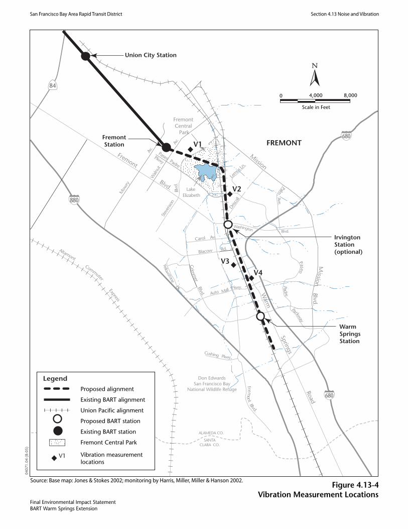

San
Fra
ncis
co B
ay A
rea
Rap
id T
rans
it D
istri
ct
S
ectio
n 4.
13.
Noi
se a
nd V
ibra
tion
BA
RT
War
m S
prin
gs E
xten
sion
Fi
nal E
nviro
nmen
tal I
mpa
ct S
tate
men
t V
olum
e 1
4.13
-7
June
200
6
J&S
040
71.0
4
Tabl
e 4.
13-1
. D
escr
iptio
n of
Am
bien
t Noi
se a
nd V
ibra
tion
Mea
sure
men
t Site
s
Site
Num
ber
Clo
sest
Rec
epto
r Su
rrou
ndin
g La
nd U
se
Maj
or E
xist
ing
Noi
se a
nd
Vib
ratio
n So
urce
s A
ppro
xim
ate
Dis
tanc
e fr
om S
ourc
e (F
eet)
1 Fr
emon
t Vill
as
Res
iden
tial/p
ark
Stev
enso
n B
oule
vard
(n, v
a )Fo
rmer
SP
(n)
300
3,00
0
2 So
ftbal
l fie
ld in
Cen
tral P
ark
Park
St
even
son
Bou
leva
rd (n
, v)
Form
er S
P (n
) U
P (n
)
800
1,40
0 2,
200
3 16
21 V
alde
z W
ay
Res
iden
tial
Form
er S
P (n
, v)
UP
(n, v
) 67
5b
80b
4 40
779
Vac
a D
rive
Res
iden
tial
Form
er S
P (n
) U
P (n
, v)
Pase
o Pa
dre
Park
way
(n)
620b
90b
570b
5 32
24, 3
232
Nea
l Ter
race
M
ulti-
fam
ily re
side
ntia
l Fo
rmer
SP
(n, v
) U
P (n
, v)
Was
hing
ton
Bou
leva
rd (n
, v)
50 400
1,40
0
6 A
partm
ents
sout
h of
Was
hing
ton
Bou
leva
rd, w
est
of a
lignm
ent
Res
iden
tial/c
omm
erci
al
Form
er S
P (n
, v)
UP
(n, v
) W
ashi
ngto
n B
oule
vard
(n)
60 350
250
7 H
omes
at e
nd o
f Bla
cow
Roa
d R
esid
entia
l Fo
rmer
SP
(n, v
) U
P (n
, v)
50 100
8 G
rimm
er E
lem
enta
ry S
choo
l R
esid
entia
l Fo
rmer
SP
(n, v
) U
P (n
, v)
I-68
0 (n
, v)
50 100
1,40
0
9 42
950
Osg
ood
Roa
d C
omm
erci
al
Form
er S
P (n
) U
P (n
) I-
680
(n)
Osg
ood
Roa
d (n
, v)
730
670
420b
13
10
Hac
kam
ore
Lane
and
War
m S
prin
gs B
oule
vard
R
esid
entia
l W
arm
Spr
ings
Bou
leva
rd (n
, v)
17
11
4767
1 W
estin
ghou
se D
rive
Indu
stria
l Fo
rmer
SP
(n, v
) U
P (n
, v)
I-88
0 (n
)
200
100
1,80
0

San
Fra
ncis
co B
ay A
rea
Rap
id T
rans
it D
istri
ct
S
ectio
n 4.
13.
Noi
se a
nd V
ibra
tion
BA
RT
War
m S
prin
gs E
xten
sion
Fi
nal E
nviro
nmen
tal I
mpa
ct S
tate
men
t V
olum
e 1
4.13
-8
June
200
6J&
S 0
4-07
1
Site
Num
ber
Clo
sest
Rec
epto
r Su
rrou
ndin
g La
nd U
se
Maj
or E
xist
ing
Noi
se a
nd
Vib
ratio
n So
urce
s A
ppro
xim
ate
Dis
tanc
e fr
om S
ourc
e (F
eet)
12
101
Cam
phor
Ave
nue
Res
iden
tial
War
m S
prin
gs B
oule
vard
(n, v
) 25
Not
es:
a n
= no
ise,
v =
vib
ratio
n b
Parti
ally
shie
lded
from
noi
se so
urce
Sour
ce:
Wils
on, I
hrig
& A
ssoc
iate
s 199
1; H
arris
, Mill
er, M
iller
and
Han
son
2002

San
Fra
ncis
co B
ay A
rea
Rap
id T
rans
it D
istri
ct
S
ectio
n 4.
13.
Noi
se a
nd V
ibra
tion
BA
RT
War
m S
prin
gs E
xten
sion
Fi
nal E
nviro
nmen
tal I
mpa
ct S
tate
men
t V
olum
e 1
4.13
-9
June
200
6J&
S 0
4-07
1
Tabl
e 4.
13-2
.S
umm
ary
of M
ay 2
002
Exi
stin
g A
mbi
ent N
oise
Mea
sure
men
t Res
ults
Star
t of M
easu
rem
ent
Noi
se E
xpos
ure
(dB
A)
Site
Num
ber*
D
escr
iptio
n of
Mea
sure
men
t Site
D
ate
Tim
e
Mea
sure
men
t
Dur
atio
n (H
ours
) L d
n L e
q
LT-1
M
ulti-
fam
ily re
side
ntia
l; Pr
esid
io a
partm
ent c
ompl
ex
5/15
/02
10:0
0 24
57
–
LT-2
M
ulti-
fam
ily re
side
ntia
l; R
ed H
awk
Ran
ch A
partm
ents
5/
15/0
2 10
:00
24
53
–
LT-3
Si
ngle
-fam
ily re
side
nce
at 1
549
Val
dez
Way
5/
13/0
2 17
:00
24
53
–
LT-4
Si
ngle
-fam
ily re
side
nce
at 4
0807
Vac
a R
oad
5/13
/02
17:0
0 24
53
–
LT-5
M
ulti-
fam
ily re
side
ntia
l; 32
40 N
eal R
oad
5/13
/02
18:0
0 24
60
–
LT-6
Si
ngle
-fam
ily re
side
nce
at 3
073
Dris
coll
Roa
d, A
pt A
5/
13/0
2 18
:00
24
54
–
LT-7
Si
ngle
-fam
ily re
side
nce
at 3
621
Kay
Cou
rt 5/
14/0
2 18
:00
24
66
–
LT-8
Si
ngle
-fam
ily re
side
nce
at 4
3244
New
port
Driv
e 5/
14/0
2 18
:00
24
65
–
LT-9
Si
ngle
-fam
ily re
side
nce
at 4
4788
Old
War
m S
prin
gs R
oad
5/15
/02
19:0
0 24
61
–
ST-1
Fr
emon
t Cen
tral P
ark,
nea
r wal
king
pat
h 5/
16/0
2 7:
35
1 –
49
ST-2
St
. Ann
e’s E
pisc
opal
Chu
rch/
Chu
rch
of C
hris
t 5/
13/0
2 17
:00
1 –
54
ST-3
E.
M. G
rimm
er E
lem
enta
ry S
choo
l 5/
16/0
2 16
:56
1 –
53
Not
es:
* L
ocat
ions
of n
oise
mea
sure
men
t site
s are
show
n on
Fig
ure
4.13
-3.
Sour
ce: H
arris
, Mill
er, M
iller
and
Han
son,
200
2

San Francisco Bay Area Rapid Transit District Section 4.13. Noise and Vibration
BART Warm Springs Extension Final Environmental Impact Statement Volume 1
4.13-10 June 2006
J&S 04071.04
Existing Vibration Conditions The only considerable sources of existing groundborne vibration along the WSX Alternative alignment are the UP freight trains operating along the existing tracks in the corridor. Figure 4.13-5 shows existing vibration levels generated by the freight trains as a function of distance from the track. The vibration measurements of the freight trains represent the current vibration levels experienced by residents near the active UP line, and are not related to the BART vehicles.
In addition to measuring the vibration levels from the existing freight trains, the vibration propagation characteristics of the substrate were also measured at representative locations. This information is used later in the process of predicting ground vibration from BART train operations.
4.13.3 Regulatory Setting4.13.3.1 Federal Guidelines The Federal Transit Administration (FTA) has adopted noise and vibration criteria for the evaluation of noise impacts associated with mass transit projects, including rail rapid transit systems. These criteria are contained within the FTA guidance manual, Transit Noise and Vibration Impact Assessment (Federal Transit Administration 1995). Operational noise and vibration impacts associated with the WSX Alternative are assessed using FTA’s criteria, which are discussed below.
The FTA noise impact criteria are founded on well-documented research on community reaction to noise and are based on a sliding-scale description of change in noise exposure. Although higher transit noise levels are allowed in neighborhoods with high levels of existing noise, smaller increases in cumulative noise exposure are allowed with increasing levels in areas with higher existing noise.
The FTA noise impact criteria group noise-sensitive land uses into the following three categories.
Category 1 – Buildings or parks where quiet is an essential element of their purpose.
Category 2 – Residences and buildings where people normally sleep. This category includes residences, hospitals, and hotels, where nighttime sensitivity is assumed to be of utmost importance.
Category 3 – Institutional land uses with primarily daytime and evening use. This category includes schools, libraries, churches, and active parks.
Ldn is used to characterize noise exposure for residential areas (Category 2). For other noise-sensitive land uses, such as outdoor amphitheaters and school buildings (Categories 1 and 3), the maximum 1-hour Leq during the facility’s operating period is used.
There are two levels of impact included in the FTA criteria. The interpretation of these two levels of impact is summarized below:
Severe: Severe noise impacts are considered "significant" as this term is used in the National Environmental Policy Act (NEPA) and implementing regulations. Noise mitigation will normally be specified for severe impact areas unless there is no practical method of mitigating the noise.


San Francisco Bay Area Rapid Transit District Section 4.13. Noise and Vibration
BART Warm Springs Extension Final Environmental Impact Statement Volume 1
4.13-11 June 2006
J&S 04071.04
Impact: In this range of noise impact, sometimes referred to as moderate impact, other project-specific factors must be considered to determine the magnitude of the impact and the need for mitigation. These other factors can include the predicted increase over existing noise levels, the types and number of noise-sensitive land uses affected, existing outdoor-indoor sound insulation, and the cost effectiveness of mitigating noise to more acceptable levels.
The noise impact criteria are summarized in Table 4.13-3. The first column shows the existing noise exposure, and the other columns show the additional noise exposure from the WSX Alternative that would cause either moderate or severe impacts. The future noise exposure would be the combination of the existing noise exposure plus the additional noise exposure caused by the WSX Alternative. Table 4.13-3 shows the amount of noise a project can generate, depending on existing noise levels, before FTA noise criteria are exceeded.
Table 4.13-3. FTA Noise Impact Criteria
Noise Exposure Criteria, Ldn or Leq (dBA) Category 1 or 2 Sites Category 3 Sites Existing Noise Exposure
Leq or Ldn Moderate Impact Severe Impact Moderate Impact Severe Impact <43 Amb.+10 Amb.+15 Amb.+15 Amb.+20 43 52 58 57 63 44 52 59 57 64 45 52 59 57 64 46 52 59 57 64 47 52 59 57 64 48 53 59 58 64 49 53 59 58 64 50 53 60 58 65 51 54 60 59 65 52 54 60 59 65 53 54 60 59 65 54 55 61 60 66 55 55 61 60 66 56 56 62 61 67 57 56 62 61 67 58 57 62 62 67 59 57 63 62 68 60 58 63 63 68 61 58 64 63 69 62 59 64 64 69 63 60 65 65 70 64 60 66 65 71 65 61 66 66 71 66 61 67 66 72

San Francisco Bay Area Rapid Transit District Section 4.13. Noise and Vibration
BART Warm Springs Extension Final Environmental Impact Statement Volume 1
4.13-12 June 2006
J&S 04071.04
Noise Exposure Criteria, Ldn or Leq (dBA) Category 1 or 2 Sites Category 3 Sites Existing Noise Exposure
Leq or Ldn Moderate Impact Severe Impact Moderate Impact Severe Impact 67 62 67 67 72 68 63 68 68 73 69 64 69 69 74 70 64 69 69 74 71 65 70 70 75 72 65 71 70 76 73 65 72 70 77 74 65 72 70 77 75 65 73 70 78 76 65 74 70 79 77 65 75 70 80
>77 65 75 70 80
Notes: Ldn is used for land uses where nighttime sensitivity is a factor; maximum 1-hour Leq is used for land use involving only daytime activities. Source: Federal Transit Administration 1995
FTA’s vibration impact criteria are thresholds for ground-borne vibration and ground-borne noise (i.e., “rumbling” or other noise associated with vibration), depending on the land use category. These criteria are presented in Table 4.13-4. Special criteria (not shown in Table 4.13-4) apply to particularly sensitive building types, such as concert halls, TV studios, recording studios, auditoriums, and theaters.

San Francisco Bay Area Rapid Transit District Section 4.13. Noise and Vibration
BART Warm Springs Extension Final Environmental Impact Statement Volume 1
4.13-13 June 2006
J&S 04071.04
Table 4.13-4. FTA Ground-Borne Vibration and Noise Impact Criteria
Ground-Borne Vibration Impact Levels
(VdB re 1 micro-inch/sec)
Ground-Borne Noise Impact Levels
(dB re 20 micro Pascals)
Land Use
Category Description of Land Use Category
Frequent Eventsa
Infrequent Eventsb
Frequent Eventsa
Infrequent Eventsb
1
Buildings where low ambient vibration is essential to the operations within the building, which vibrations may be well below levels associated with human annoyance. Concert halls, TV studios and recording studios are included in this category only for the purpose of applying these screening distances. Always included are vibration-sensitive research and manufacturing, hospitals with vibration-sensitive equipment, certain university research operations, and computer-chip manufacturing facilities where electron microscopes and photolithographic equipment are used.
65 VdBc 65 VdBc --d -- d
2
Residences and buildings where people normally sleep. This category includes homes, hospitals, and hotels. Theatres and auditoriums are included in this category for the purpose of applying screening distances only.
72 VdB 80 VdB 35 dBA 43 dBA
3
Institutional land uses such as schools, libraries, and churches. Buildings with interior spaces where vibration-sensitive equipment is not present but where excessive vibration could cause activity interference through human annoyance are included (e.g., certain offices).
75 VdB 83 VdB 40 dBA 48 dBA
Notes: a “Frequent Events” is defined as more than 70 vibration events per day. Most transit actions fall into this category. b “Infrequent Events” is defined as fewer than 70 vibration events per day. This category includes most commuter
rail systems. c This criterion limit is based on levels that are acceptable for most moderately sensitive equipment such as optical
microscopes. Vibration sensitive manufacturing or research will require detailed evaluation to define the acceptable vibration levels. Ensuring lower vibration levels in a building often requires special design of the HVAC systems and stiffened floors.
d Vibration-sensitive equipment is not sensitive to ground-borne noise.
Source: Federal Transit Administration 1995
In addition to the vibration criteria summarized in Table 4.13-4, FTA has established vibration damage criteria of 0.20 inches per second (approximately 100 VdB) for fragile buildings, and 0.12 inches per second (approximately 95 VdB) for extremely fragile historic buildings.

San Francisco Bay Area Rapid Transit District Section 4.13. Noise and Vibration
BART Warm Springs Extension Final Environmental Impact Statement Volume 1
4.13-14 June 2006
J&S 04071.04
There are no commonly accepted criteria for acceptable levels of noise from construction activities. FTA suggests the guidelines shown in Table 4.13-5 as reasonable criteria for the assessment of construction noise impacts. Table 4.13-5. FTA Suggested Construction Noise Criteria
One-Hour Leq (dBA)
Land Use Day Night
Residential 90 80
Commercial 100 100
Industrial 100 100
Source: Federal Transit Administration 1995
The FTA guidance manual does not include any noise limits that are specifically applicable to stationary ancillary equipment such as substations and ventilation shafts. Therefore, BART’s criteria for operational noise from ancillary facilities are used in this analysis. BART’s adopted criteria for noise and vibration are found in its 1992 Extensions Program System Design Criteria. The criteria specify maximum passby noise and vibration levels for BART trains and maximum noise levels from ancillary facilities, which are related directly to the community area categories defined by BART. Table 4.13-6 presents the BART criteria for ancillary facilities.
Table 4.13-6. BART Design Criteria for Operational Noise from Ancillary Facilities
Maximum Noise Level (dBA)
BART Area Category* Transient Continuous
Category I, Low Density Residential: urban residential, open space park, suburban residential or quiet recreation area; no nearby highways or boulevards
50 40
Category II, Average Residential: urban residential, quiet apartments and hotels, open space, suburban residential, or occupied outdoor areas near busy streets
55 45
Category III, High Density Residential: urban residential, average semi-residential/commercial areas, parks, museum, and non-commercial public building areas
60 50
Category IV, Commercial: areas with office buildings, retail stores, etc., primarily daytime occupancy; central business districts
65 55
Category I Industrial/Highway: areas or freeway and highway corridors 70 65
Notes: Criteria are reduced by 5 dBA for noises with pure tones. * Residential land uses are described in additional detail in Section 3.4 (Land Use and Planning).
Source: San Francisco Bay Area Rapid Transit District 1992

San Francisco Bay Area Rapid Transit District Section 4.13. Noise and Vibration
BART Warm Springs Extension Final Environmental Impact Statement Volume 1
4.13-15 June 2006
J&S 04071.04
4.13.4 Environmental Consequences and Mitigation MeasuresThis section presents the analysis of potential noise and vibration impacts that could result from implementation of the WSX Alternative. Where adverse noise impacts are identified, mitigation measures to reduce the severity of impacts are identified, where feasible.
4.13.4.1 Methodology for Analysis of Environmental ConsequencesNoise Impacts Methodology BART train and ancillary equipment noise impacts associated with implementation of the WSX Alternative were evaluated using methods defined by FTA (Federal Transit Administration 1995). Additional information considered included noise measurements conducted by Wilson, Ihrig & Associates, Inc. (WIA) and published in 1998 (Wilson, Ihrig & Associates, Inc. 1998), the speed profile designed by BART’s general engineering consultant, and the conceptual engineering drawings of the alignment (see Figure 3-5a through Figure 3-8b). Key assumptions and analytical methods used in this assessment are summarized below.1
Based on the WIA memorandum, the predictions assume that a single 75-foot-long vehicle operating at 80 mph on ballast and tie track with continuous welded rail (CWR) generates a maximum noise level of 84 dBA at a distance of 50 feet from the track centerline. The projections of Lmax values at receptors along the corridor are calculated using standard models for transit vehicles and take into account the actual anticipated operating speed of the vehicles.
The span of service (hours of operation) for the WSX Alternative would be between 4:00 a.m. and midnight. The operating plan for BART service specifies peak headways of 12 minutes and an off-peak headway of 20 minutes, for both the Richmond service and the Daly City service. BART vehicles would operate with 10 cars throughout the day.
Peak operations would occur between 4:00 a.m. and 7:00 p.m. and off-peak operations would occur between 7:00 p.m. and 12:00 a.m. for the Warm Springs/Richmond Service. The operations would be identical for the Warm Springs/Daly City service, except that peak operations would commence at 5:00 a.m.
Vehicle operating speeds are based on the speed profile. Speed limits would range from 36 mph to 70 mph along the corridor.
An additional 6 dB is added to the noise projections for receptors near crossovers.2
1 In this NEPA document, FTA noise criteria are used to identify noise impacts. In the 2003 Supplemental EIR (San Francisco Bay Area Rapid Transit 2003), BART’s adopted noise criteria from its Extensions Program System Design Criteria were used to identify noise impacts. The FTA noise impact criteria is used in this analysis and identifies more noise impacts than the BART noise impact criteria. 2 The term crossover refers to special trackwork that allow transit vehicles to switch between tracks. Crossovers contain gaps in the track to allow the wheels to move from one track to the other, and these gaps generate additional noise and vibration as the vehicle moves through the crossover.

San Francisco Bay Area Rapid Transit District Section 4.13. Noise and Vibration
BART Warm Springs Extension Final Environmental Impact Statement Volume 1
4.13-16 June 2006
J&S 04071.04
Noise impacts resulting from construction activities were modeled using methodology developed by FTA (Federal Transit Administration 1995). Under this methodology, FTA identifies noise source levels at a fixed distance of 50 feet for various types of construction activity. The noise levels from these sources are then calculated at receiver locations based on a noise attenuation model.
Vibration Impacts Methodology Vibration impacts caused by BART trains associated with the WSX Alternative were evaluated using methods defined by FTA (Federal Transit Administration 1995) and vibration measurement data. Key assumptions and analysis methods used in this assessment are summarized below.
Vibration source levels were based on measurements previously conducted on vehicles operating on the existing BART system by WIA (1998).
Vibration propagation tests were conducted at four sites along the corridor near sensitive receptors. Figure 4.13-4 shows the locations of the propagation tests along the proposed WSX Alternative corridor. These tests measured the ground’s response to an input force. The results of these tests were combined with the vibration source level measurements to provide projections of future vibration levels from vehicles operating on the WSX Alternative alignment. A more detailed discussion of the vibration impact analysis procedure is contained in the noise and vibration technical report (Harris, Miller, Miller & Hanson 2003).
Vehicle operating speeds are based on the BART speed profile. The speed limits range from 36 mph to 70 mph along the corridor.
An additional 10 dB is added to the vibration projections for receptors near crossovers.
The assessment assumes that the BART vehicle wheels and track are maintained in good condition with regular wheel truing and rail grinding.
4.13.4.2 Alternative-Specific Environmental Analysis Impacts Related to Operation of the WSX Alternative Impact N-1—Exposure of noise-sensitive land uses to noise from BART trains in the WSX Alternative corridor.
WSX Alternative. Detailed projections were made of the future noise exposure along the WSX Alternative alignment. The future noise levels were compared to the measured existing noise levels presented above in Existing Conditions to determine locations where noise impacts are expected to result from operation of the WSX Alternative. Table 4.13-7 lists results for the residential receptors with both daytime and nighttime sensitivity to noise (e.g., residences and hotels), from north to south along the alignment. Table 4.13-8 lists all institutional receptors that are not sensitive to noise at night (e.g., schools and churches), from north to south along the alignment. Both tables include the locations, the civil station, side of track, distance to the near track, and vehicle speed. The distance from the near track and the projected noise level represent the worst case within the group of residences. All the receptors along the alignment fall into FTA Category 2 (residences and buildings where people sleep) or Category 3 (institutional uses with primarily daytime and evening use such as schools, libraries, and churches) for the noise analysis.

San Francisco Bay Area Rapid Transit District Section 4.13. Noise and Vibration
BART Warm Springs Extension Final Environmental Impact Statement Volume 1
4.13-17 June 2006
J&S 04071.04
Table 4.13-7 provides the existing and future noise levels in terms of Ldn, the projected increase in noise, the amount of increase allowed by FTA noise impact criteria, and the number of impacts. Table 4.13-8 contains the same information for institutional uses (FTA Category 3), but the noise levels are presented in terms of the peak-hour Leq, instead of the Ldn.
As shown in Table 4.13-7, noise impacts are anticipated for a total of 467 residences, with 321 moderate impacts and 146 severe impacts A brief discussion of each affected area follows.
Walnut Avenue to Stevenson Boulevard (east side). Noise impacts are projected at twelve buildings in the Red Hawk Ranch Apartments complex that contain 282 total units. There are 198 moderate noise impacts and 84 severe noise impacts projected at this location. These noise impacts would result from a combination of the speed of the BART vehicles and the proximity of the buildings to the tracks (less than 100 feet for some buildings) (Figure 4.13-6a).
Walnut Avenue to Stevenson Boulevard (west side). Noise impacts are projected at nine buildings in the Fremont Villas condominiums that have four units each (for a total of 36 residences). There are 24 moderate noise impacts and twelve severe noise impacts projected at this location. These noise impacts result from a combination of the speed of the BART vehicles and the proximity of the buildings to the tracks (less than 50 feet for some buildings) (` 4.13-6a).
Valdez Way/Vaca Road (east side). Moderate noise impacts are projected at nine residences in this location. The noise impacts are due to the speed of the BART vehicles and the relatively low ambient noise levels in this area (Figure 4.13-6b).
Paseo Padre Parkway to Washington Boulevard (west side). Moderate noise impacts are projected at four residences in this location. The noise impacts at this location are due to the proximity of the residences to the crossover located between Stations 2309 and 2315 (Figure 4.13-6b).
Paseo Padre Parkway to Washington Boulevard (east side). Noise impacts are projected at a total of 50 single-family residences and at six buildings in the proposed senior housing in this area. Of these, 20 are located along Valero Drive within 170 feet of the tracks (plus the Senior Housing Project). Moderate impacts are projected at two of the senior housing buildings and severe impacts are projected at 20 residences and four of the buildings in the senior housing. In addition to the proximity of the residences to the tracks and the speed of the BART vehicles, the crossover between Stations 2309 and 2315 is projected to contribute to the noise impacts at these residences. Noise impacts are predicted to occur at 30 additional residences just south of this area along Driscoll Road. Moderate impacts are projected at ten of these residences and severe impacts are projected at 20 of the residences. The noise impact at this location would result primarily from the short distance between the tracks and the residences (20 feet for the closest residence) (Figure 4.13-6c).
Washington Boulevard to Blacow Road (east side). Moderate noise impacts are projected seven at residences in this location. The noise impacts at this location would result primarily from the speed of the BART vehicles (70 mph) (Figure 4.13-6c).
Washington Boulevard to Blacow Road (west side). Twelve noise impacts are projected at residences in this location. Moderate impact is projected at six residences and severe impact is projected at six residences at this location. The noise impacts at this location would result primarily from the speed of the BART vehicles (70 mph) (Figure 4.13-6c).
San Francisco Bay Area Rapid Transit District Section 4.13. Noise and Vibration
BART Warm Springs Extension Final Environmental Impact Statement Volume 1
4.13-18 June 2006
J&S 04071.04
Blacow Road to Auto Mall Parkway (west side). 58 moderate noise impacts are projected at residences in this location. The noise impacts at this location would result primarily from the speed of the BART vehicles (70 mph) (Figures 4.13-6c and 6d).
Auto Mall Parkway to South Grimmer Road (west side). Three moderate noise impacts are projected at residences in this location. The noise impacts at this location would result primarily from the speed of the BART vehicles (70 mph). Because of the proximity to the Warm Springs Station, the impacts at this location should be reevaluated when more detailed speed profiles are developed during final design, which could result in lower projected noise levels (Figures 4.13-6e).
An assessment of noise impacts for institutional receptors was also conducted (see Table 4.13-8). This assessment was also based on a comparison of the predicted maximum noise level with the FTA design criteria for these types of buildings.
The measured existing peak hour Leq at the school tends to be low. The measurement was taken during a period proscribed by FTA for institutional land uses. For an impact to occur, the peak hour Leq must be around 42 to 45 dBA, which is not likely for a suburban daytime Leq. As indicated in Table 4.13-8, the results predict moderate noise impact at the E. M. Grimmer Elementary School playground.
The total number of noise impacts (both residential and institutional) along the WSX Alternative alignment is 468 (467 residences and the playground). Figures 4.13-6a through 4.13-6e show the locations of the noise impacts.
As stated earlier, FTA’s guidance states that noise mitigation should be applied to severe impacts unless there is no practical method of mitigating the noise. In the moderate impact range, other project factors should be considered in determining the need for noise mitigation. Two of the factors that FTA states should be considered in determining the need for mitigation at the moderate impact level include:
the increase in noise level due to the introduction of the project,
and providing cost effective mitigation measures relative to the amount of noise reduction required.
For this project, all severe impacts are proposed to be mitigated. At the moderate impact level, a 5 dBA increase in the noise levels due to the project is used to determine the location for mitigation. For locations in the moderate impact category with a greater than 5 dBA increase in noise, mitigation is recommended. For locations in the moderate impact category with an increase in noise less than 5 dBA, no noise mitigation is recommended.
The 5 dBA increase in noise level represents a substantial change in the noise levels due to the introduction of the project. In addition, a noise barrier that would provide less than 5 dBA of mitigation for the project noise would not be cost effective, based on the amount of reduction required.


San
Fra
ncis
co B
ay A
rea
Rap
id T
rans
it D
istri
ct
S
ectio
n 4.
13.
Noi
se a
nd V
ibra
tion
BA
RT
War
m S
prin
gs E
xten
sion
Fi
nal E
nviro
nmen
tal I
mpa
ct S
tate
men
t V
olum
e 1
4.13
-19
June
200
6
J&S
040
71.0
4
Tabl
e 4.
13-7
.R
esid
entia
l Noi
se Im
pact
s of
WS
X A
ltern
ativ
e
Noi
se L
evel
(Ldn
, dB
A)
N
oise
Exp
osur
e (L
dn, d
BA
)a
FTA
Crit
erio
n N
umbe
r of
Impa
cts
Loca
tion
Civ
ilSt
atio
nSi
de o
f Tr
ack
Dis
t to
Nea
r Tr
ack
(ft)
Spee
d (m
ph)
Ex
istin
g Fu
ture
b
Incr
ease
Im
pact
Se
vere
Im
pact
Se
vere
Wal
nut A
ve to
St
even
son
Blv
d 22
27 to
22
42
East
14
5 50
/70
57
63
8.4
2.9
6.6
19
8 84
Wal
nut A
ve to
St
even
son
Blv
d 22
30 to
22
38
Wes
t 45
70
/70
53
70
16.3
3.
8 8.
2
24
12
Val
dez
Way
/Vac
a R
oad
2290
to
2304
Ea
st
300
70
53
60
7.4
4.2
8.8
9
0
Pase
o Pa
dre
Park
way
to
Was
hing
ton
Blv
d 23
08 to
23
34
Wes
t 39
0 70
60
65
4.
6 2.
0 5.
0
4 0
Pase
o Pa
dre
Park
way
to
Was
hing
ton
Blv
d 23
08 to
23
34
East
20
70
54
77
22
.7
3.5
7.6
12
44
Was
hing
ton
Blv
d to
B
laco
w R
oad
2339
to
2370
Ea
st
340
70
54
60
5.8
3.5
7.6
7
0
Was
hing
ton
Blv
d to
B
laco
w R
oad
2339
to
2368
W
est
95
70
66
70
3.8
1.3
3.4
6
6
Bla
cow
Roa
d to
Aut
o M
all P
arkw
ay
2370
to
2415
W
est
130
70
65
68
3.1
1.5
3.9
58
0
Aut
o M
all P
arkw
ay to
So
uth
Grim
mer
Roa
d 24
15 to
24
51
Wes
t 23
0 70
61
63
2.
0 1.
9 4.
7
3 0
Tot
al:
321
146
Not
e:a
Incr
ease
s in
nois
e le
vel a
nd th
e im
pact
crit
erio
n ar
e re
porte
d to
0.1
dec
ibel
s so
that
roun
ding
err
ors i
n th
e re
sults
do
not l
ead
to c
onfu
sion
.b
Futu
re c
umul
ativ
e am
bien
t noi
se c
ondi
tions
are
ass
umed
to b
e th
e sa
me
as e
xist
ing
ambi
ent n
oise
con
ditio
ns.
Sour
ce: H
arris
, Mill
er, M
iller
and
Han
son
2002
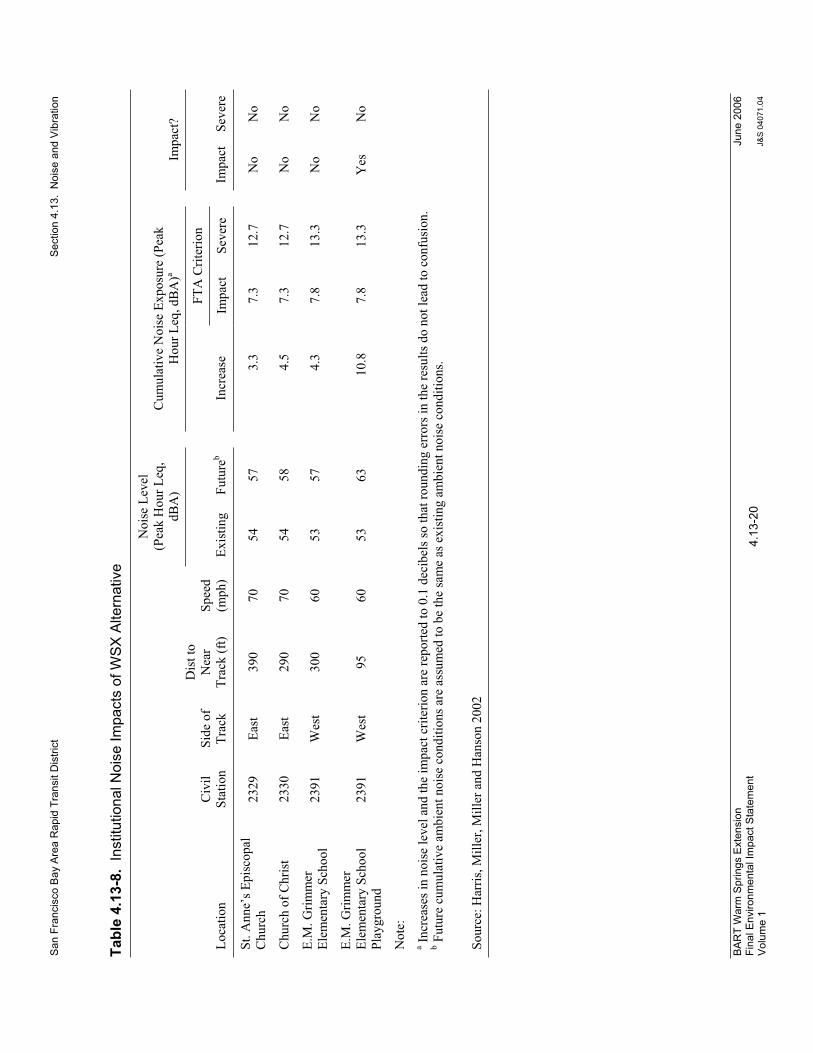
San
Fra
ncis
co B
ay A
rea
Rap
id T
rans
it D
istri
ct
S
ectio
n 4.
13.
Noi
se a
nd V
ibra
tion
BA
RT
War
m S
prin
gs E
xten
sion
Fi
nal E
nviro
nmen
tal I
mpa
ct S
tate
men
t V
olum
e 1
4.13
-20
June
200
6
J&S
040
71.0
4
Tabl
e 4.
13-8
.In
stitu
tiona
l Noi
se Im
pact
s of
WSX
Alte
rnat
ive
Noi
se L
evel
(Pea
k H
our L
eq,
dBA
) C
umul
ativ
e N
oise
Exp
osur
e (P
eak
Hou
r Leq
, dB
A)a
Impa
ct?
FTA
Crit
erio
n
Loca
tion
Civ
ilSt
atio
nSi
de o
f Tr
ack
Dis
t to
Nea
rTr
ack
(ft)
Spee
d (m
ph)
Exis
ting
Futu
reb
In
crea
se
Impa
ct
Seve
re
Im
pact
Se
vere
St. A
nne’
s Epi
scop
al
Chu
rch
2329
Ea
st
390
70
54
57
3.
3 7.
3 12
.7
N
o N
o
Chu
rch
of C
hris
t 23
30
East
29
0 70
54
58
4.5
7.3
12.7
No
No
E.M
. Grim
mer
El
emen
tary
Sch
ool
2391
W
est
300
60
53
57
4.
3 7.
8 13
.3
N
o N
o
E.M
. Grim
mer
El
emen
tary
Sch
ool
Play
grou
nd
2391
W
est
95
60
53
63
10
.8
7.8
13.3
Yes
N
o
Not
e:a
Incr
ease
s in
nois
e le
vel a
nd th
e im
pact
crit
erio
n ar
e re
porte
d to
0.1
dec
ibel
s so
that
roun
ding
err
ors i
n th
e re
sults
do
not l
ead
to c
onfu
sion
.b
Futu
re c
umul
ativ
e am
bien
t noi
se c
ondi
tions
are
ass
umed
to b
e th
e sa
me
as e
xist
ing
ambi
ent n
oise
con
ditio
ns.
Sour
ce: H
arris
, Mill
er, M
iller
and
Han
son
2002

San Francisco Bay Area Rapid Transit District Section 4.13. Noise and Vibration
BART Warm Springs Extension Final Environmental Impact Statement Volume 1
4.13-21 June 2006
J&S 04071.04
Table 4.13-9 identifies the location of noise barriers needed to provide mitigation for severe impacts and moderate impacts where the increase in noise is greater than 5 dB along the WSX Alternative alignment. Table 4.13-9 also indicates that noise mitigation with barriers is not feasible for two residences. At these two residences, sound insulation would be the only feasible mitigation available to reduce impacts. Mitigation Measure N-1 identifies mitigation that would reduce noise impacts resulting from operation of the WSX Alternative.
Table 4.13-9. Potential Locations for Noise Barriers to Reduce Impacts
Location Civil Station Side of Track
Length(Feet)
Number of Residences Exposed to
Impacts without Mitigationc
Number of Residences Exposed to
Impacts with Mitigationa
Walnut Ave to Stevenson Blvd 2223 – 2242 East 1,900 282 0
Walnut Ave to Stevenson Blvd 2223 – 2240 West 1,700 36 0
Stevenson Blvd to Paseo Padre Parkway 2295-2305 East 1,000 9 0
Paseo Padre Parkway to Washington Blvd 2308 – 2337 East 2,900 56 2
Washington Blvd to Blacow Road 2355 – 2369 West 1,400 10 0
Total: 8,900 393 2b
Note: a The mitigation assessment assumes a minimum of 8 dB of noise reduction for a noise barrier. Detailed barrier design
and mitigation projections are required during the design phase of the project. b At these residences, building sound insulation is the only feasible mitigation to reduce impacts c Severe impacts and moderate impacts where there is a 5 dB increase in noise.
Source: Harris, Miller, Miller and Hanson 2002
Mitigation Measure N-1—Implement noise-reducing measures at noise-sensitive land uses in the WSX Alternative corridor. The following mitigation measures are available for reducing noise impacts from operation of the WSX Alternative. The measures include but are not limited to the following.
Noise Barriers – Construction of barriers is a common approach to reducing noise impacts from surface transportation sources. The primary requirements for an effective noise barrier are that (1) the barrier be high enough and long enough to break the line-of-sight between the sound source and the receiver; (2) the barrier be of an impervious material with a minimum surface density of 4 lb/sq. ft., and (3) the barrier not have any gaps or holes between the panels or at the bottom. Because numerous materials meet these requirements, the selection of materials for noise barriers is usually dictated by aesthetics, durability, cost, and maintenance considerations. Depending on the proximity of the barrier to the tracks and on the track elevation, transit system noise barriers typically range in height from between 4 and 8 feet. Building Sound Insulation – Sound insulation of residences and institutional buildings to improve the outdoor-to-indoor noise reduction has been widely applied around airports

San Francisco Bay Area Rapid Transit District Section 4.13. Noise and Vibration
BART Warm Springs Extension Final Environmental Impact Statement Volume 1
4.13-22 June 2006
J&S 04071.04
and has seen limited application for transit projects. Although this approach has no effect on noise in exterior areas, it may be the best choice for sites where noise barriers are not feasible or desirable, and for buildings where indoor sensitivity is of greatest concern. Substantial improvements in building sound insulation (on the order of 5 to 10 dBA) can often be achieved by adding an extra layer of glazing to the windows, sealing any holes in exterior surfaces that act as sound leaks, and providing forced ventilation and air-conditioning so that windows need not to be opened. Special Trackwork at Crossovers – Because the impacts of wheels over rail gaps at track crossover locations increase noise by about 6 dBA, crossovers in sensitive areas are a major source of noise impact. The first option for mitigation is to relocate the crossovers. BART Facility Standards do not allow the use of spring rail or moving point frogs. Per Standard, all mainline frogs shall be rail-bound manganese type in accordance with AREMA Portfolio Plan No. 621.
The primary mitigation measure would be the construction of sound barrier walls to shield areas where impacts are predicted. Table 4.13-9 indicates the approximate noise barrier locations, lengths, and side of track, as well as the number of impacts that would be reduced. Barriers are assumed to provide at least 8 dB of noise reduction. Other measures may include installing building sound insulation and relocating the crossover near Station 2311. Specific implementation of the noise mitigation measures described above, including details regarding noise barrier heights and lengths, locations for sound insulation, and locations of crossover, will be addressed in detail during preliminary engineering and final design, when further detail about track and receiver elevation, track location, and other pertinent information will be available. This information will be used to adapt the mitigation measures presented above on a site-specific basis and will allow design at an appropriate level of detail. However, based on reasonable worst-case assumptions, deploying these mitigation measures individually or in combination as necessary will suffice to minimize noise impacts.
No-Build Alternative. The No-Build Alternative would not result in any exposure of noise-sensitive land uses to noise from BART trains in the WSX Alternative corridor.
Impact N-2—Exposure of vibration-sensitive land uses to groundborne vibration from BART trains.
WSX Alternative. Predicted groundborne vibration levels (VdB re 1 micro-in./sec.) resulting from BART train operations are summarized in Tables 4.13-10 and 4.13-11. Vibration-sensitive land uses listed from north to south along the alignment are included in Table 4.13-10 for residential land uses and in Table 4.13-11 for institutional land uses. Each table lists the locations from north to south, civil station, side of the track, distance to the near track, and projected speed at each location. The predicted project maximum vibration level and the FTA impact criterion level are also indicated, together with the number of residences predicted to be exposed to vibration impacts.
Table 4.13-10 indicates that 124 residences are predicted to be exposed to vibration impacts. A brief discussion of each affected area follows.
Walnut Avenue to Stevenson Boulevard (east side). Project-induced vibration impacts are predicted at two buildings in the Red Hawk Ranch Apartments complex with a total of 54 units.
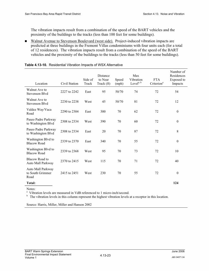
San Francisco Bay Area Rapid Transit District Section 4.13. Noise and Vibration
BART Warm Springs Extension Final Environmental Impact Statement Volume 1
4.13-23 June 2006
J&S 04071.04
The vibration impacts result from a combination of the speed of the BART vehicles and the proximity of the buildings to the tracks (less than 100 feet for some buildings).
Walnut Avenue to Stevenson Boulevard (west side). Project-induced vibration impacts are predicted at three buildings in the Fremont Villas condominiums with four units each (for a total of 12 residences). The vibration impacts result from a combination of the speed of the BART vehicles and the proximity of the buildings to the tracks (less than 50 feet for some buildings).
Table 4.13-10. Residential Vibration Impacts of WSX Alternative
Location Civil Station Side of Track
Distanceto Near
Track (ft) Speed (mph)
Max Vibration Levela, b
FTACriteriona
Number of Residences Exposed to
Impacts
Walnut Ave to Stevenson Blvd 2227 to 2242 East 95 50/70 74 72 54
Walnut Ave to Stevenson Blvd 2230 to 2238 West 45 50/70 81 72 12
Valdez Way/Vaca Road 2290 to 2304 East 300 70 62 72 0
Paseo Padre Parkway to Washington Blvd 2308 to 2334 West 390 70 60 72 0
Paseo Padre Parkway to Washington Blvd 2308 to 2334 East 20 70 87 72 8
Washington Blvd to Blacow Road 2339 to 2370 East 340 70 55 72 0
Washington Blvd to Blacow Road 2339 to 2368 West 95 70 73 72 10
Blacow Road to Auto Mall Parkway 2370 to 2415 West 115 70 71 72 40
Auto Mall Parkway to South Grimmer Road
2415 to 2451 West 230 70 55 72 0
Total: 124
Notes: a Vibration levels are measured in VdB referenced to 1 micro-inch/second. b The vibration levels in this column represent the highest vibration levels at a receptor in this location.
Source: Harris, Miller, Miller and Hanson 2002

San Francisco Bay Area Rapid Transit District Section 4.13. Noise and Vibration
BART Warm Springs Extension Final Environmental Impact Statement Volume 1
4.13-24 June 2006
J&S 04071.04
Table 4.13-11. Institutional Vibration Impacts of WSX Alternative
Location Civil
Station Side of Track
Distanceto Near
Track (ft) Speed (mph)
Max Vibration Levela,b
FTACriterionb Impact?
St. Anne’s Episcopal Church 2324 East 390 70 63 75 No
Church of Christ 2325 East 290 70 66 75 No
E.M. Grimmer Elementary School 2386 West 300 70 61 75 No
Note:a Vibration levels are measured in VdB referenced to 1 micro-inch/sec. b The vibration levels in this column represent the highest vibration levels at a receptor in this location.
Source: Harris, Miller, Miller and Hanson 2002
Valdez Way/Vaca Road (east side). No project-induced vibration impacts are predicted at residences in this location. The residences are located at least 300 feet from the tracks.
Paseo Padre Parkway to Washington Boulevard (west side). No vibration impacts are predicted at residences in this location. The residences are located at least 400 feet from the tracks.
Paseo Padre Parkway to Washington Boulevard (east side). Project-induced vibration impacts are predicted at eight single-family residences in this area. Three residences along Valero Drive are located within 170 feet of the tracks. In addition to the proximity of the residences to the tracks and the speed of the BART vehicles, the crossover between points 2309 and 2315 is expected to contribute to the vibration impact at these residences. Project-induced vibration impacts are predicted at five additional residences located just to the south of this area along Driscoll Road. The vibration impacts result primarily from the short distance between the tracks and the residences (20 feet for the closest residence).
Washington Boulevard to Blacow Road (east side). No vibration impacts are predicted at residences in this location. The residences are located at least 300 feet from the tracks.
Washington Boulevard to Blacow Road (west side). Ten single-family residences are projected to sustain vibration impacts. The vibration impacts result from a combination of the speed of the BART vehicles (70 mph) and the proximity of the residences to the tracks (within 100 feet).
Blacow Road to Auto Mall Parkway (west side). Forty single-family residences are projected to sustain vibration impacts. The vibration impacts result from a combination of the speed of the BART vehicles (70 mph) and the proximity of the residences to the tracks (within 100 feet).
Auto Mall Parkway to South Grimmer Boulevard (west side). No project-induced vibration impacts are predicted at residences in this location. The residences are located at least 200 feet from the tracks.
As shown in Table 4.13-11, no potential institutional vibration impacts were identified along the WSX Alternative alignment.

San Francisco Bay Area Rapid Transit District Section 4.13. Noise and Vibration
BART Warm Springs Extension Final Environmental Impact Statement Volume 1
4.13-25 June 2006
J&S 04071.04
Figures 4.13-7a through 4.13-7e show the locations of potential impacts created by groundborne vibration discussed above. Exposure of residences to vibration from BART train operations is considered an impact. Implementation of the following mitigation measure is expected to reduce this impact.
Mitigation Measure N-2—Implement vibration-reducing measures at vibration-sensitive land uses in the WSX Alternative corridor. The following mitigation measures are available to reduce vibration impacts from operation of the WSX Alternative. The measures may include but are not limited to the following.
Ballast Mats – Rail trackways consist of ballast and ties. Ballast is the aggregate rock material that lies between the crosspieces of wood or concrete that support the rails. A ballast mat consists of a pad made of rubber or rubber-like material placed on an asphalt or concrete base with the normal ballast, ties, and rail above. The reduction in ground-borne vibration provided by a ballast mat depends strongly on the frequency content of the vibration and on the design and support of the mat. Ballast mats will only work in locations where there is ballast and tie track. Resilient Fasteners and/or Resiliently Supported Ties – A number of resilient fastening systems for reducing vibration are available. However, many resilient fasteners are suitable for direct fixation only and would not work for ballast and tie track. Resilient fasteners reduce the amount of vibration energy that is transferred into the track substructure and are effective in reducing ground-borne vibration in frequencies above 30 Hz. Special Trackwork at Crossovers – Because the impacts of wheels over rail gaps at track crossover locations increases vibration by about 10 dBA, crossovers are a major source of vibration impact when they are located in sensitive areas. BART Facility Standards do not allow the use of spring rail or moving point (swing nose) frogs. Per Standard, all mainline frogs shall be rail-bound manganese type in accordance with AREMA Portfolio Plan No. 621.
Table 4.13-12 indicates the areas along the WSX Alternative alignment where mitigation would be needed to reduce vibration levels. BART will identify the most appropriate mitigation measure or combination of measures required at each location to reduce vibration impacts to the greatest extent practicable. Specific implementation of the vibration mitigation measures described above, including details regarding the specific locations and types of mitigation, would be addressed in detail during preliminary engineering and final design. During preliminary engineering and final design, further detail about track and receiver elevation, track location, and other pertinent information will be available. This information would be used to adopt the mitigation measures presented above on a site-specific basis and to allow design at an appropriate level of detail. Implementation of these mitigation measures is expected to reduce the severity of the impacts. However there may be some situations where implementation of all feasible available mitigation may not avoid or minimize impacts. The situations where this could occur cannot be determined until the detailed vibration mitigation design is developed.

San Francisco Bay Area Rapid Transit District Section 4.13. Noise and Vibration
BART Warm Springs Extension Final Environmental Impact Statement Volume 1
4.13-26 June 2006
J&S 04071.04
Table 4.13-12. Potential Locations for Vibration Mitigation
Location Civil Station Length (Feet) Impacts
Walnut Ave to Stevenson Blvd 2230 to 2245 1,500 66
Paseo Padre Parkway to Washington Blvd 2325 to 2332 700 8
Washington Blvd to Auto Mall Parkway 2354 to 2384 and 2388 to 2408 5,000 50
Total: 7,200 124
Source: Harris, Miller, Miller and Hanson 2002
No-Build Alternative. The No-Build Alternative would not result in any exposure of vibration-sensitive land uses to groundborne vibration from BART trains.
Impact N-3—Exposure of noise-sensitive land uses to noise from ancillary equipment.
WSX Alternative. Fixed facilities such as electrical substations, emergency generators, and ventilation shafts can be a source of noise. Using prediction methodology recommended by FTA (Federal Transit Administration 1995) and BART’s impact criteria for Category II, average residential receptors (Table 4.13-6), Table 4.13-13 has been developed to show distances at which noise impacts from ancillary equipment could occur at residences. Although detailed information on the location of substations and vent shafts is not available at this time, the results in Table 4.13-13 indicate that there is potential for this equipment to have noise impacts. Implementation of the following mitigation measure would minimize the severity of this impact.
Table 4.13-13. Summary of BART Ancillary Equipment Noise Impact Assessment
Projected Impact Distance (ft)
Continuous Noise
Equipment Type Broadband Tonal
Substation 400 700
Vent Shaft 500 900
Source: Harris, Miller, Miller and Hanson 2002
Mitigation Measure N-3—Design and construct electrical substations, vent shafts, and other ancillary facilities to minimize noise. Electrical substations, emergency generators, vent shafts, and other ancillary facilities will be designed so that noise generated by these facilities does not exceed the limits specified in Table 4.13-6. Measures to be employed may include but are not limited to the following.
Orient noise-generating components away from noise-sensitive land uses or locating buildings between noise-generating components and noise-sensitive land uses. Use acoustically rated vents to reduce noise. Construct local barriers or enclosures around noise-generating components.


San Francisco Bay Area Rapid Transit District Section 4.13. Noise and Vibration
BART Warm Springs Extension Final Environmental Impact Statement Volume 1
4.13-27 June 2006
J&S 04071.04
No-Build Alternative. The No-Build Alternative would not result in any new ancillary equipment related to the WSX Alternative and therefore would result in no new exposure of noise-sensitive land uses to noise.
Impacts Related to Construction of the WSX Alternative Construction noise and vibration vary greatly depending on the construction process, type and condition of equipment used, and layout of the construction site. Many of these factors are traditionally left to the contractor’s discretion, which makes it difficult to accurately estimate levels of construction noise and vibration. Overall, construction noise levels are governed primarily by the noisiest pieces of equipment. For most construction equipment, the engine, which is usually diesel, is the dominant noise source. This is particularly true of engines without sufficient muffling. For special activities such as impact pile driving and pavement breaking, noise generated by the actual process dominates. Impact pile driving and pavement breaking also create the most groundborne vibration.
Impact N-4—Exposure of noise-sensitive land uses to construction noise.
WSX Alternative. Assuming that construction noise is reduced by 6 dB for each doubling of distance from the noise source within the construction site, screening distances for construction noise impacts can be estimated. For a typical piece of construction equipment, such as a bulldozer, the impact screening distances for single-family residences (the strictest set of criteria) would be 160 feet for intermittent daytime activities, and up to 900 feet for intermittent nighttime or continuous activities. The table indicates that there is potential for construction of the WSX Alternative to result in construction noise impacts. Implementation of the following mitigation measures would minimize this impact.
Mitigation Measure N-4(a)—Employ noise-reducing construction practices. Theconstruction contractor will employ noise-reducing construction practices such that construction noise does not exceed the limits specified in Table 4.13-5 at occupied land uses. Measures to be employed may include but are not limited to the following.
Avoid nighttime construction in residential areas. Use equipment with enclosed engines and/or high performance mufflers. Locate stationary equipment as far as possible from noise-sensitive uses. Construct noise barriers, such as temporary walls or piles of excavated material between noise activities and noise sensitive uses. Re-route construction-related traffic along roads that will result in the least amount of disturbance to residences. Where pile driving is planned within 1,200 feet of residences, or within 650 feet of hotels or in-use outdoor recreation areas, use cast-in-drilled-hole (CIDH) piles, pre-drilled piles, soil-mix wall technology, shielded pile drivers, vibratory pile drivers. (Shielded pile drivers or vibratory pile drivers can be used only where geotechnical conditions allow.)
Mitigation Measure N-4(b)—Disseminate essential information to residences and implement a complaint response/tracking program. BART will notify residences within 500 feet of a construction area of the construction schedule in writing, prior to construction.BART and the construction contractor will designate a noise-disturbance coordinator who will be responsible for responding to complaints regarding construction noise. The

San Francisco Bay Area Rapid Transit District Section 4.13. Noise and Vibration
BART Warm Springs Extension Final Environmental Impact Statement Volume 1
4.13-28 June 2006
J&S 04071.04
coordinator will determine the cause of the complaint and will ensure that reasonable measures are implemented to correct the problem. A contact telephone number for the noise disturbance coordinator will be conspicuously posted on construction site fences and will be included in the written notification of the construction schedule sent to nearby residents.
No-Build Alternative. The No-Build Alternative would not result in any project-related exposure of noise-sensitive land uses to construction noise.
Impact N-5—Exposure of vibration-sensitive land uses to construction vibration.
WSX Alternative. Table 4.13-14 lists vibration levels at varying distances for various types of construction equipment. The table indicates that there is potential for construction of the WSX Alternative to result in construction vibration impacts on residences. Implementation of the following mitigation measure would reduce this impact.
Table 4.13-14. Summary of Construction Vibration Levels as a Function of Distance
Projected Distance (ft)
Equipment Type 80 VdB 90 VdB 100 VdB
H Piles 150 75 40
Sheet Piles 100 40 15
Vibratory Roller 260 100 40
Dynamic Compaction 95 55 30
Source: San Francisco Bay Area Rapid Transit District 1992
Mitigation Measure N-5—Employ vibration-reducing construction practices. Theconstruction contractor will employ vibration-reducing construction practices such that construction vibration does not exceed a peak particle velocity damage criteria of 0.20 inches per second (approximately 100 VdB) for fragile buildings or structures, 0.12 inches per second (approximately 95 VdB) for extremely fragile historic buildings, or the criteria indicated in Table 4.13-4. The Horner House at 3101 Driscoll Road is the only historic structure in close proximity to the project area that is potentially in the fragile category. The Horner House is also discussed previously in Section 4.12, Impact CR-1b. Measures to be employed may include but are not limited to the following.
Locate vibration-generating equipment as far as possible from vibration-sensitive land uses.Avoid simultaneous operation of multiple pieces of vibration-generating equipment. Avoid nighttime construction in residential areas. Avoid construction processes that generate high vibration levels (for example vibration from pile driving can be reduced or eliminated by using pre-drilled holes or using pushed piles).Avoid the use of vibratory rollers near vibration-sensitive uses.

San Francisco Bay Area Rapid Transit District Section 4.13. Noise and Vibration
BART Warm Springs Extension Final Environmental Impact Statement Volume 1
4.13-29 June 2006
J&S 04071.04
No-Build Alternative. The No-Build Alternative would not result in any project-related exposure of vibration-sensitive land uses to construction vibration.
Impacts Related to Operation of the Optional Irvington Station The operation-related noise and vibration impacts and mitigation measures of the WSX Alternative with the optional Irvington Station would be the same as those for the WSX Alternative without the station.
Impacts Related to Construction of the Optional Irvington Station The construction-related noise and vibration impacts and mitigation measures of the WSX Alternative with the optional Irvington Station would be the same as those for the WSX Alternative without the station.

BART Warm Springs Extension Final Environmental Impact Statement Volume 1
4.14-1June 2006
J&S 04071.04
Section 4.14 Air Quality
4.14.1 IntroductionThis section describes existing air quality conditions in the area studied for the WSX Alternative, including current attainment or nonattainment of applicable air quality standards. In addition, this section discusses regulations pertaining to air quality that are applicable to the air quality study area, and analyzes the potential effects of the WSX Alternative on air quality. Detailed analysis supporting the findings in this section can be found in the Air Quality Technical Report for the San Francisco Bay Area Rapid Transit District Warm Springs Extension Project, (Jones & Stokes 2002), available for review at the BART offices at 300 Lakeside Drive, 21st Floor, Oakland, CA 94612.
4.14.2 Affected Environment
4.14.2.1 Methodology for Assessment of Existing Conditions The study area analyzed for the purposes of this air quality section is the San Francisco Bay Area Air Basin (SFBAAB). This is referred to as the air quality study area. Information on existing air quality conditions in the study area was based on data collected by the Bay Area Air Quality Management District (BAAQMD) at the Chapel Way monitoring station in Fremont, California (California Air Resources Board 2002).
4.14.2.2 Existing Conditions Topography and Climate Air quality conditions in a given area are characterized by the concentrations of various pollutants in that area. The concentration of a given pollutant in the atmosphere is determined by the amount of the pollutant released and the atmosphere’s ability to transport and dilute it. Air pollution transport and dilution are mostly determined by wind, atmospheric stability, terrain, and insolation (solar energy). Information on these factors as they relate to southwestern Alameda County is summarized below and is available in BAAQMD’s CEQA guidelines (Bay Area Air Quality Management District 1999) and on the BAAQMD web site (Bay Area Air Quality Management District 1996).
The climate in southwestern Alameda County is affected indirectly by marine air flow. The East Bay hills block marine air entering through the Golden Gate, forcing the air to diverge into northerly and southerly paths. The southerly flow is directed down the Bay, parallel to the hills, and eventually passes over southwestern Alameda County, creating sea breezes that are strongest in the afternoon.

San Francisco Bay Area Rapid Transit District Section 4.14. Air Quality
BART Warm Springs Extension Final Environmental Impact Statement Volume 1
4.14-2June 2006
J&S 04071.04
The farther from the ocean the marine air travels, the more the ocean’s effect is diminished. Therefore, although the climate in the study area and surrounding region is affected by sea breezes, it is affected less than the regions closer to the Golden Gate.
The climate of southwestern Alameda County is also affected by its proximity to San Francisco Bay. In warm weather, the Bay cools the air with which it comes in contact, whereas in cold weather the Bay warms the air. The normal northwesterly wind pattern then carries this air onshore. During periods of flat pressure gradients, the Bay can generate its own circulation system, producing what is called a “Bay breeze.” A Bay breeze, much like a sea breeze, pushes cool air onshore during the day and draws air from the land offshore at night. Bay breezes are common in the morning, before the sea breeze begins.
Air temperatures are moderated by southwestern Alameda County’s proximity to the Bay and to the sea breeze. Temperatures are slightly cooler in winter and slightly warmer in summer than in East Bay cities to the north. During summer, average maximum temperatures (in °F) are in the mid 70s. Average maximum winter temperatures are in the high 50s to low 60s. Average minimum temperatures are in the low 40s in winter and mid 50s in summer.
Pollution potential is relatively high in southwestern Alameda County during summer and fall. When high pressure dominates, generally in the summer, low mixing depths1 and Bay and ocean wind patterns can concentrate and carry pollutants from other cities to this area, adding to the pollutants that are already emitted within the area. The polluted air is then pushed up and trapped against the East Bay hills by prevailing winds. In winter, the air pollution potential in southwestern Alameda County is moderate. Generally in winter, the Pacific high-pressure cell weakens and shifts southward, winds tend to flow offshore, upwelling ceases, and storms occur. During winter rainy periods, inversions are weak or nonexistent, winds are usually moderate, and air pollution potential is low.
Regional Attainment Status Air pollutant concentrations in various regions called air basins are monitored at stations throughout the state. The state is divided into 15 air basins characterized by similar meteorological and geographic conditions. Measured air pollutant concentrations are compared to federal and state standards to determine the “attainment status” of particular air basins. Attainment status is a classification of regional air quality.
The federal and state governments—specifically, the U.S. Environmental Protection Agency (U.S. EPA) and California Air Resources Board (ARB)—each establish ambient air quality standards for several criteria pollutants. These are referred to as the National Ambient Air Quality Standards (NAAQS) and California Ambient Air Quality Standards (CAAQS), respectively. The current standards are listed in Table 4.14-1 on the following page. Most of the standards have been set to protect public health, although some are based on other values (e.g., protection of crops, protection of
1 Mixing depth is the vertical depth in the atmosphere available for diluting air contaminants near the ground. A low mixing depth means that mixing (and hence dilution of pollutants) is confined to the portion of the atmosphere near the ground. In this case, pollutants are less effectively diluted, and air quality near the ground is decreased.

San
Fra
ncis
co B
ay A
rea
Rap
id T
rans
it D
istri
ct
Sec
tion
4.14
. A
ir Q
ualit
y
BA
RT
War
m S
prin
gs E
xten
sion
Fi
nal E
nviro
nmen
tal I
mpa
ct S
tate
men
t V
olum
e 1
4.14
-3Ju
ne 2
006
J&S
040
71.0
4
Tabl
e 4.
14-1
.A
mbi
ent A
ir Q
ualit
y S
tand
ards
App
licab
le in
Cal
iforn
ia
Stan
dard
(par
ts p
er m
illio
n)
Stan
dard
(mic
rogr
ams
per c
ubic
met
er)
Vio
latio
n C
riter
ia
Pollu
tant
Sy
mbo
l A
vera
ge T
ime
Cal
iforn
ia
Nat
iona
l
Cal
iforn
ia
Nat
iona
l
Cal
iforn
ia
Nat
iona
l 1
hour
0.
09
0.12
180
235
If
exc
eede
d If
exc
eede
d on
mor
e th
an 1
day
per
yea
r O
zone
O
3
8 ho
urs
NA
0.
08
N
A
157
N
A
If fo
urth
hig
hest
8-h
our c
once
ntra
tion
in a
ye
ar, a
vera
ged
over
3 y
ears
, is e
xcee
ded
at
each
mon
itor w
ithin
an
area
8
hour
s 9
9
10,0
00
10,0
00
If
exc
eede
d If
exc
eede
d on
mor
e th
an 1
day
per
yea
r C
arbo
n m
onox
ide
CO
1
hour
20
35
23,0
00
40,0
00
If
exc
eede
d If
exc
eede
d on
mor
e th
an 1
day
per
yea
r (L
ake
Taho
e on
ly)
8
hour
s 6
NA
7,00
0 N
A
If
equ
aled
or e
xcee
ded
NA
A
nnua
l ave
rage
N
A
0.05
3
NA
10
0
NA
If
exc
eede
d on
mor
e th
an 1
day
per
yea
r N
itrog
en d
ioxi
de
NO
2
1 ho
ur
0.25
N
A
47
0 N
A
If
exc
eede
d N
A
Ann
ual a
vera
ge
NA
0.
03
N
A
80
N
A
If e
xcee
ded
24 h
ours
0.
04
0.14
105
365
If
exc
eede
d If
exc
eede
d on
mor
e th
an 1
day
per
yea
r Su
lfur d
ioxi
de
SO2
1 ho
ur
0.25
N
A
65
5 N
A
If
exc
eede
d N
A
Hyd
roge
n su
lfide
H
2S
1 ho
ur
0.03
N
A
42
N
A
If
equ
aled
or e
xcee
ded
NA
V
inyl
chl
orid
e C
2H3C
l 24
hou
rs
0.01
N
A
26
N
A
If
equ
aled
or e
xcee
ded
NA
A
nnua
l geo
met
ric m
ean
NA
N
A
20
N
A
If
exc
eede
d N
A
Ann
ual a
rithm
etic
mea
n N
A
NA
NA
50
NA
If
exc
eede
d at
eac
h m
onito
r with
in a
rea
PM10
24 h
ours
N
A
NA
50
150
If
exc
eede
d If
exc
eede
d on
mor
e th
an 1
day
per
yea
r A
nnua
l geo
met
ric m
ean
NA
N
A
12
N
A
If
exc
eede
d N
A
Ann
ual a
rithm
etic
mea
n N
A
NA
NA
15
NA
If
3-y
ear a
vera
ge fr
om si
ngle
or m
ultip
le
com
mun
ity-o
rient
ed m
onito
rs is
exc
eede
d
Inha
labl
epa
rticu
late
mat
ter
PM2.
5
24 h
ours
N
A
NA
NA
65
NA
If
3-y
ear a
vera
ge o
f 98th
per
cent
ile a
t eac
h po
pula
tion-
orie
nted
mon
itor w
ithin
an
area
is e
xcee
ded
Sulfa
te p
artic
les
SO4
24 h
ours
N
A
NA
25
NA
If e
qual
ed o
r exc
eede
d N
A

San
Fra
ncis
co B
ay A
rea
Rap
id T
rans
it D
istri
ct
Sec
tion
4.14
. A
ir Q
ualit
y
BA
RT
War
m S
prin
gs E
xten
sion
Fi
nal E
nviro
nmen
tal I
mpa
ct S
tate
men
t V
olum
e 1
4.14
-4Ju
ne 2
006
J&S
04-
071
Stan
dard
(par
ts p
er m
illio
n)
Stan
dard
(mic
rogr
ams
per c
ubic
met
er)
Vio
latio
n C
riter
ia
Pollu
tant
Sy
mbo
l A
vera
ge T
ime
Cal
iforn
ia
Nat
iona
l
Cal
iforn
ia
Nat
iona
l
Cal
iforn
ia
Nat
iona
l C
alen
dar q
uarte
r N
A
NA
NA
1.
5
NA
If
exc
eede
d no
mor
e th
an 1
day
per
yea
r Le
ad p
artic
les
Pb
30 d
ay a
vera
ge
NA
N
A
1.
5 N
A
If
equ
aled
or e
xcee
ded
NA
N
otes
: A
ll st
anda
rds a
re b
ased
on
mea
sure
men
ts a
t 25º
C a
nd 1
atm
osph
ere
pres
sure
.
Nat
iona
l sta
ndar
ds sh
own
are
the
prim
ary
(hea
lth e
ffec
ts) s
tand
ards
.
NA
= n
ot a
pplic
able
. So
urce
: C
alifo
rnia
Air
Res
ourc
es B
oard
, “A
rea
Des
igna
tions
for S
tate
and
Nat
iona
l Am
bien
t Air
Qua
lity
Stan
dard
s.”

San Francisco Bay Area Rapid Transit District Section 4.14. Air Quality
BART Warm Springs Extension Final Environmental Impact Statement Volume 1
4.14-5June 2006
J&S 04071.04
materials, or avoidance of nuisance conditions). For some pollutants, separate standards have been set for different periods of time (averaging times).
When an air basin exceeds the NAAQS or CAAQS for a given pollutant more times than allowed under the established violation criteria, it is generally designated as a nonattainment area for that pollutant by the U.S. EPA or ARB. A nonattainment classification may be used to specify what air pollution reduction measures an area must adopt and when the area must reach attainment. Areas designated as nonattainment areas that subsequently achieve attainment of federal or state standards must develop and implement plans as necessary to maintain their attainment status. Such areas are referred to as “maintenance areas.”
The WSX Alternative corridor is located within the San Francisco Bay Area Air Basin (SFBAAB). The SFBAAB includes all of San Francisco, San Mateo, Santa Clara, Alameda, Contra Costa, Marin, and Napa Counties, and parts of Sonoma and Solano Counties. For state standards, the ARB has designated the SFBAAB as being a serious non-attainment area for ozone, and a non-attainment area for inhalable particulate matter (PM10). For carbon monoxide (CO), the ARB has designated the SFBAAB as an attainment area. For federal standards the U.S. EPA has designated the SFBAAB as an unclassified non-attainment area for the 1-hour ozone standard, with a 2006 attainment deadline, as a moderate 1-hour ozone non-attainment area for purposes of congestion management transportation funding only (to meet the qualifications specified at 23 U.S.C. Section 104 (b)(2)), and as a marginal non-attainment area for the 8-hour ozone standard. In April 2004, the U.S. EPA made a final finding that the Bay Area has attained the national 1-hour ozone standard. While the U.S. EPA has prepared a finding of attainment for the region, the Bay Area has not been formally reclassified as an attainment area for the 1-hour standard. In order to be reclassified as an attainment area, the region must submit a redesignation request to U.S. EPA. The U.S. EPA has designated the SFBAAB as an unclassifiable/attainment area for PM10 and CO. Although the SFBAAB has attained the CO NAAQS, the area is considered a CO maintenance area because it previously was a CO nonattainment area. See http://www.epa.gov/air/oaqps/ greenbk/cmc.html. The region has not yet been classified for the recently established state standards for fine inhalable particulate matter (PM2.5). On January 5, 2005, the SFBAAB was designated “unclassifiable/attainment” of the federal PM2.5 standard. (Due to limited available information in fine particulates, all areas not designated as “non-attainment” have been designated as “unclassifiable/attainment” pending the collection of more data.)
Existing Pollutant Concentrations in the Air Quality Study Area The following sections describe the air pollutants of greatest concern in the air quality study area: ozone, CO, PM10, and PM2.5. The existing air quality conditions in the WSX Alternative area can be characterized by monitoring data collected in the region. Monitoring data for these pollutants are listed in Table 4.14-2 on the following page and discussed further in the subsequent sections. Toxic air contaminants (TACs) and greenhouse gases are also discussed below, although no air quality standards exist for either.

San Francisco Bay Area Rapid Transit District Section 4.14. Air Quality
BART Warm Springs Extension Final Environmental Impact Statement Volume 1
4.14-6June 2006
J&S 04071.04
Table 4.14-2. Ambient Air Quality Monitoring Data Measured at the Chapel Way Monitoring Station, Fremont
Pollutant Standards 2001 2002 2003
Ozone
Maximum 1-hour concentration (ppm) .109 .110 .123
Number of days standard exceededa
NAAQS 1-hour (>0.12 ppm) 0 0 0
CAAQS 1-hour (>0.09 ppm) 3 3 4
Ozone
Maximum 8-hour concentration (ppm) .081 .073 .090
Number of days standard exceededa
NAAQS 1-hour (>0.08 ppm) 0 0 1
Carbon Monoxide (CO)
Maximum 8-hour concentration (ppm) 2.72 2.20 1.87
Maximum 1-hour concentration (ppm) 5.4 3.7 3.2
Number of days standard exceededa
NAAQS 8-hour (>9.0 ppm) 0 0 0
CAAQS 8-hour (>9.0 ppm) 0 0 0
NAAQS 1-hour (>35 ppm) 0 0 0
CAAQS 1-hour (>20 ppm) 0 0 0
Particulate Matter (PM10)b
Nationalc maximum 24-hour concentration ( g/m3) 57.6 51.7 22.5
Nationalc second-highest 24-hour concentration ( g/m3) 56.3 44.1 18.2
Stated maximum 24-hour concentration ( g/m3) 60.4 54.1 37.2
Stated second-highest 24-hour concentration ( g/m3) 57.8 46.1 32.4
Nationalc annual average concentration ( g/m3) 23.3 22.6 17.7
Stated annual average concentration ( g/m3) NA NA 18.2
Number of days standard exceededa
NAAQS 24-hour (>150 g/m3)e 0 0 0
CAAQS 24-hour (>50 g/m3)e NA NA 0

San Francisco Bay Area Rapid Transit District Section 4.14. Air Quality
BART Warm Springs Extension Final Environmental Impact Statement Volume 1
4.14-7June 2006
J&S 04071.04
Pollutant Standards 2001 2002 2003
Particulate Matter (PM2.5)
Maximum 24-hour concentration ( g/m3) 56.8 48.0 33.5
Second-highest 24-hour concentration ( g/m3) 51.0 44.2 23.8
Nationalb annual average concentration ( g/m3) 12.2 12.5 NA
Statec annual average concentration ( g/m3) 12.2 12.5 NA
Number of days standard exceededa
NAAQS 24-hour (>65 g/m3) 0 0 0
Notes: CAAQS = California ambient air quality standards. NAAQS = national ambient air quality standards. NA = insufficient data available to determine the value. a An exceedance is not necessarily a violation. b Measurements usually are collected every 6 days. c National statistics are based on standard conditions data. d State statistics are based on local conditions data, except in the South Coast Air Basin, for which statistics are
based on standard conditions data. e Mathematical estimate of how many days’ concentrations would have been measured as higher than the level of
the standard had each day been monitored.
Sources: California Air Resources Board 2004; U.S. Environmental Protection Agency 2004.
OzoneOzone is a respiratory irritant and an oxidant that increases susceptibility to respiratory infections. It is also a severe eye, nose, and throat irritant. Ozone can cause substantial damage to vegetation and other materials; plants exposed to ozone can experience leaf discoloration and cell damage. Ozone also attacks synthetic rubber and textiles.
Ozone is not emitted directly into the air; it is formed by a photochemical reaction in the atmosphere. Ozone precursors, which include reactive organic gases (ROG) and oxides of nitrogen (NOx), react in the atmosphere in the presence of sunlight to form ozone. Because photochemical reaction rates depend on the intensity of ultraviolet light and on air temperature, ozone is primarily a summer air pollution problem. The ozone precursors ROG and NOx are emitted by mobile sources and by various types of stationary equipment.
For ozone, the Fremont monitoring station recorded 10 violations of the 1-hour CAAQS, no violations of the 1-hour NAAQS, and one violation of the 8-hour NAAQS between 2001 and 2003.2
2 Data from the nearest monitoring station are used to show air quality concentrations in the vicinity of the action area. Data from any one monitoring station, however, are not used to establish the attainment/nonattainment status of the air basin. The Bay Area as a whole is designated as attainment or nonattainment for particular pollutants based on whether exceedances occur at any monitoring station within the basin.

San Francisco Bay Area Rapid Transit District Section 4.14. Air Quality
BART Warm Springs Extension Final Environmental Impact Statement Volume 1
4.14-8June 2006
J&S 04071.04
Carbon Monoxide CO is essentially inert to plants and materials, but it can have substantial effects on human health. CO is a public health concern because it combines readily with hemoglobin and thus reduces the amount of oxygen transported in the bloodstream. Effects on humans range from slight headaches to nausea to death.
Motor vehicles are the dominant source of CO emissions in most areas. High CO levels develop primarily during the winter, typically from the evening through early morning, when periods of light wind combine with the formation of ground-level temperature inversions.3 These conditions result in reduced dispersion of vehicle emissions. Motor vehicles also exhibit increased CO emission rates at low air temperatures.
For CO, the Fremont monitoring station recorded no violations of the NAAQS or CAAQS during the three most recent years for which data are available (2001–2003).
PM10 and PM2.5 Health concerns associated with suspended particulate matter focus on particles that are small enough to reach the lungs when inhaled. Particulates can damage human health and retard plant growth. Particulates also reduce visibility, soil buildings and other materials, and corrode materials.
Emissions of PM10, also called inhalable particulate matter, are generated by a wide variety of sources, including agriculture, industry, suspension of dust by vehicle traffic, and formation of secondary aerosols by reactions in the atmosphere.
For PM10, the Fremont monitoring station recorded no violations of the 24-hour CAAQS and NAAQS during the three most recent years for which data are available (2001–2003).
Emissions of PM2.5, also called fine particulate matter, are generated primarily by combustion sources, including stationary and mobile sources, and by formation of secondary aerosols by reactions in the atmosphere. PM2.5 is a particular concern because it can reach deep into the lungs when inhaled.
PM2.5 monitoring in Fremont began in 1999. The Fremont monitoring station recorded no violations of the 24-hour NAAQS for 2001–2003.
Toxic Air Contaminants (TACs) Although ambient air quality standards exist for criteria pollutants, no ambient standards exist for toxic air contaminants (TACs) (also known as hazardous air pollutants [HAPs]). Many pollutants are identified as TACs because of their potential to increase the risk of developing cancer or because of the acute or chronic health risks that may result from exposure to these substances. For TACs that are known or suspected carcinogens, the ARB has consistently found that there are no levels or thresholds below which exposure is risk free. Individual TACs vary greatly in the risk they present. At a given level of exposure, one TAC may pose a hazard that is many times greater than another. For certain TACs, a unit risk factor can be developed to evaluate cancer risk. For acute and chronic health risks, a similar factor called a Hazard Index is used to evaluate risk. 3 Temperature inversion refers to a condition where the air near the ground is cooler than overlying air; this is an inversion because it is the reverse of the typical condition. Because cooler air is denser, it remains trapped near the ground; inversions represent a challenge from an air quality standpoint because they prevent the natural dispersion and dilution of air contaminants (Bay Area Air Quality Management District 1997).
San Francisco Bay Area Rapid Transit District Section 4.14. Air Quality
BART Warm Springs Extension Final Environmental Impact Statement Volume 1
4.14-9June 2006
J&S 04071.04
Several TACs are emitted during combustion of gasoline and diesel fuel by motor vehicles. Those TACs include benzene, formaldehyde, 1,3-butadiene, and particulate matter from diesel exhaust. Of these TACs, particulate matter from diesel exhaust represents the greatest health risk. On August 27, 1998, the ARB formally identified particulate matter emitted by diesel-fueled engines as a TAC. Since by weight the vast majority of diesel exhaust particles are very small (94% of their combined mass consists of particles less than 2.5 micrometers in diameter), they are easily inhaled into the lungs. The ARB action will lead to additional control by the ARB of diesel exhaust in coming years. The U.S. EPA has also begun an evaluation of both the cancer and noncancer health effects of diesel exhaust.
Greenhouse Gases Greenhouse gases absorb heat in the atmosphere. Since the industrial revolution, concentrations of greenhouse gases in the earth’s atmosphere have been gradually increasing. Many scientists believe that recently recorded increases in the earth’s average temperature are the result of increases in concentrations of greenhouse gases.
Naturally occurring greenhouse gases include water vapor, carbon dioxide, methane, nitrous oxide, and ozone. Certain human activities add to the levels of most of these naturally occurring gases. Carbon dioxide is released to the atmosphere when solid waste, fossil fuels (oil, natural gas, and coal), and wood and wood products are burned. Nitrous oxide is emitted during agricultural and industrial activities, as well as during combustion of solid waste and fossil fuels. Carbon dioxide and nitrous oxide are the two greenhouse gases released in greatest quantities from mobile sources burning gasoline and diesel fuel.
4.14.3 Regulatory SettingThe following federal, state, and local laws, regulations, ordinances, and rules are related to air quality and the construction and operation of the WSX Alternative.
4.14.3.1 Air Quality Legislation Air quality regulation is controlled primarily by the federal Clean Air Act (CAA) and California Air Pollution Control Laws in the Health and Safety Code. The federal CAA was originally enacted in the 1970s; the CAA Amendments of 1990 represented a substantial update of the act. The California Air Pollution Control Laws are amended almost every year and include a substantial set of air quality planning requirements, called the California Clean Air Act (CCAA), enacted in 1988.
4.14.3.2 Agency Roles and Responsibilities At the federal level, U.S. EPA has authority to require states to reduce emissions of CO, ozone precursors, and PM10 in nonattainment areas. Recent federal and state standards have been established for PM2.5. U.S. EPA must also approve State Implementation Plans submitted by the ARB. At the state level, the ARB establishes CAAQS, maintains oversight authority in air quality planning, develops programs for reducing emissions from motor vehicles, develops air emission inventories, collects air quality and meteorological data, and approves locally adopted state implementation plans for submission to U.S. EPA. At a regional level, California’s air districts are responsible for planning to attain federal and state air quality standards, overseeing stationary source emissions, approving permits, maintaining emissions inventories, maintaining air quality stations, and

San Francisco Bay Area Rapid Transit District Section 4.14. Air Quality
BART Warm Springs Extension Final Environmental Impact Statement Volume 1
4.14-10June 2006
J&S 04071.04
overseeing agricultural and forestry burn permits. BAAQMD is responsible for administering federal, state, and local air quality regulations in the air quality study area and vicinity.
4.14.3.3 Air Quality Management Programs The CCAA requires the air district with jurisdiction to prepare an air quality attainment plan for any air basin that violates CAAQS for CO, sulfur dioxide, nitrogen dioxide, or ozone. These plans include control measures for stationary sources as well as transportation control measures (TCMs) for mobile sources. Locally prepared attainment plans are not required by state law for areas that violate the CAAQS for PM10; hence, an attainment plan for the SFBAAB is not required even though the basin is classified as a nonattainment area for that state PM10 standard. Local PM10 issues, which result primarily from construction dust, are addressed by BAAQMD through a list of construction-related mitigation measures described in its CEQA guidelines (Bay Area Air Quality Management District 1999). All applicable measures from that list must be incorporated into the design of construction projects that occur within BAAQMD’s jurisdiction.
As discussed in Regional Attainment Status above, SFBAAB is a nonattainment area for the CAAQS and NAAQS for ozone. Air pollution problems within SFBAAB are primarily the result of locally generated emissions. However, SFBAAB has been identified as a source of ozone precursor emissions that occasionally contribute to air quality problems in the Monterey Bay area, northern San Joaquin Valley, and southern Sacramento Valley. Therefore, in addition to correcting local air pollution problems, air quality management efforts for SFBAAB must also reduce the area’s effect on downwind air basins.
BAAQMD has prepared both state and federal air quality plans to bring SFBAAB into attainment with ozone standards. The 2000 Clean Air Plan (2000 CAP), adopted by BAAQMD on December 20, 2000, addresses the CAAQS for ozone; the 2001 Ozone Attainment Plan (2001 OAP), adopted by BAAQMD on October 24, 2001, addresses the NAAQS for ozone. In 1999, the ARB submitted the 1999 Ozone Attainment Plan (1999 OAP) to the U.S. EPA. The U.S. EPA approved portions of the 1999 OAP, while disapproving others (the reasonably available control measures [RACMs] demonstration, the attainment demonstration, and the motor vehicle emissions budgets [MVEBs]). This disapproval action by the U.S. EPA started a sanctions clock under which the Bay Area became subject to the imposition of a 2-to-1 offset sanction. On November 30, 2001, ARB submitted the 2001 OAP to the U.S. EPA for approval as a revision to the California SIP to correct the deficiencies in the 1999 OAP. On April 22, 2004, the U.S. EPA approved the following elements of the 2001 OAP: emissions inventory, RACMs; commitments to adopt and implement specific control measures; MVEBs; and commitments for further study measures. The U.S. EPA's approval of RACM and the MVEBs in the 2001 OAP terminates the sanctions clock for those plan elements. In April 2004, the U.S. EPA made a final finding that the Bay Area has attained the national 1-hour ozone standard. As a result of this finding, certain planning commitments contained within the 2001 Ozone Attainment Plan are no longer required. While the U.S. EPA has prepared a finding of attainment for the region, the Bay Area has not been reclassified as an attainment area for the 1-hour standard. In order to be reclassified as an attainment area, the region must submit a redesignation request to U.S. EPA. Consequently, the portion of the 2004 Ozone Strategy that addresses national ozone planning requirements is expected to include: (1) a redesignation request, and (2) a maintenance plan to show the region will continue to meet the 1-hour ozone standard. The 2004 Ozone Strategy will also include the triennial update to the region’s 2000 Clean Air Plan.

San Francisco Bay Area Rapid Transit District Section 4.14. Air Quality
BART Warm Springs Extension Final Environmental Impact Statement Volume 1
4.14-11June 2006
J&S 04071.04
4.14.3.4 Conformity Rules The CAA requires that federally funded or approved transportation plans, programs, and projects in nonattainment or maintenance areas conform to the state implementation plan for meeting the NAAQS. Transportation conformity must be assessed for all nonattainment area transportation-related pollutants classified as regional pollutants. This process involves forecasting future air pollutant emissions to determine whether the amount of pollution expected to result from the plan, program, or project would be within the allowable limit for motor vehicle emissions of ozone precursors. Transportation projects also generate CO and PM10, which are considered localized pollutants. CO and PM10 microscale analyses are required in CO and PM10 nonattainment areas, respectively, to determine whether a transportation project would cause or contribute to localized violations of the NAAQS for CO or PM10. On May 6, 2005, EPA issued a final rule (70 CFR 24280) amending the transportation conformity regulations to add new provisions for the emission of fine particulate matter (PM2.5). The PM2.5 conformity requirements became effective for nonattainment areas on April 5, 2006. The San Francisco Bay Area was found to be in attainment with PM 2.5 standards; therefore, there are no new conformity requirements.
Typically, conformity for a federally funded individual transportation project is assessed by evaluating whether the project is included in a conforming regional transportation plan (RTP) and transportation improvement program (TIP). If the air pollutant emissions associated with the RTP and TIP are within the allowable motor vehicle ozone precursor emissions budgets, then no further assessment of the individual project or plan’s contribution to regional ozone levels is needed. The conformity regulations further require that transportation projects be evaluated to determine whether they would cause or contribute to violations of the federal CO or PM10 ambient standards in areas designated as nonattainment or maintenance for these pollutants. However, transportation conformity applies only to operational emissions associated with a project. CO and PM10 hot-spot analyses are not required for construction-related activities. When an air quality analysis must be prepared, the analysis must be performed using the current EPA-approved transportation emissions model.
In June 2004, the U.S. EPA finalized amendments to the transportation conformity rule to 1) provide transportation conformity regulations for the new 8-hour ozone and fine particulate matter (PM2.5) national ambient air quality standards (NAAQS), 2) incorporate existing federal guidance that is consistent with a U.S. Court of Appeals decision, and 3) streamline and improve U.S. EPA’s existing transportation conformity rule.
4.14.4 Environmental Consequences and Mitigation Measures
4.14.4.1 Methodology for Analysis of Environmental ConsequencesThe WSX Alternative would generate operational and construction-related emissions. The emissions assessment was based on motor vehicle trip projections from the analysis in Section 4.2 (Transportation). The methodology used to evaluate operational effects is described below.

San Francisco Bay Area Rapid Transit District Section 4.14. Air Quality
BART Warm Springs Extension Final Environmental Impact Statement Volume 1
4.14-12June 2006
J&S 04071.04
Operational Impact Assessment Methodology The primary operational emissions associated with the action include CO, PM10, and ozone precursors (ROG, NOx) emitted as vehicle exhaust. This analysis analyzes pollutant emissions on two scales: 1) regional emissions of ozone precursors and PM10, and 2) localized “hot-spot” CO and PM10 emissions. The WSX Alternative would reduce regional motor vehicle emissions by reducing overall vehicle miles traveled (VMT). These emissions of ozone precursors and PM10 operational emissions for with-project conditions in both 2010 and 2025 were estimated by multiplying EMFAC 2001 model emission factors by the vehicle miles traveled (VMT) information provided by DKS Associates (DKS Associates 2002). EMFAC 2001, an ARB emission inventory model, calculates emission factors (grams of emissions/mile traveled) for motor vehicles operating on roads in California. An emission inventory can be summarized as the product of a vehicle emission factor (e.g., grams of pollutant emitted over a mile) and vehicle activity (e.g., miles driven per day). Because BART stations attract vehicles, localized CO hot-spot concentrations were estimated for sensitive receptors located near intersections in the vicinity of the WSX Alternative corridor for conformity determination. CO concentrations were estimated using EMFAC 7F (a version of the EMFAC model earlier than EMFAC 2001, and which was EPA-approved for use in performing CO hotspot analyses when this analysis was prepared) emission factors and the CALINE4 dispersion model, described in detail in the air quality technical report (Jones & Stokes 2002). A qualitative PM10 hot-spot analysis was also conducted (EPA has not yet approved a quantitative model for local PM10 hotspot impact assessment).
Construction Impact Assessment Methodology As indicated above, estimates of emissions from construction activities are not required as part of the transportation conformity determination. The BAAQMD’s thresholds are used to identify construction impacts in this EIS. BAAQMD’s thresholds represent relevant and appropriate guidance to minimize emissions and thereby ensure compliance with the NAAQS.
The BAAQMD does not require quantification of construction emissions. Instead, it requires implementation of effective and comprehensive feasible control measures to reduce PM10 emissions (Bay Area Air Quality Management District 1999). PM10 emitted during construction activities varies greatly depending on the level of activity, the specific operations taking place, the equipment being operated, local soils, and weather conditions. Despite this variability in emissions, experience has shown that there are a number of feasible control measures that can be reasonably implemented to reduce PM10 emissions during construction. These control measures are aimed at controlling PM10 emissions and are summarized in Table 4.14-3.
Table 4.14-3. BAAQMD Feasible Control Measures for Construction Emissions of PM10
Basic Control Measures – The following controls should be implemented at all construction sites. Water all active construction areas at least twice daily. Cover all trucks hauling soil, sand, and other loose materials or require all trucks to maintain at least 2 feet of freeboard. Pave, apply water three times daily, or apply (nontoxic) soil stabilizers on all unpaved access roads, parking areas, and staging areas at construction sites. Sweep daily (with water sweepers) all paved access roads, parking areas, and staging areas at construction sites. Sweep streets daily (with water sweepers) if visible soil material is carried onto adjacent public streets.
Enhanced Control Measures – The following measures should be implemented at construction sites greater than 4 acres in area.

San Francisco Bay Area Rapid Transit District Section 4.14. Air Quality
BART Warm Springs Extension Final Environmental Impact Statement Volume 1
4.14-13June 2006
J&S 04071.04
Hydroseed or apply (non-toxic) soil stabilizers to inactive construction areas (previously graded areas inactive for 10 days or more). Enclose, cover, water twice daily, or apply (non-toxic) soil binders to exposed stockpiles (dirt, sand, etc.). Limit traffic speeds on unpaved roads to 15 mph. Install sandbags or other erosion control measures to prevent silt runoff to public roadways. Replant vegetation in disturbed areas as quickly as possible.
Optional Control Measures – The following control measures are strongly encouraged at large construction sites located near sensitive receptors or sites that may warrant additional emissions reductions for any other reason.
Install wheel washers for all exiting trucks, or wash off the tires or tracks of all trucks and equipment leaving the site.Install wind breaks, or plant trees/vegetative wind breaks at windward side(s) of construction areas. Suspend excavation and grading activity when winds (instantaneous gusts) exceed 25 mph. Limit the area subject to excavation, grading, and other construction activity at any one time.
Source: Bay Area Air Quality Management District 1999
4.14.4.2 Alternative-Specific Environmental Analysis Impacts Related to Operation of the WSX Alternative Impact AQ-1—Effects on ROG, NOx, and PM10 emissions from mobile sources during operation.
WSX Alternative. As indicated in Tables 4.14-4 and 4.14-5 below, the WSX Alternative would decrease regional ROG, NOx, and PM10 emissions in 2010 and 2025 as compared to no build conditions. Emissions would decrease because the WSX Alternative would result in a decrease in regional auto and bus VMT as compared to no build conditions. Therefore, the WSX Alternative would result in a regional air quality benefit.
No-Build Alternative. The No-Build Alternative would result in increased ROG, NOx, and PM10 emissions in 2010 and 2025 because travelers that would likely use the BART system with implementation of the WSX Alternative would likely keep using vehicles under the No-Build Alternative.
Table 4.14-4. Mobile Source Emissions (pounds/day)
ROG NOx PM10
2010 No Build 154,868 131,534 151,525
2010 WSX Alternative 154,648 131,339 151,310
2010 WSX Alternative with Irvington Station 154,632 131,328 151,294
2025 No Build 14,029 34,232 175,548
2025 WSX Alternative 14,008 34,176 175,278
2025 WSX Alternative with Irvington Station 13,995 34,156 175,113
Source: EMFAC 2001; Vehicle Miles Traveled, DKS Associates 2002

San Francisco Bay Area Rapid Transit District Section 4.14. Air Quality
BART Warm Springs Extension Final Environmental Impact Statement Volume 1
4.14-14June 2006
J&S 04071.04
Table 4.14-5. Mobile Source Emissions (tons/year)
ROG NOx PM10
2010 No Build 33,752 28,821 27,653
2010 WSX Alternative 33,703 28,779 27,614
2010 WSX Alternative with Irvington Station 33,700 28,776 27,611
2025 No Build 3,089 7,229 32,038
2025 WSX Alternative 3,085 7,217 31,988
2025 WSX Alternative with Irvington Station 3,082 7,213 31,958
Source: EMFAC 2001; Vehicle Miles Traveled, (DKS Associates 2002)
Impact AQ-2—Generation of localized CO and PM10 emissions.
WSX Alternative. CO modeling was conducted to determine whether the WSX Alternative would cause or contribute to localized exceedances of the state or federal ambient standards at sensitive receptors in the vicinity of the WSX Alternative. The Transportation Project-Level Carbon Monoxide Protocol (Garza et al. 1997) stated that, for a single project with multiple intersections, only the three intersections representing the worst LOS ratings of the project need to be analyzed. CO modeling was therefore performed at three existing intersections that are at LOS F plus the intersection at the Warm Springs Station for the 2010 and 2025 cumulative conditions. Non-cumulative 2025 conditions approximate 2025 cumulative conditions. Consequently, a single 2025 condition was modeled. The modeled intersections (existing) included the intersections of Osgood Road/Durham Road/Auto Mall Parkway, Osgood Road/Warm Springs Boulevard/South Grimmer Boulevard, and Warm Springs Boulevard/Mission Boulevard. The proposed Warm Springs Station north entrance was also modeled. Modeled results as presented in Table 4.14-6 on the following page show no violation of either the 1-hour or the 8-hour CO state standard. The WSX Alternative would therefore result in only a minor change to local CO emissions.
Based on the Caltrans Guidance for PM10 hotspots, there is no reason to believe that the WSX Alternative would contribute to a PM10 hotspot that would cause or contribute to violations of the PM10 NAAQS (Caltrans 2000). No violations of the PM10 NAAQS have been recorded during the three most recent years at the monitoring site nearest the project (Table 4.14-2). Recent work by U.C. Davis and others suggests that project level PM10 impacts are insignificant beginning a short distance downwind of the project. These studies document that unless background concentrations already contribute to pollutant concentrations that exceed or are close to the NAAQS threshold, project impacts will be negligible (Asbaugh et al., 1996; Asbaugh et al., 1998; South Coast Air Quality Management District 1999). Further, since the results of the CO modeling analysis show decreases in ambient concentrations at some receptors and only small increases in CO concentrations at other locations, the concentrations of PM10 would be expected to follow a similar pattern because PM10, like CO, is non reactive. For these reasons, impacts resulting from any local increase in PM10 emissions would be minimal.
No-Build Alternative. The No-Build Alternative would result in no change from current conditions.
Impact AQ-3—Generation of regional toxic air contaminant emissions.
WSX Alternative. BAAQMD has developed a methodology to evaluate the significance of TAC emissions from stationary sources, but their approach does not apply to mobile sources. Automobiles

San Francisco Bay Area Rapid Transit District Section 4.14. Air Quality
BART Warm Springs Extension Final Environmental Impact Statement Volume 1
4.14-15June 2006
J&S 04071.04
and trucks are mobile sources of TAC in the Bay Area, and the quantity of TAC emissions from motor vehicles is directly correlated to the amount of VMT. Accordingly, implementation of the WSX Alternative would reduce emissions of TAC from automobiles, resulting in a beneficial effect throughout the San Francisco Bay Area Air Basin.
No-Build Alternative. TAC emissions would increase under the No-Build Alternative because the quantity of vehicles on the roadways in the study area would be higher than current conditions and higher than under the WSX Alternative.
Impact AQ-4—Generation of localized toxic air contaminant emissions at station site.
WSX Alternative. Even though the WSX Alternative would decrease regional VMT and emissions of TAC, it would increase traffic volumes, traffic congestion, and TAC emissions near transit stations. Increases in local TAC concentrations would likely result from increases in emissions from light-duty vehicles (automobiles, trucks, and sport utility vehicles [SUVs]) rather than from diesel-powered vehicles because light-duty vehicles would be the predominate users of the BART station parking facilities. However, the increase in TAC emissions from gasoline combustion is expected to be negligible. This conclusion is based on the results of the CO modeling analysis that shows decreases in ambient concentrations at some receptors and only small increases in CO concentrations at other locations. The concentrations of TAC would be expected to follow a pattern similar to CO because the TAC of primary concern, diesel particulates, is, like CO, non reactive. Consequently, impacts resulting from a local increase in emissions of TACs would be minimal.
No-Build Alternative. The No-Build Alternative would result in no change from current conditions.
Impact AQ-5—Generation of greenhouse gas emissions.
WSX Alternative. The BAAQMD has not developed any significance thresholds for greenhouse gases. This is because greenhouse gases, especially carbon dioxide, do not pose any health risks at ambient concentrations. The effects associated with greenhouse gases are long-term climatic changes, which are beyond the regulatory purview of the air district. However, automobiles are a major source of greenhouse gas emissions, and the quantity of greenhouse gas emissions from automobiles is directly correlated to the amount of VMT. Accordingly, realization of the WSX Alternative would reduce emissions of greenhouse gases from automobiles, resulting in a beneficial effect.
No-Build Alternative. The No-Build Alternative would result in increased emissions of greenhouse gases from automobiles because the quantity of vehicles on the roadways in the study area would be higher than current conditions and higher than under the WSX Alternative.
Impacts Related to Construction of the WSX Alternative Impact AQ-6—Generation of emissions during project construction.
WSX Alternative. PM10 and diesel particulate matter emitted during construction activities varies greatly, depending on the level of activity, the specific operations taking place, the equipment being operated, local soils, and weather conditions. Construction activities have the potential to result in significant increases in PM10 generation. As noted above, BAAQMD does not require quantification of construction emissions and does not consider air pollutant emissions from construction activities an impact if the control measures listed in Table 4.14-3 above are implemented. The following mitigation measures would minimize impacts resulting from construction of the WSX Alternative.

San Francisco Bay Area Rapid Transit District Section 4.14. Air Quality
BART Warm Springs Extension Final Environmental Impact Statement Volume 1
4.14-16June 2006
J&S 04071.04
Mitigation Measure AQ-1—Comply with BAAQMD feasible control measures for construction emissions of PM10. To control the generation of construction-related PM10 emissions, BAAQMD feasible control measures for construction emissions of PM10, as summarized in Table 4.14-3 above, will be complied with.
Mitigation Measure AQ-2—Provide a construction emissions plan for diesel particulate matter. BART’s contractor will design a construction emissions mitigation plan (“CEMP”) to incorporate specific conditions that reduce diesel particulate matter during project construction. The conditions shall include, but are not limited to the following measures; that equipment: a) not idle for more than ten minutes, b) not be tampered with in order to increase engine horsepower, c) include particulate traps, oxidation catalysts and other suitable control devices on all construction equipment used at the construction site or shall use ultra low sulfur diesel fuel (“ULSD”) with a sulfur content of 15 ppm or less or other suitable alternative diesel fuel, unless the fuel cannot be reasonably procured in the geographic area, and d) be tuned to the engine manufacturer's specifications in accordance with a defined maintenance schedule. (Suitability of control devices or fuel is based on a number of factors including the following: reduced availability of the construction equipment due to increased downtime and/or power output, potential for significant damage to equipment engines, and any significant risk to nearby workers or the public.) The CEMP shall also establish work limitations such as minimizing trips, establishing truck routes, and providing staging areas for trucks located away from sensitive receptors, etc. BART or BART’s contractor will include a cost analysis in the Draft CEMP with respect to the sensitive receptors in the area, location of supplies, and availability of construction easements near the project. BART’s contractor will work with the City of Fremont to develop an approved truck routing plan, which will be included in the Final CEMP. BART will report on the progress of this mitigation.
No-Build Alternative. The No-Build Alternative would result in no change from current conditions.
Impacts Related to the Optional Irvington Station The impacts and mitigation measures identified above for the WSX Alternative would also apply to the optional Irvington Station, including the beneficial impacts of decreasing ROG, NOx, and PM10 emissions in 2010 and 2025 as compared to no build conditions, reducing emissions of TAC from automobiles, and reducing emissions of greenhouse gases from automobiles. The impacts of the No-Build Alternative described above would apply equally to not building the optional Irvington Station.

San
Fra
ncis
co B
ay A
rea
Rap
id T
rans
it D
istri
ct
Sec
tion
4.14
. A
ir Q
ualit
y
BA
RT
War
m S
prin
gs E
xten
sion
Fi
nal E
nviro
nmen
tal I
mpa
ct S
tate
men
t V
olum
e 1
4.14
-17
June
200
6
J&S
040
71.0
4
Tabl
e 4.
14-6
. C
O M
odel
ing
Res
ults
(ppm
)
Exis
ting
2010
WSX
A
ltern
ativ
e
2010
WSX
A
ltern
ativ
e w
ith
Irvi
ngto
n
2025
Cum
ulat
ive
plus
SV
RTC
b
2025
Cum
ulat
ive
with
Irvi
ngto
n pl
us
SVR
TCb
Inte
rsec
tion
1-hr
8-
hr
1-
hr
8-hr
1-hr
8-
hr
1-
hr
8-hr
1-hr
8-
hr
Osg
ood
Roa
d/D
urha
m R
oad/
Aut
o M
all
Park
way
6.3
4.4
6.
1 4.
3
5.8
4.1
5.
9 4.
1
5.5
3.8
Osg
ood
Roa
d/W
arm
Spr
ings
Bou
leva
rd/
Sout
h G
rimm
er B
oule
vard
N
/Aa
N/A
a
5.1
3.6
5.
0 3.
5
5.3
3.7
5.
03.
5
War
m S
prin
gs B
oule
vard
/Mis
sion
B
oule
vard
6.
54.
6
6.0
4.2
6.
6 4.
6
5.5
3.8
4.
93.
4
War
m S
prin
gs B
oule
vard
/Nor
ther
n
War
m S
prin
gs S
tatio
n En
tranc
e N
/Aa
N/A
a
4.8
3.4
4.
8 3.
4
5.4
3.8
4.
93.
4
CO
Sta
te S
tand
ards
20
.09.
0
20.0
9.
0
20.0
9.
0
20.0
9.
0
20.0
9.
0
Not
es:
a Nee
d no
t be
anal
yzed
bec
ause
LO
S is
at C
or b
ette
r.
b C
umul
ativ
e an
alys
is o
f the
WSX
Alte
rnat
ive
with
SV
RTC
, if i
t is a
dopt
ed, i
s dis
cuss
ed in
Cha
pter
5.
For c
onve
nien
ce o
f com
paris
on, t
his t
able
pre
sent
s res
ults
for t
he W
SX A
ltern
ativ
e an
d fo
r the
WSX
Alte
rnat
ive
with
SV
RTC
.
ppm
= p
arts
per
mill
ion

San Francisco Bay Area Rapid Transit District Section 4.14. Air Quality
BART Warm Springs Extension Final Environmental Impact Statement Volume 1
4.14-18June 2006
J&S 04071.04
4.14.4.3 Transportation Conformity The WSX Alternative is in compliance with transportation conformity regulations as defined by 40 CFR Part 93, Subpart A, and Metropolitan Transportation Commission (MTC) Resolution N0. 3075, Approval of Federal Air Quality Procedures and Conformity Protocol.
MTC identifies transit as an alternative to the private automobile that can reduce annual average daily travel (AADT), which would reduce vehicular emissions in the air basin (Metropolitan Transportation Commission 2001). The WSX Alternative was named a Transportation Control Measure in MTC Resolution No. 2131, the Transportation Contingency Plan of the 1982 Air Quality Plan. The WSX Alternative does not interfere with implementation of any Transportation Control Measure (TCM) contained in the Bay Area air quality implementation plan, and continues the implementation process for a previous TCM. TCM #6 for ozone in the 1982 State Implementation Plan, which provided for continued efforts to obtain funding to support long-range transit improvements and referred specifically to the design of the BART Warm Springs extension, was deleted from the SIP for the Bay Area, effective October 22, 2001, because (according to the 1999 San Francisco Bay Area Ozone Attainment Plan) the design activities had been completed. Notwithstanding deletion of the completed design phase from the SIP, the construction and implementation of the WSX Alternative must be considered consistent with the purposes of TCM #6.
In addition, the WSX Alternative comes from a conforming transportation plan and program. The WSX Alternative is identified in the 2005 Regional Transportation Plan, titled the Transportation 2030 Plan for the San Francisco Bay Area, which is the current conforming transportation plan. The Transportation 2030 Plan was adopted (MTC Resolution No. 3681) with conformity findings (MTC Resolution No. 3679) on February 23, 2005. The WSX Alternative is also identified in the 2005 Transportation Improvement Program, which was approved (MTC Resolution No. 3630) and found to be conforming (MTC Resolution No. 3629) on July 28, 2004. The U.S. Department of Transportation approved the conformity determination in the plan and program on March 17, 2005.4 MTC’s conformity findings are based on the approved motor vehicle emissions budget in the 2001 Ozone Attainment Plan. Under EPA’s new conformity rule for the national 8-hour ozone standard, the existing 1-hour motor vehicle emission budget is to be used for conformity analyses until it is replaced by another budget.
As noted in the discussion of Impact AQ-1, the WSX Alternative will reduce regional vehicular emissions of ozone precursors (organic compounds and NOx) and PM10. In addition, a project must not cause or contribute to new local CO or PM10 NAAQS violations or increase the frequency or severity of any existing NAAQS violations in areas federally designated as a nonattainment or maintenance areas for these pollutants. Since the Bay Area is a federal maintenance area for CO and attainment for PM10, for conformity purposes, a local hot spot analysis is required only for project-related CO emissions. As discussed above in Impact AQ-2, CO modeling was conducted to determine whether the WSX Alternative would cause or contribute to localized exceedances of the state or federal ambient standards at sensitive receptors in the vicinity of the WSX Alternative. The
4 Also of note, although no longer included in the list of federal TCMs, the WSX Alternative is among the regional rail service project identified in TCM 4, one of the State TCMs included in the now-adopted 2005 Bay Area Ozone Strategy (adopted January 4, 2006), and listed in the Transportation 2030 Plan. The State TCMs are adopted for state air quality planning purposes rather than for the federal SIP.

San Francisco Bay Area Rapid Transit District Section 4.14. Air Quality
BART Warm Springs Extension Final Environmental Impact Statement Volume 1
4.14-19June 2006
J&S 04071.04
results showed no violation of the CO air quality standards. The WSX Alternative consequently would be a conforming transportation project.

BART Warm Springs Extension Final Environmental Impact Statement Volume 1
4.15-1June 2006
J&S 04071.04
Section 4.15 Energy
4.15.1 IntroductionThis section describes the existing energy resources and consumption patterns in the WSX Alternative vicinity, and analyzes the effects on energy that would result from implementing the WSX Alternative. Potential effects generally pertain to consumption of nonrenewable energy sources by BART and to reduced automobile use that results from mass-transit improvements.
4.15.2 Affected Environment4.15.2.1 Methodology for Assessment of Existing ConditionsThe information used in identifying the existing energy setting and conditions was obtained from existing sources, including the California Energy Commission and U.S. Department of Transportation (DOT). The boundary of the area studied for this energy analysis coincides with the area for which energy-related data were collected (i.e., the area where future BART extension patronage would be reflected in changes to the number of vehicle miles traveled [VMT], primarily southern Alameda and northern Santa Clara Counties).
4.15.2.2 Existing Conditions California relies on a regional power system composed of a diverse mix of natural gas, renewable, hydroelectric, and nuclear generation resources. The state generates 70–80% of the electricity it consumes and imports the remaining 20–30% from 11 other western states, Canada, and Mexico. In 2000, the net electricity consumption of four Bay Area counties (Alameda, San Francisco, San Mateo, and Santa Clara) exceeded 36 million megawatt hours (MWh), which represented approximately 14% of the electricity consumed in the state that year (California Energy Commission 2001a). These four counties represent a typical cross-section of Bay Area energy consumption patterns.
Pacific Gas and Electric Company (PG&E) is the largest publicly owned utility in California and is the electricity and natural gas provider for residential, industrial, and agency consumers within the WSX Alternative area, including BART. PG&E buys power from a diverse mix of generating sources, including fossil-fueled plants, hydroelectric powerhouses, wind farms, and nuclear power plants. In addition to electrical power purchased from PG&E, BART purchases power directly from

San Francisco Bay Area Rapid Transit District Section 4.15. Energy
BART Warm Springs Extension Final Environmental Impact Statement Volume 1
4.15-2June 2006
J&S 04071.04
the Bonneville Power Administration (BPA), which is a federal agency headquartered in Portland, Oregon, that markets power to large portions of the Northwest, in addition to other states, including California. The majority of the power sold by BPA is hydroelectrically generated.
Natural gas supplies are derived from underground sources and brought to the surface at gas wells. Once it is extracted, gas is purified and the odorant that allows gas leaks to be detected is added to the normally odorless gas. Natural gas suppliers such as PG&E then send gas into transmission pipelines, which are usually buried underground. PG&E has more than 5,700 miles of these pipelines. Compressors propel the gas through a 35,000-mile interstate system of pipelines, which ultimately delivers the gas to homes and businesses. PG&E has 3.7 million gas customer accounts.
In 2000, unexpected developments in the electricity and natural-gas markets resulted in higher prices and increased reliability risks. These developments were related to limited supplies of electricity and natural gas throughout the western United States and the consequences of deregulation and market restructuring.
Mass-transit systems, such as BART, can provide energy savings because they are able to transport people much more efficiently than private automobiles. According to a 1983 Caltrans report (Caltrans 1983) on energy and transportation systems, transit (including freight) consumed only 2% of the total energy utilized by California’s transportation sector.
4.15.3 Regulatory SettingThe following federal and state laws, regulations, and standards are related to energy and the construction and operation of the WSX Alternative.
4.15.3.1 FederalCorporate Average Fuel Economy Standards Corporate Average Fuel Economy (CAFE) standards are federal regulations that are set to reduce energy consumed by on-road motor vehicles. The standards specify minimum fuel consumption efficiency standards for new automobiles sold in the United States. The current standard for passenger cars is 27.5 miles per gallon (mpg). The 1998 standard for light trucks was 20.7 mpg (Competitive Enterprise Institute 1996). In April 2002, the National Highway Traffic Safety Administration, part of DOT, issued a final rule for CAFE standards for model-year 2004 light trucks that codified a standard of 20.7 mpg; this level is now in effect (U.S. Department of Transportation 2002a).
Transportation Equity Act for the 21st Century The Transportation Equity Act for the 21st Century, passed in 1998, is intended to protect and enhance communities and the natural environment as development occurs in the transportation sector. It builds on the initiatives established in the Intermodal Surface Transportation Efficiency Act of 1991 (ISTEA), which was the previous major authorizing legislation for surface transportation. The ISTEA identified planning factors for use by Metropolitan Planning Organizations (MPOs), including the Metropolitan Transportation Commission (MTC), in developing transportation plans and programs. Under the ISTEA, MPOs are required to “[p]rotect

San Francisco Bay Area Rapid Transit District Section 4.15. Energy
BART Warm Springs Extension Final Environmental Impact Statement Volume 1
4.15-3June 2006
J&S 04071.04
and enhance the environment, promote energy conservation, and improve quality of life” and are required to consider the consistency of transportation planning with federal, state, and local energy goals (U.S. Department of Transportation 2002b).
4.15.3.2 State California Code of Regulations, Title 24, Part 6, Energy Efficiency Standards Title 24, Part 6 of the CCR Energy Efficiency Standards promotes efficient energy use in new buildings constructed in California. The standards regulate energy consumed for heating, cooling, ventilation, water heating, and lighting. The standards are enforced through the local building permit process.
California Assembly Bill 1X On February 1, 2001, Governor Gray Davis signed into law California Assembly Bill 1X (AB 1X), which authorized the California Department of Water Resources to purchase electricity under long-term contracts to re-sell to two utilities: PG&E and Southern California Edison. This law was passed because, as a result of financial constraints, the two utilities were unable to obtain long-term power contracts with power generators. AB 1X is significant because it made the state government an active participant in California’s power industry (California Energy Commission 2002b).
4.15.4 Environmental Consequences and Mitigation Measures4.15.4.1 Methodology for Analysis of Environmental ConsequencesThis section explains the methodology used to evaluate the impacts of the WSX Alternative on regional transportation-related energy consumption in 2010 and 2025. The analysis estimates the total amount of energy expected to be consumed by the WSX Alternative by considering both direct (operational) and indirect (construction-related) energy impacts. The direct energy impacts were assessed quantitatively, using the following methodology.
Direct energy consumption involves energy used by the operation of vehicles (automobile, truck, bus, or train) within the region. In assessing the direct energy impacts, consideration was given to the following factors.
Annual vehicle miles traveled (VMT) for automobiles, trucks, buses, and BART vehicles.
Variation of fuel consumption rates by vehicle type.
The direct-energy analysis was based on projected year 2010 and 2025 regional traffic volumes and total VMT. The projected daily traffic volumes for the region were an output of the traffic model and

San Francisco Bay Area Rapid Transit District Section 4.15. Energy
BART Warm Springs Extension Final Environmental Impact Statement Volume 1
4.15-4June 2006
J&S 04071.04
were annualized using a factor of 320 days per year.1 The VMT fuel consumption method used for this project is outlined in Technical Guidance, Section 5309 New Starts Criteria (Federal Transit Administration, Office of Planning 1999). Energy consumption factors for the various modes identified in Table 4.15-1 were developed by Oak Ridge Laboratory and published in the 2002 Transportation Energy Book (Edition 22) (Oak Ridge Laboratory 2002).
Direct energy, measured in British thermal units (Btu) was converted to the equivalent barrels of crude oil for comparison to the No-Build condition. The annual direct energy expenditure (in Btu) was also calculated for the No-Build Alternative in 2010 and 2025 and each of the WSX Alternative scenarios modeled in the transportation analysis (WSX Alternative in 2010 and 2025, WSX Alternative with optional Irvington Station in 2010 and 2025). In addition, for purposes of examining cumulative effects of the WSX Alternative together with the proposed SVRTC, energy expenditures were calculated for the WSX Alternative together with SVRTC in 2025, without and with the optional Irvington Station. The WSX Alternative’s contribution to cumulative impacts on energy resources is discussed in Chapter 5, Section 5.2, Cumulative Effects.
Indirect energy impacts were assessed qualitatively, with attention given to the efficiency with which construction materials and machinery are produced and the choices made with respect to the construction procedures and the adequacy of equipment maintenance.
Table 4.15-1. Energy Consumption Factors
Mode Factor
Passenger Vehicles (auto, van, light truck) 5,815 Btu/VMT
Transit Bus (all vehicle types)* 42,955 Btu/VMT
Rail (light or heavy) 71,360 Btu/VMT
Note:
* A transit bus energy consumption factor of 42,955 Btu/VMT was used for all bus types (including alternative fueled buses). Sufficient data has not been available to develop consumption factors for alternative fuels such as CNG (compressed natural gas), LNG (liquefied natural gas), and others.
Source: Oak Ridge Laboratory 2002
4.15.4.2 Alternative-Specific Environmental Analysis Impacts Related to Operation of the WSX Alternative Impact E-1—Effects on overall regional energy usage.
WSX Alternative. As indicated in Table 4.15-2, the WSX Alternative would result in an overall decrease in Bay Area transportation energy consumption in 2010 and in 2025 as compared to No-Build conditions. The annual automobile and bus VMT would decrease with the WSX Alternative. In 2010, the WSX Alternative would also result in a decrease in automobile and bus VMT of approximately 58.5 million miles, while the VMT for BART, including the WSX Alternative, would increase by approximately 377,000 miles. The net result in 2010, with implementation of the WSX 1 Daily traffic and train volumes are projected for a typical weekday. The annualization factor of 320 allows for differences in traffic levels and levels of service for transit during weekends and holidays.

San Francisco Bay Area Rapid Transit District Section 4.15. Energy
BART Warm Springs Extension Final Environmental Impact Statement Volume 1
4.15-5June 2006
J&S 04071.04
Alternative, would be an overall annual decrease in energy consumption of 323.3 billion Btu, or approximately 55,748 barrels of oil. In 2025, the WSX Alternative would also result in a decrease in automobile and bus VMT of approximately 73.3 million miles and an increase of 495,000 miles in BART VMT. The net result in 2025, with implementation of the WSX Alternative, would be an overall annual decrease in energy consumption of approximately 401.1 billion Btu, or approximately 69,150 barrels of oil, compared to No-Build.
Therefore, the WSX Alternative would result in an overall decrease in the consumption of energy, resulting in gains to energy efficiency, which would be a net benefit.
No-Build Alternative. Under the No-Build Alternative, overall transportation energy consumption would continue to increase in 2010 and 2025.
Impact E-2—Effects on regional energy supply and capacity.
WSX Alternative. As indicated in Table 4.15-2 and discussed above, the WSX Alternative would result in an overall decrease in Bay Area transportation energy consumption in 2010 and in 2025 as compared to the No-Build conditions. As a result, there would be a decrease in the amount of overall energy required to meet the regional energy demands. Therefore, the WSX Alternative would result in a net benefit.
No-Build Alternative. Bay Area transportation energy consumption would continue to increase in 2010 and 2025 under the No-Build Alternative. As a result, supply and capacity would be adversely affected.
Impact E-3—Effects on peak- and base-period electricity demand.
WSX Alternative. Peak electricity demand, expressed in megawatts (MW), measures the largest electric power requirement during a specified period of time, usually integrated over 1 hour. Peak demand is important in evaluating system reliability. On a typical day, peak demand on the electricity grid that is controlled by the California Independent System Operator2 (Cal-ISO) normally occurs on weekdays between 3:00 p.m. and 5:00 p.m., and is highest during the hot summer months. Base-period, or off-peak demand occurs during the middle of the day and in the evening, when electricity usage patterns change. BART operates at a peak operating schedule—15-minute headways in 2010 and 12-minute headways in 2025—during the period of peak-demand on the Cal-ISO-controlled system. BART operates at an off-peak operating schedule—20-minute headways in both 2010 and 2025—during the off-peak hours on the Cal-ISO-controlled system.
Two elements of the electrical system are important to determine whether electrical power demand increases are significant: generating capacity and transmission capacity.
2 Cal-ISO operates the wholesale power grid that provides power for 82% of California, including BART.

San
Fra
ncis
co B
ay A
rea
Rap
id T
rans
it D
istri
ct
S
ectio
n 4.
15.
Ene
rgy
BA
RT
War
m S
prin
gs E
xten
sion
Fi
nal E
nviro
nmen
tal I
mpa
ct S
tate
men
t V
olum
e 1
4.15
-6
June
200
6
J&S
040
71.0
4
Tabl
e 4.
15-2
.A
nnua
l Ope
ratio
nal E
nerg
y C
onsu
mpt
ion
Veh
icle
Mile
s Tra
vele
d (V
MT)
20
10
No-
Bui
ld
2010
W
SX
Alte
rnat
ive
2010
WSX
A
ltern
ativ
ew
ith Ir
ving
ton
2025
N
o-B
uild
2025
W
SX
Alte
rnat
ive
2025
WSX
A
ltern
ativ
ew
ithIr
ving
ton
2025
Pro
pose
d A
ctio
n(p
lus S
VR
TC)5
2025
Pro
pose
d A
ctio
n w
ith Ir
ving
ton
(plu
s SV
RTC
)5
Dai
ly A
uto
and
Truc
k V
MT
127,
685,
200
127,
503,
300
127
,490
,200
14
9,04
9,80
0 14
8,82
1,60
0 14
8,68
0,40
0
148,
006,
900
14
8,22
7,60
0
A
nnua
l Aut
o VM
T (m
illio
ns)
40
,859
.2
40
,801
.1
40
,796
.9
47
,695
.9
47
,622
.9
47
,577
.7
47
,362
.2
47
,432
.8
Dai
ly B
us V
MT
46
5,49
0
464,
636
46
4,63
6
465,
490
46
4,63
6
464,
636
46
9,50
2
469,
502
A
nnua
l Bus
VM
T (m
illio
ns)
14
9.0
14
8.7
14
8.7
14
9.0
14
8.7
14
8.7
15
0.2
15
0.2
Dai
ly B
AR
T V
MT1
30
,425
31,6
02
31
,602
39,0
05
40
,551
40,5
51
44
,770
44,7
70
A
nnua
l BAR
T VM
T (m
illio
ns)
9.
7
10.1
10.1
12.5
13.0
13.0
14.3
14.3
Ener
gy C
onsu
mpt
ion
(Btu
)2 (bill
ions
)
Ann
ual A
uto
and
Truc
k B
tu2
23
7,59
6
237,
258
23
7,23
4
277,
352
27
6,92
7
276,
664
27
5,41
1
275,
822
Ann
ual B
us B
tu2
6,
398
6,
387
6,
387
6,
398
6,
387
6,
387
6,
454
6,
454
Ann
ual B
AR
T B
tu2
69
5
722
72
2
891
92
6
926
1,
022
1,
022
Tota
l Ann
ual D
irect
Btu
(bill
ions
3 )
244,
690
24
4,36
6
244,
342
28
4,64
1
284,
240
28
3,97
7
282,
887
28
3,29
8
Tota
l Ann
ual B
arre
ls o
f Oil4
42,
187,
900
42,
132,
152
42
,127
,949
4
9,07
6,03
3 4
9,00
6,88
3 4
8,96
1,58
3
48,7
73,6
48
48
,844
,455
Cha
nge
in B
tu v
s. N
o-B
uild
(bill
ions
3 )
-323
-348
-401
-664
-1,7
54
-1
,343
Cha
nge
in B
arre
ls v
s. N
o-B
uild
-55,
748
-5
9,95
1
-69,
150
-1
14,4
51
-3
02,3
86
-2
31,5
79
Not
es:
1 Bas
ed o
n 15
-min
ute
head
way
s in
2010
and
12-
min
ute
head
way
s in
2025
. 2 O
ne B
ritis
h th
erm
al u
nit (
Btu
) is t
he q
uant
ity o
f ene
rgy
nece
ssar
y to
rais
e 1
poun
d of
wat
er 1
deg
ree
Fahr
enhe
it.
3 Rou
nded
. 4 O
ne b
arre
l of c
rude
oil
is e
qual
to 5
.8 m
illio
n B
tu.
5 Cum
ulat
ive
anal
ysis
of t
he W
SX A
ltern
ativ
e w
ith S
VR
TC, i
f it i
s ado
pted
, is d
iscu
ssed
in C
hapt
er 5
. Fo
r con
veni
ence
of c
ompa
rison
, thi
s tab
le p
rese
nts r
esul
ts
for t
he W
SX A
ltern
ativ
e an
d fo
r the
WSX
Alte
rnat
ive
with
SV
RTC
.
Sour
ces:
Veh
icle
Mile
s Tra
vele
d (D
KS
2002
); En
ergy
Con
sum
ptio
n Fa
ctor
s (O
ak R
idge
Nat
iona
l Lab
orat
ory
2002
)

San Francisco Bay Area Rapid Transit District Section 4.15. Energy
BART Warm Springs Extension Final Environmental Impact Statement Volume 1
4.15-7June 2006
J&S 04071.04
Generating CapacityWhen operating at peak frequency, the WSX Alternative would increase demand on the statewide electricity supply by 0.36 MW in 2010. One MW is enough power to meet the electricity needs of 1,000 typical California homes, meaning that the WSX Alternative would require the electricity of 360 homes when it is operating at peak frequency. Peak demand statewide in 2010 has been forecasted at 50,796 MW, which means that the additional load placed on the system by the WSX Alternative would be 0.00007% of the Cal-ISO-controlled grid (California Independent System Operator 2002).
While it is difficult to project supply more than 2 to 3 years into the future, it is expected that total supply capacity of the Cal-ISO-controlled system will be about 53,000 MW in 2008 (California Energy Commission 2003a). Predictions of system-wide supply capacity in 2010 are not available. However, capacity in 2010 would be adequate to accommodate demand, assuming the accuracy of the projections showing that capacity projected for 2008 is in excess of demand expected in 2010 by approximately 2,200 MW. The additional 0.36-MW load placed on the system by the WSX Alternative would represent approximately 0.0016% of the 2,200-MW surplus. The same comparisons cannot be drawn for 2025 because it is too speculative to make electricity supply and demand projections that far into the future.
While the WSX Alternative would increase the peak demand on the power generation system, the effect would be limited because of surplus capacity and the relatively small percentage of that surplus that the additional load from the project represents.
Transmission CapacityTransmission capacity refers to the maximum amount of power that can be carried from the generating source to the utility provider and is a key component in the electrical power delivery system. In the years since the start of the electricity crisis, the transmission capabilities of some portions of the state’s electrical grid have occasionally not been adequate to transmit electricity at a rate that satisfies the quantities of electricity demanded. This phenomenon is known as transmission bottlenecks. An example of one such current bottleneck occurs through what is known as Path 15, a major transmission line between Northern and Southern California. According to the Western Area Power Administration (WAPA), PG&E plans to increase the rating of Path 15 from 3,900 MW to 5,400 MW, which is expected to be completed by late 2004 (Western Area Power Administration 2004). Improvements to other transmission paths are currently planned (Cal-ISO 2002a).
The increased demand to the Cal-ISO electrical transmission grid could have a potential impact, depending on how much the transmission system is improved prior to implementation of the WSX Alternative. Therefore, the WSX Alternative would have an impact on transmission capacity. Because no mitigation is available to reduce this impact to a negligible level, it is considered adverse.
No-Build Alternative. Under the No-Build Alternative, it is likely that development will continue to place new demands on the electricity grid, resulting in a similar substantial and unavoidable impact on transmission capacity. However, the details of any such development are not known at this time.
San Francisco Bay Area Rapid Transit District Section 4.15. Energy
BART Warm Springs Extension Final Environmental Impact Statement Volume 1
4.15-8June 2006
J&S 04071.04
Impacts Related to Construction of the WSX Alternative Impact E-4—Effects of construction on the consumption of nonrenewable energy resources.
WSX Alternative. A construction impact would occur on energy if construction activities related to the WSX Alternative consumed nonrenewable energy resources in a wasteful, inefficient, or unnecessary manner.
Construction-related energy consumption comprises two components: secondary facilities and project construction. A secondary facility is a facility such as a factory that produces construction materials and machinery that will be used in the construction and maintenance of the WSX Alternative structures and attendant facilities. The majority of the energy consumed by this component of construction-related energy consumption would be consumed at the time of construction (the exception being the amount used during maintenance activities). It is assumed that secondary facilities employ all reasonable energy conservation practices as part of their operations management plans, in the interest of minimizing the cost of doing business. In fact, industry in California reduced electricity usage (which is mostly generated by natural gas, a non-renewable fuel) from 54.7 million MWh in 2000 to 52.2 million MWh in 2001, a 4.6% reduction, even as the state’s population increased by 513,352, or 1.5% (CEC 2002c). As such, it can be assumed that WSX Alternative-related energy consumption by secondary facilities would not consume non-renewable energy resources in a wasteful, inefficient, or unnecessary manner. This impact would therefore be negligible.
The project construction component of the construction-related energy consumption for the WSX Alternative would result in the one-time, non-recoverable energy costs associated with construction of cut-and-cover subway, trackwork, systems/equipment, transportation-related facilities (stations, maintenance facilities), and vehicles. Details regarding energy conservation practices have not been specified because the WSX Alternative has only been designed to a conceptual level of detail. It is expected, however, that BART would require contractors to employ good construction practices and energy management techniques to ensure that nonrenewable resources are not consumed in a wasteful, inefficient, or unnecessary manner. However, in the absence of clear energy conservation guidelines for construction of the WSX Alternative, it is conservatively assumed that there is the potential for substantial energy impacts during construction of the WSX Alternative. For example, unplanned and inefficient delivery of materials to the work sites could increase the number of truck trips required, resulting in wasteful use of energy. In addition, if the construction equipment and machinery were not in good condition, wasteful consumption of energy could result. Equipment and vehicles left idling could also result in unnecessary use of energy. Mitigation Measure E-4 would minimize this impact.
Mitigation Measure E-4—Develop and implement a construction energy conservation plan. BART will require the contractors to adopt construction energy conservation measures including, but not limited to, those listed below.
Use energy-efficient equipment and incorporate energy-saving techniques in the construction of the WSX Alternative. Avoid unnecessary idling of construction equipment. Consolidate material delivery as much as possible to ensure efficient vehicle utilization. Schedule delivery of materials during non-rush hours to maximize vehicle fuel efficiency. Encourage construction workers to carpool.

San Francisco Bay Area Rapid Transit District Section 4.15. Energy
BART Warm Springs Extension Final Environmental Impact Statement Volume 1
4.15-9June 2006
J&S 04071.04
Maintain equipment and machinery, especially those using gasoline and diesel, in good working condition.
No-Build Alternative. Implementation of the No-Build Alternative would not result in the project-related consumption of nonrenewable energy resources.
Impacts Related to Operation of the Optional Irvington Station Some of the impacts and mitigation measures identified above for the WSX Alternative would also apply to the optional Irvington Station. As appropriate, the discussion below refers to the previous section, Impacts Related to Operation of the WSX Alternative, for descriptions of those impacts and mitigation measures that apply to both the Warm Springs Extension and the optional Irvington Station.
Impact E-5—Effects of optional Irvington Station on overall energy usage.
WSX Alternative. As indicated in Table 4.15-2, the WSX Alternative with Irvington Station would result in an overall decrease in Bay Area transportation energy consumption in 2010 and in 2025 as compared to No-Build and to the WSX Alternative without Irvington Station conditions. The annual automobile and bus VMT would decrease more with the optional Irvington Station because more patrons would make the mode change from automobile to transit. In 2010, the WSX Alternative with Irvington Station would result in a decrease in automobile and bus VMT of approximately 62.7 million miles compared to No-Build and approximately 4.2 million miles compared to the WSX Alternative without Irvington Station, while the VMT for BART would increase by approximately 377,000 miles compared to No-Build and remain the same when compared to the WSX Alternative without Irvington. In 2010, the net result of building the WSX Alternative with Irvington Station would be an overall annual decrease in energy consumption of about 347.7 billion Btu, or approximately 59,951 barrels of oil, compared to No-Build, and 24.4 billion Btu, or approximately 4,203 barrels of oil, compared to the WSX Alternative without Irvington.
In 2025, the WSX Alternative with Irvington Station would also result in a decrease in automobile and bus VMT of approximately 118.5 million miles and an increase of 495,000 miles in BART VMT, compared to No-Build, which would result in an overall annual decrease in energy consumption of about 663.8 billion Btu, or approximately 114,451 barrels of oil. The optional Irvington Station automobile and bus VMT would decrease by about 45.2 million miles compared to the WSX Alternative without Irvington, resulting in a annual energy savings of 263 billion Btu (with BART VMT having remained the same as with the WSX Alternative). The WSX Alternative with Irvington Station would result in an overall decrease in the consumption of transportation-related energy over No-Build and WSX Alternative, resulting in gains to energy efficiency, a net benefit.
No-Build Alternative. Overall transportation energy consumption will continue to increase in 2010 and 2025 if the No-Build Alternative is chosen.
Impact E-6— Effects of optional Irvington Station on regional energy supply and capacity.
WSX Alternative. As indicated in Table 4.15-2 and discussed above, the WSX Alternative with Irvington Station would result in an overall decrease in Bay Area transportation energy consumption in 2010 and in 2025 as compared to No-Build and the WSX Alternative without Irvington Station conditions. As a result, there would be a decrease in the amount of overall energy necessary to meet

San Francisco Bay Area Rapid Transit District Section 4.15. Energy
BART Warm Springs Extension Final Environmental Impact Statement Volume 1
4.15-10 June 2006
J&S 04071.04
the regional energy demands. The WSX Alternative with Irvington Station would result in a decrease in the overall consumption of energy compared to No-Build and the WSX Alternative without Irvington, resulting in a decrease in the amount of energy required by the region, a net benefit.
No-Build Alternative. Bay Area transportation energy consumption would continue to increase in 2010 and 2025 under the No-Build Alternative. As a result, supply and capacity would be adversely affected.
Impact E-7—Effects of the optional Irvington Station on peak- and base-period electricity demand.
WSX Alternative. The impacts on peak- and base-period electricity demand for the WSX Alternative with Irvington Station would be the same as for the WSX Alternative without Irvington Station, described above. As such, effects on peak-demand on the electricity generating system are anticipated to be negligible, but there is a potential adverse unavoidable impact on peak-demand on the transmission system, as discussed above in the analysis conducted for Impact E-3.
The increased demand to the Cal-ISO electrical transmission grid could have a potential impact, depending on how much the transmission system is improved prior to implementation of the WSX Alternative. Therefore, the WSX Alternative with optional Irvington Station would have an impact on transmission capacity. Because no mitigation is available to reduce this impact to a negligible level, it is considered adverse.
No-Build Alternative. Under the No-Build Alternative, it is likely that development will continue to place new demands on the electricity grid, resulting in a similar substantial and unavoidable impact on transmission capacity.
Impacts Related to Construction of the Optional Irvington Station Impact E-8—Effects of construction of optional Irvington Station on the consumption of nonrenewable energy resources.
WSX Alternative. Although construction impacts on energy consumption would increase slightly over the WSX Alternative without Irvington Station because of the additional station, Impact E-4 as described above would also apply to construction activities associated with the optional Irvington Station. Mitigation Measure E-4 as described above would minimize this impact.
Mitigation Measure E-4—Develop and implement a construction energy conservation plan. This mitigation measure is described above.
No-Build Alternative. Implementation of the No-Build Alternative would not result in the project-related consumption of nonrenewable energy resources.

BART Warm Springs Extension Final Environmental Impact Statement Volume 1
4.16-1June 2006
J&S 04071.04
Section 4.16 Utilities and Public Service
4.16.1 IntroductionThis section discusses the utilities and public services that potentially would be affected by the WSX Alternative. The utility and public service systems analyzed include fresh water, stormwater and sewer systems, and natural gas, electrical, communications, and petroleum pipelines.
4.16.2 Affected Environment4.16.2.1 Methodology for Assessment of Existing ConditionsTo assess the existing utilities and public services in the study area, BART contacted the various utility and service providers in the region. This analysis concentrates on major utility lines in the study area because the WSX Alternative could have potential impacts on the surrounding community and large costs could be incurred if major relocation of a utility were necessary. In most instances, the relocation of minor utility lines is not expected to be an issue, based on discussions with the various utilities.
All the utility companies discussed below have indicated that they do not expect the WSX Alternative to have any impacts that could not be mitigated. In addition, all utility agencies have stated the intent to work with BART and the engineering design team to resolve conflicts. BART has agreements with Pacific Gas & Electric Company (PG&E) and SBC Communications, Inc. (SBC) that establish the guidelines for necessary utility relocation. These agreements are amended periodically, and any BART-related work involving the utilities’ facilities will follow guidelines set forth in the agreements. Although no such agreement currently exists between BART and the San Francisco Public Utilities Commission (SFPUC), which is supplied by the Hetch Hetchy aqueduct system, SFPUC intends to work directly with the BART team to avoid or resolve any conflicts.
4.16.2.2 Existing Conditions The existing conditions are discussed below by type of utility system.

San Francisco Bay Area Rapid Transit District Section 4.16. Utilities and Public Service
BART Warm Springs Extension Final Environmental Impact Statement Volume 1
4.16-2June 2006
J&S 04071.04
Electrical Power
Hetch Hetchy System The City of San Francisco Public Utilities Commission (SFPUC) obtains electric power from the Hetch Hetchy aqueduct system. The Hetch Hetchy electrical power system in the Fremont area consists of overhead electrical transmission lines.
In the project area, overhead electrical transmission lines cross the proposed alignment just north of Auto Mall Parkway. These transmission lines are rated 115 kilovolt (kV) and supported by 90-foot towers. Where the right-of-way crosses the WSX Alternative alignment, the transmission lines maintain a minimum clearance of 34 feet from the existing level of the former SP and former WP tracks. The clearance requirement is controlled by the State Industrial Safety Division General Order 95 (GO 95).
PG&EThe existing PG&E electrical utility system in the Fremont area consists of transmission lines rated at 12kV and 21kV that are supported by a series of wood poles, and trunk lines rated at 60kV, 115kV, and 230kV that are supported by towers. The 12kV and 21kV lines cross the proposed WSX Alternative alignment in many locations, but relocating them is a relatively uncomplicated matter. The trunk line crosses the proposed WSX Alternative alignment near Auto Mall Parkway. At present, the lines maintain a minimum clearance in some areas of 34 feet from the existing level of the former SP and WP tracks, and a minimum clearance of 25 feet in other areas as controlled by GO 95. PG&E also has underground power lines under Walnut Avenue, Stevenson Boulevard, Paseo Padre Parkway, and Grimmer Boulevard.
Natural GasThe existing natural gas line network in the Fremont area is operated and maintained by PG&E. The WSX Alternative alignment would cross the existing gas lines at several locations, usually where the alignment crosses an existing roadway. These locations include the alignment crossings at Walnut Avenue, Stevenson Boulevard, Washington Boulevard, just north of Blacow Road, just north of Auto Mall Parkway (two locations), Prune Avenue, and Warm Springs Court.
The gas-line pipe ranges from 3 to 36 inches in diameter. At some locations, concrete casings and/or other protective coverings have been installed over the existing pipelines.
Communication Utilities SBC, US Sprint, MCI, AT&T, Time-Warner, Wiltel, 360 Networks, XO Communications, Qwest, and Level 3 Communications operate and maintain communication lines near the WSX Alternative alignment.
SBCThe underground SBC lines in the study area include a mainline parallel to the west side of the former SP tracks from Stevenson Boulevard to the Alameda/Santa Clara County line. There are line crossings also at Washington Boulevard, Adams Avenue, Darby Common, Prune Avenue, and Warm

San Francisco Bay Area Rapid Transit District Section 4.16. Utilities and Public Service
BART Warm Springs Extension Final Environmental Impact Statement Volume 1
4.16-3June 2006
J&S 04071.04
Springs Court. The size of conduits and depth of cover of these lines are undetermined at present (Walde pers. comm.).
US Sprint The US Sprint system consists of six 2-inch conduits with fiber optic cables running parallel to the east side of the former SP tracks through the study area. The WSX Alternative is expected to cross these cables in the vicinity of Fremont Central Park (Marchuk pers. comm.).
MCIThe MCI system consists of two fiber optic cable lines in the study area. One fiber optic cable line is parallel to the former SP tracks, and the other is parallel to the east side of the former WP tracks from north of Paseo Padre Parkway to just north of Auto Mall Parkway where the fiber optic cable then crosses to the west of the former WP tracks. The WSX Alternative alignment would cross one MCI cable in the former SP right-of-way near Fremont Central Park, and it would cross the other MCI cable in the UP right-of-way north of Auto Mall Parkway.
The fiber optic cables are sometimes placed in 4-inch galvanized steel or PVC conduits, depending on geographical location. All conduits typically have a 42-inch minimum cover, except where a 24-inch minimum clearance is maintained in ballast under railroad tracks (Scurries pers. comm., Siegel pers. comm.).
AT&TThe AT&T underground television cable runs along Walnut Avenue. The WSX Alternative alignment would cross over the existing cable on Walnut Avenue between Gardino Drive and Civic Center Drive (Azevedo pers. comm.).
Other Communication Utilities Time-Warner, Wiltel, 360 Networks, XO Communications, Qwest, and Level 3 Communication have installed fiber optic cables parallel and/or perpendicular to the UP tracks. The UP has signal/communication lines in the railroad right-of-way. There are also Western Union lines in the railroad right-of-way.
Petroleum Pipelines Kinder Morgan and Chevron Pipeline Company have petroleum pipelines in the WSX Alternative corridor.
Kinder Morgan In the study area from Paseo Padre Parkway to the south of Kato Road, Kinder Morgan operates and maintains a welded steel pipe 10 inches in diameter. The pipeline follows Driscoll Road from Mission Boulevard to just north of Washington Boulevard, where it crosses the UP tracks. From there, the pipe runs parallel to the east side of the former SP tracks to the Alameda/Santa Clara County line. An 8-inch welded steel pipeline leased from the Shell Oil Company runs parallel to the 10-inch pipe (Whitelaw pers. comm.). The pipelines have been included in a listing of critical utilities that cross the Hayward fault (California Department of Conservation & Division of Mines

San Francisco Bay Area Rapid Transit District Section 4.16. Utilities and Public Service
BART Warm Springs Extension Final Environmental Impact Statement Volume 1
4.16-4June 2006
J&S 04071.04
and Geology 1987). The Kinder Morgan guidelines require a minimum cover of 6 feet under heavy loading conditions. The existing pipes have been placed without special cover or casing. There is no plan to modify or improve the present arrangement in the next 10 years (Reed pers. comm.).
Chevron Pipeline Company The portions of the Bay Area Products Line (BAPL) in the Fremont area consist of petroleum pipelines currently operated and maintained by the Chevron Pipeline Company. Within the WSX Alternative corridor, the existing 8-inch pipe runs parallel to and east of the UP track from Grimmer Boulevard south to Kato Road. Between Grimmer Boulevard and Prune Avenue, some branch pipes have been abandoned in place (Noreen pers. comm.). The pipeline is included in a listing of critical utilities that cross the Hayward fault (California Department of Conservation & Division of Mines and Geology 1987). There are no planned improvements to the existing system in the near future (Billeter pers. comm.).
SewerThe existing sewer network, under the jurisdiction of the Union Sanitary District, crosses theWSXAlternative in several locations. The system consists mainly of PVC, clay, and asbestos pipes; it operates by gravity flow. Minor feeder lines cross the former WP and former SP tracks. These lines range from 8 to 27 inches in diameter and are located near the alignment crossings at Paseo Padre Parkway, Washington Boulevard, Blacow Road, Sheldon Court, Prune Avenue, Grimmer Boulevard, and Warm Springs Court. No improvements are planned in the next 5 years (Davis pers. comm.).
Water
Alameda County Water District In the Fremont area, the Alameda County Water District (ACWD) operates and maintains the local water network serving the area. The ACWD adopted the Integrated Resources Planning Study in 1995. The study did not identify any ACWD proposals that would affect the WSX Alternative. In 1988–89, under drought conditions, ACWD’s water supply of 48,300 acre-feet was received from three main sources: 31,300 acre-feet from the State Water Project (65%), 10,000 acre-feet from SFWD (20%), and 7,000 acre-feet from local run-off and groundwater (City of Fremont 1991).
The existing water system crosses the WSX Alternative alignment at Walnut Avenue, Stevenson Boulevard, Paseo Padre Parkway, Washington Boulevard, Blacow Road, Prune Avenue, and Warm Springs Court. The existing water lines range from 12 to 24 inches in diameter. ACWD water lines parallel the proposed WSX Alternative alignment from north of Paseo Padre Parkway to Washington Boulevard. In addition, 24-inch and 48-inch diameter lines cross the WSX Alternative in the area between Paseo Padre Parkway and Washington Boulevard.
Hetch Hetchy System SFPUC obtains water from the Hetch Hetchy aqueduct system. The Hetch Hetchy water system in the Fremont area consists of a network of water pipelines and a pumping station.
The existing 60-inch and 66-inch Hetch Hetchy water pipelines run east-west and cross the proposed alignment just north of Paseo Padre Parkway.

San Francisco Bay Area Rapid Transit District Section 4.16. Utilities and Public Service
BART Warm Springs Extension Final Environmental Impact Statement Volume 1
4.16-5June 2006
J&S 04071.04
The pumping station is located along the north side of the pipelines north of Paseo Padre Parkway between the former SP and former WP tracks. The pumping station is no longer in service and is programmed to be demolished.
SFPUC plans to replace or repair aging facilities and seismically upgrade facilities of the entire Hetch Hetchy system between 2003 and 2013.
Storm Drain In the Fremont area, the Alameda County Flood Control and Water Conservation District (ACFCD) operates and maintains a series of drainage ponds, basins, and culverts. The systems within the WSX Alternative corridor and their respective impacts and mitigations are listed in Section 4.5, Hydrology.ACFCD has not set aside funds for improvements in the near future to the drainage systems discussed in the hydrology section. However, additional upstream drainage needs due to development will increase the downstream capacity requirements for those drainage systems affected by the WSX Alternative (Lindley pers. comm.).
4.16.3 Regulatory SettingThe following federal, state, and local laws, regulations, ordinances, and rules are related to utilities and public service impacts respective of the construction and operation of the WSX Alternative.
4.16.3.1 FederalSafe Drinking Water Act The Safe Drinking Water Act (SDWA) (42 USC 300f et seq.) is the primary federal law regulating drinking water quality; it establishes standards intended to protect public health, safety, and welfare. U.S. EPA implements the SDWA and delegates its authority under the SDWA to the states.
In California, the Department of Health Services (DHS) oversees public water systems, regulates drinking water, and implements the Safe Drinking Water Act. California’s regulations for domestic water quality and monitoring, including primary and secondary drinking water standards, are contained in Title 22, CCR (Health and Safety Code).
The state requires that public water systems meet two groups of water quality standards: primary and secondary drinking water standards. Primary drinking water standards, known as Maximum Contaminant Levels (MCLs), are legally enforceable standards that regulate contaminants that could threaten public health. Secondary drinking water standards are used to regulate contaminants that affect the taste, odor, and appearance of water, and are enforceable for new potable water sources.
4.16.3.2 State Construction Regulations California has established laws to protect infrastructure from damage caused by construction activities. Contractor State License Board Enforcement Business and Professions Code (Section 7110), Assembly Bill (AB) 2719, AB 73 (Chapter 328), and California Government Code (Sections

San Francisco Bay Area Rapid Transit District Section 4.16. Utilities and Public Service
BART Warm Springs Extension Final Environmental Impact Statement Volume 1
4.16-6June 2006
J&S 04071.04
4216–4216.9) state that contractors must notify and coordinate with appropriate groups before beginning ground-disturbing construction activities. Contractors must paint the area to be disturbed and call Underground Service Alert (USA) at least 2 days before starting to dig. USA is responsible for notifying its subscribing member agencies of the excavation. Existing underground facilities must be exposed by hand excavation before power equipment is used (Underground Service Alert 2004).
In addition to coordinating activities and giving proper notification, WSX Alternative proponents must obtain required permits for impacts on groups or agencies that use or own utilities affected by the action.
4.16.4 Environmental Consequences and Mitigation Measures4.16.4.1 Methodology for Analysis of Environmental ConsequencesThis analysis focuses on potential impacts of the WSX Alternative on utilities and public service. An effect was deemed an impact where a utility would be materially affected by construction or operation of the WSX Alternative, resulting in the need for new utility systems or substantial alterations to existing systems. For this study, a utility is defined as
electrical power,
natural gas,
communications systems,
water,
sewer or septic tanks,
stormwater drainage, and
solid waste disposal.
4.16.4.2 Alternative-Specific Environmental Analysis Impacts Related to Operation of the WSX Alternative Impact UPS-1—Potential conflicts with Hetch Hetchy water pipelines and electrical transmission lines, and ACWD water lines.
WSX Alternative. BART and SFPUC are currently in the process of negotiating what right-of-way SFPUC needs for potential future expansion. Once the BART extension is constructed, the options for Hetch Hetchy pipeline expansion could be constrained.

San Francisco Bay Area Rapid Transit District Section 4.16. Utilities and Public Service
BART Warm Springs Extension Final Environmental Impact Statement Volume 1
4.16-7June 2006
J&S 04071.04
It should be noted that no bridge abutment or similar structure of any kind should be located near the pipelines (Zandian pers. comm.). Mitigation Measure UPS-1 would reduce this impact to a minimal level.
In addition to SFPUC, ACWD operates and maintains the local water network serving the project corridor. The future existence of stray electrical currents related to BART operations may also have adverse impacts on the pipelines. Operation of BART generates stray electrical currents. Utility lines near the WSX Alternative corridor could be affected by stray currents, especially those utilities that run parallel to the BART tracks. In particular, stray current may accelerate the corrosion of metal pipes through the process of electrolysis.
Mitigation Measure UPS-1—Coordinate with the San Francisco Public Utilities Commission staff and ACWD staff. Impacts on the Hetch Hetchy water system and ACWD water system will be minimized by consulting the respective staff early in the engineering design process to coordinate key elements of the design, such as locations of structural columns, at-grade track ballast, subway structure, or similar structures, so as to maintain proper clearance and minimize potential effects on the pipelines.
BART will coordinate with the SFPUC and ACWD during project design to minimize constraints and operational impacts related to the Hetch Hetchy pipelines. During construction, access would be provided for emergency purposes and maintenance repairs.
Mitigation Measure UPS-2—Provide protection from stray electrical currents. As a precautionary measure to safeguard against stray electrical currents related to BART operation, running rails will be insulated from ground at all potential areas of effect. This insulation will prevent stray currents from leaving the running rail and returning to it, ensuring that BART operations do not interfere with the cathodic protection installed on the pipes. BART will also monitor the system for significant stray currents. BART will coordinate with potentially affected utility agencies to identify any additional measures that may be required to protect facilities from stray electrical current.
Mitigation Measure UPS-3—Proper clearance from Hetch Hetchy electrical transmission lines will be maintained. With regard to the Hetch Hetchy overhead power lines, the reconstruction of existing support towers or placement of new ones may prove necessary to meet minimum clearance requirements. Proper clearance from electrical transmission lines will be maintained.
No-Build Alternative. The No-Build Alternative would not result in the project-related need for any relocation or adjustments of the Hetch Hetchy System.
Impact UPS-2—Potential disruptions of utilities, electrical transmission lines, pipelines, and fiber optic cables related to the operation of the WSX Alternative.
WSX Alternative. Operation of the WSX Alternative may have the impacts identified below by individual utility.
Natural GasThe BART track, structures, and associated improvements may result in insufficient clearance of the existing gas pipe locations, potentially causing disruptions of service. Any new stray electric currents could also have an impact on metal pipes.
San Francisco Bay Area Rapid Transit District Section 4.16. Utilities and Public Service
BART Warm Springs Extension Final Environmental Impact Statement Volume 1
4.16-8June 2006
J&S 04071.04
Electrical PowerThe BART track, structures, and associated improvements may result in insufficient clearance of the existing electrical transmission line locations, potentially causing disruptions of service.
Communication UtilitiesThe BART track, structures, and associated improvements may result in insufficient clearance of the existing conduit locations, potentially causing disruptions of service. The future existence of electric currents in the area may have an impact on the lines within metal conduits, if precautionary measures are not taken. No stray current effects are expected to have an impact on the fiber optic cables.
Petroleum PipelinesThe final design of the WSX Alternative will ultimately determine whether the pipelines need to be relocated or their grade adjusted. Depending on final design, the placement of new BART track, structures, and associated improvements may result in insufficient clearance of the existing pipeline locations, potentially causing disruption of service. The future existence of stray electric currents generated by BART trains may have an impact on the metal pipe, if precautionary measures are not taken. The planting of deep-rooted vegetation for landscaping could also affect the integrity of the pipeline.
WaterThere would be possible conflicts where the WSX Alternative would cross the existing water systems. Relocation and grade adjustments could be necessary to maintain adequate protective coverings and clearances. The future presence of stray electrical currents due to the new BART operations in the vicinity of water lines will be a concern.
The following mitigation measures will reduce the severity of these impacts.
Mitigation Measure UPS-1—Coordinate with the San Francisco Public Utilities Commission and ACWD staff. This mitigation measure is described above.
Mitigation Measure UPS-2—Provide protection from stray electrical currents. This mitigation measure is described above.
Mitigation Measure UPS-4—Maintain clearance beneath electrical transmission lines. The relocation or grade adjustment of existing support towers, pipelines, and facilities may prove necessary to maintain proper clearances. Early consultation with appropriate staff of all parties referenced above in the engineering design process will be done to minimize any potential conflicts resulting from the WSX Alternative.
No-Build Alternative. The No-Build Alternative would not result in the project-related need for any relocation or adjustments in utilities and public services.
Impact UPS-3—Incremental increase on water and sewer utilities during the operation of the WSX Alternative.
WSX Alternative. ACWD operates and maintains the local water network serving the project corridor. Water usage required by BART is limited to the station facilities (landscaping, bathroom facilities, and drinking water fountains) and the subway fire suppression system. Water consumption for the WSX Alternative is expected to be low, resulting in only a negligible impact on the local water supply.

San Francisco Bay Area Rapid Transit District Section 4.16. Utilities and Public Service
BART Warm Springs Extension Final Environmental Impact Statement Volume 1
4.16-9June 2006
J&S 04071.04
BART has been in contact with the Union Sanitary District, and discussions with the sanitary district indicate that sewer capacity is not an issue. The WSX Alternative is not expected to have an impact on the existing sewer network.
No-Build Alternative. The No-Build Alternative would not result in the increased demand on water and sewer services.
Impacts Related to Construction of the WSX Alternative Impact UPS-4—Construction-related service interruptions.
WSX Alternative. Construction of the WSX Alternative may have the impacts identified below by individual utility.
WaterThe construction process could temporarily affect the existing Hetch Hetchy system water lines, although the extent of conflict cannot be fully determined at this stage of design. There is a concern regarding the disturbance effect of the WSX Alternative on protective groundcovers of the pipelines, and the operation of heavy construction equipment over the pipelines may cause excess loading. SFWD engineering staff indicated in discussions that they would analyze and evaluate construction conditions in coordination with the project development team to determine the exact areas affected. Any disturbance to the existing ACWD system would result in interruption of service.
Natural GasDuring construction, the WSX Alternative would present potential conflicts with the existing PG&E gas line network at the locations mentioned above in Section 4.16.2.2, “Existing Conditions.” Depending on the final design, the pipelines may need to be relocated or their grades adjusted.
The planting of deep-rooted vegetation for landscaping purposes also may affect the integrity of the pipelines. Construction activities also may interfere with the clearance of the high-voltage lines, resulting in safety concerns for construction personnel and equipment.
Communication UtilitiesLines parallel to the WSX Alternative also may be affected if the existing clearance is disturbed. Conduits may need to be relocated or their grades adjusted. Any excavation in the areas of potential conflict may affect the protective covering currently in place. Operation of construction equipment may result in excessive loading on the conduit cover. The planting of deep-rooted vegetation for landscaping purposes also may affect the integrity of the conduits.
Petroleum PipelinesThe construction process of the WSX Alternative presents potential conflicts with the existing Kinder Morgan pipeline at the crossing location near Washington Boulevard. Portions of the pipeline parallel to the WSX Alternative alignment also may be affected. Excavation in the area may adversely reduce the required cover for heavy loading conditions.
SewerSome disturbance to the feeder line crossings may result from earthwork in the area during construction; however, the conflict would be minor with proper involvement by Union Sanitary District staff.

San Francisco Bay Area Rapid Transit District Section 4.16. Utilities and Public Service
BART Warm Springs Extension Final Environmental Impact Statement Volume 1
4.16-10 June 2006
J&S 04071.04
Storm DrainAs discussed in Section 4.5, Hydrology, excavation or filling in any part of the identified detention areas during the BART construction would affect the storm drain storage and flow capacity of the system. Culvert relocations or adjustments of grades may be necessary to accommodate the BART design. Impacts on the storage and flow capacity of the system would occur unless interim drainage diversion systems were provided and construction was scheduled during the dry season.
The following mitigation measures would reduce the severity of this impact.
Mitigation Measure UPS-1—Coordinate with the San Francisco Public Utilities Commission and ACWD staff. This mitigation measure is described above.
Mitigation Measure UPS-5—Coordinate with affected utilities, companies, and agencies that own pipelines and underground conduits to arrange necessary relocation and protection of existing lines. Any interruption of underground utility service will be coordinated with the service provider(s) well in advance of the projected date of interruption. In particular, BART shall continue to coordinate with ACWD during design of modifications to the water distribution system to ensure that impacts to ACWD’s operations are minimized.
Consultation with appropriate staff in the engineering design process is necessary to minimize any potential conflicts resulting from implementation of the WSX Alternative. Scheduling of BART construction should account for sufficient lead-time required for the involvement of utility staff.
Electrical Power and Natural GasPG&E has established strict regulations regarding the possible disturbances of its electrical facilities and gas pipelines for construction purposes. The construction staging process of the WSX Alternative will account for access to the PG&E right-of-way for emergency purposes, maintenance repairs, and future improvements. The exact location of the gas pipeline crossings will be ascertained prior to doing any work in the area, and this effort will be coordinated with PG&E staff.
Sewer LineInterim sewer lines and/or drainage should be provided to avoid flooding if any change or improvement to the existing system proves necessary. Work on the sewer systems will be scheduled to avoid periods of peak flow. It is essential that the construction staging process of the BART project account for access to the sewer right-of-way for emergency purposes, maintenance repairs, and future improvements.
The Union Sanitary District has a policy that will not allow sewerage-lift stations, which may result from the relocation of pipelines associated with the BART improvements. Therefore, design of all relocated sewer lines would be coordinated with the sanitary district.
Communication UtilitiesThe exact location and elevation of the cables and conduits will be determined prior to doing any work in the area, and this effort should be coordinated with the staff of all aforementioned communication utilities parties. This coordination also will take place prior to placing any new utility, landscape vegetation, and fencing. As previously mentioned, the relocation or adjustment of existing lines may prove necessary to maintain proper clearances.

San Francisco Bay Area Rapid Transit District Section 4.16. Utilities and Public Service
BART Warm Springs Extension Final Environmental Impact Statement Volume 1
4.16-11 June 2006
J&S 04071.04
The construction staging process of the WSX Alternative will account for access for emergency purposes, maintenance repairs, and future improvements.
The complicated transfer of customers data line required as a result of the relocation of the fiber optic communication systems is expected to have longer lead times than other utilities. Existing agreements with fiber optic companies will enable BART to include sufficient lead-time in the master project schedule to avoid conflicts.
Petroleum PipelinesPlans for grading near petroleum pipelines should be reviewed by authorized Kinder Morgan and Chevron Pipeline personnel to avoid damage to their pipelines. Kinder Morgan and Chevron Pipeline have established guidelines regarding the possible disturbances of their pipelines for construction purposes. The exact location of their pipelines will be ascertained prior to doing any work in the area, and this effort should be coordinated with Kinder Morgan and Chevron Pipeline staff. This coordination also will take place prior to placing any new utility lines, landscape vegetation, and fencing. As previously mentioned, the relocation or grade adjustment of existing pipelines may prove necessary to maintain proper clearances. Coordination with Kinder Morgan and Chevron Pipeline during the engineering design process will minimize potential impacts and lay the basis for a future agreement regarding any potential conflict.
Emergency access will be provided before and after construction of the WSX Alternative.
WaterAt BART alignment crossing locations, the relocation and adjustment of the grades of existing facilities may be necessary. Emergency access before and after construction of the WSX Alternative also will be provided. The placement of new BART track ballast, structures, or related improvements must have adequate clearance from existing facilities.
During the final design of the WSX Alternative, BART will consider and coordinate construction with the future upgrades of the existing water systems.
Storm DrainAt crossing locations the relocation and adjustment of existing drainage facilities may prove necessary. Upgrade of existing drainage systems may be considered in order to maintain existing drainage patterns after completion of the BART construction.
Interim drainage can be provided to avoid flooding if any changes or improvements to the existing systems prove necessary. Construction in the potentially affected areas should be done in the dry months to limit the demand on the interim drainage systems.
Emergency access before and after construction of the WSX Alternative also will be provided.
No-Build Alternative. The No-Build Alternative would result in the need for no relocation or adjustments in utilities and public services.

San Francisco Bay Area Rapid Transit District Section 4.16. Utilities and Public Service
BART Warm Springs Extension Final Environmental Impact Statement Volume 1
4.16-12 June 2006
J&S 04071.04
Impacts Related to the Optional Irvington Station As of this EIS, the utilities in the Irvington Station area have not been profiled. If funding were identified for the Irvington Station, the same mitigation measures identified above would be applied and would suffice to avoid or minimize impacts.

BART Warm Springs Extension Final Environmental Impact Statement Volume 1
4.17-1June 2006
J&S 04071.04
Section 4.17 Safety and Security
4.17.1 Introduction This section describes the affected environment and impacts of the WSX Alternative with regard to safety and security. Specifically, this section discusses existing safety and security conditions and describes applicable regulations pertaining to safety and security. This section identifies safety and security issues, the types and magnitude of impacts that would occur during construction or operation of the WSX Alternative, and mitigation measures necessary to reduce impacts.
4.17.2 Affected Environment4.17.2.1 Methodology for Assessment of Existing ConditionsThe following sources were used to compile information on current BART safety and security policies.
The BART System Safety Program Plan Revision No. 5 (San Francisco Bay Area Rapid Transit District 2002a).
The BART Emergency Plan (San Francisco Bay Area Rapid Transit District 2002b).
The BART web site, which includes discussions of the BART Police Department and ongoing security efforts (www.bart.gov).
4.17.2.2 Existing Conditions
BART System Safety Department The BART System Safety Department is responsible for ensuring that safety procedures are established and implemented and for monitoring safety performance. The System Safety Department is empowered to develop, implement, and administer a comprehensive and coordinated System Safety Program. The program emphasizes the preventive activities and responsibilities of each department in an effort to identify control and resolve hazards during the design, development, and operation of transit service.

San Francisco Bay Area Rapid Transit District Section 4.17. Safety and Security
BART Warm Springs Extension Final Environmental Impact Statement Volume 1
4.17-2June 2006
J&S 04071.04
The BART Systems Safety Program Plan (SSPP) defines technical and managerial safety activities and describes the System Safety Department’s organization, methods, procedures, documentation, and relationship with regulatory agencies and other departments. The SSPP complies with the requirements of the California Public Utilities Commission (CPUC) General Order 164, Rules and Regulations Governing State Safety Oversight of Rail Fixed Guideway Systems. The SSPP has the following goals.
Provide a safe, reliable, high quality, and economical transportation service to the San Francisco Bay Area community.
Eliminate, minimize, and/or control safety hazards and risks.
Ensure compliance with safety, health, and environmental laws, regulations, and codes.
Maintain a high level of ability to respond to emergency/disaster conditions.
Establish requirements, lines of authority, levels of responsibility, and accountability for implementation of the System Safety Program within the organization.
BART Safety and Security Certification Plan One of the major activities under the SSPP is the development and implementation of a Safety and Security Certification Program for design and construction of projects. FTA guidelines provide that certification addresses not only the conditions that could result in unintentional harm (safety), but intentional harm (security) as well. Furthermore, the CPUC, under General Order 164C requires the preparation of a Safety Certification Plan during the preliminary engineering phase. The purpose of the Safety and Security Certification Plan is to ensure that the design, construction, and installation of equipment are systematically reviewed for compliance with safety and security requirements and to verify safe operational readiness of the system prior to the commencement of revenue service (San Francisco Bay Area Rapid Transit District 2004a).
Throughout the system, BART stations are designed to meet safety and security criteria. The public areas and parking lots of BART stations are typically well illuminated, and are designed to avoid creating dark or remote passageways and areas that cannot be readily viewed or patrolled. Stations are attended by BART personnel, patrolled by BART police, and are kept clean and free of graffiti. Public access to BART facilities and rights-of-way other than stations and parking areas are strictly controlled. These non-public areas within the BART system, including the electrified rail alignment, train yard, and maintenance facilities, are securely fenced or are located on aerial structures or in subways that are inaccessible to the public. Wherever the alignment is at grade, warning signs are posted on the security fences adjacent to the tracks to deter trespassing and to warn the public of the dangers of entering the track area containing the electrified third rail.
BART Police Department The BART police department consists of 284 police personnel, of which 204 are sworn peace officers. The balance of the workforce consists of community service assistants, communications and 9-1-1 dispatchers, revenue protection guards, clerical staff, and supervisors. The BART Police Department provides the full range of law enforcement services. The department also includes a bicycle patrol unit, a police canine unit, and a special problems and rescue team. To prepare for major emergencies, critical incidents, and tactical call-outs, the department participates in mutual aid

San Francisco Bay Area Rapid Transit District Section 4.17. Safety and Security
BART Warm Springs Extension Final Environmental Impact Statement Volume 1
4.17-3June 2006
J&S 04071.04
agreements with nearby jurisdictions in the Bay Area. Mutual aid allows the BART police officers to work with police officers and emergency responders from other districts so that they can provide to or receive assistance from these jurisdictions in the event of a major emergency or critical incident. In addition, select officers receive training in special weapons and tactics, emergency rescues, crowd management, and crisis negotiations. BART maintains police facilities and field offices at the Oakland, Concord, Walnut Creek, El Cerrito, Dublin/Pleasanton, Castro Valley, San Leandro, Hayward, San Francisco, Daly City, Colma, SFO, and San Bruno stations.
Crime-prevention programs include BART Against Auto Theft, Truancy Reduction Intervention Program, and Together Against Graffiti. The Police Department’s goal is to build a more community-oriented police force that is focused on crime prevention and emphasizes customer service. Zone commanders and their personnel are forming working partnerships with BART riders, fellow employees, community groups, schools, and business owners.
Since the September 11, 2001, terrorist attacks, BART has begun implementing the following additional security measures.
Enhancing the presence of uniformed personnel.
Installing alarms and surveillance systems at key facilities.
Providing training to employees on emergency preparedness and terrorism.
Educating and reminding employees and riders to be more vigilant and aware of their surroundings.
Conducting background checks on prospective employees, contractors, and vendors.
Fire Suppression Local fire departments are the primary responders in the event of fire on the BART system, and would assume overall command of any fire scene in close liaison with the BART Operations Control Center (OCC). The WSX Alternative is located wholly within the City of Fremont. The City of Fremont Fire Department would respond to a fire on the system or right-of-way within the city. The Fremont Fire Department currently operates 10 fire stations staffed with 13 companies of firefighters.
4.17.3 Regulatory Setting4.17.3.1 Federal49 Code of Federal Regulations 659, State Safety Oversight Rule The Federal Transit Administration (FTA) created a state-managed oversight program for rail transit safety and security. The program is applicable to all states that have within their boundaries a fixedguideway rail system not regulated by the Federal Railroad Administration. The rule requires that transit agencies address the personal security of their passengers and employees by preparing a system safety program plan conforming to the CPUC’s system safety program standard.

San Francisco Bay Area Rapid Transit District Section 4.17. Safety and Security
BART Warm Springs Extension Final Environmental Impact Statement Volume 1
4.17-4June 2006
J&S 04071.04
Federal Transit Administration Security Initiatives Since September 11th, 2001, FTA has undertaken a series of major steps to help prepare the transit industry to counter terrorist threats. FTA has provided direct assistance to transit agencies through on-site readiness assessments, technical assistance teams, regional forums for emergency responders, grants for drills, training, and accelerating technology and research projects.
FTA has developed a National Transit Response Model that supports the initiatives of the U.S. Department of Homeland Security (DHS). The plan is a guide for the FTA’s response to the DHS Homeland Security Advisory System (HSAS). The Transit Threat Level Response Recommendation, in turn, provides guidance to the U.S. transit industry in responding to the various DHS threat level designations. The plan establishes a consistent and coordinated transit response to potential threats in the interest of protecting transit passengers, employees, and infrastructure, and of supporting community emergency response efforts.
FTA has developed a list of Security Program Action Items for transit agencies that are the most important elements transit agencies should incorporate into their System Security Program Plans. These top 20 items are based on good security practices identified through FTA’s Security Assessments and Technical Assistance provided to the largest transit agencies. FTA is working with transit agencies such as BART to encourage them to incorporate these practices into their system safety programs.
In addition to the police programs already discussed, BART has responded to the FTA security initiatives in other ways, including the ones listed below.
Providing extensive training to all BART frontline employees on how to react to emergencies and providing new information to these employees regularly.
Working with many outside agencies to perform security drills and identify latest detection devices for various chemical or biological agents.
Undertaking a program to involve BART riders in security and anti-terrorism initiatives. The Eyes & Ears campaign has recently been launched to alert BART customers to unattended bags and suspicious behavior. The program includes the use of rider awareness ads, large signs, and posters to provide passengers with instructions for identifying and reporting suspicious items or behavior. Information regarding the Eyes & Ears program is available through BART’s web site (www.bart.gov/guide/overview/yoursafety.asp). The web site also provides passengers with information about personal security when riding BART or traveling to and from BART stations, garages, and parking areas (San Francisco Bay Area Rapid Transit District 2004b).
4.17.3.2 State California Public Utilities Commission BART is one of six major rail transit systems in the state over which the CPUC has regulatory and safety oversight. CPUC’s authority over transit agencies is based in state law and delegated by FTA through CFR 49, part 659. The primary regulation governing BART service is CPUC’s General Order No. 164-C, which sets forth regulations governing state safety oversight of rail fixed guideway systems (California Public Utilities Commission 2003).

San Francisco Bay Area Rapid Transit District Section 4.17. Safety and Security
BART Warm Springs Extension Final Environmental Impact Statement Volume 1
4.17-5June 2006
J&S 04071.04
The Rail Transit Safety Section is responsible for overseeing the safety of public transit guideways. The Commission's program ensures that transit agencies have and follow system safety programs that integrate safety in all facets of transit system operations. Every 3 years staff members audit the transit agencies on the agencies’ adherence to the system safety programs. Section staff members also review the design of new systems and system extensions, work with transit agencies to mitigate safety hazards, inspect construction to ensure conformance with applicable standards, and audit the safety certification practices of transit systems. Staff members oversee the safety of operations, including accident investigations and resolution of safety-related complaints
The purpose of the Rail Transit Safety program and its implementing regulations is to establish safety requirements governing the design, construction, operation, and maintenance of rail transit systems in California. The safety and security of patrons, employees, and the public is of primary importance in the application of these regulations.
4.17.3.3 LocalBART Emergency Plan The BART Emergency Plan establishes standard operating policies and procedures that would be implemented by BART and other public safety agencies during an emergency that may occur within the BART system. The plan defines an emergency as any incident threatening life safety or causing damage that threatens life safety on or in any BART facility or right-of-way, or adjacent to the system. The plan applies to all BART personnel and is also used by outside public agencies such as local police and fire departments. The plan would be implemented through BART’s OCC when an emergency occurs, and would supersede all other plans, rules, and procedures that conflict. BART also has a Terrorism Response Plan, which is maintained by the BART Police Department.
BART System Safety Program Plan As described previously, the BART System Safety Department is responsible for developing, implementing and administering a System Safety Program. The program establishes safety goals and objectives, and defines the technical and managerial safety activities that fulfill those goals and objectives. The SSPP complies with the requirements of the CPUC’s General Order 164, Rules and Regulations Governing State Safety Oversight of Rail Fixed Guideway Systems. As noted previously, BART’s System Safety Department is responsible for developing, implementing, and administering the System Safety Program.
BART Safety and Security Certification Plan A project-specific Safety and Security Certification Plan would be developed for the WSX Alternative as required by the SSPP. The Safety and Security Certification Plan would outline the process, responsibilities, documentation, and procedures necessary for certification of the WSX extension. The plan would provide a list of project-specific elements. BART, through the project team, would be responsible for self-certifying the safety and security of the WSX and for providing evidence of safety and security certification to CPUC. BART would require certificates of conformance and supporting documentation (checklists, test results, etc.) from the contractor and others responsible for ensuring that the project achieves identified safety and security requirements.

San Francisco Bay Area Rapid Transit District Section 4.17. Safety and Security
BART Warm Springs Extension Final Environmental Impact Statement Volume 1
4.17-6June 2006
J&S 04071.04
When all system elements are certified, BART would issue safety and security certification documentation to the CPUC.
4.17.4 Environmental Consequences and Mitigation Measures4.17.4.1 Methodology for Analysis of Environmental ConsequencesThe analysis of effects related to safety and security was based on a qualitative assessment of whether BART and cooperating public safety agencies would provide adequate coverage and response necessary for the WSX Alternative to comply with federal, state, and local safety regulations pertaining to system operations and passenger security. An evaluation of whether these conditions would be restricted by particular facilities, features, or aspects of service is also provided. Mitigation measures are included to minimize those effects identified as adverse effects.
4.17.4.2 Alternative-Specific Environmental Analysis Impacts Related to Operation of the WSX Alternative Impact SS-1—Impacts on local community safety services.
WSX Alternative. The WSX Alternative is not expected to affect demand for local police protection, fire protection, or community services.
The contractor would provide public and project security during construction. During operation of the WSX Alternative, BART police officers would provide for security in station areas, and the BART police would increase the number of police beats required to patrol the new facilities. The presence of BART police and other personnel would serve to deter and reduce the amount of criminal activity at stations. The WSX Alternative would not require increased staffing for local police within the City of Fremont to serve BART property. BART police services will respond to crime immediately related to BART patrons and on BART property.
The WSX Alternative is located wholly within the City of Fremont. Fremont Fire Department includes 10 local fire stations, and the department serves as the first responder in the event of a fire on the BART System. With 10 local fire stations, the Fremont Fire Department would provide sufficient coverage in the event of a BART fire. The Fremont Fire Fighters would assume overall command of any fire scene in close liaison with BART’s Operations Control Center. In addition to fire suppression, the Fire Department is also the first response agency for medical treatment in the community.
There would be no adverse effect on local community safety services. Nevertheless, the following mitigation measures would minimize the possibility for increased demand on such services, particularly the Fremont Fire Department.
Mitigation Measure SS-1—Coordination with the Fremont Fire Department. The potential addition of subways and depressed sections along the alignment in the City of

San Francisco Bay Area Rapid Transit District Section 4.17. Safety and Security
BART Warm Springs Extension Final Environmental Impact Statement Volume 1
4.17-7June 2006
J&S 04071.04
Fremont would require emergency preparation work with the Fremont Fire Department. BART will provide additional training and coordination with the Fremont Fire Department, as necessary. The Fremont Fire Department would also be given the opportunity to comment on the engineering plans for the WSX Alternative as they are developed. BART’s Safety engineers would review the fire department’s recommendation for design modification that would further BART’s system safety goals.
No-Build Alternative. The No-Build Alternative would have no effect on community safety services.
Impact SS-2—Inadequate lighting or visual obstructions at stations and park-and-ride lots.
WSX Alternative. BART’s SSPP provides systematic procedures for the identification, elimination, and control of hazards in new facilities by building safety into the design through adherence to applicable codes and standards, the use of sound engineering codes, and the implementation of a detailed safety certification program. As described in the Safety and Security Certification Plan, BART’s Fire/Life Safety Committee helps to eliminate or minimize fire/life safety and security hazards at the design, construction, testing, and start-up phases of the project. In addition, the committee assists in the development of plans to protect customers, employees, emergency response personnel, and property from injury or damage, whether accidental or intentional (San Francisco Bay Area Rapid Transit District 2004a). With these processes in place, new BART stations will be designed to meet safety and security criteria, including adequate lighting, minimal landscaping in outlying or secluded areas, and the avoidance of poorly lit, visually obscured public waiting areas.
The new station facilities along the WSX Alternative alignment, including the enhanced Fremont station and the new Warm Springs Station would create activity centers with increased pedestrian activity, auto and bus drop-offs and loadings, and park-and-ride traffic. Similar to other public facilities, transit facilities such as trains, buses, stations, or park-and-ride lots may be potential targets for crime. The most common type of crime at such facilities is vandalism, including the defacement of property with graffiti. Automobile vandalism and theft from vehicles left in park-and-ride lots also occasionally occurs. Finally, more serious crimes, such as robbery and assault, are rarely committed at such facilities. This impact is considered adverse. The following mitigation measures would minimize this effect.
Mitigation Measure SS-2(a)—Implement safety and security criteria to deter crime. ASafety and Security Certification Plan will be implemented for the WSX to ensure that the design, construction, and installation of equipment are systematically reviewed for compliance with safety and security requirements prior to revenue operations.
BART will design and operate the WSX Alternative in accordance with applicable CPUC regulations to minimize the frequency and severity of criminal activities.
Mitigation Measure SS-2(b)—Use cameras, and security patrols to enhance safety. BART stations, park-and-ride lots, and train cars will be equipped with video-surveillance recording systems to further enhance security. BART will extend coverage provided by the regular BART Police Department to new train operations and will patrol all facilities on a regular basis to maintain customer security.
No-Build Alternative. Inadequate lighting or visual obstructions at park-and-ride lots would not occur as a result of implementation of the No-Build Alternative.

San Francisco Bay Area Rapid Transit District Section 4.17. Safety and Security
BART Warm Springs Extension Final Environmental Impact Statement Volume 1
4.17-8June 2006
J&S 04071.04
Impacts Related to Construction of the WSX Alternative Impact SS-3—Safety of workers and work sites during construction. WSX Alternative. Construction of the WSX Alternative could have temporary adverse impacts on public safety and security. During the construction phase, safety hazards to motorists, pedestrians, and bicyclists could increase because of the number and proximity of vehicles and people adjacent to the construction of facilities and right-of-way improvements. This would be an adverse impact.
Mitigation Measure SS-3—Implement safety rules, procedures and policies to protect workers and work sites during construction. The contractor is responsible for the safety of the work site, work personnel, and maintaining California Occupational Safety and Health Administration (Cal-OSHA) work practices during construction. The WSX Alternative project management would ensure that the contractor implements actions to insure the safety of workers and work sites during construction. The project management is responsible for general plan review, construction site inspection, review, and approval of the contractor’s safety plan, and compliance with the BART Operating Rules & Procedures Manual. Potential safety and security impacts during the construction period would be addressed through compliance with federal Occupational Safety and Health Administration (OSHA), state (Cal-OSHA), and BART policies that provide for protection of workers and site visitors. The contractor would be responsible for ensuring the security of construction equipment and materials in the field during construction.
No-Build Alternative. There would be no safety-related impacts to workers or others as a result of the No-Build Alternative.
Impacts Related to the Optional Irvington Station The adverse effects and mitigation measures for the operation and construction of the Optional Irvington Station would be similar to those identified for the WSX Alternative.

BART Warm Springs Extension Final Environmental Impact Statement Volume 1
4.18-1June 2006
J&S 04071.04
Section 4.18 Environmental Justice
4.18.1 IntroductionThis section describes the requirements of Executive Order (EO) 12898, Federal Actions to Address Environmental Justice in Minority and Low-Income Populations (1994), as they relate to the WSX Alternative, and documents how the WSX Alternative complies with the EO.
4.18.2 Affected Environment4.18.2.1 Methodology for Assessment of Existing ConditionsEO 12898, signed by President Clinton on February 11, 1994, states that “([t]o the greatest extent practicable and permitted by law…each Federal agency shall make achieving environmental justice part of its mission by identifying and addressing, as appropriate, disproportionately high and adverse human health or environmental effects of its programs, policies, and activities on minority populations and low-income populations….” According to the pertinent guidance materials described below, the term minority includes persons who identify themselves in whole or in part as black, Asian/Pacific Islander, Native American, or Hispanic, and the term low-income includes persons whose household income is at or below the U.S. Department of Health and Human Services (HHS) poverty guidelines. A different income threshold (e.g., U.S. Census Bureau poverty threshold) may be used providing it is not selectively implemented and is inclusive of all persons at or below the HHS poverty guidelines. (See Council on Environmental Quality, Environmental Justice: Guidance under the National Environmental Policy Act 25 [December 10, 1997] [CEQ Guidance] and U.S. Department of Transportation web site: Environmental Justice [http://www.fhwa.dot.gov/environment/ejustice/facts/index.htm#legislation].)
The 1999 HHS poverty guideline for an individual was $8,240 and was $16,700 for a family of four. However, the HHS poverty guidelines web site (http://aspe.os.dhhs.gov/poverty/figures-fed-reg.shtml) notes that “1999 and 2000 poverty guidelines figures should NOT be used in connection with determining poverty population figures from 2000 Decennial Census data. Poverty population figures are calculated using the Census Bureau poverty thresholds, not the poverty guidelines.” Accordingly, this environmental justice analysis relies upon the 1999 Census Bureau poverty threshold, which was $8,501 for an individual and $17,029 for a family of four.

San Francisco Bay Area Rapid Transit District Section 4.18. Environmental Justice
BART Warm Springs Extension Final Environmental Impact Statement Volume 1
4.18-2June 2006
J&S 04071.04
To identify minority and low-income population groups for purposes of this environmental justice assessment, a study area has been defined that encompasses those census tracts from the 2000 U.S. Census of Population and Housing (U.S. Census Bureau 2000) (hereinafter “2000 Census”) that are located within 0.5 mile of the WSX Alternative alignment (Figure 4.18-1). Demographic data were reviewed from the 2000 Census detailing the race/ethnicity and economic characteristics of the population in the environmental justice study area. For contextual purposes, the same demographic data were examined for the County of Alameda and the City of Fremont. In addition, a field survey of the study area was conducted.
4.18.2.2 Existing Conditions Race and ethnicity data for the study area population and the county and city comparison areas are outlined in Table 4.18-1. These data indicate that the racial/ethnic composition of the population in the study area (i.e., the aggregate of all the census tracts) is not substantially different from that of either the surrounding county or city. Like in the county and city, minority population groups comprise the majority of the population in the study area (i.e., 62%). No one group, however, forms a majority. One noticeable deviation in the data on racial and ethnic distribution is the considerably larger proportion of Asian persons in both the city and the study area (i.e., 37% and 41%, respectively) than in the county (i.e., 20%). In addition, the proportion of Black/African American persons in the city and the study area (i.e., 3% for both) is much lower than in the county (i.e., 15%). Although the proportion of Hispanic/Latino persons in the overall study area (i.e., 12%) is about the same as in the city (i.e., 13%) and the county (i.e., 19%), several individual census tracts in the study area include notably larger proportions of this group (i.e., tracts 4419.21, 4430.01, and 4430.02).
Income and poverty status data for the study area population and the county and city comparison areas are detailed in Table 4.18-2. These data show that the per capita income for persons in the aggregated study area census tracts (i.e., $30,692) is slightly higher than in the county (i.e., $26,680) and about the same as in the city (i.e., $31,411). The proportion of persons in the study area whose income in 1999 was below the Census Bureau poverty threshold was the same as in the surrounding city (i.e., 5%) and about half of what was reported for the county (i.e., 11%).
A field survey confirmed that the study area is a developed, primarily residential area with no obvious indicators of an environmental justice population (e.g., businesses or services for a particular minority population group).


San
Fra
ncis
co B
ay A
rea
Rap
id T
rans
it D
istri
ct
S
ectio
n 4.
18.
Env
ironm
enta
l Jus
tice
BA
RT
War
m S
prin
gs E
xten
sion
Fi
nal E
nviro
nmen
tal I
mpa
ct S
tate
men
t V
olum
e 1
4.18
-3
June
200
6
J&S
040
71.0
4
Tabl
e 4.
18-1
.P
opul
atio
n C
hara
cter
istic
s –
Rac
e/E
thni
city
(200
0)
Are
a To
tal
Popu
latio
nH
ispa
nic
or L
atin
o W
hite
B
lack
/Afr
ican
A
mer
ican
A
mer
ican
Indi
an
and
Ala
ska
Nat
ive
Asi
an
Nat
ive
Haw
aiia
n an
d O
ther
Pa
cific
Isla
nder
Som
e O
ther
R
ace
Two
or M
ore
Rac
es
Ala
med
a C
ount
y 1,
443,
741
273,
910
18.9
7%
591,
095
40.9
4%21
1,12
4 14
.62%
5,30
6 0.
37%
29
2,67
3 20
.27%
8,45
8 0.
59%
4,67
6 0.
32%
56,4
99
3.91
%C
ity o
f Fr
emon
t20
3,41
3 27
,409
13
.47%
84
,149
41
.37%
6,08
4 2.
99%
65
6 0.
32%
74
,773
36
.76%
736
0.36
%55
3 0.
27%
9,05
3 4.
45%
Proj
ect S
tudy
A
rea
Cen
sus
Trac
ts (C
T)
87,8
05
10,9
35
12.4
5%
33,5
08
38.1
6%2,
747
3.13
%
273
0.31
%
36,2
15
41.2
4%24
8 0.
28%
208
0.24
%3,
671
4.18
%
C
T 44
15.0
310
,783
54
4 5.
04%
2,
086
19.3
5%27
9 2.
59%
12
0.
11%
7,
410
68.7
2%25
0.
23%
29
0.27
%39
8 3.
69%
C
T 44
18
6,64
3 92
6 13
.94%
3,
396
51.1
2%28
2 4.
25%
16
0.
24%
1,
643
24.7
3%37
0.
56%
9 0.
14%
334
5.03
%
C
T 44
19.0
1 11
,485
1,
437
12.5
1%
4,43
7 38
.63%
413
3.60
%
26
0.23
%
4,59
7 40
.03%
20
0.17
%39
0.
34%
516
4.49
%
C
T 44
19.2
1 2,
982
886
29.7
1%
1,14
7 38
.46%
116
3.89
%
24
0.80
%
645
21.6
3%10
0.
34%
16
0.54
%13
8 4.
63%
C
T 44
19.2
2 7,
870
1,27
0 16
.14%
2,
324
29.5
3%36
7 4.
66%
20
0.
25%
3,
392
43.1
0%23
0.
29%
19
0.24
%45
5 5.
78%
C
T 44
19.2
3 5,
247
806
15.3
6%
1,62
6 30
.99%
266
5.07
%
16
0.30
%
2,27
0 43
.26%
13
0.25
%5
0.10
%24
5 4.
67%
C
T 44
21
5,07
9 22
1 4.
35%
1,
978
38.9
4%33
0.
65%
9
0.18
%
2,68
0 52
.77%
8 0.
16%
16
0.32
%13
4 2.
64%
C
T 44
22
6,48
2 54
9 8.
47%
3,
488
53.8
1%10
9 1.
68%
20
0.
31%
2,
074
32.0
0%11
0.
17%
13
0.20
%21
8 3.
36%
C
T 44
23
7,98
7 1,
383
17.3
2%
3,81
8 47
.80%
478
5.98
%
47
0.59
%
1,79
3 22
.45%
45
0.56
%29
0.
36%
394
4.93
%
C
T 44
30.0
1 2,
987
889
29.7
6%
1,23
3 41
.28%
76
2.54
%
13
0.44
%
667
22.3
3%12
0.
40%
3 0.
10%
94
3.15
%
C
T 44
30.0
2 6,
069
1,32
2 21
.78%
2,
850
46.9
6%13
4 2.
21%
46
0.
76%
1,
427
23.5
1%25
0.
41%
7 0.
12%
258
4.25
%
C
T 44
31.0
1 9,
329
512
5.49
%
3,59
0 38
.48%
156
1.67
%
19
0.20
%
4,67
8 50
.14%
7 0.
08%
19
0.20
%34
8 3.
73%
C
T 44
31.0
2 4,
862
190
3.91
%
1,53
5 31
.57%
38
0.78
%
5 0.
10%
2,
939
60.4
5%12
0.
25%
4 0.
08%
139
2.86
%
Sour
ce:
U.S
. Cen
sus o
f Pop
ulat
ion
and
Hou
sing
, Sum
mar
y Fi
le 1
(U.S
. Cen
sus B
urea
u 20
00).

San Francisco Bay Area Rapid Transit District Section 4.18. Environmental Justice
BART Warm Springs Extension Final Environmental Impact Statement Volume 1
4.18-4June 2005
J&S 04-071
Table 4.18-2. Population Characteristics – Income/Poverty Status (2000)
Income Below Poverty Level (1999)
AreaPer Capita
Income Number of Households Percentage of Population
Alameda County $26,680 156,804 11.04%
City of Fremont $31,411 10,915 5.40%
Project Study Area Census Tracts (CT) $30,692 4,690 5.39%
CT 4415.03 $35,664 333 3.09%
CT 4418 $29,465 294 4.52%
CT 4419.01 $35,265 606 5.33%
CT 4419.21 $23,785 103 3.41%
CT 4419.22 $25,433 870 11.17%
CT 4419.23 $25,140 488 9.87%
CT 4421 $34,613 49 0.96%
CT 4422 $31,063 242 3.73%
CT 4423 $26,684 842 10.56%
CT 4430.01 $21,014 112 3.65%
CT 4430.02 $23,852 288 4.90%
CT 4431.0 $41,220 376 4.04%
CT 4431.02 $45,802 87 1.79%
Source: U.S. Census of Population and Housing, Summary File 3 (U.S. Census Bureau 2000)
4.18.3 Regulatory Setting4.18.3.1 Executive Order 12898 As noted above, the requirement to assess environmental justice considerations related to the WSX Alternative arises out of EO 12898, Federal Actions to Address Environmental Justice in Minority and Low-Income Populations, signed by President Clinton on February 11, 1994. The EO states that “([t]o the greatest extent practicable and permitted by law…each Federal agency shall make achieving environmental justice part of its mission by identifying and addressing, as appropriate, disproportionately high and adverse human health or environmental effects of its programs, policies, and activities on minority populations and low-income populations….” A presidential Memorandum accompanying the EO directs federal agencies to provide opportunities for community input in the NEPA process.
4.18.3.2 USDOT Order 5610.2 In accordance with EO 12898, the U.S. Department of Transportation (DOT) released DOT Order 5610.2 (April 15, 1997). This order documents the DOT’s commitment to integrating environmental

San Francisco Bay Area Rapid Transit District Section 4.18. Environmental Justice
BART Warm Springs Extension Final Environmental Impact Statement Volume 1
4.18-5June 2006
J&S 04071.04
justice considerations into all of its programs, policies, and activities. The order outlines minimum requirements to identify and avoid potential disproportionately high and adverse effects on environmental justice populations. Additionally, the order establishes certain steps to be taken to avoid or minimize disproportionately high and adverse effects through project alternatives, mitigation measures, and project enhancements.
4.18.3.3 Joint FTA/FHWA Guidance As part of the “One DOT” initiative, FTA and the Federal Highway Administration (FHWA) have issued joint informal guidance on environmental justice on their web site. This material provides an overview and history, case studies, effective practices, and resources related to environmental justice in transportation planning, programs, and projects.
4.18.3.4 FHWA Order 6640.23 Pursuant to EO 12898 and DOT Order 5610.2, FHWA issued Order 6640.23 to define its environmental policies and procedures. Because FTA has not issued any policies or procedures of its own in this area, but taking into consideration the “One DOT” initiative, the guidance provided in the FHWA order provides a useful reference, but not a mandatory requirement, with respect to FTA programs, policies, and activities.
4.18.3.5 FHWA Western Resource Center Interim Guidance The FHWA Western Resource Center issued a document in 1999 entitled “Interim Guidance – Addressing Environmental Justice in the Environmental Assessment (EA)/Environmental Impact Statement (EIS).” This guidance provides a recommended methodology for addressing environmental justice in NEPA documentation. Like FHWA Order 6640.23 above, this material cannot be considered compulsory with respect to FTA programs, policies, and activities.
4.18.3.6 Title VI – Civil Rights Act of 1964 Title VI declares it to be the policy of the United States that discrimination on the grounds of race, color, or national origin shall not occur in connection with programs and activities receiving federal financial assistance, and authorizes and directs the involved federal departments and agencies to take action to carry out this policy. Title VI prohibits discrimination whether intentional or where the unintended effect is unduly burdensome. Unlike EO 12898, the protections of Title VI are afforded to minority population groups but not low-income population groups.
4.18.4 Environmental Consequences4.18.4.1 Methodology for Analysis of Environmental ConsequencesConsistent with the guidance described above, the following environmental justice analysis for the WSX Alternative describes: (1) the existing population and the presence of minority and low-income population groups in the study area; (2) potential adverse effects on the overall study area population;

San Francisco Bay Area Rapid Transit District Section 4.18. Environmental Justice
BART Warm Springs Extension Final Environmental Impact Statement Volume 1
4.18-6June 2006
J&S 04071.04
(3) potential disproportionately high and adverse effects on minority and low-income population groups; and (4) community outreach and public involvement efforts.
4.18.4.2 Alternative-Specific Environmental Analysis Population Characteristics As the summary of demographic data in Section 4.18.2.2 shows, minority population groups are present in the study area, and are a majority of the entire population (i.e., 62%). The Asian population is the largest of any group in the study area, at 41% of the total population, and is substantially larger in relative proportion in the study area than in the surrounding county. Additionally, as noted above, there are concentrations of Hispanic/Latino persons in three of the 13 study area census tracts that exceed the proportion of this group in the overall study area as a whole, as well as in the city and county. Accordingly, given the presence of minority population groups in the study area, an evaluation of potential environmental justice issues is warranted.
The demographic data suggest that the study area population does not include either concentrated or dispersed low-income population groups. The proportions of low-income persons in all of the 13 individual census tracts in the study area are at or well below the proportion of low-income persons in the city and county. While the relatively small size of the low-income population in the study area compared to the surrounding city and county does not eliminate potential environmental justice concerns, it does suggest that the likelihood of disproportionately high adverse effects on this group may be lower than in areas where the low-income population is larger overall or is concentrated in small “pockets.”
Environmental Effects on General Population
Adverse Effects WSX Alternative. The technical analyses conducted as part of the NEPA and CEQA processes have determined that the WSX Alternative would result in adverse effects prior to mitigation in the areas of transportation, hazards and hazardous materials, hydrology, soils, geology, and seismicity, biological resources, wetlands, land use and planning, population, economics, and housing, aesthetics, cultural resources, noise and vibration, air quality, energy, safety and security, parks and recreation, and utilities and public services.
No-Build Alternative. The No-Build Alternative would result in none of these adverse effects.
Unavoidable Adverse Effects For the resource areas above where adverse effects have been identified, mitigation measures have been proposed to avoid or minimize the adverse effects. In most cases, the adverse effects would be substantially reduced after implementation of these measures. In some instances, however, some degree of adverse effect would remain even after mitigation measures are employed. These residual, unavoidable adverse effects are listed below.
Impacts TRN-4, TRN-8, and TRN-11—Change in V/C and LOS at the intersection of Osgood road/Durham Road/Auto Mall Parkway (WSX Alternative, and with optional Irvington Station).

San Francisco Bay Area Rapid Transit District Section 4.18. Environmental Justice
BART Warm Springs Extension Final Environmental Impact Statement Volume 1
4.18-7June 2006
J&S 04071.04
Impacts TRN-7, TRN-14, TRN-19, and TRN-Cume-6—Change in V/C and LOS at the intersection of Mission Boulevard/Warm Springs Boulevard (WSX Alternative, and with optional Irvington Station).
Impacts TRN-20 and TRN-21—Change in LOS on northbound I-880 just south of Mission Boulevard (WSX Alternative, and with optional Irvington Station).
Impacts BIO-Cume-2 and BIO-Cume-5—Potential for loss of ruderal forb-grassland habitat (WSX Alternative, and with optional Irvington Station).
Impact BIO-Cume-3—Potential to contribute to cumulative regional impacts on the Western Burrowing Owl.
Impact A-5—Potential visual impacts due to sound walls.
Impacts E-3, E-7, and E-Cume-2—Effects on peak- and base-period electricity demand (WSX Alternative, and with optional Irvington Station).
Off-Setting Environmental Benefits WSX Alternative. Along with the adverse effects that would result from the WSX Alternative, certain environmental benefits would also result in the areas of transportation, land use, air quality, and energy. The environmental benefits of the WSX Alternative are summarized below.
Transportation. As discussed in section 4.2 Transportation, the WSX Alternative would have beneficial effects on transportation by enhancing transit opportunities within the project area. For instance, extension of the WSX Alternative would improve access to jobs and ease commute times for residents in the Warm Springs and Irvington areas. The Warm Springs Station design also allows for a future access to the west side of the station area and direct access to the NUMMI plant, one of the largest employers in Alameda County. The WSX Alternative would relieve overall traffic congestion to some degree. The WSX Alternative would result in an increase in new transit trips, particularly for trips destined for, originating in, or passing through southern Alameda County. Transit person trips would increase with the WSX Alternative in comparison to the No-Build Alternative in both 2010 and 2025. The WSX Alternative would increase new transit ridership by 4,700 daily trips in 2010 and 7,200 daily trips in 2025. The optional Irvington Station would increase new transit ridership to a total of 5,700 and 9,100 daily trips in 2010 and 2025, respectively.This increase in transit trips indicates a shift in use from automobile to transit. No changes to existing bus schedules or bus rates for local residents are anticipated.
Land Use. As discussed in Section 4.8, Land Use, through its Strategic Plan and System Expansion Criteria, BART encourages intensification of land uses surrounding BART facilities to enhance increased transit opportunities and ridership. Land use intensification surrounding the proposed Warm Springs Station and optional Irvington Station sites is not part of the WSX Alternative. Rather, land use intensification through transit-oriented development and access planning surrounding future station sites would be addressed through a comprehensive community-based process to be undertaken by the City of Fremont in coordination with BART and other stakeholders. To the extent that the WSX Alternative does successfully encourage development, a beneficial effect would result, maximizing opportunities to foster “smart growth” in the vicinity of the proposed future station sites.

San Francisco Bay Area Rapid Transit District Section 4.18. Environmental Justice
BART Warm Springs Extension Final Environmental Impact Statement Volume 1
4.18-8June 2006
J&S 04071.04
Air Quality. As discussed in Section 4.14, Air Quality, a reduction in the emission of reactive organic gases, oxides of nitrogen, and particulate matter <10 microns in diameter from mobile sources during project operation would result in regional air quality benefits. Such benefits would result from decreases in auto and bus vehicle miles traveled (VMTs) compared to baseline conditions without the WSX Alternative. Implementation of the WSX Alternative also would reduce greenhouse gas emissions. In addition, the WSX Alternative would reduce toxic air contaminants because such emissions are directly correlated with VMT. These three air quality benefits would be augmented if the optional Irvington Station were constructed, due to the additional riders related to the Irvington Station.
Energy. As discussed in Section 4.15, Energy, the WSX Alternative would result in an overall decrease in Bay Area transportation energy consumption in 2010 and 2025 compared to conditions without the WSX Alternative. The decrease in energy consumption would result from a project-related decrease in annual automobile and bus VMT. This decrease in VMT would translate into gains in energy efficiency, which would be a net benefit. The net energy benefit would be augmented if the optional Irvington Station were constructed, due to the additional riders related to the Irvington Station.
No-Build Alternative. These benefits would not result from the No-Build Alternative.
Environmental Effects on Minority and Low-Income Populations Taking into consideration the efforts to avoid and minimize adverse environmental effects that have occurred during the project planning and alternatives development process, the mitigation measures that have been proposed to avoid and minimize adverse environmental effects resulting from the WSX Alternative, and the potential benefits from the WSX Alternative that would accrue to the community, environmental justice considerations require an assessment of whether the effects of the WSX Alternative on minority and low-income groups could be considered disproportionately high and adverse.
Pursuant to DOT Order 5610.2, a determination of whether the effects of the WSX Alternative are disproportionately high and adverse depends on whether (1) the effects of the WSX Alternative are predominately borne by a minority or low-income population, or (2) the effects of the WSX Alternative are appreciably more severe or greater in magnitude on minority or low-income populations compared to the effects on non-minority or non-low-income populations. The following discussion describes how these factors apply to the WSX Alternative.
With regard to the first factor, other than beneficial regional air quality and transportation effects, the impacts of the WSX Alternative would tend to be limited to the immediate project area and its population. As the demographic data show, this population includes a majority of minority residents. In this regard, it could be argued that the effects of the WSX Alternative are substantially borne by a minority population. However, the WSX Alternative involves an extension to an existing transportation facility that has shared its location with the diverse regional and local population for many years. Like the existing transit system to which it would join, the WSX Alternative and the effects associated with it bear no particular relationship to the demographic characteristics of the surrounding area, except to the extent that efforts have been made to identify and meet the needs of transit-dependent persons in the area, while also avoiding or minimizing adverse environmental and human health effects on the community. Additionally, since the “majority minority” character of the

San Francisco Bay Area Rapid Transit District Section 4.18. Environmental Justice
BART Warm Springs Extension Final Environmental Impact Statement Volume 1
4.18-9June 2006
J&S 04071.04
study area is not unlike that of the surrounding county and the Bay Area generally, both adverse and beneficial effects would be experienced by minority population groups.
Under the second factor, the adverse effects of the WSX Alternative would not be appreciably more severe or greater in magnitude on minority or low-income populations than they would be on the population as a whole. As noted above, most adverse effects would be satisfactorily avoided or minimized through the implementation of mitigation measures. Because there has been no evidence to suggest that the efficacy of these measures would differ with respect to different population groups, the net result would be the same for all population groups for these resource areas. The adverse effects that have been identified as unavoidable even after implementation of mitigation would also not be appreciably more severe or greater in magnitude on minority or low-income populations because they would not be markedly different in relative character, duration, or likelihood with respect to any population group. These are all adverse effects common to similar types of public works efforts in any of the diverse communities of the Bay Area. As annoying or disruptive as these unavoidable adverse effects might be, they are best characterized as an unpleasant, yet inescapable consequence for all persons and all population groups living and working in a growing urbanized area.
Additionally, and of equal importance, the WSX Alternative would result in important benefits that would offset to a considerable extent any disproportionate and adverse effects, and would add balance to the net environmental conditions for all population groups after project implementation. DOT Order 5610.2 provides:
In making determinations regarding disproportionately high and adverse effects on minority and low-income populations, mitigation and enhancements measures that will be taken and all offsetting benefits to the affected minority and low-income populations may be taken into account, as well as the design, comparative impacts, and the relevant number of similar existing system elements in non-minority and non-low-income areas.
Id. at Section 8(b) (emphasis added). See also id. at Section 7(c)(2), allowing avoidance of disproportionate and adverse impacts by “providing offsetting benefits and opportunities to enhance communities, neighborhoods, and individuals affected by DOT programs, policies and activities.”
Substantial offsetting benefits of the WSX Alternative exist that will accrue to the affected population consistent with the above explanation of “offsetting environmental benefits.” Offsetting benefits for the minority and low-income populations in the study area include improved public transportation service to increase mobility, improved environmental quality in terms of both regional energy savings and displacement of air polluting auto trips, consistency with adjacent land uses and planned development, provision of transportation services that make efficient and effective use of financial resources, provision of increased and inter-modal transportation services equitably to all population segments, and project design to accommodate future transit-oriented development. These offsetting benefits separately support the conclusion that the WSX Alternative would not result in disproportionately high and adverse human health or environmental effects on minority or low-income population groups.
Accordingly, since the net adverse effects of the WSX Alternative would neither (1) be predominately borne by a minority or low-income population nor (2) be appreciably more severe or greater in magnitude on minority or low-income populations compared to the effects on non-minority

San Francisco Bay Area Rapid Transit District Section 4.18. Environmental Justice
BART Warm Springs Extension Final Environmental Impact Statement Volume 1
4.18-10 June 2006
J&S 04071.04
or non-low-income populations, the WSX Alternative would not result in disproportionately high and adverse human health or environmental effects on minority or low-income population groups.
Community Outreach and Public Involvement The WSX Alternative is the culmination of two prior planning and environmental studies that included input from the public. Public participation for those efforts, as well as the public participation activities conducted in association with this EIS, are detailed in Chapter 8, where the following outreach and involvement activities are documented:
BART and FTA have conducted a public information and outreach program for the Warm Springs Extension. The public outreach components of the outreach program have centered around the public scoping meeting and an extensive mailing list to reach stakeholders. Public outreach included mailings to residents and agencies, newspaper advertisements, press releases, web site updates, project updates, and general information materials.
The public involvement program to date for the EIS is currently summarized in a scoping report. The summary report consists of various components, including an overview of the public involvement and comments received, public meeting conducted, and a summary of community outreach activities. Supporting documentation includes copies of the agency mailing list, press release, scoping meeting agenda, a blank comment card, meeting sign-in sheets, transcript of proceedings, direct mail notice, exhibits, and copies of letters received during the scoping period
A public scoping meeting for the Warm Springs Extension was held April 28, 2004, at the Fremont Main Library in Fremont, California. During the public scoping meeting comments were solicited from attendees to help determine the scope of the EIS. A press release was prepared, and notices regarding the meeting were published beforehand in five local newspapers of general circulation (San Francisco Chronicle, Fremont Argus, Tri-Valley Herald, Contra Costa Times, and San Jose Mercury News). The notices announced the time, date, location, and purpose of the meeting. Invitations to the meeting were also distributed to an extensive mailing list of stakeholders throughout the City of Fremont, southern Alameda County, and northern Santa Clara County.
The public scoping meeting was conducted in an informal open-house format. Self-guided exhibits were displayed describing the proposed project alignment, conceptual station layouts, and an overview of the environmental process. Attendees were invited to talk with representatives from BART and consultants. BART staff members were also available to answer questions about the WSX project, related projects, and general BART-related issues. A formal presentation followed the open-house session. A facilitated comment session allowed members of the public to provide verbal input. Interested parties also had the opportunity to provide comments by comment card, mail, or email. A scoping report summarizing all comments received during the scoping period was prepared and is available at the BART office at 300 Lakeshore Drive, 21st floor, Oakland, CA 94612.
Additional outreach and involvement efforts are expected to continue as part of the ongoing environmental compliance and project development processes. BART has extensive experience working with diverse community and ethnic groups. BART Community Relations will work with the City of Fremont and the local Fremont community groups to identify how to best interact with and communicate with those local communities. In the past, BART has developed programs unique to affected communities that included communications and tools in languages other than English.

San Francisco Bay Area Rapid Transit District Section 4.18. Environmental Justice
BART Warm Springs Extension Final Environmental Impact Statement Volume 1
4.18-11 June 2006
J&S 04071.04
Disabled Consultation BART works with a disabled task force to investigate how to improve access to BART for that community. The task force meets with BART representatives on a regular basis and provides input on signage, circulation, station design, and other access issues.
Native American Consultation As part of the cultural resources assessment for the WSX Alternative, Native American consultation was conducted through letters sent to the Native American Heritage Commission (NAHC) and to individual Native American contacts. In response, the NAHC indicated that a search of their sacred lands database did not identify sacred lands listed within the WSX Alternative area. Two responses were received from individual Native Americans who were contacted, one from Andrew Galvan and the other from Katherine Perez. Both are members of the Ohlone Tribe and are active in the Native American community and involved in Native American issues throughout the Bay Area. Native American consultation is expected to continue throughout the construction period of the WSX Alternative because the study area is sensitive and includes known cultural resources.