Embed Size (px)
Citation preview
WATER-RESOURCES INITESTIGATIONS REPORT 84-40`'4
DROUGHT-RELATED IMPACTS ON MUNICIPAL AND MAJOR SELF- SUPPLIED INDUSTRIAL WATER WITHDRAWALS IN TENNESSEE--PART B
Prepared by U . S. GEOLOGICAL SURVEY
in cooperation with TENNESSEE DEPARTMENT OF HEALTH AND
ENVIRONMENT, Division of Water Management TENNESSEE VALLEY AUTHORITY, Office of
Natural Resources and Economic Development, Division of Air and Water Resources, Regional
���������������������������
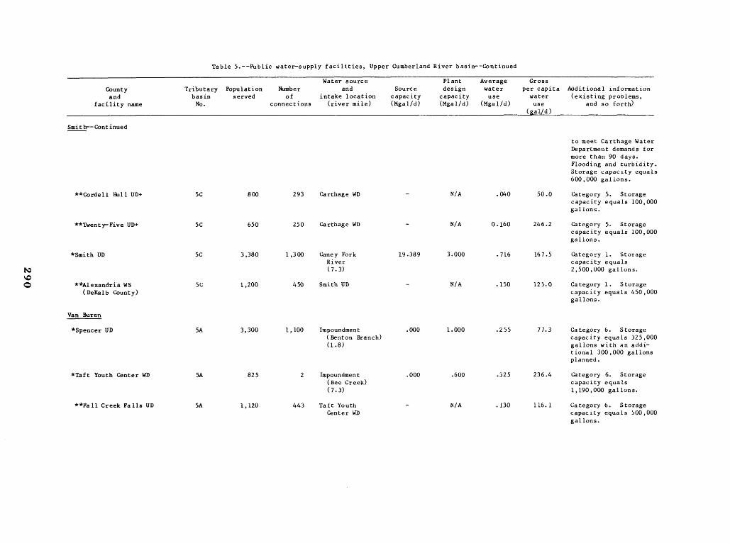
Table 5 .--Public water-supply facilities, Upper Cumberland River basin--Continued
Water source Plant Average Gross County Tributary Population Number and Source design water per capita Additional information and basin served of intake location capacity capacity use water (existing problems,
facility name No . connections (river mile) (Mgal/d) (Mgal/d) (Mgal/d) use and so forth) _ Wal/a)
Smith--Continued
to meet Carthage Water Department demands for more than 90 days . Flooding and turbidity . Storage capacity equals 600,000 gallons .
**Cordell Hull UD+ 5C 800 293 Carthage WD - N/A .040 50 .0 Category 5 . Storagecapacity equals 100,000 gallons .
**Twenty-Five UD+ 5C 650 250 Carthage WD - N/A 0 .160 246 .2 Category 5 . Storagecapacity equals 100,000 gallons.
N *Smith UD 5C 3,380 1,300 Caney Fork
River (7 .3)
19 .389 3 .000 .716 167 .5 Category 1 . Storage capacity equals 2,500,000 gallons .
Q **Alexandria WS (DeKalb County)
5C 1,200 450 Smith UD - N/A .150 125 .0 Category 1 . Storage capacity equals 450,000 gallons.
Van Buren
*Spencer UD 5A 3,300 1,100 Impoundment (Benton Branch)
.000 1 .000 .255 77.3 Category 6. Storage capacity equals 325,000
(1 .8) gallons with an additional 300,000 gallons planned.
*Taft Youth Center WD 5A 825 2 Impoundment .000 .600 .325 236 .4 Category 6 . Storage (Bee Creek) capacity equals (7 .3) 1,190,000 gallons.
**Fall Creek Falls UD 5A 1,120 443 Taft Youth Center WD
- N/A .130 116.1 Category 6 . Storage capacity equals 500,000 gallons.

������������
Table 5 .--Public water-supply facilities, Upper Cumberland River basin--Continued
Countyand
facility name
Tributarybasin No .
Populationserved
Number of
connections
Water source and
intake location (river mile)
Source capacity(Mgal/d)
Plant design
capacity(Mgal/d)
Average water use
(Mgal/d)
Gross per capita
water use
(g a l/d)
Additional information (existing problems,
and so forth)
Warren
*McMinnville WD 5B 12,500 5,000 Barren Fork River (6 .3)
28.437 3.500 2.850 152 .3 Category 1 . Water shortages may occur during summer for lack of treatment facilities . Storage capacity equals 4,100,000 gallons .
**Gentertown UD 5B 3,360 1,120 McMinnville WD - N/A .210 62 .5 Category 1 . Shortage of water at times . Storage capacity equals250,000 gallons .
**Irving College UD 5B 1,863 621 McMinnville WD - N/A .125 67.1 Category 1 . Shortage of water and storage at times . Storagecapacity equals 100,000 gallons .
**Lower Collins UD 5B 3,150 1,050 McMinnville WD - N/A 0 .205 65 .1 Category 1 . Shortageof water and storage at times . Storagecapacity equals 300,000 gallons .
**North Warren UD 5B 2,877 959 Minnville WD - N/A .205 71 .3 Category 1 . Shortageof water at times . Storage capacity equais200,000 gallons .
**Viola UD 5B 2,000 544 McMinnville WD - N/A .085 42 .5 Category 1 . Floodingof underground pumps at pumping station . Storage capacity equals500,000 gallons .
**West Warren County UD 5B 1,100 550 McMinnville WD - N/S .116 105 .5 Category 1 . Storagecapacity equals 100,000 gallons .
�������������������������������������������������������������������������������������������
Table 5.--Public water-supply facilities, Upper Cumberland River basin--Continued
County and
Tributary basin
Population served
Number of
Water source and
intake location Source
capacity
Plant design
capacity
Average water use
Gross per capita
water Additional information (existing problems,
facility name No . connections (river mile) (Mgal/d) (Mgal/d) (Mgal/d) use (&al/d) -
and so forth)
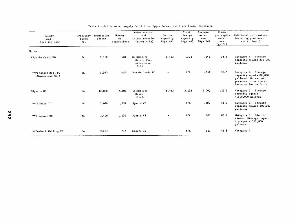
White
*Bon de Croft UD 5A 1,510 520 Calfkiller River, Fire-stone Lake
6 .463 .322 .145 58.3 Category 5 . Storage capacity equals 250,000 gallons .
(8 .2)
**Pleasant Hill UD (Cumberland Co .)
5A 1,500 453 Bon de Croft UD - N/A .057 38.0 Category 5 . Storage capacity equals 80,000 gallons . Occasional pressure drops due to leaks at Bon de Croft .
*Sparta WS 5A 12,000 2,800 Ca lfkiller River
6 .463 3 .133 2 .000 115 .2 Category 3. Storage capacity equals
(16.1) 4,500,000 gallons .
**Dewhite UD 5A 5,000 1,020 Sparta WS - N/A .207 41 .4 Category 3. Storage capacity equals 300,000
N gallons .
N **O'Conner UD 5A 3,400 1,230 Sparta WS - N/A .300 88.2 Category 3 . Odor at times . Storage capacity equals 300,000 gallons .
**Quebeck-Walling UD+ 5A 2,207 797 Sparta WS - N/A .110 49.8 Category 3 .
���������
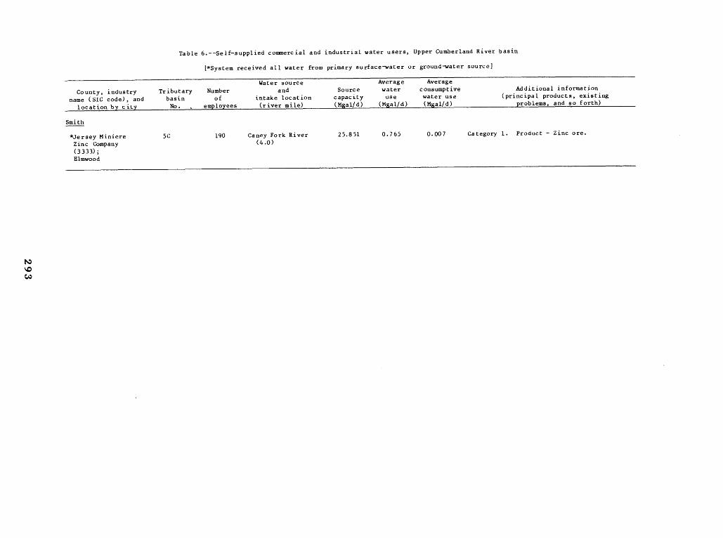
Table 6.--Self-supplied commercial and industrial water users, Upper Cumberland River basin
(*System received all water from primary surface-water or ground water source)
County, industry name (SIC code), and
location by city
Tributarybasin No
Number of
employees
Water source and
intake location (river mile)
Source capacity (Mgal/d)
Average water use
(Mgal/d)
Averageconsumptive water use (Mgal/d)
Additional information (principal products, existing
problems, and so forth)
Smith
*Jersey Miniere Zinc Company(3333) ; Elmwood
5C 190 Caney Fork River (4 .0)
25.851 0.765 0 .007 Category 1 . Product - Zinc ore .
�����������������������������������������������
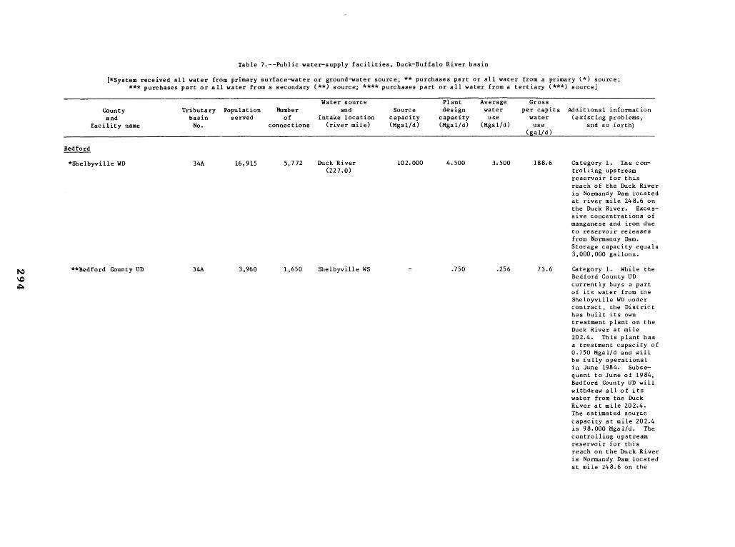
Table 7 .--Public water-supply facilities, Duck-Buffalo River basin
(*System received all water from primary surface-water or ground-water source ; ** purchases part or all water from a primary (*) source ; *** purchases part or all water from a secondary (**) source ; **** purchases part or all water from a tertiary (***) source)
Countyand
facility name
Tributarybasin No .
Populationserved
Number of
connections
Water source and
intake location (river mile)
Source capacity(Mgal/d)
Plant design
capacity(Mgal/d)
Average water use
(Mgal/d)
Gross per capita water use
gal/d)
Additional information (existing problems,
and so torth)
Bedford
*Shelbyville WD 34A 16,915 5,772 Duck River (227 .0)
102.000 4.500 3.500 188 .6 Category 1 . The con trolling upstreamreservoir for this reach of the Duck River is Normandy Dam located at river mile 248.6 on the Duck River . Excessive concentrations of manganese and iron due to reservoir releases from Normandy Dam . Storage capacity equals3,000,000 gallons .
**Bedford County UD 34A 3,960 1,650 Shelbyville WS - .750 .256 73.6 Category 1 . While the Bedford County UD currently buys a partof its water from the Shelbyville WD under contract, the District has built its own treatment plant on the Duck River at mile 202 .4 . This plant has a treatment capacity of 0 .750 Mgal/d and will be fully operationalin June 1984 . Subsequent to June of 1984, Bedford County UD will withdraw all of its water from the Duck River at mile 202.4 . The estimated source capacity at mile 202.4 is 98.000 Mgal/d . The controlling upstream reservoir for this reach on the Duck River is Normandy Dam located at mile 248.6 on the
�
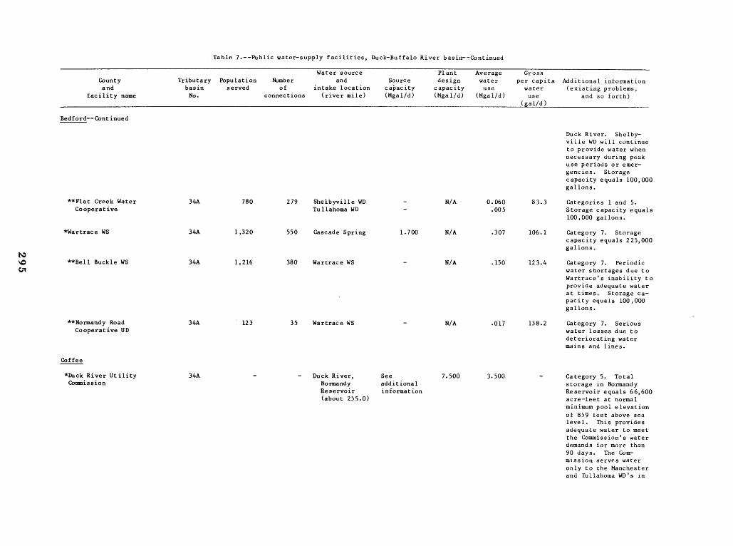
Table 7.--Public water-supply facilities, Duck-Buffalo River basin--Continued
Water source Plant Average Gross County and
facility name
Tributary basin No .
Population served
Number of
connections
and intake location
(river mile)
Source capacity (Mgal/d)
design capacity (Mgal/d)
water use
(Mgal/d)
per capita water use
(gal/d)
Additional information (existing problems,
and so forth)
Bedford--Continued
Duck River. Shelbyville WD will continue to provide water when necessary during peak use periods or emergencies . Storage capacity equals 100,000 gallons .
**Flat Creek Water Cooperative
34A 780 279 Shelbyville WD Tullahoma WD
--
N/A 0.060 .005
83.3 Categories 1 and 5 . Storage capacity equals 100,000 gallons .
*Wartrace WS 34A 1,320 550 Cascade Spring 1 .700 N/A .307 106 .1 Category 7. Storage capacity equals 225,000 gallons .
N 10 CT1
**Bell Buckle WS 34A 1,216 380 Wartrace WS - N/A .150 123.4 Category l. Periodic water shortages due to Wartrace's inability to provide adequate water at times . Storage capacity equals 100,000 gallons .
**Normandy Road Cooperative UD
34A 123 35 Wartrace WS - N/A .017 138.2 Category 7. Serious water losses due to deteriorating water mains and lines.
Coffee
*Duck River UtilityCommission
34A - -
(about 255.0)
Duck River, Normandy Reservoir
See additional information
7.500 3.500 - Category 5. Total storage in Normandy Reservoir equals 66,600 acre-feet at normal minimum pool elevation of 859 feet above sea level . This provides adequate water to meet the Commission's water demands for more than 90 days . The Commission serves water only to the Manchester and Tullahoma WD's in
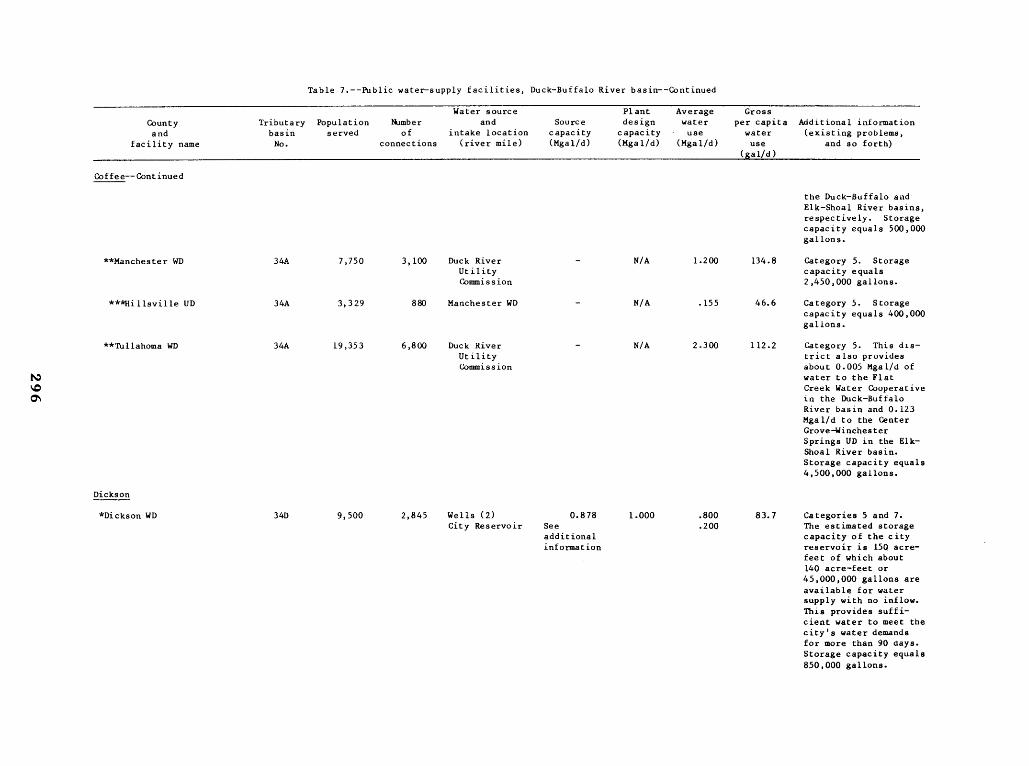
Table 7 .--Public water-supply facilities, Duck-Buffalo River basin--Continued
County and
facility name
Tributary basin No .
Population served
Number of
connections
Water source and
intake location (river mile)
Source capacity (Mgal/d)
Plant design
capacity (Mgal/d)
Average water
- use (Mgal/d)
Gross per capita
water use
(gal/d)
Additional information (existing problems,
and so forth)
Coffee--Continued
the Duck-Buffalo and Elk-Shoal River basins, respectively . Storage capacity equals 500,000 gallons.
**Manchester WD 34A 7,750 3,100 Duck River Utility Commission
- N/A 1.200 134 .8 Category 5. Storage capacity equals 2,450,000 gallons.
***Hillsville UD 34A 3,329 880 Manchester WD - N/A .155 46.6 Category 5 . Storage capacity equals 400,000 gallons .
**Tullahoma WD 34A 19,353 6,800 Duck River Utility
- N/A 2.300 112 .2 Category 5. This district also provides
N Commission about 0.005 Mgal/d of water to the Flat
10 Creek Water Cooperative Q1 in the Duck-Buffalo
River basin and 0 .123 Mgal/d to the Center Grove-Winchester Springs UD in the Elk-Shoal River basin . Storage capacity equals 4,500,000 gallons .
Dickson
*Dickson WD 34D 9,500 2,845 Wells (2) 0.878 1 .000 .800 83.7 Categories 5 and 7. City Reservoir See
additional .200 The estimated storage
capacity of the city information reservoir is 150 acre-
feet of which about 140 acre-feet or 45,000,000 gallons are available for water supply with no inflow . This provides sufficient water to meet the city's water demands for more than 90 days . Storage capacity equals 850,000 gallons .
����������
Table 7 .--Public water-supply facilities, Duck-Buffalo River basin--Continued
Countyand
facility name
Tributarybasin No .
Populationserved
Number of
connections
Water source and
intake location (river mile)
Source capacity(Mgal/d)
Plant designcapacity(Mgal/d)
Average water use
(Mgal/d)
Gross per capita water use
(gal/d)
Additional information (existing problems,
and so forth)
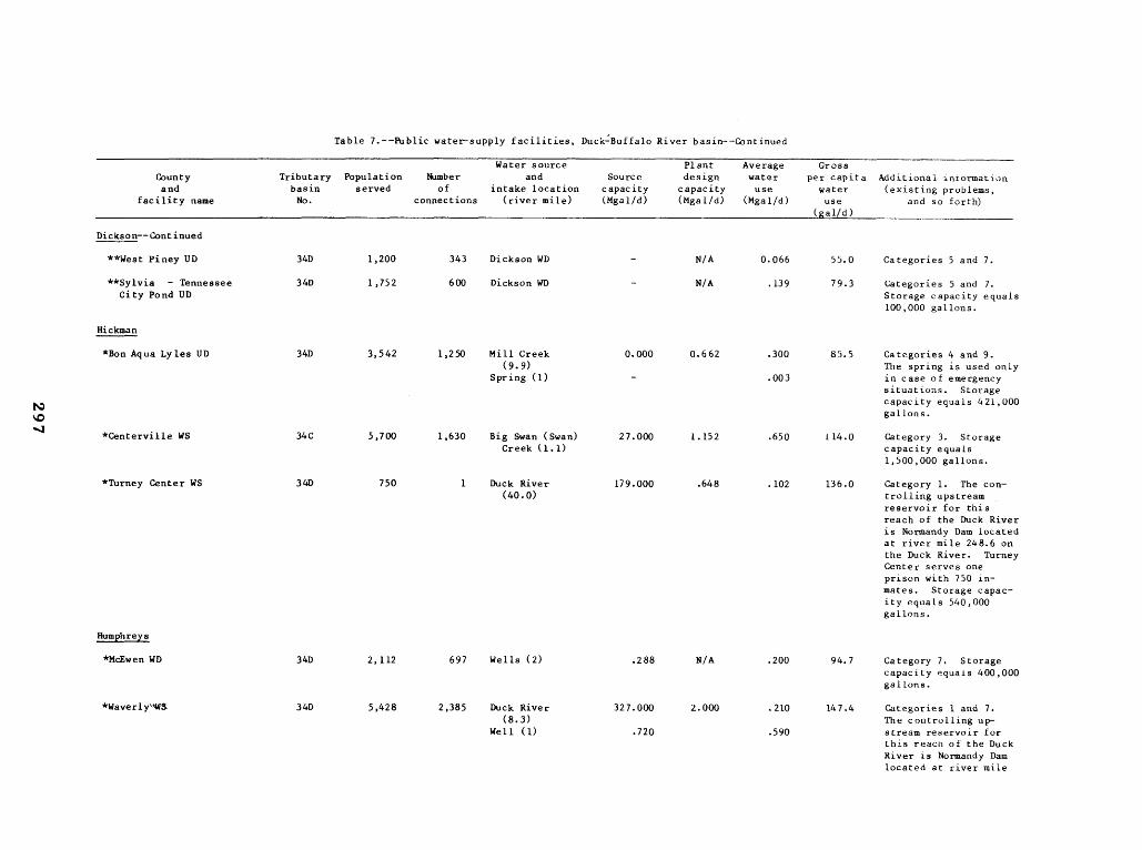
Dickson--Continued
**West Piney UD 34D 1,200 343 Dickson WD - N/A 0 .066 55.0 Categories 5 and 7 .
**Sylvia - Tennessee City Pond UD
34D 1,752 600 Dickson WD - N/A .139 79 .3 Categories 5 and 7 . Storage capacity equals100,000 gallons .
Hickman
*Bon Aqua Lyles UD 34D 3,542 1,250 Mill Creek (9 .9)
Spring (1)
0 .000
-
0 .662 .300
.003
85.5 Categories 4 and 9 . The spring is used only in case of emergency situations . Storagecapacity equals 421,000 gallons .
*Centerville WS 34C 5,700 1,630 Big Swan (Swan)Creek (1 .1)
27 .000 1 .152 .650 114 .0 Category 3 . Storagecapacity equals1,500,000 gallons .
*Turney Center WS 34D 750 1 Duck River (40 .0)
179 .000 .648 .102 136 .0 Category 1 . The controlling upstream reservoir for this reach of the Duck River is Normandy Dam located at river mile 248 .6 on the Duck River . TurneyCenter serves one prison with 750 inmates . Storage capacity equals 540,000gallons .
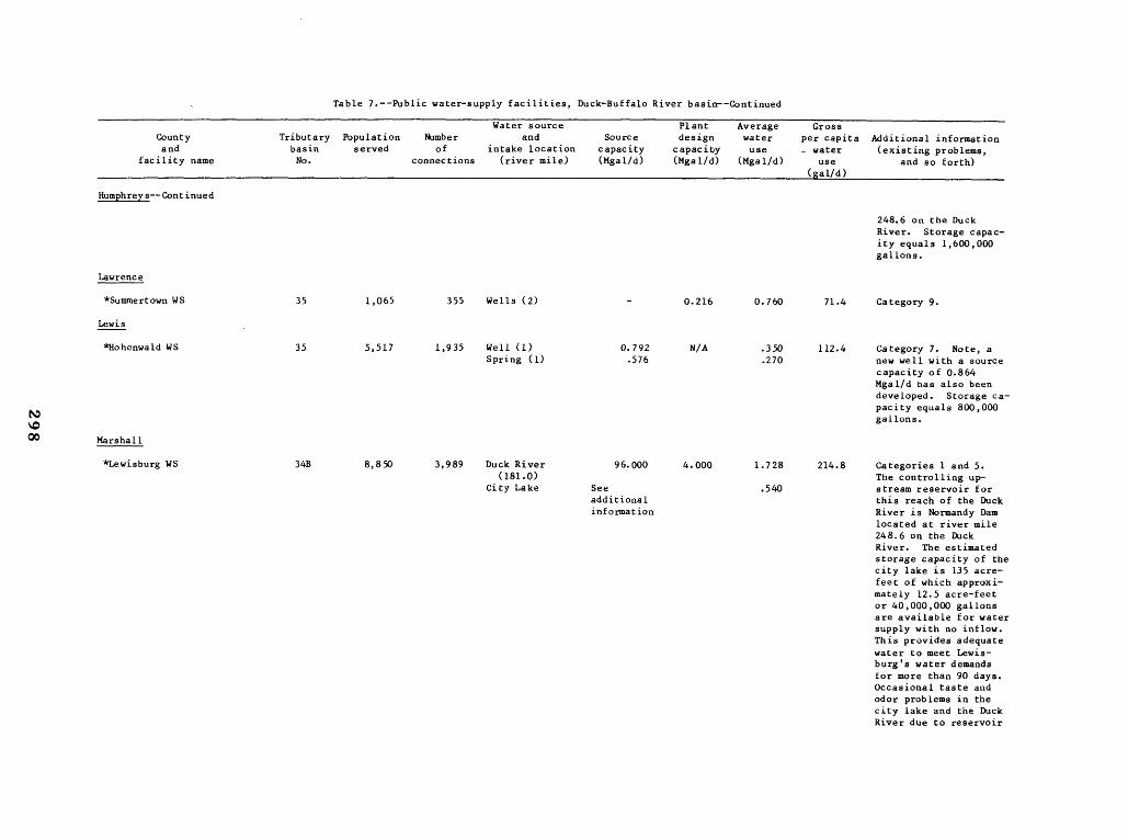
Humphreys
*McEwen WD 34D 2,112 697 Wells (2) .288 N/A .200 94 .7 Category 7 . Storagecapacity equals 400,000gallons .
*Waverly"W3 34D 5,428 2,385 Duck River (8 .3)
Well (1)
327 .000
.720
2.000 .210
.590
147 .4 Categories 1 and 7 . The controlling upstream reservoir for this reach of the Duck River is Normandy Dam located at river mile
������������������������������������
Table 7 .--Public water-supply facilities, Duck-Buffalo River basin--Continued
County Tributary Population Number Water source
and Source Plant design
Average water
Gross per capita Additional information
and facility name
basin No .
served of connections
intake location (river mile)
capacity (Mgal/d)
capacity (Mgal/d)
use (Mgal/d)
_ water use
(gal/d )
(existing problems, and so forth)
Humphreys--Continued
248.6 on the Duck River. Storage capacity equals 1,600,000 gallons .
Lawrence
*Summertown WS 35 1,065 355 Wells (2) - 0 .216 0 .760 71 .4 Category 9 .
Lewis
*Hohenwald WS 35 5,517 1,935 Well (1) Spring (1)
0.792 .576
N/A .350 .270
112.4 Category 7. Note, a new well with a source capacity of 0.864 Mgal/d has also been developed . Storage capacity equals 800,000 gallons .
00 Marshall
*Lewisburg WS 34B 8,850 3,989 Duck River (181 .0)
City Lake
96.000
See
4.000 1 .728
.540
214 .8 Categories 1 and 5 . The controlling upstream reservoir for
additional this reach of the Duck information River is Normandy Dam
located at river mile 248.6 on the Duck River. The estimated storage capacity of the city lake is 135 acre-feet of which approximately 12 .5 acre-feet or 40,000,000 gallons are available for water supply with no inflow . This provides adequate water to meet Lewis-burg's water demands for more than 90 days . Occasional taste and odor problems in the city lake and the Duck River due to reservoir
����������
Table 7 .--Public water-supply facilities, Duck-Buffalo River basin--Continued
Countyand
facility name
Tributarybasin No .
Populationserved
Number of
connections
Water source and
intake location (river mile)
Source capacity(Mgal/d)
Plant designcapacity (Mgal/d)
Average water use
(Mgal/d)
Gross per capita
water use
(gal/d )
Additional information (existing problems,
and so forth)
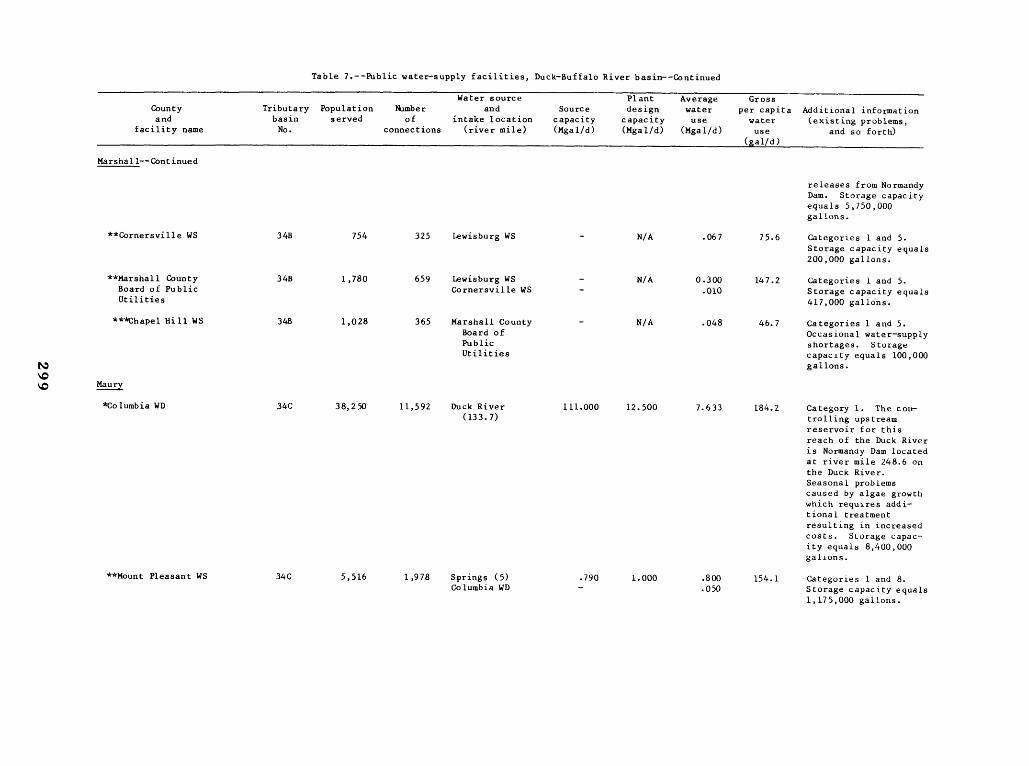
Marshall--Continued
releases from Normandy Dam . Storage capacityequals 5,750,000gallons .
**Cornersville WS 34B 754 325 Lewisburg WS - N/A .067 75.6 Categories 1 and 5 . Storage capacity equals200,000 gallons .
**Marshall CountyBoard of Public Utilities
34B 1,780 659 Lewisburg WS Cornersville WS
--
N/A 0 .300 .010
147 .2 Categories 1 and 5 . Storage capacity equals417,000 gallons .
***Chapel Hill WS 34B 1,028 365 Marshall County Board of Public Utilities
- N/A .048 46.7 Categories 1 and 5 . Occasional water-supplyshortages . Storagecapacity equals 100,000gallons .
Maury
*Columbia WD 34C 38,250 11,592 Duck River (133 .7)
111 .000 12 .500 7 .633 184 .2 Category 1 . The coin trolling upstreamreservoir for this reach of the Duck River is Normandy Dam located at river mile 248.6 on the Duck River . Seasonal problems caused by algae growthwhich requires additional treatment resulting in increased costs . Storage capacity equals 8,400,000gallons .
**Mount Pleasant WS 34C 5,516 1,978 Springs (5)Columbia WD
.790 -
1 .000 .800 .050
154 .1 Categories 1 and 8 . Storage capacity equals1,175,000 gallons .
����������
Table 1 .--Public water-supply facilities, Duck-Buffalo River basin--Continued
County and
facility name
Tributary basin No .
_
Population served
Number of
connections
Water source and
intake location (river mile)
Source capacity (Mgal/d)
Plant design
capacity (Mgal/d)
Average water use
(Mgal/d)
Gross per capita water use
(gal/d)
Additional information (existing problems,
and so forth)
Main-Continued
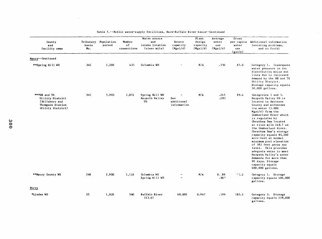
**Spring Hill WD 34C 1,200 435 Columbia WD - N/A .350 85 .0 Category 1 . Inadequate water pressure in the distribution mains and lines due to increased demand by the HB and TS Utility District . Storage capacity equals 50,000 gallons .
***HB and TS 34C 5,903 1,851 Spring Hill WD - N/A .245 89 .4 Categories 1 and 5 . Utility District (Hillsboro and
Harpeth Valley UD
See additional
.283 Rarpeth Valley UD is located in Davidson
Thompson Station information County and withdraws Utility District) its water (5 .000
Mgal/d) from the Cumberland River which
W is regulated by Cheatham Dam located at river mile 148.7 on the Cumberland River . Cheatham Dam's storage capacity equals 84,200 acre-feet at normal minimum pool elevation of 382 feet above sea level . This provides adequate water to meet Harpeth Valley's water demands for more than 90 days . Storage capacity equals 600,000 gallons .
**Maury County WS 34B 2,900 1,116 Columbia WS - N/A 0.'.89 `, .2 Category 1 . Storage Spring Hill WD - .00? capacity equals 100,000
gallons .
Perry
*Linden WD 35 1,020 560 Buffalo River 68.000 0 .967 .199 185.3 Category 3 . Storage (43 .0) capacity equals 538,000
gallons .
����������
Table 7-Public water-supply facilities, Duck-Buffalo River basin--Continued
Countyand
facility name
Tributarybasin No .
Populationserved
Number of
connections
Water source and
intake location (river mile)
Source capacity(Mgal/d)
Plant designcapacity(Mgal/d)
Average water use
(Mgal/d)
Gross per capita water use
(&al/d )
Additional information (existing problems,
and so forth)
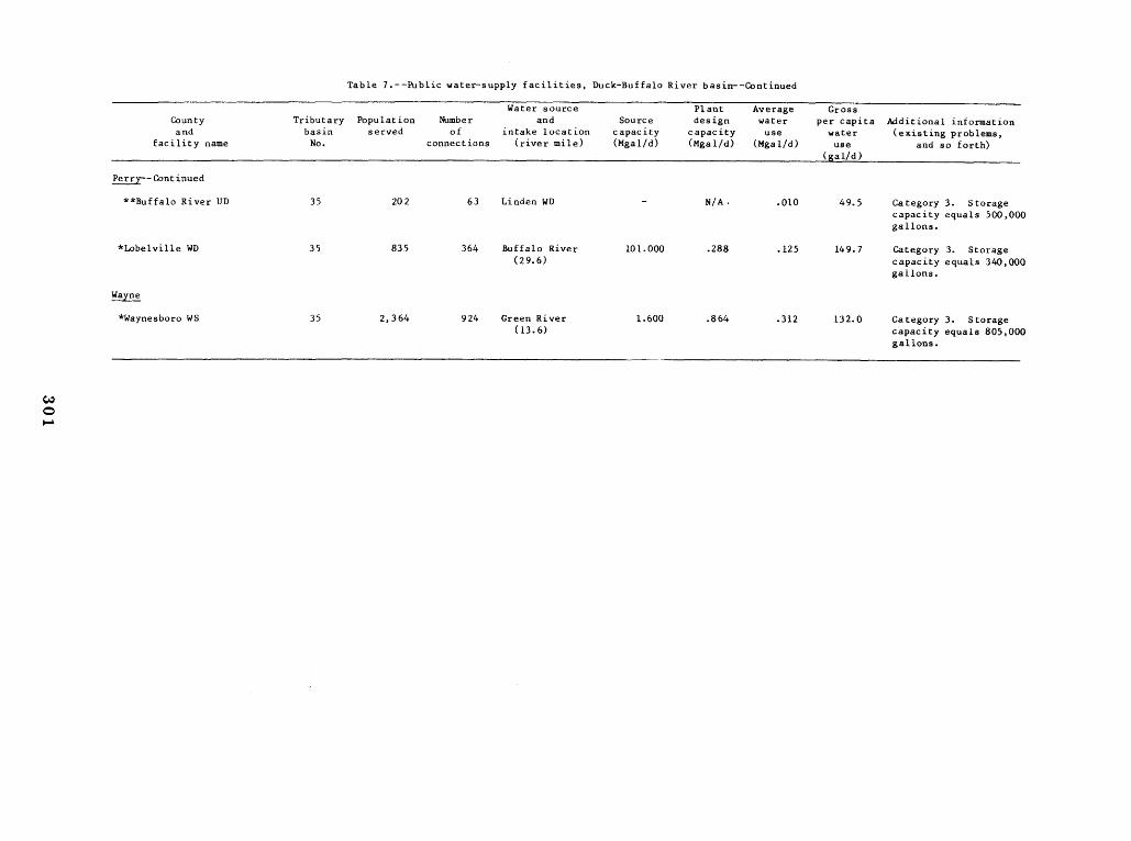
Perry--Continued
**Buffalo River UD 35 202 63 Linden WD - N/A . .010 49 .5 Category 3 . Storagecapacity equals 500,000gallons .
*Lobelville WD 35 835 364 Buffalo River (29 .6)
101 .000 .288 .125 149 .7 Category 3 . Storagecapacity equals 340,000 gallons .
Wayne
*Waynesboro WS 35 2,364 924 Green River (13 .6)
1 .600 .864 .312 132 .0 Category 3 . Storagecapacity equals 805,000 gallons .
����
Table 8.--Self-supplied commercial and industrial water users, Duck-Buffalo River basin
[*System received all water from primary surface-water or groundwater source)
Water source Average Average r
County, industry Tributary Number and Source water consumptive Additional information
name (SIC code), and basin of intake location capacity use water use (principal products, existing
location by city -- No . employees (river mile) (Mgal/d) (Mgal/d) (Mgal/d) problems, and so forth)
Hickman
*Levi Strauss and 34C 470 Big Swan (Swan) 27.000 0.700 - Category 3 . Product - Men's jeans . Company (2328) ; Creek (about Centerville 1 .1)
*M . C . West and 34B 14 Duck River 121 .000 .720 - Category 1 . The controlling upstream Company (1475) ; (92 .2) reservoir for this reach of the Duck Columbia River is Normandy Dam located at river mile
248.6 on the Duck River . Product - Phosphate mining .
Lewis
*Lewis Products 35 650 Wells (2) - .500 0.270 Category 9 . Product - Hose . Storage (2251) ; Hohenwald WS - .001 equals 100,000 gallons . Hohenwald
W MarshallON *Lewisburg Materials 34B 15 Rock Quarry See .112 - Source capacity data for this rock quarry is
(1422) ; additional not available due to inadequate data . Lewisburg information Product - Crushed limestone .
Maury
*E . I . DuPont 34C 128 Duck River 111 .000 .463 .029 Category 1 . The controlling upstream De Nemours and (about 130.4) reservoir for this reach of the Duck River Company, Inc . Columbia WD - .192 is Normandy Dam located at river mile 248.6 (3079) ; Columbia on the Duck River . Product - Cellulose
sponge . Occasional flooding and turbidity problem .
*Occidental Chemical 34C 7 Duck River 111 .000 2 .667 - Category 1 . The controlling upstream reser-Corporation, (130 .5) voir for this reach of the Duck River is Codwin Washer Plant Normandy Dam located at river mile 248.6 on (1475) ; Columbia the Duck River . Product - Washed phosphate
ore .
*Occidental Chemical 34C 15 Duck River 113 .000 6 .660 - Category 1 . The controlling upstream reser-Corporation, (113.8) voir for this reach of the Duck River is
ormany am ocaearver meWilliamsport Washer NdDltd t iil2486 on (2819) ; the Duck River . Product - Washed phosphate .Plant
Columbia ore .
Table 8 .--Self-supplied commercial and industrial water users, Duck-Buffalo River basitr-Continued
Maury--Continued
*Occidental Chemical 34C 275 Duck River 111.000 0.014 0 .074 Corporation, (130 .5) Furnace Plant (2819) ; Ponds (13) - .176 Columbia Columbia WD - .475
*Monsanto Industrial 34C 600 Duck River 112.000 14 .400 1 .980 Chemicals Company (119.9) (2819) ; Columbia Greenlick Creek
Ponds (2) 2 .600
See additional
12 .960 5.760
information
*Presnell Phosphate Company, Inc .
34C Unavailable Rutherford Creek .000 .960 -
(2819) ; Columbia
*Stouffer Chemical 34C 302 West Fork Creek See .420 .115 Company, Inc . (2879) ; Mount Pleasant
(15 .4)
Mount Pleasant WS
additional information
- .035
*Stouffer Chemical 34C 36 Scotts Creek See .486 .001 Company, Globe (0 .13) additional Plant (2819) ; Mount Pleasant Mount Pleasant WS
information - .001
*Stouffer Furnace 34C 280 Big Bigby Creek 2.300 .900 -Plant (2819) ; Mount Pleasant
(16 .2) Mount Pleasant WS - .100
Categories 1 and 5 . The controlling upstream reservoir for this reach of the Duck River is Normandy Dam located at river mile 248.6 on the Duck River. The estimated storage capacity of the 13 rain-filled ponds is about 80 acre-feet of which about 70 acre-feet or 23,000,000 gallons is available for water supply with no inflow . This provides ample water to meet Occidental's water demands from this source for more than 90 days . Product - Elemental phosphorous .
Categories 1, 4, and 5 . The controlling upstream reservoir for this reach of the Duck River is Normandy Dam located at river mile 248.6 on the Duck River. The estimated storage of the two ponds equals about 3,910 acre-feet of which approximately 3,870 acre-feet or 1,241,000 gallons of water are available for water supply with no inflow . This provides adequate water to meet Monsanto's water demands from this source for more than 90 days . Product - Elemental phosphorous. Excessive turbidity at the intake area after heavy rains . Storage capacity equals about 1,270,000,000 gallons .
Category 4. Product - Elemental phorphorous.
Source capacity data for West Fork Creek is not available due to the lack of adequate records . Product - Pesticides . Storage capacity equals 690,000 gallons .
Source capacity data for Scotts Creek is not available because of the lack of adequate records . Product - Washed phosphate ore . Storage capacity equals 736,404,000 gallons.
Category 3. Product - Elemental phosphorous . Storage capacity equals 24,000 gallons .
����������������
Table 8 .--Self-supplied commercial and industrial water users, Duck-Buffalo River basin--Continued
Water source , Average Average County, industry Tributary Number and Source water consumptive Add tional information
name (SIC code), and basin of intake location capacity use water use (princi al products, existing location by city - No . -- employees (river mile) (Mgal/d) (Mgal/d) (Mgal/d) pro lems, and so forth)
Wade
*True Temper 35 18 Barlow Branch See 0 .266 - Category 9. Source capacity data for Barlow Corporation (0 .5) additional Branch is not available due to a lack of (2499) ; information adequate data . Product - Hickory handles . Waynesboro Well (1) - .001

�������������������
C
Table 9.--Public water-supply facilities, Elk-Shoal River basin
[*System received all water from primary surface-water or ground-water source ; ** purchases part or all water from a primary (*) source ; *** purchases part or all water from a secondary (**) source ; **** purchases part or all water from a tertiary (***) source]
Water source Pladt Average Gross County Tributary Population Number and Source design water per capita Additional information and basin served of intake location capacity capacity use water (existing problems,
facility name No . connections (river mile) (Mgal/d) (MgaX/d) (Mgal/d) use and so forth) (gal/d )
Franklin
*Belvidere Rural UD 27A 1,227 230 Well (1) 0.180 N/A 0.080 65.2 Categories 5 and 7 . Winchester WS - - Winchester WS provides
water to Belvidere Rural UD in emergencysituations . Storagecapacity equals 70,000 gallons .
*Cowan WS 27A 2,125 800 Spring (1) .130 0 .504 .210 98 .8 Category 8 . Additional storage is needed to avoid periodic shortages . Storage capacityequals 250,000 gallons.
W *Decherd Water Works 27A 3,275 1,045 Wells (2) .720 .561 .199 60.8 Category 7. Storage capacity equals 400,000
N gallons.
*Estill Springs WD 27A 2,280 760 Spring (1) .547 .495 .245 107.5 Category 7. Storage capacity equals 375,000 gallons plus a 200,000-gallon tank for emergency use.
*Huntland WS 27B 1,152 390 Wells (3) .290 .280 .095 82.5 Category 7. Storage capacity equals 500,000 gallons.
*Sewanee Utility Depart- 25 4,000 860 Jackson and See .680 .303 80.8 Category 5. Togetherment O'Donnel Lakes additional the estimated capacity
information of Jackson and O'Donnel Lakes is about 340 acre-feet of which approximately 260 acre-feet or 85,000,000 gallons is available for water supply with no flow . While this provides sufficient water to meet Sewanee's water demands for more than 90 days, it should be
���������������������������
Table 9.--Public water-supply facilities, Elk-Shoal River basin--Continued
Water source Plant Average Gross County and
facility name
Tributary basin No .
Populationserved
Number of
connections
and intake location
(river mile)
Source capacity (Mgal/d)
design capacity (Mgal/d)
water use
(Mgal/d)
per capita water use
(gal/d)
Additional information (existing problems,
and so forth)
Franklin--Continued
noted that the dams forming these lakes are leaking. Sewanee Utility Department serves about 2,500 people on a year-round basis and 4,000 people when Sewanee College is in session .
*Winchester UD 27A 10,054 3,634 Elk River, Tims Fork Reservoir (154 .0)
See additional information
3 .000 1 .141 97 .9 Category 5. Total storage in Tims Ford Reservoir equals 325,400 acre-feet at normal minimum pool elevation of 865 feet above sea level . This provides sufficient water to meet this UD's water demands for more than 90 days . Storage capacity equals 1,550,000 gallons .
**Center Grove -Winchester Springs UD
27A 3,700 984 Winchester UD Tullahoma WD
-See additional
N/A .157 .123
75 .7 Category 5 . Water purchased from the Tullahoma Water Department
information is withdrawn from Normandy Reservoir on the Duck River via the Duck River Utility Commission and Tullahoma Water Department in Coffee County . Total storage in Normandy Reservoir is 66,600 acre-feet at normal minimum pool elevation of 859 feet above sea level . While this coupled with the water available from Tims Ford Reservoir is more than adequate to meet the District's water
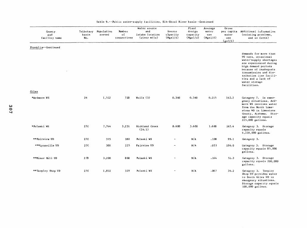
Table 9.--Public water-supply facilities, Elk-Shoal River basin--Continued
Countyand
facility name
Tributarybasin No .
Populationserved
Number of
connections
Water source and
intake location (river mile)
Source capacity(Mgal/d)
Plant design
capacity(Mgal/d)
Average water use
(Mgal/d)
Gross per capita water use
Additional information (existing problems,
and so forth)
Franklin--Continued
demands for more than 90 days, occasional water-supply shortagesare experienced during high demand periodsbecause of inadequatetransmission and distribution line facilities and a lack of water storage facilities .
Giles
*Ardmore WS 26 1,512 720 Wells (3) 0 .360 0 .360 0 .215 142 .2 Category 7 . In emergency situations, Ardmore WS receives water from the North Limestone WS in Limestone County, Alabama . Storage capacity equals225,000 gallons .
*Pulaski WS 27C 7,764 3,251 Richland Creek (24.1)
8 .600 3 .600 1 .600 162 .4 Category 3 . Storagecapacity equals4,550,000 gallons .
**Fairview UD 27C 555 180 Pulaski WS - N/A .108 99 .1 Category 3 .
***Lynnville UD 27C 500 225 Fairview UD - N/A .053 106 .0 Category 3 . Storagecapacity equals 85,000 gallons .
**Minor Hill UD 27D 3,200 800 Pulaski WS - N/A .164 51 .3 Category 3 . Storagecapacity equals 200,000 gallons .
**Tarpley Shop UD 27C 1,852 529 Pulaski WS - N/A .067 36.2 Category 3 . TarpleyShop UD provides water to South Giles UD in emergency situations . Storage capacity equals100,000 gallons .
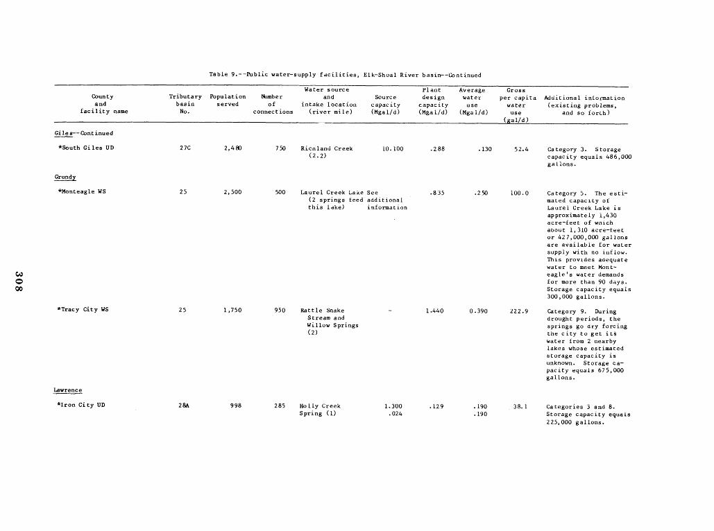
Table 9 .--Public water-supply facilities, Elk-Shoal River basin--Continued
County and
facility name
Tributary basin No .
Population served
Number of
connections
Water source and
intake location (river mile)
Source capacity (Mgal/d)
Plant design
capacity (Mgal/d)
Average water use
(Mgal/d)
Gross per capita water use
(gal/d)
Additional information (existing problems,
and so forth)
Giles--Continued
*South Giles UD 27C 2,480 750 Ricnland Creek (2 .2)
10.100 .288 .130 52.4 Category 3. Storagecapacity equals 486,000 gallons .
Grundy
*Monteagle WS 25 2,500 500 Laurel Creek Lake See (2 springs feed additional this lake) information
.835 .250 100.0 Category 5. The estimated capacity of Laurel Creek Lake is approximately 1,430 acre-feet of which about 1,310 acre-feet or 427,000,000 gallons are available for water supply with no inflow . This provides adequate water to meet Mont-eagle's water demands for more than 90 days . Storage capacity equals 300,000 gallons .
*Tracy City WS 25 1,750 950 Rattle Snake Stream and Willow Springs (2)
- 1 .440 0 .390 222.9 Category 9. During drought periods, the springs go dry forcing the city to get it,§ water from 2 nearbylakes whose estimated storage capacity is unknown . Storage capacity equals 675,000 gallons .
Lawrence
*Iron City UD 28A 998 285 Holly Creek Spring (1)
1 .300 .024
.129 .190 .190
38.1 Categories 3 and 8 . Storage capacity equals 225,000 gallons.
�������������
Table 9 .--Public water-supply facilities, Elk-Shoal River basin--Continued
Countyand
facility name
Tributarybasin No .
Populationserved
Number of
connections
Water source and
intake location (river mile)
Source capacity(Mgal/d)
Plant designcapacity(Mgal/d)
Average water use
(Mgal/d)
Gross per capita water use
(gal/d)
Additional information (existing problems,
and so forth)
lawrenc e--fontinued
*Lawrenceburg WS 28A 10,332 4,283 Shoal Creek (55 .9)
Hope Spring (1)
7 .800
1 .100
6.450 2 .112
1 .382
309 .5 Categories 3 and 8 . Lawrenceburg's treatment plant can treat up to 4.000 Mgal/d from Shoal Creek and 2 .450 Mgal/d from HopeSpring . Storage capacity equals3,650,000 gallons .
**Fall River Road UD 28A 805 230 Lawrenceburg WS - N/A .060 74 .5 Categories 3 and 8 .
**Flatwoods UD 28A 360 113 Lawrenceburg WS - N/A .133 202 .8 Categories 3 and 8 . Storage capacity equals150,000 gallons .
***Ethridge UD 28A 1,200 375 Flatwoods UD - N/A .060 50 .0 Categories 3 and 8 .
**New Prospect UD 28A 1,040 260 Lawrenceburg WS - N/A 0.063 60 .6 Categories 3 and 8 . Storage capacity equals100,000 gallons .
**Northeast Lawrence UD 28A 700 217 Lawrenceburg WS - N/A .040 57 .1 Categories 3 and 8 .
*Leoma UD 27D 1,200 400 Spring (1) - N/A .090 75.0 Category 9 . Storagecapacity equals 110,000 gallons .
*Loretto WS+ 28A 1,830 610 Spring (1) 0.648 0 .368 .153 83 .6 Category 7 .
*St . Joseph WS 28A 987 336 Spring (1) 0.360 N/A .086 87 .1 Category 7 . Storagecapacity equals 300,000 gallons .
*Westpoint UD 28A 350 120 Factory Creek (4 .2)
9 .600 .072 .021 60 .0 Category 3 . Storagecapacity equals 50,000 gallons .
Lincoln
*Fayetteville WS 278 7,075 3,300 Elk River (93 .9)
Pearl Hollow
68.500
.500
3 .100 1 .944
.500
316 .0 Categories 1 and 7 . The controlling upstream reservoir for
Spring (1) this reach of the Elk
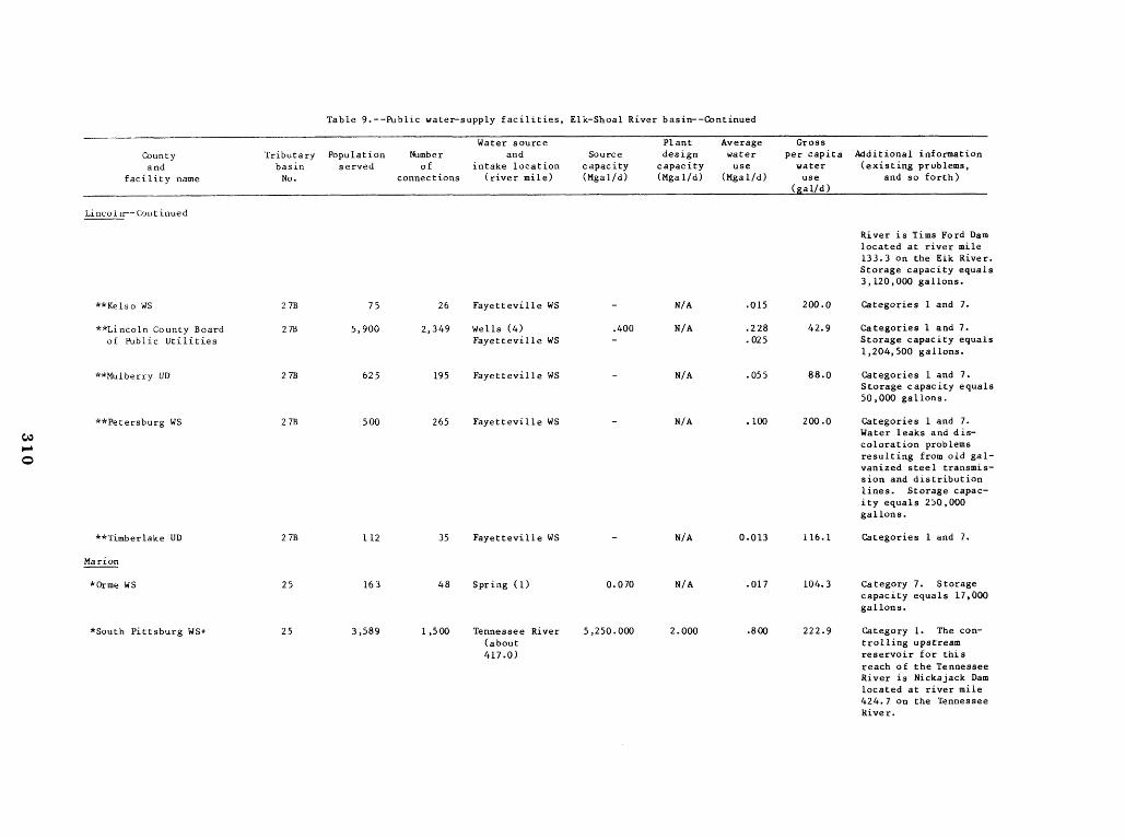
Table 9.--Public water-supply facilities, Elk-Shoal Ri er basin--Continued
Countyand
facility name
Tributarybasin No .
Populationserved
Number of
connections
Water source and
intake location (river mile)
Source capacity(Mgal/d)
Plant design capacity(Mgal/d)
Average water use
(Mgal/d)
Gross per capita water use
(gal/d)
Additional information (existing problems,
and so forth)
Lincoln--Continued
River is Tims Ford Dam located at river mile 133 .3 on the Elk River . Storage capacity equals3,110,000 gallons .
**Kelso WS 27B 75 26 Fayetteville WS - N/A .015 200 .0 Categories 1 and 7 .
**Lincoln County Board of Public Utilities
27B 5,900 2,349 Wells (4)Fayetteville WS
.400 -
N/A .228 .025
42.9 Categories 1 and 7 . Storage capacity equals1,204,500 gallons .
**Mulberry UD 27B 625 195 Fayetteville WS - N/A .055 88 .0 Categories 1 and 7 . Storage capacity equals50,000 gallons .
**Petersburg WS 27B 500 265 Fayetteville WS - N/A .100 200 .0 Categories 1 and 7 . Water leaks and discoloration problemsresulting from old galvanized steel transmission and distribution lines . Storage capacity equals 250,000 gallons .
**Timberlake UD 27B 112 35 Fayetteville WS - N/A 0 .013 116 .1 Categories 1 and 7 .
Marion
*Orme WS 25 163 48 Spring (1) 0 .070 N/A .017 104 .3 Category 7 . Storagecapacity equals 17,000 gallons .
*South Pittsburg WS+ 25 3,589 1,500 Tennessee River (about417 .0)
5,250 .000 2 .000 .800 222 .9 Category 1 . The controlling upstreamreservoir for this reach of the Tennessee River is Nickajack Dam located at river mile 424.7 on the Tennessee River .

�����������������
Table 9 .--Public water-supply facilities, Elk-Shoal Ri er basin--Continued
County and
Tributary basin
Populationserved
Number of
Water source and
intake location Source
capacity
Plant design
capacity
Average water use
Gross per capita water
Additional information (existing problems,
facility name No . connections (river mile) (Mgal/d) (Mgal/d) (Mgal/d) use and so forth) - al/d)
Moore
*Lynchburg WS 27B 700 384 East Fork Mulberry Creek (14.4)
Tims Ford See
1 .200 .288 .055
.083
197.1 Categories 3 and 5 . Total storage in Tims Ford Reservoir is 325,400 acre-feet at
Reservoir additional normal minimum pool information elevation of 865 feet
above sea level . This provides adequate water to meet Lynchburg's water demands for more than 90 days . Occasional rust problemsand water losses due to leaking mains and distribution lines . Storage capacity equals705,000 gallons .
�
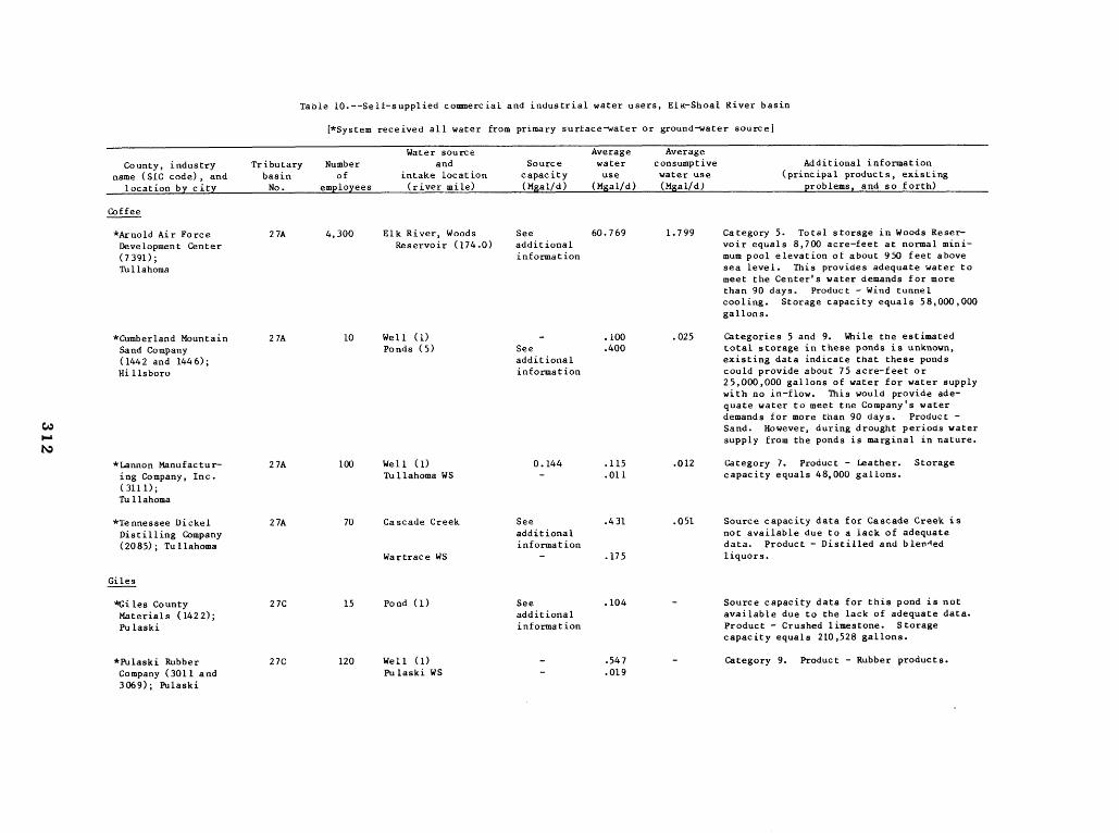
Table 10 .--Self-supplied commercial and industrial water users, Elk-Shoal River basin
[*System received all water from primary surface-water or groundwater source]
Water source Average AverageCounty, industry Tributary Number and Source water consumptive Additional information
name (SIC code), and basin of intake location capacity use water use (principal products, existing location by city No . employees (river mile) (Mgal/d) (Mgal/d) (Mgal/d) problems, and so forth)
Coffee
*Arnold Air Force 27A 4,300 Elk River, Woods See 60.769 1 .799 Category 5 . Total storage in Woods Reser-Development Center Reservoir (174 .0) additional voir equals 8,700 acre-feet at normal mini-(7391) ; information mum pool elevation of about 950 feet above Tullahoma sea level . This provides adequate water to
meet the Center's water demands for more than 90 days . Product - Wind tunnel cooling . Storage capacity equals 58,000,000 gallons .
*Cumberland Mountain 27A 10 Well (1) - .100 .025 Categories 5 and 9 . While the estimated Sand Company Ponds (5) See .400 total storage in these ponds is unknown, (1442 and 1446) ; additional existing data indicate that these ponds Hillsboro information could provide about 75 acre-feet or
25,000,000 gallons of water for water supplywith no in-flow . This would provide adequate water to meet the Company's water demands for more than 90 days . Product Sand . However, during drought periods water supply from the ponds is marginal in nature .
*Lannon Manufactur- 27A 100 Well (1) 0 .144 .115 .012 Category 7 . Product - Leather . Storage ing Company, Inc . TuIlahoma WS - .011 capacity equals 48,000 gallons . ( 3111) ; Tullahoma
*Tennessee Dickel 27A 70 Cascade Creek See .431 .051 Source capacity data for Cascade Creek is Distilling Company additional not available due to a lack of adequate (2085) ; Tullahoma information data . Product - Distilled and blen-led
Wartrace WS - .175 liquors .
Giles
*Giles County 27C 15 Pond (1) See .104 - Source capacity data for this pond is not Materials (1422) ; additional available due to the lack of adequate data . Pulaski information Product - Crushed limestone . Storage
capacity equals 210,528 gallons .
*Pulaski Rubber 27C 120 Well (1) - .547 - Category 9 . Product - Rubber products . Company (3011 and Pulaski WS - .019 3069) ; Pulaski
�
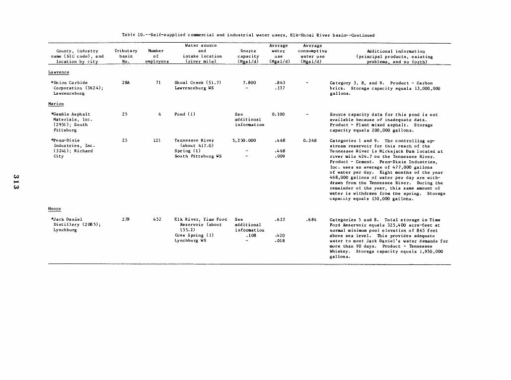
Table 10 .--Self-supplied commercial and industrial water users, Elk-Shoal River basin--Continued
County, industry name (SIC code), and
Tributary basin
Number of
Water source and
intake location Source
capacity
Average water use
Average consumptive water use
location by city No . employees (river mile) (Mgal/d) (Mgal/d) (Mgal/d)
Lawrence
*Union Carbide Corporation (3624) ;
28A 71 Shoal Creek (51 .7) Lawrenceburg WS
7.800 -
.863
.137 -
Lawrenceburg
Marion
*Gamble Asphalt Materials, Inc . (2951) ; South
25 4 Pond (1) See additional information
0.100 -
Pittsburg
*Penn-Dixie Industries, Inc .
25 121 Tennessee River (about 417 .0)
5,250.000 .468 0 .368
(3241) ; Richard Spring (1) - .468 city South Pittsburg WS - .009
Moore
*Jack Daniel 27B 452 Elk River, Tims Ford See .622 .684 Distillery (2085) ; Reservoir (about additional Lynchburg 135.2) information
Cove Spring (1) Lynchburg WS
.108 -
.420 .018
Additional information (principal products, existing
problems, and so forth)
Category 3, 8, and 9. Product - Carbon brick. Storage capacity equals 13,000,000 gallons.
Source capacity data for this pond is not available because of inadequate data . Product - Plant mixed asphalt . Storage capacity equals 200,000 gallons .
Categories 1 and 9 . The controlling upstream reservoir for this reach of the Tennessee River is Nickajack Dam located at river mile 424 .7 on the Tennessee River. Product - Cement . Penn-Dixie Industries, Inc . uses an average of 477,000 gallons of water per day. Eight months of the year 468,000 gallons of water per day are withdrawn from the Tennessee River. During the remainder of the year, this same amount of water is withdrawn from the spring . Storagecapacity equals 150,000 gallons .
Categories 5 and 8 . Total storage in Tims Ford Reservoir equals 325,400 acre-feet at normal minimum pool elevation of 865 feet above sea level . This provides adequate water to meet Jack Daniel's water demands for more than 90 days . Product - Tennessee Whiskey . Storage capacity equals 1,950,000 gallons .
����������
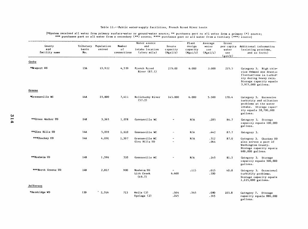
Table 11 .--Public water-supply facilities, French Broad River basin
(*System received all water from primary surface-water or ground-water source ; ** purchases part or all water from a primary (*) source ;*** purchases part or all water from a secondary (**) source ; **** purchases part or all water from a tertiary (***) source]
Water source Plant Average Gross County Tributary Population Number and Source design water per capita Additional information and basin served of intake location capacity capacity use water (existing problems,
facility name No . connections (river mile) (Mgal/d) (Mgal/d) (Mgal/d) use and so forth) __ __(gal/d)
Cocke
*Newport WS 13A 13,922 4,520 French Broad 279.00 6 .000 3 .000 215 .5 Category 3 . High chlo-River (81 .1) rine demand and drastic
fluctuations in turbidity during heavy rain . Storage capacity equals3,915,000 gallons .
Greene
*Greeneville WC 14A 25,000 7,411 Nolichucky River 145.000 6.000 5.500 170 .4 Category 3 . Excessive (51 .2) turbidity and siltation
problems at the water intake . Storage capacity equals 38,700,000 gallons .
W **Cross Anchor UD 14B 3,365 1,078 Greeneville WC - N/A .285 84.7 Category 3 . Storage
capacity equals 100,000gallons .
**Glen Hills UD 14A 5,039 1,610 Greeneville WC - N/A .442 87 .7 Category 3 .
***Chuckey UD 14A 4,091 1,307 Greeneville WC - N/A .312 87 .0 Category 3 . Chuckey UD Glen Hills UD - .044 also serves a part of
Washington County . Storage capacity equals600,000 gallons .
**Mosheim UD 14B 1,596 510 Greeneville WC - N/A .145 81 .5 Category 3 . Storagecapacity equals 500,000 gallons .
***North Greene UD 14B 2,817 900 Mosheim UD - .115 .015 40 .8 Category 3 . Occasional Lick Creek 6 .600 .100 turbidity problems .
(49 .7) Storage capacity equals1,225,000 gallons .
Jefferson
*Dandridge WD 13D ` 2,316 713 Wells (3) .504 .345 .080 105 .8 Category 7 . StorageSprings (2) .245 .165 capacity equals 880,000
gallons .
����������
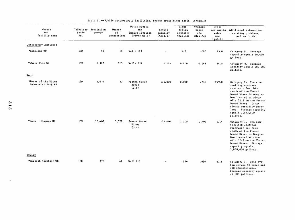
Table 11 .--Public water-supply facilities, French Broad River basin--Continued
County and
facility name
Tributary basin No .
Population served
Number of
connections
Water source and
intake location (river mile)
Source capacity (Mgal/d)
Plant design
capacity (Mgal/d)
Average water use
(Mgal/d)
Gross per capita water use
Additional information (existing problems,
and so forth) (gal/d)
Jefferson--Continued
*Lakeland UD 130 40 10 Wells (2) - N/A .003 75 .0 Category 9 . Storage capacity equals 10,000 gallons .
*White Pine WD 130 1,980 625 Wells (2) 0 .144 0 .400 0.168 84.8 Category 8. Storage capacity equals 200,000 gallons .
Knox
*Forks of the River Industrial Park WS
130 2,670 32 French Broad River (2.8)
132.000 2 .000 .745 279.0 Category 1 . The controlling upstream reservoir for this reach of the French Broad River is Douglas Dam located at river mile 32 .3 on the French Broad River. Occasional turbidity problems . Storage capacityequals 2,553,500 gallons .
*Knox - Chapman UD 130 16,405 5,578 French Broad River (3 .4)
132.000 2 .500 1 .500 91 .4 Category 1 . The controlling upstream reservoir for this reach of the French Broad River is Douglas Dam located at river mile 32 .3 on the French Broad River . Storagecapacity equals 2,838,000 gallons.
Sevier
*English Mountain WS 130 376 41 Well (1) - .086 .016 42.6 Category 9 . This system serves 40 homes and 118 condominiums . Storage capacity equals 72,000 gallons.
������
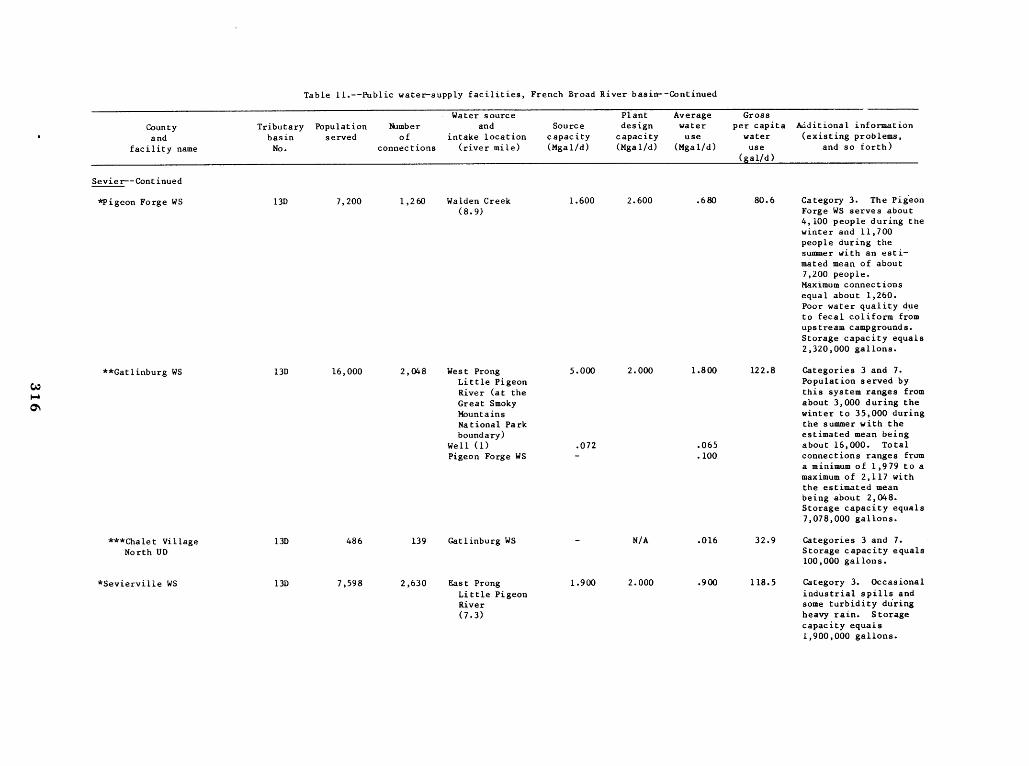
Table 11 .--Public water-supply facilities, French Broad River basin--Continued
County and
Tributary basin
Population served
Number of
Water source and
intake location Source
capacity
Plant design
capacity
Average water use
Gross per capita
water Additional information (existing problems,
facility name No . connections (river mile) (Mgal/d) (Mgal/d) (Mgal/d) use (gal/d)
and so forth)
Sevie r-Continued
*Pigeon Forge WS 13D 7,200 1,260 Walden Creek (8 .9)
1 .600 2 .600 .680 80.6 Category 3 . The Pigeon Forge WS serves about 4,100 people during the winter and 11,700 people during the summer with an estimated mean of about 7,200 people . Maximum connections equal about 1,260 . Poor water quality due to fecal coliform from upstream campgrounds . Storage capacity equals 2,320,000 gallons .
**Gatlinburg WS 13D 16,000 2,048 West Prong Little Pigeon River (at the Great Smoky Mountains
5 .000 2.000 1 .800 122 .8 Categories 3 and 7 . Population served by this system ranges from about 3,000 during the winter to 35,000 during
National Park the summer with the boundary)
Well (1) Pigeon Forge WS
.072 -
.065
.100
estimated mean being about 16,000 . Total connections ranges from a minimum of 1,979 to a maximum of 2,117 with the estimated mean being about 2,048. Storage capacity equals 7,078,000 gallons.
***Chalet Village North UD
13D 486 139 Gatlinburg WS - N/A .016 32.9 Categories 3 and 7. Storage capacity equals 100,000 gallons .
*Sevierville WS 13D 7,598 2,630 East Prong 1 .900 2 .000 .900 118.5 Category 3. Occasional Little Pigeon River
industrial spills and some turbidity during
(7 .3) heavy rain . Storage capacity equals 1,900,000 gallons.