Embed Size (px)
Citation preview
GG
GG G G
GG
GG
GG
GG
GG
GG
GG
GG
GG
GG
GG
GG
GG
GG
GG
GG
GG
GG
GG
G
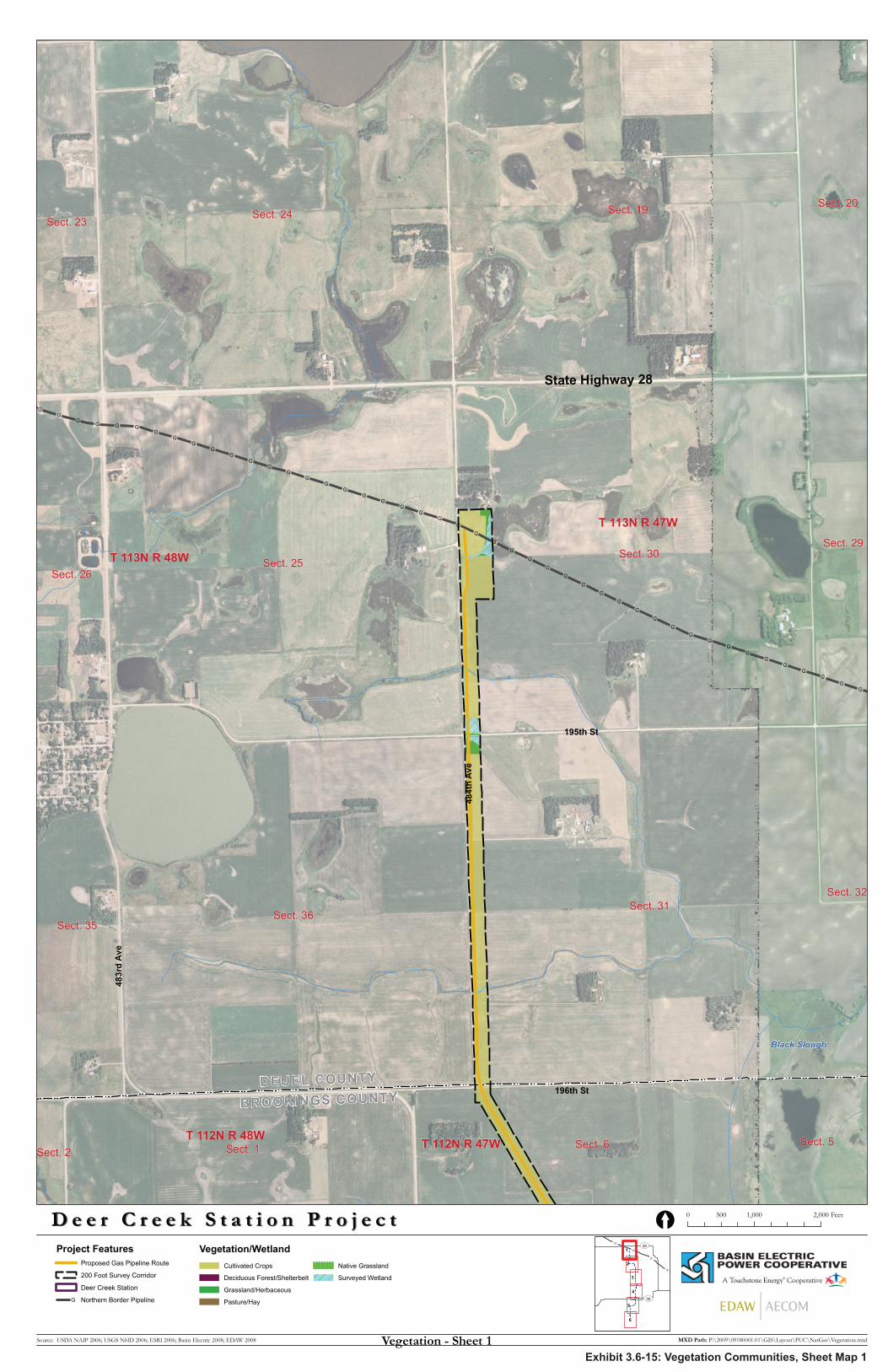
196th StDEUEL COUNTY
BROOKINGS COUNTY
State Highway 28
195th St
484t
h A
ve
483r
d A
ve
Black Slough
Sect. 31
Sect. 30
Sect. 36
Sect. 25
Sect. 19Sect. 24
Sect. 6Sect. 1
Sect. 35
Sect. 26
Sect. 23
Sect. 20
Sect. 29
Sect. 5
Sect. 32
Sect. 2
T 113N R 48W
T 113N R 47W
T 112N R 47WT 112N R 48W
D e e r C r e e k S t a t i o n P r o j e c tD e e r C r e e k S t a t i o n P r o j e c t
Source: USDA NAIP 2006; USGS NHD 2006; ESRI 2006; Basin Electric 2008; EDAW 2008
Project FeaturesProposed Gas Pipeline Route
200 Foot Survey Corridor
Deer Creek Station
G Northern Border Pipeline
0 1,000 2,000500 Feet[
MXD Path: P:\2009\09180001.01\GIS\Layout\PUC\NatGas\Vegetation.mxd
G
G
G
G
UV30
UV28
6
5
4
3
2
1
Vegetation - Sheet 1
Vegetation/WetlandCultivated Crops
Deciduous Forest/Shelterbelt
Grassland/Herbaceous
Pasture/Hay
Native Grassland
Surveyed Wetland
Exhibit 3.6-15: Vegetation Communities, Sheet Map 1
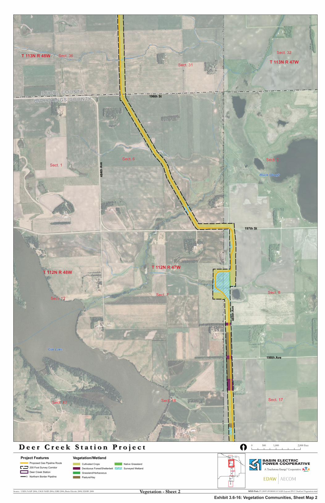
198th Ave
196th StDEUEL COUNTY
BROOKINGS COUNTY
197th St
484t
h A
ve
485t
h A
ve
Oak Lake
Black Slough
Sect. 6
Sect. 7
Sect. 5Sect. 1
Sect. 8Sect. 12
Sect. 18
Sect. 31
Sect. 36
Sect. 13Sect. 17
Sect. 32
T 112N R 47WT 112N R 48W
T 113N R 47WT 113N R 48W
D e e r C r e e k S t a t i o n P r o j e c tD e e r C r e e k S t a t i o n P r o j e c t
Source: USDA NAIP 2006; USGS NHD 2006; ESRI 2006; Basin Electric 2008; EDAW 2008
Project FeaturesProposed Gas Pipeline Route
200 Foot Survey Corridor
Deer Creek Station
G Northern Border Pipeline
0 1,000 2,000500 Feet[
MXD Path: P:\2009\09180001.01\GIS\Layout\PUC\NatGas\Vegetation.mxd
G
G
G
G
UV30
UV28
6
5
4
3
2
1
Vegetation - Sheet 2
Vegetation/WetlandCultivated Crops
Deciduous Forest/Shelterbelt
Grassland/Herbaceous
Pasture/Hay
Native Grassland
Surveyed Wetland
Exhibit 3.6-16: Vegetation Communities, Sheet Map 2
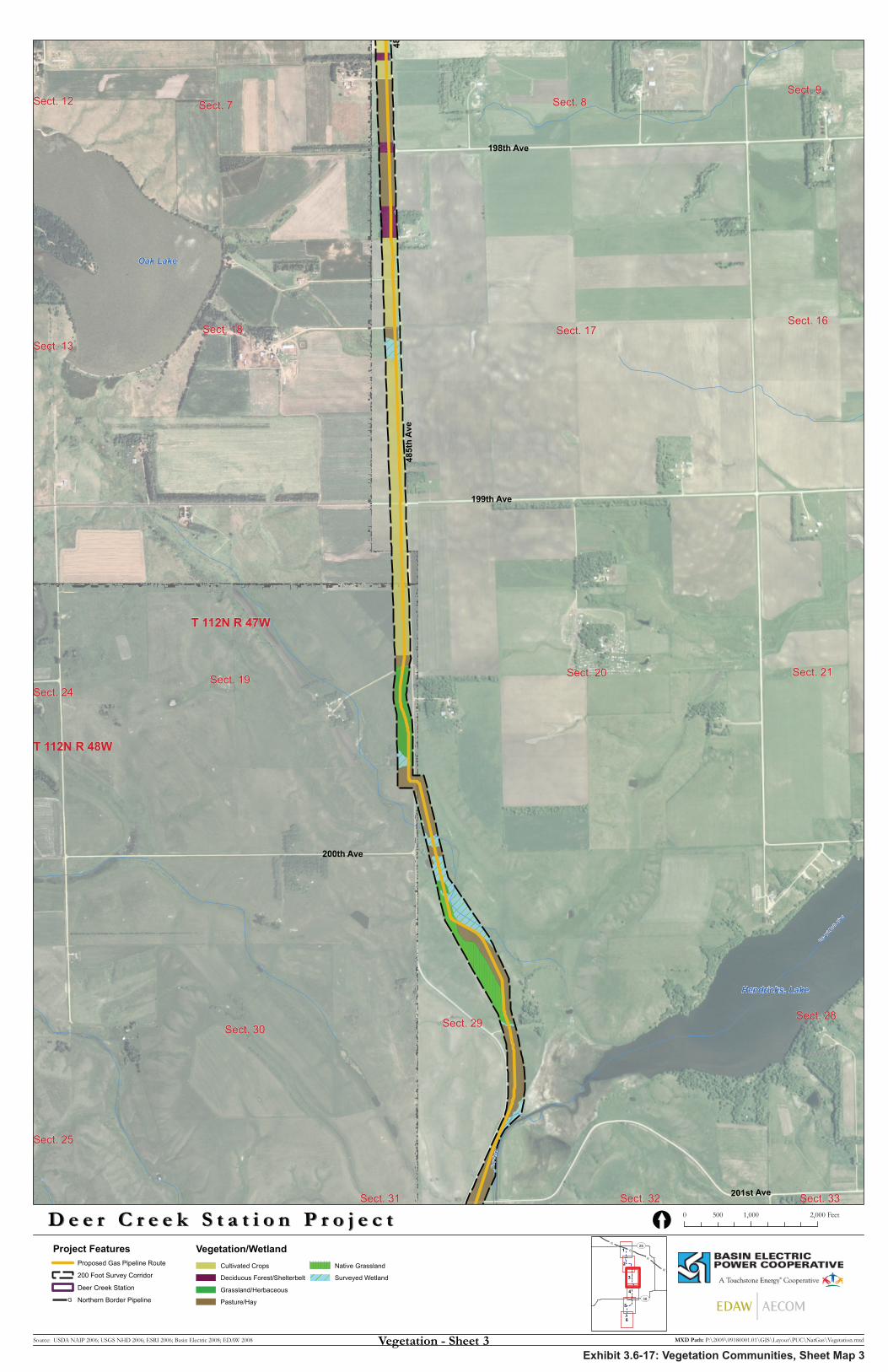
201st Ave
200th Ave
485t
h A
ve
199th Ave
198th Ave
48
Lac q
ui Parl
e Rive
r
Dee
r Cre
ek
Oak Lake
Hendricks, Lake
Sect. 18 Sect. 17
Sect. 19
Sect. 29
Sect. 20
Sect. 30
Sect. 7 Sect. 8
Sect. 16
Sect. 21
Sect. 28
Sect. 9
Sect. 25
Sect. 24
Sect. 13
Sect. 32
Sect. 12
Sect. 33Sect. 31
T 112N R 47W
T 112N R 48W
D e e r C r e e k S t a t i o n P r o j e c tD e e r C r e e k S t a t i o n P r o j e c t
Source: USDA NAIP 2006; USGS NHD 2006; ESRI 2006; Basin Electric 2008; EDAW 2008
Project FeaturesProposed Gas Pipeline Route
200 Foot Survey Corridor
Deer Creek Station
G Northern Border Pipeline
0 1,000 2,000500 Feet[
MXD Path: P:\2009\09180001.01\GIS\Layout\PUC\NatGas\Vegetation.mxd
G
G
G
G
UV30
UV28
6
5
4
3
2
1
Vegetation - Sheet 3
Vegetation/WetlandCultivated Crops
Deciduous Forest/Shelterbelt
Grassland/Herbaceous
Pasture/Hay
Native Grassland
Surveyed Wetland
Exhibit 3.6-17: Vegetation Communities, Sheet Map 3
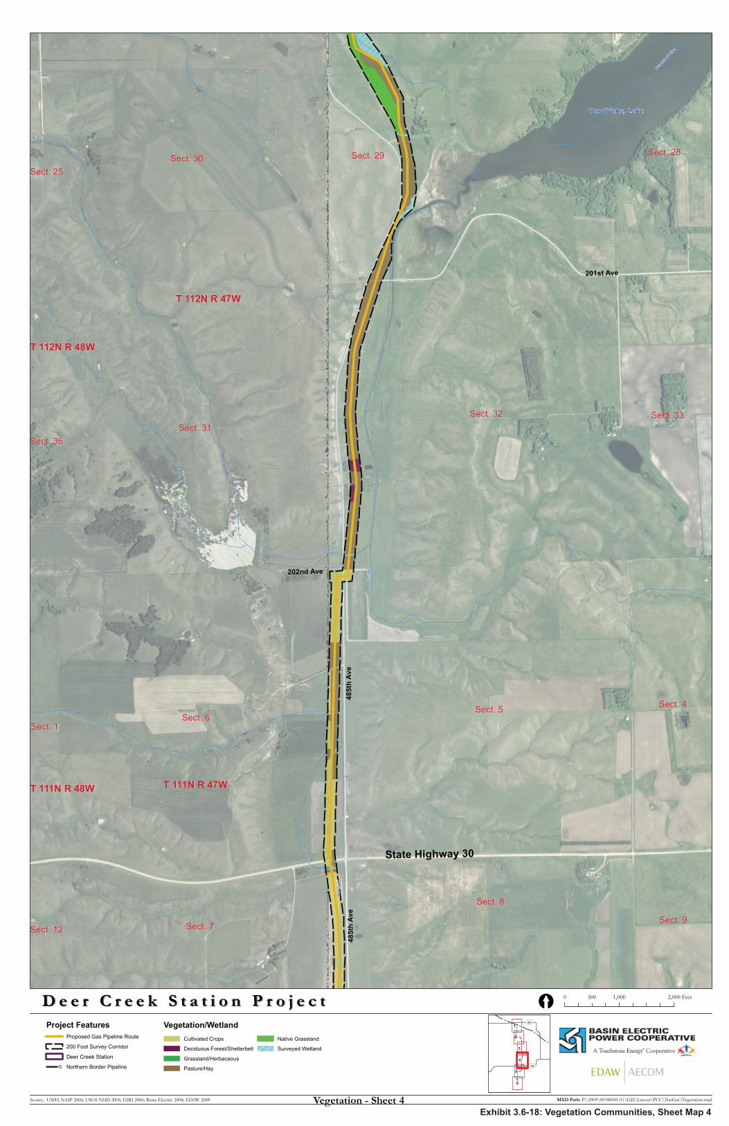
485t
h A
ve
State Highway 30
485t
h A
ve
202nd Ave
201st Ave
Dee
r Cre
ek
Lac q
ui Parl
e Rive
r
Dee
r Cre
ek
Hendricks, Lake
Sect. 5Sect. 6
Sect. 31Sect. 32
Sect. 30 Sect. 29
Sect. 8
Sect. 7
Sect. 4
Sect. 33
Sect. 28
Sect. 9
Sect. 1
Sect. 36
Sect. 12
Sect. 25
T 112N R 47W
T 111N R 47WT 111N R 48W
T 112N R 48W
D e e r C r e e k S t a t i o n P r o j e c tD e e r C r e e k S t a t i o n P r o j e c t
Source: USDA NAIP 2006; USGS NHD 2006; ESRI 2006; Basin Electric 2008; EDAW 2008
Project FeaturesProposed Gas Pipeline Route
200 Foot Survey Corridor
Deer Creek Station
G Northern Border Pipeline
0 1,000 2,000500 Feet[
MXD Path: P:\2009\09180001.01\GIS\Layout\PUC\NatGas\Vegetation.mxd
G
G
G
G
UV30
UV28
6
5
4
3
2
1
Vegetation - Sheet 4
Vegetation/WetlandCultivated Crops
Deciduous Forest/Shelterbelt
Grassland/Herbaceous
Pasture/Hay
Native Grassland
Surveyed Wetland
Exhibit 3.6-18: Vegetation Communities, Sheet Map 4

484t
h A
ve
205th Ave
204th Ave
485t
h A
ve
State Highway 30
Dee
r Cre
ek
Deer Creek
Sect. 7
Sect. 18
Sect. 19
Sect. 8
Sect. 13
Sect. 12
Sect. 17
Sect. 24Sect. 20
Sect. 6Sect. 1Sect. 5
T 111N R 47WT 111N R 48W
D e e r C r e e k S t a t i o n P r o j e c tD e e r C r e e k S t a t i o n P r o j e c t
Source: USDA NAIP 2006; USGS NHD 2006; ESRI 2006; Basin Electric 2008; EDAW 2008
Project FeaturesProposed Gas Pipeline Route
200 Foot Survey Corridor
Deer Creek Station
G Northern Border Pipeline
0 1,000 2,000500 Feet[
MXD Path: P:\2009\09180001.01\GIS\Layout\PUC\NatGas\Vegetation.mxd
G
G
G
G
UV30
UV28
6
5
4
3
2
1
Vegetation - Sheet 5
Vegetation/WetlandCultivated Crops
Deciduous Forest/Shelterbelt
Grassland/Herbaceous
Pasture/Hay
Native Grassland
Surveyed Wetland
Exhibit 3.6-19: Vegetation Communities, Sheet Map 5
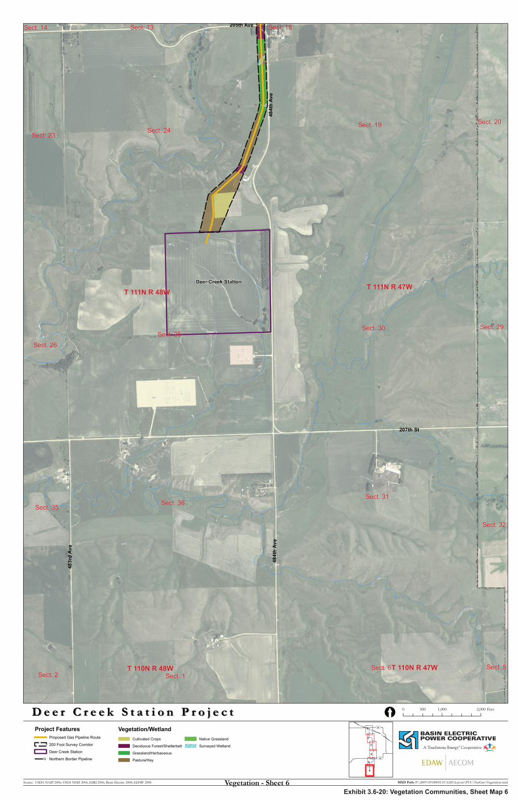
207th St
484t
h Av
e
483r
d Av
e
484t
h Av
e
205th Ave
Deer Creek Station
Dee
r Cre
ek
Sect. 24
Sect. 25Sect. 30
Sect. 19
Sect. 31Sect. 36
Sect. 6Sect. 1
Sect. 26
Sect. 23
Sect. 20
Sect. 29
Sect. 35
Sect. 32
Sect. 2Sect. 5
Sect. 14 Sect. 13 Sect. 18
T 111N R 48WT 111N R 47W
T 110N R 47WT 110N R 48W
D e e r C r e e k S t a t i o n P r o j e c tD e e r C r e e k S t a t i o n P r o j e c t
Source: USDA NAIP 2006; USGS NHD 2006; ESRI 2006; Basin Electric 2008; EDAW 2008
Project FeaturesProposed Gas Pipeline Route
200 Foot Survey Corridor
Deer Creek Station
G Northern Border Pipeline
0 1,000 2,000500 Feet[
MXD Path: P:\2009\09180001.01\GIS\Layout\PUC\NatGas\Vegetation.mxd
G
G
G
G
UV30
UV28
6
5
4
3
2
1
Vegetation - Sheet 6
Vegetation/WetlandCultivated Crops
Deciduous Forest/Shelterbelt
Grassland/Herbaceous
Pasture/Hay
Native Grassland
Surveyed Wetland
Exhibit 3.6-20: Vegetation Communities, Sheet Map 6