Embed Size (px)
Citation preview
SEABEAM ELAC1185 MULTIBEAM ECHOSOUNDER
BENTOS – Servicios y Equipos Marinos Ltda. Avda. Suecia 3005, Ñuñoa, Santiago Telephone: (56 2) 296 373 60 Fax: (56 2) 296 373 77 E-mail: [email protected]

GENERAL ASPECTS
The multibeam (MB) echosounder is a hydroacoustic instrument used for the performance of precision bathymetric surveys.
COMPONENTS
• 2 transducers: the components that emit and receive the beams.
• Processing unit: the component in charge of generating and processing the beams.
• Software to process the information generated by the MB equipment.
EXTERNAL COMPONENTS
• GPS (provides positioning data for the system)
• Movement sensor (Motion)
• Sound velocity profiler (SVP)
• Compass (provides the precise bearing) www.bentos.cl

FUNCTIONING
The same as an echosounder, the ELAC1185 emits an acoustic pulse that when reflected by the marine bottom transforms the travel time of the signal into a distance value. This when multiplied by 126 times makes achievable a swath coverage angle of 153º.
www.bentos.cl
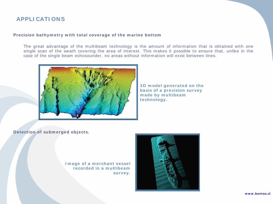
APPLICATIONS Precision bathymetry with total coverage of the marine bottom
The great advantage of the multibeam technology is the amount of information that is obtained with one single scan of the swath covering the area of interest. This makes it possible to ensure that, unlike in the case of the single beam echosounder, no areas without information will exist between lines.
3D model generated on the basis of a precision survey made by multibeam technology.
Detection of submerged objects.
Image of a merchant vessel recorded in a multibeam
survey.
www.bentos.cl

APPLICATIONS Control of Dredging
Precision increases considerably for the performance of dredging control tasks while survey times in the field are reduced.
Multibeam image in a dredging area
Alignments of submarine cables and pipelines
Optimum areas can be detected for the alignments for submarine alignments and structures (cables, pipelines, oil platforms) with a precision of less than one meter.
www.bentos.cl
Detection of a submarine
pipeline
Digital field of a submarine canyon

SEABEAM ELAC1185 MULTIBEAM ECHOSOUNDER
Digital field model made in southern Chile. Survey performed in December 2009.
www.bentos.cl
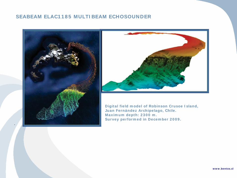
SEABEAM ELAC1185 MULTIBEAM ECHOSOUNDER
Digital field model of Robinson Crusoe Island, Juan Fernández Archipelago, Chile. Maximum depth: 2300 m. Survey performed in December 2009.
. www.bentos.cl
EXPERIENCE Official Multibeam Bathymetry, Marine Geophysics (Sub Bottom Profiler, Side Scan Sonar, Marine Magnetometry and Piston Corer). Puerto Lirquén, Bahía Concepción, Eighth Administrative Region. OCTOPUS LNG Project. GEOVENOR EXPLORA SpA., 2013. Exploratory Multibeam Bathymetry, Lago Villarrica, Villarrica, Ninth Administrative Region, Chile. Ad Honorem investigation work. UNIVERSITY OF GENT (BELGIUM) and UNIVERSITY OF ZURICH (SWITZERLAND), in collaboration with AUSTRAL UNIVERSITY OF CHILE (UACH) and BENTOS. 2013. Multibeam Survey for a Submarine Cable Route, Robinson Crusoe Island, Fifth Administrative Region, Chile, L-3 MARIPRO, 2012. Multibeam Bathymetric Survey and Current Measurements in the Chacao Channel, Tenth Administrative Region, PONTIFICAL CATHOLIC UNIVERSITY OF CHILE, 2012. Multibeam Bathymetric Survey and Marine Sub Bottom Profiler, Bahía Chapaco, Third Administrative Region, COMPAÑÍA MINERA DEL PACÍFICO S.A. (CAP-MINERÍA), 2012. Multibeam Bathymetric Survey and Marine Geophysical Exploration, Mejillones Second Administrative Region, Gas Atacama Project, GASATACAMA CHILE S.A., 2011. Multibeam Bathymetric Survey and Marine Geophysical Exploration, First Administrative Region, Quebrada Blanca Project, Phase 2, COMPAÑÍA MINERA TECK QUEBRADA BLANCA S.A., 2011. Multibeam Bathymetric Survey and Marine Sub Bottom Profiler, Bahía Chapaco, Third Administrative Region, COMPAÑÍA MINERA DEL PACÍFICO S.A. (CAP-MINERÍA), 2011. Multibeam Bathymetric Survey and Marine Sub Bottom Profiler, Bahía Cumberland, Robinson Crusoe Island, Fifth Administrative Region, Chile, PREPARATORY COMMISSION FOR THE COMPREHENSIVE NUCLEAR TEST-BAN-TREATY ORGANIZATION (CTBTO), 2010-2011. Multibeam Hydrography, Geophysics, Coastal Topography and Soil Mechanics Studies for Submarine Power Cable Studies; Alignments in the Tenth and Eleventh Administrative Regions, Chile, CENTRALES HIDROELÉCTRICAS DE AYSÉN S.A. 2009 - 2010.
www.bentos.cl

EXPERIENCE Multibeam Bathymetric Survey for the Juan Fernández Submarine Cable Route, Fifth Administrative Region, L3 COMMUNICATIONS MARIPRO INC., 2009. Multibeam bathymetry, Austral Cable Route, Chiloé, Tenth Administrative Region. Chile, NORDDEUTSCHE SEEKABELWERKE GMBH & CO. KG. SUBMARINE CABLE SYSTEMS, 2007. Multibeam Bathymetry, Centerline Area of the Chacao Bridge and Future Port Facilities, Chacao Channel, Tenth Administrative Region, Chile, EMPRESA CONSTRUCTORA PUENTE CHILOÉ S.A., 2006. URUGUAY Multibeam Bathymetric Survey, Side Scan Sonar and Marine Sub Bottom Profiler (SBP). Directional Wave and Current Measurements and Sedimentology Sampling, Rocha District, Uruguay, MINERA ARATIRÍ S.A. - AUSENCO MANAGEMENT, 2010-2011. PERU Multibeam Bathymetry and Wave Measurements. Marine Studies for the Bahía Islay Marine Terminal, Arequipa, Peru, TERMINAL INTERNACIONAL DEL SUR S.A., 2011. BRAZIL Multibeam Bathymetry and Geophysics Study for the URUCU-MANAUS Gas Pipeline, Amazonas, Brazil, PLANAL SERVICOS DE ENGENHARIA, 2008.
www.bentos.cl