Embed Size (px)
Citation preview
Torres Strait Island Regional Council
Planning SchemePage 671
Schedule 2: Mapping
SC2.11 Mer (Murray) Island maps
WEB
OK
BA
UZ
DEONER
UGAB
ZOMEREDMAS
BEUR
ZEUB
KEWEIDSEBEG
BOGEDAKITIR
KIAM
LARTE
KOP
BABUD
ULA
G
LAS BEACH
EGER
WER
BA
DU
MEK
MAD
PASI
GIG
O
GGM
abo
Gra
ve
Erub
Island
Mas
igIs
land
Dowar(Daua) Islet
Wyer (Waier) Islet
Mer 6 StMer
5 St
Mer
2St
Mer
9 S
t
Mer 8
St
Mer
4St
Mer
10
St
Mer
3St
Koki
Gab
Rd
Mer
7St
Mer
11St
Mar
ouG
abR
d
Zena
dth
Kes
Plan
ning
Sch
eme:
Plan
ning
Sch
eme f
orTh
e Tor
res S
trait
Islan
dRe
gion
al Co
uncil
Are
a
BO
UN
DA
RIE
S A
ND
FEA
TUR
ESD
irect
ion
to th
e ne
ares
t Isl
ands
Wat
erw
ays
Roa
dLG
A
PAPU
A N
EW G
UIN
EA
Mer
(Mur
ray)
Loca
tion
Map
Stra
tegi
c Fr
amew
ork
Map
M
er (M
urra
y) Is
land
´0
100
200
Kilo
met
res
KUKI
SAG
ER
Kuki
(NW
Win
ds -
Janu
ary
to A
pril)
Sage
r (S
E W
inds
- M
ay to
Dec
embe
r)
PATT
ERN
OF
LAN
D U
SE
Tow
nshi
pEn
viro
nmen
tal M
anag
emen
t and
Con
serv
atio
nN
ATU
RA
L EN
VIR
ON
MEN
T
Fish
ing
Are
a
EXIS
TIN
G F
AC
ILIT
IES
AN
D IN
FRA
STR
UC
TUR
E
Airs
trip
Info
rmal
Exi
stin
g B
arge
R
amp
(pot
entia
l loc
atio
nfo
r fut
ure
finge
r wha
rf)
Cem
eter
y
Chu
rch
Com
mun
ity H
all
Elec
trici
tyIn
frast
ruct
ure
! (Ex
istin
g In
dust
ry
Hea
lth C
entre
IBIS
Sto
re
Sacr
ed S
ite
Scho
olSe
wer
age
Infra
stru
ctur
e
TSIR
C B
uild
ings
Tele
com
mun
icat
ions
Infra
stru
ctur
e
Was
te F
acili
tyW
ater
Sup
ply
Infra
stru
ctur
e
LEG
END
FUTU
RE
FAC
ILIT
IES,
INFR
AST
RU
CTU
RE
AN
D A
CTI
VITI
ES
Tow
nshi
p E
xpan
sion
Tow
n C
entre
Cor
e
Poss
ible
Fut
ure
Hou
sing
Inve
stig
atio
n A
rea
010
020
050
Met
res
°Pr
ojec
tion:
GDA
1994
MGA
Zon
e 55
Datu
m:G
DA 19
94
Upda
ted:
17/12
/2015
1:10
,000
Appr
ox. S
cale
@A3
Dat
a S
ourc
es:
Unl
ess
stat
ed b
elow
all
land
use,
road
, or n
atur
al fe
atur
e da
ta s
how
nis
from
the
Stra
tegi
c La
ndus
e P
lan
(SLU
P) b
y th
e R
PS
Gro
up 2
010.
Com
mun
ity C
onsu
ltatio
n 20
13:L
ocal
Nam
es, P
lace
s an
d id
entif
ied
faci
litie
sQ
ueen
slan
d D
ept.
Nat
ural
Res
ourc
es a
nd E
nviro
nmen
t:Im
ager
y,LG
A B
ound
arie
s, T
erra
in d
ata
and
Floo
ding
laye
rsAE
CO
M:
all
stra
tegi
c fra
mew
ork,
zo
ning
an
d lo
cal
area
pl
an
data
is
mod
ified
from
the
SLU
P an
d D
NR
M s
ourc
e da
ta.
Loca
tion
Map
Bas
e D
ata
and
Inse
t:W
orld
Stre
et M
ap /
Wor
ld Im
ager
y @
ES
RI O
nlin
e. S
ourc
es:S
ourc
es: E
sri,
HER
E, D
eLor
me,
US
GS
, Int
erm
ap, i
ncre
men
t P C
orp.
, NR
CA
N, E
sri J
apan
,M
ETI
, E
sri C
hina
(H
ong
Kon
g),
Esr
i (Th
aila
nd),
Tom
Tom
, M
apm
yInd
ia,
©O
penS
treet
Map
con
tribu
tors
, and
the
GIS
Use
r Com
mun
ityM
ain
Map
Imag
ery:
Mer
15c
m S
atel
lite
Imag
ery
@ S
ISP,
201
1Di
sclai
mer
:AE
COM
doe
s not
war
rant
the
accu
racy
or c
omple
tene
ss o
f inf
orm
ation
disp
layed
in th
is m
apan
d an
y pe
rson
usin
g it
does
so
at th
eir o
wn ri
sk. A
ECOM
sha
ll be
ar n
o re
spon
sibilit
y or
liabil
ity fo
r any
erro
rs, f
aults
, def
ects
, or o
miss
ions
in th
e inf
orm
ation
. Whe
re n
ot p
art o
f the
DCDB
, int
erna
l lot
bou
ndar
ies h
ave
been
der
ived
base
d on
visi
ble o
ccup
ation
of l
and
from
2011
,201
2 an
d 20
13 o
rthor
ectifi
ed a
erial
imag
ery
and
CAD
Deta
il Sur
vey.
The
y sh
ould
not
be c
onsid
ered
spat
ially
accu
rate
(Der
ived
Lot B
ound
ary)
Mer
(Mur
ray)
Isla
nd
Wye
r (W
aier
) Is
let
Dow
ar (D
aua)
Isle
t
MER
(MU
RR
AY)
ISLA
ND
GR
OU
PO
VER
VIEW
WEB
OK
BA
UZ
DEONER
UGAB
ZOMEREDMAS
BEUR
ZEUB
KEWEIDSEBEG
BOGEDAKITIR
KIAM
LARTE
KOP
BABUD
ULA
G
LAS BEACH
EGER
WER
BA
DU
MEK
MAD
PASI
GIG
O
GGM
abo
Gra
ve
Erub
Island
Dowar(Daua) Islet
Mas
igIs
land
Wyer (Waier) Islet
Unknown
Unknow n
Mer 6 StMer
5 St
Mer
2St
Mer
9 S
t
Mer 8
St
Mer
4St
Mer
10
St
Mer
3St
Koki
Gab
Rd
Mer
7St
Mer
11St
Mar
ouG
abR
d
Zena
dth
Kes
Plan
ning
Sch
eme:
Plan
ning
Sch
eme f
orTh
e Tor
res S
trait
Islan
dRe
gion
al Co
uncil
Are
a
LEG
END
BO
UN
DA
RIE
S A
ND
FEA
TUR
ESD
irect
ion
to th
e ne
ares
t Isl
ands
Wat
erw
ays
Cad
astra
l Bou
ndar
ies
Roa
dLG
A
PAPU
A N
EW G
UIN
EA
Mer
(Mur
ray)
Loca
tion
Map
Zone
Map
– M
er (M
urra
y) Is
land
´0
100
200
Kilo
met
res
KUKI
SAG
ER
Kuki
(NW
Win
ds -
Janu
ary
to A
pril)
Sage
r (S
E W
inds
- M
ay to
Dec
embe
r)
ZON
ES
Tow
nshi
p Zo
neEn
viro
nmen
tal M
anag
emen
t and
C
onse
rvat
ion
Zone
PREC
INC
TS
Tow
nshi
p E
xpan
sion
Pre
cinc
t
010
020
050
Met
res
°
Proj
ectio
n:GD
A 19
94 M
GA Z
one 5
5 Da
tum
:GDA
1994
Upda
ted:
17/12
/2015
1:10
,000
Appr
ox. S
cale
@A3
Mer
(Mur
ray)
Isla
nd
Wye
r (W
aier
) Is
let
Dow
ar (D
aua)
Isle
t
MER
(MU
RR
AY)
ISLA
ND
GR
OU
PO
VER
VIEW
Dat
a S
ourc
es:
Unl
ess
stat
ed b
elow
all
land
use,
road
, or n
atur
al fe
atur
e da
ta s
how
nis
from
the
Stra
tegi
c La
ndus
e P
lan
(SLU
P) b
y th
e R
PS
Gro
up 2
010.
Com
mun
ity C
onsu
ltatio
n 20
13: L
ocal
Nam
es, P
lace
s an
d id
entif
ied
faci
litie
sQ
ueen
slan
d D
ept.
Nat
ural
Res
ourc
es a
nd E
nviro
nmen
t:Im
ager
y,LG
A B
ound
arie
s, T
erra
in d
ata
and
Floo
ding
laye
rsAE
CO
M:
all
stra
tegi
c fra
mew
ork,
zo
ning
an
d lo
cal
area
pl
an
data
is
mod
ified
from
the
SLU
P an
d D
NR
M s
ourc
e da
ta.
Loca
tion
Map
Bas
e D
ata:
Wor
ld S
treet
Map
@ E
SR
I Onl
ine.
Sou
rces
:Sou
rces
: Esr
i, H
ER
E, D
eLor
me,
USG
S, I
nter
map
, inc
rem
ent P
Cor
p., N
RC
AN
, Esr
i Jap
an, M
ETI
, Esr
i Chi
na(H
ong
Kon
g),
Esr
i (T
haila
nd),
Tom
Tom
, M
apm
yInd
ia,
© O
penS
treet
Map
cont
ribut
ors,
and
the
GIS
Use
r Com
mun
ityM
ain
Map
Imag
ery:
Mer
15c
m S
atel
lite
Imag
ery
@ S
ISP,
201
1In
set I
mag
ery:
Wor
ld
Imag
ery@
E
SRI
Onl
ine.
S
ourc
e:
Esr
i, D
igita
lGlo
be,
Geo
Eye
,Ea
rthst
ar G
eogr
aphi
cs, C
NE
S/A
irbus
DS
, US
DA
, US
GS,
AE
X, G
etm
appi
ng,
Aero
grid
, IG
N, I
GP,
sw
isst
opo,
and
the
GIS
Use
r Com
mun
ityDi
sclai
mer
:AE
COM
doe
s not
war
rant
the
accu
racy
or c
omple
tene
ss o
f inf
orm
ation
disp
layed
in th
is m
apan
d an
y pe
rson
usin
g it
does
so
at th
eir o
wn ri
sk. A
ECOM
sha
ll be
ar n
o re
spon
sibilit
y or
liabil
ity fo
r any
erro
rs, f
aults
, def
ects
, or o
miss
ions
in th
e inf
orm
ation
. Whe
re n
ot p
art o
f the
DCDB
, int
erna
l lot
bou
ndar
ies h
ave
been
der
ived
base
d on
visi
ble o
ccup
ation
of l
and
from
2011
,201
2 an
d 20
13 o
rthor
ectifi
ed a
erial
imag
ery
and
CAD
Deta
il Sur
vey.
The
y sh
ould
not
be c
onsid
ered
spat
ially
accu
rate
(Der
ived
Lot B
ound
ary)
WEB
OK
BA
UZ
DEONER
UGAB
ZOMEREDMAS
BEUR
ZEUB
KEWEIDSEBEG
BOGEDAKITIR
KIAM
LARTE
KOP
BABUD
ULA
G
LAS BEACH
EGER
WER
BA
DU
MEK
MAD
PASI
GIG
O
Erub
Island
Wyer (Waier) Islet
Dowar(Daua) Islet
Mas
igIs
land
Unknown
Unknow n
Mer 6 StMer
5 St
Mer
2St
Mer
9 S
t
Mer 8
St
Mer
4St
Mer
10
St
Mer
3St
Koki
Gab
Rd
Mer
7St
Mer
11St
Mar
ouG
abR
d
010
020
050
Met
res
°
Zena
dth
Kes
Plan
ning
Sch
eme:
Plan
ning
Sch
eme f
orTh
e Tor
res S
trait
Islan
dRe
gion
al Co
uncil
Are
a
LEG
END
BO
UN
DA
RIE
S A
ND
FEA
TUR
ESD
irect
ion
to th
e ne
ares
t Isl
ands
Cad
astra
l Bou
ndar
ies
Roa
dLG
A
Proj
ectio
n:GD
A 19
94 M
GA Z
one 5
5 Da
tum
:GDA
1994
PAPU
A N
EW G
UIN
EA
Mer
(Mur
ray)
Loca
tion
Map
Loca
l Are
a P
lan
Map
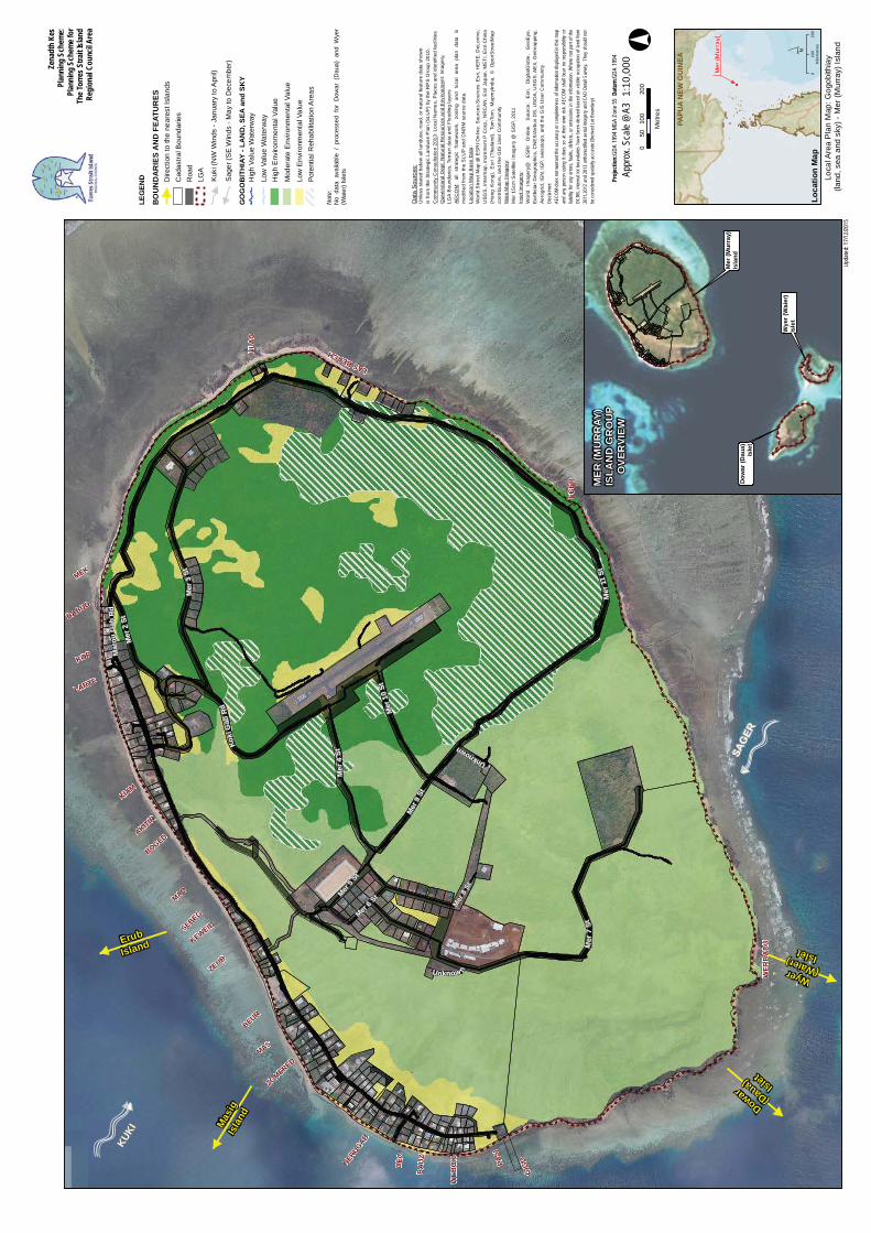
: Gog
obith
iay
(land
, sea
and
sky
) - M
er (M
urra
y) Is
land
Upda
ted:
17/12
/2015
´0
100
200
Kilo
met
res
1:10
,000
Appr
ox. S
cale
@A3
GO
GO
BIT
HIA
Y - L
AN
D, S
EA a
nd S
KY
Hig
h Va
lue
Wat
erw
ay
Low
Val
ue W
ater
way
Hig
h E
nviro
nmen
tal V
alue
Mod
erat
e E
nviro
nmen
tal V
alue
Low
Env
ironm
enta
l Val
uePo
tent
ial R
ehab
ilita
tion
Are
as
Kuki
(NW
Win
ds -
Janu
ary
to A
pril)
Sage
r (S
E W
inds
- M
ay to
Dec
embe
r)
KUKI
SAG
ER
Mer
(Mur
ray)
Isla
nd
Wye
r (W
aier
) Is
let
Dow
ar (D
aua)
Isle
t
MER
(MU
RR
AY)
ISLA
ND
GR
OU
PO
VER
VIEW
Dat
a S
ourc
es:
Unl
ess
stat
ed b
elow
all
land
use,
road
, or n
atur
al fe
atur
e da
ta s
how
nis
from
the
Stra
tegi
c La
ndus
e P
lan
(SLU
P) b
y th
e R
PS
Gro
up 2
010.
Com
mun
ity C
onsu
ltatio
n 20
13: L
ocal
Nam
es, P
lace
s an
d id
entif
ied
faci
litie
sQ
ueen
slan
d D
ept.
Nat
ural
Res
ourc
es a
nd E
nviro
nmen
t:Im
ager
y,LG
A B
ound
arie
s, T
erra
in d
ata
and
Floo
ding
laye
rsAE
CO
M:
all
stra
tegi
c fra
mew
ork,
zo
ning
an
d lo
cal
area
pl
an
data
is
mod
ified
from
the
SLU
P an
d D
NR
M s
ourc
e da
ta.
Loca
tion
Map
Bas
e D
ata:
Wor
ld S
treet
Map
@ E
SR
I Onl
ine.
Sou
rces
:Sou
rces
: Esr
i, H
ER
E, D
eLor
me,
USG
S, I
nter
map
, inc
rem
ent P
Cor
p., N
RC
AN
, Esr
i Jap
an, M
ETI
, Esr
i Chi
na(H
ong
Kon
g),
Esr
i (T
haila
nd),
Tom
Tom
, M
apm
yInd
ia,
© O
penS
treet
Map
cont
ribut
ors,
and
the
GIS
Use
r Com
mun
ityM
ain
Map
Imag
ery:
Mer
15c
m S
atel
lite
Imag
ery
@ S
ISP,
201
1In
set I
mag
ery:
Wor
ld
Imag
ery@
E
SRI
Onl
ine.
S
ourc
e:
Esr
i, D
igita
lGlo
be,
Geo
Eye
,Ea
rthst
ar G
eogr
aphi
cs, C
NE
S/A
irbus
DS
, US
DA
, US
GS,
AE
X, G
etm
appi
ng,
Aero
grid
, IG
N, I
GP,
sw
isst
opo,
and
the
GIS
Use
r Com
mun
ityDi
sclai
mer
:AE
COM
doe
s not
war
rant
the
accu
racy
or c
omple
tene
ss o
f inf
orm
ation
disp
layed
in th
is m
apan
d an
y pe
rson
usin
g it
does
so
at th
eir o
wn ri
sk. A
ECOM
sha
ll be
ar n
o re
spon
sibilit
y or
liabil
ity fo
r any
erro
rs, f
aults
, def
ects
, or o
miss
ions
in th
e inf
orm
ation
. Whe
re n
ot p
art o
f the
DCDB
, int
erna
l lot
bou
ndar
ies h
ave
been
der
ived
base
d on
visi
ble o
ccup
ation
of l
and
from
2011
,201
2 an
d 20
13 o
rthor
ectifi
ed a
erial
imag
ery
and
CAD
Deta
il Sur
vey.
The
y sh
ould
not
be c
onsid
ered
spat
ially
accu
rate
(Der
ived
Lot B
ound
ary)
Not
e:N
o da
ta a
vaila
ble
/ pr
oces
sed
for
Dow
ar (
Dau
a) a
nd W
yer
(Wai
er) I
slet
s
WEB
OK
BA
UZ
DEONER
UGAB
ZOMEREDMAS
BEUR
ZEUB
KEWEIDSEBEG
BOGEDAKITIR
KIAM
LARTE
KOP
BABUD
ULA
G
LAS BEACH
EGER
WER
BA
DU
MEK
MAD
PASI
GIG
O
Erub
Island
Mas
igIs
land
Dowar(Daua) Islet
Wyer (Waier) Islet
Zena
dth
Kes
Plan
ning
Sch
eme:
Plan
ning
Sch
eme f
orTh
e Tor
res S
trait
Islan
dRe
gion
al Co
uncil
Are
a
LEG
END
BO
UN
DA
RIE
S A
ND
FEA
TUR
ESD
irect
ion
to th
e ne
ares
t Isl
ands
Wat
erw
ays
Cad
astra
l Bou
ndar
ies
Roa
dLG
A
PAPU
A N
EW G
UIN
EA
Mer
(Mur
ray)
Loca
tion
Map
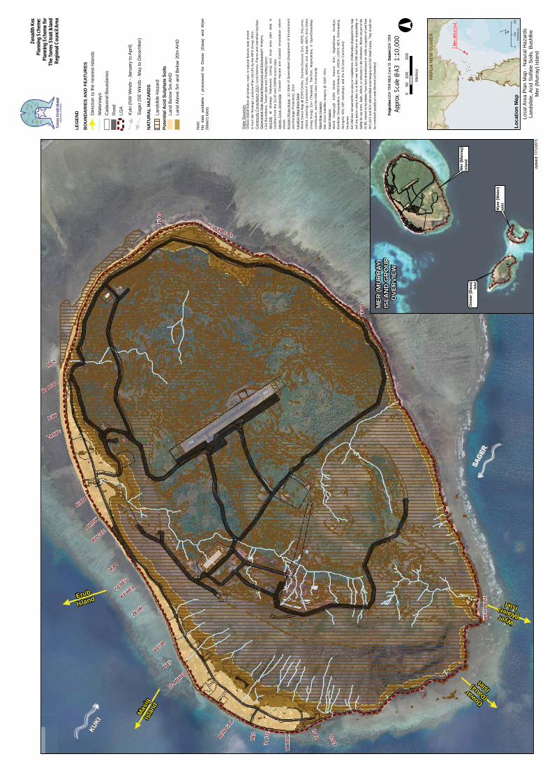
Loca
l Are
a P
lan
Map
- N
atur
al H
azar
dsLa
ndsl
ide,
Aci
d S
ulfa
te S
oils
, Bus
hfire
Mer
(Mur
ray)
Isla
nd
´0
100
200
Kilo
met
res
NAT
UR
AL
HA
ZAR
DS
Land
slid
e H
azar
dPo
tent
ial A
cid
Sulp
hate
Soi
lsLa
nd B
elow
5m
AH
DLa
nd A
bove
5m
and
Bel
ow 2
0m A
HD
KUKI
SAG
ER
Kuki
(NW
Win
ds -
Janu
ary
to A
pril)
Sage
r (S
E W
inds
- M
ay to
Dec
embe
r)
010
020
050
Met
res
°Pr
ojec
tion:
GDA
1994
MGA
Zon
e 55
Datu
m:G
DA 19
94
Upda
ted:
17/12
/2015
1:10
,000
Appr
ox. S
cale
@A3
Dat
a S
ourc
es:
Unl
ess
stat
ed b
elow
all
land
use,
road
, or n
atur
al fe
atur
e da
ta s
how
nis
from
the
Stra
tegi
c La
ndus
e P
lan
(SLU
P) b
y th
e R
PS
Gro
up 2
010.
Com
mun
ity C
onsu
ltatio
n 20
13: L
ocal
Nam
es, P
lace
s an
d id
entif
ied
faci
litie
sQ
ueen
slan
d D
ept.
Nat
ural
Res
ourc
es a
nd E
nviro
nmen
t:Im
ager
y,LG
A B
ound
arie
s, T
erra
in d
ata
and
Floo
ding
laye
rsAE
CO
M:
all
stra
tegi
c fra
mew
ork,
zo
ning
an
d lo
cal
area
pl
an
data
is
mod
ified
from
the
SLU
P an
d D
NR
M s
ourc
e da
ta.
Jam
es C
ook
Uni
vers
ity:
Coa
stal
Haz
ard
and
Coa
stal
Inn
unda
tion
whe
resh
own.
Eros
ion
Pron
e A
reas
:(c
) S
tate
of Q
ueen
slan
d (D
epar
tmen
t of E
nviro
nmen
tan
d H
erita
ge P
rote
ctio
n), 2
014
Loca
tion
Map
Bas
e D
ata:
Wor
ld S
treet
Map
@ E
SR
I Onl
ine.
Sou
rces
:Sou
rces
: Esr
i, H
ER
E, D
eLor
me,
USG
S, I
nter
map
, inc
rem
ent P
Cor
p., N
RC
AN
, Esr
i Jap
an, M
ETI
, Esr
i Chi
na(H
ong
Kon
g),
Esr
i (T
haila
nd),
Tom
Tom
, M
apm
yInd
ia,
© O
penS
treet
Map
cont
ribut
ors,
and
the
GIS
Use
r Com
mun
ityM
ain
Map
Imag
ery:
Mer
15c
m S
atel
lite
Imag
ery
@ S
ISP,
201
1In
set I
mag
ery:
Wor
ld
Imag
ery@
E
SRI
Onl
ine.
S
ourc
e:
Esr
i, D
igita
lGlo
be,
Geo
Eye
,Ea
rthst
ar G
eogr
aphi
cs, C
NE
S/A
irbus
DS
, US
DA
, US
GS,
AE
X, G
etm
appi
ng,
Aero
grid
, IG
N, I
GP,
sw
isst
opo,
and
the
GIS
Use
r Com
mun
ityDi
sclai
mer
:AE
COM
doe
s not
war
rant
the
accu
racy
or c
omple
tene
ss o
f inf
orm
ation
disp
layed
in th
is m
apan
d an
y pe
rson
usin
g it
does
so
at th
eir o
wn ri
sk. A
ECOM
sha
ll be
ar n
o re
spon
sibilit
y or
liabil
ity fo
r any
erro
rs, f
aults
, def
ects
, or o
miss
ions
in th
e inf
orm
ation
. Whe
re n
ot p
art o
f the
DCDB
, int
erna
l lot
bou
ndar
ies h
ave
been
der
ived
base
d on
visi
ble o
ccup
ation
of l
and
from
2011
,201
2 an
d 20
13 o
rthor
ectifi
ed a
erial
imag
ery
and
CAD
Deta
il Sur
vey.
The
y sh
ould
not
be c
onsid
ered
spat
ially
accu
rate
(Der
ived
Lot B
ound
ary)
Mer
(Mur
ray)
Isla
nd
Wye
r (W
aier
) Is
let
Dow
ar (D
aua)
Isle
t
MER
(MU
RR
AY)
ISLA
ND
GR
OU
PO
VER
VIEW
Not
e:N
o da
ta a
vaila
ble
/ pr
oces
sed
for
Dow
ar (
Dau
a) a
nd W
yer
(Wai
er) I
slet
s
WEB
OK
BA
UZ
DEONER
UGAB
ZOMEREDMAS
BEUR
ZEUB
KEWEIDSEBEG
BOGEDAKITIR
KIAM
LARTE
KOP
BABUD
ULA
G
LAS BEACH
EGER
WER
BA
DU
MEK
MAD
PASI
GIG
O
Erub
Island
Mas
igIs
land
Dowar(Daua) Islet
Wyer (Waier) Islet
Zena
dth
Kes
Plan
ning
Sch
eme:
Plan
ning
Sch
eme f
orTh
e Tor
res S
trait
Islan
dRe
gion
al Co
uncil
Are
a
LEG
END
BO
UN
DA
RIE
S A
ND
FEA
TUR
ESD
irect
ion
to th
e ne
ares
t Isl
ands
Wat
erw
ays
Cad
astra
l Bou
ndar
ies
Roa
dLG
A
PAPU
A N
EW G
UIN
EA
Mer
(Mur
ray)
Loca
tion
Map
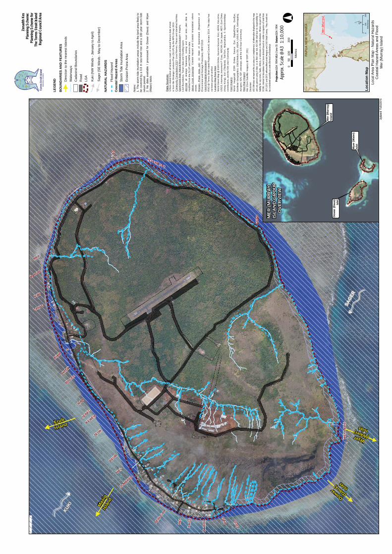
Loca
l Are
a P
lan
Map
- N
atur
al H
azar
dsC
oast
al H
azar
d A
reas
and
Flo
odM
er (M
urra
y) Is
land
´0
100
200
Kilo
met
res
NAT
UR
AL
HA
ZAR
DS
Floo
d H
azar
d
KUKI
SAG
ER
Kuki
(NW
Win
ds -
Janu
ary
to A
pril)
Sage
r (S
E W
inds
- M
ay to
Dec
embe
r)
010
020
050
Met
res
°Pr
ojec
tion:
GDA
1994
MGA
Zon
e 55
Datu
m:G
DA 19
94
Upda
ted:
15/03
/2016
1:10
,000
Appr
ox. S
cale
@A3
Dat
a S
ourc
es:
Unl
ess
stat
ed b
elow
all
land
use,
road
, or n
atur
al fe
atur
e da
ta s
how
nis
from
the
Stra
tegi
c La
ndus
e P
lan
(SLU
P) b
y th
e R
PS
Gro
up 2
010.
Com
mun
ity C
onsu
ltatio
n 20
13: L
ocal
Nam
es, P
lace
s an
d id
entif
ied
faci
litie
sQ
ueen
slan
d D
ept.
Nat
ural
Res
ourc
es a
nd E
nviro
nmen
t:Im
ager
y,LG
A B
ound
arie
s, T
erra
in d
ata
and
Floo
ding
laye
rsAE
CO
M:
all
stra
tegi
c fra
mew
ork,
zo
ning
an
d lo
cal
area
pl
an
data
is
mod
ified
from
the
SLU
P an
d D
NR
M s
ourc
e da
ta.
Jam
es C
ook
Uni
vers
ity:
Coa
stal
Haz
ard
and
Coa
stal
Inn
unda
tion
whe
resh
own.
Eros
ion
Pro
ne
Are
a (v
5):
(c)
Sta
te
of
Que
ensl
and
(Dep
artm
ent
ofEn
viro
nmen
t and
Her
itage
Pro
tect
ion)
, 08/
07/2
016
Inte
rim F
lood
plai
n A
sses
smen
tIF
AO
@ T
orre
s St
rait
Isla
nd R
egio
nal C
ounc
il, J
anua
ry 2
014.
Thi
s da
ta h
asno
t bee
n gr
ound
ver
ified
Loca
tion
Map
Bas
e D
ata:
Wor
ld S
treet
Map
@ E
SR
I Onl
ine.
Sou
rces
:Sou
rces
: Esr
i, H
ER
E, D
eLor
me,
USG
S, I
nter
map
, inc
rem
ent P
Cor
p., N
RC
AN
, Esr
i Jap
an, M
ETI
, Esr
i Chi
na(H
ong
Kon
g),
Esr
i (T
haila
nd),
Tom
Tom
, M
apm
yInd
ia,
© O
penS
treet
Map
cont
ribut
ors,
and
the
GIS
Use
r Com
mun
ityIn
set I
mag
ery:
Wor
ld
Imag
ery@
E
SRI
Onl
ine.
S
ourc
e:
Esr
i, D
igita
lGlo
be,
Geo
Eye
,Ea
rthst
ar G
eogr
aphi
cs, C
NE
S/A
irbus
DS
, US
DA
, US
GS,
AE
X, G
etm
appi
ng,
Aero
grid
, IG
N, I
GP,
sw
isst
opo,
and
the
GIS
Use
r Com
mun
ityM
ain
Map
Imag
ery:
Mer
15c
m S
atel
lite
Imag
ery
@ S
ISP,
201
1Di
sclai
mer
:AE
COM
doe
s not
war
rant
the
accu
racy
or c
omple
tene
ss o
f inf
orm
ation
disp
layed
in th
is m
apan
d an
y pe
rson
usin
g it
does
so
at th
eir o
wn ri
sk. A
ECOM
sha
ll be
ar n
o re
spon
sibilit
y or
liabil
ity fo
r any
erro
rs, f
aults
, def
ects
, or o
miss
ions
in th
e inf
orm
ation
. Whe
re n
ot p
art o
f the
DCDB
, int
erna
l lot
bou
ndar
ies h
ave
been
der
ived
base
d on
visi
ble o
ccup
ation
of l
and
from
2011
,201
2 an
d 20
13 o
rthor
ectifi
ed a
erial
imag
ery
and
CAD
Deta
il Sur
vey.
The
y sh
ould
not
be c
onsid
ered
spat
ially
accu
rate
(Der
ived
Lot B
ound
ary)
Eros
ion
Pro
ne A
rea
Coa
stal
Haz
ard
Are
asSt
orm
Tid
e In
unda
tion
Are
a
Not
es:
1.Th
e st
orm
tide
inun
datio
n ar
eas
incl
ude
the
land
are
a lik
ely
tobe
cov
ered
by
a 0.
8 m
sea
leve
l ris
e an
d a
100
year
sto
rm ti
dere
turn
per
iod.
2.N
o da
ta a
vaila
ble
/ pr
oces
sed
for
Dow
ar (
Dau
a) a
nd W
yer
(Wai
er) I
slet
s
Mer
(Mur
ray)
Isla
nd
Wye
r (W
aier
) Is
let
Dow
ar (D
aua)
Isle
t
MER
(MU
RR
AY)
ISLA
ND
GR
OU
PO
VER
VIEW