Embed Size (px)
Citation preview
Saskatchewan
Provincial Standard
System of
Rural Addressing
Adopted by Saskatchewan Association of Rural Municipalities (SARM)
at the 2005 mid-term convention under the Rural Municipal Signing System Resolution No. 7-05M
300 – 10 Research Drive
Regina, Canada
S4S 7J7
Phone Ask ISC at
1-866-275-4721
www.isc .ca
Table of Contents
Table of Contents ....................................................................................................................... i
Introduction ................................................................................................................................ 1
Required Attributes of an Addressing System ........................................................................... 1
Standard Address System ......................................................................................................... 2
Road Name................................................................................................................................... 2
Access Numbers...................................................................................................................................2
Unit Numbers.....................................................................................................................................3
Road Signage................................................................................................................................. 3
Figures ......................................................................................................................................... 4
Figure 1 : Application of the Road Naming System in the First and Second Systems of Survey ............................5
Figure 2 : Application of the Road Naming System in the Third System of Survey ................................................6
Figure 3 : An Example of Roads That do not Follow the Township System and are Numbered and Lettered ......7
Figure 4 : An Example of a Named Road ................................................................... ............................................ 8
Figure 5 : The Division of the Section Edges Into 40 metre Frontages for Access Number Assignment .............. 9
Figure 6 : Assignment of Access Numbers at an Intersection ................................................................................ 10
Figure 7 : Access numbers Crossing a “Nonexistent” Road .................................................................................. 11
Figure 8 : Addressing in a Rural Subdivision ................................................................................................. ....... 12
Introduction
This document describes the Saskatchewan standard system of addressing to be applied in the rural areas of the
province that have been subdivided using the township system. The Rural Municipal Signing System, which
includes the rural addressing standard, was adopted by SARM resolution No. 7-05M at the mid-term convention of
the Saskatchewan Association of Rural Municipalities. This Standard is not meant to be applied to incorporated
areas of the province (Cities, Towns, Villages, …) or to the remote northern areas of the province.
One of the driving forces behind the desire for a common rural addressing system is the movement towards the
establishment of 9•1•1 systems to cover the province providing protective services dispatch services. A simple and
concise method of providing a location to the 9•1•1 operator is required. The addressing system has also been
developed to provide a standard address for use by crown utility corporations, Canada Post, and the many other
service companies that need to make deliveries to rural customers and are finding it harder and harder to keep track
of locations and routes to access those locations.
The standard describes seven attributes that an addressing system should have to ensure that it will meet the needs of
all users. The Standard then identifies an address assignment system for Saskatchewan that has all the attributes that
are required. It is freely acknowledged that the Saaskatchewan standard system is largely based on the addressing
system developed by the County of Strathcona in Alberta. The Strathcona system has been altered slightly to
account for differences between the survey systems in Saskatchewan and Alberta and to make it work on a
provincial, as opposed to county, basis.
Required Attributes of an Addressing System
The following seven points describe the attributes and features that any address designation system must have in
order to meet the requirements of all users.
1) The primary purpose of an address is to provide a user friendly means of describing to another person a
location that they are to go to, whether that other person be a visiting friend, a pizza delivery person, a
mail delivery person, or an ambulance or fire truck driver.
2) Addresses should be predictable. A person who is nominally familiar with the addressing system should be
able to figure out how to get from where they are to a given address. This means , for example, that
numerical addresses (house number, street numbers, …) should increase in a predictable manner and not
be randomly assigned or be assigned in a manner that requires detailed knowledge of the address
designation system.
3) Addresses must be unique. A single address should refer to a single location. Having multiple
locations with the same address will only cause confusion and defeat the purpose of assigning
addresses. (Note that it is possible to have multiple addresses on the same location, however.)
4) Addresses should be static. The address for a particular location should not change over time. Doing so
will only cause confusion amongst the persons using the address information. While it is not possible to
guarantee that addresses will not change it is possible to design the address system to minimize the
number of changes that may occur.
5) Addresses need to be codeable. That is, it must be possible to load the address into a computerized data
base. This implies some regularity to the form of the address and no special cases that are not handled
by the address designation system.
6) Addresses need to be linked to locations on the ground. This means that it must be possible to assign a
coordinate to the location that the address refers to and link that location to the address. This, and the
previous, requirement are functions of the emergence of computer aided dispatch systems and automated
vehicle location systems that are based on maps and coordinates.
7) Addresses must be visible. It is important that roads be signed and buildings marked with their address to
let persons know what address they are currently at and determine whether it is the location they are
looking for. If it is not the predictability aspect discussed above will let them determine what direction to
go to get to the correct location.
Standard Address System
The addresses for rural Saskatchewan have three components. These are the road name, the access number, and
the unit number. Of these the road name and access number are required by all addresses while the unit number is
only required by some addresses. Each of these three components are defined and described in the following
sections. It should be noted that the standard system will result in a unique address on a province wide basis using
only the three components. That is, given the three (or two) elements of an address there is only one location in
the province that is being refered to and no other information is required to ensure the uniqueness.
Road Name
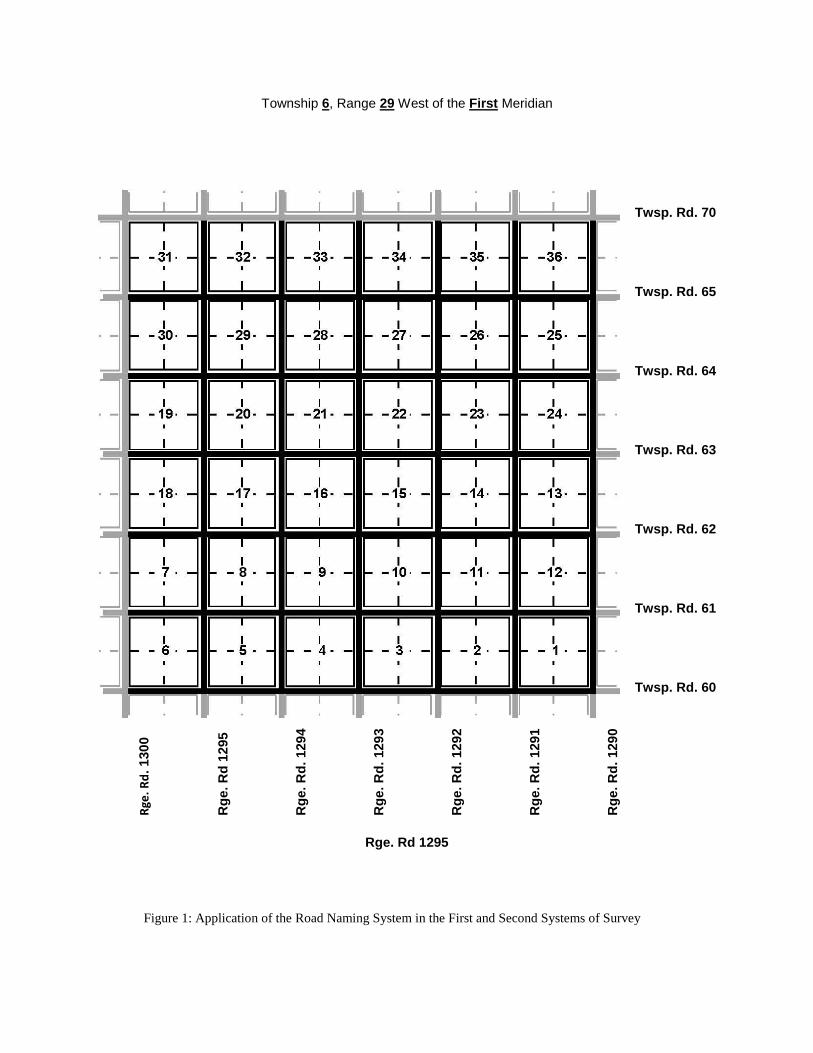
The first element of the standard is that every road in the province be named using a unique naming convention to
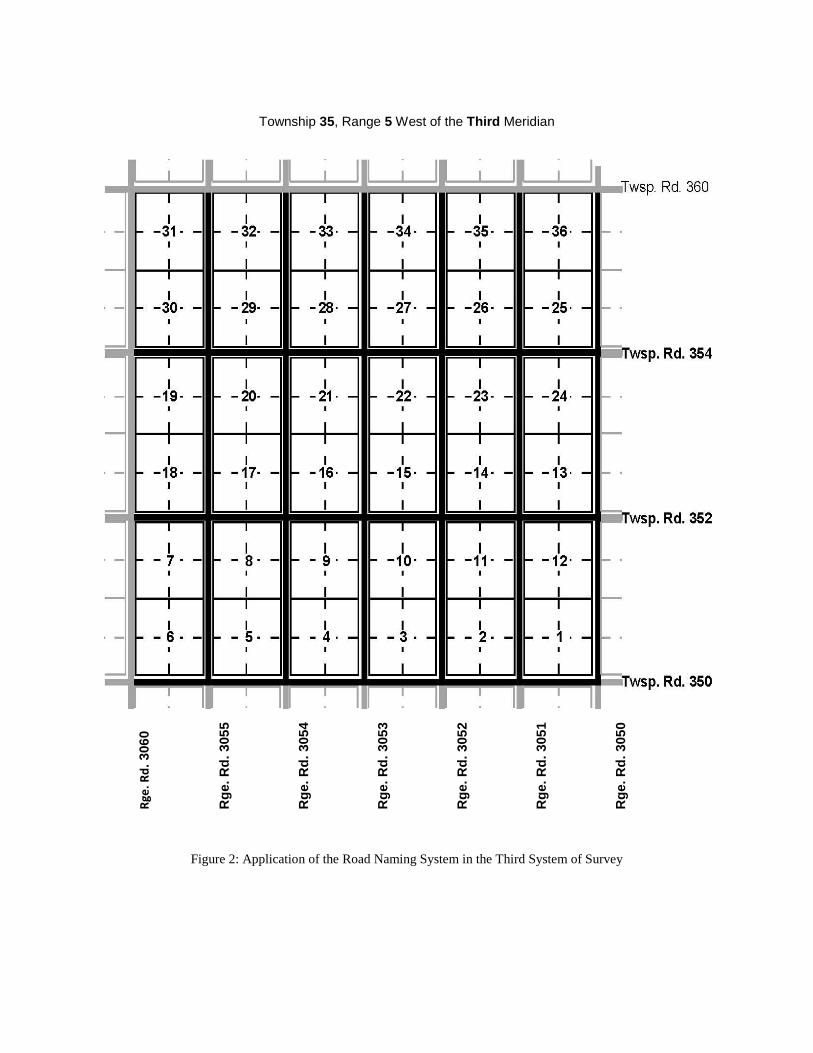
ensure that no two roads have the same name. All east-west roads following either road allowance or section lines
will have names of the form Twsp. Rd. ttdwhere the tt is the number of the township that the road is in and d is the
distance in miles from the southern edge of the township. All north-south roads following road allowances will have
names of the form Rge. Rd. mrrdwhere rr is the number of the range that the road is in, m is number of the meridian
that the range is west of and d is the distance in miles from the eastern edge of the range.
Figures 1 and 2 illustrate the application of this naming convention to the roads in the first, second, and third
systems of survey found in Saskatchewan.
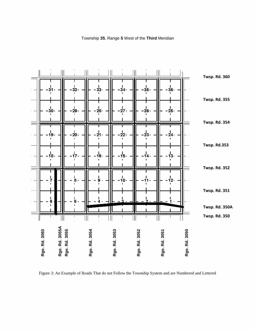
Some roads in the province do not follow the road allowances or section lines and cannot be named using this
method. There are two different situations that need to be handled. The first are roads that are predominately
east-west or north-south in orientation and do not cross other roads with the same orientation. An example would
be a road built along quarter section lines.
The roads lying between numbered range or township roads are to be numbered using the number of the road to the
south or east of the road with the letter A, B, C, etc. appended to it.
As an example of this, Rge. Rd 2043A would be a north-south road to the west of Rge. Rd 2043 and east of
Rge. Rd 2044. This situation is shown in Figure 3.
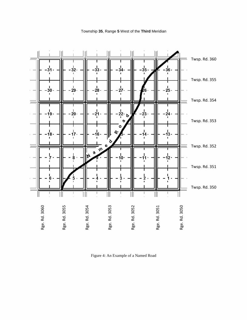
The second situation of roads not following the road allowances are roads that run “cross country”. These roads
may cross several range and township roads (or road allowances) and generally do not follow the township fabric
at all. Instead they are built according to the topography. It is not possible to fit roads that do not follow the
township fabric into the standard numbering system. They are to be named separately as described below.
Roads that cannot be numbered because they do not follow the township fabric will have names assigned to them
or, where they are a numbered highway or grid will use the highway or grid road number. The names would be
chosen by the consensus of all the rural municipalities that the road passes through, with the requirement that the
name must be approved by the Department of Government Relations who will ensure that names are unique across
the province. Figure 4 illustrates an example of a named road.
Access Numbers
Access numbers are used to define points along a road and serve much the same purpose as civic numbers
(house numbers) in the urban setting. The standard method of assigning access numbers is as follows:
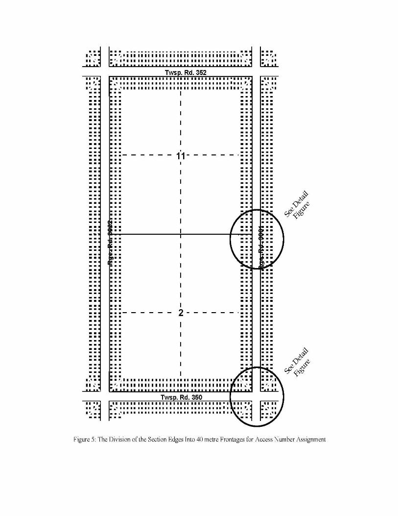
Each section on either side of a one mile segment of road is subdivided into approximately 40 imaginary lots
with each lot being 40 metres wide and of an indeterminate depth. Figure 5 illustrates this subdivision for two
sections from a township surveyed in the third system of survey. The lots are numbered from 1 to 80 with the
numbers increasing in a northerly direction on range roads and in a westerly direction on township roads. Odd
and even lot numbers are on opposite sides of the roads with odd numbers on the north side of township roads
and on the east side of range roads. The access numbers assigned to each of the “lots” take the form
nnnllwhere nnn is the number of the township or range cross road to the south or east of the lot, whether that
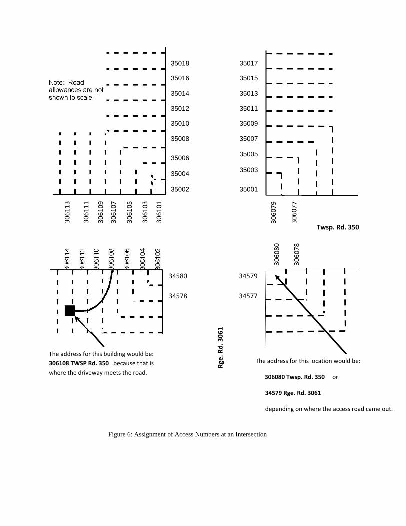
road actually exists or not and ll is the lot number. Figure 6 illustrates the access numbers at the intersection
of two roads and shows how a full address is defined for two of the lots. Figure 7 illustrates the assignment of
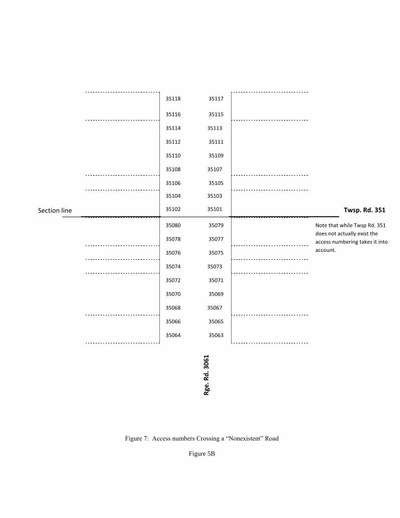
access numbers where the range road crosses a section line that does not have a road constructed.
Access numbers are assigned to locations to be addressed on the basis of where the driveway or access road
connects to the public road. If, for example, an access road joined Twsp. Rd. 350 within the length bordering
imaginary lot 8 west of Rge. Rd. 3061 the address for the building served by that access road would be 306108
Twsp. Rd. 350, as illustrated in Figure 6.
Roads that do not follow road allowances or section lines (i.e. roads that are numbered with an A or are named) are
not taken into account in determining access numbers. Only the “regular” roads following road allowances or
section lines are used.
On named roads the access numbers are assigned by using only the imaginary lot numbers. The named road is
subdivided into 40 metre segments for its entire length and lot numbers assigned in the same manner as for the
regular roads. The access numbers on named roads would be just the lot number with no other number attached as a
prefix.
Unit Numbers
In certain circumstances more than one location (building) will be served by the same access road. This would
occur, for example, when two farm homes share a common access road or in a rural subdivision. In these
circumstances unit numbers need to be added to the address in order to uniquely identify a location.
The solution to this is to assign unit numbers to each location. For example, in the case of the two farm homes they
would be numbered 1 and 2 and their addresses would be, for example, #1 306108 Twsp. Rd. 350 and #2 306108
Twsp. Rd. 350. In rural subdivisions with one access road the same process would apply.
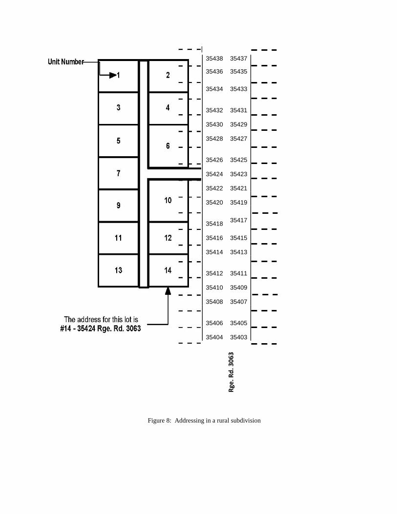
Where a rural subdivision has more than one access road all the lots in the rural subdivision should be
numbered uniquely and any of the access numbers associated with the access roads may be used. This is
illustrated in Figure 8.
Road Signage
Specifications as to the type and location of signage are not made as part of this standard. This is left for other
agencies to do. It should be noted, however, that signage is a critical element of the rural addressing system.
Without it the visibility of the addressing discussed at the start of this document will be missing. The requirement
for signage must be made part of the provincial rural addressing, including the signing of access and unit numbers.

Figures
Township 6, Range 29 West of the First Meridian
Twsp. Rd. 70
Twsp. Rd. 65
Twsp. Rd. 64
Twsp. Rd. 63
Twsp. Rd. 62
Twsp. Rd. 61
Twsp. Rd. 60
Rge. Rd 1300
Rge. Rd 1295
Figure 1: Application of the Road Naming System in the First and Second Systems of Survey
Twsp. Rd 70
Twsp. Rd 65
Twsp. Rd 64
Twsp. Rd 63
Twps. Rd 62
Twsp. Rd 61
Twsp. Rd 60
Rge
. Rd. 130
0
Rg
e. R
d 1
295
Rg
e. R
d.
129
4
Rg
e. R
d.
129
3
Rg
e. R
d.
12
92
Rg
e. R
d.
129
1
Rg
e. R
d.
129
0
Township 35, Range 5 West of the Third Meridian
Rge. Rd. 3060
Figure 2: Application of the Road Naming System in the Third System of Survey
Rge
. Rd. 306
0
Rg
e. R
d.
305
5
Rg
e. R
d.
305
4
Rg
e. R
d.
305
3
Rg
e. R
d.
305
2
Rg
e. R
d.
305
1
Rg
e. R
d.
305
0
Township 35, Range 5 West of the Third Meridian
Figure 3: An Example of Roads That do not Follow the Township System and are Numbered and Lettered
Twsp. Rd. 360
Twsp. Rd. 355
Twsp. Rd. 354
Twsp. Rd.353
Twsp. Rd. 352
Twsp. Rd. 351
Twsp. Rd. 350A
Twsp. Rd. 350
Rg
e. R
d.
306
0
Rg
e. R
d.
305
5A
Rg
e. R
d.
305
5
Rg
e. R
d.
305
4
Rg
e. R
d.
305
3
Rg
e. R
d.
305
2
Rg
e. R
d.
305
1
Rg
e. R
d.
305
0
Township 35, Range 5 West of the Third Meridian
Figure 4: An Example of a Named Road
Twsp. Rd. 360
Twsp. Rd. 355
Twsp. Rd. 354
Twsp. Rd. 353
Twsp. Rd. 352
Twsp. Rd. 351
Twsp. Rd. 350
Rge
. Rd
. 306
0
Rge
. Rd
. 305
5
Rge
. Rd
. 305
4
Rge
. Rd
. 305
3
Rge
. Rd
. 305
2
Rge
. Rd
. 305
1
Rge
. Rd
. 305
0
35018 35017
35016 35015
35014 35013
35012 35011
35010 35009
35008 35007
35006
35005
35004
35003
35002 35001
30
61
13
30
61
11
30
61
09
30
61
07
30
61
05
30
61
03
30
61
01
Figure 6: Assignment of Access Numbers at an Intersection
30
60
80
30
60
78
3
06
07
7
30
60
79
34577
34579
34578
34580
The address for this building would be:
306108 TWSP Rd. 350 because that is
where the driveway meets the road.
The address for this location would be:
306080 Twsp. Rd. 350 or
34579 Rge. Rd. 3061
depending on where the access road came out.
Twsp. Rd. 350 R
ge. R
d. 3
06
1
Section line Twsp. Rd. 351
35118 35117
35116 35115
35114 35113
35112 35111
35110 35109
35106 35105
35108 35107
35104 35103
35102 35101
35080 35079
35076 35075
35078 35077
35074 35073
35072 35071
35070 35069
35068 35067
35066 35065
35064 35063
Note that while Twsp Rd. 351
does not actually exist the
access numbering takes it into
account.
Rge
. Rd
. 30
61
Figure 7: Access numbers Crossing a “Nonexistent” Road
Figure 5B
35438 35437
35436 35435
35434
35433
35432
35431 35430
35429
35428
35427
35426
35425 35424
35423
35422
35421
35420
35419
35418
35417
35416
35415
35414
35413
35412
35411 35410
35409
35408
35407
35406
35405 35404 35403
Rge
. Rd
. 30
63
Figure 8: Addressing in a rural subdivision