Embed Size (px)
Citation preview
SARANAC RIVER TRAIL GREENWAY FEASIBILITY STUDY | 1
Saranac River Trail Greenway FEASIBILITY STUDY | SUMMER 2016
APPENDIX
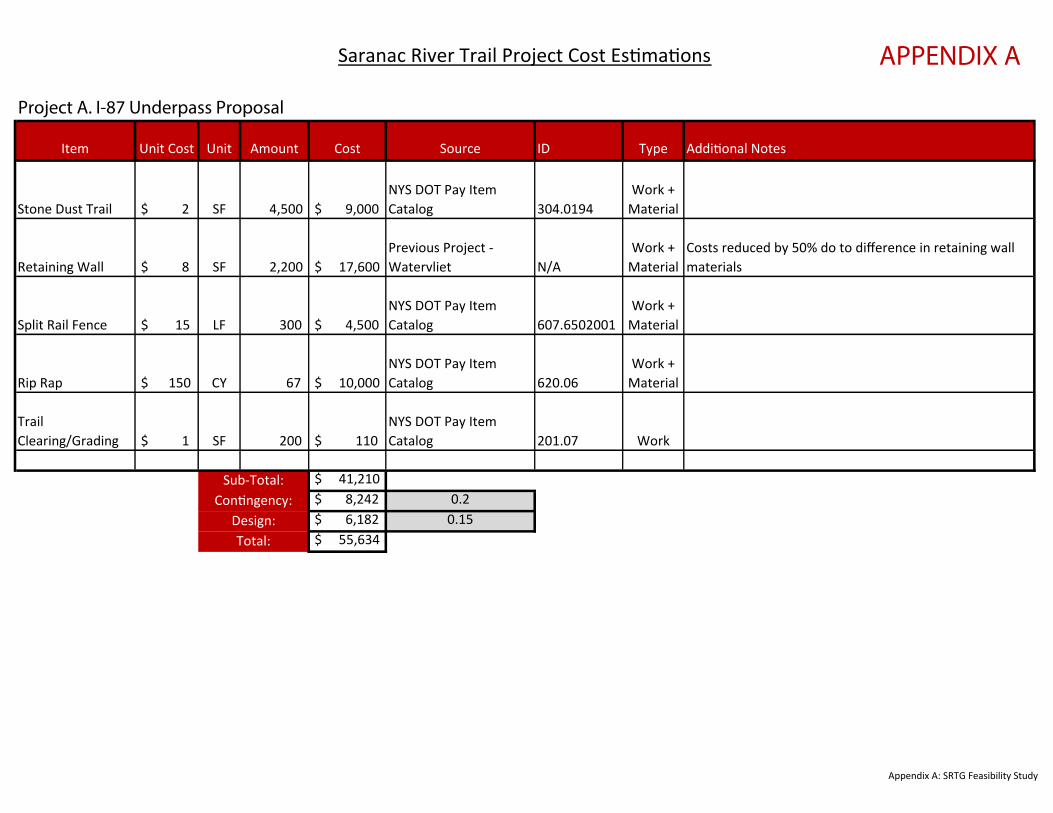
Item Unit Cost Unit Amount Cost Source ID Type Additional Notes
Stone Dust Trail $ 2 SF 4,500 $ 9,000 NYS DOT Pay Item Catalog 304.0194
Work + Material
Retaining Wall $ 8 SF 2,200 $ 17,600 Previous Project - Watervliet N/A
Work + Material
Costs reduced by 50% do to difference in retaining wall materials
Split Rail Fence $ 15 LF 300 $ 4,500 NYS DOT Pay Item Catalog 607.6502001
Work + Material
Rip Rap $ 150 CY 67 $ 10,000 NYS DOT Pay Item Catalog 620.06
Work + Material
Trail Clearing/Grading $ 1 SF 200 $ 110
NYS DOT Pay Item Catalog 201.07 Work
$ 41,210 $ 8,242 0.2 $ 6,182 0.15 $ 55,634 Total:
Project A. I-87 Underpass Proposal
Saranac River Trail Project Cost Estimations
Contingency:Sub-Total:
Design:
Appendix A: SRTG Feasibility Study
APPENDIX A
Item Unit Cost Unit Amount Cost Source ID Type Additional Notes
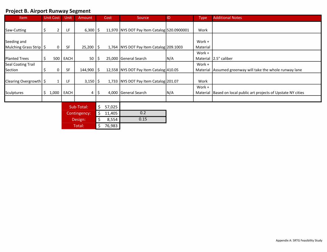
Saw-Cutting $ 2 LF 6,300 $ 11,970 NYS DOT Pay Item Catalog 520.0900001 Work
Seeding and
Mulching Grass Strip $ 0 SF 25,200 $ 1,764 NYS DOT Pay Item Catalog 209.1003
Work +
Material
Planted Trees $ 500 EACH 50 $ 25,000 General Search N/A
Work +
Material 2.5" caliber
Seal Coating Trail
Section $ 0 SF 144,900 $ 12,558 NYS DOT Pay Item Catalog 410.05
Work +
Material Assumed greenway will take the whole runway lane
Clearing Overgrowth $ 1 LF 3,150 $ 1,733 NYS DOT Pay Item Catalog 201.07 Work
Sculptures $ 1,000 EACH 4 $ 4,000 General Search N/A
Work +
Material Based on local public art projects of Upstate NY cities
57,025$
11,405$ 0.2
8,554$ 0.15
76,983$
Project B. Airport Runway Segment
Sub-Total:
Contingency:
Design:
Total:
Appendix A: SRTG Feasibility Study

Item Unit Cost Unit Amount Cost Source ID Type Additional Notes
RRFB $ 2,800 EACH 2 $ 5,600
NYS DOT Pay Item
Catalog 680.8221011
Work +
Material
Shoulder Striping
Removal $ 0 LF 1000 $ 450
NYS DOT Pay Item
Catalog 619.080101 Work
White Shoulder
Striping $ 0 LF 1000 $ 200
NYS DOT Pay Item
Catalog 640.1
Work +
Material
High Visibility
Crosswalks $ 1,500 EACH 1 $ 1,500
Previous Project -
Highland SRTS N/A
Work +
Material
Parking Lot
Entrance Stone
Base $ 2 SF 2200 $ 4,400
Previous Project -
Moreau Bikeway N/A
Work +
Material Double the thickness for trail
Parking Entrance
Paving $ 4 SF 2200 $ 8,800
Previous Project -
Moreau Bikeway N/A
Work +
Material Double the thickness for trail
Gravel Parking Lot
Improvement $ 0 SF 1500 $ 375
NYS DOT Pay Item
Catalog 623.11
Work +
Material
Assumed 25% cost of new gravel parking lot as up to 25%
may need to be replaced
Parking Lot
Striping $ 0 LF 100 $ 25
NYS DOT Pay Item
Catalog 640.1
Work +
Material
Assumed 20% increase for non-linear instalation of
parking stalls
Sidepath Asphault $ 4 SF 1600 $ 6,400
Previous Project -
Moreau Bikeway N/A
Work +
MaterialSidepath Stone
Base $ 2 SF 1600 $ 3,200
Previous Project -
Moreau Bikeway N/A
Work +
Material
Jughandle
Pavement $ 4 SF 120 $ 480
Previous Project -
Moreau Bikeway N/A
Work +
Material
Bike Lane Striping $ 8 LF 1000 $ 8,000
Previous Project -
Moreau Bikeway N/A
Work +
Material
Jughandle Colored
Pavement $ 1 SF 120 $ 156
NACTO Bikeway Design
Guide - Materials N/A
Work +
Material
This applies to paint application - thermoplastic option
would be ~ $12 - $14
Kiosk $ 3,000 EACH 2 $ 6,000 Professional Experience N/A
Work +
Material
$ 45,586
$ 9,117 0.2
$ 6,838 0.15
$ 61,541
Sub-Total:
Contingency:
Project C. Goddeau Road Bridge Connection
Design:
Total: Appendix A: SRTG Feasibility Study
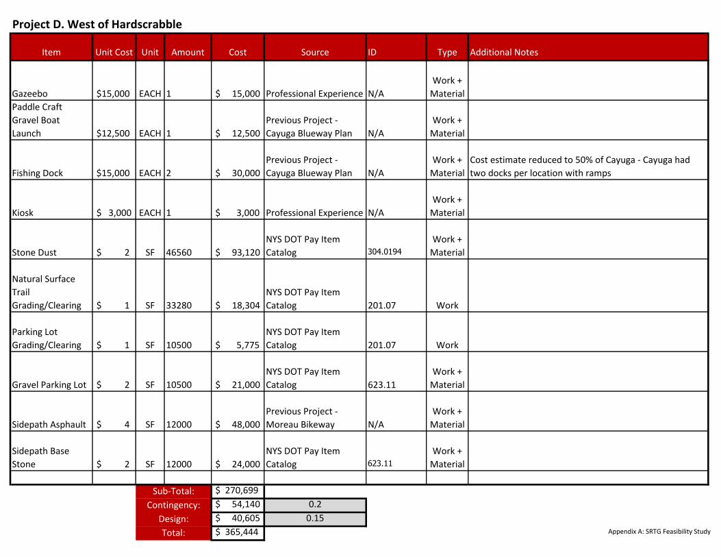
Item Unit Cost Unit Amount Cost Source ID Type Additional Notes
Gazeebo $15,000 EACH 1 $ 15,000 Professional Experience N/A
Work +
Material
Paddle Craft
Gravel Boat
Launch $12,500 EACH 1 $ 12,500
Previous Project -
Cayuga Blueway Plan N/A
Work +
Material
Fishing Dock $15,000 EACH 2 $ 30,000
Previous Project -
Cayuga Blueway Plan N/A
Work +
Material
Cost estimate reduced to 50% of Cayuga - Cayuga had
two docks per location with ramps
Kiosk $ 3,000 EACH 1 $ 3,000 Professional Experience N/A
Work +
Material
Stone Dust $ 2 SF 46560 $ 93,120
NYS DOT Pay Item
Catalog 304.0194
Work +
Material
Natural Surface
Trail
Grading/Clearing $ 1 SF 33280 $ 18,304
NYS DOT Pay Item
Catalog 201.07 Work
Parking Lot
Grading/Clearing $ 1 SF 10500 $ 5,775
NYS DOT Pay Item
Catalog 201.07 Work
Gravel Parking Lot $ 2 SF 10500 $ 21,000
NYS DOT Pay Item
Catalog 623.11
Work +
Material
Sidepath Asphault $ 4 SF 12000 $ 48,000
Previous Project -
Moreau Bikeway N/A
Work +
Material
Sidepath Base
Stone $ 2 SF 12000 $ 24,000
NYS DOT Pay Item
Catalog 623.11
Work +
Material
$ 270,699
$ 54,140 0.2
$ 40,605 0.15
$ 365,444 Total:
Contingency:
Project D. West of Hardscrabble
Sub-Total:
Design:Appendix A: SRTG Feasibility Study
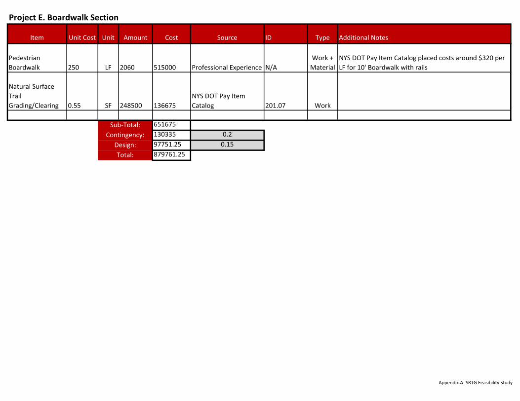
Item Unit Cost Unit Amount Cost Source ID Type Additional Notes
Pedestrian
Boardwalk 250 LF 2060 515000 Professional Experience N/A
Work +
Material
NYS DOT Pay Item Catalog placed costs around $320 per
LF for 10' Boardwalk with rails
Natural Surface
Trail
Grading/Clearing 0.55 SF 248500 136675
NYS DOT Pay Item
Catalog 201.07 Work
651675
130335 0.2
97751.25 0.15
879761.25
Sub-Total:
Design:
Total:
Contingency:
Project E. Boardwalk Section
Appendix A: SRTG Feasibility Study
Item Unit Cost Unit Amount Cost Source ID Type Additional Notes
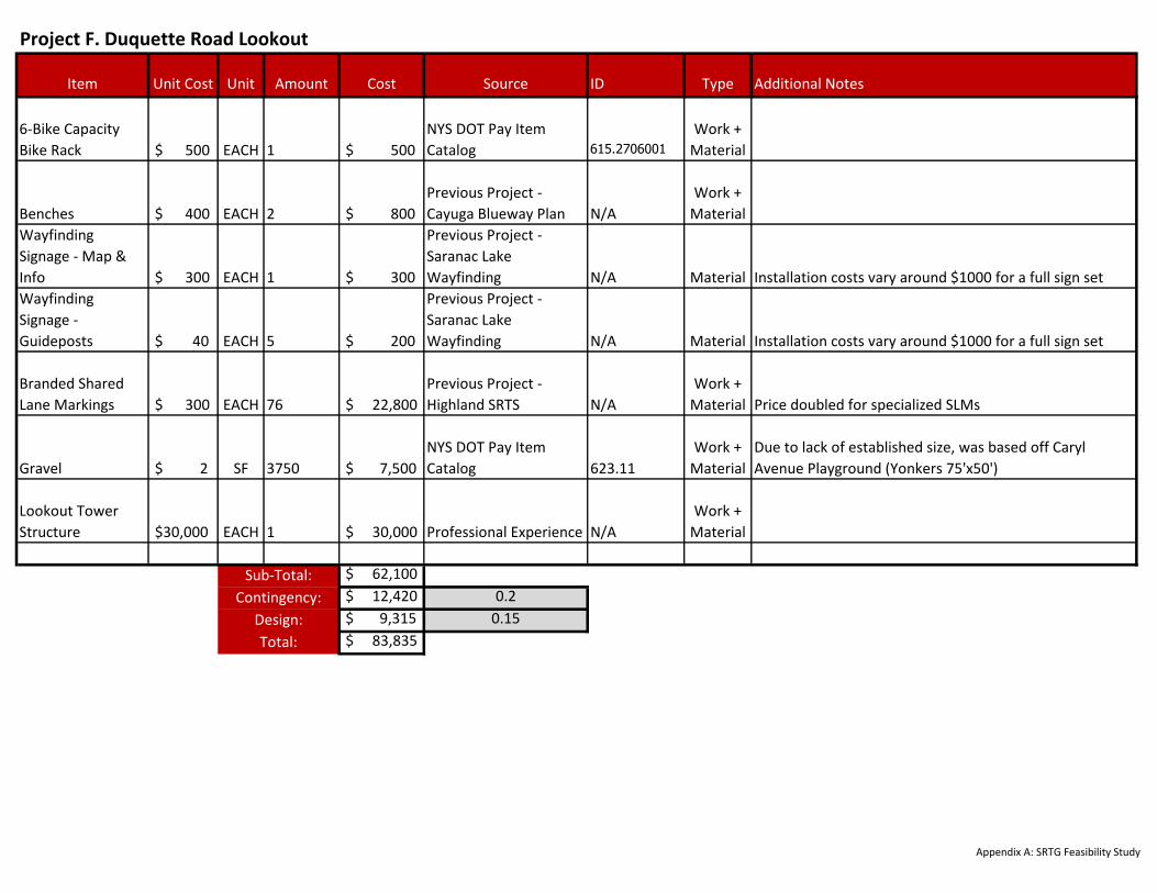
6-Bike Capacity
Bike Rack $ 500 EACH 1 $ 500
NYS DOT Pay Item
Catalog 615.2706001
Work +
Material
Benches $ 400 EACH 2 $ 800
Previous Project -
Cayuga Blueway Plan N/A
Work +
Material
Wayfinding
Signage - Map &
Info $ 300 EACH 1 $ 300
Previous Project -
Saranac Lake
Wayfinding N/A Material Installation costs vary around $1000 for a full sign set
Wayfinding
Signage -
Guideposts $ 40 EACH 5 $ 200
Previous Project -
Saranac Lake
Wayfinding N/A Material Installation costs vary around $1000 for a full sign set
Branded Shared
Lane Markings $ 300 EACH 76 $ 22,800
Previous Project -
Highland SRTS N/A
Work +
Material Price doubled for specialized SLMs
Gravel $ 2 SF 3750 $ 7,500
NYS DOT Pay Item
Catalog 623.11
Work +
Material
Due to lack of established size, was based off Caryl
Avenue Playground (Yonkers 75'x50')
Lookout Tower
Structure $30,000 EACH 1 $ 30,000 Professional Experience N/A
Work +
Material
$ 62,100
$ 12,420 0.2
$ 9,315 0.15
$ 83,835
Sub-Total:
Design:
Contingency:
Project F. Duquette Road Lookout
Total:
Appendix A: SRTG Feasibility Study

Item Unit Cost Unit Amount Cost Source ID Type Additional Notes
Picnic Tables $ 500 EACH 10 $ 5,000
Previous Project -
Cayuga Blueway Plan N/A
Work +
Material
Trash Receptacles $ 1,275 EACH 5 $ 6,375
NYS DOT Pay Item
Catalog 615.0101011
Work +
Material Similar to Park Catalog
Kiosks $ 3,000 EACH 1 $ 3,000
6-Bike Capacity
Bike Rack $ 500 EACH 2 $ 1,000
NYS DOT Pay Item
Catalog 615.2706001
Work +
Material Same price applies for 6-bike grid bike rack
Gravel Parking Lot
Improvement $ 0 SF 11250 $ 2,813
NYS DOT Pay Item
Catalog 623.11
Work +
Material
Assumed 1/4 price of new - since existing assume only
1/4 needs to be replaced
Natural Surface
Trail
Grading/Clearing $ 1 SF 6000 $ 3,300
NYS DOT Pay Item
Catalog 201.07 Work
Picnic Area
Clearing/Grading $ 1 SF 10000 $ 5,500
NYS DOT Pay Item
Catalog 201.07 Work
$ 26,988
$ 5,398 0.2
$ 4,048 0.15
$ 36,433
Contingency:
Project G. High Falls Dam Trailhead
Sub-Total:
Design:
Total:
Appendix A: SRTG Feasibility Study
Item Unit Cost Unit Amount Cost Source ID Type Additional Notes
Wayfinding
Signage - Map &
Info $ 300 EACH 1 $ 300
Previous Project -
Saranac Lake
Wayfinding N/A Material Instalation costs vary around $1000 for a full sign set
Benches $ 400 EACH 2 $ 800
Previous Project -
Cayuga Blueway Plan N/A
Work +
Material
6-Bike Capacity
Bike Rack $ 500 EACH 1 $ 500
NYS DOT Pay Item
Catalog 615.2706001
Work +
Material Same price applies for 6-bike grid bike rack
Gravel Parking Lot
Grading/Clearing $ 1 SF 25000 $ 13,750
NYS DOT Pay Item
Catalog 201.07 Work
Gravel Parking Lot $ 2 SF 25000 $ 50,000
NYS DOT Pay Item
Catalog 623.11
Work +
Material
Parking Entrance
Paving $ 4 SF 4000 $ 16,000
Previous Project -
Moreau Bikeway N/A
Work +
Material
Kiosks $ 3,000 EACH 1 $ 3,000 General Search N/A
Work +
Material
Fishing Dock $15,000 EACH 1 $ 15,000
Previous Project -
Cayuga Blueway Plan N/A
Work +
Material
Cost estimate reduced to 50% of Cayuga - Cayuga had
two docks per location with ramps
Soft Surface Trail
Grading/Clearing $ 1 SF 6200 $ 3,410
NYS DOT Pay Item
Catalog 201.07 Work
Paddle Craft
Gravel Boat
Launch $12,500 EACH 1 $ 12,500
Previous Project -
Cayuga Blueway Plan N/A
Work +
Material
$ 115,260
$ 23,052 0.2
$ 17,289 0.15
$ 155,601 Total:
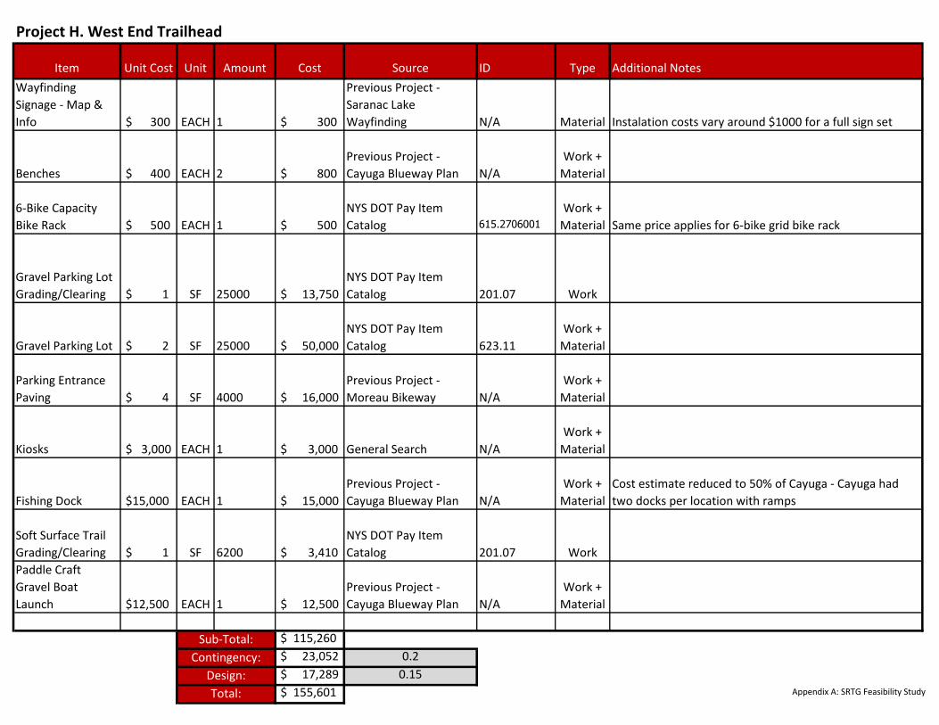
Project H. West End Trailhead
Sub-Total:
Contingency:
Design:Appendix A: SRTG Feasibility Study
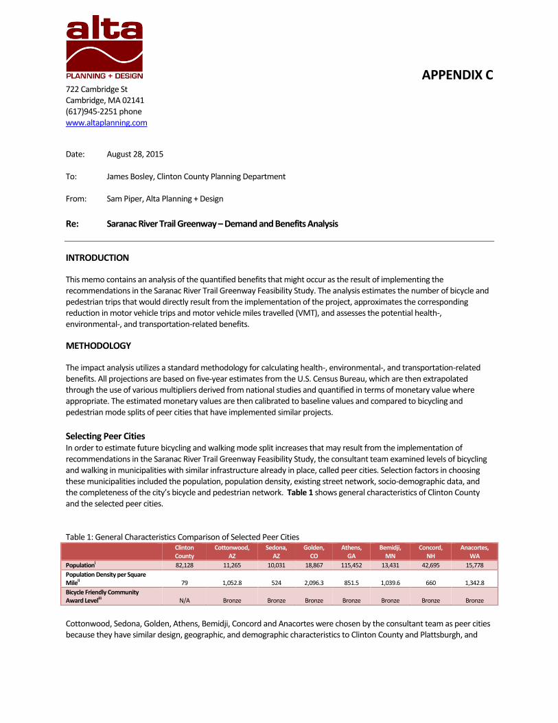
APPENDIX C 722 Cambridge St Cambridge, MA 02141 (617)945-2251 phone www.altaplanning.com
Date: August 28, 2015 To: James Bosley, Clinton County Planning Department From: Sam Piper, Alta Planning + Design
Re: Saranac River Trail Greenway – Demand and Benefits Analysis
INTRODUCTION
This memo contains an analysis of the quantified benefits that might occur as the result of implementing the recommendations in the Saranac River Trail Greenway Feasibility Study. The analysis estimates the number of bicycle and pedestrian trips that would directly result from the implementation of the project, approximates the corresponding reduction in motor vehicle trips and motor vehicle miles travelled (VMT), and assesses the potential health-, environmental-, and transportation-related benefits.
METHODOLOGY
The impact analysis utilizes a standard methodology for calculating health-, environmental-, and transportation-related benefits. All projections are based on five-year estimates from the U.S. Census Bureau, which are then extrapolated through the use of various multipliers derived from national studies and quantified in terms of monetary value where appropriate. The estimated monetary values are then calibrated to baseline values and compared to bicycling and pedestrian mode splits of peer cities that have implemented similar projects.
Selecting Peer Cities In order to estimate future bicycling and walking mode split increases that may result from the implementation of recommendations in the Saranac River Trail Greenway Feasibility Study, the consultant team examined levels of bicycling and walking in municipalities with similar infrastructure already in place, called peer cities. Selection factors in choosing these municipalities included the population, population density, existing street network, socio-demographic data, and the completeness of the city’s bicycle and pedestrian network. Table 1 shows general characteristics of Clinton County and the selected peer cities. Table 1: General Characteristics Comparison of Selected Peer Cities Clinton
County Cottonwood,
AZ Sedona,
AZ Golden,
CO Athens,
GA Bemidji,
MN Concord,
NH Anacortes,
WA
Populationi 82,128 11,265 10,031 18,867 115,452 13,431 42,695 15,778
Population Density per Square Mileii 79 1,052.8 524 2,096.3 851.5 1,039.6 660 1,342.8
Bicycle Friendly Community Award Leveliii N/A Bronze Bronze Bronze Bronze Bronze Bronze Bronze
Cottonwood, Sedona, Golden, Athens, Bemidji, Concord and Anacortes were chosen by the consultant team as peer cities because they have similar design, geographic, and demographic characteristics to Clinton County and Plattsburgh, and
2 | P a g e
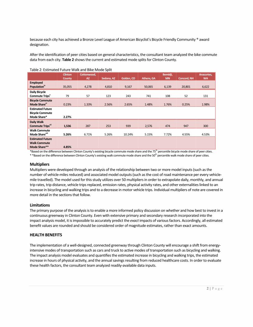
because each city has achieved a Bronze Level League of American Bicyclist’s Bicycle Friendly Community ® award designation. After the identification of peer cities based on general characteristics, the consultant team analyzed the bike commute data from each city. Table 2 shows the current and estimated mode splits for Clinton County. Table 2: Estimated Future Walk and Bike Mode Split Clinton
County Cottonwood,
AZ Sedona, AZ Golden, CO Athens, GA Bemidji,
MN Concord, NH Anacortes,
WA
Employed Populationiv 35,055 4,278 4,810 9,167 50,065 6,139 20,801 6,622
Daily Bicycle Commute Tripsv 79 57 123 243 741 108 52 131
Bicycle Commute Mode Sharevi 0.23% 1.33% 2.56% 2.65% 1.48% 1.76% 0.25% 1.98%
Estimated Future Bicycle Commute Mode Share* 2.27%
Daily Walk Commute Tripsvii 1,536 287 253 939 2,576 474 947 300
Walk Commute Mode Shareviii 5.26% 6.71% 5.26% 10.24% 5.15% 7.72% 4.55% 4.53%
Estimated Future Walk Commute Mode Share** 4.85%
*Based on the difference between Clinton County’s existing bicycle commute mode share and the 75th percentile bicycle mode share of peer cities. * *Based on the difference between Clinton County’s existing walk commute mode share and the 50th percentile walk mode share of peer cities.
Multipliers Multipliers were developed through an analysis of the relationship between two or more model inputs (such as the number of vehicle-miles reduced) and associated model outputs (such as the cost of road maintenance per every vehicle-mile travelled). The model used for this study utilizes over 50 multipliers in order to extrapolate daily, monthly, and annual trip rates, trip distance, vehicle trips replaced, emission rates, physical activity rates, and other externalities linked to an increase in bicycling and walking trips and to a decrease in motor vehicle trips. Individual multipliers of note are covered in more detail in the sections that follow.
Limitations The primary purpose of the analysis is to enable a more informed policy discussion on whether and how best to invest in a continuous greenway in Clinton County. Even with extensive primary and secondary research incorporated into the impact analysis model, it is impossible to accurately predict the exact impacts of various factors. Accordingly, all estimated benefit values are rounded and should be considered order of magnitude estimates, rather than exact amounts.
HEALTH BENEFITS The implementation of a well-designed, connected greenway through Clinton County will encourage a shift from energy-intensive modes of transportation such as cars and truck to active modes of transportation such as bicycling and walking. The impact analysis model evaluates and quantifies the estimated increase in bicycling and walking trips, the estimated increase in hours of physical activity, and the annual savings resulting from reduced healthcare costs. In order to evaluate these health factors, the consultant team analyzed readily-available data inputs.

3 | P a g e
Health Calculations The primary inputs into the health component of the impact analysis model come from five-year estimates of commute trip data from the U.S. Census Bureau. Five-year estimates were chosen because they are the most reliable dataset available from the U.S. Census Bureau between the 10-year censuses and because they allow for analysis at the individual census tract level.
ix
After extrapolating the commute trip data to recreational trips and to estimate daily, monthly, and annual trip values, the consultant team used a series of multipliers and assumptions to calculate the various health factors. If Clinton County implements the entire Saranac River Trail Greenway, mid-level estimates show that the region could experience 1,178,000 more bicycling trips per year and 205,000 more walking trips per year if the SRTG is fully implemented. Using trip distance multipliers derived the National Household Travel Survey (NHTS) and annual vehicle trip replacement factors derived from a combination of US Census data, NHTS data, and historic Safe Routes to School data, the estimated increase in distance bicycled would be 1,648,000 miles per year and the estimated increase in distance walked would be 65,000 miles per year, resulting in 1,050,000 fewer vehicle-miles travelled (VMT) annually. These annual distance estimates and VMT reduction estimates were used to calculate changes in physical activity rates among residents in Clinton County. Implementation of the recommended projects could result in 187,000 more hours of physical activity per year among Clinton County residents than currently occurs. This increase in physical activity means that an estimated 1,438 more residents will be meeting the Centers for Disease Control and Prevention (CDC) minimum number of hours of physical activity per day, which is equal to a jump from approximately 12 percent of the regional physical activity need being met to 14 percent of the regional physical activity need being met – an increase of over 16%. This growth in the percent of people within the city exercising also equates to a $62,000 reduction in healthcare expenses per year. Table 3 summarizes the annual health benefits for Clinton County. Table 3: Annual Health Benefits
Clinton County – Low Estimate
Clinton County – Mid Estimate
Clinton County – High Estimate
Increase in Annual Bicycle Trips 907,000 1,178,000 1,569,000
Increase in Annual Miles Bicycled 1,269,000 1,648,000 2,195,000
Increase in Annual Walk Trips 109,000 205,000 663,000
Increase in Annual Miles Walked 34,000 65,000 209,000
Increase in Annual Hours of Physical Activity 139,000 187,000 290,000
Increase in Number of Resident Meeting CDC Recommended Number of Hours of Physical Activity
1,069 1,438 2,231
Annual Healthcare Cost Savings $45,000 $62,000 $97,000
ENVIRONMENTAL BENEFITS While the causes of physical inactivity and pollution stem from many sources, the implementation of the recommended greenway in Clinton County will contribute to a shift from energy-intensive modes of transportation such as cars and trucks to active modes of transportation such as bicycling and walking. The impact analysis model evaluates and quantifies the estimated increase in bicycling and walking trips and the annual savings from reduced vehicle emissions. In order to evaluate these environmental factors, a number of readily-available data inputs were analyzed.
4 | P a g e
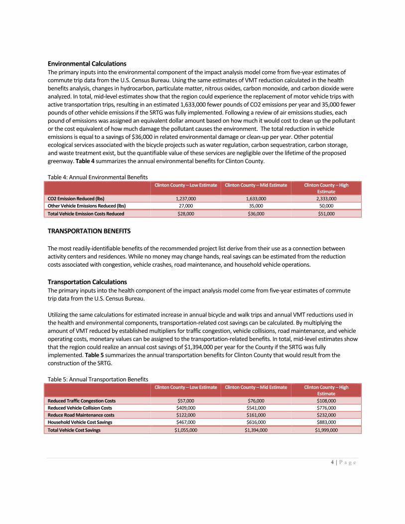
Environmental Calculations The primary inputs into the environmental component of the impact analysis model come from five-year estimates of commute trip data from the U.S. Census Bureau. Using the same estimates of VMT reduction calculated in the health benefits analysis, changes in hydrocarbon, particulate matter, nitrous oxides, carbon monoxide, and carbon dioxide were analyzed. In total, mid-level estimates show that the region could experience the replacement of motor vehicle trips with active transportation trips, resulting in an estimated 1,633,000 fewer pounds of CO2 emissions per year and 35,000 fewer pounds of other vehicle emissions if the SRTG was fully implemented. Following a review of air emissions studies, each pound of emissions was assigned an equivalent dollar amount based on how much it would cost to clean up the pollutant or the cost equivalent of how much damage the pollutant causes the environment. The total reduction in vehicle emissions is equal to a savings of $36,000 in related environmental damage or clean-up per year. Other potential ecological services associated with the bicycle projects such as water regulation, carbon sequestration, carbon storage, and waste treatment exist, but the quantifiable value of these services are negligible over the lifetime of the proposed greenway. Table 4 summarizes the annual environmental benefits for Clinton County. Table 4: Annual Environmental Benefits Clinton County – Low Estimate Clinton County – Mid Estimate Clinton County – High
Estimate
CO2 Emission Reduced (lbs) 1,237,000 1,633,000 2,333,000
Other Vehicle Emissions Reduced (lbs) 27,000 35,000 50,000
Total Vehicle Emission Costs Reduced $28,000 $36,000 $51,000
TRANSPORTATION BENEFITS The most readily-identifiable benefits of the recommended project list derive from their use as a connection between activity centers and residences. While no money may change hands, real savings can be estimated from the reduction costs associated with congestion, vehicle crashes, road maintenance, and household vehicle operations.
Transportation Calculations The primary inputs into the health component of the impact analysis model come from five-year estimates of commute trip data from the U.S. Census Bureau. Utilizing the same calculations for estimated increase in annual bicycle and walk trips and annual VMT reductions used in the health and environmental components, transportation-related cost savings can be calculated. By multiplying the amount of VMT reduced by established multipliers for traffic congestion, vehicle collisions, road maintenance, and vehicle operating costs, monetary values can be assigned to the transportation-related benefits. In total, mid-level estimates show that the region could realize an annual cost savings of $1,394,000 per year for the County if the SRTG was fully implemented. Table 5 summarizes the annual transportation benefits for Clinton County that would result from the construction of the SRTG. Table 5: Annual Transportation Benefits Clinton County – Low Estimate Clinton County – Mid Estimate Clinton County – High
Estimate
Reduced Traffic Congestion Costs $57,000 $76,000 $108,000
Reduced Vehicle Collision Costs $409,000 $541,000 $776,000
Reduce Road Maintenance costs $122,000 $161,000 $232,000
Household Vehicle Cost Savings $467,000 $616,000 $883,000
Total Vehicle Cost Savings $1,055,000 $1,394,000 $1,999,000
5 | P a g e
ECONOMIC BENEFITS The implementation of the SRTG could have a very positive economic impact on Clinton County based on data that is available on the economic impact of comparable greenway trails after they were implemented. The economic impact analysis presents the impact the SRTG could have on tourism spending and on property values adjacent to the trail.
Tourism Benefits The leisure and hospitality industry contributes to a large portion of Clinton County’s economy. Tourism represents the use of outside purchasing power to support local businesses, and the ability of Saranac River Trail Greenway to attract tourism spending is an important factor in analyzing the overall impact of the trail system.
While it is difficult to accurately forecast the exact change in tourism spending resulting from the implementation of the Greenway, an examination of current tourism activity and tourism spending near similar, completed trail projects provides a useful proxy for evaluating tourism benefits of the SRTG.
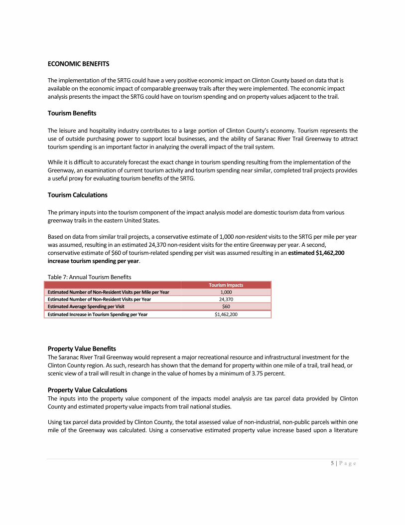
Tourism Calculations The primary inputs into the tourism component of the impact analysis model are domestic tourism data from various greenway trails in the eastern United States. Based on data from similar trail projects, a conservative estimate of 1,000 non-resident visits to the SRTG per mile per year was assumed, resulting in an estimated 24,370 non-resident visits for the entire Greenway per year. A second, conservative estimate of $60 of tourism-related spending per visit was assumed resulting in an estimated $1,462,200 increase tourism spending per year. Table 7: Annual Tourism Benefits Tourism Impacts
Estimated Number of Non-Resident Visits per Mile per Year 1,000
Estimated Number of Non-Resident Visits per Year 24,370
Estimated Average Spending per Visit $60
Estimated Increase in Tourism Spending per Year $1,462,200
Property Value Benefits The Saranac River Trail Greenway would represent a major recreational resource and infrastructural investment for the Clinton County region. As such, research has shown that the demand for property within one mile of a trail, trail head, or scenic view of a trail will result in change in the value of homes by a minimum of 3.75 percent.
Property Value Calculations The inputs into the property value component of the impacts model analysis are tax parcel data provided by Clinton County and estimated property value impacts from trail national studies.
Using tax parcel data provided by Clinton County, the total assessed value of non-industrial, non-public parcels within one mile of the Greenway was calculated. Using a conservative estimated property value increase based upon a literature
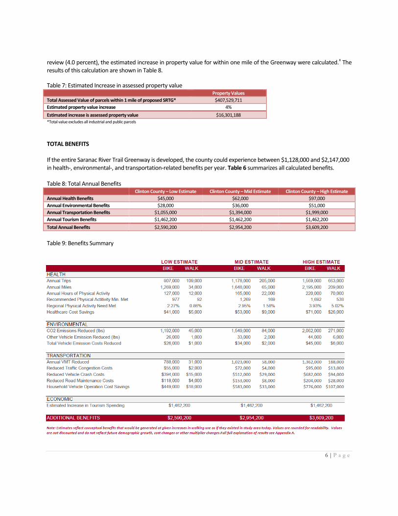
6 | P a g e
review (4.0 percent), the estimated increase in property value for within one mile of the Greenway were calculated.x The
results of this calculation are shown in Table 8.
Table 7: Estimated Increase in assessed property value Property Values
Total Assessed Value of parcels within 1 mile of proposed SRTG* $407,529,711
Estimated property value increase 4%
Estimated increase is assessed property value $16,301,188
*Total value excludes all industrial and public parcels
TOTAL BENEFITS If the entire Saranac River Trail Greenway is developed, the county could experience between $1,128,000 and $2,147,000 in health-, environmental-, and transportation-related benefits per year. Table 6 summarizes all calculated benefits. Table 8: Total Annual Benefits Clinton County – Low Estimate Clinton County – Mid Estimate Clinton County – High Estimate
Annual Health Benefits $45,000 $62,000 $97,000
Annual Environmental Benefits $28,000 $36,000 $51,000
Annual Transportation Benefits $1,055,000 $1,394,000 $1,999,000
Annual Tourism Benefits $1,462,200 $1,462,200 $1,462,200
Total Annual Benefits $2,590,200 $2,954,200 $3,609,200
Table 9: Benefits Summary
7 | P a g e
Endnotes i wikipedia. ii Ibid.
iii “Current Bicycle Friendly Communities.” (2014). The League of American Bicyclists.
http://bikeleague.org/sites/default/files/BFC_MasterList_2014.pdf iv American Community Survey. (2009-2013).
v Ibid.
vi Ibid.
vii Ibid.
viii Ibid.
ix “When to use 1-year, 3-year, or 5-year estimates.” US Census Bureau.
http://www.census.gov/acs/www/guidance_for_data_users/estimates/ x Riddel. “A Dynamic Approach to Estimating Hedonic Prices for Environmental Goods: An Application to Open
Space Purchase.” (2001); “Quantifying the Economic Value of Protected open Space in Southeastern Pennsylvania.” (2010). Econsult Corporation; Campbell and Monroe. “The Economic Impact of the Catawba Regional Trail.” (2004); “The Potential Economic Impacts of the Proposed Carolina Thread Trail.” (2007). Econsult Corporation; “Valuing the Conversion of Urban Green Space.” (2010). Econsult Corporation.
Appendix D - Public Comments Clinton County Fair Comments Comments 7/28 to 7/30 1. This is really cool. 2. We need more of this. 3. ATVs need a formal place to do this — maybe airport parking? 4. Need more places where you can hike and fish 5. Right now I walk it with my Dad but if that land was developed I’d find excuses to use it 6. This is great 7. My kids would love this — he loves the outdoors 8. There is some great fishing near the trail end, that owl deb great, great idea. 9. This is wonderful. This is a great idea. 10. The trail will pay for itself many times over. 11. That would be incredible 12. My kids don’t like to be outside but I’d love a place to go walking 13. This is a good idea 14. Is there opposition? 15. This is great, we love kayaking, new places to kayak would be fun 16. Awesome it would be great to have a snowmobile trail in Plattsburgh 17. I work with the elderly and the disabled and there is just nowhere to go, we would love to
have somewhere to go other than the mall. 18. Good luck, great idea. We go to snowmobile trails in Canada, it would be good to have trails
here too. 19. We have a trail out in Laconia, everyone uses it. It’s so beautiful here it would be wonderful
for that to exist here. FERC - Kent Falls and High Falls just renewed contract. Marathon to raise money for the trail. This would offer incentive for industries.
20. We love trails, this is really cool! 21. When I was a kid there were trails everywhere. I want to have places to snowmobile like that
again. 22. I remember reading about the treehouse, I’d like to see more things for the kids along the
rest of the trail. I lived in the dorms [PSU] last year and I used the beginning of the trail all the time to walk downtown.
Comments 7/31: 1. I didn’t know this was going on. 2. From avid fisherman - great fishing spot right off map by Redford 3. My son has biked and I’ve run it while my daughter had swimming lessons @ college [live in
Morrisonville] 4. I’d love to see access to some good fishing spots and to get that old crumbling dam torn
down [Imperial Dam]. It’s not doing anything but blocking the salmon. 5. This is beautiful. I’d love to see this happen 6. A safe place for my daughter to ride her bike would be really awesome There just aren’t
many places on our side of Plattsburgh. [Commenter lives on the S. Peru St. end of S. Catherine.]
7. We walk the trail all the time. Even a portion through the woods to the Military Turnpike would make us so happy. A loop would be great too.
8. A trail to High Falls would be awesome. I swam there as a girl and I took my grandkids there it’s beautiful.
9. There’s a trail in Peru and it’s great. I think there should be trails like this everywhere 10. My family and I think it’s a wonderful idea. We bike all the time! Comments 8/1 1. Our family could use this frequently during the summer for bike riding & picnics 2. I think this is an awesome idea! If it’s done environmentally friendly, what are you waiting
for?! 3. We would love to hike this new trail. 4. As a family, we would love this trail to hike, walk and bike ride on. 5. Awesome bike trail, [would] use for exercise 6. Awesome idea! Love the idea of recreation opportunities closer to Plattsburgh! 7. What a great initiative! 8. Coming from a small town Cadyville this is an amazing project for the community. We’ve
never had much to do and this now gives us the opportunity to adventure beyond our small area
9. I like the idea 10. I would be so excited to have this option 11. Great idea for the Plattsburgh area! Comments 8/2 12. Kingdom Trails in Vermont might have some info that could be helpful.
Public Comments received from May 10, 2016 Public Meeting
Overall Feedback:
Group was especially supportive of using different trail surfaces for different segments of trail.
They also look forward to the safety benefits of having more responsible adults moving through
areas, such as Rugar Woods, as a result of the trail.
The concern expressed was for Kent Falls Road being potentially repainted to be a shared-use
road. However the PAC explained that as a local dead-end residential road, Kent Falls Road
could be used appropriately as a shared use road if properly marked based on the experience of
Alta Planning with similar situations.
o Response: Existing traffic volumes and posted speeds are consistent with a shared
bicycle/vehicle lane environment. The road could be signed local access only, further
reducing volumes. This would make Kent Falls Rd even more comfortable for bicycle and
pedestrian travel.
The new Town Supervisor from the Town of Saranac was in attendance and suggested that if a
large company moves in, such as Norsk Titanium, that they be approached about including
developing a section of trail as part of their site construction. Since Norsk is considering the
former County Airport property for their location, this would be a great opportunity since the
Town has zoned a 300 foot stretch of the property for conservation/recreation along the river.
o Response: The development of the trail should be coordinated with other development
efforts. Recreational trails have been found to be a key amenity that can attract and
retain employees and employers. Trail construction, in many instances, has been
successfully included as a permit requirement prior to construction, and this approach
has proved to be very successful in sharing the costs of trail development.
Public Comments received by May 24, 2016 (two week public
comment period post May 10, 2016 Meeting)
I attended the feasibility study meeting on May 10, at Town of Plattsburgh town hall and although
wondering about the small size of the concerned citizens seemed about the same size as the
stakeholders present.
This was my first meeting that I attended and the information gained and questions answered helped
bridge my understanding of the trail and where it needs to go. I have hiked on what will likely be the
future alignment from the downtown to the Military Turnpike. And we live on the river, it's out our back
door. The river is our view-shed and homeowners get upset when that view is changed or
diminished. We thank you for NOT taking the SRTG across our property. The board of managers held a
meeting today and I put the SRTG at the top of the agenda. I showed the board where the trail ends
now, where it will go, and how far up Adirondack Lane the trail will cross. I am sure it will turn out to be
a nice neighbor, and not the on-top-of-us neighbor. We do currently have a fence that keeps most of
the high school kids on school grounds. We are curious as to where PHS will put the trail on their
property.
The future of the trail through Ruger woods is what gives me concerns for the community at
large. Mostly based on what I have seen on this "trail". College students party in the woods and leave
big piles of trash. Homeless use the remoteness to set up camp, right on the "trail", and spend the
summer in their "home" by the river, leading to more trash. And to top that off, I saw evidence of [other
delinquent activities] in the area of the crib-dam. Don't ask me about details, just more trash.
The stakeholders did say that the SRTG has brought a cleaner environment to walk, run and bike in, and
maybe someday that will be the case for a trail that runs along the shores of the Saranac River.
Friends of the Saranac, you will see more of me, at the meetings and on the trail,
Rick Hockersmith
p.s. As a retired waste-water treatment plant operator, I'm sorry I missed the tour in April.
o Response: Plattsburgh City Schools and SUNY Plattsburgh will be key partners in
developing the next phase of the SRTG. Representatives from both entities were met
with by the planning team on September 9th, 2016. Both entities were very supportive of
the development of the trail. The exact alignment of the SRTG through these properties
will be determined in the next phase of the project. Representatives from SUNY
Plattsburgh stated that there are issues with deviant behavior occurring in Rugar Woods.
Currently, the local police and campus security personnel have a difficult time monitoring
the woods and responding to incidents quickly, because there are no trails that can
accommodate ATV travel. The proposed trail would provide a wide enough trail tread for
ATVs. This would enable security personnel to respond more quickly to incidents within
the woods and patrol them more easily/frequently. The construction of the trail through
Rugar Woods, therefore, would help to deter delinquent activities within this vicinity.
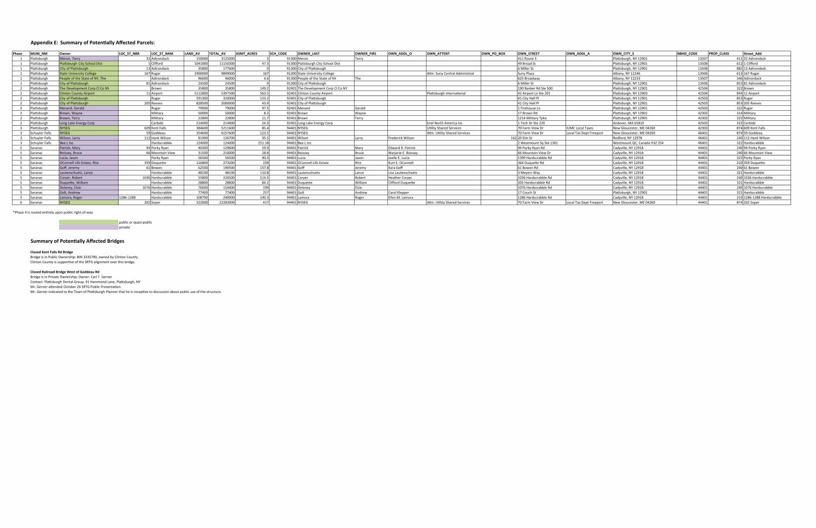
Appendix E: Summary of Potentially Affected Parcels:
SAL_RENWOEDOC_HCSSERCA_TMSAVA_LATOTVA_DNALMAN_TS_COLRBN_TS_COLrenwOMN_INUMesahP T OWNER_FIRS OWN_ADDL_O OWN_ATTENT OWN_PO_BOX OWN_STREET ddA_teertSSSALC_PORPEDOC_DHBNS_YTIC_NWOA_LDDA_NWO1 Plattsburgh Meron, yrreTnoreM0031950005213000051kcadnoridA23yrreT 411 Route 3 Plattsburgh, NY 231147023110921 Adirondack1 Plattsburgh Plattsburgh City School hgrubsttalP003193.74003051110001401droffilC1tsiD City School Dist 49 Broad St Plattsburgh, NY 12166053110921 Clifford1 Plattsburgh City of ytiC00319000677100853kcadnoridA31hgrubsttalP of Plattsburgh 6 Miller St Plattsburgh, NY 312886053110921 Adirondack1 Plattsburgh State University etatS0031976100099890000091raguR761egelloC University College Attn: Suny Central Administrat Suny Plaza Albany, NY 7613166053164221 Rugar1 Plattsburgh People of the State of NY, The Adirondack 96000 96000 4.6 91300 People of the State of NY The 625 Broadway Albany, NY kcadnoridA04370531332211 Plattsburgh City of ytiC0031900054200542kcadnoridA18hgrubsttalP of Plattsburgh 6 Miller St Plattsburgh, NY 183586053110921 Adirondack2 Plattsburgh The Development Corp Cl Co NY Brown 35800 35800 149.2 92401 The Development Corp Cl Co NY 190 Banker Rd Ste 500 Plattsburgh, NY nworB22340524109212 Plattsburgh Clinton County notnilC104295.36500579350082115tropriA11tropriA County Airport Plattsburgh International 42 Airport Ln Ste 201 Plattsburgh, NY 114484052430921 Airport2 Plattsburgh City of Plattsburgh Rugar 291300 320000 133.2 92401 City of Plattsburgh 41 City Hall Pl Plattsburgh, NY raguR35830524109212 Plattsburgh City of ytiC104299.340000002005828seveeR502hgrubsttalP of Plattsburgh 41 City Hall Pl Plattsburgh, NY 5023583052410921 Reeves2 Plattsburgh Menard, Gerald dlareGdraneM104295.790009700097raguR 1 Firehouse Ln Plattsburgh, NY raguR22330524109212 Plattsburgh Brown, Wayne enyaWnworB104292.80000500005yratiliM 17 Brown Rd Plattsburgh, NY yratiliM41320324109212 Plattsburgh Brown, Terry yrreTnworB104297.110082200822yratiliM 1214 Military Tpke Plattsburgh, NY yratiliM22320324109212 Plattsburgh Long Lake Energy Corp Carbide 214000 214000 24.3 92401 Long Lake Energy Corp Enel North America Inc 1 Tech Dr Ste 220 Andover, MA edibraC2233052401810
tneK906GESYNhgrubsttalP3 Falls 384600 5211600 85.4 94401 NYSEG Utility Shared Services 70 Farm View Dr IUMC Local Taxes New Gloucester, ME 04260 42303 874 609 Kent Falls3 Schuyler GESYN104495.3210067516006453uaeddoG95GESYNsllaF Attn: Utility Shared Services 70 Farm View Dr Local Tax Dept Freeport New Gloucester, ME 04260 46401 874 59 Goddeau3 Schuyler Falls Wilson, knaH211yrraL kcirederFyrraLnosliW104495.5900763100918nosliW Wilson 162 20 Elm St Redford, NY 2110421046487921 Hank Wilson3 Schuyler Falls Bee L Inc Hardscrabble 124000 124000 251.18 94401 Bee L Inc 2 Westmount Sq Ste 1301 Westmount QC, Canada H3Z 2S4 46401 322 Hardscrabble5 Saranac Patrick, ykroP49yraM drawdEyraMkcirtaP104499.9500692100304nayR R. Patrick 94 Porky Ryan Rd Cadyville, NY 490421044481921 Porky Ryan5 Saranac Boissey, niatnuoM66ecurB eirojraMecurByessioB104498.8200001200513weiV E. Boissey 66 Mountain View Dr Cadyville, NY 660421044481921 Mountain View5 Saranac Lucia, Jason Porky elleoJnosaJaicuL104493.090056500565nayR E. Lucia 1399 Hardscrabble Rd Cadyville, NY ykroP2231044481921 Ryan5 Saranac OConnell Life Estate, llennoCO10449932002372008611etteuquD953atiR Life Estate Rita Kurt E. OConnell 364 Duquette Rd Cadyville, NY 9530121044481921 Duquette5 Saranac Goff, araKymereJffoG104498.75100509100526newoB16ymereJ Goff 61 Bowen Rd Cadyville, NY 160421044481921 Bowen5 Saranac Lautenschuetz, Lance Hardscrabble 48100 48100 110.8 94401 Lautenschuetz Lance Lisa Lautenschuetz 3 Meyers Way Cadyville, NY elbbarcsdraH12310444819215 Saranac Coryer, rehtaeHtreboRreyroC104495.41100502200855elbbarcsdraH6301treboR Coryer 1036 Hardscrabble Rd Cadyville, NY 63010421044481921 Hardscrabble5 Saranac Duquette, William droffilCmailliWetteuquD104492.480088200882elbbarcsdraH Duquette 205 Hardscrabble Rd Cadyville, NY elbbarcsdraH12310444819215 Saranac Delaney, eislEyenaleD1044999100445100667elbbarcsdraH6701eislE 1076 Hardscrabble Rd Cadyville, NY 67010421044481921 Hardscrabble5 Saranac Golt, Andrew loraCwerdnAtloG104497520047700477elbbarcsdraH Klepper 17 Couch St Plattsburgh, NY elbbarcsdraH12310444109215 Saranac Lamora, Roger 1286- nellEregoRaromaL104493.091000042007801elbbarcsdraH8821 M. Lamora 1286 Hardscrabble Rd Cadyville, NY 68210121044481921 -1288 Hardscrabble
GESYN1044971400038222000223repoS202GESYNcanaraS6 Attn: Utility Shared Services 70 Farm View Dr Local Tax Dept Freeport New Gloucester, ME 04260 44401 874 202 Soper
*Phase 4 is routed entirely upon public right-of-way
public or quasi-publicprivate
Summary of Potentially Affected Bridges
Closed Kent Falls Rd BridgeBridge is in Public Ownership: BIN 3335790, owned by Clinton County.Clinton County is supportive of the SRTG alignment over this bridge.
Closed Railroad Bridge West of Goddeau RdBridge is in Private Ownership; Owner: Carl T. GernerContact: Plattsburgh Dental Group, 91 Hammond Lane, Plattsburgh, NYMr. Gerner attended October 26 SRTG Public Presentation. Mr. Gerner indicated to the Town of Plattsburgh Planner that he is receptive to discussion about public use of the structure.
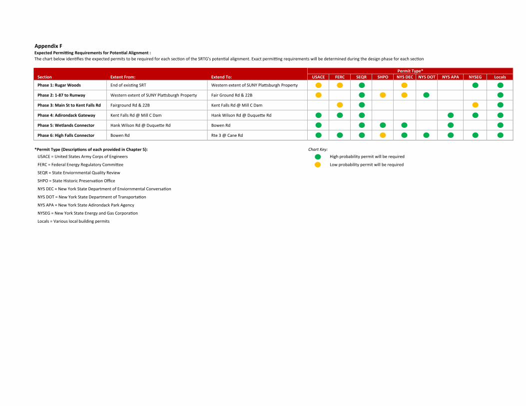
Appendix FExpected Permitting Requirements for Potential Alignment :The chart below identifies the expected permits to be required for each section of the SRTG's potential alignment. Exact permitting requirements will be determined during the design phase for each section
tnetxEnoitceS dnetxE:morF SYNOPHSRQESCREFECASU:oT DEC NYS DOT NYS APA NYSEG Locals
Phase 1: Rugar Woods End of existing nretseWTRS extent of SUNY Plattsburgh Property
Phase 2: 1-87 to Runway Western extent of SUNY Plattsburgh Property Fair Ground Rd & 22B
Phase 3: Main St to Kent Falls Rd Fairground Rd & tneKB22 Falls Rd @ Mill C Dam
Phase 4: Adirondack Gateway Kent Falls Rd @ Mill C knaHmaD Wilson Rd @ Duquette Rd
Phase 5: Wetlands Connector Hank Wilson Rd @ Duquette Rd Bowen Rd
Phase 6: High Falls Connector Bowen etRdR 3 @ Cane Rd
*Permit Type (Descriptions of each provided in Chapter 5): Chart Key:USACE = United States Army Corps of Engineers High probability permit will be required
FERC = Federal Energy Regulatory Committee Low probability permit will be required
SEQR = State Enviornmental Quality Review
SHPO = State Historic Preservation Office
NYS DEC = New York State Department of Enviornmental Conversation
NYS DOT = New York State Department of Transportation
NYS APA = New York State Adirondack Park Agency
NYSEG = New York State Energy and Gas Corporation
Locals = Various local building permits
Permit Type*