Embed Size (px)
Citation preview
MINNESOTAJurisdictional Realignment ProjectPhase 1 Report
January 2013
M i n n e s o t a J u r i s d i c t i o n a l R e a l i g n m e n t P r o j e c t P h a s e 1 R e p o r t i
Table of Contents
Executive Summary ....................................................................................................................................... 1
Objective ................................................................................................................................................... 1
Approach ................................................................................................................................................... 1
Prior studies .............................................................................................................................................. 2
Phase 1—Assigning the right roads to the right levels of government .................................................... 2
Step 1: Divide network into three tiers for analysis based on probability of misalignment ................ 2
Step 2: Obtain detailed information for segments for further analysis ................................................ 4
Step 3: Review segments with appropriate team members against established parameters ............. 5
Step 4: Prepare a revised preliminary transfer register ........................................................................ 6
Phase 2—Developing a state-wide transfer register ................................................................................ 6
Scope ..................................................................................................................................................... 6
Process .................................................................................................................................................. 6
Timeline ................................................................................................................................................. 6
Introduction .................................................................................................................................................. 7
Project Objectives ......................................................................................................................................... 8
Guiding principles ..................................................................................................................................... 8
Overall Project Approach .............................................................................................................................. 9
Manage project ......................................................................................................................................... 9
Conduct literature review ......................................................................................................................... 9
Identify risks, analyze issues, and specify analysis approach ................................................................... 9
Conduct baseline problem analysis .......................................................................................................... 9
Conduct review of historical turnback actions ....................................................................................... 10
Prepare final report ................................................................................................................................. 10
Historical Findings ....................................................................................................................................... 11
Literature review—key themes .............................................................................................................. 11
Trends in historical ownership ................................................................................................................ 12
Segment Analysis Approach ........................................................................................................................ 16
Legal/regulatory restrictions ................................................................................................................... 16
Definitions ............................................................................................................................................... 17
Route system definitions .................................................................................................................... 17
Functional classification definitions .................................................................................................... 18
Segment identification approach ............................................................................................................ 21
Exclusions ............................................................................................................................................ 21
Step 1: Divide network into three tiers for analysis based on probability of misalignment .............. 23
Step 2: Obtain detailed information for segments for further analysis .............................................. 26
Step 3: Review segments with appropriate team members against established parameters ........... 26
Step 4: Prepare a revised preliminary transfer register ...................................................................... 27
ii M i n n e s o t a J u r i s d i c t i o n a l R e a l i g n m e n t P r o j e c t P h a s e 1 R e p o r t
Implementation Pilot .................................................................................................................................. 28
Prepare MnDOT district-specific mileage charts and maps .................................................................... 28
Prepare MnDOT district-specific preliminary transfer register .............................................................. 30
Review preliminary transfer register with MnDOT district representatives .......................................... 33
Discuss approach feasibility and lessons learned ................................................................................... 33
Next Steps—Phase 2 ................................................................................................................................... 34
Scope ....................................................................................................................................................... 34
Process .................................................................................................................................................... 34
Timeline ................................................................................................................................................... 34
Exhibits
Exhibit 1. Analysis tiers and mileage chart ................................................................................................... 3
Exhibit 2. Analysis tiers by jurisdiction .......................................................................................................... 3
Exhibit 3. Preliminary transfer register example .......................................................................................... 4
Exhibit 4. Preliminary transfer register (map) example ................................................................................ 5
Exhibit 5. Overall project (Phase 1) approach ............................................................................................... 9
Exhibit 6. Minnesota roadways—vehicle miles of travel share and mile share ......................................... 12
Exhibit 8. Growth of road miles in Minnesota ............................................................................................ 14
Exhibit 9. Road miles in Minnesota by jurisdiction, 1983 through 2012 .................................................... 15
Exhibit 10. Road miles in Minnesota by jurisdiction, 1983 and 2012 ......................................................... 15
Exhibit 11. High-level segment analysis approach ...................................................................................... 22
Exhibit 12. Analysis tiers and mileage chart ............................................................................................... 24
Exhibit 13. Analysis tiers by jurisdiction ...................................................................................................... 24
Exhibit 14. District 4 mileage chart ............................................................................................................. 29
Exhibit 15. District 4 mileage by tier ........................................................................................................... 29
Exhibit 16. Preliminary transfer register ..................................................................................................... 30
Exhibit 17: Preliminary transfer register (map) .......................................................................................... 31
Exhibit 18. District 6 Tier 2 (state-owned) map (without AADT variations) ............................................... 32
Exhibit 19. District 6 Tier 2 (state-owned) map (with AADT variations) ..................................................... 32
M i n n e s o t a J u r i s d i c t i o n a l R e a l i g n m e n t P r o j e c t P h a s e 1 R e p o r t 1
Executive Summary
Objective
The overall objective for this project is to ensure that Minnesota roads are owned and operated at the
right jurisdictional level. The intent is to develop and apply a methodology that can be used to evaluate
current jurisdictional responsibilities for roads to identify specific segments that are not at the right level
of government. This information will then be used as the basis from which a jurisdictional transfer
process and program can be established that will remedy the misalignment. To accomplish these
objectives, the project establishes a standard and consistent approach that can be used to identify
segments that the different jurisdictional interests in Minnesota—the state, counties, cities, and
townships—agree are “misaligned.” The project then applies this approach to build a register of roads
that are candidates for transfer.
It has long been recognized in Minnesota that the jurisdictional responsibilities for roadways need to be
reassessed to ensure their efficient and effective management. The issue and discussion of jurisdictional
alignment has been ongoing. The topic became a highly focused issue in the 1980s and has been
revisited since then. Looking forward, a guiding principle in Minnesota’s 50-year vision is to “strategically
fix the system,” which includes ensuring that roads are aligned with the proper jurisdictional owner.
The key issue with misaligned roads is that they may not provide appropriate level of service for users in
terms of both their capacity and customer expectations, such as ride quality. Some issues with
misaligned roads are
Misaligned roads may not receive the priority for funding or improvements
Misaligned roads may use the wrong source of funding, which may not contain required funds
for improvements
Misaligned roads may lead to an “impaired” network of roads due to differing jurisdiction
priorities (that is, the road conditions may change drastically while going from one location to
another if the road jurisdiction changes along the way)
Approach
The project has two phases:
Phase 1 established guiding principles, evaluated the history and prior studies, developed an
approach for identifying misalignments, piloted the approach, and defined an agreed-upon
process for applying the approach. The end result of the first phase is this report.
Phase 2 will apply the process defined in Phase 1 to build a transfer register, which will then act
as a basis for initiating transfers based on interagency agreement and available funding.
2 M i n n e s o t a J u r i s d i c t i o n a l R e a l i g n m e n t P r o j e c t P h a s e 1 R e p o r t
Prior studies
A review of prior studies indicated that the studies acknowledged misalignments in the state and agreed
that it was necessary to ensure that the “right roads are at the right level” of government to ensure that
funding was protected for the highest priority roads in the state. While multiple studies provided
general guidance or methodology on how to identify misaligned segments, the factors that were
presented varied from study to study—and none of the studies presented an implementation
methodology or approach.
The current project focuses on preparing a consistent methodology that can be applied across the state,
and Phase 2 will focus on implementing the methodology across the state to prepare a transfer register
(a comprehensive list of segments that may be misaligned). This list of segments, along with potential
transfer costs, risks, and other factors for consideration, will help prepare a plan for conducting segment
transfers.
Phase 1—Assigning the right roads to the right levels of government
This phase of the project focused on routes that are owned by state, counties, cities, and townships—
but excludes the interstate system and the Interregional Corridor (IRC) system since its ownership is
already well established.
The approach for identifying segments that may be misaligned along with examples from the
implementation pilot is summarized as follows.
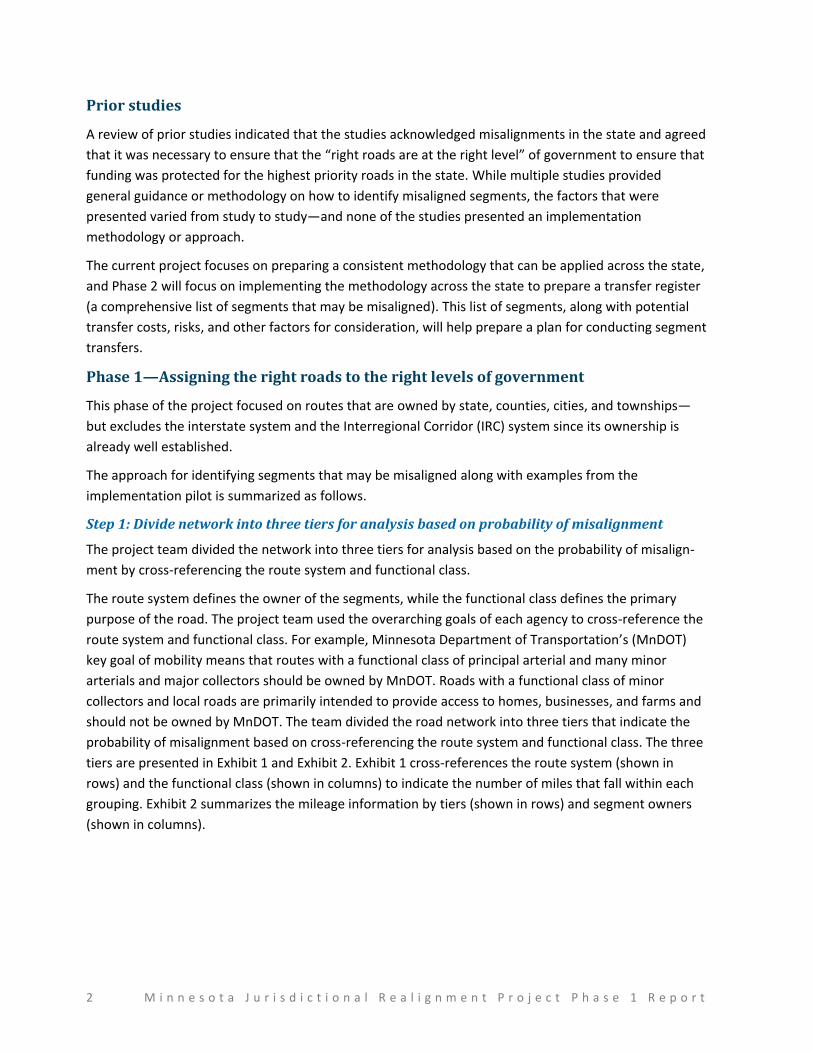
Step 1: Divide network into three tiers for analysis based on probability of misalignment
The project team divided the network into three tiers for analysis based on the probability of misalign-
ment by cross-referencing the route system and functional class.
The route system defines the owner of the segments, while the functional class defines the primary
purpose of the road. The project team used the overarching goals of each agency to cross-reference the
route system and functional class. For example, Minnesota Department of Transportation’s (MnDOT)
key goal of mobility means that routes with a functional class of principal arterial and many minor
arterials and major collectors should be owned by MnDOT. Roads with a functional class of minor
collectors and local roads are primarily intended to provide access to homes, businesses, and farms and
should not be owned by MnDOT. The team divided the road network into three tiers that indicate the
probability of misalignment based on cross-referencing the route system and functional class. The three
tiers are presented in Exhibit 1 and Exhibit 2. Exhibit 1 cross-references the route system (shown in
rows) and the functional class (shown in columns) to indicate the number of miles that fall within each
grouping. Exhibit 2 summarizes the mileage information by tiers (shown in rows) and segment owners
(shown in columns).
M i n n e s o t a J u r i s d i c t i o n a l R e a l i g n m e n t P r o j e c t P h a s e 1 R e p o r t 3
Exhibit 1. Analysis tiers and mileage chart
Road System Owner
Principal Arterial
Minor Arterial
Major Collector
Minor Collector Local Total
Total by Jurisdiction Interstate
Other Freeway/
Expressway Other
Interstate highway State* 913.9 913.9 913.9
State highway State 166.2 4,143.3 5,560.7 1,045.6 17.8 8.8 10,942.4 10,942.4
County state-aid highway Counties 80.7 2,863.1 15,048.9 10,027.9 2,563.6 30,584.3
46,600.3 County road Counties 83.0 513.5 1,433.2 12,296.1 14,325.8
Unorganized territory road Counties 4.2 4.1 1,681.9 1,690.2
Municipal state-aid street Cities 31.7 610.3 1,319.1 1,421.0 3,382.2 22,198.6
Municipal street Cities 0.2 41.1 350.7 29.5 18,394.9 18,816.5
Township road Township 18.9 76.4 354.6 53,267.6 53,717.5 53,717.5
Parks and other roads Parks or private 1.0 63.9 163.2 4,101.0 4,329.0 4,329.0
Total 914 166 4,256 9,178 18,422 12,030 93,735 138,702 138,702
Total without interstate and parks and other roads 133,459
*Policies dictated by FHWA, managed by State
Legend
Tier 1—High misalignment probability
Tier 2—Medium misalignment probability
Tier 3—Low misalignment probability
Not applicable
Excluded from analysis
Exhibit 2. Analysis tiers by jurisdiction
Tier State Counties Cities Townships Total
Tier 1 (high misalignment probability) 27 14,940 32 19 15,018
Tier 2 (medium misalignment probability) 6,606 10,032 651 431 17,721
Tier 3 (low misalignment probability) 4,310 21,628 21,515 53,268 100,720
Excluded from analysis (not applicable) 5,243
Total 10,942 46,600 22,199 53,717 138,702
4 M i n n e s o t a J u r i s d i c t i o n a l R e a l i g n m e n t P r o j e c t P h a s e 1 R e p o r t
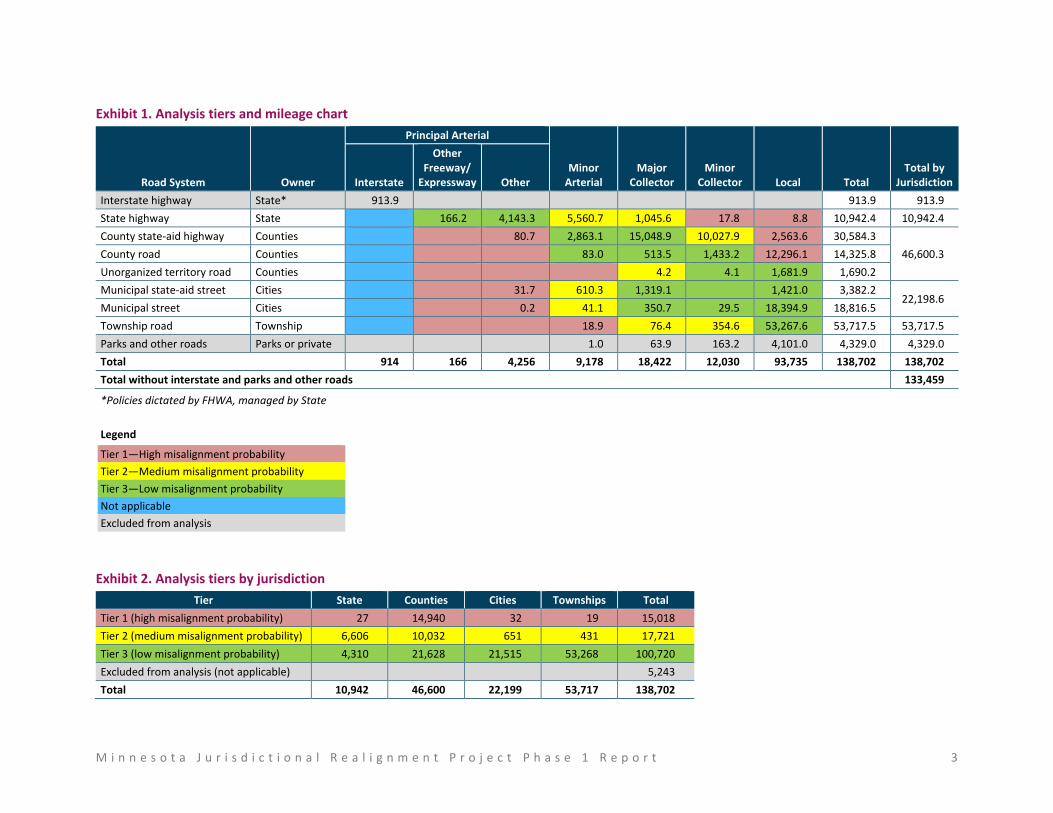
Step 2: Obtain detailed information for segments for further analysis
The team then obtained detailed information for each road segment to prepare a listing of all segments
for analysis. This information included current owner, mile beginning and end points, functional class,
and location (county and city). The team also prepared maps to present the same information visually,
allowing reviewers to view both the road network and individual segments for further review and
analysis. The listing of segments and maps was prepared for a subset of the road network during
Phase 1. This includes Tier 1 segments that are either owned by MnDOT or functionally classified as
principal arterials and Tier 2 segments that are owned by MnDOT.
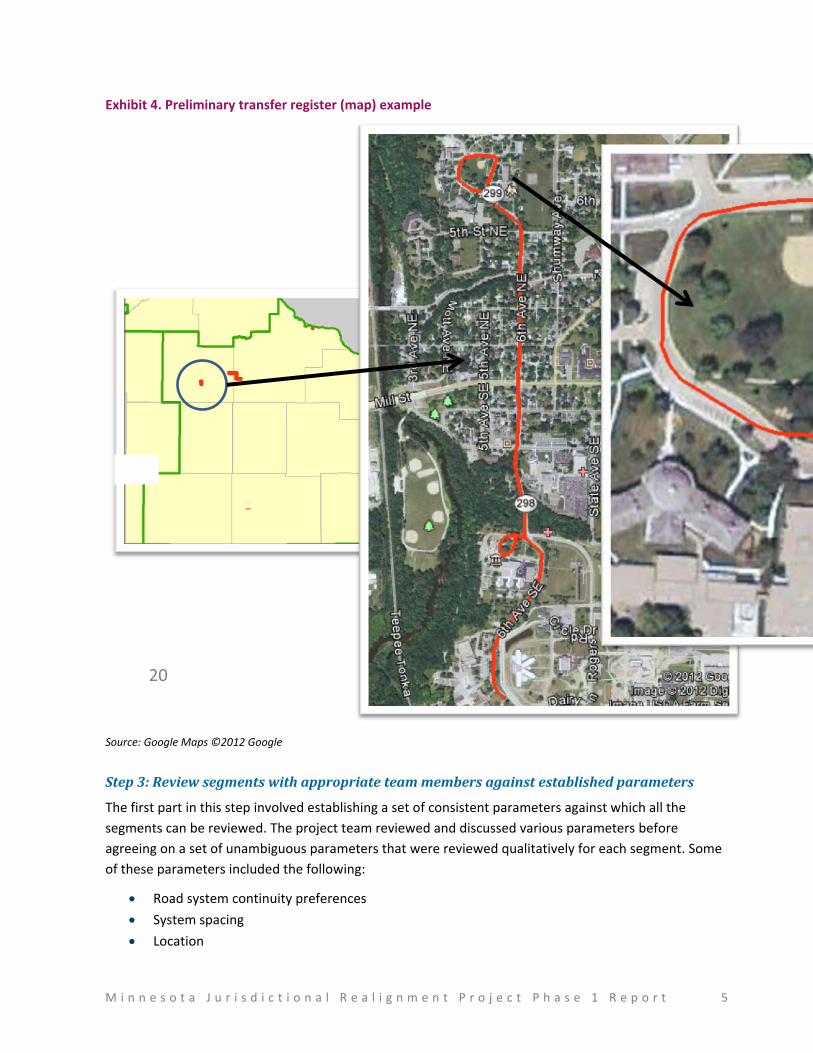
Exhibit 3 presents a part of Tier 1 (MnDOT/state-owned) preliminary transfer register for District 6 that
was prepared during the pilot as an example. Exhibit 4 presents the preliminary transfer register
information presented on a map that was prepared during the piloting process. The extreme-left map
shows the segments presented in Exhibit 3, while the two attached maps present details for MN 299
(Olaf Hansen Drive).
Exhibit 3. Preliminary transfer register example
Route Number Route System Owner
Functional Class County City Street Name Miles BegPt EndPt
818 U.S. highway State Local Mower Austin 21st St NE 0.047 12.195 12.242
298 Minnesota state highway
State Local Rice Faribault 6th Ave SE 0.151 1 1.151
299 Minnesota state highway
State Local Rice Faribault Olaf Hansen Dr 0.674 0 0.674
M i n n e s o t a J u r i s d i c t i o n a l R e a l i g n m e n t P r o j e c t P h a s e 1 R e p o r t 5
Exhibit 4. Preliminary transfer register (map) example
Source: Google Maps ©2012 Google
Step 3: Review segments with appropriate team members against established parameters
The first part in this step involved establishing a set of consistent parameters against which all the
segments can be reviewed. The project team reviewed and discussed various parameters before
agreeing on a set of unambiguous parameters that were reviewed qualitatively for each segment. Some
of these parameters included the following:
Road system continuity preferences
System spacing
Location
20
6 M i n n e s o t a J u r i s d i c t i o n a l R e a l i g n m e n t P r o j e c t P h a s e 1 R e p o r t
Site of national, state, or local interest
Traffic volume
Intermodal facilities
As a part of the piloting process, the team reviewed segments with MnDOT district representatives and
evaluated the segments against the parameters. The team then revised the list of parameters based on
the effectiveness during the evaluation process.
Step 4: Prepare a revised preliminary transfer register
This step involved revising the preliminary transfer register to remove any segments that are not
deemed to be candidates for transfer and adding any segments that may be additionally identified
during the process.
The pilot implementation and revisions to the segment identification approach marked the end of
Phase 1 of the project.
Phase 2—Developing a state-wide transfer register
Scope
Phase 2 of the project will focus on implementing the segment identification approach presented in this
phase 1 report, discussing the segments with key stakeholders from various jurisdictions, and obtaining
agreement on transfer candidate segments. The end result of Phase 2 will be a state-wide transfer
register that will present all segments that are candidates for transfer based on discussions with
representatives from various districts, counties, cities, and local agencies (realignment teams). Phase 2
will include a broad, order-of-magnitude cost for transfers when possible, including a qualitative
assessment from district/county/city engineers as to whether the road would require a full reconstruc-
tion/rehabilitation or minor repairs before a transfer. The results will also include any policy implications
that may be of importance.
Process
The segment identification process during Phase 2 will include close collaboration with multiple
jurisdictions. The team will prepare preliminary transfer registers for each MnDOT district based on the
approach identified in Phase 1 working with a district champion in each district. The district champions
could be the district planning staff, district engineers, or other district staff member(s). A realignment
team will be formed in each MnDOT district to aid with the segment identification process and will
include collaborating with district champions to identify district participants who will form the
realignment teams. Realignment teams will potentially be comprised of district champion, district
planning directors, MnDOT state aid engineers, select county engineers, select city engineers, and
township representatives. The end result of Phase 2 will be a state-wide transfer register that will
present all segments that are candidates for transfer based on discussions with realignment teams.
Timeline
Phase 2 began in January 2013 and is anticipated to end in May 2013.
M i n n e s o t a J u r i s d i c t i o n a l R e a l i g n m e n t P r o j e c t P h a s e 1 R e p o r t 7
Introduction
This document presents the results from Phase 1 of the jurisdictional realignment project. It has been
long recognized in Minnesota that the jurisdictional responsibilities for roadways needs to be reassessed
to ensure their efficient and effective management. The issue and discussion of jurisdictional alignment
has been ongoing. The topic became a highly focused issue in the 1980s and has been revisited since
then. Looking forward, a guiding principle in Minnesota’s 50-year vision is to “strategically fix the
system,” which includes ensuring that roads are aligned with the proper jurisdictional owner.
The key issue with misaligned roads is that they may not provide appropriate level of service for users in
terms of both their capacity and customer expectations, such as ride quality. Some issues with
misaligned roads are:
Misaligned roads may not receive the priority for funding or improvements
Misaligned roads may use the wrong source of funding, which may not contain required funds
for improvements
Misaligned roads may lead to an “impaired” network of roads due to differing jurisdiction
priorities (that is, the road condition may change drastically while going from one location to
another if the road jurisdiction changes along the way)
The Minnesota jurisdictional realignment project is aimed at ensuring that Minnesota roads are owned
and operated at the right jurisdictional level. The overall project has been divided into two phases.
Phase 1 established guiding principles, evaluated the history and prior studies, developed an
approach for identifying misalignments, piloted the approach, and defined an agreed-upon
process for applying the approach. The end result of the first phase is this report.
Phase 2 will apply the process defined in Phase 1 to build a transfer register, which will then act
as a basis for initiating transfers based on interagency agreement and available funding.
The report is divided into the following sections:
Executive summary—Presents a summary of this report
Introduction—Provides an introduction to this project and the report
Project objectives—Presents the key objectives for this project
Overall project approach—Presents the overall approach for the project
Historical findings—Presents findings from analysis of historical roadway mileage data
Segment analysis approach—Details the approach to identifying segments that are transfer
candidates
Implementation pilot—Presents the findings from the implementation pilot
Next steps—Presents the next steps in the project
8 M i n n e s o t a J u r i s d i c t i o n a l R e a l i g n m e n t P r o j e c t P h a s e 1 R e p o r t
Project Objectives
The overall objective for this project is to ensure that Minnesota roads are owned and operated at the
right jurisdictional level. The intent is to develop and apply a methodology that can be used to evaluate
current jurisdictional responsibilities for roads to identify specific segments that are not at the right level
of government. This information will then be used as the basis from which a jurisdictional transfer
process and program can be established with the help of a multi-jurisdictional team representing all
jurisdictional interests that will remedy the misalignment.
Guiding principles
The guiding principles of developing the project approach include the following:
Holistic approach—the project focuses on all jurisdictions and in both directions of transfer
(e.g., state to county and vice versa)
Aid in achieving 50-year goal—the project looks at ways to “strategically fix the system”—that
is, get the right roads at the right level of government and develop a realignment method that
can be used in the future
Collaboration and constant feedback—the project is transparent and collaborative among a
broad project team
Implementable—the project creates an approach that can be easily and consistently
implemented across the state—of course, subject to financial considerations
M i n n e s o t a J u r i s d i c t i o n a l R e a l i g n m e n t P r o j e c t P h a s e 1 R e p o r t 9
Overall Project Approach
Exhibit 5 presents the overall project approach for Phase 1 at a high level and is followed by a short
description of each task.
Exhibit 5. Overall project (Phase 1) approach
Manage project
This task included conducting ongoing project management, providing regular status updates, and
conducting project team meetings to discuss project progress and direction.
Conduct literature review
This task consisted of conducting literature review of completed studies that address realignment-
related issues.
Identify risks, analyze issues, and specify analysis approach
This task included understanding available data for both historical review and preparing an analysis
approach. The outcome of this task was a draft analysis approach.
Conduct baseline problem analysis
This task formed the majority of the project and involved implementing the draft analysis approach. This
included collecting core network data and conducting a pilot of the analysis approach.
10 M i n n e s o t a J u r i s d i c t i o n a l R e a l i g n m e n t P r o j e c t P h a s e 1 R e p o r t
Conduct review of historical turnback actions
This task was conducted in parallel to developing a draft analysis approach and included reviewing
historical data. Since actual transfer (turnback) data was not available, the project team reviewed
project data (highway performance monitoring system [HPMS]) that MnDOT reports to FHWA on an
annual basis.
Prepare final report
This task consisted of compiling all information in the form of this phase 1 final report and a Phase 2
project plan.
M i n n e s o t a J u r i s d i c t i o n a l R e a l i g n m e n t P r o j e c t P h a s e 1 R e p o r t 11
Historical Findings
This section presents a summary of literature review conducted by the project team and a summary of
mileage growth and jurisdictional ownership over time.
Literature review—key themes
One of the first tasks of this project was to conduct a detailed literature review of key studies related to
jurisdictional alignment within the state of Minnesota. The prior studies focused on a variety of
jurisdictional realignment issues, including funding considerations, legislation changes, and general
obstacles to realignment. Following are the seven studies reviewed:
Citizens League Report (1983)
Highway Study Commission Report (1984)
Highway Jurisdiction Task Force (1984)
Minnesota Legislative Changes (1985)
Minnesota Highway Jurisdiction Study (1988)
Minnesota Experience with Jurisdiction Studies (1989)
Turnback Task Force Report (1998)
A detailed literature review summary was presented to the project team at the end of this task to assist
the project team in understanding each study and its application to this project. The summary provides
specific details, findings, and recommendations. This report section presents the key themes from prior
studies:
Inconsistent prior methodology for assessing and implement transfers—A key theme emerging
from the studies was that the methodology adopted for assessing and implementing transfers
was inconsistent, leading to difficulties in making much progress.
Deemed necessary to protect funds for highest priority roads—Almost every study agreed that
it was necessary to have the “right roads at the right level” of government to ensure that
funding was protected for the highest priority roads in the state.
Overall funding shortfall critical to aiding/preventing transfers—Almost every study mentioned
funding shortfalls and how critical they are to aiding/preventing transfers.
Concerns over future funding uncertainties—Many studies referred to future funding
uncertainties. This situation has worsened since those studies were conducted.
Dedicated funding for transfers—The concept of dedicated funding for transfers was discussed
in some of the earliest studies.
Plan for the future—The studies agreed that any methodology should take future conditions,
priorities, and goals into consideration.
12 M i n n e s o t a J u r i s d i c t i o n a l R e a l i g n m e n t P r o j e c t P h a s e 1 R e p o r t
Trends in historical ownership
This section presents the trends in historical ownership of roadways among various jurisdictions. The
key trends, as indicated by the data in this section, are as follows:
A majority of the roads are owned by townships and counties, while a majority of the traffic is
carried by the Interstate highway and state highway systems owned by FHWA and MnDOT.
Roadway mileage within the state has grown consistently over the years for all jurisdictions.
The mileage ownership ratios (e.g., percentage of mileage owned by MnDOT vs. cities) have
remained consistent for the most part, which indicates that there has not been a wide-scale
reassessment of jurisdictional responsibilities over the years.
Exhibit 6 and Exhibit 7 show the share of Minnesota roads among jurisdictions based on MnDOT
Transportation Data and Analysis data.3 Townships own the largest percentage of roads in Minnesota at
about 39 percent, with counties (both county-owned and state-aided) constituting about 34 percent
combined. When considering jurisdictional alignment, the primary concern is deciding what the “share
of miles” among jurisdictions should be—and which jurisdictions should own which roads from a
performance and financial perspective.
Exhibit 6. Minnesota roadways—vehicle miles of travel share and mile share
Route System Owner 2010 Annual VMT
(billions) Share of Annual
VMT (%) 2012 Centerline
Miles Share of Miles
(%)
Interstate highway State* 12.36 21.8 914 0.7
State highway State 20.54 36.2 10,942 7.9
County state-aid highway Counties 12.69 22.4 30,584 22.1
County road Counties 1.01 1.8 14,326 10.3
Unorganized territory road Counties 0.02 0.0 1,690 1.2
Municipal state-aid street Cities 4.55 8.0 3,382 2.4
Municipal street Cities 4.36 7.7 18,816 13.6
Township road Townships 1.17 2.1 53,717 38.7
Parks and other roads Parks or private 0.05 0.1 4,329 3.1
Total 56.76 138,702
*Policies dictated by FHWA, managed by State
3 http://www.dot.state.mn.us/roadway/data/reports/vmt.html
M i n n e s o t a J u r i s d i c t i o n a l R e a l i g n m e n t P r o j e c t P h a s e 1 R e p o r t 13
Exhibit 7: Minnesota roadways (graph)—vehicle miles of travel share and mile share
MnDOT supplied data from its HPMS, which provided road ownership in miles over the past 28 years.
The reporting method has changed over the years, and quality checks have led to updates in data
collection methodology—which has resulted in some data anomalies. However, the historical data
provides a good overview of the system changes and should be reviewed as a whole without focusing on
the actual number of miles shown or the mileage changes between years.
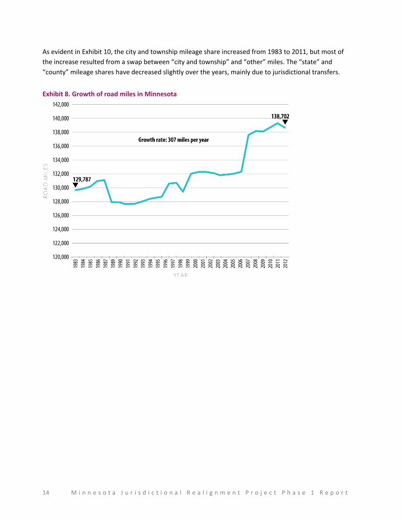
Exhibit 8 shows the total mileage for Minnesota from 1983 to 2011. Total mileage has been increasing at
a rate of about 342 miles per year and, currently, the highway network consists of about 139,000 miles.
That represents an increase of about 7 percent from 1983 miles. It is believed that the drops in mileage
resulted from changes to the data collection methodology or roadway classification/definitions. The
total mileage, subdivided by jurisdiction, is displayed in Exhibit 9.
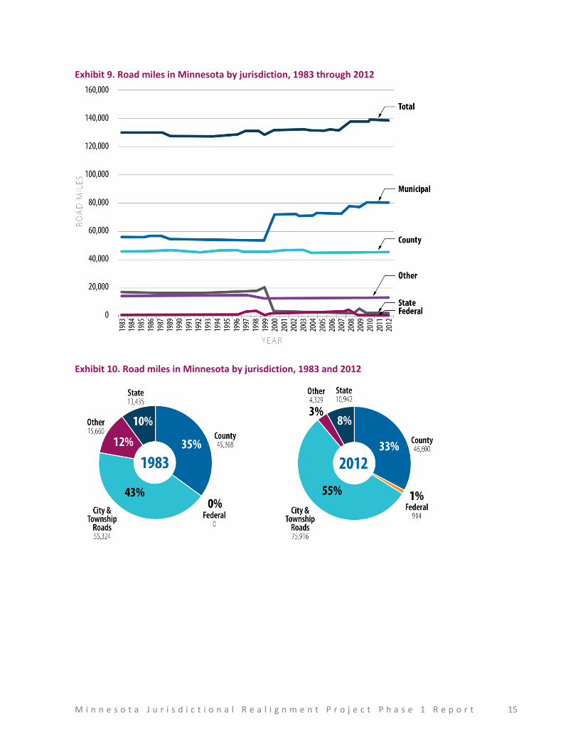
As seen in Exhibit 9, the growth in jurisdiction ownership is fairly constant between jurisdictions. The
biggest change resulted from a definition change in the late 1990s, which led to a “swap” in miles from
“other” (includes toll roads, roads not identified by administrative authority, and federal parks, forests,
and reservations that are not a part of the state and local highway systems) to “city and township”
jurisdictions. Exhibit 10 presents the distribution of ownership in years 1983 and 2012.
14 M i n n e s o t a J u r i s d i c t i o n a l R e a l i g n m e n t P r o j e c t P h a s e 1 R e p o r t
As evident in Exhibit 10, the city and township mileage share increased from 1983 to 2011, but most of
the increase resulted from a swap between “city and township” and “other” miles. The “state” and
“county” mileage shares have decreased slightly over the years, mainly due to jurisdictional transfers.
Exhibit 8. Growth of road miles in Minnesota
M i n n e s o t a J u r i s d i c t i o n a l R e a l i g n m e n t P r o j e c t P h a s e 1 R e p o r t 15
Exhibit 9. Road miles in Minnesota by jurisdiction, 1983 through 2012
Exhibit 10. Road miles in Minnesota by jurisdiction, 1983 and 2012
16 M i n n e s o t a J u r i s d i c t i o n a l R e a l i g n m e n t P r o j e c t P h a s e 1 R e p o r t
Segment Analysis Approach
This section presents the segment analysis approach that was developed to identify segments that may
be misaligned and are, therefore, candidates for transfer from one jurisdiction to another. The project
team first divided the network into three tiers for analysis based on the probability of misalignment by
cross-referencing the route system and functional class.
The route system defines the owner of the segments, while the functional class defines the primary
purpose of the road. The project team used the overarching goals of each agency to cross-reference the
route system and functional class. For example, MnDOT’s key goal of mobility means that routes with a
functional class of principal arterial and many minor arterials and major collectors should be owned by
MnDOT. Roads with a functional class of minor collectors and local roads are primarily intended to
provide access to homes, businesses, and farms—and should not be owned by MnDOT.
This section presents the following three subsections:
Legal/regulatory restrictions that affect jurisdictional transfers
Definitions of various route systems/classifications and functional classifications
Segment identification approach, including roadway exclusions, approach, and analysis
framework
Legal/regulatory restrictions
There are certain Minnesota statutes and legal requirements that affect jurisdictional ownership of
Minnesota roads. While these requirements have been in place for many years and may be outdated,
changing these requirements is a complex process.
Following are the basic legal/regulatory restrictions related to the roadway network:
The state highway system is limited to 12,200 miles
The county state-aid highway system is 30,000 miles
The municipal state-aid street system is 2,500 miles
There are 70 constitutional routes across the state that connect key locations across the state. By state
law:
A state route must exist to maintain these connections
A state route may be designated on any roadway that meets the constitutional route definition
M i n n e s o t a J u r i s d i c t i o n a l R e a l i g n m e n t P r o j e c t P h a s e 1 R e p o r t 17
Definitions
This section presents the definitions for route systems and functional classifications which aid the
segment analysis and identification process. The route system definitions presented below are derived
from Minnesota statutes and clarified through feedback from the project’s multi-jurisdictional team,
while the functional classification definitions are obtained from FHWA functional classification
guidelines.4
Route system definitions
The route system definitions below provide information presented in the statutes and as well as more
detailed information/definition as agreed upon by the project’s multi-jurisdictional team.
State roads (also known as “state highways”)
Statute 160.02, Subd. 29—“State highways or trunk highways” includes all roads established or to be
established under the provisions of article 14, section 2 of the Constitution of the State of Minnesota.
State roads provide the primary backbone of Minnesota’s transportation network. These roads are
critical to providing mobility across the state for people and goods, as well as ensuring economic
development and growth. The state highway system in Minnesota includes about 10,942 centerline
miles.
System primary goal—Statewide mobility (high speed)
County roads
Statute 160.02, Subd. 17—“County highways” includes those roads which have heretofore been or which
hereafter may be established, constructed, or improved under authority of the several county boards,
including all roads lying within the county or on the line between counties established by judicial
proceedings, except those roads established, constructed, or improved by the counties that have been
maintained by the towns for a period of at least one year prior to July 1, 1957. All roads heretofore
designated prior to July 1, 1957 as county-aid highways shall be county highways until abandoned or
changed in accordance with law.
County roads link different cities and townships within a county. A road within an unorganized territory,
by default, is a county road. County roads provide mobility within the county and may have different
(lower) speed limits than on state roads.
County state-aid highways (CSAH)
Statute 160.02, Subd. 18—“County state-aid highways” includes all roads established in accordance with
law as county state-aid highways.
Municipal state-aid streets (MSAS)
Statute 160.02, Subd. 21—“Municipal state-aid streets” includes all streets within the cities having a
population of 5,000 or more, established in accordance with law as municipal state-aid streets.
4 http://www.fhwa.dot.gov/planning/processes/statewide/related/functional_classification/fc02.cfm#ad

18 M i n n e s o t a J u r i s d i c t i o n a l R e a l i g n m e n t P r o j e c t P h a s e 1 R e p o r t
City roads
City roads primarily serve residents of a particular city. They are designed to provide access to homes
and commercial establishments and provide intra-city mobility. City roads primarily consist of local
streets with multiple access points. These local streets tie to collectors with less access points. City roads
act as the first and last leg of connectivity for most trips. City roads may include roads with high AADT—
for example, a road that leads to a major shopping location (e.g., Mall of America). Typically, a road with
the primary use of “passing-by” a city, including trucks, is not owned by cities.
Township roads
Statute 160.02, Subd. 28—“Town roads” includes those roads and cartways which have heretofore been
or which hereafter may be established, constructed, or improved under the authority of the several town
boards, roads established, constructed, or improved by counties that have been maintained by the towns
for a period of at least one year prior to July 1, 1957.
Minnesota Administrative Rules (8820.0100), Subp. 17b—“Town road” means a road that is
maintained by a town or any other local unit of government acting as a town and open to the traveling
public a minimum of eight months of the year as certified by the county highway engineer.
Township roads primarily serve residents of the town and transport people to and from cities, larger
roads, or other township roads. These roads also provide connectivity to farm lands as well as
recreational areas (e.g., summer cabins). Township roads act as the first and last leg of connectivity for
most trips.
Functional classification definitions
This section presents functional classification definitions derived from FHWA functional classification
guidelines. Although the FHWA guidelines include separate definitions for urban and rural classifica-
tions, they have been merged here for consistency.
Principal arterial system
Urban principal arterial system
In every urban environment there exists a system of streets and highways which can be identified as
unusually significant to the area in which it lies in terms of the nature and composition of travel it
serves. In smaller urban areas (under 50,000), these facilities may be very limited in number and extent
and their importance may be primarily derived from the service provided to travel passing through the
area. In larger urban areas, their importance also derives from service to rural-oriented traffic but
equally, or even more, important from service for major movements within these urbanized areas.
This system of streets and highways is the urban principal arterial system and should serve the major
centers of activity of a metropolitan area, the highest traffic volume corridors, and the longest trip
desires and should carry a high proportion of the total urban area travel on a minimum of mileage. The
system should be integrated, both internally and between major rural connections.
The principal arterial system should carry the major portion of trips entering and leaving the urban area,
as well as the majority of through movements desiring to bypass the central city. In addition, significant
intra-area travel, such as between central business districts and outlying residential areas between
M i n n e s o t a J u r i s d i c t i o n a l R e a l i g n m e n t P r o j e c t P h a s e 1 R e p o r t 19
major inner city communities, or between major suburban centers should be served by this system.
Frequently the principal arterial system will carry important intra-urban as well as intercity bus routes.
Finally, this system in small urban and urbanized areas should provide continuity for all rural arterials
which intercept the urban boundary.
Because of the nature of the travel served by the principal arterial system, almost all fully and partially
controlled access facilities will be part of this functional system. However, this system is not restricted to
controlled access routes. In order to preserve the identification of controlled access facilities, the
principal arterial system is stratified as follows:
Interstate
Other freeways and expressways
Other principal arterials (with no control of access)
The spacing of urban principal arterials will be closely related to the trip-end density characteristics of
particular portions of the urban areas. While no firm spacing rule can be established which will apply in
all—or even most—circumstances, the spacing of principal arterials (in larger urban areas) may vary
from less than 1 mile in the highly developed central business areas to 5 miles or more in the sparsely
developed urban fringes.
For principal arterials, the concept of service to abutting land should be subordinate to the provision of
travel service to major traffic movements. It should be noted that only facilities within the “other
principal arterial” system are capable of providing any direct access to adjacent land, and such service
should be purely incidental to the primary functional responsibility of this system.
Rural principal arterial system
The rural principal arterial system consists of a connected rural system of continuous routes having the
following characteristics:
Serve corridor movements having trip length and travel density characteristics indicative of
substantial statewide or interstate travel
Serve all, or virtually all, urban areas of 50,000 and over population and a large majority of those
with population of 25,000 and over
Provide an integrated system without stub connections except where unusual geographic or
traffic flow conditions dictate otherwise (e.g., international boundary connections and
connections to coastal cities)
In the more densely populated states, this system of highways may not include all heavily traveled
routes which are multi-lane facilities. It is likely, however, that in the majority of states, the principal
arterial system will include all existing rural freeways.
The principal arterial system is stratified into the following two subsystems:
Interstate System—The Interstate System consists of all presently designated routes of the
Interstate System.
Other principal arterials—This system consists of all non-Interstate principal arterials.

20 M i n n e s o t a J u r i s d i c t i o n a l R e a l i g n m e n t P r o j e c t P h a s e 1 R e p o r t
Minor arterial road/street system
Urban minor arterial street system
The minor arterial street system should interconnect with and augment the urban principal arterial
system and provide service to trips of moderate length at a somewhat lower level of travel mobility than
principal arterials. This system also distributes travel to geographic areas smaller than those identified
with the higher system.
The minor arterial street system includes all arterials not classified as principal, contains facilities that
place more emphasis on land access than the higher system, and offers a lower level of traffic mobility.
Such facilities may carry local bus routes and provide intra-community continuity but ideally should not
penetrate identifiable neighborhoods. This system should include urban connections to rural collector
roads where such connections have not been classified as urban principal arterials.
The spacing of minor arterial streets may vary from 1/8 to 1/2 mile in the central business district to 2 to
3 miles in the suburban fringes but should normally be no more than 1 mile in fully developed areas.
Rural minor arterial road system
The rural minor arterial road system should, in conjunction with the principal arterial system, form a
rural system having the following characteristics:
Link cities and larger towns (and other traffic generators, such as major resort areas, that are
capable of attracting travel over similarly long distances) and form an integrated system
providing interstate and inter-county service.
Be spaced at such intervals, consistent with population density, so that all developed areas of
the state are within a reasonable distance of an arterial highway.
Provide (because of the two characteristics defined above) service to corridors with trip lengths
and travel density greater than those predominantly served by rural collector or local systems.
Minor arterials, therefore, constitute routes whose design should be expected to provide for
relatively high overall travel speeds, with minimum interference to through movement.
Collector road/street system
Urban collector street system
The collector street system provides both land access service and traffic circulation within residential,
commercial, and industrial areas. It differs from the arterial system in that facilities on the collector
system may penetrate residential neighborhoods, distributing trips from the arterials through the area
to the ultimate destination. Conversely, the collector street also collects traffic from local streets in
residential neighborhoods and channels it into the arterial system. In the central business district, and in
other areas of like development and traffic density, the collector system may include the street grid
which forms a logical entity for traffic circulation.
Rural collector road system
The rural collector routes generally serve travel of primarily intra-county rather than statewide
importance and constitute those routes on which (regardless of traffic volume) predominant travel
distances are shorter than on arterial routes. Consequently, more moderate speeds may be typical on
average.
M i n n e s o t a J u r i s d i c t i o n a l R e a l i g n m e n t P r o j e c t P h a s e 1 R e p o r t 21
In order to define more clearly the characteristics of rural collectors, this system should be sub-classified
according to the following criteria:
Major collector roads—These routes should (1) provide service to any county seat not on an
arterial route, to the larger towns not directly served by the higher systems, and to other traffic
generators of equivalent intra-county importance, such as consolidated schools, shipping points,
county parks, important mining and agricultural areas, etc. ; (2) link these places with nearby
larger towns or cities or with routes of higher classification; and (3) serve the more important
intra-county travel corridors.
Minor collector roads—These routes should (1) be spaced at intervals, consistent with
population density, to collect traffic from local roads and bring all developed areas within a
reasonable distance of a collector road; (2) provide service to the remaining smaller
communities; and (3) link the locally important traffic generators with their rural hinterland.
Local road/street system
Urban local street system
The urban local street system comprises all facilities not on one of the higher systems. It serves primarily
to provide direct access to abutting land and access to the higher order systems. It offers the lowest
level of mobility and usually contains no bus routes. Service to through traffic movement usually is
deliberately discouraged.
Rural local road system
The rural local road system should have the following characteristics: (1) serve primarily to provide
access to adjacent land and (2) provide service to travel over relatively short distances as compared to
collectors or other higher systems. Local roads will constitute the rural mileage not classified as part of
the principal arterial, minor arterial, or collector systems.
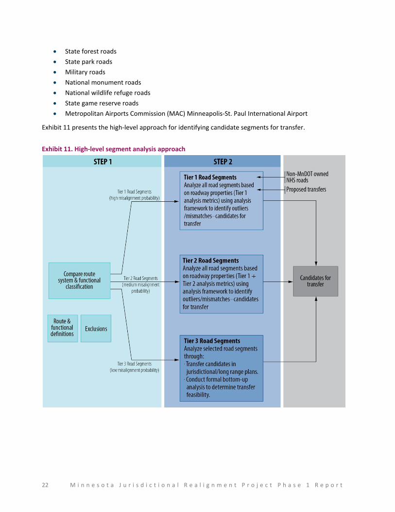
Segment identification approach
This section presents the approach to identify candidates for jurisdictional transfers. The analysis is
based on a set of metrics, or properties of road segments and the current owner. The next section (Pilot
Implementation) presents detailed information on how the approach was applied in MnDOT District 4
and District 6.
Exclusions
The following roads will be excluded from the analysis since their ownership is well-established. Any
special roads that may be identified as candidates for transfer (by any involved parties) will be treated
on a case-by-case basis:
Interstate routes
Interregional Corridor (IRC) network, which includes key transportation corridors in Minnesota
“Special roads”
National park roads
National forest development roads
Indian reservation roads
22 M i n n e s o t a J u r i s d i c t i o n a l R e a l i g n m e n t P r o j e c t P h a s e 1 R e p o r t
State forest roads
State park roads
Military roads
National monument roads
National wildlife refuge roads
State game reserve roads
Metropolitan Airports Commission (MAC) Minneapolis-St. Paul International Airport
Exhibit 11 presents the high-level approach for identifying candidate segments for transfer.
Exhibit 11. High-level segment analysis approach
M i n n e s o t a J u r i s d i c t i o n a l R e a l i g n m e n t P r o j e c t P h a s e 1 R e p o r t 23
Step 1: Divide network into three tiers for analysis based on probability of misalignment
The project team divided the network into three tiers for analysis based on the probability of misalign-
ment by cross-referencing the route system and functional class.
The route system defines the owner of the segments, while the functional class defines the primary
purpose of the road. The project team used the overarching goals of each agency to cross-reference the
route system and functional class. For example, MnDOT’s key goal of mobility means that routes with a
functional class of principal arterial and many minor arterials and major collectors should be owned by
MnDOT. Roads with a functional class of minor collectors and local roads are primarily intended to
provide access to homes, businesses, and farms—and should not be owned by MnDOT. The team
divided the road network into three tiers that indicate the probability of misalignment based on cross-
referencing the route system and functional class.
These tiers are presented in Exhibit 12 in the form of a mileage chart that cross-references the route
system (shown in rows) and the functional class (shown in columns) to indicate the number of miles that
fall within each grouping. Exhibit 13 summarizes the mileage information by tiers (shown in rows) and
segment owners (shown in columns). In addition to the routes identified in the exhibit, other routes that
are included in the tiers are as follows:
Tier 1
Routes that a jurisdiction may have proposed to take ownership from another jurisdiction
Routes that are on the National Highway System (NHS) and are owned by jurisdictions other
than MnDOT
Tier 2
None
Tier 3
Interregional Corridor system that is owned by MnDOT and has different functional
classifications.
24 M i n n e s o t a J u r i s d i c t i o n a l R e a l i g n m e n t P r o j e c t P h a s e 1 R e p o r t
Exhibit 12. Analysis tiers and mileage chart
Road System Owner
Principal Arterial
Minor Arterial
Major Collector
Minor Collector Local Total
Total by Jurisdiction Interstate
Other Freeway/
Expressway Other
Interstate highway State* 913.9 913.9 913.9
State highway State 166.2 4,143.3 5,560.7 1,045.6 17.8 8.8 10,942.4 10,942.4
County state-aid highway Counties 80.7 2,863.1 15,048.9 10,027.9 2,563.6 30,584.3
46,600.3 County road Counties 83.0 513.5 1,433.2 12,296.1 14,325.8
Unorganized territory road Counties 4.2 4.1 1,681.9 1,690.2
Municipal state-aid street Cities 31.7 610.3 1,319.1 1,421.0 3,382.2 22,198.6
Municipal street Cities 0.2 41.1 350.7 29.5 18,394.9 18,816.5
Township road Township 18.9 76.4 354.6 53,267.6 53,717.5 53,717.5
Parks and other roads Parks or private 1.0 63.9 163.2 4,101.0 4,329.0 4,329.0
Total 914 166 4,256 9,178 18,422 12,030 93,735 138,702 138,702
Total without interstate and parks and other roads 133,459
*Policies dictated by FHWA, managed by State
Legend
Tier 1—High misalignment probability
Tier 2—Medium misalignment probability
Tier 3—Low misalignment probability
Not applicable
Excluded from analysis
Exhibit 13. Analysis tiers by jurisdiction
Tier MnDOT Counties Cities Townships Total
Tier 1 (high misalignment probability) 27 14,940 32 19 15,018
Tier 2 (medium misalignment probability) 6,606 10,032 651 431 17,721
Tier 3 (low misalignment probability) 4,310 21,628 21,515 53,268 100,720
Excluded from analysis (not applicable) 5,243
Total 10,942 46,600 22,199 53,717 138,702

M i n n e s o t a J u r i s d i c t i o n a l R e a l i g n m e n t P r o j e c t P h a s e 1 R e p o r t 25
26 M i n n e s o t a J u r i s d i c t i o n a l R e a l i g n m e n t P r o j e c t P h a s e 1 R e p o r t
Step 2: Obtain detailed information for segments for further analysis
The team then obtained detailed information for each road segment to prepare a listing of all segments
for analysis. This information included current owner, mile beginning and end points, functional class,
and location (county and city). The team also prepared maps to present the same information visually,
allowing reviewers to view both the road network and individual segments for further review and
analysis.
The listing of segments and maps was prepared for a subset of the road network during Phase 1. This
included Tier 1 segments that are either owned by MnDOT or functionally classified as principal arterials
and Tier 2 segments that are owned by MnDOT.
Step 3: Review segments with appropriate team members against established parameters
The first part in this step involved establishing a set of consistent parameters against which all the
segments can be reviewed. The project team reviewed and discussed various parameters before
agreeing upon a set of unambiguous parameters that are reviewed qualitatively for each segment. The
parameters included the following:
Road system continuity preferences
System spacing
Roadway speed limit
Location
Minimum length of segment/road
High volume truck traffic
Site of national, state, or local interest
Road restrictions
Traffic volume
Intermodal facilities
Specifically, traffic volume information (in the form of Average Annual Daily Traffic [AADT]) was found to
be particularly helpful to further segregate Tier 2 segments. Further, for Tier 2, the team agreed on
some additional factors:
Identifying new alternative routes that have altered, or may alter, traffic patterns significantly
(e.g., a new highway that bypasses a city would result in an old state road to become a city road)
Reviewing and identifying potential efficiency gains through transfer (feedback from
jurisdictions/long range plans)—funding, access, agency controls, community values (excluding
maintenance)
Reviewing design standards for consistency with current functional class/jurisdiction standards
Identifying other considerations based on location, geography, etc.

M i n n e s o t a J u r i s d i c t i o n a l R e a l i g n m e n t P r o j e c t P h a s e 1 R e p o r t 27
Step 4: Prepare a revised preliminary transfer register
This step involves revising the preliminary transfer register to remove any segments that are not
deemed to be candidates for transfer and adding any segments that may be additionally identified
during the process.
28 M i n n e s o t a J u r i s d i c t i o n a l R e a l i g n m e n t P r o j e c t P h a s e 1 R e p o r t
Implementation Pilot
To test the segment identification approach, an implementation pilot was conducted in two MnDOT
districts—District 4 (Detroit Lakes) and District 6 (Rochester). The pilots focused on three segment types:
Tier 1 (state-owned), Tier 1 (principal arterials), and Tier 2 (state-owned). This allowed the team to test
the approach for various functional classifications, owners, and tiers, while keeping the scope
manageable, and develop a detailed implementation approach for Phase 2 of the project. The
information below uses information from both districts to present the implementation step-by-step.
Prepare district-specific mileage charts and maps
Prepare district-specific preliminary transfer register
Review preliminary transfer register with MnDOT district representatives
Discuss approach feasibility and lessons learned and adjust segment identification approach for
clarity
Prepare MnDOT district-specific mileage charts and maps
The first step of the implementation approach was to prepare district-specific mileage charts (listing of
all segments) and maps. The charts and maps were prepared for each MnDOT district, and then
separately for Tier 1 (state-owned), Tier 1 (principal arterials), and Tier 2 (state-owned). Exhibit 14 and
Exhibit 15 show the mileage chart and mileage summary by Tier for District 4.
M i n n e s o t a J u r i s d i c t i o n a l R e a l i g n m e n t P r o j e c t P h a s e 1 R e p o r t 29
Exhibit 14. District 4 mileage chart
Road System Owner Interstate
Principal Arterial
Minor Arterial
Major Collector
Minor Collector Local Total
Total by Jurisdiction
Other Freeway/
Expressway Other
Interstate highway State* 115.209
State highway State 489.28 799.877 192.176 0.68 1,482.012 1482.012
County state-aid highway Counties 44.46 2,042.87 1,507.52 644.67 4,239.517
6,327.18 County road Counties 20.564 191.55 1,875.55 2,087.666
Unorganized territory road Counties 0
Municipal state-aid street Cities 3.995 34.547 47.05 38.23 123.825 1,053.05
Municipal street Cities 1.732 15.108 0.42 911.97 929.228
Township road Township 3.995 19.196 35.156 9,102.67 9,160.979 9,160.98
Parks and other roads Parks or private 0.91 1.79 163.7 166.466 166.47
Total 115.209 0 493.274 884.569 2,337.868 1,737.116 12,736.866 18,304.902 18,304.90
Total without interstate and parks and other roads
*Policies dictated by FHWA, managed by State
Legend
Tier 1—High misalignment probability
Tier 2—Medium misalignment probability
Tier 3—Low misalignment probability
Not applicable
Excluded from analysis
Exhibit 15. District 4 mileage by tier
Tier Miles
Tier 1 (state-owned) 0.68
Tier 2 (principal arterials) 4.00
Tier 3 (state-owned) 992.05
Total 996.73
30 M i n n e s o t a J u r i s d i c t i o n a l R e a l i g n m e n t P r o j e c t P h a s e 1 R e p o r t
Prepare MnDOT district-specific preliminary transfer register
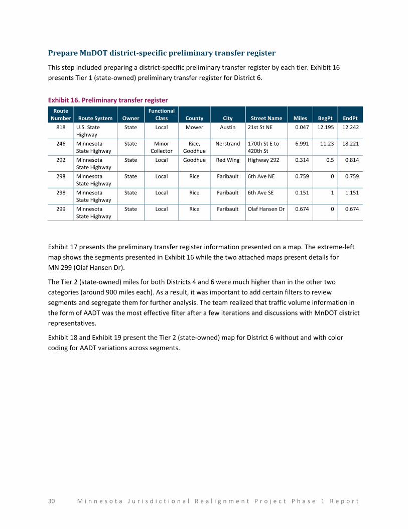
This step included preparing a district-specific preliminary transfer register by each tier. Exhibit 16
presents Tier 1 (state-owned) preliminary transfer register for District 6.
Exhibit 16. Preliminary transfer register
Route Number Route System Owner
Functional Class County City Street Name Miles BegPt EndPt
818 U.S. State Highway
State Local Mower Austin 21st St NE 0.047 12.195 12.242
246 Minnesota State Highway
State Minor Collector
Rice, Goodhue
Nerstrand 170th St E to 420th St
6.991 11.23 18.221
292 Minnesota State Highway
State Local Goodhue Red Wing Highway 292 0.314 0.5 0.814
298 Minnesota State Highway
State Local Rice Faribault 6th Ave NE 0.759 0 0.759
298 Minnesota State Highway
State Local Rice Faribault 6th Ave SE 0.151 1 1.151
299 Minnesota State Highway
State Local Rice Faribault Olaf Hansen Dr 0.674 0 0.674
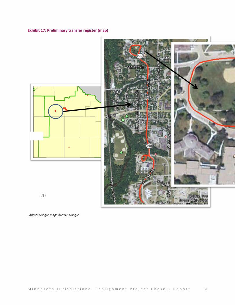
Exhibit 17 presents the preliminary transfer register information presented on a map. The extreme-left
map shows the segments presented in Exhibit 16 while the two attached maps present details for
MN 299 (Olaf Hansen Dr).
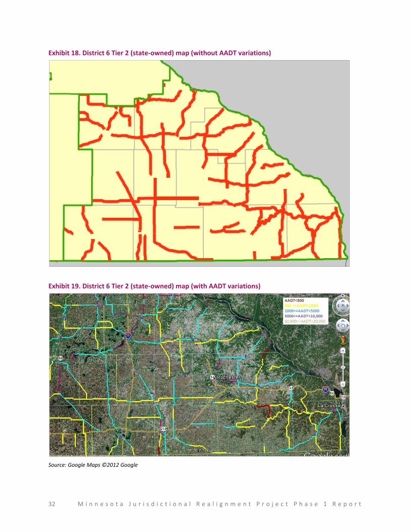
The Tier 2 (state-owned) miles for both Districts 4 and 6 were much higher than in the other two
categories (around 900 miles each). As a result, it was important to add certain filters to review
segments and segregate them for further analysis. The team realized that traffic volume information in
the form of AADT was the most effective filter after a few iterations and discussions with MnDOT district
representatives.
Exhibit 18 and Exhibit 19 present the Tier 2 (state-owned) map for District 6 without and with color
coding for AADT variations across segments.
M i n n e s o t a J u r i s d i c t i o n a l R e a l i g n m e n t P r o j e c t P h a s e 1 R e p o r t 31
Exhibit 17: Preliminary transfer register (map)
Source: Google Maps ©2012 Google
20
32 M i n n e s o t a J u r i s d i c t i o n a l R e a l i g n m e n t P r o j e c t P h a s e 1 R e p o r t
Exhibit 18. District 6 Tier 2 (state-owned) map (without AADT variations)
Exhibit 19. District 6 Tier 2 (state-owned) map (with AADT variations)
Source: Google Maps ©2012 Google
M i n n e s o t a J u r i s d i c t i o n a l R e a l i g n m e n t P r o j e c t P h a s e 1 R e p o r t 33
Review preliminary transfer register with MnDOT district representatives
The project team met with MnDOT district representatives from Districts 4 and 6 to discuss the
preliminary transfer register using a combination of the transfer register tables and maps. The maps
allowed the team to review the segments visually, reviewing segment location, system spacing, and
segment continuity and identifying any alternative routes. The team reviewed various segments to
assess their probability as candidates for transfer using a range of factors mentioned under Step 3 of the
segment identification approach and repeated here:
Road system continuity preferences
System spacing
Roadway speed limit
Location
Minimum length of segment/road
High volume truck traffic
Site of national, state, or local interest
Road restrictions
Traffic volume
Intermodal facilities
The AADT color coding allowed the team to first focus the analysis on segments with low AADT and then
move to other segments. The teams were able to turn various information on and off on the maps
during the analysis/review to understand and analyze the network as a whole and not just in tiers. This
information included showing other roads, points of national/state/local interest, intermodal facilities
and other tier roads.
Discuss approach feasibility and lessons learned
The team discussed the strengths and weaknesses of the approach with MnDOT district representatives
and MnDOT project management staff to determine any adjustments required to the approach. Initial
discussions revealed that while the approach worked very well for Tier 1 segments, analysis of Tier 2
segments required the use of filters. It was agreed after discussions and trials that the AADT filter
provided the most value. Furthermore, it became apparent that the local knowledge of MnDOT district
representatives and other engineers/representatives will be critical to the success of the project, as the
analysis approach is designed to be qualitative to account for various route/traffic differences within the
state. Based on the lessons learned, the identification approach was adjusted and clarified—and the
adjustments have been incorporated in this section of the report.
34 M i n n e s o t a J u r i s d i c t i o n a l R e a l i g n m e n t P r o j e c t P h a s e 1 R e p o r t
Next Steps—Phase 2
The overall project has been divided into two phases. This report marks the end of Phase 1 of the
project and the beginning of Phase 2.
Scope
Phase 2 of the project will focus on implementing the segment identification approach presented in this
phase 1 report, discussing the segments with key stakeholders from various jurisdictions, and obtaining
agreement on transfer candidate segments. The end result of Phase 2 will be a statewide transfer
register that will present all segments that are candidates for transfer based on discussions with
representatives from various districts, counties, cities, and local agencies (realignment teams). Phase 2
will include a broad, order-of-magnitude cost for transfers when possible, including a qualitative
assessment from district/county/city engineers as to whether the road would require a full
reconstruction/rehabilitation or minor repairs before a transfer. The results will also include any policy
implications that may be of importance.
Process
The segment identification process during Phase 2 will include close collaboration with multiple
jurisdictions. The team will prepare preliminary transfer registers for each MnDOT district based on the
approach identified in Phase 1 working with a district champion in each district. The district champions
could be the district planning staff, district engineers, or other district staff member(s). A realignment
team will be formed in each MnDOT district to aid with the segment identification process and will
include collaborating with district champions to identify district participants that will form the
realignment teams. Realignment teams will potentially be comprised of district champion, district
planning directors, MnDOT state aid engineers, select county engineers, select city engineers, and
township representatives. The end result of Phase 2 will be a state-wide transfer register that will
present all segments that are candidates for transfer based on discussions with realignment teams.
Timeline
Phase 2 began in January 2013 and is anticipated to end in May 2013.