Embed Size (px)
Citation preview
1
www.jrc.ec.europa.eu
Serving society
Stimulating innovation
Supporting legislation
18 November 2013
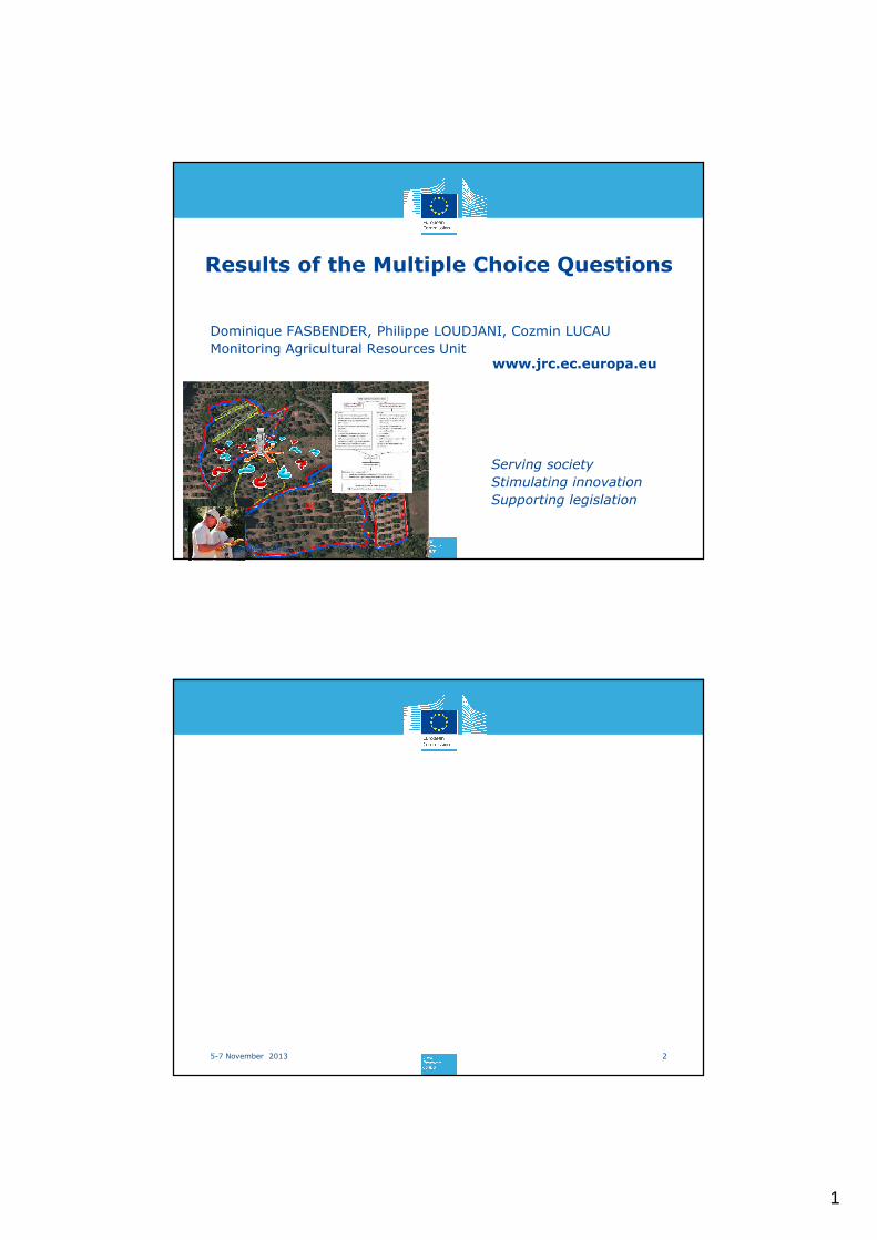
Results of the Multiple Choice Questions
Dominique FASBENDER, Philippe LOUDJANI, Cozmin LUCAU
Monitoring Agricultural Resources Unit
25-7 November 2013
2
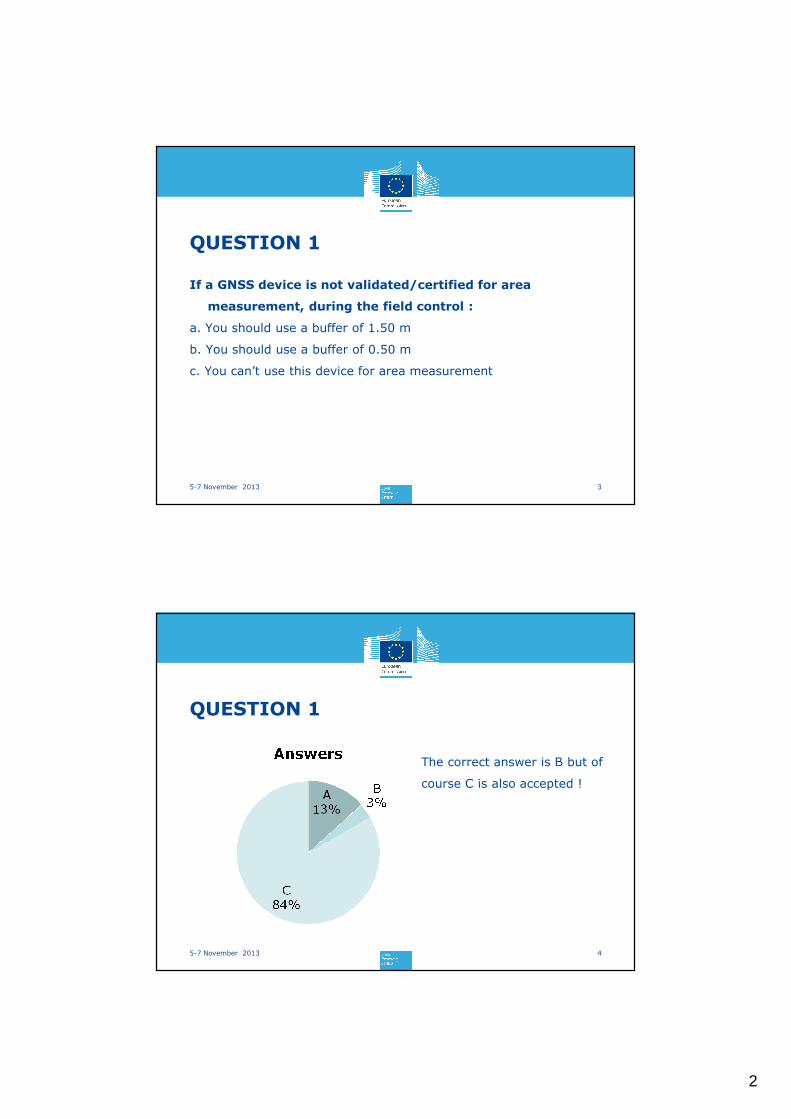
QUESTION 1
35-7 November 2013
If a GNSS device is not validated/certified for area
measurement, during the field control :
a. You should use a buffer of 1.50 m
b. You should use a buffer of 0.50 m
c. You can’t use this device for area measurement
QUESTION 1
4
The correct answer is B but of
course C is also accepted !
5-7 November 2013
3
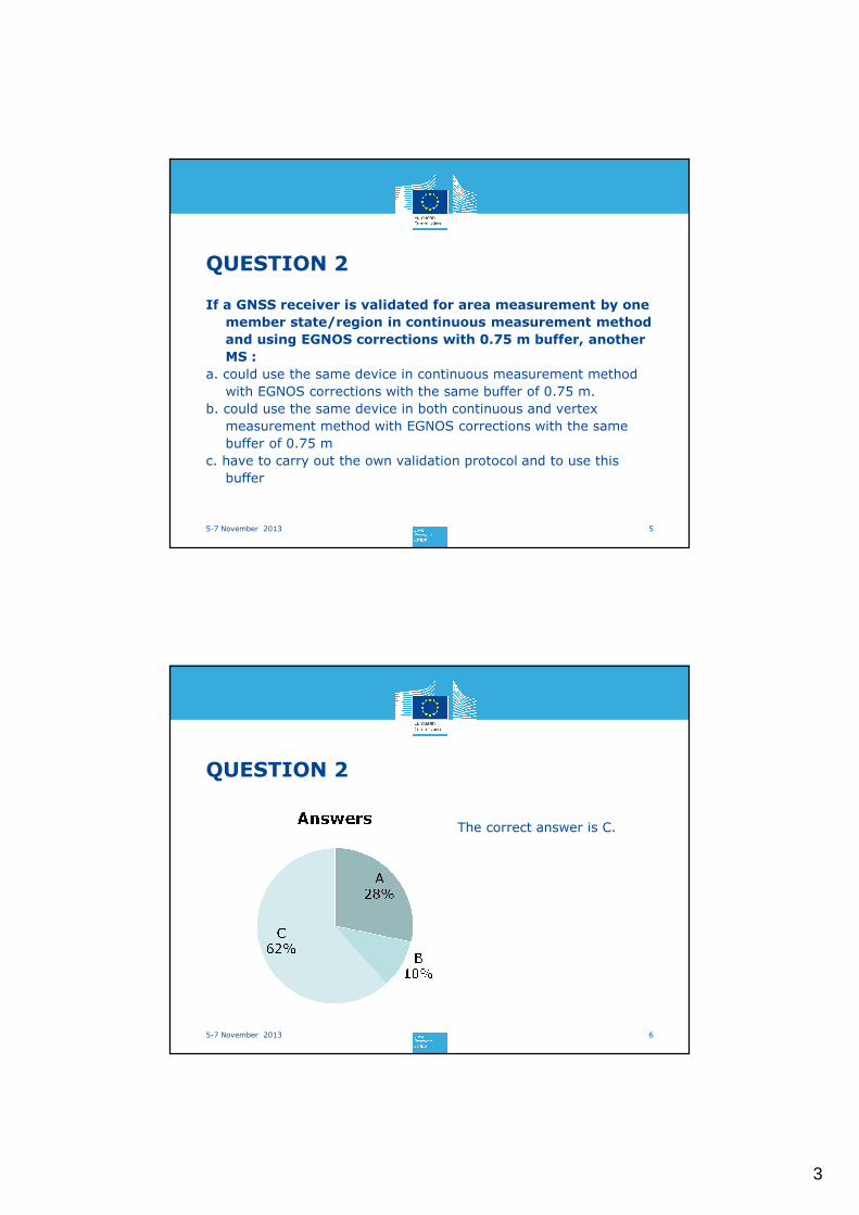
QUESTION 2
5
If a GNSS receiver is validated for area measurement by one
member state/region in continuous measurement method
and using EGNOS corrections with 0.75 m buffer, another
MS :
a. could use the same device in continuous measurement method
with EGNOS corrections with the same buffer of 0.75 m.
b. could use the same device in both continuous and vertex
measurement method with EGNOS corrections with the same
buffer of 0.75 m
c. have to carry out the own validation protocol and to use this
buffer
5-7 November 2013
QUESTION 2
6
The correct answer is C.
5-7 November 2013
4
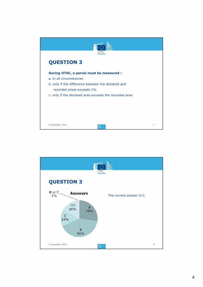
QUESTION 3
7
During OTSC, a parcel must be measured :
a. in all circumstances
b. only if the difference between the declared and
recorded areas exceeds 1%
c. only if the declared area exceeds the recorded area
5-7 November 2013
QUESTION 3
8
The correct answer is C.
5-7 November 2013
5
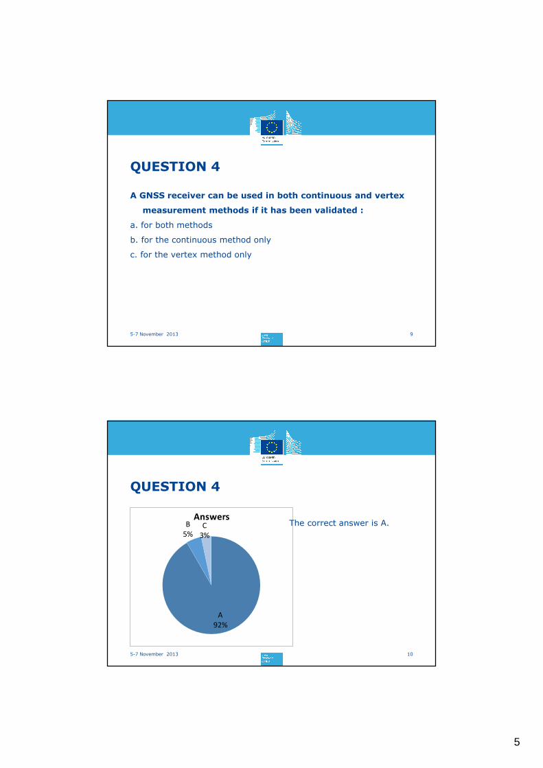
QUESTION 4
95-7 November 2013
A GNSS receiver can be used in both continuous and vertex
measurement methods if it has been validated :
a. for both methods
b. for the continuous method only
c. for the vertex method only
QUESTION 4
A
92%
B
5%
C
3%
Answers
105-7 November 2013
The correct answer is A.
6
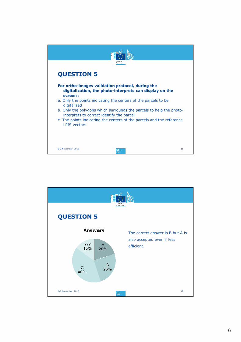
QUESTION 5
115-7 November 2013
For ortho-images validation protocol, during the
digitalization, the photo-interprets can display on the
screen :
a. Only the points indicating the centers of the parcels to be
digitalized
b. Only the polygons which surrounds the parcels to help the photo-
interprets to correct identify the parcel
c. The points indicating the centers of the parcels and the reference
LPIS vectors
QUESTION 5
125-7 November 2013
The correct answer is B but A is
also accepted even if less
efficient.
7
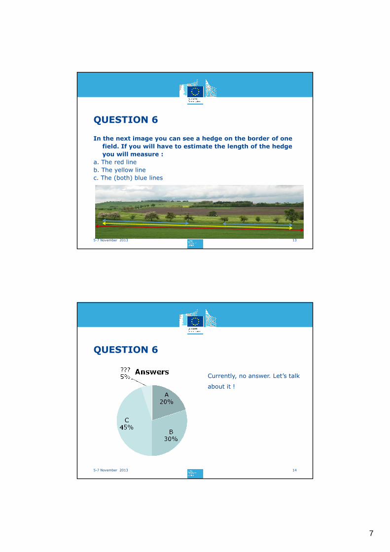
QUESTION 6
135-7 November 2013
In the next image you can see a hedge on the border of one
field. If you will have to estimate the length of the hedge
you will measure :
a. The red line
b. The yellow line
c. The (both) blue lines
QUESTION 6
145-7 November 2013
Currently, no answer. Let’s talk
about it !
8
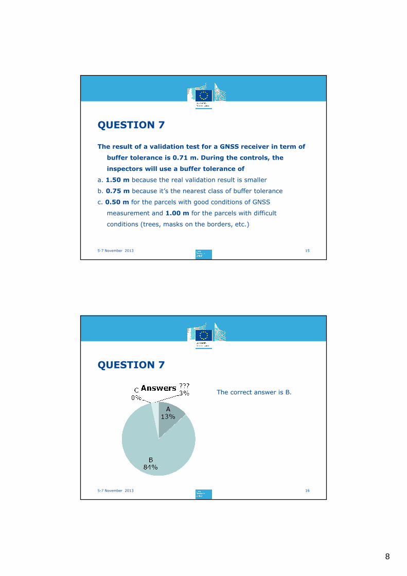
QUESTION 7
155-7 November 2013
The result of a validation test for a GNSS receiver in term of
buffer tolerance is 0.71 m. During the controls, the
inspectors will use a buffer tolerance of
a. 1.50 m because the real validation result is smaller
b. 0.75 m because it’s the nearest class of buffer tolerance
c. 0.50 m for the parcels with good conditions of GNSS
measurement and 1.00 m for the parcels with difficult
conditions (trees, masks on the borders, etc.)
QUESTION 7
165-7 November 2013
The correct answer is B.
9
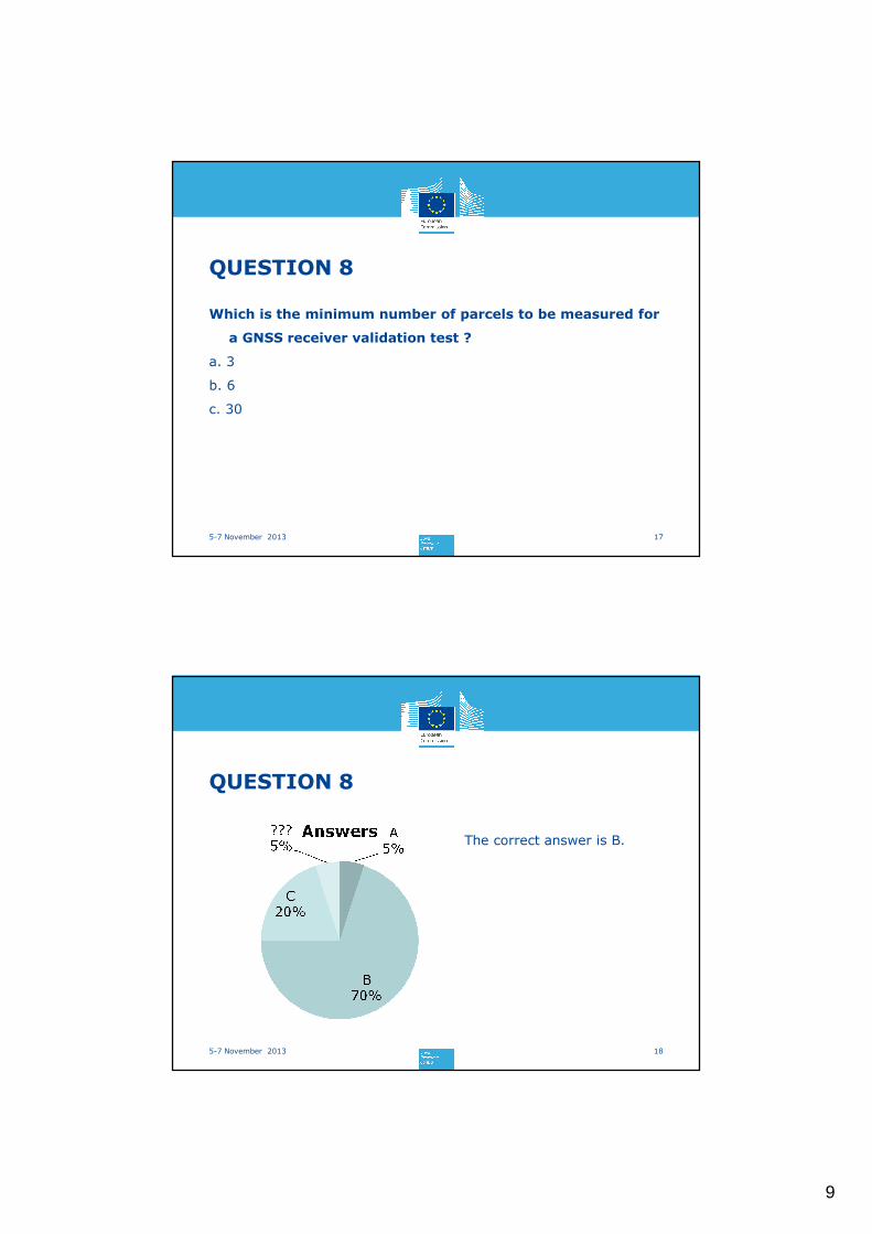
QUESTION 8
175-7 November 2013
Which is the minimum number of parcels to be measured for
a GNSS receiver validation test ?
a. 3
b. 6
c. 30
QUESTION 8
185-7 November 2013
The correct answer is B.
10
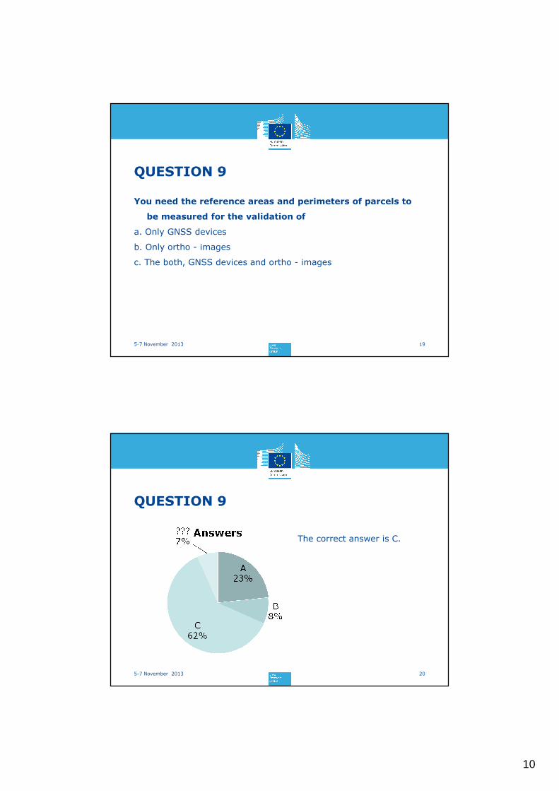
QUESTION 9
195-7 November 2013
You need the reference areas and perimeters of parcels to
be measured for the validation of
a. Only GNSS devices
b. Only ortho - images
c. The both, GNSS devices and ortho - images
QUESTION 9
205-7 November 2013
The correct answer is C.

11
QUESTION 10
215-7 November 2013
Which is the minimum number of parcels to be measured for
a ortho-image validation test ?
a. 3
b. 6
c. 30
QUESTION 10
225-7 November 2013
The correct answer is C.
12
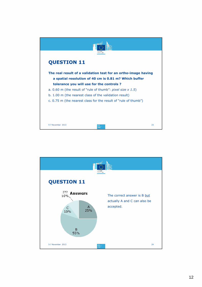
QUESTION 11
235-7 November 2013
The real result of a validation test for an ortho-image having
a spatial resolution of 40 cm is 0.81 m? Which buffer
tolerance you will use for the controls ?
a. 0.60 m (the result of “rule of thumb”: pixel size x 1.5)
b. 1.00 m (the nearest class of the validation result)
c. 0.75 m (the nearest class for the result of “rule of thumb”)
QUESTION 11
245-7 November 2013
The correct answer is B but
actually A and C can also be
accepted.

13
25
Thank you!
Dominique FASBENDER, Philippe LOUDJANI, Cozmin LUCAU