Embed Size (px)
Citation preview

Naval Facilities Engineering Command Southwest BRAC PMO West San Diego, CA FINAL RESTORATION ADVISORY BOARD (RAB) MEETING MINUTES FORMER MARE ISLAND NAVAL SHIPYARD VALLEJO, CALIFORNIA May 31, 2018
Approved for public release: distribution is unlimited

Final MINS RAB Meeting Minutes 1 May 31, 2018 TTEM-9008-FZ01-0012
FINAL MARE ISLAND NAVAL SHIPYARD Restoration Advisory Board (RAB) Meeting Minutes May 31, 2018
The Restoration Advisory Board (RAB) for former Mare Island Naval Shipyard (MINS) held its regular meeting on Thursday, May 31, 2018, at the Mare Island Conference Center, 375 G Street, Vallejo, California. The RAB meeting started at 7:07 p.m. and adjourned at 9:39 p.m. These minutes contain a transcript of the discussions and presentations from the RAB Meeting.
RAB Community Members in Attendance:
• Myrna Hayes (Community Co-Chair) • Carol Philips
• Paula Tygielski
RAB Navy, Developers, Regulatory, and Other Agency Members in Attendance:
• Janet Lear (Navy Co-Chair) • Valerie Harris (Navy Lead Remedial Project
Manager) • Brooks Pauly (Navy Remedial Project
Manager) • Gavin McCreary (Department of Toxic
Substances Control [DTSC]) • Ron Gerber (City of Vallejo)
• Elizabeth Wells (San Francisco Bay Regional Water Quality Control Board [Regional Water Board])
• Alison Mathews (Regional Water Board) • Neal Siler (Lennar Mare Island) • Horus Nelson (Lennar Mare Island) • Dwight Gemar (Weston Solutions)
Community and Other Guests in Attendance:
• Chip Gribble • Fred Ousey
RAB Support in Attendance:
• Carolyn Hunter (Tetra Tech) • Doris Bailey (Stenographer)
• Wally NeVille (Audio Support)
I. WELCOME AND INTRODUCTIONS (Myrna Hayes [Community Co-Chair] and Janet Lear [Navy Co-Chair])
CO-CHAIR LEAR: All right. Let's go ahead and get started. Welcome, everyone, to the Mare Island Restoration Advisory Board. We usually start our meetings with introductions. My name is Janet Lear, I'm the Navy Co-Chair.
CO-CHAIR HAYES: And I'm Myrna Hayes, and I'm the community Co-Chair, and I live here in Vallejo.
And I think this is 24 years of being the Co-Chair. I wasn't in April when we first started, they put me up to that later.

Final MINS RAB Meeting Minutes 2 May 31, 2018 TTEM-9008-FZ01-0012
MS. WELLS: I'm Elizabeth Wells with the San Francisco Bay Regional Water Quality Control Board.
MS. MATHEWS: I'm Alison Mathews with the San Francisco Bay Regional Water Quality Control Board.
MS. HARRIS: I'm Valerie Harris, the Lead Remedial Project Manager for Mare Island.
MR. GEMAR: Dwight Gemar with Weston.
MS. PAULY: Brooks Pauly, Remedial Project Manager with the Navy.
MR. GRIBBLE: Chip Gribble. I'm a community resident.
MR. OUSEY: Fred Ousey with Enviro-Tech Services.
MR. SILER: Neal Siler, Lennar Mare Island.
MS. TYGIELSKI: Paula Tygielski, community member of the Restoration Advisory Board, resident of Benicia.
MS. PHILLIPS: I'm Carol Phillips. I'm also a community member of Vallejo.
MR. MCCREARY: Gavin McCreary. I'm with the Department of Toxic Substances Control.
MR. NELSON: Horus Nelson, Lennar Mare Island.
MR. GERBER: Ron Gerber, City of Vallejo, Economic Development.
CO-CHAIR LEAR: Okay. I think we've made the rounds.
Our first presentation tonight is the Western Early Transfer Parcel Third Five-Year Review. And Dwight Gemar with Weston Solutions will be giving the presentation.
II. PRESENTATION (Dwight Gemar [Weston Solutions]) Western Early Transfer Parcel Third 5-Year Review
MR. GEMAR: Okay. Thanks everybody for coming out tonight. So this is the third five-year review for what's known as the Western Early Transfer Parcel.
And so I want to first describe what a five-year review is, and then we'll provide a little bit more information on what part of the island we're talking about.
So a five-year review is required whenever contamination remains on a site that doesn't allow for unrestricted use. And these reviews are conducted according to the Comprehensive Environmental Response, Compensation, and Liability Act, which is also known as Superfund. And also the National Oil and Hazardous Substances Pollution Contingency Plan, or the NCP plan, are two federal regulations that require this five-year review.
The purpose of the five-year review is to determine if the remedy that was selected during the investigation work and follow-on cleanup was done in a way that is protective of human health and the environment, and whether that remedy is still effective.
So we've gone through this for this particular part of the property, the Western Early Transfer Parcel, twice before.
CO-CHAIR HAYES: Wow.

Final MINS RAB Meeting Minutes 3 May 31, 2018 TTEM-9008-FZ01-0012
MR. GEMAR: And so, again, this is the third five-year review. It's hard to believe it's been 15 years.
So on this map we're actually off the end of the map here. But this is the western half of the island essentially. And it consists of about 2,800 acres on -- the far western edge is the -- what's known as the western submerged lands. These are basically mudflat areas as well as land -- or waters of the state, and basically San Pablo Bay.
And then adjacent to that is what's known during the cleanup investigation time frame as Investigation Area J. This is basically tidal wetland.
And then these other parts are known as part of Investigation Area I. And those are actually former dredge ponds. And the dredge pond is basically part of the island where berms were pushed up and sediment from the Napa River, basically Mare Island Strait, was pumped. In order to keep the ship channel depth to what they needed for the ships, it was pumped into those dredge ponds. The sediment was allowed to settle out, and the water would decant and flow out into the tidal wetlands.
So those areas were originally tidal wetlands back in the 1800s, but eventually, due to this process of collecting dredge sediment, those areas became land.
So I went through already the introduction of Investigation Areas I, J, and the western submerged lands. Again, we're talking about 2,800 acres, give or take.
The two main concerns that were investigated and the remedy addressed were munitions and explosives of concern, and also the low-level radiological items -- and I'll get into that in a little bit more detail.
But these munitions and radiological items were discovered within the Western Early Transfer Parcel. And a lot of effort had to be undertaken to investigate where those items actually were and to remove them.
And then also in the dredge ponds themselves primarily, and to a lesser degree the tidal wetlands, based on sediment sampling, there were some indications that the surface water in those dredge pond areas had chemical concentrations above what they call screening criteria for human health. And screening criteria are basically just no adverse effect levels that regulators and the scientific community developed for different contaminants. So it was determined that the surface water in the dredge ponds exceeded those criteria.
And then also soils and sediments were above screening levels for ecological receptors, which are birds and small mammals, et cetera.
But in the process of doing the investigation it was determined that the property did not pose a significant enough risk that it could not be transferred while the remaining environmental work was completed. And so in 2002 the property was transferred from the Navy to the State Lands Commission of the State of California. And that was called an early transfer because the property transferred before the cleanup was actually completed. So that's why this property is known as the Western Early Transfer Parcel.
And that's allowed under CERCLA. Of course, you have to go through a lot of hoops to do that, and ultimately it has to be approved by the Governor in order for that property to be transferred before the cleanup is done -- and in this case the Navy also had to provide assurances that the cleanup will occur in a timely manner.

Final MINS RAB Meeting Minutes 4 May 31, 2018 TTEM-9008-FZ01-0012
So what we're going to talk about tonight is basically the evaluation of the remedy -- basically the work that was done to clean up this property over the past five years from 2012 to 2017.
CO-CHAIR HAYES: Can I ask a question?
MR. GEMAR: Sure.
CO-CHAIR HAYES: We're virtually at -- I mean, tomorrow will be June of 2018.
MR. GEMAR: Uh-huh.
CO-CHAIR HAYES: Why did we wait a year to do this -- was it documentation -- you know, doing the next five?
MR. GEMAR: Right. Yeah. I mean, we go the five years, and then basically, based on the data that's collected over those five years, then we start the documentation to do the review, and that takes a while to go through that study and reporting. And then, of course, it gets reviewed.
And so ultimately one of the purposes for this meeting tonight is to inform the public as to the work that's been done to evaluate the effectiveness of the cleanup, and to solicit any concerns or comments that we can then incorporate into the final version of a document that we write for this five-year review.
So again, the primary concerns of this property were the munitions and radiological items. And this dredging that I mentioned, you can see this network of pipes that were connected to in order to take the dredge sediment from Mare Island Strait and pump it to these dredge ponds.
And these kind of circles that you see in the picture, that was basically the end of the pipe where the sediment, or the mud basically, and the slurry would be discharged.
And then, again, the slurry would be allowed to settle out -- their sediments would be allowed to settle out, and the water would decant through weirs on the opposite side of the ponds from the outfalls, and then eventually be conveyed out into the western -- or the submerged lands.
CO-CHAIR HAYES: This is just a little bit of trivia for you. But my first visit to Mare Island was to go with the engineer for the Navy in charge of managing those ponds, and Betsy Radtke, the U.S. Fish and Wildlife Service refuge manager, San Pablo Bay Refuge.
And I have a photo somewhere of my red boot kicking one of those weir boards off long before I was on the Restoration Advisory Board. It was a memorable day.
MR. GEMAR: And, in fact, you were probably out there by Dredge Pond 5N?
CO-CHAIR HAYES: No.
MR. GEMAR: Uh-oh.
CO-CHAIR HAYES: More like Dredge Pond 2M.
MR. GEMAR: They weren't in Building 505 back in those days?
CO-CHAIR HAYES: Nope.
MR. GEMAR: Okay.
CO-CHAIR HAYES: Before that.
MR. GEMAR: That was kind of getting back there in those days.

Final MINS RAB Meeting Minutes 5 May 31, 2018 TTEM-9008-FZ01-0012
CO-CHAIR HAYES: Way back.
MR. GEMAR: So the initial response was done starting back in the 1990s when it was first determined that the dredge material had things in it, more than just mud. And it was determined that when the ships would dock at Mare Island, that oftentimes the sailors would chuck overboard things that they didn't want; which could be cutlery, or it could be a piece of munition, or it could be a radioactive-type item like a luminescent deck marker.
And so when those things were chucked overboard, the dredger then would come through and suck it up, along with the mud, and it would get pumped out to the dredge ponds. So ultimately, where we found these items was at these outfalls.
And a series of investigations was undertaken over the period from the mid-1990s through the early 2000s time frame to investigate these outfalls, as well as the interior of the dredge ponds and the associated levees, and remove items that could be a munition or radiological item.
And that was done by using a series of studies, using magnetometers to detect buried metal, and then going through the process of digging up these locations, which were called anomalies, because they would pick up an anomaly in the magnetic readings based on the metal item, and then you would dig it up.
And oftentimes it would be nothing more than just metal debris or trash of some type. But obviously a number of MEC [munitions and explosives of concern] items were recovered, almost exclusively all at those outfall locations. They were heavy so they would tend to drop out right at the end of the pipe, and they would tend to congeal into kind of a rusted mass, and that was how those items were ultimately found.
The radiological items, again they do have a metal backing typically, and so they also would be able to detect those. But once they knew that there were some radioluminescent type radiological items out there, they also used Geiger counter-type detectors to locate those radiological items, and also by visual observation as well.
The main effort was done in 1998 to 2001.
And then in 2001 to 2002 there was one additional survey done just as a confirmation that the previous work was effective. And although MEC items were still recovered, only eight items were recovered at that point compared to, obviously, a much larger number prior to that.
So this is kind of an extreme example, but this is one of the outfall masses that was essentially dug out of the dredge pond.
Again, this is just a big mass of rusted metal, but interspersed within that metal was oftentimes a munition or a radiological item.
And in this case, an excavator would be used to help to break apart this mass. And you can kind of see, it's a little shiny here, but there's a plexiglass shield that's put in front of the excavator in case that an item would detonate while they were breaking it apart with the thumb of the excavator. Fortunately, that's never occurred, but nevertheless that's a safety precaution that is taken to protect the operator.
CO-CHAIR HAYES: And if you want to see some of the non-munitions items that were recovered in those masses, we have a small collection at our visitor center on the Mare Island

Final MINS RAB Meeting Minutes 6 May 31, 2018 TTEM-9008-FZ01-0012
Preserve, the collection of one of the UXO [unexploded ordnance] technicians who shared it for education purposes. It makes it much more graphic to show.
We don't have any munitions items out of that, but we do have some non-munitions items like bottles and things, silverware, things like that.
MR. GEMAR: And this is also an example of the geophysical survey equipment that was used to survey the levees and the dredge pond bottoms. The detectors are along this cart. And it has a geo positioning system receiver, GPS. And as the operator drives along, the instrumentation collects both geophysical data as well as position data, and then it's all downloaded, and a geophysicist will look at the data and correlate it to things that could be a buried item. And then based on the navigational information, they know exactly where to go to go back and dig it up.
So that was done for all of the levee tops, a sampling of the levee bottoms, and all of the outfall areas.
So based on all that work, and in addition to soil sediment sampling, et cetera, a decision document was approved in 2002.
And I should have spelled it out in this first bullet, but RAP stands for Remedial Action Plan.
And that was approved by the Department of Toxic Substances Control in 2002.
Some folks in the audience had a fair amount to do with that.
But in addition to the work that was done, there was a need to still have some controls over access to the property. And that's partly because, although these detectors do a good job of finding munitions items, they're not 100 percent foolproof because the ability to detect a buried metal item varies based on the size of the item and the depth. So if a small item is a little bit deeper, you're probably not going to be able to detect it.
Therefore, it's prudent in this case where munitions items have been found, to have some institutional controls over the future use of the property.
And in this case, for the Western Early Transfer Parcel, that includes the requirement that there be no residences built on the property, and no schools, hospitals, or daycares.
Also, the groundwater on Mare Island is not really usable because of its salinity, and also the clay nature of the soil is such that the ability to extract groundwater is very limited. Nevertheless, part of the requirement is to not disturb the groundwater at this site.
Also, without having approval of the Department of Toxic Substances Control, soil disturbance is not allowed, again because of the potential for uncovering a munitions item.
Now, it can be done with prior approval and with appropriate oversight from a trained observer who understands munitions. And certainly, Weston has those folks that can provide that oversight.
In addition, there were some engineering controls that were applied. One of the activities that was performed was to put a 2-foot thick soil cover along the eastern side of the levees. And those are the sides of the levees that are closest to the residential areas. Basically, the concern was that residents could be accessing the levees based on the proximity. I've never seen it. Nevertheless, that 2-foot soil cover was added to the outboard side of the levee adjacent to those residential areas.
Final MINS RAB Meeting Minutes 7 May 31, 2018 TTEM-9008-FZ01-0012
We have some fencing around the perimeter, and also some natural boundaries, and we have signage at frequent intervals.
And then one of the things that we were required to install is a public access trail. And the reason for that was there was, obviously, a desire for people to be able to access the western side of the island, partly because it's got great views. The cover photo on the handout is basically the tidal wetlands from the trail. So it's a beautiful view of Mt. Tamalpais and other surrounding areas.
And so a lot of people, Myrna included, fought very hard to allow for public access in the property. In order to do that, the regulators felt that it was important to provide for a safe access route, again on the off-chance that there are munitions items that could be encountered otherwise, and to discourage trailblazing.
So this public access trail was part of the remedy, actually, and was installed in the property. And I'll show an alignment of that here in a moment.
And then also initially there was sediment monitoring that was part of the requirement within the dredge ponds and at the exit weir where the water drains to the tidal wetlands. And that was done annually just to determine if there was any change in the concentration of contaminants.
And then also visual inspections of the levees and the outfalls of the trail.
And signage was also part of the remedy. Again, just to make sure that those things were intact; and also to look for things, like erosion and whatnot, that could potentially expose an item that was missed during previous removal actions.
So during the first five years of the time period after the Remedial Action Plan was approved in 2002, a number of things occurred. Of course, the quarterly monitoring was performed. One munitions item was located on a levee top back in 2003 during one of those inspections. And that's the only one that's been found in the 15 years of inspections.
The quarterly boundary inspection of signage. Of course, it needed some minor repairs during this time period.
The sampling, of course, was performed, but no trend in the contaminant concentrations was observed.
And then also during this period, of course, we completed the 2-foot soil cover of that outboard levee on the east side. You can, again, see the new homes that were being built back in that time frame. A lot more now.
CO-CHAIR HAYES: Dwight, can I also mention that -- and you can correct me, and Brooks is here too -- but it's my understanding that, to date, we've never found anything, a munitions item fired, fuzed, or armed?
MR. GEMAR: That's correct. All the munitions items have been classified as discarded military munitions or DMM.
CO-CHAIR HAYES: So there weren't training ranges where duds or UXO might have ended up where somebody might have left their backpack behind, or lightened their backpack --
MR. GEMAR: Yes.
CO-CHAIR HAYES: -- on this particular property on Mare Island?

Final MINS RAB Meeting Minutes 8 May 31, 2018 TTEM-9008-FZ01-0012
MR. GEMAR: That's right. Correct. The trail installation actually occurred in the second five-year review, because we were doing a lot of remediation work adjacent to the former landfill that's out near the property. But as soon as that work was wrapped up, the trail was installed. And again, the quarterly inspections were continued as well.
And this is a picture of one of the overlooks. And a series of interpretive signage is also part of the trail, just to give people history or talk about the history of Mare Island, and also talk about the origin of some of the hazards that were addressed, munitions items, et cetera. And flora and fauna type of information.
So the trailhead is at the end of what is lovingly referred to as Dump Road.
And then you can go out around what is called the containment area, which is the former landfill area. And then also you can go out along the western levee. It's about 2 miles out to the end and back, so about a 4-mile roundtrip if you go out to the far end of the trail.
And again, it has expansive views of the bay and Marin County, Contra Costa County, Solano County, and Napa County. So you get a nice view out there on a clear day. I highly recommend it.
Also as part of the second five-year review, there were some adjustments recommended and ultimately accepted by the regulators.
One was based on nearly 10 years of sampling data. There was no indication of any change to the contaminant concentrations in the ponds or at the weirs, so it was allowed that that work or that sampling could be discontinued given the lack of any change.
Also the frequency of the inspections, given the fact that a munitions item hadn't been seen since 2003, and now we're at 2012, that the frequency was reduced to every five years or if there was a major rain event, which was determined or set at a five-year rain event, which is equivalent to 2.6 inches in 24 hours or five inches of rain over five days. So pretty hard rain.
It does happen, you know, on average about every five years. So if that event occurs before the five years are up, then the levees have to be inspected for any potential for erosion which could uncover a munitions item.
And also there, as seen in the pictures, there's a lot of pretty robust vegetation on the levees and at the outfalls. And that certainly, (a) helps to minimize erosion; and –(b) it helps to minimize the potential for people to trail blaze, and encourages people to stay on the trail, which is where we want them to be.
So going into the third five-year time period, which is the focus of our discussion today, that occurred from the third quarter of 2012 through the second quarter of 2017.
Again, the quarterly monitoring of the trail and the entry point signage has continued. And from time to time there is some minor maintenance that's required, either dressing up the trail or fixing or reattaching loose signs or signs that fall down.
There has been a five-year event in that time period back in 2014. There was some minor erosion out at the trail, and so that was repaired.
And then also the levee tops were inspected a few days later; again, to look for potential erosion issues, and see if any munitions or radiological items could be detected, which was not the case.

Final MINS RAB Meeting Minutes 9 May 31, 2018 TTEM-9008-FZ01-0012
And then a five-year inspection, again of the levees, took place in March of 2017. Again, no RAD or -- radiological or munitions items were recovered, and no erosion issues observed.
And then a checklist, obviously, was also completed in July of 2017 which focuses on the site, but also on some of the administrative requirements; inspection records, documentation, compliance with institutional controls, et cetera. And that becomes part of the five-year review report.
So based on the inspections that have been performed over the last five years, and the five-year inspections of the levee tops as well as the administrative activities that -- basically from a remedy protectiveness standpoint, the conclusion of the report that has been prepared as a draft at this point is that the trail -- the remedy is functioning as intended, and specifically the trail is providing safe access for the public.
Levee outfall inspections have shown that there's no munitions or radiological items being uncovered due to the vegetation and lack of erosion. And that there are no obvious physical changes that have been observed.
There's been no land use change, of course. No violation of institutional controls.
And given that, things have been fairly static and working. Therefore, we are not recommending any change to the current inspection frequency, it is still going to be quarterly for the trail and for the signage, and then a five-year inspection for the levees or after a five-year rain event.
So the recommendation is just to basically maintain the status quo in that regard.
As part of the five-year review there is an effort to try to obtain participation and comments from the public. There was a public notice provided in the Vallejo newspaper in February of this year indicating the start of this review process.
A draft document was prepared in that same month, and it's available for review.
And then finally, during this meeting or any time after this meeting, you can provide comments, either written or verbal. And written comments would go to Gavin, the DTSC project manager, and his contact information is provided here as well.
So we encourage folks to bring up any questions or concerns at this meeting that we would have record of based on the transcripts, and then we can address those concerns or questions as part of the final review or the preparation of the final version of that document.
And we hope that probably by July we could issue a final five-year summary report for this time period.
So with that, this picture is the grand opening of the trail, many dignitaries showed up.
CO-CHAIR HAYES: There's Dwight.
MR. GEMAR: Including former DTSC project managers, the Navy, mayor, folks that had been on this Restoration Advisory Board for a while, and a few people from Weston Solutions.
Happy to entertain any questions or comments on the presentation.
CO-CHAIR HAYES: I just want to give some kudos because I know -- boy, do I recall -- this was a long, long, long process of convincing the Department of Toxic Substances Control to allow this as a remedy for the landfill, or a component of the remedy for the landfill.
Final MINS RAB Meeting Minutes 10 May 31, 2018 TTEM-9008-FZ01-0012
We spent our visits in Sacramento with the highest level of DTSC. And we were always welcomed and encouraged to participate in the process.
And I know it was partly just the tremendous team that we had put together, that we had assembled.
And I'm very proud -- something Dwight's probably too modest to say, and maybe Janet -- but I think it's very cool that in 2011 this project was selected as the Chief of Naval Operations Best Environmental Cleanup Project in the Navy under their control. And it went on to compete amongst other sites in the country, in the world.
And the Secretary of the Navy selected it as the best project, Environmental Cleanup Project for 2012.
And then ultimately that put it in the running for the Secretary of Defense. And we swept all three awards.
MR. GEMAR: It was a hat trick there.
CO-CHAIR HAYES: So I'm very, very, very, very proud of the accomplishment that we were able to achieve, you know, simply because we have this forum, really.
We had tremendous people from DTSC, from Weston, from the Navy, and from our community, but it's because we packaged ourselves together in these monthly -- at that time monthly -- meetings, that we were able to gain a sense of trust and respect for each other, and move through a really arduous process.
Putting a RCRA [Resource Conservation and Recovery Act] landfill to bed is not a simple job. And providing for public access as part of a remedy for munitions exposure is not a simple job.
And I'm very proud of the whole team. And that was the most exciting day right there for us.
There's councilwoman Marti Brown.
I can see assistant city manager Craig Whittom in the background.
If you don't know John, there with the kind of long hair, I sometimes say he's Prince Valiant. But he really is. He rides about 8 miles every Saturday and Sunday to open up our preserve visitor center until I get there. And he's just always been a supporter from the community too.
So thank you.
MR. GEMAR: Appreciate that, Myrna.
Sir.
MR. OUSEY: I just have a question. How long do these five-year reviews go on?
MR. GEMAR: Until the regulators say they don't. Unless the contaminants have been removed, and if they still remain above the unrestricted use criteria, it's my understanding that these five-year reviews have to continue. I'm not sure there is an end.
CO-CHAIR HAYES: Unless sea level rise rises over 14 feet above the current level and we can't get out there, I suppose.
MR. GEMAR: Yeah. The levees are at 20 feet so, yeah, I think we're safe.
CO-CHAIR HAYES: Woah, I said 14, what do I know?

Final MINS RAB Meeting Minutes 11 May 31, 2018 TTEM-9008-FZ01-0012
MR. GEMAR: Yes, Mr. Gribble.
MR. GRIBBLE: May I make a comment?
MR. GEMAR: Yes.
MR. GRIBBLE: I've been out there a couple of times in the last few years, and I have to say it's particularly impressive how well maintained it is. I assume that's Weston; is that right?
MR. GEMAR: Yes.
MR. GRIBBLE: It's beautiful. It's worth the walk.
Number two. Yes, I think it was remarkable that the community and the Navy and Weston and everybody participated in what was a pretty good outcome.
And number three. I think the regulator that did the job was remarkable. They just -- whoever that was.
CO-CHAIR HAYES: That's good.
MR. GEMAR: Anything else?
MR. GRIBBLE: Seriously, I think it's encouraging to see that in the process there is a dialogue that is entertained about modifications to the five-year review. I think that is an important piece that is not often given its due.
Ideas to improve it, ideas to simplify it -- things change, perspectives change, and I would really encourage people to use that robustly going forward, regulators, advocates, or contractors, RPs [responsible parties].
MR. GEMAR: Thank you very much.
CO-CHAIR LEAR: Thanks, Dwight.
Okay. Our second presentation for the evening will be given by Horus Nelson with Lennar Mare Island. He's going to talk about Additional Characterization Results and Path Forward for Building 116, PCB Site UL01, in Investigation Area C2.
III. PRESENTATION (Horus Nelson [Lennar Mare Island]) Additional Characterization Results and Path Forward for Building 116 PCB Site UL#01 in Investigation Area C2
MR. NELSON: Hello, everyone. I'm Horus Nelson. I'm here on behalf of Lennar Mare Island. And this evening I'm going to be speaking about the Additional Characterization Results and Path Forward at Building 116, Polychlorinated Biphenyl Site, Unknown Location 01 (UL#01) in Investigation Area C2.
Some of you may recall the last time we presented on this site was November 30th, 2017. The time before that was July 25th, 2013. And we had a RAB tour last year on August 17th where we visited the site and we took everyone inside and had a look around.
Building 116 is in the historic core of Mare Island. It is a site with known elevated concentrations of polychlorinated biphenyls and total petroleum hydrocarbons as diesel and motor oil that are above the cleanup goals for the site.

Final MINS RAB Meeting Minutes 12 May 31, 2018 TTEM-9008-FZ01-0012
Tonight's presentation. We're going to give a little bit of description of the site itself.
We're going to talk about some of the historical investigations and remedial activities that have taken place there; some of the recent characterization activities that have taken place; results of those characterization activities; and our path forward based on those results.
We'll have a section at the end devoted to any questions you may have. But if anything comes up during the presentation, please feel free to chime in and ask.
So here's a site map showing the general location of Building 116. Again, it's in the northern portion of Investigation Area C2. There's an exterior photo showing the eastern side of the building.
Here's a closeup site map showing the building itself and the surrounding areas. For reference, at the very top of your figure there, Building 46, is the Mare Island Museum, to give you an idea of the location.
Railroad Ave is there on the western side, and Nimitz Ave.
And you can see Dry Docks 1 and 2 on the far right-hand side of your figure there.
These are some interior shots showing the interior of the building. On the top left there you can see the long narrow A-frame structure.
On the right is a view looking in the opposite direction at the former tool crib location.
At the bottom there we've got a closeup of some of the wood block flooring that's pervasive throughout the building, and covers a majority of the flooring that exists in Building 116.
As mentioned, it's in the northern portion of Investigation Area C2.
It's an industrial/commercial property.
Two-story building. It's roughly 45,000 square feet. The building's constructed of wood and metal, and it's on an asphalt and concrete foundation. The surrounding roadways and parking areas are also asphalt and concrete.
Historically, the building was constructed in 1905, and it was used as a sheet metal operation building as well as a welding shop.
And that continued until 1973 where the sheet metal operations were transferred northward to Building 1310, which some of you may know is currently the location of Film Mare Island -- they have some soundstages set up in that building.
From 1973 to base closure, Building 116 acted as an auxiliary sheet metal shop as well as ship fitting operations, which makes sense given its proximity to the building ways as well as the dry docks to the east.
The future use of the building, according to the 2000 land use plan, is also for commercial and industrial usages.
A little bit about some of the historical investigations and remedial activities that have taken place.
Back in 1995, the Navy conducted characterization sampling throughout the building in areas where there were machinery and heavy equipment. They also addressed areas where there were heavily stained locations that had seen previous industrial activity.

Final MINS RAB Meeting Minutes 13 May 31, 2018 TTEM-9008-FZ01-0012
Samples were collected from these areas. Pieces of machinery and equipment were removed from the building as a result.
In 2014, additional characterization activities took place. Samples were collected from the wood blocks in the former tool crib area of the building.
In 2013, additional samples were collected along a 40-foot grid throughout the flooring of the building. They collected samples of the wood block floor, the asphalt, concrete floor surfaces, as well as underlying concrete floor beneath the wood block flooring.
The samples that were collected were analyzed for PCBs [polychlorinated biphenyls] as well as total petroleum hydrocarbons, or TPH, D for diesel, and M for motor oil.
Results of those samples showed that there were exceedances of the cleanup goals in the wood block flooring, the concrete and asphalt floor and subfloor, as well as some of the areas where they had collected samples from the heavily oil stained areas.
Soil samples that were collected beneath the concrete and asphalt floors showed no exceedances of PCBs or TPH at the time those samples were collected.
So as we fast forward to 2017, Lennar Mare Island submitted a sampling and analysis plan for review to the Department of Toxic Substances Control to address and understand -- expand upon our current understanding of the level of contaminants that existed in the building. So there were a number of areas that hadn't previously been sampled prior to that point.
The sampling and analysis plan was approved in October of 2017.
We implemented that sampling analysis plan in March of this year, 2018.
However, prior to going back in there and collecting additional samples, there were a number of interior structures that needed to be abated and demolished prior to getting back in there and collecting samples.
If you were on the RAB tour last year, you may recall there were some isolated structures, kind of interspersed throughout the building. There was the former tool kit area and a few isolated structures throughout the building that we needed to remove, demolish, and get out of the way so we could expand upon the 40-foot grid, gain access to the flooring, some of the support columns, and wall locations throughout the building.
In total, we collected over 530 discrete samples throughout the building. I'm not going to itemize this entire list, but we collected additional samples from the concrete asphalt and subfloor;
We took step-out samples along the 40-foot grid;
We collected concrete strip samples that run along the length of the building;
Isolated concrete islands and other areas on the wall;
And there was a storm drain Why we had a storm drain on the interior of a building is anyone's guess -- however, we collected samples from there;
As well as beneath a T-slot that existed in the building that previously supported heavier machinery.
The samples that were collected were analyzed for PCBs and TPH as diesel and motor oil.
Final MINS RAB Meeting Minutes 14 May 31, 2018 TTEM-9008-FZ01-0012
Samples that were collected beneath the T-slot pit were analyzed additionally for organochlorine pesticides and Title 22 metals.
Historically we've found exceedances in pit areas for pesticides and metals. It's thought that some of the machinery and equipment work that's done in that area can release metal shavings that somehow find their way down beneath the slats and get beneath the steel plates themselves.
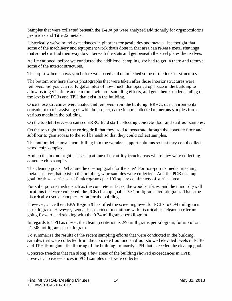
As I mentioned, before we conducted the additional sampling, we had to get in there and remove some of the interior structures.
The top row here shows you before we abated and demolished some of the interior structures.
The bottom row here shows photographs that were taken after those interior structures were removed. So you can really get an idea of how much that opened up space in the building to allow us to get in there and continue with our sampling efforts, and get a better understanding of the levels of PCBs and TPH that exist in the building.
Once those structures were abated and removed from the building, ERRG, our environmental consultant that is assisting us with the project, came in and collected numerous samples from various media in the building.
On the top left here, you can see ERRG field staff collecting concrete floor and subfloor samples.
On the top right there's the coring drill that they used to penetrate through the concrete floor and subfloor to gain access to the soil beneath so that they could collect samples.
The bottom left shows them drilling into the wooden support columns so that they could collect wood chip samples.
And on the bottom right is a set-up at one of the utility trench areas where they were collecting concrete chip samples.
The cleanup goals. What are the cleanup goals for the site? For non-porous media, meaning metal surfaces that exist in the building, wipe samples were collected. And the PCB cleanup goal for those surfaces is 10 micrograms per 100 square centimeters of surface area.
For solid porous media, such as the concrete surfaces, the wood surfaces, and the minor drywall locations that were collected, the PCB cleanup goal is 0.74 milligrams per kilogram. That's the historically used cleanup criterion for the building.
However, since then, EPA Region 9 has lifted the screening level for PCBs to 0.94 milligrams per kilogram. However, Lennar has decided to continue with historical use cleanup criterion going forward and sticking with the 0.74 milligrams per kilogram.
In regards to TPH as diesel, the cleanup criterion is 240 milligrams per kilogram; for motor oil it's 500 milligrams per kilogram.
To summarize the results of the recent sampling efforts that were conducted in the building, samples that were collected from the concrete floor and subfloor showed elevated levels of PCBs and TPH throughout the flooring of the building, primarily TPH that exceeded the cleanup goal.
Concrete trenches that ran along a few areas of the building showed exceedances in TPH; however, no exceedances in PCB samples that were collected.

Final MINS RAB Meeting Minutes 15 May 31, 2018 TTEM-9008-FZ01-0012
The isolated storm drain that was in the building showed PCBs above the cleanup goal in the sediment that was collected from it; however, the concrete chip sample and the water that was present were both below the cleanup goals.
Wood chip samples that were collected from support columns throughout the building, as well as some of the interior wall samples that were composed of wood, had a few exceedances of the PCB cleanup goals.
On the plus side, the metal columns that were sampled showed concentrations of PCBs below the cleanup goal, as well as all the metal wipe samples that were collected along the perimeter walls that had metal surfaces present.
All of the soil samples that were collected beneath the concrete floor and subfloor, every single one of them was beneath the PCB cleanup goal as well as TPH, which was great news.
Samples that were collected beneath the T-slot pit, once we removed the steel plates from there, the sediment and rubble samples that were collected beneath those T-slot pits were below the cleanup goals for both PCBs and TPH. And, as I mentioned, for pesticides as well as Title 22 metals.
CO-CHAIR HAYES: I just wanted to comment that Wally has mentioned to us, because he worked on the shipyard, that the wood flooring, those cross-cut floor blocks were routinely removed as they became saturated and were replaced.
And I think that this demonstrates, really, the power of that particular, you know, use of wood on the cross-section to contain contaminants. I'm absolutely fascinated by this, that they were -- it was able to contain it, remove it. Who knows what they did with it? But that you don't have contamination in those areas above the cleanup goals. Very impressive.
MR. NELSON: Yeah. Thank you for bringing that up, Myrna.
One thing I'd like to mention since she brought up the wood block flooring. The wood block flooring, in case you aren't familiar, has had a two-fold approach.
So I mentioned that there were concrete islands interspersed throughout the building or areas where they had equipment. If they were machining a piece of metal or something intended for use by the naval shipyard, and it fell off the machine or it hit the wood block floor, it wouldn't damage that equipment that was likely very expensive to produce. If it damaged the wood block floor you could easily just cut new blocks of wood and replace that area.
But now that you bring that up, it seems as if there was a third aspect to that in that it was absorbing any of the spills that were present.
But again, like you say, what they did with those is likely anyone's guess at this point.
So this is another slide showing the results of the constituents that were detected at the site. I'm not going to go through each and every one of them.
But again, with the concrete floor, the samples that were collected, we had PCBs ranging up to 28 milligrams per kilogram.
You can see for TPH as diesel and motor oil, we had some fairly elevated levels, up to 4,100 milligrams per kilogram for diesel, and 23,000 milligrams per kilogram for motor oil.

Final MINS RAB Meeting Minutes 16 May 31, 2018 TTEM-9008-FZ01-0012
The concrete trenches. Again, the PCBs were below the cleanup goal; however, there were some exceedances for motor oil and diesel.
The soil beneath the concrete and subfloor was below the cleanup goals for both PCBs and TPH.
Again, the wood chips had some exceedances -- one location had a concentration of 52 milligrams per kilogram of PCBs.
Metal wipe samples were all below the cleanup goals, as well as the samples collected underneath the T-slot pit.
CO-CHAIR HAYES: You know, one thing that I -- it's been a heck of a long time since I've asked for this, but I will remind Lennar that it's a good idea if you can show us what your cleanup goal would be on these maximum concentrations. You know, 52 milligrams per kilogram doesn't tell me anything, because I don't know whether that's within the range or not. You know, as I might review this document or share it at another time, I --
MR. NELSON: That's a good point, Myrna. I probably should have included a little box there.
But we can jump back here real quick. Just to reiterate here that for the solid and porous media, the wood chips, the concrete chip samples that were collected, the cleanup goal is 0.74 milligrams per kilogram.
Non-porous media, the wipe metal samples, were 10 micrograms per 100 square centimeters.
And, of course, TPH as diesel, 240 milligrams per kilogram, and motor oil is 500 milligrams per kilogram.
I think it would have been helpful to have a little box.
CO-CHAIR HAYES: Because you have to go back and forth.
MR. NELSON: Exactly. Yeah. Good eye.
So again, those are the results there. And you guys, feel free to take a look at those, a closer look after the presentation, if you like.
The following figures show graphical representations of the results of the sampling efforts that were conducted in the building.
The first figure on slide 14 shows the concrete step-out samples that were collected along the 40-foot grid on areas where exceedances for PCBs or TPH existed.
And I know there's a lot going on visually. But, generally speaking, the green symbols mean that the PCBs are below the cleanup goal.
The red symbols indicate that you have elevated concentrations above the cleanup goal.
The black symbols indicate that there wasn't physically enough space to collect that additional step-out sample, or there was an obstruction or something like that in the way.
And in the bottom right you'll see some blue symbology that indicates that those were proposed step-out sample locations; however, those weren't collected because the 40-foot grid location that was collected inside of those step-out locations was below the cleanup goal.
The following figure on slide 15 shows the TPH results of the concrete floor and subfloor samples that were collected. And as you can see, there's a lot of this red on this figure. TPH is

Final MINS RAB Meeting Minutes 17 May 31, 2018 TTEM-9008-FZ01-0012
pervasive throughout the flooring of the building, with the exception of these three locations on the top left, or northwestern portion of the figure.
The next slide, 16, shows the PCB results for the underlying soil samples that were collected beneath the concrete and asphalt floor surfaces.
So you saw the core drill on that previous slide. So they were coring through the concrete and asphalt to get to the soil beneath.
We collected additional samples in areas that had not previously had soil samples collected. As you can see, the PCB concentrations for those areas were below the cleanup goal.
Next slide, number 17, shows the TPH results of those soil samples that were collected in areas that had not previously been sampled or analyzed for TPH. And you can see that there's not a single exceedance for TPH for those samples that were collected.
Next slide, number 18. This is actually a culmination of four slides. It shows the results that were collected from the support columns throughout the building. There's two types of support columns that exist in Building 116.
On the western half of the building you have support columns that are wood, and in the eastern half of the building you have metal support columns.
We collected wood chip samples from the wood; we collected wipe samples from the metal.
And I said there were four figures associated with all the support column samples that were collected. If there was a north, south, or east or west facing wall on a particular column, we collected a sample on that location and have a respective figure for that.
However, if there was an exceedance at all, we kind of put everything -- condensed everything down into one figure just to say if there was an exceedance on a particular column, we wanted to show that in one figure itself.
So what this figure shows you is the columns that had an exceedance, regardless of the location that the wall was facing.
So you can see that the exceedances are isolated to the wooden columns in the western portion of the building. And there's one location there in the top left that had an elevated PCB concentration above ten milligrams per kilogram.
I mentioned the concrete islands that are interspersed throughout the building. There's no order to the layout. Again, as we understand it, these were areas where the Navy had pieces of equipment or machinery placed throughout the building as needed.
So we collected samples from any and all of these, where present, throughout the building.
This figure shows the results of the PCB analysis for samples collected on the islands. And you can see that -- by the red symbols that are present, there were a number of exceedances above the cleanup goal for those islands.
The following figure almost looks identical; however, it is different. It shows the TPH results from those same concrete islands.
Again, you can see the TPH is pretty spread out through the flooring of the building. We had a number of exceedances as well.

Final MINS RAB Meeting Minutes 18 May 31, 2018 TTEM-9008-FZ01-0012
The next figure shows the results of concrete chip samples that were collected from the concrete strips that run along with the support columns of the building. No, I'm not prepping you for flight takeoff, I'm just showing you how they're laid out.
They run the length of the building. They're run in line with the support columns, and they tie into the foundation of the building.
We collected concrete chip samples every ten feet. You can see by the red symbols we had some elevated concentrations of PCBs. A few areas were below the cleanup goal.
The rings surrounding the symbols may be a little bit difficult to see on the screen here, might be easier to see on your 11 by 17-inch figure, those indicate whether or not there was an exceedance for TPH, and there were a few areas that did exceed the cleanup goal.
The next figure, slide 22, shows the sampling results of the concrete trenches that are throughout the building. There were generally four areas where these were present. We collected concrete chip samples from those.
Not a single one had an elevated concentration above the cleanup goal for PCBs; however, we did have some instances of TPH above the cleanup goal.
The final figure here, it's also a culmination of multiple figures that shows the results of the perimeter wall samples that were collected throughout the building.
There's various media present on the walls, depending on where you're at.
There's some wooden areas.
There's some areas with metal plates present.
There's a small area with drywall.
And some concrete locations there on the northern middle portion of the figure.
You can see there's four locations where we did encounter exceedances above the cleanup goal. Those were isolated to the wood chip samples that were collected in the building.
None of the wipe samples, none of the concrete samples, and none of the drywall samples exceeded PCBs above the cleanup goal.
So what's our path forward as a result of these sampling activities? We're going to provide an updated cleanup plan, notification addendum to DTSC, EPA, and the Water Board.
And in consultation with them in oversight, we're going to perform remediation activities in the building in the form of, initially we're going to remove the wood block flooring from the building.
We're going to scabble areas of the concrete throughout the flooring that have exceedances above the cleanup goals for PCBs and TPH.
Restore the floor as needed.
We'll remove any wood columns that showed exceedances, as well as wall areas along the perimeter.
The sediment that is in the storm drain, we are going to remove that sediment, clean the storm drain out.

Final MINS RAB Meeting Minutes 19 May 31, 2018 TTEM-9008-FZ01-0012
During this process, once we remove these areas and scabble or remediate, we're going to collect confirmation samples along the way to verify whether or not the cleanup goal has been met.
We're going to stay in consultation with DTSC along the way; provide information to them to let them know where we're at; and receive guidance as to how best to continue the cleanup, until we have ensured that the cleanup goals have been met for the site.
Any wastes that are generated as a result of the investigation and remedial --
Yes, Paula.
MS. TYGIELSKI: You've got removing the columns and removing walls, and perhaps those columns and walls support things.
MR. NELSON: That's a good point.
MS. TYGIELSKI: You know, do you want to take that building apart?
MR. NELSON: We are not going to do anything that subjects the building to structural anomalies or issues or anything like that. And we're going to address those areas in a way that doesn't affect the structural stability of the building.
This building will be retained. It has future uses for commercial industrial use.
MS. TYGIELSKI: Okay.
MR. NELSON: It's part of the historic core, and we want to be very careful as to how we conduct those remedial activities. It's not going to be whimsical.
MS. TYGIELSKI: So maybe you're going to put a different column nearby to hold up --
MR. NELSON: There's possibilities for however we address that, exactly. And, again, we're going to be in communication with the regulatory agencies to make sure that any remedial efforts that are taking place are done so safely, not only for the staff and the workers that are on-site, but in such a way that it retains the structural integrity of the building as we do that work.
But good point. Thank you for bringing that up, Paula.
MS. TYGIELSKI: Very good. Thank you.
MR. NELSON: Any wastes that are generated as a result of the investigation remedial activities, those will be transported and disposed of at a licensed waste facility engineered to control those wastes.
Finally, we'll prepare the closure documentation. We'll get together the site characterization and cleanup action summary report for review by the agencies, and ultimately request no further action at Building 116.
Any questions?
CO-CHAIR HAYES: Can you explain what no further action [NFA] means? I mean, I know people run around saying you should get a NFA letter from the regulators, I'll bet you could get that for this building and that building and this property, that property. What does that mean? And what kind of binding -- what's your -- you never come back, it's all done, taken care of? Does it have a land use restriction on it? How does this work?

Final MINS RAB Meeting Minutes 20 May 31, 2018 TTEM-9008-FZ01-0012
MR. NELSON: Well, our goal is to avoid the necessity of a land use covenant being applied to the building.
And Neal may be able to provide some additional insight into this matter.
But essentially, what no further action states is that there's an agreement among the regulatory agencies that the cleanup and concentrations that exist in the building are at such a level as to not affect the environment and the health of individuals that occupy that space over a given amount of time.
Neal, would you like to expand upon that?
MR. SILER: Well, there will be a land use covenant on the building. There won't be a PCB-specific land use covenant on the building.
What will happen is it will be cleaned up to its commercial industrial use, which is what it's designated for. So we'll always have a land use covenant for unrestricted land use.
But what we're saying is that for the use that its purpose is, for commercial industrial, if you're in there for 250 days for eight hours a day, that there's no risk to human health. That's what we're talking about in this specific building.
CO-CHAIR HAYES: And who has to concur? And how do you -- how do you evaluate five years from now -- we've got that other five-year study -- whether your land use controls are effective? And how do you track that?
MR. SILER: Well, for this --
CO-CHAIR HAYES: How does the public track it, for that matter?
MR. SILER: For this building, what happens with this is that both DTSC; EPA, if they want to chime in; and the Water Board will chime in because of the petroleum hydrocarbon issue; is that we will do annual inspections of the entire area, take a look, and see if everything is being consistent with the covenant.
And then when we do the five-year review we go ahead and take a look back. Have any cleanup levels changed? Has there been anything that has changed in the building that would expose anyone to any additional health risk? And if that's the case, then we would make modifications.
But, if not, then we'd just go on with the way the use is as we move forward.
CO-CHAIR HAYES: So not to keep us here all night, but what's the difference between an NFA and, I don't know, some of your other terminology, Record of Decision or whatever other -- what's that mean, you know, no further action? Who concurs? Do you have a comment period? Do you have a -- how does it work?
MR. SILER: Well, as far as that, on the specific building itself there wouldn't be a comment period. But as we move through things with the Remedial Action Plan, which is coming up, this is in Investigation Area C2, there will be a Remedial Action Plan, there will be a public presentation of that, and the public can go ahead and comment on that Remedial Action Plan or anything they want to do with any of these remedies that are put forth in that plan. And that's a 30-day public comment period is my understanding.
CO-CHAIR HAYES: And then help me out. You are the Eastern Early Transfer Parcel [EETP] responsible party, RP. The Navy gave you and the city that job.

Final MINS RAB Meeting Minutes 21 May 31, 2018 TTEM-9008-FZ01-0012
How do you decide which building gets shredded and ground up and destroyed, and which building merits hanging onto for dear life like you are doing here? What drives you?
MR. SILER: Well, that all is done with a settlement agreement with -- my understanding is, with the State of California. And so there was a decision made with the state and the city as to what buildings would -- could stay or needed to stay, and what buildings could be demolished or modified.
CO-CHAIR HAYES: And do you ever update that plan? Because, you know, in today's day and age I'm seeing a lot of -- and Ron probably is too in his Economic Development Department -- seeing a lot of shows on TV and on, you know, Facebook where parking garages are considered obsolete, parking areas are considered obsolete, and they're repurposing them because nobody really drives anymore or they're eventually not going to or not at the numbers that they did historically. Yet, every time I see a building come crashing down I'm told, "Oh, it's because we need that parking."
Well, the Navy had 45,000 people here during World War II, and a lot of those buildings are pre-World War II and, you know, I think that the number I've heard is that a Greyhound bus traveled 800 miles a day bringing workers in. I can kind of see that that will one day be the way it is.
Aren't you kind of destroying -- possibly destroying valuable assets in the name of pave-over paradise or, you know, destroy paradise, you know, it's a -- these are contributors to the National Register? And then, "Oh, we could have used that building for another distillery, what were we thinking?"
How do you modify your plans? I mean, I know you and the city -- and theoretically the public had a tiny bit to play, but I kind of recall that it kind of didn't -- and there was some settlement terms, a lot of which I haven't -- I've been in the room when those settlement agreements were being discussed, but I haven't actually seen them come to fruition.
You know, like on the trail we have interpretive signs, and that was one of the things that was going to be a part of the settlement agreement was -- for the destruction of these buildings was that you were going to put up signs that basically said this is what used to be here, you know, and this is what it did. But I haven't seen any of those signs. And I know I've seen the buildings come crashing down, I absolutely have, because I can kind of remember things and look at pictures and things.
So I'm just curious, when do you rethink that, reopen that? Like you have these five-year plans for environmental cleanup, but where is the thought process about, heck, a building we never imagined could be important to us financially, you know, suddenly is. And how do you shift? How's your company do that?
MR. SILER: And really that, you know, what's in the settlement agreement is the framework of all this.
Now, we go in front of the AHLC, the Architectural Heritage and Landmark Commission, and we present what buildings we think need to come down, and do a unit plan and everything else as to how that goes. So the public does have some input to that.
It can go inform the city council if it gets to that point, and the public can have additional comment into that.

Final MINS RAB Meeting Minutes 22 May 31, 2018 TTEM-9008-FZ01-0012
But what happens numerous times is that some of these things are economically driven. At one point years ago we had talked about demolishing a couple buildings on the island. And when we talked about that, when I talked it over with the people they said, "Well, we think we have a use for that." So they came back and said, "Let's stop and put, you know, a stop to that right now and reevaluate that use."
And then we've come back now full circle and they've said, "No, we don't think there's an economically viable reuse for those buildings." So we're looking as to abating and demolishing those buildings and putting something else in there.
So it's a process that goes on all the time within Lennar Mare Island. And, again, when we do that, we talk too about the Architectural Heritage and Landmarks Commission, and eventually it can go to the city council also.
CO-CHAIR HAYES: Have you ever approached them and they've convinced you to keep a building up?
MR. SILER: I think right now they're in discussions about potentially keeping a building up that was slated for demolition, and there's actually being a reevaluation of the use of that building.
CO-CHAIR HAYES: Oh. I'm even seeing on, you know, I mean -- we think we're way advanced in the U.S. now, don't we? But I'm seeing things like from Europe, where it just seems kind of like we're behind the times a little tiny bit.
I'm seeing some buildings that seem like they'd be quite suitable, similar to the way the piers are in San Francisco, where you actually use them for parking lots, they just look like an old tiny building, but they're really an interior parking lot, and even maybe multi-structural.
I mean, I'm not trying to obsess on parking lots versus no parking lots, and breweries and distilleries versus no breweries and distilleries; but, you know, where is that really robust nexus between Ron's department, Economic Development, Architectural Heritage and Landmarks Commission -- which is required under the, you know, the National Historic Landmark and Historic Districts -- and then how does Lennar fit into that? And how do you, you know, you all sit down together, like we did for the -- for the landfill and the trail around it?
I mean, the very first thing that came out of Navy, and they were adamant about it, and I can say that DTSC at the highest level absolutely was too, "Put a fence up" flat out. "Let's just lock everybody out."
Well, we now know that's impossible, first of all. I mean, I am living proof of that for the last couple of months. We couldn't lock anybody out, you know, even though I bought $251 worth of German locks for a certain area.
But I'm just curious, because in the end we had a more eloquent solution, a more beautiful solution, one that's more compelling and more interesting. And the public enjoys it, you know. It works well as a protective remedy. It has all the magic that you couldn't have possibly expected from cleaning up a landfill, putting it to bed, and making sure no one steps on anything and blows themselves up like Tierrasanta.
So where's the magic? Where's that nexus in this community? I'm hearing that, "Oh, well this agency does this, and this department does that." Kind of siloed.

Final MINS RAB Meeting Minutes 23 May 31, 2018 TTEM-9008-FZ01-0012
And I'm just curious, again, because of the environmental cleanup, I mean, it has its impacts, but then, "Oh, well, we'll clean it up and then we'll destroy it." You know, I'm just curious.
And maybe that's not appropriate for me to talk about because it's not technically an environmental cleanup issue, but it's always been curious to me how you change the course of the ship.
MR. SILER: You know, and I think we're always open to listening to public input. And I'm sure --
CO-CHAIR HAYES: Do you have a mechanism to do that?
MR. GERBER: I think that's a really good point. There is no one magic solution for every structure.
But I think, in general, the studies have been done, a lot of the buildings you've already preserved. So one of the things we've learned from Lennar is that they have a preference, because tenants have a preference. The beautiful brick and timber buildings have a panache and tenants are interested in it. That's one of the reasons Savage & Cooke is doing what they're doing is because they fell in love with the structures.
So I think the general rules appears to be that preservation is preferred. And in -- part of that has to do with our character, the age and integrity of the building.
In some cases, if they're more like dilapidated sheds versus -- and there's no one guardian of public taste that has all the right answers. But I think a lot of the older buildings have great character, good bones, brick and timber, the history. And the federal government has encouraged preservation through the Federal Tax Code of the buildings pre-1936.
CO-CHAIR HAYES: That's right. That's right.
MR. GERBER: So there's oftentimes incentives. There are buildings that may not be as -- have the architectural qualities, the characters; they look more like dilapidated sheds than nice structures, and part of it is them saying it's economic.
And for a building that is really dilapidated, doesn't have the architectural character, who's going to pay rent to go in there? We do know that for some of the buildings, tenants do want to pay rent and go in there. But some of the more dilapidated, maybe they don't have the architectural character, the market speaks to you. And will somebody want to store stuff there instead of work there? And I think that impacts the buildings.
There's opportunities to lease it out to people who just want to use it for storage. I'm sure you entertain offers like that all the time too.
So I don't think there's one magic answer for every structure, but I think you've got, like, 4 million square feet of space out here out of the 7.5 million, and it's by and large in existing structures. You haven't built any new high-rise mid-rise buildings. So the 4 million square feet is proof of the pudding so far as preservation is preferred.
CO-CHAIR HAYES: And I just won't go on and on. I like your remarks; however, I'm -- I might invite you to sneak down and, you know, hide out in our 1934 bomb storage magazine, reinforced, eight-inch thick, poured concrete walls, where you can actually see the small first-ever plywood uses and reuses.

Final MINS RAB Meeting Minutes 24 May 31, 2018 TTEM-9008-FZ01-0012
And I've been asked -- kind of surprisingly -- by the State Archaeology Department, who came out for a site visit, to consider writing a paper about the influence of reinforced poured concrete buildings in the Navy property in the ammunition depot that then influenced industrial building development and commercial building development throughout the nation. The most local one being the grain mill which was just placed on the State Register of Historic Places because it's the first industrial reinforced, concrete-poured industrial building in America.
However, buildings on the Navy property actually predate that building. And they probably got some of their technology from the Navy. Before the Navy used plywood in 1917, 1918-- I visited with a structural engineer -- they used 2x6 boards to pour those walls.
So, you know, one man's treasure is another man's trash. Just because the guy with the distillery thinks that brick and wood is really snazzy doesn't mean that people like I had out 2 weeks ago from Dart -- they both were Dartmouth grads, they were visiting our preserve.
One of them was here because he's a quite well-respected architect in New York City, and he was here to do the student architecture competition, to judge those at Cal the next week.
And his other person with him went to school with him, and she's in cryptocurrency.
And they both remarked on the astonishing feel of those buildings and the eclectic types of buildings they see on Mare Island.
And when you start picking apart -- really the National Historic Landmarks' contributors are all of them put together; not just, "Oh, well, that one's cute because that one's sexy," or, "That one's not so sexy. Let's rip that one down."
I think you might consider going back to the whole purpose of the National Historic Landmark and what National Parks does, and what some of the more, you know, more interesting projects are around the world. And so, anyway, there you are.
But environmental cleanup seems to -- is what makes reuse possible absolutely. But I was just wondering about the next step when you decide that you put all this time into environmental cleanup, and then you just rip it down. And I don't quite see the investment, you know, paying off. So --
CO-CHAIR LEAR: I have one quick question for Horus.
MR. NELSON: Sure.
CO-CHAIR LEAR: Can you explain the decision to not adjust the cleanup level when EPA adjusted it? You made a comment about that but I wasn't quite --
MR. NELSON: Yeah. You know, I think Lennar didn't want to get into a situation where we were applying certain historical criteria in one area, especially in an existing building that had been characterized and remediated previously, and then having sections that are all the sudden elevated.
CO-CHAIR LEAR: Okay.
MR. NELSON: It becomes way too complicated, and it just makes sense to stick to that original cleanup criteria.
Neal, you might have something additional to say about that?
MR. SILER: No, that covers it.

Final MINS RAB Meeting Minutes 25 May 31, 2018 TTEM-9008-FZ01-0012
MR. NELSON: Yeah.
CO-CHAIR LEAR: Are there a lot of sample results that are in that narrow window of 0.74 to, what was it, 0.94 milligram per kilogram? I wouldn't think so but --
MR. NELSON: I don't think so, I'd have to go back and take a look. But that hasn't been a reasoning either way, I don't think, to --
MR. SILER: Yeah.
MR. NELSON: -- just choose the high level.
MR. SILER: And what we're trying to do here is just keep a consistent basis for the cleanup on the commercial industrial side of the building -- of the property, looking at both short-term liability and long-term liability, as far as that's concerned.
Now, there are a lot of times where we'll have -- and one building I'm looking at right now is Building 688. And it's PCB site UL#01. We've been taking hundreds of samples across the building. I have five samples that are above 0.74 milligram per kilogram. They range from 0.75 to 0.97 milligram per kilogram. And so I pointed out that, you know, we're trying to clean up to 0.74, but 0.75 and 0.74, it's the same thing.
But there's a way we can do a risk analysis that says that really when you're looking at 0.97 and 0.74 milligram per kilogram, the risk isn't really that much greater. It ends up being, instead of 1.0×10⁻⁶, it ends up being 1.31×10⁻⁶. And the regulators understand that, yeah, that's within the risk management range for a commercial industrial structure and, therefore, you don't have to go back and do anything, with that specific site where you had that result, to do any additional cleanup, because it just doesn't make sense at that point.
CO-CHAIR LEAR: Okay. So you're sticking with 0.74 milligram per kilogram across all of the EETP, or is it just because the one building had started cleanup at the lower cleanup goal, and you just wanted to make the building consistent internally?
MR. NELSON: I believe that's across the board.
MR. SILER: Well, it's across the commercial industrial portions of the property.
MR. NELSON: Yeah.
MR. SILER: And a lot of times what happens is, when we did these cleanup plans, is that back then the cleanup goal was 0.74 milligram per kilogram. So now you get into this -- into this, you know, area where --
CO-CHAIR LEAR: Might have to open the plan back up?
MR. SILER: But the cleanup plan is 0.74 milligram per kilogram, so let's just stick with that. And even if we got something that was a 0.8, you know, or 0.94, there's a way to deal with that as we're moving forward with the cleanup.
CO-CHAIR LEAR: Okay. Thank you.
MR. NELSON: Any other questions?
(NO RESPONSE)
MR. NELSON: All right. Thanks, everyone.

Final MINS RAB Meeting Minutes 26 May 31, 2018 TTEM-9008-FZ01-0012
IV. FIRST PUBLIC COMMENT PERIOD
CO-CHAIR: Thanks. Okay. We are at the first public comment period. If we have any members of the public that want to comment?
(NO RESPONSE)
CO-CHAIR LEAR: If not, we have a 10-minute break.
CO-CHAIR HAYES: Might want to make it a 5-minute break.
CO-CHAIR LEAR: Okay. 5 minutes.
(Thereupon there was a brief recess.)
V. ADMINISTRATIVE BUSINESS (Myrna Hayes [Community Co-Chair] and Janet Lear [Navy Co-Chair])
CO-CHAIR LEAR: All right. I think we better get started again.
We are on administrative business. As always, if you have any comments on the meeting minutes, please get those to Myrna or myself.
I'm sure Myrna can do her administrative business when she gets back.
VI. FOCUS GROUPS REPORTS
CO-CHAIR LEAR: Let's go ahead and get to the focus group reports.
Community focus group. Carol, did you have anything you wanted to discuss?
a) Community Focus Group (Carol Phillips [RAB Community Member])
MS. PHILLIPS: I would like to mention, has there been any activity on filling up the holes in the -- that were found in the ground with the abandoned wells back in November, I believe, when the dog fell into the pit?
CO-CHAIR LEAR: I believe at our last RAB meeting Erin was here and reported out. I know that Myrna just mentioned to me that some additional work needs to be done, and she's made some other contacts with the city.
Myrna, did you want to --
CO-CHAIR HAYES: Yeah. Thank you for asking that question. Sometimes there's just a lot on everybody's plate.
But I was kind of disappointed that the actual hole where the dog was killed wasn't actually covered.
So public works staff and I are -- and Erin in Ron's office are scheduled to go back out.
MR. GERBER: Next week, right?
CO-CHAIR HAYES: Yes. And so I kind of feel like, you know, I mean, you can walk the land and you can find these holes and you can fall in them.

Final MINS RAB Meeting Minutes 27 May 31, 2018 TTEM-9008-FZ01-0012
And I know another agency who someone stepped out of their truck and almost stepped into a hole, and went out and got something very effective done.
And so I know it can be done. But I think the more -- maybe the more people you have working for an agency, or the more departments, the more complicated it is.
Some areas just fell through the cracks. And I guess I kind of expected with the presentation and the, you know, the sadness, that it was going to, you know, be a really thorough investigation. Because if I can walk the land and find them, you know, then surely there's even more advanced technology. I don't know, maybe not. But I'm hopeful that maybe I can get them started and figure, you know, in the city, different departments.
I mean, I would just bring a truck and gravel, ride along and go, "All right. Here, you guys. Fill that one. Fill that one. Fill that one."
That's kind of what we did at the preserve, we had all these huge gaps in the asphalt. It was very dangerous.
One of our volunteers saw a very giant pile of asphalt that was just abandoned. After a few days someone came along from the community and said, "Say, do you mind if my wife and I start bringing buckets -- I'm in a wheelchair and she'll do the work -- and fill some of those holes?"
Well, it kind of became a community effort, and we probably put about, oh, ten of my truckloads full of this asphalt. And we made the ugly pile go away, but we also were able to make the park a lot safer.
Now, I kind of think that the department who put the pile there, if they had worked together with us and with other departments, they probably would have been a lot more skilled and done it a lot faster and filled all those holes.
But there's ways to get things done, and I'm very hopeful that this meeting next week we'll be able to knock it out and have a good report next time.
But thank you for asking. It's not quite there yet.
b) Technical Focus Group (Paula Tygielski [RAB Community Member])
CO-CHAIR LEAR: Okay. Technical group. Did you have anything you wanted to report, Paula?
MS. TYGIELSKI: No, I do not.
CO-CHAIR LEAR: Thank you.
City. Ron, did you have anything you wanted to report?
c) City of Vallejo Update (Ron Gerber [City of Vallejo])
MR. GERBER: Yeah. I assume most know, but I'll just mention anyway. The city council accepted the recommendation to select a developer for North Mare Island. And so we are authorized to negotiate an agreement to get them exclusive rights to prepare a plan and get it developed within that 1.2 million square foot commercial industrial envelope.

Final MINS RAB Meeting Minutes 28 May 31, 2018 TTEM-9008-FZ01-0012
There were eight responses to the solicitation. And the team that was selected is comprised of a couple different principals from Savage & Cooke as well as another investor.
And among the reasons that they were selected is they have demonstrated interest and experience on Mare Island, and they have invested millions as a tenant in the buildings, and prefer to preserve and restore rather than just build new. Although the land on Mare Island will require new construction -- North Mare Island will be new construction; but they've demonstrated they're interested in being on Mare Island already because they, you know, have a lot of pride in what they're doing out here. And rather than just try to build warehouses, logistics buildings, they have an interest.
We did not request these, but in their response they submitted letters of interest from companies to actually occupy spaces in new buildings. And of the 1.2 million square feet, they have interest from firms to take up about 75 percent of the space. So it's less speculative in a couple of ways.
The anchor use under their letter of support would be -- almost 50 percent of that space of the expressed interest would be for a film studio campus. And then they have other firms that expressed interest for another winery, for example.
So there are a variety of reasons that that team was recommended compared to others. So they are already here locally; have already invested millions as tenants; and it involved expansion of the existing folks that are already out there, the film studios as well as the folks from Savage & Cook.
And because of another investor they brought in with substantial financial capacity, that further reduces the risk on the part of the city. Because if you're going to be disposing of city-owned land for economic development purposes, it's helpful if there's -- you consider selling or leasing to where there's less risk to the city. And by the demonstrated commitment of their already financial involvement in having companies already lined up to make commitments to build buildings, put in new construction, and create jobs here, it seemed to be a win-win compared to the other proposals.
Once that selection was made, as Janet recalls, we informed them right away, but we also made sure we let the team in Berkeley at DTSC know, as well as the Water Board, because that's going to be the first time somebody's going to be interested in getting something built quickly because we'll have a commitment from a developer.
So we want to make sure --
Because that last 30 acres or so that the Navy still has title to, that cleanup plan has been proposed, and DTSC has responded, so we want to keep that ball rolling so that we can start getting towards the construction infrastructure and the jobs out there.
CO-CHAIR LEAR: That's great. All right. Thanks.
Lennar update.
d) Lennar Update (Horus Nelson [Lennar Mare Island])
MR. NELSON: Okay. For Lennar, this is Horus Nelson with Lennar.

Final MINS RAB Meeting Minutes 29 May 31, 2018 TTEM-9008-FZ01-0012
We've got the RAB update sheet for Lennar here. I'm not going to go through the entirety of the list, but I will update the group on some documents and fieldwork that are currently in the pipeline that weren't addressed on a previous update at the RAB meeting.
So some documents that have been reviewed or commented upon by the regulatory agencies or concurred with include the final 2016 First Five-year Review for Investigation Area C2 PCB sites.
The Removal Action Work Plan, Mercury Removal, PCB Site Building 91 UL#01.
Fact sheet for Investigation Area C2 Remedial Action Plan; comments were received.
And a revised final Investigation Area C3 Land Use Covenant comments were received.
Some documents planned for submittal include the revised final 2016 First Five-year Review report for Investigation Area B.2-1;
The revised final 2016 First Five-year Review report for Investigation Area C2, including six PCB sites and IR21.
Documents that have been submitted that are currently in review are in the process of modification include the Building 688 PCB Site UL#01, Site Characterization and Cleanup Action Summary report. That will be submitted here soon.
The revised Building 746A PCB Site UL#01, Site Characterization and Cleanup Action Summary report in Investigation Area C2.
And jumping down to the upcoming fieldwork, we have some work coming up at Oil Houses 434 and 862, and Cistern 36 Petroleum Correction Action Plan Implementation in Investigation Area C2 as well.
And that's it for Lennar's update.
CO-CHAIR LEAR: Great.
Okay. So next we have the Weston update. Dwight.
e) Weston Update (Dwight Gemar [Weston Solutions])
MR. GEMAR: I have a brief report. My text keeps on shrinking and exposing more and more of the island, which is a good thing. I can see IR05 now at the bottom.
But we just have two documents that are out for review.
Two documents being reviewed, the draft Land Use Control Remedial Design for the IR05 -- Installation Restoration Site 05, Dredge Pond 7 South, and the Western Magazine Area. So we need to respond to those and then finalize the document.
And then as we discussed here tonight, the draft Western Early Transfer Parcel Third Five-year Review is also in draft form and will be finalized within the next couple months.
And otherwise, we're watching the weeds and the grass grow at IR05 and trying to keep control of both.
And to date, a little over 33 million gallons of groundwater has been collected at IA H1 and discharged through the discharge.

Final MINS RAB Meeting Minutes 30 May 31, 2018 TTEM-9008-FZ01-0012
And so everything continues to operate, not only in term of the remedy.
That's all I got.
CO-CHAIR LEAR: All right. Thanks, Dwight.
Regulatory agency update.
f) Regulatory Agency Update (Gavin McCreary [Department of Toxic Substances Control] and Elizabeth Wells [Regional Water Board])
MR. MCCREARY: Okay. We're continuing to review documents and submit comments.
Coming up very soon we will be submitting comments for Parcel XV-B(1)b which is the parcel that includes IR17 area and Building 503 Area. We will be submitting comments for that FOST, so moving along towards getting transfer of that parcel.
And we are going to be shortly submitting comments for the Production Manufacturing Area Remedial Investigation/Feasibility Study.
MS. WELLS: Okay. This is Elizabeth with the Water Board. I have four things.
The first is that not everybody had the chance to meet Ali. She is one of our interns. And the Water Board has a pretty robust internship program, and Ali helps me review Mare Island documents. And this summer she's going to be going out and watching fieldwork.
CO-CHAIR HAYES: All right.
MS. WELLS: So I wanted to bring her along to see what happens at our very exciting RAB meetings.
CO-CHAIR HAYES: Thank you.
MS. WELLS: Yeah. The second thing is we are also continuing to review reports. And I have only -- for the Navy I'm continuing to do that.
I have one site remaining for Lennar. And it looks like we will be able to provide the no further action [NFA] or closure package early next week.
And then I wanted to go back to Myrna's question about what is NFA. And I know that it was partially answered; but a couple of things.
It is the desire of our agency, and I would imagine the Department of Toxic Substances Control, that all of the responsible parties or RPs clean up to clean and to background and to get all of the contamination out.
Now, while that is not always possible, we take that into consideration. And we're not -- neither of us are land use agencies. But what we do is we like to work with the people who are doing the land use or the land reuse so that the contaminated properties can go back into use as opposed to just being blighted properties.
So the no further action process basically says we concur with your -- with you -- you, the RP, have made a recommendation that there's no more risk for the intended use of the land.
And so what we'll do is we'll evaluate the information they've provided and say, "Okay. We concur with your recommendation with the following conditions."

Final MINS RAB Meeting Minutes 31 May 31, 2018 TTEM-9008-FZ01-0012
So, for instance, if it's been cleaned up to a level that's unrestricted or residential, then it will say, you can go out and redevelop it as residential, we concur with that.
But if it's not cleaned up to unrestricted or residential, then there will be restrictions on it.
So basically, as Neal mentioned, there would be a land use covenant or deed restrictions or something like that saying it can only be commercial or industrial property.
And then the Water Board and DTSC have certain requirements that are -- for instance, if there's going to be a change in land use.
So if some of these buildings or these areas that Horus and Neal talked about all of the sudden are going to go to condos, that would be a change in land use, the agencies would have to be notified, and then additional work would have to be done to bring it into an unrestricted situation. So maybe more investigation, more remediation, that kind of thing. You may not be able to use the groundwater for something. Or you may -- or if something new is discovered.
Let's say during the construction of the commercial building something is found, then there has to be notification to the agencies.
So that's basically the way the no further action process works. Does that make sense?
Okay. And then the last thing is I wanted to invite everyone to consider, I'm thinking about running the Mare Island half marathon on October 7th, and I think all of you should do it with me.
(LAUGHTER)
CO-CHAIR HAYES: We'll stand by. I know I will.
MS. WELLS: But I don't think they've figured out where the route is going to be yet, as I understand it. So -- and the idea of running up the hill to the golf course sounds really horrible.
CO-CHAIR HAYES: Well, in case you chicken out or some other pressing issue comes up, Touro University has, for a number of years, conducted a 5K zombie race in September. And that does go into our preserve. And the nice thing is it doesn't go all the way to the top of the hill. And I think you can probably even win in your class because there's not all that many people who register for it.
And the neat thing is the last several years we've also been the beneficiary of some of the fundraising around it. So, you know, it might work for you just right. Yeah. Or any of the rest of you that Elizabeth is challenging.
Don't worry, I'm not going to challenge you.
CO-CHAIR LEAR: Do people dress up as zombies?
CO-CHAIR HAYES: We have a whole team of zombies who torment people as they're running. And then a lot of fun because a lot of the medical doctors and people like that, who are all zombies, and they chase people down the road. It's a lot of fun. It's a really neat race.
MS. WELLS: That sounds horrible.
CO-CHAIR HAYES: Oh. To me it would be a lot better than running 26 miles or something.
MS. WELLS: It's only 13 and a half.

Final MINS RAB Meeting Minutes 32 May 31, 2018 TTEM-9008-FZ01-0012
CO-CHAIR HAYES: Oh. 13 and a half, anybody could do that, I suppose.
(LAUGHTER)
CO-CHAIR HAYES: Oh. Paula's waving at me.
MS. TYGIELSKI: Elizabeth, I just want to say my walker and I will not join you.
(LAUGHTER)
VII. CO-CHAIRS’ REPORT (Myrna Hayes [Community Co-Chair] and Janet Lear [Navy Co-Chair])
CO-CHAIR LEAR: Okay. I have the Navy monthly progress report. It's a handout on the table. You probably all pulled a copy.
I'm not going to go through this tonight because I thought it would be prudent for me to say a couple of things about all the news for the Hunters Point Naval Shipyard cleanup. And Myrna's gotten a couple questions, I've gotten a couple questions.
Obviously, it's not my base, but I did a little research on some of the things that happened.
And first and foremost, I wanted to just say that the Navy takes public safety and environmental protection very seriously. We work very closely with the regulatory agencies, the ones in the room, DTSC and the Water Board, as well as other support agencies during our environmental cleanup.
Quality assurance/quality control programs are implemented for all our projects in accordance with regulatory agency-approved work plans, field oversight and data review are conducted by both Navy personnel and regulatory agencies.
So the takeaway --
One of the things that I took away from doing some investigation on the Hunters Point Naval Shipyard stories that are in the paper now is that the data irregularities were actually discovered during the Navy quality control process --
The Navy is the one that found the irregularities and made the initial calls and started the dialogues.
So, to me, that gives me a level of confidence that the Navy oversight and the things that are in place to find these kinds of things are working.
That happened in 2012. Now, at that time, it was just a data irregularity. I mean, all this talk about fraudulent practices wasn't in the news. It was, "There's some irregularities, let's figure out what happened. Was it a field mistake? Were there procedures that weren't being followed appropriately?", et cetera.
So from 2012 to 2014, the Navy, EPA, DTSC, and the contractor worked closely together to do investigations, to find out what might have happened to cause the data irregularities. And there was a lot of rework that was then performed during those several years.
Then also during that time, in 2013, the contractor, which is Tetra Tech EC, self-reported that they had done some building surveys not in accordance with the work plans.
All that work was also re-performed.

Final MINS RAB Meeting Minutes 33 May 31, 2018 TTEM-9008-FZ01-0012
Then after that is when some employees of the contractor came forward with claims of deliberate falsification of data.
At that point, the Navy paused the radiological cleanup program at Hunters Point, and started a comprehensive review.
Since then, nothing has happened on that program. Everything has been stopped. There have been several investigations, as you probably saw in the news. The Department of Justice [DOJ] did sentence a couple of supervisors that were involved in that activity to jail time.
The Navy has been supporting the DOJ in all their activities and investigations.
And Navy management is in full agreement with the EPA that all of that radiological work that was done over the years must be reevaluated.
And right now, there are -- it's a lot of time and effort and, frankly, a lot of money being expended in planning and appropriating, getting the funds to redo an incredible amount of work at Hunters Point Naval Shipyard. So that is ongoing.
It's -- at my office, I would say three-quarters of the people, 100 percent of the time, are working on this issue. It's very serious. The Navy takes it very serious. And a lot of effort is being put in doing the right thing, making sure all that work is redone to the very highest standards.
So when we start talking about Mare Island, I know that there are concerns about the other bases, what's going on with the other bases.
So I will say, first and foremost, Tetra Tech EC did not do any of the radiological work on Mare Island at all.
And we do have Tetra Tech EMI -- which is a different business entity -- they do some. They have done investigations on Mare Island, but no radiological work was done by them at all. And they aren't the business entity that has been involved in the issues at Hunters Point.
Let's see. What else?
The other thing is that due to the nature of the projects, and the contracting mechanisms that we've used at Mare Island, none of our sites have been investigated by a single contractor.
So, for instance, on Site 04, which is a project that will never end, we've been working on the remedial investigation on that site for how many years?
MS. HARRIS: I want to say since 2003, but maybe it's longer.
CO-CHAIR LEAR: I think it's longer than that.
MS. HARRIS: I think it's longer.
CO-CHAIR LEAR: So we've had investigations done by Trevet; we've had investigations done by quite a few contractors.
So they come in, take a bunch of soil samples, try to write the report. We get a new contract cause that's not enough data, right? So we get a new contract, another contractor comes in, takes data in the same areas. And then we have another contractor. So there's not one contractor that does the entire thing. So there's a little bit of check and balance there, I would say.
And the contracts aren't these huge contracts like they are at some of the other bases. Hunters Point radiological contracts were enormous. And they were the same company all through, so

Final MINS RAB Meeting Minutes 34 May 31, 2018 TTEM-9008-FZ01-0012
you didn't have a kind of, "Well, when we went out and took the sample we didn't get the same results as the company before, let's talk about that." So we have those kind of checks and balances.
And I'm trying to think what other concerns.
There's a lot of talk about what is the Navy doing contractually to make sure that Tetra Tech EC is not given contracts anymore.
There are limitations with what the Navy can do. There's a lot of regulations. But we are looking into all of our avenues to address the situation, to address the company that is causing the problems. But that's still being investigated in terms of what we can do.
Let's see. Was there -- was there anything I missed that you had specific questions about?
CO-CHAIR HAYES: Well, certainly people have looked on the record and found that Tetra Tech -- a Tetra Tech has conducted --
CO-CHAIR LEAR: Certainly.
CO-CHAIR HAYES: -- work at Mare Island. And, you know, there's other properties -- I mean other companies.
But this idea that, "Oh, well, you know, we had one company that did everything;" well, you know, we have sole source contracts or kind of long-term contracts that we've had great success with, great luck with. So I'm not sure that that's a -- that's very compelling or very convincing to me.
And, you know, does Tetra Tech have to put up, or other companies have to put up bonds, or are we going to be, as the American people, stuck with that bill? And what impact will that have on our meager funding that we already have here at Mare Island that's caused our cleanup to drag on and on and on and on and on and on actual Navy property. I don't know about the Eastern Early Transfer Parcel. I know you ponied up some money for that.
But these are concerns. And the public generally just -- I think your message about, well, these guys didn't do any of that cleanup. Well, what was the motivation? You know, why did they do this? So we put them in jail. Oh, good for us. Jail, big deal. I mean, we're a jail economy, you know. So what was the motivation and who benefited from it, or who is benefiting from it? Is it the city, is it a developer, is it -- I mean, why did we -- why did we do that? I think those are questions too.
So it probably calls for -- I don't know what. I know that the questions just keep on coming. Anytime there's a newspaper article or a radio report, there's more questions and concerns and fears.
CO-CHAIR LEAR: I would suggest that if you have any specific questions about what's happening at Hunters Point, I know that there is a constant effort to update their website with new information, so I would recommend you go there if you have concerns for Hunters Point.
I know that they have community meetings that are advertised on their website. So if --
CO-CHAIR HAYES: They have a RAB meeting still?
CO-CHAIR LEAR: They don't have a RAB, but they have community meetings.

Final MINS RAB Meeting Minutes 35 May 31, 2018 TTEM-9008-FZ01-0012
CO-CHAIR HAYES: Oh. Hmmm. Maybe a lesson. We are one of the last RABs in the nation, maybe this is a lesson maybe that we shouldn't have so quickly thrown the baby out with the bathwater. Maybe there were some checks and balances that come through with communication on a regular basis regarding environmental cleanup.
CO-CHAIR LEAR: So they do have community meetings, and they are advertised on the website. So if anyone has an interest in learning more about what's going on there, I would encourage you to find out the meeting dates and locations and do that.
CO-CHAIR HAYES: How is it going to affect us financially? And is the --
Do you have insurance policies in place so that the company is paying for this, not the Navy, for all that work being done over again? I mean, that's what we have in the early transfer parcel process.
CO-CHAIR LEAR: Environmental insurance isn't something that -- those big insurance policies are kind of hard to get nowadays, that's my understanding, and there's no requirement for those in the contracts.
The effort to redo the work at Hunters Point is not going to affect our budget. I believe there's a Congressional plus-up in mind for that. As well as you probably all saw that Tetra Tech EC publicly offered to provide funding for the third-party rework of all of the investigations and cleanup. A lot of details need to be worked out on that.
But for now, I'll say it doesn't affect us at all in terms of funding, certainly not in the near term.
As far as motivation, individual -- individual's motivation for things, I can't speculate on. I would say what I've read -- and from the same forums that any of you probably read in the newspaper and other places -- the people that were picking up clean soil and substituting it for the site soil indicated they were getting pressure from their supervisors to get things done faster. I expect that there was a financial motivation.
And in some companies -- again, I don't know for sure that this was anything to do with Tetra Tech, I'm just --
I know from my experience that in some companies, managers and supervisors may get bonuses based on the profitability of their individual projects. So there may have been some of that going on to motivate people. But this is all speculation on my part. I don't know for sure, and certainly I haven't heard from any of those people and they haven't specifically said that that was going on. And I believe there's still ongoing investigations by DOJ.
So I'm not concerned with any of the work that Tetra Tech EMI has done on our base. We have no reason to be concerned. And I'm sure these things will be in the news for some time to come.
But if there are any specific concerns you have and you want to give me a call, I will do my best to answer your questions.
I don't know a lot of the details, and these things are changing pretty rapidly, but I can certainly find out and ask questions in the office and see if I can get more information.
So does anyone have any questions on that?
MR. GRIBBLE: If you're going to public comment, I wanted to make a public comment.
CO-CHAIR LEAR: Yes.

Final MINS RAB Meeting Minutes 36 May 31, 2018 TTEM-9008-FZ01-0012
And Myrna, did you --
CO-CHAIR HAYES: Yeah. We can go to public comment pretty quickly.
I want to invite you to a couple of events taking place at the Mare Island preserve. When you have good environmental cleanup you have reuse made possible, in this case for park land. And we have a fun event coming up on June 10th called Halfway to Halloween. It will be a flea market and some fun food and, you know, just get you in the mood for Halloween. A little bit early, but it's always fun.
And then on June 16th we have another one of, I think we've done four years now, of sound art in one of our buildings. And that's got the reverb almost exactly the same as the Grace Cathedral, so it's a very compelling place to play and very interesting for people. It's not everybody's cup of tea, I can assure you that, some very strange sounds come out of that building.
And then finally, for now, the 6th Annual San Francisco Bay Osprey Days taking place June 22, 23, and 24. The Navy and the city and we have arranged for public access to the South Shore, the historic South Shore with the osprey nests, and also 14 great egrets nesting, and great blue herons nesting in the Navy properties, arranged for a hike that morning, I think it's 10:00 or 10:30 on Friday morning. And then a little earlier on Saturday morning, maybe 9:30.
And sadly, we're not going to be able to offer something on Sunday. I guess maybe there's a football game or basketball or soccer game or something that's preventing people from being able to commit to that, which I had expected and also paid a gob of insurance to ensure that we were able to have, so I'm disappointed about that.
But boat tours on Saturday and Sunday. I'll be a guide. And presentations at the lunch hour at our visitor center. Driving tours as well as walking tours.
So very, very exciting program with some of the leading bird watching specialists who are, you know, breaking -- we're continuing to break new ground here at Mare Island because we have a nest at the end of Pier 34 which was -- is the first osprey nest in San Francisco Bay period.
Going back to the records of the 19th and 20th century -- 20th and 21st century, as well as going clear back to the shale mounds, which Ron knows a bit about, no record of osprey nesting in San Francisco Bay during those time periods.
So if nothing else, you want to see a historic nest that is active right now, right today.
And then we've certainly expanded throughout the mouth of the Napa and onto Richmond. We have 47 documented nests from that one starting at Mare Island in 2000 that include nests in Richmond, at Alameda, other locations throughout the Bay.
So those are things that I want you to be aware of and I want you to come out and enjoy.
VIII. SECOND PUBLIC COMMENT PERIOD
CO-CHAIR LEAR: Okay. Public comment period.
MR. GRIBBLE: I'm sorry we're -- you're running late tonight. I can't make this terribly short, but I'll try to be concise and to the point.

Final MINS RAB Meeting Minutes 37 May 31, 2018 TTEM-9008-FZ01-0012
And, by the way, thanks for your comments about the RAD [radiological] business. I didn't know that you were doing that. But I came with -- really, that was my key interest here tonight myself.
So that was --
The RAD issue at Mare Island was our first priority for several reasons. Our view at the time was that was the most significant thing that related to reuse and reinterest on Mare Island.
And we also wanted to be efficient, because the Navy was going to do that anyway for their own purposes. We wanted to not have to make them pay twice for that work.
And we also had an opportunity to get really high-quality work from an existing workforce. So that's why we prioritized it when we did.
And this is going to sound a little far ranging, but it all adds to the same point.
By the way, the records retention requirement for the agencies is generally -- in most agencies is 10 years. And I recently learned that the basis for that, the fundamental for that is simply, it's about liability law. I'm not an attorney, but that's, you know, something with -- to the extent of liability limitations.
It does not do anything to address what we think we are keeping records for, which is to answer these questions, keep our answers to these questions in perpetuity. So we spent --
We as a civilization, as a government, as a society, we spent serious amounts of money on these big military, federal projects to answer questions. And we put those answers on the shelf so that anybody in the future should be able to go back and answer the questions for themselves. But we really are not set up to do that because we toss them out in 10 years, or we -- that's if we're doing our jobs, which that's kind of a, you know, a little bit of use requires a little bit of imagination itself. But if the agencies were doing that, you, you, and you, 10 years and then you dispose of them. And that's the ideal.
And I don't think that works. And --
Oh. Here's another story.
MS. TYGIELSKI: With computers you can keep them forever.
MR. GRIBBLE: If you go to the federal government, the National Archives, the -- what do you call it? -- the Smithsonian, will tell you that that's one of the least long-term, least stable forms of record retention in existence. They can go just like that. They do deteriorate. I'm not an expert in that, but it's -- look at what's happened over history. What have we got from the Egyptians and so on?
Anyway, try to access your computer files from 10 years ago, and I suspect that most of us would not be able to do that.
So there used to be an elementary school out here when the shipyard was operating. And that community of people; the teachers, the staff, the students, the parents; all knew the Navy, all knew the regulators, and were familiar with what was going on around them. And we communicated with them on a regular basis.

Final MINS RAB Meeting Minutes 38 May 31, 2018 TTEM-9008-FZ01-0012
They knew what we were -- what we were doing, what the Navy was doing for cleanup at the time, and they knew what the regulatory agencies were doing too. That community knew us; we knew them. And I thought that was really well covered.
And blink, 10 years later, the Navy's gone, virtually the entire staff of the school is turned over, all new -- virtually all new faces; the parents, the students, all new people. And just like that, we lost that connection, that part of the community knowing what we were doing and knowing that they could have confidence in what we were doing.
And it blew up one day when Lennar and the city leased out a bunch of housing to students. And I go on vacation for a month, I come back, and the whole street is filled with kids, where the restriction on those leased properties was no children, nobody under the age of 18.
We got into this really ugly scene. And, oh, they wanted a big meeting with all the parents and all the regulators, and how could this happen? In the span of a few years we went from a community that knew us and had confidence in our oversight to a totally new community that never -- didn't even know our names. It happens very quickly.
And there's a need to stay connected to the community, to keep these answers to allow people to find their own answers, again, answer the same questions.
And I'm concerned about the RAD business, in particular, because there's a risk here, because I don't think anybody has kept the community abreast of that history.
And I doubt that the agencies -- if the agencies, if they would be able to pull those records together very efficiently to allow the public to learn about that again, to have confidence. I think they should have confidence. Maybe they wouldn't, but I think that they should.
And so that's my concern. And I would be sad to see that loss of confidence in the community with respect to that part of the remediation.
So I would encourage you to do something about that, in particular -- and I think we've already talked about this -- which is the one thing that invites people to still worry about the RAD piece at Mare Island is the one piece that's still not resolved, it's going on in perpetuity, and that's the RAD button issue.
There have been RAD buttons found here, RAD buttons found there. The Navy's worked with that, the regulators have worked with that. They've got documents for that site cleanup, that site cleanup.
There's no document that says the RAD button issue is this; we know this history and, therefore, we can define the nature and extent of that problem.
It's an open question to an unsuspecting or an unknowing public. And let me give you a couple examples.
Lennar wanted to build housing behind the elementary school once upon a time. Do you remember that? And that was a historical dredge pond. There was an ordnance issue out there. And they want to build housing on an ordnance site. How are you going to do that?
And I guess I'd gotten confused as to who wrote the report. But somebody wrote a technical memorandum that pieced together -- very cleverly pieced together the history that made it quite clear that there was no potential for ordnance in that historical dredge pond, different

Final MINS RAB Meeting Minutes 39 May 31, 2018 TTEM-9008-FZ01-0012
configuration than what we saw on the maps tonight. Therefore, everybody was able to agree that was not an ordnance site, Lennar was able to go forward with their housing.
The Navy could do the same thing for the RAD button issue for the entire island. Where is it an issue? Where is it not an issue? Where might it be an issue? And then you've got the problem bounded. You know where it's an issue, where it's not an issue, and you can simply go forward with resolving that issue for the remaining parts of Mare Island that it hasn't been addressed. And end this in a final way, and close the door -- as good as you can ever close the door -- on the RAD issue for Mare Island.
So I would like to encourage the Navy and the regulatory agencies to really finish this off in a robust and well documented fashion, to make this the one military base, Navy base in the entire Bay Area, by the way, that really did it right the first time. And I'll stop.
CO-CHAIR HAYES: And what's amazing to me and to Paula, and I guess to Dwight, I think you've still got access to some of those folks who did that work all those years ago, Bob O'Brien and Bruce Christiansen and others.
You know, are you talking about something like we did for the housing area; like a tech memo where we were able to demonstrate that the Naval Ammunition Depot workers' homes would not have been exposed to frag from the types of explosions that took place? Are you talking about something like that, kind of, for RAD buttons as well as --
I mean, some kind of a document that could be -- that does an overview of what we did, what the Navy did, $130 million worth of analysis and sampling and removal of radiological contamination in buildings, taking whole buildings down, and then, "Oh. By the way, we have this one other issue that, you know, that we can package as well." I mean, are you talking about something like that?
MR. GRIBBLE: I'm not familiar with the report that you're talking about.
But in my mind, it would be a PA, a preliminary assessment style document. No sampling. Just pull together historical information that's available and accessible now that wasn't available, wasn't even known or understood 10 or 20 years ago or whenever, some point. Not too many years ago.
You know, the manufacturer of those radioluminescent dials, they started at a certain date, they ended at a certain date for radium. They started at a certain date, ended at a certain date for Strontium-90, and where were they used?
And the Navy has the information. There's information out in the public domain on that. The EPA Superfund site where they were made, manufactured, a lot of history there. And what's it associated with on Mare Island?
Just compile some -- a cleverly written report by a good consultant, to pull together that information. And in my opinion, has a high likelihood that they could simplify and narrow that issue for the Navy and the regulators.
CO-CHAIR HAYES: And so you would think that it's possible that -- that this -- that Mare Island wouldn't get caught up in the -- in this overall fear that's throughout the Bay area, that we would be able to demonstrate through this type of document, or maybe some meetings, presentation, that we had a different program here at Mare Island? Is that what you're hoping to -- we might be able to achieve or you're recommending?

Final MINS RAB Meeting Minutes 40 May 31, 2018 TTEM-9008-FZ01-0012
MR. GRIBBLE: Well, I think probably several of the regulatory agencies and the Navy already know that some of this unbounded concern for RAD concerns at Mare Island has already surfaced by some new regulators over the years. And it's been really an effort to try to educate them as to what has happened already.
But their starting point, or at least one of their points of contention is -- if I'm not mistaken -- is this RAD issue which gives somebody who's not in the know the thought that maybe this entire island is still glowing.
CO-CHAIR HAYES: Right. Good. Hmmm. Well, thank you.
MR. GRIBBLE: Thank you for your time.
CO-CHAIR LEAR: Okay. I did want to mention one more thing before I let everybody go.
So Myrna and I were talking over the last few days about the next RAB tour. We're looking at the end of September. So we're thinking instead of the September 27th RAB meeting, we would have our RAB tour that day.
But we'll talk about it some more, send out some information, and we'll go from there.
Anything else?
CO-CHAIR HAYES: No.
CO-CHAIR LEAR: All right. Well, thanks, everyone, for coming. Drive safe and we'll see you next time.
(Thereupon the proceedings ended at 9:39 p.m.)

Final MINS RAB Meeting Minutes 41 May 31, 2018 TTEM-9008-FZ01-0012
List of Handouts: • Presentation Handout – Western Early Transfer Parcel Third 5-Year Review
[Attachment 1]
• Presentation Handout – Additional Characterization Results and Path Forward for Building 116 PCB Site UL#01 in Investigation Area C2 [Attachment 2]
• Navy Monthly Progress Report, May 31, 2018 [Attachment 3]
• Lennar Mare Island RAB Update, May 2018 [Attachment 4]
• Weston Mare Island RAB Update, May 2018 [Attachment 5]

Attachment 1. Presentation Handout – Western Early Transfer Parcel Third 5-Year Review

MARE ISLAND NAVAL SHIPYARD
Western Early Transfer Parcel (WETP)Third Five-Year Review
Restoration Advisory Board MeetingMay 31, 2018

Five-Year Review Process
• A five-year review is required if conditions at a site following remedy implementation do not allow for unrestricted use
• Reviews are conducted pursuant to:– Comprehensive Environmental Response, Compensation, and
Liability Act Section 121– National Oil and Hazardous Substances Pollution Contingency
Plan (NCP) 40 Code of Federal Regulations Section 300.430(f)(4)(ii)
• Purpose of a five-year review is to evaluate whether the selected remedy has been and continues to be protective of human health and the environment
• This presentation describes the third five-year review for the Western Early Transfer Parcel (WETP)
2

Western Early Transfer Parcel Location
3

WETP Description and Background
• Areas included in the WETP:– Investigation Area I – Partial (uplands/dredge ponds)– Investigation Area J (tidal wetlands)– Western Submerged Lands (mudflats and submerged lands)
• Includes 2,814 acres created by combination of natural sediments and dredge spoils
• Munitions and explosives of concern (MEC) and low-level radiological (RAD) items discovered at dredge pond outfall locations
• Surface water above human health screening levels and soils/sediment above ecological screening levels (primarily metals)
• Property was transferred from the Navy to California State Lands Commission on September 20, 2002
• This Third Five-Year Review includes July 2012 through June 2017
4

Former Dredge Ponds/Outfall Locations
5

WETP Initial Response Actions
• 1995-1997 Unexploded Ordnance Site Investigation—Geophysical (handheld magnetometer/metal detector) surveys of dredge ponds
• 1998-2001 Unexploded Ordnance Intrusive Investigation—Investigation of geophysical anomalies and limited screening for radiological items
– 1,528 MEC items recovered– 29 Radiological items recovered
• 2000-2001 Radiological Investigation—High-density radiological surveys of 16 dredge outfall locations– 32 Radiological items recovered
• 2001-2002 Digital Geophysical Mapping — Dredge pond surveys to locate and remove remaining MEC – 8 MEC items recovered
6

Example of Outfall Debris Mass
• 1998 outfall mass excavation
7

Dredge Pond Geophysical Survey
• Cart photo
8

WETP Remedial Action Plan (RAP)
• RAP approved by Department of Toxic Substances Control (DTSC) inJune 2002
• Institutional Controls – No residences, schools, hospitals, day-care– No alteration of groundwater– No soil disturbance without DTSC approval
• Access Restrictions– Two-foot soil cover along levee slopes adjacent to residential areas– Installation of boundary signage– Installation of engineered trail for public access
• Sediment Removal and Monitoring– Annual sediment sampling within dredge ponds and at weirs– Quarterly visual inspection of levees/outfalls, trail, and signage
9

WETP First Five-Year Review Period(2002 – 2007)
• Quarterly inspections of levees/outfalls for MEC or radiological items –One 20-mm anti-aircraft projectile found in 2003 on top of levee between Dredge Ponds 4M/4N
• Quarterly boundary signage inspections – Minor repairs as needed• Annual sampling within dredge ponds and at weir locations – No
increase in contaminant concentrations observed• Completed 2-foot soil cover on the eastern levee of Dredge Ponds 4N,
4M, and 4S (partial)
10
Placement of the 2-foot soil cover on the slope of the eastern face of eastern levee of Dredge Ponds 4N, 4M, and 4S (partial)

WETP Second Five-Year Review Period(2007 – 2012)
• Quarterly inspections of levees/outfalls – No MEC or radiological items encountered
• Quarterly boundary signage inspections – Minor repairs as needed• Annual sampling within dredge ponds and at weir locations – No
increase in contaminant concentrations observed• Completed engineered trail (initiated quarterly inspections)
11
Interpretive panels are located along the San Pablo Bay Trail to provide information regarding Mare Island history, ordnance safety, as well as the local flora and fauna

San Pablo Bay Trail Alignment
12

WETP Monitoring Adjustments(Based on Second Five-Year Review)
13
Southern Levee of Dredge Pond 2S
• Discontinued annual sediment sampling− Sediments collected over ten year period
showed no increase in contaminant concentrations in ponds or at weirs
• Reduced frequency of levee/outfall inspections for MEC/RAD to once every five years, or after five-year rain events (2.6 inches < 24 hours or 5 inches over five days), and additional inspection of San Pablo Bay Trail due to five-year rain event– Only one MEC item recovered (2003)
and no radiological items– Heavy vegetation reduces erosion and
unauthorized access– Trail provides directed access and
reduces potential for “trailblazing” Dredge Pond 3E Outfall Location

Third Five-Year Inspections Summary
• Inspections completed 3rd Quarter 2012 – 2nd Quarter 2017– Quarterly Trail and WETP Entry Point Signage Inspections
▪ Minor maintenance (reattaching loose or fallen signs)– 5-Year Rain Event Trail Inspection December 17, 2014
▪ Minor erosion noted, repairs implemented– 5-Year Rain Event 2-Foot Soil Cover Levee and MEC/Rad
Inspection December 22, 2014▪ No erosion issues noted, no MEC/RAD items observed
– 5-Year Inspection of 2-Foot Soil Cover Levee and MEC/Rad Inspection March 16, 2017▪ Healthy/dense vegetation, no erosion issues, no MEC/RAD
– 5-Year Site Inspection Checklist Completed July 18, 2017▪ Inspection records, documentation, IC compliance
14
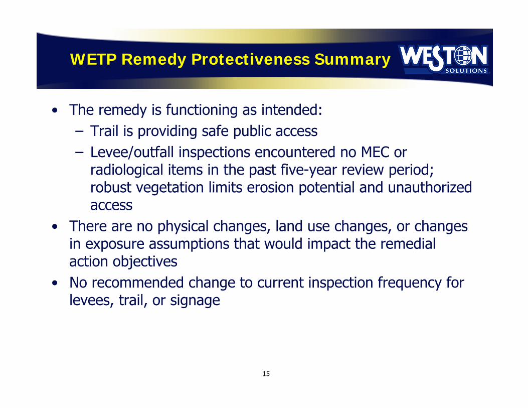
WETP Remedy Protectiveness Summary
• The remedy is functioning as intended:– Trail is providing safe public access– Levee/outfall inspections encountered no MEC or
radiological items in the past five-year review period; robust vegetation limits erosion potential and unauthorized access
• There are no physical changes, land use changes, or changes in exposure assumptions that would impact the remedial action objectives
• No recommended change to current inspection frequency for levees, trail, or signage
15

Public Participation
• Public notice regarding start of WETP Third Five-Year Review posted in Vallejo Times-Herald on February 21-25, 2018
• Draft Third Five Year Review report for WETP issued for review in February 2018– Available in John F. Kennedy Library in Vallejo
• Opportunity to provide verbal comments (this meeting) or written comments to:
Mr. Gavin McCrearyDTSC Project Manager(510) [email protected]
16

17
Questions?

Acronyms
DTSC Department of Toxic Substances ControlIA Investigation AreaIC institutional controlsMEC munitions and explosives of concernmm millimeterRAD radiologicalRAP Remedial Action PlanWETP Western Early Transfer Parcel
18

Attachment 2. Presentation Handout – Additional Characterization Results and Path Forward for Building 116 PCB Site UL#01 in Investigation Area C2
Additional Characterization Results and Path Forward
Building 116 Polychlorinated Biphenyl Site
Unknown Location #01
Investigation Area C2
Additional Characterization Results and Path Forward
Building 116 Polychlorinated Biphenyl Site
Unknown Location #01
Investigation Area C2
Presented to
Mare Island Restoration Advisory Board
May 31, 2018

Discussion Topics
• Building 116 Site Description and Historical Investigation and Remedial Activities Site Description Historic Investigations
and Remedial Activities
• Recent Characterization Activities Characterization Activities
Results Summary
• Path Forward
• Questions
2

Building 116 – Site Description
3
View from Across Nimitz Avenue to the Northwest
Building 116

Building 116 – Site Description (Continued)
4

Building 116 – Site Description(Continued)
Building 116 - Interior View to the West
(Main Bay)
Building 116 - Wood Block Floor
Building 116 - Interior View the East
(Tool Crib Room)
5

Building 116 - Site Description(Continued)
• Located in Northwest Portion of Investigation Area (IA) C2
• Industrial / Commercial Property• Building 116
Two-Story, 45,000-Square Foot Building Building Constructed of Wood and Metal with an Asphalt and Concrete
Foundation. Approximately 60-70% of Floor is covered with Wood Blocks Surrounded by Asphaltic Concrete Parking Areas and Roadways
• Historic Use Constructed in 1905 – Production Shop
Sheet Metal Operations Welding Shop
1973 - Sheet Metal Shop Transferred to Building 1310 After 1973 – Used as an Auxiliary Sheet Metal Shop and for Ship Fitting
Operations
• Future Use Per 2000 Land Use Plan – Industrial / Commercial Reuse
6

Historic Investigations and Remedial Activities
• The Twentieth Century (1995) Navy Conducted Characterization Activities Removal and Decontamination Activities of Equipment
• The Twenty-First Century (2004 and 2013) 2004 – Characterization Activities of Wood Blocks at Tool Crib Area 2013 – Characterization Activities – Building Floor, Sub-floor and
Underlying Soil Work Performed
Selected Sample Locations Using a 40-foot by 40-foot Grid Collected 33 Wood Block / Asphalt / Concrete Floor Surface Samples Collected Underlying Concrete Sub-Floor Surface Samples Analyzed All Samples for PCBs Heavily Oil-Stained Sub-Floor and Underlying Soil Areas Analyzed for Petroleum Hydrocarbons as
Diesel (TPHd) and Motor Oil (TPHmo) Results Summary
Concrete / Asphalt / Wood Block Floor – Detections of PCBs Above Cleanup Goal (0.74 Milligrams per Kilogram [mg/kg])
Concrete Sub-Floor – Smaller Areas where PCBs and/or Petroleum Hydrocarbons Detected Above Cleanup Goal
Underlying Soil – No PCBs Detected At or In Excess of Cleanup Goal. Most Results are Non-Detects. No TPH Detected At or In Excess of Cleanup Goals.
7
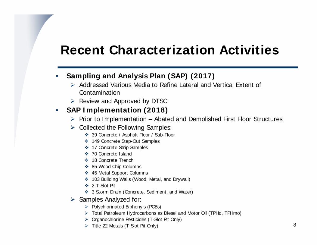
Recent Characterization Activities
• Sampling and Analysis Plan (SAP) (2017) Addressed Various Media to Refine Lateral and Vertical Extent of
Contamination Review and Approved by DTSC
• SAP Implementation (2018) Prior to Implementation – Abated and Demolished First Floor Structures Collected the Following Samples:
39 Concrete / Asphalt Floor / Sub-Floor 149 Concrete Step-Out Samples 17 Concrete Strip Samples 70 Concrete Island 18 Concrete Trench 85 Wood Chip Columns 45 Metal Support Columns 103 Building Walls (Wood, Metal, and Drywall) 2 T-Slot Pit 3 Storm Drain (Concrete, Sediment, and Water)
Samples Analyzed for: Polychlorinated Biphenyls (PCBs) Total Petroleum Hydrocarbons as Diesel and Motor Oil (TPHd, TPHmo) Organochlorine Pesticides (T-Slot Pit Only) Title 22 Metals (T-Slot Pit Only) 8

9
Recent Characterization Activities (Continued)
Before
After
Abatement and Demolition of Interior Structures
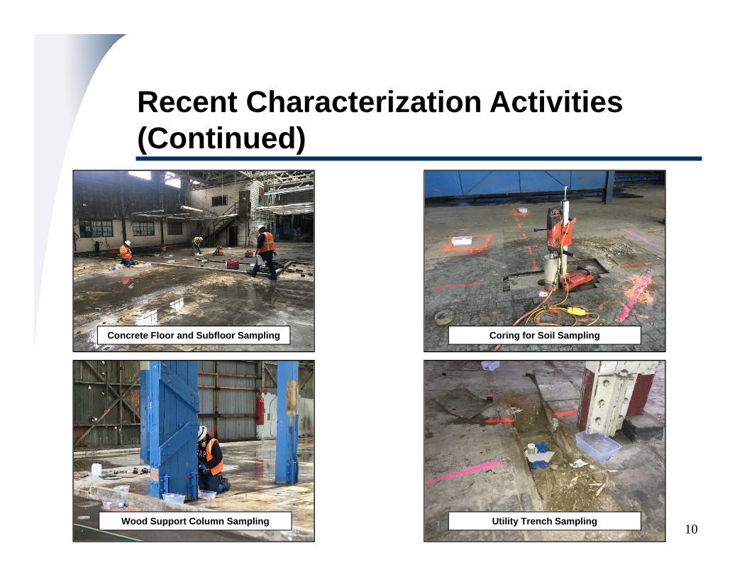
10
Recent Characterization Activities (Continued)
Concrete Floor and Subfloor Sampling
Wood Support Column Sampling
Coring for Soil Sampling
Utility Trench Sampling

Recent Characterization Activities –Results Summary
• Cleanup Goals PCBs –
Non-Porous Media – 10 micrograms per 100 square centimeters (10 µg/100 cm2)
Solid / Porous Media – No PCB-Specific Land Use Covenant
o 0.74 mg/kg (Currently = 0.94 mg/kg – USEPA Region IX Commercial / Industrial Screening Level)
TPH – Diesel (TPHd; 240 mg/kg) and Motor-Oil (TPHmo; 500 mg/kg)
11

Recent Characterization Activities –Results Summary (Continued)
• Results Summary Concrete Floor – PCBs, TPHd and TPHmo Above Cleanup Goals Concrete Trench – TPHd and TPHmo Above Cleanup Goals Storm Drain Manhole – PCBs Above Cleanup Goal in Sediment / Not Above
Cleanup Goal in Concrete and Water Wood Chip Column or Interior Wall – PCBs Above Cleanup Goals on Some
Columns / Interior Walls Metal Wipe Columns or Interior Walls – PCBs Not Above Cleanup Goals on
Columns and Interior Walls Soil Underlying Floor – PCBs, TPHd and TPHmo Not Above Cleanup Goals T-Slot Pit – PCBs, TPHd and TPHmo Not Above Cleanup Goals
12

Recent Characterization Activities –Results Summary (Continued)
• Summary of Constituents Detected Concrete Floor
PCBs Ranged from <0.005 to 28 mg/kg TPHd Ranged from 53 to 4,100 mg/kg TPHmo Ranged from 170 to 23,000 mg/kg
Concrete Trench PCBs Ranged from <0.0074 to 0.47 mg/kg TPHd Ranged from 3.3 to 6,600 mg/kg TPHmo Ranged from 30 to 24,000 mg/kg
Soil Underlying Floor PCBs – All Non-Detect (< 0.005 mg/kg) TPHd – Ranged from <0.24 to 48 mg/kg TPHmo – Ranged from <1.3 to 460 mg/kg
Wood Chip Column or Interior Wall – PCBs - Maximum Concentration of 52 mg/kg
Metal Wipe Samples PCBs – Maximum Concentration of 1.9 µg/100 cm2
T-Slot Pit PCBs – All Non-Detect (< 0.028 mg/kg) TPHd – Ranged from 3.2 to 12 mg/kg TPHmo – Ranged from 13 to 57 mg/kg
13

14
Building 116 – PCB Results SummaryConcrete Floor and Subfloor

15
Building 116 – TPH Results SummaryConcrete Floor and Subfloor

16
Building 116 – PCB Results SummaryUnderlying Soil

17
Building 116 – TPH Results SummaryUnderlying Soil

18
Building 116 – PCB Results SummaryInterior Support Columns

19
Building 116 – PCB Results SummaryConcrete Islands

20
Building 116 – TPH Results SummaryConcrete Islands

21
Building 116 – PCB and TPH Results Summary - Concrete Strips

22
Building 116 – PCB and TPH Results Summary – Utility Trenches

23
Building 116 – PCB Results SummaryInterior Wall (Chip and Wipe Samples)

Building 116 – Path Forward
• Update Cleanup Plan / Notification Addendum to DTSC / USEPA / Water Board
• Perform Remediation Activities Remediate / Remove Wood Block Floor Scabble / Remove Concrete Over Specific Areas Restore Floor Remove Specific Wood Columns / Interior Walls Remove Sediment in Storm Drain
• Collect Confirmation Samples• Offsite Transport and Disposal of Wastes• Prepare Closure Documentation
Document Results of Cleanup Plan / Notification Implementation(Site Characterization and Cleanup Action Summary Report)
• Request No Further Action
24

Questions?Questions?

Acronyms and Abbreviations
• µg/100 cm2 – Micrograms per 100 Square Centimeters• DTSC - California Environmental Protection Agency,
Department of Toxic Substances Control• Mg/kg – Milligrams per Kilogram• ND – Not Detected• PCB – Polychlorinated Biphenyl• SAP – Sampling and Analysis Plan• TPHd – Total Petroleum Hydrocarbons as Diesel• TPHmo – Total Petroleum Hydrocarbons as Motor-Oil• USEPA – United States Environmental Protection Agency• Water Board – California Regional Water Quality Control
Board, San Francisco Bay Region
26

Attachment 3. Navy Monthly Progress Report, May 31, 2018

1.0 INTRODUCTION The Department of the Navy (Navy) prepared this monthly progress report (MPR) to discuss environmental cleanup at the former Mare Island Naval Shipyard (MINS) in Vallejo, California. This MPR does not discuss cleanup work by the City of Vallejo, its agent, Weston Solutions or its developer, Lennar Mare Island, through the Environmental Services Cooperative Agreements (ESCAs). The work completed through those agreements this month is reported separately. This MPR discusses progress made during the reporting period from April 27, 2018, through May 31, 2018. The information provided in this report includes updates to field work and removal actions, document submittals, the progress of regulatory reviews, issues associated with Navy environmental programs, and Base Realignment and Closure (BRAC) Cleanup Team (BCT) and Restoration Advisory Board (RAB) meetings.
2.0 FIELD WORK, ACTIONS, AND UPCOMING EVENTS
The Navy performed field work at Installation Restoration (IR) Site 4 and Production Manufacturing Area (PMA) and Unexploded Ordnance Site 3 (UXO 3)—Dredge Pond 3E and Northern Marine Corps Firing Range (MCFR).
IR Site 4 and PMA On May 8 to May 10, 2018, the Navy performed field work at IR Site 4 and PMA. The Navy inspected, gauged, and collected groundwater samples from 19 groundwater wells at IR Site 4 and measured the groundwater level at one well at the PMA. The groundwater data is being collected for the IR Site 4 Feasibility Study.
USS Kennison (DD-138), Mare Island, 1919
www.bracpmo.navy.mil
UXO 3—Dredge Pond 3E and Northern MCFR On May 30, the Navy mobilized to the UXO 3—Dredge Pond 3E and Northern Marine Corps Firing Range to set up equipment for dewatering Dredge Pond 3E. Between June 4 to June 8, the Navy plans to pump accumulated rain water out of Dredge Pond 3E into an adjacent dredge pond to facilitate drier conditions so field work for the remedial investigation can proceed later this summer.
Navy Monthly Progress Report
Former Mare Island Naval Shipyard
May 31, 2018
Groundwater Sampling at IR Site 4
Dredge Pond 3E
www.bracpmo.navy.mil
Monthly Progress Report – Former Mare Island Naval Shipyard May 31, 2018
3.0 DOCUMENT SUBMITTALS AND PROGRESS OF REGULATORY REVIEW
The Navy submitted the following document during the reporting period:
Draft Final, Final Status Survey Report Debris Disposal Area Near Dike 14 South Shore Area
The Navy received comments or concurrence from the regulatory agencies on the following documents during the reporting period:
Concurrence received from the Regional Water Quality Control Board (Regional Water Board) on the Final Remedial Investigation Report for the Crane Test Area North
Comments received from the Department of Toxic Substances Control (DTSC) on the 2017 Annual Monitoring Report for the Paint Waste Area Wetland Monitoring
Comments received from DTSC on the Draft Record of Decision/Final Remedial Action Plan for Investigation Area F1
Comments received from the Regional Water Board on the Final 2017 Annual Remedy Status Report for Investigation Area H1
Comments received from the Regional Water Board on the Draft Finding of Suitability to Transfer for Parcel XV-B(1)b (FOST 16)
4.0 REGULATORY REVIEW: YEAR-TO-DATE PROGRESS
The documents presented in the following table include only documents that address sites where the Navy remains responsible for the cleanup work.
BCT meetings are held regularly with the Navy, DTSC, and the Regional Water Board to discuss the progress of environmental cleanup at MINS. The next BCT meeting will be held on July 26, 2018.
RAB MEETING SCHEDULE The RAB meets the last Thursday of every other month, unless otherwise noted in bold. The next RAB meetings are scheduled for:
July 26, 2018 September 27, 2018 November 29, 2018
Meetings begin at 7:00 p.m. and are held at: Mare Island Conference Center 375 G Street, Vallejo, CA 94592
NAVY CONTACT INFORMATION Janet Lear
BRAC Environmental Coordinator E-mail: [email protected]
Local Telephone: (707) 562-3104 San Diego Telephone: (619) 524-1924
San Diego Fax: (619) 524-0575 www.bracpmo.navy.mil
Number of Documents Submitted by the Navy 14
Number of DTSC Comments Received by the Navy 7
Number of Regional Water Board Comments Received by the Navy 6
Number of EPA Comments Received by the Navy 0

Attachment 4. Lennar Mare Island RAB Update, May 2018

"S"S"S
"S
!
!
!
!
!!!
!
!
!!!!
AZUAR DR
WALNUT AVE
CALIFORNIA AVEDUMP RD
MESA RD
C ST
RAILROAD AVE
I ST
CLUB
DR
J ST
7TH ST
A ST
L ST
MARE ISLAND CAUSEWAY
ACCESS RD
D ST
M ST
SARGO WAY
B ST
4TH ST3RD ST
K ST
P ST
E ST
N ST
ACAC
IAL ST
1ST ST
Q ST
15TH ST
9TH ST
MADRONE AVE
10TH ST
OAK AVE
DENT RD
WAHOO AVE
LAWS AVE
PRESTON ST
17TH AVE
FIREDELL AVE
CRISP AVE
WAWSMUTH AVE
KLEIN AVE
18TH ST
IHONSON LN
RAILROAD AVE
OAK AVE
C ST
WATERFRONT AVEW 13TH ST
12TH ST
14TH ST
14TH ST
MOISES WY
TISDALE AVE
5TH ST
5TH ST
E ST
SUISUN AVE
WISEMAN AVEDETORO WAY
9TH ST
9TH ST
13TH ST
GROVE ST
POMPANO AVE
8TH ST
8TH ST
10TH ST
POPLAR AVE
WEST ELM ST
SAN PABLO
2ND ST
KIRKLAND AVE
REEVES AVE
SAN PABLO AVE
PETALUMA AVE
CURRY ST
SARGO AVE
MAGN
OLIA
ST
H ST
HENLEY AVEKLEIN AVE
ACCESS RD
BUILDINGS 85/89/271
IWPS 4
IR03
IR15
OWS T-2
BUILDING 121
D1.3
IR13IR10
H1/X/B207S
IA C3 BGM TRIANGLE
BUILDING 742 UL#02
BUILDING 46
BUILDING 144 OIL WATER SEPARATOR (BUILDING 144 OWS)
UST M57
BUILDING 84
BUILDING 746A UL#01
BUILDING 91 UL#01BUILDING 87 UL#01
BUILDING 116 UL#01
BUILDINGS 206/208 AREA
DOM 6/CWL-IA
H1/2/B85S
BUILDING 386
BUILDING 237
ARMY
SCHOOL
A3
B.1
D1.2
D1.1
D1.2
D1.3
D1.1
C1
D2
H2
D1.3
D1.1
B.2-1
B.2-2
C2
C3OIL HOUSE 862
BUILDING 730 AL#01
BUILDING 688 UL#01
CISTERN 36
OIL HOUSE 434
Q:\TEAM\DMMV\CLIENTS_L_P\LENNAR\REMEDY_LMI\MXD\RAB_REPORT\2017_05\RAB_OVERVIEW_MAY2018_20180530.MXD DANA.HEUSINKVELD 5/30/2018 9:21:05 AM
FEATURES WITHIN THE EETPMAY 2018 RAB UPDATELENNAR MARE ISLAND, VALLEJO, CALIFORNIA
LEGEND! PCB SITE!! FORMER IWL FEATURES"S FORMER UNDERGROUND STORAGE TANK
FUEL-OIL PIPELINEINVESTIGATION AREAEETPGROUP I SITESSTRUCTURESROADSWETLANDS
FOUR KEY STAGES OF CLEANUPSURVEY & SAMPLINGREMEDIAL INVESTIGATION / FEASIBILITY STUDYREMEDIAL ACTION / CLEANUPPENDING CLOSURE / CLOSED
0 500 1,000 1,500Feet
³
BUILDING 746 UL#01
Upcoming Field Work:Building 87 PCB Site UL#01, IA C1 (Continuation of Remediation)Building 91 PCB Site UL#01, IA C1 (Continuation of Remediation)Building 91 Elemental Mercury, IA C1 (Continuation of Remediation)Cooling Water Loop-Intake Arm Corrective Action Plan Implementation, IA C1 (Initiation of Remediation)FOPL Segment H1/X/B207S, Petroleum Corrective Action Plan Implementation, IA C1 (Initiation of Remediation)Oil Houses 434 and 862 and Cistern 36 Petroleum Corrective Action Plan Implementation, IA C2 (Continuation of Remediation)Building 742 UL#02 PCB Site Remediation, IA C2 (Continuation of Remediation)
Field Work Performed:DOM-6 Area, Baseline Groundwater Monitoring Event, IA C1B84/84A, Building Materials Sampling, IA D1.3 Central
Documents Submitted and/or in Review/Modification:DOM-6 Remedial Design Work Plan - Response to Comments, IA C1Second Revised Data Gaps Site Characterization Report, Multiple Sanitary Sewer Sites, IAs C1 and C2Implementation Report and Request for Closure for Underground Storage Tank M57 and Fuel-oil Pipeline E3/VAR/M57 and Other Building 866 Area Petroleum Hydrocarbon Environmental Sites, IA C2Building 742 PCB Site UL#02 Analytical Results Technical Memorandum, IA C2Building 742 PCB Site UL#02, Addendum Notification, IA C2Building 688 PCB Site UL#01, Site Characterization and Cleanup Action Summary Report, IA C2Revised Building 746A PCB Site UL#01, Site Characterization and Cleanup Action Summary Report, IA C2Revised Building 144 Oil/Water Separator Summary Report and Request for Closure and Response to Comments, IA C3Final 2016 First Five-Year Review Report for IA C3 PCB Sites, IA C3Groundwater Beneficial Use Exception, IA D1.3 Central
Upcoming Documents:Final 2016 First Five-Year Review Report for IR15, IA C1Revised Final 2016 First Five-Year Review Report for IA B.2-1Revised Final 2016 First Five-Year Review Report for IA C2, 6 PCB Sites and IR21IA C1 Remedial Action Plan for Public ReviewRevised FOPL Segment H1/2/B85S Implementation Report and Request for Closure, IA C1IA C2 Remedial Action Plan for Public ReviewRevised IA D1.2 Commercial Area Land Use Covenant (LUC) / Rescission of Existing LUC, IA D1.2
Agency Reviewed / Commented or Concurred Documents:Final 2016 First Five-Year Review for IA C2 PCB Sites, IA C2 (Comments)Removal Action Work Plan, Mercury Removal, Polychlorinated Biphenyl Site Building 91 UL#01, IA C1 (Comments)Fact Sheet for IA C2 Remedial Action Plan (Comments)Revised Final IA C3 Land Use Covenant, IA C3 (Comments)

Attachment 5. Weston Mare Island RAB Update, May 2018

May 2018
INVESTIGATION AREA H1 (IA-H1) AND WESTERN EARLY TRANSFER PARCEL (WETP) - DOCUMENT STATUS
Comments were received from the agencies for the following documents:
Draft Land Use Control Remedial Design for Installation Restoration Site 05, Dredge Pond 7S, and the Western Magazine Area (to address land use controls and implementation)
Draft Western Early Transfer Parcel Third Five-Year Review
Comments received from the public will also be incorporated and responses prepared. The documents will be finalized after acceptance from the regulators.
MAINTENANCE ACTIVITIES
WESTON continues maintenance activities for the San Pablo Bay Trail (part of the WETP) and the 72-acre Investigation Area H1 (IA-H1) Containment Area cap and perimeter groundwater collection trench system. The IA-H1 Leachate and Groundwater Collection System continues to operate normally. To date approximately 33.5 million gallons of groundwater/ leachate have been collected and discharged to the Vallejo Sanitation and Flood Control District treatment works.


![Former Wurtsmith AFB Restoration Advisory Board (RAB ... · item be added to the RAB Action Item Tracker.[AI #20] Mr. Leriche also cited a draft study completed by MDEQ and investigation](https://img.dokumen.tips/doc/110x75/5e1f848554eb36145f0bc08d/former-wurtsmith-afb-restoration-advisory-board-rab-item-be-added-to-the-rab.jpg)