Embed Size (px)
Citation preview

Altitude Resources Ltd. Palisades Coal Property
Technical Report‐ Palisades Coal Property Prepared for Altitude Resources Ltd Page 1 of 60
RESOURCE ESTIMATE FOR THE
PALISADES COAL PROPERTY
West Central Alberta Centred at 5,924,076 N and 430,933 E (NAD 83)
Submitted to: Altitude Resources Ltd 28 November 2011 Moose Mountain Technical Services Robert F. Engler, P.Geol. Robert J. Morris, M.Sc., P.Geol. 1975 1st Ave. South Cranbrook, B.C. V1C 6Y3 Canada Tel: (780) 940-05700 Email: [email protected]

Altitude Resources Ltd. Palisades Coal Property
Technical Report‐ Palisades Coal Property Prepared for Altitude Resources Ltd Page 2 of 60
DATE & SIGNATURE PAGES Herewith, our report entitled ‘Resource Estimate for the Palisades Coal Property” dated 28 November 2011. Signature of Robert F. Engler Dated the 28th day of November 2011. B.Sc, P.Geol. Moose Mountain Technical Services Principal Geologist Signature of Robert J. Morris Dated the 28th
day of November 2011. M.Sc., P.Geol. Moose Mountain Technical Services Principal Geologist

Altitude Resources Ltd. Palisades Coal Property
Technical Report‐ Palisades Coal Property Prepared for Altitude Resources Ltd Page 3 of 60
CERTIFICATE & DATE – ROBERT F. ENGLER I, Robert F. Engler, BSc, P.Geol., do hereby certify that:
1. I am a Principal of Moose Mountain Technical Services., 28 Hummingbird Road, Sherwood Park AB T8A 0A2
2. I graduated with a B.Sc. from the University of Alberta in 1974. 3. I am a member of the Association of Professional Engineers, Geologists and
Geophysicists of Alberta. (#M24009). 4. I have worked as a geologist for a total of thirty-six years since my graduation from
university. 5. My past experience includes work with all of the coal mines in Alberta, Saskatchewan
and British Columbia as well as exploration projects in western Canada, and western US, Mexico, Mongolia, and China. I also held senior marketing positions for fifteen years with Luscar Ltd, a major Canadian coal producer.
6. I have read the definition of “qualified person” set out in NI 43-101 and certify that by reason of my education, affiliation with a professional association and past relevant work experience, I fulfill the requirements to be a “qualified person”. I am independent of Altitude Resources Ltd in accordance with section 1.5 of NI 43-101.
7. I am responsible for the entire Technical Report titled “Resource Estimate for the Palisades Coal Property”, dated 28 November 2011, other than Item 14 of the Technical Report.
8. I inspected the property on September 3, 2011 and have worked extensively on nearby Sherritt owned mining operations. I work as a geological consultant to the mining industry.
9. To the best of my knowledge, information and belief, the Technical Report contains all scientific and technical information that is required to be disclosed to make the Technical Report not misleading.
10. I have read NI 43-101 and Form 43-101F1, and the Technical Report has been prepared in compliance with that instrument and form.
11. I consent to the filing of the Technical Report with any stock exchange and other regulatory authority and any publication by them, including electronic publication in the public company files on their websites accessible by the public.
Dated this 28th day of November 2011 “Signed and sealed” ________________________ Signature of Qualified Person Robert F. Engler, B.Sc., P.Geol. Print Name of Qualified Person

Altitude Resources Ltd. Palisades Coal Property
Technical Report‐ Palisades Coal Property Prepared for Altitude Resources Ltd Page 4 of 60
CERTIFICATE & DATE – ROBERT J. MORRIS I, Robert J. Morris, M.Sc., P.Geol., of Fernie B.C. do hereby certify that:
1. I am a Principal Geologist with Moose Mountain Technical Services. 2. I graduated with a Bachelor of Science degree in geology from the University of B.C. in
1973 and a Master of Science degree in geology from Queen’s University in 1978. 3. I am a member of the Association of Professional Engineers, Geologists and
Geophysicists of Alberta. (#75480) 4. I have worked as a Geologist for 35 years since my graduation from university. My
experience in coal mining, exploration, and feasibility studies includes extensive work in the coalfields of southeast and northeast B.C., Iran, England, Colombia, Indonesia, Mongolia, and Thailand.
5. I have read the definition of “qualified person” set out in National Instrument 43-101 (“NI 43-101”) and certify that by reason of my education, affiliation with a professional associations (as defined in NI 43-101) and past relevant work experience, I fulfill the requirements to be a “qualified person” for the purposes of NI 43-101.
6. I have prepared and am responsible for Item 14 of the Technical Report titled “Resource Estimate for the Palisades Coal Property” dated 28 November 2011.
7. I have had no prior involvement with the property. 8. To the best of my knowledge, information and belief, the Technical Report contains all
scientific and technical information that is required to be disclosed to make the Technical Report not misleading.
9. I am independent of Altitude Resources Ltd applying all of the tests in Section 1.5 of NI 43-101.
10. I have read NI 43-101, and the Technical Report has been prepared in compliance with that instrument.
Dated this 28th day of November 2011 “Signed and sealed” ________________________ Signature of Qualified Person Robert J. Morris, M.Sc., P.Geol. Print Name of Qualified Person

Altitude Resources Ltd. Palisades Coal Property
Technical Report‐ Palisades Coal Property Prepared for Altitude Resources Ltd Page 5 of 60
TABLE OF CONTENTS
1.0 Summary ............................................................................................................................. 8 2.0 Introduction ....................................................................................................................... 10 3.0 Reliance on Other Experts ................................................................................................. 11 4.0 Property Description and Location .................................................................................... 12 5.0 Accessibility, Climate, Local Resources, Infrastructure and Physiography ...................... 14 6.0 History ............................................................................................................................... 20
6.1 Denison Mines Limited 1982/1983 .............................................................................. 21 6.2 Altitude Resources ....................................................................................................... 21
7.0 Geological Setting and Mineralization .............................................................................. 22 7.1 Stratigraphy .................................................................................................................. 22 7.2 Structure ....................................................................................................................... 23 7.3 Mineralization .............................................................................................................. 24
8.0 Deposit Types .................................................................................................................... 30 9.0 Exploration ........................................................................................................................ 31
9.1 Exploration Conducted by Denison Mines Limited ..................................................... 31 10.0 Drilling .............................................................................................................................. 32 11.0 Sample Preparation, Analyses and Security ...................................................................... 33 12.0 Data Verification ............................................................................................................... 36 13.0 Mineral Processing and Metallurgical Testing .................................................................. 37
13.1 Coal Quality Assessment ............................................................................................. 37 13.2 In Situ Coal Quality ..................................................................................................... 38 13.3 Clean Coal Quality ....................................................................................................... 39 13.4 Coal Beneficiation Studies ........................................................................................... 41 13.5 Rheological and Petrographic Analysis ....................................................................... 42 13.6 Summary ...................................................................................................................... 44
14.0 Mineral Resource Estimates .............................................................................................. 45 15.0 Mineral Reserve Estimates ................................................................................................ 54 16.0 Mining Method .................................................................................................................. 54 17.0 Recovery Methods ............................................................................................................. 54 18.0 Project Infrastructure ......................................................................................................... 54 19.0 Market Studies and Contracts ............................................................................................ 54 20.0 Environmental Studies, Permitting and Social or Community Impact ............................. 54 21.0 Capital and Operating Costs .............................................................................................. 54 22.0 Economic Analysis ............................................................................................................ 54 23.0 Adjacent Properties ........................................................................................................... 55 24.0 Other Relevant Data and Information ............................................................................... 55 25.0 Interpretation and Conclusions .......................................................................................... 55 26.0 Recommendations ............................................................................................................. 56 27.0 References ......................................................................................................................... 59 APPENDIX A COAL INTERCEPTS ...................................................................................... 60

Altitude Resources Ltd. Palisades Coal Property
Technical Report‐ Palisades Coal Property Prepared for Altitude Resources Ltd Page 6 of 60
LIST OF TABLES
Table 4-1 Palisades Coal Property Coal Tenures ................................................................. 12 Table 10-1 Summary of Palisades Coal Drilling ................................................................... 32 Table 13-1 Palisades Coal Core Hole Coal Samples ............................................................. 38 Table 13-2 Palisades Coal Raw Coal Sample Analysis ......................................................... 39 Table 13-3 Palisades Coal 1.50SG Float Sample Analysis .................................................... 40 Table 13-4 Palisades Coal Composite Sample Washability Clean Coal ................................ 40 Table 13-5 Composite Sample Washability Tests ................................................................. 41 Table 13-6 Fluidity and Dilatation Analysis .......................................................................... 42 Table 13-7 Palisades Coal Petrographic Analysis .................................................................. 43 Table 14-1 Coal Seam Thickness ........................................................................................... 46 Table 14-2 Coal Seam Bulk Density ...................................................................................... 47 Table 14-3 Inferred Resources within Total Property ............................................................ 47 Table 26-1 Proposed Exploration Program, Priority 1 ........................................................... 56 Table 26-2 Proposed Exploration Program, Priority 2 ........................................................... 56

Altitude Resources Ltd. Palisades Coal Property
Technical Report‐ Palisades Coal Property Prepared for Altitude Resources Ltd Page 7 of 60
LIST OF FIGURES Figure 4-1 Land Holdings ..................................................................................................... 13 Figure 5-1 Palisades Coal Physiography ............................................................................... 15 Figure 5-2 Regional Access ................................................................................................... 16 Figure 7-1 Stratigraphic Section ............................................................................................ 25 Figure 7-2 Stratigraphic Column ........................................................................................... 26 Figure 7-3 Geological Structure ............................................................................................ 27 Figure 7-4 Brule Mine Section: Coal Seam Structure and Deformation Style ...................... 28 Figure 7-5 Trench WT-10 ..................................................................................................... 28 Figure 7-6 Drillhole Seam Correlation .................................................................................. 29 Figure 11-1 Flow Chart for Core Analysis .............................................................................. 34 Figure 11-2 Flow Chart for Composite Sample Analysis ....................................................... 35 Figure 14-1 Palisades Coal Property ....................................................................................... 48 Figure 14-2 Showing the Topography, Property Boundary, and Outline of 20:1 Ratio Coal . 49 Figure 14-3 Palisades Coal Property; Showing the Drillholes in More Detail ........................ 50 Figure 14-4 Showing the Location of Five Cross-Sections: Figures 14-5 to 14-9 .................. 51 Figure 14-5 Cross-Section, Row 307 ...................................................................................... 52 Figure 14-6 Cross-Section, Row 363 ...................................................................................... 52 Figure 14-7 Cross-Section, Row 389 ...................................................................................... 52 Figure 14-8 Cross-Section, Row 421 ...................................................................................... 53 Figure 14-9 Cross-Section, Row 472 ...................................................................................... 53 Figure 26-1 Palisades Coal Project, Proposed Exploration ..................................................... 58

Altitude Resources Ltd. Palisades Coal Property
Technical Report‐ Palisades Coal Property Prepared for Altitude Resources Ltd Page 8 of 60
1.0 Summary In May, 2011, Moose Mountain Technical Services (MMTS) was retained by Altitude Resources Ltd. (Altitude) to review the geology of the Palisades Coal Property, build a computer model, generate an initial resource estimate, and recommend further exploration drilling programs. Altitude is a private company with its head offices in Calgary, Alberta. The company holds six coal licenses in the Hinton area of west central Alberta. This Property is at an early stage of exploration and this present assessment is focused only on the northwest half of the property where drilling is sufficient to define geologic structure and confidently allow correlation of individual coal seams. The southeast half of the property is much more structurally complex and will require considerable drilling to develop a geologic model and define resource potential. The Palisades Coal Property is comprised of six contiguous Alberta Crown Coal leases which are in Township 51 and 52, Ranges 27and 28, west of the 5th Meridian and Ranges 01,west of the 6th Meridian. The total area of the combined leases is 4,648.4 hectares. The properties are approximately 270km west of Edmonton and a further 28km northwest of the town of Hinton. The leases are located approximately 12kms west of the Canadian National Railway (CN) that runs to ports on the west coast. They form a continuous block running parallel to the east of the Rocky Mountain Front Range; extending from Solomon Creek northwest over a strike distance of 12 km to the Wildhay River. The Palisades Coal Property is directly adjacent to the north of Teck Corporation’s Brule Property. The Brule Property was developed by the Blue Diamond Coal Company as an underground mine and operated continuously over the period 1914 through 1928 producing a total of 1.8 million tonnes. The geology was most recently defined by work undertaken by geologists of Denison Mines Limited from 1982 to 1983. Collectively a total of 23 diamond coreholes were completed by Denison on the Palisades Coal Property. Most were geophysically logged and this data has been entered into the MMTS MineSight geologic model. Raw and clean coal quality expectations for the Palisades Coal Property are based on historic assay summary data reported by Denison on six coreholes completed in 1982/83. The results indicate a Low Volatile Bituminous Coking coal (Ro 1.47 to 1.54) similar to the coal produced at Grande Cache. Resources have been estimated for the Palisades coal deposit for those areas that potentially could be mined by open pit or underground methods. The geological modeling portion of the Project includes a review of the available data, formatting and treatment of data to support model development, an update of the geological interpretation, and the construction of the 3D resource model. Interpretation and modeling has focused on the Grande Cache Member of the Gates Formation.

Altitude Resources Ltd. Palisades Coal Property
Technical Report‐ Palisades Coal Property Prepared for Altitude Resources Ltd Page 9 of 60
The strike length of the modeled area is approximately 6.5km while the width is approximately 3.0km. Model geometry follows the Grande Cache Member where it is folded into a series of anticlines and synclines paralleling the Collie Creek thrust fault. Block dimensions are 25m along strike, 25m in the dip direction, and 10m in elevation. Trench and outcrop data has been used for modeling with the modeled structure considering bedding to core angles logged in drill core where available. On the basis of the current interpretation, the property is classified as complex, potentially surface mineable deposit. Sample analyses indicate that the coal is a low volatile bituminous coking coal. Coal seam SG, used to determine the coal tonnage, was from the earlier Denison work The resources have not been classified by level of assurance because of the sparse data across the property. The deposit is considered complex, so the resources would be classified as inferred. Due to the uncertainty that may be attached to Inferred Mineral Resources, at this time it cannot be assumed that all or any part of an Inferred Mineral Resource will be upgraded to an Indicated or Measured Mineral Resource as a result of continued exploration. The Inferred Resources for the Palisades Coal Property of immediate interest were determined to be 10.7 million tonnes with an overall strip ratio of 12.67:1. The coal, as defined, is within a pit with 45° walls and a strip ratio of less than 20:1BCM/tonne (a pit delineated resource with an incremental strip ratio of 20 bank cubic metres of waste to one tonne of in place coal). With an incremental strip ratio, each block of coal within the pit must have twenty blocks of waste, or less, above it. The property has an exploration target, requiring further drilling, of approximately 140 million tonnes of low volatile bituminous coking coal. MMTS is of the opinion that the Palisades Coal Property hosts significant coal resources and is a property of merit, worthy of further exploration. It is recommended that a phase of verification drilling, for a total of 90 holes, be undertaken to verify seam location and thickness. Samples for coal quality testing should also be collected. The proposed exploration work is estimated to cost $2.05 million, (see Tables 26-1 and 26-2 in Item 26). As of this time, Altitude has not applied for the necessary approvals from the Alberta Government for this program.
Altitude Resources Ltd. Palisades Coal Property
Technical Report‐ Palisades Coal Property Prepared for Altitude Resources Ltd Page 10 of 60
2.0 Introduction In May 2011, Moose Mountain Technical Services (MMTS) was retained by Altitude Resources Ltd. to create a geological model of the Palisades Coal Property, to estimate the coal resources for the deposit and to recommend a follow-up drill program. The geology of this property is defined on a macro scale by the previous work of geologists from Denison Mines Limited and the Alberta Geological Survey. Mr. Robert F. Engler completed a site visit on the 3rd of September 2011. Access to the property was confirmed as well as recent activities, including logging, gas wells, and gas pipelines. There appears to be limited pre-existing access trails into the coal-bearing areas of the property, the existing trails follow the eastern boundary only. More detailed on ground surveys will be necessary to determine the amount of new access trails that will be required for follow-up drilling. The purpose of the present work is to report on the current status of the Palisades Coal Property specifically addressing the estimate of resources within the property. At this point in time this assessment is limited to historic exploration undertaken by Denison Mines Limited in 1982/83. While actively involved in the preparation of the report, MMTS had no direct involvement or responsibility in the collection of the data and information or any role in the execution or direction of the work programs conducted for the Project on the property or elsewhere. Much of the data has undergone thorough scrutiny by project staff as well as certain data verification procedures by MMTS (included in Item 12). Sources of information are listed in the References, Item 27.

Altitude Resources Ltd. Palisades Coal Property
Technical Report‐ Palisades Coal Property Prepared for Altitude Resources Ltd Page 11 of 60
3.0 Reliance on Other Experts Moose Mountain Technical Services (MMTS) prepared this report for Altitude Resources Ltd. (Altitude). The quality of information, conclusions and estimates contained herein are based on industry standards for engineering and evaluation of a mineral project. The report is based on: i) information available at the time of preparation, ii) data supplied by outside sources, iii) engineering, evaluation, and costing by other technical specialists and iv) the assumptions, conditions and qualifications set forth in this report. This report relies primarily on the geologic investigations undertaken by Denison Mines Limited in 1982/1983 and reported in their summary document "Wildhay Project, Geological Report, April 1984". Other portions of the material in this report are based on Open File Reports available from:
The Alberta Geological Survey Bulletin 56, "Deformed Lower Cretaceous coal bearing strata of the Grande
Cache area, Alberta", OFR 89-1, "Regional Evaluation of Coal Quality in Northern Foothills/Mountain
Region of Alberta" OFR 1990-02." Coal Compilation Project, Entrance NTS 83F/5".
The Geologic Survey of Canada
"Summary Report 1928, Brule Mines Coal Area, Alberta". The Denison Exploration data and public domain Geological Reports have been reviewed and the assumptions and conclusions contained therein are reasonable. In preparing this report, the authors hereof have followed methodology and procedures, and exercised due care consistent with the intended level of accuracy, using their professional judgment and reasonable care. Robert F. Engler, P. Geol. is responsible for the entire report, except Item 14, “Mineral Resource Estimates”, which has been prepared by Robert J. Morris, P.Geol. This report is intended to be used by Altitude, subject to the terms and conditions of its contract with MMTS. Parts of this report, relating to the legal aspects of the ownership of the mineral claims, rights granted by the Government of Alberta and reports on which they are based has been reviewed and audited by the authors.

Altitude Resources Ltd. Palisades Coal Property
Technical Report‐ Palisades Coal Property Prepared for Altitude Resources Ltd Page 12 of 60
4.0 Property Description and Location
The Palisades Coal Property is located northwest of the town of Hinton in the inner foothills of west central Alberta. The property is accessible driving west from Hinton along Hwy 16 for 7km and turning north onto Hwy 40 for an additional 14km to the junction with the Peppers Lake forestry gravel road. The Peppers Lake road extends northwest for 28km to the eastern boundary of the Palisades Coal Property. From here, access onto the property is by ATV along old seismic trails or on foot. The property extends from the Wildhay River in the northwest to Solomon Creek in the southeast over a distance of 12km. Its approximate centre is 5,924,076 North and 430,933 East (UTM NAD 83). The Palisades Coal Property consists of six contiguous Alberta Crown Coal Leases held by Altitude Resources Ltd as shown in Figure 4-1. The total area of the combined leases is approximately 4,648.4 hectares (46.48 square kilometres). Altitude acquired these lands through open Public Tender of indisposed Coal Rights in September, 2010. Alberta Crown Coal Leases are granted for a term of 15 years and are renewable for additional terms on Application. There are no other obligations on the property other than annual lease rental requirements ($3.50 per hectare) to the Alberta Government and subsequent Coal Royalty payments after production. A detailed listing of the Alberta Crown Coal Leases currently held by Altitude Resources Ltd. on the Palisades Coal Property is shown in Table 4-1.
Table 4-1 Palisades Coal Property Coal Tenures Alberta Coal Lease Number Hectares Start Date First Term
013 1310091002 1,024 02-Sept -10 03-Sept-25 013 1310091003 1,024 02-Sept -10 03-Sept-25 013 1311040473 50.8 07-Apr -11 08 Apr-26 013 1311040474 82.9 07-Apr -11 08 Apr-26 013 1311040475 1,954.7 07-Apr -11 08 Apr-26 013 1311040476 512 07-Apr -11 08 Apr-26
Total 4,648.4
All of these lease holdings are in Category 4 as designated by the 1976 Alberta Coal Policy. This land category allows for coal surface mine development application by the lease holder. Exploration drilling activity will require a Coal Exploration Permit, issued by the Alberta Government, prior to conducting the work on a mineral property. The current or future operations of Altitude, including development and commencement of production activities on this property require other permits governed by laws and regulations pertaining to development, mining, production, taxes, labour standards, occupational health, waste disposal, toxic substances, land use, environmental protection, mine safety and other matters, may be required as the Project progresses. The property is within the West Fraser Mills Forest Management Area and access to the Project will require a road use agreement with this company. There are no other surface rights holders. At this time there are no environmental liabilities identified on the Property.

Altitude Resources Ltd. Palisades Coal Property
Technical Report‐ Palisade Coal Property Prepared for Altitude Mines Limited Page 13 of 60
Figure 4-1 Land Holdings

Altitude Resources Ltd. Palisades Coal Property
Technical Report‐ Palisade Coal Property Prepared for Altitude Mines Limited Page 14 of 60
5.0 Accessibility, Climate, Local Resources, Infrastructure and Physiography
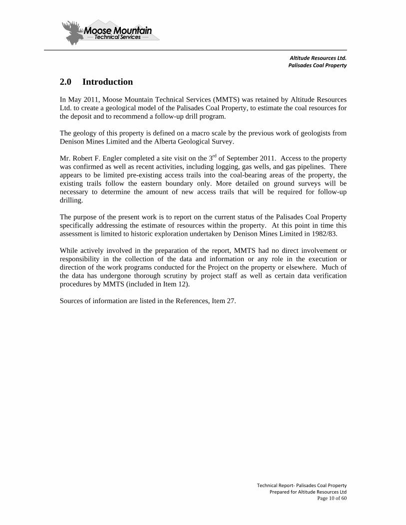
The Palisades Coal Property is located northwest of the town of Hinton in west central Alberta. Primary road access to the general area is via the Yellowhead Highway (Highway 16), which is an all-weather divided paved major highway which connects Hinton with Edson and Edmonton, Alberta, 70km and 276km respectively, to the east. The Athabasca River flows parallel to and north of the highway and the town of Hinton. Proceeding west from Hinton for 7km, turn north onto Hwy 40 and proceed approximately 14km to the junction with the Peppers Lake forestry gravel road and turn west. This road extends a further 28km to the eastern boundary of the Palisades Coal Property. From this point access to the property is by ATV or foot on old seismic trails. The Canadian National Railway (CN) rail line runs 12km parallel to the eastern boundary of the property. The railway provides direct access for coal delivery to the Port of Vancouver and to the Ridley Island Terminal at Prince Rupert. Paved landing strips are available in both Hinton and Edson for light aircraft. The property is situated in the northwest trending inner foothills physiographic region of the Rocky Mountains which is characterized by a series of steep rounded hills running parallel northwest southeast to the front range of the Rocky Mountains, incised by east flowing streams (Figure 5-1). Elevations range from 1800m ASL along the south-western boundary of the lease block to 1400m ASL along the north-eastern boundary The Wildhay River forms the northern boundary of the property, flowing east from Rock Lake towards the Athabasca River drainage system. The southern boundary is formed by Solomon Creek. The linear extent between these streams is 12km and the total property encompasses 46.5 square kilometres. The property is covered with dense forest cover of pine and spruce on the hillsides and ridges while alders, willows and black spruce occur in low lying areas. The region is part of the West Fraser Forest Management Area and is being commercially logged at present. The climate of the region is classified as boreal sub alpine, characterized by long cold winters and short cool summers. Daily temperatures range from a mean maximum of 9ºC to a mean minimum of minus 2.5ºC, with a mean daily temperature of 3ºC. Extreme temperatures range from a maximum of 30ºC in August to a minimum of minus 42ºC in January. The average annual number of days with frost is 280. The mean total precipitation in the region is approximately 500mm, which includes the rainfall equivalent of a mean snowfall of 119cm. The average annual number of days with measurable precipitation is 133.
Surface rights are held by the Alberta Government and logging and timber management are granted to West Fraser Mills Ltd. under a Forest Management Area agreement. There are no oil and gas activities on the property and no private lands.

Altitude Resources Ltd. Palisades Coal Property
Technical Report‐ Palisade Coal Property Prepared for Altitude Mines Limited Page 15 of 60
Figure 5-1 Palisades Coal Physiography
Altitude Resources Ltd. Palisades Coal Property
Technical Report‐ Palisade Coal Property Prepared for Altitude Mines Limited Page 16 of 60
Figure 5-2 Regional Access

Altitude Resources Ltd. Palisades Coal Property
Technical Report‐ Palisade Coal Property Prepared for Altitude Mines Limited Page 17 of 60
Figure 5-3 Property Access

Altitude Resources Ltd. Palisades Coal Property
Technical Report‐ Palisade Coal Property Prepared for Altitude Mines Limited Page 18 of 60
Photo 5-1 Looking West from Waypoint 33 In the foreground, the low hills are underlain by lower Cretaceous coal-bearing strata.
Photo 5-2 Looking West from Waypoint 44 Crossing Ice Water Creek, in the foreground, the low hills are underlain by lower Cretaceous coal-bearing strata.

Altitude Resources Ltd. Palisades Coal Property
Technical Report‐ Palisade Coal Property Prepared for Altitude Mines Limited Page 19 of 60
Photo 5-3 Looking West from Waypoint 42 The Wildhay River, in the foreground; the low hills are underlain by lower Cretaceous coal-bearing strata.
Photo 5-4 Railway This photo is of the CN Railway line near the property.

Altitude Resources Ltd. Palisades Coal Property
Technical Report‐ Palisade Coal Property Prepared for Altitude Mines Limited Page 20 of 60
6.0 History The first geological investigations of the region were undertaken by the Geological Survey of Canada. The coal deposits of the Foothills region surrounding the Athabasca River were first examined in 1910 and 1911 by D.B. Dowling. In 1914, the Blue Diamond Coal Company commenced commercial underground production on deposits immediately north of Brule Lake. In 1916, the region northwest of Brule, including the Palisades area, was studied by J.M. MacVicar. In 1927, B.R. MacKay made a detailed study of the Brule mining operations and coal deposits extending north to Solomon Creek. The purpose was to record in detail the stratigraphy and structure of coal seams at the active mine and assist in extending these deposits northwest towards the Palisades Coal Property. Much of the detailed structural mapping undertaken here is still relevant to conditions that apply to the Palisades Coal lease area. The underground mines at Brule closed permanently in 1928 after producing a total of 1.8 million tonnes over a 14 year period. The closure was attributed to complex structural conditions and faulting which severely affected production costs. Between 1943 and 1945, A.H. Lang mapped the Brule and Entrance map areas for the Geological Survey of Canada. Considerable work has been done over the years on the stratigraphy of the Lower Cretaceous in the Alberta Foothills. The work concentrated on establishing a nomenclature for the central and northern Foothills and correlating this stratigraphy with that of the southern Foothills. The original stratigraphic work was done by MacKay (1929a and b; 1930), who established the original formational names for the Lower Cretaceous in the Athabasca Region. Later work was done by Lang (1947), Irish (1965), Thorsteinsson (1952) and JR McLean (1982). The stratigraphic nomenclature used in this report is that established by CW Langenberg and ME McMechan (1985) of the Alberta Geologic Survey based on detailed mapping of the region. Prior to the acquisition of the Palisades coal leases by Altitude Resources, the only significant exploration in the area was undertaken by Rio Tinto who acquired the property in 1969 and Denison Mines Limited who subsequently acquired the property in 1974. Rio conducted basic mapping and trenching and completed five rotary drillholes. None of this information is currently available. Denison Mines undertook a small reconnaissance and trenching program shortly after the original leases were acquired in 1974. In 1982/1983, an extensive program was carried out by Denison, the results of which are detailed in the Palisades Coal Project, Geological Report, April 1984. This report represents the most current information available on the property.
Altitude Resources Ltd. Palisades Coal Property
Technical Report‐ Palisade Coal Property Prepared for Altitude Mines Limited Page 21 of 60
6.1 Denison Mines Limited 1982/1983
Denison carried out a detailed assessment of the Palisades Coal lease area over a 24 month period commencing in early 1982. This consisted of:
Geologic Mapping and Air Photo Interpretation on a 1:10,000 scale Trenching and mapping ten coal subcrop locations Geophysics, Magnetometer and Resistivity profiles Diamond Drilling 23 helicopter supported core drilling sites.
The mapping and trenching data identified the major Formation boundaries and macro scale structural configuration of the Palisades coal lease. The Geophysics was not successful in identifying subsurface traces of the coal seams. The Diamond Drilling program identified three distinct coal seam horizons that can be correlated along the strike length of the property. Only 10 of the 23 holes intersected coal seams and samples from these were analyzed to determine coal rank and quality. No additional work was carried out after 1983. Denison Mines focused their efforts on mine development in NE BC and subsequently withdrew from the coal business with the sale of their Quintette Mine to Teck in 1991. The Palisades lease were allowed to lapse and reverted to the Alberta Government.
6.2 Altitude Resources
Altitude Resources conducted a survey of potential indisposed crown coal lands in the Alberta Foothills with favourable development zoning and reasonable access to rail transportation. The work also included a review of historic exploration reports available in the public domain The results of this survey showed that these former Denison lands met the selection criteria. The lands were posted for Public Tender in September 2010 and Altitude was successful in acquiring the leases.

Altitude Resources Ltd. Palisades Coal Property
Technical Report‐ Palisade Coal Property Prepared for Altitude Mines Limited Page 22 of 60
7.0 Geological Setting and Mineralization
7.1 Stratigraphy
The Palisades Coal Property is located on the eastern margin of the inner foothills of the Rocky Mountain thrust belt in west central Alberta. The rocks underlying the property occur within the predominantly continental Lower Cretaceous Luscar Group (Langenberg and McMechan, 1985) which is equivalent to the Blairmore Group in Sothern Alberta and Fort St. John Group in northeast BC. (Figure 7-2) The Group is overlain by dark gray marine shales of the Shaftesbury Formation.
Strata of the Luscar Group are divided into four Formations identified in ascending order as the Cadomin, Gladstone, Moosebar and Gates Formations.
The Cadomin Formation consists of a very hard pebble conglomerate ranging from 5 to 10 meters in thickness. It forms a resistant marker in the section but has only been identified in outcrop to the west of the property.
The Gladstone Formation consists of a fining upward sequence of fine grained sandstone, shale and minor carbonaceous stringers. The lower part of the formation is interpreted as braided stream deposits while the upper part appears to be of marine estuarine origin. The formation ranges from 80 to 100 meters in thickness on the property.
The Moosebar Formation consists of dark gray marine shales conformably overlying the Gladstone. The formation is 35 to55 meters thick and presents a distinct marker for mapping in the area.
The Gates Formation consists primarily of sandstones, siltstones and coal cyclothems. The base is typically massive medium grained sandstone known as the Torrens Member which conformably overlies the marine Moosebar shales. This Member ranges from 20 to 40 meters in thickness. The coal bearing section is referred the Grande Cache Member, consisting of fine sandstones, siltstones and mudstones and continuous coal seams. The member is 85 to 95 meters thick on the property and three distinct coal zones have been identified. The Grande Cache Member is overlain by the Mountain Park Member which consists predominantly of thick bedded fine to medium grain sandstone sequences with distinct siderite grains. This Member ranges from 200m to 275m in thickness and forms prominent ridges on the property.
Three distinct coal seam horizons have been identified in the Grand Cache Member, identified in ascending order as the Solomon, Hoff and Moosehorn Seams.

Altitude Resources Ltd. Palisades Coal Property
Technical Report‐ Palisade Coal Property Prepared for Altitude Mines Limited Page 23 of 60
The lowermost Solomon is the most persistent and typically occurs directly above the Torrens Member sandstones. The Hoff seam occurs approximately 23 meters above the Solomon Seam and is only locally identified central part of the property. Elsewhere it thins out and grades into carbonaceous mudstone. The uppermost Moosehorn Seam occurs approximately 26m above the Hoff Seam at or near the top of the Grande Cache Member. The relative position of these coal seams is shown on Figure 7-1.
7.2 Structure
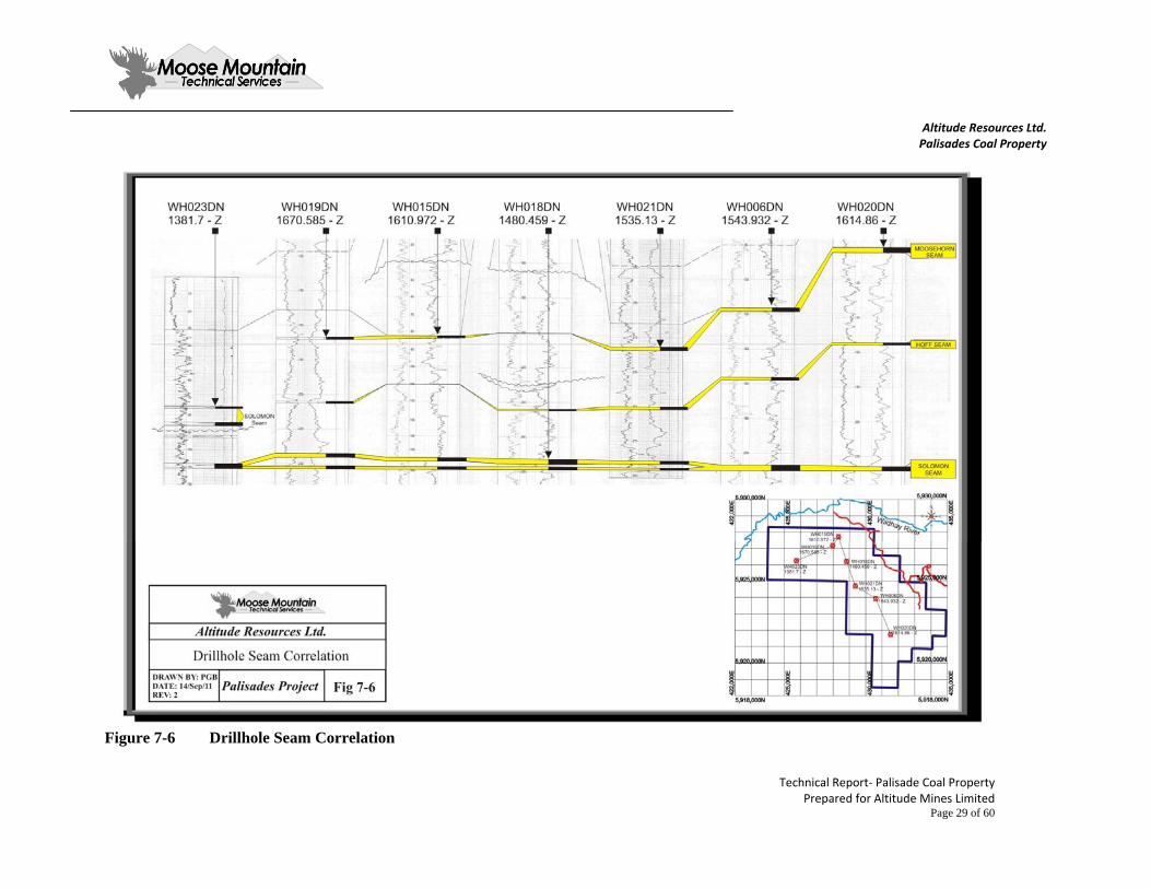
The Luscar Group sediments on the Palisades Coal Property are exposed in a northwest to southeast trending fold belt bounded on both margins by major thrust faults. (See Figure 7-4, Geology Map) The southeast boundary is marked by the Folding Mountain Thrust Fault which over thrusts-carbonate rocks of the Mississippian age onto the much younger Cretaceous strata. The northeast boundary is marked by the Collie Creek Thrust Fault which over thrusts the Luscar Group strata onto younger Upper Cretaceous formations. The macro structure containing the Luscar Group between these two major bounding faults is described from west to east as the Moosehorn Syncline, Solomon Creek Anticline and Coal Hill Syncline. The south west limb of the Moosehorn Syncline is near vertical to overturn. The axial hinge of this fold runs parallel to the Folding Mountain Thrust suggesting deformation took place at the time this trust fault was active. The Solomon Creek Anticline appears to be asymmetric with the northeast dipping limb inclined at higher angles than the south west dipping limb. There is also some evidence that this fold is faulted locally along the axial hinge line by a steeply dipping southwest dipping thrust fault. The adjacent Coal Hill Syncline is also asymmetric, dipping more steeply on the southwest limb. The Collie Creek Thrust which marks the north-eastern boundary of the property is sub-parallel to the axial hinges of the fold structures, suggesting this major dislocation was subsequent to and not contemporaneous with the initial deformation events. While evidence from the current drilling on the property is not sufficient to accurately define structure on a local scale (only ten holes intersected coal), there is apparent over thickening, thinning, and repeats of the coal section noted in the drill records to support a model of severe deformation and faulting in high compression zones at or near the axial hinges of these folds. (See Figure 7-6) Mapping the workings of the old underground mines at Brule adjacent to the southeast (BR McKay, 1927) show plastic deformation and over thickening of the coal seams in anticline crowns and syncline hinges. A typical cross section of the structure of the old Brule Mine is shown in Figure 7-4.

Altitude Resources Ltd. Palisades Coal Property
Technical Report‐ Palisade Coal Property Prepared for Altitude Mines Limited Page 24 of 60
The style of deformation is related to the mechanical nature of the Gates Formation. Effectively, the relatively weak coal bearing Grande Cache Member is sandwiched between the hard Torrens Member sandstone and the equally massive Mountain Park member sands. During severe folding events, the weaker shale and coal units will literally detach and compress along bedding planes and flow towards hinge axes. This type of deformation is expected to occur at Palisades Coal.
7.3 Mineralization
The terminology used for identifying coal zones and individual seam plies has been adopted from Denison Mines Limited. There are three coal zones recognized within the Grande Cache Member identified in ascending order as the Solomon, Hoff, and Moosehorn. While these individual zones maintain relative stratigraphic position in the area modeled by MMTS, the thickness of individual seams and proportion of coal plies to rock partings in each zone is variable. The variation is both depositional and in some cases caused by structural distortion. It should also be noted here that observations regarding the continuity and character of these zones is based on very limited drill data spaced over a wide area. The Solomon Zone is the best developed coal zone on the property and has been intersected in six drillholes. Typically, it lies directly above the Torrens Member sands and consists of two major sub-seams separated by a carbonaceous mudstone parting. Seam thickness varies from hole to hole. In the southeast (Hole WH 020), the zone contains 1.07m of coal. In the centre (Hole WH 021) the seam thins to 0.53m. In the northwest (Hole WH 023) the seam is 0.65m thick. The maximum development occurs in the northeast in the Coal Hill area along the hinge of the Solomon Creek Anticline where seam thickness averages over 3m (Hole WH 019, 015 and 018). The thickest intersection is in WH 015 at 4.6m; this is likely showing the effect of structural thickening. A second area of thick coal is recorded in holes WH 006 and WH 014 where the seam averages over 2m in thickness. Again this follows the crown of the Solomon Creek Anticline. The Hoff Zone occurs approximately 23m above the Solomon Zone. The zone consists of a single seam which was only intersected in two drillholes in the central part of the property. (WH 006, 1.5M; WH 019, 0.9M) Elsewhere, the zone deteriorates into thin coal stringers and carbonaceous shale. The upper most Moosehorn Zone is approximately 26m above the Hoff Zone near the top of the Grande Cache Member. It is typically a single coal seam ranging from 0.9 to 1.2m in thickness. Figure 7-6 shows a correlation diagram of the main coal zones on the Palisades Coal Property.

Altitude Resources Ltd. Palisades Coal Property
Technical Report‐ Palisade Coal Property Prepared for Altitude Mines Limited Page 25 of 60
Figure 7-1 Stratigraphic Section

Altitude Resources Ltd. Palisades Coal Property
Technical Report‐ Palisade Coal Property Prepared for Altitude Mines Limited Page 26 of 60
Figure 7-2 Stratigraphic Column

Altitude Resources Ltd. Palisades Coal Property
Technical Report‐ Palisade Coal Property Prepared for Altitude Mines Limited Page 27 of 60
Figure 7-3 Geological Structure

Altitude Resources Ltd. Palisades Coal Property
Technical Report‐ Palisade Coal Property Prepared for Altitude Mines Limited Page 28 of 60
Figure 7-4 Brule Mine Section: Coal Seam Structure and Deformation Style
Figure 7-5 Trench WT-10
Altitude Resources Ltd. Palisades Coal Property
Technical Report‐ Palisade Coal Property Prepared for Altitude Mines Limited Page 29 of 60
Figure 7-6 Drillhole Seam Correlation

Altitude Resources Ltd. Palisades Coal Property
Technical Report‐ Palisade Coal Property Prepared for Altitude Mines Limited Page 30 of 60
8.0 Deposit Types As specified in Geological Survey of Canada (GSC) Paper 88-21, which is a reference for coal deposits as specified in NI 43-101, coal “Deposit Types” are either surface mineable, underground mineable, non-conventional, or sterilized. In addition to “Deposit Types” the GSC also refers to “Geology Types”, which are a definition of the amount of geological complexity, usually imposed by the structural complexity of the area. The classification of a coal deposit by “Geology Type” determines the approach to be used for the resource estimation methodology and the limits to be applied to certain key estimation criteria. The identification of a particular deposit type for a coal property defines the confidence that can be placed in the extrapolation of data values away from a particular point of reference. The classification scheme of the GSC is similar to many other international coal resource classification systems but it has one significant difference. This system is designed to accommodate differences in the degree of tectonic deformation of different coal deposits in Canada. Four classes are provided for that range from the first, which is for deposits of the Plains type with low tectonic disturbance, to the fourth which is for Rocky Mountains type deposits such as that of Coal Mountain, which is classed as "severe". MMTS classifies the Palisades Coal Property deposit as modeled in this report as geologically Complex. Defining resources on a Complex coal deposit will require close spaced drilling. Typically, Measured Resources require cross sectional drilling lines 150m apart and Indicated Resources require lines paced 300m apart. The drill hole data along these lines should be at a minimum of 100m and 200m apart respectively. This would be the level of detail required to design actual mining pits. MMTS has targeted the most promising near surface coal bearing structures on the property in the initial phase of drilling exploration. Nine cross sectional drill lines are proposed, spaced 1000m apart. Ten closely spaced angle holes are proposed for each line to provide stratigraphic and structural control. The outcome will provide resources in the Measured, Indicated and Inferred categories and more precisely indicate those areas that warrant further drilling for resource Category refinement.

Altitude Resources Ltd. Palisades Coal Property
Technical Report‐ Palisade Coal Property Prepared for Altitude Mines Limited Page 31 of 60
9.0 Exploration Exploration on the Palisades Coal Property consisted of two separate campaigns conducted by Rio Tinto in 1969 and Denison Mines Limited in 1982 and 1983. As none of the Rio Tinto work is available, this section will focus on work conducted by Denison. Altitude Resources has not conducted any exploration work on the Property.
9.1 Exploration Conducted by Denison Mines Limited
Denison Mines Limited carried out exploration continuously between 1982 and 1983. The programs consisted of geologic mapping, aerial photography producing topographic maps, trenching, diamond core drilling, down-hole geophysical logging, coal sampling, and subsequent analytical work. In addition, Denison experimented with surface geophysics in an attempt to trace near surface coal seams. The geologic mapping was compiled on a 1:10,000 scale and identified all of the formation boundaries and structural features exposed on the property. Ten trenches were excavated to measure coal outcrops found in the field. Exploration drilling was conducted by a helicopter supported Longyear 38 diamond drilling rig due to limited road/trail access on the property. The 1982 drilling focused on areas on potential coal resource delineation along the trend of the Solomon Creek Anticline in the north east part of the property where mapping had identified coal occurrences. A total of 18 holes were completed of which six intersected coal. Ten of these holes (WH 001through 005, WH 007 through 010 and WH 012) were shallow and may have encountered difficulty penetrating the surface overburden. The 1983 drilling focused on understanding the total stratigraphic package from north to south across the whole property. Five deep holes were completed (WH 019 through 023) of which four intersected coal. Drillhole WH 022 only reached a total depth of 137m which appears to be too shallow to intersect the coal seams. All drillholes were logged with a full suite of geophysical logs including gamma ray, calliper, long-spaced density, bed resolution density, and in inclined holes; a dipmeter log was run. All core recovered was photographed and logged. Recoveries were reconciled against geophysical log records. Coal seams were sampled in separate plies and sent to General Testing Laboratories in Vancouver. Denison also experimented with surface geophysics in an attempt to map concealed lithological units. A Sintrex MP-2 Proton magnetometer was evaluated. The results indicated no magnetic contrasts between rock units and it was concluded that this technology would not be useful at Palisades Coal. Denison also tried a Sintrex RSP-6DC ground resistivity unit to map near surface coal seams. The results of this test were also negative.

Altitude Resources Ltd. Palisades Coal Property
Technical Report‐ Palisade Coal Property Prepared for Altitude Mines Limited Page 32 of 60
10.0 Drilling Altitude Resources has not conducted any drilling on the Property. In 1982 and 1983, Denison Mines Limited drilled 23 diamond core holes on the Palisades Coal Property block, totalling 2,968.91 meters. Table 10-1 summarizes the drilling on the property between 1982 and 1983. Table 10-1 Summary of Palisades Coal Drilling
Company Year Coreholes Type (m) Intersections
Denison Mines Ltd 1982 18 NQ 1,782.03 Six holes intersected coal
Denison Mines Ltd 1983 5 HQ 1,186.88 Four holes intersected coal
Grand Total 23 2,968.91 Due to the absence of available trails, the Denison drilling was undertaken with a helicopter supported Longyear 38 core rig. All core was washed and photographed prior to logging lithology and structural features. The angle between bedding and corehole axis was measured and recorded. All holes (except WH-022) were geophysically logged by B.P.B. Instruments. The geophysical suite included Gamma Ray, Long Spaced Density, Neutron, Bed Resolution Density, and Calliper. A detailed summary of Coal Intercepts for the Palisades Coal Property can be found in Appendix A at the end of this report.

Altitude Resources Ltd. Palisades Coal Property
Technical Report‐ Palisade Coal Property Prepared for Altitude Mines Limited Page 33 of 60
11.0 Sample Preparation, Analyses and Security MMTS was not involved in any sampling or coal quality work on the property that was done by Denison Mines Limited, and the only surviving record of this activity is limited to the summary report issued by Denison Mines Limited "Wildhay Project, Geological Report, April 1984". The sampling procedure used by Denison for sampling coal in core included:
Surveying of drillhole locations (X, Y, and Z). Systematic sampling of coal by collecting the entire coal interval. Systematic core logging and down hole geophysics completed to better define coal
locations and core recovery. Sealing coal samples in plastic bags and shipping them to a certified lab for analysis.
Denison describes core recovery as variable for most holes due to the friable nature of the coal and structural shearing. Core recovery was reconciled to the geophysical logs to determine the areas of loss. In general, the recovery in coal zones in 1982 averaged less than 50%, and improved to an average of 70% in the 1983 program. Denison attributes this to switching to a larger diameter HQ core from the previous NQ size used in 1982. Denison sampled all coal plies recovered, sealed these individual samples in plastic bags and shipped them to General Testing Laboratories in Vancouver. General Testing Laboratories was an independent laboratory serving the industry in western Canada and was certified lab with regard to ASTM procedures. The work undertaken predates the current ISO Certification standards for Coal Laboratories. MMTS considers the historic analytical data from General Testing to be acceptable in terms of analytical process.

Altitude Resources Ltd. Palisades Coal Property
Technical Report‐ Palisade Coal Property Prepared for Altitude Mines Limited Page 34 of 60
MMTS was not involved in any of the historic sampling on the properties. All of the previous exploration sampling completed by Denison is reported as:
"All the diamond drill core was logged in detail, and full core coal samples were taken from selected mining sections. These samples were sent to General Testing Laboratories, Vancouver for analysis. A detailed flow chart of the analyses conducted for the 1982 program is shown below:"
Figure 11-1 Flow Chart for Core Analysis

Altitude Resources Ltd. Palisades Coal Property
Technical Report‐ Palisade Coal Property Prepared for Altitude Mines Limited Page 35 of 60
"In 1983 the testing protocol was changed to include full float /sink analysis of the composited core material as shown in the following flowsheet"
Figure 11-2 Flow Chart for Composite Sample Analysis

Altitude Resources Ltd. Palisades Coal Property
Technical Report‐ Palisade Coal Property Prepared for Altitude Mines Limited Page 36 of 60
12.0 Data Verification MMTS completed numerous levels of verification, including:
Checking of all available geophysical logs and drilling records from the 23 coreholes. Checking of all available drillhole-collar coordinates to eliminate any obvious errors in
location. MMTS entered all drillhole data into lithology and coal quality database files which were in turn uploaded into MineSight software to create a 3D resource model. MMTS believes that the database and model are accurate and presents no major threats to the resource estimate.

Altitude Resources Ltd. Palisades Coal Property
Technical Report‐ Palisade Coal Property Prepared for Altitude Mines Limited Page 37 of 60
13.0 Mineral Processing and Metallurgical Testing
13.1 Coal Quality Assessment
The data consists of historic corehole records and laboratory analysis on 27 individual coal samples collected from full seam intervals for the 10 holes which intersected coal. The initial task involved in this assessment was to evaluate individual samples to determine how relevant they may be to understanding the coal quality of the Palisades Coal Property. As discussed in Section 14, Denison experienced very poor core recovery due to the friable nature of the coal (HG1 100, structural shearing) so the first criteria in determining relevance was actual sample recovery. Recoveries below 50% make the analytical data meaningless, and ideally all recoveries should be above 85% to extract valid data. In light of how difficult it is to core and recover these coal seams, a recovery minimum threshold of 60% was set for this evaluation. The next item considered was what type of material was recovered. The Hoff Seam is known to degrade into banded coal stringers and carbonaceous shale. The amount of non coal material can be estimated from the initial raw ash content of the samples collected. Three of the four Hoff samples collected had ash contents ranging from 50% to 80% which would disqualify them for further consideration. Other high ash samples were collected from the Solomon Seam cores (50% to 80%). In some cases, they represent a true carbonaceous shale layer, in other circumstances they were the only material that was retrieved when coring through the soft coal seam. Applying these criteria, 14 of the 27 individual coal seam samples were rejected for further consideration. The remaining samples represent 3 Moosehorn Seam intersections, 1 Hoff Seam intersection, and 6 Solomon Seam intersections. While this sample set is not sufficient for quantitative purposes it can be considered indicative of what coal quality can be expected from the property. The selected (green highlight) and rejected (yellow highlight) samples are shown on Table 13-1, Palisades Coal Core Sample Summary.

Altitude Resources Ltd. Palisades Coal Property
Technical Report‐ Palisade Coal Property Prepared for Altitude Mines Limited Page 38 of 60
Table 13-1 Palisades Coal Core Hole Coal Samples Seam Hole No. Year Sample
No. Composite
No. Raw
Ash % Thick. meters
Recovery %
Comment
Moosehorn WH 019 1983 2554 WH -4 41.22 0.85 73 WH 020 1983 2551 WH-1 31.46 0.91 63 WH 021 1983 2558 22.55 0.61 70
Hoff WH 006 1982 2601 50.08 0.31 100 WH 013 1982 2610 55.49 1.76 19 WH 018 1982 2614 81.56 0.19 100 Carb. shale WH 019 1983 2555 WH-2 28.69 0.89 68
Solomon WH 006 1982 2602 37.52 1.10 30 WH 006 1982 2603 70.94 1.07 49 Carb. shale WH 014 1982 2608 48.28 1.92 84 WH 015 1982 2606 26.86 1.56 17 WH 015 1982 2604 19.46 0.78 63 WH 015 1982 2607 66.77 2.0 12 Carb. shale WH 015 1982 2605 82.13 0.17 100 Carb. shale WH 016 1982 2611 42.86 4.6 91 WH 018 1982 2615 49.66 1.79 56.7 WH 018 1982 2612 63.59 2.08 10 Carb. shale WH 018 1982 2613 30.49 1.12 31 WH 019 1983 2757 WH-3 14.01 1.13 72 WH 019 1983 2556 WH-3 11.41 1.17 68 WH 020 1983 2552 WH-5 26.61 0.32 100 WH 020 1983 2553 WH-5 38.43 0.75 100 WH 023 1983 2559 WH-6 36.38 0.38 100 WH 023 1983 2561 WH-6 25.94 0.27 100
Unknown WH 023 1983 2560 71.35 0.54 85 Carb. shale WH 023 1983 2562 57.96 0.51 28 WH 023 1983 2563 47.49 0.41 22
13.2 In Situ Coal Quality
In 1982, Denison only analyzed raw core for head ash content and immediately floated the sample at 1.50SG to determine the "clean" coal proximate analysis. In 1983, the procedure was changed to run a full analysis on the raw coal sample. The results of this testing is shown in Table 13-2, Palisades Coal Raw Coal Sample Analysis.

Altitude Resources Ltd. Palisades Coal Property
Technical Report‐ Palisade Coal Property Prepared for Altitude Mines Limited Page 39 of 60
Table 13-2 Palisades Coal Raw Coal Sample Analysis Seam Hole No. Sample
No. Res.
Moist Ash %
Vol. %
FC %
Vol. dmmf
Sul. %
FSI
Moosehorn WH 019 2554 1.02 41.22 14.77 42.99 0.63 1 WH 020 2551 1.25 31.46 13.93 53.26 17.50 0.26 1 WH 021 2558 0.78 22.55 18.19 58.48 21.75 0.37 2.5
Hoff WH 019 2555 0.86 28.69 17.19 53.26 21.66 0.48 7
Solomon WH 014 2608 48.28 WH 015 2604 19.46 WH 016 2611 42.86 WH 019 2757 0.80 14.01 17.61 19.49 0.40 5 WH 019 2556 0.87 11.41 18.53 20.14 0.46 8 WH 020 2552 1.05 26.61 56.43 19.19 1.04 4.5 WH 020 2553 1.03 38.43 14.76 45.78 19.83 0.99 2.5 WH 023 2559 0.93 36.38 14.73 47.96 19.59 0.38 7 WH 023 2561 0.87 25.94 15.97 57.22 19.32 0.54 4.5
The results show that the insitu ash content of the coal seams are variable ranging from a high of 48.24% to a low of 11.41% with an average value of 29.8%. This variance is related to include high ash rock material. Sulphur is also variable ranging from 0.26 % to 1.04% with an average value of 0.52%. The Volatile Matter content on a dry, mineral matter free basis (dmmf) ranges from 21.75% to 19.19% which classifies this coal as a Low Volatile Bituminous Coking coal as per ASTM D -388.
13.3 Clean Coal Quality
In order to assess the potential clean coal product that could be developed from the Palisades Coal Property, all individual coal ply core samples collected by Denison were processed and washed at General Testing Laboratories in Vancouver according to the protocols described in Section 11. In 1982, initial testing was a clean coal separation at 1.50 Specific Gravity (SG). These results are shown on the following Table 13-3, 1982 Palisades Coal 1.50SG Float Sample Analysis.

Altitude Resources Ltd. Palisades Coal Property
Technical Report‐ Palisade Coal Property Prepared for Altitude Mines Limited Page 40 of 60
Table 13-3 Palisades Coal 1.50SG Float Sample Analysis 1982 Palisades Coal 1.50SG Float Sample Analysis
Seam Hole No. Sample No.
Res. Moist
Ash %
Vol. %
FC %
Vol. dmmf
Sul. %
FSI
Moosehorn WH 021 2558 1.05 6.04 18.55 74.36 18.38 0.54 6.5
Solomon WH 014 2608 2.58 7.23 20.95 69.24 22.61 0.40 3.5 WH 015 2604 0.99 10.37 20.27 68.37 22 0.43 8 WH 016 2611 2.22 12.42 19.61 65.75 21.90 0.50 6
In 1984, the procedure was modified. The raw samples were first combined into representative seam composites to create enough volume for float/sink testing at various gravities. A full raw head analysis was conducted followed by screening and washing these fractions to simulate a wash plant process. The results of the analysis of the clean coal produced through this process are summarized in the following Table 13-4, 1983 Palisades Coal Composite Washed Coal. Table 13-4 Palisades Coal Composite Sample Washability Clean Coal
1983 Palisades Coal Composite Sample Washabilty Clean Coal Seam Hole No. Sample
No. Res.
Moist Ash %
Vol. %
FC %
Vol. dmmf
Sul. %
FSI Phos In coal
Moosehorn WH 020 WH-1 1.13 16.28 18.49 64.10 20.90 0.69 7.5 0.040 WH 019 WH-4 1.29 17.73 15.81 65.17 17.96 0.35 8.0 0.022
Hoff WH 019 WH-2 1.01 8.43 20.38 70.18 21.73 0.63 9.0 0.085
Solomon WH 019 WH-3 0.94 4.62 19.60 74.84 20.29 0.50 8 0.007 WH 020 WH-5 2.05 8.80 18.59 70.56 20.02 0.62 7 0.005 WH 023 WH-6 1.12 5.44 18.68 74.76 19.45 0.53 8 0.005
The results show that the coal can be readily cleaned to below 10% ash content to produce a 19% to 20% Volatile Matter Low Vol coking coal. The Sulphur content is reduced from the initial raw coal assay, and should average 0.50% on the clean product. FSI values are good ranging from 6 to 9. The overall level of Phosphorous in coal is low, particularly in the Solomon Seam. The low FSI values highlighted in the previous Table 13-4 is likely a result of sample oxidation as the core was from a shallow depth near the surface.

Altitude Resources Ltd. Palisades Coal Property
Technical Report‐ Palisade Coal Property Prepared for Altitude Mines Limited Page 41 of 60
13.4 Coal Beneficiation Studies
As discussed in 18.3, Denison created seam composite samples to generate sufficient volume for float sink test work. The samples were screened into plus 28 Mesh, 28 x 100 Mesh, and minus 100 Mesh fractions. The two plus 100 Mesh Fractions were floated at Specific Gravities at 1.40, 1.60, 1.70, 1.80 and 2.00. The minus 100m material was cleaned in a froth floatation cell and collected a 60, 120, and 180 second intervals. The clean composite were created by combining the plus 28 Mesh floats cut at 1.50SG, the 28 x 100 Mesh fraction at 1.80SG and the minus 100 Mesh froth at 60 seconds. While the process was useful in understanding the composition of the three size fractions of the material tested, the results cannot be extrapolated into the expectations of coal washability in a full scale commercial wash plant due to the lab scale nature of the tests. At best, they could be considered an “estimate” of potential theoretical yield. The results are summarized in the following Table 13-5, Composite Sample Washability Tests. Table 13-5 Composite Sample Washability Tests
Seam Hole No. Sample No.
Yield %
Res. Moist
Ash %
Vol. %
FC %
Sul. %
FSI
Moosehorn WH 020 WH-1 Raw 1.02 41.22 14.77 42.99 0.63 1.0 Clean 35.88% 1.13 16.28 18.49 64.10 0.69 7.5 WH 019 WH-4 Raw 1.25 31.46 13.93 53.36 0.26 1.0 Clean 43.30% 1.29 17.73 15.81 65.17 0.35 8.0
Hoff WH 019 WH-2 Raw 0.86 28.69 17.19 53.26 0.48 7.0 Clean 62.65% 1.01 8.43 20.38 70.18 0.63 9.0
Solomon WH 019 WH-3 Raw 0.87 13.35 18.60 67.18 0.47 6.6 Clean 85.09% 0.94 4.62 19.60 74.84 0.50 8 WH 020 WH-5 Raw 0.94 33.98 14.88 50.20 1.04 3.0 Clean 47.01% 2.05 8.80 18.59 70.56 0.62 7 WH 023 WH-6 Raw 0.83 28.54 15.50 55.13 0.51 4.5 Clean 70.02% 1.12 5.44 18.68 74.76 0.53 8
The results show the clean coal yield expectations are a function of the initial raw coal ash content. This relationship cannot be established with any precision from the current limited data set, largely due to the small sample size of coal tested.

Altitude Resources Ltd. Palisades Coal Property
Technical Report‐ Palisade Coal Property Prepared for Altitude Mines Limited Page 42 of 60
13.5 Rheological and Petrographic Analysis
Denison selected certain coal seam samples for both Fluidity and Dilatation analysis to qualify the rheological properties of the coal. The results are summarized in Table 13-6, Fluidity and Dilatation Analysis. Table 13-6 Fluidity and Dilatation Analysis
Palisades Coal Rheology Tests Seam Solomon Hoff Moosehorn
Sample Number 2604 2615 WH-3 WH-5 WH-6 2611 WH-2 WH-1 WH-4 Gieseler Plasticity
Start Temp C 445 448 455 470 461 446 446 482 n/a Max. Fluid Temp C 481 487 474 472 482 475 478 483 n/a
Final Temp C 511 506 506 496 510 500 510 506 n/a Melting Range C 66 58 51 26 49 54 64 44 n/a
Max Fluidity ddpm 111 1 3 1 7 1 4 2 n/a
Dilatation T1 Softening C 398 422 410 416 389 416 398 410 417
T2 Max. Contract C 441 479 - 467 461 482 T3 Max. Dilatation C 479 485 467 485 485 491 482
Contraction % 23 10 27 22 22 16 27 20 5 Dilatation % 48 -17 22 12 37 -2 5
The Gieseler Fluidity Test is a measure of the coals’ viscosity (measured in ddpm) as it melts during carbonization. The results show a relatively consistent temperature envelope where the coal becomes plastic and re-solidifies. The Maximum Fluidity values are low with the exception of sample 2604 which shows a higher value of 111ddpm. These low fluidity values are typical of high rank Gates Formation coals (Grande Cache is a low vol Gates coal with low fluidity.) The Dilatation tests are a measure of the coals’ coking capacity (the ability to incorporate Inerts during the melting phase). Generally, coals that display Dilatation values from 0 to 50% are considered Coking coals. The results again show a consistent temperature range of reactivity and mostly positive Dilatation values. Denison selected five clean coal samples for petrographic analysis at CANMET Research Labs in Ottawa. Coal Petrography is a used to determine the proportion of Reactive components (particles that melt during coke making) and Inert components (particles which remain un-melted) for a particular coal and its relative rank (carbon maturation) determined by optical reflectance under a microscope (Ro). The strength (Calculated Stability Index) of the coke produced during carbonization can be predicted by formula if the amount of Reactives and Inerts and the Ro are determined. Typically, a prime coking coal will have a Calculated Stability Index greater than 55. The results of the Palisades Coal samples petrographic analysis are shown in Table 13-7, Petrographic Analysis.

Altitude Resources Ltd. Palisades Coal Property
Technical Report‐ Palisade Coal Property Prepared for Altitude Mines Limited Page 43 of 60
Table 13-7 Palisades Coal Petrographic Analysis Palisades Coal Petrographic Analysis
Seam Moosehorn Solomon Sample Number WH-4 2611 2604 2615 WH-6
Sample Ash% Content 17.74 12.42 10.37 13.29 5.54
V Types V 12 1.3 V 13 2.4 8.2 31.7 0.5 4.0 V 14 6.2 34.2 30.5 12.0 8.2 V 15 11.3 20.2 29.2 40.9 V 16 4.1 0.6 6.2 14.3
Reactive Components
Total Vitrinite 23.9 63.2 63.5 47.9 68.2 1/3 Semifusinite 5.4 6.4 ½ Semifusinite 29.4 9.4 16.0
Exinite 0 0 0 0 0 Total Reactives 53.3 68.6 72.9 65.9 74.6
Inert Components
2/3 Semifusinite 10.7 12.8 ½ Semifusinite 29.4 9.5 16.1
Micrinite 2.7 2.2 2.5 4.0 4.4 Fusinite 4.1 5.6 9.2 4.4 5.1
Mineral Matter 10.5 7.2 5.9 7.6 3.1 Coke 5.7
Total Inerts 46.7 31.4 27.1 34.1 25.4
Mean Reflectance 1.51 1.47 1.39 1.53 1.54
Compositional Balance Index 7.49 3.47 2.28 4.71 3.13 Strength Index 6.37 6.73 6.35 6.87 7.00
Calculated Stability Index 20.4 52.8 59.3 43.4 55.4
The results show certain samples may be anomalous and not representative. The single Moosehorn Seam sample WH-4 has very low levels of Vitrinite and the high raw ash of 17.74%. This higher proportion of non coal material may be in this sample which would cause a biased analysis. The other anomaly is Solomon Seam Sample 2604 which shows a lower rank (Ro 1.39) as compared to the other samples that occur in a relatively narrow rank range of Ro 1.47 to Ro 1.54. This rank range confirms these coals are Low Volatile Bituminous coking coals. Rejecting the biased assay from Drillhole WH-4; the Calculated Stability Index ranges from 43.4 to 59.3, with an average value of 52.7.

Altitude Resources Ltd. Palisades Coal Property
Technical Report‐ Palisade Coal Property Prepared for Altitude Mines Limited Page 44 of 60
13.6 Summary
The coal underlying the Palisades Coal Property is Low Volatile Bituminous Coking coal
as defined by ASTM D-388 and confirmed by an average Ro value of 1.51.
The raw insitu coal ash content is variable from 48.24% to 11.41% with an average value of 29.8%. Limited washability testing has show a clean coal product in the 10% ash range can be produced at a 1.50SG cut-point.
The clean coal has a volatile matter content of 19% to 20% dry basis and a sulphur content
averaging 0.50%. The phosphorous level in coal is low, ranging from a high of 0.085% to a low of 0.005%. FSI values range from 7 to 9 indicating good coking capacity.
The coal has low Fluidity values and acceptable Dilatation values.
Petrographic Analysis indicates a good predicted Stability Factor of plus 50 at a
Reactives/Inerts ratio of 70%/30%.

Altitude Resources Ltd. Palisades Coal Property
Technical Report‐ Palisade Coal Property Prepared for Altitude Mines Limited Page 45 of 60
14.0 Mineral Resource Estimates Resources have been estimated for the Palisades coal deposit for those areas that potentially could be mined by open pit or underground methods. The geological modeling portion of the Project includes a review of the available data, formatting and treatment of data to support model development, an update of the geological interpretation, and the construction of the 3D resource model. Interpretation and modeling has focused on the Grande Cache Member of the Gates Formation. Model Extent The resources documented with this report represent the north-western portion of the Palisades Coal Property, Figure 14-1. The strike length of the modeled area is approximately 6.5km while the width is approximately 3.0km. Model Geometry Model geometry follows the Grande Cache Member where it is folded into a series of anticlines and synclines paralleling the Collie Creek thrust fault. Block dimensions are 25m along strike, 25m in the dip direction, and 10m in elevation. The model measures 620 blocks (15,500m) in length and 250 blocks (6,000m) across and examines resources between 750m and 2,100m in elevation (135 blocks). The model has a –45° rotation (west of north, an azimuth of 315°). Topography A digital elevation model for the Project area was obtained from the Alberta Government, 1:20 000 DEM, which included an elevation datum on a 100m grid with accuracy within 5m, surface feature break lines, and general infrastructure. The drillhole data was ‘draped’ to the digital data and the drillhole collar elevations were adjusted to fit the topography. Overburden (till) Surface The base of overburden surface defines the extent of glacial-fluvial cover over in situ materials. No coal seams are modeled above the base of overburden surface. The depth of overburden was reported in the drillhole logs. An interpolation, using inverse distance to the 3.5 power with a 10,000m search, and a maximum of 8 points, was completed. The overburden thickness was then subtracted from the topography surface to make the base of overburden surface. Oxide Horizon Oxidized coal is considered to be coal within 10m of surface. Geological Data The geological database for the model was developed from previous exploration records by MMTS and includes 23 drillholes with a total of 2,683.5m. Of these, 15 are shallow holes less than 30m deep (the eight deep holes total 2,304.7m of drilling). Trench and outcrop data has been used for

Altitude Resources Ltd. Palisades Coal Property
Technical Report‐ Palisade Coal Property Prepared for Altitude Mines Limited Page 46 of 60
modeling with the modeled structure considering bedding to core angles logged in drill core where available. Coal seam thicknesses from exploration drillholes are measured along the length of the hole (from geophysical logs) and because the angle of intersection between the hole and the seam is often less than perpendicular, these intersections represent an ‘apparent’ rather than ‘true’ thickness of the seam. Adjustment from apparent to true seam thickness is, therefore, a critical step in the modeling of in place coal resources. The resource model is based on true seam thickness, as defined mathematically through the relationship between drillhole geometry and interpreted bedding geometry. The true thickness interpolation used a 5,000m x 5,000m search and an inverse distance power of three and a half. Mineable Thickness On the basis of the current interpretation, the property is classified as complex, potentially surface mineable deposit. Sample analyses indicate that the coal is a low volatile bituminous coking coal. Resource assumptions for mineable thicknesses conform to GSC Paper 88-21 guidelines at 0.6m. Seam thickness is shown in Table 14-1. Table 14-1 Coal Seam Thickness
HOLE SEAM
No. Seam Name TTHK
WH018DN 11 Moosehorn 1 1.32 WH015DN 11 1.67 WH015DN 12 Moosehorn 2 1.18 WH021DN 13 Moosehorn 3 0.74 WH019DN 13 0.96 WH018DN 13 1.79 WH015DN 13 2.36 WH019DN 20 Hoffman 0.95 WH006DN 20 1.20 WH013DA 20 1.83 WH016DA 20 3.29 WH014DA 30 Solomon 1.60 WH006DN 30 2.60 WH019DN 31 Solomon 1 1.70 WH018DN 31 2.06 WH018DN 32 Solomon 2 1.11 WH015DN 32 1.25 WH019DN 32 1.25
In Situ Bulk Density Conversion of coal volumes to weight requires knowledge of the bulk density of the coal. Earlier work by Denison determined bulk density for the various seams, as shown in Table 14-2. The bulk density values as shown in Table 14-2 compare reasonably to estimates suggested in GSC Paper 88-21 which show low volatile bituminous coal with bulk densities ranging from 1.52g/cm3 to 1.66g/cm3 having ash contents of 25% to 35%.

Altitude Resources Ltd. Palisades Coal Property
Technical Report‐ Palisade Coal Property Prepared for Altitude Mines Limited Page 47 of 60
Table 14-2 Coal Seam Bulk Density SEAM Seam Name Bulk Density
11 Moosehorn 1 1.66 12 Moosehorn 2 1.66 13 Moosehorn 3 1.66 20 Hoffman 1.56 30 Solomon 1.52 31 Solomon 1 1.52 32 Solomon 2 1.52
Resource Classification The resources have not been classified by level of assurance because of the sparse data across the property. The deposit is considered complex, so the resources would be classified as inferred at best. Due to the uncertainty that may be attached to Inferred Mineral Resources, it cannot be assumed that all or any part of an Inferred Mineral Resource will be upgraded to an Indicated or Measured Mineral Resource as a result of continued exploration. Table 14-3 shows the inferred resources for the Palisades Coal Property of immediate interest. The coal, as defined, is within a pit with 45° walls and a strip ratio of less than 20:1BCM/tonne (a pit delineated resource with an incremental strip ratio of 20 bank cubic metres of waste to one tonne of in place coal). With an incremental strip ratio, each block of coal within the pit must have twenty blocks of waste, or less, above it. The overall strip ratio for the Palisades Coal Property is 12.67:1. Table 14-3 Inferred Resources within Total Property (Low Volatile Bituminous Coking Coal)
Pit ROM MET OXIDE Waste ROM kT kT kT kBCM S/R
S06 1,729 1,156 574 6,768 3.91 S10 4,089 3,143 946 25,994 6.36 S15 6,713 5,608 1,105 58,501 8.71 S20 11,814 10,670 1,144 149,705 12.67
Note:1) The table lists coal resources for all three of the seams modeled. 2) Oxide coal is considered to be within 10m of surface. 3) The overburden (OVB) volume is included in the waste volume.
The property hosts an exploration target of approximately 140Mt of low volatile bituminous coal which requires further drilling to define.

Altitude Resources Ltd. Palisades Coal Property
Technical Report‐ Palisade Coal Property Prepared for Altitude Mines Limited Page 48 of 60
Figure 14-1 Palisades Coal Property (Yellow outline) The data points are shown as dots with white name tags, while the modeled area of the seams is shown in the coloured areas.

Altitude Resources Ltd. Palisades Coal Property
Technical Report‐ Palisade Coal Property Prepared for Altitude Mines Limited Page 49 of 60
Figure 14-2 Showing the Topography, Property Boundary, and Outline of 20:1 Ratio Coal (The grid is 1000m x 1000m).

Altitude Resources Ltd. Palisades Coal Property
Technical Report‐ Palisade Coal Property Prepared for Altitude Mines Limited Page 50 of 60
Figure 14-3 Palisades Coal Property; Showing the Drillholes in More Detail (The grid is 1000m x 1000m).

Altitude Resources Ltd. Palisades Coal Property
Technical Report‐ Palisade Coal Property Prepared for Altitude Mines Limited Page 51 of 60
Figure 14-4 Showing the Location of Five Cross-Sections: Figures 14-5 to 14-9 (The grid is 500m x 500m).

Altitude Resources Ltd. Palisades Coal Property
Technical Report‐ Palisade Coal Property Prepared for Altitude Mines Limited Page 52 of 60
Figure 14-5 Cross-Section, Row 307 (Showing the tight anticline east of drillhole 060; The Solomon seam is shown in blue while the Hoffman seam is green. The vertical grid is 100m)
Figure 14-6 Cross-Section, Row 363 (Showing the tight anticline east of drillhole 021; The Solomon seam is shown in blue while the Hoffman seam is green. The vertical grid is 100m)
Figure 14-7 Cross-Section, Row 389 (Showing the anticline; The Solomon seam is shown in blue while the Hoffman seam is green. The vertical grid is 100m)

Altitude Resources Ltd. Palisades Coal Property
Technical Report‐ Palisade Coal Property Prepared for Altitude Mines Limited Page 53 of 60
Figure 14-8 Cross-Section, Row 421 (The Solomon seam is shown in blue while the Hoffman seam is green. The vertical grid is 100m)
Figure 14-9 Cross-Section, Row 472 (The Solomon seam is shown in blue while the Hoffman seam is green. The vertical grid is 100m)

Altitude Resources Ltd. Palisades Coal Property
Technical Report‐ Palisade Coal Property Prepared for Altitude Mines Limited Page 54 of 60
15.0 Mineral Reserve Estimates There are no reserve estimates at this time.
16.0 Mining Method Mining methods have not been considered at this time.
17.0 Recovery Methods Recovery methods have not been considered at this time.
18.0 Project Infrastructure Preliminary infrastructure is discussed in Item 5, while detailed infrastructure has not been determined at this time.
19.0 Market Studies and Contracts Marketing and contracts have not been considered at this time.
20.0 Environmental Studies, Permitting and Social or Community Impact Environmental studies and social or community impacts have not been considered at this time. The permitting process for the proposed drill program has not started at this time.
21.0 Capital and Operating Costs Capital and Operating costs have not been considered at this time.
22.0 Economic Analysis Economic analysis has not been completed at this time.

Altitude Resources Ltd. Palisades Coal Property
Technical Report‐ Palisade Coal Property Prepared for Altitude Mines Limited Page 55 of 60
23.0 Adjacent Properties The Palisades Coal Property is directly adjacent to the north of Teck Corporation's Brule Property. The Brule Property was developed by the Blue Diamond Coal Company as an underground mine and operated continuously over the period 1914 through 1928 producing a total of 1.8 million tonnes. The Geologic Survey of Canada conducted a detailed survey of the Brule Property in 1927 during active operations and established the stratigraphy and seam nomenclature which extends north into the Palisades Coal Property. There are currently two active mining operations producing metallurgical coal from the same Gates Formation; the Cheviot Mine operated by Teck 68km to the southeast and the Grande Cache Mine, 90km to the northwest. Information from these properties has not been used to complete the resource estimate for the Palisades Property.
24.0 Other Relevant Data and Information MMTS does not believe there is additional technical data available for this Project.
25.0 Interpretation and Conclusions The Palisades Coal Property is considered a property of merit, which warrants further exploration. In Summary;
An in situ coal resource in excess of 140Mt to a depth of 800m;
A 10.7Mt resource within a 12.7:1 incremental strip ratio pit;
The Coal Resource at Palisades Coal includes three coal seams which have a cumulative coal thickness of approximately 4.9m;
Drilling has confirmed that the coal seams demonstrate moderate lateral stratigraphic and coal
quality continuity and that the raw in-situ coal is classified as being Low Volatile Bituminous Coking coal.
Potential exists for structurally thickened coal seams which could present attractive mining
situations.

Altitude Resources Ltd. Palisades Coal Property
Technical Report‐ Palisade Coal Property Prepared for Altitude Mines Limited Page 56 of 60
26.0 Recommendations The Palisades Coal Property is considered a significant coal resource, which warrants further exploration. It is recommended that further drilling and coring is undertaken to:
1. To confirm the structure and coal resource potential 2. To confirm coal quality expectations and coking potential
The concept is to drill 90 new angle rotary drillholes on nine cross sectional access lines to provide infill data points for more precise resource definition. The holes are planned on each line to intersect all three coal seams within surface mineable depths, less than 100m. Certain holes will be sampled (coring or reverse circulation) for quality testing. The concept is to initially drill the northern part of the lease area where historic mapping and drilling has shown high potential (Priority 1 Area). If successful, drilling would proceed to the south in the Priority 2 area. The budget costs for this proposed work program is as follows: Table 26-1 Proposed Exploration Program, Priority 1
Permitting and Access and Construction Costs $200,000
Drilling Costs $230,000 Coring Costs $30,000
Laboratory, Coal Testing Costs $70,000 Geological Supervision and Geophysical Logging Costs $80,000
Drill Site Survey Costs $20,000 Site Reclamation Costs $30,000
Final Reports/Data Entry $20,000 Contingency 25% $170,000 Total Estimate $850,000
Table 26-2 Proposed Exploration Program, Priority 2
Permitting and Access and Construction Costs $300,000
Drilling Costs $300,000 Coring Costs $50,000
Laboratory, Coal Testing Costs $100,000 Geological Supervision and Geophysical Logging Costs $120,000
Drill Site Survey Costs $30,000 Site Reclamation Costs $40,000
Final Reports/Data Entry $30,000 Contingency 25% $242,500 Total Estimate $1,212,500

Altitude Resources Ltd. Palisades Coal Property
Technical Report‐ Palisade Coal Property Prepared for Altitude Mines Limited Page 57 of 60
At this point, the cost estimates have not been verified by contractor quotes. Figure 26-1 shows the conceptual layout of the drilling program. This will be refined by follow up access reconnaissance on the ground and any restrictions identified in the Coal Exploration Permit application process.

Altitude Resources Ltd. Palisades Coal Property
Technical Report‐ Palisade Coal Property Prepared for Altitude Mines Limited Page 58 of 60
Figure 26-1 Palisades Coal Project, Proposed Exploration

Altitude Resources Ltd. Palisades Coal Property
Technical Report‐ Palisade Coal Property Prepared for Altitude Mines Limited Page 59 of 60
27.0 References Alberta Geological Survey, Open File Reports OFR 89-1, "Regional Evaluation of Coal Quality in Northern Foothills/Mountain, Region of Alberta" OFR 1990-02 "Coal Compilation Project, Entrance NTS 83F/5" Bulletin 56 "Deformed Lower Cretaceous coal bearing strata of the Grande Cache area, Alberta," Denison Mines Limited, "Wildhay Project, Geological Report, April 1984" Geological Survey of Canada McKay BR, 1928, "Brule Mines Area Alberta, Summary Report 1928" Irish E.J.W, 1945, "Pedley Map Area, Alberta", Paper 45-13 Irish E.J.W, 1946, "Pedley Map Area, Alberta", Map 838A Lang, A.H. 1945, "Entrance Map Area, Alberta" Paper 45-11 Lang, A.H. 1947, "Brule and Entrance Map Area, Alberta", Memoir 224 Hughes, J.D., L. Klatzel-Mudry, and D.J. Nikols. A Standardized Coal Resource/Reserve Reporting System for Canada. Paper 88-21 Geological Survey of Canada. 1989. Smith, G.G., Cameron, A.R., and Bustin, R.M., Geological Atlas of the Western Canada Sedimentary Basin, Chapter 33, Coal Resources of the Western Canada Sedimentary Basin

Altitude Resources Ltd. Palisades Coal Property
Technical Report‐ Palisade Coal Property Prepared for Altitude Mines Limited Page 60 of 60
APPENDIX A COAL INTERCEPTS Drillhole From To Drilled Thickness Seam Name
WH015DN 3.4 5.1 1.7 Moosehorn WH018DN 121.76 123.13 1.37 Moosehorn
WH015DN 15.6 16.8 1.2 Moosehorn
WH018DN 129.23 129.82 0.59 Moosehorn
WH015DN 18 20.4 2.4 Moosehorn
WH018DN 130.97 132.88 1.91 Moosehorn
WH019DN 167.08 168.04 0.96 Moosehorn
WH021DN 216.38 217.17 0.79 Moosehorn
WT07 0 2.49 2.49 Moosehorn
WT08 0 5.37 5.37 Moosehorn
WT09 0 0.79 0.79 Moosehorn
Wh006DN 116.84 118.04 1.2 Hoffman
WH013DA 24.08 25.91 1.83 Hoffman
WH016DA 15.29 19.96 4.67 Hoffman
WH018DN 244.3 244.5 0.2 Hoffman
WH019DN 203.97 204.92 0.95 Hoffman
WH021DN 251.12 251.44 0.32 Hoffman
WT02 0 1.2 1.2 Hoffman
WT06 0 1.6 1.6 Hoffman
WH015DN 153.54 154.08 0.54 Solomon
WH018DN 273.16 275.25 2.09 Solomon
WH019DN 234.28 235.98 1.7 Solomon
WH021DN 282.41 282.76 0.35 Solomon
WH023DN 84.24 84.72 0.48 Solomon
WH015DN 157.86 159.13 1.27 Solomon
WH018DN 277.32 278.44 1.12 Solomon
WH019DN 241.7 242.95 1.25 Solomon
WH021DN 286.38 286.78 0.4 Solomon
WH023DN 85.46 85.8 0.34 Solomon
Wh006DN 207 209.6 2.6 Solomon
WH014DA 18.12 20.27 2.15 Solomon
WT01 0 1.89 1.89 Solomon
WT03 0 2.15 2.15 Solomon
WT04 0 0.17 0.17 Solomon
WT04 0.56 1.04 0.48 Solomon
WT05 0 2.34 2.34 Solomon
Wh006DN 157.88 158.23 0.35 Unnamed coal
WH018DN 242.91 242.96 0.05 Unnamed coal
WH023DN 75 75.7 0.7 Unnamed coal
WH023DN 91.84 92.56 0.72 Unnamed coal
WH023DN 108.6 109.24 0.64 Unnamed coal
WT02 5.43 6.57 1.14 Unnamed coal