Embed Size (px)
Citation preview

RESILIENT NEIGHBORHOODS INITIATIVE:SHEEPSHEAD BAY/GERRITSEN BEACHCB 15 UPDATEAPRIL 25, 2017

A more resilient New York City
2
A more resilient NYC is one where neighborhoods, buildings and infrastructure can withstand and recover quickly from flooding and climate events.
This requires multiple lines of defense:• infrastructure hardening where feasible,• emergency preparedness, and • utilizing building code and zoning as tools so buildings are
protected from future flooding due to sea level rise.

Flood resilience zoning (DCP)
3
Flood Text II (2018) to be updated and made permanent
SIRR Report (2013) long-term, citywide resiliency framework
PFIRM + Freeboard (2012) DOB requires most restrictive map; additional elevation
Executive Order 230 (2012) mayoral override of zoning
One New York (2015) moves from recovery to future resiliency
Flood Text (2013) initial, temporary regulations
building off EO 230
SRNR (2015) provides additional zoning relief to
expedite recovery
Neighborhood Studies (2014-17) will inform the text and local rezonings
2018
Build it Back (2015) lessons learned in rebuilding effort inform zoning changes

Flood resilience zoning (DCP)
4
Flood Text II (2018) to be updated and made permanent
SIRR Report (2013) long-term, citywide resiliency framework
PFIRM + Freeboard (2012) DOB requires most restrictive map; additional elevation
Executive Order 230 (2012) mayoral override of zoning
One New York (2015) moves from recovery to future resiliency
Flood Text (2013) initial, temporary regulations
building off EO 230
SRNR (2015) provides additional zoning relief to
expedite recovery
Neighborhood Studies (2014-17) will inform the text and local rezonings
2018
Build it Back (2015) lessons learned in rebuilding effort inform zoning changes

Resilient Neighborhoods Initiative
5
Reduce flood risksDevelop zoning strategies and other tools to advance short-term, cost-effective investments that can make New York City’s building stock more resilient to severe storms and better protect our coastline.
Plan for adaptation over timeClimate change will increase coastal risks over time, including more tidal flooding in some areas. It is important to take measures to reduce the long-term vulnerabilities that neighborhoods will face over time.
Ensure neighborhoods are both resilient and vibrantEncourage high-quality development that is both resilient and respects each neighborhood’s built environment, such as by limiting building height and improving public space.

Timeline
6
Spring 2013 – Winter 2014 New York Rising Program
June 2014 Resilient Neighborhoods Initiative Kickoff at CB15
Fall 2014 – Spring 2015 Community Advisory Committee Meetings
August 2015 Gerritsen Beach Homeowners Association
November 2015 CB 15 update on Resilient Neighborhoods Studies
Fall 2016 – Spring 2017 Councilmember Briefings
April 2017 Brooklyn Borough Board

Community Board 15 Flood Maps
7
Currently in NYC, Building Code and Zoning rules are based off the1% annual chance floodplain, as shown on the Preliminary Flood Insurance Rate Map
For flood insurance purposes, the Effective Flood Insurance Rate Map is used.

Resiliency Challenges in Gerritsen Beach
8
Sunken lots and residential uses below the DFE vulnerability to coastal flooding is exacerbated by high DFEs and sunken lots
Large homes on shallow lots with limited light and air: Lots with narrow yards that pose challenges for existing zoning compliance, elevation strategies, ADA access, streetscape, and neighborhood character
Narrow streets: Many of the streets are as narrow as 20 feet, particularly in the southern section of the neighborhood, which present safety risks and accessibility issues during emergencies
Density: current zoning designation allows for multi-family development, which could over-stress existing storm sewer infrastructure
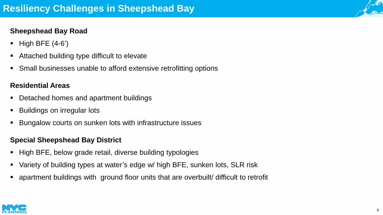
Resiliency Challenges in Sheepshead Bay
9
Sheepshead Bay Road High BFE (4-6’)
Attached building type difficult to elevate
Small businesses unable to afford extensive retrofitting options
Residential Areas Detached homes and apartment buildings
Buildings on irregular lots
Bungalow courts on sunken lots with infrastructure issues
Special Sheepshead Bay District High BFE, below grade retail, diverse building typologies
Variety of building types at water’s edge w/ high BFE, sunken lots, SLR risk
apartment buildings with ground floor units that are overbuilt/ difficult to retrofit

What We’ve Learned
10
Based on our work in Sheepshead Bay, Gerritsen Beach, and other floodplain communities, we’ve learned:
1Height
Homeowners may face the loss of
subgrade spaces when retrofitting
2Height
Properties owners may want to
address future risk by over-elevating
3Ground Floors
Current incentives to keep active ground
floors may not be enough
4Homes in M
DistrictsExisting homes in M. Districts, if damaged,
may not be able to rebuild
5Old Homes in
Small LotsOld bungalow homes on
small lots may need more flexibility to rebuild
in the future
6Highly
Vulnerable Areas
Density may need to be limited in highly
vulnerable areas

What We’ve Learned
11
Based on our work in Sheepshead Bay, Gerritsen Beach, and other floodplain communities, we’ve learned:
1Height
Homeowners may face the loss of
subgrade spaces when retrofitting
2Height
Properties owners may want to
address future risk by over-elevating
3Ground Floors
Current incentives to keep active ground
floors may not be enough
4Homes in M
DistrictsExisting homes in M. Districts, if damaged,
may not be able to rebuild
5Old Homes in
Small LotsOld bungalow homes on
small lots may need more flexibility to rebuild
in the future
6Highly
Vulnerable Areas
Density may need to be limited in highly
vulnerable areas

Gerritsen Beach
12

Gerritsen Beach Residential Core Existing R4 Zoning
13
Allows for multi-family buildings
Max building height 35ft above DFE (already 6-8ft above street level)
Inefficient footprint due to zoning requirements
Max building height 2 to 3 stories
Often do not comply with side yard regulations

Gerritsen Beach Residential Core Proposed Zoning Strategies
14
Rezone from multi-family R4 to one and two family R4-1 to prevent out of context development
Reduce side yard requirements to allow for a better building layout
Limit height at 25 feet or two (2) stories to match existing built character
Further limit new development to one-family homes for lots < 3,000 sf in line with existing infrastructure capacity
No change in allowable FAR

Gerritsen Beach Waterfront Proposed Zoning Strategies
15
On lots not directly fronting the water, rezone from multi-family C3 to one and two family R4-1 to prevent out of context development
Limit development in areas at higher risk along the waterfront to commercial uses only
Subject to Wave Risk (LiMWA)
C3 Zoning District

Gerritsen Avenue Proposed Zoning Strategies
16
Expand C2-2 designation along existing commercial uses
Allow for a wider range of uses to serve the local community

Gerritsen Beach
17

Special Sheepshead Bay District
18
Special District does not have any guidance on resiliency
Public open space requirements are not aligned with todays resiliency design standards
Plazas are allowed to be sunken up to 2 feet below grade.
Created in 1973 to promote waterfront related uses and encourage the creation of new public open space.

Special Sheepshead Bay District Proposed Zoning Strategies
19
Align SSBD text with resiliency and urban design best practices to ensure open space is accessible and can withstand flooding
ACTIVE COMMERCIAL GROUND FLOORSRequire retail spaces have optimal floor to ceiling heights to allow for a range of uses.
UPDATE PUBLIC SPACE REGULATIONS
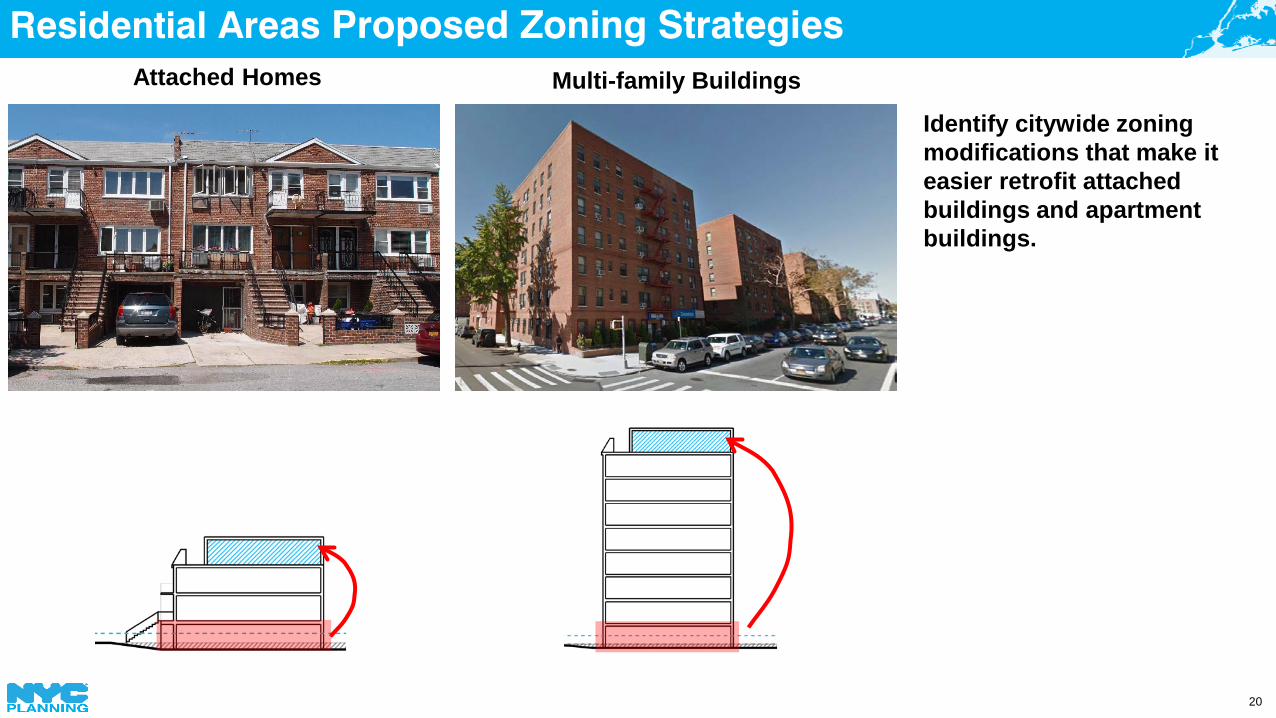
Residential Areas Proposed Zoning Strategies
20
Identify citywide zoning modifications that make it easier retrofit attached buildings and apartment buildings.
Attached Homes Multi-family Buildings

Sheepshead Bay Road Strategies
21
Sheesphead Bay Road is case study in Resilient Retail Report
The report provides retrofit and design strategies for commercial buildings
Existing low rise mixed use building with below grade space
Retrofitted low rise mixed use building

Bungalows
22
DCP provided retrofitting and zoning analysis to the Build it Back program
Build it Back evaluating elevation/reconstruction options and infrastructure repairs.

Flood Text II
23
Begin to promote new development + proactive
retrofitting to high resiliency standards
Fix and improve provisions based on lessons learned from Resilient Neighborhood Studies and other areas in the floodplain
Make the provisions of the current, temporary
2013 Flood Text permanent
1 2 3
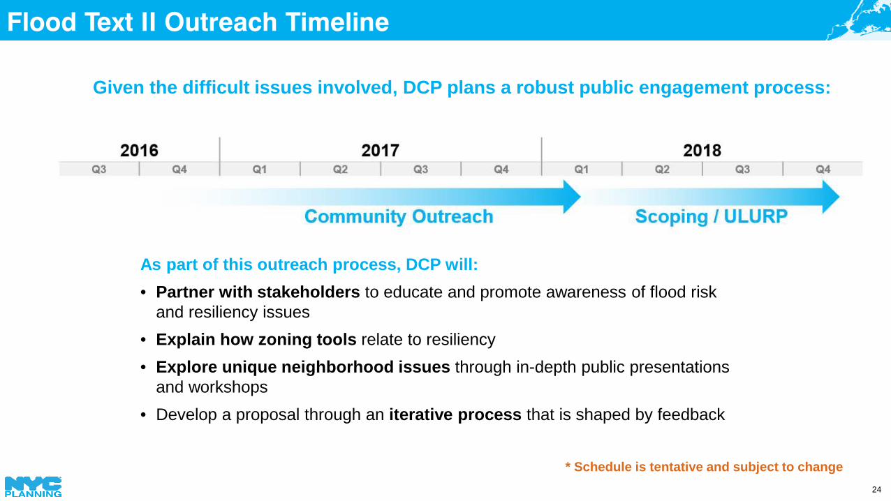
Flood Text II Outreach Timeline
24
As part of this outreach process, DCP will:• Partner with stakeholders to educate and promote awareness of flood risk
and resiliency issues • Explain how zoning tools relate to resiliency• Explore unique neighborhood issues through in-depth public presentations
and workshops• Develop a proposal through an iterative process that is shaped by feedback
Given the difficult issues involved, DCP plans a robust public engagement process:
* Schedule is tentative and subject to change

City Flood Insurance Affordability Study
25
Key Findings/Next Steps
Many neighborhoods will be especially hard hit when risk increases and rates move toward actuarial rates. Rates could reach up to $4000 a year.
City is advocating that FEMA explore more cost-effective retrofitting strategies.

Next Steps
26
Report release in late April/early May
2017-2018 outreach on Flood Text II
Proposed local zoning actions will travel with Flood Text II

Flood Insurance and Retrofitting Resources
27
Flood risk information and address lookup
floodhelpny.org
For more information and updates visit our website:www.nyc.gov/resilientneighborhoods
or email us: