Embed Size (px)
Citation preview
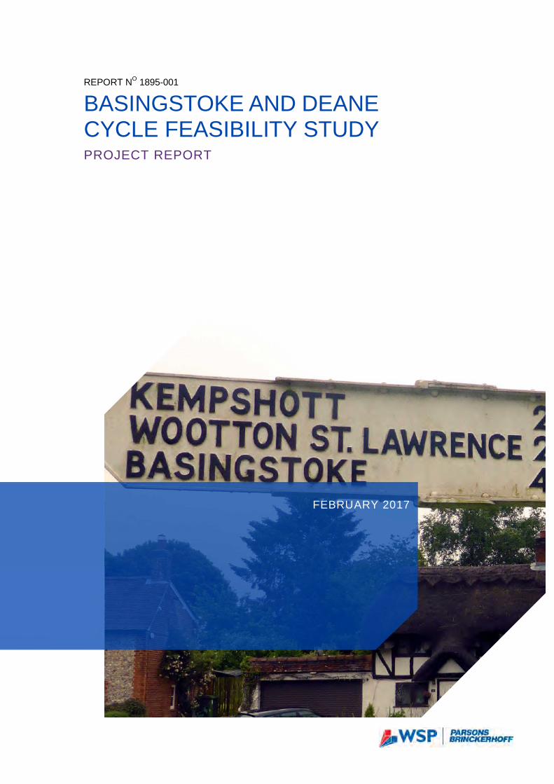
REPORT NO 1895-001
BASINGSTOKE AND DEANE CYCLE FEASIBILITY STUDY PROJECT REPORT
FEBRUARY 2017
Revision 1 Project no: 70021895 Date: February 17
– WSP | Parsons Brinckerhoff Regus House Southampton International Business Park George Curl Way Southampton SO18 2RZ Tel: +44 (0) 23 8030 2518 Fax: +44 (0) 23 8030 2000 www.wsp-pb.com
BASINGSTOKE AND DEANE CYCLE FEASIBILITY STUDY Basingstoke and Deane Borough Council
Q U A L I T Y M A N A G E M E N T ISSUE/REVISION FIRST ISSUE REVISION 1 REVISION
2 REVISION 3
Remarks First Issue Revised following BDBC comments
Date 10/02/2017
Prepared by H Littler H Littler
Signature
Checked by L Berridge L Berridge
Signature
Authorised by M Croucher N Wilkinson
Signature
Project number 70021895 70021895
Report number 1 2
File reference
\\uk.wspgroup.com\central data\Projects\700218xx\70021895 - Basingstoke & Deane Cycle Path\C Documents\Reports
\\uk.wspgroup.com\central data\Projects\700218xx\70021895 - Basingstoke & Deane Cycle Path\C Documents\Reports
ii
Basingstoke and Deane Cycle Feasibility Study WSP | Parsons Brinckerhoff Basingstoke and Deane Borough Council Project No 70021895 February 17
P R O D U C T I O N T E A M CLIENT
Transport Officer, Basingstoke and Deane Borough Council Peter Smith
Design Environment and Infrastructure Manager, Basingstoke and Deane Borough Council
Mark Lambert
WSP | PARSONS BRINCKERHOFF
Project Director Nigel Wilkinson
Project Manager Louise Berridge
Project Engineer Helen Littler
iii
Basingstoke and Deane Cycle Feasibility Study WSP | Parsons Brinckerhoff Basingstoke and Deane Borough Council Project No 70021895 February 2017
TABLE OF CONTENTS 1 INTRODUCTION ...........................................................................1
1.1 INTRODUCTION ............................................................................................. 1
1.2 STRUCTURE .................................................................................................. 2
2 POLICY BACKGROUND AND STUDY OBJECTIVES ................3
2.1 INTRODUCTION ............................................................................................. 3
2.2 PLANNING POLICY AND GUIDANCE ........................................................... 3
2.3 PROPOSED DEVELOPMENTS ...................................................................... 6
3 STUDY SCOPE AND OBJECTIVES ............................................8
3.1 SCOPE OF STUDY ......................................................................................... 8
3.2 STUDY OBJECTIVES ..................................................................................... 9
3.3 STUDY METHODOLOGY ............................................................................... 9
4 BACKGROUND INFORMATION AND EXISTING SITUATION .................................................................................10
4.1 INTRODUCTION ........................................................................................... 10
4.2 SITE WALKOVER AND AUDIT .................................................................... 10
4.3 EXISTING SITUATION ................................................................................. 10
4.4 IMPROVEMENTS AS PART OF OTHER DEVELOPMENTS ........................ 17
4.5 ACCIDENT DATA ......................................................................................... 19
4.6 TRAFFIC FLOW DATA ................................................................................. 21
4.7 KEY ATTRACTORS ..................................................................................... 22
4.8 SUMMARY ................................................................................................... 22
5 APPRAISAL CRITERIA .............................................................24
5.1 INTRODUCTION ........................................................................................... 24
5.2 INTERVENTIONS ......................................................................................... 25
5.3 INTERVENTION LEVELS ............................................................................. 25
iv
Basingstoke and Deane Cycle Feasibility Study WSP | Parsons Brinckerhoff Basingstoke and Deane Borough Council Project No 70021895 February 2017
6 ROUTE OPTIONEERING ...........................................................26
6.1 INTRODUCTION ........................................................................................... 26
6.2 CORRIDOR 1................................................................................................ 26
6.3 OPTIONS – CORRIDOR 5 ............................................................................ 30
6.4 OPTIONS – TOWN CENTRE ........................................................................ 38
BRONZE LEVEL INTERVENTIONS ............................................................................... 39
SILVER LEVEL INTERVENTIONS ................................................................................. 40
GOLD LEVEL INTERVENTIONS ................................................................................... 41
7 STAKEHOLDER ENGAGEMENT ..............................................42
7.1 INTRODUCTION ........................................................................................... 42
7.2 FEEDBACK FROM PUBLIC ......................................................................... 42
7.3 FEEDBACK FROM LOCAL AUTHORITIES ................................................. 42
7.4 OPTION APPRAISAL ................................................................................... 43
8 PROPOSED OPTION .................................................................44
8.1 INTRODUCTION ........................................................................................... 44
8.2 ROUTE 1 ...................................................................................................... 44
8.3 ROUTE 5 ...................................................................................................... 46
9 ROAD SAFETY AUDIT ..............................................................50
10 COSTING ....................................................................................52
10.1 INTRODUCTION ........................................................................................... 52
10.2 ROUTE 1 ...................................................................................................... 52
10.3 ROUTE 5 ...................................................................................................... 54
10.4 TOWN CENTRE............................................................................................ 55
11 OUTLINE DELIVERY PLAN .......................................................58
11.1 INTRODUCTION ........................................................................................... 58
v
Basingstoke and Deane Cycle Feasibility Study WSP | Parsons Brinckerhoff Basingstoke and Deane Borough Council Project No 70021895 February 2017
12 CONCLUSIONS ..........................................................................59
12.1 INTRODUCTION ........................................................................................... 59
12.2 SUMMARY OF PROPOSALS ....................................................................... 60
12.3 FUTURE DEVELOPMENT AND OPPORTUNITIES ...................................... 60
T A B L E S TABLE 2-1 BASINGSTOKE AND DEANE CYCLING STRATEGY SHORT TERM
ACTIONS .......................................................................................5 TABLE 2-2 BASINGSTOKE AND DEANE CYCLING STRATEGY MEDIUM AND LONG
TERM CONNECTIVITY AND PERMEABILITY ACTIONS ...............5 TABLE 4-1 SUMMARY OF PROPOSED HCC IMPROVEMENT SCHEMES .................. 19 TABLE 6-1 IMPROVEMENT OPTIONS - NORN HILL & POPLEY ................................. 27 TABLE 6-2 IMPROVEMENT OPTIONS - CHINEHAM BUSINESS PARK ...................... 28 TABLE 6-3 IMPROVEMENT OPTIONS – CHINEHAM .................................................. 29 TABLE 6-4 IMPROVEMENT OPTIONS – BASINGSTOKE TOWN CENTRE TO
WINCHESTER ROAD ROUNDABOUT ........................................ 31 TABLE 6-5 IMPROVEMENT OPTIONS – WINCHESTER ROAD................................... 33 TABLE 6-6 IMPROVEMENT OPTIONS – KEMPSHOTT & HATCH WARREN ............... 35 TABLE 6-7 IMPROVEMENT OPTIONS – PACK LANE ................................................. 36 TABLE 6-8 IMPROVEMENT OPTIONS – OAKLEY ....................................................... 38 TABLE 9-1 ROAD SAFETY AUDIT GENERAL SUMMARY ........................................... 51 TABLE 10-1 ROUTE 1 SUMMARY OF PROPOSALS ................................................... 52 TABLE 10-2 ROUTE 1 CONSTRUCTION COST SUMMARY ........................................ 53 TABLE 10-3 ROUTE 5 SUMMARY OF PROPOSALS ................................................... 54 TABLE 10-4 ROUTE 5 CONSTRUCTION COST SUMMARY ........................................ 55 TABLE 10-5 TOWN CENTRE SUMMARY OF PROPOSALS ........................................ 56 TABLE 10-6 TOWN CENTRE CONSTRUCTION COST SUMMARY ............................. 57 TABLE 10-7 SUMMARY OF TOTAL COSTS ................................................................. 57
F I G U R E S DIAGRAM 1-1 PROPOSED STRATEGIC CYCLE NETWORK ........................................1 DIAGRAM 1-2 STUDY METHODOLOGY ........................................................................2 DIAGRAM 3-1 STUDY CORRIDORS ..............................................................................8 DIAGRAM 4-1 BASINGSTOKE TOWN CENTRE TO CROCKFORD ROUNDABOUT.... 11 DIAGRAM 4-2 CROCKFORD LANE ROUNDABOUT NORTHWARDS .......................... 12 DIAGRAM 4-3 TOWN CENTRE TO WINCHESTER ROAD ROUNDABOUT ................. 13 DIAGRAM 4-4 WINCHESTER ROAD ............................................................................ 14
vi
Basingstoke and Deane Cycle Feasibility Study WSP | Parsons Brinckerhoff Basingstoke and Deane Borough Council Project No 70021895 February 2017
DIAGRAM 4-5 A30 WINCHESTER ROAD..................................................................... 15 DIAGRAM 4-6 OAKLEY ................................................................................................ 16 DIAGRAM 4-7 ADAPTED HCC CYCLIST ACCIDENT MAP SHOWING THE
LOCATIONS OF SLIGHT (CIRCLES) AND SERIOUS (SQUARES) INJURIES ALONG THE PROPOSED CORRIDOR ....................... 20
DIAGRAM 6-1 CORRIDOR 1 IMPROVEMENTS, NORN HILL & POPLEY .................... 26 DIAGRAM 6-2 CHINEHAM BUSINESS PARK............................................................... 28 DIAGRAM 6-3 CHINEHAM TO SHERFIELD PARK ....................................................... 29 DIAGRAM 6-4 BASINGSTOKE TOWN CENTRE TO WINCHESTER ROAD
ROUNDABOUT ............................................................................ 30 DIAGRAM 6-5 WINCHESTER ROAD ............................................................................ 32 DIAGRAM 6-6 KEMPSHOTT & HATCH WARREN ........................................................ 34 DIAGRAM 6-7 PACK LANE .......................................................................................... 36 DIAGRAM 6-8 OAKLEY ................................................................................................ 37 DIAGRAM 6-9 BRONZE TOWN CENTRE PROPOSALS .............................................. 39 DIAGRAM 6-10 SILVER TOWN CENTRE PROPOSALS .............................................. 40 DIAGRAM 6-11 GOLD TOWN CENTRE PROPOSALS ................................................. 41
A P P E N D I C E S A P P E N D I X A PROPOSED DEVELOPMENTS A P P E N D I X B EXISTING PROVISION ALONG CORRIDOR 1 A P P E N D I X C EXISTING PROVISION ALONG CORRIDOR 5 A P P E N D I X D PROVISION IN THE TOWN CENTRE A P P E N D I X E HAMPSHIRE COUNTY COUNCIL HIGHWAY
IMPROVEMENT PROPOSALS A P P E N D I X F SITE OBSERVATIONS A P P E N D I X G SCHOOLS WITHIN THE STUDY AREA A P P E N D I X H FOOD RETAILERS WITHIN BASINGSTOKE A P P E N D I X I MAJOR EMPLOYMENT AREAS WITHIN BASINGSTOKE A P P E N D I X J PUBLIC CONSULTATION KEY POINTS A P P E N D I X K CORRIDOR OPTIONS APPRAISAL TABLE A P P E N D I X L RECOMMENDED OPTIONS A P P E N D I X M STAGE 1 ROAD SAFETY AUDITS AND DESIGNERS
RESPONSE A P P E N D I X N COST ESTIMATION A P P E N D I X O OUTLINE DELIVERY PLAN
1
Basingstoke and Deane Cycle Feasibility Study WSP | Parsons Brinckerhoff Basingstoke and Deane Borough Council Project No 70021895 February 17
1 INTRODUCTION 1.1 INTRODUCTION
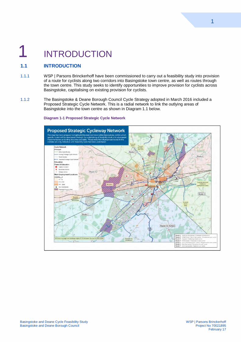
1.1.1 WSP | Parsons Brinckerhoff have been commissioned to carry out a feasibility study into provision of a route for cyclists along two corridors into Basingstoke town centre, as well as routes through the town centre. This study seeks to identify opportunities to improve provision for cyclists across Basingstoke, capitalising on existing provision for cyclists.
1.1.2 The Basingstoke & Deane Borough Council Cycle Strategy adopted in March 2016 included a Proposed Strategic Cycle Network. This is a radial network to link the outlying areas of Basingstoke into the town centre as shown in Diagram 1.1 below.
Diagram 1-1 Proposed Strategic Cycle Network
2
Basingstoke and Deane Cycle Feasibility Study WSP | Parsons Brinckerhoff Basingstoke and Deane Borough Council Project No 70021895 February 17
1.2 STRUCTURE
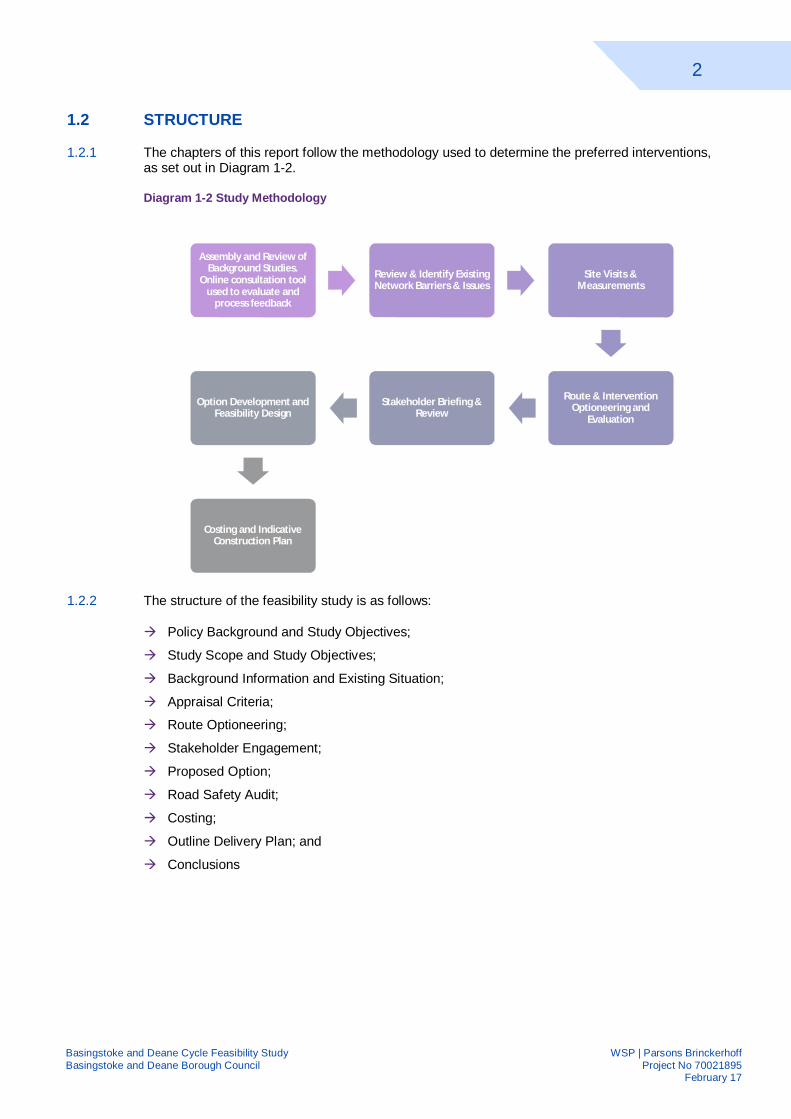
1.2.1 The chapters of this report follow the methodology used to determine the preferred interventions, as set out in Diagram 1-2.
Diagram 1-2 Study Methodology
1.2.2 The structure of the feasibility study is as follows:
Policy Background and Study Objectives;
Study Scope and Study Objectives;
Background Information and Existing Situation;
Appraisal Criteria;
Route Optioneering;
Stakeholder Engagement;
Proposed Option;
Road Safety Audit;
Costing;
Outline Delivery Plan; and
Conclusions
Assembly and Review of Background Studies.
Online consultation tool used to evaluate and
process feedback
Review & Identify Existing Network Barriers & Issues
Site Visits & Measurements
Route & Intervention Optioneering and
Evaluation
Stakeholder Briefing & Review
Option Development and Feasibility Design
Costing and Indicative Construction Plan
3
Basingstoke and Deane Cycle Feasibility Study WSP | Parsons Brinckerhoff Basingstoke and Deane Borough Council Project No 70021895 February 17
2 POLICY BACKGROUND AND STUDY OBJECTIVES
2.1 INTRODUCTION
2.1.1 This section sets out the policies and guidance, both on a national and local level, which have steered this study.
2.2 PLANNING POLICY AND GUIDANCE
NATIONAL POLICY PLANNING FRAMEWORK
2.2.1 The UK Government policy, set out in National Policy Planning Framework (NPPF) states, where possible, greater priority should be given to walking and cycling over private motorised transport modes. NPPF also requires local authorities to identify routes where infrastructure improvements could be made to widen travel choice options.
DRAFT CYCLING AND WALKING INVESTMENT STRATEGY
2.2.2 The Draft cycling and walking investment strategy sets out the Governments ambition to:
"…to make cycling and walking the natural choice for shorter journeys, or as part of a longer journey"
2.2.3 They seek to achieve this through three methods:
Better safety – making cycling safer through reducing the severance effect of roads, reduced speeds and creating streets where cyclists and pedestrians feel they belong;
Better mobility – offering world class cycling facilities, a denser network of routes and safe paths along busy routes; and
Better streets – streets designed for people not vehicles, more routes through green spaces and better public realm.
HAMPSHIRE COUNTY COUNCIL LOCAL TRANSPORT PLAN
2.2.4 Hampshire County Council Local Transport Plan was adopted in February 2011 and is formed of two parts; a 20 year strategy of how transport in the county will develop and a three year implementation plan.
2.2.5 The 20 year strategy contains the main transport objectives for the county. The policies objectives which are relevant to this study are:
Policy Objective 9: Introduce the ‘shared space’ philosophy, applying Manual for Streets design principles to support a better balance between traffic and community life in towns and residential areas;
Policy Objective 12: Invest in sustainable transport measures, including walking and cycling infrastructure, principally in urban areas, to provide a healthy alternative to the car for local short journeys to work, local services or schools; and work with health authorities to ensure that transport policy supports local ambitions for health and well-being;
Policy Objective 14: Outline and implement a long-term transport strategy to enable sustainable development in major growth areas.
4
Basingstoke and Deane Cycle Feasibility Study WSP | Parsons Brinckerhoff Basingstoke and Deane Borough Council Project No 70021895 February 17
2.2.6 The strategies chapter on North Hampshire highlights the challenges that Basingstoke faces with a high level of car ownership. 44% of households have access to two or more vehicles compared to 29.4% nationally. This level is rises to around 70% for outer areas of Hatch Warren and Chineham. This is against a background of congestion at peak times.
2.2.7 The current implementation plan covers the period April 2014 to March 2017. It identifies the success already achieved using Local Sustainable Transport Fund (LSTF) funded interventions and wherefuture funding could be sought.
HAMPSHIRE COUNTY COUNCIL CYCLING STRATEGY
2.2.8 Hampshire’s cycling strategy, approved in 2015, provides a clear statement of the counties aspirations for cycling and highlights it as a key catalyst for growth. It sets out five cycling objectives:
1. To make cycling a daily travel choice for more people;
2. To reduce cyclist casualties and safety concerns;
3. To encourage regular cycling as part of a healthy lifestyle;
4. To enable more people to enjoy Hampshire by cycling; and
5. To ensure an appropriate balance between the needs of all road users.
2.2.9 And five cycling challenges:
1. Realising the unmet potential of cycling for daily trips;
2. Protecting cyclists and changing perceptions of safety;
3. Increasing levels of physical activity amongst children and adults;
4. Making recreational cycling opportunities more accessible; and
5. Encouraging cycle event organisers to manage their events responsibly
BASINGSTOKE AND DEANE CYCLING STRATEGY
2.2.10 Basingstoke and Deane Borough Council adopted a Cycling Strategy in March 2016, which sets out a vision for cycling in Basingstoke & Deane and is intended to: 'Create an environment that is a safe, attractive and practical choice for cyclists in the borough so that more people are enabled to cycle safely in the area and to encourage a shift towards more sustainable transport choices and healthy lifestyles.' It seeks to achieve this through a number of aims:
1. Creating New Routes, Linkages – seeking opportunities to develop new routes and improved linkages from residential areas to key services, whilst improving permeability for cyclists to overcome existing barriers;
2. Improvements in Other Facilities – recognising the other facilities that the Borough currently benefits from, such as BMX tracks, and the scope for providing new facilities to encourage participation in cycling including for off-road training or sports facilities;
3. Safer Cycling – ensuring infrastructure is well designed and takes into account the needs of cyclists, prioritising routes as appropriate and providing road safety education;
4. Improvements to Cycle Parking – identifying locations for additional cycle parking facilities and positioning them to maximise security;
5. Promotion and Encouragement – raising awareness of cycling and its benefits in addressing issues such as obesity and medical conditions amongst the community;
6. Maintenance and Signage – ensuring existing and any future facilities are well maintained through a regular and pro-active approach, with clear signage.
5
Basingstoke and Deane Cycle Feasibility Study WSP | Parsons Brinckerhoff Basingstoke and Deane Borough Council Project No 70021895 February 17
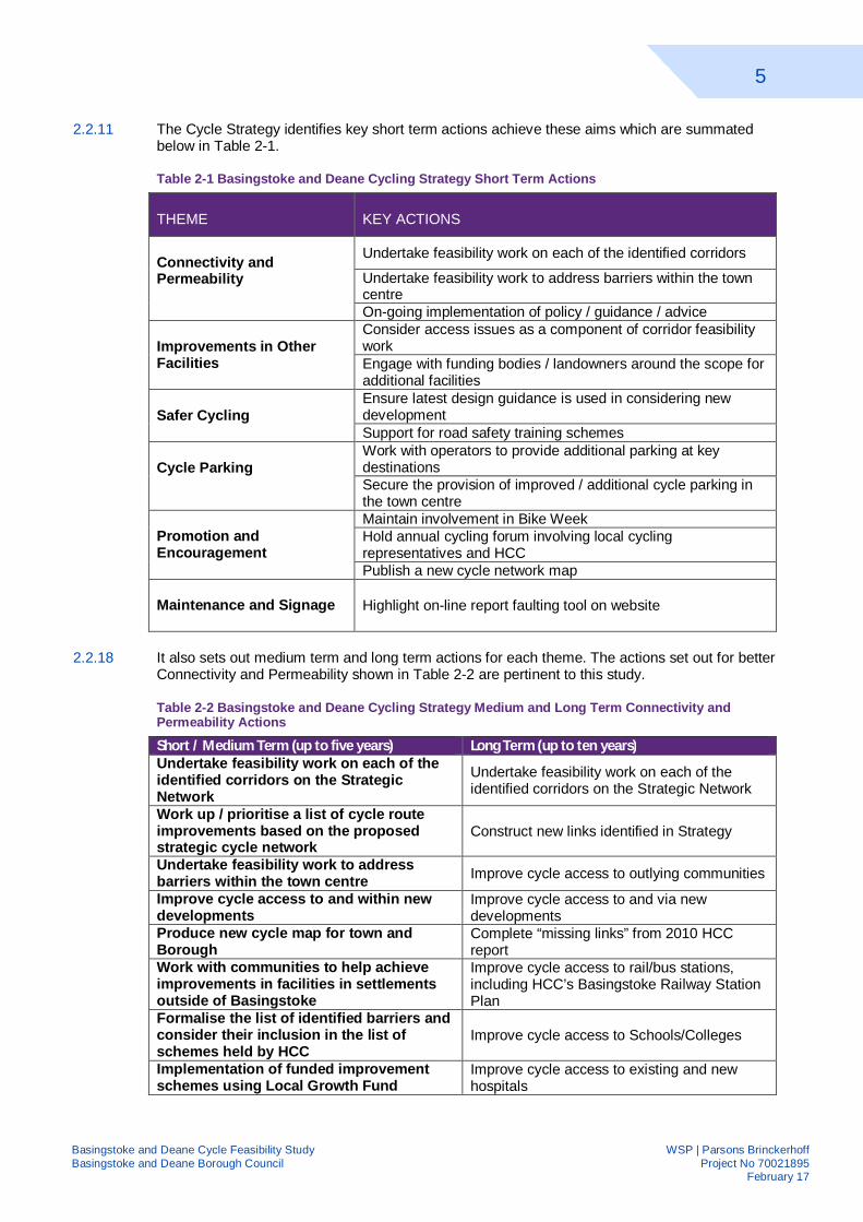
2.2.11 The Cycle Strategy identifies key short term actions achieve these aims which are summated below in Table 2-1.
Table 2-1 Basingstoke and Deane Cycling Strategy Short Term Actions
THEME KEY ACTIONS
Connectivity and Permeability
Undertake feasibility work on each of the identified corridors
Undertake feasibility work to address barriers within the town centre On-going implementation of policy / guidance / advice
Improvements in Other Facilities
Consider access issues as a component of corridor feasibility work Engage with funding bodies / landowners around the scope for additional facilities
Safer Cycling Ensure latest design guidance is used in considering new development Support for road safety training schemes
Cycle Parking Work with operators to provide additional parking at key destinations Secure the provision of improved / additional cycle parking in the town centre
Promotion and Encouragement
Maintain involvement in Bike Week Hold annual cycling forum involving local cycling representatives and HCC Publish a new cycle network map
Maintenance and Signage Highlight on-line report faulting tool on website
2.2.18 It also sets out medium term and long term actions for each theme. The actions set out for better Connectivity and Permeability shown in Table 2-2 are pertinent to this study.
Table 2-2 Basingstoke and Deane Cycling Strategy Medium and Long Term Connectivity and Permeability Actions
Short / Medium Term (up to five years) Long Term (up to ten years) Undertake feasibility work on each of the identified corridors on the Strategic Network
Undertake feasibility work on each of the identified corridors on the Strategic Network
Work up / prioritise a list of cycle route improvements based on the proposed strategic cycle network
Construct new links identified in Strategy
Undertake feasibility work to address barriers within the town centre Improve cycle access to outlying communities
Improve cycle access to and within new developments
Improve cycle access to and via new developments
Produce new cycle map for town and Borough
Complete “missing links” from 2010 HCC report
Work with communities to help achieve improvements in facilities in settlements outside of Basingstoke
Improve cycle access to rail/bus stations, including HCC’s Basingstoke Railway Station Plan
Formalise the list of identified barriers and consider their inclusion in the list of schemes held by HCC
Improve cycle access to Schools/Colleges
Implementation of funded improvement schemes using Local Growth Fund
Improve cycle access to existing and new hospitals
6
Basingstoke and Deane Cycle Feasibility Study WSP | Parsons Brinckerhoff Basingstoke and Deane Borough Council Project No 70021895 February 17
2.2.19 The Cycling Strategy identified a Strategic Cycling Network across the Town. This defined a series of routes radiating from the town centre, linking key destinations and each corridor within the town, including the main development sites in the Local Plan. Its ultimate target is by 2021 to double the number of trips to work made by bicycle and double the number of bikes travelling over the identified cycle counters in Basingstoke.
2.3 PROPOSED DEVELOPMENTS
2.3.1 There are several developments proposed within or adjacent to Basingstoke. As identified within the policy review, future development should encourage travel by sustainable modes of travel. Furthermore developer contributions will assist in funding of sustainable travel initiatives such as those proposed within this report.
2.3.2 The developments listed below and their proposed infrastructure improvements have been taken into consideration in development of this cycle strategy and are shown in Appendix A and summarised below:
HOUNSOME FIELDS
2.3.3 Hounsome Fields scheme comprises of 750 dwellings for residential use, a primary school, a neighbourhood centre along with an area of open space. In addition to the mix dwelling sizes and types, provisions will be made for a proportion of self-build units and a permanent pitch/plot to meet identified accommodation needs of travellers within the borough. Other provision includes local shop facilities, indoor sports facilities, a school and a nursery.
2.3.4 Measures to mitigate the impact of development on the local road network include improvements to the A30 corridor. Also, appropriate green space including allotments to meet local needs in line with the councils adopted standards will be provided, to link the existing green infrastructure network.
KENNEL FARM
2.3.5 Kennel Farm consists of 310 residential dwellings, new access from Winchester Road (A30) and a new pedestrian link from Winchester Road, including internal access roads with open space areas and landscaping. It will provide measures to mitigate the impact of development on local road network, including the A30 corridor and improvements at Kempshott Roundabout. Improvements will be made for the pedestrian/ crossing facilities across the adjacent section of the A30, enabling access to services to the east. In addition, appropriate green space to meet local needs, in line with the councils adopted standards, including amenity of the footpath along the western site boundary, will be included.
BASINGSTOKE GOLF COURSE
2.3.6 The Golf Course development will make provision for approximately 1,000 dwellings including a community centre, local shops and sports facility which will include playing pitches. This will also provide a comprehensive development associated with the Kennel Farm and Hounsome Fields allocations.
RAZORS FARM
2.3.7 Razors Farm comprises of 425 residential dwellings, public open space, associated landscaping and two new vehicular accesses from Crockford Lane. Internal shared use paths are proposed which will connect to the adjacent main roads. Green spaces including green links to Cufaude Lane and a central green space have been included within the masterplan.
CRITICAL CARE HOSPITAL
2.3.8 Construction of a critical treatment hospital including a cancer treatment centre. The new hospital will be accessed via a new roundabout on the A30.
7
Basingstoke and Deane Cycle Feasibility Study WSP | Parsons Brinckerhoff Basingstoke and Deane Borough Council Project No 70021895 February 17
SWING SWANG LANE
2.3.9 This site will deliver 100 dwellings and provide connections to the existing cycle and pedestrian routes with direct access to Eastrop Park, Basing View and the Town Centre.
REDLANDS & LAND EAST OF BASINGSTOKE
2.3.10 Redlands comprises of up to 165 dwellings with measures to mitigate the impact of development on the local road networks, including improvements to the A33 corridor and accessibility for non-car transport modes will be improved. The total area of the site is 9.4 hectares.
2.3.11 The Land East of Basingstoke will make provision for 450 dwellings and a primary school. It will also include measures to improve accessibility by non-car modes including provision of internal walking and cycling routes linking with the strategic cycle network.
MANYDOWN
2.3.12 This 290 hectare site will deliver a high quality mixed use development comprising approximately 3,400 dwellings, local shopping and healthcare facilities and two primary schools. Land will also be reserved for the phased provision of a secondary school if required.
2.3.13 Also included are measures to mitigate the impact on the local road network and include measures to improve accessibility by non-car transport modes through the provision of internal walking and cycling routes linked to those already existing externally - providing direct access to the town centre.
UPPER CUFAUDE FARM
2.3.14 This site will make provision for approximately 390 dwellings including a community centre and a primary school if required by the education authority. It will also include measures to improve accessibility by non-car modes including the provision of internal walking and cycling routes linked to those existing externally as well as providing access to the potential railway station at Chineham.
8
Basingstoke and Deane Cycle Feasibility Study WSP | Parsons Brinckerhoff Basingstoke and Deane Borough Council Project No 70021895 February 17
3 STUDY SCOPE AND OBJECTIVES 3.1 SCOPE OF STUDY
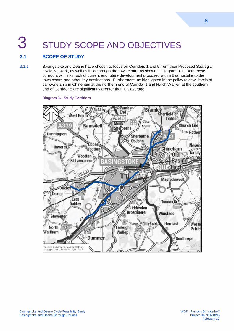
3.1.1 Basingstoke and Deane have chosen to focus on Corridors 1 and 5 from their Proposed Strategic Cycle Network, as well as links through the town centre as shown in Diagram 3.1. Both these corridors will link much of current and future development proposed within Basingstoke to the town centre and other key destinations. Furthermore, as highlighted in the policy review, levels of car ownership in Chineham at the northern end of Corridor 1 and Hatch Warren at the southern end of Corridor 5 are significantly greater than UK average.
Diagram 3-1 Study Corridors
9
Basingstoke and Deane Cycle Feasibility Study WSP | Parsons Brinckerhoff Basingstoke and Deane Borough Council Project No 70021895 February 17
3.2 STUDY OBJECTIVES
3.2.1 Basingstoke and Deane Borough Councils’ objectives for this study are to seek to connect residential areas with key destinations by providing direct, continuous, convenient cycle route or linkages. Their focus is on the creation of Strategic Cycling Network, developed through the corridors to provide radial routes from the town centre.
3.2.2 Improved connections will also focus on the following destinations:
Employment areas and schools to encourage cycling to work and school;
Key public transport interchange at Basingstoke rail station to capitalise on the high level of rail use and encourage cycling as part of longer multi-modal journeys; and
Other key services such as health, shopping, libraries and leisure activities to encourage cycling as a mode of transport to access key services.
3.2.3 Sustrans Core Principles for High Quality Design which are discussed further in Chapter 5 will also be guiding principles in the development of this study. They are:
Safety;
Directness;
Comfort;
Coherence; and
Attractiveness.
3.3 STUDY METHODOLOGY
3.3.1 The feasibility and options for improvements to direct cycling routes and connections to Basingstoke town centre, within Corridors 1 and 5, linking strategic sites in the south west of Basingstoke and Chineham areas with the town centre, as set out in the BDBC Cycle Strategy will be investigated. We will also examine options for improving across town connectivity and links with key facilities in the centre of Basingstoke.
3.3.2 The particular constraints and barriers to cycling, as identified in the Basingstoke & Deane Cycle Strategy, have been noted and we will ensure these are considered when designing and recommending new routes and infrastructure. Topographical and environmental issues will also be reviewed when considering improvements and this will assist in facilitating risk identification and mitigation measures.
3.3.3 Routes recommended will be technically feasible and realistic, in relation to the available funding.
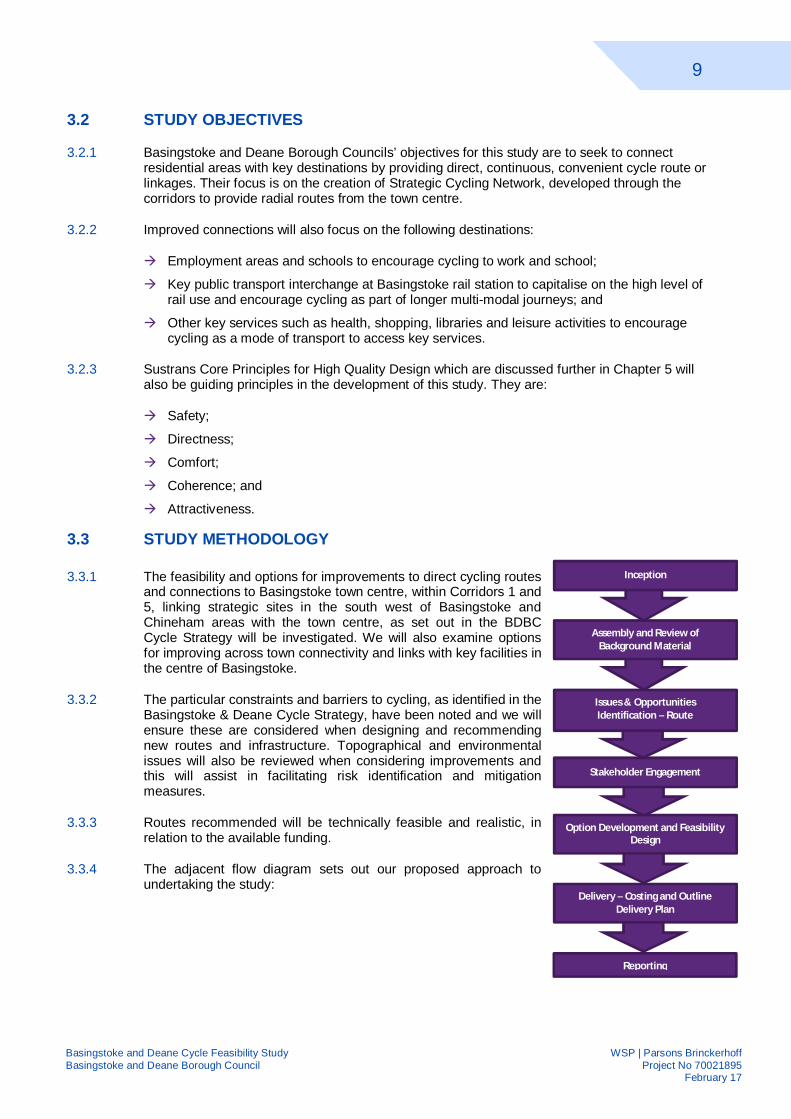
3.3.4 The adjacent flow diagram sets out our proposed approach to undertaking the study:
Issues & Opportunities Identification – Route
Optioneering and
Stakeholder Engagement
Option Development and Feasibility Design
Inception
Assembly and Review of Background Material
Delivery – Costing and Outline Delivery Plan
Reporting
10
Basingstoke and Deane Cycle Feasibility Study WSP | Parsons Brinckerhoff Basingstoke and Deane Borough Council Project No 70021895 February 17
4 BACKGROUND INFORMATION AND EXISTING SITUATION
4.1 INTRODUCTION
4.1.1 This section examines the existing situation along both corridors and within the town centre. It also examines future proposals for infrastructure improvements by both developers and Hampshire County Council along both corridors.
4.2 SITE WALKOVER AND AUDIT
4.2.1 Two site visits were undertaken on foot to examine existing provision, identifying any barriers, taking measurements. This was followed up by a visit to Corridor 1 and the town centre routes by bicycle.
4.2.2 The observations from these visits are shown in Appendix F, along with key comments from previous stakeholder engagement carried out as part of the development of the Basingstoke and Deane Cycling Strategy.
4.3 EXISTING SITUATION
CORRIDOR 1
4.3.1 Corridor 1 will link the Chineham and Sherfield Park areas of Basingstoke and Chineham Business Park to Basingstoke town centre. The proposed corridor is Y-shaped with branches splitting just north of Crockford Roundabout to go to Chineham Business Park and Chineham respectively.
4.3.2 The existing provision along Corridor 1 and its path is summarised in Appendix B. The rest of this section discusses the existing provision along Corridor 1 in further detail.
11
Basingstoke and Deane Cycle Feasibility Study WSP | Parsons Brinckerhoff Basingstoke and Deane Borough Council Project No 70021895 February 17
Diagram 4-1 BASINGSTOKE TOWN CENTRE TO CROCKFORD ROUNDABOUT (Colours highlight the different sections)
4.3.3 As shown on Diagram 4-1, Corridor 1 commences on Basing View where it will connect with the proposed town centre Route. Along both sides of Basing View there is a newly constructed 3m shared use path, which links to the footbridge over the railway. Basing View is well served by buses with up to 21 per hour in either direction. The footbridge is sufficiently wide to accommodate use by cyclists and is lit.
4.3.4 There is no existing provision along Norn Hill for cyclists. At several junctions, there are “Think Bike” signs reminding drivers turning onto Norn Hill to check for approaching cyclists. At the northern end of Norn Hill there is signage, along with dropped kerbs, directing cyclists onto the shared use path around Reading Road Roundabout. Norn Hill has several high frequency bus routes serving it with a bus every 5 minutes in each direction at its southern end. At the north of Queen Mary Avenue there are buses every 8-9 minutes in either direction.
4.3.5 The shared use path around Reading Road Roundabout directs users with frequently placed directional signage to key destinations. At each traffic light controlled road crossing there is a signalised phase for cyclists, which is called during every stage.
4.3.6 There is a lit shared use path along the western side of Reading Road, between Reading Road Roundabout and Crockford Roundabout. The southern half is approximately 2.5m wide but verge creep has reduced the width to approximately 2m. Along this section of Reading Road, there are buses every 8-9 minutes in either direction.
4.3.7 At the junction with Popley Way, users can either use the subway to reach the shared path on the northern side or a newly installed staggered toucan crossing.
12
Basingstoke and Deane Cycle Feasibility Study WSP | Parsons Brinckerhoff Basingstoke and Deane Borough Council Project No 70021895 February 17
4.3.8 There is a 3m wide, lit shared use path from Popley Way linking it to Crockford Roundabout and Carpenters Down cycle path via a subway.
Diagram 4-2 Crockford Lane Roundabout northwards (Colours highlight the different sections)
4.3.9 The proposed corridor splits at this point with those heading to Chineham Business Park heading north on Crockford Road via a shared path along the western side. This continues for approximately 250m. At the terminus of the path, there is a dropped kerb and signage indicating that corridor has ended.
4.3.10 Within Chineham Business Park, there is no provision for cyclists but there is street lighting throughout the business park. A loop bus service operates through the business park every 15 minutes during the AM peak, lunchtimes and PM peak. The proposed corridor goes along Crockford Lane, onto Lime Tree Way and then back onto Crockford Lane as it leaves the business park. At Hanmore Road where it connects to NCN23 off-road route, this branch of Corridor 1 terminates.
4.3.11 The second branch of Corridor 1 connects to Reading Road via a service road between Reading Road and Crockford Lane. Users can reach it via a toucan crossing further north on Crockford Lane, necessitating an approximate 170m detour from the desire line.
4.3.12 Access to the disused road is restricted by a gate at the southern end which also stops cyclists; they must dismount and walk their bicycles around via the footway to join Reading Road.
4.3.13 There is no provision along Reading Road for cyclists. It is the main road within the Chineham area, linking to the local amenities. A bus service, with a 10 minute frequency, operates along this section of Reading Road. There are residential dwellings along the northern side with off-road parking and hence frequent driveways crossing the footway.
13
Basingstoke and Deane Cycle Feasibility Study WSP | Parsons Brinckerhoff Basingstoke and Deane Borough Council Project No 70021895 February 17
4.3.14 NCN23, which connects to destinations including Basingstoke town centre and Reading, intersects with Corridor 1 at Thornhill Way Roundabout. The northern section of Reading Road is a no through route for vehicles but there is a short section of footpath linking between it and the A33.
4.3.15 At present there is no provision for cyclists along A33 and the speed limit is 50mph making it an unsuitable route for cyclists. An hourly bus service currently operates on this section of the A33.
CORRIDOR 5
4.3.16 Corridor 5 will link the Hatch Warren and Kempshott areas of Basingstoke and the Village of Oakley to Basingstoke town centre. The proposed corridor is Y-shaped with branches splitting at Buckland Parade to go west to Oakley and south-west to Hatch Warren.
4.3.17 The existing provision along the Corridor 5 and its route is summarised in Appendix C. The rest of this section discusses the existing provision along Corridor 5 in further detail.
Diagram 4-3 Town Centre to Winchester Road Roundabout (Colours highlight the different sections)
4.3.18 The Sarum Hill section of Winchester Road, as shown in Diagram 4.3, is steep with a narrow footway either on both or just one side. As Winchester Road passes through the Kings Furlong area, it widens and there are footways either side separated by verge and/or guard railing or wooden dragons’ teeth. South of Wessex Close, there is a shared use path whose width varies between 1.7m and 2.3m. There is also a short section of shared use path on the opposing side. There is a frequent bus service along here with nine buses an hour in each direction.
14
Basingstoke and Deane Cycle Feasibility Study WSP | Parsons Brinckerhoff Basingstoke and Deane Borough Council Project No 70021895 February 17
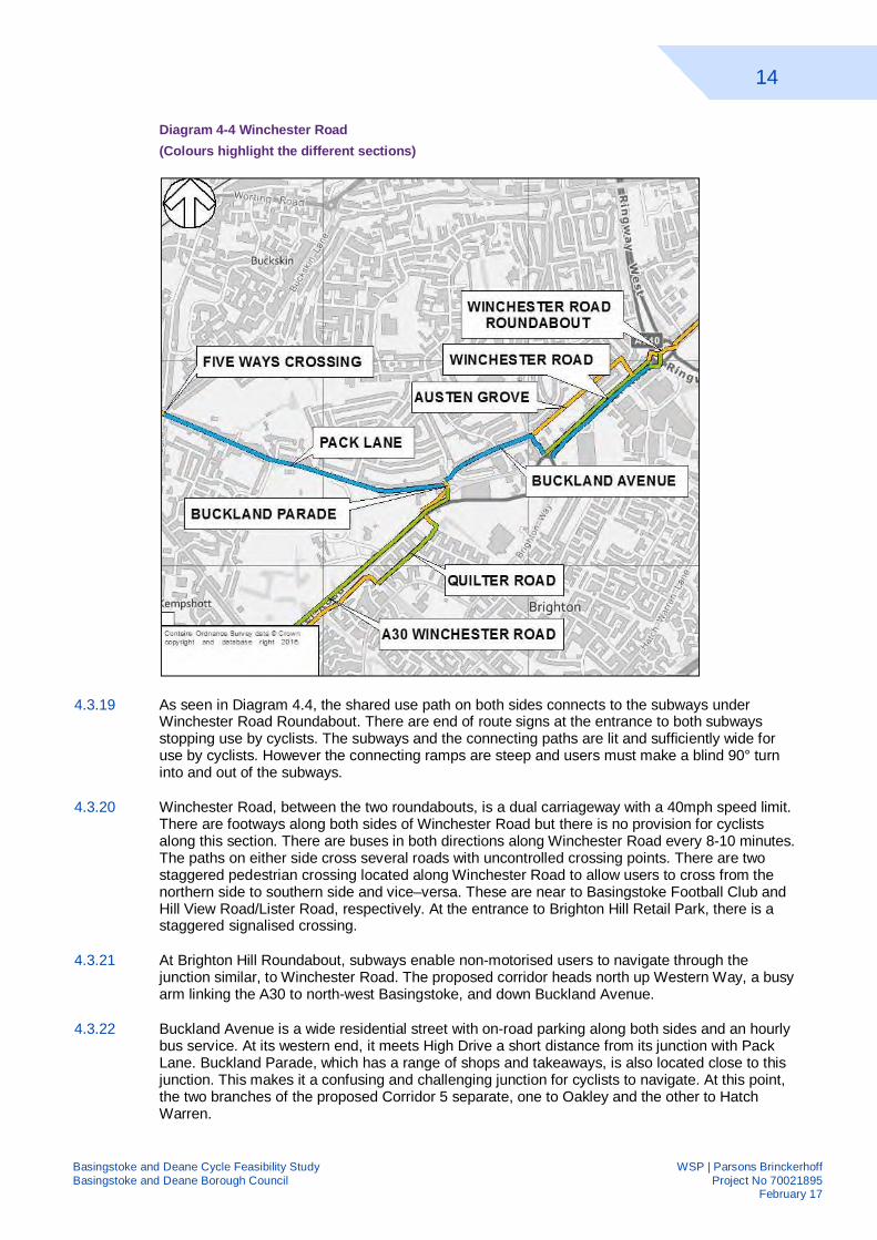
Diagram 4-4 Winchester Road (Colours highlight the different sections)
4.3.19 As seen in Diagram 4.4, the shared use path on both sides connects to the subways under Winchester Road Roundabout. There are end of route signs at the entrance to both subways stopping use by cyclists. The subways and the connecting paths are lit and sufficiently wide for use by cyclists. However the connecting ramps are steep and users must make a blind 90° turn into and out of the subways.
4.3.20 Winchester Road, between the two roundabouts, is a dual carriageway with a 40mph speed limit. There are footways along both sides of Winchester Road but there is no provision for cyclists along this section. There are buses in both directions along Winchester Road every 8-10 minutes. The paths on either side cross several roads with uncontrolled crossing points. There are two staggered pedestrian crossing located along Winchester Road to allow users to cross from the northern side to southern side and vice–versa. These are near to Basingstoke Football Club and Hill View Road/Lister Road, respectively. At the entrance to Brighton Hill Retail Park, there is a staggered signalised crossing.
4.3.21 At Brighton Hill Roundabout, subways enable non-motorised users to navigate through the junction similar, to Winchester Road. The proposed corridor heads north up Western Way, a busy arm linking the A30 to north-west Basingstoke, and down Buckland Avenue.
4.3.22 Buckland Avenue is a wide residential street with on-road parking along both sides and an hourly bus service. At its western end, it meets High Drive a short distance from its junction with Pack Lane. Buckland Parade, which has a range of shops and takeaways, is also located close to this junction. This makes it a confusing and challenging junction for cyclists to navigate. At this point, the two branches of the proposed Corridor 5 separate, one to Oakley and the other to Hatch Warren.
15
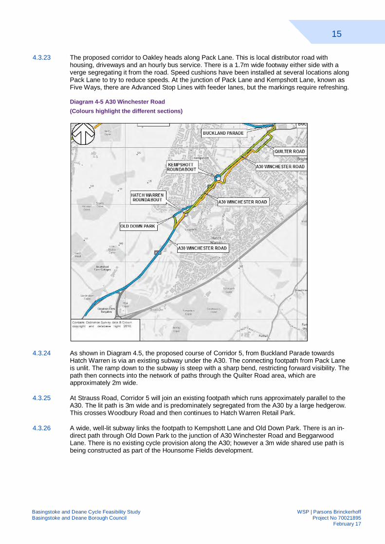
Basingstoke and Deane Cycle Feasibility Study WSP | Parsons Brinckerhoff Basingstoke and Deane Borough Council Project No 70021895 February 17
4.3.23 The proposed corridor to Oakley heads along Pack Lane. This is local distributor road with housing, driveways and an hourly bus service. There is a 1.7m wide footway either side with a verge segregating it from the road. Speed cushions have been installed at several locations along Pack Lane to try to reduce speeds. At the junction of Pack Lane and Kempshott Lane, known as Five Ways, there are Advanced Stop Lines with feeder lanes, but the markings require refreshing.
Diagram 4-5 A30 Winchester Road (Colours highlight the different sections)
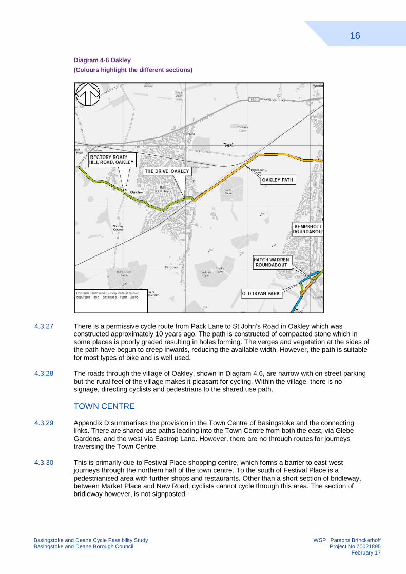
4.3.24 As shown in Diagram 4.5, the proposed course of Corridor 5, from Buckland Parade towards Hatch Warren is via an existing subway under the A30. The connecting footpath from Pack Lane is unlit. The ramp down to the subway is steep with a sharp bend, restricting forward visibility. The path then connects into the network of paths through the Quilter Road area, which are approximately 2m wide.
4.3.25 At Strauss Road, Corridor 5 will join an existing footpath which runs approximately parallel to the A30. The lit path is 3m wide and is predominately segregated from the A30 by a large hedgerow. This crosses Woodbury Road and then continues to Hatch Warren Retail Park.
4.3.26 A wide, well-lit subway links the footpath to Kempshott Lane and Old Down Park. There is an in-direct path through Old Down Park to the junction of A30 Winchester Road and Beggarwood Lane. There is no existing cycle provision along the A30; however a 3m wide shared use path is being constructed as part of the Hounsome Fields development.
16
Basingstoke and Deane Cycle Feasibility Study WSP | Parsons Brinckerhoff Basingstoke and Deane Borough Council Project No 70021895 February 17
Diagram 4-6 Oakley (Colours highlight the different sections)
4.3.27 There is a permissive cycle route from Pack Lane to St John’s Road in Oakley which was constructed approximately 10 years ago. The path is constructed of compacted stone which in some places is poorly graded resulting in holes forming. The verges and vegetation at the sides of the path have begun to creep inwards, reducing the available width. However, the path is suitable for most types of bike and is well used.
4.3.28 The roads through the village of Oakley, shown in Diagram 4.6, are narrow with on street parking but the rural feel of the village makes it pleasant for cycling. Within the village, there is no signage, directing cyclists and pedestrians to the shared use path.
TOWN CENTRE
4.3.29 Appendix D summarises the provision in the Town Centre of Basingstoke and the connecting links. There are shared use paths leading into the Town Centre from both the east, via Glebe Gardens, and the west via Eastrop Lane. However, there are no through routes for journeys traversing the Town Centre.
4.3.30 This is primarily due to Festival Place shopping centre, which forms a barrier to east-west journeys through the northern half of the town centre. To the south of Festival Place is a pedestrianised area with further shops and restaurants. Other than a short section of bridleway, between Market Place and New Road, cyclists cannot cycle through this area. The section of bridleway however, is not signposted.
17
Basingstoke and Deane Cycle Feasibility Study WSP | Parsons Brinckerhoff Basingstoke and Deane Borough Council Project No 70021895 February 17
4.3.31 The road circulating the southern half of the town centre, between Timberlake Road and Eastrop Roundabout, is one way. This only allows travel in a clockwise direction for vehicles and cyclists. Bounty Road and Southern Road, to the south of the town centre are also one-way streets, similarly only allowing travel westbound, thus cyclists wishing to traverse the town centre eastbound have very limited options.
4.4 IMPROVEMENTS AS PART OF OTHER DEVELOPMENTS
4.4.1 This section sets out improvements which have been proposed along both corridors by other parties which will feed into or complement our proposals. Some of these are at an early stage of development whereas others are being implemented.
4.4.2 Other schemes, not included within the below list, should provide links to key destinations in accordance with the site specific policies in the Adopted Local Plan. These other non-identified sites should make provision as and when proposals come forward, as per policy CN9 of the Basingstoke and Deane Local Plan.
DEVELOPER-LED SCHEMES
HOUNSOME FIELDS
4.4.3 Measures put forward by the developer to mitigate the impact of the 750 dwelling development on the local road network include improvements to the A30 corridor including a shared use path along its northern side. Also, appropriate green space, including allotments to meet local needs in line with the councils adopted standards, will be provided to link the existing green infrastructure network.
KENNEL FARM
4.4.4 Kennel Farm consists of 310 residential dwellings, new access from Winchester Road (A30) and a new pedestrian link from Winchester Road, including internal access roads with open space areas and landscaping. The toucan crossing on the A30 will be improved to allow for connections to Hatch Warren.
BASINGSTOKE GOLF COURSE
4.4.5 The Golf Course development will make provision for approximately 1,000 dwellings including a community centre, local shops and sports facility which will include playing pitches. This will also provide a comprehensive development associated with the Kennel Farm and Hounsome Fields allocations.
RAZORS FARM
4.4.6 The Razors Farm development will comprise of 425 residential dwellings, with two new vehicular accesses from Crockford Lane and shared use paths connecting the development to nearby major roads and links to cycle and public transport to the adjoining business park.
CRITICAL CARE HOSPITAL
4.4.7 Construction of a critical treatment hospital, cancer treatment centre additional development including energy centre, service yard, link building and underground link. The construction will involve building a helicopter landing strip and pad, associated internal roads, car parking and landscaping together with the means of access via a new roundabout on the A30.
18
Basingstoke and Deane Cycle Feasibility Study WSP | Parsons Brinckerhoff Basingstoke and Deane Borough Council Project No 70021895 February 17
REDLANDS & LAND EAST OF BASINGSTOKE
4.4.8 Redlands comprises of a proposed housing capacity of up to 165 dwellings with measures proposed to mitigate the impact of development on the local road networks, including improvements to the A33 corridor, providing accessibility for non-car transport modes will be improved.
4.4.9 The Land East of Basingstoke will make provision for 450 dwellings and a primary school. It will also include measures to improve accessibility by non-car modes including provision of internal walking and cycling routes linking with the strategic cycle network.
MANYDOWN
4.4.10 This 290 hectare site will deliver a high quality mixed use development comprising approximately 3,400 dwellings, local shopping and healthcare facilities and two primary schools. Land will also be reserved for the phased provision of a secondary school if required.
4.4.11 Also included are measures to mitigate the impact on the local road network and include measures to improve accessibility by non-car transport modes through the provision of internal walking and cycling routes linked to those already existing externally - providing direct access to the town centre.
UPPER CUFAUDE FARM
4.4.12 This site will make provision for approximately 390 dwellings including a community centre and a primary school if required by the education authority. It will also include measures to improve accessibility by non-car modes including the provision of internal walking and cycling routes linked to those existing externally as well as providing access to the potential railway station at Chineham.
LOCAL AUTHORITY SCHEMES
4.4.13 Hampshire County Council (HCC) has proposals to carry out improvement works along key corridors into central Basingstoke, including the A30 and A33, to increase capacity. These schemes are anticipated to be funded by the Local Enterprise Partnership. This Table 4.2 summarises the improvements proposed. HCC scheme drawings are shown in Appendix E.
19
Basingstoke and Deane Cycle Feasibility Study WSP | Parsons Brinckerhoff Basingstoke and Deane Borough Council Project No 70021895 February 17
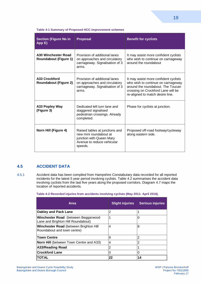
Table 4-1 Summary of Proposed HCC improvement schemes
Section (Figure No in App E)
Proposal Benefit for cyclists
A30 Winchester Road Roundabout (Figure 1)
Provision of additional lanes on approaches and circulatory carriageway. Signalisation of 3 arms.
It may assist more confident cyclists who wish to continue on carriageway around the roundabout
A33 Crockford Roundabout (Figure 2)
Provision of additional lanes on approaches and circulatory carriageway. Signalisation of 3 arms.
It may assist more confident cyclists who wish to continue on carriageway around the roundabout. The Toucan crossing on Crockford Lane will be re-aligned to match desire line.
A33 Popley Way (Figure 3)
Dedicated left turn lane and staggered signalised pedestrian crossings. Already completed.
Phase for cyclists at junction.
Norn Hill (Figure 4) Raised tables at junctions and new mini roundabout at junction with Queen Mary Avenue to reduce vehicular speeds.
Proposed off-road footway/cycleway along eastern side.
4.5 ACCIDENT DATA
4.5.1 Accident data has been compiled from Hampshire Constabulary data recorded for all reported incidents for the latest 5 year period involving cyclists. Table 4.2 summarises the accident data involving cyclists from the last five years along the proposed corridors. Diagram 4.7 maps the location of reported accidents.
Table 4-2 Recorded injuries from accidents involving cyclists (May 2011- April 2016).
Area Slight injuries Serious injuries
Oakley and Pack Lane 2 1 Winchester Road (between Beggarwood Lane and Brighton Hill Roundabout)
1 0
Winchester Road (between Brighton Hill Roundabout and town centre)
4 8
Town Centre 9 2 Norn Hill (between Town Centre and A33) 4 2 A33/Reading Road 2 1 Crockford Lane 0 0 TOTAL 22 14
20
Basingstoke and Deane Cycle Feasibility Study WSP | Parsons Brinckerhoff Basingstoke and Deane Borough Council Project No 70021895 February 17
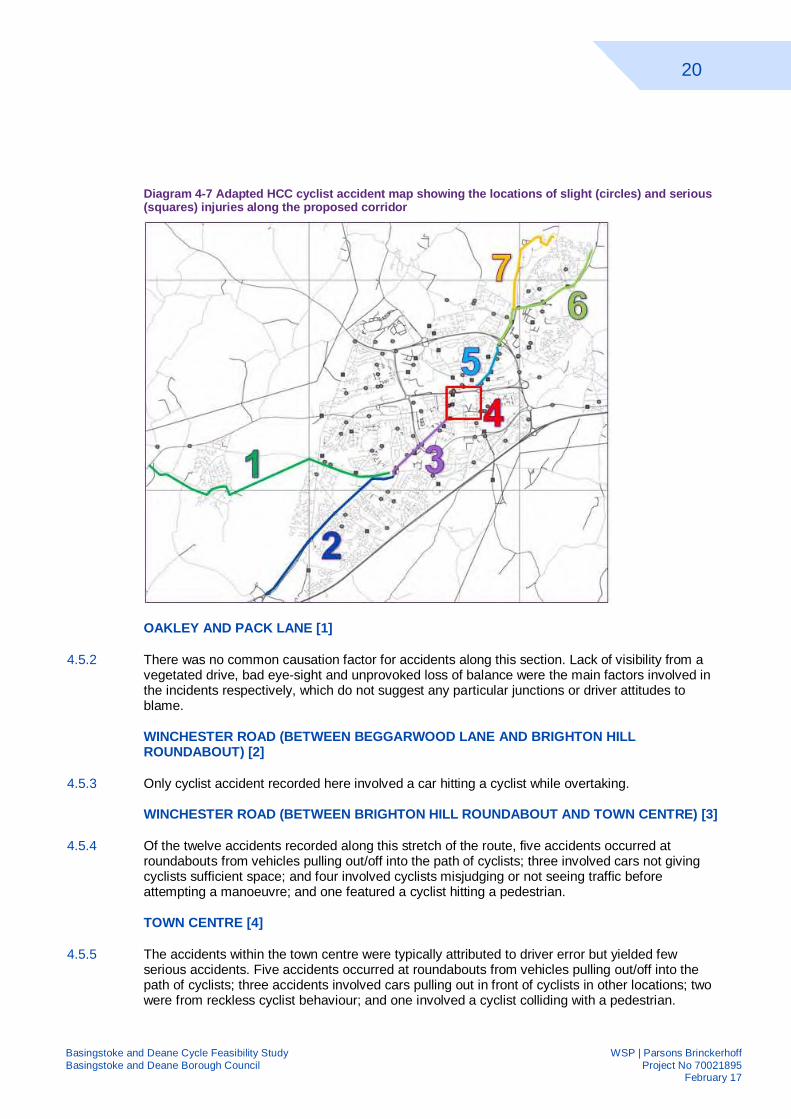
Diagram 4-7 Adapted HCC cyclist accident map showing the locations of slight (circles) and serious (squares) injuries along the proposed corridor
OAKLEY AND PACK LANE [1]
4.5.2 There was no common causation factor for accidents along this section. Lack of visibility from a vegetated drive, bad eye-sight and unprovoked loss of balance were the main factors involved in the incidents respectively, which do not suggest any particular junctions or driver attitudes to blame.
WINCHESTER ROAD (BETWEEN BEGGARWOOD LANE AND BRIGHTON HILL ROUNDABOUT) [2]
4.5.3 Only cyclist accident recorded here involved a car hitting a cyclist while overtaking.
WINCHESTER ROAD (BETWEEN BRIGHTON HILL ROUNDABOUT AND TOWN CENTRE) [3]
4.5.4 Of the twelve accidents recorded along this stretch of the route, five accidents occurred at roundabouts from vehicles pulling out/off into the path of cyclists; three involved cars not giving cyclists sufficient space; and four involved cyclists misjudging or not seeing traffic before attempting a manoeuvre; and one featured a cyclist hitting a pedestrian.
TOWN CENTRE [4]
4.5.5 The accidents within the town centre were typically attributed to driver error but yielded few serious accidents. Five accidents occurred at roundabouts from vehicles pulling out/off into the path of cyclists; three accidents involved cars pulling out in front of cyclists in other locations; two were from reckless cyclist behaviour; and one involved a cyclist colliding with a pedestrian.
21
Basingstoke and Deane Cycle Feasibility Study WSP | Parsons Brinckerhoff Basingstoke and Deane Borough Council Project No 70021895 February 17
NORN HILL (BETWEEN TOWN CENTRE AND A33) [5]
4.5.6 Along Norn Hill, four accidents were recorded where cars pulled out in front of cyclists; one accident was due to a cyclist misjudging a manoeuvre; and one of the serious accidents featured a van hitting a cyclist who was travelling the opposite direction.
A33/READING ROAD [6]
4.5.7 Two accidents recorded along this stretch of Reading road involved vehicles failing to see cyclists and moving to collide with them; and the serious accident occurred when the cyclist misjudged crossing a junction during a green signal at the major Popley Way/A33 junction.
CROCKFORD LANE [7]
4.5.8 No accidents involving cyclists were reported along Crockford Lane. This may be due to the relatively low volumes of cyclist/car traffic that the route currently experiences.
4.6 TRAFFIC FLOW DATA
INTRODUCTION
4.6.1 Hampshire County Council have provided traffic flow data from the most recently available traffic count showing flow, speeds and vehicle class broken down across a week. Data about typical; congestion on the road network was also collated from online data for a Monday morning to give an indication of possible delays and where an off road/segregated cycle route might have a time advantage over a vehicle.
CORRIDOR 5
WINCHESTER ROAD A30, KEMPSHOTT
4.6.2 The 85th percentile traffic speed of inbound traffic is 50mph for Winchester Road, which is in line with the speed limit. There is no congestion for both inbound traffic towards Hatch Warren roundabout, compared to some congestion inbound towards Kempshott Roundabout. After Kempshott Roundabout, there is no congestion for inbound traffic.
OAKLEY TRAFFIC DATA
4.6.3 Pack Lane between Oakley and Kempshott has minimal congestion. There is slight congestion around Oakley and the Five Ways Junction.
4.6.4 The 85th percentile for traffic speed is 31mph for traffic traveling inbound on Pack Lane between Five Ways Junction and Brighton Hill. The speed limit on this section of Pack Lane is 30mph. However, a lower 85th percentile would be expected due to the presence of speed cushions along the length of Pack Lane. There is no traffic congestion identified along this section road.
WINCHESTER ROAD TRAFFIC DATA
4.6.5 There is congestion on the approaches to Brighton Hill Roundabout with 150m of slow moving traffic on three of its arms, and slight congestion on the northern Winchester Road arm. There is slow moving traffic on Winchester Road arms of the Winchester Road roundabout.
4.6.6 The 85th percentile speed on the section of Winchester Road roundabout adjacent to Brighton Hill Retail Park is 43mph which is slightly above the 40mph speed limit. On the section of Winchester Road though Kings Furlong, an 85th percentile traffic speed of 36mph was recorded. The speed limit on this section is 30mph demonstrating a significant speeding issue.
ROUTE 1
22
Basingstoke and Deane Cycle Feasibility Study WSP | Parsons Brinckerhoff Basingstoke and Deane Borough Council Project No 70021895 February 17
NORN HILL TRAFFIC DATA
4.6.7 The 85th percentile for traffic speed is 42mph. However the speed limit is 30mph which indicates a speeding issue along Norn Hill. As access is restricted at the northern end to buses and taxis there is minimal congestion along the southern section.
4.6.8 For traffic travelling northbound on the A33 towards Crockford Roundabout, there is minimal congestion. For traffic going south bound on the A33, there is no congestion until Popley Way and then there is minimal congestion.
TOWN CENTRE TRAFFIC DATA
4.6.9 There is minor congestion for traffic travelling inbound towards the town centre via Alen on Link, Basing View and Winchester Road. There is no congestion within the town centre one-way system, other than on the section of New Road approaching London Road. The 85th percentile for inbound traffic is 27mph.
4.7 KEY ATTRACTORS
4.7.1 Basingstoke and Deane Borough Councils’ objectives for this study are to connect residential areas with key destinations by providing direct, continuous, convenient cycle route or linkages. Their focus is on the creation of Strategic Cycling Network, developed through the corridors to provide arterial routes.
SCHOOLS
4.7.2 Appendix G shows the schools within the study area which are within 1000m of the proposed corridor. Also shown are local roads within this area showing the local links to the corridor. A total of 39 schools are within this buffer area including 27 infant, junior and primary schools, 7 secondary schools, 3 specialist schools and 2 further education colleges.
RETAIL
4.7.3 The two corridors, and the town centre loop, which connects them, provide access to destinations across Basingstoke, as shown on Appendix H. 28 food retailers are within 1000m of the proposed corridors. Furthermore, several retail parks, home several to high street shops, are adjacent or within 500m of the proposed corridors.
4.7.4 Approximately 20 sports and fitness facilities are within 1000m of the proposed corridor. These include gyms, playing fields and tennis clubs. Three public libraries within Basingstoke are also within 1000m of the proposed corridor, including Basingstoke Discovery Centre, which is directly served by the town centre loop.
EMPLOYMENT
4.7.5 Appendix I shows the major employment areas within Basingstoke colour coded by employment numbers. Each area is labelled with the percentage of trips which are by cycle, taken from the 2011 census. Basingstoke have set a target of doubling the number of trips to work made by bicycle by 2021 from a baseline of 1,930 in 2011.
4.7.6 Appendix I shows the proposed corridors and local road network showing the connectivity to the major employment areas potentially achieved by these corridors. Around 3,500 people work at Chineham Business Park, but currently only 45 people, approximately 1.3%, cycle based on data from the Office of National Statistics taken from the 2011 Census.
4.8 SUMMARY
CORRIDOR 1
23
Basingstoke and Deane Cycle Feasibility Study WSP | Parsons Brinckerhoff Basingstoke and Deane Borough Council Project No 70021895 February 17
4.8.1 There is some good existing infrastructure along Corridor 1 with a shared use path between Reading Road Roundabout and Crockford Roundabout, and a shared use path along Basing View. However, there is a speeding issue along Norn Hill, which may discourage cyclists.
4.8.2 Cyclists heading to/from Sherfield Park in northern Basingstoke must currently take an indirect route into/from Basingstoke town centre as there is no provision along the A33, a 50mph road. Neither is there provision within Chineham and Hampshire International Business Parks.
4.8.3 Analysis of existing traffic data showed high flows along the A33 in particular, with moderate congestion occurring. Thus, cycling may offer time savings in comparison to vehicular travel. Where there is provision for cyclists, there are moderate levels of cyclists observed. Where there is none, much lower levels are observed.
4.8.4 The proposed Corridor 1 meets Basingstoke and Deane Borough Councils objective to improve connectivity to education, employment, retail and new development. Seven schools are located within 1000m of the corridor, connected to it via local roads. Four proposed developments are in proximity to the proposed corridor, Razors Farm, Redlands, Land of East of Basingstoke and Upper Cufaude Farm.
CORRIDOR 5
4.8.5 There is less existing infrastructure for cyclists along Corridor 5, compared to Corridor 1. However there is existing infrastructure such as wide footpaths and footways which could be upgraded. Oakley is linked to Basingstoke via a permissive, off-road cycle path which provides a pleasant route.
4.8.6 Cyclists currently cycling between Hatch Warren/Kempshott and Basingstoke must take an indirect route via residential areas or cycle along the busy A30 Winchester Road. This route takes them via some major junctions. Junction data shows that cyclists currently bypass these junctions, using the pedestrian subways.
4.8.7 There are 26 schools within 1000m of the corridor with a few directly on it. There are also two adjacent major retail parks, as well as numerous food shops meeting Basingstoke and Deane Borough Councils’ objective to improve connectivity to education, employment, retail and new development. Several proposed developments are directly served by the proposed corridor, Hounsome Fields, Kennel Farm and Critical Care Hospital
TOWN CENTRE
4.8.8 At present, cyclists travelling to the town centre must park at the edge of the town centre and walk to their destination as there are no connecting routes through or around the town centre, only routes connecting into it.
24
Basingstoke and Deane Cycle Feasibility Study WSP | Parsons Brinckerhoff Basingstoke and Deane Borough Council Project No 70021895 February 17
5 APPRAISAL CRITERIA 5.1 INTRODUCTION
5.1.1 As discussed in Section 3, there are a number of objectives that the proposed cycle corridors should seek to meet based on the policy aspirations of Basingstoke and Deane Borough Council, in particular their Cycling Strategy adopted in March 2016. The overriding requirement to meet these objectives is to improve connectivity, therefore, both existing and proposed provision will be scored against the items below:
Links to & across Basingstoke
Links to employment
Links to development
Links to education
5.1.2 The proposals put forward should offer high quality provision for potential users therefore, the core design principles from Sustrans Principles and Processes for cycle friendly design1 have been used to score both existing and proposed provision.
Sustrans Principles of Cycle Design:
Safety – must be safe and seen as a safe route with due regard given to personal security and potential conflict with other users.
Directness – provide a direct route in line with desire lines to give the quickest route preferably giving advantage over motor traffic.
Comfort – sufficient width for predicted/current flows and offering a route free of impediments such as surface water, debris, sharp bends and other obstacles.
Coherence – a simple to follow signposted route with consistent provision.
Attractiveness – an attractive, well designed route in keeping with its surroundings.
5.1.3 An additional gradient criterion has also been included to factor in the impact of the several subways and bridges along the potential routes.
5.1.4 For proposed schemes additional criteria were also appraised:
Cost – the cost of a scheme is an essential factor in assessment of the merits of a proposal as it will likely determine its viability.
Deliverability/buildability – the deliverability or buildability of a proposed scheme is determined either by its likely impacts, e.g. significant road works, or the feasibility of constructing it, e.g. availability of sufficient space.
Stakeholder support – the level of support from any stakeholders including non-cyclists.
1 http://www.sustrans.org.uk/sites/default/files/images/files/Route-Design-Resources/Principles-and-
Processes-31-10-14.pdf
25
Basingstoke and Deane Cycle Feasibility Study WSP | Parsons Brinckerhoff Basingstoke and Deane Borough Council Project No 70021895 February 17
5.2 INTERVENTIONS
5.2.1 Each corridor has been split into sections. For simplicity predominantly only large, significant improvements have been proposed. Smaller scale improvements to provide coherent, connected routes will be included in the final proposals.
5.3 INTERVENTION LEVELS
5.3.1 For each section, three levels of intervention have been put forward:
Bronze – utilising existing infrastructure and making small improvements. These small improvements could include signage or maintenance work to develop a coherent route. These are “quick wins” which could be achieved in some sections with minimal cost.
Silver – improvements to existing infrastructure such as surfacing or minor streetscape alterations. Larger improvements on existing routes to allow for or to encourage increased use.
Gold – visible and occasionally innovative provision for cyclists. These interventions predominately involve reducing space/priority for cars, in many cases offering an alternate cycle route more suited for utility cyclists.
26
Basingstoke and Deane Cycle Feasibility Study WSP | Parsons Brinckerhoff Basingstoke and Deane Borough Council Project No 70021895 February 17
6 ROUTE OPTIONEERING 6.1 INTRODUCTION
6.1.1 This section sets out the route optioneering exercise undertaken along each corridor to develop a strategy for development. Each corridor was sub-divided into appropriate sections of similar existing provision for appraisal purposes. This provision was judged against the criteria outlined below.
6.1.2 For each section, up to three levels of intervention were proposed; Bronze, Silver and Gold which are discussed later. These were also reviewed against the appraisal criteria outlined below to quantify the merits of each. For all these criteria, a simple scoring system has been applied:
5 Unacceptable 4 Poor 3 Acceptable 2 Good 1 Excellent
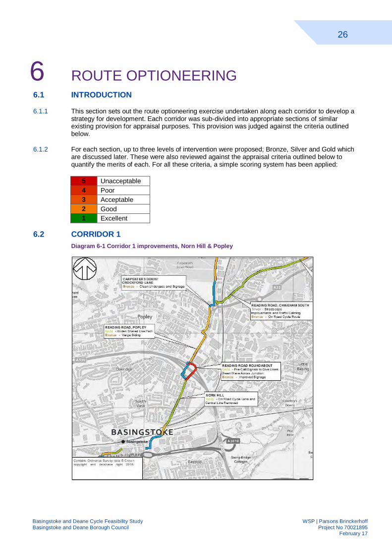
6.2 CORRIDOR 1 Diagram 6-1 Corridor 1 improvements, Norn Hill & Popley
27
Basingstoke and Deane Cycle Feasibility Study WSP | Parsons Brinckerhoff Basingstoke and Deane Borough Council Project No 70021895 February 17
Table 6-1 Improvement Options - Norn Hill & Popley
Section Extents Standard Proposal Basing View From Alençon Link to Norn Hill
including railway overbridge Bronze Improve signage
Norn Hill From railway overbridge to Reading Road Roundabout
Gold On road cycle lanes & remove centre line to
complement HCC proposals
Reading Rd Roundabout
Reading Road Roundabout including toucan crossings
Gold Precall signals to provide green wave to cyclists across junction
Bronze Improve signage Reading Rd Popley From Reading Road Roundabout
to Carpenters Down Gold Widen the existing
shared use path Bronze Verge siding
Carpenters Down/Crockford
Lane
From Carpenters Down to terminus of shared use path on
Crockford Lane
Bronze Clean subway & improve directional
signage
6.2.1 Diagram 6.1 and Table 6.1 summarise the proposed options along Corridor 1 within the Norn Hill and Popley sections of the route. These proposals are discussed in greater detail below.
6.2.2 The existing shared use path along Basing View is a good existing asset so would remain as is. There is only a gold proposal for Norn Hill, to remove the centreline and provide on road advisory cycle lanes, where possible. The frequency of side roads and the poor visibility when crossing them reduce benefit of provision of a shared use path.
6.2.3 There is existing provision for cyclists at Reading Road Roundabout which enables them to navigate the roundabout off-road. However, cyclist movements around the roundabout are delayed due to the need to cross several arms of the roundabout.
6.2.4 The bronze proposal is to revise the signage to ensure users are taking the most direct route to their destination, crossing the road the least number of times. The gold proposal seeks to prioritise cyclist movements by giving them a green wave by detecting their movement and pre-calling the cycle phase at lights.
6.2.5 There is an existing shared use path along the western side of Reading Road towards Popley Way, however, there is only approximately 2m width available due to the adjacent verges creeping over the path. The bronze proposal is to undertake verge siding to widen it back to 2.5m. The gold proposal is to widen the shared use path to 4m to give a greater capacity.
6.2.6 Where the existing shared use path reaches Carpenters Down and Crockford Roundabout, it crosses the road via an underpass. The bronze option proposes to clean the subway, including removal of vegetation, to make it more attractive and increase forward visibility for cyclists.
28
Basingstoke and Deane Cycle Feasibility Study WSP | Parsons Brinckerhoff Basingstoke and Deane Borough Council Project No 70021895 February 17
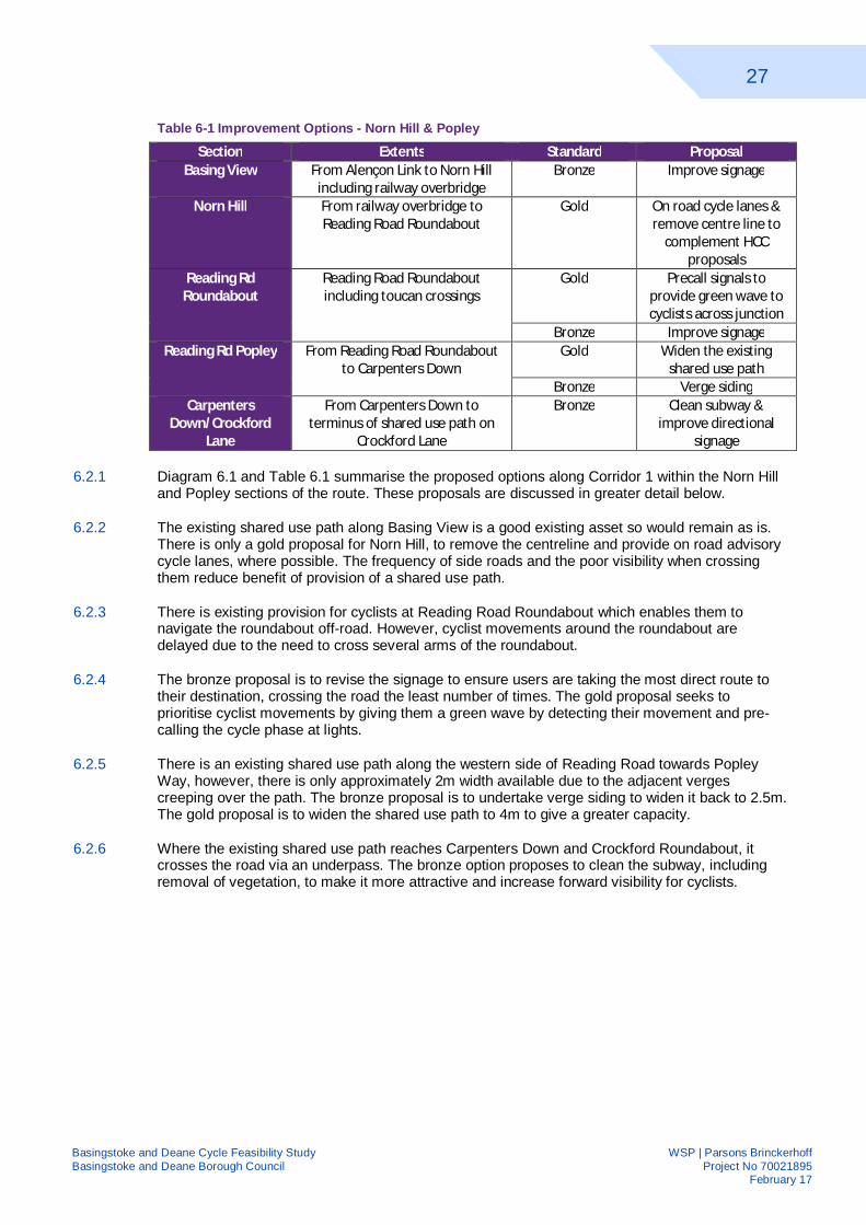
Diagram 6-2 Chineham Business Park
6.2.7
Table 6-2 Improvement Options - Chineham Business Park
Section Extents Standard Proposal
Chineham Business Park
From terminus of Shared Use path to
Hanmore Road including Lime Tree Way
Gold Off road shared use route
Silver Alterations to streetscape
6.2.8 The proposed options along Corridor 1 within the Norn Hill and Popley sections of the route are summarised by Diagram 6.2 and Table 6.2 above. These proposals are discussed in greater detail below.
6.2.9 Just north of Crockford Roundabout, the two corridors branch off. There is an existing shared use path along Crockford Lane for approximately 250m. Where this terminates, two levels of intervention are proposed; silver, altering the streetscape to making it more appropriate for all users and gold, converting the existing footways to shared use paths through widening the paths and providing flush, dropped crossings at access points. Both options would offer a visible, continuous corridor from Basingstoke Town Centre and Railway Station to the Business Park.
29
Basingstoke and Deane Cycle Feasibility Study WSP | Parsons Brinckerhoff Basingstoke and Deane Borough Council Project No 70021895 February 17
Diagram 6-3 Chineham to Sherfield Park
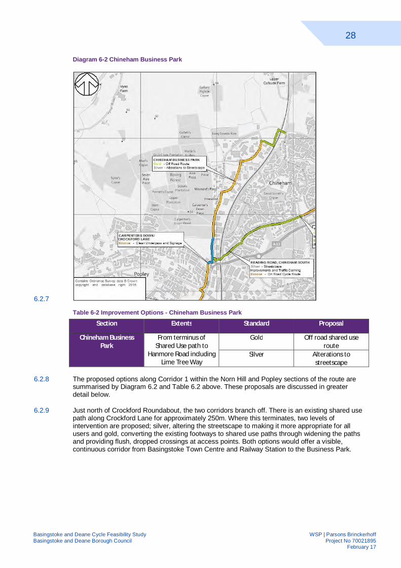
Table 6-3 Improvement Options – Chineham
Section Extents Standard Proposal Reading Road
Chineham South From Crockford Lane to Thornhill Roundabout
Silver On road route with streetscape
improvements & traffic calming
Bronze On road cycle route Thornhill Roundabout Junction of Reading
Road and Thornhill Way Gold Widen splitter islands &
tighten geometry Bronze Signed on road route if
A33 development off road route is not built
Reading Rd Chineham North
Between Thornhill Roundabout and A33
Gold Off road shared use route
Silver Streetscape improvements with on
road route A33 From Reading Road to
Gaiger Avenue Gold 3m wide off road shared
use route
30
Basingstoke and Deane Cycle Feasibility Study WSP | Parsons Brinckerhoff Basingstoke and Deane Borough Council Project No 70021895 February 17
6.2.10 Diagram 6.3 and Table 6.3 above summarise the proposed options along Corridor 1 within Chineham. These proposals are discussed in greater detail below.
6.2.11 The suggested bronze intervention for Reading Road, Chineham South, would be to provide an on road cycle route where achievable to provide a dedicated space for cyclists. The silver intervention would seek to change the nature of this section of Reading Road from a local distributor road to a residential street. The frequency of driveways along this road would make a shared-use path impractical.
6.2.12 NCN23 connects with Corridor 1 at Thornhill Roundabout; gold proposal would be to tighten the geometry of the roundabout to reduce vehicular speeds through it.
6.2.13 The northern section of Reading Road, through Chineham, is a no-through road for vehicular traffic, so traffic flows are low. The gold intervention proposed would be to convert the footway to a shared use path. The silver proposal would be to carry out a similar streetscape improvement as the southern end of Reading Road.
6.2.14 The final section of improvement is adjacent to the A33 to provide a direct link to Sherfield Park. As the A33 is a 50mph road, the only suitable provision would be a shared use path running parallel, which, due to the significant works required, would be a gold intervention. It could potentially form part of longer term improvements to the A33 overall.
6.2.15 If the route adjacent to the A33 does not come forward, it is proposed that signage is provided at Thornhill Roundabout direct users heading for Sherfield Park via NCN23.
6.3 OPTIONS – CORRIDOR 5 Diagram 6-4 Basingstoke Town Centre to Winchester Road Roundabout
6.3.1
31
Basingstoke and Deane Cycle Feasibility Study WSP | Parsons Brinckerhoff Basingstoke and Deane Borough Council Project No 70021895 February 17
Table 6-4 Improvement Options – Basingstoke Town Centre to Winchester Road Roundabout
Section Extents Standard Proposal
Penrith Road From Winchester Road to Alençon Road
Bronze On road route with signage
Cordale Road From Winchester Road to New Road
Bronze Directional Signage
Winchester Rd Sarum Hill
From Penrith Road to New Street
Gold Streetscape improvements & gateway treatment
Winchester Rd Kings Furlong
From Winchester Road Roundabout to Penrith
Road
Gold Reduce traffic flow & downgrade route with
on road advisory Silver Advisory cycle lanes on
road, remove centre line
Bronze Extend existing off road cycle route
Winchester Rd Roundabout
Between Winchester Rd South and Winchester Rd Kings Furlong
Gold Toucan Crossings Silver Subway entrance
realignment & close one exit
Bronze Vegetation clearance and improved lighting
32
Basingstoke and Deane Cycle Feasibility Study WSP | Parsons Brinckerhoff Basingstoke and Deane Borough Council Project No 70021895 February 17
6.3.2 Diagram 6.4 and Table 6.4 summarise the proposed options along Corridor 5 from Basingstoke Town Centre to Winchester Road Roundabout. These proposals are discussed in greater detail below.
6.3.3 The indicative alignment for Corridor 5 was along Winchester Road. As discussed in the previous section, this section of road is narrow and thus the gold proposal put forward would be to change the streetscape, making it more appropriate for all users.
6.3.4 The bronze recommendation would be to sign two alternative routes to the southern end of the town centre and to Basingstoke Train Station respectively via quieter roads, thus avoiding the busy Winchester Road and busy junctions in the town centre.
6.3.5 There is an existing shared use path along the south side of Winchester Road through Kings Furlong which is a substandard width and can have high levels of use at peak times. The gold proposal would be to reduce traffic flow by downgrading it as a route into the town centre enabling cyclists to stay on road and maintain reasonable speeds.
6.3.6 The silver proposal also accommodates cyclists on road through the provision of advisory cycle lanes, allocating space to them and linking to the quieter road links. The bronze proposal would be to extend the existing shared use path to connect with the proposed quiet routes.
6.3.7 The Winchester Road Roundabout can be traversed by cyclists by using subways. The bronze proposal improves these to make use by cyclists easier by removing vegetation to increase forward visibility and increasing natural light within them.
6.3.8 The silver proposal realigns the approach ramps to reduce the gradient and the sharp 90° bend users must make. For both the bronze and silver options, signage would discourage cyclists from using the northern subway. The Gold Proposal replaces the subways with toucan crossings.
Diagram 6-5 Winchester Road
33
Basingstoke and Deane Cycle Feasibility Study WSP | Parsons Brinckerhoff Basingstoke and Deane Borough Council Project No 70021895 February 17
Table 6-5 Improvement Options – Winchester Road
Section Extents Standard Proposal
Winchester Rd South 6.3.10 From Brighton Hill Roundabout to Winchester
Road Roundabout
Gold Speed limit reduction & segregated cycle route
Silver On & off road route behind football ground
Bronze New off road shared use route both sides
Buckland Avenue From Buckland Parade to Winchester Road
Bronze On road cycle route
Brighton Hill From Woodbury Road to Pack Lane
Gold Segregated route on the northern side of the A33
Silver Widen existing footpath, re-align &
convert to shared use Bronze Improve signage on the
existing footpath & convert
Buckland Parade Junction of High Drive and Buckland Ave including area
outside Buckland Parade
Gold Streetscape improvements
34
Basingstoke and Deane Cycle Feasibility Study WSP | Parsons Brinckerhoff Basingstoke and Deane Borough Council Project No 70021895 February 17
6.3.11 Diagram 6.5 and Table 6.5 above summarise the proposed options along Corridor 5 along Winchester Road. These proposals are discussed in greater detail below.
6.3.12 Winchester Road is a heavily trafficked, 40mph dual carriageway. The gold proposal for the corridor would be to reduce the speed limit to 30mph in line with connecting roads and reallocate road space to provide on-road, segregated cycle facilities. The silver option would be to route cyclists via quieter residential streets and a strip of unused land within BDBC ownership, taking cyclists away from the noise and pollution.
6.3.13 The bronze option would be to upgrade the existing footways along either side of Winchester Road to shared use, to allow use by cyclists. Along the northern side, there is sufficient width to provide a 3m plus wide route. On the southern side, the available width varies due to highway boundary restrictions.
6.3.14 The route would then follow Buckland Avenue, which is a residential street with on-road parking. The bronze proposal would be to mark it an on road cycle route. Due to the frequency of parked cars, no cycle lanes are proposed.
6.3.15 The junction High Drive, Buckland Avenue and Pack Lane and the adjacent Buckland Parade create a complexity of movements. It is proposed that the streetscape at this junction and parade is transformed to a shared surface.
Diagram 6-6 Kempshott & Hatch Warren
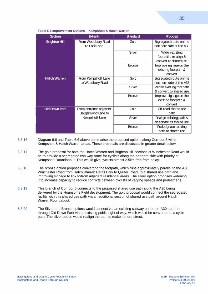
35
Basingstoke and Deane Cycle Feasibility Study WSP | Parsons Brinckerhoff Basingstoke and Deane Borough Council Project No 70021895 February 17
Table 6-6 Improvement Options – Kempshott & Hatch Warren
Section Extents Standard Proposal Brighton Hill From Woodbury Road
to Pack Lane Gold Segregated route on the
northern side of the A33
Silver Widen existing footpath, re-align &
convert to shared use Bronze Improve signage on the
existing footpath & convert
Hatch Warren From Kempshott Lane to Woodbury Road
Gold Segregated route on the northern side of the A33
Silver Widen existing footpath & convert to shared use
Bronze Improve signage on the existing footpath &
convert Old Down Park From entrance adjacent
Beggarwood Lane to Kempshott Lane
Gold Off road shared use path
Silver Realign existing path & designate as shared use
Bronze Redesignate existing path to shared use
6.3.16 Diagram 6.6 and Table 6.6 above summarise the proposed options along Corridor 5 within Kempshott & Hatch Warren areas. These proposals are discussed in greater detail below.
6.3.17 The gold proposal for both the Hatch Warren and Brighton Hill sections of Winchester Road would be to provide a segregated two way route for cyclists along the northern side with priority at Kempshott Roundabout. This would give cyclists almost 2.5km free from delay.
6.3.18 The bronze option proposes converting the footpath, which runs approximately parallel to the A30 Winchester Road from Hatch Warren Retail Park to Quilter Road, to a shared use path and improving signage to link to/from adjacent residential areas. The silver option proposes widening it to increase capacity to reduce conflicts between cyclists of varying speeds and pedestrians.
6.3.19 This branch of Corridor 5 connects to the proposed shared use path along the A30 being delivered by the Hounsome Field development. The gold proposal would connect the segregated facility with this shared use path via an additional section of shared use path around Hatch Warren Roundabout.
6.3.20 The Silver and Bronze options would connect via an existing subway under the A30 and then through Old Down Park via an existing public right of way, which would be converted to a cycle path. The silver option would realign the path to make it more direct.
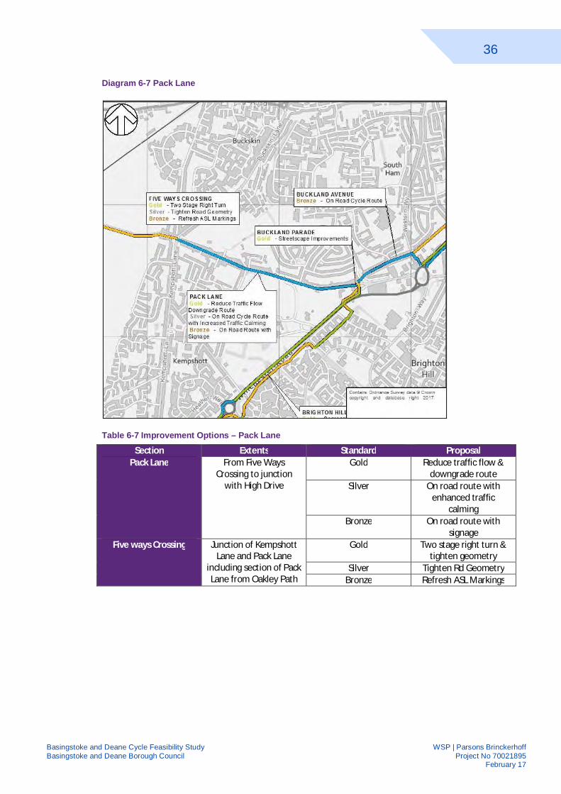
36
Basingstoke and Deane Cycle Feasibility Study WSP | Parsons Brinckerhoff Basingstoke and Deane Borough Council Project No 70021895 February 17
Diagram 6-7 Pack Lane
Table 6-7 Improvement Options – Pack Lane
Section Extents Standard Proposal Pack Lane From Five Ways
Crossing to junction with High Drive
Gold Reduce traffic flow & downgrade route
Silver On road route with enhanced traffic
calming Bronze On road route with
signage Five ways Crossing Junction of Kempshott
Lane and Pack Lane including section of Pack Lane from Oakley Path
Gold Two stage right turn & tighten geometry
Silver Tighten Rd Geometry Bronze Refresh ASL Markings
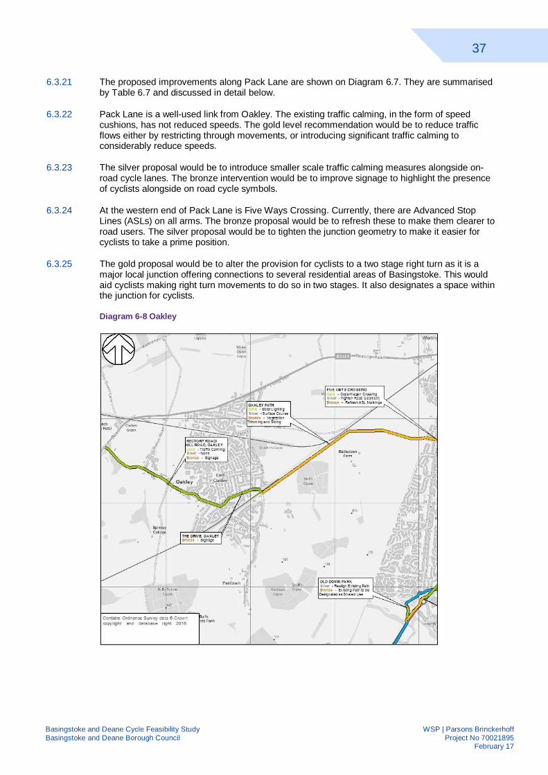
37
Basingstoke and Deane Cycle Feasibility Study WSP | Parsons Brinckerhoff Basingstoke and Deane Borough Council Project No 70021895 February 17
6.3.21 The proposed improvements along Pack Lane are shown on Diagram 6.7. They are summarised by Table 6.7 and discussed in detail below.
6.3.22 Pack Lane is a well-used link from Oakley. The existing traffic calming, in the form of speed cushions, has not reduced speeds. The gold level recommendation would be to reduce traffic flows either by restricting through movements, or introducing significant traffic calming to considerably reduce speeds.
6.3.23 The silver proposal would be to introduce smaller scale traffic calming measures alongside on-road cycle lanes. The bronze intervention would be to improve signage to highlight the presence of cyclists alongside on road cycle symbols.
6.3.24 At the western end of Pack Lane is Five Ways Crossing. Currently, there are Advanced Stop Lines (ASLs) on all arms. The bronze proposal would be to refresh these to make them clearer to road users. The silver proposal would be to tighten the junction geometry to make it easier for cyclists to take a prime position.
6.3.25 The gold proposal would be to alter the provision for cyclists to a two stage right turn as it is a major local junction offering connections to several residential areas of Basingstoke. This would aid cyclists making right turn movements to do so in two stages. It also designates a space within the junction for cyclists.
Diagram 6-8 Oakley
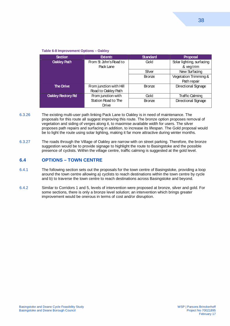
38
Basingstoke and Deane Cycle Feasibility Study WSP | Parsons Brinckerhoff Basingstoke and Deane Borough Council Project No 70021895 February 17
Table 6-8 Improvement Options – Oakley
Section Extents Standard Proposal Oakley Path From St John's Road to
Pack Lane Gold Solar lighting, surfacing
& veg trim Silver New Surfacing
Bronze Vegetation Trimming & Path repair
The Drive From junction with Hill Road to Oakley Path
Bronze Directional Signage
Oakley Rectory Rd
From junction with Station Road to The
Drive
Gold Traffic Calming Bronze Directional Signage
6.3.26 The existing multi-user path linking Pack Lane to Oakley is in need of maintenance. The proposals for this route all suggest improving this route. The bronze option proposes removal of vegetation and siding of verges along it, to maximise available width for users. The silver proposes path repairs and surfacing in addition, to increase its lifespan. The Gold proposal would be to light the route using solar lighting, making it far more attractive during winter months.
6.3.27 The roads through the Village of Oakley are narrow with on street parking. Therefore, the bronze suggestion would be to provide signage to highlight the route to Basingstoke and the possible presence of cyclists. Within the village centre, traffic calming is suggested at the gold level.
6.4 OPTIONS – TOWN CENTRE
6.4.1 The following section sets out the proposals for the town centre of Basingstoke, providing a loop around the town centre allowing a) cyclists to reach destinations within the town centre by cycle and b) to traverse the town centre to reach destinations across Basingstoke and beyond.
6.4.2 Similar to Corridors 1 and 5, levels of intervention were proposed at bronze, silver and gold. For some sections, there is only a bronze level solution; an intervention which brings greater improvement would be onerous in terms of cost and/or disruption.
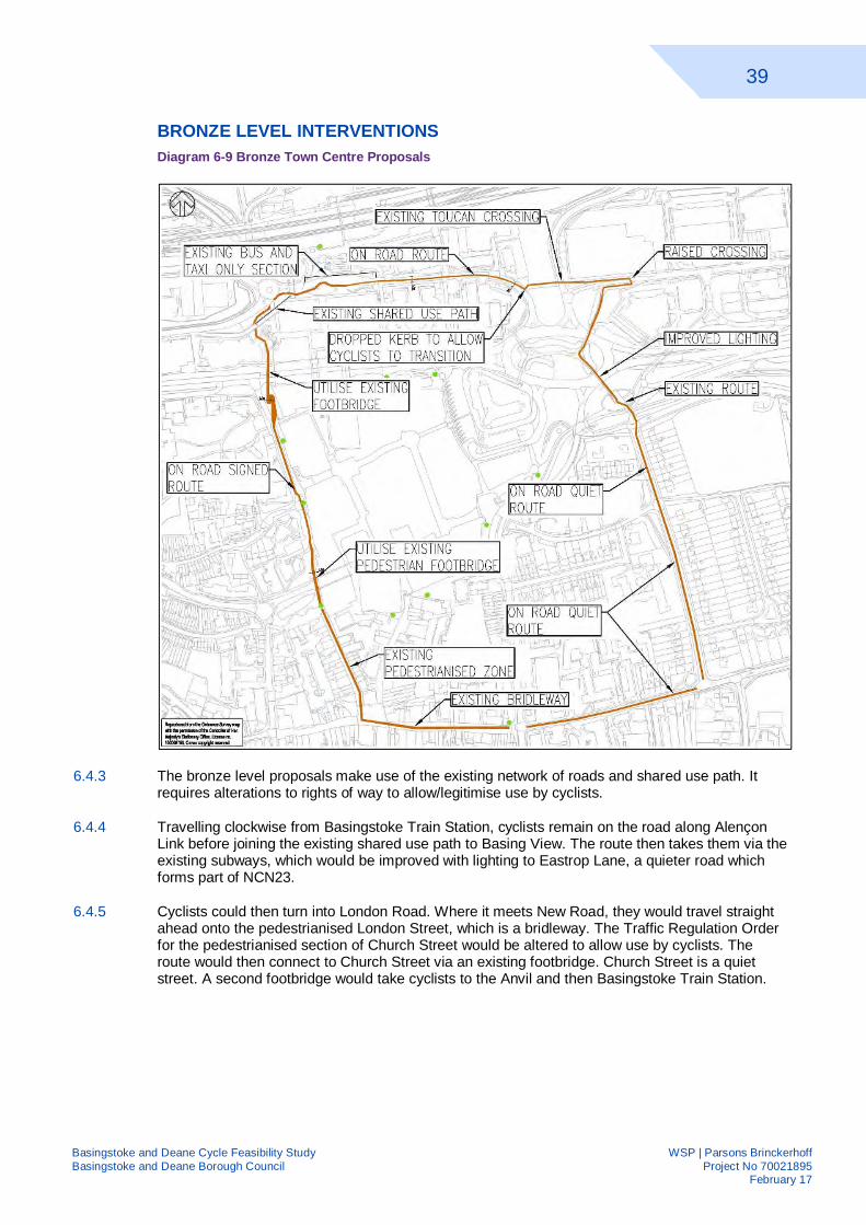
39
Basingstoke and Deane Cycle Feasibility Study WSP | Parsons Brinckerhoff Basingstoke and Deane Borough Council Project No 70021895 February 17
BRONZE LEVEL INTERVENTIONS Diagram 6-9 Bronze Town Centre Proposals
6.4.3 The bronze level proposals make use of the existing network of roads and shared use path. It requires alterations to rights of way to allow/legitimise use by cyclists.
6.4.4 Travelling clockwise from Basingstoke Train Station, cyclists remain on the road along Alençon Link before joining the existing shared use path to Basing View. The route then takes them via the existing subways, which would be improved with lighting to Eastrop Lane, a quieter road which forms part of NCN23.
6.4.5 Cyclists could then turn into London Road. Where it meets New Road, they would travel straight ahead onto the pedestrianised London Street, which is a bridleway. The Traffic Regulation Order for the pedestrianised section of Church Street would be altered to allow use by cyclists. The route would then connect to Church Street via an existing footbridge. Church Street is a quiet street. A second footbridge would take cyclists to the Anvil and then Basingstoke Train Station.
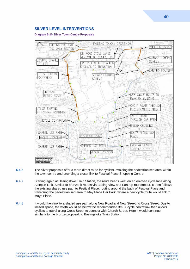
40
Basingstoke and Deane Cycle Feasibility Study WSP | Parsons Brinckerhoff Basingstoke and Deane Borough Council Project No 70021895 February 17
SILVER LEVEL INTERVENTIONS Diagram 6-10 Silver Town Centre Proposals
6.4.6 The silver proposals offer a more direct route for cyclists, avoiding the pedestrianised area within the town centre and providing a closer link to Festival Place Shopping Centre.
6.4.7 Starting again at Basingstoke Train Station, the route heads west on an on-road cycle lane along Alençon Link. Similar to bronze, it routes via Basing View and Eastrop roundabout. It then follows the existing shared use path to Festival Place, routing around the back of Festival Place and traversing the pedestrianised area to May Place Car Park, where a new cycle route would link to Mays Place.
6.4.8 It would then link to a shared use path along New Road and New Street, to Cross Street. Due to limited space, the width would be below the recommended 3m. A cycle contraflow then allows cyclists to travel along Cross Street to connect with Church Street. Here it would continue similarly to the bronze proposal, to Basingstoke Train Station.
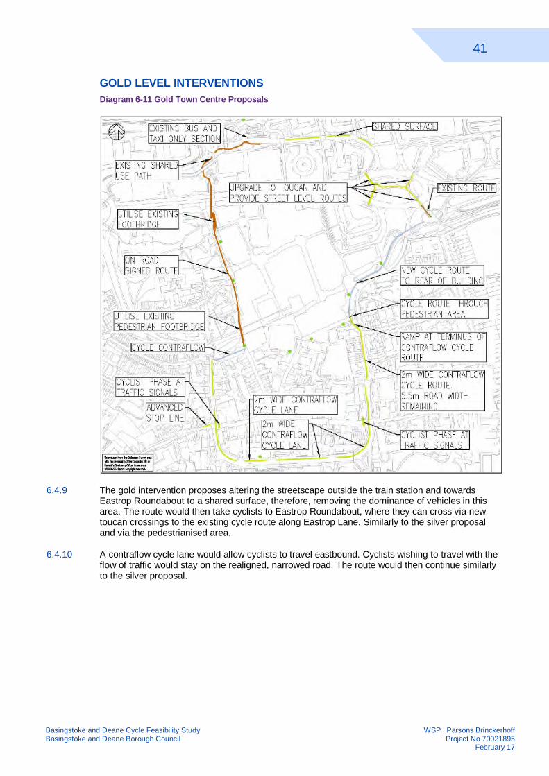
41
Basingstoke and Deane Cycle Feasibility Study WSP | Parsons Brinckerhoff Basingstoke and Deane Borough Council Project No 70021895 February 17
GOLD LEVEL INTERVENTIONS Diagram 6-11 Gold Town Centre Proposals
6.4.9 The gold intervention proposes altering the streetscape outside the train station and towards Eastrop Roundabout to a shared surface, therefore, removing the dominance of vehicles in this area. The route would then take cyclists to Eastrop Roundabout, where they can cross via new toucan crossings to the existing cycle route along Eastrop Lane. Similarly to the silver proposal and via the pedestrianised area.
6.4.10 A contraflow cycle lane would allow cyclists to travel eastbound. Cyclists wishing to travel with the flow of traffic would stay on the realigned, narrowed road. The route would then continue similarly to the silver proposal.
42
Basingstoke and Deane Cycle Feasibility Study WSP | Parsons Brinckerhoff Basingstoke and Deane Borough Council Project No 70021895 February 17
7 STAKEHOLDER ENGAGEMENT 7.1 INTRODUCTION
7.1.1 An important element of the study is feedback from key stakeholders to ensure it meets their objectives and requirements. Furthermore, their local knowledge is key in understanding which measures would have impact and which would be challenging to implement. Prior to determining the proposed option, two consultation exercises were undertaken.
7.2 FEEDBACK FROM PUBLIC
7.2.1 An evening stakeholder event was held at Basingstoke and Deane Borough Council Civic Offices on 9th August 2016 with an invited audience, representing the local cycling community. Background information and purpose of the project was explained, with input from Basingstoke and Deane’s officers.
7.2.2 Each section of corridor was then discussed in turn; first the barriers to cycling were discussed and the proposed interventions at bronze, silver and gold level were put forward. At each section, feedback was collected from the audience about the optimum choice and any other options which could be considered.
7.2.3 Appendix J contains the memo summating the points raised but the key points taken from the meeting were:
Concerns if bronze schemes are implemented then unlikely to pursue silver/gold in the future;
Key areas of concern were Buckland Avenue/ Winchester Road Roundabout and Link by Audi Garage in Chineham; and
A mix and match approach is likely to be most suitable with some junctions/links requiring gold treatment.
7.2.4 Attendees were also able to send feedback/comments following on from the public consultation to Basingstoke and Deane Borough Council. Much of the feedback related to connectivity to other parts of Basingstoke and to the Borough as a whole. There was also an emphasis on maintenance of both existing and proposed infrastructure, with a suggestion that some budget should be retained for ongoing maintenance.
7.2.5 These comments were taken into consideration and amendments carried out to the proposals, based on the useful feedback.
7.3 FEEDBACK FROM LOCAL AUTHORITIES
7.3.1 Following on from the public consultation, a meeting was held with Basingstoke and Deane Borough Council (BDBC) and Hampshire County Council (HCC) officers to firstly discuss the feedback from the meeting and secondly to discuss which option to take forward.
7.3.2 BDBC had also organised an internal member workshop/exhibition where they presented our options appraisal. This enabled them to obtain feedback, and ultimately consent for, the preferred BDBC option.
43
Basingstoke and Deane Cycle Feasibility Study WSP | Parsons Brinckerhoff Basingstoke and Deane Borough Council Project No 70021895 February 17
7.3.3 WSP | Parsons Brinckerhoff talked through the options appraisal at the meeting and highlighted the recommended optimum option for each section. BDBC and HCC then provided their feedback on the options chosen and any possible barriers. In particular the options for the route around Brighton Hill Roundabout were discussed in depth.
7.4 OPTION APPRAISAL
7.4.1 Using the appraisal criteria, set out at the beginning of this chapter, each section of corridor was appraised; both existing and proposed at all levels, where appropriate. The final appraisal table is presented in Appendix K.
7.4.2 As discussed previously, each corridor was scored for the existing situation and for each of the proposed options. This scoring mechanism used allowed an assessment be made of the preferable solution, based on the performance score.
7.4.3 This formed the basis for the discussions with the local authorities about their preferred option. Where opinion differed, it is because of the greater importance placed by BDBC on the key factors of cost, deliverability and stakeholder support. For Corridor 1 BDBC and WSP|PB route selections concurred. However, for Corridor 5 and the Town Centre area, option selection varied.
7.4.4 In general, along Corridors 1 and 5, the bronze option was preferred by BDBC and HCC to be taken forward. The bronze option utilises existing infrastructure and makes small improvements. These small improvements include signage or maintenance work to develop a coherent route.
7.4.5 These are “quick wins” which can be achieved in some situations with minimal cost and predominately less disruption than the other options. None of the options preclude introducing a silver or even gold intervention in the future if demand were to increase, for example, or funding were to become available such as through development opportunities.
7.4.6 Within the town centre, a mixture of intervention levels has been selected. All proposals put forward had challenges associated with them, in terms of acceptability, due to the dominance of cars within the town centre and the pedestrianised town centre.
44
Basingstoke and Deane Cycle Feasibility Study WSP | Parsons Brinckerhoff Basingstoke and Deane Borough Council Project No 70021895 February 17
8 PROPOSED OPTION 8.1 INTRODUCTION
8.1.1 This chapter presents the proposed route options along Corridor 1 and Corridor 5 and within the town centre. This has been based upon the options appraisal and stakeholder engagement discussed within the previous chapter.
8.1.2 This appraisal was used by Basingstoke and Deane Borough Council and Hampshire County Council Officers to identify their preferred option and at the member workshop/exhibition organised internally. This was determined by the council and predominately based on the key factors of cost, deliverability and stakeholder support.
8.1.3 The feasibility design for Route 1 and Route 5 are shown on drawings within Appendix L. 1895/GA/026 gives a geographic overview of the drawings, showing which drawings cover which area. The two corridors and town centre are covered thus:
1895/GA/004 to GA/011 shows the feasibility design for Corridor 1;
The feasibility design for Corridor 5 is set out on 1895/GA/012 to GA/024; and
The town centre is shown on 1895/GA/005.
8.1.4 This chapter will detail the route along both corridors. Route 1 serves Corridor 1 and Route 5 serves Corridor 5. In the process of progressing the proposals from options to feasibility design, additional details have been added to provide a coherent, continuous route.
8.2 ROUTE 1
BASING VIEW TO QUEEN MARY AVENUE, NORN HILL – GA/004
8.2.1 The route starts on Basing View using the existing shared use path towards Norn Hill. The existing footbridges, which link Basing View to Norn Hill, will be re-designated shared use to allow cyclists to avoid using the road. Where the bridge connects to Norn Hill, a 2.4m wide dropped kerb will be provided to allow cyclists to transition on/off the carriageway. Cycle markings and signage will guide them.
8.2.2 Due to the limited width and the need to retain on street parking, there is insufficient space to provide advisory cycle lanes and retain sufficient width for vehicles. Tapers, formed of road markings, have been proposed to transform the appearance of parking spaces so that they perform a traffic calming function.
QUEEN MARY AVENUE TO READING ROAD, A33 – GA/005
8.2.3 The route continues along Norn Hill towards Reading Roundabout on road. Along this section there is no on-road parking, therefore, the advisory cycle lanes continue unobstructed by parked cars. At the junctions with Westray Close and Taverner Close, raised tables are being considered by Hampshire County Council. These, along with the visual narrowing of the road achieved by the advisory cycle lanes and the removal of the centreline, will aid in reducing speeds.
8.2.4 At the northern end of Norn Hill a new section of shared use path will enable northbound cyclists to transition onto the existing shared use path around Reading Road Roundabout. Signage directs users to destinations within the local area. This signage will be improved to direct cyclists along the quickest route, reducing the number of times they must cross the road.
45
Basingstoke and Deane Cycle Feasibility Study WSP | Parsons Brinckerhoff Basingstoke and Deane Borough Council Project No 70021895 February 17
8.2.5 At each signalised junction, there is a phase for cyclists and pedestrians, which is called during every stage, removing the necessity to call it.
8.2.6 The shared use path connects cyclists with the existing shared used path along the western side of Reading Road, leading them north.
READING ROAD TO CROCKFORD ROUNDABOUT – GA/006
8.2.7 The existing shared use path along Reading Road is around 2.2m wide. It is proposed that siding is carried out along the length, to increase the width available as the verge has crept over the path.
8.2.8 Where the route crosses Popley Way, a new junction layout has recently been constructed which requires pedestrians and cyclists to cross in three stages. Alternately, there is a subway 70m from the junction, which is suitable for use by cyclists via a circuitous route.
8.2.9 The existing shared use path continues along Reading Road. When it reaches Carpenter Down, adjacent to Crockford Roundabout, it passes under the road via a subway. It is recommended that the subway is cleaned and the vegetation on the approaches is cleared away to increase visibility on the approaches.
8.2.10 The route splits after the subway. Cyclists heading to Chineham will cross via a relocated Toucan Crossing. This relocation will form part of the improvement works at Crockford Roundabout planned by Hampshire County Council.
CROCKFORD LANE THROUGH CHINEHAM AND HAMPSHIRE INTERNATIONAL BUSINESS PARKS – GA/007 AND GA/008
8.2.11 The existing shared use path extends to the entrance to the Business Park. It is suggested that this is extended 250m further into Chineham Business Park. Users will then transition onto the proposed on-road advisory cycle lane.
8.2.12 A raised parallel pedestrian cyclist crossing will enable southbound cyclists to cross the road to reach the shared use path. Furthermore, it will slow traffic approaching the Business Park. At present the 85th percentile speed of traffic on this section of Crockford Lane is 45mph.
8.2.13 The advisory cycle route is proposed to continue along Crockford Lane and Lime Tree Way. The cycle lane is proposed to be 1.5m wide, the minimum recommended width, leaving a minimum road width of 4.3m, which is sufficient for two cars to pass each other without encroaching into the cycle lane.
8.2.14 At the approaches to the roundabout and junctions, the advisory cycle lanes terminates 20m in advance. This is to encourage cyclists to position themselves correctly. The centreline will also be removed to reduce speeds.
8.2.15 The route rejoins Crockford Lane after passing through both business parks. It is proposed that the existing footway along one side of this road is re-designated as a shared use path, which will connect into NCN23 along Cufuade Lane.
READING ROAD, CHINEHAM (NCN23) – GA/009 AND GA/010
8.2.16 To connect cyclists from Crockford Lane to Reading Road, it is proposed that the existing Toucan Crossing is relocated 60m south in line with the pedestrian desire line. This repositioned crossing will link directly to Reading Road via a service road, which is only accessible to non-motorised users at the western end. At the eastern end, there is a barrier restricting access from Reading Road.
46
Basingstoke and Deane Cycle Feasibility Study WSP | Parsons Brinckerhoff Basingstoke and Deane Borough Council Project No 70021895 February 17
8.2.17 It is recommended that a dropped kerb is installed west of the railway overbridge to allow cyclists to transition from the proposed shared use path on the northern side to the proposed shared use path on the southern side.
8.2.18 The existing footway on the southern side is proposed to be re-designated as a shared use path, which will allow cyclists to bypass the gate which currently restricts access. A raised parallel zebra and cyclist crossing will allow users to move to/from the proposed on-road advisory cycle lanes.
8.2.19 The proposed advisory cycle lanes continue along the length of Reading Road where space allows. There is some informal on street parking currently on Reading Road. Twelve formal spaces have been created as a traffic calming feature and to deter parking.
8.2.20 1.8m wide parking bays have been proposed with an additional marked 0.5m wide zone to allow for the opening of car doors. The tapers leading into these parking spaces are less than the recommended 1:10. The advisory cycle lanes are 1.5m wide, the minimum width recommended. Where these have been proposed both sides, a minimum width of 4.4m remains which is sufficient for two cars to pass each other.
8.2.21 At Thornhill Way Roundabout, the on road cycle lane terminates 20m in advance to encourage users to position themselves correctly. This branch of Route 1 connects with NCN23 at this point. The proposed on road advisory cycle lane then continue to the end of Reading Road. There is an existing pedestrian link to A33 which will be cleared of vegetation and signed as a cycle route.
A33 TO GAIGER AVENUE – GA/011
8.2.22 The volume and speed of traffic along the A33 is such that the only suitable provision for cyclists is an off-road shared use path. Where possible, this is 3m wide and set as far back from the carriageway as is achievable within the highway boundary, with a minimum offset of 0.5m.
8.2.23 In two locations there are pinch points reducing the available width to 1.4m and 0.8m, respectively. In the first situation a vehicle crash barrier, protecting a culvert and a stream, is situated within the verge, restricting space for a path. The barrier should be relocated to increase the space available or removed entirely if allowed.
8.2.24 The second pinch point is caused by the lack of available highway space giving only 0.8m available for cyclists, excluding a 0.5m wide verge. Realignment of the road or acquisition of land will be necessary to make this shared use route feasible. The route terminates at Gaiger Avenue, where it will connect to the residential development of Sherfield Park.
8.2.25 Longer term proposals to improve the A33 should comprehensively consider the needs of cyclists while adjacent development sites should make provision in bringing forward their sites in line with the Adopted Local Plan requirements.
8.3 ROUTE 5
OAKLEY - GA/012, GA/013, GA/014 AND GA/015
8.3.1 Following on from feedback from the consultation, Route 5 has been extended to B3400 Andover Road to encourage connections from elsewhere within the borough. The proposal along Rectory Road, Hill Road and The Drive is to use signage to firstly guide cyclists and markings to alert road users to their presence.
8.3.2 At the eastern end of The Drive, users will have two options; a) turn right and continue on road over the railwaybridge or b) dismount and cross via the footbridge. They will then join the existing Oakley Multi User Path permissive cycle route from St Johns Road to Pack Lane.
8.3.3 It is proposed this path is improved by trimming back the vegetation, increasing the available width and resurfacing it along its entire length to improve the durability of the path.
47
Basingstoke and Deane Cycle Feasibility Study WSP | Parsons Brinckerhoff Basingstoke and Deane Borough Council Project No 70021895 February 17
8.3.4 Where the route meets Pack Lane, eastbound cyclists will be directed to join the carriageway. Westbound cyclists will be directed to join the shared use path on the southern side. It is suggested that the road markings at the Five Ways junction are refreshed to make them clear to road users and increase the confidence of cyclists using the advanced stop lines.
PACK LANE – GA/016
8.3.5 Pack Lane currently has speed cushions every 60 – 70m along its length. As the width of this section of Pack Lane is insufficient for advisory cycle lanes, it is proposed to highlight the presence of cyclists and the space available to them through on road cycle symbols placed frequently along Pack Lane.
OLD DOWN PARK TO HATCH WARREN – GA/023
8.3.6 Route 5 starts from the A30 adjacent to the Critical Care Hospital. A shared use path alongside the A30, as part of the Hounsome Fields Development is proposed. This path will connect to the existing path through Old Down Park, the first section of which is a cycle path. The second half will be designated as a shared use path.
8.3.7 The existing 3m wide path which runs broadly parallel to the A30 Winchester Road will be re-designated as a shared use path. This path is connected to Old Down Park via a subway. Where the route crosses Woodbury Road, the pedestrian refuge island will be widened to 2.5m to accommodate cyclists.
HATCH WARREN TO PACK LANE – GA/024
8.3.8 East of Woodbury Road, the existing path is approximately 2m wide. It is proposed that this path is re-designated as a shared use path. If cyclist flows are high, the section through here should be widened to 3m to accommodate these flows.
8.3.9 The route then passes under the A30 Winchester Road via a subway. The northern ramp is very steep and features a tight bend, restricting visibility. It is recommended that this is re-profiled to reduce the steep gradient to enable designation as a shared use route.
BUCKLAND AVENUE TO WINCHESTER ROAD – GA/017
8.3.10 The Buckland Parade section of the route has been left in abeyance as BDBC will develop their own solution for this complex junction and parade of shops. However, longer term proposals to improve Brighton Hill roundabout should also consider the needs of cyclists. As there is a large quantum of off-street parking, it is proposed to highlight the presence of cyclists and the space available to them through on-road cycle symbols placed frequently along Buckland Avenue.
8.3.11 At the eastern end of Buckland Avenue, it is proposed that cyclists will join a new shared use path along the eastern side of Western Way using the existing footway. This footway is 2.2m wide but there is space to widen, if demand increases. A short section of proposed shared use path will allow them to cross using the existing pedestrian refuge islands; which will be widened to 2.5m to make them suitable for use by cyclists.
WINCHESTER ROAD – GA/018 AND GA/019
8.3.12 It is proposed that the footway both sides of Winchester Road are re-designated as shared use. The proposed route uses the northern side so it is envisaged that most demand will be along this side. However, Brighton Hill Retail Park and other retailers are located along the southern side and therefore, provision of a link to these is important to meet BDBC objectives.
8.3.13 The existing footway along the northern side is mostly above the recommended width of 3m for a shared use path. It is proposed that pedestrian guard railing and other items of street furniture are removed / relocated to maximise available space for users.
48
Basingstoke and Deane Cycle Feasibility Study WSP | Parsons Brinckerhoff Basingstoke and Deane Borough Council Project No 70021895 February 17
8.3.14 Along the southern side, the width of the footway varies between 2m and 2.5m. Along most of this side, there is space within highway land to widen it if required to increase capacity. There two sets of pedestrian signalised crossings along Winchester Road.
8.3.15 The pedestrian signalised crossings adjacent to the entrance to Brighton Hill Retail Park are currently staggered crossings requiring users crossing from one side of Winchester Road to the other, to cross in three stages. The crossing on across the vehicular access into the Retail Park requires users to cross in two stages. It is suggested that these crossings are upgraded to Toucan crossings as part of the redevelopment of adjacent land, along with associated improvements to provide access to the site by all modes.
8.3.16 The proposed shared use path both sides link into the subways under Winchester Road Roundabout. It is recommended vegetation clearance is carried out to maximise the amount of natural light on the approaches to and within the subways. The approach ramps from Winchester Road are steep and thus there is a concern that cyclists may travel too fast. Therefore, staggered barriers with a 3m offset are recommended.
8.3.17 Cyclists will be guided to the existing shared use path along the southern side of Winchester Road via signage to discourage use of the footway along the northern side.
8.3.18 The existing shared use path along Winchester Road is between 1.7m and 2m wide, therefore, below recommended width. Anecdotal evidence suggests that this path becomes congested before and after school times therefore, consideration should be given to widening it where possible.
8.3.19 It is proposed that the existing shared use path along the southern side is extended to Cordale Road to provide a connection to this quiet street route to the Top of Town. It is recommended that the existing puffin crossing near Cordale Road is changed to a Toucan Crossing to connect with a short section of new shared use path linking to Penrith Road to connect with the Railway Station.
PENRITH ROAD/ESSEX ROAD – GA/020
8.3.20 An advisory cycle lane is proposed along the western side of Penrith Road to accommodate cyclists travelling uphill. Cyclists travelling downhill will be moving at a speed similar to vehicular traffic and thus a cycle lane is less vital. On-road cycle symbols will highlight the presence of cyclists on the southbound side.
8.3.21 Towards the northern end of Penrith Road, there is on-road parking along both sides of the road. This will be retained but the markings will be refreshed to include a taper and a dooring zone to discourage cyclists from riding too close to vehicles and highlight the presence of cyclists to other road users.
8.3.22 The route crosses Worting Road via a signalised junction; at the junction there are existing advance stop lines. Along Essex Road there is insufficient space for cycle lanes, therefore, the existing on-street parking will be used as traffic calming with lead in tapers.
8.3.23 Cyclists will use the existing subway under Victory Roundabout to connect to a new section of shared use path along Alençon Link. As with Winchester Road Roundabout, the ramps within the subway are steep and thus, there is a concern that cyclists may travel too fast.. Therefore, staggered barriers, with a 3m offset, are recommended.
8.3.24 This branch of Route 5 will then connect with the Town Centre Route to link to Basingstoke Railway Station and Festival Place.
49
Basingstoke and Deane Cycle Feasibility Study WSP | Parsons Brinckerhoff Basingstoke and Deane Borough Council Project No 70021895 February 17
CORDALE ROAD/COUNCIL ROAD/SOUTHERN ROAD – GA/021 AND GA/022
8.3.25 It is proposed that cyclists travelling towards the Top of Town, the southern side of the town centre, are directed up Cordale Road, a quiet residential road. The footpath which circumnavigates the Cricket Club is proposed to be upgraded to permit cycling from the play area on Cordale Road. Where possible, it is suggested it should be widened and lighting provided.
8.3.26 The existing footpath links to Council Road a residential street. It is then proposed that the cycle route continues along Southern Road. This road is currently one way so it is proposed that a TRO is obtained to enable cycling in both directions. This route will connect to the town centre via an existing footpath through Castons Car Park.
TOWN CENTRE - GA/025
8.3.27 It is proposed that the town centre is served by a loop. The route starts outside Basingstoke Railway Station on Alençon Link. Heading clockwise, the route initially is proposed to be an on- road advisory cycle lane. Enforcement of the parking restrictions along Alençon Link will be necessary to maximise the effectiveness of the cycle lanes.
8.3.28 The cycle route will then connect to Basing View via the existing shared use path and toucan crossing. Cyclists will then be routed via the existing subways under Eastrop Roundabout to connect to Eastrop Lane. The ramp down to the subway from Basing View is steep so staggered barriers with a 3m offset are recommended to reduce cyclist speeds.
8.3.29 At Eastrop Lane, the route will connect with NCN23 towards Reading and Southampton and an existing shared use path that links to Festival Place’s food court.
8.3.30 It is then proposed that cyclists are directed along Eastrop Lane, Goat Lane then Chequers Road which are quiet streets. A TRO will be required to allow cyclists to ride eastbound as Chequers Road is a one-way street. It is proposed the existing pelican crossing on New Road is upgraded to a toucan crossing. It will be connected to Chequers Road via a short section of shared use path.
8.3.31 A contra-flow cycle route is proposed for cyclists going anti-clockwise around the town centre. Cyclists travelling clockwise will cycle on road. The 2m wide route is proposed between the new toucan crossing and Timberlake Road. Segregation will be achieved using kerbs with breaks at car park accesses.
8.3.32 Cyclists will be directed onto Cross Street. A TRO will allow entry for cyclists onto Cross Street from New Street. They will then be directed onto the existing footbridge over Timberlake Road which connects to Church Street.
8.3.33 Church Street is a quiet, lightly trafficked road thus cyclists will be directed on road until they reach the footbridge connecting to The Anvil. This footbridge will be designated as shared use path allowing cyclists to connect to Alençon Link and Basingstoke Railway Station.
50
Basingstoke and Deane Cycle Feasibility Study WSP | Parsons Brinckerhoff Basingstoke and Deane Borough Council Project No 70021895 February 17
9 ROAD SAFETY AUDIT INTRODUCTION
9.1.1 The proposals for Route 1, Route 5 and the town centre were audited by two teams from WSP | Parsons Brinckerhoff. The audit teams were not involved in the design process and work in separate offices to the design team. They have examined and reported only on the road safety implications of the scheme as presented in the drawings submitted to them and have not examined or verified the compliance of the designs to any other criteria.
9.1.2 Their Road Safety Audits and the designers’ responses are contained within Appendix M. Table 9.1 summarises the points raised by the auditors. Where an alteration to the proposals was recommended by the auditors and agreed by the design team, the drawings have been altered to reflect this.
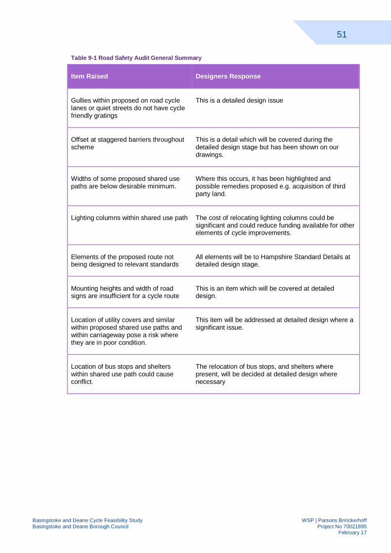
51
Basingstoke and Deane Cycle Feasibility Study WSP | Parsons Brinckerhoff Basingstoke and Deane Borough Council Project No 70021895 February 17
Table 9-1 Road Safety Audit General Summary
Item Raised Designers Response
Gullies within proposed on road cycle lanes or quiet streets do not have cycle friendly gratings
This is a detailed design issue
Offset at staggered barriers throughout scheme
This is a detail which will be covered during the detailed design stage but has been shown on our drawings.
Widths of some proposed shared use paths are below desirable minimum.
Where this occurs, it has been highlighted and possible remedies proposed e.g. acquisition of third party land.
Lighting columns within shared use path The cost of relocating lighting columns could be significant and could reduce funding available for other elements of cycle improvements.
Elements of the proposed route not being designed to relevant standards
All elements will be to Hampshire Standard Details at detailed design stage.
Mounting heights and width of road signs are insufficient for a cycle route
This is an item which will be covered at detailed design.
Location of utility covers and similar within proposed shared use paths and within carriageway pose a risk where they are in poor condition.
This item will be addressed at detailed design where a significant issue.
Location of bus stops and shelters within shared use path could cause conflict.
The relocation of bus stops, and shelters where present, will be decided at detailed design where necessary