Embed Size (px)
Citation preview
Recommended Procedures for Post-Processing Static GPS Observations using OPUS-Projects
Daniel T. Gillins, Ph.D., P.L.S.,
Assistant Professor, Oregon State University
MAJ Darren J. Kerr,
Instructor, United States Military Academy at West Point, NY
Mark L. Armstrong, P.L.S.,
Geodesist, NOAA’s National Geodetic Survey
September 13, 2016 1
Outline
•Objectives of this presentation
•Introduction to OPUS-Projects
•Recommended procedures for using OPUS-Projects
•Introduction to OPUS-Net
•Presentation of a case study in Oregon
• Compare results from OPUS-Projects with OPUS-Net
•Conclusions
September 13, 2016 2
Objectives
• To recommend procedures for post-processing and adjusting static GPS survey projects using OPUS-Projects
• To provides guidance on:
- setting up a project
- selecting reliable CORS for session processing and control
- designing the geometry of the survey network
- selecting constraint weights on the control
- processing the GPS sessions
- performing and analyzing network adjustments
September 13, 2016 3
Evaluation of the recommended procedure
• Static GPS data collected on 18 passive marks in western Oregon was processed according to the following recommended OPUS-Projects procedures.
• The same data was post-processed in another NGS product under development named OPUS-Net.
• Results from OPUS-Net and OPUS-Projects were compared and found to be remarkably similar.
September 13, 2016 4
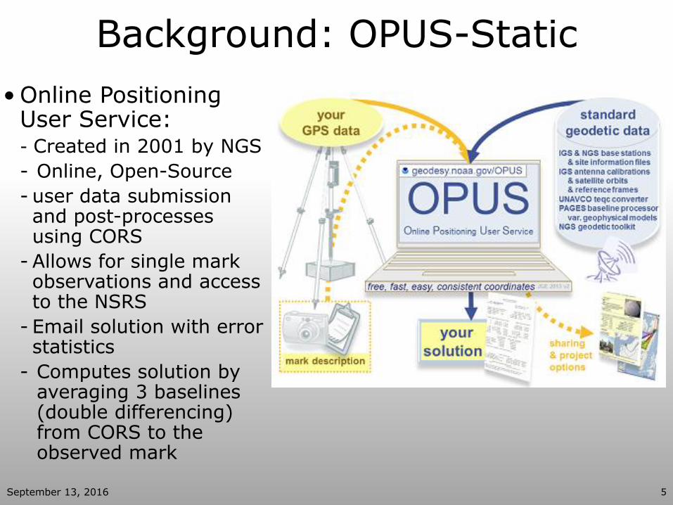
Background: OPUS-Static
September 13, 2016 5
• Online Positioning User Service: - Created in 2001 by NGS
- Online, Open-Source
- user data submission and post-processes using CORS
- Allows for single mark observations and access to the NSRS
- Email solution with error statistics
- Computes solution by averaging 3 baselines (double differencing) from CORS to the observed mark
September 13, 2016 6
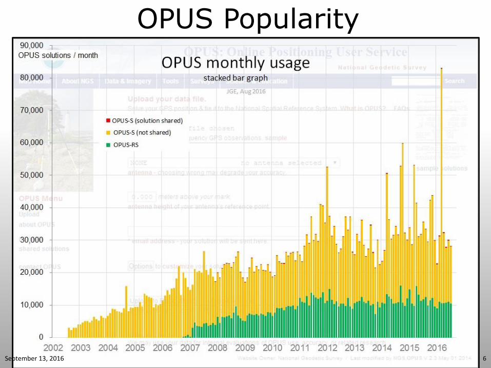
OPUS Popularity
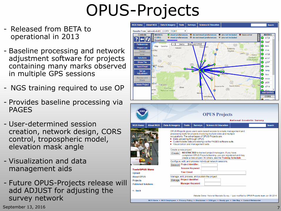
OPUS-Projects - Released from BETA to
operational in 2013
- Baseline processing and network adjustment software for projects containing many marks observed in multiple GPS sessions
- NGS training required to use OP
- Provides baseline processing via PAGES
- User-determined session creation, network design, CORS control, tropospheric model, elevation mask angle
- Visualization and data management aids
- Future OPUS-Projects release will add ADJUST for adjusting the survey network
September 13, 2016 7
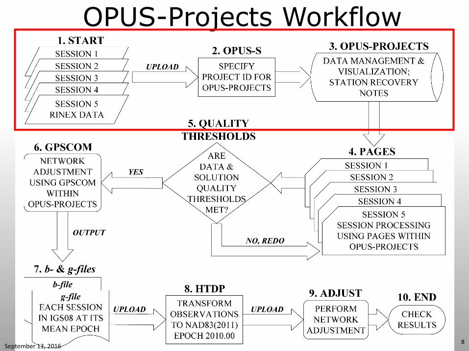
OPUS-Projects Workflow
September 13, 2016 8
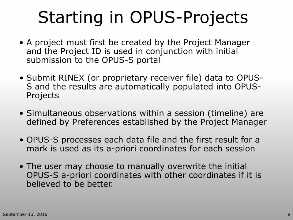
Starting in OPUS-Projects
• A project must first be created by the Project Manager and the Project ID is used in conjunction with initial submission to the OPUS-S portal
• Submit RINEX (or proprietary receiver file) data to OPUS-S and the results are automatically populated into OPUS-Projects
• Simultaneous observations within a session (timeline) are defined by Preferences established by the Project Manager
• OPUS-S processes each data file and the first result for a mark is used as its a-priori coordinates for each session
• The user may choose to manually overwrite the initial OPUS-S a-priori coordinates with other coordinates if it is believed to be better.
September 13, 2016 9
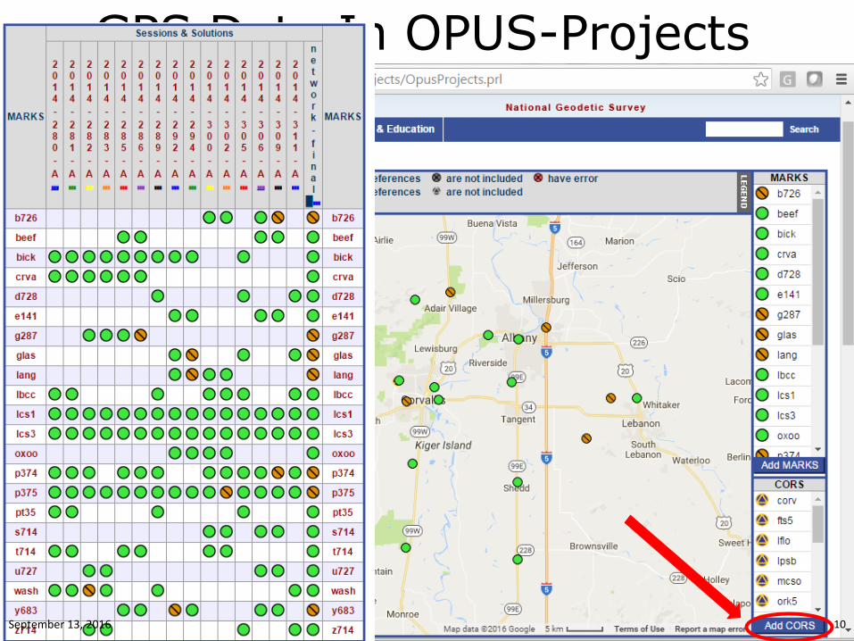
GPS Data In OPUS-Projects
September 13, 2016 10
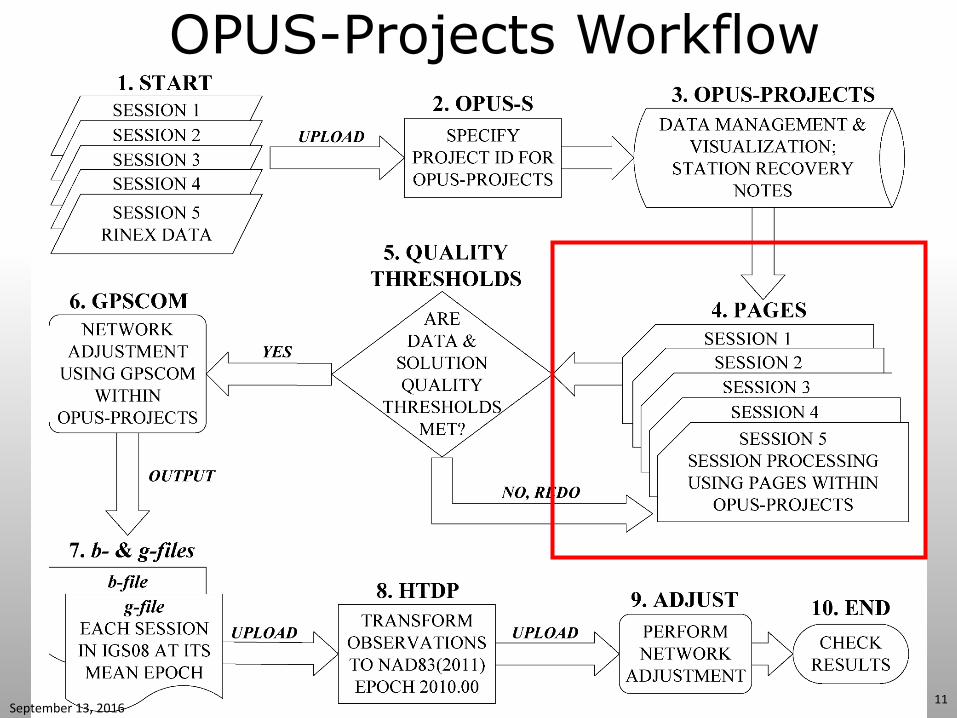
OPUS-Projects Workflow
September 13, 2016 11
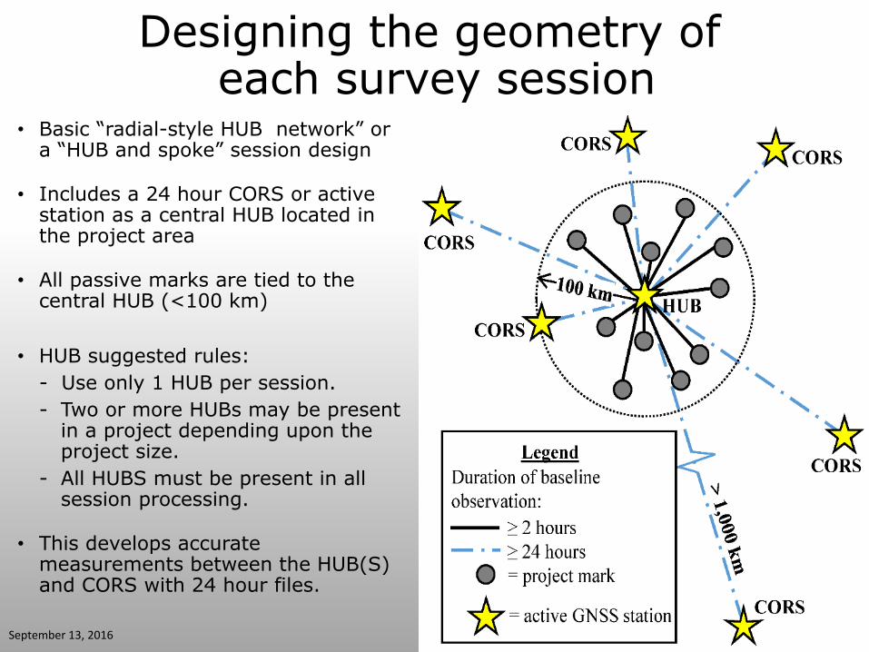
Designing the geometry of each survey session
• Basic “radial-style HUB network” or a “HUB and spoke” session design
• Includes a 24 hour CORS or active station as a central HUB located in the project area
• All passive marks are tied to the central HUB (<100 km)
• HUB suggested rules:
- Use only 1 HUB per session.
- Two or more HUBs may be present in a project depending upon the project size.
- All HUBS must be present in all session processing.
• This develops accurate
measurements between the HUB(S) and CORS with 24 hour files.
September 13, 2016
HUB
CORS
CORS
12
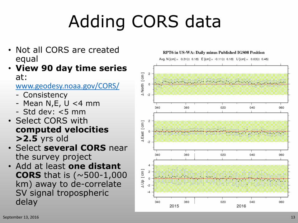
Adding CORS data
• Not all CORS are created equal
• View 90 day time series at: www.geodesy.noaa.gov/CORS/ - Consistency - Mean N,E, U <4 mm - Std dev: <5 mm
• Select CORS with computed velocities >2.5 yrs old
• Select several CORS near the survey project
• Add at least one distant CORS that is (~500-1,000 km) away to de-correlate SV signal tropospheric delay
September 13, 2016 13
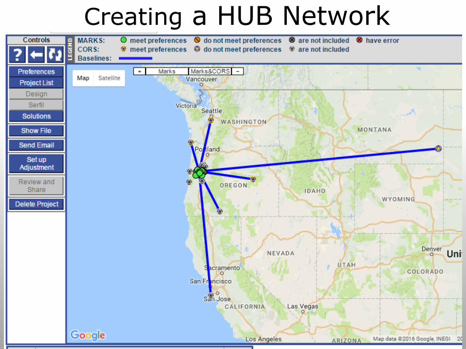
Creating a HUB Network
September 13, 2016 14
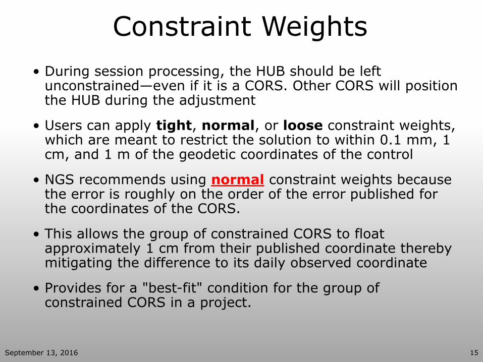
Constraint Weights
• During session processing, the HUB should be left unconstrained—even if it is a CORS. Other CORS will position the HUB during the adjustment
• Users can apply tight, normal, or loose constraint weights, which are meant to restrict the solution to within 0.1 mm, 1 cm, and 1 m of the geodetic coordinates of the control
• NGS recommends using normal constraint weights because the error is roughly on the order of the error published for the coordinates of the CORS.
• This allows the group of constrained CORS to float approximately 1 cm from their published coordinate thereby mitigating the difference to its daily observed coordinate
• Provides for a "best-fit" condition for the group of constrained CORS in a project.
September 13, 2016 15
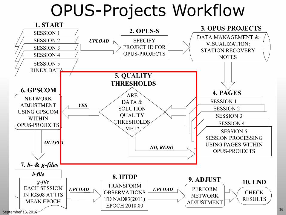
OPUS-Projects Workflow
September 13, 2016 16
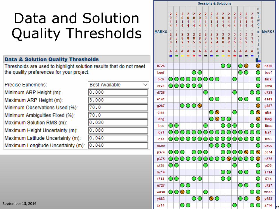
Data and Solution Quality Thresholds
September 13, 2016 17
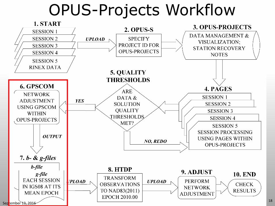
OPUS-Projects Workflow
September 13, 2016 18
Combining the Session Solutions
September 13, 2016 19
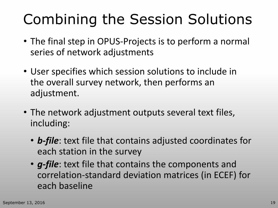
• The final step in OPUS-Projects is to perform a normal series of network adjustments
• User specifies which session solutions to include in the overall survey network, then performs an adjustment.
• The network adjustment outputs several text files, including:
• b-file: text file that contains adjusted coordinates for each station in the survey
• g-file: text file that contains the components and correlation-standard deviation matrices (in ECEF) for each baseline
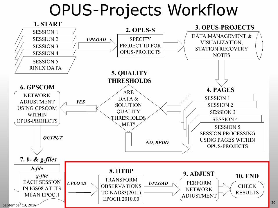
OPUS-Projects Workflow
September 13, 2016 20
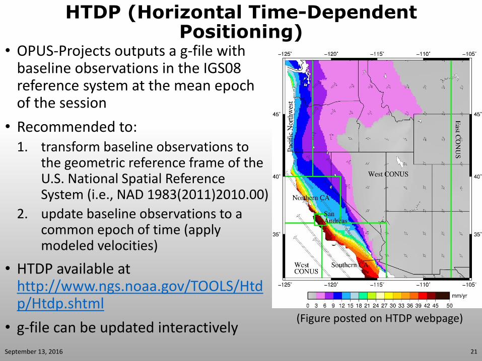
HTDP (Horizontal Time-Dependent Positioning)
• OPUS-Projects outputs a g-file with baseline observations in the IGS08 reference system at the mean epoch of the session
• Recommended to: 1. transform baseline observations to
the geometric reference frame of the U.S. National Spatial Reference System (i.e., NAD 1983(2011)2010.00)
2. update baseline observations to a common epoch of time (apply modeled velocities)
• HTDP available at http://www.ngs.noaa.gov/TOOLS/Htdp/Htdp.shtml
• g-file can be updated interactively
(Figure posted on HTDP webpage)
September 13, 2016 21
ADJUST • PC software for performing a survey network adjustment by
least squares • Upload the g-file, b-file, and an “a-file” containing the coordinates and
weights for the control stations
• User can specify weights on constrained (control) stations
• Software outputs most-probable coordinates and their standard deviations for each station in the survey network
• Software outputs “network” and “local” accuracies for each station, as defined by federal standards (FGDC 1998)
• A series of adjustments should be performed in ADJUST • Minimally constrained adjustment identify and remove poor baseline
observations; solve for project error scale factors
• Constrained adjustments evaluate coordinates of the control; “best fit” the network to reliable control coordinates
• Output compatible for publishing a GPS survey in the NGS Integrated Database (i.e., Bluebooking)
September 13, 2016 22
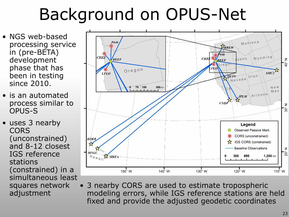
Background on OPUS-Net
23
• 3 nearby CORS are used to estimate tropospheric modeling errors, while IGS reference stations are held fixed and provide the adjusted geodetic coordinates
• NGS web-based processing service in (pre-BETA) development phase that has been in testing since 2010.
• is an automated process similar to OPUS-S
• uses 3 nearby CORS (unconstrained) and 8-12 closest IGS reference stations (constrained) in a simultaneous least squares network adjustment
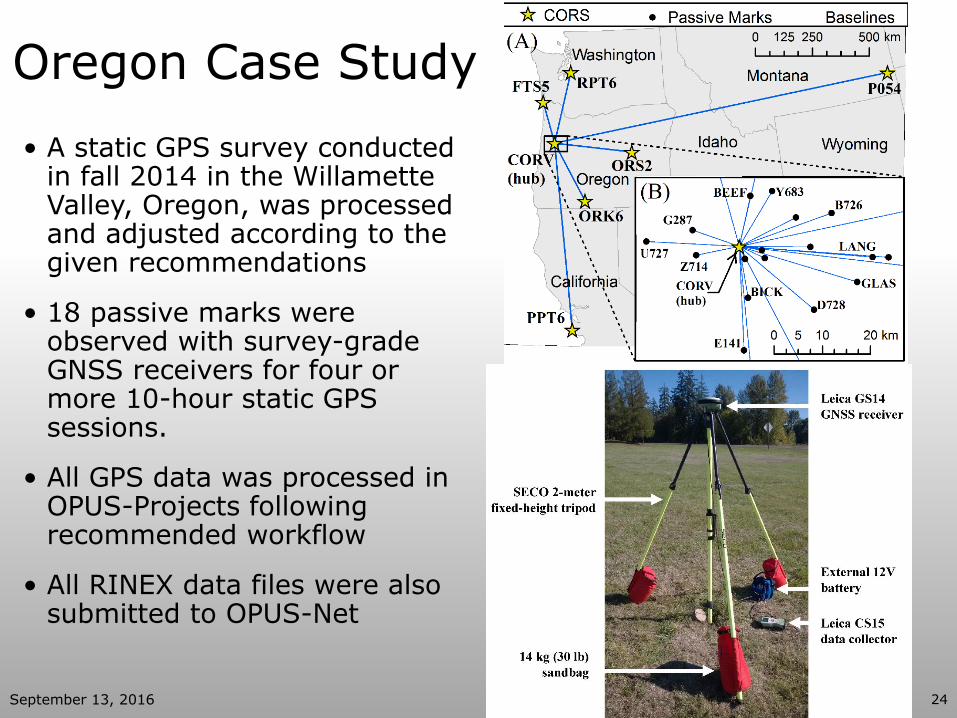
Oregon Case Study
• A static GPS survey conducted in fall 2014 in the Willamette Valley, Oregon, was processed and adjusted according to the given recommendations
• 18 passive marks were observed with survey-grade GNSS receivers for four or more 10-hour static GPS sessions.
• All GPS data was processed in OPUS-Projects following recommended workflow
• All RINEX data files were also submitted to OPUS-Net
September 13, 2016 24
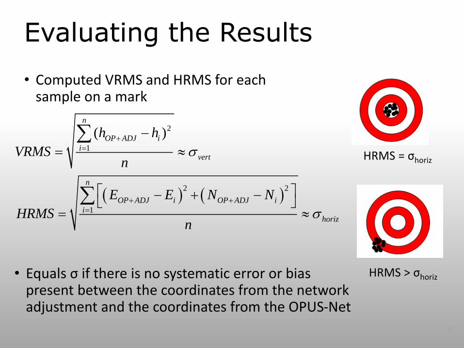
Evaluating the Results
• Computed VRMS and HRMS for each sample on a mark
2
1
2 2
1
( )n
OP ADJ i
ivert
n
OP ADJ i OP ADJ i
ihoriz
h h
VRMSn
E E N N
HRMSn
• Equals σ if there is no systematic error or bias present between the coordinates from the network adjustment and the coordinates from the OPUS-Net
HRMS = σhoriz
HRMS > σhoriz
25
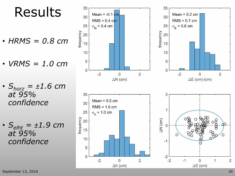
Results
• HRMS = 0.8 cm
• VRMS = 1.0 cm
• Shorz = ±1.6 cm at 95% confidence
• Selht = ±1.9 cm at 95% confidence
September 13, 2016 26
Conclusions
• OPUS-S and OPUS-RS remains an option for less robust solutions to surveyors, but using OPUS-Projects allows for more precise work for networks with multiple observations on marks in a series of sessions.
• Following these recommended procedures leads to a high degree of accuracy and precision when processing data through OPUS-Projects.
• The surveying industry should follow these steps for any work in OPUS-Projects to ensure that final network solutions represent the highest degree of accuracy and precision available.
September 13, 2016 27

Acknowledgements
• Mike Eddy- former graduate student OSU
• Leica & David Evans & Assoc. for providing the survey hardware
September 13, 2016 28

Questions?
September 13, 2016 30