Embed Size (px)
Citation preview
Ple
ase
note
that
this
is a
n au
thor
-pro
duce
d P
DF
of a
n ar
ticle
acc
ept
ed fo
r pu
blic
atio
n fo
llow
ing
peer
rev
iew
. The
def
initi
ve p
ub
lish
er-a
uthe
ntic
ated
ve
rsio
n is
ava
ilab
le o
n th
e pu
blis
her
Web
site
1
Quaternary Science Reviews August 2010, Volume 29, Issues 17-18, Pages 2010-2026 http://dx.doi.org/10.1016/j.quascirev.2010.04.016 © 2010 Elsevier Ltd All rights reserved.
Archimerhttp://archimer.ifremer.fr
Deepwater carbonate deposition in response to re-flooding of carbonate bank and atoll-tops at glacial terminations
Stéphan J. Jorrya, b, *, André W. Droxlerb and Jason M. Francisb, c
a IFREMER, Department of Marine Geosciences, BP 70, 29280 Plouzané, France b Rice University, Department of Earth Science, MS126, PO Box 1892, Houston TX 77051-1892, USA c Chevron Energy Technology Company, 1500 Louisiana, Houston TX 77002-8001, USA *: Corresponding author : Stéphan J. Jorry, Tel.: +33 298224232; fax: +33 298224570, email address : [email protected]
Abstract:
The late Quaternary has experienced large glacial/interglacial climatic variations and related 10’s to 100 meters high-amplitude sea level fluctuations at Milankovich frequencies from 10’s to 100 kyr during which carbonate platform tops have been exposed and re-flooded in many occasions. This study focuses on the accumulation of calci-turbidites, the aragonite onset/sharp increase in fine sediments and their timing in deep basins adjacent to carbonate platforms. A particular emphasis is developed on the occurrence of the first gravity flow event and aragonite onset/sharp increase and their linkage to the initial re-flooding of the platform tops during deglaciations. Three basins adjacent to isolated platforms in the Bahamas, the Northern Nicaragua Rise, and the Gulf of Papua, were selected to represent pure carbonate versus mixed systems, in quiescent versus tectonically active settings, and various carbonate bank top morphologies, ranging from atoll to relatively deeply and narrowly flooded flat top banks. In spite of these differences, each record illustrates a clear relationship between the timing of platform top re-flooding and initiation of significant carbonate export by gravity flows and low-density plumes into the surrounding basins. The concept of “re-flooding window” is introduced to characterize the prolific period of time during which bank and atoll-tops are flooded enough to produce large export of bank-derived aragonite and of calci-turbidites in adjacent basins. According to our datasets, the main re-flooding windows have occurred mainly on the last part of the sea level rise at each glacial termination (T), those periods being marked by some of the highest rates of sea level rise. The analysis of a long-piston core from the earthquakes-prone Walton Basin (Northern Nicaragua Rise) demonstrates that sea level, not seismic activities, played a major role as trigger mechanism for the initiation of gravity flows since the last four glacial/interglacial transitions, and supports the existence of an extra glacial termination during the early portion of the transition from MIS 7.4 to MIS 7.3 (TIIIA).
Ple
ase
note
that
this
is a
n au
thor
-pro
duce
d P
DF
of a
n ar
ticle
acc
ept
ed fo
r pu
blic
atio
n fo
llow
ing
peer
rev
iew
. The
def
initi
ve p
ub
lish
er-a
uthe
ntic
ated
ve
rsio
n is
ava
ilab
le o
n th
e pu
blis
her
Web
site
2
1. INTRODUCTION
Late Quaternary climate changes have triggered periodic large-scale oscillations of sea level
at glacial/interglacial transitions, during which atoll and carbonate bank-tops have been
exposed and flooded. Once isolated carbonate bank and shelf tops are re-flooded during
interglacial times, they become important producers of large volumes of neritic sediments
(fine aragonite and magnesian calcite), excess sediment being exported by plumes (Mullins
et al., 1984; Glaser and Droxler, 1993; Wilson and Roberts, 1995) and gravity flows to the
adjacent deep sea (Droxler et al., 1983; Droxler and Schlager, 1985;
Glaser and Droxler, 1991; Schlager et al., 1994; Andresen et al., 2003). Previous data sets
lack resolution to address the linkage between initial bank top re-flooding and first
calciturbidite deposition in adjacent basins. This concept can be tested during the last glacial
cycle, because sea level (eustatic) is well established for the last termination (TI) and the last
glacial cycle (Yokoyama et al., 2000; Lambeck and Chappell, 2001; Alley et al., 2003; Siddall
et al., 2003; Alley et al., 2005).
Observations of the last glacial cycle have clearly demonstrated for sometime that
periplatform sediments accumulating on slopes and basins adjacent to carbonate platforms
bear the record of sea-level fluctuations (Droxler et al., 1983; Droxler and Schlager, 1985;
Schlager et al., 1994; Andresen et al., 2003; Lantzsch et al., 2007). Sea-level changes and
turbidite accumulation in deep basins directly adjacent to isolated carbonate platforms are
fundamentally linked to two parameters. The water depth of the bank tops and atoll lagoons
is an important factor controlling the shallow water neritic carbonate production, which has
been dramatically disturbed during late Quaternary high amplitude sea-level changes. At
glacial periods, most of the carbonate platforms have been exposed and karstified (Purdy,
1974; Gischler et al., 2000; Walker et al., 2008). During interglacials, the optimum water
depth for carbonate production on bank tops and atoll lagoons is intimately linked to the type
of carbonate producers. Assuming that sediment production presently occurs on the shallow
banks and atolls, the observed thin sediment covers and its coarse nature attest to the fact
that sediments presently are not accumulating in significant quantities on platform tops to fill
up the available accommodation space (Hine et al., 1988; Triffleman, 1989; Milliman et al.,
1993; MacKinnon and Jones, 2001; Gischler, 2003) and the majority of the sediments are
exported toward the deeper periplatform environments.
3
In relation to the bathymetry of carbonate bank tops and atoll lagoons, sea level
amplitude is an important parameter to estimate intervals when bank tops and atoll lagoons
were subaerially exposed and flooded. Sea level curves are well constrained for the last
glacial cycle (Lambeck and Chappell, 2001; Lea et al., 2002; Cutler et al., 2003; Siddall et al.,
2003; Thompson and Goldstein, 2005), and of better resolution for the last 20 ky (Fairbanks,
1989; Bard et al., 1990; Edwards et al., 1993; Hanebuth et al., 2000; Yokoyama et al., 2000;
Camoin et al., 2004; Clark et al., 2004; Alley et al., 2005; Clark et al., 2009). However,
estimating intervals of exposure becomes more difficult when the observations are older than
the last glacial cycle because sea level curves past 150 kyr are not well-constrained. In
general, the details of the sea level curve for the interval prior to 130 kyr remain elusive,
primarily due to a progressive loss in the resolution of the U-series chronometer, coupled to a
lack of well-preserved coral in older fossil reefs. Nevertheless, the most recent published sea
level reconstructions based on stable oxygen isotope analyses of planktonic foraminifera and
bulk sediments from the Red Sea reveal a strong correlation in multimillennial timescales
between global sea level and Antarctic/global temperature over the past five glacial cycles
(Rohling et al., 2009). Rapid sea level rise during glacial terminations occurs just after, or
synchronous to, the increase in Northern Hemisphere summer insolation. These large and
rapid amplitude climatic oscillations associated with glacial terminations are likely due to
strong non-linearity of ice sheet dynamics during growth and decay (Cutler et al., 2003;
Thompson and Goldstein, 2006; Rohling et al., 2008; Dutton et al., 2009).
In this paper, we are using the depositional frequency of calci-turbidite vs. isotopic
stratigraphy and mineralogy in order to evaluate the impact of platform top re-flooding on
carbonate productivity and export to adjacent slopes and basins, at each glacial/interglacial
transitions since the MIS 12 / MIS 11 boundary. We present results based on the integration
of deep-sea sediment cores collected in two different pure carbonate systems (the
tectonically active zone of the Northern Nicaragua Rise and the relatively tectonically stable
area of the Great Bahama Bank) and in a mixed carbonate/siliciclastic system from the Gulf
of Papua.
2. PHYSICAL SETTINGS
2.1. Gulf of Papua
The Gulf of Papua, broadly defined, comprises ~150,000 km2 of the northwestern
Coral Sea between the southern coast of Papua New Guinea and the northeast coast of
4
Australia (Figure 1A). Several major rivers, most notably the Fly, drain into the Gulf of Papua
on the northwest coast, delivering some 200 to 300 megatonnes per year of siliciclastic
sediment to the inner shelf ((Harris et al., 1993; Milliman, 1995). In the southwest Gulf of
Papua, the Great Barrier Reef on the middle to outer shelf and several atoll systems
established since the Oligocene on tectonic ridges (Tcherepanov et al., 2008) produce
substantial amounts of carbonate material (Harris et al., 1993; e.g., Francis, 2007; Jorry et
al., 2008). Both siliciclastic and neritic carbonate sediments are reworked from the shelf and
platforms to adjacent slopes and basins of the Gulf of Papua, although at different rates
depending on location (Brunskill et al., 1995; Walsh and Nittrouer, 2003; Francis, 2007; Jorry
et al., 2008).
Surface waters of the Gulf of Papua lie within the latitudinal band of tropical waters
characterized by relatively high temperatures of 25°-29°C. The surface waters of the outer
shelf and Gulf of Papua basin are generally well mixed to a depth of ~100 m and typically
express normal marine salinities of ~34.5-35.5% (Pickard et al., 1977; Wolanski et al., 1995).
These waters are predominately brought into the Gulf of Papua by the westward flowing
South Equatorial Current, producing overall convergence in the region (Wyrtki, 1962; Pickard
et al., 1977). Surface circulation in the Gulf of Papua is dominated by a clockwise gyre
generated under the influence the Coral Sea Coastal Current (Wolanski et al., 1995;
Slingerland et al., 2008).
Several large atolls are located in the Gulf of Papua. These include the Portlock Reef
partially attached to the shelf edge, and detached - isolated Ashmore, Boot, and Eastern
Fields Reefs. These atolls are typical long-lived rimmed reefs (Tcherepanov et al., 2008)
reaching present sea level. Their shallow lagoons have common water depths of 40-55 m
(Webster, pers. com.; Jorry et al., 2008). Foraminifers, coral reefs and bryozoans are
considered as dominant producers on top of Eastern Fields and Ashmore atolls. As no data
is available from literature for these atolls, this assumption is based on the grain composition
observed in calci-turbidites (after Jorry et al., 2008).
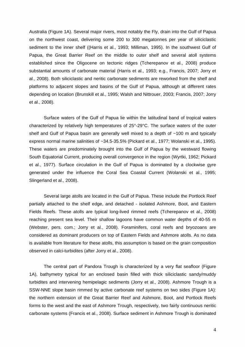
The central part of Pandora Trough is characterized by a very flat seafloor (Figure
1A), bathymetry typical for an enclosed basin filled with thick siliciclastic sandy/muddy
turbidites and intervening hemipelagic sediments (Jorry et al., 2008). Ashmore Trough is a
SSW-NNE slope basin rimmed by active carbonate reef systems on two sides (Figure 1A):
the northern extension of the Great Barrier Reef and Ashmore, Boot, and Portlock Reefs
forms to the west and the east of Ashmore Trough, respectively, two fairly continuous neritic
carbonate systems (Francis et al., 2008). Surface sediment in Ashmore Trough is dominated
5
by carbonate material (80 to 95%), principally a mixture of pelagic microfossils and neritic
material shed from surrounding reef systems (Carson et al., 2008; Francis et al., 2008;
Muhammad et al., 2008).
2.2. Bahamas
With a surface area of almost 1.1 105 km2, the Great Bahama Bank (GBB) is the
largest shallow water carbonate platform of the Bahamian archipelago with an average water
depth of less than 10 m (e.g., Boss and Rasmussen, 1995). The GBB is positioned in the
subtropical temperate climate belt, which is influenced by variations in strength and direction
of the northeasterly trade winds. The North Atlantic Subtropical Gyre, which is largely wind
driven, is the major source of water masses delivered to GBB (Atkinson et al., 1995; Leaman
et al., 1995). Most of these surface water masses enter in the Lesser Antilles through various
passages (Wajsowicz, 2002). A smaller portion (approximately 20%) enters the Caribbean
Sea through the Windward Passage between Cuba and Hispaniola (Schmitz and
Richardson, 1991). A more complete synthesis about currents and oceanographic circulation
of the Caribbean zone is proposed in Reijmer et al. (2009).
Tectonically, the Bahamian islands appear to be quiescent. All emergent portions of
Bahamian platforms consist entirely of Late Quaternary shallow-water and aeolian
carbonates (Carew and Mylroie, 1985; Hearty and Kindler, 1993) which show no sign of
tectonically-induced deformation, although vertical failure surfaces associated with large
mass-wasting events are known (Daugherty et al., 1987). Data from fossil coral reefs and
flank margin caves indicate that all Bahamian banks on which there are islands have been
tectonically stable, and behaving similarly, for at least the past several hundred thousand
years (Carew and Mylroie, 1995).
The facies, grain-size, and mineralogy distribution patterns on GBB show a current-
dominated sedimentation pattern with a clear distinction between the outer edge and the
inner platform (Reijmer et al., 2009, and references herein). Skeletal (coral fragments,
calcareous green algae, benthic foraminifera, gastropods, echinoderm spines and fragments,
serpulids, ostracods, bryozoans, sponge spicules, and others) and non-skeletal components
(peloids, ooids, grapestones, clasts) constitute the main carbonate production on top of the
Great Bahama Bank (Reijmer et al., 2009). Carbonate mineralogy on GBB is well
documented and shows a dominance of aragonite on the platform top with minor high-
magnesium and low-magnesium calcite (Purdy, 1963; Husseini and Matthews, 1972;
Milliman, 1974; Milliman et al., 1993). Aragonite-rich material is produced during times, such
6
as last interglacial (most of MIS 5) and since the last 6 kyr, when the Bahama bank tops are
flooded during intervals of maximum sea level (Hine and Mullins, 1981; Milliman et al., 1993;
Malone et al., 2001; Slowey et al., 2002). Platform top exposure during times of lower sea-
level (e.g. MIS 4, MIS 3, MIS 2) leads to strong reduction or demise of carbonate neritic
production, and almost complete cessation of neritic carbonate export towards the deep
surroundings (Droxler and Schlager, 1985). Periplatform sediments that have accumulated in
TOTO (a relatively flat-floored slightly tilted to the west, 1300-m-deep basin, surrounded by
the wide shallow carbonate platform tops of Great Bahamas Bank, Figures 1B and Figure
1C) are excellent sediment archives recording bank top flooding and exposure and related
neritic carbonate production and partial sediment export (Droxler and Schlager, 1985; Haak
and Schlager, 1989).
2.3. Northern Nicaragua Rise
The Northern Nicaragua Rise is a 540 km wide, 1,350 km long ENE-WSW oriented
topographic high in the western Caribbean Sea. Extending from Honduras and Nicaragua in
the west to Jamaica in the east, the Northern Nicaragua Rise consists of several shallow-
water carbonate banks and shelves separated by intervening basins and channels among
them the Walton Basin (Figure 1D).
Most of the Caribbean Current flows over the Nicaragua Rise between the Caribbean
shelf of Nicaragua and Honduras and the southern coast of Jamaica (Wust, 1964; Kinder et
al., 1985; Hine et al., 1988). The relative strong flow results in current velocities over the
banks of the Nicaragua Rise exceeding 20 cm/s (Hallock et al., 1988). This vigor explains the
occurrence of coarse sediments on the bank and shelf tops as the effect of winnowing. Thus,
the thin Holocene sediment cover found on the bank tops results from the export of the fine
(silt and mud) bank-derived sediment which is deposited from suspension on the basin
slopes (Glaser and Droxler, 1991; Triffleman et al., 1992; Glaser and Droxler, 1993; Duncan
et al., 1999; Sepulcre et al., 2009).
The Northern Nicaragua Rise is known as a particularly tectonically active area that
results from a complex tectonic history. The Northern Nicaragua Rise is part of an island-arc
originating in the East Pacific during the Cretaceous (Perfit and Heezen, 1978; Pindell and
Barrett, 1990). Throughout the Paleocene to early Eocene, structural deformation and rifting
was widespread along the Northern Nicaragua Rise and on Jamaica (Holcombe et al., 1990).
Perhaps the most important component in the tectonic history of this portion of the Northern
Nicaragua Rise is the formation of the Cayman Trough during the early to middle Eocene
7
(Holcombe et al., 1973; Rosencrantz and Sclater, 1986; Rosencrantz et al., 1988). Partly due
to the lack of terrigenous deposition, the late Eocene to middle Miocene is believed to be a
time of tectonic quiescence in Jamaica (Arden, 1975) and along the Nicaragua Rise where
shallow carbonate platforms were flourishing (Cunningham, 1998; Duncan et al., 1999; Mutti
et al., 2005). Final emergence of Jamaica and southward tilting of the entire Northern
Nicaragua Rise is thought to have occurred during the late middle Miocene in response to
major lateral movement along the Cayman Trough (Arden, 1975; Cunningham, 1998). There
is evidence for continuing fault-movement and tilting of Jamaica and the NNR throughout
much of the Neogene (Horsfield, 1975; Mann and Burke, 1990; Leroy et al., 1996).
The banks of the Northern Nicaragua Rise consist of nearly pure carbonate material,
except near Jamaica and Central America where a large siliciclastic component has been
added to the carbonate component (Arden, 1975). Algal, mollusk, sponge and foraminiferal
debris with some coral fragments form the primary components of the sediment on top of
banks (Zans, 1958; Dolan, 1972; Reijmer and Andresen, 2007). Hallock et al. (1988) suggest
that the high concentration of nutrients in the waters passing over the Nicaragua Rise is
detrimental to the growth of hermatypic corals. This explains the prominence of Halimeda on
the bank and shelf tops and their upper margins. Bands of Halimeda bioherms, growing on
the rims of isolated banks and shelves of the Northern Nicaragua Rise, have been frequently
observed (Roberts and Murray, 1983; Hine et al., 1988; Triffleman, 1989). Dolan (1972)
described Halimeda meadows on Pedro Bank.
Pedro Bank lies at the north-eastern extension of the Northern Nicaragua Rise.
Contrary to the flat-topped shallow Great Bahama Bank, Pedro Bank is a northward sloping
platform in which 80% of the bank lies within water depths of 20-40 meters below sea level
(Zans, 1958; Triffleman et al., 1992). It can be assumed that small areas around the northern
to northwestern edge of Pedro Bank (which lay in a water depth of about 60-65 meters below
sea level, after Dullo (1997)) had the potential to remain flooded during periods in which sea
level stood 30 to 50 m below present sea level (e.g. during the MIS 5 subglacial and rare
times during MIS 3).
3. MATERIALS AND METHODS
Six cores (Figure 1, Table 1) were examined in this study. One gravity core MD05-
2940 and one Calypso piston core MD05-2949 were collected during a 2005 PECTEN cruise
aboard R/V Marion Dufresne. Core MD05-2940 was collected in the eastern basin floor of
central Pandora Trough (Gulf of Papua), in one of a series of sub-circular, partially isolated
8
mini basins 50 km north of Eastern Fields reef. Core MD05-2949 was retrieved in the
Ashmore Trough, a slope basin located between the Great Barrier Reef to the west and an
atoll chain on its eastern border (Figure 1). Two piston cores, CH0288-035 and CH0288-108,
collected during a cruise on the R/V Cape Hatteras in 1988, were collected in two flat-floored
mini basins in the northern part of Walton Basin (Northern Nicaragua Rise, eastern
Caribbean Sea, Figure 1). In 2003, a CALYPSO piston core MD03-2632 was retrieved at the
same location as core CH0288-108 north of Pedro Bank during a 2003 IMAGES XI –
PICASSO cruise aboard R/V Marion Dufresne. A piston core P7102-14 collected in the Cul
de Sac from Tongue of the Ocean (TOTO), Bahamas, in 1971 on R/V Pillsbury, was also
studied (Figure 1).
Oxygen isotopic stratigraphy of core MD05-2940 was previously established by Jorry
et al. (2008). The stratigraphy of cores CH0288-035 and CH0288-108 derives from the 18O
curves published by Glaser (1991) and Andresen et al. (2003). For this study, oxygen isotope
analyses were conducted on small batches of monospecific planktonic foraminifera that
calcify in the surface mixed layer: Globigerinoides ruber for core P7102-14 (TOTO) and
Globigerinoides sacculifer (without the final sac-like chamber) for cores MD05-2949
(Ashmore Trough) and MD03-2632 (Walton Basin). Samples were collected in layers
composed of pelagic periplatform carbonate, purposely excluding turbidites. On average, 10
specimens were picked from the >250 m fraction. Using a common 100% phosphoric acid
bath at 90 degrees C, 20-50 grams of sample were reacted and analyzed using a GV
Instruments Optima isotope ratio mass spectrometer at University of California, Davis.
Isotope values are reported in delta notation relative to V-PDB. Repeated analyses of a
marble working standard (calibrated against the international standard NBS-19) indicate an
accuracy and precision of 0.05 ‰ (1).
Six AMS dates were also obtained in cores MD05-2949 and CH0288-035 (Table 2).
For each measurement, approximately 500 specimens of G. ruber and G. sacculifer were
picked from the >250 m fraction, washed in an ultrasonic bath with distilled water, and
dried. These aliquots were then analyzed at the AMS laboratory at University of California,
Irvine. Reported radiocarbon ages have been corrected for a marine reservoir effect of 400
years and converted to calendar years using CALIB Rev 5.0/Marine04 data set (Stuiver and
Reimer, 1993; Hughen et al., 2004; Stuiver et al., 2005). We used a regional reservoir-age
correction R of 30 yr for core CH0288-035 (Reimer and Reimer, 2001), assuming it to be
invariant with time. All ages are reported in thousands of years before present (kyr BP),
where Present is defined as 1950 AD.
9
The <63 m fraction of sediment was used to determine carbonate mineralogy on
cores MD05-2940, MD05-2949, and CH0288-035. Carbonate mineralogy was determined on
samples by x-ray diffraction. Analyses were conducted using a Rigaku X-ray diffractometer
housed at Rice University. All samples were analyzed at 2 kV and 2 mA through a scan from
25° to 31° and a scanning speed of 0.25° per minute. Peak areas for aragonite, HMC, and
LMC were measured using JADE 6.1 software (Material Data Inc., Livermore, CA, USA), and
used to determine their relative proportions. The aragonite proportion was determined by
comparison to a calibration curve generated by x-ray diffraction analyses of known mixtures
of research grade aragonite with coccolith calcite.
Linear sedimentation rates (LSRs) were determined in core MD05-2940 (down to 220
cm, corresponding to the Holocene interval) and core MD05-2949 by dividing thicknesses of
sediment by the time they represent. Such calculations render constant sedimentation rates
between age datums, and do not account for compaction or potential hiatuses between age
datums. Aragonite mass accumulation rates (MARs) were then determined by:
MARAr = wt%Ar x db x LSR,
where wt%Ar is the aragonite mass fraction, and db was the dry bulk density calculated by:
db = b – (FP x water)
Bulk density (b) and fractional porosity (FP) were measured by using a multisensor track
system onboard the RV Marion Dufresne.
Oxygen stable isotopes, MAR Aragonite, % of fine Aragonite, and age model are presented
in Appendix 1.
4. RESULTS
4.1. Age model
Core chronostratigraphies were established through integration of radiocarbon dating
and high-resolution planktic oxygen isotope stratigraphy, and include biostratigraphic
markers for cores MD05-2949 and MD03-2632 (Figure 2). Calibrated radiocarbon dates were
10
used as the primary age tie points over the last ~ 43 kyr cal BP while oxygen isotope
stratigraphy was primarily used to establish the chronostratigraphy prior to this date. Distinct
peaks and troughs in the oxygen isotope records were correlated to and dated with the LR04
stacked benthic oxygen isotopic record of Lisiecki and Raymo (2005) (Figure 2).
In total, 535 18O measurements on G. ruber (white) and G. sacculifer were generated
and analyzed in this study (see Appendix 1). In addition to anchoring the robust
chronostratigraphy, these 18O data also allowed interpretation of sea-level fluctuations and
marine isoptope stages (Emiliani, 1955; Shackleton and Opdyke, 1977).
Stratigraphy of core MD05-2940 was established by Jorry et al. (2008). Based on
down core variations in the 18O of planktic foraminifers G. sacculifer and on 14C AMS dates,
this core spans from LGM to late Holocene and records the last glacial-to-interglacial
transition (Figure 3). In core MD05-2949, the last occurrence of pink-pigmented G. ruber
indicates the transition between MIS6 and MIS 5 (Thompson et al., 1979). In the lowest
section of core MD03-2632, the last occurrence of P. lacunosa indicates that the core
reaches MIS 12 (Thierstein et al., 1977) (Figure 2).
Stratigraphy of core CH0288-35 includes the 18O curve published by Glaser (1991)
and Andresen et al. (2003). The glacial-interglacial stratigraphy of core P7102-14, initially
based on the identification of aragonite-rich and aragonite-poor intervals (Droxler and
Schlager, 1985), has been completed with new 18O measurements on G. ruber (white). Both
cores record the last glacial-interglacial cycle (Figure 2).
4.2. Lithostratigraphy
The lower part of core MD-40 is composed of siliciclastic sandy turbidites and muddy
turbidites corresponding to LGM (Jorry et al., 2008). The turbidites are separated by
intervening layers rich in pelagic carbonates (hemipelagic), which become more frequent up
the core. The siliciclastic turbidites disappear up the cores and are not recognized in the
Holocene, which consists only of pelagic relatively carbonate-rich sediment. Once the
siliciclastic sandy turbidite layers disappear in the core, 1 dm-thick calciturbidite is observed
on the upper part of the core.
According to the study of Francis (2007), sediments in core MD05-2949 contain
varying amounts of pelagic and neritic carbonate, as well as siliciclastic components. The
11
fine (<63μm) size fraction consists of significant amounts of siliciclastic material,
predominately quartz, feldspar, and clay minerals as well as carbonate (aragonite, high- and
low-magnesium calcite). The coarse (>63μm) size fraction is dominated by pelagic carbonate
particles, primarily planktic foraminifers and pteropods, with minimal benthic constituents
(e.g., benthic foraminifers, ostracods, echinoderm fragments, sponge spicules).
Sediments of core P7102-14 are dominated by periplatform ooze and calci-turbidites
(Droxler and Schlager, 1985; Haak and Schlager, 1989). Calci-turbidites are characterized by
a sharp base, a graded bedding, parallel laminations or ripple cross laminations, a packstone
or grainstone texture, and abundant shallow-water carbonate grains such as ooids, pellets,
and neritic skeletal grains. Glacial sediments contain more fragments of skeletal organisms,
while interglacial sediments (which include calci-turbidites) have more pellets and ooids
(Haak and Schlager, 1989).
In core CH0288-035, pelagic (really periplatform) carbonate sediments primarily
consist of calcitic planktonic foraminifers and coccoliths with some aragonitic pteropods tests
in the coarse (>63μm) size fraction (Glaser, 1991). The fine (>63μm) size fraction is made of
bank-derived aragonite and magnesian calcite, and mostly coccolith-derived low magnesian
calcite. Neritic carbonate sediments in the turbidite layers consist of sand-sized skeletal
particles and fragments composed of algae (Halimeda), molluscs, sponges and
benthic/planktic foraminifers (Andresen et al., 2003).
Core CH0288-108 correlates to the upper 6 m of a 19 m long sequence recovered in
core MD03-2632 (Figure 1, Table 1) and represents approximately the last 450 kyr (Figure
2). The 19 m interval recovered in MD03-2632 alternates between fine periplatform
sediments and a series of calci-turbidite layers. The fine periplatform sediment (aragonite
and magnesian calcite bank-derived particles) was transported from the carbonate platforms
by sediment plumes that ultimately settled to the basin floor. Low magnesian calcite planktic
foraminifer, pteropod, and coccolith tests settle from the upper part of the water column and
accumulate on the sea floor like snow. In contrast, calci-turbidites record sudden punctuated
mass-flow events.
4.3. Re-flooding of carbonate atoll-tops at TI: the example of the Gulf of Papua
The overall deglacial trend, expressed by a relatively gradual decrease of 18O values
is illustrated in cores MD05-2940 and MD05-2949 (Figure 3). However the deglacial record is
clearly interrupted by a significant reversal (beginning abruptly at ~12,5 kyr BP and ending at
12
~11,5 kyr BP, Figure 3), corresponding relatively well to the timing of the Younger Dryas cold
period. The first warming/deglacial step, evidenced by low 18O values, corresponds most
likely to the Bølling-Allerød interval during which the Meltwater pulse IA occurred (Figure 3).
The second warming/deglacial step, clearly identified by an abrupt decrease of the 18O,
corresponds to the Meltwater pulse IB (Figure 3). This two-step deglaciation is marked by the
deposition of a calci-turbidite in MD05-2940 and in additional two Pandora Trough cores
described in Jorry et al. (2008). Based on 14C ages, the timing of calci-turbidite deposition
appears to be a synchronous event between 11,5 to 11 kyr BP extending across Pandora
Trough.
An abrupt onset of fine aragonite is detected both in Ashmore (Francis, 2007) and
Pandora Troughs (Jorry et al., 2008). Maximum aragonite MARs (up to ~ 13 g/cm2kyr in
core MD05-2940 and ~11 g/cm2kyr in core MD05-2949) typically occur during the sea level
transgression and reach a maximum during the MIS 1 highstand (Figure 3). According to our
age model, the onset of bank-derived fine aragonite in both Pandora and Ashmore Troughs
is contemporaneous to the deposition of a calci-turbidite in the central part of Pandora
Trough during Meltwater pulse IB. Relative sea-level records from far-field sites (Alley et al.,
2005) show that sea level rose at about -55 to -40 m below present sea level at Meltwater
pulse IB (Figure 3). Considering that lagoon depths of Ashmore and Eastern Fields atolls are
ranging between 40 and 55 m, we conclude that the re-flooding of platform tops triggered the
re-initiation of neritic carbonate production and its immediate partial export towards the
adjacent slopes and basins during the sea level rise interval following the Younger Dryas
(Figure 3).
4.4. Re-flooding of carbonate bank and atoll-tops during the last glacial/interglacial
cycle
Variation of the sedimentation in both Caribbean basins during the last
glacial/interglacial cycle is well illustrated in both P7102-14 and CH0288-035 cores (Figure
4). In the Walton Basin, thin calci-turbidites have been deposited during last interglacial since
Termination II (TII). These layers should coincide with the re-flooding of the majority of Pedro
Bank at the end of MIS 6, when sea level rose at about 20 m below present-day sea level.
The correspondence between both pure carbonate systems shows that the main calci-
turbidite depositional trend has been initiated during the final rise of the sea level at TII
(Figure 4). The estimate of the precise timing of the first deglacial calci-turbidite is somewhat
difficult due to limited resolution of the 18O stratigraphy at both sites. However, we compared
13
the ratio between the full 18O amplitude from MIS 6 to MIS 5.5 and the 18O value above the
first deglacial calci-turbidite to approximate the relative timing of initial calci-turbidite
deposition. The slightly different ratio observed in core P7102-14 (equal to 1) compared to
that of core CH0288-035 (equal to 1.11) suggests that the onset of the first deglacial calci-
turbidite is younger in TOTO than in the Walton Basin. This observation corresponds to the
shallower depth of the Great Bahama Bank (0 to -15 m) compared to that of the Pedro Bank
(-30m to -50m).
The precise timing of the re-flooding of isolated carbonate platforms at TII can be
determined by using the high-resolution 18O stratigraphy and fluctuations of the MAR
aragonite in core MD05-2949 from Ashmore Trough (Figure 1A and Figure 5A). At TI, the
onset of aragonite corresponds to the re-flooding of adjacent carbonate platforms during the
Meltwater pulse IB between 11,5 and 11,0 kyr BP (Figure 3) (Francis, 2007).
Contemporaneous onset of aragonite has also been observed in three additional cores from
the slope of Ashmore Trough close to the Great Barrier Reef (Francis, 2007). In focusing on
TII, a good correspondence is observed between the 18O and the MAR aragonite
fluctuations of core MD05-2949 and changes in sea level (Figure 5B and Figure 5C). The
aragonite onset is detected at about 135 kyr BP and aragonite MAR reaches a maximum
between 124 and 125 kyr BP (Francis, 2007). Between 120 and 121 kyr BP, aragonite MAR
starts to decrease progressively to reach a minimum at about 110 kyr BP. Similar to the
Meltwater pulse IB at TI, it appears that the onset of aragonite in Ashmore Trough has
occurred during the last rise of the sea level at TII (Meltwater pulse IIB described by Esat et
al. (1999)), when sea level rose at about -55 to -40 m below present sea level. It confirms
that the final rise of the sea level between 130 and 136 kyr BP corresponds to a main
window initiating the carbonate production on top of isolated carbonate platforms from the
Bahamas, the Northern Nicaragua Rise, and the Gulf of Papua.
In spite of a shallower bathymetry at the top of the Great Bahama Bank, the return to
calci-turbidite deposition at TI is observed first in the Tongue of the Ocean at about 6 kyr BP,
while we documented the first occurrence of calci-turbidite in the Walton Basin about 3,8 kyr
BP (Figure 4). In the Bahamas, the onset of fine aragonite is younger in TOTO (about 6 ka)
than on the western margin of Great Bahama Bank where the onset has occurred at about
11 kyr BP (Droxler and Schlager, 1985; Slowey et al., 2002). This difference could be
explained by the fact that the western margin of Great Bahama Bank is somewhat deeper
than the central and eastern margin (Wilber et al., 1990). Concerning the Northern Nicaragua
Rise, the absence of calci-turbidite deposition due the Pedro Bank-top re-flooding at the last
deglaciation is observed in all cores from the Walton Basin north of Pedro Bank (CH0288-
14
035, CH0288-108, and MD03-2632, Figure 4 and Figure 6). Based on a previous study, it
has been demonstrated that the deposition of calci-turbidites during the last deglaciation and
the Holocene occurred preferentially in basins located south of the Pedro Bank (Andresen et
al., 2003).
4.5. Re-flooding of Pedro Bank during the last four glacial terminations
The age model, based upon a reference 18O stratigraphy (Lisiecki and Raymo,
2005), shows that highest sedimentation rates occurred during highstands, corresponding to
the main calci-turbidite depositional trends (Figure 6B). The lowest sedimentation rates
correspond to glacial stages, i.e. to periods of low sea levels and to bank-top exposures.
Significant stratigraphic hiatuses are observed at TIII, TIV and TV (Figure 6B). Erosional
processes most likely induced these hiatuses during calci-turbidite deposition after bank-top
re-flooding. Throughout the entire sedimentary record, the initiation of the calci-turbidites at
each interglacial stage is consistent with the timing of the last four glacial terminations (TII,
TIII, TIV and TV). Four corresponding re-flooding events can be defined according to a sea
level high enough to flood the top of the Pedro Bank and to trigger the deposition of calci-
turbidites in the Walton basin (Figure 6B and Figure 6C). The deposition of a calci-turbidite is
also detected at about 225 kyr BP. The timing of this specific gravity flow deposit nicely
coincides with the recent recognition of an extra glacial termination (TIIIA) that takes place
one precession cycle after TIII (Cheng et al., 2009). This Termination is bounded by the
lowest and the highest insolation values in the last 400 kyr and is coupled with a rise of the
sea level from -70 m to -25 m. The sea level rise corresponds to an important reflooding
window and associated onset of carbonate production on Pedro Bank.
The analyses of Walton Basin cores illustrate that the model of highstand shedding is
well defined in the last four interglacial stages. The first calci-turbidite at each interglacial
occurs during each glacial termination itself, triggered by the re-flooding of the Pedro Bank-
top. This study in Walton Basin, an active tectonic region of Northern Nicaragua Rise
(Horsfield, 1975; Mann and Burke, 1990; Leroy et al., 1996), also demonstrates that the
timing of the first calci-turbidite deposition at each glacial/interglacial transition is not
controlled by earthquakes, but rather by sea-level changes facilitating bank top re-flooding
and re-initiation of neritic carbonate production.
5. DISCUSSION
15
This study confirms the strong ability of turbiditic systems to record the global late
Quaternary climatic/eustatic fluctuations. Recent studies, based on high-resolution 18O
stratigraphies, show that climate and sea-level changes at millennial timescale have a
significant influence on the deep ocean sedimentation during the last deglaciation (Skene
and Piper, 2003; Jorry et al., 2008; Toucanne et al., 2008; Lebreiro et al., 2009; Pierau et al.,
2009).
Re-flooding of isolated carbonate platforms at glacial/interglacial transitions and the
rapid export of sediment to the deepwater demonstrates the outstanding capability for
carbonate banks to produce sediment after a long period of exposure. According to our
findings, it appears that intermediate high sea levels during glacial times, e.g. MIS 8.5 at -40
± 20 m (Lea et al., 2002; Siddall et al., 2003; Bintanja et al., 2005; Rohling et al., 2009) and
MIS 6.5 at -30 ± 20 m (Lea et al., 2002), had no impact on the calci-turbidite deposition in
basins adjacent to the banks. The overall sedimentation rates during these events were
some of the lowest, and, therefore, preclude significant carbonate production. In this context,
the calci-turbidite deposited during MIS 3 (Figure 4 and Figure 6) would then locally illustrate
that the northern deeper part of Pedro Bank (Zans, 1958; Triffleman et al., 1992; Dullo, 1997)
could have been re-flooded temporarily at that time.
The initiation of the most prolific periods for sediment production on carbonate
platform tops appears to be intimately linked to the occurrence of glacial terminations, in
particular during the second half of these terminations and before the highest sea levels. It
suggests that periods of abrupt rises of the sea level at glacial terminations appears to be a
fundamental parameter controlling the carbonate production on isolated carbonate platform-
tops, and then the initiation of calci-turbidite accumulation and fine aragonites in adjacent
basins. According to our observations in the Gulf of Papua for TI (Figure 3), the initiation of
the carbonate production on atoll tops has occurred very rapidly during Meltwater pulse IB, a
period of time corresponding to high rates of sea-level rise (11 mm/yr according to Weaver et
al. (2003)). In spite of differences in terms of rates and magnitude of sea level changes at TII
(Esat et al., 1999; Siddall et al., 2006), the first deglacial calci-turbidites in TOTO and Walton
Basin (Figure 4 and Figure 6) and the initial onset of bank-derived aragonite in Ashmore
Trough (Figure 5) occurred during the second half of TII (Meltwater pulse IIB described by
Esat et al. (1999)) when rates of sea level rise were very high, approximating 25 mm/yr
(Rohling et al., 2008). Our dataset doesn’t support any significant influence of the first
meltwater pulse at TII (Meltwater pulse IIA described by Esat et al. (1999)) on the carbonate
production of bank and atoll tops. Despite the absence of information concerning rates of
sea-level rise at TIII, TIV and TV, a general pattern of rapid changes in sea level is expected
16
throughout the last glacial terminations, with rates close to 10 mm/yr. This is supported by
the observed 1.2 ± 0.1‰ shift in 18Owater over the last four glacial terminations (Lea et al.,
2002).
The concept of “re-flooding window” is proposed for the first time in this study to
characterize the very short period of time during which bank and atoll-tops are flooded at
glacial terminations, re-initiating neritic carbonate production on bank and atoll tops. The
timing of the re-flooding window is constrained by an optimal bathymetry on top of banks and
atolls and the position of sea level during the marine incursion. The optimum bathymetry for
all case studies could have been slightly different according to the type of carbonate
producers. Because the most important carbonate production is observed during glacial
terminations, the re-flooding window is obviously driven by the conjunction of external forcing
parameters such as unusual rising of insolation, triggering the melting of glacial main ice
sheets and, as a result, the rise of sea level at unusual high rates. This is confirmed by the
occurrence of a calci-turbidite in the Walton Basin at TIIIA (Figure 6). This extra glacial
termination, recently documented by Cheng et al. (2009), is the result of unusually low
insolation that rapidly generates a large ice sheet, followed by unusually high insolation that
triggers collapse. The return of the calci-turbidite deposition in the Walton Basin during TIIIA
corroborates the strong relationships between glacial terminations and the carbonate
production on bank and atoll-tops and immediate neritic carbonate export through plumes
and gravity flows towards adjacent slopes and basins.
6. CONCLUSIONS
This study demonstrates that the most significant export of sediments in oceanic
basins surrounding isolated carbonate platforms are driven by the combination of local and
regional parameters (e.g. the bathymetry on platform top) and of external forcings (insolation
variations triggering climate changes resulting in sea level fluctuations) at glacial
terminations. Our findings demonstrate a clear relationship between climate, sea level, and
turbiditic accumulations in several carbonate basins during the last four glacial/interglacial
cycles. Each one of the case studies shows that the initiation of trends of calci-turbidite and
of the onset of aragonite production and basinward transport coincide with abrupt rises of the
sea level at glacial terminations. Concerning TII, we demonstrate that the final rise of the sea
level between 130 and 136 kyr BP corresponds to a main re-flooding window initiating the
carbonate production on top of isolated carbonate platforms from the Bahamas, the Northern
Nicaragua Rise and the Gulf of Papua. The analysis of the Walton Basin core demonstrates
that the established highstand shedding model for calci-turbidite deposition in the last
17
glacial/interglacial cycle is also applicable for the previous four 100-kyr cycles. This
observation demonstrates that earthquakes did not play a major role as trigger mechanism
for calci-turbidites deposition.
7. ACKNOWLEDGMENTS
We are grateful to Captains, Officers, crew members and scientific and technical
shipboard parties of the PECTEN and PICASSO cruises on the R/V Marion Dufresne. IPEV
(Institut Polaire Français Paul-Emile Victor) is acknowledged for his support in recovering
high quality cores with R/V Marion Dufresne. We are grateful to Mei-Mei E. Tang and Emily
Pohlman for lithology and carbonate analyses of core MD03-2532, David Winter (UC Davis)
who ran oxygen isotopes analyses and Guaciara Dos Santos (University of California) for
AMS radiocarbon dates. Mark Siddall, an anonymous reviewer, and Editor Colin Murray-
Wallace are acknowledged for constructive comments and review. This research was
supported by the Swiss National Foundation (PBGE2-111250), the National Science
Foundation Ocean Sciences (OCE 0305688 and OCE-8715922), and by TOTAL (R62620).
8. REFERENCES CITED
Alley, R.B., Clark, P.U., Huybrechts, P., Joughin, I., 2005. Ice-sheet and sea-level changes.
Science 310, 456-460.
Alley, R.B., Marotzke, J., Nordhaus, W.D., Overpeck, J.T., Peteet, D.M., Pielke, R.A.,
Pierrehumbert, R.T., Rhines, P.B., Stocker, T.F., Talley, L.D., Wallace, J.M., 2003.
Abrupt climate change. Science 299, 2005-2010.
Andresen, N., Reijmer, J.J.G., Droxler, A.W., 2003. Timing and distribution of calciturbidites
around a deeply submerged carbonate platform in a seismically active setting (Pedro
Bank, Northern Nicaragua Rise, Caribbean Sea). International Journal of Earth
Sciences 92, 573-592.
Arden, D.D., 1975. Geology of Jamaica and the Nicaragua Rise, In: Nairn, A.E.M., Stehli,
F.G. (Eds.), The Ocean Basins and Margins, Volume 3, The Gulf of Mexico and the
Caribbean. Plenum Press, New York, pp. 617-661.
Atkinson, L.P., Berger, T., Hamilton, P., Waddell, E., Leaman, K., Lee, T.N., 1995. Current-
Meter Observations in the Old-Bahama Channel. Journal of Geophysical Research-
Oceans 100, 8555-8560.
Bard, E., Hamelin, B., Fairbanks, R.G., Zindler, A., 1990. Calibration of the C-14 Timescale
over the Past 30,000 Years Using Mass-Spectrometric U-Th Ages from Barbados
Corals. Nature 345, 405-410.
18
Bintanja, R., van de Wal, R.S.W., Oerlemans, J., 2005. Modelled atmospheric temperatures
and global sea levels over the past million years. Nature 437, 125-128.
Boss, S.K., Rasmussen, K.A., 1995. Misuse of Fischer Plots as Sea-Level Curves. Geology
23, 221-224.
Brunskill, G.J., Woolfe, K.J., Zagorskis, I., 1995. Distribution of riverine sediment chemistry
on the shelf, slope and rise of the Gulf of Papua. Geo Mar Lett. 15, 160-165.
Camoin, G.F., Montaggioni, L.F., Braithwaite, C.J.R., 2004. Late glacial to post glacial sea
levels in the Western Indian Ocean. Marine Geology 206, 119-146.
Carew, J.L., Mylroie, J.E., 1985. Pleistocene and Holocene stratigraphy of San Salvador
Island, Bahamas, with reference to marine and terrestrial lithofacies at French Bay, In:
Curran, H.A. (Ed.), Pleistocene and Holocene Environments on San Salvador Island,
Bahamas. CCFL Bahamian Field Station, Fort Lauderdale, Florida, pp. 11-61.
Carew, J.L., Mylroie, J.E., 1995. Quaternary Tectonic Stability of the Bahamian Archipelago -
Evidence from Fossil Coral-Reefs and Flank Margin Caves. Quaternary Science
Reviews 14, 145-153.
Carson, B.E., Francis, J.M., Leckie, R.M., Droxler, A.W., Dickens, G.R., Jorry, S.J., Bentley,
S.J., Peterson, L.C., Opdyke, B.N., 2008. Benthic Foraminiferal response to sea level
change in the mixed siliciclastic-carbonate system of southern Ashmore Trough (Gulf of
Papua). Journal of Geophysical Research-Earth Surface 113, F01S20.
Cheng, H., Edwards, R.L., Broecker, W.S., Denton, G.H., Kong, X.G., Wang, Y.J., Zhang, R.,
Wang, X.F., 2009. Ice Age Terminations. Science 326, 248-252.
Clark, P.U., Dyke, A.S., Shakun, J.D., Carlson, A.E., Clark, J., Wohlfarth, B., Mitrovica, J.X.,
Hostetler, S.W., McCabe, A.M., 2009. The Last Glacial Maximum. Science 325, 710-
714.
Clark, P.U., Marshall McCabe, A., Mix, A.C., Weaver, A.J., 2004. Rapid rise of sea level
19,000 years ago and its global implications. Science 304, 1141-1144.
Cunningham, A.D., 1998. The Neogene Evolution of the Pedro Channel Carbonate System,
Northern Nicaragua Rise. Ph.D. Thesis, Rice University, Houston.
Cutler, K.B., Edwards, R.L., Taylor, F.W., Cheng, H., Adkins, J., Gallup, C.D., Cutler, P.M.,
Burr, G.S., Bloom, A.L., 2003. Rapid sea-level fall and deep-ocean temperature change
since the last interglacial period. Earth and Planetary Science Letters 206, 253-271.
Daugherty, D.R., Boardman, M.R., Metzler, C.V., 1987. Characteristics and origins of joints
and sedimentary dikes of the Bahama Islands. Proceedings of the 3rd Symposium on
the Geology of the Bahamas, 45-56.
Dolan, P., 1972. Genesis and distribution of recent sediments on the Pedro Bank, south of
Jamaica. Ph.D. Thesis, University College, London.
19
Droxler, A.W., Schlager, W., 1985. Glacial versus interglacial sedimentation rates and
turbidite frequency in the Bahamas. Geology 13, 799-802.
Droxler, A.W., Schlager, W., Whallon, C.C., 1983. Quaternary aragonite cycles and oxygen
isotope record in bahamian carbonate ooze. Geology 11, 235-239.
Dullo, W.C., 1997. Die Plattformhangmorphologie der Pedro Bank in der Karibik. Geol Bl NO-
Bayern 47, 303-320.
Duncan, D.S., Hine, A.C., Droxler, A.W., 1999. Tectonic controls on carbonate sequence
formation in an active strike-slip setting: Serranilla Basin, Northern Nicaragua Rise,
Western Caribbean Sea. Marine Geology 160, 355-382.
Dutton, A., Bard, E., Antonioli, F., Esat, T.M., Lambeck, K., McCulloch, M.T., 2009. Phasing
and amplitude of sea-level and climate change during the penultimate interglacial.
Nature Geoscience 2, 355-359.
Edwards, R.L., Beck, J.W., Burr, G.S., Donahue, D.J., Chappell, J.M.A., Bloom, A.L., Druffel,
E.R.M., Taylor, F.W., 1993. A Large Drop in Atmospheric C-14/C-12 and Reduced
Melting in the Younger Dryas, Documented with Th-230 Ages of Corals. Science 260,
962-968.
Emiliani, C., 1955. Pleistocene temperatures. Journal of Geology 63, 538-578.
Esat, T.M., McCulloch, M.T., Chappell, J., Pillans, B., Omura, A., 1999. Rapid fluctuations in
sea level recorded at Huon Peninsula during the penultimate deglaciation. Science 283,
197-201.
Fairbanks, R.G., 1989. A 17,000-Year Glacio-Eustatic Sea-Level Record - Influence of
Glacial Melting Rates on the Younger Dryas Event and Deep-Ocean Circulation. Nature
342, 637-642.
Francis, J.M., 2007. Late Quaternary sediment dispersal and accumulation on slopes of the
Great Barrier Reef mixed siliciclastic-carbonate depositional system, Gulf of Papua,
Papua New Guinea and north Queensland Margin, Australia. Ph.D. Thesis, Rice
University, Houston.
Francis, J.M., Daniell, J.J., Droxler, A.W., Dickens, G.R., Bentley, S.J., Peterson, L.C.,
Opdyke, B.N., Beaufort, L., 2008. Deep water geomorphology of the mixed siliciclastic-
carbonate system, Gulf of Papua. Journal of Geophysical Research-Earth Surface 113,
F01S16.
Gischler, E., 2003. Holocene lagoonal development in the isolated carbonate platforms off
Belize. Sedimentary Geology 159, 113-132.
Gischler, E., Lomando, A.J., Hudson, J.H., Holmes, C.W., 2000. Last interglacial reef growth
beneath Belize barrier and isolated platform reefs. Geology 28, 387-390.
Glaser, K.S., 1991. Late Quaternary periplatform sediments and environments on the
Northeastern Nicaragua Rise, Caribbean Sea. Ph.D. Thesis, Rice University, Houston.
20
Glaser, K.S., Droxler, A.W., 1991. High production and highstand shedding from deeply
submerged carbonate banks, Northern Nicaragua Rise. Journal of Sedimentary
Petrology 61, 128-142.
Glaser, K.S., Droxler, A.W., 1993. Controls and development of Late Quaternary periplatform
carbonate stratigraphy in Walton Basin (Northeastern Nicaragua Rise, Caribbean Sea).
Paleoceanography 8, 243-274.
Haak, A.B., Schlager, W., 1989. Compositional Variations in Calciturbidites Due to Sea-Level
Fluctuations, Late Quaternary, Bahamas. Geologische Rundschau 78, 477-486.
Hallock, P., Hine, A.C., Vargo, G.A., Elrod, J.A., Jaap, W.C., 1988. Platforms of the
Nicaraguan Rise - Examples of the Sensitivity of Carbonate Sedimentation to Excess
Trophic Resources. Geology 16, 1104-1107.
Hanebuth, T., Stattegger, K., Grootes, P.M., 2000. Rapid flooding of the Sunda Shelf: A late-
glacial sea-level record. Science 288, 1033-1035.
Harris, P.T., Baker, E.K., Cole, A.R., Short, S.A., 1993. A Preliminary-Study of Sedimentation
in the Tidally Dominated Fly River Delta, Gulf of Papua. Continental Shelf Research 13,
441-472.
Hathearn, W.D., 1963. Bathymetry of the Straits of Florida and the Bahamas Islands, 2)
Bathymetry of the Tongue of the Ocean, Bahamas. Bulletin of Marine Sciences 13,
365-377.
Hearty, P.J., Kindler, P., 1993. New Perspectives on Bahamian Geology - San-Salvador
Island, Bahamas. Journal of Coastal Research 9, 577-594.
Hine, A.C., Hallock, P., Harris, M.W., Mullins, H.T., Belknap, D.F., Jaap, W.C., 1988.
Halimeda Bioherms Along an Open Seaway - Miskito Channel, Nicaraguan Rise, Sw
Caribbean Sea. Coral Reefs 6, 173-178.
Hine, A.C., Mullins, H.T., 1981. Modern Carbonate Shelf-Slope Boundaries. Aapg Bulletin-
American Association of Petroleum Geologists 65, 938-939.
Holcombe, T.L., Ladd, J.W., Westbrook, G., Edgar, N.T., Bowland, C.L., 1990. Caribbean
marine geology; ridges and basins of the plate interior, In: Dengo, G., Case, J.E. (Eds.),
The Caribbean Region. Geological Society of America, Boulder, pp. 231-260.
Holcombe, T.L., Vogt, P.R., Matthews, J.E., Murchison, R.R., 1973. Evidence for sea floor
spreading in the Cayman Trough. Earth & Planetary Science Letters 20, 357-371.
Horsfield, W.T., 1975. Quaternary Vertical Movements in Greater Antilles. Geological Society
of America Bulletin 86, 933-938.
Hughen, K.A., Baillie, M.G.L., Bard, E., Beck, J.W., Bertrand, C.J.H., Blackwell, P.G., Buck,
C.E., Burr, G.S., Cutler, K.B., Damon, P.E., Edwards, R.L., Fairbanks, R.G., Friedrich,
M., Guilderson, T.P., Kromer, B., McCormac, G., Manning, S., Ramsey, C.B., Reimer,
P.J., Reimer, R.W., Remmele, S., Southon, J.R., Stuiver, M., Talamo, S., Taylor, F.W.,
21
van der Plicht, J., Weyhenmeyer, C.E., 2004. Marine04 Marine Radiocarbon Age
Calibration, 0-26 cal kyr BP. Radiocarbon 46, 1059-1086.
Husseini, S.I., Matthews, R.K., 1972. Distribution of high-magnesium calcite in lime muds of
the Great Bahama Bank; diagenetic implications. Journal of Sedimentary Petrology 42,
179-182.
Jorry, S.J., Droxler, A.W., Mallarino, G., Dickens, G.R., Bentley, S.J., Beaufort, L., Peterson,
L.C., Opdyke, B.N., 2008. Bundled turbidite deposition in the central Pandora Trough
(Gulf of Papua) since Last Glacial Maximum: Linking sediment nature and
accumulation to sea level fluctuations at millennial timescale. Journal of Geophysical
Research-Earth Surface 113, F01S19.
Kinder, T.H., Heburn, G.W., Green, A.W., 1985. Some Aspects of the Caribbean Circulation.
Marine Geology 68, 25-52.
Lambeck, K., Chappell, J., 2001. Sea level change through the last glacial cycle. Science
292, 679-686.
Lantzsch, H., Roth, S., Reijmer, J.J.G., Kinkel, H., 2007. Sea-level related resedimentation
processes on the northern slope of Little Bahama Bank (Middle Pleistocene to
Holocene). Sedimentology 54, 1307-1322.
Lea, D.W., Martin, P.A., Pak, D.K., Spero, H.J., 2002. Reconstructing a 350 ky history of sea
level using planktonic Mg/Ca and oxygen isotope records from a Cocos Ridge core.
Quaternary Science Reviews 21, 283-293.
Leaman, K.D., Vertes, P.S., Atkinson, L.P., Lee, T.N., Hamilton, P., Waddell, E., 1995.
Transport, Potential Vorticity, and Current Temperature Structure across Northwest
Providence and Santaren Channels and the Florida Current Off Cay-Sal Bank. Journal
of Geophysical Research-Oceans 100, 8561-8569.
Lebreiro, S.M., Voelker, A.H.L., Vizcaino, A., Abrantes, F.G., Alt-Epping, U., Jung, S.,
Thouveny, N., Gracia, E., 2009. Sediment instability on the Portuguese continental
margin under abrupt glacial climate changes (last 60 kyr). Quaternary Science Reviews
28, 3211-3223.
Leroy, S., deLepinay, B.M., Mauffret, A., Pubellier, M., 1996. Structural and tectonic evolution
of the eastern Cayman Trough (Caribbean sea) from seismic reflection data. Aapg
Bulletin-American Association of Petroleum Geologists 80, 222-247.
Lisiecki, L.E., Raymo, M.E., 2005. A Pliocene-Pleistocene stack of 57 globally distributed
benthic delta O-18 records. Paleoceanography 20, -.
MacKinnon, L., Jones, B., 2001. Sedimentological evolution of North Sound, Grand Cayman
- A freshwater to marine carbonate succession driven by Holocene sea-level rise.
Journal of Sedimentary Research 71, 568-580.
22
Malone, M.J., Slowey, N.C., Henderson, G.M., 2001. Early diagenesis of shallow-water
periplatform carbonate sediments, leeward margin, Great Bahama Bank (Ocean Drilling
Program Leg 166). Geological Society of America Bulletin 113, 881-894.
Mann, P., Burke, K., 1990. Transverse Intraarc Rifting - Paleogene Wagwater Belt, Jamaica.
Marine and Petroleum Geology 7, 410-&.
Milliman, J.D., 1974. Marine carbonates. Springer Verlag, Berlin, Heidelberg, New York.
Milliman, J.D., 1995. Sediment discharge to the ocean from small mountainous rivers: The
New Guinea example. Geo-Marine Letters 15, 127-133.
Milliman, J.D., Freile, D., Steinen, R.P., Wilber, R.J., 1993. Great Bahama Bank Aragonitic
Muds - Mostly Inorganically Precipitated, Mostly Exported. Journal of Sedimentary
Petrology 63, 589-595.
Muhammad, Z., Bentley, S.J., Febo, L.A., Droxler, A.W., Dickens, G.R., Peterson, L.C.,
Opdyke, B.N., 2008. Excess Pb-210 inventories and fluxes along the continental slope
and basins of the Gulf of Papua. Journal of Geophysical Research-Earth Surface 113,
F01S17.
Mullins, H.T., Heath, K.C., Vanburen, H.M., Newton, C.R., 1984. Anatomy of a Modern
Open-Ocean Carbonate Slope - Northern Little Bahama Bank. Sedimentology 31, 141-
168.
Mutti, M., Droxler, A.W., Cunningham, A.D., 2005. Evolution of the Northern Nicaragua Rise
during the Oligocene-Miocene: Drowning by environmental factors. Sedimentary
Geology 175, 237-258.
Perfit, M.R., Heezen, B.C., 1978. Geology and Evolution of Cayman Trench. Geological
Society of America Bulletin 89, 1155-1174.
Pickard, G.L., Donguy, J.R., Henin, C., Rougerie, R., 1977. A review of the physical
oceanography of the Great Barrier Reef and Western Coral Sea. Aust. Inst. of Mar.
Sci., Cape Ferguson.
Pierau, R., Hanebuth, T.J.J., Krastel, S., Henrich, R., 2009. Late Quaternary climatic events
and sea-level changes recorded by turbidite activity, Dakar Canyon, NW Africa.
Quaternary Research 73, 385-392.
Pindell, J.L., Barrett, S.F., 1990. Geological evolution of the Caribbean region: a plate
tectonic perspective, In: Dengo, G., Case, J.E. (Eds.), The Caribbean Region.
Geological Society of America, Boulder, pp. 405-432.
Purdy, E.G., 1963. Recent calcium carbonate facies of the Great Bahama Bank. 1.
Petrography and reaction groups. Journal of Geology 71, 334-355.
Purdy, E.G., 1974. Reef configurations, cause and effect, In: Laporte, L.F. (Ed.), Reefs in
Time and Space. SEPM Special Publication, Tulsa, pp. 9-76.
23
Reijmer, J.J., Swart, P.K., Bauch, T., Otto, R., Reuning, L., Roth, S., Zechel, S., 2009. A
reevaluation of facies variations on Great Bahama Bank 1: New Facies Maps of
Western Great Bahama Bank, In: Swart, P.K., Eberli, G.P., McKenzie, J.A. (Eds.),
Perspectives in Sedimentary Geology: A Tribute to the Career of Robert Nathan
Ginsburg. International Association of Sedimentologists Special Publication pp. 29-46.
Reijmer, J.J.G., Andresen, N., 2007. Mineralogy and grain size variations along two
carbonate margin-to-basin transects (Pedro Bank, Northern Nicaragua Rise).
Sedimentary Geology 198, 327-350.
Reimer, P.J., Reimer, R.W., 2001. A marine reservoir correction database and on-line
interface. Radiocarbon 43, 461-463.
Roberts, H.H., Murray, S.P., 1983. Controls on reef development and the terrigeneous-
carbonate interface on a shallow shelf, Nicaragua (Central America). Coral Reefs 2, 71-
80.
Rohling, E.J., Grant, K., Bolshaw, M., Roberts, A.P., Siddall, M., Hemleben, C., Kucera, M.,
2009. Antarctic temperature and global sea level closely coupled over the past five
glacial cycles. Nature Geoscience 2, 500-504.
Rohling, E.J., Grant, K., Hemleben, C., Siddall, M., Hoogakker, B.A.A., Bolshaw, M., Kucera,
M., 2008. High rates of sea-level rise during the last interglacial period. Nature
Geoscience 1, 38-42.
Rosencrantz, E., Ross, M.I., Sclater, J.G., 1988. Age and Spreading History of the Cayman
Trough as Determined from Depth, Heat-Flow, and Magnetic-Anomalies. Journal of
Geophysical Research-Solid Earth and Planets 93, 2141-2157.
Rosencrantz, E., Sclater, J.G., 1986. Depth and Age in the Cayman Trough. Earth and
Planetary Science Letters 79, 133-144.
Schlager, W., Reijmer, J.J.G., Droxler, A.W., 1994. Highstand shedding of carbonate
platforms. Journal of Sedimentary Research 64, 270-281.
Schmitz, W.J., Richardson, P.L., 1991. On the Sources of the Florida Current. Deep-Sea
Research Part a-Oceanographic Research Papers 38, S379-S409.
Sepulcre, S., Tachikawa, K., Vidal, L., Thouveny, N., Bard, E., 2009. Preservation state of
metastable magnesian calcite in periplatform sediments from the Caribbean Sea over
the last million years. Geochemistry Geophysics Geosystems 10, -.
Shackleton, N.J., Opdyke, N.D., 1977. Oxygen Isotope and Paleomagnetic Evidence for
Early Northern Hemisphere Glaciation. Nature 270, 216-219.
Siddall, M., Bard, E., Rohling, E.J., Hemleben, C., 2006. Sea-level reversal during
Termination II. Geology 34, 817-820.
24
Siddall, M., Rohling, E.J., Almogi-Labin, A., Hemleben, C., Meischner, D., Schmelzer, I.,
Smeed, D.A., 2003. Sea-level fluctuations during the last glacial cycle. Nature 423,
853-858.
Skene, K.I., Piper, D.J.W., 2003. Late Quaternary stratigraphy of Laurentian Fan: a record of
events off the eastern Canadian continental margin during the last deglacial period.
Quaternary International 99, 135-152.
Slingerland, R., Selover, R.W., Ogston, A.S., Keen, T.R., Driscoll, N.W., Milliman, J.D., 2008.
Building the Holocene clinothem in the Gulf of Papua: An ocean circulation study.
Journal of Geophysical Research-Earth Surface 113, F01S14.
Slowey, N.C., Wilber, R.J., Haddad, G.A., Henderson, G.M., 2002. Glacial-to-Holocene
sedimentation on the western slope of Great Bahama Bank. Marine Geology 185, 165-
176.
Stuiver, M., Reimer, P.J., 1993. Extended 14C data base and revised CALIB radiocarbon
calibration program. Radiocarbon 35, 215-230.
Stuiver, M., Reimer, P.J., Reimer, R.W., 2005. CALIB 5.0. WWW program and
documentation.
Tcherepanov, E.N., Droxler, A.W., Lapointe, P., Mohn, K., 2008. Carbonate seismic
stratigraphy of the Gulf of Papua mixed depositional system: Neogene stratigraphic
signature and eustatic control. Basin Research 20, 185-209.
Thierstein, H.R., Geitzenauer, K.R., Molfino, B., 1977. Global Synchroneity of Late
Quaternary Coccolith Datum Levels - Validation by Oxygen Isotopes. Geology 5, 400-
404.
Thompson, P.R., Be, A.W.H., Duplessy, J.C., Shackleton, N.J., 1979. Disappearance of
Pink-Pigmented Globigerinoides-Ruber at 120,000-Yr Bp in the Indian and Pacific
Oceans. Nature 280, 554-558.
Thompson, W.G., Goldstein, S.L., 2005. Open-system coral ages reveal persistent suborbital
sea-level cycles. Science 308, 401-404.
Thompson, W.G., Goldstein, S.L., 2006. A radiometric calibration of the SPECMAP
timescale. Quaternary Science Reviews 25, 3207-3215.
Toucanne, S., Zaragosi, S., Bourillet, J.F., Naughton, F., Cremer, M., Eynaud, F., Dennielou,
B., 2008. Activity of the turbidite levees of the Celtic-Armorican margin (Bay of Biscay)
during the last 30,000 years: Imprints of the last European deglaciation and Heinrich
events. Marine Geology 247, 84-103.
Triffleman, N.J., 1989. Morphology, sediments and depositional environments of a partially
drowned carbonate platform: Serranilla Bank - Southwest Carribbean Sea. M.S. Thesis,
Univ. of South Florida, Tampa.
25
Triffleman, N.J., Hallock, P., Hine, A.C., 1992. Morphology, Sediments, and Depositional-
Environments of a Small Carbonate Platform - Serranilla Bank, Nicaraguan Rise,
Southwest Caribbean Sea. Journal of Sedimentary Petrology 62, 591-606.
Wajsowicz, R.C., 2002. A modified Sverdrup model of the Atlantic and Caribbean circulation.
Journal of Physical Oceanography 32, 973-993.
Walker, L.N., Mylroie, J.E., Walker, A.D., Mylroie, J.R., 2008. The Caves of Abaco Island,
Bahamas: Keys to Geologic Timelines. Journal of Cave and Karst Studies 70, 108-119.
Walsh, J.P., Nittrouer, C.A., 2003. Contrasting styles of off-shelf sediment accumulation in
New Guinea. Marine Geology 196, 105-125.
Weaver, A.J., Saenko, O.A., Clark, P.U., Mitrovica, J.X., 2003. Meltwater pulse 1A from
Antarctica as a trigger of the bolling-allerod warm interval. Science 299, 1709-1713.
Webster, J., 2006.
Wilber, R.J., Milliman, J.D., Halley, R.B., 1990. Accumulation of Bank-Top Sediment on the
Western Slope of Great Bahama Bank - Rapid Progradation of a Carbonate Megabank.
Geology 18, 970-974.
Wilson, P.A., Roberts, H.H., 1995. Density Cascading - Off-Shelf Sediment Transport,
Evidence and Implications, Bahama Banks. Journal of Sedimentary Research Section
a-Sedimentary Petrology and Processes 65, 45-56.
Wolanski, E., Norro, A., King, B., 1995. Water Circulation in the Gulf of Papua. Continental
Shelf Research 15, 185-212.
Wust, G., 1964. Stratification and circulation in the Antillian-Caribbean Basins. Columbia
Univ. Press, New York.
Wyrtki, K., 1962. The subsurface water masses in the western South Pacific Ocean.
Australian Journal of Freshwater Research 13, 18-47.
Yokoyama, Y., Lambeck, K., De Deckker, P., Johnston, P., Fifield, I.K., 2000. Timing of the
Last Glacial Maximum from observed sea-level minima. Nature 406, 413-416.
Zans, V.A., 1958. The Pedro Cays and Pedro Bank: report of survey of the Cay (1955-1957).
Geological Survey of Jamaica, p. 57.
26
9. TABLE AND FIGURE LEGENDS
Cores Basin Latitude °S Longitude °N Water Depth (m) Length (m)
MD05-2949 Ashmore Trough 10,0407 144,1582 657 36,6
MD05-2940 Pandora Trough 9,7937 145,7248 1769 8,8
CH0288-035 Walton Basin 17,8377 78,3939 1642 6
CH0288-108 Walton Basin 17,8619 78,8005 1230 6,2
MD03-2632 Walton Basin 17.8528 78.8107 1230 19
P7102-14 Tongue of the Ocean 23.4020 76.5010 1330 7,2
Table 1: Location, bathymetry and length of the studied cores.
Core
Depth
cmbsf Material
Laboratory
number
14C age
(yrs BP)
Calendar Age
(cal yrs BP) Data origin
MD05-2949 10 G. ruber & G. sacculifer UCIAMS-31888 1,685 +/- 15 1,283 This study
MD05-2949 140 G. ruber & G. sacculifer UCIAMS-31889 7,930 +/- 25 8,392 This study
MD05-2949 200 G. ruber & G. sacculifer UCIAMS-31890 10,980 +/- 45 12,902 This study
MD05-2949 260 G. ruber & G. sacculifer UCIAMS-28040 23,080 +/- 120 27,232 This study
MD05-2949 330 G. ruber & G. sacculifer UCIAMS-28041 34,090 +/- 470 38,752 This study
MD05-2940 101 G. ruber & G. sacculifer UCIAMS-23909 9,812 +/- 20 11,226 Jorry et al., 2008
MD05-2940 181 G. ruber & G. sacculifer UCIAMS-23910 11,812 +/- 40 13,724 Jorry et al., 2008
MD05-2940 321 G. ruber & G. sacculifer UCIAMS-23911 13,022 +/- 40 15,439 Jorry et al., 2008
MD05-2940 421 G. ruber & G. sacculifer UCIAMS-23912 15,077 +/- 45 18,436 Jorry et al., 2008
MD05-2940 701 G. ruber & G. sacculifer UCIAMS-28042 18,722 +/- 60 22,349 Jorry et al., 2008
CH0288-035 21 G. sacculifer CAMS-18501 3975 +/- 15 3,871 This study
P7102-14 47,5 G. ruber BETA-163248 5,730 +/- 20 5,647 Droxler, 1984
P7102-14 78 G. ruber BETA-163248 11,430 +/- 50 12,414 Droxler, 1984
Table 2: Radiocarbon dates from cores MD05-2949, MD05-2940, CH0288-035, and P7102-
14.
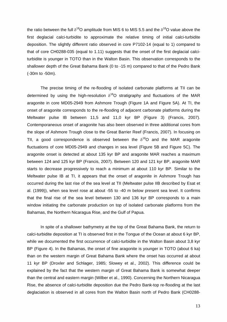
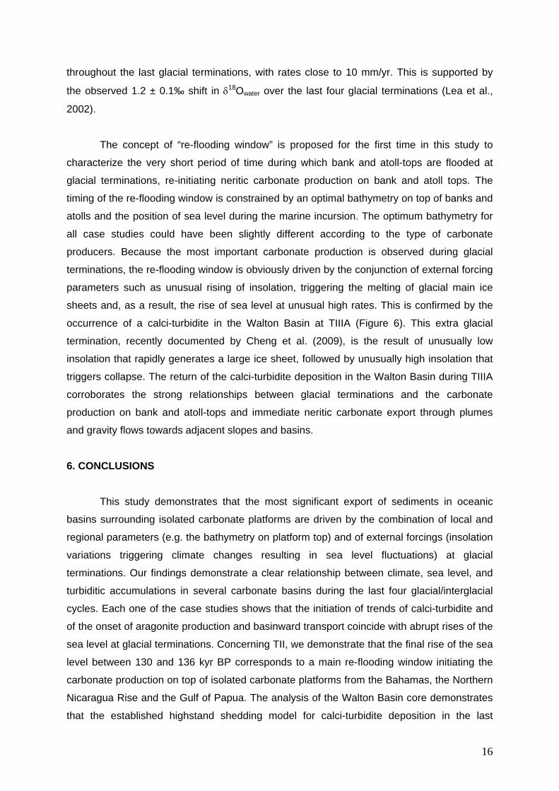
Figure 1: Modern physiography of the studied isolated carbonate platforms and their
surrounding basins, with location of cores. The highest carbonate productive zones are
illustrated in orange. All these maps are drawn at the same scale (except detail in B). A:
Eastern Fields Reef and Pandora Trough, Ashmore Reef and Ashmore Trough, Gulf of
Papua. B: Cul de Sac of the Tongue of the Ocean and Great Bahama Bank. C: Detail
bathymetry of the Cul de Sac of the Tongue of Ocean. Bathymetry after Hathearn
(1963). D: Pedro Bank and Walton Basin, Northern Nicaragua Rise. Bathymetry after
Glaser and Droxler (1991).
Figure 2: Core chronostratigraphy. A: 18O stratigraphy of core Ch0288-108/MD03-2632,
Walton Basin. B: LR04 18O benthic stack from Lisiecki and Raymo (2005). C: LR04
27
18O benthic stack between 0 and 150 kyr BP. D: 18O stratigraphy of core MD05-2949,
Ashmore Trough. E: 18O stratigraphy of core P7102-14, Tongue of the Ocean. F: 18O
stratigraphy of core CH0288-035, Walton Basin.
Figure 3: Timing of turbidite deposition and aragonite onset in Pandora and Ashmore
Troughs (Gulf of Papua) during TI. A: 18O measurements, fine (<63m) aragonite MAR
and turbidite frequency in core MD05-2940 (after Jorry et al., 2008). B: Age-depth
model of core MD05-2940 and MD05-2949 showing the occurrence of a calci-turbidite
in Pandora Trough and the onset of aragonite in both Pandora and Ashmore Trough,
phasing Meltwater pulse IB. C: 18O measurements and fine (<63m) aragonite MAR at
core MD05-2949 (fine aragonite MAR is adapted from Francis (2007)). D: Relative sea-
level records from far-field sites (after Alley et al., 2005) and location of Eastern
Fields/Ashmore atoll/lagoon average depth. B-A is the Bølling-Allerød warming, YD is
the Younger Dryas cold period, and MWP are the Meltwater pulses occurring during TI.
Figure 4: Timing of turbidite deposition in deep basins surrounding isolated carbonate bank-
tops from the Bahamas and the Northern Nicaragua Rise at TI and TII. A: Planktonic
oxygen isotopes (Glaser, 1991), aragonite content and turbidite occurrence at core
CH0288-035 in the Walton Basin (Northern Nicaragua Rise); B: Age-depth model of
core CH0288-035 and P7102-14; C: Planktonic oxygen isotopes, aragonite content
(Droxler and Schlager, 1985) and turbidite occurrence at core P7102-14, Cul de Sac of
the Tongue of the Ocean (Bahamas); D: Red Sea sea level curve from core GeoTü-
KL11 (data from Siddall et al., 2003; Siddall et al., 2006; Rohling et al., 2008; Rohling et
al., 2009). Hatches represent the average depth of bank-tops (Pedro Bank and Great
Bahama Bank [GBB]).
Figure 5: Synchronism of the aragonite onset in Ashmore Trough with the re-flooding of
Ashmore Reef at TII. A: 18O measurements and fine (<63m) aragonite MAR in core
MD05-2949 over the last glacial cycle (fine aragonite MAR is adapted from Francis
(2007)). The black line represents the 5-point running mean of MD05-2949 18O curve.
B: 18O and fine aragonite MAR in core MD05-2949 between 110 and 145 kyr BP. C:
Red Sea sea level reconstruction between 110 and 145 kyr BP of core GeoTü-KL11
(Siddall et al., 2003; Siddall et al., 2006). Hatches represent the average depth of
Ashmore atoll/lagoon. MWP are the Meltwater pulses occurring at TII (according to
Esat et al.(1999)).
28
Figure 6: Timing of calci-turbidite deposition in Walton Basin throughout the last four glacial
Terminations. A: Planktonic oxygen isotopes and calci-turbidite occurrence in cores
CH0288-108 (Glaser, 1991) and MD03-2632; B: Age-depth model of cores CH0288-
108 and MD03-2632; C: Red Sea sea level curve of core GeoTü-KL09 (Rohling et al.,
2009). The timing of TII, TIII, TIIIA, and TIV refers to Cheng et al. (2009).
145EPAPUA NEW GUINEA
Gulf of PapuaShelf
shelf
edge
N
PortlockReefs
BootAtoll
AshmoreAtoll
Eastern FieldsAtoll
PandoraTrough
Ashm
ore
Trou
gh
Gre
atBa
rrier
Reef
120m
1500m
1700
m
Fly delta
MD05-2940
9°
11°
APAPUANEW
GUINEA
145° 146°144° 7°
10°
8°
MD05-2949
700700
700500
500 500
500
500
600
500
700700
500
500
500
500
500
500
500
500
700
500
1306m
750
184m
1288m
1325m
1343m
1380m
920m
1417m
23°30"
77°30"
C
78° 76°
N
Great Bahama Bank
Andros Is.
Eleuthera Is.
Nassau
Tongueof the
Ocean
P7102-14
24°
26°
B
detail in C
P7102-14
500
2000
WaltonBasin
N
Pedro Bank
79°
17°
D
100m
1000m
2000
m
1000m
1000m
1000m 500m
CH0288-108/MD03-2632
CH0288-035
100m
JAMAICA77°78°
18°
FIGURE 1
-2.0
-1.0
0.0
MD03-2632δ18O per milleG. sacculifer
-2.0
-1.0
0.0
-2.0
-1.0
0.0
2.0
3.0
4.0
6.2
5.5
5.4
5.3
5.2
5.1
4.2
3.33.1
2.2
LR04δ18O per milleBenthic Stack
3.13.3
5.3
5.2 5.46.3
7.2
7.3
8.4
8.69.2
9.3
10.3
10.4
11.1
11.22
11.23
11.3
11.24
5.5
2.2
4.2
5.1
6.2
6.5
6.6
7.1
7.4
7.5
8.2
8.59.1
10.2
2.0
3.0
4.0
12.2
LR04δ18O per milleBenthic Stack
0 50 100 150 200 250 300 350 400 450
Age (ky BP)
0 50 100 150
-2.0
-1.0
0.0
MD05-2949δ18O per milleG. sacculifer
CH0288-035δ18O per milleG. sacculifer
P7102-14δ18O per mille
G. ruber
Age (ky BP)
last occurrence of pink G. ruber
last occurrenceof P. lacunosa
FIGURE 2
Cor
eD
epth
(cm
bsf)
0 5 10 15 200
100
200
600
700
800
13.7 kyr
18.4 kyr
15.4 kyr
11.2 kyr
22.3 kyr
-2.0-1.5-1.0-0.5
Pandora TroughCore MD05-2940
δ18O (per mille) G. sacculifer
19-kyr MWP
MWP-IA
B-A
YD
0 5 10 15 20
0 5 10 15 20
Age (kyr BP)
0
100
200
600
700
800
0
-40
-80
-120
Rel
ativ
eSe
aLe
vel(
m)
Cor
eD
epth
(cm
bsf)
Age (kyr BP)
Eastern Fields / Ashmoreatoll/lagoon average depth
-40m
-55m
siliciclastic turbiditecalci-turbidite
re-fl
oodi
ngw
indo
w
MWP-IB
BA
D
8.4 kyr
12.9 kyr
27.2 kyr
38.8 kyr
1.3 kyr-2.0-1.5-1.0-0.5
Ashmore TroughCore MD05-2949
δ18O (per mille) G. sacculifer
0.0 -2.5
0 4 8 12 16 20
MAR fine Aragonite(g.cm-2.kyr-1)
Aragonite onsetin Ashmore
Calci-turbiditeand
Aragonite onsetin Pandora
C
FIGURE 3
0 4 8 12 16
MAR fine Aragonite(g.cm-2.kyr-1)
-2.5-2.0-1.5-1.0-0.50.00.5
706050403020 80 9010
12,4 kyr
5,6 kyrMIS 1
MIS 2MIS 3MIS 4
MIS 5
MIS 6
% Fine Aragonite (<63µm)
Core
Dept
h(c
mbs
f)
0
100
200
400
500
Tongue of the OceanCore P7102-14
δ18O (per mille) G. ruberC
3,8 kyr
-2.5-2.0-1.5-1.0-0.50.00.5
706050403020 80 9010
MIS 1
MIS 2
MIS 3
MIS 4
MIS 5
MIS 6
% Fine Aragonite (<63µm) 1 2 3 4 6
0
100
200
400
500
140120100806040200
Core
Dept
h(c
mbs
f)
140120100806040200
5
0m
-15m
-30m
-50m
re-flooding window
Rel
ativ
eSe
aLe
vel(
m)
0
-20
-40
-60
-80
-100
-120
calci-turbiditescalci-turbidites duringbank-top re-flooding
Age (kyr BP)
Age (kyr BP)
140120100806040200
BA
D
Pedro Bank-topaverage depth
GBB-topaverage depth
FIGURE 4
600
T.IIT.I
Walton BasinCore CH0288-035
δ18O (per mille) G. sacculifer
0 20 40 60 80 100 120 140
110 120 130 140
110 120 130 140
-2.50
-2.00
-1.50
-1.00
-0.50
0.00
20
16
12
8
4
0
-2.50
-2.00
-1.50
-1.00
-0.50
0.00
20
16
12
8
4
0
20
0
-40
-60
-100
-80
-40m
-55m
-20
re-floodingwindow
Ashm
ore
atol
l/la
goon
aver
age
dept
h
δ18O
(per
mille
)
MAR
Arag
onite
(g.c
m-2
.kyr
-1)
δ18O
(per
mille
)
MAR
Arag
onite
(g.c
m-2
.kyr
-1)
Rel
ativ
eSe
ale
vel(
m)
Age (kyr BP)
Age (kyr BP)
flooded atoll
exposed atoll
27.2 kyr
38.8 kyr
12.9 kyr
8.4 kyr
B
A
C
FIGURE 5
MW
P-IIA
MW
P-IIB
-2.5-1.5-0.50.5
5.5
7.1
7.57.4
8.28.5
9.1
10.2
5.1
4.22.2
6.26.6
0 50 100 150 200 250 300 350 4000
200
400
600
800
1000
1200
1400
1600C
ore
dept
h(c
mbs
f)
MIS 5 MIS 7 MIS 9 MIS 11
-30m
1800
Walton BasinCH0288-108/MD03-2632
δ18Ο (per mille) G. sacculifer Age (kyr BP)
0
200
400
600
800
1000
1200
1400
1600
1800
-120
-80
-40
0
0 50 100 150 200 250 300 350 400
Pedro Bank-topaverage depth -50m
Rel
ativ
eSe
aLe
vel(
m)
Age (kyr BP)
BA
C
calci-turbiditescalci-turbidites during bank-top re-floodingre-flooding window at glacial Terminations
FIGURE 6
T.II T.III T.IVT.IIIA T.V
6.5
29
10. APPENDIX
Core Depth (cmbsf) 18O MAR Aragonite
(g.cm-2.kyr-1)
Calendar Age
(cal yrs BP)
MD05-2940 0 -2,24 11,99 0
MD05-2940 10 -2,02 1,12
MD05-2940 20 -2,17 2,24
MD05-2940 30 -2,12 12,43 3,36
MD05-2940 40 -1,92 4,48
MD05-2940 50 -2,18 9,79 5,6
MD05-2940 60 -1,94 6,72
MD05-2940 70 -1,71 7,84
MD05-2940 80 -1,59 8,96
MD05-2940 90 -1,85 5,82 10,08
MD05-2940 100 -1,54 3,87 11,2
MD05-2940 110 -1,41 3,02 11,51
MD05-2940 120 -1,38 0 11,82
MD05-2940 130 -1,12 0 12,14
MD05-2940 170 -1,17 13,39
MD05-2940 180 -1,27 0 13,70
MD05-2940 190 -1,29 13,80
MD05-2940 200 -1,11 0 14,00
MD05-2940 210 -1,24 14,50
MD05-2940 220 -1,13 14,58
MD05-2940 240 -1,03 0 14,75
MD05-2940 250 -0,98 14,83
MD05-2940 270 -0,93 14,99
MD05-2940 290 -0,90 0 15,15
MD05-2940 300 -1,05 15,24
MD05-2940 320 -0,91 0 15,40
MD05-2940 330 -0,75 15,48
MD05-2940 350 -0,99 15,65
MD05-2940 370 -0,77 15,81
MD05-2940 380 -0,51 15,90
MD05-2940 390 -0,76 16,52
MD05-2940 410 -0,42 17,77
MD05-2940 420 -0,51 18,40
MD05-2940 430 -0,62 18,52
MD05-2940 450 -0,59 18,76
MD05-2940 490 -0,58 19,25
MD05-2940 500 -0,59 19,37
MD05-2940 520 -0,66 19,61
MD05-2940 530 -0,64 19,74
MD05-2940 540 -0,56 19,86
MD05-2940 550 -0,55 19,98
MD05-2940 560 -0,80 20,50
MD05-2940 590 -0,45 20,89
MD05-2940 640 -0,52 21,53
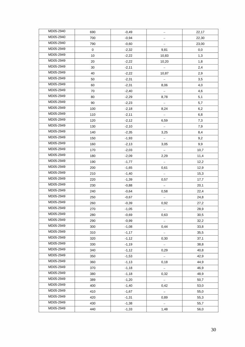
30
MD05-2940 690 -0,49 22,17
MD05-2940 700 -0,94 22,30
MD05-2940 790 -0,60 23,00
MD05-2949 0 -2,32 9,81 0,0
MD05-2949 10 -2,22 10,83 1,3
MD05-2949 20 -2,22 10,20 1,8
MD05-2949 30 -2,11 2,4
MD05-2949 40 -2,22 10,87 2,9
MD05-2949 50 -2,31 3,5
MD05-2949 60 -2,31 8,06 4,0
MD05-2949 70 -2,40 4,6
MD05-2949 80 -2,29 8,78 5,1
MD05-2949 90 -2,23 5,7
MD05-2949 100 -2,18 8,24 6,2
MD05-2949 110 -2,11 6,8
MD05-2949 120 -2,12 6,59 7,3
MD05-2949 130 -2,10 7,9
MD05-2949 140 -2,35 3,25 8,4
MD05-2949 150 -1,93 9,2
MD05-2949 160 -2,13 3,05 9,9
MD05-2949 170 -2,03 10,7
MD05-2949 180 -2,09 2,29 11,4
MD05-2949 190 -1,77 12,2
MD05-2949 200 -1,65 0,61 12,9
MD05-2949 210 -1,40 15,3
MD05-2949 220 -1,39 0,57 17,7
MD05-2949 230 -0,88 20,1
MD05-2949 240 -0,64 0,58 22,4
MD05-2949 250 -0,67 24,8
MD05-2949 260 -0,39 0,92 27,2
MD05-2949 270 -1,05 28,9
MD05-2949 280 -0,69 0,63 30,5
MD05-2949 290 -0,99 32,2
MD05-2949 300 -1,08 0,44 33,8
MD05-2949 310 -1,17 35,5
MD05-2949 320 -1,12 0,30 37,1
MD05-2949 330 -1,19 38,8
MD05-2949 340 -1,12 0,29 40,8
MD05-2949 350 -1,53 42,9
MD05-2949 360 -1,13 0,18 44,9
MD05-2949 370 -1,18 46,9
MD05-2949 380 -1,18 0,32 48,9
MD05-2949 389 -1,20 50,7
MD05-2949 400 -1,40 0,42 53,0
MD05-2949 410 -1,67 55,0
MD05-2949 420 -1,31 0,89 55,3
MD05-2949 430 -1,38 55,7
MD05-2949 440 -1,33 1,48 56,0
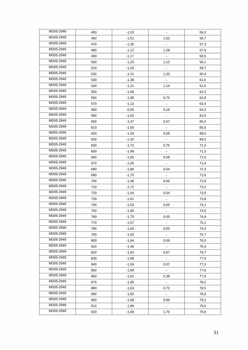
31
MD05-2949 450 -1,53 56,3
MD05-2949 460 -1,51 1,52 56,7
MD05-2949 470 -1,35 57,3
MD05-2949 480 -1,12 1,28 57,9
MD05-2949 490 -1,17 58,5
MD05-2949 500 -1,23 1,12 59,1
MD05-2949 510 -1,25 59,7
MD05-2949 520 -1,21 1,33 60,4
MD05-2949 530 -1,38 61,0
MD05-2949 540 -1,21 1,14 61,6
MD05-2949 550 -1,06 62,2
MD05-2949 560 -1,08 0,75 62,8
MD05-2949 570 -1,13 63,4
MD05-2949 580 -0,95 0,16 64,0
MD05-2949 590 -1,52 63,5
MD05-2949 600 -1,47 0,07 65,0
MD05-2949 610 -1,50 66,5
MD05-2949 620 -1,33 0,09 68,0
MD05-2949 630 -1,42 69,5
MD05-2949 640 -1,72 0,75 71,0
MD05-2949 650 -1,68 71,3
MD05-2949 660 -1,65 0,09 71,6
MD05-2949 670 -1,65 71,9
MD05-2949 680 -1,86 0,04 72,3
MD05-2949 690 -1,75 72,6
MD05-2949 700 -1,48 0,05 72,9
MD05-2949 710 -1,72 73,2
MD05-2949 720 -1,64 0,04 73,5
MD05-2949 730 -1,61 73,8
MD05-2949 740 -1,53 0,05 74,1
MD05-2949 750 -1,95 74,5
MD05-2949 760 -1,73 0,05 74,8
MD05-2949 770 -1,57 75,1
MD05-2949 780 -1,64 0,05 75,4
MD05-2949 790 -1,50 75,7
MD05-2949 800 -1,64 0,06 76,0
MD05-2949 810 -1,46 76,3
MD05-2949 820 -1,63 0,07 76,7
MD05-2949 830 -1,68 77,0
MD05-2949 840 -1,59 0,07 77,3
MD05-2949 850 -1,69 77,6
MD05-2949 860 -1,61 0,38 77,9
MD05-2949 870 -1,65 78,2
MD05-2949 880 -1,63 0,72 78,5
MD05-2949 890 -1,82 78,9
MD05-2949 900 -1,68 0,99 79,2
MD05-2949 910 -1,89 79,5
MD05-2949 920 -1,69 1,70 79,8
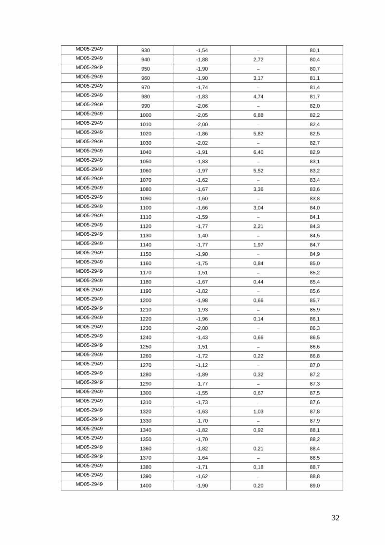
32
MD05-2949 930 -1,54 80,1
MD05-2949 940 -1,88 2,72 80,4
MD05-2949 950 -1,90 80,7
MD05-2949 960 -1,90 3,17 81,1
MD05-2949 970 -1,74 81,4
MD05-2949 980 -1,83 4,74 81,7
MD05-2949 990 -2,06 82,0
MD05-2949 1000 -2,05 6,88 82,2
MD05-2949 1010 -2,00 82,4
MD05-2949 1020 -1,86 5,82 82,5
MD05-2949 1030 -2,02 82,7
MD05-2949 1040 -1,91 6,40 82,9
MD05-2949 1050 -1,83 83,1
MD05-2949 1060 -1,97 5,52 83,2
MD05-2949 1070 -1,62 83,4
MD05-2949 1080 -1,67 3,36 83,6
MD05-2949 1090 -1,60 83,8
MD05-2949 1100 -1,66 3,04 84,0
MD05-2949 1110 -1,59 84,1
MD05-2949 1120 -1,77 2,21 84,3
MD05-2949 1130 -1,40 84,5
MD05-2949 1140 -1,77 1,97 84,7
MD05-2949 1150 -1,90 84,9
MD05-2949 1160 -1,75 0,84 85,0
MD05-2949 1170 -1,51 85,2
MD05-2949 1180 -1,67 0,44 85,4
MD05-2949 1190 -1,82 85,6
MD05-2949 1200 -1,98 0,66 85,7
MD05-2949 1210 -1,93 85,9
MD05-2949 1220 -1,96 0,14 86,1
MD05-2949 1230 -2,00 86,3
MD05-2949 1240 -1,43 0,66 86,5
MD05-2949 1250 -1,51 86,6
MD05-2949 1260 -1,72 0,22 86,8
MD05-2949 1270 -1,12 87,0
MD05-2949 1280 -1,89 0,32 87,2
MD05-2949 1290 -1,77 87,3
MD05-2949 1300 -1,55 0,67 87,5
MD05-2949 1310 -1,73 87,6
MD05-2949 1320 -1,63 1,03 87,8
MD05-2949 1330 -1,70 87,9
MD05-2949 1340 -1,82 0,92 88,1
MD05-2949 1350 -1,70 88,2
MD05-2949 1360 -1,82 0,21 88,4
MD05-2949 1370 -1,64 88,5
MD05-2949 1380 -1,71 0,18 88,7
MD05-2949 1390 -1,62 88,8
MD05-2949 1400 -1,90 0,20 89,0
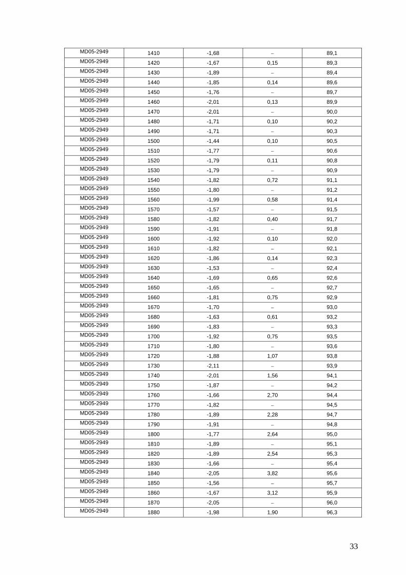
33
MD05-2949 1410 -1,68 89,1
MD05-2949 1420 -1,67 0,15 89,3
MD05-2949 1430 -1,89 89,4
MD05-2949 1440 -1,85 0,14 89,6
MD05-2949 1450 -1,76 89,7
MD05-2949 1460 -2,01 0,13 89,9
MD05-2949 1470 -2,01 90,0
MD05-2949 1480 -1,71 0,10 90,2
MD05-2949 1490 -1,71 90,3
MD05-2949 1500 -1,44 0,10 90,5
MD05-2949 1510 -1,77 90,6
MD05-2949 1520 -1,79 0,11 90,8
MD05-2949 1530 -1,79 90,9
MD05-2949 1540 -1,82 0,72 91,1
MD05-2949 1550 -1,80 91,2
MD05-2949 1560 -1,99 0,58 91,4
MD05-2949 1570 -1,57 91,5
MD05-2949 1580 -1,82 0,40 91,7
MD05-2949 1590 -1,91 91,8
MD05-2949 1600 -1,92 0,10 92,0
MD05-2949 1610 -1,82 92,1
MD05-2949 1620 -1,86 0,14 92,3
MD05-2949 1630 -1,53 92,4
MD05-2949 1640 -1,69 0,65 92,6
MD05-2949 1650 -1,65 92,7
MD05-2949 1660 -1,81 0,75 92,9
MD05-2949 1670 -1,70 93,0
MD05-2949 1680 -1,63 0,61 93,2
MD05-2949 1690 -1,83 93,3
MD05-2949 1700 -1,92 0,75 93,5
MD05-2949 1710 -1,80 93,6
MD05-2949 1720 -1,88 1,07 93,8
MD05-2949 1730 -2,11 93,9
MD05-2949 1740 -2,01 1,56 94,1
MD05-2949 1750 -1,87 94,2
MD05-2949 1760 -1,66 2,70 94,4
MD05-2949 1770 -1,82 94,5
MD05-2949 1780 -1,89 2,28 94,7
MD05-2949 1790 -1,91 94,8
MD05-2949 1800 -1,77 2,64 95,0
MD05-2949 1810 -1,89 95,1
MD05-2949 1820 -1,89 2,54 95,3
MD05-2949 1830 -1,66 95,4
MD05-2949 1840 -2,05 3,82 95,6
MD05-2949 1850 -1,56 95,7
MD05-2949 1860 -1,67 3,12 95,9
MD05-2949 1870 -2,05 96,0
MD05-2949 1880 -1,98 1,90 96,3
34
MD05-2949 1890 -1,77 96,7
MD05-2949 1900 -1,97 2,21 97,0
MD05-2949 1910 -1,79 97,4
MD05-2949 1920 -1,78 2,04 97,7
MD05-2949 1930 -1,78 98,1
MD05-2949 1940 -1,73 2,03 98,4
MD05-2949 1950 -1,94 98,7
MD05-2949 1960 -1,88 1,20 99,1
MD05-2949 1970 -1,90 99,4
MD05-2949 1980 -1,80 0,36 99,8
MD05-2949 1990 -1,71 100,1
MD05-2949 2000 -1,85 0,49 100,4
MD05-2949 2010 -2,01 100,8
MD05-2949 2020 -1,84 0,62 101,1
MD05-2949 2030 -1,78 101,5
MD05-2949 2040 -1,89 0,82 101,8
MD05-2949 2050 -1,87 102,2
MD05-2949 2060 -2,04 1,67 102,5
MD05-2949 2070 -2,01 102,8
MD05-2949 2080 -1,98 1,25 103,2
MD05-2949 2090 -1,94 103,5
MD05-2949 2100 -1,83 1,60 103,9
MD05-2949 2110 -1,70 104,2
MD05-2949 2120 -1,80 1,14 104,6
MD05-2949 2130 -1,70 104,9
MD05-2949 2140 -1,77 0,99 105,2
MD05-2949 2150 -1,79 105,6
MD05-2949 2160 -1,81 1,25 105,9
MD05-2949 2170 -2,02 106,3
MD05-2949 2180 -1,59 0,28 106,6
MD05-2949 2190 -1,59 106,9
MD05-2949 2200 -1,58 0,06 107,3
MD05-2949 2210 -1,60 0,06 107,6
MD05-2949 2220 -1,67 0,06 108,0
MD05-2949 2230 -1,57 0,07 108,3
MD05-2949 2240 -1,56 0,42 108,7
MD05-2949 2250 -1,50 0,04 109,0
MD05-2949 2260 -1,64 0,26 109,7
MD05-2949 2270 0,79 110,3
MD05-2949 2280 -1,60 0,35 111,0
MD05-2949 2290 -1,71 0,83 111,6
MD05-2949 2300 -1,72 0,68 112,3
MD05-2949 2310 -1,81 0,80 112,9
MD05-2949 2320 -1,57 0,78 113,6
MD05-2949 2330 -1,94 1,24 114,2
MD05-2949 2340 -1,93 1,04 114,9
MD05-2949 2350 -1,60 1,59 115,5
MD05-2949 2360 -1,76 1,71 116,2
35
MD05-2949 2370 -1,89 2,08 116,8
MD05-2949 2380 -1,91 3,54 117,5
MD05-2949 2390 -1,95 5,36 118,1
MD05-2949 2400 -1,74 6,50 118,8
MD05-2949 2406 -1,68 7,33 119,2
MD05-2949 2424 -1,79 10,73 120,4
MD05-2949 2426 -1,73 9,77 120,5
MD05-2949 2430 -2,04 12,74 120,8
MD05-2949 2441 -1,90 11,34 121,5
MD05-2949 2451 -1,98 12,83 122,1
MD05-2949 2461 -2,06 12,46 122,8
MD05-2949 2471 -2,20 12,46 123,4
MD05-2949 2481 -2,04 11,61 124,1
MD05-2949 2491 -1,99 12,98 124,7
MD05-2949 2501 -2,21 11,44 125,4
MD05-2949 2511 -2,31 11,82 126,0
MD05-2949 2521 -2,25 10,81 126,7
MD05-2949 2531 -2,32 10,91 127,3
MD05-2949 2541 -2,42 6,54 128,0
MD05-2949 2551 -2,23 6,11 128,3
MD05-2949 2561 -2,39 5,95 128,5
MD05-2949 2571 -2,34 6,21 128,8
MD05-2949 2581 -2,32 6,03 129,0
MD05-2949 2591 -2,29 5,66 129,3
MD05-2949 2601 -2,00 7,21 129,5
MD05-2949 2611 -2,08 6,31 129,8
MD05-2949 2621 -2,11 10,21 130,0
MD05-2949 2631 -1,79 7,91 131,0
MD05-2949 2641 -1,74 4,73 132,0
MD05-2949 2651 -1,32 2,62 133,0
MD05-2949 2661 -1,17 1,41 134,0
MD05-2949 2671 -0,96 0,25 135,0
MD05-2949 2681 -1,27 0,69 140,0
MD05-2949 2691 -0,79 0,58 140,3
MD05-2949 2701 -0,83 0,40 140,7
MD05-2949 2711 -0,88 0,32 141,0
MD05-2949 2721 -0,78 0,19 141,3
MD05-2949 2731 -0,85 0,23 141,7
MD05-2949 2741 -0,83 142,0
MD05-2949 2751 -0,91 0,26 142,3
MD05-2949 2761 -0,75 142,7
MD05-2949 2771 -0,85 0,06 143,0
MD05-2949 2781 -0,84 143,3
MD05-2949 2791 -0,68 0,07 143,7
MD05-2949 2801 -0,68 144,0
MD05-2949 2811 -0,67 0,07 144,3
MD05-2949 2821 -0,73 144,7
MD05-2949 2831 -0,65 0,04 145,0
36
Core Depth (cmbsf) 18O Fine Aragonite
< 63 m (%) Age (cal yr BP)
CH0288-035 0 -1,81 74,0 0,0
CH0288-035 8 -2,17 70,1 1,7
CH0288-035 18 -2,11 61,5 3,8
CH0288-035 30 -2,07 70,1 8,6
CH0288-035 39 -1,76 60,4 12,2
CH0288-035 49 -0,61 36,2 17,0
CH0288-035 58 -0,33 22,4 21,7
CH0288-035 68 0,25 27,9 27,0
CH0288-035 79 38,0 32,8
CH0288-035 89 -0,77 37,1 38,0
CH0288-035 99 -0,54 49,3 40,9
CH0288-035 139 -0,65 41,2 52,4
CH0288-035 148 -0,97 36,0 55,0
CH0288-035 160 -0,28 29,9 60,1
CH0288-035 168 -0,27 36,0 64,0
CH0288-035 180 -0,59 40,0 69,8
CH0288-035 189 -1,20 51,8 72,1
CH0288-035 229 -1,05 62,0 77,7
CH0288-035 238 -1,44 65,1 79,0
CH0288-035 259 -1,75 60,3 82,0
CH0288-035 279 -1,41 45,0 85,9
CH0288-035 289 -1,44 51,0 87,8
CH0288-035 298 -1,32 59,9 89,5
CH0288-035 308 -1,33 67,7 91,5
CH0288-035 329 -0,84 59,9 95,5
CH0288-035 348 -1,17 62,0 99,2
CH0288-035 394 -1,08 67,0 108,1
CH0288-035 409 -1,36 60,0 111,0
CH0288-035 410 -1,44 67,6 111,2
CH0288-035 447 -1,62 118,3
CH0288-035 448 -1,45 73,0 118,5
CH0288-035 467 -1,76 70,1 122,2
CH0288-035 497 -2,00 67,3 128,0
CH0288-035 508 -1,73 67,9 130,5
CH0288-035 537 -1,49 137,0
CH0288-035 548 -0,27 36,6 139,5
CH0288-035 558 -0,27 50,1 141,8
P7102-14 3,5 -1,93 1,0
P7102-14 21 74,1 2,1
P7102-14 35 75,6 3,0
P7102-14 47,5 -2,04 3,8
P7102-14 57,5 -1,81 70,0 4,4
P7102-14 78 -1,67 76,1 5,7
P7102-14 91,5 -1,36 9,0
P7102-14 94 42,5 9,6
P7102-14 95 41,2 9,8
37
P7102-14 101,5 -0,71 30 11,4
P7102-14 110,5 0,20 47,5 27,0
P7102-14 120,5 -0,27 49,4 34,0
P7102-14 129 37,2 40,0
P7102-14 140,5 -0,56 25,3 48,0
P7102-14 150,5 -0,59 50,0 55,0
P7102-14 160,5 -0,03 34,0 57,8
P7102-14 173 44,0 61,4
P7102-14 180,5 -0,59 47,9 63,5
P7102-14 192 58,0 66,8
P7102-14 200,5 -0,86 54,9 69,2
P7102-14 210,5 -0,85 57,7 72,1
P7102-14 220,5 -1,01 57,1 74,9
P7102-14 230,5 -0,73 62,1 77,7
P7102-14 245,5 -1,24 62,0 82,0
P7102-14 260,5 -0,94 65,3 85,5
P7102-14 270,5 -1,13 62,5 87,9
P7102-14 280,5 -1,11 67,7 90,3
P7102-14 290,5 -1,28 92,6
P7102-14 300,5 -0,88 68,0 95,0
P7102-14 313,5 -1,32 64,2 98,0
P7102-14 320,5 -1,05 67,6 99,7
P7102-14 340,5 -1,42 104,4
P7102-14 350,5 -1,25 106,8
P7102-14 364,5 -1,50 72,4 110,1
P7102-14 370,5 -1,58 111,5
P7102-14 378,5 -1,78 113,4
P7102-14 400,5 -1,94 77,1 118,6
P7102-14 412 77,2 121,3
P7102-14 440,5 -2,24 81,0 128,0
P7102-14 450,5 -1,77 129,7
P7102-14 465 73,1 132,2
P7102-14 474,5 -1,61 66,2 133,9
P7102-14 484,5 -0,27 42,1 135,6
P7102-14 494,5 0,08 48,0 137,3
P7102-14 505 42,0 139,1
P7102-14 510,5 -0,04 140,1
P7102-14 514 44,0 140,7
P7102-14 520,5 0,33 141,8
P7102-14 524 53,0 141,8
P7102-14 530,5 -0,14 63,9 143,0
P7102-14 545,5 -0,10 51,0 145,0
P7102-14 550 54,8
CH0288-108 0 -2,01 0,0
CH0288-108 10 -2,03 3,0
CH0288-108 20 -2,04 6,0
CH0288-108 30 -1,83 9,0
CH0288-108 40 -1,92 12,0
38
CH0288-108 50 -1,12 15,0
CH0288-108 60 -0,49 18,0
CH0288-108 70 0,10 21,0
CH0288-108 80 0,05 24,0
CH0288-108 90 0,10 27,0
CH0288-108 100 -0,30 32,0
CH0288-108 110 -0,39 37,0
CH0288-108 120 -0,49 42,0
CH0288-108 142 -0,52 53,0
CH0288-108 150 -0,70 57,0
CH0288-108 160 -0,24 62,0
CH0288-108 170 -0,61 64,2
CH0288-108 187 -0,81 68,0
CH0288-108 190 -0,85 68,7
CH0288-108 240 -1,37 79,8
CH0288-108 250 -1,45 82,0
CH0288-108 260 -1,31 84,6
CH0288-108 268 -1,02 86,6
CH0288-108 280 -0,96 89,7
CH0288-108 290 -1,50 92,2
CH0288-108 310 -1,42 97,3
CH0288-108 318 -1,03 99,4
CH0288-108 340 -1,24 105,0
CH0288-108 359 -1,06 109,9
CH0288-108 364 -1,27 111,1
CH0288-108 372 -1,00 113,2
CH0288-108 380 -1,26 115,2
CH0288-108 390 -1,59 117,8
CH0288-108 401 -1,71 120,6
CH0288-108 410 -2,01 122,9
CH0288-108 420 -2,18 125,4
CH0288-108 430 -2,27 128,0
CH0288-108 440 -1,68 129,1
CH0288-108 490 -1,58 134,5
CH0288-108 500 -0,05 135,6
MD03-2632 510 0,21 136,7
MD03-2632 520 -0,04 137,8
MD03-2632 530 0,19 138,9
MD03-2632 540 0,28 141,8
MD03-2632 550 -0,32 150,4
MD03-2632 562 -0,52 160,8
MD03-2632 570 -0,37 167,7
MD03-2632 580 -0,42 176,4
MD03-2632 590 -0,07 185,0
MD03-2632 600 -0,18 186,6
MD03-2632 610 -0,84 188,1
MD03-2632 620 -1,26 189,7
MD03-2632 628 -1,12 190,9
39
MD03-2632 680 -1,45 199,0
MD03-2632 690 -1,38 200,4
MD03-2632 700 -1,28 201,8
MD03-2632 710 -1,18 203,2
MD03-2632 718 -1,27 204,4
MD03-2632 800 -1,49 215,9
MD03-2632 820 -1,51 218,8
MD03-2632 830 -1,49 220,2
MD03-2632 840 -0,60 221,6
MD03-2632 850 -0,39 223,0
MD03-2632 860 -0,80 227,8
MD03-2632 870 -1,37 232,5
MD03-2632 880 -1,67 237,3
MD03-2632 890 -2,01 242,0
MD03-2632 900 -1,26 243,4
MD03-2632 910 -0,21 244,9
MD03-2632 920 -0,18 246,3
MD03-2632 925 -1,16 247,0
MD03-2632 960 0,02 252,0
MD03-2632 970 -0,10 259,8
MD03-2632 980 -0,23 267,6
MD03-2632 990 -0,16 275,4
MD03-2632 1000 0,00 283,2
MD03-2632 1010 -0,76 291,0
MD03-2632 1020 -0,64 292,3
MD03-2632 1030 -0,61 293,7
MD03-2632 1040 -0,63 295,0
MD03-2632 1050 -0,38 296,3
MD03-2632 1060 -0,50 297,7
MD03-2632 1082 -0,81 300,6
MD03-2632 1088 -0,99 301,4
MD03-2632 1144 -1,12 308,9
MD03-2632 1150 -1,05 309,7
MD03-2632 1160 -1,15 311,0
MD03-2632 1170 -0,97 312,3
MD03-2632 1180 -1,10 313,7
MD03-2632 1213 -1,16 318,1
MD03-2632 1220 -0,80 319,0
MD03-2632 1230 -1,52 321,8
MD03-2632 1250 -1,00 327,3
MD03-2632 1260 -1,19 330,1
MD03-2632 1283 -1,49 336,4
MD03-2632 1290 -1,55 337,4
MD03-2632 1300 -1,21 338,1
MD03-2632 1310 -0,17 338,8
MD03-2632 1395 0,22 345,0
MD03-2632 1400 0,06 346,1
MD03-2632 1410 -0,05 348,4
40
MD03-2632 1430 -0,15 352,8
MD03-2632 1440 -0,20 355,1
MD03-2632 1450 0,13 357,3
MD03-2632 1460 0,01 359,6
MD03-2632 1493 -0,76 366,9
MD03-2632 1500 -0,77 368,5
MD03-2632 1510 -0,45 370,7
MD03-2632 1520 -0,62 373,0
MD03-2632 1530 -0,59 375,2
MD03-2632 1540 -1,02 377,5
MD03-2632 1550 -0,75 379,7
MD03-2632 1561 -1,21 382,2
MD03-2632 1596 -0,99 390,0
MD03-2632 1600 -1,05 391,1
MD03-2632 1610 -1,43 393,7
MD03-2632 1620 -1,20 396,4
MD03-2632 1720 -1,48 423,0
MD03-2632 1730 -1,60 424,6
MD03-2632 1740 -1,49 426,1
MD03-2632 1750 -1,44 427,7
MD03-2632 1760 -1,47 429,2
MD03-2632 1770 0,10 430,8
MD03-2632 1780 -0,31 432,3
MD03-2632 1790 -0,02 433,9
MD03-2632 1800 0,45 435,4
MD03-2632 1810 0,48 437,0