Embed Size (px)
Citation preview

I .i
oj'"~
!Tbe Coastal EnviroDDlentai Profile+f: Lingayen Gulf, Philippines
Edited by
'-'iana T. McManusand_' Chua Thia-Eng

Environmental Frofile Gulf, P.b.ilippines
Edited by
L i m a T. WManu~ and Chua ' Thia-Eng
Association of Southeast Asian Nations/ United States Coastal Resources Management Project
Technical Publications Series 5

The Coastal Environmental Profile of Lingayen Gulf, Philippines
EDITED BY LlANA T. MCMANUS AND CHUA THIA-ENG
Published by the International Center for Living Aquatic Resources Management on behalf of the Association of Southeast Asian NationsIUnited States Coastal Resources Management Project
Printed in Manila, Philippines
McManus, L.T. and T.-E. Chua, editors. 1990. The coastal environmental profile of Lingayen Gulf, Philippines. ICLARM Technical Reports 22, 69 p. International Center for Living Aquatic Resources Management, Manila, Philippines.
Cover (Front): A landsat photo of Lingayen Gulf in the western coast of Luzon. Philippines, showing its coastal features. Note the mountainous regions in the eastern and southwestern parts which are major sources of runoff and sediment deposited into the major rivers and tributaries which empty into the gulf. (This photo is a rectified image based on data from the National Aeronautics and Space Administration.)
(Back, top left and right): (a) Coral reef communities of Bolinao, Pangasinan. (b) A fishing village on Silaqui Island, located on the 3-km wide reef flat of Bolinao. (Bottom left and right): (a) Gleaners on the tidally exposed reef flat. (b) Women and children gathering invertebrates, mostly clams, snails and urchins from the reef flats. (Photos by J.W. McManus.)
ISSN 01 15-5547 ISBN 971 -1022-49-4
ICLARM Contribution No. 514

Contents
List of Tables
List of Figures vii
List of Acronyms and Abbreviations viii
Peso-Dollar Conversion Rates, 1976-1 990 x
Foreword xi
Preface xiii
Chapter 1. Introduction, Liana T. McManus, CesarZ. Luna and Flordeliz Y. Guarin Objectives and Scope 3 Definitions 3
Chapter 2. Natural Resources, Cesar 2. Luna and Julius M. Concepcion Coral Resources Forest Resources Mineral Resources
Chapter 3. Economic Sector, Geronimo T. Silvestre and Adelaida L. Palma Capture Fisheries Coastal Aquaculture
Chapter 4. Pollution, Mary Ann Leah L. Maaliw Marine Pollutants Action Plans and Mitigating Measures
Chapter 5. Population and Socioeconomics, Liana T. McManus and Rebecca A. Rivera 38
Chapter 6. Institutional and Legal Framework, B. Norman V. Kalagayan Indigenous Rudiments of Coastal Zone Law The Present State of Philippine Coastal Zone Law Disposition and Management of Fisheries Disposition and Management of Forests Disposition and Management of Minerals Disposition and Management of Lands Government Coastal Zone Programs and Projects Local Government Community Development and Social Work Program Toward a Community-Based Coastal Resources Management
iii

Chapter 7. Coastal Resources Management Issues and Plan Formulation, 62 Liana T. McManus 63 Coastal Resources Management Issues Development of a Coastal Area Management Plan 6 6
References

List of Tables
Status of corals in Bolinao and Hundred Islands, Pangasinan and in San Fernando, La Union. Volume (t) of coral reef fish landed by municipal fishermen in Pangasinan and La Union, 1983-1 985. Estimates of seaweed production in Lingayen Gulf. Estimates of annual invertebrate catch (t) and value of catch (P) from Lingayen Gulf, 1983. Distribution of marketed invertebrate species along the Lingayen Gulf coast. Estimates of aquarium fish production in Bolinao, Pangasinan. Aquarium fish caught with sodium cyanide (NaCN) in their adult and semiadult forms. Area (ha) and percentage of forest lands to total land area in Pangasinan. Area of forest lands, by kind, in Region 1. Area of forest lands, by kind, in Pangasinan. Area of forest lands, by kind, in La Union. Quantity and estimated value (B) of mineral production in Pangasinan: 1983 and 1984 (preliminary estimates). Magnitude and value of annual landings in LGSA, 1976-1 984. Mean value of marine landings in LGSA, 1976-1 984 and their equivalent values in 1 984. Magnitude and value of annual landings in Lingayen Gulf, 1976-1 984. Magnitude and value of marine landings from Lingayen Gulf, April 1 983-March 1984. Types of fishing methodigear used in Lingayen Gulf as compiled from various studies conducted in the area. Trawl number, aggregate gross tonnage and landings in Lingayen Gulf, 1976-1 984. Inventory of municipal fishing gear used in the different municipalities bordering Lingayen Gulf. Frequency of use of the more important municipal fishing gear in Lingayen Gulf. Estimates of catch rate and annual catch for selected fishing gear in Lingayen Gulf, April 1983-March 1984. Mean annual landings by municipal gear type in LGSA, 1980-1 984. Distribution of the number of municipal fishermen and banca, by sector, in Lingayen Gulf as of 1985. Fish species occurrence reported in Lingayen Gulf as compiled from previous studies in the area.

Top ten farnilies/groups which make up trawl catches in Lingayen Gulf during the late 1940s, late 1970s and early 1980s. Catch composition of selected municipal fishing gear in Lingayen Gulf. Estimates of profitability in 1980 for the commercial fisheries of Lingayen Gulf. Estimates of profitability in 1980 for the municipal fisheries of Lingayen Gulf. Rates of loan repayment by fishermen in Region I, Philippines. Distribution of privately owned brackishwater fishponds in Pangasinan. The 1988 prices per kilogram of pond-cultured fish at the Dagupan public market. Mine tailings produced in Baguio Mining District. Ranges of soluble heavy metal contents of paddy soils at inlet portion of or settling basin in paddy fields of ARIS. Copper concentration (ppm) of leaves of rice plants in ARIS. Trace element content of stream sediment in tailings-affected rivers, Agno and Bued, in Pangasinan. Metal concentration of sediment from monitoring points along Bued River, Patalan River and Lingayen Gulf, Pangasinan. Concentration of toxic metals in the Agno River Basin. Concentration of noxious metals in Lingayen Gulf. Population, area and population density for municipalities and coastal villages around Lingayen Gulf. Population growth rates for the period 1985-1 988 in municipalities and coastal villages of Lingayen Gulf. Average family size and population distribution for the three sectors of Lingayen Gulf. Dialects spoken in municipalities around Lingayen Gulf and percentage of population speaking them. Employment by major occupation group in Pangasinan and La Union, January-March 1985. Occupations of coastal inhabitants of Lingayen Gulf and percentage of population engaged in them. Average monthly income and disbursements (F) of families living around Lingayen Gulf. Monthly income from fishing and family expenses (P) of small-scale fishermen of Lingayen Gulf. Partial list of NGOs in La Union as of 30 June 1985.

List of Figures
Estimated mean circulation currents of Lingayen Gulf. Map of Lingayen Gulf showing the geographical divisions of its internal waters and surrounding coastal areas. Western coast of Lingayen Gulf. Area of operation by fishing gear in Lingayen Gulf. General location of payao or fish shelters used in purse seine operations in Philippine waters. Range of operations for selected municipal fishing gear in Sector I of Lingayen Gulf. Range of operations for selected municipal fishing gear in Sector II of Lingayen Gulf. Range of operations for selected municipal fishing gear in Sector Ill of Lingayen Gulf. Relative trawl CPUE in Lingayen Gulf in the late 1940s, late 1970s and early 1980s. Distribution of fishponds in Pangasinan and La Union. Location of monitoring points for water quality of the Agno River Irrigation System (ARE).
vii

List of Acronyms and Abbreviations
ASEANIUS CRMP
A 0 ARlS BFAR BFD BL BMG BP C A CPUE CSWCD CZMC CZMTF D A DENR DLGCD DNR DOT EEZ EFPP EIA E IS EMB €0 ERDB FA0 FIDC-NMRC
FMB FOR1 GT h P INMRP lRRl KKK LGC LGMP LGSA LO I
Association of Southeast Asian Nations/ United States Coastal Resources Management Project
Administrative Order Agno River Irrigation System Bureau of Fisheries and Aquatic Resources Bureau of Forest Development Bureau of Lands Bureau of Mines and Geo-Sciences Batas Pambansa Commonwealth Act catch per unit effort College of Social Work and Community Development Coastal Zone Management Committee Coastal Zone Management Task Force Department of Agriculture Department of Environment and Natural Resources Department of Local Government and Community Development Department of Natural Resources Department of Tourism Exclusive Economic Zone Expanded Fish Production Program Environmental impact assessment Environmental impact statement Environmental Management Bureau Executive Order Ecosystems Research and Development Bureau Fisheries Administrative Order Fishery Industry Development Council-Natural Resources
Management Center Forest Management Bureau Forest Research Institute gross ton horsepower Integrated National Mangrove Research Program International Rice Research Institute Kilusang Kabuhayan at Kaunlaran Local Government Code Lingayen Gulf Management Project Lingayen Gulf Statistical Area Letter of Instruction
viii

MEY MNR MOA MSI-UP MSSD MSY NAMRIA NCSO NEDA NEPC NLSF NGO NMC NPCC OSY PB PD P P ~ PP m PP t PTA RA RDC REMlC REMlN SB SP TURF UNDPIUNESCO
Maximum economic yield Ministry of Natural Resources Memorandum of Agreement Marine Science Institute-University of the Philippines Ministry of Social Services and Development Maximum sustainable yield National Mapping Research and lnformation Authority National Census and Statistics Office National Economic Development Authority National Environmental Protection Council National Livelihood Support Fund Nongovernmental organization National Mangrove Committee National Pollution Control Commission Optimum sustainable yield Punong Barangay Presidential Decree parts per billion parts per million parts per thousand Philippine Tourism Authority Republic Act Regional Development Council Regional Mangrove lnformation Center Regional Mangrove lnformation Network Sangguniang Barangay Sangguniang Panlalawigan Territorial use rights in fisheries United Nations Development ProgrammeIUnited Nations
Educational, Scientific and Cultural Organization

Conversion Rates (P=US$I .00), 1 976-1 990
Peso Year

Foreword
The coastal environmental profile of Lingayen Gulf, Philippines answers the objectives of the six-year Association of Southeast Asian NationsIUnited States Coastal Resources Man- agement Project (ASEANIUS CRMP) (Philippine component). Originally, it was just a synthesis of secondary information from which data gaps and research foci were identified for the project. In a workshop held at Punta Baluarte, Batangas, on 3-5 December 1986, representatives from government and nongovernment agencies working in the Lingayen Gulf area and the project research teams from the University of the Philippines (UP)-Marine Science Institute (MSI), College of Social Work and Community Development (CSWCD) and College of Fisheries, and Bureau of Fisheries and Aquatic Resources (BFAR) discussed major issues which CRMP needed to address. They drew and pursued research programs on biophysical resources, socioeconomics, capture fisheries and aquaculture. In 1988, research activities were completed.
Tasked to draw the management plan for Lingayen Gulf in 1989, the National Economic Development Authority (NEDA)-Region I in cooperation with various regional line agencies coordinated with the research teams to update information, i-e., build a new database. The draft of this profile served as their framework. The new database highlighted critical issues such as the status of capture fisheries and aquaculture, and of habitats like coral reefs and estuaries. Studies on water quality stressed the need for widening the area of study which should, in the future, include the upland watershed.
This profile is thus a collaborative effort of the researchers who summarized secondary data and planners who made updates based on primary information and those provided by local governments and agencies. The MSI synthesized the chapters on the physical setting, natural resources, pollution and coastal management issues (Chapters 1, 2, 4 and 7). The University of the Philippines in the Visayas and BFAR provided a comprehensive review of the capture fish- eries and the aquaculture industry in the gulf (Chapter 3). The CSWCD did the socioeconomic profile of the gulf and the excellent synthesis of the legal and institutional network in the area. These and the able support of NEDA-Region I, the Philippine Council for Aquatic and Marine Research and Development of the Department of Science and Technology and International Center for Living Aquatic Resources Management (ICLARM) makes this profile the only published comprehensive documentation of Lingayen Gulf.
I wish to thank Marie Sol M. Sadorra, Mari Assunta Carigma and Pamela del Rosario for a most thorough copyediting job; Rachel C. Josue for typing the manuscript and Rachel Atanacio for preparing the figures. The project leaders, Elmer M. Ferrer, Gerry T. Silvestre, Aida L. Palma and Bobby A. de 10s Reyes, and their dedicated research staff, provided valuable unpublished data that would have been otherwise inaccessible. Dr. Alan T. White and Ms. Flordeliz Y. Guarin gave critical comments and helped improve the manuscript. Dr. Chua Thia- Eng was unwavering in his support throughout the preparation of this profile. The United States Agency for International Development is specially acknowledged for sponsoring a most timely project.

It is hoped that this coastal environmental profile encourages the prudent management of the Lingayen Gulf, specifically, and of the Philippine coastal and marine waters, in general.
Rafael D. Guerrero Ill Philippine Project Coordinator ASEANIUS Coastal Resources Management Project
xii

Preface
The coastal waters of Southeast Asian countries have some of the world's richest ecosystems characterized by extensive coral reefs and dense mangrove forests. Endowed with warm tropical climate and high rainfall, these waters are further enriched with nutrients from the land which enable them to support a wide diversiy of marine life. Because economic benefits could be derived from them, the coastal zones in these countries are heavily populated. Over 70% of the population in the region lives in coastal areas which have been recently character- ized by high-level resource exploitation. This situation became apparent during the last two decades when population pressure and associated economic activities have increased consid- erably. Large-scale destruction of the region's valuable resources has caused serious degrada- tion of the environment, thus, affecting the economic life of the coastal inhabitants. This lamentable situation is mainly the result of ineffective or poor management of the coastal resources.
It is essential to consider coastal resources as valuable assets that should be utilized on a sustainable basis. Unisectoral overuse of some resources has caused grave problems. Indis- criminate logging and mining in upland areas might have brought large economic benefits to companies undertaking these activities and, to a certain extent, increased government revenues, but could prove detrimental to lowland activities such as fisheries, aquaculture and coastal tourism dependent industries. Similarly, unregulated fishing efforts and the use of destructive fishing gear such as mechanized push-nets and dynamite, have caused serious destruction of fish habitats and reduction of fish stocks. Indiscriminate cutting of mangroves for aquaculture, fuel wood, timber and the like have brought temporary gains in fish production, fuel wood and timber supply but losses in nursery areas of commercially important fish and shrimp, coastal erosion and land accretion.
The coastal zones of most nations in ASEAN are subjected to increasing population and economic pressures manifested by a variety of coastal activities, notably, fishing, aquaculture, waste disposal, salt-making, tin mining, oil drilling, tanker traffic, rural construction and industri- alization. This situation is aggravated by the expanding economic activities attempting to uplift the standard of living of coastal people, the majority of which live below the official poverty line.
Some ASEAN nations have formulated regulatory measures for their coastal resources management (CRM) such as the issuance of permits to fishing, logging, mangrove harvesting, etc. However, most of these measures have not proven effective due partly to enforcement failure and largely to lack of support for the communities concerned.
Experiences in CRM in developed nations suggest the need for an integrated, inter- disciplinary and multisectoral approach in developing management plans providing a course of action usable for daily management of the coastal areas.
xiii

The ASEANIUS CRMP arose from the existing CRM problems. Its goal is to increase existing capabilities within the ASEAN nations for developing and implementing CRM strategies. The project, which is funded by USAlD and executed by ICLARM, attempts to attain its goals through these activities:
analyzing, documenting and disseminating information on trends in coastal resources development; increasing awareness of the importance of CRM policies and identifying, and where possible, strengthening existing management capabilities; providing technical solutions to coastal resources use conflicts; and promoting institutional arrangements that bring multisectoral planning to coastal resources development.
In addition to implementing training and information dissemination programs, CRMP also attempts to develop site-specific CRM plans to formulate integrated strategies that could be implemented in the prevailing conditions in each nation.
The Philippine archipelago has one of the longest coastlines in Southeast Asia. Like the other developing countries, the Philippines faces problems of resource use conflicts primarily caused by poor planning and management. Poverty, especially in the rural areas, aggravates the problems.
Sustainable development is achieved through adequate resource use planning and effective management. Many countries which have paid a substantial price far not protecting their primary resources have begun undertaking appropriate coastal area planning and developing practical management strategies. The Philippines is one of these countries.
The project has chosen Lingayen Gulf as pilot site for one of the case studies being conducted in the ASEAN region. Research shows that Lingayen Gulf is a major area for capture fisheries, aquaculture and coastal tourism in northwestern Luzon. The coastal environmental profile of Lingayen Gulf, Philippines is a comprehensive review of the available information about the environmental, social, economic and institutional features of the gulf's coastal zone. This profile will serve as database for the formulation of a management plan for the area.
Chua Thia-Eng Project Coordinator ASEANIUS Coastal Resources
Management Project
xiv

Chapter 1 Introduction
LlANA T. MCMANUS, CESAR Z. LUNA AND FLORDELlZ Y . GUARIN
Lingayen Gulf is a semicircular embayment located on the northwestern coast of Luzon. It is bounded on the west and south by Pangasinan Province and on the northeast by La Union Province between 160 and 1 P N latitude and 1 190 and 121 OE longitude. The gulf encloses an area of approximately 2,100 km* with 160 km of coastline from Cape Bolinao to Poro Point.
The coastal geomorphology of Pangasinan and La Union affects the climate and physi- cal environment of Lingayen Gulf. Pangasinan Province occupies the northern portion of the Central Plain region. On the northeast, it is bounded by the mountainous provinces of Benguet and Mountain Province. On its eastern side bordering Lingayen Gulf, it is level to nearly level with slopes ranging from 0 to 3%. Mountains with slopes greater than 65% are found in the Labrador-Lingayen area.
Pangasinan has two pronounced seasons: dry from November to April and wet the rest of the year. Between 1951 and 1980 (using Dagupan as the reference station), the average temperature recorded for Pangasinan was 28C with a maximum of 35oC registered during April. The lowest temperature was recorded at 18oC in January. The annual rainfall for Pangasinan is 2,500 mm, reaching a peak of 600 mm in August. The mountains protect the province from the northeast monsoon and the trade winds but do not spare it from floods during- the wet season. This susceptibility to flooding can be attributed to its almost smooth terrain. Pangasinan is part of a vast alluvial lowland drained by several rivers, the most prominent of which is Agno River. This river is 275 km long and, together with its tributaries, drains more than 5,000 km2. When it overflows its banks, there is extensive damage to agricultural crops. The average annual damage due to floods has been estimated at P20 million, at least, using 1990 price levels.
La Union is the smallest province in the Philippines. It is characterized by narrow low- lands and steep hilly lands with slopes ranging from 30 to 65%. Like Pangasinan, this province has two seasons: the wet season; from April to October, and the dry season, from November to March. Annual average rainfall is 2,500 mm with an average peak of 800 mm in August and a low of 1 mm in January. Meteorological data for La Union (Naguilian as the reference station) for 1948-1 977 show a mean of 27C. Maximum temperature is noted in April at 35C and minimum in January at 1 g°C.
Lingayen Gulf has an average depth of 46 rn and a maximum charted depth of about 200 m along its northern boundary. It is influenced by two major airstreams: the northwesterly winds which prevail during the dry season, and the southwesterly winds which dominate the wet sea- son. The annual average wind flow is northwesterly.
The mean circulation pattern of Lingayen Gulf was calculated by a numerical model using the data on bathymetry and prevailing wind velocities as inputs; the results were then

averaged throughout the year to produce the mean annual vertically integrated circulation pat- tern (Fig. 1 . l ) (De las Alas 1986). Along the coast of La Union, the circulation is southward and along the coast of Anda and Alaminos in Western Pangasinan, it is southwestward. Off the coast of Binmaley, a northward return flow at the center of the gulf is produced as a result of the convergence of the flows.
Fig. 1.1 . Estimated mean circulation currenu of Lingayen Gulf (De las Alas 1986)
Five major rivers drain into the gulf: Bauang and Aringay Rivers, flowing northwestward from La Union; and Patalan-Bued, Dagupan and Agno Rivers, flowing northward from Pangasi- nan. These rivers affect the physicochemical characteristics of the gulf.
Sediment loads of Agno and Patalan-Bued Rivers include sediment from the watershed and contributions from the mines located in Benguet on the upstream segment of the rivers. Physicochemical parameters such as turbidity, dissolved oxygen, suspended solids, dissolved solids and trace metals are influenced by inputs from the mines as shown by results of analysis of samples collected immediately downstream from the mining areas. However, as the rivers run their course, there is a progressive change in water quality which, in most instances, meet the standards set by the National Pollution Control Commission (NPCC). However, finer sediment and silt are carried far into the gulf area by currents.
Salinity is inversely related to the amount of rainfall and freshwater runoff received by the gulf. The highest surface salinities are recorded in May (34.6 ppt) and the lowest in February (26.8 ppt).
Lingayen Gulf is a major area for capture fisheries, aquaculture and coastal tourism in northwestern Luzon (Luzon is the largest island in the Philippine archipelago). From 1980 to 1984, an average annual catch of 2,000 t was landed by commercial trawlers, and a yearly mean of 6,000 t by small-scale fishermen. The gulf ranked second highest nationwide in brack- ishwater pond yield, with a production of over 1 Wha in 1984 and 1985. Approximately 50 tourist-

oriented establishments are located along the 160-km coastline of the gulf, or about one lodging place for every 3-km stretch of shore. Thus, as the focus of a pilot effort to incorporate multiuser coastal area management in the government's agenda, Lingayen Gulf is an ideal test site.
But like most of the country's coastal waters, the gulf is beset by complex problems which make multisectoral planning necessary. Capture fisheries exert very intense pressure on the gulf. With over 12,000 fishermen and 7,000 boats in the 18 coastal municipalities and cities surrounding the gulf, catch per unit effort (CPUE) has reached a suboptimal level at less than 1 kglfishermanlday. As a result, srnall-scale fishing has become the most marginal occupation in Lingayen Gulf. The use of explosives and chemicals to augment the catch has contributed to rapid habitat degradation and diminution of fish stocks. Pollution of the gulf with silt, domestic and industrial waste, including mine tailings, has caused deterioration of the environment and dwindling productivity. Considering that the gulf is a resource and income base for over 300,000 coastal inhabitants and that it is threatened by serious environmental and socioeconomic prob- lems, its effective management presents a major challenge for both the local and regional gov- ernments. Its success is critical as it may serve as a major impetus for the Philippines to seri- ously consider a nationwide coastal management plan to ensure the long-term productivity of its coastal and marine waters.
Objectives and Scope
The coastal environmental profile of Lingayen Gulf, Philippines was prepared to provide a comprehensive review of available information, both published and unpublished, about the environmental, social, economic and institutional features of the gulf's coastal zone. An assess- ment of the physical setting of the gulf, the current levels of utilization of renewable coastal resources, the conflicts among users and the socioeconomic dynamics of the coastal popula- tion, specifically those of the fishing sector, is its major concern. It provided the needed database from which critical management issues and major information gaps were identified. Thus, a chapter summarizes the major issues to be addressed by a management plan. These and the data gaps were the foci of ensuing research and consequently, the thrusts of an inte- grated coastal area management plan.
Definitions
The coastal zone was defined by the National Environmental Protection Council (NEPC 1979) as follows:
The outermost limit is the 200-m (100-fathom) isobath at the mouth of the bay, gulf or cone if extended across. In cases where the 200-m isobath is less than 3 km from the shoreline, the 3-km distance will be adopted. The internal waters are considered part of the coastal zone.
The innermost boundary is 1 krn from the shoreline except at places where recognizable indicators for marine influence exist like mangroves, nipa swamps, beach vegetation, sand dunes, salt beds, marshlands, bayous of recent marine deposits, beach sand deposits and deltaic deposits. At such places the 1 - km distance shall be recognized from the innermost edges of such features.
The internal waters of Lingayen Gulf were conveniently divided into three sectors based on the substrate of the fishing ground, the type of fishing gear dominant in the area and depth

(Mines 1986). A similar scheme was adapted to group the surrounding coastal municipalities into three geographic divisions (Fig. 1.2).
Sector I includes the western coastline of the gulf from Bolinao to Sual, and in between are the towns of Anda, Bani and Alaminos. Fringing reefs and seagrass beds dominate the fishing grounds.
Sector II defines the southern coast of the gulf and includes the municipalities of Labrador, Lingayen, Binmaley and San Fabian and the city of Dagupan. It is the major aqua- culture center in the gulf. Its substrate is mostly silty-muddy and it is influenced largely by con- siderable freshwater inflow from Agno and Dagupan Rivers. Nipa swamps and a few mangrove patches fringe part of the coastline.
Sector Ill is the eastern portion of the gulfs coast and is bordered by the province of La Union, specifically the municipalities of Rosario, Sto. Tomas, Agoo, Aringay, Caba and Bauang and the city of San Fernando. As in Sector II, the fishing grounds are mainly soft-bottom. This area is known for its long stretch of sandy beaches which are perennial attractions for local and foreign tourists.
Fig. 1.2. Map of Lingayen Gulf showing the geographical divisions of its internal waters and surrounding coastal areas (modifid from Mines 1986).

Chapter 2 Natural Resources
CESAR 2. LUNA AND JULIUS M. CONCEPCION
Coral Resources
Status
The coastal areas and small islands in the western portion of Lingayen Gulf are mostly bordered by fringing reefs with associated communities such as seagrass beds and algal flats. The portion from Bangor Point in Sual up to the northwestern tip of the gulf in Bolinao includes the reef areas containing considerable marine resources, notably the reefs of Bolinao and Anda and the Hundred lslands in Alaminos (Fig. 2.1). In collaborative studies conducted to assess the marine resources of the gulf, this zone was considered a separate sector, distinct from the southern and eastern sectors in terms of substrate, composition of finfish and invertebrate communities and types of fishing methods and gear used (Lopez 1986; Mines 1986).
Small reefs or coral patches in predominantly sandy areas are found in San Fernando, La Union. These areas are continuous, with a deep (55-180 m) zone of coralline and sandy sub- strate extending westward across the seaward boundary of the gulf to about 12 km northeast of Santiago Island (Hernando 1981). The noteworthy reefs are located in San Fernando and include the fringing reef along Poro Point and Research and Fagg Reefs off the coast.
The status of coral reefs in Lingayen Gulf was determined in a nationwide coral assess- ment conducted in 1978 (UPMSC 1978) (Table 2.1). Reef conditions of surveyed sites in Boli- nao, the Hundred lslands and San Fernando were evaluated using arbitrarily defined categories: excellent, for stations with living hard and soft coral cover greater than 75% of surveyed area; good, with less than 75% but greater than 50% cover; fair, with 25 to 50% cover; and poor, with less than 25% cover.
In Bolinao, the most extensive fringing reef is located north of Santiago Island. This reef and the reefs of nearby Silaqui and Cangaluyan Islands were rated as good. The common coral genera included Porites, Galaxea, Acropora, Lobophyllia, Montipora, Goniopora and Diploas- trea. Areas with poor coral cover in Balingasay and Tagaporo Island were characterized by abundant algae and seagrasses. In the Hundred Islands, fair coral cover was found around the northern areas, with Acropora as the dominant genus. The silty central and southern portions had poor coral cover consisting of silt-resilient genera and species, such as Acropora aspera, Pachyseris, Porites, Fungia and Favites. The station in San Fernando also had poor coral cover (8%).

Fig. 2.1. Western coast of Lingayen Gulf.
Table 2.1. Status of corals in Bolinao and Hundred Islands, Pangasinan, and in San Fernando, La Union.
Area NO. of Excellent Good Fair Poor stations
Bolinao 17 6 3 8 Hundred Islands 14 1 2 11 San Fernando 1 1
Source: UPMSC (1978).
Uses
Fishing for Food and Income. Not only fishermen residing in the vicinity of the reefs of Bolinao fish there. When the weather permits, fishermen from La Union sail to Bolinao and stay

there for several weeks to fish. It is therefore important to sustain the productivity of this habitat for the coastal population of the gulf.
The volume of finfish caught in the reef areas may be estimated by selecting the species which are known reef dwellers (including the offshore varieties which usually enter coral reefs), based on the Bureau of Fisheries and Aquatic Resources (BFAR) data on the landed catch of municipal fishermen in Pangasinan and La Union (Table 2.2). Assuming that BFAR's estimates of the artisanal harvest are conservative, it is safe to say that coralline fish make up about 17 to 36% of total municipal catch in the gulf.
Table 2.2. Volume (t) of coral reef fish landed by municipal fishermen in Pangasinan and La Union, 1983- 1985.
Pangasinan La Union 1983 1984 1985 1983 1984 1985
Flatfish Lizardfish Eels, moray Groupers Sea bass Fusiliers Snappers Threadfin breams Siganids Surgeonfish Wrasses and parrotfish Goatfish Gobies Flatheads Therapons, grunts Butterflyfish Rainbow runner Cavallys Threadfins Garfish Halfbeaks Barracudas Snarks Skates and rays Triggorfish Assorted fish
Total reef fish catch 1,206 822 1.31 8 1,061 743 349 Total municipal catch 3,623 4,760 5,829 2,910 2,110 2,112 Percentage contribution of reef fish 33 17 23 36 35 17
Source: BFAR (1 985a)
In reef areas, the types of fishing gear commonly used do not scrape the bottom. Mines (1 986) listed as common gear the driftlsurface gill net, spear gun, fish and crab pots, fish corral, hook and line and long line (Fig. 2.2). The bottom set gill net is less commonly used in the west- ern sector. The spear gun, however, is an exclusive implement there. Kitamado (1 984) made a similar list of fishing gear for the Hundred Islands, Alaminos.
The siganid fishery is a considerable industry in Bolinao and nearby municipalities (Calvelo and Ginon 1974). The gathering of fry for the production of bagoong (fish paste), a local condiment, is the main source of livelihood in Tagaporo Island. The major gear for catching juvenile siganids are the small trawl (karakod) and purse seine (basnig) (Aragones 1987). De la Paz (1 986) listed ten species of adults commonly caught with the spear gun (pana), fish corral (baklad), scoop net (pante) and gill net (parisris).

Fish pot/corral - Bollnoo
S p a r gun - Boltnoo
Gill net- Bolmm
EW oil1 ner - ~uCpp
Fish shelter - Emong
Bottom set gill net - Arinpoy
llllll trawl - ~ m m t i s
Bottom sat g1II net - ROsWlO
Fig. 2.2. Area of operation by fishing gear in Lingayen Gulf (adapted from Mines 1986).
The intertidal areas of Bolinao and San Fernando are fully exploited, traditional milkfish fry areas. Gatherers operate full-time throughout the season and employ several methods to maximize their catch. The gear used are the bag net (sayot) and tidal set net (tangab) (Villaluz et al. 1982).
Gathering of Seaweeds. There are 20 commercially important seaweeds found in the gulf (Trono 1984). Estimates of average annual production of the seven dominant species are given in Table 2.3.
Natural stocks of seaweeds are harvested along portions of the shores and shallow areas in Bolinao, Anda and Alaminos in Pangasinan, and in Sto. Tomas and San Fernando in La Union.
About 30 small- and large-scale gatherers reside in each village (barangay). Commercial gatherers harvest seaweeds only during the peak season, aboard motorized boats (banca). Like the contract buyers, the large-scale gatherers sell the seaweeds in bulk to middlemen at distri- bution centers such as the Alarninos landing area. The produce is then transported by land to the markets in Dagupan, San Fernando and other towns. In contrast to this, small-scale gather- ers collect year-round in areas near their residence and sell directly to their neighbors or to con- tract buyers who pick up the harvest on site.

Table 2.3. Estimates of seaweed production in Lingayen Gulf.
Species Months1 Collecting Gatherers Catchlday Total production Average annual season dayslseason (liter) (liter) production (kg)
Acanthophora 5-6 60-90 Bolinao: 10-15 4 M O 24,00@81,000 8.000-27,000 17,500 spicifera San Fernando
(Poro Pt.): 30 6,000 Caulerpa 10 120-150 Anda, Bolinao: 4-30 20-60 9,600-720,000 3,20@24,000 13,000
racemosa Sual: 10-15 20-40 24,000-900,000 8,000-30,000 19,000 Caulerpa 3 3845 Bolinao: 5 20 3,60@4,500 1,200-1,500 1,350
/en tillifera Codium sp. 4 4860 Bolinao: 4-5 40-1 20 7,68045,000 2,560-1 2,000 7.280
6 72-90 San Fernando (Poro Pt.): 7-10 20-40 10,080-36,000 3,360-12,000 7,600
Hydroclathrus 5 60-75 Anda, Bolinao: 4-30 30-60 7,200-135,000 2,400-45,000 23,700 clathratus 3 36-45 Sto. Tomas 20-30 3,600-9,450 1.200-3,150 2,175
(Raois Cove): 5-7 Gracilaria 5 60-70 Sto. Tomas 40-60 12,000-22,500 4,000-7.500 5,750
verrucosa (Raois Cove): 5 Laurencia sp. 4 4860 Bolinao: 4-10 20-40 3,840-24,000 1,280-8,000 4,640
aSeaweed volume of 3 1 approximately weighs 1 kg. Source: Trono (1984).
Gathering by hand in the intertidal zone during low tide is the usual practice. However, for Codium intricatum and other subtidal species, skin diving or diving with the use of the air compressor hose (hookah kapandra) system is necessary. An alternative method involves dragging a wooden, rakelike gear (aklo or sayudsod) across the substrate.
Gathering of Invertebrates. Estimates of the invertebrate catch for 1983 are presented in Table 2.4. Using recall interviews including those of gleaners, Lopez (1 986) estimated a total invertebrate catch of 2,538 t from the municipal sector. This value amounted to 90% of the total (i.e., both commercial and municipal) invertebrate catch for the entire gulf.
The most extensively used method throughout the gulf for harvesting invertebrates is hand-gathering in shallow areas. Hand dredges are sometimes used for catching gastropods from seagrass beds. In the western section of the gulf, gleaning is done mostly by women and
Table 2.4. Estimates of annual invertebrate catch (t) and value of catch (P) from Lingayen Gulf, 1983. (A) 1981 total catch (based on BFAR statistics); (B) municipal catches, induding those hand-gathered, based on recall interyiews; (C) municipal trawl catches, based on port sampling; (0) catches from other municipal gears, excluding hanckgathering, based on port sampling; (E) total catch from municipal gears, excluding handgathering; (F) commercial trawl catches, based on port sampling; (G) total catch (commercial + municipal) using municipal values from (B) or (E), whichever is higher; (H) estimated value (P) of total catch based on 1983 prices (P) (Lopez 1986).
Species group
Crabs Lobsters Shrimp and prawn Mantis shrimp Gastropods Oysters Scallops Other bivalves Cephalopods Sea cucumbers
Total 1,135 2,538 452 55 507 41.1 2,811 39,224,100
NC - Negligible catches.

children working in family groups. Fishermen use spear guns in hunting lobsters, cuttlefish and octopus, usually at night, to supplement their finfish catches. Invertebrates are also frequently included in the harvests by fish corrals, gill nets and other traps.
Table 2.5 shows that reef areas yield a highly diverse assemblage of invertebrate species which consist mainly of gastropods, bivalves, cephalopods and echinoderms. About 530 t of gastropods are harvested annually in the gulf, and a large portion of the catch is collected by hand in the western section. This area, especially the Carot Shoal in Anda, supports the shell- craft industry. Other important groups harvested are octopus, squid and cuttlefish, with an aver- age annual aggregate yield of 490 t. Sea cucumbers and sea urchins command high prices and are sold to exporters in Manila. Collection and processing of sea cucumbers are done in Bolinao and Alaminos, Pangasinan and in San Fernando, La Union (Trinidad 1987).
Table 2.5. Distribution of marketed invenebrate Tecies along the Llngayen Gulf mat.
Abalones. Clams. Shrimps wlnklas oockles Total
and Orher and and no. of
Town Crabs Lobsters prawns crustaceans conches Oysters Munels Scallops shells Cqhalspods Echinoderms Brachlopods speclea
waslern mast Bolinaoe 3 4 4 I4 1 12 5 5 48 And@ 1 1 22 - 17 3 7 51 Alarninose 2 1 2 1 1 7
Southern coast Labrador 2 2 Lingayen 1 4 5 Binrnaley 3 - 2 2 - 1 8 Dagupan 1 1 2 San Fabian Q 2 1 1 5 18
- -
Eastern coast Sto. Tornas 2 2 1 1 1 7 1 1 1 17 Ago0 1 1 2 Arlngay 2 6 1 3 12
Bauang 1 1 1 5 6 San Fernandoe 9 1 3 3 16
%oral reef areas. Source. Lopez (19B4).
Aquarium Fishing. This dollar-earning industry has been surveyed by Albaladejo and Corpuz (1981) and Albaladejo (1986). Bolinao, Pangasinan, ranks third in production among the country's three major sources of aquarium fish, after Pagbilao, Quezon, and Lapu-Lapu City, Cebu (Table 2.6). The average monthly production is 230 bayong (native bags). Each bayong can contain 10-20 pieces of first-class aquarium fish species and up to 100 pieces of ordinary species.
Aquarium fishing in the gulf is based in a barrio in Bolinao, Pangasinan, where six mid- dlemen and 30 collectors operate. There are 14 collection areas which include the reefs around
Table 2.6. Estimates of aquarium fish production in Bolinao. Pangasinan. -~ -
Hired Collection Shipment/ Bags1 Middleman collectors dayslmonth month shipmenta
Mr. Paquibot 6 4-6 4 20 Mr. Leano 6 6 3 10 Mr. Purgatorio 4 7 3 8-10 Mr. S.Caasi 2 7 3 8-1 0 Mr. D.Caasi 2 5-7 3 6-7 Mr. Bermoso 10 7 3 8-1 0
aEach bag contains 10 to 20 pieces of first-class aquarium fish and up to 100 pieces of ordinary fish. Source: Albaladejo (1 986).

Bolinao and Fagg Reef off San Fernando, and Olanin Bay on the western coast of Bani, outside of the gulf.
The most commonly employed capture method involves the use of gill net with hookah diving. Sodium cyanide could be used with this method, although collectors claim that this prac- tice is limited only to certain species which are difficult to capture by other means (Table 2.7).
Middlemen buy the fish from the collectors and acclimatize them in floating cages prior to shipment to Manila-based exporters. About 50% of the aquarium fish are exported to the USA; the rest are-sent to Europe and other Asian countries.
Table 2.7. Aquarium fish caught with sodium cyanide (NaCN) in their adult and serniadult forms. Juveniles were caught with nets. Information was based on interviews with collectors, middlemen and exporters.
Species Common name
Balistoides conspicillurn Centropyge bispinosus Euxiphipops navarchus E. sexstriatus E. xanthometapon Paracanthurus hepatus Platax pinnatus Pornacanthus irnpera tor P. sernicirculatus Pygoplites diacanthus Rhinecanthus aculeatus Rhinornuraena guasita
Source: Albaladejo (1986).
Clown triggerfish Coral beauty Blue-girdled angelfish Six-banded angelfish Blue-faced angelfish Blue tang Orange-ringed batfish Emperor angelfish Koran angelfish Regal angelfish Hawaiian triggerfish Ribbon eel
Shellcraft Industry. This industry is an important source of income for many people in Pangasinan. There were three family enterprises based on Dewey Island in Bolinao. One family employed about 50 workers, mostly women and children. For the entire province, there were 24 identified operators (NACIAD 1981). Souvenir shops in the Hundred Islands and in Bolinao are among the outlets of finished products. However, some raw materials and finished products also come from outside the gulf area.
Natural stresses
Storms, wave action, biological interactions and other forms of natural stresses have caused damage in certain reef sections in Pangasinan (UPMSC 1978). However, the effects of these natural stresses are minor compared to man-induced perturbations such as unregulated harvesting, destructive fishing methods, pollution and siltation (Hodgson and Dixon 1988; Mefiez et al. 1988).
About a third of the 37 invertebrate species listed by Lopez (1 984) are gastropods which . are reportedly diminishing throughout the gulf. Harvesting, especially hand-gathering, of these gastropods has not been regulated. As early as 1981, seashells have been listed among critical raw materials being depleted (NACIAD 1981).
A similar situation exists for seaweeds. According to traditional gatherers who used to collect banca-loads of seaweeds, a day's harvest has now been reduced to two cans or at most five sacks. A case in point is the intense and unregulated harvesting of Eucheuma for car- rageenan production which almost completely depleted the stock a decade ago. Present stocks have hardly recovered (Trono 1984).

Decreasing catch of siganid fry has resulted in the passing of a municipal ordinance pro- hibiting their gathering in April. However, this ordinance is poorly enforced (Aragones 1987).
Blast fishing is rampant throughout the gulf (UPMSC 1978, 1980; Kitamado 1984; Mines 1986), but it is particularly in coral reefs where its effects last for a long time because it destroys the shelter of fish and other organisms. Coral recovery may be as slow as 1-2% cover per year (Alifio et al. 1985). Blast fishing is the major cause of the deterioration of the reefs of Bolinao. In the Hundred Islands, this harmful practice, along with the gathering of corals, continues even if the area has been declared a national park. Other destructive fishing methods include the use of fine-meshed nets, particularly in the siganid fishery of Bolinao.
Other stresses on the marine resources are pollution and siltation from mining operations in the adjacent mountains. These are discussed in Chapter 4.
Forest Resources
Land area
Estimates of the hectarage from the Philippine Forestry Statistics are presented in Table 2.8. Different methods of estimation or perhaps different boundaries of study areas rendered these estimates inconsistent and this cannot be attributed solely to a change in area over time. Using the data from the Bureau of Forest Development (BFD), in terms of percentage of the total land area, forests in Pangasinan declined by 0.9% from 1981 to 1987. In La Union, the decline was 1 6.6OA during the same period.
Table 2.8. Area (ha) and prcentage of forest lands to total land area in Pangasinan.
Classification
The forest lands in the two provinces are classified as established forest reserves, tim- berland, national parks, military and naval reservations, civil reservations or fishponds (Tables 2.9, 2.1 0 and 2.1 1). Unclassified forest lands in both provinces decreased as more areas were surveyed and classified. National forest parks include the Manleluag Springs National Park in Pangasinan (92 ha) and the Agoo-Damortis National Seashore Park in La Union (1 0,947 ha).

Table 2.9. Area of forest lands, by kind, in Region 1.
Area (ha) Kind 1979 1980 1981 1985 1987 -. -. - -. -. --
A. Classified forest lands 910,047 913,546 1. Established forest reserves 663,633 567,717 2. Established timberland N A 97,986 3. National parks 7,281 8,983 4. Military and naval reservations 842 842 5. Civil reservations 65.580 65,580 6. Fishponds N A N A
B. Unclassified 509,462 502,191 C. Total forest lands 2,156,845 2,156,845
NA - Not available. Source: FMB-DENR statistics.
Table 2.1 0. Area of forest lands, by kind, in Pangasinan.
Kind Area (ha)
1979 1980 1981 1985 1987
A. Classified forest lands 1. Established forest reserves 2. Established timberlands 3. National parks 4. Military and naval reservations 5. Civil reservations 6. Fishponds
B. Unclassified C. Total, forest lands
alncludod in the figure for established forest reserves for 1979 only. NA - Not available. Source: FMB-DENR statistics.
Table 2.1 1. Area of forest lands, by kind, in La Union.
Area (ha) Kind 1979 1980 1981 1985 1987
- -
A. Classified forest lands 1. Established forest reserves 2. Established timberlanda 3. National parks 4. Military and naval
reservations 5. Civil reservations 6. Fishponds
0. Unclassified C. Total forest lands
alncluded in the figure for established forest reserves for 1979 only. NA - Not available. Source: FMB-DENR statistics.
Data from BFD indicate that there was an increase in established timberland in both provinces from 1982 to 1985 but there was a decrease in 1987. The government reforestation program may have brought about the earlier increase, but the continued logging activities in the region most probably caused the decrease in 1987.

14
Production
Commercial products obtained from forest resources in Pangasinan and La Union include timber, fuel wood, charcoal, bamboo poles and cogon. All these are derived solely from terrestrial tree species because mangroves are few. Nipa swamps dominate estuarine flora which are exploited for the production of vinegar and local wine.
Mineral Resources
Under Presidential Decree (PD) 463, minerals are defined as "all naturally occurring inorganic substances in solid, liquid or any intermediate state including coal." Soil, sand, gravel, guano, petroleum, geothermal energy and natural gas are included in the definition but are gov- erned by special laws (NEPC 1979).
The nonmetallic deposits of Pangasinan are coralline limestone, silica, phosphatized limestone, red clay guano, sandy limestone (calcarinite), white clay, bull quartz, chrysolite, asbestos, refractory clay and colored clay, quartz, malachite, azurite, chalcopyrite and sphalerite (BMG-MNR 1986).
The nonmetallic reserves found in La Union are limestone, ore, clay, cementron (limestone) and construction (beach) materials. Limestone ore reserves make up about 94% of the region's total and 42% of the province's total nonmetallic reserves. The other minerals--with a total volume of 20,941 ,I 61 t--form 58% of the total nonmetallic reserves in Pangasinan and La Union (NEDA 1985a).
The metallic deposits and prospects in Pangasinan are manganese, chromite, copper, magnetite and gold (BMG-MNR 1986). The value of mineral production reached P245.7 million in 1984, with cement materials contributing the highest value (P222 million or 90.7%) (Table 2.12).
Table 2.1 2. Quantity and estimated value (P) of mineral production in Pangasinan: 1983 and 1984 (preliminary estimates)
Unit 1984 1983 % Increase (decrease) Mineral product used Quantity Value (P) Quantity Value (P) Quantity Value (P)
Cement Limestone for cement Shale clay Sand gravel Silica sand Stones, cobbles, boulders White clay Rock phosphate - .-
Total
a40 kglbag. Source: BMG-MNR (1986).

Chapter 3 Economic Sector
GERONIMO T. SILVESTRE AND ADELAIDA L. PALMA
Capture Fisheries
This overview of the Lingayen Gulf capture fisheries covers landings, capture methods, exploited resources and status of exploitation, based on secondary information compiled from available fisheries statistics and studies. The nature of the existing database has imposed limi- tations on the analyses and conclusions that could be derived for this profile. This is partly due to the following: (1) the inappropriate scope (both temporal and spatial) of the existing catch statistics; (2) the scarcity of information on fishing effort; (3) the limited number of quantitatively oriented fisheries studies on Lingayen Gulf; and (4) certain discrepancies among the available studies and statistics. In spite of these, the contradictory information in the data were deleted, and what remained of the data were assembled to infer the nature and status of the fisheries. Although these data are probably insufficient and weak to allow for strong and solid inferences, they do indicate heavy fishing pressure on the fisheries resources in Lingayen Gulf.
Philippine capture fisheries has been traditionally subdivided into the "commercial" and "municipal" fisheries sectors on the basis of vessel gross tonnage. As defined in PD 704 (commonly known as the Philippine Fisheries Decree of 1975), commercial fisheries covers fishing operations involving the use of vessels of over 3 gross tons (GT). Municipal fisheries, on the other hand, includes fishing activities that involve the use of vessels of 3 GT or less, and even those that do not involve the use of a watercraft. Based on this definition, the municipal sector roughly translates into small-scale, artisanal or traditional fisheries. The commercial sec- tor is roughly equivalent to large-scale or industrial fisheries. This delineation into commercial and municipal sectors, which recognizes the duality in the character of the Lingayen Gulf fish- eries, is used in the discussion below.
Magnitude and value of marine landings
BFAR has collected and published fisheries statistics for the Philippines since 1951, including estimates of countrywide fisheries production and commercial sector landings detailed by gear type, specieslgroup and fishing ground. However, similarly detailed information for the municipal fisheries sector became available only since 1976, when considerable improvements in the statistics collection system were introduced. Before 1976, municipal fisheries production

figures were based on a very limited sample of fishing villages in the Luzon area. Thus, it is extremely difficult to establish the level of landings in Lingayen Gulf prior to 1976.
The production statistics pertaining to Lingayen Gulf since 1976 are lumped under the Lingayen Gulf Statistical Area (LGSA) of BFAR. They include commercial and municipal land- ings in the coastal provinces of the llocos Region (Region I), namely: llocos Norte, llocos Sur, La Union and Pangasinan. The aggregate nature of the available statistics does not provide direct estimates of production for Lingayen Gulf as defined geographically in this profile.
Given the nature of the statistical baseline information, two approaches were followed in estimating the magnitude and value of marine landings from Lingayen Gulf. In the first approach, 1976-1 984 fisheries production figures for the provinces of Pangasinan and La Union were used (BFAR Regionaloffice in San Fernando, La Union). These were collected to reflect solely pro- duction from fishing activities in the gulf via the following steps: (1) by including only commercial trawl landings in Damortis, San Fernando, Dagupan and Sual (i-e., commercial landing places in the gulf); and (2) by adjusting the municipal production estimates using the ratios of the numbers of municipal fishermen within and outside the gulf municipalities for each province. The second approach used the production estimates by gear type in 1983-1 984 given by Mines (1 986), with some modifications to better reflect the information on the period of trawler operations. In both cases, the mean value per ton (P/t) for individual years was used in raising the landings esti- mate to value or monetary units (statistics for the LGSA).
Table 3.1 gives the magnitude and value of annual marine landings in the LGSA from 1976 to 1984. Mean annual landings in the area during the 1980-1 984 period was about 17,700 tlyear, about 60% of which was accounted for by the municipal sector. Table 3.2 gives the aver- age value per ton of marine landings in the LGSA, based on the data in Table 3.1. Mean value varied between $5,30O/t and P12,700/t for the commercial sector from 1976 to 1984, and between P5,400/t and P13,000/t for the municipal sector in the same period. Table 3.2 also shows the equivalent values of marine landings in 1984. These were computed using inflation rates from 1976 to 1984. Beginning 1979, real values per ton of landed catch steadily decreased such that those for 1984 were lower than 1976 prices by 20%. The overall decline in price per ton reflects the combined effects of changes in the speciedgroup composition (e-g., toward less valuable species), inflation and other marketlproduction factors.
Table 3.3 provides estimates of magnitude and value of landings from Lingayen Gulf using the above provincial production figures. Only trawler landings were included in the com- mercial category since other commercial vessels operate outside the gulf (Mines 1986). Besides, other commercial vessels such as purse seiners land the bulk of their catches in other regions (e.g., National Capital Region). Mean annual landings in Lingayen Gulf between 1980
Table 3.1. Magnitude and value of annual landings in LGSA, 1976-1984. .-
Landings (t) Value (Pxl03) Year Total Commercial Municipal Total Commercial Municipal
Mean '80-'84 17,682 6,975 10,707
Source: BFAR fisheries statistics

Table 3.2. Mean value of marine landings in LGSA, 1976-1984 and their equivalent values in 1984.
Mean value Equivalent value in 1984 (v Equivalent of (+'It)
Year Total Commercial Municipal Inflation rate f 1 .OO in 1984 Total Commercial Municipal
Table 3.3. Magnitude and value of annual landings in Lingayen Gulf, 1976-1984.
Landings (t) Value (Pxlo3) Year Total Commerciala Municipalb Total CommercialC ~ u n i c i ~ a l ~
Mean '80-'84 7,489 1,530 5,959
aBased on trawler landings given in BFAR statistics. b ~ a s e d on BFAR (1985b). corrected for provincial ratios in fisherman numbers within and outside the
gulf. CBased on mean value of municipal or mmmercial landings for LGSA given in Table 3.2. d~ossibly overestimated since this was the initial year for which municipal statistics were collected. Source: BFAR statistics.
Table3.4 Magnitude and value of marine landings from Lingayen Gulf, April 1983-March 1984.
Sector Landings (t) Value (htl O3)a
Municipal 8,713 1 13,504 Commercial 3,065b 389,387 Total 1 1,778 152,442
aBased on mean value of commercial and municipal landings for LGSA in 1984. blncludes trawl landings only. Source: Production estimates given in Mines (1986).
and 1984 amounted to about 7,500 tlyear, some 80% of which were accounted for by the municipal sector. Table 3.4 shows the alternative estimate based on the production figures given by Mines (1 986). Landings in Lingayen Gulf were estimated to be 11,800 t in 1983, about 75% of which were contributed by the municipal sector. Thus, as the available data indicate, fishing activities in Lingayen Gulf produce between 7,500 and 11,800 tlyear of fisheries products valued at f 1 10-1 50 millionlyear at 1984 prices. The bulk of this production, in terms of magni- tude and value, comes from municipal fishing activities in the gulf.

Capture methods
The capture fisheries of Lingayen Gulf is characterized by a multiplicity of gear for har- vesting the exploited multispecies mix. Table 3.5 provides a summary of methods and gear used in the gulf, as compiled from various works (Umali 1950; Lucas 1952; Cefre 1953; Bailen 1978; NCSO 1980; Kitamado 1984; and Mines 1986). Apart from the trawl (medium and large) and purse seine, the rest of the entries are municipal fishing gear.
Table 3.5. Types of fishing methodfgear used in Lingayen Gulf, as compiled from various studies con- ducted in the area.
Fishing gear Local name Sources Pangasinense lloko Pilipino
Line Handline Multiple hook and line Pole and line Troll Long line
Gill net Surface gill net Bottom gill net Drift gill net Encircling gill net
Seine Beach seine Round haul seinea Ring net Purse seine Danish seine
Bottom trawl net Large Medium Baby Beam
Dredge Drive-in net (rnuro-arni)b
Bag net Fish corral Fish pot Crab pot Lift net Lever net Cast net Push-net Filter net
Scoop net Spear gunlharpoon JiggerC Blast fishingd
sibit-sibit kitang tabal
tabalhangkok
kalukor taksay
bantak baniit bantak
palned paltaw sigay liting
karukod
taksay
karkar
kadkad kalaskas/ surambaw
pasabing tapangan
parigdig alnag
puket
pisga
bungbong
tako kalaskas/udaod
kubong-kubong nasa nasa salamba w
tabukol sayot banwar-rinakitan pakulod/sayod karwashagaban pana say ding bong-bong
ka wil
ka wil
kitang panti panti pan ti panti
pukot sapya w
pangulong
basnig baklad bubo
salambaw
pana
Wperated with fish shelters. boporated with scare lines (kayakas). CFor catching octopus. d~onsidered illegal but rampant. Sources: 1. Urnali (1950). 5. Cefre (1953). 2. Mines (1986). 6. Bailen (1978). 3. Kitamado (1984). 7. NCSO (1980). 4. Lucas (1952).

Trawling is the only form of commercial activity in Lingayen Gulf at present. The rest of the commercial catch reported for the LGSA in the BFAR statistics are taken outside the geo- graphical limits of the gulf as defined in this profile. These come primarily from purse seine operations with the aid of payao or fish shelters off Lingayen Gulf (Fig. 3.1). The purse seine operations in the area are a relatively recent development. As late as 1979, the commercial landings reported for the LGSA came solely from trawl operations inside the gulf (see Tables 3.1 and 3.3).
/ Philippines
Philippine
N A
Sea
Fig. 3.1. General location of payao or fish shelters used in purse seine operations in Philippine waters (Ganaden and Stequert 1987).
Lingayen Gulf is a traditional fishing ground for trawlers. Before the outbreak of World War 11, 15 beam trawlers were operating in the area. After the lull in fishing activities brought about by the war, trawling operations resumed. In 1949, seven otter trawlers (1 0-30 GT) using reconditioned diesel engines (50-225 hp) were fishing in the gulf (Warfel and Manacop 1950). However, information on trawl effort or number in the area until 1976 is unavailable. This is due to the lack of quantitative studies in the intervening years and the aggregate nature (on a coun- trywide basis) of statistics on trawler numbers and sizes. Table 3.6 gives a summary of trawl numbers, aggregate gross tonnage and landings in Lingayen Gulf based on BFAR statistics for the period 1976-1984. The number of trawlers varied between 20 units (1 976) and 36 units (1 981). Trawl landings varied between 1.185 t (1 980) and 2.1 10 t (1 979) while aggregate ton- nage of the trawl fleet ranged from 365 (1976) to 910 (1 981).

Table 3.6. Trawl number, aggregate gross tonnage and landings in Lingayen Gulf, 1976- 1984.
No. of Aggregate Trawl Landings Year trawlers weight (GT) landings (t) per GT (UGT)
Mean '80-'84 32 750 1,530 2.1
Source: BFAR statistics
Mines (1 986) reports that trawling activities in Lingayen Gulf are limited to the nearshore soft-bottom areas in Sectors II and Ill. The operations involve two-seam trawls with cod-end mesh sizes of not more than 2 cm. In 1983, the fleet consisted of 40% medium (10-20 GT) and 60% large (over 20 GT) trawlers, and only 23 of the 34 units registered by BFAR were opera- tional (Table 3.6). The trawlers are mostly based in Dagupan and Damortis. Signey (1987) esti- mates that an average of 345 fishermen were directly employed in trawl operations in the gulf during the 1980-1 984 period.
The complex nature of the municipal fisheries in the gulf is evident from the variety of methods and gear used by small-scale fishermen (Table 3.5). The variety and seasonality of fishing gear employed by artisanal fishermen in the various municipalities are influenced by numerous factors. These include: the bottom topography and substrate of the fishing ground, the fauna or target species in the area of operation and the capital inputs that the gear or method requires (Mines 1986). Table 3.7 lists the types of gear used in the various municipali- ties bordering the gulf, based on an inventory conducted in the late 1970s by NCSO (1 980). Note the preponderance of relatively simple, inexpensive gear.
Table 3.8 gives a qualitative assessment of the frequency of use of the more important gear in the three sectors in 1983. Sector I is characterized by coralline growth and uneven topography such that surface gill nets, spear guns and pots or traps are preferred by fishermen in the area. Sector II has mostly soft and muddy substrates with few patches of hard, rocky bot- tom close to the shore. Thus, baby trawls and beach seines, together with gill nets and crab pots, are common in the area. Sector Ill is characterized by sandy bottom with scattered rocky substrate. The shallow areas in this sector are quite narrow. Bottom gill nets, line gear and round haul seines (with fish shelter) are common in the area. The operational range for selected municipal fishing gear, as monitored by Mines (1 986), is indicated by sector from Figs. 3.2 to 3.4. A considerable overlap in area of operations occurs in Sector II among gill nets, baby trawlers and commercial trawlers. Conflicts among fishermen using different gear occur and have intensified in recent years (Mines 1986).
Table 3.9 lists the relative contributions of the various gear types to municipal fisheries production in Lingayen Gulf. Fishing operations using round haul seine, gill net (both bottom and surfaceldrift types) and baby trawl contributed 70% of the municipal landings in the area. The gear with the highest catch rates included the bag net (136 kghoaVtrip), round haul seine (96 kglboatltrip) and baby trawl (31 kgfboaVtrip). The data in Table 3.9 represent, thus far, the only direct information on the catch rate and relative significance of artisanal gear in the gulf. Table 3.1 0 compares the relative contributions of the different gear to LGSA municipal production. Gill nets contributed about 42% of the mean landings during the 1980-1 984 period in Region I. The hook and line contributed 23% and beach seines, 14%.

Table 3.7. Inventory of municipal fishing gear in the different municipalities bordering Lingayen Gulf.
Area
Sector 1 Alaminos Anda
Bani Bolinao
Sual
Sector II Labrador Lingayen
Binmaley
San Fabian Dagupan
Sector Ill Ago0
Aringay Bauang Caba Rosario San Fernando Sto. Tomas
Fishing gear
Crab lift net, hook and line, cast net, long line, push-net, fish corral Cast net, troll line, fish corral, hook and line, filter net, gill net, beach seine, long line, push-net, ring net, lambaklad Push.net, lift net, gill net, beach seine, cast net, fish corral, long line Hook and line, crab lift net, gill net, fish corral, push-net, beach seine, filter net, cast net, lift net, long line, dredge Hook and line gill net, long line, push-net, beach seine
Troll line, gill net, push-net, long line, beach seine, hook and line Gill net, lift net, push-net, beach seine, cast net, hook and line, fish corral, filter net, baby trawl, dredge, long line, lambaklad Crab lift net, cast net, push-net, hook and line, gill net, fish corral, round haul seine, baby trawl, filter net, long line, beach seine, troll line, ring net, lambaklad Gill net, push-net, troll line, cast net, beach seine, crab lift net, dredge, long line, filter net Gill net, cast net, hook and line, push-net, crab lift net, beach seine, fish corral
Hook and line, long line, baby trawl, troll line, beach seine, gill net, push-net, round haul seine, cast net, ring net, crab lift net Gill net, crab lift net, baby trawl, push-net, cast net, beach seine, dredge, fish corral Hook and line, gill net, long line, beach seine, cast net, fish corral, ring net, push-net, baby trawl Gill net, fish corral, ring net, troll line, push-net, baby trawl Gill net, hook and line, baby trawl, long line, cast net, push-net, ring net Push-net, cast net Gill net, hook and line, push-net, fish corral, cast not, filter net, baby trawl, long line
Source: NCSO (1980).
Table 3.8. Frequency of use of the more important munici- pal fishing gear in Lingayen Gulf.
Table 3,Q. Estimates of catch rate and annual eatch for selected fishing gear in Lingayen Gulf, April 1983- March 1984.
Sector of operation I I I 111
-
Municipal Catch rate Annual catch fishing gear (kghoavtrip) (t) (%)
Buttorn set gill net X DrifVsurface gill net XX Round haul seine k a c h seine Baby trawl Bag net X Spear gun XX Fish pot XX Crab pot XX Fish corral XX Hook and line xx Multiple hook and line X long line XX Lift net
- - not used in the sector. X - less wmmon.
XX - very common. Source: Mines (1986).
Bottom gill net Drift gill net Round haul seine Beach seine Baby trawl Bag net Spear gun Fish pot Crab pot Fish corral Multiple hook and line Long line Lift net Hook and line
Total 8,711 100.0
Source: Mines (1 986).

Fisfi pot/corml - Bolinoo
Swar gun - Bolinoo
Gill net - Bolinoo
Gill net - Lucop
Fig. 3.2. Range of operations for selected municipal fishing gear in Sector I of Lingayen Gulf (Mines 1986).
Gill net
Baby trawl
set long line
Fig. 3.3. Range of operations for selected municipal fishing gear in Sector II of Lingayen Gulf (Mines 1986).

Fish shelter/ baby purse seine/ round houl seine - Bouono
Sol Fernando
Fig. 3.4. Range of operations for selected municipal fishing gear in Sector Ill of Lingayen Gulf (Mines 1986).
Table 3.10. Mean annual landings by municipal gear type in LGSA, 1980-1984.
Municipal fishing gear Mean annual % Municipal fishing gear Mean annual % landings (t) landings (t)
Bag net Gill net Drive-in net Fish corral Baby trawl Beach seine Purse seinelring net Round haul seine Hook and line Long line
Troll line Lift net Crab lift net Push-net Filter net Fish pot Jigger Spear Others
Total
Source: Mines (1986).

Information on the level of municipal fishing effort in the gulf is quite limited. The only available index is the number of fishermen and boats. There were approximately 12,500 arti- sanal fishermen and a total of 7,050 municipal boats in the gulf in 1985 (Table 3.1 1). About 60% of these boats were motorized using 10-22 hp gasoline engines. Most are 3-5 m in length and are fitted with outriggers for stability. The overall banca-to-fisherman ratio is about 0.57, varying between 0.07 in Binmaley (Sector II) and 1.22 in Rosario (Sector Ill). This indicates that, on the average, two out of every five fishermen do not own boats. This situation may be far more seri- ous since some fishermen own more than one boat.
The use of explosives in fishing and of cyanide in collecting aquarium fish is rampant in the area (Bailen 1978). These activities are illegal and are punishable by stiff prison?erms. Quantitative information as to the extent of these activities is unavailable; thus, there is a need for research along these lines.
Table 3.1 1. Distribution of the number of rnuni*al fishermen and banca, by sector, in Lin- gayen Gulf as of 1985.
Sector Municipal Motorized Nonmotorized Ratio fishermen banca ban- (banw to fishermen)
Pangasinan
Sector l Bolinao Anda Bani Alaminos Sual
Sector ll Labrador Lingayen Binmaley San Fabian Dagupan
La Union
Sector Ill Rosario Sto. Tornas Ago0 Aringay Caba Bauang San Fernando
Total 12,464 4,324 2,820 0.57
Source: W A R (1985a).
Exploited resources
The fish resources of Lingayen Gulf are highly diverse. Table 3.12 summarizes the species composition in the gulf as compiled from previous studies (Herre 1953; Aprieto and Villoso 1982; Cisnero 1982; Mines 1986). The species checklist obtained from Herre (1 953) is based on taxonomic studies done prior to the 1950s and collections obtained in the area in the late 1940s. The species checklist of Aprieto and Villoso -(1982) is based on a trawl survey in

.... .
Table 3.1 2. Fish species occurrenca reported in tingayen Gulf as compiled from previous studies in the area
Source No. of No. of No. of families genera species Mode and date of data collection
1. Herre (1953) 73 132 286 Compiled from earlier records and collections
2. Aprieto and Villoso (1982) 80 103 1 66 Trawl survey (February 1978-January 1979)
3. Cisnero (1982) 30 50 72 Sampled Agoo, La Union fish market, June-September 1981
4. Mines (1 986) Commercial 57 93 1 54 Sampled commercial trawls and municipal Municipal 55 87 159 fish landings, April 1983-April 1984
1978, while that of Cisnero (1 982) is based on fish market lists in Agoo, La Union, between June 1981 and February 1982. Mines (1 986) based his list on a monitoring of trawlers and municipal landing places between April 1983 and April 1984. A synthesis of the taxonomic lists of these four studies yields 558 fish species distributed among 225 genera and 1 16 families. This excludes 195 species which were reported by Herre (1 953) but were absent from the three later works. It includes, however, 268 species reported in the later works but did not appear in the Herre checklist. Such gaps or differences between the checklists could reflect the rarity of cer- tain fish species and/or changes in composition of the exploited multispecies mix.
Quantitative information on the composition of trawl catches and its changes with time can be found in the works of Warfel and Manacop (1950), Aprieto and Villoso (1 982) and Mines (1986). The more abundant familieslgroups, as indicated by their studies, are in Table 3.13. The slipmouths (Leiognathidae) constituted the most abundant group during the three periods (i.e., late 1 940s, late 1970s and early 1980s) for which data were available. Their relative signifi- cance, however, declined from about 60% of the catch in the late 1940s to about 50% in the late 1970s, to 35% in the early 1980s. Note that the catches in the two later periods include more pelagic familieslgroups such as sardines (Clupeidae), hairtails (Trichiuridae) and mackerels (Scombridae) because of the increased use of high-opening trawls. Note also that larger, longer- living and more valuable groups such as snappers (Lutjanidae), flounders (Psettodidae), false trevallies (Lactariidae) and rayslskates (Dasyatidae) have declined in abundance. Groups with
Table 3.13. Top ten families/groups which make up trawl catches in Lingayen Gulf during the late 1940s, late 1970s and early 1980s.
Late 1 940sa Late 1 970sb Early 1980sC Familylgroup Relative Familylgroup Relative Familylgroup Relative
abundance (%) abundance (%) abundance (%)
Leiognathidae 63.0 Leiognathidae 52.4 Leiognathidae 33.6 Synodontidae 7.4 Carangidae 8.2 Carangidae 12.0 Pomadasyidae 6.7 Balistidae 6.8 Trichiuridae 8.4 Nemipteridae 6.6 - Trash fish 5.1 Apogonidae 7.0 Lutjanidae 3.1 Scombridae 3.2 Nemipteridae 6.9 Psettodidae 2.5 Menidae 3.0 Synodontidae 5.8 Dasyatidae 1.9 Serranidae 3.0 Clupeidae 5.4 Lactariidae 1.8 Sy nodontidae 2.8 Balistidae 5.1 Carangidae 1 4 Loligo and Sepia 2.5 S w m bridae 4.4 Serranidae 0.9 Mugilidae 2.3 Mullidae 4.4 Others 4.7 Others 10.7 Others 7.0
aFrom Warfel and Manamp (1950), based on a trawl survey in February-April 1949. b~ rom Aprieto and Villoso (1982), based on a trawl survey in February 1978-January 1979. CFrorn Mines (1986), based on commercial trawl catches in April 1983-April 1984.

lower value such as triggerfish and filefish (Balistidae) and trash fish, as well as generalists like squids (Loligo spp.) and cuttlefish (Sepia spp.), have become more abundant. Trends such as these have already been noted for other fisheries in Southeast Asia (Pauly 1979).
Similar quantitative information on the catch composition of the various municipal fishing gear is not available. However, Mines (1 986) enumerated the principal species and groups that make up the catch of selected municipal gear types in Lingayen Gulf during the 1983-1984 period (Table 3.14). The drift gill net, round haul seine and bag net catch principally pelagic species/groups, while the baby trawl catches shrimplprawn and crabs. The spear gun and fish pot catch mainly hard-bottom or coral-associated groups, and crab pots catch solely mud and portunid crabs. The rest of the other gear catch pelagic and demersal groups in varying degrees. Tables 3.13 and 3.14 illustrate the multiplicity of species exploited by the fisheries and the overlaps in the resource base between the commercial and municipal gear types.
Table 3.14. Catch composition of selected municipal fishing gear in Lingayen Gulf.
Fishing geartarea Principal species/genera/groups caught - Drift gill net Euthynnus affinis, Rastrellber spp., Auxis thazard Bottom gill net
Sector l Mugil spp., Leiognathus sp., Ablennes hians, Epinephelus sp., Siganus spp., Cheilio inermis
Sector Ill Rastrelliger spp., Leiognarhus sp., Chirocentrus dorab, Caranx spp., Terapon spp., Anodontostoma chacunda, Hemiptera spp., Saurida tumbil. Priacanthus sp., crabs
Beach seine Upeneus spp., Loligo spp., Rastrelliger brachysoma, Caranx spp., Tylosurus spp., Lethrinus sp., crabs, shrimps
Round haul seine Decapterus spp., R. brachysoma, Euthynnus affinis, Selaroides leptolepis, Caranx spp., Selar crumenophthalmus, Acanthurus spp., Auxis thazard
Baby trawl Sector II Penaeus monodon, Portunus pelagicus, shrimps (predominantly Metapenaeus sp.), Mugil
spp., Gobiidae, assorted juveniles Sector Ill Penasus spp., Upeneus sulphureus, crabs, assorted juveniles
Bag net Loligo sp., Caranx spp., Decapterus spp., S. crumenophthalrnus Spear gun Scarus spp., Siganus spp., Epinephelus spp., Naso unicornis, Acanthurus spp., octopus
Panulirus sp. Fish pot Siganus spp., Scarus spp.. Epinephelus sp., Arius sp., crabs Fish corral Penaeus spp., Mugilspp., C. inermis, Loligo sp., Scarus sp., Arius spp. Multiple hook and line Decapterus spp., Upeneus sp., Caranx spp., S. crumenophthalmus, Loligo spp. Hook and line Rastrelliger sp., Caranx spp., Thunnus albacares, Epinephelus spp., Sphyraena spp. Long line Lethrinus sp., Caranx spp.. Trichiurus haumela, Epinephelus spp., Sphyraena spp. Crab pot Scylla serrata, Portunus spp. Lift net Mugil spp., teraponids, siganids, hemiramphids, leiognathids
Source: Mines (1 986).
Assessment of exploitation
The assessment of the status of exploitation of the fisheries resources in Lingayen Gulf is limited by the nature of the existing database. Previous assessments in the literature have resorted to indirect or unconventional methods (e.g., comparison of estimated productivity per unit area versus current landings or harvests) to infer the prevailing level of exploitation. Based on such assessments, BFAR declared Lingayen Gulf, together with 13 other traditional fishing grounds in the Philippines, as overfished in 1976 (Smith et al. 1980). Based essentially on the same approach, FIDC-NRMC (1980) concluded that both the hard- and soft-bottom demersal resources of Lingayen Gulf are heavily exploited or overfished. Further, the coastal pelagic resources (e.g., sardines, mackerels, round scads) of the area have limited potential because of the narrow shelf portion off nor(hwestern LUZO~. The large pelagic resources (e.g., tuna) of the

gulf, however, could offer further expansion in fishing effort. Fox (1 986) concluded that the Lin- gayen Gulf fisheries were overfished, based on fisherman density in the area (more than 70 fishermen per kilometer of coastline) and their projected per capita extraction rates. Available assessments, therefore, indicate that the gulf resources are overfished.
The perception of what constitutes an overfished stock has developed from the concept of the "ideal" goal for management--from maximum sustainable yield (MSY), as the basis in the 1950s, to the maximum economic yield (MEY) in the 1960s, to the optimum sustainable yield (OSY) in the 1970s (Roedel 1975). Under the MSY concept, biological overfishing occurs when there is excessive fishing effort and/or low length-at-first-capture resulting in: (1) yields that are lower than what the stock can maximally sustain; (2) impairment of the sustainability of the stock; and (3) undesirable changes in species composition. Pauly (1 980) classified these types of biological overfishing into growth, recruitment and ecosystem overfishing. Under the MEY concept, economic overfishing results when fishing effort exceeds the level necessary to maxi- mize rent from the resources. Under the OSY concept which involves a considerable degree of subjectivity, overfishing results when fishing effort fails to achieve "optimum" social benefits from the resources, given the realities (e.g., bioeconomic, sociopolitical and other factors) of fisheries exploitation.
The existing information compiled for this profile reinforces the previous assessments on Lingayen Gulf. For instance, the number of fishermen and banca in the coastal municipalities bordering the gulf--12,464 fishermen and 7,504 boats--translates into the following: (1) 78 fish- ermen per kilometer of coastline; (2) 44 boats per kilometer of shoreline; (3) 12.5 fishermen per square kilometer of municipal fishing ground (defined as the area enclosed by the coastline and the 7-km, 7-fathom limit totalling about 1,000 km2 or 50% of the total gulf area; and (4) 7 boats per square kilometer of municipal fishing ground. The number of fishermen and boats in items (1) and (2) above is one of the highest in the country; this implies that the municipal fhhermen and boats would be 13 m and 38 m apart, respectively, when spread evenly along the coastline (FIDC-NMRC 1980). Given an MSY estimate of 4 tfkrn2lyear for the gulf, and the conditions in items (3) and (4) above, the average catch would be only 320 kg/fisherman/year. These figures indicate a very high fisherman and boat density in Lingayen Gulf. supporting previous obsewa- tions of heavy fishing pressure.
Signs of biological overfishing in the gulf are supported by the limited data available. With respect to excessive effort levels, Fig. 3.5 shows the relative catch rate of trawlers in Lin- gayen Gulf, based on the survey data collected in the late 1940s, late 1970s and early 1980s. Catch rates (kglhour of trawling) in the early 1980s have declined to about 40% of their levels in the late 1940s. The catch rates for the late 1940s are considered to be those for near-virgin biomass levels due to the lull in fishing activity brought about by World War II. Note that this decline does not include corrections for technological innovations and "learning" effects which, when incorporated, shows that the catch rates in the early 1980s actually declined to about 20°A of their levels in the late 1940s. The conventional fisheries theory suggests that the catch rates (indicative of biomass levels) should be reduced to only 35-50% of their original levels to maxi- mize biological yield. The catch rate levels evident for the trawlable resources of the gulf, there- fore, indicate excessive fishing effort. In addition, short lengths-at-first-capture characterize the demersal fishery because commercial and municipal trawlers use small-meshed nets. Mesh sizes of less than 2 cm are common in the fishery. Silvestre (1 986) has shown that the biologi- cally optimum mesh size for multispecies stocks similar to those in Lingayen Gulf are from 3.5 to 5 cm. Evidence of changes in species composition in the exploited multispecies mix are un- equivocal, as discussed above. The available data, thus, reinforce the previous assessments suggesting biological overfishing in the gulf.
~cbnomic overfishing in the gulfis evident from the initial assessment of profitability by Signey (1 987) and from the rates of loan repayment by fishermen in Region I. Tables 3.15 and 3.1 6 show that mean pure profit or resource rentin commercial and municipal operations in the gulf in 1980 were about P I ,300 and -PI ,700, respectively. The low profitability (in real terms) of
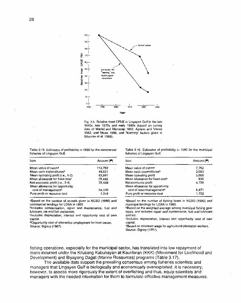
Year
Fig. 3.5. Relative trawl CPUE in Lingayen Gulf in the late 1940s, late 1970s and early 1980s (based on survey data of Warfel and Manacop 1950, Aprieto and Villoso 1982. and Mines 1986. and "learning" factors given in ~i lvestre et al. 1986).
Table 3.15. Estimates of profitability in 1980 for the commercial fisheries of Lingayen Gulf.
Table 3.16. Estimates of profitability in 1980 for the municipal fisheries of Lingayen Gulf.
Item Amount
Mean value of catcha 113,732 Mean cash expendituresb 49,851 Mean operating profit (i.e., 1-2) 63,881 Mean allowanoe for fixed costc 28.443 Net economic profit (i.e., 3-4) 35,438 Mean allowance for opportunity
cost of managementd 34,120 Pure profit or resource rent 1,318
aBased on the number of vessels given in NCSO (1980) and commercial landings for LGSA in 1980. blncludes compensation, repair and maintenance, fuel and lubricant, ice and fish containers. clncludes depreciation, interest and opportunity cost of own capital. dopportunity cost of alternative employment for boat owner. Source: Signey (1 987).
Item Amount (P)
Mean value of catcha 7,752 Mean cash expondituresb 2,083 Mean operating profit 5,669 Mean allowanm for fixed costc 930 Net economic profit 4,739 Mean allowance for opportunity
cost of labor/managementd 6,471 Pure profit or resource rent -1,732
aBased on the number of fishing boats in NCSO (1980) and municipal landings for LGSA in 1980. bBased on the weighted average among municipal fishing gear types, and includes repair and maintenance, fuel and lubricant and ice. clncludos depreciation, interest and opportunity cost of own capital. dBased on minimum wage for agricultural plantation workers. Source: Signey (1 987).
fishing operations, especially for the municipal sector, has translated into low repayment of loans incurred under the Kiluiang Kabuhayan at Kaunlaran (KKK) (Movement for Livelihood and Development) and Biyayang Dagat (Marine Resources) programs (Table 3.1 7).
The available data support the prevailing consensus among fisheries scientists and managers that Lingayen Gulf is biologically and economically overexploited. It is necessary, however, to assess more rigorously the extent of overfishing and thus, equip scientists and managers with the needed information for them to formulate effective management measures.

Table 3.17. Rates of loan repayment by fishermen in Region I, Philippines.
Credit program Period Loans Repayment (?) Repayment operational released (r) rate (%)
Biyayang Dagat 1979-1986 6,567,674 4,221,719 64 Kilusang Kabuhayan 1981-1986 14,929,155 0 0
at Kaunlaran
Source: Signey (1987).
Coastal Aquaculture
The brackishwater resources of Lingayen Gulf are made up largely of brackishwater fishponds. There are about 16,000 ha of fishponds (out of the country's total of 206,000) in Pangasinan and La Union (Fig. 3.6). Dannhaeuser (1986) reported that for the past 60 years, privately owned lands for mangrove, nipa and rice have been converted into fishponds by local traders, government employees, landlords and other medium-level entrepreneurs.
The average farm size in the eastern and central sectors of the gulf is about 1.9 ha. In Pangasinan, fishponds are concentrated in the municipalities of Binmaley and Lingayen and in Dagupan, where Agno River and its tributaries traverse (Table 3.1 8). Ponds are mostly nondrainable and consist either of nursery and grow-out ponds or of grow-out ponds only. There
-
are very few transition ponds.
N A
i n g o y e n G u l f
Lingayen
Brockishwoter flshpond
- DL11 Fig. 3.6. Distribution of fishponds in Pangasinan and La Union

Table 3.18. Distribution of privately owned brackishwater fish- ponds in Pangasinan.
Municipality No. of fishponds Total area (ha)
San Fabian 324 279 Mangaldan 71 157 Dagupan 2,693 5,830 Binmaley 3,721 3,728 Lingayen 2.337 1,729 Labrador 138 153 Sual 6 1 112 Alaminos 305 1,200 Bani 205 1,328 Anda 137 881 Bolinao 50 55
Source: Statistics from the Tax Mapping Unit, Pangasinan Mu- nicipal Assessor's ORice (1 984).
Table 3.19. The 1988 prices per kilogram of pond-cultured fish at the Dagupan public market.
Species Producer's Wholesaler's Retailer's price (P) price (P) price (P )
1. Milkfish (Bani and Binmaley, etc.) 27.00 28.00 30.00 Milkfish (Bonuan) 33.00 34.00 36.00
2. Shrimps (red, big) 81 .OO 83.00 94.00 Shrimps (white, big) 97.00 100.00 108.00
3. Black tiger shrimp or sugpo (big) 238.00 243 00 249.00 Black tiger shrimp or sugpo (small) 218.00 224.00 228.00
4. Siganid (big) 64.00 66.00 70.00 Siganid (small) 55.00 57.00 60.00
5. Tilapia 20.00 22.00 25.00
Source: BFAR statistics.
Milkfish monoculture predominates, using lablab (microbenthic complex of algae, zoo- plankton, detritus, etc.), lumut (filamentous green algae) and lumut-lablab as natural food base. Polyculture of such species combinations as milkfish-siganid, shrimp-milkfish and milkfish- shrimp-siganid is practiced by a few farmers in Binmaley. Management of the ponds is extensive and borne out of traditional practices. The usual farm inputs are fertilizers and pesticides. Chicken manure, urea and 16-20-0 are most commonly used for fertilizer, and Brestan, Aquatin and Gusathion for pesticide. Pesticide users greatly outnumber fertilizer users. Liming is never practiced, and artificial and supplemental feeds are seldom used. A regular culture period is from 1.5 to 3 months. The average number of croppings is three per year. Milkfish production there is one of the highest in the country, exceeding 1,000 kglhalyear (BFAR 1985d). Harvests are either marketed locally or sold to concessionaires, who bring the fish to Manila and other urban markets. Table 3.19 compares the 1988 prices of various pond-cultured -
fish species in the local market. Mangroves and nipa swamplands cover 520 ha in Pangasinan. Of the tidal flats and
estuaries, about 2,200 ha are in Pangasinan and 720 ha are in La Union (BFAR 1985~; 1985d). The swamps are ideal for fish breeding, nursery grounds and shelter and are potential sites for mariculture. Some portions are presently used for oyster culture and fishcage culture.
An aggregate area of 40 ha is covered by oyster beds, divided among 60 operators (BFAR 1985d) and concentrated along the Dagupan-Binmaley area. Some 1,940 ha are still available for development. Oyster farms are small, the average size being 100 m2. Hanging or

bitin is the most common method of oyster culture. One culture period is about 4 months long. Estimated annual (culture) production from oyster farms is 1,760 t; part of this goes to the local market and some part goes to concessionaires.
The cage culture of marine fish is only a recent practice in Pangasinan. The first marine cages were installed by BFAR's Lucap Marine Station under the National Bangus (Milkfish) Breeding Program. Circular cages were used for the maturation of milkfish. In Binmaley, Dagu- pan and Sual, commercial fishcages have been put up for grouper, snapper and siganid. Cages are either the floating or fixed type. Nursery cages measure 1 m x 0.5 rn x 1 m and grow-out cages measure 2 m x 2 m x 1 m. The battery of cages is attached to a wooden frame which serves as catwalk and working area.
A modular-type of management is employed, with size grading every 15-30 days. Trash fish is used as feed for snapper and grouper, and algae for siganid. Groupers are marketed locally though an export market exists for both live 750-grammers and fingerlings.
Water quality is an 'important factor affecting the growth and survival of aquatic organ- isms. It must always be maintained within the optimum range by frequent water exchange between the culture system and the water source. Sources of water must therefore be free of pollutants. However, they are often contaminated by domestic and industrial waste.
The fishponds themselves may be a source of pollution. They discharge effluent into the very same river from which they draw water. Indiscriminate use of pesticides (to eliminate predators) results in the accumulation of metal-based residues and use of fertilizers increases the nutrient load of the river.
Other sources of water pollution are domestic and industrial waste from the vicinity of the1 ponds. Serious contamination of the Dagupan-Binmaley river system with domestic waste has resulted in a very high coliform load in locally cultured oysters. The industrial pollution of the Bayawas River, on the other hand, is killing the fishpond industry in its vicinity. On a larger scale, heavy deposits of mine tailings from upland mining contribute silt, sediment and trace metals into the gulf and surrounding agriculture and aquaculture farms. If not abated on time, pollution may render the cultured organisms unfit for human consumption.

Chapter 4 Pollution
MARY ANN LEAH L. MAALIW
Poll-ution in Lingayen Gulf is one of the major issues confronting resource planners in the region today. Pesticides and fertilizers for agriculture and aquaculture activities are increasingly discharged into the gulf. Denuded and eroding forest lands, sediment and tailings from mining explorations and operations in the Cordilleras exacerbate the siltation problem. Coliform bacte- ria from raw domestic waste and wastewater, toxic chemicals employed in fishing (especially in collecting aquarium fish) and oil contamination from marine vessels, municipal fishing boats and port activities contribute to the deterioration of the water quality of Lingayen Gulf. Marine pollu- tion in particular and environmental quality in general should be addressed to maintain the pro- ductivity of the gulf.
Marine Pollutants
Nutrients
The use of inorganic fertilizers and pesticides in coastal farmlands and the daily dis- charge of nutrients from fishponds greatly contribute to the increased nutrient loading in some portions of the gulf. Its five major river systems--Aringay and Bauang Rivers in La Union, and Patalan, Dagupan and Agno Rivers in Pangasinan--receive fishpond discharge and rice paddy flushings that eventually enter Lingayen Gulf. Stationary structures such as fishpens and fish corrals near river mouths in Sectors I and II also prevent the effective mixing of seawater which concentrate pollutants in these areas.
Heavy metals and silt (C
Mining activities in the Baguio Mining District and upland activities such as logging and the slash-and-burn method of agriculture have considerably eroded the slopes of the Cordillera Mountain Range. During the annual heavy rains in the Central Plain of Luzon, more than half of Pangasinan, particularly the lowland plain of the Agno River Basin, suffers from drainage prob- lems badly enough that it may be categorized as a flood-prone area with varying risk levels

(NACIAD 1981). Floods transport significant quantities of sediment from eroded land and carry with them mine tailings from overflowing banks of damaged tailings ponds and dams.
Extraction activities in the mines alter the physiography of the area and speed up ero- sion. Extraction procedures produce acidic by-products which may also contain toxic metals.
Mine tailings from the copper and gold mines are discharged into Agno and Bued Rivers. Bued River transports an average of 3,650 Wday of tailings from Black Mountain and Benguet Exploration (Lim and Guerrero 1985). The town of Bued itself becomes silted during the rainy season when accumulated tailings are flushed out from the tailings ponds (JICA 1978), thus, affecting farmlands along the floodplains of Agno and Bued (Lim and Guerrero 1985). lrrigation canals and paddy fields of the Agno River Basin are filled with sediment which are deposited as sandbars and mudflats along the banks and near the mouths of the Agno River. On an average, Agno River transports 28,000 Vday of tailings, which is assumed to come from Philex Mining Corporation; 3,150 tlday from Benguet Consolidated; 275 tlday from Itogon-Suyoc and 11 5 tlday from Atok-Big Wedge (Table 4.1) (Lim and Guerrero 1985). Amburayan River in the north, which drains the provinces of llocos Sur and La Union, carries toward Lingayen Gulf a total load of 17,500 t/day of tailings from the Sto. NiAo Mines and Western Mipolco (Rabanal and Datingaling 1986). Aringay, Bauang and Dagupan Rivers carry mainly erosional and agricultural runoffs (De las Alas 1986).
Table 4.1. Mine tailings produced in Baguio Mining District
Mines
Black Mountain Benguet Exploration Atok-Big Wedge Benguet Consolidated Itogon-Suyoc Philex Mining
Tailings produoed Per day (t)
2,700-3,5W 120-1 70 80-1 50
2,800-3,500 250-300
27,000-29.000
Tailings produced per year (t)
885,600-1,148,000 39.360-55,760 26,240-49,200
918,400-1,148,000 82,000-98,400
8,856J000-9,51 2,000
Drainage system
Bued River Bued River Agno River Agno River Agno River Agno River
Source: Modified from Lirn and Guerrero (1985).
Sediment content
The environmental impact assessment (EIA) study of the San Roque Multipurpose Pro- ject (TCI 1984) indicated a wide fluctuation in soluble heavy metal contents--copper (Cu), zinc (Zn), cadmium (Cd), lead (Pb) and arsenic (As)--from sediment taken at ten monitoring points in the Agno River lrrigation System (ARE) area (Table 4.2 and Fig. 4.1). Rates of Cu uptake by rice plants observed in the same paddy sites were found to vary seasonally, ranging from 23 to 95 ppm during the dry season and 9 to 49 ppm during the wet season (Table 4.3) (TCI 1984).
Stream sediment from Agno and Bued Rivers analyzed by Santos et al. (1 986) were found to contain high levels of trace elements, particularly Cu, Pb and Zn (Table 4.4). Mine waste could be the main cause of these relatively high levels of trace elements in the sediment. Mercury (Hg) concentration was not determined in the study, but Santos et al. (1 986) reported a range of 120-21 0 ppb Hg content of tailings from the Philex copper concentrates. Results of the total metal analyses of sediments in Bued and Patalan Rivers and in the research station in Lin- gayen Gulf indicated that the sediment accumulated high concentrations of Cu and Zn, followed by Pb, Cd and Hg (Table 4.5) (De la Rosa et al. 1980).
Heavy metal content analysis of the Agno River and its sediments in 1981 (Table 4.6) indicated that it contains significant amounts of Cu, Zn, Pb and Hg (NACIAD 1 981). Indigenous fish species like carp, tilapia and milkfish could be contaminated with these toxic metals (Table

Table 4.2. Ranges of soluble heavy metal contents of paddy soils at inlet portion of or settling basin in paddy fields of ARIS. (See Fig. 4.1 for location of monitoring points).
- . .-
Location No. of Metal content (pprn) samples Cu Pb Zn Cd As
Along main canal 22 Maximum 287.4 13.2 36.6 0.5 22.3 Minimum 23.1 1.3 3.4 <O. 1 0.9
Along laterals A to E 84 Maximum 352.2 6.6 42.6 0.5 92.0 Minimum 6.7 ~ 0 . 3 0.9 <O. 1 0.3
Along lateral F 36 Maximum 281.4 9.0 31.9 0.6 8.4 Minimum 6.6 e0.3 2.2 <O. I 0.3
Along laterals G to K 48 Maximum 285.5 4.7 32.8 0.2 7.6 Minimum 0.1 s0.3 <O. 1 <O. 1 0.6
Along laterals L and M 50 Maximum 156.7 8.3 27.8 0.4 9.6 Minimum 0.7 1 .O 0.5 c0. 1 0.5
Source: Modified from TCI (1984).
Fig. 4.1. Location of monitoring points for water quality of the Agno River Irrigation System (ARIS).

Table 4.3. Copper concentration (ppm) in leaves of rice plants in ARIS. (See Fig. 4.1. for location of monitoring points).
ARIS no. Planting Copper cmoentration (ppm) season Plot I Plot ll Plot Ill Plot IV
- -
2 Dry 75.5 33.8 35.8 23.3 Wet 49.4 10.8 12.1 13.9
4 Dry 26.5 94.8 26.0 17.5 Wet 28.7 27.5 48.8 17.8
6 Wet 36.4 19.5 10.9 8.6 8 Wet 36.6 32.6 26.1 ND
12 Wet 9.6 9.8 10.8 17.2
ND - Not determined. Source: Modified from TCI (1984).
Table 4.4. Trace element content of stream sediment in tailings-affected rivers, Agno and Bued, in Pangasinan.
Trace element content (ppm) Map and sample no. Cu Pb Zn Mn Co Ni
Agno River 3067 - 8-0
10-0 127-0 128-0
3167 - 1-0 lO2O 103-0 104-0 101-0
6-0 7-0 8-0
Bued River 3068 - 1-0
9-0 13-0
3168- 5 0
Source: Modified from Santos et al. (1 986)
Table 4.5. Metal ccrncenbation of sediments from moniton'ng points along Table 4.6. Concentration of toxic metals in the Agno River Basin. Bued River, Patalan River and Lingayen Gulf, Pangasinan.
Concentralion (ppm) Metal concentration (ppb) Metals Upper Agno ARlS Intake Sediments in ARlS
Station no. Hg Pb Cu Zn Cd River canals and fields
1 0.035 36.50 178.00 2 0.074 35.25 152.81 3 0.048 25.25 126.50 4 0.314 29.00 11 1.62 5 0.078 30.35 126.44 6 0.101 35.85 180.00
NO - Not determined. Source: Modified from De la Rosa et al. (1980).
0.90-3.10 MI-8.90
0.03-0.08 0.O9-O. 13 bdl-0.01
bdl bdl-0.90
bdl bdl
aHg concentration (ppb). bdl - Below detectable limit. ND - Not determined. Source: Modified horn NACIAD (1981).

4.6). Gulf waters near the estuarine portion of Agno River were found to contain noxious metals like Hg and Cd at levels exceeding the NPCC and Japanese standards (Table 4.7)
A study using oceanographic models predicted that the levels of Pb and Cu as well as Cd and Zn in the gulf would be less than the limits prescribed by NPCC (De las Alas 1986). Nevertheless, the study showed that a certain section of the gulf would be affected, namely, the southern part bounded by Sto. Tomas and Labrador, where Agno and Bued Rivers are located. Metals could therefore enter the food chain and undergo biological magnification.
Table 4.7. Concentration of noxious metals in Lingayen Gulf.
Concentration (pprn) NPCC standards NPCC standards Japanese
Metals Lingayen Gulf (fishja (waterlb standards (waterlb
aMaximurn allowable concentration for fish. b~uidelines for acceptable water quality. Source: Modified from Italian Electroconsult et al, (1979) in TCI (1984).
Chemicals in fishing activities
The use of cyanide, a toxic chemical in catching aquayium fish, threatens fish nurseries and habitats (Rubec 1986). At the same time, it poses a definite hazard to its users through inhalation, ingestion and skin contact. Cyanide fishing is specifically rampant in the coral reefs of Sector I. Some concerned groups in the area have introduced and are promoting the use of nets, but the local people have not been receptive to the idea because nets require greater fishing effort.
Coliform bacterla
The presence of coliform bacteria in the water indicates fecal contamination. The absence of a sewage treatment system in major urban centers and the inadequate toilet facili- ties in some areas have contributed to the high coliform levels in some localities. Coliform counts above normal levels in the gulf, especially in aquaculture and tourism areas, may create serious economic consequences.
Action Plans and Mitigating Measures
To minimize, if not prevent, pollution and siltation, the measures suggested are as fol- lows: properly manage tailings dams; strictly enforce rules and regulations on mining operations; promote the use of organic fertilizers; regulate the use of biodegradable pesticides; encourage forest conservation and reforestation of denuded areas; treat industrial residues; implement proper sewage disposal; and enforce rules to prevent the incidence of oil spills from motorized vessels.

Government agencies can play a major role in developing and implementing action plans to mitigate the impact of coastal water pollution and thus prevent further degradation of the marine and coastal environments. The relevant government agencies are the Environmental Management Bureau.(EMB) and the regional offices of the Department of Environment and Natural Resources (DENR). Other agencies which could assist in providing valuable information in environmental characterization and assessment are the Bureau of Mines and Geo-Sciences (BMG), the National Mapping Research and Information Authority (NAMRIA) and the National Operations Center for Oil Pollution.

Chapter 5 Population and Socioeconomics
LIANA T. MCMANUS AND REBECCA A. RIVERA
Demography
The municipalities surrounding Lingayen Gulf have a total population of 799,000, of which 40% lives in coastal villages (Table 5.1). About 11 6,000 or 15% of this population is directly dependent on fishing. With a total land area of 1,670 km2, density is 480 persons/km2 assuming even distribution. Sector II has the highest density at 900/km2, largely because it is the major aquaculture center of the region, particularly Dagupan and the municipality of Binma- ley. Sector I has the lowest population density at 230/km2. Figures are even higher for coastal fishing villages. Sector II is the most dense at 2,00O/km*. Density in Sector Ill is 1,2001km2. Only the fishing villages of Sector I are not thickly populated at 2901km2. Thus, of the land area sur- rounding the gulf, the most densely populated portions are the coastal villages where most of the fishermen reside.
Rates of population increase in Sectors I and II over a three-year period (1 985-1 988) were almost equal at 2.7 and 2.6% per annum, respectively (Table 5.2). Sector Ill, the most urbanized sector, had the highest rate of increase, 4.2%. San Fernando, the capital of Region I (the Philippines is divided into 13 regions), is part of this sector. On the whole, population around the gulf increased at a yearly rate of 3.2%. Coastal barangay populations, however, increased at even higher rates, or 3-5 times those of the municipal figures. The average annual increase in coastal villages inhabited mostly by artisanal or small-scale fishermen is 12% from 1985 to 1988.
Table 5.1. Population, area and population density for municipalities and coastal villages around Lingayen Gulf.
Population, area and Sector population density I I I 1 1 1 All sectors
Population: Municipalities 181,220 312,100 305,630 798,950 Coastal villages 87,950 138,310 93,320 319,590 % in coastal villages 48 44 30 40
Area (km2): Municipalities 776 346 546 1,668 Coastal villages 30 2 72 78 453
Density (personslkm2): Municipalities 234 902 560 479 Coastal villages 29 1 1,908 1,196 706
Source: 1988 Municipal Census.
38

Table 5.2. Population growth rates for the period 1985-1988 in municipalities and coastal villages of Lingayen Gulf.
Area Sector
I I I Ill All sectors
Municipalities 2.7 2.6 4.2 3.2 Coastal villages 9.2 13.3 13.3 12.1
Sources: BFAR (1985b); 1988 Municipal Census.
Table 5.3. Average family size and population distribution for the three sec- tors of Lingayen Gulf.
Family size and Sector population distribution I I I Ill All sectors
Number of householdsa 32,000 50,000 48,000 130,000 No. of fishing householdsa 7,500 6,000 6,200 19,700 Average family sizeb (National average: 5.6) 5.7 6.3 6.4 6.1 % rural population 84 62 6 76 % urban populationb 16 38 82 24
Municipal Census. b ~ ~ S ~ (1985).
The number of households currently total about 130,000 for the 17 gulf municipalities, 50,000 of which are in Sector 11,48,000 in Sector Ill and 32,000 in Sector I (Table 5.3). Those which are dependent on fishing as a full- or part-time occupation number 19,700 (7,500 in Sec- tor 1; 6,000 in Sector II; and 6,200 in Sector Ill). The average family site was estimated using 1985 figures. Sector Ill had the highest at 6.4 persons per family, followed by Sector II at 6.3, and then Sector I at 5.7. These all exceeded the national average of 5.6 persons per family (RDC 1986). The populations of Sector 1 (84%) and Sector 11 (62%) were concentrated in rural areas. In contrast, only 6% of the population of Sector Ill lived in rural areas.
The migration pattern among gulf nlunicipalities indicates an insignificant decrease in population due to outmigration. For the period 1975-1 980, the net migration loss for Pangasinan was 1.8 migrants per thousand against a net migration gain of 0.7 migrants per thousand for La Union. The net migration rate for the whole region is 0.2% (RDC 1986). Among fishing villages, Ferrer et al. (1 985) found that many fishermen have been residing in their communities since birth. The majority have been living in the same houses and have never moved out, and more than a quarter have resided in the area for more than 5 years. Thus, outmigration among fishing families practically does not occur and this contributes to increasing pressure on coastal resources.
Language and education
Iloko, the dominant dialect, is spoken in 53% of the households in all sectors (NCSO 1985) (Table 5.4). Pangasinense is used by 39%; Zambal (Bolinao), 5%; and Tagalog, 2%. In Sectors I and II, lloko is the major dialect. Zambal is used by 20% of the population in Sector I, particularly in the municipalities of Bolinao and Anda. In Sector II, almost all or 92% speak Pan- gasinense. Other languages and dialects spoken in the gulf municipalities include Chinese, Ka- pampangan, Bontoc, Kankanai, Inibaloi, Cebuano, Waray, llonggo and Bicolano.

Table 5.4. Dialects spoken in municipalities around Lingaycn Gulf and percentage of population speaking them.
Dialects Sector I I I Ill All sectors
lloko 70 6 93 53 Pangasinense 8 92 4 39 Zarnbal (Bolinao) 20 0 0 5 Tagalog 2 2 3 2 Others 0 0 1 0
Source: NCSO (1985).
The literacy rate for all sectors is 88%. In Pangasinan, which covers Sectors I and II, there are 1,035 elementary schools, 297 high schools and 21 universities and colleges (numbers include both public and private institutions) (RDC 1986). In La Union (Sector Ill), there are 31 9 elementary schools, 78 secondary schools and 10 universities and colleges.
Among the coastal inhabitants of the gulf, 61% finished elementary education and 28% graduated from high school (Ferrer et al. 1988). Tertiary education is economically inaccessible to them. This explains the limited occupational mobility among coastal people in the area, espe- cially the fishermen.
Employment
Employment by major occupation group follows parallel trends in Pangasinan and La Union (NCSO 1985) (Table 5.5). The major occupation group is that of the agricultural-animal husbandry-forestry-fishery sector which is 56% of the labor force in Pangasinan and 41% of that in La Union. Production-related, transport equipment operators and laborers make up 21% in Pangasinan and 24% in La Union. In La Union, however, the third major group is that of the professional and technical workers, making up 13% of employed manpower. In Pangasinan, this group makes up only 5%.
Among coastal inhabitants, 50% are fishermen, 20% are farmers and the rest have an assortment of jobs (Ferrer et al. 1988) (Table 5.6). ~khe rmen make up 40% of the labor pool in Sector 1, 54% of that in Sector II and 71% of that in Sector Ill.
Table 5.5. Employment by major occupation group in'pangasinan and La Union, January-March 1985.
Pangasinan La Union Occupation group No. % No. %
Professional, technical workers Administrative, executive and
managerial workers Clerical workers Salesworkers Agricultural, animal husbandry and
forestry workers; fishermen Production-related workers; transport
equipment operators and laborers Service workers Workers not classified by operation
Total 460,600 100.0 130,400 99.8
Source: NCSO (1985).

Table 5.6. Occupations of coastal inhabitants of Lingayen Gulf and percentage of population engaged in them.
-
Sector Occupation I I I Ill All sectors
Fishermen 40 54 71 50 Fishing-related ND 8 11 N D Farming 53 ND N 13 20 Other occupations 14 9 10 18
ND - Not determined. Source: Ferrer et al. (1988).
lncome
The average monthly family income in Pangasinan in 1985 was P2,530 and in La Union, $3,220 (NCSO 1985) (Table 5.7). Monthly family expenditures averaged P2,060 in Pangasinan and 82,720 in La Union. In both provinces, 50% of expenses were for food, 10% for housing, and 5 - 6 s for education, medical care and dental care.
Small-scale fishermen in the three sectors had even lower average income (Afionuevo 1989) (Table 5.8). Earnings from fishing in Sector I averaged t470 per month; in Sector II, $430; and in Sector Ill, f 690. In contrast, household expenditures were more than twice the income derived from fishing. Sector I averaged f 1,340 monthly; Sector 11,81,260; and Sector 111 , f 1,170. Not considering the purchasing power of the peso nor poverty thresholds, one can still quickly note that fishing cannot support the minimum financial needs of a family for survival. In fact, income from fishing can hardly meet the food requirements of a family.
Table 5.7. Average monthly income and disbursements (f) of families living around Lingayen Gulf.
Income and expenses Pangasinan La Union
Average monthly income per family 2,534 3,219 Average monthly expenses per family 2,056 2,720 % breakdown:
Food 47 50 Housing 10 10 Education, medical and dental care 5 6 Household operations 2 2 Utilities 4 4
Source: NCSO (1985).
Table 5.8. Monthly income from fishing and family expenses (?) of small-scale fishermen of Lingayen Gulf.
Sector Income and expenses I II Ill All sectors
Income from fishing 470 430 690 530 Family expenses 1,340 1,260 1,170 1,290 % breakdown:
Food 49 50 70 52 Education and medicine 15 16 12 15 Utilities 3 8 3 6
Source: Aiionuevo (1989),

Health and nutrition
The health status of people in Pangasinan and La Union has improved based on tradi- tionally used health indices. For all of Region I (the two provinces included), crude death rate decreased from 10 to 9 deaths per thousand, while life expectancy increased from 63 to 64.5 years-for the period 1980-1 985 (RDC 1986). However, serious problems such as poor health facilities and declining doctor/nurse-to-population ratio in Region I remain unsolved. Doctor-to- population ratio decreased from 1 :4,260 in 1980 to 1 :7,460 in 1985; for nurses, from 1 :3,280 to 1 :5,150 in 1985. Although malnutrition still plagues a significant number of preschool and schoolchildren, figures have changed favorably over the five-year period in Region I. Among preschoolers, the rate of severely and moderately underweight children decreased from 7 to 3%. Among schoolchildren, malnourished individuals made up 42% in 1980, which decreased to 17% in 1985.
Statistics from the Provincial Health Office shows that the number of malnourished chil- dren in the two gulf provinces remains high. In Pangasinan, 77% or 89,400 children of ages 0-6 years suffer from malnutrition. In La Union, approximately 64% or 48,500 children show signs of deficient nourishment. Thus, while fish may be a possible source of protein, it is not necessarily an accessible one to the poor families of the gulf area.
Housing
About 90% of the families own houses but only 60% own residential land (Ferrer et al. 1988). Dwelling units are commonly made of dried nipa palm leaves, wood and bamboo. In Sector II, where aquaculture farms are concentrated, bamboo-nipa, wood and concrete houses are in equal proportions (Ferrer et al. 1985).
Building houses on public land, especially those adjacent to coastal waters, is common and explains in part why coastal areas are crowded. In Sector I, only 54% own residential lots; in Sector 11, 72%; and in Sector 111, 85%.
Electricity and water
Power is available to only 45% of houses in the coastal municipalities around Lingayen Gulf (NCSO 1980). These are mostly found in Sectors II and Ill. Kerosene is used for lighting fuel in about 52% of dwelling units, 74% of which are found in Sector I.
In Pangasinan, power requirements are provided mainly through three electric coopera- tives: the Pangasinan Electric Cooperatives, Inc. I and II in Bani and Urdaneta, respectively, and the Central Pangasinan Electric Cooperative in San Carlos City (NEDA 1985b). In La Union, electricity is provided by the La Union Electric Cooperative (NEDA 1985a).
Statistics from the Ministry of Health-Region I shows that about 90% of the population in Pangasinan and 87% of that in La Union is suppli~ed with potable water. Water supply sources include artesian wells and springs, small communal water systems and waterworks systems. There are 115,920 and 19,520 potable water supply sources in Pangasinan and La Union, respectively. Data on the distribution of basic services such as water and electricity between the inland and coastal municipalities are not available.
Transportation and cornmunicatlon
Land vehicles in Pangasinan and in La Union include buses, jeepneys, tricycles, taxis, animal-drawn vehicles and trucks for hire (NACIAD 1981). In the coastal communities, the most

common means are jeepneys, tricycles, buses, trucks for hire and animal-drawn carts (Ferrer et al. 1 985).
Air transport is minimal. There is a nonoperational feeder airport in Sector II (Lingayen, Pangasinan), but it has no ground control facilities. In Sector Ill, there is a secondary airport (San Fernando, La Union), but none in Sector 1.
Transport by boat is used whenever possible in all sectors. Conservative estimates of the number of motorized and nonmotorized boats by BFAR (1985b) indicate about 60% of existing watercraft are motorized and mostly found in Sector Ill. On the average, 40% are non- motorized, concentrated in Sector I.
Communication services in Pangasinan and La Union, in general, are inadequate. Tele- graph station-to-population ratios are below the regional average (1 :26,550) at 1 :33,690 for Pangasinan and 1 :26,753 for La Union. Similarly, post office-to-population ratios are far lower than that for the region (1 :I 8,320). In Pangasinan, there is one post office for 34,420 people; in La Union, one for 20,700 persons.

Chapter 6 Institutional and Legal Framework
B. NORMAN V. KALAGAYAN
An institutional framework is defined as the composite of laws, customs, organizations and management strategies of a society to allocate scarce resources and competing values for a social purpose, such as the management of a nation's coastal resources and environment (Sorensen et al. 1984). Such a definition has a wide coverage; this chapter shall be limited to laws, government agencies and government programs relevant to coastal zone management. Customs, private organizations and sociocultural influences also contribute directly to a man- agement scheme (and this is not overlooked in the study), but it is the government which receives and processes these societal forces into legally implementable and enforceable policy outputs. Hence, the focus is on the government and its issuances.
Indigenous Rudiments of Coastal Zone Law
The Philippines is an archipelago with more than 34,400 km of coastline, a great extent of mountainous areas and narrow and interrupted coastal plains. These geographic features contributed to the shaping of economic, social, cultural and institutional structures of its precon- quest settlements. Since most of these settlements were located near the seas or rivers, fishing became one of the major food-producing activities. The isolation of the islands and the inacces- sibility of settlements due to rugged terrains contributed to the diversification of languages, the development of parochial practices and the evolution of the barangay into scattered, highly clannish and independent political units.
In this context, the development of a norm of conduct evolved not only around interper- sonal relations but also around the main sources of livelihood such as farming and fishing. According to an early Spanish chronicle about the Tagalogs: "The chiefs in some villages had fisheries, with established limits and sections of the rivers for markets. At these, no one could fish, nor trade in the markets without paying for the privilege, unless he belongs to the chief's barangay or village" (Placencia 1958, cited in Lopez 1985). Fishing grounds could be bartered in the same manner as fields, houses, slaves, livestock and crops could (Antonio de Morga 1609, cited in Lopez 1985).
Very little record on preconquest laws and norms on fisheries exists. One possible explanation is the general lag in the development of preconquest custom laws on property and contracts. There was an abundance of natural resources to meet the needs of the villagers. Extensive tracts of land were available. The fishing grounds along the coasts were open to all.

The necessities of life could be had with comparable ease throughout the year so that there was little compulsion to produce and store surplus (Fernandez 1976). Also, the subsistence eco- nomic organization of the village produced little surplus, making exchange only a subsidiary goal for acquisition (Fernandez 1979). Another explanation for the scanty record on fisheries laws and norms--Spanish conquerors destroyed all traces of indigenous practices and written records.
Whatever was the state of indigenous laws at the time of the arrival of the Spaniards in the Philippines in the 1 890s, these laws were gradually eclipsed by Spanish colonial law. The independent barangay were consolidated, and with this, the territorial fishing rights claimed by each village disappeared (Lopez 1985). This rights system was replaced by the universal feudal theory that all lands (and natural resources) were held for the Crown [CariAo vs. Insular Gov- ernment 212 US 449 (1909)]. This theory, also known as jura regalia or regalian doctrine, was adopted by the 1935 Constitution of the Philippines with the modification that ownership is vested in the state rather than the head of government. The Philippines still adheres to this theory.
All lands of the public domain, waters, minerals, coal, petroleum, and other mineral oils, all forces of potential energy, fisheries, forests or timber, wildlife, flora and fauna, and other natural resources are owned by the State. With the exception of agricultural lands, all other natural resources shall not be alienated. The exploitation, development, and utilization of natural resources shall be under the full control and supervision of the State. The State may directly undertake such activities or it may enter into co-production, joint venture, or pro- duction sharing agreements with Filipino citizens, or corporation or association at least sixty per centurn of whose capital is owned by such citizens ... (1 987 Con- stitution, Sec. 2, Art. XII)
As owner, the state, through the government, could regulate the acquisition, disposition, use and exploitation of the natural resources. The state has the right to promulgate and enforce laws to achieve these goals.
While this is the "official" law, indigenous legal systems found in traditions and practices still regulate the lives of millions of Filipinos, including farmers and fishermen (Lynch 1983). Though not extensively found and described in books, indigenous legal systems have existed through generations and have become instrumental in the development of self-reliant, equitable, ecologically stable and well-adapted systems. But Philippine law, including that on natural resources, has been a process of continuous marginalization of indigenous law by the hybrid Spanish-North American system (Lynch 1983). To reverse this process, policymakers should start to appreciate grassroots law and incorporate it into the mainstream of Philippine law.
The appreciation of indigenous law does not mean the transplanting of static, over- romanticized indigenous cultures as they are unearthed from their preconquest graves. Tradi- tions and norms, as handed down from generation to generation, were also transformed in varying degrees by colonial and noncolonial influences. Nevertheless, they did not die. A sound policy approach, therefore, is to determine the interface between the "official" law and indige- nous law for mutually beneficial accommodation between them and to apply it to the peculiar cultural context (Lynch 1983). In the context of the Lingayen Gulf Coastal Resources Manage- ment (CRM) plan, indigenous law must be considered to allow the people most affected by it to participate and be involved in it.
The Present State of Philippine Coastal Zone Law
In general, the Philippine law on natural resources, which includes the coastal zone, has two dominant features. The first is state ownership, which is a colonial heirloom. The second is

that "only citizens of the Philippines and associations or corporations at least 60°A of the capital of which is owned or controlled by citizens of the Philippines may engage in any business activ- ity related to the fishing industry" (PD 43). The latter is a safeguard used by most developing countries to prevent foreign control of their natural resources.
To determine the specific laws that govern the coastal zone, there is a need to define its boundaries. In the absence of any law providing for a definition, this profile adopted the coastal zone definition of NEPC (see Chapter 1).
An examination of laws and their earlier implementation would reveal their traditional "use orientation". While these laws also provide for conservation measures, they are essentially concerned mainly with disposition, use and exploitation. But recent developments in population growth, resource extraction and diminution, and environmental degradation shifted policy orien- tation to resources management. For principally agricultural societies like the Philippines, poverty and environmental degradation are but two manifestations of the same phenomenon: the unplanned, unmanaged impact of growing populations on a fragile natural resource base the productivity of which is measurably diminished in this lifetime (USAID 1979, cited in Sorensen et al. 1984). NEPC's definition of the coastal zone is an initial government step toward a holistic coastal zone management program in the country.
Management, in the general sense, means a deliberate, self-conscious effort to direct or control conditions and actions. Coastal zone management refers to an integrated management of two or more coastal sectors in a definite region or zone. It is typically concerned with resolv- ing conflicts among many coastal uses and determining the most appropriate use of coastal re- sources (Sorensen et al. 1984).
Because of the vast array of resources and subjects covered in the coastal zone, some 50 government institutions are directly or indirectly involved in coastal zone research or rnan- agement (Tolentino 1983). But none has a direct responsibility for management as a whole, resulting in overlaps in effort and conflicts in jurisdiction. To address this need, NEPC was cre- ated with a mandate to pave the way for a rational, integrated and unified planning, manage- ment and program on the coastal zone.
The first attempt to coordinate coastal zone management started in 1977, when the Philippine President then directed NEPC, through Letter of Instruction (LOI) 549, to organize and coordinate an interagency task force that will conduct research on valuable ecosystems such as the coastal zone. Pursuant to this directive, an eight-member Coastal Zone Manage- ment Committee (CZMC) was formed. With the help of an interagency Legal Committee and an interdisciplinary group of scientific experts, a definition of the Philippine coastal zone was developed.
In 1979, a CZMC composed of 22 government agencies was formed by means of a Memorandum of Agreement (MOA) among member-agencies to coordinate all activities on coastal zone management and to enforce all policies and guidelines referred to it.
Laws on conservation and management have recently evolved. Examples of these are the Philippine Environmental Policy, the different antipollution decrees and the law requiring EIS and environmental impact assessments (EIA) for new industries. Also, the different conservation provisions found in the different "resource oriented" laws were harnessed and tapped. NEPC, which merged with NPCC in 1987 and is now known as the Environmental Management Bureau (EMB), is compiling these laws as tools for environmental management programs.
While the Philippines has one of the most comprehensive coastal zone management laws in Asia, government officials complain that "the big problem would still be the implementa- tion" (Medrano 1980). Joya (1 987) identified the problems in conservation and law enforcement and categorized them into socioeconomic, political and cultural andlor institutional problems. Of these, the most serious are the institutional problems. In the law enforcement agencies, there is either lack of personnel and equipment or rampant graft and corruption (Joya 1987). There is also a lack of coordination among fisheries law enforcement personnel, aggravated by the

absence of standardized procedures for clear delineation of duties and responsibilities in anti- illegal fishing operations.
In the judiciary, the conviction rate of prosecuted violators is dismally low. At present, the successful conviction rate vis-a-vis the number of apprehended violators charged in court is less than 1% (Joya 1987).
While many government agencies are directly or indirectly involved in coastal zone man- agement, not all are granted the power and authority to implement laws. EMB and NAMRIA are purely research and policy-formulating bodies. NAMRIA is composed of merged government institutions: Natural Resources Management Center (NRMC), Bureau of Coasts and Geodetic Survey, National Cartography Authority and BFD Land Classification. Others exercise both policy-formulating and regulating functions.
Among the government agencies vested with the power to implement laws are: (1) BFAR, by virtue of PD 43 and PD 704 (Its power was substantially reduced under Executive Order (EO) 11 6, but as of this writing, no implementing law has yet been issued, and the bureau still continues its functions as enumerated in PD 704 and its enabling law.); (2) Philippine Coast Guard, by virtue of its enabling law, Republic Act (RA) 5173, as amended by PD 601; and (3) Philippine Tourism Authority (PTA), by virtue of PD 189, as amended by PD 564.
To complement these agencies in alleviating the problem of enforcement, PD 1 160 was passed deputizing the barangay chairmen as peace officers, with the authority to arrest violators for purposes of enforcing and implementing national and local laws, ordinances, rules and reg- ulations on pollution control and other activities which create ecological imbalances or distur- bances.
Related to this is LO1 1328, which deputizes mayors and barangay chairmen in all provinces to strictly implement the prohibition against trawl and purse seine operations within 7 km from the shoreline of the provinces. LO1 550 instructs the Department of Natural Resources (DNR) [now the Department of Environment and Natural Resources (DENR)] to coordinate with the Department of Local Government and Community Development (DLGCD) in training barangay officials to become deputy fish wardens andlor deputy forest officers. Whether these officials can transcend the cultural ties within which they are fully enmeshed, in implementing these laws, is a question that is best answered in the field.
The shift in policy orientation did not abrogate the "use-oriented" laws affecting the coastal zone. After all, natural resources are the substructure of Philippine economic develop- ment and their use is a primary concern recognized in the Constitution. At most, the shift to "resources management" policy merely tempered the tendency to overexploit.
Disposition and Management of Fisherles
Nattonal and state policies
Unlike agricultural lands of the public domain, the right and/or access to fishing grounds can not be subjected to alienation. But this right may be granted by way of license, concession or lease, in which case beneficial use is the measure and hmit of the grant (Sec. 2, Art. XII, 1987 Constitution).
The principal laws that regulate the management and disposition of Philippine fisheries are PD 704 and PD 43 which provides for the accelerated development of the fisheries industry, and portions of Act 4003 which have not been amended by PD 704.

Sec. 1. 2.
2 of PD 704 declares the following fisheries policies: Accelerate and promote the integrated development of the fisheries industry. Keep the fisheries resources in optimum productive condition through proper conservation and protection.
3. Assist private organizations engaged in the fishing industry to make it a preferred area of investment.
Bureau of Fisheries and Aquatic Resources
BFAR exercises jurisdiction and assumes responsibility over all fisheries and aquatic resources of the country, except municipal fisheries which remain under the city or municipal government concerned. Fishpens and seaweed culture in municipal waters, however, are placed under the bureau's jurisdiction.
BFAR was formerly under DNR. Thus, many of the existing fisheries regulations enforced by BFAR are DNR Administrative Orders (AO). On 30 January 1987, the President issued EO 1 16 which relegated BFAR to the food production group under the Department of Agriculture (DA), among others. Under this EO, BF,AR shall only formulate plans; undertake studies; render technical assistance and advisory services; and recommend plans, programs, policies, rules and regulations to the DA Secretary. In effect, BFAR's administrative, regulatory and enforcement functions were abrogated. Also, the regional offices of BFAR were transferred to the DA regional office (per A 0 15, which converted the ministries into departments and changed the titles of key positions thereof).
Initial reactions to EO 116 have not been favorable. About 130 delegates from the gov- ernment and private sectors who participated in the National Conference on Fisheries Policy and Planning held in Baguio City in 1986 passed a resolution requesting the repeal of EO 1 16 insofar as BFAR is concerned, and the creation of a Department of Fisheries. As of 1988, though, no implementing law has yet been issued and BFAR continues to exercise its functions under PD 704.
Classifications of fisheries
For purposes of administration and disposition, Philippine fisheries are classified into three categories: national, municipal and reserve fisheries.
National Fisheries. Under these are the: (1) deepsea or offshore fisheries, (2) marine mollusk fisheries, (3) sponge fisheries, (4) marine turtle fisheries, and (5) inland fisheries.
At present the exploitation of marine turtles, turtle eggs and their by-products is prohib- ited by DNR A 0 12. Prior to the effectivity of PD 704 in 1972, public lands could be disposed of by fishpond sales patent, provided applications covered a fully developed fishpond not exceed- ing 24 ha. With PD 704, however, public lands could only be disposed of by lease agreement.
Priorities in the granting of suitable public lands to be subdivided into family-size fish- '
ponds should be in the following order, as prescribed by PD 43: 1. landless and poor families living in the vicinity, towns and provinces where the
fishponds are located; 2. qualified graduates of fisheries schools; and 3. landless veterans.
In the above categories, those with at least one-year experience in fishpond operation are preferred.

Municipal Fisheries. The jurisdiction of municipalities covers only areas in municipal waters. These waters include not only streams, lakes and tidal waters in the municipality not pri- vately owned (note that according to the Water Code, PD 1067, Art. 5 and 6, all waters belong to the state), and not within national parks, public forests, timberland, forest reserves or fisheries reserves, but also waters included between two lines drawn perpendicular to the point where the boundary line of the municipality touches the sea at low tide and a third line parallel to the gen- eral coastline at 3 nautical miles seaward. Municipal councils may pass resolutions and ordi- nances affecting this territory. However, these resolutions and ordinances shall be submitted to the DA Secretary for appropriate action and shall have full force and effect only upon his approval. BFAR shall also have the authority to regulate the production, capture and gathering of fisheries products.
Municipalities have the authority to grant to the highest qualified bidder the exclusive privilege of constructing and operating fish corrals and oyster culture beds, or of gathering fish fry in municipal waters, provided that one-fifth of the area earmarked for the gathering of fry shall be set aside as a government reserve. They can also authorize the issuance of licenses to qual- ified persons for the operation of fishing boats 3 GT or less, or for the privilege of fishing in municipal waters.
On the other hand, municipal or city councils have no authority to issue licenses for aquaculture, gathering of mollusks and their shells and gathering of sponges and other inver- tebrates.
Reserve Fisheries. These are designated by the DA Secretary through a Fisheries Administrative Order (FAO), on the recommendation of the BFAR Director. These fisheries may be declared for the exclusive use of the government or any of its political subdivisions, agencies, instrumentalities or the inhabitants of any municipality; or for the culture of fish and other aquatic animals for education, research and scientific purposes. Likewise, on the recommendation of the BFAR Director, the DA Secretary may set aside and establish fish refuge areas and sanctuaries.
Government incentives
Without expressly repealing or modifying the classifications in Act 4003, PD 43 classifies fisheries into commercial fishing and municipal or sustenance fishing to identify those who are qualified to avail of incentives. Commercial fishing is dore for business or commercial purposes in waters more than 7 fathoms deep with the use of fishing boats of more than 3 GT. Municipal fishing uses boats of 3 GT or less or makes use of gear even without the use of boats. In com- mercial fishing, the personnel requirements are lax. Fishermen on board commercial fishing vessels are exempted from the Blue Sunday Law (which prohibits work during Sunday or pre- scribes rest without additional compensation). Requirements for the acquisition of two-way radios are liberalized. In municipal fishing, the law provides for financing from the Agricultural Guarantee Loan Fund administered by the Central Bank and rural banks or other sources under a supervised credit scheme.
Laws to protect fisheries resources
Preventing Overexploitation. To minimize such activities as trawling which compete with sustenance fishing, PD 101 5 prohibits the operation of commercial trawls in waters 7 fathoms deep or less. LO1 1328 prohibits the operation of fishing gear such as commercial trawl and purse seine in marine waters within 7 km from the shoreline of all provinces of the Philippines. Mayors and barangay officials are deputized to help enforce this law.

The use of fine-meshed net is illegal. The eye of the net must not be smaller than 3 cm when stretched (FA0 11 5).
Preventing Illegal Fishing. PD 704, as amended by PD 1058, increased the penalty for dynamite or blast fishing to 20 years up to life imprisonment. Mere possession of explosives and dealing in illegally caught fish or fisheries products are punishable by law. PD 704 increased the penalty on the use of poison and other obnoxious substances to 8 years--it used to be from 2 to 4 years--of imprisonment.
Laws to conserve coral resources
PD 121 9, also known as the Coral Resources Development and Conservation Decree, prohibits the gathering of ordinary corals and the exporting of precious and semiprecious corals that have not been processed and manufactured into finished products in the Philippines.
Some provisions of PD 121 9 were amended in May 1980 by PD 1698 which provides for the improvement of facilities for enforcement, requiring all stocks to be cleared within 15 days and forbidding the use of corals as building materials.
Wells (1982) and Gomez (1 983) also cited foreign legislations that may help philippine coral conservation efforts. In 1981, the US Lacey Act was amended to prohibit the import to the United States of corals that are illegally obtained in their country of origin.
Laws to conserve mollusk resources
The different laws for the conservation of mollusk resources are found in FAOs promul- gated by DNR (now DENR) and later by DA. The latest ordinance so far is FA0 161, series (ser.) of 1986, which revised the rules and regulations on the issuance of lease for pearl culture. Other more recent issuances include FA0 158, ser. of 1986, which prohibits the gathering, sell- ing or possessing for sale of mollusks belonging to the genera Charonia and Cassis; FA0 157, ser. of 1986, which governs the use of the species Placuna placenta; FA0 142, ser. of 1984, which provides a framework for the issuance of permits for the exportation of fish and fish- erieslaquatic resources; FA0 145, ser. of 1983, which provides for rules and regulations on the payment of fees and other charges for shells and aquatic resources; and FA0 138, ser. of 1982, which provides for rules and regulations on mussel culture.
Laws to conserve seaweed resources
Under FA0 146, ser. of 1983, an area may be declared "restricted" for seaweed gather- ing. Gatherers are required to have a permit, and their harvest must be reported to BFAR for data-recording purposes. Trono (1 984) proposed that certain areas in the gulf be declared restricted for seaweed gathering and certain months as closed season for a species, when pro- duction yields show signs of overexploitation.
Establishment of marine parks and reserves
Protection and conservation of the marine ecosystem started in 1932, with the estab- lishment of the National Park System by virtue of Act 3915. Nationwide efforts were concen- trated in the Marine ParksIReserve Development Program of NRMC (Gornez and Yap 1982,

citing Palaganas and BiAa 1981). Among the organizations that have contributed to the overall effort are BFAR, Silliman University, Development Academy of the Philippines, Marine Science Institute-University of the Philippines, PTA, NEPC (now EMB) and DENR.
PTA has control and supervision over the Hundred Islands National Park and over its surrounding waters, and Lucap Bay and foreshore areas. But UPMSC (1 978) reported no clear protection for the marine environment of the islands. The fringing reefs north of Santiago Island, Silaqui Island and Hundred Islands are among the sites for possible conversion into marine parks and reserves. On the La Union side of the gulf, a national park created under RA 4570 in 1966 is on the Agoo-Darnortis shores and territorial waters.
Disposition and Management of Forests
National and state policies
Only citizens of the Philippines and associations or corporations at least 60% owned or controlled by citizens of the Philippines may be given the privilege to use or exploit forest reserves (Sec. 2, Art. XII, 1987 Constitution). Under the Revised Forestry Reform Code, certain grants or privileges may be made available to qualified persons only by means of lease, license, license agreement or permit. In other words, lands of the public domain classified as forests may not be alienated by sales patents (Sec. 3, PD 705). In the evaluation of applications of cor- porations, the applicant with more Filipino equity and participation shall be preferred (Sec. 59). However, these corporations may, in the national interest, be allowed by the DENR Secretary to enter into service contracts for financial, technical, management or other forms of assistance with any foreign entity to exploit forest resources covered by license agreements, licenses, leases or permits.
As a type of forest mentioned under PD 705, mangroves are under the jurisdiction of BFD. Hence, the bureau issues permits for extraction of mangrove products such as firewood and construction materials. Swamplands that are declared for fishpond development by BFD through the Land Classification Committees are released to BFAR for administrative disposition.
The principal laws that regulate forests and forestry are PD 705 or the Forest Reform Code and portions of PD 389, Commonwealth Act (CA) 452 and portions of RA 471 5 which are consistent with PD 705.
The two state policies on forestry in the Forestry Reform Code are: (1) the multiple use of forest lands shall be oriented to the development and progress requirements of the country, the development of science and technology, and the public welfare; and (2) the protection, development and rehabilitation of forest lands shall be emphasized so as to sustain their productivity.
Bureau of Forest Development
BFD is tasked with implementing the provisions of the Revised Forestry Code. Its juris- diction and authority covers all forest lands, grazing lands, mangroves and all forest reserva- tions including watershed reservations. Among the functions of this bureau are:
1. protect, develop, reforest and regenerate forest lands; 2. implement multiple use and sustained yield management in forest lands;

3. protect, develop and preserve national parks, marine parks, game refuge areas and wildlife; and
4. implement measures and programs to prevent slash-and-burn (kaingin) activities and to manage occupancy of forest and grazing lands.
National Mangrove Committee
In 1976, DNR created the National Mangrove Committee (NMC) through Special Order 309, in response to the need for a comprehensive and integrated mangrove resources man- agement program that can rationalize and reorient policies for the sound and optimal rnanage- ment of the country's mangrove resources. Its mandate has undergone critical changes since its establishment. Among its functions, as provided initially by Special Order 309 and as amended by Special Orders 178 (1 980) and 728 (1 987), are to:
1. develop appropriate policy guidelines for the rational management and conserva- tion of the mangrove ecosystem and other related coastal ecosystems;
2. serve as a "clearinghouse" in the allocation and use of mangrove resources; 3. identify priority research areas to be part of the integrated national research pro-
gram on natural resources and environment; 4. serve as the national focal point in coordinating regional and international activi-
ties related to mangrove and other coastal ecosystems; 5. provide technical expertise in the activities of the Regional Mangrove lnformation
Network (REMIN) for Asia and the Pacific; and 6. enter into contract with local and international agencies in pursuing and achieving
its mandates and functions. NMC, in cooperation with NRMC, undertook a national inventory and assessment of
Philippine mangroves using remote sensing technology. Initial outputs of the project were used as bases for the issuance of Presidential Proclamation Nos. 2151 and 2152 in 1981, declaring certain islands and other parts of the country as mangrove conservation areas, and the entire province of Palawan and certain parcels of the public domain and other areas as mangrove preservation areas. These decrees set aside 74,270 ha and 4,330 ha of mangrove forests as conservation and preservation areas, respectively, out of the total 106,130 ha of mangrove area remaining.
In 1982, NMC hosted a National Mangrove Research Coordination Symposium-Work- shop in an effort to pool and coordinate all local experts on mangrove research, management and development. The participants then adopted the Integrated National Mangrove Research Program (INMRP), which was conceived as the masterplan for all mangrove-related activities; they also drafted a Mangrove Forest Resource Management and Utilization Regulation as an A 0 by DNR.
NMC has taken an active part in regional and international activities, particularly in the implementation of the UNDPIUNESCO Regional Projects on Mangrove Research and Training for Asia and the Oceania, and the institutionalization of a Regional Mangrove Information Center (REMIC).
Pursuant to EO 192 (Reorganizational Act of the Department of Environment and Natu- ral Resources), NMC merged with the Forest Research Institute (FORI) to form the Ecosystems Research and Development Bureau (ERDB) in 1987. Thus, the National Mangrove Research Program has been integrated into ERDB's research and development programs.
Forest protection
In general, all measures designed to prevent the destruction of forests have beneficial effects on coastal areas since coastal problems such as excessive siltation are consequences

of deforestation. Forest management activities may be categorized into those which directly affect the coastal zone, such as the management of mangrove areas, and the general protective measures which influence the lowlands indirectly.
General Measures. As guidelines for their disposition, forest areas are classified into areas with slopes of less than 18% and of 18% or over. According to the law, the latter areas, which have been declared alienable and disposable, shall be reverted to the classification of forest lands by DENR to form part of the forest reserves, unless they are covered by existing titles or approved public land applications, or are actually occupied for a period of not less than 30 years as of the effectivity of the Forest Code, where the applicant is qualified for a free patent under the Public Lands Act. But the occupants of these lands where they are not yet part of well-established communities shall keep such lands in vegetative conditions, sufficient to pre- vent erosion and the adverse effects of pollution and siltation on the lowlands and streams.
License holders who are granted exclusive rights to cut all allowable timber in their con- cession area shall have the corresponding obligation to adopt all protection and conservation measures that conform with multiple use and sustained yield management.
Reforestation and Protection. The law provides for measures and incentives for the reforestation of areas that are leased (i.e., exemption from payment of certain taxes, sale at cost of seedlings and free technical advice).
Forest areas within 20 m along the edge of the normal high waterline may not be classi- fied as alienable and disposable. Also, critical watersheds may be declared as forest reserves.
Exploitation of mangroves is regulated and not allowed in critical areas. Mangroves or swamps at least 40 m wide along shorelines facing rivers, lakes and other water bodies, and belts or strips not less than 100 m facing bays or the sea, are excluded from fishpond development.
Disposition and Management of Minerals
National and state policies
Mineral lands are lands in which minerals exist in sufficient quantity and grade to justify the necessary expenditures in extracting and utilizing them (Sec. 2, PD 463). Therefore, to clas- sify a particular tract of land as mineral land, it must be shown that it is more valuable for the minerals it contains than for its agricultural or other uses (Black's law dictionary 1979).
Like all other natural resources, mineral lands and mineral deposits in public or private lands belong to the state. Minerals are excluded from other rights that come from private owner- ship of land. This means that no private person may exploit mineral resources in government lands and even in private lands without first securing a mining right or mining permit.
The principal laws that govern mineral lands are the Mining Act or CA 137, as amended; Coal Land Act or Act 2713; PD 972; Petroleum Act of 1949 or RA 387, as amended; PD 87; PD 463 and PD 1281, as amended by PD 1654.
As culled from different laws related to mining and environment, some of the state poli- cies on mineral lands are:
1. promote and encourage the development and optimal use of the country's min- eral resources (Preamble, PD 463);
2. improve the socioeconomic conditions of the people and widen the distribution of benefits from mineral wealth; and
3. properly manage mineral resources and minimize environmental degradation due to mineral resources exploitation (PD 1251).

Regulations on the mining industry
Charged with overseeing the mining industry. BMG regulates, among others, coastal mineral exploitation and mining pollution, two aspects of the industry that affect the coast.
Coastal Mining. About 13 nonmetallic and 11 metallic minerals are known to occur along the country's coast. Of particular importance in the case of Lingayen Gulf is magnetite sand, which is reportedly being mined in Bacnotan and Aringay, La Union.
Mines A 0 19, which implements PD 463, prohibits the issuance of a temporary permit or lease to applicants or operators extracting magnetite along the beaches of the seas and lakes and areas adjoining thereto, including lands for residential, agricultural or reforestation pur- poses, unless they are within zones open for mining operations as designated by DENR, in con- sultation with the Department of Tourism (DOT) and DLGCD. They must be duly supported by a project study on mining and the restoration of the mined-out areas, previously approved by the BMG Director. The applicant or operator must prove his financial capability and technical com- petence to undertake the restoration of the mined-out area before being allowed to extract magnetite.
Mining Pollution. PD 463 provides that all rnineraVquarry operations are prohibited from directly disposing of tailings or mill waste into natural drainage systems, including rivers and tributaries. Further, it provides that "impounding of mine tailings shall be far from watershed areas and free from spillage, slides and/or washing away of tailings by surface runoff during heavy rains into drainage systems, creeks, or rivers." Flushing of tailings is also prohibited.
PD 1251 provides for the imposition of a semiannual fee known as Mine Waste Tailing Fee at such amounts to be determined by the DENR Secretary, on the recommendation of the BMG Director. This fee shall form a reserve fund exclusively for payment of damages on lands, infrastructure, agricultural crops, forest products and aquatic resources affected by mine waste.
Disposition and Management of Lands
Agricultural lands are generally classified as private or public. Private agricultural lands are governed by the Civil Code provisions on property and modes of acquiring ownership and the Land Registration Act (Act 496). These lands cannot be the subject of government appropri- ation except in the exercise of police power and eminent domain to promote order, safety, gen- eral welfare of society and public interest. A popular example of this government intrusion into private relations is the land reform program (PD 27).
Public agricultural lands are lands of the public domain that are classified as such and are subject to alieriation and disposal of the state. Under the 1987 Constitution (Sec. 3; Art. XII), alienable lands of the public domain are limited only to agricultural lands; while under the 1973 Constitution, the range of alienable lands extends to agricultural, industrial or commercial, resi- dential and settlement lands.
The state policy on distribution of alienable and disposable lands may be tied up with the policy of implementing an agrarian reform program. There are several modes of acquiring public lands:
1. by confirmation of an imperfect or incomplete title, which may be done by judicial legalization and by administrative legalization or free patent;
2. by homestead patent; or 3. by sale cr lease of public agricultural land.

Bureau of Lands
The Bureau of Lands (BL) is charged with the administration of laws on public lands. It conducts surveys of public lands, cadastral surveys and official surveys of private lands. It is also charged with the presentation of all existing records of Spanish grants and concessions of agricultural lands. These records may be issued when requested by interested persons.
BL officers and employees are endowed with police authority over public lands, including the power to execute decisions, resolutions and decrees promulgated by the bureau on such public lands. For administrative purposes, land districts have been established throughout the Philippines (Sec. 844-1847, Revised Administrative Code).
Government Coastal Zone Programs and Projects
Government programs and projects related to coastal zones are being implemented by a host of agencies. While BFAR is engaged primarily in projects enhancing fish production, major- ity of these agencies conduct research development programs. This indicates that except for the traditional fishing resources, other coastal zone resources remain little understood or unex- ploited to their economically viable and ecologically tolerable limits.
Fisheries
The Department of Agriculture (DA) with the assistance of 'the Asian Development Bank, is implementing the Fisheries Sector Program from 1990 to 1994. The objectives of this program include: (a) regeneration, conservation and sustainable management of aquatic resources; (b) rehabilitation and protection of the coastal environment; (c) alleviation of poverty among munici- pal fishermen through livelihooddiversification and aquaculture; and (d) inducement of commer- cia1 fishing away from overfished coastal waters and into the exploitation of deepsea resources.
To attain these objectives, the program calls for certain institutional reforms: 1. Rationalize the issuance of permits. 2. Decentralize the management of nearshore fisheries resources by amending PD
704 to expand the regulatory powers of municipal and local fishing communities and to ensure that the municipal fishermen are given preferential use of municipal waters.
3. Strengthen enforcement of fisheries laws through the Presidential Committee on Anti-illegal Fishing and Marine Conservation.
4. Establish the National Fishery Information System to provide solid technical, ecological, and economic database support to policy, investment and resources management decisions for the sector.
5. Promote community-based initiatives to rehabilitate, conserve and protect the coastal resources and to diversify the sources of income of small-scale fisher- men, involving nongovernmental organizations (NGOs) in the process.
6. Prioritize and coordinate research efforts to support the new Fisheries Develop- ment Program.
7. Expand extension services by establishing a Provincial Fisheries Management unit at the DA provincial offices.

8. Encourage formal financial institutions to support income diversification among marginal fishermen and intensification of aquaculture development.
9. Provide postharvest facilities in areas not reached by private sector. 10. Extend trade incentives to make export products more competitive in the interna-
tional market. The program will be implemented in 12 priority bays, namely: Manila Bay, comprising the
coastal areas in Metro Manila, Cavite, Pampanga, Bulacan and Bataan; Calauag Bay in Quezon Province; San Miguel Bay in Camarines Sur and Camarines Norte; Tayabas Bay in Quezon Province; Ragay Bay in Quezon Province and Camarines Sur; Lagonoy Gulf in Camarines Sur, Albay and Catanduanes; Sorsogon Bay in Sorsogon; Carigara Bay in Leyte; San Pedro Bay in Western Samar, Leyte; Ormoc Bay in Leyte; Sogod Bay in Southern Leyte; and Pangil Bay in Zamboanga del Sur. An interagency committee shall guide, coordinate and monitor the irnple- mentation of the program.
Coastal forests
The government implements its coastal forest-related projects mainly through ERDB, organized in 1987. This bureau represents a merger of functions of FORI, NMC and the Coastal Zone Management Task Force (CZMTF), all of which are now defunct by virtue of the reorgani- zation of DENR in 1987. The CZMTF was the realization of a move to create a CZMC in 1977 by the former Ministry of Natural Resources (MNR). Hence, for all practical purposes, CZMTF is the same as CZMC. Two other agencies which used to have functions directly affecting coastal forests are NRMC and NEPC. NRMC has been absorbed by NAMRIA, which currently acts as the central mapping agency for all line departments. NEPC is now part of EMB which currently advises the DENR Secretary on matters pertaining to environmental management, conservation and pollution control.
NEPC used to coordinate the CZMC or CZMTF, which was engaged in nationwide data- gathering activities to determine the status and manner of using the coastal resources as bases for the formulation of a National Coastal Zone Management Program. Among the committee's outputs were several volumes of "The Philippine Coastal Zone." The task force also adrninis- tered pilot projects in selected sites along the Bolinao-Laoag coastal area in the northwestern coast of Luzon. Conceptualized were 15 pilot projects. As of 1983, four were implemented, namely: (1) study of the effects of silt load on the coastal ecosystem of San Fabian, Pangasi- nan; (2) assessment of Port Currimao-Sual area as a national seashore park; (3) coastal zone management studies of the Hundred Islands, Alaminos, Pangasinan; and (4) natural hazards of mapping the coastal zone.
Mining pollution
Government and private entities are engaged in projects related to environmental irnpli- cations of extraction of coastal mineral resources. Among the government agencies involved are BMG, FOR1 of ERDB, NAMRIA and EMB.
Agriculture
The lRRl at Los Bafios, Laguna, is conducting research on producing rice varieties that can tolerate toxic soils such as those with high salinity.

Local Government
Under the 1987 Constitution (Sec. 1, Art. X), "the territorial and political subdivisions of the Republic of the Philippines are the provinces, cities, municipalities and barangays." As such, they serve as an instrumentality of the state in carrying out the functions of government. They also act as an agency of the community in the administration of local affairs. Until the enactment by Congress of a local government code pursuant to Sec. 3, Art. X of the Constitution, the new Local Government Code (LGC) [Batas Pambansa (BP) 3371 continues to govern the powers and functions of local government offices and officials.
The President of the Philippines supervises all local governments through DLGCD. Also, provinces with respect to component cities and municipalities, and cities and municipalities with respect to component barangay exercise the same supervisory power over their component units (Sec. 4, Art. X, 1987 Constitution). As long as these local government units act within the scope of their prescribed powers and functions, the national government cannot meddle in their local affairs. Their local autonomy is guaranteed under the Constitution (Sec. 2, Art. X).
Local and regional government and the Coastal Resources Management Project
It is still uncertain whether the Lingayen Gulf Management Project (LGMP) will be implemented through a national agency or local government. What is clear, though, is that the management plan would be community-based.
Barangay. The barangay is the basic political unit and as such it serves (or ought to serve) as the primary planning and implementing unit of government programs, projects and activities, and as a forum in which the collective views of the people in the community may be crystallized and considered (Sec. 81, LGC). For a management program, coordination should be made with the Punong Barangay (PB) (village chief) and the Sangguniang Barangay (SB) (village council).
The PB, among other functions, enforces all laws and ordinances operative in the barangay and negotiates and enters into agreement in behalf of the barangay upon authoriza- tion of the SB (Sec. 88, LGC). The SB, as the legislative body, has the general power to enact ordinances operative in the barangay for the general welfare of its constituents and to assist in the establishment, organization and promotion of cooperative enterprises that will improve the economic condition and well-being of the residents (Sec. 91, LGC). The SB also reviews the ordinances and resolutions it approves to ensure that these are within the powers granted to it by law and in conformity with municipal ordinances (Sec. 25, LGC).
Municipality. The most exact and direct provisions of law concerning local fisheries as found in PD 704, the LGC and the Local Government Tax Code involve the municipality. The law delineates expressly the extent of municipal waters (Sec. 3P, PD 704) and gives the municipality the power to grant fisheries privileges in the form of grants and licenses (Sec. 29, PD 704). A municipality, through the SB, can also enact general welfare ordinances, regulate business (subject to municipal license tax) and adopt zoning ordinances, among others (Sec. 149, LGC).
The mayor of the municipality is expressly charged with the power to coordinate with any national official or employee in the municipality to formulate and implement plans, programs and projects; to seek advice and recommendation on matters affecting the municipality and to direct the formulation and execution of municipal development plans and programs (Sec. 141 ilj, LGC).
Province. The provincial government exercises general supervision over its component municipalities and cities. The Sangguniang Panlalawigan (SP) reviews ordinances approved by

the component city or municipal council (Sec. 208, LGC). The governor of the province directs the formulation of provincial development plans and programs. Once these are approved by the SP, he directs their implementation (Sec. 203C, LGC).
Should a locally implemented CRM be decided, close coordination with the offices of the governors of Pangasinan and La Union Provinces should be done to include the plan in their respective provincial development plans.
The Regional Development Council (RDC) provides the forum where problems unique to a region can be addressed. Strategies and programs can then be formulated by the council composed of governors, mayors of chartered cities and directors of regional line agencies. As such, a region can then shape and determine its own direction of development. Development and management plans for Lingayen Gulf, in particular, will only be implemented if these are sanctioned by RDC Region I, of which Pangasinan and La Union are member provinces.
Community Development and Social Work Program
Nongovernmental organizations
As of 30 June 1985, the Ministry (now Department) of Social Services and Development (MSSD) provincial office listed 56 local NGOs (15 of these are listed in Table 6.1) in the towns of La Union. Most of these are local chapters of different areawide organizations such as the Lions Club, Rotary Club and Foster Parents Plan. Their services include scholarship, financial assis- tance, animal dispersal, day care, educational training and community development.
Along the coastal areas of Pangasinan, there are at least 74 NGOs engaged in civic activities, including distribution of educational supplies, powdered milk, seedlings and such other needs; housing assistance; emergency relief; medical assistance; income-generating projects; etc.
Government asslstance
Other government assistance include the National Aid to Local Government Units. These are funds in the annual General Appropriations Act intended as grants-in-aid to local govern- ments to finance their development and the delivery of their social services. Availment of funds by the barangay, town or province is on a case-to-case basis, depending on the evaluation of its needs. Depressed local government units are given priority. Also, Project Compassion exists in Bolinao, Pangasinan, but no details on its operation were supplied.
Toward a Community-Based Coastal Resources Management
The 1987 Constitution provides that "Congress may, by law, allow small-scale utilization of natural resources by Filipino citizens, as well as cooperative fish farming, with priority to sub- sistence fishermen and fishworkers in rivers, lakes and lagoons." (Sec. 2, Art. XII)
Whatever skepticism the use of the word "may" may have generated should be dispelled by the subsequent constitutional provision, to wit: "The State shall protect the rights of subsis-

Table 6.1. Partial list of NGOs in La Union as of 30 June 1985.
NGOlhead Address
Balikatan (Ms. Felicitas Manuyac) Agoo, La Union
Target clientele Eligibility recruitment Services oifered
Unemployed housewives Experience and skill Animal dispersal, in animal raising sponsoring scholar-
ships among children of eligible families
Bannatiran Jaycees San Fernando, (Ms. Marissa Fernandez) La Union
Needy Indigence Financial
Fil-Chinese Chamber of San Fernando. Commerce (Ms. Gapuz Te) La Union
Needy Indigence Financiallgoods
San Fernando, Needy children Indigence Financial La Union
United Way of La Unlon- National Commission Concerning Disabled Persons (Mr. Ralph Rillera)
Targetted Paternal and Child Health Program-Catholic Relief Service (USA)
Tubao, La Union Malnourished children, Second and third Supplemental feeding lactating and pregnant degree malnutrition classes for mothers mothers
Tubao Balikatan Tubao, La Union Mothers Indigence Pig dispersal
Foster Parents Plan International
Bauang, La Union Children, 6 years old Low-income families Educational, financial. and above family planning, day care,
community development
Aringay. La Union Family. children, out- Indigence Community services of-school youth
Foster Parents Plan International
Foster Parents of the Philippines (Mr. Crispin Corpuz)
Aringay, La Union Family, children, out- Indigence Community services of-school youth
Aringay, La Union Family, children, out- Indigence Community services of-school youth, married couples of reproductive age
Balikatan (Ms. Neri Corpuz)
Bangar, La Union Distressed children, A child from a family Educational/financial, family heads and other with 6 children, 0-18 community dental project. needy adults, youth years old family assistancx!
Foster Parents Plan International
Foster Parents Plan International
Bacnotan, Family heads, youth and Low-income families Community development. La Union children scholarship grant, child
development, income
Balikatan sa Kaunlaran (Ms. Carmen V. Lewis)
San Juan, Mothers La Union
Bona fide residents Sociallzation, beauti- fication, food production,
Tubao, La Union Malnourished children, Second and third Supplemental feeding, lactating and pregnant degree malnutrition classes for mothers mothers
Targatted Maternal and Health Program
Tubao, La Union Interested individuals Residents of Tubao Instant loans, scholarships and nearby municipal- to deserving students ities and cities whose parents are
members of the coop- erative
Tubao Credit Cooperative
- -
Source: MSSD Region I.
tence fishermen, especially of local communities, to the preferential use of the communal marine and fishing resources, both inland and offshore. It shall provide to such fishermen through appropriate technology and research, adequate financial, production, and marketing assistance, and other services. The State shall also protect, develop, and conserve such resources. The protection shall extend to offshore fishing grounds of subsistence fishermen against foreign intrusion. Fishworkers shall receive a just share from their labor in the utilization of marine and fishing resources." (Sec. 7, Art. XIII)

In a keynote speech by then DA Sec. Carlos Dominguez during the National Conference on Fisheries Policy and Planning in Baguio City, Philippines, on 17 March 1987, he said that the primary goal of the present policy framework for the management of fisheries resources is toward "increasing farmers' and fishermen's profitability and improving their quality of life," in line with the "primary national objective to promote equity and social justice through the alleviation of poverty."
Toward this end, Sec. Dominguez proposed that small fishermen be consulted and that several action programs be pursued. These should include promotion of coastal fisheries man- agement by establishing small fishermen's associations with exclusive fishing, landing and mar- keting rights and reformulation of policies on the disposition and use of aquaculture areas to address the national concern for, access to and equitable distribution of aquaculture resources, among others. These policy statements of the Secretary coincided with the results of the ASEANIUSlPhilippines CRMP Workshop held in Batangas in 1986.
With these government policies in perspective, the next task is to identify possible prob- lem areas and available laws that address them in order to formulate a community-based CRM plan. It is hoped that the Philippine Congress will enact laws that guarantee the protection of in- land and offshore fishing grounds of subsistence fishermen and will amend inadequate ones. Identification of existing laws and their possible use in a community-based management setup and possible gaps in the law should also be made.
Right to communal fishing
Under PD 704, the DA Secretary, on the recommendation of the BFAR Director, may designate, by FAO, areas in Philippine waters as fisheries reservations for the exclusive use of the government or any of its political subdivisions or agencies, or for the culture of fish and other aquatic animals for educational research and scientific purposes (Sec. 32, PD 704). A more explicit provision mentioning communal fishing grounds, and following the procedure stated above, is provided for in Act 4003. The effectivity of this provision has been settled with the rati- fication of the 1987 Constitution which expressly provides for state protection of preferential use of communal fishing grounds (Sec. 7, Art. XIII).
Fishing associations and cooperatives
The Constitution provides that the state shall encourage nongovernmental, community- based or sectoral organizations that promote the welfare of the nation (Sec. 16, Art. 11). Effective and reasonable participation of people's organizations in all levels of social, political and eco- nomic decisionmaking is guaranteed (Sec. 16, Art. XIII).
The present policy thrust of DA is to strengthen and empower community-based organi- zations. The Constitution also directs Congress to give priority to subsistence fishermen and fishworkers in rivers, lakes, bays and lagoons (Sec. 2, Art. XII). Under FA0 156 (ser. of 1986) and the implementing LO1 1328 (which bans the operation of commercial fishing vessels within 7 km from the shore of all provinces in the Philippines), officers of registered fishermen's organi- zations shall, after proper orientation and training by BFAR, be deputized by the DA Secretary to enforce provisions of LO1 1328, including all other existing and related fisheries laws, decrees, rules and regulations.
A fishermen's cooperative has been granted the authority to supervise and manage the government's milkfish fry reservation area in Bayawan, Negros Oriental, through the MOA signed between the cooperative and Dominguez, then Acting Minister of Agriculture and Food (Villareal 1987).

Local government lawmaking
Local government units such as the barangay may enact ordinances in their jurisdiction provided these are consistent with the constitutional provisions or city or municipal ordinances. The DENR Secretary shall have authority to suspend the effectivity of ordinances pertaining to fishing or fisheries promulgated by the SB within 120 days after their passage, upon due notice to the council. But the SB may contest a decision in an appropriate court (Sec. 92, LGC).
The grant of broad powers to the SB by LGC and by PD 704 gives the municipal gov- ernment much leeway in enacting ordinances for a community-based management plan pro- vided there is a political will to do so. For example, the power to grant to the highest qualified bidder exclusive privileges in municipal, waters is meant to enable municipalities to earn rev- enues. A municipality may thus choose to just issue licenses at fixed rates or to enter into licensing arrangements with community cooperatives or organizations. However, any act of the municipality concerning fishing and fisheries is subject to the approval of the DA Secretary. The municipality may also enact ordinances such as regulating the number of certain gear types operating in municipal waters at certain seasons and others that promote its prosperity and gen- eral welfare.
Community policing of communal waters
This should start from a massive educational campaign to correct existing rnisconcep- tions about marine resources and to reinforce proper beliefs and practices. An economical and feasible practice would be the fishermen's policing of their communal waters themselves so they can effectively stop the use of illegal and destructive fishing methods.
Artificial reef project
Artificial reefs are a new technology which should be regulated but are not yet mentioned in existing law (Bojos et al. 1987). Organizations setting up artificial reefs lay claim over them. But they can not have a legal basis for such claims until a licensing scheme is established. Licensing of this new technology should be limited to community organizations and coopera- tives. A draft F A 0 providing for a regulatory framework was presented to and discussed with the Ministry of Agriculture and Food-Fisheries in 1984, but no action has been taken (Bojos et al. 1987).
Flshcages, fishpens and fishponds
FA0 160, ser. of 1986, governs the construction, establishment or operation of fishpens and fishcages in Philippine waters. It provides that no Filipino person or association shall con- struct these in Philippine waters without a license duly issued by the BFAR Director. The license shall be valid for five years subject to renewal.
Public lands for fishponds which were processed and approved on or before 9 Novem- ber 1972 (Sec. 23, PD 704) can not be sold. They can only be leased for 25 years, subject to renewal. DA is still reviewing fishpond leases so that all abandoned and undeveloped areas could be cancelled and equitably redistributed. But most fishponds along the gulf area are already privately owned. To expropriate these for redistribution, just compensation must be given.

Chapter 7 Coastal Resources Management Issues
and Plan Formulation
Coastal Resources Management Issues
Environmental issues
Perhaps the most significant and urgent issue directly related to the environmental status of Lingayen Gulf is its overexploitation as a fishing ground (see Chapter 3). This is strongly sug- gested by the decrease in average mean length of commercially important finfish, the decline in CPUE and the changes in fish communities which favor less valuable food species. Harvests in the gulf have been exceeding the optimum sustainable level because of various factors, includ- ing the use of 'illegal and destructive fishing methods, poor enforcement of laws against such methods, high fishing effort and low public awareness of the consequences of these practices.
Another management issue is the conflict in the uses of land within the watershed of the gulf. Deforestation, upland mining and dam operations result in siltation, flooding and pollution, and in the long term, these lower the water table and diminish the supply of potable freshwater for the burgeoning coastal population. Agricultural practices, which include the application of pesticides and chemical fertilizers, worsen the water quality of the rivers, estuaries and coastal waters.
The impact of coastal aquaculture on and its interaction with Lingayen Gulf also make up one management issue. On one hand, the aquaculture industry suffers from the deteriorating environmental state of the gulf. Current aquaculture production is low because of traditional culture practices and poor water quality management or disease control. Operators have been hesitant to adopt modern methods either because these require more capital or because techni- cal information is inaccessible. On the other hand, the aquaculture industry adds to the degra- dation of the gulf. Aquaculture activities contribute significantly to the chemical and nutrient loading of the gulf because of the continued use of biocides for fish and mollusks, and fertilizer for enhancing the primary productivity of ponds.
Legal and institutional issues
Institutional failure at all government levels can be manifested in the vague delineation of responsibilities among agencies which are supposed to safeguard the environment, in the

incompetence of manpower (especially those in charge of information dissemination and trans- fer of appropriate technology) and in the inadequacy of support mechanisms to implement pro- grams and enforce laws effectively.
The inability of existing mechanisms to include nongovernmental organizations, fisher- men's groups and local schools, among others, as support institutions in implementing various programs at the grassroots level, has greatly handicapped community mobilization. Further- more, it has reinforced the common notion that the government still adheres to a top-down approach not only in defining but also in executing policies and priorities. In effect, potential beneficiaries in community programs usually participate tongue in cheek or with more obvious cynicism.
Traditional superstructures that exist in an informal way in local communities should be reccagnized to ensure the success of programs such as alternative livelihood, environmental education, organization of cooperatives, and establishment of territorial use rights in fisheries (TURF). Ignorance of these social setups has hampered the success of most community-based programs in the past.
Socioeconomic issues
Socioeconomic programs for fisneries, in general, do not take on a long-term ecological perspective and tend to focus only on the short-term economic aspects. Increase in motorization in the 1970s for example, became the salient feature of government support programs for the fishing industry. This took its toll ten years later, when most fisheries, especially those based in inland areas, reached their point of open-access equilibrium (i.e., returns have reached zero). In Lingayen Gulf, municipal fishermen using legal gear get from zero to negative returns. Thus, future economic schemes should look beyond providing income within their lifetime. Rather, these must consider ecological processes which are longer in duration. Harvest levels must be reckoned from what can be sustained by the fishing grounds.
Existing marketing schemes do not allow for optimum returns from municipal or artisanal fisheries. The catch needs to be disposed of in a day to avoid spoilage. Prices are determined by middlemen who maximize profit by becoming the exclusive marketing agent. Cold storage facilities and transport means are not available to sustenance fishermen.
Conflict has intensified between commercial trawlers and municipal fishermen such as gill-netters in the southern and eastern sectors (I1 and Ill) of the gulf. Despite laws which reserve the municipal waters for sustenance fishermen, wide stretches of gulf waters are left unpoliced and are easily encroached upon by big operators. While both the small fishermen and the com- mercial operators are disadvantaged by the low CPUE, encroachment by the latter further diminishes the potential catch of sustenance fishermen who are mechanically ill-equipped to exploit offshore fishing grounds.
The perception that communal resources such as coastal living resources are infinitely free for the taking and infinitely capable of accommodating extractive use is perhaps the most pervasive notion that demands urgent reeducation. Scientific information on the finiteness of the regenerative capacities of organisms and their habitats needs to be conveyed through effective means, both formally through school curricula and informally through mass media.
Development of a Coastal Area Management Plan
A management plan that attempts to address a multiplicity of issues, users, resources and implementors requires a well-orchestrated, delicately balanced and, most of all, dynamically
relevant process from which to evolve. The ASEANIUS CRMP was given a six-year time frame to allow this process to take its course toward a realizable scheme of stewardship. During the last four years, much of the groundwork has been laid down. Management goals have been formulated, the area to be managed has been delineated, and the data gaps and research to fill in such gaps have been identified. On this sixth year, the most crucial task of drawing up a written plan for the Lingayen coastal areas--which shall be validated and incorporated in the development plan of two surrounding provinces--is being done. This section summarizes past and potential outputs toward the completion of the management plan.
Management goal
The primary goal of the coastal area management plan for Lingayen Gulf is to develop community-based management of renewable resources directed toward upgrading the socioe- conomic and environmental conditions of surrounding coastal communities.
More specifically, the objectives of the plan are the: 1. environmentally sustainable exploitation of resources; 2. development of mechanisms to facilitate local participation and to strengthen
community organizations in the managerpent process; 3. design of more effective ways to ensure active participation of support grzups; 4. identification of alternative livelihood for the coastal population; and 5. reeducation of resource users for more ecologically sound use of natural
resources.
Boundaries
The plan will outline the general guidelines that will apply to the management of the coastal areas of the gulf. Modules subsumed in it include issue- and site-specific plans to address problems peculiar to the ecology and resource users of particular areas. Although the coastal areas are normally within 1 km inland from the shoreline, the pollution problems to be tackled will also have to consider the watershed and extent of river systems.
Technical database
The plan will be based on primary data gathered by the project during its first three years. These include assessments of:
1. natural resources, including the fisheries of coralline and soft-bottom substrates; 2. aquaculture production; 3. water quality of the gulf; 4. economics of municipal fisheries; and 5. social dynamics in fishing communities--perceptions and valuation of the envi-
ronment and resources and attitudes toward misuse of these resources, particu- larly the use of destructive fishing gear.
Plan formulatlon
The drafting of a management plan for Lingayen Gulf is the major responsibility of gov- ernment agencies in charge of the geopolitical region where it is located. Led by NEDA, rep-

resentatives from various government agencies, academic institutions, municipal, city and provincial development councils and benefi ciary groups actively participate in drawing up a plan. The process is as follows:
1. Draft plans on the following issues and areas will be formulated: coral reefs and marine reserves, fisheries and aquaculture management, .alternative livelihood and community mobilization, environmental quality and tourism management. These will be integrated to form the Lingayen Gulf Coastal Area Management Plan.
2. The plan will be validated during its formulation by beneficiary groups such as fishermen's organizations and local communities.
3. The integrated plan is envisioned to be formally incorporated into the develop- ment plan for the region, and into the plans of the provinces of La Union and Pangasinan. This formal inclusion of coastal management in development plans at different political levels signals a radical change in political will to safeguard the environment.
4. The plan will serve as a pilot test for implementation on a nationwide scale. From it, bills on natural resources management should be passed by Congress and the Senate, toward the ultimate goal of developing a national coastal management scheme.
The implementation of any plan determines its long-range success. Coastal resources management in the Philippines may look vaguely feasible within a milieu of poverty and ecologi- cal decline. Yet, communities exhibit a strong desire to optimally and wisely use what is left of their natural resources. For most, these are all they have. A willingness to try to change percep- tions and mechanisms to achieve a judicious level of use of the coastal environment, and to win government sanction to do such, may just spell the difference. The gulf may be one step toward attaining sustainability of its resources and economic emancipation of its fishing communities.

References
Albaladejo, V.D. 1986. Identification of coral reef areas in the Philippines in the three major trading zones for aquarium fishes where most of these were collected. College of Fisheries, University of the Philippines, Quezon City, Philippines.
Albaladejo, V.D. and V.T. Corpuz. 1981. A market study of the aquarium fish industry of the Philippines: an assessment of the growth and the mechanics of the trade, p. 75-81. In E.D. Gomez, C.E. Birkeland, R.W. Buddemeier, R.E. Johannes. J.A. Marsh Jr. and R.T. Tsuda (eds.) Proceedings of the Fourth lnternational Coral Reef Symposium, 18-22 May 1981. Manila, Philippines. Vol. 1. Marine Sciences Center, University of the Philippines, Quezon City, Philippines.
Alifio, P.M., P.V. Banzon, H.T. Yap, E.D. Gomez, J.T. Morales and R.P. Bayoneto. 1985. Recovery and recolonization on adam- aged backreef area at Cangaluyan Island (Northern Philippines), p. 280-284. In Proceedings of the Fifth lnternational Coral Reef Congress, 25 May-l June 1985. Tahiti, French Polynesia. Vol. 4. Antenne Museum-EPHE, Moorea. French Polynesia.
AKonuevo, C. 1989. The economics of municipal fisheries: the case of Lingayen Gulf, p. 141-155. In G. Silvestre, E . Miclat and T.-E. Chua (eds.) Towards sustainable development of the coastal resources of Lingayen Gulf, Philippines. ICLARM Confer- ence Proceedings 17, 200 p. Philippine Council for Aquatic and Marine Research and Development, Los Bafios, Laguna, and International Center for Living Aquatic Resources Management, Makati. Metro Manila, Philippines.
Aprieto, V.L. and E.P. Villoso. 1982. Demersal fish resources of Lingayen Gulf. Fish. Res. J. Philipp. 7 (2): 40-49. Aragones, N.V. 1987. Taxonomy, distribution, and relative abundance of juvenile siganids and aspects of the padas fishery in Boli-
nao, Pangasinan. University of tho Philippines, Quezon City, Philippines. 66 p. M.S. thesis. BAEcon (Bureau of Agricultural Economics). 1974. Regional agricultural patterns in the Philippines. Part Ill. llocos Region. Bureau of
Agricultural Economics, Manila. Bailen, J.B. 1978. Blast fishing in Lucap. Department of Anthropology, University of the Philippines. 36 p. Term paper. BFAR (Bureau of Fisheries and Aquatic Resourms). 1985a. Fisheries statistics of the Philippines. Bureau of Fisheries and Aquatic
Resources, Manila. BFAR (Bureau of Fisheries and Aquatic Resources). 1985b. Municipal fisheries data. Bureau of Fisheries and Aquatic Resources-
Region I, La Union. BFAR (Bureau of Fisheries and Aquatic Resources). 1985~. Provincial fishery data: a compilation of the fishery resources in La
Union. Bureau of Fisheries and Aquatic Resources Provincial Fishery Office, La Union. BFAR (Bureau of Fisheries and Aquatic Resources). 1985d. Provincial fishery data: a compilation of the fishery resources in Pan-
gasinan. Bureau of Fisheries and Aquatic Resources Provincial Fishery Offiae, Dagupan, Pangasinan. BFD (Bureau of Forest Development). 1981. Philippine forestry statistics. Bureau of Forest Development, Manila. BFD (Bureau of Forest Development). 1982. Philippine forestry statistics. Bureau of Forest Development. Manila. BFD (Bureau of Forest Development). 1984. Philippine forestry statistics. Bureau of Forest Development, Manila. Black's law dictionary. 5th ed. 1979. BMG-MNR (Bureau of Mines and Geo-Sciences-Ministry of Natural Resources). 1986. Biology and mineral resources of the Philip-
pines. Bureau of Mines and Geo-Sciences, Ministty of Natural Resources, Quezon City, Philippines. Bojos, R. and F. Vande. 1987. Experience in community-based coastal fishery rehabilitation. Paper presented at the National Con-
ference on Fisheries Policy and Planning, 16-20 March 1987. Bureau of Fisheries and Aquatic Resources, Baguio, Philip- pines.
Calvelo, R.R. and J.S. Ginon. 1974. Siganid fishery of Northwestern Pangasinan. Philipp. J. Fish. 12(1-2): 114-130. Cefre, B.C. 1953. Some methods of fish capture in Bolinao, Pangasinan. Philippine Institute of Fisheries Technology, Port Area,
Manila. Cisnero, R.S. 1982. A taxonomic study of the commercial marine perciform fishes sold in Agoo, La Union. University of the Philip-
pines, Quezon City, Philippines. 147 p. M.S. thesis. Dannhaeuser, N. 1986. Aquaculture and land reform: incongruous conditions in the Philippines. Hum. Organ. 45(3): 254-260. De la Paz, R. 1986. Developmental biology, seasonality and abundance of the siganids of Bolinao, Pangasinan and the taxonomy of
the fishes occurring in the area. Prog. Rep. 8 p. Marine Science Institute, University of the Philippines, Quezon City. Philippines.
De la Rosa, A.M., E.Z. Sombrito, B.M. Bucoy and J. Pastolero. 1980. Effects of siltation on the coastal emsystem of San Fabian. Chemistry Research Division, Atomic Research Center, Philippine Atomic Energy Commission, Diliman, Quezon City. Philippines.
De las Alas, J.G. 1986. Prediction of levels and trends of non-oil pollutants in Lingayen Gulf and Manila Bay. University of the Philip- pines-Science Research Foundation, Manila.
Fernandez, P.V. 1976. Custom law in pre-conquest Philippines. University of the Philippines Law Center, Manila. Fernandez, P.V. 1979. The structure and sources of Philippine law, p. 48-54. In J.V. Abueva and R. Guzman (eds.) Foundations and
dynamics of Filipino government and politics. Bookmark, Manila.

Ferrer, E.M., M.C. Pagaduan and R.A. Rivera. 1985. Socio-economic studies of the fishing communities bordering Lingayen Gulf. Philippine Council for Agriculture and Resources Research and Development and University of the Philippines-Institute of Social Work and Development, Quezon City, Philippines.
Ferrer, E.M., C. Aiionuevo, G. Castillo, R. Catelo, H. Chan, R. Rivera and S. Rodriguez. 1988. Marketing studies of selected com- munities in Lingayen Gulf. Terminal Report submitted to the International Center for Living Aquatic Resources Manage- ment for the ASEANIUS Coastal Resources Management Project. (Unpublished).
FIDC-NRMC (Fishery Industry Development Council-Natural Resources Management Center). 1980. Marine fishery resources of the Philippines. Results of a delphi approach. (Unpublished).
Fox, P. 1986. A manual of rapid appraisal techniques for Philippine coastal fisheries. Bureau of Fisheries and Aquatic Resources Research Division, Manila.
Ganaden, R. and B. Stequert. 1987. Tuna fisheries in the Philippines. Paper presented at the Second Meeting of Tuna Working Groups in the Southeast Asian Region, 25-28 August 1987. Indo-Pacific Tuna Development Management Programme, Colombo.
Gornez, E.D. 1983. Perspectives on coral reef research and management in the Pacific, Ocean Manage. 8: 281-295. Gomez, E.D. and H.T. Yap. 1982. Recent trends and future directions of marine parklreserve development. Paper presented at the
First National Conference on Marine Parks, 4-6 October 1982. Batangas, Philippines. Hernando, A.M. 1981. Contributions to the taxonomy and biology of Forrnio niger(B1och) in Lingayen Gulf. University of the Philip-
pines, Quezon City, Philippines. 103 p. MS. thesis. Herre, A. 1953. Checklist of Philippine fishes. Res. Rep. 20. Fisheries and Wildlife Service, US Department of the Interior, Wash-
ington, D.C. Hodgson, G. and J.A. Dixon. 1988. Measuring economic. losses due to sediment pollution: logging versus tourism and fisheries.
Trop. Coast. Area Manage. 3(1): 5-8. JICA (Japan International Cooperation Agency). 1978. Report on mine tailings disposal system in the Baguio Mining District, June
1978. Japan International Cooperation Agency, MakaC, Metro Manila. Joya, R. 1987. Fisheries conservation and law enforcement. Paper presented at the National Conference on Fisheries Policy and
Planning, 16-20 March 1987. Bureau of Fisheries and Aquatic Resources, Baguio City, Philippines. Kitamado, T. 1984. Report on the construction of an artificial reef in Lingayen Gulf, Luzon Island, Philippines. Japan Overseas
Cooperation Volunteers, Hyogo, Japan. Lim, J.B. and D. Guerrero. 1985. Mapping tailings-affected farmlands using landsat temporal data. NRMC Res. Monogr. 1, Ser.
1985. Ministry of Natural Resources, Manila. Lopez, M.D.G. 1984. An invertebrate resourm survey of Lingayen Gulf, Philippines. Res. Rep. 34 p. Marine Science Institute, Uni-
versity of the Philippines, Quezon City, Philippines. Lopez, M.D.G. 1985. Notes in traditional fisheries in the Philippines, p. 195-206. In K. Ruddle and R. E. Johannes (eds.) The tradi-
tional knowledge and management of coastal systems in Asia and Pacific. United Nations Educational, Scientific and Cultural Organization Regional Office for Science and Technology for Southeast Asia, Jakarta.
Lopez, M.D.G. 1986. An invertebrate resource survey of Lingayen Gulf, Philippines, p. 402-409, In G.S. Jamieson and N. Bourne (eds.) North Pacific Workshop on Stock Assessment and Management of Invertebrates. Can. Spec. Publ. Fish. Aquat. Sci. 92. Ottawa, Ontario, Canada.
Lucas, R.M. 1952. Some fishing methods of Lingayen Gulf. Philippine Institute of Fisheries Technology, Port Area, Manila. Lynch, F. 1983. The Philippine indigenous law wllection: an introduction and preliminary bibliography. Philipp. Law J. 58(4): 457-
534. Medrano, O.B. 1980. Some legal aspects of coastal xone management. Paper presented at the Coastal Zone Management Serni-
nar-Workshop, 17 September 1980. Manila. Mefiez, L.A.B., L.T. McManus, N.M. Metra, J.F. Jimenez, C.A. Rivera, J.M. Conception and C.Z. Luna. 1990. Survey on coral reef
resource of Western Lingayen Gulf, Philippines. In L.M. Chou, T.-E. Chua, H.W. Khoo, P.E. Lim, J.N. Paw, G.T. Silvestre, M.J. Valencia, A.T. White and P.K. Wong (eds.) Towards en integrated management of tropical coastal resources. ICLARM Conference Proceedings 22. National University of Singapore, Singapore; Science Council of Singapore, Singa- pore; and International Center for Living Aquatic Resources Management, Philippines.
Mines, A.N. 1986. Assessment of the fisheries of Lingayen Gulf. Final Repwt.55 p. Philippine Council for Agriculture and Resources Research and Development, and College of Fisheries, University of the Philippines, Quezon City, Philippines.
MNR (Ministry of Natural Resouroes). 1979. Philippine natural resources profile and statistics: forestry. Vol. 8. Ministry of Natural Resources, Manila.
NACIAD (National Council on Integrated Area Development). 1981. Pangasinan Integrated Area Development Project, Pangasinan. National Council on Integrated Area Development, Pangasinan.
NCSO (National Census and Statistics Office). 1980. Census of fisheries (Region I-llocos). National Census and Statistics Office, Manila.
NCSO (National Census and Statistics Office). 1985. Provincial and municipal dernqraptiic data. National Census and Statistics Office-Region I. La Union.
NEDA (National Economic Development Authority). 1983. Pangasinan Province development profile CY 1983. National Economic Development Authority, La Union.
NEDA (National Economic Development Authority). 1985a. La Union development profile. National Economic Development Author- ity, La Union.
NEDA (National Economic Development Authoritli). 1985b. PangasinanIDagupan C i t y f i n Carlos City development prole. National Economic Development Authority, La Union.
NEPC (National Environmental Protection Council). 1979. Coastal zone management study. Vol. 1. National Environmental Protec- tion Council, Manila.
OPM (Office of the Prime Minister). 1984. The province of Pangasinan accomplishment report: 1978-1983184. Apo Production Unit, Manila.

Pauly, D. 1979. Theory and management of tropical multispecies stocks: a review with emphasis on the Southeast Asian demersal fisheries. ICLARM Studies and Reviews 1, 35 p. International Center for Living Aquatic Resources Management, Makati, Metro Manila, Philippines.
Pauly, D. 1980. A selection of simple methods for the assessment of tropical fish stocks. FA0 Fish. Circ. (729): 54. Rabanal, H.R. and B.Y. Datingaling. 1986. Observations on the effeets of river pollution and siltation on fish life. Paper presented at
the Second Symposium on Mineral Resources Development and the Thirteenth Mine Safety Conference, 24-26 Novem- ber 1966. Manila, Philippines.
RDC (Regional Development Council, Region 1-llocos). 1986. Medium-term llocos Region development plan 1987-1992. Regional Development Council, Region 1-llocos.
Roedel, P.M., editor. 1975, Optimum sustainable yield as a concept in fisheries management. Am. Fish. Soc. Spec. Publ. (9): 89. Rubec, P.J. 1986. The effects of sodium cyanide on coral reefs and marine fish in the Philippines, p. 297-302. In J.L. Maclean, L.B.
Dizon and L.V. Hosillos (eds.) The Fi:st Asian Fisheries Forum. Asian Fisheries Society, Manila, Philippines. Santos, G. Jr., C. Bernido and L. Fernandez. 1986. Trace element mntent of stream sediments in Pangasinan. NSTA Technol. J. 2-
4: 30-42. Signey, L.O. 1987. Consequences of excessive fishing effort in economic aspect in Lingayen Gulf, Philippines. Paper presented at
the Indo-Pacific Fishery Commission Symposium on the Exploitation and Management of Marine Fishery Resources in Southeast Asia, 18-19 February 1987. Darwin, Australia.
Silvestre, G.T. 1986. Assessment of the multispecies demersal stock of the Samar Sea. Philippines. Dep. Mar. Fish. Tech. Rep. 7. 65 p. University of the Philippines in the Visayas, Iloilo, Philippines.
Silvestre, G., R. Regalado and D. Pauly. 1986. Status of Philippine demersal stocks: inferences from underutilized catch rate data. p. 47-96. In D. Pauly, J. Saeger and G. Silvestre (eds.) Resources management and socio-economics of Philippine marine fisheries. Dep. Mar. Fish. Tech. Rop. 10. 217 p. University of the Philippines in the Visayas, Iloilo, Philippines.
Smith, I.R., M.Y. Puzon and C.V. Vidal-Libunao. 1980. Philippine municipal fisheries: a review of resources, technology and socio- economics. ICLARM Studies and Reviews 4, 87 p. International Center for Living Aquatic Resources Management, Makati, Metro Manila, Philippines.
Sorensen, J.C., S.T. McCreary and M.J. Hershman. 1984. Institutional arrangements for management of coastal resources. Research Planning Institute, Inc., South Carolina.
TCI (Test Consultants Inc.) 1984. San Roque Multipurpose Project: environmental impact assessment study. Test Consultants, Inc., National Ppwer Corporation, Manila.
Tolentino, AS., Jr. 1983. Philippine coastal zone management organizational linkages and interconnections. East-West Center Environment and Policy Institute, Hawaii.
Trinidad, M.J. 1987. BechCde-mer fishery in the Philippines. Res. Rep. 11 p. Marine Science Institute, University of the Philippines, Quezon City, Philippines.
Trono, G.C., Jr. 1984. The mmmercially important seaweeds of Lingayen Gulf. Marine Sciences Center, University of the Philip pines, Quezon City, Philippines.
Umali, A.F. 1950. Guide to the classification of fishing gear in the Philippines. Res. Rep. 17. 165 p. Fisheries and Wildlife Service, US Department of the Interior, Washington, D.C.
UPMSC (University of the Philippines Marine Sciences Center). 1978. lnvestigation of the coral resources of the Philippines (Phase II final report). University of the Philippines Marine Sciences Center, Quezon City, Philippines.
UPMSC (University of the Philippines Marine Sciences Center). 1980. lnvestigation of the coral resources of the Philippines (Phase Ill-A annual report). University of the Philippines Marine Sciences Center, Quezon City, Philippines.
Villaluz, A.C., W.R. Villaver and R.J. Salde. 1982. Milkfish fry and fingerling industry of the Philippines: methods and practices. Southeast Asian Fisheries Development Center, lloilo City, Philippines.
Villareal, M.T. 1987. Philippines' small-scale fisheries development. Paper presented at the National Conference on Fisheries Policy and Planning, 16-20 March 1987. Bureau of Fisheries and Aquatic Resources, Baguio City, Philippines.
Warfel, H.E. and P.R. Manacop. 1950. Otter trawl explorations in Philippine waters. Res. Rep. 25. 490 p. Fisheries and Wildlife Ser- vice, US Department of the Interior, Washington, D.C.
Wells, S.M. 1982. Marine conservation in the Philippines and Papua New Guinea with special emphasis on the ornamental mral and shell trade. Report on a visit to the Philippines and Papua New Guinea, May-June 1981. 74 p. (Unpublished).

ICLARM Technical Reports
The economics of the mllkfish fry and fingerling Industry of the Philippines. I.R. Smith. 1981. No. 1, 148 p. Out of print - avail- able at cost in photocopied form only.
Inputs as related to output In milkflsh production In the Phlllppines. K.-C. Chong, M.S. Lizarondo, V.F. Holazo and I.R. Smith. 1982. No. 3, 82 p. Out of print - available at mst in photocopied form only.
The economics of catflsh farming in central Thailand. T. Panayotou, S. Wattanutchariya, S. lsvilanonda and R. Tokrisna. 1982. Reprinted 1985. No. 4, 60 p. US$6.50 surface; $10 airmail.
The ICLARM-CLSU integrated animal-fish farming project: final report. K.D.Hopkins and E.M. Cruz. 1982. No. 5, 96 p. $7.75 surface; $14.85 airmail.
Production and marketing of milkfish in Taiwan: an economlc analysis. C.3. Lee. 1983. No. 6,41 p. $6.30 surface; $9.50 airmail.
Small-ecale fisheries of San Miguel Bay, Phlllpplnes: biology and stock assessment. D. Pauly and A.N. Mines, editors. 1982. No. 7, 124 p. $9 surface; $16 airmail.
Small-scale fisheries of San Miguel Bay, Philippines: economics of production and marketing. I.R. Smith and A.N. Mines, editors. 1982. No. 8, 143 p. Out of print - available in photocopied form only.
Small-scale fisheries of San Miguel Bay, Philippines: social aspects of production and marketing. C. Bailey, editor. 1982. No. 9, 57 p. $7 surface; $1 1.50 airmail.
Small-scale fisheries of San Miguel Bay, Philippines: occupational and geographic mobility. C. Bailey. 1982. No. 10,57 p. $7 surface; $1 1.50 airmail.
Small-scale fisherles of San Miguel Bay, Philippines: options for management and research. I.R. Smith, D. Pauly and A.N. Mines. No. 11, 80 p. $6.30 surface; $9.50 airmail.
A Japanese fishing Joint venture: workw experience and national development in the Solomon Islands. S.K. Meltzoff and E.S. LiPuma. 1983. No. 12, 63 p. $6.55 surface; $10.90 airmail.
An atlas of the growth, mortailty and recruitment of Philippine flshes. J. lngles and D. Pauly. 1985. No. 13, 127 p. $6.55 surface; $10.90 airmail.
Experimental rearing of Nile tilapla fry (Orcmchrrrmis nliotlcus) for saltwelor culture. W.O. Watanabe, C.-M. Kuo and M.4. Huang. 1984. No, 14, 28 p. $3 surface; $6 airmail.
Milkfish production dualism in the Philipplnes: a multldlsciplinary perspective on continuous low yields and constraints to aquaculture development. K.-C. Chong, M.S. Lizarondo, Z.S. dela Cruz, C.V. Guerrero and I.R. Smith. 1984. No. 15, 70 p. $7 surface; $10.50 airmail.
Salinity tolerance of the tilapias Oreachromls nllotlcus (L) and an 0. mossambicus x 0. nlloticus hybrid. W.O. Watanabe, C.-M. Kuo and M.-C. Huang. 1985. No. 16,22 p. $3 surface; $7 airmail.
Growth, mortality and recruitment of commercially important fishes and penaeld shrimps In Indonesian waters. A. Dwiponggo, T. Hariati, S. Banon, M.L. Palomaras and D. Pauly. 1986. No. 17, 91 p. $4.50 surface; $8.50 airmail.
The coastal environmental profile of Brunei Darussalam: resource assessment and management issues. T.-E. Chua, L.M. Chou and M.S.M. Sadorra, editors. 1987. No. 18, 193 p. Out of print - available in photocopied form only.
Bivalve mollusc culture research In Thailand. E.W. McCoy and T. Chongpeepien, editors. 1988. No. 19, 170 p. $7.50 surface; $13 airmail.
The coastal environmental profile of Ban Don Bay and Phangnge Bay, Thailand. A.T. White, S. Bunpapong and M.S.M. Sadorra, editors. 1988. No. 20, 79 p. $1 surface; $5 airmail.
The coastal environmental profile of Singapore. L.S. Chia, H. Khan and L.M. Chou. 1988, No. 21, 92 p. $1 surface; $5 airmail. The coastal envlronmental profile of Ungayen Gulf, Philipplnes. L.T. McManus and T.-E. Chua, editors. 1990. No. 22,69 p. $1
surface; $5 airmail. ' The coastal envlronmental proflle of Segara Anakan-Cllacap, South Java, Indonesia. A.T. White, P. Martosubroto and M.S.M.
Sadorra, editors. 1989. No. 25, 82 p. $1 surface; $5 airmail. The bibliographic impact of ICLARM. J.L. Maclean, R.M. Temprosa, N.I. Jhocson and A.F. Diaz. 1990. No. 26, 19 p. $2 surface;
$3 airmail.
Mail orders and Inquiries to: 0 International Specialized Book Services, P.O. Box 1632, Beaverton, Oregon 97075, USA (for North America). Airmail price must
be used. S. ToecheMitder GmbH, Versandbuchhandlung, Hindenburgstrasse 33, D-6100 Darmstadt, Federal Republic of Germany (for Europe). Airmail price must be used. The Editor, ICLARM, MC P.O. Box 1501, Makati, 1299 Metro Manila, Philippines (for inquiries elsewhere). Send US$ by inter- national money order, bankdraft or UNESCO coupons payable to ICLARM. We can accept US$ checks only i f from a US-based bank due to high clearance fees of other banks.
Airmail Is strongly recommended due to delays of up to 6 months and occasional losses experienced with surfae mail.

OTHER TITLES:
. The coastal environmental profile of Brunei Darussalam: resource assessment and management issuesThe coastal environmental profile of Ban Don Bayand Phangnga Bay,Thailand .
The coastal environmental profile of SingaporeThe coastal environmental profile of Segara Anakan-Cilacap, South Java, IndonesiaThe coastal environmental profile of South Johore, Malaysia
..
..
For titles and prices of available reports inthis series, please see p. 69 of this book.
For more information on the Coastal Resources Management Program (CRMP), contact: The Director, CAMP,IClARM, MC P.O. Box 1501, Makati, 1299 Metro Manila,.Philippines.Cable: IClARM MANilA.Telex: (ETPI) 64794IClARM PN; (US Telex line) 49000 10376 ICl UI. FAX:(63-2)816-3183; (63-2)819-3329 ATTN:ICS406. Tel. nos.818-9283; 818-0466; 817-5255.


![I @)~~[fi]C!ffi]m - pubs.iclarm.netpubs.iclarm.net/libinfo/Pdf/Pub TR4 38.pdf · Perlita V. Corpuz ... Mercedes, Camarines Norte ... groups who have been shown to be most sensitive](https://img.dokumen.tips/doc/110x75/5b88f4627f8b9a5b688c89ff/i-ficffim-pubs-tr4-38pdf-perlita-v-corpuz-mercedes-camarines.jpg)