Embed Size (px)
Citation preview

1
Staff recommends transmittal to County Council for introduction the proposed zoning text amendment to implement the recommendations of the Planning Board Draft of the Bethesda Downtown Plan by establishing the Bethesda Overlay Zone. Background/Analysis On July, 2016, the Planning Board unanimously voted to transmit to the County Council the Planning
Board Draft Bethesda Downtown Plan. The proposed overlay zone was recommended to assist in
implementing many of the goals in the Plan.
The aim of the Plan is not to radically transform the community but to achieve a sustainable downtown
through incremental measures addressing its economic, social and environmental future. The
recommendations work to increase:
1. Parks and open spaces, including new civic greens at Veteran’s Park, Bethesda Farm Women’s
Cooperative Market, Capital Crescent Trail and new urban parks, pathways and gateways.
2. Affordable housing, including the preservation of existing market-rate affordable housing, providing
a mix of housing options and the provision of Moderately Priced Dwelling Units in exchange for
development incentives.
Summary
MONTGOMERY COUNTY PLANNING DEPARTMENT
THE MARYLAND-NATIONAL CAPITAL PARK AND PLANNING COMMISSION
MCPB Item No. 5
Date: 10-6-16
Proposed Zoning Text Amendment (ZTA), Overlay Zone – Bethesda
Gregory Russ, Planner Coordinator, FP&P, [email protected], 301-495-2174
Pamela Dunn, Chief, FP&P, [email protected], 301-650-5649
Description
Completed: 9/29/16
The proposed ZTA would establish the Bethesda Overlay Zone (BOZ) to implement recommendations of the Planning Board Draft of the Bethesda Downtown Plan.
2
3. Environmental innovation, including more energy-efficient buildings, better stormwater
management, improved sidewalks and bicycle routes, and other measures to enhance community
health and quality of life.
4. Economic competitiveness, based on new development, public amenities and proximity to public
transit to attract businesses and visitors from throughout the region, and foster entrepreneurship and
innovation.
Montgomery County’s new Zoning Ordinance, enacted in October 2014, provides valuable tools for
developing a mix of residential and non-residential uses within the Commercial Residential (CR) or
Commercial Residential Town (CRT) zones, such as those of Downtown Bethesda. At the same time,
these zones allow for public amenities and benefits, including affordable housing, energy conservation,
public open space and high quality designs of streetscapes and buildings. One of the proposed methods
for achieving several of these benefits is the subject zoning text amendment to establish the Bethesda
Overlay Zone: This new overlay zone would provide a planning and zoning strategy that implements the
recommendations outlined in the Plan while providing a comprehensive zoning scheme that does not
exceed the densities recommended in the land use vision.
Generally, the Bethesda Overlay Zone:
Establishes a funding mechanism for parks and open space critical to support additional
development
Expands the County’s affordable housing inventory
Ensures high quality design through the use of a Design Review Advisory Panel.
Modifies the density averaging rules for certain priority sites in the Plan area. The Sector Plan
designates Open Space Priority Sending Sites, Historic/Community Resources Priority Sending
Sites and Affordable Housing Sending Sites. Density transfers from these sites are encouraged to
facilitate, respectively, the creation or enlargement of urban parks, protection of significant
landmarks and retention of affordable housing.
In order to accomplish these objectives, the Plan recommends zoning individual properties CR with the currently mapped density limit and with the building heights recommended in the Sector Plan. These properties will also be covered under the Bethesda Overlay Zone. Specifically, the Bethesda Overlay Zone will:
Cover all properties within the Sector Plan boundary.
Set a cap on development to ensure that additional density in the Plan Area (excluding mapped CR and CRT density) does not exceed 3,289,000 square feet. (Lines 64-71)

3
Allow development to exceed the mapped CR density limit on a property if overlay zone density is available and the proposed development meets certain requirements. (Lines 64-91)
Establish the requirements for additional density received through the Bethesda Overlay Zone, including a requirement to provide a Park Impact Payment, provide 15 percent MPDUs and participate in a Design Review Advisory Panel at the Concept Plan and/or Sketch Plan application phase. (Lines 74-91)
Not give additional building height for projects with MPDUs located outside of the High Performance Area. (Lines 60-63)
Establish the process for obtaining approval of a development with overlay zone density and using it in a timely manner so that unused density is not hoarded. (Lines 135-156)
Modify the density averaging rules to encourage transfers of density from the Priority Sending Sites identified in the Sector Plan. (Lines 92-132)
Overall, staff believes that the proposed overlay zone consistently implements the recommendations of Planning Board Draft Bethesda Downtown Plan which intends to create a truly sustainable downtown by focusing on components that will bolster the elements most in need of enhancement. Attachments
1. ZTA No. 16-XX 2. Map-Proposed Overlay Zone Boundary
ATTACHMENT 1
Zoning Text Amendment No.: 16-XX
Concerning: Overlay Zone – Bethesda
Draft No. & Date: 2-9/14/16
Introduced:
Public Hearing:
Adopted:
Effective:
Ordinance No.:
COUNTY COUNCIL FOR MONTGOMERY COUNTY, MARYLAND
SITTING AS THE DISTRICT COUNCIL FOR THAT PORTION OF
THE MARYLAND-WASHINGTON REGIONAL DISTRICT WITHIN
MONTGOMERY COUNTY, MARYLAND
Lead Sponsor:
______________________________________________________________________________
AN AMENDMENT to the Montgomery County Zoning Ordinance to:
- establish the Bethesda Overlay Zone
By amending the following sections of the Montgomery County Zoning Ordinance, Chapter 59
of the Montgomery County Code:
ARTICLE 59-1 “General Zoning Ordinance Provisions”
Section 1.4.2. “Specific Terms and Phrases Defined”
ARTICLE 59-2. “Zones and Zoning Map”
Section 2.1.2. “Zoning Categories”
ARTICLE 59-4. “Development Standards for Euclidean Zones”
Section 59.4.9. “Overlay Zones”
Section 4.9.2 “Burtonsville Employment Area (BEA) Overlay Zone”
Section 4.9.3 “Chevy Chase Neighborhood Retail (CCNR) Overlay Zone”
Section 4.9.4 “Clarksburg East Environmental (CEE) Overlay Zone”
Section 4.9.5 “Clarksburg West Environmental (CWE) Overlay Zone”
Section 4.9.6 “Community-serving Retail (CSR) Overlay Zone”
Section 4.9.7 “Fenton Village (FV) Overlay Zone”
Section 4.9.8 “Garrett Park (GP) Overlay Zone”
Section 4.9.9 “Germantown Transit Mixed Use (GTMU) Overlay Zone”
Section 4.9.10 “Montgomery Village (MV) Overlay Zone”
Section 4.9.11. “Regional Shopping Center (RSC) Overlay Zone”
Section 4.9.12. “Ripley/South Silver Spring (RSS) Overlay Zone”
Section 4.9.13. “Rural Village Center (RVC) Overlay Zone”
Section 4.9.14. “Sandy Spring/Ashton Rural Village (SSA) Overlay Zone”
Section 4.9.15. “Takoma Park/East Silver Spring Commercial Revitalization
(TPESS) Overlay Zone”
Section 4.9.16. “Transferable Development Rights (TDR) Overlay Zone”
2
Section 4.9.17. Twinbrook (TB) Overlay Zone
Section 4.9.18. Upper Paint Branch (UPB) Overlay Zone
Section 4.9.19. Upper Rock Creek (URC) Overlay Zone
And adding
New defined term
Section 1.4.2 “Bonus Density”
Section 59.4.9.2. “Bethesda (B) Overlay Zone”
EXPLANATION: Boldface indicates a Heading or a defined term.
Underlining indicates text that is added to existing law by the original text
amendment.
[Single boldface brackets] indicate text that is deleted from existing law by
original text amendment.
Double underlining indicates text that is added to the text amendment by
amendment.
[[Double boldface brackets]] indicate text that is deleted from the text
amendment by amendment.
* * * indicates existing law unaffected by the text amendment.
ORDINANCE
The County Council for Montgomery County, Maryland, sitting as the District Council for
that portion of the Maryland-Washington Regional District in Montgomery County, Maryland,
approves the following ordinance:
Zoning Text Amendment No.: 16-XX
3
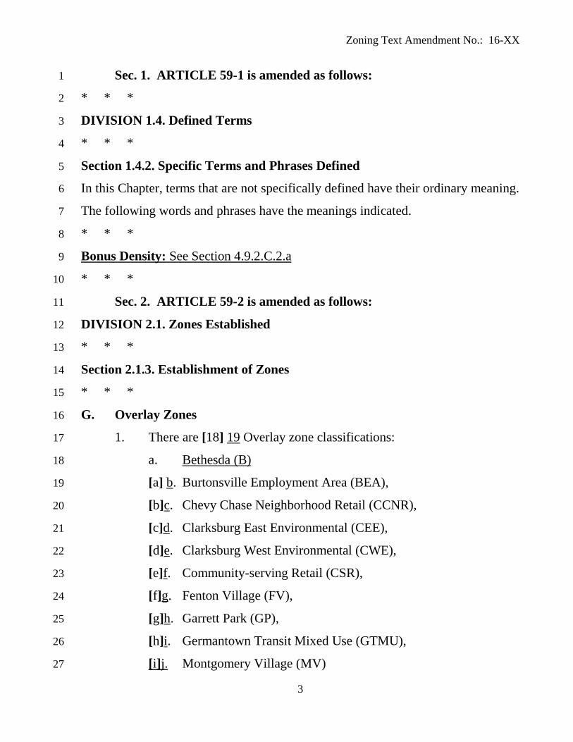
Sec. 1. ARTICLE 59-1 is amended as follows: 1
* * * 2
DIVISION 1.4. Defined Terms 3
* * * 4
Section 1.4.2. Specific Terms and Phrases Defined 5
In this Chapter, terms that are not specifically defined have their ordinary meaning. 6
The following words and phrases have the meanings indicated. 7
* * * 8
Bonus Density: See Section 4.9.2.C.2.a 9
* * * 10
Sec. 2. ARTICLE 59-2 is amended as follows: 11
DIVISION 2.1. Zones Established 12
* * * 13
Section 2.1.3. Establishment of Zones 14
* * * 15
G. Overlay Zones 16
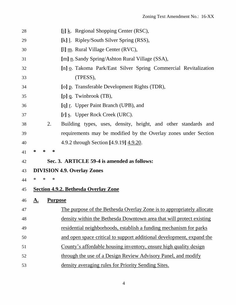
1. There are [18] 19 Overlay zone classifications: 17
a. Bethesda (B) 18
[a] b. Burtonsville Employment Area (BEA), 19
[b]c. Chevy Chase Neighborhood Retail (CCNR), 20
[c]d. Clarksburg East Environmental (CEE), 21
[d]e. Clarksburg West Environmental (CWE), 22
[e]f. Community-serving Retail (CSR), 23
[f]g. Fenton Village (FV), 24
[g]h. Garrett Park (GP), 25
[h]i. Germantown Transit Mixed Use (GTMU), 26
[i]j. Montgomery Village (MV) 27
Zoning Text Amendment No.: 16-XX
4
[j] k. Regional Shopping Center (RSC), 28
[k] l. Ripley/South Silver Spring (RSS), 29
[l] m. Rural Village Center (RVC), 30
[m] n. Sandy Spring/Ashton Rural Village (SSA), 31
[n] o. Takoma Park/East Silver Spring Commercial Revitalization 32
(TPESS), 33
[o] p. Transferable Development Rights (TDR), 34
[p] q. Twinbrook (TB), 35
[q] r. Upper Paint Branch (UPB), and 36
[r] s. Upper Rock Creek (URC). 37
2. Building types, uses, density, height, and other standards and 38
requirements may be modified by the Overlay zones under Section 39
4.9.2 through Section [4.9.19] 4.9.20. 40
* * * 41
Sec. 3. ARTICLE 59-4 is amended as follows: 42
DIVISION 4.9. Overlay Zones 43
* * * 44
Section 4.9.2. Bethesda Overlay Zone 45
A. Purpose 46
The purpose of the Bethesda Overlay Zone is to appropriately allocate 47
density within the Bethesda Downtown area that will protect existing 48
residential neighborhoods, establish a funding mechanism for parks 49
and open space critical to support additional development, expand the 50
County’s affordable housing inventory, ensure high quality design 51
through the use of a Design Review Advisory Panel, and modify 52
density averaging rules for Priority Sending Sites. 53

Zoning Text Amendment No.: 16-XX
5
B. Land Uses 54
1. The land uses of the Commercial Residential (CR) and the 55
Commercial Residential Town (CRT) zones are applicable. 56
2. Surface Parking for Use Allowed in the Zone is not allowed on a 57
Priority Sending Site from which density has been transferred. 58
C. Development Standards 59
1. Building Height 60
Outside of the High Performance Area designated in the Bethesda 61
Downtown Plan, development may not exceed the mapped height limit in 62
order to facilitate the provision of MPDUs under Section 4.7.3.D.6.b. 63
2. Density 64
a. A development may exceed the mapped CR or CRT FAR on a site if 65
the Planning Board approves on a sketch and site plan the allocation 66
of FAR from Bonus Density. Bonus Density is the total square 67
footage by which approved development in the Downtown Bethesda 68
plan area may cumulatively exceed the maximum square footage 69
allowed under the mapped CR and CRT zones. Bonus Density is 70
limited to 3,289,000 square feet. 71
b. FAR allocated from Bonus Density may be developed with any 72
Commercial or Residential use allowed in the underlying zone. 73
c. In order to qualify for Bonus Density FAR, a proposed development 74
must: 75
1. Use all mapped CR or CRT FAR associated with the property. 76
Density may not be transferred from the property. 77
2. Provide a minimum of 15 percent MPDUs. 78
3. Make a Park Impact Payment before the filing of any building 79
permit application at a rate of $10 per square foot of approved Bonus 80
Zoning Text Amendment No.: 16-XX
6
Density FAR. If a property owner dedicates land designated as an 81
Open Space Priority Sending Site to the M-NCPPC Parks Department, 82
the Planning Board may reduce the amount of square footage for 83
which a Park Impact Payment must be made in proportion to the 84
dedicated area. 85
4. Be reviewed by the Design Review Advisory Panel at sketch plan 86
and site plan review to help ensure the development achieves the 87
highest level design quality, consistent with the master plan, design 88
guidelines, and other applicable requirements. The Design Review 89
Advisory Panel must consist of at least five members appointed by the 90
Planning Director. 91
3. FAR Averaging 92
a. The Bethesda Downtown Plan designates certain properties as Priority 93
Sending Sites to encourage the creation or enlargement of urban 94
parks, protect significant historic and community resources, and to 95
retain existing affordable housing. 96
b. Density transferred from a Priority Sending Site may be included in a 97
development application for any CR or CRT-zoned site within the 98
Sector Plan Area boundary. 99
c. Density transferred from a Priority Sending Site may be used on 100
another site without the Priority Sending Site being under the same 101
sketch plan or site plan. 102
d. Density transferred from a Priority Sending Site is exempt from the 103
BLT purchase requirements of Section 4.7.3.F.1.a. 104
e. Density transferred from a Priority Sending Site is exempt from any 105
requirement to provide MPDUs above the 12.5 percent minimum. 106
Zoning Text Amendment No.: 16-XX
7
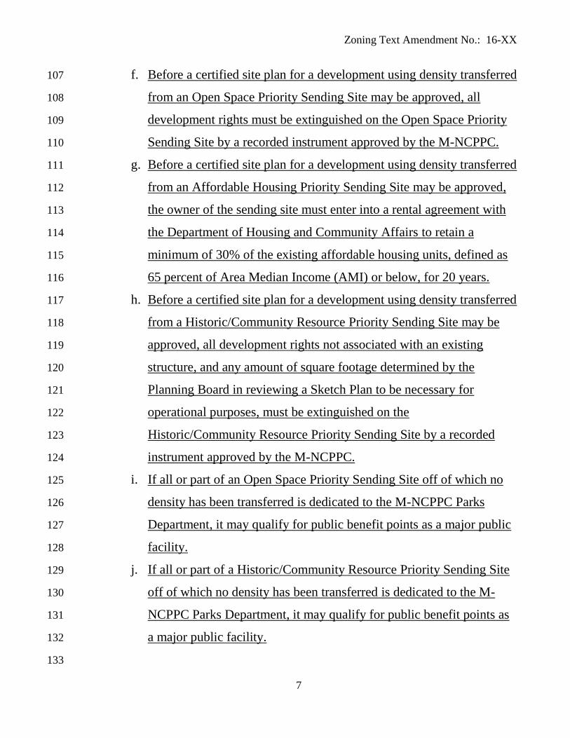
f. Before a certified site plan for a development using density transferred 107
from an Open Space Priority Sending Site may be approved, all 108
development rights must be extinguished on the Open Space Priority 109
Sending Site by a recorded instrument approved by the M-NCPPC. 110
g. Before a certified site plan for a development using density transferred 111
from an Affordable Housing Priority Sending Site may be approved, 112
the owner of the sending site must enter into a rental agreement with 113
the Department of Housing and Community Affairs to retain a 114
minimum of 30% of the existing affordable housing units, defined as 115
65 percent of Area Median Income (AMI) or below, for 20 years. 116
h. Before a certified site plan for a development using density transferred 117
from a Historic/Community Resource Priority Sending Site may be 118
approved, all development rights not associated with an existing 119
structure, and any amount of square footage determined by the 120
Planning Board in reviewing a Sketch Plan to be necessary for 121
operational purposes, must be extinguished on the 122
Historic/Community Resource Priority Sending Site by a recorded 123
instrument approved by the M-NCPPC. 124
i. If all or part of an Open Space Priority Sending Site off of which no 125
density has been transferred is dedicated to the M-NCPPC Parks 126
Department, it may qualify for public benefit points as a major public 127
facility. 128
j. If all or part of a Historic/Community Resource Priority Sending Site 129
off of which no density has been transferred is dedicated to the M-130
NCPPC Parks Department, it may qualify for public benefit points as 131
a major public facility. 132
133
Zoning Text Amendment No.: 16-XX
8
134
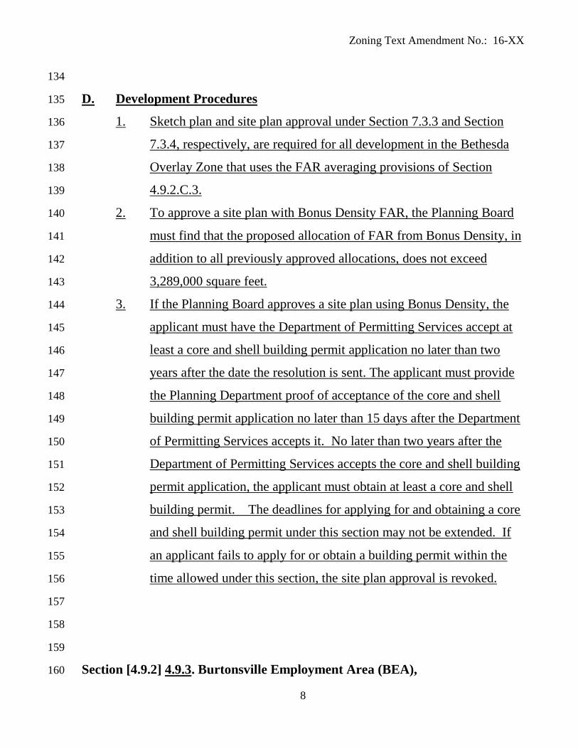
D. Development Procedures 135
1. Sketch plan and site plan approval under Section 7.3.3 and Section 136
7.3.4, respectively, are required for all development in the Bethesda 137
Overlay Zone that uses the FAR averaging provisions of Section 138
4.9.2.C.3. 139
2. To approve a site plan with Bonus Density FAR, the Planning Board 140
must find that the proposed allocation of FAR from Bonus Density, in 141
addition to all previously approved allocations, does not exceed 142
3,289,000 square feet. 143
3. If the Planning Board approves a site plan using Bonus Density, the 144
applicant must have the Department of Permitting Services accept at 145
least a core and shell building permit application no later than two 146
years after the date the resolution is sent. The applicant must provide 147
the Planning Department proof of acceptance of the core and shell 148
building permit application no later than 15 days after the Department 149
of Permitting Services accepts it. No later than two years after the 150
Department of Permitting Services accepts the core and shell building 151
permit application, the applicant must obtain at least a core and shell 152
building permit. The deadlines for applying for and obtaining a core 153
and shell building permit under this section may not be extended. If 154
an applicant fails to apply for or obtain a building permit within the 155
time allowed under this section, the site plan approval is revoked. 156
157
158
159
Section [4.9.2] 4.9.3. Burtonsville Employment Area (BEA), 160
Zoning Text Amendment No.: 16-XX
9
* * * 161
B. Land Uses 162
1. The following uses are prohibited: 163
* * * 164
k. Light Manufacturing and Production, except as noted in Section 165
[4.9.2.B.3] 4.9.3.B.3; 166
* * * 167
Section [4.9.3] 4.9.4. Chevy Chase Neighborhood Retail (CCNR), 168
* * * 169
Section [4.9.4] 4.9.5. Clarksburg East Environmental (CEE), 170
* * * 171
D. Development Standards 172
1 Except as allowed under Section [4.9.4.B] 4.9.5.B, the maximum total 173
impervious surface area for any development after August 4, 2014 is 174
15% of the total area under application for development. 175
* * * 176
E. Site Plan 177
1. Any development that must file a preliminary plan of subdivision under 178
Chapter 50 requires approval of a site plan by the Planning Board under 179
Section 7.3.4, unless excluded under Section [4.9.4.E.2] 4.9.5.E.2. 180
* * * 181
Section [4.9.5] 4.9.6. Clarksburg West Environmental (CWE), 182
* * * 183
D. Development Standards 184
1. Except for County owned land or land under a conservation easement 185
granted to the benefit of the County and development exempted under 186
Section [4.9.5.B] 4.9.6.B, the maximum total impervious surface area 187
Zoning Text Amendment No.: 16-XX
10
for any development after August 4, 2014 is 6% of the total area under 188
application for development. 189
* * * 190
E. Site Plan 191
1. Any development that must file a preliminary plan of subdivision under 192
Chapter 50 requires approval of a site plan by the Planning Board under 193
Section 7.3.4, unless excluded under Section [4.9.5.E.2] 4.9.6.E.2 or 194
Section [4.9.5.E.3] 4.9.6.E.3. 195
* * * 196
Section [4.9.6] 4.9.7. Community-serving Retail (CSR), 197
* * * 198
Section [4.9.7] 4.9.8. Fenton Village (FV), 199
* * * 200
C. Development Standards 201
1. Building Height 202
* * * 203
b. Maximum building height is 60 feet along any street confronting 204
any block that includes property in a Residential Detached zone 205
and, when a building is allowed to be higher than 60 feet under 206
Section [4.9.7.C.1.c] 4.9.8.C.1.c, each additional foot in building 207
height above 60 feet requires at least an additional one foot 208
stepback from the front of the building along Fenton Street; 209
* * * 210
e. For properties with frontage on both Wayne Avenue and Fenton Street, 211
in spite of the height limitations in Section [4.9.7.C.1.b] 4.9.8.C.1.b 212
through Section [4.9.7.C.1.d] 4.9.8.C.1.d, maximum building height may 213
be increased by 15 feet for a building that includes residential uses or a 214
Zoning Text Amendment No.: 16-XX
11
mix of residential and commercial uses, if such additional height is not 215
more than 200 feet from the right-of-way line for Fenton Street as 216
recommended in the Approved and Adopted 2000 Silver Spring CBD 217
Sector Plan; however, any building using additional height must be set 218
back from abutting Residentially zoned land no less than the setback 219
required in the abutting Residential zone or the height of the building, 220
whichever is greater. 221
f. Building heights may be approved under the standards of Section 222
[4.9.7.C.1] 4.9.8.C.1 without regard to the building height 223
recommendations of the master plan. 224
* * * 225
Section [4.9.8] 4.9.9. Garrett Park (GP), 226
* * * 227
C. Land Uses 228
The land uses and use standards of the underlying zone are applicable unless 229
the development standards in Section [4.9.8.D] 4.9.9.D are more restrictive, 230
in which case Section [4.9.8.D] 4.9.9.D must be followed. 231
* * * 232
Section [4.9.9] 4.9.10. Germantown Transit Mixed Use (GTMU), 233
* * * 234
Section [4.9.10] 4.9.11. Montgomery Village (MV), 235
* * * 236
Section [4.9.11] 4.9.12. Regional Shopping Center (RSC) Overlay Zone 237
* * * 238
D. Site Plan 239
Site plan approval under Section 7.3.4 is required for any increase in 240
building height under Section [4.9.11.C.1] 4.9.12.C.1. 241

Zoning Text Amendment No.: 16-XX
12
E. Parking 242
243
4. Pedestrian Access 244
The major point of pedestrian access for an off-street parking facility that 245
occupies contiguous land area integral to the regional shopping center property 246
may extend more than 500 feet walking distance from an entrance to the center 247
to satisfy the number of spaces required under Section [4.9.11.E.1.a] 248
4.9.12.E.1.a. 249
* * * 250
Section [4.9.12] 4.9.13. Ripley/South Silver Spring (RSS) Overlay Zone 251
* * * 252
Section [4.9.13] 4.9.14. Rural Village Center (RVC) Overlay Zone 253
* * * 254
C. Development Standards 255
1. Where a lot is either partially or totally in a Commercial/Residential 256
zone: 257
* * * 258
e. In addition to the parking requirements in Division 6.2: 259
* * * 260
iii. For any cumulative enlargement of a surface parking 261
facility that is greater than 50% of the total parking area 262
approved before November 4, 2002, the entire off-street 263
parking facility must be brought into conformance with 264
Section [4.9.13] 4.9.14. 265
* * * 266
Section [4.9.14] 4.9.15. Sandy Spring/Ashton Rural Village (SSA) Overlay 267
Zone 268

Zoning Text Amendment No.: 16-XX
13
* * * 269
Section [4.9.15] 4.9.16. Takoma Park/East Silver Spring Commercial 270
Revitalization (TPESS) Overlay Zone 271
* * * 272
D. Site Plan 273
274
3. For any addition, reconstruction, or alteration that changes a building by 275
less than 1,000 square feet and does not require site plan approval under 276
Section [4.9.15.D.1.c] 4.9.16.D.1.c, the Planning Board or its designee 277
must review the building permit to determine compliance with master 278
plan recommendations and the provisions of this Overlay zone. If an 279
existing building is located on the site or on an adjacent property, the 280
minimum setback of the zone may be reduced to conform to the existing 281
setback on the site or on the adjacent property. 282
283
Section [4.9.16] 4.9.17. Transferable Development Rights (TDR) Overlay Zone 284
* * * 285
B. Optional Method 286
1. In General 287
The TDR Overlay optional method of development permits an 288
increase in the maximum residential density, if the development 289
satisfies the requirements for optional method development using 290
Transferable Development Rights under Section [4.9.16.B] 4.9.17.B. 291
a. Applicability 292
The procedures and requirements in Section [4.9.16.B] 4.9.17.B 293
apply to the transfer of development rights from land in the AR 294
zone to land in a Transferable Development Rights (TDR) 295
Zoning Text Amendment No.: 16-XX
14
Overlay zone. The Planning Board may approve subdivision of 296
such land at densities up to the maximum density allowed in the 297
applicable TDR Overlay zone and substantially conforming to 298
the recommendations in the applicable master plan. 299
* * * 300
c. Recording of Development Right 301
* * * 302
ii. A final record plat for a subdivision using transferred 303
development rights must contain a statement including the 304
development proposed, the zoning classification of the 305
property, the number of development rights used, and a 306
notation of the recordation of the conveyance as required by 307
Section [4.9.16.B] 4.9.17.B. 308
d. Development with Moderately Priced Dwelling Units 309
i. A property developed under Section 4.9.16.B must satisfy 310
Chapter 25A. 311
ii. A density bonus allowed under Chapter 25A is calculated 312
after the base density of the property has been increased 313
under Section [4.9.16.B] 4.9.17.B through TDRs. 314
* * * 315
e. Additional Findings 316
In addition to the findings required for approval of a site plan 317
under Section 7.3.4, for projects developed under Section 318
[4.9.16.B] 4.9.17.B, the Planning Board must find that the 319
proposed development provides an appropriate range of 320
housing types that takes advantage of existing topography and 321
Zoning Text Amendment No.: 16-XX
15
environmental features and achieves a compatible relationship 322
between the proposed development and adjoining land uses. 323
* * * 324
Section [4.9.17] 4.9.18. Twinbrook (TB) Overlay Zone 325
* * * 326
Section [4.9.18] 4.9.19. Upper Paint Branch (UPB) Overlay Zone 327
* * * 328
B. Exemptions 329
The following are exempt from Section [4.9.18] 4.9.19: 330
* * * 331
C. Land Uses 332
1. Except as listed in Section [4.9.18.C.2] 4.9.19.C.2 and Section 333
[4.9.18.C.3] 4.9.19.C.3, the land uses of the underlying zone apply. 334
The use standards of the underlying zone apply unless the 335
development standards in Section [4.9.18.D] 4.9.19.D are more 336
restrictive, in which case Section [4.9.18.D] 4.9.19.D must be 337
followed. 338
* * * 339
3. If validly existing on July 1, 1997, the uses in Section [4.9.18.C.2] 340
4.9.19.C.2 may be continued under the requirements in effect at the 341
time the use was established. Any expansion requires compliance with 342
the UPB Overlay zone. 343
* * * 344
E. Waiver 345
The applicable review body may grant a waiver of the development 346
standards in Section [4.9.18.D] 4.9.19.D if it finds that: 347
* * * 348

Zoning Text Amendment No.: 16-XX
16
4. Alternative water quality and control techniques are used to meet the 349
purposes of Section [4.9.18] 4.9.19. 350
Section [4.9.19] 4.9.20. Upper Rock Creek (URC) Overlay Zone 351
* * * 352
B. Exemptions 353
1. The following are exempt from Section [4.9.19] 4.9.20: 354
* * * 355
D. Waiver 356
The applicable review body may grant a waiver of the development 357
standards in Section [4.9.19.C] 4.9.20.C if it finds that: 358
* * * 359
4. Alternative water quality and quantity control techniques are used to 360
meet the purposes of Section [4.9.19] 4.9.20. 361
* * * 362
Sec. 4. OLD ZONING ORDINANCE TO NEW ZONING 363
ORDINANCE SECTION CROSS REFERENCE is amended as follows: 364
Old ZONING ORDINANCE
Article 59-C: Zoning Districts; Regulations. New ZONING ORDINANCE
* * *
Division 59-C-18. Overlay Zones.
* * * Sec. 59-C-18.15. Environmental Overlay Zone
for the Upper Paint Branch Special Protection
Area.
Sec. [4.9.18] 4.9.19. Upper Paint Branch
(UPB) Overlay Zone
* * *
Sec. 59-C-18.18. Sandy Spring/Ashton Rural
Village Overlay Zone.
Sec. [4.9.14] 4.9.15. Sandy Spring/ Ashton
Rural Village (SSA) Overlay Zone
* * *
Sec. 59-C-18.20. Ripley/South Silver Spring
Overlay Zone.
Sec. [4.9.12] 4.9.13. Ripley/South Silver
Spring (RSS) Overlay Zone
Sec. 59-C-18.21. Takoma Park/East Silver
Spring commercial revitalization overlay zone.
Sec. [4.9.15] 4.9.16. Takoma Park/ East Silver
Spring Commercial Revitalizations (TPESS)
Overlay Zone
* * *

Zoning Text Amendment No.: 16-XX
17
Sec. 59-C-18.23. Rural village center overlay
zone.
Sec. [4.9.13] 4.9.14. Rural Village Center
(RVC) Overlay Zone
Sec. 59-C-18.24. Environmental overlay zone
for the Upper Rock Creek Special Protection
Area.
Sec. [4.9.19] 4.9.20. Upper Rock Creek (URC)
Overlay Zone
365
Sec. 5. Effective date. This ordinance becomes effective 20 days after the 366
date of Council adoption. 367
368
This is a correct copy of Council action. 369
370
________________________________ 371
Linda M. Lauer, Clerk of the Council 372
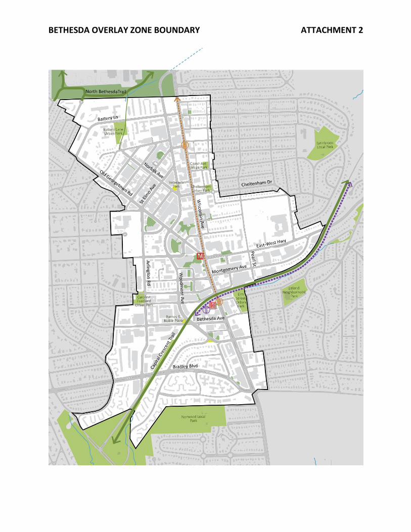
BETHESDA OVERLAY ZONE BOUNDARY ATTACHMENT 2