Embed Size (px)
Citation preview

TEXAS COMMISSION ON ENVIRONMENTAL QUALITY • PO BOX 13087 • AUSTIN, TX 78711-3087 T h e T C E Q is a n e q ua l o p p o r t u n i t y e m p l oye r . T h e a g e nc y d o e s n o t a l l o w d i s c r im in a t i o n o n t h e b a s i s o f r a c e , c o l o r , r e l i g i o n , n a t i o n a l o r i g i n , s e x , d i s a b i l i t y , a g e , s e x u a l o r i e n t a t i o n , o r v e t e r a n s t a t us . I n c om p l i a n c e w i t h t h e A m e r i c a ns w i t h D i s a b i l i t i e s A c t , t h i s d o c um e n t m a y b e r e q u e s t e d i n a l t e r n a t e f o rm a ts b y c o n t a c t i n g t h e T C EQ a t 5 1 2 - 2 3 9 - 0 0 2 8 , f ax 5 1 2 - 2 3 9- 4 4 8 8 , o r 1 - 8 0 0 - R E L A Y-T X (T D D ) , o r b y w r i t i n g P O B o x 1 3 0 8 7 , A u s t i n T X 7 8 7 1 1 - 3 0 8 7 . W e a u th o r i ze yo u t o u s e o r r e p r o d uc e a n y o r i g i n a l m a t e r i a l c o n t a i n e d i n t h i s p u b l i c a t i o n — t h a t i s , a n y m a t e r i a l we d i d n o t o b t a i n f r om o t h e r s o u rc e s . P l e a s e a c k n o w l e d g e t h e T C E Q a s yo u r s o u rc e . P r i n t e d o n r ec yc l e d p a p e r .
TCEQ REGULATORY GUIDANCE Remediation Division RG-428 ● Revised January 2010
Preparation of a Drinking Water
Survey Report
Contents
Introduction and Purpose ................................................................... 1 Definitions ............................................................................................ 2 Background........................................................................................... 3 Example Scenarios Demonstrating Section 26.408 Applicability ...... 4
Preparing a Drinking Water Survey Report ...................................... 6 Step 1: Identify Local Public Drinking Water Source(s) ..................... 6 Step 2: Conduct a Records Survey of Water Wells ............................. 6 Step 3: Conduct a Field Survey for Water Wells................................. 7 Step 4: Prepare and Submit the Drinking Water Survey Report ........ 9
Appendix A. Drinking Water Survey Report Transmittal Form............................................................................ 14
Appendix B. Instructions for Collecting and Submitting Site and Private Water Well Location Information...................... 15
Introduction........................................................................................ 15 Data Collection Standards for Hand-held GPS Devices.................... 16 Data Collection Standards for Map Interpolation and
Heads-Up Map Digitizing Methods................................................. 19
Introduction and Purpose This document outlines for the regulated community the minimum procedures necessary to prepare a Drinking Water Survey Report and submit it to the Remediation Division (RD) of the Texas Commission on Environmental Quality (TCEQ). The Drinking Water Survey Report is designed to provide information on water wells and sources of drinking water in the area near groundwater contamination.
When initially reporting a case of groundwater contamination to the RD, or when submitting the results of continued assessment activities

Preparation of a Drinking Water Survey Report TCEQ publication RG-428
documenting additional plume delineation, you must concurrently submit a Drinking Water Survey Report, as a stand-alone document. You must also submit a Drinking Water Survey Report at any other time you are requested (e.g., when a water well has been determined to have detectable levels of a contaminant and the source of the contamination is unknown).
The RD uses the report primarily to comply with Texas Water Code (TWC), Section 26.408. Section 26.408 requires the TCEQ to notify the owners of the potentially affected private drinking water wells within 30 days of the date that the TCEQ receives notice or otherwise becomes aware of a case of groundwater contamination that may affect a drinking water well. If another division of the TCEQ has evaluated the applicability of the groundwater contamination under Section 26.408, submittal of the Drinking Water Survey Report to the RD is not required.
Definitions
Whenever possible, the definitions for the following terms are based on those found in the Texas Administrative Code, either Title 30 (30 TAC) or Title 31 (31 TAC). These definitions, meant for use only in this and related Remediation Division documents, are provided in order to help determine applicability and ensure consistent implementation of TWC, Section 26.408, by the Remediation Division.
Groundwater Water below the land surface in a zone of saturation [31 TAC, Section 601.3(6)].
Groundwater contamination The detrimental alteration of the naturally occurring physical, thermal, chemical, or biological quality of groundwater, reasonably suspected of having been caused by activities or by entities under the jurisdiction of the TCEQ [31 TAC, Section 601.3(7)]. For the purpose of this document, the Remediation Division defines groundwater contamination as limited to chemical concentrations that exceed residential health-based values for ingestion.
Groundwater production zone The zone of saturation in which a water well is screened or completed. If the well-completion details are unknown or incomplete, the groundwater production zone includes each saturated zone penetrated by the well [30 TAC Section 350.4(a)(41)].
Imminent threat to a water well The presence (for the purpose of this guidance) of any water well within 500 feet of the known extent of groundwater contamination, when the groundwater contaminant plume has not been defined laterally and vertically to residential health-based values for ingestion.
Person An individual, corporation, organization, government, governmental subdivision or agency, business trust, partnership, association, or any other legal entity [30 TAC, Section 350.4(a)(62)].
2 January 2010

TCEQ publication RG-428 Preparation of a Drinking Water Survey Report
Potentially affected private drinking water well A private drinking water well located within the known extent of a defined groundwater contaminant plume or within 0.25 miles of groundwater contamination when the full extent of the groundwater contaminant plume has not been defined laterally and vertically.
Private drinking water well A non-public water well that is used for human consumption or is plumbed to a structure.
Public water well A water well that is a component of a system that has at least 15 service connections or serves at least 25 individuals at least 60 days out of the year [30 TAC, Section 290.38(66)].
Background
The 78th Legislature passed House Bill 3030, which was subsequently codified as Section 26.408, Subchapter J, of the TWC. The statute reads:
§ 26.408. Notice of Groundwater Contamination
(a) If a state agency documents under Section 26.406(a) a case of groundwater contamination that may affect a drinking water well, the state agency shall notify the commission.
(b) Not later than the 30th day after the date the commission receives notice under Subsection (a) or obtains independent knowledge of groundwater contamination, the commission shall make every effort to give notice of the contamination by first class mail to each owner of a private drinking water well that may be affected by the contamination and to each applicable groundwater conservation district.
(c) The committee by rule shall prescribe the form and content of notice required under this section.
The law took effect Sept. 1, 2003, and applies only to a case of groundwater contamination documented on or after that date.
TWC, Section 26.408, regulates how the TCEQ and, in particular, the RD responds to reports of groundwater contamination. In short, the law allows the TCEQ a maximum of 30 days to provide notice to owners of private drinking water wells that may be affected by groundwater contamination. The form and content of this notice is prescribed in 31 TAC, Section 601.10, which was adopted by the Texas Groundwater Protection Committee in response to TWC, Section 26.408.
Implementation of TWC, Section 26.408, requires new actions to be taken by both the regulated community and RD staff. Historically, the regulated community initially reported a case of groundwater contamination to the
January 2010 3

Preparation of a Drinking Water Survey Report TCEQ publication RG-428
RD and, at a later date, submitted an assessment report that included a discussion of potential receptors, such as the location and use of surrounding water wells. In order for the RD to meet the 30-day time frame, the regulated community must provide information on water wells at the same time that the case of groundwater contamination is initially reported, and must update information when submitting assessment data that indicates an increase in the known extent of the groundwater plume.
Therefore, you should complete and submit a Drinking Water Survey Report when reporting a new case of groundwater contamination to the RD, when reporting additional assessment activities to further delineate the plume, or any time you are requested to do so by the RD. The submission of a Drinking Water Survey Report will ensure that the RD is alerted and provided sufficient information to evaluate Section 26.408 applicability and complete any required notifications within the statutorily required 30-day time frame.
If a Drinking Water Survey Report is not submitted when a new case of groundwater contamination is reported to the RD, the RD will request that one be submitted. The deadline for submitting the Drinking Water Survey Report will be based upon the suspected presence or absence of an imminent threat to a private drinking water well. If an imminent threat to a private drinking water well is identified, the request and submission of the Drinking Water Survey Report is considered “expedited” and the entire process must be completed in a very short time frame, to be specified by the RD.
Requests for non-expedited Drinking Water Survey Reports will also have relatively short time frames. Therefore, we recommend that you complete all the parts of the Drinking Water Survey Report at the same time as the documentation establishing a new case of groundwater contamination.
Example Scenarios Demonstrating Section 26.408 Applicability
TWC, Section 26.408, applies only to cases of groundwater contamination (as defined above) that may affect a private drinking water well and that were documented on or after Sept. 1, 2003. For the purposes of this section, such cases of groundwater contamination are considered new (see Scenarios 1 and 2).
Scenario 1
On Nov. 1, 2005, the TCEQ received a report that documented concentrations of contaminants in groundwater that exceeded residential health-based values for ingestion. This was the first time the contaminant concentrations had been reported to the TCEQ. This qualifies as a new case of groundwater contamination, since it was initially reported to the TCEQ on or after Sept. 1,
4 January 2010

TCEQ publication RG-428 Preparation of a Drinking Water Survey Report
2003. Therefore, this case of groundwater contamination is subject to TWC, Section 26.408.
Scenario 2
A person had been conducting quarterly monitoring of groundwater since May 2002. Annual groundwater reports had been submitted to the TCEQ since that time. Concentrations of contaminants in groundwater had been less than residential health-based values for ingestion. In October 2003, groundwater contaminant concentrations exceeded health-based values for the first time. Since these exceedances were reported for the first time on or after Sept. 1, 2003, this is a new case of groundwater contamination, subject to TWC, Section 26.408.
However, if groundwater contamination is not present, Section 26.408 is not applicable (see Scenario 3).
Scenario 3
A person conducted a groundwater assessment as part of a real estate transaction. Concentrations of contaminants in groundwater monitoring wells were less than or equal to health-based values for ingestion. The assessment report was submitted to and received by the TCEQ on Nov. 1, 2005. This was the first time that the TCEQ had been notified of the groundwater assessment. However, since groundwater contamination, as defined in this document, was not present in monitoring wells, TWC, Section 26.408, is not applicable.
A case of groundwater contamination is not new or subject to Section 26.408 if concentrations exceeding health-based values were reported to the TCEQ prior to Sept. 1, 2003 (see Scenario 4).
Scenario 4
A person reported to the TCEQ in May 1999 that concentrations of contaminants in groundwater exceeded health-based values. Annual groundwater reports had been submitted to the TCEQ since that time. Concentrations of contaminants in groundwater exceeded residential health-based values until January 2002. From February 2002 until October 2003, concentrations of contaminants were equal to or less than residential health-based values. Since November 2003, groundwater contaminant concentrations have exceeded residential health-based values. However, since the groundwater contamination was initially reported to the TCEQ prior to Sept. 1, 2003, this was not a new case of groundwater contamination and TWC, Section 26.408, is not applicable.
January 2010 5

Preparation of a Drinking Water Survey Report TCEQ publication RG-428
Activities necessary for the completion of a Drinking Water Survey Report are also applicable to the performance of investigations subject to TCEQ program rules such as the Texas Risk Reduction Program (TRRP) rule (30 TAC, Chapter 350) or the Underground and Aboveground Storage Tank rules (30 TAC, Chapter 334). Use the information collected for a Drinking Water Survey Report in the preparation of a TRRP Affected Property Assessment Report (APAR) or Assessment Report Form. Be aware, however, that the investigations require the identification of additional sensitive receptors, such as schools and day-care centers, within 500 feet and surface water bodies within 0.5 miles or 0.25 miles (as applicable). In order to reduce or eliminate redundancy, record for later use the presence of other sensitive receptors noted in the surveys required by this document.
Preparing a Drinking Water Survey Report The following procedures outline the minimum necessary steps for the preparation of a Drinking Water Survey Report. Repeat this process if the assessment is conducted in a phased manner.
Step 1: Identify Local Public Drinking Water Source(s)
Purpose: To document the availability of a public water system (PWS) within the coverage area and to identify the properties that are not serviced by a PWS or connected to an existing PWS.
Coverage area: 0.5 miles beyond the known extent of the groundwater contamination.
Recommended information sources: Local retail public utilities (including, if necessary, individuals responsible for meter reading), municipalities, groundwater conservation districts, neighborhood associations, local water well drillers, the TCEQ, and the Texas Water Development Board (TWDB).
Step 2: Conduct a Records Survey of Water Wells
Purpose: To locate all recorded water wells within the coverage area and to determine the groundwater production zone(s). The RD recommends concurrently locating surface water bodies that are within 0.5 miles of the known extent of groundwater contamination, in order to reduce or eliminate redundancy with the performance of program-required assessments.
Coverage area: 0.5 miles beyond the known extent of the groundwater contamination.
6 January 2010

TCEQ publication RG-428 Preparation of a Drinking Water Survey Report
Recommended record sources: Topographic maps and water well records filed with the Texas Department of Licensing and Regulation, the TWDB, the TCEQ, and the applicable groundwater conservation district.
Provide documentation that the applicable groundwater conservation district has been contacted for information it may have on wells within the coverage area. If the information was not obtained through an automated system, the documentation should include the name of the person contacted, their contact information (phone number), and the date the conversation occurred. Include this, as well as reports generated by automated systems, in Attachment 3.
Step 3: Conduct a Field Survey for Water Wells
Purpose: To locate and obtain information on water wells that were not identified during the records survey and to confirm or refine the location of water wells and other water well information obtained during the records survey. Note: The RD recommends concurrently locating other sensitive receptors (schools, day-care centers, etc.) that are within 500 feet of the known extent of groundwater contamination, in order to reduce or eliminate redundancy during the performance of any program-required assessments.
You have to conduct only the portions of the Drinking Water Survey that are warranted based on the requirements of the applicable cleanup rule, available site-specific information, and plume definition. For example, if the groundwater contamination has been fully defined to residential health-based values based on ingestion, then the coverage areas of the field survey would be limited to an area within 500 feet of the defined groundwater contamination, and it would not be necessary to collect well-owner, user, or other information outside 500 feet of the defined contaminant plume.
Coverage area: Visual survey within 500 feet of the known extent of the groundwater contamination, and door-to-door survey at certain properties within 0.25 miles of the known extent of the groundwater contamination (see Figure 1).
January 2010 7
Preparation of a Drinking Water Survey Report TCEQ publication RG-428
8 January 2010
Figure 1. Example of a field survey coverage area and areas identified as requiring door-to-door survey
The Minimum Requirements for a Field Survey
The following bullet list provides the minimum requirements for a field survey (see Figure 1).
Conduct a visual survey for water wells within 500 feet of the known extent of the groundwater contamination.
Conduct a door-to-door survey within 0.25 miles of the known extent of the groundwater contamination at properties:
not serviced by or connected to a PWS,
where a water well was identified during the record survey, or
where a water well is suspected to be present based on the 500-ft visual survey.
Conduct a visual survey (slowly drive or walk the area) to determine if there is evidence of a water well. If a property is not serviced by or connected to a PWS, you should presume that a water well is present, unless you can confirm the absence of a water well. You should presume that a water well is used to supply drinking water if you cannot confirm the use of a well.
If you cannot confirm the absence of a private drinking water well because the landowner(s) or tenant(s) is unavailable, contact the property owner by phone to obtain information regarding the presence or absence of a private drinking water well on the property. In areas where a water
Areas lacking public water supply service or connection
Known extent of groundwater contamination
Limit of on-site property
0.25-mile radial survey distance
Registered water well
500-ft visual survey distance
0.25 mi.
500 ft
Door-to-door survey
Door-to-door survey
Observed water well
Door-to-door survey

TCEQ publication RG-428 Preparation of a Drinking Water Survey Report
well is known, suspected, or presumed to be present, conduct a door-to-door survey.
Note: Since a door-to-door survey has to be conducted only in the three specified instances, it is generally not necessary to conduct a door-to-door survey in all areas within the known extent of a fully defined groundwater contaminant plume or within 0.25 miles of an undefined groundwater contaminant plume.
During the door-to-door survey, collect the latitude and longitude coordinates of the well, obtain the current mailing address and telephone number for the owner(s) and user(s), and determine the use of each water well. If known by the owner(s) or user(s), collect other information about the well, including the date of installation, well completion details, and the status of the well.
Use the information obtained to complete your Drinking Water Survey Report’s Table 1 (Water Well Information), created through the procedures described in Appendix B. Clearly distinguish information that was obtained through discussions with the owner(s) or user(s) from information that was obtained from well reports. Instructions for collecting and submitting the latitude and longitude coordinates as well as other well details can be found at the following Web page: <www.tceq.state.tx.us/goto/pdw_survey_reports>. This information must also be submitted in electronic format, as Attachment 6 of the Drinking Water Survey Report.
Step 4: Prepare and Submit the Drinking Water Survey Report
Report Format and Submission
The Drinking Water Survey Report does not require a significant amount of text. Rather, it calls for a small amount of text and a comprehensive graphic and tabular presentation of data.
Submit the original and one copy of the Drinking Water Survey Report to the appropriate program of the RD. Include with these a CD of the requested electronic files. Submit another copy of the Drinking Water Survey Report to the appropriate TCEQ Regional Office. You do not need to include a CD with this copy. A list of TCEQ Regional Offices and contact information can be found at <www.tceq.state.tx.us/goto/maps>.
Please note that the Remediation Division verifies whether reports that are submitted to the agency include a professional geoscientist's seals, when required by law. For information on what constitutes geoscience and the requirements for licensing as a geoscientist, please refer to the Web site of the Texas Board of Professional Geoscientists, at <www.tbpg.state.tx.us>.
January 2010 9

Preparation of a Drinking Water Survey Report TCEQ publication RG-428
Transmittal Form
Complete the Drinking Water Survey Report Transmittal Form provided in Appendix A of this document. The transmittal sheet must accompany the Drinking Water Survey Report and be plainly visible.
Executive Summary
Briefly describe the layout and use of the site, the contaminants in the groundwater, any areas or locations without a public water supply or a connection to one, and the number of private drinking water wells that are affected or potentially affected by the groundwater contamination.
Section 1. Groundwater Contamination
Discuss the groundwater contamination present at the site and the methods used to determine its presence. Include a discussion of the concentrations of contaminants relative to their respective residential health-based values for ingestion. Also include a discussion of the chemical and physical characteristics of the contaminants that relate to the potential for a private drinking water well(s) to be affected. Identify and report the analytical results of any public or private water wells that have been sampled. Discuss the current phase of investigation, including whether or not the lateral and vertical extent of groundwater contami-nation has been defined to residential health-based values for ingestion.
Section 2. Public Water Availability and Connection
Discuss public water availability within one-half mile of the known extent of the groundwater contamination. Note any areas not serviced by a PWS and, when a PWS is present, any properties not connected to the PWS. Document when and how the information was obtained, and provide the names and contact information for the individuals who have provided pertinent information. It may be necessary to contact the individuals who record water meter readings in order to determine properties that are not connected to an existing PWS.
Section 3. Groundwater Production Zones
Discuss the local hydrogeology and identify the general groundwater production zones (as defined in this guidance) for the private drinking water wells identified in the records and field surveys.
Section 4. Affected or Potentially Affected Water Wells
Identify the private drinking water wells that are known to be affected by the groundwater contamination and those that are potentially affected by the groundwater contamination. See Figure 2 for a sample illustration of potentially affected private drinking water wells relative to plume definition.
10 January 2010

TCEQ publication RG-428 Preparation of a Drinking Water Survey Report
For notification purposes, the TCEQ assumes a private drinking water well to be potentially affected if the well is located within the known extent of groundwater contamination (well A in both maps of Figure 2) or the well is located within 0.25 miles of groundwater contamination that has not been defined (wells B and C in Map 2 of Figure 2).
Figure 2. Examples of survey radii and potentially affected wells based on degree of plume definition
Map of Water Well Locations
Illustrate all of the following on a single map:
1. The boundaries of the on-site property.
2. The boundaries of properties within 0.25 miles of the known extent of the groundwater contamination.
3. Areas without supplied public water and any properties that are not connected to an existing PWS.
4. The known extent of groundwater contamination with a clear indication of whether the extent has been delineated to residential health-based values for ingestion.
5. All water wells (public and private, drinking and non-drinking) identified in the records and field surveys. Label each well with a unique identification number and distinguish all private drinking water wells by using a unique symbol for those wells.
6. The radial coverage areas (500-ft, 0.25-mile, and 0.5-mile).
January 2010 11

Preparation of a Drinking Water Survey Report TCEQ publication RG-428
Table 1. Water Well Information
Provide a table of information for all water wells identified through Steps 1 through 3, and in accordance with Appendix B. Appendix B contains instructions for collecting and submitting site and private water well information, and for collecting and formatting locational data on water wells found during the field survey.
Table 2. Analytical Results
Submit a table of detected analytical results for groundwater samples collected from monitoring wells and water wells. For comparison purposes, include the corresponding residential health-based levels for ingestion in the table.
Attachment 1. Laboratory Analytical and Quality Control Data
Submit copies of laboratory reports and associated quality control data sheets corresponding to the groundwater contamination. Submit only the minimum information necessary to establish that groundwater contamination is present. Also include copies of the chain-of-custody forms for the requested minimum information.
Attachment 2. Soil Boring Logs and Monitoring Well Construction Details
Provide copies of representative soil boring logs and schematics depicting monitoring well construction details for borings and monitoring wells installed at the site. It is not necessary to include all such logs and schematics. However, you should include enough of them to adequately represent the known site conditions and the monitoring well network.
Attachment 3. Water Well Database Searches
Include copies of all water well database searches performed for the site. Include in this attachment the information received from the applicable groundwater conservation district or gathered through discussions with them. To document a discussion with the groundwater conservation district, include a copy of the pertinent telephone memo or e-mail. Additionally, submit text (preferably in tabular format) that documents how water wells identified in a database search but not field-verified were excluded from Table 1 (Water Well Information) of your Drinking Water Survey Report. For example, a search performed in reasonable proximity to the suspected location of a plotted water well did not indicate the presence of any well.
As requested in the instructions above, please submit locational data for all water wells found during the surveys. For your convenience, our Web page <www.tceq.state.tx.us/goto/pdw_survey_reports> has two templates
12 January 2010

TCEQ publication RG-428 Preparation of a Drinking Water Survey Report
that you can use to provide this data. You may use either of these two templates. Our two templates are:
1. Prvww.mdb [in Microsoft Access]
2. Prvww.xls [in Microsoft Excel]
Attachment 4. Well Reports
Submit all available well reports for water wells identified in the records and field surveys.
Attachment 5. Mailing Labels
Provide mailing labels for each owner and user of an affected or potentially affected private drinking water well.
Attachment 6. Electronic Files
Provide an electronic file of the water well information collected during the door-to-door survey in either Microsoft Access (mdb) or Microsoft Excel (xls) formats. Provide an electronic file of mailing labels (Attachment 5) in Microsoft Word or in Excel formatted as a data source for mail merge to generate the notification letters required under TWC, Section 26.408. These files should be submitted on a CD along with the report.
January 2010 13

Preparation of a Drinking Water Survey Report TCEQ publication RG-428
APPENDIX A. Drinking Water Survey Report
Transmittal Form (Remediation Division, TCEQ)
Remediation Division Program: Transmittal Date:
Program ID No.:
Regulated Entity Reference No.:
Customer Reference No.:
Document Date:
Facility Name:
Submittal
With Initial Release Documentation
Expedited TCEQ Request
Non-Expedited TCEQ Request
Physical address of property
Street:
City:
where groundwater assessment was conducted.
Have you contacted the applicable groundwater conservation district? (This is a required step—it must be completed. Choose NA only if there is no groundwater conservation district for the area.)
Yes NA
Has the extent of groundwater contamination been defined to residential health-based values for ingestion?
Yes No
If the extent of groundwater contamination has been defined to residential health-based values for ingestion, are any private drinking water wells located within the groundwater contaminant plume?
Yes No NA
If the extent of groundwater contamination has not been defined to residential health-based values for ingestion, are any private drinking water wells located within a 0.25-mile radius of the known extent of groundwater contamination?
Yes No NA
Form TCEQ-20535 (8/09)
14 January 2010

TCEQ publication RG-428 Preparation of a Drinking Water Survey Report
APPENDIX B. Instructions for Collecting and
Submitting Site and Private Water Well Location Information
(Remediation Division, TCEQ)
Introduction........................................................................ 15
Data Collection Standards for Hand-held GPS Devices (Preferred Method) ............................................................. 16
Data Collection Standards for Map Interpolation and Heads-Up Map Digitizing Methods.................................... 19
Attachment A. Site Location Information .......................... 20
Attachment B. Private Water Well Information ................. 21
Reference Tables ................................................................. 23
Introduction The Texas Water Code (TWC), Section26.408, requires the TCEQ to notify owners and users of private drinking water wells that may be affected by groundwater contamination. In accordance with the guidance in Preparation of a Drinking Water Survey Report (RG-428), the regulated community must conduct a field survey for water wells and submit a Drinking Water Survey Report when reporting a new case of groundwater contamination. In order to effectively locate private water wells found during these surveys and capture the information for future use, the TCEQ prefers that accurate locational data and associated information on the site location and the private water wells be submitted electronically to the TCEQ.
The TCEQ is also requesting locational data for the release site itself. For the site location, please identify the location at the site entrance. Alternatively, the site location may be represented as driveway at the road, the front door of the site, or other location specified in Reference Table-8 (Horizontal Reference). Please refer to Attachment A (Site Location Information) for the minimum attributes to be submitted.
The Private Water Well (PRVWW) database will serve as a storage platform for private water well information that is collected by the TCEQ. The PRVWW database is a Microsoft (MS) Access database that was created to capture information on private water wells in the state of Texas.
January 2010 15

Preparation of a Drinking Water Survey Report TCEQ publication RG-428
Important components of the private water well database are the physical location of the well, the use of the well, and the address of the well owner and the well user(s). This information is needed to organize and compile the locations of private water wells used as a drinking water source or wells that have the potential to be used for drinking water to meet Texas Water Code, Section 26.408, notification requirements and to assess potentially impacted water wells for site assessment projects. Please refer to Attachment B for the minimum attributes to be submitted.
The information presented within this document is specifically written to describe the procedures for collecting and submitting private water well information. Please submit the data to the TCEQ in electronic format by either filling out the MS Access file (PRVWW.mdb) or a .dbf file format. Include in the electronic file the information in Table B.1, GPS Data Attributes (below), and the information in Attachments A and B (at the end of this appendix). Note: Please submit the private water well information and the GPS data in the same electronic file.
Data Collection Standards for Hand-held GPS Devices (Preferred Method)
GPS Certification
The TCEQ Remediation Division prefers, but does not require, that certified GPS data collectors collect GPS data for submission to the TCEQ. If you would like to become a certified GPS data collector, please contact the TCEQ GPS Coordinator at <[email protected]> for additional information.
Appropriate GPS Technology Guidelines
GPS units used to collect data must meet the minimum qualifications outlined in this section. At a minimum, GPS units used to collect data should be accurate to 5 meters or less when differentially corrected. GPS units that do not meet this standard are not acceptable.
A GPS receiver may be either a stand-alone unit or a GPS module plugged into a portable computer. The GPS receiver must:
have six-channel parallel reception;
employ these processing parameters:
position acquisition rate, 1/second or better
position mode, 3D (uses 4 satellites)
maximum PDOP, 6 (or less)
minimum elevation, 15 degrees for units that require post-processing
16 January 2010

TCEQ publication RG-428 Preparation of a Drinking Water Survey Report
have the ability to store a minimum number of raw position measurements for the purpose of post processing differential correction;
have the ability to transfer position data to a personal computer via cable or wireless;
include software to perform mission planning, differential correction, point data averaging, data transfer, and conversion to common formats; and
have electronic components that are sufficiently shielded from the effects of electrical and magnetic interference.
The real-time correction receiver must receive correction data from a recognized, reliable source that is appropriate for real-time correction in the geographic area in which the GPS measurements will be made.
Dilution of Precision (DOP)
Do not collect GPS data when the Position Dilution of Precision (PDOP) value equals or exceeds 6.0. Do not use DOPs other than PDOP when collecting GPS data.
Collection Methods
Superimposed: The superimposed method involves standing close or upon the subject for which you are collecting GPS locational data.
Centroid: The centroid method is used when the superimposed method cannot be used (e.g., well inside a locked fence or structure).
Differential Correction
Differentially correct all GPS data before submitting to the TCEQ. Perform differential correction either by post processing or by real-time differential correction. Wide Area Augmentation System (WAAS) corrections are acceptable for point data.
Correction Status
Submit all GPS data with a field indicating each record’s differential correction status. Uncorrected data may not be used. There are only three selections available:
Differential Correction. Indicates that the record has been differentially corrected.
Real-time Corrected. Indicates that the record has been real-time differentially corrected.
Uncorrected. Indicates that the record has not been differentially corrected. Uncorrected data does not have value to the TCEQ and may not be used.
January 2010 17
Preparation of a Drinking Water Survey Report TCEQ publication RG-428
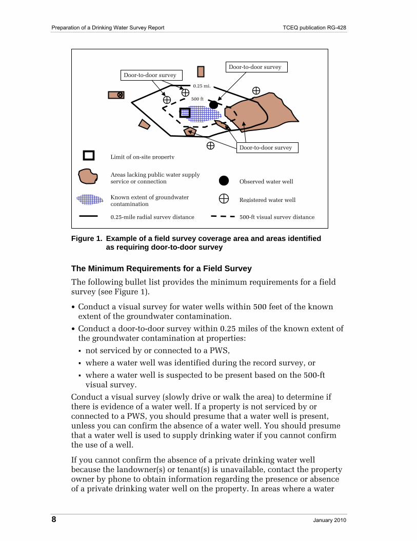
All GPS data collected by hand-held devices and submitted to the TCEQ should conform to the data attributes defined in the following table.
Table B.1. GPS Data Attributes
Attribute Data Type
Field Length
Description
Latitude (Lat_DD) Number Double Decimal Degree to a minimum of six decimal places. (9, 6) As a check the values for Texas are positive and range between 25 and 36.
Longitude (Long_DD) Number Double Decimal Degree to a minimum of six decimal places. (11, 6) As a check the values for Texas are negative and range between -93 and -106.
Collector Name (Coll_Name)
Text 50 Last name, First initial
GPS Certificate Number (Cert_No)
Text 8 TCEQ GPS Certificate Number or N/A
Collection Method (Coll_Meth)
Text 15 Superimposed, Centroid, Offset
Horizontal Datum (Horz_Datum)
Text 5 Horizontal Datum (WGS 84, NAD 83, or NAD 27). Consult Reference Table 6 (Horizontal Datum).
Max PDOP (Max_PDOP)
Number Single Maximum PDOP value in effect during data collection
Receiver Type (Rcvr_Type)
Text 50 GPS model name
Correction Status* (Corr_Type)
Text 50 Differential Correction, Real-time Corrected, Uncorrected
GPS Date (GPS_Date) Date N/A Date GPS data was collected
GPS Time (GPS_Time)
Text 8 Time GPS data was collected
Total Positions Collected (Tot_Pos)
Number Integer Number of positions collected/corrected
* Data that is not differentially corrected may not be used.
Note: Submit only one complete file to the TCEQ that includes the GPS location information and the water well information. Transfer GPS data from the GPS unit to the computer and then into the database or spreadsheet in a way to minimize transposition or typing errors.
18 January 2010

TCEQ publication RG-428 Preparation of a Drinking Water Survey Report
Data Collection Standards for Map Interpolation and Heads-Up Map Digitizing Methods
Internet Map Interpolation
The Internet may be used to find the locational data (latitude and longitude coordinates) for sites and private water wells. An Internet map application may be used if it is an Internet service that features high-resolution aerial photography such as Google Earth, at <earth.google.com>. Be aware that typically these sites make no claims as to the accuracy of these measurements.
Note: The location method selection (Loc_Meth from Reference Table 5) for Internet Map Interpolation is MAP.
Heads-Up Map Digitizing
Graphic Information System (GIS) software may also be used to find the locational data (latitude and longitude coordinates) for sites and private water wells. Orthorectified aerial imagery (i.e., Digital Ortho Quadrangle, DOQ) may be used with GIS software to extract vector data points from raster scans using a cursor on-screen.
Orthorectified aerial imagery may be obtained from an organization such as, but not limited to, the U.S. Geological Survey (USGS) at <www.usgs.gov/pubprod/aerial.html>. The Texas Natural Resources Information System (TNRIS), a Division of the Texas Water Development Board, is the state's clearinghouse for maps, aerial imagery, and digital natural resources data. TNRIS, at <www.tnris.state.tx.us>, also serves as a distribution center for USGS products and has numerous other map collections available for in-house use or reproduction. USGS products are also available from local commercial firms that deal with surveying and mapping products; check your local yellow pages for additional sources of orthorectified aerial imagery.
Note: The location method selection (Loc_Meth from Reference Table 5) for Heads-Up Digitizing with a DOQ is GIS-M3.
Note: Internet- or Web-based address matching software such as Yahoo Maps, Map Quest, and Globe Explorer may not provide accurate locations based on addresses. In fact, the results of an Internet address search can sometimes be miles away from its actual location. You should not use this method.
January 2010 19

Preparation of a Drinking Water Survey Report TCEQ publication RG-428
Attachment A (to App. B. Instructions for Collecting and Submitting Site and Private Water Well Location Information)
Site Location Information
The following information is needed for the site location. The description includes information about field names for use in a database. Consult the reference tables as necessary for additional information. For consistency in compiling the data, use the exact name of each field. All previously mentioned standards must be followed.
1. Site Name ID (Site_Name): Insert the name of the site that is related to the well search.
2. Site ID (Site_ID): Insert the program ID number that refers to the site (for example, SWR number, LPST ID number, VCP ID number, etc).
3. Location Method (Loc_Meth): Specify the method used to collect the latitude and longitude data. Consult Reference Table 5.
4. Horizontal Accuracy (Horz_Acc): Assessment of the horizontal accuracy of the reported latitude/longitude coordinate expressed in meters. Accuracy will depend on the method of collection, procedures and equipment used, and/or the results of any statistically valid test of similar points. Consult Reference Table 7.
5. Horizontal Reference (Horz_Ref): A code that specifically describes the precise location of the coordinate within the property. Consult Reference Table 8.
Format and Submission Guidelines
Option 1: Preferred Method. Submit the information in the PRVWW.mdb in Microsoft Access 2000 or 2003 format located at <www.tceq.state.tx.us/goto/pdw_survey_reports>.
Option 2: .XLS. Submit the information in a Microsoft Excel format (.xls). An example is located at <www.tceq.state.tx.us/goto/pdw_survey_reports>.
20 January 2010

TCEQ publication RG-428 Preparation of a Drinking Water Survey Report
Attachment B (to App. B. Instructions for Collecting and Submitting Site and Private Water Well Location Information)
Private Water Well Information
The following information is needed for each applicable private water well. The description includes information about field names for use in a database. Consult the reference tables for additional information. For consistency in compiling the data, use the exact name of each field. All previously mentioned standards must be followed.
1. Site Name ID (Site_Name): Insert the name of the site that is related to the well search.
2. Site ID (Site_ID): Insert the program ID number that refers to the site where groundwater contamination has been found (for example, SWR number, LPST ID number, VCP ID number, etc).
3. State Well ID (SWell_ID): When available, use State Well ID Numbers. Leave blank if not available.
4. Physical Address of Well (Well_Add; Well_City; Well_Zip; FIPS_Co): Provide the physical address of the well. Include the street address, city, county, and zip code. Corresponding FIPS codes for each county are located at <www.epa.gov/enviro/html/codes/tx.html>.
5. Map ID No. (Map_ID_No): This is the number that identifies the well location on the map provided.
6. Well Type (Well_Type): This category includes the type of well (e.g., private drinking water well, industrial, irrigation, or public supply well). Consult Reference Table 1 for preset options for the database. This table and all other tables mentioned can be found in the database itself.
7. Well Use (Well_Use): There are three options: drinking, non-drinking, and unknown. Drinking water wells include wells that are plumbed to structures intended for human occupancy and used for potable purposes. Consult Reference Table 2.
8. Well Status (Well_Stat): This category describes the latest status of well, for example, if it is operational, abandoned, plugged, etc. Consult Reference Table 3.
9. Well Owner and Address Information (Owner_Name; Owner_Add; Owner_City, Owner_St, Owner_Zip; Owner_Ph; OMail_Add; OMail_City, OMail_St, OMail_Zip): Provide the owner’s name, physical address, mailing address, and phone number. Include the street address, city, and zip code.
10. Well User(s) and Address Information: (User_Name; User_Add; UMail_City, UMail_St, UMail_Zip; User_Ph): If the well user is not
January 2010 21

Preparation of a Drinking Water Survey Report TCEQ publication RG-428
the same as the well owner, provide the user’s name, mailing address, and phone. Include the street address, city, and zip code.
11. Distance to Known Extent of Groundwater Contamination (Dist_GWC): The shortest linear distance listed in feet.
12. Well Depth (Well_Depth): Total well depth in feet below ground surface (bgs). Leave blank if unknown.
13. Top of the Screened Interval (Top_Screen): Listed in feet bgs. Leave blank if unknown.
14. Bottom of the Screened Interval (Bot_Screen): Listed in feet bgs. Leave blank if unknown.
15. Top of Cementation Zone (Top_Cemt): Listed in feet bgs. Leave blank if unknown.
16. Bottom of Cementation Zone (Bot_Cemt): Listed in feet bgs. Leave blank if unknown.
17. Aquifer Code/Name (Aquif_Name): The aquifer codes can be found at <www.twdb.state.tx.us/publications/reports/groundwaterreports/gwdatabasereports/Database%20in%20ASCII/All%20Counties/aquifer.txt>.
18. Aquifer Method (Aquif_Meth): Specify how the aquifer information was collected. Consult Reference Table 4.
19. Location Method (Loc_Meth): Specify the method used to collect the latitude and longitude data. Consult Reference Table 5.
20. Horizontal Accuracy (Horz_Acc): Assessment of the horizontal accuracy of the reported latitude/longitude coordinate expressed in meters. Accuracy will depend on the method of collection, procedures and equipment used, and/or the results of any statistically valid test of similar points. Consult Reference Table 7.
21. Horizontal Reference (Horz_Ref): A code that specifically describes the precise location of the coordinate within the property. Consult Reference Table 8.
22. Date Well Installed (Date_Well): Enter the date the well was installed.
23. Comment (Comments): Identify any qualifiers or additional information that has been obtained during the water well survey (e.g., water used for vegetable gardens, filling a swimming pool), per well.
Format and Submission Guidelines
Option 1: Preferred Method. Submit the information in the PRVWW.mdb in Microsoft Access 2000 or 2003 format located at <www.tceq.state.tx.us/goto/pdw_survey_reports>.
Option 2: .XLS. Submit the information in a Microsoft Excel format (.xls). An example is located at <www.tceq.state.tx.us/goto/pdw_survey_reports>.
22 January 2010

TCEQ publication RG-428 Preparation of a Drinking Water Survey Report
Reference Tables (to App. B. Instructions for Collecting and Submitting Site and Private Water Well Location Information)
Reference Table 1. Well Type
Abbrev. Well Type Definition
Prv Private Well meets definition of private drinking water well in Texas Water Code, Section 26.408, and guidance document RG-428
E De-Watering
I Irrigation
J Injection
M Monitor Well
N Industrial
P Public Supply Well meets definition of public well according to 30 TAC, Chapter 290
S Stock
T Test Well
U Unknown
Reference Table 2. Well Use
Abbrev. Well Use Description
D Drinking Water Water used for human consumption, including wells plumbed to structures
N Non-Drinking Water Water used for purposes other than human consumption and is not included in the Drinking Water Well Use Description as described above
U Unknown Water use unknown
January 2010 23

Preparation of a Drinking Water Survey Report TCEQ publication RG-428
Reference Table 3. Well Status
Abbrev. Well Status Definition
A Abandoned Well is abandoned according to TDLR Rules*
C Capped Well is capped according to TDLR Rules
O Operational Well is operational
P Plugged Well is plugged according to TDLR Rules
U Unknown Well status is unknown
* According to Texas Department of Licensing and Regulation, an “abandoned well" means a well that is not in use. A well is considered to be in use if: (1) the well is not a deteriorated well and contains the casing, pump, and pump column in good condition; (2) the well is not a deteriorated well and has been capped; (3) the water from the well has been put to an authorized beneficial use, as defined by the Water Code; (4) the well is used in the normal course and scope and with the intensity and frequency of other similar users in the general community; or (5) the owner is participating in the Conservation Reserve Program authorized by Sections 1231–1236, Food Security Act of 1985 (Title 16, United States Code, Sections 3831–3836), or a similar governmental program.
Reference Table 4. Aquifer Method
Abbrev. Aquifer Method
C Computer Database, Method Not Indicated
D Interpretation of Driller’s Log
G Interpretation of Geological Atlas of Texas Sheet
H Interpretation of County Hydrogeological Report
L Interpretation of Geophysical Log
Q Interpretation of 7.5-Minute Geological Map
R Published or Unpublished Report
Well Construction and Location Compared to TWDB Wells
U Unknown
W Well Schedule
X Aquifer Code Assumed from Geographic Location
24 January 2010

TCEQ publication RG-428 Preparation of a Drinking Water Survey Report
Reference Table 5. Location Method
Abbrev. Location Method
AddMat Address Matching
GPS-C GPS Coordinates, D.C. Centroid
GIS-M3 GIS Heads-Up Digitizing, 1:24K DOQ
GPS-NC GPS Coordinates, No Corrections
GPS-PP1 GPS Coordinates, TXDOT Post Process
GPS-PP2 GPS Coordinates, Tandem R. Post Process
GPS-PP3 GPS Coordinates, Unknown Post Process
GPS-PP4 GPS Coordinates, Pathfinder Office P.P.
GPS-RT1 GPS Coordinates, NavStar D. C.
GPS-RT2 GPS Coordinates, Commercial Radio D. C.
GPS-RT3 GPS Coordinates, Other D. C.
GPS-S GPS Coordinates, D.C. Superimposed
GPS-Sur GPS Coordinates, Survey Level Quality
GPS-Unk GPS Coordinates, Method Unknown
Map Map Interpolation, Digital
Unknown Unknown Method
Reference Table 6. Horizontal Datum
Abbrev. Horizontal Datum
0 Datum Unknown
27 North American Datum 1927 (NAD 27)
83 North American Datum 1983 (NAD 83)
84 World Geodetic System 1984 (WGS 84)
Reference Table 7. Horizontal Accuracy
Abbrev. Horizontal Accuracy
P Less than 2 m
Q Within 2 to 5 m
R Greater than 5 m
U Unknown
January 2010 25

Preparation of a Drinking Water Survey Report TCEQ publication RG-428
26 January 2010
Reference Table 8. Horizontal Reference
Abbrev. Horizontal Reference
DR Private Driveway at the Road
E-CL East Corner of Land Parcel
FD Front Door
N-CL North Corner of Land Parcel
NE-CL Northeast Corner of Land Parcel
NW-CL Northwest Corner of Land Parcel
SC Site Center
S-CL South Corner of Land Parcel
SE Site Entrance
SE-CL Southeast Corner of Land Parcel
SW-CL Southwest Corner of Land Parcel
W-CL West Corner of Land Parcel
WH Wellhead
Comments If needed, insert a comment regarding why the location was taken at a particular spot.