Embed Size (px)
Citation preview

Catalogue no. 92-153-G
March 2009 Postal codes
Postal Code ConversionFile (PCCF),Reference Guide
How to obtain more information
For information about this product or the wide range of services and data available from Statistics Canada, visit our website at www.statcan.gc.ca, e-mail us at [email protected], or telephone us, Monday to Friday from 8:30 a.m. to 4:30 p.m., at the following numbers:
Statistics Canada’s National Contact CentreToll-free telephone (Canada and United States): Inquiries line 1-800-263-1136 National telecommunications device for the hearing impaired 1-800-363-7629 Fax line 1-877-287-4369
Local or international calls: Inquiries line 1-613-951-8116 Fax line 1-613-951-0581
Depository Services Program Inquiries line 1-800-635-7943 Fax line 1-800-565-7757
To access this product
This product, Catalogue no. 92-153-G, is available free in electronic format. To obtain a single issue, visit our website at www.statcan.gc.ca and select “Publications.”
Standards of service to the public
Statistics Canada is committed to serving its clients in a prompt, reliable and courteous manner. To this end, Statistics Canada has developed standards of service that its employees observe. To obtain a copy of these service standards, please contact Statistics Canada toll-free at 1-800-263-1136. The service standards are also published on www.statcan.gc.ca under “About us” > “Providing services to Canadians.”
Statistics Canada
Postal Code Conversion File (PCCF), Reference Guide
March 2009 Postal codes
Published by authority of the Minister responsible for Statistics Canada © Minister of Industry, 2009 All rights reserved. The content of this electronic publication may be reproduced, in whole or in part, and by any means, without further permission from Statistics Canada, subject to the following conditions: that it be done solely for the purposes of private study, research, criticism, review or newspaper summary, and/or for non-commercial purposes; and that Statistics Canada be fully acknowledged as follows: Source (or “Adapted from”, if appropriate): Statistics Canada, year of publication, name of product, catalogue number, volume and issue numbers, reference period and page(s). Otherwise, no part of this publication may be reproduced, stored in a retrieval system or transmitted in any form, by any means—electronic, mechanical or photocopy—or for any purposes without prior written permission of Licensing Services, Client Services Division, Statistics Canada, Ottawa, Ontario, Canada K1A 0T6. July 2009 Catalogue no. 92-153-G Issue number 2009002 ISSN 1708-3095 Frequency: semi-annual Ottawa Cette publication est disponible en français sur demande (no 92-153-G au catalogue).
Note of appreciation Canada owes the success of its statistical system to a long-standing partnership between Statistics Canada, the citizens of Canada, its businesses, governments and other institutions. Accurate and timely statistical information could not be produced without their continued cooperation and goodwill.
March 2009 Postal codes Postal Code Conversion File (PCCF), Reference Guide
What's new?
• The postal code reference date for this Postal Code Conversion File (PCCF) is March 2009.
• With this release, some geocoding linkages within the PCCF were improved. A total of 636 records were updated and 4,104 were deleted from the postal code database used to generate the PCCF.
• A file is available that indicates all of the postal codes corrected in the March 2009 PCCF.
• New record level metadata are included indicating the source, quality and type of linkage made between the postal code and the geographic area.
• A conceptual review of the postal code to geographic area linkage was completed. The resulting working paper, entitled How Postal Codes Map to Geographic Areas (Catalogue no. 92F0138MIE2007001), is available on the Statistics Canada website (www.statcan.gc.ca).
Statistics Canada 4 Catalogue no. 92-153-G

March 2009 Postal codes Postal Code Conversion File (PCCF), Reference Guide
Table of contents Page What’s new? ............................................................................................................................................... 4 1 About this guide....................................................................................................................................... 6 2 Overview ............................................................................................................................................... 7
Reference dates......................................................................................................................................................7 3 How to use this product .......................................................................................................................... 8
Purpose of the product............................................................................................................................................8 Limitations...............................................................................................................................................................8 General methodology..............................................................................................................................................9 Content ...................................................................................................................................................................9 Comparison to the 2001 Census Postal Code Conversion Files (PCCF)..............................................................11
4 Data quality............................................................................................................................................. 12 Lineage .................................................................................................................................................................12 Linking to 2006 Census geographic areas............................................................................................................12 Positional accuracy ...............................................................................................................................................14 Attribute accuracy .................................................................................................................................................15 Logical consistency...............................................................................................................................................16 Consistency with other products ...........................................................................................................................16 Completeness .......................................................................................................................................................16
5 Technical specifications........................................................................................................................ 17 File specifications..................................................................................................................................................17 Postal Code Conversion File (PCCF) and Retired 2005 record layouts and data descriptions.............................17 Name files record layouts......................................................................................................................................24
Appendix A Glossary............................................................................................................................... 25 Appendix B Hierarchy of standard geographic units for dissemination, 2006 Census ................... 32 Appendix C Postal code structure ......................................................................................................... 33 Appendix D Quality indicator.................................................................................................................. 35 Appendix E Representative points......................................................................................................... 36 Appendix F Census subdivision types by province and territory, 2006 Census .............................. 37 Appendix G Data file naming convention.............................................................................................. 39 End-use licence agreement for Statistics Canada’s Postal Code Conversion File (PCCF) .............. 40
Statistics Canada 5 Catalogue no. 92-153-G
March 2009 Postal codes Postal Code Conversion File (PCCF), Reference Guide
1 About this guide This guide is intended for users of the Postal Code Conversion File (PCCF). It provides general information about the product, including a description of the general methodology used in its creation. Section 4, Data quality, gives a detailed description of the steps taken to create the PCCF. This section also provides information to evaluate the suitability of the data for a particular use. Section 5, Technical specifications includes record layouts and item descriptions. Geographic terms and concepts are briefly described in the glossary (Appendix A). More details can be found in the 2006 Census Dictionary (Catalogue no. 92-566-XWE). Supplementary information is provided in the appendices. This data product is provided 'as-is', and Statistics Canada makes no warranty, either express or implied, including but not limited to, warranties of merchantability and fitness for a particular purpose. In no event will Statistics Canada be liable for any direct, special, indirect, consequential or other damages, however caused.
Statistics Canada 6 Catalogue no. 92-153-G
March 2009 Postal codes Postal Code Conversion File (PCCF), Reference Guide
2 Overview The Postal Code Conversion File (PCCF) is a digital file which provides a correspondence between the Canada Post Corporation (CPC) six-character postal code and Statistics Canada’s standard geographic areas for which census data and other statistics are produced. Through the link between postal codes and standard geographic areas, the PCCF permits the integration of data from various sources. The geographic coordinates attached to each postal code on the PCCF are commonly used to map the distribution of data for spatial analysis (e.g., clients, activities). The location information is a powerful tool for marketing, planning, or research purposes. In April 1983, the Geography Division released the first version of the PCCF, which linked postal codes to 1981 Census geographic areas and included geographic coordinates. Since then, the file has been updated on a regular basis to reflect changes. For this release of the PCCF, the vast majority of the postal codes are directly geocoded to 2006 Census geography. This improves precision of the file over the previous conversion process used to align postal code linkages to new geographic areas after each census. About 94% of the postal codes were linked to geographic areas using the new automated process. A quality indicator for the confidence of this linkage is available in the PCCF. Reference dates The reference date for postal codes contained in this product is March 2009. The geographic reference date is a date determined by Statistics Canada to finalize the geographic framework for which the census data are collected, tabulated and reported. The geographic reference date for the 2006 Census is January 1, 2006.
Statistics Canada 7 Catalogue no. 92-153-G
March 2009 Postal codes Postal Code Conversion File (PCCF), Reference Guide
3 How to use this product Purpose of the product The Postal Code Conversion File (PCCF) provides a link between six-character postal codes and standard 2006 Census geographic areas such as dissemination areas, census subdivisions and census tracts. It also provides a latitude and longitude coordinate for a point representing the approximate location of the postal code to support mapping. Limitations The PCCF contains multiple records for a postal code when the postal code straddles more than one block-face, dissemination block, or dissemination area. It should be acknowledged that the Canada Post Corporation source data used to create the PCCF contains some postal codes which have links to multiple address ranges. For example, in the March 2009 file received from Canada Post Corporation, 512 postal codes were linked to between 50 and 100 different address ranges, and 319 postal codes were linked to 100 or more address ranges. Civic addresses are not available for some postal codes such as those associated with rural routes. Many of these postal codes tend to straddle several dissemination areas and often cross boundaries of standard geographic areas such as census tracts or census subdivisions. It is difficult, if not impossible, to identify the precise physical location of a rural postal code. Community mailboxes are a growing source for multiple records per postal code on the PCCF. In newer urban delivery areas, postal codes are assigned to a community mailbox that may cover partial dissemination blocks, both sides of a street, and different streets within 200 metres of the community mailbox. These situations often result in multiple links being established between a postal code and block-faces, unlike the more traditional urban postal codes, which correspond generally to a block-face. The single link indicator (SLI) was created to assist users in dealing with postal codes with multiple records. The method used to establish the single link indicator identifies the geographic area with the majority of dwellings assigned to a particular postal code. Users should be aware that only a partial correspondence between the postal code and other geographic areas is achieved when using the single link indicator. It should also be noted that the single link indicator is identified on both active and retired postal codes. Users will find when working with both active and retired postal codes, multiple SLIs will appear for a postal code that has been retired and reintroduced. Table 3.1 presents the number of postal codes (including retired postal codes) that show multiple links by geographic area. Table 3.1 Postal codes with multiple links
Geographic area Number of postal codes
Dissemination block 116,024 Dissemination area 89,666 Census tract 16,919 Census subdivision 7,353 Census division 1,865 Census metropolitan area 240 Province/Territory 1
Statistics Canada 8 Catalogue no. 92-153-G
March 2009 Postal codes Postal Code Conversion File (PCCF), Reference Guide
The address associated with a postal code does not always represent the location where those receiving mail using that postal code actually reside. This is particularly the case in rural areas, where rural route service and post office pick-up are commonly used to deliver mail. The delivery mode type of 'W' (rural) and 'H' (rural route) on the PCCF identify postal codes that are usually considered rural. A typical rural route address, such as 'RR#6, Georgeville, Québec', does not provide sufficient address information to identify a precise physical location. A rural post office address such as 'PO BOX 4001 STN A VICTORIA BC' is also imprecise and not explicitly attached to the dwellings served by that postal code. Consequently, rural postal codes cannot be used in the same manner as most urban postal codes can to precisely geo-reference a physical location. Similarly, postal codes with a delivery mode type of 'K' (group of post office boxes) or 'M' (one post office box) may be linked to the location of the postal installation on the PCCF, as opposed to the physical location of customers who rent a post office box. A new variable indicating whether a postal code is linked to a post office location or to where the customers reside is now available in the PCCF. General methodology The Postal Code Conversion File (PCCF) is updated on a regular basis and is released every six months. The regular maintenance of the file takes all postal code changes continually introduced by Canada Post Corporation (CPC) and finds the corresponding census geographic areas. Every five years, after each census, the PCCF is aligned with the new census geographic areas. Every month, Statistics Canada obtains files from CPC containing the latest postal codes, address ranges and other attributes such as delivery mode type. Whenever possible, postal code address ranges are linked to a block-face, dissemination block or dissemination area. Municipality maps are also used and, when necessary, contact is made with local authorities to obtain as precise a street and address location as possible. When the block-face or dissemination block cannot be precisely determined, the postal code is coded to a dissemination area(s). All other postal code links to higher level geographic areas are derived from the block-face, dissemination block or dissemination area. Content This version of the PCCF contains a total of 829,045 postal codes (825,644 active, 3,401 retired codes that are not active). This total figure includes seven postal codes reintroduced since the last release. Postal codes retired before January 1, 2006 are included in a separate file called Retired 2005, available with the PCCF. These postal codes are linked to the geographic areas used in the 2006 Census and to latitude and longitude coordinates. This file contains postal code data under license from CPC. The CPC file from which the active postal code data were obtained is dated March 2009. The PCCF includes all valid postal codes as of March 2009 according to CPC. Postal codes do not respect census geographic boundaries and so may be linked to more than one standard geographic area, or assigned to more than one set of coordinates. Therefore, one postal code may be represented by more than one record. Postal codes can also straddle provincial boundaries. See Postal code structure (Appendix C) for more information. Postal code data are available as a national file or as separate provincial/territorial files identified by using Standard Geographic Classification (SGC) codes. This is summarized in Data file naming convention (Appendix G).
Statistics Canada 9 Catalogue no. 92-153-G
March 2009 Postal codes Postal Code Conversion File (PCCF), Reference Guide
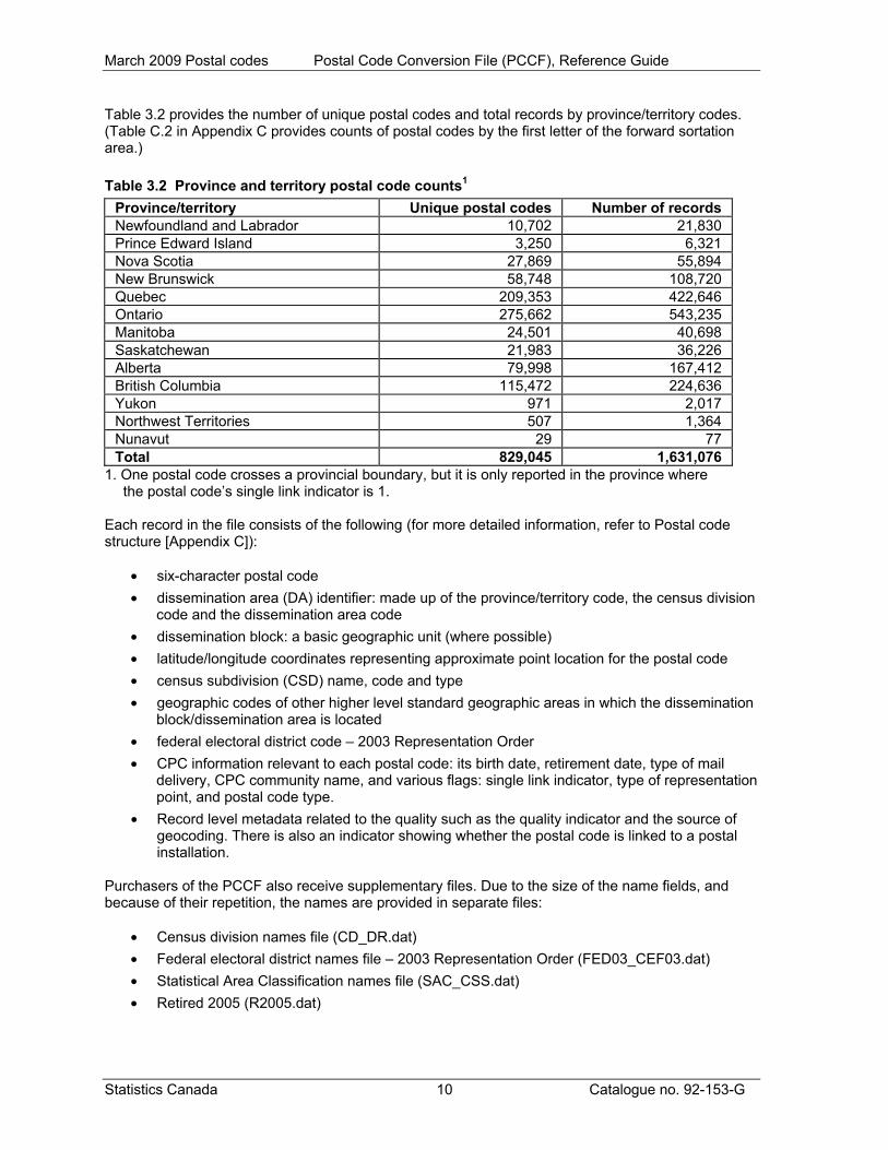
Table 3.2 provides the number of unique postal codes and total records by province/territory codes. (Table C.2 in Appendix C provides counts of postal codes by the first letter of the forward sortation area.) Table 3.2 Province and territory postal code counts1
Province/territory Unique postal codes Number of records Newfoundland and Labrador 10,702 21,830 Prince Edward Island 3,250 6,321 Nova Scotia 27,869 55,894 New Brunswick 58,748 108,720 Quebec 209,353 422,646 Ontario 275,662 543,235 Manitoba 24,501 40,698 Saskatchewan 21,983 36,226 Alberta 79,998 167,412 British Columbia 115,472 224,636 Yukon 971 2,017 Northwest Territories 507 1,364 Nunavut 29 77 Total 829,045 1,631,076
1. One postal code crosses a provincial boundary, but it is only reported in the province where the postal code’s single link indicator is 1.
Each record in the file consists of the following (for more detailed information, refer to Postal code structure [Appendix C]):
• six-character postal code • dissemination area (DA) identifier: made up of the province/territory code, the census division
code and the dissemination area code • dissemination block: a basic geographic unit (where possible) • latitude/longitude coordinates representing approximate point location for the postal code • census subdivision (CSD) name, code and type • geographic codes of other higher level standard geographic areas in which the dissemination
block/dissemination area is located • federal electoral district code – 2003 Representation Order • CPC information relevant to each postal code: its birth date, retirement date, type of mail
delivery, CPC community name, and various flags: single link indicator, type of representation point, and postal code type.
• Record level metadata related to the quality such as the quality indicator and the source of geocoding. There is also an indicator showing whether the postal code is linked to a postal installation.
Purchasers of the PCCF also receive supplementary files. Due to the size of the name fields, and because of their repetition, the names are provided in separate files:
• Census division names file (CD_DR.dat) • Federal electoral district names file – 2003 Representation Order (FED03_CEF03.dat) • Statistical Area Classification names file (SAC_CSS.dat) • Retired 2005 (R2005.dat)
Statistics Canada 10 Catalogue no. 92-153-G
March 2009 Postal codes Postal Code Conversion File (PCCF), Reference Guide
The basic link between the postal code and other standard census geographic areas is made through one or more 2006 Census dissemination blocks. The geographic areas contained on the PCCF are shown on the hierarchy chart (Appendix B). The PCCF is available as standard packages for Canada, the provinces and territories. Custom orders are available on request. Contact us by e-mail ([email protected]) or by visiting our website (www.statcan.gc.ca). Comparison to the 2001 Census Postal Code Conversion Files (PCCF)
• The 2006 Census PCCF record layout has changed (i.e., the order of the fields has changed).
• The 2006 Census PCCF links to 2006 Census geographic areas, whereas the 2001 Census PCCFs linked to 2001 Census geographic areas.
• The 2006 Census PCCF has new variables, including: census subdivision unique identifier (CSDuid), dissemination block code, delivery installation (PO), quality indicator (QI), and Source.
• The PCCF with March 2009 postal codes has more precision in the geocoding. In this version, 720,862 postal codes (or 86.95% of the postal codes) are coded to block-face level. In the September 2006 PCCF, 541,960 postal codes (or 62.89% of the postal codes) were linked to block-face level.
Statistics Canada 11 Catalogue no. 92-153-G
March 2009 Postal codes Postal Code Conversion File (PCCF), Reference Guide
Statistics Canada 12 Catalogue no. 92-153-G
4 Data quality Linkage data quality elements provide information on the fitness-for-use of a linkage database by describing why, when, and how the data are created, and how accurate the data are. The elements include an overview describing the purpose and usage, as well as specific quality elements reporting on the lineage, positional accuracy, attribute accuracy, logical consistency and completeness. This information is provided to users for all linkage data products disseminated for the census. Lineage Lineage describes the history of the linkage data, including descriptions of the source material from which the data were derived and the methods of derivation. It also contains the dates of the source material, and all transformations involved in producing the final digital files. The Postal Code Conversion File (PCCF) is the result of two updating activities. The first is done every five years, after each census, to align the database to the latest census geographic areas. The other is the ongoing maintenance activity that links the latest postal codes from Canada Post Corporation (CPC) to census geographic areas. These links are recorded on the Geography Division’s postal code database. Linking to 2006 Census geographic areas Sources The sources used to align the census geography linkage from 2001 to 2006 were:
• Monthly updates of the Address Lookup File, Postal Code Delivery Mode File, and Householder File from CPC
• Geography Division’s Spatial Data Infrastructure (SDI) • 2006 Census of Population and Dwellings • September 2006 PCCF • 2006 Census block-face, dissemination block, and representative points data files • Dissemination area correspondence file
Process The following steps were used to assign 2006 Census geographic areas to the PCCF:
1. Process information from the CPC files 2. Automated geocoding of postal codes to 2006 Census block-face, dissemination block or
dissemination area 3. Assign 2006 Census dissemination areas for postal codes using the correspondence between
2001 Census and 2006 Census geographic areas 4. Manually geocode postal codes 5. Sample verification of postal code records 6. Assign the single link indicator (SLI) 7. Assign higher levels of geography.
Step 1: Process information from the CPC files The monthly files received from CPC between October 2006 and March 2009 are processed to assign Birth date, Retired date, Historic Delivery Mode Type (H_DMT) and Delivery Mode Type (DMT). Records are extracted from the CPC Address Lookup File with the postal code, Postal Code type (PCtype) and related address information. Birth date is the date the postal code became effective. Retired date is the date the postal code is no longer found in the CPC monthly files. The Delivery Mode Type is assigned
March 2009 Postal codes Postal Code Conversion File (PCCF), Reference Guide
using the Delivery Mode Type File. When a DMT is updated for a postal code, the previous DMT becomes the H_DMT. Users should note that some postal codes are retired and reintroduced at a later date, possibly in another location. Step 2: Automated geocoding of postal codes to 2006 Census block-face, dissemination block or
dissemination area All postal codes active in March 2009 are geocoded using a new automated geocoding system. A detailed discussion of the new approach to geocoding is found in the working paper entitled How Postal Codes Map to Geographic Areas (Catalogue no. 92F0138MIE2007001), which is available on the Statistics Canada website (www.statcan.gc.ca). The new system uses the forward sortation area (FSA) search area file and a match between CPC municipality and census subdivision (CSD) to determine the general area where the postal code would be found. Census responses are used to create FSA search areas. These FSA areas are composed of dissemination areas where a particular FSA was reported in the 2006 Census. Canada Post municipalities are matched to 2006 Census subdivisions using the province of the municipality and the similarity in name. When the match is not clear, historical CSD files on the Spatial Data Infrastructure (SDI) are used to determine the match. Postal codes with civic address ranges associated with them (PCtype 1 and 2) are coded to the appropriate dissemination area, dissemination block or block-face in the SDI. About 94% of the PCtype 1 and 2 postal code records in the March 2009 PCCF were coded in this way. The postal code response in the 2006 Census is used to code rural routes, postal installation/post office boxes and postal codes that service general areas. These postal codes are geocoded to the dissemination area (DA) level. The number of DAs coded to is reduced in a post process to remove duplication in DA assignment. However, not all active postal codes are geocoded in this way, either because the address information is not found or the census response is not significant (at least four responses of that postal code per dissemination block) to determine the appropriate area for geocoding. A quality indicator (QI) is assigned in the automated geocoding process. The indicator is based on the confidence of the link of the postal code to the geographic area. Please see Appendix D for more details. Step 3: Assign 2006 Census dissemination areas for postal codes using the correspondence between
2001 Census and 2006 Census geographic areas
When a match could not be found through the automated address matching system, postal codes that had been previously coded to a 2001 Census geographic area are linked to a 2006 Census geographic area using the correspondence between 2001 Census and 2006 Census geographic areas (based on the 2001 Census dissemination areas in the September 2006 PCCF). These links are created at the 2006 Census DA level only. Step 4: Manually geocode postal codes Postal codes are manually geocoded when they could not be coded at an acceptable degree of precision using the automated process or when they could not be converted using the correspondence between the 2001 Census and 2006 Census geographic areas. In addressable areas covered by the Spatial Data Infrastructure (SDI), an attempt is made to link postal codes to one or more block-faces. The list of new postal codes and address range records from CPC was matched to the SDI street listings according to elements common to both files (e.g., province, municipality, street name, type, direction, and address range). Once matched, the postal code and related geographic area codes are transferred to the postal code database. For those postal codes that could not be coded by the above method, municipal and other maps are used to find the street(s). If a street could not be found on a municipal map or other authoritative source, local authorities (such as Planning and Engineering Departments and local post offices) are contacted to assist
Statistics Canada 13 Catalogue no. 92-153-G
March 2009 Postal codes Postal Code Conversion File (PCCF), Reference Guide
in the location of the street. In areas experiencing high growth, new maps are requested from the proper authority. After the street is located, the position of the boundary relative to that street on the SDI is used to determine the associated dissemination area. Step 5: Sample verification of postal code records The relationship between the postal code, dissemination blocks and dissemination areas is verified by sampling records from the geocoding completed in each of the processes above. These records are independently manually geocoded. The two sets of geocodes are compared as part of the verification. Step 6: Assign the single link indicator (SLI) Many postal codes are represented by multiple records on the PCCF. The single link indicator (SLI) is created to assist users dealing with postal codes having multiple records. The SLI provides a geographic record for mapping a postal code representative point. The SLI has a value of '1' to flag the best (or only) link for a given postal code. The value '0' indicates an additional record. Please note that the SLI is identified on both active and retired postal codes. Users will find when working with both active and retired postal codes that multiple SLIs will appear for a postal code that was retired and reintroduced. However, there will only be one SLI for a set of active records for a postal code. When assigning the SLI, priority is given to postal codes associated with civic addresses or dwellings (based on the PCtype). The confidence of coding to the geographic area (the quality indicator) and the precision of the geocoding (the block-face, dissemination area or dissemination block), as well as the population are considered. When the postal code was linked to a DA associated with multiple federal electoral district (FED), urban area (UA), or designated place (DPL), the SLI is linked to the record represented by the greatest proportion of the FED, UA, or DPL population. Users are cautioned that the SLI provides only a partial correspondence between the postal code and other geographic areas. Step 7: Assign higher levels of geography Higher levels of geography are assigned based on the block-face, dissemination block, or dissemination area. Please see the hierarchy chart in Appendix B for how geographic areas are related. When a dissemination area is related to more than one FED, DPL or UA, more than one record appears in the PCCF for that postal code to dissemination areas linkage. Positional accuracy Positional accuracy refers to the absolute and relative accuracy of the positions of geographic features. Absolute accuracy is the closeness of the coordinate values in a dataset to values accepted as being true. Relative accuracy is the closeness of the relative positions of features to their respective relative positions accepted as or being true. Descriptions of positional accuracy include the quality of the final file or product after all transformations. The geographic coordinates assigned to postal codes are either block-face, dissemination block or dissemination area representative points calculated for census purposes. Therefore, the positional accuracy of the postal code is dependent on:
• the accuracy of the links established between the postal code and the block-face, dissemination block, or dissemination area
• the positional accuracy of the block-face, dissemination block, or dissemination area representative point with respect to the block-face, dissemination block, or dissemination area.
Using different methods to create links in the PCCF results in varying degrees of accuracy for those links. Postal codes linked to block-faces are considered to be the more precise, as they are linked as closely as possible to address ranges representing the location of the postal code according to CPC. When the
Statistics Canada 14 Catalogue no. 92-153-G
March 2009 Postal codes Postal Code Conversion File (PCCF), Reference Guide
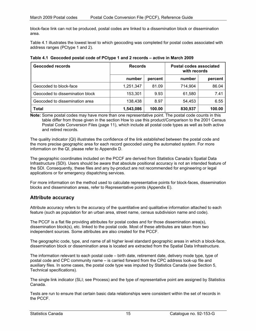
block-face link can not be produced, postal codes are linked to a dissemination block or dissemination area. Table 4.1 illustrates the lowest level to which geocoding was completed for postal codes associated with address ranges (PCtype 1 and 2). Table 4.1 Geocoded postal code of PCtype 1 and 2 records – active in March 2009
Note: Some postal codes may have more than one representative point. The postal code counts in this table differ from those given in the section How to use this product/Comparison to the 2001 Census Postal Code Conversion Files (page 11), which include all postal code types as well as both active and retired records.
Records Postal codes associated with records
Geocoded records
number percent number percent
Geocoded to block-face 1,251,347 81.09 714,904 86.04
Geocoded to dissemination block 153,301 9.93 61,580 7.41
Geocoded to dissemination area 138,438 8.97 54,453 6.55
Total 1,543,086 100.00 830,937 100.00
The quality indicator (QI) illustrates the confidence of the link established between the postal code and the more precise geographic area for each record geocoded using the automated system. For more information on the QI, please refer to Appendix D. The geographic coordinates included on the PCCF are derived from Statistics Canada’s Spatial Data Infrastructure (SDI). Users should be aware that absolute positional accuracy is not an intended feature of the SDI. Consequently, these files and any by-product are not recommended for engineering or legal applications or for emergency dispatching services. For more information on the method used to calculate representative points for block-faces, dissemination blocks and dissemination areas, refer to Representative points (Appendix E). Attribute accuracy Attribute accuracy refers to the accuracy of the quantitative and qualitative information attached to each feature (such as population for an urban area, street name, census subdivision name and code). The PCCF is a flat file providing attributes for postal codes and for those dissemination area(s), dissemination block(s), etc. linked to the postal code. Most of these attributes are taken from two independent sources. Some attributes are also created for the PCCF. The geographic code, type, and name of all higher level standard geographic areas in which a block-face, dissemination block or dissemination area is located are extracted from the Spatial Data Infrastructure. The information relevant to each postal code – birth date, retirement date, delivery mode type, type of postal code and CPC community name – is carried forward from the CPC address look-up file and auxiliary files. In some cases, the postal code type was imputed by Statistics Canada (see Section 5, Technical specifications). The single link indicator (SLI; see Process) and the type of representative point are assigned by Statistics Canada. Tests are run to ensure that certain basic data relationships were consistent within the set of records in the PCCF.
Statistics Canada 15 Catalogue no. 92-153-G

March 2009 Postal codes Postal Code Conversion File (PCCF), Reference Guide
Logical consistency Logical consistency describes the fidelity of relationships encoded in the data structure of the digital linkage data. In some cases, especially in rural areas, the postal code service areas do not respect dissemination area boundaries. When this occurs, the same postal code is repeated with different geographical information (i.e., different coordinates or dissemination area codes). These multiple records for a postal code reflect the relationship between the postal code and census geographic areas. Also, a postal code can be linked to more than one block-face or dissemination block within the same dissemination area. Conversely, different postal codes could have the same coordinates. This happens when more than one postal code has been linked to the same dissemination area. Also, more than one postal code can be linked to a single block-face or dissemination block. Every set of active records for a postal code has one SLI equal to ‘1’. Every set of retired records for a postal code, for a given retirement date, has one SLI equal to ‘1’. Consistency with other products Geographic areas contained in the PCCF are consistent with all 2006 Census related geographic products, except for the 2006 Census Forward Sortation Area Boundary File (Catalogue no. 92-170-XWE, XCE). The 2006 Census Forward Sortation Area Boundary File represents only the FSAs reported in the 2006 Census, whereas the PCCF is updated twice a year to include recent postal codes and also includes retired postal codes. Completeness Completeness refers to the degree to which geographic features, their attributes and their relationships are included or omitted in a dataset. It also includes information on selection criteria, definitions used, and other relevant mapping rules. Completeness in the context of the PCCF is the degree to which all valid postal codes are accounted for on the PCCF and all geographic codes from the 2006 Census are linked to a postal code. All postal codes as of March 2009 according to CPC have been linked to census geography. There are 459 populated dissemination areas that are not linked to any postal code on the PCCF. Of the DAs that are linked to a postal code, there are ten populated dissemination areas that are not linked to any active postal code on the PCCF. There are also 3,401 retired postal codes included in the PCCF. Postal codes retired before January 1, 2006 are included in the auxiliary file, Retired 2005. There are 59,247 retired postal codes in the Retired 2005 file. The quality indicator (QI) is currently available only for the records using the automated geocoding process. When postal codes were geocoded using address information, each of the three characters of the QI contains an 'A', 'B' or 'C' indicating the confidence of geocoding. When the QI could not be determined, an 'N' is used to represent 'unknown'. The QI for the records that are manually geocoded or were directly converted from the 2001 Census geocodes contain an 'NNN' for the QI. Every attempt was made to ensure that the delivery installation (PO) value indicated whether a postal code of PCtype 3 or 5 was coded to a postal installation or to the area serviced by the postal code. Occasionally a PCtype 3 or 5 record may be coded to a postal installation (indicated in a record with PO=’1’) and to a service area (indicated by a record with PO=’0’). In some cases, including where the geographic area linkages were directly based on conversion from the 2001 Census geocodes, the PO is unknown (this is indicated by a PO=’2’).
Statistics Canada 16 Catalogue no. 92-153-G
March 2009 Postal codes Postal Code Conversion File (PCCF), Reference Guide
Statistics Canada 17 Catalogue no. 92-153-G
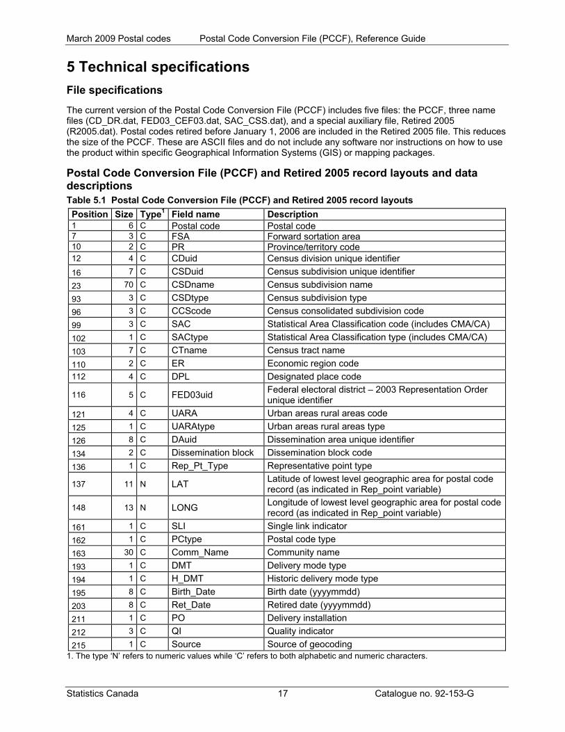
5 Technical specifications File specifications The current version of the Postal Code Conversion File (PCCF) includes five files: the PCCF, three name files (CD_DR.dat, FED03_CEF03.dat, SAC_CSS.dat), and a special auxiliary file, Retired 2005 (R2005.dat). Postal codes retired before January 1, 2006 are included in the Retired 2005 file. This reduces the size of the PCCF. These are ASCII files and do not include any software nor instructions on how to use the product within specific Geographical Information Systems (GIS) or mapping packages. Postal Code Conversion File (PCCF) and Retired 2005 record layouts and data descriptions Table 5.1 Postal Code Conversion File (PCCF) and Retired 2005 record layouts
Position Size Type1 Field name Description 1 6 C Postal code Postal code7 3 C FSA Forward sortation area10 2 C PR Province/territory code12 4 C CDuid Census division unique identifier 16 7 C CSDuid Census subdivision unique identifier 23 70 C CSDname Census subdivision name 93 3 C CSDtype Census subdivision type 96 3 C CCScode Census consolidated subdivision code 99 3 C SAC Statistical Area Classification code (includes CMA/CA) 102 1 C SACtype Statistical Area Classification type (includes CMA/CA) 103 7 C CTname Census tract name 110 2 C ER Economic region code 112 4 C DPL Designated place code
116 5 C FED03uid Federal electoral district – 2003 Representation Order unique identifier
121 4 C UARA Urban areas rural areas code 125 1 C UARAtype Urban areas rural areas type 126 8 C DAuid Dissemination area unique identifier 134 2 C Dissemination block Dissemination block code 136 1 C Rep_Pt_Type Representative point type
137 11 N LAT Latitude of lowest level geographic area for postal code record (as indicated in Rep_point variable)
148 13 N LONG Longitude of lowest level geographic area for postal code record (as indicated in Rep_point variable)
161 1 C SLI Single link indicator 162 1 C PCtype Postal code type 163 30 C Comm_Name Community name 193 1 C DMT Delivery mode type 194 1 C H_DMT Historic delivery mode type 195 8 C Birth_Date Birth date (yyyymmdd) 203 8 C Ret_Date Retired date (yyyymmdd) 211 1 C PO Delivery installation 212 3 C QI Quality indicator 215 1 C Source Source of geocoding
1. The type ‘N’ refers to numeric values while ‘C’ refers to both alphabetic and numeric characters.
March 2009 Postal codes Postal Code Conversion File (PCCF), Reference Guide
Postal code The postal code is a six-character code defined and maintained by Canada Post Corporation (CPC) for the purpose of sorting and delivering mail. The form of the postal code is 'ANA NAN', where ‘A’ is an alphabetic character and ‘N’ is a numeric character. The first character of a postal code represents a province or territory, or a major sector entirely within a province. Refer to Postal code structure (Appendix C) for more information. FSA The forward sortation area is the first three characters of the postal code, designating a postal delivery area within Canada. PR The PR uniquely identifies provinces and territories.
10 Newfoundland and Labrador 11 Prince Edward Island 12 Nova Scotia 13 New Brunswick 24 Quebec 35 Ontario 46 Manitoba 47 Saskatchewan 48 Alberta 59 British Columbia 60 Yukon 61 Northwest Territories 62 Nunavut
CDuid This uniquely identifies a census division. The first two digits of the CDuid identify the province or territory (PR). Census division names are found in the Census division names file (CD_DR.dat). CSDuid This uniquely identifies a census subdivision in the country. The province/territory, census division, and census subdivision (municipality) codes combine to represent the 2006 Standard Geographical Classification (SGC). CSDname This contains the name of the census subdivision (municipality) in effect as of January 1, 2006. CSDtype This field provides abbreviations used to identify the census subdivision (municipality) type. See Appendix F: CSD types by province and territory, 2006 Census, for the complete list. CCScode This identifies a census consolidated subdivision within a census division. It should be combined with the CDuid to uniquely identify a census consolidated subdivision in the country.
Statistics Canada 18 Catalogue no. 92-153-G
March 2009 Postal codes Postal Code Conversion File (PCCF), Reference Guide
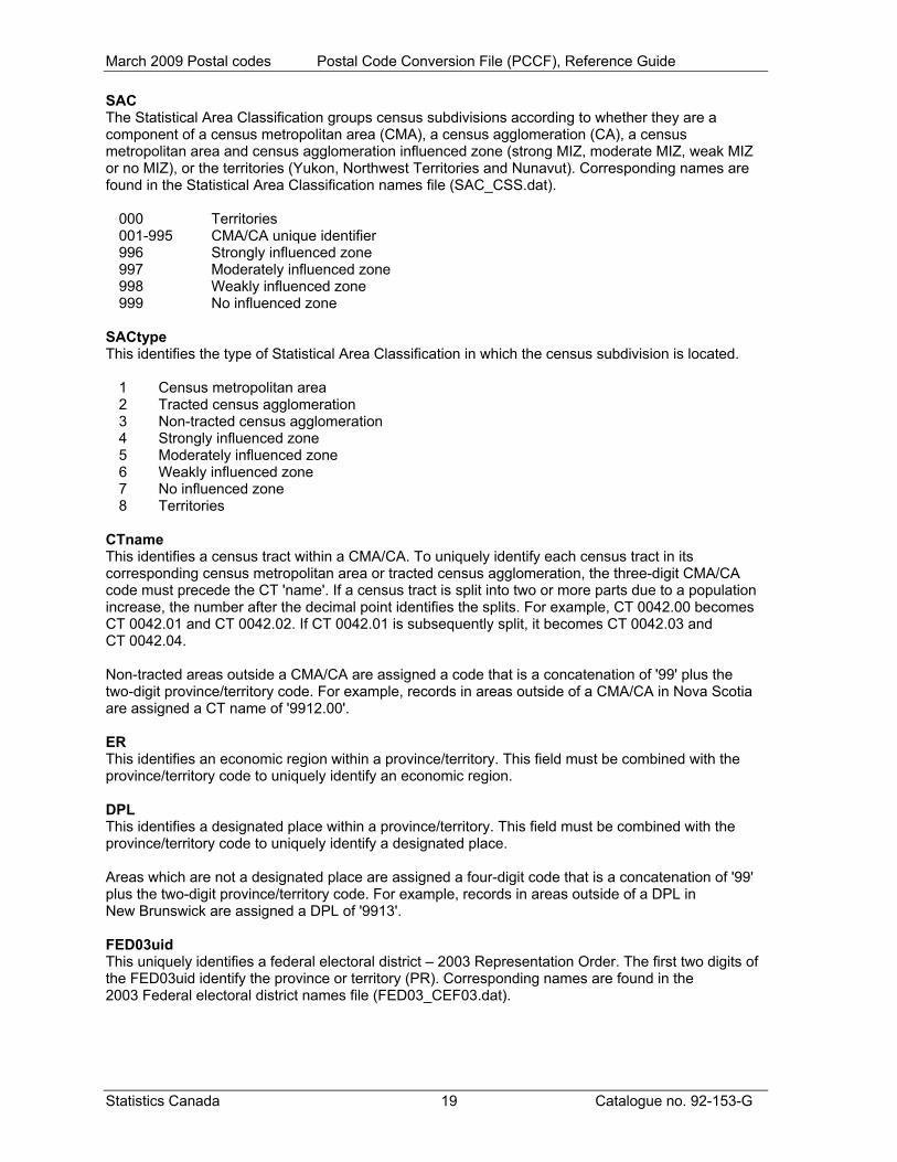
SAC The Statistical Area Classification groups census subdivisions according to whether they are a component of a census metropolitan area (CMA), a census agglomeration (CA), a census metropolitan area and census agglomeration influenced zone (strong MIZ, moderate MIZ, weak MIZ or no MIZ), or the territories (Yukon, Northwest Territories and Nunavut). Corresponding names are found in the Statistical Area Classification names file (SAC_CSS.dat).
000 Territories 001-995 CMA/CA unique identifier 996 Strongly influenced zone 997 Moderately influenced zone 998 Weakly influenced zone 999 No influenced zone
SACtype This identifies the type of Statistical Area Classification in which the census subdivision is located.
1 Census metropolitan area 2 Tracted census agglomeration 3 Non-tracted census agglomeration 4 Strongly influenced zone 5 Moderately influenced zone 6 Weakly influenced zone 7 No influenced zone 8 Territories
CTname This identifies a census tract within a CMA/CA. To uniquely identify each census tract in its corresponding census metropolitan area or tracted census agglomeration, the three-digit CMA/CA code must precede the CT 'name'. If a census tract is split into two or more parts due to a population increase, the number after the decimal point identifies the splits. For example, CT 0042.00 becomes CT 0042.01 and CT 0042.02. If CT 0042.01 is subsequently split, it becomes CT 0042.03 and CT 0042.04. Non-tracted areas outside a CMA/CA are assigned a code that is a concatenation of '99' plus the two-digit province/territory code. For example, records in areas outside of a CMA/CA in Nova Scotia are assigned a CT name of '9912.00'. ER This identifies an economic region within a province/territory. This field must be combined with the province/territory code to uniquely identify an economic region. DPL This identifies a designated place within a province/territory. This field must be combined with the province/territory code to uniquely identify a designated place. Areas which are not a designated place are assigned a four-digit code that is a concatenation of '99' plus the two-digit province/territory code. For example, records in areas outside of a DPL in New Brunswick are assigned a DPL of '9913'. FED03uid This uniquely identifies a federal electoral district – 2003 Representation Order. The first two digits of the FED03uid identify the province or territory (PR). Corresponding names are found in the 2003 Federal electoral district names file (FED03_CEF03.dat).
Statistics Canada 19 Catalogue no. 92-153-G

March 2009 Postal codes Postal Code Conversion File (PCCF), Reference Guide
UARA Urban area codes are unique four-digit codes that are assigned sequentially upon the UA creation. These codes remain constant between censuses. If an urban area is retired due to amalgamation or failure to meet the population or density thresholds, then its code is retired. Rural area codes are unique four-digit codes which are a concatenation of '99' plus the two-digit province/territory code. For example, records in rural areas in Manitoba are assigned '9946'. This field will be '0000' for postal codes linked to dissemination areas only (Rep_Point = 3). UARAtype For urban areas, the type code indicates the relationship of the urban area to the CMA/CA structure.
0 Rural area 1 Urban core 2 Urban fringe 4 Urban areas outside CMA/CAs 6 Secondary urban core
This field will be '9' for postal codes linked to dissemination areas only (Rep_Point = 3). There is no UARAtype available for postal codes linked at the dissemination area level. UARAtype is only available for postal codes linked at the more detailed dissemination block or block-face level. DAuid The DAuid uniquely identifies a dissemination area. It is composed of the two-digit province/territory code, the two-digit census division code and the four-digit dissemination area code. Dissemination block A dissemination block (DB) is an area bounded on all sides by roads and/or boundaries of standard geographic areas. Dissemination blocks cover all the territory of Canada. This code should be combined with the DAuid to uniquely identify the dissemination block within the country. This field will be '00' for postal codes linked to dissemination areas only (Rep_Point = 3). Rep_Pt_Type This identifies whether the record uses a block-face, dissemination block or dissemination area representative point as the coordinate. Table 5.2 Representative points in the Postal Code Conversion File (PCCF) Code Type Number of records1 Block-face 1,259,8922 Dissemination block 155,7293 Dissemination area 215,455Total 1,631,076
LAT This is the latitude, in decimal degrees, of the dissemination area, dissemination block, or block-face representative point. The decimal point is explicit. LONG This is the longitude, in decimal degrees, of the dissemination area, dissemination block, or block-face representative point. The decimal point is explicit.
Statistics Canada 20 Catalogue no. 92-153-G
March 2009 Postal codes Postal Code Conversion File (PCCF), Reference Guide
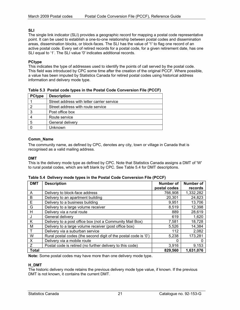
SLI The single link indicator (SLI) provides a geographic record for mapping a postal code representative point. It can be used to establish a one-to-one relationship between postal codes and dissemination areas, dissemination blocks, or block-faces. The SLI has the value of '1' to flag one record of an active postal code. Every set of retired records for a postal code, for a given retirement date, has one SLI equal to ‘1’. The SLI value '0' indicates additional records. PCtype This indicates the type of addresses used to identify the points of call served by the postal code. This field was introduced by CPC some time after the creation of the original PCCF. Where possible, a value has been imputed by Statistics Canada for retired postal codes using historical address information and delivery mode type. Table 5.3 Postal code types in the Postal Code Conversion File (PCCF) PCtype Description 1 Street address with letter carrier service 2 Street address with route service 3 Post office box 4 Route service 5 General delivery 0 Unknown
Comm_Name The community name, as defined by CPC, denotes any city, town or village in Canada that is recognised as a valid mailing address. DMT This is the delivery mode type as defined by CPC. Note that Statistics Canada assigns a DMT of 'W' to rural postal codes, which are left blank by CPC. See Table 5.4 for DMT descriptions. Table 5.4 Delivery mode types in the Postal Code Conversion File (PCCF) DMT Description Number of
postal codes Number of
records A Delivery to block-face address 766,908 1,332,282 B Delivery to an apartment building 20,301 24,823 E Delivery to a business building 9,951 13,706 G Delivery to a large volume receiver 8,519 12,398 H Delivery via a rural route 889 28,619 J General delivery 619 1,620 K Delivery to a post office box (not a Community Mail Box) 7,581 18,728 M Delivery to a large volume receiver (post office box) 5,526 14,384 T Delivery via a suburban service 112 2,082 W Rural postal codes (the second digit of the postal code is ‘0’) 5,238 173,281 X Delivery via a mobile route 0 0 Z Postal code is retired (no further delivery to this code) 3,916 9,153 Total 829,560 1,631,076
Note: Some postal codes may have more than one delivery mode type. H_DMT The historic delivery mode retains the previous delivery mode type value, if known. If the previous DMT is not known, it contains the current DMT.
Statistics Canada 21 Catalogue no. 92-153-G

March 2009 Postal codes Postal Code Conversion File (PCCF), Reference Guide
Birth_Date This is the date when the postal code became effective. All postal codes created before April 1983 were given a birth date of '19830401'. Ret_Date This is the date when a postal code was retired. All postal codes retired before April 1983 have '19830401' as the retirement date. Users should note that some postal codes have been retired and reintroduced at a later date. Active postal codes have a retirement date of '19000001'. PO This indicates whether the record represents coding to a post office where the mail can be accessed. The value '1' indicates this record was coded to a post office or other postal installation and the value '2' indicates 'unknown'. The value '0' indicates this record was coded to the area serviced by the postal code. Postal code type (PCtype) 3 and 5 postal codes represent mail service that can be accessed at the post office or other postal installation. Where possible, these records are coded to the appropriate post office or other postal installation. QI The quality indicator (QI) provides an indicator of the quality of the link established between the postal code and the geographic area. While every attempt is made to provide the best quality of link, this is not always possible. QI is only available for records coded using the automated geocoding system. The first character of the QI indicates the quality of geocoding to the CSD, the second character indicates the quality of geocoding to the street and the last character indicates the quality of geocoding to the address range. A QI of 'AAA' indicates the highest quality and a QI of 'CCC' indicates the lowest quality. Please see Appendix D for a more detailed explanation of QI. The QI is established at the record level and is currently available only for the postal codes that were geocoded using the automated geocoding system. The possible values of QI and the number of records by source are indicated in Table 5.5.
Statistics Canada 22 Catalogue no. 92-153-G

March 2009 Postal codes Postal Code Conversion File (PCCF), Reference Guide
Statistics Canada 23 Catalogue no. 92-153-G
Table 5.5 Number of records by geocoding source and quality indicator Source Quality indicator
1 2 3 4AAA 1,074,703 0 0 0AAB 14,812 0 0 0AAC 0 0 0 0AAN 111,217 0 0 0ABA 8,019 0 0 0ABB 191 0 0 0ABC 0 0 0 0ABN 1,339 0 0 0ACA 0 0 0 0ACB 0 0 0 0ACC 0 0 0 0ACN 23,979 0 0 0ANN 0 0 0 0BAA 139,306 0 0 0BAB 5,929 0 0 0BAC 0 0 0 0BAN 18,601 0 0 0BBA 1,349 0 0 0BBB 146 0 0 0BBC 0 0 0 0BBN 620 0 0 0BCA 0 0 0 0BCB 0 0 0 0BCC 0 0 0 0BCN 8,410 0 0 0BNN 0 0 0 0CAA 6,197 0 0 0CAB 107 0 0 0CAC 0 0 0 0CAN 3,653 0 0 0CBA 138 0 0 0CBB 5 0 0 0CBC 0 0 0 0CBN 493 0 0 0CCA 0 0 0 0CCB 0 0 0 0CCC 0 0 0 0CCN 8,845 0 0 0BNN 0 0 0 0NNN 0 64,867 73,722 64,428Total 1,428,059 64,867 73,722 64,428
March 2009 Postal codes Postal Code Conversion File (PCCF), Reference Guide
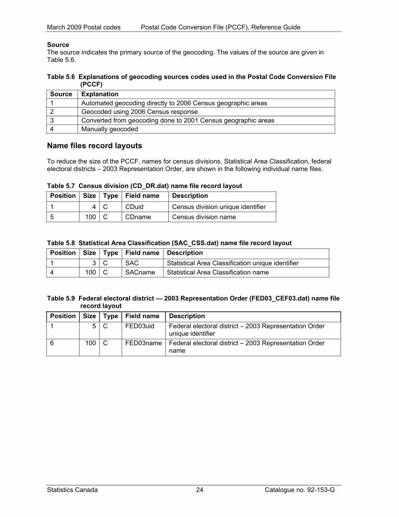
Source The source indicates the primary source of the geocoding. The values of the source are given in Table 5.6. Table 5.6 Explanations of geocoding sources codes used in the Postal Code Conversion File
(PCCF) Source Explanation 1 Automated geocoding directly to 2006 Census geographic areas 2 Geocoded using 2006 Census response 3 Converted from geocoding done to 2001 Census geographic areas 4 Manually geocoded
Name files record layouts To reduce the size of the PCCF, names for census divisions, Statistical Area Classification, federal electoral districts – 2003 Representation Order, are shown in the following individual name files. Table 5.7 Census division (CD_DR.dat) name file record layout Position Size Type Field name Description 1 4 C CDuid Census division unique identifier 5 100 C CDname Census division name
Table 5.8 Statistical Area Classification (SAC_CSS.dat) name file record layout Position Size Type Field name Description 1 3 C SAC Statistical Area Classification unique identifier 4 100 C SACname Statistical Area Classification name
Table 5.9 Federal electoral district — 2003 Representation Order (FED03_CEF03.dat) name file
record layout Position Size Type Field name Description 1 5 C FED03uid Federal electoral district – 2003 Representation Order
unique identifier 6 100 C FED03name Federal electoral district – 2003 Representation Order
name
Statistics Canada 24 Catalogue no. 92-153-G

March 2009 Postal codes Postal Code Conversion File (PCCF), Reference Guide
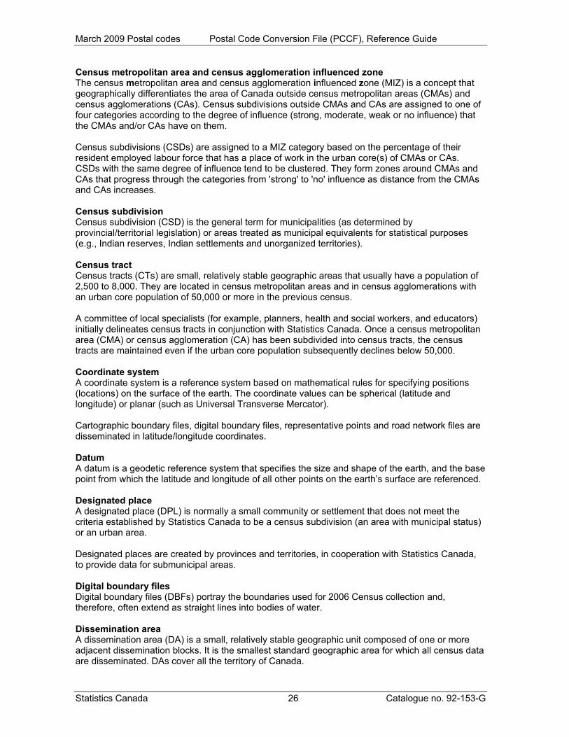
Appendix A Glossary Adjusted counts 'Adjusted counts' refer to previous census population and dwelling counts that were adjusted (i.e., recompiled) to reflect current census boundaries, when a boundary change occurs between the two censuses. Block-face A block-face is one side of a street between two consecutive features intersecting that street. The features can be other streets or boundaries of standard geographic areas. Block-faces are used for generating block-face representative points, which in turn are used for geocoding and census data extraction when the street and address information are available. Cartographic boundary files Cartographic boundary files (CBFs) contain the boundaries of standard geographic areas together with the shoreline around Canada. Selected inland lakes and rivers are available as a supplementary layer. Census agricultural region Census agricultural regions (CARs) are composed of groups of adjacent census divisions. In Saskatchewan, census agricultural regions are made up of groups of adjacent census consolidated subdivisions, but these groups do not necessarily respect census division boundaries. Census consolidated subdivision A census consolidated subdivision (CCS) is a group of adjacent census subdivisions. Generally, the smaller, more urban census subdivisions (towns, villages, etc.) are combined with the surrounding, larger, more rural census subdivision, in order to create a geographic level between the census subdivision and the census division. Census division Census division (CD) is the general term for provincially legislated areas (such as county, municipalité régionale de comté and regional district) or their equivalents. Census divisions are intermediate geographic areas between the province/territory level and the municipality (census subdivision). Census metropolitan area and census agglomeration A census metropolitan area (CMA) or a census agglomeration (CA) is formed by one or more adjacent municipalities centred on a large urban area (known as the urban core). A CMA must have a total population of at least 100,000 of which 50,000 or more must live in the urban core. A CA must have an urban core population of at least 10,000. To be included in the CMA or CA, other adjacent municipalities must have a high degree of integration with the central urban area, as measured by commuting flows derived from census place of work data. If the population of the urban core of a CA declines below 10,000, the CA is retired. However, once an area becomes a CMA, it is retained as a CMA even if its total population declines below 100,000 or the population of its urban core falls below 50,000. The urban areas in the CMA or CA that are not contiguous to the urban core are called the urban fringe. Rural areas in the CMA or CA are called the rural fringe. When a CA has an urban core of at least 50,000, it is subdivided into census tracts. Census tracts are maintained for the CA even if the population of the urban core subsequently falls below 50,000. All CMAs are subdivided into census tracts.
Statistics Canada 25 Catalogue no. 92-153-G
March 2009 Postal codes Postal Code Conversion File (PCCF), Reference Guide
Census metropolitan area and census agglomeration influenced zone The census metropolitan area and census agglomeration influenced zone (MIZ) is a concept that geographically differentiates the area of Canada outside census metropolitan areas (CMAs) and census agglomerations (CAs). Census subdivisions outside CMAs and CAs are assigned to one of four categories according to the degree of influence (strong, moderate, weak or no influence) that the CMAs and/or CAs have on them. Census subdivisions (CSDs) are assigned to a MIZ category based on the percentage of their resident employed labour force that has a place of work in the urban core(s) of CMAs or CAs. CSDs with the same degree of influence tend to be clustered. They form zones around CMAs and CAs that progress through the categories from 'strong' to 'no' influence as distance from the CMAs and CAs increases. Census subdivision Census subdivision (CSD) is the general term for municipalities (as determined by provincial/territorial legislation) or areas treated as municipal equivalents for statistical purposes (e.g., Indian reserves, Indian settlements and unorganized territories). Census tract Census tracts (CTs) are small, relatively stable geographic areas that usually have a population of 2,500 to 8,000. They are located in census metropolitan areas and in census agglomerations with an urban core population of 50,000 or more in the previous census. A committee of local specialists (for example, planners, health and social workers, and educators) initially delineates census tracts in conjunction with Statistics Canada. Once a census metropolitan area (CMA) or census agglomeration (CA) has been subdivided into census tracts, the census tracts are maintained even if the urban core population subsequently declines below 50,000. Coordinate system A coordinate system is a reference system based on mathematical rules for specifying positions (locations) on the surface of the earth. The coordinate values can be spherical (latitude and longitude) or planar (such as Universal Transverse Mercator). Cartographic boundary files, digital boundary files, representative points and road network files are disseminated in latitude/longitude coordinates. Datum A datum is a geodetic reference system that specifies the size and shape of the earth, and the base point from which the latitude and longitude of all other points on the earth’s surface are referenced. Designated place A designated place (DPL) is normally a small community or settlement that does not meet the criteria established by Statistics Canada to be a census subdivision (an area with municipal status) or an urban area. Designated places are created by provinces and territories, in cooperation with Statistics Canada, to provide data for submunicipal areas. Digital boundary files Digital boundary files (DBFs) portray the boundaries used for 2006 Census collection and, therefore, often extend as straight lines into bodies of water. Dissemination area A dissemination area (DA) is a small, relatively stable geographic unit composed of one or more adjacent dissemination blocks. It is the smallest standard geographic area for which all census data are disseminated. DAs cover all the territory of Canada.
Statistics Canada 26 Catalogue no. 92-153-G

March 2009 Postal codes Postal Code Conversion File (PCCF), Reference Guide
Dissemination block A dissemination block (DB) is an area bounded on all sides by roads and/or boundaries of standard geographic areas. The dissemination block is the smallest geographic area for which population and dwelling counts are disseminated. Dissemination blocks cover all the territory of Canada. Economic region An economic region (ER) is a grouping of complete census divisions (CDs) (with one exception in Ontario) created as a standard geographic unit for analysis of regional economic activity. Ecumene Ecumene is a term used by geographers to mean inhabited land. It generally refers to land where people have made their permanent home, and to all work areas that are considered occupied and used for agricultural or any other economic purpose. Thus, there can be various types of ecumenes, each having their own unique characteristics (population ecumene, agricultural ecumene, industrial ecumene, etc.). Federal electoral district A federal electoral district (FED) is an area represented by a member of the House of Commons. The federal electoral district boundaries used for the 2006 Census are based on the 2003 Representation Order. Forward sortation area The forward sortation area (FSA) is identified by the first three characters of the postal code. FSAs are associated with a postal facility from which mail delivery originates. The average number of households served by an FSA is approximately 8,000, but the number can range from zero to more than 60,000 households. This wide range of households can occur because some FSAs may serve only businesses (zero households) and some FSAs serve very large geographic areas. Geocoding Geocoding is the process of assigning geographic identifiers (codes) to map features and data records. The resulting geocodes permit data to be linked geographically. Households, postal codes and place of work data are linked to block-face representative points when the street and address information is available; otherwise, they are linked to dissemination block (DB) representative points. In some cases, postal codes and place of work data are linked to dissemination area (DA) representative points when they cannot be linked to DBs. As well, place of work data are linked to census subdivision representative points when the data cannot be linked to DAs. Geographic code A geographic code is a numerical identifier assigned to a geographic area. The code is used to identify and access standard geographic areas for the purposes of data storage, retrieval and display. Geographic reference date The geographic reference date is a date determined by Statistics Canada for the purpose of finalizing the geographic framework for which census data will be collected, tabulated and reported. For the 2006 Census, the geographic reference date is January 1, 2006. Land area Land area is the area in square kilometres of the land-based portions of standard geographic areas. Land area data are unofficial, and are provided for the sole purpose of calculating population density.
Statistics Canada 27 Catalogue no. 92-153-G
March 2009 Postal codes Postal Code Conversion File (PCCF), Reference Guide
Statistics Canada 28 Catalogue no. 92-153-G
Locality 'Locality' (LOC) refers to the historical place names of former census subdivisions (municipalities), former designated places and former urban areas, as well as to the names of other entities, such as neighbourhoods, post offices, communities and unincorporated places. Map projection A map projection is the process of transforming and representing positions from the earth's three-dimensional curved surface to a two-dimensional (flat) surface. The process is accomplished by a direct geometric projection or by a mathematically derived transformation. The Lambert conformal conic map projection is widely used for general maps of Canada at small scales and is the most common map projection used at Statistics Canada. National Geographic Database The National Geographic Database (NGD) is a shared database between Statistics Canada and Elections Canada. The database contains roads, road names and address ranges. It also includes separate reference layers containing physical and cultural features, such as hydrography and hydrographic names, railroads and power transmission lines. The NGD was created in 1997 as a joint Statistics Canada/Elections Canada initiative to develop and maintain a national road network file serving the needs of both organizations. The active building of the NGD – that is, integrating the files from Statistics Canada, Elections Canada and Natural Resources Canada – occurred from 1998 to 2000. Thereafter, Statistics Canada and Elections Canada reconciled their digital boundary holdings to the new database's road network geometry so that operational products could be derived. Since 2001, the focus of the NGD has been on intensive data quality improvements, especially regarding the quality and currency of its road network coverage. There has been considerable expansion of road names and civic addresses ranges, as well as the addition of hydrographic names. Priorities were determined by Statistics Canada and Elections Canada, enabling the NGD to meet the joint operational needs of both agencies in support of census and electoral activities. Place name 'Place name' refers to the set of names that includes current census subdivisions (municipalities), current designated places and current urban areas, as well as the names of localities. Population density Population density is the number of persons per square kilometre. Postal code The postal code is a six-character code defined and maintained by Canada Post Corporation for the purpose of sorting and delivering mail. Province or territory Province and territory refer to the major political units of Canada. From a statistical point of view, province and territory are basic areas for which data are tabulated. Canada is divided into 10 provinces and three territories. Reference map A reference map shows the location of the geographic areas for which census data are tabulated and disseminated. The maps display the boundaries, names and codes of standard geographic areas, as well as major cultural and physical features, such as roads, railroads, coastlines, rivers and lakes.

March 2009 Postal codes Postal Code Conversion File (PCCF), Reference Guide
Representative point A representative point is a point that represents a line or a polygon. The point is centrally located along the line, and centrally located or population weighted in the polygon. Representative points are generated for block-faces, dissemination blocks, dissemination areas, census subdivisions, urban areas and designated places. Households, postal codes and place of work data are linked to block-face representative points when the street and address information is available; otherwise, they are linked to dissemination block (DB) representative points. In some cases, postal codes and place of work data are linked to dissemination area (DA) representative points when they cannot be linked to DBs. As well, place of work data are linked to census subdivision representative points when the data cannot be linked to DAs. Road network file The road network file (RNF) contains roads, road names, address ranges and road ranks for the entire country. Most commonly, address ranges are dwelling-based and are mainly available in the large urban centres of Canada. Rural area Rural areas include all territory lying outside urban areas. Taken together, urban and rural areas cover all of Canada. Rural population includes all population living in the rural fringes of census metropolitan areas (CMAs) and census agglomerations (CAs), as well as population living in rural areas outside CMAs and CAs. Spatial Data Infrastructure The Spatial Data Infrastructure (SDI), formerly known as the National Geographic Base (NGB), is an internal, maintenance database that is not disseminated outside of Statistics Canada. It contains roads, road names and address ranges from the National Geographic Database (NGD), as well as boundary arcs of standard geographic areas that do not follow roads, all in one integrated line layer. The database also includes a related polygon layer consisting of basic blocks (BB) (basic blocks are the smallest polygon units in the database, and are formed by the intersection of all roads and the arcs of geographic areas that do not follow roads), boundary layers of standard geographic areas, and derived attribute tables, as well as reference layers containing physical and cultural features (such as hydrography, railroads and power transmission lines) from the NGD. The SDI supports a wide range of census operations, such as the maintenance and delineation of the boundaries of standard geographic areas (including the automated delineation of dissemination blocks, dissemination areas and urban areas), and geocoding. The SDI is also the source for generating many geography products for the 2006 Census, such as cartographic boundary files and road network files. Spatial data quality elements Spatial data quality elements provide information on the fitness for use of a spatial database by describing why, when and how the data are created, and how accurate the data are. The elements include an overview describing the purpose and usage, as well as specific quality elements reporting on the lineage, positional accuracy, attribute accuracy, logical consistency and completeness. This information is provided to users for all spatial data products disseminated for the census.
Statistics Canada 29 Catalogue no. 92-153-G

March 2009 Postal codes Postal Code Conversion File (PCCF), Reference Guide
Standard Geographical Classification The Standard Geographical Classification (SGC) is Statistics Canada’s official classification for three types of geographic areas: provinces and territories, census divisions (CDs) and census subdivisions (CSDs). The SGC provides unique numeric identification (codes) for these hierarchically related geographic areas. Statistical Area Classification The Statistical Area Classification (SAC) groups census subdivisions according to whether they are a component of a census metropolitan area, a census agglomeration, a census metropolitan area and census agglomeration influenced zone (strong MIZ, moderate MIZ, weak MIZ or no MIZ), or the territories (Yukon, Northwest Territories and Nunavut). The SAC is used for data dissemination purposes. Thematic map A thematic map shows the spatial distribution of one or more specific data themes for standard geographic areas. The map may be qualitative in nature (e.g., predominant farm types) or quantitative (e.g., percentage population change). Urban area An urban area has a minimum population concentration of 1,000 persons and a population density of at least 400 persons per square kilometre, based on the current census population count. All territory outside urban areas is classified as rural. Taken together, urban and rural areas cover all of Canada. Urban population includes all population living in the urban cores, secondary urban cores and urban fringes of census metropolitan areas (CMAs) and census agglomerations (CAs), as well as the population living in urban areas outside CMAs and CAs. Urban core, urban fringe and rural fringe 'Urban core, urban fringe and rural fringe' distinguish between central and peripheral urban and rural areas within a census metropolitan area (CMA) or census agglomeration (CA). 'Urban core' is a large urban area around which a CMA or a CA is delineated. The urban core must have a population (based on the previous census) of at least 50,000 persons in the case of a CMA, or at least 10,000 persons in the case of a CA. The urban core of a CA that has been merged with an adjacent CMA or larger CA is called the 'secondary urban core'. 'Urban fringe' includes all small urban areas within a CMA or CA that are not contiguous with the urban core of the CMA or CA. 'Rural fringe' is all territory within a CMA or CA not classified as an urban core or an urban fringe.
Statistics Canada 30 Catalogue no. 92-153-G
March 2009 Postal codes Postal Code Conversion File (PCCF), Reference Guide
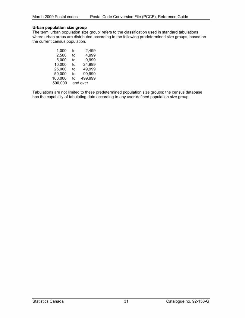
Urban population size group The term 'urban population size group' refers to the classification used in standard tabulations where urban areas are distributed according to the following predetermined size groups, based on the current census population. 1,000 to 2,499 2,500 to 4,999 5,000 to 9,999 10,000 to 24,999 25,000 to 49,999 50,000 to 99,999 100,000 to 499,999
500,000 and over Tabulations are not limited to these predetermined population size groups; the census database has the capability of tabulating data according to any user-defined population size group.
Statistics Canada 31 Catalogue no. 92-153-G
March 2009 Postal codes Postal Code Conversion File (PCCF), Reference Guide
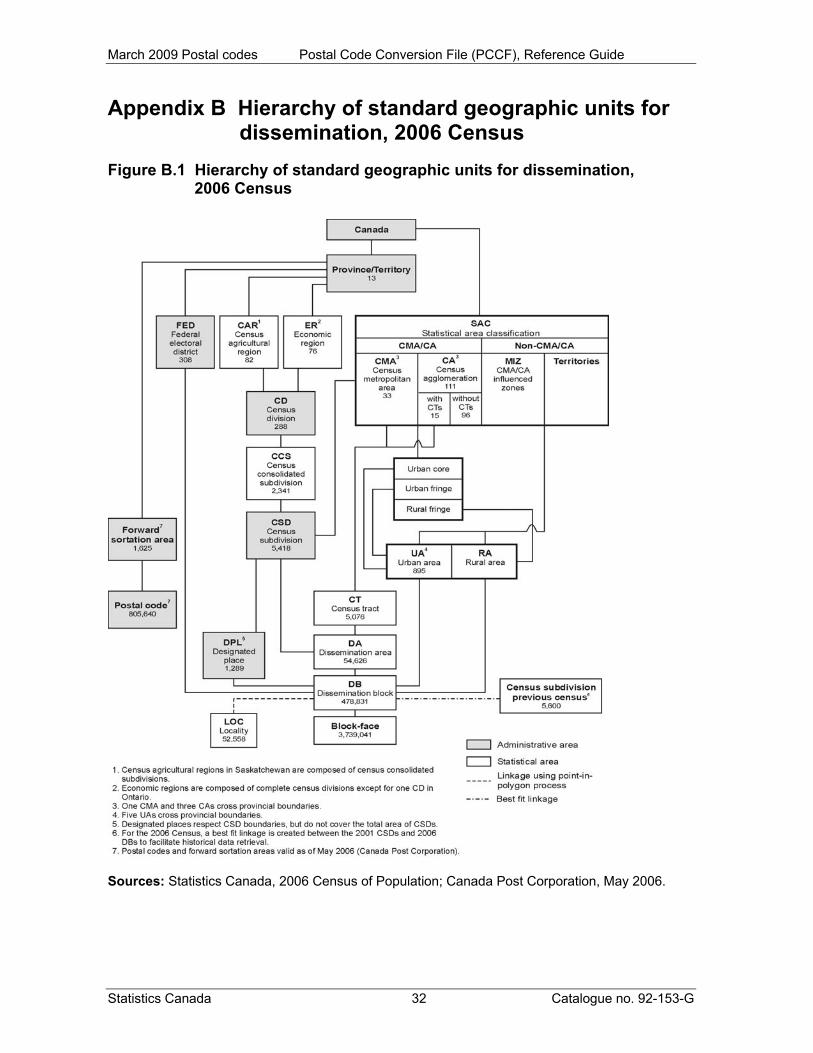
Appendix B Hierarchy of standard geographic units for dissemination, 2006 Census
Figure B.1 Hierarchy of standard geographic units for dissemination, 2006 Census
Sources: Statistics Canada, 2006 Census of Population; Canada Post Corporation, May 2006.
Statistics Canada 32 Catalogue no. 92-153-G

March 2009 Postal codes Postal Code Conversion File (PCCF), Reference Guide
Appendix C Postal code structure The postal code is an alphanumeric combination of six characters describing the destination of each item of mail addressed in Canada. The characters are arranged in the form 'ANA NAN', where 'A' represents an alphabetic character and 'N' represents a numeric character (e.g., K1A 0T6). The postal code uses 18 alphabetic characters and 10 numeric characters. Eight alphabetic characters (D, F, I, O, Q, U, W and Z) are not in use at the present time. The first character of a postal code is allocated in alphabetic sequence from east to west across Canada and denotes a province, territory, or a major sector found entirely within the boundaries of a province. Table C.1 First character of the postal code and corresponding province, territory or region Province/territory/region Postal code first character Newfoundland and Labrador A Nova Scotia B Prince Edward Island C New Brunswick E Eastern Québec G Metropolitan Montréal H Western Québec J Eastern Ontario K Central Ontario L Metropolitan Toronto M Southwestern Ontario N Northern Ontario P Manitoba R Saskatchewan S Alberta T British Columbia V Northwest Territories and Nunavut X Yukon Y
Note: The regions used in this table are defined by Canada Post Corporation. In the Postal Code Conversion File (PCCF), there are 69 postal codes linked to a different province from their first character allocation. The counts of postal codes given by province/territory in Table C.2 are generated by grouping all postal codes by the first letter of the forward sortation area.
Statistics Canada 33 Catalogue no. 92-153-G
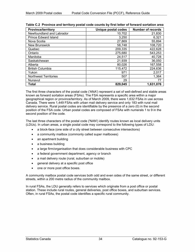
March 2009 Postal codes Postal Code Conversion File (PCCF), Reference Guide
Table C.2 Province and territory postal code counts by first letter of forward sortation area Province/territory Unique postal codes Number of records Newfoundland and Labrador 10,702 21,830 Prince Edward Island 3,250 6,321 Nova Scotia 27,869 55,894 New Brunswick 58,748 108,720 Quebec 209,335 422,628 Ontario 275,680 543,253 Manitoba 24,517 40,728 Saskatchewan 21,939 36,050 Alberta 80,026 167,558 British Columbia 115,472 224,636 Yukon 971 2,017 Northwest Territories 507 1,364 Nunavut 29 77 Total 829,045 1,631,076
The first three characters of the postal code ('ANA') represent a set of well-defined and stable areas known as forward sortation areas (FSAs). The FSA represents a specific area within a major geographical region or province/territory. As of March 2009, there were 1,632 FSAs in use across Canada. There were 1,449 FSAs with urban mail delivery service and only 183 with rural mail delivery service. Rural postal codes are identifiable by the presence of a zero (0) in the second position of the FSA code. Urban postal codes are composed of FSAs with numerals 1 to 9 in the second position of the code. The last three characters of the postal code ('NAN') identify routes known as local delivery units (LDUs). In urban areas, a single postal code may correspond to the following types of LDU:
• a block-face (one side of a city street between consecutive intersections) • a community mailbox (commonly called super mailboxes) • an apartment building • a business building • a large firm/organisation that does considerable business with CPC • a federal government department, agency or branch • a mail delivery route (rural, suburban or mobile) • general delivery at a specific post office • one or more post office boxes.
A community mailbox postal code services both odd and even sides of the same street, or different streets, within a 200 metre radius of the community mailbox. In rural FSAs, the LDU generally refers to services which originate from a post office or postal station. These include rural routes, general deliveries, post office boxes, and suburban services. Often, in rural FSAs, the postal code identifies a specific rural community.
Statistics Canada 34 Catalogue no. 92-153-G

March 2009 Postal codes Postal Code Conversion File (PCCF), Reference Guide
Statistics Canada 35 Catalogue no. 92-153-G
Appendix D Quality indicator The quality indicator (QI) is a record level indicator on the Postal Code Conversion File (PCCF) that indicates the confidence with which that particular record is coded to the geographic areas in that record. It is only available for the records coded using the automated geocoding system. The final quality indicator output after geocoding is complete is a concatenation such that: QI = QI_1 | QI_2 | QI_3 The quality indicator (QI_1) QI_1 indicates the quality of the general area where geocoding occurred. It is an indicator of our certainty that the postal code is linked to the correct census subdivision. QI is assigned as follows:
A good, verifiable geocoding, search area verified by more than one source B good, search area based on 2006 Census data C satisfactory approximation based on place name match to CSD alone N unknown
The quality indicator (QI_2) QI_2 indicates the level of confidence of the match to the correct street. This is not available for Postal Code type (PCtype) 3, 4 and 5 records, when delivery installation (PO) = 0 or 2, since they do not represent service to a particular civic address; when PO = 1 QI_2 represents the confidence of the match to a delivery installation address. QI is assigned as follows:
A good, match on street name, type, and direction B good, but match only on street name and type C satisfactory match on street name only or street name and direction N unknown
The quality indicator (QI_3) QI_3 indicates the level of confidence of the match to the correct address range. This is not available for PCtype 3, 4 and 5 records, when PO = 0 or 2, since they do not represent service to a particular civic address; when PO = 1 QI_3 represents the confidence of the match to a delivery installation address. QI is assigned as follows:
A good, if the parity was matched on both addresses on the Spatial Data Infrastructure
B good, but the parity was matched on one address only on the Spatial Data Infrastructure
C satisfactory, if the parity was not matched but the ranges overlap N unknown
For more information, please see the working paper entitled How Postal Codes Map to Geographic Areas (Catalogue no. 92F0138MIE2007001), which is available on the Statistics Canada website (www.statcan.gc.ca).

March 2009 Postal codes Postal Code Conversion File (PCCF), Reference Guide
Appendix E Representative points
A representative point is a point that represents a line or a polygon. The point is centrally located along the line, and centrally located or population weighted in the polygon. Representative points are generated for block-faces, dissemination blocks (DBs), dissemination areas (DAs), census subdivisions (CSDs), urban areas (UAs) and designated places (DPLs). These points support the mapping of postal codes to geographic areas. Representative points are located by the following methods using the Spatial Data Infrastructure (SDI): Block-face representative points
The block-face representative points are computed along addressable and non-addressable streets, midway (or approximately midway) between two consecutive features intersecting a street. The features can be other streets or boundaries of standard geographic areas. The points are set back a perpendicular distance of 10, 5, 1 or 0.5 metres from the street centre line to ensure that all points have unique coordinates, and are located in the correct block and on the correct side of the street. Geographic area representative points
The representative points for DBs, DAs, CSDs, UAs and DPLs are generated in conjunction with their respective cartographic boundary file (CBF). The most detailed dissemination hydrography in the CBF is used. The points are initially calculated and stored based on the Lambert conformal conic projection; they are also transformed to latitude/longitude coordinates. Topology checks are applied to ensure that the points fall within the appropriate geographic area. Since some dissemination blocks and designated places are located in water only, their representative points fall in water. Postal codes are linked to block-face, dissemination block, or dissemination area representative points. Representative points can also be used for data retrieval, data analysis and mapping. All representative points are calculated based on the x, y coordinates of the Lambert conformal conic map projection, but are disseminated in latitude/longitude coordinates.
Statistics Canada 36 Catalogue no. 92-153-G
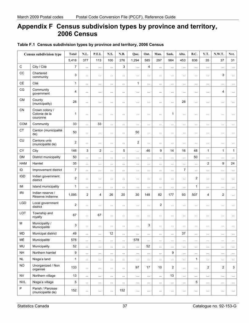
March 2009 Postal codes Postal Code Conversion File (PCCF), Reference Guide
Appendix F Census subdivision types by province and territory, 2006 Census
Table F.1 Census subdivision types by province and territory, 2006 Census
Total N.L. P.E.I. N.S. N.B. Que. Ont. Man. Sask. Alta. B.C. Y.T. N.W.T. Nvt. Census subdivision type 5,418 377 113 100 276 1,294 585 297 984 453 836 35 37 31
C City / Cité 7 ... ... ... 3 ... 4 ... ... ... ... ... ... ...
CC Chartered community 3 ... ... ... ... ... ... ... ... ... ... ... 3 ...
CÉ Cité 1 ... ... ... ... 1 ... ... ... ... ... ... ... ...
CG Community government 4 ... ... ... ... ... ... ... ... ... ... ... 4 ...
CM County (municipality) 28 ... ... ... ... ... ... ... ... 28 ... ... ... ...
CN Crown colony / Colonie de la couronne
1 ... ... ... ... ... ... ... 1 ... ... ... ... ...
COM Community 33 ... 33 ... ... ... ... ... ... ... ... ... ... ...
CT Canton (municipalité de) 50 ... ... ... ... 50 ... ... ... ... ... ... ... ...
CU Cantons unis (municipalité de) 2 ... ... ... ... 2 ... ... ... ... ... ... ... ...
CY City 146 3 2 ... 5 ... 46 9 14 16 48 1 1 1
DM District municipality 50 ... ... ... ... ... ... ... ... ... 50 ... ... ...
HAM Hamlet 35 ... ... ... ... ... ... ... ... ... ... 2 9 24
ID Improvement district 7 ... ... ... ... ... ... ... ... 7 ... ... ... ...
IGD Indian government district 2 ... ... ... ... ... ... ... ... ... 2 ... ... ...
IM Island municipality 1 ... ... ... ... ... ... ... ... ... 1 ... ... ...
IRI Indian reserve / Réserve indienne 1,095 2 4 26 20 30 148 82 177 93 507 4 2 ...
LGD Local government district 2 ... ... ... ... ... ... 2 ... ... ... ... ... ...
LOT Township and royalty 67 ... 67 ... ... ... ... ... ... ... ... ... ... ...
M Municipality / Municipalité 3 ... ... ... ... ... 3 ... ... ... ... ... ... ...
MD Municipal district 49 ... ... 12 ... ... ... ... ... 37 ... ... ... ...
MÉ Municipalité 578 ... ... ... ... 578 ... ... ... ... ... ... ... ...
MU Municipality 52 ... ... ... ... ... 52 ... ... ... ... ... ... ...
NH Northern hamlet 9 ... ... ... ... ... ... ... 9 ... ... ... ... ...
NL Nisga’a land 1 ... ... ... ... ... ... ... ... ... 1 ... ... ...
NO Unorganized / Non organisé 133 ... ... ... ... 97 17 10 2 ... ... 2 2 3
NV Northern village 13 ... ... ... ... ... ... ... 13 ... ... ... ... ...
NVL Nisga’a village 5 ... ... ... ... ... ... ... ... ... 5 ... ... ...
P Parish / Paroisse (municipalité de) 152 ... ... ... 152 ... ... ... ... ... ... ... ... ...
Statistics Canada 37 Catalogue no. 92-153-G
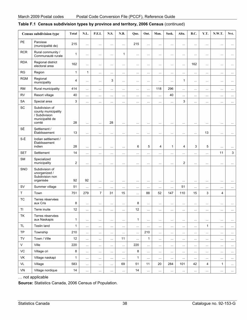
March 2009 Postal codes Postal Code Conversion File (PCCF), Reference Guide
Table F.1 Census subdivision types by province and territory, 2006 Census (continued)
Census subdivision type Total N.L. P.E.I. N.S. N.B. Que. Ont. Man. Sask. Alta. B.C. Y.T. N.W.T. Nvt.
PE Paroisse (municipalité de) 215 ... ... ... ... 215 ... ... ... ... ... ... ... ...
RCR Rural community / Communauté rurale 1 ... ... ... 1 ... ... ... ... ... ... ... ... ...
RDA Regional district electoral area 162 ... ... ... ... ... ... ... ... ... 162 ... ... ...
RG Region 1 1 ... ... ... ... ... ... ... ... ... ... ... ...
RGM Regional municipality 4 ... ... 3 ... ... ... ... ... 1 ... ... ... ...
RM Rural municipality 414 ... ... ... ... ... ... 118 296 ... ... ... ... ...
RV Resort village 40 ... ... ... ... ... ... ... 40 ... ... ... ... ...
SA Special area 3 ... ... ... ... ... ... ... ... 3 ... ... ... ...
SC Subdivision of county municipality / Subdivision municipalité de comté 28 ... ... 28 ... ... ... ... ... ... ... ... ... ...
SÉ Settlement / Établissement 13 ... ... ... ... ... ... ... ... ... ... 13 ... ...
S-É Indian settlement / Établissement indien 28 ... ... ... ... 6 5 4 1 4 3 5 ... ...
SET Settlement 14 ... ... ... ... ... ... ... ... ... ... ... 11 3
SM Specialized municipality 2 ... ... ... ... ... ... ... ... 2 ... ... ... ...
SNO Subdivision of unorganized / Subdivision non organisée 92 92 ... ... ... ... ... ... ... ... ... ... ... ...
SV Summer village 51 ... ... ... ... ... ... ... ... 51 ... ... ... ...
T Town 751 279 7 31 15 ... 88 52 147 110 15 3 4
TC Terres réservées aux Cris 8 ... ... ... ... 8 ... ... ... ... ... ... ... ...
TI Terre inuite 12 ... ... ... ... 12 ... ... ... ... ... ... ... ...
TK Terres réservées aux Naskapis 1 ... ... ... ... 1 ... ... ... ... ... ... ... ...
TL Teslin land 1 ... ... ... ... ... ... ... ... ... ... 1 ... ...
TP Township 210 ... ... ... ... ... 210 ... ... ... ... ... ... ...
TV Town / Ville 12 ... ... ... 11 ... 1 ... ... ... ... ... ... ...
V Ville 220 ... ... ... ... 220 ... ... ... ... ... ... ... ...
VC Village cri 8 ... ... ... ... 8 ... ... ... ... ... ... ... ...
VK Village naskapi 1 ... ... ... ... 1 ... ... ... ... ... ... ... ...
VL Village 583 ... ... ... 69 51 11 20 284 101 42 4 1 ...
VN Village nordique 14 ... ... ... ... 14 ... ... ... ... ... ... ... ...
… not applicable Source: Statistics Canada, 2006 Census of Population.
Statistics Canada 38 Catalogue no. 92-153-G

March 2009 Postal codes Postal Code Conversion File (PCCF), Reference Guide
Appendix G Data file naming convention
The naming convention for Postal Code Conversion Files (PCCF) is bilingual and reflects the reference date of the Canada Post Corporation (CPC) data used in the release. Data files in this release are: National file pccfNat_MAR09_fccpNat.zip Provincial / territorial files pccf10_MAR09_fccp10.zip pccf11_MAR09_fccp11.zip pccf12_MAR09_fccp12.zip pccf13_MAR09_fccp13.zip pccf24_MAR09_fccp24.zip pccf35_MAR09_fccp35.zip pccf46_MAR09_fccp46.zip pccf47_MAR09_fccp47.zip pccf48_MAR09_fccp48.zip pccf59_MAR09_fccp59.zip pccf60_MAR09_fccp60.zip pccf61_MAR09_fccp61.zip pccf62_MAR09_fccp62.zip Table G.1 File name structure of Postal Code Conversion File (PCCF)
Name component Description pccf file name - english provincial code (10, 11, 12, 13, 24, 35, 46, 47, 48, 59, 60, 61, 62)
2-digit province code (see Section 5, Technical specifications/PR)
MAR09 reference date of CPC postal code data (month, year)
fccp file name - french
Statistics Canada 39 Catalogue no. 92-153-G
March 2009 Postal codes Postal Code Conversion File (PCCF), Reference Guide
End-use licence agreement for Statistics Canada's Postal Code Conversion File (PCCF) Copyright The Government of Canada (Statistics Canada) is the owner or a licensee of all intellectual property rights (including copyright) in this data product. With your payment of the requisite fee, you (hereinafter referred to as 'the Licensee') are granted a non-exclusive, non-assignable and non-transferable licence to use this data product subject to the terms below. This licence is not a sale of any or all of the rights of the owner(s). Terms of use 1. All copyright and proprietary notices, as well as all conditions of use associated with the data
product, must be communicated to all users of the data product. 2. The Licensee shall not transfer this data product to, or store the data product in, any electronic
network for use by more than three (3) regular users unless the Licensee obtains prior written permission from Statistics Canada and pays any additional fees.
3. The Licensee shall not lend, rent, lease, sublicense, transfer or sell any part of the data product
nor any right granted under this agreement to any person outside the licensed organization or to any other organization.
4. The Licensee shall not disassemble, decompile or in any way attempt to reverse engineer any
software provided as part of the data product. 5. The Licensee shall not use any part of the data product to develop or derive any other data
product or data service for external distribution or commercial sale. 6. The Licensee is granted reasonable rights of use of the content of this data product only for
personal, corporate or public policy research, as well as for educational purposes. This permission includes the use of the content in analyses and in the reporting of results and conclusions, including the citation of limited amounts of supporting data, extracted from the data product, in such documents. In such cases, the source of the data must be acknowledged in all such documents and communications by providing the following source citation at the bottom of each table and graph:
Source (or 'Adapted from', if appropriate): Geography Division, Statistics Canada,
Postal Code Conversion File (PCCF), Catalogue no. 92-153-XCB Postal Code Conversion File (PCCF), Update, Catalogue no. 92-153-UCB.
7. The Licensee shall obtain approval from Statistics Canada before publishing any significant
volume of material, in any medium, that is extracted from the data product. 8. The Licensee agrees not to merge or link the data product with any other databases in such a
fashion that gives the appearance that the Licensee may have received, or had access to, information held by Statistics Canada about any identifiable individual, family, household, organization or business.
9. Any violation of this licence renders it void and of no effect. This agreement will terminate
automatically without notice if the Licensee fails to comply with any of the terms of this agreement. In the event of termination, the Licensee must immediately return the data product to Statistics Canada or destroy it and certify this destruction in writing to Statistics Canada.
Statistics Canada 40 Catalogue no. 92-153-G
March 2009 Postal codes Postal Code Conversion File (PCCF), Reference Guide
Warranties and disclaimers This data product is provided 'as-is', and Statistics Canada makes no warranty, either express or implied, including but not limited to, warranties of merchantability and fitness for a particular purpose. In no event will Statistics Canada be liable for any direct, special, indirect, consequential or other damages, however caused. Acceptance of terms It is your responsibility to ensure that your use of this data product complies with these terms and to seek prior written permission from Statistics Canada for any uses not permitted or not specified in this agreement. Any infringement of Statistics Canada's rights may result in legal action. Any use whatsoever of this data product shall constitute your acceptance of the terms of this agreement. Any violation of these terms may result in termination of this licence. For further information please contact: Licensing Services Client Services Division, Statistics Canada 9th floor, R. H. Coats Building 100 Tunney’s Pasture Driveway Ottawa, Ontario K1A 0T6 Canada E-mail: [email protected] Telephone: 613-951-1122 Fax: 613-951-1134 © Statistics Canada, 2009
Statistics Canada 41 Catalogue no. 92-153-G