Embed Size (px)
Citation preview
PLANS OF MANAGEMENT FOR
PARKS AT WARRAGAMBA
AND SILVERDALE
Rural Living
PO Box 21 Picton NSW 2571
62-64 Menangle St Picton NSW 2571
DX: 26052 Picton Ph: 02 4677 1100 Fax: 02 4677 2339
Email: [email protected] Water Wilderness Way of Life www.wollondilly.nsw.gov.au WO
LL
ON
DIL
LY
SH
IRE
CO
UN
CIL
WOLLONDILLY SHIRE COUNCIL
TABLE OF CONTENTS
PLAN OF MANAGEMENT FOR PARKS AT WARRAGAMBA AND SILVERDALE ....................................................................... 4
PART 1 INTRODUCTION ............................................................ 5
LOCAL GOVERNMENT ACT 1993 .......................................................................... 5 OTHER CONSIDERATIONS.................................................................................... 5 PROPOSED FUTURE MANAGEMENT OF THE LAND .................................................. 5
PART 2 – PROPERTY DETAILS .................................................. 6
1. LAND SUBJECT TO THIS PLAN ............................................................. 6 WARRAGAMBA ...................................................................................... 6
WALKWAY - THIRTEENTH STREET ............................................................... 6 DRAINAGE RESERVE - THIRTEENTH STREET ............................................. 6 SIXTH STREET PARK ...................................................................................... 6 NINTH STREET PARK ..................................................................................... 6 WALKWAY – SECOND STREET TO WEIR ROAD........................................... 7 THIRD STREET PARK ..................................................................................... 7 DRAINAGE RESERVE - THIRTEENTH STREET ............................................. 8 KIPARA CRESCENT RESERVE ...................................................................... 8 WALKWAY – FIRST STREET TO WEIR ROAD ............................................... 9 DRAINAGE RESERVES NINETEENTH STREET ........................................... 10 RESIDENTIAL LAND NINETEENTH STREET ................................................ 10 CIVIC PARK .................................................................................................... 11 MEMORIAL PARK .......................................................................................... 11 FIFTH STREET PARK .................................................................................... 11
SILVERDALE ........................................................................................ 12 WARRADALE ROAD WALKWAY/DRAINAGE RESERVE .............................. 12 EUGENIE BYRNE PARK ................................................................................ 12 TAYLORS ROAD RESERVE .......................................................................... 13 MCKAY DRIVE LAND ..................................................................................... 13 TAYLORS ROAD PARK ................................................................................. 13 DUNBAR/BARROW STREET RESERVE ....................................................... 14
2. LAND STATUS AND OWNERSHIP ....................................................... 14 3. LAND CLASSIFICATION ....................................................................... 14 4. CURRENT MANAGEMENT REGIME .................................................... 14 5. CONDITION OF THE LAND AND STRUCTURES ON ADOPTION OF
THE PLAN...................................................................................................... 15 DRAINAGE RESERVES THIRTEENTH STREET ........................................... 15 SIXTH STREET PARK .................................................................................... 15 NINTH STREET PARK ................................................................................... 15 WALKWAY – SECOND STREET TO WEIR ROAD......................................... 15 THIRD STREET PARK ................................................................................... 15 THIRTEENTH STREET DRAINAGE RESERVE/WALKWAY .......................... 15 KIPARA CRESCENT RESERVE .................................................................... 16 WALKWAY – FIRST STREET TO WEIR ROAD ............................................. 16 DRAINAGE RESERVES NINETEENTH STREET ........................................... 16 RESIDENTIAL LAND, NINETEENTH STREET ............................................... 16 CIVIC PARK .................................................................................................... 16 MEMORIAL PARK .......................................................................................... 17 FIFTH STREET PARK .................................................................................... 17
WOLLONDILLY SHIRE COUNCIL
SILVERDALE ........................................................................................ 19 WARRADALE ROAD WALKWAY/DRAINAGE RESERVE .............................. 19 EUGENIE BYRNE PARK ................................................................................ 19 TAYLORS ROAD RESERVE .......................................................................... 19 MCKAY DRIVE LAND ..................................................................................... 19 TAYLORS ROAD PARK/PLAYGROUND ........................................................ 20 DUNBAR/BARROW STREETS RESERVE ..................................................... 20
6. LAYOUT OF EXISTING FACILITIES ..................................................... 20 7. USE OF THE LAND AND STRUCTURES AT THE TIME OF ADOPTION
OF THE PLAN ................................................................................................ 20
PART 3 – MANAGEMENT ISSUES ............................................ 21
1. COUNCIL’S STATEMENT OF PURPOSE ............................................. 21 2. WOLLONDILLY VISION 2025 ............................................................... 21 3. RECREATION DEMAND AND OPPORTUNITIES ................................ 21
Demand for Informal Use of Parks .................................................................. 21 Demand for Access to Water (Visual and Physical) ......................................... 21 Demand for Interaction with Nature ................................................................. 21 Connections and Travel on Trails and Routes ................................................. 21
4. OTHER EXPRESSED DEMANDS AND OPPORTUNITIES ................. 22 Targeting Youth ............................................................................................... 22 Targeting People with a Disability ................................................................... 22 Targeting People from Non English Speaking Backgrounds............................ 22 Cultural and Civic Spaces ............................................................................... 22 Demand for Sports Facilities ........................................................................... 22
5. SUCCESS FACTORS ........................................................................... 22
PART 4 – MANAGEMENT OBJECTIVES .................................. 23
1. LAND “CATEGORISATION” .................................................................. 23 2. MANAGEMENT OBJECTIVES .............................................................. 23
1. CORE OBJECTIVES FOR THE MANAGEMENT OF COMMUNITY LAND 23 Park 23 2. COUNCIL’S OTHER OBJECTIVES ........................................................... 23
3. THREATENED SPECIES LAW ............................................................. 24 4. FUTURE USE OF THE LAND ................................................................ 24 5. FUTURE USE AND DEVELOPMENT OF THE LAND ............................ 24
1. Schedule of Permitted Uses and Permitted Development .......................... 24 2. Management Strategies and Performance Measures ................................. 24 3. Master Plans .............................................................................................. 24 4. Development Plan ...................................................................................... 24
6. LEASES LICENCES AND OTHER ESTATES ....................................... 25 1. Authorisation.......................................................................................... 25 2. Tendering for Leases Licences and Other Estates ................................ 25
7. APPROVALS FOR WORKS ON THE LAND .......................................... 25 1. Wollondilly Local Environment Plan 1991 .............................................. 25 2. Activities Requiring Council Approval (Section 68, Part D, Local Government Act 1993) .................................................................................. 25 3. Advertising and Signage ........................................................................ 25 4. Prohibited Activities ............................................................................... 26 Appendix 1A - Existing Layout Plan - Sixth Street Park, Warragamba .......... 27 Appendix 1B - Existing Layout Plan - Ninth Street Park, Warragamba .......... 28 Appendix 1C - Existing Layout Plan - Third Street Park, Warragamba .......... 29 Appendix 1D - Existing Layout Plan - Kipara Crescent, Warragamba ........... 30 Appendix 1E - Existing Layout Plan - Civic Park, Warragamba ..................... 31
WOLLONDILLY SHIRE COUNCIL
Appendix 1F- Existing Layout Plan - Memorial Park, Warragamba ............... 32 Appendix 1G - Fifth Street Park, Warragamba .............................................. 33 Appendix H - Eugenie Byrne Park, Silverdale ............................................... 34 Appendix 1 I - Mckay Drive land and Taylors Road Reserve, Silverdale ....... 35 Appendix 1J - Taylors Road Park and Dunbar Street Reserve, Silverdale .... 36 Appendix 1K - Warradale Road Walkway/Drainage Reserve, Silverdale ...... 37 Appendix 2 - Permitted Uses and Development ............................................ 38 Appendix 3 - ................................................................................................. 39 Appendix 4A - Indicative Landscape Master Plan - Sixth Street Park, Warragamba ................................................................................................. 46 Appendix 4B - Indicative Landscape Master Plan - Ninth Street Park, Warragamba ................................................................................................. 47 Appendix 4C - Indicative Landscape Master Plan - Third Street Park, Warragamba ................................................................................................. 48 Appendix 4D - Indicative Landscape Master Plan - Kipara Crescent Reserve, Warragamba ................................................................................................. 49 Appendix 4E - Indicative Landscape Master Plan - Civic Park, Warragamba 50 Appendix 4F - Indicative Landscape Master Plan - Memorial Park, Warragamba ................................................................................................. 51 Appendix 4G - Indicative Master Landscape Plan - Fifth Street Park, Warragamba ................................................................................................. 52 Appendix 4H - Indicative Master Landscape Plan - Eugenie Byrne Park, Silverdale ...................................................................................................... 53 Appendix 4I - Indicative Master Landscape Plan - McKay Drive Land and Taylors Road Reserve, Silverdale ................................................................. 54 Appendix 4J - Indicative Master Landscape Plan- Dunbar Street Reserve and Taylors Road Park, Silverdale ...................................................................... 55 Appendix 4K - Indicative Master Landscape Plan - Warradale Road walkway/Drainage Reserve, Silverdale ......................................................... 56 Appendix 5 - Parks at Warragamba and Silverdale ....................................... 57

WOLLONDILLY SHIRE COUNCIL
Page 4
PLAN OF MANAGEMENT FOR PARKS IN
WARRAGAMBA AND SILVERDALE This plan was prepared to meet the core objectives for the management of community land pursuant to Section 36 of the Local Government Act 1993. The Council adopted the draft plan at its meeting on 18 October 2004. Following exhibition of the draft plan, Council adopted the plan at its meeting on 19 December 2005. This plan is operative from 19 December 2005.
WOLLONDILLY SHIRE COUNCIL
Page 5
PART 1 INTRODUCTION
Local Government Act 1993 Council is required in terms of Section 36 of the Local Government Act 1993 to prepare plans of management for its community lands. Please refer to the Schedule attached to this set of plans for information relating to the preparation of plans of management.
Other Considerations In preparing these plans, Council has endeavoured to ensure compatibility with a range of other plans and policies previously adopted by the Council, including: The State of Wollondilly Report incorporating Council’s Social Plan. Wollondilly Vision 2025 - Visions for the separate communities and the Shire as
a whole. Local Environmental Plan 1991. Stormwater Management Plans (Upper Georges River, Upper Nepean River
and Wollondilly District). Stonequarry Creek Floodplain Management Plan. Strategic Management of Council’s Assets Policy. Should any specific item provided for in a community land plan of management be incompatible with existing plans or policies, then the provisions of those previously adopted plans and policies shall generally have precedence. Please refer to the attached Schedule for information relating to the Wollondilly Vision 2025.
Proposed Future Management of the Land The plan outlines strategies for the ongoing management of the land detailing Council’s expectations in relation to matters such as general condition and suability, suitability for all people regardless of physical ability, health and safety concerns, environmental concerns and cost effectiveness. Council will continue to seek ways and means of improving its management of these lands for the benefit of the public at large. It proposes to develop a comprehensive asset management program and to continue to develop its asset maintenance program to achieve a high level of service at an affordable and sustainable cost. Council’s focus in these plans is to: Improve accessibility for people of all ages and levels of ability. Upgrade and improve existing facilities rather than build new facilities. Improve the standard of amenities provided. Improve the level of service provided. Address health and safety issues. Address environmental issues. Provide cost effective services.
WOLLONDILLY SHIRE COUNCIL
Page 6
PART 2 – PROPERTY DETAILS
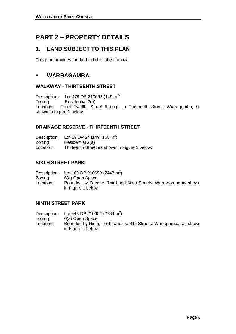
1. LAND SUBJECT TO THIS PLAN This plan provides for the land described below:
WARRAGAMBA
WALKWAY - THIRTEENTH STREET Description: Lot 479 DP 210652 (149 m2) Zoning Residential 2(a) Location: From Twelfth Street through to Thirteenth Street, Warragamba, as shown in Figure 1 below:
DRAINAGE RESERVE - THIRTEENTH STREET Description: Lot 13 DP 244149 (160 m2) Zoning Residential 2(a) Location: Thirteenth Street as shown in Figure 1 below:
SIXTH STREET PARK Description: Lot 169 DP 210650 (2443 m2) Zoning: 6(a) Open Space Location: Bounded by Second, Third and Sixth Streets, Warragamba as shown
in Figure 1 below:
NINTH STREET PARK Description: Lot 443 DP 210652 (2784 m2) Zoning: 6(a) Open Space Location: Bounded by Ninth, Tenth and Twelfth Streets, Warragamba, as shown
in Figure 1 below:
WOLLONDILLY SHIRE COUNCIL
Page 7
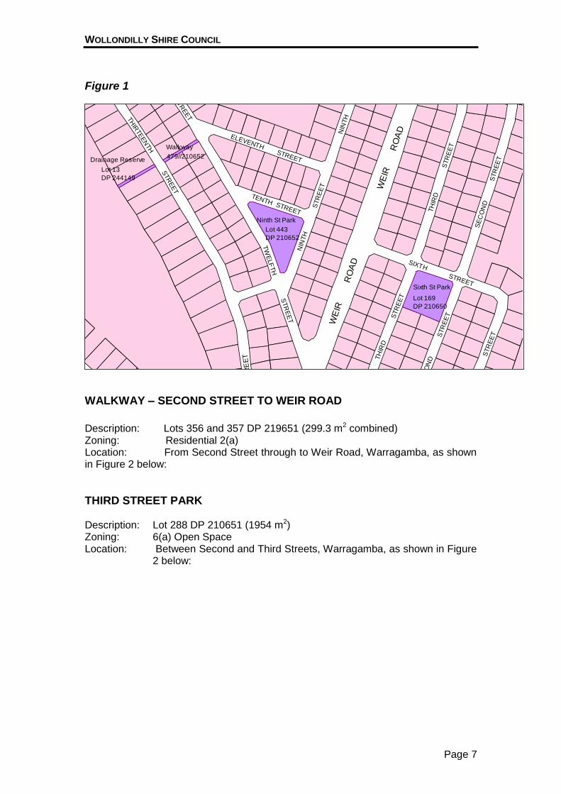
Figure 1
WE
IR
SIXTH
RO
AD
STREET
NIN
TH
STR
EE
T
NIN
TH
TENTH STREET
ELEVENTH
TW
ELF
TH
STR
EE
T
STR
EE
T
TH
IRTEEN
TH
STR
EET
TH
IRD
SE
CO
ND
STREET
STR
EE
T
FIR
ST
STR
EE
TSTR
EE
T
SE
CO
ND
WE
IRR
OA
D
STR
EE
T
TH
IRD
STR
EE
T
ST
RE
ET
Drainage Reserve
Lot 13
DP 244149
Lot 443
DP 210652
Ninth St Park
Walkway
479//210652
Lot 169
DP 210650
Sixth St Park
357
WALKWAY – SECOND STREET TO WEIR ROAD
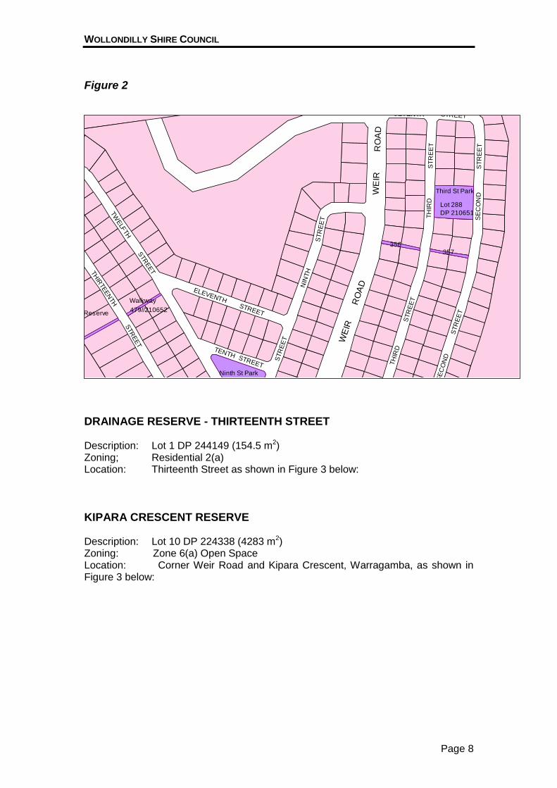
Description: Lots 356 and 357 DP 219651 (299.3 m2 combined) Zoning: Residential 2(a) Location: From Second Street through to Weir Road, Warragamba, as shown in Figure 2 below:
THIRD STREET PARK Description: Lot 288 DP 210651 (1954 m2) Zoning: 6(a) Open Space Location: Between Second and Third Streets, Warragamba, as shown in Figure
2 below:
WOLLONDILLY SHIRE COUNCIL
Page 8
Figure 2 SEVENTH
STREETS
TR
EE
T
NIN
TH
STR
EE
T
NIN
TH
TENTH STREET
ELEVENTH
STR
EE
T
TH
IRTEEN
TH
STR
EET
TW
ELF
TH
RO
AD
STREET
ST
RE
ET
TH
IRD
ST
RE
ET
SE
CO
NDW
EIR
SE
CO
ND
WE
IRR
OA
D
STR
EE
T
TH
IRD
STR
EE
T
Drainage Reserve
Drainage Reserve
Lot 443
DP 210652
Ninth St Park
Walkway
479//210652
357
Lot 288
DP 210651
Third St Park
356
DRAINAGE RESERVE - THIRTEENTH STREET Description: Lot 1 DP 244149 (154.5 m2) Zoning; Residential 2(a) Location: Thirteenth Street as shown in Figure 3 below:
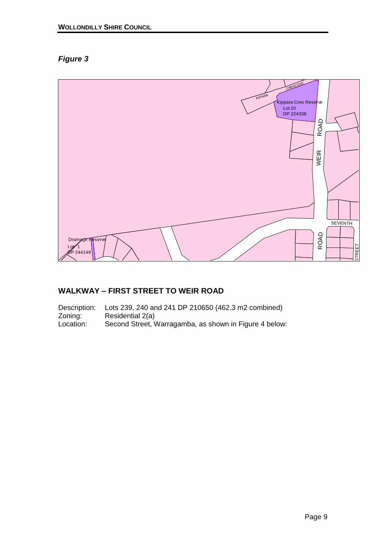
KIPARA CRESCENT RESERVE Description: Lot 10 DP 224338 (4283 m2) Zoning: Zone 6(a) Open Space Location: Corner Weir Road and Kipara Crescent, Warragamba, as shown in Figure 3 below:
WOLLONDILLY SHIRE COUNCIL
Page 9
Figure 3
SEVENTH
RO
AD
STREET
ST
RE
ET
WE
IRW
EIR
RO
AD
KIPARA
CRESCENT
Drainage Reserve
Lot 1
DP 244149
Lot 10
DP 224338
Kippara Cres Reserve
WALKWAY – FIRST STREET TO WEIR ROAD Description: Lots 239, 240 and 241 DP 210650 (462.3 m2 combined) Zoning: Residential 2(a) Location: Second Street, Warragamba, as shown in Figure 4 below:
WOLLONDILLY SHIRE COUNCIL
Page 10
Figure 4
WE
IR
SIXTH
RO
AD
STR
EE
T
NIN
TH
TENTH STREET
TW
ELF
TH
STR
EE
T
ST
RE
ET
ST
RE
ET
ST
RE
ET
TH
IRD
SE
CO
ND
STREET
STR
EE
T
FIR
ST
STR
EE
TSTR
EE
T
SE
CO
ND
TH
IRD
RO
AD
SE
CO
ND
TH
IRT
EE
NT
H
WE
IR
ST
RE
ET
EIG
HT
EE
NTH
Lot 443
DP 210652
Ninth St Park
239
241
240
Lot 169
DP 210650
Sixth St Park
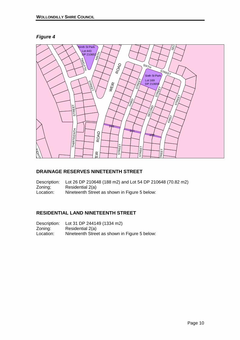
DRAINAGE RESERVES NINETEENTH STREET Description: Lot 26 DP 210648 (188 m2) and Lot 54 DP 210648 (70.82 m2) Zoning; Residential 2(a) Location: Nineteenth Street as shown in Figure 5 below:
RESIDENTIAL LAND NINETEENTH STREET Description: Lot 31 DP 244149 (1334 m2) Zoning: Residential 2(a) Location: Nineteenth Street as shown in Figure 5 below:
WOLLONDILLY SHIRE COUNCIL
Page 11
Figure 5
ST
RE
MAUNDER PL
WE
IR
STREET
FO
UR
TE
EN
TH
ST
RE
ET
ST
RE
ET
FARNSWO
RTH
AVENUE
RO
AD
TWENTIETH ST
AVENUE
ET
FAR
NSW
OR
TH
NIN
ET
EE
NT
H
NIN
ETE
EN
TH
Pool
Warragamba Sports Ground
Town
Hall
Drainage Reserve
Lot 26 DP 210648
Residential LandLot 31 DP 244149
Drainage Reserve
Lot 54 DP 210648
Primary School
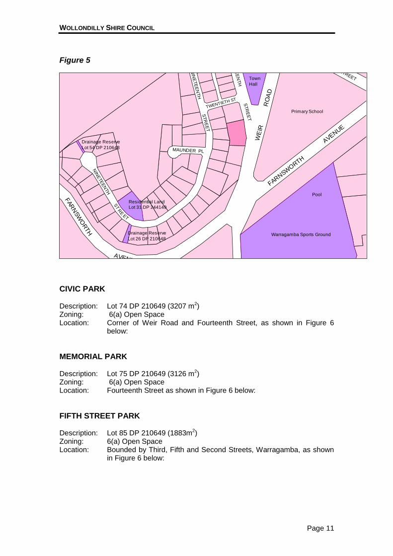
CIVIC PARK Description: Lot 74 DP 210649 (3207 m2) Zoning: 6(a) Open Space Location: Corner of Weir Road and Fourteenth Street, as shown in Figure 6
below:
MEMORIAL PARK Description: Lot 75 DP 210649 (3126 m2) Zoning: 6(a) Open Space Location: Fourteenth Street as shown in Figure 6 below:
FIFTH STREET PARK Description: Lot 85 DP 210649 (1883m2) Zoning: 6(a) Open Space Location: Bounded by Third, Fifth and Second Streets, Warragamba, as shown
in Figure 6 below:
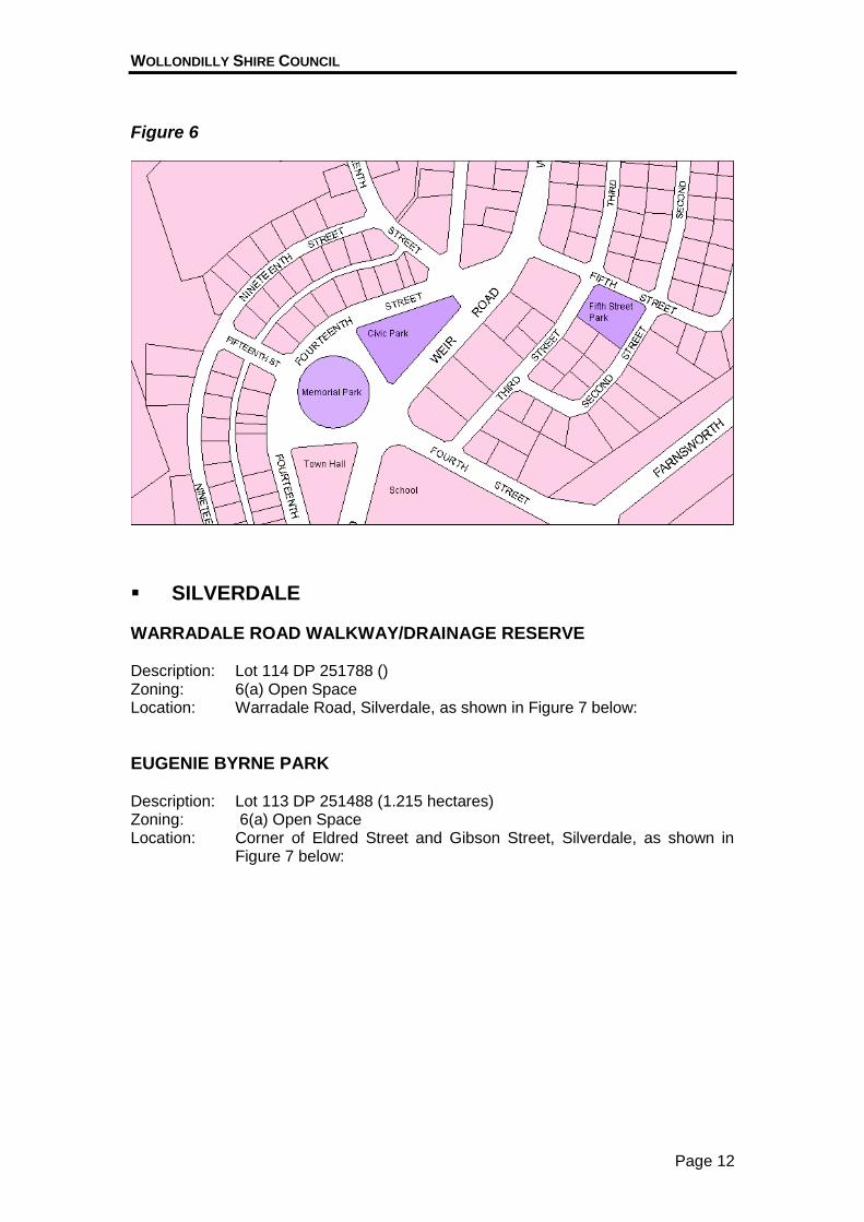
WOLLONDILLY SHIRE COUNCIL
Page 12
Figure 6
SILVERDALE
WARRADALE ROAD WALKWAY/DRAINAGE RESERVE Description: Lot 114 DP 251788 () Zoning: 6(a) Open Space Location: Warradale Road, Silverdale, as shown in Figure 7 below:
EUGENIE BYRNE PARK Description: Lot 113 DP 251488 (1.215 hectares) Zoning: 6(a) Open Space Location: Corner of Eldred Street and Gibson Street, Silverdale, as shown in
Figure 7 below:
WOLLONDILLY SHIRE COUNCIL
Page 13
Figure 7
STREET
MA
RS
HR
OA
D
ST
RE
ET
ELD
RE
D
COVENY STREET
GIB
SO
N
AARON PL
LEWISS
TR
EE
T
RO
AD
STREET
GIB
SO
N
ST
RE
ET
GIBSON
TU
RU
NE
N
SIL
VE
RD
ALE
RO
AD
SIL
VE
RD
ALE
BILLETT
McA
ULIF
FE
RO
AD
PLA
CE
GOLDEN
Walkway/Drainage ReserveLot 114DP 251788
Eugenie Byrne ParkLot 113 DP 251788
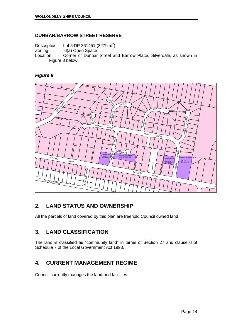
TAYLORS ROAD RESERVE Description: Lot 48 DP 261770 (6644 m2) Zoning: 6(a) Open Space Location: Corner of Taylors Road and McKay Drive, Silverdale, as shown in
Figure 8 below:
MCKAY DRIVE LAND Description: Lot 105 DP 261770 (2101 m2) Zoning: 6(a) Open Space Location: McKay Drive, Silverdale, as shown in Figure 8 below:
TAYLORS ROAD PARK Description: Lot 46 DP 261451 (2961 m2) Zoning: 6(a) Open Space Location: Corner of Taylors Road and Dunbar Street, Silverdale, as shown in
Figure 8 below:
WOLLONDILLY SHIRE COUNCIL
Page 14
DUNBAR/BARROW STREET RESERVE Description: Lot 5 DP 261451 (3279 m2) Zoning: 6(a) Open Space Location: Corner of Dunbar Street and Barrow Place, Silverdale, as shown in
Figure 8 below:
Figure 8
SA
LE
S
MO
OR
EH
EA
D
AVE
GR
AH
AM
PL
ST
RE
ET
AVE
DRIVE
DRIVE
DE
LA
NE
Y
AV
EN
UE
ROADM
cKA
Y
BARROW PL
DU
NB
AR
TAYLORS
DR
IVE
ST HELIERS ROAD
ST HELIERS ROAD
ST
HE
LIE
RS
RO
AD
TAYLORS
TAYLORSROAD
RO
AD
McKAY
SIL
VERD
ALE
WA
LK
ER
CL
McKAY
Lot 105 DP 261770
Taylors Road ParkLot 46DP 261451
Dunbar St ReserveLot 5 DP 261451
McKay Drive Park
Lot 48DP 261770
Taylors Road Reserve
2. LAND STATUS AND OWNERSHIP All the parcels of land covered by this plan are freehold Council owned land.
3. LAND CLASSIFICATION The land is classified as “community land” in terms of Section 27 and clause 6 of Schedule 7 of the Local Government Act 1993.
4. CURRENT MANAGEMENT REGIME Council currently manages the land and facilities.
WOLLONDILLY SHIRE COUNCIL
Page 15
5. CONDITION OF THE LAND AND STRUCTURES ON ADOPTION OF THE PLAN
DRAINAGE RESERVES THIRTEENTH STREET Lot 1 DP 244149 is a grassed strip sloping down from Thirteenth Street providing vehicle entrance for Sydney Water to the water catchment area beyond. The land also provides pedestrian access for bushwalkers. Lot 13 DP 244149 provides pedestrian access to Water Catchment land (deep gully).
SIXTH STREET PARK Grassed open space with a few trees and two light standards. The land slopes noticeably down towards Sixth Street. There were no structures and the land appeared to be little used. The grass was very dry reflecting drought conditions and water restrictions. The park was maintained in a clean and tidy condition.
NINTH STREET PARK Triangular shaped park with only fair grass cover, some trees, a few shrubs that needed to be trimmed, a Council sign and three light standards. When viewed, there was long grass that needed mowing. There were no facilities on the land. The park looked unkempt with bare patches indicating that the Ninth Street boundary area is used for car parking.
WALKWAY – SECOND STREET TO WEIR ROAD Grass cover is generally good as pedestrian traffic is generally confined to the concrete pathways provided.
THIRD STREET PARK Gently sloping grassed open space with a few trees and two light standards. At time of review one light was missing. There were no structures and the land appeared to be little used. The grass was very dry reflecting drought conditions and water restrictions. The park is bisected by a water main (1 metre deep). There is also a 1 metre wide easement for drainage near the southern boundary. The park was maintained in a clean and tidy condition.
THIRTEENTH STREET DRAINAGE RESERVE/WALKWAY Land provides access from Thirteenth Street to Sydney Water Corporation land. There is no infrastructure on the land.
WOLLONDILLY SHIRE COUNCIL
Page 16
KIPARA CRESCENT RESERVE This is a medium sized (almost one acre) area off the northern end of Weir Street close to the Scout Camp. This reserve is considerably less developed than other parks in Warragamba. It has some mature trees and a few shrubs, a Council sign, two light standards and one park bench. Part of a former tennis court enclosure remains on the land indicating the drop in level to the former court. There was also a rock retaining wall and several mature trees and shrubs (mainly exotics). The park is surrounded by modern homes constructed since a recent bushfire destroyed several properties in the area. The access to Kipara Crescent is not formed within its legal boundary due to the difference in level between Kipara Crescent and Weir Road. The road encroaches on the park. Furthermore, a vehicular track has been formed within the park around the north and western boundaries of the land.
WALKWAY – FIRST STREET TO WEIR ROAD Grass cover is generally good as pedestrian traffic is generally confined to the concrete pathways provided.
DRAINAGE RESERVES NINETEENTH STREET These reserves provide access for public drains. They are generally kept in a reasonably tidy condition but not maintained as public use areas.
RESIDENTIAL LAND, NINETEENTH STREET This is an attractive, grassed allotment bisected by a watercourse and over which there is a 3m wide easement to drain water and a foul sewer drain. There are a number of mature trees (generally exotic varieties) on the land.
CIVIC PARK The park is developed with a range of playground equipment (double A-frame swing with soft fall matting and a combined playground unit with woodchip soft fall). It also has seating, two picnic shelters and an electric barbecue. These facilities were in a good condition. The land appeared very dry and had a “tired" appearance despite being generally tidy and well mown. The site has a number of mature trees for shade and there is a reasonably large (300m2) area of grass which was in a generally poor condition indicative of a lack of water (due to drought conditions and water restrictions) and of a need to undertake remedial work (such as topdressing and fertilizing) to keep the grass in an “A” grade condition. Part of the land fronting Fourteenth Street has been developed for car parking and footpath. The land has been built up on this side with a rock retaining wall. Access to the Park is via steps from the footpath or via ramps from other points.
WOLLONDILLY SHIRE COUNCIL
Page 17
Electricity lines on the site have been undergrounded in a galvanised pipe. Power is delivered to the site overhead to a stay pole in the south west corner. There are four light standards. A telephone cable and pit are installed within the land at the western end. The water line runs through the Weir Road side of the property from the main that bisects the Town Hall land at Thirteenth Street. Water is designed to be delivered to three taps for manual irrigation but there was no obvious sign of the taps on the land so that there was no water available to park users. The pathways through the land were unsealed. The park is surrounded by a chain wire fence which is adequate but has a very temporary appearance.
MEMORIAL PARK This centrally located circular shaped park is a focal point in the town centre with the War and Warragamba Dam Memorial monument set in a concrete surround and very small feature rock garden with a flag pole. The greater part of the park comprises grass which is in a generally poor condition indicative of a lack of water (due to drought conditions and water restrictions) and a need to undertake remedial work (such as topdressing and fertilizing) to keep the grass in an “A” grade condition, along with a number of established trees which were showing signs of stress. The land has been built up from the kerb with a grassed footpath and bank. Access to the Park is via three sets of steps. There were no paths across the land. Electricity lines on the site have been undergrounded in a galvanised pipe. Power is delivered to the site underground from the Town Hall land. There are two light standards on the land and a floodlight to illuminate the memorial area. The water connection is near the Fourteenth Street entrance. There is just one tap in the centre for manual irrigation. The park was generally clean and tidy, but appeared “tired” and in need of refurbishment.
FIFTH STREET PARK This is a level block of land with established “A” grade grass cover which is well maintained. There are a few mature trees on the land but no shrubs or other garden plants. The park has a number of park lights but no other infrastructure. The land is bounded on three sides by residential properties; a church hall is on the fourth side. A range of community facilities including a pre-school are in the vicinity so this park could be better utilised if upgraded. It is surrounded by sealed but narrow streets. It is fenced only on its southern boundary adjoining residential properties.
WOLLONDILLY SHIRE COUNCIL
Page 18
A public sewer main bisects the property. The site is serviced by the town water supply and can be connected to the reticulated sewerage system (not yet connected as there are no toilet facilities on site).
WOLLONDILLY SHIRE COUNCIL
Page 19
SILVERDALE
WARRADALE ROAD WALKWAY/DRAINAGE RESERVE This is an attractive walkway linking Gibson Street to Warradale Road and Warragamba. The meandering path is of concrete with 3 light standards and a seat. It adjoins a grassed and mown drainage swale landscaped with trees and some shrubs. The adjoining fences had in places been defaced with graffiti, which detracted from its appearance. The Sydney Water Corporation has installed a sewerage pumping station within the land.
EUGENIE BYRNE PARK This park is located in a developed residential area. The park is quite large (1.125 hectares) with grass and a number of large mature trees which add considerably to the amenities of the neighbourhood. The grass was in only a reasonable condition but may have been affected by the prolonged period of drought through the summers of 2002 and 2003 and water restrictions imposed. The only play equipment on site were two small sprung units suitable for very small children. These units have faded and look tired although they are still functional. When the park was inspected this equipment had been defaced with obscene graffiti. The park lacks other amenities such as seating, shelters or picnic furniture. It has five light standards and some refuse receptacles.
TAYLORS ROAD RESERVE This large park (over one and a half acres) block of land serves as open space and informal sportsground for the local community. The “A grade” grass was in generally good condition, possibly reflecting a lack of use. There are few trees and no public facilities. There is a concrete cricket wicket in the centre. The park was not fenced but was surrounded by wooden bollards to keep unauthorised vehicular traffic off the land.
MCKAY DRIVE LAND This half acre parcel is situated opposite the Taylors Road Reserve. It currently serves only as a public open space. The land slopes to a relatively flat area which is grassed and mown. It has a one large mature gum tree towards the front and some smaller trees. There were no recreational facilities on the land. There are stormwater mains installed within the land limiting future development. The land appeared tidy.
WOLLONDILLY SHIRE COUNCIL
Page 20
TAYLORS ROAD PARK/PLAYGROUND This is a large (2961 m2) block directly opposite the Dunbar/Barrow Streets Park. Playground equipment included a double “A” frame swing over rubber matting softfall and a combined playground item and a large sprung “animal” play item on a woodchip soft fall. The land is gently sloping with “A" grade grass and a number of large mature trees on the site. A concrete path meanders through the site. There was one light standard, two seats and a tap. The site was well fenced.
DUNBAR/BARROW STREETS RESERVE This land comprises a large (almost 1 acre) flat grassed area with three light standards. The grass appears to be in good condition reflecting little active public use. There were a number of medium sized native trees which appeared to be in good condition. There were two park benches for seating but no other facilities. This park provides a most attractive outlook for nearby residential properties adding considerably to the landscape amenities of the neighbourhood.
6. LAYOUT OF EXISTING FACILITIES Attached as Appendices 1A-K are plans showing the layout of the facilities at the time of adoption of the plan. Plans are not attached for other drainage or walkway reserves where the only infrastructure is a sealed pathway. 1A Sixth Street Park 1B Ninth Street Park 1C Third Street Park 1D Kipara Crescent Reserve 1E Civic Park 1F Memorial Park 1G Fifth Street Park 1H Eugenie Byrne Park 1I McKay Drive land and Taylors Road Reserve 1J Taylors Road Playground and Dunbar Street Reserve 1K Warradale Road Drainage Reserve/Walkway
7. USE OF THE LAND AND STRUCTURES AT THE TIME OF ADOPTION OF THE PLAN
With the exception of the drainage reserves, the lands in this plan are used primarily for open space and passive recreation. Civic Park and the Taylors Road Park/Playground and to a lesser extent Eugenie Byrne Park are used as children’s playgrounds. Memorial Park is used for Anzac Day and other memorial services.
WOLLONDILLY SHIRE COUNCIL
Page 21
PART 3 – MANAGEMENT ISSUES
1. COUNCIL’S STATEMENT OF PURPOSE To create opportunities in partnership with the community. To enhance the quality of life and the environment, by managing growth and providing services and facilities of the highest quality.
2. WOLLONDILLY VISION 2025 Derived from community workshops held in February and March 2003 Council adopted ” A Vision for Wollondilly 2025” incorporating nine separate visions covering all aspects of the Shire’s future having regard to the lifestyle needs of the residents through to the uniqueness of the rural countryside and the various towns and villages. The Vision provides Council with a framework to develop new strategies and policies and to guide the organisation so that it can effectively play its vital role in the delivery of the Vision. Visions 1 and 7 are particularly relevant for the management of community lands and Crown Reserves under the care and control of the Council. Please refer to the attached Schedule for details of the Visions and Vision Strategies that particularly affect Council managed land.
3. RECREATION DEMAND AND OPPORTUNITIES A preliminary pre-publication Summary Report on the Western Sydney Regional Recreation Demand and Opportunities Study has identified, among other things, that the following issues affect the acquisition and/or development of future recreational assets.
Demand for Informal Use of Parks Note: Refer to Key Vision Strategy 7.1
Demand for Access to Water (Visual and Physical) Note: Refer to Key Vision Strategy 7.8
Demand for Interaction with Nature Note: Refer to Key Vision Strategy 7.2
Connections and Travel on Trails and Routes Note: Refer to Key Vision Strategies 7.4 and 7.7.

WOLLONDILLY SHIRE COUNCIL
Page 22
4. OTHER EXPRESSED DEMANDS AND OPPORTUNITIES
Targeting Youth Note: Refer to Key Vision Strategy 7.5
Targeting People with a Disability Note: Refer to Key Vision Strategy 7.1
Targeting People from Non English Speaking Backgrounds Note: Refer to Key Vision Strategy 7.1
Cultural and Civic Spaces Note: Refer to Key Vision Strategy 7.5
Demand for Sports Facilities “Existing facilities should where necessary be upgraded and demand managed through greater use of mid week competitions and multi purpose use of grounds between seasons and sports types.” Note: Refer to Key Vision Strategy 7.5
5. SUCCESS FACTORS Council has identified a number of factors, which contribute towards the success of public places. The first four key qualities affect particularly the users of the place; the fifth factor, value for money, affects both users and providers.
Access and Linkages
Comfort and Image
Uses and Activities
Sociability
Value for Money Please refer to the attached Schedule for further information about the key success factors identified.
WOLLONDILLY SHIRE COUNCIL
Page 23
PART 4 – MANAGEMENT OBJECTIVES
1. LAND “CATEGORISATION” Council is required to categorise the land according to its use type and to manage it so as to achieve the core objectives for the land categories. The Act provides guidelines for choosing the category or categories to be applied. A parcel may be categorised as one or more separate categories according to its use and the characteristics of the land. Please refer to the attached Schedule for the guidelines for categorisation of community land according to its proposed use and land characteristics.
Note: One parcel can be categorised as to its parts provided the parts are clearly identified (not necessarily surveyed). The Council proposes to categorise the land in this plan as “park”.
2. MANAGEMENT OBJECTIVES
1. CORE OBJECTIVES FOR THE MANAGEMENT OF COMMUNITY LAND
The Local Government Act prescribes “core objectives” for managing community land according to its category. These core objectives help councils to focus on the essential aspects of each area of land and to determine key performance targets. Council proposes to manage the various parts of the land according to the Local Government Act core objectives and Council’s other objectives.
Park The core objectives for management of community land categorised as a park are: (a) to encourage, promote and facilitate recreational, cultural, social, educational
pastimes and activities, filming, business, and tourism events; and (b) to provide for passive recreational activities or pastimes and for the casual
playing of games, and use of its facilities; and (c) to improve the land in such a way as to promote and facilitate its use to
achieve the other core objectives for its management.
2. COUNCIL’S OTHER OBJECTIVES 1. Public Safety and Risk Management 2. Bushfire Hazard Management 3. Traffic Management 4. Economically sustainable development 5. Community development – building social capital
WOLLONDILLY SHIRE COUNCIL
Page 24
3. THREATENED SPECIES LAW These lands are not affected by the Threatened Species Conservation Act 1995.
4. FUTURE USE OF THE LAND The Council proposes to maintain these lands public open space providing opportunities for passive recreation, with minor upgrading to improve public access and increase the public’s use and enjoyment of the land.
5. FUTURE USE AND DEVELOPMENT OF THE LAND
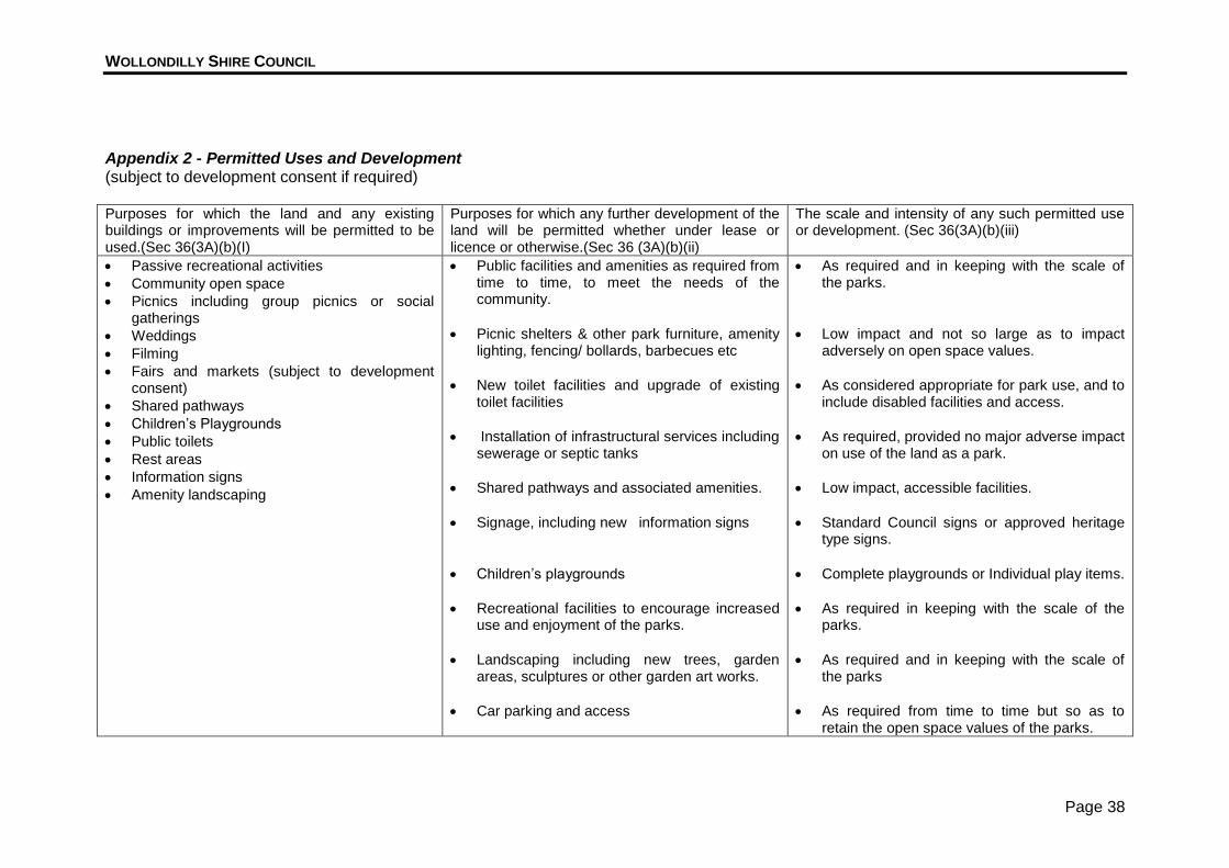
1. Schedule of Permitted Uses and Permitted Development Attached as Appendix 2 is a schedule in terms of Section 36(3A)(b) specifying the purposes for which the land and any existing buildings or improvements will be permitted to be used, the purposes for which any further development of the land will be permitted whether under lease or licence or otherwise and the scale and intensity of any such permitted use or intensity.
2. Management Strategies and Performance Measures Council has prepared strategies to enable it to effectively manage this land, and has established some means of measuring its performance. The strategy plan is attached as Appendix 3.
3. Master Plans Attached as Appendices 4A K- are indicative master plans for the following reserves: 4A Sixth Street Park 4B Ninth Street Park Park 4C Third Street Park 4D Kipara Crescent Reserve 4E Civic Park 4F Memorial Park 4G Fifth Street Park 4H Eugenie Byrne Park 4I McKay Drive land and Taylors Road Reserve 4J Taylors Road Park and Dunbar Street Reserve 4K Warradale Road Walkway/Drainage Reserve Detailed design work has yet to be undertaken; this may result in some adjustments to the final layout plans but will not be considered as grounds for amending or reviewing this plan.
4. Development Plan Attached as Appendix 5 is a proposed development plan, which outlines proposed future development. As all future capital expenditure must be able to be justified in terms of the Strategic Management of Council’s Assets Policy and is subject detailed
WOLLONDILLY SHIRE COUNCIL
Page 25
design and to the availability of funding, Council is unable to provide more than an indicative time frame or a “rough order” estimate of costs for these proposed future works.
6. LEASES LICENCES AND OTHER ESTATES 1. Authorisation This Plan expressly authorises the leasing, licensing or granting of any other estate over the land subject to the provisions of sections 45 and 46 of the Local Government Act 1993. Applications for lease licence or grant of an estate will be considered by Council on their merit. Any lease, license or other estate would however need to be for the purpose of meeting the management objectives for the land as “park” land. 2. Tendering for Leases Licences and Other Estates A lease or licence for a term exceeding 5 years may be granted only by tender in accordance with Division 1 of Part 3 of the Act unless it is granted to a non-profit organisation. The Council may however apply a tender process in respect of the grant of any particular licence or estate over the land.
7. APPROVALS FOR WORKS ON THE LAND 1. Wollondilly Local Environment Plan 1991 Any development on the land must be in accordance with the objectives and permitted works applying to its zoning. 2. Activities Requiring Council Approval (Section 68, Part D, Local
Government Act 1993) This plan provides that the following activities on the land will be permitted only with the prior approval of the Council in writing: Engage in a trade or business. Direct or procure a theatrical, musical or other entertainment for the public. Construct a temporary enclosure for the purpose of entertainment. For fee or reward, play a musical instrument or sing. Set up, operate or use a loudspeaker or sound amplifying device. Deliver a public address or hold a religious service or public meeting. Note: the erection of an advertising sign is considered to be engaging in a trade or business. 3. Advertising and Signage The erection or display of advertising and signage within New South Wales is subject to State Environmental Policy No 64 – Advertising and Signage. (1) This Policy applies to all signage:
WOLLONDILLY SHIRE COUNCIL
Page 26
(a) that, under another environmental planning instrument that applies to
the signage, can be displayed with or without development consent; and
(b) is visible from any public place or public reserve, except as provided by this Policy.
Note: Public place and public reserve are defined in section 4 (1) of the Act to have the same meanings as in the Local Government Act 1993. (2) This Policy does not apply to signage that, or the display of which, is exempt
development under an environmental planning instrument that applies to it. 4. Prohibited Activities This plan prohibits the following activities on the land: Camping (with or without a tent, caravan or vehicle), unless authorised by
Council. Driving of vehicles unless within a designated traffic areas (except reserves
maintenance or emergency services vehicles), unless authorised by Council. Lighting of fires unless in a purpose built barbecue facility or approved fireplace
provided on site specifically for the purpose. Cutting down or removal of any tree, shrub or other plant material by other than
an authorised person. Dogs are not generally permitted off leash except in off leash areas (if
provided) or at such times as Council may specify by notice erected on the land. Dogs will generally be permitted on leash where the person in control of the dog has a means of removing that dog’s faeces and safely disposing of them in an approved container.
Dogs are not permitted in or around children’s’ play areas (whether on or off a leash).
Flying model aircraft. Any activity that interferes with the public’s use and enjoyment of the premises
(including littering, breaking glass, writing graffiti on structures or intentionally damaging the grounds or structures).
The sale or consumption of alcohol or soft drink in glass bottles. Any other activity identified in the Ordinance sign erected on the land.
WOLLONDILLY SHIRE COUNCIL
Page 27
Appendix 1A - Existing Layout Plan - Sixth Street Park, Warragamba

WOLLONDILLY SHIRE COUNCIL
Page 28
Appendix 1B - Existing Layout Plan - Ninth Street Park, Warragamba

WOLLONDILLY SHIRE COUNCIL
Page 29
Appendix 1C - Existing Layout Plan - Third Street Park, Warragamba
WOLLONDILLY SHIRE COUNCIL
Page 30
Appendix 1D - Existing Layout Plan - Kipara Crescent, Warragamba
WOLLONDILLY SHIRE COUNCIL
Page 31
Appendix 1E - Existing Layout Plan - Civic Park, Warragamba

WOLLONDILLY SHIRE COUNCIL
Page 32
Appendix 1F- Existing Layout Plan - Memorial Park, Warragamba
WOLLONDILLY SHIRE COUNCIL
Page 33
Appendix 1G - Fifth Street Park, Warragamba

WOLLONDILLY SHIRE COUNCIL
Page 34
Appendix H - Eugenie Byrne Park, Silverdale

WOLLONDILLY SHIRE COUNCIL
Page 35
Appendix 1 I - Mckay Drive land and Taylors Road Reserve, Silverdale
WOLLONDILLY SHIRE COUNCIL
Page 36
Appendix 1J - Taylors Road Park and Dunbar Street Reserve, Silverdale

WOLLONDILLY SHIRE COUNCIL
Page 37
Appendix 1K - Warradale Road Walkway/Drainage Reserve, Silverdale
WOLLONDILLY SHIRE COUNCIL
Page 38
Appendix 2 - Permitted Uses and Development (subject to development consent if required) Purposes for which the land and any existing buildings or improvements will be permitted to be used.(Sec 36(3A)(b)(I)
Purposes for which any further development of the land will be permitted whether under lease or licence or otherwise.(Sec 36 (3A)(b)(ii)
The scale and intensity of any such permitted use or development. (Sec 36(3A)(b)(iii)
Passive recreational activities
Community open space
Picnics including group picnics or social gatherings
Weddings
Filming
Fairs and markets (subject to development consent)
Shared pathways
Children’s Playgrounds
Public toilets
Rest areas
Information signs
Amenity landscaping
Public facilities and amenities as required from time to time, to meet the needs of the community.
Picnic shelters & other park furniture, amenity lighting, fencing/ bollards, barbecues etc
New toilet facilities and upgrade of existing toilet facilities
Installation of infrastructural services including sewerage or septic tanks
Shared pathways and associated amenities.
Signage, including new information signs
Children’s playgrounds
Recreational facilities to encourage increased use and enjoyment of the parks.
Landscaping including new trees, garden areas, sculptures or other garden art works.
Car parking and access
As required and in keeping with the scale of the parks.
Low impact and not so large as to impact adversely on open space values.
As considered appropriate for park use, and to include disabled facilities and access.
As required, provided no major adverse impact on use of the land as a park.
Low impact, accessible facilities.
Standard Council signs or approved heritage type signs.
Complete playgrounds or Individual play items.
As required in keeping with the scale of the parks.
As required and in keeping with the scale of the parks
As required from time to time but so as to retain the open space values of the parks.
WOLLONDILLY SHIRE COUNCIL
Page 39
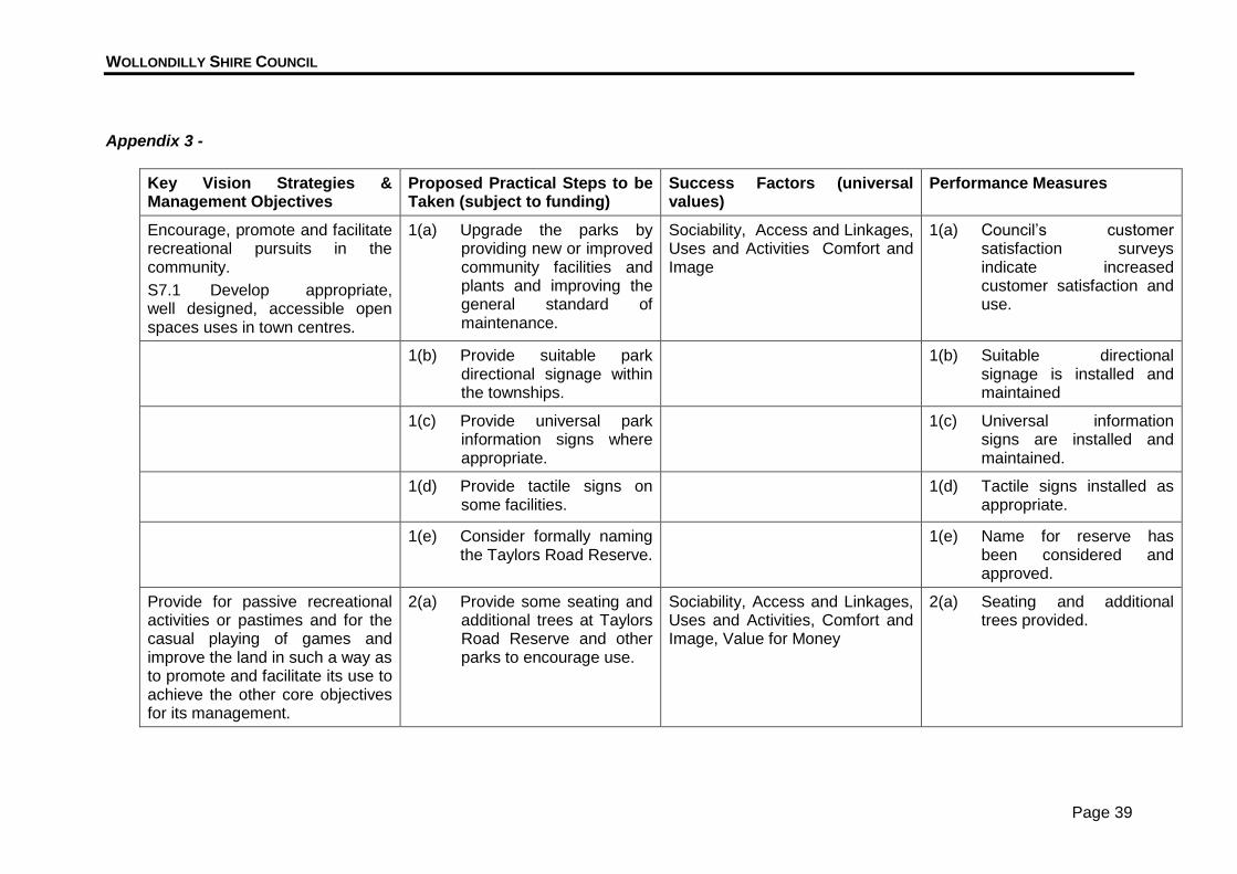
Appendix 3 -
Key Vision Strategies & Management Objectives
Proposed Practical Steps to be Taken (subject to funding)
Success Factors (universal values)
Performance Measures
Encourage, promote and facilitate recreational pursuits in the community.
S7.1 Develop appropriate, well designed, accessible open spaces uses in town centres.
1(a) Upgrade the parks by providing new or improved community facilities and plants and improving the general standard of maintenance.
Sociability, Access and Linkages, Uses and Activities Comfort and Image
1(a) Council’s customer satisfaction surveys indicate increased customer satisfaction and use.
1(b) Provide suitable park directional signage within the townships.
1(b) Suitable directional signage is installed and maintained
1(c) Provide universal park information signs where appropriate.
1(c) Universal information signs are installed and maintained.
1(d) Provide tactile signs on some facilities.
1(d) Tactile signs installed as appropriate.
1(e) Consider formally naming the Taylors Road Reserve.
1(e) Name for reserve has been considered and approved.
Provide for passive recreational activities or pastimes and for the casual playing of games and improve the land in such a way as to promote and facilitate its use to achieve the other core objectives for its management.
2(a) Provide some seating and additional trees at Taylors Road Reserve and other parks to encourage use.
Sociability, Access and Linkages, Uses and Activities, Comfort and Image, Value for Money
2(a) Seating and additional trees provided.
WOLLONDILLY SHIRE COUNCIL
Page 40
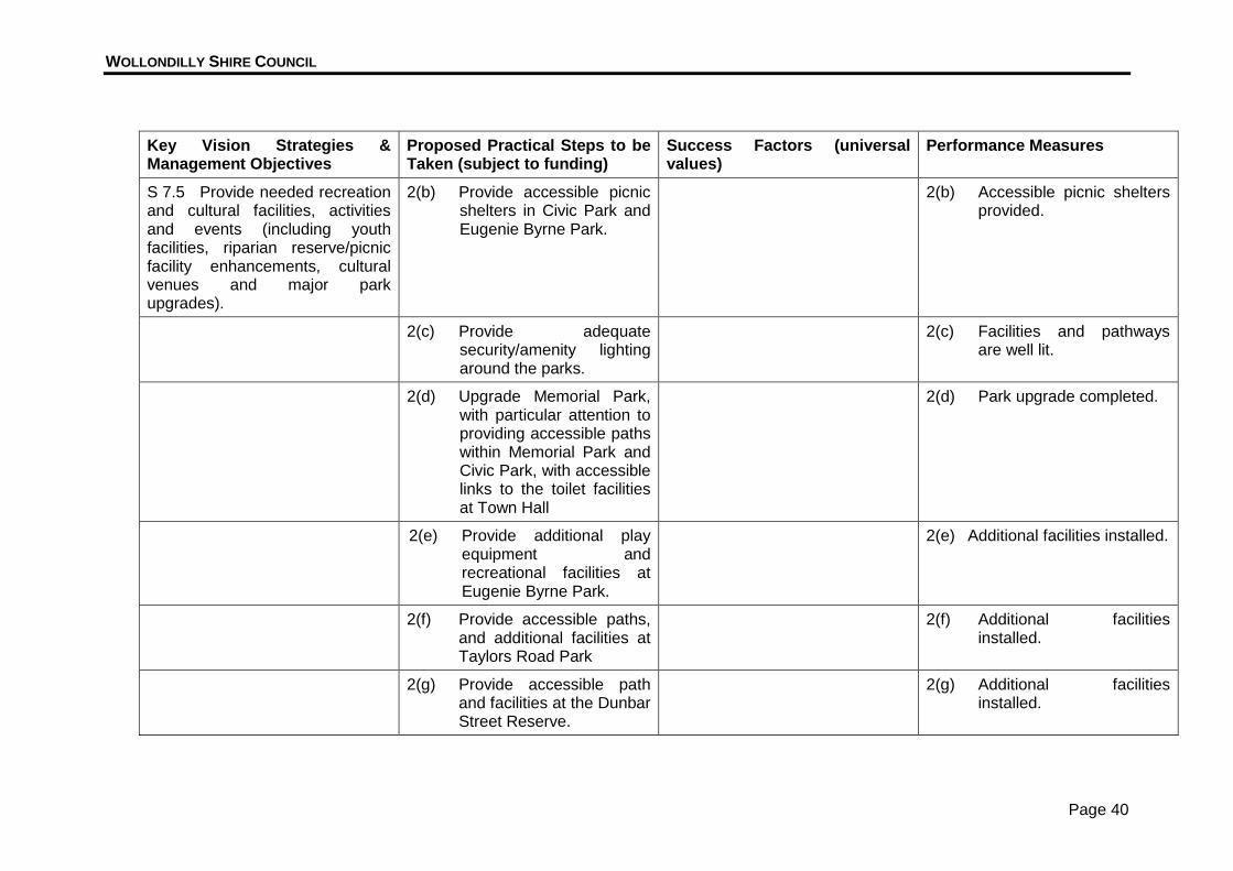
Key Vision Strategies & Management Objectives
Proposed Practical Steps to be Taken (subject to funding)
Success Factors (universal values)
Performance Measures
S 7.5 Provide needed recreation and cultural facilities, activities and events (including youth facilities, riparian reserve/picnic facility enhancements, cultural venues and major park upgrades).
2(b) Provide accessible picnic shelters in Civic Park and Eugenie Byrne Park.
2(b) Accessible picnic shelters provided.
2(c) Provide adequate security/amenity lighting around the parks.
2(c) Facilities and pathways are well lit.
2(d) Upgrade Memorial Park, with particular attention to providing accessible paths within Memorial Park and Civic Park, with accessible links to the toilet facilities at Town Hall
2(d) Park upgrade completed.
2(e) Provide additional play equipment and recreational facilities at Eugenie Byrne Park.
2(e) Additional facilities installed.
2(f) Provide accessible paths, and additional facilities at Taylors Road Park
2(f) Additional facilities installed.
2(g) Provide accessible path and facilities at the Dunbar Street Reserve.
2(g) Additional facilities installed.
WOLLONDILLY SHIRE COUNCIL
Page 41
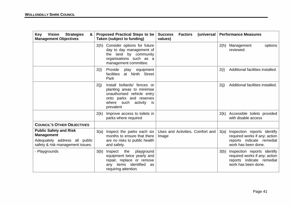
Key Vision Strategies & Management Objectives
Proposed Practical Steps to be Taken (subject to funding)
Success Factors (universal values)
Performance Measures
2(h) Consider options for future day to day management of the land by community organisations such as a management committee.
2(h) Management options reviewed.
2(i) Provide play equipment facilities at Ninth Street Park
2(i) Additional facilities installed.
2(j) Install bollards/ fences or planting areas to minimise unauthorised vehicle entry onto parks and reserves where such activity is prevalent
2(j) Additional facilities installed.
2(k) Improve access to toilets in parks where required
2(k) Accessible toilets provided with disable access
COUNCIL'S OTHER OBJECTIVES
Public Safety and Risk Management
Adequately address all public safety & risk management issues.
3(a) Inspect the parks each six months to ensure that there are no risks to public health and safety.
Uses and Activities, Comfort and Image
3(a) Inspection reports identify required works if any; action reports indicate remedial work has been done.
- Playgrounds 3(b) Inspect the playground equipment twice yearly and repair, replace or remove any items identified as requiring attention.
3(b) Inspection reports identify required works if any; action reports indicate remedial work has been done.
WOLLONDILLY SHIRE COUNCIL
Page 42
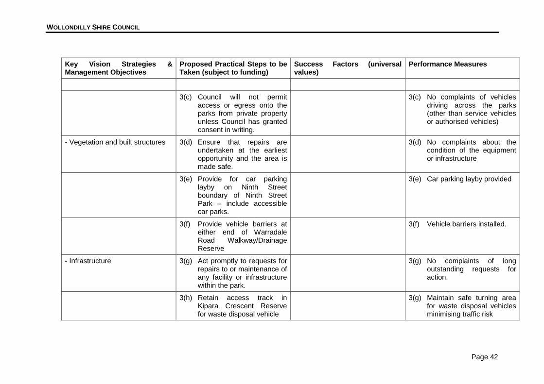
Key Vision Strategies & Management Objectives
Proposed Practical Steps to be Taken (subject to funding)
Success Factors (universal values)
Performance Measures
3(c) Council will not permit access or egress onto the parks from private property unless Council has granted consent in writing.
3(c) No complaints of vehicles driving across the parks (other than service vehicles or authorised vehicles)
- Vegetation and built structures 3(d) Ensure that repairs are undertaken at the earliest opportunity and the area is made safe.
3(d) No complaints about the condition of the equipment or infrastructure
3(e) Provide for car parking layby on Ninth Street boundary of Ninth Street Park – include accessible car parks.
3(e) Car parking layby provided
3(f) Provide vehicle barriers at either end of Warradale Road Walkway/Drainage Reserve
3(f) Vehicle barriers installed.
- Infrastructure 3(g) Act promptly to requests for repairs to or maintenance of any facility or infrastructure within the park.
3(g) No complaints of long outstanding requests for action.
3(h) Retain access track in Kipara Crescent Reserve for waste disposal vehicle
3(g) Maintain safe turning area for waste disposal vehicles minimising traffic risk
WOLLONDILLY SHIRE COUNCIL
Page 43
Key Vision Strategies & Management Objectives
Proposed Practical Steps to be Taken (subject to funding)
Success Factors (universal values)
Performance Measures
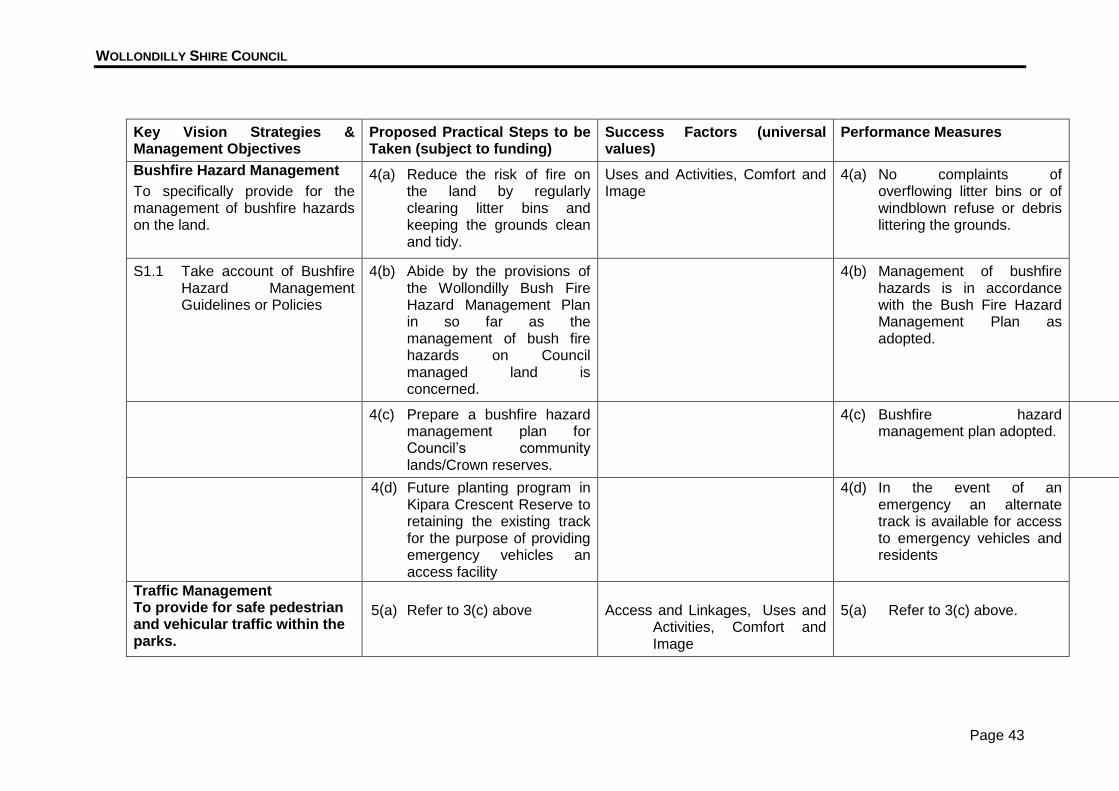
Bushfire Hazard Management
To specifically provide for the management of bushfire hazards on the land.
4(a) Reduce the risk of fire on the land by regularly clearing litter bins and keeping the grounds clean and tidy.
Uses and Activities, Comfort and Image
4(a) No complaints of overflowing litter bins or of windblown refuse or debris littering the grounds.
S1.1 Take account of Bushfire Hazard Management Guidelines or Policies
4(b) Abide by the provisions of the Wollondilly Bush Fire Hazard Management Plan in so far as the management of bush fire hazards on Council managed land is concerned.
4(b) Management of bushfire hazards is in accordance with the Bush Fire Hazard Management Plan as adopted.
4(c) Prepare a bushfire hazard management plan for Council’s community lands/Crown reserves.
4(c) Bushfire hazard management plan adopted.
4(d) Future planting program in Kipara Crescent Reserve to retaining the existing track for the purpose of providing emergency vehicles an access facility
4(d) In the event of an emergency an alternate track is available for access to emergency vehicles and residents
Traffic Management To provide for safe pedestrian and vehicular traffic within the parks.
5(a) Refer to 3(c) above
Access and Linkages, Uses and Activities, Comfort and Image
5(a) Refer to 3(c) above.
WOLLONDILLY SHIRE COUNCIL
Page 44
Key Vision Strategies & Management Objectives
Proposed Practical Steps to be Taken (subject to funding)
Success Factors (universal values)
Performance Measures
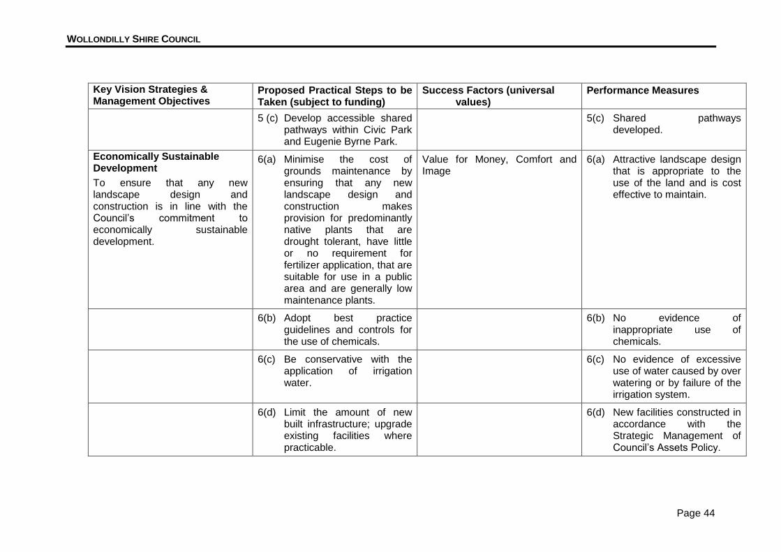
5 (c) Develop accessible shared pathways within Civic Park and Eugenie Byrne Park.
5(c) Shared pathways developed.
Economically Sustainable Development
To ensure that any new landscape design and construction is in line with the Council’s commitment to economically sustainable development.
6(a) Minimise the cost of grounds maintenance by ensuring that any new landscape design and construction makes provision for predominantly native plants that are drought tolerant, have little or no requirement for fertilizer application, that are suitable for use in a public area and are generally low maintenance plants.
Value for Money, Comfort and Image
6(a) Attractive landscape design that is appropriate to the use of the land and is cost effective to maintain.
6(b) Adopt best practice guidelines and controls for the use of chemicals.
6(b) No evidence of inappropriate use of chemicals.
6(c) Be conservative with the application of irrigation water.
6(c) No evidence of excessive use of water caused by over watering or by failure of the irrigation system.
6(d) Limit the amount of new built infrastructure; upgrade existing facilities where practicable.
6(d) New facilities constructed in accordance with the Strategic Management of Council’s Assets Policy.
WOLLONDILLY SHIRE COUNCIL
Page 45
Key Vision Strategies & Management Objectives
Proposed Practical Steps to be Taken (subject to funding)
Success Factors (universal values)
Performance Measures
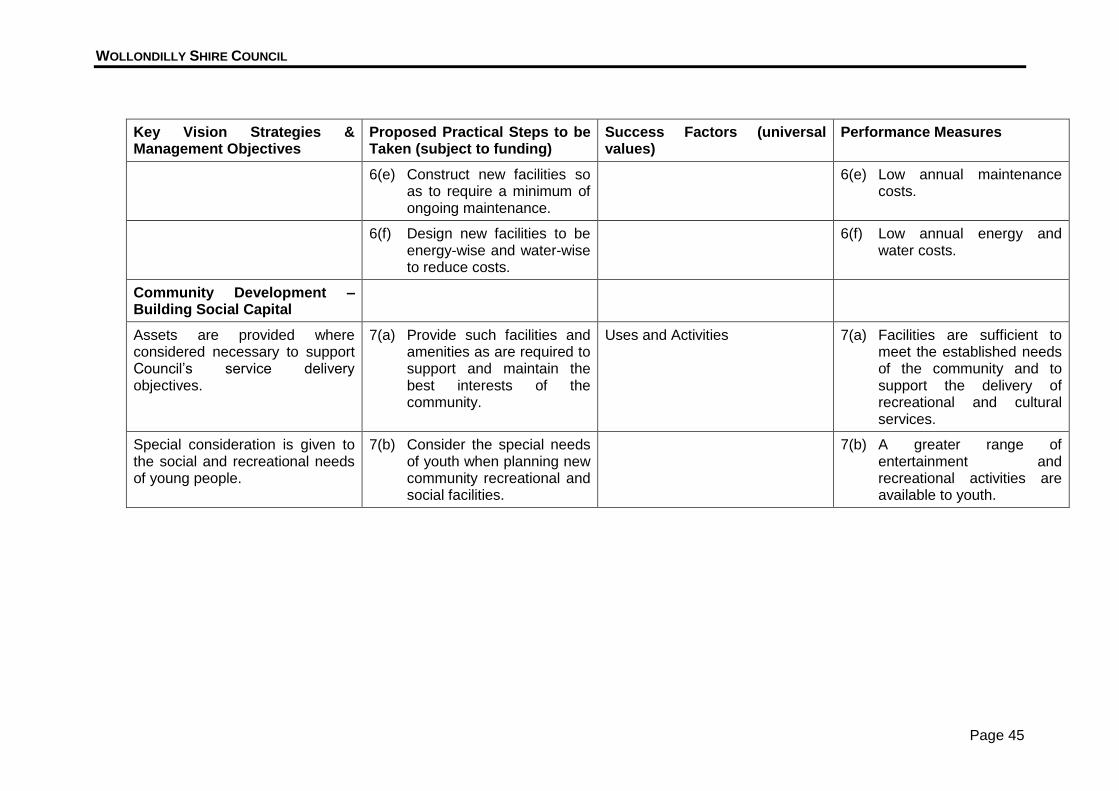
6(e) Construct new facilities so as to require a minimum of ongoing maintenance.
6(e) Low annual maintenance costs.
6(f) Design new facilities to be energy-wise and water-wise to reduce costs.
6(f) Low annual energy and water costs.
Community Development –Building Social Capital
Assets are provided where considered necessary to support Council’s service delivery objectives.
7(a) Provide such facilities and amenities as are required to support and maintain the best interests of the community.
Uses and Activities 7(a) Facilities are sufficient to meet the established needs of the community and to support the delivery of recreational and cultural services.
Special consideration is given to the social and recreational needs of young people.
7(b) Consider the special needs of youth when planning new community recreational and social facilities.
7(b) A greater range of entertainment and recreational activities are available to youth.
WOLLONDILLY SHIRE COUNCIL
Page 46
Appendix 4A - Indicative Landscape Master Plan - Sixth Street Park, Warragamba

WOLLONDILLY SHIRE COUNCIL
Page 47
Appendix 4B - Indicative Landscape Master Plan - Ninth Street Park, Warragamba

WOLLONDILLY SHIRE COUNCIL
Page 48
Appendix 4C - Indicative Landscape Master Plan - Third Street Park, Warragamba
WOLLONDILLY SHIRE COUNCIL
Page 49
Appendix 4D - Indicative Landscape Master Plan - Kipara Crescent Reserve, Warragamba
WOLLONDILLY SHIRE COUNCIL
Page 50
Appendix 4E - Indicative Landscape Master Plan - Civic Park, Warragamba

WOLLONDILLY SHIRE COUNCIL
Page 51
Appendix 4F - Indicative Landscape Master Plan - Memorial Park, Warragamba

WOLLONDILLY SHIRE COUNCIL
Page 52
Appendix 4G - Indicative Master Landscape Plan - Fifth Street Park, Warragamba

WOLLONDILLY SHIRE COUNCIL
Page 53
Appendix 4H - Indicative Master Landscape Plan - Eugenie Byrne Park, Silverdale
WOLLONDILLY SHIRE COUNCIL
Page 54
Appendix 4I - Indicative Master Landscape Plan - McKay Drive Land and Taylors Road Reserve, Silverdale

WOLLONDILLY SHIRE COUNCIL
Page 55
Appendix 4J - Indicative Master Landscape Plan- Dunbar Street Reserve and Taylors Road Park, Silverdale
WOLLONDILLY SHIRE COUNCIL
Page 56
Appendix 4K - Indicative Master Landscape Plan - Warradale Road walkway/Drainage Reserve, Silverdale
WOLLONDILLY SHIRE COUNCIL
Page 57
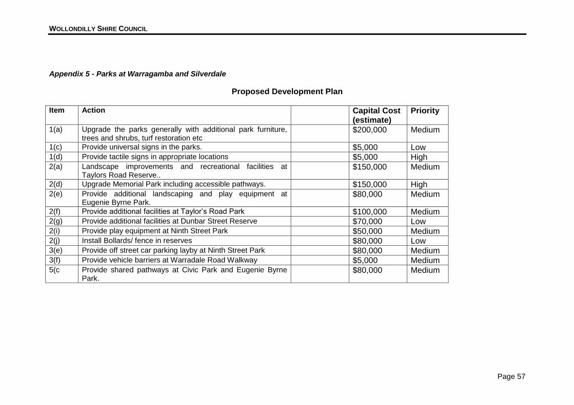
Appendix 5 - Parks at Warragamba and Silverdale
Proposed Development Plan Item Action Capital Cost
(estimate) Priority
1(a) Upgrade the parks generally with additional park furniture, trees and shrubs, turf restoration etc
$200,000 Medium
1(c) Provide universal signs in the parks. $5,000 Low 1(d) Provide tactile signs in appropriate locations $5,000 High 2(a) Landscape improvements and recreational facilities at
Taylors Road Reserve.. $150,000 Medium
2(d) Upgrade Memorial Park including accessible pathways. $150,000 High 2(e) Provide additional landscaping and play equipment at
Eugenie Byrne Park. $80,000 Medium
2(f) Provide additional facilities at Taylor’s Road Park $100,000 Medium 2(g) Provide additional facilities at Dunbar Street Reserve $70,000 Low 2(i) Provide play equipment at Ninth Street Park $50,000 Medium 2(j) Install Bollards/ fence in reserves $80,000 Low 3(e) Provide off street car parking layby at Ninth Street Park $80,000 Medium 3(f) Provide vehicle barriers at Warradale Road Walkway $5,000 Medium 5(c Provide shared pathways at Civic Park and Eugenie Byrne
Park. $80,000 Medium