Embed Size (px)
Citation preview

SUNOCO PIPELINE L.P.
Pennsylvania Pipeline Project
Alternatives Analysis
in support of
Joint Permit Application for a
Pennsylvania Water Obstruction & Encroachment Permit and a
U.S. Army Corps of Engineers Section 404 Permit Application
Revised March 2016
Revised and Supplemented December 2016
Submitted by:
Sunoco Pipeline L.P.
535 Fritztown Road
Sinking Spring, PA 19608
Prepared by: Tetra Tech, Inc.
301 Ellicott Street
Buffalo, NY 14203

Pennsylvania Pipeline Project
Sunoco Pipeline L.P. Alternatives Analysis
i
TABLE OF CONTENTS
SECTION PAGE
1.0 INTRODUCTION............................................................................................................. 1
2.0 APPLICABLE REGULATIONS .................................................................................... 1
3.0 DEVELOPMENT OF BASELINE ROUTE ALTERNATIVE .................................... 1
3.1 DESCRIPTION OF THE PROJECT ...................................................................................... 1
3.2 INITIAL ROUTE SELECTION ............................................................................................. 3
3.3 MAJOR ROUTE ALTERNATIVES ...................................................................................... 5
3.4 BASELINE ROUTE ALTERNATIVE .................................................................................. 10
4.0 WATER DEPENDENCY OF PROJECT .................................................................... 12
5.0 MEASURES TAKEN TO AVOID AND MINIMIZE HARM TO WETLANDS AND
WATERBODIES TO THE MAXIMUM EXTENT PRACTICABLE ...................... 13
5.1 MINOR ROUTE VARIATIONS.......................................................................................... 17
5.2 TRENCHLESS CONSTRUCTION METHODS ..................................................................... 25
5.3 PROGRAMMATIC IMPACT AVOIDANCE AND REDUCTION MEASURES ......................... 42
5.4 RESULTS OF AVOIDANCE AND MINIMIZATION OF HARM MEASURES ......................... 43
5.5 PFO WETLAND COVER TYPE CONVERSION COMPENSATORY MITIGATION .............. 45
6.0 WETLAND-SPECIFIC PRACTICABLE ALTERNTIVES ANALYSIS ................. 51
6.1 ALTERNATIVES ANSLYSIS NARRATIVES ....................................................................... 51
6.2 SUMMARY TABLE OF ALTERNATIVES ANSLYSIS .......................................................... 52
7.0 STREAM-SPECIFIC IMPACT AVOIDANCE AND MINIMIZATION
ASSESSMENT ................................................................................................................ 55
8.0 SUMMARY AND CONCLUSIONS ............................................................................. 55
9.0 REFERENCES ................................................................................................................ 56

Pennsylvania Pipeline Project
Sunoco Pipeline L.P. Alternatives Analysis
ii
LIST OF TABLES
TABLE PAGE
Table 1. Summary of Project Wide Wetland and Waterbody Impact Reduction from Baseline
Route Alternative to Proposed Route Alternative ......................................................... 12
Table 2. Comparison of Site-Specific and Cumulative Pipeline Construction Cost for Average
Trenching-Proposed and Trenching-Alternative Routes on the Project (20-inch-
diameter Pipeline) .......................................................................................................... 15
Table 3. Summary of Minor Route Variation Significant Resource Avoidance and Wetland and
Waterbody Impact Reduction by County and Project-Wide ......................................... 18
Table 4. Summary of Trenchless Construction Significant Resource Avoidance and Wetland and
Waterbody Impact Reduction by County and Project-Wide ......................................... 26
Table 5. Wetland Impact Reduction from Baseline Route Alternative to Proposed Route
Alternative by County and Project-Wide ....................................................................... 46
Table 6. Waterbody Impact Reduction from Baseline Route Alternative to Proposed Route
Alternative by County and Project-Wide ....................................................................... 49
Table 7. Summary of Wetland-Specific Practicable Alternatives Analysis .............. Appendix B-1
LIST OF FIGURES
FIGURES PAGE
Figure 1. Cresson-Altoona Southern Bypass Alternative ......................................... Appendix A-1
Figure 2. Blairsville Bypass Alternative ................................................................... Appendix A-2
Figure 3. North Middleton and Mechanicsburg Bypass Alternative ........................ Appendix A-3
Figure 4. Raystown Lake Crossing Alternative ........................................................ Appendix A-4
LIST OF APPENDICES
APPENDIX
APPENDIX A – Major Route Alternatives Figures
APPENDIX B – Trenchless Construction Feasibility Assessment
APPENDIX C – Trenchless Area Practicable Alternatives Assessment
APPENDIX D – Wetland-specific Practicable Alternatives Assessment
APPENDIX E – Stream Area Impact Avoidance and Minimization Assessment

Pennsylvania Pipeline Project
Sunoco Pipeline L.P. Alternatives Analysis
1
ALTERNATIVES ANALYSIS
1.0 INTRODUCTION
This revised and supplemented Alternatives Analysis is being prepared as a part of Sunoco
Pipeline’s L.P. (SPLP) Joint Permit Application for a Pennsylvania Water Obstruction and
Encroachment Permit Application and U.S. Army Corps of Engineers (USACE) Section 404
Permit Application for the Pennsylvania Pipeline Project (Project or PPP), and responds to the
comments set forth in the Pennsylvania Department of Environmental Protection’s (Department’s
or PADEP’s) technical deficiency letters. SPLP has been diligent in siting the Project to avoid,
minimize, and mitigate potential effects to environmental resources, as well as land uses and
landowners, located along the approximately 307-mile route of the Project.
2.0 APPLICABLE REGULATIONS
The Department’s regulations regarding the analysis of alternatives for proposed wetland
impacts are principally set forth at 25 Pa. Code § 105.18 (a) and (b), depending upon whether the
wetland is classified as an exceptional value wetland or an “other” wetland, respectively. In its
review of Section 105 permit applications, the Department also determines the unavailability of
alternative locations, routes and designs as set forth in 25 Pa. Code § 105.14(b)(7).
The USACE’s regulations requiring an analysis of alternatives to issue its Section 404
permit is set forth at 40 CFR § 230.10.
As set forth below, the following alternatives analysis meets the requirement of both the
state and federal regulations, and requests of multiple state and federal agencies, as well as
addresses the technical deficiency comments made by the Department on the previously submitted
Section 105 and Section 404 Joint Permit Applications.
3.0 DEVELOPMENT OF BASELINE ROUTE ALTERNATIVE
During the development and siting of the Project, SPLP considered a number of different
routings, locations and designs to determine whether there was a practicable alternative to the
proposed use of a wetland area. SPLP performed this determination through a sequential review
of routes and design techniques, which sequential review concluded with an alternative that has
the least environmental impacts, taking into consideration cost, existing technology and logistics.
Specifically, the following sections describe the detailed analysis that was performed to develop
the proposed alternative.
3.1 DESCRIPTION OF THE PROJECT
SPLP proposes to construct and operate the Project that would expand existing pipeline
systems to provide natural gas liquid (NGL) transportation. The Project involves the installation
of two parallel pipelines within an approximately 306.8-mile, 50-foot-wide right-of-way from
Houston, Washington County, Pennsylvania to SPLP’s Marcus Hook facility in Delaware County,
Pennsylvania with the purpose of interconnecting with existing SPLP Mariner East pipelines. A

Pennsylvania Pipeline Project
Sunoco Pipeline L.P. Alternatives Analysis
2
20-inch diameter pipeline will be installed within the right-of-way from Houston to Marcus Hook
(306.8 miles) and a second, 16-inch diameter pipeline, will also be installed in the same right-of-
way. The second line is proposed to be installed from SPLP’s Delmont Station, Westmoreland
County, Pennsylvania to the Marcus Hook facility, paralleling the initial line for approximately
255.8 miles.
The Project includes one new 20-inch and one new 16-inch diameter pipelines installed
within or adjacent to 306.8 miles of existing or new right-of-way. The majority of the new right-
of-way will be co-located adjacent to existing utility corridors, including approximately 230 miles
of pipeline that will be co-located in the existing SPLP Mariner East pipeline system that is
currently used for the transportation of NGLs.
The following provides the details of the proposed pipeline facilities:
Pipeline 1: Houston, Pennsylvania to Marcus Hook, Pennsylvania – This is an
incremental expansion of the capacities of SPLP to transport NGLs to the Marcus
Hook facility. This Phase of the Project will include a 20 inch diameter steel
pipeline, pump stations, and valve settings. The route of the pipeline is either inside
or adjacent to the existing SPLP pipeline corridor for a majority of its length and is
approximately 306.8 miles long.
Pipeline 2: Delmont, Pennsylvania to Marcus Hook, Pennsylvania –The pipeline
route for the second 16-inch pipeline will include 255.8 miles of pipeline that will
parallel Pipeline 1.
The aboveground facilities included with the Project are the following:
Houston, Pennsylvania has an existing facility which will connect to the pipeline.
This Project will install meters on the outlets from existing storage, injection
pumps, control valves, associated piping and accessory structures. New land
disturbance will be required to accommodate the injection station component.
Delmont, Pennsylvania has an existing facility and this Project will expand the
pump station with added booster pumps, associated piping and accessory structures.
Some new land disturbance within the existing station site will be required to
accommodate this modification.
Ebensburg, Pennsylvania, SPLP will construct a new pump station with booster
pumps, leak detection metering, associated piping and accessory structures adjacent
to an existing station. Some new land disturbance within the existing station site
will be required to accommodate this modification.
Mount Union, Pennsylvania has an existing pump station and this Project will
expand the pump station with added piping, pig traps and valves. Some new land
disturbance will be required to accommodate this modification.

Pennsylvania Pipeline Project
Sunoco Pipeline L.P. Alternatives Analysis
3
Doylesburg, Pennsylvania has an existing pump station and this Project will expand
the pump station with added booster pumps, associated piping and accessory
structures. Some new land disturbance will be required to accommodate this
modification.
Middletown, Pennsylvania has an existing pump station and this Project will
expand the pump station with added booster pumps, associated piping and
accessory structures. Some new land disturbance will be required to accommodate
this modification.
Beckersville, Pennsylvania has an existing pump station and this Project will
expand the pump station with added piping, pig traps and valves. Some new land
disturbance will be required to accommodate this modification.
Twin Oaks, Pennsylvania is an existing site and this Project will install custody
transfer meters and control valves. Some new land disturbance within the existing
facility will be required to accommodate this modification.
There are 53 mainline block valve sets planned for this Project, of which 22 are
sited at existing valve sites, and 5 are sited at existing pump stations. Block valves
are installed for the purpose of shutting off sections of the pipeline to allow
maintenance or to stop flow in the case of emergencies. Block valves are installed
in accordance with U. S. Department of Transportation Pipeline and Hazardous
Materials Safety Administration (PHMSA) requirements, and reference
recommendations from American Society of Mechanical Engineers (ASME)
B. PHMSA requires block valves to be installed on the suction end and discharge
end of a pump station, at locations along the pipeline system that will minimize
damage or pollution from accidental hazardous liquid discharge, and on each side
of a major water crossing. SPLP has determined that in the interest of facilitating
operational control it will place block valves at every railroad crossing, at every
water crossing wider than 100 feet, and at a minimum of one per 10 miles with
closer densities in areas with denser populations.
The Project crosses 17 counties in Pennsylvania.
3.2 INITIAL ROUTE SELECTION
The initial route selected for the Project was routing to be co-located with (abut and/or
overlap) the right-of-way of an existing pipeline owned and operated by SPLP. The co-location
of the Project with an existing SPLP right-of-way, and ultimately also co-location of sections of
the Project with other existing utility corridors, was a major means to avoid environmental impacts
and impacts to sensitive resources and communities, and to minimize the site-specific and
cumulative environmental impacts arising from the Project.

Pennsylvania Pipeline Project
Sunoco Pipeline L.P. Alternatives Analysis
4
In addition, as set forth above, all but one of the pump stations incorporated with the Project
will be an expansion of an existing pump station. By definition, the valve sets plans for the Project
are required to be located within the right-of-way of the Project. All pump station sites and valve
sets were located to avoid direct impacts to wetlands.
Governor’s Pipeline Infrastructure Task Force Report Recommending Co-Location
Sharing existing utility right-of-way corridors, which has been implemented with the
Project, is identified by resource agencies as a preferred pipeline routing method, and was also a
key recommendation of Pennsylvania Governor Tom Wolf’s Pipeline Infrastructure Task Force
Report (the “Report”). As set forth in the Report, Governor Wolf created the Pipeline
Infrastructure Task Force “to engage stakeholders in a transparent, collaborative process to achieve
responsible development of pipeline infrastructure in the Commonwealth.” The Governor
appointed 48 volunteers to serve on the Task Force who represented academia, government,
industry and citizen’s groups. The work of the Task Force members were aided by more than 100
additional volunteers appointed by the Governor serving on 12 individual topic-specific work
groups.
The conclusion of the Task Force’s work was the publication of the Report, which defined
best practices in specific topic areas related to pipeline infrastructure development and operation.
Although the Report identifies a total of 184 recommendations for pipeline infrastructure
development in Pennsylvania, there were 12 recommendations gaining the most support from the
Task Force members. These 12 recommendations are identified as the “Top Recommendations.”
Within the category of “Planning, Siting and Routing pipelines to avoid/reduce environmental and
community impacts,” one of the two Top Recommendations listed is to “Identify Barriers to
Sharing Rights-of-Way.” As set forth in more detail in County Government Work Group
Recommendation #9, the full recommendation is described as follows:
State should establish a requirement to co-locate, to the extent
possible, new pipeline infrastructure within existing or planned
utility right-of-ways (by regulation or statute), including other
pipelines, electric transmission lines, etc. to reduce the impact on
existing development, available land for development and natural
resources, and to be consistent with the county comprehensive plan.
Any requirement should include a maximum number of pipelines,
regardless of product, in any single right-of-way.
The Project, even prior to the Task Force’s recommendations, started with a routing that
co-located the new pipeline within the right-of-way of SPLP’s existing pipeline corridor. SPLP
was able to select this initial routing for the Project because it possessed the legal right to add
additional pipelines within or adjacent to most of the existing right-of-way of SPLP’s existing
pipeline corridor. This initial routing decision for the Project produced the benefits described in
the Report, namely a reduction in the impact on natural resources which could have occurred if an
entirely new, or “greenfield,” alignment was initially considered for the approximately 300 mile
distance across the state to achieve the purpose of the Project.

Pennsylvania Pipeline Project
Sunoco Pipeline L.P. Alternatives Analysis
5
In addition to the County Government Work Group of the Task Force making a
recommendation that new pipelines be co-located within existing utility corridors, the same
recommendation was also made by other Task Force work groups. See, Conservation and Natural
Resources Work Group Recommendations #18 (“Co-locate new pipelines along existing rights-
of-way to minimize the creation of new, separate clearings”); Environmental Protection Work
Group Recommendation #17 (“Where practicable, safe, and all parties are agreeable, oil and gas
development and associated infrastructure should utilize existing disturbances such as road
networks, rights-of-way corridors and other utility installations.” “Pipelines that share existing
corridors reduce the amount of disturbance and fragmentation that would otherwise occur with a
separate pipeline corridor.”) Therefore, a wide variety of Task Force Work Groups realized the
wisdom of co-locating new pipelines “within” and/or “along” existing utility corridors, because of
the reduced environmental impacts that would be created as compared to a pipeline located on a
totally new “greenfield” right-of-way, to the extent possible.
USFWS-Pennsylvania Field Office Co-Location Recommendations
In addition to Governor Wolf’s Task Force stating a Top Recommendation that new
pipelines should be co-located with existing utility corridors, the Pennsylvania Field Office of the
U.S. Fish and Wildlife Service (“USFWS”) also recommends the co-location of new pipelines
with already disturbed areas such as existing pipelines corridors. In its initial consultation letter
to SPLP dated March 19, 2014, the USFWS recommended that SPLP follow its guidelines entitled
“USFWS Pennsylvania Field Office – Adaptive Management for the Conservation of Migratory
Birds” (USFWS undated). As part of these guidelines, the USFWS states five recommendations
applicable to the siting of new pipelines to avoid and minimize impacts to migratory birds pursuant
to its authority under the Migratory Bird Treaty Act. One of these five recommendations states as
follows: “To reduce habitat fragmentation, co-locate roads, fences, lay down areas, staging areas,
and other infrastructure in or immediately adjacent to already disturbed areas such as existing
pipelines.” In conformance with these guidelines of the USFWS, the initial routing of the Project
was placed within or immediately adjacent to the right-of-way of an existing pipeline owned and
operated by SPLP to avoid and minimize environmental impacts which would have otherwise
occurred if a new “greenfield” location was initially selected for the routing of the Project.
Conclusion
In conclusion, SPLP selected the right-of-way of the existing pipeline corridor it owned
and operated as the initial routing for the Project. This selected routing is consistent with one of
the Top Recommendations of the Governor’s Pipeline Infrastructure Task Force, as well as the
USFWS guidelines. With the selection of this initial routing, the Project initially avoided adverse
environmental impacts and caused less site-specific and cumulative environmental impact as
compared to a pipeline alignment on a totally new “greenfield” right-of-way.
3.3 MAJOR ROUTE ALTERNATIVES
Once the right-of-way corridor for SPLP’s existing pipeline was identified as the initial
routing for the Project, SPLP then evaluated that routing, at a planning, desk-top level, to determine
if there were any obvious constraints and impacts that would occur if the entire existing right-of-

Pennsylvania Pipeline Project
Sunoco Pipeline L.P. Alternatives Analysis
6
way was used for the approximately 300 mile length of the Project. This evaluation included
consideration of the feasibility and practicability of the initial routing of the Project with regard to
current technology, cost, and logistics. The purpose of this evaluation was to determine if there
were practicable major route alternatives that avoided or reduced impacts on environmentally
sensitive resources, such as large population centers, scenic areas, wildlife management areas, or
cultural/historically significant resources proposed to be crossed by the Project. Any major route
alternative could obviously not change the origin and delivery point of the Project. However, this
evaluation involved a concerted effort to identify alternative routes that would satisfy the Project
need and further minimize environmental impacts and/or improve public health and safety.
The four major route alternatives evaluated and ultimately incorporated into the initial
routing for the Project were re-routes around the Borough of Blairsville in Indiana County; around
the heavily developed and populated area of Altoona—specifically between the Borough of
Cresson, Cambria County and the Township of Frankstown in Blair County; across the U.S. Army
Corps of Engineers’ Raystown Lake reservoir and associated facilities in Huntington County; and
around the heavily developed and populated areas of North Middleton and Mechanicsburg in
Cumberland County. Even though these four re-routes deviated from SPLP’s existing pipeline
right-of-way, these major route alternatives were sited to the extent possible immediately adjacent
to and therefore co-located with other existing utility rights-of-way to again avoid and reduce site-
specific and cumulative environmental impacts that would have occurred if a new “greenfield”
routing was selected.
These four major re-routes are described below.
Blairsville Northern Bypass Alternative
The initial planning route co-located with SPLP’s 8-inch pipeline corridor was determined
to not be practicable due to obvious constraints and impacts that would occur along an
approximately 5-mile-long pipeline segment in Burrell Township, Indiana County. Specifically,
the initial planning route would have crossed a heavily developed and populated area including
residential, commercial, and recreational uses (i.e., Chestnut Ridge Golf Course, etc.), in the
Borough of Blairsville. Appendix A: Figure 1 depicts the initial planning route (co-located with
SPLP’s 8-inch pipeline corridor and 40-foot-wide maintenance corridor). Accordingly, SPLP
evaluated potential major route alternative corridors in this area that would allow co-location with
other existing utility or other developed corridors, and avoid potential significant impacts on other
(non-wetland) environmental resources and the subject developed and populated area.
The Blairsville Northern Bypass Alternative shifts the Project alignment north of the
Borough of Blairsville (Appendix A: Figure 1). This re-route alternative is approximately 5.6
miles long, and would result in an approximately 0.5 mile increase in pipeline length. This route
alternative is co-located with existing utility corridors for the majority of its length and to the
maximum extent practicable along the subject alignment. This route alternative would avoid the
heavily developed and populated area in the Borough of Blairsville, and potential impacts on
associated land use, land encumbrance, residential, commercial, and recreational uses. This route

Pennsylvania Pipeline Project
Sunoco Pipeline L.P. Alternatives Analysis
7
was determined to be practicable with regard to current technology, cost, and logistics, and was
selected as the proposed route.
As set forth in Section 5.0, following selection of the Blairsville Northern Bypass
Alternative route, SPLP implemented the Management of Change (MOC) Process. In general,
implementation of the MOC Process resulted in the evaluation and adoption of minor route
variations (see Section 5.1 and Table 3) and trenchless crossings (see Section 5.2 and Table 4) to
avoid or minimize: 1) significant impacts on other (non-wetland) environmental resources, 2)
permanent palustrine forested (PFO) wetland cover type conversion, and 3) remaining temporary
and minor site-specific impacts on wetlands and waterbodies. Note that Appendix A: Figure 1
depicts the location of field-delineated wetlands along the post-MOC Process route.
Cresson-Altoona Southern Bypass Alternative
The initial planning route co-located with SPLP’s 8-inch pipeline corridor was determined
to not be practicable due to obvious constraints and impacts that would occur along an
approximately 20-mile-long pipeline segment in Cresson and Washington Townships, Cambria
County, and Juanita, Allegheny, Blair, and Frankstown Townships, Blair County. Specifically,
the initial planning route would have crossed a heavily developed and populated area including
extremely congested residential and commercial development in the City of Altoona. Appendix
A: Figure 2 depicts the initial planning route (co-located with SPLP’s 8-inch pipeline corridor and
40-foot-wide maintenance corridor).
Additionally, the initial planning route would have crossed nearly 4,600 feet of the National
Register of Historic Places (NRHP)-listed Allegheny Portage Railroad National Historic Site and
paralleled nearly 2,000 feet of the National Historic Landmark (NHL) District - Allegheny Portage
Railroad of the Penn Canal (Key 123985). The Allegheny Portage Railroad National Historic Site
was designated as a historic site by the Pennsylvania Historical and Museum Commission (PHMC)
on April 1, 1947, and designated a NHL District on December 29, 1962. Both resources contain
a high archaeological sensitivity for the location of both prehistoric and historic archaeological
resources. Although not subjected to a historic resources reconnaissance level survey, both
resources also have potential to contain associated aboveground historic resources as well.
Accordingly, SPLP evaluated potential major route alternative corridors in this area that
would allow co-location with other existing utility corridors, and avoid potential significant
impacts to this developed and populated area, NRHP-listed historic site, and NHL District.
The Cresson-Altoona Southern Bypass shifts the Project alignment to the south of the
initial planning route, traverses south of the Borough of Cresson, continues southeast through State
Game Lands 198, and then heads east/northeast to connect to the initial planning route near
Frankstown Township (Appendix A: Figure 2). This re-route alternative is approximately 20.0
miles long, and would result in an approximately 2.9 mile increase in pipeline length. This route
alternative is co-located with existing utility corridors for the majority of its length and to the
maximum extent practicable along the subject alignment. This route alternative would avoid the

Pennsylvania Pipeline Project
Sunoco Pipeline L.P. Alternatives Analysis
8
heavily developed and populated area in the City of Altoona, and potential impacts on associated
land use, land encumbrance, residential, commercial, and recreational uses.
This bypass alternative route crosses the NHL District - Allegheny Portage Railroad of the
Penn Canal (Key 123985) at Level Road (Cambria County). However, no adverse effects are
anticipated for aboveground cultural resources due to the proposed trenchless construction method
across Level Road. Furthermore, fieldwork reconnaissance indicated no aboveground indications
of the NHL District at this location. No adverse effects to historic resources are anticipated for
this area pursuant to field studies undertaken on behalf of SPLP, and, by letter dated July 28, 2016,
PHMC concurrence with this recommendation is pending ongoing USACE consultation with other
federal agencies. No archaeological resources were identified in this location pursuant to field
studies undertaken on behalf of SPLP. No additional archaeological work is recommended for
this area, and PHMC concurrence with this recommendation is pending.
This major route alternative avoids the heavily developed City of Altoona and the
Allegheny Portage Railroad National Historic Site. Incorporation of this major route alternative
avoided potentially significant environmental impacts to the City of Altoona, and specifically to
cultural/historic resources in the area. This route was determined to be practicable with regard to
current technology, cost, and logistics, and was selected as the proposed route.
As set forth in Section 5.0, following selection of the Cresson-Altoona Southern Bypass
route, SPLP implemented the MOC Process. In general, implementation of the MOC Process
resulted in the evaluation and adoption of minor route variations (see Section 5.1 and Table 3) and
trenchless crossings (see Section 5.2 and Table 4) to avoid or minimize: 1) significant impacts on
other (non-wetland) environmental resources, 2) PFO wetland cover type conversion, and 3)
remaining temporary and minor site-specific impacts on wetlands and waterbodies. Note that
Appendix A: Figure 2 depicts the location of field-delineated wetlands along the post-MOC
Process route.
Raystown Lake Crossing Alternative
The initial planning route co-located with SPLP’s 8-inch pipeline corridor was determined
to not be practicable due to obvious constraints and impacts that would occur along an
approximately 12-mile-long pipeline segment in the vicinity of U.S. Army Corps of Engineers’
(USACE’s) Raystown Lake and associated federal property in Penn and Union Townships,
Huntington County. Specifically, the portion of initial planning route west of Raystown Lake
would have crossed two small open water areas at Raystown Lake, which based on engineering
review undertaken on behalf of SPLP was recommended for avoidance to minimize the risks
associated with flooding during heavy rainfall events, erosion and sedimentation concerns, and
potential health and safety impacts for pipeline construction and operation workers. The portion
of the initial planning route east of Raystown Lake would have crossed a Raystown Lake Marina
(Seven Points) and associated Trail’s campground, and involved a longer and non-perpendicular
HDD crossing of Raystown Lake. Appendix A: Figure 3 depicts the initial planning route (co-
located with SPLP’s 8-inch pipeline corridor and 40-foot-wide maintenance corridor).

Pennsylvania Pipeline Project
Sunoco Pipeline L.P. Alternatives Analysis
9
The Raystown Lake Crossing Alternative route involves two segments of pipeline totaling
approximately 11.9 miles, including a reroute of the pipeline to the north of the initial planning
route within USACE’s Raystown Lake property and parallel to the existing Lancer pipeline
corridor, and a reroute to the southeast of the Raystown Lake Marina across the lake to Trough
Creek Valley Pike Road (Appendix A: Figure 3). This reroute alternative is approximately 11.9
miles long, and would result in an approximately 0.8 mile increase in pipeline length. This route
alternative is co-located with existing utility corridors for the majority of its length and to the
maximum extent practicable along the subject alignment. The western segment of the reroute
avoids crossings of the two small open water areas at Raystown Lake. The eastern segment of the
reroute avoids potential impacts to recreational activities at Raystown Lake, including activities at
the Raystown Lake Marina and associated Trail’s campground. The southern route also reduces
the length of the major HDD crossing of Raystown Lake, as well as avoiding a landowners east of
the lake by eliminating the number of parcels required to cross the area. This route was determined
to be practicable with regard to current technology, cost, and logistics, and was selected as the
proposed route.
As set forth in Section 5.0, following selection of the Raystown Lake Crossing Alternative
route, SPLP implemented the MOC Process. In general, implementation of the MOC Process
resulted in the evaluation and adoption of minor route variations (see Section 5.1 and Table 3) and
trenchless crossings (see Section 5.2 and Table 4) to avoid or minimize: 1) significant impacts on
other (non-wetland) environmental resources, 2) PFO wetland cover type conversion, and 3)
remaining temporary and minor site-specific impacts on wetlands and waterbodies. Note that
Appendix A: Figure 3 depicts the location of field-delineated wetlands along the post-MOC
Process route.
North Middleton/Mechanicsburg Southern Bypass Alternative
The initial planning route co-located with SPLP’s 8-inch pipeline corridor was determined
to not be practicable due to obvious constraints and impacts that would occur along an
approximately 15-mile-long pipeline segment in North Middleton, Middlesex, Silver Spring,
Hampden, and Lower Allen Townships, Cumberland County. Specifically, the initial planning
route would have crossed a heavily developed and populated area including residential and
commercial uses in North Middleton and Mechanicsburg. Appendix A: Figure 4 depicts the initial
planning route (co-located with SPLP’s 8-inch pipeline corridor and 40-foot-wide maintenance
corridor). Accordingly, SPLP evaluated potential major route alternative corridors in this area that
would allow co-location with other existing utility or other developed corridors, and avoid
potential significant impacts on other (non-wetland) environmental resources and the subject
developed and populated area.
The North Middleton/Mechanicsburg Bypass Alternative route involves two segments
totaling approximately 15 miles, including a reroute of the pipeline to the north of the initial
planning route and parallel to the existing Buckeye pipeline and electric transmission utility lines,
and a reroute to the south of the Mechanicsburg area to a crossing of the Pennsylvania Turnpike
to reconnect with the existing SPLP maintenance corridor before Rossmoyne Road (Appendix A:
Figure 4). This re-route alternative is approximately 15.8 miles long, and would result in an
Pennsylvania Pipeline Project
Sunoco Pipeline L.P. Alternatives Analysis
10
approximately 0.5 mile increase in pipeline length. This route alternative is co-located with
existing utility corridors for the majority of its length and to the maximum extent practicable along
the subject alignment. In both segments, the reroute parallels existing utility corridors to avoid
heavily developed and congested residential and commercial areas in North Middleton and in the
Mechanicsburg area. In addition to avoidance of these constructability constraints and properties,
this reroute avoided areas that were congested with existing pipelines, power lines, and drainage
systems, paralleling the Pennsylvania Turnpike for approximately 2 miles. This route was
determined to be practicable with regard to current technology, cost, and logistics, and was selected
as the proposed route.
As set forth in Section 5.0, following selection of the North Middleton/Mechanicsburg
Bypass Alternative route, SPLP implemented the MOC Process. In general, implementation of
the MOC Process resulted in the evaluation and adoption of minor route variations (see Section
5.1 and Table 3) and trenchless crossings (see Section 5.2 and Table 4) to avoid or minimize: 1)
significant impacts on other (non-wetland) environmental resources, 2) PFO wetland cover type
conversion, and 3) remaining temporary and minor site-specific impacts on wetlands and
waterbodies. Note that Appendix A: Figure 4 depicts the location of field-delineated wetlands
along the post-MOC Process route.
Major Route Alternative Conclusion
Using the initial routing along SPLP’s existing pipeline right-of-way, modified by the
above four major re-routes which avoided obvious community, cultural, and natural resource
impacts while also being co-located adjacent to other existing utility corridors to the maximum
extent practicable, a Project alternative (Baseline Route Alternative) was developed to be used for
comparison purposes for further route and design modifications.
The Baseline Route Alternative is co-located with other existing utility corridors for over
80 percent of its length.
3.4 BASELINE ROUTE ALTERNATIVE
The Baseline Route Alternative achieved the objectives and need for the Project, while
maximizing the use of opportunities to co-locate (abut and overlap) its right-of-way with existing
SPLP right-of-way and co-locate (abut) its right-of-way with other existing utility rights-of-way,
avoiding potential significant impacts on other non-wetland environmental resources, allowing for
feasible pipeline construction, and reducing engineering constraints. The Baseline Route
Alternative established the baseline against which additional measures to avoid and minimize
wetland impacts were considered.
The Baseline Route Alternative incorporated SPLP’s baseline preferred approach to
optimize pipeline and station construction and operation, including:
Co-location (abut and overlap) with SPLP’s existing pipeline right-of-way to the
maximum extent practicable;
Use of a 100-foot-wide pipeline construction right-of-way along the entire length of
the pipeline route; and

Pennsylvania Pipeline Project
Sunoco Pipeline L.P. Alternatives Analysis
11
Use of the conventional wet open cut construction method across all wetlands and
waterbodies (see Section 5.3).
It is important to note that use of wet open trench installation method is an industry-
standard construction method for pipeline crossings of wetlands and waterbodies. For instance,
the wet open trench installation method is identified as an available best management practice by
the Federal Energy Regulatory Commission (FERC) for FERC-regulated interstate natural gas
pipeline projects, via application of the FERC’s Wetland and Waterbody Construction and
Mitigation Procedures (FERC 2013). See also Research of Wetland Construction and Mitigation
Activities for Certificated Section 7(c) Pipeline Projects (FERC 2004).
Wet open trench pipeline crossings of wetlands and waterbodies typically result in the
shortest construction duration (24 hours for “minor waterbodies” less than or equal to10 feet wide,
and 48 hours for “intermediate waterbodies” greater than 10 feet but less than or equal to 100 feet
wide) and typically result in only temporary and minor impacts on wetlands and waterbodies.
As set forth on Table 1, the Baseline Route Alternative would have required the clearing,
grading, excavation, and disturbance of approximately 118.9 acres of wetlands and approximately
124,570 linear feet of stream crossings (linear length of stream in the construction right-of-way)
using conventional (wet open cut installation) construction techniques throughout its entire length.
As noted above, the Baseline Route Alternative was used as a baseline for comparison with other
site-specific modifications to the Project.
As set forth in the Alternatives Analysis presented herein, Table 1 presents a summary of
the Project-wide reduction in total impacts to wetlands and waterbodies through the Project
development process from the Baseline Route Alternative to the Proposed Route Alternative. This
includes total impact reduction to EV wetlands (the number crossed and areal extent [acreage]
within the construction right-of-way [CROW]), other wetlands (areal extent [acreage] within the
CROW), all wetlands Project-wide (areal extent [acreage] within the CROW), PFO wetlands (areal
extent [acreage] within the CROW), High Quality (HQ) and Exceptional Value (EV) streams
(linear footage within the CROW), and Non-HQ and EV streams, or “other” streams (linear
footage within the CROW). The stages of the Project development process presented include:
Baseline Route Alternative – presents the total impact along the Baseline Route
Alternative described above.
Narrowed ROW at Wetlands and Waterbodies – presents the total impact along the
Baseline Alternative Route, but including adoption of narrowing the construction ROW
at wetland and waterbody crossings from 100-feet wide to 50-feet wide.
Proposed Route Alternative – presents the total impact along the Proposed Route
Alternative, including the adoption of Minor Route Variations and Trenchless
Construction Methods
Cumulative Impact Reduction – presents the total (cumulative) reduction in impact
from the Baseline Route Alternative to the Proposed Route Alternative, based on
quantitative (i.e., areal extent and linear footage) and percentage impact reduction.

Pennsylvania Pipeline Project
Sunoco Pipeline L.P. Alternatives Analysis
12
As set forth more fully below, SPLP evaluated alternative routings and design techniques
to further identify reductions to wetland impacts.
Table 1. Summary of Project Wide Wetland and Waterbody Impact Reduction from Baseline Route
Alternative to Proposed Route Alternative
Resource
Baseline
Route
Alternative
Narrowed
ROW at
Wetlands and
Waterbodies
Proposed
Route
Alternative1
Cumulative
Impact
Reduction
Cumulative
Impact
Reduction
(%)
EV Wetlands (number crossed) 181 168 139 42 23.2
EV Wetlands Total (acres) 32.1 17.5 11.2 (10.6) 20.9 (21.5) 65.1 (67.0)
Other Wetlands Total (acres) 86.8 48.1 25.5 (23.3) 61.3 (63.5) 70.6 (73.2)
Project-Wide Wetland Total (acres) 118.9 62.2 36.7 (33.9) 82.2 (85.0) 69.1 (71.5)
PFO Wetlands Total (acres) 35.2 11.7 1.6 (0.6) 33.7 (34.6) 95.7 (98.3)
HQ and EV Streams Total (linear feet) 35,031 17,936 14,409 20,622 58.9
Non-HQ and EV Streams Total (linear feet) 89,539 45,923 38,722 50,817 56.8
Project-Wide Stream Total (linear feet) 124,570 63,859 52,131 71,439 57.3
Notes: 1 Impact acreages based on PADEP and USACE Bore/HDD calculations (provided in parenthesis). PADEP calculates permanent disturbance
impacts at Bore and HDD crossings based on the width of the pipelines (3-feet) multiplied by the length of the wetland crossing; USACE
does not calculate impact acreages for Bore and HDD crossings. However, wetlands crossed via Bore or HDD may have USACE impacts
due to travel lanes or clearing.
4.0 WATER DEPENDENCY OF PROJECT
Constructing and operating a natural gas liquids pipeline is not, per se, a water-dependent
project. However, because of Pennsylvania’s abundant water and wetland resources, any project
which travels approximately 300 miles east-west across the Commonwealth requires the crossing
of, and therefore access to, waters and wetlands. The Project requires access and proximity to and
siting in, on, over or under waters and wetlands in order to achieve its primary purpose to transport
natural gas liquids from Houston, Washington County to SPLP’s existing facility in Marcus Hook,
Delaware County. Therefore, the linear nature and approximately 300 mile length of the Project
across 17 counties east-west in Pennsylvania makes the Project water-dependent.
As demonstrated by the following sections, SPLP has avoided and minimized potential
impacts to waters and wetlands from the Project. In so doing, the analysis set forth herein
concludes that there is no practicable alternative to each of the crossings to waters and wetlands
that would have less effect on each water or wetland, and not have other significant adverse effects
on the environment, taking into consideration construction costs, existing technology and logistics.

Pennsylvania Pipeline Project
Sunoco Pipeline L.P. Alternatives Analysis
13
5.0 MEASURES TAKEN TO AVOID AND MINIMIZE HARM TO WETLANDS AND
WATERBODIES TO THE MAXIMUM EXTENT PRACTICABLE
Establishment of Engineering and Environmental Survey Corridor
The Baseline Route Alternative established the centerline for a 200-foot-wide engineering,
land use, biological, wetland, waterbody, and cultural resource survey corridor in which to
investigate minor route variations and construction techniques to further minimize environmental
impacts from the Project. This 200-foot-wide survey corridor was considered a reasonable width
along the Baseline Route Alternative to perform detailed and site-specific field studies to develop
additional improvements to the Project to minimize environmental impacts, as well as assess
Project practicability with regard to current technology, cost, and logistics. This survey corridor
width allows for flexibility in considering potential application of detailed, site-specific trenchless
construction methods (conventional bore and horizontal directional drilling [HDD] techniques)
along with minor pipeline route variations (realignments).
In addition to the information collected during field surveys, existing publicly-available
data were also reviewed, including but not necessarily limited to aerial photography, topographic
maps, National Wetland Inventory (NWI) maps, and U.S. Geological Survey quadrangle maps.
All of this information was incorporated into a Project-specific geographic information system
geo-database to be used for route analysis.
Consideration of Impacts Beyond Survey Corridor
By definition, because the Baseline Route Alternative is co-located (abuts and overlaps)
with the existing SPLP pipeline right-of-way and co-located (abuts) with other existing utility
rights-of-way to the maximum extent practicable, any minor route variation that diverges from the
Baseline Route Alternative would violate the co-location principle, as well as potentially result in
increased impacts on other (non-wetland) environmental resources, suboptimal pipeline
construction, suboptimal pipeline operation, and increased construction cost, as described below.
Increased Site-specific and Cumulative Environmental Impact
State and federal guidelines strongly recommend routing new linear projects in co-location
with existing utility rights-of-way to the maximum extent practicable. These guidelines recognize
that new “greenfield” routing of linear projects has the potential to result or results in increased
site-specific and cumulative environmental impacts. These increased impacts may include, but
are not necessarily limited to the following:
increased amount of new, permanent land disturbance and encumbrance on existing
industrial and commercial development and associated land uses;
increased amount of new, permanent land disturbance on existing private residential
development, private land uses, and affected private landowners;
permanent reduction in availability of land for future development;
inconsistency with county comprehensive plans;

Pennsylvania Pipeline Project
Sunoco Pipeline L.P. Alternatives Analysis
14
increased amount of new, permanent land disturbance and landscape fragmentation,
including impairment of natural landscapes, scenic uses, recreational uses, contiguous
forested lands, and contiguous natural resources;
increased amount of new, permanent forested land fragmentation, including impairment of
forested ecosystem functions and values, watershed/water quality values, and availability
of contiguous forest habitat for interior wildlife species and migratory birds protected
pursuant to the Migratory Bird Treaty Act;
permanent reduction in availability of land for future natural resource uses, including
natural landscapes, scenic uses, recreational uses, forested lands, forest production, and
other natural resources;
increased potential to effectuate a cumulative impact on land use planning, land
fragmentation, forest fragmentation, and natural resource fragmentation.
Suboptimal Pipeline Construction and Operation and Increased Cost
On a site-specific basis, and on a cumulative basis across the entire Project, increasing the
length and changing the location of the pipeline to further avoid or minimize minor and temporary
impacts on individual wetlands via realignment partially or entirely outside the survey corridor
results in suboptimal pipeline construction, suboptimal pipeline operation, and increased pipeline
construction and operation costs.
With the use of current technology, the subject pipeline realignments on a site-specific and
cumulative basis potentially jeopardizes Project practicability with regard to logistics, including
but not necessarily limited to suboptimal pipeline construction and/or operation process, safety,
access, efficiency, and duration; as well as increased construction and operation costs. This may
include, but is not necessarily be limited to, the following considerations:
In some cases, realignment to avoid or minimize the areal extent of impacts on wetlands
may necessarily realign the pipeline route across less favorable terrain and result in more
complex construction. For instance, pipeline construction on side slopes or across steep
ravines is more difficult than along more level terrain. This affects the construction process
by extending the duration of pipeline construction and reducing pipeline construction
efficiency, results in concern regarding safe access and working conditions for equipment
and personnel, and increases construction cost due to the increased duration of the overall
Project construction schedule.
Cumulatively, deviation from co-location with existing SPLP pipelines increases the length
of the pipeline, right-of-way, and equipment and personnel access ways, and thus increases
the associated effort, duration, and cost of pipeline monitoring and maintenance activities.
These activities include, but are not necessarily limited to, right-of-way vegetation
maintenance, aerial inspection, ground inspection, in-line inspection, corrosion protection,
anomaly detection, and pipeline repair and maintenance to ensure pipeline safety and
integrity during the life of pipeline operations.

Pennsylvania Pipeline Project
Sunoco Pipeline L.P. Alternatives Analysis
15
Cumulatively, this also includes increased effort, duration, and cost of pipeline operations
responding to third-party One Call requests and potential pipeline and right-of-way
encroachment by third-party activities. For similar reasons stated above for pipeline
monitoring and maintenance, this results in suboptimal pipeline operation and maintenance
process, access, efficiency, and duration; as well as increased cost, to ensure pipeline safety
and integrity during the life of pipeline operations.
Cumulatively, a significant increase in pipeline length results in increased energy inputs to
transport the NGL product. This may include, but is not necessarily limited to, increased
pump station horsepower capacity, energy use, and energy cost during the life of pipeline
operations.
Cumulatively, an increased construction cost related to the direct cost of additional
materials (e.g., pipe length, pipe bends), construction logistics (e.g., equipment
mobilization and access, material transport and delivery), construction labor, and
construction duration.
As a conservative estimate of the increased cost associated with the subject pipeline
realignments on a site-specific and cumulative basis, Table 2 presents the additional direct cost of
materials (based on additional pipeline length and additional pipe bends required to construct an
average individual pipeline realignment) and increased cost of construction labor (for pipe bends
only) for the 20-inch pipeline. As set forth in Table 2, it is estimated that adoption of minor route
variations that diverge from the Baseline Route Alternative would increase the pipeline
construction cost on a site-specific ($48K) and cumulative ($24.3M) basis for the 20-inch-diameter
pipeline; increased costs would be similar for the 16-inch-diameter pipeline.
Table 2. Comparison of Site-Specific and Cumulative Pipeline Construction Cost for Average Trenching-
Proposed and Trenching-Alternative Routes on the Project (20-inch-diameter Pipeline)
Trenching Route
Alternative
Pipe Length
(feet)
Total
Installed
Pipe Cost1
($K)
Additional
Pipe Bend
Cost
($K)
Increased
Pipe Bend
Labor Cost
($K)
Total Cost
($K)
Cost
Increase
($K)
Average2 Individual Site-Specific Realignment
Trenching-Proposed Route 880 $288 - - $288 -
Trenching-Alternative
Route 1,010 $330 $5.5 $22 $358 +$48
Cumulative3 Project Realignment
Trenching-Proposed Route 307,120 100,512 - - 100,512 -
Trenching-Alternative
Route 352,490 115,170 1,920 7,678 124,861 +$24,349
1 Estimated total installed cost of 20-inch-diameter pipeline is $327 per linear foot of pipe. 2 For the Project, the average length of an individual Crossing Area, not included as part of an adopted Management of Change
(MOC) Process pipeline realignment, designed to potentially further avoid or minimize the areal extent of impacts on wetlands. 3 For the Project, a total of 349 individual Crossing Areas, not included as part of an adopted Management of Change (MOC)
Process pipeline realignment, are presented and analyzed in this Alternatives Analysis.
The above-described considerations demonstrate that minor route variations that diverge
from the Baseline Route Alternative, which was co-located with existing utility rights-of-way to

Pennsylvania Pipeline Project
Sunoco Pipeline L.P. Alternatives Analysis
16
reduce environmental impacts, result in site-specific and cumulative suboptimal pipeline
construction and operation, increased construction cost, and increased operation costs for the life
of pipeline operations. Accordingly, unless required to allow feasible and practicable pipeline and
station construction and operation, were generally considered reasonable and practicable if the
minor route variation further avoided or minimized potential significant impacts on wetland and/or
other (non-wetland) environmental resources.
Management of Change (MOC) Process
Following establishment of the Baseline Route Alternative and associated 200-foot-wide
survey corridor, SPLP conducted an integrated and detailed evaluation of the Baseline Route
Alternative, which was labeled the Management of Change (MOC) Process. The MOC Process
considered opportunities to change the Baseline Route Alternative to further avoid and minimize
potential environmental impacts, while simultaneously considering potential construction and
operational constraints presented by affected landowners, existing land uses, infrastructure
obstacles, and other factors affecting use of existing technology, cost, and logistics.
The MOC Process was initiated on a site-specific basis as opportunities or constraints were
raised by an Integrated Project Team. The Integrated Project Team consisted of representatives
from SPLP project management, engineering, land/right-of-way, and environmental specialists.
Any member of the Integrated Project Team that identified an opportunity or constraint along the
Baseline Route Alternative route then raised the subject issue to the rest of the team for
consideration of a minor route variation or trenchless construction method. Thus, any type of
opportunity or constraint – practicability, constructability, engineering design, landowner
concerns, land use, environmental impacts, or any other relevant concern – could initiate the MOC
Process.
Upon initiation of the MOC Process, each member of the Integrated Project Team was
engaged and solicited for input on the subject alternative minor route variation or trenchless
construction method (i.e., conventional bore or HDD) under consideration. The Integrated Project
Team then worked together to review, consider, and provide subject matter expertise regarding the
feasibility and practicability of the potential change with regard to each area of expertise – design
requirements, land constraints, environmental resources, existing technology, cost, and logistics.
Approval from each member of the Integrated Project Team, including environmental, was
required in order to adopt the suggested change. By definition, each adopted change was
determined to avoid significant impacts on other (non-wetland) environmental resources, to avoid
and minimize impacts on wetlands to the maximum extent practicable, and to be practicable
(feasible, constructible, operable) with regard to current technology, cost, and logistics.
Implementation of this MOC Process resulted in the evaluation and adoption of 72 minor
route variations (see Section 5.1 and Table 3) and a significant number of trenchless crossings (see
Section 5.2 and Table 4) to avoid or minimize: 1) significant impacts on other (non-wetland)
environmental resources, 2) PFO wetland cover type conversion, and 3) remaining temporary and
minor site-specific impacts on wetlands and waterbodies.

Pennsylvania Pipeline Project
Sunoco Pipeline L.P. Alternatives Analysis
17
5.1 MINOR ROUTE VARIATIONS
SPLP implemented the MOC Process to evaluate the entire Baseline Route Alternative
using the detailed, site-specific engineering, land use, biological, wetland, waterbody, and cultural
resource data collected within the 200-foot-wide survey corridor to consider potential alternatives
to co-locating with existing pipeline and other utility rights-of-way for construction and operation
of the pipeline. This evaluation included an assessment of the practicability of the Baseline Route
Alternative with regard to constraints to Project construction and operation in consideration of
existing technology, cost and logistics. This evaluation also included an assessment of all
wetlands, as well as waterbodies, to be crossed, including consideration of exceptional value
designation, the areal extent of potential impacts, the functions and values of the wetlands, and
unique functions and values of the wetlands. This evaluation also considered the presence and
potential impacts on other (non-wetland) significant federal and state lands or sensitive
environmental resources.
Based on this evaluation (the MOC Process), SPLP developed, assessed, and adopted a
total of 72 minor route variations to the Baseline Route Alternative that avoided or minimized
impacts on other (non-wetland) environmental resources, including potential significant impacts,
and wetlands and waterbodies. Table 3 presents for each of these minor route variations the
county, location, length, and other significant and/or sensitive resources avoided, as well as
breakdown of total impact change (compared to the Baseline Route Alternative route) to wetlands
and waterbodies.
Cumulatively, compared to the Baseline Route Alternative, the adoption of the minor route
variations presented in Table 3 illustrates the avoidance of impacts to significant other (non-
wetland) environmental resources. As a result of this effort to first avoid impacts to significant
other (non-wetland) environmental resources, in some cases at individual crossings (or
cumulatively for HQ and EV streams) the net impact to wetlands and waterbodies increased. Table
3 illustrates the individual crossing area, county-specific, and Project-wide avoidance and
minimization of impacts to wetlands and waterbodies. Specifically, the adoption of the subject 72
minor route variations results in significant cumulative impact avoidance and reduction to
Exceptional Value (EV) Wetlands (9.33 acres), Other Wetlands (16.05 acres), PFO wetland
conversion (9.26 acres), HQ/EV Waterbodies (an increase of 1,103 linear feet), and other
waterbodies (6,207 linear feet).

Pennsylvania Pipeline Project
Sunoco Pipeline L.P. Alternatives Analysis
18
Table 3. Summary of Minor Route Variation Significant Resource Avoidance and Wetland and Waterbody Impact Reduction by County and Project-Wide
MOC ID Location Coordinates Length
(miles)
Crossing
Method
Crossing
Areas
Significant
Resource
Impact
Avoided12
EV Wetland
Impact
Reduction
(acres)
Other
Wetland
Impact
Reduction
(acres)
PFO
Conversion
Impact
Reduction
(acres)
HQ and EV
Stream
Impact
Reduction
(linear feet)
Other
Stream
Impact
Reduction
(linear feet) Start End
Washington County
S1B-0001 40.2370,
-80.1833
40.2359
-80.1707 0.88 Open Cut -
Commercial
Development - - - -144 -
Subtotal - - - -144 -
Allegheny County
n/a n/a n/a n/a n/a n/a n/a n/a n/a n/a n/a n/a
Subtotal n/a n/a n/a n/a n/a
Westmoreland County
S2-0103-E-Rev51 40.4437,
-79.3250
40.4447,
-79..3057 0.85
Open Cut/
HDD CA-073
Commercial
Development - 2.88 0.85 - -142
S2-0067-Rev 2 40.4449,
-79.3035
40.4456
-79.2968 0.36 HDD CA-074 - - 0.66 0.43 - 72
S2-0049-AP 40.4297,
-79.5129
40.4305,
-79.5082 0.43 Open Cut CA-050
Residential
Development - -0.25 - -98 138
S2-0052-Rev2-AP 40.425,
-79.5429
40.4251,
-79.5379 0.36 Open Cut -
Residential
Development - 0.08 - -57 -
S2-0062-AP 40.4337,
-79.4902
40.4346,
-79.4860 - Open Cut -
Residential
Development - - - - 167
S2-0078-AP 40.4272,
-79.5616
40.4268,
-79.5572 0.27 Open Cut - - - 0.20 0.20 - 1
Subtotal - 3.57 1.48 -155 236
Indiana County
S2-0077-Rev2 40.4521,
-79.2643
40.4533,
-79.2478 0.88 Open Cut
CA-078
CA-079 - - 0.01 - - 38
S2-0034-Rev2 40.4328,
-79.0695
40.4325,
-79.0655 0.28 HDD
CA-098
CA-099 Cemetery - <0.01 - - 50
S2-0102-AP 40.4321,
-78.9677
40.4308,
-78.9638 0.26 Open Cut CA-115 Cemetery 0.02 - - -98 -11
S2-0074-Rev3-AP 40.4464,
-79.2913
40.4490,
-79.2826 0.49 Open Cut
CA-075
CA-076
Commercial
Development - 0.14 0.01 50 -
S2-00017-AP 40.4311,
-79.0282
40.4308,
-79.0247 0.22 Open Cut CA-106
Residential
Development -0.02 - - - -50

Pennsylvania Pipeline Project
Sunoco Pipeline L.P. Alternatives Analysis
19
Table 3. Summary of Minor Route Variation Significant Resource Avoidance and Wetland and Waterbody Impact Reduction by County and Project-Wide
MOC ID Location Coordinates Length
(miles)
Crossing
Method
Crossing
Areas
Significant
Resource
Impact
Avoided12
EV Wetland
Impact
Reduction
(acres)
Other
Wetland
Impact
Reduction
(acres)
PFO
Conversion
Impact
Reduction
(acres)
HQ and EV
Stream
Impact
Reduction
(linear feet)
Other
Stream
Impact
Reduction
(linear feet) Start End
S2-0026-Rev2-AP 40.4311,
-78.9884
40.4321,
-78.9677 1.24 Open Cut
CA-112
CA-113
CA-114
Residential
Development -0.12 -0.02 -0.02 -60 -166
S2-0063-AP 40.4307,
-78.9969
40.4308,
-78.9912 0.39 Open Cut CA-111
Residential
Development -0.12 - - -219 -
S2-0069-AP 40.4520,
-79.2179
40.4500,
-79.2089 0.59 HDD - - - 0.24 - - 127
S2-0095-AP 40.4522,
-79.2703
40.4529,
-79.2668 0.22 Open Cut - - - - - - -166
Subtotal -0.24 0.37 -0.01 -327 -178
Cambria County
S2-005 40.4506,
-78.6079
40.4461,
-78.6079 0.81 HDD -
Residential
Development - 1.05 0.58 - 52
S2-0073-AP2 40.4265,
-78.5818
40.4077,
-78.5543 2.01
Open Cut/
HDD
CA-177
CA-178
CA-179
CA-180
CA-183
CA-185
- 1.10 0.95 0.28 1 1012
S2-0010-Rev2-AP 40.4526, -
78.6565
40.4527, -
78.6523 0.25 Open Cut CA-159
Residential
Development - -0.02 - - -
S2-0042-Rev2-AP3 40.4452, -
78.601
40.4307, -
78.5854 1.68 Open Cut
CA-170
CA-171
CA-172
CA-173
CA-174
- - 0.58 <0.01 - 126
S2-0051-Rev2-AP 40.4306, -
78.5853
40.4287, -
78.5826 0.24 Open Cut CA-175 - - <0.01 - - -
Subtotal 1.10 2.56 0.86 1 1,190
Blair County
S2-0070-AP 40.4302,
-78.2833
40.4323,
-78.2806 0.22 Open Cut -
State Game
Land 147 0.12 - 0.12 - 122
S2-0094-E-AP 40.4027,
-78.5443
40.0225,
-78.5410 0.18 Open Cut - T&E Species - - - - -

Pennsylvania Pipeline Project
Sunoco Pipeline L.P. Alternatives Analysis
20
Table 3. Summary of Minor Route Variation Significant Resource Avoidance and Wetland and Waterbody Impact Reduction by County and Project-Wide
MOC ID Location Coordinates Length
(miles)
Crossing
Method
Crossing
Areas
Significant
Resource
Impact
Avoided12
EV Wetland
Impact
Reduction
(acres)
Other
Wetland
Impact
Reduction
(acres)
PFO
Conversion
Impact
Reduction
(acres)
HQ and EV
Stream
Impact
Reduction
(linear feet)
Other
Stream
Impact
Reduction
(linear feet) Start End
S2-0104-AP 40.4308,
-78.3375
40.4353,
-78.3342 0.41
Open Cut/
Bore - - 0.68 - 0.30 1 52
S3 - 00024 40.4339,
-78.3339
40.4477,
-78.3213 1.277 HDD
CA-202
CA-204
CA-205
CA-206
- 1.57 <0.01 0.47 3 236
S2-0029-AP 40.4073,
-78.4661
40.4089,
-78.4547 0.7
HDD/
Open Cut -
Commercial
Development - - - - -107
S2-0048-AP5 40.4375,
-78.3013
40.4355,
-78.2784 1.6
HDD/
Open Cut CA-209 - -0.04 0.09 0.05 -38 -20
Subtotal 2.33 0.09 0.95 -34 283
Huntingdon County
S2-0033-Rev2-AP 40.3256,
-77.8101
40.3242,
-77.8048 0.33 Open Cut - - 0.01 - - -
S2-0058-Rev3-AP6 40.4046,
-78.1646
40.3980,
-78.1480 1.28 Open Cut
CA-215
CA-216
Residential
Development - -0.03 - - 931
S2-0089-AP 40.3435,
-77.8559
40.3426,
-77.8509 0.27 HDD - - - - - 158
S2-0092-E-AP 40.3173,
-77.7700
40.3164,
-77.7654 0.30 Open Cut - - - - - -
S2-0106-AP 40.3426,
-77.8509
40.3419,
-77.8492 0.13 Open Cut - - - - - 26
S2-0014-AP7 40.3723,
-78.0724
40.3515,
-77.9727 5.61
HDD/
Open Cut
CA-220
CA-221
CA-222
CA-223
CA-224
CA-225
CA-226
- - 0.78 - - -145
S2-0057-AP 40.3407,
-77.8954
40.3411,
-77.8912 0.23 Open Cut -
Residential
Development - - - - -21
S2-0044-Rev3-AP8 40.3964,
-78.1440
40.3791,
-78.0793 4.09
HDD/
Open Cut
CA-218
CA-219
Residential,
Commercial
Development
- -0.22 0.06 - 192
Subtotal - 0.53 0.06 - 1,141

Pennsylvania Pipeline Project
Sunoco Pipeline L.P. Alternatives Analysis
21
Table 3. Summary of Minor Route Variation Significant Resource Avoidance and Wetland and Waterbody Impact Reduction by County and Project-Wide
MOC ID Location Coordinates Length
(miles)
Crossing
Method
Crossing
Areas
Significant
Resource
Impact
Avoided12
EV Wetland
Impact
Reduction
(acres)
Other
Wetland
Impact
Reduction
(acres)
PFO
Conversion
Impact
Reduction
(acres)
HQ and EV
Stream
Impact
Reduction
(linear feet)
Other
Stream
Impact
Reduction
(linear feet) Start End
Juniata County
n/a n/a n/a n/a n/a n/a n/a n/a n/a n/a n/a n/a
Subtotal n/a n/a n/a n/a n/a
Perry County
S2-0093-E-AP 40.2658,
-77.5041
40.2654,
-77.5024 0.11 Open Cut - T&E Species - - - - -
S3-007 40.2696,
-77.5179
40.2656,
-77.5039 0.79 Open Cut - T&E Species 0.10 0.09 - -152 11
S2-0109-AP 40.2738,
-77.5410
40.2733,
-77.5382 0.17 Open Cut Cultural Site - - - -73 -
Subtotal 0.10 0.09 - -225 11
Cumberland County
S2-0065-AP 40.2288,
-77.1382
40.2284,
-77.1303 0.11 Open Cut - Cemetery 0.11 - 0.05 - -
S2-0037-Rev3-AP 40.2407,
-77.2247
40.2403,
-77.2192 0.30 Open Cut CA-316
Residential
Development 0.25 - 0.10 - -8
S2-0040-Rev2-AP 40.2405,
-77.1815
40.2372,
-77.1646 0.98
Open Cut/
HDD
CA-323
CA-325
Cultural Site,
CNHI
Supporting
0.15 2.74 1.31 - 344
S2-0043-Rev3-AP 40.2351,
-77.1515
40.2287,
-77.1449 0.64 Open Cut - - - 0.11 0.09 - 3
S2-0085-L-AP 40.2423,
-77.2901
40.2421,
-77.2868 0.22 Open Cut CA-308 - - 0.10 - - -
S2-0003-AP 40.237,
-77.1631
40.2361,
-77.1566 0.36 Open Cut - - - - - - -22
S2-0005-AP 40.2426,
-77.3136
40.2424,
-77.3066 0.44 Open Cut -
Residential
Development - 0.01 - - -24
S2-0039-AP 40.2435,
-77.2076
40.2440,
-77.1944 0.74 Open Cut
CA-317
CA-318
CA-319
CA-320
- 0.02 0.03 0.02 - 125
S2-0072-AP 40.1973,
-76.9901
40.1971,
-76.9596 1.63 Open Cut
CA-329
CA-330
Commercial
Development 0.02 0.01 - - 300

Pennsylvania Pipeline Project
Sunoco Pipeline L.P. Alternatives Analysis
22
Table 3. Summary of Minor Route Variation Significant Resource Avoidance and Wetland and Waterbody Impact Reduction by County and Project-Wide
MOC ID Location Coordinates Length
(miles)
Crossing
Method
Crossing
Areas
Significant
Resource
Impact
Avoided12
EV Wetland
Impact
Reduction
(acres)
Other
Wetland
Impact
Reduction
(acres)
PFO
Conversion
Impact
Reduction
(acres)
HQ and EV
Stream
Impact
Reduction
(linear feet)
Other
Stream
Impact
Reduction
(linear feet) Start End
S2-0097-AP 40.2202,
-77.0971
40.2138,
-77.0784 1.27 Open Cut CA-328 - - 0.05 - - -50
Subtotal 0.56 3.04 1.56 - 668
York County
S3-0053-Rev2-AP9 40.1924,
-76.8661
40.1920,
-76.8515 0.83 Open Cut -
Residential
Development - - - - 62
S2-0041-AP 40.1949,
-76.8113
40.2035,
-76.7819 1.67
HDD/
Open Cut -
Cultural Site -
Avoided - 1.04 0.97 - 287
S2-0002-Rev2 40.1920,
-76.8209
40.1950,
-76.8114 0.68
HDD/
Open Cut
CA-337
CA-338
CA-339
CA-340
- - -0.06 - - -240
Subtotal - 0.98 0.97 - 109
Dauphin County
S3-0002-Rev 2-AP 40.2219,
-76.7155
40.2228,
-76.7112 0.24 HDD - - - 0.04 - - 81
S3-0036-Rev5-AP 40.2062,
-76.7683
40.2080,
-76.7666 0.16 Open Cut CA-341 - - -0.08 -0.08 - -30
S3-0005-Rev2-AP 40.2487,
-76.6123
40.2505,
-76.6054 0.4 Open Cut -
Commercial,
Residential
Development
- 0.07 - - 216
Subtotal - 0.03 -0.08 - 267
Lebanon County
S3-0006-AP 40.2867,
-76.3326
40.2860,
-76.3276 0.29 HDD -
Commercial
Development 0.31 - - - 188
Subtotal 0.31 - - - 188
Lancaster County
S3-0043-Rev2-AP 40.2858,
-76.2286
40.2842,
-76.1819 2.69
Open Cut/
HDD CA-376
Cultural Site –
HDD,
Commercial
Development
2.45 1.06 0.32 -52 363
Subtotal 2.45 1.06 0.32 -52 363

Pennsylvania Pipeline Project
Sunoco Pipeline L.P. Alternatives Analysis
23
Table 3. Summary of Minor Route Variation Significant Resource Avoidance and Wetland and Waterbody Impact Reduction by County and Project-Wide
MOC ID Location Coordinates Length
(miles)
Crossing
Method
Crossing
Areas
Significant
Resource
Impact
Avoided12
EV Wetland
Impact
Reduction
(acres)
Other
Wetland
Impact
Reduction
(acres)
PFO
Conversion
Impact
Reduction
(acres)
HQ and EV
Stream
Impact
Reduction
(linear feet)
Other
Stream
Impact
Reduction
(linear feet) Start End
Berks County
S3-0045-AP 40.2813,
-76.0283
40.2793,
-76.0272 0.15 Open Cut CA-396 - - 0.07 - - 21
S3-0046-AP 40.2766,
-76.0222
40.2772,
-76.0202 0.13 HDD - - - - - - -
S3-0050-Rev4-AP10 40.3155,
-76.0405
40.3077,
-76.0301 0.90 Open Cut -
Commercial
Development - - - - 569
S3-0058-AP 40.1703.
-75.8636
40.1666,
-75.8579 0.40 HDD CA-411 - - 1.01 0.43 - 455
S3-0070-AP 40.1886,
-75.8933
40.1767,
-75.8747 1.64
Open Cut/
Bore -
Cultural Site -
Avoided 0.03 0.97 0.53 - 159
S5-001-Rev2 40.2583,
-75.9932
40.2543,
-75.9893 0.41
Open Cut/
Bore/
HDD
CA-400 - 0.90 - 0.43 -49 81
S3-0065-AP 40.2876,
-76.0318
40.2912,
-76.0292 0.31 Open Cut - Landfill 0.03 - - - -95
Subtotal 0.96 2.04 1.39 -49 1,190
Chester County
S3-0072-AP 40.0916,
-75.7342
40.0861,
-75.7235 0.86 HDD CA-423
T&E Species,
Marsh Creek
State Park
1.52 - 0.93 -49 95
Subtotal 1.52 - 0.93 -49 95
Delaware County
S3-0026-AP 39.8478,
-75.4058
39.8525,
-75.4022 0.44 HDD -
Commercial
Development - 0.95 0.61 - -
S3-0055-AP 39.9135,
-75.4574
39.9083,
-75.4500 0.64 Open Cut CA-429
Wastewater
Plant 0.50 - 0.07 -99 135
S3-0066-AP 39.8065,
-75.4019
39.8549,
-75.3955 0.44 HDD - - - 0.05 - - 386
S3-0068-AP 39.9407,
-75.4955
39.9397,
-75.4917 0.21 HDD - - 0.30 - 0.12 - 261
S6-029 39.8445,
-75.4178
39.8478,
-75.4058 0.74
HDD/
Open Cut CA-432
Industrial
Development - 0.45 0.04 - 169

Pennsylvania Pipeline Project
Sunoco Pipeline L.P. Alternatives Analysis
24
Table 3. Summary of Minor Route Variation Significant Resource Avoidance and Wetland and Waterbody Impact Reduction by County and Project-Wide
MOC ID Location Coordinates Length
(miles)
Crossing
Method
Crossing
Areas
Significant
Resource
Impact
Avoided12
EV Wetland
Impact
Reduction
(acres)
Other
Wetland
Impact
Reduction
(acres)
PFO
Conversion
Impact
Reduction
(acres)
HQ and EV
Stream
Impact
Reduction
(linear feet)
Other
Stream
Impact
Reduction
(linear feet) Start End
S6-074-Rev1 39.8745,
-75.4124
39.8729,
-75.4124 0.15 Open Cut - - - 0.02 - - -46
S3-0067-AP 39.8729,
-75.4124
39.8669,
-75.4082 0.49
Open Cut/
HDD - - - - - - 185
S3-000111 39.9203,
-75.4635
39.8445,
-75.4177 7.70
HDD/
Open Cut
CA-429
CA-432
CA-433
Municipal
Congestion -0.56 0.21 - 30 -446
Subtotal 0.24 1.68 0.84 -69 644
Project-Wide Total 9.33 16.05 9.26 -1,103 6,207
Notes:
All individual and aggregate acreage values are rounded to the nearest hundredth of an acre, such that county subtotals and the Project-Wide total may not necessarily equal the sum of the
individual rounded values presented.
1 Includes MOC S2-0001. 2 Includes MOC S2-0101-AP. 3 Includes MOC S2-0081-L-AP. 4 Includes MOC S2-0105-AP. 5 Includes MOC S2-0070-AP. 6 Includes MOC S3-009. 7 Includes MOC S2-0084-L-AP. 8 Includes MOC S3-0102. 9 Includes MOC S2-0096-L-AP. 10 Includes MOC S5-003. 11 Includes MOCs S3-0055-A.P, S3-0067-AP, S3-0066-AP, S3-0026-AP, S6-029, and S3-074-Rev1. 12 CNHI Supporting = Supporting Landscape of Natural Heritage Areas identified through the County Natural Heritage Inventory (CNHI) project of the Pennsylvania Natural Heritage Program.
T&E Species = Federally- or state-listed threatened and endangered species habitat.T&E Species = Federally- or state-listed threatened and endangered species habitat.
Pennsylvania Pipeline Project
Sunoco Pipeline L.P. Alternatives Analysis
25
5.2 TRENCHLESS CONSTRUCTION METHODS
SPLP also evaluated the entire Baseline Route Alternative using the detailed site-specific
engineering, land use, biological, wetland, waterbody, and cultural resource data collected within
the 200-foot-wide survey corridor to determine whether there were potential practicable
alternatives to the open cut installation of the pipeline, considering existing technology,
construction cost and logistics. This evaluation included an assessment of all wetlands and
waterbodies to be crossed, including consideration of the extent of potential impacts, the functions
and values of the wetlands, unique functions and values of the wetlands, and other (non-wetland)
significant federal and state lands or important environmental resources that could be impacted.
As described more fully in the “Impact Avoidance, Minimization and Mitigation
Procedures” which are part of the permit application for the Project (Attachment 11: Enclosure E,
Part 4), based on existing technology there are two primary trenchless construction measures that
were evaluated and frequently proposed for use in areas where wetlands needed to be crossed.
These trenchless construction measures are as follows:
Horizontal Directional Drilling (HDD)
Conventional Bore
Based on this evaluation, SPLP developed, assessed, and adopted a significant number of
trenchless crossings (in place of conventional open cut or trenched crossings) using either
conventional bore or HDD construction methods. Across the Project, SPLP adopted a total of 554
conventional bore crossings (304 on the 20-inch pipeline and 250 on the 16-inch pipeline) and a
total of 237 HDD crossings (132 on the 20-inch pipeline and 105 on the 16-inch pipeline).
A significant number of these trenchless crossings were specifically designed to avoid
impacts on other (non-wetland) environmental resources, and further avoid or minimize impacts
to wetlands and waterbodies. For each of these trenchless crossings, Table 4 presents the county,
location, proposed trenchless crossing method, and resources avoided, including a breakdown of
total impact reduction (compared to the conventional open trenching installation method) to
wetlands and waterbodies.
As requested by PADEP, SPLP separately conducted a Trenchless Construction Feasibility
Analysis, which is provided as Appendix B.
Cumulatively, compared to the Baseline Route Alternative, the adoption of the trenchless
construction methods presented in Table 4 illustrates the avoidance of impacts to significant other
(non-wetland) environmental resources, and the further avoidance and minimization of impacts to
wetlands and waterbodies. Specifically, the adoption of these conventional bores and HDDs
results in significant cumulative impact avoidance and reduction to EV Wetlands (9.78 acres),
Other Wetlands (22.34 acres), PFO wetland conversion (13.24 acres), HQ and EV Waterbodies
(1,656 linear feet), and other waterbodies (11,730 linear feet).

Pennsylvania Pipeline Project
Sunoco Pipeline L.P. Alternatives Analysis
26
Table 4. Summary of Trenchless Construction Significant Resource Avoidance and Wetland and Waterbody Impact Reduction by County and Project-Wide
Trenchless
Construction
Method
(HDD/Bore)
Centroid Location
(Latitude,
Longitude)
Significant
Resource Impact
Avoided1
Wetland and
Waterbody
Resource Impact
Avoided
EV
Wetland
Impact
Reduction
(acres)
Other
Wetland
Impact
Reduction
(acres)
PFO
Conversion
Impact
Reduction
(acres)
HQ and EV
Stream
Impact
Reduction
(linear feet)
Other
Stream
Impact
Reduction
(linear feet)
Washington County
HDD 40.2357, -80.1359 - S16 - - - 369 -
HDD 40.2356, -80.1338 - S250 - - - 69 -
HDD 40.2354, -80.1032 - S129 - - - - 50
HDD 40.2356, -80.0912 - S130 - - - - 114
HDD 40.2357, -80.0917 - S131 - - - - 192
HDD 40.2301, -79.9914 - S142 - - - - 70
HDD 40.2310, -79.9967 - S27 - - - - 63
HDD 40.2301, -79.9915 - S28 - - - - 5
HDD 40.2343, -80.1019 - S280 - - - - 294
HDD 40.2342, -80.1016 - S281 - - - - 23
HDD 40.2294, -79.9841 - S29 - - - - 55
HDD 40.2349, -80.2125 - S7 - - - - 51
HDD 40.2347, -80.1435 Cultural Site - - - - - -
HDD 40.2361, -80.1320 Cultural Site - - - - - -
HDD 40.2348, -80.0982 CNHI Supporting - - - - - -
HDD 40.2356, -80.0911 CNHI Supporting - - - - - -
Bore 40.2329, -80.0760 CNHI Supporting - - - - - -
Bore 40.2311, -80.0723 CNHI Supporting - - - - - -
Bore 40.2288, -80.0461 CNHI Supporting - - - - - -
Bore 40.2273, -80.0384 CNHI Supporting - - - - - -
Bore 40.2304, -80.0215 CNHI Supporting - - - - - -
HDD 40.2321, -80.0083 CNHI Supporting - - - - - -
HDD 40.2308, -79.9948 CNHI Supporting - - - - - -
HDD 40.2294, -79.9848 CNHI Supporting - - - - - -
HDD 40.2300, -79.9734 CNHI Supporting - - - - - -
Subtotal 0 0 0 438 917
Allegheny County
HDD 40.2300, -79.9709 - S121 - - - - 50
Bore 40.2232, -79.8935 - S149 - - - - 56
Bore 40.2232, -79.8934 - S150 - - - - 59
HDD 40.2223, -79.8429 - S163 - - - - 33
Bore 40.2295, -79.9600 Cultural Site - - - - - -
HDD 40.2300, -79.9658 CNHI Supporting - - - - - -
Bore 40.2294, -79.9600 CNHI Supporting - - - - - -
Bore 40.2229, -79.9048 CNHI Supporting - - - - - -
Bore 40.2232, -79.8983 CNHI Supporting - - - - - -
Bore 40.2232, -79.8933 CNHI Supporting - - - - - -
Bore 40.2229, -79.8768 CNHI Supporting - - - - - -
Pennsylvania Pipeline Project
Sunoco Pipeline L.P. Alternatives Analysis
27
Table 4. Summary of Trenchless Construction Significant Resource Avoidance and Wetland and Waterbody Impact Reduction by County and Project-Wide
Trenchless
Construction
Method
(HDD/Bore)
Centroid Location
(Latitude,
Longitude)
Significant
Resource Impact
Avoided1
Wetland and
Waterbody
Resource Impact
Avoided
EV
Wetland
Impact
Reduction
(acres)
Other
Wetland
Impact
Reduction
(acres)
PFO
Conversion
Impact
Reduction
(acres)
HQ and EV
Stream
Impact
Reduction
(linear feet)
Other
Stream
Impact
Reduction
(linear feet)
Bore 40.2220, -79.8711 CNHI Supporting - - - - - -
HDD 40.2217, -79.8455 CNHI Supporting - - - - - -
Bore 40.2214, -79.8211 CNHI Supporting - - - - - -
HDD 40.2301, -79.9693 CNHI Supporting - - - - - -
Subtotal 0 0 0 0 198
Westmoreland County
HDD 40.4451, -79.3013 - Wetland N28 0 0.64 0.43 - -
HDD 40.4420, -79.3428 - Wetland O45 0 0.11 0.07 - -
HDD 40.4410, -79.3618 - Wetland P13 0 0.02 0 - -
HDD 40.4409, -79.3631 - Wetland P14 0 0.02 0 - -
Bore 40.4437, -79.3269 - Wetland P7 0 0 0 - -
HDD 40.4257, -79.5496 - Wetland Q4 0 0.01 0 - -
HDD 40.4258, -79.5504 - Wetland Q6 0 0.09 0.09 - -
Bore 40.4431, -79.3213 - Wetland Q69 0 0.25 0.14 - -
HDD 40.4259, -79.5523 - Wetland Q7 0 0.02 0 - -
Bore 40.4403, -79.3181 - Wetland Q70 0 0.32 0.32 - -
HDD 40.4259, -79.5519 - Wetland Q8 0 0.09 0 - -
HDD 40.2374, -79.7524 - Wetland SZ6 0 0.02 0 - -
Bore 40.2963, -79.6508 - Wetland W53 0 0.06 0 - -
HDD 40.4171, -79.6071 - Wetland W61 0 0.09 0 - -
HDD 40.2877, -79.6698 - Wetland W68 0 0.03 0 - -
HDD 40.4419, -79.3432 - S-O61 - - - 60 -
HDD 40.4259, -79.5524 - S-Q7 - - - 56 -
Bore 40.3875, -79.6213 - S-DQ2 - - - - 29
HDD 40.4409, -79.3619 - S-P19 - - - - 49
HDD 40.4410, -79.3628 - S-P20 - - - - 94
HDD 40.4257, -79.5500 - S-Q5 - - - - 61
HDD 40.4259, -79.5511 - S-Q8 - - - - 146
HDD 40.4259, -79.5521 - S-Q9 - - - - 45
Bore 40.4430, -79.3212 - S-R90 - - - - 76
Bore 40.4428, -79.3211 - S-R91 - - - - 61
Bore 40.4405, -79.3186 - S-R92 - - - - 52
HDD 40.2634, -79.6878 - S-Z2 - - - - 10
HDD 40.2286, -79.7727 - S122 - - - - 50
HDD 40.2399, -79.7424 - S172 - - - - 20
HDD 40.2635, -79.6877 - S182 - - - - 341
HDD 40.2652, -79.6850 - S184 - - - - 134
HDD 40.2651, -79.6851 - S185 - - - - 13
Bore 40.2963, -79.6506 - S186 - - - - 33

Pennsylvania Pipeline Project
Sunoco Pipeline L.P. Alternatives Analysis
28
Table 4. Summary of Trenchless Construction Significant Resource Avoidance and Wetland and Waterbody Impact Reduction by County and Project-Wide
Trenchless
Construction
Method
(HDD/Bore)
Centroid Location
(Latitude,
Longitude)
Significant
Resource Impact
Avoided1
Wetland and
Waterbody
Resource Impact
Avoided
EV
Wetland
Impact
Reduction
(acres)
Other
Wetland
Impact
Reduction
(acres)
PFO
Conversion
Impact
Reduction
(acres)
HQ and EV
Stream
Impact
Reduction
(linear feet)
Other
Stream
Impact
Reduction
(linear feet)
HDD 40.3240, -79.6349 - S198 - - - - 20
HDD 40.3300, -79.6326 - S199 - - - - 53
HDD 40.3628, -79.6312 - S201 - - - - 51
HDD 40.3630, -79.6312 - S202 - - - - 55
HDD 40.4167, -79.6073 - S215 - - - - 21
HDD 40.2377, -79.7515 - S224 - - - - 52
HDD 40.2877, -79.6699 - S227 - - - - 43
HDD 40.2877, -79.6698 - S228 - - - - 42
Bore 40.2234, -79.7771 CNHI Supporting - - - - - -
Bore 40.2270, -79.7733 CNHI Supporting - - - - - -
HDD 40.2312, -79.7714 CNHI Supporting - - - - - -
Bore 40.2357, -79.7625 CNHI Supporting - - - - - -
Bore 40.2364, -79.7563 CNHI Supporting - - - - - -
Bore 40.2369, -79.7533 CNHI Supporting - - - - - -
HDD 40.2381, -79.7503 CNHI Supporting - - - - - -
Bore 40.2447, -79.7323 CNHI Supporting - - - - - -
Bore 40.2471, -79.7201 CNHI Supporting - - - - - -
HDD 40.3238, -79.6353 CNHI Supporting - - - - - -
Bore 40.3271, -79.6315 CNHI Supporting - - - - - -
HDD 40.3308, -79.6323 CNHI Supporting - - - - - -
Bore 40.3394, -79.6267 CNHI Supporting - - - - - -
Bore 40.3471, -79.6276 CNHI Supporting - - - - - -
Bore 40.3567, -79.6307 CNHI Supporting - - - - - -
HDD 40.3624, -79.6312 CNHI Supporting - - - - - -
Bore 40.3765, -79.6256 CNHI Supporting - - - - - -
Bore 40.3847, -79.6224 CNHI Supporting - - - - - -
Bore 40.3875, -79.6213 CNHI Supporting - - - - - -
Bore 40.3972, -79.6119 CNHI Supporting - - - - - -
Bore 40.4012, -79.6091 CNHI Supporting - - - - - -
Bore 40.4079, -79.6114 CNHI Supporting - - - - - -
HDD 40.4160, -79.6077 CNHI Supporting - - - - - -
Bore 40.4179, -79.6059 CNHI Supporting - - - - - -
HDD 40.4277, -79.5812 CNHI Supporting - - - - - -
HDD 40.2399, -79.7423 CNHI Core - - - - - -
Bore 40.3567, -79.6307 State Park - - - - - -
HDD 40.3615, -79.6312 State Park - - - - - -
Subtotal 0 1.77 1.05 116 1551
Indiana County
HDD 40.4307, -78.9991 - Wetland N34 0.23 0 0.2 - -
Pennsylvania Pipeline Project
Sunoco Pipeline L.P. Alternatives Analysis
29
Table 4. Summary of Trenchless Construction Significant Resource Avoidance and Wetland and Waterbody Impact Reduction by County and Project-Wide
Trenchless
Construction
Method
(HDD/Bore)
Centroid Location
(Latitude,
Longitude)
Significant
Resource Impact
Avoided1
Wetland and
Waterbody
Resource Impact
Avoided
EV
Wetland
Impact
Reduction
(acres)
Other
Wetland
Impact
Reduction
(acres)
PFO
Conversion
Impact
Reduction
(acres)
HQ and EV
Stream
Impact
Reduction
(linear feet)
Other
Stream
Impact
Reduction
(linear feet)
HDD 40.4454, -79.2992 - Wetland J52 0 0.01 0 - -
HDD 40.4529, -79.2251 - Wetland J53 0 0.2 0 - -
HDD 40.4308, -78.9980 - Wetland N35 0 0.02 0 - -
HDD 40.4374, -79.1245 - Wetland N56 0 0.02 0 - -
HDD 40.4375, -79.1253 - Wetland N57 0 0.37 0 - -
HDD 40.4510, -79.2106 - Wetland N61 0 0.02 0 - -
Bore 40.4324, -79.0667 - Wetland O56 0 0.04 0 - -
HDD 40.4514, -79.2113 - Wetland O77 0 0.13 0 - -
Bore 40.4502, -79.2788 - Wetland P2 0 0.16 0 - -
HDD 40.4307, -78.9989 - S-N66 - - - 59 -
HDD 40.4465, -79.2911 - S-J53 - - - - 9
HDD 40.4465, -79.2910 - S-J54 - - - - 21
HDD 40.4453, -79.3000 - S-J55 - - - - 51
HDD 40.4454, -79.2991 - S-J56 - - - - 23
HDD 40.4530, -79.2257 - S-J58 - - - - 57
HDD 40.4307, -78.9990 - S-N65 - - - - 52
HDD 40.4514, -79.2113 - S-O113 - - - - 41
Bore 40.4324, -79.0667 - S-O79 - - - - 51
Bore 40.4323, -79.0670 CNHI Supporting - - - - - -
Subtotal 0.23 0.97 0.2 59 305
Cambria County
HDD 40.4357, -78.7695 - Wetland CC17 0.52 0 0.15 - -
HDD 40.4121, -78.5626 - Wetland L62 0.07 0 0.07 - -
HDD 40.4134, -78.5651 - Wetland M59 0.96 0 0.69 - -
HDD 40.4499, -78.6065 - Wetland K31 0 1.02 0.5 - -
Bore 40.4253, -78.5804 - Wetland L65 0 0.14 0.13 - -
Bore 40.4490, -78.7125 - Wetland N1 0 0.08 0.07 - -
HDD 40.4526, -78.6847 - Wetland N18 0 0.39 0.23 - -
HDD 40.4155, -78.8630 - Wetland N20 0 0.54 0.21 - -
HDD 40.4157, -78.8666 - Wetland N24 0 0.31 0.08 - -
HDD 40.4163, -78.8724 - Wetland N25 0 0.07 0 - -
HDD 40.4164, -78.8730 - Wetland N26 0 0.25 0 - -
HDD 40.4165, -78.8742 - Wetland N27 0 0.16 0 - -
Bore 40.4270, -78.8070 - Wetland O17 0 0.17 0.07 - -
HDD 40.4156, -78.8606 - Wetland O35 0 0.02 0 - -
Bore 40.4369, -78.7642 - S-CC2 - - - - 59
HDD 40.4360, -78.7684 - S-CC8 - - - - 109
HDD 40.4495, -78.6057 - S-K33 - - - - 62
Bore 40.4252, -78.5803 - S-L92 - - - - 87

Pennsylvania Pipeline Project
Sunoco Pipeline L.P. Alternatives Analysis
30
Table 4. Summary of Trenchless Construction Significant Resource Avoidance and Wetland and Waterbody Impact Reduction by County and Project-Wide
Trenchless
Construction
Method
(HDD/Bore)
Centroid Location
(Latitude,
Longitude)
Significant
Resource Impact
Avoided1
Wetland and
Waterbody
Resource Impact
Avoided
EV
Wetland
Impact
Reduction
(acres)
Other
Wetland
Impact
Reduction
(acres)
PFO
Conversion
Impact
Reduction
(acres)
HQ and EV
Stream
Impact
Reduction
(linear feet)
Other
Stream
Impact
Reduction
(linear feet)
Bore 40.4489, -78.7126 - S-N1 - - - - 52
Bore 40.4490, -78.7123 - S-N2 - - - - 32
Bore 40.4489, -78.7125 - S-N3 - - - - 4
HDD 40.4526, -78.6854 - S-N34 - - - - 123
HDD 40.4156, -78.8610 - S-N35 - - - - 7
HDD 40.4155, -78.8630 - S-N36 - - - - 65
HDD 40.4157, -78.8661 - S-N39 - - - - 62
HDD 40.4163, -78.8723 - S-N41 - - - - 54
HDD 40.4164, -78.8732 - S-N42 - - - - 40
HDD 40.4156, -78.8603 - S-O43 - - - - 60
HDD 40.4156, -78.8608 - S-O44 - - - - 252
HDD 40.4123, -78.5629 T&E Species - - - - - -
HDD 40.4141, -78.5663 State Game Land - - - - - -
HDD 40.4141, -78.5662 State Game Land - - - - - -
Subtotal 1.55 3.15 2.20 0 1068
Blair County
HDD 40.4069, -78.4622 - Wetland BB120 0.02 0 0 - -
HDD 40.4411, -78.3308 - Wetland BB125 0.01 0 0 - -
HDD 40.4125, -78.3727 - Wetland BB58 0.14 0 0 - -
HDD 40.4439, -78.3259 - Wetland L54 0.83 0 0 - -
HDD 40.4431, -78.3274 - Wetland L55 0.23 0 0.05 - -
HDD 40.4420, -78.3291 - Wetland L56 0.09 0 0.02 - -
HDD 40.4348, -78.2985 - Wetland M24 0.08 0 0 - -
HDD 40.4334, -78.2682 - Wetland M26 0.01 0 0 - -
HDD 40.4336, -78.2947 - Wetland M29 0.15 0 0 - -
Bore 40.4323, -78.3350 - Wetland M35 0.25 0 0.25 - -
HDD 40.4094, -78.4399 - Wetland M49 0.36 0 0.36 - -
HDD 40.4092, -78.4419 - Wetland M79 0.3 0 0.3 - -
HDD 40.4122, -78.3721 - Wetland BB159 0 0 0 - -
HDD 40.4331, -78.2668 - S-M30 - - - 56 -
HDD 40.4334, -78.2682 - S-M33 - - - 89 -
HDD 40.4131, -78.3741 - S-BB48 - - - - 59
Bore 40.4323, -78.3349 - S-BB89 - - - - 52
HDD 40.4410, -78.3308 - S-BB92 - - - - 65
HDD 40.4417, -78.3297 - S-BB95 - - - - 51
HDD 40.4445, -78.3250 - S-L76 - - - - 81
HDD 40.4413, -78.3304 - S-L77 - - - - 52
HDD 40.4343, -78.2969 - S-M31 - - - - 50
HDD 40.4350, -78.2991 - S-M32 - - - - 33

Pennsylvania Pipeline Project
Sunoco Pipeline L.P. Alternatives Analysis
31
Table 4. Summary of Trenchless Construction Significant Resource Avoidance and Wetland and Waterbody Impact Reduction by County and Project-Wide
Trenchless
Construction
Method
(HDD/Bore)
Centroid Location
(Latitude,
Longitude)
Significant
Resource Impact
Avoided1
Wetland and
Waterbody
Resource Impact
Avoided
EV
Wetland
Impact
Reduction
(acres)
Other
Wetland
Impact
Reduction
(acres)
PFO
Conversion
Impact
Reduction
(acres)
HQ and EV
Stream
Impact
Reduction
(linear feet)
Other
Stream
Impact
Reduction
(linear feet)
HDD 40.4093, -78.4404 - S-M69 - - - - 90
Bore 40.4048, -78.4933 - S-M79 - - - - 34
HDD 40.4330, -78.2668 Cultural Site - - - - - -
HDD 40.4341, -78.2962 CNHI Core - - - - - -
HDD 40.4341, -78.2962 CNHI Core - - - - - -
HDD 40.4321, -78.2896 State Game Land - - - - - -
HDD 40.4321, -78.2897 State Game Land - - - - - -
Subtotal 2.47 0 0.98 145 567
Huntingdon County
Bore 40.3537, -77.9900 - Wetland BB127 0 0.08 0.02 - -
HDD 40.3131, -77.7488 - Wetland K68 0 0.81 0.39 - -
HDD 40.3214, -77.7887 - Wetland K69 0 0.3 0 - -
HDD 40.3212, -77.7876 - Wetland K70 0 0.27 0.26 - -
HDD 40.3577, -78.0108 - Wetland L26 0 0.01 0 - -
HDD 40.3579, -78.0121 - Wetland L27 0 0.48 0 - -
HDD 40.3972, -78.1343 - Wetland Y1 0 0.01 0.01 - -
HDD 40.3969, -78.1332 - Wetland Y2 0 0.41 0 - -
HDD 40.3967, -78.1325 - Wetland Y3 0 0.01 0 - -
HDD 40.3961, -78.1297 - Wetland Y4 0 0.13 0.13 - -
HDD 40.3941, -78.1213 - Wetland Y6 0 0.14 0.14 - -
HDD 40.3939, -78.1204 - Wetland Y7 0 0.33 0.33 - -
HDD 40.3213, -77.7881 - S-K94 - - - 53 -
Bore 40.3537, -77.9897 - S-BB97 - - - - 111
HDD 40.3130, -77.7486 - S-K91 - - - - 51
HDD 40.3130, -77.7487 - S-K93 - - - - 74
HDD 40.3428, -77.8520 - S-L28 - - - - 50
HDD 40.3430, -77.8523 - S-L29 - - - - 105
HDD 40.3577, -78.0112 - S-L45 - - - - 288
HDD 40.3579, -78.0120 - S-L46 - - - - 65
Bore 40.3537, -77.9895 - S-M21 - - - - 48
Bore 40.3235, -77.8011 - S-M3 - - - - 6
HDD 40.3968, -78.1325 - S-Y1 - - - - 61
HDD 40.3961, -78.1296 - S-Y2 - - - - 52
HDD 40.3960, -78.1294 - S-Y3 - - - - 42
HDD 40.3942, -78.1215 - S-Y5 - - - - 54
HDD 40.3941, -78.1214 - S-Y6 - - - - 442
HDD 40.3939, -78.1202 - S-Y7 - - - - 117
Bore 40.3453, -77.8642 CNHI Supporting - - - - - -
HDD 40.3431, -77.8533 CNHI Supporting - - - - - -

Pennsylvania Pipeline Project
Sunoco Pipeline L.P. Alternatives Analysis
32
Table 4. Summary of Trenchless Construction Significant Resource Avoidance and Wetland and Waterbody Impact Reduction by County and Project-Wide
Trenchless
Construction
Method
(HDD/Bore)
Centroid Location
(Latitude,
Longitude)
Significant
Resource Impact
Avoided1
Wetland and
Waterbody
Resource Impact
Avoided
EV
Wetland
Impact
Reduction
(acres)
Other
Wetland
Impact
Reduction
(acres)
PFO
Conversion
Impact
Reduction
(acres)
HQ and EV
Stream
Impact
Reduction
(linear feet)
Other
Stream
Impact
Reduction
(linear feet)
HDD 40.3431, -77.8533 CNHI Supporting - - - - - -
Bore 40.3235, -77.8014 CNHI Supporting - - - - - -
HDD 40.3967, -78.1323 CNHI Core - - - - - -
HDD 40.3967, -78.1322 CNHI Core - - - - - -
Bore 40.3507, -77.9701 State Game Land - - - - - -
Subtotal 0 2.98 1.28 53 1566
Juniata County
HDD 40.3013, -77.6958 - Wetland K59 0 0.02 0 - -
HDD 40.3011, -77.6947 - Wetland K60 0 0.07 0.06 - -
HDD 40.3015, -77.6964 - S-K74 - - - - 50
HDD 40.3016, -77.6972 CNHI Supporting - - - - - -
HDD 40.3016, -77.6973 CNHI Supporting - - - - - -
HDD 40.3013, -77.6958 CNHI Core - - - - - -
HDD 40.3013, -77.6958 CNHI Core - - - - - -
Subtotal 0 0.09 0.06 0 50
Perry County
HDD 40.2929, -77.6498 - Wetland L1 0.23 0 0.2 - -
HDD 40.2934, -77.6522 - Wetland L2 1.06 0 0 - -
HDD 40.2930, -77.6504 - S-L6 - - - 74 -
HDD 40.2931, -77.6506 - S-L7 - - - - 26
HDD 40.2929, -77.6499 State Forest - - - - - -
HDD 40.2929, -77.6499 State Forest - - - - - -
Bore 40.2852, -77.6152 State Forest - - - - - -
Bore 40.2739, -77.5426 State Forest - - - - - -
Subtotal 1.29 0 0.2 74 26
Cumberland County
HDD 40.1925, -76.9416 - Wetland I25 0.02 0 0 - -
HDD 40.2287, -77.1324 - Wetland I30 0.22 0 0 - -
HDD 40.2288, -77.1395 - Wetland I31 0.14 0 0 - -
HDD 40.2287, -77.1405 - Wetland I32 0.15 0 0.15 - -
HDD 40.2402, -77.1806 - Wetland J10 0.15 0 0 - -
HDD 40.1921, -76.9123 - Wetland I24 0 0.48 0.18 - -
HDD 40.2398, -77.1797 - Wetland I36 0 0.03 0.03 - -
HDD 40.2512, -77.4451 - Wetland I63 0 0.4 0 - -
HDD 40.2433, -77.3169 - Wetland J31 0 0.43 0.35 - -
HDD 40.2445, -77.3260 - Wetland J35 0 2.78 0.84 - -
HDD 40.2516, -77.4469 - Wetland J40 0 0.61 0.19 - -
HDD 40.2400, -77.1802 - Wetland J9 0 0.01 0 - -
HDD 40.2374, -77.1746 - Wetland K44 0 0.55 0.48 - -
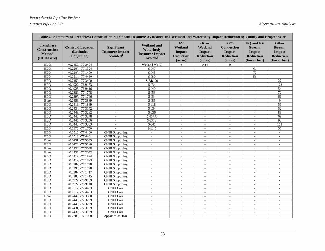
Pennsylvania Pipeline Project
Sunoco Pipeline L.P. Alternatives Analysis
33
Table 4. Summary of Trenchless Construction Significant Resource Avoidance and Wetland and Waterbody Impact Reduction by County and Project-Wide
Trenchless
Construction
Method
(HDD/Bore)
Centroid Location
(Latitude,
Longitude)
Significant
Resource Impact
Avoided1
Wetland and
Waterbody
Resource Impact
Avoided
EV
Wetland
Impact
Reduction
(acres)
Other
Wetland
Impact
Reduction
(acres)
PFO
Conversion
Impact
Reduction
(acres)
HQ and EV
Stream
Impact
Reduction
(linear feet)
Other
Stream
Impact
Reduction
(linear feet)
HDD 40.2450, -77.3494 - Wetland W177 0 0.14 0 - -
HDD 40.2287, -77.1324 - S-I47 - - - 61 -
HDD 40.2287, -77.1400 - S-I48 - - - 72 -
HDD 40.2514, -77.4460 - S-I89 - - - 56 -
HDD 40.2450, -77.3490 - S-BB120 - - - - 27
HDD 40.1922, -76.9153 - S-I34 - - - - 122
HDD 40.1925, -76.9416 - S-I40 - - - - 54
HDD 40.2389, -77.1778 - S-I53 - - - - 72
HDD 40.2397, -77.1796 - S-I54 - - - - 61
Bore 40.2456, -77.3839 - S-I85 - - - - 9
HDD 40.2419, -77.1899 - S-J18 - - - - 51
HDD 40.2434, -77.3172 - S-J34 - - - - 52
HDD 40.2443, -77.3232 - S-J36 - - - - 88
HDD 40.2446, -77.3278 - S-J37A - - - - 69
HDD 40.2445, -77.3256 - S-J37B - - - - 93
HDD 40.2448, -77.3303 - S-J41 - - - - 113
HDD 40.2376, -77.1750 - S-K45 - - - - 56
HDD 40.2518, -77.4480 CNHI Supporting - - - - - -
HDD 40.2519, -77.4481 CNHI Supporting - - - - - -
Bore 40.2451, -77.3399 CNHI Supporting - - - - - -
HDD 40.2428, -77.3140 CNHI Supporting - - - - - -
Bore 40.2430, -77.3068 CNHI Supporting - - - - - -
Bore 40.2435, -77.2072 CNHI Supporting - - - - - -
HDD 40.2419, -77.1894 CNHI Supporting - - - - - -
HDD 40.2419, -77.1893 CNHI Supporting - - - - - -
HDD 40.2389, -77.1778 CNHI Supporting - - - - - -
HDD 40.2390, -77.1778 CNHI Supporting - - - - - -
HDD 40.2287, -77.1417 CNHI Supporting - - - - - -
HDD 40.2288, -77.1415 CNHI Supporting - - - - - -
HDD 40.1922, -76.9139 CNHI Supporting - - - - - -
HDD 40.1922, -76.9140 CNHI Supporting - - - - - -
HDD 40.2512, -77.4453 CNHI Core - - - - - -
HDD 40.2512, -77.4453 CNHI Core - - - - - -
Bore 40.2449, -77.3330 CNHI Core - - - - - -
HDD 40.2445, -77.3259 CNHI Core - - - - - -
HDD 40.2445, -77.3259 CNHI Core - - - - - -
HDD 40.2431, -77.3159 CNHI Core - - - - - -
HDD 40.2432, -77.3159 CNHI Core - - - - - -
HDD 40.2288, -77.1038 Appalachian Trail - - - - - -

Pennsylvania Pipeline Project
Sunoco Pipeline L.P. Alternatives Analysis
34
Table 4. Summary of Trenchless Construction Significant Resource Avoidance and Wetland and Waterbody Impact Reduction by County and Project-Wide
Trenchless
Construction
Method
(HDD/Bore)
Centroid Location
(Latitude,
Longitude)
Significant
Resource Impact
Avoided1
Wetland and
Waterbody
Resource Impact
Avoided
EV
Wetland
Impact
Reduction
(acres)
Other
Wetland
Impact
Reduction
(acres)
PFO
Conversion
Impact
Reduction
(acres)
HQ and EV
Stream
Impact
Reduction
(linear feet)
Other
Stream
Impact
Reduction
(linear feet)
HDD 40.2288, -77.1038 Appalachian Trail - - - - - -
HDD 40.2313, -77.1096 Appalachian Trail - - - - - -
HDD 40.2313, -77.1096 Appalachian Trail - - - - - -
Subtotal 0.68 5.43 2.22 189 867
York County
HDD 40.1990, -76.7988 - Wetland BB1 0 0.03 0 - -
Bore 40.1924, -76.8150 - Wetland H51 0 0.25 0.15 - -
Bore 40.1924, -76.8144 - S-H61 - - - - 49
Bore 40.1914, -76.8411 - S-I25 - - - - 25
HDD 40.1922, -76.9112 - S-I36 - - - - 89
HDD 40.1992, -76.7987 Cultural Site - - - - - -
HDD 40.1922, -76.9100 CNHI Supporting - - - - - -
HDD 40.1922, -76.9100 CNHI Supporting - - - - - -
HDD 40.1987, -76.8002 CNHI Core - - - - - -
HDD 40.1987, -76.8002 CNHI Core - - - - - -
Subtotal 0 0.28 0.15 0 163
Dauphin County
HDD 40.2026, -76.7853 - Wetland A18 0 0.09 0.09 - -
HDD 40.2535, -76.5935 - Wetland A29 0 0 0 - -
HDD 40.2333, -76.6747 - Wetland B58 0 0.4 0.33 - -
HDD 40.2050, -76.7697 - Wetland B65 0 0 0 - -
HDD 40.2342, -76.6713 - Wetland C26 0 1.73 1.22 - -
HDD 40.2226, -76.7122 - Wetland CC22 0 0.04 0 - -
HDD 40.2537, -76.5923 - Wetland J47 0 0.14 0.55 - -
HDD 40.2053, -76.7694 - Wetland W118 0 0.03 0 - -
HDD 40.2009, -76.7917 - S-A22 - - - - 60
HDD 40.2532, -76.5945 - S-A47 - - - - 88
HDD 40.2227, -76.7118 - S-A75 - - - - 84
HDD 40.2319, -76.6796 - S-B61 - - - - 52
HDD 40.2331, -76.6755 - S-B62 - - - - 54
HDD 40.2339, -76.6724 - S-B63 - - - - 508
HDD 40.2189, -76.7248 - S-B70 - - - - 50
HDD 40.2184, -76.7255 - S-C54 - - - - 80
HDD 40.2532, -76.5944 - S-K18 - - - - 66
HDD 40.2187, -76.7250 CNHI Supporting - - - - - -
HDD 40.2188, -76.7250 CNHI Supporting - - - - - -
HDD 40.2013, -76.7903 CNHI Core - - - - - -
HDD 40.2013, -76.7904 CNHI Core - - - - - -
Subtotal 0 2.43 2.19 0 1042

Pennsylvania Pipeline Project
Sunoco Pipeline L.P. Alternatives Analysis
35
Table 4. Summary of Trenchless Construction Significant Resource Avoidance and Wetland and Waterbody Impact Reduction by County and Project-Wide
Trenchless
Construction
Method
(HDD/Bore)
Centroid Location
(Latitude,
Longitude)
Significant
Resource Impact
Avoided1
Wetland and
Waterbody
Resource Impact
Avoided
EV
Wetland
Impact
Reduction
(acres)
Other
Wetland
Impact
Reduction
(acres)
PFO
Conversion
Impact
Reduction
(acres)
HQ and EV
Stream
Impact
Reduction
(linear feet)
Other
Stream
Impact
Reduction
(linear feet)
Lebanon County
Bore 40.2868, -76.3300 - Wetland CJ2 0.02 0 0 - -
HDD 40.2855, -76.2391 - Wetland H13 0 0.7 0.31 - -
HDD 40.2855, -76.2414 - Wetland H14 0 0.53 0.19 - -
HDD 40.2534, -76.5936 - Wetland J47 0 0.55 0.55 - -
Bore 40.2868, -76.3296 - S-A25 - - - - 25
HDD 40.2555, -76.5865 - S-A49 - - - - 297
HDD 40.2551, -76.5879 - S-A51 - - - - 30
HDD 40.2855, -76.2406 - S-C85 - - - - 23
HDD 40.2855, -76.2406 - S-C86 - - - - 97
Bore 40.2877, -76.3716 CNHI Supporting - - - - - -
Bore 40.2852, -76.2752 CNHI Supporting - - - - - -
Bore 40.2852, -76.2475 CNHI Core - - - - - -
Bore 40.2853, -76.2444 CNHI Core - - - - - -
Bore 40.2856, -76.2335 CNHI Core - - - - - -
HDD 40.2854, -76.2403 CNHI Core - - - - - -
HDD 40.2855, -76.2402 CNHI Core - - - - - -
Bore 40.2852, -76.2475 State Game Land - - - - - -
HDD 40.2855, -76.2402 State Game Land - - - - - -
Bore 40.2853, -76.2444 State Game Land - - - - - -
Bore 40.2856, -76.2335 State Game Land - - - - - -
HDD 40.2854, -76.2403 State Game Land - - - - - -
Subtotal 0.02 1.78 1.05 0 472
Lancaster County
HDD 40.2835, -76.1688 - Wetland A54 0.98 0 0.06 - -
HDD 40.2839, -76.1750 - Wetland A55 0.81 0 0 - -
Bore 40.2826, -76.1581 - Wetland A56 0.17 0 0 - -
HDD 40.2808, -76.2085 - Wetland K32 0.73 0 0 - -
Bore 40.2823, -76.1528 - Wetland B72 0 0.25 0 - -
Bore 40.2797, -76.1949 - Wetland J54 0 0.15 0.15 - -
HDD 40.2835, -76.1678 - S-A77 - - - 66 -
HDD 40.2839, -76.1761 - S-A82 - - - 56 -
Bore 40.2796, -76.1947 - S-J59 - - - 55 -
HDD 40.2808, -76.2098 - S-K34 - - - 72 -
HDD 40.2809, -76.2067 - S-K35 - - - 51 -
HDD 40.2836, -76.1699 - S-A78 - - - - 60
HDD 40.2836, -76.1702 - S-A79 - - - - 52
HDD 40.2839, -76.1762 - S-A83 - - - - 52
Bore 40.2826, -76.1576 - S-A87 - - - - 25

Pennsylvania Pipeline Project
Sunoco Pipeline L.P. Alternatives Analysis
36
Table 4. Summary of Trenchless Construction Significant Resource Avoidance and Wetland and Waterbody Impact Reduction by County and Project-Wide
Trenchless
Construction
Method
(HDD/Bore)
Centroid Location
(Latitude,
Longitude)
Significant
Resource Impact
Avoided1
Wetland and
Waterbody
Resource Impact
Avoided
EV
Wetland
Impact
Reduction
(acres)
Other
Wetland
Impact
Reduction
(acres)
PFO
Conversion
Impact
Reduction
(acres)
HQ and EV
Stream
Impact
Reduction
(linear feet)
Other
Stream
Impact
Reduction
(linear feet)
Bore 40.2824, -76.1517 - S-B82 - - - - 31
HDD 40.2836, -76.1722 T&E Species - - - - - -
HDD 40.2835, -76.1741 Cultural Site - - - - - -
HDD 40.2808, -76.2080 Cultural Site - - - - - -
Bore 40.2834, -76.1274 CNHI Supporting - - - - - -
HDD 40.2808, -76.2084 CNHI Core - - - - - -
HDD 40.2809, -76.2085 CNHI Core - - - - - -
Bore 40.2809, -76.2037 CNHI Core - - - - - -
Bore 40.2830, -76.1873 CNHI Core - - - - - -
HDD 40.2836, -76.1714 CNHI Core - - - - - -
HDD 40.2837, -76.1714 CNHI Core - - - - - -
Bore 40.2823, -76.1542 CNHI Core - - - - - -
Bore 40.2823, -76.1530 CNHI Core - - - - - -
Bore 40.2830, -76.1447 CNHI Core - - - - - -
Bore 40.2832, -76.1447 CNHI Core - - - - - -
Bore 40.2830, -76.1374 CNHI Core - - - - - -
Bore 40.2798, -76.1953 CNHI Core - - - - - -
Bore 40.2827, -76.1587 CNHI Core - - - - - -
HDD 40.2808, -76.2086 State Game Land - - - - - -
Bore 40.2810, -76.2170 State Game Land - - - - - -
HDD 40.2809, -76.2086 State Game Land - - - - - -
Subtotal 2.69 0.40 0.21 300 220
Berks County
Bore 40.2950, -76.0253 - Wetland C13 0.03 0 0 - -
Bore 40.2549, -75.9895 - Wetland C6 0.13 0 0 - -
Bore 40.1886, -75.8885 - Wetland Q80 0.06 0 0.06 - -
HDD 40.1699, -75.8630 - Wetland A37 0 0.02 0 - -
HDD 40.1679, -75.8598 - Wetland J48 0 0.93 0.34 - -
HDD 40.1701, -75.8632 - S-A57 - - - - 60
HDD 40.1698, -75.8627 - S-A58 - - - - 229
HDD 40.1700, -75.8629 - S-A59 - - - - 12
Bore 40.2345, -75.9649 - S-B30 - - - - 25
HDD 40.2772, -76.0201 - S-B40 - - - - 11
HDD 40.2772, -76.0202 - S-B41 - - - - 15
Bore 40.2551, -75.9896 - S-C10 - - - - 28
Bore 40.2549, -75.9895 - S-C8 - - - - 66
Bore 40.2549, -75.9895 - S-C9 - - - - 52
HDD 40.1689, -75.8615 - S-J51 - - - - 121
HDD 40.1669, -75.8583 - S-J52 - - - - 36

Pennsylvania Pipeline Project
Sunoco Pipeline L.P. Alternatives Analysis
37
Table 4. Summary of Trenchless Construction Significant Resource Avoidance and Wetland and Waterbody Impact Reduction by County and Project-Wide
Trenchless
Construction
Method
(HDD/Bore)
Centroid Location
(Latitude,
Longitude)
Significant
Resource Impact
Avoided1
Wetland and
Waterbody
Resource Impact
Avoided
EV
Wetland
Impact
Reduction
(acres)
Other
Wetland
Impact
Reduction
(acres)
PFO
Conversion
Impact
Reduction
(acres)
HQ and EV
Stream
Impact
Reduction
(linear feet)
Other
Stream
Impact
Reduction
(linear feet)
Bore 40.1886, -75.8886 - S-Q89 - - - - 85
Bore 40.2549, -75.9895 T&E Species - - - - - -
Bore 40.2863, -76.1015 CNHI Supporting - - - - - -
Bore 40.2892, -76.0947 CNHI Supporting - - - - - -
Bore 40.2909, -76.0917 CNHI Supporting - - - - - -
HDD 40.3092, -76.0552 CNHI Supporting - - - - - -
HDD 40.3093, -76.0550 CNHI Supporting - - - - - -
Bore 40.3157, -76.0431 CNHI Supporting - - - - - -
Bore 40.2817, -76.0292 CNHI Supporting - - - - - -
HDD 40.2768, -76.0190 CNHI Supporting - - - - - -
HDD 40.2767, -76.0190 CNHI Supporting - - - - - -
HDD 40.2757, -76.0124 CNHI Supporting - - - - - -
HDD 40.2756, -76.0124 CNHI Supporting - - - - - -
Bore 40.2747, -76.0095 CNHI Supporting - - - - - -
Bore 40.2632, -75.9981 CNHI Supporting - - - - - -
Bore 40.2567, -75.9905 CNHI Supporting - - - - - -
Bore 40.2553, -75.9896 CNHI Supporting - - - - - -
Bore 40.2500, -75.9854 CNHI Supporting - - - - - -
Bore 40.2418, -75.9757 CNHI Supporting - - - - - -
Bore 40.2375, -75.9750 CNHI Supporting - - - - - -
Bore 40.2369, -75.9715 CNHI Supporting - - - - - -
HDD 40.2235, -75.9481 CNHI Supporting - - - - - -
HDD 40.2234, -75.9481 CNHI Supporting - - - - - -
Bore 40.2194, -75.9420 CNHI Supporting - - - - - -
Bore 40.2176, -75.9391 CNHI Supporting - - - - - -
Bore 40.2116, -75.9293 CNHI Supporting - - - - - -
Bore 40.2024, -75.9154 CNHI Supporting - - - - - -
Bore 40.1886, -75.8883 CNHI Supporting - - - - - -
Bore 40.1798, -75.8748 CNHI Supporting - - - - - -
Bore 40.1760, -75.8737 CNHI Supporting - - - - - -
Bore 40.1752, -75.8725 CNHI Supporting - - - - - -
HDD 40.1679, -75.8599 CNHI Supporting - - - - - -
HDD 40.1679, -75.8599 CNHI Supporting - - - - - -
Bore 40.1634, -75.8533 CNHI Supporting - - - - - -
Bore 40.1611, -75.8492 CNHI Supporting - - - - - -
Bore 40.1560, -75.8431 CNHI Supporting - - - - - -
Bore 40.2370, -75.9715 CNHI Core - - - - - -
Bore 40.2346, -75.9650 CNHI Core - - - - - -
Bore 40.2295, -75.9571 CNHI Core - - - - - -
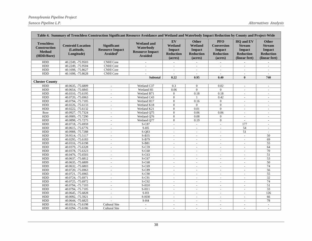
Pennsylvania Pipeline Project
Sunoco Pipeline L.P. Alternatives Analysis
38
Table 4. Summary of Trenchless Construction Significant Resource Avoidance and Wetland and Waterbody Impact Reduction by County and Project-Wide
Trenchless
Construction
Method
(HDD/Bore)
Centroid Location
(Latitude,
Longitude)
Significant
Resource Impact
Avoided1
Wetland and
Waterbody
Resource Impact
Avoided
EV
Wetland
Impact
Reduction
(acres)
Other
Wetland
Impact
Reduction
(acres)
PFO
Conversion
Impact
Reduction
(acres)
HQ and EV
Stream
Impact
Reduction
(linear feet)
Other
Stream
Impact
Reduction
(linear feet)
HDD 40.2249, -75.9503 CNHI Core - - - - - -
HDD 40.2249, -75.9504 CNHI Core - - - - - -
HDD 40.1698, -75.8627 CNHI Core - - - - - -
HDD 40.1698, -75.8628 CNHI Core - - - - - -
Subtotal 0.22 0.95 0.40 0 740
Chester County
HDD 40.0635, -75.6809 - Wetland C37 0.3 0 0.02 - -
HDD 40.0654, -75.6845 - Wetland H1 0.06 0 0 - -
HDD 40.0310, -75.6195 - Wetland B71 0 0.18 0.18 - -
HDD 40.0720, -75.6963 - Wetland C43 0 1 0.42 - -
HDD 40.0794, -75.7105 - Wetland H17 0 0.16 0 - -
HDD 40.0226, -75.6133 - Wetland K18 0 0 0 - -
HDD 40.0222, -75.6132 - Wetland K21 0 0.01 0 - -
Bore 40.0927, -75.7324 - Wetland Q75 0 0.06 0.06 - -
HDD 40.0909, -75.7290 - Wetland Q76 0 0.08 0 - -
HDD 40.0898, -75.7275 - Wetland Q77 0 0.19 0 - -
HDD 40.0718, -75.6959 - S-C87 - - - 177 -
HDD 40.0615, -75.6776 - S-H5 - - - 54 -
HDD 40.0908, -75.7288 - S-Q83 - - - 51 -
HDD 39.9514, -75.5117 - S-B35 - - - - 50
HDD 40.0295, -75.6183 - S-B79 - - - - 69
HDD 40.0316, -75.6198 - S-B81 - - - - 55
HDD 40.0379, -75.6328 - S-C59 - - - - 64
HDD 40.0378, -75.6323 - S-C60 - - - - 70
HDD 40.0476, -75.6503 - S-C63 - - - - 51
HDD 40.0637, -75.6812 - S-C67 - - - - 53
HDD 40.0635, -75.6809 - S-C68 - - - - 50
HDD 40.0632, -75.6803 - S-C69 - - - - 74
HDD 40.0720, -75.6963 - S-C89 - - - - 56
HDD 40.0721, -75.6965 - S-C90 - - - - 55
HDD 40.0724, -75.6971 - S-C91 - - - - 32
HDD 40.0725, -75.6972 - S-C92 - - - - 74
HDD 40.0794, -75.7103 - S-H10 - - - - 51
HDD 40.0794, -75.7105 - S-H11 - - - - 33
HDD 40.0645, -75.6828 - S-H3 - - - - 126
HDD 40.0092, -75.5921 - S-H30 - - - - 66
HDD 40.0644, -75.6825 - S-H4 - - - - 78
HDD 40.0314, -75.6198 Cultural Site - - - - - -
HDD 40.0294, -75.6186 Cultural Site - - - - - -

Pennsylvania Pipeline Project
Sunoco Pipeline L.P. Alternatives Analysis
39
Table 4. Summary of Trenchless Construction Significant Resource Avoidance and Wetland and Waterbody Impact Reduction by County and Project-Wide
Trenchless
Construction
Method
(HDD/Bore)
Centroid Location
(Latitude,
Longitude)
Significant
Resource Impact
Avoided1
Wetland and
Waterbody
Resource Impact
Avoided
EV
Wetland
Impact
Reduction
(acres)
Other
Wetland
Impact
Reduction
(acres)
PFO
Conversion
Impact
Reduction
(acres)
HQ and EV
Stream
Impact
Reduction
(linear feet)
Other
Stream
Impact
Reduction
(linear feet)
HDD 40.0321, -75.6199 Cultural Site - - - - - -
Bore 40.1557, -75.8428 CNHI Supporting - - - - - -
Bore 40.1532, -75.8394 CNHI Supporting - - - - - -
Bore 40.1521, -75.8360 CNHI Supporting - - - - - -
Bore 40.1502, -75.8326 CNHI Supporting - - - - - -
Bore 40.1469, -75.8264 CNHI Supporting - - - - - -
Bore 40.1418, -75.8181 CNHI Supporting - - - - - -
Bore 40.1402, -75.8154 CNHI Supporting - - - - - -
Bore 40.1363, -75.8089 CNHI Supporting - - - - - -
Bore 40.1313, -75.8006 CNHI Supporting - - - - - -
Bore 40.1249, -75.7924 CNHI Supporting - - - - - -
Bore 40.1193, -75.7889 CNHI Supporting - - - - - -
Bore 40.1156, -75.7822 CNHI Supporting - - - - - -
Bore 40.1154, -75.7801 CNHI Supporting - - - - - -
Bore 40.1145, -75.7772 CNHI Supporting - - - - - -
Bore 40.1111, -75.7711 CNHI Supporting - - - - - -
Bore 40.1079, -75.7656 CNHI Supporting - - - - - -
Bore 40.1022, -75.7560 CNHI Supporting - - - - - -
Bore 40.0861, -75.7235 CNHI Supporting - - - - - -
HDD 40.0886, -75.7260 CNHI Supporting - - - - - -
HDD 40.0886, -75.7260 CNHI Supporting - - - - - -
HDD 40.0810, -75.7135 CNHI Supporting - - - - - -
HDD 40.0809, -75.7135 CNHI Supporting - - - - - -
HDD 40.0727, -75.6976 CNHI Supporting - - - - - -
HDD 40.0727, -75.6976 CNHI Supporting - - - - - -
HDD 40.0662, -75.6862 CNHI Supporting - - - - - -
HDD 40.0662, -75.6862 CNHI Supporting - - - - - -
HDD 40.0606, -75.6761 CNHI Supporting - - - - - -
HDD 40.0605, -75.6761 CNHI Supporting - - - - - -
HDD 40.0576, -75.6711 CNHI Supporting - - - - - -
HDD 40.0576, -75.6712 CNHI Supporting - - - - - -
Bore 40.0569, -75.6698 CNHI Supporting - - - - - -
Bore 40.0569, -75.6684 CNHI Supporting - - - - - -
HDD 40.0548, -75.6644 CNHI Supporting - - - - - -
HDD 40.0547, -75.6645 CNHI Supporting - - - - - -
HDD 40.0055, -75.5821 CNHI Supporting - - - - - -
HDD 40.0042, -75.5799 CNHI Supporting - - - - - -
HDD 40.0034, -75.5788 CNHI Supporting - - - - - -
HDD 39.9978, -75.5669 CNHI Supporting - - - - - -

Pennsylvania Pipeline Project
Sunoco Pipeline L.P. Alternatives Analysis
40
Table 4. Summary of Trenchless Construction Significant Resource Avoidance and Wetland and Waterbody Impact Reduction by County and Project-Wide
Trenchless
Construction
Method
(HDD/Bore)
Centroid Location
(Latitude,
Longitude)
Significant
Resource Impact
Avoided1
Wetland and
Waterbody
Resource Impact
Avoided
EV
Wetland
Impact
Reduction
(acres)
Other
Wetland
Impact
Reduction
(acres)
PFO
Conversion
Impact
Reduction
(acres)
HQ and EV
Stream
Impact
Reduction
(linear feet)
Other
Stream
Impact
Reduction
(linear feet)
HDD 39.9977, -75.5668 CNHI Supporting - - - - - -
HDD 39.9938, -75.5594 CNHI Supporting - - - - - -
HDD 39.9938, -75.5594 CNHI Supporting - - - - - -
HDD 39.9883, -75.5472 CNHI Supporting - - - - - -
HDD 39.9882, -75.5471 CNHI Supporting - - - - - -
HDD 39.9858, -75.5428 CNHI Supporting - - - - - -
HDD 39.9859, -75.5429 CNHI Supporting - - - - - -
HDD 39.9806, -75.5387 CNHI Supporting - - - - - -
HDD 39.9805, -75.5387 CNHI Supporting - - - - - -
HDD 39.9787, -75.5374 CNHI Supporting - - - - - -
HDD 39.9779, -75.5370 CNHI Supporting - - - - - -
HDD 39.9676, -75.5246 CNHI Supporting - - - - - -
HDD 39.9676, -75.5246 CNHI Supporting - - - - - -
HDD 39.9530, -75.5129 CNHI Supporting - - - - - -
HDD 39.9531, -75.5131 CNHI Supporting - - - - - -
HDD 40.0055, -75.5821 CNHI Supporting - - - - - -
Bore 40.0931, -75.7317 CNHI Core - - - - - -
HDD 40.0914, -75.7295 CNHI Core - - - - - -
HDD 40.0913, -75.7295 CNHI Core - - - - - -
HDD 40.0898, -75.7276 State Park - - - - - -
HDD 40.0899, -75.7276 State Park - - - - - -
Subtotal 0.36 1.68 0.68 282 1107
Delaware County
HDD 39.9405, -75.4945 - Wetland B51 0 0 0 - -
HDD 39.9054, -75.4468 - Wetland C10 0.05 0 0 - -
HDD 39.8945, -75.4319 - Wetland I1 0.22 0 0 - -
HDD 39.8464, -75.4102 - Wetland BA5 0 0.01 0.01 - -
HDD 39.8463, -75.4104 - Wetland BA6 0 0.03 0.03 - -
HDD 39.9166, -75.4606 - Wetland C19 0 0.01 0 - -
HDD 39.9213, -75.4643 - Wetland C21 0 0.01 0.01 - -
HDD 39.8488, -75.4038 - Wetland I16 0 0.37 0.32 - -
HDD 39.9405, -75.4945 - S-B52 - - - - 6
HDD 39.9405, -75.4945 - S-B53 - - - - 6
HDD 39.9405, -75.4945 - S-B54 - - - - 79
HDD 39.9405, -75.4947 - S-B55 - - - - 66
HDD 39.9056, -75.4470 - S-C23 - - - - 63
HDD 39.9066, -75.4482 - S-C24 - - - - 52
HDD 39.9065, -75.4480 - S-C25 - - - - 51
HDD 39.9079, -75.4497 - S-C26 - - - - 58

Pennsylvania Pipeline Project
Sunoco Pipeline L.P. Alternatives Analysis
41
Table 4. Summary of Trenchless Construction Significant Resource Avoidance and Wetland and Waterbody Impact Reduction by County and Project-Wide
Trenchless
Construction
Method
(HDD/Bore)
Centroid Location
(Latitude,
Longitude)
Significant
Resource Impact
Avoided1
Wetland and
Waterbody
Resource Impact
Avoided
EV
Wetland
Impact
Reduction
(acres)
Other
Wetland
Impact
Reduction
(acres)
PFO
Conversion
Impact
Reduction
(acres)
HQ and EV
Stream
Impact
Reduction
(linear feet)
Other
Stream
Impact
Reduction
(linear feet)
HDD 39.9155, -75.4595 - S-C39 - - - - 19
HDD 39.9155, -75.4596 - S-C40 - - - - 60
HDD 39.9206, -75.4637 - S-C42 - - - - 64
HDD 39.8701, -75.4112 - S-H37 - - - - 91
HDD 39.8658, -75.4065 - S-H41 - - - - 150
HDD 39.8561, -75.3990 - S-H43 - - - - 56
HDD 39.8478, -75.4059 - S-I18 - - - - 50
HDD 39.9502, -75.5105 CNHI Supporting - - - - - -
HDD 39.9502, -75.5106 CNHI Supporting - - - - - -
HDD 39.9451, -75.5038 CNHI Supporting - - - - - -
HDD 39.9450, -75.5037 CNHI Supporting - - - - - -
HDD 39.9404, -75.4943 CNHI Supporting - - - - - -
HDD 39.9404, -75.4943 CNHI Supporting - - - - - -
Bore 39.9434, -75.5013 CNHI Supporting - - - - - -
HDD 39.9206, -75.4637 CNHI Supporting - - - - - -
HDD 39.9206, -75.4638 CNHI Supporting - - - - - -
Bore 39.8808, -75.4145 CNHI Supporting - - - - - -
HDD 39.8673, -75.4087 CNHI Supporting - - - - - -
HDD 39.8673, -75.4087 CNHI Supporting - - - - - -
HDD 39.8478, -75.4058 CNHI Supporting - - - - - -
HDD 39.8479, -75.4058 CNHI Supporting - - - - - -
HDD 39.8569, -75.3995 CNHI Supporting - - - - - -
HDD 39.8569, -75.3995 CNHI Supporting - - - - - -
Subtotal 0.27 0.43 0.37 0 871
Project Total 9.78 22.34 13.24 1,656 11,730
Notes: 1 CNHI Core = Core Habitat of Natural Heritage Areas identified through the County Natural Heritage Inventory (CNHI) project of the Pennsylvania Natural Heritage Program.
CNHI Supporting = Supporting Landscape of Natural Heritage Areas identified through the CNHI project of the Pennsylvania Natural Heritage Program.
T&E Species = Federally- or state-listed threatened and endangered species habitat.

Pennsylvania Pipeline Project
Sunoco Pipeline L.P. Alternatives Analysis
42
As requested by PADEP in it is technical deficiency comments, SPLP evaluated a total of
43 site-specific areas proposed for trenchless construction techniques (each designated with a
unique Trenchless Area [TA] identification number). Specifically, SPLP evaluated each TA with
regard to potential extension of the length of the technique and/or work space reconfiguration to
further avoid or minimize impacts on wetlands, which is provided as Appendix C.
For each designated TA, a wetland-specific impact avoidance and minimization
assessment is presented. Each assessment presents the wetland-specific PADEP comment(s)
regarding the crossing area. Each assessment includes baseline information on the wetland and a
narrative qualitative assessment of the practicability of conventional bore, HDD, Trenching-
Proposed route, Trenching-Alternative route, work space reconfiguration, or other action as
commented by PADEP.
5.3 PROGRAMMATIC IMPACT AVOIDANCE AND REDUCTION MEASURES
In parallel with the MOC Process and early in the planning process, SPLP undertook
substantive programmatic measures to programmatically avoid and reduce environmental impacts,
including impacts at all wetland and waterbody crossings. Specifically, SPLP evaluated and
adopted the following programmatic wetland and waterbody impact avoidance and reduction
measures:
Measures to Avoid and Reduce Areal Extent of Wetland and Waterbody Impact:
o Maximized the co-location (abut and overlap) of the Project construction and
operation workspace with the existing SPLP pipeline right-of-way.
o Where the Project diverges from the existing SPLP pipeline right-of-way,
maximized the co-location (abut) of the Project construction and operation
workspace with the other existing utility rights-of-way.
o Narrowed the width of the construction right-of-way from 100 feet to 75 feet along
the entire pipeline alignment.
o Further narrowed the width of the construction right-of-way from 75 feet to 50 feet
at all wetland and waterbody crossings, except in a limited number of cases where
site-specific conditions required the use of a wider construction right-of-way.
Measures to Avoid and Reduce Construction and Operation Impact:
o Use of dry, open trench installation methods at all the remaining (i.e., non-
trenchless) open trench wetland and waterbody crossings.
o Use of wetland and waterbody crossing best management practices, as detailed in
(Attachment 11: Enclosure E, Part 4) – Impact Avoidance, Minimization, and
Mitigation Procedures; and Attachment 12 – Erosion & Sedimentation Control
Plan.
o As set forth in the Project Impact analyses (Attachment 11: Enclosure D, and
Enclosure E, Part 2), implementation of the Project as proposed, including the
proposed best management practices presented in the Impact Avoidance,
Minimization, and Mitigation Procedures and Erosion & Sedimentation Control
Plan, would result temporary and minor impacts to wetlands and associated wetland

Pennsylvania Pipeline Project
Sunoco Pipeline L.P. Alternatives Analysis
43
functions and values (with the exception of PFO cover type conversion). The
resultant impacts are not considered significant or adverse, and thus do not require
compensatory mitigation.
o As set forth in the Compensatory Mitigation Plan (Attachment 11: Enclosure F),
the remaining unavoidable adverse impacts resulting in PFO cover type conversion
(reduced to 0.405 acres Project-wide) would be adequately mitigated via
compensatory mitigation.
o As set forth in the Antidegradation Analysis (Attachment 11: Enclosure E, Part 5),
the Project as proposed would comply with State antidegradation requirements
contained in Chapters 93, 95 and 102 (relating to water quality standards;
wastewater treatment requirements; and erosion and sediment control) and the
Clean Water Act (CWA) (33 U.S.C.A. § § 1251—1376).
o As set forth in the Cumulative Impacts Assessment (Attachment 11: Enclosure E,
Part 6), the Project as proposed, and in consideration of other projects, would not
cause cumulative impacts that result in the impairment of the Commonwealth’s EV
wetland resources or a major impairment of the Commonwealth’s other wetland
resources.
Adoption of the above programmatic wetland and waterbody impact avoidance and
reduction measures resulted in a cumulative quantitative and qualitative reduction in Project
impacts on EV Wetlands, Other Wetlands, PFO wetland conversion, HQ and EV Streams, and
other (non-HQ/EV) streams (see Section 5.4). Adoption of these measures demonstrate
substantive site-specific and cumulative impact avoidance and minimization to the environment,
including wetland and waterbodies.
5.4 RESULTS OF AVOIDANCE AND MINIMIZATION OF HARM MEASURES
With the implementation of the above described routing for the Project, and then the
avoidance and minimization of harm through minor route changes and construction techniques,
potential impacts to wetland and waterbody resources have been avoided and minimized to the
maximum extent practicable. This Alternatives Analysis describes a process which has identified,
assessed, and adopted quantitative and qualitative impact avoidance and reduction measures,
including the most significant ones as follows:
Co-location (abut and overlap) of the Project with the existing SPLP pipeline right-of-way
and co-location (abut) with other utility right-of-way to the maximum extent practicable to
avoid and minimize impacts to new land and additional landowners, landscape and habitat
fragmentation, federal and state owned lands, and communities, as well as wetlands and
waterbodies;
Major Route Alternatives to allow avoidance of impacts to federal and state sensitive lands
and significant protected resources, cultural resources, and communities at a landscape
planning level;
Minor Route Variations to incrementally and further avoid and minimize quantitative
impacts to new land and additional landowners, landscape and habitat fragmentation,

Pennsylvania Pipeline Project
Sunoco Pipeline L.P. Alternatives Analysis
44
federal and state owned lands and significant protected resources, and wetlands and
waterbodies at site-specific locations;
Programmatic Impact Avoidance and Minimization Measures to incrementally and further
avoid and minimize quantitative impacts to new land and additional landowners, and
reduce quantitative and qualitative impacts to wetlands and waterbodies on a programmatic
basis, both cumulatively and on a site-specific basis, across the entire Project; and
Trenchless Construction Methods to incrementally and further avoid and minimize
quantitative impacts to new land and additional landowners, federal and state owned lands
and significant protected resources, and federal and state protected wetlands and
waterbodies at site-specific locations.
As presented in Table 5, adoption of these measures results in significant cumulative
impact avoidance and reduction from the Baseline Route Alternative to the Proposed Route
Alternative, including to:
EV Wetlands – Compared to the Baseline Route Alternative (32.1 acres), implementation
of the above measures reduced impacts (by 20.9 acres, a 65.1 percent reduction), resulting
in significant cumulative reduction in impacts associated with the Proposed Route
Alternative (11.2 acres);
Other Wetlands – Compared to the Baseline Route Alternative (86.8 acres),
implementation of the above measures reduced impacts (by 61.3 acres, a 70.6 percent
reduction), resulting in significant cumulative reduction in impacts associated with the
Proposed Route Alternative (25.5 acres);
Total Wetlands – Compared to the Baseline Route Alternative (118.9 acres),
implementation of the above measures reduced impacts (by 82.2 acres, a 69.1 percent
reduction), resulting in significant cumulative reduction in impacts associated with the
Proposed Route Alternative (36.7 acres); and
PFO Wetlands – Compared to the Baseline Route Alternative (35.2 acres), implementation
of the above measures reduced impacts (by 33.7 acres, a 95.7 percent reduction), resulting
in significant cumulative reduction in impacts associated with the Proposed Route
Alternative (1.6 acres), only 0.405 acre (across 19 wetlands) of which results in PFO
wetland cover type conversion.
As presented in Table 6, adoption of these measures results in significant cumulative impact
avoidance and reduction from the Baseline Route Alternative to the Proposed Route Alternative,
including to:
HQ and EV Waterbodies – Compared to the Baseline Route Alternative (35,031 linear
feet), implementation of the above measures reduced impacts (by 20,622 linear feet, a 58.9
percent reduction), resulting in significant cumulative reduction in impacts associated with
the Proposed Route Alternative (14,409 linear feet);
Other (Non-HQ and EV) Waterbodies – Compared to the Baseline Route Alternative
(89,539 linear feet), implementation of the above measures reduced impacts (by 50,817

Pennsylvania Pipeline Project
Sunoco Pipeline L.P. Alternatives Analysis
45
linear feet, a 56.8 percent reduction), resulting in significant cumulative reduction in
impacts associated with the Proposed Route Alternative (38,722 linear feet); and
Total Waterbodies – Compared to the Baseline Route Alternative (124,570 linear feet),
implementation of the above measures reduced impacts (by 71,439 linear feet, a 57.3
percent reduction), resulting in significant cumulative reduction in impacts associated with
the Proposed Route Alternative (53,131 linear feet).
With the exception of several PFO wetland cover type conversions of relatively small size
(0.405 acre across 19 wetlands), the remaining potential impacts to wetlands and waterbodies, with
the implementation of proposed industry-standard and agency-recommended best management
practices (see Attachment 11: Enclosure E, Part 4 – Impact Avoidance, Minimization, and
Mitigation Procedures; and Attachment 12 – Erosion & Sedimentation Control Plan), are
considered temporary and minor (see Attachment 11: Enclosure D – Project Impacts [County-
specific], and Attachment 11: Enclosure E, Part 2 – Resource Identification and Project Impacts
[Project-wide]).
5.5 PFO WETLAND COVER TYPE CONVERSION COMPENSATORY MITIGATION
As requested by PADEP in its technical deficiency comments, SPLP proposes to provide
compensatory mitigation for PFO wetland cover type conversion associated with the Project. With
the implementation of the preceding comprehensive pipeline routing and construction design
methodology development process (the MOC Process described in Section 5.0), potential impacts
to wetland and waterbody resources have been avoided and minimized to the maximum extent
practicable (see Section 5.4 and Tables 5 and 6). The effort to avoid and minimize harm resulted
in a significant cumulative quantitative impact reduction of PFO wetlands (from 35.2 acres for the
Baseline Route Alternative to only 1.6 acres for the Propose Route Alterantive), a reduction of
95.7 percent. Additionally, PFO wetland cover type conversion associated with the Proposed
Route Alternative is further reduced to 0.693 acre.
For this remaining, unavoidable, and minor PFO wetland cover type conversion, SPLP has
developed and proposes implementation of a tree replanting plan on 0.288 acre of PFO wetlands
within the permanent right-of-way, as presented the Impact Avoidance, Minimization, and
Mitigation Procedures provided in Attachment 11, Enclosure E, Part 4. The resultant final PFO
wetland cover type conversion is limited to 0.405 acre across 19 wetlands falling in 12 counties (a
net 98.8 percent impact reduction compared to the Baseline Route Alternative). A conceptual
Wetland Compensatory Mitigation Plan provided in Attachment 11: Enclosure F has been
developed for the Project to offset the loss associated with the permanent conversion of the PFO
cover type.

Pennsylvania Pipeline Project
Sunoco Pipeline L.P. Alternatives Analysis
46
Table 5. Wetland Impact Reduction from Baseline Route Alternative to Proposed Route Alternative
by County and Project-Wide
County/Resource
Baseline
Route
Alternative
(acres)
Narrowed
ROW
Width at
Wetlands
(acres)
Proposed
Route
Alternative1
(acres)
Cumulative
Impact
Reduction
(acres)
Cumulative
Impact
Reduction
(%)
Washington
EV Wetlands (Number) 0 0 0 0 0
EV Wetlands 0 0 0 (0) 0 (0) 0 (0)
Other Wetlands 0.6 0.5 0.6 (0.6) 0 (0) 0 (0)
Subtotal 0.6 0.5 0.6 (0.6) 0 (0) 0 (0)
PFO Wetlands 0 0 0 (0) 0 (0) 0 (0)
Allegheny
EV Wetlands (Number) 0 0 0 0 0
EV Wetlands 0 0 0 (0) 0 (0) 0 (0)
Other Wetlands 0.5 0.4 0.4 (0.4) 0.1 (0.1) 20.0 (20.0)
Subtotal 0.5 0.4 0.4 (0.4) 0.1 (0.1) 20.0 (20.0)
PFO Wetlands 0 0 0 (0) 0 (0) 0 (0)
Westmoreland
EV Wetlands (Number) 1 1 0 1 0
EV Wetlands 0 0 0 (0) 0 (0) 0 (0)
Other Wetlands 8.3 4.5 3.5 (3.3) 4.8 (5.0) 57.8 (60.2)
Subtotal 8.3 4.6 3.5 (3.3) 4.8 (5.0) 42.2 (39.8)
PFO Wetlands 2.7 0.9 0.1 (0) 2.6 (2.7) 96.3 (100.0)
Indiana
EV Wetlands (Number) 16 16 13 3 18.8
EV Wetlands 1.4 0.7 0.4 (0.4) 1.0 (1.0) 71.4 (71.4)
Other Wetlands 3.3 1.9 1.0 (0.9) 2.3 (2.4) 69.7 (72.7)
Subtotal 4.7 2.5 1.4 (1.3) 3.3 (3.4) 70.2 (72.3)
PFO Wetlands 0.4 0.2 0 (0) 0.4 (0.4) 100.0 (100.0)
Cambria
EV Wetlands (Number) 35 27 20 15 42.9
EV Wetlands 4.6 2.4 1.0 (0.9) 3.6 (3.7) 78.3 (80.4)
Other Wetlands 11.3 6.3 3.8 (3.5) 7.5 (7.8) 66.4 (69.0)
Subtotal 15.9 8.7 4.8 (4.4) 11.1 (11.5) 69.8 (72.3)
PFO Wetlands 5.1 2.4 0.4 (0.2) 4.7 (4.9) 92.2 (96.1)
Blair
EV Wetlands (Number) 44 37 29 15 34.1
EV Wetlands 9.8 4.7 3.0 (2.9) 6.8 (6.9) 69.4 (70.4)
Other Wetlands 3.3 1.4 0.2 (0.2) 3.1 (3.1) 93.9 (93.9)
Subtotal 13.1 6.1 3.2 (3.1) 9.9 (10) 75.6 (76.3)
PFO Wetlands 2.3 1.1 0.1 (0) 2.2 (2.3) 95.7 (100.0)
Huntingdon
EV Wetlands (Number) 0 0 0 0 0
EV Wetlands 0 0 0 (0) 0 (0) 0 (0)
Other Wetlands 8.4 6.2 3.5 (3.1) 4.9 (5.3) 58.3 (63.1)

Pennsylvania Pipeline Project
Sunoco Pipeline L.P. Alternatives Analysis
47
Table 5. Wetland Impact Reduction from Baseline Route Alternative to Proposed Route Alternative
by County and Project-Wide
County/Resource
Baseline
Route
Alternative
(acres)
Narrowed
ROW
Width at
Wetlands
(acres)
Proposed
Route
Alternative1
(acres)
Cumulative
Impact
Reduction
(acres)
Cumulative
Impact
Reduction
(%)
Subtotal 8.4 6.2 3.5 (3.1) 4.9 (5.3) 58.3 (63.1)
PFO Wetlands 1.9 1.2 0.2 (0) 1.7 (1.9) 89.5 (100.0)
Juniata
EV Wetlands (Number) 0 0 0 0 0
EV Wetlands 0 0 0 (0) 0 (0) 0 (0)
Other Wetlands 0.7 0.2 0.3 (0.2) 0.4 (0.5) 57.1 (71.4)
Subtotal 0.7 0.2 0.3 (0.2) 0.4 (0.5) 57.1 (71.4)
PFO Wetlands 0.2 0 0 (0) 0.2 (0.2) 0 (0)
Perry
EV Wetlands (Number) 19 25 14 5 26.3
EV Wetlands 3.6 2.7 1.0 (0.9) 2.6 (2.7) 72.2 (75.0)
Other Wetlands 0.5 0.4 0.2 (0.2) 0.3 (0.3) 60.0 (60.0)
Subtotal 4.1 3.1 1.2 (1.1) 2.9 (3.0) 70.7 (73.2)
PFO Wetlands 0.6 0.2 0.1 (0.1) 0.5 (0.5) 83.3 (83.3)
Cumberland
EV Wetlands (Number) 5 5 11 -6 -120.0
EV Wetlands 0.9 0.5 2.4 (2.3) -1.5 (-1.4) -166.7 (-155.6)
Other Wetlands 21.9 10.8 3.2 (2.8) 18.7 (19.1) 85.4 (87.2)
Subtotal 22.8 11.3 5.6 (5.1) 17.2 (17.7) 75.4 (77.6)
PFO Wetlands 6.4 1.8 0.2 (0) 6.2 (6.4) 96.9 (100.0)
York
EV Wetlands (Number) 0 0 0 0 0
EV Wetlands 0 0 0 (0) 0 (0) 0 (0)
Other Wetlands 0.8 0.7 0.4 (0.4) 0.4 (0.4) 50.0 (50.0)
Subtotal 0.8 0.7 0.4 (0.4) 0.4 (0.4) 50.0 (50.0)
PFO Wetlands 0.4 0.1 0 (0) 0.4 (0.4) 0 (0)
Dauphin
EV Wetlands (Number) 1 0 1 0 0
EV Wetlands 0.1 0 0 (0) 0.1 (0.1) 100.0 (100.0)
Other Wetlands 7.0 3.9 1.9 (1.6) 5.1 (5.4) 72.9 (77.1)
Subtotal 7.1 3.9 1.9 (1.6) 5.2 (5.5) 73.2 (77.5)
PFO Wetlands 3.8 1.3 0.2 (0.1) 3.6 (3.7) 94.7 (97.4)
Lebanon
EV Wetlands (Number) 5 5 4 1 20.0
EV Wetlands 1 0.5 0.5 (0.5) 0.5 (0.5) 50.0 (50.0)
Other Wetlands 4 2.5 0.7 (0.6) 3.3 (3.4) 82.5 (85.0)
Subtotal 4.9 3.0 1.2 (1.1) 3.7 (3.8) 75.5 (77.6)
PFO Wetlands 2.7 0.7 0.1 (0.1) 2.6 (2.6) 96.3 (96.3)
Lancaster
EV Wetlands (Number) 7 9 5 2 28.6
EV Wetlands 5.4 3.0 0.4 (0.2) 5.0 (5.2) 92.6 (96.3)

Pennsylvania Pipeline Project
Sunoco Pipeline L.P. Alternatives Analysis
48
Table 5. Wetland Impact Reduction from Baseline Route Alternative to Proposed Route Alternative
by County and Project-Wide
County/Resource
Baseline
Route
Alternative
(acres)
Narrowed
ROW
Width at
Wetlands
(acres)
Proposed
Route
Alternative1
(acres)
Cumulative
Impact
Reduction
(acres)
Cumulative
Impact
Reduction
(%)
Other Wetlands 2.2 1.2 1.1 (1.1) 1.1 (1.1) 50.0 (50.0)
Subtotal 7.6 4.3 1.5 (1.3) 6.1 (6.3) 80.3 (82.9)
PFO Wetlands 0.6 0.2 0 (0) 0.6 (0.6) 100.0 (100.0)
Berks
EV Wetlands (Number) 31 31 30 1 3.2
EV Wetlands 3.0 1.8 1.6 (1.6) 1.4 (1.4) 46.7 (46.7)
Other Wetlands 3.0 1.7 0.6 (0.5) 2.4 (2.5) 80.0 (83.3)
Subtotal 6.0 0 2.2 (2.1) 3.8 (3.9) 63.3 (65.0)
PFO Wetlands 1.9 0.5 0 (0) 1.9 (1.9) 100.0 (100.0)
Chester
EV Wetlands (Number) 16 11 10 6 37.5
EV Wetland 1.8 0.9 0.6 (0.6) 1.2 (1.2) 66.7 (66.7)
Other Wetland 7.3 4.6 3.1 (2.9) 4.2 (4.4) 57.5 (60.3)
Subtotal 9.1 5.5 3.7 (3.5) 5.4 (5.6) 59.3 (61.5)
PFO Wetlands 3.6 0.7 0.1 (0.1) 3.5 (3.5) 97.2 (97.2)
Delaware
EV Wetlands (Number) 1 1 3 -2 -200.0
EV Wetlands 0.5 0.3 0.3 (0.3) 0.2 (0.2) 40.0 (40.0)
Other Wetlands 3.7 0.9 1.0 (1.0) 2.7 (2.7) 73.0 (73.0)
Subtotal 4.3 1.2 1.3 (1.3) 3.0 (3.0) 69.8 (69.8)
PFO Wetlands 2.6 0.4 0 (0) 2.6 (2.6) 100.0 (100.0)
Project-Wide Total
EV Wetlands (Number) 181 168 138 43 23.8
EV Wetlands Total 32.1 17.5 11.2 (10.6) 20.9 (21.5) 65.1 (67.0)
Other Wetlands Total 86.8 48.1 25.5 (23.3) 61.3 (63.5) 70.6 (73.2)
Project-Wide Total 118.9 62.2 36.7 (33.9) 82.2 (85.0) 69.1 (71.5)
PFO Wetlands Total 35.2 11.7 1.6 (0.6) 33.7 (34.6) 95.7 (98.3)
Notes: 1 Impact acreages based on PADEP and USACE Bore/HDD calculations (provided in parenthesis). PADEP calculates permanent
disturbance impacts at Bore and HDD crossings based on the width of the pipelines (3-feet) multiplied by the length of the wetland
crossing; USACE does not calculate impact acreages for Bore and HDD crossings. However, wetlands crossed via Bore or HDD may
have USACE due to travel lanes or clearing.

Pennsylvania Pipeline Project
Sunoco Pipeline L.P. Alternatives Analysis
49
Table 6. Waterbody Impact Reduction from Baseline Route Alternative to Proposed Route
Alternative by County and Project-Wide
County/Resource
Baseline
Route
Alternative
(linear feet)
Narrowed
ROW at
Waterbodies
(linear feet)
Proposed
Route
Alternative
(linear feet)
Cumulative
Impact
Reduction
(linear feet)
Cumulative
Impact
Reduction
(%)
Washington
HQ and EV Streams 3,214 1,880 1,702 1,512 47.0
Non-HQ and EV Streams 3,324 1,886 984 2,340 70.4
Total 6,538 3,767 2,686 3,852 58.9
Allegheny
HQ and EV Streams 0 0 0 0 0
Non-HQ and EV Streams 2,383 1,744 1,540 843 35.4
Total 2,383 1,744 1,540 843 35.4
Westmoreland
HQ and EV Streams 4,522 2,367 2,494 2,028 44.8
Non-HQ and EV Streams 8,804 6,112 5,064 3,740 42.5
Total 13,326 8,479 7,558 5,768 43.3
Indiana
HQ and EV Streams 2,083 1,232 887 1,196 57.4
Non-HQ and EV Streams 8,391 3,670 3,727 4,664 55.6
Total 10,474 4,903 4,614 5,859 55.9
Cambria
HQ and EV Streams 6,647 3,288 3,057 3,590 54.0
Non-HQ and EV Streams 6,733 3,913 3,143 3,590 53.3
Total 13,380 7,200 6,200 7,180 53.7
Blair
HQ and EV Streams 1,363 349 188 1,175 86.2
Non-HQ and EV Streams 7,383 2,585 2,096 5,287 71.6
Total 8,746 2,934 2,284 6,462 73.9
Huntingdon
HQ and EV Streams 2,324 1,114 1,047 1,277 54.9
Non-HQ and EV Streams 13,657 6,926 6,088 7,569 55.4
HU Total 15,981 8,039 7,135 8,846 55.4
Juniata
HQ and EV Streams 0 0 0 0 0
Non-HQ and EV Streams 3,588 2,293 2,204 1,384 38.6
Total 3,588 2,293 2,204 1,384 38.6
Perry
HQ and EV Streams 3,353 2,230 1,761 1,592 47.5
Non-HQ and EV Streams 0 0 0 0 0
PE Total 3,353 2,230 1,761 1,592 47.5
Cumberland
HQ and EV Streams 2,448 1,064 910 1,538 62.8
Non-HQ and EV Streams 11,044 5,374 4,416 6,628 60.0
Total 13,492 6,438 5,326 8,166 60.5

Pennsylvania Pipeline Project
Sunoco Pipeline L.P. Alternatives Analysis
50
Table 6. Waterbody Impact Reduction from Baseline Route Alternative to Proposed Route
Alternative by County and Project-Wide
County/Resource
Baseline
Route
Alternative
(linear feet)
Narrowed
ROW at
Waterbodies
(linear feet)
Proposed
Route
Alternative
(linear feet)
Cumulative
Impact
Reduction
(linear feet)
Cumulative
Impact
Reduction
(%)
York
HQ and EV Streams 0 0 0 0 0
Non-HQ and EV Streams 2,995 1,331 1,540 1,455 48.6
Total 2,995 1,331 1,540 1,455 48.6
Dauphin
HQ and EV Streams 0 0 0 0 0
Non-HQ and EV Streams 6,146 2,783 2,271 3,875 63.0
Total 6,146 2,783 2,271 3,875 63.0
Lebanon
HQ and EV Streams 0 0 0 0 0
Non-HQ and EV Streams 5,019 2,516 2,112 2,907 57.9
Total 5,019 2,516 2,112 2,907 57.9
Lancaster
HQ and EV Streams 1,050 618 64 986 93.9
Non-HQ and EV Streams 1,318 554 715 603 45.8
Total 2,368 1,173 779 1,589 67.1
Berks
HQ and EV Streams 4,059 1,717 1,266 2,793 68.8
Non-HQ and EV Streams 2,458 1,415 1,340 1,118 45.5
Total 6,517 3,131 2,606 3,911 60.0
Chester
HQ and EV Streams 3,823 1,969 983 2,840 74.3
Non-HQ and EV Streams 1,038 518 164 874 84.2
Total 4,861 2,487 1,147 3,714 76.4
Delaware
HQ and EV Streams 145 108 50 95 65.5
Non-HQ and EV Streams 5,258 2,303 1,318 3,940 74.9
Total 5,403 2,411 1,368 4,035 74.7
Project-Wide Total
HQ and EV Streams 35,031 17,936 14,409 20,622 58.9
Non-HQ and EV Streams 89,539 45,923 38,722 50,817 56.8
Project-Wide Total 124,570 63,859 53,131 71,439 57.3

Pennsylvania Pipeline Project
Sunoco Pipeline L.P. Alternatives Analysis
51
6.0 WETLAND-SPECIFIC PRACTICABLE ALTERNTIVES ANALYSIS
6.1 ALTERNATIVES ANSLYSIS NARRATIVES
As presented in this Alternatives Analysis, SPLP designed the proposed Project to be co-
located (abut and overlap) with existing SPLP pipeline right-of-way and co-located (abut) with
other existing utility rights-of-way (Section 3.2), adopt major route alternatives to avoid and
minimize obvious impacts on other (non-wetland) significant environmental resources and
communities (Section 3.3), and adopt further quantitative and qualitative impact avoidance and
minimization measures (Section 5.0) in a concerted and successful effort to avoid, minimize, and
mitigate site-specific and cumulative impacts to wetlands, as well as waterbodies and other (non-
wetland) environmental resources, to the maximum extent practicable. This process resulted in
the avoidance, minimization, and mitigation of adverse impacts to wetlands and waterbodies from
the Project as a whole by investigating successively more site-specific information regarding
potential environmental impacts, and developing alternative routing, locations, and designs to
avoid and minimize those potential environmental impacts.
Following establishment of the Baseline Route Alternative and associated 200-foot-wide
survey corridor (Section 3.4), SPLP conducted the integrated evaluation of the route via the MOC
Process (Section 5.0). This MOC Process considered opportunities to change the Baseline Route
Alternative to further avoid and minimize potential environmental impacts, while simultaneously
considering potential construction and operational constraints presented by affected landowners,
existing land uses, infrastructure obstacles, and other factors affecting use of existing technology,
cost, and logistics.
As presented in Section 5.0, the MOC Process was initiated on a site-specific basis as
opportunities or constraints were raised by an Integrated Project Team, consisting of
representatives from SPLP project management, engineering, land/right-of-way, and
environmental specialists. The MOC Process engaged and solicited input from each member of
the Integrated Project Team on a given alternative minor route variation or trenchless construction
method (i.e., conventional bore or HDD) under consideration. With the approval from each
member of the Integrated Project Team, including environmental, each adopted change was
determined to avoid significant impacts on other (non-wetland) environmental resources, to avoid
and minimize impacts on wetlands (as well as waterbodies) to the maximum extent practicable,
and to be practicable (feasible, constructible, operable) with regard to current technology, cost,
and logistics.
Implementation of this MOC Process resulted in the evaluation and adoption of 72 minor
route variations (see Section 5.1 and Table 3) and a significant number of trenchless crossings (see
Section 5.2 and Table 4) to avoid or minimize: 1) significant impacts on other (non-wetland)
environmental resources, 2) permanent PFO wetland cover type conversion, and 3) remaining
temporary and minor site-specific impacts on wetlands and waterbodies.
In response to PADEP comments, a detailed, site-specific practicable alternatives
assessment embodied in the MOC process is presented. This assessment addresses each crossing

Pennsylvania Pipeline Project
Sunoco Pipeline L.P. Alternatives Analysis
52
area (CA) that contains an individual or group of proximate individual wetland (and waterbody)
resources that are proposed for open trench pipeline installation; crossing areas determined to be
suitable, practicable, and proposed for trenchless construction methods (e.g., conventional bore
and HDD) to entirely avoid surface impacts to wetland and other (non-wetland) sensitive
environmental resources are previously presented in Section 5.2. Each crossing area represents a
reasonable area of analysis for the consideration of alternative construction techniques (e.g.,
conventional bore, HDD, and trenching) potentially available based on current technology, cost,
and logistics. The Project contains a total of 349 crossing areas, encompassing a total of 405
wetland (inclusive of 303 waterbody) resource crossings initially proposed for open trench pipeline
installation.
For each CA, a wetland (site)-specific practicable alternatives assessment narrative is
presented in Appendix D. Each wetland (site)-specific practicable alternatives assessment
narrative includes baseline information on wetland, as well as waterbody, resources within the
crossing area, and any specific PADEP comment(s) regarding the resources within the crossing
area. Each assessment includes a narrative qualitative comparison of conventional bore, HDD,
Trenching-Proposed, and Trenching-Alternative routes. This includes a qualitative assessment of
impacts to resources or constraints (e.g., other significant resources, wetlands, waterbodies, and
other site-specific and cumulative environmental and community resource impacts), and a
summary of technical feasibility and practicability for each alternative with regarding to current
technology, cost, and logistics. Additionally, each assessment includes a figure with aerial
photographic background depicting the location of a Trenching-Proposed route and a Trenching-
Alternative route (or MOC-considered routing), as well as wetland and waterbody resources
delineated within the 200-foot-wide survey corridor, and other (non-wetland) sensitive
environmental resources identified within (via field delineation or desk-top databases) or adjacent
to (via desk-top databases) the survey corridor.
For each wetland (site)-specific practicable alternatives assessment, the MOC reference
number is noted if applicable, as well as notation whether the MOC was adopted, and the proposed
construction method.
6.2 SUMMARY TABLE OF ALTERNATIVES ANSLYSIS
Table 7 (Appendix D) provides a summary of the results of the wetland (site)-specific
practicable alternatives assessment. This table identifies the CA identification number, latitude
and longitude centroid location, county, and wetland (including breakdown by EV wetlands [and
EV wetland designation] vs other wetlands) and waterbody (including breakdown by HQ and EV
waterbodies vs. other waterbodies) resources encompassed within the CA. This table also
identifies the field-determined wetland functions and values encompassed within the CA.
For each CA, a summary of the results of the Trenchless Construction Feasibility Analysis
(Appendix A), as further evaluated in the wetland (site)-specific practicable alternatives analysis
herein, is provided. For each the CAB and the HDD construction methodologies, the table notes
whether the subject methodology is technically feasible, and practicable, noted as yes (“Y”),
potentially (“P”), or no (“N”).

Pennsylvania Pipeline Project
Sunoco Pipeline L.P. Alternatives Analysis
53
For each CA, a summary comparison of the the Trenching-Alternative or Trenching-
Proposed route is provided. For each the Trenching-Alternative or Trenching-Proposed routes,
the table notes whether the subject methodology is technically feasible, and practicable, noted as
yes (“Y”), potentially (“P”), or no (“N”).
In addition, for each the Trenching-Alternative or Trenching-Proposed routes, 12
environmental impact avoidance or reduction criterion are presented, including evaluation of the
following:
Avoid Other (Non-Wetland) Significant Impact – this criterion identifies whether the
subject route avoids a significant other (non-wetland) resource, such as a cultural
resource site, T&E species record, sensitive or protected land, or residential,
commercial, or industrial structures and associated infrastructure.
Avoid & Minimize Wetland Impacts – this criterion identifies whether the subject route
avoids and minimizes the areal extent of disturbance to wetlands compared to the
alternative route. This assessment was based on in-field wetland delineation data
within the 200-foot-wide survey corridor; and review of aerial photographs, NWI maps,
and in-field wetland continuation lines (in-field observation that the delineated wetland
continues beyond the 200-foot-wide survey corridor) beyond the 200-foot-wide survey
corridor.
Avoid & Minimize Waterbody Impacts – this criterion identifies whether the subject
route avoids and minimizes the linear footage of disturbance to waterbodies (streams)
compared to the alternative route. This assessment was based on in-field waterbody
delineation data within the 200-foot-wide survey corridor; and review of aerial
photographs and National Hydrologic Database data beyond the 200-foot-wide survey
corridor).
Decreased Land Encumbrance – this criterion identifies whether the subject route,
compared to the alternative route, decreases the amount of new, permanent land
disturbance and encumbrance on existing industrial and commercial development and
associated land uses; decreases the amount of new, permanent land disturbance on
existing private residential development, private land uses, and affected private
landowners; futher avoids permanent reduction in availability of land for future
development; and facilitates consistency with county comprehensive plans.
Decreased Land Fragementation – this criterion identifies whether the subject route,
compared to the alternative route, decreases the amount of new, permanent land
disturbance and landscape fragmentation, including impairment of natural landscapes,
scenic uses, recreational uses, contiguous forested lands, and contiguous natural
resources.
Decreased Forest Fragmentation – this criterion identifies whether the subject route,
compared to the alternative route, decreases the amount of new, permanent forested
land fragmentation, including impairment of forested ecosystem functions and values,
watershed/water quality values, and availability of contiguous forest habitat for interior

Pennsylvania Pipeline Project
Sunoco Pipeline L.P. Alternatives Analysis
54
wildlife species and migratory birds protected pursuant to the Migratory Bird Treaty
Act.
Decreased Forested Land Impact – this criterion identifies whether the subject route,
compared to the alternative route, decreases the permanent reduction in availability of
forested land for future forested land uses, forest production, and associated forest
natural resources.
Decreased Natural Resource Impact – this criterion identifies whether the subject route,
compared to the alternative route, decreases the permanent reduction in availability of
land for future natural resource uses, including natural landscapes, scenic uses,
recreational uses, and other natural resources.
Decreased Cumulative Impacts – this criterion identifies whether the subject route,
compared to the alternative route, decreases the potential to effectuate a cumulative
impact on land use planning, land fragmentation, forest fragmentation, and natural
resource fragmentation.
Optimal Pipeline Construction – this criterion identifies whether the subject route,
compared to the alternative route, facilitates optimal pipeline construction with regard
to process, safety, access, efficiency, and duration, on a site-specific and cumulative
basis.
Optimal Pipeline Operations – this criterion identifies whether the subject route,
compared to the alternative route, facilitates optimal pipeline operation with regard to
process, safety, access, efficiency, and duration, on a site-specific and cumulative basis.
Decreased Costs – this criterion identifies whether the subject route, compared to the
alternative route, results in decreased pipeline construction and operation costs.
For each CA, Table 7 provides a summary comparison as to whether the Trenching-
Alternative or Trenching-Proposed route meets each environmental impact reduction criterion.
Each environmental impact reduction criterion is noted with one of three analysis outcomes:
Yes (“Y”), meaning the subject route meets the environmental impact reduction
criterion when compared to the alternative route;
Potentially (“P”), meaning the subject route potentially meets the environmental
impact reduction criterion when compared to the alternative route, but such
determination requires additional site-specific information (e.g., in-field wetland
delineation outside of 200-foot-wide survey corridor) to confirm; or
No or neutral (blank), meaning either the subject route does not meet the
environmental impact reduction criterion when compared to the alternative route,
or both routes equally meet the environmental impact reduction criterion.
Appendix D presents Table 7 (results summary), followed by a legend depicting the
typology used on the site-specific practicable alternatives assessments maps, then the site-specific
practicable alternatives assessment narratives for each of the 349 crossing areas.

Pennsylvania Pipeline Project
Sunoco Pipeline L.P. Alternatives Analysis
55
7.0 STREAM-SPECIFIC IMPACT AVOIDANCE AND MINIMIZATION
ASSESSMENT
As requested by PADEP in it is technical deficiency comments, SPLP evaluated a total of
16 site-specific areas of proposed stream crossings not associated with any wetland crossing area
(each designated with a unique Stream Area [SA] identification number). Specifically, SPLP
evaluated each SA with regard to PADEP’s site-specific comments regarding use of new or the
potential extension of the length of currently proposed trenchless construction techniques, work
space reconfiguration, or other actions to further avoid or minimize impacts on streams, which is
provided as Appendix E.
For each designated SA, a stream-specific impact avoidance and minimization assessment
is presented. Each assessment presents the stream-specific PADEP comment(s) regarding the
crossing area. Each assessment includes baseline information on the stream and a narrative
qualitative assessment of the practicability of conventional bore, HDD, Trenching-Proposed route,
Trenching-Alternative route, work space reconfiguration, or other action as commented by
PADEP.
8.0 SUMMARY AND CONCLUSIONS
In conclusion, SPLP has assessed and balanced potential environmental impacts to develop
a practicable proposed pipeline route and station and valve setting locations. Specifically with
regard to the Project, SPLP has done the following:
Co-location With Existing Rights-of-Way – In accordance with state and federal guidance,
has routed the Project to be co-located with existing pipeline and other utility corridors,
and to avoid new “greenfield” routing alignments, to the maximum extent practicable. This
avoids and minimizes new and permanent impacts on previously undisturbed land, land
use encumbrance, and site-specific and cumulative impacts on land, environmental, and
community resources.
Avoid Significant Environmental Impacts – SPLP has adopted re-routes and trenchless
construction method as part of the Project to avoid significant impacts on both wetland and
other (non-wetland) environmental resources.
Minimize and Mitigate Temporary Impacts – In all areas where there will be construction-
related impacts to wetlands, SPLP plans to restore the area to its prior condition making
the impact temporary and minor.
Compensatory Mitigation of Unavoidable Permanent Impacts – When SPLP could not
avoid or further minimize permanent impacts, it has provided for compensatory mitigation
of wetland impacts.
Cumulatively, the Project meets all federal, state, and local environmental (as well as
critical non-environmental) regulations and guidance. Specifically, the Project maximizes co-
location with existing rights-of-way (over 80 percent), utilizes the minimum amount of
construction workspace practicable, utilizes a significant number of trenchless construction

Pennsylvania Pipeline Project
Sunoco Pipeline L.P. Alternatives Analysis
56
methods (conventional bore and HDD crossings) to cross sensitive resources such as waters and
wetlands, and adopts carefully considered, site-specific route variations to avoid and minimize
environmental impact while ensuring construction and operation of the Project.
Through these substantial planning efforts, the Project avoids permanent significant
impacts on regulatory-protected sensitive environmental resources, avoids and minimizes
permanent encumbrance on new lands, avoids and minimizes permanent PFO wetland conversion
(0.405 acres), and avoids and minimizes impacts on PADEP-protected wetlands (as well as
waterbodies) including exceptional value wetlands, and with regard to areal extent, functions and
values, unique functions and values, and other federal and state regulatory protections on other
wetlands. With the implementation of industry-standard and additional federal, state, and local
agency-required best management practices, the remaining, unavoidable impacts to wetlands (and
waterbodies) are temporary and minor. Based on the above measures and planning results, the
proposed Project by definition also avoids and minimizes potential cumulative effects on the
environment, including wetlands (and waterbodies), as required by PADEP regulations.
9.0 REFERENCES
Federal Energy Regulatory Commission (FERC). 2004. Research of Wetland
Construction and Mitigation Activities for Certificated Section 7(c) Pipeline Projects. Federal
Energy Regulatory Commission, Office of Energy Projects. Washington, D.C. 53 pp. + app.
Federal Energy Regulatory Commission (FERC). 2013. Wetland and Waterbody
Construction and Mitigation Procedures. May 2013 Version. 20 pp.
Pennsylvania Department of Environmental Protection (PADEP) – Pipeline Infrastructure
Task Force. 2016. Governor’s Pipeline Infrastructure Task Force (PITF) Report. February 2016.
658 pp. (unnumbered).
U.S. Fish and Wildlife Service (USFWS). Undated. USFWS Pennsylvania Field Office –
Adaptive Management for the Conservation of Migratory Birds. USFWS, Pennsylvania Field
Office. 2 pp. (unnumbered).

Pennsylvania Pipeline Project
Sunoco Pipeline L.P. Alternatives Analysis
APPENDIX A
Major Route Alternatives Figures

Pennsylvania Pipeline Project
Sunoco Pipeline L.P. Alternatives Analysis
APPENDIX B
Trenchless Construction Feasibility Analysis

Pennsylvania Pipeline Project
Sunoco Pipeline L.P. Alternatives Analysis
APPENDIX C
Trenchless Area Practicable Alternatives Assessment

Pennsylvania Pipeline Project
Sunoco Pipeline L.P. Alternatives Analysis
APPENDIX D
Wetland-specific Practicable Alternatives Assessment

Pennsylvania Pipeline Project
Sunoco Pipeline L.P. Alternatives Analysis
APPENDIX E
Stream Area Impact Avoidance and Minimization Assessment