Embed Size (px)
Citation preview
125
The Geological Society of AmericaField Guide 21
2011
Paleontology and stratigraphy of middle Eocene rock units in the Bridger and Uinta Basins, Wyoming and Utah
Paul C. Murphey*Department of Paleontology, San Diego Natural History Museum, 1788 El Prado,
Balboa Park, San Diego, California 92101, USA
K.E. Beth Townsend*Arizona College of Osteopathic Medicine, Midwestern University, 19555 N. 59th Avenue, Glendale, Arizona 85308, USA
Anthony R. Friscia*Department of Integrative Biology and Physiology, University of California, Los Angeles,
621 Charles E. Young Drive So., Los Angeles, California 90095-1606, USA
Emmett Evanoff*Department of Earth Sciences, University of Northern Colorado, Greeley, Colorado 80639, USA
A grand scene burst open us. Fifteen hundred feet below us lay the beds of another great Tertiary lake. We stood upon the brink of a vast basin so desolate, wild, and broken, so lifeless and silent, that it seemed like the ruins of the world.
—Charles Betts’ description of the fi rst glimpse of the Uinta basin in his account of the 1870 Yale College Expedition led by paleontologist O.C. Marsh, published in Harper’s magazine, 1871, v. 43, p. 66.
ABSTRACT
The Bridger Formation is located in the Green River basin in southwest Wyo-ming, and the Uinta and Duchesne River formations are located in the Uinta basin in Utah. These three rock units and their diverse fossil assemblages have great scien-tifi c importance and are also of historic interest to vertebrate paleontologists. Nota-bly, they are also the stratotypes for the three middle Eocene North American Land Mammal “Ages,” the Bridgerian, Uintan, and Duchesnean, from oldest to youngest. The fossils and sediments of these formations provide a critically important record of biotic, environmental, and climatic history spanning ~10 million years (49–39 Ma). This article features a detailed fi eld excursion through portions of the Green River and Uinta basins that focuses on locations of geologic, paleontologic, and historical interest. In support of the fi eld excursion, we also provide a review of current knowl-edge of these formations with emphasis on lithostratigraphy, biochronology, deposi-tional and paleoenvironmental history, and the history of scientifi c exploration.
*[email protected]; [email protected]; [email protected]; [email protected].
Murphey, P.C., Townsend, K.E.B., Friscia, A.R., and Evanoff, E., 2011, Paleontology and stratigraphy of middle Eocene rock units in the Bridger and Uinta Basins, Wyoming and Utah, in Lee, J., and Evans, J.P., eds., Geologic Field Trips to the Basin and Range, Rocky Mountains, Snake River Plain, and Terranes of the U.S. Cordillera: Geological Society of America Field Guide 21, p. 125–166, doi:10.1130/2011.0021(06). For permission to copy, contact [email protected]. ©2011 The Geological Society of America. All rights reserved.
126 Murphey et al.
INTRODUCTION AND STRUCTURAL SETTING
Situated to the north and south of the Uinta Mountains in Wyoming and Utah, respectively, the Bridger and Uinta basins have great scientifi c importance and are of historic interest to ver-tebrate paleontologists. The rock units and fossils of the Bridger basin (actually part of the southern Green River basin) and the Uinta basin have been the focus of paleontological investiga-tions for the past 140 years. Perhaps the most familiar of the rock units within the Green River and Uinta basins is the Green River Formation because of its economic importance and exqui-sitely preserved vertebrate, invertebrate and plant fossils. How-ever, despite the geological and paleontological importance of this world renowned lacustrine rock unit, this fi eld excursion is focused on three closely related stratigraphically adjacent and overlying fl uvial rock units that are best known for their assem-blages of middle Eocene vertebrate fossils. The Bridger, Uinta, and Duchesne River formations are the stratotypes for the Bridg-erian, Uintan and Duchesnean North American Land Mammal “Ages” (NALMAs) (Gunnell et al., 2009; Wood et al., 1941). The fossils and sediments of these formations provide a critically important record of biotic, environmental, and climatic history spanning ~10 million years (49–39 Ma).
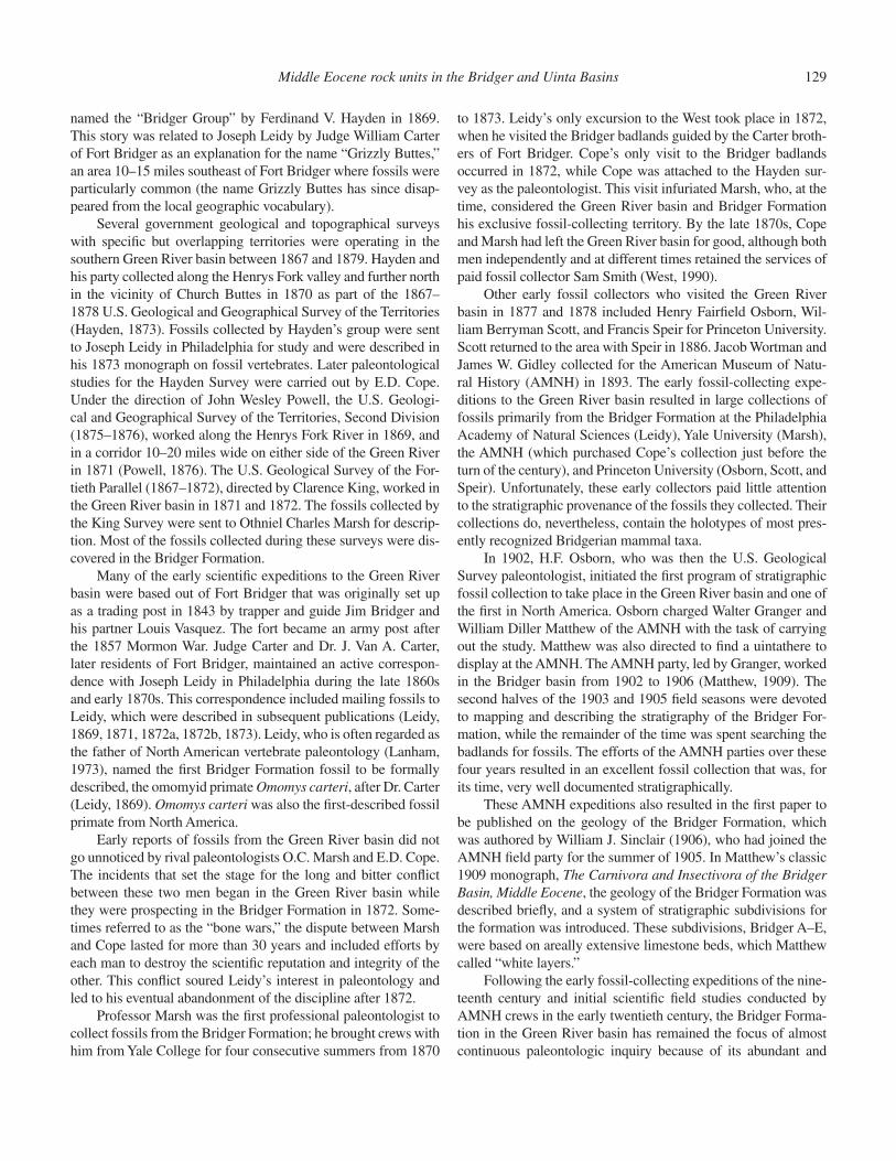
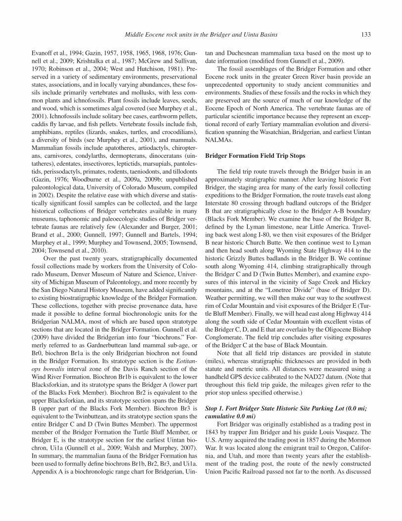
The greater Green River basin occupies 32,187 km2 of south-western Wyoming and northwestern Colorado (Roehler, 1992a). Structurally, it is a large asymmetrical syncline with mostly gen-tly dipping fl anks (3° to 5°) with steeper dips along the south-ern margin of the basin, and an approximately north-south axis (Koenig, 1960; Roehler, 1992a). The greater Green River basin is divided into four smaller basins by three intrabasin arches. The largest of these arches, the north-south–trending Rock Springs uplift, divides the basin into roughly equal halves, with the Green River basin to the west, and the Great Divide, Sand Wash, and Washakie basins to the east. The Bridger basin is located within the southern part of the Green River basin. The term Bridger basin (Hayden, 1871) traditionally refers to an area located north of the Uinta Mountains and south of the Blacks Fork of the Green River in Uinta and Sweetwater counties, Wyoming, and is a phys-iographic, not a structural basin (Fig. 1).
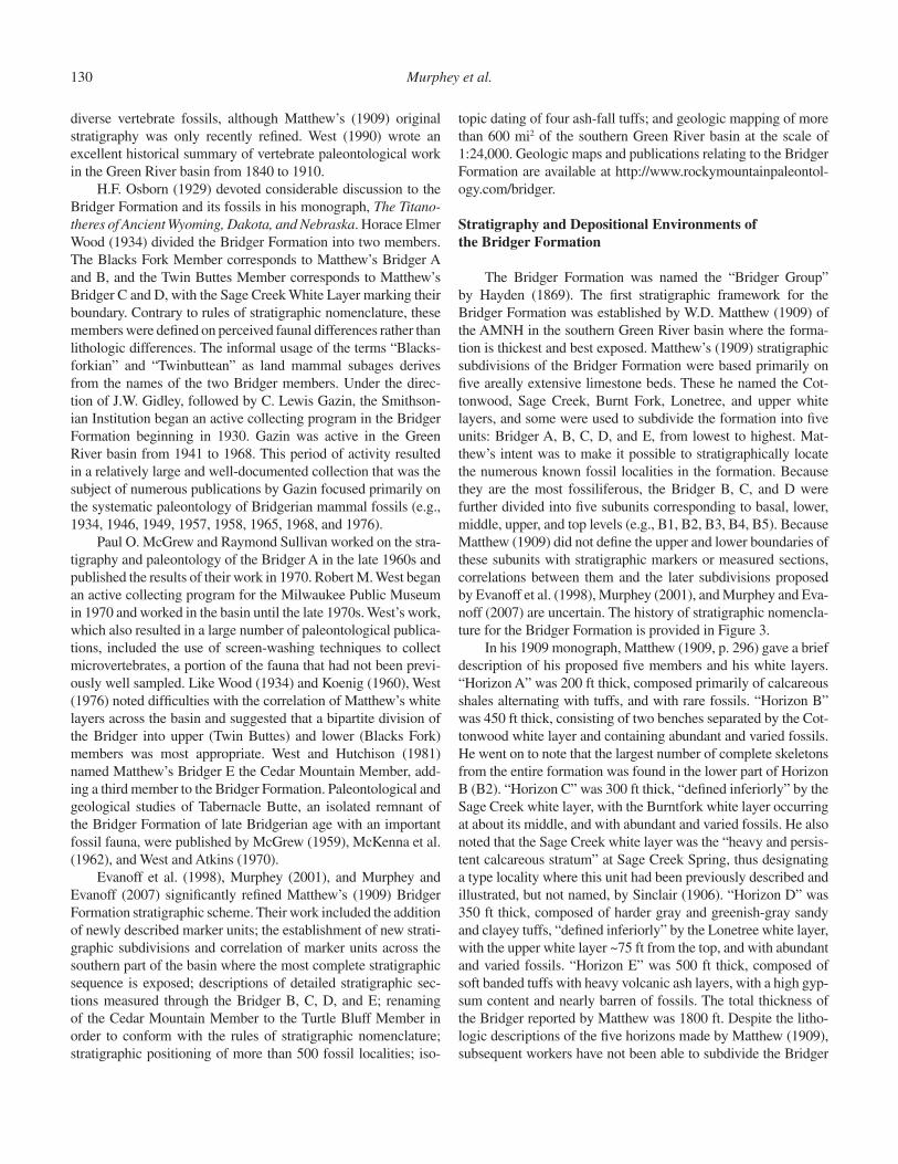
The Uinta basin occupies 10,943 km2 of northeastern Utah. Structurally, it is an asymmetrical, elongate east-west–trending synclinal basin bounded by the Uinta Mountains to the north, the Douglas Creek Arch and Roan Plateau to the east, the Book Cliffs/Tavaputs Plateau to the south, and the Wasatch Range to the west (Fig. 2). It was formed in the latest Cretaceous and Paleocene during the Laramide uplift of the Uinta Mountains.
Figure 1. Index map of the greater Green River basin showing the approximate lo-cation of the Bridger basin (type area of the Bridger Formation), major structural features, and surrounding uplifts (modi-fi ed from Murphey and Evanoff, 2007).
Middle Eocene rock units in the Bridger and Uinta Basins 127
The Uinta basin is closely related structurally and sedimento-logically to the Piceance Creek basin in northwestern Colorado. The Uinta and Piceance Creek basins are separated by the Doug-las Creek arch, a broad north-south–trending anticline that sepa-rated the two sedimentary basins until the early-middle Eocene, when the two basins coalesced across the top of the arch to form one large sedimentary basin (Moncure and Surdam, 1980; John-son, 1985, 1989). Like the Uinta basin, the Piceance Creek basin is highly asymmetrical (Johnson, 1985). Early Cenozoic strata in the Uinta basin dip gently from all directions to the northern margin of the basin, where the strata are sharply upturned and faulted along the southern fl ank of the Uinta Mountains uplift (Johnson, 1985).
The greater Green River, Uinta, and Piceance Creek basins began forming during the Laramide orogeny, a period of tec-tonism in western North America that was initiated during the late Cretaceous and continued for ~30 million years until the late Eocene. In addition to the uplifting of surrounding moun-tain ranges, Laramide tectonism resulted in rapid subsidence in basin depositional centers, and lacustrine and fl uvial deposition in these intermontane basins was mostly continuous. Lacustrine
deposition was characterized by a complex history of expansions and contractions in response to basin subsidence, climatic condi-tions, and volcanic activity (Murphey, 2001; Murphey and Eva-noff, 2007; Roehler, 1992b).
PART I. BRIDGER BASIN FIELD TRIP
With its abundant and diverse vertebrate fossils and exten-sive exposures, the Bridger Formation provides an excellent opportunity to study middle Eocene continental environments of North America. The dramatic and picturesque Bridger badlands are an 842 m (2763 ft) thick sequence dominated by green-brown and red mudstone and claystone, with interbedded scattered rib-bon and sheet sandstone, widespread beds of micritic, sparry, and silicifi ed limestone, and thin but widespread beds of ash-fall tuff (Evanoff et al., 1998; Murphey and Evanoff, 2007).
This fi eld trip offers participants the opportunity to exam-ine paleontologically signifi cant strata of the Bridger Forma-tion in the southern Green River basin. The following sections of the fi eld trip guide provide a summary of the Cenozoic geo-logic history of the Green River basin, as well as the history of
Figure 2. Index map of the Uinta Basin showing adjacent struc-tural and physiographic features. The gray region represents the areal extent of Tertiary deposits in both the Uinta basin, Utah, and Piceance Creek basin (not labeled), western Colorado. The Douglas Creek Arch separates the Uinta basin from the Piceance Creek basin.
128 Murphey et al.
investigations, stratigraphy, depositional and paleoenvironmental history, and fossils of the Bridger Formation. This is followed by a detailed road log.
Paleogene Geologic History of the Green River Basin, Wyoming
The greater Green River basin was fi lled with Paleocene and Eocene fl uvial and lacustrine sediments, and, during the Eocene, sedimentation appears to have been continuous in most of the basin. The oldest Cenozoic rock units in the greater Green River basin, the Paleocene Fort Union Formation and the early Eocene Wasatch Formation, are exposed mostly along its eastern and western fl anks. During the Paleocene and earliest Eocene, deposition in the greater Green River basin was predominantly fl uvial, with epiclastic sediments accumulating in river drain-ages and on adjacent fl oodplains. The onset of lacustrine deposi-tion associated with the Green River lake system may have com-menced as early as the late Paleocene (Grande and Buchheim, 1994). Lake sediments accumulated on broad fl oodplains of low topographic relief, and the lake waters expanded and contracted numerous times over the next approximately fi ve million years in response to climatic changes, tectonic infl uences, and epi-sodic volcanic activity.
Occupying the center of the basin in the shape of a large, irregular lens (Bradley, 1964; Roehler, 1992b, 1993), the Green River Formation is the result of at least fi ve million years of lacustrine deposition lasting from ca. 53.5 to 48.5 Ma (Smith et al., 2003), although lacustrine deposition may have persisted later in the southernmost part of the basin along the Uinta Moun-tain front (Murphey and Evanoff, 2007). The Green River For-mation was deposited in a vast ancient lake system that existed from the late Paleocene to the middle Eocene in what is now Colorado, Utah, and Wyoming. The smallest and oldest of these lakes, Fossil Lake, was deposited in Fossil basin, which is located in the Wyoming overthrust belt just to the west of the Green River basin in southwestern Wyoming. Lake Gosiute was deposited in the greater Green River basin, which includes the Green River and Washakie basins in southwestern Wyoming, and the Sand Wash basin in northwestern Colorado. Fossil Lake and Lake Gosiute may never have been physically connected (Surdam and Stanley, 1980). Lake Uinta was deposited in the Uinta basin in northeastern Utah and the Piceance Creek basin in northwest-ern Colorado. Lithologically, the Green River Formation in the greater Green River basin is a complex sequence of limestone, shale, and sandstone beds with a maximum thickness of ~838 m (2750 ft) (Roehler, 1993). It was deposited lateral to and above the predominantly fl uvial Wasatch Formation, and lateral to and below the fl uvial and lacustrine Bridger and Washakie forma-tions. The Laney Member is the uppermost member of the Green River Formation in Wyoming and represents the fi nal expansion of Lake Gosiute.
Most volcaniclastic sediments deposited in the Green River basin during the middle Eocene were apparently transported from
the Absaroka Volcanic Field in what is now northwestern Wyo-ming. These sediments were washed into the basin in rivers and streams. Some volcaniclastic sediments were transported into the basin via eolian processes and deposited as ash fall in lakes and on fl oodplains. A large infl ux of fl uvially transported volcanicla-stic sediment is believed to have led to the fi nal middle Eocene fi lling of Lake Gosiute (Mauger, 1977; Murphey, 2001; Murphey and Evanoff, 2007; Surdam and Stanley, 1979). Mauger (1977) and Surdam and Stanley (1979) estimated that Lake Gosiute was ultimately extinguished by ca. 44 Ma.
The Bridger, Green River, and Washakie formations are locally and unconformably overlain by the Oligocene Bishop Conglomerate and the middle-to-late–Miocene Browns Park Formation. Since the Eocene, the greater Green River basin has been modifi ed by erosion, regional uplift, and normal faulting, but the basic structure of the basin remains the same as it was during deposition of the Wasatch, Green River, Washakie, and Bridger formations.
History of Paleontological Investigations in the Bridger Formation
John Colter, who traveled to the headwaters of the Green River in 1807, was probably among the fi rst non–Native Ameri-cans to visit the Green River basin (Chadey, 1973). Hundreds of subsequent trappers and explorers traversed the basin during the fi rst half of the nineteenth century, and a number of records of these early explorations make reference to fossils and coal (Roehler, 1992a). The earliest scientifi c observations on the geology of the Green River basin were made by Army Lt. John C. Fremont. After entering the basin through South Pass at the southern end of the Wind River Mountain, Fremont (1845) described varicolored rocks (now known as Eocene-age Wasatch Formation) along the Big Sandy and New Fork rivers. He also collected fossil shells from near Cumberland Gap (Veatch, 1907). The earliest vertebrate fossils reported from the Green River basin were fi shes discovered in the Green River Forma-tion. In 1856, Dr. John Evans collected a specimen of a fossil fi sh from an unknown Green River Formation locality west of Green River City. He sent this specimen to paleontologist Joseph Leidy in Philadelphia for study, and Leidy named it Clupea humilis (later renamed Knightia humilis) (West, 1990). Hayden (1871) described the discovery of a locality he referred to as the “petrifi ed fi sh cut” along the main line of the Union Pacifi c Railroad ~2 miles west of Green River. Employees of the rail-road had initially discovered the locality and later turned many specimens over to Hayden. Paleontologist Edward Drinker Cope described the fi sh fossils from the petrifi ed fi sh cut in Hayden’s (1871) expedition report.
The initial discovery of mammalian fossils in the Green River basin was probably made by a long-time local resident. Trapper Jack Robinson (also called Robertson) found what he described as a “petrifi ed grizzly bear” sometime in the late 1860s in what is now called the Bridger Formation but which had initially been
Middle Eocene rock units in the Bridger and Uinta Basins 129
named the “Bridger Group” by Ferdinand V. Hayden in 1869. This story was related to Joseph Leidy by Judge William Carter of Fort Bridger as an explanation for the name “Grizzly Buttes,” an area 10–15 miles southeast of Fort Bridger where fossils were particularly common (the name Grizzly Buttes has since disap-peared from the local geographic vocabulary).
Several government geological and topographical surveys with specifi c but overlapping territories were operating in the southern Green River basin between 1867 and 1879. Hayden and his party collected along the Henrys Fork valley and further north in the vicinity of Church Buttes in 1870 as part of the 1867–1878 U.S. Geological and Geographical Survey of the Territories (Hayden, 1873). Fossils collected by Hayden’s group were sent to Joseph Leidy in Philadelphia for study and were described in his 1873 monograph on fossil vertebrates. Later paleontological studies for the Hayden Survey were carried out by E.D. Cope. Under the direction of John Wesley Powell, the U.S. Geologi-cal and Geographical Survey of the Territories, Second Division (1875–1876), worked along the Henrys Fork River in 1869, and in a corridor 10–20 miles wide on either side of the Green River in 1871 (Powell, 1876). The U.S. Geological Survey of the For-tieth Parallel (1867–1872), directed by Clarence King, worked in the Green River basin in 1871 and 1872. The fossils collected by the King Survey were sent to Othniel Charles Marsh for descrip-tion. Most of the fossils collected during these surveys were dis-covered in the Bridger Formation.
Many of the early scientifi c expeditions to the Green River basin were based out of Fort Bridger that was originally set up as a trading post in 1843 by trapper and guide Jim Bridger and his partner Louis Vasquez. The fort became an army post after the 1857 Mormon War. Judge Carter and Dr. J. Van A. Carter, later residents of Fort Bridger, maintained an active correspon-dence with Joseph Leidy in Philadelphia during the late 1860s and early 1870s. This correspondence included mailing fossils to Leidy, which were described in subsequent publications (Leidy, 1869, 1871, 1872a, 1872b, 1873). Leidy, who is often regarded as the father of North American vertebrate paleontology (Lanham, 1973), named the fi rst Bridger Formation fossil to be formally described, the omomyid primate Omomys carteri, after Dr. Carter (Leidy, 1869). Omomys carteri was also the fi rst-described fossil primate from North America.
Early reports of fossils from the Green River basin did not go unnoticed by rival paleontologists O.C. Marsh and E.D. Cope. The incidents that set the stage for the long and bitter confl ict between these two men began in the Green River basin while they were prospecting in the Bridger Formation in 1872. Some-times referred to as the “bone wars,” the dispute between Marsh and Cope lasted for more than 30 years and included efforts by each man to destroy the scientifi c reputation and integrity of the other. This confl ict soured Leidy’s interest in paleontology and led to his eventual abandonment of the discipline after 1872.
Professor Marsh was the fi rst professional paleontologist to collect fossils from the Bridger Formation; he brought crews with him from Yale College for four consecutive summers from 1870
to 1873. Leidy’s only excursion to the West took place in 1872, when he visited the Bridger badlands guided by the Carter broth-ers of Fort Bridger. Cope’s only visit to the Bridger badlands occurred in 1872, while Cope was attached to the Hayden sur-vey as the paleontologist. This visit infuriated Marsh, who, at the time, considered the Green River basin and Bridger Formation his exclusive fossil-collecting territory. By the late 1870s, Cope and Marsh had left the Green River basin for good, although both men independently and at different times retained the services of paid fossil collector Sam Smith (West, 1990).
Other early fossil collectors who visited the Green River basin in 1877 and 1878 included Henry Fairfi eld Osborn, Wil-liam Berryman Scott, and Francis Speir for Princeton University. Scott returned to the area with Speir in 1886. Jacob Wortman and James W. Gidley collected for the American Museum of Natu-ral History (AMNH) in 1893. The early fossil-collecting expe-ditions to the Green River basin resulted in large collections of fossils primarily from the Bridger Formation at the Philadelphia Academy of Natural Sciences (Leidy), Yale University (Marsh), the AMNH (which purchased Cope’s collection just before the turn of the century), and Princeton University (Osborn, Scott, and Speir). Unfortunately, these early collectors paid little attention to the stratigraphic provenance of the fossils they collected. Their collections do, nevertheless, contain the holotypes of most pres-ently recognized Bridgerian mammal taxa.
In 1902, H.F. Osborn, who was then the U.S. Geological Survey paleontologist, initiated the fi rst program of stratigraphic fossil collection to take place in the Green River basin and one of the fi rst in North America. Osborn charged Walter Granger and William Diller Matthew of the AMNH with the task of carrying out the study. Matthew was also directed to fi nd a uintathere to display at the AMNH. The AMNH party, led by Granger, worked in the Bridger basin from 1902 to 1906 (Matthew, 1909). The second halves of the 1903 and 1905 fi eld seasons were devoted to mapping and describing the stratigraphy of the Bridger For-mation, while the remainder of the time was spent searching the badlands for fossils. The efforts of the AMNH parties over these four years resulted in an excellent fossil collection that was, for its time, very well documented stratigraphically.
These AMNH expeditions also resulted in the fi rst paper to be published on the geology of the Bridger Formation, which was authored by William J. Sinclair (1906), who had joined the AMNH fi eld party for the summer of 1905. In Matthew’s classic 1909 monograph, The Carnivora and Insectivora of the Bridger Basin, Middle Eocene, the geology of the Bridger Formation was described briefl y, and a system of stratigraphic subdivisions for the formation was introduced. These subdivisions, Bridger A–E, were based on areally extensive limestone beds, which Matthew called “white layers.”
Following the early fossil-collecting expeditions of the nine-teenth century and initial scientifi c fi eld studies conducted by AMNH crews in the early twentieth century, the Bridger Forma-tion in the Green River basin has remained the focus of almost continuous paleontologic inquiry because of its abundant and
130 Murphey et al.
diverse vertebrate fossils, although Matthew’s (1909) original stratigraphy was only recently refi ned. West (1990) wrote an excellent historical summary of vertebrate paleontological work in the Green River basin from 1840 to 1910.
H.F. Osborn (1929) devoted considerable discussion to the Bridger Formation and its fossils in his monograph, The Titano-theres of Ancient Wyoming, Dakota, and Nebraska. Horace Elmer Wood (1934) divided the Bridger Formation into two members. The Blacks Fork Member corresponds to Matthew’s Bridger A and B, and the Twin Buttes Member corresponds to Matthew’s Bridger C and D, with the Sage Creek White Layer marking their boundary. Contrary to rules of stratigraphic nomenclature, these members were defi ned on perceived faunal differences rather than lithologic differences. The informal usage of the terms “Blacks-forkian” and “Twinbuttean” as land mammal subages derives from the names of the two Bridger members. Under the direc-tion of J.W. Gidley, followed by C. Lewis Gazin, the Smithson-ian Institution began an active collecting program in the Bridger Formation beginning in 1930. Gazin was active in the Green River basin from 1941 to 1968. This period of activity resulted in a relatively large and well-documented collection that was the subject of numerous publications by Gazin focused primarily on the systematic paleontology of Bridgerian mammal fossils (e.g., 1934, 1946, 1949, 1957, 1958, 1965, 1968, and 1976).
Paul O. McGrew and Raymond Sullivan worked on the stra-tigraphy and paleontology of the Bridger A in the late 1960s and published the results of their work in 1970. Robert M. West began an active collecting program for the Milwaukee Public Museum in 1970 and worked in the basin until the late 1970s. West’s work, which also resulted in a large number of paleontological publica-tions, included the use of screen-washing techniques to collect microvertebrates, a portion of the fauna that had not been previ-ously well sampled. Like Wood (1934) and Koenig (1960), West (1976) noted diffi culties with the correlation of Matthew’s white layers across the basin and suggested that a bipartite division of the Bridger into upper (Twin Buttes) and lower (Blacks Fork) members was most appropriate. West and Hutchison (1981) named Matthew’s Bridger E the Cedar Mountain Member, add-ing a third member to the Bridger Formation. Paleontological and geological studies of Tabernacle Butte, an isolated remnant of the Bridger Formation of late Bridgerian age with an important fossil fauna, were published by McGrew (1959), McKenna et al. (1962), and West and Atkins (1970).
Evanoff et al. (1998), Murphey (2001), and Murphey and Evanoff (2007) signifi cantly refi ned Matthew’s (1909) Bridger Formation stratigraphic scheme. Their work included the addition of newly described marker units; the establishment of new strati-graphic subdivisions and correlation of marker units across the southern part of the basin where the most complete stratigraphic sequence is exposed; descriptions of detailed stratigraphic sec-tions measured through the Bridger B, C, D, and E; renaming of the Cedar Mountain Member to the Turtle Bluff Member in order to conform with the rules of stratigraphic nomenclature; stratigraphic positioning of more than 500 fossil localities; iso-
topic dating of four ash-fall tuffs; and geologic mapping of more than 600 mi2 of the southern Green River basin at the scale of 1:24,000. Geologic maps and publications relating to the Bridger Formation are available at http://www.rockymountainpaleontol-ogy.com/bridger.
Stratigraphy and Depositional Environments of the Bridger Formation
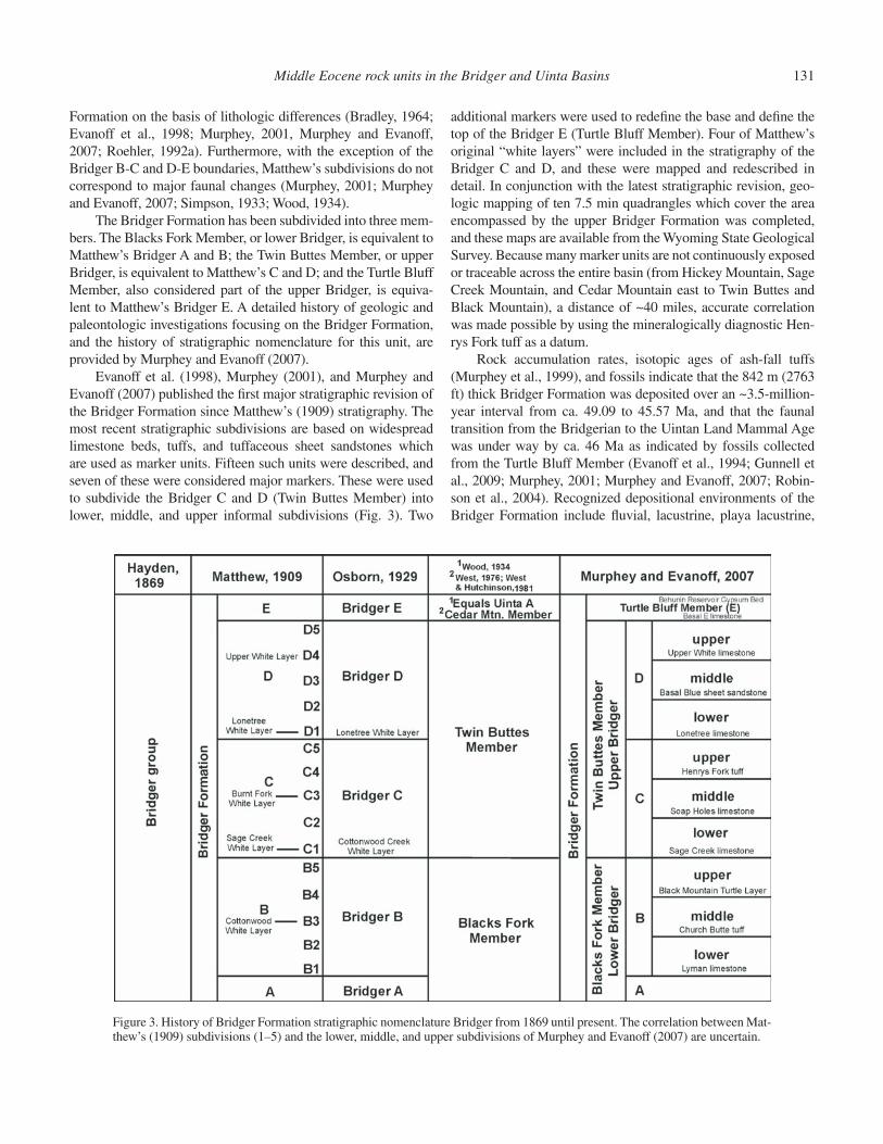
The Bridger Formation was named the “Bridger Group” by Hayden (1869). The fi rst stratigraphic framework for the Bridger Formation was established by W.D. Matthew (1909) of the AMNH in the southern Green River basin where the forma-tion is thickest and best exposed. Matthew’s (1909) stratigraphic subdivisions of the Bridger Formation were based primarily on fi ve areally extensive limestone beds. These he named the Cot-tonwood, Sage Creek, Burnt Fork, Lonetree, and upper white layers, and some were used to subdivide the formation into fi ve units: Bridger A, B, C, D, and E, from lowest to highest. Mat-thew’s intent was to make it possible to stratigraphically locate the numerous known fossil localities in the formation. Because they are the most fossiliferous, the Bridger B, C, and D were further divided into fi ve subunits corresponding to basal, lower, middle, upper, and top levels (e.g., B1, B2, B3, B4, B5). Because Matthew (1909) did not defi ne the upper and lower boundaries of these subunits with stratigraphic markers or measured sections, correlations between them and the later subdivisions proposed by Evanoff et al. (1998), Murphey (2001), and Murphey and Eva-noff (2007) are uncertain. The history of stratigraphic nomencla-ture for the Bridger Formation is provided in Figure 3.
In his 1909 monograph, Matthew (1909, p. 296) gave a brief description of his proposed fi ve members and his white layers. “Horizon A” was 200 ft thick, composed primarily of calcareous shales alternating with tuffs, and with rare fossils. “Horizon B” was 450 ft thick, consisting of two benches separated by the Cot-tonwood white layer and containing abundant and varied fossils. He went on to note that the largest number of complete skeletons from the entire formation was found in the lower part of Horizon B (B2). “Horizon C” was 300 ft thick, “defi ned inferiorly” by the Sage Creek white layer, with the Burntfork white layer occurring at about its middle, and with abundant and varied fossils. He also noted that the Sage Creek white layer was the “heavy and persis-tent calcareous stratum” at Sage Creek Spring, thus designating a type locality where this unit had been previously described and illustrated, but not named, by Sinclair (1906). “Horizon D” was 350 ft thick, composed of harder gray and greenish-gray sandy and clayey tuffs, “defi ned inferiorly” by the Lonetree white layer, with the upper white layer ~75 ft from the top, and with abundant and varied fossils. “Horizon E” was 500 ft thick, composed of soft banded tuffs with heavy volcanic ash layers, with a high gyp-sum content and nearly barren of fossils. The total thickness of the Bridger reported by Matthew was 1800 ft. Despite the litho-logic descriptions of the fi ve horizons made by Matthew (1909), subsequent workers have not been able to subdivide the Bridger
Middle Eocene rock units in the Bridger and Uinta Basins 131
Formation on the basis of lithologic differences (Bradley, 1964; Evanoff et al., 1998; Murphey, 2001, Murphey and Evanoff, 2007; Roehler, 1992a). Furthermore, with the exception of the Bridger B-C and D-E boundaries, Matthew’s subdivisions do not correspond to major faunal changes (Murphey, 2001; Murphey and Evanoff, 2007; Simpson, 1933; Wood, 1934).
The Bridger Formation has been subdivided into three mem-bers. The Blacks Fork Member, or lower Bridger, is equivalent to Matthew’s Bridger A and B; the Twin Buttes Member, or upper Bridger, is equivalent to Matthew’s C and D; and the Turtle Bluff Member, also considered part of the upper Bridger, is equiva-lent to Matthew’s Bridger E. A detailed history of geologic and paleontologic investigations focusing on the Bridger Formation, and the history of stratigraphic nomenclature for this unit, are provided by Murphey and Evanoff (2007).
Evanoff et al. (1998), Murphey (2001), and Murphey and Evanoff (2007) published the fi rst major stratigraphic revision of the Bridger Formation since Matthew’s (1909) stratigraphy. The most recent stratigraphic subdivisions are based on widespread limestone beds, tuffs, and tuffaceous sheet sandstones which are used as marker units. Fifteen such units were described, and seven of these were considered major markers. These were used to subdivide the Bridger C and D (Twin Buttes Member) into lower, middle, and upper informal subdivisions (Fig. 3). Two
additional markers were used to redefi ne the base and defi ne the top of the Bridger E (Turtle Bluff Member). Four of Matthew’s original “white layers” were included in the stratigraphy of the Bridger C and D, and these were mapped and redescribed in detail. In conjunction with the latest stratigraphic revision, geo-logic mapping of ten 7.5 min quadrangles which cover the area encompassed by the upper Bridger Formation was completed, and these maps are available from the Wyoming State Geological Survey. Because many marker units are not continuously exposed or traceable across the entire basin (from Hickey Mountain, Sage Creek Mountain, and Cedar Mountain east to Twin Buttes and Black Mountain), a distance of ~40 miles, accurate correlation was made possible by using the mineralogically diagnostic Hen-rys Fork tuff as a datum.
Rock accumulation rates, isotopic ages of ash-fall tuffs (Murphey et al., 1999), and fossils indicate that the 842 m (2763 ft) thick Bridger Formation was deposited over an ~3.5-million-year interval from ca. 49.09 to 45.57 Ma, and that the faunal transition from the Bridgerian to the Uintan Land Mammal Age was under way by ca. 46 Ma as indicated by fossils collected from the Turtle Bluff Member (Evanoff et al., 1994; Gunnell et al., 2009; Murphey, 2001; Murphey and Evanoff, 2007; Robin-son et al., 2004). Recognized depositional environments of the Bridger Formation include fl uvial, lacustrine, playa lacustrine,
Figure 3. History of Bridger Formation stratigraphic nomenclature Bridger from 1869 until present. The correlation between Mat-thew’s (1909) subdivisions (1–5) and the lower, middle, and upper subdivisions of Murphey and Evanoff (2007) are uncertain.
132 Murphey et al.
paludal, marginal mudfl at, basin margin, and volcanic. Murphey and Evanoff (2007) concluded that an infl ux of fl uvially trans-ported volcaniclastic sediment to the Green River basin during middle Eocene time led to the fi lling of Lake Gosiute and the development of muddy fl oodplains of low topographic relief, which persisted for up to 85% of the time during which the upper Bridger was deposited. Occasional lapses in the fl ow of sedi-ment to the basin permitted the development of shallow, mostly groundwater-fed lakes and ponds, which accumulated up to four times as slowly as fl oodplain deposits. These lapses decreased in frequency throughout deposition of the upper Bridger Forma-tion. As indicated by fossil distribution and diversity, lakes and their margins provided favorable habitats for both aquatic and terrestrial organisms during deposition of the Bridger Formation.
Middle Eocene Paleoenvironments of the Green River Basin
Numerous studies based on paleontological and geologi-cal evidence have concluded that the Eocene-age rock units in the greater Green River basin were deposited in warm temper-ate, subtropical, and tropical climatic conditions (Roehler, 1993). Perhaps the most reliable information concerning paleoclimates comes from analysis of plant mega- and micro-fossils. According to Leopold and MacGinitie (1972), early Eocene fl oras (based on palynology of samples collected from the Niland Tongue of the Wasatch Formation and the Luman and Tipton tongues of the Green River Formation) suggest a humid subtropical to warm temperate climate with summer rainfall and only mild frost and with a mean annual temperature of 55 °F. Nichols (1987) con-cluded that the climate of the basin fl oor during deposition of the Niland Tongue was subtropical, without freezing temperatures.
The earliest middle Eocene climates pertaining to the Cathe-dral Bluffs Tongue of the Wasatch Formation and the Wilkins Peak Member of the Green River Formation were interpreted as generally hot and dry (Leopold and MacGinitie, 1972). Climatic conditions in the early-middle Eocene during deposition of the lower part of the Laney Member of the Green River Formation were characterized as warm and humid with tropical affi nities. Floras of the upper part of the Laney Member indicate a change to cooler, subhumid conditions (Leopold and MacGinitie, 1972). Both pollen and leaf data from the Washakie Formation indicate a dry but temperate climate (Leopold and MacGinitie, 1972). Roehler (1993) reported in a written communication that Mac-Ginitie reinterpreted temperature and precipitation ranges on the basis of palynology of samples collected from the Washakie basin by Roehler (1992a). His reinterpretation estimated mean annual temperatures of 65 °F during the early Eocene, 63 °F during the earliest middle Eocene, and 62 °F during the middle Eocene. Average annual precipitation was estimated at more than 40 inches during the early Eocene, 25–35 inches during the earliest middle Eocene, and 15–20 inches in the middle Eocene. Sedimentological evidence of a more arid climate during the middle Eocene (transitional Uintan NALMA) includes massive beds of gypsum capping the Turtle Bluff Member of the Bridger
Formation (Murphey, 2001; Murphey and Evanoff, 2007). The shift from dominantly tropical forest environments to more-open, savanna-like conditions in the Eocene intermontane basins dur-ing late Bridgerian (early-middle Eocene) and Uintan (middle Eocene) times has also been studied by using ecological diversity analysis applied to mammalian faunas (Murphey and Townsend, 2005; Townsend, 2004).
As indicated by fossil distribution and diversity, the Green River lakes and their forested margins provided highly favorable habitats and preservational environments for both aquatic and terrestrial organisms. Lake margin habitats, riparian corridors and adjacent fl oodplains were apparently vegetated during much of the time of Green River Formation deposition, as indicated by a paleofl ora that includes a variety of trees and bushes such as palm, cinnamon, oak, maple, lilac, and hazel, as well as cattails and rushes. Insects of many varieties lived in the lakes and forests and are locally well preserved in lake sediments. A variety of ter-restrial and aquatic mollusks (clams and snails) are also known to have inhabited the Green River lakes (Hanley, 1974). Crayfi sh, prawn, and ostracods inhabited the warm lake waters, as did a diversity of fi sh species, including relatives of the herring, perch, paddlefi sh, bowfi n, gar, catfi sh, and stingray (Grande, 1984; Grande and Buchheim, 1994; McGrew and Casilliano, 1975). Frogs, crocodiles, and turtles were common residents of shal-lower proximal shoreline waters. A diversity of reptile species, including tortoise, lizards, and snakes, inhabited the forests sur-rounding Eocene lakes and ponds. Flamingos, hawks, rails, stone curlews, and other bird species frequented the forests, wetlands, and lakes (Murphey et al., 2001). The forests teemed with the primitive ancestors of many modern mammalian groups, includ-ing rodents, insectivores, bats, primates, perissodactyls (horse, rhinoceros, and tapir), and carnivores, as well as more bizarre archaic forms such as creodonts, brontotheres, and massive six-horned uintatheres (Gazin, 1976; Grande and Buchheim, 1994; Gunnell and Bartels, 1994; McGrew and Casilliano, 1975; Mur-phey et al., 2001).
Fossils and Biochronology of the Bridger Formation
One of the world’s most abundant and diverse middle Eocene vertebrate faunas is preserved in the Bridger Forma-tion. More than 86 species representing 67 genera, 30 families, and 13 orders of fossil mammals are recognized (Gazin, 1976). Joseph Leidy’s 1869 description of Omomys carteri was the fi rst scientifi c description of a fossil from the Bridger Formation. Subsequently, Bridger fossils have been the subject of numer-ous publications, including many classic papers by pioneers of American vertebrate paleontology (Cope 1872, 1873; Granger, 1908; Leidy, 1869, 1871, 1872a; Marsh, 1871, 1886; Matthew, 1909; Osborn, 1929). Like many other highly fossiliferous for-mations, the Bridger contains an abundance and diversity of fos-sils that make it well suited for paleontological research, most of which has focused on the phylogenetics, systematic paleontology, and biostratigraphy of the vertebrate fauna (Covert et al., 1998;
Middle Eocene rock units in the Bridger and Uinta Basins 133
Evanoff et al., 1994; Gazin, 1957, 1958, 1965, 1968, 1976; Gun-nell et al., 2009; Krishtalka et al., 1987; McGrew and Sullivan, 1970; Robinson et al., 2004; West and Hutchison, 1981). Pre-served in a variety of sedimentary environments, preservational states, associations, and in locally varying abundances, these fos-sils include primarily vertebrates and mollusks, with less com-mon plants and ichnofossils. Plant fossils include leaves, seeds, and wood, which is sometimes algal covered (see Murphey et al., 2001). Ichnofossils include solitary bee cases, earthworm pellets, caddis fl y larvae, and fi sh pellets. Vertebrate fossils include fi sh, amphibians, reptiles (lizards, snakes, turtles, and crocodilians), a diversity of birds (see Murphey et al., 2001), and mammals. Mammalian fossils include apatotheres, artiodactyls, chiropter-ans, carnivores, condylarths, dermopterans, dinoceratans (uin-tatheres), edentates, insectivores, leptictids, marsupials, pantoles-tids, perissodactyls, primates, rodents, taeniodonts, and tillodonts (Gazin, 1976; Woodburne et al., 2009a, 2009b; unpublished paleontological data, University of Colorado Museum, compiled in 2002). Despite the relative ease with which diverse and statis-tically signifi cant fossil samples can be collected, and the large historical collections of Bridger vertebrates available in many museums, taphonomic and paleoecologic studies of Bridger ver-tebrate faunas are relatively few (Alexander and Burger, 2001; Brand et al., 2000; Gunnell, 1997; Gunnell and Bartels, 1994; Murphey et al., 1999; Murphey and Townsend, 2005; Townsend, 2004; Townsend et al., 2010).
Over the past twenty years, stratigraphically documented fossil collections made by workers from the University of Colo-rado Museum, Denver Museum of Nature and Science, Univer-sity of Michigan Museum of Paleontology, and more recently by the San Diego Natural History Museum, have added signifi cantly to existing biostratigraphic knowledge of the Bridger Formation. These collections, together with precise provenance data, have made it possible to defi ne formal biochronologic units for the Bridgerian NALMA, most of which are based upon stratotype sections that are located in the Bridger Formation. Gunnell et al. (2009) have divided the Bridgerian into four “biochrons.” For-merly referred to as Gardnerbuttean land mammal sub-age, or Br0, biochron Br1a is the only Bridgerian biochron not found in the Bridger Formation. Its stratotype section is the Eotitan-ops borealis interval zone of the Davis Ranch section of the Wind River Formation. Biochron Br1b is equivalent to the lower Blacksforkian, and its stratotype spans the Bridger A (lower part of the Blacks Fork Member). Biochron Br2 is equivalent to the upper Blacksforkian, and its stratotype section spans the Bridger B (upper part of the Blacks Fork Member). Biochron Br3 is equivalent to the Twinbuttean, and its stratotype section spans the entire Bridger C and D (Twin Buttes Member). The uppermost member of the Bridger Formation the Turtle Bluff Member, or Bridger E, is the stratotype section for the earliest Uintan bio-chron, Ui1a (Gunnell et al., 2009; Walsh and Murphey, 2007). In summary, the mammalian fauna of the Bridger Formation has been used to formally defi ne biochrons Br1b, Br2, Br3, and Ui1a. Appendix A is a biochronologic range chart for Bridgerian, Uin-
tan and Duchesnean mammalian taxa based on the most up to date information (modifi ed from Gunnell et al., 2009).
The fossil assemblages of the Bridger Formation and other Eocene rock units in the greater Green River basin provide an unprecedented opportunity to study ancient communities and environments. Studies of these fossils and the rocks in which they are preserved are the source of much of our knowledge of the Eocene Epoch of North America. The vertebrate faunas are of particular scientifi c importance because they represent an excep-tional record of early Tertiary mammalian evolution and diversi-fi cation spanning the Wasatchian, Bridgerian, and earliest Uintan NALMAs.
Bridger Formation Field Trip Stops
The fi eld trip route travels through the Bridger basin in an approximately stratigraphic manner. After leaving historic Fort Bridger, the staging area for many of the early fossil collecting expeditions to the Bridger Formation, the route travels east along Interstate 80 crossing through badland outcrops of the Bridger B that are stratigraphically close to the Bridger A-B boundary (Blacks Fork Member). We examine the base of the Bridger B, defi ned by the Lyman limestone, near Little America. Travel-ing back west along I-80, we then visit exposures of the Bridger B near historic Church Butte. We then continue west to Lyman and then head south along Wyoming State Highway 414 to the historic Grizzly Buttes badlands in the Bridger B. We continue south along Wyoming 414, climbing stratigraphically through the Bridger C and D (Twin Buttes Member), and examine expo-sures of this interval in the vicinity of Sage Creek and Hickey mountains, and at the “Lonetree Divide” (base of Bridger D). Weather permitting, we will then make our way to the southwest rim of Cedar Mountain and visit exposures of the Bridger E (Tur-tle Bluff Member). Finally, we will head east along Highway 414 along the south side of Cedar Mountain with excellent vistas of the Bridger C, D, and E that are overlain by the Oligocene Bishop Conglomerate. The fi eld trip concludes after visiting exposures of the Bridger C at the base of Black Mountain.
Note that all fi eld trip distances are provided in statute (miles), whereas stratigraphic thicknesses are provided in both statute and metric units. All distances were measured using a handheld GPS device calibrated to the NAD27 datum. (Note that throughout this fi eld trip guide, the mileages given refer to the prior stop unless specifi ed otherwise.)
Stop 1. Fort Bridger State Historic Site Parking Lot (0.0 mi; cumulative 0.0 mi)
Fort Bridger was originally established as a trading post in 1843 by trapper Jim Bridger and his guide Louis Vasquez. The U.S. Army acquired the trading post in 1857 during the Mormon War. It was located along the emigrant trail to Oregon, Califor-nia, and Utah, and more than twenty years after the establish-ment of the trading post, the route of the newly constructed Union Pacifi c Railroad passed not far to the north. As discussed
134 Murphey et al.
in greater detail above, many of the early scientifi c expeditions to the Bridger Formation were based out of Fort Bridger. Yale University paleontologist O.C. Marsh and his fi eld classes stayed at Fort Bridger before heading out to the Bridger badlands in 1870, 1871, and 1873. Rival paleontologist E.D. Cope stayed at the fort in 1872 during his only fossil collecting expedition to the Bridger. Joseph Leidy, often regarded as the father of North American Vertebrate Paleontology and the fi rst paleontologist to formally describe a Bridger Formation fossil, made his only fossil collecting trip to the west in 1872, and also stayed at Fort Bridger. Today, Fort Bridger is a state historical site and has been partially reconstructed.
The low butte just to the west of Fort Bridger is Bridger Butte, which is capped with Quaternary gravels and is composed of Bridger B strata.
Turn west out of the fort parking lot along the Interstate 80 business loop and then turn east onto I-80 (toward Green River). Drive for ~32 mi and take the Granger Junction exit (Exit 66) heading north along U.S. Highway 30. Follow U.S. 30 for 1.8 mi after exiting the interstate. Then turn east and cross the cattle guard onto a dirt road for 0.2 mi at which point you will arrive at the route of old Highway 30 (unmarked gravel road that is still paved in places). Park immediately after turning right (southeast) onto old Highway 30. Outcrops of the Lyman lime-stone are located just to the east.
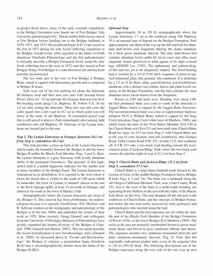
Stop 2. The Lyman Limestone at Granger Junction (36.3 mi from Stop 1; cumulative 36.3 mi)
This stop provides a close-up look at the Lyman limestone, which marks the boundary between the Bridger A and the lower Bridger B within the Blacks Fork Member (Figs. 3 and 4). Here, the Lyman limestone is a gray limestone with locally abundant shells of the gastropod Goniobasis. The presence of this high-spired snail is a useful diagnostic indicator for this marker unit at many localities in the Bridger basin. The Lyman limestone is widespread in its distribution. It is exposed to the west where it forms the bench that is visible to the south of I-80 upon which its namesake, the town of Lyman, is situated, almost as far east as the Rock Springs uplift, at least 15 mi north of Granger, and almost as far south as the town of Manila, Utah.
Stratigraphically below the Lyman limestone are strata of the Bridger A. This interval has been problematic for paleon-tologists because it is sparsely fossiliferous. P.O. McGrew and R. Sullivan worked on the stratigraphy and paleontology of the Bridger A in the late 1960s and published the results of their work in 1970. More recently, Gregg Gunnell and colleagues from the University of Michigan Museum of Paleontology have greatly expanded the known diversity of the Bridger A (Gun-nell, 1998; Gunnell and Bartels, 2001). This has made possible the recent formalization of new biochronologic units (Gunnell et al., 2009). As discussed above in “Fossils and Biochronon-logy,” the Bridger A contains a mammalian fauna (biochron Br1b) that is biostratigraphically distinct from the fauna of the Bridger B (Br2).
Optional StopApproximately 18 m (59 ft) stratigraphically above the
Lyman limestone 1.7 mi to the southeast along Old Highway 30 is an unusual type of deposit for the Bridger Formation. Park approximately one-third of the way up the hill and look for abun-dant dark-brown rock fragments littering the slopes underlain by a thick green mudstone interval. The thin, dark-brown bed contains abundant fossil caddis-fl y larval cases and other more enigmatic fossils preserved in what appear to be algal covered logs (SDSNH Loc. 5783). The taphonomy and paleoecology of this unit has yet to be adequately studied. The fossil-bearing bed is overlain by a 2.8 m (9 ft) thick sequence of green to tan, well-indurated, platy, fi ne-grained, silty sandstone. It is underlain by a 1.5 m (5 ft) thick, platy, grayish-brown, non-fossiliferous, mudstone with a distinct top contact. Insect and plant fossils are sparse in the Bridger Formation, and this bed contains the most abundant insect fossils known from the formation.
Return to I-80 and head west. Heading west along I-80, the fi rst prominent butte you come to south of the interstate is Jagged Butte, which is capped by the Jagged Butte limestone. The second prominent butte you come to (approximate highway milepost 56.5) is Wildcat Butte, which is capped by the Sage Creek limestone (Sage Creek white layer of Matthew, 1909), and which forms the base of the Twin Buttes Member. Exit I-80 at the Church Butte exit (Exit 53) and turn north onto Church Butte Road (no sign). At 19.2 mi from Stop 2, with Church Butte just to the east of your location, turn left (southwest) onto Granger Road, Uinta County Road (CR) 233. At mile 21.0, turn southeast off of CR 233 onto a two-track road heading toward the west-ernmost point of Jackson Ridge. Park where the two-track road crosses the pipeline right-of-way at 21.2 mi from Stop 2.
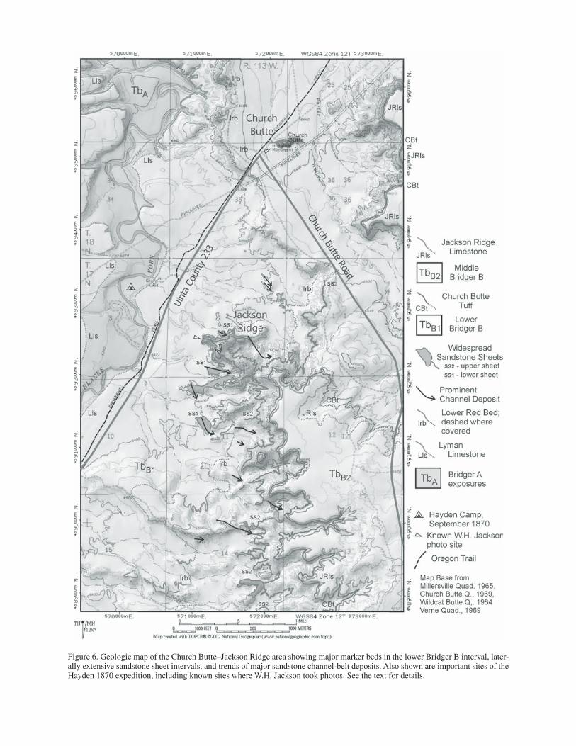
Stop 3. Church Butte and Jackson Ridge (21.2 mi from Stop 2; cumulative 57.5 mi)
Church Butte is a large-linear badland knob formed by the erosion of rocks of the middle Bridger Formation (lower Bridger B beds; Figs. 4, 5 and 7A). The butte was a landmark along the old Oregon-California-Mormon Trail, now Uinta County Road 233. Just to the west of the butte is a north-south–trending rim separating Porter Hollow on the east with the valley of the Blacks Fork River on the west. The trail dropped off the rim just to the southwest of Church Butte, and the outcrops of Bridger Forma-tion below the rim were easily accessed by early geologists and paleontologists who traveled along the trail.
Church Butte and the rim exposures are all within the mid-dle part of the Blacks Fork Member of the Bridger Formation of Wood (1934), or the lower Bridger B of Matthew (1909). The rocks in the area are primarily interbedded brown to green mud-stone sheets and brown to gray sandstone ribbons and sheets. The sequence includes two sandstone-dominated intervals and three mudstone-dominated intervals (Fig. 6). Four thin but regionally widespread marker units occur in the sequence that is 120 m (394 ft) thick. The following descriptions are of the Bridger exposures along the west side of the rim, over an area

Middle Eocene rock units in the Bridger and Uinta Basins 135
approximately three square miles south of where the county road crosses the rim.
The two sandstone-dominated intervals are characterized by a series of thick ribbons to broadly lenticular sheet sandstone bodies within a sequence of stacked, thin, muddy sandstone and mudstone sheets. Sandstones can comprise 100% of the total thickness within the sandstone-dominated interval, but the lower interval averages 58% sandstone and the upper interval averages
84% sandstone within a minor amount of mudstone. The thick sandbodies within these sandstone-dominated sequences are highly connected both laterally and vertically. The thick sand-bodies have a reticulate pattern, with some sandbodies oriented toward the south-southeast (vector mean of 173°) and others ori-ented toward the east-southeast (vector mean 118°). The sinu-osities of the individual sandbodies are low (mean 1.02). These sandstone-dominated intervals represent a river system with
Figure 4. Generalized stratigraphic sec-tion of the Bridger Formation in the southern Green River basin, southwest-ern Wyoming. Isotopic ages reported by Murphey et al. (1999) have been re-calculated using the current 28.201 Ma sanidine standard for the Fish Canyon Tuff (Renne et al., 1998).
136 Murphey et al.
Figure 5. Index map of the western Bridger basin, Uinta and Sweetwater counties, Wyoming.
Middle Eocene rock units in the Bridger and Uinta Basins 137
Figure 6. Geologic map of the Church Butte–Jackson Ridge area showing major marker beds in the lower Bridger B interval, later-ally extensive sandstone sheet intervals, and trends of major sandstone channel-belt deposits. Also shown are important sites of the Hayden 1870 expedition, including known sites where W.H. Jackson took photos. See the text for details.
138 Murphey et al.
numerous splays and local avulsions. The two intervals outcrop as cliffs in the badland exposures.
The mudstone-dominated intervals are characterized by thick ribbon sandstone bodies that are typically separated from adjacent sandstones by extensive mudstone beds. Mudstone-dominated intervals have sandstone contents that range from 10% to 35% of total interval thickness. The sandstone ribbons represent large channels carrying mostly medium sand within a mud-dominated system. The paleocurrent indicators in these ribbons (mostly medium- to thick-trough crossbed sets) and sandbody orientations indicate an original fl ow toward the east-southeast (vector mean of 120°). The sinuosities of the sand-stone bodies are low (mean 1.03) and their geometry is in a “broken stick” pattern with long straight reaches and short sharp bends. Sandbody widths and thicknesses are relatively small in straight reaches, but at bends the sandbodies are thicker and wider and contain well-developed lateral accretion sets. Fossil bones typically accumulate near the bases of these bends. Thin sandstone sheets representing overbank splay deposits are rare and are limited to near their source channels. The mudstone-dominated intervals outcrop as benches and slopes in the bad-land exposures.
The Eocene streams which deposited the lower Bridger B channel sandstones in this area were perennial and fl ooded every year. This is indicated by the abundance of freshwater turtles, gar-pike scales (and other fi sh bones), and a large freshwater snail fauna in the overbank deposits. The channel-belt deposits also contain the shells of numerous freshwater mussels (unio-nid clams), which indicate perennial, well-oxygenated waters in streams and rivers. Fossil plants of this time (MacGinitie and Leopold, 1972) indicate subtropical temperatures and mesic moisture with seasonal precipitation.
There are four regionally widespread marker beds in the Bridger exposures in this area. Two widespread thin limestone sheets occur at the base and top of the section in the Church Butte area. The lower limestone is the Lyman limestone at the base of the Bridger B (along the Blacks Fork), and in this area it is a brown to gray ostracodal limestone with scattered catfi sh bones. The upper limestone occurs on the fl at-surface on top of the rim, just south of the county road. This upper limestone is a brown micrite with brown to black banded chert masses and scattered large planorbid snail shells (Biomphalaria sp.). Both limestone beds can be mapped over much of the Bridger basin in lower Bridger B exposures. The predominantly fl uvial sequence pre-served in the Church Butte area was bracketed by these wide-spread lacustrine deposits.
Two lithifi ed volcanic ashes (tuffs) occur in the section. The lower tuff is represented by a red clayey mudstone that ranges from 0.2 to 0.6 m (0.6 to 2 ft) thick, 33 m (108 ft) above the Lyman limestone. The bed does not contain euhedral crystals in this area, but in other parts of the Bridger basin this bed thickens and is white with euhedral biotite crystals. This bed has not been radiometrically dated. This red tuff has been mapped over much of the western Bridger basin. A second tuff bed occurs between
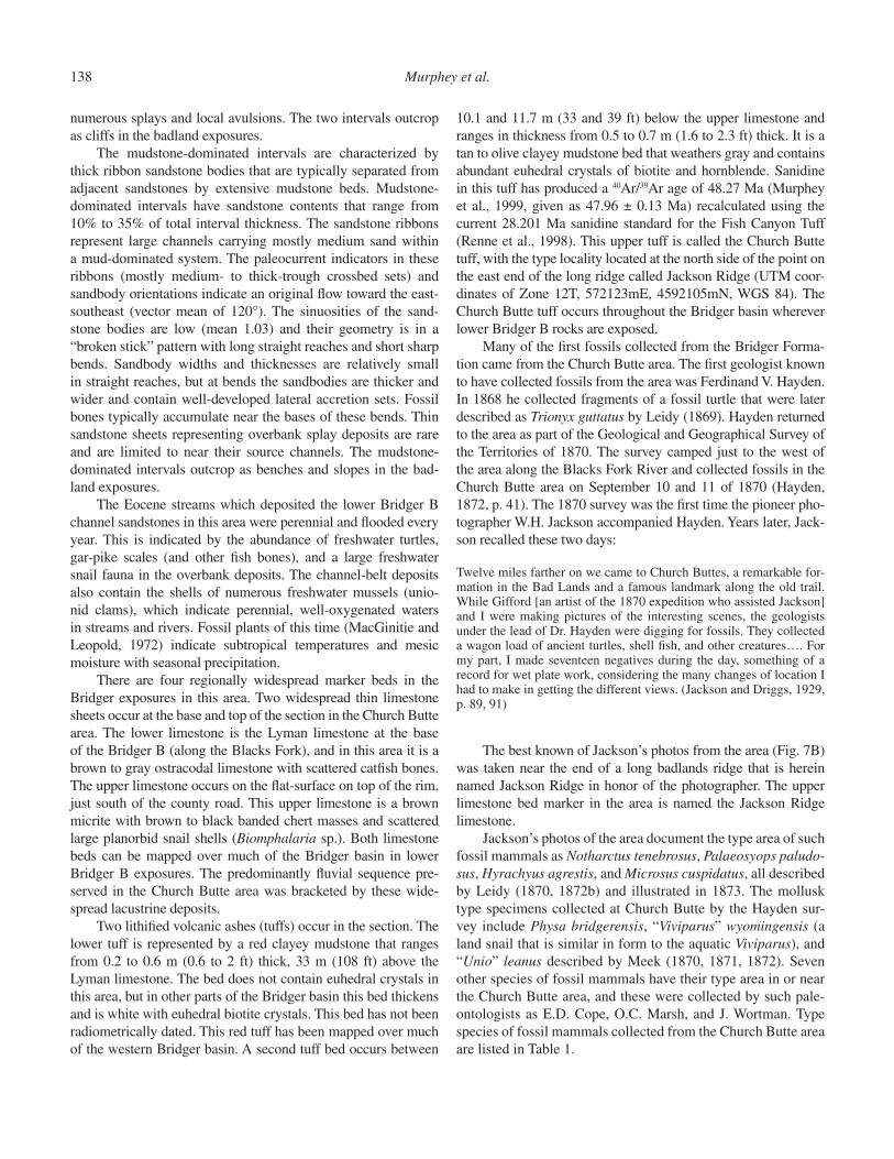
10.1 and 11.7 m (33 and 39 ft) below the upper limestone and ranges in thickness from 0.5 to 0.7 m (1.6 to 2.3 ft) thick. It is a tan to olive clayey mudstone bed that weathers gray and contains abundant euhedral crystals of biotite and hornblende. Sanidine in this tuff has produced a 40Ar/39Ar age of 48.27 Ma (Murphey et al., 1999, given as 47.96 ± 0.13 Ma) recalculated using the current 28.201 Ma sanidine standard for the Fish Canyon Tuff (Renne et al., 1998). This upper tuff is called the Church Butte tuff, with the type locality located at the north side of the point on the east end of the long ridge called Jackson Ridge (UTM coor-dinates of Zone 12T, 572123mE, 4592105mN, WGS 84). The Church Butte tuff occurs throughout the Bridger basin wherever lower Bridger B rocks are exposed.
Many of the fi rst fossils collected from the Bridger Forma-tion came from the Church Butte area. The fi rst geologist known to have collected fossils from the area was Ferdinand V. Hayden. In 1868 he collected fragments of a fossil turtle that were later described as Trionyx guttatus by Leidy (1869). Hayden returned to the area as part of the Geological and Geographical Survey of the Territories of 1870. The survey camped just to the west of the area along the Blacks Fork River and collected fossils in the Church Butte area on September 10 and 11 of 1870 (Hayden, 1872, p. 41). The 1870 survey was the fi rst time the pioneer pho-tographer W.H. Jackson accompanied Hayden. Years later, Jack-son recalled these two days:
Twelve miles farther on we came to Church Buttes, a remarkable for-mation in the Bad Lands and a famous landmark along the old trail. While Gifford [an artist of the 1870 expedition who assisted Jackson] and I were making pictures of the interesting scenes, the geologists under the lead of Dr. Hayden were digging for fossils. They collected a wagon load of ancient turtles, shell fi sh, and other creatures…. For my part, I made seventeen negatives during the day, something of a record for wet plate work, considering the many changes of location I had to make in getting the different views. (Jackson and Driggs, 1929, p. 89, 91)
The best known of Jackson’s photos from the area (Fig. 7B) was taken near the end of a long badlands ridge that is herein named Jackson Ridge in honor of the photographer. The upper limestone bed marker in the area is named the Jackson Ridge limestone.
Jackson’s photos of the area document the type area of such fossil mammals as Notharctus tenebrosus, Palaeosyops paludo-sus, Hyrachyus agrestis, and Microsus cuspidatus, all described by Leidy (1870, 1872b) and illustrated in 1873. The mollusk type specimens collected at Church Butte by the Hayden sur-vey include Physa bridgerensis, “Viviparus” wyomingensis (a land snail that is similar in form to the aquatic Viviparus), and “Unio” leanus described by Meek (1870, 1871, 1872). Seven other species of fossil mammals have their type area in or near the Church Butte area, and these were collected by such pale-ontologists as E.D. Cope, O.C. Marsh, and J. Wortman. Type species of fossil mammals collected from the Church Butte area are listed in Table 1.
Middle Eocene rock units in the Bridger and Uinta Basins 139
Drive back onto CR 233, and turn left (southwest) toward Lyman. Turn left at mile 5.5 onto CR 237 which then crosses the Blacks Fork River, winding south to I-80. Turn westbound (toward Evanston) onto I-80 at mile 7.4. Pass the Lyman exit and drive to the Mountain View-Fort Bridger (Exit 39, 15.5 mi from Stop 3). Turn south onto Wyoming State Highway (SH) 414, crossing the Blacks Fork River and climbing up onto the Lyman limestone at the top of the hill. Continue through Urie and Mountain View, where the highway will bend to the east near the center of town. Refer to Figure 8 for a map that shows the major geographic features of the remainder of the fi eld trip route. As you drive east from the center of Mountain View along Highway 414, the badlands to the south that are visible beginning at SH 414 milepost 105 were known to the early residents and explor-ers as “Grizzly Buttes” (lower and middle Bridger B). The north end of the badlands to the northeast constitute the type area of
the Blacks Fork Member. Continue southeast on Highway 414 and the highway rises onto the Cottonwood Bench. Immediately after reaching the top of this bench, at 29.7 mi from Stop 3, turn east and then immediately north. At 0.2 mi from the turn off, do not turn east on Burnt Fork Road (Bureau of Land Management Road [BLM] 4315) and instead continue traveling north. At 30.4 mi from Stop 3, turn west onto the two-track road and follow it for 0.6 mi to the Grizzly Buttes overlook.
Stop 4. Grizzly Buttes (31.0 mi from Stop 3; cumulative 88.5 mi)Heading southeast from Mountain View, Wyoming State
Highway 414 rises through a panel of badland exposures and climbs onto a high fl at, called the Cottonwood Bench. The bench is capped by gravels derived from the Bishop Conglomerate and transported to the area by Cottonwood and Sage Creeks. Below the gravel-fl at is a series of badlands cut by Leavitt Creek, Little
Figure 7. (A) William H. Jackson photo of Church Butte taken on 10 or 11 Sep-tember 1870. View is to the east north-east. UTM location of the photo site is Zone 12T, 571955mE, 4595101mN, WGS84 datum (U.S. Geological Survey photo jwh00462). (B) William H. Jack-son photo of the west end of Jackson Ridge, taken mid-day either on 10 or 11September 1870. The view is toward the northwest, and includes the Hayden Survey campsite along the Blacks Fork River. Notice the crack that was in the original glass-plate negative. The UTM location of the photo site is Zone 12T, 571318mE, 4592360mN, WGS84 da-tum (U.S. Geological Survey photo jwh00309).
140 Murphey et al.
Dry Creek and their tributaries. The badland hills directly west of the overlook comprise the traditional “Grizzly Buttes” of the early explorers, but the name is not known to the modern population of the Smith’s Fork valley (see history of paleonto-logical investigations). Matthew (1909, p. 297) stated about the buttes: “This is the richest collecting ground in the basin; thou-sands of specimens have been taken from it, and many skulls and skeletons more or less complete.” Type species of fossil mam-mals collected from the Grizzly Buttes area are listed in Table 2.
The lower half of the Bridger B is exposed in the Grizzly Buttes and along the Cottonwood Bench escarpment. Not far below the Quaternary gravels at this overlook is a widespread limestone that was named by Matthew (1909) the Cottonwood white layer (now known as the Cottonwood limestone). It is a white micritic limestone that is very widespread but is locally absent in the Church Butte area. The Cottonwood limestone is typically 5 m (16 ft) above the Church Butte tuff, but in this area it is 10.4 m (34 ft) above the tuff. The thickness of intervals between the widespread marker beds increases from the Church Butte area toward the southwest. The Jackson Ridge limestone has been eroded by Cottonwood Creek on the bench, but in this area it is typically 6 m (20 ft) above the Cottonwood White Layer.
TABLE 1. TYPE SPECIES OF FOSSILS FROM THE CHURCH BUTTE–BLACKS FORK AREA
MAMMALS Marsupialia Peratherium innominatus (Simpson) 1928 Pantolesta Pantolestes longicaudus Cope 1872 Primates Notharctus tenebrosus Leidy 1870 Tillodontia Tillodon fodiens (Marsh) 1875 Rodentia Microparamys minutus (R.W. Wilson) 1937 Sciuravus bridgeri R.W. Wilson 1937 Carnivora Miacis parvivorus Cope 1872 Hyaenodontida Sinopa major Wortman, 1902 Condylarthra Hyopsodus paulus Leidy 1872 Perissodactyla Orohippus major Marsh 1874 Palaeosyops paludosus Leidy 1870 Cetartiodactyla Microsus cuspidatus Leidy 1870
TURTLE Trionychidae “Aspideretes” guttatus Leidy 1869
MOLLUSKS Bivalvia, Unionidae “Unio” leanus Meek 1870 Gastropoda, Pulmonata Physa bridgerensis Meek 1872 “Viviparus” wyominensis Meek 1871
Note: Data compiled from Leidy (1872a); Meek (1872); Henderson (1935); and Gazin (1976).
The Church Butte tuff is a prominent gray band about half way down the escarpment. Notice that channel sandstones are not as abundant in the lower Bridger B rocks below you as they are in the Church Butte area.
To the east is a prominent escarpment rising far above the Cottonwood Bench. This escarpment is capped by the Sage Creek White Layer, the boundary between the Blacks Fork and Twin Buttes members of the Bridger Formation (the boundary between Matthew’s Bridger B and C). Almost all the upper half of the Bridger B is exposed in the west face of the escarpment.
Return to Wyoming State Highway 414 and travel north for 5.7 mi. Then turn east and drive for 0.2 mi and park on the north side of the road. A short walk to the northeast will lead you to Sage Creek limestone and the type locality of the Sage Creek white layer.
Stop 5. Sage Creek White Layer Type Locality (5.9 mi from Stop 4; cumulative 94.4 mi)
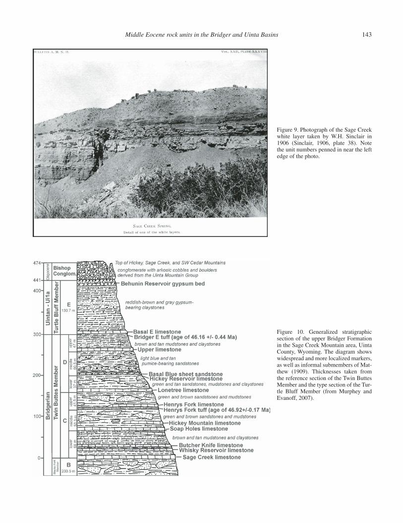
This outcrop of the Sage Creek white layer is located next to site of the old Sage Creek stage station and Sage Creek Spring along the old Lonetree stage road. It was fi rst described and photographed by Sinclair in 1906 (Fig. 9), and then named and mapped by Matthew (1909). The Sage Creek white layer is the base of Matthew’s Bridger C, the base of the Twin Buttes Member, and the base of the upper Bridger Formation as pres-ently defi ned. Since Matthew’s (1909) work, this unit has been renamed the Sage Creek limestone, and is the base of the lower Bridger C of Evanoff et al. (1998), Murphey (2001), and Mur-phey and Evanoff (2007). The general stratigraphy of the upper Bridger Formation in the Sage Creek Mountain area is illustrated in Figure 10.
At its type locality, the Sage Creek limestone is 4.1 m (13.5 ft) thick. It consists of a lower massive tan micritic limestone, a mid-dle shaly limestone with dark-gray to black chert bands, and an upper platy to shaly limestone. Elsewhere, it includes massive to blocky marly and micritic limestone, ledgy marlstone, and platy calcareous shale, and is locally interbedded with green to brown mudstone and claystone and thin carbonaceous shale. Fossils of this unit consist of scattered gastropods, bone fragments (mostly fi sh), and turtle shell fragments, and the limestone within it is locally stromatolitic. The Sage Creek limestone supports a very widespread bench, and it is the thickest and most widespread lacustrine deposit in the upper Bridger Formation.
Stratigraphically overlying the Sage Creek limestone within the lower Bridger C are two other limestone beds that are much thinner but are also widespread: the Whisky Reservoir limestone and the Butcher Knife limestone (see Fig. 10). The lower Bridger C is the least fossiliferous subunit of the upper Bridger Formation (Twin Buttes and Turtle Bluff members), despite the fact that it is by far the most geographically widespread.
Continue south along Highway 414 for 3.2 mi. Traveling south, the highway route travels up section through the lower Bridger C and into the middle Bridger C. Sage Creek Mountain is the highest point on the west side of the highway and Hickey Mountain is the highest point on the east side of the highway.
Middle Eocene rock units in the Bridger and Uinta Basins 141
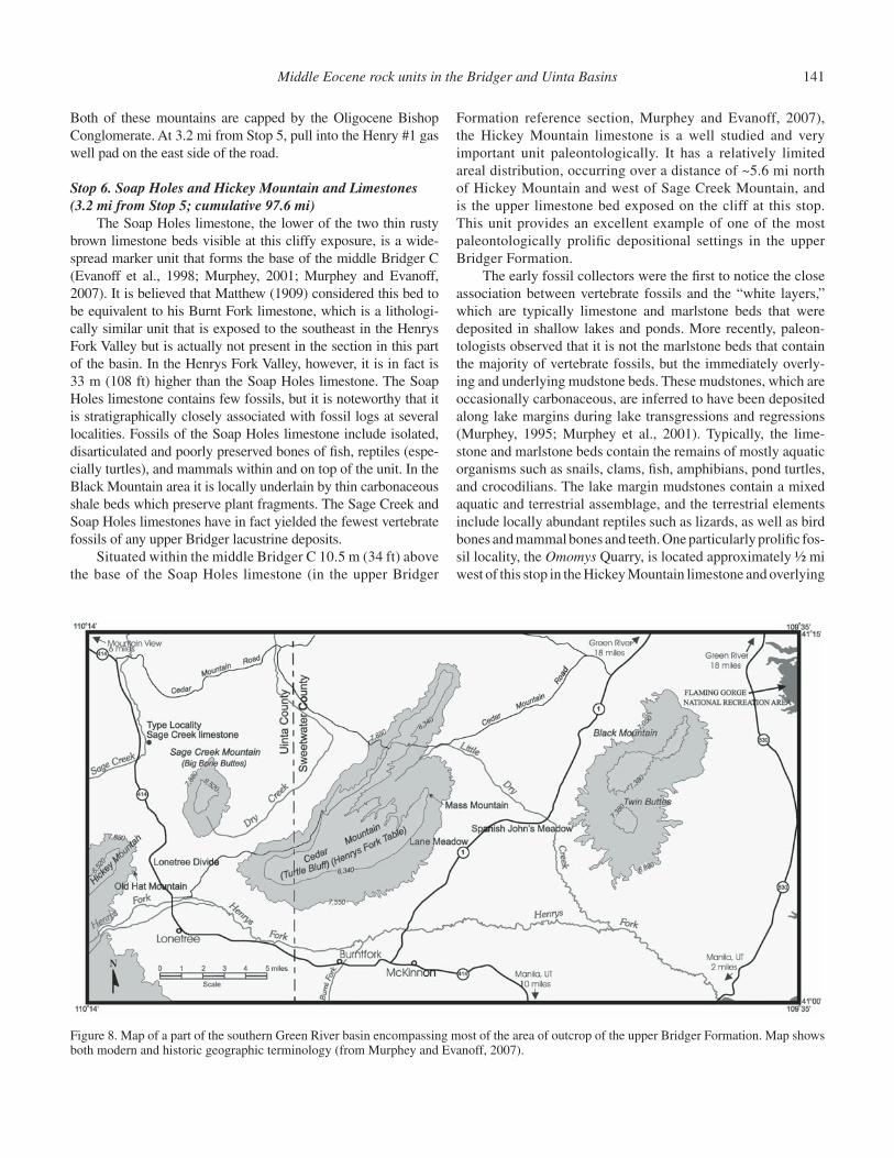
Figure 8. Map of a part of the southern Green River basin encompassing most of the area of outcrop of the upper Bridger Formation. Map shows both modern and historic geographic terminology (from Murphey and Evanoff, 2007).
Both of these mountains are capped by the Oligocene Bishop Conglomerate. At 3.2 mi from Stop 5, pull into the Henry #1 gas well pad on the east side of the road.
Stop 6. Soap Holes and Hickey Mountain and Limestones (3.2 mi from Stop 5; cumulative 97.6 mi)
The Soap Holes limestone, the lower of the two thin rusty brown limestone beds visible at this cliffy exposure, is a wide-spread marker unit that forms the base of the middle Bridger C (Evanoff et al., 1998; Murphey, 2001; Murphey and Evanoff, 2007). It is believed that Matthew (1909) considered this bed to be equivalent to his Burnt Fork limestone, which is a lithologi-cally similar unit that is exposed to the southeast in the Henrys Fork Valley but is actually not present in the section in this part of the basin. In the Henrys Fork Valley, however, it is in fact is 33 m (108 ft) higher than the Soap Holes limestone. The Soap Holes limestone contains few fossils, but it is noteworthy that it is stratigraphically closely associated with fossil logs at several localities. Fossils of the Soap Holes limestone include isolated, disarticulated and poorly preserved bones of fi sh, reptiles (espe-cially turtles), and mammals within and on top of the unit. In the Black Mountain area it is locally underlain by thin carbonaceous shale beds which preserve plant fragments. The Sage Creek and Soap Holes limestones have in fact yielded the fewest vertebrate fossils of any upper Bridger lacustrine deposits.
Situated within the middle Bridger C 10.5 m (34 ft) above the base of the Soap Holes limestone (in the upper Bridger
Formation reference section, Murphey and Evanoff, 2007), the Hickey Mountain limestone is a well studied and very important unit paleontologically. It has a relatively limited areal distribution, occurring over a distance of ~5.6 mi north of Hickey Mountain and west of Sage Creek Mountain, and is the upper limestone bed exposed on the cliff at this stop. This unit provides an excellent example of one of the most paleontologically prolifi c depositional settings in the upper Bridger Formation.
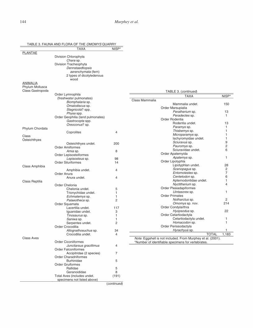
The early fossil collectors were the fi rst to notice the close association between vertebrate fossils and the “white layers,” which are typically limestone and marlstone beds that were deposited in shallow lakes and ponds. More recently, paleon-tologists observed that it is not the marlstone beds that contain the majority of vertebrate fossils, but the immediately overly-ing and underlying mudstone beds. These mudstones, which are occasionally carbonaceous, are inferred to have been deposited along lake margins during lake transgressions and regressions (Murphey, 1995; Murphey et al., 2001). Typically, the lime-stone and marlstone beds contain the remains of mostly aquatic organisms such as snails, clams, fi sh, amphibians, pond turtles, and crocodilians. The lake margin mudstones contain a mixed aquatic and terrestrial assemblage, and the terrestrial elements include locally abundant reptiles such as lizards, as well as bird bones and mammal bones and teeth. One particularly prolifi c fos-sil locality, the Omomys Quarry, is located approximately ½ mi west of this stop in the Hickey Mountain limestone and overlying
142 Murphey et al.
mudstone. This unusual fossil accumulation has produced over 2,300 specimens of vertebrates, gastropods, and plants from an 8–10-cm-thick deposit in a 4 m2 area (Murphey et al., 2001). What makes the assemblage so unusual is that it contains a high concentration of dental and post-cranial remains of the primate Omomys, avian skeletal remains, and eggshell fragments. The unusual components of the fauna are superimposed on a more typical Bridger fauna that occurs at the quarry and lateral to it in the same stratigraphic interval. Four taphonomic agents have been postulated for the formation of the Omomys Quarry fossil accumulation: (1) an attritional accumulation of aquatic taxa in lacustrine sediments; (2) an attritional accumulation of both aquatic and terrestrial taxa in shoreline sediments; (3) an attritional accumulation consisting primarily of bird bones and eggshell formed in close proximity to a nesting area; and
TABLE 2. TYPE SPECIES OF FOSSIL MAMMALS FROM GRIZZLY BUTTES
Lipotyphla Entomolestes grangeri Matthew 1909 Nyctitherium serotinum (Marsh) 1872 Nyctitherium dasypelix (Matthew) 1909
Plesiadapiformes Mycrosyops elegans (Marsh) 1871
Primates Smilodectes gracilis (Marsh) 1871
Tillodontia Trogosus castoridens Leidy 1871
Pholidota Metacheiromys marshi Wortman 1903 Metacheiromys tatusia Osborn 1904 Metacheiromys dasypus Osborn 1904
Rodentia Thisbemys plicatus A.E. Wood 1962 Leptotomus parvus A.E. Wood 1959 Reithroparamys delicatissimus (Leidy) 1871 Pseudotomus robustus (Marsh) 1872 Ischyrotomus horribilis A.E. Wood 1962 Mysops minimus Leidy 1871 Mysops parvus (Marsh) 1872 Sciuravus nitidus Marsh 1871 Tillomys? parvidens (Marsh) 1872
Hyaenodontida Sinopa rapax Leidy 1871 Sinopa minor Wortman 1902 Tritemnodon agilis (Marsh) 1872 Limnocyon verus Marsh 1872
Carnivora Thinocyon velox Marsh 1872 Viverravus gracilis Marsh 1872 Oödectes proximus Mattehw 1909 Vulpavus profectus Matthew 1909
Perissodactyla Palaeosyops major Leidy 1871 Limnohyops priscus Osborn 1908 Helaletes nanus (Marsh) 1871
Cetartiodactyla Helohyus plicodon Marsh 1872
Note: Compiled from Gazin (1976).
(4) a predator accumulation dominated by Omomys but prob-ably including other vertebrates formed by owls in close prox-imity to a nest, day roost or night feeding station. The fauna and fl ora of the Omomys Quarry is listed in Table 3.
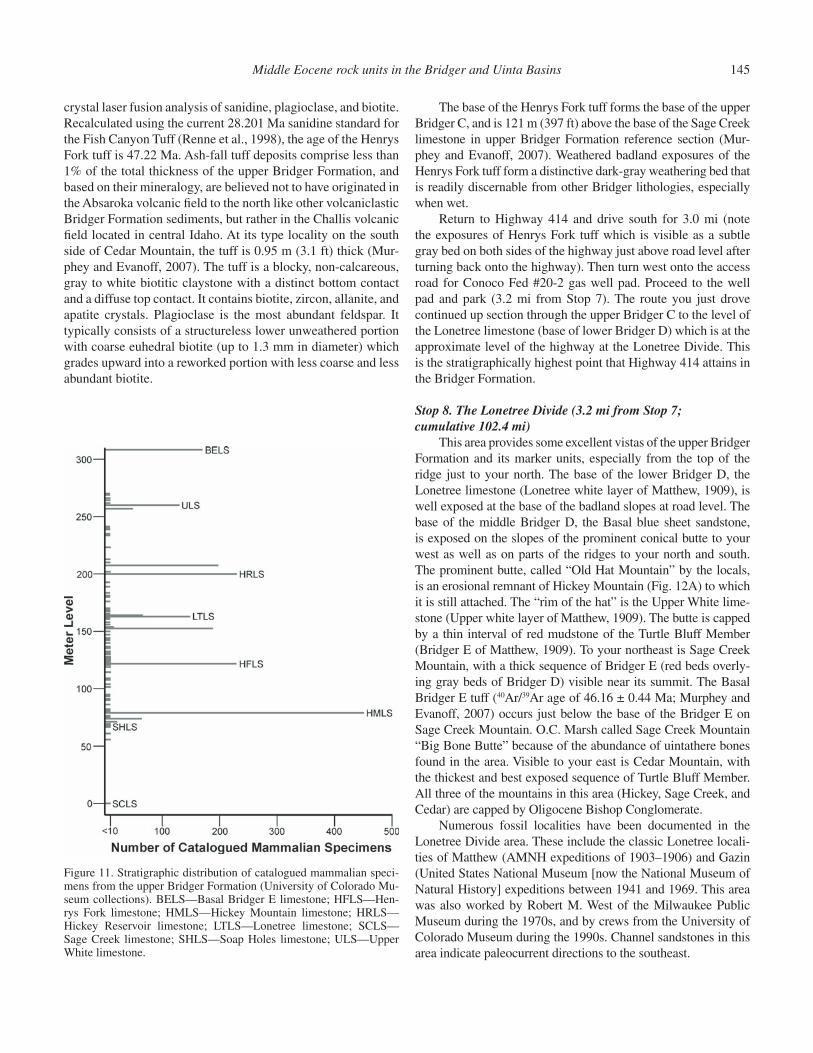
The same pattern of fossil distribution observed in the Hickey Mountain limestone occurs throughout the upper Bridger Formation as illustrated in Figure 11. Most fossils are found in association with lacustrine deposits, although stream chan-nels are also productive. Least productive are the volcaniclastic mudstone and claystone beds that were deposited on low relief fl oodplains, and, together with stream channel deposits, comprise 95% of the total thickness of the upper Bridger. Examples of the fl oodplain deposits, here consisting of green and gray mudstone and claystone beds, are well exposed at this stop above and below the Soap Holes and Hickey Mountain limestones. Both the Soap Holes and Hickey Mountain limestones are better exposed, with some minor faulting, on the east side of the highway just to the north of this location.
Continue south on Highway 414 for 1.1 mi and turn east onto the gas well road. Follow this road to the east and it will bend to the north for a total distance of 1.6 mi from Stop 6. Park on the north side of the Henry #10 well pad. The Henrys Fork limestone (type locality of this unit) and the underlying Henrys Fork tuff are exposed above the well pad on the badland hill just to your north. Look for the gray weathered bed near the top of the badland slope and an overlying thin light-gray marlstone, and bring a shovel to examine the tuff.
Stop 7. Type Locality of the Henrys Fork Limestone (1.6 mi from Stop 6; cumulative 99.2 mi)
The Henrys Fork limestone (and associated shore margin deposits) is another highly fossiliferous unit, and has produced hundreds of fossil mollusks and vertebrates across its distri-bution. It is quite widespread, covering an area of ~402 km2 (250 mi2), and was deposited in an elongate east-west–trending basin which formed in the downwarp along the Uinta Mountain front. At this location, which is near the western edge of ancient Henrys Fork Lake, the deposit is only 3 cm (1.2 in) thick, but it attains a maximum thickness of 1.65 m (5.4 ft) on the south side of Cedar Mountain near the center of its depositional basin. It is of taphonomic interest that the upper Bridger Formation with its abundant vertebrate fossils preserved in lacustrine and associated shore margin deposits contains few articulated skel-etons or even partially articulated vertebrate remains, most of which have been collected in the Bridger B (see Alexander and Burger, 2001).
Immediately underlying the Henrys Fork limestone is the Henrys Fork tuff, a unit that was fi rst discovered by Emmett Evanoff while conducting fi eld work in the Sage Creek Moun-tain area in 1991. This ash-fall tuff is the most analyzed tuff in the Bridger Formation, and it is beyond the scope of this paper to report the various ages that have been published. How-ever, Murphey et al. (1999) and Murphey and Evanoff (2007) reported a 40Ar/39Ar age of 46.92 ± 0.17 Ma based on single
Middle Eocene rock units in the Bridger and Uinta Basins 143
Figure 10. Generalized stratigraphic section of the upper Bridger Formation in the Sage Creek Mountain area, Uinta County, Wyoming. The diagram shows widespread and more localized markers, as well as informal submembers of Mat-thew (1909). Thicknesses taken from the reference section of the Twin Buttes Member and the type section of the Tur-tle Bluff Member (from Murphey and Evanoff, 2007).
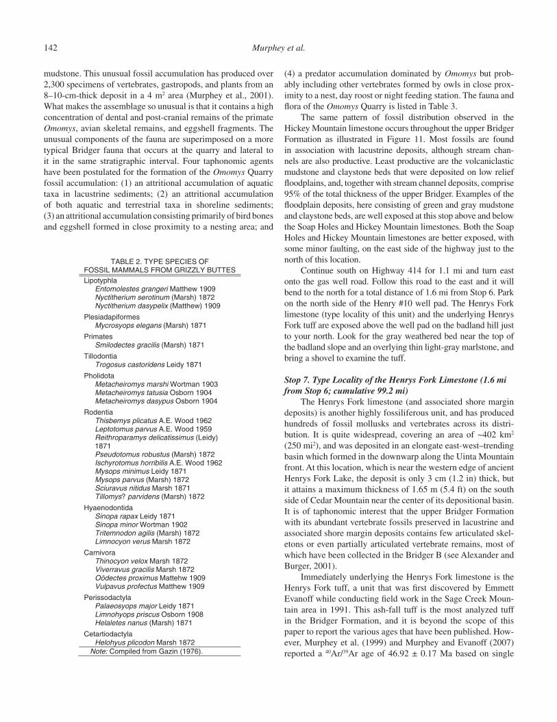
Figure 9. Photograph of the Sage Creek white layer taken by W.H. Sinclair in 1906 (Sinclair, 1906, plate 38). Note the unit numbers penned in near the left edge of the photo.
144 Murphey et al.
TABLE 3. FAUNA AND FLORA OF THE OMOMYS QUARRY
*PSIN AXAT PLANTAE Division Chlorophyta Chara .ps Division Tracheophyta Dennstaedtiopsis
aerenchymata (fern)
suonedelytocid fo sepyt 2 wood
ANIMALIA acsulloM mulyhP adoportsaG ssalC
Order Lymnophila (freshwater pulmonates)
Biomphalaria sp. Omalodiscus sp. Stagnicola? spp. Physa .pps Order Geophilia (land pulmonates) Gastrocopta spp. Oreoconus? sp.
atadrohC mulyhP 4 setilorpoC
Class Osteichthyes
002 .tednu seyhthcietsO semrofiimA redrO
Amia 8 .ps Order Lepisosteiformes Lepisosteus sp. 98 Order Siluriformes 14
aibihpmA ssalC 4 .tednu aibihpmA
arunA redrO 4 .tednu arunA
ailitpeR ssalC ainolehC redrO 5 .tednu ainolehC 1 .tednu eadihcynoirT
Echmatemys sp. 1 acehtoealaP sp. 2
atamauqS redrO 711 .tednu ailitrecaL
3 .tednu eadinaugI Tinosaurus sp. 1 Saniwa sp. 1
2 .tednu setnepreS ailidocorC redrO
Allognathosuchus sp. 34 4 .tednu ailidocorC sevA ssalC
Order Ciconiiformes Juncitarsus gracillimus 4 Order Falconiformes
7 )seiceps 2( eadirtipiccA Order Charadriiformes
5 eadinihruB semrofiurG redrO 5 eadillaR 8 eadidionareG
Total Aves (includes undet. specimens not listed above)
(191)
(continued)
TABLE 3. (continued)
*PSIN AXAT ailammaM ssalC
051 .tednu ailammaM ailaipusraM redrO
Peratherium sp. 13 Peradectes sp. 1
aitnedoR redrO 31 .tednu aitnedoR
Paramys 1 .ps Thisbemys sp. 1 Microparamys sp. 1
1 .tednu eadiymoryhcsI Sciuravus sp. 9 Pauromys sp. 2
6 .tednu eadivaruicS adiymetapA redrO
Apatemys sp. 1 alhpytopiL redrO
82 .tednu nalhpytopiL Scenopagus sp. 2 Entomolestes sp. 7 Centetodon sp. 6
1 .tednu eaditnodonretpA Nyctitherium sp. 4 Order Plesiadapiformes Uintasorex sp. 1
setamirP redrO Notharctus sp. 2 Omomys sp. nov. 214
arhtralydnoC redrO Hyopsodus sp. 22
alytcadoitrateC redrO 1 .tednu alytcadoitrateC
nodocamoH sp. 1 Order Perissodactyla Hyrachyus sp. 1
LATOT 1,183 Note: Eggshell is not included. From Murphey et al. (2001). *Number of identifiable specimens for vertebrates.
Middle Eocene rock units in the Bridger and Uinta Basins 145
crystal laser fusion analysis of sanidine, plagioclase, and biotite. Recalculated using the current 28.201 Ma sanidine standard for the Fish Canyon Tuff (Renne et al., 1998), the age of the Henrys Fork tuff is 47.22 Ma. Ash-fall tuff deposits comprise less than 1% of the total thickness of the upper Bridger Formation, and based on their mineralogy, are believed not to have originated in the Absaroka volcanic fi eld to the north like other volcaniclastic Bridger Formation sediments, but rather in the Challis volcanic fi eld located in central Idaho. At its type locality on the south side of Cedar Mountain, the tuff is 0.95 m (3.1 ft) thick (Mur-phey and Evanoff, 2007). The tuff is a blocky, non-calcareous, gray to white biotitic claystone with a distinct bottom contact and a diffuse top contact. It contains biotite, zircon, allanite, and apatite crystals. Plagioclase is the most abundant feldspar. It typically consists of a structureless lower unweathered portion with coarse euhedral biotite (up to 1.3 mm in diameter) which grades upward into a reworked portion with less coarse and less abundant biotite.
The base of the Henrys Fork tuff forms the base of the upper Bridger C, and is 121 m (397 ft) above the base of the Sage Creek limestone in upper Bridger Formation reference section (Mur-phey and Evanoff, 2007). Weathered badland exposures of the Henrys Fork tuff form a distinctive dark-gray weathering bed that is readily discernable from other Bridger lithologies, especially when wet.
Return to Highway 414 and drive south for 3.0 mi (note the exposures of Henrys Fork tuff which is visible as a subtle gray bed on both sides of the highway just above road level after turning back onto the highway). Then turn west onto the access road for Conoco Fed #20-2 gas well pad. Proceed to the well pad and park (3.2 mi from Stop 7). The route you just drove continued up section through the upper Bridger C to the level of the Lonetree limestone (base of lower Bridger D) which is at the approximate level of the highway at the Lonetree Divide. This is the stratigraphically highest point that Highway 414 attains in the Bridger Formation.
Stop 8. The Lonetree Divide (3.2 mi from Stop 7; cumulative 102.4 mi)
This area provides some excellent vistas of the upper Bridger Formation and its marker units, especially from the top of the ridge just to your north. The base of the lower Bridger D, the Lonetree limestone (Lonetree white layer of Matthew, 1909), is well exposed at the base of the badland slopes at road level. The base of the middle Bridger D, the Basal blue sheet sandstone, is exposed on the slopes of the prominent conical butte to your west as well as on parts of the ridges to your north and south. The prominent butte, called “Old Hat Mountain” by the locals, is an erosional remnant of Hickey Mountain (Fig. 12A) to which it is still attached. The “rim of the hat” is the Upper White lime-stone (Upper white layer of Matthew, 1909). The butte is capped by a thin interval of red mudstone of the Turtle Bluff Member (Bridger E of Matthew, 1909). To your northeast is Sage Creek Mountain, with a thick sequence of Bridger E (red beds overly-ing gray beds of Bridger D) visible near its summit. The Basal Bridger E tuff (40Ar/39Ar age of 46.16 ± 0.44 Ma; Murphey and Evanoff, 2007) occurs just below the base of the Bridger E on Sage Creek Mountain. O.C. Marsh called Sage Creek Mountain “Big Bone Butte” because of the abundance of uintathere bones found in the area. Visible to your east is Cedar Mountain, with the thickest and best exposed sequence of Turtle Bluff Member. All three of the mountains in this area (Hickey, Sage Creek, and Cedar) are capped by Oligocene Bishop Conglomerate.
Numerous fossil localities have been documented in the Lonetree Divide area. These include the classic Lonetree locali-ties of Matthew (AMNH expeditions of 1903–1906) and Gazin (United States National Museum [now the National Museum of Natural History] expeditions between 1941 and 1969. This area was also worked by Robert M. West of the Milwaukee Public Museum during the 1970s, and by crews from the University of Colorado Museum during the 1990s. Channel sandstones in this area indicate paleocurrent directions to the southeast.
Figure 11. Stratigraphic distribution of catalogued mammalian speci-mens from the upper Bridger Formation (University of Colorado Mu-seum collections). BELS—Basal Bridger E limestone; HFLS—Hen-rys Fork limestone; HMLS—Hickey Mountain limestone; HRLS—Hickey Reservoir limestone; LTLS—Lonetree limestone; SCLS—Sage Creek limestone; SHLS—Soap Holes limestone; ULS—Upper White limestone.
146 Murphey et al.
Turn south on Highway 414 for 1.9 mi and turn east onto Cedar Mountain Rim road (BLM Road 4314). At 2.8 mi from Stop 8, the road bends to the north and travels stratigraphically through the upper Bridger C, crossing the Lonetree limestone, and continuing up through the lower and middle Bridger D. At the junction of Cedar Mountain Rim Road and Sage Creek Mountain Road (5.2 mi from Stop 8), turn south onto a two-track road. Drive south on the two track, keeping straight at miles 6.2 and 6.3 where other tracks diverge, until you reach the Turtle Bluff Member overlook (6.4 mi from Stop 8). Note
that if the ground is wet, it is not advisable to leave the paved highway (SH 414).
Stop 9. The Turtle Bluff Member on Cedar Mountain (6.4 mi from Stop 8; cumulative 108.8 mi)
Looking east from this location affords an excellent view of the upper Bridger D, the highest sub-unit in the Twin Buttes Member, overlain by the Turtle Bluff Member of the Bridger Formation (Matthew’s Bridger E). The contact between the two members is shown on Figure 12B and is defi ned on the basis of
Figure 12. (A) View of the Bridger D and E on “Old Hat Mountain,” a prominent butte on the southeast fl ank of Hickey Mountain, Uinta County, Wyoming. Photo taken looking southwest. (B) View of the Bridger D and Bridger E on the southwest fl ank of Cedar Mountain, Uinta County, Wyoming. Photo taken looking east. BBS—Basal blue sheet sandstone; BELS—Basal Bridger E limestone; BRGB— Behunin Reservoir Gypsum bed; Tbe—Bridger E; Tbi—Bishop Conglomerate; Tbdm—middle Bridger D; Tbdu—upper Bridger D; ULS— Upper White limestone.
Middle Eocene rock units in the Bridger and Uinta Basins 147
a limestone that occurs at the approximate level of the lowest red bed (note that some of the strata you see are slumped). The limestone that supports the bench that you are standing on is the Upper White limestone.
Consisting primarily of banded red, gray, and tan beds of gypsiferous claystone and mudstone, rocks of the Turtle Bluff Member are the least volcaniclastic in the Bridger Formation. Lthologically, the Turtle Bluff Member is somewhat distinct from the rest of the formation, being similar in appearance to the red and brown sandstone, mudstone, and claystone beds of parts of the Washakie and Uinta Formations of similar age. The Tur-tle Bluff member occurs only on Hickey Mountain, Sage Creek Mountain, the south end of Black Mountain, and Twin Buttes, but by far the most extensive and thickest exposures occur here on the southwest side of Cedar Mountain. The type section for the Turtle Bluff Member on Cedar Mountain is a 131.5 m (431 ft) thick sequence of reddish-brown and gray claystone beds with a high gypsum content. This gypsum is both primary and second-ary. Secondary gypsum consists of selenite and satin spar crys-tals which are abundant on the upper slopes of Cedar Mountain. Primary gypsum occurs in thin beds, but the Turtle Bluff Member on Cedar Mountain is capped by a thick and laterally extensive gypsum bed. The mostly fi ne-grained reddish Turtle Bluff sedi-ments were probably derived from the adjacent Uinta Mountains based on their color, unlike those of the Bridger A–D, which were largely derived from more distal volcanic sources.
The Turtle Bluff Member contains two markers: The Basal Bridger E limestone, which marks the base of the member (base of Matthew’s Bridger E), and the Behunin Reservoir Gypsum Bed, which is the youngest and stratigraphically highest well exposed rock unit in the Bridger Formation (note that Behunin is pronounced “Buhannan” by locals). Here on southwest Cedar Mountain, the Turtle Bluff Member contains four additional unnamed limestone beds, and on Twin Buttes there are three. A 2.3 m (7.5 ft) thick laterally extensive, quartz arenite bed that lies 75 m (246 ft) above the base of the member on Cedar Mountain is the only sandstone bed. Similar sandstone beds in the Turtle Bluff Member also occur on the northwest fl ank of Hickey Mountain and the south fl ank of Sage Creek Mountain, and may be roughly stratigraphically equivalent.
The Behunin Reservoir Gypsum Bed is lithologically unique for the Bridger Formation. Although other gypsum beds occur in the Turtle Bluff Member, they are much thinner. Restricted to just below the southwest rim of Cedar Mountain (below the Bishop Conglomerate), this unit consists of a 7 m (23 ft) thick sequence of gray and tan unfossiliferous bedded gypsum beds interbedded with gypsiferous mudstones and marlstones. It is visible from a great distance as a prominent white bed high on Cedar Mountain. This bed is interpreted as an evaporitic playa lacustrine deposit, and may indicate changing climatic conditions near the end of Bridger Formation deposition.
Because of its sparse fossils and steep, limited exposures, the biochronologic affi nity of the Turtle Bluff Member has been diffi cult to determine. Matthew was the fi rst worker to comment
on the age of the member, saying that its few mammal fossils prove suffi ciently that it “belongs to the Bridger Age” (Matthew, 1909, p. 296). Osborn (1929) correlated the Bridger E with the Washakie B and Uinta B, although he cited no evidence to sup-port this correlation. Simpson (1933), Wood et al. (1941), and Gazin (1976) also regarded the Bridger E as Uintan, although this was apparently not based on fossil evidence. Based on eight isolated rodent teeth identifi ed as Paramys cf. P. delicatior, and “several” bone fragments identifi ed as brontothere, West and Hutchison (1981) concluded that the Bridger E (their Cedar Mountain Member) was Bridgerian. Subsequent work during the 1990s by crews from the University of Colorado Museum (Evanoff et al., 1994; Murphey and Evanoff, 2007) and in the 2000s by crews from the San Diego Natural History Museum (Walsh and Murphey, 2007) have now documented a much more diverse faunal assemblage from multiple stratigraphic lev-els within the Turtle Bluff Member (Table 4). Donna’s locality (UCM Loc. 92189) is located near the base of the member and is the only locality thus far to produce specimens of the newly described species of omomyid primate Hemiacodon engardae (Murphey and Dunn, 2009). Located 105 m (344 ft) above the base of the member, Roll the Bones (SDSNH Loc. 5844) and Red Lenses (SDSNH Loc. 5844) are the stratigraphically high-est localities to yield identifi able fossils in the member. Hun-dreds of fossils have now been collected from these and other localities mostly via screenwashing of sedimentary matrix. Non-Bridgerian taxa include Epihippus, Metanoiamys, Pareu-mys, Triplopus, Sespedectinae indet., and Oromerycidae gen. and sp. nov. The faunal assemblage of the Turtle Bluff Member is now considered to be earliest Uintan in age (biochron Ui1a of Gunnell et al., 2009), although efforts to obtain additional fossils from this biochronologically important interval member on Cedar Mountain and other locations within the Bridger basin are ongoing.
The Bridger Formation is unconformably overlain by the Bishop Conglomerate, which is visible from this stop capping Cedar Mountain. To the east of this location, it forms massive cliffs and spectacular columns. This unit is a very coarse con-glomerate composed primarily of arkosic cobbles and boulders derived from the Proterozoic Uinta Mountain Group, with locally common cobbles and boulders of Paleozoic limestone (Bradley, 1964). It is as much as 40 m (131 ft) thick. The Bishop Conglom-erate is unfossiliferous, but currently believed to be Oligocene in age (K/Ar 29.50 ± 1.08 Ma, biotite) based on isotopic ages obtained from a tuff that occurs within it on the south side of the Uinta Mountains (Hansen, 1986).
Return to Wyoming State Highway 414, and continue south. The highway crosses the Henrys Fork of the Green River, passes by the hamlet of Lonetree, and bends to the east. There is an excellent view of the Henrys Fork tuff and Henrys Fork limestone on the north side of the highway at SH 414 milepost 128. The Henrys Fork tuff is the prominent gray bed exposed low on the slopes of Cedar Mountain not far above road level, and the Henrys Fork limestone is a prominent white
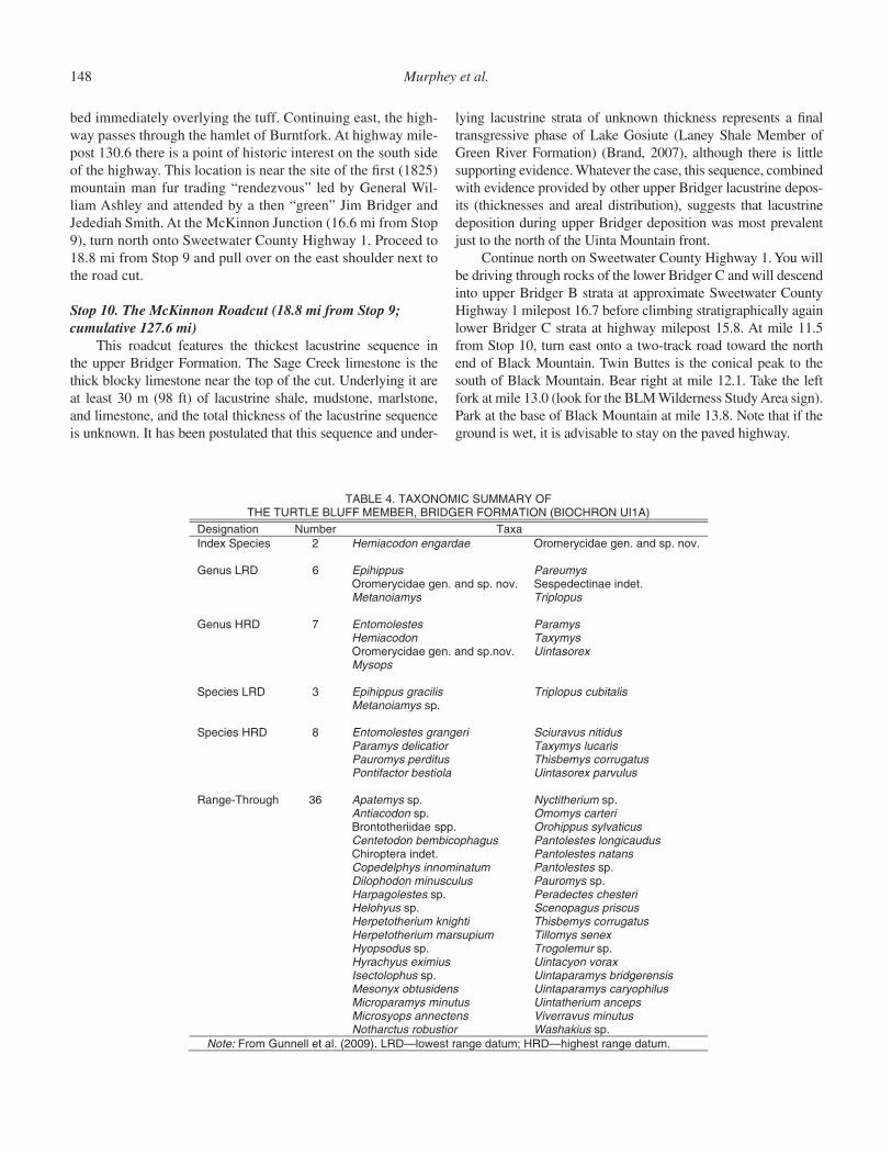
148 Murphey et al.
bed immediately overlying the tuff. Continuing east, the high-way passes through the hamlet of Burntfork. At highway mile-post 130.6 there is a point of historic interest on the south side of the highway. This location is near the site of the fi rst (1825) mountain man fur trading “rendezvous” led by General Wil-liam Ashley and attended by a then “green” Jim Bridger and Jedediah Smith. At the McKinnon Junction (16.6 mi from Stop 9), turn north onto Sweetwater County Highway 1. Proceed to 18.8 mi from Stop 9 and pull over on the east shoulder next to the road cut.
Stop 10. The McKinnon Roadcut (18.8 mi from Stop 9; cumulative 127.6 mi)
This roadcut features the thickest lacustrine sequence in the upper Bridger Formation. The Sage Creek limestone is the thick blocky limestone near the top of the cut. Underlying it are at least 30 m (98 ft) of lacustrine shale, mudstone, marlstone, and limestone, and the total thickness of the lacustrine sequence is unknown. It has been postulated that this sequence and under-
lying lacustrine strata of unknown thickness represents a fi nal transgressive phase of Lake Gosiute (Laney Shale Member of Green River Formation) (Brand, 2007), although there is little supporting evidence. Whatever the case, this sequence, combined with evidence provided by other upper Bridger lacustrine depos-its (thicknesses and areal distribution), suggests that lacustrine deposition during upper Bridger deposition was most prevalent just to the north of the Uinta Mountain front.
Continue north on Sweetwater County Highway 1. You will be driving through rocks of the lower Bridger C and will descend into upper Bridger B strata at approximate Sweetwater County Highway 1 milepost 16.7 before climbing stratigraphically again lower Bridger C strata at highway milepost 15.8. At mile 11.5 from Stop 10, turn east onto a two-track road toward the north end of Black Mountain. Twin Buttes is the conical peak to the south of Black Mountain. Bear right at mile 12.1. Take the left fork at mile 13.0 (look for the BLM Wilderness Study Area sign). Park at the base of Black Mountain at mile 13.8. Note that if the ground is wet, it is advisable to stay on the paved highway.
TABLE 4. TAXONOMIC SUMMARY OF THE TURTLE BLUFF MEMBER, BRIDGER FORMATION (BIOCHRON UI1A)
axaT rebmuN noitangiseDIndex Species 2 Hemiacodon engardae Oromerycidae gen. and sp. nov.
Genus LRD 6 symueraP suppihipE Oromerycidae gen. and sp. nov. Sespedectinae indet. Metanoiamys Triplopus
Genus HRD 7 Entomolestes Paramys Hemiacodon Taxymys Oromerycidae gen. and sp.nov. Uintasorex Mysops Species LRD 3 Epihippus gracilis Triplopus cubitalis Metanoiamys sp.
Species HRD 8 Entomolestes grangeri Sciuravus nitidus Paramys delicatior Taxymys lucaris Pauromys perditus Thisbemys corrugatus Pontifactor bestiola Uintasorex parvulus
Range-Through 36 Apatemys sp. Nyctitherium sp. Antiacodon sp. Omomys carteri Brontotheriidae spp. Orohippus sylvaticus Centetodon bembicophagus Pantolestes longicaudus Chiroptera indet. Pantolestes natans Copedelphys innominatum Pantolestes sp. Dilophodon minusculus Pauromys sp. Harpagolestes sp. Peradectes chesteri Helohyus sp. Scenopagus priscus Herpetotherium knighti Thisbemys corrugatus Herpetotherium marsupium Tillomys senex Hyopsodus sp. Trogolemur sp. Hyrachyus eximius Uintacyon vorax Isectolophus sp. Uintaparamys bridgerensis Mesonyx obtusidens Uintaparamys caryophilus Microparamys minutus Uintatherium anceps Microsyops annectens Viverravus minutus Notharctus robustior Washakius sp. Note: From Gunnell et al. (2009). LRD—lowest range datum; HRD—highest range datum.
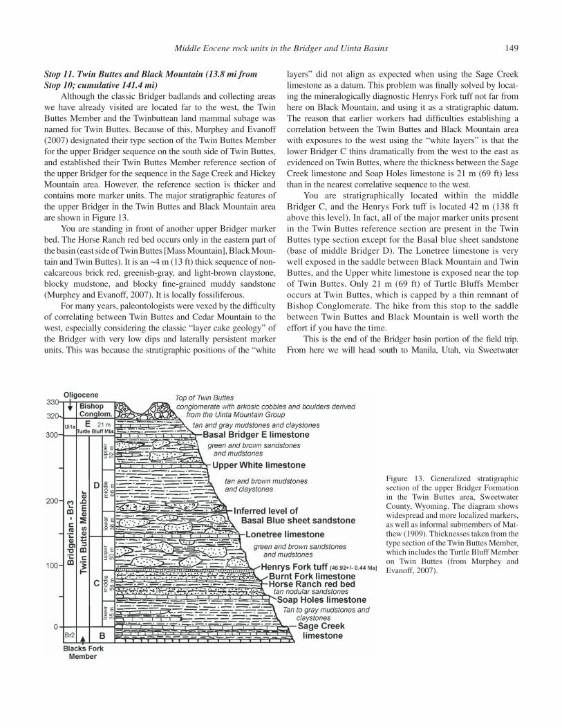
Middle Eocene rock units in the Bridger and Uinta Basins 149
Stop 11. Twin Buttes and Black Mountain (13.8 mi from Stop 10; cumulative 141.4 mi)
Although the classic Bridger badlands and collecting areas we have already visited are located far to the west, the Twin Buttes Member and the Twinbuttean land mammal subage was named for Twin Buttes. Because of this, Murphey and Evanoff (2007) designated their type section of the Twin Buttes Member for the upper Bridger sequence on the south side of Twin Buttes, and established their Twin Buttes Member reference section of the upper Bridger for the sequence in the Sage Creek and Hickey Mountain area. However, the reference section is thicker and contains more marker units. The major stratigraphic features of the upper Bridger in the Twin Buttes and Black Mountain area are shown in Figure 13.
You are standing in front of another upper Bridger marker bed. The Horse Ranch red bed occurs only in the eastern part of the basin (east side of Twin Buttes [Mass Mountain], Black Moun-tain and Twin Buttes). It is an ~4 m (13 ft) thick sequence of non-calcareous brick red, greenish-gray, and light-brown claystone, blocky mudstone, and blocky fi ne-grained muddy sandstone (Murphey and Evanoff, 2007). It is locally fossiliferous.
For many years, paleontologists were vexed by the diffi culty of correlating between Twin Buttes and Cedar Mountain to the west, especially considering the classic “layer cake geology” of the Bridger with very low dips and laterally persistent marker units. This was because the stratigraphic positions of the “white
layers” did not align as expected when using the Sage Creek limestone as a datum. This problem was fi nally solved by locat-ing the mineralogically diagnostic Henrys Fork tuff not far from here on Black Mountain, and using it as a stratigraphic datum. The reason that earlier workers had diffi culties establishing a correlation between the Twin Buttes and Black Mountain area with exposures to the west using the “white layers” is that the lower Bridger C thins dramatically from the west to the east as evidenced on Twin Buttes, where the thickness between the Sage Creek limestone and Soap Holes limestone is 21 m (69 ft) less than in the nearest correlative sequence to the west.
You are stratigraphically located within the middle Bridger C, and the Henrys Fork tuff is located 42 m (138 ft above this level). In fact, all of the major marker units present in the Twin Buttes reference section are present in the Twin Buttes type section except for the Basal blue sheet sandstone (base of middle Bridger D). The Lonetree limestone is very well exposed in the saddle between Black Mountain and Twin Buttes, and the Upper white limestone is exposed near the top of Twin Buttes. Only 21 m (69 ft) of Turtle Bluffs Member occurs at Twin Buttes, which is capped by a thin remnant of Bishop Conglomerate. The hike from this stop to the saddle between Twin Buttes and Black Mountain is well worth the effort if you have the time.
This is the end of the Bridger basin portion of the fi eld trip. From here we will head south to Manila, Utah, via Sweetwater
Figure 13. Generalized stratigraphic section of the upper Bridger Formation in the Twin Buttes area, Sweetwater County, Wyoming. The diagram shows widespread and more localized markers, as well as informal submembers of Mat-thew (1909). Thicknesses taken from the type section of the Twin Buttes Member, which includes the Turtle Bluff Member on Twin Buttes (from Murphey and Evanoff, 2007).
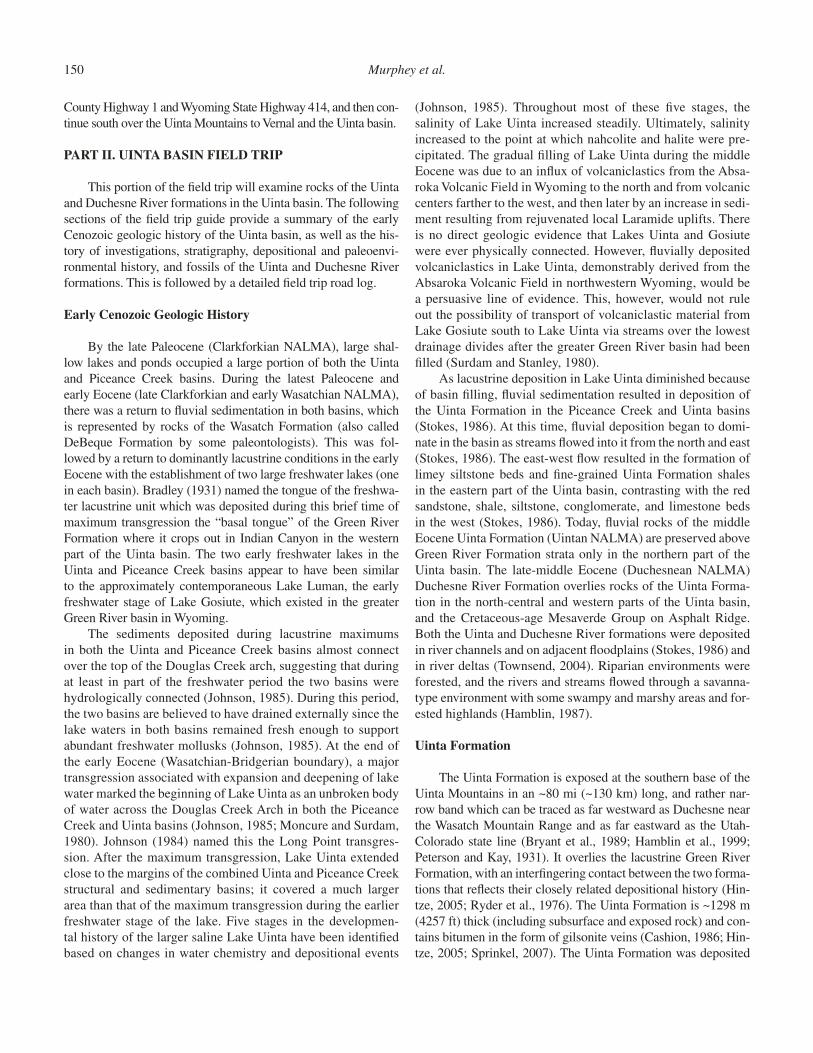
150 Murphey et al.
County Highway 1 and Wyoming State Highway 414, and then con-tinue south over the Uinta Mountains to Vernal and the Uinta basin.
PART II. UINTA BASIN FIELD TRIP
This portion of the fi eld trip will examine rocks of the Uinta and Duchesne River formations in the Uinta basin. The following sections of the fi eld trip guide provide a summary of the early Cenozoic geologic history of the Uinta basin, as well as the his-tory of investigations, stratigraphy, depositional and paleoenvi-ronmental history, and fossils of the Uinta and Duchesne River formations. This is followed by a detailed fi eld trip road log.
Early Cenozoic Geologic History
By the late Paleocene (Clarkforkian NALMA), large shal-low lakes and ponds occupied a large portion of both the Uinta and Piceance Creek basins. During the latest Paleocene and early Eocene (late Clarkforkian and early Wasatchian NALMA), there was a return to fl uvial sedimentation in both basins, which is represented by rocks of the Wasatch Formation (also called DeBeque Formation by some paleontologists). This was fol-lowed by a return to dominantly lacustrine conditions in the early Eocene with the establishment of two large freshwater lakes (one in each basin). Bradley (1931) named the tongue of the freshwa-ter lacustrine unit which was deposited during this brief time of maximum transgression the “basal tongue” of the Green River Formation where it crops out in Indian Canyon in the western part of the Uinta basin. The two early freshwater lakes in the Uinta and Piceance Creek basins appear to have been similar to the approximately contemporaneous Lake Luman, the early freshwater stage of Lake Gosiute, which existed in the greater Green River basin in Wyoming.
The sediments deposited during lacustrine maximums in both the Uinta and Piceance Creek basins almost connect over the top of the Douglas Creek arch, suggesting that during at least in part of the freshwater period the two basins were hydrologically connected (Johnson, 1985). During this period, the two basins are believed to have drained externally since the lake waters in both basins remained fresh enough to support abundant freshwater mollusks (Johnson, 1985). At the end of the early Eocene (Wasatchian-Bridgerian boundary), a major transgression associated with expansion and deepening of lake water marked the beginning of Lake Uinta as an unbroken body of water across the Douglas Creek Arch in both the Piceance Creek and Uinta basins (Johnson, 1985; Moncure and Surdam, 1980). Johnson (1984) named this the Long Point transgres-sion. After the maximum transgression, Lake Uinta extended close to the margins of the combined Uinta and Piceance Creek structural and sedimentary basins; it covered a much larger area than that of the maximum transgression during the earlier freshwater stage of the lake. Five stages in the developmen-tal history of the larger saline Lake Uinta have been identifi ed based on changes in water chemistry and depositional events
(Johnson, 1985). Throughout most of these fi ve stages, the salinity of Lake Uinta increased steadily. Ultimately, salinity increased to the point at which nahcolite and halite were pre-cipitated. The gradual fi lling of Lake Uinta during the middle Eocene was due to an infl ux of volcaniclastics from the Absa-roka Volcanic Field in Wyoming to the north and from volcanic centers farther to the west, and then later by an increase in sedi-ment resulting from rejuvenated local Laramide uplifts. There is no direct geologic evidence that Lakes Uinta and Gosiute were ever physically connected. However, fl uvially deposited volcaniclastics in Lake Uinta, demonstrably derived from the Absaroka Volcanic Field in northwestern Wyoming, would be a persuasive line of evidence. This, however, would not rule out the possibility of transport of volcaniclastic material from Lake Gosiute south to Lake Uinta via streams over the lowest drainage divides after the greater Green River basin had been fi lled (Surdam and Stanley, 1980).
As lacustrine deposition in Lake Uinta diminished because of basin fi lling, fl uvial sedimentation resulted in deposition of the Uinta Formation in the Piceance Creek and Uinta basins (Stokes, 1986). At this time, fl uvial deposition began to domi-nate in the basin as streams fl owed into it from the north and east (Stokes, 1986). The east-west fl ow resulted in the formation of limey siltstone beds and fi ne-grained Uinta Formation shales in the eastern part of the Uinta basin, contrasting with the red sandstone, shale, siltstone, conglomerate, and limestone beds in the west (Stokes, 1986). Today, fl uvial rocks of the middle Eocene Uinta Formation (Uintan NALMA) are preserved above Green River Formation strata only in the northern part of the Uinta basin. The late-middle Eocene (Duchesnean NALMA) Duchesne River Formation overlies rocks of the Uinta Forma-tion in the north-central and western parts of the Uinta basin, and the Cretaceous-age Mesaverde Group on Asphalt Ridge. Both the Uinta and Duchesne River formations were deposited in river channels and on adjacent fl oodplains (Stokes, 1986) and in river deltas (Townsend, 2004). Riparian environments were forested, and the rivers and streams fl owed through a savanna-type environment with some swampy and marshy areas and for-ested highlands (Hamblin, 1987).
Uinta Formation
The Uinta Formation is exposed at the southern base of the Uinta Mountains in an ~80 mi (~130 km) long, and rather nar-row band which can be traced as far westward as Duchesne near the Wasatch Mountain Range and as far eastward as the Utah- Colorado state line (Bryant et al., 1989; Hamblin et al., 1999; Peterson and Kay, 1931). It overlies the lacustrine Green River Formation, with an interfi ngering contact between the two forma-tions that refl ects their closely related depositional history (Hin-tze, 2005; Ryder et al., 1976). The Uinta Formation is ~1298 m (4257 ft) thick (including subsurface and exposed rock) and con-tains bitumen in the form of gilsonite veins (Cashion, 1986; Hin-tze, 2005; Sprinkel, 2007). The Uinta Formation was deposited
Middle Eocene rock units in the Bridger and Uinta Basins 151
under fl uvial conditions as the lake depositing the Green River Formation was receding (Ryder et al., 1976).
History of Paleontological Investigations
O.C. Marsh led the fi rst paleontological expedition to the Uinta basin in 1870 as part of a Yale College Scientifi c Expedi-tion (Betts, 1871; Marsh, 1875a, 1875b). In an unexplored area between the Green and White rivers, he and his party collected numerous fossil mammals, the beginnings of an assemblage that would later defi ne the Uintan North American Land Mammal Age (NALMA), a time period that spans ~40–46.5 Ma (Murphey and Evanoff, 2007; Prothero, 1996; Wood et al., 1941). In the 1880s, Francis Speir of Princeton University collected in this same area and the mammalian fossils he collected were studied by W.B. Scott and H.F. Osborn, whose efforts produced the fi rst com-prehensive publications on mammals from the Uinta Formation (Rasmussen et al., 1999a; Scott and Osborn, 1887, 1890). At the turn of the century, the Carnegie Museum sent expeditions to the Uinta basin at different times led by O.A. Peterson and then Earl Douglass (Douglass, 1914; Peterson, 1919). Peterson (1919) ini-tially described many of the medium and smaller-sized mammals from the Uinta Formation, many now recognized as index taxa for the Uintan NALMA and therefore crucial for understanding Uintan biochronology on both the regional and continental scales (Walsh, 1996). After these initial expeditions, museums across North America sent parties to collect small samples of Uintan mammals, the most notable of these being the Smithsonian Insti-tution. In 1993, an expedition from Washington University in St. Louis began what would be a 15+ year project (still ongoing) in the Uinta and Duchesne River Formations, with the goal of col-lecting small mammals (Rasmussen et al., 1999a; Townsend et al., 2006). These latest expeditions have amassed one of the larg-est assemblages of Uintan mammals from the Rocky Mountain region (Townsend, 2004).
Stratigraphy
While the Uinta Formation has been formally divided into a lower Wagonhound Member and an upper Myton Member, many geologists and paleontologists continue to utilize the informal tripartite scheme in which the formation was initially subdivided: Uinta A, B and C, from lowest to highest (Pro-thero, 1996; Sprinkel, 2007; Wood et al., 1941). The tripartite division of the formation is a modifi cation of Osborn’s (1929) stratigraphic nomenclature: Uinta A, Uinta B1, Uinta B2, and Uinta C (Peterson and Kay, 1931; Prothero, 1996; Sprinkel, 2007; Townsend et al., 2006; Walsh, 1996). The lowermost unit, Uinta A, intertongues with the underlying Parachute Creek Member of the Green River Formation and is com-prised of resistant fi ne-grained sandstones that are yellowish-brown and yellowish-gray (Sprinkel, 2007). These beds are medium to massive sandstones that weather to cliffs, ledges, and softer gray slopes and have been measured to be ~226 m
(740 ft) in thickness (Cashion, 1974). Within in Uinta A, there is a 1.8 m (6 ft) thick tuffaceous bed (“a” tuff), and the base of this bed occurs 56 m (185 ft) below the top of the Uinta A (Cashion, 1974). Uinta B is composed of light-gray, light greenish-gray, light-brown, light-purple mudstones and claystones forming non-resistant slopes (Sprinkel, 2007). These are interbedded with green-gray, yellow and brown fi ne-grained sandstones that form thin resistant ledges (Sprinkel, 2007; Townsend et al., 2006). There are prominent gilsonite veins in this unit (Cashion, 1986). In the eastern part of the basin, the Uinta B is capped by a massive fi ne- to coarse-grained gray and brown sandstone bed that weathers to dark brown, and was named the “Amynodon” sandstone (Riggs, 1912). This massive sandstone unit is over one mile in length, and was originally defi ned as the boundary between the Uinta B and Uinta C horizons (Riggs, 1912), but is now known to be local in extent. Uinta C is distinctive in that the lower intervals and upper intervals are strikingly different in terms of rock type and coloration (Townsend et al., 2006). The lower part of Uinta C is comprised of light-gray, light green-ish gray, and light-brown mudstone and claystone that interbed with fi ne-grain sandstone beds, which are also greenish-gray or commonly yellow or brown (Sprinkel, 2007, Townsend et al., 2006). The upper part is composed of mainly deep red orange, red, dark-brown, grayish-purple and yellow mudstone and clay-stone with thin gray and green fi ne grain sandstone beds that form thin ledges (Sprinkel, 2007; Townsend et al., 2006).
The stratigraphy of the Uinta Formation has been less well studied than that of the Green River Formation, and most of the stratigraphic work has been undertaken by paleontologists. The early work that produced the initial description of the for-mation has been confused by changes in terminology describ-ing the lithologic horizons and by shifting boundaries of the units that divide these horizons (Cashion, 1986; Osborn, 1929; Prothero, 1996; Riggs, 1912; Stagner, 1941; Townsend, et al., 2006). Osborn (1895) cited Peterson as fi rst dividing the forma-tion into informal units Uinta A, B, and C, and all units were reported to be fossiliferous. All early fossil collections have these horizon designations assigned as stratigraphic data (Pro-thero, 1996). Osborn (1929) removed the top 400 ft of Peter-son’s Uinta A, and called it Uinta B1, leaving the remaining sandstones of Uinta A without any known record of fossil verte-brates. Additionally, he designated the “Amynodon” sandstone of Riggs (1912) as the boundary unit between Uinta B (now B2) and Uinta C, further altering Peterson’s initial scheme. Osborn’s (1929) Uinta B1 had an upper limit bound by another massive unit, the “Metarhinus” sandstone. The massive sand-stone units of Uinta B1 are not laterally extensive, and a red shale and siltstone unit described by Cashion (1974) might be a more appropriate boundary unit. The various changes in ter-minology and marker units have caused signifi cant confusion in museum locality data, and have adversely affected the accuracy of the stratigraphic ranges of numerous Uintan taxa.
Prothero (1996) constructed a magnetostratigraphic section correlating the various historical Uinta Formation localities. With
152 Murphey et al.
the local ranges of various mammalian taxa in disorder due to ear-lier stratigraphic nomenclatural changes, Prothero’s (1996) work was an essential fi rst step in clarifying and correlating localities across the exposed formation in the Uinta basin. Townsend et al. (2006) described a series of stratigraphic sections through the upper intervals of Osborn’s (1929) Uinta B2 and Uinta C, up to the contact with the overlying Duchesne River Formation (Fig. 14A). These authors suggested a new boundary between the Uinta B–Uinta C units based on a signifi cant lithologic and color change. The suggested boundary is ~73 m higher than the “Amyn-odon” sandstone of Osborn (1929). Sprinkel (2007) mapped the boundary between the Uinta C and the Duchesne River Forma-tion higher in the section, and because it is associated with such a gradual lithology change in the eastern part of the basin, he recognized and mapped a transition zone between the forma-tions. He mapped the Uinta B-C boundary using a distinctive and reportedly more laterally persistent greenish mudstone bed that occurs just below the “Amynodon” sandstone. Stratigraphic work continues in conjunction with the current paleontological work.
Paleoenvironmental History, Paleontology and Biochronology
The Eocene epoch is the time when many modern orders of mammals fi rst appear in the fossil record (e.g., primates, bats, artiodactyls, perissodactyls, rabbits,). Prior to the Eocene, mam-malian faunas were composed of archaic forms that had diver-sifi ed just after the demise of the dinosaurs at the Cretaceous-Tertiary boundary. During the early Eocene, global climates were exceedingly warm and produced an almost pole-to-pole tropical greenhouse (Zachos et al., 2001). The Uintan NALMA and the fi nal intervals of the preceding Bridgerian, mark the beginning of the end of this global greenhouse, and this is refl ected in the ecological diversity of the mammals that lived during this time (Townsend et al., 2010; Woodburne et al., 2009a). Tropical arbo-real forms, typical of the early Eocene greenhouse, began to drop off, and mammals that were more adapted to subtropical, even temperate conditions and habitats began to appear (Townsend et al., 2010). The Uintan NALMA also marks a key transition in the evolutionary history of North American mammalian faunas as ~31% of modern mammalian taxonomic families (ancestors of canids, camelids, felids, and some modern rodents) appeared in the fossil record (Black and Dawson, 1966).
The Uinta Formation fossils that form the basis of the Uintan NALMA are from Uinta B1, B2, and C units. The fauna from Uinta B1 comes mainly from the Wagonhound-Bonanza area, an early locality (Well No. 2), and the Willow Creek-Ouray area. The assemblage from this unit is small and includes Achaenodon uintensis, Protoreodon parvus, Oromeryx plicatus, Harp-agolestes, Eomoropus amarorum, Hyrachyus eximius, a species of Triplopus, and a diverse group of brontotheres and uintatheres (see Appendix A) (Gunnell et al., 2009; Prothero, 1996). These taxa are considered an early Uintan assemblage corresponding to biochron Ui2 of Gunnell et al. (2009).
The Uinta B2 fauna is incredibly diverse (see Appendix A) and constitutes the bulk of the assemblage that is considered early Uintan, and corresponds to biochron Ui2 of Gunnell et al. (2009). Sediments that have yielded faunas from the Uinta B2 unit include White River Pocket and areas around Kennedy’s Hole. Recent fossil collecting efforts have made it possible to formally defi ne biochronologic units and stratotype sections for the Uinta Formation (Gunnell et al., 2009). The beginning of Ui2 is defi ned by 26 index taxa (outlined in Gunnell et al., 2009). Numerous taxa range through Ui2, but only a few are unique to Ui2 and these are from Uinta B2 beds: Amynodon reedi, Eobasileus cor-nutus; Eomoropus amororum, Hyrachyus eximius, Limnocyon potens, Mesonyx obtusidens, Metarhinus fl uviatalis, Metarhinus sp., Ourayia sp. nov., Pantolestes longicaudus, Paramys sp., Sci-uravus popi, Uintatherium anceps (Gunnell et al., 2009).
Fossil mammals found in Uinta C sediments are typically considered to be late Uintan and correlate to biochron Ui3 of Gunnell et al. (2009). Strata that have yielded late Uintan faunas include Myton Pocket, Kennedy’s Hole, Leota Ranch, Devil’s Playground, Leland Bench Draw, and Antelope Draw. The Uinta C fauna is equally as diverse as the Uinta B2 fauna. Twenty-four taxa defi ne the beginning of Ui3 including Auxontodon, Colo-don, Duchesneodus, Eosictis, Janimus, Mytonius, Mytonomeryx, Pentacemylus, Procyonodictis, Protadjiduamo, Protitanoth-erium, and Metatelmatherium. One of the striking differences between Ui2 and Ui3 faunas is that the younger assemblage is dominated by artiodactyls. Therefore, this biochron was desig-nated the “Pentacemylus progressus Interval Zone” refl ecting the abundance of this particular taxon (Gunnell et al., 2009). While the taxonomic composition of Ui3 is quite different than Ui2, only a few genera make their fi rst appearance during this interval (Gunnell et al., 2009). Current fi eldwork is focused on collecting the upper intervals of the Uinta C unit via excavation and screen-washing in order to increase the sample of small mammals.
Uinta Formation Field Trip Stops
Traveling south across the Uinta basin via State Route (SR) 45, we will cross both the Green and White rivers and make our way to the base of the Uinta Formation just south of Wagon Hound Canyon. Note that the driving distance from the Utah Field House Museum in Vernal to the fi rst fi eld trip stop is 42.6 mi. Our examination of the Uinta Formation will com-mence at the base of the formation where it overlies strata of the Parachute Creek Member of the Green River Formation along the White River. From there we will travel north across Wagon Hound Canyon to examine rocks of the Uinta A and interbed-ded Green River Formation. Continuing north, we will exam-ine the green siltstones and brown sandstones typical of Uinta B1. From here we will be able to see the typical red and gray beds defi ning Uinta B2 and the orange-red sediments that typify the Brennan Basin Member of the Duchesne River Formation from a distance. We will spend most of the day exploring typi-cal Uinta B2 localities in the Coyote Wash area and will then

Middle Eocene rock units in the Bridger and Uinta Basins 153
Figure 14. (A) Stratigraphic section from Townsend et al. (2006) indicating the level of the Amynodon sandstone of Os-born (1929), the base of which forms the traditional Uinta B2–Uinta C boundary, and the Uinta B2-C boundary at Devil’s Playground suggested by Townsend et al. (2006). (B) View of massive cliff-forming Uinta A sandstones overlying and interfi ngering with Parachute Creek Member of the Green River Formation. (C) Measuring one of the massive sandstone units in Uinta B. (D) Collecting at WU-18, a typical Uinta B2 locality. (E) Sandstone channels associated with the WU-110 locality complex.
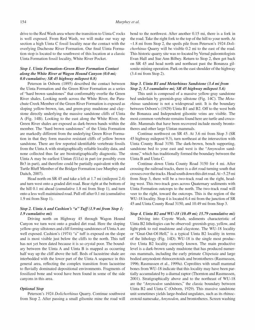
154 Murphey et al.
drive to the Red Wash area where the transition to Uinta C rocks is well exposed. From Red Wash, we will make our way up section a high Uinta C fossil locality near the contact with the overlying Duchesne River Formation. Our fi nal Uinta Forma-tion stop is located to the southwest of this location at a classic Uinta Formation fossil locality, White River Pocket.
Stop 1. Uinta Formation–Green River Formation Contact along the White River at Wagon Hound Canyon (0.0 mi; 0.0 cumulative; SR 45 highway milepost 0.8)
Peterson in Osborn (1895) described the contact between the Uinta Formation and the Green River Formation as a series of “hard brown sandstones” that conformably overlie the Green River shales. Looking north across the White River, the Para-chute Creek Member of the Green River Formation is exposed as sloping yellow-brown, tan, and green-gray mudstone and clay-stone directly underlying the massive sandstone cliffs of Uinta A (Fig. 14B). Looking to the east along the White River, the Green River shales are exposed as dark-brown bands within the member. The “hard brown sandstones” of the Uinta Formation are markedly different from the underlying Green River Forma-tion in that they form massive resistant cliffs of yellow brown sandstone. There are few reported identifi able vertebrate fossils from the Uinta A with stratigraphically reliable locality data, and none collected thus far are biostratigraphically diagnostic. The Uinta A may be earliest Uintan (Ui1a) in part (or possibly even Br3 in part), and therefore could be partially equivalent with the Turtle Bluff Member of the Bridger Formation (see Murphey and Daitch, 2007).
Head north on SR 45 and take a left at 1.7 mi (milepost 2.4) and turn west onto a graded dirt road. Bear right at the bottom of the hill 0.1 mi ahead (cumulative 1.8 mi from Stop 1), and turn onto a less well maintained road. Pull off after 0.1 mi (cumulative 1.9 mi from Stop 1).
Stop 2. Uinta A and Cashion’s “a” Tuff (1.9 mi from Stop 1; 1.9 cumulative mi)
Driving north on Highway 45 through Wagon Hound Canyon we turn west onto a graded dirt road. Here the sloping yellow-gray siltstones and cliff forming sandstones of Uinta A are well exposed. Cashion’s (1974) “a” tuff is exposed on the slope and is most visible just below the cliffs to the north. This tuff has not yet been dated because it is so crystal poor. The bound-ary between the Uinta A and Uinta B is mapped as occurring half way up the cliff above the tuff. Beds of lacustrine shale are interbedded with the lower part of the Uinta A sequence in this general area, refl ecting the complex transition from lacustrine to fl uvially dominated depositional environments. Fragments of fossilized bone and wood have been found in some of the side canyons in this area.
Optional StopPeterson’s 1924 Dolichorhinus Quarry. Continue southwest
from Stop 2. After passing a small gilsonite mine the road will
bend to the northwest. After another 0.15 mi, there is a fork in the road. Take the right fork to the top of the hill to your north. At ~1.8 mi from Stop 2, the spoils pile from Peterson’s 1924 Doli-chorhinus Quarry will be visible 0.2 mi to the east of the road. This historic quarry site was re-located by Vernal paleontologists Evan Hall and Sue Ann Bilbey. Return to Stop 2, then get back on SR 45 and head north and northeast past the Bonanza gil-sonite mining operation. Park on the east shoulder of the highway (3.4 mi from Stop 2).
Stop 3. Uinta B1 and Metarhinus Sandstone (3.4 mi from Stop 2; 5.3 cumulative mi; SR 45 highway milepost 5.6)
This unit is composed of a massive yellow-gray sandstone bed underlain by greenish-gray siltstone (Fig. 14C). The Meta-rhinus sandstone is not a widespread unit. It is the boundary between Osborn’s (1929) Uinta B1 and B2. Off to the west both the Bonanza and Independent gilsonite veins are visible. The most common vertebrate remains found here are turtle and croco-dile. Mammals that have been recovered include mostly bronto-theres and other large Uintan mammals.
Continue northwest on SR 45. At 3.6 mi from Stop 3 (SR 45 highway milepost 9.3), turn northeast at the intersection with Uinta County Road 3150. The dark-brown, bench supporting, sandstone bed to your east and west is the “Amynodon sand-stone,” which has traditionally formed the boundary between the Uinta B and Uinta C.
Continue down Uinta County Road 3150 for 4 mi. After crossing the railroad tracks, there is a dirt road turning south that crosses over the tracks. Head south down this dirt road. At ~5.25 mi from Stop 3, there will be a two-track road on the right, head-ing west. This two-track goes across Quaternary sediments with Uinta Formation outcrops to the north. The two-track road will veer to the right, toward the outcrops. This is the region of the WU-18 locality. Stop 4 is located 6.4 mi from the junction of SR 45 and Uinta County Road 3150, and 10.49 mi from Stop 3.
Stop 4. Uinta B2 and WU-18 (10.49 mi; 15.79 cumulative mi)Driving into Coyote Wash, sediments characteristic of
Uinta B2 lithologies can be observed: greenish-gray, yellow, and light-pink to red mudstone and claystone. The WU-18 locality or “Gnat-Out-Of-Hell,” is a typical Uinta B2 locality in terms of the lithology (Fig. 14D). WU-18 is the single most produc-tive Uinta B2 locality currently known. The main productive level is a dark-brown sandy mudstone that has produced numer-ous mammals, including the early primate Chipetaia and large bodied amynodont rhinocerotoids and brontotheres (Rasmussen, 1996; Rasmussen et al., 1999a). Coprolites with small mammal bones from WU-18 indicate that this locality may have been par-tially accumulated by a diurnal raptor (Thornton and Rasmussen, 2001). Stratigraphically above and to the northeast of WU-18 are the “Amynodon sandstones,” the classic boundary between Uinta B2 and Uinta C (Osborn, 1929). This massive sandstone unit sometimes yields large-bodied ungulates, such as its rhinoc-erotoid namesake, Amynodon, and brontotheres. Screen washing

Middle Eocene rock units in the Bridger and Uinta Basins 155
at WU-18 has resulted in the recovery of multiple bird bones, increased samples of primates and small rodents.
Return to SR 45 and head north. Pull over carefully as close to the guardrails as possible at SR 45 highway milepost 11.6, which is 1.8 mi from Stop 4.
Stop 5. Devil’s Playground Red Beds (1.8 mi from Stop 4; 17.59 cumulative mi; SR 45 highway milepost 11.6)
To the east there is a prominent red bed that Townsend et al. (2006) consider to be the boundary between the Uinta C and the Brennan Basin Member of the Duchesne River Formation.
Heading south on SR 45, about ¾ of a mile, make a sharp right and travel a mile and veer to the right at ~1 mi from the turn off from SR 45. Travel for another 1¼ mi to a well pad and park.
Stop 6. Uinta C WU-110 Locality Complex (2.25 mi; 19.84 cumulative mi)
The WU-110 locality complex spans the Uinta B2–Uinta C boundary as defi ned by Townsend et al. (2006). The pri-mary lithology in the area consists of gray-green, tan, and yellow-brown mudstones. A distinctive feature of this complex includes large dark-brown fi ne- to coarse-grained channel sand-stone beds (Fig. 14E). Numerous fossils have been discovered in a dark-brown siltstone layer that weathers pink at WU-110. These fossils include the primate Ourayia, the artiodactyls Pro-toreodon and Leptotragulus, as well as numerous rodents. The remaining localities in the area WU-115, 116, 117, have also been quite productive. In addition to more small mammal den-taries, large-bodied perissodactyls, carnivore postcrania, and a specimen of Simidectes have been recovered.
Return to SR 45. Turn right and travel ¾ of a mile to the fi rst dirt road exit on the left, this is the Sand Ridge Road. Take a right. Follow Sand Ridge Road west, and at mile 7 from Stop 6, you will come to a road that veers left. Do not turn here; con-tinue west. After mile 9, the road will turn south, and at mile 10 you will encounter a fork in the road. Make a right here, and in another ½ mi there will be another fork where you will take a right again. Continue on this road for 3.5 mi. Close to mile 14, you will see a road veering left, do not turn here, continue straight ahead. At approximately mile 15, there is a road that veers right (north). Turn here. At the 16.5 mi mark, pull off the road and park. Looking due west, you will see a large gray and orange outcrop in the distance, this is the WU-22 locality complex.
Stop 7. Uinta C and WU-22 Locality Complex (16.69 mi; 36.53 cumulative mi)
Note the Deseret Power Plant to the northeast and a large bench directly north of the locality complex with strata consist-ing of highly variegated red, purple, gray, and orange sediments. These claystone and mudstone beds surround the main drainage of this region of the basin, Red Wash. Fossils at WU-22 are gen-erally found in gray, tan, yellow, and green-gray mudstone beds. Typically, as with other localities, fossils here are found directly on the surface, where they have eroded out of the surrounding
sediments and are highly fragmented. Small-scale excavations in this locality complex have recovered a number of articulated skeletons, including the skull and postcrania of the tiny deer-like Protoreodon and a skull, forelimb, and vertebral column of medium sized rodent.
From Stop 7, turn left, heading northeast for ~2 mi until reaching an intersecting road, and turn left again. After ¼ mi, you will see an intersection of four roads. Take the road to your immediate left, which will lead west along a pipeline road. Stay on this road for the next 5–6 mi. This is a main transport road in the oil fi elds. After mile 7, this road will become Glen Bench Road. At about mile 7¾, the road will jog to the right and you will see an intersecting road. Turn left and begin the steep climb up to the top of Glen Bench. There is a sharp turn at about mile 9¼. After this turn, continue along the road until you come across an intersecting road just past mile 10. Cross this intersecting road and follow it down the northwest face of Glen Bench into Antelope Draw. There will be a three-way intersec-tion at about the 11¾ mi mark. Veer left, heading northwest. At mile 13, take a sharp left, driving for more than a ½ mi. Make a hard right heading due north, this is another major transport road. At ~14½ mi, you will come to two roads that veer off to the right, one heading northeast, the other southeast. Take the northeast road. After mile 15, the road will loop around a large canyon. Continue along a series of tall escarpments, and the road will make another loop after mile 17. At this point, fi nd a place off of the main road to park. Looking due east, you will see the WU-210 locality complex.
Stop 8. Uinta C, WU-210, Contact with Duchesne River Formation (18.71 mi; 55.24 cumulative mi)
Nearing the top of the Uinta Formation, the sediments are brightly pigmented as they weather deep brown, bright orange, and various shades of red. In the WU-210 area, sloping red, gray, and tan mudstone beds are interbedded with large, ledge-forming blocky yellow-brown sandstone beds. At this level in the formation, the Duchesne River and Uinta formations are locally interbedded. Conglomeratic resistant sandstone chan-nels typical of the Brennan Basin member of the Duchesene River Formation can be viewed at the top of WU-210. This locality and others surrounding it are highly productive and have yielded numerous perissodactyls including early tapiroids, such as Isectolophus, and almost complete skeletons of large rodents such as Pseudotomus.
From WU-210, head north toward the loop in the road and make your way back to the main road from which we approached this complex of localities. Take a right heading north going toward the top of Deadman Bench. This road will intersect with the main Deadman Bench road that trends east-west. Take a right on this main road and head back to SR 45 (6.6 mi).
Head southeast on SR 45 for 5.9 mi and turn northeast onto a short graded road at SR 45 highway milepost 14.0. There is an old information kiosk and small wind turbine located ~300 ft east of the highway at this location.
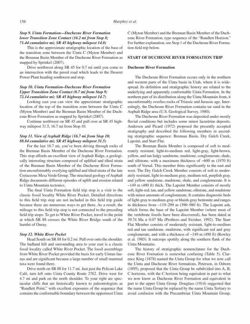
156 Murphey et al.
Stop 9. Uinta Formation—Duchesne River Formation lower Transition Zone Contact (16.2 mi from Stop 8; 71.44 cumulative mi; SR 45 highway milepost 14.0)
This is the approximate stratigraphic location of the base of the transition zone between the Uinta C (Myton Member) and the Brennan Basin Member of the Duchesne River Formation as mapped by Sprinkel (2007).
Drive northwest along SR 45 for 0.7 mi until you come to an intersection with the paved road which leads to the Deseret Power Plant heading southwest and stop.
Stop 10. Uinta Formation–Duchesne River Formation Upper Transition Zone Contact (0.7 mi from Stop 9; 72.14 cumulative mi; SR 45 highway milepost 14.7)
Looking east you can view the approximate stratigraphic location of the top of the transition zone between the Uinta C (Myton Member) and the Brennan Basin Member of the Duch-esne River Formation as mapped by Sprinkel (2007).
Continue northwest on SR 45 and pull over at SR 45 high-way milepost 31.5, 16.7 mi from Stop 10.
Stop 11. View of Asphalt Ridge (16.7 mi from Stop 10; 88.84 cumulative mi; SR 45 highway milepost 31.5)
For the last 16.7 mi, you’ve been driving through rocks of the Brennan Basin Member of the Duchesne River Formation. This stop affords an excellent view of Asphalt Ridge, a geologi-cally interesting structure composed of uplifted and tilted strata of the Brennan Basin Member of the Duchesne River Forma-tion unconformably overlying uplifted and tilted strata of the late Cretaceous Mesa Verde Group. The structural geology of Asphalt Ridge documents different episodes of uplift and erosion related to Uinta Mountain tectonics.
The fi nal Uinta Formation fi eld trip stop is a visit to the classic fossil locality White River Pocket. Detailed directions to this fi eld trip stop are not included in this fi eld trip guide because there are numerous ways to get there. As a result, the mileage to this fi eld trip stop is not connected to the preceding fi eld trip stops. To get to White River Pocket, travel to the point at which SR 88 crosses the White River Bridge south of the hamlet of Ouray.
Stop 12. White River PocketHead South on SR 88 for 0.2 mi. Pull over onto the shoulder.
The badland hill and surrounding area to your east is a classic fossil locality called White River Pocket. The fossil assemblage from White River Pocket provided the basis for early Uintan fau-nas and are signifi cant because a large number of small mammal taxa were found there.
Drive north on SR 88 for 11.7 mi. Just past the Pelican Lake Café, turn left onto Uinta County Route 2762. Drive west for 4.7 mi and park on the north shoulder. To your right are spec-tacular cliffs that are historically known to paleontologists as “Randlett Point,” with excellent exposures of the sequence that contains the conformable boundary between the uppermost Uinta
C (Myton Member) and the Brennan Basin Member of the Duch-esne River Formation, type sequence of the “Randlett Horizon.” For further explanation, see Stop 1 of the Duchesne River Forma-tion fi eld trip below.
START OF DUCHESNE RIVER FORMATION TRIP
Duchesne River Formation
The Duchesne River Formation occurs only in the northern and western parts of the Uinta basin in Utah, where it is wide-spread. Its defi nition and stratigraphic history are related to the underlying and apparently conformable Uinta Formation. In the northern part of its distribution along the Uinta Mountain front, it unconformably overlies rocks of Triassic and Jurassic age. Inter-estingly, the Duchesne River Formation contains tar sand in the Asphalt Ridge area (U.S. Geological Survey, 1980).
The Duchesne River Formation was deposited under mostly fl uvial conditions but includes some minor lacustrine deposits. Andersen and Picard (1972) proposed the presently accepted stratigraphy and described the following members in ascend-ing stratigraphic sequence: Brennan Basin, Dry Gulch Creek, Lapoint, and Starr Flat.
The Brennan Basin Member is composed of soft to mod-erately resistant, light-to-medium red, light-gray, light-brown, yellow, and tan ledgy sandstone, mudstone, conglomerate, shale, and siltstone, with a maximum thickness of ~600 m (1970 ft) south of Vernal. This member thins signifi cantly to the east and west. The Dry Gulch Creek Member consists of soft to moder-ately resistant, light-to-medium gray, medium red, purplish gray, and yellow sandstone, mudstone, shale, and conglomerate. It is ~149 m (490 ft) thick. The Lapoint Member consists of mostly soft, light-red, tan, and yellow sandstone, siltstone, and mudstone with minor amounts of conglomerate. It contains diagnostic beds of light-gray to medium-gray or bluish-gray bentonite and ranges in thickness from ~119–299 m (390–980 ft). The Lapoint ash, which forms the base of the Lapoint Member (where most of the vertebrate fossils have been discovered), has been dated at 39.74 Ma ± 0.07 Ma (Prothero and Swisher, 1992). The Starr Flat Member consists of moderately resistant, light-to-medium red and tan sandstone, mudstone, with signifi cant red and gray conglomerate, and with a thickness of ~149 m (490 ft) (Rowley et al. 1985). It outcrops spottily along the southern fl ank of the Uinta Mountains.
The history of stratigraphic nomenclature for the Duch-esne River Formation is somewhat confusing (Table 5). Clar-ence King (1878) named the Uinta Group for what we now call the Uinta and Duchesne River formations. Peterson, in Osborn (1895), proposed that the Uinta Group be subdivided into A, B, C horizons, with the C horizon being equivalent in part to what we now know as Duchesne River Formation and equivalent in part to the upper Uinta Group. Douglass (1914) suggested that the name Uinta Group be replaced by the name Uinta Tertiary to avoid confusion with the Precambrian Uinta Mountain Group.
Middle Eocene rock units in the Bridger and Uinta Basins 157
Scott in Peterson (1931c) named the Duchesne Formation, and it was renamed Duchesne River Formation by Kay (1934) because the name Duchesne Formation was preoccupied. Kay (1934) defi ned the Duchesne River Formation by removing the red beds of Osborn’s (1895) upper Uinta Group, recognizing they have a younger mammalian fossil fauna. He also recognized three bio-stratigraphic “horizons:” Randlett, Halfway, and Lapoint. Gazin (1955) removed the Randlett horizon from the Duchesne River Formation, recognizing that it contains a fauna that is almost identical to that of the Uinta C. Warner (1963) recognized two members, the Minor Bentonite member being equivalent to the Brennan Basin and Dry Gulch Creek members, and the Major Bentonite Member being equivalent with the Lapoint Member. Andersen and Picard (1972) named the currently recognized members: Brennan Basin, Dry Gulch Creek, Lapoint, and Starr Flat members. With regard to Andersen and Picard’s (1972) stratigraphic terminology, the Brennan Basin Member is equiva-lent to the Randlett Horizon of Kay (1934) and the lower part of Halfway Horizon, the Dry Gulch Creek Member is equiva-lent with the upper part of the Halfway horizon, and the Lapoint Member is equivalent to the Lapoint horizon.
Fossils and Biochronology of the Duchesne River Formation
In comparison with the underlying Uinta Formation and cor-relative strata of Duchesnean age in coastal southern California, the vertebrate fossil fauna of the type Duchesne River Formation is sparse. However, it is a critically important period in mamma-lian evolution (Lucas 1992; Rasmussen et al., 1999b; Robinson et al., 2004). Although it is the nominal stratotype for the Duch-esnean NALMA (Wood et al.,1941), its validity has been the subject of some controversy among paleontologists (see Lucas, 1992; Wilson, 1978). Nevertheless, the Duchesnean NALMA has now been widely accepted by paleontologists (Rasmussen et al., 1999b; Robinson et al., 2004). Lucas (1992. p. 88) made the observation that the Duchesne River Formation “has either been questioned, abandoned, subdivided, or defended.” Scott (1945) regarded the Duchesne River Formation as Oligocene in age. Simpson (1946) and Gazin (1955) considered it Eocene. Faunally, the importance of the Duchesne River Formation and the Duchesnean NALMA is based on the fact that it records a major faunal replacement in North America, as demonstrated by its large number of fi rst and last occurrences, as well as the small number of genera that are restricted to it (Appendix A; Black and Dawson, 1966; Robinson et al., 2004). Robinson et al. (2004) tentatively assigned Duchesnean fi rst appearances to include Hyaenodon, Duchesneodus, Duchesnehippus interme-dius, Amynodontopsis, and Eotylopus.
The fauna of the Brennan Basin Member, which was previ-ously assigned to the Randlett horizon and lower part of the half-way horizon of Kay (1934), includes a faunal assemblage that is generally considered to be intermediate between the Uinta C (biochron Ui3, Gunnell et al., 2009) and the Lapoint Member
TA
BLE
5. H
IST
OR
Y O
F D
UC
HE
SN
E R
IVE
R F
OR
MA
TIO
N S
TR
AT
IGR
AP
HIC
NO
ME
NC
LAT
UR
E
Kin
g (1
878)
P
eter
son
in
Osb
orn
(189
5)
Dou
glas
s (1
914)
P
eter
son
and
Kay
(19
31)
Sco
tt in
Pet
erso
n (1
931)
K
ay (
1934
) G
azin
(19
55)
War
ner
(196
3)
And
erse
n an
d P
icar
d (1
972)
Uin
ta G
roup
(in
par
t)
C h
oriz
on (
in p
art)
=
upp
er U
inta
G
roup
Uin
ta T
ertia
ry(in
par
t)
Upp
er U
inta
re
dbed
s se
para
ted
from
un
derly
ing
Uin
ta T
ertia
ry
Duc
hesn
e F
orm
atio
n
Duchesne River Formation
(not
stu
died
) (n
ot s
tudi
ed)
(not
stu
died
) S
tarr
Fla
t M
embe
r
Lapo
int h
oriz
on
Lapo
int h
oriz
on
Maj
or b
ento
nite
m
embe
r La
poin
t Mem
ber
Hal
fway
hor
izon
H
alfw
ay h
oriz
on
Min
or b
ento
nite
m
embe
r
Dry
Gul
ch C
reek
M
embe
r
Bre
nnan
Bas
in
Mem
ber
Ran
dlet
t hor
izon
158 Murphey et al.
of the Duchesne River Formation, although most workers regard it as late Uintan. The Brennan Basin Member outcrops over a fairly large area, and several somewhat productive localities are known. It contains a reasonably diverse assemblage of Uintan artiodactyls including Protoreodon, Pentacemylus, Diplobunops, and Leptotragulus. Perissodactyls include a mix of Uintan and Duchesnean brontotheres, as well as tapirs and rhinos. Speci-mens of the Uintan lagomorph Mytonolagus and the rodents Pareumys and Mytonomys have also been collected (Rasmussen et al., 1999b).
Until recently, only two published specimens had ever been reported from the Dry Gulch Creek Member, and these repre-sented the “Halfway Fauna.” The specimens include the holotype of Duchesnehippus intermedius, a genus of horse that is pur-portedly intermediate between the Uintan horse Epihippus and the Chadronian horse Mesohippus, and a femur and astragalus tentatively identifi ed as (?) hyracodontid rhinoceros. Walsh and Murphey (2007) discovered a locality that produced a diversity of small mammals in the Dry Gulch Creek Member (67 identifi able specimens). SDSNH Loc. 5939 (“Halfway Hollow One”) is situ-ated roughly in the stratigraphic middle of the Tdr-dgc, at about the same level as the type locality of D. intermedius. Taxa from this locality include Nanodelphys sp., Lipotyphlan indet., Pareu-mys cf. P. guensburgi, cf. Janimus sp., Metanoiamys sp., Protad-jidaumo typus, Protadjidaumo sp. (large), Eomyidae, unidenti-fi ed gen. and sp., Eomyidae? new gen. and sp., Geomorpha, new gen. and sp., cf. Griphomys sp., cf. Passaliscomys sp., Mytono-lagus sp., and Artiodactyla indet. Thus, the number of identifi -able mammal specimens from the Dry Gulch Creek Member has been increased dramatically. Fourteen additional mammalian taxa are now known from this member, nine of which are new records for the Duchesne River Formation as a whole. Impor-tantly, Pareumys cf. P. guensbergi, Protadjidaumo typus, and cf. Passaliscomys sp. suggest a Duchesnean age for most or all of the Dry Gulch Creek Member, and that the Uintan-Duchesnean boundary occurs somewhere within the upper part of the Brennan Basin Member or the lower part of the Dry Gulch Creek Member. Additional stratigraphically controlled screen washing efforts are needed to determine the precise stratigraphic location of the Uintan-Duchesnean boundary in the Uinta basin.
The mammalian fauna of the Lapoint Member is considered the type Duchesnean fauna, although misidentifi cations, data loss, and mistakes made by earlier workers have resulted in con-siderable confusion regarding what was actually collected at this horizon. Most of these problems seem to have been resolved by the efforts of Rasmussen et al. (1999b). The Lapoint fauna con-tains diverse assemblages of artiodactyls such as Protereodon, Agriochoerus, Simimeryx, and Brachyops, and perissodactyls such as Colodon, Hyracodon, Duchesnehippus, and Duchesneo-dus. Also present are carnivores, the mesonychid Hessolestes, the hyaenodontan Hyaenodon, the lipotyphlan Centetodon, and the rodents Pareumys and Protadjidaumo.
No published accounts of fossils have been reported from the stratigraphically highest Starr Flat Member. However, Mark
Roeder and Paul Murphey of the San Diego Natural History Museum discovered a highly fragmented mammal tooth that was tentatively identifi ed as a partial upper molar of a large camelid from near the base of the member (Paul Murphey, 2008, unpub-lished fi eld notes).
Although the Lapoint and Brennan Basin members of the Duchesne River Formation are the most fossiliferous, fossils are generally scarce throughout the formation. Any new discoveries would be highly signifi cant, especially from the Dry Gulch Creek and Starr Flat members. It is also noteworthy that reptiles in gen-eral are poorly represented from the Duchesne River Formation. Much work remains to be done in order to document the faunal changes within the Duchesne River and ascertain the position of the Uintan-Duchesnean boundary.
Duchesne River Formation Field Trip Stops
Our exploration of the Duchesne River Formation begins at Randlett Point where the contact between the Myton Member of the Uinta Formation (informal member C of Uinta Forma-tion) and the overlying Brennan Basin Member of the Duchesne River Formation is well exposed and relatively easy to discern. From there we travel north through strata of the Brennan Basin Member in Halfway Hollow, and then examine exposures of the Dry Gulch Creek Member and discuss the paleontology of this sparsely fossiliferous unit that appears to contain the boundary between the Uintan and Duchesnean NALMA’s although the precise stratigraphic position of the boundary has not yet been determined. From a distance, we then view the Lapoint Member and overlying Starr Flat Member in Halfway Hollow. Heading east along the Lapoint highway to Twelvemile Wash, our last stop is at the site of the famous Carnegie Museum Titanothere Quarry just above the base of the Lapoint Member, as well as the Lapoint ash at quarry level.
Stop 1. Randlett Point (0.0 mi; cumulative 0.0 mi)Peterson and Kay (1931) defi ned the base of the Duch-
esne River Formation at this location. The boundary between the Uinta C (Myton Member) and overlying Brennan Basin Member in this part of the Uinta basin is easier to discern than further to the east in the type area of the Uinta Forma-tion in the Coyote basin. Here the contact is marked by the change from slope- forming pink, purple, light-gray, and red variegated beds of mudstone and siltstone to orange, reddish-brown and gray ledge forming siltstone and sandstone beds of the overlying Brennan Basin Member (Fig. 15A). The Carn-egie Museum’s Randlett Quarry is ~1 mile to the north of this location. With the exception of the large Duchesnean bronto-there Duchesneodus, the fauna of the Brennan Basin Member resembles that of the Uinta C, and the fauna of the lower part of the Brennan Basin Member is regarded by most workers to be Uintan in age.
Drive east on the Ouray-Randlett Road (Uinta County Road 2762) for 4.7 mi to the junction of State Route (SR).
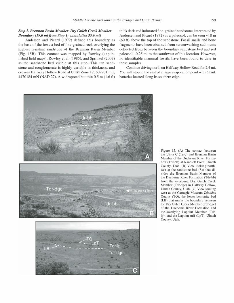
Middle Eocene rock units in the Bridger and Uinta Basins 159
Stop 2. Brennan Basin Member–Dry Gulch Creek Member Boundary (19.0 mi from Stop 1; cumulative 35.6 mi)
Andersen and Picard (1972) defi ned this boundary as the base of the lowest bed of fi ne-grained rock overlying the highest resistant sandstone of the Brennan Basin Member (Fig. 15B). This contact was mapped by Rowley (unpub-lished fi eld maps), Rowley et al. (1985), and Sprinkel (2007) as the sandstone bed visible at this stop. This tan sand-stone and conglomerate is highly variable in thickness, and crosses Halfway Hollow Road at UTM Zone 12, 609901 mE, 4470184 mN (NAD 27). A widespread but thin 0.5 m (1.6 ft)
thick dark-red indurated fi ne-grained sandstone, interpreted by Andersen and Picard (1972) as a paleosol, can be seen ~18 m (60 ft) above the top of the sandstone. Fossil snails and bone fragments have been obtained from screenwashing sediments collected from between the boundary sandstone bed and red paleosol ~0.25 mi to the southwest of this location. However, no identifi able mammal fossils have been found to date in these samples.
Continue driving north on Halfway Hollow Road for 2.4 mi. You will stop to the east of a large evaporation pond with 5 tank batteries located along its southern edge.
Figure 15. (A) The contact between the Uinta C (Tu-c) and Brennan Basin Member of the Duchesne River Forma-tion (Tdr-bb) at Randlett Point, Uintah County, Utah. (B) View looking north-east at the sandstone bed (Ss) that di-vides the Brennan Basin Member of the Duchesne River Formation (Tdr-bb) from the overlying Dry Gulch Creek Member (Tdr-dgc) in Halfway Hollow, Uintah County, Utah. (C) View looking west at the Carnegie Museum Teleodus Quarry (TQ), the lower bentonite bed (LB) that marks the boundary between the Dry Gulch Creek Member (Tdr-dgc) of the Duchesne River Formation and the overlying Lapoint Member (Tdr-lp), and the Lapoint tuff (LpT), Uintah County, Utah.
160 Murphey et al.
Stop 3. Dry Gulch Creek Member Fauna (2.4 mi from Stop 2; cumulative 38.0 mi)
This part of Halfway Hollow has produced the only known mammal fossils from the Dry Gulch Creek Member. A rela-tively fossil-rich micromammal quarry was discovered just to the east of the road (Halfway Hollow One, SDSNH Loc. 5939) in 2006, and is discussed above. These fossils are currently being formally described, and it is likely that additional screen washing of sediments from this locality will yield additional mammal fossils. Peterson (1931c, p. 70–71) described the type specimen of Epihippus (Duchesnehippus) intermedius (along with specimens he tentatively identifi ed as a partial femur and astragalus of a hyracodontid rhinoceros) as coming from “the west side of Halfway Hollow, from a red clay about 8 feet thick, overlain by a massive brown sand and underlain by a reddish nodular clay associated with astragalus and horse jaw.” The specimens were collected by John Clark on 21 July 1931 (Alan Tabrum, Carnegie Museum of Natural History, 2006, written commun.).
Continue driving north/northeast on Halfway Hollow Road for 0.9 mi until you reach SR 121 (Lapoint Highway). Stop just beyond the cattle guard.
Stop 4. View of Lapoint and Starr Flat Members (0.9 mi from Stop 3; cumulative 38.9 mi)
Looking north from this spot affords an excellent view of the Lapoint Member, the Starr Flatt Member, and the distant Uinta Mountains with 3668 m (12,031 ft) high Leidy Peak on the skyline. The base of the Lapoint Member is defi ned as the lowest widespread bentonite bed. Thick, laterally persis-tent bentonite beds are characteristic of this member. Several additional American Museum of Natural History and Carnegie Museum fossil localities are located in this part of Halfway Hollow to the north of the Lapoint highway, although recent efforts to relocate them have proven unsuccessful. The con-tact between the Lapoint and overlying Starr Flat members is located at the approximate level of the tops of the red cliffs you see in the distance at the north end of Halfway Hollow. How-ever, the top of the Duchesne River Formation is not visible from this location. As discussed above, the Starr Flatt member has yielded tooth fragments from one locality, but no other fos-
sils have been reported. That said, it has yet to be thoroughly prospected. It is possible that the fauna of the Starr Flatt Mem-ber is younger than the Duchesnean NALMA.
Turn east onto the Lapoint highway and drive for 2.5 mi. Just past SR 121 highway milepost 31, turn north onto a two-track road and drive for 0.7 mi for a total of 3.2 mi from Stop 4. The Carnegie Teleodus Quarry pit is located near the summit of the large hill to the northwest of your location.
Stop 5. Carnegie Titanothere Quarry and Lapoint Ash (3.2 mi from Stop 4; cumulative 42.1)
This is the site of the famous Carnegie Titanothere Quarry (also known as the Teleodus Quarry and the Duchesneodus Quarry). For many years prior to the discovery of this quarry, there remained a recognized hiatus between the earlier mam-malian faunas of the Rocky Mountain intermontane basins and the younger mammalian faunas of the White River badlands of South Dakota and Nebraska. In discovering and working this quarry, J.L. Kay of the Carnegie Museum made the fi rst impor-tant paleontological discovery to begin to fi ll this knowledge gap. Peterson (1931a, 1931b, 1931c) and Peterson and Kay (1931) described the fossils from this locality and from other localities in the then Lapoint horizon. These workers regarded the fauna as “perfectly transitional” (Peterson, 1931c, p. 62). In addition to the brontothere fossils collected from the quarry, bunodont and selenodont artiodactyls, a rodent, an insecti-vore, hyracodontid rhinos, and a creodont and mesonychid were discovered and described. Note that a recent thorough re- inspection of the quarry and surrounding area has failed to yield any additional fossils.
The thin bentonite bed visible on the slope below the quarry is considered to be the base of the Lapoint Member by Ander-sen and Picard (1972). However, the Lapoint ash (39.74 Ma ± 0.07 Ma, Prothero and Swisher, 1992) is actually the thicker, higher bentonite bed that is cut by the red sandstone channel in which the Carnegie Quarry fossils were preserved (Fig. 15C). Therefore, the Carnegie Titanothere Quarry is located strati-graphically just above the base of the Lapoint Member and is slightly younger than the Lapoint tuff that was cut by the red sandstone channel.
End of Uinta basin fi eld trip.
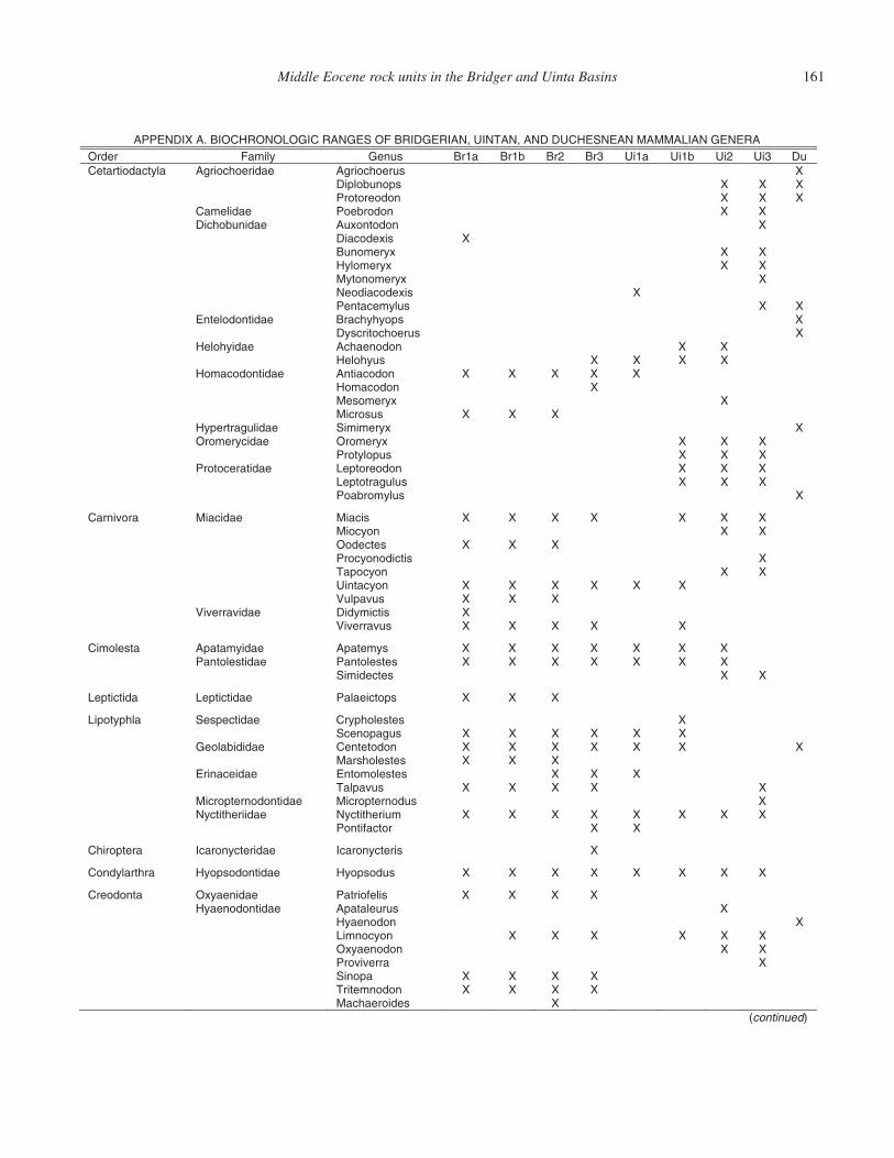
Middle Eocene rock units in the Bridger and Uinta Basins 161
APPENDIX A. BIOCHRONOLOGIC RANGES OF BRIDGERIAN, UINTAN, AND DUCHESNEAN MAMMALIAN GENERA b1rB a1rB suneG ylimaF redrO Br2 Br3 Ui1a Ui1b Ui2 Ui3 Du
Cetartiodactyla Agriochoeridae Agriochoerus X X X X sponubolpiD X X X nodoerotorP
Camelidae Poebrodon X X Dichobunidae Auxontodon X
X sixedocaiD X X xyremonuB X X xyremolyH X xyremonotyM X sixedocaidoeN X X sulymecatneP
Entelodontidae Brachyhyops X X sureohcotircsyD
Helohyidae Achaenodon X X X X X X suyholeH
Homacodontidae Antiacodon X X X X X X nodocamoH X xyremoseM X X X susorciM
Hypertragulidae Simimeryx X Oromerycidae Oromeryx X X X
X X X supolytorP Protoceratidae Leptoreodon X X X
X X X sulugartotpeL X sulymorbaoP
Carnivora Miacidae Miacis X X X X X X X X X noycoiM X X X setcedoO X sitcidonoycorP X X noycopaT X X X X X X noycatniU X X X suvapluV
Viverravidae Didymictis X X X X X X suvarreviV
Cimolesta Apatamyidae Apatemys X X X X X X X Pantolestidae Pantolestes X X X X X X X
X X setcedimiS
Leptictida Leptictidae Palaeictops X X X
Lipotyphla Sespectidae Crypholestes X X X X X X X sugaponecS
Geolabididae Centetodon X X X X X X X X X X setselohsraM
Erinaceidae Entomolestes X X X X X X X X suvaplaT
Micropternodontidae Micropternodus X Nyctitheriidae Nyctitherium X X X X X X X X
X X rotcafitnoP
Chiroptera Icaronycteridae Icaronycteris X
Condylarthra Hyopsodontidae Hyopsodus X X X X X X X X
Creodonta Oxyaenidae Patriofelis X X X X Hyaenodontidae Apataleurus X
X nodoneayH X X X X X X noyconmiL X X nodoneayxO X arrevivorP X X X X aponiS X X X X nodonmetirT X sedioreahcaM
(continued)
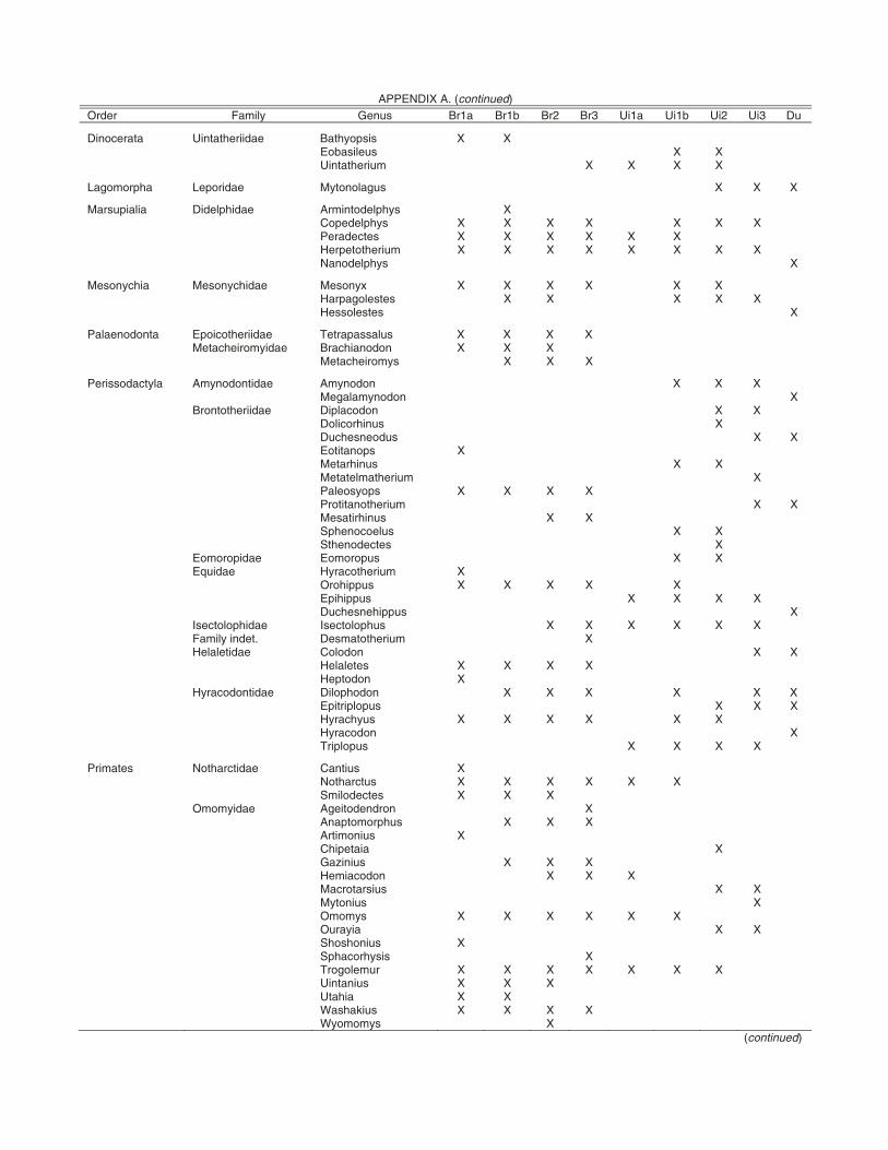
162 Murphey et al.
APPENDIX A. (continued) Order Family Genus Br1a Br1b Br2 Br3 Ui1a Ui1b Ui2 Ui3 Du
Dinocerata Uintatheriidae Bathyopsis X X X X suelisaboE X X X X muirehtatniU
Lagomorpha Leporidae Mytonolagus X X X
Marsupialia Didelphidae Armintodelphys X X X X X X X X syhpledepoC X X X X X X setcedareP X X X X X X X X muirehtotepreH X syhpledonaN
Mesonychia Mesonychidae Mesonyx X X X X X X X X X X X setselogapraH X setselosseH
Palaenodonta Epoicotheriidae Tetrapassalus X X X X Metacheiromyidae Brachianodon X X X
X X X symoriehcateM
Perissodactyla Amynodontidae Amynodon X X X X nodonymalageM
Brontotheriidae Diplacodon X X X sunihrociloD X X sudoensehcuD
X sponatitoE X X sunihrateM X muirehtamletateM X X X X spoysoelaP X X muirehtonatitorP
X X sunihritaseM X X suleoconehpS X setcedonehtS
Eomoropidae Eomoropus X X Equidae Hyracotherium X
X X X X X suppihorO X X X X suppihipE X suppihensehcuD
Isectolophidae Isectolophus X X X X X X Family indet. Desmatotherium X Helaletidae Colodon X X
X X X X setelaleH X nodotpeH
Hyracodontidae Dilophodon X X X X X X X X X supolpirtipE
X X X X X X suyhcaryH X nodocaryH
X X X X supolpirT
Primates Notharctidae Cantius X X X X X X X sutcrahtoN X X X setcedolimS
Omomyidae Ageitodendron X X X X suhpromotpanA X suinomitrA X aiatepihC X X X suinizaG X X X nodocaimeH X X suisratorcaM X suinotyM X X X X X X symomO X X aiyaruO X suinohsohS X sisyhrocahpS X X X X X X X rumelogorT X X X suinatniU X X aihatU X X X X suikahsaW X symomoyW
(continued)
Middle Eocene rock units in the Bridger and Uinta Basins 163
ACKNOWLEDGMENTS
The authors wish to express their deepest gratitude to the many colleagues, students, and volunteers who have assisted with our fi eld work in the Bridger and Uinta basins over the years. In particular, we are grateful for the participation of faculty, staff, and students from the University of Colorado Museum, Washington University in St. Louis, San Diego Nat-ural History Museum, College of Charleston, and Lamar Uni-versity. We also thank the Wyoming and Utah State Offi ces of the U.S. Department of Interior Bureau of Land Management, and the Kemmerer, Rock Springs and Vernal fi eld offi ces. Without the support of the BLM, our fi eld work would not have been possible. Finally, we thank Justin Strauss and Mar-garet Madsen for their assistance with the compilation of the fi eld trip mileage log.
REFERENCES CITED
Alexander, J.P., and Burger, B.J., 2001, Stratigraphy and taphonomy of Grizzly Buttes, Bridger Formation, and the middle Eocene of Wyoming; Eocene biodiversity; unusual occurrences and rarely sampled habitats: Topics in Geobiology, v. 18, p. 165–196.
Andersen, D.W., and Picard, M.D., 1972, Stratigraphy of the Duchesne River Formation (Eocene-Oligocene), northern Uinta Basin, Northwestern Utah: Bulletin of the Utah Geological and Mineral Survey, v. 97, p. 1–29.
Betts, C.W., 1871, The Yale College expedition of 1870: Harper’s New Monthly Magazine, v. 43, p. 663–671.
Black, C.C., and Dawson, M.R., 1966, A review of late Eocene mammalian faunas from North America: American Journal of Science, v. 264, p. 321–349, doi:10.2475/ajs.264.5.321.
Bradley, W.H., 1931, Origin and microfossils of the Green River Formation of Colo-rado and Utah: U.S. Geological Survey Professional Paper 168, p. 58.
Bradley, W.H., 1964, Geology of Green River Formation and associated Eocene rocks in southwestern Wyoming and adjacent parts of Colorado and Utah: U.S. Geological Survey Professional Paper 496-A, p. 1–86.
Brand, L.R., 2007, Lacustrine deposition in the Bridger Formation: Lake Gos-iute extended: The Mountain Geologist, v. 44, p. 69–77.
Brand, L.R., Goodwin, H.T., Ambrose, P.D., and Buchheim, H.P., 2000, Tapho-nomy of turtles in the Middle Eocene Bridger Formation: Palaeogeogra-phy, Palaeoclimatology, Palaeoecology, v. 162, p. 171–189, doi:10.1016/S0031-0182(00)00111-5.
Bryant, B., Naeser, C.W., Marvin, R.F., and Mehnert, H.H., 1989, Upper Cre-taceous and Paleogene sedimentary rocks and isotopic ages of Paleogene tuffs, Uinta Basin, Utah: U.S. Geological Survey Bulletin 1787-J, p. 1–22 p.
Cashion, W.B., 1974, Geologic map of the Southam Canyon quadrangle, Uin-tah County, Utah: U.S. Geological Survey Miscellaneous Field Studies Map, MF-579.
Cashion, W.B., 1986, Geologic map of the Bonanza quadrangle, Uintah County, Utah: Miscellaneous Field Studies Map, MF-1865.
Chadey, H.F., 1973, Historical Aspects of the Green River Basin, Wyoming, in 25th Field Conference on the geology and mineral resources of the greater Green River Basin, Wyoming: Wyoming Geological Association, p. 27–33.
Cope, E.D., 1872, Descriptions of some new Vertebrata from the Bridger Group of the Eocene: Proceedings of the American Philosophical Society, v. 12, p. 460–465.
Cope, E.D., 1873, On the extinct Vertebrata of the Eocene of Wyoming, observed by the expedition of 1872, with notes on the geology, in Hayden,
APPENDIX A. (continued) b1rB a1rB suneG ylimaF redrO Br2 Br3 Ui1a Ui1b Ui2 Ui3 Du
Plesiadapiformes Microsyopsidae Microsyops X X X X X X X X X xerosatniU
Rodentia Allomyidae Spurimus X X X suminaJ eadiymopytuE
X symatniU .tnedni ylimaF X anortaN X X X symarapotircA eadiymoryhcsI X X X X X X X symaraporciM X X X symonotyM
X X X X X X symaraP X X X X X sumotoduesP X X X sumotardauQ X X X X X symaraporhtieR X X X X X X X symebsihT X X X X X X X symarapatniU
X symothginK eadivaruicS X X X X symoruaP X X X X X X suvaruicS X X X symyxaT X X X X symolliT X sposyM eaditnodordnilyC X X X X X symueraP X X X symaionateM eadiymoE X X omuadijdatorP
X X X suchytpotorP eadihcypotorP X symohpirG .tnedni ylimaF X symocsilassaP eadiymocsileH
Tillodontia Esthonychidae Tillodon X X X X susogorT
Taeniodonta Stylinodontidae Stylinodon X X X X X Note: Modified from Gunnell et al. (2009).
164 Murphey et al.
F.V. ed., Sixth Annual Report of the United States Geological Survey of the Territories for 1872, p. 545–649.
Covert, H.H., Robinson, P., and Harris, J.R., 1998, Evidence for two lineages of Notharctus during the Bridger C and D: Journal of Vertebrate Paleontol-ogy, Supplement to v. 18, p. 3.
Douglass, E., 1914, Geology of the Uinta Formation: Geological Society of America Bulletin, v. 25, p. 417–420.
Evanoff, E., Robinson, P., Murphey, P.C., Kron, D.G., Engard, D., and Monaco, P., 1994, An early Uintan fauna from Bridger E: Society of Vertebrate Paleontology, Supplement to v. 14, p. 24.
Evanoff, E., Brand, L.R., and Murphey, P.C., 1998, The lower Bridger Forma-tion (middle Eocene) of southwest Wyoming: Widespread marker units and subdivisions of Bridger B: Dakoterra, v. 5, p. 115–122.
Fremont, J.C., 1845, Report of the exploring expedition through the Rocky Mountains in the year 1842 and to Oregon and California in the years 1843–1844: Senate Document No. 174 and House Document No. 166, 28th Congress, 2nd session.
Gazin, C.L., 1934, On the priority of specifi c names for the upper Bridger Noth-arctus: Journal of Mammalogy, v. 15, p. 71.
Gazin, C.L., 1946, Machaeroides eothen Matthew, the saber tooth creodont of the Bridger Eocene: Proceedings of the United States National Museum, v. 96, p. 335–347.
Gazin, C.L., 1949, A leptictid insectivore from the middle Eocene Bridger For-mation of Wyoming: Journal of the Washington Academy of Sciences, v. 39, p. 220–223.
Gazin, C.L., 1955, A review of the Upper Eocene Artiodactyla of North Amer-ica: Smithsonian Miscellaneous Collections 281, 96 p.
Gazin, C.L., 1957, A skull of the Bridger middle Eocene creodont, Patriofelis ulta Leidy: Smithsonian Miscellaneous Collections, v. 134, p. 20.
Gazin, C.L., 1958, A review of the middle and upper Eocene primates of North America: Smithsonian Miscellaneous Collections, v. 136, p. 1–112.
Gazin, C.L., 1965, An endocranial cast of the Bridger middle Eocene primate Smilo-dectes gracilis: Smithsonian Miscellaneous Collections, v. 149, p. 1–14.
Gazin, C.L., 1968, A study of the Eocene condylarthran mammal Hyopsodus: Smithsonian Miscellaneous Collections, v. 153, p. 1–90.
Gazin, C.L., 1976, Mammalian faunal zones of the Bridger middle Eocene: Smithsonian Contributions to Paleobiology, no. 26, 25 p.
Grande, L., 1984, Paleontology of the Green River Formation, with a review of the fi sh fauna; second edition: Geological Survey of Wyoming Bulletin, v. 63, p. 333.
Grande, L., and Buchheim, H.P., 1994, Paleontological and sedimentological variation in early Eocene Fossil Lake: Contributions to Geology, Univer-sity of Wyoming, v. 30, p. 33–56.
Granger, W., 1908, A revision of the American Eocene horses: Bulletin of the American Museum of Natural History, v. 24, p. 221–264.
Gunnell, G.F., 1997, Wasatchian-Bridgerian (Eocene) paleoecology of the western interior of North America: changing paleoenvironments and taxonomic composition of omomyid (Tarsiiformes) primates: Journal of Human Evolution, v. 32, p. 105–132, doi:10.1006/jhev.1996.0101.
Gunnell, G.F., 1998, Mammalian fauna from the lower Bridger Formation (Bridger A, early middle Eocene) of the southern Green River Basin, Wyoming: Contributions from the Museum of Paleontology: University of Michigan, v. 30, p. 83–130.
Gunnell, G.F., and Bartels, W.S., 1994, Early Bridgerian (middle Eocene) ver-tebrate paleontology and paleoecology of the southern Green River Basin Wyoming: Contributions to Geology, University of Wyoming, v. 30, p. 57–70.
Gunnell, G.F., and Bartels, W.S., 2001, Basin margins, biodiversity, evolution-ary innovation, and the origin of new taxa, in Gunnell, G.F., ed., Eocene Biodiversity: Unusual Occurrences and Rarely Sampled Habitats: New York, New York, Kluwer Academic/Plenum Publishers, p. 404–432.
Gunnell, G.F., Murphey, P.C., Stucky, R.K., Townsend, K.E., Robinson, P., Zonneveld, J.P., and Bartels, W.S., 2009, Biostratigraphy and biochro-nology of the latest Wasatchian, Bridgerian, and Uintan North American Land-Mammal “Ages” Papers, in Albright, B., ed., Geology, Vertebrate Paleontology, and Biostratigraphy in Honor of Michael O. Woodburne: Museum of Northern Arizona Bulletin, v. 65, p. 279–330.
Hamblin, A.H., 1987, Paleogeography and paleoecology of the Myton Pocket, Uinta Basin, Utah (Uinta Formation–Upper Eocene): Brigham Young University Studies, Brigham Young University, v. 34, p. 33–60.
Hamblin, A.H., Sarjeant, W.A.S., and Spalding, D.A.E., 1999, Vertebrate footprints in the Duchesne River and Uinta Formations (middle to late
Eocene), Uinta Basin, Utah, in Vertebrate paleontology in Utah: Utah Geological Survey, Miscellaneous Publication 99-1, p. 443–454.
Hanley, J.H., 1974, Systematics, paleoecology, and biostratigraphy of nonma-rine Mollusca from the Green River and Wasatch formations (Eocene), southwestern Wyoming and northwestern Colorado [Ph.D. thesis]: Lara-mie, Wyoming, University of Wyoming.
Hansen, W.R., 1986, Neogene tectonics and geomorphology of the eastern Uinta Mountains in Utah, Colorado, and Wyoming: U.S. Geological Sur-vey Professional Paper 1506-A, v. 1356, p. 1–78.
Hayden, F.V., 1869, Preliminary fi eld report (3rd ann.) of the U.S. Geological Survey of Colorado and New Mexico: U.S. Government, Washington, 155 p.
Hayden, F.V., 1871, Preliminary report of the United States Geological Survey of Wyoming and portions of contiguous territories (2nd Annual Report): U.S. Government Printing Offi ce, Department of the Interior, 155 p.
Hayden, F.V., 1872, Part 1, Report of F.V. Hayden, in Preliminary report of the United States Geological Survey of Wyoming and portions of contiguous territories: U.S. Geological and Geographical Survey of the Territories, 2nd (4th) Annual Report, p. 9–81.
Hayden, F.V., 1873, First, Second, and Third Annual Reports Report of the U.S. Geological and Geographic Survey of the Territories, for the years 1867, 1868, and 1869: Washington, D.C., U.S. Government Printing Offi ce, 261 p.
Henderson, J., 1935, Fossil non-marine Mollusca of North America: Geological Society of America Special Paper 3, 313 p.
Hintze, L.F., 2005, The geologic history of Utah: Brigham Young Department of Geology, 202 p.
Jackson, W.H., and Driggs, H.R., 1929, The pioneer photographer, Rocky Mountain adventures with a camera: Yonkers-on-Hudson, New York, World Book Company, 314 p.
Johnson, R.C., 1984, New names for units in the lower part of the Green River Formation, Piceance Creek Basin, Colorado: U.S. Geological Survey Bul-letin, B 1529-I.
Johnson, R.C., 1985, Early Cenozoic history of the Uinta and Piceance Creek basins, Utah and Colorado, with special reference to the development of Eocene Lake Uinta, in Flores, R.M., and Kaplan, S.S., eds., Cenozoic Paleogeography of West-Central United States: Society for Sedimentary Geology, p. 247–276.
Johnson, R.C., 1989, Geologic history and hydrocarbon potential of late Cretaceous-age, low-permeability reservoirs, Piceance Basin, western Colorado: U.S. Geological Survey Bulletin, B1787-E, 51 p.
Kay, J.L., 1934, The Tertiary formations of the Uinta Basin, Utah: Annals of the Carnegie Museum, v. 23, p. 357–371.
King, C., 1878, Systematic geology: Report of the U.S. Geological Exploration of the 40th Parallel, v. 1, p. 202–277.
Koenig, K.J., 1960, Bridger Formation in the Bridger Basin, Wyoming: Wyo-ming Geological Association Guidebook, Fifteenth Annual Field Confer-ence, p. 163–168.
Krishtalka, L., West, R.M., Black, C.C., Dawson, M.R., Flynn, J.J., Turnbull, W.D., Stucky, R.K., McKenna, M.C., Bown, T.M., Golz, D.J., and Lil-legraven, J.A., 1987, Eocene (Wasatchian through Duchesnean) biochro-nology of North America, in Woodburne, M.O., ed., Cenozoic Mammals of North America: Geochronology and Biostratigraphy: Berkeley, Univer-sity of California Press, p. 77–117.
Lanham, U., 1973, The Bone Hunters: The Historic Age of Paleontology in the American West: Dover Publications, 285 p.
Leidy, J., 1869, Notice of some extinct vertebrates from Wyoming and Dakota: Pro-ceedings, Academy of Natural Sciences of Philadelphia, v. 21, p. 63–67.
Leidy, J., 1870, On fossils from Church Buttes, Wyoming Territory: Proceed-ings, Academy of Natural Sciences of Philadelphia, v. 22, p. 113–114.
Leidy, J., 1871, Notice of some extinct rodents: Proceedings, Academy of Natu-ral Sciences of Philadelphia, v. 23, p. 230–232.
Leidy, J., 1872a, Report on the vertebrate fossils of the Tertiary formations of the west: U.S. Geological and Geographical Survey of the Territories, 2nd (4th) Annual Report, p. 340–370.
Leidy, J., 1872b, On some new species of fossil mammalia from Wyoming: Proceedings, Academy of Natural Sciences of Philadelphia, v. 24, p. 167–169.
Leidy, J., 1873, Contributions to the extinct vertebrate fauna of the western territories: U.S. Geological and Geographical Survey of the Territories Report, v. 1, 358 p.
Leopold, E.B., and MacGinitie, H.D., 1972, Development and affi nities of Ter-tiary fl oras in the Rocky Mountains, in Floristics and Paleofl oristics of Asia and Eastern North America: Amsterdam, Elsevier, p. 147–200.
Middle Eocene rock units in the Bridger and Uinta Basins 165
Lucas, S.G., 1992, Redefi nition of the Duchesnean Land Mammal “Age,” late Eocene of western North America, in Prothero, D.R., and Berggren, W.A., eds., Eocene-Oligocene Climatic and Biotic Evolution: Princeton, New Jersey, Princeton University Press, p. 46–73.
MacGinitie, H.D., and Leopold, E.B., 1972, Development and affi nities of Ter-tiary fl oras in the Rocky Mountains, in Graham, A., ed., Floristics and paleofl oristics of Asia and eastern North America: Amsterdam, Elsevier Publishing Co. p. 147–200.
Marsh, O.C., 1871, Notice of some new fossil reptiles from the Cretaceous and Tertiary formations: American Journal of Science and Arts, v. 4, p. 122–128, 202–224.
Marsh, O.C., 1875a, Ancient lake basins of the Rocky Mountain region: Ameri-can Journal of Science and Arts, v. 9, p. 49–52.
Marsh, O.C., 1875b, Notice of new Tertiary mammals, IV: American Journal of Science and Arts: Third Series, v. 9, p. 239–250.
Marsh, O.C., 1886, Dinocerata, a monograph of an extinct order of gigantic mammals: U.S. Geological Survey Monograph M0010, 243 p.
Matthew, W.D., 1909, The Carnivora and Insectivora of the Bridger Basin, middle Eocene: American Museum of Natural History Memoir, v. 9, no. pt. 6, p. 291–567.
Mauger, R.L., 1977, K-Ar ages of biotites from tuffs in Eocene rocks of the Green River Washakie, and Uinta basins, Utah, Wyoming and Colorado: University of Wyoming, Contributions to Geology, v. 15, p. 17–42.
McGrew, P.O., 1959, The geology and paleontology of the Elk Mountain and Tabernacle Butte area, Wyoming: Bulletin of the American Museum of Natural History, v. 117, p. 123–174.
McGrew, P.O., and Casilliano, M., 1975, The geological history of Fossil Butte National Monument and Fossil Basin: National Park Service Occasional Paper 3, p. 37–37.
McGrew, P.O., and Sullivan, R., 1970, The stratigraphy and paleontology of Bridger A: Contributions to Geology, University of Wyoming, v. 9, p. 66–85.
McKenna, M.C., Robinson, P., and Taylor, D.W., 1962, Notes on Eocene Mam-malia and Mollusca from Tabernacle Butte, Wyoming: American Museum Novitates, v. 2102, p. 33.
Meek, F.B., 1870, Preliminary paleontological report, consisting of lists of fos-sils with descriptions of some new types: U.S. Geological and Geographi-cal Survey of the Territories, 2nd Annual Report, p. 287–318.
Meek, F.B., 1871, Descriptions of new species of fossils from Ohio and other western states and territories: Proceedings, Academy of Natural Sciences of Philadelphia, v. 23, p. 159–184.
Meek, F.B., 1872, Preliminary paleontological report consisting of lists and descriptions of fossils, with remarks on the ages of the rocks in which they were found: U.S. Geological and Geographical Survey of the Territories 6th Annual Report, p. 431–541.
Moncure, G., and Surdam, R.C., 1980, Depositional environment of the Green River Formation in the vicinity of the Douglas Creek Arch, Colorado and Utah: Contributions to Geology, University of Wyoming, v. 19, p. 9–24.
Murphey, P.C., 1995, Paleontology, sedimentology, and depositional history of a middle Eocene lacustrine deposit in the Bridger Formation, southwest Wyoming [masters thesis]: Boulder, University of Colorado, 121 p.
Murphey, P.C., 2001, Stratigraphy, fossil distribution, and depositional environ-ments of the upper Bridger Formation (middle Eocene) of southwestern Wyoming, and the taphonomy of an unusual Bridger microfossil assem-blage [Ph.D. thesis]: Boulder, University of Colorado, 345 p.
Murphey, P.C., and Daitch, D., 2007, Paleontological overview of oil shale and tar sands areas in Colorado, Utah and Wyoming: U.S. Department of Energy, Argonne National Laboratory Report Prepared for the U.S. Department of Interior Bureau of Land Management, 468 p. and 6 maps (scale 1:500,000).
Murphey, P.C., and Dunn, R.H., 2009, Hemiacodon engardae: a new species of omomyid primate from the Turtle Bluff Member of the Bridger Forma-tion, southwestern Wyoming: Journal of Human Evolution, v. 57, p. 123–130, doi:10.1016/j.jhevol.2009.05.006.
Murphey, P.C., and Evanoff, E., 2007, Stratigraphy, fossil distribution and dep-ositional environments of the upper Bridger Formation (middle Eocene), southwestern Wyoming: Wyoming State Geological Survey Report of Investigation, v. 57, p. 1–96.
Murphey, P.C., and Townsend, K.E., 2005, Ecological Diversity Analysis applied to facies faunas in the Twin Buttes Member, middle Eocene Bridger Formation, southwestern Wyoming, USA: Society of Vertebrate Paleontology, v. 25.
Murphey, P.C., Lester, A., Bohor, B., Robinson, P., Evanoff, E., and Larson, E., 1999, 40Ar/39Ar dating of volcanic ash deposits in the Bridger Formation
(Middle Eocene) southwestern Wyoming: Geological Society of America Abstracts with Programs, v. 31, no. 7, p. A-233.
Murphey, P.C., Torick, L.L., Bray, E.S., Chandler, R., and Evanoff, E., 2001, Taphonomy, fauna, and depositional environment of the Omomys Quarry, an unusual accumulation from the Bridger Formation (middle Eocene) of southwestern Wyoming (USA), in Gunnell, G.F. and Alexander, J.P., eds., Eocene biodiversity; unusual occurrences and rarely sampled habitats, Topics in Geobiology, v. 18, p. 361–402.
Nichols, D.J., 1987, Palynology of the Vermillion Creek coal bed and associ-ated strata: U.S. Geological Survey Professional Paper 1314-D, p. 47–73.
Osborn, H.F., 1895, Fossil mammals of the Uinta Basin; Expedition of 1894: Bulletin of the American Museum of Natural History, v. 7, p. 71–105.
Osborn, H.F., 1929, The Titanotheres of ancient Wyoming, Dakota, and Nebraska: United States Geological Survey Monograph, v. 1, p. 1–701.
Peterson, O.A., 1919, Report upon the material discovered in the upper Eocene of the Uinta Basin by Earl Douglass in the years 1908–1909, and by O.A. Peterson in 1912: Annals of the Carnegie Museum, v. 12, p. 40–169.
Peterson, O.A., 1931a, New species of the genus Teleodus from the upper Uinta of northeastern Utah: Annals of Carnegie Museum, v. 20, p. 307–312.
Peterson, O.A., 1931b, New mesonychids from the Uinta: Annals of the Carn-egie Museum, v. 20, p. 333–339.
Peterson, O.A., 1931c, New species from the Oligocene of the Uinta: Annals of the Carnegie Museum, v. 21, p. 61–78.
Peterson, O.A., and Kay, J.L., 1931, The upper Uinta Formation of northeastern Utah: Annals of Carnegie Museum, v. 20, p. 293–306.
Powell, J.W., 1876, Report on the geology of the eastern portion of the Uinta Mountains and a region of country adjacent thereto: U.S. Geological and Geographical survey of the Territories, 218 p.
Prothero, D.R., and Swisher, C.C., III, 1992, Magnetostratigraphy and geochronol-ogy of the terrestrial Eocene-Oligocene transition in North America, in Pro-thero, D.R., and Berggren, W.A., eds., Eocene-Oligocene Climatic and Biotic Evolution: Princeton, New Jersey, Princeton University Press, p. 46–73.
Prothero, D.R., 1996, Magnetic stratigraphy and biostratigraphy of the middle Eocene Uinta formation, Uinta Basin, Utah, in, Prothero, D.R., and Emry, R.J., eds., The terrestrial Eocene-Oligocene transition in North America: Cambridge, England, Cambridge University Press, p. 3–24.
Rasmussen, D.T., 1996, A new middle Eocene omomyine primate from the Uinta Basin, Utah: Journal of Human Evolution, v. 31, p. 75–87, doi:10.1006/jhev.1996.0051.
Rasmussen, D.T., Conroy, G.C., Friscia, A.R., Townsend, K.T., and Kinkel, M.D., 1999a, Mammals of the middle Eocene Uinta Formation, in Verte-brate paleontology in Utah: Utah Geological Survey, Miscellaneous Pub-lication 99-1, p. 401–420.
Rasmussen, D.T., Hamblin, A.H., and Tabrum, A.R., 1999b, The mammals of the Eocene Duchesne River Formation; Vertebrate paleontology in Utah: Utah Geological Survey, Miscellaneous Publication 99-1, p. 421–427.
Renne, P.R., Swisher, C.C., Deino, A.L., Karner, D.B., Owens, T.L., and DePaolo, D.J., 1998, intercalibration of standards, absolute ages and uncertainties in 40Ar/39Ar dating: Chemical Geology, v. 145, p. 117–152, doi:10.1016/S0009-2541(97)00159-9.
Riggs, E.S., 1912, New or Little Known Titanotheres from the Lower Uintah Forma-tions: Field Museum of Natural History Geological Series, v. 159, p. 17–41.
Robinson, P., Gunnell, G.F., Walsh, S.L., Clyde, W.C., Storer, J.E., Stucky, R.K., Froehlich, D.J., Villafranca, I.F., and McKenna, M.C., 2004, Wasat-chian though Duchesnean biochronology, in Woodburne, M.O., ed., Late Cretaceous and Cenozoic Mammals of North America: Columbia Univer-sity Press, p. 106–155.
Roehler, H.W., 1992a, Geology of the Eocene Wasatch, Green River, and Bridger (Washakie) Formations, Greater Green River Basin, Wyoming, Utah and Colorado: Introduction to Greater Green River Basin Geology, Physiography, and History of Investigations: U.S. Geological Survey Pro-fessional Paper 1506-A, 14 p.
Roehler, H.W., 1992b, Description and correlation of Eocene rocks in strati-graphic reference sections for the Green River and Washakie Basins, south-west Wyoming: U.S. Geological Survey Professional Paper 1506-D, 83p.
Roehler, H.W., 1993, Geology of the Eocene Wasatch, Green River, and Bridger (Washakie) Formations, Greater Green River Basin, Wyoming, Utah and Colorado: Eocene Climates, Depositional Environments, and Geography, Greater Green River Basin, Wyoming, Utah and Colorado: U.S. Geologi-cal Survey Professional Paper 1506-F, 74 p.
Rowley, P.D., Hansen, W.R., Tweto, O., and Carrara, P.E., 1985, Geologic map of the Vernal 1 degree by 2 degrees Quadrangle, Colorado, Utah, and
166 Murphey et al.
Wyoming: U.S. Geological Survey Miscellaneous Investigations Series I-1526, scale 1:1 2 500 000, 1 sheet.
Ryder, R.T., Fouch, T.D., and Elison, J.H., 1976, Early Tertiary sedimenta-tion in the western Uinta Basin, Utah: Geological Society of America Bulletin, v. 87, p. 496–512, doi:10.1130/0016-7606(1976)87<496:ETSITW>2.0.CO;2.
Scott, W.B., 1945, The Mammalia of the Duchesne River Oligocene: Trans-actions of the American Philosophical Society, v. 34, p. 209–253, doi:10.2307/1005542.
Scott, W.B., and Osborn, H.F., 1887, Preliminary report of the vertebrate fossils from the Uinta Formation, collected by the Princeton expedition of 1886: Proceedings of the American Philosophical Society, v. 1887, p. 255–264.
Scott, W.B., and Osborn, H.F., 1890, The Mammalia of the Uinta Formation: Transactions of the American Philosophical Society, v. 16, p. 461–572, doi:10.2307/1005400.
Simpson, G.G., 1933, Glossary and correlation charts of North American Ter-tiary mammal-bearing formations: American Museum of Natural History Bulletin, v. 47, p. 91.
Simpson, G.G., 1946, The Duchesnean fauna and the Eocene-Oligocene boundary: American Journal of Science, v. 244, p. 52–57, doi:10.2475/ajs.244.1.52.
Sinclair, W.J., 1906, Volcanic ash in the Bridger beds of Wyoming: American Museum of Natural History Bulletin, v. 22, p. 273–280.
Smith, M.E., Singer, B., and Carroll, A.R., 2003, 40Ar/39Ar geochronol-ogy of the Eocene Green River Formation, Wyoming: Geologi-cal Society of America Bulletin, v. 115, no. 5, p. 549–565, doi: 10.1130/0016-7606(2003)115<0549:AGOTEG>2.0.CO;2.
Sprinkel, D.A., 2007, Interim geologic map of the of the Vernal 30’ x 60’ Quad-rangle, Uintah and Duchesne counties, Utah, and Moffat and Rio Blanco counties, Colorado: Utah State Geological Survey Map, OFR 506DM, scale 1:100,000, 3 sheets.
Stagner, W.L., 1941, The paleogeography of the eastern part of the Uinta Basin during Uinta B (Eocene) time: Annals of the Carnegie Museum, v. 28, p. 273–308.
Stokes, W.L., 1986, Geology of Utah: Utah Museum of Natural History, Uni-versity of Utah and Utah Geological and Mineral Survey, Department of Natural Resources.
Surdam, R.C., and Stanley, K.O., 1979, Lacustrine sedimentation during the culminating phase of Eocene Lake Gosiute Wyoming (Green River Formation): Geological Society of America Bulletin, v. 90, no. part 1, p. 93–110, doi:10.1130/0016-7606(1979)90<93:LSDTCP>2.0.CO;2.
Surdam, R.C., and Stanley, K.O., 1980, Effects on changes in drainage basin boundaries on sedimentation in Eocene Lakes Gosiute and Uinta of Wyo-ming, Utah, and Colorado: Geology, v. 8, p. 135–139, doi:10.1130/0091-7613(1980)8<135:EOCIDB>2.0.CO;2.
Thornton, M.L., and Rasmussen, D.T., 2001, Taphonomic interpretation of Gnat-Out-Of-Hell, an early Uintan small mammal locality in the Uinta Formation, Utah, in Gunnell, G.F., ed., Eocene Biodiversity: Unusual Occurrences and Poorly Sampled Habitats: New York, Kluwer Academic/Plenum Publishers, p. 299–316.
Townsend, K.E., 2004, Stratigraphy, paleoecology, and habitat change in the middle Eocene of North America [Ph.D. thesis]: St. Louis, Missouri, Washington University.
Townsend, K.E., Friscia, A.R., and Rasmussen, D.T., 2006, Stratigraphic dis-tribution of upper middle Eocene fossil vertebrate localities in the eastern
Uinta Basin, Utah, with commons on Uintan biostratigraphy: The Moun-tain Geologist, v. 43, no. 2, p. 115–134.
Townsend, K.E.B., Rasmussen, D.T., Murphey, P.C., and Evanoff, E., 2010, Middle Eocene habitat shifts in the North American Western interior: a case study: Palaeogeography, Palaeoclimatology, Palaeoecology, v. 297, no. 1, p. 144–158, doi:10.1016/j.palaeo.2010.07.024.
U.S. Geological Survey, 1980, Asphalt Ridge, White Rocks, and Vicinity, Utah tar sands leasing minutes no. 3: Minutes of the Mineral Land Evaluation Committee, 28 p.
Veatch, A.C., 1907, Geography and geology of a portion of southwestern Wyo-ming: U.S. Geological Survey Professional Paper 56, 163 p.
Walsh, S.L., 1996, Middle Eocene mammalian faunas of San Diego County, California, in Prothero, D.R., and Emry, R.J., eds., The terrestrial Eocene-Oligocene transition in North America: Cambridge, England, Cambridge University Press, p. 52–74.
Walsh, S.L., and Murphey, P.C., 2007, Documenting the Uintan/Duchesnean faunal transition in the Duchesne River Formation, Utah: Journal of Ver-tebrate Paleontology, v. 27, supplement to no. 3, p. 163A.
Warner, M.M., 1963, Sedimentation of the Duchesne River Formation, Uinta Basin, Utah [Ph.D. thesis]: State University of Iowa, 339 p.
West, R.M., 1976, Paleontology and geology of the Bridger Formation, south-ern Green River basin, southwestern Wyoming; Part 1, History of fi eld work and geological setting: Contributions in Biology and Geology, v. 7, p. 12–12.
West, R.M., 1990, Vertebrate paleontology of the Green River Basin, Wyoming, 1840–1910: Earth Sciences History, v. 9, p. 45–56.
West, R.M., and Atkins, E.G., 1970, Additional middle Eocene (Bridgerian) mammals from Tabernacle Butte, Sublette County, Wyoming: American Museum Novitates, v. 2404, p. 1–26.
West, R.M., and Hutchison, J.H., 1981, Geology and paleontology of the Bridger Formation, southern Green River basin, southwestern Wyoming; Part 6, The fauna and correlation of Bridger E: Contributions in Biology and Geology, v. 46, p. 8.
Wilson, J.A., 1978, Stratigraphic occurrence and correlation of early Tertiary vertebrate faunas, Trans-Pecos, Texas Part 1–Vieja area: Texas Memorial Museum Bulletin, v. 25, p. 1–42.
Wood, H.E., 1934, Revision of the Hyrachyidae: American Museum of Natural History Bulletin, v. 67, p. 182–295.
Wood, H.E., Chaney, R.W., Clark, J., Colbert, E.H., Jepsen, G.L., Reeside, J.B., and Stock, C., 1941, Nomenclature and correlation of the North Ameri-can continental Tertiary: Geological Society of America Bulletin, v. 52, p. 1–48.
Woodburne, M.O., Gunnell, G.F., and Stucky, R.K., 2009a, Land mammal faunas of North America rise and fall during the early Eocene: Denver Museum of Nature and Science Annals, no. 1, 78 p.
Woodburne, M.O., Gunnell, G.F., and Stucky, R.K., 2009b, Climate directly infl uences Eocene mammal faunal dynamics in North America: Proceed-ings of the National Academy of Sciences of the United States of Amer-ica, v. 106, no. 32, p. 13399–13403, doi:10.1073/pnas.0906802106.
Zachos, J., Pagani, M., Sloan, L., Thomas, E., and Billups, K., 2001, Trends, Rhythms, and Aberrations in Global Climate 65 Ma to Present: Science, v. 292, p. 686–693, doi:10.1126/science.1059412.
MANUSCRIPT ACCEPTED BY THE SOCIETY 23 MARCH 2011
Printed in the USA


![Stratigraphy of the Bois Blanc Formation in New York · Stratigraphy of the Bois Blanc Formation in New York By WILLIAM A. OLIVER, ]R. STRATIGRAPHY AND PALEONTOLOGY OF THE BOIS BLANC](https://img.dokumen.tips/doc/110x75/5ad44a127f8b9a48398c2531/stratigraphy-of-the-bois-blanc-formation-in-new-york-of-the-bois-blanc-formation.jpg)