Embed Size (px)
Citation preview
PALAEO-ICE STREAMS IN TH E
NORTH -EASTERN LAURENTIDE ICE SH EET
H e rnán D e Ange lis
Doctoral dis s e rtation 2007De partm e nt of Ph ys ical Ge ograph y and Quate rnary Ge ology
Stock h olm Unive rs ity

© 2007 H e rnán D e Ange lisISSN: 1653-7211ISBN: 9 78-9 1-7155-509 -0
Article II © Inte rnational Glaciological Socie ty 2005Article III © Else vie r Publis h ing Co. 2007
Layout: H e rnán D e Ange lis (e xce pt article s II and III)
Cove r ph oto: Palae o-ice stre am be d in south -e aste rn Victoria Island, Arctic Canada. Vie w tow ards north -e ast (Ph oto: H e rnán D e Ange lis , July 2005).
Printe d in Sw e de n by PrintCe nte r US-AB
Palae o-ice stre am s in th e north -e aste rn Laure ntide Ice Sh e e t
1
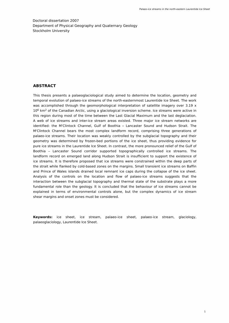
Th is th e s is pre s e nts a palae oglaciological study aim e d to de te rm ine th e location, ge om e try and
te m poral e volution of palae o-ice stre am s of th e north -e aste rnm ost Laure ntide Ice Sh e e t. Th e w ork
w as accom plis h e d th rough th e ge om orph ological inte rpre tation of sate llite im age ry ove r 3.19 x
106 k m 2 of th e Canadian Arctic, us ing a glaciological inve rs ion sch e m e . Ice stre am s w e re active in
th is re gion during m ost of th e tim e be tw e e n th e Last Glacial Maxim um and th e last de glaciation.
A w e b of ice stre am s and inte r-ice stre am are as e xiste d. Th re e m ajor ice stre am ne tw ork s are
ide ntifie d: th e M'Clintock Ch anne l, Gulf of Booth ia – Lancaste r Sound and H udson Strait. Th e
M'Clintock Ch anne l be ars th e m ost com ple x landform re cord, com pris ing th re e ge ne rations of
palae o-ice stre am s . Th e ir location w as w e ak ly controlle d by th e subglacial topograph y and th e ir
ge om e try w as de te rm ine d by froze n-be d portions of th e ice s h e e t, th us providing e vide nce for
pure ice stre am s in th e Laure ntide Ice Sh e e t. In contrast, th e m ore pronounce d re lie f of th e Gulf of
Booth ia – Lancaste r Sound corridor supporte d topograph ically controlle d ice stre am s . Th e
landform re cord on e m e rge d land along H udson Strait is insufficie nt to support th e e xiste nce of
ice stre am s . It is th e re fore propos e d th at ice stre am s w e re constraine d w ith in th e de e p parts of
th e strait w h ile flank e d by cold-bas e d zone s on th e m argins . Sm all trans ie nt ice stre am s on Baffin
and Prince of W ale s islands draine d local re m nant ice caps during th e collapse of th e ice s h e e t.
Analys is of th e controls on th e location and flow of palae o-ice stre am s sugge sts th at th e
inte raction be tw e e n th e subglacial topograph y and th e rm al state of th e substrate plays a m ore
fundam e ntal role th an th e ge ology. It is conclude d th at th e be h aviour of ice stre am s cannot be
e xplaine d in te rm s of e nvironm e ntal controls alone , but th e com ple x dynam ics of ice stre am
s h e ar m argins and ons e t zone s m ust be cons ide re d.
Ke yw ords: ice s h e e t, ice stre am , palae o-ice s h e e t, palae o-ice stre am , glaciology,
palae oglaciology, Laure ntide Ice Sh e e t.
ABSTRACT
Doctoral dis s e rtation 2007
De partm e nt of Ph ys ical Ge ograph y and Quate rnary Ge ology
Stock h olm Unive rs ity
2
H e rnán D e Ange lis , Doctoral dis s e rtation, 2007
Th is th e s is cons ists of a sum m ary and five article s :
Article I
De Ange lis , H . In pre s s . Glacial landform s of th e e ast-ce ntral Canadian Arctic. Journal of Maps .
Acce pte d for publication in Journal of Maps .
Article II
De Ange lis , H . and J. Kle m an. 2005. Palae o-ice stre am s in th e north e rn Ke e w atin s e ctor of th e Laure ntide Ice Sh e e t. Annals of Glaciology 42, 135-144.
Re printe d w ith pe rm is s ion from th e Inte rnational Glaciological Socie ty.
Article III
De Ange lis , H . and J. Kle m an. 2007. Palae o-ice stre am s in th e Foxe -Baffin s e ctor of th e Laure ntide Ice Sh e e t. Quate rnary Scie nce Re vie w s 26 (9 -10), 1313-1331.
Re printe d w ith pe rm is s ion from th e Else vie r Publis h ing Co..
Article IV
De Ange lis , H . and J. Kle m an. Palae o-ice stre am e volution in th e north -e aste rn Laure ntide Ice Sh e e t.
Manuscript.
Article V
De Ange lis , H . and J. Kle m an. In pre s s . Palae o-ice stre am ons e ts : e xam ple s from th e north -e aste rn Laure ntide Ice Sh e e t.
Acce pte d for publication in Earth Surface Landform s and Proce s s e s .
All pape rs are auth ore d by m e and Joh an Kle m an e xce pt th e first, in w h ich I am th e only auth or. In all pape rs , I did th e m apping, im age proce s s ing, databas e m anage m e nt, figure draw ing and m ost of th e w riting. In pape rs II to V, Prof. Joh an Kle m an contribute d w ith m any ide as and som e w riting. H e also starte d th is proje ct and provide d m ost of th e ne ce s sary funding. Along th e te xt, th e s e article s are re fe rre d to by th e ir Rom an num e ral.
Palae o-ice stre am s in th e north -e aste rn Laure ntide Ice Sh e e t
3
“ ... th e unive rs e w e s e e is a ce as e le s s cre ation, e volution, and de struction of form s and th e purpos e of scie nce is to fore s e e th is
ch ange of form and, if poss ible , e xplain it.”
Re né Th om (19 23 - 2002), Fre nch m ath e m atician and ph ilosoph e r.
4
H e rnán D e Ange lis , Doctoral dis s e rtation, 2007
INTRODUCTION
Ice s h e e ts are e s s e ntial com pone nts of th e clim ate syste m be caus e of th e ir m ark e d influe nce upon th e e ne rgy balance and th e oce anic and atm osph e ric circulations (O e rle m ans and van de r Ve e n, 19 84). Th is re le vance also e m e rge s from th e analys is of proxy re cords th at s h ow substantial diffe re nce s be tw e e n clim ate s be fore and afte r th e appe arance of large ice s h e e ts in th e e arly Oligoce ne , approxim ate ly 34 m illion ye ars ago (Z ach os and oth e rs , 2001). Com pre h e ns ive k now le dge about th e dynam ics , inte rnal organization, stability and e volution of m ode rn and ancie nt ice s h e e ts is th e re fore crucial for unde rstanding th e caus e s and e valuating th e cons e q ue nce s of clim ate and e nvironm e ntal ch ange s (Alle y and oth e rs , 2005; Bam be r and oth e rs , 2007). Large ice s h e e ts m ay de ve lop com ple x inte rnal arch ite cture s , fe aturing s e ve ral dynam ic and m orph ological subsyste m s , i.e . ice dom e s , ice stre am s , outle t glacie rs and ice s h e lve s (Kotlyak ov and Sm olyarova, 19 9 0; H ugh e s , 19 9 8). Am ong th e s e , ice stre am s are arguably th e m ost com ple x and intriguing (Be ntle y, 19 87; Alle y and oth e rs , 2004). Th e s e fe ature s w e re first re porte d from Gre e nland (Rink , 1877) and late r from th e Antarctic, w h e re ice stre am s w e re de fine d as part of an ice s h e e t w h e re ice flow s faste r and not ne ce s sarily in th e sam e dire ction as th e surrounding ice (Sw ith inbank , 19 54). In addition, during re ce nt de cade s ce rtain landform ass e m blage s h ave be e n convincingly associate d to ancie nt stre am ing flow , i.e . palae o-ice stre am s (Stok e s and Clark , 2001). Th is h as re sulte d in th e w ide spre ad ide ntification of palae o-ice stre am s in th e form e r be ds of th e Antarctic (Canals and oth e rs , 2000; O 'Cofaigh and oth e rs , 2002; Mosola and Ande rson, 2006), Laure ntide (Dyk e and Morris , 19 88; H odgson, 19 9 4; Clark and Stok e s , 2001; Jansson and oth e rs , 2003; Stok e s and Clark , 2003a; W insborrow and oth e rs , 2004), Cordille ran (Kovane n and Slaym ak e r, 2004), Fe nnoscandian (Punk ari, 19 80; Kle m an and oth e rs , 19 9 7; O tte s e n and oth e rs , 2005), Bare nts Se a (Andre ass e n and oth e rs , 2004), Patagonian (Be nn and Clappe rton, 2000; Glass e r and Jansson, 2003; H ubbard and oth e rs , 2005) and Britis h -Iris h (Jansson and Glass e r, 2005; Robe rts and oth e rs , 2007) palae o-ice s h e e ts . Th e s e studie s s h ow e d th e broad structural and dynam ical s im ilarity be tw e e n m ode rn and ancie nt ice s h e e ts and provide us e ful m e ans for illum inating our unde rstanding of ice s h e e ts . Th is is be caus e th e form e r be ds of palae o-ice stre am s are now acce s s ible , m ak ing it poss ible to m ap th e ge om e try and te m poral e volution of th e ir ne tw ork s w ith full re cognition of th e topograph ical, ge ological and ge om orph ological conte xts . In th is w ay, palae oglaciological re s e arch ope ns ne w , com ple m e ntary w ays for th e as s e s sm e nt of h ypoth e s e s on ice stre am flow , subglacial ph ys ics and landform ge ne ration. More ove r, re s e arch on palae o-ice stre am s provide s uniq ue ins igh ts into past state s of ice stre am syste m s th at re m ain pre s e ntly unobs e rve d. Th e re fore , by e xte nding th e pre s e nt range of obs e rvations into th e past it be com e s a valuable tool for th e unde rstanding of th e dynam ics of ice s h e e ts .
Mode rn Antarctic ice stre am s are re m ark able fe ature s th at, w h ile draining a substantial portion of th e Antarctic Ice Sh e e t, display notorious spatio-
te m poral variability and s e lf-organization in com ple x large -scale ne tw ork s (Bam be r and oth e rs , 2000; Rém y and oth e rs , 2001; Conw ay and oth e rs , 2002; Jough in and oth e rs , 2002; H ulbe and Fah ne stock , 2004; Sie ge rt and oth e rs 2004a). In addition, th e ir m ode of flow is uniq ue be caus e h igh surface ve locitie s are attaine d at low driving stre s s e s (up to 800 m yr-1 at ~ 10 k Pa), in s h arp contrast w ith th e slow ly flow ing ne igh bouring ice (0-25 m yr-1 at ~ 100 k Pa) (Jough in and oth e rs , 2002). Glaciological re s e arch h as s h ow n th at th is dynam ical s ituation ste m s from particular basal conditions , nam e ly e fficie nt sliding and pe rvas ive de form ation of subglacial s e dim e nts , w h ich h igh ligh ts th e re le vance of th e topograph y, h ydraulics , ge ology and th e rm al state of th e substrate (Kam b, 2001; Bougam ont and oth e rs , 2003; Ch ristoffe rs e n and Tulaczyk , 2003; Alle y and oth e rs , 2004). In ge ne ral, fast ice flow w ith in ice s h e e ts occurs along a w ide range of topograph ical s e ttings , from w e ll de fine d trough s in th e be d, i.e . topograph ical ice -stre am s , to are as lack ing notice able topograph ical controls, i.e . pure ice stre am s (Truffe r and Ech e lm e ye r, 2003). Topograph ical ice stre am s form as ice conve rge s into subglacial valle ys be caus e m ass continuity re q uire s ice ve locity to incre as e , le ading to e nh ance d basal m e lting and sliding, w h ich furth e r e nh ance s ve locity. Th is pos itive fe e dback m ay be lim ite d e ith e r by incre as e d late ral s h e ar or by de ple tion of th e ice source , both le ading to th e oppos ite fe e dback , i.e . de cre as e d ice flux le ading to de cre as e d basal m e lt and sliding (van de r Ve e n, 19 9 9 ; Pate rson, 2001). O n th e oth e r h and, pure ice stre am s are m ore com ple x s ince th e s e occur in are as w ith out obvious topograph ical controls and in th e s e cas e s oth e r factors be com e re le vant, such as th e ge ology, h ydraulics and th e rm al state of th e be d. Ge ology is im portant be caus e th e pre s e nce of ce rtain lith ologie s , lik e clay-rich s e dim e ntary rock s , contribute s to th e build-up of h igh subglacial h ydraulic pre s sure , e nh ancing basal sliding and de form ation of th e subglacial s e dim e nts (Be ll and oth e rs , 19 9 8; Anandak ris h nan and oth e rs , 19 9 8; Bam be r and oth e rs , 2006; Pe te rs and oth e rs , 2006). In th is re gard, th e occurre nce of be drock th at is dom inantly com pose d of th is type of rock s is usually re fe rre d to as “rh e ologically soft be drock ”, w h e re as a be drock dom inantly com pose d by crystalline rock s , i.e . granite s and m e tam orph ite s , is usually re fe rre d to as “rh e ologically h ard be drock ”. Alth ough th is broad class ification is loose and arguably inade q uate , it is us e d in th is w ork due to its ge ne rally unde rstood m e aning and to be cons iste nt w ith curre nt glaciological re s e arch . Th e th e rm al state of th e be d is critical be caus e a m e lting be d allow s basal sliding, w h e re as a froze n be d pre ve nts it. A m e lte d be d also favours th e initiation of a w ide range of h ydraulic proce s s e s in th e substrate , w h ich m ay h ave a strong influe nce on ice stre am be h aviour. Inde e d, a grow ing body of w ork on subglacial s e dim e nts indicate s th at com ple x proce s s e s occur w ith in a w ate r saturate d subglacial s e dim e nt laye r unde r ch anging th e rm al conditions (Kam b, 2001; Tulaczyk and oth e rs , 2000a; Ch ristoffe rs e n and Tulaczyk , 2003). For instance , ice stre am stagnation m igh t occur as subglacial s e dim e nts unde rgo progre s s ive fre e zing, w h e re as progre s s ive m e lting unde r a stagnate d ice stre am m igh t le ad to its re activation (Bougam ont and oth e rs , 2003; Voge l and oth e rs , 2005).
Palae o-ice stre am s in th e north -e aste rn Laure ntide Ice Sh e e t
5
De spite th e s e advance s in unde rstanding ice stre am s , pre s e nt glaciological k now le dge is still insufficie nt to e xplain th e ir obs e rve d be h aviour at th e ice s h e e t scale . Th is conce rns particularly th e occurre nce and e volution of ice stre am ne tw ork s (Bam be r and oth e rs , 2000; Rém y and oth e rs , 2001; Article II; Kle m an and Glass e r, 2007) and th e ir role in th e long-te rm stability of ice s h e e ts .
Re garding th e de ve lopm e nt of ice stre am ne tw ork s , unde rstanding th e controls involve d in th e location and longe vity of s h e ar m argins and ons e t zone s be com e s re le vant be caus e th e s e are th e discontinuitie s be tw e e n s h e e t and stre am flow type s (Bindsch adle r and oth e rs , 2001; Raym ond and oth e rs , 2001). In th e cas e of s h e ar m argins , it h as be e n sugge ste d th at th e actual e xiste nce of ice stre am s m igh t de pe nd on th e de licate th e rm o-m e ch anical balance at th e m argins , w h e re a critical com pe tition is e stablis h e d be tw e e n m e lting outw ard (w ide ning) and fre e zing inw ard (narrow ing) (Jacobson and Raym ond, 19 9 8; Raym ond, 2000). Th is subtle e q uilibrium appe ars to be furth e r com plicate d by th e inte rplay of additional non-line ar proce s s e s lik e ice fabric de ve lopm e nt due to e xtre m e s h e ar, fracture , fracture -induce d ch ange s in th e ice te m pe rature fie lds, subglacial h ydraulic proce s s e s and cold-ice adve ction from up-ice and ne igh bouring zone s (Raym ond and oth e rs , 2001; Sch oof, 2004). In th e cas e of ons e t zone s , th e ore tical studie s bas e d on analogie s be tw e e n ice stre am s and surging glacie rs indicate d th at th e ons e t zone s of ice stre am s m igh t be subje ct to up-ice m igration (Bindsch adle r, 19 9 7). Th is h ypoth e s is h as be e n q ue stione d by studie s s h ow ing th at m igration of th e ons e t w ould be lim ite d by th e e xte nt of subglacial bas ins providing soft substrate (Pe te rs and oth e rs , 2006) or by incre as e d be d rough ne s s in re gions locate d up-ice of ice stre am s (Sie ge rt and oth e rs , 2004b). Ne ve rth e le s s , palae oglaciological inte rpre tation of ons e t zone s of palae o-ice stre am s indicate s th at m igration m igh t h ave occurre d in som e cas e s during pe riods of rapid ice s h e e t re tre at (Article V). Th e re ce nt discove ry of subglacial lak e s at th e h e ad of som e East Antarctic ice stre am s (Be ll and oth e rs , 2007) and th e ore tical de ve lopm e nts on th e h ydraulics of ons e t zone s (Bindsch adle r and Ch oi, 2007) indicate th at ons e t zone s m igh t be affe cte d by pre viously unfore s e e n com ple xitie s , such as fe e dback s be tw e e n w ate r storage , basal and surface topograph y and ice ve locity.
Re garding th e role of ice stre am s in th e stability of ice s h e e ts , one of th e m ost ch alle nging proble m s is th e nature of th e trans itional flow re gim e involve d in th e m ass transfe r be tw e e n ice dom e s and ice s h e lve s , w h ich bas ically conce rns th e couple d dynam ics of ice stre am s and grounding line s (Vie li and Payne , 2005; W ilch ins k y, 2007). Th e s e is sue s aris e from difficultie s in tre atm e nt and form alization of th e m e ch anical trans ition be tw e e n s h e e t-type flow , w h e re ice de form ation large ly occurs due to ve rtical s h e ar, and s h e lf-type flow , w h e re ice de form ation is dom inantly due to h orizontal s h e ar (H ugh e s , 2003). Th e m atte r is re le vant for th e as s e s sm e nt of th e stability of m arine ice s h e e ts (H ollin, 19 62; Me rce r, 19 68; H ugh e s , 19 73), w h ich h as be e n q ue stione d due to th e inh e re nt com ple xitie s of th e ice stre am – ice s h e lf coupling
(W e e rtm an, 19 74; Th om as, 19 79 ; H ugh e s , 19 81). Th is h ypoth e s is e m ph as ize s th e role of ice s h e lve s in th e stability of th e grounde d ice and im plie s th at th e disappe arance of ice s h e lve s m igh t trigge r th e pour of vast am ounts of ice into th e oce ans , le ading to a substantial incre as e in s e a le ve l. Alth ough th is h ypoth e s is h as be e n disre garde d by late r th e ore tical w ork (H e rte rich , 19 87; H indm ars h and Le Me ur, 2001), th e re ce nt surge s of form e r tributarie s to th e Lars e n Ice Sh e lf, Antarctic Pe ninsula, follow ing its collapse call to a re cons ide ration of th e m e ch anical assum ptions be h ind th e s e m ode ls (D e Ange lis and Sk varca, 2003; Rignot and oth e rs , 2004). In th is particular conte xt, th e dynam ics of ice stre am s is im portant be caus e obs e rvations in m ode rn ice s h e e ts s h ow th at it is large ly along th e ir track s th at th e above de scribe d m e ch anical trans ition is m ate rialize d (H ugh e s , 2003). Furth e rm ore , th e re is strong th e ore tical support for th e ide a th at m e ch anical pe rturbations at th e grounding line can be rapidly propagate d to th e ice s h e e t inte riors via ice stre am s (Rém y and Le grésy, 2004; H indm ars h , 2006). H e re it is w orth to note th at, alth ough th e s e ide as m igh t indicate a close as sociation be tw e e n ice stre am s and ice s h e e t instability, a note of caution s h ould be adde d be caus e , as spe culate d by H indm ars h (19 9 3; 19 9 6), th e occurre nce and e volution of ice stre am s m igh t tak e place w ith in a m ore ge ne ral m anifold of ice s h e e t e q uilibria. In fact, re ce nt studie s com bining obs e rvations on m ode rn and ancie nt ice s h e e ts h ave sugge ste d th at ice stre am s are one aspe ct of th e m ore e xte ns ive and ge ne ric subglacial th e rm al organization of ice s h e e ts , w h ich m igh t re organize and adapt, for e xam ple , in re spons e to clim ate ch ange s (Kle m an and Glass e r, 2007). Furth e rm ore , substantial e vide nce s h ow s th at s e dim e nt de pos ition tak e s place at th e grounding line s of ice stre am s (O 'Cofaigh and oth e rs , 2003; Alle y and oth e rs , 2007; Anandak ris h nan and oth e rs , 2007), a proce s s th at m igh t play a stabilizing role and poss ibly re tard th e dynam ic e ffe cts of rais ing s e a le ve ls (Sch oof, 2007).
MOTIVATION AND OBJECTIVES OF TH E PRESENT STUDYTh e pre s e nt study w as m otivate d by th e ne e d of a de taile d account of th e ch aracte ristics and e volution of palae o-ice stre am s in th e north -e aste rn Laure ntide Ice Sh e e t, a re gion th at be ars one of th e m ost com ple te re cords of palae o-ice stre am s in a form e rly glaciate d re gion. Th e aim w as to de ciph e r th e location, e xte nt, ge om e try, and re lative te m poral e volution of palae o-ice stre am s and to analyse th e ir dynam ics and influe nce in th e functioning and m ode of de cay of th e ice s h e e t. W ork w as accom plis h e d th rough th e ge om orph ological inte rpre tation of sate llite im age s and subs e q ue nt proce s s ing of th e re sulting m ap us ing a glaciological inve rs ion sch e m e . Cons ide rations about th e s e palae o-ice stre am s and th e ir im plications for th e Laure ntide Ice Sh e e t w e re pe rform e d in th e ligh t of conte m porary th e orie s and h ypoth e s e s on th e be h aviour of ice stre am s and ice s h e e ts .
6
H e rnán D e Ange lis , Doctoral dis s e rtation, 2007
REGION OF INTEREST
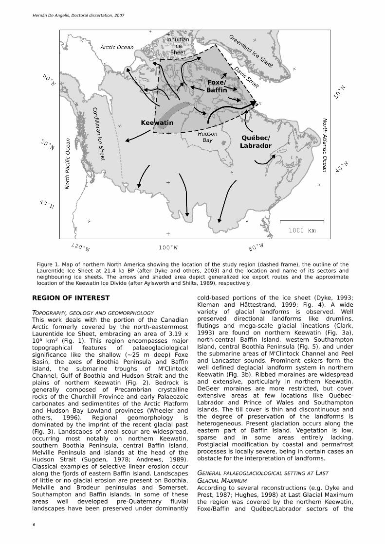
TOPOGRAPH Y, GEOLOGY AND GEOMORPH OLOGYTh is w ork de als w ith th e portion of th e Canadian Arctic form e rly cove re d by th e north -e aste rnm ost Laure ntide Ice Sh e e t, e m bracing an are a of 3.19 x 10⁶ k m 2 (Fig. 1). Th is re gion e ncom pass e s m ajor topograph ical fe ature s of palae oglaciological s ignificance lik e th e s h allow (~ 25 m de e p) Foxe Bas in, th e axe s of Booth ia Pe ninsula and Baffin Island, th e subm arine trough s of M'Clintock Ch anne l, Gulf of Booth ia and H udson Strait and th e plains of north e rn Ke e w atin (Fig. 2). Be drock is ge ne rally com pose d of Pre cam brian crystalline rock s of th e Ch urch ill Province and e arly Palae ozoic carbonate s and s e dim e ntite s of th e Arctic Platform and H udson Bay Low land province s (W h e e le r and oth e rs , 19 9 6). Re gional ge om orph ology is dom inate d by th e im print of th e re ce nt glacial past (Fig. 3). Landscape s of are al scour are w ide spre ad, occurring m ost notably on north e rn Ke e w atin, south e rn Booth ia Pe ninsula, ce ntral Baffin Island, Me lville Pe ninsula and islands at th e h e ad of th e H udson Strait (Sugde n, 19 78; Andre w s , 19 89 ). Class ical e xam ple s of s e le ctive line ar e ros ion occur along th e fjords of e aste rn Baffin Island. Landscape s of little or no glacial e ros ion are pre s e nt on Booth ia, Me lville and Brode ur pe ninsulas and Som e rs e t, South am pton and Baffin islands . In som e of th e s e are as w e ll de ve lope d pre -Quate rnary fluvial landscape s h ave be e n pre s e rve d unde r dom inantly
cold-bas e d portions of th e ice s h e e t (Dyk e , 19 9 3; Kle m an and H ätte strand, 19 9 9 ; Fig. 4). A w ide varie ty of glacial landform s is obs e rve d. W e ll pre s e rve d dire ctional landform s lik e drum lins , flutings and m e ga-scale glacial line ations (Clark , 19 9 3) are found on north e rn Ke e w atin (Fig. 3a), north -ce ntral Baffin Island, w e ste rn South am pton Island, ce ntral Booth ia Pe ninsula (Fig. 5), and unde r th e subm arine are as of M'Clintock Ch anne l and Pe e l and Lancaste r sounds . Prom ine nt e s k e rs form th e w e ll de fine d de glacial landform syste m in north e rn Ke e w atin (Fig. 3b). Ribbe d m oraine s are w ide spre ad and e xte ns ive , particularly in north e rn Ke e w atin. D e Ge e r m oraine s are m ore re stricte d, but cove r e xte ns ive are as at fe w locations lik e Québe c-Labrador and Prince of W ale s and South am pton islands . Th e till cove r is th in and discontinuous and th e de gre e of pre s e rvation of th e landform s is h e te roge ne ous . Pre s e nt glaciation occurs along th e e aste rn part of Baffin Island. Ve ge tation is low , spars e and in som e are as e ntire ly lack ing. Postglacial m odification by coastal and pe rm afrost proce s s e s is locally s e ve re , be ing in ce rtain cas e s an obstacle for th e inte rpre tation of landform s .
GENERAL PALAEOGLACIOLOGICAL SETTING AT LAST GLACIAL MAXIMUMAccording to s e ve ral re constructions (e .g. Dyk e and Pre st, 19 87; H ugh e s , 19 9 8) at Last Glacial Maxim um th e re gion w as cove re d by th e north e rn Ke e w atin, Foxe /Baffin and Québe c/Labrador s e ctors of th e
Figure 1. Map of north e rn North Am e rica s h ow ing th e location of th e study re gion (das h e d fram e ), th e outline of th e Laure ntide Ice Sh e e t at 21.4 k a BP (afte r Dyk e and oth e rs , 2003) and th e location and nam e of its s e ctors and ne igh bouring ice s h e e ts . Th e arrow s and s h ade d are a de pict ge ne ralize d ice e xport route s and th e approxim ate location of th e Ke e w atin Ice D ivide (afte r Aylsw orth and Sh ilts, 19 89 ), re spe ctive ly.
Palae o-ice stre am s in th e north -e aste rn Laure ntide Ice Sh e e t
7
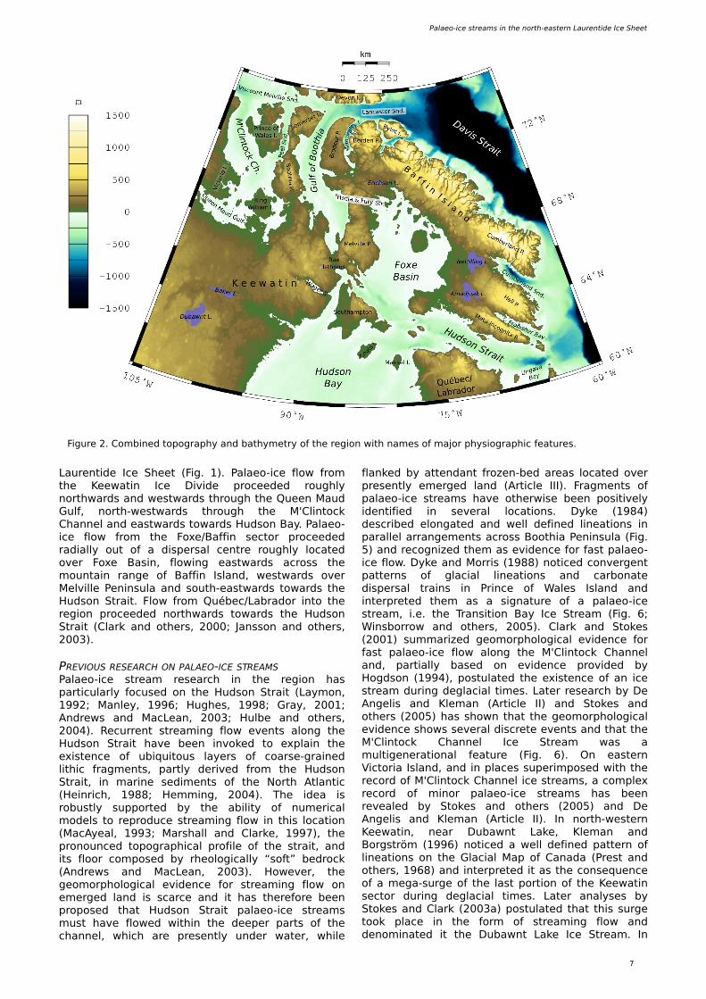
Figure 2. Com bine d topograph y and bath ym e try of th e re gion w ith nam e s of m ajor ph ys iograph ic fe ature s .
Laure ntide Ice Sh e e t (Fig. 1). Palae o-ice flow from th e Ke e w atin Ice D ivide proce e de d rough ly north w ards and w e stw ards th rough th e Que e n Maud Gulf, north -w e stw ards th rough th e M'Clintock Ch anne l and e astw ards tow ards H udson Bay. Palae o-ice flow from th e Foxe /Baffin s e ctor proce e de d radially out of a dispe rsal ce ntre rough ly locate d ove r Foxe Bas in, flow ing e astw ards across th e m ountain range of Baffin Island, w e stw ards ove r Me lville Pe ninsula and south -e astw ards tow ards th e H udson Strait. Flow from Québe c/Labrador into th e re gion proce e de d north w ards tow ards th e H udson Strait (Clark and oth e rs , 2000; Jansson and oth e rs , 2003).
PREVIOUS RESEARCH ON PALAEO -ICE STREAMSPalae o-ice stre am re s e arch in th e re gion h as particularly focus e d on th e H udson Strait (Laym on, 19 9 2; Manle y, 19 9 6; H ugh e s , 19 9 8; Gray, 2001; Andre w s and MacLe an, 2003; H ulbe and oth e rs , 2004). Re curre nt stre am ing flow e ve nts along th e H udson Strait h ave be e n invok e d to e xplain th e e xiste nce of ubiq uitous laye rs of coars e -graine d lith ic fragm e nts , partly de rive d from th e H udson Strait, in m arine s e dim e nts of th e North Atlantic (H e inrich , 19 88; H e m m ing, 2004). Th e ide a is robustly supporte d by th e ability of num e rical m ode ls to re produce stre am ing flow in th is location (MacAye al, 19 9 3; Mars h all and Clark e , 19 9 7), th e pronounce d topograph ical profile of th e strait, and its floor com pose d by rh e ologically “soft” be drock (Andre w s and MacLe an, 2003). H ow e ve r, th e ge om orph ological e vide nce for stre am ing flow on e m e rge d land is scarce and it h as th e re fore be e n propos e d th at H udson Strait palae o-ice stre am s m ust h ave flow e d w ith in th e de e pe r parts of th e ch anne l, w h ich are pre s e ntly unde r w ate r, w h ile
flank e d by atte ndant froze n-be d are as locate d ove r pre s e ntly e m e rge d land (Article III). Fragm e nts of palae o-ice stre am s h ave oth e rw is e be e n pos itive ly ide ntifie d in s e ve ral locations . Dyk e (19 84) de scribe d e longate d and w e ll de fine d line ations in paralle l arrange m e nts across Booth ia Pe ninsula (Fig. 5) and re cognize d th e m as e vide nce for fast palae o-ice flow. Dyk e and Morris (19 88) notice d conve rge nt patte rns of glacial line ations and carbonate dispe rsal trains in Prince of W ale s Island and inte rpre te d th e m as a s ignature of a palae o-ice stre am , i.e . th e Trans ition Bay Ice Stre am (Fig. 6; W insborrow and oth e rs , 2005). Clark and Stok e s (2001) sum m arize d ge om orph ological e vide nce for fast palae o-ice flow along th e M'Clintock Ch anne l and, partially bas e d on e vide nce provide d by H ogdson (19 9 4), postulate d th e e xiste nce of an ice stre am during de glacial tim e s . Late r re s e arch by D e Ange lis and Kle m an (Article II) and Stok e s and oth e rs (2005) h as s h ow n th at th e ge om orph ological e vide nce s h ow s s e ve ral discre te e ve nts and th at th e M'Clintock Ch anne l Ice Stre am w as a m ultige ne rational fe ature (Fig. 6). O n e aste rn Victoria Island, and in place s supe rim pos e d w ith th e re cord of M'Clintock Ch anne l ice stre am s , a com ple x re cord of m inor palae o-ice stre am s h as be e n re ve ale d by Stok e s and oth e rs (2005) and D e Ange lis and Kle m an (Article II). In north -w e ste rn Ke e w atin, ne ar Dubaw nt Lak e , Kle m an and Borgström (19 9 6) notice d a w e ll de fine d patte rn of line ations on th e Glacial Map of Canada (Pre st and oth e rs , 19 68) and inte rpre te d it as th e cons e q ue nce of a m e ga-surge of th e last portion of th e Ke e w atin s e ctor during de glacial tim e s . Late r analyse s by Stok e s and Clark (2003a) postulate d th at th is surge took place in th e form of stre am ing flow and de nom inate d it th e Dubaw nt Lak e Ice Stre am . In
8
H e rnán D e Ange lis , Doctoral dis s e rtation, 2007
north -ce ntral Ke e w atin, McMartin and H e nde rson (2004) and D e Ange lis and Kle m an (Article II) inde pe nde ntly ide ntifie d a cle ar patte rn of fast palae o-ice flow from th e form e r Ke e w atin Ice D ivide (Aylsw orth and Sh ilts, 19 89 ). Th is patte rn s h ow s th e occurre nce of palae o-ice stre am flow close to th e core of th e ice s h e e t and h as be e n inte rpre te d as a form e r tributary to palae o-ice stre am s along th e M'Clintock Ch anne l (Article II). Dre dge (19 9 5) re cognize d w ide spre ad carbonate dispe rsal trains in north e rn Me lville Pe ninsula, inte rpre ting th e m as e vide nce for palae o-ice stre am s of th e Foxe /Baffin s e ctor (Dre dge , 2001). D e Ange lis and Kle m an (Article II) de scribe d a m ass ive conve rge nt patte rn at Rae Isth m us , inte rpre ting it as th e s ignature of ice flow at th e h e ad of ice stre am s and ice s h e lve s along th e Gulf of Booth ia and Lancaste r Sound. O n e aste rn Baffin Island, Mille r and oth e rs (2002) and Brine r and oth e rs (2003) found e vide nce for fast palae o-ice flow along th e fjords in th e form of low gradie nt outle t glacie rs , particularly along Cum be rland Sound (Kaplan and oth e rs , 2001). O n north e rn Baffin Island, D e Ange lis and Kle m an (Article s II and III) notice d patte rns of fast palae o-ice flow at th e e dge s of Brode ur and Borde n Pe ninsulas, w h ich w e re inte rpre te d as topograph ically controlle d outle t glacie rs and ice stre am s draining local ice caps . Baffin Island also be ars re m ark able landform ass e m blage s around Erich s e n and Am adjuak lak e s , w h ich w e re inte rpre te d as th e re cord of trans ie nt succe s s ions of sm all de glacial ice stre am s (Article III).
MATERIALS AND METH ODS
TH E GLACIOLOGICAL INVERSION SCH EMETh is w ork re lie s on th e us e of a glaciological inve rs ion sch e m e for th e inte rpre tation of landform ass e m blage s m appe d from sate llite im age ry. Th is conce ptual m ode l is conce ive d as an obje ctive fram e w ork to form alize th e data re duction ne ce s sary for us e of th e landform re cord to re construct ice s h e e t configurations . Th e sch e m e w as originally pre s e nte d in Kle m an and Borgström (19 9 6), furth e r de ve lope d in Kle m an and oth e rs (19 9 7) and fully e xplaine d in its re vis e d form in
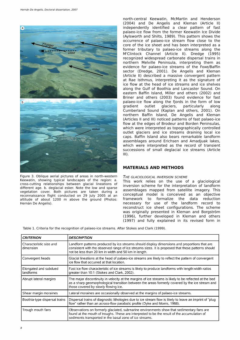
Figure 3. O bliq ue ae rial picture s of are as in north -w e ste rn Ke e w atin, s h ow ing typical landscape s of th e re gion: a. cross -cutting re lations h ips be tw e e n glacial line ations of diffe re nt age . b. de glacial e s k e r. Note th e low and spars e ve ge tation cove r. Both picture s are tak e n during a re connais sance fligh t conducte d on 29 July 2005 at an altitude of about 1200 m above th e ground (Ph otos : H e rnán D e Ange lis).
Table 1. Crite ria for th e re cognition of palae o-ice stre am s . Afte r Stok e s and Clark (19 9 9 ).
Palae o-ice stre am s in th e north -e aste rn Laure ntide Ice Sh e e t
9
Kle m an and oth e rs (2006). A s im ilar approach h as also be e n de ve lope d and applie d by Boulton and Clark (19 9 0) and Clark (19 9 7). Bas ically, th e sch e m e m ak e s us e of th e distribution of glacial ge om orph ological data, i.e . striae , line ations , e s k e rs and m oraine s , in orde r to re construct th e ge om e try and e volution of ice s h e e ts . Th e m ain ide a be h ind th e sch e m e is to class ify th e landform s according to form ative conditions , particularly cons ide ring th at
landform cre ation, de struction and pre s e rvation are controlle d by th e th e rm al state of th e be d. Th is m e ans th at w e t- (or m e lte d-, or w arm -) bas e d conditions prom ote re s h aping of th e landscape w h e re as dry- (or froze n-, or cold-) bas e d conditions translate into landscape pre s e rvation (Lage rbäck , 19 88b; Kle m an, 19 9 4). Accordingly, th e sch e m e tak e s into cons ide ration th at olde r landform syste m s m igh t h ave survive d due to pre s e rvation
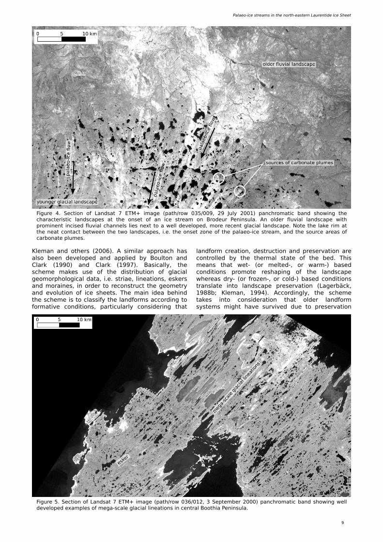
Figure 4. Se ction of Landsat 7 ETM+ im age (path /row 035/009 , 29 July 2001) panch rom atic band s h ow ing th e ch aracte ristic landscape s at th e ons e t of an ice stre am on Brode ur Pe ninsula. An olde r fluvial landscape w ith prom ine nt incis e d fluvial ch anne ls lie s ne xt to a w e ll de ve lope d, m ore re ce nt glacial landscape . Note th e lak e rim at th e ne at contact be tw e e n th e tw o landscape s , i.e . th e ons e t zone of th e palae o-ice stre am , and th e source are as of carbonate plum e s .
Figure 5. Se ction of Landsat 7 ETM+ im age (path /row 036/012, 3 Se pte m be r 2000) panch rom atic band s h ow ing w e ll de ve lope d e xam ple s of m e ga-scale glacial line ations in ce ntral Booth ia Pe ninsula.
1 0
H e rnán D e Ange lis , Doctoral dis s e rtation, 2007
unde r cold-bas e d ice and th e re fore portions of th e be d m ay s h ow anom alous or contrasting flow patte rns . In practice th e sch e m e is applie d by re cognizing landform ass e m blage s form ing coh e re nt patte rns and subs e q ue ntly inte grating th e m into landform sw arm s . Th e s e sw arm s are de fine d on th e bas is of spatial continuity and re s e m blance to a glaciologically plaus ible patte rn, follow ing th e le ast com ple x poss ible solution. O nce ide ntifie d, sw arm s are draw n us ing line s th at are paralle l to th e visually coh e re nt landform patte rn, w ith transve rs e up and dow nstre am lim its (Fig. 7). Landform sw arm s re pre s e nt th e first le ve l of abstraction in th e re gional inte rpre tation sch e m e and s e rve to re duce th e cartograph ic inform ation into a m anage able num be r of e ntitie s (Kle m an and oth e rs , 19 9 7).
PALAEO -ICE STREAMS IN TH E LANDFORM RECORDPalae o-ice stre am s h ave be e n long suspe cte d and propos e d, alth ough th e ir syste m atic re cognition in form e r ice s h e e t be ds re q uire d th e ade q uate tools to be de ve lope d (Clark and Stok e s , 2003). Th e s e tools com pris e : 1. sate llite im age ry, 2. advance d im aging sonar syste m s and 3. crite ria to ide ntify th e ge om orph ological s ignature of stre am ing flow in th e palae o-re cord. Sate llite im age ry is im portant be caus e th e e xte ns ive are a cove re d by s ingle sce ne s (e .g. 180 x 180 k m in a Landsat im age ) s h ow s s ignificant portions of ice stre am path s in a s ingle vie w , w h ile at th e sam e tim e re ve aling th e large landform s as sociate d w ith palae o-ice stre am flow (Clark , 19 9 7; Stok e s , 2002). Th e introduction of advance d im aging sonar syste m s allow e d th e w ide spre ad ide ntification of subm e rge d palae o-ice
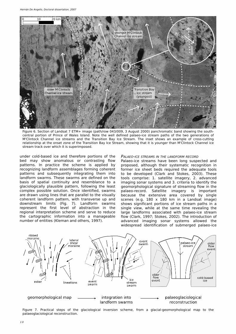
Figure 6. Se ction of Landsat 7 ETM+ im age (path /row 043/009 , 3 August 2000) panch rom atic band s h ow ing th e south -ce ntral portion of Prince of W ale s Island. Note th e w e ll de fine d palae o-ice stre am path s of th e tw o ge ne rations of M'Clintock Ch anne l ice stre am s and th e Trans ition Bay Ice Stre am . Th e ins e t s h ow s an e xam ple of cross -cutting re lations h ip at th e ons e t zone of th e Trans ition Bay Ice Stre am , s h ow ing th at it is younge r th an M'Clintock Ch anne l ice stre am track ove r w h ich it is supe rim pos e d.
Figure 7. Practical ste ps of th e glaciological inve rs ion sch e m e , from a glacial-ge om orph ological m ap to th e palae oglaciological re construction.
Palae o-ice stre am s in th e north -e aste rn Laure ntide Ice Sh e e t
1 1
flow patte rns , e xte nding th e re ach of palae oglaciological re s e arch into contine ntal platform s (O 'Cofaigh and oth e rs , 2005; O tte s e n and oth e rs , 2005). Finally, a m ajor advance m e nt in th e syste m atic re cognition of palae o-ice stre am s w as th e introduction of coh e re nt crite ria for th e ir ide ntification in th e landform re cord (Stok e s and Clark , 19 9 9 ; Table 1). Th e s e crite ria involve th e ide ntification of landform patte rns of ch aracte ristic s h ape and dim e ns ion, conve rge nt h e ads (Figs . 4 and 6), abrupt late ral m argins (Figs . 6 and 8), late ral s h e ar m oraine s (Figs . 6 and 8), e longate d and subdue d landform s (Figs . 4 and 9 ) and Booth ia-type dispe rsal trains (Dyk e and Morris , 19 88). Us e of th e s e crite ria provide s unam biguous rule s th at cons ide rably re duce th e subje ctivity in th e ide ntification of palae o-ice stre am s , in particular w h e n th e y are us e d w ith in th e com pre h e ns ive fram e w ork of th e glaciological inve rs ion sch e m e .
IMPLEMENTATION OF TH E METH O DOLOGYAll inform ation involve d in m apping and inte rpre tation w as h andle d w ith in a ge ograph ic inform ation syste m (GIS). In orde r to k e e p
ge om e trical uniform ity w ith Canadian cartograph y, our GIS databas e is bas e d on a Lam be rt Conform al Conical proje ction re fe rre d to th e North Am e rican Datum 19 83 (NAD83). Standard paralle ls are locate d at 49 °N and 77°N and th e ce ntre of proje ction is at 83°W , 68°N. Data is organize d in four le ve ls: source , m apping, re fe re nce and inte rpre tation. Th e conte nt, structure , as sum ptions and m e th odological de tails of th e s e le ve ls are e xplaine d be low and sum m arize d in Table 2. D igitizing w as accom plis h e d first on ESRI ArcGIS© softw are and late r on O pe nEV (h ttp://ope ne v.source forge .ne t/). Ve ctor laye rs w e re originally store d as ESRI Sh ape file s and w e re afte rw ards im porte d into a PostGIS (h ttp://w w w.postgis .org/) databas e for proce s s ing and analys is . Th is w as pe rform e d us ing PostGIS SQL com m ands via custom Pe rl (h ttp://w w w.pe rl.org/) program s and Ge ograph ic Re source s Analys is Support Syste m (GRASS, h ttp://grass .itc.it/). Map production w as accom plis h e d w ith Ge ne ric Mapping Tools (GMT) softw are (W e s s e l and Sm ith , 19 9 8) and cosm e tic de tails finis h e d w ith Ink scape (h ttp://w w w.ink scape .org/).
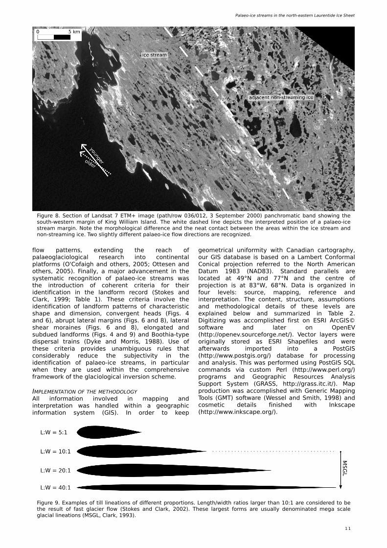
Figure 8. Se ction of Landsat 7 ETM+ im age (path /row 036/012, 3 Se pte m be r 2000) panch rom atic band s h ow ing th e south -w e ste rn m argin of King W illiam Island. Th e w h ite das h e d line de picts th e inte rpre te d pos ition of a palae o-ice stre am m argin. Note th e m orph ological diffe re nce and th e ne at contact be tw e e n th e are as w ith in th e ice stre am and non-stre am ing ice . Tw o sligh tly diffe re nt palae o-ice flow dire ctions are re cognize d.
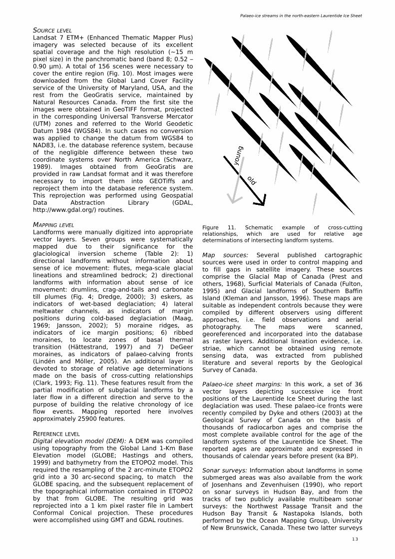
Figure 9 . Exam ple s of till line ations of diffe re nt proportions . Le ngth /w idth ratios large r th an 10:1 are cons ide re d to be th e re sult of fast glacie r flow (Stok e s and Clark , 2002). Th e s e large st form s are usually de nom inate d m e ga scale glacial line ations (MSGL, Clark , 19 9 3).
1 2
H e rnán D e Ange lis , Doctoral dis s e rtation, 2007
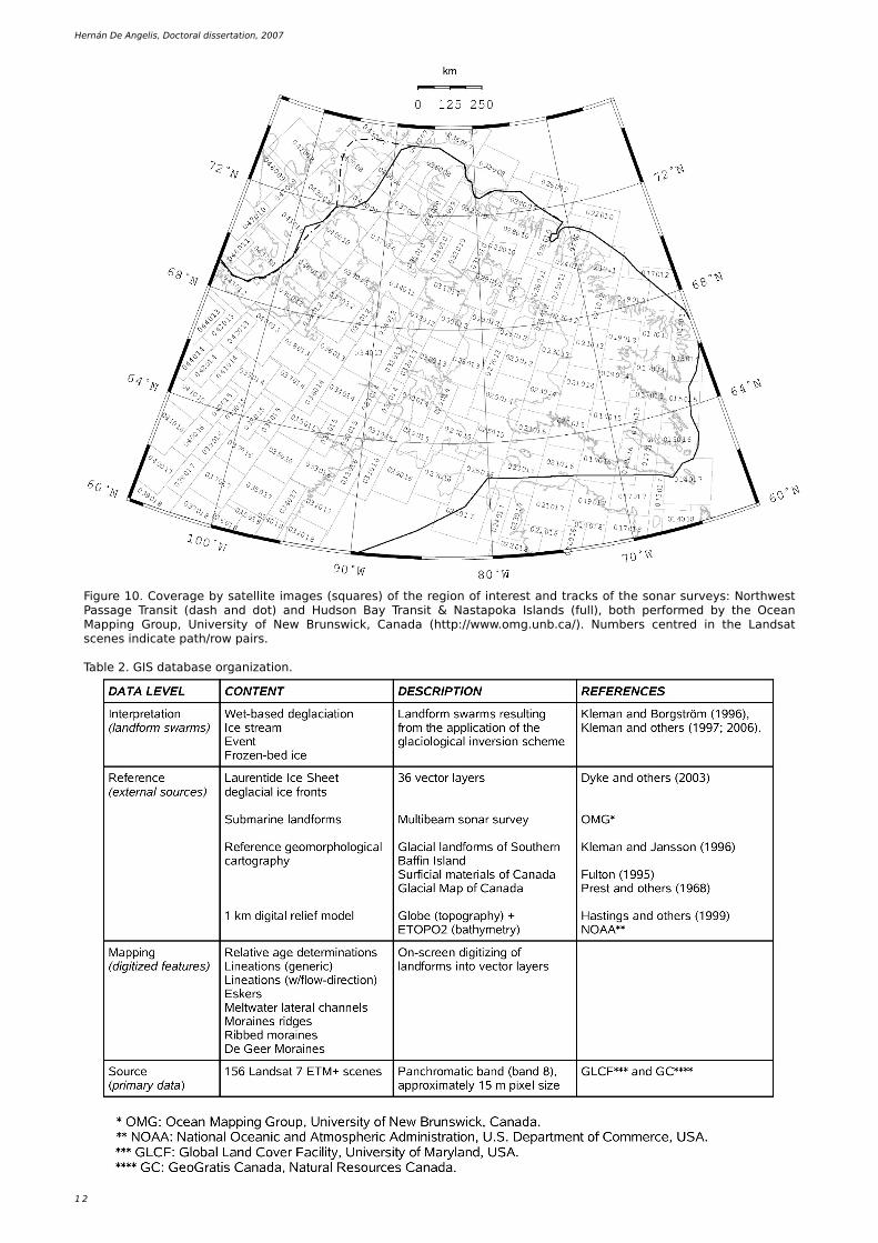
Figure 10. Cove rage by sate llite im age s (s q uare s) of th e re gion of inte re st and track s of th e sonar surve ys : North w e st Passage Trans it (das h and dot) and H udson Bay Trans it & Nastapok a Islands (full), both pe rform e d by th e O ce an Mapping Group, Unive rs ity of Ne w Brunsw ick , Canada (h ttp://w w w.om g.unb.ca/). Num be rs ce ntre d in th e Landsat sce ne s indicate path /row pairs .
Table 2. GIS databas e organization.
Palae o-ice stre am s in th e north -e aste rn Laure ntide Ice Sh e e t
1 3
SOURCE LEVELLandsat 7 ETM+ (Enh ance d Th e m atic Mappe r Plus) im age ry w as s e le cte d be caus e of its e xce lle nt spatial cove rage and th e h igh re solution (~ 15 m pixe l s ize ) in th e panch rom atic band (band 8; 0.52 – 0.9 0 µm ). A total of 156 sce ne s w e re ne ce s sary to cove r th e e ntire re gion (Fig. 10). Most im age s w e re dow nloade d from th e Global Land Cove r Facility s e rvice of th e Unive rs ity of Maryland, USA, and th e re st from th e Ge oGratis s e rvice , m aintaine d by Natural Re source s Canada. From th e first s ite th e im age s w e re obtaine d in Ge oTIFF form at, proje cte d in th e corre sponding Unive rsal Transve rs e Me rcator (UTM) zone s and re fe rre d to th e W orld Ge ode tic Datum 19 84 (W GS84). In such cas e s no conve rs ion w as applie d to ch ange th e datum from W GS84 to NAD83, i.e . th e databas e re fe re nce syste m , be caus e of th e ne gligible diffe re nce be tw e e n th e s e tw o coordinate syste m s ove r North Am e rica (Sch w arz, 19 89 ). Im age s obtaine d from Ge oGratis are provide d in raw Landsat form at and it w as th e re fore ne ce s sary to im port th e m into GEOTiffs and re proje ct th e m into th e databas e re fe re nce syste m . Th is re proje ction w as pe rform e d us ing Ge ospatial Data Abstraction Library (GDAL, h ttp://w w w.gdal.org/) routine s .
MAPPING LEVELLandform s w e re m anually digitize d into appropriate ve ctor laye rs . Se ve n groups w e re syste m atically m appe d due to th e ir s ignificance for th e glaciological inve rs ion sch e m e (Table 2): 1) dire ctional landform s w ith out inform ation about s e ns e of ice m ove m e nt: flute s , m e ga-scale glacial line ations and stre am line d be drock ; 2) dire ctional landform s w ith inform ation about s e ns e of ice m ove m e nt: drum lins , crag-and-tails and carbonate till plum e s (Fig. 4; Dre dge , 2000); 3) e s k e rs , as indicators of w e t-bas e d de glaciation; 4) late ral m e ltw ate r ch anne ls, as indicators of m argin pos itions during cold-bas e d de glaciation (Maag, 19 69 ; Jansson, 2002); 5) m oraine ridge s , as indicators of ice m argin pos itions; 6) ribbe d m oraine s , to locate zone s of basal th e rm al trans ition (H ätte strand, 19 9 7) and 7) D e Ge e r m oraine s , as indicators of palae o-calving fronts (Lindén and Mölle r, 2005). An additional laye r is de vote d to storage of re lative age de te rm inations m ade on th e bas is of cross -cutting re lations h ips (Clark , 19 9 3; Fig. 11). Th e s e fe ature s re sult from th e partial m odification of subglacial landform s by a late r flow in a diffe re nt dire ction and s e rve to th e purpos e of building th e re lative ch ronology of ice flow e ve nts . Mapping re porte d h e re involve s approxim ate ly 259 00 fe ature s .
REFERENCE LEVELD igital e le vation m ode l (DEM): A DEM w as com pile d us ing topograph y from th e Global Land 1-Km Bas e Ele vation m ode l (GLOBE; H astings and oth e rs , 19 9 9 ) and bath ym e try from th e ETOPO2 m ode l. Th is re q uire d th e re sam pling of th e 2 arc-m inute ETOPO2 grid into a 30 arc-s e cond spacing, to m atch th e GLOBE spacing, and th e subs e q ue nt re place m e nt of th e topograph ical inform ation containe d in ETOPO2 by th at from GLOBE. Th e re sulting grid w as re proje cte d into a 1 k m pixe l raste r file in Lam be rt Conform al Conical proje ction. Th e s e proce dure s w e re accom plis h e d us ing GMT and GDAL routine s .
Map source s : Se ve ral publis h e d cartograph ic source s w e re us e d in orde r to control m apping and to fill gaps in sate llite im age ry. Th e s e source s com pris e th e Glacial Map of Canada (Pre st and oth e rs , 19 68), Surficial Mate rials of Canada (Fulton, 19 9 5) and Glacial landform s of South e rn Baffin Island (Kle m an and Jansson, 19 9 6). Th e s e m aps are suitable as inde pe nde nt controls be caus e th e y w e re com pile d by diffe re nt obs e rve rs us ing diffe re nt approach e s , i.e . fie ld obs e rvations and ae rial ph otograph y. Th e m aps w e re scanne d, ge ore fe re nce d and incorporate d into th e databas e as raste r laye rs . Additional line ation e vide nce , i.e . striae , w h ich cannot be obtaine d us ing re m ote s e ns ing data, w as e xtracte d from publis h e d lite rature and s e ve ral re ports by th e Ge ological Surve y of Canada.
Palae o-ice s h e e t m argins : In th is w ork , a s e t of 36 ve ctor laye rs de picting succe s s ive ice front pos itions of th e Laure ntide Ice Sh e e t during th e last de glaciation w as us e d. Th e s e palae o-ice fronts w e re re ce ntly com pile d by Dyk e and oth e rs (2003) at th e Ge ological Surve y of Canada on th e bas is of th ousands of radiocarbon age s and com pris e th e m ost com ple te available control for th e age of th e landform syste m s of th e Laure ntide Ice Sh e e t. Th e re porte d age s are approxim ate and e xpre s s e d in th ousands of cale ndar ye ars be fore pre s e nt (k a BP).
Sonar surve ys : Inform ation about landform s in som e subm e rge d are as w as also available from th e w ork of Jos e nh ans and Z e ve nh uis e n (19 9 0), w h o re port on sonar surve ys in H udson Bay, and from th e track s of tw o publicly available m ultibe am sonar surve ys : th e North w e st Passage Trans it and th e H udson Bay Trans it & Nastapok a Islands, both pe rform e d by th e O ce an Mapping Group, Unive rs ity of Ne w Brunsw ick , Canada. Th e s e tw o latte r surve ys
Figure 11. Sch e m atic e xam ple of cross -cutting re lations h ips , w h ich are us e d for re lative age de te rm inations of inte rs e cting landform syste m s .
1 4
H e rnán D e Ange lis , Doctoral dis s e rtation, 2007
provide inform ation about th e subm arine ge ology and ge om orph ology along parts of th e H udson Strait, e aste rn Baffin Island and Lancaste r Sound (Fig. 10).
Low -altitude obliq ue ae rial ph otograph y: A re connais sance and validation fie ld cam paign w as carrie d out in July 2005. H undre ds of low altitude obliq ue ae rial picture s from th e w e ste rnm ost rim of th e re gion w e re acq uire d for us e in th e validation of th e m apping, particularly cross -cutting re lations h ips (Fig. 3).
INTERPRETATION LEVELTh is le ve l com pris e s all landform sw arm s . Th re e diffe re nt type s of landform sw arm s are us e d h e re : 1) ice stre am ; 2) e ve nt and 3) w e t-bas e d de glaciation. Ice stre am sw arm s are de fine d according to th e crite ria e xplaine d above (Table 1). Eve nt sw arm s are de fine d as landform syste m s w ith abundant flow trace s but lack ing aligne d e s k e rs (Kle m an and oth e rs , 2006). Th e palae oglaciological s ignificance of e ve nt sw arm s w as e valuate d individually according to th e conte xt, be caus e th e y m igh t re pre s e nt anyth ing from sm all outle t glacie rs to fragm e nts of large r ice stre am s . W e t-bas e d de glaciation sw arm s are syste m s of dire ctional landform s and aligne d m e ltw ate r trace s , inte rpre te d to be th e re sult of th e re tre at of a w e t-bas e d ice s h e e t (Kle m an and oth e rs , 19 9 7). Are as inte rpre te d to h ave be e n cove re d by cold-bas e d ice , i.e . palae o-froze n be d are as , w e re groupe d w ith sw arm s . Th e s e w e re ide ntifie d th rough th e re cognition of re lict landscape s (Fig. 4), landform s indicative of th e rm al trans ition (ribbe d m oraine s; H ätte strand and Kle m an, 19 9 7) and cold-bas e d de glaciation (late ral m e ltw ate r ch anne ls; Maag, 19 69 ; Jansson, 2002). W e also de al spe cifically w ith zone s th at re m aine d froze n to th e be d during re lative ly s h ort pe riods as , for e xam ple , during re organization of flow patte rns . Th is applie s particularly to palae o-ice stre am track s th at are obs e rve d to be nd around “m is s ing” obstacle s in th e abs e nce of oth e r cle ar controls such as topograph y (Figs . 6 and 8). In th e s e cas e s it w as ge ne rally assum e d th at th e m ost re asonable e xplanation w as th e occurre nce of a trans ie nt zone of cold-bas e d ice .
ADVANTAGES AND LIMITATIONS OF TH E METH O DOLOGYGIS approach : Th e us e of a GIS approach in ge oscie nce is advantage ous be caus e it allow s th e e fficie nt us e of diffe re nt data type s and th e rigorous incorporation and update of pre vious w ork , w h ile providing tools for re scaling, re proje ction, class ification and e xport to a varie ty of form ats . In th e particular cas e of palae oglaciology, a GIS approach facilitate s th e us e of tim e -consum ing and labour-inte ns ive m apping e fforts in th e obje ctive validation of num e rical ice s h e e t m ode ls (e .g. Napie rals k i and oth e rs , 2007).
Mapping: Ge om orph ological m apping of large are as w ith an h e te roge ne ous landform re cord is a pote ntially subje ctive proce s s and th e ris k e xists for th e ove r-re pre s e ntation of w e ll de fine d landform ass e m blage s and th e unde r-re pre s e ntation of fainte r one s . Care ful and cons iste nt m apping te ch niq ue s are th e re fore re q uire d w h e n m apping such com ple x are as in orde r to m inim ize th e spatial
bias in th e cartograph ic re pre s e ntation (e .g. Sm ith and W is e , 2007). Mapping re porte d h e re w as com ple te d in tw o succe s s ive ste ps , first at 1:250,000 and late r at 1:100,000 scale . Th is approach w as de s igne d to ach ie ve a cons iste nt cartograph ic h om oge ne ity ove r are as fe aturing w e ll pre s e rve d landform s and to ide ntify are as re q uiring close r inspe ction. In th e latte r cas e (e .g. Baffin Island and ce ntral Booth ia Pe ninsula), m apping w as pe rform e d at 1:75,000 due to th e faintne s s and sm all s ize of th e landform s . W h e n m apping dire ctional landform s a ge ne ric principle of re pre s e ntativity w as applie d, m e aning th at m apping w as accom plis h e d w ith th e obje ctive of ach ie ving a good re pre s e ntation of th e landform patte rns . Accordingly, any line ation in th e m ap m ay re pre s e nt a group of ne arby landform s h aving s im ilar dire ction. Se ve ral control rounds w e re carrie d out at sm alle r scale s , i.e . 1:500,000, in orde r to ass e s s th e cons iste ncy across th e re gion as w e ll as to e lim inate abe rrations lik e fe ature duplication due to im age ove rlaps and inade q uate re pre s e ntation of landform ass e m blage s .
Inte rpre tation: Th e glaciological inve rs ion sch e m e provide s an obje ctive , cons iste nt and re producible m e th odology for th e re construction of palae o-ice s h e e ts . H ow e ve r, e rrors and am biguitie s m igh t appe ar be caus e of th e fragm e ntary and inh om oge ne ous nature of th e landform re cord. Usually th e s e am biguitie s involve : 1. th e lack of continuity be tw e e n landform syste m s , 2. m is inte rpre tation of tim e -transgre s s ive patte rns as s ingle -e ve nt, and 3. occurre nce of re curre nt or m ultige ne rational flow , w h ich m ak e s th e discrim ination of s ingular flow e ve nts difficult. An additional source of unce rtainty conce rns th e actual proce dure of sw arm ide ntification. In practice , ide ntifying landform sw arm s is e s s e ntially a proble m of patte rn re cognition, w h e re th e obs e rve r infe rs th e ge om e try of palae o-ice flow fie lds from m ore or le s s scatte re d ve ctor obs e rvations . Alth ough som e subje ctivity m ay be involve d in th is proce s s , e xpe rie nce s h ow s th at th orough us e of th e principle s of th e glaciological inve rs ion sch e m e allow s diffe re nt obs e rve rs to ide ntify re asonably s im ilar sw arm patte rns . In th is re gard, it is inte re sting to note th at future ste ps aim ing to incre as e obje ctivity in sw arm re cognition m igh t cons ide r th e adaptation of solutions de rive d from com pute r vis ion re s e arch , due to th e re m ark able conce ptual analogie s be tw e e n th e s e tw o proble m s (e .g. Rao and Jain, 19 9 2).
Age constraints in th e palae oglaciological re construction: As s e s s ing th e tim ing of palae o-ice stre am activity is proble m atic be caus e of th e inh e re nt im poss ibility of e stablis h ing th e age of subglacial landform s (e .g. H ätte strand and oth e rs , 2004). In th is re gard, stratigraph ic inform ation is us e ful w h e n landform ass e m blage s can be safe ly link e d to datable de pos its . Unfortunate ly, th is is rare ly th e cas e w h e n w ork ing at th e ice s h e e t scale be caus e of th e large are as involve d and th e ofte n poor spatial continuity of th e landform ass e m blage s . In practice , th e m ost rigorous poss ible w ay to obtain a re asonable ch ronological fram e w ork for palae o-ice stre am s is to corre late th e ir landform im print to datable de pos its and ice -rafte d de bris in off-s h ore re gions . Th is h as be e n done , for e xam ple ,
Palae o-ice stre am s in th e north -e aste rn Laure ntide Ice Sh e e t
1 5
by Stok e s and oth e rs (2005) for palae o-ice stre am s along th e M'Clure Strait, Canada, and Dow de sw e ll and Elve rh øi (2002) for th e Norw e gian Coast. Unfortunate ly, com piling and analys ing a databas e of m arine s e dim e nt core s in th e North Atlantic and Arctic O ce ans th at w ould suit th e ne e ds of th e pre s e nt w ork is a m ajor unde rtak ing and h as not ye t be e n atte m pte d. Accordingly, in th is w ork I ch os e th e s im ple r but still robust proce dure of building our ch ronological fram e w ork on th e bas is of glaciological corre lation be tw e e n publis h e d palae o-ice s h e e t m argins and our inte rpre te d palae o-ice flow patte rns . Th e palae o-ice s h e e t m argins us e d h e re w e re e xtracte d from of a s e t of ve ctor laye rs de picting succe s s ive ice front pos itions of th e Laure ntide Ice Sh e e t during th e last de glaciation (Dyk e and oth e rs , 2003). Corre lations w e re m ade by applying glaciological re asoning bas e d on pre s e nt k now le dge about ice s h e e t flow (van de r Ve e n, 19 9 9 ; H ugh e s , 19 9 8; Pate rson, 2001). Alth ough som e subje ctivity is involve d in th is proce dure , e xpe rie nce s h ow s th at for any give n s e t of palae o-ice flow patte rns and palae o-ice s h e e t m argins it is poss ible to re duce th e unce rtainty to a sm all se t of re asonable s ituations .
Longe vity, coe xiste nce , and le ngth of palae o-ice stre am ne tw ork s : Anoth e r im portant m e th odological cons ide ration is re late d to th e inte rpre te d longe vity, coe xiste nce , and le ngth of palae o-ice stre am ne tw ork s . Th e s e is sue s are am ongst th e m ost critical and unce rtain aspe cts of any palae oglaciological re construction and re q uire e xplicit tre atm e nt. In principle , it s e e m s conce ivable th at longe vity and coe xiste nce can be as s e s s e d w h e n a sufficie ntly de taile d databas e of date d s e dim e nt core s in off-s h ore re gions is available and corre lations can be confide ntly e stablis h e d be tw e e n palae o-ice stre am im print and s e dim e nt de pos ition. O n th e oth e r h and, it is difficult to e nvisage a practical w ay of ass e s s ing th e actual le ngth of a palae o-ice stre am ne tw ork at a ce rtain tim e . Th is proble m is not trivial s ince ice stre am ne tw ork s can display com plicate d dynam ics and, ove r tim e scale s of ce nturie s and m ille nnia, th e y could e as ily adjust th e ir active le ngth s to th e e ve r ch anging clim atic and dynam ic conditions of th e ice s h e e t (e .g. H ulbe and Fah ne stock , 2007). I h e re de al w ith th e s e is sue s by e xplicitly m ark ing th e unce rtaintie s and plaus ible configurations . Longe vity is ge ne rally ass e s s e d th rough analys is of th e palae o-ice s h e e t m argins by ruling out unlik e ly configurations and adjusting our inte rpre tations to th e re lative age s and ge om e try of landform sw arm s . Th is , h ow e ve r, can only be strictly applie d ove r a lim ite d portion of form e r ice stre am be ds and, for m ost of th e re gion, th e propos e d configurations m ust be inte rpolate d. Coe xiste nce of diffe re nt ice stre am ne tw ork s is e valuate d th rough glaciological re asoning, particularly in th e cas e of ne igh bouring ons e t zone s , by m ark ing pote ntially incom patible configurations . Le ngth re m ains th e le ast constraine d of th e th re e is sue s and in m y inte rpre tations I m ark e d w h at I cons ide re d th e m axim um poss ible le ngth of ice stre am s . By doing th is , h ow e ve r, no im plication w as m ade about th e longe vity of any particular configuration.
From th e landform re cord to th e palae oglaciological re construction: A final re m ark m ust be introduce d to note th at re constructing th e inte rnal structure of
palae o-ice s h e e ts us ing th e landform re cord im plie s a s e rie s of ste ps w h e re th e le ve l of abstraction is rais e d at th e e xpe ns e of ce rtainty. W ork starts from a ge om orph ological m ap w h e re fide lity to re ality, but also com ple xity, are at m axim um and gradually arrive s at th e palae oglaciological re construction, w h e re th e initial com ple xity is re duce d to a fe w plaus ible configurations th rough s im plifying assum ptions and ge ne ralization. Th e re ade r is th e re fore re m inde d th at th is w ork aim s to obtain glaciologically coh e re nt picture s at th e sub-contine ntal scale and th at th e re sults are not m e ant to be dire ctly com pare d w ith w ork at local scale s .
RESULTS
Th e re sults of th is w ork are pre s e nte d in th re e m aps and a s e rie s of figure s s h ow ing th e propos e d tim e e volution of palae o-ice stre am s in th e study re gion. Th e s e re sults are also distribute d in th e five appe nde d article s .
MAPSGlacial landform s m appe d from sate llite im age ry are s h ow n in Map 1, e ntitle d “Glacial ge om orph ology of th e e ast-ce ntral Canadian Arctic”, w h ich is part of Article I. An e le ctronic (PDF) ve rs ion can be found in th e CD -ROM accom panying th is th e s is . Map 2 s h ow s th e distribution of ice stre am and e ve nt sw arm s , toge th e r w ith th e ir re lative age s , and Map 3 s h ow s th e distribution of w e t-bas e d de glaciation sw arm s . Both m aps de pict th e distribution of inte rpre te d cold bas e d are as .
PALAEO -ICE STREAM EVOLUTIONA s e rie s of palae oglaciological re constructions at s ix diffe re nt stage s be tw e e n th e Last Glacial Maxim um and th e last de glaciation h as be e n constructe d on th e bas is of th e re sults of th is study. Th e s e rie s is th e subje ct of Article IV and is th e re fore only brie fly discuss e d in th e ne xt s e ction.
ARTICLES
Article IDe Ange lis , H . In pre s s . Glacial ge om orph ology of th e e ast-ce ntral Canadian Arctic. Acce pte d for publication in Journal of Maps .
Th is article de scribe s ge om orph ological m apping of th e are a of inte re st and form s th e fundam e ntal bas is of th e palae oglaciological re construction and re late d studie s de ve lope d in th is th e s is .
Article IIDe Ange lis , H . and J. Kle m an. 2005. Palae o-ice stre am s in th e north e rn Ke e w atin s e ctor of th e Laure ntide Ice Sh e e t. Annals of Glaciology 42, 135-144.
In th is pape r, w e produce d a palae o-ice stre am m ap of th e north e rnm ost Ke e w atin s e ctor of th e Laure ntide Ice Sh e e t. Th e m ain re sults conce rn th e e vide nce for th e m ultige ne rational nature of th e palae o-ice stre am re cord along th e M'Clintock Ch anne l. Analys is of th e landform re cord also s h ow e d th at th e location of ice stre am s w ith in th is
1 6
H e rnán D e Ange lis , Doctoral dis s e rtation, 2007
subre gion w as controlle d by th e location of trans ie nt froze n-be d are as , providing e vide nce for th e occurre nce of pure ice stre am s in th e Laure ntide Ice Sh e e t. W e also discuss e d th e occurre nce of palae o-ice stre am track s on Prince of W ale s Island and conclude d th at th e s e fe ature s functione d during a ve ry s h ort pe riod of tim e (~ 11.0 – 10.0 k a BP) as th e y draine d a local re m nant ice cap in th e conte xt of th e collapse of th e north -w e ste rn s e ctor of th e Laure ntide Ice Sh e e t. A cle ar picture th at e m e rge d from th is pape r w as th e w ide spre ad occurre nce of stre am ing flow in th e north e rn Ke e w atin s e ctor, from are as th at are inte rpre te d to h ave be e n close to th e north e rn m argin up to w ith in 200 k m of th e propos e d ice divide re gion. Th is confirm s partial re constructions (Kle m an and oth e rs , 2002; McMartin and H e nde rson, 2004) and s h ow s th at ice flow w ith in th e Laure ntide Ice Sh e e t de ve lope d patte rns th at are s im ilar to th os e pre s e nt on th e Gre e nland and Antarctic ice s h e e ts .
Article IIIDe Ange lis , H . and J. Kle m an. 2007. Palae o-ice stre am s in th e Foxe /Baffin s e ctor of th e Laure ntide Ice Sh e e t. Quate rnary Scie nce Re vie w s 26 (9 -10), 1313-1331.
H e re , w e analyse d th e location and e volution of palae o-ice stre am s in th e Foxe /Baffin s e ctor of th e Laure ntide Ice Sh e e t. W e follow e d a large ly s im ilar approach to th at in Article II, e xce pt th at w e h e re e m ph as ize d on th e m e th odological aspe cts and th e palae oglaciological re construction. In line w ith pre vious re s e arch , w e re cognize d tw o e s s e ntial patte rns of re gional palae o-ice flow in th e Foxe /Baffin s e ctor th at w e re as sociate d w ith diffe re nt stage s of th e de glaciation h istory. Th e olde r patte rn e ncom pass e s radial palae o-ice flow from a dom e ce ntre d in e aste rn Foxe Bas in th at e xiste d during th e tim e be tw e e n th e Last Glacial Maxim um and 7.8 k a BP. During th is pe riod m ost of th e Foxe /Baffin s e ctor e xpe rie nce d slow and stable re tre at and our re sults s h ow e d th at it w as large ly draine d by a re lative ly stable patte rn of topograph ically controlle d outle t glacie rs and ice stre am s . Be tw e e n approxim ate ly 7.8 and 6.8 k a BP, th e re m nant portion of th e Foxe /Baffin s e ctor collapse d catastroph ically in th e Foxe Bas in be fore stabilizing at rough ly th e pre s e nt w e ste rn coast of Baffin Island. During th is collapse , trans ie nt ice stre am s occurre d in tw o s e ctors of Baffin Island: th e are a around Erich s e n Lak e and be tw e e n Am adjuak and Ne ttilling lak e s . O ur analyse s re ve ale d th at th e m ost lik e ly e xplanation for th is re cord w as th at sm all trans ie nt ice stre am s sw itch e d on and off in re spons e to th e ge om e trical and dynam ical ch ange s of th e ice s h e e t during its collapse . In th is article w e also discuss e d th e obs e rvation th at th e landform arch ive on land is not sufficie nt to support th e e xiste nce of ice stre am s along th e H udson Strait. W e th e re fore propos e d th at stre am ing flow m igh t h ave occurre d as topograph ically controlle d palae o-ice stre am s , w h ich w e re active in th e de e pe st parts of H udson Strait in com bination w ith atte ndant cold-bas e d ice zone s fixe d in m arginal are as and on islands at th e h e ad of th e strait.
Article IVDe Ange lis , H . and J. Kle m an. Manuscript. Palae o-ice stre am e volution in th e north -e aste rn Laure ntide Ice Sh e e t.
In th is article w e re constructe d th e e volution of th e north -e aste rnm ost portion of th e Laure ntide Ice Sh e e t during th e pe riod be tw e e n th e Last Glacial Maxim um and th e last de glaciation. O ur re construction focus e d particularly on th e ch aracte ristics of th e ice stre am ne tw ork s . In addition, w e also analyse d th e role of th e topograph y, ge ology and inte rpre te d basal th e rm al state of th e ice s h e e t on th e location and dynam ics of th e s e palae o-ice stre am s . Th e as sum ptions and lim itations involve d in th is type of palae oglaciological studie s w e re e xplicitly addre s s e d.
Article VDe Ange lis , H . and J. Kle m an. In pre s s . Palae o-ice stre am ons e ts : e xam ple s from th e north -e aste rn Laure ntide Ice Sh e e t. Earth Surface Landform s and Proce s s e s .
In th is pape r w e focus e d on th e ge om orph ological ch aracte ristics of landscape s found at th e h e ad of inte rpre te d palae o-ice stre am s , i.e . palae o-ice stre am ons e ts . O ns e t zone s in th e study re gion w e re found to be ch aracte rize d by an h e te roge ne ous landform re cord and w e obs e rve d th at th e s e are m ore e as ily re cognize d w h e n landscape s of partially froze n-be ds w e re pre s e nt. In none of th e analyse d cas e s could w e find e vide nce for strong topograph ical or ge ological control on th e location of th e ons e t. Inste ad, w e favoure d e xplanations th at involve th e inte rs e ction of th e subglacial ph as e boundary surface w ith th e subglacial topograph y. Th e pre s e rvation of th e ge om orph ological im print of ons e t zone s afte r de glaciation w as also addre s s e d and w e conclude d th at, alth ough th e sam e q ualitative proce s s e s are pre s e nt unde r th e m ajority of ice stre am s , conditions for th e pre s e rvation of th e ons e t zone s are m ore lik e ly to be m e t in th e cas e of re lative ly sm all ice stre am s be caus e th e s e are m ore rapidly de glaciate d.
PALAEO-ICE STREAMS IN TH E NORTH -EASTERN LAURENTIDE ICE SH EET
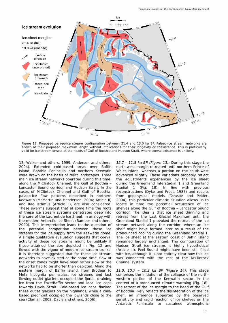
PALAEO -ICE STREAM EVOLUTIONI h e re sum m arize and discuss th e propos e d palae o-ice stre am e volution of th e north -e aste rnm ost s e ctor of th e Laure ntide Ice Sh e e t, w h ich is pre s e nte d as s ix palae oglaciological re constructions (Figs . 12 to 17).
21.4 – 13.0 k a BP (Figure 12): Th is stage corre sponds to th e initial re tre at ph as e of th e Laure ntide Ice Sh e e t afte r Last Glacial Maxim um . O xyge n isotope re cords from North Gre e nland Ice Core Proje ct s h ow th at clim ate during th is pe riod w as ch aracte rize d by an initially ste ady w arm ing follow e d by an abrupt w arm e xcurs ion, i.e . th e Gre e nland Inte rstadial 1, be ginning at ~ 15 k a (Fig.
Palae o-ice stre am s in th e north -e aste rn Laure ntide Ice Sh e e t
1 7
Figure 12. Propose d palae o-ice stre am configuration be tw e e n 21.4 and 13.0 k a BP. Palae o-ice stre am ne tw ork s are s h ow n at th e ir propos e d m axim um le ngth w ith out im plications for th e ir longe vity or coe xiste nce . Th is is particularly valid for ice stre am ons e ts at th e h e ads of Gulf of Booth ia and H udson Strait, w h e re coe val e xiste nce is unlik e ly.
18; W alk e r and oth e rs , 19 9 9 ; Ande rs e n and oth e rs , 2004). Exte nde d cold-bas e d are as ove r Baffin Island, Booth ia Pe ninsula and north e rn Ke e w atin w e re draw n on th e bas is of re lict landscape s . Th re e m ain ice stre am ne tw ork s ope rate d during th is tim e : along th e M'Clintock Ch anne l, th e Gulf of Booth ia – Lancaste r Sound corridor and H udson Strait. In th e cas e s of M'Clintock Ch anne l and Gulf of Booth ia, palae o-ice flow patte rns de scribe d in north e rn Ke e w atin (McMartin and H e nde rson, 2004; Article II) and Rae Isth m us (Article II), are also cons ide re d. Th e s e sw arm s sugge st th at at som e tim e th e roots of th e s e ice stre am syste m s pe ne trate d de e p into th e core of th e Laure ntide Ice Sh e e t, in analogy w ith th e m ode rn Antarctic Ice Sh e e t (Bam be r and oth e rs , 2000). Th is inte rpre tation le ads to th e q ue stion of th e pote ntial com pe tition be tw e e n th e s e ice stre am s for th e ice supply from th e Ke e w atin dom e . A s im ple q ualitative e valuation sugge sts th at coe val activity of th e s e ice stre am s m igh t be unlik e ly if th e s e attaine d th e s ize de picte d in Fig. 12 and flow e d w ith th e vigour of m ode rn ice stre am trunk s . It is th e re fore sugge ste d th at for th e s e ice stre am ne tw ork s to h ave e xiste d at th e sam e tim e , flow at th e ons e t zone s m igh t h ave be e n rath e r slow or th e ne tw ork s h ad to be s h orte r th an de picte d. Along th e e aste rn m argin of Baffin Island, from Brode ur to Me ta Incognita pe ninsulas, ice stre am s and fast flow ing outle t glacie rs occupie d th e fjords , draining ice from th e Foxe /Baffin s e ctor and local ice caps tow ards Davis Strait. Cold-bas e d ice caps flank e d th e s e outle t glacie rs on th e h igh lands, w h ile a cold-bas e d pie dm ont occupie d th e low lands close to th e s e a (Clarh äll, 2002; Davis and oth e rs , 2006).
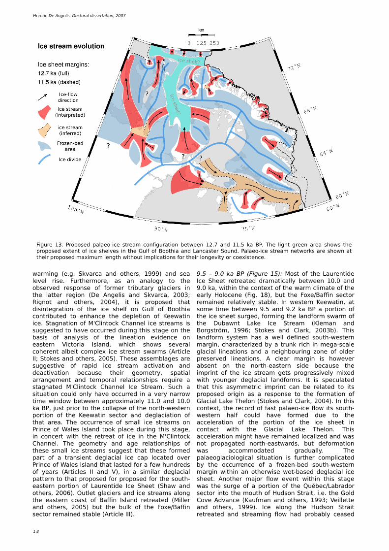
12.7 – 11.5 k a BP (Figure 13): During th is stage th e north -w e st m argin re tre ate d until north e rn Prince of W ale s Island, w h e re as a portion on th e south -w e st advance d sligh tly. Th e s e variations probably re fle ct th e adjustm e nts e xpe rie nce d by th e ice s h e e t during th e Gre e nland Inte rstadial 1 and Gre e nland Stadial 1 (Fig. 18). In line w ith pre vious re constructions (Dyk e and Pre st, 19 87) and re sults from ge oph ys ical m ode ls (Tarasov and Pe ltie r, 2004), th is particular clim atic s ituation allow s us to locate in tim e th e pote ntial occurre nce of ice s h e lve s along th e Gulf of Booth ia – Lancaste r Sound corridor. Th e ide a is th at ice s h e e t th inning and re tre at from th e Last Glacial Maxim um until th e Gre e nland Stadial 1 provok e d th e re tre at of th e ice stre am ne tw ork along th e corridor, w h e re an ice s h e lf m igh t h ave form e d late r as a re sult of th e pronounce d cooling during th e Gre e nland Stadial 1. Th e ice s h e e t at th e e aste rn coast of Baffin Island re m aine d large ly unch ange d. Th e configuration of H udson Strait ice stre am s is h igh ly h ypoth e tical (Article III). Pe e l Sound m igh t h ave be e n still fille d w ith ice , alth ough it is not e ntire ly cle ar h ow th is ice w as conne cte d w ith th e re st of th e M'Clintock Ch anne l syste m .
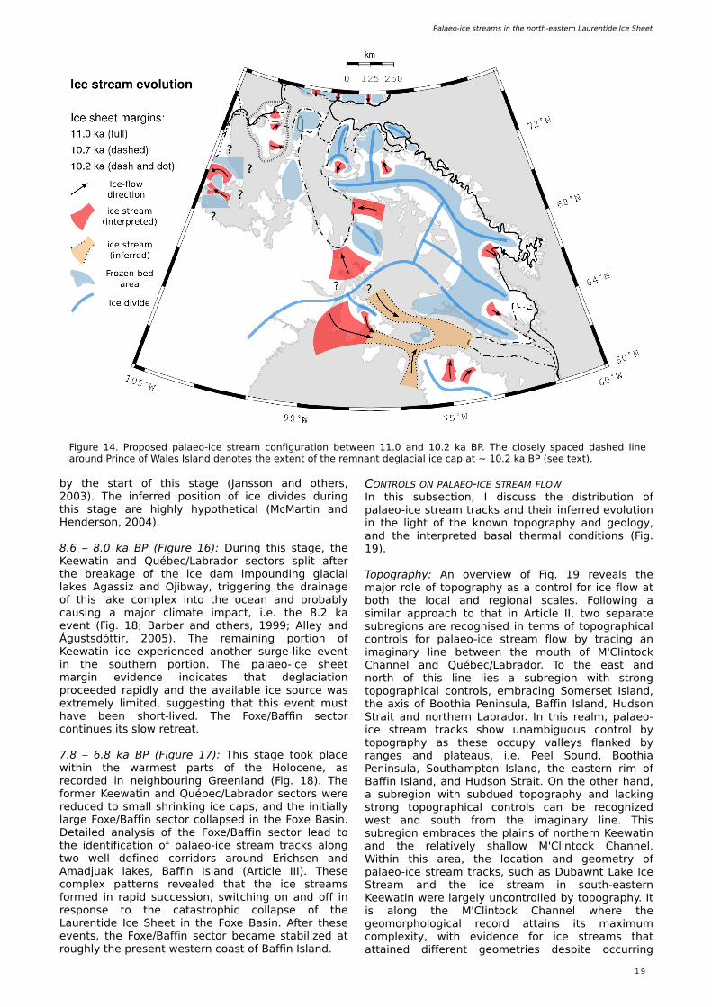
11.0, 10.7 – 10.2 k a BP (Figure 14): Th is stage com pris e s th e initiation of th e collapse of th e north -w e ste rn portion of th e Ke e w atin s e ctor in th e conte xt of a pronounce d clim ate w arm ing (Fig. 18). Th e re tre at of th e ice m argin to th e h e ad of th e Gulf of Booth ia lik e ly re fle cts th e dis inte gration of th e ice s h e lf, an infe re nce supporte d by th e obs e rve d s e ns itivity and rapid re action of ice s h e lve s on th e Antarctic Pe ninsula to sustaine d atm osph e ric
1 8
H e rnán D e Ange lis , Doctoral dis s e rtation, 2007
Figure 13. Propose d palae o-ice stre am configuration be tw e e n 12.7 and 11.5 k a BP. Th e ligh t gre e n are a s h ow s th e propos e d e xte nt of ice s h e lve s in th e Gulf of Booth ia and Lancaste r Sound. Palae o-ice stre am ne tw ork s are s h ow n at th e ir propos e d m axim um le ngth w ith out im plications for th e ir longe vity or coe xiste nce .
w arm ing (e .g. Sk varca and oth e rs , 19 9 9 ) and s e a le ve l ris e . Furth e rm ore , as an analogy to th e obs e rve d re spons e of form e r tributary glacie rs in th e latte r re gion (D e Ange lis and Sk varca, 2003; Rignot and oth e rs , 2004), it is propos e d th at dis inte gration of th e ice s h e lf on Gulf of Booth ia contribute d to e nh ance th e de ple tion of Ke e w atin ice . Stagnation of M'Clintock Ch anne l ice stre am s is sugge ste d to h ave occurre d during th is stage on th e bas is of analys is of th e line ation e vide nce on e aste rn Victoria Island, w h ich s h ow s s e ve ral coh e re nt albe it com ple x ice stre am sw arm s (Article II; Stok e s and oth e rs , 2005). Th e s e as s e m blage s are sugge stive of rapid ice stre am activation and de activation be caus e th e ir ge om e try, spatial arrange m e nt and te m poral re lations h ips re q uire a stagnate d M'Clintock Ch anne l Ice Stre am . Such a s ituation could only h ave occurre d in a ve ry narrow tim e w indow be tw e e n approxim ate ly 11.0 and 10.0 k a BP, just prior to th e collapse of th e north -w e ste rn portion of th e Ke e w atin s e ctor and de glaciation of th at are a. Th e occurre nce of sm all ice stre am s on Prince of W ale s Island took place during th is stage , in conce rt w ith th e re tre at of ice in th e M'Clintock Ch anne l. Th e ge om e try and age re lations h ips of th e s e sm all ice stre am s sugge st th at th e s e form e d part of a trans ie nt de glacial ice cap locate d ove r Prince of W ale s Island th at laste d for a fe w h undre ds of ye ars (Article s II and V), in a s im ilar de glacial patte rn to th at propos e d for propos e d for th e south -e aste rn portion of Laure ntide Ice Sh e e t (Sh aw and oth e rs , 2006). O utle t glacie rs and ice stre am s along th e e aste rn coast of Baffin Island re tre ate d (Mille r and oth e rs , 2005) but th e bulk of th e Foxe /Baffin s e ctor re m aine d stable (Article III).
9 .5 – 9 .0 k a BP (Figure 15): Most of th e Laure ntide Ice Sh e e t re tre ate d dram atically be tw e e n 10.0 and 9 .0 k a, w ith in th e conte xt of th e w arm clim ate of th e e arly H oloce ne (Fig. 18), but th e Foxe /Baffin s e ctor re m aine d re lative ly stable . In w e ste rn Ke e w atin, at som e tim e be tw e e n 9 .5 and 9 .2 k a BP a portion of th e ice s h e e t surge d, form ing th e landform sw arm of th e Dubaw nt Lak e Ice Stre am (Kle m an and Borgström , 19 9 6; Stok e s and Clark , 2003b). Th is landform syste m h as a w e ll de fine d south -w e ste rn m argin, ch aracte rize d by a trunk rich in m e ga-scale glacial line ations and a ne igh bouring zone of olde r pre s e rve d line ations . A cle ar m argin is h ow e ve r abs e nt on th e north -e aste rn s ide be caus e th e im print of th e ice stre am ge ts progre s s ive ly m ixe d w ith younge r de glacial landform s . It is spe culate d th at th is asym m e tric im print can be re late d to its propos e d origin as a re spons e to th e form ation of Glacial Lak e Th e lon (Stok e s and Clark , 2004). In th is conte xt, th e re cord of fast palae o-ice flow its south -w e ste rn h alf could h ave form e d due to th e acce le ration of th e portion of th e ice s h e e t in contact w ith th e Glacial Lak e Th e lon. Th is acce le ration m igh t h ave re m aine d localize d and w as not propagate d north -e astw ards , but de form ation w as accom m odate d gradually. Th e palae oglaciological s ituation is furth e r com plicate d by th e occurre nce of a froze n-be d south -w e ste rn m argin w ith in an oth e rw is e w e t-bas e d de glacial ice s h e e t. Anoth e r m ajor flow e ve nt w ith in th is stage w as th e surge of a portion of th e Québe c/Labrador s e ctor into th e m outh of H udson Strait, i.e . th e Gold Cove Advance (Kaufm an and oth e rs , 19 9 3; Ve ille tte and oth e rs , 19 9 9 ). Ice along th e H udson Strait re tre ate d and stre am ing flow h ad probably ce as e d
Palae o-ice stre am s in th e north -e aste rn Laure ntide Ice Sh e e t
1 9
Figure 14. Propose d palae o-ice stre am configuration be tw e e n 11.0 and 10.2 k a BP. Th e close ly space d das h e d line around Prince of W ale s Island de note s th e e xte nt of th e re m nant de glacial ice cap at ~ 10.2 k a BP (s e e te xt).
by th e start of th is stage (Jansson and oth e rs , 2003). Th e infe rre d pos ition of ice divide s during th is stage are h igh ly h ypoth e tical (McMartin and H e nde rson, 2004).
8.6 – 8.0 k a BP (Figure 16): During th is stage , th e Ke e w atin and Québe c/Labrador s e ctors split afte r th e bre ak age of th e ice dam im pounding glacial lak e s Agass iz and O jibw ay, trigge ring th e drainage of th is lak e com ple x into th e oce an and probably caus ing a m ajor clim ate im pact, i.e . th e 8.2 k a e ve nt (Fig. 18; Barbe r and oth e rs , 19 9 9 ; Alle y and Ágústsdóttir, 2005). Th e re m aining portion of Ke e w atin ice e xpe rie nce d anoth e r surge -lik e e ve nt in th e south e rn portion. Th e palae o-ice s h e e t m argin e vide nce indicate s th at de glaciation proce e de d rapidly and th e available ice source w as e xtre m e ly lim ite d, sugge sting th at th is e ve nt m ust h ave be e n s h ort-live d. Th e Foxe /Baffin s e ctor continue s its slow re tre at.
7.8 – 6.8 k a BP (Figure 17): Th is stage took place w ith in th e w arm e st parts of th e H oloce ne , as re corde d in ne igh bouring Gre e nland (Fig. 18). Th e form e r Ke e w atin and Québe c/Labrador s e ctors w e re re duce d to sm all s h rink ing ice caps , and th e initially large Foxe /Baffin s e ctor collapse d in th e Foxe Bas in. D e taile d analys is of th e Foxe /Baffin s e ctor le ad to th e ide ntification of palae o-ice stre am track s along tw o w e ll de fine d corridors around Erich s e n and Am adjuak lak e s , Baffin Island (Article III). Th e s e com ple x patte rns re ve ale d th at th e ice stre am s form e d in rapid succe s s ion, sw itch ing on and off in re spons e to th e catastroph ic collapse of th e Laure ntide Ice Sh e e t in th e Foxe Bas in. Afte r th e s e e ve nts , th e Foxe /Baffin s e ctor be cam e stabilize d at rough ly th e pre s e nt w e ste rn coast of Baffin Island.
CONTROLS ON PALAEO -ICE STREAM FLOWIn th is subs e ction, I discuss th e distribution of palae o-ice stre am track s and th e ir infe rre d e volution in th e ligh t of th e k now n topograph y and ge ology, and th e inte rpre te d basal th e rm al conditions (Fig. 19 ).
Topograph y: An ove rvie w of Fig. 19 re ve als th e m ajor role of topograph y as a control for ice flow at both th e local and re gional scale s . Follow ing a s im ilar approach to th at in Article II, tw o s e parate subre gions are re cognis e d in te rm s of topograph ical controls for palae o-ice stre am flow by tracing an im aginary line be tw e e n th e m outh of M'Clintock Ch anne l and Québe c/Labrador. To th e e ast and north of th is line lie s a subre gion w ith strong topograph ical controls, e m bracing Som e rs e t Island, th e axis of Booth ia Pe ninsula, Baffin Island, H udson Strait and north e rn Labrador. In th is re alm , palae o-ice stre am track s s h ow unam biguous control by topograph y as th e s e occupy valle ys flank e d by range s and plate aus , i.e . Pe e l Sound, Booth ia Pe ninsula, South am pton Island, th e e aste rn rim of Baffin Island, and H udson Strait. O n th e oth e r h and, a subre gion w ith subdue d topograph y and lack ing strong topograph ical controls can be re cognize d w e st and south from th e im aginary line . Th is subre gion e m brace s th e plains of north e rn Ke e w atin and th e re lative ly s h allow M'Clintock Ch anne l. W ith in th is are a, th e location and ge om e try of palae o-ice stre am track s , such as Dubaw nt Lak e Ice Stre am and th e ice stre am in south -e aste rn Ke e w atin w e re large ly uncontrolle d by topograph y. It is along th e M'Clintock Ch anne l w h e re th e ge om orph ological re cord attains its m axim um com ple xity, w ith e vide nce for ice stre am s th at attaine d diffe re nt ge om e trie s de spite occurring
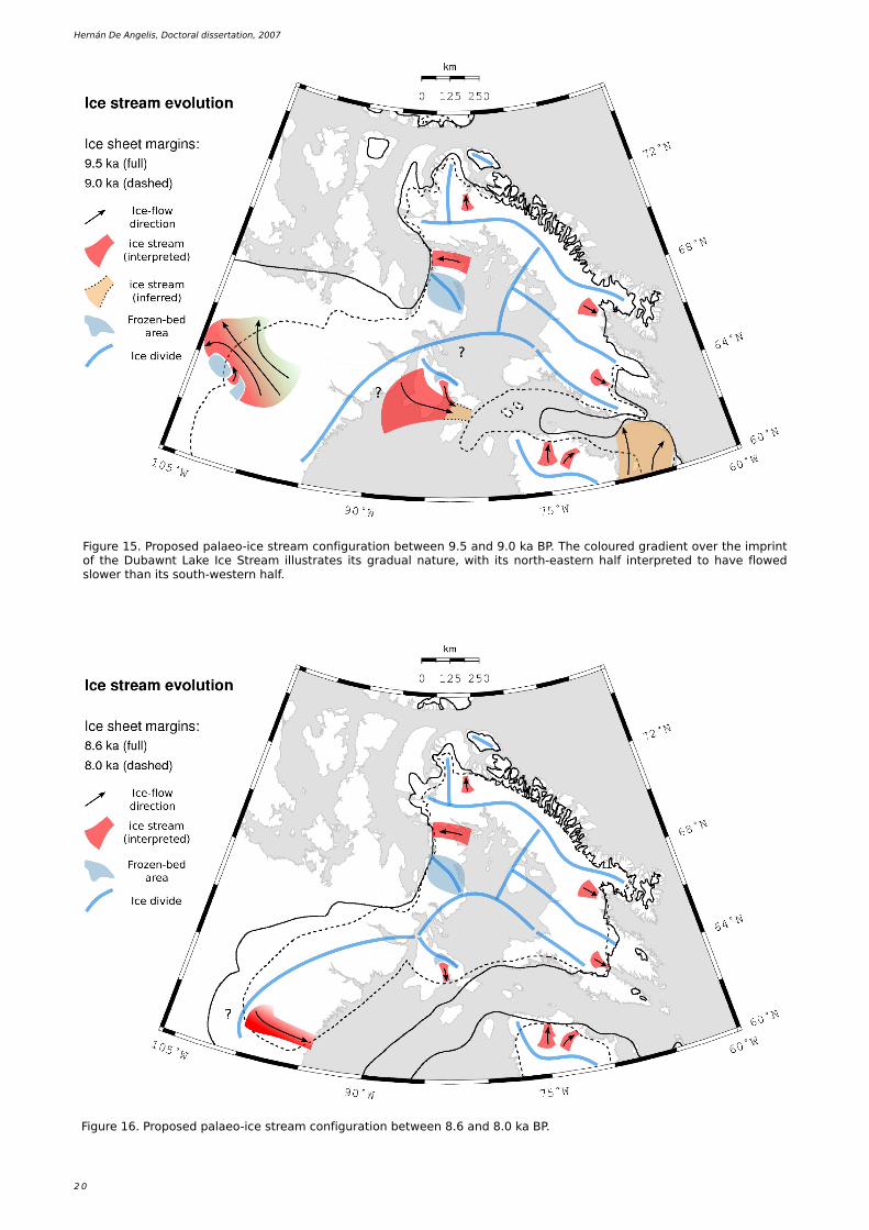
2 0
H e rnán D e Ange lis , Doctoral dis s e rtation, 2007
Figure 15. Propose d palae o-ice stre am configuration be tw e e n 9 .5 and 9 .0 k a BP. Th e coloure d gradie nt ove r th e im print of th e Dubaw nt Lak e Ice Stre am illustrate s its gradual nature , w ith its north -e aste rn h alf inte rpre te d to h ave flow e d slow e r th an its south -w e ste rn h alf.
Figure 16. Propose d palae o-ice stre am configuration be tw e e n 8.6 and 8.0 k a BP.
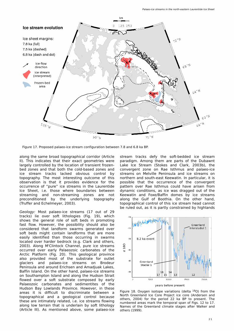
Palae o-ice stre am s in th e north -e aste rn Laure ntide Ice Sh e e t
2 1
Figure 17. Propose d palae o-ice stre am configuration be tw e e n 7.8 and 6.8 k a BP.
Figure 18. O xyge n isotope variations (de lta 18O ) from th e North Gre e nland Ice Core Proje ct ice core (Ande rs e n and oth e rs , 2004) for th e pe riod 22 k a BP to pre s e nt. Th e num be re d are as m ark th e te m poral span of Figs . 12 to 17. Nam e s of th e Gre e nland clim ate stage s afte r W alk e r and oth e rs (19 9 9 ).
along th e sam e broad topograph ical corridor (Article II). Th is indicate s th at th e ir e xact ge om e trie s w e re large ly controlle d by th e location of trans ie nt froze n-be d zone s and th at both th e cold-bas e d zone s and ice stre am track s lack e d obvious control by topograph y. Th e m ost inte re sting outcom e of th is obs e rvation is th at it provide s e vide nce for th e occurre nce of “pure ” ice stre am s in th e Laure ntide Ice Sh e e t, i.e . th os e w h e re boundarie s be tw e e n stre am ing and non-stre am ing zone s are not pre conditione d by th e unde rlying topograph y (Truffe r and Ech e lm e ye r, 2003).
Ge ology: Most palae o-ice stre am s (17 out of 29 track s) lie ove r soft lith ologie s (Fig. 19 ), w h ich s h ow s th e ge ne ral role of soft be ds in prom oting fast flow. H ow e ve r, th e poss ibility s h ould also be cons ide re d th at landform sw arm s ge ne rate d ove r soft be ds m igh t contain landform s th at are m ore e as ily ide ntifie d th an th os e occurring in sw arm s locate d ove r h arde r be drock (e .g. Clark and oth e rs , 2003). Along M'Clintock Ch anne l, pure ice stre am s occurre d ove r e arly Palae ozoic carbonate s of th e Arctic Platform (Fig. 20). Th is ge ological province also provide d m ost of th e substrate for outle t glacie rs and palae o-ice stre am s on Brode ur Pe ninsula and around Erich s e n and Am adjuak Lak e s , Baffin Island. O n th e oth e r h and, palae o-ice stre am s on South am pton Island and along th e H udson Strait flow e d ove r a soft substrate com pose d by e arly Palae ozoic carbonate s and s e dim e ntite s of th e H udson Bay Low lands Province . H ow e ve r, in th e s e are as it is difficult to discrim inate be tw e e n a topograph ical and a ge ological control be caus e th e s e are intim ate ly re late d, i.e . ice stre am s flow ing along low te rrain th at is unde rlain by soft lith ology (Article III). As m e ntione d above , som e palae o-ice
stre am track s de fy th e soft-be dde d ice stre am paradigm . Am ong th e m are parts of th e Dubaw nt Lak e Ice Stre am (Stok e s and Clark , 2003b), th e conve rge nt zone on Rae Isth m us and palae o-ice stre am s on Me lville Pe ninsula and ice stre am s on north e rn and south -e ast Ke e w atin. In particular, it is poss ible th at th e occurre nce of th e conve rge nt patte rn ove r Rae Isth m us could h ave aris e n from dynam ic conditions , as ice w as dragge d out of th e Ke e w atin and Foxe /Baffin dom e s by ice stre am s along th e Gulf of Booth ia. O n th e oth e r h and, topograph ical control of th is ice stre am h e ad cannot be rule d out, as it is partly constraine d by h igh lands
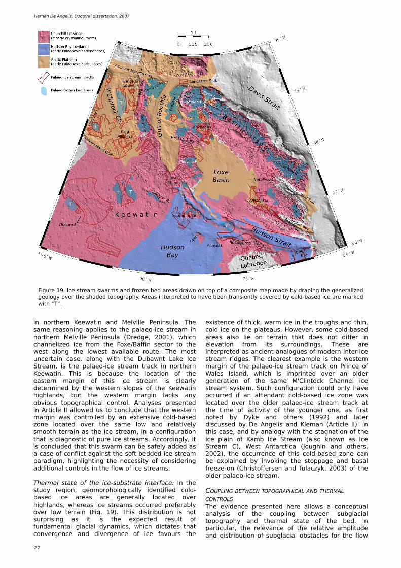
2 2
H e rnán D e Ange lis , Doctoral dis s e rtation, 2007
Figure 19 . Ice stre am sw arm s and froze n be d are as draw n on top of a com pos ite m ap m ade by draping th e ge ne ralize d ge ology ove r th e s h ade d topograph y. Are as inte rpre te d to h ave be e n trans ie ntly cove re d by cold-bas e d ice are m ark e d w ith “T”.
in north e rn Ke e w atin and Me lville Pe ninsula. Th e sam e re asoning applie s to th e palae o-ice stre am in north e rn Me lville Pe ninsula (Dre dge , 2001), w h ich ch anne lize d ice from th e Foxe /Baffin s e ctor to th e w e st along th e low e st available route . Th e m ost unce rtain cas e , along w ith th e Dubaw nt Lak e Ice Stre am , is th e palae o-ice stre am track in north e rn Ke e w atin. Th is is be caus e th e location of th e e aste rn m argin of th is ice stre am is cle arly de te rm ine d by th e w e ste rn slope s of th e Ke e w atin h igh lands, but th e w e ste rn m argin lack s any obvious topograph ical control. Analyse s pre s e nte d in Article II allow e d us to conclude th at th e w e ste rn m argin w as controlle d by an e xte ns ive cold-bas e d zone locate d ove r th e sam e low and re lative ly sm ooth te rrain as th e ice stre am , in a configuration th at is diagnostic of pure ice stre am s . Accordingly, it is conclude d th at th is sw arm can be safe ly adde d as a cas e of conflict against th e soft-be dde d ice stre am paradigm , h igh ligh ting th e ne ce s s ity of cons ide ring additional controls in th e flow of ice stre am s .
Th e rm al state of th e ice -substrate inte rface : In th e study re gion, ge om orph ologically ide ntifie d cold-bas e d ice are as are ge ne rally locate d ove r h igh lands, w h e re as ice stre am s occurre d pre fe rably ove r low te rrain (Fig. 19 ). Th is distribution is not surpris ing as it is th e e xpe cte d re sult of fundam e ntal glacial dynam ics , w h ich dictate s th at conve rge nce and dive rge nce of ice favours th e
e xiste nce of th ick , w arm ice in th e trough s and th in, cold ice on th e plate aus . H ow e ve r, som e cold-bas e d are as also lie on te rrain th at doe s not diffe r in e le vation from its surroundings . Th e s e are inte rpre te d as ancie nt analogue s of m ode rn inte r-ice stre am ridge s . Th e cle are st e xam ple is th e w e ste rn m argin of th e palae o-ice stre am track on Prince of W ale s Island, w h ich is im printe d ove r an olde r ge ne ration of th e sam e M'Clintock Ch anne l ice stre am syste m . Such configuration could only h ave occurre d if an atte ndant cold-bas e d ice zone w as locate d ove r th e olde r palae o-ice stre am track at th e tim e of activity of th e younge r one , as first note d by Dyk e and oth e rs (19 9 2) and late r discuss e d by D e Ange lis and Kle m an (Article II). In th is cas e , and by analogy w ith th e stagnation of th e ice plain of Kam b Ice Stre am (also k now n as Ice Stre am C), W e st Antarctica (Jough in and oth e rs , 2002), th e occurre nce of th is cold-bas e d zone can be e xplaine d by invok ing th e stoppage and basal fre e ze -on (Ch ristoffe rs e n and Tulaczyk , 2003) of th e olde r palae o-ice stre am .
COUPLING BETW EEN TOPOGRAPH ICAL AND TH ERMAL CONTROLSTh e e vide nce pre s e nte d h e re allow s a conce ptual analys is of th e coupling be tw e e n subglacial topograph y and th e rm al state of th e be d. In particular, th e re le vance of th e re lative am plitude and distribution of subglacial obstacle s for th e flow
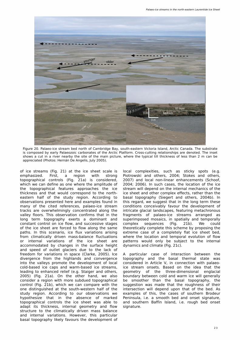
Palae o-ice stre am s in th e north -e aste rn Laure ntide Ice Sh e e t
2 3
Figure 20. Palae o-ice stre am be d north of Cam bridge Bay, south -e aste rn Victoria Island, Arctic Canada. Th e substrate is com pose d by e arly Palae ozoic carbonate s of th e Arctic Platform . Cross -cutting re lations h ips are de note d. Th e ins e t s h ow s a cut in a rive r ne arby th e s ite of th e m ain picture , w h e re th e typical till th ick ne s s of le s s th an 2 m can be appre ciate d (Ph otos : H e rnán D e Ange lis , July 2005).
of ice stre am s (Fig. 21) at th e ice s h e e t scale is e m ph as ize d. First, a re gion w ith strong topograph ical controls (Fig. 21a) is cons ide re d, w h ich w e can de fine as one w h e re th e am plitude of th e topograph ical fe ature s approach e s th e ice th ick ne s s and th at w ould corre spond to th e north -e aste rn h alf of th e study re gion. According to obs e rvations pre s e nte d h e re and e xam ple s found in m any of th e cite d re fe re nce s , palae o-ice stre am track s are ove rw h e lm ingly conce ntrate d along th e valle y floors . Th is obs e rvation confirm s th at in th e long te rm topograph y e xe rts a dom inant and constant control on ice flow , and succe s s ive stage s of th e ice s h e e t are force d to flow along th e sam e path s . In th is sce nario, ice flux variations aris ing from clim atically drive n m ass -balance fluctuations or inte rnal variations of th e ice s h e e t are accom m odate d by ch ange s in th e surface h e igh t and spe e d of outle t glacie rs due to th e lack of fre e dom for variations in space (Clark e , 2005). Ice dive rge nce from th e h igh lands and conve rge nce into th e valle ys prom ote th e de ve lopm e nt of local cold-bas e d ice caps and w arm -bas e d ice stre am s , le ading to e nh ance d re lie f (e .g. Staige r and oth e rs , 2005) (Fig. 21a). O n th e oth e r h and, w e also cons ide r a re gion w ith m ore subdue d topograph ical control (Fig. 21b), w h ich w e can com pare w ith th e one distinguis h e d at th e south -w e ste rn h alf of th e study re gion. According to our obs e rvations w e h ypoth e s ize th at in th e abs e nce of m ark e d topograph ical controls th e ice s h e e t w as able to adapt its th ick ne s s , inte rnal ge om e try and flow structure to th e clim atically drive n m ass balance and inte rnal variations . H ow e ve r, th is particular basal topograph y lik e ly favours th e de ve lopm e nt of
local com ple xitie s , such as stick y spots (e .g. Piotrow s k i and oth e rs , 2004; Stok e s and oth e rs , 2007) and local non-line ar e nh ance m e nts (Sch oof, 2004; 2006). In such cas e s , th e location of th e ice stre am w ill de pe nd on th e inte rnal m e ch anics of th e ice s h e e t and oth e r com ple x e ffe cts , rath e r th an th e basal topograph y (Sie ge rt and oth e rs , 2004b). In th is re gard, w e sugge st th at in th e long te rm th e s e conditions conce ivably favour th e de ve lopm e nt of intricate glacial landscape s , fe aturing m e tach ronous fragm e nts of palae o-ice stre am s arrange d as supe rim pos e d m osaics , in spatially and te m porally com ple x s e q ue nce s (Fig. 21b). W e could th e ore tically com ple te th is sch e m e by propos ing th e e xtre m e cas e of a com ple te ly flat ice s h e e t be d, w h e re th e location and te m poral e volution of flow patte rns w ould only be subje ct to th e inte rnal dynam ics and clim ate (Fig. 21c).
A particular cas e of inte raction be tw e e n th e topograph y and th e basal th e rm al state w as cons ide re d in Article V, in conne ction w ith palae o-ice stre am ons e ts . Bas e d on th e ide a th at th e ge om e try of th e th re e -dim e ns ional e nglacial boundary be tw e e n cold and w arm ice w ill ge ne rally be sm ooth e r th an th e basal topograph y, th e sugge stion w as m ade th at th e rough ne s s of th e ir inte rs e ction w ill de pe nd upon th at of th e be d. As e xam ple s of th is , th e cas e s of south e rn Brode ur Pe ninsula, i.e . a sm ooth be d and ons e t s ignature , and south e rn Baffin Island, i.e . rough be d ons e t s ignature .
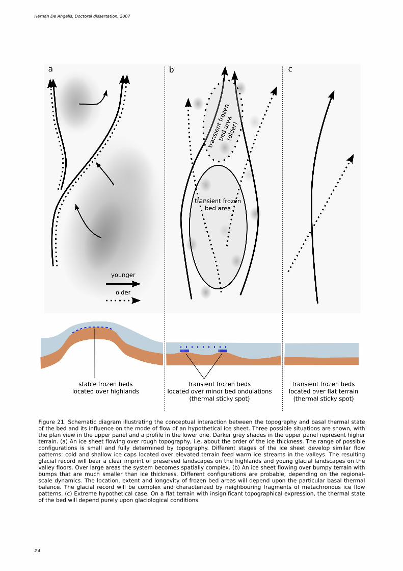
2 4
H e rnán D e Ange lis , Doctoral dis s e rtation, 2007
Figure 21. Sch e m atic diagram illustrating th e conce ptual inte raction be tw e e n th e topograph y and basal th e rm al state of th e be d and its influe nce on th e m ode of flow of an h ypoth e tical ice s h e e t. Th re e poss ible s ituations are s h ow n, w ith th e plan vie w in th e uppe r pane l and a profile in th e low e r one . Dark e r gre y s h ade s in th e uppe r pane l re pre s e nt h igh e r te rrain. (a) An ice s h e e t flow ing ove r rough topograph y, i.e . about th e orde r of th e ice th ick ne s s . Th e range of poss ible configurations is sm all and fully de te rm ine d by topograph y. D iffe re nt stage s of th e ice s h e e t de ve lop s im ilar flow patte rns : cold and s h allow ice caps locate d ove r e le vate d te rrain fe e d w arm ice stre am s in th e valle ys . Th e re sulting glacial re cord w ill be ar a cle ar im print of pre s e rve d landscape s on th e h igh lands and young glacial landscape s on th e valle y floors . Ove r large are as th e syste m be com e s spatially com ple x. (b) An ice s h e e t flow ing ove r bum py te rrain w ith bum ps th at are m uch sm alle r th an ice th ick ne s s . D iffe re nt configurations are probable , de pe nding on th e re gional-scale dynam ics . Th e location, e xte nt and longe vity of froze n be d are as w ill de pe nd upon th e particular basal th e rm al balance . Th e glacial re cord w ill be com ple x and ch aracte rize d by ne igh bouring fragm e nts of m e tach ronous ice flow patte rns . (c) Extre m e h ypoth e tical cas e . O n a flat te rrain w ith ins ignificant topograph ical e xpre s s ion, th e th e rm al state of th e be d w ill de pe nd pure ly upon glaciological conditions .
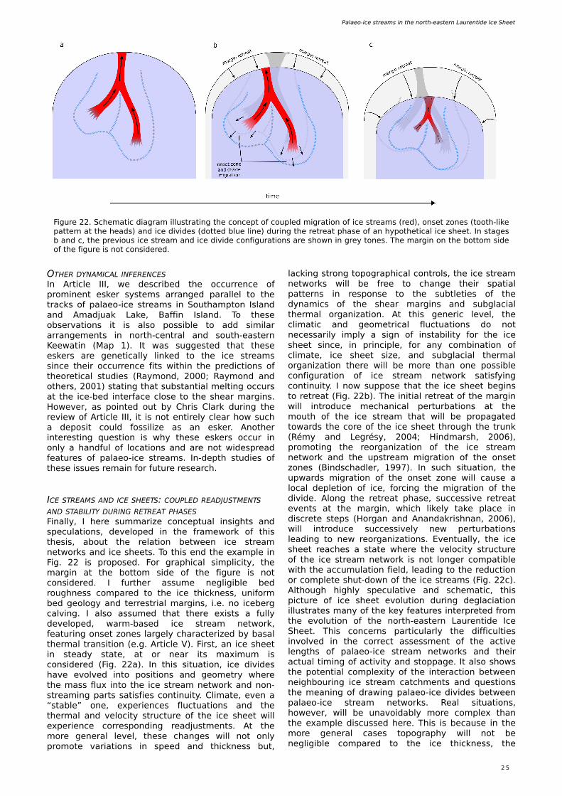
Palae o-ice stre am s in th e north -e aste rn Laure ntide Ice Sh e e t
2 5
O TH ER DYNAMICAL INFERENCESIn Article III, w e de scribe d th e occurre nce of prom ine nt e s k e r syste m s arrange d paralle l to th e track s of palae o-ice stre am s in South am pton Island and Am adjuak Lak e , Baffin Island. To th e s e obs e rvations it is also poss ible to add s im ilar arrange m e nts in north -ce ntral and south -e aste rn Ke e w atin (Map 1). It w as sugge ste d th at th e s e e s k e rs are ge ne tically link e d to th e ice stre am s s ince th e ir occurre nce fits w ith in th e pre dictions of th e ore tical studie s (Raym ond, 2000; Raym ond and oth e rs , 2001) stating th at substantial m e lting occurs at th e ice -be d inte rface close to th e s h e ar m argins . H ow e ve r, as pointe d out by Ch ris Clark during th e re vie w of Article III, it is not e ntire ly cle ar h ow such a de pos it could foss ilize as an e s k e r. Anoth e r inte re sting q ue stion is w h y th e s e e s k e rs occur in only a h andful of locations and are not w ide spre ad fe ature s of palae o-ice stre am s . In-de pth studie s of th e s e is sue s re m ain for future re s e arch .
ICE STREAMS AND ICE SH EETS: COUPLED READJUSTMENTS AND STABILITY DURING RETREAT PH ASESFinally, I h e re sum m arize conce ptual ins igh ts and spe culations , de ve lope d in th e fram e w ork of th is th e s is , about th e re lation be tw e e n ice stre am ne tw ork s and ice s h e e ts . To th is e nd th e e xam ple in Fig. 22 is propos e d. For graph ical s im plicity, th e m argin at th e bottom s ide of th e figure is not cons ide re d. I furth e r as sum e ne gligible be d rough ne s s com pare d to th e ice th ick ne s s , uniform be d ge ology and te rre strial m argins , i.e . no ice be rg calving. I also assum e d th at th e re e xists a fully de ve lope d, w arm -bas e d ice stre am ne tw ork , fe aturing ons e t zone s large ly ch aracte rize d by basal th e rm al trans ition (e .g. Article V). First, an ice s h e e t in ste ady state , at or ne ar its m axim um is cons ide re d (Fig. 22a). In th is s ituation, ice divide s h ave e volve d into pos itions and ge om e try w h e re th e m ass flux into th e ice stre am ne tw ork and non-stre am ing parts satisfie s continuity. Clim ate , e ve n a “stable ” one , e xpe rie nce s fluctuations and th e th e rm al and ve locity structure of th e ice s h e e t w ill e xpe rie nce corre sponding re adjustm e nts . At th e m ore ge ne ral le ve l, th e s e ch ange s w ill not only prom ote variations in spe e d and th ick ne s s but,
lack ing strong topograph ical controls, th e ice stre am ne tw ork s w ill be fre e to ch ange th e ir spatial patte rns in re spons e to th e subtle tie s of th e dynam ics of th e s h e ar m argins and subglacial th e rm al organization. At th is ge ne ric le ve l, th e clim atic and ge om e trical fluctuations do not ne ce s sarily im ply a s ign of instability for th e ice s h e e t s ince , in principle , for any com bination of clim ate , ice s h e e t s ize , and subglacial th e rm al organization th e re w ill be m ore th an one poss ible configuration of ice stre am ne tw ork satisfying continuity. I now suppos e th at th e ice s h e e t be gins to re tre at (Fig. 22b). Th e initial re tre at of th e m argin w ill introduce m e ch anical pe rturbations at th e m outh of th e ice stre am th at w ill be propagate d tow ards th e core of th e ice s h e e t th rough th e trunk (Rém y and Le grésy, 2004; H indm ars h , 2006), prom oting th e re organization of th e ice stre am ne tw ork and th e upstre am m igration of th e ons e t zone s (Bindsch adle r, 19 9 7). In such s ituation, th e upw ards m igration of th e ons e t zone w ill caus e a local de ple tion of ice , forcing th e m igration of th e divide . Along th e re tre at ph as e , succe s s ive re tre at e ve nts at th e m argin, w h ich lik e ly tak e place in discre te ste ps (H organ and Anandak ris h nan, 2006), w ill introduce succe s s ive ly ne w pe rturbations le ading to ne w re organizations . Eve ntually, th e ice s h e e t re ach e s a state w h e re th e ve locity structure of th e ice stre am ne tw ork is not longe r com patible w ith th e accum ulation fie ld, le ading to th e re duction or com ple te s h ut-dow n of th e ice stre am s (Fig. 22c). Alth ough h igh ly spe culative and sch e m atic, th is picture of ice s h e e t e volution during de glaciation illustrate s m any of th e k e y fe ature s inte rpre te d from th e e volution of th e north -e aste rn Laure ntide Ice Sh e e t. Th is conce rns particularly th e difficultie s involve d in th e corre ct ass e s sm e nt of th e active le ngth s of palae o-ice stre am ne tw ork s and th e ir actual tim ing of activity and stoppage . It also s h ow s th e pote ntial com ple xity of th e inte raction be tw e e n ne igh bouring ice stre am catch m e nts and q ue stions th e m e aning of draw ing palae o-ice divide s be tw e e n palae o-ice stre am ne tw ork s . Re al s ituations , h ow e ve r, w ill be unavoidably m ore com ple x th an th e e xam ple discuss e d h e re . Th is is be caus e in th e m ore ge ne ral cas e s topograph y w ill not be ne gligible com pare d to th e ice th ick ne s s , th e
Figure 22. Sch e m atic diagram illustrating th e conce pt of couple d m igration of ice stre am s (re d), ons e t zone s (tooth -lik e patte rn at th e h e ads) and ice divide s (dotte d blue line ) during th e re tre at ph as e of an h ypoth e tical ice s h e e t. In stage s b and c, th e pre vious ice stre am and ice divide configurations are s h ow n in gre y tone s . Th e m argin on th e bottom s ide of th e figure is not cons ide re d.
2 6
H e rnán D e Ange lis , Doctoral dis s e rtation, 2007
froze n-be d portions of th e ice s h e e t, th us providing unam biguous e vide nce for th e occurre nce of pure ice stre am s in th e Laure ntide Ice Sh e e t.
- It is poss ible th at th e Gulf-of Booth ia – Lancaste r Sound corridor supporte d an ice s h e lf for a s h ort tim e be tw e e n 12.7 and 11.0 k a BP, w h ich could h ave form e d as a re sult of th e clim atic cooling during th e Gre e nland Stadial 1.
- Th e ge om orph ological re cord on e m e rge d land is insufficie nt to conclus ive ly support th e e xiste nce of ice stre am s along th e H udson Strait. It is propos e d th at ice stre am s flow e d along th e de e pe st parts of th e strait, w h ich are pre s e ntly unde r w ate r, w h ile constraine d by atte ndant cold-bas e d zone s on th e m argins and islands at th e h e ad of th e strait.
- In tw o are as of Baffin Island, sm all trans ie nt ice stre am s sw itch e d on and off in rapid s e q ue nce as th e Foxe /Baffin s e ctor of th e collapse d catastroph ically.Sm all de glacial ice stre am s also occurre d on Prince of W ale s Island, as a re m nant local ice cap w as draine d during th e dis inte gration of th e north -w e ste rnm ost Ke e w atin s e ctor.
- Th e topograph y, ge ology and th e rm al state of th e be d are im portant controls in th e location and rate of ice stre am flow. H ow e ve r, it is sugge ste d th at th e inte raction be tw e e n th e subglacial topograph y and th e rm al state m igh t play a fundam e ntal role .
- Th e obs e rve d be h aviour of m ode rn and ancie nt ice stre am s cannot be e xplaine d in te rm s of e nvironm e ntal controls alone , but th e com ple x inte rnal dynam ics of ice stre am s h e ar m argins and ons e t zone s m ust be cons ide re d.
- Ice stre am s are probably ce ntral for m aintaining ove rall dynam ical balance of ice s h e e ts and th e ir e xiste nce doe s not ne ce s sarily im ply instability.
ACKNOW LEDGEMENTS
Th rough out th e s e four ye ars I e njoye d th e acade m ic guidance of m y m ain supe rvisor Prof. Joh an Kle m an, w h o also provide d financial support and allow e d m e to w ork in an atm osph e re of h e alth y inte lle ctual fre e dom . I am also th ank ful to m y ass istant supe rvisor Dr. Kriste r Jansson.
Additional funding for fie ld w ork , cours e s and confe re nce s w as provide d by Alh m anns Fond, Manne rfe lts Fond, Stifte lse n Ym e r-80 and Kungliga Ve te ns k apsak ade m ie n.
Se ve ral colle ague s provide d h e lpful ins igh ts and constructive vie w s th at h e lpe d to im prove m y w ork . In th is re gard, I w ant to e xpre s s m y gratitude to Arje n Stroe ve n, Clas H ätte strand, Frank Rau (Unive rs ität Fre iburg, Ge rm any), Bruce Raup (National Snow and Ice Data Ce nte r, USA), Pe te r Kuh ry, Ch ris Clark (Unive rs ity of Sh e ffie ld, UK), Ch ris Stok e s (Unive rs ity of Durh am , UK), Marta Gh ide lla (Instituto Antártico Arge ntino, Arge ntina), Re gine H ock (Unive rs ity of Alas k a, USA), Ralph Ste a
ge ological variations in th e be d w ill locally influe nce th e lik e lih ood of stre am ing flow , and ice be rg calving te rm ini w ill occur at th e m argins . In th e s e cas e s , it is conce ivable th at th e com bine d e ffe ct of th e m e ntione d e nvironm e ntal variable s w ill be to re duce th e de gre e s of fre e dom of th e syste m to adapt to e xte rnal and inte rnal fluctuations . Furth e rm ore , and cons ide ring th e topics pre s e nte d in th e introduction, th e inte rnal dynam ics of ice s h e e ts appe ars to be subje ct to s e ve ral inte racting non-line ar proce s s e s . Th e fundam e ntal im portance of th is is th at th e s im ultane ous occurre nce of m ultiple non-line ar proce s s e s at syste m boundarie s incre as e s th e lik e lih ood for large re spons e s to oth e rw is e ins ignificant s ignals, particularly if th e syste m is alre ady close to th re s h olds (Prigogine , 19 9 7; Strogatz, 2001). In th is conte xt, th e s e q ue nce of dynam ical e ve nts and re sulting ge om e trie s of ice stre am ne tw ork s and ice s h e e t organization m igh t be com e difficult to pre dict. Th is ide a h igh ligh ts th e im portance of e xploring th e functioning of ice s h e e ts in th e ligh t of non-line ar ph ys ics , w h ich m igh t h e lp e xplain th e occurre nce of e m e rge nt be h aviour and s e lf-organization of ice stre am ne tw ork s (Payne and Donge lm ans, 19 9 7). In th is re gard, it is poss ible th at th e ch ance s of pre dicting future ice s h e e t configurations m igh t not de pe nd on th e e xact num e rical de tails of m ode ls but on a solid topological k now le dge of ice s h e e t syste m s (e .g. Th om , 19 72) built on th e unde rstanding of th e m utual inte ractions of th e ph ys ical proce s s e s involve d.
CONCLUSIONS
Mapping of palae o-ice flow patte rns on 3.19 x 10⁶ k m 2 of e ast-ce ntral Canadian Arctic le ad to th e ide ntification of th e occurre nce and spatial arrange m e nt of palae o-ice stre am s in th e north -e aste rnm ost Laure ntide Ice Sh e e t. Alth ough th e e xiste nce and im portance of ice stre am s in th e Laure ntide Ice Sh e e t h ave be e n long re cognize d, w ork pre s e nte d h e re s h ow s for th e first tim e a com pre h e ns ive vie w of th e ir organization and e volution during th e tim e be tw e e n th e Last Glacial Maxim um and th e last de glaciation. O n th e bas is of th e analys is of th e palae oglaciological re cord, th e follow ing conclus ions can be draw n:
- Ice stre am s appe ar to h ave be e n pre s e nt and active in all stage s of th e e volution of th e north -e aste rn Laure ntide Ice Sh e e t during th e pe riod be tw e e n th e Last Glacial Maxim um and th e last de glaciation.
- Th re e m ajor ice stre am ne tw ork s w e re pre s e nt: th e M'Clintock Ch anne l, Gulf of Booth ia – Lancaste r Sound, and H udson Strait. Th e m ost proxim al parts of th e s e ice stre am s probably re ach e d th e de e pe st parts of th e ice s h e e t at som e tim e , in a configuration w h ich is ch aracte ristic of th e pre s e nt W e st Antarctic Ice Sh e e t.
- Th e M'Clintock Ch anne l be ars a rich and com ple x re cord of s e ve ral ge ne rations of palae o-ice stre am s . Th e location of th e s e palae o-ice stre am s w as not controlle d by be d topograph y and th e ir e xact ge om e trie s w e re de te rm ine d by ne igh bouring
Palae o-ice stre am s in th e north -e aste rn Laure ntide Ice Sh e e t
2 7
REFERENCES
Alle y, R.B. and A.M. Ágústsdóttir. 2005. Th e 8k e ve nt: caus e and cons e q ue nce s of a m ajor H oloce ne abrupt clim ate ch ange . Quate rnary Scie nce Re vie w s 24, 1123-1149 .
Alle y, R.B., S. Anandak ris h nan, T.K. Dupont and B.R. Parize k . 2004. Ice stre am s - fast, and faste r? Com pte s Re ndus Ph ys iq ue 5 (7), 723-734.
Alle y, R.B., S. Anandak ris h nan, T.K. Dupont, B.R. Parize k and D . Pollard. 2007. Effe ct of s e dim e ntation on ice -s h e e t grounding line stability. Scie nce 315 (5820), 1838-1841.
Alle y, R.B., P.U. Clark , P. H uybre ch ts and I. Jough in. 2005. Ice -s h e e t and s e a-le ve l ch ange s . Scie nce 310 (5747), 456-460.
Anandak ris h nan, S., D .D . Blank e ns h ip, R.B. Alle y and P.L. Stoffa. 19 9 8. Influe nce of subglacial ge ology on th e pos ition of a W e st Antarctic ice stre am from s e ism ic obs e rvations . Nature 39 4 (6688), 62-65.
Anandak ris h nan, S., G.A. Catania, R.B. Alle y and H .J. H organ. 2007. D iscove ry of till de pos ition at th e grounding line of W h illans Ice Stre am . Scie nce 315 (5820), 1835-1838.
Ande rs e n, K.K., N. Azum a, J.M. Barnola, M. Bigle r, P. Biscaye , N. Caillon, J. Ch appe llaz, H .B. Clause n, D . Dah l Je ns e n, H . Fisch e r, J. Fluck ige r, D . Fritzsch e , Y. Fujii, K. Goto-Azum a, K. Gronvold, N.S. Gunde strup, M. H ansson, C. H ube r, C.S. H vidbe rg, S.J. Joh ns e n, U. Jons e ll, J. Jouze l, S. Kipfstuh l, A. Landais , M. Le ue nbe rge r, R. Lorrain, V. Masson-D e lm otte , H . Mille r, H . Motoyam a, H . Narita, T. Popp, S.O . Rasm uss e n, D . Raynaud, R. Roth lisbe rge r, U. Ruth , D . Sam yn, J. Sch w ande r, H . Sh oji, M.L. Siggard-Ande rs e n, J.P. Ste ffe ns e n, T. Stock e r, A.E. Sve inbjornsdottir, A. Sve nsson, M. Tak ata, J.L. Tison, T. Th orste ins son, O . W atanabe , F. W ilh e lm s and J.W .C. W h ite (North Gre e nland Ice Core Proje ct). 2004. H igh -re solution re cord of North e rn H e m isph e re clim ate e xte nding into th e last inte rglacial pe riod. Nature 431 (7005), 147-151.
Andre ass e n, K. L.C. Nilss e n, L. Rafae lse n and L. Kuilm an. 2004. Th re e -dim e ns ional s e ism ic data from th e Bare nts Se a m argin re ve al e vide nce of past ice
stre am s and th e ir dynam ics . Ge ology 32 (8), 729 -732.Andre w s , J.T. 19 89 . Quate rnary ge ology of th e north -
e aste rn Canadian Sh ie ld. In: R.J. Fulton (Ed.) Quate rnary Ge ology of Canada and Gre e nland. Ge ology of North Am e rica Vol. K-1, Ge ological Socie ty of Am e rica, 276-302.
Andre w s , J.T. and B. MacLe an. 2003. H udson Strait ice stre am s : a re vie w of stratigraph y, ch ronology and link s w ith North Atlantic H e inrich e ve nts . Bore as 32, 4-17.
Aylsw orth , J.M. and W .W . Sh ilts . 19 89 . Be dform s of th e Ke e w atin Ice Sh e e t, Canada. Se dim e ntary Ge ology 62 (3–4), 407–428.
Bam be r, J.L., R.B. Alle y and I. Jough in. 2007. Rapid re spons e of m ode rn day ice s h e e ts to e xte rnal forcing. Earth and Plane tary Scie nce Le tte rs 257, 1-13.
Bam be r, J.L., F. Fe rraccioli, I. Jough in, T. Sh e ph e rd, D .M. Rippin, M.J. Sie ge rt and D .G. Vaugh an. 2006. East Antarctic ice stre am tributary unde rlain by m ajor s e dim e ntary bas in. Ge ology 34 (1), 33-36.
Bam be r, J.L., D .G. Vaugh an and I. Jough in. 2000. W ide spre ad com ple x flow in th e inte rior of th e Antarctic Ice Sh e e t. Scie nce 287 (5456), 1248-1250.
Barbe r, D .C., A. Dyk e , C. H illaire -Marce l, A. E. Je nnings , J. T. Andre w s , M. W . Ke rw in, G. Bilode au, R. McNe e ly, J. South on, M. D . More h e ad and J.M. Gagnonk . 19 9 9 . Forcing of th e cold e ve nt of 8,200 ye ars ago by catastroph ic drainage of Laure ntide lak e s . Nature 400 (6742), 344-348.
Be ll, R.E., D .D . Blank e ns h ip, C.A. Finn, D .L. Mors e , T.A. Scam bos, J.M. Broze na and S.M. H odge . 19 9 8. Influe nce of subglacial ge ology on th e ons e t of a W e st Antarctic ice stre am from ae roge oph ys ical obs e rvations . Nature 39 4 (6688), 58-62.
Be ll, R.E., M. Studinge r, C.A. Sh um an, M.A. Fah ne stock and I. Jough in. 2007. Large subglacial lak e s in East Antarctica at th e ons e t of fast flow ing ice stre am s . Nature 445 (7130), 9 04-9 07.
Be nn, D .I. and C.M. Clappe rton. 2000. Ple istoce ne glacite ctonic landform s and s e dim e nts around ce ntral Mage llan Strait, south e rnm ost Ch ile : e vide nce for fast outle t glacie rs w ith cold-bas e d m argins . Quate rnary Scie nce Re vie w s 19 , 59 1-612.
Be ntle y, C.R. 19 87. Antarctic ice stre am s : a re vie w . Journal of Ge oph ys ical Re s e arch 9 2 (B9 ), 8843-8858.
Bindsch adle r, R. 19 9 7. Active ly surging W e st Antarctic ice stre am s and th e ir re spons e ch aracte ristics . Annals of Glaciology 24, 409 -414.
Bindsch adle r R, J. Bam be r and S. Anandak ris h nan. 2001. O ns e t of stre am ing flow in th e Siple Coast Re gion, W e st Antarctica. In: R.B. Alle y and R.A. Bindsch adle r (Eds .): Th e W e st Antarctic Ice Sh e e t: Be h avior and Environm e nt, Am e rican Ge oph ys ical Union, Antarctic Re s e arch Se rie s 77, 123-136.
Bindsch adle r, R. and H . Ch oi. 2007. Incre as e d w ate r storage at ice -stre am ons e ts : a critical m e ch anism ? Journal of Glaciology 53 (181), 163-171.
Bougam ont, M., S. Tulaczyk and I. Jough in. 2003. Title : Re spons e of subglacial s e dim e nts to basal fre e ze -on - 2. Application in num e rical m ode lling of th e re ce nt stoppage of Ice Stre am C, W e st Antarctica. Journal of Ge oph ys ical Re s e arch 108 (B4), Art. No. 2223, doi:10.1029 /2002JB0019 36.
Boulton, G.S. and C.D . Clark . 19 9 0. A h igh ly m obile Laure ntide Ice -Sh e e t re ve ale d by sate llite im age s of glacial line ations . Nature 346 (6287), 813-817.
Brine r, J.P., G.H . Mille r, P.T. Davis , P.R. Bie rm an and M. Caffe e . 2003. Last Glacial Maxim um ice s h e e t dynam ics in Arctic Canada infe rre d from young e rratics pe rch e d on ancie nt tors . Quate rnary Scie nce Re vie w s 22, 437-444.
Canals, M., R. Urge le s and A.M. Calafat. 2000. D e e p s e a-floor e vide nce of past ice stre am s off th e Antarctic Pe ninsula. Ge ology 28 (1), 31-34.
Ch ristoffe rs e n, P. and S. Tulaczyk . 2003. Signature of
(Natural Re source s Canada, Canada) and Evge niy Erm olin (Instituto Antártico Arge ntino, Arge ntina).
I also th ank all Ph D stude nts and pe rsonne l at th e D e partm e nt of Ph ys ical Ge ograph y and Quate rnary Ge ology for m ak ing up a nice e nvironm e nt. I am particularly grate ful to m y office m ate Ulf Jons e ll for h is valuable frie nds h ip and th e inte re sting discuss ions w e h ad ove r th e ye ars , Am élie Darracq and Yanduy Cabre ra.
O ur life in Sw e de n could not h ave be e n so nice w ith out th e frie nds h ip of m any pe ople , particularly Cilla, Gastón, Jonas, Le na, María and Ola.
Finally, but above e ve ryth ing e lse , it w ould h ave be e n im poss ible for m e to accom plis h th is w ork w ith out th e love , e ncourage m e nt and patie nce of m y w ife Marina and m y son Quim e y. My pare nts María Cristina and Norbe rto, m y s iblings Paula, Cintia and Pablo, and Dam ián, Laura, Marta and Ale jandro provide d e s s e ntial support in conne ction w ith th e ch alle nge s and difficultie s of m oving to Sw e de n. To all th e m I am m ost de e ply grate ful.
2 8
H e rnán D e Ange lis , Doctoral dis s e rtation, 2007
palae o-ice -stre am stagnation: till consolidation induce d by basal fre e ze -on. Bore as 32 (1), 114-129 .
Clarh äll, A. 2002. Glacial e ros ion zonation – pe rspe ctive s on topograph y, landform s and tim e . Th e s is in Ge ograph y w ith e m ph as is on Ph ys ical Ge ograph y No. 23, D e partm e nt of Ph ys ical Ge ograph y and Quate rnary Ge ology, Stock h olm Unive rs ity.
Clark , C.D . 19 9 3. Me ga-scale glacial line ations and cross -cutting ice -flow landform s . Earth Surface Proce s s e s and Landform s 18 (1), 1-29 .
Clark , C.D . 19 9 7. Re constructing th e e volutionary dynam ics of form e r ice s h e e ts us ing m ulti-te m poral e vide nce , re m ote s e ns ing and GIS. Quate rnary Scie nce Re vie w s 16, 1067-109 2.
Clark , C.D . and C.R. Stok e s . 2001. Exte nt and basal ch aracte ristics of th e M’Clintock Ch anne l Ice Stre am . Quate rnary Inte rnational 86, 81-101.
Clark , C.D . and C.R. Stok e s . 2003. Th e palae o-ice stre am landsyste m , In Evans, D .J.A. (Ed.), Glacial Landsyste m s . Edw ard Arnold, London, 204-227.
Clark , C.D ., J.K. Knigh t, and J.T. Gray. 2000. Ge om orph ological re construction of th e Labrador s e ctor of th e Laure ntide Ice Sh e e t. Quate rnary Scie nce Re vie w s 19 , 1343-1366.
Clark , C.D ., S.M. Tulaczyk , C.R. Stok e s and M. Canals. 2003. A groove plough ing th e ory for th e production of m e ga-scale glacial line ations , and im plications for ice stre am m e ch anics . Journal of Glaciology 49 (165), 240-256.
Clark e , G.K.C. 2005. Subglacial proce s s e s . Annual Re vie w s of Earth and Plane tary Scie nce 33, 247-276.
Conw ay, H ., G. Catania, C.F. Raym ond, A.M. Gade s , T.A. Scam bos and H . Enge lh ardt. 2002. Sw itch of flow dire ction in an Antarctic ice stre am . Nature 419 (69 06), 465-467.
Davis , P.T., J.P. Brine r, R.D . Coulth ard, R.W . Fink e l and G.H . Mille r. 2006. Pre s e rvation of Arctic landscape s ove rridde n by cold-bas e d ice s h e e ts . Quate rnary Re s e arch 65, 156-163.
D e Ange lis , H . and P. Sk varca. 2003. Glacie r surge afte r ice s h e lf collapse . Scie nce 29 9 (5612), 1560-1562.
Dow de sw e ll, J.A. and A. Elve rh øi. 2004. Th e tim ing of initiation of fast-flow ing ice stre am s during a glacial cycle infe rre d from glacim arine s e dim e ntation. Marine Ge ology 188, 3-14.
Dre dge , L.A. 19 9 5. Quate rnary ge ology of north e rn Me lville Pe ninsula, D istrict of Frank lin, North w e st Te rritorie s : surface de pos its , glacial h istory, e nvironm e ntal ge ology and till ge och e m istry. Ge ological Surve y of Canada Bulle tin 484, Natural Re source s Canada, O ttaw a, 114 p.
Dre dge , L.A. 2000. Carbonate dispe rsal trains , s e condary till plum e s , and ice stre am s in th e w e st Foxe Se ctor, Laure ntide Ice Sh e e t. Bore as 29 , 144-156.
Dre dge , L.A. 2001. Late Ple istoce ne and H oloce ne glaciation and de glaciation of Me lville Pe ninsula, north e rn Laure ntide Ice Sh e e t. Géograph ie Ph ys iq ue e t Quate rnaire 55 (2), 159 -170.
Dyk e , A.S. 19 84. Quate rnary ge ology of Booth ia Pe ninsula and north e rn district of Ke e w atin, Ce ntral Canadian Arctic. Ge ological Surve y of Canada, Me m oir 407, 26 p.
Dyk e , A. S. 19 9 3. Landscape s of cold-ce ntre d Late W iscons inan ice caps , Arctic Canada. Progre s s in Ph ys ical Ge ograph y 17, 223-247.
Dyk e , A.S. and T.F. Morris . 19 88. Drum lin fie lds, dispe rsal trains and ice -stre am s in Arctic Canada. Canadian Ge ograph e r 32, 86-9 0.
Dyk e , A.S. and V.K. Pre st. 19 87. Late W iscons inan and H oloce ne h istory of th e Laure ntide Ice Sh e e t. Géograph ie Ph ys iq ue e t Quate rnaire 41, 237–263.
Dyk e , A.S., A. Moore and L. Robe rtson. 2003. D e glaciation of North Am e rica. Ge ological Surve y of Canada, Te ch nical Re port O pe n File 1574.
Dyk e , A.S., T.F. Morris , D .E.C. Gre e n and J. England. 19 9 2. Quate rnary ge ology of Prince of W ale s Island, Arctic Canada. Ge ological Surve y of Canada Me m oir 433, 149 p.
Fulton, R.J. 19 9 5. Surficial Mate rials of Canada. O ttaw a, O ntario, Ge ological Surve y of Canada, "A" Se rie s Map , 1880A, Scale 1:5,000,000.
Glass e r, N.F. and K.N. Jansson. 2005. Fast-flow ing outle t glacie rs of th e Last Glacial Maxim um Patagonian Ice Fie ld. Quate rnary Re s e arch 63, 206-211.
Gray, J.T. 2001. Patte rns of ice flow and de glaciation ch ronology for south e rn coastal m argins of H udson Strait and Ungava Bay. Ge ological Surve y of Canada Bulle tin 566, 31-55.
H astings , D .A., P.K. Dunbar, G.M. Elph ingstone , M. Bootz, H . Murak am i, H . Maruyam a, H . Masah aru, P. H olland, J. Payne , N.A. Bryant, T.L. Logan, J.P. Mulle r, G. Sch re ie r, and J.S. MacDonald (GLOBE Tas k Te am ). 19 9 9 . Th e Global Land O ne -k ilom e tre Bas e Ele vation (GLOBE) D igital Ele vation Mode l, Ve rs ion 1.0. National Oce anic and Atm osph e ric Adm inistration, National Ge oph ys ical Data Ce nte r, 325 Broadw ay, Boulde r, Colorado 80303, U.S.A. D igital data bas e (h ttp://w w w.ngdc.noaa.gov/se g/topo/globe .s h tm l) and CDROMs.
H ätte strand, C. 19 9 7. Ribbe d m oraine s in Sw e de n – distribution patte rn and palae oglaciological im plications . Se dim e ntary Ge ology 111, 41-56.
H ätte strand, C., S. Gotz, J.O . Näslund, D . Fabe l and A.P. Stroe ve n. 2004. Drum lin form ation tim e : Evide nce from north e rn and ce ntral Sw e de n. Ge ografis k a Annale r 86A (2), 155-167.
H e inrich , H . 19 88. O rigin and cons e q ue nce s of cyclic ice -rafting in th e north -e ast Atlantic O ce an during th e past 130000 ye ars . Quate rnary Re s e arch 29 , 143-152.
H e m m ing, S.R. 2004. Mass ive late Ple istoce ne de tritus laye rs of th e North Atlantic and th e ir global clim ate im print. Re vie w s of Ge oph ys ics 42 (1), pRG1005, doi:10.1029 /2003RG000128.
H e rte rich , K. 19 87. O n th e flow w ith in th e trans ition zone be tw e e n ice s h e e t and ice s h e lf. In: van de r Ve e n, C.J. and J. O e rle m ans (Eds .): Dynam ics of th e W e st Antarctic ice s h e e t. Dordre ch t, Kluw e r Acade m ic Publis h e r, 185 p.
H indm ars h , R.C.A. 19 9 3. Qualitative dynam ics of m arine ice s h e e ts . In: Pe ltie r, W .R. (Ed.) Ice in th e clim ate syste m . NATO ASI Se rie s I 12, 67-9 9 .
H indm ars h , R.C.A. 19 9 6. Stability of ice ris e s and uncouple d m arine ice s h e e ts . Annals of Glaciology 23, 105-115.
H indm ars h , R.C.A. 2006. Th e role of m e m brane -lik e stre s s e s in de te rm ining th e stability and s e ns itivity of th e Antarctic ice s h e e ts : back pre s sure and grounding line m otion. Ph ilosoph ical Transactions of th e Royal Socie ty A 364(1844), 1733-1767.
H indm ars h R.C.A. and E. Le Me ur. 2001. Dynam ical proce s s e s involve d in th e re tre at of m arine ice s h e e ts . Journal of Glaciology 47 (157), 271-282.
H odgson, D .A. 19 9 4. Episodic ice stre am s and ice s h e lve s during re tre at of th e north w e ste rnm ost s e ctor of th e late W iscons inan Laure ntide Ice Sh e e t ove r th e ce ntral Canadian Arctic Arch ipe lago. Bore as 23, 14-28.
H ollin, J.T. 19 62. O n th e glacial h istory of Antarctica. Journal of Glaciology 4 (32), 173-19 5.
H organ, H .J. and S. Anandak ris h nan. 2006. Static grounding line s and dynam ic ice stre am s : Evide nce from th e Siple Coast, W e st Antarctica. Ge oph ys ical Re s e arch Le tte rs 33, L18502, doi:10.1029 /2006GL02709 1.
H ubbard, A., A.S. H e in, M.R. Kaplan, N.R.J. H ulton and N. Glass e r. 2005. A m ode lling re construction of th e Last Glacial Maxim um ice s h e e t and its de glaciation in th e vicinity of th e North e rn Patagonian Ice fie ld, South Am e rica. Ge ografis k a Annale r 87A (2), 375-39 1.
H ugh e s , T.J. 19 73. Is th e W e st Antarctic Ice Sh e e t
Palae o-ice stre am s in th e north -e aste rn Laure ntide Ice Sh e e t
2 9
dis inte grating? Journal of Ge oph ys ical Re s e arch 78 (33), 7884-79 10.
H ugh e s , T.J. 19 81. Th e w e ak unde rbe lly of th e W e st Antarctic Ice Sh e e t. Journal of Glaciology 27 (9 7), 518-525.
H ugh e s , TJ. 19 9 8. Ice Sh e e ts . O xford Unive rs ity Pre s s , Ne w York , 343 p.
H ugh e s , T.J. 2003. Ge om e trical force balance in glaciology. Journal of Ge oph ys ical Re s e arch 108 (B11), 2526, doi: 10.1029 /2003JB002557.
H ulbe , C.L, and M.A. Fah ne stock . 2004. W e st Antarctic ice -stre am disch arge variability: m e ch anism , controls and patte rn of grounding-line re tre at. Journal of Glaciology 50 (171), 471-484.
H ulbe , C.L., and M.A. Fah ne stock . 2007. Ce ntury-scale disch arge stagnation and re activation of th e Ross ice stre am s , W e st Antarctica. Journal of Ge oph ys ical Re s e arch 112, F03S27, doi:10.1029 /2006JF000603.
H ulbe , C.L., D .R. MacAye al, G.H . D e nton, J. Kle m an and T.V. Low e ll. 2004. Catastroph ic ice s h e lf bre ak up as th e source of H e inrich e ve nt ice be rgs . Pale oce anograph y 19 , PA1004, doi:10.1029 /2003PA000089 0.
Jacobson, H .P. and C.F. Raym ond. 19 9 8. Th e rm al e ffe cts on th e location of ice stre am m argins . Journal of Ge oph ys ical Re s e arch 103 (B6), 12111-12122.
Jansson, K.N. 2002. Glacial ge om orph ology of north -ce ntral Labrador/Ungava, Canada, Ph .D . th e s is , D e partm e nt of Ph ys ical Ge ograph y and Quate rnary Ge ology, Stock h olm Unive rs ity, Stock h olm .
Jansson, K.N. And N.F. Glass e r. 2005. Palae oglaciology of th e W e ls h s e ctor of th e Britis h -Iris h Ice Sh e e t. Journal of th e Ge ological Socie ty 162 (1), 25-37.
Jansson, K.N., A.P. Stroe ve n and J. Kle m an. 2003. Configuration and tim ing of Ungava Bay ice stre am s , Labrador-Ungava, Canada. Bore as 32 (1), 256-262.
Jos e nh ans , H .W . and J. Z e ve nh uis e n. 19 9 0. Dynam ics of th e Laure ntide Ice Sh e e t in H udson Bay, Canada. Marine ge ology 9 2, 1-26.
Jough in, I., S. Tulaczyk , R. Bindsch adle r and S.F. Price . 2002. Ch ange s in W e st Antarctic ice stre am ve locitie s : obs e rvation and analys is . Journal of Ge oph ys ical Re s e arch 107 (B11), 2289 , doi:10.1029 /2001JB001029 .
Kam b, B. 2001. Basal zone of th e W e st Antarctic ice stre am s and its role in th e lubrication of th e ir rapid m otion. In: R.B. Alle y and R.A. Bindsch adle r (Eds .): Th e W e st Antarctic Ice Sh e e t: Be h avior and Environm e nt, Am e rican Ge oph ys ical Union, Antarctic Re s e arch Se rie s 77, 157-19 9 .
Kaplan, M.R., G.H . Mille r and E.J. Ste ig. 2001. Low -gradie nt outle t glacie rs (ice stre am s?) draine d th e Laure ntide ice s h e e t. Ge ology 29 , 4, 343-346.
Kaufm an, D . S., G.H . Mille r, J.A. Strave rs and J.T. Andre w s . 19 9 3. Abrupt e arly H oloce ne (9 .9 - 9 .6 k a) ice -stre am advance at th e m outh of H udson Strait, Arctic Canada. Ge ology 21, 1063-1066.
Kle m an, J. 19 9 4. Pre s e rvation of landform s unde r ice s h e e ts and ice caps . Ge om orph ology 9 (1), 19 -32.
Kle m an, J. and I. Borgström . 19 9 6. Re construction of palae o-ice s h e e ts : th e us e of ge om orph ological data. Earth Surface Proce s s e s and Landform s 21, 89 3-9 09 .
Kle m an, J. and N.F. Glass e r. 2007. Th e subglacial th e rm al organization (STO ) of ice s h e e ts . Quate rnary Scie nce Re vie w s 26, 585-59 7.
Kle m an, J. and C. H ätte strand. 19 9 9 . Froze n-be d Fe nnoscandian and Laure ntide ice s h e e ts during th e Last Glacial Maxim um . Nature 402 (6757), 63-66.
Kle m an, J. and K. Jansson. 19 9 6. Glacial landform s of South e rn Baffin Island. D e partm e nt of Ph ys ical Ge ograph y, Stock h olm Unive rs ity. Map scale 1:600,000.
Kle m an, J., J. Fastook and A.P. Stroe ve n. 2002. Ge ologically and ge om orph ologically constraine d num e rical m ode l of Laure ntide Ice Sh e e t ince ption and build-up. Quate rnary Inte rnational 9 5-9 6, 87-9 8.
Kle m an, J., C. H ätte strand, I. Borgström and A. Stroe ve n. 19 9 7. Fe nnoscandian palae oglaciology re constructe d us ing a glacial ge ological inve rs ion m ode l. Journal of Glaciology 43(144), 283-29 9 .
Kle m an, J., C. H ätte strand, A. Stroe ve n, K. Jansson, H . D e Ange lis and I. Borgström . 2006. Re construction of palae o-ice s h e e ts – inve rs ion of th e ir glacial ge om orph ological re cord. In: Knigh t , P. (Ed.) Glaciology and Earth ’s Ch anging Environm e nt, Black w e ll, 19 2-19 8.
Kotlyak ov, V.M. and N.A. Sm olyarova. 19 9 0. Else vie r’s D ictionary of Glaciology. Else vie r, 362 p.
Kovane n, D .J. and O . Slaym ak e r. 2004. Glacial im prints of th e O k anogan Lobe , south e rn m argin of th e Cordille ran Ice Sh e e t. Journal of Quate rnary Scie nce 19 (6), 547-565.
Lage rbäck , R. 19 88b. Th e Ve ik i m oraine s in north e rn Sw e de n – w ide spre ad e vide nce of an Early W e ich s e lian de glaciation. Bore as 17 (4), 463-486.
Laym on, C.A. 19 9 2. Glacial ge ology of w e ste rn H udson Strait, Canada, w ith re fe re nce to Laure ntide Ice Sh e e t dynam ics . Ge ological Socie ty of Am e rica Bulle tin 104, 1169 -1177.
Lindén, M. and P. Mölle r. 2005. Marginal form ation of D e Ge e r m oraine s and th e ir im plications to th e dynam ics of grounding-line re ce s s ion. Journal of Quate rnary Scie nce 20 (2), 113-133.
Maag, H . 19 69 . Ice dam m e d lak e s and m arginal drainage on Axe l H e ibe rg Island, Canadian Arctic Arch ipe lago. Axe l H e ibe rg Island Re s e arch Re ports , McGill Unive rs ity, Montre al, 143 p.
MacAye al, D .R. 19 9 3. Binge /purge oscillations of th e Laure ntide Ice Sh e e t as a caus e of th e North -Atlantic H e inrich laye rs . Pale oce anograph y 8 (6), 775-784.
Manle y, W .F. 19 9 6. Late -glacial flow patte rns , de glaciation, and postglacial e m e rge nce of south -ce ntral Baffin Island and th e north -ce ntral coast of H udson Strait, e aste rn Canadian Arctic. Canadian Journal of Earth Scie nce s 33, 149 9 -1510.
Mars h all, S.J. and G.K.C. Clark e . 19 9 7. A continuum m ixture m ode l of ice stre am th e rm om e ch anics in th e Laure ntide Ice Sh e e t. 2. Application to th e H udson Strait Ice Stre am . Journal of Ge oph ys ical Re s e arch 102 (B9 ), 20615-20637.
McMartin, I. and P.J. H e nde rson. 2004. Evide nce from Ke e w atin (ce ntral Nunavut) for pale o-ice divide m igration. Géograph ie Ph ys iq ue e t Quate rnaire , 58 (2-3), 163-186.
Me rce r, J. 19 68. Antarctic ice and Sangam on s e a le ve l. Inte rnational Association of Scie ntific H ydrology Publication 79 , 217-225.
Mille r, G.H ., A.P. W olfe , J.P. Brine r, P.E. Saue r and A. Ne sje . 2005. H oloce ne glaciation and clim ate e volution of Baffin Island, Arctic Canada. Quate rnary Scie nce Re vie w s 24, 1703-1721.
Mille r, G.H ., A.P. W olfe , E.J. Ste ig, P.E. Saue r, M.R. Kaplan and J.P. Brine r. 2002. Th e Goldilock s dile m m a: big ice , little ice , or “just-righ t” ice in th e Easte rn Canadian Arctic. Quate rnary Scie nce Re vie w s 21, 33-48.
Mosola, A.B. and J.B. Ande rson. 2006. Expans ion and rapid re tre at of th e W e st Antarctic Ice Sh e e t in e aste rn Ross Se a: poss ible cons e q ue nce of ove r-e xte nde d ice stre am s? Quate rnary Scie nce Re vie w s 25, 2177-219 6.
Napie rals k i, J., A. H ubbard, Y. Li, J. H arbor, A.P. Stroe ve n, J. Kle m an, G. Alm and K. Jansson. 2007. Tow ards a GIS ass e s sm e nt of num e rical ice -s h e e t m ode l pe rform ance us ing ge om orph ological data. Journal of Glaciology 53 (180), 71-83.
O 'Cofaigh , C., J. A. Dow de sw e ll, C.S. Alle n, J.F. H ie m stra, C.J. Puds e y, J. Evans and D .J.A. Evans . 2005. Flow dynam ics and till ge ne s is as sociate d w ith a m arine -bas e d Antarctic palae o-ice stre am . Quate rnary Scie nce Re vie w s 24, 709 -740.
O 'Cofaigh , C., C.J. Puds e y, J.A. Dow de sw e ll and P.
3 0
H e rnán D e Ange lis , Doctoral dis s e rtation, 2007
Morris . 2002. Evolution of subglacial be dform s along a palae o-ice stre am , Antarctic Pe ninsula contine ntal s h e lf. Ge oph ys ical Re s e arch Le tte rs 29 (8), 119 9 , doi 10.1029 /2001GL014488.
O 'Cofaigh , C., J. Taylor, J.A. Dow de sw e ll and C.J. Puds e y. 2003. Palae o-ice stre am s , trough m outh fans and h igh latitude slope s e dim e ntation. Bore as 32 (1), 37-55.
O e rle m ans, J., and C.J. van de r Ve e n. 19 84. Ice s h e e ts and clim ate . D . Re ide l, Dordre ch t, 217 p.
O tte s e n, D ., L. Ris e , J. Knie s , L. Olse n and S. H e nrik s e n. 2005. Th e Ve stfjorde n-Træ nadjupe t palae o-ice stre am drainage syste m , m id-Norw e gian contine ntal s h e lf. Marine Ge ology 218 (1-4), 175-189 .
Pate rson, W .S.B. 2001. Th e ph ys ics of glacie rs . Th ird e dition. O xford, Else vie r, 480 p.
Payne , A.J. and P.W . Donge lm ans . 19 9 7. Se lf-organization in th e th e rm om e ch anical flow of ice s h e e ts . Journal of Ge oph ys ical Re s e arch 102 (B6), 12219 -12233.
Pe te rs , L.E., S. Anandak ris h nan, R.B. Alle y, J.P. W inbe rry, D .E. Voigt, A.M. Sm ith and D .L. Mors e . 2006. Subglacial s e dim e nts as a control on th e ons e t and location of tw o Siple Coast ice stre am s , W e st Antarctica. Journal of Ge oph ys ical Re s e arch 111 (B1): Art. No. B01302, doi:10.1029 /2005JB003766.
Piotrow s k i, J.A., N.K. Lars e n and F.W . Junge . 2004. Re fle ctions on soft subglacial be ds as a m osaic of de form ing and stable spots . Quate rnary Scie nce Re vie w s 23, 9 9 3-1000.
Pre st, V.K., D .R. Grant and V.N. Ram pton. 19 68. Glacial Map of Canada. O ttaw a, O ntario, Ge ological Surve y of Canada. Map 1253A, Scale : 1:5,000,000.
Prigogine , I. 19 9 7. Th e e nd of ce rtainty. Fre e pre s s , Ne w York , 240 p.
Punk ari, M. 19 80. Th e ice lobe s of th e Scandinavian ice s h e e t during th e de glaciation in Finland. Bore as 9 , 307–310.
Rao, A.R. and R.C. Jain. 19 9 2. Com pute rize d flow fie ld analys is – orie nte d te xture fie lds . IEEE Transactions on patte rn analys is and m ach ine inte llige nce 14 (87), 69 3-709 .
Raym ond, C.F. 2000. Ene rgy balance of ice stre am s . Journal of Glaciology 46 (155), 665-674.
Raym ond, C.F., K.A. Ech e lm e ye r, I.M. W h illans and C.S.M. Doak e . 2001. Ice stre am s h e ar m argins . In: R.B. Alle y and R.A. Bindsch adle r (Eds .): Th e W e st Antarctic Ice Sh e e t: Be h avior and Environm e nt, Am e rican Ge oph ys ical Union, Antarctic Re s e arch Se rie s 77, 137-155.
Rém y, F. and B. Le grésy. 2004. Antarctic ice s h e e t s h ape re spons e to ch ange s in outle t flow boundary conditions . Global and Plane tary Ch ange 42, 133-142.
Rém y, F., B. Le grésy and L. Te stut. 2001. Ice s h e e t and sate llite altim e try. Surve ys in Ge oph ys ics 22, 1-29 .
Rignot, E., G. Casassa, P. Gogie ni, W . Krabill, A. Rive ra and R. Th om as . 2004. Acce le rate d ice disch arge from th e Antarctic Pe ninsula follow ing th e collapse of Lars e n B ice s h e lf. Ge oph ys ical Re s e arch Le tte rs 31, L18401, doi:10.1029 /2004GL02069 7.
Rink , H . 1877. Danis h Gre e nland, its pe ople and its products . H e nry S. King, London.
Robe rts , D .H ., R.V. Dack om be and G.S.P. Th om as . 2007. Palae o-ice stre am ing in th e ce ntral s e ctor of th e Britis h -Iris h Ice Sh e e t during th e Last Glacial Maxim um : e vide nce from th e north e rn Iris h Se a Bas in. Bore as 36 (2), 115-129 .
Sch oof, C. 2004. O n th e m e ch anics of ice -stre am s h e ar m argins . Journal of Glaciology 50 (169 ), 208-218.
Sch oof, C. 2006. A variational approach to ice stre am flow. Journal of Fluid Me ch anics 556, 227-251.
Sch oof, C. 2007. Marine ice -s h e e t dynam ics . Part 1. Th e cas e of rapid sliding. Journal of Fluid Me ch anics 573, 27-55.
Sch w arz, C.R. 19 89 . Re lation of NAD83 to W GS84. In:
Sch w arz, C.R. (Ed.) North Am e rican Datum of 19 83. U.S. D e partm e nt of Com m e rce , National Oce anic and Atm osph e ric Adm inistration, Profe s s ional Pape r No. 2, 256 p.
Sh aw , J., D .J.W . Pipe r, G.B.J. Fade r, E.L. King, B.J. Todd, T. Be ll, M.J. Batte rson and D .G.E. Live rm an. 2006. A conce ptual m ode l of th e de glaciation of Atlantic Canada. Quate rnary Scie nce re vie w s 25, 2059 -2089 .
Sie ge rt M.J., J. Taylor, A.J. Payne , and B. H ubbard. 2004a. Macro-scale be d rough ne s s of th e Siple Coast ice stre am s in W e st Antarctica. Earth Surface Proce s s e s and Landform s 29 (13), 159 1-159 6.
Sie ge rt, M.J., B. W e lch , D . Mors e , A. Vie li, D .D . Blank e ns h ip, I. Jough in, E.C. King, G. Vie li, A.J. Payne and R. Jacobe l. 2004b. Ice flow dire ction ch ange in inte rior W e st Antarctica. Scie nce 305 (569 2), 19 48-19 51.
Sk varca, P., W . Rack , H . Rott and T. Ibarzábal y Donánge lo. 19 9 9 . Clim atic tre nd and th e re tre at and dis inte gration of ice s h e lve s on th e Antarctic Pe ninsula: an ove rvie w . Polar Re s e arch 18 (2), 151-157.
Sm ith , M.J. and S.M. W is e . 2007. Proble m s of bias in m apping line ar landform s from sate llite im age ry. Inte rnational Journal of Applie d Earth O bs e rvation and Ge oinform ation 9 , 65-78.
Staige r, J.K.W ., J.C. Goss e , J.V. Joh nson, J. Fastook , J.T. Gray, D .F. Stock li, L. Stock li and R. Fink e l. 2005. Quate rnary re lie f ge ne ration by polyth e rm al glacie r ice . Earth Surface Proce s s e s and Landform s 30, 1145–1159 .
Stok e s , C.R. 2002. Ide ntification and m apping of palae o-ice stre am ge om orph ology from sate llite im age ry: im plications for ice stre am functioning and ice s h e e t dynam ics . Inte rnational Journal of Re m ote Se ns ing 23 (8), 1557-1563.
Stok e s , C.R. and C.D . Clark . 19 9 9 . Crite ria for th e re cognition of palae o-ice stre am s . Annals of Glaciology 28, 67-74.
Stok e s , C.R. and C.D . Clark . 2001. Palae o-ice stre am s . Quate rnary Scie nce Re vie w s 20, 1437-1457.
Stok e s , C.R. and C.D . Clark . 2002. Are long subglacial be dform s indicative of fast ice flow ? Bore as 31 (3), 239 -249 .
Stok e s , C.R. and C.D . Clark . 2003a. Th e Dubaw nt Lak e palae o-ice stre am : e vide nce for dynam ic ice s h e e t be h aviour on th e Canadian Sh ie ld and ins igh ts re garding th e controls on ice -stre am location and vigour. Bore as 32, 263-279 .
Stok e s , C.R. and C.D . Clark . 2003b. Laure ntide ice stre am ing on th e Canadian Sh ie ld: A conflict w ith th e soft-be dde d ice stre am paradigm ? Ge ology 31 (4), 347-350.
Stok e s , C.R., C.D . Clark , D .A. Darby and D .A. H odgson. 2005. Late Ple istoce ne ice e xport e ve nts into th e Arctic O ce an from th e M'Clure Strait Ice Stre am , Canadian Arctic Arch ipe lago. Global and Plane tary Ch ange 49 , 139 -162.
Stok e s , C.R., C.D . Clark , O .B. Lian and S. Tulaczyk . 2007. Ice stre am stick y spots : A re vie w of th e ir ide ntification and influe nce be ne ath conte m porary and palae o-ice stre am s . Earth -Scie nce Re vie w s 81, 217-249 .
Strogatz, S.H . 2001. Nonline ar Dynam ics and Ch aos : W ith Applications to Ph ys ics , Biology, Ch e m istry and Engine e ring. W e stvie w Pre s s , Advance d Book Program , 49 8 p.
Sugde n, D .E. 19 78. Glacial e ros ion by th e Laure ntide Ice Sh e e t. Journal of Glaciology 20 (83), 367-39 1.
Sw ith inbank , C.W .M., 19 54. Ice stre am s . Polar Re cord 7, 185–186.
Tarasov, L. and W .R. Pe ltie r. 2004. A ge oph ys ically constraine d large e ns e m ble analys is of th e de glacial h istory of th e North Am e rican ice -s h e e t com ple x. Quate rnary Scie nce Re vie w s 23, 359 -388.
Th om , R. 19 72. Structural stability and m orph oge ne s is .
Palae o-ice stre am s in th e north -e aste rn Laure ntide Ice Sh e e t
3 1
An outline of a ge ne ral th e ory of m ode ls. W e stvie w Pre s s , Advance d Book Program , 49 8 p.
Th om as, R.H . 19 79 . Th e dynam ics of m arine ice s h e e ts . Journal of Glaciology 24 (9 0), 167-177.
Truffe r, M. and K.A. Ech e lm e ye r. 2003. O f Isbræ and ice stre am s . Annals of Glaciology 36, 66-72.
Tulaczyk , S., B. Kam b and H .F. Enge lh ardt. 2000. Basal m e ch anics of Ice Stre am B, W e st Antarctica 1. Till m e ch anics . Journal of Ge oph ys ical Re s e arch 105 (B1), 463-481.
van de r Ve e n, C.J. 19 9 9 . Fundam e ntals of glacie r dynam ics . Balk e m a, Rotte rdam , 462 p.
Ve ille tte , J.J., A.S. Dyk e and M. Roy. 19 9 9 . Ice -flow e volution of th e Labrador Se ctor of th e Laure ntide Ice Sh e e t: a re vie w , w ith ne w e vide nce from north e rn Que be cq . Quate rnary Scie nce Re vie w s 18, 9 9 3-1019 .
Vie li, A. and A.J. Payne . 2005. Ass e s s ing th e ability of num e rical ice s h e e t m ode ls to s im ulate grounding line m igration. Journal of Ge oph ys ical Re s e arch 110 (F1), Art. No. F01003, doi:10.1029 /2004JF000202.
Voge l, S.W ., S. Tulaczyk , B. Kam b, H . Enge lh ardt, F.D . Cars e y, A.E. Be h ar, A.L. Lane and I. Jough in. 2005. Subglacial conditions during and afte r stoppage of an Antarctic Ice Stre am : Is re activation im m ine nt? Ge oph ys ical Re s e arch Le tte rs 32 (14), Art. No. L14502, doi:10.1029 /2005GL022563.
W alk e r, M.J.C., S. Björck , J.J. Low e , L.C. Cw ynar, S. Joh ns e n, K.-L. Knuds e n and B. W oh lfarth . 19 9 9 . Isotopic “e ve nts” in th e GRIP ice core : a stratotype for th e Late Ple istoce ne . Quate rnary Scie nce Re vie w s 18, 1143-1150.
W e e rtm an, J. 19 74. Stability of th e junction of an ice s h e e t and an ice s h e lf. Journal of Glaciology 13 (67), 3-11.
W e s s e l, P. and W .H .F. Sm ith . 19 9 8. Ne w , im prove d ve rs ion of Ge ne ric Mapping Tools re le as e d. EO S Transactions of th e Am e rican Ge oph ys ical Union 79 (47), 579 .
W h e e le r, J.O ., P.F. H offm an, K.D . Card, A. Davidson, B.V. Sanford, A.V. O k ulitch and W .R. Roe st (com p.). 19 9 6. Ge ological Map of Canada, Ge ological Surve y of Canada, Map D1860A, Scale 1:5,000,000.
W ilch ins k y, A.V. 2007. Th e e ffe ct of bottom boundary conditions in th e ice s h e e t to ice -s h e lf trans ition zone proble m . Journal of Glaciology 53 (182), 363-367.
W insborrow M.C.M, C.D . Clark and C.R. Stok e s . 2004. Ice stre am s of th e Laure ntide Ice Sh e e t. Géograph ie Ph ys iq ue e t Quate rnaire , 58 (2-3), 269 -280.
Z ach os , J., M. Pagani, L. Sloan, E. Th om as and K. Billups. 2001. Tre nds , ryth m s and abe rrations in global clim ate 65 Ma to pre s e nt. Scie nce 29 2 (5517), 686-69 3.