Embed Size (px)
Citation preview

Otter Tail CountyShoreland Guide to Lake Stewardship
2011

Table of Contents: Introduction Section ....................................................................... 1
Keeping Our Lakes Healthy........................................................... 2
Curb Pollution: Reduce Phosphorus and Other Pollutants............ 3,4
Manage Waste Properly ............................................................... 5,6
Working Around Wetlands ............................................................. 7
Properly Install, Operate, and Maintain the Septic System .......... 8,9
Reduce Rainwater Runoff.............................................................. 10,11, 12, 13
Buffer the Lake from Runoff........................................................... 14,15,16
Requirements When Working in the Shoreland District ................ 17
Don t Let Your Shoreline Slip Away; Curb Erosion ........................ 18,19,20
Be a Careful Boater ....................................................................... 21
What Can I Do On a Shoreland Property?What Permits are Required? ......................................................... 22,23,24
Otter Tail County Landowner s Checklist ....................................... Inside Back Cover
Otter Tail County Contact Information ........................................... Back Cover
Production Credits:
Content: Paula West, West CommunicationsDesign: Marlene Waller, The Paper Plan-It Printing: Precision Printing, Detroit Lakes, Minnesota 800-346-4874
Printed 2011
Photo Credits:
Front Cover: photos courtesy of John W. Dermody, Frazee, Minnesota.
Back Cover: John Szafranski, loons in the mist; Cindy Hendrickson, February 2010 ;John W. Dermody fishing off the dock.
Photos on page 1: courtesy of the History Museum of East Otter Tail, 230 1st Avenue North, Perham, Minnesota 56473; (218) 346-7676. Open Year Round: Mon-Sat, 10:00 am-5:00 pm, Sun 1:00 pm-4:00 pm; admission is free. www.historymuseumeot.com, Email: [email protected]
References:1 Lakescaping for Wildlife and Water Quality, State of Minnesota, Department of
Natural Resources; Henderson C; Dindorf C; Rozumalski, F. 2 Rain Barrel Fact Sheet, Crow Wing County Extension, 2007.
The OtterTail CountyShoreland Guide to LakeStewardship is a collabora-tive project of the OtterTail County Coalition ofLake Associations (COLA),East and West Otter TailSoil and WaterConservation Districts, andOtter Tail County Land &Resource Management.
This guidebook will provideyou with basic informationon good lake stewardship;however, it should not beconsidered complete orcurrent. Many of the mat-ters discussed are subject todetailed ordinances, rules,regulations, and statutoryprovisions to which youshould refer for details andare subject to periodicchanges that may not bereflected in this guidebook.Neither the Otter TailCounty COLA nor any ofthe other contributorsassume any responsibilityfor errors or omissions.
Funding Partners: See the inside back coverfor a complete listing offunding partners.
Funding for this projectwas provided in-part by theMinnesota Environmentand Natural ResourcesTrust Fund as recommend-ed by the Legislative-Citizen Commission onMinnesota Resources(LCCMR).

Introduction
Water is Otter Tail County’s greatest natural resource covering approximately 12% of the County’s total surface area.With more than 1,048 lakes and 1,174 miles of rivers, Otter Tail County is considered one of Minnesota’s most beautifuland versatile recreation areas. Its water resources have provided economic sustenance and high quality of life for OtterTail County residents and property owners for over a century. From the first major industries of lumber production andagriculture to the increasing tourism industry of today, multiple generations have enjoyed the lakes of Otter Tail County.
Recent years have seen increasing pressure on theCounty’s lake resources as more intense developmenthas increased along lakeshores, even on remote lakes.While lakeshore development is a prime opportunity foreconomic growth it can also be a threat to a limited andfragile resource. As lakeshores accommodate morehouses, are ringed by more roads, and seasonal homesare converted to more intensive year-round use, the rateof lakeshore development becomes a critical variable insustaining the County’s lake resources.
Development must be balanced with environmental pro-tection and sound lake management. From good regula-tions to personal responsibility, the future of Otter TailCounty’s lakes will depend on everyone who valuesthese water resources to keep them healthy and produc-tive for continued enjoyment, today and in the future.
Otter Tail County
Shoreland Guide to Lake Stewardship
Big Pine Lake
Page 1
“ lake is the landscape’s most beautiful andexpressive feature. It is earth’seye; looking into which thebeholder measures the depth ofhis own nature.”
Henry David Thoreau in Walden
A

It s Up to Us
This Shoreland Guide to Lake Stewardship will provide you with basic information ongood lake stewardship. You’ll learn about two primary ways you can manage your prop-erty to protect water quality: 1) curbing pollution at the source; and 2) reducing, cap-turing, and cleansing runoff that can carry pollutants to the lake. If we who live aroundthe lake practice the ideas in this guide, collectively we will keep our lakes healthy toprotect our investment in shoreland property, continue our enjoyment of the lake, andalso preserve ecological integrity.
When you own shoreland you do have certain rights and privileges, such as the right toput out a dock to a navigable depth; to fish, boat, hunt, and swim; and to use the waterfor domestic purposes. But, these rights must be exercised in compliance with the rulesof Otter Tail County, the watershed district, and the State of Minnesota. These rules arein place for the benefit of your health and safety and the health of the adjacent lake orstream.
Along with those rights also comes the responsibility to protect, improve, and enhancethe quality of the water for your enjoyment and that of future generations, keeping inmind that the water itself is a public resource for everyone to enjoy. That’s called stew-ardship: the individual responsibility to manage one’s life and property withregard for the rights of others. The lake is a living ecosystem and part of the largerecosystem of all living plants and animals to which we also belong.
Keeping Our Lakes Healthy
Water quality is primarily dependent on what happens on the land around the lake oralong a river and within its watershed, which is the area of land that drains to a particularwaterbody. It’s the runoff from the land, and the pollution that is carried with it, that candetermine the quality of the water.
A healthy lake depends on a healthy watershed. A healthy lake doesn’t just happen. Itcomes about when shoreline property owners and others living in the watershed takesteps to insure the lake’s health.
Each lake has its own watershed or land that directly influences what comes into thelake. Each lake watershed is part of a larger watershed that influences water quality. Themajority of Otter Tail County lies within the Otter Tail River Watershed. Smaller parts ofthe county are within nine other watersheds. The Bois de Sioux, Buffalo-Red River andPelican River Watersheds have watershed districts that have authority for specifiedactivities within their watershed.
While the land activity in the watershed contributes pollution to the lake, the shorelandzone is the lake’s first line of defense. What you and your neighbors do or don’tdo on your shoreland property can have a significant impact on the quality of the lake.Managing water quality means appropriately managing the land use around the lake toreduce the amount of pollution that enters the lake.
“ ….we must never forget that the land andthe water are ours for themoment only, that genera-tions will follow who mustthemselves live from theland and drink that water.It would not be enough tojust leave something forthem, we must also leave ita little better than wefound it.”
L. L’Amour
Page 2
The shoreland zone whereyou live is the lake’s firstline of defense againstunwanted pollution.
Watershed Districts are special purposeunits of government whose boundariesfollow those of the natural watershed. ADistrict is run by a board of managersappointed by the County Board, and itsprojects are funded through its taxingauthority or special assessments. Threewatershed districts have some authorityin parts of Otter Tail County, includingthe Bois de Sioux, Buffalo-Red River, andPelican River Watershed Districts. OtterTail County has all permitting authoritycounty-wide. For drainage issues, contactthe appropriate watershed district office.Information on each watershed districtcan be found at: www.mnwatershed.org.
Buffalo-RedRiver
Pelican River
BoisdeSioux

Nitrogen, potash, and phosphorus are the nutrients necessary for plant growth.Phosphorus is the key nutrient needed for aquatic plant and algae growth. When exces-sive phosphorus reaches the lake, it fuels the overgrowth of aquatic plants and algae,those microscopic organisms that give water a greenish tinge and can cause blue-greenscums along the shore. Excessive plant and algae growth decreases water clarity, inter-feres with the recreational use of the lake, and diminishes oxygen for fish.
Natural rainfall contains some phosphorus, which increases when the rain hits a surfaceand picks up grime. We can’t control rainfall, but we can control our own shoreland prac-tices that contribute phosphorus to the lake. Excessive phosphorus can get into lakesfrom shoreland properties in a number of ways, including:
• excessive fertilizer application;
• decomposition of leaves and other plantmaterial;
• erosion of soil, which has phosphorusparticles attached to it;
• improper human and pet waste management, both of which contain highamounts of phosphorus; and the
• use of household products high in phosphorus.
Apply Fertilizer Sparingly. Use Zero-Phosphorus Lawn FertilizerIt s the Law in Minnesota
By law since 2005, Minnesota homeowners cannot use fertilizers containing phosphorus,except for exemptions for new lawns or when a soil test indicates a need for phosphorus.In much of Otter Tail County, soils are naturally high in phosphorus so lawns generallydon t need extra phosphorus.
Curb Pollution: Reduce Phosphorus and Other Pollutants
When shopping for fertilizer, buy a brand that has a mid-dle number of zero i.e. 22-0-15. The law did not prohibitretailers from selling phosphorous fertilizers, and eventhough most retailers are carrying more zero phosphorusfertilizers, it s up to you to make sure you comply with thelaw.
If you have left over phosphorus fertilizer, using it on thegarden is a good way to dispose of it.
Other herbicide and pesticide precautions to follow:• Eliminate the use of fertilizers near water or
wetlands.• Before you consider fertilizing your lawn, aerate it
first and see if that improves its health.• Use the minimum amount needed to replenish the
soil and apply at the right time of year, usually springand early fall. Water lightly after fertilizing to ensureabsorption by the roots before a heavy rainfall.
• Sweep fertilizer that has spilled on the driveway andother hard surfaces back onto the lawn to preventrunoff.
One pound of phosphorus can feed thegrowth of over 500 pounds of algae.
Page 3
Managing water qualitymeans appropriately managing the land usearound the lake andwithin the watershed toreduce the amount ofpollution that enters thelake.
The average one acrelawn yields one pound ofphosphorus to the lakeevery year.
Use Herbicides and Pesticides Sparingly, or Not at All• Keep lawn healthy to avoid the need for herbicide applications. • When necessary, use the least toxic and most degradable herbicide and follow
directions carefully. • Use corn gluten meal, a byproduct of the corn milling process, as a natural pre-
emergent herbicide that stops the root growth of germinating plants. If you can t findit in major retail stores, ask them to carry it.
• Remove dandelions and other unwanted plants from your lawn using hand-toolsinstead of chemical applications. If you feel you must use a herbicide for control, donot apply it to the whole lawn. Instead, use an applicator which allows you to directa small spray towards each unwanted plant.
• Identify the pest and learn about the best way to control it; there are many methodsof control other than pesticides. See Integrated Pest Management resources.
• When you use pesticides outside your house, on the lawn and in the garden, usethem according to the instructions on the label to prevent spillage on the ground,where watering or rain can percolate it into the groundwater or wash it into the lakewith runoff.
Do Not Dump Yard Waste
Grass clipping, leaves, and aquatic plant material that wash up on shore all containphosphorus, which is released when the plant material decomposes. To prevent phosphorus from getting into the lake:
• Use a mulching lawn mower and leave grass clippings on the lawn as natural fertilizer.
• Collect and compost leaves and clippings, or haul them away from the lake to a disposal site.
• Leave a strip of taller grass along the lake to catch windblown leaves and debris. • Do not burn leaves near the lake; it destroys the organic matter releasing the phos-
phorus, which could then be washed into the lake.
Locate Fire Pits Away from the Shore and Dispose of Ash
The leftover ash from burning wood is very high in phosphorus. If the fire pit is locatednear the lake, rain can wash the ashes into the lake.
• Locate the fire pit at least 50 feet away from the lake; and, • Remove ashes from the fire pit to prevent the phosphorus-loaded ashes from being
blown or washed into the lake.
Pick Up Pet Waste
Improper disposal of pet waste not only jeopardizes water quality, but your health aswell. Pet waste contains phosphorus and may contain disease causing organisms,which, if washed into the water, can make it unsafe for swimming.
• Pick up pet waste in the yard or near the shore and dispose of it properly.
Practice Low-Impact Boating
To reduce the pollution impact of motorized watercraft on the lake:• When fueling the boat, take precautions not to overfill the fuel tank. If you do spill,
wipe it up with a rag, do not hose into the water.• Boat slowly; motors stir up sediments releasing nutrients that can lead to
deterioration of water quality. A 50-horsepower motor operated full throttle can stirthe water column and sediment up off the bottom in water as deep as 15 feet.
• Keep your motor well-tuned; use four-cycle motors.
Page 4
Never use fertilizers, pesticides, or herbicidesnear the lake. Runoff cancarry these products intothe lake and harm fish,plants, and other wildlife.

Manage Waste ProperlyTake Household Hazardous Waste (HHW) to the Regional Facility
Many of the products that we use at home contain substances that are hazardous.Paints, cleaners, garden chemicals, automotive products and aerosol cans are all exam-ples of products you may have around the home that are hazardous. When these prod-ucts are no longer useful, they become household hazardous waste (HHW). Householdhazardous waste not only threatens the health and safety of our families and ourselves,it can also cause damage to the air we breathe and the fish and wildlife in our waters.Products are considered hazardous when they have at least one of the following proper-ties and words on the label:
• Flammable: The label may say Combustible, Inflammable, PetroleumDistillates, etc. These products could easily catch on fire.
• Toxic: Poisonous, Harmful or fatal if swallowed, etc. These products may causeimmediate harm or cause long term health problems, such as cancer.
• Corrosive: Acid, Lye, Alkali, etc. These products can eat through skin or othermaterials, such as metal.
• Reactive/Hazardous: Do not mix with other chemicals. These products can reactwith other chemicals, possibly releasing toxic or flammable gases, igniting, or evenexploding.
Before buying or using a potentially hazardous product, read the entire label, buy theleast hazardous product you can, purchase only the quantity you need to avoid storing,and follow the use directions carefully. Store those products you do use in a safe place,away from heat, flames, cold temperatures, and in dry areas. Store in original containersaccording to product directions.
Page 5
Regional HHW Facility 1115 Tower Rd. N.Fergus Falls, MN 56537(218) 736-2161Thurs: 8:00-4:30 (year around)2nd Sat: 9:00-3:00 (May-Sept)Call for mobile collection dates andlocation
Free Product Exchange Area residents can bring in paint, stain,wallpaper paste and other usable mate-rials to the HHH facility. Materials areoffered to the public for their use, free ofcharge.
Recycling & Redemption CentersFergus Falls(Redemption and Processing Center)1115 Tower Rd. N.Fergus Falls, MN 56537 (north of college)(218) 736-4400
Mon-Fri: 8:00-4:30; Sat: 9:00-4:00
Pelican Rapids (Redemption only)
24 11th Ave. SE (behind Dairy Queen)(218) 863-3584
Fri: 10:30-6:00; Sat: 9:30-4:00
Perham (Redemption only)
205 6th Ave. NE (Industrial Park)(218) 346-2999Fri: 12:00-6:00; Sat: 8:30-3:00
Other Recycling Sites: Battle Lake: Larry s Supermarket,
transfer stationClitheral: City ParkBluffton: Tom’s Body ShopDalton: Fire HallDeer Creek: Senior Citizen’s CtrDent: Sacred Heart ChurchDunvilla: Lakeland General StoreElizabeth: Super H Gas StationFergus Falls: Sunmart, BJ’s East,
Recycling CenterHenning: Balmoral AvenueNew York Mills: City Utility BuildingOttertail: Carr’s Supermarket Otter Tail Lake: Near Prante’s
(OTC Hwy 72)Parkers Prairie: OTC Hwy Garage Perham: Redemption CenterPelican Rapids: Redemption CtrPelican Lake: So. Side of Pelican
Hills Park, Fair Hills Hwy 20Richville: Post Office Rush Lake: Rush LakeloopUnderwood: Railroad Park Vergas: OTC Hwy 17Vining: So. Side of MN Hwy 210
Weetown: No. Side of OTC Hwy 1
Acceptable Items• Automotive Items: • Antifreeze• Car Wax/Polish• Carburetor Cleaner• Battery Acid• Degreasers, fuels, gaso-
line, brake fluid • Leather Cleaners• Transmission Fluid and
used motor oil• Oil Filters: (auto & small
engine only; limit 4)
Lawn & Garden:• Bug Spray• Charcoal Light Fluid• Fertilizer (all) • Pesticides, insecticides,
and herbicides • Pool Chemicals• Rodent Bait
Household Items:• Aerosols• Batteries; button &
rechargeable (Dispose ofalkaline, carbon zinc, and zincair hearing aid batteries intrash. Take motorized vehicleand equipment batteries totransfer station.)
• Drain, oven, and windowcleaners
• Floor care products, furniture polish
• Gun cleaning solvents• Mercury fever thermome-
ters• Metal Polish• Mothballs• Spot and nail polish
removers• Fluorescent light
tubes/bulbs (maximum of10/household)
Home Improvement:• Adhesives; wall paper
paste • Caulking• Concrete Cleaner• Crack Fillers/Putty; drive-
way sealer • Paint; latex and oil-based• Paint remover & thinner • Roofing Tar• Solvents, turpentine, var-
nish • Stain & wood preservative
Unacceptable Items• Home Medical Waste • Explosives • Hazardous Waste from
Businesses
Recycle All the Materials You Can There are 30 recycling locations inOtter Tail County. Accepted materials include:
HHW Regional Facility
cents, tag board or construction paper);
• cardboard (no cereal orshiny/waxy boxes); plastic(only #1 or #2 bottle jugs);
• glass (no light bulbs, automotive, or porcelain).
See Solid Waste Departmentwebsite for specifics.
• newspaper• phone books• magazines/catalogs (only
at redemption centers); • office paper (no fluores-

Don t Burn Garbage
Burning household garbage in burn barrels, wood stoves, and fire pits creates pollutionthat’s dangerous to human health and contaminates the air, water, and soil. It’s againstthe law in Minnesota.
Garbage today contains a lot of plastics; paper treated with chemicals, coatings, and ink;and many other chemicals. Backyard burning is a low-temperature fire that receives verylittle oxygen and produces lots of smoke. Under these conditions, a variety of toxic sub-stances is produced and released primarily into the airclose to ground level, where they are easily inhaled withno pollution controls! Dioxin, a potent human carcinogen, isthe major health risk posed by residential garbage burning.U.S. EPA research shows that burn barrels are the #1source of dioxin in the U.S. Just one burn barrel can pro-duce as much or more dioxin as a full-scale municipalwaste combustor burning 200 tons/day.
• Instead of burning garbage, dispose of it properly.• REDUCE, REUSE, RECYCLE. Reduce the amount of
waste you create by buying products with less packag-ing and buying items that last longer instead of dispos-able ones. REUSE the durable packaging you get (likewash out that sour cream container and use it to putleftovers in). RECYCLE all the materials you can, likecardboard, newspapers, plastic grocery bags, cansand bottles.
Compost Waste
Composting is a practical and convenient way to transform yard and kitchen waste into auseable resource. Compost is a natural fertilizer that can be used as a blended pottingsoil mix (indoor and outdoor); as an additive to garden soil; and as a great mulch aroundtrees, shrubs, and garden plants. You don’t need fancy equipment or expensive artificialadditives to break down your organic scraps and turn them into something useful. All youneed is: food, water, air/oxygen, and correct temperature.
Like any simple recipe, you’ll get the best results if you use the right mix of ingredients tomake your compost. The key materials are nitrogen-rich "greens," carbon-rich "browns,"water, and air. All of these are essential, but they’re easy to mix together for quality com-post.
Composting Basics
GREENS provide nitro-gen and act as a source ofprotein for the microbesthat are hard at work inyour compost pile. • Green leaves • Coffee grounds • Tea bags • Plant trimmings • Raw fruit and vegetable
scraps • Fresh grass clippings • Egg shells
BROWNS are a source ofcarbon and provide energy for the microbes. • Dried grasses, leaves • Woodchips • Twigs and branches • Straw • Sawdust • Shredded newspaper
NO meat, bones, dairy,fatty foods like grease orcooking oils, pet feces,weed seeds, and charcoal.
Page 6
Getting your own compost bin started canbe boiled down to three simple steps:
1. Make a compost bin (or buy one).2. Throw in your kitchen scraps and
yard waste. 3. Mix it up with a shovel or pitch-
fork once in a while. It’s thateasy!
Lay a base. Start with a layerof browns, laying down 4-6inches of twigs or othercoarse carbons on the bottomof the pile for good air circula-tion. Add Browns and Greens,and stir. Add water as you go(about the amount of a dampsponge).
See http://www.co.otter-tail.mn.us/solidwaste/composting.php for more composting basics.
If you’re burning garbage, you’re making poison.
Benefits: • Improves soil structure• Provides aeration• Drought protection• Reduces erosion• And much more
What are Wetlands?
Wetlands are a vital transitional link between land and water. When you think of wet-lands you probably think of wet, swampy, marshy areas. This would be true for some,yet other types of wetlands may be dry most of the year and support trees and shrubs.Generally, a wetland is defined as an area that is mostly wet soil, is saturated with watereither above or just below the surface, and is covered with plants that have adapted towet conditions.
Wetlands have extremely valuable benefits, including: • Water Quality Protection: Wetlands filter and absorb polluted surface water runoff
before it enters groundwater, lakes and rivers. • Flood Control and Groundwater Recharge: Wetlands serve as holding areas for
water, slowing flood damage and soil erosion during heavy rain falls. • Fish and Wildlife Habitat: Wetlands provide homes, nesting areas, and feeding
areas for wildlife. Wetlands along shorelines are especially important due to thehabitat they provide to aquatic insects and amphibians, which are also food sourcesfor fish.
• Reducing shoreline erosion: Wetlands, and the deep rooted plants that grow inthem, protect shorelines from the forces of wave action that erode away the shore-line.
Who has permit authority?
Despite these benefits, wetlands have been considered nuisances in the past and havebeen drained or filled in shoreland areas for development.
In 1991, the Minnesota Wetland Conservation Act (WCA) was passed to stop the loss ofwetlands. To accomplish this, anyone proposing to drain, fill, or excavate in wetlandareas must first try to avoid disturbing the wetland; second, try to minimize the impact onthe wetland; and finally, mitigate, or replace the square footage of wetland loss. Someexemptions to the law may apply to certain situations. Generally, wetlands in shorelandareas are given extra consideration for protection due to the benefits they provide tolakes.
If access to the lake is limited due to the presence of wetlands along the shoreline,boardwalks and docking is encouraged. The Otter Tail Soil and Water ConservationDistricts (SWCDs) can also provide assistance in helping you determine if wetlands areon your property and what permits may be needed. Work that is done below the ordinaryhigh water level (OHWL) in lakes, rivers or public waters will require a permit from theDNR Public Works Program.
Contact the East Otter Tail SWCD (218-346-4260) or West Otter Tail SWCD (218-739-1308) and the Otter Tail Land & Resource Management Office (218-998-8095) for permit information and requirements when working around wetlands.
Also contact a SWCD for: • Soils information for your property.• Technical assistance for erosion control practices.• Tree sales and design assistance for windbreaks and wildlife plantings.• Information on sealing abandoned water wells.• Cost share programs for installing conservation practices on your property.
For concerns about county ditches or noxious weeds, contact the Ag and Ditch Inspectorat the Otter Tail Land & Resource Management Office (218-998-8095).
Working Around Wetlands
Statewide, Minnesota haslost over 50% of its pre-statehood wetlands andhas about 9.285 million acres of wetlandsremaining. Let’s protectwhat we have left.
Wetlands are valuablebecause:
• they clean the water. • recharge water
supplies.• reduce flood risks.• provide fish and
wildlife habitat.• provide recreational
opportunities andaesthetic benefits.
If access to the lake islimited due to the pres-ence of wetlands alongthe shoreline, boardwalksand docking is encour-aged.
Page 7

Properly Install, Operate, andMaintain the Septic System
Page 8
Many homes in shoreland and rural areas rely on Subsur-face Sewage Treatment Systems (SSTS), commonly knownas the septic system. Your septic system, if designed,installed, operated and maintained properly, will effectivelytreat wastewater before it is returned to the environment toprotect public health and prevent pollution of nearby waters.
Understand How Your Septic System Works
Understanding your system is essential to proper operationand maintenance. The basic components of most systemsare the:
➵ The Septic Tank receives the wastewater from thehousehold plumbing. In the tank, the solids are separatedfrom the liquid. Here, naturally occurring bacteria decom-poses food particles and human waste and the remainingsolids settle to the bottom until they are pumped out on aregular basis. The tank will have an inspection pipe formonitoring of the tank and a manhole for access whenpumped. The size of the tank is based on the home spotential water use and types of appliances installed.When the capacity of the tank is reached the excess liq-uid flows, or is pumped, over into the drainfield.
➵ The Soil Treatment System (drainfield), which is typi-cally a network of perforated pipes surrounded by smallrock and soil. The liquid, which contains pathogens (dis-ease-causing organisms), nutrients such as phosphorus,and fine solids, is cleansed naturally by bacteria as itpercolates down through the soil. The design of the treat-ment system (trench, mound, etc.) is based on the soilconditions on your property, which must allow for at leastthree feet of unsaturated soil for the wastewater to per-colate through for proper treatment. The correct type ofsystem needed for your property will be determined by astate-licensed septic designer. Where gravity flow is notenough to move the liquids from the tank to the soil treatment system, pumps or lift stations are common.This is typical with mound systems.
What Causes a Septic System to Fail?
Septic system failure is most commonly the result of: • Improper design or installation of the system;• Overuse of water in the home; and/or • Improper maintenance.
When your system, or a neighbor s system fails, untreatedwastewater could come in contact with people, causing apublic health hazard. Or, it could enter the groundwaterand eventually a nearby lake, river, or stream, adding pol-lution that can contribute to increased algae and aquaticplant growth and declining water quality.
What are the signs of a failing system? • Sewage backup into the house or slow toilet flushing,• Frozen pipes or soil treatment areas, • System alarms sounding, • Wet and/or black areas around a septic mound, • Algal blooms and excessive plant growth in the water
near shore, • Sewage odors indoors or outdoors, • Water or sewage surfacing in the yard or a nearby
low spot, or• High levels of nitrates or coliform bacteria in well
water tests.
Properly Operate and Maintain Your System
Proper operation and maintenance will extend the life ofyour system for many years and prevent costly repairs.
✓ Pump the Tank RegularlyHave a licensed professional pump the solids (floatingscum and sludge) that have accumulated from the septictank every one to three years. The more use, the moreoften pumping is needed. Make sure they pump throughthe manhole. While garbage disposal use is not recom-mended with septic systems, pump annually if you areusing one. Failure to remove the solids can cause them toenter the drainfield, which can result in expensive repair orreplacement. For licensed and certified septic system
If you have a problem:1. Contact a licensed installer for advice.
2. Contact the Otter Tail Land & Resource Management Officefor permits.
3. If the drainfield or household pipes are not clogged, havethe system pumped for both solids and liquids as a tempo-rary measure.
4. If there is surface pooling of wastewater, temporarily fenceoff the area to prevent contact with humans or pets, andthen repair or replace the septic system immediately.
Source: University of MN Extension Protecting Our Waters Series, #2
maintenance services, refer to the yellow pages underseptic tanks and systems-cleaning.
✓ Practice Water Conservation Too much water flowing into the tank will cause the tank toback up and lead to ineffective treatment of wastewater. Toprevent this:
• Repair all leaky faucets, fixtures, and appliances. • Install low water-use fixtures and appliances (espe-
cially toilets and shower heads). • Do not empty roof drains and sump pump water into
the septic system. • Wash only full loads of clothing and dishes, and
spread out water use, such as laundry, throughout theday and week. Consider front loading machines; theyuse less water.
• Reduce the length of showers and the number of toi-let flushings, especially during high use periods.
• Reroute water softener discharge water out of theseptic system.
• Do not hook floor drains or drain tile into the septicsystem.
✓ Limit What Goes Down the Drain • Do not put household cleaners, paint, solvents, med-
ications, and other chemicals down the drain. • Limit the use of antibacterial products. As the name
suggests, they can reduce the amount of workingbacteria in the septic tank.
• Use only the recommended amounts of liquid non-phosphorus detergents and cleaners.
• Prevent food particles, grease, lint, coffee grounds,plastics, and other non-degradable solids from gettinginto the system.
• Use single-ply toilet paper for the best decomposition.
✓ Do Not Use System AdditivesIt is not necessary to use starters, feeders, cleaners, orother septic additives to enhance the performance of yoursystem. If your system is properly maintained and operat-ed, it will operate at maximum performance with the use ofnaturally occurring bacteria.
✓ Protect Your DrainfieldCompacting or obstructing the soil over the treatment areacan cause malfunctioning of the drain field. To protect it:
• Keep heavy vehicles off the drainfield. • Maintain vegetative cover, but do not plant trees or
shrubs on the drainfield because the roots may pene-trate and clog the distribution system.
• Mow the area, but do not fertilize or water. • Reroute roof drains and drain tile away from the
drainfield.
Protect Your System from Freezing in the Winter
Common causes of septic system freezing during the wintercan be lack of snow cover, extreme cold, compacted snow,irregular use of the system, leaking plumbing fixtures, pipesnot draining properly, or a water-logged system.
What to do if the system freezes? Unplug your pumpand call a septic system professional. Do not addantifreeze, additives, or continuously run water to try tothaw the system.
To prevent freezing, follow these general guidelines: • Fix any leaking plumbing or appliances prior to winter. • Late fall, add a layer of hay or straw mulch (8-12 inch-
es) over the pipes, tank, and soil treatment area. • Spread hot water use (laundry, showers, dishwasher)
out over the day and week. • For high efficiency furnaces that have low water dis-
charge, you can put a heat tape in the pipe or install asmall condensate pump.
• If you are gone for extended period of time, considerhaving someone stop by to run hot water regularly orpump the tank before leaving.
For more information on septic system design and maintenance, see the University of Minnesota WaterResources Center’s homeowner resources at: http://septic.umn.edu/owners/index.htm; call the hotline at800-322-8642; or email questions to [email protected]
Otter Tail County Requirements
Who Regulates? The design and installation of septicsystems is regulated by Otter Tail County, and permits arerequired from the Land & Resource Management Office.All septic systems, including outhouses, must be designed,installed, inspected, and maintained (pumped) by a state-licensed business. For a list see: www.pca.state.mn.us/programs/ists/ or ask your preferred provider for licenseinformation.
Who certifies systems? Licensed inspectors review allnewly installed septic systems and will sign a Certificate ofCompliance on properly installed new systems. For anexisting system, a certificate of compliance can beobtained by a certified design professional.
When is a new compliance certificate required? If youare applying for a building permit for new construction, acompliant septic system is required. If a certificate is noton record or it is not current (less than 3 years old), a newinspection will be required. In Otter Tail County, compli-ance inspections are not required upon sale or transfer ofproperty, but the owner must provide the buyer with a writ-ten disclosure statement about the location and conditionof the septic system.
What are the setbacks from a structure? Ten (10) feetfrom the structure for the septic tank and 20 feet for thedrainfield. Wells require a 3 foot setback from the struc-ture; they are regulated by the MN Department of Health.
Call the Land & Resource Management Office (218-998-8095) for questions about septic systems,including your lake setback requirement.
Page 9
What is runoff?
Rainwater or snowmelt that does not soak into the ground and instead runs off hard sur-faces that don’t absorb water (impervious surfaces) or washes off lawns and steepslopes is called runoff. Impervious surfaces include roofs, driveways, sidewalks, andcompacted soils. When the runoff reaches the lake, it can carry with it nutrients, erodedsoil sediments, toxic materials, bacteria and other pollutants that can cause reducedwater clarity, increased aquatic plants and algae, and impact fish and wildlife habitat.
What was once an occasional cabin along a wild shore has become a ribbon of struc-tures and paved areas circling the lakes. All this construction has added more rooftops,roads, walkways, decks, parking areas and driveways, increasing the amount of impervi-ous surfaces, which act like funnels for runoff to reach lakes, rivers, and wetlands.Runoff from compacted soils and impervious surfaces also increases erosion and sedi-mentation.
Managing runoff on your property is the best way to reduce pollutants before theyreach the lake. Increasing opportunities for water to soak into the ground (infiltrate)instead of running off is the best way to reduce runoff and filter out the pollutants beforethey reach the lake.
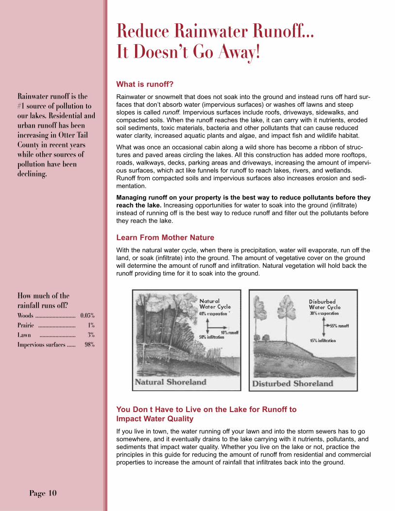
Learn From Mother Nature
With the natural water cycle, when there is precipitation, water will evaporate, run off theland, or soak (infiltrate) into the ground. The amount of vegetative cover on the groundwill determine the amount of runoff and infiltration. Natural vegetation will hold back therunoff providing time for it to soak into the ground.
You Don t Have to Live on the Lake for Runoff to Impact Water Quality
If you live in town, the water running off your lawn and into the storm sewers has to gosomewhere, and it eventually drains to the lake carrying with it nutrients, pollutants, andsediments that impact water quality. Whether you live on the lake or not, practice theprinciples in this guide for reducing the amount of runoff from residential and commercialproperties to increase the amount of rainfall that infiltrates back into the ground.
Reduce Rainwater Runoff...It Doesn’t Go Away!
Page 10
Rainwater runoff is the#1 source of pollution toour lakes. Residential andurban runoff has beenincreasing in Otter TailCounty in recent yearswhile other sources ofpollution have beendeclining.
How much of the rainfall runs off? Woods ............................ 0.05%Prairie .......................... 1%Lawn ......................... 3%Impervious surfaces ...... 98%

Maintain Natural Vegetation
Natural vegetation will naturally reduce runoff by holding back the water to provide timefor it to soak into the ground.
• When clearing your lot, minimize the removal of wooded areas, trees and low grow-ing shrubs. Their removal causes more rain to fall to the ground instead of landingon leaves and branches.
• Grading large areas of land removes the natural depressions of land where watercan pond and soak in.
• Carefully landscape your yard near roads, driveways, and along the shoreline todirect runoff away from the lake.
Practice Good Lawn Management
Maintain a Healthy Lawn to Absorb More Water• Aerate your lawn to alleviate some of the compaction
that turns many lawns into green concrete. • Mow to a height of two to three inches; mow when dry
to prevent clumping. Taller grass provides shade forbetter root growth, which helps with water absorption.
• Consider replacing some of the grass in your lawnarea with clover, native grasses, or other groundcov-ers that don t need watering.
• If watering is necessary, water deeply, but infrequently,to encourage deep root growth. Water with lake water.(Hint: use the nutrients in the lake to make a healthylawn instead of frequent fertilizer applications.) Water inthe morning, not mid-day or evening.
• In hot weather, allow lawn grasses to go dormant sothat they require less water and nutrient intake for sur-vival. Water 1/4 to 1/2 inch every two or three weeks to keep crowns from dehydrat-ing beyond the point of recovery.
If we love our lakes, wehave to change our ideasabout what is a good lawnfor shoreland properties.Limit the amount of lawnand keep it as natural aspossible to reduce mainte-nance and increase itsability to absorb runoff.
Building a home andestablishing a lawn to thewater’s edge can causeseven times the amount ofphosphorus and 18 timesthe amount of sediment toenter the water comparedto a natural shoreline.1
Page 11
Problem Is the water near shore cloudy?Possible Cause Excess sediment reaching the water.
Problem Is there an oily rainbow film on the water?Possible Cause Possible petroleum contamination.
Problem Are there algal blooms, green scum, or abundant plantgrowth in the water?
Possible Cause Excess nutrients such as nitrate or phosphorus reachingthe water.
Problem Are washouts, trenches, small piles of sediment, leaves, ordebris found at the bottom of slopes?
Possible Cause Excessive water runoff across the property.
Problem Is your shoreline eroding? Possible Cause Removal of natural vegetation for property development or
creation of beaches, both on-shore and in the lake; dredg-ing, filling, or construction on or near the shoreline; tram-pling of banks; inadequate protection against runoff fromroofs, driveways, roads, or other developed areas.
Identifying Lake Problems Caused by Runoff
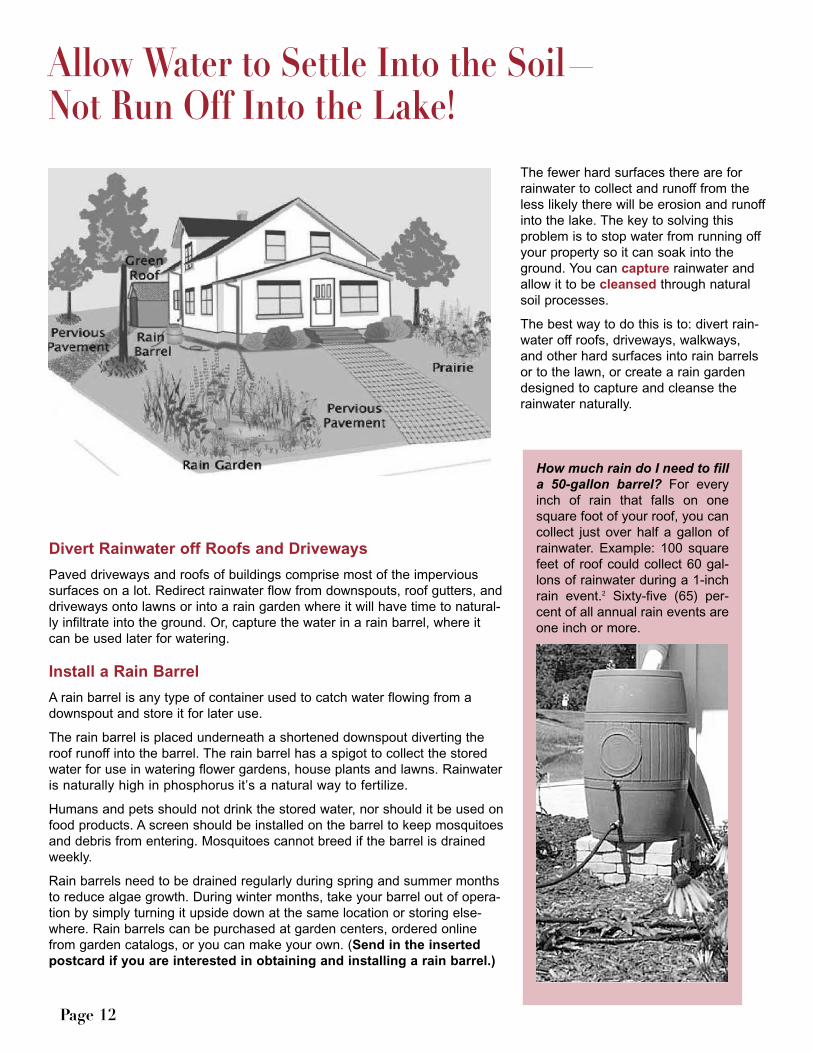
The fewer hard surfaces there are forrainwater to collect and runoff from theless likely there will be erosion and runoffinto the lake. The key to solving thisproblem is to stop water from running offyour property so it can soak into theground. You can capture rainwater andallow it to be cleansed through naturalsoil processes.
The best way to do this is to: divert rain-water off roofs, driveways, walkways,and other hard surfaces into rain barrelsor to the lawn, or create a rain gardendesigned to capture and cleanse therainwater naturally.
Divert Rainwater off Roofs and Driveways
Paved driveways and roofs of buildings comprise most of the impervioussurfaces on a lot. Redirect rainwater flow from downspouts, roof gutters, anddriveways onto lawns or into a rain garden where it will have time to natural-ly infiltrate into the ground. Or, capture the water in a rain barrel, where itcan be used later for watering.
Install a Rain Barrel
A rain barrel is any type of container used to catch water flowing from adownspout and store it for later use.
The rain barrel is placed underneath a shortened downspout diverting theroof runoff into the barrel. The rain barrel has a spigot to collect the storedwater for use in watering flower gardens, house plants and lawns. Rainwateris naturally high in phosphorus it’s a natural way to fertilize.
Humans and pets should not drink the stored water, nor should it be used onfood products. A screen should be installed on the barrel to keep mosquitoesand debris from entering. Mosquitoes cannot breed if the barrel is drainedweekly.
Rain barrels need to be drained regularly during spring and summer monthsto reduce algae growth. During winter months, take your barrel out of opera-tion by simply turning it upside down at the same location or storing else-where. Rain barrels can be purchased at garden centers, ordered onlinefrom garden catalogs, or you can make your own. (Send in the insertedpostcard if you are interested in obtaining and installing a rain barrel.)
Page 12
Allow Water to Settle Into the Soil—Not Run Off Into the Lake!
How much rain do I need to filla 50-gallon barrel? For everyinch of rain that falls on onesquare foot of your roof, you cancollect just over half a gallon ofrainwater. Example: 100 squarefeet of roof could collect 60 gal-lons of rainwater during a 1-inchrain event.2 Sixty-five (65) per-cent of all annual rain events areone inch or more.
Plant a Rain Garden
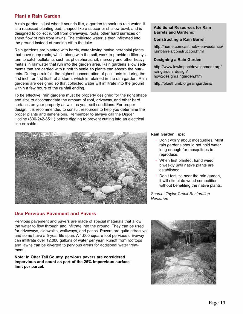
A rain garden is just what it sounds like, a garden to soak up rain water. Itis a recessed planting bed, shaped like a saucer or shallow bowl, and isdesigned to collect runoff from driveways, roofs, other hard surfaces orsheet flow of rain from lawns. The collected water is then infiltrated intothe ground instead of running off to the lake.
Rain gardens are planted with hardy, water-loving native perennial plantsthat have deep roots, which along with the soil, work to provide a filter sys-tem to catch pollutants such as phosphorus, oil, mercury and other heavymetals in rainwater that run into the garden area. Rain gardens allow sedi-ments that are carried with runoff to settle so plants can absorb the nutri-ents. During a rainfall, the highest concentration of pollutants is during thefirst inch, or first flush of a storm, which is retained in the rain garden. Raingardens are designed so that collected water will infiltrate into the groundwithin a few hours of the rainfall ending.
To be effective, rain gardens must be properly designed for the right shapeand size to accommodate the amount of roof, driveway, and other hardsurfaces on your property as well as your soil conditions. For properdesign, it is recommended to consult resources to help you determine theproper plants and dimensions. Remember to always call the DiggerHotline (800-242-8511) before digging to prevent cutting into an electricalline or cable.
Use Pervious Pavement and Pavers
Pervious pavement and pavers are made of special materials that allowthe water to flow through and infiltrate into the ground. They can be usedfor driveways, sidewalks, walkways, and patios. Pavers are quite attractiveand some have a 5-year life span. A 1,000 square foot pervious drivewaycan infiltrate over 12,000 gallons of water per year. Runoff from rooftopsand lawns can be diverted to pervious areas for additional water treat-ment.
Note: In Otter Tail County, pervious pavers are considered impervious and count as part of the 25% impervious surface limit per parcel.
Page 13
Rain Garden Tips:
• Don t worry about mosquitoes. Mostrain gardens should not hold waterlong enough for mosquitoes toreproduce.
• When first planted, hand weedbiweekly until native plants areestablished.
• Don t fertilize near the rain garden, it will stimulate weed competitionwithout benefiting the native plants.
Source: Taylor Creek RestorationNurseries
Additional Resources for RainBarrels and Gardens:
Constructing a Rain Barrel:
http://home.comcast.net/~leavesdance/rainbarrels/construction.html
Designing a Rain Garden:
http://www.lowimpactdevelopment.org/raingarden_design/how2designraingarden.htm
http://bluethumb.org/raingardens/

Scientific research shows that the way we treat our shorelines affects lake water qualityand fish and wildlife habitat. To protect and improve our lakes, we need to improveour shorelines. The best way we can do that is by adding or keeping a buffer strip ofnatural vegetation along the shore. Buffer strips of native wildflowers, grasses, trees,and shrubs protect water quality and provide habitat for fish and wildlife.
If you have lawn to the water’s edge, lawn behind rip-rap, steep slopes, or little vegeta-tion near the shore, consider a natural shoreland landscaping project to restore thenative vegetation by creating a shoreland buffer zone—an area of native vegetationalong the water’s edge.
Rethinking How our Shorelands Should Look
Creating and maintaining a natural buffer zone along your shore does not mean yourproperty has to look messy, but it may mean you have to re-think what your shorelandshould look like. Lawn-to-lake shorelines are no longer ecologically smart.
Creating or keeping a native shoreline buffer reduces the amount of nutrients enteringthe lake along with providing better wildlife habitat. For example, a 20-foot buffer stripalong the lake can trap about 80% of the phosphorus runoff and about 90% of the sedi-ment pollutants.
This lawn is labor-intensive and expensiveto maintain. Fertilizer and grass clippingsadd nutrients to the lake leading to weedand algae growth. A shallow-rooted lawn(turfgrass) has a minimal ability to filternutrients and sediment entering from rain-water runoff and is ineffective at allowinginfiltration of water into the soil. The shallow roots leave subsurface runoffuntreated while native plant roots interceptand withdraw the nutrients and water.
This shoreland buffer of native vegetation pro-tects the shoreline, maintains the natural land-scape, and filters out boat noise. Many plants aresuitable that are low growing and won’t impedeyour view of the lake. Using ornamental grasses,perennials and smaller woody plants will signifi-cantly reduce and filter runoff while restoring thenatural beauty to the shore, and they are lesswork—more time to recreate.
Buffer the Lake from RunoffBenefits of a Shoreland Buffer
1. Enhances waterquality. A good bufferprotects your lake,stream, or wetland byslowing runoff and allow-ing it to soak into theground.
2. Stabilizes shorelines.Buffers prevent fluctuat-ing water levels, movingice, flooding, surfacerunoff and wave actionfrom eroding your shore-line.
3. Provides fish andwildlife habitat. Theshoreline buffer provideshabitat for fish and coverfor birds, butterflies, tur-tles, and other wildlife.
4. Enhances aesthetics.Natural buffers beautifyyour yard with a varietyof colorful wildflowers,create a natural screenfor privacy, and enhancethat “Up North” feeling.
5. Increases propertyvalue. A high qualitybuffer is an asset that canadd resale value.
6. Limits nuisancebugs and wildlife. Anative plant buffer cre-ates a natural barrier toCanada geese.
Page 14

One of the greatest benefitsof establishing native vege-tation is their deep root sys-tems that stabilize the shorefrom erosion and ice dam-age, and they loosen the soilallowing the rain to soak intothe ground instead of run-ning off to the lake.
What is a shoreland buffer?
A shoreland buffer is anunmowed strip of native veg-etation that extends bothlakeward and landward fromthe water s edge. A bufferzone of native plants thatextends 25-50 feet landwardfrom the shore is preferable, but even adding a buffer asnarrow as 10-15 feet can restore many functions critical tothe health of the lake that may have been eliminated previ-ously by sod, hard structures, or mowing. When it comesto shoreland buffers, wider is better for more benefits.
A shoreland buffer consists of:
• The shallow aquatic zone of the emergent, sub-merged, and floating leaf aquatic plants that providefood and shelter for ducks, songbirds, frogs and otheramphibians, and fish. The taller plants, like bulrush,sedges, and cattails can reduce the energy of waveaction to minimize erosion and help maintain waterquality.
• The wetland transition zone of more water-lovingplants that bind the lake bed to the upland soils.
• The upland zone of native trees, shrubs, grasses,and wildflowers slows rainwater running over-land,making sediment drop out, absorbing water and nutri-ents, and breaking down pollutants.
Getting Started Creating a Shoreland Buffer
There are a number of ways to create a shoreland bufferdepending on the characteristics of the shoreland and thedesires of the property owner. Some decisions in creatinga buffer are easy, such as: How tall do you want theplants to be? Others, are more complicated, like: What isyour soil type and moisture?
Otter Tail County has a program to assist you indesigning and installing a shoreland buffer. For personal assistance, fill out and mail the inserted postcardor contact the Otter Tail County Shoreland Specialist:
801 Jenny Ave SW Suite 2Perham, MN 56573218-346-4260 ext.3
Email: [email protected]
Here are some options to help you decide how you want toestablish a shoreland buffer.
Don t Mow, Let It Grow A simple, no-cost way to getstarted in restoring your shoreland is to stop mowing forthe width of the desired buffer strip. Turf grasses will grow12-24 inches before going to seed, after which seeds inthe soil will germinate and valuable native plants will beginto appear. You can note the types of native plants andwildflowers growing on natural shorelands around lake toget an idea of what is likely to appear or will be suitable forgrowing in your area. While the buffer is getting estab-lished, you may need to weed out nuisance species or addnative plants for diversity, but not mowing will get youstarted. Perennial native plants will take three to five yearsto become apparent.
Page 15
Source: University of Minnesota Extension Service, 2005; Item #08308
Resource professionals recommend that you maintain a shoreland
buffer along 75% of the shoreline frontage.
Native plants are moreeffective at stabilizingsoils and banks becausetheir roots are longer (3-5 feet) and more densethan typical Kentuckybluegrass (2-3 inches).They hold the soil parti-cles together to preventerosion and reduce icedamage.
Native Shoreland Buffer

Restore Your Shoreline
Local nurseries and gardencenters are starting to carrymore native plant stock andcan recommend the bestplants for your site. Plantsused should be indigenous tothis region of Minnesota-don’tbuy plants from a mail ordercatalog grown in another partof the country and expect themto grow. The DNR website hasa list of native plant suppliersand landscapers. Consult withUniversity of MinnesotaShoreland Specialists, DNRShoreland RestorationSpecialists, or the Otter TailCounty Soil and WaterConservation Districts forresources and fact sheets ondesigning your project, selecting plants, preparing the site, and planting. Take one of themany classes, tours, and open houses offered throughout the summer on the basics ofshoreland restoration. Professionals teaching the classes will help you design your ownproject and may later be available for further consultation. Many classes include anopportunity to participate in the planting of a restoration project to give you experiencefor planting your own project. Check with the Otter Tail Shoreline Specialist for possiblecost-share assistance.
Hire a Professional
Shoreland restoration is a rapidly growing field among landscape professionals; consultthe yellow pages or watch for promotions. Ask for recommendations from other propertyowners who have completed re-vegetation projects. If your site has a steep slope orother unusual characteristics, getting professional assistance will be very important tothe success of your project.
Maintaining Your Restored Shoreland
A shoreland restored with native vegetation should maintain itself once it is established.Apply mulch to new planting beds to prevent soil erosion, hold moisture in the soil, andcontrol weeds. You may need to water and weed the first season, but once the plantsare established, they will be able to out-compete most weeds. Native species shouldnever be fertilized because they are adapted to the nutrient levels found in local soils,and fertilizers and pesticides applied to areas near shore can be a threat to aquatic lifeand water quality. Plants left standing in fall and winter provide seeds and shelter forwildlife, protect the soil from wind erosion, and capture windblown leaves and debris.
Leave Fallen Trees and Branches Alone
Unless they are interfering with your recreational access, leave trees and branches thathave fallen into the water alone. They form critical habitat for aquatic organisms that fish
and other aquatic life feed on, provide cover from predators for small fish,and they serve as a dock for turtles, kingfishers and other interesting
wildlife.
Page 16
The book Lakescaping forWildlife and Water Qualityand the DNR CD RestoreYour Shore are two highlyrecommended resourcesto get you started. Theyare available in book-stores and online throughthe Minnesota Bookstoreat www.mnbookstore.com
The Restore Your Shore CD is also online at www.dnr.state.mn.us/restoreyourshore/index.html
Check local Otter TailCounty libraries for copiesof both resources.

Protect the Aquatic Zone
The aquatic zone is a vital part of the shoreland buffer. Emergentvegetation, such as soft stem bulrush, wild rice, and cattails, helppurify the lake by removing contaminants and calming the water,which allows suspended soil particles to settle to the lake bottom.They provide food, shelter and spawning areas for fish and otherwildlife and add oxygen back into the water. If submerged aquaticplants are interfering with swimming, clear by hand only what isneeded to provide a small swimming area and access to the water.Leave other submerged plants in place. Remember, aquatic plantsare protected and any disturbance may require a DNR Fisheriespermit (218-739-7576) to remove or treat with chemicals.
Requirements When Working in the Shoreland District
All counties and municipalities with shorelands within their jurisdiction are required tohave and enforce a Shoreland Ordinance that regulates activities done in the shorelanddistrict. The shoreland district is established as 1,000 feet from a lake or 300 feet from ariver or floodplain. The local government ordinance must meet or exceed the MinnesotaState Shoreland Rules.
The Otter Tail County Shoreland Management Ordinance is not a building code. Itaddresses the setbacks and the location of structures on a shoreland lot and definesrestrictions on the types of activities that can take place within the shoreland zone. Italso regulates the setback and construction of septic systems. It does not address thetype of structure that may be built or anything regarding the interior of the structure.
The requirements in the shoreland management ordinance are based on the establishedclassification of the lake on which the work is to be done. Lakes in Otter Tail County areclassified by the Minnesota DNR as one of the following types:
1. General Development (GD)
2. Recreational Development (RD)
3. Natural Environment (NE)
Most of the more populated, well-developed lakes are designated as general develop-ment (GD), while many of the less developed lakes are natural environment (NE).Because each type of lake has unique characteristics, each has different shorelanddevelopment standards to provide adequate protection of water quality and fish andwildlife habitat. Natural environment lakes generally have the most restrictive standardswhile general development lakes have less restrictive standards. To find the classifica-tion of your lake, see the DNR Lake Finder at www.dnr.state.mn.us or Waters of OtterTail County on the home page of the Otter Tail Land & Resource Management webpage.
The Otter Tail ShorelandOrdinance is periodicallyrevised to insure that it is fairand yet protective of the envi-ronment. Before doing anywork in the shoreland district, contact the OtterTail Land & ResourceManagement Office to see ifpermits are required orthere are other require-ments. See pages 23 and 24for some requirements in theOtter Tail ShorelandManagement Ordinance.
Page 17
Otter Tail Land & Resource Management Government Services Center540 West FirFergus Falls, MN 56537 218-998-8095 http://www.co.ottertail.mn.us;
Business Hours: 8 a.m. - 4:30 p.m.Monday-Friday No applications processedafter 4 p.m.
The Otter Tail ShorelandOrdinance is located at:www.co.ottertail.mn.us Under Departments choose Land & ResourceManagement.
Shoreland District Map

Rainwater runoff or waves lapping at the banks of your shore can erode the shoreline,silt up the water, and wash away sand blankets and impair fish spawning areas. Whensoil washes into the lake, it carries with it phosphorus, the desired nutrient for aquaticplant and algae growth. It causes sediment to build up in the lake; increases turbidityafter rain events, which interferes with normal lake functions; and impacts fish andwildlife habitat. Degradation to water quality is the result. Curbing the erosion of soilinto the lake will reduce pollutants reaching the lake.
Shorelines can erode through many processes. Natural causes of erosion include cur-rents, waves, ice, and rain. Many human activities may significantly increase the rate oferosion. Some common causes of erosion include:
• removal of natural vegetation for property development or creation of beaches, bothon shore and in the lake.
• improper installation of erosion control structures, such as retaining walls. • increased wave action from watercraft traveling close to the shore. • dredging, filling, or construction on or near the shoreline. • trampling of banks by human, animal, or vehicle traffic. • inadequate protection against stormwater runoff from roofs, driveways, streets, and
other paved or hard surfaces.
Signs of a Serious Problem
• A large area of bare soil on asteep, high shoreline bank.
• A noticeable recession of theshoreline over a period of time.
• Large patches of muddy waternear a lakeshore, or unusuallymuddy streams during periods ofhigh water or following a rain-storm.
• Excessive deposits of sand orother sediments on the streambed, or very wide, shallow areasin a stream.
How can shoreline erosion be controlled?
If your shoreland is eroding away, stabilizing the shoreland will be necessary toreduce erosion.
Each shoreland situation is different. You are encouraged to consult with shoreland land-scaping professionals, the DNR Area Hydrologist, University of Minnesota ShorelandSpecialists, or an Otter Tail County Soil and Water Conservation District to determine thebest solution for your shoreline erosion situation.
Rip-rap, stone, retaining walls, or turf grass might seem like good solutions for stabilizingerosion, but they are not usually the best choice. Rip-rap reflects wave energy backtowards the lake causing previously sandy areas to erode to gravel or cobblestones.Water can undercut retaining walls and turf grasses. Rip-rap and non-native grassesdon t reduce chemical runoff polluting the water and causing unsightly algal blooms.These choices can negatively impact the lake by creating an unnatural barrier betweenupland areas and the shoreland environment that destroys vegetative transition areasand eliminates critical habitat for many species.
Don’t Let Your Shoreline Slip Away—Curb Erosion
Curbing the erosionof soil into the lakewill reduce pollu-tants reaching thelake.
A survey of Otter TailCounty shoreland owners found that over25% of shoreline stabilization projectswere not performing aslandowner’s expected.
Success Rates ReportedRip-Rap 74%Native Plants 68%Retaining Wall 50%Sandbags 15%Areator 8%Concrete Blocks 7%
Page 18
Erosion may be accelerated by activities such as boatwakes or high waves during storms. Each year erosion
causes the loss of valuable shorefront property.

Retaining walls deflect wave energy back to the lake instead of diffusing it, which canundercut the base of the wall and cause increased erosion at the ends making the watermore turbid. And, neither rip-rap or retaining walls will prevent ice ridges from formingbecause rock cannot withstand the up to 30,000 pounds of ice pressure per square foot.
Preventing Erosion
Some basic preventive actions include:
• Preserve existing rock and vegetation that naturally occur along the shoreline. • Stop mowing a strip of land near the shoreline or restore a shoreland buffer of
native vegetation. • Prevent impervious surface (i.e. roofs, driveways, etc.) runoff from flowing to the
shoreline, steep slopes and bluff areas.• Avoid construction within 100 feet of the shoreline, steep slopes or bluffs. • Protect berms pushed up by ice action along lakeshores. They prevent excessive
surface runoff and trap sand which "nourishes" the beach. • Limit the amount of foot traffic and other recreational activities in erosion prone
areas. Regardless of preventive measures, the right combination of conditions,such as high water level, violent windstorms, drastic ice movement, and certainshoreline configurations, may result in serious shoreline erosion.
Preventing Erosion on Steep Slopes and Bluff Areas
The erosion potential on steep slopes and bluffs can be reduced by:• Diverting water away from steep slopes by rerouting drainpipes and gutters. If
diverting water away from the bluff is impractical, it should be routed through a non-perforated plastic drain pipe that outlets at the very bottom of the bluff into rockdrainage.
• If you need a walkway to the shore, follow the natural contours of the slope to goacross or around the slope, or use steps when a walkway must go directly up anddown a slope, but minimize destruction of natural vegetation during construction.
• Keep the moisture- and nutrient-absorbing natural vegetation on steep slopes bylimiting clearing and grading.
• Replant vegetation on barren slopes.• Create a view corridor through the trees with selective pruning for an excellent view
while maintaining the natural trees and shrubs.
Neither rip-rap orretaining walls will pre-vent ice ridges fromforming because rockcannot withstand the upto 30,000 pounds of icepressure per square foot.
Naturalizing your shoreline or maintainingthe natural shorelandvegetation is the mostimportant way to reduceshoreland erosion.
Page 19
On steep bluffs, selectively prune trees to create a view corridor of the lake. Keep the vegetative undergrowth to stabilize the soil on the bluff.
Reduce Erosion By Slowing Down the Boat
Boat wakes can cause tremendous shoreland erosion, so slow the boat down. In shal-low areas (less than 15 feet), motor at slow-no-wake speeds (5 mph or less) to reducethe boat wake and the consequent wave action that can erode your shoreline and theshoreline of others around the lake. Observe all posted no-wake and low-speed zones. For personal watercraft, running at slow, no-wake speed within 150 feet of the shore isthe law.
Boating slowly makes less wake, less noise, reduces pollution and is less disruptive tobottom sediments, wildlife and other people. When running at higher speeds, keep themotor properly trimmed to reduce noise and the boat wake.
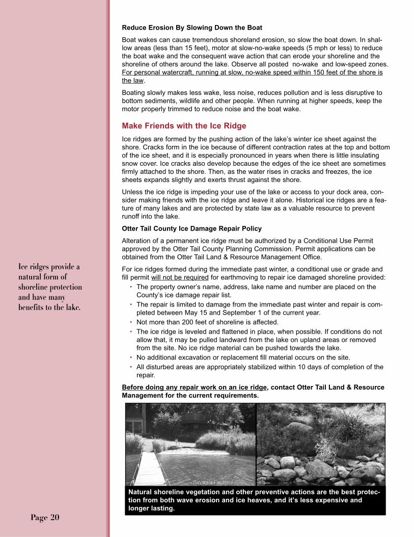
Make Friends with the Ice Ridge
Ice ridges are formed by the pushing action of the lake’s winter ice sheet against theshore. Cracks form in the ice because of different contraction rates at the top and bottomof the ice sheet, and it is especially pronounced in years when there is little insulatingsnow cover. Ice cracks also develop because the edges of the ice sheet are sometimesfirmly attached to the shore. Then, as the water rises in cracks and freezes, the icesheets expands slightly and exerts thrust against the shore.
Unless the ice ridge is impeding your use of the lake or access to your dock area, con-sider making friends with the ice ridge and leave it alone. Historical ice ridges are a fea-ture of many lakes and are protected by state law as a valuable resource to preventrunoff into the lake.
Otter Tail County Ice Damage Repair Policy
Alteration of a permanent ice ridge must be authorized by a Conditional Use Permitapproved by the Otter Tail County Planning Commission. Permit applications can beobtained from the Otter Tail Land & Resource Management Office.
For ice ridges formed during the immediate past winter, a conditional use or grade andfill permit will not be required for earthmoving to repair ice damaged shoreline provided:
• The property owner’s name, address, lake name and number are placed on theCounty’s ice damage repair list.
• The repair is limited to damage from the immediate past winter and repair is com-pleted between May 15 and September 1 of the current year.
• Not more than 200 feet of shoreline is affected. • The ice ridge is leveled and flattened in place, when possible. If conditions do not
allow that, it may be pulled landward from the lake on upland areas or removedfrom the site. No ice ridge material can be pushed towards the lake.
• No additional excavation or replacement fill material occurs on the site. • All disturbed areas are appropriately stabilized within 10 days of completion of the
repair.
Before doing any repair work on an ice ridge, contact Otter Tail Land & ResourceManagement for the current requirements.
Ice ridges provide anatural form ofshoreline protectionand have many benefits to the lake.
Page 20
Natural shoreline vegetation and other preventive actions are the best protec-tion from both wave erosion and ice heaves, and it’s less expensive andlonger lasting.

Aquatic Invasive Species (AIS) are plants and animals released either accidentally orintentionally into areas where they are not native. Such introductions usually occurthrough human activities and often are spread through boating activity.
Common AIS in Minnesota lakes include: • Eurasian watermilfoil, now in over 246 lakes, rivers, and
streams statewide. There are no infested lakes in OtterTail County yet; let’s keep it that way.
• Curlyleaf pondweed, found in 18 lakes in Otter TailCounty.
• Zebra mussels, now in 7 lakes and streams in Otter TailCounty.
• Flowering Rush, not yet in Otter Tail County but it is found in 7 lakes in neighboringBecker County and in the Pelican River.
AIS, such as Eurasian watermilfoil and Curlyleafpondweed, cause problems by replacing native plantsimportant for fish and wildlife habitat and form thick matsthat make boating difficult. When Curlyleaf pondweed diesback in mid-summer it releases phosphorus that can fuelnoxious algal blooms. Zebra mussels attach to hard sur-faces and interrupt the food chain eventually impacting fish
populations. Flowering rush outcompetes native shoreland vegetation impeding accessto the lake and interrupting shoreland ecological functions.
To stop the spread of AIS, careful boaters: • Inspect boat, trailer, and boating equipment (anchors, centerboards, rollers, axles)
before entering a lake or leaving a lake, and remove any plants and animals thatare visible.
• Drain water from the motor, livewell, bilge, and transom wells while on land beforeleaving any waterbody; it is the law.
• Dispose of unwanted bait in the trash. Never release live bait into a waterbody.When cleaning off fishing lines, collect plant fragments in a bucket and dispose ofonshore away from the lake.
• Wash then dry your boat, tackle, downriggers, trailer, and other boating equipmentto kill harmful species that were not visible at the boat launch.
• Know what waters are infested; check lake accesses for DNR infested waters signs.
Jet skies can carry AIS, too, so clean out all water intakes and other parts before trans-porting jet skies.
Other Boating Cautions • Do not dump wastewater from toilets, porta-potties, sinks, or showers into or near
the lake. All waste must be held on board and disposed of properly onshore.• Avoid boating in very shallow areas, where motors can churn up the bottom and
increase the amount of damaging, nutrient-rich sediment in the water. • Make sure boat engines do not leak oil, gas or other contaminants. Be extra careful
when filling fuel tanks and be sure to clean up any spills.• Keep unsightly litter out of the lake. Take it ashore and place in recyclable trash
containers.• Be safe: wear a Coast Guard approved life vest when boating. Stay 100 feet away
from swimmers, paddle boats, and other small objects in the water. Remember whohas the right away on the lake.
Be a Careful BoaterStop the Spread of Aquatic Invasive Species (AIS)
Page 21
In Minnesota it is againstthe law to transport anyaquatic plants and invasivespecies.
The law requires boaters toremove the drain plug anddrain all water from theboat. The plug must remainout while the boat is transported.
AIS Infested Lakes in Otter Tail County: Zebra Mussels: Bass, Crystal, Fish, Little Pelican,Lizzie, Pelican, Prairie & the Pelican River from Fish Lake downstream to Prairie Lake.
Curlyleaf Pondweed: West Battle, Clitheral, Deer,Hoot, Jolly Ann, East Leaf,Leek/Trowbridge, North &South Lida, Lizzie, Orwell,Otter Tail, Big Pelican, Big & Little Pine, Rush,Swan, & North Turtle.
Lakes in neighboringBecker County infestedwith Flowering Rush: Buck, Detroit Lake,Curfman, Melissa, Mill,Muskrat, & Sallie plus thePelican River from DetroitLake to Muskrat Lake.
Eurasian Watermilfoil
Zebra Mussel

Who Has Regulatory Authority in the Shoreland Zone?
The shoreland zone is defined as the land within 1,000 feet of a lake and 300 feet of ariver or stream plus the near shore waters.
• For any actions in the water or on the land below the ordinary high waterlevel (OHWL) of a public water (lakes, rivers, streams, wetlands), check with theappropriate Minnesota Department of Natural Resources (DNR) office for permitsthat may be required.
• For any actions on the land above the OHWL (the upland areas of your prop-erty) and within the shoreland zone, contact the appropriate county, city or water-shed office.
How do I know where the ordinary high water level (OHWL) is? For lakes and wet-lands, the OHWL is the highest water level that has been maintained for a sufficient periodof time to leave evidence on the landscape; it is not necessarily the highest place thewater has been. It is commonly that point where the natural vegetation changes from pre-dominately aquatic to predominantly terrestrial.
If there is a question about the OHWL on your property, contact the DNR AreaHydrologist or check Otter Tail County Land & Resource Management.
What Rules Apply To These Shoreland Activities?
Shoreland Structures and Repairs
Any land alteration in the shoreland area, including building retaining walls,installing rip-rap or beach blankets, and ice ridge repair requires a permit fromOtter Tail Land & Resource Management.
Dock Placement and Size
Docks are privately owned structures, which are allowed to be placed in thepublic waters of the state to provide access to the use of the water. The DNRestablishes dock rules to prevent the deterioration of the lake’s ecosystem fromexcessive or inappropriate dock placement that can harm aquatic plants or dis-turb fish spawning, feeding, and shelter from predators.
Local governments have the authority to regulate docks; Otter Tail County cur-rently defers to state rules.
What Can I Do On Shoreland Property?What Permits Are Required?
Knowing what you canand cannot do in thewater and on the adja-cent shoreland area, andfollowing the regulationsthat apply, is an impor-tant stewardship practice.
Any activity that disturbs land, plant oranimal life or applyingchemicals in the water isa regulated activity toensure that the quality ofthe environment is notcompromised.
Page 22
Ordinary High Water Mark (OHWM)(Above is Otter Tail County jurisdiction)
Ordinary High Water Level (OHWL) (Below DNR)
Record highwater level
Cattails, Bulrushes, Sedges,and other aquatic vegetation
Record lowwater level
Average Water Level
See checkliston inside backcover forappropriateauthority in various situa-tions.

Page 23
The DNR is currently revising its dock rules. No DNR per-mit is needed to install, construct, or reconstruct a dock if:1) the dock, not including the watercraft lift or canopy, isnot wider than 8 feet and is not combined with other struc-tures that create a larger structure; or 2) the dock is nolonger than is necessary to reach navigable water depth, isnot a safety hazard, it does not close off access for othersto the lake, allows for free flow of water under it, and is notintended for use as a marina.
A general permit was issued in 2008 that allows for a mod-est platform at the lake end of the dock under the followingcircumstances: 1) a single temporary platform up to 120square feet measured separately from the access dock, or;2) 170 square feet including the area of the adjacentaccess dock. The access dock must be 5 feet or less inwidth and is located on a lake with a classification ofGeneral Development or Recreational Development. Thegeneral permit for platforms expires when the revised rulesfor docks are adopted. A DNR Waters permit will be need-ed if a dock exceeds these conditions. Check the DNRwebsite for final dock rule revisions.
Control of Aquatic Plants
The removal or destruction of aquatic plants inMinnesota lakes is regulated by the MinnesotaDNR. Aquatic plants are a valuable part of the lakesystem. They stabilize bottom sediments, protectwater clarity, prevent shoreline erosion and providefish habitat. Keep destruction of aquatic plants to aminimum.
If you see unusually high plant growth where it has notpreviously occurred, look for possible sources of phospho-rus getting into the lake from your property that might befueling this growth, such as excessive runoff, a malfunc-tioning septic system, or shoreland erosion.
If it is necessary to manage submersed aquatic vegetationfor swimming or boat docking consider removing only thatvegetation allowed without permit (see below). DNR regu-lations restrict submersed vegetation control with a permitto up to 100 feet or one-half the length of the person’sshoreline, whichever is less.
DNR Aquatic Plant Management rules require: • No destruction of emergent aquatic plants (bulrushes,
cattails,wild rice) is allowed unless authorized by aDNR permit.
• Limited mechanical control (cutting or pulling) of sub-merged vegetation not exceeding 2,500 square feetor wider than 50 feet along the shore or half the widthof your property, whichever is smaller; more than thatrequires a permit.
• Cut or pulled vegetation must be removed from thewater and the cleared area must remain in the sameplace from year to year.
A permit from the DNR Fisheries Regional office isneeded for:
• Use of any chemicals or automated mechanicaldevices (such as the Crary WeedRoller, Beach-groomer or Lake Sweeper).
• Use of copper sulfate for control of swimmers itch orfilamentous algae.
• Removal of lily pads in an area larger than a channel15 feet wide to open water.
• Any removal of any bulrushes, cattails, or wild rice.• Removal or relocation of a bog.• Planting aquatic plants below the OHWM (ordinary
high water mark).
These activities are not allowed in any circumstances:• Excavating the lake bottom for aquatic plant control.• Using lake-bottom barriers to prevent the growth of
aquatic plants.• Removing vegetation within posted fish-spawning
areas.• Removing aquatic plants from an undeveloped shore.• Removing aquatic plants where they do not interfere
with swimming, boating or other recreation.
Otter Tail County Site Permits:
General Permit Requirements
The following information is based on the Otter TailShoreland Management Ordinance effective at the timethis guide was written. However, ordinances do changeperiodically. Before doing any work in the shoreland zone,contact Otter Tail Land & Resource Management.
An Otter Tail County Site Permit is required prior to erect-ing or installing a new structure or altering a structure.Alterations include projects which make structuralchanges, alter the outside dimensions of a structure or thecost of the project exceeds 50% of the market value of thestructure. A Site Permit is also required prior to moving astructure.
Before the site permit is issued, the current Otter TailShoreland Management Ordinance requirements must bemet. This includes bringing a non-conforming septic sys-tem on the property in compliance.
A Single Family Residential lot can contain only one (1)dwelling structure. Guest houses would be prohibited as asecond dwelling. The following exemptions are allowedwithout a Site Permit.
• A tent no more than 100 sq. ft., or tents whose cumu-lative size is no more than 100 sq. ft.
• A Recreational Camping Unit (RCU) of less than 40feet in length and less than 399 sq. ft. when erectedis allowed provided the lot is compliant with theShoreland Management Ordinance and there are nosewer or water connections. RCUs include, but notlimited to tents, motor homes and travel trailers.

Clearing of Vegetation: Limited clearing of vegetation andtrees in the shoreland zone is allowed. Minimal clearing isallowed to accommodate construction, but keep as muchvegetation as possible to minimize runoff.
Stairways, Lifts, and Landings: These are the preferredalternatives to major topographic alterations for access tothe shore area. The maximum width of stairs is 4 feet.Landings must be no more than 36 square feet in area.Stairs and landings may not have canopies or roofs. Otherplacement and building restrictions may apply.
Decks: Decks must meet the structure setback require-ments. Non-conforming decks may be allowed without avariance for structures existing prior to 2/5/1992; contactLand & Resource Management for allowable criteria.
Water Oriented Accessory Structures: A small buildingsuch as a boathouse, screen porch, sauna, fish house ordetached deck, may be located closer to public watersthan the normal structure providing a site permit isobtained from Otter Tail Land & Resource Management.The structure cannot be used for human habitation or havewater or sewer connections.
Drainage and/or filling of Wetlands: Wetlands are protect-ed by the State Wetland Conservation Act (WCA) and inmost cases drainage and/or filling of wetlands is prohibit-ed. If wetland acreage is lost as a result of permitted landalteration, they must be replaced in accordance with theWCA requirements.
Non-Conforming Structures and Lots Buildings and lots platted before 10/15/1971 are grandfa-thered in. If these structures and lots do not conform tothe current ordinance they are designated nonconform-ing. The Otter Tail Shoreland Management Ordinanceplaces limitations on the amount of expansion or replacement that is allowed for these structures and whatmay be built on nonconforming lots without getting a vari-ance. Contact Land & Resource Management for allowedactivity.
Conditional Use Permits and Building VariancesTo obtain a conditional use permit, the proposed usesmust be presented to the Otter Tail County PlanningCommission for their determination of its applicability tothe Shoreland Management Ordinance. In granting a per-mit, the Planning Commission may impose conditions onsetbacks, vegetation, location of septic system, placementof docking and other conditions. An application must befiled along with detailed drawings not less than 21 daysprior to the next scheduled meeting of the Commission.
The Board of Adjustment can issue variances to theShoreland Management Ordinance requirements.Variances are only granted when the request is in harmonywith the general purpose of the ordinance. No variance willbe granted that would allow any use or expansion of usethat is prohibited in the shoreland district. Contact Land &Resource Management for filing requirements.
Page 24
General Otter Tail Shoreland ManagementOrdinance Requirements
The following general requirements apply to work done inthe shoreland zone of a lake or river.
Building and Landscaping
If you intend to build or alter a structure or change thelandscape on your shoreland lot, develop your ideas in adrawing of your lot and the lake and then visit the Land &Resource Management Office. Your drawing should bedrawn to scale, including lot dimension, water frontage andsetbacks from the road right of way, lake, sewage system,and top of a bluff. The drawing should also include existingstructures and all impervious surfaces.
Lot Building Requirments: The Otter Tail ShorelandManagement Ordinance establishes minimum require-ments for building on shoreland lots. Requirements includebuildable lot area (in square feet), shoreland width, set-backs from the lake or river, and setbacks from the struc-ture and water well for the placement of a septic system.Requirements vary depending on the lake classification(natural environment, recreational development, or generaldevelopment) for the lake or river on which the building willtake place. Check with Otter Tail Land & ResourceManagement for specific requirements for a particular lakeand before purchasing a lot to make sure your plans areconsistent with the lot requirements. You can refer to achart in the Shoreland Management Ordinance on theLand & Resource Management website.(www.co.ottertail.mn.us)
Shoreland Alterations or Excavation: In general, no grad-ing, filling or alternation of land, including retaining walls, isallowed in the Shoreland Impact Zone (SIZ), Bluff ImpactZone (BIZ) or a wetland. Land alteration not to exceed 20cubic yards per year may be allowed elsewhere in theshoreland zone. Check with Otter Tail Land & ResourceManagement for allowable activities with a Conditional UsePermit or Grade/Fill Permit, which must be issued beforeany earth is moved. See page 20 for ice ridge repairrequirements.
Building On a Bluff: Because bluffs are potentially unsta-ble, no structures or accessory facilities, except stairwaysand landings, are allowed in the Bluff Impact Zone (BIZ),the land located within 30 feet from the top of the bluff.
Stormwater Management: The goal of stormwater man-agement is to keep precipitation from running off the landand into the waterbody because water runoff carries with itnutrients and pollutants that may be detrimental to waterquality. Development of a lot should be planned to mini-mize disturbed areas and erosion to reduce runoff poten-tial. Impervious surfaces, those that water cannot pene-trate, must not exceed 25% of the lot area. Permeablepavers for walkways and patios must be included in thecalculation. Minimization of paved areas is discouragedwhile rain gardens and the use of natural drainage areasare encouraged.

✓ Otter Tail County Shoreland Homeowner s Checklist:
Funding Partners
• MN DNR Native Shoreland Buffers Incentive Program• Otter Tail County Coalition of Lake Associations• Otter Tail County Land & Resource Management• Lake Region Electric Cooperative “Operation Round Up”• Otter Tail Lakes Property Owners Association• Otter Tail Power Community Connections Program• East Battle Lake Lakeshore Association
• East and West Otter Tail Soil and Water ConservationDistricts
• Buffalo-Red River Watershed District• RMB Environmental Laboratories, Inc.• Park Region Mutual Telephone Company• Dead Lake Association• Wall Lake Association
Depending on what you want to do with your shorelandproperty, permisson and/or permits may be required fromone or more agencies before proceeding with a project.
Contact the Otter Tail Land & Resource ManagementOffice before: • Buying, clearing, or developing shoreland property.• Building a new structure, remodeling or adding on to an
existing structure. • Building detached accessory structures, i.e. fences,
decks, patios. • Installing a septic system, including an outhouse. • Building a boardwalk, raised path to the lake, or anything
that does not meet setback requirements. • Building or repairing any accessory structure near the
shore (boat house, gazebo, storage locker, etc.). • Draining, excavating, or filling a wetland anywhere in
Otter Tail County. • Building stairways, landings, or clearing access paths in
bluff areas. • Installing rip-rap, a beach blanket, or ice ridge repair. • Seasonally placing an RV on a shoreland lot. • Building on a sub-standard lot.
When planning and before starting a project in the shore-land zone, contact the Otter Tail Land & ResourceManagement Office. Bring in a detailed plan of the projectto review with staff. Contact staff at 218-998-8095 or stopby the office at the Government Services Center, 540 FirAvenue in Fergus Falls.
Contact the East or West Otter Tail Soil and WaterConservation District (SWCD) for: • Technical information and assistance on projects that
involve shoreland stabilization (erosion control) andshoreland and woodland management.
• Technical information and assistance on shorelandrestoration/landscaping projects; talk with the shorelandspecialist in the East Otter Tail SWCD Office.
• Funding assistance for abandoned well sealing, low inter-est septic compliance loans, and conservation programassistance.
• Cost-share programs for water quality and shorelinerestoration projects; wildlife projects on private land; andwetland restoration projects.
• Tree sales.
See the map at http://www.eotswcd.org for the East andWest SWCD boundaries.
Contact the appropriate Watershed District (see page 2 for district boundaries): • For assistance with projects that involve shoreland stabi-
lization.• Before starting any shoreland project to see if watershed
district permits are required.
Contact the appropriate Minnesota DNR Office before: • Removing emergent vegetation (cattails, bulrushes, wild
rice); contact the Fisheries office. • Using chemicals to control any aquatic vegetation (emer-
gent or submerged); contact the Fisheries office. • Clearing a path through lilypads for access to open
water; contact the Fisheries office. • Altering a lake bed or any work done below the OHWL;
contact Waters/Fergus Falls.
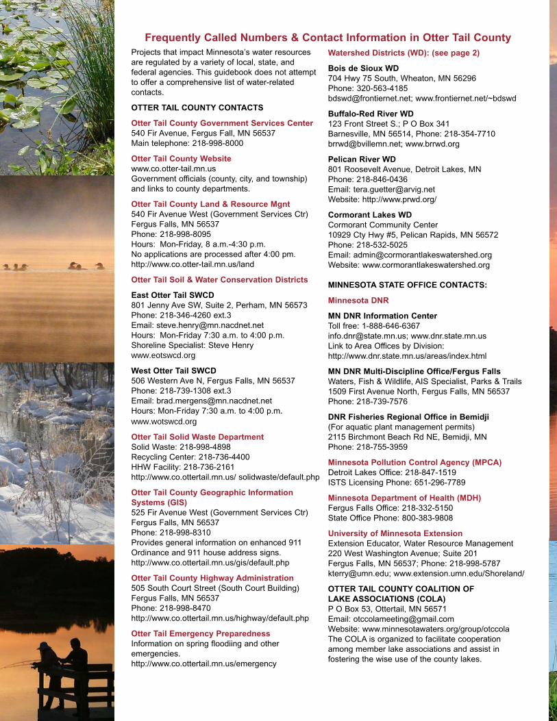
Projects that impact Minnesota’s water resourcesare regulated by a variety of local, state, and federal agencies. This guidebook does not attemptto offer a comprehensive list of water-related contacts.
OTTER TAIL COUNTY CONTACTS
Otter Tail County Government Services Center540 Fir Avenue, Fergus Fall, MN 56537Main telephone: 218-998-8000
Otter Tail County Websitewww.co.otter-tail.mn.usGovernment officials (county, city, and township)and links to county departments.
Otter Tail County Land & Resource Mgnt540 Fir Avenue West (Government Services Ctr)Fergus Falls, MN 56537Phone: 218-998-8095Hours: Mon-Friday, 8 a.m.-4:30 p.m. No applications are processed after 4:00 pm.http://www.co.otter-tail.mn.us/land
Otter Tail Soil & Water Conservation Districts
East Otter Tail SWCD801 Jenny Ave SW, Suite 2, Perham, MN 56573Phone: 218-346-4260 ext.3Email: [email protected]: Mon-Friday 7:30 a.m. to 4:00 p.m. Shoreline Specialist: Steve Henrywww.eotswcd.org
West Otter Tail SWCD506 Western Ave N, Fergus Falls, MN 56537Phone: 218-739-1308 ext.3Email: [email protected]: Mon-Friday 7:30 a.m. to 4:00 p.m.www.wotswcd.org
Otter Tail Solid Waste DepartmentSolid Waste: 218-998-4898Recycling Center: 218-736-4400HHW Facility: 218-736-2161http://www.co.ottertail.mn.us/ solidwaste/default.php
Otter Tail County Geographic InformationSystems (GIS)525 Fir Avenue West (Government Services Ctr)Fergus Falls, MN 56537Phone: 218-998-8310Provides general information on enhanced 911Ordinance and 911 house address signs.http://www.co.ottertail.mn.us/gis/default.php
Otter Tail County Highway Administration 505 South Court Street (South Court Building)Fergus Falls, MN 56537Phone: 218-998-8470http://www.co.ottertail.mn.us/highway/default.php
Otter Tail Emergency PreparednessInformation on spring floodiing and other emergencies.http://www.co.ottertail.mn.us/emergency
Watershed Districts (WD): (see page 2)
Bois de Sioux WD704 Hwy 75 South, Wheaton, MN 56296Phone: [email protected]; www.frontiernet.net/~bdswd
Buffalo-Red River WD123 Front Street S.; P O Box 341Barnesville, MN 56514, Phone: [email protected]; www.brrwd.org
Pelican River WD 801 Roosevelt Avenue, Detroit Lakes, MN Phone: 218-846-0436Email: [email protected]: http://www.prwd.org/
Cormorant Lakes WD Cormorant Community Center10929 Cty Hwy #5, Pelican Rapids, MN 56572Phone: 218-532-5025Email: [email protected]: www.cormorantlakeswatershed.org
MINNESOTA STATE OFFICE CONTACTS:
Minnesota DNR
MN DNR Information CenterToll free: [email protected]; www.dnr.state.mn.usLink to Area Offices by Division: http://www.dnr.state.mn.us/areas/index.html
MN DNR Multi-Discipline Office/Fergus FallsWaters, Fish & Wildlife, AIS Specialist, Parks & Trails1509 First Avenue North, Fergus Falls, MN 56537Phone: 218-739-7576
DNR Fisheries Regional Office in Bemidji(For aquatic plant management permits)2115 Birchmont Beach Rd NE, Bemidji, MN Phone: 218-755-3959
Minnesota Pollution Control Agency (MPCA)Detroit Lakes Office: 218-847-1519ISTS Licensing Phone: 651-296-7789
Minnesota Department of Health (MDH)Fergus Falls Office: 218-332-5150State Office Phone: 800-383-9808
University of Minnesota ExtensionExtension Educator, Water Resource Management220 West Washington Avenue; Suite 201Fergus Falls, MN 56537; Phone: [email protected]; www.extension.umn.edu/Shoreland/
OTTER TAIL COUNTY COALITION OF LAKE ASSOCIATIONS (COLA)P O Box 53, Ottertail, MN 56571Email: [email protected]: www.minnesotawaters.org/group/otccolaThe COLA is organized to facilitate cooperationamong member lake associations and assist in fostering the wise use of the county lakes.
Frequently Called Numbers & Contact Information in Otter Tail County