Embed Size (px)
Citation preview
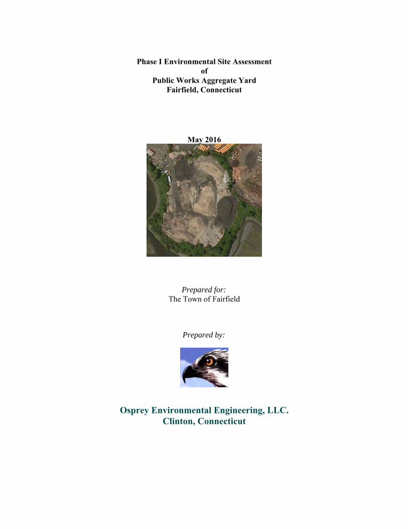
Phase I Environmental Site Assessment
ofPublic Works Aggregate Yard
Fairfield, Connecticut
May 2016
Prepared for:
The Town of Fairfield
Prepared by:
Osprey Environmental Engineering, LLC.Clinton, Connecticut
SIGNATURES OF REPORT AUTHORS
The person whose signature appears below prepared this report. Requests for information on thecontent of this document should be directed to this individual.
Robert Grabarek, P.E., L.S., LEPPresident
TABLE OF CONTENTSSection Page
EXECUTIVE SUMMARY...............................................................................................1
1.0 INTRODUCTION..............................................................................................................21.1 Purpose of Study1.2 Parcel Location and Ownership1.3 Date of Study1.4 Scope of Work1.5 Summary of Previous Environmental Site Assessments
2.0 CURRENT SITE AND AREA CHARACTERISTICS..................................................32.1 Site Description and Operations2.2 Utilities2.3 Building Toxins2.4 Underground/Aboveground Storage Tanks2.5 Geology/Hydrogeology2.6 Ground Water and Surface Water Quality Classifications2.7 Wetlands/Natural Diversity Data Base2.8 Site Reconnaissance2 9. Area Reconnaissance
3.0 SITE AND AREA HISTORY...........................................................................................43.1 Historical Ownership and Street Files3.2 Pertinent File Review/Research3.3 Aerial Photographs, Street Directories, and Sanborn Maps Review
4.0 SITE REGULATORY INFORMATION........................................................................84.1 Pertinent File Review/Research4.2 Results of Regulatory Review
5.0 AREA REGULATORY INFORMATION......................................................................85.1 Pertinent File Review/Research5.2 Results of Regulatory Review5.3 Underground Storage Tanks/Oil and Chemical Spill Incidents
6.0 CONCLUSIONS AND RECOMMENDATIONS...........................................................97.0 REFERENCES.................................................................................................................108.0 LIMITATIONS................................................................................................................10
FIGURESFigure 1 Site Location MapFigure 2 Site Plan
APPENDICESAppendix A Site and Area PhotographsAppendix B File Information and Database Search Report
EXECUTIVE SUMMARY
Osprey Environmental Engineering, LLC. (Osprey) has completed a Phase I Environmental Site Assessment (ESA) for the parcel known as the Public Works Aggregate Yard, which is a part of the larger Fairfield Department of Public Works site, located at 183 Richard White Way in Fairfield, Connecticut. This assessment consisted of a site inspection, file searches of local and state records, an EDR Radius Map Database Search review of state and federal databases, a review of aerial photographs and other historic sources, and interviews with the subject parcel site contacts, Mr. ScottBartlett, Superintendent, Department of Public Works - Operations, and Mr. Ron Manning, former Superintendent of Public Works Operations from June of 1977 through April of 2014. The Public Works Aggregate Yard, referred to in this report as “the parcel” is the 5.54 acre central southern portion of the site that contains stockpiles of recyclable fill material. The 124-acre site containing the parcel also contains the DPW facility, composting facility, former landfill, and bus storage yard, and is referred to as the “site”. The site is situated along Richard White Way.
At the time the research was conducted, the findings of the Phase I Environmental Site Assessment were as follows: The parcel was supplied with a public utility electricity connection. There was no evidence of existing underground or aboveground fuel storage tanks on the subject
parcel. No significant staining of the ground or other visible signs of contamination were present during
the time of the inspection. Floor drains were not present in the trailer. Surface runoff from the outside waste sorting areas on the southerly portion of the parcel drained
to a water quality treatment pond. Overflow from this pond was directed to the sanitary sewer. Documentation reviewed did not indicate that hazardous wastes had been generated on-site. The
site did not appear to meet the definition of an “Establishment” under the Transfer Act as activities listed in the qualifying criteria were present. No outstanding orders or notice of violations pertaining to the subject parcel were identified during a review of municipal, state, or federal records.
The parcel was located in a municipal public works area surrounded by a larger residential area. No documentation reviewed under the scope of the Phase I ESA indicated that any area propertieshad potentially impacted the environmental quality of the parcel.
Asbestos containing building materials were not a concern as no permanent buildings were present on the parcel.
The subject parcel had MSW, possibly as deep as 20', buried in an excavation and then covered with soil, concrete, and asphalt that was intended to be recycled. This base was added to over theyears with soil, concrete, and asphalt from DPW projects over the ensuing years. The existing stockpile was gradually being reduced as it was mixed with clean fill for off-site reuse.
Significant data gaps were present in the research of this parcel under the industry standard scope for a Phase I site assessment and included:
Information regarding the composition and depth of the base municipal solid waste layer was not available other than the general type and estimated depth.
Information regarding the composition and depth of the layer of fill material above the MSW was not available other than it was referenced as being DPW project fill.
Phase I Environmental Site Assessment 1 Town of Fairfield Department of Public WorksPublic Works Aggregate Yard, Fairfield, CT Osprey Environmental Engineering
1.0 INTRODUCTION
1.1 Purpose of StudyThe purpose of this Phase I Environmental Site Assessment (ESA) was to evaluate the potential ofon-site contamination due to spills of oils or hazardous materials or wastes resulting from past andpresent parcel operations, land use activities, or from off site activities, as well as to identify otheradverse environmental conditions present on-site.
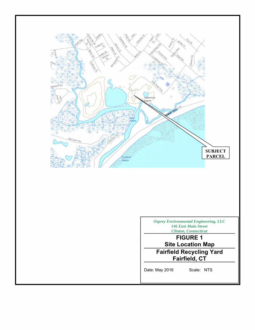
1.2 Parcel Location and OwnershipThe parcel was identified as the Public Works Aggregate Yard and was located at 183 RichardWhite Way in Fairfield, Connecticut. Town of Fairfield Tax Assessor’s files identify the parcel as183/153. The parcel was located along the southwestern side of Richard White Way. According tothe Town of Fairfield Tax Assessors records, the Town of Fairfield owned the parcel at the timethe research was conducted. Refer to Figure 1 for the parcel Location Map.
1.3 Date of StudyAuthorization to proceed on this project was provided by the Fairfield Department of Public Worksin accordance with an Osprey proposal. The site inspection was conducted on 13 May 2016.
1.4 Scope of WorkThe following scope of work was performed in accordance with standard Osprey Environmental Engineering, LLC. (Osprey) due diligence Phase I ESA protocols and provides conclusions relative to the potential release of oils or hazardous materials on-site, the environmental liabilities associated with the parcel, and any other adverse environmental conditions that may be present. Historical aerial photographs (dated 1934, 1949, 1951, 1960, 1969, 1971, 1979, 1985, 1990,
1991, 1995, 2005, 2006, 2008, 2010, and 2012) and available Fairfield topographic maps were reviewed to evaluate previous parcel and area activities and occupants. Sanborn Fire Insurance maps were reviewed to evaluate previous parcel and surrounding area activities anduses. Town of Fairfield Tax Assessor and Clerk files were reviewed to trace ownership history.
Pertinent Federal, State of Connecticut, and municipal records were reviewed for current and historical regulatory information concerning the subject parcel and nearby properties.
A site inspection was conducted to view surface conditions for indications of spills of oils or hazardous materials, and other adverse environmental impacts. Osprey made limited observations of area properties. Conditions observed at the time of inspection have been recorded through photographic documentation. Copies of photographs taken at the time of inspection are appended.
Local officials and other knowledgeable persons that could be contacted were interviewed regarding on-site operations, land use, and historic incidents that may have adverse environmental impacts. An EDR Radius Map data base search of State and Federal records was conducted in accordance with Phase I ESA ASTM radius standards. A copy of the EDR report is appended.
The scope of work completed for this assessment did not include the sampling and chemical testingof soil or groundwater, potential polychlorinated biphenyl (PCB) containing fluids, potential lead-based paint, or potential asbestos-containing building materials. The scope of work did address conditions of the on-site buildings, if any, with respect to sumps, floor drains, hazardous
Phase I Environmental Site Assessment 2 Town of Fairfield Department of Public WorksPublic Works Aggregate Yard, Fairfield, CT Osprey Environmental Engineering
materials/waste storage areas, and other potential pathways to the environment according to the limitations outlined in this report.
1.5 Summary of Previous Environmental Site AssessmentsNo previous environmental reports were available for review.
2.0 CURRENT SITE AND AREA CHARACTERISTICSThe site inspection conducted by Osprey included visual observations of the site and limited observations of surrounding areas. The inspection n included observations of the presence/absence of surficial expressions of potential hazardous and regulated waste impacts to the parcel, such as spills, staining, dumping, stressed or dead vegetation, areas of subsidence, points of discharge, any visual evidence of disturbance to the ground surface, features associated with underground storage tanks, and other potential environmental impacts.
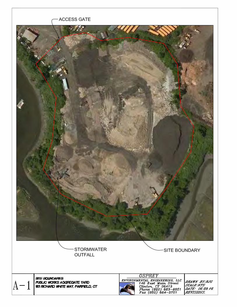
2.1 Site Description and OperationsThe parcel was located on Richard White Way. The parcel was identified as the Public Works Aggregate Yard and was 5.54 acres in area. It was developed as a recycling yard for fill materials. A temporary trailer was present that served as an office. Site features included: A storage pile containing soil, concrete materials (catch basin tops, etc.), and asphalt
materials. A crushing and screening area to process larger sized materials including concrete and asphalt
into smaller effective size aggregate materials. Several large stockpiles of fill material to be shipped off-site.
The rest of the parcel contained dirt travel areas and vegetated borders. The overall site was developed with Department of Public Works buildings to the northwest, a school bus storage lot to the north-northeast, a waste recycling area to the north, a pond to the west, a composting lot to the east, and salt marshes to the south and southeast.
2.2 Utilities The parcel was supplied with public utility electric service. Portable toilet facilities were available on site. The office trailer heated with electricity.
2.3 Building ToxinsBuilding toxins were not a consideration in this report since no permanent buildings were located on the parcel.
2.4 Underground/Aboveground Storage TanksFiles did not indicate the presence of existing underground or aboveground storage tanks at the parcel, nor were there visible signs of any.
2.5 Geology/HydrogeologyThe parcel was elevated above the surrounding terrain and sloped down in all directions. The site elevation varied from sea level to approximately 50 feet above the surrounding area. The DEEP Drainage Basin Map indicates the parcel was in Basin 7000-09. Surficial material consisted of artificial fill. Groundwater flow was most likely toward the salt marshes and ponds along the borders of the site.
Phase I Environmental Site Assessment 3 Town of Fairfield Department of Public WorksPublic Works Aggregate Yard, Fairfield, CT Osprey Environmental Engineering
2.6 Groundwater and Surface Water Quality ClassificationsThe Water Quality Classifications Map of Connecticut (2011) indicates the parcel was located within a GB groundwater classified area. This classification is for groundwater that is presumed to be unsuitable for potable uses without treatment. Surface water in the watercourse running adjacent to the parcel was classified as being of SA quality, indicating it is suitable as a habitat for marine fish, other aquatic life and wildlife; shellfish harvesting for direct human consumption; recreation; industrial water supply; and navigation. The parcel was not within an aquifer protectionarea.
2.7 Hydrology/Wetlands/ Natural Diversity Data BaseWetlands were not present on the parcel but tidal wetlands directly abutted it to the south and east. The parcel was partially within an identified Natural Diversity Database area, withing a hurricane Category 4 surge zone, and within the “coastal boundary”. It was not in a flood zone.
2.8 Site ReconnaissanceRobert Grabarek of Osprey, visited the parcel on 13 May 2016. Visual observations of the parcel were made during the parcel and area reconnaissance and are discussed below. At the time of the inspection, the parcel was developed with an office trailer, crushing and transport machinery, a central stockpile and an associated drive that looped through the parcel providing access to the office trailer and other smaller stockpiles.
The grounds appeared to have no significant staining present. No staining or stressed vegetation was observed in the vegetated areas or along the watercourse/pond. No pits, lagoons, chemical storage tanks/drums, or other staining/deposits of non-soil materials were noted during the inspection other than those noted in this report.
2.9 Area ReconnaissanceA limited visual reconnaissance of the surrounding area revealed that the parcel is located in a larger municipal property surrounded by a residential area. Abutting properties observed at the time of inspection included: Pine Creek and salt marshes to the south A pond to the west A composting facility to the east A school bus lot to the north The town Department of Public Works facility to the northwest
No visual evidence of environmental areas of concern was identified on adjacent sites other than the closed landfill.
3.0 SITE AND AREA HISTORYThe offices of the Town of Fairfield visited to review documentation included: the Tax Assessor, Town Clerk, Fire Department, Planning & Zoning Department, Department of Public Works Building Inspection Division, and Conservation.
3.1 Historical Ownership and Street FilesOn May 6th, 1955 the United States Army was granted a judgment for a Declaration of Taking that allowed them to buy ten properties that now make up the parcel, the pond, the old landfill, the
Phase I Environmental Site Assessment 4 Town of Fairfield Department of Public WorksPublic Works Aggregate Yard, Fairfield, CT Osprey Environmental Engineering
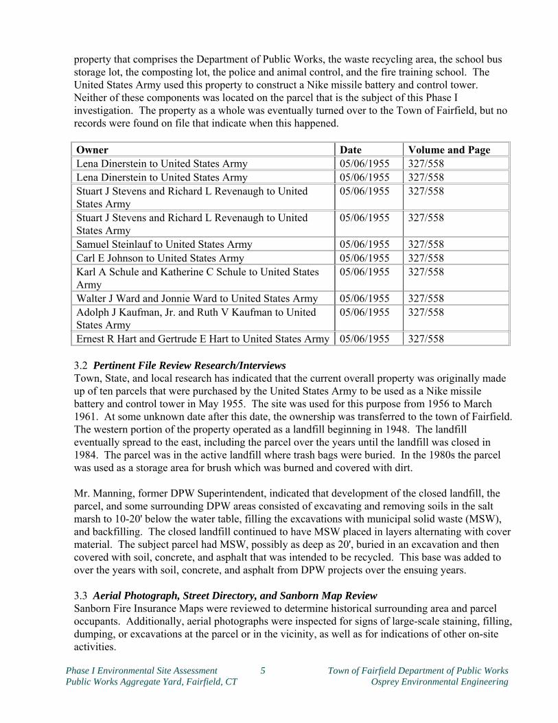
property that comprises the Department of Public Works, the waste recycling area, the school bus storage lot, the composting lot, the police and animal control, and the fire training school. The United States Army used this property to construct a Nike missile battery and control tower. Neither of these components was located on the parcel that is the subject of this Phase I investigation. The property as a whole was eventually turned over to the Town of Fairfield, but no records were found on file that indicate when this happened.
Owner Date Volume and PageLena Dinerstein to United States Army 05/06/1955 327/558Lena Dinerstein to United States Army 05/06/1955 327/558Stuart J Stevens and Richard L Revenaugh to United States Army
05/06/1955 327/558
Stuart J Stevens and Richard L Revenaugh to United States Army
05/06/1955 327/558
Samuel Steinlauf to United States Army 05/06/1955 327/558Carl E Johnson to United States Army 05/06/1955 327/558Karl A Schule and Katherine C Schule to United States Army
05/06/1955 327/558
Walter J Ward and Jonnie Ward to United States Army 05/06/1955 327/558Adolph J Kaufman, Jr. and Ruth V Kaufman to United States Army
05/06/1955 327/558
Ernest R Hart and Gertrude E Hart to United States Army 05/06/1955 327/558
3.2 Pertinent File Review Research/InterviewsTown, State, and local research has indicated that the current overall property was originally made up of ten parcels that were purchased by the United States Army to be used as a Nike missile battery and control tower in May 1955. The site was used for this purpose from 1956 to March 1961. At some unknown date after this date, the ownership was transferred to the town of Fairfield.The western portion of the property operated as a landfill beginning in 1948. The landfill eventually spread to the east, including the parcel over the years until the landfill was closed in 1984. The parcel was in the active landfill where trash bags were buried. In the 1980s the parcel was used as a storage area for brush which was burned and covered with dirt.
Mr. Manning, former DPW Superintendent, indicated that development of the closed landfill, the parcel, and some surrounding DPW areas consisted of excavating and removing soils in the salt marsh to 10-20' below the water table, filling the excavations with municipal solid waste (MSW), and backfilling. The closed landfill continued to have MSW placed in layers alternating with covermaterial. The subject parcel had MSW, possibly as deep as 20', buried in an excavation and then covered with soil, concrete, and asphalt that was intended to be recycled. This base was added to over the years with soil, concrete, and asphalt from DPW projects over the ensuing years.
3.3 Aerial Photograph, Street Directory, and Sanborn Map ReviewSanborn Fire Insurance Maps were reviewed to determine historical surrounding area and parcel occupants. Additionally, aerial photographs were inspected for signs of large-scale staining, filling,dumping, or excavations at the parcel or in the vicinity, as well as for indications of other on-site activities.
Phase I Environmental Site Assessment 5 Town of Fairfield Department of Public WorksPublic Works Aggregate Yard, Fairfield, CT Osprey Environmental Engineering
Sanborn MapsSanborn maps were not available for review.
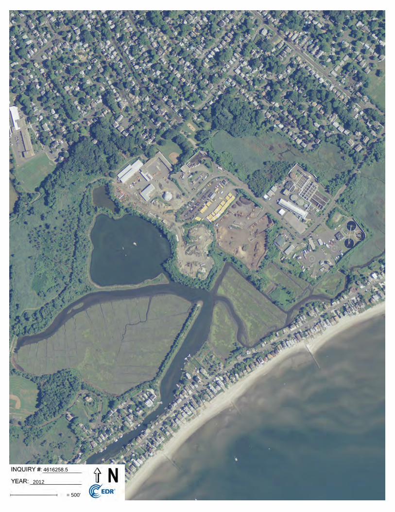
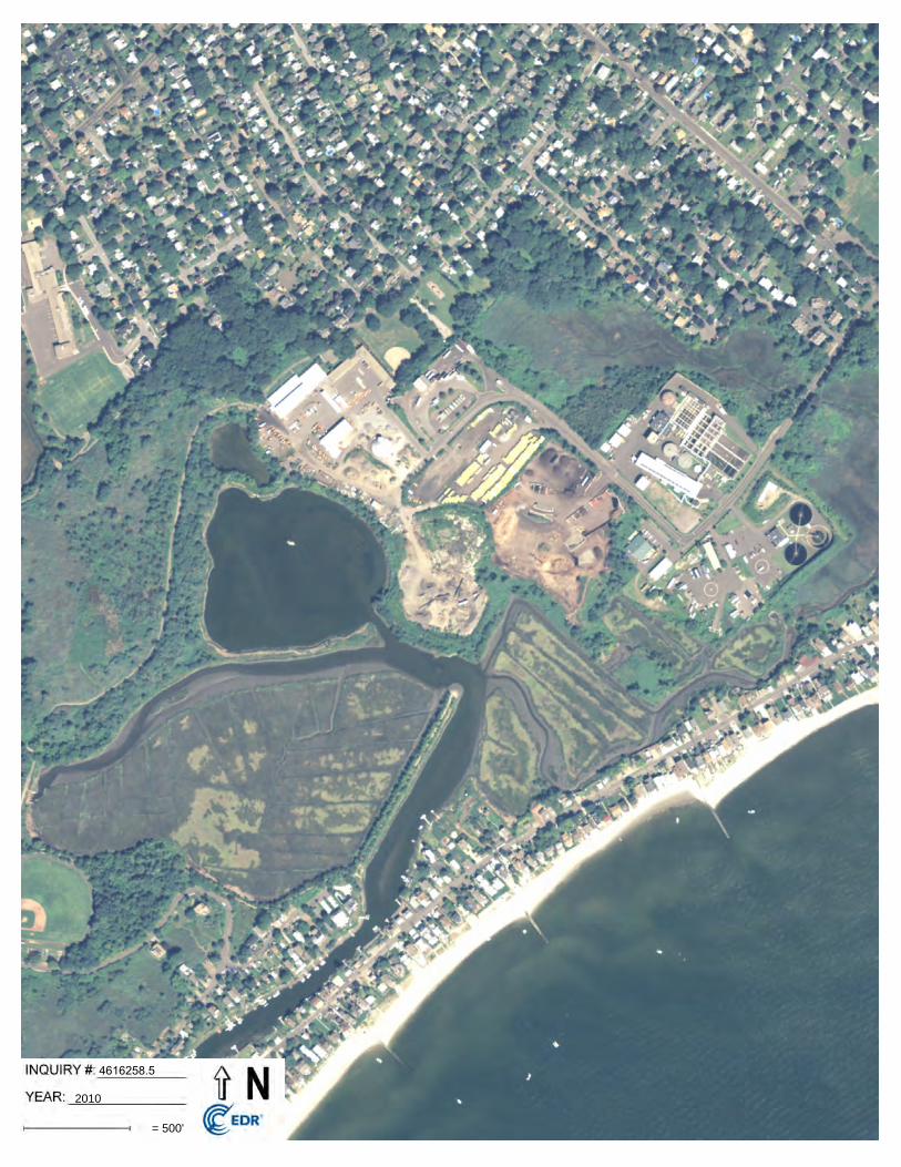
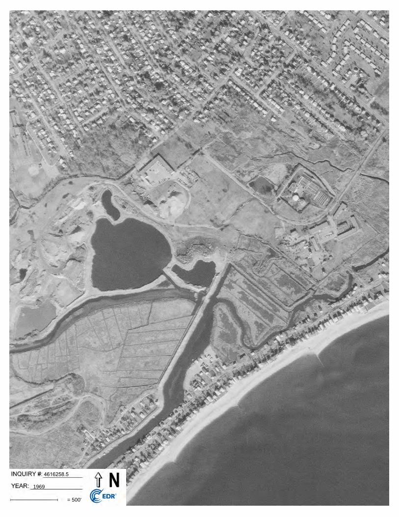
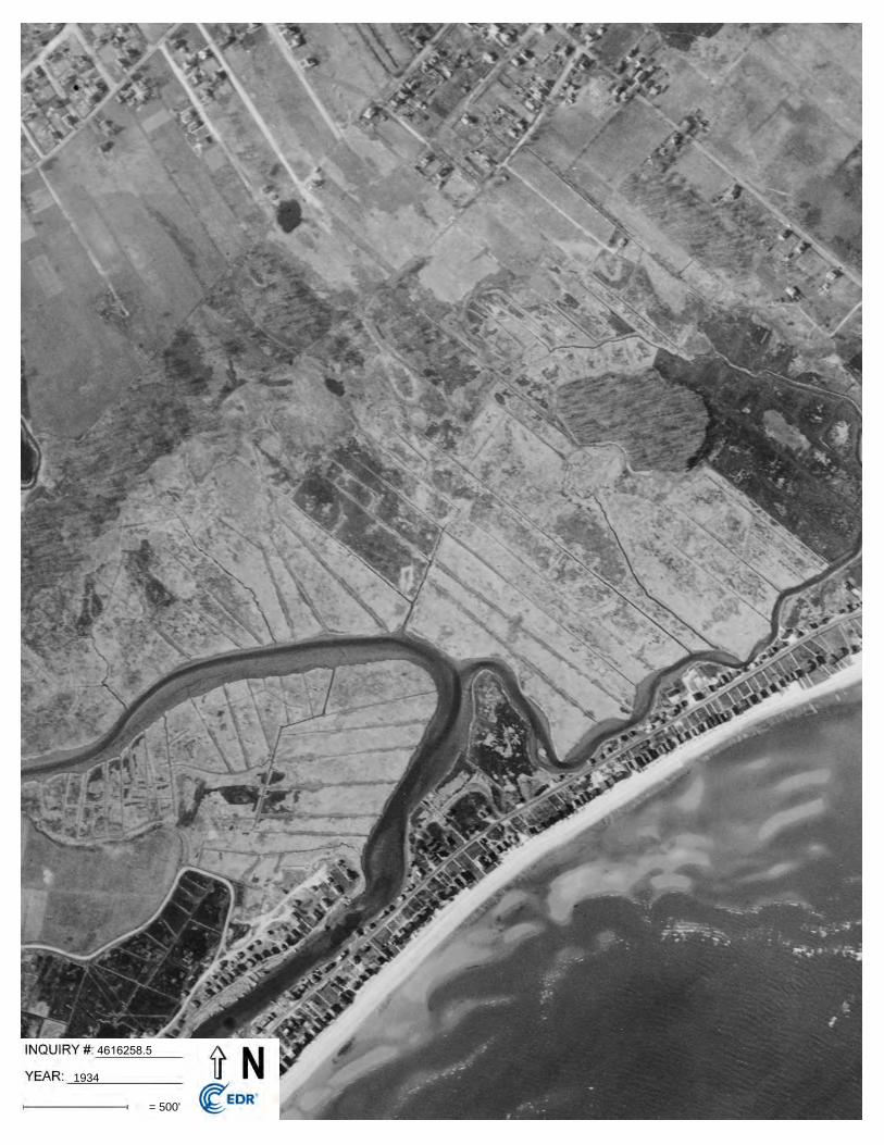
Aerial PhotographsAerial photographs from the years 1934, 1949, 1951, 1960, 1969, 1971, 1979, 1985, 1990, 1991, 1995, 2005, 2006, 2008, 2010, and 2012 were reviewed. Aerial photograph observations are discussed below. In the 1934 photograph the whole site was vacant land. The pond that is currently to the west of
the parcel was not present. Richard White Way was also not present. Reef Road and the beginnings of Longdean Road and Veres Street were present to the east and north. Buildings were present sparsely along Reef Road and Veres Street. A lone building was present at the southern point of Longdean Road. Pine Creek and Fairfield Beach Road were present to the south of the parcel. Old Dam Road E and Old Dam Road were present to the southeast. Houses were present on all the roads to the south and southeast.
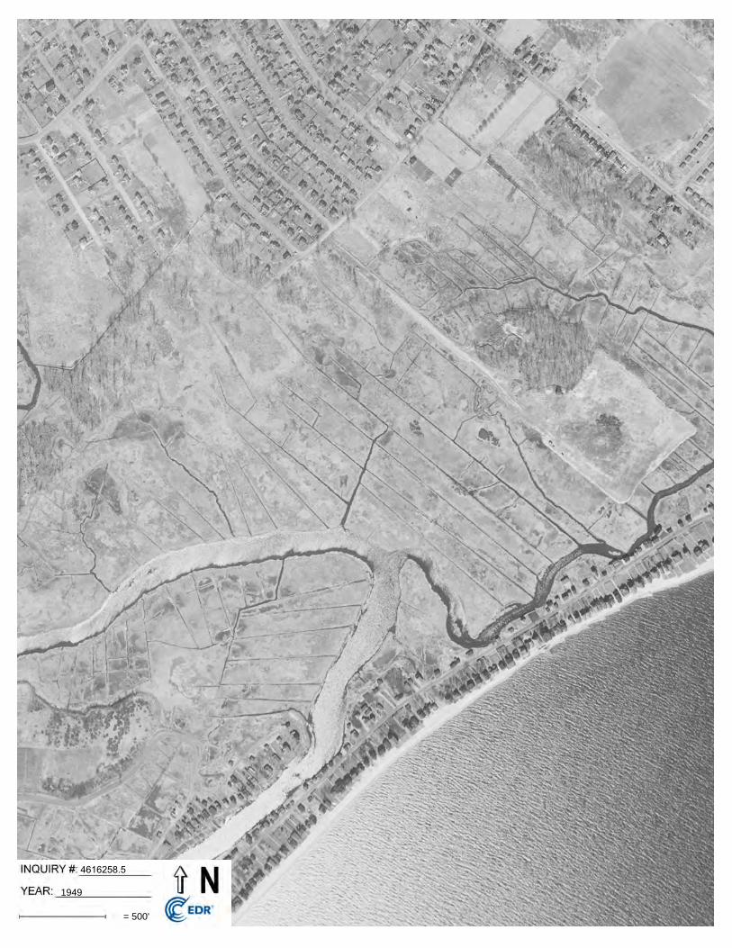
In the 1949 photograph Veres Street had been paved further west to its current length. The parcel remained vacant. A road stretching from Veres Street situated between Alden Street and James Street has been constructed that runs along the southwestern length of Richard White Way to where the sewage treatment plant is currently located. A long square area of land had been cleared that is roughly the same size and shape of the sewage treatment plant property. A residential structure sized building was located on this patch on the northeastern border. The streets to the north had been further developed with more residences. The house at the end of Longdean Road had been demolished leaving vacant land. Reef Road had been developed with more buildings as well. Oldfield Drive and Mona Terrace had been constructed and built up withresidential type buildings.
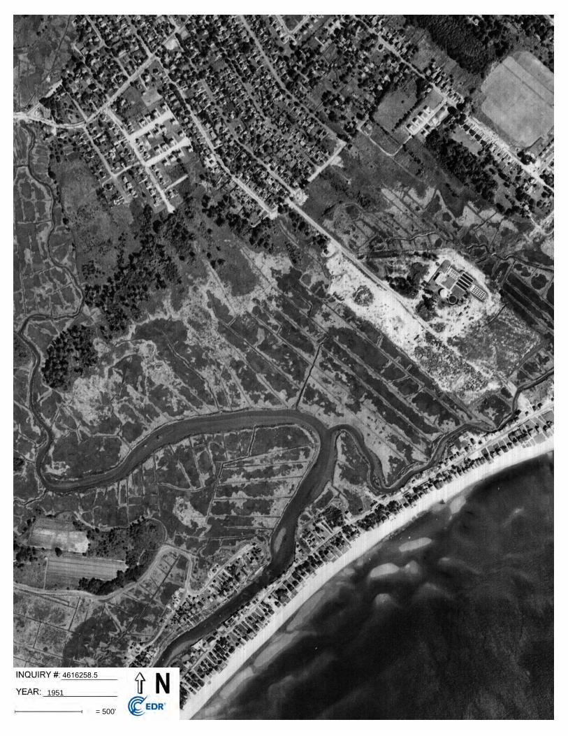
In the 1951 photograph the parcel was still vacant land. The cleared square patch that had been developed with what is currently the sewage treatment plant and the building that had been on thenorthwestern border was gone. A long rectangular patch of land had been cleared on the opposite side of the road where the sewage treatment plant was located. The properties to the north, northeast, south, and southeast appeared to have remained unchanged. Oldfield Drive and Mona Terrace had been further developed with more residential type buildings.
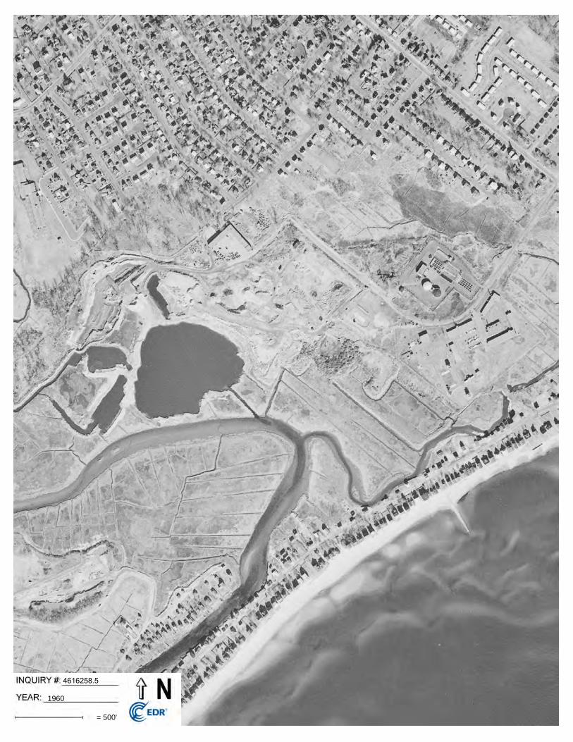
In the 1960 photograph the parcel had been cleared and appeared to be an open lot with dirt roadsleading through it and around the rest of the property. The pond that is currently located to the southwest was present. Landfill operations were present on the western portion of the property. Three large pits had been dug below the water table to the west and north of the large pond. The Department of Public Works (DPW) building was present on the northwestern portion of the property. The Nike Command Center had been constructed to the south-southeast of the sewage treatment plant. Richard White Way (One Rod Highway) was no longer connected to Veres Road. The road had been extended northeasterly to Reef Road as it currently is today. Forest Avenue had been constructed parallel to Reed Road and had been built up with residential type buildings. Longdean Road was partially present where it connects with Cummings Avenue. Residential type buildings had been constructed partway down Veres Road on the southern side. The properties to the south and southwest appeared to remain unchanged. Sullivan Place was present to the northwest and the senior center had been constructed.
In the 1969 photograph the southern portion of the parcel had been dug out below the water table creating a pond. The northern portion was used as a landfill area. The two ponds to the west of the large pond had been filled in with waste and covered over with fill material. The parking lot of the DPW building had been extended to the southeast of the building. The rest of the property
Phase I Environmental Site Assessment 6 Town of Fairfield Department of Public WorksPublic Works Aggregate Yard, Fairfield, CT Osprey Environmental Engineering
appeared to remain unchanged. Longdean Road had been extended further southeast and more residential type buildings had been constructed on both sides of the road. The surrounding properties to the north, northwest, south, and southeast appeared unchanged.
In the 1971 photograph the pit on the southern portion of the parcel had been filled in. The northern portion of the parcel had been covered over with fill. Directly to the east of the parcel a large rectangular hole had been dug. On the property to the southeast of the parcel earth materials were stored in two rectangular areas adjacent to Pine Creek. A new silo had been addedto the sewage treatment plant on the northwestern portion of the property. The remainder of the property appeared unchanged. Longdean Road was in the process of being extended further southeast and the surround land had been cleared and signs of buildings being constructed were present. The rest of the surrounding properties appeared unchanged.
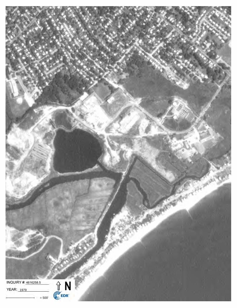
In the 1979 photograph the square pit to the east of the parcel had been filled in and covered over.The rectangular areas of earth materials were no longer present. Southeast of the DPW building, a building had been constructed where the current transfer station building is located. Residentialtype buildings had been constructed along the remainder of Longdean Road. The remainder of the property and surrounding properties appeared unchanged.
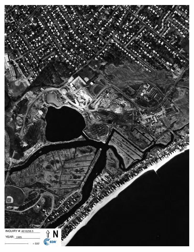
In the 1985 photograph rows of brush piles were present on the parcel. A baseball field had been created on the property to the southwest of the landfill and a road had been created connecting thefield with the landfill. The southern portion appeared to be covered over with the northern three quarters will in use. Piles of earthen materials appeared to be present in long rows to the west of the pond. The DPW building had been extended on the southeastern side with an addition. A baseball field had been constructed adjacent to the DPW building on the northeastern side. The main road through the property had been rerouted to where it currently remains. The land directly south of the DPW building was in the process of being excavated. The land to the north-northeast of the parcel was being used as an earthen materials storage lot. What is currently the bus parking lot had been cleared and was used as a car and bus lot. The remainder of the propertyand surrounding properties remained unchanged.
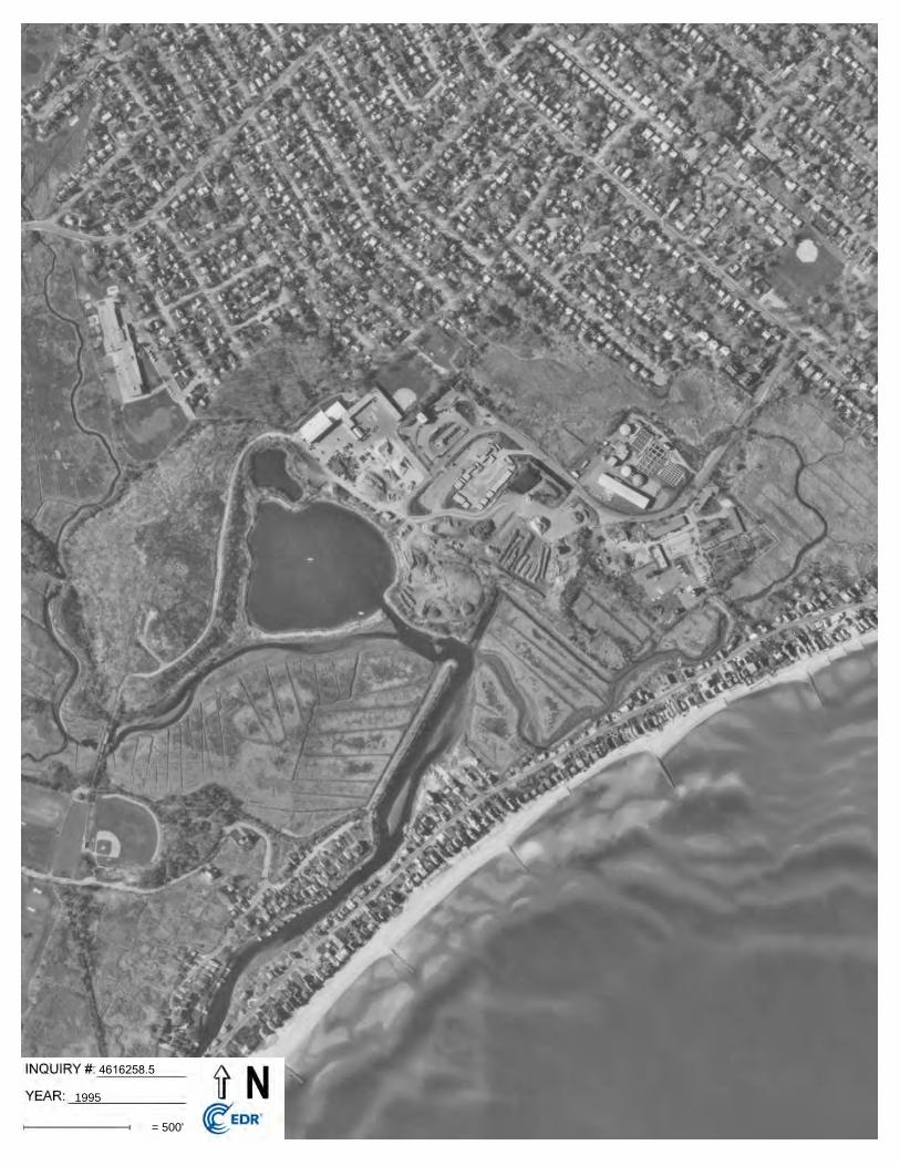
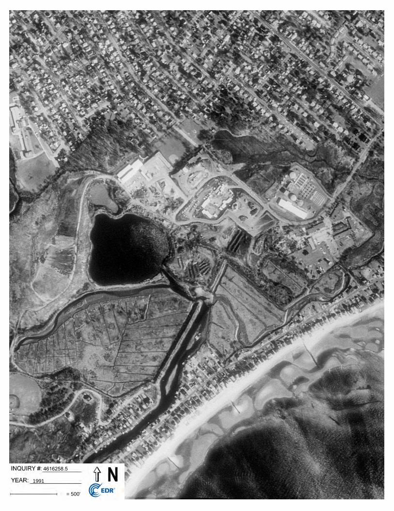
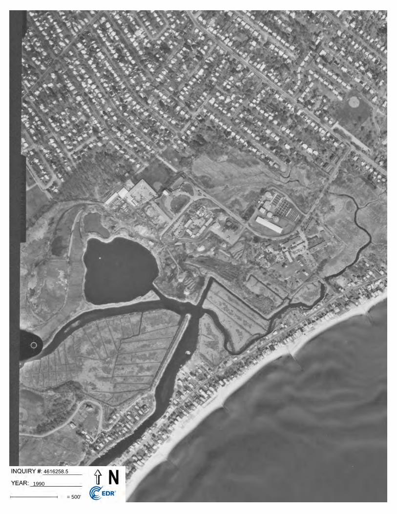
In the 1990 photograph the brush had been removed or covered over and the parcel appeared to contain piles of earthen materials. The landfill to the west had been covered over and appeared tobe out of use. An addition had been added to the DPW building. A long rectangular building had a smaller square building had been added to the sewage treatment plant complex. The remainder of the property and the surrounding properties appeared unchanged.
In the 1991 and 1995 photographs the addition on the DPW building had been enlarged. The parcel, remainder of the property, and the surrounding properties appeared unchanged.
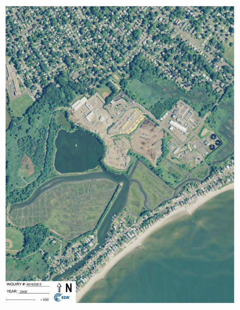
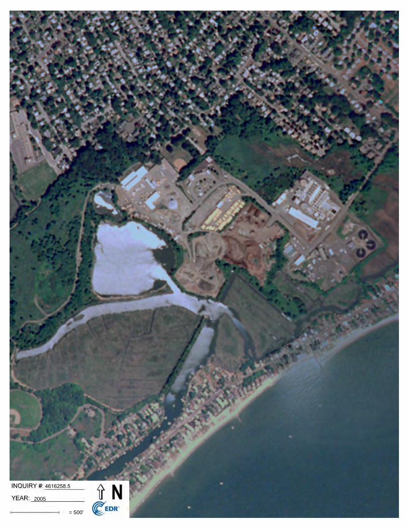
In the 2005 through 2012 photographs the parcel remained unchanged. A building had been constructed southeast of the DPW building and the salt/sand storage building had been constructed. The Nike Command Center complex had been demolished and the animal control and police buildings, fire training school, and the wastewater process tanks and building had beenconstructed. The remainder of the property and the surrounding properties appeared unchanged.
4.0 SITE REGULATORY INFORMATION
4.1 Pertinent File Review/ResearchOsprey reviewed municipal, state, and federal records for site permits, environmental violations, infractions, incidents, complaints and orders relating to the subject parcel. Osprey additionally performed a search of State and Federal databases for the parcel and surroundings through an EDR Radius Map Database Search (EDR), Phase I ESA ASTM radius database search. A copy of the
Phase I Environmental Site Assessment 7 Town of Fairfield Department of Public WorksPublic Works Aggregate Yard, Fairfield, CT Osprey Environmental Engineering
EDR data base search is provided in Appendix D. Additional sources of information reviewed for this assessment included:
CT DEP Water Quality Classifications Map; CT DEP Water and Waste Management Bureau public files; CT DEP Spill incident reports; and Town of Fairfield offices; Fire Marshal, DPW Building Inspection Division and Engineering
Division, Planning and Zoning Department, and Environmental Health Department
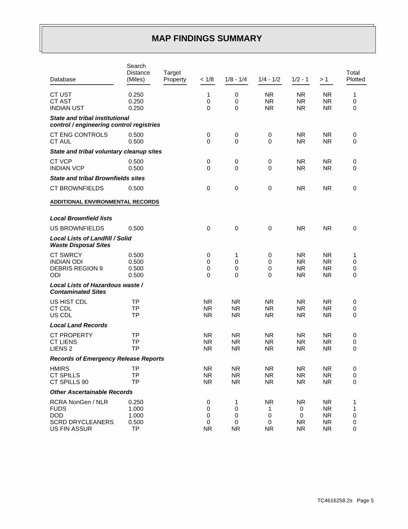
4.2 Results of Regulatory ReviewThe parcel was listed in UST, SWRCY, Spills, SEMS-Archive, LWDS, LUST, RCRA NonGen / NLR, RI Manifest, NJ Manifest, SHWS, SDADB, FUDS, SWF/LF, and CPCS databases. Review of documentation on file with the Fairfield Planning, Zoning, Inland Wetlands, Fire Marshall, Public Works, and Health Departments did not contain documentation related to environmental issues associated with the parcel.
5.0 AREA REGULATORY INFORMATION
5.1 Pertinent File Review/ResearchPertinent state and federal files, records, and lists mentioned in Section 4.1 of this report were reviewed for environmental infractions, incidents, complaints, and permits associated with the properties within the parcel vicinity. An EDR Radius Map Database Search data base report was prepared in accordance with Phase I ASTM radius standards. The EDR report is appended along with other pertinent records.
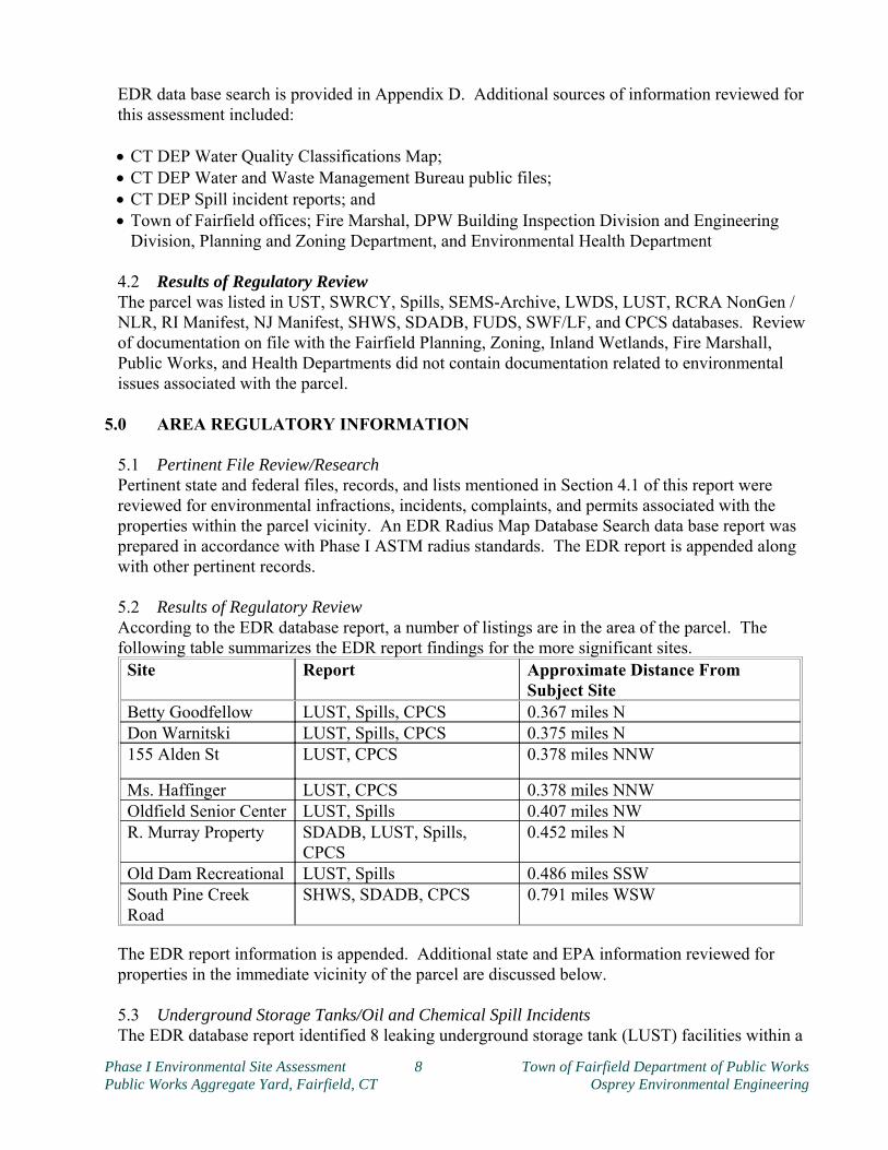
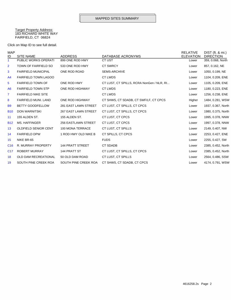
5.2 Results of Regulatory ReviewAccording to the EDR database report, a number of listings are in the area of the parcel. The following table summarizes the EDR report findings for the more significant sites.
Site Report Approximate Distance From Subject Site
Betty Goodfellow LUST, Spills, CPCS 0.367 miles NDon Warnitski LUST, Spills, CPCS 0.375 miles N155 Alden St LUST, CPCS 0.378 miles NNW
Ms. Haffinger LUST, CPCS 0.378 miles NNWOldfield Senior Center LUST, Spills 0.407 miles NWR. Murray Property SDADB, LUST, Spills,
CPCS0.452 miles N
Old Dam Recreational LUST, Spills 0.486 miles SSWSouth Pine Creek Road
SHWS, SDADB, CPCS 0.791 miles WSW
The EDR report information is appended. Additional state and EPA information reviewed for properties in the immediate vicinity of the parcel are discussed below. 5.3 Underground Storage Tanks/Oil and Chemical Spill IncidentsThe EDR database report identified 8 leaking underground storage tank (LUST) facilities within a
Phase I Environmental Site Assessment 8 Town of Fairfield Department of Public WorksPublic Works Aggregate Yard, Fairfield, CT Osprey Environmental Engineering
0.5 mile radius of the parcel. Documented/reported spills or releases of chemicals and/or petroleumproducts have occurred within a 1/2-mile radius of the parcel but a review of the search data does not indicate a high probability of area releases impacting the parcel.
6.0 CONCLUSIONS AND RECOMMENDATIONSThe Public Works Aggregate Yard parcel is a 5.54 acre parcel that contains stockpiles of fill material.At the time the research was conducted, the findings of the Phase I Environmental Site Assessment were as follows:
At the time the research was conducted, the findings of the Phase I Environmental Site Assessment were as follows:
The parcel was supplied with a public utility electricity connection. There was no evidence of existing underground or aboveground fuel storage tanks on the
subject parcel. No significant staining of the ground or other visible signs of contamination were present
during the time of the inspection. Floor drains were not present in the trailer. Surface runoff from the outside waste sorting areas on the southerly portion of the parcel
drained to a water quality treatment pond. Overflow from this pond was directed to the sanitary sewer.
Documentation reviewed did not indicate that hazardous wastes had been generated on-site. The site did not appear to meet the definition of an “Establishment” under the Transfer Act as activities listed in the qualifying criteria were present. No outstanding orders or notice of violations pertaining to the subject parcel were identified during a review of municipal, state, or federal records.
The parcel was located in a municipal public works area surrounded by a larger residential area. No documentation reviewed under the scope of the Phase I ESA indicated that any surrounding area properties had potentially impacted the environmental quality of the parcel.
Asbestos containing building materials were not a concern as no permanent buildings were present on the parcel.
The subject parcel had MSW, possibly as deep as 20', buried in an excavation and then covered with soil, concrete, and asphalt that was intended to be recycled. This base was added to over the years with soil, concrete, and asphalt from DPW projects over the ensuing years. The existing stockpile was gradually being reduced as it was mixed with clean fill for off-site reuse.
Significant data gaps were present in the research of this parcel under the industry standard scope for a Phase I site assessment and included: Information regarding the composition and depth of the base municipal solid waste layer was notavailable other than the general type and estimated depth. Information regarding the composition and depth of the layer of fill material above the MSW wasnot available other than it was referenced as being DPW project fill.
7.0 REFERENCESConnecticut DEEP, Water Compliance Unit, "Water Quality Classifications for the Connecticut River and South Central Coastal Basin," February 1993.Lundgren, Lawrence and Thurrell, Robert, State Geological and Natural History Survey of Connecticut, "The Bedrock Geology of the Fairfield Quadrangle," 1973.Stone, et al, "Surficial Geologic Map of Connecticut," 1992.
Phase I Environmental Site Assessment 9 Town of Fairfield Department of Public WorksPublic Works Aggregate Yard, Fairfield, CT Osprey Environmental Engineering
U.S. Geological Survey, Topographic Maps of the Fairfield Quadrangle 1961 (rev. 1984).EDR Radius Map Database Search Data Base Report, November 30, 1999 State and Federal Databases and Sources:NPL: National Priorities List, October 1999SPL: State Priorities List, August 1999CORRACTS: Corrective Actions, September 1999CERCLIS: Comprehensive Environmental Response, Compensation, and Liability Information System, August 1999RCRA TSD: Resource Conservation and Recovery Information System-Treatment, Storage, and Disposal Facilities, September 1999RCRA Generator: Resources Conservation and Recovery Information System-Large and Small Quantity Generators, September 1999ERNS: Emergency Response Notification System, August 1999SCL: State Cleanup Sites, August 1999SWLF:Connecticut Solid Waste Facilities Report, January 1994/February 1999LUST: Connecticut Leaking Underground Storage Tank List, June 1999UST: Connecticut Underground Storage Tank List, September 1999
AgenciesConnecticut DEEP, Water Compliance Unit, public files.Connecticut DEEP, Hazardous Waste Management Unit, public files.Connecticut DEEP, Oil and Chemicals Spills Unit, public files.Connecticut State Library Archives, Aerial Photographs. (1934 and 1951)Connecticut DEEP, Aerial Photographs (1965, 1970, 1975, 1980, 1986, 1990, and 1995)Connecticut State Library, Sanborn Fire Insurance Maps, and Street Directories.Town of Fairfield Offices: Assessor, Clerk, Planning and Zoning, Building, Department of Public Works, Engineering, Environmental Health, Fire Marshall
8.0 LIMITATIONS
This report was completed by Osprey Environmental Engineering, LLC. (Osprey) for the sole use of the client listed on the cover of this report, and their lenders, attorneys, and clients in connection withan assessment of on-site environmental conditions. Use of the report by any other person for any other purpose is not authorized except with the prior written consent of Osprey.
The work was undertaken to assess environmental conditions specifically on the subject parcel in accordance with generally accepted engineering and hydrogeologic practices. No other warranty, express or implied, is made. Absolute assurance that any and all possible contamination at the site was identified cannot be provided. The report conclusions are based, in part, on information provided by the client, their agents, or third parties, including State or local officials. Osprey assumes no responsibility for the accuracy and completeness of this information. Where visual observations are included in the report, they represent conditions at the time of the inspection, and may not be indicative of past or future site conditions.
Phase I Environmental Site Assessment 10 Town of Fairfield Department of Public WorksPublic Works Aggregate Yard, Fairfield, CT Osprey Environmental Engineering
Osprey Environmental Engineering, LLC146 East Main StreetClinton, Connecticut
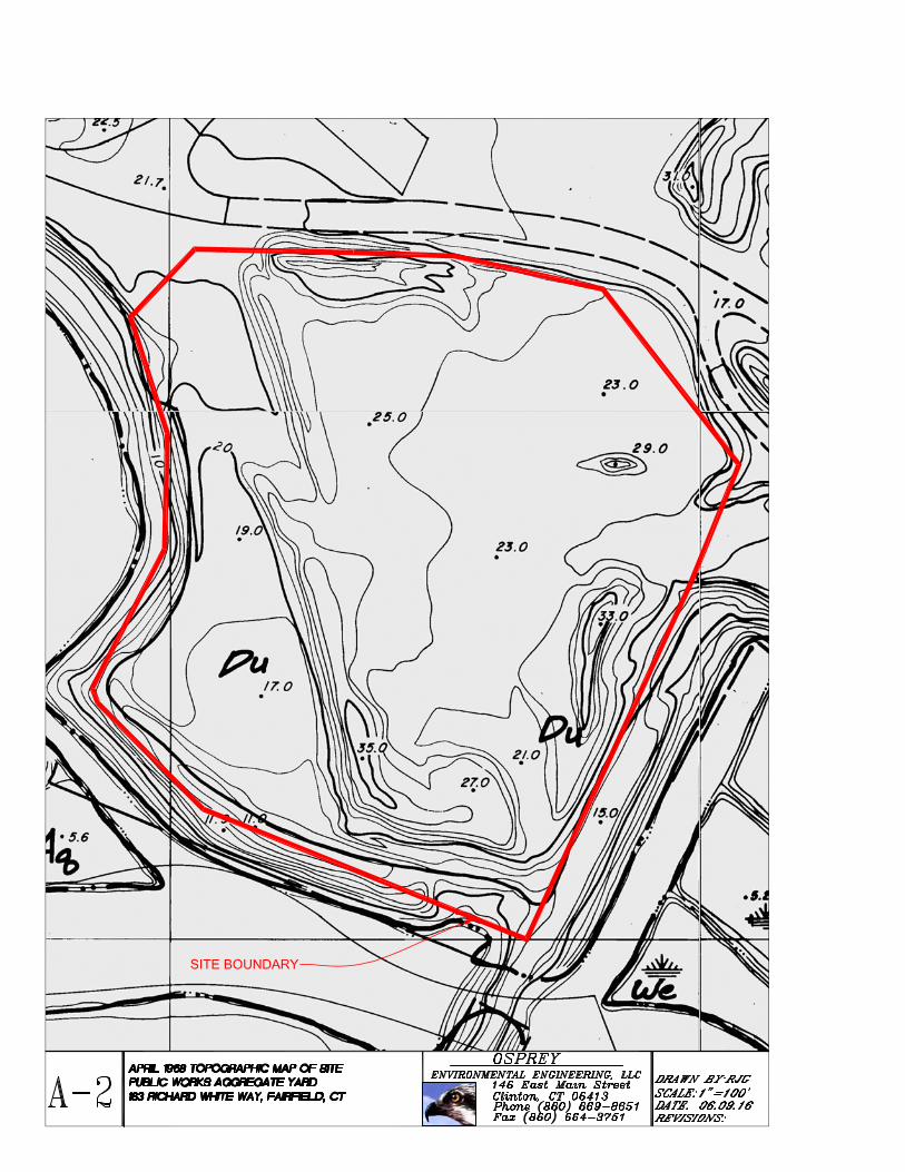
FIGURE 1Site Location Map
Fairfield Recycling YardFairfield, CT
Date: May 2016 Scale: NTS
SUBJECT PARCEL
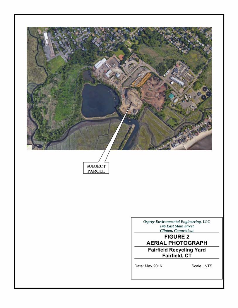
Osprey Environmental Engineering, LLC146 East Main StreetClinton, Connecticut
FIGURE 2AERIAL PHOTOGRAPHFairfield Recycling Yard
Fairfield, CT
Date: May 2016 Scale: NTS
SUBJECT PARCEL
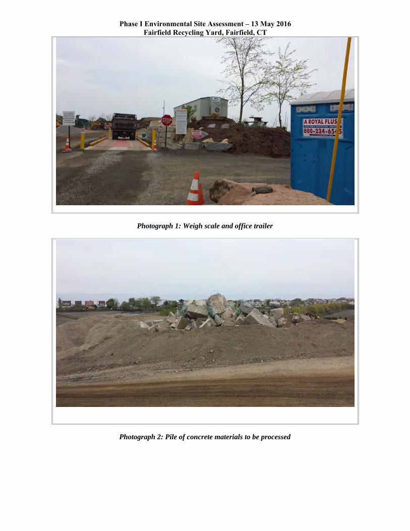
Phase I Environmental Site Assessment – 13 May 2016Fairfield Recycling Yard, Fairfield, CT
Photograph 1: Weigh scale and office trailer
Photograph 2: Pile of concrete materials to be processed
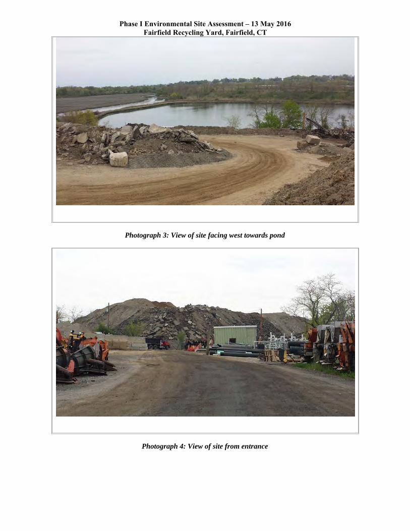
Phase I Environmental Site Assessment – 13 May 2016Fairfield Recycling Yard, Fairfield, CT
Photograph 3: View of site facing west towards pond
Photograph 4: View of site from entrance
Certified Sanborn® Map Report
Inquiry Number:
6 Armstrong Road, 4th floor Shelton, CT 06484Toll Free: 800.352.0050 www.edrnet.com
Fairfield Transfer Station
183 Richard White Way
Fairfield, CT 06824
May 11, 2016
4616258.3
Certified Sanborn® Map Report
Certified Sanborn Results:
Disclaimer - Copyright and Trademark Notice
EDR and its logos (including Sanborn and Sanborn Map) are trademarks of Environmental Data Resources, Inc. or its affiliates. All other trademarks used herein are the property of their respective owners.
page-
The Sanborn Library includes more than 1.2 millionfire insurance maps from Sanborn, Bromley, Perris &Browne, Hopkins, Barlow and others which trackhistorical property usage in approximately 12,000American cities and towns. Collections searched:
Library of Congress
University Publications of America
EDR Private Collection
The Sanborn Library LLC Since 1866™
Limited Permission To Make Copies
Sanborn® Library search results
Certification #
Contact:EDR Inquiry #
Site Name: Client Name:
PO #
Project
05/11/16
Fairfield Transfer Station Osprey Environmental183 Richard White Way 146 East Main StreetFairfield, CT 06824 Clinton, CT 06413
4616258.3 Robert Grabarek
The Sanborn Library has been searched by EDR and maps covering the target property location as provided by Osprey Environmental wereidentified for the years listed below. The Sanborn Library is the largest, most complete collection of fire insurance maps. The collectionincludes maps from Sanborn, Bromley, Perris & Browne, Hopkins, Barlow, and others. Only Environmental Data Resources Inc. (EDR) isauthorized to grant rights for commercial reproduction of maps by the Sanborn Library LLC, the copyright holder for the collection. Resultscan be authenticated by visiting www.edrnet.com/sanborn.
The Sanborn Library is continually enhanced with newly identified map archives. This report accesses all maps in the collection as of theday this report was generated.
3EDF-46CD-B236
NA
Town of Fairfield
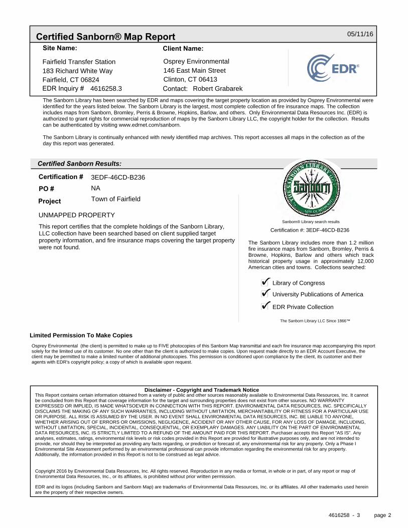
UNMAPPED PROPERTY
This report certifies that the complete holdings of the Sanborn Library,LLC collection have been searched based on client supplied targetproperty information, and fire insurance maps covering the target propertywere not found.
Certification #: 3EDF-46CD-B236
Osprey Environmental (the client) is permitted to make up to FIVE photocopies of this Sanborn Map transmittal and each fire insurance map accompanying this reportsolely for the limited use of its customer. No one other than the client is authorized to make copies. Upon request made directly to an EDR Account Executive, theclient may be permitted to make a limited number of additional photocopies. This permission is conditioned upon compliance by the client, its customer and theiragents with EDR's copyright policy; a copy of which is available upon request.
This Report contains certain information obtained from a variety of public and other sources reasonably available to Environmental Data Resources, Inc. It cannotbe concluded from this Report that coverage information for the target and surrounding properties does not exist from other sources. NO WARRANTYEXPRESSED OR IMPLIED, IS MADE WHATSOEVER IN CONNECTION WITH THIS REPORT. ENVIRONMENTAL DATA RESOURCES, INC. SPECIFICALLYDISCLAIMS THE MAKING OF ANY SUCH WARRANTIES, INCLUDING WITHOUT LIMITATION, MERCHANTABILITY OR FITNESS FOR A PARTICULAR USEOR PURPOSE. ALL RISK IS ASSUMED BY THE USER. IN NO EVENT SHALL ENVIRONMENTAL DATA RESOURCES, INC. BE LIABLE TO ANYONE,WHETHER ARISING OUT OF ERRORS OR OMISSIONS, NEGLIGENCE, ACCIDENT OR ANY OTHER CAUSE, FOR ANY LOSS OF DAMAGE, INCLUDING,WITHOUT LIMITATION, SPECIAL, INCIDENTAL, CONSEQUENTIAL, OR EXEMPLARY DAMAGES. ANY LIABILITY ON THE PART OF ENVIRONMENTALDATA RESOURCES, INC. IS STRICTLY LIMITED TO A REFUND OF THE AMOUNT PAID FOR THIS REPORT. Purchaser accepts this Report "AS IS". Anyanalyses, estimates, ratings, environmental risk levels or risk codes provided in this Report are provided for illustrative purposes only, and are not intended toprovide, nor should they be interpreted as providing any facts regarding, or prediction or forecast of, any environmental risk for any property. Only a Phase IEnvironmental Site Assessment performed by an environmental professional can provide information regarding the environmental risk for any property.Additionally, the information provided in this Report is not to be construed as legal advice.
Copyright 2016 by Environmental Data Resources, Inc. All rights reserved. Reproduction in any media or format, in whole or in part, of any report or map ofEnvironmental Data Resources, Inc., or its affiliates, is prohibited without prior written permission.
4616258 3 2
The EDR Aerial Photo Decade Package
Inquiry Number:
6 Armstrong Road, 4th floor Shelton, CT 06484Toll Free: 800.352.0050 www.edrnet.com
Fairfield Transfer Station
183 Richard White Way
Fairfield, CT 06824
May 12, 2016
4616258.5
Contact:EDR Inquiry #
Search Results:
Disclaimer - Copyright and Trademark Notice
EDR and its logos (including Sanborn and Sanborn Map) are trademarks of Environmental Data Resources, Inc. or its affiliates. All other trademarks used herein arethe property of their respective owners.
page-
Environmental Data Resources, Inc. (EDR) Aerial Photo Decade Package is a screening tool designed to assistenvironmental professionals in evaluating potential liability on a target property resulting from past activities. EDR’sprofessional researchers provide digitally reproduced historical aerial photographs, and when available, provide one photoper decade.
When delivered electronically by EDR, the aerial photo images included with this report are for ONE TIME USEONLY. Further reproduction of these aerial photo images is prohibited without permission from EDR. For moreinformation contact your EDR Account Executive.
Year Details SourceScale
EDR Aerial Photo Decade Package Site Name: Client Name:
2012 1"=500' Flight Year: 2012 USDA/NAIP
2010 1"=500' Flight Year: 2010 USDA/NAIP
2008 1"=500' Flight Year: 2008 USDA/NAIP
2006 1"=500' Flight Year: 2006 USDA/NAIP
2005 1"=500' Flight Year: 2005 USDA/NAIP
1995 1"=500' Flight Date: April, 26 1995 Magic
1991 1"=500' Acquisition Date: April, 03 1991 USGS/DOQQ
1990 1"=500' Flight Date: March, 22 1990 MAGIC
1985 1"=500' Flight Date: March, 25 1985 USGS
1979 1"=500' Flight Date: June, 20 1979 USDA
1971 1"=500' Flight Date: December, 03 1971 USGS
1969 1"=500' Flight Date: November, 13 1969 USGS
1960 1"=500' Flight Date: February, 04 1960 USGS
1951 1"=500' Flight Date: September, 08 1951 MAGIC
1949 1"=500' Flight Date: March, 14 1949 USGS
1934 1"=500' Flight Date: April, 26 1934 USGS
05/12/16
Fairfield Transfer Station Osprey Environmental183 Richard White Way 146 East Main StreetFairfield, CT 06824 Clinton, CT 06413
4616258.5 Robert Grabarek
This Report contains certain information obtained from a variety of public and other sources reasonably available to Environmental Data Resources, Inc. It cannotbe concluded from this Report that coverage information for the target and surrounding properties does not exist from other sources. NO WARRANTYEXPRESSED OR IMPLIED, IS MADE WHATSOEVER IN CONNECTION WITH THIS REPORT. ENVIRONMENTAL DATA RESOURCES, INC. SPECIFICALLYDISCLAIMS THE MAKING OF ANY SUCH WARRANTIES, INCLUDING WITHOUT LIMITATION, MERCHANTABILITY OR FITNESS FOR A PARTICULAR USEOR PURPOSE. ALL RISK IS ASSUMED BY THE USER. IN NO EVENT SHALL ENVIRONMENTAL DATA RESOURCES, INC. BE LIABLE TO ANYONE,WHETHER ARISING OUT OF ERRORS OR OMISSIONS, NEGLIGENCE, ACCIDENT OR ANY OTHER CAUSE, FOR ANY LOSS OF DAMAGE, INCLUDING,WITHOUT LIMITATION, SPECIAL, INCIDENTAL, CONSEQUENTIAL, OR EXEMPLARY DAMAGES. ANY LIABILITY ON THE PART OF ENVIRONMENTALDATA RESOURCES, INC. IS STRICTLY LIMITED TO A REFUND OF THE AMOUNT PAID FOR THIS REPORT. Purchaser accepts this Report "AS IS". Anyanalyses, estimates, ratings, environmental risk levels or risk codes provided in this Report are provided for illustrative purposes only, and are not intended toprovide, nor should they be interpreted as providing any facts regarding, or prediction or forecast of, any environmental risk for any property. Only a Phase IEnvironmental Site Assessment performed by an environmental professional can provide information regarding the environmental risk for any property.Additionally, the information provided in this Report is not to be construed as legal advice.Copyright 2016 by Environmental Data Resources, Inc. All rights reserved. Reproduction in any media or format, in whole or in part, of any report or map ofEnvironmental Data Resources, Inc., or its affiliates, is prohibited without prior written permission.
4616258 5 2
4616258.5
2012
= 500'
4616258.5
2010
= 500'
4616258.5
2008
= 500'

4616258.5
2006
= 500'
4616258.5
2005
= 500'
4616258.5
1995
= 500'
4616258.5
1991
= 500'
4616258.5
1990
= 500'
4616258.5
1985
= 500'
4616258.5
1979
= 500'

4616258.5
1971
= 500'
4616258.5
1969
= 500'
4616258.5
1960
= 500'
4616258.5
1951
= 500'
4616258.5
1949
= 500'
4616258.5
1934
= 500'
FORM-LBD-BCS
®kcehCoeG htiw tropeR ™paM suidaR RDE ehT
6 Armstrong Road, 4th floorShelton, CT 06484Toll Free: 800.352.0050www.edrnet.com
Fairfield Transfer Station183 Richard White WayFairfield, CT 06824
Inquiry Number: 4616258.2sMay 11, 2016
SECTION PAGE
Executive Summary ES1
Overview Map 2
Detail Map 3
Map Findings Summary 4
Map Findings 8
Orphan Summary 56
Government Records Searched/Data Currency Tracking GR-1
GEOCHECK ADDENDUM
Physical Setting Source Addendum A-1
Physical Setting Source Summary A-2
Physical Setting SSURGO Soil Map A-5
Physical Setting Source Map A-12
Physical Setting Source Map Findings A-14
Physical Setting Source Records Searched PSGR-1
TC4616258.2s Page 1
Thank you for your business.Please contact EDR at 1-800-352-0050
with any questions or comments.
Disclaimer - Copyright and Trademark Notice
This Report contains certain information obtained from a variety of public and other sources reasonably available to Environmental DataResources, Inc. It cannot be concluded from this Report that coverage information for the target and surrounding properties does not exist fromother sources. NO WARRANTY EXPRESSED OR IMPLIED, IS MADE WHATSOEVER IN CONNECTION WITH THIS REPORT. ENVIRONMENTALDATA RESOURCES, INC. SPECIFICALLY DISCLAIMS THE MAKING OF ANY SUCH WARRANTIES, INCLUDING WITHOUT LIMITATION,MERCHANTABILITY OR FITNESS FOR A PARTICULAR USE OR PURPOSE. ALL RISK IS ASSUMED BY THE USER. IN NO EVENT SHALLENVIRONMENTAL DATA RESOURCES, INC. BE LIABLE TO ANYONE, WHETHER ARISING OUT OF ERRORS OR OMISSIONS, NEGLIGENCE,ACCIDENT OR ANY OTHER CAUSE, FOR ANY LOSS OF DAMAGE, INCLUDING, WITHOUT LIMITATION, SPECIAL, INCIDENTAL,CONSEQUENTIAL, OR EXEMPLARY DAMAGES. ANY LIABILITY ON THE PART OF ENVIRONMENTAL DATA RESOURCES, INC. IS STRICTLYLIMITED TO A REFUND OF THE AMOUNT PAID FOR THIS REPORT. Purchaser accepts this Report "AS IS". Any analyses, estimates, ratings,environmental risk levels or risk codes provided in this Report are provided for illustrative purposes only, and are not intended to provide, norshould they be interpreted as providing any facts regarding, or prediction or forecast of, any environmental risk for any property. Only a Phase IEnvironmental Site Assessment performed by an environmental professional can provide information regarding the environmental risk for anyproperty. Additionally, the information provided in this Report is not to be construed as legal advice.
Copyright 2016 by Environmental Data Resources, Inc. All rights reserved. Reproduction in any media or format, in wholeor in part, of any report or map of Environmental Data Resources, Inc., or its affiliates, is prohibited without prior written permission.
EDR and its logos (including Sanborn and Sanborn Map) are trademarks of Environmental Data Resources, Inc. or its affiliates. All othertrademarks used herein are the property of their respective owners.
TABLE OF CONTENTS
EXECUTIVE SUMMARY
TC4616258.2s EXECUTIVE SUMMARY 1
A search of available environmental records was conducted by Environmental Data Resources, Inc (EDR).The report was designed to assist parties seeking to meet the search requirements of EPA’s Standardsand Practices for All Appropriate Inquiries (40 CFR Part 312), the ASTM Standard Practice forEnvironmental Site Assessments (E 1527-13) or custom requirements developed for the evaluation ofenvironmental risk associated with a parcel of real estate.
TARGET PROPERTY INFORMATION
ADDRESS
183 RICHARD WHITE WAYFAIRFIELD, CT 06824
COORDINATES
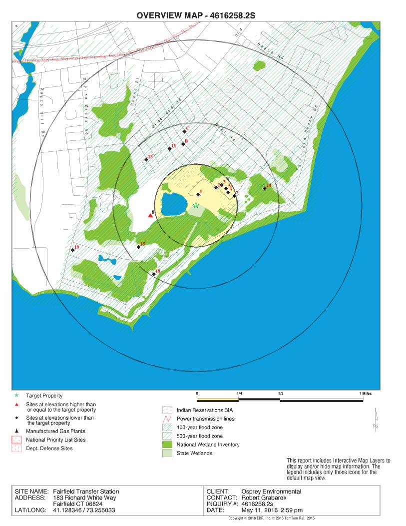
41.1283460 - 41˚ 7’ 42.04’’Latitude (North): 73.2550330 - 73˚ 15’ 18.11’’Longitude (West): Zone 18Universal Tranverse Mercator: 646476.4UTM X (Meters): 4554260.0UTM Y (Meters): 21 ft. above sea levelElevation:
USGS TOPOGRAPHIC MAP ASSOCIATED WITH TARGET PROPERTY
5641979 WESTPORT, CTTarget Property Map:2012Version Date:
5641945 BRIDGEPORT, CTNortheast Map:2012Version Date:
5641967 SHERWOOD POINT, CTSouthwest Map:2012Version Date:
AERIAL PHOTOGRAPHY IN THIS REPORT
20120725, 20120807Portions of Photo from:USDASource:
4616258.2s Page 2
19 SOUTH PINE CREEK ROA SOUTH PINE CREEK ROA CT SHWS, CT SDADB, CT CPCS Lower 4174, 0.791, WSW
18 OLD DAM RECREATIONAL 50 OLD DAM ROAD CT LUST, CT SPILLS Lower 2564, 0.486, SSW
C17 ROBERT MURRAY 144 PRATT ST CT LUST, CT SPILLS, CT CPCS Lower 2385, 0.452, North
C16 R. MURRAY PROPERTY 144 PRATT STREET CT SDADB Lower 2385, 0.452, North
15 NIKE BR-65 FUDS Lower 2255, 0.427, SW
14 FAIRFIELD DPW 1 ROD HWY OLD NIKE B CT SPILLS, CT CPCS Lower 2253, 0.427, ENE
13 OLDFIELD SENIOR CENT 100 MONA TERRACE CT LUST, CT SPILLS Lower 2149, 0.407, NW
B12 MS. HAFFINGER 256 EASTLAWN STREET CT LUST, CT CPCS Lower 1997, 0.378, NNW
11 155 ALDEN ST. 155 ALDEN ST. CT LUST, CT CPCS Lower 1995, 0.378, NNW
B10 DON WARNITSKI 267 EAST LAWN STREET CT LUST, CT SPILLS, CT CPCS Lower 1980, 0.375, North
B9 BETTY GOODFELLOW 281 EAST LAWN STREET CT LUST, CT SPILLS, CT CPCS Lower 1937, 0.367, North
8 FAIRFIELD MUNI. LAND ONE ROD HIGHWAY CT SHWS, CT SDADB, CT SWF/LF, CT CPCS Higher 1484, 0.281, WSW
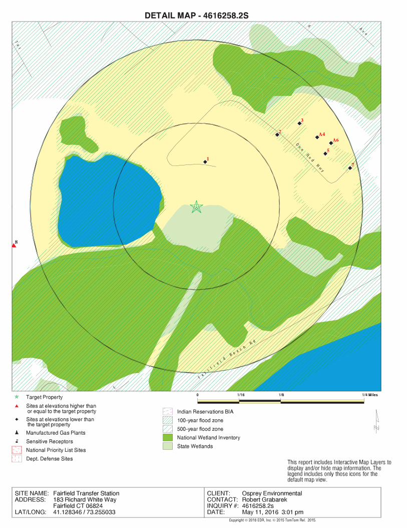
7 FAIRFIELD NIKE SITE CT LWDS Lower 1256, 0.238, ENE
A6 FAIRFIELD TOWN STP ONE ROD HIGHWAY CT LWDS Lower 1180, 0.223, ENE
5 FAIRFIELD TOWN OF ONE ROD HWY CT LUST, CT SPILLS, RCRA NonGen / NLR, RI... Lower 1105, 0.209, ENE
A4 FAIRFIELD TOWN LAGOO CT LWDS Lower 1104, 0.209, ENE
3 FAIRFIELD MUNICIPAL ONE ROD ROAD SEMS-ARCHIVE Lower 1050, 0.199, NE
2 TOWN OF FAIRFIELD SO 533 ONE ROD HWY CT SWRCY Lower 857, 0.162, NE
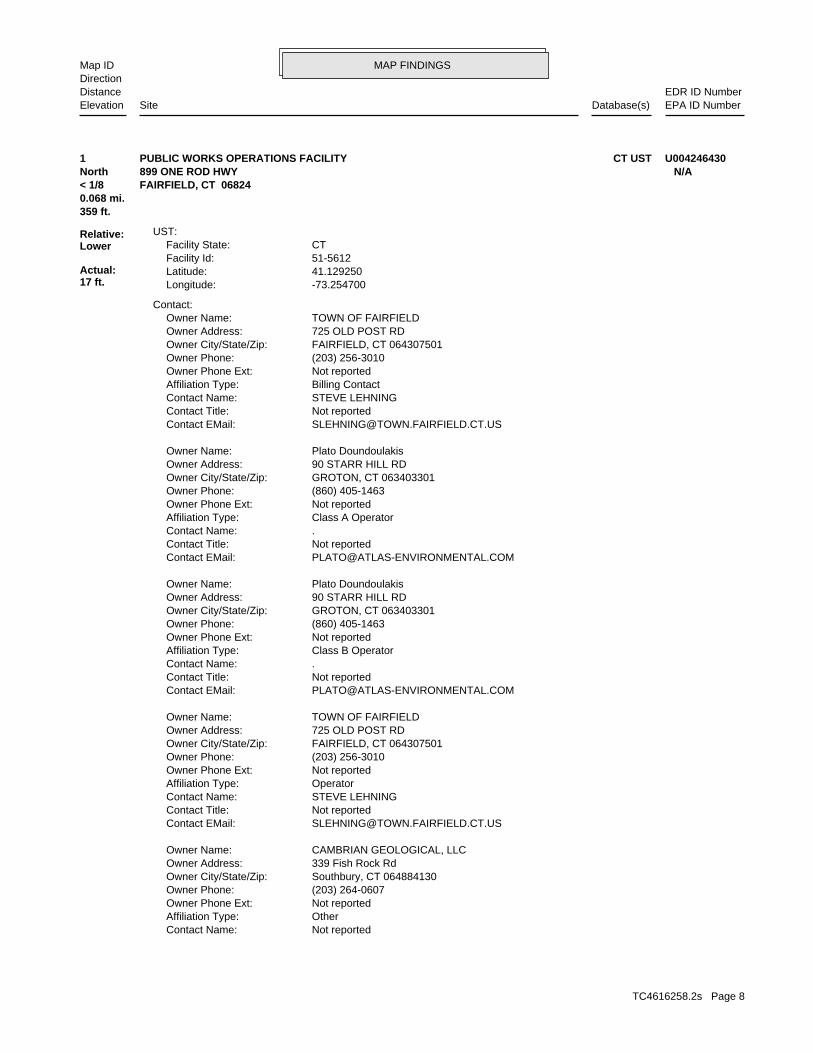
1 PUBLIC WORKS OPERATI 899 ONE ROD HWY CT UST Lower 359, 0.068, North
MAPPED SITES SUMMARY
Target Property Address:183 RICHARD WHITE WAYFAIRFIELD, CT 06824
Click on Map ID to see full detail.
MAP RELATIVE DIST (ft. & mi.)ID DATABASE ACRONYMS ELEVATION DIRECTIONSITE NAME ADDRESS
EXECUTIVE SUMMARY
TC4616258.2s EXECUTIVE SUMMARY 3
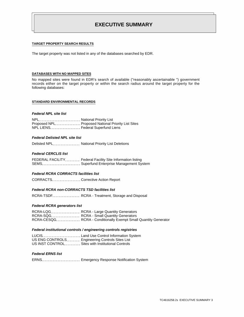
TARGET PROPERTY SEARCH RESULTS
The target property was not listed in any of the databases searched by EDR.
DATABASES WITH NO MAPPED SITES
No mapped sites were found in EDR’s search of available ("reasonably ascertainable ") governmentrecords either on the target property or within the search radius around the target property for thefollowing databases:
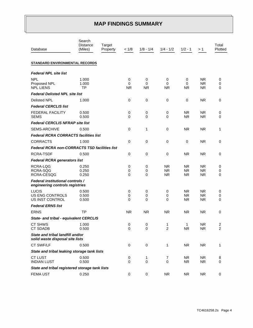
STANDARD ENVIRONMENTAL RECORDS
Federal NPL site list
NPL National Priority ListProposed NPL Proposed National Priority List SitesNPL LIENS Federal Superfund Liens
Federal Delisted NPL site list
Delisted NPL National Priority List Deletions
Federal CERCLIS list
FEDERAL FACILITY Federal Facility Site Information listingSEMS Superfund Enterprise Management System
Federal RCRA CORRACTS facilities list
CORRACTS Corrective Action Report
Federal RCRA non-CORRACTS TSD facilities list
RCRA-TSDF RCRA - Treatment, Storage and Disposal
Federal RCRA generators list
RCRA-LQG RCRA - Large Quantity GeneratorsRCRA-SQG RCRA - Small Quantity GeneratorsRCRA-CESQG RCRA - Conditionally Exempt Small Quantity Generator
Federal institutional controls / engineering controls registries
LUCIS Land Use Control Information SystemUS ENG CONTROLS Engineering Controls Sites ListUS INST CONTROL Sites with Institutional Controls
Federal ERNS list
ERNS Emergency Response Notification System
EXECUTIVE SUMMARY
TC4616258.2s EXECUTIVE SUMMARY 4
State and tribal leaking storage tank lists
INDIAN LUST Leaking Underground Storage Tanks on Indian Land
State and tribal registered storage tank lists
FEMA UST Underground Storage Tank ListingCT AST Marine Terminals and Tank InformationINDIAN UST Underground Storage Tanks on Indian Land
State and tribal institutional control / engineering control registries
CT ENG CONTROLS Engineering Controls ListingCT AUL ELUR Sites
State and tribal voluntary cleanup sites
CT VCP Voluntary Remediation SitesINDIAN VCP Voluntary Cleanup Priority Listing
State and tribal Brownfields sites
CT BROWNFIELDS Brownfields Inventory
ADDITIONAL ENVIRONMENTAL RECORDS
Local Brownfield lists
US BROWNFIELDS A Listing of Brownfields Sites
Local Lists of Landfill / Solid Waste Disposal Sites
INDIAN ODI Report on the Status of Open Dumps on Indian LandsDEBRIS REGION 9 Torres Martinez Reservation Illegal Dump Site LocationsODI Open Dump Inventory
Local Lists of Hazardous waste / Contaminated Sites
US HIST CDL Delisted National Clandestine Laboratory RegisterCT CDL Clandestine Drug Lab ListingUS CDL National Clandestine Laboratory Register
Local Land Records
CT PROPERTY Property Transfer FilingsCT LIENS Environmental Liens ListingLIENS 2 CERCLA Lien Information
Records of Emergency Release Reports
HMIRS Hazardous Materials Information Reporting SystemCT SPILLS 90 SPILLS 90 data from FirstSearch
Other Ascertainable Records
DOD Department of Defense Sites
EXECUTIVE SUMMARY
TC4616258.2s EXECUTIVE SUMMARY 5
SCRD DRYCLEANERS State Coalition for Remediation of Drycleaners ListingUS FIN ASSUR Financial Assurance InformationEPA WATCH LIST EPA WATCH LIST2020 COR ACTION 2020 Corrective Action Program ListTSCA Toxic Substances Control ActTRIS Toxic Chemical Release Inventory SystemSSTS Section 7 Tracking SystemsROD Records Of DecisionRMP Risk Management PlansRAATS RCRA Administrative Action Tracking SystemPRP Potentially Responsible PartiesPADS PCB Activity Database SystemICIS Integrated Compliance Information SystemFTTS FIFRA/ TSCA Tracking System - FIFRA (Federal Insecticide, Fungicide, & Rodenticide Act)/TSCA (Toxic Substances Control Act)MLTS Material Licensing Tracking SystemCOAL ASH DOE Steam-Electric Plant Operation DataCOAL ASH EPA Coal Combustion Residues Surface Impoundments ListPCB TRANSFORMER PCB Transformer Registration DatabaseRADINFO Radiation Information DatabaseHIST FTTS FIFRA/TSCA Tracking System Administrative Case ListingDOT OPS Incident and Accident DataCONSENT Superfund (CERCLA) Consent DecreesINDIAN RESERV Indian ReservationsFUSRAP Formerly Utilized Sites Remedial Action ProgramUMTRA Uranium Mill Tailings SitesLEAD SMELTERS Lead Smelter SitesUS AIRS Aerometric Information Retrieval System Facility SubsystemUS MINES Mines Master Index FileFINDS Facility Index System/Facility Registry SystemUXO Unexploded Ordnance SitesDOCKET HWC Hazardous Waste Compliance Docket ListingCT AIRS Permitted Air Sources ListingCT DRYCLEANERS Drycleaner FacilitiesCT ENF Enforcement Case ListingCT Financial Assurance Financial Assurance Information ListingCT LEAD Lead Inspection DatabaseCT MANIFEST Hazardous Waste Manifest DataCT NPDES Wastewater Permit ListingCT SEH List of Significant Environmental Hazards Report to DEEPFUELS PROGRAM EPA Fuels Program Registered ListingECHO Enforcement & Compliance History Information
EDR HIGH RISK HISTORICAL RECORDS
EDR Exclusive Records
EDR MGP EDR Proprietary Manufactured Gas PlantsEDR Hist Auto EDR Exclusive Historic Gas StationsEDR Hist Cleaner EDR Exclusive Historic Dry Cleaners
EDR RECOVERED GOVERNMENT ARCHIVES
Exclusive Recovered Govt. Archives
CT RGA HWS Recovered Government Archive State Hazardous Waste Facilities List
EXECUTIVE SUMMARY
TC4616258.2s EXECUTIVE SUMMARY 6
CT RGA LUST Recovered Government Archive Leaking Underground Storage Tank
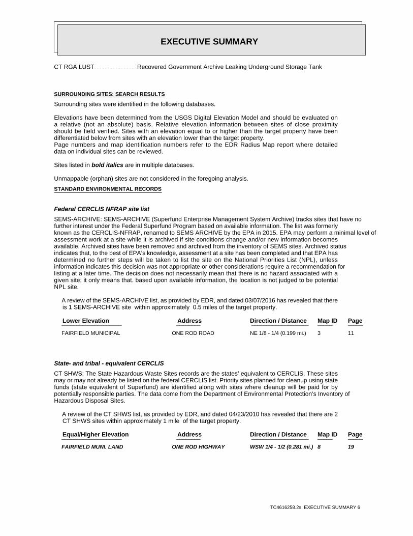
SURROUNDING SITES: SEARCH RESULTS
Surrounding sites were identified in the following databases.
Elevations have been determined from the USGS Digital Elevation Model and should be evaluated ona relative (not an absolute) basis. Relative elevation information between sites of close proximityshould be field verified. Sites with an elevation equal to or higher than the target property have beendifferentiated below from sites with an elevation lower than the target property.Page numbers and map identification numbers refer to the EDR Radius Map report where detaileddata on individual sites can be reviewed.
Sites listed in bold italics are in multiple databases.
Unmappable (orphan) sites are not considered in the foregoing analysis.
STANDARD ENVIRONMENTAL RECORDS
Federal CERCLIS NFRAP site list
SEMS-ARCHIVE: SEMS-ARCHIVE (Superfund Enterprise Management System Archive) tracks sites that have nofurther interest under the Federal Superfund Program based on available information. The list was formerlyknown as the CERCLIS-NFRAP, renamed to SEMS ARCHIVE by the EPA in 2015. EPA may perform a minimal level ofassessment work at a site while it is archived if site conditions change and/or new information becomesavailable. Archived sites have been removed and archived from the inventory of SEMS sites. Archived statusindicates that, to the best of EPA’s knowledge, assessment at a site has been completed and that EPA hasdetermined no further steps will be taken to list the site on the National Priorities List (NPL), unlessinformation indicates this decision was not appropriate or other considerations require a recommendation forlisting at a later time. The decision does not necessarily mean that there is no hazard associated with agiven site; it only means that. based upon available information, the location is not judged to be potentialNPL site.
A review of the SEMS-ARCHIVE list, as provided by EDR, and dated 03/07/2016 has revealed that there is 1 SEMS-ARCHIVE site within approximately 0.5 miles of the target property.
PageMap IDDirection / Distance Address Lower Elevation ____________________ ________ ___________________ _____ _____
FAIRFIELD MUNICIPAL ONE ROD ROAD NE 1/8 - 1/4 (0.199 mi.) 3 11
State- and tribal - equivalent CERCLIS
CT SHWS: The State Hazardous Waste Sites records are the states’ equivalent to CERCLIS. These sitesmay or may not already be listed on the federal CERCLIS list. Priority sites planned for cleanup using statefunds (state equivalent of Superfund) are identified along with sites where cleanup will be paid for bypotentially responsible parties. The data come from the Department of Environmental Protection’s Inventory ofHazardous Disposal Sites.
A review of the CT SHWS list, as provided by EDR, and dated 04/23/2010 has revealed that there are 2 CT SHWS sites within approximately 1 mile of the target property.
PageMap IDDirection / Distance Address Equal/Higher Elevation ____________________ ________ ___________________ _____ _____
FAIRFIELD MUNI. LAND ONE ROD HIGHWAY WSW 1/4 - 1/2 (0.281 mi.) 8 19
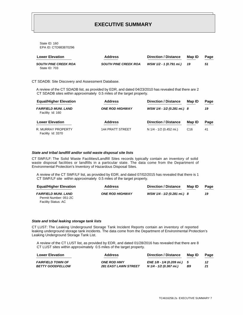
EXECUTIVE SUMMARY
TC4616258.2s EXECUTIVE SUMMARY 7
State ID: 160EPA ID: CTD983870296
PageMap IDDirection / Distance Address Lower Elevation ____________________ ________ ___________________ _____ _____
SOUTH PINE CREEK ROA SOUTH PINE CREEK ROA WSW 1/2 - 1 (0.791 mi.) 19 51State ID: 703
CT SDADB: Site Discovery and Assessment Database.
A review of the CT SDADB list, as provided by EDR, and dated 04/23/2010 has revealed that there are 2 CT SDADB sites within approximately 0.5 miles of the target property.
PageMap IDDirection / Distance Address Equal/Higher Elevation ____________________ ________ ___________________ _____ _____
FAIRFIELD MUNI. LAND ONE ROD HIGHWAY WSW 1/4 - 1/2 (0.281 mi.) 8 19Facility Id: 160
PageMap IDDirection / Distance Address Lower Elevation ____________________ ________ ___________________ _____ _____
R. MURRAY PROPERTY 144 PRATT STREET N 1/4 - 1/2 (0.452 mi.) C16 41Facility Id: 3370
State and tribal landfill and/or solid waste disposal site lists
CT SWF/LF: The Solid Waste Facilities/Landfill Sites records typically contain an inventory of solidwaste disposal facilities or landfills in a particular state. The data come from the Department ofEnvironmental Protection’s Inventory of Hazardous Disposal Sites.
A review of the CT SWF/LF list, as provided by EDR, and dated 07/02/2015 has revealed that there is 1 CT SWF/LF site within approximately 0.5 miles of the target property.
PageMap IDDirection / Distance Address Equal/Higher Elevation ____________________ ________ ___________________ _____ _____
FAIRFIELD MUNI. LAND ONE ROD HIGHWAY WSW 1/4 - 1/2 (0.281 mi.) 8 19Permit Number: 051-2CFacility Status: AC
State and tribal leaking storage tank lists
CT LUST: The Leaking Underground Storage Tank Incident Reports contain an inventory of reportedleaking underground storage tank incidents. The data come from the Department of Environmental Protection’sLeaking Underground Storage Tank List.
A review of the CT LUST list, as provided by EDR, and dated 01/28/2016 has revealed that there are 8 CT LUST sites within approximately 0.5 miles of the target property.
PageMap IDDirection / Distance Address Lower Elevation ____________________ ________ ___________________ _____ _____
FAIRFIELD TOWN OF ONE ROD HWY ENE 1/8 - 1/4 (0.209 mi.) 5 12 BETTY GOODFELLOW 281 EAST LAWN STREET N 1/4 - 1/2 (0.367 mi.) B9 21
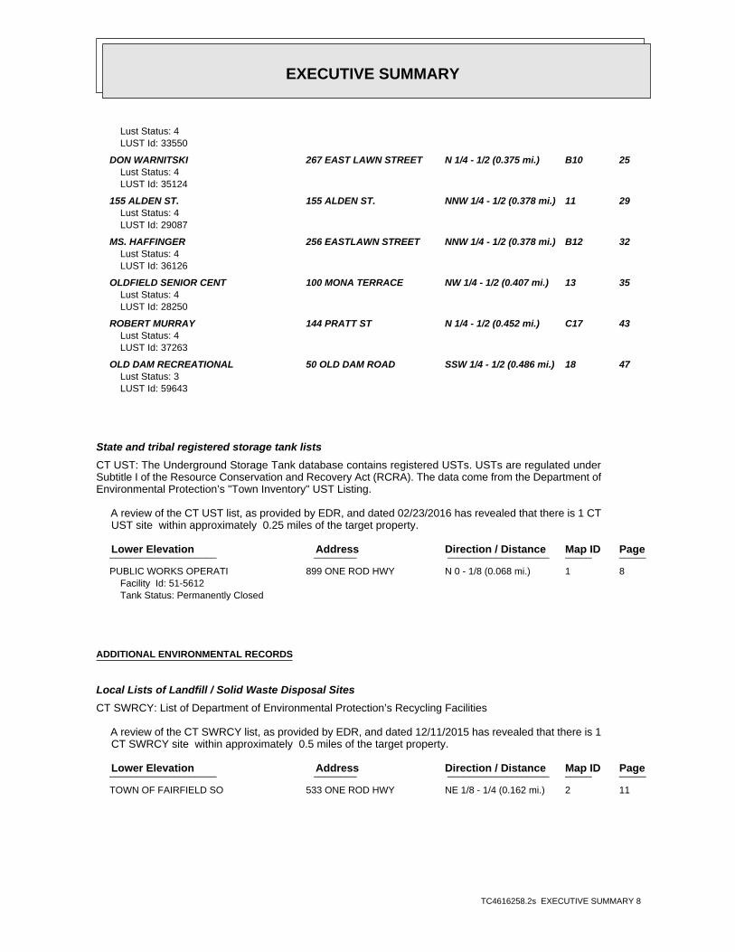
EXECUTIVE SUMMARY
TC4616258.2s EXECUTIVE SUMMARY 8
Lust Status: 4LUST Id: 33550
DON WARNITSKI 267 EAST LAWN STREET N 1/4 - 1/2 (0.375 mi.) B10 25Lust Status: 4LUST Id: 35124
155 ALDEN ST. 155 ALDEN ST. NNW 1/4 - 1/2 (0.378 mi.) 11 29Lust Status: 4LUST Id: 29087
MS. HAFFINGER 256 EASTLAWN STREET NNW 1/4 - 1/2 (0.378 mi.) B12 32Lust Status: 4LUST Id: 36126
OLDFIELD SENIOR CENT 100 MONA TERRACE NW 1/4 - 1/2 (0.407 mi.) 13 35Lust Status: 4LUST Id: 28250
ROBERT MURRAY 144 PRATT ST N 1/4 - 1/2 (0.452 mi.) C17 43Lust Status: 4LUST Id: 37263
OLD DAM RECREATIONAL 50 OLD DAM ROAD SSW 1/4 - 1/2 (0.486 mi.) 18 47Lust Status: 3LUST Id: 59643
State and tribal registered storage tank lists
CT UST: The Underground Storage Tank database contains registered USTs. USTs are regulated underSubtitle I of the Resource Conservation and Recovery Act (RCRA). The data come from the Department ofEnvironmental Protection’s "Town Inventory" UST Listing.
A review of the CT UST list, as provided by EDR, and dated 02/23/2016 has revealed that there is 1 CT UST site within approximately 0.25 miles of the target property.
PageMap IDDirection / Distance Address Lower Elevation ____________________ ________ ___________________ _____ _____
PUBLIC WORKS OPERATI 899 ONE ROD HWY N 0 - 1/8 (0.068 mi.) 1 8Facility Id: 51-5612Tank Status: Permanently Closed
ADDITIONAL ENVIRONMENTAL RECORDS
Local Lists of Landfill / Solid Waste Disposal Sites
CT SWRCY: List of Department of Environmental Protection’s Recycling Facilities
A review of the CT SWRCY list, as provided by EDR, and dated 12/11/2015 has revealed that there is 1 CT SWRCY site within approximately 0.5 miles of the target property.
PageMap IDDirection / Distance Address Lower Elevation ____________________ ________ ___________________ _____ _____
TOWN OF FAIRFIELD SO 533 ONE ROD HWY NE 1/8 - 1/4 (0.162 mi.) 2 11
EXECUTIVE SUMMARY
TC4616258.2s EXECUTIVE SUMMARY 9
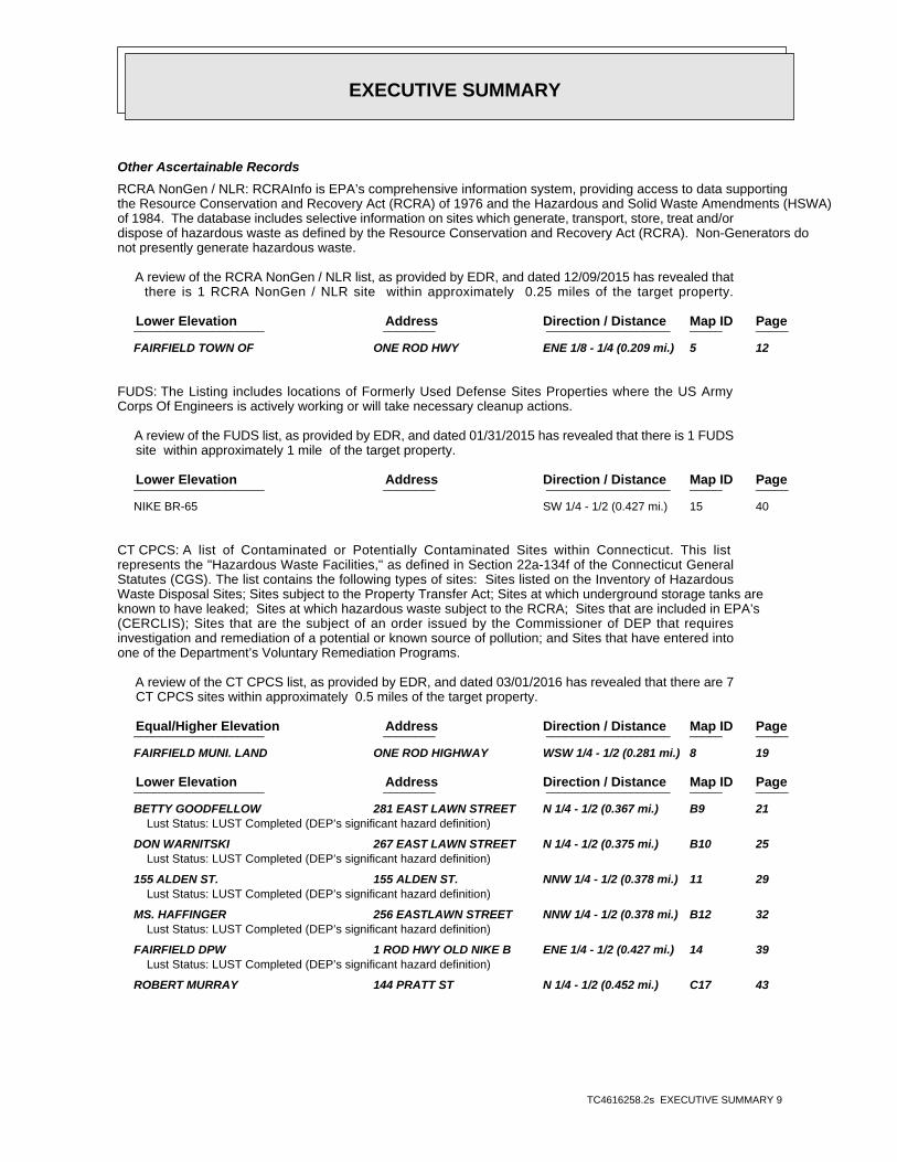
Other Ascertainable Records
RCRA NonGen / NLR: RCRAInfo is EPA’s comprehensive information system, providing access to data supportingthe Resource Conservation and Recovery Act (RCRA) of 1976 and the Hazardous and Solid Waste Amendments (HSWA)of 1984. The database includes selective information on sites which generate, transport, store, treat and/ordispose of hazardous waste as defined by the Resource Conservation and Recovery Act (RCRA). Non-Generators donot presently generate hazardous waste.
A review of the RCRA NonGen / NLR list, as provided by EDR, and dated 12/09/2015 has revealed that there is 1 RCRA NonGen / NLR site within approximately 0.25 miles of the target property.
PageMap IDDirection / Distance Address Lower Elevation ____________________ ________ ___________________ _____ _____
FAIRFIELD TOWN OF ONE ROD HWY ENE 1/8 - 1/4 (0.209 mi.) 5 12
FUDS: The Listing includes locations of Formerly Used Defense Sites Properties where the US ArmyCorps Of Engineers is actively working or will take necessary cleanup actions.
A review of the FUDS list, as provided by EDR, and dated 01/31/2015 has revealed that there is 1 FUDS site within approximately 1 mile of the target property.
PageMap IDDirection / Distance Address Lower Elevation ____________________ ________ ___________________ _____ _____
NIKE BR-65 SW 1/4 - 1/2 (0.427 mi.) 15 40
CT CPCS: A list of Contaminated or Potentially Contaminated Sites within Connecticut. This listrepresents the "Hazardous Waste Facilities," as defined in Section 22a-134f of the Connecticut GeneralStatutes (CGS). The list contains the following types of sites: Sites listed on the Inventory of HazardousWaste Disposal Sites; Sites subject to the Property Transfer Act; Sites at which underground storage tanks areknown to have leaked; Sites at which hazardous waste subject to the RCRA; Sites that are included in EPA’s(CERCLIS); Sites that are the subject of an order issued by the Commissioner of DEP that requiresinvestigation and remediation of a potential or known source of pollution; and Sites that have entered intoone of the Department’s Voluntary Remediation Programs.
A review of the CT CPCS list, as provided by EDR, and dated 03/01/2016 has revealed that there are 7 CT CPCS sites within approximately 0.5 miles of the target property.
PageMap IDDirection / Distance Address Equal/Higher Elevation ____________________ ________ ___________________ _____ _____
FAIRFIELD MUNI. LAND ONE ROD HIGHWAY WSW 1/4 - 1/2 (0.281 mi.) 8 19
PageMap IDDirection / Distance Address Lower Elevation ____________________ ________ ___________________ _____ _____
BETTY GOODFELLOW 281 EAST LAWN STREET N 1/4 - 1/2 (0.367 mi.) B9 21Lust Status: LUST Completed (DEP’s significant hazard definition)
DON WARNITSKI 267 EAST LAWN STREET N 1/4 - 1/2 (0.375 mi.) B10 25Lust Status: LUST Completed (DEP’s significant hazard definition)
155 ALDEN ST. 155 ALDEN ST. NNW 1/4 - 1/2 (0.378 mi.) 11 29Lust Status: LUST Completed (DEP’s significant hazard definition)
MS. HAFFINGER 256 EASTLAWN STREET NNW 1/4 - 1/2 (0.378 mi.) B12 32Lust Status: LUST Completed (DEP’s significant hazard definition)
FAIRFIELD DPW 1 ROD HWY OLD NIKE B ENE 1/4 - 1/2 (0.427 mi.) 14 39Lust Status: LUST Completed (DEP’s significant hazard definition)
ROBERT MURRAY 144 PRATT ST N 1/4 - 1/2 (0.452 mi.) C17 43
EXECUTIVE SUMMARY
TC4616258.2s EXECUTIVE SUMMARY 10
Lust Status: LUST Completed (DEP’s significant hazard definition)
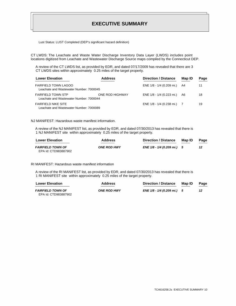
CT LWDS: The Leachate and Waste Water Discharge Inventory Data Layer (LWDS) includes pointlocations digitized from Leachate and Wastewater Discharge Source maps compiled by the Connecticut DEP.
A review of the CT LWDS list, as provided by EDR, and dated 07/17/2009 has revealed that there are 3 CT LWDS sites within approximately 0.25 miles of the target property.
PageMap IDDirection / Distance Address Lower Elevation ____________________ ________ ___________________ _____ _____
FAIRFIELD TOWN LAGOO ENE 1/8 - 1/4 (0.209 mi.) A4 11Leachate and Wastewater Number: 7000045
FAIRFIELD TOWN STP ONE ROD HIGHWAY ENE 1/8 - 1/4 (0.223 mi.) A6 18Leachate and Wastewater Number: 7000044
FAIRFIELD NIKE SITE ENE 1/8 - 1/4 (0.238 mi.) 7 19Leachate and Wastewater Number: 7000089
NJ MANIFEST: Hazardous waste manifest information.
A review of the NJ MANIFEST list, as provided by EDR, and dated 07/30/2013 has revealed that there is 1 NJ MANIFEST site within approximately 0.25 miles of the target property.
PageMap IDDirection / Distance Address Lower Elevation ____________________ ________ ___________________ _____ _____
FAIRFIELD TOWN OF ONE ROD HWY ENE 1/8 - 1/4 (0.209 mi.) 5 12EPA Id: CTD983887902
RI MANIFEST: Hazardous waste manifest information
A review of the RI MANIFEST list, as provided by EDR, and dated 07/30/2013 has revealed that there is 1 RI MANIFEST site within approximately 0.25 miles of the target property.
PageMap IDDirection / Distance Address Lower Elevation ____________________ ________ ___________________ _____ _____
FAIRFIELD TOWN OF ONE ROD HWY ENE 1/8 - 1/4 (0.209 mi.) 5 12EPA Id: CTD983887902

EXECUTIVE SUMMARY
TC4616258.2s EXECUTIVE SUMMARY 11
There were no unmapped sites in this report.
EDR Inc.EDR Inc.EDR Inc.EDR Inc.EDR Inc.EDR Inc.EDR Inc.EDR Inc.EDR Inc.EDR Inc.EDR Inc.EDR Inc.EDR Inc.EDR Inc.EDR Inc.EDR Inc.EDR Inc.EDR Inc.EDR Inc.EDR Inc.EDR Inc.EDR Inc.EDR Inc.EDR Inc.EDR Inc.EDR Inc.EDR Inc.EDR Inc.EDR Inc.EDR Inc.EDR Inc.EDR Inc.EDR Inc.EDR Inc.EDR Inc.EDR Inc.EDR Inc.EDR Inc.EDR Inc.EDR Inc.
80
40
EDR Inc.EDR Inc.EDR Inc.EDR Inc.EDR Inc.EDR Inc.EDR Inc.EDR Inc.EDR Inc.EDR Inc.EDR Inc.EDR Inc.EDR Inc.EDR Inc.EDR Inc.EDR Inc.EDR Inc.EDR Inc.EDR Inc.EDR Inc.EDR Inc.EDR Inc.EDR Inc.EDR Inc.EDR Inc.EDR Inc.EDR Inc.EDR Inc.EDR Inc.EDR Inc.EDR Inc.EDR Inc.EDR Inc.EDR Inc.EDR Inc.EDR Inc.EDR Inc.EDR Inc.EDR Inc.EDR Inc.
MAP FINDINGS SUMMARY
SearchTargetDistance Total
Database Property(Miles) < 1/8 1/8 - 1/4 1/4 - 1/2 1/2 - 1 > 1 Plotted
STANDARD ENVIRONMENTAL RECORDS
Federal NPL site list
0 NR 0 0 0 0 1.000NPL 0 NR 0 0 0 0 1.000Proposed NPL 0 NR NR NR NR NR TPNPL LIENS
Federal Delisted NPL site list
0 NR 0 0 0 0 1.000Delisted NPL
Federal CERCLIS list
0 NR NR 0 0 0 0.500FEDERAL FACILITY 0 NR NR 0 0 0 0.500SEMS
Federal CERCLIS NFRAP site list
1 NR NR 0 1 0 0.500SEMS-ARCHIVE
Federal RCRA CORRACTS facilities list
0 NR 0 0 0 0 1.000CORRACTS
Federal RCRA non-CORRACTS TSD facilities list
0 NR NR 0 0 0 0.500RCRA-TSDF
Federal RCRA generators list
0 NR NR NR 0 0 0.250RCRA-LQG 0 NR NR NR 0 0 0.250RCRA-SQG 0 NR NR NR 0 0 0.250RCRA-CESQG
Federal institutional controls /engineering controls registries
0 NR NR 0 0 0 0.500LUCIS 0 NR NR 0 0 0 0.500US ENG CONTROLS 0 NR NR 0 0 0 0.500US INST CONTROL
Federal ERNS list
0 NR NR NR NR NR TPERNS
State- and tribal - equivalent CERCLIS
2 NR 1 1 0 0 1.000CT SHWS 2 NR NR 2 0 0 0.500CT SDADB
State and tribal landfill and/orsolid waste disposal site lists
1 NR NR 1 0 0 0.500CT SWF/LF
State and tribal leaking storage tank lists
8 NR NR 7 1 0 0.500CT LUST 0 NR NR 0 0 0 0.500INDIAN LUST
State and tribal registered storage tank lists
0 NR NR NR 0 0 0.250FEMA UST
TC4616258.2s Page 4
MAP FINDINGS SUMMARY
SearchTargetDistance Total
Database Property(Miles) < 1/8 1/8 - 1/4 1/4 - 1/2 1/2 - 1 > 1 Plotted
1 NR NR NR 0 1 0.250CT UST 0 NR NR NR 0 0 0.250CT AST 0 NR NR NR 0 0 0.250INDIAN UST
State and tribal institutionalcontrol / engineering control registries
0 NR NR 0 0 0 0.500CT ENG CONTROLS 0 NR NR 0 0 0 0.500CT AUL
State and tribal voluntary cleanup sites
0 NR NR 0 0 0 0.500CT VCP 0 NR NR 0 0 0 0.500INDIAN VCP
State and tribal Brownfields sites
0 NR NR 0 0 0 0.500CT BROWNFIELDS
ADDITIONAL ENVIRONMENTAL RECORDS
Local Brownfield lists
0 NR NR 0 0 0 0.500US BROWNFIELDS
Local Lists of Landfill / SolidWaste Disposal Sites
1 NR NR 0 1 0 0.500CT SWRCY 0 NR NR 0 0 0 0.500INDIAN ODI 0 NR NR 0 0 0 0.500DEBRIS REGION 9 0 NR NR 0 0 0 0.500ODI
Local Lists of Hazardous waste /Contaminated Sites
0 NR NR NR NR NR TPUS HIST CDL 0 NR NR NR NR NR TPCT CDL 0 NR NR NR NR NR TPUS CDL
Local Land Records
0 NR NR NR NR NR TPCT PROPERTY 0 NR NR NR NR NR TPCT LIENS 0 NR NR NR NR NR TPLIENS 2
Records of Emergency Release Reports
0 NR NR NR NR NR TPHMIRS 0 NR NR NR NR NR TPCT SPILLS 0 NR NR NR NR NR TPCT SPILLS 90
Other Ascertainable Records
1 NR NR NR 1 0 0.250RCRA NonGen / NLR 1 NR 0 1 0 0 1.000FUDS 0 NR 0 0 0 0 1.000DOD 0 NR NR 0 0 0 0.500SCRD DRYCLEANERS 0 NR NR NR NR NR TPUS FIN ASSUR
TC4616258.2s Page 5
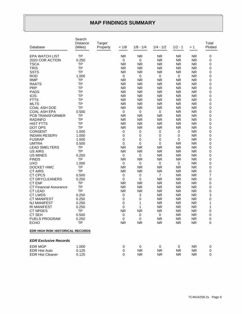
MAP FINDINGS SUMMARY
SearchTargetDistance Total
Database Property(Miles) < 1/8 1/8 - 1/4 1/4 - 1/2 1/2 - 1 > 1 Plotted
0 NR NR NR NR NR TPEPA WATCH LIST 0 NR NR NR 0 0 0.2502020 COR ACTION 0 NR NR NR NR NR TPTSCA 0 NR NR NR NR NR TPTRIS 0 NR NR NR NR NR TPSSTS 0 NR 0 0 0 0 1.000ROD 0 NR NR NR NR NR TPRMP 0 NR NR NR NR NR TPRAATS 0 NR NR NR NR NR TPPRP 0 NR NR NR NR NR TPPADS 0 NR NR NR NR NR TPICIS 0 NR NR NR NR NR TPFTTS 0 NR NR NR NR NR TPMLTS 0 NR NR NR NR NR TPCOAL ASH DOE 0 NR NR 0 0 0 0.500COAL ASH EPA 0 NR NR NR NR NR TPPCB TRANSFORMER 0 NR NR NR NR NR TPRADINFO 0 NR NR NR NR NR TPHIST FTTS 0 NR NR NR NR NR TPDOT OPS 0 NR 0 0 0 0 1.000CONSENT 0 NR 0 0 0 0 1.000INDIAN RESERV 0 NR 0 0 0 0 1.000FUSRAP 0 NR NR 0 0 0 0.500UMTRA 0 NR NR NR NR NR TPLEAD SMELTERS 0 NR NR NR NR NR TPUS AIRS 0 NR NR NR 0 0 0.250US MINES 0 NR NR NR NR NR TPFINDS 0 NR 0 0 0 0 1.000UXO 0 NR NR NR NR NR TPDOCKET HWC 0 NR NR NR NR NR TPCT AIRS 7 NR NR 7 0 0 0.500CT CPCS 0 NR NR NR 0 0 0.250CT DRYCLEANERS 0 NR NR NR NR NR TPCT ENF 0 NR NR NR NR NR TPCT Financial Assurance 0 NR NR NR NR NR TPCT LEAD 3 NR NR NR 3 0 0.250CT LWDS 0 NR NR NR 0 0 0.250CT MANIFEST 1 NR NR NR 1 0 0.250NJ MANIFEST 1 NR NR NR 1 0 0.250RI MANIFEST 0 NR NR NR NR NR TPCT NPDES 0 NR NR 0 0 0 0.500CT SEH 0 NR NR NR 0 0 0.250FUELS PROGRAM 0 NR NR NR NR NR TPECHO
EDR HIGH RISK HISTORICAL RECORDS
EDR Exclusive Records
0 NR 0 0 0 0 1.000EDR MGP 0 NR NR NR NR 0 0.125EDR Hist Auto 0 NR NR NR NR 0 0.125EDR Hist Cleaner
TC4616258.2s Page 6
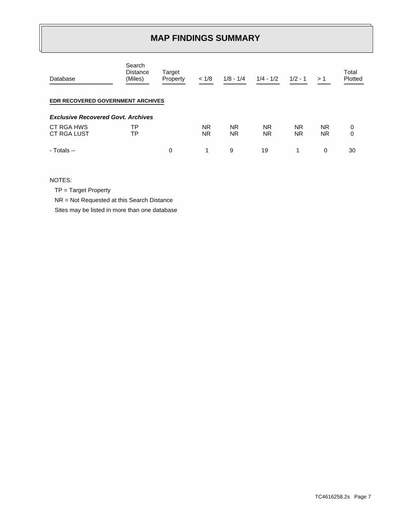
MAP FINDINGS SUMMARY
SearchTargetDistance Total
Database Property(Miles) < 1/8 1/8 - 1/4 1/4 - 1/2 1/2 - 1 > 1 Plotted
EDR RECOVERED GOVERNMENT ARCHIVES
Exclusive Recovered Govt. Archives
0 NR NR NR NR NR TPCT RGA HWS 0 NR NR NR NR NR TPCT RGA LUST
30 0 1 19 9 1 0- Totals --
NOTES:
TP = Target Property
NR = Not Requested at this Search Distance
Sites may be listed in more than one database
TC4616258.2s Page 7
MAP FINDINGSMap IDDirection
EDR ID NumberDistanceEPA ID NumberDatabase(s)SiteElevation
Not reportedContact Name: OtherAffiliation Type: Not reportedOwner Phone Ext: (203) 264-0607Owner Phone: Southbury, CT 064884130Owner City/State/Zip: 339 Fish Rock RdOwner Address: CAMBRIAN GEOLOGICAL, LLCOwner Name:
[email protected] EMail: Not reportedContact Title: STEVE LEHNINGContact Name: OperatorAffiliation Type: Not reportedOwner Phone Ext: (203) 256-3010Owner Phone: FAIRFIELD, CT 064307501Owner City/State/Zip: 725 OLD POST RDOwner Address: TOWN OF FAIRFIELDOwner Name:
[email protected] EMail: Not reportedContact Title: .Contact Name: Class B OperatorAffiliation Type: Not reportedOwner Phone Ext: (860) 405-1463Owner Phone: GROTON, CT 063403301Owner City/State/Zip: 90 STARR HILL RDOwner Address: Plato DoundoulakisOwner Name:
[email protected] EMail: Not reportedContact Title: .Contact Name: Class A OperatorAffiliation Type: Not reportedOwner Phone Ext: (860) 405-1463Owner Phone: GROTON, CT 063403301Owner City/State/Zip: 90 STARR HILL RDOwner Address: Plato DoundoulakisOwner Name:
[email protected] EMail: Not reportedContact Title: STEVE LEHNINGContact Name: Billing ContactAffiliation Type: Not reportedOwner Phone Ext: (203) 256-3010Owner Phone: FAIRFIELD, CT 064307501Owner City/State/Zip: 725 OLD POST RDOwner Address: TOWN OF FAIRFIELDOwner Name:
Contact:
-73.254700Longitude: 41.129250Latitude: 51-5612Facility Id: CTFacility State:
UST:
359 ft.0.068 mi.
Relative:Lower
Actual:17 ft.
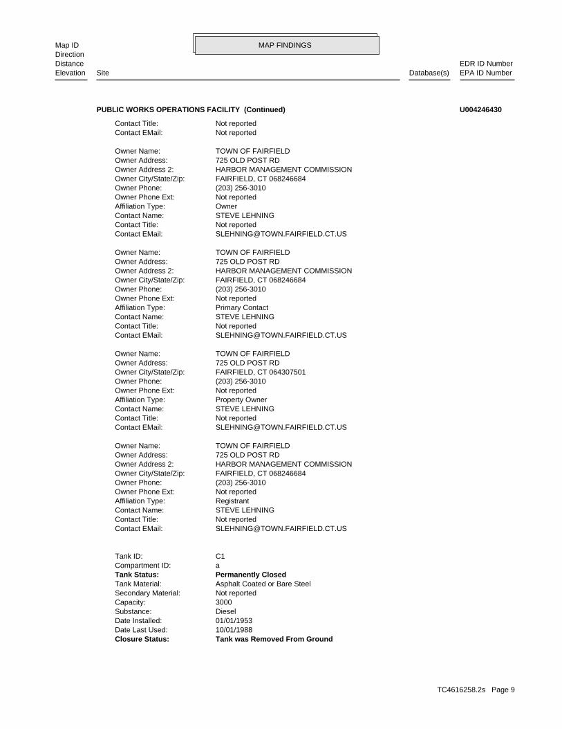
< 1/8 FAIRFIELD, CT 06824North 899 ONE ROD HWY N/A1 CT USTPUBLIC WORKS OPERATIONS FACILITY U004246430
TC4616258.2s Page 8
MAP FINDINGSMap IDDirection
EDR ID NumberDistanceEPA ID NumberDatabase(s)SiteElevation
Tank was Removed From GroundClosure Status: 10/01/1988Date Last Used: 01/01/1953Date Installed: DieselSubstance: 3000Capacity: Not reportedSecondary Material: Asphalt Coated or Bare SteelTank Material: Permanently ClosedTank Status: aCompartment ID: C1Tank ID:
[email protected] EMail: Not reportedContact Title: STEVE LEHNINGContact Name: RegistrantAffiliation Type: Not reportedOwner Phone Ext: (203) 256-3010Owner Phone: FAIRFIELD, CT 068246684Owner City/State/Zip: HARBOR MANAGEMENT COMMISSIONOwner Address 2: 725 OLD POST RDOwner Address: TOWN OF FAIRFIELDOwner Name:
[email protected] EMail: Not reportedContact Title: STEVE LEHNINGContact Name: Property OwnerAffiliation Type: Not reportedOwner Phone Ext: (203) 256-3010Owner Phone: FAIRFIELD, CT 064307501Owner City/State/Zip: 725 OLD POST RDOwner Address: TOWN OF FAIRFIELDOwner Name:
[email protected] EMail: Not reportedContact Title: STEVE LEHNINGContact Name: Primary ContactAffiliation Type: Not reportedOwner Phone Ext: (203) 256-3010Owner Phone: FAIRFIELD, CT 068246684Owner City/State/Zip: HARBOR MANAGEMENT COMMISSIONOwner Address 2: 725 OLD POST RDOwner Address: TOWN OF FAIRFIELDOwner Name:
[email protected] EMail: Not reportedContact Title: STEVE LEHNINGContact Name: OwnerAffiliation Type: Not reportedOwner Phone Ext: (203) 256-3010Owner Phone: FAIRFIELD, CT 068246684Owner City/State/Zip: HARBOR MANAGEMENT COMMISSIONOwner Address 2: 725 OLD POST RDOwner Address: TOWN OF FAIRFIELDOwner Name:
Not reportedContact EMail: Not reportedContact Title:
PUBLIC WORKS OPERATIONS FACILITY (Continued) U004246430
TC4616258.2s Page 9

MAP FINDINGSMap IDDirection
EDR ID NumberDistanceEPA ID NumberDatabase(s)SiteElevation
Spill BucketSpill Installed: Cathodically ProtectedPipe Mode Description: Bare SteelPipe Material: Tank was Removed From GroundClosure Status: 11/14/2013Date Last Used: 10/01/1982Date Installed: DieselSubstance: 10000Capacity: Not reportedSecondary Material: Fiberglass Reinforced PlasticTank Material: Permanently ClosedTank Status: aCompartment ID: C4Tank ID:
Not reportedTank Longitude: Not reportedTank Latitude: Not reportedOverfill Installed: Not reportedSpill Installed: Not reportedPipe Mode Description: Bare SteelPipe Material: Tank was Removed From GroundClosure Status: 10/01/1988Date Last Used: 01/01/1953Date Installed: DieselSubstance: 1000Capacity: Not reportedSecondary Material: Asphalt Coated or Bare SteelTank Material: Permanently ClosedTank Status: aCompartment ID: C3Tank ID:
Not reportedTank Longitude: Not reportedTank Latitude: Not reportedOverfill Installed: Not reportedSpill Installed: Not reportedPipe Mode Description: Bare SteelPipe Material: Tank was Removed From GroundClosure Status: 10/01/1988Date Last Used: 01/01/1953Date Installed: DieselSubstance: 2000Capacity: Not reportedSecondary Material: Asphalt Coated or Bare SteelTank Material: Permanently ClosedTank Status: aCompartment ID: C2Tank ID:
Not reportedTank Longitude: Not reportedTank Latitude: Not reportedOverfill Installed: Not reportedSpill Installed: Not reportedPipe Mode Description: Bare SteelPipe Material:
PUBLIC WORKS OPERATIONS FACILITY (Continued) U004246430
TC4616258.2s Page 10
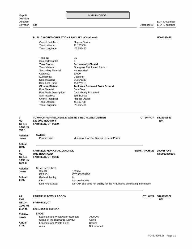
MAP FINDINGSMap IDDirection
EDR ID NumberDistanceEPA ID NumberDatabase(s)SiteElevation
-73.256460Tank Longitude: 41.130750Tank Latitude: Flapper DeviceOverfill Installed: Spill BucketSpill Installed: Cathodically ProtectedPipe Mode Description: Bare SteelPipe Material: Tank was Removed From GroundClosure Status: 11/07/2013Date Last Used: 04/01/1985Date Installed: GasolineSubstance: 10000Capacity: Not reportedSecondary Material: Fiberglass Reinforced PlasticTank Material: Permanently ClosedTank Status: aCompartment ID: C5Tank ID:
-73.256460Tank Longitude: 41.130900Tank Latitude: Flapper DeviceOverfill Installed:
PUBLIC WORKS OPERATIONS FACILITY (Continued) U004246430
Municipal Transfer Station General PermitPermit Type:SWRCY:
857 ft.0.162 mi.
Relative:Lower
Actual:18 ft.
1/8-1/4 FAIRFIELD, CT 06824NE 533 ONE ROD HWY N/A2 CT SWRCYTOWN OF FAIRFIELD SOLID WASTE & RECYCLING CENTER S115949949
NFRAP-Site does not qualify for the NPL based on existing informationNon NPL Status: Not on the NPLNPL: NFederal Facility: CTD983870296EPA ID: 101524Site ID:
SEMS-ARCHIVE:
1050 ft.0.199 mi.
Relative:Lower
Actual:14 ft.
1/8-1/4 FAIRFIELD, CT 06430NE ONE ROD ROAD CTD9838702963 SEMS-ARCHIVEFAIRFIELD MUNICIPAL LANDFILL 1000357069
Not reportedAlias: GroundLeachate and Waste Flow: ActiveStatus of the Discharge Activity: 7000045Leachate and Wastewater Number:
LWDS:
1104 ft. Site 1 of 2 in cluster A0.209 mi.
Relative:Lower
Actual:17 ft.
1/8-1/4 FAIRFIELD, CT ENE N/AA4 CT LWDSFAIRFIELD TOWN LAGOON S109938777
TC4616258.2s Page 11
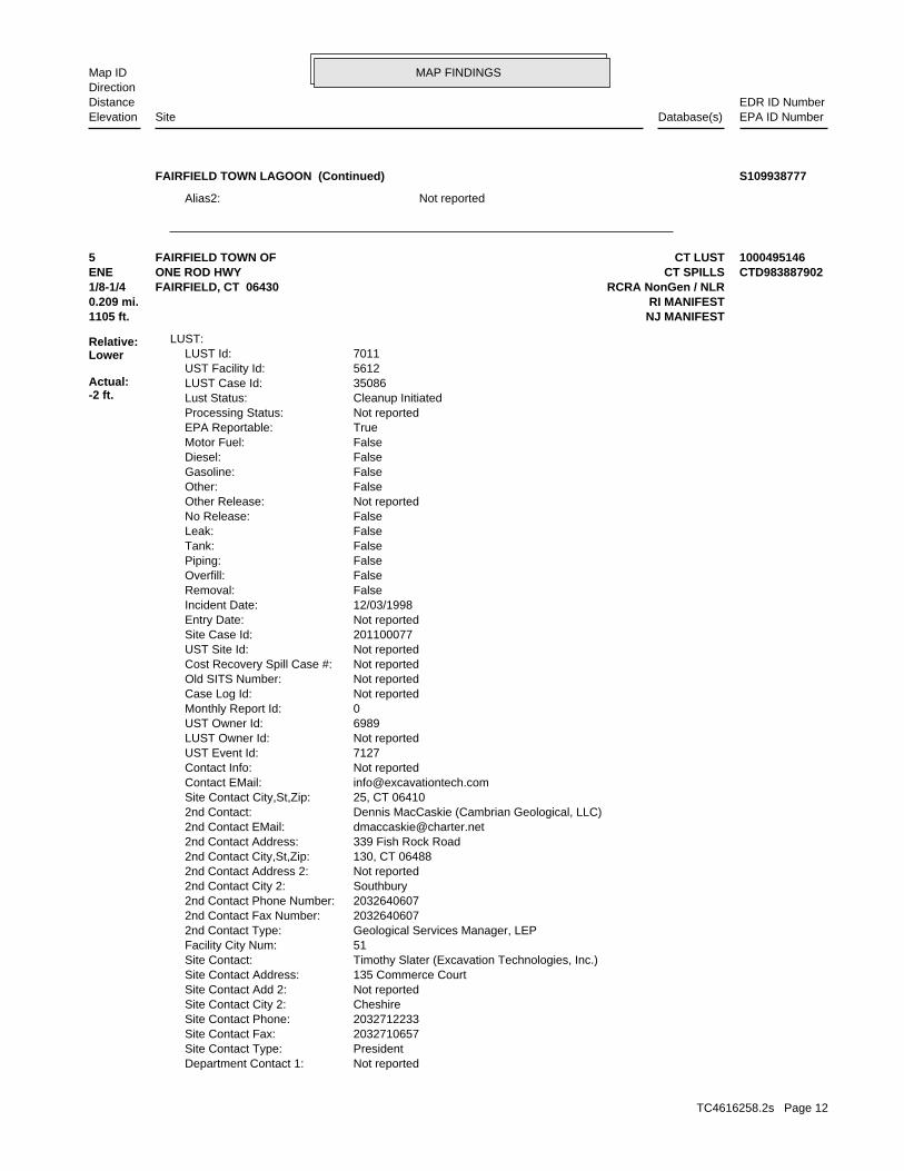
MAP FINDINGSMap IDDirection
EDR ID NumberDistanceEPA ID NumberDatabase(s)SiteElevation
Not reportedAlias2:
FAIRFIELD TOWN LAGOON (Continued) S109938777
Not reportedDepartment Contact 1: PresidentSite Contact Type: 2032710657Site Contact Fax: 2032712233Site Contact Phone: CheshireSite Contact City 2: Not reportedSite Contact Add 2: 135 Commerce CourtSite Contact Address: Timothy Slater (Excavation Technologies, Inc.)Site Contact: 51Facility City Num: Geological Services Manager, LEP2nd Contact Type: 20326406072nd Contact Fax Number: 20326406072nd Contact Phone Number: Southbury2nd Contact City 2: Not reported2nd Contact Address 2: 130, CT 064882nd Contact City,St,Zip: 339 Fish Rock Road2nd Contact Address: [email protected] Contact EMail: Dennis MacCaskie (Cambrian Geological, LLC)2nd Contact: 25, CT 06410Site Contact City,St,Zip: [email protected] EMail: Not reportedContact Info: 7127UST Event Id: Not reportedLUST Owner Id: 6989UST Owner Id: 0Monthly Report Id: Not reportedCase Log Id: Not reportedOld SITS Number: Not reportedCost Recovery Spill Case #: Not reportedUST Site Id: 201100077Site Case Id: Not reportedEntry Date: 12/03/1998Incident Date: FalseRemoval: FalseOverfill: FalsePiping: FalseTank: FalseLeak: FalseNo Release: Not reportedOther Release: FalseOther: FalseGasoline: FalseDiesel: FalseMotor Fuel: TrueEPA Reportable: Not reportedProcessing Status: Cleanup InitiatedLust Status: 35086LUST Case Id: 5612UST Facility Id: 7011LUST Id:
LUST:
1105 ft. NJ MANIFEST0.209 mi. RI MANIFEST
Relative:Lower
Actual:-2 ft.
1/8-1/4 RCRA NonGen / NLRFAIRFIELD, CT 06430ENE CT SPILLSONE ROD HWY CTD9838879025 CT LUSTFAIRFIELD TOWN OF 1000495146
TC4616258.2s Page 12
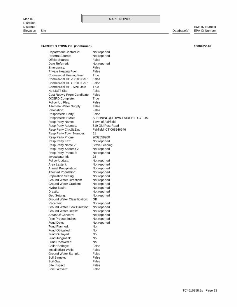
MAP FINDINGSMap IDDirection
EDR ID NumberDistanceEPA ID NumberDatabase(s)SiteElevation
FalseSoil Excavate: FalseSite Inspect: FalseSoil Gas: FalseSoil Sample: FalseGround Water Sample: FalseInstall Micro Wells: FalseCellar Borings: NoFund Recovered: NoFund Judgment: NoFund Outlayed: NoFund Obligated: NoFund Planned: Not reportedFund Date: Not reportedFree Product Inches: Not reportedAreas Of Concern: Not reportedGround Water Depth: Not reportedGround Water Flow Direction: Not reportedReceptor: GBGround Water Classification: Not reportedGeo Setting: Not reportedDrastic: Not reportedHydro Basin: Not reportedGround Water Gradient: Not reportedGround Water Direction: Not reportedPopulation Setting: Not reportedAffected Population: Not reportedAnnual Precipitation: Not reportedArea Lextent: Not reportedFollow Update: 28Investigator Id: Not reportedResp Party Phone 2: Not reportedResp Party Address 2: Steve LehningResp Party Name 2: Not reportedResp Party Fax: 2032558200Resp Party Phone: 51Resp Party Town Number: Fairfield, CT 068246646Resp Party City,St,Zip: 610 Old Post RoadResp Party Address: Town of FairfieldResp Party Name: [email protected] EMail: FalseResponsible Party: FalseRelocation: FalseAlternate Water Supply: FalseFollow Up Flag: TrueOCSRD Complete: FalseCost Recvry Prgm Candidate: FalseNo LUST Site: TrueCommercial HF - Size Unk: FalseCommercial HF > 2100 Gal.: FalseCommercial HF < 2100 Gal.: TrueCommercial Heating Fuel: FalsePrivate Heating Fuel: FalseEmergency: Not reportedDate Referred: FalseOffsite Source: Not reportedReferral Source: Not reportedDepartment Contact 2:
FAIRFIELD TOWN OF (Continued) 1000495146
TC4616258.2s Page 13
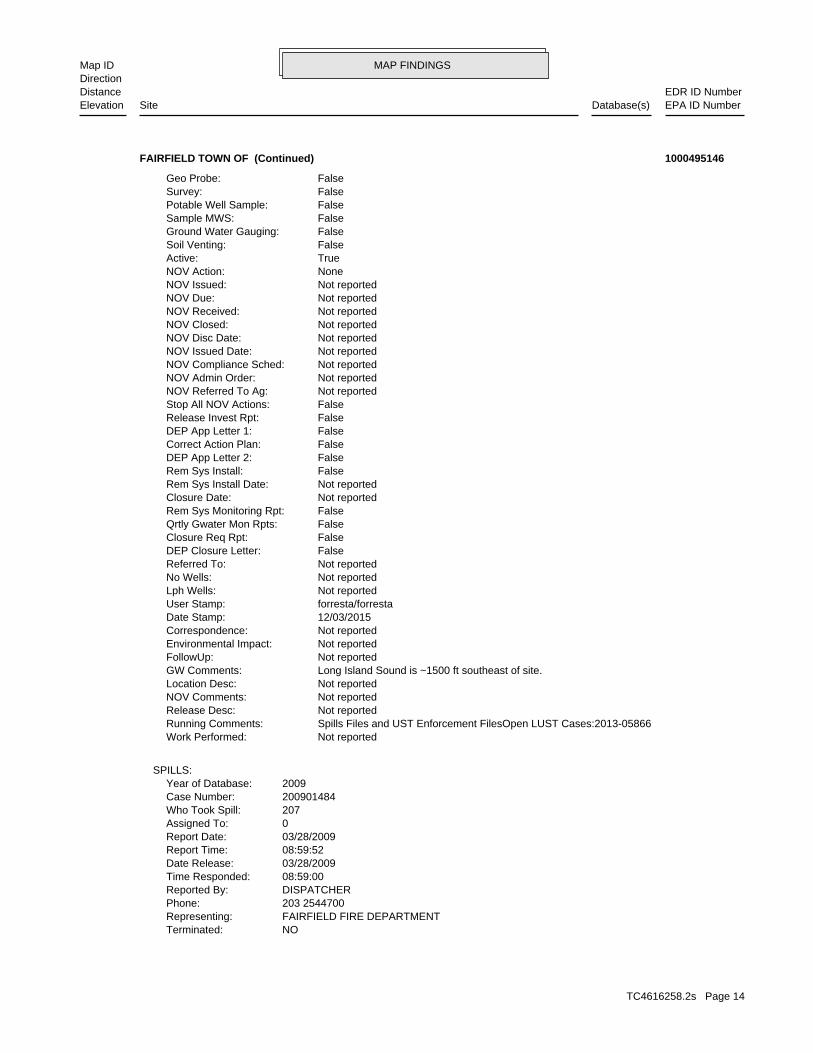
MAP FINDINGSMap IDDirection
EDR ID NumberDistanceEPA ID NumberDatabase(s)SiteElevation
NOTerminated: FAIRFIELD FIRE DEPARTMENTRepresenting: 203 2544700Phone: DISPATCHERReported By: 08:59:00Time Responded: 03/28/2009Date Release: 08:59:52Report Time: 03/28/2009Report Date: 0Assigned To: 207Who Took Spill: 200901484Case Number: 2009Year of Database:
SPILLS:
Not reportedWork Performed: Spills Files and UST Enforcement FilesOpen LUST Cases:2013-05866Running Comments: Not reportedRelease Desc: Not reportedNOV Comments: Not reportedLocation Desc: Long Island Sound is ~1500 ft southeast of site.GW Comments: Not reportedFollowUp: Not reportedEnvironmental Impact: Not reportedCorrespondence: 12/03/2015Date Stamp: forresta/forrestaUser Stamp: Not reportedLph Wells: Not reportedNo Wells: Not reportedReferred To: FalseDEP Closure Letter: FalseClosure Req Rpt: FalseQrtly Gwater Mon Rpts: FalseRem Sys Monitoring Rpt: Not reportedClosure Date: Not reportedRem Sys Install Date: FalseRem Sys Install: FalseDEP App Letter 2: FalseCorrect Action Plan: FalseDEP App Letter 1: FalseRelease Invest Rpt: FalseStop All NOV Actions: Not reportedNOV Referred To Ag: Not reportedNOV Admin Order: Not reportedNOV Compliance Sched: Not reportedNOV Issued Date: Not reportedNOV Disc Date: Not reportedNOV Closed: Not reportedNOV Received: Not reportedNOV Due: Not reportedNOV Issued: NoneNOV Action: TrueActive: FalseSoil Venting: FalseGround Water Gauging: FalseSample MWS: FalsePotable Well Sample: FalseSurvey: FalseGeo Probe:
FAIRFIELD TOWN OF (Continued) 1000495146
TC4616258.2s Page 14
MAP FINDINGSMap IDDirection
EDR ID NumberDistanceEPA ID NumberDatabase(s)SiteElevation
Not reportedOwner/operator country: FAIRFIELD, CT 06430 725 OLD POST RDOwner/operator address: TOWN OF FAIRFIELDOwner/operator name:
Owner/Operator Summary:
Handler: Non-Generators do not presently generate hazardous wasteDescription: Non-GeneratorClassification: 01EPA Region: Not reportedContact email: (203) 256-3023Contact telephone: USContact country: FAIRFIELD, CT 06430 725 OLD POST RDContact address: RICHARD CELLARContact: FAIRFIELD, CT 06430 OLD POST RDMailing address: CTD983887902EPA ID: FAIRFIELD, CT 06430 ONE ROD HWYFacility address: FAIRFIELD TOWN OFFacility name: 08/07/1991Date form received by agency:
RCRA NonGen / NLR:
Not reportedOther Wtrbody:Catch BasinWaterbody:Not reportedOther Release:biomedicalRelease Type:Not reportedOther Class:GovernmentalClass ID:Not reportedOther Media:Ground WaterMedia ID:Not reportedOther Cause:SeepageCause ID:Not reportedOther Action:ReferredAction: Not reportedComments: CGuzmanUser Stamp: **NO RESPONSEAt Inspctor: Gilmore, PeteSr Inspector: 2009-03-30 15:51:41Time Stamp: FalseWaterbody: FalseHistoric: CTRP City,St,Zip: Not reportedRP Address 1: Not reportedResponsible Party: Not reportedTelephone: Not reportedDischarger: Not reportedWater Body: Unknown chemical in storm drain, and notify 937.Emergency Measure: 0 (Gallons)Qty: UNKNOWN CHEMICALReleased Substance: FalseContinuous Spill: CLOSEDFacility Status: 0Total (Water): 0Recovd (Total):
FAIRFIELD TOWN OF (Continued) 1000495146
TC4616258.2s Page 15
MAP FINDINGSMap IDDirection
EDR ID NumberDistanceEPA ID NumberDatabase(s)SiteElevation
RIH0018174Manifest Docket Number: CTD983887902EPA ID:
Details:
Not reportedComment: Not reportedFee Exempt Code: Not reportedWaste Code3: Not reportedWaste Code2: Not reportedWaste Code1: Not reportedContainer Type: 0Number Of Containers: Not reportedTransporter Receipt Date: Not reportedTransporter 2 Name: Not reportedTransporter 2 Id: Not reportedTSDF Date: NORTHLAND ENVIRONMENTAL INC.TSDF Name: RID040098352TSDF Id: 3/26/2002GEN Cert Date: RIH0018174Manifest Document Number: CTD983887902EPA Id:
RI MANIFEST:
No violations foundViolation Status:
TETRACHLOROETHYLENE. Waste name: D039. Waste code:
BENZENE. Waste name: D018. Waste code:
LEAD. Waste name: D008. Waste code:
IGNITABLE WASTE. Waste name: D001. Waste code:
NoUsed oil transporter: NoUsed oil transfer facility: NoUsed oil Specification marketer: NoUsed oil fuel marketer to burner: NoUser oil refiner: NoUsed oil processor: NoUsed oil fuel burner: NoFurnace exemption: NoOn-site burner exemption: NoUnderground injection activity: NoTreater, storer or disposer of HW: NoTransporter of hazardous waste: NoRecycler of hazardous waste: NoMixed waste (haz. and radioactive): NoU.S. importer of hazardous waste:
Handler Activities Summary:
Not reportedOwner/Op end date: Not reportedOwner/Op start date: OwnerOwner/Operator Type: PrivateLegal status: (203) 256-3023Owner/operator telephone:
FAIRFIELD TOWN OF (Continued) 1000495146
TC4616258.2s Page 16

MAP FINDINGSMap IDDirection
EDR ID NumberDistanceEPA ID NumberDatabase(s)SiteElevation
Not reportedTransporter 7 EPA ID: Not reportedTransporter 6 EPA ID: Not reportedTransporter 5 EPA ID: Not reportedTransporter 4 EPA ID: Not reportedTransporter 3 EPA ID: Not reportedTransporter 2 EPA ID: TXR000050930Transporter EPA ID: NJD982270506TSDF EPA ID: 07/01/2009Date Shipped: CTD983887902EPA ID: 001819424SKSManifest Number:
Manifest:
Not reportedDate Change: Not reportedName Change: Not reportedTSDF Flag: Not reportedTrans Flag: Not reportedGen Flag: Not reportedPrevious EPA Id: Not reportedMunicipal: CT001County: Not reportedSIC Code: Not reportedComments: RICHARD CELLARContact: Not reportedEmergency Phone: Not reportedFacility Phone: FAIRFIELD, CT 06430Mail City/State/Zip: OLD POST RDMail Address: CTD983887902EPA Id:
NJ MANIFEST:
Not reportedTransporter 2 ID: Not reportedTSDF Receipt Date: Not reportedTransporter 2 Receipt Date: Not reportedTransporter Receipt Date: 3/26/2002GEN Cert Date: MAD084814136Transporter EPA ID: FRANKLIN ENVIRONMENTAL SERVICETransporter Name: 5827Item Number: GWT/Vol Units: 55Quantity: OIL & WATERWaste Description: RIH0018174Manifest Docket Number: CTD983887902EPA ID:
Not reportedTransporter 2 ID: Not reportedTSDF Receipt Date: Not reportedTransporter 2 Receipt Date: Not reportedTransporter Receipt Date: 3/26/2002GEN Cert Date: MAD084814136Transporter EPA ID: FRANKLIN ENVIRONMENTAL SERVICETransporter Name: 5827Item Number: GWT/Vol Units: 55Quantity: OIL & WATERWaste Description:
FAIRFIELD TOWN OF (Continued) 1000495146
TC4616258.2s Page 17
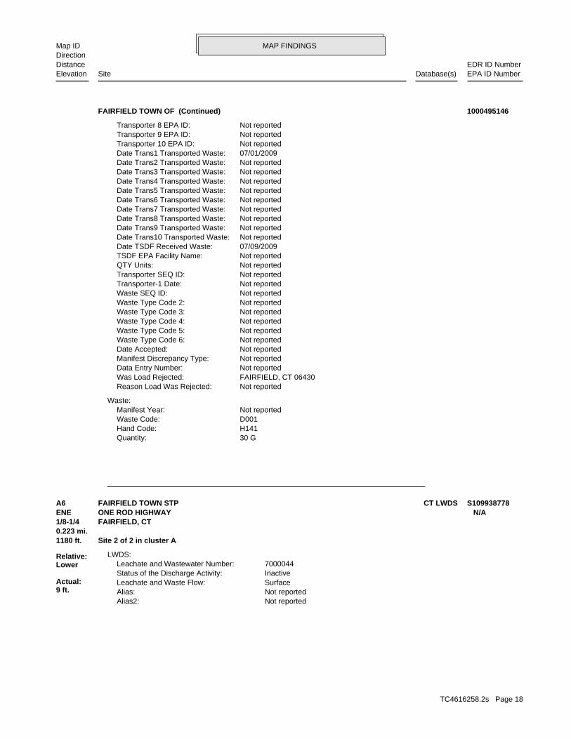
MAP FINDINGSMap IDDirection
EDR ID NumberDistanceEPA ID NumberDatabase(s)SiteElevation
30 GQuantity: H141Hand Code: D001Waste Code: Not reportedManifest Year:
Waste:
Not reportedReason Load Was Rejected: FAIRFIELD, CT 06430Was Load Rejected: Not reportedData Entry Number: Not reportedManifest Discrepancy Type: Not reportedDate Accepted: Not reportedWaste Type Code 6: Not reportedWaste Type Code 5: Not reportedWaste Type Code 4: Not reportedWaste Type Code 3: Not reportedWaste Type Code 2: Not reportedWaste SEQ ID: Not reportedTransporter-1 Date: Not reportedTransporter SEQ ID: Not reportedQTY Units: Not reportedTSDF EPA Facility Name: 07/09/2009Date TSDF Received Waste: Not reportedDate Trans10 Transported Waste: Not reportedDate Trans9 Transported Waste: Not reportedDate Trans8 Transported Waste: Not reportedDate Trans7 Transported Waste: Not reportedDate Trans6 Transported Waste: Not reportedDate Trans5 Transported Waste: Not reportedDate Trans4 Transported Waste: Not reportedDate Trans3 Transported Waste: Not reportedDate Trans2 Transported Waste: 07/01/2009Date Trans1 Transported Waste: Not reportedTransporter 10 EPA ID: Not reportedTransporter 9 EPA ID: Not reportedTransporter 8 EPA ID:
FAIRFIELD TOWN OF (Continued) 1000495146
Not reportedAlias2: Not reportedAlias: SurfaceLeachate and Waste Flow: InactiveStatus of the Discharge Activity: 7000044Leachate and Wastewater Number:
LWDS:
1180 ft. Site 2 of 2 in cluster A0.223 mi.
Relative:Lower
Actual:9 ft.
1/8-1/4 FAIRFIELD, CT ENE ONE ROD HIGHWAY N/AA6 CT LWDSFAIRFIELD TOWN STP S109938778
TC4616258.2s Page 18
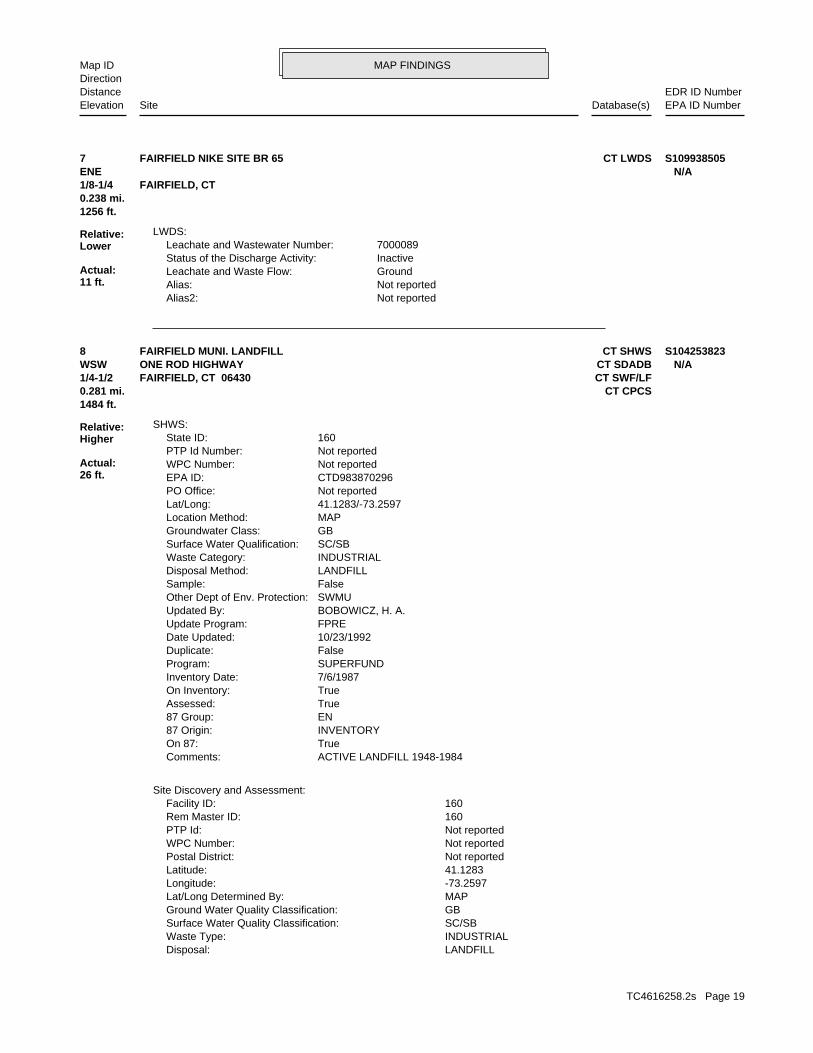
MAP FINDINGSMap IDDirection
EDR ID NumberDistanceEPA ID NumberDatabase(s)SiteElevation
Not reportedAlias2: Not reportedAlias: GroundLeachate and Waste Flow: InactiveStatus of the Discharge Activity: 7000089Leachate and Wastewater Number:
LWDS:
1256 ft.0.238 mi.
Relative:Lower
Actual:11 ft.
1/8-1/4 FAIRFIELD, CT ENE N/A7 CT LWDSFAIRFIELD NIKE SITE BR 65 S109938505
LANDFILLDisposal: INDUSTRIALWaste Type: SC/SBSurface Water Quality Classification: GBGround Water Quality Classification: MAPLat/Long Determined By: -73.2597Longitude: 41.1283Latitude: Not reportedPostal District: Not reportedWPC Number: Not reportedPTP Id: 160Rem Master ID: 160Facility ID:
Site Discovery and Assessment:
ACTIVE LANDFILL 1948-1984Comments: TrueOn 87: INVENTORY87 Origin: EN87 Group: TrueAssessed: TrueOn Inventory: 7/6/1987Inventory Date: SUPERFUNDProgram: FalseDuplicate: 10/23/1992Date Updated: FPREUpdate Program: BOBOWICZ, H. A.Updated By: SWMUOther Dept of Env. Protection: FalseSample: LANDFILLDisposal Method: INDUSTRIALWaste Category: SC/SBSurface Water Qualification: GBGroundwater Class: MAPLocation Method: 41.1283/-73.2597Lat/Long: Not reportedPO Office: CTD983870296EPA ID: Not reportedWPC Number: Not reportedPTP Id Number: 160State ID:
SHWS:
1484 ft.0.281 mi. CT CPCS
Relative:Higher
Actual:26 ft.
1/4-1/2 CT SWF/LFFAIRFIELD, CT 06430WSW CT SDADBONE ROD HIGHWAY N/A8 CT SHWSFAIRFIELD MUNI. LANDFILL S104253823
TC4616258.2s Page 19
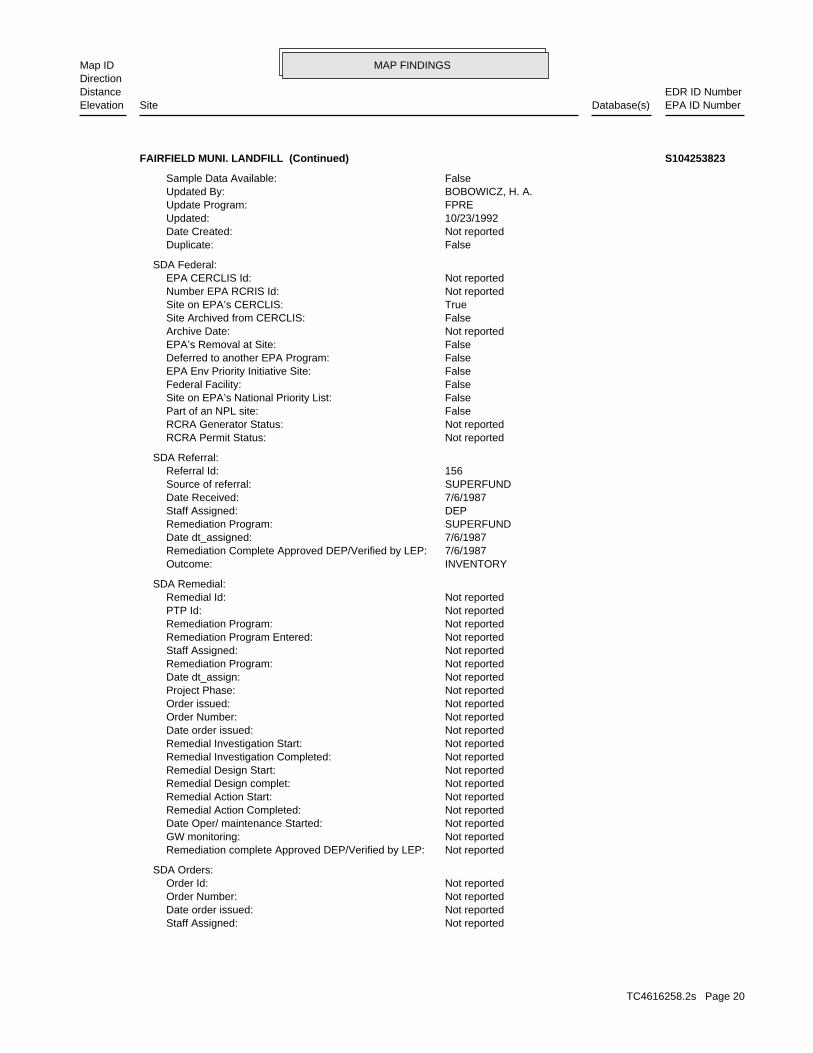
MAP FINDINGSMap IDDirection
EDR ID NumberDistanceEPA ID NumberDatabase(s)SiteElevation
Not reportedStaff Assigned: Not reportedDate order issued: Not reportedOrder Number: Not reportedOrder Id:
SDA Orders:
Not reportedRemediation complete Approved DEP/Verified by LEP: Not reportedGW monitoring: Not reportedDate Oper/ maintenance Started: Not reportedRemedial Action Completed: Not reportedRemedial Action Start: Not reportedRemedial Design complet: Not reportedRemedial Design Start: Not reportedRemedial Investigation Completed: Not reportedRemedial Investigation Start: Not reportedDate order issued: Not reportedOrder Number: Not reportedOrder issued: Not reportedProject Phase: Not reportedDate dt_assign: Not reportedRemediation Program: Not reportedStaff Assigned: Not reportedRemediation Program Entered: Not reportedRemediation Program: Not reportedPTP Id: Not reportedRemedial Id:
SDA Remedial:
INVENTORYOutcome: 7/6/1987Remediation Complete Approved DEP/Verified by LEP: 7/6/1987Date dt_assigned: SUPERFUNDRemediation Program: DEPStaff Assigned: 7/6/1987Date Received: SUPERFUNDSource of referral: 156Referral Id:
SDA Referral:
Not reportedRCRA Permit Status: Not reportedRCRA Generator Status: FalsePart of an NPL site: FalseSite on EPA’s National Priority List: FalseFederal Facility: FalseEPA Env Priority Initiative Site: FalseDeferred to another EPA Program: FalseEPA’s Removal at Site: Not reportedArchive Date: FalseSite Archived from CERCLIS: TrueSite on EPA’s CERCLIS: Not reportedNumber EPA RCRIS Id: Not reportedEPA CERCLIS Id:
SDA Federal:
FalseDuplicate: Not reportedDate Created: 10/23/1992Updated: FPREUpdate Program: BOBOWICZ, H. A.Updated By: FalseSample Data Available:
FAIRFIELD MUNI. LANDFILL (Continued) S104253823
TC4616258.2s Page 20

MAP FINDINGSMap IDDirection
EDR ID NumberDistanceEPA ID NumberDatabase(s)SiteElevation
Inventory of Hazardous Waste Disposal SitesSite Type Definition: Active Landfill 1948-1984Comments: -1Program: Not reportedPTP Form: Not reportedLust Status: Not reportedLust Status code: SitesSite Type:
CPCS:
Not reportedComments:Not reportedApplication Acr:051-2CPermit Number:7/21/1987Permit Issued:Not reportedOwner Name:Not reportedWaste Type:SWFProgram ID:199701034Application ID:ACFacility Status:TRANSFER STATIONActivity Type:Permit to OperateFacility Type:12/31/2011Permit Expires:FAIRFIELD, TOWN OFCompany Name:MIXED MUNICIPAL WASTEMaterial:
SWF/LF:
Not reportedComments: Not reportedIn compliance: Not reportedOrder Complete: Not reportedPenalty assessed: Not reportedDate of AGR judgement: Not reportedJudgement: Not reportedDate Referred to AG: Not reportedDate Order Modified: Not reportedDate of Court Ruling: Not reportedDate of Court Ruling: Not reportedDate of Court Appeal: Not reportedDate of Final Order: Not reportedDate of Admin Appeal Ruling: Not reportedDate of Admin Appeal Ruling: Not reportedAdmin Appeal Date: Not reportedOrder Respondent: Not reportedType of Order:
FAIRFIELD MUNI. LANDFILL (Continued) S104253823
FalseMotor Fuel: FalseEPA Reportable: Not reportedProcessing Status: Lust CompletedLust Status: 33550LUST Case Id: Not reportedUST Facility Id: 5425LUST Id:
LUST:
1937 ft. Site 1 of 3 in cluster B0.367 mi.
Relative:Lower
Actual:14 ft.
1/4-1/2 CT CPCSFAIRFIELD, CT 06430North CT SPILLS281 EAST LAWN STREET N/AB9 CT LUSTBETTY GOODFELLOW S103162950
TC4616258.2s Page 21
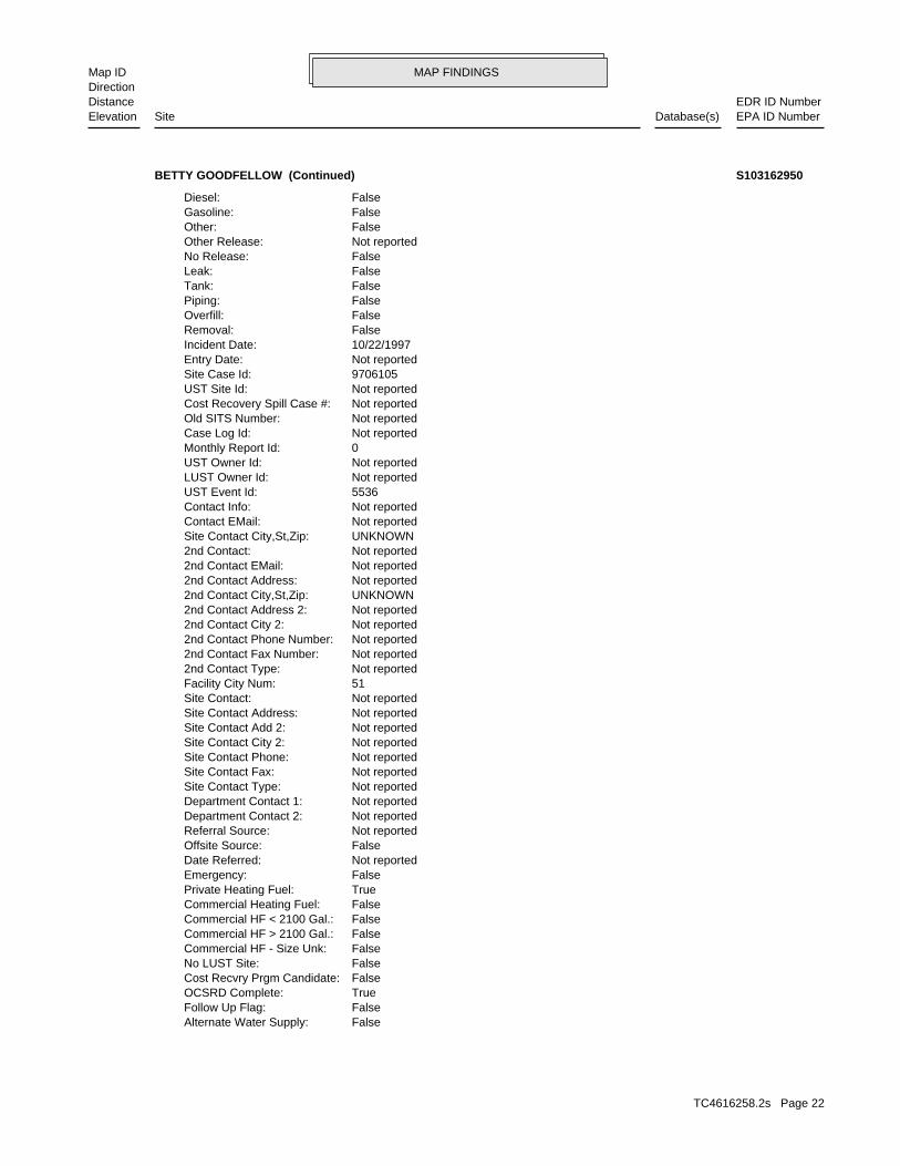
MAP FINDINGSMap IDDirection
EDR ID NumberDistanceEPA ID NumberDatabase(s)SiteElevation
FalseAlternate Water Supply: FalseFollow Up Flag: TrueOCSRD Complete: FalseCost Recvry Prgm Candidate: FalseNo LUST Site: FalseCommercial HF - Size Unk: FalseCommercial HF > 2100 Gal.: FalseCommercial HF < 2100 Gal.: FalseCommercial Heating Fuel: TruePrivate Heating Fuel: FalseEmergency: Not reportedDate Referred: FalseOffsite Source: Not reportedReferral Source: Not reportedDepartment Contact 2: Not reportedDepartment Contact 1: Not reportedSite Contact Type: Not reportedSite Contact Fax: Not reportedSite Contact Phone: Not reportedSite Contact City 2: Not reportedSite Contact Add 2: Not reportedSite Contact Address: Not reportedSite Contact: 51Facility City Num: Not reported2nd Contact Type: Not reported2nd Contact Fax Number: Not reported2nd Contact Phone Number: Not reported2nd Contact City 2: Not reported2nd Contact Address 2: UNKNOWN2nd Contact City,St,Zip: Not reported2nd Contact Address: Not reported2nd Contact EMail: Not reported2nd Contact: UNKNOWNSite Contact City,St,Zip: Not reportedContact EMail: Not reportedContact Info: 5536UST Event Id: Not reportedLUST Owner Id: Not reportedUST Owner Id: 0Monthly Report Id: Not reportedCase Log Id: Not reportedOld SITS Number: Not reportedCost Recovery Spill Case #: Not reportedUST Site Id: 9706105Site Case Id: Not reportedEntry Date: 10/22/1997Incident Date: FalseRemoval: FalseOverfill: FalsePiping: FalseTank: FalseLeak: FalseNo Release: Not reportedOther Release: FalseOther: FalseGasoline: FalseDiesel:
BETTY GOODFELLOW (Continued) S103162950
TC4616258.2s Page 22
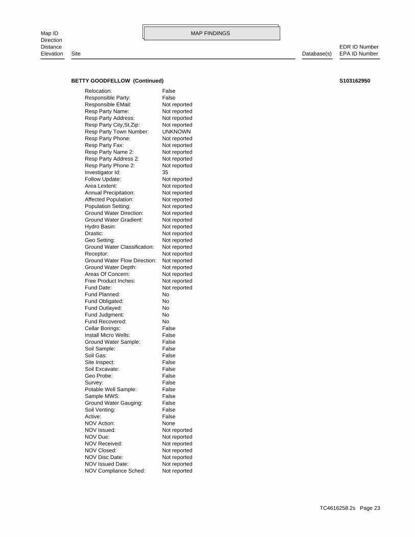
MAP FINDINGSMap IDDirection
EDR ID NumberDistanceEPA ID NumberDatabase(s)SiteElevation
Not reportedNOV Compliance Sched: Not reportedNOV Issued Date: Not reportedNOV Disc Date: Not reportedNOV Closed: Not reportedNOV Received: Not reportedNOV Due: Not reportedNOV Issued: NoneNOV Action: FalseActive: FalseSoil Venting: FalseGround Water Gauging: FalseSample MWS: FalsePotable Well Sample: FalseSurvey: FalseGeo Probe: FalseSoil Excavate: FalseSite Inspect: FalseSoil Gas: FalseSoil Sample: FalseGround Water Sample: FalseInstall Micro Wells: FalseCellar Borings: NoFund Recovered: NoFund Judgment: NoFund Outlayed: NoFund Obligated: NoFund Planned: Not reportedFund Date: Not reportedFree Product Inches: Not reportedAreas Of Concern: Not reportedGround Water Depth: Not reportedGround Water Flow Direction: Not reportedReceptor: Not reportedGround Water Classification: Not reportedGeo Setting: Not reportedDrastic: Not reportedHydro Basin: Not reportedGround Water Gradient: Not reportedGround Water Direction: Not reportedPopulation Setting: Not reportedAffected Population: Not reportedAnnual Precipitation: Not reportedArea Lextent: Not reportedFollow Update: 35Investigator Id: Not reportedResp Party Phone 2: Not reportedResp Party Address 2: Not reportedResp Party Name 2: Not reportedResp Party Fax: Not reportedResp Party Phone: UNKNOWNResp Party Town Number: Not reportedResp Party City,St,Zip: Not reportedResp Party Address: Not reportedResp Party Name: Not reportedResponsible EMail: FalseResponsible Party: FalseRelocation:
BETTY GOODFELLOW (Continued) S103162950
TC4616258.2s Page 23
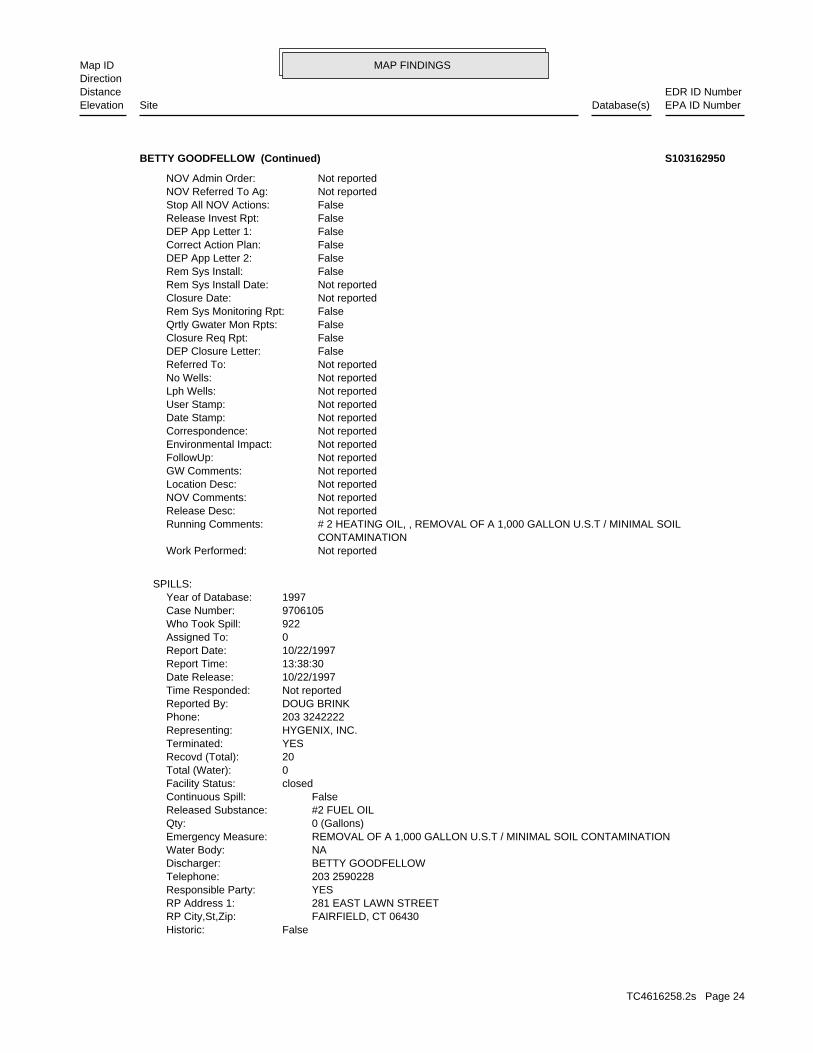
MAP FINDINGSMap IDDirection
EDR ID NumberDistanceEPA ID NumberDatabase(s)SiteElevation
FalseHistoric: FAIRFIELD, CT 06430RP City,St,Zip: 281 EAST LAWN STREETRP Address 1: YESResponsible Party: 203 2590228Telephone: BETTY GOODFELLOWDischarger: NAWater Body: REMOVAL OF A 1,000 GALLON U.S.T / MINIMAL SOIL CONTAMINATIONEmergency Measure: 0 (Gallons)Qty: #2 FUEL OILReleased Substance: FalseContinuous Spill: closedFacility Status: 0Total (Water): 20Recovd (Total): YESTerminated: HYGENIX, INC.Representing: 203 3242222Phone: DOUG BRINKReported By: Not reportedTime Responded: 10/22/1997Date Release: 13:38:30Report Time: 10/22/1997Report Date: 0Assigned To: 922Who Took Spill: 9706105Case Number: 1997Year of Database:
SPILLS:
Not reportedWork Performed: CONTAMINATION # 2 HEATING OIL, , REMOVAL OF A 1,000 GALLON U.S.T / MINIMAL SOILRunning Comments: Not reportedRelease Desc: Not reportedNOV Comments: Not reportedLocation Desc: Not reportedGW Comments: Not reportedFollowUp: Not reportedEnvironmental Impact: Not reportedCorrespondence: Not reportedDate Stamp: Not reportedUser Stamp: Not reportedLph Wells: Not reportedNo Wells: Not reportedReferred To: FalseDEP Closure Letter: FalseClosure Req Rpt: FalseQrtly Gwater Mon Rpts: FalseRem Sys Monitoring Rpt: Not reportedClosure Date: Not reportedRem Sys Install Date: FalseRem Sys Install: FalseDEP App Letter 2: FalseCorrect Action Plan: FalseDEP App Letter 1: FalseRelease Invest Rpt: FalseStop All NOV Actions: Not reportedNOV Referred To Ag: Not reportedNOV Admin Order:
BETTY GOODFELLOW (Continued) S103162950
TC4616258.2s Page 24
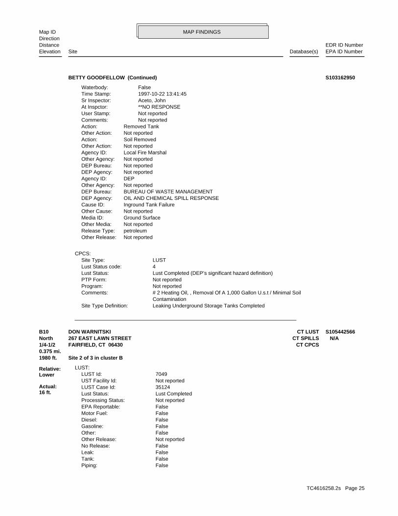
MAP FINDINGSMap IDDirection
EDR ID NumberDistanceEPA ID NumberDatabase(s)SiteElevation
Leaking Underground Storage Tanks CompletedSite Type Definition: Contamination # 2 Heating Oil, , Removal Of A 1,000 Gallon U.s.t / Minimal SoilComments: Not reportedProgram: Not reportedPTP Form: Lust Completed (DEP’s significant hazard definition)Lust Status: 4Lust Status code: LUSTSite Type:
CPCS:
Not reportedOther Release:petroleumRelease Type:Not reportedOther Media:Ground SurfaceMedia ID:Not reportedOther Cause:Inground Tank FailureCause ID:OIL AND CHEMICAL SPILL RESPONSEDEP Agency:BUREAU OF WASTE MANAGEMENTDEP Bureau:Not reportedOther Agency:DEPAgency ID:Not reportedDEP Agency:Not reportedDEP Bureau:Not reportedOther Agency:Local Fire MarshalAgency ID:Not reportedOther Action:Soil RemovedAction:Not reportedOther Action:Removed TankAction: Not reportedComments: Not reportedUser Stamp: **NO RESPONSEAt Inspctor: Aceto, JohnSr Inspector: 1997-10-22 13:41:45Time Stamp: FalseWaterbody:
BETTY GOODFELLOW (Continued) S103162950
FalsePiping: FalseTank: FalseLeak: FalseNo Release: Not reportedOther Release: FalseOther: FalseGasoline: FalseDiesel: FalseMotor Fuel: FalseEPA Reportable: Not reportedProcessing Status: Lust CompletedLust Status: 35124LUST Case Id: Not reportedUST Facility Id: 7049LUST Id:
LUST:
1980 ft. Site 2 of 3 in cluster B0.375 mi.
Relative:Lower
Actual:16 ft.
1/4-1/2 CT CPCSFAIRFIELD, CT 06430North CT SPILLS267 EAST LAWN STREET N/AB10 CT LUSTDON WARNITSKI S105442566
TC4616258.2s Page 25
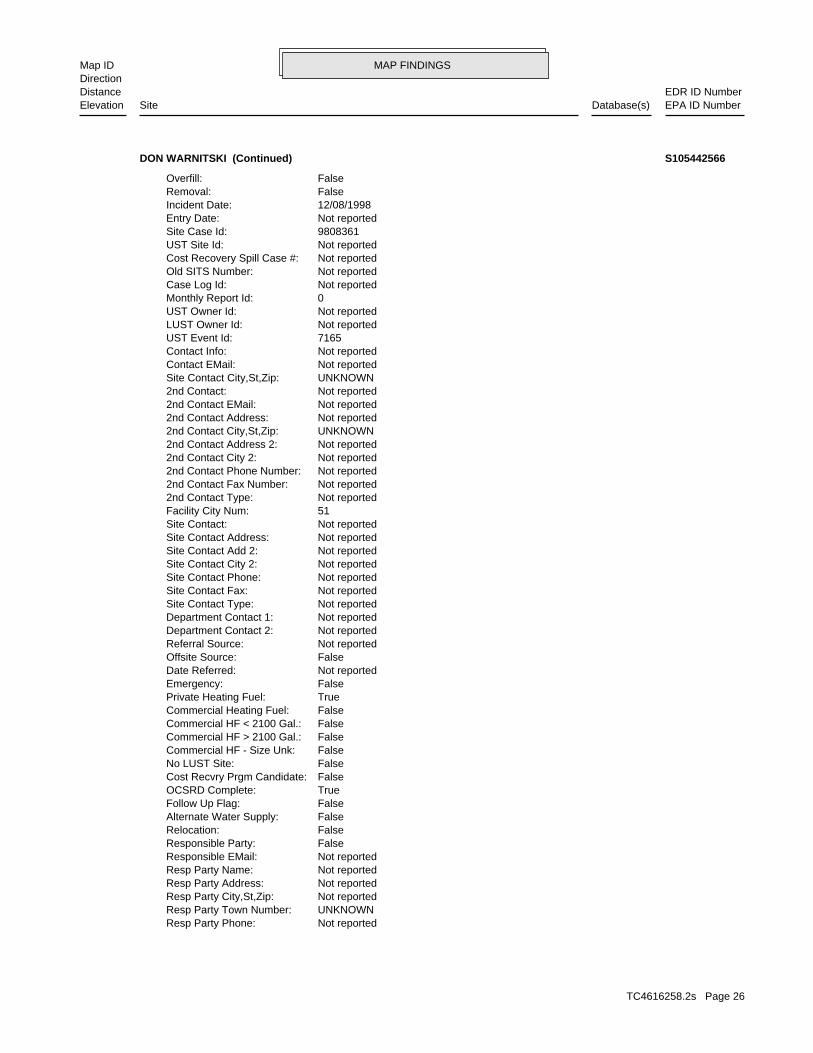
MAP FINDINGSMap IDDirection
EDR ID NumberDistanceEPA ID NumberDatabase(s)SiteElevation
Not reportedResp Party Phone: UNKNOWNResp Party Town Number: Not reportedResp Party City,St,Zip: Not reportedResp Party Address: Not reportedResp Party Name: Not reportedResponsible EMail: FalseResponsible Party: FalseRelocation: FalseAlternate Water Supply: FalseFollow Up Flag: TrueOCSRD Complete: FalseCost Recvry Prgm Candidate: FalseNo LUST Site: FalseCommercial HF - Size Unk: FalseCommercial HF > 2100 Gal.: FalseCommercial HF < 2100 Gal.: FalseCommercial Heating Fuel: TruePrivate Heating Fuel: FalseEmergency: Not reportedDate Referred: FalseOffsite Source: Not reportedReferral Source: Not reportedDepartment Contact 2: Not reportedDepartment Contact 1: Not reportedSite Contact Type: Not reportedSite Contact Fax: Not reportedSite Contact Phone: Not reportedSite Contact City 2: Not reportedSite Contact Add 2: Not reportedSite Contact Address: Not reportedSite Contact: 51Facility City Num: Not reported2nd Contact Type: Not reported2nd Contact Fax Number: Not reported2nd Contact Phone Number: Not reported2nd Contact City 2: Not reported2nd Contact Address 2: UNKNOWN2nd Contact City,St,Zip: Not reported2nd Contact Address: Not reported2nd Contact EMail: Not reported2nd Contact: UNKNOWNSite Contact City,St,Zip: Not reportedContact EMail: Not reportedContact Info: 7165UST Event Id: Not reportedLUST Owner Id: Not reportedUST Owner Id: 0Monthly Report Id: Not reportedCase Log Id: Not reportedOld SITS Number: Not reportedCost Recovery Spill Case #: Not reportedUST Site Id: 9808361Site Case Id: Not reportedEntry Date: 12/08/1998Incident Date: FalseRemoval: FalseOverfill:
DON WARNITSKI (Continued) S105442566
TC4616258.2s Page 26

MAP FINDINGSMap IDDirection
EDR ID NumberDistanceEPA ID NumberDatabase(s)SiteElevation
FalseRem Sys Install: FalseDEP App Letter 2: FalseCorrect Action Plan: FalseDEP App Letter 1: FalseRelease Invest Rpt: FalseStop All NOV Actions: Not reportedNOV Referred To Ag: Not reportedNOV Admin Order: Not reportedNOV Compliance Sched: Not reportedNOV Issued Date: Not reportedNOV Disc Date: Not reportedNOV Closed: Not reportedNOV Received: Not reportedNOV Due: Not reportedNOV Issued: NoneNOV Action: FalseActive: FalseSoil Venting: FalseGround Water Gauging: FalseSample MWS: FalsePotable Well Sample: FalseSurvey: FalseGeo Probe: FalseSoil Excavate: FalseSite Inspect: FalseSoil Gas: FalseSoil Sample: FalseGround Water Sample: FalseInstall Micro Wells: FalseCellar Borings: NoFund Recovered: NoFund Judgment: NoFund Outlayed: NoFund Obligated: NoFund Planned: Not reportedFund Date: Not reportedFree Product Inches: Not reportedAreas Of Concern: Not reportedGround Water Depth: Not reportedGround Water Flow Direction: Not reportedReceptor: Not reportedGround Water Classification: Not reportedGeo Setting: Not reportedDrastic: Not reportedHydro Basin: Not reportedGround Water Gradient: Not reportedGround Water Direction: Not reportedPopulation Setting: Not reportedAffected Population: Not reportedAnnual Precipitation: Not reportedArea Lextent: Not reportedFollow Update: 35Investigator Id: Not reportedResp Party Phone 2: Not reportedResp Party Address 2: Not reportedResp Party Name 2: Not reportedResp Party Fax:
DON WARNITSKI (Continued) S105442566
TC4616258.2s Page 27
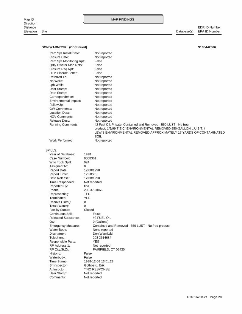
MAP FINDINGSMap IDDirection
EDR ID NumberDistanceEPA ID NumberDatabase(s)SiteElevation
Not reportedComments: Not reportedUser Stamp: **NO RESPONSEAt Inspctor: Gothberg, ErikSr Inspector: 1998-12-08 13:01:23Time Stamp: FalseWaterbody: FalseHistoric: FAIRFIELD, CT 06430RP City,St,Zip: Not reportedRP Address 1: YESResponsible Party: 203 2614684Telephone: Don WarnitskiDischarger: None reportedWater Body: Contained and Removed - 550 LUST - No free productEmergency Measure: 0 (Gallons)Qty: #2 FUEL OILReleased Substance: FalseContinuous Spill: ClosedFacility Status: 0Total (Water): 0Recovd (Total): YESTerminated: TECRepresenting: 203 3781066Phone: tinaReported By: Not reportedTime Responded: 12/08/1998Date Release: 12:58:26Report Time: 12/08/1998Report Date: 0Assigned To: 924Who Took Spill: 9808361Case Number: 1998Year of Database:
SPILLS:
Not reportedWork Performed: SOIL LEWIS ENVIRONMENTAL REMOVED APPROXIMATELY 17 YARDS OF CONTAMINATED product, 1/6/99 T.E.C. ENVIRONMENTAL REMOVED 550-GALLON L.U.S.T. / #2 Fuel Oil, Private, Contained and Removed - 550 LUST - No freeRunning Comments: Not reportedRelease Desc: Not reportedNOV Comments: Not reportedLocation Desc: Not reportedGW Comments: Not reportedFollowUp: Not reportedEnvironmental Impact: Not reportedCorrespondence: Not reportedDate Stamp: Not reportedUser Stamp: Not reportedLph Wells: Not reportedNo Wells: Not reportedReferred To: FalseDEP Closure Letter: FalseClosure Req Rpt: FalseQrtly Gwater Mon Rpts: FalseRem Sys Monitoring Rpt: Not reportedClosure Date: Not reportedRem Sys Install Date:
DON WARNITSKI (Continued) S105442566
TC4616258.2s Page 28
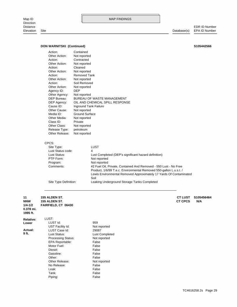
MAP FINDINGSMap IDDirection
EDR ID NumberDistanceEPA ID NumberDatabase(s)SiteElevation
Leaking Underground Storage Tanks CompletedSite Type Definition: Soil Lewis Environmental Removed Approximately 17 Yards Of Contaminated Product, 1/6/99 T.e.c. Environmental Removed 550-gallon L.u.s.t. / #2 Fuel Oil, Private, Contained And Removed - 550 Lust - No FreeComments: Not reportedProgram: Not reportedPTP Form: Lust Completed (DEP’s significant hazard definition)Lust Status: 4Lust Status code: LUSTSite Type:
CPCS:
Not reportedOther Release:petroleumRelease Type:Not reportedOther Class:PrivateClass ID:Not reportedOther Media:Ground SurfaceMedia ID:Not reportedOther Cause:Inground Tank FailureCause ID:OIL AND CHEMICAL SPILL RESPONSEDEP Agency:BUREAU OF WASTE MANAGEMENTDEP Bureau:Not reportedOther Agency:DEPAgency ID:Not reportedOther Action:Soil RemovedAction:Not reportedOther Action:Removed TankAction:Not reportedOther Action:CleanedAction:Not reportedOther Action:ContractedAction:Not reportedOther Action:ContainedAction:
DON WARNITSKI (Continued) S105442566
FalsePiping: FalseTank: FalseLeak: FalseNo Release: Not reportedOther Release: FalseOther: FalseGasoline: FalseDiesel: FalseMotor Fuel: FalseEPA Reportable: Not reportedProcessing Status: Lust CompletedLust Status: 29087LUST Case Id: Not reportedUST Facility Id: 959LUST Id:
LUST:
1995 ft.0.378 mi.
Relative:Lower
Actual:9 ft.
1/4-1/2 FAIRFIELD, CT 06430NNW CT CPCS155 ALDEN ST. N/A11 CT LUST155 ALDEN ST. S105456464
TC4616258.2s Page 29
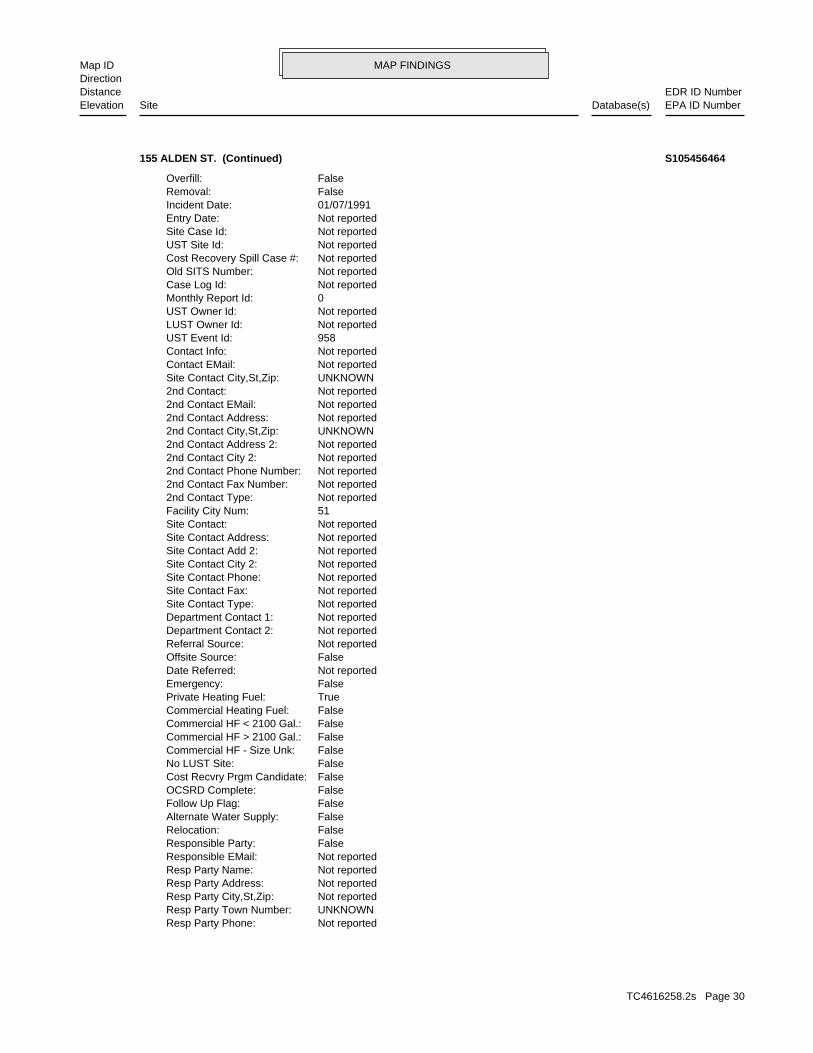
MAP FINDINGSMap IDDirection
EDR ID NumberDistanceEPA ID NumberDatabase(s)SiteElevation
Not reportedResp Party Phone: UNKNOWNResp Party Town Number: Not reportedResp Party City,St,Zip: Not reportedResp Party Address: Not reportedResp Party Name: Not reportedResponsible EMail: FalseResponsible Party: FalseRelocation: FalseAlternate Water Supply: FalseFollow Up Flag: FalseOCSRD Complete: FalseCost Recvry Prgm Candidate: FalseNo LUST Site: FalseCommercial HF - Size Unk: FalseCommercial HF > 2100 Gal.: FalseCommercial HF < 2100 Gal.: FalseCommercial Heating Fuel: TruePrivate Heating Fuel: FalseEmergency: Not reportedDate Referred: FalseOffsite Source: Not reportedReferral Source: Not reportedDepartment Contact 2: Not reportedDepartment Contact 1: Not reportedSite Contact Type: Not reportedSite Contact Fax: Not reportedSite Contact Phone: Not reportedSite Contact City 2: Not reportedSite Contact Add 2: Not reportedSite Contact Address: Not reportedSite Contact: 51Facility City Num: Not reported2nd Contact Type: Not reported2nd Contact Fax Number: Not reported2nd Contact Phone Number: Not reported2nd Contact City 2: Not reported2nd Contact Address 2: UNKNOWN2nd Contact City,St,Zip: Not reported2nd Contact Address: Not reported2nd Contact EMail: Not reported2nd Contact: UNKNOWNSite Contact City,St,Zip: Not reportedContact EMail: Not reportedContact Info: 958UST Event Id: Not reportedLUST Owner Id: Not reportedUST Owner Id: 0Monthly Report Id: Not reportedCase Log Id: Not reportedOld SITS Number: Not reportedCost Recovery Spill Case #: Not reportedUST Site Id: Not reportedSite Case Id: Not reportedEntry Date: 01/07/1991Incident Date: FalseRemoval: FalseOverfill:
155 ALDEN ST. (Continued) S105456464
TC4616258.2s Page 30
MAP FINDINGSMap IDDirection
EDR ID NumberDistanceEPA ID NumberDatabase(s)SiteElevation
FalseRem Sys Install: FalseDEP App Letter 2: FalseCorrect Action Plan: FalseDEP App Letter 1: FalseRelease Invest Rpt: FalseStop All NOV Actions: Not reportedNOV Referred To Ag: Not reportedNOV Admin Order: Not reportedNOV Compliance Sched: Not reportedNOV Issued Date: Not reportedNOV Disc Date: Not reportedNOV Closed: Not reportedNOV Received: Not reportedNOV Due: Not reportedNOV Issued: NoneNOV Action: FalseActive: FalseSoil Venting: FalseGround Water Gauging: FalseSample MWS: FalsePotable Well Sample: FalseSurvey: FalseGeo Probe: FalseSoil Excavate: FalseSite Inspect: FalseSoil Gas: FalseSoil Sample: FalseGround Water Sample: FalseInstall Micro Wells: FalseCellar Borings: NoFund Recovered: NoFund Judgment: NoFund Outlayed: NoFund Obligated: NoFund Planned: Not reportedFund Date: Not reportedFree Product Inches: Not reportedAreas Of Concern: Not reportedGround Water Depth: Not reportedGround Water Flow Direction: Not reportedReceptor: Not reportedGround Water Classification: Not reportedGeo Setting: Not reportedDrastic: Not reportedHydro Basin: Not reportedGround Water Gradient: Not reportedGround Water Direction: Not reportedPopulation Setting: Not reportedAffected Population: Not reportedAnnual Precipitation: Not reportedArea Lextent: Not reportedFollow Update: 22Investigator Id: Not reportedResp Party Phone 2: Not reportedResp Party Address 2: Not reportedResp Party Name 2: Not reportedResp Party Fax:
155 ALDEN ST. (Continued) S105456464
TC4616258.2s Page 31
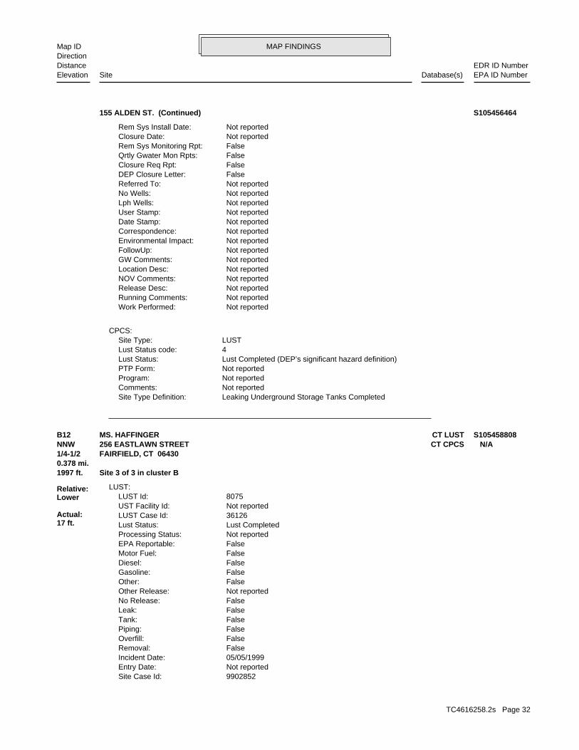
MAP FINDINGSMap IDDirection
EDR ID NumberDistanceEPA ID NumberDatabase(s)SiteElevation
Leaking Underground Storage Tanks CompletedSite Type Definition: Not reportedComments: Not reportedProgram: Not reportedPTP Form: Lust Completed (DEP’s significant hazard definition)Lust Status: 4Lust Status code: LUSTSite Type:
CPCS:
Not reportedWork Performed: Not reportedRunning Comments: Not reportedRelease Desc: Not reportedNOV Comments: Not reportedLocation Desc: Not reportedGW Comments: Not reportedFollowUp: Not reportedEnvironmental Impact: Not reportedCorrespondence: Not reportedDate Stamp: Not reportedUser Stamp: Not reportedLph Wells: Not reportedNo Wells: Not reportedReferred To: FalseDEP Closure Letter: FalseClosure Req Rpt: FalseQrtly Gwater Mon Rpts: FalseRem Sys Monitoring Rpt: Not reportedClosure Date: Not reportedRem Sys Install Date:
155 ALDEN ST. (Continued) S105456464
9902852Site Case Id: Not reportedEntry Date: 05/05/1999Incident Date: FalseRemoval: FalseOverfill: FalsePiping: FalseTank: FalseLeak: FalseNo Release: Not reportedOther Release: FalseOther: FalseGasoline: FalseDiesel: FalseMotor Fuel: FalseEPA Reportable: Not reportedProcessing Status: Lust CompletedLust Status: 36126LUST Case Id: Not reportedUST Facility Id: 8075LUST Id:
LUST:
1997 ft. Site 3 of 3 in cluster B0.378 mi.
Relative:Lower
Actual:17 ft.
1/4-1/2 FAIRFIELD, CT 06430NNW CT CPCS256 EASTLAWN STREET N/AB12 CT LUSTMS. HAFFINGER S105458808
TC4616258.2s Page 32
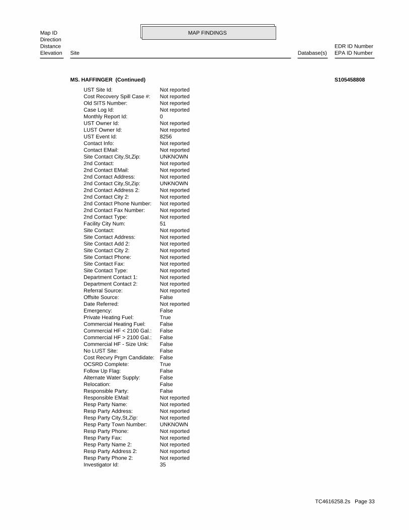
MAP FINDINGSMap IDDirection
EDR ID NumberDistanceEPA ID NumberDatabase(s)SiteElevation
35Investigator Id: Not reportedResp Party Phone 2: Not reportedResp Party Address 2: Not reportedResp Party Name 2: Not reportedResp Party Fax: Not reportedResp Party Phone: UNKNOWNResp Party Town Number: Not reportedResp Party City,St,Zip: Not reportedResp Party Address: Not reportedResp Party Name: Not reportedResponsible EMail: FalseResponsible Party: FalseRelocation: FalseAlternate Water Supply: FalseFollow Up Flag: TrueOCSRD Complete: FalseCost Recvry Prgm Candidate: FalseNo LUST Site: FalseCommercial HF - Size Unk: FalseCommercial HF > 2100 Gal.: FalseCommercial HF < 2100 Gal.: FalseCommercial Heating Fuel: TruePrivate Heating Fuel: FalseEmergency: Not reportedDate Referred: FalseOffsite Source: Not reportedReferral Source: Not reportedDepartment Contact 2: Not reportedDepartment Contact 1: Not reportedSite Contact Type: Not reportedSite Contact Fax: Not reportedSite Contact Phone: Not reportedSite Contact City 2: Not reportedSite Contact Add 2: Not reportedSite Contact Address: Not reportedSite Contact: 51Facility City Num: Not reported2nd Contact Type: Not reported2nd Contact Fax Number: Not reported2nd Contact Phone Number: Not reported2nd Contact City 2: Not reported2nd Contact Address 2: UNKNOWN2nd Contact City,St,Zip: Not reported2nd Contact Address: Not reported2nd Contact EMail: Not reported2nd Contact: UNKNOWNSite Contact City,St,Zip: Not reportedContact EMail: Not reportedContact Info: 8256UST Event Id: Not reportedLUST Owner Id: Not reportedUST Owner Id: 0Monthly Report Id: Not reportedCase Log Id: Not reportedOld SITS Number: Not reportedCost Recovery Spill Case #: Not reportedUST Site Id:
MS. HAFFINGER (Continued) S105458808
TC4616258.2s Page 33
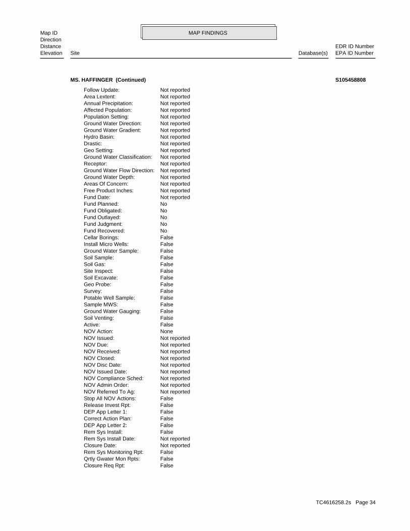
MAP FINDINGSMap IDDirection
EDR ID NumberDistanceEPA ID NumberDatabase(s)SiteElevation
FalseClosure Req Rpt: FalseQrtly Gwater Mon Rpts: FalseRem Sys Monitoring Rpt: Not reportedClosure Date: Not reportedRem Sys Install Date: FalseRem Sys Install: FalseDEP App Letter 2: FalseCorrect Action Plan: FalseDEP App Letter 1: FalseRelease Invest Rpt: FalseStop All NOV Actions: Not reportedNOV Referred To Ag: Not reportedNOV Admin Order: Not reportedNOV Compliance Sched: Not reportedNOV Issued Date: Not reportedNOV Disc Date: Not reportedNOV Closed: Not reportedNOV Received: Not reportedNOV Due: Not reportedNOV Issued: NoneNOV Action: FalseActive: FalseSoil Venting: FalseGround Water Gauging: FalseSample MWS: FalsePotable Well Sample: FalseSurvey: FalseGeo Probe: FalseSoil Excavate: FalseSite Inspect: FalseSoil Gas: FalseSoil Sample: FalseGround Water Sample: FalseInstall Micro Wells: FalseCellar Borings: NoFund Recovered: NoFund Judgment: NoFund Outlayed: NoFund Obligated: NoFund Planned: Not reportedFund Date: Not reportedFree Product Inches: Not reportedAreas Of Concern: Not reportedGround Water Depth: Not reportedGround Water Flow Direction: Not reportedReceptor: Not reportedGround Water Classification: Not reportedGeo Setting: Not reportedDrastic: Not reportedHydro Basin: Not reportedGround Water Gradient: Not reportedGround Water Direction: Not reportedPopulation Setting: Not reportedAffected Population: Not reportedAnnual Precipitation: Not reportedArea Lextent: Not reportedFollow Update:
MS. HAFFINGER (Continued) S105458808
TC4616258.2s Page 34
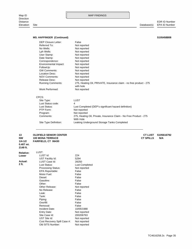
MAP FINDINGSMap IDDirection
EDR ID NumberDistanceEPA ID NumberDatabase(s)SiteElevation
Leaking Underground Storage Tanks CompletedSite Type Definition: With Hole 275, Heating Oil, Private, Insurance Claim - No Free Product - 275Comments: Not reportedProgram: Not reportedPTP Form: Lust Completed (DEP’s significant hazard definition)Lust Status: 4Lust Status code: LUSTSite Type:
CPCS:
Not reportedWork Performed: with hole 275, Heating Oil, PRIVATE, Insurance claim - no free product - 275Running Comments: Not reportedRelease Desc: Not reportedNOV Comments: Not reportedLocation Desc: Not reportedGW Comments: Not reportedFollowUp: Not reportedEnvironmental Impact: Not reportedCorrespondence: Not reportedDate Stamp: Not reportedUser Stamp: Not reportedLph Wells: Not reportedNo Wells: Not reportedReferred To: FalseDEP Closure Letter:
MS. HAFFINGER (Continued) S105458808
Not reportedOld SITS Number: Not reportedCost Recovery Spill Case #: Not reportedUST Site Id: 200206763Site Case Id: Not reportedEntry Date: 10/05/1988Incident Date: FalseRemoval: FalseOverfill: FalsePiping: FalseTank: FalseLeak: FalseNo Release: Not reportedOther Release: FalseOther: FalseGasoline: FalseDiesel: FalseMotor Fuel: FalseEPA Reportable: Not reportedProcessing Status: Lust CompletedLust Status: 28250LUST Case Id: 5294UST Facility Id: 224LUST Id:
LUST:
2149 ft.0.407 mi.
Relative:Lower
Actual:2 ft.
1/4-1/2 FAIRFIELD, CT 06430NW CT SPILLS100 MONA TERRACE N/A13 CT LUSTOLDFIELD SENIOR CENTER S105616792
TC4616258.2s Page 35
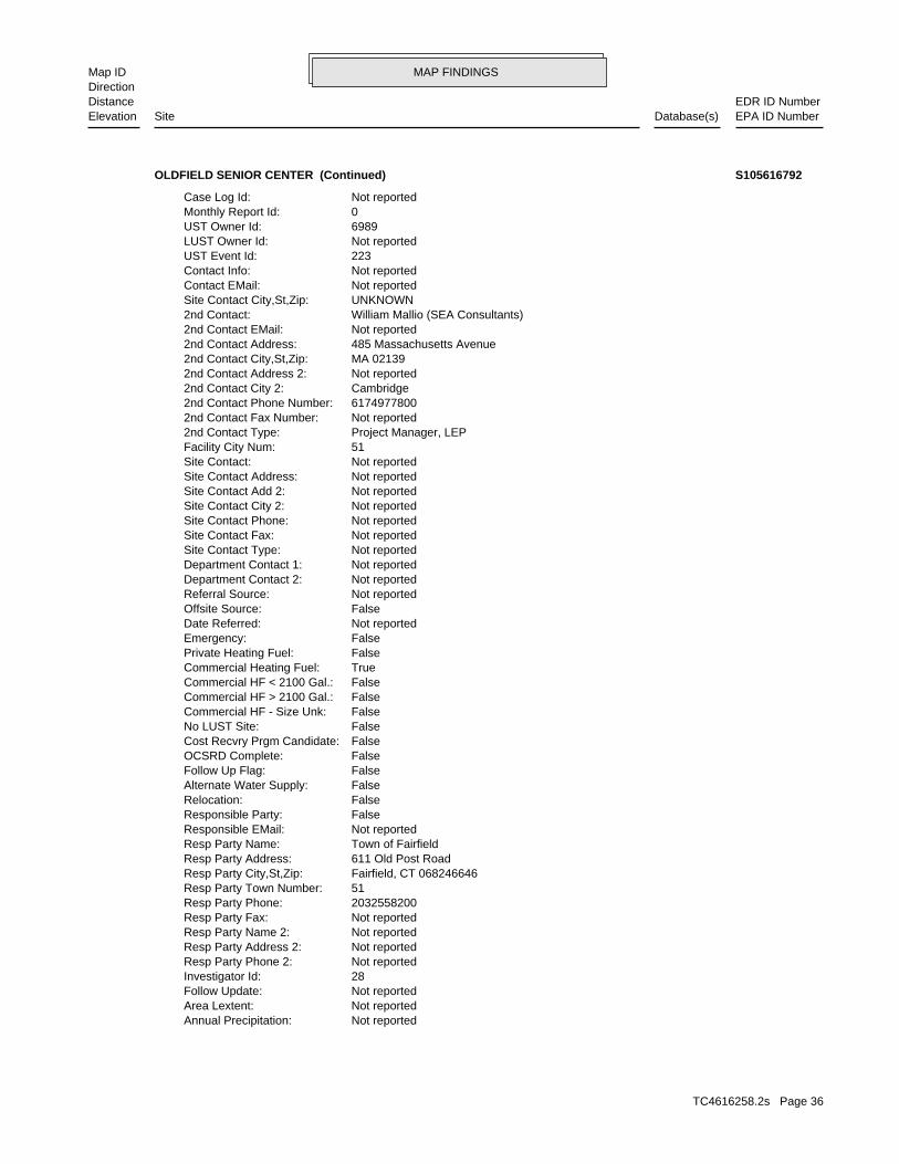
MAP FINDINGSMap IDDirection
EDR ID NumberDistanceEPA ID NumberDatabase(s)SiteElevation
Not reportedAnnual Precipitation: Not reportedArea Lextent: Not reportedFollow Update: 28Investigator Id: Not reportedResp Party Phone 2: Not reportedResp Party Address 2: Not reportedResp Party Name 2: Not reportedResp Party Fax: 2032558200Resp Party Phone: 51Resp Party Town Number: Fairfield, CT 068246646Resp Party City,St,Zip: 611 Old Post RoadResp Party Address: Town of FairfieldResp Party Name: Not reportedResponsible EMail: FalseResponsible Party: FalseRelocation: FalseAlternate Water Supply: FalseFollow Up Flag: FalseOCSRD Complete: FalseCost Recvry Prgm Candidate: FalseNo LUST Site: FalseCommercial HF - Size Unk: FalseCommercial HF > 2100 Gal.: FalseCommercial HF < 2100 Gal.: TrueCommercial Heating Fuel: FalsePrivate Heating Fuel: FalseEmergency: Not reportedDate Referred: FalseOffsite Source: Not reportedReferral Source: Not reportedDepartment Contact 2: Not reportedDepartment Contact 1: Not reportedSite Contact Type: Not reportedSite Contact Fax: Not reportedSite Contact Phone: Not reportedSite Contact City 2: Not reportedSite Contact Add 2: Not reportedSite Contact Address: Not reportedSite Contact: 51Facility City Num: Project Manager, LEP2nd Contact Type: Not reported2nd Contact Fax Number: 61749778002nd Contact Phone Number: Cambridge2nd Contact City 2: Not reported2nd Contact Address 2: MA 021392nd Contact City,St,Zip: 485 Massachusetts Avenue2nd Contact Address: Not reported2nd Contact EMail: William Mallio (SEA Consultants)2nd Contact: UNKNOWNSite Contact City,St,Zip: Not reportedContact EMail: Not reportedContact Info: 223UST Event Id: Not reportedLUST Owner Id: 6989UST Owner Id: 0Monthly Report Id: Not reportedCase Log Id:
OLDFIELD SENIOR CENTER (Continued) S105616792
TC4616258.2s Page 36
MAP FINDINGSMap IDDirection
EDR ID NumberDistanceEPA ID NumberDatabase(s)SiteElevation
Not reportedNo Wells: Not reportedReferred To: FalseDEP Closure Letter: FalseClosure Req Rpt: FalseQrtly Gwater Mon Rpts: FalseRem Sys Monitoring Rpt: Not reportedClosure Date: Not reportedRem Sys Install Date: FalseRem Sys Install: FalseDEP App Letter 2: FalseCorrect Action Plan: FalseDEP App Letter 1: FalseRelease Invest Rpt: FalseStop All NOV Actions: Not reportedNOV Referred To Ag: Not reportedNOV Admin Order: Not reportedNOV Compliance Sched: Not reportedNOV Issued Date: Not reportedNOV Disc Date: Not reportedNOV Closed: Not reportedNOV Received: Not reportedNOV Due: Not reportedNOV Issued: NoneNOV Action: FalseActive: FalseSoil Venting: FalseGround Water Gauging: FalseSample MWS: FalsePotable Well Sample: FalseSurvey: FalseGeo Probe: FalseSoil Excavate: FalseSite Inspect: FalseSoil Gas: FalseSoil Sample: FalseGround Water Sample: FalseInstall Micro Wells: FalseCellar Borings: NoFund Recovered: NoFund Judgment: NoFund Outlayed: NoFund Obligated: NoFund Planned: Not reportedFund Date: Not reportedFree Product Inches: Not reportedAreas Of Concern: Not reportedGround Water Depth: Not reportedGround Water Flow Direction: Not reportedReceptor: GBGround Water Classification: Not reportedGeo Setting: Not reportedDrastic: Not reportedHydro Basin: Not reportedGround Water Gradient: Not reportedGround Water Direction: Not reportedPopulation Setting: Not reportedAffected Population:
OLDFIELD SENIOR CENTER (Continued) S105616792
TC4616258.2s Page 37
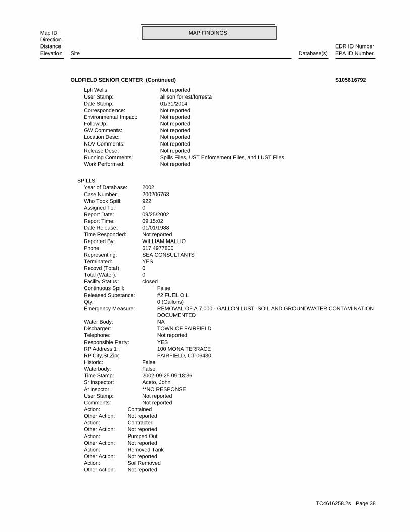
MAP FINDINGSMap IDDirection
EDR ID NumberDistanceEPA ID NumberDatabase(s)SiteElevation
Not reportedOther Action:Soil RemovedAction:Not reportedOther Action:Removed TankAction:Not reportedOther Action:Pumped OutAction:Not reportedOther Action:ContractedAction:Not reportedOther Action:ContainedAction: Not reportedComments: Not reportedUser Stamp: **NO RESPONSEAt Inspctor: Aceto, JohnSr Inspector: 2002-09-25 09:18:36Time Stamp: FalseWaterbody: FalseHistoric: FAIRFIELD, CT 06430RP City,St,Zip: 100 MONA TERRACERP Address 1: YESResponsible Party: Not reportedTelephone: TOWN OF FAIRFIELDDischarger: NAWater Body: DOCUMENTED REMOVAL OF A 7,000 - GALLON LUST -SOIL AND GROUNDWATER CONTAMINATIONEmergency Measure: 0 (Gallons)Qty: #2 FUEL OILReleased Substance: FalseContinuous Spill: closedFacility Status: 0Total (Water): 0Recovd (Total): YESTerminated: SEA CONSULTANTSRepresenting: 617 4977800Phone: WILLIAM MALLIOReported By: Not reportedTime Responded: 01/01/1988Date Release: 09:15:02Report Time: 09/25/2002Report Date: 0Assigned To: 922Who Took Spill: 200206763Case Number: 2002Year of Database:
SPILLS:
Not reportedWork Performed: Spills Files, UST Enforcement Files, and LUST FilesRunning Comments: Not reportedRelease Desc: Not reportedNOV Comments: Not reportedLocation Desc: Not reportedGW Comments: Not reportedFollowUp: Not reportedEnvironmental Impact: Not reportedCorrespondence: 01/31/2014Date Stamp: allison forrest/forrestaUser Stamp: Not reportedLph Wells:
OLDFIELD SENIOR CENTER (Continued) S105616792
TC4616258.2s Page 38
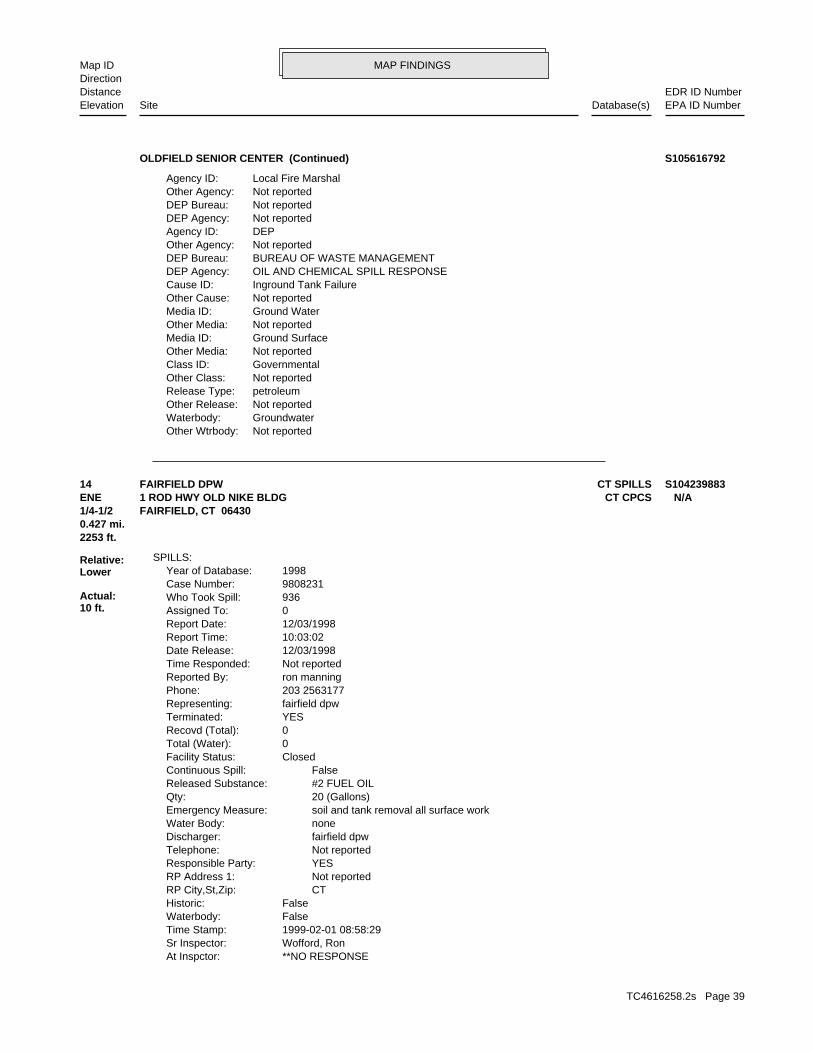
MAP FINDINGSMap IDDirection
EDR ID NumberDistanceEPA ID NumberDatabase(s)SiteElevation
Not reportedOther Wtrbody:GroundwaterWaterbody:Not reportedOther Release:petroleumRelease Type:Not reportedOther Class:GovernmentalClass ID:Not reportedOther Media:Ground SurfaceMedia ID:Not reportedOther Media:Ground WaterMedia ID:Not reportedOther Cause:Inground Tank FailureCause ID:OIL AND CHEMICAL SPILL RESPONSEDEP Agency:BUREAU OF WASTE MANAGEMENTDEP Bureau:Not reportedOther Agency:DEPAgency ID:Not reportedDEP Agency:Not reportedDEP Bureau:Not reportedOther Agency:Local Fire MarshalAgency ID:
OLDFIELD SENIOR CENTER (Continued) S105616792
**NO RESPONSEAt Inspctor: Wofford, RonSr Inspector: 1999-02-01 08:58:29Time Stamp: FalseWaterbody: FalseHistoric: CTRP City,St,Zip: Not reportedRP Address 1: YESResponsible Party: Not reportedTelephone: fairfield dpwDischarger: noneWater Body: soil and tank removal all surface workEmergency Measure: 20 (Gallons)Qty: #2 FUEL OILReleased Substance: FalseContinuous Spill: ClosedFacility Status: 0Total (Water): 0Recovd (Total): YESTerminated: fairfield dpwRepresenting: 203 2563177Phone: ron manningReported By: Not reportedTime Responded: 12/03/1998Date Release: 10:03:02Report Time: 12/03/1998Report Date: 0Assigned To: 936Who Took Spill: 9808231Case Number: 1998Year of Database:
SPILLS:
2253 ft.0.427 mi.
Relative:Lower
Actual:10 ft.
1/4-1/2 FAIRFIELD, CT 06430ENE CT CPCS1 ROD HWY OLD NIKE BLDG N/A14 CT SPILLSFAIRFIELD DPW S104239883
TC4616258.2s Page 39
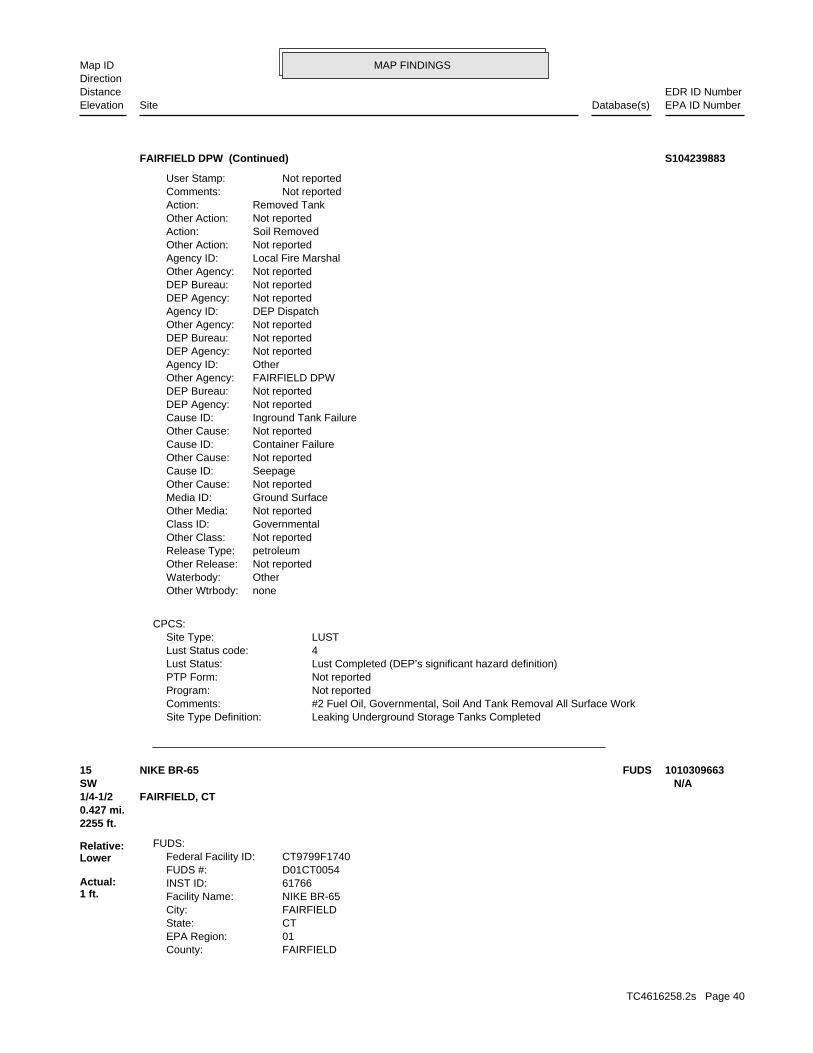
MAP FINDINGSMap IDDirection
EDR ID NumberDistanceEPA ID NumberDatabase(s)SiteElevation
Leaking Underground Storage Tanks CompletedSite Type Definition: #2 Fuel Oil, Governmental, Soil And Tank Removal All Surface WorkComments: Not reportedProgram: Not reportedPTP Form: Lust Completed (DEP’s significant hazard definition)Lust Status: 4Lust Status code: LUSTSite Type:
CPCS:
noneOther Wtrbody:OtherWaterbody:Not reportedOther Release:petroleumRelease Type:Not reportedOther Class:GovernmentalClass ID:Not reportedOther Media:Ground SurfaceMedia ID:Not reportedOther Cause:SeepageCause ID:Not reportedOther Cause:Container FailureCause ID:Not reportedOther Cause:Inground Tank FailureCause ID:Not reportedDEP Agency:Not reportedDEP Bureau:FAIRFIELD DPWOther Agency:OtherAgency ID:Not reportedDEP Agency:Not reportedDEP Bureau:Not reportedOther Agency:DEP DispatchAgency ID:Not reportedDEP Agency:Not reportedDEP Bureau:Not reportedOther Agency:Local Fire MarshalAgency ID:Not reportedOther Action:Soil RemovedAction:Not reportedOther Action:Removed TankAction: Not reportedComments: Not reportedUser Stamp:
FAIRFIELD DPW (Continued) S104239883
FAIRFIELDCounty: 01EPA Region: CTState: FAIRFIELDCity: NIKE BR-65Facility Name: 61766INST ID: D01CT0054FUDS #: CT9799F1740Federal Facility ID:
FUDS:
2255 ft.0.427 mi.
Relative:Lower
Actual:1 ft.
1/4-1/2 FAIRFIELD, CT SW N/A15 FUDSNIKE BR-65 1010309663
TC4616258.2s Page 40
MAP FINDINGSMap IDDirection
EDR ID NumberDistanceEPA ID NumberDatabase(s)SiteElevation
41.125Longitude: -73.2642974853Latitude: Not reported Control and launch areas currently owned by the town of Fairfield, CT. Fairfield, CT. 22.26 acres easement assumed disposed to the owners. excess to GSA in 1964. 15.82 acre parcel deed to the town of easement. Acquired by purchase and condemnation in 1955. Reported terminated in 1965. Launch site 15.82 acres fee and 22.26 acres Control site 22.14 acres. Acquired by lease 4/1/1955. LeaseHistory: the east, west and south. town landfill to the north and recently constructed athletic fields to this location. The missile storage silos abut wetlands and a former shed were removed by the town and a baseball field was constructed at acid shed. The generator building, acid fueling station, and storage test building, a generator building, and a acid fueling station and an enlisted men and officer quarters barracks, a missile assembly and Road off of South Pine Creek Road. Consisted of three missile silos, utilized by the town of Fairfield, CT. Launch site located on Old Dam shed. All buildings at control site in satisfactory condition and storehouse, spare parts, and battery charger building, and a lube oil quarters buildings No. 1 and 2, combined mess hall, motor repair shop, and storage buildings No. 1 and 2, enlisted men barracks and officers control site consists of eight buildings. Administration, recreation, facility to the north and wetlands to the east, west, and south. The Old Rod Highway and the Town of Fairfield wastewater treatment Control site located on Old Rod Highway off of Reef Road. Abutted byDescription: Not reportedAcreage: Not reportedFuture Prog: Not reportedCurrent Prog: OtherCurrent Owner: 412.1000CTC: Not reportedRAB: Not ListedNPL Status: 978-318-8238Telephone: 2013Fiscal Year: New England District (NAE)US Army District: 04Congressional District:
NIKE BR-65 (Continued) 1010309663
DANYLUK, M.Updated By: FalseSample Data Available: USTDisposal: HYDRO/OILWaste Type: Not reportedSurface Water Quality Classification: Not reportedGround Water Quality Classification: Not reportedLat/Long Determined By: Not reportedLongitude: Not reportedLatitude: Not reportedPostal District: Not reportedWPC Number: Not reportedPTP Id: 3780Rem Master ID: 3370Facility ID:
Site Discovery and Assessment:
2385 ft. Site 1 of 2 in cluster C0.452 mi.
Relative:Lower
Actual:19 ft.
1/4-1/2 FAIRFIELD, CT North 144 PRATT STREET N/AC16 CT SDADBR. MURRAY PROPERTY S104253850
TC4616258.2s Page 41
MAP FINDINGSMap IDDirection
EDR ID NumberDistanceEPA ID NumberDatabase(s)SiteElevation
Not reportedOrder Respondent: Not reportedType of Order: Not reportedStaff Assigned: Not reportedDate order issued: Not reportedOrder Number: Not reportedOrder Id:
SDA Orders:
Not reportedRemediation complete Approved DEP/Verified by LEP: Not reportedGW monitoring: Not reportedDate Oper/ maintenance Started: Not reportedRemedial Action Completed: Not reportedRemedial Action Start: Not reportedRemedial Design complet: Not reportedRemedial Design Start: Not reportedRemedial Investigation Completed: Not reportedRemedial Investigation Start: Not reportedDate order issued: Not reportedOrder Number: Not reportedOrder issued: Not reportedProject Phase: Not reportedDate dt_assign: Not reportedRemediation Program: Not reportedStaff Assigned: Not reportedRemediation Program Entered: Not reportedRemediation Program: Not reportedPTP Id: Not reportedRemedial Id:
SDA Remedial:
ON RECORDOutcome: 4/8/1999Remediation Complete Approved DEP/Verified by LEP: Not reportedDate dt_assigned: D&ARemediation Program: DANYLUK, M.Staff Assigned: 3/11/1999Date Received: SPILLSSource of referral: 3169Referral Id:
SDA Referral:
Not reportedRCRA Permit Status: Not reportedRCRA Generator Status: Not reportedPart of an NPL site: Not reportedSite on EPA’s National Priority List: Not reportedFederal Facility: Not reportedEPA Env Priority Initiative Site: Not reportedDeferred to another EPA Program: Not reportedEPA’s Removal at Site: Not reportedArchive Date: Not reportedSite Archived from CERCLIS: Not reportedSite on EPA’s CERCLIS: Not reportedNumber EPA RCRIS Id: Not reportedEPA CERCLIS Id:
SDA Federal:
FalseDuplicate: Not reportedDate Created: 4/8/1999Updated: D&AUpdate Program:
R. MURRAY PROPERTY (Continued) S104253850
TC4616258.2s Page 42
MAP FINDINGSMap IDDirection
EDR ID NumberDistanceEPA ID NumberDatabase(s)SiteElevation
Hydrocarbons and/or Fuel OilDescription: HYDRO/OILWaste Type: 11Waste Id:
SDA Waste:
SDADB:
Not reportedComments: Not reportedIn compliance: Not reportedOrder Complete: Not reportedPenalty assessed: Not reportedDate of AGR judgement: Not reportedJudgement: Not reportedDate Referred to AG: Not reportedDate Order Modified: Not reportedDate of Court Ruling: Not reportedDate of Court Ruling: Not reportedDate of Court Appeal: Not reportedDate of Final Order: Not reportedDate of Admin Appeal Ruling: Not reportedDate of Admin Appeal Ruling: Not reportedAdmin Appeal Date:
R. MURRAY PROPERTY (Continued) S104253850
9418UST Event Id: Not reportedLUST Owner Id: Not reportedUST Owner Id: 0Monthly Report Id: Not reportedCase Log Id: Not reportedOld SITS Number: Not reportedCost Recovery Spill Case #: Not reportedUST Site Id: 9901560Site Case Id: Not reportedEntry Date: 03/11/1999Incident Date: FalseRemoval: FalseOverfill: FalsePiping: FalseTank: FalseLeak: FalseNo Release: Not reportedOther Release: FalseOther: FalseGasoline: FalseDiesel: FalseMotor Fuel: FalseEPA Reportable: Not reportedProcessing Status: Lust CompletedLust Status: 37263LUST Case Id: Not reportedUST Facility Id: 9237LUST Id:
LUST:
2385 ft. Site 2 of 2 in cluster C0.452 mi.
Relative:Lower
Actual:19 ft.
1/4-1/2 CT CPCSFAIRFIELD, CT 06430North CT SPILLS144 PRATT ST N/AC17 CT LUSTROBERT MURRAY S104237716
TC4616258.2s Page 43
MAP FINDINGSMap IDDirection
EDR ID NumberDistanceEPA ID NumberDatabase(s)SiteElevation
Not reportedHydro Basin: Not reportedGround Water Gradient: Not reportedGround Water Direction: Not reportedPopulation Setting: Not reportedAffected Population: Not reportedAnnual Precipitation: Not reportedArea Lextent: Not reportedFollow Update: 35Investigator Id: Not reportedResp Party Phone 2: Not reportedResp Party Address 2: Not reportedResp Party Name 2: Not reportedResp Party Fax: Not reportedResp Party Phone: UNKNOWNResp Party Town Number: Not reportedResp Party City,St,Zip: Not reportedResp Party Address: Not reportedResp Party Name: Not reportedResponsible EMail: FalseResponsible Party: FalseRelocation: FalseAlternate Water Supply: FalseFollow Up Flag: TrueOCSRD Complete: FalseCost Recvry Prgm Candidate: FalseNo LUST Site: FalseCommercial HF - Size Unk: FalseCommercial HF > 2100 Gal.: FalseCommercial HF < 2100 Gal.: FalseCommercial Heating Fuel: TruePrivate Heating Fuel: FalseEmergency: Not reportedDate Referred: FalseOffsite Source: Not reportedReferral Source: Not reportedDepartment Contact 2: Not reportedDepartment Contact 1: Not reportedSite Contact Type: Not reportedSite Contact Fax: Not reportedSite Contact Phone: Not reportedSite Contact City 2: Not reportedSite Contact Add 2: Not reportedSite Contact Address: Not reportedSite Contact: 51Facility City Num: Not reported2nd Contact Type: Not reported2nd Contact Fax Number: Not reported2nd Contact Phone Number: Not reported2nd Contact City 2: Not reported2nd Contact Address 2: UNKNOWN2nd Contact City,St,Zip: Not reported2nd Contact Address: Not reported2nd Contact EMail: Not reported2nd Contact: UNKNOWNSite Contact City,St,Zip: Not reportedContact EMail: Not reportedContact Info:
ROBERT MURRAY (Continued) S104237716
TC4616258.2s Page 44
MAP FINDINGSMap IDDirection
EDR ID NumberDistanceEPA ID NumberDatabase(s)SiteElevation
Not reportedEnvironmental Impact: Not reportedCorrespondence: Not reportedDate Stamp: Not reportedUser Stamp: Not reportedLph Wells: Not reportedNo Wells: Not reportedReferred To: FalseDEP Closure Letter: FalseClosure Req Rpt: FalseQrtly Gwater Mon Rpts: FalseRem Sys Monitoring Rpt: Not reportedClosure Date: Not reportedRem Sys Install Date: FalseRem Sys Install: FalseDEP App Letter 2: FalseCorrect Action Plan: FalseDEP App Letter 1: FalseRelease Invest Rpt: FalseStop All NOV Actions: Not reportedNOV Referred To Ag: Not reportedNOV Admin Order: Not reportedNOV Compliance Sched: Not reportedNOV Issued Date: Not reportedNOV Disc Date: Not reportedNOV Closed: Not reportedNOV Received: Not reportedNOV Due: Not reportedNOV Issued: NoneNOV Action: FalseActive: FalseSoil Venting: FalseGround Water Gauging: FalseSample MWS: FalsePotable Well Sample: FalseSurvey: FalseGeo Probe: FalseSoil Excavate: FalseSite Inspect: FalseSoil Gas: FalseSoil Sample: FalseGround Water Sample: FalseInstall Micro Wells: FalseCellar Borings: NoFund Recovered: NoFund Judgment: NoFund Outlayed: NoFund Obligated: NoFund Planned: Not reportedFund Date: Not reportedFree Product Inches: Not reportedAreas Of Concern: Not reportedGround Water Depth: Not reportedGround Water Flow Direction: Not reportedReceptor: Not reportedGround Water Classification: Not reportedGeo Setting: Not reportedDrastic:
ROBERT MURRAY (Continued) S104237716
TC4616258.2s Page 45
MAP FINDINGSMap IDDirection
EDR ID NumberDistanceEPA ID NumberDatabase(s)SiteElevation
Not reportedOther Media:Ground WaterMedia ID:Not reportedOther Cause:Inground Tank FailureCause ID:Not reportedDEP Agency:Not reportedDEP Bureau:Not reportedOther Agency:Local Fire MarshalAgency ID:Not reportedOther Action:Soil RemovedAction:Not reportedOther Action:Removed TankAction:Not reportedOther Action:Test WellsAction: Not reportedComments: Not reportedUser Stamp: **NO RESPONSEAt Inspctor: Torres, NeilSr Inspector: 1999-12-08 15:45:08Time Stamp: FalseWaterbody: FalseHistoric: CTRP City,St,Zip: aboveRP Address 1: YESResponsible Party: 203 2561705Telephone: robert murrayDischarger: Not reportedWater Body: slight sheen on groundwater, referred removed 1000 gal lust, removing soil, brooks lab to perform borings,Emergency Measure: 0 (Gallons)Qty: #2 FUEL OILReleased Substance: FalseContinuous Spill: ClosedFacility Status: 0Total (Water): 0Recovd (Total): YESTerminated: santa fuelRepresenting: 203 3673661Phone: bart liquigliReported By: Not reportedTime Responded: 03/11/1999Date Release: 08:17:43Report Time: 03/11/1999Report Date: 0Assigned To: 935Who Took Spill: 9901560Case Number: 1999Year of Database:
SPILLS:
Not reportedWork Performed: brooks lab to perform borings, slight sheen on groundwater, referred 1000, Heating Oil, PRIVATE, removed 1000 gal lust, removing soil,Running Comments: Not reportedRelease Desc: Not reportedNOV Comments: Not reportedLocation Desc: Not reportedGW Comments: Not reportedFollowUp:
ROBERT MURRAY (Continued) S104237716
TC4616258.2s Page 46
MAP FINDINGSMap IDDirection
EDR ID NumberDistanceEPA ID NumberDatabase(s)SiteElevation
Leaking Underground Storage Tanks CompletedSite Type Definition: Brooks Lab To Perform Borings, Slight Sheen On Groundwater, Referred 1000, Heating Oil, Private, Removed 1000 Gal Lust, Removing Soil,Comments: Not reportedProgram: Not reportedPTP Form: Lust Completed (DEP’s significant hazard definition)Lust Status: 4Lust Status code: LUSTSite Type:
CPCS:
Not reportedOther Wtrbody:GroundwaterWaterbody:Not reportedOther Release:petroleumRelease Type:Not reportedOther Class:PrivateClass ID:soilsOther Media:OtherMedia ID:
ROBERT MURRAY (Continued) S104237716
UNKNOWNSite Contact City,St,Zip: Not reportedContact EMail: Not reportedContact Info: 0UST Event Id: Not reportedLUST Owner Id: 0UST Owner Id: 0Monthly Report Id: 0Case Log Id: 0Old SITS Number: 0Cost Recovery Spill Case #: 0UST Site Id: 0Site Case Id: 12/16/2010Entry Date: 03/10/2010Incident Date: FalseRemoval: FalseOverfill: FalsePiping: FalseTank: FalseLeak: FalseNo Release: Not reportedOther Release: FalseOther: FalseGasoline: FalseDiesel: FalseMotor Fuel: FalseEPA Reportable: Not reportedProcessing Status: Cleanup InitiatedLust Status: 59643LUST Case Id: 0UST Facility Id: 0LUST Id:
LUST:
2564 ft.0.486 mi.
Relative:Lower
Actual:0 ft.
1/4-1/2 FAIRFIELD, CT 06430SSW CT SPILLS50 OLD DAM ROAD N/A18 CT LUSTOLD DAM RECREATIONAL BUILDING S110279650
TC4616258.2s Page 47
MAP FINDINGSMap IDDirection
EDR ID NumberDistanceEPA ID NumberDatabase(s)SiteElevation
GBGround Water Classification: Not reportedGeo Setting: Not reportedDrastic: Not reportedHydro Basin: Not reportedGround Water Gradient: Not reportedGround Water Direction: Not reportedPopulation Setting: Not reportedAffected Population: Not reportedAnnual Precipitation: Not reportedArea Lextent: Not reportedFollow Update: 58Investigator Id: Not reportedResp Party Phone 2: Not reportedResp Party Address 2: Not reportedResp Party Name 2: Not reportedResp Party Fax: 2032558200Resp Party Phone: 51Resp Party Town Number: Fairfield, CT 068246646Resp Party City,St,Zip: 611 Old Post RoadResp Party Address: Town of FairfieldResp Party Name: Not reportedResponsible EMail: FalseResponsible Party: FalseRelocation: FalseAlternate Water Supply: FalseFollow Up Flag: FalseOCSRD Complete: FalseCost Recvry Prgm Candidate: FalseNo LUST Site: FalseCommercial HF - Size Unk: FalseCommercial HF > 2100 Gal.: FalseCommercial HF < 2100 Gal.: FalseCommercial Heating Fuel: FalsePrivate Heating Fuel: FalseEmergency: Not reportedDate Referred: FalseOffsite Source: Not reportedReferral Source: Not reportedDepartment Contact 2: Phil WildeDepartment Contact 1: Not reportedSite Contact Type: Not reportedSite Contact Fax: Not reportedSite Contact Phone: Not reportedSite Contact City 2: Not reportedSite Contact Add 2: Not reportedSite Contact Address: KesslerSite Contact: 51Facility City Num: Not reported2nd Contact Type: Not reported2nd Contact Fax Number: Not reported2nd Contact Phone Number: Not reported2nd Contact City 2: Not reported2nd Contact Address 2: UNKNOWN2nd Contact City,St,Zip: Not reported2nd Contact Address: Not reported2nd Contact EMail: Not reported2nd Contact:
OLD DAM RECREATIONAL BUILDING (Continued) S110279650
TC4616258.2s Page 48
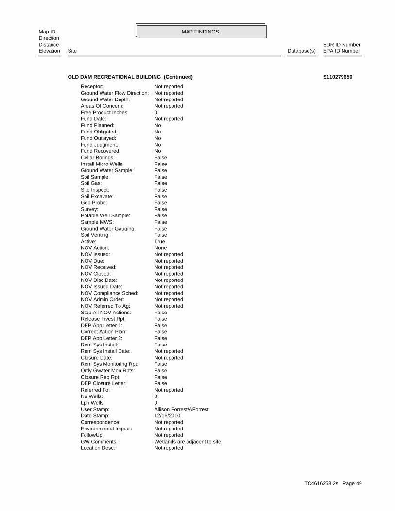
MAP FINDINGSMap IDDirection
EDR ID NumberDistanceEPA ID NumberDatabase(s)SiteElevation
Not reportedLocation Desc: Wetlands are adjacent to siteGW Comments: Not reportedFollowUp: Not reportedEnvironmental Impact: Not reportedCorrespondence: 12/16/2010Date Stamp: Allison Forrest/AForrestUser Stamp: 0Lph Wells: 0No Wells: Not reportedReferred To: FalseDEP Closure Letter: FalseClosure Req Rpt: FalseQrtly Gwater Mon Rpts: FalseRem Sys Monitoring Rpt: Not reportedClosure Date: Not reportedRem Sys Install Date: FalseRem Sys Install: FalseDEP App Letter 2: FalseCorrect Action Plan: FalseDEP App Letter 1: FalseRelease Invest Rpt: FalseStop All NOV Actions: Not reportedNOV Referred To Ag: Not reportedNOV Admin Order: Not reportedNOV Compliance Sched: Not reportedNOV Issued Date: Not reportedNOV Disc Date: Not reportedNOV Closed: Not reportedNOV Received: Not reportedNOV Due: Not reportedNOV Issued: NoneNOV Action: TrueActive: FalseSoil Venting: FalseGround Water Gauging: FalseSample MWS: FalsePotable Well Sample: FalseSurvey: FalseGeo Probe: FalseSoil Excavate: FalseSite Inspect: FalseSoil Gas: FalseSoil Sample: FalseGround Water Sample: FalseInstall Micro Wells: FalseCellar Borings: NoFund Recovered: NoFund Judgment: NoFund Outlayed: NoFund Obligated: NoFund Planned: Not reportedFund Date: 0Free Product Inches: Not reportedAreas Of Concern: Not reportedGround Water Depth: Not reportedGround Water Flow Direction: Not reportedReceptor:
OLD DAM RECREATIONAL BUILDING (Continued) S110279650
TC4616258.2s Page 49
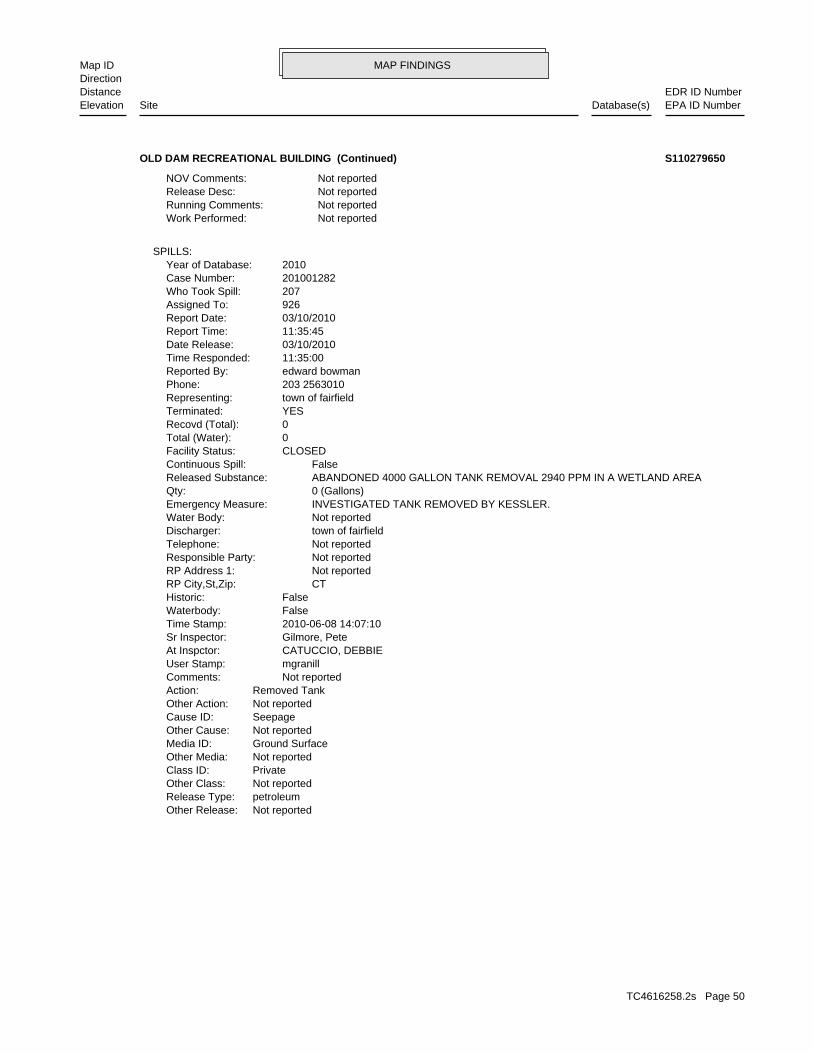
MAP FINDINGSMap IDDirection
EDR ID NumberDistanceEPA ID NumberDatabase(s)SiteElevation
Not reportedOther Release:petroleumRelease Type:Not reportedOther Class:PrivateClass ID:Not reportedOther Media:Ground SurfaceMedia ID:Not reportedOther Cause:SeepageCause ID:Not reportedOther Action:Removed TankAction: Not reportedComments: mgranillUser Stamp: CATUCCIO, DEBBIEAt Inspctor: Gilmore, PeteSr Inspector: 2010-06-08 14:07:10Time Stamp: FalseWaterbody: FalseHistoric: CTRP City,St,Zip: Not reportedRP Address 1: Not reportedResponsible Party: Not reportedTelephone: town of fairfieldDischarger: Not reportedWater Body: INVESTIGATED TANK REMOVED BY KESSLER.Emergency Measure: 0 (Gallons)Qty: ABANDONED 4000 GALLON TANK REMOVAL 2940 PPM IN A WETLAND AREAReleased Substance: FalseContinuous Spill: CLOSEDFacility Status: 0Total (Water): 0Recovd (Total): YESTerminated: town of fairfieldRepresenting: 203 2563010Phone: edward bowmanReported By: 11:35:00Time Responded: 03/10/2010Date Release: 11:35:45Report Time: 03/10/2010Report Date: 926Assigned To: 207Who Took Spill: 201001282Case Number: 2010Year of Database:
SPILLS:
Not reportedWork Performed: Not reportedRunning Comments: Not reportedRelease Desc: Not reportedNOV Comments:
OLD DAM RECREATIONAL BUILDING (Continued) S110279650
TC4616258.2s Page 50
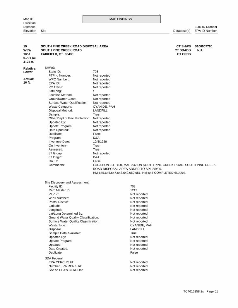
MAP FINDINGSMap IDDirection
EDR ID NumberDistanceEPA ID NumberDatabase(s)SiteElevation
Not reportedSite on EPA’s CERCLIS: Not reportedNumber EPA RCRIS Id: Not reportedEPA CERCLIS Id:
SDA Federal:
FalseDuplicate: Not reportedDate Created: Not reportedUpdated: Not reportedUpdate Program: Not reportedUpdated By: TrueSample Data Available: LANDFILLDisposal: CYANIDE, PAHWaste Type: Not reportedSurface Water Quality Classification: Not reportedGround Water Quality Classification: Not reportedLat/Long Determined By: Not reportedLongitude: Not reportedLatitude: Not reportedPostal District: Not reportedWPC Number: Not reportedPTP Id: 1213Rem Master ID: 703Facility ID:
Site Discovery and Assessment:
HM-645,646,647,648,649,650,651. HM-645 COMPLETED 6/14/94. ROAD DISPOSAL AREA ADDED TO SPL 2/9/90. LOCATION LOT 100, MAP 232 ON SOUTH PINE CREEK ROAD. SOUTH PINE CREEKComments: FalseOn 87: D&A87 Origin: Not reported87 Group: TrueAssessed: TrueOn Inventory: 10/4/1989Inventory Date: D&AProgram: FalseDuplicate: Not reportedDate Updated: Not reportedUpdate Program: Not reportedUpdated By: Not reportedOther Dept of Env. Protection: TrueSample: LANDFILLDisposal Method: CYANIDE, PAHWaste Category: Not reportedSurface Water Qualification: Not reportedGroundwater Class: Not reportedLocation Method: /Lat/Long: Not reportedPO Office: Not reportedEPA ID: Not reportedWPC Number: Not reportedPTP Id Number: 703State ID:
SHWS:
4174 ft.0.791 mi.
Relative:Lower
Actual:16 ft.
1/2-1 CT CPCSFAIRFIELD, CT 06430WSW CT SDADBSOUTH PINE CREEK ROAD N/A19 CT SHWSSOUTH PINE CREEK ROAD DISPOSAL AREA S100007760
TC4616258.2s Page 51
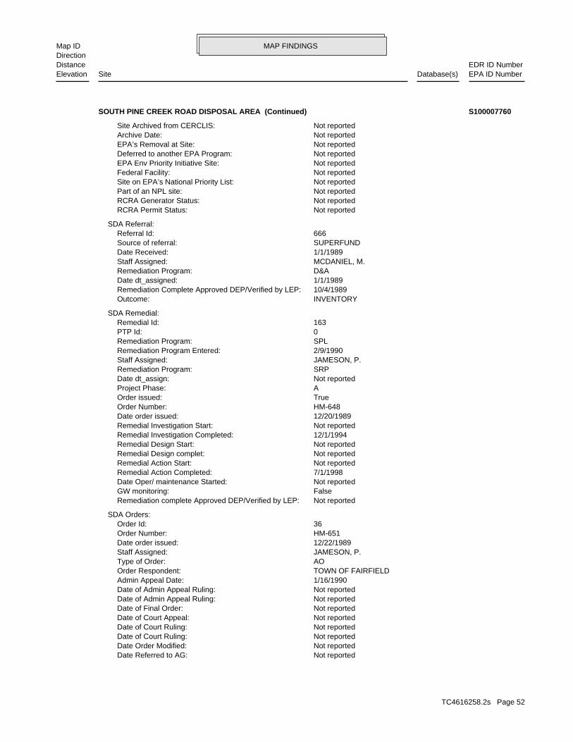
MAP FINDINGSMap IDDirection
EDR ID NumberDistanceEPA ID NumberDatabase(s)SiteElevation
Not reportedDate Referred to AG: Not reportedDate Order Modified: Not reportedDate of Court Ruling: Not reportedDate of Court Ruling: Not reportedDate of Court Appeal: Not reportedDate of Final Order: Not reportedDate of Admin Appeal Ruling: Not reportedDate of Admin Appeal Ruling: 1/16/1990Admin Appeal Date: TOWN OF FAIRFIELDOrder Respondent: AOType of Order: JAMESON, P.Staff Assigned: 12/22/1989Date order issued: HM-651Order Number: 36Order Id:
SDA Orders:
Not reportedRemediation complete Approved DEP/Verified by LEP: FalseGW monitoring: Not reportedDate Oper/ maintenance Started: 7/1/1998Remedial Action Completed: Not reportedRemedial Action Start: Not reportedRemedial Design complet: Not reportedRemedial Design Start: 12/1/1994Remedial Investigation Completed: Not reportedRemedial Investigation Start: 12/20/1989Date order issued: HM-648Order Number: TrueOrder issued: AProject Phase: Not reportedDate dt_assign: SRPRemediation Program: JAMESON, P.Staff Assigned: 2/9/1990Remediation Program Entered: SPLRemediation Program: 0PTP Id: 163Remedial Id:
SDA Remedial:
INVENTORYOutcome: 10/4/1989Remediation Complete Approved DEP/Verified by LEP: 1/1/1989Date dt_assigned: D&ARemediation Program: MCDANIEL, M.Staff Assigned: 1/1/1989Date Received: SUPERFUNDSource of referral: 666Referral Id:
SDA Referral:
Not reportedRCRA Permit Status: Not reportedRCRA Generator Status: Not reportedPart of an NPL site: Not reportedSite on EPA’s National Priority List: Not reportedFederal Facility: Not reportedEPA Env Priority Initiative Site: Not reportedDeferred to another EPA Program: Not reportedEPA’s Removal at Site: Not reportedArchive Date: Not reportedSite Archived from CERCLIS:
SOUTH PINE CREEK ROAD DISPOSAL AREA (Continued) S100007760
TC4616258.2s Page 52
MAP FINDINGSMap IDDirection
EDR ID NumberDistanceEPA ID NumberDatabase(s)SiteElevation
JAMESON, P.Staff Assigned: 12/20/1989Date order issued: HM-646Order Number: 39Order Id:
SDA Orders:
SPL SITE. NO FURTHER ENFORCEMENT ACTION IS PLANNED AT THIS TIComments: FalseIn compliance: Not reportedOrder Complete: 0Penalty assessed: Not reportedDate of AGR judgement: Not reportedJudgement: Not reportedDate Referred to AG: Not reportedDate Order Modified: Not reportedDate of Court Ruling: Not reportedDate of Court Ruling: Not reportedDate of Court Appeal: Not reportedDate of Final Order: Not reportedDate of Admin Appeal Ruling: Not reportedDate of Admin Appeal Ruling: 1/16/1990Admin Appeal Date: MADELINE T. WRABELOrder Respondent: AOType of Order: JAMESON, P.Staff Assigned: 12/22/1989Date order issued: HM-650Order Number: 38Order Id:
SDA Orders:
SPL SITE. NO FURTHER ENFORCEMENT ACTION IS PLANNED AT THIS TIComments: TrueIn compliance: 6/14/1994Order Complete: 0Penalty assessed: Not reportedDate of AGR judgement: Not reportedJudgement: Not reportedDate Referred to AG: Not reportedDate Order Modified: Not reportedDate of Court Ruling: Not reportedDate of Court Ruling: Not reportedDate of Court Appeal: Not reportedDate of Final Order: Not reportedDate of Admin Appeal Ruling: Not reportedDate of Admin Appeal Ruling: 1/18/1990Admin Appeal Date: JACQUELINE SWEENEYOrder Respondent: AOType of Order: JAMESON, P.Staff Assigned: 12/22/1989Date order issued: HM-645Order Number: 37Order Id:
SDA Orders:
THIS TIME. THE SITE IS ON THE SPL. NO FURTHER ENFORCEMENT ACTION IS PLANComments: FalseIn compliance: Not reportedOrder Complete: 0Penalty assessed: Not reportedDate of AGR judgement: Not reportedJudgement:
SOUTH PINE CREEK ROAD DISPOSAL AREA (Continued) S100007760
TC4616258.2s Page 53
MAP FINDINGSMap IDDirection
EDR ID NumberDistanceEPA ID NumberDatabase(s)SiteElevation
Not reportedJudgement: Not reportedDate Referred to AG: Not reportedDate Order Modified: Not reportedDate of Court Ruling: Not reportedDate of Court Ruling: Not reportedDate of Court Appeal: Not reportedDate of Final Order: Not reportedDate of Admin Appeal Ruling: Not reportedDate of Admin Appeal Ruling: 1/16/1990Admin Appeal Date: ROGER F. PECKOrder Respondent: AOType of Order: JAMESON, P.Staff Assigned: 12/20/1989Date order issued: HM-647Order Number: 41Order Id:
SDA Orders:
SPL SITE. NO FURTHER ENFORCEMENT ACTION PLANNED AT THIS TIMEComments: FalseIn compliance: Not reportedOrder Complete: 0Penalty assessed: Not reportedDate of AGR judgement: Not reportedJudgement: Not reportedDate Referred to AG: Not reportedDate Order Modified: Not reportedDate of Court Ruling: Not reportedDate of Court Ruling: Not reportedDate of Court Appeal: Not reportedDate of Final Order: Not reportedDate of Admin Appeal Ruling: Not reportedDate of Admin Appeal Ruling: 1/16/1990Admin Appeal Date: DAVID J. PECKOrder Respondent: AOType of Order: JAMESON, P.Staff Assigned: 12/20/1989Date order issued: HM-649Order Number: 40Order Id:
SDA Orders:
SPL SITE. NO FURTHER ENFORCEMENT ACTION PLANNED AT THIS TIMEComments: FalseIn compliance: Not reportedOrder Complete: 0Penalty assessed: Not reportedDate of AGR judgement: Not reportedJudgement: Not reportedDate Referred to AG: Not reportedDate Order Modified: Not reportedDate of Court Ruling: Not reportedDate of Court Ruling: Not reportedDate of Court Appeal: Not reportedDate of Final Order: Not reportedDate of Admin Appeal Ruling: Not reportedDate of Admin Appeal Ruling: 1/16/1990Admin Appeal Date: MARIE S. PECKOrder Respondent: AOType of Order:
SOUTH PINE CREEK ROAD DISPOSAL AREA (Continued) S100007760
TC4616258.2s Page 54
MAP FINDINGSMap IDDirection
EDR ID NumberDistanceEPA ID NumberDatabase(s)SiteElevation
Inventory of Hazardous Waste Disposal SitesSite Type Definition: 2/9/90.Hm-645,646,647,648,649,650,651.Hm-645 Completed 6/14/94. Road Disposal Area Added To Spl Location Lot 100, Map 232 On South Pine Creek Road.South Pine CreekComments: -1Program: Not reportedPTP Form: Not reportedLust Status: Not reportedLust Status code: SitesSite Type:
CPCS:
Not reportedDescription: CYANIDEWaste Type: 6Waste Id:
SDA Waste:
SDADB:
SPL SITE. NO FURTHER ACTION PLANNED AT THIS TIME.Comments: FalseIn compliance: Not reportedOrder Complete: 0Penalty assessed: Not reportedDate of AGR judgement: Not reportedJudgement: Not reportedDate Referred to AG: Not reportedDate Order Modified: Not reportedDate of Court Ruling: Not reportedDate of Court Ruling: Not reportedDate of Court Appeal: Not reportedDate of Final Order: Not reportedDate of Admin Appeal Ruling: Not reportedDate of Admin Appeal Ruling: 1/16/1990Admin Appeal Date: SUMAKO M. PECKOrder Respondent: AOType of Order: JAMESON, P.Staff Assigned: 12/20/1989Date order issued: HM-648Order Number: 42Order Id:
SDA Orders:
SPL SITE. NO FURTHER ENFORCEMENT ACTION PLANNED AT THIS TIMEComments: FalseIn compliance: Not reportedOrder Complete: 0Penalty assessed: Not reportedDate of AGR judgement:
SOUTH PINE CREEK ROAD DISPOSAL AREA (Continued) S100007760
TC4616258.2s Page 55
ORPHAN SUMMARY
City EDR ID Site Name Site Address Zip Database(s)
Count: 0 records.
NO SITES FOUND
TC4616258.2s Page 56
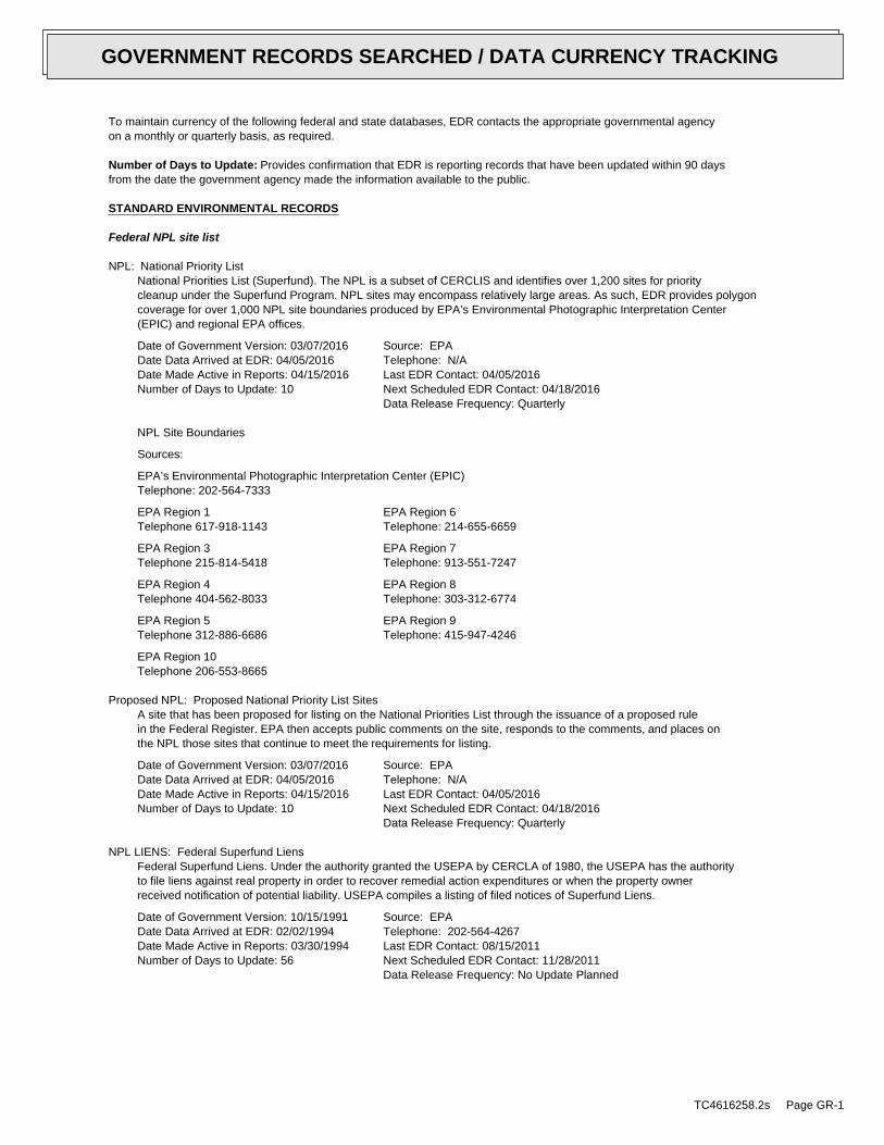
To maintain currency of the following federal and state databases, EDR contacts the appropriate governmental agencyon a monthly or quarterly basis, as required.
Number of Days to Update: Provides confirmation that EDR is reporting records that have been updated within 90 daysfrom the date the government agency made the information available to the public.
STANDARD ENVIRONMENTAL RECORDS
Federal NPL site list
NPL: National Priority ListNational Priorities List (Superfund). The NPL is a subset of CERCLIS and identifies over 1,200 sites for prioritycleanup under the Superfund Program. NPL sites may encompass relatively large areas. As such, EDR provides polygoncoverage for over 1,000 NPL site boundaries produced by EPA’s Environmental Photographic Interpretation Center(EPIC) and regional EPA offices.
Date of Government Version: 03/07/2016Date Data Arrived at EDR: 04/05/2016Date Made Active in Reports: 04/15/2016Number of Days to Update: 10
Source: EPATelephone: N/ALast EDR Contact: 04/05/2016Next Scheduled EDR Contact: 04/18/2016Data Release Frequency: Quarterly
NPL Site Boundaries
Sources:
EPA’s Environmental Photographic Interpretation Center (EPIC)Telephone: 202-564-7333
EPA Region 1 EPA Region 6Telephone 617-918-1143 Telephone: 214-655-6659
EPA Region 3 EPA Region 7Telephone 215-814-5418 Telephone: 913-551-7247
EPA Region 4 EPA Region 8Telephone 404-562-8033 Telephone: 303-312-6774
EPA Region 5 EPA Region 9Telephone 312-886-6686 Telephone: 415-947-4246
EPA Region 10Telephone 206-553-8665
Proposed NPL: Proposed National Priority List SitesA site that has been proposed for listing on the National Priorities List through the issuance of a proposed rulein the Federal Register. EPA then accepts public comments on the site, responds to the comments, and places onthe NPL those sites that continue to meet the requirements for listing.
Date of Government Version: 03/07/2016Date Data Arrived at EDR: 04/05/2016Date Made Active in Reports: 04/15/2016Number of Days to Update: 10
Source: EPATelephone: N/ALast EDR Contact: 04/05/2016Next Scheduled EDR Contact: 04/18/2016Data Release Frequency: Quarterly
NPL LIENS: Federal Superfund LiensFederal Superfund Liens. Under the authority granted the USEPA by CERCLA of 1980, the USEPA has the authorityto file liens against real property in order to recover remedial action expenditures or when the property ownerreceived notification of potential liability. USEPA compiles a listing of filed notices of Superfund Liens.
Date of Government Version: 10/15/1991Date Data Arrived at EDR: 02/02/1994Date Made Active in Reports: 03/30/1994Number of Days to Update: 56
Source: EPATelephone: 202-564-4267Last EDR Contact: 08/15/2011Next Scheduled EDR Contact: 11/28/2011Data Release Frequency: No Update Planned
TC4616258.2s Page GR-1
GOVERNMENT RECORDS SEARCHED / DATA CURRENCY TRACKING
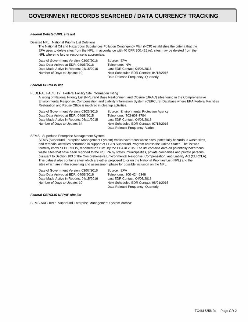
Federal Delisted NPL site list
Delisted NPL: National Priority List DeletionsThe National Oil and Hazardous Substances Pollution Contingency Plan (NCP) establishes the criteria that theEPA uses to delete sites from the NPL. In accordance with 40 CFR 300.425.(e), sites may be deleted from theNPL where no further response is appropriate.
Date of Government Version: 03/07/2016Date Data Arrived at EDR: 04/05/2016Date Made Active in Reports: 04/15/2016Number of Days to Update: 10
Source: EPATelephone: N/ALast EDR Contact: 04/05/2016Next Scheduled EDR Contact: 04/18/2016Data Release Frequency: Quarterly
Federal CERCLIS list
FEDERAL FACILITY: Federal Facility Site Information listingA listing of National Priority List (NPL) and Base Realignment and Closure (BRAC) sites found in the ComprehensiveEnvironmental Response, Compensation and Liability Information System (CERCLIS) Database where EPA Federal FacilitiesRestoration and Reuse Office is involved in cleanup activities.
Date of Government Version: 03/26/2015Date Data Arrived at EDR: 04/08/2015Date Made Active in Reports: 06/11/2015Number of Days to Update: 64
Source: Environmental Protection AgencyTelephone: 703-603-8704Last EDR Contact: 04/08/2016Next Scheduled EDR Contact: 07/18/2016Data Release Frequency: Varies
SEMS: Superfund Enterprise Management SystemSEMS (Superfund Enterprise Management System) tracks hazardous waste sites, potentially hazardous waste sites,and remedial activities performed in support of EPA’s Superfund Program across the United States. The list wasformerly know as CERCLIS, renamed to SEMS by the EPA in 2015. The list contains data on potentially hazardouswaste sites that have been reported to the USEPA by states, municipalities, private companies and private persons,pursuant to Section 103 of the Comprehensive Environmental Response, Compensation, and Liability Act (CERCLA).This dataset also contains sites which are either proposed to or on the National Priorities List (NPL) and thesites which are in the screening and assessment phase for possible inclusion on the NPL.
Date of Government Version: 03/07/2016Date Data Arrived at EDR: 04/05/2016Date Made Active in Reports: 04/15/2016Number of Days to Update: 10
Source: EPATelephone: 800-424-9346Last EDR Contact: 04/05/2016Next Scheduled EDR Contact: 08/01/2016Data Release Frequency: Quarterly
Federal CERCLIS NFRAP site list
SEMS-ARCHIVE: Superfund Enterprise Management System Archive
TC4616258.2s Page GR-2
GOVERNMENT RECORDS SEARCHED / DATA CURRENCY TRACKING
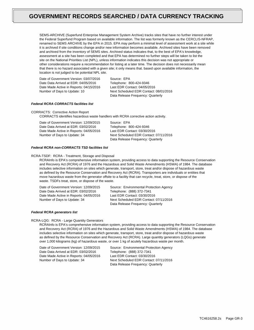
SEMS-ARCHIVE (Superfund Enterprise Management System Archive) tracks sites that have no further interest underthe Federal Superfund Program based on available information. The list was formerly known as the CERCLIS-NFRAP,renamed to SEMS ARCHIVE by the EPA in 2015. EPA may perform a minimal level of assessment work at a site whileit is archived if site conditions change and/or new information becomes available. Archived sites have been removedand archived from the inventory of SEMS sites. Archived status indicates that, to the best of EPA’s knowledge,assessment at a site has been completed and that EPA has determined no further steps will be taken to list thesite on the National Priorities List (NPL), unless information indicates this decision was not appropriate orother considerations require a recommendation for listing at a later time. The decision does not necessarily meanthat there is no hazard associated with a given site; it only means that. based upon available information, thelocation is not judged to be potential NPL site.
Date of Government Version: 03/07/2016Date Data Arrived at EDR: 04/05/2016Date Made Active in Reports: 04/15/2016Number of Days to Update: 10
Source: EPATelephone: 800-424-9346Last EDR Contact: 04/05/2016Next Scheduled EDR Contact: 08/01/2016Data Release Frequency: Quarterly
Federal RCRA CORRACTS facilities list
CORRACTS: Corrective Action ReportCORRACTS identifies hazardous waste handlers with RCRA corrective action activity.
Date of Government Version: 12/09/2015Date Data Arrived at EDR: 03/02/2016Date Made Active in Reports: 04/05/2016Number of Days to Update: 34
Source: EPATelephone: 800-424-9346Last EDR Contact: 03/30/2016Next Scheduled EDR Contact: 07/11/2016Data Release Frequency: Quarterly
Federal RCRA non-CORRACTS TSD facilities list
RCRA-TSDF: RCRA - Treatment, Storage and DisposalRCRAInfo is EPA’s comprehensive information system, providing access to data supporting the Resource Conservationand Recovery Act (RCRA) of 1976 and the Hazardous and Solid Waste Amendments (HSWA) of 1984. The databaseincludes selective information on sites which generate, transport, store, treat and/or dispose of hazardous wasteas defined by the Resource Conservation and Recovery Act (RCRA). Transporters are individuals or entities thatmove hazardous waste from the generator offsite to a facility that can recycle, treat, store, or dispose of thewaste. TSDFs treat, store, or dispose of the waste.
Date of Government Version: 12/09/2015Date Data Arrived at EDR: 03/02/2016Date Made Active in Reports: 04/05/2016Number of Days to Update: 34
Source: Environmental Protection AgencyTelephone: (888) 372-7341Last EDR Contact: 03/30/2016Next Scheduled EDR Contact: 07/11/2016Data Release Frequency: Quarterly
Federal RCRA generators list
RCRA-LQG: RCRA - Large Quantity GeneratorsRCRAInfo is EPA’s comprehensive information system, providing access to data supporting the Resource Conservationand Recovery Act (RCRA) of 1976 and the Hazardous and Solid Waste Amendments (HSWA) of 1984. The databaseincludes selective information on sites which generate, transport, store, treat and/or dispose of hazardous wasteas defined by the Resource Conservation and Recovery Act (RCRA). Large quantity generators (LQGs) generateover 1,000 kilograms (kg) of hazardous waste, or over 1 kg of acutely hazardous waste per month.
Date of Government Version: 12/09/2015Date Data Arrived at EDR: 03/02/2016Date Made Active in Reports: 04/05/2016Number of Days to Update: 34
Source: Environmental Protection AgencyTelephone: (888) 372-7341Last EDR Contact: 03/30/2016Next Scheduled EDR Contact: 07/11/2016Data Release Frequency: Quarterly
TC4616258.2s Page GR-3
GOVERNMENT RECORDS SEARCHED / DATA CURRENCY TRACKING
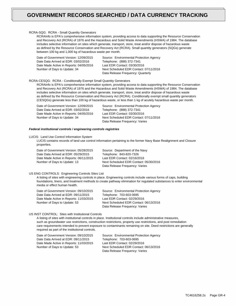
RCRA-SQG: RCRA - Small Quantity GeneratorsRCRAInfo is EPA’s comprehensive information system, providing access to data supporting the Resource Conservationand Recovery Act (RCRA) of 1976 and the Hazardous and Solid Waste Amendments (HSWA) of 1984. The databaseincludes selective information on sites which generate, transport, store, treat and/or dispose of hazardous wasteas defined by the Resource Conservation and Recovery Act (RCRA). Small quantity generators (SQGs) generatebetween 100 kg and 1,000 kg of hazardous waste per month.
Date of Government Version: 12/09/2015Date Data Arrived at EDR: 03/02/2016Date Made Active in Reports: 04/05/2016Number of Days to Update: 34
Source: Environmental Protection AgencyTelephone: (888) 372-7341Last EDR Contact: 03/30/2016Next Scheduled EDR Contact: 07/11/2016Data Release Frequency: Quarterly
RCRA-CESQG: RCRA - Conditionally Exempt Small Quantity GeneratorsRCRAInfo is EPA’s comprehensive information system, providing access to data supporting the Resource Conservationand Recovery Act (RCRA) of 1976 and the Hazardous and Solid Waste Amendments (HSWA) of 1984. The databaseincludes selective information on sites which generate, transport, store, treat and/or dispose of hazardous wasteas defined by the Resource Conservation and Recovery Act (RCRA). Conditionally exempt small quantity generators(CESQGs) generate less than 100 kg of hazardous waste, or less than 1 kg of acutely hazardous waste per month.
Date of Government Version: 12/09/2015Date Data Arrived at EDR: 03/02/2016Date Made Active in Reports: 04/05/2016Number of Days to Update: 34
Source: Environmental Protection AgencyTelephone: (888) 372-7341Last EDR Contact: 03/30/2016Next Scheduled EDR Contact: 07/11/2016Data Release Frequency: Varies
Federal institutional controls / engineering controls registries
LUCIS: Land Use Control Information SystemLUCIS contains records of land use control information pertaining to the former Navy Base Realignment and Closureproperties.
Date of Government Version: 05/28/2015Date Data Arrived at EDR: 05/29/2015Date Made Active in Reports: 06/11/2015Number of Days to Update: 13
Source: Department of the NavyTelephone: 843-820-7326Last EDR Contact: 02/16/2016Next Scheduled EDR Contact: 05/30/2016Data Release Frequency: Varies
US ENG CONTROLS: Engineering Controls Sites ListA listing of sites with engineering controls in place. Engineering controls include various forms of caps, buildingfoundations, liners, and treatment methods to create pathway elimination for regulated substances to enter environmentalmedia or effect human health.
Date of Government Version: 09/10/2015Date Data Arrived at EDR: 09/11/2015Date Made Active in Reports: 11/03/2015Number of Days to Update: 53
Source: Environmental Protection AgencyTelephone: 703-603-0695Last EDR Contact: 02/29/2016Next Scheduled EDR Contact: 06/13/2016Data Release Frequency: Varies
US INST CONTROL: Sites with Institutional ControlsA listing of sites with institutional controls in place. Institutional controls include administrative measures,such as groundwater use restrictions, construction restrictions, property use restrictions, and post remediationcare requirements intended to prevent exposure to contaminants remaining on site. Deed restrictions are generallyrequired as part of the institutional controls.
Date of Government Version: 09/10/2015Date Data Arrived at EDR: 09/11/2015Date Made Active in Reports: 11/03/2015Number of Days to Update: 53
Source: Environmental Protection AgencyTelephone: 703-603-0695Last EDR Contact: 02/29/2016Next Scheduled EDR Contact: 06/13/2016Data Release Frequency: Varies
TC4616258.2s Page GR-4
GOVERNMENT RECORDS SEARCHED / DATA CURRENCY TRACKING
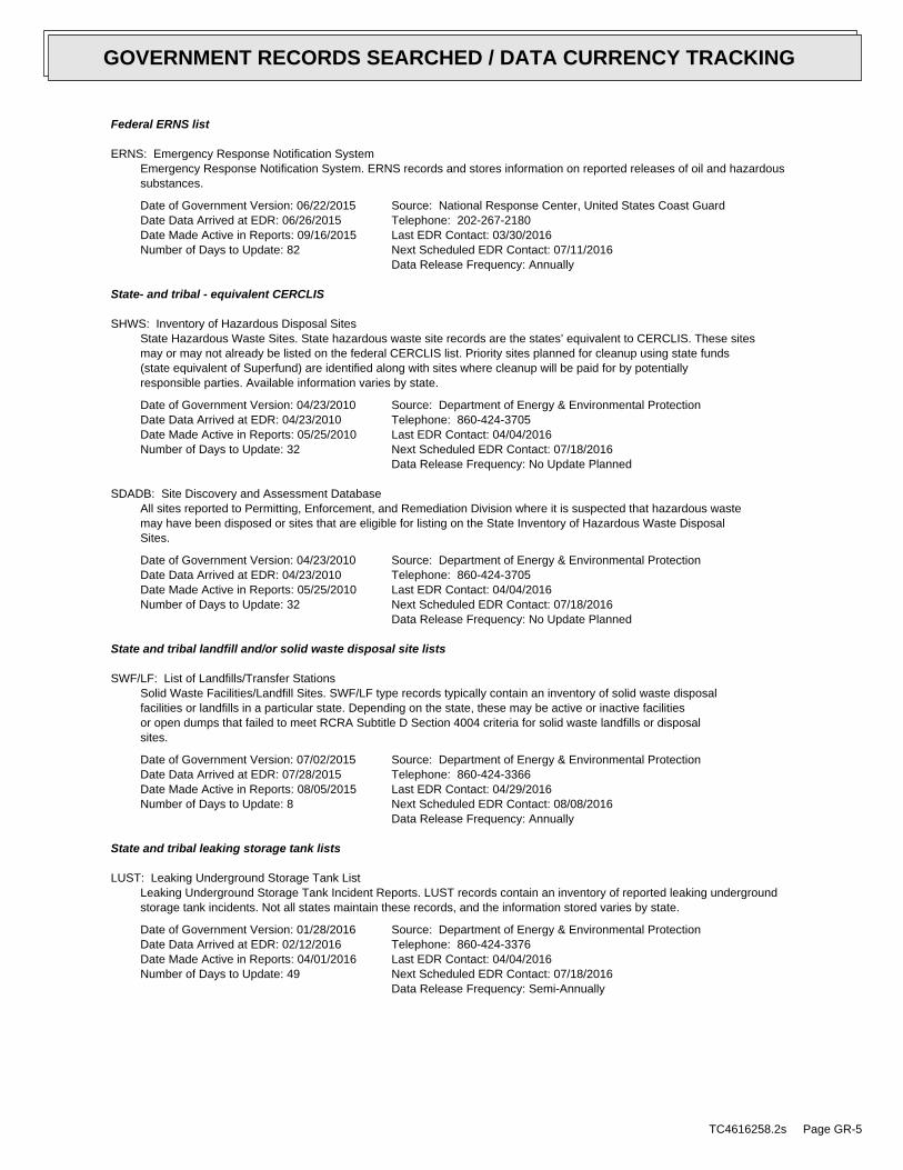
Federal ERNS list
ERNS: Emergency Response Notification SystemEmergency Response Notification System. ERNS records and stores information on reported releases of oil and hazardoussubstances.
Date of Government Version: 06/22/2015Date Data Arrived at EDR: 06/26/2015Date Made Active in Reports: 09/16/2015Number of Days to Update: 82
Source: National Response Center, United States Coast GuardTelephone: 202-267-2180Last EDR Contact: 03/30/2016Next Scheduled EDR Contact: 07/11/2016Data Release Frequency: Annually
State- and tribal - equivalent CERCLIS
SHWS: Inventory of Hazardous Disposal SitesState Hazardous Waste Sites. State hazardous waste site records are the states’ equivalent to CERCLIS. These sitesmay or may not already be listed on the federal CERCLIS list. Priority sites planned for cleanup using state funds(state equivalent of Superfund) are identified along with sites where cleanup will be paid for by potentiallyresponsible parties. Available information varies by state.
Date of Government Version: 04/23/2010Date Data Arrived at EDR: 04/23/2010Date Made Active in Reports: 05/25/2010Number of Days to Update: 32
Source: Department of Energy & Environmental ProtectionTelephone: 860-424-3705Last EDR Contact: 04/04/2016Next Scheduled EDR Contact: 07/18/2016Data Release Frequency: No Update Planned
SDADB: Site Discovery and Assessment DatabaseAll sites reported to Permitting, Enforcement, and Remediation Division where it is suspected that hazardous wastemay have been disposed or sites that are eligible for listing on the State Inventory of Hazardous Waste DisposalSites.
Date of Government Version: 04/23/2010Date Data Arrived at EDR: 04/23/2010Date Made Active in Reports: 05/25/2010Number of Days to Update: 32
Source: Department of Energy & Environmental ProtectionTelephone: 860-424-3705Last EDR Contact: 04/04/2016Next Scheduled EDR Contact: 07/18/2016Data Release Frequency: No Update Planned
State and tribal landfill and/or solid waste disposal site lists
SWF/LF: List of Landfills/Transfer StationsSolid Waste Facilities/Landfill Sites. SWF/LF type records typically contain an inventory of solid waste disposalfacilities or landfills in a particular state. Depending on the state, these may be active or inactive facilitiesor open dumps that failed to meet RCRA Subtitle D Section 4004 criteria for solid waste landfills or disposalsites.
Date of Government Version: 07/02/2015Date Data Arrived at EDR: 07/28/2015Date Made Active in Reports: 08/05/2015Number of Days to Update: 8
Source: Department of Energy & Environmental ProtectionTelephone: 860-424-3366Last EDR Contact: 04/29/2016Next Scheduled EDR Contact: 08/08/2016Data Release Frequency: Annually
State and tribal leaking storage tank lists
LUST: Leaking Underground Storage Tank ListLeaking Underground Storage Tank Incident Reports. LUST records contain an inventory of reported leaking undergroundstorage tank incidents. Not all states maintain these records, and the information stored varies by state.
Date of Government Version: 01/28/2016Date Data Arrived at EDR: 02/12/2016Date Made Active in Reports: 04/01/2016Number of Days to Update: 49
Source: Department of Energy & Environmental ProtectionTelephone: 860-424-3376Last EDR Contact: 04/04/2016Next Scheduled EDR Contact: 07/18/2016Data Release Frequency: Semi-Annually
TC4616258.2s Page GR-5
GOVERNMENT RECORDS SEARCHED / DATA CURRENCY TRACKING
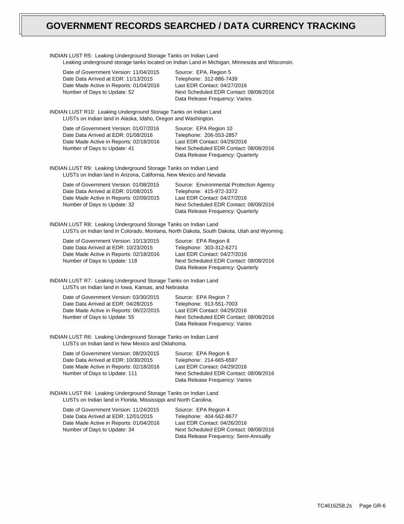
INDIAN LUST R5: Leaking Underground Storage Tanks on Indian LandLeaking underground storage tanks located on Indian Land in Michigan, Minnesota and Wisconsin.
Date of Government Version: 11/04/2015Date Data Arrived at EDR: 11/13/2015Date Made Active in Reports: 01/04/2016Number of Days to Update: 52
Source: EPA, Region 5Telephone: 312-886-7439Last EDR Contact: 04/27/2016Next Scheduled EDR Contact: 08/08/2016Data Release Frequency: Varies
INDIAN LUST R10: Leaking Underground Storage Tanks on Indian LandLUSTs on Indian land in Alaska, Idaho, Oregon and Washington.
Date of Government Version: 01/07/2016Date Data Arrived at EDR: 01/08/2016Date Made Active in Reports: 02/18/2016Number of Days to Update: 41
Source: EPA Region 10Telephone: 206-553-2857Last EDR Contact: 04/29/2016Next Scheduled EDR Contact: 08/08/2016Data Release Frequency: Quarterly
INDIAN LUST R9: Leaking Underground Storage Tanks on Indian LandLUSTs on Indian land in Arizona, California, New Mexico and Nevada
Date of Government Version: 01/08/2015Date Data Arrived at EDR: 01/08/2015Date Made Active in Reports: 02/09/2015Number of Days to Update: 32
Source: Environmental Protection AgencyTelephone: 415-972-3372Last EDR Contact: 04/27/2016Next Scheduled EDR Contact: 08/08/2016Data Release Frequency: Quarterly
INDIAN LUST R8: Leaking Underground Storage Tanks on Indian LandLUSTs on Indian land in Colorado, Montana, North Dakota, South Dakota, Utah and Wyoming.
Date of Government Version: 10/13/2015Date Data Arrived at EDR: 10/23/2015Date Made Active in Reports: 02/18/2016Number of Days to Update: 118
Source: EPA Region 8Telephone: 303-312-6271Last EDR Contact: 04/27/2016Next Scheduled EDR Contact: 08/08/2016Data Release Frequency: Quarterly
INDIAN LUST R7: Leaking Underground Storage Tanks on Indian LandLUSTs on Indian land in Iowa, Kansas, and Nebraska
Date of Government Version: 03/30/2015Date Data Arrived at EDR: 04/28/2015Date Made Active in Reports: 06/22/2015Number of Days to Update: 55
Source: EPA Region 7Telephone: 913-551-7003Last EDR Contact: 04/29/2016Next Scheduled EDR Contact: 08/08/2016Data Release Frequency: Varies
INDIAN LUST R6: Leaking Underground Storage Tanks on Indian LandLUSTs on Indian land in New Mexico and Oklahoma.
Date of Government Version: 08/20/2015Date Data Arrived at EDR: 10/30/2015Date Made Active in Reports: 02/18/2016Number of Days to Update: 111
Source: EPA Region 6Telephone: 214-665-6597Last EDR Contact: 04/29/2016Next Scheduled EDR Contact: 08/08/2016Data Release Frequency: Varies
INDIAN LUST R4: Leaking Underground Storage Tanks on Indian LandLUSTs on Indian land in Florida, Mississippi and North Carolina.
Date of Government Version: 11/24/2015Date Data Arrived at EDR: 12/01/2015Date Made Active in Reports: 01/04/2016Number of Days to Update: 34
Source: EPA Region 4Telephone: 404-562-8677Last EDR Contact: 04/26/2016Next Scheduled EDR Contact: 08/08/2016Data Release Frequency: Semi-Annually
TC4616258.2s Page GR-6
GOVERNMENT RECORDS SEARCHED / DATA CURRENCY TRACKING
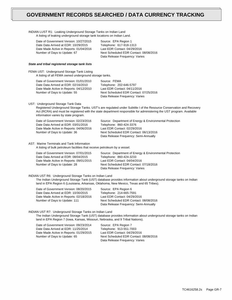
INDIAN LUST R1: Leaking Underground Storage Tanks on Indian LandA listing of leaking underground storage tank locations on Indian Land.
Date of Government Version: 10/27/2015Date Data Arrived at EDR: 10/29/2015Date Made Active in Reports: 01/04/2016Number of Days to Update: 67
Source: EPA Region 1Telephone: 617-918-1313Last EDR Contact: 04/29/2016Next Scheduled EDR Contact: 08/08/2016Data Release Frequency: Varies
State and tribal registered storage tank lists
FEMA UST: Underground Storage Tank ListingA listing of all FEMA owned underground storage tanks.
Date of Government Version: 01/01/2010Date Data Arrived at EDR: 02/16/2010Date Made Active in Reports: 04/12/2010Number of Days to Update: 55
Source: FEMATelephone: 202-646-5797Last EDR Contact: 04/11/2016Next Scheduled EDR Contact: 07/25/2016Data Release Frequency: Varies
UST: Underground Storage Tank DataRegistered Underground Storage Tanks. UST’s are regulated under Subtitle I of the Resource Conservation and RecoveryAct (RCRA) and must be registered with the state department responsible for administering the UST program. Availableinformation varies by state program.
Date of Government Version: 02/23/2016Date Data Arrived at EDR: 03/01/2016Date Made Active in Reports: 04/06/2016Number of Days to Update: 36
Source: Department of Energy & Environmental ProtectionTelephone: 860-424-3376Last EDR Contact: 02/29/2016Next Scheduled EDR Contact: 06/13/2016Data Release Frequency: Semi-Annually
AST: Marine Terminals and Tank InformationA listing of bulk petroleum facilities that receive petroleum by a vessel.
Date of Government Version: 07/01/2015Date Data Arrived at EDR: 08/04/2015Date Made Active in Reports: 09/01/2015Number of Days to Update: 28
Source: Department of Energy & Environmental ProtectionTelephone: 860-424-3233Last EDR Contact: 04/04/2016Next Scheduled EDR Contact: 07/18/2016Data Release Frequency: Varies
INDIAN UST R6: Underground Storage Tanks on Indian LandThe Indian Underground Storage Tank (UST) database provides information about underground storage tanks on Indianland in EPA Region 6 (Louisiana, Arkansas, Oklahoma, New Mexico, Texas and 65 Tribes).
Date of Government Version: 08/20/2015Date Data Arrived at EDR: 10/30/2015Date Made Active in Reports: 02/18/2016Number of Days to Update: 111
Source: EPA Region 6Telephone: 214-665-7591Last EDR Contact: 04/29/2016Next Scheduled EDR Contact: 08/08/2016Data Release Frequency: Semi-Annually
INDIAN UST R7: Underground Storage Tanks on Indian LandThe Indian Underground Storage Tank (UST) database provides information about underground storage tanks on Indianland in EPA Region 7 (Iowa, Kansas, Missouri, Nebraska, and 9 Tribal Nations).
Date of Government Version: 09/23/2014Date Data Arrived at EDR: 11/25/2014Date Made Active in Reports: 01/29/2015Number of Days to Update: 65
Source: EPA Region 7Telephone: 913-551-7003Last EDR Contact: 04/29/2016Next Scheduled EDR Contact: 08/08/2016Data Release Frequency: Varies
TC4616258.2s Page GR-7
GOVERNMENT RECORDS SEARCHED / DATA CURRENCY TRACKING
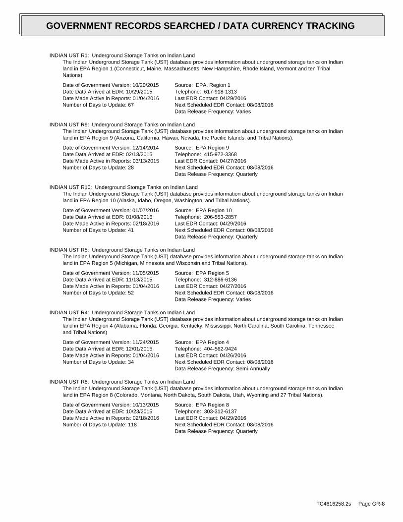
INDIAN UST R1: Underground Storage Tanks on Indian LandThe Indian Underground Storage Tank (UST) database provides information about underground storage tanks on Indianland in EPA Region 1 (Connecticut, Maine, Massachusetts, New Hampshire, Rhode Island, Vermont and ten TribalNations).
Date of Government Version: 10/20/2015Date Data Arrived at EDR: 10/29/2015Date Made Active in Reports: 01/04/2016Number of Days to Update: 67
Source: EPA, Region 1Telephone: 617-918-1313Last EDR Contact: 04/29/2016Next Scheduled EDR Contact: 08/08/2016Data Release Frequency: Varies
INDIAN UST R9: Underground Storage Tanks on Indian LandThe Indian Underground Storage Tank (UST) database provides information about underground storage tanks on Indianland in EPA Region 9 (Arizona, California, Hawaii, Nevada, the Pacific Islands, and Tribal Nations).
Date of Government Version: 12/14/2014Date Data Arrived at EDR: 02/13/2015Date Made Active in Reports: 03/13/2015Number of Days to Update: 28
Source: EPA Region 9Telephone: 415-972-3368Last EDR Contact: 04/27/2016Next Scheduled EDR Contact: 08/08/2016Data Release Frequency: Quarterly
INDIAN UST R10: Underground Storage Tanks on Indian LandThe Indian Underground Storage Tank (UST) database provides information about underground storage tanks on Indianland in EPA Region 10 (Alaska, Idaho, Oregon, Washington, and Tribal Nations).
Date of Government Version: 01/07/2016Date Data Arrived at EDR: 01/08/2016Date Made Active in Reports: 02/18/2016Number of Days to Update: 41
Source: EPA Region 10Telephone: 206-553-2857Last EDR Contact: 04/29/2016Next Scheduled EDR Contact: 08/08/2016Data Release Frequency: Quarterly
INDIAN UST R5: Underground Storage Tanks on Indian LandThe Indian Underground Storage Tank (UST) database provides information about underground storage tanks on Indianland in EPA Region 5 (Michigan, Minnesota and Wisconsin and Tribal Nations).
Date of Government Version: 11/05/2015Date Data Arrived at EDR: 11/13/2015Date Made Active in Reports: 01/04/2016Number of Days to Update: 52
Source: EPA Region 5Telephone: 312-886-6136Last EDR Contact: 04/27/2016Next Scheduled EDR Contact: 08/08/2016Data Release Frequency: Varies
INDIAN UST R4: Underground Storage Tanks on Indian LandThe Indian Underground Storage Tank (UST) database provides information about underground storage tanks on Indianland in EPA Region 4 (Alabama, Florida, Georgia, Kentucky, Mississippi, North Carolina, South Carolina, Tennesseeand Tribal Nations)
Date of Government Version: 11/24/2015Date Data Arrived at EDR: 12/01/2015Date Made Active in Reports: 01/04/2016Number of Days to Update: 34
Source: EPA Region 4Telephone: 404-562-9424Last EDR Contact: 04/26/2016Next Scheduled EDR Contact: 08/08/2016Data Release Frequency: Semi-Annually
INDIAN UST R8: Underground Storage Tanks on Indian LandThe Indian Underground Storage Tank (UST) database provides information about underground storage tanks on Indianland in EPA Region 8 (Colorado, Montana, North Dakota, South Dakota, Utah, Wyoming and 27 Tribal Nations).
Date of Government Version: 10/13/2015Date Data Arrived at EDR: 10/23/2015Date Made Active in Reports: 02/18/2016Number of Days to Update: 118
Source: EPA Region 8Telephone: 303-312-6137Last EDR Contact: 04/29/2016Next Scheduled EDR Contact: 08/08/2016Data Release Frequency: Quarterly
TC4616258.2s Page GR-8
GOVERNMENT RECORDS SEARCHED / DATA CURRENCY TRACKING
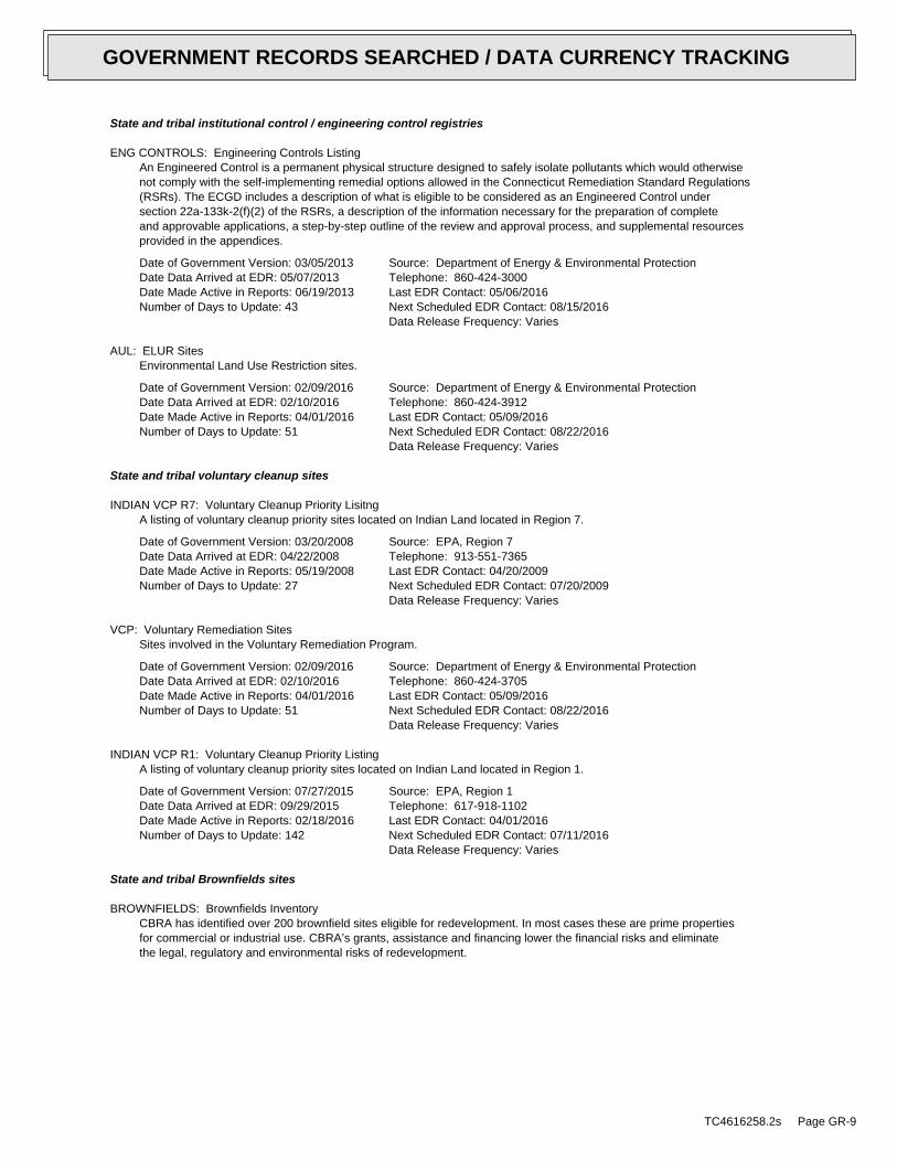
State and tribal institutional control / engineering control registries
ENG CONTROLS: Engineering Controls ListingAn Engineered Control is a permanent physical structure designed to safely isolate pollutants which would otherwisenot comply with the self-implementing remedial options allowed in the Connecticut Remediation Standard Regulations(RSRs). The ECGD includes a description of what is eligible to be considered as an Engineered Control undersection 22a-133k-2(f)(2) of the RSRs, a description of the information necessary for the preparation of completeand approvable applications, a step-by-step outline of the review and approval process, and supplemental resourcesprovided in the appendices.
Date of Government Version: 03/05/2013Date Data Arrived at EDR: 05/07/2013Date Made Active in Reports: 06/19/2013Number of Days to Update: 43
Source: Department of Energy & Environmental ProtectionTelephone: 860-424-3000Last EDR Contact: 05/06/2016Next Scheduled EDR Contact: 08/15/2016Data Release Frequency: Varies
AUL: ELUR SitesEnvironmental Land Use Restriction sites.
Date of Government Version: 02/09/2016Date Data Arrived at EDR: 02/10/2016Date Made Active in Reports: 04/01/2016Number of Days to Update: 51
Source: Department of Energy & Environmental ProtectionTelephone: 860-424-3912Last EDR Contact: 05/09/2016Next Scheduled EDR Contact: 08/22/2016Data Release Frequency: Varies
State and tribal voluntary cleanup sites
INDIAN VCP R7: Voluntary Cleanup Priority LisitngA listing of voluntary cleanup priority sites located on Indian Land located in Region 7.
Date of Government Version: 03/20/2008Date Data Arrived at EDR: 04/22/2008Date Made Active in Reports: 05/19/2008Number of Days to Update: 27
Source: EPA, Region 7Telephone: 913-551-7365Last EDR Contact: 04/20/2009Next Scheduled EDR Contact: 07/20/2009Data Release Frequency: Varies
VCP: Voluntary Remediation SitesSites involved in the Voluntary Remediation Program.
Date of Government Version: 02/09/2016Date Data Arrived at EDR: 02/10/2016Date Made Active in Reports: 04/01/2016Number of Days to Update: 51
Source: Department of Energy & Environmental ProtectionTelephone: 860-424-3705Last EDR Contact: 05/09/2016Next Scheduled EDR Contact: 08/22/2016Data Release Frequency: Varies
INDIAN VCP R1: Voluntary Cleanup Priority ListingA listing of voluntary cleanup priority sites located on Indian Land located in Region 1.
Date of Government Version: 07/27/2015Date Data Arrived at EDR: 09/29/2015Date Made Active in Reports: 02/18/2016Number of Days to Update: 142
Source: EPA, Region 1Telephone: 617-918-1102Last EDR Contact: 04/01/2016Next Scheduled EDR Contact: 07/11/2016Data Release Frequency: Varies
State and tribal Brownfields sites
BROWNFIELDS: Brownfields InventoryCBRA has identified over 200 brownfield sites eligible for redevelopment. In most cases these are prime propertiesfor commercial or industrial use. CBRA’s grants, assistance and financing lower the financial risks and eliminatethe legal, regulatory and environmental risks of redevelopment.
TC4616258.2s Page GR-9
GOVERNMENT RECORDS SEARCHED / DATA CURRENCY TRACKING
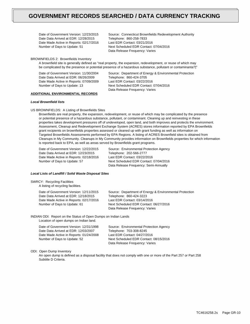
Date of Government Version: 12/23/2015Date Data Arrived at EDR: 12/28/2015Date Made Active in Reports: 02/17/2016Number of Days to Update: 51
Source: Connecticut Brownfields Redevelopment AuthorityTelephone: 860-258-7833Last EDR Contact: 03/21/2016Next Scheduled EDR Contact: 07/04/2016Data Release Frequency: Varies
BROWNFIELDS 2: Brownfields InventoryA brownfield site is generally defined as "real property, the expansion, redevelopment, or reuse of which maybe complicated by the presence or potential presence of a hazardous substance, pollutant or contaminanta?|"
Date of Government Version: 11/30/2004Date Data Arrived at EDR: 06/26/2009Date Made Active in Reports: 07/09/2009Number of Days to Update: 13
Source: Department of Energy & Environmental ProtectionTelephone: 860-424-3705Last EDR Contact: 03/22/2016Next Scheduled EDR Contact: 07/04/2016Data Release Frequency: Varies
ADDITIONAL ENVIRONMENTAL RECORDS
Local Brownfield lists
US BROWNFIELDS: A Listing of Brownfields SitesBrownfields are real property, the expansion, redevelopment, or reuse of which may be complicated by the presenceor potential presence of a hazardous substance, pollutant, or contaminant. Cleaning up and reinvesting in theseproperties takes development pressures off of undeveloped, open land, and both improves and protects the environment.Assessment, Cleanup and Redevelopment Exchange System (ACRES) stores information reported by EPA Brownfieldsgrant recipients on brownfields properties assessed or cleaned up with grant funding as well as information onTargeted Brownfields Assessments performed by EPA Regions. A listing of ACRES Brownfield sites is obtained fromCleanups in My Community. Cleanups in My Community provides information on Brownfields properties for which informationis reported back to EPA, as well as areas served by Brownfields grant programs.
Date of Government Version: 12/22/2015Date Data Arrived at EDR: 12/23/2015Date Made Active in Reports: 02/18/2016Number of Days to Update: 57
Source: Environmental Protection AgencyTelephone: 202-566-2777Last EDR Contact: 03/22/2016Next Scheduled EDR Contact: 07/04/2016Data Release Frequency: Semi-Annually
Local Lists of Landfill / Solid Waste Disposal Sites
SWRCY: Recycling FacilitiesA listing of recycling facilities.
Date of Government Version: 12/11/2015Date Data Arrived at EDR: 12/18/2015Date Made Active in Reports: 02/17/2016Number of Days to Update: 61
Source: Department of Energy & Environmental ProtectionTelephone: 860-424-3223Last EDR Contact: 03/14/2016Next Scheduled EDR Contact: 06/27/2016Data Release Frequency: Varies
INDIAN ODI: Report on the Status of Open Dumps on Indian LandsLocation of open dumps on Indian land.
Date of Government Version: 12/31/1998Date Data Arrived at EDR: 12/03/2007Date Made Active in Reports: 01/24/2008Number of Days to Update: 52
Source: Environmental Protection AgencyTelephone: 703-308-8245Last EDR Contact: 04/27/2016Next Scheduled EDR Contact: 08/15/2016Data Release Frequency: Varies
ODI: Open Dump InventoryAn open dump is defined as a disposal facility that does not comply with one or more of the Part 257 or Part 258Subtitle D Criteria.
TC4616258.2s Page GR-10
GOVERNMENT RECORDS SEARCHED / DATA CURRENCY TRACKING
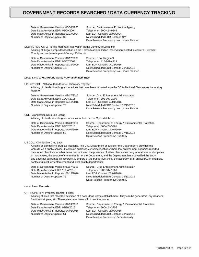
Date of Government Version: 06/30/1985Date Data Arrived at EDR: 08/09/2004Date Made Active in Reports: 09/17/2004Number of Days to Update: 39
Source: Environmental Protection AgencyTelephone: 800-424-9346Last EDR Contact: 06/09/2004Next Scheduled EDR Contact: N/AData Release Frequency: No Update Planned
DEBRIS REGION 9: Torres Martinez Reservation Illegal Dump Site LocationsA listing of illegal dump sites location on the Torres Martinez Indian Reservation located in eastern RiversideCounty and northern Imperial County, California.
Date of Government Version: 01/12/2009Date Data Arrived at EDR: 05/07/2009Date Made Active in Reports: 09/21/2009Number of Days to Update: 137
Source: EPA, Region 9Telephone: 415-947-4219Last EDR Contact: 04/21/2016Next Scheduled EDR Contact: 08/08/2016Data Release Frequency: No Update Planned
Local Lists of Hazardous waste / Contaminated Sites
US HIST CDL: National Clandestine Laboratory RegisterA listing of clandestine drug lab locations that have been removed from the DEAs National Clandestine LaboratoryRegister.
Date of Government Version: 09/17/2015Date Data Arrived at EDR: 12/04/2015Date Made Active in Reports: 02/18/2016Number of Days to Update: 76
Source: Drug Enforcement AdministrationTelephone: 202-307-1000Last EDR Contact: 03/01/2016Next Scheduled EDR Contact: 06/13/2016Data Release Frequency: No Update Planned
CDL: Clandestine Drug Lab ListingA listing of clandestine drug lab locations included in the Spills database.
Date of Government Version: 01/28/2016Date Data Arrived at EDR: 02/02/2016Date Made Active in Reports: 04/01/2016Number of Days to Update: 59
Source: Department of Energy & Environmental ProtectionTelephone: 860-424-3361Last EDR Contact: 04/04/2016Next Scheduled EDR Contact: 07/18/2016Data Release Frequency: Quarterly
US CDL: Clandestine Drug LabsA listing of clandestine drug lab locations. The U.S. Department of Justice ("the Department") provides thisweb site as a public service. It contains addresses of some locations where law enforcement agencies reportedthey found chemicals or other items that indicated the presence of either clandestine drug laboratories or dumpsites.In most cases, the source of the entries is not the Department, and the Department has not verified the entryand does not guarantee its accuracy. Members of the public must verify the accuracy of all entries by, for example,contacting local law enforcement and local health departments.
Date of Government Version: 09/17/2015Date Data Arrived at EDR: 12/04/2015Date Made Active in Reports: 02/18/2016Number of Days to Update: 76
Source: Drug Enforcement AdministrationTelephone: 202-307-1000Last EDR Contact: 03/01/2016Next Scheduled EDR Contact: 06/13/2016Data Release Frequency: Quarterly
Local Land Records
CT PROPERTY: Property Transfer FilingsA listing of sites that meet the definition of a hazardous waste establishment. They can be generators, dry cleaners,furniture strippers, etc. These sites have been sold to another owner.
Date of Government Version: 02/09/2016Date Data Arrived at EDR: 02/10/2016Date Made Active in Reports: 04/01/2016Number of Days to Update: 51
Source: Department of Energy & Environmental ProtectionTelephone: 860-424-3705Last EDR Contact: 05/09/2016Next Scheduled EDR Contact: 08/22/2016Data Release Frequency: Semi-Annually
TC4616258.2s Page GR-11
GOVERNMENT RECORDS SEARCHED / DATA CURRENCY TRACKING
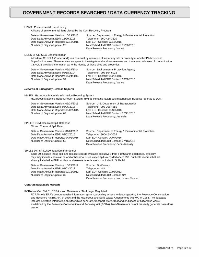
LIENS: Environmental Liens ListingA listing of environmental liens placed by the Cost Recovery Program.
Date of Government Version: 10/23/2015Date Data Arrived at EDR: 11/20/2015Date Made Active in Reports: 12/18/2015Number of Days to Update: 28
Source: Department of Energy & Environmental ProtectionTelephone: 860-424-3120Last EDR Contact: 02/16/2016Next Scheduled EDR Contact: 05/30/2016Data Release Frequency: Varies
LIENS 2: CERCLA Lien InformationA Federal CERCLA (’Superfund’) lien can exist by operation of law at any site or property at which EPA has spentSuperfund monies. These monies are spent to investigate and address releases and threatened releases of contamination.CERCLIS provides information as to the identity of these sites and properties.
Date of Government Version: 02/18/2014Date Data Arrived at EDR: 03/18/2014Date Made Active in Reports: 04/24/2014Number of Days to Update: 37
Source: Environmental Protection AgencyTelephone: 202-564-6023Last EDR Contact: 04/26/2016Next Scheduled EDR Contact: 08/08/2016Data Release Frequency: Varies
Records of Emergency Release Reports
HMIRS: Hazardous Materials Information Reporting SystemHazardous Materials Incident Report System. HMIRS contains hazardous material spill incidents reported to DOT.
Date of Government Version: 06/24/2015Date Data Arrived at EDR: 06/26/2015Date Made Active in Reports: 09/02/2015Number of Days to Update: 68
Source: U.S. Department of TransportationTelephone: 202-366-4555Last EDR Contact: 03/30/2016Next Scheduled EDR Contact: 07/11/2016Data Release Frequency: Annually
SPILLS: Oil & Chemical Spill DatabaseOil and Chemical Spill Data.
Date of Government Version: 01/28/2016Date Data Arrived at EDR: 02/02/2016Date Made Active in Reports: 04/01/2016Number of Days to Update: 59
Source: Department of Energy & Environmental ProtectionTelephone: 860-424-3024Last EDR Contact: 04/04/2016Next Scheduled EDR Contact: 07/18/2016Data Release Frequency: Semi-Annually
SPILLS 90: SPILLS90 data from FirstSearchSpills 90 includes those spill and release records available exclusively from FirstSearch databases. Typically,they may include chemical, oil and/or hazardous substance spills recorded after 1990. Duplicate records that arealready included in EDR incident and release records are not included in Spills 90.
Date of Government Version: 10/15/2012Date Data Arrived at EDR: 01/03/2013Date Made Active in Reports: 02/11/2013Number of Days to Update: 39
Source: FirstSearchTelephone: N/ALast EDR Contact: 01/03/2013Next Scheduled EDR Contact: N/AData Release Frequency: No Update Planned
Other Ascertainable Records
RCRA NonGen / NLR: RCRA - Non Generators / No Longer RegulatedRCRAInfo is EPA’s comprehensive information system, providing access to data supporting the Resource Conservationand Recovery Act (RCRA) of 1976 and the Hazardous and Solid Waste Amendments (HSWA) of 1984. The databaseincludes selective information on sites which generate, transport, store, treat and/or dispose of hazardous wasteas defined by the Resource Conservation and Recovery Act (RCRA). Non-Generators do not presently generate hazardouswaste.
TC4616258.2s Page GR-12
GOVERNMENT RECORDS SEARCHED / DATA CURRENCY TRACKING
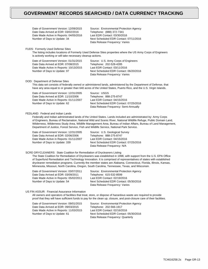
Date of Government Version: 12/09/2015Date Data Arrived at EDR: 03/02/2016Date Made Active in Reports: 04/05/2016Number of Days to Update: 34
Source: Environmental Protection AgencyTelephone: (888) 372-7341Last EDR Contact: 03/30/2016Next Scheduled EDR Contact: 07/11/2016Data Release Frequency: Varies
FUDS: Formerly Used Defense SitesThe listing includes locations of Formerly Used Defense Sites properties where the US Army Corps of Engineersis actively working or will take necessary cleanup actions.
Date of Government Version: 01/31/2015Date Data Arrived at EDR: 07/08/2015Date Made Active in Reports: 10/13/2015Number of Days to Update: 97
Source: U.S. Army Corps of EngineersTelephone: 202-528-4285Last EDR Contact: 03/11/2016Next Scheduled EDR Contact: 06/20/2016Data Release Frequency: Varies
DOD: Department of Defense SitesThis data set consists of federally owned or administered lands, administered by the Department of Defense, thathave any area equal to or greater than 640 acres of the United States, Puerto Rico, and the U.S. Virgin Islands.
Date of Government Version: 12/31/2005Date Data Arrived at EDR: 11/10/2006Date Made Active in Reports: 01/11/2007Number of Days to Update: 62
Source: USGSTelephone: 888-275-8747Last EDR Contact: 04/15/2016Next Scheduled EDR Contact: 07/25/2016Data Release Frequency: Semi-Annually
FEDLAND: Federal and Indian LandsFederally and Indian administrated lands of the United States. Lands included are administrated by: Army Corpsof Engineers, Bureau of Reclamation, National Wild and Scenic River, National Wildlife Refuge, Public Domain Land,Wilderness, Wilderness Study Area, Wildlife Management Area, Bureau of Indian Affairs, Bureau of Land Management,Department of Justice, Forest Service, Fish and Wildlife Service, National Park Service.
Date of Government Version: 12/31/2005Date Data Arrived at EDR: 02/06/2006Date Made Active in Reports: 01/11/2007Number of Days to Update: 339
Source: U.S. Geological SurveyTelephone: 888-275-8747Last EDR Contact: 04/15/2016Next Scheduled EDR Contact: 07/25/2016Data Release Frequency: N/A
SCRD DRYCLEANERS: State Coalition for Remediation of Drycleaners ListingThe State Coalition for Remediation of Drycleaners was established in 1998, with support from the U.S. EPA Officeof Superfund Remediation and Technology Innovation. It is comprised of representatives of states with establisheddrycleaner remediation programs. Currently the member states are Alabama, Connecticut, Florida, Illinois, Kansas,Minnesota, Missouri, North Carolina, Oregon, South Carolina, Tennessee, Texas, and Wisconsin.
Date of Government Version: 03/07/2011Date Data Arrived at EDR: 03/09/2011Date Made Active in Reports: 05/02/2011Number of Days to Update: 54
Source: Environmental Protection AgencyTelephone: 615-532-8599Last EDR Contact: 02/19/2016Next Scheduled EDR Contact: 05/30/2016Data Release Frequency: Varies
US FIN ASSUR: Financial Assurance InformationAll owners and operators of facilities that treat, store, or dispose of hazardous waste are required to provideproof that they will have sufficient funds to pay for the clean up, closure, and post-closure care of their facilities.
Date of Government Version: 09/01/2015Date Data Arrived at EDR: 09/03/2015Date Made Active in Reports: 11/03/2015Number of Days to Update: 61
Source: Environmental Protection AgencyTelephone: 202-566-1917Last EDR Contact: 02/16/2016Next Scheduled EDR Contact: 05/30/2016Data Release Frequency: Quarterly
TC4616258.2s Page GR-13
GOVERNMENT RECORDS SEARCHED / DATA CURRENCY TRACKING
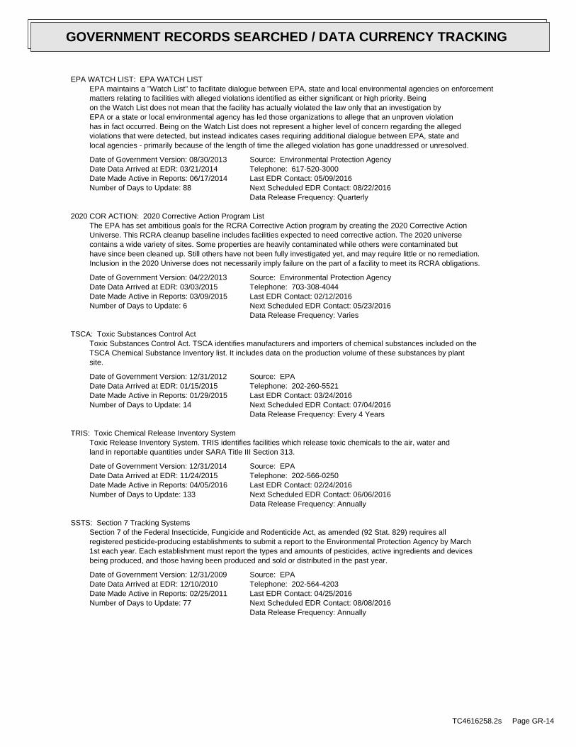
EPA WATCH LIST: EPA WATCH LISTEPA maintains a "Watch List" to facilitate dialogue between EPA, state and local environmental agencies on enforcementmatters relating to facilities with alleged violations identified as either significant or high priority. Beingon the Watch List does not mean that the facility has actually violated the law only that an investigation byEPA or a state or local environmental agency has led those organizations to allege that an unproven violationhas in fact occurred. Being on the Watch List does not represent a higher level of concern regarding the allegedviolations that were detected, but instead indicates cases requiring additional dialogue between EPA, state andlocal agencies - primarily because of the length of time the alleged violation has gone unaddressed or unresolved.
Date of Government Version: 08/30/2013Date Data Arrived at EDR: 03/21/2014Date Made Active in Reports: 06/17/2014Number of Days to Update: 88
Source: Environmental Protection AgencyTelephone: 617-520-3000Last EDR Contact: 05/09/2016Next Scheduled EDR Contact: 08/22/2016Data Release Frequency: Quarterly
2020 COR ACTION: 2020 Corrective Action Program ListThe EPA has set ambitious goals for the RCRA Corrective Action program by creating the 2020 Corrective ActionUniverse. This RCRA cleanup baseline includes facilities expected to need corrective action. The 2020 universecontains a wide variety of sites. Some properties are heavily contaminated while others were contaminated buthave since been cleaned up. Still others have not been fully investigated yet, and may require little or no remediation.Inclusion in the 2020 Universe does not necessarily imply failure on the part of a facility to meet its RCRA obligations.
Date of Government Version: 04/22/2013Date Data Arrived at EDR: 03/03/2015Date Made Active in Reports: 03/09/2015Number of Days to Update: 6
Source: Environmental Protection AgencyTelephone: 703-308-4044Last EDR Contact: 02/12/2016Next Scheduled EDR Contact: 05/23/2016Data Release Frequency: Varies
TSCA: Toxic Substances Control ActToxic Substances Control Act. TSCA identifies manufacturers and importers of chemical substances included on theTSCA Chemical Substance Inventory list. It includes data on the production volume of these substances by plantsite.
Date of Government Version: 12/31/2012Date Data Arrived at EDR: 01/15/2015Date Made Active in Reports: 01/29/2015Number of Days to Update: 14
Source: EPATelephone: 202-260-5521Last EDR Contact: 03/24/2016Next Scheduled EDR Contact: 07/04/2016Data Release Frequency: Every 4 Years
TRIS: Toxic Chemical Release Inventory SystemToxic Release Inventory System. TRIS identifies facilities which release toxic chemicals to the air, water andland in reportable quantities under SARA Title III Section 313.
Date of Government Version: 12/31/2014Date Data Arrived at EDR: 11/24/2015Date Made Active in Reports: 04/05/2016Number of Days to Update: 133
Source: EPATelephone: 202-566-0250Last EDR Contact: 02/24/2016Next Scheduled EDR Contact: 06/06/2016Data Release Frequency: Annually
SSTS: Section 7 Tracking SystemsSection 7 of the Federal Insecticide, Fungicide and Rodenticide Act, as amended (92 Stat. 829) requires allregistered pesticide-producing establishments to submit a report to the Environmental Protection Agency by March1st each year. Each establishment must report the types and amounts of pesticides, active ingredients and devicesbeing produced, and those having been produced and sold or distributed in the past year.
Date of Government Version: 12/31/2009Date Data Arrived at EDR: 12/10/2010Date Made Active in Reports: 02/25/2011Number of Days to Update: 77
Source: EPATelephone: 202-564-4203Last EDR Contact: 04/25/2016Next Scheduled EDR Contact: 08/08/2016Data Release Frequency: Annually
TC4616258.2s Page GR-14
GOVERNMENT RECORDS SEARCHED / DATA CURRENCY TRACKING
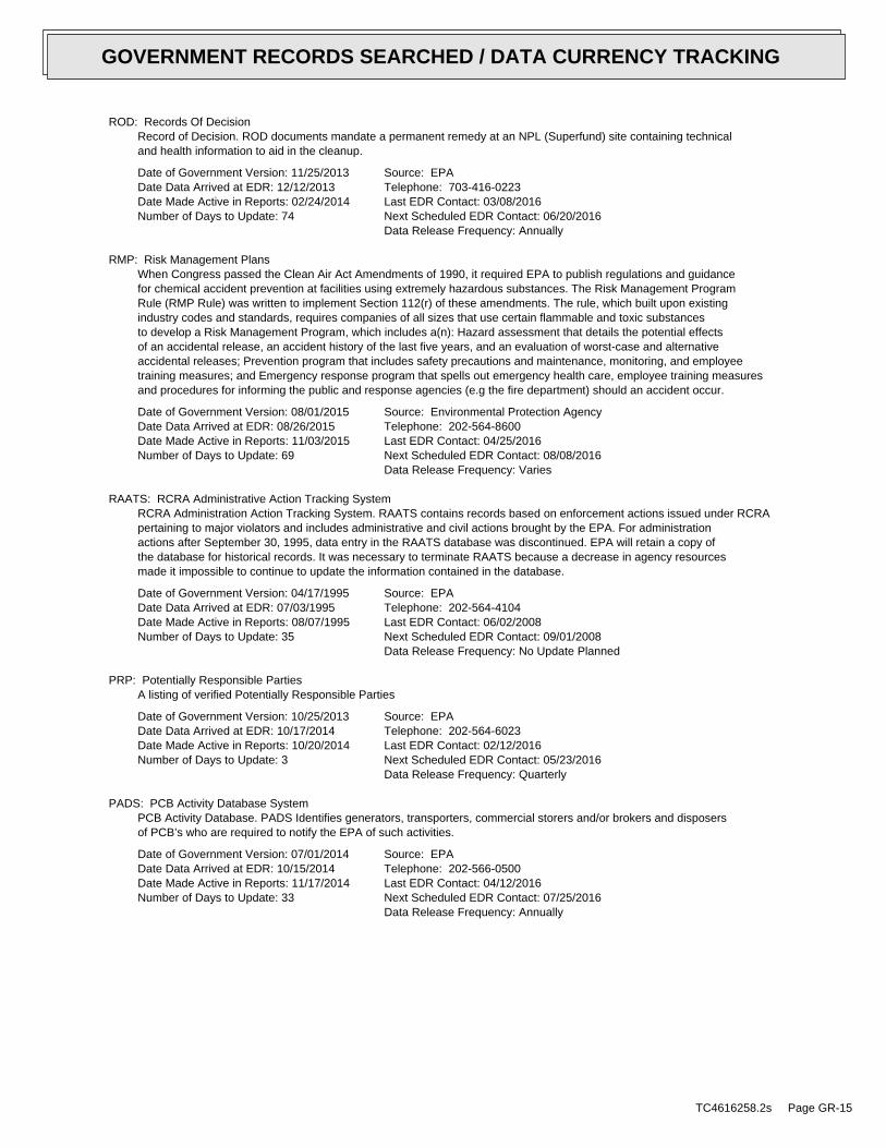
ROD: Records Of DecisionRecord of Decision. ROD documents mandate a permanent remedy at an NPL (Superfund) site containing technicaland health information to aid in the cleanup.
Date of Government Version: 11/25/2013Date Data Arrived at EDR: 12/12/2013Date Made Active in Reports: 02/24/2014Number of Days to Update: 74
Source: EPATelephone: 703-416-0223Last EDR Contact: 03/08/2016Next Scheduled EDR Contact: 06/20/2016Data Release Frequency: Annually
RMP: Risk Management PlansWhen Congress passed the Clean Air Act Amendments of 1990, it required EPA to publish regulations and guidancefor chemical accident prevention at facilities using extremely hazardous substances. The Risk Management ProgramRule (RMP Rule) was written to implement Section 112(r) of these amendments. The rule, which built upon existingindustry codes and standards, requires companies of all sizes that use certain flammable and toxic substancesto develop a Risk Management Program, which includes a(n): Hazard assessment that details the potential effectsof an accidental release, an accident history of the last five years, and an evaluation of worst-case and alternativeaccidental releases; Prevention program that includes safety precautions and maintenance, monitoring, and employeetraining measures; and Emergency response program that spells out emergency health care, employee training measuresand procedures for informing the public and response agencies (e.g the fire department) should an accident occur.
Date of Government Version: 08/01/2015Date Data Arrived at EDR: 08/26/2015Date Made Active in Reports: 11/03/2015Number of Days to Update: 69
Source: Environmental Protection AgencyTelephone: 202-564-8600Last EDR Contact: 04/25/2016Next Scheduled EDR Contact: 08/08/2016Data Release Frequency: Varies
RAATS: RCRA Administrative Action Tracking SystemRCRA Administration Action Tracking System. RAATS contains records based on enforcement actions issued under RCRApertaining to major violators and includes administrative and civil actions brought by the EPA. For administrationactions after September 30, 1995, data entry in the RAATS database was discontinued. EPA will retain a copy ofthe database for historical records. It was necessary to terminate RAATS because a decrease in agency resourcesmade it impossible to continue to update the information contained in the database.
Date of Government Version: 04/17/1995Date Data Arrived at EDR: 07/03/1995Date Made Active in Reports: 08/07/1995Number of Days to Update: 35
Source: EPATelephone: 202-564-4104Last EDR Contact: 06/02/2008Next Scheduled EDR Contact: 09/01/2008Data Release Frequency: No Update Planned
PRP: Potentially Responsible PartiesA listing of verified Potentially Responsible Parties
Date of Government Version: 10/25/2013Date Data Arrived at EDR: 10/17/2014Date Made Active in Reports: 10/20/2014Number of Days to Update: 3
Source: EPATelephone: 202-564-6023Last EDR Contact: 02/12/2016Next Scheduled EDR Contact: 05/23/2016Data Release Frequency: Quarterly
PADS: PCB Activity Database SystemPCB Activity Database. PADS Identifies generators, transporters, commercial storers and/or brokers and disposersof PCB’s who are required to notify the EPA of such activities.
Date of Government Version: 07/01/2014Date Data Arrived at EDR: 10/15/2014Date Made Active in Reports: 11/17/2014Number of Days to Update: 33
Source: EPATelephone: 202-566-0500Last EDR Contact: 04/12/2016Next Scheduled EDR Contact: 07/25/2016Data Release Frequency: Annually
TC4616258.2s Page GR-15
GOVERNMENT RECORDS SEARCHED / DATA CURRENCY TRACKING
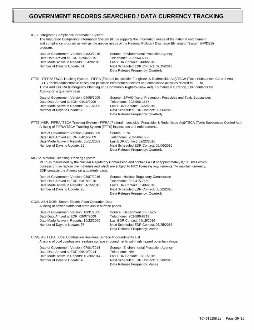
ICIS: Integrated Compliance Information SystemThe Integrated Compliance Information System (ICIS) supports the information needs of the national enforcementand compliance program as well as the unique needs of the National Pollutant Discharge Elimination System (NPDES)program.
Date of Government Version: 01/23/2015Date Data Arrived at EDR: 02/06/2015Date Made Active in Reports: 03/09/2015Number of Days to Update: 31
Source: Environmental Protection AgencyTelephone: 202-564-5088Last EDR Contact: 04/08/2016Next Scheduled EDR Contact: 07/25/2016Data Release Frequency: Quarterly
FTTS: FIFRA/ TSCA Tracking System - FIFRA (Federal Insecticide, Fungicide, & Rodenticide Act)/TSCA (Toxic Substances Control Act)FTTS tracks administrative cases and pesticide enforcement actions and compliance activities related to FIFRA,TSCA and EPCRA (Emergency Planning and Community Right-to-Know Act). To maintain currency, EDR contacts theAgency on a quarterly basis.
Date of Government Version: 04/09/2009Date Data Arrived at EDR: 04/16/2009Date Made Active in Reports: 05/11/2009Number of Days to Update: 25
Source: EPA/Office of Prevention, Pesticides and Toxic SubstancesTelephone: 202-566-1667Last EDR Contact: 02/22/2016Next Scheduled EDR Contact: 06/06/2016Data Release Frequency: Quarterly
FTTS INSP: FIFRA/ TSCA Tracking System - FIFRA (Federal Insecticide, Fungicide, & Rodenticide Act)/TSCA (Toxic Substances Control Act)A listing of FIFRA/TSCA Tracking System (FTTS) inspections and enforcements.
Date of Government Version: 04/09/2009Date Data Arrived at EDR: 04/16/2009Date Made Active in Reports: 05/11/2009Number of Days to Update: 25
Source: EPATelephone: 202-566-1667Last EDR Contact: 02/22/2016Next Scheduled EDR Contact: 06/06/2016Data Release Frequency: Quarterly
MLTS: Material Licensing Tracking SystemMLTS is maintained by the Nuclear Regulatory Commission and contains a list of approximately 8,100 sites whichpossess or use radioactive materials and which are subject to NRC licensing requirements. To maintain currency,EDR contacts the Agency on a quarterly basis.
Date of Government Version: 03/07/2016Date Data Arrived at EDR: 03/18/2016Date Made Active in Reports: 04/15/2016Number of Days to Update: 28
Source: Nuclear Regulatory CommissionTelephone: 301-415-7169Last EDR Contact: 05/06/2016Next Scheduled EDR Contact: 08/22/2016Data Release Frequency: Quarterly
COAL ASH DOE: Steam-Electric Plant Operation DataA listing of power plants that store ash in surface ponds.
Date of Government Version: 12/31/2005Date Data Arrived at EDR: 08/07/2009Date Made Active in Reports: 10/22/2009Number of Days to Update: 76
Source: Department of EnergyTelephone: 202-586-8719Last EDR Contact: 04/15/2016Next Scheduled EDR Contact: 07/25/2016Data Release Frequency: Varies
COAL ASH EPA: Coal Combustion Residues Surface Impoundments ListA listing of coal combustion residues surface impoundments with high hazard potential ratings.
Date of Government Version: 07/01/2014Date Data Arrived at EDR: 09/10/2014Date Made Active in Reports: 10/20/2014Number of Days to Update: 40
Source: Environmental Protection AgencyTelephone: N/ALast EDR Contact: 03/11/2016Next Scheduled EDR Contact: 06/20/2016Data Release Frequency: Varies
TC4616258.2s Page GR-16
GOVERNMENT RECORDS SEARCHED / DATA CURRENCY TRACKING
PCB TRANSFORMER: PCB Transformer Registration DatabaseThe database of PCB transformer registrations that includes all PCB registration submittals.
Date of Government Version: 02/01/2011Date Data Arrived at EDR: 10/19/2011Date Made Active in Reports: 01/10/2012Number of Days to Update: 83
Source: Environmental Protection AgencyTelephone: 202-566-0517Last EDR Contact: 04/26/2016Next Scheduled EDR Contact: 08/08/2016Data Release Frequency: Varies
RADINFO: Radiation Information DatabaseThe Radiation Information Database (RADINFO) contains information about facilities that are regulated by U.S.Environmental Protection Agency (EPA) regulations for radiation and radioactivity.
Date of Government Version: 07/07/2015Date Data Arrived at EDR: 07/09/2015Date Made Active in Reports: 09/16/2015Number of Days to Update: 69
Source: Environmental Protection AgencyTelephone: 202-343-9775Last EDR Contact: 04/08/2016Next Scheduled EDR Contact: 07/18/2016Data Release Frequency: Quarterly
HIST FTTS: FIFRA/TSCA Tracking System Administrative Case ListingA complete administrative case listing from the FIFRA/TSCA Tracking System (FTTS) for all ten EPA regions. Theinformation was obtained from the National Compliance Database (NCDB). NCDB supports the implementation of FIFRA(Federal Insecticide, Fungicide, and Rodenticide Act) and TSCA (Toxic Substances Control Act). Some EPA regionsare now closing out records. Because of that, and the fact that some EPA regions are not providing EPA Headquarterswith updated records, it was decided to create a HIST FTTS database. It included records that may not be includedin the newer FTTS database updates. This database is no longer updated.
Date of Government Version: 10/19/2006Date Data Arrived at EDR: 03/01/2007Date Made Active in Reports: 04/10/2007Number of Days to Update: 40
Source: Environmental Protection AgencyTelephone: 202-564-2501Last EDR Contact: 12/17/2007Next Scheduled EDR Contact: 03/17/2008Data Release Frequency: No Update Planned
HIST FTTS INSP: FIFRA/TSCA Tracking System Inspection & Enforcement Case ListingA complete inspection and enforcement case listing from the FIFRA/TSCA Tracking System (FTTS) for all ten EPAregions. The information was obtained from the National Compliance Database (NCDB). NCDB supports the implementationof FIFRA (Federal Insecticide, Fungicide, and Rodenticide Act) and TSCA (Toxic Substances Control Act). SomeEPA regions are now closing out records. Because of that, and the fact that some EPA regions are not providingEPA Headquarters with updated records, it was decided to create a HIST FTTS database. It included records thatmay not be included in the newer FTTS database updates. This database is no longer updated.
Date of Government Version: 10/19/2006Date Data Arrived at EDR: 03/01/2007Date Made Active in Reports: 04/10/2007Number of Days to Update: 40
Source: Environmental Protection AgencyTelephone: 202-564-2501Last EDR Contact: 12/17/2008Next Scheduled EDR Contact: 03/17/2008Data Release Frequency: No Update Planned
DOT OPS: Incident and Accident DataDepartment of Transporation, Office of Pipeline Safety Incident and Accident data.
Date of Government Version: 07/31/2012Date Data Arrived at EDR: 08/07/2012Date Made Active in Reports: 09/18/2012Number of Days to Update: 42
Source: Department of Transporation, Office of Pipeline SafetyTelephone: 202-366-4595Last EDR Contact: 05/04/2016Next Scheduled EDR Contact: 08/15/2016Data Release Frequency: Varies
CONSENT: Superfund (CERCLA) Consent DecreesMajor legal settlements that establish responsibility and standards for cleanup at NPL (Superfund) sites. Releasedperiodically by United States District Courts after settlement by parties to litigation matters.
TC4616258.2s Page GR-17
GOVERNMENT RECORDS SEARCHED / DATA CURRENCY TRACKING
Date of Government Version: 12/31/2014Date Data Arrived at EDR: 04/17/2015Date Made Active in Reports: 06/02/2015Number of Days to Update: 46
Source: Department of Justice, Consent Decree LibraryTelephone: VariesLast EDR Contact: 03/24/2016Next Scheduled EDR Contact: 07/11/2016Data Release Frequency: Varies
BRS: Biennial Reporting SystemThe Biennial Reporting System is a national system administered by the EPA that collects data on the generationand management of hazardous waste. BRS captures detailed data from two groups: Large Quantity Generators (LQG)and Treatment, Storage, and Disposal Facilities.
Date of Government Version: 12/31/2013Date Data Arrived at EDR: 02/24/2015Date Made Active in Reports: 09/30/2015Number of Days to Update: 218
Source: EPA/NTISTelephone: 800-424-9346Last EDR Contact: 02/26/2016Next Scheduled EDR Contact: 06/06/2016Data Release Frequency: Biennially
INDIAN RESERV: Indian ReservationsThis map layer portrays Indian administered lands of the United States that have any area equal to or greaterthan 640 acres.
Date of Government Version: 12/31/2005Date Data Arrived at EDR: 12/08/2006Date Made Active in Reports: 01/11/2007Number of Days to Update: 34
Source: USGSTelephone: 202-208-3710Last EDR Contact: 04/15/2016Next Scheduled EDR Contact: 07/25/2016Data Release Frequency: Semi-Annually
FUSRAP: Formerly Utilized Sites Remedial Action ProgramDOE established the Formerly Utilized Sites Remedial Action Program (FUSRAP) in 1974 to remediate sites whereradioactive contamination remained from Manhattan Project and early U.S. Atomic Energy Commission (AEC) operations.
Date of Government Version: 11/23/2015Date Data Arrived at EDR: 11/24/2015Date Made Active in Reports: 02/18/2016Number of Days to Update: 86
Source: Department of EnergyTelephone: 202-586-3559Last EDR Contact: 05/09/2016Next Scheduled EDR Contact: 08/22/2016Data Release Frequency: Varies
UMTRA: Uranium Mill Tailings SitesUranium ore was mined by private companies for federal government use in national defense programs. When the millsshut down, large piles of the sand-like material (mill tailings) remain after uranium has been extracted fromthe ore. Levels of human exposure to radioactive materials from the piles are low; however, in some cases tailingswere used as construction materials before the potential health hazards of the tailings were recognized.
Date of Government Version: 09/14/2010Date Data Arrived at EDR: 10/07/2011Date Made Active in Reports: 03/01/2012Number of Days to Update: 146
Source: Department of EnergyTelephone: 505-845-0011Last EDR Contact: 03/28/2016Next Scheduled EDR Contact: 06/06/2016Data Release Frequency: Varies
LEAD SMELTER 1: Lead Smelter SitesA listing of former lead smelter site locations.
Date of Government Version: 11/25/2014Date Data Arrived at EDR: 11/26/2014Date Made Active in Reports: 01/29/2015Number of Days to Update: 64
Source: Environmental Protection AgencyTelephone: 703-603-8787Last EDR Contact: 04/07/2016Next Scheduled EDR Contact: 07/18/2016Data Release Frequency: Varies
LEAD SMELTER 2: Lead Smelter SitesA list of several hundred sites in the U.S. where secondary lead smelting was done from 1931and 1964. These sitesmay pose a threat to public health through ingestion or inhalation of contaminated soil or dust
TC4616258.2s Page GR-18
GOVERNMENT RECORDS SEARCHED / DATA CURRENCY TRACKING
Date of Government Version: 04/05/2001Date Data Arrived at EDR: 10/27/2010Date Made Active in Reports: 12/02/2010Number of Days to Update: 36
Source: American Journal of Public HealthTelephone: 703-305-6451Last EDR Contact: 12/02/2009Next Scheduled EDR Contact: N/AData Release Frequency: No Update Planned
US AIRS (AFS): Aerometric Information Retrieval System Facility Subsystem (AFS)The database is a sub-system of Aerometric Information Retrieval System (AIRS). AFS contains compliance dataon air pollution point sources regulated by the U.S. EPA and/or state and local air regulatory agencies. Thisinformation comes from source reports by various stationary sources of air pollution, such as electric power plants,steel mills, factories, and universities, and provides information about the air pollutants they produce. Action,air program, air program pollutant, and general level plant data. It is used to track emissions and compliancedata from industrial plants.
Date of Government Version: 10/20/2015Date Data Arrived at EDR: 10/27/2015Date Made Active in Reports: 01/04/2016Number of Days to Update: 69
Source: EPATelephone: 202-564-2496Last EDR Contact: 03/24/2016Next Scheduled EDR Contact: 07/11/2016Data Release Frequency: Annually
US AIRS MINOR: Air Facility System DataA listing of minor source facilities.
Date of Government Version: 10/20/2015Date Data Arrived at EDR: 10/27/2015Date Made Active in Reports: 01/04/2016Number of Days to Update: 69
Source: EPATelephone: 202-564-2496Last EDR Contact: 03/24/2016Next Scheduled EDR Contact: 07/11/2016Data Release Frequency: Annually
US MINES: Mines Master Index FileContains all mine identification numbers issued for mines active or opened since 1971. The data also includesviolation information.
Date of Government Version: 02/09/2016Date Data Arrived at EDR: 03/02/2016Date Made Active in Reports: 04/15/2016Number of Days to Update: 44
Source: Department of Labor, Mine Safety and Health AdministrationTelephone: 303-231-5959Last EDR Contact: 03/02/2016Next Scheduled EDR Contact: 06/13/2016Data Release Frequency: Semi-Annually
US MINES 2: Ferrous and Nonferrous Metal Mines Database ListingThis map layer includes ferrous (ferrous metal mines are facilities that extract ferrous metals, such as ironore or molybdenum) and nonferrous (Nonferrous metal mines are facilities that extract nonferrous metals, suchas gold, silver, copper, zinc, and lead) metal mines in the United States.
Date of Government Version: 12/05/2005Date Data Arrived at EDR: 02/29/2008Date Made Active in Reports: 04/18/2008Number of Days to Update: 49
Source: USGSTelephone: 703-648-7709Last EDR Contact: 03/04/2016Next Scheduled EDR Contact: 06/13/2016Data Release Frequency: Varies
US MINES 3: Active Mines & Mineral Plants Database ListingActive Mines and Mineral Processing Plant operations for commodities monitored by the Minerals Information Teamof the USGS.
Date of Government Version: 04/14/2011Date Data Arrived at EDR: 06/08/2011Date Made Active in Reports: 09/13/2011Number of Days to Update: 97
Source: USGSTelephone: 703-648-7709Last EDR Contact: 03/04/2016Next Scheduled EDR Contact: 06/13/2016Data Release Frequency: Varies
TC4616258.2s Page GR-19
GOVERNMENT RECORDS SEARCHED / DATA CURRENCY TRACKING
FINDS: Facility Index System/Facility Registry SystemFacility Index System. FINDS contains both facility information and ’pointers’ to other sources that contain moredetail. EDR includes the following FINDS databases in this report: PCS (Permit Compliance System), AIRS (AerometricInformation Retrieval System), DOCKET (Enforcement Docket used to manage and track information on civil judicialenforcement cases for all environmental statutes), FURS (Federal Underground Injection Control), C-DOCKET (CriminalDocket System used to track criminal enforcement actions for all environmental statutes), FFIS (Federal FacilitiesInformation System), STATE (State Environmental Laws and Statutes), and PADS (PCB Activity Data System).
Date of Government Version: 07/20/2015Date Data Arrived at EDR: 09/09/2015Date Made Active in Reports: 11/03/2015Number of Days to Update: 55
Source: EPATelephone: (617) 918-1111Last EDR Contact: 03/08/2016Next Scheduled EDR Contact: 06/20/2016Data Release Frequency: Quarterly
UXO: Unexploded Ordnance SitesA listing of unexploded ordnance site locations
Date of Government Version: 10/25/2015Date Data Arrived at EDR: 01/29/2016Date Made Active in Reports: 04/05/2016Number of Days to Update: 67
Source: Department of DefenseTelephone: 571-373-0407Last EDR Contact: 04/18/2016Next Scheduled EDR Contact: 07/04/2016Data Release Frequency: Varies
DOCKET HWC: Hazardous Waste Compliance Docket ListingA complete list of the Federal Agency Hazardous Waste Compliance Docket Facilities.
Date of Government Version: 03/01/2016Date Data Arrived at EDR: 03/03/2016Date Made Active in Reports: 04/05/2016Number of Days to Update: 33
Source: Environmental Protection AgencyTelephone: 202-564-0527Last EDR Contact: 02/24/2016Next Scheduled EDR Contact: 06/13/2016Data Release Frequency: Varies
AIRS: Permitted Air Sources ListingA listing of permitted air sources in Connecticut.
Date of Government Version: 02/01/2016Date Data Arrived at EDR: 02/05/2016Date Made Active in Reports: 04/06/2016Number of Days to Update: 61
Source: Department of Energy & Environmental ProtectionTelephone: 860-424-3026Last EDR Contact: 04/25/2016Next Scheduled EDR Contact: 08/08/2016Data Release Frequency: Varies
CPCS: Contaminated or Potentially Contaminated SitesA list of Contaminated or Potentially Contaminated Sites within Connecticut. This list represents the "HazardousWaste Facilities," as defined in Section 22a-134f of the Connecticut General Statutes (CGS). The list containsthe following types of sites: Sites listed on the Inventory of Hazardous Waste Disposal Sites; Sites subject tothe Property Transfer Act; Sites at which underground storage tanks are known to have leaked; Sites at which hazardouswaste subject to the RCRA; Sites that are included in EPA’s (CERCLIS); Sites that are the subject of an orderissued by the Commissioner of DEP that requires investigation and remediation of a potential or known source ofpollution; and Sites that have entered into one of the Department’s Voluntary Remediation Programs.
Date of Government Version: 03/01/2016Date Data Arrived at EDR: 03/03/2016Date Made Active in Reports: 04/01/2016Number of Days to Update: 29
Source: Department of Energy & Environmental ProtectionTelephone: 860-424-3766Last EDR Contact: 05/09/2016Next Scheduled EDR Contact: 08/22/2016Data Release Frequency: Quarterly
DRYCLEANERS: Drycleaner FacilitiesA listing of drycleaner facility locations.
TC4616258.2s Page GR-20
GOVERNMENT RECORDS SEARCHED / DATA CURRENCY TRACKING
Date of Government Version: 07/18/2008Date Data Arrived at EDR: 08/08/2008Date Made Active in Reports: 08/27/2008Number of Days to Update: 19
Source: Department of Energy & Environmental ProtectionTelephone: 860-424-3026Last EDR Contact: 03/14/2016Next Scheduled EDR Contact: 06/27/2016Data Release Frequency: Varies
ENFORCEMENT: Enforcement Case ListingThe types of enforcement actions included are administrative consent orders, final unilateral orders and finaldispositions of civil cases through the Attorney General’s Office.
Date of Government Version: 01/20/2016Date Data Arrived at EDR: 01/22/2016Date Made Active in Reports: 04/01/2016Number of Days to Update: 70
Source: Department of Energy & Environmental ProtectionTelephone: 860-424-3265Last EDR Contact: 04/18/2016Next Scheduled EDR Contact: 08/01/2016Data Release Frequency: Varies
Financial Assurance 1: Financial Assurance Information ListingA listing containing RCRA financial assurance information submitted on behalf of the CT DEP’s Program AnalysisGroup of the Waste Engineering and Enforcement Division.
Date of Government Version: 12/17/2015Date Data Arrived at EDR: 12/23/2015Date Made Active in Reports: 02/17/2016Number of Days to Update: 56
Source: Department of Energy & Environmental ProtectionTelephone: 860-418-5930Last EDR Contact: 03/21/2016Next Scheduled EDR Contact: 07/04/2016Data Release Frequency: Varies
Financial Assurance 2: Financial Assurance Information ListingA listing of financial assurance information for solid waste facilities. Financial assurance is intended to ensurethat resources are available to pay for the cost of closure, post-closure care, and corrective measures if theowner or operator of a regulated facility is unable or unwilling to pay.
Date of Government Version: 12/17/2015Date Data Arrived at EDR: 12/23/2015Date Made Active in Reports: 02/17/2016Number of Days to Update: 56
Source: Department of Energy & Environmental ProtectionTelephone: 860-418-5930Last EDR Contact: 03/21/2016Next Scheduled EDR Contact: 07/04/2016Data Release Frequency: Varies
LEAD: Lead Inspection DatabaseThe Lead Poisoning Prevention and Control Program lead inspection database.
Date of Government Version: 03/26/2014Date Data Arrived at EDR: 03/27/2014Date Made Active in Reports: 05/08/2014Number of Days to Update: 42
Source: Department of Public HealthTelephone: 860-509-7299Last EDR Contact: 03/03/2016Next Scheduled EDR Contact: 06/20/2016Data Release Frequency: Varies
LWDS: Connecticut Leachate and Wastewater Discharge SitesThe Leachate and Waste Water Discharge Inventory Data Layer (LWDS) includes point locations digitized from Leachateand Wastewater Discharge Source maps compiled by the Connecticut DEP. These maps locate surface and groundwaterdischarges that (1) have received a waste water discharge permit from the state or (2) are historic and nowdefunct waste sites or (3) are locations of accidental spills, leaks, or discharges of a variety of liquid orsolid wastes.
Date of Government Version: 07/17/2009Date Data Arrived at EDR: 10/21/2009Date Made Active in Reports: 10/30/2009Number of Days to Update: 9
Source: Department of Energy & Environmental ProtectionTelephone: N/ALast EDR Contact: 10/15/2014Next Scheduled EDR Contact: 01/26/2015Data Release Frequency: Varies
TC4616258.2s Page GR-21
GOVERNMENT RECORDS SEARCHED / DATA CURRENCY TRACKING
CT MANIFEST: Hazardous Waste Manifest DataFacility and manifest data. Manifest is a document that lists and tracks hazardous waste from the generator throughtransporters to a tsd facility.
Date of Government Version: 07/30/2013Date Data Arrived at EDR: 08/19/2013Date Made Active in Reports: 10/03/2013Number of Days to Update: 45
Source: Department of Energy & Environmental ProtectionTelephone: 860-424-3375Last EDR Contact: 02/18/2016Next Scheduled EDR Contact: 05/30/2016Data Release Frequency: No Update Planned
NPDES: Wastewater Permit ListingA listing of permits issued by the DEP.
Date of Government Version: 10/16/2015Date Data Arrived at EDR: 10/20/2015Date Made Active in Reports: 11/06/2015Number of Days to Update: 17
Source: Department of Energy & Environmental ProtectionTelephone: 860-424-3832Last EDR Contact: 04/11/2016Next Scheduled EDR Contact: 07/11/2016Data Release Frequency: Varies
SEH: List of Significant Environmental Hazards Report to DEEPThe Significant Environmental Hazard Statute is intended to identify and abate short-term risks associated withspecific environmental conditions identified in the statute. After abatement of short-term risks (meaning abatementof the significant environmental hazard condition), there may still be potential long-term risks associated withthe release. However, a significant environmental hazard can be considered abated under the statute even thoughpotential long-term risks may not have been addressed.
Date of Government Version: 06/30/2015Date Data Arrived at EDR: 07/24/2015Date Made Active in Reports: 08/05/2015Number of Days to Update: 12
Source: Department of Energy & Environmental ProtectionTelephone: 860-424-3766Last EDR Contact: 04/18/2016Next Scheduled EDR Contact: 08/01/2016Data Release Frequency: Varies
FUELS PROGRAM: EPA Fuels Program Registered ListingThis listing includes facilities that are registered under the Part 80 (Code of Federal Regulations) EPA FuelsPrograms. All companies now are required to submit new and updated registrations.
Date of Government Version: 11/23/2015Date Data Arrived at EDR: 11/24/2015Date Made Active in Reports: 02/18/2016Number of Days to Update: 86
Source: EPATelephone: 800-385-6164Last EDR Contact: 02/24/2016Next Scheduled EDR Contact: 06/06/2016Data Release Frequency: Quarterly
ECHO: Enforcement & Compliance History InformationECHO provides integrated compliance and enforcement information for about 800,000 regulated facilities nationwide.
Date of Government Version: 09/20/2015Date Data Arrived at EDR: 09/23/2015Date Made Active in Reports: 01/04/2016Number of Days to Update: 103
Source: Environmental Protection AgencyTelephone: 202-564-2280Last EDR Contact: 03/23/2016Next Scheduled EDR Contact: 07/04/2016Data Release Frequency: Quarterly
EDR HIGH RISK HISTORICAL RECORDS
EDR Exclusive Records
EDR MGP: EDR Proprietary Manufactured Gas PlantsThe EDR Proprietary Manufactured Gas Plant Database includes records of coal gas plants (manufactured gas plants)compiled by EDR’s researchers. Manufactured gas sites were used in the United States from the 1800’s to 1950’sto produce a gas that could be distributed and used as fuel. These plants used whale oil, rosin, coal, or a mixtureof coal, oil, and water that also produced a significant amount of waste. Many of the byproducts of the gas production,such as coal tar (oily waste containing volatile and non-volatile chemicals), sludges, oils and other compoundsare potentially hazardous to human health and the environment. The byproduct from this process was frequentlydisposed of directly at the plant site and can remain or spread slowly, serving as a continuous source of soiland groundwater contamination.
TC4616258.2s Page GR-22
GOVERNMENT RECORDS SEARCHED / DATA CURRENCY TRACKING
Date of Government Version: N/ADate Data Arrived at EDR: N/ADate Made Active in Reports: N/ANumber of Days to Update: N/A
Source: EDR, Inc.Telephone: N/ALast EDR Contact: N/ANext Scheduled EDR Contact: N/AData Release Frequency: No Update Planned
EDR Hist Auto: EDR Exclusive Historic Gas StationsEDR has searched selected national collections of business directories and has collected listings of potentialgas station/filling station/service station sites that were available to EDR researchers. EDR’s review was limitedto those categories of sources that might, in EDR’s opinion, include gas station/filling station/service stationestablishments. The categories reviewed included, but were not limited to gas, gas station, gasoline station,filling station, auto, automobile repair, auto service station, service station, etc. This database falls withina category of information EDR classifies as "High Risk Historical Records", or HRHR. EDR’s HRHR effort presentsunique and sometimes proprietary data about past sites and operations that typically create environmental concerns,but may not show up in current government records searches.
Date of Government Version: N/ADate Data Arrived at EDR: N/ADate Made Active in Reports: N/ANumber of Days to Update: N/A
Source: EDR, Inc.Telephone: N/ALast EDR Contact: N/ANext Scheduled EDR Contact: N/AData Release Frequency: Varies
EDR Hist Cleaner: EDR Exclusive Historic Dry CleanersEDR has searched selected national collections of business directories and has collected listings of potentialdry cleaner sites that were available to EDR researchers. EDR’s review was limited to those categories of sourcesthat might, in EDR’s opinion, include dry cleaning establishments. The categories reviewed included, but werenot limited to dry cleaners, cleaners, laundry, laundromat, cleaning/laundry, wash & dry etc. This database fallswithin a category of information EDR classifies as "High Risk Historical Records", or HRHR. EDR’s HRHR effortpresents unique and sometimes proprietary data about past sites and operations that typically create environmentalconcerns, but may not show up in current government records searches.
Date of Government Version: N/ADate Data Arrived at EDR: N/ADate Made Active in Reports: N/ANumber of Days to Update: N/A
Source: EDR, Inc.Telephone: N/ALast EDR Contact: N/ANext Scheduled EDR Contact: N/AData Release Frequency: Varies
EDR RECOVERED GOVERNMENT ARCHIVES
Exclusive Recovered Govt. Archives
RGA HWS: Recovered Government Archive State Hazardous Waste Facilities ListThe EDR Recovered Government Archive State Hazardous Waste database provides a list of SHWS incidents derivedfrom historical databases and includes many records that no longer appear in current government lists. Compiledfrom Records formerly available from the Department of Energy & Environmental Protection formerly know as theDEP which changes in July 2011 in Connecticut.
Date of Government Version: N/ADate Data Arrived at EDR: 07/01/2013Date Made Active in Reports: 01/02/2014Number of Days to Update: 185
Source: Department of Energy & Environmental ProtectionTelephone: N/ALast EDR Contact: 06/01/2012Next Scheduled EDR Contact: N/AData Release Frequency: Varies
RGA LUST: Recovered Government Archive Leaking Underground Storage TankThe EDR Recovered Government Archive Leaking Underground Storage Tank database provides a list of LUST incidentsderived from historical databases and includes many records that no longer appear in current government lists.Compiled from Records formerly available from the Department of Energy & Environmental Protection formerly knowas the DEP which changes in July 2011 in Connecticut.
TC4616258.2s Page GR-23
GOVERNMENT RECORDS SEARCHED / DATA CURRENCY TRACKING
Date of Government Version: N/ADate Data Arrived at EDR: 07/01/2013Date Made Active in Reports: 01/02/2014Number of Days to Update: 185
Source: Department of Energy & Environmental ProtectionTelephone: N/ALast EDR Contact: 06/01/2012Next Scheduled EDR Contact: N/AData Release Frequency: Varies
OTHER DATABASE(S)
Depending on the geographic area covered by this report, the data provided in these specialty databases may or may not becomplete. For example, the existence of wetlands information data in a specific report does not mean that all wetlands in thearea covered by the report are included. Moreover, the absence of any reported wetlands information does not necessarilymean that wetlands do not exist in the area covered by the report.
NJ MANIFEST: Manifest InformationHazardous waste manifest information.
Date of Government Version: 12/31/2013Date Data Arrived at EDR: 07/17/2015Date Made Active in Reports: 08/12/2015Number of Days to Update: 26
Source: Department of Environmental ProtectionTelephone: N/ALast EDR Contact: 04/12/2016Next Scheduled EDR Contact: 07/25/2016Data Release Frequency: Annually
NY MANIFEST: Facility and Manifest DataManifest is a document that lists and tracks hazardous waste from the generator through transporters to a TSDfacility.
Date of Government Version: 02/01/2016Date Data Arrived at EDR: 02/03/2016Date Made Active in Reports: 03/22/2016Number of Days to Update: 48
Source: Department of Environmental ConservationTelephone: 518-402-8651Last EDR Contact: 05/06/2016Next Scheduled EDR Contact: 08/15/2016Data Release Frequency: Annually
PA MANIFEST: Manifest InformationHazardous waste manifest information.
Date of Government Version: 12/31/2014Date Data Arrived at EDR: 07/24/2015Date Made Active in Reports: 08/18/2015Number of Days to Update: 25
Source: Department of Environmental ProtectionTelephone: 717-783-8990Last EDR Contact: 04/18/2016Next Scheduled EDR Contact: 08/01/2016Data Release Frequency: Annually
RI MANIFEST: Manifest informationHazardous waste manifest information
Date of Government Version: 12/31/2013Date Data Arrived at EDR: 06/19/2015Date Made Active in Reports: 07/15/2015Number of Days to Update: 26
Source: Department of Environmental ManagementTelephone: 401-222-2797Last EDR Contact: 03/21/2016Next Scheduled EDR Contact: 06/06/2016Data Release Frequency: Annually
VT MANIFEST: Hazardous Waste Manifest DataHazardous waste manifest information.
Date of Government Version: 03/16/2016Date Data Arrived at EDR: 03/29/2016Date Made Active in Reports: 04/19/2016Number of Days to Update: 21
Source: Department of Environmental ConservationTelephone: 802-241-3443Last EDR Contact: 04/18/2016Next Scheduled EDR Contact: 08/01/2016Data Release Frequency: Annually
TC4616258.2s Page GR-24
GOVERNMENT RECORDS SEARCHED / DATA CURRENCY TRACKING
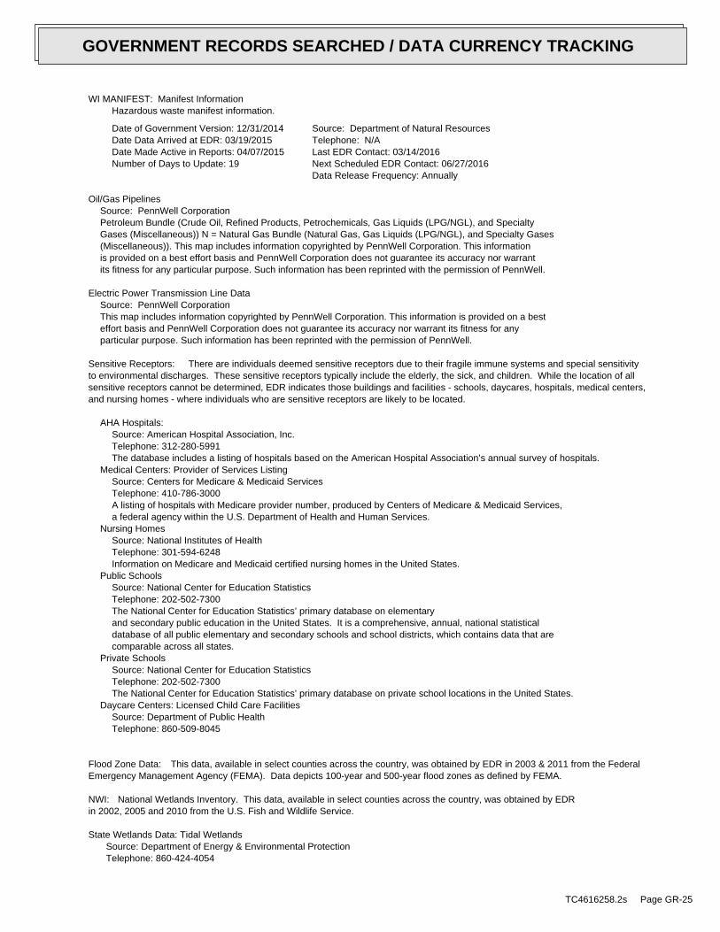
WI MANIFEST: Manifest InformationHazardous waste manifest information.
Date of Government Version: 12/31/2014Date Data Arrived at EDR: 03/19/2015Date Made Active in Reports: 04/07/2015Number of Days to Update: 19
Source: Department of Natural ResourcesTelephone: N/ALast EDR Contact: 03/14/2016Next Scheduled EDR Contact: 06/27/2016Data Release Frequency: Annually
Oil/Gas PipelinesSource: PennWell CorporationPetroleum Bundle (Crude Oil, Refined Products, Petrochemicals, Gas Liquids (LPG/NGL), and SpecialtyGases (Miscellaneous)) N = Natural Gas Bundle (Natural Gas, Gas Liquids (LPG/NGL), and Specialty Gases(Miscellaneous)). This map includes information copyrighted by PennWell Corporation. This informationis provided on a best effort basis and PennWell Corporation does not guarantee its accuracy nor warrantits fitness for any particular purpose. Such information has been reprinted with the permission of PennWell.
Electric Power Transmission Line DataSource: PennWell CorporationThis map includes information copyrighted by PennWell Corporation. This information is provided on a besteffort basis and PennWell Corporation does not guarantee its accuracy nor warrant its fitness for anyparticular purpose. Such information has been reprinted with the permission of PennWell.
Sensitive Receptors: There are individuals deemed sensitive receptors due to their fragile immune systems and special sensitivityto environmental discharges. These sensitive receptors typically include the elderly, the sick, and children. While the location of allsensitive receptors cannot be determined, EDR indicates those buildings and facilities - schools, daycares, hospitals, medical centers,and nursing homes - where individuals who are sensitive receptors are likely to be located.
AHA Hospitals:Source: American Hospital Association, Inc.Telephone: 312-280-5991The database includes a listing of hospitals based on the American Hospital Association’s annual survey of hospitals.
Medical Centers: Provider of Services ListingSource: Centers for Medicare & Medicaid ServicesTelephone: 410-786-3000A listing of hospitals with Medicare provider number, produced by Centers of Medicare & Medicaid Services,a federal agency within the U.S. Department of Health and Human Services.
Nursing HomesSource: National Institutes of HealthTelephone: 301-594-6248Information on Medicare and Medicaid certified nursing homes in the United States.
Public SchoolsSource: National Center for Education StatisticsTelephone: 202-502-7300The National Center for Education Statistics’ primary database on elementaryand secondary public education in the United States. It is a comprehensive, annual, national statisticaldatabase of all public elementary and secondary schools and school districts, which contains data that arecomparable across all states.
Private SchoolsSource: National Center for Education StatisticsTelephone: 202-502-7300The National Center for Education Statistics’ primary database on private school locations in the United States.
Daycare Centers: Licensed Child Care FacilitiesSource: Department of Public HealthTelephone: 860-509-8045
Flood Zone Data: This data, available in select counties across the country, was obtained by EDR in 2003 & 2011 from the FederalEmergency Management Agency (FEMA). Data depicts 100-year and 500-year flood zones as defined by FEMA.
NWI: National Wetlands Inventory. This data, available in select counties across the country, was obtained by EDRin 2002, 2005 and 2010 from the U.S. Fish and Wildlife Service.
State Wetlands Data: Tidal WetlandsSource: Department of Energy & Environmental ProtectionTelephone: 860-424-4054
TC4616258.2s Page GR-25
GOVERNMENT RECORDS SEARCHED / DATA CURRENCY TRACKING
Current USGS 7.5 Minute Topographic MapSource: U.S. Geological Survey
STREET AND ADDRESS INFORMATION
© 2015 TomTom North America, Inc. All rights reserved. This material is proprietary and the subject of copyright protectionand other intellectual property rights owned by or licensed to Tele Atlas North America, Inc. The use of this material is subjectto the terms of a license agreement. You will be held liable for any unauthorized copying or disclosure of this material.
TC4616258.2s Page GR-26
GOVERNMENT RECORDS SEARCHED / DATA CURRENCY TRACKING
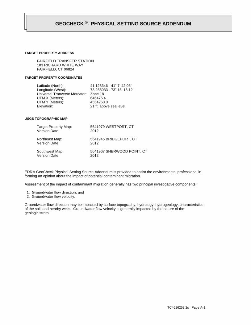
TC4616258.2s Page A-1
geologic strata.of the soil, and nearby wells. Groundwater flow velocity is generally impacted by the nature of theGroundwater flow direction may be impacted by surface topography, hydrology, hydrogeology, characteristics
2. Groundwater flow velocity. 1. Groundwater flow direction, and
Assessment of the impact of contaminant migration generally has two principal investigative components:
forming an opinion about the impact of potential contaminant migration.EDR’s GeoCheck Physical Setting Source Addendum is provided to assist the environmental professional in
2012Version Date:5641967 SHERWOOD POINT, CTSouthwest Map:
2012Version Date:5641945 BRIDGEPORT, CTNortheast Map:
2012Version Date:5641979 WESTPORT, CTTarget Property Map:
USGS TOPOGRAPHIC MAP
21 ft. above sea levelElevation:4554260.0UTM Y (Meters): 646476.4UTM X (Meters): Zone 18Universal Tranverse Mercator: 73.255033 - 73˚ 15’ 18.12’’Longitude (West): 41.128346 - 41˚ 7’ 42.05’’Latitude (North):
TARGET PROPERTY COORDINATES
FAIRFIELD, CT 06824183 RICHARD WHITE WAYFAIRFIELD TRANSFER STATION
TARGET PROPERTY ADDRESS
®GEOCHECK - PHYSICAL SETTING SOURCE ADDENDUM®
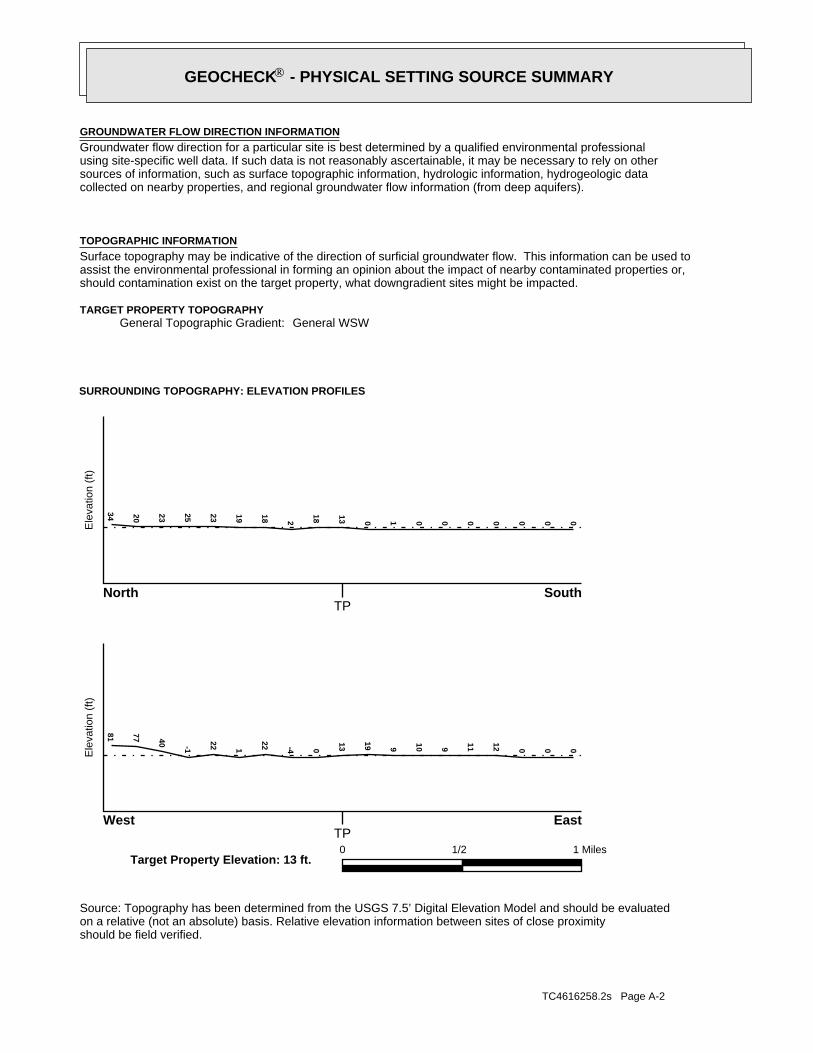
TC4616258.2s Page A-2
should be field verified.on a relative (not an absolute) basis. Relative elevation information between sites of close proximitySource: Topography has been determined from the USGS 7.5’ Digital Elevation Model and should be evaluated
SURROUNDING TOPOGRAPHY: ELEVATION PROFILES
Ele
vatio
n (f
t)E
leva
tion
(ft)
TP
TP0 1/2 1 Miles
✩Target Property Elevation: 13 ft.
North South
West East
000000010
13
182
1819
23252320
3481 77 40 -1
22 1
22 -4 0
13
19 9 10 9 11 12 0 0 0
General WSWGeneral Topographic Gradient:TARGET PROPERTY TOPOGRAPHY
should contamination exist on the target property, what downgradient sites might be impacted.assist the environmental professional in forming an opinion about the impact of nearby contaminated properties or,Surface topography may be indicative of the direction of surficial groundwater flow. This information can be used toTOPOGRAPHIC INFORMATION
collected on nearby properties, and regional groundwater flow information (from deep aquifers).sources of information, such as surface topographic information, hydrologic information, hydrogeologic datausing site-specific well data. If such data is not reasonably ascertainable, it may be necessary to rely on otherGroundwater flow direction for a particular site is best determined by a qualified environmental professionalGROUNDWATER FLOW DIRECTION INFORMATION
®GEOCHECK - PHYSICAL SETTING SOURCE SUMMARY®
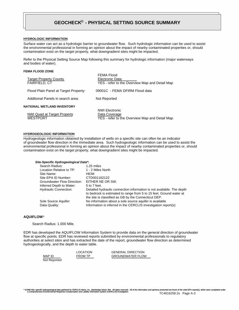
TC4616258.2s Page A-3
Not Reported
GENERAL DIRECTIONLOCATIONGROUNDWATER FLOWFROM TPMAP ID
hydrogeologically, and the depth to water table.authorities at select sites and has extracted the date of the report, groundwater flow direction as determinedflow at specific points. EDR has reviewed reports submitted by environmental professionals to regulatoryEDR has developed the AQUIFLOW Information System to provide data on the general direction of groundwater
AQUIFLOW®
Search Radius: 1.000 Mile.
* ©1996 Site−specific hydrogeological data gathered by CERCLIS Alerts, Inc., Bainbridge Island, WA. All rights reserved. All of the information and opinions presented are those of the cited EPA report(s), which were completed undera Comprehensive Environmental Response Compensation and Liability Information System (CERCLIS) investigation.
Information is inferred in the CERCLIS investigation report(s) Data Quality:No information about a sole source aquifer is available Sole Source Aquifer:the site is classified as GB by the Connecticut DEP.to bedrock is estimated to range from 5 to 15 feet. Ground water atDetailed hydraulic connection information is not available. The depth Hydraulic Connection:5 to 7 feet. Inferred Depth to Water:EITHER NE OR SW. Groundwater Flow Direction:CTD001162122 Site EPA ID Number:HEIM Site Name:1 - 2 Miles North Location Relative to TP:1.25 miles Search Radius:
Site-Specific Hydrogeological Data*:
* ©1996 Site−specific hydrogeological data gathered by CERCLIS Alerts, Inc., Bainbridge Island, WA. All rights reserved. All of the information and opinions presented are those of the cited EPA report(s), which were completed undera Comprehensive Environmental Response Compensation and Liability Information System (CERCLIS) investigation.
contamination exist on the target property, what downgradient sites might be impacted.environmental professional in forming an opinion about the impact of nearby contaminated properties or, shouldof groundwater flow direction in the immediate area. Such hydrogeologic information can be used to assist theHydrogeologic information obtained by installation of wells on a specific site can often be an indicatorHYDROGEOLOGIC INFORMATION
YES - refer to the Overview Map and Detail MapWESTPORT
NATIONAL WETLAND INVENTORYNWI ElectronicData CoverageNWI Quad at Target Property
Not ReportedAdditional Panels in search area:
09001C - FEMA DFIRM Flood dataFlood Plain Panel at Target Property:
YES - refer to the Overview Map and Detail MapFAIRFIELD, CT
FEMA FLOOD ZONEFEMA FloodElectronic DataTarget Property County
and bodies of water).Refer to the Physical Setting Source Map following this summary for hydrologic information (major waterways
contamination exist on the target property, what downgradient sites might be impacted.the environmental professional in forming an opinion about the impact of nearby contaminated properties or, shouldSurface water can act as a hydrologic barrier to groundwater flow. Such hydrologic information can be used to assistHYDROLOGIC INFORMATION
®GEOCHECK - PHYSICAL SETTING SOURCE SUMMARY®
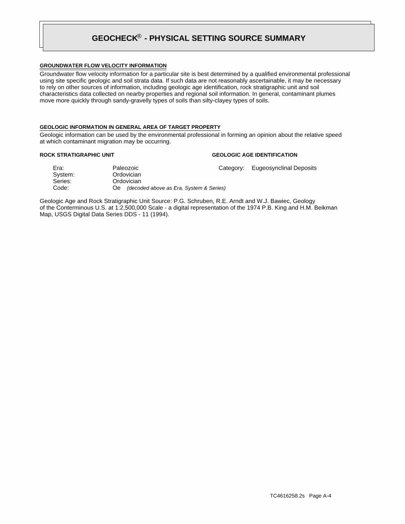
TC4616258.2s Page A-4
Map, USGS Digital Data Series DDS - 11 (1994).of the Conterminous U.S. at 1:2,500,000 Scale - a digital representation of the 1974 P.B. King and H.M. BeikmanGeologic Age and Rock Stratigraphic Unit Source: P.G. Schruben, R.E. Arndt and W.J. Bawiec, Geology
ROCK STRATIGRAPHIC UNIT GEOLOGIC AGE IDENTIFICATION
Eugeosynclinal DepositsCategory:PaleozoicEra:OrdovicianSystem:OrdovicianSeries:OeCode: (decoded above as Era, System & Series)
at which contaminant migration may be occurring.Geologic information can be used by the environmental professional in forming an opinion about the relative speedGEOLOGIC INFORMATION IN GENERAL AREA OF TARGET PROPERTY
move more quickly through sandy-gravelly types of soils than silty-clayey types of soils.characteristics data collected on nearby properties and regional soil information. In general, contaminant plumesto rely on other sources of information, including geologic age identification, rock stratigraphic unit and soilusing site specific geologic and soil strata data. If such data are not reasonably ascertainable, it may be necessaryGroundwater flow velocity information for a particular site is best determined by a qualified environmental professionalGROUNDWATER FLOW VELOCITY INFORMATION
®GEOCHECK - PHYSICAL SETTING SOURCE SUMMARY®
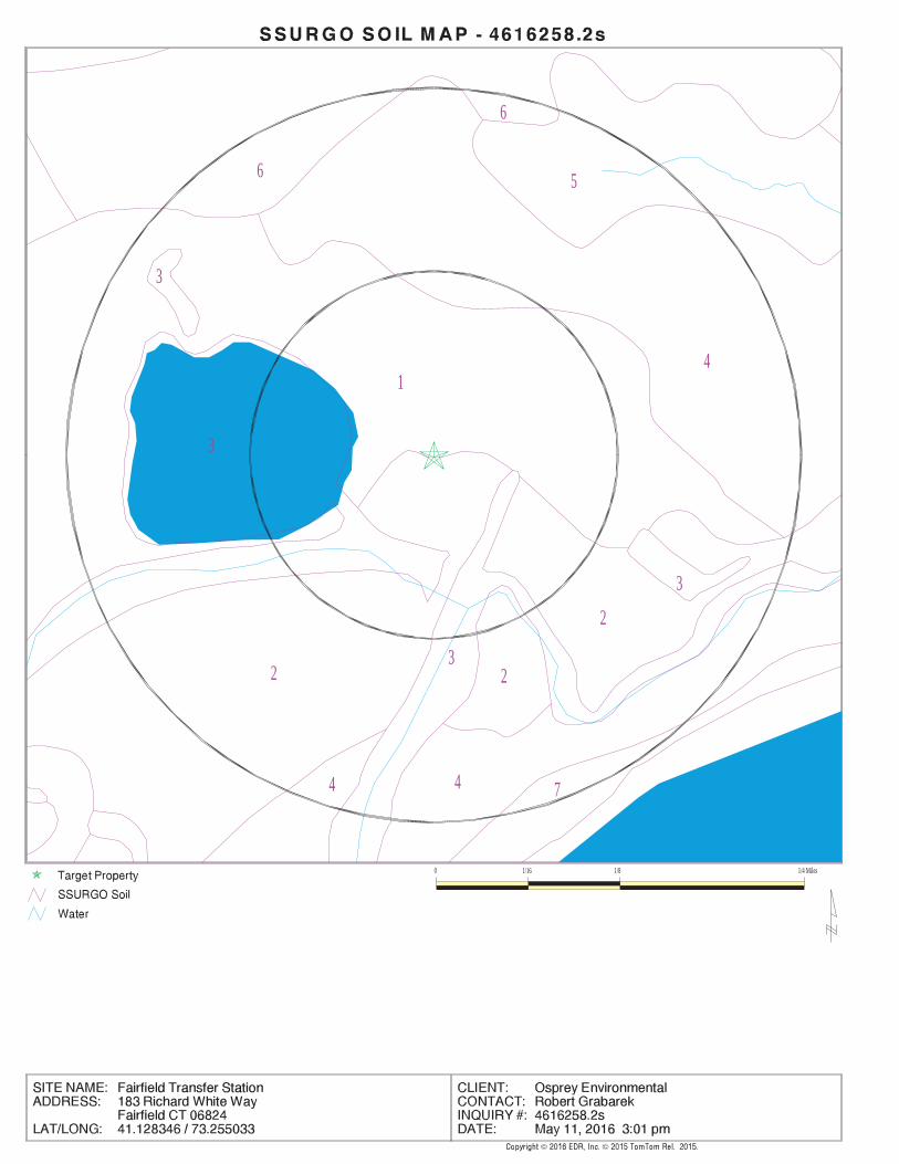
EDR Inc.EDR Inc.EDR Inc.EDR Inc.EDR Inc.EDR Inc.EDR Inc.EDR Inc.EDR Inc.EDR Inc.EDR Inc.EDR Inc.EDR Inc.EDR Inc.EDR Inc.EDR Inc.EDR Inc.EDR Inc.EDR Inc.EDR Inc.EDR Inc.EDR Inc.EDR Inc.EDR Inc.EDR Inc.EDR Inc.EDR Inc.EDR Inc.EDR Inc.EDR Inc.EDR Inc.EDR Inc.EDR Inc.EDR Inc.EDR Inc.EDR Inc.EDR Inc.EDR Inc.EDR Inc.EDR Inc.
4
6
6 5
1
3
3
23
2
3
4
2
74
0 1/16 1/8 1/4 Miles
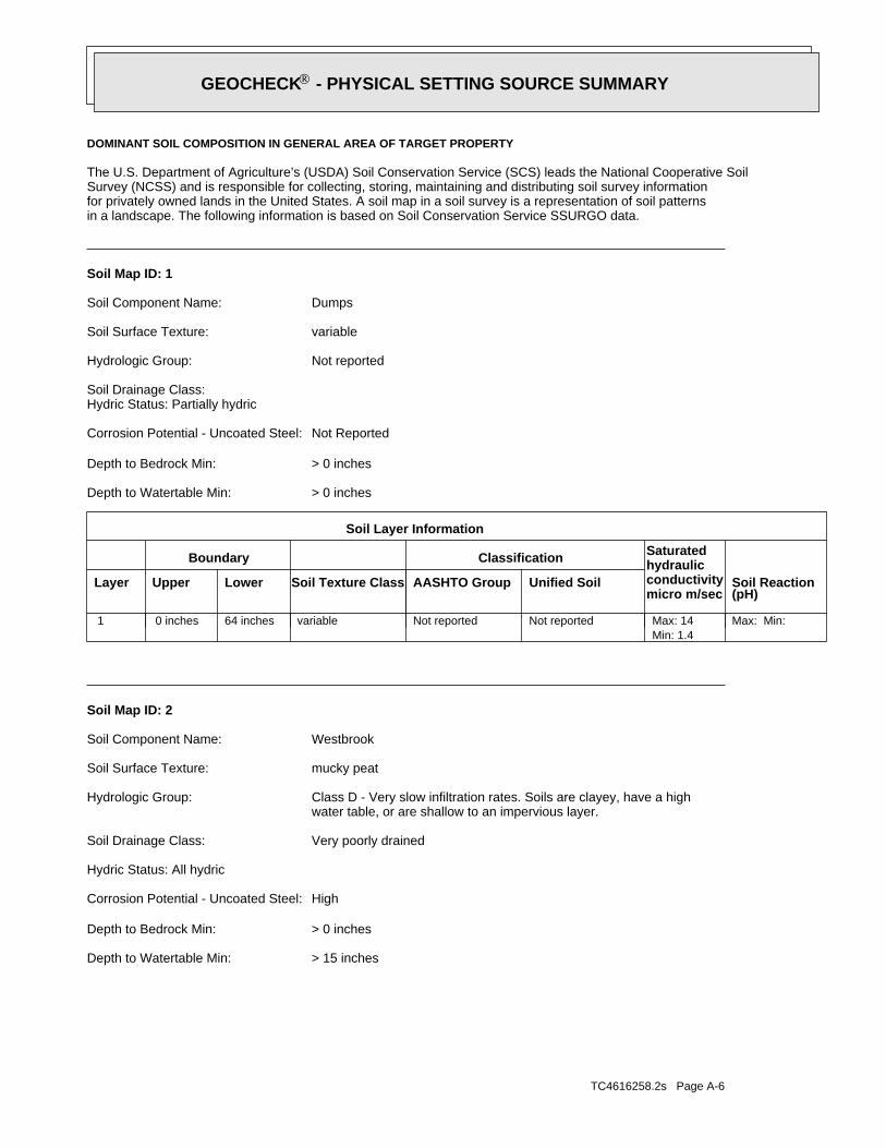
TC4616258.2s Page A-6
> 15 inchesDepth to Watertable Min:
> 0 inchesDepth to Bedrock Min:
HighCorrosion Potential - Uncoated Steel:
Hydric Status: All hydric
Very poorly drainedSoil Drainage Class:
water table, or are shallow to an impervious layer.Class D - Very slow infiltration rates. Soils are clayey, have a highHydrologic Group:
mucky peatSoil Surface Texture:
WestbrookSoil Component Name:
Soil Map ID: 2
Max: Min: Min: 1.4Max: 14 Not reportedNot reportedvariable64 inches 0 inches 1
Soil Layer Information
Boundary Classification Saturatedhydraulicconductivitymicro m/sec
Layer Upper Lower Soil Texture Class AASHTO Group Unified Soil Soil Reaction(pH)
> 0 inchesDepth to Watertable Min:
> 0 inchesDepth to Bedrock Min:
Not ReportedCorrosion Potential - Uncoated Steel:
Hydric Status: Partially hydricSoil Drainage Class:
Not reportedHydrologic Group:
variableSoil Surface Texture:
DumpsSoil Component Name:
Soil Map ID: 1
in a landscape. The following information is based on Soil Conservation Service SSURGO data.for privately owned lands in the United States. A soil map in a soil survey is a representation of soil patternsSurvey (NCSS) and is responsible for collecting, storing, maintaining and distributing soil survey informationThe U.S. Department of Agriculture’s (USDA) Soil Conservation Service (SCS) leads the National Cooperative Soil
DOMINANT SOIL COMPOSITION IN GENERAL AREA OF TARGET PROPERTY
®GEOCHECK - PHYSICAL SETTING SOURCE SUMMARY®
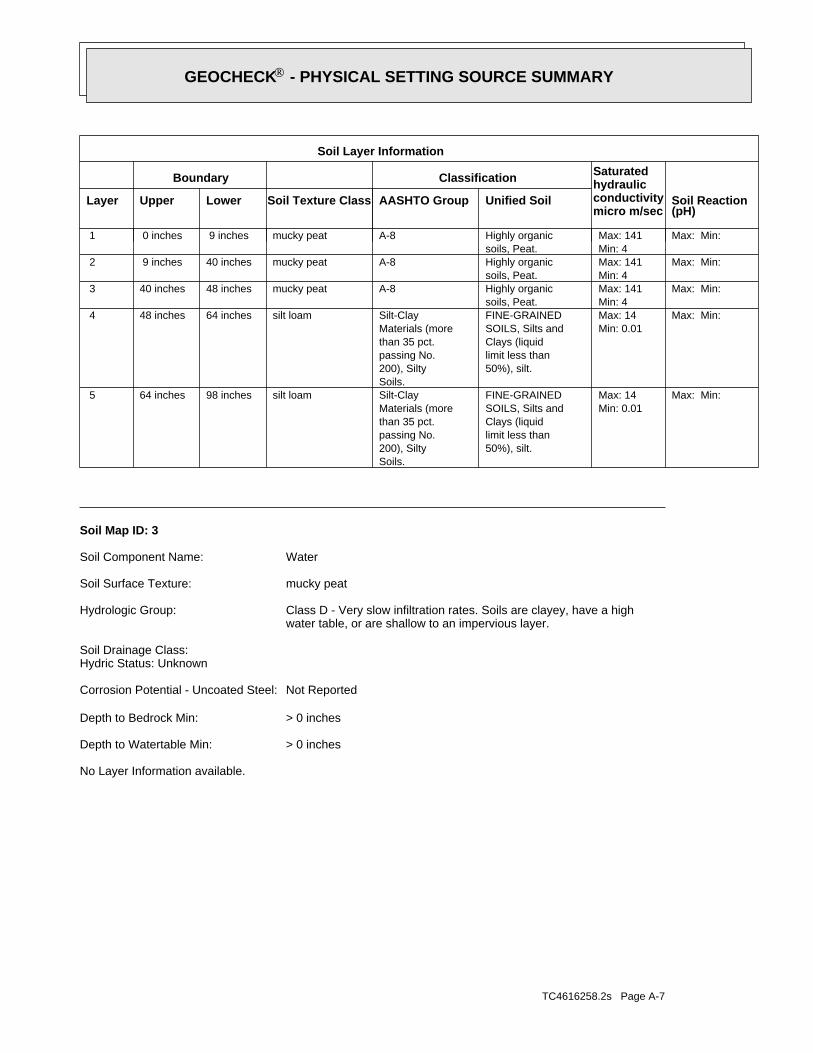
TC4616258.2s Page A-7
No Layer Information available.
> 0 inchesDepth to Watertable Min:
> 0 inchesDepth to Bedrock Min:
Not ReportedCorrosion Potential - Uncoated Steel:
Hydric Status: UnknownSoil Drainage Class:
water table, or are shallow to an impervious layer.Class D - Very slow infiltration rates. Soils are clayey, have a highHydrologic Group:
mucky peatSoil Surface Texture:
WaterSoil Component Name:
Soil Map ID: 3
Max: Min: Min: 0.01Max: 14
50%), silt.limit less thanClays (liquidSOILS, Silts andFINE-GRAINED
Soils.200), Siltypassing No.than 35 pct.Materials (moreSilt-Claysilt loam98 inches64 inches 5
Max: Min: Min: 0.01Max: 14
50%), silt.limit less thanClays (liquidSOILS, Silts andFINE-GRAINED
Soils.200), Siltypassing No.than 35 pct.Materials (moreSilt-Claysilt loam64 inches48 inches 4
Max: Min: Min: 4Max: 141
soils, Peat.Highly organicA-8mucky peat48 inches40 inches 3
Max: Min: Min: 4Max: 141
soils, Peat.Highly organicA-8mucky peat40 inches 9 inches 2
Max: Min: Min: 4Max: 141
soils, Peat.Highly organicA-8mucky peat 9 inches 0 inches 1
Soil Layer Information
Boundary Classification Saturatedhydraulicconductivitymicro m/sec
Layer Upper Lower Soil Texture Class AASHTO Group Unified Soil Soil Reaction(pH)
®GEOCHECK - PHYSICAL SETTING SOURCE SUMMARY®
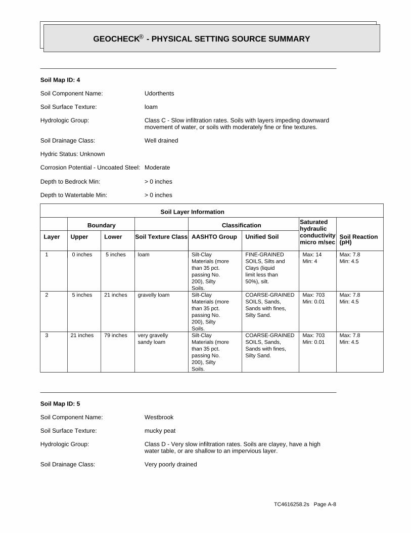
TC4616258.2s Page A-8
Very poorly drainedSoil Drainage Class:
water table, or are shallow to an impervious layer.Class D - Very slow infiltration rates. Soils are clayey, have a highHydrologic Group:
mucky peatSoil Surface Texture:
WestbrookSoil Component Name:
Soil Map ID: 5
Min: 4.5Max: 7.8
Min: 0.01Max: 703
Silty Sand.Sands with fines,SOILS, Sands,COARSE-GRAINED
Soils.200), Siltypassing No.than 35 pct.Materials (moreSilt-Clay
sandy loamvery gravelly79 inches21 inches 3
Min: 4.5Max: 7.8
Min: 0.01Max: 703
Silty Sand.Sands with fines,SOILS, Sands,COARSE-GRAINED
Soils.200), Siltypassing No.than 35 pct.Materials (moreSilt-Claygravelly loam21 inches 5 inches 2
Min: 4.5Max: 7.8
Min: 4Max: 14
50%), silt.limit less thanClays (liquidSOILS, Silts andFINE-GRAINED
Soils.200), Siltypassing No.than 35 pct.Materials (moreSilt-Clayloam 5 inches 0 inches 1
Soil Layer Information
Boundary Classification Saturatedhydraulicconductivitymicro m/sec
Layer Upper Lower Soil Texture Class AASHTO Group Unified Soil Soil Reaction(pH)
> 0 inchesDepth to Watertable Min:
> 0 inchesDepth to Bedrock Min:
ModerateCorrosion Potential - Uncoated Steel:
Hydric Status: Unknown
Well drainedSoil Drainage Class:
movement of water, or soils with moderately fine or fine textures.Class C - Slow infiltration rates. Soils with layers impeding downwardHydrologic Group:
loamSoil Surface Texture:
UdorthentsSoil Component Name:
Soil Map ID: 4
®GEOCHECK - PHYSICAL SETTING SOURCE SUMMARY®
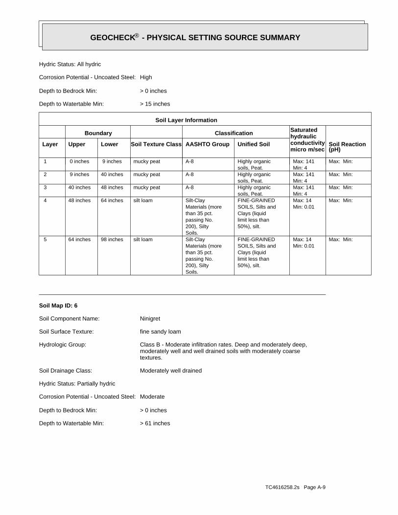
TC4616258.2s Page A-9
> 61 inchesDepth to Watertable Min:
> 0 inchesDepth to Bedrock Min:
ModerateCorrosion Potential - Uncoated Steel:
Hydric Status: Partially hydric
Moderately well drainedSoil Drainage Class:
textures.moderately well and well drained soils with moderately coarseClass B - Moderate infiltration rates. Deep and moderately deep,Hydrologic Group:
fine sandy loamSoil Surface Texture:
NinigretSoil Component Name:
Soil Map ID: 6
Max: Min: Min: 0.01Max: 14
50%), silt.limit less thanClays (liquidSOILS, Silts andFINE-GRAINED
Soils.200), Siltypassing No.than 35 pct.Materials (moreSilt-Claysilt loam98 inches64 inches 5
Max: Min: Min: 0.01Max: 14
50%), silt.limit less thanClays (liquidSOILS, Silts andFINE-GRAINED
Soils.200), Siltypassing No.than 35 pct.Materials (moreSilt-Claysilt loam64 inches48 inches 4
Max: Min: Min: 4Max: 141
soils, Peat.Highly organicA-8mucky peat48 inches40 inches 3
Max: Min: Min: 4Max: 141
soils, Peat.Highly organicA-8mucky peat40 inches 9 inches 2
Max: Min: Min: 4Max: 141
soils, Peat.Highly organicA-8mucky peat 9 inches 0 inches 1
Soil Layer Information
Boundary Classification Saturatedhydraulicconductivitymicro m/sec
Layer Upper Lower Soil Texture Class AASHTO Group Unified Soil Soil Reaction(pH)
> 15 inchesDepth to Watertable Min:
> 0 inchesDepth to Bedrock Min:
HighCorrosion Potential - Uncoated Steel:
Hydric Status: All hydric
®GEOCHECK - PHYSICAL SETTING SOURCE SUMMARY®
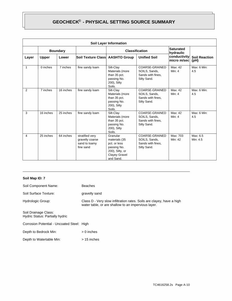
TC4616258.2s Page A-10
> 15 inchesDepth to Watertable Min:
> 0 inchesDepth to Bedrock Min:
HighCorrosion Potential - Uncoated Steel:
Hydric Status: Partially hydricSoil Drainage Class:
water table, or are shallow to an impervious layer.Class D - Very slow infiltration rates. Soils are clayey, have a highHydrologic Group:
gravelly sandSoil Surface Texture:
BeachesSoil Component Name:
Soil Map ID: 7
Min: 4.5Max: 6.5
Min: 42Max: 703
Silty Sand.Sands with fines,SOILS, Sands,COARSE-GRAINED
and Sand.Clayey Gravel200), Silty, orpassing No.pct. or lessmaterials (35Granular
fine sandsand to loamygravelly coarsestratified very64 inches25 inches 4
4.5Max: 6 Min:
Min: 4Max: 42
Silty Sand.Sands with fines,SOILS, Sands,COARSE-GRAINED
Soils.200), Siltypassing No.than 35 pct.Materials (moreSilt-Clayfine sandy loam25 inches16 inches 3
4.5Max: 6 Min:
Min: 4Max: 42
Silty Sand.Sands with fines,SOILS, Sands,COARSE-GRAINED
Soils.200), Siltypassing No.than 35 pct.Materials (moreSilt-Clayfine sandy loam16 inches 7 inches 2
4.5Max: 6 Min:
Min: 4Max: 42
Silty Sand.Sands with fines,SOILS, Sands,COARSE-GRAINED
Soils.200), Siltypassing No.than 35 pct.Materials (moreSilt-Clayfine sandy loam 7 inches 0 inches 1
Soil Layer Information
Boundary Classification Saturatedhydraulicconductivitymicro m/sec
Layer Upper Lower Soil Texture Class AASHTO Group Unified Soil Soil Reaction(pH)
®GEOCHECK - PHYSICAL SETTING SOURCE SUMMARY®
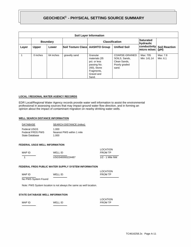
TC4616258.2s Page A-11
STATE DATABASE WELL INFORMATION
LOCATIONFROM TPWELL IDMAP ID
Note: PWS System location is not always the same as well location.
No PWS System Found
FEDERAL FRDS PUBLIC WATER SUPPLY SYSTEM INFORMATION
LOCATIONFROM TPWELL IDMAP ID
1/2 - 1 Mile NWUSGS40000224487 1
FEDERAL USGS WELL INFORMATION
LOCATIONFROM TPWELL IDMAP ID
1.000State DatabaseNearest PWS within 1 mileFederal FRDS PWS1.000Federal USGS
WELL SEARCH DISTANCE INFORMATION
SEARCH DISTANCE (miles)DATABASE
opinion about the impact of contaminant migration on nearby drinking water wells.professional in assessing sources that may impact ground water flow direction, and in forming anEDR Local/Regional Water Agency records provide water well information to assist the environmental
LOCAL / REGIONAL WATER AGENCY RECORDS
Min: 6.1Max: 7.8
Min: 141.14Max: 705
sand.Poorly gradedClean Sands,SOILS, Sands,COARSE-GRAINED
Sand.Gravel andFragments,200), Stonepassing No.pct. or lessmaterials (35Granulargravelly sand64 inches 0 inches 1
Soil Layer Information
Boundary Classification Saturatedhydraulicconductivitymicro m/sec
Layer Upper Lower Soil Texture Class AASHTO Group Unified Soil Soil Reaction(pH)
®GEOCHECK - PHYSICAL SETTING SOURCE SUMMARY®
TC4616258.2s Page A-12
No Wells Found
STATE DATABASE WELL INFORMATION
LOCATIONFROM TPWELL IDMAP ID
®GEOCHECK - PHYSICAL SETTING SOURCE SUMMARY®
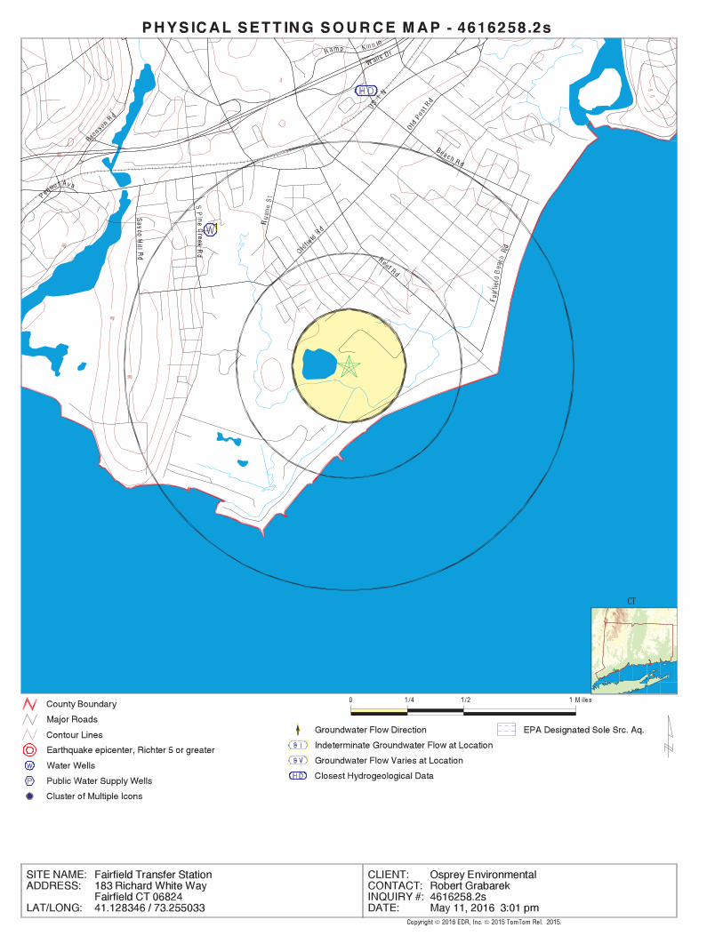
EDR Inc.EDR Inc.EDR Inc.EDR Inc.EDR Inc.EDR Inc.EDR Inc.EDR Inc.EDR Inc.EDR Inc.EDR Inc.EDR Inc.EDR Inc.EDR Inc.EDR Inc.EDR Inc.EDR Inc.EDR Inc.EDR Inc.EDR Inc.EDR Inc.EDR Inc.EDR Inc.EDR Inc.EDR Inc.EDR Inc.EDR Inc.EDR Inc.EDR Inc.EDR Inc.EDR Inc.EDR Inc.EDR Inc.EDR Inc.EDR Inc.EDR Inc.EDR Inc.EDR Inc.EDR Inc.EDR Inc.
80
80
80
40
80
40
CT
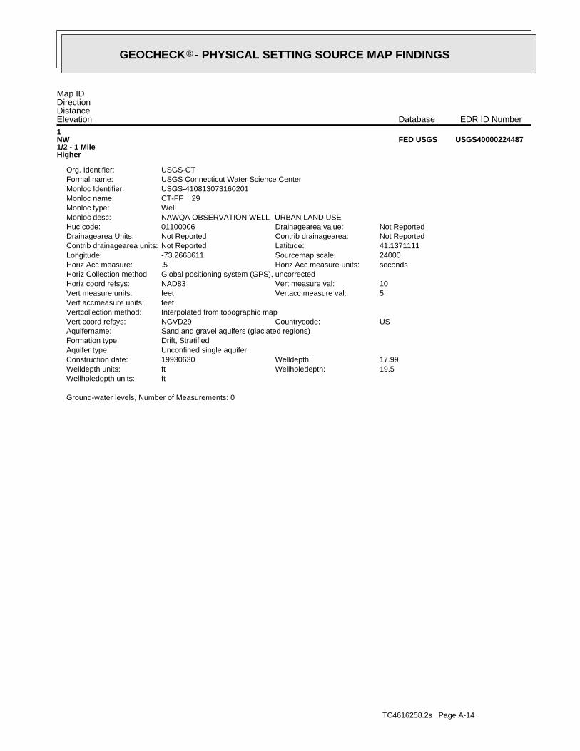
TC4616258.2s Page A-14
Ground-water levels, Number of Measurements: 0
ftWellholedepth units:19.5Wellholedepth:ftWelldepth units:17.99Welldepth:19930630Construction date:
Unconfined single aquiferAquifer type:Drift, StratifiedFormation type:Sand and gravel aquifers (glaciated regions)Aquifername:
USCountrycode:NGVD29Vert coord refsys:Interpolated from topographic mapVertcollection method:feetVert accmeasure units:
5Vertacc measure val:feetVert measure units:10Vert measure val:NAD83Horiz coord refsys:
Global positioning system (GPS), uncorrectedHoriz Collection method:secondsHoriz Acc measure units:.5Horiz Acc measure:24000Sourcemap scale:-73.2668611Longitude:41.1371111Latitude:Not ReportedContrib drainagearea units:Not ReportedContrib drainagearea:Not ReportedDrainagearea Units:Not ReportedDrainagearea value:01100006Huc code:
NAWQA OBSERVATION WELL--URBAN LAND USEMonloc desc:WellMonloc type:CT-FF 29Monloc name:USGS-410813073160201Monloc Identifier:USGS Connecticut Water Science CenterFormal name:USGS-CTOrg. Identifier:
1NW1/2 - 1 MileHigher
USGS40000224487FED USGS
Map IDDirectionDistanceElevation EDR ID NumberDatabase
®GEOCHECK - PHYSICAL SETTING SOURCE MAP FINDINGS®

TC4616258.2s Page A-15
2%29%69%2.630 pCi/LBasement0%10%89%1.270 pCi/LLiving Area
% >20 pCi/L% 4-20 pCi/L% <4 pCi/LAverage ActivityArea
Number of sites tested: 1859
Federal Area Radon Information for FAIRFIELD COUNTY, CT
: Zone 3 indoor average level < 2 pCi/L. : Zone 2 indoor average level >= 2 pCi/L and <= 4 pCi/L. Note: Zone 1 indoor average level > 4 pCi/L.
Federal EPA Radon Zone for FAIRFIELD County: 1
0 (0)0 (0)0 (0)0 (0)1 (100)0 (0)1South Norwalk0 (0)0 (0)0 (0)0 (0)4.3 (50)1 (50)2Sherman0 (0)0 (0)0 (0)1 (4.4)5 (21.7)17 (73.9)23Shelton0 (0)0 (0)4 (8.30)5 (10.42)15 (31.25)25 (52.1)48Sandy Hook0 (0)0 (0)0 (0)0 (0)0 (0)1 (100)1Rowayton0 (0)0 (0)0 (0)1 (20)1 (20)3 (60)5Riverside0 (0)0 (0)0 (0)3 (0)10 (0)97 (0)110Ridgefield0 (0)0 (0)0 (0)0 (0)2 (28.6)5 (71.4)7Redding0 (0)0 (0)0 (0)0 (0)0 (0)3 (100)3Old Greenwich0 (0)0 (0)1 (3.7)1 (3.7)4 (14.8)21 (77.8)27Norwalk2 (9.5)1 (4.8)7 (33.3)4 (19.1)0 (0)7 (33.3)21Newtown0 (0)0 (0)0 (0)0 (0)2 (25)6 (75)8New Fairfield0 (0)0 (0)0 (0)0 (0)0 (0)1 (100)1New Canaan0 (0)0 (0)3 (2.2)5 (3.7)12 (8.9)115 (85.2)135Monroe0 (0)0 (0)1 (.8)3(2.2)7 (5.1)125 (91.9)136Greenwich0 (0)0 (0)0 (0)1 (2.55)1 (2.55)37 (94.9)39Fairfield0 (0)0 (0)0 (0)1 (.9)27 (25)80 (74.1)108Easton0 (0)0 (0)1 (2)7 (1.4)49 (9.5)457 (88.9)514Darien0 (0)0 (0)0 (0)0 (0)1 (6.7)14 (93.3)15Danbury0 (0)0 (0)0 (0)0 (0)1 (25)3 (75)4Cos Cob0 (0)0 (0)0 (0)1 (20)2 (40)2 (40)5Brookfield0 (0)0 (0)2 (2)3 (3)24 (23.5)73 (71.6)102Bridgeport0 (0)0 (0)0 (0)0 (0)3 (17.6)14 (82.4)17Bethel0 (0)0 (0)0 (0)0 (0)3 (21.4)11 (78.6)14Wilton0 (0)0 (0)4 (2.6)12 (7.8)29 (18.8)109 (70.8)154Westport0 (0)1 (.9)3 (2.7)5 (4.5)31 (27.9)71 (63.9)111Weston1 (.9)0 (0)2 (1.8)5 (4.4)20 (17.5)86 (75.4)114Trumbull2 (2.3)0 (0)1 (.7)3 (2.3)27 (20.9)96 (74.4)129Stratford0 (0)0 (0)3 (2.7)6 (5.3)34 (30.4)69 (61.6)112Stamford0 (0)0 (0)0 (0)0 (0)0 (0)2 (100)2Southport
___________________________________________________________________________> 100 Pci/L50 < 100 Pci/L20 < 50 Pci/L10 < 20 Pci/L4 < 10 Pci/L< 4 Pci/L# SitesCity
Radon Test Results
State Database: CT Radon
AREA RADON INFORMATION
®GEOCHECK - PHYSICAL SETTING SOURCE MAP FINDINGSRADON
®
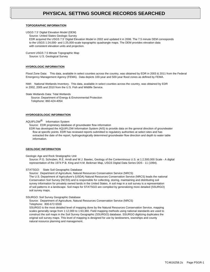
TOPOGRAPHIC INFORMATION
USGS 7.5’ Digital Elevation Model (DEM)Source: United States Geologic SurveyEDR acquired the USGS 7.5’ Digital Elevation Model in 2002 and updated it in 2006. The 7.5 minute DEM correspondsto the USGS 1:24,000- and 1:25,000-scale topographic quadrangle maps. The DEM provides elevation datawith consistent elevation units and projection.
Current USGS 7.5 Minute Topographic MapSource: U.S. Geological Survey
HYDROLOGIC INFORMATION
Flood Zone Data: This data, available in select counties across the country, was obtained by EDR in 2003 & 2011 from the FederalEmergency Management Agency (FEMA). Data depicts 100-year and 500-year flood zones as defined by FEMA.
NWI: National Wetlands Inventory. This data, available in select counties across the country, was obtained by EDRin 2002, 2005 and 2010 from the U.S. Fish and Wildlife Service.
State Wetlands Data: Tidal WetlandsSource: Department of Energy & Environmental ProtectionTelephone: 860-424-4054
HYDROGEOLOGIC INFORMATION
AQUIFLOW Information SystemR
Source: EDR proprietary database of groundwater flow informationEDR has developed the AQUIFLOW Information System (AIS) to provide data on the general direction of groundwater
flow at specific points. EDR has reviewed reports submitted to regulatory authorities at select sites and hasextracted the date of the report, hydrogeologically determined groundwater flow direction and depth to water tableinformation.
GEOLOGIC INFORMATION
Geologic Age and Rock Stratigraphic UnitSource: P.G. Schruben, R.E. Arndt and W.J. Bawiec, Geology of the Conterminous U.S. at 1:2,500,000 Scale - A digitalrepresentation of the 1974 P.B. King and H.M. Beikman Map, USGS Digital Data Series DDS - 11 (1994).
STATSGO: State Soil Geographic DatabaseSource: Department of Agriculture, Natural Resources Conservation Service (NRCS)The U.S. Department of Agriculture’s (USDA) Natural Resources Conservation Service (NRCS) leads the nationalConservation Soil Survey (NCSS) and is responsible for collecting, storing, maintaining and distributing soilsurvey information for privately owned lands in the United States. A soil map in a soil survey is a representationof soil patterns in a landscape. Soil maps for STATSGO are compiled by generalizing more detailed (SSURGO)soil survey maps.
SSURGO: Soil Survey Geographic DatabaseSource: Department of Agriculture, Natural Resources Conservation Service (NRCS)Telephone: 800-672-5559SSURGO is the most detailed level of mapping done by the Natural Resources Conservation Service, mappingscales generally range from 1:12,000 to 1:63,360. Field mapping methods using national standards are used toconstruct the soil maps in the Soil Survey Geographic (SSURGO) database. SSURGO digitizing duplicates theoriginal soil survey maps. This level of mapping is designed for use by landowners, townships and countynatural resource planning and management.
TC4616258.2s Page PSGR-1
PHYSICAL SETTING SOURCE RECORDS SEARCHED
LOCAL / REGIONAL WATER AGENCY RECORDS
FEDERAL WATER WELLS
PWS: Public Water SystemsSource: EPA/Office of Drinking WaterTelephone: 202-564-3750Public Water System data from the Federal Reporting Data System. A PWS is any water system which provides water to at
least 25 people for at least 60 days annually. PWSs provide water from wells, rivers and other sources.
PWS ENF: Public Water Systems Violation and Enforcement DataSource: EPA/Office of Drinking WaterTelephone: 202-564-3750Violation and Enforcement data for Public Water Systems from the Safe Drinking Water Information System (SDWIS) after
August 1995. Prior to August 1995, the data came from the Federal Reporting Data System (FRDS).
USGS Water Wells: USGS National Water Inventory System (NWIS)This database contains descriptive information on sites where the USGS collects or has collected data on surfacewater and/or groundwater. The groundwater data includes information on wells, springs, and other sources of groundwater.
STATE RECORDS
Connecticut Leachate and Wastewater Discharge SitesSource: Department of Environmental ProtectionThe Leachate and Waste Water Discharge Inventory Data Layer (LWDS) includes point locations digitized from Leachate
and Wastewater Discharge Source maps compiled by the Connecticut DEP. These maps locate surface and groundwaterdischarges that (1) have received a waste water discharge permit from the state or (2) are historic and now defunctwaste sites or (3) are locations of accidental spills, leaks, or discharges of a variety of liquid or solid wastes.
EPA-Approved Sole Source Aquifers in ConnecticutSource: EPASole source aquifers are defined as an aquifer designated as the sole or principal source of drinking water for
a given aquifer service area; that is, an aquifer which is needed to supply 50% or more of the drinking waterfor the area and for which there are no reasonable alternative sources should the aquifer become contaminated.
Community and Non-Community Water System WellsSource: Department of Public Health, Water Supplies SectionTelephone: 860-509-7333Active, emergency and inactive wells used for potable purposes that are owned and operated by active community
and non-community water systems in Connecticut.
OTHER STATE DATABASE INFORMATION
RADON
State Database: CT RadonSource: Department of Public HealthTelephone: 860-509-7367Radon Statistical Summary
Area Radon InformationSource: USGSTelephone: 703-356-4020The National Radon Database has been developed by the U.S. Environmental Protection Agency(USEPA) and is a compilation of the EPA/State Residential Radon Survey and the National Residential Radon Survey.The study covers the years 1986 - 1992. Where necessary data has been supplemented by information collected atprivate sources such as universities and research institutions.
TC4616258.2s Page PSGR-2
PHYSICAL SETTING SOURCE RECORDS SEARCHED
EPA Radon ZonesSource: EPATelephone: 703-356-4020Sections 307 & 309 of IRAA directed EPA to list and identify areas of U.S. with the potential for elevated indoorradon levels.
OTHER
Airport Landing Facilities: Private and public use landing facilitiesSource: Federal Aviation Administration, 800-457-6656
Epicenters: World earthquake epicenters, Richter 5 or greaterSource: Department of Commerce, National Oceanic and Atmospheric Administration
Earthquake Fault Lines: The fault lines displayed on EDR’s Topographic map are digitized quaternary faultlines, preparedin 1975 by the United State Geological Survey
STREET AND ADDRESS INFORMATION
© 2015 TomTom North America, Inc. All rights reserved. This material is proprietary and the subject of copyright protectionand other intellectual property rights owned by or licensed to Tele Atlas North America, Inc. The use of this material is subjectto the terms of a license agreement. You will be held liable for any unauthorized copying or disclosure of this material.
TC4616258.2s Page PSGR-3
PHYSICAL SETTING SOURCE RECORDS SEARCHED


![Osprey - Aerospace - Tiger Squadrons [Osprey - Aerospace].pdf](https://img.dokumen.tips/doc/110x75/55cf9675550346d0338b9dbe/osprey-aerospace-tiger-squadrons-osprey-aerospacepdf.jpg)

