Embed Size (px)
Citation preview

Orienteering
Boy Scout Troop Meeting Troop 39
September Skills Sessions:•Sept. 17 – Orienteering Rank Req.•Sept. 24 – Merit Badge Req.•Sept. 26-28 – Merit Badge Req.

Orienteering Introduction A Brief History of Orienteering Review of Scout Rank Requirements Orienteering Merit Badge
Requirements Troop Orienteering at Schiff Camp

What is Orienteering? Explorers like Marco Polo, Christopher Columbus, Lewis and Clark have used rough
maps of the earth and simple compasses to guide them. Often, their skills with map and compass were all that kept them from disaster.
What has been a vital skill for thousands of years is now a sport – orienteering. In 1919, a Swedish Scout leader decided that compass and maps could be used for fun as well as survival and navigation. Orienteering is now a recognized sport in the Olympic games.
By definition, orienteering is a cross-country race in which participants use a highly detailed map and a compass to navigate their way between checkpoints along an unfamiliar course.

Orienteering Magnetic compasses are among the oldest instruments used for navigation on land and
water. The exact origin is not known but several theories exist.
It is believed the Chinese were first to discover the magnetic properties of lodestone somewhere around 2300 B.C. This ore when suspended freely, aligned itself in a north-south position and could transfer its magnetic properties to pieces of some other metals. It is believed that a simple compass was developed by suspending a magnetized piece of iron (the needle) on light wood on the surface of a bowl of water. Yet another theory says the Arabs discovered the magnetism of lodestone.
Hannibal (247 B.C. - 181 B.C.), a great military general and leader who commanded the Carthaginian forces against Rome, was believed to have used a magnetic compass when he sailed from Italy in 203 B.C.

Orienteering Compass History Compass Parts Declination Map Features Map Symbols

Compass History The Vikings used a basic form of compass in the eleventh century A.D. When Marco
Polo visited China in the thirteenth century A.D. he brought a compass back to Europe. It was in this same century that the typical magnetic compass, as we know it, was developed.
A liquid-filled (damped) compass was perfected in 1862 and adopted for use by the U.S. Navy. This type of compass was more stable in rough conditions. In 1876 a dry-card compass was invented and used by the British Navy until 1906, after which they changed to a liquid-filled compass.
Gyrocompasses came into being in the first decade of the twentieth century and soon became standard equipment on large ships.
Today, digital compasses are being developed that use satellite signals to provide accurate, non-magnetic alignment.

Compass Types
baseplate sighting
heavy-duty sighting
specialty noveltydigital
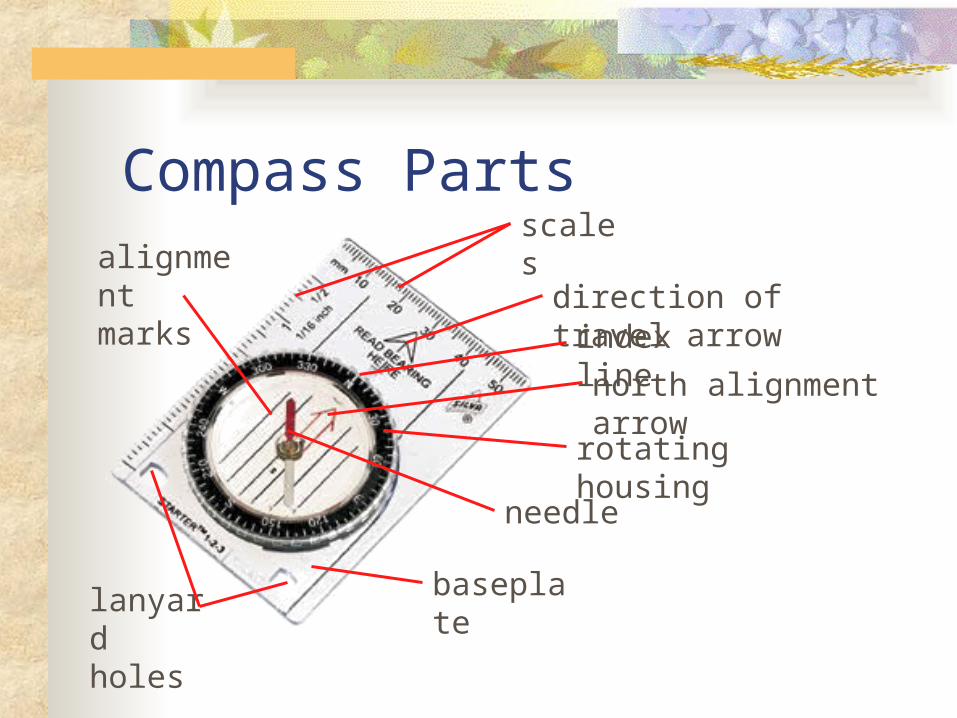
Compass Parts
baseplate
needle
rotating housing
north alignment arrow
direction of travel arrow
scalesalignment marks
lanyard holes
index line

Declination – WMM ViewA magnetic compass points to magnetic north, not geographic north. The difference between true north and magnetic north, measured in degrees, is declination.

Declination – US View

Topographic Map Features
contours (represent elevation)
declination diagram and data
contour data
contour heights
topographic features
scale

USGS Map Symbols-Examples

Scout Rank RequirementsBreak into patrols to work on the following skills:
(Scouts who have earned Orienteering badge meet with Harrison to review teaching requirements.)
Tenderfoot
1. Explain the rules of safe hiking, both on the highway and cross-country, during the day and at night. Explain what to do if you are lost.
Second Class
1a. Demonstrate how a compass works and how to orient a map. Explain what map symbols mean.
1b. Using a compass and map together, take a five-mile hike (or 10 miles by bike) approved by your adult leader and your parent or guardian. (Schiff Campout)
First Class
1. Demonstrate how to find directions during the day and at night without using a compass.
2. Using a compass, complete an orienteering course that covers at least one mile and requires measuring the height and/or width of designated items (tree, tower, canyon, ditch, etc.). (Schiff Campout)

Orienteering Merit Badge1. Show that you know first aid for the types of injuries that could
occur while orienteering, including cuts, scratches, blisters, snakebite, insect stings, tick bites, heat and cold reactions (sunburn, heatstroke, heat exhaustion, hypothermia), and dehydration. Explain to your counselor why you should be able to identify poisonous plants and poisonous animals that are found in your area.
2. Explain what orienteering is. 3. Do the following:
a. Explain how a compass works. Describe the features of an orienteering compass.
b. In the field, show how to take a compass bearing and follow it.

Orienteering Merit Badge4. Do the following:
a. Explain how a topographic map shows terrain features. Point out and name five terrain features on a map and in the field.
b. Point out and name 10 symbols on a topographic map. c. Explain the meaning of declination. Tell why you must consider
declination when using map and compass together. d. Show a topographic map with magnetic north-south lines. e. Show how to measure distances using an orienteering
compass. f. Show how to orient a map using a compass.
5. Set up a 100-meter pace course. Determine your walking and running pace for 100 meters. Tell why it is important to pace-count.

Orienteering Merit Badge6. Do the following:
a. Identify 20 international control description symbols. Tell the meaning of each symbol.
b. Show a control description sheet and explain the information provided.
c. Explain the following terms and tell when you would use them: attack point, collecting feature, aiming off, contouring, reading ahead, handrail, relocation, rough versus fine orienteering.

Orienteering Merit BadgeAt Schiff Campout:
7. Do the following: a. Take part in three orienteering events. One of these must be a
cross-country course. b. After each event, write a report with
a copy of the master map and control description sheet , a copy of the route you took on the course, a discussion of how you could improve your time between
control points, and a list of your major weaknesses on this course . Describe
what you could do to improve. 8. Do ONE of the following:
a. Set up a cross-country course of at least 2,000 meters long with at least five control markers. Prepare the master map and control description sheet.
b. Set up a score-orienteering course with 12 control points and a time limit of at least 60 minutes. Prepare the master map and control description sheet.

Orienteering Merit Badge9. Act as an official during an orientation. This may be during the
running of the course you set up for requirement 8. 10. Teach orienteering techniques to your patrol, troop or crew.
Note to the Counselor:While orienteering is primarily an individual sport, BSA Youth Protection procedures call for using the buddy system. Requirement 7a can be completed by pairs or groups of Scouts.