Embed Size (px)
Citation preview

Oregon Coast Trail: Connection Strategy
January 2011

2
Cover: Oregon Coast Trail at Heceta Head Lighthouse State Scenic ViewpointOregon Coast Trail (Historic 804 Trail) at Yachats State Recreation Area
Oregon Parks and Recreation Commission
Tim Wood Congressional District 1 Congressional District 2 Congressional District 3 Director Davis Moriuchi, Chair Brad Chalfant Jay Graves, Vice-Chair
Congressional District 4 Congressional District 5 East of the Cascades West of the Coast RangeSue Musser James Brown Sharon Rudi Robin Risley

3
Oregon Recreation Trails Advisory Council
Congressional District 1 Congressional District 2 Congressional District 2 Congressional District 3Raymond Amsinger Kent Howes Bruce Galloway Nancy Ream Enabnit, Vice-ChairCongressional District 4 Congressional District 5 Congressional District 5(Coastal Representative) Terry Wheeler (Coastal Representative)Chuck Solin, Chair John Mare’

4
Oregon Coast Trail: Connec
678910
Go
ld B
ea
ch
Po
rt O
rfo
rd
Co
os
Ba
y
Flo
ren
ceBro
ok
ing
s
Ba
nd
on
Re
ed
spo
rt
.. . .
...
Introduction....................................................................................................................................Page 6Planning Sections:Section 1 - Columbia River to Oswald West State Park...............................................................Page 12Section 2 - Oswald West State Park to Cape Lookout State Park...............................................Page 15Section 3 - Cape Lookout State Park to Lincoln City....................................................................Page 19Section 4 - Lincoln City to Waldport..............................................................................................Page 23Section 5 - Waldport to Florence...................................................................................................Page 29

5
ction Strategy Section Map
25 4 3 1
Ast
ori
a
Ne
wp
ort
Wa
ldp
ort
Til
lam
oo
k
Lin
coln
Cit
y
Se
asi
de
. . .. . .
Planning Sections:Section 6 - Florence to North Bend......................................................................................Page 34 Section 7 - North Bend to Bandon.......................................................................................Page 37 Section 8 - Bandon to Humbug Mountan State Park..........................................................Page 42 Section 9 - Humbug Mountain State Park to Pistol River State Scenic Viewpoint...........Page 44 Section 10 - Pistol River State Scenic Viewpoint to California...........................................Page 48
6
Introduction:
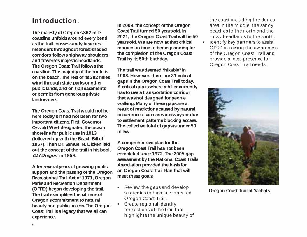
The majesty of Oregon’s 362-mile coastline unfolds around every bend as the trail crosses sandy beaches, meanders throughout forest-shaded corridors, follows highway shoulders and traverses majestic headlands. The Oregon Coast Trail follows the coastline. The majority of the route is on the beach. The rest of its 382 miles wind through state parks or other public lands, and on trail easements or permits from generous private landowners.
The Oregon Coast Trail would not be here today it if had not been for two important citizens. First, Governor Oswald West designated the ocean shoreline for public use in 1913 (followed up with the Beach Bill of 1967). Then Dr. Samuel N. Dicken laid out the concept of the trail in his book Old Oregon in 1959.
After several years of growing public support and the passing of the Oregon Recreational Trail Act of 1971, Oregon Parks and Recreation Department (OPRD) began developing the trail. The trail exemplifies the citizens of Oregon’s commitment to natural beauty and public access. The Oregon Coast Trail is a legacy that we all can experience.
In 2009, the concept of the Oregon Coast Trail turned 50 years old. In 2021, the Oregon Coast Trail will be 50 years old. We are now at that critical moment in time to begin planning for the completion of the Oregon Coast Trail by its 50th birthday.
The trail was deemed “hikable” in 1988. However, there are 31 critical gaps in the Oregon Coast Trail today. A critical gap is where a hiker currently has to use a transportation corridor that was not designed for people walking. Many of these gaps are a result of restrictions caused by natural occurrences, such as waterways or due to settlement patterns blocking access. The collective total of gaps is under 50 miles.
A comprehensive plan for the Oregon Coast Trail has not been completed since 1972. The 2005 gap assessment by the National Coast Trails Association provided the basis for an Oregon Coast Trail Plan that will meet these goals:
Review the gaps and develop • strategies to have a connected Oregon Coast Trail. Create regional identity • for sections of the trail that highlights the unique beauty of
the coast including the dunes area in the middle, the sandy beaches to the north and the rocky headlands to the south. Identify key partners to assist • OPRD in raising the awareness of the Oregon Coast Trail and provide a local presence for Oregon Coast Trail needs.
Oregon Coast Trail at Yachats.

7
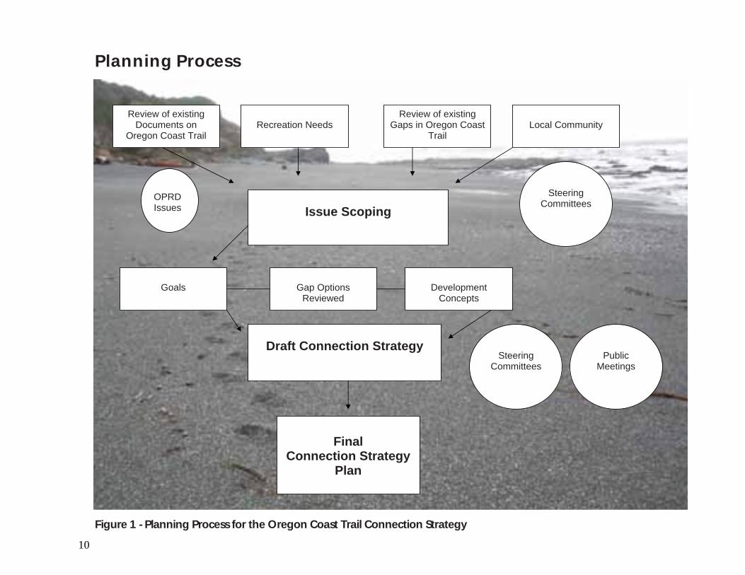
The Planning Process:
The steps for completing the Oregon Coast Trail Connection Strategy included input from local communities, land managers, public agencies, trail advocate groups, and individuals along its length (Figure 1). Four steering committees were formed, representing the North Coast, North Central Coast, South Central Coast and South Coast. The trail was divided into 10 sections and the 31 gaps were reviewed section by section. Current use and future short-term and long-term connections were identified and development concepts were formulated though input from the stakeholder meetings. The development of the concepts reflects resource constraints and opportunities and addresses the goals, opportunities and constraints established in the planning process. The concepts include site plan drawings and written descriptions of the gaps, locations, sizes and proposed short-term and long-term solutions.
Planning Products:
Phase I: Connection Strategy
The connection strategy is written and illustrated as conceptual “blueprints” containing summarized information about, and long term plans for Oregon Coast Trail gaps. The plan will serve as a guide for directing future planning to close the gaps for the next 20 years.
The connection strategy will direct future planning on the closing of the gaps. The connection strategy will also assist OPRD in the development of a management plan for the Oregon Coast Trail.
Phase II: Individual Gap Planning
The next step wiil be to develop feasibility planning, operational planning, and design planning on each gap identified in the Connection Strategy (Figure 2). This effort will succeed only with local interest and partnerships with OPRD, local communities or other land managers.
Oregon Coast Trail at Heceta Head.
Oregon Coast Trail at Cape Lookout State Park.

8
Oregon Coast Trail Connection Strategy Meetings
Stakeholder Meeting 1: Introduction to Process / Gap IdentificationAugust 11, 2009 - Astoria August 12, 2009 - Newport August 13, 2009 - Coos Bay August 14, 2009 - Gold Beach
Stakeholder Meeting 2: Gap Solution RefinementNovember 17, 2009 - Brookings November 18, 2009 - Bandon November 19, 2009 - Lincoln City November 20, 2009 - Astoria
Stakeholder Meeting 3: Connection Strategy Draft ReviewJune 3, 2010 - TillamookJune 10, 2010 - FlorenceJune 11, 2010 - North Bend
Public Meeting: Connection Strategy Final Draft Presentation/CommentsAugust 17, 2010 - PortlandAugust 18, 2010 - EugeneAugust 24, 2010 - Lincoln CityAugust 25, 2010 - North Bend
Port Orford Head State Park, looking south to Humbug Mountain
9
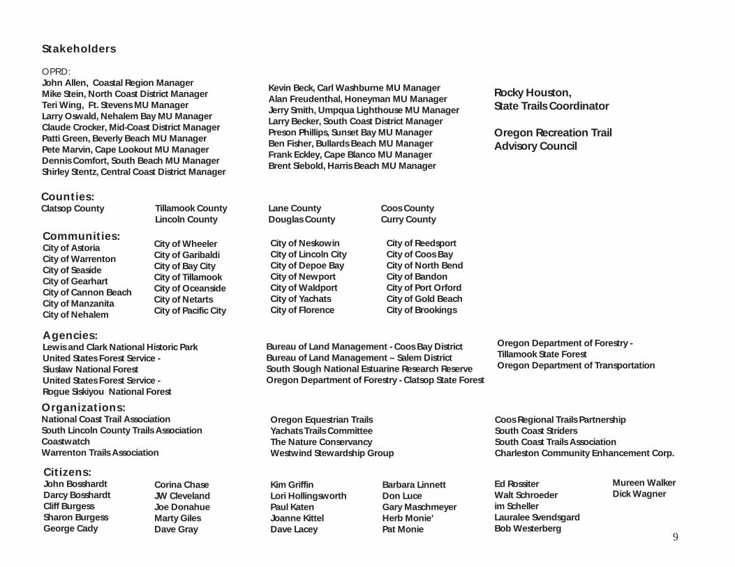
Organizations:National Coast Trail AssociationSouth Lincoln County Trails Association CoastwatchWarrenton Trails Association
Citizens:John Bosshardt Darcy Bosshardt Cliff Burgess Sharon Burgess George Cady
Agencies:Lewis and Clark National Historic Park United States Forest Service - Siuslaw National Forest United States Forest Service - Rogue Siskiyou National Forest
Communities:City of Astoria City of Warrenton City of Seaside City of Gearhart City of Cannon Beach City of ManzanitaCity of Nehalem
Counties:Clatsop County
Stakeholders
OPRD:John Allen, Coastal Region Manager Mike Stein, North Coast District Manager Teri Wing, Ft. Stevens MU Manager Larry Oswald, Nehalem Bay MU Manager Claude Crocker, Mid-Coast District ManagerPatti Green, Beverly Beach MU Manager Pete Marvin, Cape Lookout MU Manager Dennis Comfort, South Beach MU ManagerShirley Stentz, Central Coast District Manager
Kevin Beck, Carl Washburne MU ManagerAlan Freudenthal, Honeyman MU Manager Jerry Smith, Umpqua Lighthouse MU Manager Larry Becker, South Coast District Manager Preson Phillips, Sunset Bay MU Manager Ben Fisher, Bullards Beach MU Manager Frank Eckley, Cape Blanco MU Manager Brent Siebold, Harris Beach MU Manager
Rocky Houston, State Trails Coordinator
Oregon Recreation Trail Advisory Council
City of Wheeler City of Garibaldi City of Bay City City of Tillamook City of OceansideCity of Netarts City of Pacific City
City of Neskowin City of Lincoln City City of Depoe Bay City of NewportCity of Waldport City of Yachats City of Florence
City of Reedsport City of Coos Bay City of North BendCity of BandonCity of Port Orford City of Gold Beach City of Brookings
Tillamook County Lincoln County
Lane CountyDouglas County
Coos County Curry County
Bureau of Land Management - Coos Bay DistrictBureau of Land Management – Salem District South Slough National Estuarine Research ReserveOregon Department of Forestry - Clatsop State Forest
Oregon Equestrian Trails Yachats Trails CommitteeThe Nature ConservancyWestwind Stewardship Group
Coos Regional Trails PartnershipSouth Coast Striders South Coast Trails AssociationCharleston Community Enhancement Corp.
Ed RossiterWalt Schroeder im Scheller Lauralee Svendsgard Bob Westerberg
Corina Chase JW ClevelandJoe Donahue Marty Giles Dave Gray
Kim Griffin Lori Hollingsworth Paul Katen Joanne KittelDave Lacey
Barbara Linnett Don LuceGary Maschmeyer Herb Monie’ Pat Monie
Oregon Department of Forestry - Tillamook State ForestOregon Department of Transportation
Mureen WalkerDick Wagner
10
Figure 1 - Planning Process for the Oregon Coast Trail Connection Strategy
Review of existing Documents on
Oregon Coast Trail
Goals
Local Community
Issue Scoping
Review of existing Gaps in Oregon Coast
TrailRecreation Needs
OPRDIssues
SteeringCommittees
Gap Options Reviewed
DevelopmentConcepts
Draft Connection Strategy Steering
CommitteesPublic
Meetings
FinalConnection Strategy
Plan
Planning Process

11
Connection Strategy
Identification of all gaps in Oregon Coast Trail and short term and long term
solutions identified.
Gap connection to Oregon Coast Trail
Planning and Design
Site specific development plan and design
Operation Planning
Acquisition, Development Planning, Funding for individual
gap project
Planning
Feasibility plan for individual gaps in the Oregon Coast Trail
Management Plan
Day to day operation of the trail to include: design standards,
maintenance standards, MOUs, annual work plants, etc.
For existing portions of the trail
Figure 2 - Oregon Coast Trail Planning Documents
Planning Documents

12
Fort to Sea Trail
Fort StevensState Park
Saddle MountainState Natural Area
EcolaState Park
Elmer FeldenheimerState Natural Area
Gearhart OceanState Recreation Area
Sunset BeachState Recreation Site
Del Ray BeachState Recreation Site
John YeonState Natural Site
Warrenton
Astoria
Seaside
Gearhart
Cannon Beach
¾À202
¾À104
¾À53
¾À104S
£¤26
£¤101
£¤101B
£¤30
£¤101
£¤101B
£¤26
£¤30
0 2.51.25 Miles
· n¡
n¡
n¡
n¡
Section 1: There are two gaps on this section of the Oregon Coast Trail.
1-1 Necanium River Connection: Located in Seaside, this urban gap is caused by the Necanium River and Neawanna Creek as it enters the Pacific Ocean.
1 -2 Ecola Creek Connection: Located in Cannon Beach, this gap is caused by the Ecola Creek and Ecola Head’s rough terrain.
Sect
ion
1C
olu
mb
ia R
iver
to
Osw
ald
Wes
t St
ate
Park
Gap 1-1
Gap 1-2

Necanium River Connection: The confluence of Necanium River and the Pacific Ocean creates an unstable , unpredictable water crossing. The current route leaves Gearhart Ocean State Recreation at Pacific Way St. It then follows surface streets to Highway 101, to cross Neawanna Creek. The route returns to surface streets on 12th Ave in Seaside and then returns to the beach.
Short-term Solution: Enhance your ability to walk on streets. Work with the City of Seaside and Gearhart as they develop the estuary park.
Long-term Solution: Identify fording of Necanium River risks and provide river crossing to keep trail on beach.
13
£¤101
0 760380 Feet
J
S e a s i d eS e a s i d e
G e a r h a r tG e a r h a r t
Necanium River
Neawanna Creek
Short-Term:Enhance ability towalk
Long-Term: Option #1Assess feasibilityof fording Necanium Riverand keep trail on beach
Long-Term: Option #2Work within Estuary ParkPlanning for bridge and trail
LegendOregon Coast Trail
Oregon Coast Trail
Short Term Solution
Long Term Solution - Primary
Long Term Solution - Secondary
Highways

14
Ecola Creek Connection: Rough terrain on the south side of Ecola Head forces the trail inland. The current route follows the park road to 5th St. into Cannon Beach. After crossing Ecola Creek, the trail returns to the beach.
Short-term Solution: Re-route the trail to surface streets. Heading south, turn right onto 8th St. from the park road. Turn left on Ash St. and then turn rigth onto 7th St. At the end of 7th St. take the beach access to return to the beach.
Long-term Solution: Explore the feasibility of a trail alignment from the beach to Ecola State Park.
0 440220 Feet
LegendOregon Coast Trail
Oregon Coast Trail
Short Term Solution
Long Term Solution - Primary
Long Term Solution - Secondary
Approximate Park Boundary
Highways
J
C a n n o n B e a c hC a n n o n B e a c h
Short Term:Re-route trail andenhance ability to walk
Long Term: Explore Trail Connectionand fording of creek
Ecola State Park

15
Oswald WestState Park
Cape LookoutState Park
Nehalem BayState Park
Cougar Valley
Cape MearesState Scenic Viewpoint
Munson CreekState Natural Area
Manhattan BeachState Recreation Site
Twin RocksState Natural Site
Oceanside BeachState Wayside
SymonsState Scenic Viewpoint
Rockaway BeachState Recreation Site
Neahkahnie-ManzanitaState Recreation Site
Bay City
Tillamook
Garibaldi
Rockaway Beach
Manzanita
Wheeler
Nehalem
¾À53
¾À131
¾À06
¾À06
£¤101
£¤101
£¤101
0 2.51.25 Miles
3rd St.
·n¡
n¡
n¡
n¡
Section 2: There are three gaps on this section of the Oregon Coast Trail. 2-1 Oswald West Connection: Located just north of Manzanita, this gap is formed by Neahkahnie Mountain.
2-3 Tillamook Bay Connection: Located from north of Garibaldi to the village of Cape Meares, this gap is formed by theTIllamook Bay. 2-3 Netarts Bay Connection: Located at Oceanside, this gap is formed by Netarts Bay.
Sectio
n 2
Osw
ald W
est State Park to C
ape
Loo
kou
t State Park
Gap 2-2
Gap 2-3
Gap 2-1

16
Oswald West Connection: Trail comes off of Neahkahnie Mountain and drops into Hwy 101, ¼ mile inland from the beach, with a residential neighborhood in between. The current route follows Hwy 101 to access the beach at Neahkahnie-Manzanita State Recreation Site.
Short-term Solution: Enhance the ability to walk on streets.
Long-term Solution: Conduct feasibility of two options: the first would use an existing water district utlity corridor from Hwy 101 to Hillcrest Rd and use surface streets. The second would use Meadows Loop Rd to Mariners Trail Rd and access Beulah Reed Rd to Pacific Blvd to Ocean Rd and back to the beach, north of Neahkahnie-Manzanita State Recreation Site.
Oswald WestState Park
Neahkahnie-ManzanitaState Recreation Site
£¤101
0 850425 Feet
LegendOregon Coast Trail
Oregon Coast Trail
Long Term Solution - Secondary
Long Term Solution - Primary
Short Term Solution
Approximate Park Boundary
Highways
J
M a n z a n i t aM a n z a n i t a
Short Term Option:Improve ability to walkon Hwy 101
LongTerm Option #2:Explore feasibility of usingprivate roads of MeadowsLoop to Mariners Trail. Thenconnect with Beulah Reed Rdto Pacific Blvd and then returnto the Beach
Â
Ä
Long Term Option #1:Conduct feasibility of usingwater district utility right-of-wayto access Hillcrest Rd.

17
Tillamook Bay Connection: At Barview County Park, Tillamook Bay creates a water barrier that cannot be forded. The current route follows Hwy 101 through Garibaldi, Bay City and Tillamook. The trail follows Hwy 131 and Bay Ocean Drive to village of Cape Meares.
Short-term Solution: Enhance the pedestrian facilities on Hwy 101, Hwy 131 and Bay Ocean Drive
Long-term Solution: Explore the opportunity of a ferry service from Garibaldi to Crab Harbor or explore the feasibility of a Rail with Trail along Tillamook Rail corridor.
¾À131
¾À06
£¤101
0 3,7001,850 Feet
LegendOregon Coast Trail
Oregon Coast Trail
Short Term Solution
Long Term Solution - Primary
Long Term Solution - Secondary
Approximate Park Boundary
Highways
JT i l l a m o o kT i l l a m o o k
B a y C i t yB a y C i t y
G a r i b a l d iG a r i b a l d i
Long Term: Option #1Enhance a ferry servicefrom Garibaldi to CrabHarbor and return to beach
Short Term:Improve ability to walk on Hwy 101
Long Term: Option #2Explore feasibility of aRail-with-Trail
18
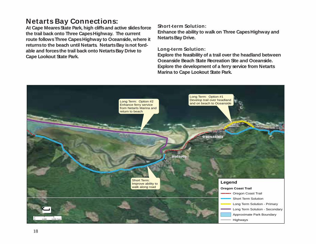
Netarts Bay Connections: At Cape Meares State Park, high cliffs and active slides force the trail back onto Three Capes Highway. The current route follows Three Capes Highway to Oceanside, where it returns to the beach until Netarts. Netarts Bay is not ford-able and forces the trail back onto Netarts Bay Drive to Cape Lookout State Park.
Short-term Solution: Enhance the ability to walk on Three Capes Highway and Netarts Bay Drive.
Long-term Solution: Explore the feasibility of a trail over the headland between Oceanside Beach State Recreation Site and Oceanside. Explore the development of a ferry service from Netarts Marina to Cape Lookout State Park.
Cape LookoutState Park
Cape MearesState Scenic Viewpoint
Oceanside BeachState Recreation Site
SymonsState Scenic Viewpoint
Oceanside BeachState Recreation Site
Oceanside BeachState Recreation Site
¾À131
0 3,2001,600 Feet
LegendOregon Coast Trail
Oregon Coast Trail
Short Term Solution
Long Term Solution - Primary
Long Term Solution - Secondary
Approximate Park Boundary
Highways
J
N e t a r t sN e t a r t s
O c e a n s i d eO c e a n s i d e
Long Term: Option #2Enhance ferry servicefrom Netarts Marina and return to beach
Long Term: Option #1Develop trail over headland and on beach to Oceanside
Short Term:Improve ability to walk along road

19
Cape LookoutState Park
H.B. Van Duzer ForestState Scenic Corridor
Bob StraubState Park
Clay MyersState Natural Area
Cape KiwandaState Natural Area
Sand Lake
H.B. Van Duzer ForestState Scenic Corridor
Munson CreekState Natural Area
Devil's LakeState Recreation Area
Roads EndState Recreation Site
Neskowin BeachState Recreation Site
Neskowin BeachState Recreation Site
D RiverState Recreation Site
Lincoln City
¾À22
¾À18
¾À130
¾À229
¾À18
£¤101
0 2.51.25 Miles
3rd St.
· n¡
n¡
n¡
n¡
n¡
Sectio
n 3
Cap
e Loo
kou
t State Park to
Linco
ln C
ity
À¾¾¾
Gap 3-2
nnnnnnnnnnnnnnn
Section 3: There are three gaps on this section of the Oregon Coast Trail. 3-1 Nestucca River Connection: Located south of Pacific City, this gap is formed by the bay formed by Nestucca River. 3-2 Cascade Head Connection: Located south of Neskowin, this gap is formed by Cascade Head.
3-3 Salmon River Connection: Located north of Lincoln City, this gap is formed by the Salmon River.
Gap 3-3
Gap 3-1

20
Nestucca River Connection: The Nestucca River creates a barrier that cannot be forded. The current route returns to Cape Kiwanda Dr at Bob Straub State Park. The route goes through Pacific City on Brooten Rd until it reaches Hwy 101. At Hwy 101, it returns to the beach at Winema Rd.
Short-term Solution: Enhance the ability to walk in Pacific City and on Hwy 101.
Long-term Solution: Explore the feasibility of connecting a trail on the south bank of the Nestucca River through an existing nature preserve.
Bob StraubState Park
¾À130
£¤101
0 1,600800 Feet
LegendOregon Coast Trail
Oregon Coast Trail
Short Term Solution
Long Term Solution - Primary
Long Term Solution - Secondary
Approximate Park Boundary
Highways
J
P a c i f i c C i t yP a c i f i c C i t y
O r e t o w nO r e t o w n
Short Term:Improve ability to walk on Hwy 101
Long Term: Explore feasibilityof trail through nature preserve
Ä
Æ

21
Cascade Head Connection: At Nekowin the beach terminates at Cascade Head. The current route returns to Hwy 101 at Neskowin Beach State Recreation Site. It returns to a USFS trail after about 1 mile.
Short-term Solution: Enhance the ability to walk on Hwy 101.
Long-term Solution: Explore the access rights to USFS lands via South Beach Drive in Neskowin to connect to Hart’s Cove Trail. Then use USFS Road 1861 to connect back to the existing Oregon Coast Trail route.
Neskowin BeachState Recreation Site
Neskowin BeachState Recreation Site
£¤101
0 1,200600 Feet
LegendOregon Coast Trail
Oregon Coast Trail
Short Term Solution
Long Term Solution - Primary
Long Term Solution - Secondary
Approximate Park Boundary
Highways
J
N e s k o w i nN e s k o w i n
Short Term:Improve ability towalk on Hwy 101
Long Term:Research USFSaccess rights toproperty via SouthBeach Drive andthen connect with existingtrails.
Å

22
Salmon River Connection: At the south end of Cascade Head the Salmon River creates a barrier that cannot be forded. The current route returns to Hwy 101 at the Three Rocks Trailhead. The trail follows 39th St in Lincoln City, where it returns to the beach.
Short-term Solution: Enhance the ability to walk on Hwy 101.
Long-term Solution: Explore the feasibility of a two alternative trail links over USFS, city owned and private lands south of Salmon River.
Roads EndState Recreation Site
¾À18
¾À18
£¤101
0 2,0001,000 Feet
LegendOregon Coast Trail
Oregon Coast Trail
Short Term Solution
Long Term Solution - Primary
Long Term Solution - Secondary
Approximate Park Boundary
Highways
J
L i n c o l n C i t yL i n c o l n C i t y
USFS
USFS
USFS
USFS
USFS
USFS
City Owned
Long Term Option #1:Connect with existing USFS trail and make connection to Salmon River.Would require landowner easement.
Long Term Option #2:Connect Roads Endvia city street to city property. Would requirelandowner easement.
Short Term:Improve ability to walk on Hwy 101
Ä
Å¿
Ä

23
South BeachState Park
Beverly BeachState Park
Fogarty CreekState Recreation Area
State Scenic Viewpoint
Ona BeachState Park
Yaquina BayState Recreation Site
L. Presley & Vera C. GillState Natural Site
Lost CreekState Recreation Site
Driftwood BeachState Recreation Site
Agate BeachState Recreation Site
Gleneden BeachState Recreation Site
Collins CreekState Recreation Site
Devil's Punch BowlState Natural Area
Seal RockState Recreation Site
Fishing RockState Recreation Site
Depoe Bay Whale Watch Center
Otter CrestState Scenic Viewpoint
Newport
Toledo
Siletz
Lincoln City
¾À229
¾À182
£¤101
£¤20
£¤20B
£¤101
0 2.51.25 Miles
3rd St.
·
¡
¡
¡
¡
Section 4: There are five gaps on this section of the Oregon Coast Trail.
4-1 Siletz Bay Connection: Located south of Lincoln City, this gap is formed by bay formed by the Siletz River.
4-2 Fogarty Creek Connection: Locat4ed north of Depoe Bay, this gap is formed by rocky cliffs.
4-3 Whales Cove Connection: Located south of Depoe Bay, this gap is formed by rocky cliffs.
4-4 Cape Foulweather Connection: Located north of Newport, this gap is formed by rocky cliffs.
4-5 Yaquina Head Connection: Located in Newport, this gap is formed by the rocky cliffs of Yaquina Head.
Sectio
n 4
Linco
ln C
ity to W
aldp
ort
Gap 4-1Ga
3rd St3rd St.
Gap 4-4
Gap 4-3
e Watch Centere Watch Center
¤££££
Gap 4-2
Gap 4-5

24
Siletz Bay Connection: The Siletz Bay creates a barrier that cannot be forded. The current route follows Hwy 101 to Gleneden Beach Loop and to Gleneden Beach State Recreation Site where it returns to the beach.
Short-term Solution: Enhance the ability to walk on Hwy 101 and reroute the trail from Gleneden Beach Loop to Laurel St and onto the beach.
Long-term Solution: Explore the feasibility of using the existing trail system that goes through the Salishan Golf and Spa Resort and connects to the beach.
Gleneden BeachState Recreation Site
¾À229£¤101
0 1,500750 Feet
LegendOregon Coast Trail
Oregon Coast Trail
Short Term Solution
Long Term Solution - Primary
Long Term Solution - Secondary
Approximate Park Boundary
Highways
J
L i n c o l n C i t yL i n c o l n C i t y
G l e n e d e n B e a c hG l e n e d e n B e a c h
Short Term:Improve ability towalk on Hwy 101and re-route trailonto Laurel St tobeach access.
Long Term:Explore the use ofan existing path to connect to the beach
Æ
À

25
Fogarty Creek Connection: South of Fishing Rock State Recreation Site to Depoe Bay, rocky cliffs push the trail back to Hwy 101. The current route returns to Hwy 101 from Fishing Rock State Recreation Site to Boiler Bay State Scenic Viewpoint. At Boiler Bay, the trail is on sidewalks through the city of Depoe Bay.
Short-term Solution: Enhance the ability to walk on Hwy 101.
Long-term Solution: Explore the feasibility of routing trail down Fishing Rock Road to a beach access. Then route the trail on the oceanside of Fogarty Creek State Recreation Area to Boiler Bay State Scenic Viewpoint using, ODOT right-of-way and a utility corridor.
Fogarty CreekState Recreation Area
Boiler BayState Scenic Viewpoint
Fogarty CreekState Recreation Area
Fishing RockState Recreation Site
Boiler BayState Scenic Viewpoint
£¤101
£¤101
0 700350 Feet
LegendOregon Coast Trail
Oregon Coast Trail
Short Term Solution
Long Term Solution - Primary
Long Term Solution - Secondary
Approximate Park Boundary
Highways
J
Existing Sidewalks
Long Term:Re-route Trail throughFogarty Creek State Recreation Area andlook at feasibility of usingUtility Corridor and ODOTROW for trail.
Short Term:Improve ability to walkon Hwy 101

26
Whales Cove Connection: Rocky cliffs through the city of Depoe Bay and south keep the trail on Hwy 101. The current route follows Hwy 101 on sidewalks.
Short-term Solution: Enhance the ability to walk on Hwy 101.
Long-term Solution: Explore rerouting the trail onto Ocean Ave, south of the Depoe Bay inlet bridge. The route would then take Beach Ave. back to Hwy 101. Between Hwy 101 and Whales Cover, explore the feasibility of placing the trail within a utility corridor. At Whales Cove, a trail connection to Rocky Creek State Scenic Viewpoint over public and private lands would need to be explored.
Rocky CreekState Scenic Viewpoint
Depoe Bay Whale Watch Center
£¤101
0 920460 Feet
LegendOregon Coast Trail
Oregon Coast Trail
Short Term Solution
Long Term Solution - Primary
Long Term Solution - Secondary
Approximate Park Boundary
Highways
J
Short Term:Improve Pedestrian Facilities
Long Term Option #1:Route Trail onCoast Ave to Beach St toHwy 101
Long Term Option #2:Explore trail in ODOTROW or Utility Cooridorto Whales Cove. Exploreeasement from landownerto connect with Rocky PointState Scenic Viewpoint.
D e p o e B a yD e p o e B a y
Ä
¿

27
Cape Foulweather Connection: Rocky cliffs at Cape Foulweather keep the trail on Hwy 101 and Otter Crest Loop. The current route follows Hwy 101 and Otter Crest Loop to Devil’s Punch Bowl State Natural Area.
Short-term Solution: Enhance the ability to walk on Otter Crest Loop.
Long-term Solution: Explore feasibility of routing the trail over ODOT and private lands using existing trails to connect to Devil’s Punch Bowl State Natural Area.
Devil's Punch BowlState Natural Area
Rocky CreekState Scenic Viewpoint
Devil's Punch BowlState Natural Area
Otter CrestState Scenic Viewpoint
Rocky CreekState Scenic Viewpoint
Devil's Punch BowlState Natural Area
Devil's Punch BowlState Natural Area
Otter CrestState Scenic Viewpoint
¾À182
£¤101
0 920460 Feet
LegendOregon Coast Trail
Oregon Coast Trail
Short Term Solution
Long Term Solution - Primary
Long Term Solution - Secondary
Approximate Park Boundary
Highways
J
Short Term:Improve ability to walk on the road
Long Term:Explore ODOTowned propertyand existing privatetrails to connect toDevil's Punch BowlState Natural Area.

28
£¤101
0 650325 Feet
LegendOregon Coast Trail
Oregon Coast Trail
Short Term Solution
Long Term Solution - Primary
Long Term Solution - Secondary
Approximate Park Boundary
Highways
J
N e w p o r tN e w p o r t
Long Term Option #1:Use surfer accesstrail along CityROW to accessbeach and follow55th St. out to Hwy101
Short Term:Improve ability to walk on Hwy 101
Long Term Option #2:Look at feasibillityof using Water TowerTrail to conncect withYaquina Head andconnect back to beach.
Â
¿
Yaquina Head Connection: The beach ends at Yaquina Head. The current route takes a beach access route to 62nd Ave through a mobile home park back to Hwy 101.
Short-term Solution: Enhance the ability to walk on Hwy 101, reroute would enhance an existing surfer access trail on city right-of-way and use 55th St to come back to Hwy 101.
Long-term Solution: Explore the feasibility of crossing Yaquina Head on BLM lands and return to the southern beach access point.

29
¡Carl G. WashburneState Park
Heceta Head LighthouseState Scenic Viewpoint
Siuslaw North Jetty
NeptuneState Scenic Viewpoint
Governor PattersonState Recreation Site
BeachsideState Recreation Site
State Natural Site
Ocean Shore
Stonefield Beach
DarlingtoniaState Natural Site
San MarineState Wayside
Smelt SandsState Recreation Site
YachatsState Recreation Area
Yachats Ocean RoadState Natural Site
Muriel O. PonslerState Scenic Viewpoint
State Natural Site
State RecreationSite
Alsea BayHistoric Interpretive Center
Florence
Waldport
¾À126
¾À34
¾À36
¾À126
£¤101
0 2.51.25 Miles
3rd St.
·
¡
¡
¡
Section 5: There are four gaps on this section of the Oregon Coast Trail.
5-1 Alsea Bay Connection: Located in Waldport, the gap is formed by Alsea Bay. 5-2 Cummins Creek Connection: Located south of Yachats, the gap is formed by rocky shores and sheer cliffs.
5-3 Tokatee Klootchman Connection: Located south of Yachats, the gap is formed by headlands that terminate in the ocean.
5-4 Heceta Head Connection: Located north of Florence, the gap is formed by Heceta Head’s sheer cliffs.
Sectio
n 5
Wald
po
rt to Flo
rence
creationcreation
Gap 5-1G
StonStonStonStonGap 5-3
Gap 5-4
househousepointpointpoint
d Beachd Beachnnefieef ldnnefieef ld
¤¤¤¤¤£££££
¡¡ S
3rd St.
Gap 5-2

30
Alsea Bay Connection: Alsea Bay creates a barrier that cannot be forded. The current route leaves the beach at the Bayshore Beach Club and follows Bayshore Dr. to Hwy 101 across the Alsea Bay Bridge. The trail then returns to the south beach of Alsea Bay, except at high tide, where it follows Maple Street.
Short-term Solution: Enhance the ability to walk on Bayshore Dr. and Hwy 101.
Long-term Solution: Explore two options. The first would be to take Bayshore Dr south to the north beach of Alsea Bay, develop a trail to the Alsea Bay viewpoint, and return to Hwy 101. The second would be to explore the feasibility of developing a trail through a private campground to Hwy 101.
Alsea BayHistoric Interpretive Center
£¤101
0 470235 Feet
LegendOregon Coast Trail
Oregon Coast Trail
Long Term Solution - Secondary
Long Term Solution - Primary
Short Term Solution
Approximate Park Boundary
Highways
JW a l d p o r tW a l d p o r t
Long Term:Connect to AlseaBay Viewpoint frombeach access orlandowner easement.
Short Term:Enhance the abilityto walk on Hwy 101

31
Cummins Creek Connection: Sheer cliffs and rocky shores force the trail onto Hwy 101 at Neptune State Scenic Viewpoint. The current route follows Hwy 101 from Neptune State Scenic Viewpoint to Bob Creek Wayside.
Short-term Solution: Enhance the ability to walk on Hwy 101.
Long-term Solution: Explore the development of a trail on public owned property.
NeptuneState Scenic Viewpoint
£¤101
0 770385 Feet
LegendOregon Coast Trail
Oregon Coast Trail
Short Term Solution
Long Term Solution - Primary
Long Term Solution - Secondary
Approximate Park Boundary
Highways
J
USFS
Long Term Option #1:Develop Trail through NeptuneState Scenic Viewpointto Bob Creek Wayside.
Long Term Option #2:Develop Trail through rocky shoresbased on tidal influence.

32
Tokatee Klootchman Connection: South of Bob Creek Wayside. from Tokatee Klootchman State Natural Area south to Muriel O. Ponsler State Scenic Viewpoint there are several rock outcroppings that create a barrier. The current route follows Hwy 101 to Muriel O. Ponsler State Scenic Viewpoint.
Short-term Solution: Enhance ability to walk on Hwy 101.
Long-term Solution: Explore 3 to 6 sites where rock outcroppings occur and identify feasibility of developing trail or crossing at beach, depending on tidal influence.
Tokatee KlootchmanState Natural Site
Tokatee KlootchmanState Natural Site£¤101
0 830415 Feet
LegendOregon Coast Trail
Oregon Coast Trail
Short Term Solution
Long Term Solution - Primary
Long Term Solution - Secondary
Approximate Park Boundary
Highways
J
Long Term:Develop Trail on Beach and over rocky shorebased on tidalinfluence.
Short Term: Enhance ability to walkon Hwy 101

33
Heceta Head Connection: Heceta Head creates a barrier. The current route follows Hwy 101 through a tunnel to public access back to beach.
Short-term Solution: The short term solution would be to explore the feasibility of developing a trail from Heceta Head State Scenic Viewpoint south to an existing access road just north of Sea Lion Caves and back to Hwy 101.
Long-term Solution: Explore feasibility of developing a trail that would continue south from the short-term solution point to an existing beach access point. This option would require discussions with adjacent land owners.
Heceta Head LighthouseState Scenic Viewpoint
£¤101
0 1,500750 Feet
LegendOregon Coast Trail
Oregon Coast Trail
Short Term Solution
Long Term Solution - Primary
Long Term Solution - Secondary
Approximate Park Boundary
Highways
txlane2007
J
USFS
USFSUSFS
Long Term Option #2:Develop trail on USFS to connectfarther south toroad and crossHwy 101 to return tobeach. Would requirelandowner easement.
Short Term:Develop trail fromHeceta Head parkinglot south to USFS property. Connectwith existing loggingroad to reconnectto Hwy 101.
ÃÄ

34
· Florence
Dunes City
Lakeside
Reedsport
Siuslaw North Jetty
Jessie M. HoneymanState Park
Joaquin Miller
UmpquaState Scenic Corridor
Umpqua LighthouseState Park
UmpquaState Scenic Corridor
Bolon Island TidewaysState Scenic Corridor
UmpquaState Scenic Corridor
UmpquaState Scenic Corridor
UmpquaState Scenic Corridor
PrichardState Wayside
UmpquaState Scenic Corridor
William M. TugmanState Park
¾À126
£¤101
0 2.51.25 Miles
3rd St.
¡
¡
¡
¡
Section 6: There are two gaps on this section of the Oregon Coast Trail.
6-1 Siuslaw River Connection: Located in Florence, the gap is created by the Siuslaw River.
6-2 Umpqua River Connection: Located at Gardiner, the gap is created by the Umpqua River.
Sect
ion
6Fl
ore
nce
to
No
rth
Ben
d
Gap 6-2
À¾¾Gap 2-1

35
Siuslaw River Connection: The Siuslaw River creates a barrier that cannot be forded. The current route returns to Rhododendron Drive at Siuslaw North Jetty Park. It then follows Kingwood Dr to Hwy 101, where it crosses the Siuslaw River and returns to the beach at The Oregon Dunes National Recreation Area South Jetty Access Rd.
Short-term Solution: Enhance the ability to walk on roads.
Long-term Solution: Explore the feasibility of developing a trail through Joaquin Miller State Park to the Oregon Dunes National Recreation Area and the beach.
Joaquin Miller
Siuslaw North Jetty
PrichardState Wayside
¾À126
£¤101
0 1,900950 Feet
LegendOregon Coast Trail
Oregon Coast Trail
Short Term Solution
Long Term Solution - Primary
Long Term Solution - Secondary
Approximate Park Boundary
Highways
J F l o r e n c eF l o r e n c e
Short term:Improve ability towalk on road
Long term:Develop trailat Joaquin MillerState Park to USFS lands and toBeach.
36
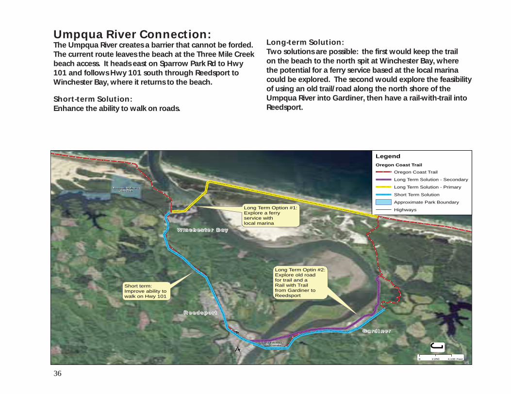
Umpqua River Connection: The Umpqua River creates a barrier that cannot be forded. The current route leaves the beach at the Three Mile Creek beach access. It heads east on Sparrow Park Rd to Hwy 101 and follows Hwy 101 south through Reedsport to Winchester Bay, where it returns to the beach.
Short-term Solution: Enhance the ability to walk on roads.
Long-term Solution: Two solutions are possible: the first would keep the trail on the beach to the north spit at Winchester Bay, where the potential for a ferry service based at the local marina could be explored. The second would explore the feasibility of using an old trail/road along the north shore of the Umpqua River into Gardiner, then have a rail-with-trail into Reedsport.
Umpqua LighthouseState Park
Bolon Island TidewaysState Scenic Corridor
¾À38
£¤101
0 4,1002,050 Feet
LegendOregon Coast Trail
Oregon Coast Trail
Long Term Solution - Secondary
Long Term Solution - Primary
Short Term Solution
Approximate Park Boundary
Highways
J
W i n c h e s t e r B a yW i n c h e s t e r B a y
R e e d s p o r tR e e d s p o r t
G a r d i n e rG a r d i n e r
Long Term Option #1:Explore a ferryservice with local marina
Short term:Improve ability to walk on Hwy 101
Long Term Optin #2:Explore old roadfor trail and a Rail with Trailfrom Gardiner toReedsport
37
Bullards BeachState Park
Shore Acres
Sunset BayState Park
BandonState Natural Area
Seven DevilsState Recreation Site
Yoakam PointState Natural Site
Conde B. McCulloughState Recreation Site
Face RockState Scenic Viewpoint
Coos Bay
North Bend
Bandon
Coquille
¾À42S
¾À540
¾À42
¾À241
¾À42
¾À540
¾À540
¾À42
¾À241
£¤101
£¤101
£¤101
£¤101
£¤101
0 2.51.25 Miles
3rd St.
·
¡
¡
¡
¡
Sectio
n 7
No
rth B
end
to B
and
on
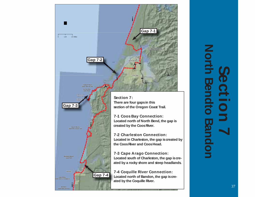
Section 7: There are four gaps in this section of the Oregon Coast Trail.
7-1 Coos Bay Connection: Located north of North Bend, the gap is created by the Coos River. 7-2 Charleston Connection: Located in Charleston, the gap is created by the Coos River and Coos Head.
7-3 Cape Arago Connection: Located south of Charleston, the gap is cre- ated by a rocky shore and steep headlands.
7-4 Coquille River Connection: Located north of Bandon, the gap is cre- ated by the Coquille River.
Gap 7-1
3rd St.
¡¡¡¡¡¡¡¡¡¡
Gap 7-3
a Gap 7-4
Gap 7-2

38
Coos Bay Connection: The Coos River creates a barrier that cannot be forded. The current route leaves the beach at the Horsfall Beach access and follows the road back to Hwy 101, through North Bend, Coos Bay and Charleston.
Short-term Solution: Enhance the ability to walk on the road.
Long-term Solution: There are three options to explore: the first is to extend the trail south to the North Spit area, where BLM has a trail system. The trail could then connect to the river side of the spit, near Empire. There, if a ferry service existed, it could go from Empire to the existing boat launch on the spit. The second would have the trail go to the end of the spit near Charleston and explore a ferry from there to the Charleston marina, and the third would be to follow the Sawmill Trail alignment through North Bend and Coos Bay. This trail alignment is not yet established.
¾À540
¾À540
¾À540
£¤101£¤101
0 2,5001,250 Feet
LegendOregon Coast Trail
Oregon Coast Trail
Short Term Solution
Long Term Solution - Primary
Long Term Solution - Secondary
Approximate Park Boundary
Highways
J
N o r t h B e n dN o r t h B e n dC o o s B a yC o o s B a y
Long Term Option #2:Route trail down beach and BLM trailsto existing Boat launch and develop ferry toEmpire boat launch orChaleston Marina.
Long Term Option #1:Follow proposedSawmill Trailthru North Bend.
Short term:Improve ability to walk on roads

39
Charleston Connection: The Coos River and South Spit create a barrier that cannot be forded. The current route follows Cape Arago Hwy into Charleston and follows secondary roads over Coos Head to Bassendorf. A through hiker follows Seven Devil’s Road.
Short-term Solution: Enhance ability to walk on Cape Arago Hwy. About half of the route currently has a bike path.
Long-term Solution: BLM and the Coos Confederated Tribes have plans to develop trails over Coos Head. Explore the feasibility of a ferry service to the Charleston Marina from the BLM trail system on the North Spit. Explore the feasibility of a trail from Yoakam Point to Sunset Bay State Park.
Sunset BayState Park
Yoakam PointState Natural Site
¾À540
0 2,3001,150 Feet
LegendOregon Coast Trail
Oregon Coast Trail
Short Term Solution
Long Term Solution - Primary
Long Term Solution - Secondary
Approximate Park Boundary
Highways
J
C h a r l e s t o nC h a r l e s t o n
Short term:Improve ability to walk on road. About halfof this section has abike path.
Long Term Option #1:Use Beach and existing BLM Trailsand Explore ferryservice from Charleston Marinaor Empire Dock.
Long Term Option #3:Develop trail toSunset Bay StatePark Campgroundfrom Yoakam Point
Route currently terminates atCape Arago State Park.
Long Term Option #2:Explore trailover Coos Headon BLM and TribalLands
À
Æ

40
Cape Arago Connection: Bluffs around Cape Arago create a barrier. The current route requires through hikers to hike Seven Devil’s Road to Seven Devil’s State Recreation Site.
Short-term: Enhance the ability to walk on Seven Devil’s Road.
Long-term: Explore the feasibility of using existing forest roads on private lands to connect with Seven Devil’s State Recreation Site, or the beach north of it.
Shore AcresState Park
Cape AragoState Park
Seven DevilsState Recreation Site
Cape AragoState Park
¾À540
0 2,0001,000 Feet
LegendOregon Coast Trail
Oregon Coast Trail
Short Term Solution
Long Term Solution - Primary
Long Term Solution - Secondary
Approximate Park Boundary
Highways
J
Long term:Explore the use ofexisting forest roadsand landowner easementsto connect Cape Arago StatePark with the beach
Ã
Å

41
Coquille River Connection: The Coquille River creates a barrier that cannot be forded. The current route returns to Hwy 101 at Bullards Beach State Park. It then follows Riverside Dr. to Bandon and returns to the beach.
Short-term Solutions: Enhance the ability to walk on Hwy 101, the bridge over Coquille River and on city streets.
Long-term Solutions: Explore the feasibility of a ferry from the Bandon Lighthouse to the Bandon Harbor.
Bullards BeachState Park
£¤101
£¤101
0 1,100550 Feet
LegendOregon Coast Trail
Oregon Coast Trail
Short Term Solution
Long Term Solution - Primary
Long Term Solution - Secondary
Approximate Park Boundary
Highways
J
B a n d o nB a n d o n
Long term:Explore a ferryservice with Bandon Harbor
Short term:Improve ability towalk on road

42
Cape BlancoState Park
Humbug MountainState Park
Floras LakeState Natural Area
BandonState Natural Area
Port Orford HeadsState Park
Bullards BeachState Park
TseriadunState Recreation Area
Port Orford Cedar ForestState Scenic Corridor
Paradise PointState Recreation Site
Face RockState Scenic Viewpoint
Bandon
Port Orford
¾À250
¾À42S
¾À251
£¤101
0 2.51.25 Miles
3rd St.
·
¡
¡
¡
¡
Section 8: There is one gap on this section of the Oregon Coast Trail.
8-1 Rocky Point Connection: Located south of Port Orford, the gap is created by rocky cliffs.
Sect
ion
8B
and
on
to
Hu
mb
ug
Mo
un
tain
St
ate
Park
Gap 8-1
43
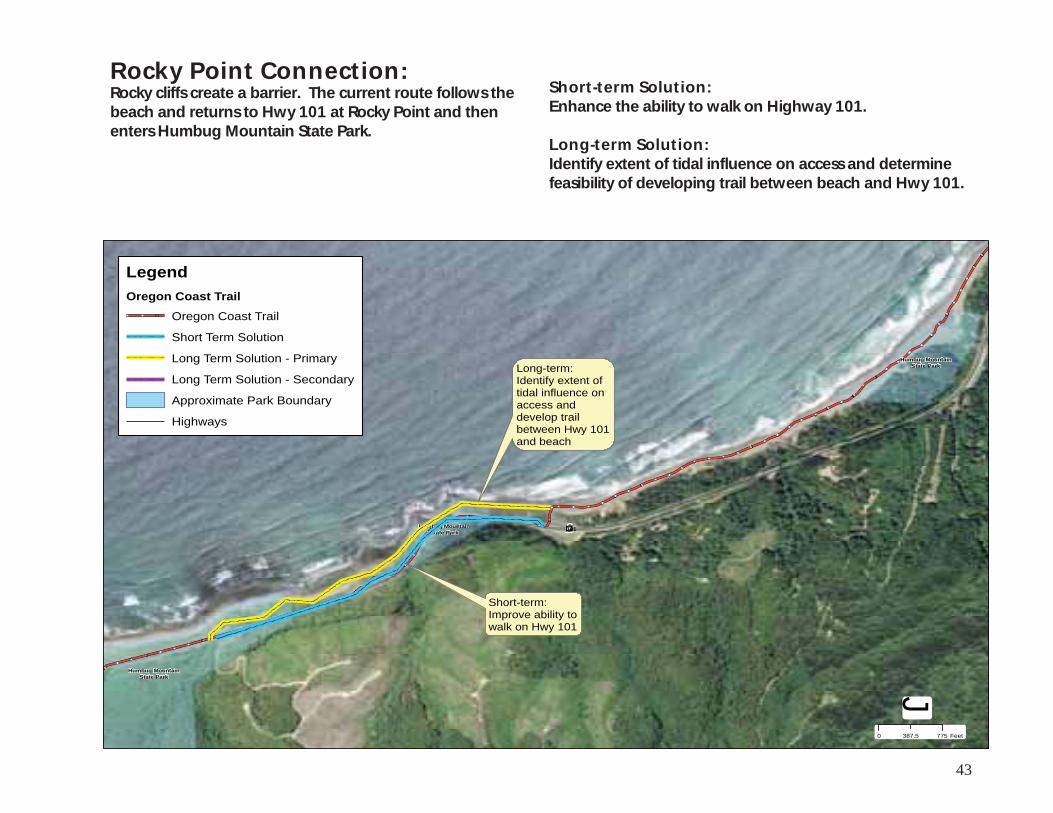
Rocky Point Connection: Rocky cliffs create a barrier. The current route follows the beach and returns to Hwy 101 at Rocky Point and then enters Humbug Mountain State Park.
Short-term Solution: Enhance the ability to walk on Highway 101.
Long-term Solution: Identify extent of tidal influence on access and determine feasibility of developing trail between beach and Hwy 101.
Humbug MountainState Park
Humbug MountainState Park
Humbug MountainState Park £¤101
0 775387.5 Feet
LegendOregon Coast Trail
Oregon Coast Trail
Short Term Solution
Long Term Solution - Primary
Long Term Solution - Secondary
Approximate Park Boundary
Highways
J
Long-term:Identify extent oftidal influence onaccess anddevelop trailbetween Hwy 101and beach
Short-term:Improve ability towalk on Hwy 101

44
Humbug MountainState Park
Cape SebastianState Scenic Corridor
Sisters Rock
Buena VistaOcean Wayside
Pistol RiverState Scenic Viewpoint
Otter PointState Recreation Site
Geisel MonumentState Heritage Site
Gold Beach
¾À255
¾À255
£¤101
£¤101
0 2.51.25 Miles
3rd St.
· ¡
¡
¡
¡
Section 9: There are three gaps on this section of the Oregon Coast Trail.
9-1 Humbug Mountain Connection: Located south of Port Orford, the gap is created by Humbug Mountain.
9-2 Sisters Rock Connection: Located south of Port Orford, the gap is created by rocky cliffs.
9-3 Nesika Connection: Located north of Gold Beach, the gap is created by rocky cliffs.
Sect
ion
9H
um
bu
g M
oun
tain
Sta
te P
ark
to
Pist
ol R
iver
Sta
te S
cen
ic V
iew
poin
t
Gap 9-1
¡¡¡¡¡¡¡¡¡¡¡¡
numentnumentnumentt SitSit
¤¤¤£££££££££££££££££££Gap 9-3
Gap 9-2

45
Humbug Mountain Connection: Humbug Mountain creates a barrier. The current trail follows the old Hwy 101 route into Humbug Mountain State Park and returns to Hwy 101 at the south end of the park.
Short-term Solution: Explore feasibility of developing a trail in ODOT right-of-way to where old Hwy 101 route heads east and then to Highland Drive south to Arizona Beach State Recreation Site, where the old Hwy 101 right-of-way goes through park.
Long-term Solution: Explore the feasibility of developing a trail that would head south off of the existing Humbug Mountain trail across private lands to Hwy 101. At this point, explore the feasibility of developing a trail on the west side of Hwy 101 along the rocky cliffs to Arizona Beach State Recreation Site, where the old Hwy 101 right-of-way goes through the park.
Humbug MountainState Park
Arizona BeachState Recreation Site
Arizona BeachState Recreation Site
Arizona BeachState Recreation Site
£¤101
0 2,1001,050 Feet
LegendOregon Coast Trail
Oregon Coast Trail
Short Term Solution
Long Term Solution - Primary
Long Term Solution - Secondary
Long Term Solution - Tertiary
Approximate Park Boundary
Highways
J
Long Term Option #1:Identify extent oftidal influence onaccess anddevelop trailbetween Hwy 101and beach
Short-term:Improve Pedestrianfacilities
Long Term Option #2:Explore feasibility ofplacing trail on OldCoast Hwy ROW
Long Term Option #3:Develop trailon Hwy 101 ROW

46
Sisters Rock Connection: Rocky cliffs create a barrier. The current trail follows Hwy 101 until it meets Euchre Creek, where it returns to the beach.
Short-term Solution: Enhance the ability to walk on Hwy 101. Long-term Solution: Explore the feasibility of developing a trail to the west of Hwy 101 from Arizona Beach to Sister Rock State Natural Area and use Old Hwy 101 right-of-way and Hwy 101 right-of-way for trail development.
Sisters Rock
Arizona BeachState Recreation Site
£¤101
0 1,500750 Feet
LegendOregon Coast Trail
Oregon Coast Trail
Short Term Solution
Long Term Solution - Primary
Long Term Solution - Secondary
Long Term Solution - Tertiary
Approximate Park Boundary
Highways
J
Long Term Option #1:Identify feasibility oftrail on upland. Mayrequire landownereasement.
Short-term:Improve ability towalk on road
Long Term Option #2:Explore feasibility ofplacing trail on OldCoast Hwy ROW
Long Term Option #3:Develop trailon Hwy 101 ROW

47
Nesika Connection: Rocky cliffs create a barrier. The current route leaves Nesika Beach and follows Nesika Beach Rd to Hwy 101 and then follows the old coast rd to Otter Point State Recreation Site.
Short-term Solution: Improve the ability to walk on Nesika Rd.
Long-term Solution: Explore the feasibility of an upland trail from the end of Nesika Beach to Geisel Monument State Heritage Site over public and private lands.
Geisel MonumentState Heritage Site
£¤101
0 640320 Feet
LegendOregon Coast Trail
Oregon Coast Trail
Long Term Solution - Secondary
Long Term Solution - Primary
Short Term Solution
Approximate Park Boundary
Highways
J
N e s i k aN e s i k a
Long Term:Explore the feasibilityof an upland trail on public owned lands.
Short Term: Enhance ability towalk on road

48
Samuel H. BoardmanState Scenic Corridor
Cape SebastianState Scenic Corridor
Harris BeachState Park
Alfred A. LoebState Park
Alfred A. LoebState Park
Pistol RiverState Scenic Viewpoint
Buena VistaOcean Wayside
State Recreation Site
McVay RockState Recreation Site
WinchuckState Recreation Site
Brookings
Gold Beach
¾À255
¾À255
£¤101
£¤101
0 2.51.25 Miles
3rd St.
·
¡
¡
¡
¡
Section 10: There are four gaps on this section of the Oregon Coast Trail.
10-1 Crook Point Connection: Located south of Gold Beach, the gap is formed by a rocky point.
10-2 Shy Creek Connection: Located north of Brookings, the gap is created by rocky shores and cliffs.
10-3 Chetco River Connection: Located in Brookings, the gap is cre-ated by the Chetco River.
10-4 Winchuck River Connection: Located south of Brookings, the gap is created by rocky cliffs.
Sect
ion
10
Pist
ol R
iver
Sta
te S
cen
ic
Vie
wp
oin
t to
Cal
iforn
ia
BrookingsBrookings
Gap 10-1 ¡¡¡¡¡¡¡
Harris BeachHarris BeachState ParkState Park
State Recreation SiteState Recreation Site
Gap 10-2
Gap 10-3
Gap 10-4

49
Crook Point Connection: Crook Point creates a barrier. The current route heads east at Crook Point and returns to Hwy 101 until Samuel Boardman State Scenic Corridor.
Short-term Solution: There is no short-term solution.
Long-term Solution: Explore feasibility of developing a trail in ODOT right-of-way.
Pistol RiverState Scenic Viewpoint
Samuel H. BoardmanState Scenic Corridor
¾À255
£¤101
0 1,600800 Feet
LegendOregon Coast Trail
Oregon Coast Trail
Short Term Solution
Long Term Solution - Primary
Long Term Solution - Secondary
Approximate Park Boundary
Highways
J
Long-term:Develop trailin ODOT ROWto Sam BoardmanState Scenic Corridor.

50
Shy Creek Connection: Rocky cliffs create a barrier. The current route returns to a trail built in the Hwy 101 right-of-way at the southern end of Samuel Boardman State Scenic Corridor.
Short-term Solution: Enhance the ability to walk on Hwy 101.
Long-term Solution: At the north end of the gap, explore the feasibility of using existing private trail. In the middle of the gap, explore the feasibility of a beach trail, allowing for high tide implications. At the end of the gap, explore the feasibility of using an existing private beach access and streets to access Harris Beach State Park at the northern boundary at Pacific Heights Rd.
Harris BeachState Park
Samuel H. BoardmanState Scenic Corridor
¾À255
£¤101
0 775387.5 Feet
LegendOregon Coast Trail
Oregon Coast Trail
Short Term Solution
Long Term Solution - Primary
Long Term Solution - Secondary
Approximate Park Boundary
Highways
J
B r o o k i n g sB r o o k i n g s
Long-term:Explore connection with existing trail.Landowner approval needed.
Long-term:Explore tidal influence withoutcropping of rocks. Useexisting trail to connect tosurface street and Harris BeachState Park. Landowner approvalneeded.
¿
Ã
¿
Ã

51
Chetco River Connection: Rocky cliffs force the trail back to Hwy 101 at the southern boundary of Harris Beach State Park. The current route follows a bike path to Hwy 101, and continues on sidewalk to Lower Harbor Rd.
Short-term Solution: Enhance the ability to walk on Hwy 101 and on Lower Harbor Rd.
Long-term Solution: Explore the feasibility of placing the route onto surface streets in Brookings, first turning south on Pacific St (near Fred Meyer) and then turning east on Railroad Ave. The trail would then turn north on Oak St. and return to Hwy 101.
Harris BeachState Park
£¤101
0 1,000500 Feet
LegendOregon Coast Trail
Oregon Coast Trail
Short Term Solution
Long Term Solution - Primary
Long Term Solution - Secondary
Approximate Park Boundary
Highways J
B r o o k i n g sB r o o k i n g s
Long-term:Follow Railroad Aveand proposed Bike/ Pedpath
Short-term:Improve abilityto walk on road

52
Winchuck River Connection: Rocky cliffs south of the harbor at the Chetco River create a barrier. The current route follows Oceanview Drive South to Hwy 101 and then returns to the beach at the Winchuck River.
Short-term Solution: Enhance the ability to walk on Hwy 101.
Long-term Solution: Explore the feasibility of a beach trail due to the tidal influence and a upland trail at pinch points on private lands.
£¤101
0 1,700850 Feet
LegendOregon Coast Trail
Oregon Coast Trail
Short Term Solution
Long Term Solution - Primary
Long Term Solution - Secondary
Approximate Park Boundary
Highways
J
H a r b o rH a r b o rShort-term:Improve ability towalk on road
Long-term:Determine tidalinfluence for beach trail.

53
Oregon Coast Trail at Rocky Point, south of Port Orford

Oregon Coast Trail, Amanda’s Trail section, Cape Perpetua
Oregon Parks and Recreation Department Trail Services Section 725 Summer Street NE, Suite C Salem, OR 97301
Email: [email protected] Phone: 800-551-6949