Embed Size (px)
Citation preview
615 W. Alder ♦ Shelton, WA 98584 (360) 427-9760/(360) 427-7798 fax www. mason.co. wa.us
Open Space & Public Benefit Rating System Public Hearing – ITEM#4
April 16, 2018
Staff Contact
David Windom Director Community Services Ext #260
Background
The State Open Tax Act (84.34 RCW) authorizes counties to establish a Public Benefit Rating System (PBRS) for the purpose of encouraging preservation of specified open space resources by providing a tax incentive for private land owners within their jurisdictions. This Act was originally established by the State Legislature in 1986 and updated in 1993 to institute additional rules.
A section of the state law is included in this briefing to provide additional background information.
RCW 84.34.055 Open space priorities—Open space plan and public benefit rating system.
(1)(a) The county legislative authority may direct the county planning commission to set open space priorities and adopt, after a public hearing, an open space plan and public benefit rating system for the county. The plan shall consist of criteria for determining eligibility of lands, the process for establishing a public benefit rating system, and an assessed valuation schedule. The assessed valuation schedule shall be developed by the county assessor and shall be a percentage of market value based upon the public benefit rating system. The open space plan, the public benefit rating system, and the assessed valuations schedule shall not be effective until approved by the county legislative authority after at least one public hearing: PROVIDED, that any county which has complied with the procedural requisites of chapter 393, Laws of 1985, prior to July 28, 1985, need not repeat those procedures in order to adopt an open space plan pursuant to chapter 393, Laws of 1985.
(b) County legislative authorities, in open space plans, public benefit rating systems, and assessed valuation schedules, shall give priority consideration to lands used for buffers that are planted with or primarily contain native vegetation.
(c) "Priority consideration" as used in this section may include, but is not limited to, establishing classification eligibility and maintenance criteria for buffers meeting the requirements of (b) of this subsection.
(d) County legislative authorities shall meet the requirements of (b) of this subsection no later than July 1, 2006, unless buffers already receive priority consideration in the existing open space plans, public benefit rating systems, and assessed valuation schedules.
(2) In adopting an open space plan, recognized sources shall be used unless the county does its own survey of important open space priorities or features, or both. Recognized sources include but are not limited to the natural heritage database; the state office of historic preservation; the recreation and conservation office inventory of dry accretion beach and shoreline features; state, national, county, or
615 W. Alder ♦ Shelton, WA 98584 (360) 427-9760/(360) 427-7798 fax www. mason.co. wa.us
Page 2 of 2
city registers of historic places; the shoreline master program; or studies by the parks and recreation commission and by the departments of fish and wildlife and natural resources. Features and sites may be verified by an outside expert in the field and approved by the appropriate state or local agency to be sent to the county legislative authority for final approval as open space.
(3) When the county open space plan is adopted, owners of open space lands then classified under this chapter shall be notified in the same manner as is provided in RCW 84.40.045 of their new assessed value. These lands may be removed from classification, upon request of owner, without penalty within thirty days of notification of value.
(4) The open space plan and public benefit rating system under this section may be adopted for taxes payable in 1986 and thereafter.
Recommendation
Staff recommends: 1) Review, discuss and amend as needed the DRAFT Public Benefit Rating System, Mason
County Code Title 3.25.
2) Consider expanding the Mason County Parks and Recreation Plan and/or the Rural Element of the Comprehensive Plan to include an Open Space section providing a foundation for the Public Benefit Rating System and ensuring public benefit of tax relief provided under RCW 84.34 consistent with state law.
3) Direct Staff to convene one meeting of a five person advisory committee for the sole
purpose of advising the Assessor in implementing assessment guidelines as established by the department of revenue for open space, farms and agricultural lands, and timberlands per RCW 84.34.145, as follows:
Advisory committee. The county legislative authority shall appoint a five member committee representing
the active farming community within the county to serve in an advisory capacity to the assessor in implementing assessment guidelines as established by the department of revenue for the assessment of open space, farms and agricultural lands, and timberlands classified under this chapter.
Attachments
Attachment A ‐ Background Information Slides on Public Benefit Rating System Attachment B ‐ DRAFT amendment to the Mason County Code 3.25, Public Benefit Rating System
3.30.2018 Page 1
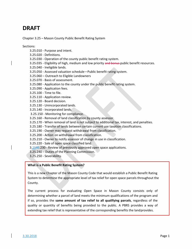
DRAFT Chapter 3.25 – Mason County Public Benefit Rating System
Sections: 3.25.010 ‐ Purpose and intent. 3.25.020 ‐ Definitions. 3.25.030 ‐ Operation of the county public benefit rating system. 3.25.035 ‐ Eligibility of high, medium and low priority and bonus public benefit resources. 3.25.040 ‐ Ineligible lands. 3.25.050 ‐ Assessed valuation schedule—Public benefit rating system. 3.25.060 – Outreach to Eligible Landowners 3.25.070 ‐ Basis of assessment. 3.25.080 ‐ Application to the county under the public benefit rating system. 3.25.090 ‐ Application fees. 3.25.100 ‐ Time to file. 3.25.110 ‐ Application review. 3.25.120 ‐ Board decision. 3.25.130 ‐ Unincorporated lands. 3.25.140 ‐ Incorporated lands. 3.25.150 ‐ Monitoring for compliance.
3.25.160 ‐ Removal of land classification by county assessor. 3.25.170 ‐ When removal of land is not subject to additional tax, interest, and penalties. 3.25.180 ‐ Transfer of lands between certain current use taxation classifications. 3.25.190 ‐ Owner may request withdrawal from classification. 3.25.200 ‐ Action on withdrawal from classification. 3.25.210 ‐ Owner to notify assessor of change in use in classification. 3.25.220 ‐ Sale of open space classified land. 3.2540.230 ‐ Review of previously approved open space applications. 3.25.240 – Duties of the Planning Commission. 3.25.250 ‐ Severability.
What is a Public Benefit Rating System?
This is a new Chapter of the Mason County Code that would establish a Public Benefit Rating System to determine the appropriate level of tax relief for open space parcels throughout the County.
The current process for evaluating Open Space in Mason County consists only of determining whether a parcel of land meets the minimum qualifications of the program and if so, provides the same amount of tax relief to all qualifying parcels, regardless of the quality or quantity of benefits being provided to the public. A PBRS provides a way of extending tax relief that is representative of the corresponding benefits the land provides.
3.30.2018 Page 2
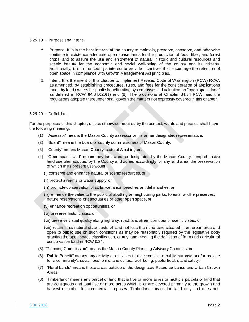
3.25.10 ‐ Purpose and intent.
A. Purpose. It is in the best interest of the county to maintain, preserve, conserve, and otherwise
continue in existence adequate open space lands for the production of food, fiber, and forest crops, and to assure the use and enjoyment of natural, historic and cultural resources and scenic beauty for the economic and social well-being of the county and its citizens. Additionally, it is in the county's interest to provide incentives that encourage the retention of open space in compliance with Growth Management Act principles.
B. Intent. It is the intent of this chapter to implement Revised Code of Washington (RCW) RCW, as amended, by establishing procedures, rules, and fees for the consideration of applications made by land owners for public benefit rating system assessed valuation on "open space land" as defined in RCW 84.34.020(1) and (8). The provisions of Chapter 84.34 RCW, and the regulations adopted thereunder shall govern the matters not expressly covered in this chapter.
3.25.20 ‐ Definitions.
For the purposes of this chapter, unless otherwise required by the context, words and phrases shall have the following meaning:
(1) "Assessor" means the Mason County assessor or his or her designated representative.
(2) "Board" means the board of county commissioners of Mason County.
(3) "County" means Mason County, state of Washington.
(4) "Open space land" means any land area so designated by the Mason County comprehensive land use plan adopted by the County and zoned accordingly, or any land area, the preservation of which in its present use would
(i) conserve and enhance natural or scenic resources, or
(ii) protect streams or water supply, or
(iii) promote conservation of soils, wetlands, beaches or tidal marshes, or
(iv) enhance the value to the public of abutting or neighboring parks, forests, wildlife preserves, nature reservations or sanctuaries or other open space, or
(v) enhance recreation opportunities, or
(vi) preserve historic sites, or
(vii) preserve visual quality along highway, road, and street corridors or scenic vistas, or
(viii) retain in its natural state tracts of land not less than one acre situated in an urban area and open to public use on such conditions as may be reasonably required by the legislative body granting the open space classification, or any land meeting the definition of farm and agricultural conservation land in RCW 8.34.
(5) “Planning Commission” means the Mason County Planning Advisory Commission.
(6) “Public Benefit” means any activity or activities that accomplish a public purpose and/or provide for a community’s social, economic, and cultural well-being, public health, and safety.
(7) “Rural Lands” means those areas outside of the designated Resource Lands and Urban Growth Areas.
(8) "Timberland" means any parcel of land that is five or more acres or multiple parcels of land that are contiguous and total five or more acres which is or are devoted primarily to the growth and harvest of timber for commercial purposes. Timberland means the land only and does not
3.30.2018 Page 3
include a residential homesite. The term includes land used for incidental uses that are compatible with the growing and harvesting of timber but no more than ten percent of the land may be used for such incidental uses. It also includes the land on which appurtenances necessary for the production, preparation, or sale of the timber products exist in conjunction with land producing these products.
(9) “Urban Areas” are those designated in Urban Growth areas around the incorporated area of Shelton and the two unincorporated areas of Allyn and Belfair as well as those areas defined as Limited Areas of More Intense Rural Developments (LAMRIDs) consistent with RCW 36.70A.
3.25.30 ‐ Operation of the county public benefit rating system.
To be eligible for open space classification under the county's public benefit rating system, property must contain one (1) or more open space resource listed below as defined in MCC Section 3.25.035 of this Chapter. These resources are defined in this chapter and ranked as high, medium or low priority open space resources. High priority open space resources receive five (5) points each, medium priority open space resources receive three (3) points each, and low priority open space resources receive one (1) point each. Properties can receive a maximum of thirty (30) points. from no more than six (6) open space priority resources. In addition, bonus points and super bonus points may be awarded pursuant to this chapter and a property can achieve a maximum of fifty-seven (57) points through the rating system and the bonus system. Portions of property may also qualify for open space designation.
A. High priority open space resources. Five (5) points each:
1. Public recreation area.
2. Resource and rural agricultural lands;
3. Trail linkages and recreational corridors;
4. Rural forest lands/woodlots;
5. Natural shoreline environments;
6. Significant fish and wildlife habitat conservation areas, aquifer protection areas, special plant sites, and category "I" or "II" wetlands as defined in MCC 8.52.110 and surveyed by a licensed wetland biologist;
7. Historic landmarks/archeological sites;
8. Private lands within designated national reserves;
B. Medium priority open space resources. Three (3) points each:
1. Conservancy shoreline environments;
2. Flood hazard buffer areas;
3. Geologic hazard buffer areas;
4. Scenic natural resources, viewpoints, and view corridors;
5. Urban growth area open space;
6. Category "III" or "IV" wetlands.
C. Low priority open space resources. One (1) point each:
(1) Exempt and artificial wetlands.
D. Bonus system. Properties qualifying in the specific high, medium, or low priority open space resource categories may receive up to twenty-seven (27) bonus points if the following additional qualifications are met:
3.30.2018 Page 4
1. Community priority—Five (5) points.
2. Voluntary resource or critical area restoration—Five (5) points.
3. Water quality buffer—One (1), three (3), or five (5) points.
4. Contiguous parcels under separate ownership—Three (3) points per contiguous parcel.
5. Conservation/historic/trail easement in perpetuity—Five (5) points.
E. Bonus public access points. 1. Unlimited public access—Five (5) points.
2. Limited public access—Sensitive area—Five (5) points.
3. Privately owned tidelands access—Five (5) points.
4. Limited public access—Three (3) points.
FD. Properties with at least one (1) high priority open space resource and which allow unlimited public access, or limited public access if due to resource sensitivity, and which convey a conservation, historic, or trail easement in perpetuity, in a form approved by the county, shall be automatically eligible for current use value at ten (10) percent of market value.
E. Special exceptions to this priority framework that do not violate state (RCW 84.34) law and that have the support of either the State or County Conservation Agency will be considered on a case by case basis for a maximum 20% assessed value.
3.25.35 – Eligibility of high, medium and low priority and bonus public benefit resources.
A. Public recreation area means property which is currently devoted to providing active or passive non-motorized recreation use or which complements or substitutes for government facilities. The facility must be open to the public and, if charging a use fee, that fee shall be no higher than the fee charged by a like public facility and the facility must provide recreation or other services to youth, senior citizens, the handicappeddisabled, or similar groups. An eligible site is that then identified by an appropriate parks department as meeting the definition of an active or passive recreation area.
Eligible examples include:
1. Sports fields on private property that are open to the public;
2. Golf courses open to the public with fees comparable to local public golf courses and which adhere to best management PRACTICES (as determined by Mason County Planning and Community Development). Annual monitoring reports are required;
3. A community garden; and
How does this criteria get applied?
The property owner applies to Mason County to receive tax relief for their property under the Open Space Tax Act. Mason County uses this criteria to review and score each application.
The information from this type of a review process can also be quantified to share with the public about the benefits they are receiving. More detail about each category of open space eligible for tax relieve is included in Section 3.25.035…
3.30.2018 Page 5
4. Other recreational uses determined to be consistent with the definition of active or passive recreation areas as determined by the Mason County Parks Department.
Ineligible examples include:
51. Properties with public or private trails: These are covered under the privately owned trails resource;
62. Recreational vehicle park portions of sites and related improvements to the land, including parking;
7. Golf courses which do not adhere to best management practices or charge a fee not comparable to public golf courses; and
83. Indoor recreation centers, gambling establishments, arcades, fun centers, etc.
B. Resource and rural agricultural lands means Land primarily devoted to the current non- commercial production of horticultural, viticultural, floricultural, dairy, apiary, vegetable, or animal products or of berries, grain, hay, straw, turf, seed, Christmas trees not subject to the excise tax imposed by RCW 84.33.100 through 84.33.140, or livestock, and which has significance for agricultural production. Or, land that has been traditionally in or is still capable of production for the above and which could be returned to productive commercial agriculture. Eligible sites are those that are currently not enrolled in existing current use assessment programs and meet any of the following criteria:
1. Lands of at least five (5) acres which are on prime or unique soils as identified in the data source; or
2. Lands of at least five (5) acres which meet the definition of resource and rural agricultural lands above; or
3. Lands that have been traditionally in or is still capable of production of the above as demonstrated by sales receipts, income tax statements, or other materials which the county accepts as proof that farming once occurred on the property and that the property could be returned to productive commercial agriculture.
CB. Trail linkages and recreational corridors means privately owned trails and corridors that are publicly accessible and used for hiking, biking, walking, horseback riding, and jogging. The trails may vary in scale and surfacing and may also be used as a means of non-motorized transportation connecting one (1) destination point to another. Streets, roads, and highways with widened shoulders or bike lanes are not included in this category. Eligible lands must be used as a public trail or corridor that remains in private ownership. Public access on the trail from a public road or public trail is required.
D. Rural forest lands/woodlots means rural forest lands/woodlots shall mean any parcel of land that is greater than two (2) acres but less than five (5) acres which is devoted primarily to the growth and harvest of forest crops for commercial purposes. A timber management plan shall be filed with the county legislative authority at the time application is made for classification as timber land pursuant to this chapter. Eligible sites are those that are currently not enrolled in existing current use assessment programs and meet the definition for forestlands/woodlots, above.
EC. "Natural" shoreline environment means a marine, lake, or river shoreline and its "associated wetlands" designated "natural" in the Shoreline Management Master Program for the county. Eligible lands are those identified as natural shoreline environments and their associated wetlands in the adopted shoreline master plan governing the area in which the shoreline is located. Eligible land must be adjacent to the water. To qualify there must be no structures or buildings within 200 feet upland from the ordinary high water mark (OHWM); this area is within the shoreline jurisdiction, and is based on the Shoreline Master Program; and there must be no
3.30.2018 Page 6
structures within 200 feet from the edge of an associated wetland boundary. If there is a bluff, any buildings must be at least 200 feet back from the edge of the bluff in a "natural" shoreline environment. Eligibility for this resource category cannot overlap with the "conservancy shoreline environment" category or other wetland categories of the public benefit rating system.
FD. Significant fish and wildlife habitat conservation areas, aquifer recharge areas, species and habitats of local importance, category I and II wetlands and special plant sites. 1. Significant fish and wildlife habitat conservation areas means areas identified as being of
critical importance to the maintenance of fish and wildlife species including areas with which endangered, threatened, and sensitive species have a primary association; habitats and species of local importance; streams; commercial and recreational shellfish areas; kelp and eelgrass beds; herring and smelt spawning areas; state natural area preserves, and state natural resource conservation; or
2. Aquifer recharge areas means the undisturbed area beyond that required by an applicable regulation that has a plant community in which native plants are dominant adjacent to a groundwater-bearing geologic formation or formations that contain enough saturated permeable material to yield significant quantities of water to wells or springs consistent with WAC 173-100 and MCC 8.52. Eligible sites are those where the buffer is a least fifty percent wider than the buffer required by any applicable regulation and longer than twenty (20) feet. The quality of the buffer area must be preserved from clearing and intrusion by domestic animals and protected from grazing or the use by livestock;
3. Species and habitats of local importance means areas containing vascular plant species as identified and listed in the Natural Heritage Program as being either endangered, threatened, or sensitive and areas identified in the Natural Heritage Program as high quality ecosystems and consistent with MCC 8.52. Eligible sites include:
a. The species or habitat is native to the county;
b. Locally declining populations that are in danger of extirpation;
c. Sensitivity to habitat manipulation; and
d. Commercial, game, other special value.
e. A habitat management plan shall be submitted which identifies the area to be protected and appropriate mitigation, management and/or protection strategies that will be employed.
f. Streams, provided that the stream buffer is at least twice the size of that required under MCC 8.52. Buffer averaging shall not be used;
g. Commercial and recreational shellfish areas, provided that the fish and wildlife habitat conservation area buffer is at least twice the size of that required under MCC 8.52. Buffer averaging shall not be used;
4. Kelp and eelgrass beds; herring and smelt spawning areas, provided that the fish and wildlife habitat conservation area buffer is at least twice the size of that required under MCC 8.52. Buffer averaging shall not be used;
5. State natural area preserves and natural resource conservation areas;
6. Sites listed in the Natural Heritage Database as containing endangered, threatened, or sensitive vascular plant species or high quality ecosystems, or which are verified by an expert in the field as containing the same plants or communities and which are acceptable by the state agency for addition to the database. A habitat management plan shall be submitted which identifies the area to be protected and appropriate mitigation, management and/or protection strategies that will be employed.
7. Category I and II wWetlands means wetlands that are classified category "I" or "II"as defined by MCC 8.52.110.
3.30.2018 Page 7
8. Special plant sites means sites where preservation, restoration or enhancement of native plant communities is maintained subject to an approved management plan. Eligible sites have a primary association with federally- or state-listed endangered, threatened, or sensitive species of fish or wildlife, and which, if altered, may reduce the likelihood that the species will maintain and reproduce over the long term. A habitat management plan shall be submitted which identifies the area to be protected and appropriate mitigation, management and/or protection strategies that will be employed.
Items 1. through 8. listed above require protection through easements, or voluntary buffers in those cases where buffers are not established through MCC 8.52 and, in certain cases, shall require preparation and submittal of a biological site assessment or habitat management plan. The BSA or HMP shall provide a description of the fish and wildlife habitat conservation area, the location of the protected features, the location of buffers and a description of efforts to protect the fish and wildlife habitat conservation area, or a description of restoration efforts in those instances where the critical area has been damaged.
GE. Historic landmarks/archaeological sites means lands which constitute or upon which is
situated an historic landmark formally designated by the county or a local jurisdiction, including buildings, structures or sites of significance in the county's historic or prehistoric heritage, such as Native American settlements, trails, pioneer settlements, farmsteads, roads, industrial works, bridges, burial sites, prehistoric and historic archaeological sites and landscapes, or traditional cultural properties and landscapes. Eligible properties must be listed on the county or other local list or register of historic places or landmarks for which there is local regulatory protection. Eligible properties include contributing properties within designated historic districts. Improvements to the land are not eligible for other federal or state tax credits. Additionally, land that has been verified through an archaeological report prepared by a qualified archaeologist that contains archaeological resources. The county will review and make determinations on eligibility.
HF. Private lands within designated National Reserves or long term commercial forests means officially designated areas under private ownership located within National Reserves or long term commercial forests that remain undeveloped and are maintained to protect the landscape of the reserve. Eligible lands are privately owned parcels five (5) acres or greater in size, that remain undeveloped and are maintained to protect the landscape of the reserve.
IG. "Conservancy" shoreline environment means marine and lake shoreline and associated wetlands designated as "conservancy environment" in an adopted shoreline management master plan. Conservancy shoreline areas are intended to preserve their existing character. The area must consist of native vegetation. Eligible sites must be identified as "conservancy shoreline environment" in an adopted shoreline master plan. The property must not be in another shoreline category of the PBRS. The area to be considered eligible is a maximum of 200 feet upland from the ordinary high water mark, within the 100-year floodplain, or the edge of the associated wetland, whichever is greater. To qualify there must be no structures or buildings within 150 feet upland from the ordinary high water mark (OHWM); this area is within the shoreline jurisdiction, and is based on the shoreline master plan; and there must be no structures within 150 feet from the edge of an associated wetland. If there is a bluff, any buildings must be at least 150 feet back from the edge of the bluff in a "conservancy" shoreline environment. Eligibility under this resource category cannot overlap with the "natural shoreline environment" category or other wetland categories of the PBRS.
J. Flood Hazard Areas Buffers means land buffering a floodplain within the county subject to a one (1) percent or greater chance of flooding in any given year consistent with MCC 14.22. These areas include, but are not limited to, streams, lakes, coastal areas, and wetlands. Eligible sites are those buffer areas located adjacent to or in the immediate vicinity of and which provide at least two (2) times the additional buffer width beyond that required by regulation for areas located within a 100-year floodplain as identified on the FEMA flood insurance program maps.
3.30.2018 Page 8
K. Geologic hazard area buffers means land buffering areas not suited to the siting of commercial, residential, or industrial development consistent with public health or safety concerns due to their susceptibility to sliding or other slope failures, erosion, earthquake, or other geologic events. Eligible sites are those areas of undisturbed vegetation located adjacent to or in the immediate vicinity of geologically hazardous areas and which provide at least two (2) times the additional buffer/setback width beyond that required by regulation for areas indicated in the Washington Department of Ecology's Coastal Zone Atlas; USDA Mason County Soil Survey; or areas with slopes forty (40) percent or greater and with a vertical relief of ten (10) feet or more, except areas of consolidated rock.
LH. Scenic natural resources, viewpoints, and view corridors means areas of ten (10) or more acres of natural features which is visually significant to the aesthetic character of the county or contains features which otherwise qualifies as a historic landmark or archaeological site. No lands that have been subject to commercial logging or mineral extraction within twenty-five (25) years of the date of the open space classification application are eligible under the public benefit rating system. Eligible sites must be significant to the identity of the local area and be visible to a significant number of the general public from public rights-of-way. Such lands must be of sufficient size to substantially preserve the scenic resource value and must be at least ten (10) acres in size.
1. Viewpoint means property that provides a view of an area which is visually significant to the aesthetic character of the county and which provides unlimited public access identified by a permanent sign readily visible from a road or other public right-of-way Eligible sites must provide a view of a scenic natural resource in the county or other visually significant areas and must provide for unlimited public access.
2. View corridor means an area of adjoining parcels which individually may be less than one (1) acre but which, when combined, total at least one (1) acre and create a view corridor critical to maintaining a view of a scenic resource area or other visually significant area.
MI. Urban growth area open space means five (5) or more acres of land, open to the public, and located within the boundaries of an urban growth area designated by the county. For purposes of this definition, land shall be considered open to the public if it qualifies for receiving any points for public access under the public access section of this open space taxation program.
N. Category "III" and "IV" wetlands means wetlands classified as category "III" or "IV" consistent with MCC 8.52.
O. Bonus system. Additional point values may be applied for the following eligible lands:
1. Public priority means land containing one (1) or more of the following community natural lands priorities of county residents:
a. Critical aquifer recharge areas which materially protect watersheds for drinking water sources and supply;
b. Significant undisturbed natural communities and ecosystems; or
c. Natural shoreline systems, including lagoons, saltwater tidal flats, marshes and accretion beaches that serve a diversity of ecological functions.
2. Voluntary resource or critical area restoration means restoration of any high, medium or low open space resource defined above. Emphasis shall be placed on restoration of anadromous fish-rearing habitat, wildlife and plant habitat areas, and upland, stream, and wetland habitats. Eligible sites are those that qualify for (A) through (N) resource classification as defined in this Section. The property owner must have an implemented restoration plan developed in cooperation with, or approved by appropriate federal, state, county, or local agency.
3. Water quality buffer areas means an undisturbed zone of native growth vegetation adjacent to a lake, pond, stream, wetland, or marine waters of a sufficient buffer width, but
3.30.2018 Page 9
no less than fifty (50) feet that will contribute to the protection of water quality in a surface water body. Bonus points are awarded for a streamside or wetland buffer width of at least one and a half (1½) that required by the applicable local critical areas ordinance or for a streamside or wetland buffer, of no less than fifty (50) feet, in agricultural lands otherwise exempted from buffering requirements. The buffer width is measured upland from the ordinary high water mark or the outer edge of a regulated wetland. The buffer does not include the body of water waterward of the ordinary high water mark or the wetland itself. Sites qualifying under the "water quality buffer area" or shorelines classifications would receive additional points through the provision of additional buffer which is preserved from clearing and from livestock intrusion. All such lands in or adjacent to pasture land must be fenced to prevent intrusion by domesticated animals. Eligibility requires property use and access restriction beyond those specified in the critical areas ordinance or other surface water protection regulations. The bonus points are awarded as follows:
a. One and a half (1½) times additional buffer width beyond that required by regulation— One (1) point.
b. Two (2) times additional buffer width beyond that required by regulation—Three (3) points.
c. Three (3) times additional buffer width beyond that required by regulation—Five (5) points.
d. At least seventy-five (75) feet of buffer width in agricultural lands otherwise exempted from buffering requirements—Five (5) points.
4. Contiguous parcels under separate ownership means contiguous parcels of land with the same open space resources are eligible for treatment as a single parcel if open space classification is sought under the same application. "Contiguous parcels" are defined as parcels abutting each other or abutting a publicly owned open space without any significant manmade barrier that materially restricts the free movement of wildlife or interferes with the visual continuity between the two (2) or more properties. Treatment as contiguous parcels shall include the requirement to pay only a single application fee. The total area of all parcels combined must equal or exceed any required minimum (rather than each parcel being required to meet such minimums). This contiguous parcel bonus must be accepted by all the applicants within the configuration under identical terms and conditions of access, easements, and restrictions. Individual parcels may be withdrawn from open space classification consistent with all applicable rules and regulations without affecting the continued eligibility of all other parcels accepted under the same application, provided that the combined area of the parcels remaining in open space classification must equal or exceed any minimum size requirement established in the PBRS and that access to the remaining parcels is not affected. Contiguous parcels must meet the following conditions:
a. The application must include two (2) or more parcels;
b. Each parcel included in the application must contain qualifying open space resources as defined by the public benefit rating system;
c. The owner(s) of parcels included in the application must agree to such terms and conditions for inclusion in the program that are consistent with the open space resource of the property.
5. Conservation/historic easement in perpetuity means an easement that restricts in perpetuity, further potential development, or other uses of a property, and which may include a requirement for native growth protection. Eligible lands are those that qualify for any high, medium or low open space resource classification. The conservation/historic easement will be in a form, and with such conditions, as are acceptable to the county.
3.30.2018 Page 10
6. Public access means access to the county's open space lands by the general public should be encouraged for all lands unless it is determined that such access would damage or endanger the resource. Property owners who allow access to the property, beyond that which is otherwise required by the open space resource category, should be afforded consideration in the level of tax reduction they receive depending on the level of access allowed and the conditions under which access is permitted. Properties shall be awarded additional points to the extent that such public access is available to the open space site, to a maximum of five (5) points. For open space resource categories which either contain public access requirements in the definition or eligibility criteria, no public access bonus points shall be awarded.
Signage. For properties allowing public access and receiving access points under [subsections] a. and d. above, the county shall furnish and maintain, at its own expense, signage according to county specifications which designates the property as part of the open space taxation program and states the conditions of access.
Accessibility. For properties allowing access and being considered for receiving access points under [subsections] a. through c. above, no points will be allowed if the property is not reasonably accessible. Off-road parking may be required where necessary to provide safe vehicular or pedestrian access. The property owner may, at their own expense and without any deduction in the number of access points awarded, limit access to the property to a reasonable number of locations through the use of fences, berms or other access barriers. Such physical barriers must be approved by the appropriate agency in advance, so as not to defeat the purpose of a resource category - for instance restricting wildlife in a wildlife corridor or construction of a visually incompatible fence near an historic resource.
Limitations on access and use. Reasonable limitations on access and use of properties may be imposed without a deduction in the number of access points a property receives. For example, prohibiting access before a reasonable time in the morning and after a reasonable time in the evening, prohibiting the use of any motorized or wheeled vehicles (except those required by disabled persons), prohibiting the use of the property for any kind of social gathering, prohibiting the consumption of any alcoholic beverages on the property, prohibiting the use of the property for picnics, etc. are all examples of reasonable limitations on the use of the property by the public which would likely not result in a reduction of points received by the property in the public access category. All such restrictions must be included in such documents or easements that establish the property as eligible for current use taxation.
The applicant shall specify the type of access that will be available in the application. Access points shall be awarded on the following scale:
a. Unlimited public access means year-round access to the general public is allowed without special arrangement with the property owner.
b. Limited public access/sensitive area means access may be reasonably limited due to the sensitive nature of the resource, with access provided only to appropriate user groups. The access allowed must generally be for an educational, scientific, or research purpose and available through special arrangements with the owner.
c. Privately owned tidelands access means public access to tidelands and such portions of the upland property necessary to provide access to the water line. Eligibility for public access points requires that the property is able to provide public access to the tidelands from a public right-of-way. Entry points and uses may be posted so that it does not detract from the resource.
d. Limited public access means access to the public is allowed, with or without special arrangements with the property owner, for any period of less than the full year, or access is available to any and all of the general public during any period of the year
3.30.2018 Page 11
upon special arrangements with the owner or upon the payment of a use fee that may not exceed twice the cost for members of the organization utilizing the facility.
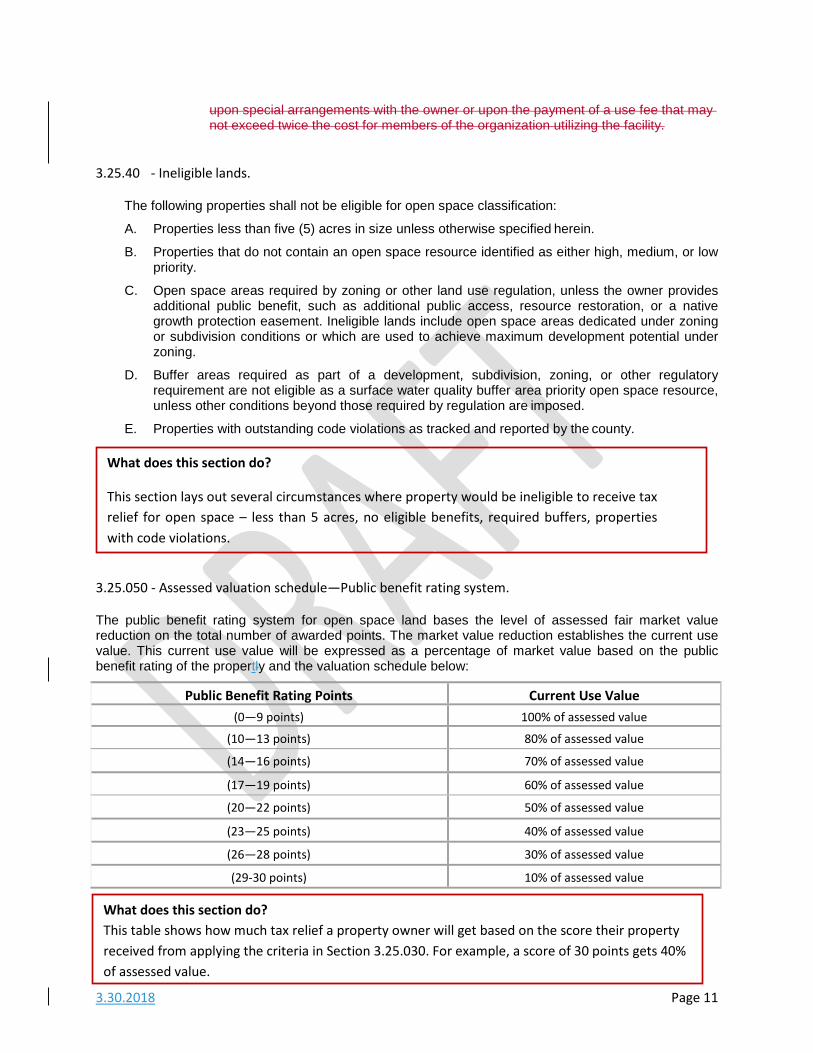
3.25.40 ‐ Ineligible lands.
The following properties shall not be eligible for open space classification:
A. Properties less than five (5) acres in size unless otherwise specified herein.
B. Properties that do not contain an open space resource identified as either high, medium, or low priority.
C. Open space areas required by zoning or other land use regulation, unless the owner provides additional public benefit, such as additional public access, resource restoration, or a native growth protection easement. Ineligible lands include open space areas dedicated under zoning or subdivision conditions or which are used to achieve maximum development potential under zoning.
D. Buffer areas required as part of a development, subdivision, zoning, or other regulatory requirement are not eligible as a surface water quality buffer area priority open space resource, unless other conditions beyond those required by regulation are imposed.
E. Properties with outstanding code violations as tracked and reported by the county.
3.25.050 ‐ Assessed valuation schedule—Public benefit rating system.
The public benefit rating system for open space land bases the level of assessed fair market value reduction on the total number of awarded points. The market value reduction establishes the current use value. This current use value will be expressed as a percentage of market value based on the public benefit rating of the propertly and the valuation schedule below:
Public Benefit Rating Points Current Use Value (0—9 points) 100% of assessed value
(10—13 points) 80% of assessed value
(14—16 points) 70% of assessed value
(17—19 points) 60% of assessed value
(20—22 points) 50% of assessed value
(23—25 points) 40% of assessed value
(26—28 points) 30% of assessed value
(29‐30 points) 10% of assessed value
What does this section do? This table shows how much tax relief a property owner will get based on the score their property received from applying the criteria in Section 3.25.030. For example, a score of 30 points gets 40% of assessed value.
What does this section do?
This section lays out several circumstances where property would be ineligible to receive tax relief for open space – less than 5 acres, no eligible benefits, required buffers, properties with code violations.
3.30.2018 Page 12
3.25.090 ‐ Application fees.
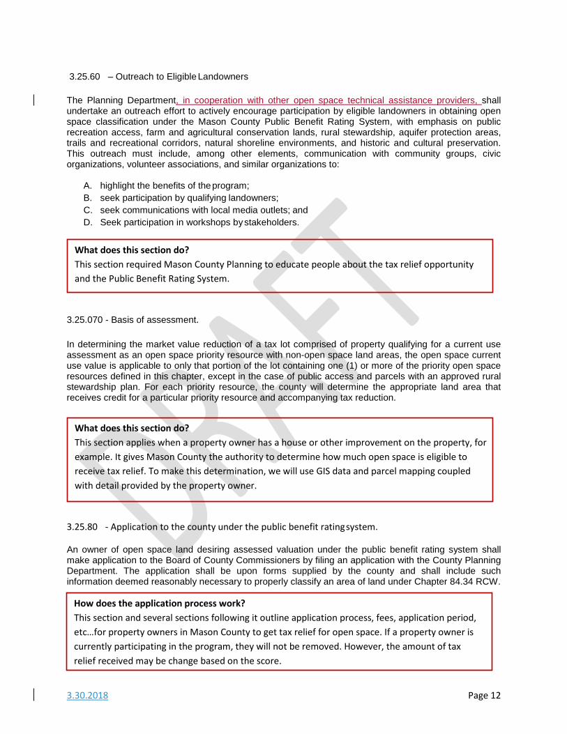
3.25.60 – Outreach to Eligible Landowners
The Planning Department, in cooperation with other open space technical assistance providers, shall undertake an outreach effort to actively encourage participation by eligible landowners in obtaining open space classification under the Mason County Public Benefit Rating System, with emphasis on public recreation access, farm and agricultural conservation lands, rural stewardship, aquifer protection areas, trails and recreational corridors, natural shoreline environments, and historic and cultural preservation. This outreach must include, among other elements, communication with community groups, civic organizations, volunteer associations, and similar organizations to:
A. highlight the benefits of the program; B. seek participation by qualifying landowners; C. seek communications with local media outlets; and D. Seek participation in workshops by stakeholders.
3.25.070 - Basis of assessment.
In determining the market value reduction of a tax lot comprised of property qualifying for a current use assessment as an open space priority resource with non-open space land areas, the open space current use value is applicable to only that portion of the lot containing one (1) or more of the priority open space resources defined in this chapter, except in the case of public access and parcels with an approved rural stewardship plan. For each priority resource, the county will determine the appropriate land area that receives credit for a particular priority resource and accompanying tax reduction.
3.25.80 ‐ Application to the county under the public benefit rating system.
An owner of open space land desiring assessed valuation under the public benefit rating system shall make application to the Board of County Commissioners by filing an application with the County Planning Department. The application shall be upon forms supplied by the county and shall include such information deemed reasonably necessary to properly classify an area of land under Chapter 84.34 RCW.
What does this section do? This section required Mason County Planning to educate people about the tax relief opportunity and the Public Benefit Rating System.
What does this section do? This section applies when a property owner has a house or other improvement on the property, for example. It gives Mason County the authority to determine how much open space is eligible to receive tax relief. To make this determination, we will use GIS data and parcel mapping coupled with detail provided by the property owner.
How does the application process work? This section and several sections following it outline application process, fees, application period, etc…for property owners in Mason County to get tax relief for open space. If a property owner is currently participating in the program, they will not be removed. However, the amount of tax relief received may be change based on the score.
3.30.2018 Page 13
A. Each application for current use open space taxation as defined in RCW 84.34.020, must include an application fee as established in the most current Mason County Permit Fee Schedule. Upon adoption, application fees shall be set at five hundred (500) dollars.
B. If an application is filed to add farm and agricultural conservation land, forest stewardship land, resource restoration or rural stewardship land to a parcel that is already enrolled in the Public Benefit Rating System, no fee shall be charged for the application.
C. In the case of all farm and agricultural land applications, whether the application is based on land within or outside of an incorporated area, the entire fee shall be collected and retained by the county. In the case of open space or timber land applications based on land in an incorporated area, where the city legislative authority has set no filing fee, the county fee shall govern and the entire fee shall be collected and retained by the county. Where the city legislative authority has established a filing fee, the fee established consistent with Section A of this section shall be collected by the county from the applicant and the county shall pay the city one-half of the fee collected.
3.25.100 ‐ Time to file.
Applications shall be made to Mason County by December 31 of the calendar year preceding the year in which such classification is to begin. Actual tax reduction will not be recognized until one (1) year after the classification of the property has been made.
3.25.110 ‐ Application review.
A. Applications under the public benefit rating system shall be reviewed by the county and approved directly by the Board of Mason County Commissioners. By Chapter 84.34 RCW such applications are exempt from the comprehensive plan annual review amendment cycle and are SEPA exempt.
B. In determining whether an application made for open space current use taxation status should be approved or disapproved, pursuant to RCW 84.34.020 and this chapter, the county shall consider whether or not preservation of the current use of the land, when balanced against the resulting revenue loss or tax shift from granting the application under the provisions of this chapter will:
1. Conserve or enhance natural, cultural or scenic resources;
2. Protect streams, stream corridors, wetlands, natural shorelines, and aquifers;
3. Protect soil resources and unique or critical wildlife and native plant habitat;
4. Promote conservation principles by example or by offering educational opportunities;
5. Enhance the value of abutting or neighboring parks, forests, wildlife preserves, nature reservations, or sanctuaries or other open spaces;
6. Enhance recreation opportunities;
7. Preserve historic and archeological sites; or
8. Affect any other factors relevant in weighing benefits to the general welfare or preserving the current use of the property as delineated in this chapter.
3.30.2018 Page 14
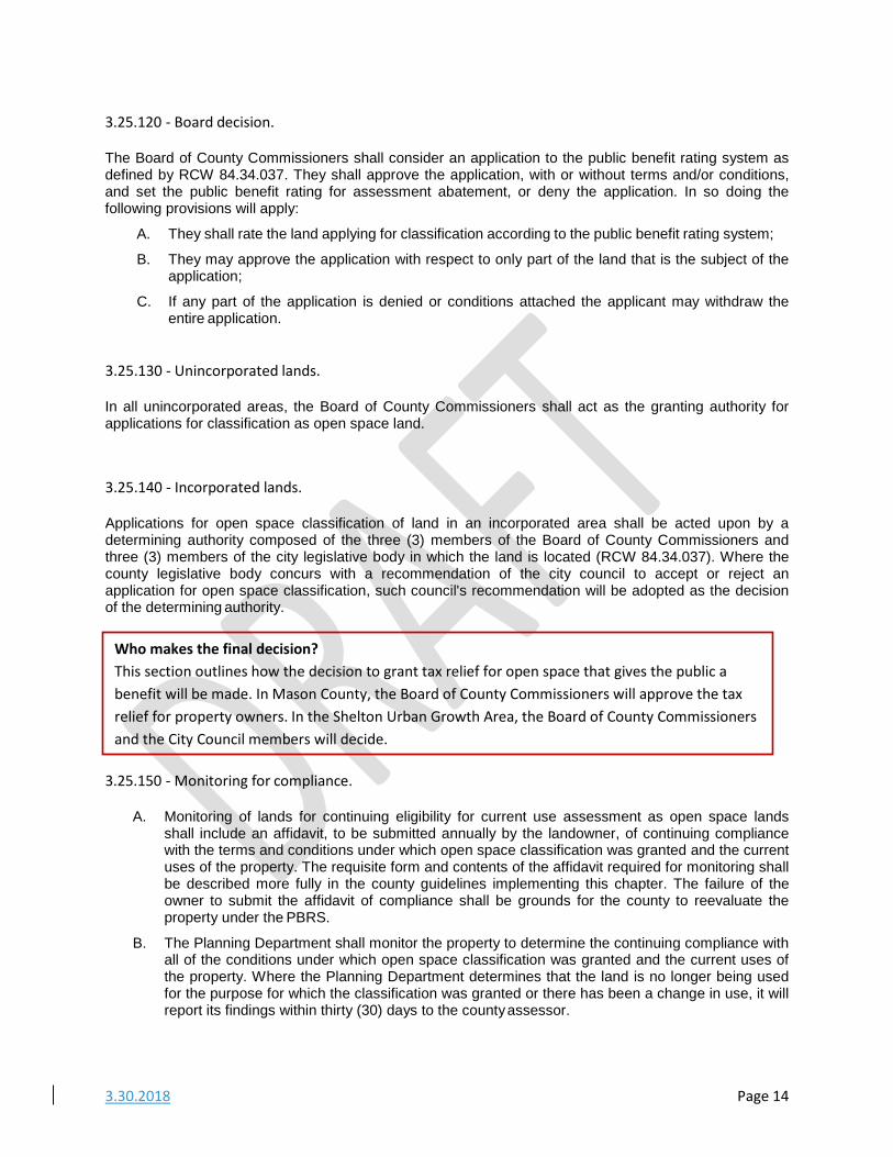
3.25.120 ‐ Board decision.
The Board of County Commissioners shall consider an application to the public benefit rating system as defined by RCW 84.34.037. They shall approve the application, with or without terms and/or conditions, and set the public benefit rating for assessment abatement, or deny the application. In so doing the following provisions will apply:
A. They shall rate the land applying for classification according to the public benefit rating system;
B. They may approve the application with respect to only part of the land that is the subject of the application;
C. If any part of the application is denied or conditions attached the applicant may withdraw the entire application.
3.25.130 ‐ Unincorporated lands.
In all unincorporated areas, the Board of County Commissioners shall act as the granting authority for applications for classification as open space land.
3.25.140 ‐ Incorporated lands.
Applications for open space classification of land in an incorporated area shall be acted upon by a determining authority composed of the three (3) members of the Board of County Commissioners and three (3) members of the city legislative body in which the land is located (RCW 84.34.037). Where the county legislative body concurs with a recommendation of the city council to accept or reject an application for open space classification, such council's recommendation will be adopted as the decision of the determining authority.
3.25.150 ‐ Monitoring for compliance.
A. Monitoring of lands for continuing eligibility for current use assessment as open space lands
shall include an affidavit, to be submitted annually by the landowner, of continuing compliance with the terms and conditions under which open space classification was granted and the current uses of the property. The requisite form and contents of the affidavit required for monitoring shall be described more fully in the county guidelines implementing this chapter. The failure of the owner to submit the affidavit of compliance shall be grounds for the county to reevaluate the property under the PBRS.
B. The Planning Department shall monitor the property to determine the continuing compliance with all of the conditions under which open space classification was granted and the current uses of the property. Where the Planning Department determines that the land is no longer being used for the purpose for which the classification was granted or there has been a change in use, it will report its findings within thirty (30) days to the county assessor.
Who makes the final decision? This section outlines how the decision to grant tax relief for open space that gives the public a benefit will be made. In Mason County, the Board of County Commissioners will approve the tax relief for property owners. In the Shelton Urban Growth Area, the Board of County Commissioners and the City Council members will decide.
3.30.2018 Page 15
3.25.160 ‐ Removal of land classification by county assessor.
A. Classified land may be removed from the public benefit rating system classification if it is no longer used for the purpose for which classification was granted or for any other classified use within the current use program. The assessor may determine, after giving the owner written notice and an opportunity to respond, that the land classified as open space is no longer primarily devoted to and used for the purposes for which it was granted classification.
B. When land is removed from classification an additional tax, applicable interest, and penalties are due unless the removal meets one (1) of the exceptions listed in this chapter. The owner may appeal the removal of classification to the Hearings Examiner consistent with MCC 15.11.020.
3.25.170 ‐ When removal of land is not subject to additional tax, interest, and penalties.
Removal of land is not subject to additional tax, interest, and penalties in the following instances:
A. Land is transferred to a government entity in exchange for other land located in the State of Washington;
B. Land is taken by power of eminent domain or transferred in anticipation of the exercise of such power;
C. Land is sold or transferred within two (2) years of the death of the owner of at least fifty-percent interest in the land;
D. A natural disaster such as a flood, windstorm, earthquake, or other such calamity rather than by virtue of an act of the landowner which changes the use of such property;
E. Official action by the state, county or city disallows the present use of such land;
F. The land is transferred to a church, such that the land would qualify for a property tax exemption;
G. Acquisition of property interests by state agencies or agencies or organizations qualified under RCW 84.34.210 and 64.04.130 for the purpose of protecting, preserving, maintaining, improving, restoring, limiting the future use of, or otherwise conserving, selected open space land as defined in Chapter 84.34 RCW for public use and enjoyment.
3.25.180 ‐ Transfer of lands between certain current use taxation classifications.
Land reclassified between the following current use assessment resource categories pursuant to RCW 84.34.70 are not considered withdrawals and are not subject to the additional tax interest and penalties:
A. Reclassification between farm and agricultural lands and timber lands;
B. Reclassification of farm and agricultural lands or timber lands to open space lands;
C. Reclassification of farm and agricultural lands or timber lands to forest land classified under Chapter 84.33 RCW; and
What if things change and the property is no longer open space? These sections establish a process for Mason County to monitor open space properties receiving the tax relief by getting updated information from property owners annually and removing properties that change status. Owners are also required to notify the County if the use of the property changes.
3.30.2018 Page 16
D. Reclassification from open space designated farm and agricultural conservation land under RCW 84.34.020(1)(c) to farm and agricultural land under RCW 84.34.020(2) if the land was previously classified as farm and agricultural land.
An application fee must be paid at the time the application is submitted consistent with Section 3.25.090 of this chapter. If the type of transfer is not listed in this section, it is considered to be a new application for which the applicable fees will be applied.
3.25.190 ‐ Owner may request withdrawal from classification.
A. After eight (8) years of the initial ten-year period has passed, the landowner may request that all or part of his/her land be withdrawn from the classification. The landowner must submit the request to withdraw classification to the assessor at least two (2) years prior to the date upon which it is to be removed from the current use assessment classification. The request to withdraw classification may be revoked at any time until the land is withdrawn from classification.
B. If a portion of a parcel is removed from classification the remaining portion must meet the same requirements, as did the entire parcel when the land was originally granted classification. Following withdrawal from classification, future valuation of such land as open space resource property under the public benefit rating system is contingent upon reapplication and approval under this chapter.
3.25.200 ‐ Action on withdrawal from classification.
Upon receipt of a request for withdrawal, the assessor shall notify the legislative authority that originally approved the application, and after one (1) year from the date of the withdrawal request, the assessor shall withdraw the land from classification. The land which is removed shall be subject to a tax equal to the difference between the amount of tax paid under the open space classification and the tax at true and fair value for seven (7) years last past, plus the statutory interest rate charged on delinquent property taxes.
3.25.210 ‐ Owner to notify assessor of change in use in classification.
If an owner changes the use of the classified land, the owner must notify the county assessor of the change within sixty (60) days. The assessor shall then impose an additional tax equal to the difference between the tax paid on current use value and the tax that would have been paid on that land had it not been so classified, payable for the seven (7) years last past, plus interest on this additional tax at the same rate as charged on delinquent property taxes, plus a penalty of twenty (20) percent of the total amount.
What do these sections do? These sections establish a process for the property owner to withdraw from the open space classification of his/her property. It is designed to encourage those property owners interested in preserving the open space value of their property. So, it requires a two (2) year notice and it is available to property owners who have had the open space classification for at least eight (8) years.
3.30.2018 Page 17
3.25.220 ‐ Sale of open space classified land.
When classified open space land is sold, the seller or transferor becomes liable at the time of sale for the additional tax, interest, and penalty of all or a portion of classified lands, unless the new owner signs the notice of continuance which is attached to or shown on the excise tax affidavit.
3.2540.230 ‐ Review of previously approved open space applications.
A. Upon adoption of a public benefit rating system, the Planning Department shall review and re- rate the existing open space land current use assessment program parcels according to the public benefit rating system in determining whether to recommend that an application be approved or denied.
B. Owners of property classified under the existing open space land current use assessment program shall be notified of their new assessed value in the same manner as provided in RCW 84.40.045. These lands may be removed from classification under the existing open space land assessment program, without payment of penalties, back taxes, and interest, upon request of the owner, within thirty (30) days of notification of their newly determined value under the public benefit rating system.
C. Property which does not qualify under the public benefit rating system and whose owner chooses not to remove the property from the open space land current use assessment program shall be rated according to the public benefit rating system (RCW 84.34.037[3]).
3.25.240 – Duties of the Planning Commission.
The Planning Commission shall review participation in the public benefit rating system when the first additional 1,000300 acres have been approved for open space classification under the county's current use assessment program or, after the first two (2) years after adoption of this chapter, whichever occurs sooner, and thereafter once every two (2) years. The planning commission shall make written recommendation to the Board of County Commissioners on the following matters:
What if open space property is sold? Again, the property owner receiving the tax relief is responsible for notifying Mason County if the status of the property changes. If open space property is sold, the seller must pay any additional taxes, interest or penalties associated with the property and change in classification. However, if the buyer formally agrees to continue to keep the property classified as open space, this does not apply.
What does this section do? This section outlines a process for property owners currently receiving tax relief for open space to have their property assessed under the new Public Benefit Rating System. Existing open space properties cannot be removed, but their tax relief amount may change. This section also gives property owners an opportunity to withdraw their property without paying any penalties.
3.30.2018 Page 18
A. The fundamental elements of the public benefit rating system, including such as the assessed valuation schedule and the other PBRS procedures defined in this chapter, open space resource definitions, etc.; and
B. The overall administrative process, including such issues as staffing, outreach to prospective applicants, application form and application processing, monitoring, etc.; and
C. The public benefit of the open space designated properties, the magnitude of the tax shift resulting from the designated properties and recommendations for expanding or restricting the program.
3.25.250 ‐ Severability.
If any provision of this chapter or its application to any person or circumstance is held invalid, the remainder of this chapter or its application to other persons or circumstances is not affected.
What does this section do? This section establishes the role of the Planning Commission as reviewing the Public Benefit Rating System every two years and reporting to the Board of County Commission along with any recommendations for improvements.


![Warrnambool OPEN SPACE STRATEGY 2014 · WARRNAMBOOL OPEN SPACE STRATEGY 2014 [3] ... Environmental Sustainability: ... The Warrnambool Open Space Strategy considers the open space](https://img.dokumen.tips/doc/110x75/5b14c4a67f8b9ab6778bd350/warrnambool-open-space-strategy-warrnambool-open-space-strategy-2014-3-.jpg)